 |
 |  |
Manors of Swanton Morley and Worthing; messuage; two water cornmills; a fulling mill and 24a.; dilapidated tenement; 3a. called Bradbury's tenement; the Lizard, 153a.; 104a. of meadow and pasture; 80a. of land; 40a. of other land; foldcourse of 800a. |
Conveyed by Thomas Bedingfield to William Small in 1663; conveyed by Laurence Whitwell and his sister Anne, devisees under Small's will, to Sir George Walker in 1676. Mortgaged by Walker to Joseph Bertham in 1679, and conveyed by Walker to Daniel Farrington in 1679. With deeds relating to mortgages on the property. |
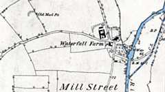
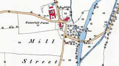
Manors of Swanton Morley, Hoe Harfords, and Ingworth; capital messuage in Swanton Morley, messuage, messuage with water mill, messuage called New Castle House, and a decayed tenement, all in Swanton Morley, messuage in Worthing; messuage in Hoe, called Hoe Malthouse Farm,; messuage in Scarning; messuage in Ingworth; several closes of land in Oulton; messuage and land in Burnham; a moiety of the rectory and vicarage of Scarning. |
 |
Bacon Hibgame of the City of Norwich, Flour Merchant & Baker. On a House & Water Corn Millhouse adjoining brick built & tiled with the Mills in the sd. Millhouse together with the Running Tackle & other parts of the Machinery belonging thereto situate in Swanton Morley in the County of Norfolk in his own Occupation, £500. On Goods in Trade therein, £500. 9th March 1775 |
 |
 |
 |
 |
 |
 |
 |
I always thought there must have been something there - we know the people who live beside the river there. |
Mills |
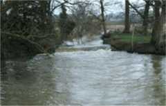
6.16 The mill structures have a profound influence on the river system in the Wensum catchment. If high retained water levels continue upstream of the mills, they would form a significant constraint on the effectiveness of river restoration. Physical modifications at mill sites should aim to restore a more natural longitudinal profile to the river and to remove or reduce physical barriers to the movement of fish and wildlife. Whilst historically a number of mills have been in existence for centuries these have always very actively stored and released water and the cessation of working of the mills in combination with dredging has had a significant impact. 6.17 The recommended actions at mill structures are shown in Table 9. At a number of sites there is no mill building and removal of water level control structures would be the desired course of action. However, often there are multiple channels at a mill site and it is likely that some hydraulic controls would be needed to maintain a split of flows to all channels. These would probably take the form of a fixed crest and a natural chute that would allow the passage of fish and woody debris. At locations where the water level control structures are part of the historic mill building, there is often a variety of passageways and the best way to lower levels will need to be identified using more detailed survey. Initial action can be taken at low cost by merely adjusting operating levels using the available gates and stop boards. The reduction in head that could be achieved at a typical dry weather flow is also summarised in Table 9. The estimated maximum reduction in backwater length through changing the operational level of the sluices (that is, without the need for major engineering works) is 18km. This would reduce the length of the River Wensum SSSI affected by backwater from mills from 67% to 40%. To achieve this it would be necessary to ensure that no channels downstream of gates or fixed weirs are affected, but this could be a cost effective start to the Wensum restoration. 6.18 It is likely that at some locations, where the channel course has been altered and the mill channel is significantly higher than the natural channel, the main flow could be diverted upstream of the current mill location. Maintaining some flow to the original mill weir is likely to be preferable for aesthetic and heritage reasons, so by-passing is likely to be required in conjunction with lowering of the mill weir. Sites where such a solution is envisaged are at Great Ryburgh and Lyng. 6.19 The control structures at Costessey, Swanton Morley and Fakenham are used for flow gauging by the Environment Agency. Lowering these weirs may mean that the existing gauging arrangements will need to be replaced by other methods, such as ultrasonic techniques. The weir on the main channel at Swanton Morley has a two stage drop and a significant reduction in water level could be achieved there without affecting flow gauging through the bridge. 6.20 A former mill known as Gogg‟s Mill near to Fakenham was removed as part of the drainage improvement works of the 1950s. The channel upstream of the mill has narrowed significantly through the accretion of silt berms, and provides a good case study of the extent to which natural recovery can help restore natural river form and function. 6.21 As part of the River Wensum Water Level Management Plan being prepared by Entec (2007) the views of some private owners on changes in operating level have been canvassed. In broad terms this is not opposed, but there is concern to maintain an attractive setting incorporating some mill pond in line with the historical context particularly at: 1) Elsing 2) Great Ryburgh 3) Bintree 4) North Elmham 5) Lenwade. 6.22 A reduction in the retained water level at mills may constrain the ability to direct water through all the existing channels at mill sites, should this still be required, there may be a need to carry out physical modifications to some of the subsidiary water level control structures. River Wensum Restoration Strategy - Natural England, 26th June 2009 |


A little story about the Weir at Swanton Morley. My parents Edna and Frank Smith lived opposite in Swanton Morley Lodge and I was born there in 1942 and lived there until bomber command moved us out. When the heavy woollen grey blankets needed freshening, my father used to put a stake each side of the weir and a thick rope across and these blankets would be hung over and left all night for the weir to cleanse them and apparently it worked a treat. Some washing machine!!! |
 |
 |
|
|