Home PageAbout MindatThe Mindat ManualHistory of MindatCopyright StatusWho We AreContact UsAdvertise on Mindat
Donate to MindatCorporate SponsorshipSponsor a PageSponsored PagesMindat AdvertisersAdvertise on Mindat
Learning CenterWhat is a mineral?The most common minerals on earthInformation for EducatorsMindat ArticlesThe ElementsThe Rock H. Currier Digital LibraryGeologic Time
Minerals by PropertiesMinerals by ChemistryAdvanced Locality SearchRandom MineralRandom LocalitySearch by minIDLocalities Near MeSearch ArticlesSearch GlossaryMore Search Options
The Mindat ManualAdd a New PhotoRate PhotosLocality Edit ReportCoordinate Completion ReportAdd Glossary Item
Mining CompaniesStatisticsUsersMineral MuseumsClubs & OrganizationsMineral Shows & EventsThe Mindat DirectoryDevice SettingsThe Mineral QuizTime Machine
Photo SearchPhoto GalleriesSearch by ColorNew Photos TodayNew Photos YesterdayMembers' Photo GalleriesPast Photo of the Day GalleryPhotography
Kafferskraal Farm, Ditsobotla Local Municipality, Ngaka Modiri Molema District Municipality, North West, South Africai
| Regional Level Types | |
|---|---|
| Kafferskraal Farm | Farm |
| Ditsobotla Local Municipality | Municipality |
| Ngaka Modiri Molema District Municipality | District |
| North West | Province |
| South Africa | Country |
This page is currently not sponsored.Click here to sponsor this page.
All Photos (10)Specimen Photos (6)Locality Photos (4)Photos by ColorGalleryPhoto StatisticsAdd Photo

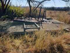
Part of the winder gear foundations.
Kafferskraal Farm, Ditsobotla Local Municipality, Ngaka Modiri Molema District Municipality, North West, South Africa
Kafferskraal Farm, Ditsobotla Local Municipality, Ngaka Modiri Molema District Municipality, North West, South Africa

Part of the headgear foundations.
Kafferskraal Farm, Ditsobotla Local Municipality, Ngaka Modiri Molema District Municipality, North West, South Africa
Kafferskraal Farm, Ditsobotla Local Municipality, Ngaka Modiri Molema District Municipality, North West, South Africa

View of the dumps, very little material remains.
Kafferskraal Farm, Ditsobotla Local Municipality, Ngaka Modiri Molema District Municipality, North West, South Africa
Kafferskraal Farm, Ditsobotla Local Municipality, Ngaka Modiri Molema District Municipality, North West, South Africa

Part of the winder gear foundations.
Kafferskraal Farm, Ditsobotla Local Municipality, Ngaka Modiri Molema District Municipality, North West, South Africa
Kafferskraal Farm, Ditsobotla Local Municipality, Ngaka Modiri Molema District Municipality, North West, South Africa
Part of the headgear foundations.
Kafferskraal Farm, Ditsobotla Local Municipality, Ngaka Modiri Molema District Municipality, North West, South Africa
Kafferskraal Farm, Ditsobotla Local Municipality, Ngaka Modiri Molema District Municipality, North West, South Africa

View of the dumps, very little material remains.
Kafferskraal Farm, Ditsobotla Local Municipality, Ngaka Modiri Molema District Municipality, North West, South Africa
Kafferskraal Farm, Ditsobotla Local Municipality, Ngaka Modiri Molema District Municipality, North West, South Africa
Part of the winder gear foundations.
Kafferskraal Farm, Ditsobotla Local Municipality, Ngaka Modiri Molema District Municipality, North West, South Africa
Kafferskraal Farm, Ditsobotla Local Municipality, Ngaka Modiri Molema District Municipality, North West, South Africa
Part of the headgear foundations.
Kafferskraal Farm, Ditsobotla Local Municipality, Ngaka Modiri Molema District Municipality, North West, South Africa
Kafferskraal Farm, Ditsobotla Local Municipality, Ngaka Modiri Molema District Municipality, North West, South Africa
Latitude & Longitude (WGS84):
25° 42' 32'' South , 26° 10' 20'' East
Latitude & Longitude (decimal):
Type:
Köppen climate type:
Nearest Settlements:
| Place | Population | Distance |
|---|---|---|
| Zeerust | 17,708(2012) | 21.5km |
| Lichtenburg | 65,863(2012) | 49.3km |
| Lobatse | 30,883(2018) | 73.3km |
Kafferskraal Farm 306 JP. Located south of Zeerust & east of Ottoshoop.
Select Mineral List Type
StandardDetailedGalleryStrunzChemical ElementsDetailed Mineral List:
| ⓘAnglesite Formula:PbSO4 Description: Deposit formed in dolomite. |
| ⓘCerussite Formula:PbCO3 |
| ⓘGalena Formula:PbS |
| ⓘ'Limonite' |
| ⓘMassicot Formula:PbO |
| ⓘMinium Formula:Pb3O4 |
| ⓘPlumbojarosite Formula:Pb0.5Fe3+3(SO4)2(OH)6 |
| ⓘPyromorphite Formula:Pb5(PO4)3Cl Description: Recovered in the 1920s crystals up to 1cm length, are prismatic and generally aggregated in parallel or divergent groups. |
| ⓘVanadinite Formula:Pb5(VO4)3Cl Description: Hexagonal crystals to 1cm, colours range from yellow-brown, brown, orange-red to brown-red. Associations are cerussite, galena, minium, pyromorphite and massicot. |

List of minerals arranged by Strunz 10th Edition classification
| Group 2 - Sulphides and Sulfosalts | |||
|---|---|---|---|
| ⓘ | Galena | 2.CD.10 | PbS |
| Group 4 - Oxides and Hydroxides | |||
| ⓘ | Massicot | 4.AC.25 | PbO |
| ⓘ | Minium | 4.BD.05 | Pb3O4 |
| Group 5 - Nitrates and Carbonates | |||
| ⓘ | Cerussite | 5.AB.15 | PbCO3 |
| Group 7 - Sulphates, Chromates, Molybdates and Tungstates | |||
| ⓘ | Anglesite | 7.AD.35 | PbSO4 |
| ⓘ | Plumbojarosite | 7.BC.10 | Pb0.5Fe3+3(SO4)2(OH)6 |
| Group 8 - Phosphates, Arsenates and Vanadates | |||
| ⓘ | Pyromorphite | 8.BN.05 | Pb5(PO4)3Cl |
| ⓘ | Vanadinite | 8.BN.05 | Pb5(VO4)3Cl |
| Unclassified | |||
| ⓘ | 'Limonite' | - | |
List of minerals for each chemical element
| H | Hydrogen | |
|---|---|---|
| H | ⓘPlumbojarosite | Pb0.5Fe33+(SO4)2(OH)6 |
| C | Carbon | |
| C | ⓘCerussite | PbCO3 |
| O | Oxygen | |
| O | ⓘAnglesite | PbSO4 |
| O | ⓘCerussite | PbCO3 |
| O | ⓘMassicot | PbO |
| O | ⓘMinium | Pb3O4 |
| O | ⓘPlumbojarosite | Pb0.5Fe33+(SO4)2(OH)6 |
| O | ⓘPyromorphite | Pb5(PO4)3Cl |
| O | ⓘVanadinite | Pb5(VO4)3Cl |
| P | Phosphorus | |
| P | ⓘPyromorphite | Pb5(PO4)3Cl |
| S | Sulfur | |
| S | ⓘAnglesite | PbSO4 |
| S | ⓘGalena | PbS |
| S | ⓘPlumbojarosite | Pb0.5Fe33+(SO4)2(OH)6 |
| Cl | Chlorine | |
| Cl | ⓘPyromorphite | Pb5(PO4)3Cl |
| Cl | ⓘVanadinite | Pb5(VO4)3Cl |
| V | Vanadium | |
| V | ⓘVanadinite | Pb5(VO4)3Cl |
| Fe | Iron | |
| Fe | ⓘPlumbojarosite | Pb0.5Fe33+(SO4)2(OH)6 |
| Pb | Lead | |
| Pb | ⓘAnglesite | PbSO4 |
| Pb | ⓘCerussite | PbCO3 |
| Pb | ⓘGalena | PbS |
| Pb | ⓘMassicot | PbO |
| Pb | ⓘMinium | Pb3O4 |
| Pb | ⓘPlumbojarosite | Pb0.5Fe33+(SO4)2(OH)6 |
| Pb | ⓘPyromorphite | Pb5(PO4)3Cl |
| Pb | ⓘVanadinite | Pb5(VO4)3Cl |
Other Regions, Features and Areas containing this locality
AfricaContinent
African PlateTectonic Plate
- Kalahari Craton
- Kaapvaal CratonCraton
South Africa
- ⭔TransvaalProvince
This page contains all mineral locality references listed on mindat.org. This does not claim to be a complete list. If you know of more minerals from this site, pleaseregister so you can add to our database. This locality information is for reference purposes only. You should never attempt tovisit any sites listed in mindat.org without first ensuring that you have the permission of the land and/or mineral rights holdersfor access and that you are aware of all safety precautions necessary.
References
Mindat.org is an outreach project of theHudson Institute of Mineralogy, a 501(c)(3) not-for-profit organization.
Copyright © mindat.org and the Hudson Institute of Mineralogy 1993-2025, except where stated. Most political location boundaries are© OpenStreetMap contributors. Mindat.org relies on the contributions of thousands of members and supporters. Founded in 2000 byJolyon Ralph.
To cite: Ralph, J., Von Bargen, D., Martynov, P., Zhang, J., Que, X., Prabhu, A., Morrison, S. M., Li, W., Chen, W., & Ma, X. (2025). Mindat.org: The open access mineralogy database to accelerate data-intensive geoscience research. American Mineralogist, 110(6), 833–844.doi:10.2138/am-2024-9486.
Privacy Policy -Terms & Conditions -Contact Us / DMCA issues -Report a bug/vulnerabilityCurrent server date and time: November 28, 2025 22:52:34 Page updated: August 13, 2025 04:10:27