WO2023087802A1 - Automatic driving positioning method and system, testing method, device, and storage medium - Google Patents
Automatic driving positioning method and system, testing method, device, and storage mediumDownload PDFInfo
- Publication number
- WO2023087802A1 WO2023087802A1PCT/CN2022/111845CN2022111845WWO2023087802A1WO 2023087802 A1WO2023087802 A1WO 2023087802A1CN 2022111845 WCN2022111845 WCN 2022111845WWO 2023087802 A1WO2023087802 A1WO 2023087802A1
- Authority
- WO
- WIPO (PCT)
- Prior art keywords
- positioning
- automatic driving
- data
- test
- integrated navigation
- Prior art date
- Legal status (The legal status is an assumption and is not a legal conclusion. Google has not performed a legal analysis and makes no representation as to the accuracy of the status listed.)
- Ceased
Links
Images


Classifications
- G—PHYSICS
- G01—MEASURING; TESTING
- G01C—MEASURING DISTANCES, LEVELS OR BEARINGS; SURVEYING; NAVIGATION; GYROSCOPIC INSTRUMENTS; PHOTOGRAMMETRY OR VIDEOGRAMMETRY
- G01C21/00—Navigation; Navigational instruments not provided for in groups G01C1/00 - G01C19/00
- G01C21/26—Navigation; Navigational instruments not provided for in groups G01C1/00 - G01C19/00 specially adapted for navigation in a road network
- G01C21/28—Navigation; Navigational instruments not provided for in groups G01C1/00 - G01C19/00 specially adapted for navigation in a road network with correlation of data from several navigational instruments
- G—PHYSICS
- G01—MEASURING; TESTING
- G01S—RADIO DIRECTION-FINDING; RADIO NAVIGATION; DETERMINING DISTANCE OR VELOCITY BY USE OF RADIO WAVES; LOCATING OR PRESENCE-DETECTING BY USE OF THE REFLECTION OR RERADIATION OF RADIO WAVES; ANALOGOUS ARRANGEMENTS USING OTHER WAVES
- G01S17/00—Systems using the reflection or reradiation of electromagnetic waves other than radio waves, e.g. lidar systems
- G01S17/88—Lidar systems specially adapted for specific applications
- G01S17/89—Lidar systems specially adapted for specific applications for mapping or imaging
- G—PHYSICS
- G01—MEASURING; TESTING
- G01C—MEASURING DISTANCES, LEVELS OR BEARINGS; SURVEYING; NAVIGATION; GYROSCOPIC INSTRUMENTS; PHOTOGRAMMETRY OR VIDEOGRAMMETRY
- G01C21/00—Navigation; Navigational instruments not provided for in groups G01C1/00 - G01C19/00
- G01C21/10—Navigation; Navigational instruments not provided for in groups G01C1/00 - G01C19/00 by using measurements of speed or acceleration
- G01C21/12—Navigation; Navigational instruments not provided for in groups G01C1/00 - G01C19/00 by using measurements of speed or acceleration executed aboard the object being navigated; Dead reckoning
- G01C21/16—Navigation; Navigational instruments not provided for in groups G01C1/00 - G01C19/00 by using measurements of speed or acceleration executed aboard the object being navigated; Dead reckoning by integrating acceleration or speed, i.e. inertial navigation
- G01C21/165—Navigation; Navigational instruments not provided for in groups G01C1/00 - G01C19/00 by using measurements of speed or acceleration executed aboard the object being navigated; Dead reckoning by integrating acceleration or speed, i.e. inertial navigation combined with non-inertial navigation instruments
- G01C21/1652—Navigation; Navigational instruments not provided for in groups G01C1/00 - G01C19/00 by using measurements of speed or acceleration executed aboard the object being navigated; Dead reckoning by integrating acceleration or speed, i.e. inertial navigation combined with non-inertial navigation instruments with ranging devices, e.g. LIDAR or RADAR
- G—PHYSICS
- G01—MEASURING; TESTING
- G01S—RADIO DIRECTION-FINDING; RADIO NAVIGATION; DETERMINING DISTANCE OR VELOCITY BY USE OF RADIO WAVES; LOCATING OR PRESENCE-DETECTING BY USE OF THE REFLECTION OR RERADIATION OF RADIO WAVES; ANALOGOUS ARRANGEMENTS USING OTHER WAVES
- G01S17/00—Systems using the reflection or reradiation of electromagnetic waves other than radio waves, e.g. lidar systems
- G01S17/02—Systems using the reflection of electromagnetic waves other than radio waves
- G01S17/06—Systems determining position data of a target
- G—PHYSICS
- G01—MEASURING; TESTING
- G01S—RADIO DIRECTION-FINDING; RADIO NAVIGATION; DETERMINING DISTANCE OR VELOCITY BY USE OF RADIO WAVES; LOCATING OR PRESENCE-DETECTING BY USE OF THE REFLECTION OR RERADIATION OF RADIO WAVES; ANALOGOUS ARRANGEMENTS USING OTHER WAVES
- G01S17/00—Systems using the reflection or reradiation of electromagnetic waves other than radio waves, e.g. lidar systems
- G01S17/86—Combinations of lidar systems with systems other than lidar, radar or sonar, e.g. with direction finders
- G—PHYSICS
- G01—MEASURING; TESTING
- G01S—RADIO DIRECTION-FINDING; RADIO NAVIGATION; DETERMINING DISTANCE OR VELOCITY BY USE OF RADIO WAVES; LOCATING OR PRESENCE-DETECTING BY USE OF THE REFLECTION OR RERADIATION OF RADIO WAVES; ANALOGOUS ARRANGEMENTS USING OTHER WAVES
- G01S17/00—Systems using the reflection or reradiation of electromagnetic waves other than radio waves, e.g. lidar systems
- G01S17/88—Lidar systems specially adapted for specific applications
- G01S17/93—Lidar systems specially adapted for specific applications for anti-collision purposes
- G01S17/931—Lidar systems specially adapted for specific applications for anti-collision purposes of land vehicles
- G—PHYSICS
- G01—MEASURING; TESTING
- G01S—RADIO DIRECTION-FINDING; RADIO NAVIGATION; DETERMINING DISTANCE OR VELOCITY BY USE OF RADIO WAVES; LOCATING OR PRESENCE-DETECTING BY USE OF THE REFLECTION OR RERADIATION OF RADIO WAVES; ANALOGOUS ARRANGEMENTS USING OTHER WAVES
- G01S19/00—Satellite radio beacon positioning systems; Determining position, velocity or attitude using signals transmitted by such systems
- G01S19/38—Determining a navigation solution using signals transmitted by a satellite radio beacon positioning system
- G01S19/39—Determining a navigation solution using signals transmitted by a satellite radio beacon positioning system the satellite radio beacon positioning system transmitting time-stamped messages, e.g. GPS [Global Positioning System], GLONASS [Global Orbiting Navigation Satellite System] or GALILEO
- G01S19/42—Determining position
- G01S19/45—Determining position by combining measurements of signals from the satellite radio beacon positioning system with a supplementary measurement
- G01S19/47—Determining position by combining measurements of signals from the satellite radio beacon positioning system with a supplementary measurement the supplementary measurement being an inertial measurement, e.g. tightly coupled inertial
- G—PHYSICS
- G01—MEASURING; TESTING
- G01S—RADIO DIRECTION-FINDING; RADIO NAVIGATION; DETERMINING DISTANCE OR VELOCITY BY USE OF RADIO WAVES; LOCATING OR PRESENCE-DETECTING BY USE OF THE REFLECTION OR RERADIATION OF RADIO WAVES; ANALOGOUS ARRANGEMENTS USING OTHER WAVES
- G01S19/00—Satellite radio beacon positioning systems; Determining position, velocity or attitude using signals transmitted by such systems
- G01S19/38—Determining a navigation solution using signals transmitted by a satellite radio beacon positioning system
- G01S19/39—Determining a navigation solution using signals transmitted by a satellite radio beacon positioning system the satellite radio beacon positioning system transmitting time-stamped messages, e.g. GPS [Global Positioning System], GLONASS [Global Orbiting Navigation Satellite System] or GALILEO
- G01S19/42—Determining position
- G01S19/48—Determining position by combining or switching between position solutions derived from the satellite radio beacon positioning system and position solutions derived from a further system
- G—PHYSICS
- G06—COMPUTING OR CALCULATING; COUNTING
- G06T—IMAGE DATA PROCESSING OR GENERATION, IN GENERAL
- G06T7/00—Image analysis
- G06T7/70—Determining position or orientation of objects or cameras
- G06T7/73—Determining position or orientation of objects or cameras using feature-based methods
- G—PHYSICS
- G01—MEASURING; TESTING
- G01S—RADIO DIRECTION-FINDING; RADIO NAVIGATION; DETERMINING DISTANCE OR VELOCITY BY USE OF RADIO WAVES; LOCATING OR PRESENCE-DETECTING BY USE OF THE REFLECTION OR RERADIATION OF RADIO WAVES; ANALOGOUS ARRANGEMENTS USING OTHER WAVES
- G01S19/00—Satellite radio beacon positioning systems; Determining position, velocity or attitude using signals transmitted by such systems
- G01S19/38—Determining a navigation solution using signals transmitted by a satellite radio beacon positioning system
- G01S19/39—Determining a navigation solution using signals transmitted by a satellite radio beacon positioning system the satellite radio beacon positioning system transmitting time-stamped messages, e.g. GPS [Global Positioning System], GLONASS [Global Orbiting Navigation Satellite System] or GALILEO
- G01S19/42—Determining position
- G01S19/48—Determining position by combining or switching between position solutions derived from the satellite radio beacon positioning system and position solutions derived from a further system
- G01S19/485—Determining position by combining or switching between position solutions derived from the satellite radio beacon positioning system and position solutions derived from a further system whereby the further system is an optical system or imaging system
- G—PHYSICS
- G06—COMPUTING OR CALCULATING; COUNTING
- G06T—IMAGE DATA PROCESSING OR GENERATION, IN GENERAL
- G06T2207/00—Indexing scheme for image analysis or image enhancement
- G06T2207/10—Image acquisition modality
- G06T2207/10028—Range image; Depth image; 3D point clouds
- G—PHYSICS
- G06—COMPUTING OR CALCULATING; COUNTING
- G06T—IMAGE DATA PROCESSING OR GENERATION, IN GENERAL
- G06T2207/00—Indexing scheme for image analysis or image enhancement
- G06T2207/30—Subject of image; Context of image processing
- G06T2207/30241—Trajectory
- G—PHYSICS
- G06—COMPUTING OR CALCULATING; COUNTING
- G06T—IMAGE DATA PROCESSING OR GENERATION, IN GENERAL
- G06T2207/00—Indexing scheme for image analysis or image enhancement
- G06T2207/30—Subject of image; Context of image processing
- G06T2207/30248—Vehicle exterior or interior
- G06T2207/30252—Vehicle exterior; Vicinity of vehicle
- Y—GENERAL TAGGING OF NEW TECHNOLOGICAL DEVELOPMENTS; GENERAL TAGGING OF CROSS-SECTIONAL TECHNOLOGIES SPANNING OVER SEVERAL SECTIONS OF THE IPC; TECHNICAL SUBJECTS COVERED BY FORMER USPC CROSS-REFERENCE ART COLLECTIONS [XRACs] AND DIGESTS
- Y02—TECHNOLOGIES OR APPLICATIONS FOR MITIGATION OR ADAPTATION AGAINST CLIMATE CHANGE
- Y02T—CLIMATE CHANGE MITIGATION TECHNOLOGIES RELATED TO TRANSPORTATION
- Y02T10/00—Road transport of goods or passengers
- Y02T10/10—Internal combustion engine [ICE] based vehicles
- Y02T10/40—Engine management systems
Definitions
- the present inventionrelates to the technical field of automatic driving positioning, in particular to an automatic driving positioning method, system, testing method, equipment and storage medium.
- Positioningis the basic module of automatic driving.
- a key prerequisite for the continuous safe and reliable operation of the automatic driving systemis that the positioning system of the vehicle must output sufficiently high-precision position and position-related information in real time and stably, including the longitude, latitude, and speed of the vehicle. , pitch angle, heading angle, update frequency, etc. Once this information cannot be obtained in a timely and accurate manner, the vehicle will not be able to determine its own position, and must immediately exit the automatic driving mode, and the driver will take over the control of the vehicle.
- GNSS and IMU integrated navigation systemare commonly used positioning solutions in automatic driving systems.
- GNSSGlobal Navigation Satellite System
- IMUintial navigation
- IMUintial navigation
- the integrated navigation system formed by the fusion of GNSS and IMUcan take advantage of the advantages of the two navigation systems.
- the current GNSS/IMU integrated navigation systemstill cannot achieve long-term and long-distance stable positioning.
- a test method for automatic drivingwhich leads to low reliability of integrated navigation and low positioning accuracy, proposes an automatic driving positioning method, system, testing method, equipment and storage medium.
- the present inventionprovides an automatic driving positioning method, system, testing method, equipment and storage medium.
- a positioning method for automatic drivingcomprising:
- the acquired real-time laser point cloud datais processed by the laser SLAM algorithm, and then processed by the extended Kalman filter method;
- the fusion output positioning datais obtained, and the input abnormal data is eliminated by using the fusion output positioning data to form a closed-loop processing.
- the real-time laser point cloud datais processed by laser SLAM algorithm to generate position and heading angle data.
- the fused output position, velocity, and attitude angle positioning dataare generated, and the fused output positioning data is used to eliminate abnormal data in the input data to form a closed-loop process.
- steps of removing abnormal datainclude:
- Step 1Determine the starting point of the fusion positioning output data, input position track and laser SLAM position track;
- Step 2Carry out interval resampling to the fusion positioning output data, input position track and laser SLAM position track in step 1 by linear interpolation method;
- Step 3Calculate the distance between equally spaced resampling points, extract and eliminate abnormal position data input and laser SLAM input;
- Step 4Based on the fusion output speed data, use the curve similarity analysis method to extract and eliminate the input abnormal speed data;
- Step 5Based on the attitude angle data of the fusion output, the curve similarity analysis method is used to extract and eliminate the abnormal angle data of the input and laser SLAM input.
- the inventionprovides an automatic driving positioning system, comprising: an integrated navigation equipment module, a laser radar module, an automatic driving controller module and an automatic driving positioning module,
- the integrated navigation device moduleis used to provide the position, speed and attitude angle data set to the automatic driving positioning module
- the laser radar moduleis used to provide real-time laser point cloud data to the automatic driving positioning module;
- the automatic driving positioning moduleis used to realize the automatic driving positioning method
- the automatic driving controller moduleis used to run the automatic driving positioning module.
- the automatic driving positioning moduleadopts an automatic driving positioning program based on integrated navigation and laser SLAM fusion technology.
- test methodis suitable for the above-mentioned automatic driving positioning system, the test method includes:
- the test of the automatic driving positioning systemis completed through the combined test of the integrated navigation equipment module and the automatic driving positioning function module.
- testing steps of the integrated navigation equipment moduleinclude:
- Step 1Test the positioning stability of the integrated navigation device in a static state
- Step 2Test the changes of different positioning states of the integrated navigation device in the motion state
- Step 3Based on the high-precision navigation and positioning system, test the positioning accuracy of the integrated navigation equipment
- Step 4Test the switching time between the fixed solution and the non-fixed solution of the integrated navigation device
- Step 5Test the change in the time of multiple cold starts of the integrated navigation device
- Step 6Test and analyze the packet loss rate and packet loss interval of the integrated navigation device.
- testing steps of the automatic driving positioning function moduleinclude:
- Step 1In a site with excellent GNSS signals and complete fixed facilities, arrange a fixed navigation track to test the positioning accuracy of automatic driving and the update frequency of positioning data;
- Step 2Test the positioning accuracy and data processing time of automatic driving in the GNSS signal occlusion area.
- the present inventionalso provides an automatic driving positioning device, which includes: a memory, a processor, and an automatic driving positioning program stored on the memory and running on the processor, the automatic driving positioning program is configured as The steps of the automatic driving positioning method as described in any one of the above are realized.
- the present inventionalso provides an electronic storage medium, in which at least one instruction or at least one section of program is stored, and the at least one instruction or at least one section of program is loaded and executed by a processor to realize any of the above automatic Driving positioning method.
- the present inventionadopts a real-time closed-loop automatic driving positioning method based on the integration of integrated navigation and laser SLAM, which can make up for the defect that satellite signals are easily affected by the environment, further improve the reliability of integrated navigation, and effectively improve positioning accuracy;
- the positioning method adopted by the automatic driving positioning system of the present inventionis a closed-loop processing method, and the positioning data input by the combined navigation device and laser SLAM is processed by the extended Kalman filter, and the output result data will be used for the combined navigation device and
- the screening of laser SLAM input positioning data, the direction verification of the validity of the input data, and the real-time laser positioning method based on deep learningare used to output laser positioning data with high accuracy and strong robustness, making the fusion positioning data more reliable;
- the function-level test method of the automatic driving positioning system provided by the present inventionis applicable to any automatic driving positioning system including integrated navigation equipment.
- the present inventioncarries out automatic driving from the two aspects of integrated navigation equipment testing and positioning function testing
- the test of the positioning system, and a set of test methods for integrated navigation equipment set up from the six aspects of static positioning data stability, positioning state, positioning accuracy, fixed solution switching time, cold start time, and packet loss,are for the testing of the automatic driving positioning system Verification-providing verification scheme, the test is easy to operate and has high reliability of test results.
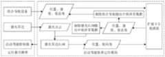
- Fig. 1is a structural schematic diagram of the overall structure process of the present invention.
- FIG. 2is a schematic diagram of the flow structure of the automatic driving positioning system of the present invention.
- FIG. 3is a schematic structural diagram of a laser SLAM processing flow in an embodiment of the present invention.
- FIG. 4is a schematic diagram of a flow structure of fused positioning data and eliminating input abnormal data in an embodiment of the present invention.
- Fig. 5is a schematic structural diagram of the test flow of the integrated navigation device of the present invention.
- the present inventionprovides a positioning method for automatic driving, including:
- the acquired position, velocity, and attitude angle data sets of the integrated navigation equipmentare processed by the extended Kalman filter method;
- the real-time laser point cloud data obtained from the lidaris processed by the laser SLAM algorithm, and then processed by the extended Kalman filter method;
- the real-time laser point cloud datais processed by the laser SLAM algorithm to generate position and heading angle data.
- the laser point cloud datais processed by the laser SLAM algorithm to generate the position and heading angle.
- the laser SLAM algorithmuses the deep learning model to learn the point cloud features, and outputs more accurate and robust positioning results.
- the feature matching and pose The calculation processis combined with the real-time production of point cloud feature maps, which reduces the calculation time of laser positioning and has higher real-time performance, making the fusion results of laser positioning and integrated navigation more reliable.
- the feature mapcan be combined with it to directly extract the local point cloud feature map, reducing the calculation time of laser positioning.
- the real-time laser point cloud datais generated during the process of laser SLAM algorithm processing.
- the real-time point cloud feature mapcan be combined with it to directly extract
- the fusion output positioning datais obtained, and the input abnormal data is eliminated by using the fusion output positioning data to form a closed-loop processing.
- the fused output position, velocity, and attitude angle positioning dataare generated, and the fused output positioning data is used to eliminate abnormal data in the integrated navigation and laser SLAM positioning to form a closed-loop processing.
- Figure 4shows the process of eliminating input abnormal data with fusion positioning results.
- the curve similarity analysis methodis used to compare the change trend of V1 and V0 over time, and the abnormal speed data in the integrated navigation input speed V1 is eliminated;
- the curve similarity analysis methodis used to compare the change trend of A1, A2 and A0 over time, and the abnormal angle data in the attitude angle A1 input by integrated navigation and the attitude angle A2 input by laser SLAM are eliminated.
- the inventionprovides an automatic driving positioning system, comprising: an integrated navigation equipment module, a laser radar module, an automatic driving controller module and an automatic driving positioning module,
- the integrated navigation device moduleis used to provide the position, speed and attitude angle data set to the automatic driving positioning module
- the laser radar moduleis used to provide real-time laser point cloud data to the automatic driving positioning module;
- the automatic driving positioning moduleis used to realize the automatic driving positioning method
- the automatic driving controller moduleis used to run the automatic driving positioning module.
- the automatic driving positioning moduleadopts an automatic driving positioning program based on integrated navigation and laser SLAM fusion technology.
- test methodis suitable for the above-mentioned automatic driving positioning system, the test method includes:
- the test of the automatic driving positioning systemis completed through the combined test of the integrated navigation equipment module and the automatic driving positioning function module.
- the tests for the integrated navigation aid moduleinclude:
- Static positioning data stability testtest the positioning stability of the integrated navigation device in a static state, and count the distribution of position data in a static state for a period of time.
- Install the integrated navigation equipment on the vehiclepark the vehicle in an open area, wait until the integrated navigation equipment can receive stable satellite signals, and after the equipment is in a stable state, record the received data within a period of time ⁇ T, and count the position data x, y According to the distribution of x and y, calculate the range, variance, standard deviation and covariance of x and y, and use the following formula to analyze the degree of dispersion of the location data.
- R xx max -x min
- R yy max -y min
- x max , x min , y max , y minare respectively the maximum value of x, the minimum value of x, The maximum value of y, the minimum value of y.
- nis the number of data records
- Positioning state testtest the changes of different positioning states of the combined navigation device in the motion state.
- the devicereceives data, and counts fixed solution, floating point solution, pseudorange solution, single point solution and other positioning states trajectories, calculate the proportion of trajectories in different positioning states at different vehicle speeds, and analyze the stability of the positioning of the integrated navigation device in the moving state.
- Positioning accuracy testtake the high-precision navigation and positioning system as the benchmark, compare and analyze the position error of the integrated navigation equipment and the reference positioning system on the same track line, and test the positioning accuracy of the integrated navigation equipment.
- a fixed navigation trackis arranged in an open test site, and the vehicle equipped with the integrated navigation device to be tested drives along the navigation track line, and the received positioning data set ⁇ x, y ⁇ is recorded;
- a high-precision navigation and positioning systemis installed at the same location, and the received reference positioning data set ⁇ x0, y0 ⁇ is recorded in the same way to form a reference trajectory curve R0.
- Fixed solution switching time testtest the switching time between the fixed solution and the non-fixed solution of the integrated navigation device.
- the vehicle installed with the integrated navigation device to be testeddrives along the specified trajectory at different speeds, records the received data content, records the time points from fixed solution to non-fixed solution, and from non-fixed solution to fixed solution, and calculates the time difference.
- Cold start time testtest the change in the time of repeated cold starts of the combined navigation device.
- Select a site with a good positioning signal for the integrated navigation device to be testedturn off the power of the device by unplugging the power, wait for a period of time (for example, 5 minutes), power on the device and receive data, and record the time from power on to the first observation with a fixed solution T. Power off, repeat the same operation several times, record the time T, and calculate the maximum value, minimum value, average value and standard deviation of T.
- Packet loss testtest and analyze the packet loss rate and packet loss interval of the integrated navigation device, including data comparison test and data integrity test.
- the vehicle installed with the integrated navigation device to be testeddrives along the specified track at different speeds, records the data content sent by the device through the communication interface, compares the data content received and recorded inside the device, and analyzes and calculates the packet loss rate at different speeds , check the interval of packet loss in the driving track;
- Data integrity testAccording to the data content sent by the integrated navigation device through the communication interface, the time continuity is counted, the integrity of the data itself is checked, the packet loss rate at different speeds is calculated, and the packet loss interval in the driving track is checked.
- the test of the automatic driving positioning function moduleincludes:
- GNSSGlobal Navigation Satellite System
- Control pointuse high-precision measuring instruments, such as total stations, etc., measure the precise position coordinates (X0, Y0) of the control points, turn on the vehicle's automatic driving positioning module, and drive the vehicle through the tunnel at different speeds.
- Control pointrecord the position data (X, Y) and time of the control point output by the automatic driving system, calculate the error of (X0, Y0) and (X, Y), analyze the change of the error over time, and calculate the distribution of the error The maximum, minimum, and average values of the error.
- the present inventionalso provides an automatic driving positioning device, which includes: a memory, a processor, and an automatic driving positioning program stored on the memory and running on the processor, the automatic driving positioning program is configured as The steps of the automatic driving positioning method as described in any one of the above are realized.
- the present inventionalso provides an electronic storage medium, in which at least one instruction or at least one section of program is stored, and the at least one instruction or at least one section of program is loaded and executed by a processor to realize any of the above automatic Driving positioning method.
- the integrated navigation of the present inventionadopts GNSS and IMU integrated navigation.
- the present inventionadopts a real-time closed-loop automatic driving positioning system based on the integration of integrated navigation and laser SLAM, which can make up for the defect that satellite signals are easily affected by the environment, further improve the reliability of integrated navigation, and effectively improve the positioning accuracy.
- the positioning data input by the integrated navigation equipment and laser SLAMis processed by the extended Kalman filter, and the output result data will be used to screen the input positioning data of the integrated navigation equipment and laser SLAM, and reversely verify the validity of the input positioning data.
- using a real-time laser positioning method based on deep learning to output laser positioning data with high accuracy and strong robustnessmaking the result of fusion positioning more reliable and optimizing the overall performance of the positioning system.
- test and positioning function testare two aspects to carry out the test of the automatic driving positioning system, and conduct a relatively comprehensive test on the automatic driving positioning system.
- the test operationis simple and the reliability is high.
Landscapes
- Engineering & Computer Science (AREA)
- Radar, Positioning & Navigation (AREA)
- Remote Sensing (AREA)
- Physics & Mathematics (AREA)
- General Physics & Mathematics (AREA)
- Computer Networks & Wireless Communication (AREA)
- Electromagnetism (AREA)
- Automation & Control Theory (AREA)
- Computer Vision & Pattern Recognition (AREA)
- Theoretical Computer Science (AREA)
- Control Of Position, Course, Altitude, Or Attitude Of Moving Bodies (AREA)
- Navigation (AREA)
Abstract
Description
Translated fromChinese本发明涉及自动驾驶定位技术领域,特别涉及一种自动驾驶定位方法、系统、测试方法、设备及存储介质。The present invention relates to the technical field of automatic driving positioning, in particular to an automatic driving positioning method, system, testing method, equipment and storage medium.
汽车自动驾驶是近年来的一项前沿研究技术,需要在没有人为操纵的情况下完整、安全、有效地驾驶汽车。定位是自动驾驶的基础模块,自动驾驶系统能够持续安全可靠运行的一个关键前提是车辆的定位系统必须实时稳定地输出足够高精度的位置和与位置相关的信息,包括车辆的经度、纬度、速度、俯仰角、航向角、更新频率等。一旦这些信息无法及时精确地获取,车辆就无法确定自身位置,必须立即退出自动驾驶模式,由驾驶员接管车辆操控。Autopilot is a cutting-edge research technology in recent years, which requires complete, safe and efficient driving of cars without human manipulation. Positioning is the basic module of automatic driving. A key prerequisite for the continuous safe and reliable operation of the automatic driving system is that the positioning system of the vehicle must output sufficiently high-precision position and position-related information in real time and stably, including the longitude, latitude, and speed of the vehicle. , pitch angle, heading angle, update frequency, etc. Once this information cannot be obtained in a timely and accurate manner, the vehicle will not be able to determine its own position, and must immediately exit the automatic driving mode, and the driver will take over the control of the vehicle.
要实现汽车自动驾驶系统,必须采用高精定位导航技术,GNSS和IMU组合导航系统是自动驾驶系统中常用的定位方案,GNSS(全球导航卫星系统)可以提供精确的绝对定位,但是在局部区域卫星信号丢失或者微弱时会导致定位信息延迟而造成车辆失控。IMU(惯性导航)虽然可以不依托外在信息,无惧极端环境提供稳定的位置和速度信息,但是存在定位误差随时间积累、长时间内不能保证足够的导航精度的问题。GNSS和IMU融合形成的组合导航系统可以发挥两种导航系统的优势。但是,在复杂场景下,受到信号遮挡和多径效应的影响,目前的GNSS/IMU组合导航系统仍然无法实现长时间、长距离的稳定定位。In order to realize the automatic driving system of automobiles, high-precision positioning and navigation technology must be adopted. GNSS and IMU integrated navigation system are commonly used positioning solutions in automatic driving systems. GNSS (Global Navigation Satellite System) can provide accurate absolute positioning, but in local areas satellite When the signal is lost or weak, the positioning information will be delayed and the vehicle will be out of control. Although IMU (inertial navigation) can provide stable position and speed information without relying on external information and fearing extreme environments, there is a problem that positioning errors accumulate over time and sufficient navigation accuracy cannot be guaranteed for a long time. The integrated navigation system formed by the fusion of GNSS and IMU can take advantage of the advantages of the two navigation systems. However, in complex scenarios, affected by signal occlusion and multipath effects, the current GNSS/IMU integrated navigation system still cannot achieve long-term and long-distance stable positioning.
因此,针对现有技术,因无法在全部地区实现准确实时的定位,定位精度、系统健壮性等各方面也仍然具有很大的提升空间的情况下,本发明的目的在于 针对自动驾驶定位缺乏系统的测试方法,导致组合导航可靠性低、定位精度低而提出的一种自动驾驶定位方法、系统、测试方法、设备及存储介质。Therefore, in view of the existing technology, because accurate and real-time positioning cannot be realized in all areas, and there is still a lot of room for improvement in various aspects such as positioning accuracy and system robustness, the purpose of the present invention is to address the lack of a system for automatic driving positioning. A test method for automatic driving, which leads to low reliability of integrated navigation and low positioning accuracy, proposes an automatic driving positioning method, system, testing method, equipment and storage medium.
发明内容Contents of the invention
为了解决现有技术存在的缺漏,本发明提供了一种自动驾驶定位方法、系统、测试方法、设备及存储介质。In order to solve the deficiencies in the prior art, the present invention provides an automatic driving positioning method, system, testing method, equipment and storage medium.
本发明的技术内容如下:Technical content of the present invention is as follows:
一种自动驾驶定位方法,包括:A positioning method for automatic driving, comprising:
输入位置、速度、姿态角数据集合以及实时激光点云数据;Input position, velocity, attitude angle data set and real-time laser point cloud data;
将获取的位置、速度、姿态角数据集合经扩展卡尔曼滤波法处理;Process the acquired position, velocity, and attitude angle data sets through the extended Kalman filter method;
将获取的实时激光点云数据经激光SLAM算法处理,再经扩展卡尔曼滤波法处理;The acquired real-time laser point cloud data is processed by the laser SLAM algorithm, and then processed by the extended Kalman filter method;
经扩展卡尔曼滤波法处理后获得融合输出定位数据,利用融合输出定位数据剔除输入的异常数据,形成闭环处理。After being processed by the extended Kalman filter method, the fusion output positioning data is obtained, and the input abnormal data is eliminated by using the fusion output positioning data to form a closed-loop processing.
进一步地,所述实时激光点云数据经激光SLAM算法处理生成位置、航向角数据。Further, the real-time laser point cloud data is processed by laser SLAM algorithm to generate position and heading angle data.
进一步地,经扩展卡尔曼滤波法处理后生成融合输出的位置、速度、姿态角定位数据,使用该融合输出定位数据剔除输入数据中的异常数据,形成闭环处理。Further, after being processed by the extended Kalman filter method, the fused output position, velocity, and attitude angle positioning data are generated, and the fused output positioning data is used to eliminate abnormal data in the input data to form a closed-loop process.
进一步地,剔除异常数据的步骤包括:Further, the steps of removing abnormal data include:
步骤一:确定融合定位输出数据、输入位置轨迹和激光SLAM位置轨迹的起始点;Step 1: Determine the starting point of the fusion positioning output data, input position track and laser SLAM position track;
步骤二:采用线性插值法对步骤一中的融合定位输出数据、输入位置轨迹 和激光SLAM位置轨迹进行间隔重采样;Step 2: Carry out interval resampling to the fusion positioning output data, input position track and laser SLAM position track in step 1 by linear interpolation method;
步骤三:计算等间隔重采样点之间的距离,提取并剔除输入和激光SLAM输入的异常位置数据;Step 3: Calculate the distance between equally spaced resampling points, extract and eliminate abnormal position data input and laser SLAM input;
步骤四:基于融合输出的速度数据,采用曲线相似性分析方法,提取并剔除输入的异常速度数据;Step 4: Based on the fusion output speed data, use the curve similarity analysis method to extract and eliminate the input abnormal speed data;
步骤五:基于融合输出的姿态角数据,采用曲线相似性分析方法,提取并剔除输入和激光SLAM输入的异常角度数据。Step 5: Based on the attitude angle data of the fusion output, the curve similarity analysis method is used to extract and eliminate the abnormal angle data of the input and laser SLAM input.
本发明提供了一种自动驾驶定位系统,包括:组合导航设备模块、激光雷达模块、自动驾驶控制器模块及自动驾驶定位模块,The invention provides an automatic driving positioning system, comprising: an integrated navigation equipment module, a laser radar module, an automatic driving controller module and an automatic driving positioning module,
所述组合导航设备模块,用于向所述自动驾驶定位模块提供位置、速度、姿态角数据集合;The integrated navigation device module is used to provide the position, speed and attitude angle data set to the automatic driving positioning module;
所述激光雷达模块,用于向所述自动驾驶定位模块提供实时激光点云数据;The laser radar module is used to provide real-time laser point cloud data to the automatic driving positioning module;
所述自动驾驶定位模块,用于实现自动驾驶定位方法;The automatic driving positioning module is used to realize the automatic driving positioning method;
所述自动驾驶控制器模块,用于运行所述自动驾驶定位模块。The automatic driving controller module is used to run the automatic driving positioning module.
进一步地,所述自动驾驶定位模块采取基于组合导航和激光SLAM融合技术的自动驾驶定位程序。Further, the automatic driving positioning module adopts an automatic driving positioning program based on integrated navigation and laser SLAM fusion technology.
本发明提供了一种测试方法,所述测试方法适用于上述的自动驾驶定位系统,所述测试方法包括:The present invention provides a test method, the test method is suitable for the above-mentioned automatic driving positioning system, the test method includes:
通过组合导航设备模块及自动驾驶定位功能模块的组合测试完成自动驾驶定位系统的测试。The test of the automatic driving positioning system is completed through the combined test of the integrated navigation equipment module and the automatic driving positioning function module.
进一步地,所述组合导航设备模块的测试步骤包括:Further, the testing steps of the integrated navigation equipment module include:
步骤一:测试组合导航设备在静止状态下的定位稳定性;Step 1: Test the positioning stability of the integrated navigation device in a static state;
步骤二:测试组合导航设备在运动状态下的不同定位状态的变化;Step 2: Test the changes of different positioning states of the integrated navigation device in the motion state;
步骤三:以高精度导航定位系统为基准,测试组合导航设备的定位精度;Step 3: Based on the high-precision navigation and positioning system, test the positioning accuracy of the integrated navigation equipment;
步骤四:测试组合导航设备的固定解和非固定解的互相切换时间;Step 4: Test the switching time between the fixed solution and the non-fixed solution of the integrated navigation device;
步骤五:测试组合导航设备重复多次冷启动的时间的变化;Step 5: Test the change in the time of multiple cold starts of the integrated navigation device;
步骤六:测试及分析组合导航设备的丢包率和丢包区间。Step 6: Test and analyze the packet loss rate and packet loss interval of the integrated navigation device.
进一步地,所述自动驾驶定位功能模块的测试步骤包括:Further, the testing steps of the automatic driving positioning function module include:
步骤一:在GNSS信号优良、固定设施完备的场地中,布置固定的导航轨道,测试自动驾驶定位精度和定位数据更新频率;Step 1: In a site with excellent GNSS signals and complete fixed facilities, arrange a fixed navigation track to test the positioning accuracy of automatic driving and the update frequency of positioning data;
步骤二:在GNSS信号遮挡区域测试自动驾驶定位精度和数据处理时间。Step 2: Test the positioning accuracy and data processing time of automatic driving in the GNSS signal occlusion area.
本发明还提供了一种自动驾驶定位设备,所述设备包括:存储器、处理器及存储在所述存储器上并在所述处理器上运行的自动驾驶定位程序,所述自动驾驶定位程序配置为实现如上述中任一项所述的自动驾驶定位方法的步骤。The present invention also provides an automatic driving positioning device, which includes: a memory, a processor, and an automatic driving positioning program stored on the memory and running on the processor, the automatic driving positioning program is configured as The steps of the automatic driving positioning method as described in any one of the above are realized.
本发明还提供了一种电子存储介质,所述存储介质中存储有至少一条指令或至少一段程序,所述至少一条指令或至少一段程序由处理器加载并执行以实现如上述任一项的自动驾驶定位方法。The present invention also provides an electronic storage medium, in which at least one instruction or at least one section of program is stored, and the at least one instruction or at least one section of program is loaded and executed by a processor to realize any of the above automatic Driving positioning method.
本发明至少包括以下有益效果:The present invention at least includes the following beneficial effects:
(1)本发明采用一种基于组合导航和激光SLAM相融合的实时闭环的自动驾驶定位方法,能够弥补卫星信号易受环境影响的缺陷,进一步地提升组合导航的可靠性,有效提高定位精度;(1) The present invention adopts a real-time closed-loop automatic driving positioning method based on the integration of integrated navigation and laser SLAM, which can make up for the defect that satellite signals are easily affected by the environment, further improve the reliability of integrated navigation, and effectively improve positioning accuracy;
(2)本发明的自动驾驶定位系统采用的定位方法为闭环的处理方法,组合导航设备和激光SLAM输入的定位数据经扩展卡尔曼滤波处理后输出的结果数据, 又会用于组合导航设备和激光SLAM输入定位数据的筛选,方向验证输入数据的有效性,同时采用基于深度学习的实时激光定位方法,输出具有高准确性和强鲁棒性的激光定位数据,使得融合定位的数据更加可靠;(2) The positioning method adopted by the automatic driving positioning system of the present invention is a closed-loop processing method, and the positioning data input by the combined navigation device and laser SLAM is processed by the extended Kalman filter, and the output result data will be used for the combined navigation device and The screening of laser SLAM input positioning data, the direction verification of the validity of the input data, and the real-time laser positioning method based on deep learning are used to output laser positioning data with high accuracy and strong robustness, making the fusion positioning data more reliable;
(3)本发明提供的自动驾驶定位系统的功能级测试方法,该测试方法适用于任何包含组合导航设备的自动驾驶定位系统,本发明从组合导航设备测试、定位功能测试两大方面开展自动驾驶定位系统的测试,并且从静态定位数据稳定性、定位状态、定位精度、固定解切换时间、冷启动时间、丢包六个方面设置的一套组合导航设备测试方法,为自动驾驶定位系统的测试验证提供型的验证方案,该测试操作方便、测试结果可靠性较高。(3) The function-level test method of the automatic driving positioning system provided by the present invention is applicable to any automatic driving positioning system including integrated navigation equipment. The present invention carries out automatic driving from the two aspects of integrated navigation equipment testing and positioning function testing The test of the positioning system, and a set of test methods for integrated navigation equipment set up from the six aspects of static positioning data stability, positioning state, positioning accuracy, fixed solution switching time, cold start time, and packet loss, are for the testing of the automatic driving positioning system Verification-providing verification scheme, the test is easy to operate and has high reliability of test results.
图1为本发明的整体结构流程结构示意图。Fig. 1 is a structural schematic diagram of the overall structure process of the present invention.
图2为本发明的自动驾驶定位系统流程结构示意图。FIG. 2 is a schematic diagram of the flow structure of the automatic driving positioning system of the present invention.
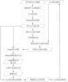
图3为本发明的实施例中的激光SLAM处理流程结构示意图。FIG. 3 is a schematic structural diagram of a laser SLAM processing flow in an embodiment of the present invention.
图4为本发明的实施例中的融合定位数据剔除输入异常数据的流程结构示意图。FIG. 4 is a schematic diagram of a flow structure of fused positioning data and eliminating input abnormal data in an embodiment of the present invention.
图5为本发明的组合导航设备测试流程结构示意图。Fig. 5 is a schematic structural diagram of the test flow of the integrated navigation device of the present invention.
为使本发明实施例的目的、技术方案和优点更加清楚,下面将结合本发明实施例中的附图,对本发明实施例中的技术方案进行清楚、完整地描述,显然,所描述的实施例是本发明一部分实施例,而不是全部的实施例。基于本发明中的实施例,本领域普通技术人员在没有作出创造性劳动前提下所获得的所有其他实施例,都属于本发明保护的范围。In order to make the purpose, technical solutions and advantages of the embodiments of the present invention clearer, the technical solutions in the embodiments of the present invention will be clearly and completely described below in conjunction with the drawings in the embodiments of the present invention. Obviously, the described embodiments It is a part of embodiments of the present invention, but not all embodiments. Based on the embodiments of the present invention, all other embodiments obtained by persons of ordinary skill in the art without creative efforts fall within the protection scope of the present invention.
结合图1-5所示,本发明提供了一种自动驾驶定位方法,包括:1-5, the present invention provides a positioning method for automatic driving, including:
输入组合导航设备的位置、速度、姿态角数据集合以及激光雷达的实时激光点云数据;Input the position, velocity, attitude angle data set of the integrated navigation device and the real-time laser point cloud data of the lidar;
组合导航的位置数据集合为P1={(x10,y10,z10),…,(x1i,y1i,z1i),…},速度数据集合为V1={(vx10,vy10,vz10),…,(vx1i,vy1i,vz1i),…},姿态角数据集合为A1={(α10,β10,γ10),…,(α1i,β1i,γ1i),…}。The position data set of integrated navigation is P1={(x10 ,y10 ,z10 ),…,(x1i ,y1i ,z1i ),…}, and the speed data set is V1={(vx10 ,vy10 ,vz10 ),…,(vx1i ,vy1i ,vz1i ),…}, the attitude angle data set is A1={(α10 ,β10 ,γ10 ),…,(α1i ,β1i ,γ1i ),...}.
将获取组合导航设备的位置、速度、姿态角数据集合经扩展卡尔曼滤波法处理;The acquired position, velocity, and attitude angle data sets of the integrated navigation equipment are processed by the extended Kalman filter method;
将获取激光雷达的实时激光点云数据经激光SLAM算法处理,再经扩展卡尔曼滤波法处理;The real-time laser point cloud data obtained from the lidar is processed by the laser SLAM algorithm, and then processed by the extended Kalman filter method;
所述实时激光点云数据经激光SLAM算法处理生成位置、航向角数据。The real-time laser point cloud data is processed by the laser SLAM algorithm to generate position and heading angle data.
激光点云数据经过激光SLAM算法处理后生成位置、航向角,激光SLAM算法使用深度学习模型来学习点云特征,输出更加准确和更强鲁棒性的定位结果,同时,将特征匹配和位姿计算的过程和实时制作点云特征地图结合在一起,减少了激光定位的计算时间,实时性更高,使得激光定位和组合导航融合的结果更加可靠。The laser point cloud data is processed by the laser SLAM algorithm to generate the position and heading angle. The laser SLAM algorithm uses the deep learning model to learn the point cloud features, and outputs more accurate and robust positioning results. At the same time, the feature matching and pose The calculation process is combined with the real-time production of point cloud feature maps, which reduces the calculation time of laser positioning and has higher real-time performance, making the fusion results of laser positioning and integrated navigation more reliable.
激光SLAM算法的处理流程如图3所示,实时激光点云数据经过剔除噪声点和离群点、点云降采样、提取PointNet特征后,生成实时点云特征图,将之进行相邻点云特征匹配,计算粗略位姿,再基于粗略位姿提取局部点云特征地图,然后经过Flann特征匹配、Ransac剔除错误点对处理后,得到正确的特征匹配点对,再基于此计算位姿变换关系,输出精确位姿,精确位姿包括位置集合P2={(x20,y20,z20),…,(x2i,y2i,z2i),…},航向角集合A2={γ20,…,γ2i,…},同时,基于 精确位姿,转换点云特征图,生成精确的点云特征图,并拼接出完整点云特征图,生成点云特征地图,已生成的点云特征地图在实时激光点云数据处理的过程中,可以与之结合直接进行提取局部点云特征地图,减少激光定位的计算时间,实时激光点云数据在进行激光SLAM算法处理的过程中,所生成的实时点云特征图可以直接进行Flann特征匹配、Ransac剔除错误点对处理,也可以直接转换点云特征图的位姿。The processing flow of the laser SLAM algorithm is shown in Figure 3. After the real-time laser point cloud data is eliminated from noise points and outliers, the point cloud is down-sampled, and PointNet features are extracted, a real-time point cloud feature map is generated, which is compared with the adjacent point cloud. Feature matching, calculate the rough pose, and then extract the local point cloud feature map based on the rough pose, and then get the correct feature matching point pair after Flann feature matching and Ransac to eliminate the wrong point pair, and then calculate the pose transformation relationship based on this , output the precise pose, which includes the position set P2={(x20 ,y20 ,z20 ),…,(x2i ,y2i ,z2i ),…}, the heading angle set A2={γ20 ,…,γ2i ,…}, at the same time, based on the precise pose, convert the point cloud feature map, generate an accurate point cloud feature map, and splicing the complete point cloud feature map to generate a point cloud feature map, the generated point cloud In the process of real-time laser point cloud data processing, the feature map can be combined with it to directly extract the local point cloud feature map, reducing the calculation time of laser positioning. The real-time laser point cloud data is generated during the process of laser SLAM algorithm processing. The real-time point cloud feature map can directly perform Flann feature matching, Ransac can eliminate wrong point pairs, and can also directly convert the pose of the point cloud feature map.
经扩展卡尔曼滤波法处理后获得融合输出定位数据,利用融合输出定位数据剔除输入的异常数据,形成闭环处理。After being processed by the extended Kalman filter method, the fusion output positioning data is obtained, and the input abnormal data is eliminated by using the fusion output positioning data to form a closed-loop processing.
经扩展卡尔曼滤波法处理后生成融合输出的位置、速度、姿态角定位数据,使用该融合输出定位数据剔除组合导航和激光SLAM定位中的异常数据,形成闭环处理。After being processed by the extended Kalman filter method, the fused output position, velocity, and attitude angle positioning data are generated, and the fused output positioning data is used to eliminate abnormal data in the integrated navigation and laser SLAM positioning to form a closed-loop processing.
采用扩展卡尔曼滤波方法,以组合导航设备的输出数据为初始值,以组合导航和激光SLAM输出的定位数据为观测量,综合输出位置集合P0={(x00,y00,z00),…,(x0i,y0i,z0i),…}、速度集合V0={(vx00、vy00、xz00),…,(vx0i,vy0i,vz0i),…}、姿态角集合A0={(α00,β00,γ00),…,(α0i,β0i,γ0i),…}。Using the extended Kalman filter method, the output data of the integrated navigation equipment is used as the initial value, and the positioning data output by the integrated navigation and laser SLAM is used as the observation quantity, and the integrated output position set P0={(x00 ,y00 ,z00 ), …,(x0i ,y0i ,z0i ),…}, velocity set V0={(vx00 ,vy00 ,xz00 ),…,(vx0i ,vy0i ,vz0i ),…}, attitude angle Set A0={(α00 ,β00 ,γ00 ),...,(α0i ,β0i ,γ0i ),...}.
以融合定位结果剔除输入异常数据的流程如图4所示,Figure 4 shows the process of eliminating input abnormal data with fusion positioning results.
比较P1、P2和P0的轨迹相似性,通过曲线相似性分析方法剔除P1和P2中的异常值,步骤如下:Compare the trajectory similarity of P1, P2 and P0, and eliminate the outliers in P1 and P2 through the curve similarity analysis method, the steps are as follows:
确认融合定位输出数据集P0的起始位置P00=(x00,y00,z00)、基于组合导航定位数据P1和激光SLAM数据P2,计算组合导航位置轨迹和激光SLAM位置轨迹中距离P00最短的位置点P10=(x10,y10,z10)和P20=(x20,y20,z20),以P10和P20作为组合导航位置轨迹和激光SLAM位置轨迹的起始点;Confirm the initial position P00 of the fusion positioning output data set P0 = (x00 , y00 , z00 ), based on the combined navigation positioning data P1 and laser SLAM data P2, calculate the distance P between the combined navigation position track and the laser SLAM position track00 The shortest position point P10 = (x10 , y10 , z10 ) and P20 = (x20 , y20 , z20 ), with P10 and P20 as the combined navigation position track and laser SLAM position track starting point;
采用线性插值的方法对P0、P1、P2进行等间隔重采样,以间隔d的采样点表示轨迹集合P0、P1、P2,分别以P0’、P1’和P2’表示,P0’={P00,P01,…,P0j,…},P1’={P10,P11,…,P1j,…},P2’={P20,P21,…,P2j,…},其中,P0j=P00+j*d,P1j=P10+j*d,P2j=P20+j*d;Use the linear interpolation method to resample P0, P1, and P2 at equal intervals, and use the sampling points at interval d to represent the trajectory sets P0, P1, and P2, which are represented by P0', P1', and P2' respectively, and P0'={P00 ,P01 ,...,P0j ,...}, P1'={P10 ,P11 ,...,P1j ,...}, P2'={P20 ,P21 ,...,P2j ,...}, where, P0j =P00 +j*d, P1j =P10 +j*d, P2j =P20 +j*d;
计算P0上各点分别和P1、P2对应点的距离DT1={dist(P00,P10),dist(P01,P11),…,dist(P0j,P1j),…}、DT2={dist(P00,P20),dist(P01,P21),…,dist(P0j,P2j),…}。设置确定距离阈值TD,记录DT1和DT2中超过TD的距离值所对应的P1’和P2’中的点,P1和P2中在这些点位置附近的点即为组合导航和激光SLAM输入的异常定位数据,剔除异常数据;Calculate the distance between each point on P0 and the corresponding point of P1 and P2 DT1={dist(P00 ,P10 ),dist(P01 ,P11 ),…,dist(P0j ,P1j ),…}, DT2 ={dist(P00 ,P20 ),dist(P01 ,P21 ),...,dist(P0j ,P2j ),...}. Set the determination distance threshold TD , record the points in P1' and P2' corresponding to the distance values exceeding TD in DT1 and DT2, and the points in P1 and P2 near these points are the combined navigation and laser SLAM input Abnormal location data, remove abnormal data;
基于融合输出的速度数据,采用曲线相似性分析方法,比较V1和V0随时间的变化趋势,剔除组合导航输入速度V1中的异常速度数据;Based on the speed data of the fusion output, the curve similarity analysis method is used to compare the change trend of V1 and V0 over time, and the abnormal speed data in the integrated navigation input speed V1 is eliminated;
基于融合输出的姿态角数据,采用曲线相似性分析方法,比较A1、A2与A0随时间的变化趋势,剔除组合导航输入姿态角A1和激光SLAM输入的姿态角A2中的异常角度数据。Based on the fusion output attitude angle data, the curve similarity analysis method is used to compare the change trend of A1, A2 and A0 over time, and the abnormal angle data in the attitude angle A1 input by integrated navigation and the attitude angle A2 input by laser SLAM are eliminated.
本发明提供了一种自动驾驶定位系统,包括:组合导航设备模块、激光雷达模块、自动驾驶控制器模块及自动驾驶定位模块,The invention provides an automatic driving positioning system, comprising: an integrated navigation equipment module, a laser radar module, an automatic driving controller module and an automatic driving positioning module,
所述组合导航设备模块,用于向所述自动驾驶定位模块提供位置、速度、姿态角数据集合;The integrated navigation device module is used to provide the position, speed and attitude angle data set to the automatic driving positioning module;
所述激光雷达模块,用于向所述自动驾驶定位模块提供实时激光点云数据;The laser radar module is used to provide real-time laser point cloud data to the automatic driving positioning module;
所述自动驾驶定位模块,用于实现自动驾驶定位方法;The automatic driving positioning module is used to realize the automatic driving positioning method;
所述自动驾驶控制器模块,用于运行所述自动驾驶定位模块。The automatic driving controller module is used to run the automatic driving positioning module.
进一步地,所述自动驾驶定位模块采取基于组合导航和激光SLAM融合技术的自动驾驶定位程序。Further, the automatic driving positioning module adopts an automatic driving positioning program based on integrated navigation and laser SLAM fusion technology.
本发明提供了一种测试方法,所述测试方法适用于上述的自动驾驶定位系统,所述测试方法包括:The present invention provides a test method, the test method is suitable for the above-mentioned automatic driving positioning system, the test method includes:
通过组合导航设备模块及自动驾驶定位功能模块的组合测试完成自动驾驶定位系统的测试。The test of the automatic driving positioning system is completed through the combined test of the integrated navigation equipment module and the automatic driving positioning function module.
组合导航设备模块的测试包括:The tests for the integrated navigation aid module include:
1、静态定位数据稳定性测试:测试组合导航设备在静止状态下的定位稳定性,统计静止状态下一段时间内位置数据的分布情况。1. Static positioning data stability test: test the positioning stability of the integrated navigation device in a static state, and count the distribution of position data in a static state for a period of time.
在车辆上安装好组合导航设备,将车辆静止停放到一空旷地带,待组合导航设备能接收到稳定的卫星信号,设备状态稳定后,记录一段时间ΔT内的接收数据,统计位置数据x、y的分布情况,计算x、y的极差、方差、标准差和协方差,通过下式计算,分析位置数据的离散程度。Install the integrated navigation equipment on the vehicle, park the vehicle in an open area, wait until the integrated navigation equipment can receive stable satellite signals, and after the equipment is in a stable state, record the received data within a period of time ΔT, and count the position data x, y According to the distribution of x and y, calculate the range, variance, standard deviation and covariance of x and y, and use the following formula to analyze the degree of dispersion of the location data.
x、y的极差:Rx=xmax-xmin,Ry=ymax-ymin,其中,xmax、xmin、ymax、ymin分别为x的最大值、x的最小值、y的最大值、y的最小值。Extreme difference of x and y: Rx =xmax -xmin , Ry =ymax -ymin , where xmax , xmin , ymax , ymin are respectively the maximum value of x, the minimum value of x, The maximum value of y, the minimum value of y.
x的方差、标准差:
y的方差、标准差:
其中,

x、y的协方差:
2、定位状态测试:测试组合导航设备在运动状态下的不同定位状态的变化。2. Positioning state test: test the changes of different positioning states of the combined navigation device in the motion state.
选定测试场地和运行轨迹,将安装有组合导航的同一车辆以不同的车速沿 着指定轨迹行驶,设备接收数据,统计固定解、浮点解、伪距解、单点解等不同定位状态下的运行轨迹,计算不同车速下不同定位状态的轨迹所占比例,分析在运动状态下组合导航设备定位的稳定性。Select the test site and running track, drive the same vehicle equipped with integrated navigation along the specified track at different speeds, the device receives data, and counts fixed solution, floating point solution, pseudorange solution, single point solution and other positioning states trajectories, calculate the proportion of trajectories in different positioning states at different vehicle speeds, and analyze the stability of the positioning of the integrated navigation device in the moving state.
3、定位精度测试:以高精度导航定位系统为基准,对比分析在相同轨道线上的组合导航设备和基准定位系统的位置误差,测试组合导航设备的定位精度。3. Positioning accuracy test: take the high-precision navigation and positioning system as the benchmark, compare and analyze the position error of the integrated navigation equipment and the reference positioning system on the same track line, and test the positioning accuracy of the integrated navigation equipment.
在空旷的测试场地中布置固定的导航轨道,安装有待测组合导航设备的车辆沿导航轨道线行驶,记录接收的定位数据集合{x,y};拆除待测组合导航设备,在同一车辆的相同位置安装高精度导航定位系统,按照同样的方式记录接收的基准定位数据集合{x0,y0},形成基准轨迹曲线R0。计算{x,y}中每个定位点到R0的距离,形成集合{d},即为定位误差,设定误差统计区间的范围,计算落入每个区间的数量,统计d的分布情况。计算{d}中的最大值dmax,最小值dmin和平均值
4、固定解切换时间测试:测试组合导航设备的固定解和非固定解的互相切换时间。4. Fixed solution switching time test: test the switching time between the fixed solution and the non-fixed solution of the integrated navigation device.
安装有待测组合导航设备的车辆以不同速度沿着指定轨迹行驶,记录接收的数据内容,记录固定解到非固定解、非固定解到固定解的时间点,并计算时间差。The vehicle installed with the integrated navigation device to be tested drives along the specified trajectory at different speeds, records the received data content, records the time points from fixed solution to non-fixed solution, and from non-fixed solution to fixed solution, and calculates the time difference.
5、冷启动时间测试:测试组合导航设备重复多次冷启动的时间的变化。5. Cold start time test: test the change in the time of repeated cold starts of the combined navigation device.
选择待测组合导航设备定位信号优良的场地,采用拔电方式关闭设备电源,等待一段时间(如,5分钟),给设备通电并接收数据,记录从通电到第一次观测有固定解的时间T。断电,再重复多次相同操作,记录时间T,计算T的最大 值、最小值、平均值、标准差。Select a site with a good positioning signal for the integrated navigation device to be tested, turn off the power of the device by unplugging the power, wait for a period of time (for example, 5 minutes), power on the device and receive data, and record the time from power on to the first observation with a fixed solution T. Power off, repeat the same operation several times, record the time T, and calculate the maximum value, minimum value, average value and standard deviation of T.
6、丢包测试:测试及分析组合导航设备的丢包率和丢包区间,包括数据对比测试和数据完整性测试。6. Packet loss test: test and analyze the packet loss rate and packet loss interval of the integrated navigation device, including data comparison test and data integrity test.
数据对比测试:安装有待测组合导航设备的车辆以不同速度沿着指定轨迹行驶,记录设备通过通讯接口发送的数据内容,对比设备内部接收记录的数据内容,分析计算不同速度时的丢包率,查看行驶轨迹中丢包的区间;Data comparison test: The vehicle installed with the integrated navigation device to be tested drives along the specified track at different speeds, records the data content sent by the device through the communication interface, compares the data content received and recorded inside the device, and analyzes and calculates the packet loss rate at different speeds , check the interval of packet loss in the driving track;
数据完整性测试:根据组合导航设备通过通讯接口发送的数据内容,统计时间连续性,检查数据自身的完整性,计算不同速度时的丢包率,查看行驶轨迹中丢包的区间。Data integrity test: According to the data content sent by the integrated navigation device through the communication interface, the time continuity is counted, the integrity of the data itself is checked, the packet loss rate at different speeds is calculated, and the packet loss interval in the driving track is checked.
自动驾驶定位功能模块的测试包括:The test of the automatic driving positioning function module includes:
(1)选择GNSS(Global Navigation Satellite System)信号优良、固定设施较完备的场地中,布置固定的导航轨道,测试自动驾驶定位精度和定位数据更新频率。(1) Select a site with excellent GNSS (Global Navigation Satellite System) signals and relatively complete fixed facilities, arrange fixed navigation tracks, and test the positioning accuracy and positioning data update frequency of automatic driving.
开启车辆自动驾驶定位模块,以不同的速度沿导航轨道线行驶,记录接收的定位数据内容和时间,计算不同速度下的数据更新频率f;然后在同一车辆上安装高精度导航定位系统,按照同样的方式记录接收的数据内容,作为基准定位数据,参照组合导航设备的定位精度测试方法,计算自动驾驶定位数据和基准数据的误差,统计误差分布情况,计算误差的最大值、最小值和平均值。Turn on the vehicle's automatic driving positioning module, drive along the navigation track at different speeds, record the content and time of the received positioning data, and calculate the data update frequency f at different speeds; then install a high-precision navigation and positioning system on the same vehicle, follow the same Record the content of the received data as the reference positioning data, refer to the positioning accuracy test method of the integrated navigation device, calculate the error between the automatic driving positioning data and the reference data, count the error distribution, and calculate the maximum value, minimum value and average value of the error .
(2)在隧道等GNSS信号遮挡区域测试自动驾驶定位精度和数据处理时间。(2) Test the positioning accuracy and data processing time of autonomous driving in GNSS signal occlusion areas such as tunnels.
在隧道中设置控制点,使用高精度测量仪器,如全站仪等,测量控制点的精确位置坐标(X0、Y0),开启车辆自动驾驶定位模块,驾驶车辆以不同的速度通过隧道,途中经过控制点,记录自动驾驶系统输出的控制点位置数据(X、Y)和时间,计算(X0、Y0)和(X、Y)的误差,分析误差随时间的变化,统计误差分 布情况,并计算误差的最大值、最小值和平均值。Set control points in the tunnel, use high-precision measuring instruments, such as total stations, etc., measure the precise position coordinates (X0, Y0) of the control points, turn on the vehicle's automatic driving positioning module, and drive the vehicle through the tunnel at different speeds. Control point, record the position data (X, Y) and time of the control point output by the automatic driving system, calculate the error of (X0, Y0) and (X, Y), analyze the change of the error over time, and calculate the distribution of the error The maximum, minimum, and average values of the error.
在自动驾驶定位模块开始接收传感器数据和输出定位数据处加上时间戳,计算输入输出数据的时间差ΔPT,记录Δτ时间内的ΔPT值,统计ΔPT的分布情况。Add a time stamp at the point where the automatic driving positioning module starts to receive sensor data and output positioning data, calculate the time difference ΔPT between input and output data, record the ΔPT value within Δτ time, and count the distribution of ΔPT.
本发明还提供了一种自动驾驶定位设备,所述设备包括:存储器、处理器及存储在所述存储器上并在所述处理器上运行的自动驾驶定位程序,所述自动驾驶定位程序配置为实现如上述中任一项所述的自动驾驶定位方法的步骤。The present invention also provides an automatic driving positioning device, which includes: a memory, a processor, and an automatic driving positioning program stored on the memory and running on the processor, the automatic driving positioning program is configured as The steps of the automatic driving positioning method as described in any one of the above are realized.
本发明还提供了一种电子存储介质,所述存储介质中存储有至少一条指令或至少一段程序,所述至少一条指令或至少一段程序由处理器加载并执行以实现如上述任一项的自动驾驶定位方法。The present invention also provides an electronic storage medium, in which at least one instruction or at least one section of program is stored, and the at least one instruction or at least one section of program is loaded and executed by a processor to realize any of the above automatic Driving positioning method.
本发明的组合导航采用的是GNSS和IMU组合导航。The integrated navigation of the present invention adopts GNSS and IMU integrated navigation.
本发明采用基于组合导航和激光SLAM相融合的实时闭环的自动驾驶定位系统,能够弥补卫星信号易受环境影响的缺陷,进一步提升组合导航的可靠性,有效提高定位精度,自动驾驶定位系统中的组合导航设备和激光SLAM输入的定位数据经扩展卡尔曼滤波处理后输出的结果数据,又会用于组合导航设备和激光SLAM输入定位数据的筛选,反向验证输入的定位数据的有效性,同时,采用基于深度学习的实时激光定位方法,输出具有高准确性和强鲁棒性的激光定位数据,使得融合定位的结果更加可靠,优化定位系统综合性能。The present invention adopts a real-time closed-loop automatic driving positioning system based on the integration of integrated navigation and laser SLAM, which can make up for the defect that satellite signals are easily affected by the environment, further improve the reliability of integrated navigation, and effectively improve the positioning accuracy. The positioning data input by the integrated navigation equipment and laser SLAM is processed by the extended Kalman filter, and the output result data will be used to screen the input positioning data of the integrated navigation equipment and laser SLAM, and reversely verify the validity of the input positioning data. , using a real-time laser positioning method based on deep learning to output laser positioning data with high accuracy and strong robustness, making the result of fusion positioning more reliable and optimizing the overall performance of the positioning system.
同时提供一种针对自动驾驶定位缺乏系统的测试方法,建立一套适用于各种组合导航设备的自动驾驶定位系统,与现有自动驾驶系统采取的系统级测试方法不同,本发明从组合导航设备测试、定位功能测试两大方面开展自动驾驶定位系统的测试,对自动驾驶定位系统进行相对全面的测试,测试操作简单,可靠性较高。At the same time, it provides a test method for the lack of a system for automatic driving positioning, and establishes a set of automatic driving positioning systems suitable for various integrated navigation devices. Different from the system-level testing methods adopted by existing automatic driving systems, the present invention starts from integrated navigation devices. The test and positioning function test are two aspects to carry out the test of the automatic driving positioning system, and conduct a relatively comprehensive test on the automatic driving positioning system. The test operation is simple and the reliability is high.
以上所述仅为本发明的实施例,并非因此限制本发明的专利范围,凡是利用本发明说明书及附图内容所作的等效结构或等效流程变换,或直接或间接运用在其他相关的技术领域,均同理包括在本发明的专利保护范围内。The above is only an embodiment of the present invention, and does not limit the patent scope of the present invention. Any equivalent structure or equivalent process transformation made by using the description of the present invention and the contents of the accompanying drawings, or directly or indirectly used in other related technologies fields, are all included in the scope of patent protection of the present invention in the same way.
Claims (10)
Translated fromChinesePriority Applications (1)
| Application Number | Priority Date | Filing Date | Title |
|---|---|---|---|
| US18/701,031US20240411033A1 (en) | 2021-11-19 | 2022-08-11 | Automatic driving positioning method and system, testing method, device, and storage medium |
Applications Claiming Priority (2)
| Application Number | Priority Date | Filing Date | Title |
|---|---|---|---|
| CN202111374084.1ACN114061596B (en) | 2021-11-19 | 2021-11-19 | Automatic driving positioning method, system, testing method, equipment and storage medium |
| CN202111374084.1 | 2021-11-19 |
Publications (1)
| Publication Number | Publication Date |
|---|---|
| WO2023087802A1true WO2023087802A1 (en) | 2023-05-25 |
Family
ID=80278325
Family Applications (1)
| Application Number | Title | Priority Date | Filing Date |
|---|---|---|---|
| PCT/CN2022/111845CeasedWO2023087802A1 (en) | 2021-11-19 | 2022-08-11 | Automatic driving positioning method and system, testing method, device, and storage medium |
Country Status (3)
| Country | Link |
|---|---|
| US (1) | US20240411033A1 (en) |
| CN (1) | CN114061596B (en) |
| WO (1) | WO2023087802A1 (en) |
Cited By (1)
| Publication number | Priority date | Publication date | Assignee | Title |
|---|---|---|---|---|
| CN117570973A (en)* | 2023-11-17 | 2024-02-20 | 中科智驰(安庆)智能科技有限公司 | Fusion positioning system and method for multi-scene unmanned vehicle |
Families Citing this family (9)
| Publication number | Priority date | Publication date | Assignee | Title |
|---|---|---|---|---|
| CN114061596B (en)* | 2021-11-19 | 2024-03-22 | 北京国家新能源汽车技术创新中心有限公司 | Automatic driving positioning method, system, testing method, equipment and storage medium |
| CN114777813B (en)* | 2022-04-20 | 2025-06-06 | 智道网联科技(北京)有限公司 | Method, device and electronic equipment for evaluating fusion positioning accuracy of autonomous driving vehicle |
| CN115166786A (en)* | 2022-05-27 | 2022-10-11 | 湖北星纪时代科技有限公司 | GNSS automatic simulation playback test method, device, system, storage medium and electronic equipment |
| CN115307628A (en)* | 2022-07-25 | 2022-11-08 | 和芯星通科技(北京)有限公司 | Map information simulation method, device and storage medium for integrated navigation positioning platform |
| CN115220058B (en)* | 2022-07-28 | 2025-06-27 | 智道网联科技(北京)有限公司 | Fusion positioning method, device and electronic equipment for autonomous driving vehicle |
| CN115164943B (en)* | 2022-09-08 | 2022-12-23 | 国网瑞嘉(天津)智能机器人有限公司 | Testing method, device, electronic equipment and storage medium of positioning equipment |
| CN119642858A (en)* | 2024-12-09 | 2025-03-18 | 东风汽车集团股份有限公司 | Test method for integrated navigation function and related equipment |
| CN119359796B (en)* | 2024-12-25 | 2025-05-02 | 杭州海康威视数字技术股份有限公司 | A method for determining posture and electronic equipment |
| CN120427014A (en)* | 2025-07-04 | 2025-08-05 | 兰州工业学院 | Fusion positioning method and system for automatic driving vehicle |
Citations (8)
| Publication number | Priority date | Publication date | Assignee | Title |
|---|---|---|---|---|
| CN104076382A (en)* | 2014-07-22 | 2014-10-01 | 中国石油大学(华东) | Seamless vehicle positioning method based on multi-source information fusion |
| CN111412929A (en)* | 2020-04-26 | 2020-07-14 | 东风汽车集团有限公司 | A method for evaluating the performance of combined inertial navigation based on high-precision maps |
| CN111561923A (en)* | 2020-05-19 | 2020-08-21 | 北京数字绿土科技有限公司 | SLAM (simultaneous localization and mapping) mapping method and system based on multi-sensor fusion |
| CN112362051A (en)* | 2020-10-16 | 2021-02-12 | 无锡卡尔曼导航技术有限公司 | GNSS/INS/LIDAR-SLAM information fusion-based mobile robot navigation positioning system |
| AU2020104248A4 (en)* | 2020-12-22 | 2021-03-11 | Mohanan, Murali MR | Integrated gps and inertial navigation system for industrial robots |
| CN112946681A (en)* | 2021-05-17 | 2021-06-11 | 知行汽车科技(苏州)有限公司 | Laser radar positioning method fusing combined navigation information |
| CN113029137A (en)* | 2021-04-01 | 2021-06-25 | 清华大学 | Multi-source information self-adaptive fusion positioning method and system |
| CN114061596A (en)* | 2021-11-19 | 2022-02-18 | 北京国家新能源汽车技术创新中心有限公司 | Automatic driving positioning method, system, test method, device and storage medium |
Family Cites Families (11)
| Publication number | Priority date | Publication date | Assignee | Title |
|---|---|---|---|---|
| US7117075B1 (en)* | 2005-08-15 | 2006-10-03 | Report On Board Llc | Driver activity and vehicle operation logging and reporting |
| CN104898139A (en)* | 2014-03-07 | 2015-09-09 | 中兴通讯股份有限公司 | Vehicle positioning excursion-correcting method and device |
| WO2019018315A1 (en)* | 2017-07-17 | 2019-01-24 | Kaarta, Inc. | Aligning measured signal data with slam localization data and uses thereof |
| CN107621271A (en)* | 2017-10-20 | 2018-01-23 | 北京航天控制仪器研究所 | A kind of inertial platform real-time testing system and method for testing |
| JP7455851B2 (en)* | 2018-10-16 | 2024-03-26 | ファイブ、エーアイ、リミテッド | Autonomous vehicle planning and forecasting |
| US10960894B2 (en)* | 2018-12-13 | 2021-03-30 | Waymo Llc | Automated performance checks for autonomous vehicles |
| US20200409369A1 (en)* | 2019-06-25 | 2020-12-31 | Uatc, Llc | System and Methods for Autonomous Vehicle Testing |
| CN110781069B (en)* | 2019-08-28 | 2022-05-20 | 腾讯科技(深圳)有限公司 | Positioning module testing method, device and equipment for automatic driving vehicle |
| CN110849362B (en)* | 2019-11-28 | 2022-01-04 | 湖南率为控制科技有限公司 | Laser radar and vision combined navigation algorithm based on vehicle-mounted inertia |
| CN112557058B (en)* | 2020-12-10 | 2023-12-05 | 清华大学苏州汽车研究院(吴江) | Automatic driving test system |
| CN113375666B (en)* | 2021-06-23 | 2022-12-27 | 北京超星未来科技有限公司 | Sensor fusion positioning system and method |
- 2021
- 2021-11-19CNCN202111374084.1Apatent/CN114061596B/enactiveActive
- 2022
- 2022-08-11USUS18/701,031patent/US20240411033A1/enactivePending
- 2022-08-11WOPCT/CN2022/111845patent/WO2023087802A1/ennot_activeCeased
Patent Citations (8)
| Publication number | Priority date | Publication date | Assignee | Title |
|---|---|---|---|---|
| CN104076382A (en)* | 2014-07-22 | 2014-10-01 | 中国石油大学(华东) | Seamless vehicle positioning method based on multi-source information fusion |
| CN111412929A (en)* | 2020-04-26 | 2020-07-14 | 东风汽车集团有限公司 | A method for evaluating the performance of combined inertial navigation based on high-precision maps |
| CN111561923A (en)* | 2020-05-19 | 2020-08-21 | 北京数字绿土科技有限公司 | SLAM (simultaneous localization and mapping) mapping method and system based on multi-sensor fusion |
| CN112362051A (en)* | 2020-10-16 | 2021-02-12 | 无锡卡尔曼导航技术有限公司 | GNSS/INS/LIDAR-SLAM information fusion-based mobile robot navigation positioning system |
| AU2020104248A4 (en)* | 2020-12-22 | 2021-03-11 | Mohanan, Murali MR | Integrated gps and inertial navigation system for industrial robots |
| CN113029137A (en)* | 2021-04-01 | 2021-06-25 | 清华大学 | Multi-source information self-adaptive fusion positioning method and system |
| CN112946681A (en)* | 2021-05-17 | 2021-06-11 | 知行汽车科技(苏州)有限公司 | Laser radar positioning method fusing combined navigation information |
| CN114061596A (en)* | 2021-11-19 | 2022-02-18 | 北京国家新能源汽车技术创新中心有限公司 | Automatic driving positioning method, system, test method, device and storage medium |
Cited By (2)
| Publication number | Priority date | Publication date | Assignee | Title |
|---|---|---|---|---|
| CN117570973A (en)* | 2023-11-17 | 2024-02-20 | 中科智驰(安庆)智能科技有限公司 | Fusion positioning system and method for multi-scene unmanned vehicle |
| CN117570973B (en)* | 2023-11-17 | 2024-04-26 | 中科智驰(安庆)智能科技有限公司 | Fusion positioning system and method for multi-scene unmanned vehicle |
Also Published As
| Publication number | Publication date |
|---|---|
| CN114061596A (en) | 2022-02-18 |
| CN114061596B (en) | 2024-03-22 |
| US20240411033A1 (en) | 2024-12-12 |
Similar Documents
| Publication | Publication Date | Title |
|---|---|---|
| WO2023087802A1 (en) | Automatic driving positioning method and system, testing method, device, and storage medium | |
| CN113447033B (en) | Lane-level map matching method and system | |
| CN109444932B (en) | Vehicle positioning method and device, electronic equipment and storage medium | |
| CN109343095B (en) | Vehicle-mounted navigation vehicle combined positioning device and combined positioning method thereof | |
| CN113310487B (en) | A combined navigation method and device for a ground-oriented mobile robot | |
| CN114923492B (en) | Positioning information determination method, device, electronic device and storage medium | |
| CN113085901B (en) | Unmanned vehicle control method and device, electronic equipment and storage medium | |
| CN102980589A (en) | Method and device for automatically computing vehicle pulse factor via GPS (global positioning system) speed | |
| CN109470276A (en) | Odometer calibration method and device based on zero-speed correction | |
| WO2023029367A1 (en) | Vehicle positioning method, vehicle-mounted uwb device, roadside uwb device and medium | |
| CN106153037B (en) | Indoor positioning method, device and system for a robot | |
| CN110906941B (en) | Automatic driving map construction method and system for long-distance tunnel | |
| CN110728309B (en) | A traffic trajectory clustering method based on railway signal and Beidou positioning | |
| CN104406592B (en) | A kind of correction of navigation system and attitude angle and backtracking decoupling method for underwater glider | |
| CN116734880A (en) | Unmanned positioning method and device for vehicle | |
| CN113138399A (en) | Unmanned aerial vehicle track tracking identification method based on machine learning | |
| CN114889606A (en) | A low-cost and high-precision positioning method based on multi-sensor fusion | |
| CN109737954A (en) | A kind of inertial navigation method based on speed and angular speed | |
| CN111583645B (en) | Quality evaluation method, device, server and medium for vehicle cooperative driving | |
| CN110497906B (en) | Vehicle control method, device, device and medium | |
| CN117152267B (en) | A vehicle speed estimation method based on GNSS and monocular camera extrinsic calibration | |
| CN107092253A (en) | Method, device and server for controlling unmanned vehicle | |
| CN113406642B (en) | Rail obstacle identification method based on millimeter wave radar | |
| CN115639826A (en) | Robot driving track deviation rectifying method and system | |
| CN111288942B (en) | Track transponder position measuring method and device and computer equipment |
Legal Events
| Date | Code | Title | Description |
|---|---|---|---|
| 121 | Ep: the epo has been informed by wipo that ep was designated in this application | Ref document number:22894345 Country of ref document:EP Kind code of ref document:A1 | |
| NENP | Non-entry into the national phase | Ref country code:DE | |
| 122 | Ep: pct application non-entry in european phase | Ref document number:22894345 Country of ref document:EP Kind code of ref document:A1 |