WO2021218131A1 - Route planning method and device, apparatus, and computer storage medium - Google Patents
Route planning method and device, apparatus, and computer storage mediumDownload PDFInfo
- Publication number
- WO2021218131A1 WO2021218131A1PCT/CN2020/131304CN2020131304WWO2021218131A1WO 2021218131 A1WO2021218131 A1WO 2021218131A1CN 2020131304 WCN2020131304 WCN 2020131304WWO 2021218131 A1WO2021218131 A1WO 2021218131A1
- Authority
- WO
- WIPO (PCT)
- Prior art keywords
- road
- road section
- route
- time
- traffic flow
- Prior art date
- Legal status (The legal status is an assumption and is not a legal conclusion. Google has not performed a legal analysis and makes no representation as to the accuracy of the status listed.)
- Ceased
Links
Images


Classifications
- G—PHYSICS
- G08—SIGNALLING
- G08G—TRAFFIC CONTROL SYSTEMS
- G08G1/00—Traffic control systems for road vehicles
- G08G1/01—Detecting movement of traffic to be counted or controlled
- G08G1/0104—Measuring and analyzing of parameters relative to traffic conditions
- G08G1/0125—Traffic data processing
- G08G1/0129—Traffic data processing for creating historical data or processing based on historical data
- G—PHYSICS
- G01—MEASURING; TESTING
- G01C—MEASURING DISTANCES, LEVELS OR BEARINGS; SURVEYING; NAVIGATION; GYROSCOPIC INSTRUMENTS; PHOTOGRAMMETRY OR VIDEOGRAMMETRY
- G01C21/00—Navigation; Navigational instruments not provided for in groups G01C1/00 - G01C19/00
- G01C21/26—Navigation; Navigational instruments not provided for in groups G01C1/00 - G01C19/00 specially adapted for navigation in a road network
- G01C21/34—Route searching; Route guidance
- G01C21/3453—Special cost functions, i.e. other than distance or default speed limit of road segments
- G01C21/3492—Special cost functions, i.e. other than distance or default speed limit of road segments employing speed data or traffic data, e.g. real-time or historical
- G—PHYSICS
- G01—MEASURING; TESTING
- G01C—MEASURING DISTANCES, LEVELS OR BEARINGS; SURVEYING; NAVIGATION; GYROSCOPIC INSTRUMENTS; PHOTOGRAMMETRY OR VIDEOGRAMMETRY
- G01C21/00—Navigation; Navigational instruments not provided for in groups G01C1/00 - G01C19/00
- G01C21/26—Navigation; Navigational instruments not provided for in groups G01C1/00 - G01C19/00 specially adapted for navigation in a road network
- G01C21/34—Route searching; Route guidance
- G01C21/36—Input/output arrangements for on-board computers
- G01C21/3667—Display of a road map
- G01C21/3676—Overview of the route on the road map
- G—PHYSICS
- G01—MEASURING; TESTING
- G01C—MEASURING DISTANCES, LEVELS OR BEARINGS; SURVEYING; NAVIGATION; GYROSCOPIC INSTRUMENTS; PHOTOGRAMMETRY OR VIDEOGRAMMETRY
- G01C21/00—Navigation; Navigational instruments not provided for in groups G01C1/00 - G01C19/00
- G01C21/26—Navigation; Navigational instruments not provided for in groups G01C1/00 - G01C19/00 specially adapted for navigation in a road network
- G01C21/34—Route searching; Route guidance
- G01C21/36—Input/output arrangements for on-board computers
- G01C21/3691—Retrieval, searching and output of information related to real-time traffic, weather, or environmental conditions
- G—PHYSICS
- G08—SIGNALLING
- G08G—TRAFFIC CONTROL SYSTEMS
- G08G1/00—Traffic control systems for road vehicles
- G08G1/01—Detecting movement of traffic to be counted or controlled
- G08G1/0104—Measuring and analyzing of parameters relative to traffic conditions
- G08G1/0125—Traffic data processing
- G08G1/0133—Traffic data processing for classifying traffic situation
- G—PHYSICS
- G08—SIGNALLING
- G08G—TRAFFIC CONTROL SYSTEMS
- G08G1/00—Traffic control systems for road vehicles
- G08G1/01—Detecting movement of traffic to be counted or controlled
- G08G1/0104—Measuring and analyzing of parameters relative to traffic conditions
- G08G1/0137—Measuring and analyzing of parameters relative to traffic conditions for specific applications
- G08G1/0141—Measuring and analyzing of parameters relative to traffic conditions for specific applications for traffic information dissemination
- G—PHYSICS
- G08—SIGNALLING
- G08G—TRAFFIC CONTROL SYSTEMS
- G08G1/00—Traffic control systems for road vehicles
- G08G1/09—Arrangements for giving variable traffic instructions
- G08G1/0962—Arrangements for giving variable traffic instructions having an indicator mounted inside the vehicle, e.g. giving voice messages
- G08G1/0968—Systems involving transmission of navigation instructions to the vehicle
- G08G1/096805—Systems involving transmission of navigation instructions to the vehicle where the transmitted instructions are used to compute a route
- G08G1/096811—Systems involving transmission of navigation instructions to the vehicle where the transmitted instructions are used to compute a route where the route is computed offboard
- G—PHYSICS
- G08—SIGNALLING
- G08G—TRAFFIC CONTROL SYSTEMS
- G08G1/00—Traffic control systems for road vehicles
- G08G1/09—Arrangements for giving variable traffic instructions
- G08G1/0962—Arrangements for giving variable traffic instructions having an indicator mounted inside the vehicle, e.g. giving voice messages
- G08G1/0968—Systems involving transmission of navigation instructions to the vehicle
- G08G1/096833—Systems involving transmission of navigation instructions to the vehicle where different aspects are considered when computing the route
- G08G1/096844—Systems involving transmission of navigation instructions to the vehicle where different aspects are considered when computing the route where the complete route is dynamically recomputed based on new data
- G—PHYSICS
- G08—SIGNALLING
- G08G—TRAFFIC CONTROL SYSTEMS
- G08G1/00—Traffic control systems for road vehicles
- G08G1/01—Detecting movement of traffic to be counted or controlled
- G08G1/0104—Measuring and analyzing of parameters relative to traffic conditions
- G08G1/0108—Measuring and analyzing of parameters relative to traffic conditions based on the source of data
- G08G1/012—Measuring and analyzing of parameters relative to traffic conditions based on the source of data from other sources than vehicle or roadside beacons, e.g. mobile networks
Definitions
- This applicationrelates to the field of computer application technology, in particular to the field of big data technology.
- Path planninghas been widely used in map applications that include navigation functions. It can provide users with rich display results of route recommendations, congestion conditions, and estimated time of arrival.
- current navigation systemscan only plan routes for users based on the current quasi-real-time status.
- the planned routemay pass through some high-risk road sections with high possibility of congestion and high probability of accidents, resulting in users not being able to reach the destination at the planned time.
- this applicationprovides a route planning method, device, equipment, and computer storage medium, so as to improve the quality of the planned route and user experience.
- this applicationprovides a route planning method, which includes:
- the present applicationprovides a route planning device, which includes:
- the data acquisition unitis used to acquire real-time traffic flow characteristic data of the road network
- the risk prediction unitis configured to use the real-time traffic flow characteristic data of the road network to predict the state change risk of each road section in the road network, and obtain the state change risk information of each road section;
- the route planning unitis used for route planning using the state change risk information of each road section.
- this applicationprovides an electronic device, including:
- At least one processorAt least one processor
- a memorycommunicatively connected with the at least one processor; wherein,
- the memorystores instructions executable by the at least one processor, and the instructions are executed by the at least one processor, so that the at least one processor can execute the method according to any one of the above.
- the present applicationprovides a non-transitory computer-readable storage medium storing computer instructions for causing the computer to execute the method described in any of the above.
- this applicationincorporates the consideration of the state change risk of each road section into the route planning, so that the planned route considers the state change risk that users may face when passing through each road section from a global perspective, thereby improving the quality of the planned route And user experience.
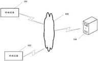
- Figure 1shows an exemplary system architecture to which embodiments of the present invention can be applied
- Figure 2is a flowchart of a method provided by an embodiment of the application.
- FIG. 3is a schematic structural diagram of a congestion state prediction model provided by an embodiment of the application.
- Fig. 4is a schematic structural diagram of an accident prediction model provided by an embodiment of the application.
- FIG. 5is an example diagram of a display interface of a recommended route provided by an embodiment of the application.
- FIG. 6is a structural diagram of an apparatus provided by an embodiment of the application.
- Fig. 7is a block diagram of an electronic device used to implement the route planning method of an embodiment of the present application.
- Figure 1shows an exemplary system architecture to which embodiments of the present invention can be applied.
- the system architecturemay include terminal devices 101 and 102, a network 103 and a server 104.
- the network 103is used to provide a medium for communication links between the terminal devices 101 and 102 and the server 104.
- the network 103may include various connection types, such as wired, wireless communication links, or fiber optic cables, and so on.
- the usercan use the terminal devices 101 and 102 to interact with the server 104 through the network 103.
- Various applicationsmay be installed on the terminal devices 101 and 102, such as map applications, voice interaction applications, web browser applications, and communication applications.
- the terminal devices 101 and 102may be various electronic devices that can support and display map applications, including but not limited to smart phones, tablet computers, smart wearable devices, and so on.
- the device provided by the present inventioncan be set up and run in the server 104 mentioned above. It can be implemented as multiple software or software modules (for example, to provide distributed services), or as a single software or software module, which is not specifically limited here.
- the route planning deviceis set up and running in the above-mentioned server 104.
- the server 104can collect and maintain in advance the user trajectory data uploaded by various terminal devices (including 101 and 102) during the use of map applications, and the data uploaded through various traffic sensors. Traffic flow data, these data can constitute the traffic flow characteristic data of the road network.
- the route planning deviceuses the method provided in the embodiment of the present invention to perform route planning.
- the route planning device set up and running in the server 104can plan the route, and the route planning result can be returned to the terminal device 101 or 102 .
- the server 104may be a single server or a server group composed of multiple servers. It should be understood that the numbers of terminal devices, networks, and servers in FIG. 1 are merely illustrative. There can be any number of terminal devices, networks, and servers according to implementation needs.
- the core idea of this applicationis to integrate the consideration of the state change risk of each road section into the route planning, so that the planned route considers the state change risk that the user may face when passing through each road section from a global perspective, thereby improving the quality of the planned route And user experience.
- the method and device provided in this applicationwill be described in detail below in conjunction with embodiments.
- Fig. 2is a flow chart of the method provided by an embodiment of the application. As shown in Fig. 2, the method may include the following steps:
- the time segmentation of the preset durationmay be used as the period to obtain the real-time traffic flow characteristic data of the current time segmentation of the road network, which can be used to determine the state change risk coefficient of each road segment in the subsequent steps to proceed with the route.
- planningFor example, taking a 5-minute time slice as an example, the real-time traffic flow characteristic data of the road network is obtained every 5 minutes.
- the acquired traffic flow characteristic datamay include one or any combination of traffic flow statistics, speed data, and rapid deceleration times of each road section.
- the traffic flow statisticsare mainly aimed at the statistics of traffic flow.
- the speed datamay include at least one of such as average speed, median speed, fastest speed, slowest speed, and the like.
- the number of rapid decelerationsmay be the number of rapid decelerations that occur when the vehicle is traveling on a road section.
- the so-called rapid decelerationmay be that the magnitude of the speed reduction per unit time exceeds a preset threshold.
- the real-time traffic flow characteristic data of the road networkis used to predict the state change risk of each road section in the road network, and obtain state change risk information of each road section.
- the state change risk prediction for each road section in this applicationmay include at least one of congestion state change prediction, accident occurrence prediction, trafficability prediction, traffic rule change prediction, and road quality degradation prediction.
- congestion state change predictionmay include at least one of congestion state change prediction, accident occurrence prediction, trafficability prediction, traffic rule change prediction, and road quality degradation prediction.
- a congestion state prediction modelcan be used to predict changes in the congestion state.
- the congestion state prediction modelcan output the predicted travel time of each road section in the future when the real-time traffic flow feature data of the current road network, the road attribute feature data, and the future environmental feature data are input.
- the congestion state prediction model in this applicationmainly includes GCN (Graph Convolutional Network, Graph Convolutional Network) and a fully connected layer.
- the training datacan be obtained from the historical information of each road section in the road network.
- Each piece of training datamay include four pieces of data: traffic flow characteristic data of the first time slice in the history, road attribute characteristic data, and environmental characteristic data and average travel time of the second time slice in the history.
- the second time sliceis a future time slice relative to the first time slice.
- the second time slicemay be the first time slice, the second time slice, the third time slice, the fourth time slice, and so on after the first time slice.
- the "first”, "second” and other limitations involved in the embodiments of this applicationare only for distinguishing two time slices in name, and do not have limitations on the meaning of order, number, importance, etc. .
- the congestion state prediction model trained with the training datais used to predict after 5 minutes The risk of changes in the congestion status of the road section. If the second time slice is the second time slice after the first time slice, the congestion state prediction model trained with this training data is used to predict the risk of road congestion state change after 10 minutes.
- multiple congestion state prediction modelscan be established to predict the congestion state change risks of different time segments in the future.
- the traffic flow characteristic data of the first time segmentmay include traffic flow statistics, speed data, and the number of rapid decelerations of the road segment in the first time segment.
- the road attribute feature datamay include information such as the length of the road section and the road grade.
- the environmental feature data of the second time slicemay include information such as weather, time, whether it is a holiday, and season corresponding to the road segment in the second time slice. For the convenience of calculation, these characteristic data can be expressed in the form of discrete values.
- the traffic flow characteristic data of the first time slice of the history of the road segmentis encoded.
- GCNcan be used to construct the association relationship, and the vector representation and the road network link relationship matrix obtained after encoding are input into the GCN.
- the GCN output vector representationcan be spliced with road attribute feature data and environmental feature data of the historical second time slice and then input to the fully connected layer.
- the fully connected layerobtains the predicted travel time of the road segment in the historical second time slice.
- the training goalis to minimize the difference between the predicted travel time of the road segment and the average travel time of the road segment in the training data, that is, to minimize the prediction error.
- the congestion state change of each road segment in the future time slicecan be determined. For example, if the predicted travel time obtained by prediction is longer than the historical average travel time of the same period, and the amplitude exceeds the preset amplitude threshold, it can be considered that congestion has occurred. Different amplitude thresholds can also be set to distinguish different degrees of congestion.
- an accident prediction modelcan be used to predict whether an accident will occur.
- the accident prediction modelcan input the traffic flow characteristic data of the road network corresponding to the current time slice, the road attribute characteristic data and the environmental characteristic data of the future time slice, and output whether each road segment occurs in the future time slice. Forecast of accidents.
- the accident prediction modelmainly includes GCN and a fully connected layer.
- the training datacan be obtained from the historical information of each road segment in the road network.
- Each piece of training datacan include four pieces of data: traffic flow characteristic data of the first time slice of the road segment, road attribute characteristic data, and historical second time slice The environmental characteristic data of the road section and the information about whether an accident occurred in the second time slice in the history.
- the second time sliceis a future time slice relative to the first time slice.
- the traffic flow characteristic data of the first historical time segmentmay include traffic flow statistics, speed data, and the number of rapid decelerations of the road sections in the historical first time segment.
- the road attribute feature datamay include information such as the length of the road section and the road grade.
- the environmental characteristic datamay include information such as weather, time, whether it is a holiday, season, etc. corresponding to the second time segment of the road section. For the convenience of calculation, these characteristic data can be expressed in the form of discrete values.
- the traffic flow characteristic data of the first time slice of the history of the road segmentis encoded.
- GCNcan be used to construct the association relationship, and the vector representation and the road network link relationship matrix obtained after encoding are input into the GCN.
- the vector representation output by GCNcan be spliced with road attribute feature data and environmental feature data of the historical second time slice and then input to the fully connected layer, and the fully connected layer obtains the prediction of whether an accident occurs on the road segment in the second time slice.
- the fully connected layercan specifically output the probability of an accident on the road section, and determine whether an accident occurs based on whether the probability is higher than a preset probability threshold. For example, if the probability is higher than the preset probability threshold, it is determined that an accident has occurred.
- the training goalis to make the prediction results of each road section consistent with the training data, that is, to minimize the prediction error.
- the real-time traffic flow feature data of each road segment in the road network corresponding to the current time sliceis encoded, and then the encoded
- the vector representation and the road network link relationship matrixis input to the GCN, and the GCN output vector representation is spliced with road attribute feature data and future time-sliced environmental feature data and then input to the fully connected layer.
- the fully connected layerobtains the road segment in the above-mentioned future The prediction of whether an accident occurs in the time slice.
- the fully connected layercan output the probability of an accident on a road section, and determine whether an accident occurs according to whether the probability is higher than a preset probability threshold. For example, if the probability is higher than the preset probability threshold, it is determined that an accident has occurred.
- the trafficability prediction made in this applicationis to predict whether the road section is trafficable, rather than blocking it due to various factors.
- the factors that cause the road section to be impassable or blockedcan be, for example, road repairs, road closures, blockages caused by other projects, etc. This application does not impose restrictions on this.
- GCNis not used for prediction, but a classifier is directly used for modeling prediction.
- the current flow characteristics of each road sectionare obtained, and the flow characteristics may include the traffic flow of the road section, the traffic flow of the preceding road section, and the traffic flow of the subsequent road section.
- the traffic flowmainly refers to the traffic flow.
- the traffic flow of the preceding road sectionmay be the average traffic flow of multiple preceding road sections
- the traffic flow of the subsequent road sectionmay be the average traffic flow of multiple subsequent road sections.
- the historical traffic characteristicmay be a historical traffic characteristic belonging to the same time segment as the current one. For example, assuming that the current time is 10:01, the traffic characteristic data of the time slice from 10:00 to 10:05 in history can be obtained.
- the historical flow characteristicmay also be the average flow characteristic of a certain historical time interval. For example, the average traffic characteristics of the week or month before yesterday.
- the characteristics and road attribute characteristics obtained after the difference between the current flow characteristics and the historical flow characteristics of the same road sectionare input into the trafficability prediction model to obtain a prediction of whether the road section is trafficable.
- the feasibility prediction modelcan be obtained by pre-training based on a classifier, where the classifier can be a two-classifier such as SVM (Support Vector Machine, Support Vector Machine).
- SVMSmall Vector Machine, Support Vector Machine
- the outputcan be the probability that the road section is impassable, and the probability is used to determine whether the road section is impassable. For example, if the probability of impassability is higher than the preset probability threshold, it is determined that the road section is impassable.
- the traffic characteristics of the corresponding time segment and the historical traffic characteristics of the time segment when the road segment is passablecan be obtained, as well as the high traffic volume and the time segment corresponding to the time segment when the road segment is impassable.
- Historical traffic characteristicsare used as training data.
- the characteristics obtained after the difference between the two traffic characteristics and the road attribute characteristics of the same road sectionare input to the classifier, and the classifier outputs the classification result of whether the road section is passable. Train the classifier until it reaches the training goal.
- the training targetis that the classification result of the classifier is consistent with the information of whether the road section in the training data is passable.
- the traffic rule changes involved in this applicationmainly include steering bans. For example, it is forbidden to go straight, turn left, turn right, turn around, and so on. In this application, it is possible to find out whether there is a traffic rule change on the road section by observing the difference between the front and back trajectories of the road section.
- the current traffic flow ratiofrom the previous road section on each road section, and obtain the historical traffic flow ratio from the previous road section on each road section. If the current high traffic flow ratio of the road segment is lower than the historical flow ratio, the reduction degree exceeds the preset ratio threshold, then it is predicted that there is a traffic rule change on the road segment.
- the road section Bis passed through the road section A, and then the road section A is the preceding road section of the road section B.
- the historical flow ratemay be the average flow rate in a certain historical time interval. For example, the average traffic characteristics of the week or month before yesterday.
- the absolute value of the traffic flow of the road sectioncan also be further combined, that is, it is necessary to meet the traffic flow of the road section compared to the historical traffic flow and the degree of decline exceeds the preset threshold. It is predicted that there will be traffic rule changes in this section.
- Road quality degradation predictionis mainly to predict whether the road quality of the road section will be worse than before.
- the factors for the deterioration of the route qualitycan be bumps caused by road damage, pedestrians walking at will, illegal parking, gradient changes, new obstacles, etc., which are not limited by this application.
- the speed datacan include, for example, the median and average of the track point speed.
- each road section and historical speed data and the number of rapid decelerationsobtain each road section and historical speed data and the number of rapid decelerations. If the current speed data of the road segment has a significant speed drop compared to the historical speed data, for example, the speed drop exceeds the preset speed threshold, and the current rapid deceleration times and the historical rapid deceleration times have a significant increase, for example, the increase degree exceeds the preset number threshold , It is predicted that the road quality degradation of the road section will occur.
- the aforementioned historical speed datamay be historical speed data belonging to the same time segment as the current one. For example, assuming that the current time is 10:01, the historical speed data of the time slices from 10:00 to 10:05 in history can be obtained.
- the historical speed datamay also be average speed data in a certain historical time interval. For example, the average traffic characteristics of the week or month before yesterday.
- the corresponding risk coefficients of the various predictions of the road sectionscan be obtained according to the various prediction results; then the risk coefficients corresponding to the various predictions obtained for each road section are respectively weighted to obtain the state change of each road section Risk factor.
- the congestion state change risk coefficient R 1 of the road section iis determined. The greater the difference between the predicted travel time and the historical average travel time, the greater the value of R 1.
- the accident risk coefficient R 2 of the road section iis determined. Probability example, if the predicted link i accident, it can be predicted based on the determined road accident i R 2, the greater the probability value, R 2 increases. You can also simply set the value of R 2 to be 1 when an accident occurs, and 0 to the value of R 2 when no accident occurs.
- the trafficability risk coefficient R 3 of the road section iis determined. For example, if a road section is predicted to be impassable, R 3 can be determined according to the predicted probability that the road section is impassable. The greater the probability value, the greater the value of R 3 . It may be simply set when impassable, R 3 take the value 1, when accessible, R 3 take the value 0.
- R 4determines the traffic rule change risk coefficient R 4 of the road section i. For example, if it is predicted that there will be a traffic rule change in a road section, R 4 can be determined according to the degree of decrease in the proportion of traffic. The greater the degree of decrease, the greater the value of R 4. May be simply set the traffic regulation changes, R 4 takes the value 1, no change in traffic rules, R 4 takes the value 0.
- the trafficability risk coefficient R 5 of the road section iis determined. For example, if it is predicted that the road quality of the road section is degraded, R 5 is determined according to the degree of decrease in speed and/or the degree of increase in the number of rapid decelerations. The greater the decrease in speed, the greater the value of R 5 ; the greater the increase in the number of rapid decelerations, the greater the value of R 5. It is also possible to simply set the road quality degradation of the road section, the value of R 5 is 1, if no road quality degradation occurs, the value of R 5 is 0.
- weighting coefficients ⁇ 1 , ⁇ 2 , ⁇ 3 , ⁇ 4 and ⁇ 5may be manually set empirical values or experimental values.
- a similar methodcan be used to determine the state change risk coefficient of each section of the road network.
- route planningis performed using the state change risk information of each road section.
- the route planning productall the road sections on the road network will be built according to the interconnection relationship with each other to establish a network topology map, the nodes in the topological map are intersections, and the edges are road sections.
- weightsare assigned to each edge on the graph based on static road network attributes and real-time road condition information. In other words, each road segment is given a weight.
- the route search processthe road sections with higher weights are preferentially selected for the selectable road sections.
- the candidate routes foundconsider one or any combination of multiple dimensions such as travel time, distance, number of red street lights, and road grades to sort the candidate routes, and finally determine the recommended route to the user.
- This applicationcan incorporate the status change risk information of the road segment in the route search process, or it can integrate the status change risk information of the road segment in the candidate route sorting process, or it can also integrate the road segment risk information in the route search and candidate route sorting process. Status change information.
- the updated link weight weight i_newis:
- Weight iis the original weight of the road section, and ⁇ all is the weighting coefficient, which can usually be set to a negative value.
- the specific valuecan be manually set to an empirical value or an experimental value.
- route searchis performed on the start position and the end position input by the user to obtain at least one candidate route.
- the estimated time to reach each road sectionis determined, and then the state change risk estimation of the road section at the time segment of the estimated time is used. How to determine the estimated time to reach each road section can be superimposed and determined by using the estimated travel time of each road section. This part of the content will not be repeated here. Then determine the recommended route to the user from the candidate routes.
- the ranking method in the prior artcan be used to sort the candidate routes in consideration of one or any combination of multiple dimensions such as travel time, distance, number of red street lights, and road grades, and finally determine the route recommended to the user.
- S21Perform route search on the start position and the end position input by the user to obtain at least one candidate route.
- the route search method in the prior artcan be used, and the influence of the risk of state change of each road section on the weight of each road section is not considered.
- S22Integrate the state change risk information of each road section in the candidate routes, and sort the candidate routes.
- the state change risk coefficient of each road section included in the candidate routecan be used to determine the state change risk coefficient of the candidate route, for example, the state change risk coefficient of each road section included is summed and averaged. Then, on the basis of considering the risk factor of the route's state change, further considering one or any combination of multiple dimensions such as travel time, distance, number of red street lights, road grade, etc., to sort the candidate routes.
- the ranking modelcan also be trained based on the user's selection behavior of the recommended route, as well as the risk characteristics of the state change of the candidate route, road grade, travel time, distance, number of traffic lights, traffic information and other characteristics. Then use the trained ranking model to rank the recommended routes.
- the top N routescan be selected to recommend to the user, and N is a preset positive integer. It is also possible to recommend the first route separately arranged using different sorting strategies to the user. and many more.
- the planned route recommended to the useris presented.
- Manner 1For the route with the lowest sum of the state change risk coefficients of each road segment included in the planned route recommended to the user, display information indicating that the route has the lowest risk.
- the route indicated in Scheme Acan display the label "Least Risk” to facilitate the user's selection.
- the second wayis to display the predicted state change risk information for the road section where the state change risk meets the preset condition in the route recommended to the user.
- Manner 3For a route that is not recommended to the user due to the risk of status change, display information about the reason why the route is not recommended to the user.
- the predicted travel time of the road section with a risk of congestion state changecan be used to determine the second estimated arrival time of the route; when the use does not consider the risk of congestion state change
- the determined first estimated arrival time and second estimated arrival timeshow the estimated time interval of arrival of the route.
- the congestion state prediction modelis used to predict the transit time of Yuequan Road, and the corresponding route for Option B can be obtained.
- the second estimated time of arrival for the recommended routeis 52 minutes.
- the first estimated arrival time of the recommended routeis calculated in a conventional way to be 42 minutes. Therefore, the estimated arrival time interval for the display is "42-52 minutes”.
- the specific display form of the informationis not limited here, and the display form shown in FIG. 5 is only an example cited in this application.
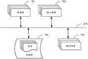
- Fig. 6is a structural diagram of a device provided by an embodiment of the application.
- the devicemay be an application on the server side, or may also be a functional unit such as a plug-in or a software development kit (SDK) in an application on the server side.
- SDKsoftware development kit
- the devicemay include: a data acquisition unit 10, a risk prediction unit 20, and a route planning unit 30, and may further include a congestion model training unit 40, an accident model training unit 50, and a presentation unit 60.
- the main functions of each componentare as follows:
- the data acquisition unit 10is used to acquire real-time traffic flow characteristic data of the road network.
- the acquired traffic flow characteristic datamay include one or any combination of traffic flow statistics, speed data, and rapid deceleration times of each road section.
- the traffic flow statisticsare mainly aimed at the statistics of traffic flow.
- the speed datamay include at least one of such as average speed, median speed, fastest speed, slowest speed, and the like.
- the number of rapid decelerationsmay be the number of rapid decelerations that occur when the vehicle is traveling on a road section.
- the so-called rapid decelerationmay be that the magnitude of the speed reduction per unit time exceeds a preset threshold.
- the risk prediction unit 20is configured to use the real-time traffic flow characteristic data of the road network to predict the state change risk of each road section in the road network, and obtain the state change risk information of each road section.
- the risk prediction unit 20may use real-time traffic flow characteristic data of the road network to perform at least one of congestion state change prediction, accident occurrence prediction, trafficability prediction, traffic rule change prediction, and road quality degradation prediction for each road section. According to various prediction results, the corresponding risk coefficients of various predictions are obtained; the risk coefficients corresponding to various predictions obtained for each road section are respectively weighted to obtain the state change risk coefficients of each road section.
- the risk prediction unit 20may include at least one of a congestion state prediction subunit 21, an accident occurrence prediction subunit 22, a trafficability prediction subunit 23, a traffic regulation change prediction subunit 24, and a road quality prediction subunit 25.
- the congestion state prediction subunit 21is used to input the real-time traffic flow feature data of the road network corresponding to the current time slice, the road attribute feature data, and the environmental feature data corresponding to the future time slice into the pre-trained congestion state prediction model to obtain The predicted travel time of each road segment in the future time slice in the road network; according to the predicted travel time of each road segment in the future time slice, determine the congestion state change of each road segment in the future time slice.
- the congestion model training unit 40may pre-train to obtain the congestion state prediction model in the following manner:
- the training dataincludes traffic flow feature data, road attribute feature data, and environmental feature data and average travel time of the historical second time segment of each road segment in the road network, where the second time segment is The slice is the future time slice relative to the first time slice; the traffic flow characteristic data of the historical first time slice of the road segment is encoded; the vector representation obtained after encoding and the road network link relationship matrix are input to the graph convolution Network: The vector representation output by the graph convolutional network is spliced with the road attribute feature data and the environmental feature data of the historical second time slice and then input into the fully connected layer to obtain the predicted travel time of the road segment in the second time slice;
- the training goalis to minimize the difference between the predicted travel time of the road segment and the average travel time in the training data.
- the accident occurrence prediction subunit 22is used to input the real-time traffic flow feature data, road attribute feature data, and environment feature data corresponding to the future time segment of the road network corresponding to the current time segment into the pre-trained accident prediction model to obtain the correct Predict whether there will be accidents in each section of the road network in the future time slices.
- the accident model training unit 50is used for pre-training to obtain an accident prediction model in the following manner:
- the training dataincludes the traffic flow feature data of the first time segment in the road network, the road attribute feature data, and the environmental feature data of the second time segment in the history and whether an accident occurred.
- the second time segment The sliceis the future time slice relative to the first time slice; the traffic flow characteristic data of the historical first time slice of the road segment is encoded; the vector representation obtained after encoding and the road network link relationship matrix are input to the graph convolution Network; input the vector representation of the graph convolutional network output, the road attribute feature data, and the environmental feature data of the historical second time slice into the fully connected layer to get the prediction of whether the road segment will have an accident in the second time slice; training image The convolutional network and the fully connected layer until the training goal is reached, the training goal is to make the prediction results of accidents on each road section consistent with the training data.
- the trafficability prediction subunit 23is used to obtain the current flow characteristics of each road section.
- the flow characteristicsinclude the traffic flow of the road section, the traffic flow of the previous road section and the traffic flow of the subsequent road section; obtain the historical flow characteristics of each road section;
- the current traffic characteristics and the historical traffic characteristicsare differentiated and the characteristics and road attribute characteristics are input into the trafficability prediction model to obtain the prediction of whether the road section is trafficable.
- the trafficability prediction modelis pre-trained based on the classifier.
- the traffic regulation change prediction subunit 24is used to obtain the current traffic flow ratio from the previous road section on each road section, and to obtain the historical traffic flow ratio from the previous road section on each road section; if the current high traffic flow rate of the road section is compared with the history If the degree of decrease of the traffic proportion exceeds the preset proportion threshold, it is predicted that there will be traffic rule changes on the road section.
- the road quality prediction subunit 25is used to obtain the current speed data and the number of rapid decelerations of each road section, and to obtain the historical speed data and the number of rapid decelerations of each road section; if the current speed data of the road section is compared with the historical speed data, there is a speed decrease degree If the preset speed threshold is exceeded, and/or the increase in the current number of rapid decelerations and the number of historical rapid decelerations exceeds the preset number of rapid decelerations, it is predicted that the road section will experience road quality degradation.
- the route planning unit 30is used for route planning using the state change risk information of each road section.
- the route planning unit 30can update the weight of each road segment by using the status change risk information of each road segment, where the higher the status change risk, the greater the degree of reduction in the weight of the road segment; based on the updated weight value of each road segment, The starting position and the ending position input by the user are searched for a route to obtain at least one candidate route; the route recommended to the user is determined from the candidate routes.
- the route planning unit 30may also perform route search on the start position and the end position input by the user to obtain at least one candidate route; merge the state change risk information of each section in the candidate route, and sort the candidate routes; As a result, the route recommended to the user is determined.
- the presentation unit 60is configured to present the result of route planning in at least one of the following ways:
- Manner 1For the route with the lowest sum of the state change risk coefficients of each road segment included in the planned route recommended to the user, display information indicating that the route has the lowest risk.
- the second wayis to display the predicted state change risk information for the road section where the state change risk meets the preset condition in the route recommended to the user.
- Method 3For a route that is not recommended to the user due to the risk of status change, display information about the reason why the route is not recommended to the user.
- the second estimated time of arrival of the routeis determined by the predicted travel time of the road section with a risk of congestion state change; it is determined when the risk of congestion state change is not considered
- the first estimated time of arrival and the second estimated time of arrivalare displayed by the display unit 60 of the estimated time interval of the route.
- the present applicationalso provides an electronic device and a readable storage medium.
- FIG. 7it is a block diagram of an electronic device according to a route planning method of an embodiment of the present application.
- Electronic devicesare intended to represent various forms of digital computers, such as laptop computers, desktop computers, workstations, personal digital assistants, servers, blade servers, mainframe computers, and other suitable computers.
- Electronic devicescan also represent various forms of mobile devices, such as personal digital processing, cellular phones, smart phones, wearable devices, and other similar computing devices.
- the components shown herein, their connections and relationships, and their functionsare merely examples, and are not intended to limit the implementation of the application described and/or required herein.
- the electronic deviceincludes: one or more processors 701, a memory 702, and interfaces for connecting various components, including a high-speed interface and a low-speed interface.
- the various componentsare connected to each other using different buses, and can be installed on a common motherboard or installed in other ways as needed.
- the processormay process instructions executed in the electronic device, including instructions stored in or on the memory to display graphical information of the GUI on an external input/output device (such as a display device coupled to an interface).
- an external input/output devicesuch as a display device coupled to an interface.
- multiple processors and/or multiple busescan be used with multiple memories and multiple memories.
- multiple electronic devicescan be connected, and each device provides part of the necessary operations (for example, as a server array, a group of blade servers, or a multi-processor system).
- a processor 701is taken as an example.
- the memory 702is a non-transitory computer-readable storage medium provided by this application.
- the memorystores instructions executable by at least one processor, so that the at least one processor executes the route planning method provided in this application.
- the non-transitory computer-readable storage medium of the present applicationstores computer instructions, and the computer instructions are used to make a computer execute the route planning method provided by the present application.
- the memory 702as a non-transitory computer-readable storage medium, can be used to store non-transitory software programs, non-transitory computer-executable programs, and modules, such as program instructions/modules corresponding to the route planning method in the embodiment of the present application.
- the processor 701executes various functional applications and data processing of the server by running non-transitory software programs, instructions, and modules stored in the memory 702, that is, implements the route planning method in the foregoing method embodiment.
- the memory 702may include a program storage area and a data storage area.
- the program storage areamay store an operating system and an application program required by at least one function; the data storage area may store data created according to the use of the electronic device.
- the memory 702may include a high-speed random access memory, and may also include a non-transitory memory, such as at least one magnetic disk storage device, a flash memory device, or other non-transitory solid-state storage devices.
- the memory 702may optionally include memories remotely provided with respect to the processor 701, and these remote memories may be connected to the electronic device through a network. Examples of the aforementioned networks include, but are not limited to, the Internet, corporate intranets, local area networks, mobile communication networks, and combinations thereof.
- the electronic device of the route planning methodmay further include: an input device 703 and an output device 704.
- the processor 701, the memory 702, the input device 703, and the output device 704may be connected by a bus or in other ways. In FIG. 7, the connection by a bus is taken as an example.
- the input device 703can receive input digital or character information, and generate key signal input related to the user settings and function control of the electronic device, such as touch screen, keypad, mouse, track pad, touch pad, indicator stick, one or more A mouse button, trackball, joystick and other input devices.
- the output device 704may include a display device, an auxiliary lighting device (for example, LED), a tactile feedback device (for example, a vibration motor), and the like.
- the display devicemay include, but is not limited to, a liquid crystal display (LCD), a light emitting diode (LED) display, and a plasma display. In some embodiments, the display device may be a touch screen.
- Various implementations of the systems and techniques described hereincan be implemented in digital electronic circuit systems, integrated circuit systems, application specific ASICs (application specific integrated circuits), computer hardware, firmware, software, and/or combinations thereof. These various embodiments may include: being implemented in one or more computer programs, the one or more computer programs may be executed and/or interpreted on a programmable system including at least one programmable processor, the programmable processor It can be a dedicated or general-purpose programmable processor that can receive data and instructions from the storage system, at least one input device, and at least one output device, and transmit the data and instructions to the storage system, the at least one input device, and the at least one output device. An output device.
- machine-readable mediumand “computer-readable medium” refer to any computer program product, device, and/or device used to provide machine instructions and/or data to a programmable processor ( For example, magnetic disks, optical disks, memory, programmable logic devices (PLD)), including machine-readable media that receive machine instructions as machine-readable signals.
- machine-readable signalrefers to any signal used to provide machine instructions and/or data to a programmable processor.
- the systems and techniques described herecan be implemented on a computer that has: a display device for displaying information to the user (for example, a CRT (cathode ray tube) or LCD (liquid crystal display) monitor) ); and a keyboard and a pointing device (for example, a mouse or a trackball) through which the user can provide input to the computer.
- a display devicefor displaying information to the user
- LCDliquid crystal display
- keyboard and a pointing devicefor example, a mouse or a trackball
- Other types of devicescan also be used to provide interaction with the user; for example, the feedback provided to the user can be any form of sensory feedback (for example, visual feedback, auditory feedback, or tactile feedback); and can be in any form (including Acoustic input, voice input, or tactile input) to receive input from the user.
- the systems and technologies described hereincan be implemented in a computing system that includes back-end components (for example, as a data server), or a computing system that includes middleware components (for example, an application server), or a computing system that includes front-end components (for example, A user computer with a graphical user interface or a web browser, through which the user can interact with the implementation of the system and technology described herein), or includes such back-end components, middleware components, Or any combination of front-end components in a computing system.
- the components of the systemcan be connected to each other through any form or medium of digital data communication (for example, a communication network). Examples of communication networks include: local area network (LAN), wide area network (WAN), and the Internet.
- the computer systemcan include clients and servers.
- the client and serverare generally far away from each other and usually interact through a communication network.
- the relationship between the client and the serveris generated by computer programs that run on the corresponding computers and have a client-server relationship with each other.
- the method, device, equipment, and computer storage medium provided in the present applicationhave the following advantages:
- This applicationincorporates the consideration of the state change risk of each road section into the route planning, so that the planned route takes into account the state change risk that users may face when passing through each road section, thereby improving the quality of the planned route and the user experience .
- the rich traffic flow characteristic datasuch as traffic flow statistics, speed data, and rapid deceleration times of each road section are used to predict the state change risk information of each road section in the road network, which has high prediction accuracy.
- This applicationuses multi-dimensional and multi-factor forecasting methods such as congestion state change prediction, accident occurrence prediction, trafficability prediction, traffic rule change prediction, and road quality degradation prediction, so as to make the state change risk coefficient of the road section more comprehensive and accurate .
- This applicationcan use the pre-trained congestion state prediction model to predict the travel time of each road segment in the future time slice, so as to determine the congestion state change of the road segment in the future time slice.
- This applicationcan use the pre-trained accident prediction model to predict whether an accident will occur on each road segment in the future time slice.
- This applicationcan use the current flow characteristics and historical flow characteristics of each road section to realize the prediction of whether the road section is passable.
- This applicationcan use the current traffic flow ratio and historical flow ratio from the previous road sections on each road section to realize the prediction of whether there is a traffic rule change on the road section.
- This applicationcan use the current speed data and the number of rapid decelerations of each road section, as well as the historical speed data and the rapid deceleration data, to realize the prediction of whether road quality degradation occurs in the road section.
- the state change risk of each road sectioncan be applied to route search in route planning, can also be applied to the ranking of candidate routes, or both.
- the result of route planningcan minimize the overall risk.
- This applicationprovides a variety of ways to display the results of route planning: For the route that minimizes the overall risk, the information indicating the lowest risk is displayed to facilitate the user's selection. For the road section where the state change risk meets the preset conditions in the recommended route to the user, display the state change risk information predicted for the road section, so that the user can clearly understand the possible risks in each recommended route and assist the user in choosing the route , Or make targeted changes to future travel plans. For a route that is not recommended to the user due to the risk of status changes, display information about the reason why the route is not recommended to the user, so that the user can clearly understand the reason why the route is not shown, and improve the user experience.
- the estimated time interval of the routecan be displayed, so that the user has an understanding of the time cost to choose the route, so as to make the correct decision , Improve user experience.
Landscapes
- Physics & Mathematics (AREA)
- Engineering & Computer Science (AREA)
- Radar, Positioning & Navigation (AREA)
- Remote Sensing (AREA)
- General Physics & Mathematics (AREA)
- Analytical Chemistry (AREA)
- Chemical & Material Sciences (AREA)
- Automation & Control Theory (AREA)
- Mathematical Physics (AREA)
- Life Sciences & Earth Sciences (AREA)
- Atmospheric Sciences (AREA)
- Biodiversity & Conservation Biology (AREA)
- Ecology (AREA)
- Environmental & Geological Engineering (AREA)
- Environmental Sciences (AREA)
- Traffic Control Systems (AREA)
- Navigation (AREA)
Abstract
Description
Translated fromChinese本申请要求了申请日为2020年04月26日,申请号为2020103386964发明名称为“一种路线规划方法、装置、设备和计算机存储介质”的中国专利申请的优先权。This application claims the priority of the Chinese patent application whose application date is April 26, 2020, and the application number is 2020103386964 and the invention title is "a route planning method, device, equipment, and computer storage medium".
本申请涉及计算机应用技术领域,特别涉及大数据技术领域。This application relates to the field of computer application technology, in particular to the field of big data technology.
路径规划已经广泛的应用于包含导航功能的地图类应用中,其能够为用户提供路线推荐、拥堵状况和预估到达时间等信息的丰富展现结果。但由于现实道路交通状况变化很快,目前的导航系统只能根据当前的准实时状态给用户以路线规划。而在实际导航过程中,规划路线可能会途径一些拥堵可能性大、出事故概率高等高风险路段,导致用户无法在计划时间到达目的地。对于一些对时间要求非常严格的需求场景上,比如商务会议、接送朋友、搭乘飞机等,如果这类风险发生,则无法预期抵达目的地。这就给用户造成规划的路线质量低、用户体验差等问题。Path planning has been widely used in map applications that include navigation functions. It can provide users with rich display results of route recommendations, congestion conditions, and estimated time of arrival. However, due to the rapid changes in actual road traffic conditions, current navigation systems can only plan routes for users based on the current quasi-real-time status. In the actual navigation process, the planned route may pass through some high-risk road sections with high possibility of congestion and high probability of accidents, resulting in users not being able to reach the destination at the planned time. For some demand scenarios that have very strict time requirements, such as business meetings, picking up friends, flying, etc., if this kind of risk occurs, you cannot expect to arrive at the destination. This causes problems such as low quality of planned routes and poor user experience for users.
发明内容Summary of the invention
有鉴于此,本申请提供了一种路线规划方法、装置、设备和存计算机储介质,以便于提高规划的路线质量以及用户体验。In view of this, this application provides a route planning method, device, equipment, and computer storage medium, so as to improve the quality of the planned route and user experience.
根据第一方面,本申请提供了一种路线规划方法,该方法包括:According to the first aspect, this application provides a route planning method, which includes:
获取路网的实时交通流特征数据;Obtain real-time traffic flow characteristic data of the road network;
利用所述路网的实时交通流特征数据对所述路网中各路段的状态变化风险进行预测,获得各路段的状态变化风险信息;Using the real-time traffic flow characteristic data of the road network to predict the state change risk of each road section in the road network, and obtain the state change risk information of each road section;
利用各路段的状态变化风险信息,进行路线规划。Use the status change risk information of each road section to plan the route.
根据第二方面,本申请提供了一种路线规划装置,该装置包括:According to the second aspect, the present application provides a route planning device, which includes:
数据获取单元,用于获取路网的实时交通流特征数据;The data acquisition unit is used to acquire real-time traffic flow characteristic data of the road network;
风险预测单元,用于利用所述路网的实时交通流特征数据对所述路网中各路段的状态变化风险进行预测,获得各路段的状态变化风险信息;The risk prediction unit is configured to use the real-time traffic flow characteristic data of the road network to predict the state change risk of each road section in the road network, and obtain the state change risk information of each road section;
路线规划单元,用于利用各路段的状态变化风险信息,进行路线规划。The route planning unit is used for route planning using the state change risk information of each road section.
根据第三方面,本申请提供了一种电子设备,包括:According to the third aspect, this application provides an electronic device, including:
至少一个处理器;以及At least one processor; and
与所述至少一个处理器通信连接的存储器;其中,A memory communicatively connected with the at least one processor; wherein,
所述存储器存储有可被所述至少一个处理器执行的指令,所述指令被所述至少一个处理器执行,以使所述至少一个处理器能够执行如上任一项所述的方法。The memory stores instructions executable by the at least one processor, and the instructions are executed by the at least one processor, so that the at least one processor can execute the method according to any one of the above.
根据第四方面,本申请提供了一种存储有计算机指令的非瞬时计算机可读存储介质,所述计算机指令用于使所述计算机执行如上任一项所述的方法。According to a fourth aspect, the present application provides a non-transitory computer-readable storage medium storing computer instructions for causing the computer to execute the method described in any of the above.
通过以上技术方案,本申请在路线规划中融入对各路段的状态变化风险的考虑,使得规划的路线从全局上考虑了用户在通过各路段时可能面临的状态变化风险,从而提高规划的路线质量以及用户体验。Through the above technical solutions, this application incorporates the consideration of the state change risk of each road section into the route planning, so that the planned route considers the state change risk that users may face when passing through each road section from a global perspective, thereby improving the quality of the planned route And user experience.
应当理解,本部分所描述的内容并非旨在标识本公开的实施例的关键或重要特征,也不用于限制本公开的范围。本公开的其它特征将通过以下的说明书而变得容易理解。It should be understood that the content described in this section is not intended to identify key or important features of the embodiments of the present disclosure, nor is it intended to limit the scope of the present disclosure. Other features of the present disclosure will be easily understood through the following description.
附图用于更好地理解本方案,不构成对本申请的限定。其中:The drawings are used to better understand the solution, and do not constitute a limitation to the application. in:
图1示出了可以应用本发明实施例的示例性系统架构;Figure 1 shows an exemplary system architecture to which embodiments of the present invention can be applied;
图2为本申请实施例提供的方法流程图;Figure 2 is a flowchart of a method provided by an embodiment of the application;
图3为本申请实施例提供的拥堵状态预测模型的结构示意图;FIG. 3 is a schematic structural diagram of a congestion state prediction model provided by an embodiment of the application;
图4为本申请实施例提供的事故预测模型的结构示意图;Fig. 4 is a schematic structural diagram of an accident prediction model provided by an embodiment of the application;
图5为本申请实施例提供的推荐路线的展现界面示例图;FIG. 5 is an example diagram of a display interface of a recommended route provided by an embodiment of the application;
图6为本申请实施例提供的装置结构图;FIG. 6 is a structural diagram of an apparatus provided by an embodiment of the application;
图7是用来实现本申请实施例的路线规划方法的电子设备的框图。Fig. 7 is a block diagram of an electronic device used to implement the route planning method of an embodiment of the present application.
以下结合附图对本申请的示范性实施例做出说明,其中包括本申请实施例的各种细节以助于理解,应当将它们认为仅仅是示范性的。因此, 本领域普通技术人员应当认识到,可以对这里描述的实施例做出各种改变和修改,而不会背离本申请的范围和精神。同样,为了清楚和简明,以下的描述中省略了对公知功能和结构的描述。The exemplary embodiments of the present application are described below in conjunction with the accompanying drawings, which include various details of the embodiments of the present application to facilitate understanding, and should be regarded as merely exemplary. Therefore, those of ordinary skill in the art should realize that various changes and modifications can be made to the embodiments described herein without departing from the scope and spirit of the present application. Likewise, for clarity and conciseness, descriptions of well-known functions and structures are omitted in the following description.
图1示出了可以应用本发明实施例的示例性系统架构。如图1所示,该系统架构可以包括终端设备101和102,网络103和服务器104。网络103用以在终端设备101、102和服务器104之间提供通信链路的介质。网络103可以包括各种连接类型,例如有线、无线通信链路或者光纤电缆等等。Figure 1 shows an exemplary system architecture to which embodiments of the present invention can be applied. As shown in FIG. 1, the system architecture may include
用户可以使用终端设备101和102通过网络103与服务器104交互。终端设备101和102上可以安装有各种应用,例如地图类应用、语音交互类应用、网页浏览器应用、通信类应用等。The user can use the
终端设备101和102可以是能够支持并展现地图类应用的各种电子设备,包括但不限于智能手机、平板电脑、智能穿戴式设备等等。本发明所提供的装置可以设置并运行于上述服务器104中。其可以实现成多个软件或软件模块(例如用来提供分布式服务),也可以实现成单个软件或软件模块,在此不做具体限定。The
例如,路线规划装置设置并运行于上述服务器104中,服务器104可以预先收集并维护各终端设备(包括101和102)在使用地图类应用过程中上传的用户轨迹数据、通过各种交通传感器上传的交通流数据,这些数据可以构成路网的交通流特征数据。路线规划装置使用本发明实施例提供的方式进行路线规划。当终端设备101或102的用户在使用地图类应用的过程中需要进行路线规划,则可以由设置并运行于服务器104中的路线规划装置进行路线规划,该路线规划结果可以返回终端设备101或102。For example, the route planning device is set up and running in the above-mentioned
服务器104可以是单一服务器,也可以是多个服务器构成的服务器群组。应该理解,图1中的终端设备、网络和服务器的数目仅仅是示意性的。根据实现需要,可以具有任意数目的终端设备、网络和服务器。The
本申请的核心思想在于,在路线规划中融入对各路段的状态变化风险的考虑,使得规划的路线从全局上考虑了用户在通过各路段时可能面临的状态变化风险,从而提高规划的路线质量以及用户体验。下面结合实施例对本申请提供的方法和装置进行详细描述。The core idea of this application is to integrate the consideration of the state change risk of each road section into the route planning, so that the planned route considers the state change risk that the user may face when passing through each road section from a global perspective, thereby improving the quality of the planned route And user experience. The method and device provided in this application will be described in detail below in conjunction with embodiments.
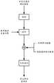
图2为本申请实施例提供的方法流程图,如图2中所示,该方法可以包括以下步骤:Fig. 2 is a flow chart of the method provided by an embodiment of the application. As shown in Fig. 2, the method may include the following steps:
在201中,获取路网的实时交通流特征数据。In 201, obtain real-time traffic flow characteristic data of the road network.
在本申请实施例中,可以以预设时长的时间分片为周期,获取路网在当前时间分片的实时交通流特征数据,供在后续步骤中确定各路段的状态变化风险系数进而进行路线规划。例如,以5分钟的时间分片为例,每隔5分钟获取路网的实时交通流特征数据。In the embodiment of the present application, the time segmentation of the preset duration may be used as the period to obtain the real-time traffic flow characteristic data of the current time segmentation of the road network, which can be used to determine the state change risk coefficient of each road segment in the subsequent steps to proceed with the route. planning. For example, taking a 5-minute time slice as an example, the real-time traffic flow characteristic data of the road network is obtained every 5 minutes.
其中获取的交通流特征数据可以包括各路段的交通流量统计数据、速度数据以及急减速次数中的一种或任意组合。其中,交通流量统计数据主要针对的是车流量的统计。速度数据可以包括诸如平均速度、速度中位数、最快速度、最慢速度等中的至少一种。急减速次数可以是车辆在路段上行驶时发生的急减速次数,所谓急减速可以是单位时间内速度减小的幅度超过预设阈值。The acquired traffic flow characteristic data may include one or any combination of traffic flow statistics, speed data, and rapid deceleration times of each road section. Among them, the traffic flow statistics are mainly aimed at the statistics of traffic flow. The speed data may include at least one of such as average speed, median speed, fastest speed, slowest speed, and the like. The number of rapid decelerations may be the number of rapid decelerations that occur when the vehicle is traveling on a road section. The so-called rapid deceleration may be that the magnitude of the speed reduction per unit time exceeds a preset threshold.
在202中,利用路网的实时交通流特征数据对路网中各路段的状态变化风险进行预测,获得各路段的状态变化风险信息。In 202, the real-time traffic flow characteristic data of the road network is used to predict the state change risk of each road section in the road network, and obtain state change risk information of each road section.
本申请中对各路段进行的状态变化风险预测可以包括拥堵状态变化预测、事故发生预测、可通行性预测、交通规则变化预测以及道路质量劣化预测中的至少一种。下面分别对各种预测进行详细描述。The state change risk prediction for each road section in this application may include at least one of congestion state change prediction, accident occurrence prediction, trafficability prediction, traffic rule change prediction, and road quality degradation prediction. The various predictions are described in detail below.
1)拥堵状态变化预测。1) Prediction of congestion status changes.
本申请中可以采用拥堵状态预测模型来进行拥堵状态变化预测。该拥堵状态预测模型能够在输入当前路网的实时交通流特征数据、道路属性特征数据以及未来环境特征数据的情况下,输出各路段未来的预测通行时长。In this application, a congestion state prediction model can be used to predict changes in the congestion state. The congestion state prediction model can output the predicted travel time of each road section in the future when the real-time traffic flow feature data of the current road network, the road attribute feature data, and the future environmental feature data are input.
为了方便理解,首先对拥堵状态预测模型的训练过程进行描述。如图3中所示,本申请中的拥堵状态预测模型主要包括GCN(Graph Convolutional Network,图卷积网络)和全连接层。To facilitate understanding, first describe the training process of the congestion state prediction model. As shown in Figure 3, the congestion state prediction model in this application mainly includes GCN (Graph Convolutional Network, Graph Convolutional Network) and a fully connected layer.
首先获取训练数据。训练数据可以从路网中各路段的历史信息中获取。每一条训练数据可以包括四个数据:路段的历史第一时间分片的交通流特征数据、道路属性特征数据以及历史第二时间分片的环境特征数据和平均通行时长。其中第二时间分片为相对于第一时间分片的未来时间分片。例如,第二时间分片可以为第一时间分片之后的第1个时间分 片、第2个时间分片、第3个时间分片或第4个时间分片等等。需要说明的是,本申请实施例中涉及的“第一”、“第二”等限定仅仅为了在名称上对两个时间分片进行区分,并不具备顺序、数量、重要程度等含义的限定。First get the training data. The training data can be obtained from the historical information of each road section in the road network. Each piece of training data may include four pieces of data: traffic flow characteristic data of the first time slice in the history, road attribute characteristic data, and environmental characteristic data and average travel time of the second time slice in the history. The second time slice is a future time slice relative to the first time slice. For example, the second time slice may be the first time slice, the second time slice, the third time slice, the fourth time slice, and so on after the first time slice. It should be noted that the "first", "second" and other limitations involved in the embodiments of this application are only for distinguishing two time slices in name, and do not have limitations on the meaning of order, number, importance, etc. .
以5分钟为一个时间分片为例,若第二时间分片是第一时间分片后的第1个时间分片,那么以此训练数据训练出的拥堵状态预测模型用以预测5分钟之后的路段拥堵状态变化风险。若第二时间分片是第一时间分片后的第2个时间分片,那么以此训练数据训练出的拥堵状态预测模型用以预测10分钟之后的路段拥堵状态变化风险。以此类推,可以分别建立多个拥堵状态预测模型来分别预测未来不同时间分片路段的拥堵状态变化风险。Taking 5 minutes as a time slice as an example, if the second time slice is the first time slice after the first time slice, then the congestion state prediction model trained with the training data is used to predict after 5 minutes The risk of changes in the congestion status of the road section. If the second time slice is the second time slice after the first time slice, the congestion state prediction model trained with this training data is used to predict the risk of road congestion state change after 10 minutes. By analogy, multiple congestion state prediction models can be established to predict the congestion state change risks of different time segments in the future.
其中,第一时间分片的交通流量特征数据可以包括路段在第一时间分片的交通流量统计数据、速度数据以及急减速次数。道路属性特征数据可以包括路段的长度、道路等级等信息。第二时间分片的环境特征数据可以包括在该路段在该第二时间分片对应的天气、时间、是否为节假日、季节等信息。为了方便计算,这些特征数据可以以离散数值的形式表示。Wherein, the traffic flow characteristic data of the first time segment may include traffic flow statistics, speed data, and the number of rapid decelerations of the road segment in the first time segment. The road attribute feature data may include information such as the length of the road section and the road grade. The environmental feature data of the second time slice may include information such as weather, time, whether it is a holiday, and season corresponding to the road segment in the second time slice. For the convenience of calculation, these characteristic data can be expressed in the form of discrete values.
如图3中所示,将路段的历史第一时间分片的交通流特征数据进行编码。为了拟合出不同路段间的关联关系,可以使用GCN进行关联关系建设,将编码后到的向量表示与路网链接关系矩阵输入到GCN。GCN输出的向量表示可以与道路属性特征数据、历史第二时间分片的环境特征数据进行拼接后输入全连接层,由全连接层得到对该路段在历史第二时间分片的预测通行时长。As shown in FIG. 3, the traffic flow characteristic data of the first time slice of the history of the road segment is encoded. In order to fit the association relationship between different road sections, GCN can be used to construct the association relationship, and the vector representation and the road network link relationship matrix obtained after encoding are input into the GCN. The GCN output vector representation can be spliced with road attribute feature data and environmental feature data of the historical second time slice and then input to the fully connected layer. The fully connected layer obtains the predicted travel time of the road segment in the historical second time slice.
训练GCN和全连接层直至达到训练目标,训练目标为最小化路段的预测通行时长和训练数据中该路段的平均通行时长的差值,也就是说,最小化预测误差。Train the GCN and the fully connected layer until the training goal is reached. The training goal is to minimize the difference between the predicted travel time of the road segment and the average travel time of the road segment in the training data, that is, to minimize the prediction error.
训练结束后,在利用训练得到的拥堵状态预测模型进行未来某时间分片的预测时,如图3中所示,将当前时间分片对应的路网中各路段的实时交通流特征数据进行编码,然后将编码后得到的向量表示与路网链接关系矩阵输入到GCN,GCN输出的向量表示与道路属性特征数据、上述未来某时间分片的环境特征数据进行拼接后输入全连接层,由全连 接层得到对该路段的上述未来某时间分片的预测通行时长。After the training, when using the trained congestion state prediction model to predict a time slice in the future, as shown in Figure 3, encode the real-time traffic flow characteristic data of each road segment in the road network corresponding to the current time slice , And then input the encoded vector representation and road network link relationship matrix to GCN. The vector representation output by GCN is spliced with road attribute feature data and the aforementioned environmental feature data fragmented at a certain time in the future and then input into the fully connected layer. The connection layer obtains the predicted travel time of the above-mentioned future time slice of the road section.
依据各路段在未来时间分片的预测通行时长,就能够确定各路段在未来时间分片的拥堵状态变化。比如,预测得到的预测通行时长比同时期的历史平均通行时长多,且多的幅度超出预设的幅度阈值,则可以认为发生拥堵。也可以设置不同的幅度阈值来区分不同程度的拥堵。According to the predicted travel time of each road segment in the future time slice, the congestion state change of each road segment in the future time slice can be determined. For example, if the predicted travel time obtained by prediction is longer than the historical average travel time of the same period, and the amplitude exceeds the preset amplitude threshold, it can be considered that congestion has occurred. Different amplitude thresholds can also be set to distinguish different degrees of congestion.
2)事故发生预测。2) Prediction of accident occurrence.
本申请中可以采用事故预测模型来进行是否发生事故的预测。该事故预测模型能够在输入当前时间分片对应的路网的交通流特征数据、道路属性特征数据和未来时间分片的环境特征数据的情况下,输出对各路段在上述未来时间分片是否发生事故的预测。In this application, an accident prediction model can be used to predict whether an accident will occur. The accident prediction model can input the traffic flow characteristic data of the road network corresponding to the current time slice, the road attribute characteristic data and the environmental characteristic data of the future time slice, and output whether each road segment occurs in the future time slice. Forecast of accidents.
为了方便理解,首先对事故预测模型的训练过程进行描述。如图4中所示,与拥堵状态预测模型类似地,事故预测模型主要包括GCN和全连接层。In order to facilitate understanding, first describe the training process of the accident prediction model. As shown in Figure 4, similar to the congestion state prediction model, the accident prediction model mainly includes GCN and a fully connected layer.
首先获取训练数据。训练数据可以从路网中各路段的历史信息中获取,每一条训练数据可以包括四个数据:路段的历史第一时间分片的交通流特征数据、道路属性特征数据和历史第二时间分片的环境特征数据和该路段在历史第二时间分片是否发生事故的信息。其中,第二时间分片为相对于第一时间分片的未来时间分片。First get the training data. The training data can be obtained from the historical information of each road segment in the road network. Each piece of training data can include four pieces of data: traffic flow characteristic data of the first time slice of the road segment, road attribute characteristic data, and historical second time slice The environmental characteristic data of the road section and the information about whether an accident occurred in the second time slice in the history. Wherein, the second time slice is a future time slice relative to the first time slice.
历史第一时间分片的交通流特征数据可以包括历史第一时间分片中路段的交通流量统计数据、速度数据以及急减速次数。道路属性特征数据可以包括路段的长度、道路等级等信息。环境特征数据可以包括该路段在该历史第二时间分片对应的天气、时间、是否为节假日、季节等信息。为了方便计算,这些特征数据可以以离散数值的形式表示。The traffic flow characteristic data of the first historical time segment may include traffic flow statistics, speed data, and the number of rapid decelerations of the road sections in the historical first time segment. The road attribute feature data may include information such as the length of the road section and the road grade. The environmental characteristic data may include information such as weather, time, whether it is a holiday, season, etc. corresponding to the second time segment of the road section. For the convenience of calculation, these characteristic data can be expressed in the form of discrete values.
如图4中所示,将路段的历史第一时间分片的交通流特征数据进行编码。为了拟合出不同路段间的关联关系,可以使用GCN进行关联关系建设,将编码后到的向量表示与路网链接关系矩阵输入到GCN。GCN输出的向量表示可以与道路属性特征数据、历史第二时间分片的环境特征数据进行拼接后输入全连接层,由全连接层得到对该路段在第二时间分片是否发生事故的预测。全连接层可以具体输出路段发生事故的概率,依据概率是否高于预设的概率阈值来确定是否发生事故。例如概率高于预设的概率阈值,则确定发生事故。As shown in FIG. 4, the traffic flow characteristic data of the first time slice of the history of the road segment is encoded. In order to fit the association relationship between different road sections, GCN can be used to construct the association relationship, and the vector representation and the road network link relationship matrix obtained after encoding are input into the GCN. The vector representation output by GCN can be spliced with road attribute feature data and environmental feature data of the historical second time slice and then input to the fully connected layer, and the fully connected layer obtains the prediction of whether an accident occurs on the road segment in the second time slice. The fully connected layer can specifically output the probability of an accident on the road section, and determine whether an accident occurs based on whether the probability is higher than a preset probability threshold. For example, if the probability is higher than the preset probability threshold, it is determined that an accident has occurred.
训练GCN和全连接层直至达到训练目标,训练目标为使各路段是否发生事故的预测结果与训练数据一致,也就是说,最小化预测误差。Train the GCN and the fully connected layer until the training goal is reached. The training goal is to make the prediction results of each road section consistent with the training data, that is, to minimize the prediction error.
训练结束后,在利用训练得到的事故预测模型进行预测时,如图4中所示,将当前时间分片对应的路网中各路段的实时交通流特征数据进行编码,然后将编码后得到的向量表示与路网链接关系矩阵输入到GCN,GCN输出的向量表示与道路属性特征数据、未来时间分片的环境特征数据进行拼接后输入全连接层,由全连接层得到对该路段在上述未来时间分片是否发生事故的预测。具体地,全连接层可以输出路段发生事故的概率,依据概率是否高于预设的概率阈值来确定是否发生事故。例如概率高于预设的概率阈值,则确定发生事故。After the training, when using the trained accident prediction model to predict, as shown in Figure 4, the real-time traffic flow feature data of each road segment in the road network corresponding to the current time slice is encoded, and then the encoded The vector representation and the road network link relationship matrix is input to the GCN, and the GCN output vector representation is spliced with road attribute feature data and future time-sliced environmental feature data and then input to the fully connected layer. The fully connected layer obtains the road segment in the above-mentioned future The prediction of whether an accident occurs in the time slice. Specifically, the fully connected layer can output the probability of an accident on a road section, and determine whether an accident occurs according to whether the probability is higher than a preset probability threshold. For example, if the probability is higher than the preset probability threshold, it is determined that an accident has occurred.
3)可通行性预测。3) Prediction of accessibility.
本申请中进行的可通行性预测是预测路段是否可通行,而并非因各种因素而阻断。造成路段不可通行即阻断的因素可以是诸如修路、封路、其他工程造成的阻断等,本申请对此不加以限制。The trafficability prediction made in this application is to predict whether the road section is trafficable, rather than blocking it due to various factors. The factors that cause the road section to be impassable or blocked can be, for example, road repairs, road closures, blockages caused by other projects, etc. This application does not impose restrictions on this.
由于路段阻断是独立发生的事件,与路网中其他路段并没有直接关联,因此不使用GCN进行预测,而直接采用分类器进行建模预测。Because the road segment blocking is an event that occurs independently and is not directly related to other road segments in the road network, GCN is not used for prediction, but a classifier is directly used for modeling prediction.
在进行预测时,获取各路段的当前流量特征,该流量特征可以包括路段的交通流量、前序路段的交通流量以及后序路段的交通流量。其中交通流量主要指车流量。对于一个路段而言,其前序路段可能有多个,后续路段也可能有多个。那么上述前序路段的交通流量可以为多个前序路段的平均交通流量,同理,后续路段的交通流量可以为多个后续路段的平均交通流量。In the prediction, the current flow characteristics of each road section are obtained, and the flow characteristics may include the traffic flow of the road section, the traffic flow of the preceding road section, and the traffic flow of the subsequent road section. The traffic flow mainly refers to the traffic flow. For a road section, there may be multiple pre-order sections, and there may be multiple subsequent sections. Then the traffic flow of the preceding road section may be the average traffic flow of multiple preceding road sections, and similarly, the traffic flow of the subsequent road section may be the average traffic flow of multiple subsequent road sections.
然后获取各路段的历史流量特征。该历史流量特征可以是与当前属于同一时间片段的历史流量特征。例如假设当前为上述10:01,那么可以获取历史上10:00~10:05的时间分片的流量特征数据。历史流量特征也可以是一定历史时间区间的平均流量特征。例如昨天之前一周、一个月等的平均流量特征。Then obtain the historical traffic characteristics of each road section. The historical traffic characteristic may be a historical traffic characteristic belonging to the same time segment as the current one. For example, assuming that the current time is 10:01, the traffic characteristic data of the time slice from 10:00 to 10:05 in history can be obtained. The historical flow characteristic may also be the average flow characteristic of a certain historical time interval. For example, the average traffic characteristics of the week or month before yesterday.
将同一路段的当前流量特征和历史流量特征进行差分后得到的特征与道路属性特征输入可通行性预测模型,得到对该路段是否可通行的预测。其中,可通行性预测模型可以基于分类器预先训练得到,其中分类器可以是诸如SVM(Support Vector Machine,支持向量机)等二分类器。 其输出的可以是该路段不可通行的概率,依据概率确定该路段是否不可通行。例如若不可通行的概率高于预设的概率阈值,则确定该路段不可通行。The characteristics and road attribute characteristics obtained after the difference between the current flow characteristics and the historical flow characteristics of the same road section are input into the trafficability prediction model to obtain a prediction of whether the road section is trafficable. Among them, the feasibility prediction model can be obtained by pre-training based on a classifier, where the classifier can be a two-classifier such as SVM (Support Vector Machine, Support Vector Machine). The output can be the probability that the road section is impassable, and the probability is used to determine whether the road section is impassable. For example, if the probability of impassability is higher than the preset probability threshold, it is determined that the road section is impassable.
在训练可通行性预测模型时,可以获取路段可通行时所对应时间片段的流量特征和该时间片段的历史流量特征,以及获取路段不可通行时所对应时间片段的交通高流量和该时间片段的历史流量特征,作为训练数据。将同一训练数据中,两个流量特征进行差分后得到的特征与同一路段的道路属性特征输入分类器,分类器输出该路段是否可通行的分类结果。训练分类器,直至达到训练目标。训练目标为分类器的分类结果与训练数据中路段是否可通行的信息一致。When training the trafficability prediction model, the traffic characteristics of the corresponding time segment and the historical traffic characteristics of the time segment when the road segment is passable can be obtained, as well as the high traffic volume and the time segment corresponding to the time segment when the road segment is impassable. Historical traffic characteristics are used as training data. In the same training data, the characteristics obtained after the difference between the two traffic characteristics and the road attribute characteristics of the same road section are input to the classifier, and the classifier outputs the classification result of whether the road section is passable. Train the classifier until it reaches the training goal. The training target is that the classification result of the classifier is consistent with the information of whether the road section in the training data is passable.
4)交通规则变化预测。4) Forecast of changes in traffic rules.
在一些情况下,因为交通规则的变化也会使得用户在路线中行驶时面临一些通行风险。本申请中所涉及的交通规则变化主要包括转向禁行。例如禁止直行、禁止左转、禁止右转、禁止掉头等等。在本申请中,可以通过观察路段前后轨迹的差异来挖掘出路段是否出现交通规则变化。In some cases, changes in traffic rules will also make users face some traffic risks when driving along the route. The traffic rule changes involved in this application mainly include steering bans. For example, it is forbidden to go straight, turn left, turn right, turn around, and so on. In this application, it is possible to find out whether there is a traffic rule change on the road section by observing the difference between the front and back trajectories of the road section.
具体地,可以获取各路段上来自前序路段的当前交通流量比例,以及获取与各路段上来自前序路段的历史流量比例。若路段的当前交通高流量比例相比较历史流量比例的下降程度超过预设比例阈值,则预测得到该路段存在交通规则变化。Specifically, it is possible to obtain the current traffic flow ratio from the previous road section on each road section, and obtain the historical traffic flow ratio from the previous road section on each road section. If the current high traffic flow ratio of the road segment is lower than the historical flow ratio, the reduction degree exceeds the preset ratio threshold, then it is predicted that there is a traffic rule change on the road segment.
举个例子,假设经由路段A穿行路段B,那么路段A为路段B的前序路段。确定路段B的交通流量中来自路段A的交通流量所占的比例,若该比例相比较历史流量比例发生明显下降,则预测该路段B存在交通规则变化。其中,历史流量比例可以是一定历史时间区间的平均流量比例。例如昨天之前一周、一个月等的平均流量特征。For example, suppose that the road section B is passed through the road section A, and then the road section A is the preceding road section of the road section B. Determine the proportion of traffic flow from section A in the traffic flow of road section B. If the proportion is significantly reduced compared with the historical flow rate, it is predicted that there will be traffic rule changes on this road section B. Among them, the historical flow rate may be the average flow rate in a certain historical time interval. For example, the average traffic characteristics of the week or month before yesterday.
另外,除了比较当前交通流量比例和历史流量比例的方式之外,还可以进一步结合路段的交通流量的绝对值,即同时需要满足路段的交通流量相比较历史交通流量的下降程度超过预设阈值,才预测得到该路段存在交通规则变化。In addition, in addition to comparing the current traffic flow ratio and the historical flow ratio, the absolute value of the traffic flow of the road section can also be further combined, that is, it is necessary to meet the traffic flow of the road section compared to the historical traffic flow and the degree of decline exceeds the preset threshold. It is predicted that there will be traffic rule changes in this section.
5)道路质量劣化预测。5) Prediction of road quality degradation.
道路质量劣化预测主要是预测路段的道路质量是否比之前变差。路线质量变差的因素可以是诸如道路损坏导致颠簸、行人随意穿行、违章 停车、坡度变化、新增障碍物等,本申请对此不加以限制。Road quality degradation prediction is mainly to predict whether the road quality of the road section will be worse than before. The factors for the deterioration of the route quality can be bumps caused by road damage, pedestrians walking at will, illegal parking, gradient changes, new obstacles, etc., which are not limited by this application.
在进行道路质量劣化预测时,可以获取各路段的当前速度数据以及急减速次数。其中速度数据可以包括诸如轨迹点速度的中位数、平均数等。When predicting road quality degradation, the current speed data and the number of rapid decelerations for each road section can be obtained. The speed data can include, for example, the median and average of the track point speed.
并且获取各路段与历史速度数据以及急减速次数。若路段的当前速度数据相比较历史速度数据存在明显的速度下降,例如速度下降程度超过预设的速度阈值,并且当前急减速次数与历史急减速次数存在明显上升,例如上升程度超过预设次数阈值,则预测得到该路段出现道路质量劣化。And obtain each road section and historical speed data and the number of rapid decelerations. If the current speed data of the road segment has a significant speed drop compared to the historical speed data, for example, the speed drop exceeds the preset speed threshold, and the current rapid deceleration times and the historical rapid deceleration times have a significant increase, for example, the increase degree exceeds the preset number threshold , It is predicted that the road quality degradation of the road section will occur.
上述的历史速度数据可以是与当前属于同一时间片段的历史速度数据。例如假设当前为上述10:01,那么可以获取历史上10:00~10:05的时间分片的历史速度数据。历史速度数据也可以是一定历史时间区间的平均速度数据。例如昨天之前一周、一个月等的平均流量特征。The aforementioned historical speed data may be historical speed data belonging to the same time segment as the current one. For example, assuming that the current time is 10:01, the historical speed data of the time slices from 10:00 to 10:05 in history can be obtained. The historical speed data may also be average speed data in a certain historical time interval. For example, the average traffic characteristics of the week or month before yesterday.
得到上述各种预测结果后,可以根据各种预测结果分别得到路段的各种预测对应的风险系数;然后针对各路段得到的各种预测对应的风险系数分别进行加权处理,得到各路段的状态变化风险系数。After obtaining the above-mentioned various prediction results, the corresponding risk coefficients of the various predictions of the road sections can be obtained according to the various prediction results; then the risk coefficients corresponding to the various predictions obtained for each road section are respectively weighted to obtain the state change of each road section Risk factor.
例如,依据拥堵状态变化预测出的路段i的预测通行时长,确定出路段i的拥堵状态变化风险系数R1。其中预测通行时长与历史平均通行时长的差异越大,R1值越大。For example, based on the predicted travel time of the road section i predicted by the congestion state change, the congestion state change risk coefficient R1 of the road section i is determined. The greater the difference between the predicted travel time and the historical average travel time, the greater the value ofR 1.
依据事故发生预测出的路段i是否发生事故,确定出路段i的事故发生风险系数R2。例如,若预测出路段i发生事故,则可以依据预测出的路段i发生事故的概率确定R2,概率值越大,R2越大。也可以简单地设置发生事故时,R2值取1,不发生事故时,R2值取0。According to whether the accident occurs on the road section i predicted by the accident, the accident risk coefficient R2 of the road section i is determined. Probability example, if the predicted link i accident, it can be predicted based on the determined road accident i R2, the greater the probability value, R2 increases. You can also simply set thevalue of R 2 to be 1 when an accident occurs, and 0 to the value ofR 2 when no accident occurs.
依据可通行性预测出的路段i是否可通行,确定出路段i的可通行性风险系数R3。例如,若预测出路段不可通行,则可以依据预测出的路段不可通行的概率确定R3,概率值越大,R3值越大。也可以简单地设置不可通行时,R3值取1,可通行时,R3值取0。According to whether the road section i predicted by the trafficability is passable, the trafficability risk coefficient R3 of the road section i is determined.For example, if a road section is predicted to be impassable, R 3 can be determined according to the predicted probability that the road section is impassable. The greater the probability value, the greater the value of R3 . It may be simply set when impassable, R3 take the value 1, when accessible, R3 take the value 0.
依据交通规则变化预测出的路段i是否发生交通规则变化,确定出路段i的交通规则变化风险系数R4。例如,若预测出路段发生交通规则变化,则可以依据流量比例下降的程度来确定R4,下降的程度越大,R4值越大。也可以简单地设置发生交通规则变化,R4值取1,未发生交通 规则变化,R4值取0。According to the predicted road section i based on the traffic rule change, whether the road section i has a traffic rule change, determine the traffic rule change risk coefficient R4 of the road section i. For example, if it is predicted that there will be a traffic rule change in a road section, R4 can be determined according to the degree of decrease in the proportion of traffic. The greater the degree of decrease, the greater the value ofR 4. May be simply set the traffic regulation changes, R4 takes the value 1, no change in traffic rules, R4 takes the value 0.
依据道路质量劣化预测出的路段i是否疑似道路质量劣化,确定出路段i的可通行性风险系数R5。例如,若预测出路段的道路质量劣化,则依据速度的下降程度和/或急减速次数的上升程度来确定R5。速度的下降程度越大,R5值越大;急减速次数的上升程度越大,R5值越大。也可以简单地设置路段的道路质量劣化,R5值取1,未发生道路质量劣化,R5值取0。According to whether the road section i predicted by the road quality degradation is suspected of road quality degradation, the trafficability risk coefficient R5 of the road section i is determined.For example, if it is predicted that the road quality of the road section is degraded, R 5 is determined according to the degree of decrease in speed and/or the degree of increase in the number of rapid decelerations. The greater the decrease in speed, the greater thevalue of R 5 ; the greater the increase in the number of rapid decelerations, the greater the value ofR 5. It is also possible to simply set the road quality degradation of the road section, thevalue of R 5 is 1, if no road quality degradation occurs, thevalue of R 5 is 0.
然后通过如下公式确定出路段i的状态变化风险系数Rall:Then use the following formula to determine the state change risk coefficient Rall of road section i:
λ1*R1+λ2*R2+λ3*R3+λ4*R4+λ5*R5=Rallλ1 *R1 +λ2 *R2 +λ3 *R3 +λ4 *R4 +λ5 *R5 =Rall
上述加权系数λ1、λ2、λ3、λ4和λ5可以采用人工设置的经验值或实验值等。The above-mentioned weighting coefficients λ1 , λ2 , λ3 , λ4 and λ5 may be manually set empirical values or experimental values.
采用类似方式可以确定出路网中各个路段的状态变化风险系数。A similar method can be used to determine the state change risk coefficient of each section of the road network.
在203中,利用各路段的状态变化风险信息,进行路线规划。In 203, route planning is performed using the state change risk information of each road section.
在路线规划产品中,会将路网上所有路段根据彼此的连通关系建立一个网状的拓扑图,该拓扑图中节点为路口,边为路段。现有技术中,根据静态的路网属性和实时的路况信息,为图上的每条边赋予权值。也就是说,每个路段都被赋予权值。当用户输入起始位置和终点位置进行路线规划时,会通过图搜索的方式进行路线查找计算。在路线查找过程中,对于可选的几条路段优先选取权值高的路段。查找得到的候选路线中,考虑通行时长、距离、红路灯数量、道路等级等多个维度中的一种或任意组合进行候选路线的排序,最终确定向用户推荐的路线。In the route planning product, all the road sections on the road network will be built according to the interconnection relationship with each other to establish a network topology map, the nodes in the topological map are intersections, and the edges are road sections. In the prior art, weights are assigned to each edge on the graph based on static road network attributes and real-time road condition information. In other words, each road segment is given a weight. When the user enters the starting position and the ending position for route planning, the route will be searched and calculated by way of map search. In the route search process, the road sections with higher weights are preferentially selected for the selectable road sections. Among the candidate routes found, consider one or any combination of multiple dimensions such as travel time, distance, number of red street lights, and road grades to sort the candidate routes, and finally determine the recommended route to the user.
本申请可以在路线查找过程中融入路段的状态变化风险信息,也可以在候选路线的排序过程中融入路段的状态变化风险信息,或者也可以在路线查找和候选路线的排序过程中均融入路段的状态变化信息。This application can incorporate the status change risk information of the road segment in the route search process, or it can integrate the status change risk information of the road segment in the candidate route sorting process, or it can also integrate the road segment risk information in the route search and candidate route sorting process. Status change information.
当在路线查找过程中融入路段的状态变化风险信息时,可以执行以下处理:When the state change risk information of the road segment is incorporated in the route search process, the following processing can be performed:
S11、利用各路段的状态变化风险信息更新各路段的权值,其中状态变化风险越高,对路段权值的降低程度越大。S11. Use the state change risk information of each road section to update the weight value of each road section, where the higher the state change risk, the greater the degree of reduction of the road section weight.
也就是说,对于存在状态变化风险的路段,利用其状态变化风险的状况对该路段的权值进行“打压”。That is to say, for a road section with a risk of state change, the weight of the road section is "suppressed" by using its state change risk.
例如,更新后的路段权值weighti_new为:For example, the updated link weight weighti_new is:
λall*Rall+weighti=weighti_newλall *Rall +weighti =weighti_new
weighti为路段原本的权值,λall为加权系数,通常可以设置为一个负值,具体取值可以由人工设置为经验值或实验值。Weight i is the original weight of the road section, and λall is the weighting coefficient, which can usually be set to a negative value. The specific value can be manually set to an empirical value or an experimental value.
S12、基于更新后各路段的权值,对用户输入的起始位置和终点位置进行路线查找,得到至少一条候选路线。S12. Based on the updated weights of each road section, route search is performed on the start position and the end position input by the user to obtain at least one candidate route.
在路线查找过程中,会确定到达各路段的预计时间,然后采用对该路段在该预计时间所在时间片段的状态变化风险的预估。具体如何确定到达各路段的预计时间,可以利用途径各路段的预计通行时长来叠加确定,这部分内容在此不做赘述。然后从候选路线中确定向用户推荐的路线。In the route search process, the estimated time to reach each road section is determined, and then the state change risk estimation of the road section at the time segment of the estimated time is used. How to determine the estimated time to reach each road section can be superimposed and determined by using the estimated travel time of each road section. This part of the content will not be repeated here. Then determine the recommended route to the user from the candidate routes.
S13、从候选路线中确定向用户推荐的路线。S13. Determine a route recommended to the user from the candidate routes.
可以采用现有技术中的排序方式,考虑通行时长、距离、红路灯数量、道路等级等多个维度中的一种或任意组合进行候选路线的排序,最终确定向用户推荐的路线。The ranking method in the prior art can be used to sort the candidate routes in consideration of one or any combination of multiple dimensions such as travel time, distance, number of red street lights, and road grades, and finally determine the route recommended to the user.
当在候选路线的排序过程中融入路段的状态变化风险信息时,可以执行以下处理:When the state change risk information of the road segment is incorporated in the ranking process of the candidate routes, the following processing can be performed:
S21、对用户输入的起始位置和终点位置进行路线查找,得到至少一条候选路线。S21: Perform route search on the start position and the end position input by the user to obtain at least one candidate route.
在此可以采用现有技术中的路线查找方式,不考虑各路段的状态变化风险对各路段的权值的影响。Here, the route search method in the prior art can be used, and the influence of the risk of state change of each road section on the weight of each road section is not considered.
S22、融合候选路线中各路段的状态变化风险信息,对各候选路线进行排序。S22: Integrate the state change risk information of each road section in the candidate routes, and sort the candidate routes.
在本步骤中,可以利用候选路线中包含的各路段的状态变化风险系数,确定候选路线的状态变化风险系数,例如进行所包含各路段状态变化风险系数的加和、求平均等。然后在考虑路线的状态变化风险系数的基础之上,进一步考虑通行时长、距离、红路灯数量、道路等级等多个维度中的一种或任意组合,对各候选路线进行排序。In this step, the state change risk coefficient of each road section included in the candidate route can be used to determine the state change risk coefficient of the candidate route, for example, the state change risk coefficient of each road section included is summed and averaged. Then, on the basis of considering the risk factor of the route's state change, further considering one or any combination of multiple dimensions such as travel time, distance, number of red street lights, road grade, etc., to sort the candidate routes.
也可以基于用户对所推荐路线的选择行为,以及候选路线的状态变化风险特征、道路等级、通行时长、距离、红绿灯数量、车流信息等特征,训练排序模型。然后利用训练得到的排序模型对各推荐路线进行排序。The ranking model can also be trained based on the user's selection behavior of the recommended route, as well as the risk characteristics of the state change of the candidate route, road grade, travel time, distance, number of traffic lights, traffic information and other characteristics. Then use the trained ranking model to rank the recommended routes.
S23、依据排序结果,确定向用户推荐的路线。S23. Determine a route recommended to the user according to the sorting result.
经过排序后,可以选择排在前N个的路线向用户推荐,N为预设的正整数。也可以将采用不同排序策略分别排列出的第一个路线向用户推荐。等等。After sorting, the top N routes can be selected to recommend to the user, and N is a preset positive integer. It is also possible to recommend the first route separately arranged using different sorting strategies to the user. and many more.
在204中,展现向用户推荐的规划路线。In 204, the planned route recommended to the user is presented.
本步骤中可以采用以下方式中的一种或任意组合:One or any combination of the following methods can be used in this step:
方式一、对向用户推荐的规划路线中所包含各路段的状态变化风险系数的总和最低的路线,展现指示该路线风险最低的信息。Manner 1: For the route with the lowest sum of the state change risk coefficients of each road segment included in the planned route recommended to the user, display information indicating that the route has the lowest risk.
如图5中所示,在方案A所指示的路线能够展示标签“风险最低”,以方便用户进行选择。As shown in Figure 5, the route indicated in Scheme A can display the label "Least Risk" to facilitate the user's selection.
方式二、对向用户推荐的路线中状态变化风险满足预设条件的路段,展示针对该路段预测的状态变化风险信息。The second way is to display the predicted state change risk information for the road section where the state change risk meets the preset condition in the route recommended to the user.
如图5中所示,当前界面上所展现的推荐路线B中,存在一条路段“月牙路”的拥堵风险较高,因此可以在该路段中指示“月泉路有拥堵风险,可能造成10分钟延误”。在推荐路线C中存在一条路段“G6辅路”有事故风险,因此可以在该路段中指示“G6辅路有事故风险”。这样用户就能够清楚地了解到各推荐路线中可能会存在的风险,从而展示上述的提示风险路段和风险类型的信息,辅助用户对路线进行选择,或者对未来的出行计划进行针对性变化。As shown in Figure 5, in the recommended route B displayed on the current interface, there is a road section "Crescent Road" that has a higher risk of congestion. Therefore, you can indicate "Yuequan Road is at risk of congestion, which may cause 10 minutes Delays". In the recommended route C, there is a section "G6 auxiliary road" that is at risk of accident, so it can be indicated that "G6 auxiliary road is at risk of accident" in this section. In this way, the user can clearly understand the risks that may exist in each recommended route, thereby displaying the above-mentioned information indicating the risky sections and risk types, assisting the user in choosing the route, or making targeted changes to the future travel plan.
方式三、对因状态变化风险而未向用户推荐的路线,展示该路线未向用户推荐的原因信息。Manner 3: For a route that is not recommended to the user due to the risk of status change, display information about the reason why the route is not recommended to the user.
当有一些路线因为风险较高而未被推荐时,可以向用户提示原因,例如“途径中山路的路线因事故风险较高,已成功为您避开”。When some routes are not recommended because of high risk, you can prompt the user for the reason, such as "The route through Zhongshan Road has a higher risk of accidents and has been successfully avoided for you."
另外,如果向用户推荐的规划路线中包含拥堵状态变化风险的路段,则可以利用包含拥堵状态变化风险的路段的预测通行时长确定路线的第二预估到达时间;利用不考虑拥堵状态变化风险时确定的第一预估到达时间和第二预估到达时间,展示该路线的预估到达的时间区间。In addition, if the planned route recommended to the user contains a road section with a risk of congestion state change, the predicted travel time of the road section with a risk of congestion state change can be used to determine the second estimated arrival time of the route; when the use does not consider the risk of congestion state change The determined first estimated arrival time and second estimated arrival time show the estimated time interval of arrival of the route.
以图5中所示,对于方案B对应的推荐路线而言,因为其包含拥堵状态变化风险的月泉路,因此利用拥堵状态预测模型对月泉路的通行时长预测,可以得到方案B所对应推荐路线的第二预估到达时间为52分钟。但若不考虑拥堵风险,按照常规的方式来计算该推荐路线的第一预 估到达时间为42分钟。因此展示的预估到达时间区间为“42-52分钟”。As shown in Figure 5, for the recommended route corresponding to Option B, because it contains Yuequan Road, which is at risk of congestion status change, the congestion state prediction model is used to predict the transit time of Yuequan Road, and the corresponding route for Option B can be obtained. The second estimated time of arrival for the recommended route is 52 minutes. However, if the risk of congestion is not considered, the first estimated arrival time of the recommended route is calculated in a conventional way to be 42 minutes. Therefore, the estimated arrival time interval for the display is "42-52 minutes".
对于信息的具体展示形式,在此不做限制,图5中所示的展示形式仅仅是本申请所举的示例。The specific display form of the information is not limited here, and the display form shown in FIG. 5 is only an example cited in this application.
以上是对本申请所提供的方法进行的详细描述,下面结合实施例对本申请提供的装置进行详细描述。The above is a detailed description of the method provided by the present application, and the device provided by the present application will be described in detail below in conjunction with embodiments.
图6为本申请实施例提供的装置结构图,该装置可以位于服务器端的应用,或者还可以为位于服务器端的应用中的插件或软件开发工具包(Software Development Kit,SDK)等功能单元。如图6中所示,该装置可以包括:数据获取单元10、风险预测单元20和路线规划单元30,还可以进一步包括拥堵模型训练单元40、事故模型训练单元50和展现单元60。各组成单元的主要功能如下:Fig. 6 is a structural diagram of a device provided by an embodiment of the application. The device may be an application on the server side, or may also be a functional unit such as a plug-in or a software development kit (SDK) in an application on the server side. As shown in FIG. 6, the device may include: a
数据获取单元10用于获取路网的实时交通流特征数据。The
其中获取的交通流特征数据可以包括各路段的交通流量统计数据、速度数据以及急减速次数中的一种或任意组合。其中,交通流量统计数据主要针对的是车流量的统计。速度数据可以包括诸如平均速度、速度中位数、最快速度、最慢速度等中的至少一种。急减速次数可以是车辆在路段上行驶时发生的急减速次数,所谓急减速可以是单位时间内速度减小的幅度超过预设阈值。The acquired traffic flow characteristic data may include one or any combination of traffic flow statistics, speed data, and rapid deceleration times of each road section. Among them, the traffic flow statistics are mainly aimed at the statistics of traffic flow. The speed data may include at least one of such as average speed, median speed, fastest speed, slowest speed, and the like. The number of rapid decelerations may be the number of rapid decelerations that occur when the vehicle is traveling on a road section. The so-called rapid deceleration may be that the magnitude of the speed reduction per unit time exceeds a preset threshold.
风险预测单元20用于利用路网的实时交通流特征数据对路网中各路段的状态变化风险进行预测,获得各路段的状态变化风险信息。The
具体地,风险预测单元20可以利用路网的实时交通流特征数据分别针对各路段进行拥堵状态变化预测、事故发生预测、可通行性预测、交通规则变化预测以及道路质量劣化预测中的至少一种,根据各种预测结果分别得到各种预测对应的风险系数;将针对各路段得到的各种预测对应的风险系数分别进行加权处理,得到各路段的状态变化风险系数。Specifically, the
风险预测单元20可以包括:拥堵状态预测子单元21、事故发生预测子单元22、可通行性预测子单元23、交规变化预测子单元24和道路质量预测子单元25中的至少一种。The
拥堵状态预测子单元21,用于将当前时间分片对应的路网的实时交通流特征数据、道路属性特征数据以及未来时间分片对应的环境特征数据输入预先训练得到的拥堵状态预测模型,得到对路网中各路段在未来 时间分片的预测通行时长;依据各路段在未来时间分片的预测通行时长,确定各路段在未来时间分片的拥堵状态变化。The congestion
这种情况下,拥堵模型训练单元40可以采用如下方式预先训练得到拥堵状态预测模型:In this case, the congestion
获取训练数据,训练数据包括路网中各路段的历史第一时间分片的交通流特征数据、道路属性特征数据以及历史第二时间分片的环境特征数据和平均通行时长,其中第二时间分片为相对于第一时间分片的未来时间分片;将路段的历史第一时间分片的交通流特征数据进行编码;将编码后得到的向量表示与路网链接关系矩阵输入到图卷积网络;将图卷积网络输出的向量表示与道路属性特征数据、历史第二时间分片的环境特征数据进行拼接后输入全连接层,得到对该路段在第二时间分片的预测通行时长;Obtain training data. The training data includes traffic flow feature data, road attribute feature data, and environmental feature data and average travel time of the historical second time segment of each road segment in the road network, where the second time segment is The slice is the future time slice relative to the first time slice; the traffic flow characteristic data of the historical first time slice of the road segment is encoded; the vector representation obtained after encoding and the road network link relationship matrix are input to the graph convolution Network: The vector representation output by the graph convolutional network is spliced with the road attribute feature data and the environmental feature data of the historical second time slice and then input into the fully connected layer to obtain the predicted travel time of the road segment in the second time slice;
训练图卷积网络和全连接层,直至达到训练目标,训练目标为最小化路段的预测通行时长和训练数据中平均通行时长的差值。Train the graph convolutional network and the fully connected layer until the training goal is reached. The training goal is to minimize the difference between the predicted travel time of the road segment and the average travel time in the training data.
事故发生预测子单元22,用于将当前时间分片对应的路网的实时交通流特征数据、道路属性特征数据以及未来时间分片对应的环境特征数据输入预先训练得到的事故预测模型,得到对路网中各路段在未来时间分片是否发生事故的预测。The accident
这种情况下,事故模型训练单元50,用于采用如下方式预先训练得到事故预测模型:In this case, the accident
获取训练数据,训练数据包括路网中各路段的历史第一时间分片的交通流特征数据、道路属性特征数据以及历史第二时间分片的环境特征数据和是否发生事故,其中第二时间分片为相对于第一时间分片的未来时间分片;将路段的历史第一时间分片的交通流特征数据进行编码;将编码后得到的向量表示与路网链接关系矩阵输入到图卷积网络;将图卷积网络输出的向量表示与道路属性特征数据、历史第二时间分片的环境特征数据输入全连接层,得到对该路段在第二时间分片是否发生事故的预测;训练图卷积网络和全连接层,直至达到训练目标,训练目标为使各路段是否发生事故的预测结果与训练数据一致。Obtain training data. The training data includes the traffic flow feature data of the first time segment in the road network, the road attribute feature data, and the environmental feature data of the second time segment in the history and whether an accident occurred. The second time segment The slice is the future time slice relative to the first time slice; the traffic flow characteristic data of the historical first time slice of the road segment is encoded; the vector representation obtained after encoding and the road network link relationship matrix are input to the graph convolution Network; input the vector representation of the graph convolutional network output, the road attribute feature data, and the environmental feature data of the historical second time slice into the fully connected layer to get the prediction of whether the road segment will have an accident in the second time slice; training image The convolutional network and the fully connected layer until the training goal is reached, the training goal is to make the prediction results of accidents on each road section consistent with the training data.
可通行性预测子单元23,用于获取各路段的当前流量特征,流量特征包括路段的交通流量、前序路段的交通流量以及后序路段的交通流量; 获取各路段的历史流量特征;将路段的当前流量特征和历史流量特征进行差分后得到的特征与道路属性特征输入可通行性预测模型,得到对该路段是否可通行的预测,其中可通行性预测模型基于分类器预先训练得到。The
交规变化预测子单元24,用于获取各路段上来自前序路段的当前交通流量比例,以及,获取与各路段上来自前序路段的历史流量比例;若路段的当前交通高流量比例相比较历史流量比例的下降程度超过预设比例阈值,则预测得到该路段存在交通规则变化。The traffic regulation
道路质量预测子单元25,用于获取各路段的当前速度数据以及急减速次数,以及,获取各路段的历史速度数据以及急减速次数;若路段的当前速度数据相比较历史速度数据存在速度下降程度超过预设速度阈值,和/或,当前急减速次数与历史急减速次数的上升程度超过预设次数阈值,则预测得到该路段出现道路质量劣化。The road
路线规划单元30,用于利用各路段的状态变化风险信息,进行路线规划。The
具体地,路线规划单元30可以利用各路段的状态变化风险信息更新各路段的权值,其中状态变化风险越高,对路段权值的降低程度越大;基于更新后各路段的权值,对用户输入的起始位置和终点位置进行路线查找,得到至少一条候选路线;从所述候选路线中确定向所述用户推荐的路线。Specifically, the
路线规划单元30也可以对用户输入的起始位置和终点位置进行路线查找,得到至少一条候选路线;融合所述候选路线中各路段的状态变化风险信息,对所述候选路线进行排序;依据排序结果,确定向所述用户推荐的路线。The
展现单元60,用于采用以下方式中的至少一种展现路线规划的结果:The
方式一、对向用户推荐的规划路线中所包含各路段的状态变化风险系数的总和最低的路线,展现指示该路线风险最低的信息。Manner 1: For the route with the lowest sum of the state change risk coefficients of each road segment included in the planned route recommended to the user, display information indicating that the route has the lowest risk.
方式二、对向用户推荐的路线中状态变化风险满足预设条件的路段,展示针对该路段预测的状态变化风险信息。The second way is to display the predicted state change risk information for the road section where the state change risk meets the preset condition in the route recommended to the user.
方式三、对因状态变化风险而未向用户推荐的路线,展示该路线未 向用户推荐的原因信息。Method 3: For a route that is not recommended to the user due to the risk of status change, display information about the reason why the route is not recommended to the user.
另外,若向用户推荐的规划路线中包含拥堵状态变化风险的路段,则利用包含拥堵状态变化风险的路段的预测通行时长确定路线的第二预估到达时间;利用不考虑拥堵状态变化风险时确定的第一预估到达时间和所述第二预估到达时间,由展示单元60展示该路线的预估到达时间区间。In addition, if the planned route recommended to the user contains a road section with a risk of congestion state change, the second estimated time of arrival of the route is determined by the predicted travel time of the road section with a risk of congestion state change; it is determined when the risk of congestion state change is not considered The first estimated time of arrival and the second estimated time of arrival are displayed by the
根据本申请的实施例,本申请还提供了一种电子设备和一种可读存储介质。According to the embodiments of the present application, the present application also provides an electronic device and a readable storage medium.
如图7所示,是根据本申请实施例的路线规划方法的电子设备的框图。电子设备旨在表示各种形式的数字计算机,诸如,膝上型计算机、台式计算机、工作台、个人数字助理、服务器、刀片式服务器、大型计算机、和其它适合的计算机。电子设备还可以表示各种形式的移动装置,诸如,个人数字处理、蜂窝电话、智能电话、可穿戴设备和其它类似的计算装置。本文所示的部件、它们的连接和关系、以及它们的功能仅仅作为示例,并且不意在限制本文中描述的和/或者要求的本申请的实现。As shown in FIG. 7, it is a block diagram of an electronic device according to a route planning method of an embodiment of the present application. Electronic devices are intended to represent various forms of digital computers, such as laptop computers, desktop computers, workstations, personal digital assistants, servers, blade servers, mainframe computers, and other suitable computers. Electronic devices can also represent various forms of mobile devices, such as personal digital processing, cellular phones, smart phones, wearable devices, and other similar computing devices. The components shown herein, their connections and relationships, and their functions are merely examples, and are not intended to limit the implementation of the application described and/or required herein.
如图7所示,该电子设备包括:一个或多个处理器701、存储器702,以及用于连接各部件的接口,包括高速接口和低速接口。各个部件利用不同的总线互相连接,并且可以被安装在公共主板上或者根据需要以其它方式安装。处理器可以对在电子设备内执行的指令进行处理,包括存储在存储器中或者存储器上以在外部输入/输出装置(诸如,耦合至接口的显示设备)上显示GUI的图形信息的指令。在其它实施方式中,若需要,可以将多个处理器和/或多条总线与多个存储器和多个存储器一起使用。同样,可以连接多个电子设备,各个设备提供部分必要的操作(例如,作为服务器阵列、一组刀片式服务器、或者多处理器系统)。图7中以一个处理器701为例。As shown in FIG. 7, the electronic device includes: one or
存储器702即为本申请所提供的非瞬时计算机可读存储介质。其中,所述存储器存储有可由至少一个处理器执行的指令,以使所述至少一个处理器执行本申请所提供的路线规划方法。本申请的非瞬时计算机可读存储介质存储计算机指令,该计算机指令用于使计算机执行本申请所提供的路线规划方法。The
存储器702作为一种非瞬时计算机可读存储介质,可用于存储非瞬 时软件程序、非瞬时计算机可执行程序以及模块,如本申请实施例中的路线规划方法对应的程序指令/模块。处理器701通过运行存储在存储器702中的非瞬时软件程序、指令以及模块,从而执行服务器的各种功能应用以及数据处理,即实现上述方法实施例中的路线规划方法。The
存储器702可以包括存储程序区和存储数据区,其中,存储程序区可存储操作系统、至少一个功能所需要的应用程序;存储数据区可存储根据该电子设备的使用所创建的数据等。此外,存储器702可以包括高速随机存取存储器,还可以包括非瞬时存储器,例如至少一个磁盘存储器件、闪存器件、或其他非瞬时固态存储器件。在一些实施例中,存储器702可选包括相对于处理器701远程设置的存储器,这些远程存储器可以通过网络连接至该电子设备。上述网络的实例包括但不限于互联网、企业内部网、局域网、移动通信网及其组合。The
路线规划方法的电子设备还可以包括:输入装置703和输出装置704。处理器701、存储器702、输入装置703和输出装置704可以通过总线或者其他方式连接,图7中以通过总线连接为例。The electronic device of the route planning method may further include: an
输入装置703可接收输入的数字或字符信息,以及产生与该电子设备的用户设置以及功能控制有关的键信号输入,例如触摸屏、小键盘、鼠标、轨迹板、触摸板、指示杆、一个或者多个鼠标按钮、轨迹球、操纵杆等输入装置。输出装置704可以包括显示设备、辅助照明装置(例如,LED)和触觉反馈装置(例如,振动电机)等。该显示设备可以包括但不限于,液晶显示器(LCD)、发光二极管(LED)显示器和等离子体显示器。在一些实施方式中,显示设备可以是触摸屏。The
此处描述的系统和技术的各种实施方式可以在数字电子电路系统、集成电路系统、专用ASIC(专用集成电路)、计算机硬件、固件、软件、和/或它们的组合中实现。这些各种实施方式可以包括:实施在一个或者多个计算机程序中,该一个或者多个计算机程序可在包括至少一个可编程处理器的可编程系统上执行和/或解释,该可编程处理器可以是专用或者通用可编程处理器,可以从存储系统、至少一个输入装置、和至少一个输出装置接收数据和指令,并且将数据和指令传输至该存储系统、该至少一个输入装置、和该至少一个输出装置。Various implementations of the systems and techniques described herein can be implemented in digital electronic circuit systems, integrated circuit systems, application specific ASICs (application specific integrated circuits), computer hardware, firmware, software, and/or combinations thereof. These various embodiments may include: being implemented in one or more computer programs, the one or more computer programs may be executed and/or interpreted on a programmable system including at least one programmable processor, the programmable processor It can be a dedicated or general-purpose programmable processor that can receive data and instructions from the storage system, at least one input device, and at least one output device, and transmit the data and instructions to the storage system, the at least one input device, and the at least one output device. An output device.
这些计算程序(也称作程序、软件、软件应用、或者代码)包括可 编程处理器的机器指令,并且可以利用高级过程和/或面向对象的编程语言、和/或汇编/机器语言来实施这些计算程序。如本文使用的,术语“机器可读介质”和“计算机可读介质”指的是用于将机器指令和/或数据提供给可编程处理器的任何计算机程序产品、设备、和/或装置(例如,磁盘、光盘、存储器、可编程逻辑装置(PLD)),包括,接收作为机器可读信号的机器指令的机器可读介质。术语“机器可读信号”指的是用于将机器指令和/或数据提供给可编程处理器的任何信号。These computing programs (also referred to as programs, software, software applications, or codes) include machine instructions for programmable processors, and can be implemented using high-level procedures and/or object-oriented programming languages, and/or assembly/machine language Calculation program. As used herein, the terms "machine-readable medium" and "computer-readable medium" refer to any computer program product, device, and/or device used to provide machine instructions and/or data to a programmable processor ( For example, magnetic disks, optical disks, memory, programmable logic devices (PLD)), including machine-readable media that receive machine instructions as machine-readable signals. The term "machine-readable signal" refers to any signal used to provide machine instructions and/or data to a programmable processor.
为了提供与用户的交互,可以在计算机上实施此处描述的系统和技术,该计算机具有:用于向用户显示信息的显示装置(例如,CRT(阴极射线管)或者LCD(液晶显示器)监视器);以及键盘和指向装置(例如,鼠标或者轨迹球),用户可以通过该键盘和该指向装置来将输入提供给计算机。其它种类的装置还可以用于提供与用户的交互;例如,提供给用户的反馈可以是任何形式的传感反馈(例如,视觉反馈、听觉反馈、或者触觉反馈);并且可以用任何形式(包括声输入、语音输入或者、触觉输入)来接收来自用户的输入。In order to provide interaction with the user, the systems and techniques described here can be implemented on a computer that has: a display device for displaying information to the user (for example, a CRT (cathode ray tube) or LCD (liquid crystal display) monitor) ); and a keyboard and a pointing device (for example, a mouse or a trackball) through which the user can provide input to the computer. Other types of devices can also be used to provide interaction with the user; for example, the feedback provided to the user can be any form of sensory feedback (for example, visual feedback, auditory feedback, or tactile feedback); and can be in any form (including Acoustic input, voice input, or tactile input) to receive input from the user.
可以将此处描述的系统和技术实施在包括后台部件的计算系统(例如,作为数据服务器)、或者包括中间件部件的计算系统(例如,应用服务器)、或者包括前端部件的计算系统(例如,具有图形用户界面或者网络浏览器的用户计算机,用户可以通过该图形用户界面或者该网络浏览器来与此处描述的系统和技术的实施方式交互)、或者包括这种后台部件、中间件部件、或者前端部件的任何组合的计算系统中。可以通过任何形式或者介质的数字数据通信(例如,通信网络)来将系统的部件相互连接。通信网络的示例包括:局域网(LAN)、广域网(WAN)和互联网。The systems and technologies described herein can be implemented in a computing system that includes back-end components (for example, as a data server), or a computing system that includes middleware components (for example, an application server), or a computing system that includes front-end components (for example, A user computer with a graphical user interface or a web browser, through which the user can interact with the implementation of the system and technology described herein), or includes such back-end components, middleware components, Or any combination of front-end components in a computing system. The components of the system can be connected to each other through any form or medium of digital data communication (for example, a communication network). Examples of communication networks include: local area network (LAN), wide area network (WAN), and the Internet.
计算机系统可以包括客户端和服务器。客户端和服务器一般远离彼此并且通常通过通信网络进行交互。通过在相应的计算机上运行并且彼此具有客户端-服务器关系的计算机程序来产生客户端和服务器的关系。The computer system can include clients and servers. The client and server are generally far away from each other and usually interact through a communication network. The relationship between the client and the server is generated by computer programs that run on the corresponding computers and have a client-server relationship with each other.
根据本申请实施例的技术方案,本申请提供的方法、装置、设备和计算机存储介质具备以下优点:According to the technical solutions of the embodiments of the present application, the method, device, equipment, and computer storage medium provided in the present application have the following advantages:
1)本申请在路线规划中融入对各路段的状态变化风险的考虑,使得规划的路线从全局上考虑了用户在通过各路段时可能面临的状态变化风 险,从而提高规划的路线质量以及用户体验。1) This application incorporates the consideration of the state change risk of each road section into the route planning, so that the planned route takes into account the state change risk that users may face when passing through each road section, thereby improving the quality of the planned route and the user experience .
2)本申请中通过各路段的交通流量统计数据、速度数据以及急减速次数这些丰富的交通流特征数据,对路网中各路段的状态变化风险信息进行预测,具有较高的预测准确性。2) In this application, the rich traffic flow characteristic data such as traffic flow statistics, speed data, and rapid deceleration times of each road section are used to predict the state change risk information of each road section in the road network, which has high prediction accuracy.
3)本申请通过拥堵状态变化预测、事故发生预测、可通行性预测、交通规则变化预测以及道路质量劣化预测等多维度、多因素的预测方式,使得对路段的状态变化风险系数更加全面和准确。3) This application uses multi-dimensional and multi-factor forecasting methods such as congestion state change prediction, accident occurrence prediction, trafficability prediction, traffic rule change prediction, and road quality degradation prediction, so as to make the state change risk coefficient of the road section more comprehensive and accurate .
4)本申请能够利用预先训练得到的拥堵状态预测模型,对各路段在未来时间分片的通行时长进行预测,从而确定路段在未来时间分片的拥堵状态变化。4) This application can use the pre-trained congestion state prediction model to predict the travel time of each road segment in the future time slice, so as to determine the congestion state change of the road segment in the future time slice.
5)本申请能够利用预先训练得到的事故预测模型,对各路段在未来时间分片是否发生事故进行预测。5) This application can use the pre-trained accident prediction model to predict whether an accident will occur on each road segment in the future time slice.
6)本申请能够利用各路段的当前流量特征和历史流量特征,实现对路段是否可通行的预测。6) This application can use the current flow characteristics and historical flow characteristics of each road section to realize the prediction of whether the road section is passable.
7)本申请能够利用各路段上来自前序路段的当前交通流量比例和历史流量比例,实现对路段是否存在交通规则变化的预测。7) This application can use the current traffic flow ratio and historical flow ratio from the previous road sections on each road section to realize the prediction of whether there is a traffic rule change on the road section.
8)本申请能够利用各路段的当前速度数据以及急减速次数,以及历史速度数据以及急减速数据,实现对路段是否出现道路质量劣化的预测。8) This application can use the current speed data and the number of rapid decelerations of each road section, as well as the historical speed data and the rapid deceleration data, to realize the prediction of whether road quality degradation occurs in the road section.
9)本申请中,各路段的状态变化风险能够应用于路线规划中的路线查找,也可以应用于候选路线的排序,或者在两者中都进行应用。使得路线规划结果能够实现全局风险最小化。9) In this application, the state change risk of each road section can be applied to route search in route planning, can also be applied to the ranking of candidate routes, or both. The result of route planning can minimize the overall risk.
10)本申请中对路线规划的结果提供了多种展现方式:对于全局风险最小化的路线,展示指示风险最低的信息,以方便用户选择。对向用户推荐的路线中状态变化风险满足预设条件的路段,展示针对该路段预测的状态变化风险信息,以便用户清楚地了解到各推荐路线中可能会存在的风险,辅助用户对路线进行选择,或者对未来的出行计划进行针对性变化。对因状态变化风险而未向用户推荐的路线,展示该路线未向用户推荐的原因信息,以便用户能够清楚地了解路线未展现的原因,提升用户体验。10) This application provides a variety of ways to display the results of route planning: For the route that minimizes the overall risk, the information indicating the lowest risk is displayed to facilitate the user's selection. For the road section where the state change risk meets the preset conditions in the recommended route to the user, display the state change risk information predicted for the road section, so that the user can clearly understand the possible risks in each recommended route and assist the user in choosing the route , Or make targeted changes to future travel plans. For a route that is not recommended to the user due to the risk of status changes, display information about the reason why the route is not recommended to the user, so that the user can clearly understand the reason why the route is not shown, and improve the user experience.
11)如果向用户推荐的规划路线中包含拥堵状态变化风险的路段,可以展示该路线预估到达的时间区间,使得用户对选择该路线要承担的 时间代价有所了解,从而做出正确的决策,提升用户体验。11) If the planned route recommended to the user contains a road section with a risk of congestion status change, the estimated time interval of the route can be displayed, so that the user has an understanding of the time cost to choose the route, so as to make the correct decision , Improve user experience.
应该理解,可以使用上面所示的各种形式的流程,重新排序、增加或删除步骤。例如,本发申请中记载的各步骤可以并行地执行也可以顺序地执行也可以不同的次序执行,只要能够实现本申请公开的技术方案所期望的结果,本文在此不进行限制。It should be understood that the various forms of processes shown above can be used to reorder, add or delete steps. For example, the steps described in the present application can be performed in parallel, sequentially, or in a different order, as long as the desired result of the technical solution disclosed in the present application can be achieved, this is not limited herein.
上述具体实施方式,并不构成对本申请保护范围的限制。本领域技术人员应该明白的是,根据设计要求和其他因素,可以进行各种修改、组合、子组合和替代。任何在本申请的精神和原则之内所作的修改、等同替换和改进等,均应包含在本申请保护范围之内。The foregoing specific implementations do not constitute a limitation on the protection scope of the present application. Those skilled in the art should understand that various modifications, combinations, sub-combinations and substitutions can be made according to design requirements and other factors. Any modification, equivalent replacement and improvement made within the spirit and principle of this application shall be included in the protection scope of this application.
Claims (27)
Translated fromChinesePriority Applications (4)
| Application Number | Priority Date | Filing Date | Title |
|---|---|---|---|
| US17/427,602US20230154327A1 (en) | 2020-04-26 | 2020-11-25 | Route planning method, apparatus, device and computer storage medium |
| JP2022543044AJP2023510879A (en) | 2020-04-26 | 2020-11-25 | Route planning method, device, equipment, and computer storage medium |
| KR1020227019547AKR20220092985A (en) | 2020-04-26 | 2020-11-25 | Route planning method, apparatus, apparatus and computer recording medium |
| EP20913070.7AEP3926601A4 (en) | 2020-04-26 | 2020-11-25 | Route planning method and device, apparatus, and computer storage medium |
Applications Claiming Priority (2)
| Application Number | Priority Date | Filing Date | Title |
|---|---|---|---|
| CN202010338696.4ACN111489553B (en) | 2020-04-26 | 2020-04-26 | Route planning method, device, equipment and computer storage medium |
| CN202010338696.4 | 2020-04-26 |
Publications (1)
| Publication Number | Publication Date |
|---|---|
| WO2021218131A1true WO2021218131A1 (en) | 2021-11-04 |
Family
ID=71795264
Family Applications (1)
| Application Number | Title | Priority Date | Filing Date |
|---|---|---|---|
| PCT/CN2020/131304CeasedWO2021218131A1 (en) | 2020-04-26 | 2020-11-25 | Route planning method and device, apparatus, and computer storage medium |
Country Status (6)
| Country | Link |
|---|---|
| US (1) | US20230154327A1 (en) |
| EP (1) | EP3926601A4 (en) |
| JP (1) | JP2023510879A (en) |
| KR (1) | KR20220092985A (en) |
| CN (1) | CN111489553B (en) |
| WO (1) | WO2021218131A1 (en) |
Cited By (7)
| Publication number | Priority date | Publication date | Assignee | Title |
|---|---|---|---|---|
| CN114030471A (en)* | 2022-01-07 | 2022-02-11 | 深圳佑驾创新科技有限公司 | Vehicle acceleration control method and device based on road traffic characteristics |
| CN114463977A (en)* | 2022-02-10 | 2022-05-10 | 北京工业大学 | Path planning method based on vehicle-road collaborative multi-source data fusion traffic flow prediction |
| CN114724322A (en)* | 2022-03-28 | 2022-07-08 | 安徽上造智能设备科技有限公司 | Visual escape route guidance system and method for protective clothing |
| CN115019505A (en)* | 2022-05-27 | 2022-09-06 | 湖南大学 | Traffic flow speed prediction method and device |
| CN118552113A (en)* | 2024-05-23 | 2024-08-27 | 广东鲸广物流科技有限公司 | A real-time control method and system for logistics data changes |
| CN119358779A (en)* | 2024-12-25 | 2025-01-24 | 成都易速物流有限公司 | Low-altitude UAV delivery demand prediction method and system based on AI prediction model |
| CN120564337A (en)* | 2025-07-31 | 2025-08-29 | 中国铁塔股份有限公司四川省分公司 | Smart campus safety management early warning method and system based on big data |
Families Citing this family (22)
| Publication number | Priority date | Publication date | Assignee | Title |
|---|---|---|---|---|
| CN111489553B (en)* | 2020-04-26 | 2022-02-25 | 百度在线网络技术(北京)有限公司 | Route planning method, device, equipment and computer storage medium |
| CN111951550B (en)* | 2020-08-06 | 2021-10-29 | 华南理工大学 | Traffic safety risk monitoring method, device, storage medium and computer equipment |
| CN111951144B (en)* | 2020-08-26 | 2022-08-30 | 腾讯科技(深圳)有限公司 | Method and device for determining violation road section and computer readable storage medium |
| CN112325899B (en)* | 2020-10-30 | 2022-12-02 | 腾讯科技(深圳)有限公司 | A path display method and related device |
| CN112529254B (en)* | 2020-11-19 | 2022-11-25 | 歌尔股份有限公司 | Path planning method and device and electronic equipment |
| CN112818243B (en)* | 2021-02-23 | 2024-04-30 | 北京梧桐车联科技有限责任公司 | Recommendation method, device, equipment and storage medium of navigation route |
| TWI813971B (en)* | 2021-03-24 | 2023-09-01 | 國立中央大學 | Individually adapted road risk prediction system, method and user equipment |
| US12142142B2 (en)* | 2021-09-27 | 2024-11-12 | GM Global Technology Operations LLC | Traffic flow risk prediction and mitigation |
| US11988515B2 (en)* | 2021-09-28 | 2024-05-21 | Uber Technologies, Inc. | Penalizing difficult immediate maneuvers in routing cost functions |
| CN114368386B (en)* | 2022-01-11 | 2024-07-02 | 恒安嘉新(北京)科技股份公司 | Early warning method, device, equipment and storage medium for vehicle safety |
| US12345532B2 (en)* | 2022-02-17 | 2025-07-01 | International Business Machines Corporation | Creating a time bounded and goal driven network for passenger guidance |
| CN114754790B (en)* | 2022-05-23 | 2024-11-01 | 深圳市诺威达电汽有限公司 | Multi-map navigation method, system and storage medium |
| CN115294791B (en)* | 2022-07-29 | 2024-11-22 | 广州新致信息科技有限公司 | An intelligent traffic guidance system for smart cities |
| CN116703008B (en)* | 2023-08-02 | 2023-10-31 | 山东高速股份有限公司 | Traffic volume prediction method, equipment and medium for newly built highway |
| CN117894201B (en)* | 2024-03-11 | 2024-06-21 | 湘江实验室 | Road traffic guiding method and device based on global traffic information and related equipment |
| CN118015839B (en)* | 2024-04-08 | 2024-07-09 | 清华大学 | A highway road area risk prediction method and device |
| CN118586812B (en)* | 2024-06-06 | 2024-11-15 | 深圳市易通安达国际物流有限公司 | A cargo transportation scheduling method and system based on artificial intelligence |
| CN119666006A (en)* | 2024-11-01 | 2025-03-21 | 重庆赛力斯凤凰智创科技有限公司 | Navigation method, cloud platform, navigation device, electronic device and storage medium |
| CN119202772B (en)* | 2024-11-25 | 2025-02-11 | 天津大学合肥创新发展研究院 | Traffic state complement prediction method based on multi-source data pre-training |
| CN119694138B (en)* | 2025-02-25 | 2025-05-09 | 陕西高速公路工程试验检测有限公司 | Dynamic construction method for digital twin bodies of expressway |
| CN120356338B (en)* | 2025-06-23 | 2025-08-19 | 四川交通职业技术学院 | A carbon emission management system for the transportation industry based on the Internet of Things |
| CN120403694B (en)* | 2025-07-03 | 2025-09-19 | 山东理工职业学院 | Intelligent guidance method, system, device and storage medium |
Citations (10)
| Publication number | Priority date | Publication date | Assignee | Title |
|---|---|---|---|---|
| US20060158330A1 (en)* | 2002-03-05 | 2006-07-20 | Andre Gueziec | Traffic information dissemination |
| CN107945507A (en)* | 2016-10-13 | 2018-04-20 | 腾讯科技(深圳)有限公司 | Travel Time Estimation Method and device |
| US20190122544A1 (en)* | 2017-10-20 | 2019-04-25 | Microsoft Technology Licensing, Llc | Traffic data reconciliation and brokering |
| CN109919347A (en)* | 2017-12-13 | 2019-06-21 | 腾讯科技(深圳)有限公司 | Road conditions generation method, relevant apparatus and equipment |
| CN110021161A (en)* | 2018-01-09 | 2019-07-16 | 株式会社日立制作所 | A kind of prediction technique and system of traffic direction |
| CN110163405A (en)* | 2018-07-23 | 2019-08-23 | 腾讯大地通途(北京)科技有限公司 | Transit time determines method, apparatus, terminal and storage medium |
| CN110375760A (en)* | 2019-07-29 | 2019-10-25 | 北京百度网讯科技有限公司 | Route determination method, apparatus, equipment and medium |
| CN110400015A (en)* | 2019-07-25 | 2019-11-01 | 腾讯科技(深圳)有限公司 | A kind of Time Estimation Method and its device, equipment |
| CN110675621A (en)* | 2019-05-23 | 2020-01-10 | 北京嘀嘀无限科技发展有限公司 | System and method for predicting traffic information |
| CN111489553A (en)* | 2020-04-26 | 2020-08-04 | 百度在线网络技术(北京)有限公司 | Route planning method, device, equipment and computer storage medium |
Family Cites Families (19)
| Publication number | Priority date | Publication date | Assignee | Title |
|---|---|---|---|---|
| JP4048963B2 (en)* | 2003-01-31 | 2008-02-20 | 株式会社日立製作所 | Navigation terminal device |
| JP4682865B2 (en)* | 2006-02-17 | 2011-05-11 | アイシン・エィ・ダブリュ株式会社 | Route search system, route guidance method in route guidance system, and navigation apparatus |
| CN102356415A (en)* | 2009-03-17 | 2012-02-15 | 新科电子(资讯通信系统)私人有限公司 | Determining a traffic route using predicted traffic congestion |
| JP4880048B2 (en)* | 2010-03-10 | 2012-02-22 | 株式会社野村総合研究所 | Navigation device, route search method, and computer program |
| US8892343B2 (en)* | 2012-07-31 | 2014-11-18 | Hewlett-Packard Development Company, L.P. | Determining a spatiotemporal impact of a planned event on traffic |
| JP6281408B2 (en)* | 2014-05-15 | 2018-02-21 | 日産自動車株式会社 | Traffic distribution system and traffic distribution method |
| CN105551244B (en)* | 2015-12-08 | 2017-12-05 | 招商局重庆交通科研设计院有限公司 | A kind of dynamic path planning method |
| JP2019501385A (en)* | 2015-12-11 | 2019-01-17 | ロケーター アイピー,エルピー | Interactive telematics system |
| JP6279624B2 (en)* | 2016-01-12 | 2018-02-14 | 本田技研工業株式会社 | Traffic jam prediction device and traffic jam forecast method |
| CN105679037B (en)* | 2016-03-29 | 2019-03-08 | 招商局重庆交通科研设计院有限公司 | A dynamic path planning method based on user travel habits |
| JP2018169823A (en)* | 2017-03-30 | 2018-11-01 | 株式会社パスコ | Disaster handling determination support device in mobile body transit and disaster handling determination support program in mobile body transit |
| US10629069B2 (en)* | 2017-12-14 | 2020-04-21 | Here Global B.V. | Method and apparatus for providing a localized link-centric metric for directional traffic propagation |
| US11255686B2 (en)* | 2018-01-19 | 2022-02-22 | Verizon Patent And Licensing Inc. | Vehicle tracking and estimated time of arrival determination system |
| CN109360421B (en)* | 2018-11-28 | 2022-03-25 | 平安科技(深圳)有限公司 | Traffic information prediction method and device based on machine learning and electronic terminal |
| CN110768819B (en)* | 2018-12-03 | 2023-03-24 | 北京嘀嘀无限科技发展有限公司 | Generation method, planning method, device, terminal and readable storage medium |
| US11748596B2 (en)* | 2019-05-23 | 2023-09-05 | International Business Machines Corporation | Context based vehicular traffic prediction |
| CN110211381B (en)* | 2019-06-05 | 2021-02-09 | 杭州中奥科技有限公司 | Traffic route distribution method and device |
| US11636307B2 (en)* | 2019-07-08 | 2023-04-25 | Uatc, Llc | Systems and methods for generating motion forecast data for actors with respect to an autonomous vehicle and training a machine learned model for the same |
| US11249480B2 (en)* | 2019-08-08 | 2022-02-15 | Toyota Motor North America, Inc. | Autonomous vehicle positioning system |
- 2020
- 2020-04-26CNCN202010338696.4Apatent/CN111489553B/enactiveActive
- 2020-11-25EPEP20913070.7Apatent/EP3926601A4/ennot_activeWithdrawn
- 2020-11-25USUS17/427,602patent/US20230154327A1/ennot_activeAbandoned
- 2020-11-25KRKR1020227019547Apatent/KR20220092985A/ennot_activeWithdrawn
- 2020-11-25JPJP2022543044Apatent/JP2023510879A/ennot_activeCeased
- 2020-11-25WOPCT/CN2020/131304patent/WO2021218131A1/ennot_activeCeased
Patent Citations (10)
| Publication number | Priority date | Publication date | Assignee | Title |
|---|---|---|---|---|
| US20060158330A1 (en)* | 2002-03-05 | 2006-07-20 | Andre Gueziec | Traffic information dissemination |
| CN107945507A (en)* | 2016-10-13 | 2018-04-20 | 腾讯科技(深圳)有限公司 | Travel Time Estimation Method and device |
| US20190122544A1 (en)* | 2017-10-20 | 2019-04-25 | Microsoft Technology Licensing, Llc | Traffic data reconciliation and brokering |
| CN109919347A (en)* | 2017-12-13 | 2019-06-21 | 腾讯科技(深圳)有限公司 | Road conditions generation method, relevant apparatus and equipment |
| CN110021161A (en)* | 2018-01-09 | 2019-07-16 | 株式会社日立制作所 | A kind of prediction technique and system of traffic direction |
| CN110163405A (en)* | 2018-07-23 | 2019-08-23 | 腾讯大地通途(北京)科技有限公司 | Transit time determines method, apparatus, terminal and storage medium |
| CN110675621A (en)* | 2019-05-23 | 2020-01-10 | 北京嘀嘀无限科技发展有限公司 | System and method for predicting traffic information |
| CN110400015A (en)* | 2019-07-25 | 2019-11-01 | 腾讯科技(深圳)有限公司 | A kind of Time Estimation Method and its device, equipment |
| CN110375760A (en)* | 2019-07-29 | 2019-10-25 | 北京百度网讯科技有限公司 | Route determination method, apparatus, equipment and medium |
| CN111489553A (en)* | 2020-04-26 | 2020-08-04 | 百度在线网络技术(北京)有限公司 | Route planning method, device, equipment and computer storage medium |
Non-Patent Citations (1)
| Title |
|---|
| See also references ofEP3926601A4 |
Cited By (10)
| Publication number | Priority date | Publication date | Assignee | Title |
|---|---|---|---|---|
| CN114030471A (en)* | 2022-01-07 | 2022-02-11 | 深圳佑驾创新科技有限公司 | Vehicle acceleration control method and device based on road traffic characteristics |
| CN114463977A (en)* | 2022-02-10 | 2022-05-10 | 北京工业大学 | Path planning method based on vehicle-road collaborative multi-source data fusion traffic flow prediction |
| CN114463977B (en)* | 2022-02-10 | 2023-06-23 | 北京工业大学 | A route planning method based on vehicle-road coordination multi-source data fusion traffic flow prediction |
| CN114724322A (en)* | 2022-03-28 | 2022-07-08 | 安徽上造智能设备科技有限公司 | Visual escape route guidance system and method for protective clothing |
| CN114724322B (en)* | 2022-03-28 | 2023-06-23 | 安徽上造智能设备科技有限公司 | Visual escape route guiding system and method for protective clothing |
| CN115019505A (en)* | 2022-05-27 | 2022-09-06 | 湖南大学 | Traffic flow speed prediction method and device |
| CN115019505B (en)* | 2022-05-27 | 2024-04-30 | 湖南大学 | A method and device for predicting traffic flow speed |
| CN118552113A (en)* | 2024-05-23 | 2024-08-27 | 广东鲸广物流科技有限公司 | A real-time control method and system for logistics data changes |
| CN119358779A (en)* | 2024-12-25 | 2025-01-24 | 成都易速物流有限公司 | Low-altitude UAV delivery demand prediction method and system based on AI prediction model |
| CN120564337A (en)* | 2025-07-31 | 2025-08-29 | 中国铁塔股份有限公司四川省分公司 | Smart campus safety management early warning method and system based on big data |
Also Published As
| Publication number | Publication date |
|---|---|
| CN111489553A (en) | 2020-08-04 |
| JP2023510879A (en) | 2023-03-15 |
| US20230154327A1 (en) | 2023-05-18 |
| KR20220092985A (en) | 2022-07-04 |
| CN111489553B (en) | 2022-02-25 |
| EP3926601A1 (en) | 2021-12-22 |
| EP3926601A4 (en) | 2022-04-20 |
Similar Documents
| Publication | Publication Date | Title |
|---|---|---|
| WO2021218131A1 (en) | Route planning method and device, apparatus, and computer storage medium | |
| US11328600B2 (en) | Method and apparatus for identifying traffic accident, device and computer storage medium | |
| US20210239486A1 (en) | Method and apparatus for predicting destination, electronic device and storage medium | |
| CN112131233A (en) | Method, apparatus, device and computer storage medium for identifying updated road | |
| CN110375760A (en) | Route determination method, apparatus, equipment and medium | |
| CN111858800A (en) | Method, apparatus, device and computer storage medium for determining gate traffic status | |
| CN113706857B (en) | Method, device and equipment for determining road trafficability and storage medium | |
| CN111680362A (en) | A kind of automatic driving simulation scene acquisition method, device, equipment and storage medium | |
| CN113899381B (en) | Method, apparatus, device, medium, and product for generating route information | |
| US20160153787A1 (en) | Method and system for division of road network | |
| CN113741459B (en) | Method for determining training sample and training method and device for automatic driving model | |
| US20180216948A1 (en) | Route recommendation in map service | |
| JP2022091903A (en) | Vehicle navigation path generation methods, devices and electronic devices | |
| CN114742280A (en) | Road condition prediction method and corresponding model training method, device, equipment and medium | |
| CN112084276A (en) | Journey planning method and device, electronic equipment and storage medium | |
| CN111862590A (en) | Road condition prediction method, road condition prediction device and storage medium | |
| CN113139026B (en) | Route recommendation method, device, equipment and medium in navigation process | |
| CN118334912B (en) | Aircraft taxiing time prediction method and device based on deep learning | |
| CN111753037B (en) | Information representation method, device, electronic device and storage medium | |
| CN111047107A (en) | Highway transit time prediction method, device, electronic device and storage medium | |
| CN115206102B (en) | Method, device, electronic equipment and medium for determining traffic path | |
| CN114970949B (en) | Method and device for predicting running speed, electronic device, and storage medium | |
| CN112382090A (en) | Method, apparatus, device and storage medium for outputting information | |
| CN111735456A (en) | A navigation method, apparatus, device and storage medium | |
| CN111782976A (en) | A method, apparatus, device and storage medium for model training |
Legal Events
| Date | Code | Title | Description |
|---|---|---|---|
| ENP | Entry into the national phase | Ref document number:2020913070 Country of ref document:EP Effective date:20210721 | |
| ENP | Entry into the national phase | Ref document number:20227019547 Country of ref document:KR Kind code of ref document:A | |
| ENP | Entry into the national phase | Ref document number:2022543044 Country of ref document:JP Kind code of ref document:A | |
| NENP | Non-entry into the national phase | Ref country code:DE |