WO2021166381A1 - Point cloud data processing device, point cloud data processing method, and program - Google Patents
Point cloud data processing device, point cloud data processing method, and programDownload PDFInfo
- Publication number
- WO2021166381A1 WO2021166381A1PCT/JP2020/045365JP2020045365WWO2021166381A1WO 2021166381 A1WO2021166381 A1WO 2021166381A1JP 2020045365 WJP2020045365 WJP 2020045365WWO 2021166381 A1WO2021166381 A1WO 2021166381A1
- Authority
- WO
- WIPO (PCT)
- Prior art keywords
- point cloud
- cloud data
- point
- image data
- processor
- Prior art date
- Legal status (The legal status is an assumption and is not a legal conclusion. Google has not performed a legal analysis and makes no representation as to the accuracy of the status listed.)
- Ceased
Links
Images


Classifications
- G—PHYSICS
- G06—COMPUTING OR CALCULATING; COUNTING
- G06V—IMAGE OR VIDEO RECOGNITION OR UNDERSTANDING
- G06V10/00—Arrangements for image or video recognition or understanding
- G06V10/70—Arrangements for image or video recognition or understanding using pattern recognition or machine learning
- G06V10/77—Processing image or video features in feature spaces; using data integration or data reduction, e.g. principal component analysis [PCA] or independent component analysis [ICA] or self-organising maps [SOM]; Blind source separation
- G06V10/771—Feature selection, e.g. selecting representative features from a multi-dimensional feature space
- G—PHYSICS
- G06—COMPUTING OR CALCULATING; COUNTING
- G06T—IMAGE DATA PROCESSING OR GENERATION, IN GENERAL
- G06T19/00—Manipulating 3D models or images for computer graphics
- G06T19/20—Editing of 3D images, e.g. changing shapes or colours, aligning objects or positioning parts
- G—PHYSICS
- G06—COMPUTING OR CALCULATING; COUNTING
- G06T—IMAGE DATA PROCESSING OR GENERATION, IN GENERAL
- G06T19/00—Manipulating 3D models or images for computer graphics
- G—PHYSICS
- G06—COMPUTING OR CALCULATING; COUNTING
- G06T—IMAGE DATA PROCESSING OR GENERATION, IN GENERAL
- G06T7/00—Image analysis
- G—PHYSICS
- G06—COMPUTING OR CALCULATING; COUNTING
- G06T—IMAGE DATA PROCESSING OR GENERATION, IN GENERAL
- G06T7/00—Image analysis
- G06T7/10—Segmentation; Edge detection
- G06T7/11—Region-based segmentation
- G—PHYSICS
- G06—COMPUTING OR CALCULATING; COUNTING
- G06V—IMAGE OR VIDEO RECOGNITION OR UNDERSTANDING
- G06V10/00—Arrangements for image or video recognition or understanding
- G06V10/98—Detection or correction of errors, e.g. by rescanning the pattern or by human intervention; Evaluation of the quality of the acquired patterns
- G—PHYSICS
- G06—COMPUTING OR CALCULATING; COUNTING
- G06V—IMAGE OR VIDEO RECOGNITION OR UNDERSTANDING
- G06V20/00—Scenes; Scene-specific elements
- G06V20/60—Type of objects
- G06V20/64—Three-dimensional objects
- G06V20/647—Three-dimensional objects by matching two-dimensional images to three-dimensional objects
- G—PHYSICS
- G06—COMPUTING OR CALCULATING; COUNTING
- G06T—IMAGE DATA PROCESSING OR GENERATION, IN GENERAL
- G06T2200/00—Indexing scheme for image data processing or generation, in general
- G06T2200/24—Indexing scheme for image data processing or generation, in general involving graphical user interfaces [GUIs]
- G—PHYSICS
- G06—COMPUTING OR CALCULATING; COUNTING
- G06T—IMAGE DATA PROCESSING OR GENERATION, IN GENERAL
- G06T2210/00—Indexing scheme for image generation or computer graphics
- G06T2210/56—Particle system, point based geometry or rendering
- G—PHYSICS
- G06—COMPUTING OR CALCULATING; COUNTING
- G06T—IMAGE DATA PROCESSING OR GENERATION, IN GENERAL
- G06T2219/00—Indexing scheme for manipulating 3D models or images for computer graphics
- G06T2219/004—Annotating, labelling
- G—PHYSICS
- G06—COMPUTING OR CALCULATING; COUNTING
- G06T—IMAGE DATA PROCESSING OR GENERATION, IN GENERAL
- G06T2219/00—Indexing scheme for manipulating 3D models or images for computer graphics
- G06T2219/20—Indexing scheme for editing of 3D models
- G06T2219/2016—Rotation, translation, scaling
- G—PHYSICS
- G06—COMPUTING OR CALCULATING; COUNTING
- G06V—IMAGE OR VIDEO RECOGNITION OR UNDERSTANDING
- G06V10/00—Arrangements for image or video recognition or understanding
- G06V10/20—Image preprocessing
- G06V10/26—Segmentation of patterns in the image field; Cutting or merging of image elements to establish the pattern region, e.g. clustering-based techniques; Detection of occlusion
- G—PHYSICS
- G06—COMPUTING OR CALCULATING; COUNTING
- G06V—IMAGE OR VIDEO RECOGNITION OR UNDERSTANDING
- G06V10/00—Arrangements for image or video recognition or understanding
- G06V10/70—Arrangements for image or video recognition or understanding using pattern recognition or machine learning
- G06V10/82—Arrangements for image or video recognition or understanding using pattern recognition or machine learning using neural networks
Definitions
- the present inventionrelates to a point cloud data processing device, a point cloud data processing method and a program, and particularly to a technique for adding attribute information to each point constituting the point cloud data.
- the measured point cloud datahas a large capacity as it is, which poses a problem from the viewpoint of handling when using the point cloud data. Therefore, the capacity of the point cloud data is reduced by modeling the point cloud data (for example, a solid model, a surface model, etc.).
- one point included in the area of the objectis specified on the image data, the area of the object is determined based on the specified one point, and the determined object is determined.
- the point cloud corresponding to the area of the objectis grouped.
- the measurement target measured by the laser scanneris not only an object having a simple shape, but also a complicatedly composed of a plurality of objects, or the objects are overlapped and arranged in a complicated manner.
- a plurality of pipesmay be arranged so as to overlap each other, and even in such a case, it is necessary to add attribute information to a point cloud for each pipe.
- Patent Document 1in the technique of specifying a point group to which an object is specified and attribute information is given in the image data displayed in two dimensions, the image data in the two-dimensional display is used.
- the superimposed objectmay be hidden behind other objects, and the selection is not made accurately. Therefore, with the technique described in Patent Document 1, it may not be possible to accurately add attribute information to the point cloud.
- the present inventionhas been made in view of such circumstances, and an object of the present invention is to provide a point cloud data processing device, a point cloud data processing method, and a program capable of efficiently and accurately assigning attribute information to a point cloud. That is.
- the point group data processing devicefor achieving the above object is a point group data representing three-dimensional information of a large number of points on the surface of an object, and a plurality of image data obtained by photographing the object. It is a point group data processing device including a memory for storing the position of a pixel of at least one of a plurality of image data and a point constituting the point group data in association with each other, and a processor. Then, the processor displays the point group data on the display unit so that it can be rotated, moved, and enlarged / reduced in three dimensions, and accepts the designation of the designated point in the point group data displayed on the display unit. In the image data, the area of the target object including the area corresponding to the designated point is selected, and in the point group data, the same attribute information is given to the points corresponding to the area of the target object.
- the point cloud datais displayed on the display unit so that it can be rotated in three dimensions, moved in three dimensions, and enlarged / reduced, and the designation of a designated point is accepted in the point cloud data. Then, in this aspect, the area of the target object including the area corresponding to the designated point is selected in the image data, and the same attribute information is given to the point corresponding to the area. Therefore, in this aspect, attribute information can be efficiently and accurately added to the point cloud data.
- the processorselects the region of the target object in the image data by the machine-learned recognizer.
- the processordisplays the image data of the area corresponding to the designated point on the display unit after receiving the designation of the designated point.
- the processorsynthesizes a plurality of image data and displays them on the display unit.
- the processoraccepts the selection of the area of the target object in the image data displayed on the display unit.
- the processormodifies the addition of the attribute information to the point cloud data to which the attribute information is added by the recognizer subjected to machine learning.
- the processordisplays the point cloud data to which the attribute information is added on the display unit, accepts the correction regarding the addition of the attribute information, and modifies the assigned attribute information.
- the processoracquires the image data and the point cloud data acquired by the device having the same optical axis.
- the point group data processing methodis point group data representing three-dimensional information of a large number of points on the surface of an object, and a plurality of image data obtained by photographing the object, at least a plurality of images. It is a point group data processing method of a point group data processing apparatus including a memory for storing the position of a pixel of any one of the image data and the points constituting the point group data in association with each other, and a processor. , The processor accepts the step of displaying the point group data on the display unit so that it can be rotated, moved, and enlarged / reduced in three dimensions, and the designation of the specified point in the point group data displayed on the display unit. In the image data, a step of selecting an area of the target object including the area corresponding to the specified point, and a step of assigning the same attribute information to the point corresponding to the area of the target object in the point group data are performed. ..
- a program according to another aspect of the present inventionis point group data representing three-dimensional information of a large number of points on the surface of an object, and a plurality of image data obtained by photographing the object, and is a plurality of image data of at least a plurality of image data.
- a program that causes a point group data processing device equipped with a memory for storing the position of a pixel of any one of the image data and a point constituting the point group data in association with each other and a processor to execute the point group data processing method.Accepts the step of displaying the point group data on the display unit so that the point group data can be rotated, moved, and enlarged / reduced in three dimensions, and the designation of the specified point in the point group data displayed on the display unit.
- a step of selecting an area of the target object including the area corresponding to the specified point in the image data, and a step of assigning the same attribute information to the point corresponding to the area of the target object in the point group dataare performed. Let me.
- point cloud datacan be displayed on a display unit so that it can be rotated, moved three-dimensionally, and enlarged / reduced in three dimensions. Since the area of the target object including the area to be used is selected in the image data and the same attribute information is given to the points corresponding to the area, the attribute information can be added to the point cloud efficiently and accurately.
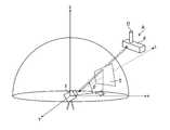
- FIG. 1is a conceptual diagram showing an aspect in the case of acquiring image data and point cloud data with a three-dimensional measuring instrument.
- FIG. 2is a conceptual diagram illustrating a laser scanner and a photographing device mounted on a three-dimensional measuring instrument.
- FIG. 3is a conceptual diagram for explaining that the image data and the point cloud data have a corresponding positional relationship.
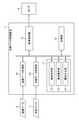
- FIG. 4is a block diagram showing a functional configuration example of the point cloud data processing device.
- FIG. 5is a flowchart showing a point cloud data processing method performed by using the point cloud data processing apparatus.
- FIG. 6is a diagram schematically showing the point cloud data displayed on the monitor.
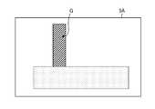
- FIG. 7is a diagram schematically showing image data.
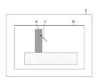
- FIG. 8is a diagram showing image data displayed on the monitor.
- FIG. 9is a diagram for explaining the point cloud data to which the attribute information is added.
- FIG. 10is a diagram showing a point cloud shown on the monitor.
- FIG. 11is a diagram showing a
- FIG. 1is a conceptual diagram showing an aspect in the case where the image data 5 and the point cloud data 7 input to the point cloud data processing device 11 (see FIG. 4) are acquired by the three-dimensional measuring instrument 1.
- the three-dimensional measuring instrument 1acquires the point cloud data of the object A to be measured and the image data 5 with the object A as the subject.
- the object Ais composed of an object D and an object E.
- the laser scanner 101(see FIG. 2) mounted on the three-dimensional measuring instrument 1 emits a laser pulse, and the distance is determined by the time until the laser pulse is reflected on the surface of the object A to be measured and returned. It is a time-of-flight laser scanner that measures. Further, the laser scanner 101 acquires angle information in the emission direction of the laser pulse with reference to the center of rotation of the laser scanner 101 (in FIG. 1, the horizontal direction ⁇ and the vertical direction ⁇ are described). Then, the three-dimensional information of the reflection point of the laser pulse is acquired from the measured distance and the angle information of the emission direction of the laser pulse.
- the laser scanner 101acquires three-dimensional information of a large number of points by changing the horizontal direction ⁇ and the vertical direction ⁇ in the emission direction of the laser pulse at a predetermined pitch.
- the point cloud datais data representing three-dimensional information of a large number of points on the surface of the object to be measured, and each point constituting the point cloud data has three-dimensional information (three-dimensional coordinates).
- the laser scanner 101is not limited to the time-of-flight method, and may acquire point cloud data by a phase difference method or a trigonometry method.
- the three-dimensional measuring instrument 1acquires the image data 5 by the photographing device 102 (see FIG. 2) having the optical axis L mounted on the three-dimensional measuring instrument 1.
- the photographing device 102includes an image sensor (not shown) such as a CCD (Charge Coupled Device).
- the image pickup devicehas a plurality of pixels composed of photoelectric exchange elements two-dimensionally arranged in the x direction (horizontal direction) and the y direction (vertical direction), and on the upper surface of the plurality of pixels, for example, R.
- a color filter(not shown) in which (red), G (green), and B (blue) filters are two-dimensionally Bayer-arranged is provided.
- the image data 5 of the color imageis acquired by the photographing device 102.
- the image data acquired by the photographing device 102is not limited to a color image, and may be a monochrome image.
- FIG. 2is a conceptual diagram illustrating a laser scanner 101 and a photographing device (camera) 102 mounted on the three-dimensional measuring instrument 1.
- the laser scanner 101 and the photographing device 102are arranged on the same optical axis L by using the half mirror 103.
- the positional relationship between the laser scanner 101 and the photographing device 102may be known as long as it is known, and is not particularly limited.
- the photographing device 102may be installed on the laser scanner 101 without making the optical axes the same.
- the three-dimensional measuring instrument 1can acquire the point cloud data 7 and the image data 5 simultaneously or sequentially.
- the point cloud datais acquired by the laser scanner 101, but the means for acquiring the point cloud data is not limited to the laser scanner 101.
- the point cloud datamay be acquired using a ToF (Time-of-Flight) camera or a stereo camera.
- ToFTime-of-Flight
- FIG. 3is a conceptual diagram for explaining that the image data 5 and the point cloud data 7 have a corresponding positional relationship.
- a plurality of image data 5(image data 5A to 5D) are acquired.
- image data 5A to 5Dare acquired.
- the image data 5Awill be described.
- the image data 5Ais image data in which pixels P are arranged two-dimensionally. Pixel P has values for each of R, G, and B.
- FIG. 3the pixels P of the coordinates (Px, Py) in the image data 5A are shown, and the points Q having the positional relationship corresponding to the pixels P are shown.
- the point Qconstitutes the point cloud data 7, and has information on three-dimensional coordinates (x, y, z) which are position information, values of R, G, and B of the corresponding pixels P, and reflection intensity (I).
- the correspondence between the pixel P and the point Qcan be obtained because the image data 5A and the point cloud data 7 have a corresponding positional relationship.
- the image data 5B to 5Dalso have a corresponding positional relationship between the pixels and the points.
- the point cloud data processing device 11into which the image data (image data 5A to 5D) 5 and the point cloud data 7 acquired as described above are input will be described.
- FIG. 4is a block diagram showing a functional configuration example of the point cloud data processing device 11.
- the point cloud data processing device 11is composed of, for example, a computer.
- the point cloud data processing device 11may be mounted on the three-dimensional measuring instrument 1 or may be configured by a computer separate from the three-dimensional measuring instrument 1.
- the point cloud data processing device 11includes an image data acquisition unit 13, a point cloud data acquisition unit 15, a control unit 17, a display control unit 19, and a storage unit (memory) 21.
- the image data acquisition unit 13acquires a plurality of image data 5A to 5D obtained by photographing the object A as image data.
- the image data acquisition unit 13may acquire a plurality of image data 5A to 5D, respectively, or may acquire composite image data in which the image data 5A to 5D are combined.
- the point cloud data acquisition unit 15acquires the point cloud data 7.
- Point cloud data 7 corresponding to each of the image data 5A to 5Dis acquired.
- the point cloud data 7 corresponding to the image data 5A to 5Dmay be combined and acquired.
- the image data acquisition unit 13 and the point cloud data acquisition unit 15acquire by wire or wirelessly.
- the image data 5A to 5D and the point cloud data 7 obtained by the image data acquisition unit 13 and the point cloud data acquisition unit 15are acquired by the above-mentioned three-dimensional measuring instrument 1 and have a corresponding positional relationship.
- the control unit 17is realized by executing a program stored in the storage unit 21 by a CPU (Central Processing Unit) (processor) (not shown) mounted on the computer.
- the control unit 17includes a designated reception unit 23, an area selection unit 25, and an attribute assignment unit 27. Further, the display control unit 19 also realizes its function by executing a program stored in the storage unit 21 by the CPU.
- the storage unit 21stores the point cloud data 7 and the image data 5A to 5D in association with the pixel positions and the points.
- FIG. 5is a flowchart showing a point cloud data processing method performed by using the point cloud data processing device 11.
- the point cloud data processing methodis performed by executing a program stored in the storage unit 21.
- the display control unit 19displays the point cloud data 7 stored in the storage unit 21 on the monitor (display unit) 9 (step S10: point cloud data display step).
- the designated reception unit 23receives the designation of the designated point in the point cloud data 7 displayed on the monitor 9 (step S11: designated step).
- the area selection unit 25selects an area of the target object including the area corresponding to the designated point in the image data (step S12: selection step).
- the attribute giving unit 27gives the same attribute information to the point cloud data 7 corresponding to the area of the target object selected in the image data (step S13: attribute giving step).
- the point cloud data display step(step S10) is performed by the display control unit 19. Further, the designated step (step S11) is performed by the designated reception unit 23.
- the display control unit 19displays the point cloud data 7 stored in the storage unit 21 on the monitor 9.
- FIG. 6is a diagram schematically showing the point cloud data 7 displayed on the monitor 9.
- the points shown in the figure schematicallyshow each point of the point cloud data 7, and the outline of the object A is shown by a dotted line (imaginary line).
- the display control unit 19displays the point cloud data 7 on the monitor 9. Since each point constituting the point cloud data 7 has three-dimensional coordinates, each point is displayed on the illustrated XYZ coordinates based on the three-dimensional coordinates.
- the point cloud data 7 displayed on the monitor 9is displayed so as to be capable of three-dimensional rotation, three-dimensional movement, and enlargement / reduction.
- the usercan use the pointing device to rotate and move the point cloud data 7 three-dimensionally to enlarge or reduce the point cloud data 7. In this way, the point cloud data 7 is three-dimensionally rotated, three-dimensionally moved, and enlarged / reduced, so that the user can accurately specify the designated point F.
- the userWhen the measurement target is complicatedly composed of a plurality of objects, or when the objects are overlapped and arranged in a complicated manner, the user three-dimensionally rotates and moves the point cloud data 7 to enlarge or reduce the point cloud data 7.
- the specified pointcan be specified more accurately.
- the userspecifies the point F by the pointing device.
- the designated reception unit 23receives the coordinate value of the point F and accepts the designation.
- the selection step (step S12)is performed by the area selection unit 25.
- the area selection unit 25selects the area of the target object including the area corresponding to the designated point F in the image data 5.
- FIG. 7is a diagram schematically showing image data 5A.
- the image data 5Ahas a region G corresponding to the designated point F in the point cloud data 7.
- the region Gis composed of a single pixel or a plurality of pixels of the image data 5A.
- each point constituting the point cloud data 7 and each pixel of the image data 5Ahave a corresponding positional relationship. Therefore, in the image data 5A, by selecting the region of the object including the region G, it is possible to specify the point cloud obtained by reflecting the designated point F on the surface of the reflected object D. The selection of the region of the object including the region G will be described below.
- FIG. 8is a diagram showing image data 5A displayed on the monitor 9. Although the case where the image data 5A is displayed will be described with reference to FIG. 8, a composite image of the image data 5A to 5D may be displayed.
- the display control unit 19displays the image data 5A on the monitor 9.
- the display control unit 19displays the area G in the image data 5A so that the user can confirm it.
- the display control unit 19changes the color of the area G to a color different from the surrounding colors, or blinks only the area G to notify the user of the position of the area G.
- the userlooks at the image data 5A displayed on the monitor 9 and selects the area R of the object with the pointing device.
- the area selection unit 25accepts the user's selection of the area R and selects the area R.
- the area Ris the area of the object D, and the user can confirm the object D in the image data 5A, so that the area R can be easily selected.
- the area selection unit 25is composed of a machine-learned recognizer, and the area R can be selected by segmenting the image data 5A with this recognizer.
- the recognizerrecognizes the object D based on the image data 5A and selects the region R of the object D.
- the recognizeris composed of a recognizer that has undergone machine learning or deep learning, and identifies an object region by performing segmentation on the image data 5A.
- existing modelssuch as FCN (Full Convolutional Network), SegNet, and Pix2Pix may be used, or models may be individually created according to the recognition mode of the object D performed by the recognizer. ..
- the learning of the recognizermay use deep learning or machine learning in a broad sense.
- the attribute assignment step (step S13)is performed by the attribute assignment unit 27.
- the attribute assigning unit 27assigns the same attribute information to the points corresponding to the area R in the point cloud data 7.
- the attribute informationis information indicating which point is a point reflected on the surface of which object, in other words, information indicating which object each point corresponds to. Since each pixel of the image data 5A and each point of the point cloud data 7 have a corresponding relationship, the attribute assigning unit 27 identifies the point cloud corresponding to the region R of the image data 5A and assigns the attribute information (D). be able to.
- the region Ris a region corresponding to the object D in the image data 5A
- the point cloud to which the attribute information (D) is addedis the point cloud reflected on the surface of the object D.
- FIG. 9is a diagram for explaining the point cloud data 7 to which the attribute information (D) is added.
- the same attribute information (D)is given to the point cloud U corresponding to the region R.
- the points to which the attribute information (D) is addedare indicated by black circles.
- the point cloud Uis composed of a point cloud to which the attribute information (D) is added.
- the point cloud Ucan be easily used when creating a solid model, a surface model, or the like corresponding to the object D. Can be done. Specifically, the attribute information (D) can be used to extract only the point cloud U from the point cloud data 7 to generate a solid model or a surface model.
- the designated pointis designated in the point cloud data 7, and the region R including the region G corresponding to the designated point is selected on the image data. Then, the point cloud U corresponding to the region R selected on the image data is specified in the point cloud data 7, and the attribute information (D) is given to the point cloud U.
- the point cloud U to which the attribute information (D) is givenis a point cloud reflected on the surface of the object D.
- FIG. 10is a diagram showing a point cloud to which the attribute information W shown on the monitor 9 is added.
- the attribute information Wis given to the point cloud U corresponding to the object D, but the attribute information W is also given to the point cloud other than the point cloud corresponding to the object D (point cloud UE). There is.
- the display control unit 19displays the point cloud (point cloud U and point cloud UE) to which the attribute information W is attached on the monitor 9.
- the userconfirms the displayed point cloud, determines that the point cloud UE does not correspond to the object D, selects the point cloud UE with the pointing device, and corrects the attribute information W given to the point cloud UE.
- the correction unitaccepts the user's correction and corrects the attribute information W given to the point cloud UE.
- FIG. 11is a diagram showing a point cloud to which the attribute information W shown on the monitor 9 is added.
- the attribute information Wis given to the point cloud U corresponding to the object D, but the point cloud to which the attribute information W is given has a leakage region (region UH).
- the display control unit 19causes the monitor 9 to display the point cloud U to which the attribute information W is added.
- the userconfirms the displayed area UH and adds a point cloud so as to fill the area UH with the pointing device.
- the correction unitadds the point cloud having the attribute information W to the area UH.
- the present inventionis not limited to this example.
- the attribute information once givenmay be modified by using a recognizer that has been machine-learned.
- the attribute informationsince the attribute information once given is modified, the attribute information can be given to the point cloud more accurately.
- processorsinclude CPUs, which are general-purpose processors that execute software (programs) and function as various processing units, and programmable processors whose circuit configurations can be changed after manufacturing such as FPGAs (Field Programmable Gate Arrays).
- FPGAsField Programmable Gate Arrays
- a dedicated electric circuitwhich is a processor having a circuit configuration specially designed for executing a specific process such as a logic device (Programmable Logic Device: PLD) and an ASIC (Application Specific Integrated Circuit), is included.
- One processing unitmay be composed of one of these various processors, or may be composed of two or more processors of the same type or different types (for example, a plurality of FPGAs or a combination of a CPU and an FPGA). You may. Further, a plurality of processing units may be configured by one processor. As an example of configuring a plurality of processing units with one processor, first, one processor is configured by a combination of one or more CPUs and software, as represented by a computer such as a client or a server. There is a form in which a processor functions as a plurality of processing units.
- SoCSystem On Chip
- a processorthat realizes the functions of the entire system including a plurality of processing units with one IC (Integrated Circuit) chip is used.
- the various processing unitsare configured by using one or more of the above-mentioned various processors as a hardware-like structure.
Landscapes
- Engineering & Computer Science (AREA)
- Theoretical Computer Science (AREA)
- Physics & Mathematics (AREA)
- General Physics & Mathematics (AREA)
- Computer Vision & Pattern Recognition (AREA)
- Multimedia (AREA)
- Software Systems (AREA)
- General Engineering & Computer Science (AREA)
- Computer Hardware Design (AREA)
- Computer Graphics (AREA)
- Databases & Information Systems (AREA)
- Evolutionary Computation (AREA)
- General Health & Medical Sciences (AREA)
- Medical Informatics (AREA)
- Computing Systems (AREA)
- Artificial Intelligence (AREA)
- Health & Medical Sciences (AREA)
- Quality & Reliability (AREA)
- Architecture (AREA)
- Length Measuring Devices By Optical Means (AREA)
- Processing Or Creating Images (AREA)
- Image Analysis (AREA)
- Image Generation (AREA)
Abstract
Description
Translated fromJapanese本発明は、点群データ処理装置、点群データ処理方法及びプログラムに関し、特に点群データを構成する各点に属性情報を付与する技術に関する。The present invention relates to a point cloud data processing device, a point cloud data processing method and a program, and particularly to a technique for adding attribute information to each point constituting the point cloud data.
レーザースキャナー等により、物体の表面での反射を利用し、物体の表面の三次元情報を表す多数の点(点群)で構成される点群データを取得する技術が知られている。近年、この点群データを様々な形で応用することが考えられている。There is known a technique for acquiring point cloud data composed of a large number of points (point clouds) representing three-dimensional information on the surface of an object by using reflection on the surface of the object with a laser scanner or the like. In recent years, it has been considered to apply this point cloud data in various forms.
一方で、計測された点群データは、そのままでは容量が大きく、点群データを利用する場合にハンドリングの観点で問題となる。そこで、点群データをモデル化(例えばソリッドモデル、サーフェスモデル等)することで、点群データの容量を小さくすることが行われている。On the other hand, the measured point cloud data has a large capacity as it is, which poses a problem from the viewpoint of handling when using the point cloud data. Therefore, the capacity of the point cloud data is reduced by modeling the point cloud data (for example, a solid model, a surface model, etc.).
ここで、点群データをモデル化する場合には、計測された物体毎に点群データを構成する各点群に属性情報を付与(グルーピング)する必要がある。例えば複数の物体を計測した場合には、その物体毎に点群に属性情報を付与する必要がある。Here, when modeling the point cloud data, it is necessary to add (group) attribute information to each point cloud that constitutes the point cloud data for each measured object. For example, when a plurality of objects are measured, it is necessary to add attribute information to the point cloud for each object.
このように点群に属性情報を付与する場合には、例えばユーザが手動により各点を選択し、物体に対応する点群を特定し、特定した点群に対して同じ属性情報を付与することが行われている。When assigning attribute information to a point cloud in this way, for example, the user manually selects each point, identifies the point cloud corresponding to the object, and assigns the same attribute information to the specified point cloud. Is being done.
また、特許文献1に記載された技術では、画像データ上で対象物の領域内に含まれる1点を指定し、指定された1点に基づいて対象物の領域を決定し、決定された対象物の領域に対応する点群をグルーピングしている。Further, in the technique described in
ここで、レーザースキャナーで計測する計測対象は、単純な形状の物体だけでなく、複雑に複数の物体で構成されていたり、物体同士が重なって複雑に配置されていたりする。例えば配管を計測する場合では、複数のパイプが重なるように配置されることがあり、このような場合であっても、パイプ毎に点群に属性情報を付与する必要がある。Here, the measurement target measured by the laser scanner is not only an object having a simple shape, but also a complicatedly composed of a plurality of objects, or the objects are overlapped and arranged in a complicated manner. For example, when measuring pipes, a plurality of pipes may be arranged so as to overlap each other, and even in such a case, it is necessary to add attribute information to a point cloud for each pipe.
このような計測対象の場合には、ユーザが手動により各点を選択し属性情報を付与すると、非常に時間を要する。また、ユーザが点を選択する際に、誤選択などが発生する場合もある。したがって、計測対象が複雑に複数の物体で構成されていたり、物体同士が重なって複雑に配置されていたりする場合には、ユーザが手動により各点を選択する手法では、効率的な作業を行うことができない。In the case of such a measurement target, it takes a lot of time if the user manually selects each point and gives attribute information. In addition, when the user selects a point, erroneous selection may occur. Therefore, when the measurement target is complicatedly composed of a plurality of objects, or when the objects are overlapped and arranged in a complicated manner, the method of manually selecting each point by the user performs efficient work. Can't.
また、特許文献1に記載されるように、2次元で表示された画像データにおいて対象物を指定して属性情報を付与する点群を特定する技術では、2次元的な表示の画像データにおいては重畳された対象物が他の対象物の裏に隠れていたりする場合があり、選択が正確に行われない。したがって、特許文献1に記載されたような技術では、正確に点群に属性情報の付与が行えない場合がある。Further, as described in
本発明はこのような事情に鑑みてなされたもので、その目的は、効率的で正確に点群に属性情報を付与するができる点群データ処理装置、点群データ処理方法及びプログラムを提供することである。The present invention has been made in view of such circumstances, and an object of the present invention is to provide a point cloud data processing device, a point cloud data processing method, and a program capable of efficiently and accurately assigning attribute information to a point cloud. That is.
上記目的を達成するための本発明の一の態様である点群データ処理装置は、物体の表面上の多数の点の三次元情報を表す点群データと、物体を撮影した複数枚の画像データであって、少なくとも複数枚の画像データのうちいずれか1枚の画像データの画素の位置と点群データを構成する点とを関連付けて記憶するメモリ、及びプロセッサを備える点群データ処理装置であって、プロセッサは、点群データを三次元的な回転、三次元的な移動、及び拡大縮小が可能に表示部に表示させ、表示部に表示された点群データにおいて指定点の指定を受け付け、画像データにおいて、指定点に対応する領域を含む対象物体の領域を選択し、点群データにおいて、対象物体の領域に対応する点に同じ属性情報を付与する。The point group data processing device according to one aspect of the present invention for achieving the above object is a point group data representing three-dimensional information of a large number of points on the surface of an object, and a plurality of image data obtained by photographing the object. It is a point group data processing device including a memory for storing the position of a pixel of at least one of a plurality of image data and a point constituting the point group data in association with each other, and a processor. Then, the processor displays the point group data on the display unit so that it can be rotated, moved, and enlarged / reduced in three dimensions, and accepts the designation of the designated point in the point group data displayed on the display unit. In the image data, the area of the target object including the area corresponding to the designated point is selected, and in the point group data, the same attribute information is given to the points corresponding to the area of the target object.
本態様によれば、点群データを三次元的な回転、三次元的な移動、及び拡大縮小が可能に表示部に表示し、その点群データにおいて指定点の指定を受け付ける。そして、本態様は、指定点に対応する領域を含む対象物体の領域は画像データにおいて選択され、その領域に対応する点に同じ属性情報を付与する。したがって、本態様は、効率的で正確に点群データに属性情報を付与することができる。According to this aspect, the point cloud data is displayed on the display unit so that it can be rotated in three dimensions, moved in three dimensions, and enlarged / reduced, and the designation of a designated point is accepted in the point cloud data. Then, in this aspect, the area of the target object including the area corresponding to the designated point is selected in the image data, and the same attribute information is given to the point corresponding to the area. Therefore, in this aspect, attribute information can be efficiently and accurately added to the point cloud data.
好ましくは、プロセッサは、画像データにおいて、対象物体の領域を機械学習が行われた認識器により選択する。Preferably, the processor selects the region of the target object in the image data by the machine-learned recognizer.
好ましくは、プロセッサは、指定点の指定を受け付けた後に、指定点に対応する領域の画像データを表示部に表示させる。Preferably, the processor displays the image data of the area corresponding to the designated point on the display unit after receiving the designation of the designated point.
好ましくは、プロセッサは、複数枚の画像データを合成して表示部に表示する。Preferably, the processor synthesizes a plurality of image data and displays them on the display unit.
好ましくは、プロセッサは、表示部に表示された画像データにおいて、対象物体の領域の選択を受け付ける。Preferably, the processor accepts the selection of the area of the target object in the image data displayed on the display unit.
好ましくは、プロセッサは、属性情報が付与された点群データに対して、機械学習が行われた認識器により、属性情報の付与の修正を加える。Preferably, the processor modifies the addition of the attribute information to the point cloud data to which the attribute information is added by the recognizer subjected to machine learning.
好ましくは、プロセッサは、属性情報が付与された点群データを表示部に表示し、属性情報の付与に関しての修正を受け付けて、付与された属性情報の修正を加える。Preferably, the processor displays the point cloud data to which the attribute information is added on the display unit, accepts the correction regarding the addition of the attribute information, and modifies the assigned attribute information.
好ましくは、プロセッサは、同一の光軸を有する装置で取得された画像データ及び点群データを取得する。Preferably, the processor acquires the image data and the point cloud data acquired by the device having the same optical axis.
本発明の他の態様である点群データ処理方法は、物体の表面上の多数の点の三次元情報を表す点群データと、物体を撮影した複数枚の画像データであって、少なくとも複数枚の画像データのうちいずれか1枚の画像データの画素の位置と点群データを構成する点とを関連付けて記憶するメモリ、及びプロセッサを備える点群データ処理装置の点群データ処理方法であって、プロセッサは、点群データを三次元的な回転、三次元的な移動、及び拡大縮小が可能に表示部に表示させるステップと、表示部に表示された点群データにおいて指定点の指定を受け付けるステップと、画像データにおいて、指定点に対応する領域を含む対象物体の領域を選択するステップと、点群データにおいて、対象物体の領域に対応する点に同じ属性情報を付与するステップと、を行う。The point group data processing method according to another aspect of the present invention is point group data representing three-dimensional information of a large number of points on the surface of an object, and a plurality of image data obtained by photographing the object, at least a plurality of images. It is a point group data processing method of a point group data processing apparatus including a memory for storing the position of a pixel of any one of the image data and the points constituting the point group data in association with each other, and a processor. , The processor accepts the step of displaying the point group data on the display unit so that it can be rotated, moved, and enlarged / reduced in three dimensions, and the designation of the specified point in the point group data displayed on the display unit. In the image data, a step of selecting an area of the target object including the area corresponding to the specified point, and a step of assigning the same attribute information to the point corresponding to the area of the target object in the point group data are performed. ..
本発明の他の態様であるプログラムは、物体の表面上の多数の点の三次元情報を表す点群データと、物体を撮影した複数枚の画像データであって、少なくとも複数枚の画像データのうちいずれか1枚の画像データの画素の位置と点群データを構成する点とを関連付けて記憶するメモリ、及びプロセッサを備える点群データ処理装置に点群データ処理方法を実行させるプログラムであって、プロセッサに、点群データを三次元的な回転、三次元的な移動、及び拡大縮小が可能に表示部に表示させるステップと、表示部に表示された点群データにおいて指定点の指定を受け付けるステップと、画像データにおいて、指定点に対応する領域を含む対象物体の領域を選択するステップと、点群データにおいて、対象物体の領域に対応する点に同じ属性情報を付与するステップと、を行わせる。A program according to another aspect of the present invention is point group data representing three-dimensional information of a large number of points on the surface of an object, and a plurality of image data obtained by photographing the object, and is a plurality of image data of at least a plurality of image data. A program that causes a point group data processing device equipped with a memory for storing the position of a pixel of any one of the image data and a point constituting the point group data in association with each other and a processor to execute the point group data processing method. , Accepts the step of displaying the point group data on the display unit so that the point group data can be rotated, moved, and enlarged / reduced in three dimensions, and the designation of the specified point in the point group data displayed on the display unit. A step of selecting an area of the target object including the area corresponding to the specified point in the image data, and a step of assigning the same attribute information to the point corresponding to the area of the target object in the point group data are performed. Let me.
本発明によれば、点群データを三次元的な回転、三次元的な移動、及び拡大縮小が可能に表示部に表示し、その点群データにおいて指定点の指定を受け付け、指定点に対応する領域を含む対象物体の領域は画像データにおいて選択され、その領域に対応する点に同じ属性情報を付与するので、効率的で正確に点群に属性情報を付与することができる。According to the present invention, point cloud data can be displayed on a display unit so that it can be rotated, moved three-dimensionally, and enlarged / reduced in three dimensions. Since the area of the target object including the area to be used is selected in the image data and the same attribute information is given to the points corresponding to the area, the attribute information can be added to the point cloud efficiently and accurately.
以下、添付図面にしたがって本発明に係る点群データ処理装置、点群データ処理方法、及びプログラムの好ましい実施の形態について説明する。Hereinafter, preferred embodiments of the point cloud data processing apparatus, the point cloud data processing method, and the program according to the present invention will be described with reference to the accompanying drawings.
図1は、点群データ処理装置11(図4を参照)に入力される画像データ5及び点群データ7を三次元計測器1で取得する場合の一態様を示す概念図である。FIG. 1 is a conceptual diagram showing an aspect in the case where the
三次元計測器1は、図1に示すように計測対象である物体Aの点群データ及び物体Aを被写体とした画像データ5を取得する。なお、物体Aは物体D及び物体Eにより構成されている。As shown in FIG. 1, the three-dimensional
三次元計測器1に搭載されるレーザースキャナー101(図2を参照)は、レーザーパルスを出射し、レーザーパルスが計測対象である物体Aの表面で反射して戻ってくるまでの時間により距離を計測するタイムオブフライト方式のレーザースキャナーである。また、レーザースキャナー101は、レーザースキャナー101の回転中心を基準にしたレーザーパルスの出射方向の角度情報(図1では水平方向α、垂直方向βを記載している)を取得する。そして、計測した距離とレーザーパルスの出射方向の角度情報によりレーザーパルスの反射点の三次元情報を取得する。レーザースキャナー101は、レーザーパルスの出射方向の水平方向α及び垂直方向βを所定のピッチで変更することにより、多数の点の三次元情報を取得する。ここで点群データは、計測対象である物体の表面上の多数の点の三次元情報を表すデータであり、そして点群データを構成する各点はそれぞれに三次元情報(三次元座標)を有する。レーザースキャナー101は、タイムオブフライト方式によるものに限らず、位相差方式、三角法方式により点群データを取得するものでもよい。The laser scanner 101 (see FIG. 2) mounted on the three-
三次元計測器1は、搭載される光軸Lを有する撮影装置102(図2を参照)により、画像データ5を取得する。撮影装置102は、CCD(Charge Coupled Device)等(図示せず)の撮像素子を含む。撮像素子は、x方向(水平方向)及びy方向(垂直方向)に二次元的に配列された光電交換素子で構成された複数の画素を有し、複数の画素の上面には、例えば、R(赤)、G(緑)及びB(青)のフィルタが二次元的にベイヤー配列されたカラーフィルタ(図示せず)が備えられている。そして撮影装置102によりカラー画像の画像データ5が取得される。なお、撮影装置102で取得される画像データは、カラー画像に限定されるものではなく、モノクロ画像でもよい。The three-
図2は、三次元計測器1に搭載されるレーザースキャナー101及び撮影装置(カメラ)102を説明する概念図である。FIG. 2 is a conceptual diagram illustrating a
図2に示す例では、ハーフミラー103を利用して、光軸Lを同一としてレーザースキャナー101及び撮影装置102が配置されている。なお、レーザースキャナー101と撮影装置102との位置関係は、既知であれば良く、特に限定されるものではない。例えば、光軸を同一とせずにレーザースキャナー101の上に撮影装置102を設置してもよい。また、三次元計測器1は、点群データ7及び画像データ5を同時に又は逐次的に取得することができる。In the example shown in FIG. 2, the
なお、三次元計測器1では、点群データをレーザースキャナー101で取得しているが、点群データを取得する手段はレーザースキャナー101に限定されるものではない。例えば点群データは、ToF(Time-of-Flight)カメラ又はステレオカメラを使用して取得してもよい。In the three-
図3は、画像データ5と点群データ7とが対応する位置関係を有することを説明する概念図である。図3に示した例では、複数枚の画像データ5(画像データ5A~5D)が取得される。例えば、三次元計測器1がパン方向に回転することにより、それぞれ異なる撮影方向の複数の画像データ5A~5Dが取得される。なお、以下の説明では画像データ5Aに関して説明する。FIG. 3 is a conceptual diagram for explaining that the
画像データ5Aは、二次元に画素Pが配列した画像データである。画素PはR、G、Bのそれぞれについての値を有する。図3では、画像データ5Aにおける座標(Px、Py)の画素Pが示されており、画素Pに対応する位置関係を有する点Qが示されている。点Qは、点群データ7を構成し、位置情報である三次元座標(x、y、z)、対応する画素PのR、G、Bの値及び反射強度(I)の情報を有する。なお、画素Pと点Qとの対応関係は、画像データ5Aと点群データ7とが対応する位置関係を有することから、取得することができる。なお、画像データ5B~5Dに関しても上述で説明したように、画素と点との対応する位置関係を有する。The
次に、上述のように取得された画像データ(画像データ5A~5D)5及び点群データ7が入力される点群データ処理装置11に関して説明する。Next, the point cloud
図4は、点群データ処理装置11の機能構成例を示すブロック図である。点群データ処理装置11は、例えばコンピュータにより構成される。点群データ処理装置11は、三次元計測器1に搭載されてもよいし、三次元計測器1とは別体のコンピュータにより構成されてもよい。FIG. 4 is a block diagram showing a functional configuration example of the point cloud
点群データ処理装置11は、画像データ取得部13、点群データ取得部15、制御部17、表示制御部19及び記憶部(メモリ)21を備える。The point cloud
画像データ取得部13は、物体Aを撮影して得られた複数の画像データ5A~5Dを画像データとして取得する。画像データ取得部13は、複数の画像データ5A~5Dをそれぞれ取得してもよいし、画像データ5A~5Dが合成された合成画像データを取得してもよい。The image
点群データ取得部15は点群データ7を取得する。画像データ5A~5Dにそれぞれ対応する点群データ7が取得される。なお、画像データ5A~5Dと同様に、画像データ5A~5Dにそれぞれ対応する点群データ7を合成して取得してもよい。The point cloud
画像データ取得部13及び点群データ取得部15は、有線又は無線により取得する。なお画像データ取得部13及び点群データ取得部15で得られる画像データ5A~5Dと点群データ7とは上述した三次元計測器1で取得されており、対応する位置関係を有する。The image
制御部17は、コンピュータに搭載されるCPU(Central Processing Unit)(プロセッサ)(図示せず)で、記憶部21に記憶されるプログラムが実行されることにより実現される。制御部17は、指定受付部23、領域選択部25、及び属性付与部27を備える。また、表示制御部19もCPUで記憶部21に記憶されるプログラムが実行されることによりその機能が実現される。The
記憶部21は、点群データ7と画像データ5A~5Dとを、画素の位置と点とを関連付けて記憶する。The
図5は、点群データ処理装置11を使用して行われる点群データ処理方法を示すフローチャートである。なお、点群データ処理方法は、記憶部21に記憶されるプログラムを実行することにより行われる。FIG. 5 is a flowchart showing a point cloud data processing method performed by using the point cloud
先ず、表示制御部19は、記憶部21に記憶されている点群データ7をモニタ(表示部)9に表示する(ステップS10:点群データ表示ステップ)。その後、指定受付部23は、モニタ9に表示された点群データ7における指定点の指定を受け付ける(ステップS11:指定ステップ)。次に、領域選択部25は、画像データにおいて、指定点に対応する領域を含む対象物体の領域を選択する(ステップS12:選択ステップ)。そして、属性付与部27は、画像データにおいて選択された対象物体の領域に対応する点群データ7に同じ属性情報を付与する(ステップS13:属性付与ステップ)。First, the
以下に、各ステップに関して詳細な説明を行う。Below, a detailed explanation will be given for each step.
<点群データ表示ステップ及び指定ステップ>
点群データ表示ステップ(ステップS10)は、表示制御部19により行われる。また、指定ステップ(ステップS11)は、指定受付部23により行われる。表示制御部19は、記憶部21に記憶されている点群データ7をモニタ9に表示する。<Point cloud data display step and designated step>
The point cloud data display step (step S10) is performed by the
図6は、モニタ9に表示された点群データ7を模式的に示す図である。なお、図示された点は点群データ7の各点を模式的に示しており、物体Aの輪郭を点線(想像線)で示している。FIG. 6 is a diagram schematically showing the
表示制御部19は、点群データ7をモニタ9に表示させる。点群データ7を構成する各点は三次元座標を有しているので、その三次元座標に基づいて各点を図示されるXYZ座標上に表示する。モニタ9に表示された点群データ7は、三次元的な回転、三次元的な移動、及び拡大縮小が可能に表示されている。ユーザは、ポインティングデバイスを使用して、点群データ7を三次元的に回転及び移動させ、拡大縮小させることができる。このように、点群データ7が三次元的に回転、三次元的に移動、及び拡大縮小が行われることによって、ユーザは正確に指定点Fの指定を行うことができる。計測対象が複雑に複数の物体で構成されていたり、物体同士が重なって複雑に配置されたりする場合には、ユーザは、点群データ7を三次元的に回転及び移動させ、拡大縮小させることにより正確に指定点を指定することができる。ユーザは、点Fをポインティングデバイスにより指定する。指定受付部23は、点Fの座標値を受け付けて指定を受け付ける。The
<選択ステップ>
選択ステップ(ステップS12)は、領域選択部25により行われる。領域選択部25は、指定点Fに対応する領域を含む対象物体の領域を画像データ5において選択する。<Selection step>
The selection step (step S12) is performed by the
図7は、画像データ5Aを模式的に示す図である。画像データ5Aは、点群データ7における指定点Fに対応する領域Gを有する。領域Gは、画像データ5Aの単数又は複数の画素で構成されている。上述したように、点群データ7を構成する各点と画像データ5Aの各画素とは対応する位置関係を有する。したがって、画像データ5Aにおいて、領域Gが含まれる対象物の領域を選択することにより、指定点Fを反射した物体Dの表面で反射して得られた点群を特定することができる。以下に領域Gが含まれる対象物の領域の選択に関して説明する。FIG. 7 is a diagram schematically showing
先ず、手動により画像データ5Aが対象物の領域を選択する場合について説明する。図8は、モニタ9に表示された画像データ5Aを示す図である。図8では、画像データ5Aが表示される場合について説明するが、画像データ5A~5Dの合成画像が表示されてもよい。First, a case where the
表示制御部19は、モニタ9に画像データ5Aを表示する。表示制御部19は、画像データ5Aにおける領域Gをユーザが確認できるように表示する。例えば、表示制御部19は、領域Gの色を周辺の色とは異なる色にしたり、領域Gのみ点滅させたりして、ユーザに領域Gの位置を報知するように表示する。ユーザは、モニタ9に表示された画像データ5Aを見て、対象物の領域Rをポインティングデバイスで選択する。領域選択部25は、ユーザの領域Rの選択を受け付け、領域Rの選択を行う。なお、領域Rは物体Dの領域であり、ユーザは画像データ5Aにおいて、物体Dを確認することができるので容易に領域Rの選択を行うことができる。The
なお、図8ではユーザが手動により領域Rを選択することについて説明をしたが本発明はこれに限定されるものではない。例えば、領域選択部25は、機械学習が施された認識器で構成され、この認識器で画像データ5Aをセグメンテーションすることにより、領域Rの選択を行うことができる。Although FIG. 8 has described that the user manually selects the area R, the present invention is not limited to this. For example, the
認識器は、画像データ5Aに基づいて物体Dを認識し、物体Dの領域Rを選択する。認識器は、機械学習又は深層学習が施された認識器で構成され、画像データ5Aについてセグメンテーションを行うことにより、物体の領域を特定する。なお、セグメンテーションには、FCN(Full Convolutional Network)、SegNet、Pix2Pix等の既存のモデルを用いてもよいし、認識器で行われる物体Dの認識態様に合わせたモデルを個別に作成してもよい。また、認識器の学習は、深層学習を用いてもよいし、広義の意味で機械学習を用いてもよい。The recognizer recognizes the object D based on the
<属性付与ステップ>
属性付与ステップ(ステップS13)は、属性付与部27で行われる。属性付与部27は、点群データ7において領域Rに対応する点に同じ属性情報を付与する。ここで属性情報とは、各点がどの物体の表面で反射した点であるかを示す情報であり、言い換えると各点がどの物体に対応する点であるかを示す情報である。画像データ5Aの各画素と点群データ7の各点とは対応関係にあるので、属性付与部27は画像データ5Aの領域Rに対応する点群を特定し、属性情報(D)を付与することができる。ここで、領域Rは画像データ5Aにおける物体Dに対応する領域であるので、属性情報(D)が付与された点群は物体Dの表面で反射された点群となる。<Attribute assignment step>
The attribute assignment step (step S13) is performed by the
図9は、属性情報(D)を付与した点群データ7を説明する図である。FIG. 9 is a diagram for explaining the
図9に示される点群データ7では、領域Rに対応する点群Uに同じ属性情報(D)が付与されている。属性情報(D)が付与された点は黒丸印で表示している。点群Uは、属性情報(D)が付与された点群で構成されている。In the
このように、物体Dに対応する点群Uに属性情報(D)を付与することにより、物体Dに対応するソリッドモデルやサーフェスモデル等を作成する際に、点群Uを簡便に使用することができる。具体的には、属性情報(D)を使用して、点群データ7から点群Uのみを抽出してソリッドモデルやサーフェスモデルを生成することができる。By adding the attribute information (D) to the point cloud U corresponding to the object D in this way, the point cloud U can be easily used when creating a solid model, a surface model, or the like corresponding to the object D. Can be done. Specifically, the attribute information (D) can be used to extract only the point cloud U from the
以上で説明したように、本実施形態においては、点群データ7において指定点を指定し、指定点に対応する領域Gを含む領域Rが画像データ上で選択される。そして、画像データ上で選択された領域Rに対応する点群Uが点群データ7において特定され、点群Uに属性情報(D)が付与される。この属性情報(D)が付与された点群Uは、物体Dの表面で反射した点群である。これにより、本態様は、効率的で正確に点群データ7を構成する点のうち物体Dに対応する属性情報(D)を付与することができる。As described above, in the present embodiment, the designated point is designated in the
<その他>
上述の説明では、点群データ7の一部の点群Uをグルーピングすることに関して説明した。しかしながら、必ずしも常に点群Uのグルーピングが上手く行われるとは限らない。例えば、上述の説明における画像データ5Aにおける領域Rの選択で、境界部分の選択が多少ずれてしまった場合などは、属性情報の付与が正確に行えない場合がある。本実施形態では、このような場合において属性情報の修正を加える。本実施形態は、制御部17に修正部(不図示)を備え、付与された属性情報に修正を加える。<Others>
In the above description, grouping of a part of the point cloud U of the
図10は、モニタ9に示された属性情報Wが付与された点群を示す図である。図10に示す場合では、物体Dに対応する点群Uに属性情報Wを付与する場合であるが、物体Dに対応する点群以外(点群UE)にも、属性情報Wが付与されている。FIG. 10 is a diagram showing a point cloud to which the attribute information W shown on the
表示制御部19は、属性情報Wが付与された点群(点群U及び点群UE)をモニタ9に表示する。ユーザは表示された点群を確認し、点群UEは物体Dに対応しないと判断し、ポインティングデバイスで点群UEを選択し、点群UEに付与されている属性情報Wを修正する。修正部は、ユーザの修正を受け付けて、点群UEに付与されている属性情報Wを修正する。The
図11は、モニタ9に示された属性情報Wが付与された点群を示す図である。図11に示す場合では、物体Dに対応する点群Uに属性情報Wを付与する場合であるが、属性情報Wが付与された点群に漏れの領域(領域UH)がある。FIG. 11 is a diagram showing a point cloud to which the attribute information W shown on the
表示制御部19は、属性情報Wが付与された点群Uをモニタ9に表示させる。ユーザは、表示された領域UHを確認し、ポインティングデバイスで領域UHを埋めるように点群を追加する。これにより、修正部は、属性情報Wを有する点群を領域UHに追加する。The
なお、上述した例ではユーザが手動により、付与された属性情報を修正する例について説明したが、本発明はこの例に限定されるものではない。例えば、一旦付与された属性情報に対して、機械学習が行われた認識器を使用して修正を行ってもよい。In the above-mentioned example, an example in which the user manually corrects the assigned attribute information has been described, but the present invention is not limited to this example. For example, the attribute information once given may be modified by using a recognizer that has been machine-learned.
このように、本実施形態においては、一旦付与された属性情報において修正を加えるので、より正確に点群に属性情報を付与することができる。As described above, in the present embodiment, since the attribute information once given is modified, the attribute information can be given to the point cloud more accurately.
上記実施形態において、各種の処理を実行する処理部(processing unit)のハードウェア的な構造は、次に示すような各種のプロセッサ(processor)である。各種のプロセッサには、ソフトウェア(プログラム)を実行して各種の処理部として機能する汎用的なプロセッサであるCPU、FPGA(Field Programmable Gate Array)などの製造後に回路構成を変更可能なプロセッサであるプログラマブルロジックデバイス(Programmable Logic Device:PLD)、ASIC(Application Specific Integrated Circuit)などの特定の処理を実行させるために専用に設計された回路構成を有するプロセッサである専用電気回路などが含まれる。In the above embodiment, the hardware structure of the processing unit that executes various processes is various processors as shown below. Various processors include CPUs, which are general-purpose processors that execute software (programs) and function as various processing units, and programmable processors whose circuit configurations can be changed after manufacturing such as FPGAs (Field Programmable Gate Arrays). A dedicated electric circuit, which is a processor having a circuit configuration specially designed for executing a specific process such as a logic device (Programmable Logic Device: PLD) and an ASIC (Application Specific Integrated Circuit), is included.
1つの処理部は、これら各種のプロセッサのうちの1つで構成されていてもよいし、同種又は異種の2つ以上のプロセッサ(例えば、複数のFPGA、あるいはCPUとFPGAの組み合わせ)で構成されてもよい。また、複数の処理部を1つのプロセッサで構成してもよい。複数の処理部を1つのプロセッサで構成する例としては、第1に、クライアントやサーバなどのコンピュータに代表されるように、1つ以上のCPUとソフトウェアの組合せで1つのプロセッサを構成し、このプロセッサが複数の処理部として機能する形態がある。第2に、システムオンチップ(System On Chip:SoC)などに代表されるように、複数の処理部を含むシステム全体の機能を1つのIC(Integrated Circuit)チップで実現するプロセッサを使用する形態がある。このように、各種の処理部は、ハードウェア的な構造として、上記各種のプロセッサを1つ以上用いて構成される。One processing unit may be composed of one of these various processors, or may be composed of two or more processors of the same type or different types (for example, a plurality of FPGAs or a combination of a CPU and an FPGA). You may. Further, a plurality of processing units may be configured by one processor. As an example of configuring a plurality of processing units with one processor, first, one processor is configured by a combination of one or more CPUs and software, as represented by a computer such as a client or a server. There is a form in which a processor functions as a plurality of processing units. Secondly, as typified by System On Chip (SoC), there is a form in which a processor that realizes the functions of the entire system including a plurality of processing units with one IC (Integrated Circuit) chip is used. be. As described above, the various processing units are configured by using one or more of the above-mentioned various processors as a hardware-like structure.
さらに、これらの各種のプロセッサのハードウェア的な構造は、より具体的には、半導体素子などの回路素子を組み合わせた電気回路(circuitry)である。Furthermore, the hardware structure of these various processors is, more specifically, an electric circuit (circuitry) in which circuit elements such as semiconductor elements are combined.
上述の各構成及び機能は、任意のハードウェア、ソフトウェア、或いは両者の組み合わせによって適宜実現可能である。例えば、上述の処理ステップ(処理手順)をコンピュータに実行させるプログラム、そのようなプログラムを記録したコンピュータ読み取り可能な記録媒体(非一時的記録媒体)、或いはそのようなプログラムをインストール可能なコンピュータに対しても本発明を適用することが可能である。Each of the above configurations and functions can be appropriately realized by any hardware, software, or a combination of both. For example, for a program that causes a computer to perform the above-mentioned processing steps, a computer-readable recording medium (non-temporary recording medium) that records such a program, or a computer on which such a program can be installed. However, it is possible to apply the present invention.
以上で本発明の例に関して説明してきたが、本発明は上述した実施の形態に限定されず、本発明の精神を逸脱しない範囲で種々の変形が可能であることは言うまでもない。Although the examples of the present invention have been described above, it goes without saying that the present invention is not limited to the above-described embodiment, and various modifications can be made without departing from the spirit of the present invention.
1 :三次元計測器
5 :画像データ
7 :点群データ
9 :モニタ
11 :点群データ処理装置
13 :画像データ取得部
15 :点群データ取得部
17 :制御部
19 :表示制御部
21 :記憶部
23 :指定受付部
25 :領域選択部
27 :属性付与部
101 :レーザースキャナー
102 :撮影装置
103 :ハーフミラー1: Three-dimensional measuring instrument 5: Image data 7: Point cloud data 9: Monitor 11: Point cloud data processing device 13: Image data acquisition unit 15: Point cloud data acquisition unit 17: Control unit 19: Display control unit 21: Storage Unit 23: Designated reception unit 25: Area selection unit 27: Attribute addition unit 101: Laser scanner 102: Imaging device 103: Half mirror
Claims (10)
Translated fromJapanese前記プロセッサは、
前記点群データを三次元的な回転、三次元的な移動、及び拡大縮小が可能に表示部に表示させ、
前記表示部に表示された前記点群データにおいて指定点の指定を受け付け、
前記画像データにおいて、前記指定点に対応する領域を含む対象物体の領域を選択し、 前記点群データにおいて、前記対象物体の領域に対応する前記点に同じ属性情報を付与する、
点群データ処理装置。Point cloud data representing three-dimensional information of a large number of points on the surface of an object, and a plurality of image data obtained by photographing the object, and at least one of the plurality of image data. A point cloud data processing device including a memory for storing pixel positions and points constituting the point cloud data in association with each other, and a processor.
The processor
The point cloud data is displayed on the display unit so that it can be rotated in three dimensions, moved in three dimensions, and enlarged / reduced.
Accepting the designation of the designated point in the point cloud data displayed on the display unit,
In the image data, a region of the target object including the region corresponding to the designated point is selected, and in the point cloud data, the same attribute information is given to the point corresponding to the region of the target object.
Point cloud data processing device.
前記属性情報が付与された前記点群データを表示部に表示し、
前記属性情報の付与に関しての修正を受け付けて、付与された前記属性情報の修正を加える請求項1から5のいずれか1項に記載の点群データ処理装置。The processor
The point cloud data to which the attribute information is added is displayed on the display unit, and the point cloud data is displayed.
The point cloud data processing apparatus according to any one of claims 1 to 5, which accepts a modification regarding the addition of the attribute information and modifies the assigned attribute information.
前記プロセッサは、
前記点群データを三次元的な回転、三次元的な移動、及び拡大縮小が可能に表示部に表示させるステップと、
前記表示部に表示された前記点群データにおいて指定点の指定を受け付けるステップと、
前記画像データにおいて、前記指定点に対応する領域を含む対象物体の領域を選択するステップと、
前記点群データにおいて、前記対象物体の領域に対応する前記点に同じ属性情報を付与するステップと、
を行う点群データ処理方法。Point cloud data representing three-dimensional information of a large number of points on the surface of an object, and a plurality of image data obtained by photographing the object, and at least one of the plurality of image data. It is a point cloud data processing method of a point cloud data processing apparatus including a memory for storing a pixel position and a point constituting the point cloud data in association with each other and a processor.
The processor
A step of displaying the point cloud data on the display unit so that it can be rotated, moved, and enlarged / reduced in three dimensions.
A step of accepting the designation of a designated point in the point cloud data displayed on the display unit, and
In the image data, a step of selecting a region of the target object including a region corresponding to the designated point, and
In the point cloud data, a step of assigning the same attribute information to the point corresponding to the region of the target object, and
Point cloud data processing method.
前記プロセッサに、
前記点群データを三次元的な回転、三次元的な移動、及び拡大縮小が可能に表示部に表示させるステップと、
前記表示部に表示された前記点群データにおいて指定点の指定を受け付けるステップと、
前記画像データにおいて、前記指定点に対応する領域を含む対象物体の領域を選択するステップと、
前記点群データにおいて、前記対象物体の領域に対応する前記点に同じ属性情報を付与するステップと、
を行わせるプログラム。Point cloud data representing three-dimensional information of a large number of points on the surface of an object, and a plurality of image data obtained by photographing the object, and at least one of the plurality of image data. A program that causes a point cloud data processing device including a memory and a processor to associate and store pixel positions with points constituting the point cloud data to execute a point cloud data processing method.
To the processor
A step of displaying the point cloud data on the display unit so that it can be rotated, moved, and enlarged / reduced in three dimensions.
A step of accepting the designation of a designated point in the point cloud data displayed on the display unit, and
In the image data, a step of selecting a region of the target object including a region corresponding to the designated point, and
In the point cloud data, a step of assigning the same attribute information to the point corresponding to the region of the target object, and
A program that lets you do.
Priority Applications (4)
| Application Number | Priority Date | Filing Date | Title |
|---|---|---|---|
| CN202080096126.7ACN115088020B (en) | 2020-02-18 | 2020-12-07 | Point cloud data processing device, point cloud data processing method, and computer-readable recording medium |
| JP2022501647AJP7392101B2 (en) | 2020-02-18 | 2020-12-07 | Point cloud data processing device, point cloud data processing method, and program |
| EP20919406.7AEP4109413B1 (en) | 2020-02-18 | 2020-12-07 | Point cloud data processing device, point cloud data processing method, and program |
| US17/816,235US20220366673A1 (en) | 2020-02-18 | 2022-07-29 | Point cloud data processing apparatus, point cloud data processing method, and program |
Applications Claiming Priority (2)
| Application Number | Priority Date | Filing Date | Title |
|---|---|---|---|
| JP2020-025448 | 2020-02-18 | ||
| JP2020025448 | 2020-02-18 |
Related Child Applications (1)
| Application Number | Title | Priority Date | Filing Date |
|---|---|---|---|
| US17/816,235ContinuationUS20220366673A1 (en) | 2020-02-18 | 2022-07-29 | Point cloud data processing apparatus, point cloud data processing method, and program |
Publications (1)
| Publication Number | Publication Date |
|---|---|
| WO2021166381A1true WO2021166381A1 (en) | 2021-08-26 |
Family
ID=77390649
Family Applications (1)
| Application Number | Title | Priority Date | Filing Date |
|---|---|---|---|
| PCT/JP2020/045365CeasedWO2021166381A1 (en) | 2020-02-18 | 2020-12-07 | Point cloud data processing device, point cloud data processing method, and program |
Country Status (5)
| Country | Link |
|---|---|
| US (1) | US20220366673A1 (en) |
| EP (1) | EP4109413B1 (en) |
| JP (1) | JP7392101B2 (en) |
| CN (1) | CN115088020B (en) |
| WO (1) | WO2021166381A1 (en) |
Cited By (1)
| Publication number | Priority date | Publication date | Assignee | Title |
|---|---|---|---|---|
| JPWO2024047782A1 (en)* | 2022-08-31 | 2024-03-07 |
Families Citing this family (2)
| Publication number | Priority date | Publication date | Assignee | Title |
|---|---|---|---|---|
| JP6874197B1 (en)* | 2020-08-27 | 2021-05-19 | パシフィックコンサルタンツ株式会社 | Equipment management program, equipment management method, and equipment management system |
| US20250292489A1 (en)* | 2024-01-29 | 2025-09-18 | Naoki MOTOHASHI | Information processing apparatus, screen generation method, non-transitory recording medium, and information processing system |
Citations (4)
| Publication number | Priority date | Publication date | Assignee | Title |
|---|---|---|---|---|
| WO2008099915A1 (en)* | 2007-02-16 | 2008-08-21 | Mitsubishi Electric Corporation | Road/feature measuring device, feature identifying device, road/feature measuring method, road/feature measuring program, measuring device, measuring method, measuring program, measured position data, measuring terminal, measuring server device, drawing device, drawing method, drawing program, and drawing data |
| JP2012083157A (en) | 2010-10-08 | 2012-04-26 | Mitsubishi Electric Corp | Outdoor feature detection system, program for the same, and record media of program for the same |
| JP2017130146A (en)* | 2016-01-22 | 2017-07-27 | キヤノン株式会社 | Image management apparatus, image management method, and program |
| JP2018041192A (en)* | 2016-09-06 | 2018-03-15 | 株式会社トプコン | Image processing apparatus, image processing method, and image processing program |
Family Cites Families (7)
| Publication number | Priority date | Publication date | Assignee | Title |
|---|---|---|---|---|
| US10139985B2 (en)* | 2012-06-22 | 2018-11-27 | Matterport, Inc. | Defining, displaying and interacting with tags in a three-dimensional model |
| US20190096135A1 (en)* | 2017-09-26 | 2019-03-28 | Aquifi, Inc. | Systems and methods for visual inspection based on augmented reality |
| EP3716210B1 (en)* | 2017-11-20 | 2023-09-06 | Panasonic Intellectual Property Corporation of America | Three-dimensional point group data generation method, position estimation method, three-dimensional point group data generation device, and position estimation device |
| WO2019245865A1 (en)* | 2018-06-19 | 2019-12-26 | Tornier, Inc. | Mixed reality indication of points at which 3d bone and implant models collide |
| CN109472852B (en)* | 2018-10-29 | 2021-08-10 | 百度在线网络技术(北京)有限公司 | Point cloud image display method and device, equipment and storage medium |
| EP3970122A1 (en)* | 2019-07-19 | 2022-03-23 | Five AI Limited | Structure modelling |
| CN110751090B (en)* | 2019-10-18 | 2022-09-20 | 宁波博登智能科技有限公司 | Three-dimensional point cloud labeling method and device and electronic equipment |
- 2020
- 2020-12-07CNCN202080096126.7Apatent/CN115088020B/enactiveActive
- 2020-12-07JPJP2022501647Apatent/JP7392101B2/enactiveActive
- 2020-12-07EPEP20919406.7Apatent/EP4109413B1/enactiveActive
- 2020-12-07WOPCT/JP2020/045365patent/WO2021166381A1/ennot_activeCeased
- 2022
- 2022-07-29USUS17/816,235patent/US20220366673A1/enactivePending
Patent Citations (4)
| Publication number | Priority date | Publication date | Assignee | Title |
|---|---|---|---|---|
| WO2008099915A1 (en)* | 2007-02-16 | 2008-08-21 | Mitsubishi Electric Corporation | Road/feature measuring device, feature identifying device, road/feature measuring method, road/feature measuring program, measuring device, measuring method, measuring program, measured position data, measuring terminal, measuring server device, drawing device, drawing method, drawing program, and drawing data |
| JP2012083157A (en) | 2010-10-08 | 2012-04-26 | Mitsubishi Electric Corp | Outdoor feature detection system, program for the same, and record media of program for the same |
| JP2017130146A (en)* | 2016-01-22 | 2017-07-27 | キヤノン株式会社 | Image management apparatus, image management method, and program |
| JP2018041192A (en)* | 2016-09-06 | 2018-03-15 | 株式会社トプコン | Image processing apparatus, image processing method, and image processing program |
Non-Patent Citations (1)
| Title |
|---|
| See also references ofEP4109413A4 |
Cited By (2)
| Publication number | Priority date | Publication date | Assignee | Title |
|---|---|---|---|---|
| JPWO2024047782A1 (en)* | 2022-08-31 | 2024-03-07 | ||
| WO2024047782A1 (en)* | 2022-08-31 | 2024-03-07 | 三菱電機株式会社 | Point group data drawing system, server, point group data drawing device, and point group data drawing method |
Also Published As
| Publication number | Publication date |
|---|---|
| JPWO2021166381A1 (en) | 2021-08-26 |
| US20220366673A1 (en) | 2022-11-17 |
| EP4109413A1 (en) | 2022-12-28 |
| CN115088020A (en) | 2022-09-20 |
| EP4109413B1 (en) | 2024-05-15 |
| EP4109413A4 (en) | 2023-07-19 |
| CN115088020B (en) | 2024-12-17 |
| JP7392101B2 (en) | 2023-12-05 |
Similar Documents
| Publication | Publication Date | Title |
|---|---|---|
| JP7344289B2 (en) | Point cloud data processing device, point cloud data processing method, and program | |
| JP7265639B2 (en) | Point cloud merging method that identifies and retains preferred points | |
| JP7392101B2 (en) | Point cloud data processing device, point cloud data processing method, and program | |
| JP5620200B2 (en) | Point cloud position data processing device, point cloud position data processing method, point cloud position data processing system, and point cloud position data processing program | |
| US11290704B2 (en) | Three dimensional scanning system and framework | |
| WO2021140886A1 (en) | Three-dimensional model generation method, information processing device, and program | |
| JP6812271B2 (en) | Image processing equipment, image processing methods and programs | |
| US7403268B2 (en) | Method and apparatus for determining the geometric correspondence between multiple 3D rangefinder data sets | |
| EP1193646A2 (en) | Image processing apparatus | |
| JP6841863B2 (en) | OCT retinal image data rendering method, storage medium storing OCT retinal image data rendering program, OCT retinal image data rendering program and OCT retinal image data rendering device | |
| JP2018514237A (en) | Texture mapping apparatus and method for dental 3D scanner | |
| CN113160328A (en) | External reference calibration method, system, robot and storage medium | |
| JP2020053008A (en) | Positioning method, robot and computer storage medium | |
| CN113610741A (en) | Point cloud processing method and device based on laser line scanning | |
| WO2020075252A1 (en) | Information processing device, program, and information processing method | |
| CN117523105A (en) | Three-dimensional scene reconstruction method for laser radar and multi-camera data fusion | |
| JP7615126B2 (en) | Point cloud data processing device, point cloud data processing method, and program | |
| Grammatikopoulos et al. | Automatic multi-image photo-texturing of 3d surface models obtained with laser scanning | |
| EP4627519A1 (en) | Generating a parallax free two and a half (2.5) dimensional point cloud using a high resolution image | |
| JP2024072284A (en) | 3D calibration method and apparatus for multi-view phase shift profilometry - Patents.com | |
| JP7457971B2 (en) | Quantity calculation device and quantity calculation method | |
| WO2022133569A1 (en) | Methods and system for reconstructing textured meshes from point cloud data | |
| JP3052926B2 (en) | 3D coordinate measuring device | |
| JP2003216933A (en) | Data processing device, storage medium and program | |
| CN113287151B (en) | Information processing device, computer-readable recording medium, and information processing method |
Legal Events
| Date | Code | Title | Description |
|---|---|---|---|
| 121 | Ep: the epo has been informed by wipo that ep was designated in this application | Ref document number:20919406 Country of ref document:EP Kind code of ref document:A1 | |
| ENP | Entry into the national phase | Ref document number:2022501647 Country of ref document:JP Kind code of ref document:A | |
| NENP | Non-entry into the national phase | Ref country code:DE | |
| ENP | Entry into the national phase | Ref document number:2020919406 Country of ref document:EP Effective date:20220919 |