WO2021106509A1 - Apparatus and method for controlling mobile body - Google Patents
Apparatus and method for controlling mobile bodyDownload PDFInfo
- Publication number
- WO2021106509A1 WO2021106509A1PCT/JP2020/041140JP2020041140WWO2021106509A1WO 2021106509 A1WO2021106509 A1WO 2021106509A1JP 2020041140 WJP2020041140 WJP 2020041140WWO 2021106509 A1WO2021106509 A1WO 2021106509A1
- Authority
- WO
- WIPO (PCT)
- Prior art keywords
- dimensional map
- weight
- unit
- map
- moving body
- Prior art date
- Legal status (The legal status is an assumption and is not a legal conclusion. Google has not performed a legal analysis and makes no representation as to the accuracy of the status listed.)
- Ceased
Links
Images


Classifications
- G—PHYSICS
- G05—CONTROLLING; REGULATING
- G05D—SYSTEMS FOR CONTROLLING OR REGULATING NON-ELECTRIC VARIABLES
- G05D1/00—Control of position, course, altitude or attitude of land, water, air or space vehicles, e.g. using automatic pilots
- G05D1/02—Control of position or course in two dimensions
- G05D1/021—Control of position or course in two dimensions specially adapted to land vehicles
- G05D1/0231—Control of position or course in two dimensions specially adapted to land vehicles using optical position detecting means
- G05D1/0246—Control of position or course in two dimensions specially adapted to land vehicles using optical position detecting means using a video camera in combination with image processing means
- G05D1/0251—Control of position or course in two dimensions specially adapted to land vehicles using optical position detecting means using a video camera in combination with image processing means extracting 3D information from a plurality of images taken from different locations, e.g. stereo vision
- G—PHYSICS
- G05—CONTROLLING; REGULATING
- G05D—SYSTEMS FOR CONTROLLING OR REGULATING NON-ELECTRIC VARIABLES
- G05D1/00—Control of position, course, altitude or attitude of land, water, air or space vehicles, e.g. using automatic pilots
- G05D1/02—Control of position or course in two dimensions
- G05D1/021—Control of position or course in two dimensions specially adapted to land vehicles
- G05D1/0231—Control of position or course in two dimensions specially adapted to land vehicles using optical position detecting means
- G05D1/0246—Control of position or course in two dimensions specially adapted to land vehicles using optical position detecting means using a video camera in combination with image processing means
- G—PHYSICS
- G01—MEASURING; TESTING
- G01C—MEASURING DISTANCES, LEVELS OR BEARINGS; SURVEYING; NAVIGATION; GYROSCOPIC INSTRUMENTS; PHOTOGRAMMETRY OR VIDEOGRAMMETRY
- G01C21/00—Navigation; Navigational instruments not provided for in groups G01C1/00 - G01C19/00
- G01C21/38—Electronic maps specially adapted for navigation; Updating thereof
- G01C21/3804—Creation or updating of map data
- G01C21/3833—Creation or updating of map data characterised by the source of data
- G01C21/3841—Data obtained from two or more sources, e.g. probe vehicles
- G—PHYSICS
- G01—MEASURING; TESTING
- G01S—RADIO DIRECTION-FINDING; RADIO NAVIGATION; DETERMINING DISTANCE OR VELOCITY BY USE OF RADIO WAVES; LOCATING OR PRESENCE-DETECTING BY USE OF THE REFLECTION OR RERADIATION OF RADIO WAVES; ANALOGOUS ARRANGEMENTS USING OTHER WAVES
- G01S13/00—Systems using the reflection or reradiation of radio waves, e.g. radar systems; Analogous systems using reflection or reradiation of waves whose nature or wavelength is irrelevant or unspecified
- G01S13/86—Combinations of radar systems with non-radar systems, e.g. sonar, direction finder
- G01S13/867—Combination of radar systems with cameras
- G—PHYSICS
- G01—MEASURING; TESTING
- G01S—RADIO DIRECTION-FINDING; RADIO NAVIGATION; DETERMINING DISTANCE OR VELOCITY BY USE OF RADIO WAVES; LOCATING OR PRESENCE-DETECTING BY USE OF THE REFLECTION OR RERADIATION OF RADIO WAVES; ANALOGOUS ARRANGEMENTS USING OTHER WAVES
- G01S13/00—Systems using the reflection or reradiation of radio waves, e.g. radar systems; Analogous systems using reflection or reradiation of waves whose nature or wavelength is irrelevant or unspecified
- G01S13/88—Radar or analogous systems specially adapted for specific applications
- G01S13/89—Radar or analogous systems specially adapted for specific applications for mapping or imaging
- G—PHYSICS
- G01—MEASURING; TESTING
- G01S—RADIO DIRECTION-FINDING; RADIO NAVIGATION; DETERMINING DISTANCE OR VELOCITY BY USE OF RADIO WAVES; LOCATING OR PRESENCE-DETECTING BY USE OF THE REFLECTION OR RERADIATION OF RADIO WAVES; ANALOGOUS ARRANGEMENTS USING OTHER WAVES
- G01S13/00—Systems using the reflection or reradiation of radio waves, e.g. radar systems; Analogous systems using reflection or reradiation of waves whose nature or wavelength is irrelevant or unspecified
- G01S13/88—Radar or analogous systems specially adapted for specific applications
- G01S13/93—Radar or analogous systems specially adapted for specific applications for anti-collision purposes
- G01S13/931—Radar or analogous systems specially adapted for specific applications for anti-collision purposes of land vehicles
- G—PHYSICS
- G05—CONTROLLING; REGULATING
- G05D—SYSTEMS FOR CONTROLLING OR REGULATING NON-ELECTRIC VARIABLES
- G05D1/00—Control of position, course, altitude or attitude of land, water, air or space vehicles, e.g. using automatic pilots
- G05D1/02—Control of position or course in two dimensions
- G05D1/021—Control of position or course in two dimensions specially adapted to land vehicles
- G05D1/0255—Control of position or course in two dimensions specially adapted to land vehicles using acoustic signals, e.g. ultra-sonic singals
- G—PHYSICS
- G05—CONTROLLING; REGULATING
- G05D—SYSTEMS FOR CONTROLLING OR REGULATING NON-ELECTRIC VARIABLES
- G05D1/00—Control of position, course, altitude or attitude of land, water, air or space vehicles, e.g. using automatic pilots
- G05D1/02—Control of position or course in two dimensions
- G05D1/021—Control of position or course in two dimensions specially adapted to land vehicles
- G05D1/0268—Control of position or course in two dimensions specially adapted to land vehicles using internal positioning means
- G05D1/0274—Control of position or course in two dimensions specially adapted to land vehicles using internal positioning means using mapping information stored in a memory device
- G—PHYSICS
- G06—COMPUTING OR CALCULATING; COUNTING
- G06V—IMAGE OR VIDEO RECOGNITION OR UNDERSTANDING
- G06V10/00—Arrangements for image or video recognition or understanding
- G06V10/20—Image preprocessing
- G06V10/255—Detecting or recognising potential candidate objects based on visual cues, e.g. shapes
- G—PHYSICS
- G06—COMPUTING OR CALCULATING; COUNTING
- G06V—IMAGE OR VIDEO RECOGNITION OR UNDERSTANDING
- G06V20/00—Scenes; Scene-specific elements
- G06V20/50—Context or environment of the image
- G06V20/56—Context or environment of the image exterior to a vehicle by using sensors mounted on the vehicle
- G06V20/58—Recognition of moving objects or obstacles, e.g. vehicles or pedestrians; Recognition of traffic objects, e.g. traffic signs, traffic lights or roads
- G—PHYSICS
- G06—COMPUTING OR CALCULATING; COUNTING
- G06V—IMAGE OR VIDEO RECOGNITION OR UNDERSTANDING
- G06V20/00—Scenes; Scene-specific elements
- G06V20/60—Type of objects
- G06V20/64—Three-dimensional objects
- G—PHYSICS
- G01—MEASURING; TESTING
- G01S—RADIO DIRECTION-FINDING; RADIO NAVIGATION; DETERMINING DISTANCE OR VELOCITY BY USE OF RADIO WAVES; LOCATING OR PRESENCE-DETECTING BY USE OF THE REFLECTION OR RERADIATION OF RADIO WAVES; ANALOGOUS ARRANGEMENTS USING OTHER WAVES
- G01S13/00—Systems using the reflection or reradiation of radio waves, e.g. radar systems; Analogous systems using reflection or reradiation of waves whose nature or wavelength is irrelevant or unspecified
- G01S13/88—Radar or analogous systems specially adapted for specific applications
- G01S13/93—Radar or analogous systems specially adapted for specific applications for anti-collision purposes
- G01S13/931—Radar or analogous systems specially adapted for specific applications for anti-collision purposes of land vehicles
- G01S2013/9327—Sensor installation details
- G01S2013/93271—Sensor installation details in the front of the vehicles
Definitions
- the present inventionrelates to a control device and method for a moving body.
- Patent Document 1the presence or absence of a side wall that causes an erroneous detection when an object is detected by a millimeter wave radar is determined by using map information for navigation, and the presence or absence of the side wall is determined.
- Patent Document 2proposes a technique for suppressing reflected waves from a metal object on a road surface by combining object detection of a millimeter-wave radar with map information created by a stereo camera and detection of a polarized region. ing.
- Patent Document 1it is possible to predict an object registered in a navigation map, but it cannot be dealt with when an object not registered in a navigation map induces a detection error of a millimeter wave radar. For example, it cannot be solved when a large trailer is running beside the object to be detected or when there is a guardrail that is not registered on the map.
- Patent Document 2discloses a detection method for metal objects on the road surface, but does not describe how to deal with a situation where multipath may occur.
- An object of the present inventionis a control device and method for a moving body capable of adjusting the detection result by the radar device according to the three-dimensional shape of each area of the three-dimensional map generated from the image captured by the image pickup device. To provide.
- one example of the present inventionis a moving body control device having an image pickup device and a radar device, and generates a three-dimensional map around the moving body from an image captured by the image pickup device.
- the weight estimation unitthat estimates the weight of the detection result by the radar device for each region of the three-dimensional map from the three-dimensional shape of each region of the three-dimensional map, and the weight An adjustment unit for adjusting the detection result by the radar device based on the radar device is provided.
- the detection result by the radar devicecan be adjusted according to the three-dimensional shape of each area of the three-dimensional map generated from the image captured by the image pickup device. Issues, configurations and effects other than those described above will be clarified by the description of the following embodiments.
- the embodiment of the inventionis shown below.
- the present embodimentrelates to a system for highly understanding the surrounding environment in an automatic driving or a highly safe driving system.
- Figure 1shows a vehicle control system that uses an imaging device and millimeter-wave radar.
- the image pickup device 101 and the millimeter wave radar device 102are mounted on the vehicle 103, and for example, the distance to the object 104 in front and the relative velocity are measured and transmitted to the moving body control unit 105.
- the moving body control unit 105determines the control of the brake and the accelerator from the distance to the object 104 and the relative speed, and controls the vehicle 103.
- the mobile body control unit 105is a control device for the vehicle 103 (mobile body) having the image pickup device 101 and the millimeter wave radar device 102 (radar device).
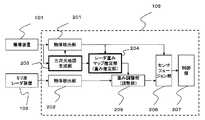
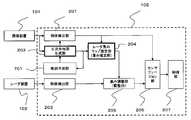
- FIG. 2shows a first form of the mobile control unit 105 that implements the present invention.
- the mobile control unit 105is, for example, an ECU (Electronic Control Unit), and is composed of a memory (storage device), a CPU (processor), an input / output circuit (communication device), and the like.
- Object detection units 201 and 202are provided in the moving body control unit 105 for the image pickup device 101 and the millimeter wave radar device 102, respectively, and detect various objects existing in the field of view seen from the own vehicle (vehicle 103).
- the image pickup apparatus 101generates a three-dimensional map in real time from the acquired sensor information by the three-dimensional map generation unit 203.
- the three-dimensional maphas information in the depth direction, the height direction, and the lateral direction (for example, distance information) of an object existing in the field of view of the sensor.
- the three-dimensional mapmay use a distance image by a stereo camera or a sensor that acquires a group of points having distance information such as LIDAR, or may generate distance information by time-series analysis using a monocular camera.
- the generation of the distance image by learningmay be used, and the means thereof is not limited.
- Radar weight map estimationis performed after generating a 3D map.
- the radar weight map estimation unit 204generates a weight value of how reliable the radar signal arriving from each point of the three-dimensional map is.
- the weight adjustment unit 205adjusts values related to detection such as the reliability, existence probability, and distance accuracy of the object detected by the object detection unit 202 on the millimeter wave radar device 102 (radar device) side. Radar weight map estimation unit 204 It is carried out using the result of. The result is input to the sensor fusion unit 206.
- the sensor fusion unit 206collates with the result of the object detection unit 201 on the image pickup device side to form one signal, and transmits the signal to the control unit 109. That is, the sensor fusion unit 206 synthesizes and outputs the detection result by the image pickup apparatus 101 and the detection result by the millimeter wave radar apparatus 102 (radar apparatus) adjusted based on the weight. As a result, the reliability of the synthesized detection result can be ensured.
- the control unit 109generates a signal for controlling the vehicle according to the result.
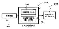
- FIG. 3shows a configuration example of the three-dimensional map generation unit 203.
- the distancecan be measured from the parallax of two or more installed cameras by the principle of triangulation, and it is output as the distance image generator 301 and treated as a three-dimensional map with distance information in the horizontal and vertical directions. be able to.
- the three-dimensional map generation unit 203has at least such a function.
- the three-dimensional map generation unit 203generates a three-dimensional map around the vehicle 103 (moving body) from the image captured by the image pickup device 101.
- the result of the three-dimensional map generation unit 203 created herecan also be used for the object detection unit 201 of the image pickup apparatus 101.
- the three-dimensional map generation unit 203includes an object attribute estimation unit 302 that estimates the attributes of the object and the material of the object for each distance by image analysis after being imaged.
- an object attribute estimation unit 302that estimates the attributes of the object and the material of the object for each distance by image analysis after being imaged.
- the use of a classifier for an image, semantic segmentation, instance segmentation, etc.are known as known techniques, and the method is not limited here.
- the three-dimensional map generation unit 203includes an object attribute estimation unit 302 (attribute estimation unit) that estimates the attributes of the object detected from the image captured by the image pickup device 101.
- object attribute estimation unit 302attribute estimation unit
- Estimated object attributesare, for example, pedestrians, vehicles, walls, trees, curbs, guardrails, or poles.
- the radar weight map estimation unit 204sets the weight of the detection result by the millimeter-wave radar device 102 (radar device) for each area of the three-dimensional map as a three-dimensional shape for each area of the three-dimensional map. For example, it may be estimated (set) from the combination of the corner shape) and the attribute of the object (for example, the guard rail). For example, a small weight is associated with a combination of a "corner shape" as a three-dimensional shape and a "guardrail" as an attribute of an object and stored in a memory.
- the detection result by the radar devicecan be adjusted according to the above.
- FIG. 4shows a configuration example of the radar weight map estimation unit 204.
- the information created by the three-dimensional map generation unit 203is input.
- the specific shape detection unit 402estimates a place where multipath may occur by detecting a specific shape by referring to the registered specific shape database 401, and the weight setting unit 404 sets the detected place at the detected place. Assign a low weight.
- the radar weight map estimation unit 204sets the weight of the detection result by the millimeter wave radar device 102 (radar device) for each area of the three-dimensional map in three dimensions for each area of the three-dimensional map. Estimated from the shape.
- the specific shape database 401retains the characteristics of the shape that are likely to generate multipath. In the specific shape database 401, since it may be necessary to change the weight setting depending on the material of the shape as described later, it is conceivable that the material information of the shape is also transmitted to the weight setting unit.
- the object size measuring unit 403detects a large object that is likely to generate multipath, and the weight setting unit 404 assigns a low reliability to the periphery thereof.
- the radar weight map estimation unit 204when an object (first object) having a predetermined size or larger exists in the three-dimensional map, is located around the object (first object).
- the weight of the detection result by the millimeter-wave radar device 102 (radar device) for each area of the three-dimensional mapis reduced.
- the radar weight map estimation unit 204is an object (first object) when another object (second object) close to the object (first object) exists in the three-dimensional map. ) And another object (second object), the weight of the detection result by the millimeter-wave radar device 102 (radar device) for each area of the three-dimensional map may be reduced. As a result, for example, when a large trailer and a passenger car run side by side, the reliability of the detection result by the radar device around them can be lowered.
- FIG. 5shows an example of a specific shape registered in the specific shape database 401.
- This specific shapediffers depending on the angle of arrival from the sensor, but here the shape in the direction shown in 501 is shown.
- This figureshows a specific shape in a bird's-eye view. Multipath tends to occur at corner-shaped (concave-shaped) parts such as 502. A similar phenomenon may occur in an example in which the shape changes continuously or in the shape 503.
- the shape 504 in which the circular (convex) pattern is directed toward the vehiclestrong reflection enters the vehicle, so that the signal from there becomes dominant and affects the signal group from others. , There is a possibility of erroneous measurement.
- this specific shapediffers depending on the arrival angle of the sensor.
- the specific shape database 401it is conceivable to store the specific shape in a sequence of points, adjust the shape with the absolute value of the arrival angle and the reference distance as parameters, and output from the specific shape database 401.
- the radar weight map estimation unit 204is a millimeter-wave radar device 102 (weight estimation unit) in a region of the three-dimensional map corresponding to the three-dimensional shape when the three-dimensional shape is a corner shape or a circular shape. Reduce the weight of the detection result by the radar device). As a result, when the three-dimensional shape is a corner shape or a circular shape and the shape tends to induce erroneous detection by the radar device, the weight of the detection result by the radar device can be reduced.
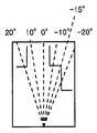
- weight setting unit 404An example of the weight setting unit 404 will be described with reference to FIG. 6 (FIGS. 6-1 to 6-3).
- FIG. 6-2shows the reference of the spread angle from the center of the sensor, and shows 20 °, 10 °, 0 °, -10 °, and -20 ° from the left.
- the weight setting unit 404lowers the weight of the region if a specific shape exists.
- An exampleis shown in FIG. 6-3.
- the horizontal axisis the spread angle from the center of the sensor, and the vertical axis is the distance.
- Fig. 6-3the reliability is higher in the order of A, B, C (A> B> C).
- the reason why C is set at + 20 ° and 30 m aheadis set because the object (front vehicle 602) is a shielded area in front.
- Fig. 6-3is based on a bird's-eye view, it is shown in two dimensions, but it is actually possible to have three-dimensional information. In that case, it is possible to change the weight according to the height.
- the weight adjustment unit 205 in the subsequent stagefurther controls the importance of the detection result of the millimeter wave radar.
- the reflectanceis generally high and the range affected by the specific shape is large. Therefore, when it is presumed to be a metal body by the object attribute estimation unit 302, it is necessary to apply a larger weight adjustment by the weight setting unit 404.
- the influence of reflectionmay be low on an object with low reflectance such as plastic or wood, so if it is estimated by the object attribute estimation unit 302 as such, it will be affected by the weight setting unit 404. Adjustments are needed to prevent it. For example, in that case, the weight of the table given in FIG. 6-3 is changed to A at -15 ° and 20 m.
- the three-dimensional map generation unit 203includes an object attribute estimation unit 302 (attribute estimation unit) that estimates the material of the object detected from the image captured by the image pickup device 101.
- the material of the presumed objectis, for example, metal, stone, tree, or plastic.
- the radar weight map estimation unit 204calculates the weight of the detection result by the millimeter wave radar device 102 (radar device) for each area of the three-dimensional map, and the weight of the three-dimensional shape and the object for each area of the three-dimensional map. Estimate (set) from the combination with the material. For example, a small weight is associated with a combination of a "corner shape" as a three-dimensional shape and a "metal" as a material of an object and stored in a memory.
- the detection result by the radar devicecan be adjusted according to the above.
- the weight adjusting unit 205adjusts the result detected by the millimeter wave radar device 102 from the weights set as described above. If the existence probability of the object and the distance / relative velocity accuracy are given at the time of the object detection unit 202 of the millimeter wave radar device 102, it is conceivable to adjust the accuracy and the probability. If it is not given, the weight is processed by the sensor fusion unit 206, and may be simply added to the output of the object detection unit 202, regardless of the method in handling the weight.
- the weight adjusting unit 205adjusts the detection result by the millimeter wave radar device 102 (radar device) based on the weight. Specifically, for example, as the weight becomes smaller, the reliability of the detection result by the millimeter wave radar device 102 (radar device) is evaluated lower. As a result, the detection result by the radar device can be adjusted according to the three-dimensional shape of each area of the three-dimensional map generated from the image captured by the image pickup device. In addition, it is possible to deal with the case where the radar device detects an object that is not registered in the navigation map.
- the moving body control unit 105generates a three-dimensional map around the vehicle 103 (moving body) from the image captured by the imaging device 101 (S10), and the area of the three-dimensional map.
- the weight of the detection result by the millimeter-wave radar device 102 (radar device) for eachis estimated from the three-dimensional shape of each area of the three-dimensional map (S15), and the millimeter-wave radar device 102 (radar device) is based on the weight.
- the detection resultis adjusted (S20).
- the sensor fusion unit 206synthesizes the detection results using the results detected from the millimeter wave radar device 102 and the results detected from the image pickup device 101, and outputs the detection results to the control unit 207.
- a method of fusiona method of simply adopting the one having a higher weight or probability as a detection result, or a method of stochastically fusing to obtain a detection result is conceivable, and the method does not matter.
- FIG. 7shows an example in which past history information is input to the three-dimensional map generation unit 203.
- the map prediction unit 701appropriately predicts the three-dimensional map at the next time t + 1 from the three-dimensional map at a certain time t from the behavior of the own vehicle and the speed at each position, and then the three-dimensional map is next.
- the three-dimensional map generation unit 203synthesizes the map predicted at time t and the map at time t + 1 at the time of generation. The combined map will be used in the subsequent processing.
- the moving body control unit 105includes a map prediction unit 701 that predicts a three-dimensional map in the next frame from the three-dimensional map.
- the three-dimensional map generation unit 203generates a three-dimensional map around the vehicle 103 (moving body) from the three-dimensional map of the next frame predicted by the map prediction unit 701 and the image captured by the image pickup device 101. This makes it possible to improve the accuracy of the three-dimensional map generated by the three-dimensional map generation unit using the three-dimensional map before fusion.
- FIG. 8describes an example in which the past history information uses the map information synthesized from the information of each sensor after the sensor fusion.
- the vehicle control systemincludes a map prediction unit 802 that predicts the current map information from the fused past map information, and is configured to be reflected in the three-dimensional map generation unit 203.
- the moving body control unit 105is the next from the synthetic map creation unit 801 that creates a three-dimensional map from the detection result synthesized by the sensor fusion unit 206 and the three-dimensional map created by the synthetic map creation unit 801. It includes a map prediction unit 802 that predicts a three-dimensional map in a frame.
- the three-dimensional map generation unit 203generates a three-dimensional map around the vehicle 103 (moving body) from the predicted three-dimensional map of the next frame and the image captured by the image pickup device 101. As a result, it is possible to improve the accuracy of the three-dimensional map generated by the three-dimensional map generation unit using the three-dimensional map after fusion.
- the present inventionis not limited to the above-described embodiment, and includes various modifications.
- the above-described embodimenthas been described in detail in order to explain the present invention in an easy-to-understand manner, and is not necessarily limited to the one including all the described configurations.
- it is possible to replace a part of the configuration of one embodiment with the configuration of another embodimentand it is also possible to add the configuration of another embodiment to the configuration of one embodiment.
- the image pickup device 101measures the distance with a stereo camera, but it may be measured with a monocular camera.
- the millimeter wave radar device 102is used as the radar device, but it may be a radar device that uses radio waves having a wavelength other than millimeter waves.
- the object detection units 201 and 202are provided in the moving body control unit 105, but they may be provided in the image pickup device 101 and the millimeter wave radar device 102, respectively. In the above embodiment, it is provided in the mobile control unit 105, but it may be provided in another ECU.
- each of the above configurations, functions, etc.may be realized by hardware, for example, by designing a part or all of them with an integrated circuit. Further, each of the above configurations, functions, and the like may be realized by software by the processor interpreting and executing a program that realizes each function. Information such as programs, tables, and files that realize each function can be stored in a memory, a hard disk, a recording device such as an SSD (Solid State Drive), or a recording medium such as an IC card, an SD card, or a DVD.
- SSDSolid State Drive
- the embodiment of the present inventionmay have the following aspects.
- a moving body control deviceincluding an imaging device for detecting an object in the outside world and a millimeter-wave radar device, a three-dimensional map generator that generates a three-dimensional map around the moving body from the information of the imaging device, and the three-dimensional map.
- a radar weight estimation unitthat estimates the weight of the detection result by the millimeter-wave radar device for each region based on distance and orientation from a three-dimensional shape, and the radar based on the weight estimated by the radar weight estimation unit.
- a moving body control deviceincluding a weight adjusting unit for adjusting the reliability of the object detected by the device.
- the radar reliability estimation unit according to (1)is based on the three-dimensional map described in (1) when an object having a size larger than a predetermined value exists or has a plurality of adjacent shapes. , A mobile control device characterized by lowering the reliability of the radar device for each direction and distance.
- the three-dimensional map generation unit described in (1)has a distance information generation unit and an attribute information generation unit, and the attribute information generation unit is one or more of pedestrians, vehicles, walls, trees, curbs, guardrails, and poles.
- a moving object control devicecharacterized in that the attributes of the above are estimated for the imaging target.
- the three-dimensional map generation unit described in (1)has a distance information generation unit and a material information generation unit, and the attribute information generation unit captures at least one or more attributes of metal, stone, tree, and plastic.
- a mobile control devicethat is characteristic.
- a moving body control deviceincluding an imaging device for detecting an object in the outside world and a millimeter-wave radar device, a three-dimensional map generator that generates a three-dimensional map around the moving body from the information of the imaging device, and the three-dimensional map.
- a radar weight estimation unitthat estimates the weight of the detection result by the millimeter-wave radar device for each region based on distance and orientation from a three-dimensional shape, and the radar based on the weight estimated by the radar weight estimation unit.
- a movementincluding a weight adjusting unit that adjusts the reliability of the object detected by the device, and a sensor fusion unit that synthesizes and outputs the detection results of the imaging device and the millimeter-wave radar based on the results of the weight adjusting unit.
- Body control deviceincluding a weight adjusting unit that adjusts the reliability of the object detected by the device, and a sensor fusion unit that synthesizes and outputs the detection results of the imaging device and the millimeter-wave radar based on the results of the weight adjusting unit.
- a moving body control deviceincluding an imaging device for detecting an object in the outside world and a millimeter-wave radar device, a three-dimensional map generator that generates a three-dimensional map around the moving body from the information of the imaging device, and the three-dimensional map.
- a radar weight estimation unitthat estimates the weight of the detection result by the millimeter-wave radar device for each region based on distance and orientation from a three-dimensional shape, and the radar based on the weight estimated by the radar weight estimation unit.
- a weight adjustment unitthat adjusts the reliability of the object detected by the device, and a map prediction that predicts the 3D map in the next frame from the information in the 3D map and reflects it in the 3D map generation unit in the next frame.
- a moving body control deviceincluding a unit.
- a moving body control deviceincluding an imaging device for detecting an object in the outside world and a millimeter-wave radar device, a three-dimensional map generator that generates a three-dimensional map around the moving body from the information of the imaging device, and the three-dimensional map.
- a radar weight estimation unitthat estimates the weight of the detection result by the millimeter-wave radar device for each region based on distance and orientation from a three-dimensional shape, and the radar based on the weight estimated by the radar weight estimation unit. From the weight adjustment unit that adjusts the reliability of the object detected by the device, the sensor fusion unit that synthesizes and outputs the detection results of the image pickup device and the millimeter-wave radar based on the results of the weight adjustment unit, and the synthesis result.
- a moving bodyincluding a composite map creation unit that creates a map and a map prediction unit that predicts a three-dimensional map in the next frame from the information in the composite map creation unit and reflects it in the three-dimensional map generation unit in the next frame.
- Control deviceincluding a composite map creation unit that creates a map and a map prediction unit that predicts a three-dimensional map in the next frame from the information in the composite map creation unit and reflects it in the three-dimensional map generation unit in the next frame.
Landscapes
- Engineering & Computer Science (AREA)
- Radar, Positioning & Navigation (AREA)
- Remote Sensing (AREA)
- Physics & Mathematics (AREA)
- General Physics & Mathematics (AREA)
- Automation & Control Theory (AREA)
- Aviation & Aerospace Engineering (AREA)
- Electromagnetism (AREA)
- Computer Networks & Wireless Communication (AREA)
- Multimedia (AREA)
- Computer Vision & Pattern Recognition (AREA)
- Theoretical Computer Science (AREA)
- Acoustics & Sound (AREA)
- Radar Systems Or Details Thereof (AREA)
- Traffic Control Systems (AREA)
- Control Of Position, Course, Altitude, Or Attitude Of Moving Bodies (AREA)
- Measurement Of Optical Distance (AREA)
Abstract
Description
Translated fromJapanese本発明は、移動体の制御装置及び方法に関する。The present invention relates to a control device and method for a moving body.
自動運転や高度安全運転支援システムの実現においては、外界を監視し、障害物やレーン情報など自車走行に必要な物体を検知するセンサの重要性が高まっている。外界監視センサにはカメラやミリ波レーダ、LIDARなどの種類があるがそれぞれにセンサの特性があり、走行するシーンにおいて得意不得意が存在する。In the realization of autonomous driving and advanced driver assistance systems, the importance of sensors that monitor the outside world and detect objects necessary for driving the vehicle, such as obstacles and lane information, is increasing. There are various types of external monitoring sensors such as cameras, millimeter-wave radars, and LIDARs, but each has its own sensor characteristics, and there are strengths and weaknesses in the driving scene.
例えばカメラにおいては逆光の場合に検知しにくくなる、ミリ波レーダにおいては検知したい物体の横に大きな反射物があると、レーダ波がその反射物に一度反射し別の物体に再度反射して戻って来るマルチパスが起こり距離や到来角度の誤計測や、クラッタによる誤検出を引き起こしやすくなる。For example, if there is a large reflector next to the object you want to detect in a millimeter-wave radar, which is difficult to detect in the case of backlight in a camera, the radar wave is reflected once by that reflector and then reflected back by another object. Incoming multipaths are likely to occur, causing erroneous measurement of distance and arrival angle, and erroneous detection by clutter.
この課題にあたり、例えば「特許文献1」には、ミリ波レーダで物体を検出する際に誤検出の要因となる側壁を、ナビゲーション用の地図情報を用いてその有無を判定し、ミリ波レーダの監視頻度を低下・停止させることで、信頼性の低い状態でセンサ情報を出力することを抑制する技術がある。例えば「特許文献2」では、ミリ波レーダの物体検出をステレオカメラで作成されたマップ情報と偏光領域の検出を組み合わせることで、路面上にある金属物からの反射波を抑制する技術を提案している。In this subject, for example, in "
特許文献1では、ナビゲーション用の地図に登録されている物体については予測が出来るが、ナビゲーション用の地図には登録されていない物体がミリ波レーダの検知誤りを誘発する際に対応できない。例えば、検出対象の物体の横を大型トレーラーが走行していたり、地図に登録されていないガードレールが存在する場合に解決できない。In
特許文献2では、路面上にある金属物に対する検出方法は開示されているものの、マルチパスが起こりえる状況への対応については記載がない。Patent Document 2 discloses a detection method for metal objects on the road surface, but does not describe how to deal with a situation where multipath may occur.
本発明の目的は、撮像装置で撮像される画像から生成される三次元地図の領域ごとの三次元の形状に応じてレーダ装置による検出結果を調整することができる移動体の制御装置及び方法を提供することにある。An object of the present invention is a control device and method for a moving body capable of adjusting the detection result by the radar device according to the three-dimensional shape of each area of the three-dimensional map generated from the image captured by the image pickup device. To provide.
上記目的を達成するために、本発明の一例は、撮像装置とレーダ装置を有する移動体の制御装置であって、前記撮像装置で撮像される画像から前記移動体の周辺の三次元地図を生成する三次元地図生成部と、前記三次元地図の領域ごとの前記レーダ装置による検出結果の重みを、前記三次元地図の前記領域ごとの三次元の形状から推定する重み推定部と、前記重みに基づいて前記レーダ装置による検出結果を調整する調整部と、を備える。In order to achieve the above object, one example of the present invention is a moving body control device having an image pickup device and a radar device, and generates a three-dimensional map around the moving body from an image captured by the image pickup device. The weight estimation unit that estimates the weight of the detection result by the radar device for each region of the three-dimensional map from the three-dimensional shape of each region of the three-dimensional map, and the weight An adjustment unit for adjusting the detection result by the radar device based on the radar device is provided.
本発明によれば、撮像装置で撮像される画像から生成される三次元地図の領域ごとの三次元の形状に応じてレーダ装置による検出結果を調整することができる。上記した以外の課題、構成及び効果は、以下の実施形態の説明により明らかにされる。According to the present invention, the detection result by the radar device can be adjusted according to the three-dimensional shape of each area of the three-dimensional map generated from the image captured by the image pickup device. Issues, configurations and effects other than those described above will be clarified by the description of the following embodiments.
以下に発明を実施する形態を示す。本実施形態は自動運転や高度安全運転システムにおいて高度に周辺環境を理解するシステムに関する。The embodiment of the invention is shown below. The present embodiment relates to a system for highly understanding the surrounding environment in an automatic driving or a highly safe driving system.
撮像装置とミリ波レーダを用いた車両制御システムを図1に示す。Figure 1 shows a vehicle control system that uses an imaging device and millimeter-wave radar.
撮像装置101とミリ波レーダ装置102は車両103に搭載され、例えば前方の物体104までの距離や相対速度を計測して移動体制御部105に送信する。移動体制御部105はその物体104までの距離や相対速度からブレーキやアクセルの制御を決定し車両103を制御する。The
すなわち、移動体制御部105は、撮像装置101とミリ波レーダ装置102(レーダ装置)を有する車両103(移動体)の制御装置である。That is, the mobile
本発明を実施する移動体制御部105の第一の形態を図2に示す。なお、移動体制御部105は、例えば、ECU(Electronic Control Unit)であり、メモリ(記憶装置)、CPU(プロセッサ)、入出力回路(通信装置)等から構成される。FIG. 2 shows a first form of the
撮像装置101とミリ波レーダ装置102に対してそれぞれ物体検出部201、202が移動体制御部105に設けられ、自車(車両103)から見える視界中に存在する様々な物体を検出する。撮像装置101は取得されたセンサ情報からリアルタイムに三次元地図を三次元地図生成部203で生成する。ここで三次元地図は、センサの視界中に存在する物体の奥行方向、高さ方向、横方向の情報(例えば、距離情報)を持つ。
三次元地図は、ステレオカメラによる距離画像や、LIDARの様に距離情報を持つ点群を取得するようなセンサを使用してもよいし、単眼カメラを用いた時系列解析による距離情報の生成や学習による距離画像の生成を用いてもよく、その手段を問わない。The three-dimensional map may use a distance image by a stereo camera or a sensor that acquires a group of points having distance information such as LIDAR, or may generate distance information by time-series analysis using a monocular camera. The generation of the distance image by learning may be used, and the means thereof is not limited.
三次元地図を生成した後にレーダ重みマップ推定を実施する。レーダ重みマップ推定部204は、三次元地図の各点においてその点から到来したレーダ信号がどれだけ信頼できるかの重み値を生成する。重み調整部205は、ミリ波レーダ装置102(レーダ装置)側の物体検出部202で検出された物体の信頼度や存在確率、距離精度など、検出に関わる値の調整をレーダ重みマップ推定部204の結果を用いて実施する。その結果はセンサフュージョン部206に入力される。Radar weight map estimation is performed after generating a 3D map. The radar weight
センサフュージョン部206は、撮像装置側の物体検出部201の結果と突き合わせて一つの信号とし、その信号を制御部109に送信する。すなわち、センサフュージョン部206は、撮像装置101による検出結果と重みに基づいて調整されたミリ波レーダ装置102(レーダ装置)による検出結果を合成して出力する。これにより、合成された検出結果の信頼度を確保することができる。制御部109はその結果に従って車両を制御する信号を生成する。The
図3に三次元地図生成部203の構成例を示す。FIG. 3 shows a configuration example of the three-dimensional
ここでは撮像装置101の一例としてステレオカメラを用いた場合の例を示す。ステレオカメラでは設置された二つ以上のカメラの視差から三角測量の原理で距離を計測でき、それを距離画像生成部301として出力し、水平方向、鉛直方向に距離情報を持つ三次元地図として扱うことができる。三次元地図生成部203では少なくともこのような機能を備える。Here, an example when a stereo camera is used as an example of the
換言すれば、三次元地図生成部203は、撮像装置101で撮像される画像から車両103(移動体)の周辺の三次元地図を生成する。なお、ここで作成された三次元地図生成部203の結果は、撮像装置101の物体検出部201にも使われうる。In other words, the three-dimensional
また、撮像されたのちに画像解析によって距離毎の物体の属性や、物体の素材推定を実施する、物体属性推定部302を三次元地図生成部203は備える。物体の属性推定に関しては一般に知られる手法として画像に対して識別器の利用やセマンティックセグメンテーション、インスタンスセグメンテーションなどが公知技術として知られ、ここではその手法を問わない。Further, the three-dimensional
換言すれば、三次元地図生成部203は、撮像装置101で撮像される画像から検出される物体の属性を推定する物体属性推定部302(属性推定部)を含む。推定される物体の属性は、例えば、歩行者、車両、壁、樹木、縁石、ガードレール、又はポールである。In other words, the three-dimensional
なお、レーダ重みマップ推定部204(重み推定部)は、三次元地図の領域ごとのミリ波レーダ装置102(レーダ装置)による検出結果の重みを、三次元地図の領域ごとの三次元の形状(例えば、コーナー状)と物体の属性(例えば、ガードレール)との組み合わせから推定(設定)してもよい。例えば、三次元の形状としての「コーナー状」と物体の属性としての「ガードレール」との組み合わせに小さな重みを紐付けてメモリに記憶しておく。The radar weight map estimation unit 204 (weight estimation unit) sets the weight of the detection result by the millimeter-wave radar device 102 (radar device) for each area of the three-dimensional map as a three-dimensional shape for each area of the three-dimensional map. For example, it may be estimated (set) from the combination of the corner shape) and the attribute of the object (for example, the guard rail). For example, a small weight is associated with a combination of a "corner shape" as a three-dimensional shape and a "guardrail" as an attribute of an object and stored in a memory.
これにより、撮像装置で撮像される画像から生成される三次元地図の領域ごとの三次元の形状(例えば、コーナー状)と属性推定部で推定される物体の属性(例えば、ガードレール)との組み合わせに応じてレーダ装置による検出結果を調整することができる。As a result, the combination of the three-dimensional shape (for example, corner shape) for each region of the three-dimensional map generated from the image captured by the image pickup device and the attribute of the object estimated by the attribute estimation unit (for example, guardrail). The detection result by the radar device can be adjusted according to the above.
図4にレーダ重みマップ推定部204の構成例を示す。FIG. 4 shows a configuration example of the radar weight
レーダ重みマップ推定部204では、三次元地図生成部203で作成された情報が入力される。特定形状検出部402は、登録された特定形状データベース401を参照して特定形状を検出することで、マルチパスが起きる可能性のある場所を推定し、その検出された場所に重み設定部404において低い重みを割り当てさせる。In the radar weight
換言すれば、レーダ重みマップ推定部204(重み推定部)は、三次元地図の領域ごとのミリ波レーダ装置102(レーダ装置)による検出結果の重みを、三次元地図の領域ごとの三次元の形状から推定する。In other words, the radar weight map estimation unit 204 (weight estimation unit) sets the weight of the detection result by the millimeter wave radar device 102 (radar device) for each area of the three-dimensional map in three dimensions for each area of the three-dimensional map. Estimated from the shape.
特定形状データベース401は、マルチパスを発生させやすそうな形状の特徴を保持する。特定形状データベース401では、後述するように形状の材質によって重み設定を変える必要がある場合があるため、形状の材質情報も重み設定部に送信することが考えられる。The
異なる実現方法として、マルチパスを発生させやすそうな大きな物体を物体サイズ測定部403が検出し、重み設定部404はその周辺に低い信頼度を割り当てる。As a different implementation method, the object
換言すれば、レーダ重みマップ推定部204(重み推定部)は、三次元地図において所定の大きさ以上の物体(第1の物体)が存在する場合、その物体(第1の物体)の周辺の三次元地図の領域ごとのミリ波レーダ装置102(レーダ装置)による検出結果の重みを下げる。これにより、例えば、マルチパスを誘発しやすい大型トレーラーが移動体(自車両)の周辺に存在する場合に、大型トレーラーの周辺のレーダ装置による検出結果の信頼度を下げることができる。In other words, the radar weight map estimation unit 204 (weight estimation unit), when an object (first object) having a predetermined size or larger exists in the three-dimensional map, is located around the object (first object). The weight of the detection result by the millimeter-wave radar device 102 (radar device) for each area of the three-dimensional map is reduced. Thereby, for example, when a large trailer that easily induces multipath exists in the vicinity of the moving body (own vehicle), the reliability of the detection result by the radar device around the large trailer can be lowered.
なお、レーダ重みマップ推定部204(重み推定部)は、三次元地図において物体(第1の物体)に近接する別の物体(第2の物体)が存在する場合に、物体(第1の物体)及び別の物体(第2の物体)の周辺の三次元地図の領域ごとのミリ波レーダ装置102(レーダ装置)による検出結果の重みを下げてもよい。これにより、例えば、大型トレーラーと乗用車が並走する場合に、それらの周辺のレーダ装置による検出結果の信頼度を下げることができる。The radar weight map estimation unit 204 (weight estimation unit) is an object (first object) when another object (second object) close to the object (first object) exists in the three-dimensional map. ) And another object (second object), the weight of the detection result by the millimeter-wave radar device 102 (radar device) for each area of the three-dimensional map may be reduced. As a result, for example, when a large trailer and a passenger car run side by side, the reliability of the detection result by the radar device around them can be lowered.
図5に特定形状データベース401に登録される特定形状の例を示す。FIG. 5 shows an example of a specific shape registered in the
この特定形状はセンサからの到来角によって異なるが、ここでは501に図示した方向における形状を示す。この図では俯瞰した状態における特定形状を示す。マルチパスは502のように、コーナー状(凹状)になっている箇所において起こりやすい。その形状が連続的に変化する例や形状503も同様の現象が起こる可能性がある。逆に円状(凸状)のパタンが車両方向に向いている形状504では、強い反射が車両に対して入るため、そちらからの信号が支配的になり、他からの信号群に影響を与え、誤計測となる可能性がある。This specific shape differs depending on the angle of arrival from the sensor, but here the shape in the direction shown in 501 is shown. This figure shows a specific shape in a bird's-eye view. Multipath tends to occur at corner-shaped (concave-shaped) parts such as 502. A similar phenomenon may occur in an example in which the shape changes continuously or in the
先述した通りこの特定形状はセンサの到来角によって異なる。特定形状データベース401への格納方法としては点列で特定形状を格納し、到来角度の絶対値と参照する距離をパラメータとして形状を調整して特定形状データベース401から出力することが考えられる。As mentioned above, this specific shape differs depending on the arrival angle of the sensor. As a storage method in the
本実施形態では、レーダ重みマップ推定部204(重み推定部)は、三次元の形状がコーナー状又は円状の場合、三次元の形状に対応する三次元地図の領域のミリ波レーダ装置102(レーダ装置)による検出結果の重みを下げる。これにより、三次元の形状がコーナー状又は円状であり、レーダ装置による誤検出を誘発しやすい形状である場合に、レーダ装置による検出結果の重みを下げることができる。In the present embodiment, the radar weight map estimation unit 204 (weight estimation unit) is a millimeter-wave radar device 102 (weight estimation unit) in a region of the three-dimensional map corresponding to the three-dimensional shape when the three-dimensional shape is a corner shape or a circular shape. Reduce the weight of the detection result by the radar device). As a result, when the three-dimensional shape is a corner shape or a circular shape and the shape tends to induce erroneous detection by the radar device, the weight of the detection result by the radar device can be reduced.
図6(図6-1から図6-3)を用いて重み設定部404の例を説明する。An example of the
図6-1のように自車両601があり、前方に2台の前方車両602、603が存在し、1台の大型トレーラー604がいる時のことを考える。撮像装置101から得られた三次元地図の俯瞰図が図6-2の様に得られたとする。図6-2に描画された破線はセンサ中心からの広がり角度の基準を示しており、左から20°、10°、0°、-10°、-20°を示す。Consider the case where there is a
図6-2を解析することで、重み設定部404は特定形状が存在すればその領域の重みを下げる。図6-3にその一例を示している。横軸はセンサ中心からの広がり角度、縦軸は距離である。今、特定形状データベース401(辞書)から特定形状が与えられた場合に、その特定形状(特殊形状)に当てはまる箇所が、-15°、20m先の距離だと仮定すると、その領域のミリ波レーダ信頼度を他に比べて落とす。By analyzing FIG. 6-2, the
この表(図6-3)では、信頼度がA、B、Cの順に高い(A>B>C)。+20°、30m先がCになっているのは物体(前方車両602)が手前にある遮蔽領域であるため設定している。図6-3は俯瞰表現を元にしているため、2次元で表記しているが実際には3次元の情報を持つことも可能である。その場合、高さに応じて重みを変更することが可能である。In this table (Fig. 6-3), the reliability is higher in the order of A, B, C (A> B> C). The reason why C is set at + 20 ° and 30 m ahead is set because the object (front vehicle 602) is a shielded area in front. Since Fig. 6-3 is based on a bird's-eye view, it is shown in two dimensions, but it is actually possible to have three-dimensional information. In that case, it is possible to change the weight according to the height.
この様な重みマップを持つことによってさらに後段の重み調整部205でミリ波レーダの検出結果の重要度を制御する。By having such a weight map, the
なお、特に当該形状が、ガードレールや金属物体と判断された領域においては一般に反射率が高く特定形状の影響する範囲が大きくなる。そのため、物体属性推定部302において金属体と推定される場合には、より大きい重みの調整を重み設定部404でかけることが必要となる。In particular, especially in the area where the shape is judged to be a guardrail or a metal object, the reflectance is generally high and the range affected by the specific shape is large. Therefore, when it is presumed to be a metal body by the object
逆にプラスチックや木材など、反射率が低い物体に対しては反射の影響が低い可能性があるため、そのように物体属性推定部302において推定された場合には重み設定部404で影響を及ぼさないようにするような調整が必要である。例えばその場合、図6-3で与えられる表の重みを-15°、20mにおいてAに変更する。On the contrary, the influence of reflection may be low on an object with low reflectance such as plastic or wood, so if it is estimated by the object
換言すれば、三次元地図生成部203は、撮像装置101で撮像される画像から検出される物体の材質を推定する物体属性推定部302(属性推定部)を含む。推定される物体の材質は、例えば、金属、石材、樹木、又はプラスチックである。レーダ重みマップ推定部204(重み推定部)は、三次元地図の領域ごとのミリ波レーダ装置102(レーダ装置)による検出結果の重みを、三次元地図の領域ごとの三次元の形状と物体の材質との組み合わせから推定(設定)する。例えば、三次元の形状としての「コーナー状」と物体の材質としての「金属」との組み合わせに小さな重みを紐付けてメモリに記憶しておく。In other words, the three-dimensional
これにより、撮像装置で撮像される画像から生成される三次元地図の領域ごとの三次元の形状(例えば、コーナー状)と属性推定部で推定される物体の材質(例えば、金属)との組み合わせに応じてレーダ装置による検出結果を調整することができる。As a result, the combination of the three-dimensional shape (for example, corner shape) for each region of the three-dimensional map generated from the image captured by the image pickup device and the material of the object (for example, metal) estimated by the attribute estimation unit. The detection result by the radar device can be adjusted according to the above.
重み調整部205は、上記のように設定された重みからミリ波レーダ装置102で検出された結果を調整する。ミリ波レーダ装置102の物体検出部202の時点で物体の存在確率や距離・相対速度精度が与えられる場合には、その精度や確率を調整することが考えられる。与えられない場合においては、その重みをセンサフュージョン部206で処理することとし、単純に物体検出部202の出力に付加してもよく、重みの扱いにおいてその手法を問わない。The
本実施形態では、重み調整部205(調整部)は重みに基づいてミリ波レーダ装置102(レーダ装置)による検出結果を調整する。具体的には、例えば、重みが小さくなるにつれてミリ波レーダ装置102(レーダ装置)による検出結果の信頼度を低く評価する。
これにより、撮像装置で撮像される画像から生成される三次元地図の領域ごとの三次元の形状に応じてレーダ装置による検出結果を調整することができる。また、ナビゲーション用の地図に登録されていない物体をレーダ装置が検出する場合にも対応することができる。In the present embodiment, the weight adjusting unit 205 (adjusting unit) adjusts the detection result by the millimeter wave radar device 102 (radar device) based on the weight. Specifically, for example, as the weight becomes smaller, the reliability of the detection result by the millimeter wave radar device 102 (radar device) is evaluated lower.
As a result, the detection result by the radar device can be adjusted according to the three-dimensional shape of each area of the three-dimensional map generated from the image captured by the image pickup device. In addition, it is possible to deal with the case where the radar device detects an object that is not registered in the navigation map.
なお、移動体制御部105は、少なくとも図9に示すように、撮像装置101で撮像される画像から車両103(移動体)の周辺の三次元地図を生成し(S10)、三次元地図の領域ごとのミリ波レーダ装置102(レーダ装置)による検出結果の重みを、三次元地図の領域ごとの三次元の形状から推定し(S15)、重みに基づいてミリ波レーダ装置102(レーダ装置)による検出結果を調整する(S20)。As shown in at least FIG. 9, the moving
センサフュージョン部206は、ミリ波レーダ装置102から検出された結果、撮像装置101から検出された結果を用いてそれらの検出結果を合成し、制御部207に出力する。フュージョンする方式としては単純に重みや確率が高いほうを検出結果として採用する、確率的にフュージョンして検出結果とするという手法が考えられ、その方式を問わない。The
図7では三次元地図生成部203に過去の履歴情報が入力される例を示す。FIG. 7 shows an example in which past history information is input to the three-dimensional
図7の形態では、ある時刻tでの三次元地図からその次の時刻t+1の三次元地図を地図予測部701が自車挙動や各位置における速度などから適切に予測し、三次元地図を次に生成する際に時刻tで予測された地図と時刻t+1の地図を三次元地図生成部203で合成する。合成された地図は後段の処理で使用される。この様な仕組みを取ることで、現在のフレームから取得した三次元地図に誤差があった場合や情報の欠落があった場合でも過去の情報(三次元地図)から外挿を行い、統計的に精度を高めることが期待できる。In the form of FIG. 7, the
換言すれば、移動体制御部105は、三次元地図から次のフレームにおける三次元地図を予測する地図予測部701を備える。三次元地図生成部203は、地図予測部701で予測された次のフレームの三次元地図と撮像装置101で撮像される画像から車両103(移動体)の周辺の三次元地図を生成する。これにより、フュージョン前の三次元地図を用いて三次元地図生成部で生成される三次元地図の精度を向上することができる。In other words, the moving
図8では過去の履歴情報がセンサフュージョンの後の各センサの情報から合成した地図情報を使用する例を説明する。FIG. 8 describes an example in which the past history information uses the map information synthesized from the information of each sensor after the sensor fusion.
車両制御システムは、そのフュージョンされた過去の地図情報から現在の地図情報を予測する地図予測部802を備え、三次元地図生成部203に反映する構成である。The vehicle control system includes a
換言すれば、移動体制御部105は、センサフュージョン部206で合成された検出結果から三次元地図を作成する合成地図作成部801と、合成地図作成部801で作成された三次元地図から次のフレームにおける三次元地図を予測する地図予測部802と、を備える。三次元地図生成部203は、予測された次のフレームの三次元地図と撮像装置101で撮像される画像から車両103(移動体)の周辺の三次元地図を生成する。これにより、フュージョン後の三次元地図を用いて三次元地図生成部で生成される三次元地図の精度を向上することができる。In other words, the moving
なお、本発明は上記した実施形態に限定されるものではなく、様々な変形例が含まれる。例えば、上述した実施形態は本発明を分かりやすく説明するために詳細に説明したものであり、必ずしも説明した全ての構成を備えるものに限定されるものではない。また、ある実施形態の構成の一部を他の実施形態の構成に置き換えることが可能であり、また、ある実施形態の構成に他の実施形態の構成を加えることも可能である。また、各実施形態の構成の一部について、他の構成の追加・削除・置換をすることが可能である。The present invention is not limited to the above-described embodiment, and includes various modifications. For example, the above-described embodiment has been described in detail in order to explain the present invention in an easy-to-understand manner, and is not necessarily limited to the one including all the described configurations. Further, it is possible to replace a part of the configuration of one embodiment with the configuration of another embodiment, and it is also possible to add the configuration of another embodiment to the configuration of one embodiment. Further, it is possible to add / delete / replace a part of the configuration of each embodiment with another configuration.
上記実施形態では、撮像装置101はステレオカメラで距離を計測しているが、単眼カメラで計測してもよい。上記実施形態では、レーダ装置としてミリ波レーダ装置102を用いているが、ミリ波以外の波長の電波を用いるレーダ装置であってもよい。In the above embodiment, the
上記実施形態では、物体検出部201、202は移動体制御部105に設けられるが、それぞれ撮像装置101、ミリ波レーダ装置102に設けるようにしてもよい。上記実施形態では、移動体制御部105に設けられるが、別のECUに設けるようにしてもよい。In the above embodiment, the
また、上記の各構成、機能等は、それらの一部又は全部を、例えば集積回路で設計する等によりハードウェアで実現してもよい。また、上記の各構成、機能等は、プロセッサがそれぞれの機能を実現するプログラムを解釈し、実行することによりソフトウェアで実現してもよい。各機能を実現するプログラム、テーブル、ファイル等の情報は、メモリや、ハードディスク、SSD(Solid State Drive)等の記録装置、または、ICカード、SDカード、DVD等の記録媒体に置くことができる。Further, each of the above configurations, functions, etc. may be realized by hardware, for example, by designing a part or all of them with an integrated circuit. Further, each of the above configurations, functions, and the like may be realized by software by the processor interpreting and executing a program that realizes each function. Information such as programs, tables, and files that realize each function can be stored in a memory, a hard disk, a recording device such as an SSD (Solid State Drive), or a recording medium such as an IC card, an SD card, or a DVD.
なお、本発明の実施形態は、以下の態様であってもよい。The embodiment of the present invention may have the following aspects.
(1).外界の物体を検出する撮像装置とミリ波レーダ装置を備える移動体制御装置であって、前記撮像装置の情報から移動体周辺の三次元地図を生成する三次元地図生成部と、前記三次元地図を用いて距離と方位に基づいた領域ごとの前記ミリ波レーダ装置による検出結果の重みを三次元の形状から推定するレーダ重み推定部と、前記レーダ重み推定部で推定した重みに基づいて前記レーダ装置によって検出された前記物体の信頼度を調整する重み調整部と、を備える移動体制御装置。(1). A moving body control device including an imaging device for detecting an object in the outside world and a millimeter-wave radar device, a three-dimensional map generator that generates a three-dimensional map around the moving body from the information of the imaging device, and the three-dimensional map. A radar weight estimation unit that estimates the weight of the detection result by the millimeter-wave radar device for each region based on distance and orientation from a three-dimensional shape, and the radar based on the weight estimated by the radar weight estimation unit. A moving body control device including a weight adjusting unit for adjusting the reliability of the object detected by the device.
(2).(1)に記載のレーダ信頼度推定部は、(1)に記載の三次元地図に基づいて、所定以上の大きさを持つ物体が存在する場合、また、複数の近接した形状をもつ場合において、方位と距離毎に前記レーダ装置の信頼度を下げることを特徴とした移動体制御装置。(2). The radar reliability estimation unit according to (1) is based on the three-dimensional map described in (1) when an object having a size larger than a predetermined value exists or has a plurality of adjacent shapes. , A mobile control device characterized by lowering the reliability of the radar device for each direction and distance.
(3).(1)に記載の三次元地図生成部は、距離情報生成部と属性情報生成部を持ち、前記属性情報生成部は歩行者、車両、壁、樹木、縁石、ガードレール、ポールのうち1つ以上の属性を撮像対象に対して推定することを特徴とした移動体制御装置。(3). The three-dimensional map generation unit described in (1) has a distance information generation unit and an attribute information generation unit, and the attribute information generation unit is one or more of pedestrians, vehicles, walls, trees, curbs, guardrails, and poles. A moving object control device characterized in that the attributes of the above are estimated for the imaging target.
(4).(1)に記載の三次元地図生成部は、距離情報生成部と材質情報生成部を持ち、前記属性情報生成部は金属、石材、樹木、プラスチックのうち少なくとも一つ以上の属性を撮像対象に対して特徴とした移動体制御装置。(4). The three-dimensional map generation unit described in (1) has a distance information generation unit and a material information generation unit, and the attribute information generation unit captures at least one or more attributes of metal, stone, tree, and plastic. On the other hand, a mobile control device that is characteristic.
(5).外界の物体を検出する撮像装置とミリ波レーダ装置を備える移動体制御装置であって、前記撮像装置の情報から移動体周辺の三次元地図を生成する三次元地図生成部と、前記三次元地図を用いて距離と方位に基づいた領域ごとの前記ミリ波レーダ装置による検出結果の重みを三次元の形状から推定するレーダ重み推定部と、前記レーダ重み推定部で推定した重みに基づいて前記レーダ装置によって検出された前記物体の信頼度を調整する重み調整部と、前記重み調整部の結果に基づいて撮像装置とミリ波レーダの検出結果を合成して出力するセンサフュージョン部と、を備える移動体制御装置。(5). A moving body control device including an imaging device for detecting an object in the outside world and a millimeter-wave radar device, a three-dimensional map generator that generates a three-dimensional map around the moving body from the information of the imaging device, and the three-dimensional map. A radar weight estimation unit that estimates the weight of the detection result by the millimeter-wave radar device for each region based on distance and orientation from a three-dimensional shape, and the radar based on the weight estimated by the radar weight estimation unit. A movement including a weight adjusting unit that adjusts the reliability of the object detected by the device, and a sensor fusion unit that synthesizes and outputs the detection results of the imaging device and the millimeter-wave radar based on the results of the weight adjusting unit. Body control device.
(6).外界の物体を検出する撮像装置とミリ波レーダ装置を備える移動体制御装置であって、前記撮像装置の情報から移動体周辺の三次元地図を生成する三次元地図生成部と、前記三次元地図を用いて距離と方位に基づいた領域ごとの前記ミリ波レーダ装置による検出結果の重みを三次元の形状から推定するレーダ重み推定部と、前記レーダ重み推定部で推定した重みに基づいて前記レーダ装置によって検出された前記物体の信頼度を調整する重み調整部と、前記三次元地図の情報から次のフレームにおける三次元地図を予測し、次のフレームの三次元地図生成部に反映させる地図予測部と、を備える移動体制御装置。(6). A moving body control device including an imaging device for detecting an object in the outside world and a millimeter-wave radar device, a three-dimensional map generator that generates a three-dimensional map around the moving body from the information of the imaging device, and the three-dimensional map. A radar weight estimation unit that estimates the weight of the detection result by the millimeter-wave radar device for each region based on distance and orientation from a three-dimensional shape, and the radar based on the weight estimated by the radar weight estimation unit. A weight adjustment unit that adjusts the reliability of the object detected by the device, and a map prediction that predicts the 3D map in the next frame from the information in the 3D map and reflects it in the 3D map generation unit in the next frame. A moving body control device including a unit.
(7).外界の物体を検出する撮像装置とミリ波レーダ装置を備える移動体制御装置であって、前記撮像装置の情報から移動体周辺の三次元地図を生成する三次元地図生成部と、前記三次元地図を用いて距離と方位に基づいた領域ごとの前記ミリ波レーダ装置による検出結果の重みを三次元の形状から推定するレーダ重み推定部と、前記レーダ重み推定部で推定した重みに基づいて前記レーダ装置によって検出された前記物体の信頼度を調整する重み調整部と、前記重み調整部の結果に基づいて撮像装置とミリ波レーダの検出結果を合成して出力するセンサフュージョン部と、合成結果から地図を作成する合成地図作成部と、前記合成地図作成部の情報から次のフレームにおける三次元地図を予測し、次のフレームの三次元地図生成部に反映させる地図予測部と、を備える移動体制御装置。(7). A moving body control device including an imaging device for detecting an object in the outside world and a millimeter-wave radar device, a three-dimensional map generator that generates a three-dimensional map around the moving body from the information of the imaging device, and the three-dimensional map. A radar weight estimation unit that estimates the weight of the detection result by the millimeter-wave radar device for each region based on distance and orientation from a three-dimensional shape, and the radar based on the weight estimated by the radar weight estimation unit. From the weight adjustment unit that adjusts the reliability of the object detected by the device, the sensor fusion unit that synthesizes and outputs the detection results of the image pickup device and the millimeter-wave radar based on the results of the weight adjustment unit, and the synthesis result. A moving body including a composite map creation unit that creates a map and a map prediction unit that predicts a three-dimensional map in the next frame from the information in the composite map creation unit and reflects it in the three-dimensional map generation unit in the next frame. Control device.
(1)~(7)によれば、ナビゲーション用の地図に登録されていない物体がミリ波レーダの検知誤りを誘発する際にもその誤りを低減し、信頼性の高いセンサシステムを提供することができる。According to (1) to (7), even when an object not registered in the navigation map induces a detection error of the millimeter wave radar, the error is reduced and a highly reliable sensor system is provided. Can be done.
101…撮像装置、102…ミリ波レーダ装置、103…車両、104…物体、105…移動体制御部、109…制御部、201…物体検出部、202…物体検出部、203…三次元地図生成部、204…レーダ重みマップ推定部、205…重み調整部、206…センサフュージョン部、207…制御部、301…距離画像生成部、302…物体属性推定部、401…特定形状データベース、402…特定形状検出部、403…物体サイズ測定部、404…重み設定部、601…自車両、602、603…前方車両、604…大型トレーラー、701…地図予測部、801…合成地図作成部、802…地図予測部101 ... Imaging device, 102 ... Millimeter wave radar device, 103 ... Vehicle, 104 ... Object, 105 ... Moving object control unit, 109 ... Control unit, 201 ... Object detection unit, 202 ... Object detection unit, 203 ... Three-dimensional map generation Unit, 204 ... Radar weight map estimation unit, 205 ... Weight adjustment unit, 206 ... Sensor fusion unit, 207 ... Control unit, 301 ... Distance image generation unit, 302 ... Object attribute estimation unit, 401 ... Specific shape database, 402 ... Specific Shape detection unit, 403 ... Object size measurement unit, 404 ... Weight setting unit, 601 ... Own vehicle, 602, 603 ... Forward vehicle, 604 ... Large trailer, 701 ... Map prediction unit, 801 ... Synthetic map creation unit, 802 ... Map Prediction department
Claims (10)
Translated fromJapanese前記撮像装置で撮像される画像から前記移動体の周辺の三次元地図を生成する三次元地図生成部と、
前記三次元地図の領域ごとの前記レーダ装置による検出結果の重みを、前記三次元地図の前記領域ごとの三次元の形状から推定する重み推定部と、
前記重みに基づいて前記レーダ装置による検出結果を調整する調整部と、
を備える移動体の制御装置。It is a control device for a moving body having an imaging device and a radar device.
A three-dimensional map generation unit that generates a three-dimensional map around the moving body from an image captured by the image pickup device, and
A weight estimation unit that estimates the weight of the detection result by the radar device for each region of the three-dimensional map from the three-dimensional shape of each region of the three-dimensional map.
An adjustment unit that adjusts the detection result by the radar device based on the weight, and an adjustment unit.
A mobile control device comprising.
前記重み推定部は、
前記三次元地図において所定の大きさ以上の第1の物体が存在する場合、前記第1の物体の周辺の前記三次元地図の領域ごとの前記レーダ装置による検出結果の重みを下げる
ことを特徴とする移動体の制御装置。The moving body control device according to claim 1.
The weight estimation unit
When a first object having a predetermined size or larger exists in the three-dimensional map, the weight of the detection result by the radar device for each area of the three-dimensional map around the first object is reduced. Control device for moving objects.
前記重み推定部は、
前記三次元地図において前記第1の物体に近接する第2の物体が存在する場合に、前記第1の物体及び前記第2の物体の周辺の前記三次元地図の領域ごとの前記レーダ装置による検出結果の重みを下げる
ことを特徴とする移動体の制御装置。The moving body control device according to claim 2.
The weight estimation unit
When a second object close to the first object exists in the three-dimensional map, the detection by the radar device for each area of the three-dimensional map around the first object and the second object. A moving object controller characterized by reducing the weight of the result.
前記三次元地図生成部は、
前記撮像装置で撮像される画像から検出される物体の属性を推定する属性推定部を含み、
推定される前記物体の属性は、
歩行者、車両、壁、樹木、縁石、ガードレール、又はポールであり、
前記重み推定部は、
前記三次元地図の領域ごとの前記レーダ装置による検出結果の重みを、前記三次元地図の前記領域ごとの三次元の形状と前記物体の属性との組み合わせから推定する
ことを特徴とする移動体の制御装置。The moving body control device according to claim 1.
The three-dimensional map generation unit
Includes an attribute estimation unit that estimates the attributes of an object detected from an image captured by the imaging device.
The estimated attributes of the object are
Pedestrians, vehicles, walls, trees, curbs, guardrails, or poles,
The weight estimation unit
The weight of the detection result by the radar device for each region of the three-dimensional map is estimated from the combination of the three-dimensional shape of the three-dimensional map for each region and the attribute of the object. Control device.
前記三次元地図生成部は、
前記撮像装置で撮像される画像から検出される物体の材質を推定する属性推定部を含み、
推定される前記物体の材質は、
金属、石材、樹木、又はプラスチックであり、
前記重み推定部は、
前記三次元地図の領域ごとの前記レーダ装置による検出結果の重みを、前記三次元地図の前記領域ごとの三次元の形状と前記物体の材質との組み合わせから推定する
ことを特徴とする移動体の制御装置。The moving body control device according to claim 1.
The three-dimensional map generation unit
Includes an attribute estimation unit that estimates the material of the object detected from the image captured by the image pickup device.
The presumed material of the object is
Metal, stone, tree, or plastic,
The weight estimation unit
The weight of the detection result by the radar device for each region of the three-dimensional map is estimated from the combination of the three-dimensional shape of the three-dimensional map for each region and the material of the object. Control device.
撮像装置による検出結果と前記重みに基づいて調整された前記レーダ装置による検出結果を合成して出力するセンサフュージョン部を備える
ことを特徴とする移動体の制御装置。The moving body control device according to claim 1.
A moving body control device including a sensor fusion unit that synthesizes and outputs a detection result by the imaging device and a detection result by the radar device adjusted based on the weight.
前記三次元地図から次のフレームにおける三次元地図を予測する地図予測部を備え、
前記三次元地図生成部は、
前記地図予測部で予測された次のフレームの三次元地図と前記撮像装置で撮像される画像から前記移動体の周辺の三次元地図を生成する
ことを特徴とする移動体の制御装置。The moving body control device according to claim 1.
It is equipped with a map prediction unit that predicts the 3D map in the next frame from the 3D map.
The three-dimensional map generation unit
A control device for a moving body, which generates a three-dimensional map around the moving body from a three-dimensional map of the next frame predicted by the map prediction unit and an image captured by the imaging device.
前記センサフュージョン部で合成された検出結果から三次元地図を作成する合成地図作成部と、
前記合成地図作成部で作成された三次元地図から次のフレームにおける三次元地図を予測する地図予測部と、を備え、
前記三次元地図生成部は、
予測された次のフレームの三次元地図と前記撮像装置で撮像される画像から前記移動体の周辺の三次元地図を生成する
ことを特徴とする移動体の制御装置。The mobile control device according to claim 6.
A composite map creation unit that creates a three-dimensional map from the detection results synthesized by the sensor fusion unit, and
It is provided with a map prediction unit that predicts a three-dimensional map in the next frame from the three-dimensional map created by the synthetic map creation unit.
The three-dimensional map generation unit
A control device for a moving body, which generates a three-dimensional map around the moving body from a predicted three-dimensional map of the next frame and an image captured by the imaging device.
前記重み推定部は、
前記三次元の形状がコーナー状又は円状の場合、前記三次元の形状に対応する前記三次元地図の領域の前記レーダ装置による検出結果の重みを下げる
ことを特徴とする移動体の制御装置。The moving body control device according to claim 1.
The weight estimation unit
A moving body control device, characterized in that when the three-dimensional shape is a corner shape or a circular shape, the weight of the detection result of the radar device in the area of the three-dimensional map corresponding to the three-dimensional shape is reduced.
前記三次元地図の領域ごとのレーダ装置による検出結果の重みを、前記三次元地図の前記領域ごとの三次元の形状から推定する重み推定工程と、
前記重みに基づいて前記レーダ装置による検出結果を調整する調整工程と、
を制御装置に実行させる方法。A three-dimensional map generation process that generates a three-dimensional map around the moving object from the image captured by the image pickup device,
A weight estimation step of estimating the weight of the detection result by the radar device for each region of the three-dimensional map from the three-dimensional shape of each region of the three-dimensional map.
An adjustment step that adjusts the detection result by the radar device based on the weight, and
How to get the controller to execute.
Priority Applications (2)
| Application Number | Priority Date | Filing Date | Title |
|---|---|---|---|
| US17/779,847US20230004169A1 (en) | 2019-11-26 | 2020-11-04 | Apparatus and Method for Controlling Mobile Body |
| DE112020005077.7TDE112020005077T5 (en) | 2019-11-26 | 2020-11-04 | DEVICE AND METHOD FOR CONTROLLING A MOBILE BODY |
Applications Claiming Priority (2)
| Application Number | Priority Date | Filing Date | Title |
|---|---|---|---|
| JP2019-213480 | 2019-11-26 | ||
| JP2019213480AJP7401273B2 (en) | 2019-11-26 | 2019-11-26 | Mobile body control device and method |
Publications (1)
| Publication Number | Publication Date |
|---|---|
| WO2021106509A1true WO2021106509A1 (en) | 2021-06-03 |
Family
ID=76087741
Family Applications (1)
| Application Number | Title | Priority Date | Filing Date |
|---|---|---|---|
| PCT/JP2020/041140CeasedWO2021106509A1 (en) | 2019-11-26 | 2020-11-04 | Apparatus and method for controlling mobile body |
Country Status (4)
| Country | Link |
|---|---|
| US (1) | US20230004169A1 (en) |
| JP (1) | JP7401273B2 (en) |
| DE (1) | DE112020005077T5 (en) |
| WO (1) | WO2021106509A1 (en) |
Cited By (1)
| Publication number | Priority date | Publication date | Assignee | Title |
|---|---|---|---|---|
| CN115407298A (en)* | 2022-09-15 | 2022-11-29 | 中国人民解放军国防科技大学 | Method and device for reconstructing three-dimensional track of moving target on fluctuating road surface of wide-angle staring SAR (synthetic aperture radar) |
Families Citing this family (4)
| Publication number | Priority date | Publication date | Assignee | Title |
|---|---|---|---|---|
| JP2023046417A (en)* | 2020-02-27 | 2023-04-05 | ソニーセミコンダクタソリューションズ株式会社 | Object recognition system and object recognition method |
| JP7396937B2 (en)* | 2020-03-12 | 2023-12-12 | ヤンマーパワーテクノロジー株式会社 | Map generation method and map generation device |
| US20240404299A1 (en)* | 2023-05-31 | 2024-12-05 | Gm Cruise Holdings Llc | Perception and understanding of road users and road objects |
| WO2025028385A1 (en)* | 2023-08-03 | 2025-02-06 | 日本電気株式会社 | Information processing device, information processing method, and recording medium |
Citations (5)
| Publication number | Priority date | Publication date | Assignee | Title |
|---|---|---|---|---|
| JP2006252348A (en)* | 2005-03-11 | 2006-09-21 | Secom Co Ltd | Mobile robot |
| JP2011127977A (en)* | 2009-12-16 | 2011-06-30 | Ntt Docomo Inc | Destination prediction apparatus, destination prediction method, intersection travel direction estimation apparatus and intersection travel direction estimation method, three-dimensional map display system, three-dimensional map display method |
| JP2011127782A (en)* | 2009-12-15 | 2011-06-30 | Toshiba Corp | Air conditioning control device, air conditioning control method, and device for measuring radiation temperature |
| JP2012173230A (en)* | 2011-02-24 | 2012-09-10 | Daihatsu Motor Co Ltd | Body recognizing device |
| JP2014137288A (en)* | 2013-01-17 | 2014-07-28 | Mitsubishi Electric Corp | Device and method for monitoring surroundings of vehicle |
Family Cites Families (20)
| Publication number | Priority date | Publication date | Assignee | Title |
|---|---|---|---|---|
| JP2900737B2 (en)* | 1993-02-01 | 1999-06-02 | トヨタ自動車株式会社 | Inter-vehicle distance detection device |
| US7136753B2 (en)* | 2002-12-05 | 2006-11-14 | Denso Corporation | Object recognition apparatus for vehicle, inter-vehicle control apparatus, and distance measurement apparatus |
| JP2005291788A (en)* | 2004-03-31 | 2005-10-20 | Denso Corp | Object recognition device for vehicle |
| JP4830438B2 (en)* | 2005-10-04 | 2011-12-07 | トヨタ自動車株式会社 | Autonomous mobile device |
| JP5012270B2 (en)* | 2007-07-10 | 2012-08-29 | トヨタ自動車株式会社 | Object detection device |
| JP5820774B2 (en)* | 2012-06-21 | 2015-11-24 | 株式会社豊田中央研究所 | Road boundary estimation apparatus and program |
| BR112015001865B1 (en)* | 2012-07-27 | 2021-10-26 | Nissan Motor Co., Ltd. | THREE-DIMENSIONAL OBJECT DETECTION DEVICE |
| US9591274B2 (en)* | 2012-07-27 | 2017-03-07 | Nissan Motor Co., Ltd. | Three-dimensional object detection device, and three-dimensional object detection method |
| JP5965276B2 (en)* | 2012-10-09 | 2016-08-03 | 株式会社日本自動車部品総合研究所 | Object detection device |
| WO2015155867A1 (en)* | 2014-04-10 | 2015-10-15 | 日産自動車株式会社 | Movement estimation device |
| WO2016029939A1 (en)* | 2014-08-27 | 2016-03-03 | Metaio Gmbh | Method and system for determining at least one image feature in at least one image |
| KR102614323B1 (en)* | 2015-04-01 | 2023-12-14 | 바야비전 리미티드 | Create a 3D map of a scene using passive and active measurements |
| JP6784943B2 (en)* | 2015-09-30 | 2020-11-18 | ソニー株式会社 | Information processing equipment, information processing methods, and programs |
| US10408932B2 (en)* | 2016-12-16 | 2019-09-10 | Automotive Research & Testing Center | Environment recognition system using vehicular millimeter wave radar |
| US10445928B2 (en)* | 2017-02-11 | 2019-10-15 | Vayavision Ltd. | Method and system for generating multidimensional maps of a scene using a plurality of sensors of various types |
| US11531354B2 (en)* | 2017-12-05 | 2022-12-20 | Sony Corporation | Image processing apparatus and image processing method |
| US11448754B2 (en)* | 2018-11-20 | 2022-09-20 | KMB Telematics, Inc. | Object sensing from a potentially moving frame of reference with virtual apertures formed from sparse antenna arrays |
| JP7039514B2 (en)* | 2019-03-15 | 2022-03-22 | 株式会社東芝 | Self-position estimation device |
| US11507084B2 (en)* | 2019-03-27 | 2022-11-22 | Intel Corporation | Collaborative 3-D environment map for computer-assisted or autonomous driving vehicles |
| JP7200897B2 (en)* | 2019-09-27 | 2023-01-10 | 株式会社デンソー | Occupancy grid map generation device, occupation grid map generation system, occupation grid map generation method, and program |
- 2019
- 2019-11-26JPJP2019213480Apatent/JP7401273B2/enactiveActive
- 2020
- 2020-11-04USUS17/779,847patent/US20230004169A1/enactivePending
- 2020-11-04WOPCT/JP2020/041140patent/WO2021106509A1/ennot_activeCeased
- 2020-11-04DEDE112020005077.7Tpatent/DE112020005077T5/enactivePending
Patent Citations (5)
| Publication number | Priority date | Publication date | Assignee | Title |
|---|---|---|---|---|
| JP2006252348A (en)* | 2005-03-11 | 2006-09-21 | Secom Co Ltd | Mobile robot |
| JP2011127782A (en)* | 2009-12-15 | 2011-06-30 | Toshiba Corp | Air conditioning control device, air conditioning control method, and device for measuring radiation temperature |
| JP2011127977A (en)* | 2009-12-16 | 2011-06-30 | Ntt Docomo Inc | Destination prediction apparatus, destination prediction method, intersection travel direction estimation apparatus and intersection travel direction estimation method, three-dimensional map display system, three-dimensional map display method |
| JP2012173230A (en)* | 2011-02-24 | 2012-09-10 | Daihatsu Motor Co Ltd | Body recognizing device |
| JP2014137288A (en)* | 2013-01-17 | 2014-07-28 | Mitsubishi Electric Corp | Device and method for monitoring surroundings of vehicle |
Cited By (1)
| Publication number | Priority date | Publication date | Assignee | Title |
|---|---|---|---|---|
| CN115407298A (en)* | 2022-09-15 | 2022-11-29 | 中国人民解放军国防科技大学 | Method and device for reconstructing three-dimensional track of moving target on fluctuating road surface of wide-angle staring SAR (synthetic aperture radar) |
Also Published As
| Publication number | Publication date |
|---|---|
| JP7401273B2 (en) | 2023-12-19 |
| DE112020005077T5 (en) | 2022-07-28 |
| JP2021086298A (en) | 2021-06-03 |
| US20230004169A1 (en) | 2023-01-05 |
Similar Documents
| Publication | Publication Date | Title |
|---|---|---|
| US11027653B2 (en) | Apparatus, system and method for preventing collision | |
| WO2021106509A1 (en) | Apparatus and method for controlling mobile body | |
| CN105083265B (en) | Object detector and vehicle | |
| EP3164859B1 (en) | Vehicle radar methods and systems | |
| US10775799B2 (en) | Autonomous cruise control apparatus and method | |
| US10836388B2 (en) | Vehicle control method and apparatus | |
| KR102569900B1 (en) | Apparatus and method for performing omnidirectional sensor-fusion and vehicle including the same | |
| US10940856B2 (en) | Driving assistance system | |
| JP5785578B2 (en) | Vehicle periphery monitoring device | |
| CN108007452A (en) | The method, apparatus and robot of environmental map are updated according to barrier | |
| WO2017014080A1 (en) | Driving assistance system | |
| JP6694067B2 (en) | Object detection device and vehicle control system including the same | |
| WO2019172103A1 (en) | Signal processing system and evaluation system for same, and signal processing device used in said signal processing system | |
| Jumaa et al. | Advanced driver assistance system (ADAS): A review of systems and technologies | |
| JP2017162178A (en) | Determination device, determination method and determination program | |
| WO2020039840A1 (en) | Radar processing device | |
| CN107450069A (en) | Moving Object Detection device, program and recording medium | |
| JP2010162975A (en) | Vehicle control system | |
| JP2019500683A (en) | Method for capturing a peripheral region of a powered vehicle having object classification, control device, driver support system, and powered vehicle | |
| GB2556384A (en) | Detection of oncoming vehicles with IR light | |
| JP6834020B2 (en) | Object recognition device and object recognition method | |
| CN110427034B (en) | Target tracking system and method based on vehicle-road cooperation | |
| JP7579983B2 (en) | External Recognition Device | |
| KR102326545B1 (en) | Method and apparatus for detecting object around vehicle | |
| JP2023106215A (en) | Object recognition device |
Legal Events
| Date | Code | Title | Description |
|---|---|---|---|
| 121 | Ep: the epo has been informed by wipo that ep was designated in this application | Ref document number:20891788 Country of ref document:EP Kind code of ref document:A1 | |
| 122 | Ep: pct application non-entry in european phase | Ref document number:20891788 Country of ref document:EP Kind code of ref document:A1 |