WO2019041266A1 - Path planning method, aircraft, and flight system - Google Patents
Path planning method, aircraft, and flight systemDownload PDFInfo
- Publication number
- WO2019041266A1 WO2019041266A1PCT/CN2017/100034CN2017100034WWO2019041266A1WO 2019041266 A1WO2019041266 A1WO 2019041266A1CN 2017100034 WCN2017100034 WCN 2017100034WWO 2019041266 A1WO2019041266 A1WO 2019041266A1
- Authority
- WO
- WIPO (PCT)
- Prior art keywords
- navigation path
- aircraft
- navigation
- current
- depth map
- Prior art date
- Legal status (The legal status is an assumption and is not a legal conclusion. Google has not performed a legal analysis and makes no representation as to the accuracy of the status listed.)
- Ceased
Links
Images


Classifications
- G—PHYSICS
- G05—CONTROLLING; REGULATING
- G05D—SYSTEMS FOR CONTROLLING OR REGULATING NON-ELECTRIC VARIABLES
- G05D1/00—Control of position, course, altitude or attitude of land, water, air or space vehicles, e.g. using automatic pilots
- G05D1/10—Simultaneous control of position or course in three dimensions
- G05D1/101—Simultaneous control of position or course in three dimensions specially adapted for aircraft
Definitions
- the present inventionrelates to the field of electronic technologies, and in particular, to a path planning method, an aircraft, and a flight system.
- aircraftsuch as drones, remote-controlled flying devices, aerial cameras, etc.
- aircraftusually need to rely on the operator to manually fly the work when performing mission work, or perform some simple navigation route planning, such as flying along a straight line in the area to be operated (such as farmland, tea garden, terrace, etc.) .
- some simple navigation route planningsuch as flying along a straight line in the area to be operated (such as farmland, tea garden, terrace, etc.) .
- the path planning method of the above aircraftis less automated and the operation efficiency of the aircraft is low.
- the embodiment of the inventiondiscloses a path planning method, an aircraft and a flight system, which can improve the automation degree of the aircraft and improve the working efficiency of the aircraft.
- a first aspect of the embodiments of the present inventiondiscloses a path specification method, including:
- the aircraft flightis controlled in accordance with the navigation path to perform a task operation on the to-be-worked area.
- a second aspect of an embodiment of the present inventiondiscloses an aircraft, including: a memory and a processor;
- the memoryis configured to store program instructions
- the processoris configured to execute program instructions stored in the memory, when program instructions are executed,
- the processoris used to:
- the aircraft flightis controlled in accordance with the navigation path to perform a task operation on the to-be-worked area.
- the third aspect of the embodimentdiscloses a flight system, including:
- At least one camera deviceAt least one camera device
- the aircraftmay obtain a work edge line according to the depth map, and then determine a target edge line according to the current position information and the work edge line, and finally obtain a navigation path according to the target edge line plan, according to the navigation.
- the path execution taskcan effectively cover the range of the area to be operated, improve the working efficiency of the aircraft, and does not require excessive manual intervention, which satisfies the user's automation and intelligent requirements.
- FIG. 1is a schematic diagram of a scenario for path planning according to an embodiment of the present invention.
- FIG. 2is a schematic diagram of another scenario for path planning according to an embodiment of the present invention.
- FIG. 3is a schematic flowchart of a path planning method according to an embodiment of the present invention.
- FIG. 4is a schematic flowchart of another path planning method according to an embodiment of the present invention.
- FIG. 5is a schematic structural diagram of an aircraft according to an embodiment of the present invention.
- FIG. 6is a schematic structural diagram of a flight system according to an embodiment of the present invention.
- the path planning method of the aircraftusually has the following two methods:
- One wayis to rely on the operator to manually control the flight operation, that is, the operator uses a remote control device such as a remote control to remotely control the flight of the aircraft.
- a remote control devicesuch as a remote control to remotely control the flight of the aircraft.
- this methoddepends on the operator's operation level.
- For the non-professional aircraft userwhen operating the aircraft, it is necessary to effectively cover the range of the work area, and also to control the aircraft to maintain within a certain height range. The task operation is undoubtedly very difficult, reducing the efficiency of the aircraft and the automation of the aircraft is low.
- Another wayis to have a relatively regular and stable shape to be operated (usually a straight line arrangement, such as a polygonal rice field).
- a relatively regular and stable shapeto be operated (usually a straight line arrangement, such as a polygonal rice field).
- the operatorselects the work area by polygons and markers on the map, and then the aircraft According to the over polygon and the mark point, some parallel linear navigation paths (for example, a z-shaped loop path) are automatically generated to cover the work area.
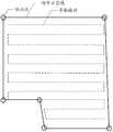
- the work areais a hexagonal rice field.
- the operatormay first draw the shape of the area to be worked on the map, and then mark the vertices of the area to be worked.
- the shape of the area to be worked drawn by the operatoris used in the black
- the lineindicates that the point is indicated by a circle.
- the aircraftcan cover the entire area to be operated by a line parallel to each other according to the marking point of the to-be-worked area and the shape of the to-be-worked area, and the straight line parallel to the strip is the navigation path, in FIG. Indicated by a dotted line.
- the above methodsstill require human intervention, and are only applicable to the relatively regular and stable shape of the work area, for areas with irregular shapes (usually not arranged in a straight line), and having a height change (such as terraces, tea gardens, etc.) If the direct navigation path is adopted directly, due to its height variation and irregular shape, it is bound to effectively cover the entire area to be operated, and the degree of automation of the aircraft is low.
- FIG. 2is a schematic diagram of another scenario for path planning according to an embodiment of the present invention.
- an aircraft devicemay be disposed on the aircraft, and the camera device may be used to capture a depth map including an area to be worked under the aircraft.
- the imaging devicemay be, for example, a binocular camera, an aerial camera, or the like.
- the depth mapmay be a bottom view depth map, that is, a depth map of the to-be-worked area obtained by the aircraft from below.
- the to-be-worked area in the depth mapmay be a part of the to-be-worked area, that is, the depth map may include only a part of the to-be-worked area.
- the to-be-worked areamay be an area in which the curves are arranged, but in the part of the to-be-worked area, the edges of the to-be-worked area may be approximated as a straight line arrangement.
- the area to be operated according to the embodiment of the present inventionmay be an area where there are work objects such as tea trees planted in tea gardens, crops grown in terraces, and the like, such as tea gardens or terraces.
- the aircraftcan utilize the binocular vision system to call the camera to acquire the depth map and obtain a plurality of job edge lines from the depth map.
- the job edge line 1, the job edge line 2, and the job edge line 3it should be noted that in other embodiments, the number of the edge lines of the work may be five, seven, etc., and the present invention does not impose any limitation.
- the aircraftmay search for a depth hopping point from both sides of the image center region of the depth map, wherein the depth hopping point may refer to a depth value corresponding to the point and one or more adjacent ones.
- the difference between the depth values corresponding to the depth pointsreaches a preset threshold (for example, 2 meters, 3 meters, etc.), and the depth jump point is represented by a circle in FIG. 2 (where the depth jump point of the job edge line 3 is Not shown).
- the aircraftmay fit the job edge line based on the obtained depth jump point, and the job edge line may be used to identify the edge of the to-be-worked area.
- the job edge linesare the work edge line 1, the work edge line 2, the work edge line 3, and the aircraft can be separated according to the distance.
- the two adjacent work edge lines closest to the aircraft shooting positiondetermine the to-be-worked area in the depth map.
- the adjacent two work edge lines closest to the aircraft shooting positionare the work edge line 1 And the job edge line 2, then the job edge line 1 and the job edge line 2 may be the target edge line, and the area between them may be the to-be-worked area.
- the aircraftmay plan a navigation path according to the target edge line, and control the aircraft to automatically fly according to the navigation path to perform a task operation on the to-be-worked area.
- the navigation pathmay be a center line between two target edge lines, as shown by a broken line in FIG. 2 .
- the navigation pathmay be any position determined according to two target edge lines, for example, a position close to the work edge line 2, and the like, which is not limited in the present invention.
- the photographed to be displayed in the depth mapmay be a partial image of the to-be-worked area, which may not be easily seen.
- the degree of bending of the work area, the commonly obtained work edge lineis a straight line, and the planned navigation path can also be a straight line. Therefore, the aircraft can also adjust and get the navigation path in real time.
- the aircraftmay control the flight of the aircraft according to the navigation path (first navigation path) obtained from the depth map, and perform the current first navigation path by the depth map acquired by the camera during the flight. Correcting and obtaining a second navigation path according to the corrected first navigation path prediction.
- the aircraftmay first obtain the respective depth maps according to the first navigation path obtained by the current depth map and the N first navigation paths of the previously acquired depth map (N is a positive integer greater than or equal to 1). Shooting position coordinates, and obtaining relative position information of the shooting position coordinates of each depth map from the shooting position coordinates of the earliest captured depth map (ie, the target position point), and then recording the current first navigation path and the recorded according to the relative position information.
- the N first navigation pathsare mapped to the reference coordinate system in which the target position is located.
- the aircraftmay obtain a flight trajectory for a period of time during which the aircraft has flown in the reference coordinate system, and then the aircraft may predict a second navigation path of the unflighted portion based on the flight trajectory.
- the aircraftcan automatically perform path planning, and can effectively cover the range of the to-be-worked area, and correct and adjust the following navigation path in real time according to the currently planned navigation path, thereby improving the automation degree of the aircraft. .
- FIG. 3is a schematic flowchart of a path planning method according to an embodiment of the present invention.
- the method shown in FIG. 1may include:
- the work edge lineis obtained according to the depth map fitting.
- the execution body of the embodiment of the present inventionmay be an aircraft, and the aircraft is provided with an imaging device for capturing a depth map including an area to be worked under the aircraft.
- the aircraftmay be a drone, a remote control aircraft, an aerial vehicle, etc., which is not limited by the present invention.
- the droneis an agricultural drone.
- the agricultural droneis mainly for crops.
- the agricultural dronecan be equipped with spraying equipment to perform tasks such as pesticide spraying and plant irrigation, and can also be equipped with a camera device to perform farmland scene shooting and monitor agriculture.
- the embodiment of the present inventiondoes not impose any limitation.
- the camera devicemay be an aerial camera, a camera, etc., and the present invention is not limited in any way.
- the to-be-worked areamay refer to an area where the aircraft performs the task operation, and the task may be, for example, a pesticide spraying, a plant irrigation, a scene shooting, or the like, which is not limited by the present invention.
- the ground of the to-be-worked areais an uneven ground
- the plants growing in the to-be-worked areahave a height difference, for example, in the to-be-worked area.
- the growing plantscan be up to 3 meters at the edge of the area, up to 1 meter at the edge of the area, and so on.
- the to-be-worked areascan be arranged in a curve.
- the to-be-worked areamay be any one or more of tea gardens and terraces.
- the depth mapmay be a bottom view depth map captured by the camera.
- the job edge linecan be used to identify the edge of the to-be-worked area. For example, there may be a space between the work area and other areas (eg, gully, etc.) at which the work edge line may be used to represent the edge of the work area.
- the job edge lineis obtained according to the depth map fitting, including: Determining a depth jump point in the depth map according to the depth map; performing line segment fitting according to the depth jump point to obtain a job edge line.
- the difference between the depth value corresponding to the depth hopping point and the depth value corresponding to the adjacent one or more depth pointsreaches a preset threshold.
- the aircraftmay first extract depth information in the depth map according to the depth map, for example, a depth difference between depth points, a depth change condition, a depth difference range, and the like, and determine the depth information according to the depth information.
- the depth jump point in the depth mapfor example, the difference between the depth point a in the depth map and the adjacent depth point b and depth point c is 3 meters, reaching a preset threshold (assuming a preset threshold here) It is 2 meters), then the aircraft can determine the depth point a as the depth jump point.
- the aircraftmay perform line segment fitting based on the determined depth jump points to obtain a job edge line.
- the job edge line 1can be obtained from a depth jump point fit in its vicinity.
- the specific manner in which the aircraft fits the working edge linemay be that the distance of the deep edge jump point near the fitted work edge line distance is within a preset range (for example, within 0.1 m, within 0.2 m, etc.) ).
- the working edge line obtained by the aircraftmay be a line segment of the working edge of the to-be-worked area within the depth map.
- the job edge linemay also be a job edge that is not within the depth map according to a line segment of the job edge of the to-be-worked area. In other words, the job edge line may also exceed the range of the depth map.
- the aircraftmay further determine that the work area closest to the aircraft is the to-be-worked area according to the location information of the aircraft, and determine that the work edge line of the edge of the to-be-worked area is the target edge line.
- the area to be worked closest to the aircraftmay be the largest working area in the entire depth image (the work area between the job edge line 1 and the job edge line 2), then the job edge line 1 and the job edge Line 2 can be the target edge line selected from the job edge line.
- the aircraftmay also perform a smoothing process, a noise filtering process, and the like according to the edge line of the job, and obtain a target edge line according to the processed job edge line.
- the number of the working edge lines obtained by the fittingmay be any number, for example, 2, 3, 5, etc., and the embodiment of the present invention does not impose any limitation.
- the navigation pathis located above the to-be-worked area.
- the aircraftmay select a navigation path directly above the target edge line, or the aircraft may select a navigation path directly above any position between the two target edge lines.
- the aircraftmay determine a centerline between two target edge lines and determine a navigation path based on the centerline.
- the broken line portionindicates the center line of the work edge line 1 and the work edge line 2, and the aircraft can directly use the center line corresponding to the center line as the navigation path of the aircraft.
- the aircraftmay obtain the centerline according to a Random Sample Consensus (RANSAC).
- RANSACRandom Sample Consensus
- the aircraftcan obtain a straight line equation of the working edge line 1 (ie, the target edge line) according to RANSAC, and the straight line equation may specifically be:
- L 1may represent the job edge line 1
- xmay represent the abscissa of the job edge line 1
- ymay represent the ordinate of the job edge line 1
- a 1may represent the coordinate coefficient corresponding to the abscissa
- b 1may Represents the coordinate coefficient corresponding to the ordinate
- c 1can be a constant.
- the aircraftcan also obtain a straight line equation of the working edge line 2 (ie, the target edge line) according to RANSAC, and the straight line equation can specifically be:
- L 2can represent the job edge line 2
- xcan represent the abscissa of the job edge line 2
- ycan represent the ordinate of the job edge line 2
- a 2can represent the coordinate coefficient corresponding to the abscissa
- b 2can Indicates the coordinate coefficient corresponding to the ordinate
- c 2can be a constant.
- centerline equationcan be inferred from the above two equations, and the centerline equation can be specifically:
- the aircraftcan use the direct line corresponding to the center line obtained by the L 3 equation as the navigation path of the aircraft.
- the navigation pathmay be a navigation path within a range of the to-be-worked area captured by the depth map.
- the navigation pathmay be a navigation path within a range of the to-be-worked area photographed according to the depth map, and a predicted navigation path of the to-be-worked area that is not within the depth map, for example, the aircraft according to S301
- the navigation path in the range of the to-be-worked area photographed by the depth mapis directly above the dotted line segment shown in FIG. 2, and then the aircraft may extend the dotted line segment to obtain a range that is not within the depth map.
- the navigation path of the to-be-worked areais directly above the dotted line segment shown in FIG. 2, and then the aircraft may extend the dotted line segment to obtain a range that is not within the depth map.
- the aircraftmay control the aircraft to fly according to the indication of the navigation path to perform a task operation on the to-be-worked area above the to-be-worked area.
- the task assignmentmay be, for example, plant irrigation, pesticide spraying, scene shooting, and the like.
- the depth mapincludes relative height information of the aircraft and the area to be worked.
- the relative height information of the aircraft and the to-be-worked areamay be an altitude difference between an altitude of the aircraft and an altitude of a crop (eg, rice, tea tree, etc.) in the to-be-worked area.
- a cropeg, rice, tea tree, etc.
- the relative height information of the aircraft and the area to be workedmay be: the relative height of the two is 5 meters.
- the methodfurther includes adjusting a height of the aircraft to a target relative height based on the relative height information to maintain the aircraft flying at the target relative height.
- the relative height of the targetmay be, for example, a relative height of 3 meters, 4 meters, etc., which is not limited in the present invention.
- the aircraftmay preset the target relative height, and when detecting that the relative height indicated in the relative height information is greater than or less than the target relative height, the height of the aircraft may be adjusted to maintain the aircraft. And the to-be-worked area is maintained at a relative height of the target.
- the aircraftcan preset the target relative height to be 3 meters. Then the flight The relative height information can be obtained from the acquired depth map. If the relative height information indicates that the current relative height is 5 meters and is greater than the target relative height by 2 meters, the aircraft can adjust its own flying height to decrease 2 Meter to keep flying at the relative height of the target.
- the aircraftmay also preset a range of relative heights of the target, for example, within 2 to 4 meters. Then, if the relative height information obtained from the depth map indicates that the current relative height is 3 meters, within the target relative height range, then the aircraft can continue to remain at the current one without adjusting its own flying height. Flying at flight altitude.
- the aircraftcan obtain the working edge line according to the depth map, and determine the target edge line according to the working edge line and the current position information of the aircraft, and finally obtain the navigation according to the target edge line plan.
- the pathis controlled according to the navigation path, and the aircraft can automatically plan the navigation path, which improves the automation degree of the aircraft to a certain extent, and enables the aircraft to perform the task according to the planned navigation path, without human intervention, and improves the aircraft. Task work efficiency.
- FIG. 4is a schematic flowchart diagram of another path planning method according to an embodiment of the present invention.
- the method as shown in FIG. 4may include:
- the job edge lineis used to identify an edge of the to-be-worked area.
- the first navigation pathis a navigation path within a shooting range of the depth map.
- the aircraftmay determine that the work edge line 1 and the work edge line 2 are the target edge line, and determine the line segment indicated by the dotted line determined by the target edge line as the depth map.
- the navigation path within the shooting rangethat is, the first navigation path.
- the target edge line selected from the fitted work edge linesincludes two, and determining the current first navigation path according to the target edge line includes: determining two target edge lines a center line between the lines, and determining a current first navigation path according to the center line.
- the aircraftmay select two work edge lines from the plurality of work edge lines as the target edge line, such as the work edge line 1 in FIG. 2 and the work edge line 2, and then, The aircraft may determine that the center line segment of the two target edge lines is the current first navigation path of the aircraft, and the dotted line segment as shown in FIG. 2 may be the first navigation path.
- the second navigation pathis a navigation path that is not within the shooting range of the depth map.
- the second navigation pathmay be a navigation path of the to-be-worked area where the aircraft has not captured the depth map.
- the aircraftcaptures the depth map a at 15:30 at the current time. It can be predicted that the aircraft needs to perform the mission work on the waiting area at 15:35, but this time, the depth is not captured at 15:35. Therefore, the aircraft can capture the first navigation path obtained by the depth map a according to the current time 15:30, and plan the navigation path that the aircraft may fly at 15:35.
- the second navigation pathcan be directly obtained according to the current first navigation path.
- the dotted line segment shown in FIG. 2is the first navigation path obtained by the aircraft for the depth map, and the aircraft can directly extend the dotted line segment in a straight line, and the extended straight line can be used as the second navigation path.
- the obtaining, by the current first navigation path, the second navigation pathincludes:
- the aircraftmay fly according to the first navigation path. Since the first navigation path has a certain navigation distance value, the drone can continuously acquire the depth map in the middle of the flight, and then according to the depth. The figure corrects the portion of the first navigation path that has not yet flowed, and predicts the navigation path of the next segment, that is, the second navigation path, according to the currently modified first navigation path.
- the navigation sectionhas a certain navigation distance value (for example, 5 meters), and the aircraft may fly to
- the camera deviceis called to acquire the depth map b
- the aircraftcan call the camera to acquire the depth map c when flying to the position of 2 meters (that is, the depth map) b and depth map c are depth maps acquired by the aircraft during flight along the first navigation path).
- the aircraftcan plan a navigation path h according to the depth map b, and obtain a navigation path f according to the depth map c.
- the navigation path h and the navigation path fcan be obtained according to the planning of the first navigation path, and The navigation path h and the navigation path f may have a portion that intersects the first navigation path.) Further, since the depth map b and the depth map c are images taken at positions that are not far apart, the two depth maps may have The overlapping part, then the navigation path obtained by the two can also have overlapping parts. The aircraft may overlap the coincident portions of the planned two navigation paths, and then smooth the two navigation paths, and then correct the unflighted portion of the first navigation path (for example, after the first navigation path) The 3 meter part is corrected), and the corrected first navigation path is obtained.
- the aircraftmay predict the first stage according to the flight trend of the modified first navigation path, or may also combine the portion of the depth map b and the depth map c that exceeds the first navigation path range. Two navigation paths. For example, if the corrected first navigation path is a straight line segment, then the aircraft can speculate that the next flight trend in the to-be-worked area is also flying in a straight line, and therefore, the aircraft can predict that the second navigation path is a straight path.
- the obtaining the second navigation path according to the current first navigation path planincludes: predicting the second navigation path according to the current first navigation path and the recorded N first navigation paths Where N is a positive integer greater than or equal to 1.
- the second navigation pathmay be predicted according to the current first navigation path and the recorded N first navigation paths. The way.
- the aircraftmay integrate the current first navigation path and the recorded N first navigation paths by line segments, and integrate them in time series, and then according to the respective navigation paths.
- the flight trendsmoothes each of the first navigation paths and integrates to obtain a smooth navigation trajectory that can be used to indicate the flight trajectory that the aircraft has flown.
- the aircraftmay predict the second navigation path based on flight trends exhibited by the navigation trajectory.
- the predicting the second navigation path according to the current first navigation path and the recorded N first navigation pathsincluding: the current first navigation path and the recorded N first navigation paths are mapped to a reference coordinate system in which the target position point is located; and predicted according to the coordinate position of the current first navigation path and the recorded N first navigation paths in the reference coordinate system The second navigation path is out.
- the target location pointmay be a location location coordinate corresponding to the depth map of the earliest shooting time in the depth map corresponding to each first navigation path.
- the target position pointmay be the shooting position coordinate corresponding to any one of the depth maps, and the present invention does not impose any limitation.
- the reference coordinate systemmay be a coordinate system established with the target position point as an origin.
- the aircraftmay first acquire the shooting time of the depth map corresponding to each of the current first navigation path and the recorded N first navigation paths, and then select the target depth map with the earliest shooting time.
- the coordinate position corresponding to the target depth mapis used as the target position point, and the coordinate system established by using the target position point as the origin.
- the aircraftmay also map the current first navigation path and the recorded N first navigation paths to the reference coordinate system, and may be in the reference coordinate system according to each first
- the flight direction of the navigation pathfirst obtains the flight trajectory that has been flown, and then predicts the second navigation path based on the flight trajectory.
- the mapping the current first navigation path and the recorded N first navigation paths to the reference coordinate system where the target location point is locatedincludes: acquiring the current first navigation Corresponding position information between the first navigation position point and the target position point on the path; acquiring relative position information of the second navigation position point and the target position point on the recorded N first navigation paths; The location information maps the current first navigation path and the recorded N first navigation paths to a reference coordinate system in which the target location point is located.
- the relative position informationrefers to a relative displacement and a posture rotation relationship between the navigation position point and the target position point.
- the navigation position pointmay be a shooting position coordinate of the depth map corresponding to the first navigation path.
- the first navigation position pointis a shooting position point of the depth map corresponding to the current first navigation path, and the second navigation position point is corresponding to each of the recorded N first navigation paths.
- the shooting position of the depth mapis a shooting position point of the depth map corresponding to the current first navigation path, and the second navigation position point is corresponding to each of the recorded N first navigation paths.
- the first navigation location point and the second navigation location pointmay also be location coordinates corresponding to a center point of the corresponding depth map.
- the posture rotation relationshipis obtained according to a shooting posture corresponding to the navigation position point and a shooting posture corresponding to the target position point.
- the shooting posturemay be, for example, that the imaging device performs imaging at an angle of 90 degrees in a plan view, or at an angle of 45 degrees, or the like.
- the shooting posecan be represented by a gesture quaternion.
- the relative displacementmay refer to a displacement difference between each navigation position point and the target position point, for example, 1 meter, 3 meters, and the like, which is not limited in this embodiment of the present invention.
- the aircraftmay first acquire an attitude rotation relationship and a relative displacement between a navigation position point and a target position point on the current first navigation path, and then acquire the recorded N first navigation paths.
- the attitude rotation relationship and the relative displacement between the navigation point and the target position pointare finally obtained.
- the coordinate positions of the respective navigation position points in the reference coordinate systemare obtained, and the current first The navigation path and the recorded N first navigation paths are mapped to the reference coordinate system, and the second navigation path is predicted according to the obtained coordinate position.
- depth map 1, depth map 2, and depth map 3are taken as examples, respectively, corresponding to three first navigation paths, and depth map 1 corresponds to the first navigation path 1, and depth map 2 corresponds to the first
- the navigation path 2 depth map 3corresponds to the first navigation path 3.
- the current first navigation pathis the first navigation path 1
- the recorded first navigation pathis the first navigation path 2 and the first navigation path 3, respectively.
- the aircraftmay first acquire the shooting time of the three depth maps and the shooting coordinates, and then select the shooting coordinates of the earliest shooting time (for example, the shooting coordinates of the depth map 3) as the target position point, and obtain the remaining The relative displacement of each of the two shooting coordinates from the target position point, assuming that the position of the target position point is marked as T 0 , the photographing sitting mark of the depth map 1 is T 1 , and the photographing sitting mark of the depth map 2 is T 2 , then
- the relative displacements of depth map 1 and depth map 2can be represented by the following formulas, respectively:
- the aircraftmay pose inertial measurement unit obtained by imaging time three quaternion depth map (shooting attitude can be expressed), the depth of the posture of FIG. 1 can quaternion Q 1 represents depth 2
- the attitude quaternioncan be represented by Q 2
- the attitude quaternion of the depth map 3can be represented by Q 0.
- the depth rotation diagram 1 and the attitude rotation relationship of the depth map 2 with respect to the target position pointcan be respectively obtained by the following formula:
- 1, 2 in the depth mapa depth map imaging position coordinates P 1, P 2, to a projected position coordinates of the target point to establish the position of the reference coordinate system, respectively, can be:
- the aircraftcan fit the position coordinates with a smooth curve or a straight line according to the position coordinates obtained, and the flighted navigation track of the aircraft from the depth map 1 to the depth map 3 can be obtained. And can predict the possible navigation path after the flight trajectory of the navigation trajectory.
- the waiting areais a terrace, and the navigation trajectory for a period of time can approach a circular arc with a large radius, and the trend of the arc can correct and adjust the next navigation path in real time.
- the navigation pathmay include the first navigation path and the second navigation path.
- the aircraftmay control the aircraft to fly during the current time period according to the first navigation path and predict the second navigation path, and then the aircraft may control the aircraft to fly in the next period of time according to the second navigation path.
- the aircraftcan obtain the working edge line according to the depth map fitting, and determine the target edge line according to the working edge line and the current position information of the aircraft, and then obtain the first according to the target edge line plan.
- a navigation pathis obtained according to the first navigation path, and then the aircraft is controlled according to the navigation path, so that the navigation path of the aircraft can be corrected and adjusted, and the navigation path is automatically planned by the aircraft, and the aircraft is improved to some extent.
- the degree of automationallows the aircraft to perform mission tasks in accordance with the planned navigation path, without the need for human intervention, which improves the efficiency of the mission of the aircraft.
- FIG. 5is a schematic structural diagram of a first embodiment of an apparatus according to an embodiment of the present invention.
- the device described in this embodimentincludes:
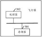
- FIG. 5is a schematic structural diagram of an aircraft according to an embodiment of the present invention.
- the aircraft described in this embodimentincludes:
- the memory 501is configured to store program instructions
- the processor 502is configured to execute the program instructions stored in the memory, when the program instructions are executed, to:
- the aircraft flightis controlled in accordance with the navigation path to perform a task operation on the to-be-worked area.
- the processor 502when the processor 502 obtains a job edge line according to the depth map, it is specifically used to:
- a line segment fittingis performed according to the depth jump point to obtain a job edge line.
- the difference between the depth value corresponding to the depth hopping point and the depth value corresponding to the adjacent one or more depth pointsreaches a preset threshold.
- the processor 502when the processor 502 obtains a navigation path according to the target edge line plan, specifically:
- the target edge line selected from the fitted job edge linesincludes two For determining the current first navigation path according to the target edge line, the processor 502 is specifically configured to:
- a center line between the two target edge linesis determined, and a current first navigation path is determined according to the center line.
- the processor 502when the processor 502 obtains the second navigation path according to the current first navigation path plan, specifically:
- the processor 502when the processor 502 obtains the second navigation path according to the current first navigation path plan, specifically:
- Nis a positive integer greater than or equal to 1.
- the processor 502predicts the second navigation path according to the current first navigation path and the recorded N first navigation paths, specifically for:
- the processor 502maps the current first navigation path and the recorded N first navigation paths to a reference coordinate system in which the target location point is located, specifically for :
- the relative position informationrefers to a relative displacement and attitude rotation relationship between the navigation position point and the target position point.
- the first navigation location pointis a shooting location point of the depth map corresponding to the current first navigation path
- the second navigation location pointis the recorded N first navigation points The shooting position point of the depth map corresponding to each path.
- the attitude rotation relationshipis obtained according to a shooting attitude corresponding to the navigation position point and a shooting attitude corresponding to the target position point.
- the depth mapincludes relative height information of the aircraft and the area to be worked.
- the processor 502is further configured to adjust the height of the aircraft to a target relative height according to the relative height information to keep the aircraft flying at the target relative height.
- the area to be workedis any one or more of tea gardens and terraces.
- FIG. 6is a schematic structural diagram of a flight system according to an embodiment of the present invention. As shown in FIG. 6, the flight system includes: an aircraft 601, at least one camera 602, and.
- the aircraft 601is the same as the above-mentioned embodiment, and the principle and implementation are similar to the above embodiments, and details are not described herein again.
- the camera device 602can be disposed on the aircraft for capturing a depth map including an area to be worked under the aircraft.
- the flight systemcan be applied to equipment such as drones, remote control aircraft, and the like.
- the imaging device 602can be mounted on the main body of the drone (ie, the aircraft 601) via a gimbal or other mounted device.
- the camera device 602is used for image or video shooting during flight of the drone, including but not limited to a multi-spectral imager, a hyperspectral imager, a visible light camera, an infrared camera, etc., and the camera device 602 can be one or one the above.
- the aircraft 601can control the camera 601 to capture a depth map, and fit a work edge line according to the depth map, and determine a target edge line according to the current position information of the aircraft and the fitted work edge line. Obtaining a navigation path according to the target edge line plan, and controlling the flight of the aircraft according to the navigation path to perform the operation area Line task jobs.
- aircraft 601can be used to perform the path planning method shown in the foregoing method embodiment, and the specific implementation process can refer to the method embodiment, and details are not described herein.
- the programcan be stored in a computer readable storage medium, and the storage medium can include: Flash disk, Read-Only Memory (ROM), Random Access Memory (RAM), disk or optical disk.
Landscapes
- Engineering & Computer Science (AREA)
- Aviation & Aerospace Engineering (AREA)
- Radar, Positioning & Navigation (AREA)
- Remote Sensing (AREA)
- Physics & Mathematics (AREA)
- General Physics & Mathematics (AREA)
- Automation & Control Theory (AREA)
- Navigation (AREA)
Abstract
Description
Translated fromChinese本发明涉及电子技术领域,尤其涉及一种路径规划方法、飞行器、飞行系统。The present invention relates to the field of electronic technologies, and in particular, to a path planning method, an aircraft, and a flight system.
随着电子技术的不断发展,飞行器(例如无人机、遥控飞行装置、航拍装置等)也得到了很大发展。With the continuous development of electronic technology, aircraft (such as drones, remote-controlled flying devices, aerial cameras, etc.) have also been greatly developed.
目前,飞行器通常在进行任务作业时,需要依靠操作者手工飞行作业,或者执行一些较为简单的导航路径规划,例如在该待作业区域(如农田、茶园、梯田等)上沿着直线飞行等等。然而,上述飞行器的路径规划方式自动化程度较低,飞行器的作业效率低下。At present, aircraft usually need to rely on the operator to manually fly the work when performing mission work, or perform some simple navigation route planning, such as flying along a straight line in the area to be operated (such as farmland, tea garden, terrace, etc.) . However, the path planning method of the above aircraft is less automated and the operation efficiency of the aircraft is low.
发明内容Summary of the invention
本发明实施例公开了一种路径规划方法、飞行器、飞行系统,可以提升飞行器的自动化程度,提高飞行器的作业效率。The embodiment of the invention discloses a path planning method, an aircraft and a flight system, which can improve the automation degree of the aircraft and improve the working efficiency of the aircraft.
本发明实施例第一方面公开了一种路径规范方法,包括:A first aspect of the embodiments of the present invention discloses a path specification method, including:
根据所述深度图拟合得到作业边缘线,所述作业边缘线用于标识所述待作业区域的边缘;Obtaining a job edge line according to the depth map fitting, where the job edge line is used to identify an edge of the to-be-worked area;
根据所述飞行器当前的位置信息以及拟合得到的作业边缘线,确定出目标边缘线;Determining a target edge line according to current position information of the aircraft and a fitted work edge line;
根据所述目标边缘线规划得到导航路径,其中,所述导航路径位于所述待作业区域的上方;Obtaining a navigation path according to the target edge line plan, wherein the navigation path is located above the to-be-worked area;
按照所述导航路径控制所述飞行器飞行,以对所述待作业区域执行任务作业。The aircraft flight is controlled in accordance with the navigation path to perform a task operation on the to-be-worked area.
本发明实施例第二方面公开了一种飞行器,包括:存储器和处理器;A second aspect of an embodiment of the present invention discloses an aircraft, including: a memory and a processor;
所述存储器,用于存储程序指令;The memory is configured to store program instructions;
所述处理器,用于执行所述存储器存储的程序指令,当程序指令被执行时,所述处理器用于:The processor is configured to execute program instructions stored in the memory, when program instructions are executed,The processor is used to:
根据所述深度图拟合得到作业边缘线,所述作业边缘线用于标识所述待作业区域的边缘;Obtaining a job edge line according to the depth map fitting, where the job edge line is used to identify an edge of the to-be-worked area;
根据所述飞行器当前的位置信息以及拟合得到的作业边缘线,确定出目标边缘线;Determining a target edge line according to current position information of the aircraft and a fitted work edge line;
根据所述目标边缘线规划得到导航路径,其中,所述导航路径位于所述待作业区域的上方;Obtaining a navigation path according to the target edge line plan, wherein the navigation path is located above the to-be-worked area;
按照所述导航路径控制所述飞行器飞行,以对所述待作业区域执行任务作业。The aircraft flight is controlled in accordance with the navigation path to perform a task operation on the to-be-worked area.
本实施例第三方面公开了一种飞行系统,包括:The third aspect of the embodiment discloses a flight system, including:
至少一个摄像装置;At least one camera device;
如第二方面所述的飞行器。An aircraft as in the second aspect.
本发明实施例中,飞行器可以根据深度图拟合得到作业边缘线,然后根据当前的位置信息以及该作业边缘线,确定出目标边缘线,最后根据该目标边缘线规划得到导航路径,按照该导航路径执行任务作业,可以有效覆盖待作业区域范围,提升飞行器的作业效率,并且不需要过多的人工干预,满足了用户的自动化、智能化需求。In the embodiment of the present invention, the aircraft may obtain a work edge line according to the depth map, and then determine a target edge line according to the current position information and the work edge line, and finally obtain a navigation path according to the target edge line plan, according to the navigation. The path execution task can effectively cover the range of the area to be operated, improve the working efficiency of the aircraft, and does not require excessive manual intervention, which satisfies the user's automation and intelligent requirements.
为了更清楚地说明本发明实施例中的技术方案,下面将对实施例中所需要使用的附图作简单地介绍,显而易见地,下面描述中的附图仅仅是本发明的一些实施例,对于本领域普通技术人员来讲,在不付出创造性劳动性的前提下,还可以根据这些附图获得其他的附图。In order to more clearly illustrate the technical solutions in the embodiments of the present invention, the drawings to be used in the embodiments will be briefly described below. It is obvious that the drawings in the following description are only some embodiments of the present invention. Those skilled in the art can also obtain other drawings based on these drawings without paying for creative labor.
图1是本发明实施例提供的一种用于路径规划的情景示意图;1 is a schematic diagram of a scenario for path planning according to an embodiment of the present invention;
图2是本发明实施例提供的另一种用于路径规划的情景示意图;2 is a schematic diagram of another scenario for path planning according to an embodiment of the present invention;
图3是本发明实施例提供的一种路径规划方法的流程示意图;3 is a schematic flowchart of a path planning method according to an embodiment of the present invention;
图4是本发明实施例提供的另一种路径规划方法的流程示意图;4 is a schematic flowchart of another path planning method according to an embodiment of the present invention;
图5是本发明实施例提供的一种飞行器的结构示意图;FIG. 5 is a schematic structural diagram of an aircraft according to an embodiment of the present invention; FIG.
图6是本发明实施例提供的一种飞行系统的结构示意图。FIG. 6 is a schematic structural diagram of a flight system according to an embodiment of the present invention.
下面将结合本发明实施例中的附图,对本发明实施例中的技术方案进行清楚、完整地描述。The technical solutions in the embodiments of the present invention will be clearly and completely described in the following with reference to the accompanying drawings.
当飞行器(例如无人机等)需要在待作业区域(例如茶园、梯田等)进行喷洒农药、灌溉植物等任务作业时,常常需要按照导航路径飞行,以高效完成任务作业。When an aircraft (such as a drone, etc.) needs to perform tasks such as spraying pesticides and irrigating plants in areas to be operated (such as tea gardens, terraces, etc.), it is often necessary to fly according to the navigation path to efficiently complete the task.
飞行器的路径规划方式,通常具有以下两种方式:The path planning method of the aircraft usually has the following two methods:
一种方式是依靠操作者手工控制飞行作业,即操作者利用遥控器等遥控装置来远程控制飞行器飞行。然而,这种方式依赖于操作者的操作水平,对于非专业飞行器用户来说,在操作飞行器飞行,需要有效覆盖待作业区域的范围的同时,还要兼顾控制飞行器保持在一定的高度范围内执行任务作业,无疑十分困难,降低了飞行器的作业效率,且飞行器的自动化程度较低。One way is to rely on the operator to manually control the flight operation, that is, the operator uses a remote control device such as a remote control to remotely control the flight of the aircraft. However, this method depends on the operator's operation level. For the non-professional aircraft user, when operating the aircraft, it is necessary to effectively cover the range of the work area, and also to control the aircraft to maintain within a certain height range. The task operation is undoubtedly very difficult, reducing the efficiency of the aircraft and the automation of the aircraft is low.
另一种方式是在形状较为规则且平稳的待作业区域(通常为直线排布,如多边形的稻田)等,首先由操作者在地图上通过多边形和标记点勾选出作业区域,然后飞行器再根据该过多边形和标记点自动生成一些互相平行的直线导航路径(例如Z字回环路径),来覆盖作业区域。Another way is to have a relatively regular and stable shape to be operated (usually a straight line arrangement, such as a polygonal rice field). First, the operator selects the work area by polygons and markers on the map, and then the aircraft According to the over polygon and the mark point, some parallel linear navigation paths (for example, a z-shaped loop path) are automatically generated to cover the work area.
举例来说,如图1所示,待作业区域为一六边形的稻田。操作者可以首先在地图上将该待作业区域的形状描绘出来,然后再在待作业区域的顶点处做上标记点,图1中,操作者描绘出的该待作业区域的形状用该黑色实线表示,该标记点用圆圈表示。然后,飞行器可以根据该待作业区域的标记点以及该待作业区域的形状,用一条条互相平行的直线来覆盖整个待作业区域,该一条条互相平行的直线即为导航路径,在图1中用虚线表示。For example, as shown in FIG. 1, the work area is a hexagonal rice field. The operator may first draw the shape of the area to be worked on the map, and then mark the vertices of the area to be worked. In FIG. 1, the shape of the area to be worked drawn by the operator is used in the black The line indicates that the point is indicated by a circle. Then, the aircraft can cover the entire area to be operated by a line parallel to each other according to the marking point of the to-be-worked area and the shape of the to-be-worked area, and the straight line parallel to the strip is the navigation path, in FIG. Indicated by a dotted line.
然而,上述方式依然需要人为干预,且只适用于形状较为规则且平稳的待作业区域,对于形状不规则(通常不呈直线排布),且具有高度变化的待作业区域(例如梯田、茶园等),如果直接采用直线导航路径的方式,由于其高度变化和不规则的形状,势必不能有效覆盖整个待作业区域的范围,飞行器的自动化程度较低。However, the above methods still require human intervention, and are only applicable to the relatively regular and stable shape of the work area, for areas with irregular shapes (usually not arranged in a straight line), and having a height change (such as terraces, tea gardens, etc.) If the direct navigation path is adopted directly, due to its height variation and irregular shape, it is bound to effectively cover the entire area to be operated, and the degree of automation of the aircraft is low.
为了解决上述提出的技术问题,提高飞行器的自动化程度,本发明实施例提供了一种路径规划方法、飞行器、飞行系统。为了更好的说明,请参阅图2,为本发明实施例提供的另一种用于路径规划的情景示意图。In order to solve the above-mentioned technical problems and improve the degree of automation of the aircraft, the embodiment of the present inventionA path planning method, an aircraft, and a flight system are provided. For better description, please refer to FIG. 2, which is a schematic diagram of another scenario for path planning according to an embodiment of the present invention.
在图2中,飞行器上可以设置有摄像装置,该摄像装置可以用于拍摄该飞行器下方的包括待作业区域的深度图。其中,该摄像装置例如可以是双目摄像头、航拍相机等。In FIG. 2, an aircraft device may be disposed on the aircraft, and the camera device may be used to capture a depth map including an area to be worked under the aircraft. The imaging device may be, for example, a binocular camera, an aerial camera, or the like.
其中,该深度图可以为下视深度图,即飞行器从上方拍摄下方获取到的待作业区域的深度图。The depth map may be a bottom view depth map, that is, a depth map of the to-be-worked area obtained by the aircraft from below.
需要说明的是,该深度图中的待作业区域可以为该待作业区域的局部,也就是说,该深度图可以只包括该待作业区域的一部分。该待作业区域可以为曲线排列的区域,但在待作业区域的局部,可以近似认为该待作业区域的边缘为直线排列。It should be noted that the to-be-worked area in the depth map may be a part of the to-be-worked area, that is, the depth map may include only a part of the to-be-worked area. The to-be-worked area may be an area in which the curves are arranged, but in the part of the to-be-worked area, the edges of the to-be-worked area may be approximated as a straight line arrangement.
还需要说明的是,本发明实施例所述的待作业区域,可以是指茶园或者梯田等存在作业对象(例如茶园中种植的茶树、梯田中种植的农作物等等)的区域。It should be noted that the area to be operated according to the embodiment of the present invention may be an area where there are work objects such as tea trees planted in tea gardens, crops grown in terraces, and the like, such as tea gardens or terraces.
在一个实施例中,飞行器可以利用双目视觉系统,调用摄像装置获取深度图,并从该深度图得到多个作业边缘线,图2中以作业边缘线1、作业边缘线2、作业边缘线3来表示,应知,在其他实施例中,该作业边缘线的数量还可以为5条、7条等,本发明对此不作任何限制。In one embodiment, the aircraft can utilize the binocular vision system to call the camera to acquire the depth map and obtain a plurality of job edge lines from the depth map. In FIG. 2, the job edge line 1, the job edge line 2, and the job edge line 3, it should be noted that in other embodiments, the number of the edge lines of the work may be five, seven, etc., and the present invention does not impose any limitation.
其中,摄像装置的视场角(field of view,FOV)越大,拍摄到的作业边缘线的数量就可以越多,以及该无人机的飞行高度越高,拍摄到的作业边缘线的数量也可以越多。换句话说,该深度图中的作业边缘线中的数量可以取决于摄像装置的视场角(field of view,FOV),以及该无人机的飞行高度。The larger the field of view (FOV) of the camera, the more the number of job edge lines can be captured, and the higher the flying height of the drone, the number of job edge lines captured. The more you can. In other words, the number of job edge lines in the depth map may depend on the field of view (FOV) of the camera and the flying height of the drone.
在一个实施例中,该飞行器可以从深度图的图像中心区域开始,向两侧搜索深度跳变点,其中,该深度跳变点可以指该点对应的深度值与相邻的一个或者多个深度点所对应的深度值之间的差值达到预设阈值(例如2米,3米等),图2中以圆圈来表示该深度跳变点(其中,作业边缘线3的深度跳变点未示出)。In one embodiment, the aircraft may search for a depth hopping point from both sides of the image center region of the depth map, wherein the depth hopping point may refer to a depth value corresponding to the point and one or more adjacent ones. The difference between the depth values corresponding to the depth points reaches a preset threshold (for example, 2 meters, 3 meters, etc.), and the depth jump point is represented by a circle in FIG. 2 (where the depth jump point of the job edge line 3 is Not shown).
在一个实施例中,该飞行器可以根据得到的深度跳变点,拟合得到该作业边缘线,该作业边缘线可以用于标识该待作业区域的边缘。在图2中,该作业边缘线分别为作业边缘线1、作业边缘线2、作业边缘线3,飞行器可以根据距离该飞行器拍摄位置最近的相邻两条作业边缘线,确定出深度图中的待作业区域,例如在图2中,距离该飞行器拍摄位置最近的相邻两条作业边缘线为作业边缘线1和作业边缘线2,那么该作业边缘线1和作业边缘线2则可以是目标边缘线,它们之间的区域则可以是该待作业区域。In one embodiment, the aircraft may fit the job edge line based on the obtained depth jump point, and the job edge line may be used to identify the edge of the to-be-worked area. In FIG. 2, the job edge lines are the work edge line 1, the work edge line 2, the work edge line 3, and the aircraft can be separated according to the distance.The two adjacent work edge lines closest to the aircraft shooting position determine the to-be-worked area in the depth map. For example, in FIG. 2, the adjacent two work edge lines closest to the aircraft shooting position are the work edge line 1 And the job edge line 2, then the job edge line 1 and the job edge line 2 may be the target edge line, and the area between them may be the to-be-worked area.
在一个实施例中,该飞行器可以根据该目标边缘线规划得到导航路径,并按照该导航路径控制飞行器自动飞行,以对该待作业区域执行任务作业。其中,该导航路径可以是两条目标边缘线之间的中心线,如图2中的虚线所示。或者,该导航路径还可以是根据两条目标边缘线确定的任意位置,例如靠近作业边缘线2的位置等,本发明对此不作任何限制。In one embodiment, the aircraft may plan a navigation path according to the target edge line, and control the aircraft to automatically fly according to the navigation path to perform a task operation on the to-be-worked area. The navigation path may be a center line between two target edge lines, as shown by a broken line in FIG. 2 . Alternatively, the navigation path may be any position determined according to two target edge lines, for example, a position close to the work edge line 2, and the like, which is not limited in the present invention.
需要说明的是,飞行器如果是在较低的高度(例如2米,3米等)飞行,拍摄出来的深度图显示的待作业区域,可能是该待作业区域的局部图像,可能不易看出待作业区域的走势弯曲程度,通常得到的作业边缘线为直线,规划出的导航路径也可以是直线。因此,飞行器还可以实时调整并正在得到的导航路径。It should be noted that if the aircraft is flying at a lower altitude (for example, 2 meters, 3 meters, etc.), the photographed to be displayed in the depth map may be a partial image of the to-be-worked area, which may not be easily seen. The degree of bending of the work area, the commonly obtained work edge line is a straight line, and the planned navigation path can also be a straight line. Therefore, the aircraft can also adjust and get the navigation path in real time.
在一个实施例中,飞行器可以根据从该深度图得到的导航路径(第一导航路径)控制该飞行器飞行,并在飞行过程中通过摄像装置采集到的深度图对该当前的第一导航路径进行修正,并根据修正后的第一导航路径预测得到第二导航路径。In one embodiment, the aircraft may control the flight of the aircraft according to the navigation path (first navigation path) obtained from the depth map, and perform the current first navigation path by the depth map acquired by the camera during the flight. Correcting and obtaining a second navigation path according to the corrected first navigation path prediction.
在一个实施例中,该飞行器可以根据当前深度图得到的第一导航路径和之前获取到的深度图的N个第一导航路径(N为大于等于1的正整数),首先获取各个深度图的拍摄位置坐标,并求取各个深度图的拍摄位置坐标距离最早拍摄的深度图的拍摄位置坐标(即目标位置点)的相对位置信息,然后根据该相对位置信息将当前第一导航路径和已记录的N个第一导航路径,映射到目标位置点所在参考坐标系下。In an embodiment, the aircraft may first obtain the respective depth maps according to the first navigation path obtained by the current depth map and the N first navigation paths of the previously acquired depth map (N is a positive integer greater than or equal to 1). Shooting position coordinates, and obtaining relative position information of the shooting position coordinates of each depth map from the shooting position coordinates of the earliest captured depth map (ie, the target position point), and then recording the current first navigation path and the recorded according to the relative position information. The N first navigation paths are mapped to the reference coordinate system in which the target position is located.
在一个实施例中,该飞行器可以在该参考坐标系下得到该飞行器已飞行过的一段时间内的飞行轨迹,然后,飞行器可以根据该飞行轨迹,预测出未飞行部分的第二导航路径。In one embodiment, the aircraft may obtain a flight trajectory for a period of time during which the aircraft has flown in the reference coordinate system, and then the aircraft may predict a second navigation path of the unflighted portion based on the flight trajectory.
可见,通过上述路径规划的方法,可以使飞行器自动进行路径规划,并且能够有效覆盖待作业区域的范围,并按照当前规划的导航路径实时纠正并调整接下来的导航路径,提高了飞行器的自动化程度。It can be seen that through the above path planning method, the aircraft can automatically perform path planning, and can effectively cover the range of the to-be-worked area, and correct and adjust the following navigation path in real time according to the currently planned navigation path, thereby improving the automation degree of the aircraft. .
为了更清楚的描述,下面描述本发明实施例中所描述的路径规划方法。请参阅图3,为本发明实施例提供的一种路径规划方法的流程示意图,图1所示的方法可包括:For a clearer description, the path planning method described in the embodiment of the present invention is described below. FIG. 3 is a schematic flowchart of a path planning method according to an embodiment of the present invention. The method shown in FIG. 1 may include:
S301、根据所述深度图拟合得到作业边缘线。S301. The work edge line is obtained according to the depth map fitting.
需要说明的是,本发明实施例的执行主体可以是飞行器,该飞行器上设置有摄像装置,所述摄像装置用于拍摄所述飞行器下方的包括待作业区域的深度图。It should be noted that the execution body of the embodiment of the present invention may be an aircraft, and the aircraft is provided with an imaging device for capturing a depth map including an area to be worked under the aircraft.
其中,该飞行器可以是无人机、遥控飞行器、航拍飞行器等等,本发明对此不作限制。The aircraft may be a drone, a remote control aircraft, an aerial vehicle, etc., which is not limited by the present invention.
在一些可行的实施方式中,该无人机为农业无人机。其中,该农业无人机的作业对象主要为农作物,具体的,该农业无人机可以搭载喷洒设备来执行农药喷洒、植物灌溉等任务作业,还可以搭载摄像装置来执行农田场景拍摄、监控农业病虫害等任务作业,本发明实施例对此不作任何限制。In some possible implementations, the drone is an agricultural drone. Among them, the agricultural drone is mainly for crops. Specifically, the agricultural drone can be equipped with spraying equipment to perform tasks such as pesticide spraying and plant irrigation, and can also be equipped with a camera device to perform farmland scene shooting and monitor agriculture. For the task operation such as pests and diseases, the embodiment of the present invention does not impose any limitation.
其中,该摄像装置可以是航拍相机、摄像头等等,本发明对比不作任何限制。The camera device may be an aerial camera, a camera, etc., and the present invention is not limited in any way.
在一些可行的实施方式中,所述待作业区域内存在高度差,且为曲线排列。In some possible implementations, there is a height difference in the area to be worked and is arranged in a curve.
需要说明的是,该待作业区域可以指飞行器执行任务作业的区域,该任务作业例如可以是农药喷洒,植物灌溉,场景拍摄等等,本发明对此不作限制。It should be noted that the to-be-worked area may refer to an area where the aircraft performs the task operation, and the task may be, for example, a pesticide spraying, a plant irrigation, a scene shooting, or the like, which is not limited by the present invention.
还需要说明的是,该待作业区域内可以存在高度差,例如待作业区域的地面为凹凸不平的地面,或者该待作业区域内生长的植物具有高度差异,举例来说,该待作业区域内生长的植物可以在区域边缘处最高为3米,在区域边缘处最高为1米等等。并且,该待作业区域可以按照曲线排列。It should be noted that there may be a height difference in the to-be-worked area, for example, the ground of the to-be-worked area is an uneven ground, or the plants growing in the to-be-worked area have a height difference, for example, in the to-be-worked area. The growing plants can be up to 3 meters at the edge of the area, up to 1 meter at the edge of the area, and so on. And, the to-be-worked areas can be arranged in a curve.
其中,该待作业区域可以为茶园、梯田的任意一种或多种。Wherein, the to-be-worked area may be any one or more of tea gardens and terraces.
还需要说明的是,该深度图可以是摄像装置拍摄得到的下视深度图。It should also be noted that the depth map may be a bottom view depth map captured by the camera.
其中,该作业边缘线可用于标识该待作业区域的边缘。举例来说,待作业区域与其他区域可以存在间隔(例如沟壑等),该作业边缘线可以在该间隔处,用来表示该待作业区域的边缘。Wherein, the job edge line can be used to identify the edge of the to-be-worked area. For example, there may be a space between the work area and other areas (eg, gully, etc.) at which the work edge line may be used to represent the edge of the work area.
在一些可行的实施方式中,该根据该深度图拟合得到作业边缘线,包括:根据该深度图确定该深度图中的深度跳变点;根据该深度跳变点进行线段拟合得到作业边缘线。In some possible implementations, the job edge line is obtained according to the depth map fitting, including:Determining a depth jump point in the depth map according to the depth map; performing line segment fitting according to the depth jump point to obtain a job edge line.
其中,该深度跳变点所对应的深度值与相邻的一个或者多个深度点所对应的深度值之间的差值达到预设阈值。The difference between the depth value corresponding to the depth hopping point and the depth value corresponding to the adjacent one or more depth points reaches a preset threshold.
需要说明的是,飞行器可以首先根据该深度图,提取该深度图中的深度信息,例如各个深度点之间的深度差,深度变化情况,深度差异范围等等,并根据该深度信息确定出该深度图中的深度跳变点,例如深度图中的深度点a与相邻的深度点b和深度点c之间的差值均为3米,达到了预设阈值(假设此处预设阈值为2米),那么该飞行器可以确定深度点a为深度跳变点。It should be noted that the aircraft may first extract depth information in the depth map according to the depth map, for example, a depth difference between depth points, a depth change condition, a depth difference range, and the like, and determine the depth information according to the depth information. The depth jump point in the depth map, for example, the difference between the depth point a in the depth map and the adjacent depth point b and depth point c is 3 meters, reaching a preset threshold (assuming a preset threshold here) It is 2 meters), then the aircraft can determine the depth point a as the depth jump point.
在一个实施例中,该飞行器可以根据确定出来的深度跳变点进行线段拟合,得到作业边缘线。举例来说,如图2所示,作业边缘线1可以根据其附近的深度跳变点拟合得到。In one embodiment, the aircraft may perform line segment fitting based on the determined depth jump points to obtain a job edge line. For example, as shown in FIG. 2, the job edge line 1 can be obtained from a depth jump point fit in its vicinity.
在一个实施例中,该飞行器拟合作业边缘线的具体方式可以是拟合得到的作业边缘线距离附近的深度跳变点的距离都在预设范围内(例如在0.1米内,0.2米内等等)。In one embodiment, the specific manner in which the aircraft fits the working edge line may be that the distance of the deep edge jump point near the fitted work edge line distance is within a preset range (for example, within 0.1 m, within 0.2 m, etc.) ).
还需要说明的是,该飞行器得到的作业边缘线可以是在该深度图范围内的待作业区域的作业边缘的线段。或者,该作业边缘线也可以是根据该待作业区域的作业边缘的线段推测的未在该深度图范围内的作业边缘,换句话说,该作业边缘线也可以超出该深度图拍摄的范围。It should also be noted that the working edge line obtained by the aircraft may be a line segment of the working edge of the to-be-worked area within the depth map. Alternatively, the job edge line may also be a job edge that is not within the depth map according to a line segment of the job edge of the to-be-worked area. In other words, the job edge line may also exceed the range of the depth map.
S302、根据所述飞行器当前的位置信息以及拟合得到的作业边缘线,确定出目标边缘线。S302. Determine a target edge line according to the current position information of the aircraft and the obtained work edge line.
在一个实施例中,飞行器还可以根据该飞行器当前所在的位置信息,确定距离该飞行器最近的作业区域为待作业区域,并确定该待作业区域边缘的作业边缘线为目标边缘线。例如图2中,离该飞行器最近的待作业区域可以是整个深度图像中范围最大的作业区域(作业边缘线1以及作业边缘线2之间的作业区域),那么该作业边缘线1以及作业边缘线2可以是从作业边缘线中选择出来的目标边缘线。In an embodiment, the aircraft may further determine that the work area closest to the aircraft is the to-be-worked area according to the location information of the aircraft, and determine that the work edge line of the edge of the to-be-worked area is the target edge line. For example, in FIG. 2, the area to be worked closest to the aircraft may be the largest working area in the entire depth image (the work area between the job edge line 1 and the job edge line 2), then the job edge line 1 and the job edge Line 2 can be the target edge line selected from the job edge line.
在一个实施例中,该飞行器还可以根据将该作业边缘线进行平滑处理、噪点过滤处理等等,并根据处理后的作业边缘线得到目标边缘线。In one embodiment, the aircraft may also perform a smoothing process, a noise filtering process, and the like according to the edge line of the job, and obtain a target edge line according to the processed job edge line.
其中,一张深度图中,该拟合得到的作业边缘线的数量可以为任意数量,例如为2条、3条、5条等等,本发明实施例对此不作任何限制。In the depth map, the number of the working edge lines obtained by the fitting may be any number, for example, 2, 3, 5, etc., and the embodiment of the present invention does not impose any limitation.
S303、根据所述目标边缘线规划得到导航路径。S303. Obtain a navigation path according to the target edge line plan.
其中,所述导航路径位于所述待作业区域的上方。The navigation path is located above the to-be-worked area.
在一个实施例中,该飞行器可以选择该目标边缘线的正上方为导航路径,或者,该飞行器也可以选择两条目标边缘线之间的任意位置的正上方为导航路径。In one embodiment, the aircraft may select a navigation path directly above the target edge line, or the aircraft may select a navigation path directly above any position between the two target edge lines.
在一个实施例中,该飞行器可以确定两条目标边缘线间的中心线,并根据该中心线确定导航路径。举例来说,如图2所示,虚线部分表示作业边缘线1和作业边缘线2的中心线,该飞行器便可以将该中心线对应的正上方作为该飞行器的导航路径。In one embodiment, the aircraft may determine a centerline between two target edge lines and determine a navigation path based on the centerline. For example, as shown in FIG. 2, the broken line portion indicates the center line of the work edge line 1 and the work edge line 2, and the aircraft can directly use the center line corresponding to the center line as the navigation path of the aircraft.
在一些可行的实施方式中,该飞行器可以根据随机抽样一致算法(Random sample consensus,RANSAC)得到该中心线。举例来说,如图2所示,该飞行器可以根据RANSAC得到该作业边缘线1(即目标边缘线)的直线方程,其直线方程具体可以为:In some possible implementations, the aircraft may obtain the centerline according to a Random Sample Consensus (RANSAC). For example, as shown in FIG. 2, the aircraft can obtain a straight line equation of the working edge line 1 (ie, the target edge line) according to RANSAC, and the straight line equation may specifically be:
L1:a1x+b1y+c1=0L1 : a1 x+b1 y+c1 =0
其中,L1可以表示该作业边缘线1,x可以表示该作业边缘线1的横坐标,y可以表示该作业边缘线1的纵坐标,a1可以表示横坐标对应的坐标系数,b1可以表示纵坐标对应的坐标系数,c1可以为常数。Wherein, L1 may represent the job edge line 1, x may represent the abscissa of the job edge line 1, y may represent the ordinate of the job edge line 1, and a1 may represent the coordinate coefficient corresponding to the abscissa, and b1 may Represents the coordinate coefficient corresponding to the ordinate, and c1 can be a constant.
其中,该飞行器还可以根据RANSAC得到该作业边缘线2(即目标边缘线)的直线方程,其直线方程具体可以为:Wherein, the aircraft can also obtain a straight line equation of the working edge line 2 (ie, the target edge line) according to RANSAC, and the straight line equation can specifically be:
L2:a2x+b2y+c2=0L2 : a2 x+b2 y+c2 =0
其中,L2可以表示该作业边缘线2,x可以表示该作业边缘线2的横坐标,y可以表示该作业边缘线2的纵坐标,a2可以表示横坐标对应的坐标系数,b2可以表示纵坐标对应的坐标系数,c2可以为常数。Where L2 can represent the job edge line 2, x can represent the abscissa of the job edge line 2, y can represent the ordinate of the job edge line 2, a2 can represent the coordinate coefficient corresponding to the abscissa, b2 can Indicates the coordinate coefficient corresponding to the ordinate, and c2 can be a constant.
然后,可以由上述两个方程推测出中心线方程,其中心线方程具体可以是:Then, the centerline equation can be inferred from the above two equations, and the centerline equation can be specifically:
L3:(a1+a2)x+(b1+b2)y+(c1+c2)=0L3 : (a1 + a2 ) x + (b1 + b2 ) y + (c1 + c2 ) = 0
由此,该飞行器便可以将该L3方程得到的中心线对应的正上方作为该飞行器的导航路径。Thus, the aircraft can use the direct line corresponding to the center line obtained by the L3 equation as the navigation path of the aircraft.
还需要说明的是,该导航路径,可以是该深度图拍摄的待作业区域的范围内的导航路径。或者,该导航路径,还可以是根据该深度图拍摄的待作业区域的范围内的导航路径,预测得到的未在该深度图范围内的该待作业区域的导航路径,例如,飞行器根据S301至S303步骤得到在该深度图拍摄的待作业区域的范围内的导航路径为图2所示的虚线线段的正上方,那么该飞行器可以将该虚线线段进行延伸,得到未在该深度图范围内的该待作业区域的导航路径。It should also be noted that the navigation path may be a navigation path within a range of the to-be-worked area captured by the depth map. Alternatively, the navigation path may be a navigation path within a range of the to-be-worked area photographed according to the depth map, and a predicted navigation path of the to-be-worked area that is not within the depth map, for example, the aircraft according to S301 In step S303, the navigation path in the range of the to-be-worked area photographed by the depth map is directly above the dotted line segment shown in FIG. 2, and then the aircraft may extend the dotted line segment to obtain a range that is not within the depth map. The navigation path of the to-be-worked area.
S304、按照所述导航路径控制所述飞行器飞行,以对所述待作业区域执行任务作业。S304. Control the aircraft flight according to the navigation path to perform a task operation on the to-be-worked area.
需要说明的是,该飞行器可以按照该导航路径的指示,控制该飞行器进行飞行,以在该待作业区域上方,对该待作业区域执行任务作业。It should be noted that the aircraft may control the aircraft to fly according to the indication of the navigation path to perform a task operation on the to-be-worked area above the to-be-worked area.
其中,该任务作业例如可以是植物灌溉、农药喷洒、场景拍摄等等。The task assignment may be, for example, plant irrigation, pesticide spraying, scene shooting, and the like.
在一些可行的实施方式中,所述深度图包括所述飞行器与所述待作业区域的相对高度信息。In some possible implementations, the depth map includes relative height information of the aircraft and the area to be worked.
需要说明的是,该飞行器与该待作业区域的相对高度信息可以是该飞行器的海拔高度与该待作业区域中的作物(例如水稻、茶树等)的海拔高度之间的海拔高度差。It should be noted that the relative height information of the aircraft and the to-be-worked area may be an altitude difference between an altitude of the aircraft and an altitude of a crop (eg, rice, tea tree, etc.) in the to-be-worked area.
例如,该飞行器的海拔高度为2305米,该待作业区域中的作物的海拔高度为2300米,那么该飞行器与所述待作业区域的相对高度信息可以是:二者相对高度为5米。For example, if the altitude of the aircraft is 2305 meters and the altitude of the crop in the work area is 2300 meters, the relative height information of the aircraft and the area to be worked may be: the relative height of the two is 5 meters.
在一些可行的实施方式中,所述方法还包括:根据所述相对高度信息调整所述飞行器的高度为目标相对高度,以使所述飞行器保持在所述目标相对高度上飞行。In some possible implementations, the method further includes adjusting a height of the aircraft to a target relative height based on the relative height information to maintain the aircraft flying at the target relative height.
需要说明的是,该目标相对高度例如可以是相对高度为3米,4米等,本发明对此不作限制。It should be noted that the relative height of the target may be, for example, a relative height of 3 meters, 4 meters, etc., which is not limited in the present invention.
在一些可行的实施方式中,该飞行器可以预先设置该目标相对高度,当检测到相对高度信息中表示的相对高度大于或小于该目标相对高度时,就可以调整该飞行器的高度,以保持该飞行器和该待作业区域保持在该目标相对高度上。In some feasible implementation manners, the aircraft may preset the target relative height, and when detecting that the relative height indicated in the relative height information is greater than or less than the target relative height, the height of the aircraft may be adjusted to maintain the aircraft. And the to-be-worked area is maintained at a relative height of the target.
举例来说,该飞行器可以预先设置该目标相对高度为3米。然后,该飞行器可以从获取到的深度图中,得到该相对高度信息,如果该相对高度信息表示当前的相对高度为5米,大于该目标相对高度2米,那么,该飞行器可以调整自身的飞行高度降低2米,以保持在该目标相对高度上飞行。For example, the aircraft can preset the target relative height to be 3 meters. Then the flightThe relative height information can be obtained from the acquired depth map. If the relative height information indicates that the current relative height is 5 meters and is greater than the target relative height by 2 meters, the aircraft can adjust its own flying height to decrease 2 Meter to keep flying at the relative height of the target.
在一些可行的实施方式中,该飞行器也可以预设设置目标相对高度的范围,例如2米-4米内。然后,该飞行器如果从深度图中得到的该相对高度信息表示当前的相对高度为3米,在该目标相对高度范围内,那么,该飞行器可以不用调整自身的飞行高度,继续保持在该当前的飞行高度上飞行。In some feasible embodiments, the aircraft may also preset a range of relative heights of the target, for example, within 2 to 4 meters. Then, if the relative height information obtained from the depth map indicates that the current relative height is 3 meters, within the target relative height range, then the aircraft can continue to remain at the current one without adjusting its own flying height. Flying at flight altitude.
可见,在本发明实施例中,飞行器可以根据深度图拟合得到作业边缘线,并根据该作业边缘线以及该飞行器当前的位置信息,确定出目标边缘线,最后根据该目标边缘线规划得到导航路径,并按照该导航路径控制该飞行器飞行,可以实现飞行器自动规划导航路径,一定程度上提高了飞行器的自动化程度,使飞行器按照规划得到的导航路径执行任务作业,无需人为干预,提升了飞行器的任务作业效率。It can be seen that, in the embodiment of the present invention, the aircraft can obtain the working edge line according to the depth map, and determine the target edge line according to the working edge line and the current position information of the aircraft, and finally obtain the navigation according to the target edge line plan. The path is controlled according to the navigation path, and the aircraft can automatically plan the navigation path, which improves the automation degree of the aircraft to a certain extent, and enables the aircraft to perform the task according to the planned navigation path, without human intervention, and improves the aircraft. Task work efficiency.
请参阅图4,是本发明实施例提供的另一种路径规划方法的流程示意图。如图4所示的方法可包括:FIG. 4 is a schematic flowchart diagram of another path planning method according to an embodiment of the present invention. The method as shown in FIG. 4 may include:
S401、根据所述深度图拟合得到作业边缘线。S401. Obtain a job edge line according to the depth map fitting.
其中,所述作业边缘线用于标识所述待作业区域的边缘。The job edge line is used to identify an edge of the to-be-worked area.
S402、根据所述飞行器当前的位置信息以及拟合得到的作业边缘线,确定出目标边缘线。S402. Determine a target edge line according to the current position information of the aircraft and the obtained work edge line.
需要说明的是,本发明实施例中的S401及S402步骤的具体实现过程可参考前述方法实施例中的S301以及S302步骤,在此不作赘述。It should be noted that, in the specific implementation process of the steps S401 and S402 in the embodiment of the present invention, reference may be made to the steps S301 and S302 in the foregoing method embodiments, and details are not described herein.
S403、根据所述目标边缘线确定当前的第一导航路径。S403. Determine a current first navigation path according to the target edge line.
其中,所述第一导航路径为在所述深度图的拍摄范围内的导航路径。The first navigation path is a navigation path within a shooting range of the depth map.
举例来说,如图2所示,该飞行器可以确定该作业边缘线1以及该作业边缘线2为该目标边缘线,并将该目标边缘线确定的用虚线表示的线段作为在该深度图的拍摄范围内的导航路径,也就是该第一导航路径。For example, as shown in FIG. 2, the aircraft may determine that the work edge line 1 and the work edge line 2 are the target edge line, and determine the line segment indicated by the dotted line determined by the target edge line as the depth map. The navigation path within the shooting range, that is, the first navigation path.
可选的,所述从拟合得到的作业边缘线中选择的目标边缘线包括两条,所述根据所述目标边缘线确定当前的第一导航路径,包括:确定两条目标边缘线间的中心线,并根据所述中心线确定当前的第一导航路径。Optionally, the target edge line selected from the fitted work edge lines includes two, and determining the current first navigation path according to the target edge line includes: determining two target edge linesa center line between the lines, and determining a current first navigation path according to the center line.
在一些可行的实施方式中,该飞行器可以从多条作业边缘线中,选择出两条作业边缘线作为该目标边缘线,例如图2中的作业边缘线1以及该作业边缘线2,然后,该飞行器可以确定该两条目标边缘线的中心线段为该飞行器当前的第一导航路径,如图2所示的虚线段就可以为该第一导航路径。In some feasible embodiments, the aircraft may select two work edge lines from the plurality of work edge lines as the target edge line, such as the work edge line 1 in FIG. 2 and the work edge line 2, and then, The aircraft may determine that the center line segment of the two target edge lines is the current first navigation path of the aircraft, and the dotted line segment as shown in FIG. 2 may be the first navigation path.
S404、根据所述当前的第一导航路径规划得到第二导航路径。S404. Obtain a second navigation path according to the current first navigation path plan.
其中,所述第二导航路径为未在所述深度图的拍摄范围内的导航路径。The second navigation path is a navigation path that is not within the shooting range of the depth map.
需要说明的是,该第二导航路径可以是该飞行器还未拍摄得到深度图的该待作业区域的导航路径。例如,飞行器在当前时间15:30分拍摄得到深度图a,可以预测该飞行器在15:35分还需要在该待作业区域上执行任务作业,但这时并没有拍摄得到15:35时的深度图,因此,该飞行器可以根据当前时间15:30分拍摄得到深度图a得到的第一导航路径,规划得到15:35时该飞行器可能会飞行的导航路径。It should be noted that the second navigation path may be a navigation path of the to-be-worked area where the aircraft has not captured the depth map. For example, the aircraft captures the depth map a at 15:30 at the current time. It can be predicted that the aircraft needs to perform the mission work on the waiting area at 15:35, but this time, the depth is not captured at 15:35. Therefore, the aircraft can capture the first navigation path obtained by the depth map a according to the current time 15:30, and plan the navigation path that the aircraft may fly at 15:35.
还需要说明的是,该第二导航路径可以根据该当前的第一导航路径直接得到。例如,如图2所示的虚线段为该飞行器针对该深度图得到的第一导航路径,该飞行器可以直接将该虚线段进行直线延伸,延伸得到的直线便可以作为该第二导航路径。It should also be noted that the second navigation path can be directly obtained according to the current first navigation path. For example, the dotted line segment shown in FIG. 2 is the first navigation path obtained by the aircraft for the depth map, and the aircraft can directly extend the dotted line segment in a straight line, and the extended straight line can be used as the second navigation path.
可选的,所述根据所述当前的第一导航路径规划得到第二导航路径,包括:Optionally, the obtaining, by the current first navigation path, the second navigation path, includes:
按照所述当前的第一导航路径控制所述飞行器飞行;根据飞行过程中所述摄像装置采集到的深度图对所述当前的第一导航路径进行修正;根据修正后的第一导航路径预测得到第二导航路径。Controlling the flight of the aircraft according to the current first navigation path; correcting the current first navigation path according to the depth map acquired by the camera during the flight; predicting according to the corrected first navigation path The second navigation path.
在一些可行的实施方式中,该飞行器可以按照该第一导航路径飞行,由于该第一导航路径具有一定的导航距离值,因此,无人机可以在飞行中途不断获取深度图,然后根据该深度图对该第一导航路径的还未飞行的部分进行修正,并根据当前修正后的第一导航路径预测下一段的导航路径,即第二导航路径。In some possible implementations, the aircraft may fly according to the first navigation path. Since the first navigation path has a certain navigation distance value, the drone can continuously acquire the depth map in the middle of the flight, and then according to the depth. The figure corrects the portion of the first navigation path that has not yet flowed, and predicts the navigation path of the next segment, that is, the second navigation path, according to the currently modified first navigation path.
例如,该飞行器在按照该第一导航路径飞行的过程中,由于该第一导航路径可以为一导航路段,该导航路段具有一定的导航距离值(例如为5米),该飞行器可以在飞行到1米的位置时,调用摄像装置获取到深度图b,该飞行器可以在飞行到2米的位置时,调用摄像装置获取到深度图c(也就是说,该深度图b和深度图c是飞行器在按照第一导航路径飞行途中获取到的深度图)。这时,该飞行器可以根据该深度图b规划得到一个导航路径h,根据该深度图c规划得到一个导航路径f(该导航路径h和导航路径f可以按照规划第一导航路径的方式得到,且该导航路径h和导航路径f可以和第一导航路径具有交叉的部分。)进一步的,由于该深度图b和深度图c为相隔不远的位置拍摄得到的图像,因此两张深度图可以具有重叠部分,那么二者得到的导航路径也可以有重叠部分。飞行器可以将规划得到的两条导航路径的重合部分重叠在一起,然后将两条导航路径进行平滑处理后,对该第一导航路径的还未飞行的部分进行修正(例如对第一导航路径后3米的部分进行修正),得到修正后的第一导航路径。For example, during flight of the aircraft according to the first navigation path, since the first navigation path may be a navigation section, the navigation section has a certain navigation distance value (for example, 5 meters), and the aircraft may fly to When the position is 1 meter, the camera device is called to acquire the depth map b, and the aircraft can call the camera to acquire the depth map c when flying to the position of 2 meters (that is, the depth map)b and depth map c are depth maps acquired by the aircraft during flight along the first navigation path). At this time, the aircraft can plan a navigation path h according to the depth map b, and obtain a navigation path f according to the depth map c. The navigation path h and the navigation path f can be obtained according to the planning of the first navigation path, and The navigation path h and the navigation path f may have a portion that intersects the first navigation path.) Further, since the depth map b and the depth map c are images taken at positions that are not far apart, the two depth maps may have The overlapping part, then the navigation path obtained by the two can also have overlapping parts. The aircraft may overlap the coincident portions of the planned two navigation paths, and then smooth the two navigation paths, and then correct the unflighted portion of the first navigation path (for example, after the first navigation path) The 3 meter part is corrected), and the corrected first navigation path is obtained.
在一个实施例中,该飞行器可以根据该修正后的第一导航路径的飞行趋势,或者还可以结合该深度图b和深度图c中的超出该第一导航路径范围的部分,预测出该第二导航路径。例如,该修正后的第一导航路径为直线段,那么,飞行器可以推测接下来在该待作业区域的飞行趋势也为沿直线飞行,因此,该飞行器可以预测该第二导航路径为直线路径。In an embodiment, the aircraft may predict the first stage according to the flight trend of the modified first navigation path, or may also combine the portion of the depth map b and the depth map c that exceeds the first navigation path range. Two navigation paths. For example, if the corrected first navigation path is a straight line segment, then the aircraft can speculate that the next flight trend in the to-be-worked area is also flying in a straight line, and therefore, the aircraft can predict that the second navigation path is a straight path.
可选的,所述根据所述当前的第一导航路径规划得到第二导航路径,包括:根据所述当前的第一导航路径和已记录的N个第一导航路径,预测得到第二导航路径;其中,N为大于等于1的正整数。Optionally, the obtaining the second navigation path according to the current first navigation path plan includes: predicting the second navigation path according to the current first navigation path and the recorded N first navigation paths Where N is a positive integer greater than or equal to 1.
需要说明的是,该飞行器在根据该当前的第一导航路径规划得到第二导航路径时,还可以采用根据当前的第一导航路径和已记录的N个第一导航路径预测得到第二导航路径的方式。It should be noted that when the aircraft obtains the second navigation path according to the current first navigation path, the second navigation path may be predicted according to the current first navigation path and the recorded N first navigation paths. The way.
在一些可行的实施方式中,该飞行器可以将该当前的第一导航路径和已记录的N个第一导航路径通过线段拟合的方式,并按照时间顺序整合到一起,然后根据各个导航路径的飞行趋势将各个第一导航路径进行平滑处理,并整合得到一平滑的导航轨迹,该导航轨迹可以用于表示该飞行器已飞行过的飞行轨迹。In some feasible implementation manners, the aircraft may integrate the current first navigation path and the recorded N first navigation paths by line segments, and integrate them in time series, and then according to the respective navigation paths. The flight trend smoothes each of the first navigation paths and integrates to obtain a smooth navigation trajectory that can be used to indicate the flight trajectory that the aircraft has flown.
在一个实施例中,该飞行器可以根据该导航轨迹展现的飞行趋势,预测出该第二导航路径。In one embodiment, the aircraft may predict the second navigation path based on flight trends exhibited by the navigation trajectory.
可选的,所述根据所述当前的第一导航路径和已记录的N个第一导航路径,预测得到第二导航路径,包括:将所述当前的第一导航路径和所述已记录的N个第一导航路径,映射到目标位置点所在的参考坐标系下;根据所述当前第一导航路径和已记录的N个第一导航路径在所述参考坐标系下的坐标位置,预测出第二导航路径。Optionally, the predicting the second navigation path according to the current first navigation path and the recorded N first navigation paths, including: the current first navigation path and the recordedN first navigation paths are mapped to a reference coordinate system in which the target position point is located; and predicted according to the coordinate position of the current first navigation path and the recorded N first navigation paths in the reference coordinate system The second navigation path is out.
在一些可行的实施方式中,该目标位置点可以是各个第一导航路径对应的深度图中,拍摄时间最早的深度图所对应的拍摄位置坐标。In some feasible implementation manners, the target location point may be a location location coordinate corresponding to the depth map of the earliest shooting time in the depth map corresponding to each first navigation path.
或者,该目标位置点也可以是任意一个深度图所对应的拍摄位置坐标,本发明对此不作任何限制。Alternatively, the target position point may be the shooting position coordinate corresponding to any one of the depth maps, and the present invention does not impose any limitation.
还需要说明的是,该参考坐标系可以是以该目标位置点为原点建立的坐标系。It should also be noted that the reference coordinate system may be a coordinate system established with the target position point as an origin.
在一些可行的实施方式中,该飞行器可以首先获取当前的第一导航路径和所述已记录的N个第一导航路径各自对应的深度图的拍摄时间,然后选择出拍摄时间最早的目标深度图,将该目标深度图对应的拍摄位置坐标作为该目标位置点,并以该目标位置点为原点建立的坐标系。In some feasible implementation manners, the aircraft may first acquire the shooting time of the depth map corresponding to each of the current first navigation path and the recorded N first navigation paths, and then select the target depth map with the earliest shooting time. The coordinate position corresponding to the target depth map is used as the target position point, and the coordinate system established by using the target position point as the origin.
在一个实施例中,该飞行器还可以将当前的第一导航路径和已记录的N个第一导航路径,均映射到该参考坐标系下,并可以在该参考坐标系中,根据各个第一导航路径的飞行趋势,首先得到已飞行过的飞行轨迹,然后再根据该飞行轨迹预测出第二导航路径。In an embodiment, the aircraft may also map the current first navigation path and the recorded N first navigation paths to the reference coordinate system, and may be in the reference coordinate system according to each first The flight direction of the navigation path first obtains the flight trajectory that has been flown, and then predicts the second navigation path based on the flight trajectory.
可选的,所述将所述当前的第一导航路径和所述已记录的N个第一导航路径,映射到目标位置点所在的参考坐标系下,包括:获取所述当前的第一导航路径上的第一导航位置点与目标位置点间的相对位置信息;获取所述已记录的N个第一导航路径上的第二导航位置点与目标位置点的相对位置信息;根据获取的相对位置信息将所述当前第一导航路径和所述已记录的N个第一导航路径,映射到所述目标位置点所在参考坐标系下。Optionally, the mapping the current first navigation path and the recorded N first navigation paths to the reference coordinate system where the target location point is located includes: acquiring the current first navigation Corresponding position information between the first navigation position point and the target position point on the path; acquiring relative position information of the second navigation position point and the target position point on the recorded N first navigation paths; The location information maps the current first navigation path and the recorded N first navigation paths to a reference coordinate system in which the target location point is located.
其中,所述相对位置信息是指:导航位置点与所述目标位置点之间的相对位移和姿态旋转关系。The relative position information refers to a relative displacement and a posture rotation relationship between the navigation position point and the target position point.
需要说明的是,该导航位置点可以是该第一导航路径所对应的深度图的拍摄位置坐标。It should be noted that the navigation position point may be a shooting position coordinate of the depth map corresponding to the first navigation path.
其中,所述第一导航位置点为所述当前的第一导航路径对应的深度图的拍摄位置点、所述第二导航位置点为所述已记录的N个第一导航路径各自对应的深度图的拍摄位置点。The first navigation position point is a shooting position point of the depth map corresponding to the current first navigation path, and the second navigation position point is corresponding to each of the recorded N first navigation paths.The shooting position of the depth map.
在一些可行的实施方式中,该第一导航位置点以及该二导航位置点,还可以是对应深度图的中心点所对应的位置坐标。In some possible implementations, the first navigation location point and the second navigation location point may also be location coordinates corresponding to a center point of the corresponding depth map.
其中,所述姿态旋转关系是根据所述导航位置点对应的拍摄姿态以及所述目标位置点对应的拍摄姿态得到的。The posture rotation relationship is obtained according to a shooting posture corresponding to the navigation position point and a shooting posture corresponding to the target position point.
需要说明的是,该拍摄姿态例如可以是摄像装置以90度俯视的角度进行拍摄,或者以45度的角度进行拍摄等等。It should be noted that the shooting posture may be, for example, that the imaging device performs imaging at an angle of 90 degrees in a plan view, or at an angle of 45 degrees, or the like.
在一些可行的实施方式中,该拍摄姿态可以用姿态四元数表示。In some possible implementations, the shooting pose can be represented by a gesture quaternion.
其中,该相对位移可以是指各个导航位置点与该目标位置点之间的位移差,例如为1米、3米等等,本发明实施例对此不作任何限制。The relative displacement may refer to a displacement difference between each navigation position point and the target position point, for example, 1 meter, 3 meters, and the like, which is not limited in this embodiment of the present invention.
在一些可行的实施方式中,该飞行器可以首先获取当前的第一导航路径上的导航位置点与目标位置点间的姿态旋转关系和相对位移,然后获取已记录的N个第一导航路径上的导航位置点与目标位置点间的姿态旋转关系和相对位移,最后根据获取到的姿态旋转关系和相对位移,得到各个导航位置点在该参考坐标系下的坐标位置,并可以将该当前第一导航路径和已记录的N个第一导航路径,映射到该参考坐标系下,并根据得到的坐标位置,预测出第二导航路径。In some feasible implementation manners, the aircraft may first acquire an attitude rotation relationship and a relative displacement between a navigation position point and a target position point on the current first navigation path, and then acquire the recorded N first navigation paths. The attitude rotation relationship and the relative displacement between the navigation point and the target position point are finally obtained. Finally, according to the obtained posture rotation relationship and the relative displacement, the coordinate positions of the respective navigation position points in the reference coordinate system are obtained, and the current first The navigation path and the recorded N first navigation paths are mapped to the reference coordinate system, and the second navigation path is predicted according to the obtained coordinate position.
举例来说,以3张深度图(深度图1、深度图2、深度图3)为例,分别对应3条第一导航路径,深度图1对应第一导航路径1、深度图2对应第一导航路径2深度图3对应第一导航路径3。当前的第一导航路径为第一导航路径1,已记录的第一导航路径分别为第一导航路径2和第一导航路径3。For example, three depth maps (depth map 1, depth map 2, and depth map 3) are taken as examples, respectively, corresponding to three first navigation paths, and depth map 1 corresponds to the first navigation path 1, and depth map 2 corresponds to the first The navigation path 2 depth map 3 corresponds to the first navigation path 3. The current first navigation path is the first navigation path 1, and the recorded first navigation path is the first navigation path 2 and the first navigation path 3, respectively.
在一个实施例中,飞行器可以首先获取3张深度图的拍摄时刻以及拍摄坐标,然后可以选取拍摄时刻最早的拍摄坐标(例如为深度图3的拍摄坐标)作为该目标位置点,并求取剩余两个拍摄坐标各自距离该目标位置点的相对位移,假设目标位置点的位置坐标记为T0,深度图1的拍摄坐标记为T1,深度图2的拍摄坐标记为T2,那么,深度图1和深度图2的相对位移可以分别由以下公式表示:In one embodiment, the aircraft may first acquire the shooting time of the three depth maps and the shooting coordinates, and then select the shooting coordinates of the earliest shooting time (for example, the shooting coordinates of the depth map 3) as the target position point, and obtain the remaining The relative displacement of each of the two shooting coordinates from the target position point, assuming that the position of the target position point is marked as T0 , the photographing sitting mark of the depth map 1 is T1 , and the photographing sitting mark of the depth map 2 is T2 , then The relative displacements of depth map 1 and depth map 2 can be represented by the following formulas, respectively:
t10=T1-T0,t20=T2-T0t10 =T1 -T0 ,t20 =T2 -T0
在一个实施例中,该飞行器可以通过惯性测量单元获取三张深度图的拍摄时刻的姿态四元数(可以表示拍摄姿态),深度图1的姿态四元数可以用Q1表示、深度图2的姿态四元数可以用Q2表示,深度图3的姿态四元数可以用Q0表示,那么深度图1、深度图2相对于目标位置点的姿态旋转关系可以分别用以下公式得到:In one embodiment, the aircraft may pose inertial measurement unit obtained by imaging time three quaternion depth map (shooting attitude can be expressed), the depth of the posture of FIG. 1 can quaternion Q1 represents depth 2 The attitude quaternion can be represented by Q2 , and the attitude quaternion of the depth map 3 can be represented by Q0. Then, the depth rotation diagram 1 and the attitude rotation relationship of the depth map 2 with respect to the target position point can be respectively obtained by the following formula:

那么,该深度图1、深度图2中的拍摄位置坐标P1、P2,投影到以目标位置点建立的参考坐标系中的位置坐标,可以分别为:Then, 1, 2 in the depth map a depth map imaging position coordinates P1, P2, to a projected position coordinates of the target point to establish the position of the reference coordinate system, respectively, can be:

在一个实施例中,该飞行器可以根据求取出的位置坐标,将各个位置坐标用平滑的曲线或直线进行拟合,便可以得到该飞行器从深度图1到深度图3的已飞行过的导航轨迹,并可以根据该导航轨迹的飞行趋势,预测出之后可能的导航路径。例如,该待作业区域为梯田,一段时间内的导航轨迹,可以接近一个半径较大的圆弧,通过该圆弧的趋势便可以实时纠正并调整接下来的导航路径。In one embodiment, the aircraft can fit the position coordinates with a smooth curve or a straight line according to the position coordinates obtained, and the flighted navigation track of the aircraft from the depth map 1 to the depth map 3 can be obtained. And can predict the possible navigation path after the flight trajectory of the navigation trajectory. For example, the waiting area is a terrace, and the navigation trajectory for a period of time can approach a circular arc with a large radius, and the trend of the arc can correct and adjust the next navigation path in real time.
S405、按照所述导航路径控制所述飞行器飞行,以对所述待作业区域执行任务作业。S405. Control the aircraft flight according to the navigation path to perform a task operation on the to-be-worked area.
需要说明的是,该导航路径可以包括该第一导航路径以及第二导航路径。飞行器可以按照该第一导航路径控制该飞行器在当前时间段内飞行,并预测出该第二导航路径,然后,该飞行器可以按照该第二导航路径控制该飞行器在下一段时间段内飞行。It should be noted that the navigation path may include the first navigation path and the second navigation path. The aircraft may control the aircraft to fly during the current time period according to the first navigation path and predict the second navigation path, and then the aircraft may control the aircraft to fly in the next period of time according to the second navigation path.
可见,在本发明实施例中,飞行器可以根据深度图拟合得到作业边缘线,并根据该作业边缘线以及该飞行器当前的位置信息,确定出目标边缘线,然后根据该目标边缘线规划得到第一导航路径,并根据第一导航路径规划得到第二导航路径,然后按照导航路径控制该飞行器飞行,可以实现纠正并调整飞行器的导航路径,实现了飞行器自动规划导航路径,一定程度上提高了飞行器的自动化程度,使飞行器按照规划得到的导航路径执行任务作业,无需人为干预,提升了飞行器的任务作业效率。It can be seen that, in the embodiment of the present invention, the aircraft can obtain the working edge line according to the depth map fitting, and determine the target edge line according to the working edge line and the current position information of the aircraft, and then obtain the first according to the target edge line plan. A navigation path is obtained according to the first navigation path, and then the aircraft is controlled according to the navigation path, so that the navigation path of the aircraft can be corrected and adjusted, and the navigation path is automatically planned by the aircraft, and the aircraft is improved to some extent. The degree of automation allows the aircraft to perform mission tasks in accordance with the planned navigation path, without the need for human intervention, which improves the efficiency of the mission of the aircraft.
请参阅图5,为本发明实施例提供的一种装置的第一实施例结构示意图。本实施例中所描述的装置,包括:FIG. 5 is a schematic structural diagram of a first embodiment of an apparatus according to an embodiment of the present invention. The device described in this embodiment includes:
本发明实施例提供一种飞行器。请参阅图5,为本发明实施例提供的一种飞行器的结构示意图,本实施例中所描述的飞行器,包括:Embodiments of the present invention provide an aircraft. FIG. 5 is a schematic structural diagram of an aircraft according to an embodiment of the present invention. The aircraft described in this embodiment includes:
存储器501和处理器502;
所述存储器501,用于存储程序指令;The
所述处理器502,用于执行所述存储器存储的程序指令,当程序指令被执行时,用于:The
根据所述深度图拟合得到作业边缘线,所述作业边缘线用于标识所述待作业区域的边缘;Obtaining a job edge line according to the depth map fitting, where the job edge line is used to identify an edge of the to-be-worked area;
根据所述飞行器当前的位置信息以及拟合得到的作业边缘线,确定出目标边缘线;Determining a target edge line according to current position information of the aircraft and a fitted work edge line;
根据所述目标边缘线规划得到导航路径,其中,所述导航路径位于所述待作业区域的上方;Obtaining a navigation path according to the target edge line plan, wherein the navigation path is located above the to-be-worked area;
按照所述导航路径控制所述飞行器飞行,以对所述待作业区域执行任务作业。The aircraft flight is controlled in accordance with the navigation path to perform a task operation on the to-be-worked area.
在某些实施例中,所述处理器502根据所述深度图拟合得到作业边缘线时,具体用于:In some embodiments, when the
根据所述深度图确定所述深度图中的深度跳变点;Determining a depth jump point in the depth map according to the depth map;
根据所述深度跳变点进行线段拟合得到作业边缘线。A line segment fitting is performed according to the depth jump point to obtain a job edge line.
所述深度跳变点所对应的深度值与相邻的一个或者多个深度点所对应的深度值之间的差值达到预设阈值。The difference between the depth value corresponding to the depth hopping point and the depth value corresponding to the adjacent one or more depth points reaches a preset threshold.
在某些实施例中,所述处理器502根据所述目标边缘线规划得到导航路径时,具体用于:In some embodiments, when the
根据所述目标边缘线确定当前的第一导航路径,所述第一导航路径为在所述深度图的拍摄范围内的导航路径;Determining a current first navigation path according to the target edge line, where the first navigation path is a navigation path within a shooting range of the depth map;
根据所述当前的第一导航路径规划得到第二导航路径,所述第二导航路径为未在所述深度图的拍摄范围内的导航路径。Obtaining a second navigation path according to the current first navigation path plan, where the second navigation path is a navigation path that is not within the shooting range of the depth map.
在某些实施例中,从拟合得到的作业边缘线中选择的目标边缘线包括两条,所述处理器502根据所述目标边缘线确定当前的第一导航路径时,具体用于:In some embodiments, the target edge line selected from the fitted job edge lines includes twoFor determining the current first navigation path according to the target edge line, the
确定两条目标边缘线间的中心线,并根据所述中心线确定当前的第一导航路径。A center line between the two target edge lines is determined, and a current first navigation path is determined according to the center line.
在某些实施例中,所述处理器502根据所述当前的第一导航路径规划得到第二导航路径时,具体用于:In some embodiments, when the
按照所述当前的第一导航路径控制所述飞行器飞行;Controlling the flight of the aircraft according to the current first navigation path;
根据飞行过程中所述摄像装置采集到的深度图对所述当前的第一导航路径进行修正;Correcting the current first navigation path according to the depth map collected by the camera device during flight;
根据修正后的第一导航路径预测得到第二导航路径。Obtaining a second navigation path according to the corrected first navigation path prediction.
在某些实施例中,所述处理器502根据所述当前的第一导航路径规划得到第二导航路径时,具体用于:In some embodiments, when the
根据所述当前的第一导航路径和已记录的N个第一导航路径,预测得到第二导航路径;Obtaining a second navigation path according to the current first navigation path and the recorded N first navigation paths;
其中,N为大于等于1的正整数。Where N is a positive integer greater than or equal to 1.
在某些实施例中,所述处理器502根据所述当前的第一导航路径和已记录的N个第一导航路径,预测得到第二导航路径时,具体用于:In some embodiments, the
将所述当前的第一导航路径和所述已记录的N个第一导航路径,映射到目标位置点所在的参考坐标系下;Mapping the current first navigation path and the recorded N first navigation paths to a reference coordinate system where the target location point is located;
根据所述当前第一导航路径和已记录的N个第一导航路径在所述参考坐标系下的坐标位置,预测出第二导航路径。And predicting a second navigation path according to the coordinate position of the current first navigation path and the recorded N first navigation paths in the reference coordinate system.
在某些实施例中,所述处理器502将所述当前的第一导航路径和所述已记录的N个第一导航路径,映射到目标位置点所在的参考坐标系下时,具体用于:In some embodiments, the
获取所述当前的第一导航路径上的第一导航位置点与目标位置点间的相对位置信息;Obtaining relative position information between the first navigation location point and the target location point on the current first navigation path;
获取所述已记录的N个第一导航路径上的第二导航位置点与目标位置点的相对位置信息;Obtaining relative location information of the second navigation location point and the target location point on the recorded N first navigation paths;
根据获取的相对位置信息将所述当前第一导航路径和所述已记录的N个第一导航路径,映射到所述目标位置点所在参考坐标系下。And mapping the current first navigation path and the recorded N first navigation paths to the reference coordinate system in which the target location point is located according to the acquired relative position information.
在某些实施例中,所述相对位置信息是指:导航位置点与所述目标位置点之间的相对位移和姿态旋转关系。In some embodiments, the relative position information refers to a relative displacement and attitude rotation relationship between the navigation position point and the target position point.
在某些实施例中,所述第一导航位置点为所述当前的第一导航路径对应的深度图的拍摄位置点、所述第二导航位置点为所述已记录的N个第一导航路径各自对应的深度图的拍摄位置点。In some embodiments, the first navigation location point is a shooting location point of the depth map corresponding to the current first navigation path, and the second navigation location point is the recorded N first navigation points The shooting position point of the depth map corresponding to each path.
在某些实施例中,所述姿态旋转关系是根据所述导航位置点对应的拍摄姿态以及所述目标位置点对应的拍摄姿态得到的。In some embodiments, the attitude rotation relationship is obtained according to a shooting attitude corresponding to the navigation position point and a shooting attitude corresponding to the target position point.
在某些实施例中,所述深度图包括所述飞行器与所述待作业区域的相对高度信息。In some embodiments, the depth map includes relative height information of the aircraft and the area to be worked.
在某些实施例中,所述处理器502还用于根据所述相对高度信息调整所述飞行器的高度为目标相对高度,以使所述飞行器保持在所述目标相对高度上飞行。In some embodiments, the
在某些实施例中,所述待作业区域内存在高度差,且为曲线排列。In some embodiments, there is a height difference in the area to be worked and is arranged in a curve.
在某些实施例中,所述待作业区域为茶园、梯田的任意一种或多种。In some embodiments, the area to be worked is any one or more of tea gardens and terraces.
本发明实施例提供一种飞行系统。图6是本发明实施例提供的飞行系统的架构示意图。如图6所示,该飞行系统包括:飞行器601、至少一个摄像装置602、。Embodiments of the present invention provide a flight system. FIG. 6 is a schematic structural diagram of a flight system according to an embodiment of the present invention. As shown in FIG. 6, the flight system includes: an
其中,该飞行器601为上述本发明实施例中公开的飞行器,原理和实现方式均与上述实施例类似,此处不再赘述。The
其中,该摄像装置602可以设置在该飞行器上,用于拍摄该飞行器下方的包括待作业区域的深度图。Wherein, the
具体地,飞行系统可应用于无人机、遥控飞机等设备。以无人机为例,摄像装置602可通过云台或其他搭载设备搭载于无人机的主体(即飞行器601)上。摄像装置602用于在无人机的飞行过程中进行图像或视频拍摄,包括但不限于多光谱成像仪、高光谱成像仪、可见光相机及红外相机等,并且该摄像装置602可以为一个或者一个以上。其中,该飞行器601可控制该摄像装置601拍摄深度图,并根据该深度图拟合得到作业边缘线,并根据所述飞行器当前的位置信息以及拟合得到的作业边缘线,确定出目标边缘线,根据该目标边缘线规划得到导航路径,按照该导航路径控制该飞行器飞行,以对该待作业区域执行任务作业。Specifically, the flight system can be applied to equipment such as drones, remote control aircraft, and the like. Taking the drone as an example, the
需要说明的是,该飞行器601可用于执行前述方法实施例所示的路径规划方法,其具体实现过程可参照该方法实施例,在此不作赘述。It should be noted that the
需要说明的是,对于前述的各个方法实施例,为了简单描述,故将其都表述为一系列的动作组合,但是本领域技术人员应该知悉,本发明并不受所描述的动作顺序的限制,因为依据本发明,某一些步骤可以采用其他顺序或者同时进行。其次,本领域技术人员也应该知悉,说明书中所描述的实施例均属于优选实施例,所涉及的动作和模块并不一定是本发明所必须的。It should be noted that, for the foregoing various method embodiments, for the sake of simple description, they are all expressed as a series of action combinations, but those skilled in the art should understand that the present invention is not limited by the described action sequence. Because certain steps may be performed in other sequences or concurrently in accordance with the present invention. In the following, those skilled in the art should also understand that the embodiments described in the specification are all preferred embodiments, and the actions and modules involved are not necessarily required by the present invention.
本领域普通技术人员可以理解上述实施例的各种方法中的全部或部分步骤是可以通过程序来指令相关的硬件来完成,该程序可以存储于一计算机可读存储介质中,存储介质可以包括:闪存盘、只读存储器(Read-Only Memory,ROM)、随机存取器(Random Access Memory,RAM)、磁盘或光盘等。A person skilled in the art can understand that all or part of the steps of the foregoing embodiments can be completed by a program to instruct related hardware. The program can be stored in a computer readable storage medium, and the storage medium can include: Flash disk, Read-Only Memory (ROM), Random Access Memory (RAM), disk or optical disk.
以上对本发明实施例所提供的一种路径规划方法、飞行器及飞行系统进行了详细介绍,本文中应用了具体个例对本发明的原理及实施方式进行了阐述,以上实施例的说明只是用于帮助理解本发明的方法及其核心思想;同时,对于本领域的一般技术人员,依据本发明的思想,在具体实施方式及应用范围上均会有改变之处,综上所述,本说明书内容不应理解为对本发明的限制。The path planning method, the aircraft, and the flight system provided by the embodiments of the present invention are described in detail. The principles and implementations of the present invention are described in the following. The description of the above embodiments is only for helping. The method of the present invention and its core idea are understood; at the same time, for those skilled in the art, according to the idea of the present invention, there are changes in the specific embodiments and application scopes. It should be understood that the invention is limited.
Claims (33)
Translated fromChinesePriority Applications (2)
| Application Number | Priority Date | Filing Date | Title |
|---|---|---|---|
| PCT/CN2017/100034WO2019041266A1 (en) | 2017-08-31 | 2017-08-31 | Path planning method, aircraft, and flight system |
| CN201780004776.2ACN108513643A (en) | 2017-08-31 | 2017-08-31 | A kind of paths planning method, aircraft, flight system |
Applications Claiming Priority (1)
| Application Number | Priority Date | Filing Date | Title |
|---|---|---|---|
| PCT/CN2017/100034WO2019041266A1 (en) | 2017-08-31 | 2017-08-31 | Path planning method, aircraft, and flight system |
Publications (1)
| Publication Number | Publication Date |
|---|---|
| WO2019041266A1true WO2019041266A1 (en) | 2019-03-07 |
Family
ID=63375366
Family Applications (1)
| Application Number | Title | Priority Date | Filing Date |
|---|---|---|---|
| PCT/CN2017/100034CeasedWO2019041266A1 (en) | 2017-08-31 | 2017-08-31 | Path planning method, aircraft, and flight system |
Country Status (2)
| Country | Link |
|---|---|
| CN (1) | CN108513643A (en) |
| WO (1) | WO2019041266A1 (en) |
Cited By (6)
| Publication number | Priority date | Publication date | Assignee | Title |
|---|---|---|---|---|
| CN113759912A (en)* | 2021-09-03 | 2021-12-07 | 深圳一清创新科技有限公司 | Full-coverage cleaning path planning method and device and sweeper |
| CN114111799A (en)* | 2021-12-07 | 2022-03-01 | 青岛市勘察测绘研究院 | A UAV aerial photography path planning method for fine modeling of tall cells |
| CN114600055A (en)* | 2020-12-29 | 2022-06-07 | 深圳市大疆创新科技有限公司 | Spray planning method, equipment, drone and storage medium for drones |
| CN116008281A (en)* | 2022-12-14 | 2023-04-25 | 上海发电设备成套设计研究院有限责任公司 | Defect detection system, method, equipment and medium for boiler water wall |
| CN116880570A (en)* | 2023-09-06 | 2023-10-13 | 中联金冠信息技术(北京)有限公司 | Unmanned aerial vehicle wireless directional navigation system |
| CN118396884A (en)* | 2024-05-28 | 2024-07-26 | 小米汽车科技有限公司 | Vector map data smoothing processing method, device, equipment and storage medium |
Families Citing this family (8)
| Publication number | Priority date | Publication date | Assignee | Title |
|---|---|---|---|---|
| CN110968110B (en)* | 2018-09-29 | 2021-04-06 | 广州极飞科技有限公司 | Method and device for determining operation area, unmanned aerial vehicle and storage medium |
| CN109683627A (en)* | 2018-12-10 | 2019-04-26 | 杭州瓦屋科技有限公司 | A kind of method and system in plant protection drone operation automatic identification plot |
| CN111982096B (en)* | 2019-05-23 | 2022-09-13 | 广州极飞科技股份有限公司 | Operation path generation method and device and unmanned aerial vehicle |
| CN111982097A (en)* | 2019-05-23 | 2020-11-24 | 广州极飞科技有限公司 | Method and device for generating target route of unmanned operation equipment and plant protection system |
| WO2021035606A1 (en)* | 2019-08-29 | 2021-03-04 | 深圳市大疆创新科技有限公司 | Course line adjustment method, ground device, unmanned aerial vehicle, system, and storage medium |
| CN111752298A (en)* | 2019-09-30 | 2020-10-09 | 广州极飞科技有限公司 | UAV operation route generation method and related device |
| CN112823322A (en)* | 2020-02-10 | 2021-05-18 | 深圳市大疆创新科技有限公司 | Route planning method, equipment and storage medium |
| CN114041097B (en)* | 2020-05-27 | 2024-05-17 | 深圳市大疆创新科技有限公司 | Unmanned aerial vehicle route smoothing method and device and control terminal |
Citations (4)
| Publication number | Priority date | Publication date | Assignee | Title |
|---|---|---|---|---|
| US20160068267A1 (en)* | 2014-09-05 | 2016-03-10 | SZ DJI Technology Co., Ltd | Context-based flight mode selection |
| CN105717933A (en)* | 2016-03-31 | 2016-06-29 | 深圳奥比中光科技有限公司 | Unmanned aerial vehicle and unmanned aerial vehicle anti-collision method |
| CN106096559A (en)* | 2016-06-16 | 2016-11-09 | 深圳零度智能机器人科技有限公司 | Obstacle detection method and system and moving object |
| CN106931961A (en)* | 2017-03-20 | 2017-07-07 | 成都通甲优博科技有限责任公司 | A kind of automatic navigation method and device |
Family Cites Families (12)
| Publication number | Priority date | Publication date | Assignee | Title |
|---|---|---|---|---|
| CN103196430B (en)* | 2013-04-27 | 2015-12-09 | 清华大学 | Based on the flight path of unmanned plane and the mapping navigation method and system of visual information |
| CN103941747B (en)* | 2014-03-31 | 2016-08-17 | 清华大学 | The control method of unmanned aerial vehicle group and system |
| CN105116911B (en)* | 2015-07-20 | 2017-07-21 | 广州极飞科技有限公司 | Unmanned plane spray method |
| CN105222779B (en)* | 2015-08-26 | 2018-03-09 | 北京农业智能装备技术研究中心 | The path planning method and device of plant protection unmanned plane |
| CN105159319B (en)* | 2015-09-29 | 2017-10-31 | 广州极飞科技有限公司 | The spray method and unmanned plane of a kind of unmanned plane |
| CN105676856B (en)* | 2016-02-24 | 2018-05-29 | 陈昊 | Exchange method, interactive device and the interactive system of unmanned vehicle |
| CN105847684A (en)* | 2016-03-31 | 2016-08-10 | 深圳奥比中光科技有限公司 | Unmanned aerial vehicle |
| CN106020233B (en)* | 2016-07-08 | 2023-11-28 | 聂浩然 | Unmanned aerial vehicle plant protection operation system, unmanned aerial vehicle for plant protection operation and control method |
| CN106384382A (en)* | 2016-09-05 | 2017-02-08 | 山东省科学院海洋仪器仪表研究所 | Three-dimensional reconstruction system and method based on binocular stereoscopic vision |
| CN106568443B (en)* | 2016-10-19 | 2019-11-29 | 槃汩工业技术(岳阳)有限公司 | Automatic spraying bends vee path V planing method and fog machine spraying operation method |
| CN106919178A (en)* | 2017-04-14 | 2017-07-04 | 南京信息工程大学 | A kind of plant protection unmanned plane autonomous flight Path Optimize Installation and its optimization method |
| CN106873630B (en)* | 2017-04-20 | 2021-05-14 | 广州极飞科技有限公司 | Flight control method and device and execution equipment |
- 2017
- 2017-08-31CNCN201780004776.2Apatent/CN108513643A/enactivePending
- 2017-08-31WOPCT/CN2017/100034patent/WO2019041266A1/ennot_activeCeased
Patent Citations (4)
| Publication number | Priority date | Publication date | Assignee | Title |
|---|---|---|---|---|
| US20160068267A1 (en)* | 2014-09-05 | 2016-03-10 | SZ DJI Technology Co., Ltd | Context-based flight mode selection |
| CN105717933A (en)* | 2016-03-31 | 2016-06-29 | 深圳奥比中光科技有限公司 | Unmanned aerial vehicle and unmanned aerial vehicle anti-collision method |
| CN106096559A (en)* | 2016-06-16 | 2016-11-09 | 深圳零度智能机器人科技有限公司 | Obstacle detection method and system and moving object |
| CN106931961A (en)* | 2017-03-20 | 2017-07-07 | 成都通甲优博科技有限责任公司 | A kind of automatic navigation method and device |
Cited By (7)
| Publication number | Priority date | Publication date | Assignee | Title |
|---|---|---|---|---|
| CN114600055A (en)* | 2020-12-29 | 2022-06-07 | 深圳市大疆创新科技有限公司 | Spray planning method, equipment, drone and storage medium for drones |
| CN113759912A (en)* | 2021-09-03 | 2021-12-07 | 深圳一清创新科技有限公司 | Full-coverage cleaning path planning method and device and sweeper |
| CN114111799A (en)* | 2021-12-07 | 2022-03-01 | 青岛市勘察测绘研究院 | A UAV aerial photography path planning method for fine modeling of tall cells |
| CN114111799B (en)* | 2021-12-07 | 2023-08-15 | 青岛市勘察测绘研究院 | Unmanned aerial vehicle aerial-shooting path planning method for high-macromonomer fine modeling |
| CN116008281A (en)* | 2022-12-14 | 2023-04-25 | 上海发电设备成套设计研究院有限责任公司 | Defect detection system, method, equipment and medium for boiler water wall |
| CN116880570A (en)* | 2023-09-06 | 2023-10-13 | 中联金冠信息技术(北京)有限公司 | Unmanned aerial vehicle wireless directional navigation system |
| CN118396884A (en)* | 2024-05-28 | 2024-07-26 | 小米汽车科技有限公司 | Vector map data smoothing processing method, device, equipment and storage medium |
Also Published As
| Publication number | Publication date |
|---|---|
| CN108513643A (en) | 2018-09-07 |
Similar Documents
| Publication | Publication Date | Title |
|---|---|---|
| WO2019041266A1 (en) | Path planning method, aircraft, and flight system | |
| US11651478B2 (en) | Methods for agronomic and agricultural monitoring using unmanned aerial systems | |
| JP7129069B2 (en) | Systems and methods for assisting work with drones | |
| CN106774431B (en) | Method and device for planning air route of surveying and mapping unmanned aerial vehicle | |
| CN105159319B (en) | The spray method and unmanned plane of a kind of unmanned plane | |
| Valente et al. | Near-optimal coverage trajectories for image mosaicing using a mini quad-rotor over irregular-shaped fields | |
| WO2018195955A1 (en) | Aircraft-based facility detection method and control device | |
| US11319067B2 (en) | Drone for capturing images of field crops | |
| CN111225855A (en) | Unmanned plane | |
| JP6993439B2 (en) | Methods for generating representations and systems for training autonomous devices based on such representations | |
| JP7299213B2 (en) | Information processing equipment | |
| WO2020103110A1 (en) | Image boundary acquisition method and device based on point cloud map and aircraft | |
| JP6762629B2 (en) | Field crop photography method and drone for photography | |
| CN107426958A (en) | Agricultural monitoring system and method | |
| WO2020103108A1 (en) | Semantic generation method and device, drone and storage medium | |
| WO2020103109A1 (en) | Map generation method and device, drone and storage medium | |
| JP7218365B2 (en) | Information processing equipment | |
| CN110254722A (en) | Aircraft system and method thereof, product with computer program | |
| CN105526916A (en) | System and method for dynamic image masking | |
| WO2019167207A1 (en) | Control device, work machine and program | |
| WO2021100430A1 (en) | Information processing device, information processing method, and program | |
| WO2021100429A1 (en) | Information processing device, information processing method, and program | |
| CN116543309B (en) | A method, system, electronic device and medium for obtaining crop abnormality information | |
| CN118836895A (en) | Adaptive correction method for fertilization route of agricultural unmanned aerial vehicle based on terrain recognition | |
| WO2021255941A1 (en) | Crop growth management device and crop growth management method |
Legal Events
| Date | Code | Title | Description |
|---|---|---|---|
| 121 | Ep: the epo has been informed by wipo that ep was designated in this application | Ref document number:17923330 Country of ref document:EP Kind code of ref document:A1 | |
| NENP | Non-entry into the national phase | Ref country code:DE | |
| 122 | Ep: pct application non-entry in european phase | Ref document number:17923330 Country of ref document:EP Kind code of ref document:A1 |