US9928750B2 - Air traffic control of unmanned aerial vehicles via wireless networks - Google Patents
Air traffic control of unmanned aerial vehicles via wireless networksDownload PDFInfo
- Publication number
- US9928750B2 US9928750B2US15/179,188US201615179188AUS9928750B2US 9928750 B2US9928750 B2US 9928750B2US 201615179188 AUS201615179188 AUS 201615179188AUS 9928750 B2US9928750 B2US 9928750B2
- Authority
- US
- United States
- Prior art keywords
- uavs
- uav
- air traffic
- traffic control
- cell towers
- Prior art date
- Legal status (The legal status is an assumption and is not a legal conclusion. Google has not performed a legal analysis and makes no representation as to the accuracy of the status listed.)
- Active, expires
Links
Images


Classifications
- G—PHYSICS
- G08—SIGNALLING
- G08G—TRAFFIC CONTROL SYSTEMS
- G08G5/00—Traffic control systems for aircraft
- G08G5/50—Navigation or guidance aids
- G08G5/55—Navigation or guidance aids for a single aircraft
- G08G5/0069—
- B—PERFORMING OPERATIONS; TRANSPORTING
- B64—AIRCRAFT; AVIATION; COSMONAUTICS
- B64C—AEROPLANES; HELICOPTERS
- B64C39/00—Aircraft not otherwise provided for
- B64C39/02—Aircraft not otherwise provided for characterised by special use
- B64C39/024—Aircraft not otherwise provided for characterised by special use of the remote controlled vehicle type, i.e. RPV
- G—PHYSICS
- G05—CONTROLLING; REGULATING
- G05D—SYSTEMS FOR CONTROLLING OR REGULATING NON-ELECTRIC VARIABLES
- G05D1/00—Control of position, course, altitude or attitude of land, water, air or space vehicles, e.g. using automatic pilots
- G05D1/0011—Control of position, course, altitude or attitude of land, water, air or space vehicles, e.g. using automatic pilots associated with a remote control arrangement
- G05D1/0022—Control of position, course, altitude or attitude of land, water, air or space vehicles, e.g. using automatic pilots associated with a remote control arrangement characterised by the communication link
- G—PHYSICS
- G05—CONTROLLING; REGULATING
- G05D—SYSTEMS FOR CONTROLLING OR REGULATING NON-ELECTRIC VARIABLES
- G05D1/00—Control of position, course, altitude or attitude of land, water, air or space vehicles, e.g. using automatic pilots
- G05D1/10—Simultaneous control of position or course in three dimensions
- G05D1/101—Simultaneous control of position or course in three dimensions specially adapted for aircraft
- G05D1/104—Simultaneous control of position or course in three dimensions specially adapted for aircraft involving a plurality of aircrafts, e.g. formation flying
- G08G5/0013—
- G08G5/0039—
- G—PHYSICS
- G08—SIGNALLING
- G08G—TRAFFIC CONTROL SYSTEMS
- G08G5/00—Traffic control systems for aircraft
- G08G5/20—Arrangements for acquiring, generating, sharing or displaying traffic information
- G08G5/22—Arrangements for acquiring, generating, sharing or displaying traffic information located on the ground
- G—PHYSICS
- G08—SIGNALLING
- G08G—TRAFFIC CONTROL SYSTEMS
- G08G5/00—Traffic control systems for aircraft
- G08G5/20—Arrangements for acquiring, generating, sharing or displaying traffic information
- G08G5/26—Transmission of traffic-related information between aircraft and ground stations
- G—PHYSICS
- G08—SIGNALLING
- G08G—TRAFFIC CONTROL SYSTEMS
- G08G5/00—Traffic control systems for aircraft
- G08G5/30—Flight plan management
- G08G5/34—Flight plan management for flight plan modification
- G—PHYSICS
- G08—SIGNALLING
- G08G—TRAFFIC CONTROL SYSTEMS
- G08G5/00—Traffic control systems for aircraft
- G08G5/50—Navigation or guidance aids
- G08G5/56—Navigation or guidance aids for two or more aircraft
- G—PHYSICS
- G08—SIGNALLING
- G08G—TRAFFIC CONTROL SYSTEMS
- G08G5/00—Traffic control systems for aircraft
- G08G5/50—Navigation or guidance aids
- G08G5/57—Navigation or guidance aids for unmanned aircraft
- G—PHYSICS
- G08—SIGNALLING
- G08G—TRAFFIC CONTROL SYSTEMS
- G08G5/00—Traffic control systems for aircraft
- G08G5/50—Navigation or guidance aids
- G08G5/58—Navigation or guidance aids for emergency situations, e.g. hijacking or bird strikes
- G—PHYSICS
- G08—SIGNALLING
- G08G—TRAFFIC CONTROL SYSTEMS
- G08G5/00—Traffic control systems for aircraft
- G08G5/70—Arrangements for monitoring traffic-related situations or conditions
- G08G5/72—Arrangements for monitoring traffic-related situations or conditions for monitoring traffic
- G08G5/727—Arrangements for monitoring traffic-related situations or conditions for monitoring traffic from a ground station
- G—PHYSICS
- G08—SIGNALLING
- G08G—TRAFFIC CONTROL SYSTEMS
- G08G5/00—Traffic control systems for aircraft
- G08G5/80—Anti-collision systems
- H—ELECTRICITY
- H04—ELECTRIC COMMUNICATION TECHNIQUE
- H04B—TRANSMISSION
- H04B7/00—Radio transmission systems, i.e. using radiation field
- H04B7/14—Relay systems
- H04B7/15—Active relay systems
- H04B7/185—Space-based or airborne stations; Stations for satellite systems
- H04B7/18502—Airborne stations
- H—ELECTRICITY
- H04—ELECTRIC COMMUNICATION TECHNIQUE
- H04W—WIRELESS COMMUNICATION NETWORKS
- H04W4/00—Services specially adapted for wireless communication networks; Facilities therefor
- H04W4/02—Services making use of location information
- H04W4/025—Services making use of location information using location based information parameters
- H04W4/027—Services making use of location information using location based information parameters using movement velocity, acceleration information
- H04W4/046—
- H—ELECTRICITY
- H04—ELECTRIC COMMUNICATION TECHNIQUE
- H04W—WIRELESS COMMUNICATION NETWORKS
- H04W4/00—Services specially adapted for wireless communication networks; Facilities therefor
- H04W4/30—Services specially adapted for particular environments, situations or purposes
- H04W4/40—Services specially adapted for particular environments, situations or purposes for vehicles, e.g. vehicle-to-pedestrians [V2P]
- H04W4/44—Services specially adapted for particular environments, situations or purposes for vehicles, e.g. vehicle-to-pedestrians [V2P] for communication between vehicles and infrastructures, e.g. vehicle-to-cloud [V2C] or vehicle-to-home [V2H]
- B—PERFORMING OPERATIONS; TRANSPORTING
- B64—AIRCRAFT; AVIATION; COSMONAUTICS
- B64U—UNMANNED AERIAL VEHICLES [UAV]; EQUIPMENT THEREFOR
- B64U10/00—Type of UAV
- B64U10/10—Rotorcrafts
- B64U10/13—Flying platforms
- B64U10/14—Flying platforms with four distinct rotor axes, e.g. quadcopters
- B—PERFORMING OPERATIONS; TRANSPORTING
- B64—AIRCRAFT; AVIATION; COSMONAUTICS
- B64U—UNMANNED AERIAL VEHICLES [UAV]; EQUIPMENT THEREFOR
- B64U2101/00—UAVs specially adapted for particular uses or applications
- B64U2101/30—UAVs specially adapted for particular uses or applications for imaging, photography or videography
- B—PERFORMING OPERATIONS; TRANSPORTING
- B64—AIRCRAFT; AVIATION; COSMONAUTICS
- B64U—UNMANNED AERIAL VEHICLES [UAV]; EQUIPMENT THEREFOR
- B64U2201/00—UAVs characterised by their flight controls
- B—PERFORMING OPERATIONS; TRANSPORTING
- B64—AIRCRAFT; AVIATION; COSMONAUTICS
- B64U—UNMANNED AERIAL VEHICLES [UAV]; EQUIPMENT THEREFOR
- B64U2201/00—UAVs characterised by their flight controls
- B64U2201/20—Remote controls
- B—PERFORMING OPERATIONS; TRANSPORTING
- B64—AIRCRAFT; AVIATION; COSMONAUTICS
- B64U—UNMANNED AERIAL VEHICLES [UAV]; EQUIPMENT THEREFOR
- B64U60/00—Undercarriages
- B64U60/50—Undercarriages with landing legs
Definitions
- the present disclosurerelates generally to systems and methods to control Unmanned Aerial Vehicles (UAVs or “drones”). More particularly, the present disclosure relates to air traffic control of UAVs via wireless networks.
- UAVsUnmanned Aerial Vehicles
- UAVsUnmanned Aerial Vehicles
- dronesUnmanned Aerial Vehicles
- FAAFederal Aviation Administration
- NASNational Airspace System
- UAVswill be autonomous, requiring communication for flight control as well.
- an Unmanned Aerial Vehicle (UAV) air traffic control method utilizing wireless networksincludes communicating with a plurality of UAVs via a plurality of cell towers associated with the wireless networks, wherein the plurality of UAVs each include hardware and antennas adapted to communicate to the plurality of cell towers, and wherein each of the plurality of UAVs include a unique identifier; maintaining data associated with flight of each of the plurality of UAVs based on the communicating; and processing the maintained data to perform a plurality of functions associated with air traffic control of the plurality of UAVs.
- the UAV-based methodcan further include transmitting data based on the processing to one or more of the plurality of UAVs to perform the plurality of functions.
- the plurality of UAVscan be configured to constrain flight based on coverage of the plurality of cell towers.
- the constrained flightcan include one or more of pre-configuring the plurality of UAVs to operate only where the coverage exists, monitoring cell signal strength by the plurality of UAVs and adjusting flight based therein, and a combination thereof.
- the maintaining datacan include the plurality of UAVs and/or the plurality of cell towers providing location, speed, direction, and altitude.
- the locationcan be determined based on a combination of triangulation by the plurality of cell towers and a determination by the UAV based on a location identification network.
- the plurality of functionscan include one or more of separation assurance between UAVs; navigation assistance; weather and obstacle reporting; monitoring of speed, altitude, location, and direction; traffic management; landing services; and real-time control.
- One or more of the plurality of UAVscan be configured for autonomous operation through the air traffic control.
- the plurality of UAVscan be configured with mobile device hardware configured to operate on a plurality of different cell networks.
- an Unmanned Aerial Vehicleadapted for air traffic control via an air traffic control system communicatively coupled to wireless networks
- UAVUnmanned Aerial Vehicle
- a bodyincludes one or more rotors disposed to a body; wireless interfaces including hardware and antennas adapted to communicate to the plurality of cell towers, and wherein the UAV includes a unique identifier; a processor coupled to the wireless interfaces and the one or more rotors; and memory storing instructions that, when executed, cause the processor to: communicate with a plurality of cell towers associated with the wireless networks; transmit data associated with flight of each of the plurality of UAVs based on the communication with the plurality of cell towers; and receive data from the plurality of cell towers based on maintained data by the air traffic control system to perform a plurality of functions associated with air traffic control of the UAV.
- UAVUnmanned Aerial Vehicle
- the UAVcan be configured to constrain flight based on coverage of the plurality of cell towers.
- the constrained flightcan include one or more of pre-configuring the UAV to operate only where the coverage exists, monitoring cell signal strength by the UAV and adjusting flight based therein, and a combination thereof.
- the maintained datacan include the UAV and/or the plurality of cell towers providing location, speed, direction, and altitude.
- the locationcan be determined based on a combination of triangulation by the plurality of cell towers and a determination by the UAV based on a location identification network.
- the plurality of functionscan include one or more of separation assurance between UAVs; navigation assistance; weather and obstacle reporting; monitoring of speed, altitude, location, and direction; traffic management; landing services; and real-time control.
- the UAVcan be configured for autonomous operation through the air traffic control system.
- the UAVcan be configured with mobile device hardware configured to operate on a plurality of different cell networks.
- an Unmanned Aerial Vehicle (UAV) air traffic control system utilizing wireless networksincludes a processor and a network interface communicatively coupled to one another; and memory storing instructions that, when executed, cause the processor to: communicate, via the network interface, with a plurality of UAVs via a plurality of cell towers associated with the wireless networks, wherein the plurality of UAVs each include hardware and antennas adapted to communicate to the plurality of cell towers, and wherein each of the plurality of UAVs include a unique identifier; maintain data associated with flight of each of the plurality of UAVs based on the communicating; and process the maintained data to perform a plurality of functions associated with air traffic control of the plurality of UAVs.
- UAVUnmanned Aerial Vehicle
- the plurality of UAVscan be configured to constrain flight based on coverage of the plurality of cell towers.
- the constrained flightcan include one or more of pre-configuring the plurality of UAVs to operate only where the coverage exists, monitoring cell signal strength by the plurality of UAVs and adjusting flight based therein, and a combination thereof.
- FIG. 1is a diagram of a side view of an exemplary cell site
- FIG. 2is a perspective view of an exemplary UAV for use with the systems and methods described herein;
- FIG. 3is a block diagram of a mobile device, which may be embedded or associated with the UAV of FIG. 1 ;
- FIG. 4is a network diagram of various cell sites deployed in a geographic region
- FIG. 5is a block diagram of functional components of a UAV air traffic control system
- FIG. 6is a diagram of various cell sites deployed in a geographic region
- FIG. 7is a map of three cell towers and associated coverage areas for describing location determination of the UAV.
- FIG. 8is a flowchart of a UAV air traffic control method utilizing wireless networks.
- the present disclosurerelates to air traffic control of UAVs via wireless networks.
- the present disclosureutilizes existing wireless networks, such as wireless networks including wireless provider networks, i.e., cell networks, using Long Term Evolution (LTE) or the like, to provide air traffic control of UAVs.
- the cell networkscan be used in combination with other networks such as the NAS network or the like.
- cell networksprovide high-bandwidth connectivity, low cost connectivity, and broad geographic coverage.
- the air traffic control of the UAVscan include, for example, separation assurance between UAVs; navigation assistance; weather and obstacle reporting; monitoring of speed, altitude, location, direction, etc.; traffic management; landing services; and real-time control.
- the UAVis equipped with a mobile device, such as an embedded mobile device or physical hardware emulating a mobile device.
- the UAVcan be equipped with hardware to support plural cell networks, to allow for broad coverage support.
- UAV flight planscan be constrained based on the availability of wireless cell coverage.
- the air traffic controlcan use plural wireless networks for different purposes such as using the NAS network for location and traffic management and using the cell network for the other functions.
- a diagramillustrates a side view of an exemplary cell site 10 .
- the cell site 10includes a cell tower 12 .
- the cell tower 12can be any type of elevated structure, such as 100-200 feet/30-60 meters tall.
- the cell tower 12is an elevated structure for holding cell site components 14 .
- the cell tower 12may also include a lighting rod 16 and a warning light 18 .
- theremay various additional components associated with the cell tower 12 and the cell site 10 which are omitted for illustration purposes.
- there are four sets 20 , 22 , 24 , 26 of cell site components 14such as for four different wireless service providers.
- the sets 20 , 22 , 24include various antennas 30 for cellular service.
- the sets 20 , 22 , 24are deployed in sectors, e.g. there can be three sectors for the cell site components—alpha, beta, and gamma.
- the antennas 30are used to both transmit a radio signal to a mobile device and receive the signal from the mobile device.
- the antennas 30are usually deployed as a single, groups of two, three or even four per sector. The higher the frequency of spectrum supported by the antenna 30 , the shorter the antenna 30 .
- the antennas 30may operate around 850 MHz, 1.9 GHz, and the like.
- the set 26includes a microwave dish 32 which can be used to provide other types of wireless connectivity, besides cellular service.
- the cell tower 12is omitted and replaced with other types of elevated structures such as roofs, water tanks, etc.
- a perspective viewillustrates an exemplary UAV 50 for use with the systems and methods described herein.
- the UAV 50may be referred to as a drone or the like.
- the UAV 50may be a commercially available UAV platform that has been modified to carry specific electronic components as described herein to implement the various systems and methods.
- the UAV 50includes rotors 80 attached to a body 82 .
- a lower frame 84is located on a bottom portion of the body 82 , for landing the UAV 50 to rest on a flat surface and absorb impact during landing.
- the UAV 50also includes a camera 86 which is used to take still photographs, video, and the like.
- the camera 86is used to provide the real-time display on the screen 62 .
- the UAV 50includes various electronic components inside the body 82 and/or the camera 86 such as, without limitation, a processor, a data store, memory, a wireless interface, and the like.
- the UAV 50can include additional hardware, such as robotic arms or the like that allow the UAV 50 to attach/detach components for the cell site components 14 .
- it is expected that the UAV 50will get bigger and more advanced, capable of carrying significant loads, and not just a wireless camera.
- the UAV 50can include similar components to the mobile device 100 .
- the UAV 50can include one or more mobile devices 100 embedded therein, such as for different cell networks.
- the UAV 50can include hardware which emulates the mobile device 100 including support for multiple different cell networks.
- the hardwarecan include multiple different antennas and unique identifier configurations (e.g., Subscriber Identification Module (SIM) cards).
- SIMSubscriber Identification Module
- the UAV 50can include circuitry to communicate on one or more LTE networks with an associated unique identifier, e.g., serial number.
- a block diagramillustrates a mobile device 100 hardware, which may be embedded or associated with the UAV 50 .
- the mobile device 100can be a digital device that, in terms of hardware architecture, generally includes a processor 102 , input/output (I/O) interfaces 104 , wireless interfaces 106 , a data store 108 , and memory 110 .
- I/Oinput/output
- FIG. 3depicts the mobile device 100 in an oversimplified manner, and a practical embodiment may include additional components and suitably configured processing logic to support known or conventional operating features that are not described in detail herein.
- the components ( 102 , 104 , 106 , 108 , and 102 )are communicatively coupled via a local interface 112 .
- the local interface 112can be, for example but not limited to, one or more buses or other wired or wireless connections, as is known in the art.
- the local interface 112can have additional elements, which are omitted for simplicity, such as controllers, buffers (caches), drivers, repeaters, and receivers, among many others, to enable communications. Further, the local interface 112 may include address, control, and/or data connections to enable appropriate communications among the aforementioned components.
- the processor 102is a hardware device for executing software instructions.
- the processor 102can be any custom made or commercially available processor, a central processing unit (CPU), an auxiliary processor among several processors associated with the mobile device 100 , a semiconductor-based microprocessor (in the form of a microchip or chip set), or generally any device for executing software instructions.
- the processor 102is configured to execute software stored within the memory 110 , to communicate data to and from the memory 110 , and to generally control operations of the mobile device 100 pursuant to the software instructions.
- the processor 102may include a mobile optimized processor such as optimized for power consumption and mobile applications.
- the I/O interfaces 104can be used to receive user input from and/or for providing system output.
- User inputcan be provided via, for example, a keypad, a touch screen, a scroll ball, a scroll bar, buttons, bar code scanner, and the like.
- System outputcan be provided via a display device such as a liquid crystal display (LCD), touch screen, and the like.
- the I/O interfaces 104can also include, for example, a serial port, a parallel port, a small computer system interface (SCSI), an infrared (IR) interface, a radio frequency (RF) interface, a universal serial bus (USB) interface, and the like.
- the I/O interfaces 104can include a graphical user interface (GUI) that enables a user to interact with the mobile device 100 . Additionally, the I/O interfaces 104 may further include an imaging device, i.e. camera, video camera, etc.
- an imaging devicei.e. camera, video camera, etc.
- the wireless interfaces 106enable wireless communication to an external access device or network. Any number of suitable wireless data communication protocols, techniques, or methodologies can be supported by the wireless interfaces 106 , including, without limitation: RF; IrDA (infrared); Bluetooth; ZigBee (and other variants of the IEEE 802.15 protocol); IEEE 802.11 (any variation); IEEE 802.16 (WiMAX or any other variation); Direct Sequence Spread Spectrum; Frequency Hopping Spread Spectrum; Long Term Evolution (LTE); cellular/wireless/cordless telecommunication protocols (e.g.
- the wireless interfaces 106can be used to communicate with the UAV 50 for command and control as well as to relay data. Again, the wireless interfaces 106 can be configured to communicate on a specific cell network or on a plurality of cell networks.
- the data store 108may be used to store data.
- the data store 108may include any of volatile memory elements (e.g., random access memory (RAM, such as DRAM, SRAM, SDRAM, and the like)), nonvolatile memory elements (e.g., ROM, hard drive, tape, CDROM, and the like), and combinations thereof.
- the data store 108may incorporate electronic, magnetic, optical, and/or other types of storage media.
- the memory 110may include any of volatile memory elements (e.g., random access memory (RAM, such as DRAM, SRAM, SDRAM, etc.)), nonvolatile memory elements (e.g., ROM, hard drive, etc.), and combinations thereof.
- the memory 110may incorporate electronic, magnetic, optical, and/or other types of storage media.
- the software in memory 110can include one or more software programs, each of which includes an ordered listing of executable instructions for implementing logical functions.
- the software in the memory 110includes a suitable operating system (O/S) 114 and programs 116 .
- the operating system 114essentially controls the execution of other computer programs, and provides scheduling, input-output control, file and data management, memory management, and communication control and related services.
- the programs 116may include various applications, add-ons, etc. configured to provide end user functionality with the mobile device 100 , including performing various aspects of the systems and methods described herein.
- processorssuch as microprocessors; Central Processing Units (CPUs); Digital Signal Processors (DSPs): customized processors such as Network Processors (NPs) or Network Processing Units (NPUs), Graphics Processing Units (GPUs), or the like; Field Programmable Gate Arrays (FPGAs); and the like along with unique stored program instructions (including both software and firmware) for control thereof to implement, in conjunction with certain non-processor circuits, some, most, or all of the functions of the methods and/or systems described herein.
- processorssuch as microprocessors; Central Processing Units (CPUs); Digital Signal Processors (DSPs): customized processors such as Network Processors (NPs) or Network Processing Units (NPUs), Graphics Processing Units (GPUs), or the like; Field Programmable Gate Arrays (FPGAs); and the like along with unique stored program instructions (including both software and firmware) for control thereof to implement, in conjunction with certain non-processor circuits, some, most, or all of the functions of
- circuitryconfigured or adapted to
- logicconfigured or adapted to
- some exemplary embodimentsmay include a non-transitory computer-readable storage medium having computer readable code stored thereon for programming a computer, server, appliance, device, processor, circuit, etc. each of which may include a processor to perform functions as described and claimed herein.
- Examples of such computer-readable storage mediumsinclude, but are not limited to, a hard disk, an optical storage device, a magnetic storage device, a ROM (Read Only Memory), a PROM (Programmable Read Only Memory), an EPROM (Erasable Programmable Read Only Memory), an EEPROM (Electrically Erasable Programmable Read Only Memory), Flash memory, and the like.
- softwarecan include instructions executable by a processor or device (e.g., any type of programmable circuitry or logic) that, in response to such execution, cause a processor or the device to perform a set of operations, steps, methods, processes, algorithms, functions, techniques, etc. as described herein for the various exemplary embodiments.
- a processor or devicee.g., any type of programmable circuitry or logic
- a block diagramillustrates a server 200 which may be used for air traffic control of the UAVs 50 .
- the server 200may be a digital computer that, in terms of hardware architecture, generally includes a processor 202 , input/output (I/O) interfaces 204 , a network interface 206 , a data store 208 , and memory 210 .
- I/Oinput/output
- FIG. 4depicts the server 200 in an oversimplified manner, and a practical embodiment may include additional components and suitably configured processing logic to support known or conventional operating features that are not described in detail herein.
- the components ( 202 , 204 , 206 , 208 , and 210 )are communicatively coupled via a local interface 212 .
- the local interface 212may be, for example but not limited to, one or more buses or other wired or wireless connections, as is known in the art.
- the local interface 212may have additional elements, which are omitted for simplicity, such as controllers, buffers (caches), drivers, repeaters, and receivers, among many others, to enable communications. Further, the local interface 212 may include address, control, and/or data connections to enable appropriate communications among the aforementioned components.
- the processor 202is a hardware device for executing software instructions.
- the processor 202may be any custom made or commercially available processor, a central processing unit (CPU), an auxiliary processor among several processors associated with the server 200 , a semiconductor-based microprocessor (in the form of a microchip or chip set), or generally any device for executing software instructions.
- the processor 302is configured to execute software stored within the memory 210 , to communicate data to and from the memory 210 , and to generally control operations of the server 200 pursuant to the software instructions.
- the I/O interfaces 204may be used to receive user input from and/or for providing system output to one or more devices or components.
- I/O interfaces 204may include, for example, a serial port, a parallel port, a small computer system interface (SCSI), a serial ATA (SATA), a fibre channel, Infiniband, iSCSI, a PCI Express interface (PCI-x), an infrared (IR) interface, a radio frequency (RF) interface, and/or a universal serial bus (USB) interface.
- SCSIsmall computer system interface
- SATAserial ATA
- PCI-xPCI Express interface
- IRinfrared
- RFradio frequency
- USBuniversal serial bus
- the network interface 306may be used to enable the server 200 to communicate over a network, such as to a plurality of UAVs 50 over a cell network or the like.
- the network interface 206may include, for example, an Ethernet card or adapter (e.g., 10BaseT, Fast Ethernet, Gigabit Ethernet, 10 GbE) or a wireless local area network (WLAN) card or adapter (e.g., 802.11a/b/g/n).
- the network interface 206may include address, control, and/or data connections to enable appropriate communications on the network.
- a data store 208may be used to store data.
- the data store 208may include any of volatile memory elements (e.g., random access memory (RAM, such as DRAM, SRAM, SDRAM, and the like)), nonvolatile memory elements (e.g., ROM, hard drive, tape, CDROM, and the like), and combinations thereof. Moreover, the data store 208 may incorporate electronic, magnetic, optical, and/or other types of storage media. In one example, the data store 208 may be located internal to the server 200 such as, for example, an internal hard drive connected to the local interface 212 in the server 200 . Additionally, in another embodiment, the data store 208 may be located external to the server 200 such as, for example, an external hard drive connected to the I/O interfaces 204 (e.g., SCSI or USB connection). In a further embodiment, the data store 208 may be connected to the server 200 through a network, such as, for example, a network attached file server.
- the memory 210may include any of volatile memory elements (e.g., random access memory (RAM, such as DRAM, SRAM, SDRAM, etc.)), nonvolatile memory elements (e.g., ROM, hard drive, tape, CDROM, etc.), and combinations thereof. Moreover, the memory 210 may incorporate electronic, magnetic, optical, and/or other types of storage media. Note that the memory 210 may have a distributed architecture, where various components are situated remotely from one another, but can be accessed by the processor 202 .
- the software in memory 210may include one or more software programs, each of which includes an ordered listing of executable instructions for implementing logical functions.
- the software in the memory 210includes a suitable operating system (O/S) 214 and one or more programs 216 .
- O/Soperating system
- the operating system 214essentially controls the execution of other computer programs, such as the one or more programs 216 , and provides scheduling, input-output control, file and data management, memory management, and communication control and related services.
- the one or more programs 216may be configured to implement the various processes, algorithms, methods, techniques, etc. described herein.
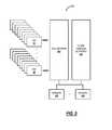
- a block diagramillustrates functional components of a UAV air traffic control system 300 .
- the UAV air traffic control system 300includes a cell network 302 and optionally other wireless networks 304 communicatively coupled to one of more servers 200 and to a plurality of UAVs 50 .
- the cell network 302can actually include a plurality of different provider networks, such as AT&T, Verizon, Sprint, etc.
- the cell network 302is formed in part with a plurality of cell towers 12 , geographically dispersed and covering the vast majority of the United States.
- the cell towers 12are configured to backhaul communications from subscribers.
- the subscribersare the UAVs 50 (in addition to conventional mobile devices) and the communications is between the UAVs 50 and the servers 200 .
- the other wireless networks 304can include, for example, the NAS network, GPS and/or GLONASS, WLAN networks, private wireless networks, or any other wireless networks.
- the servers 200are configured to provide air traffic control and can be deployed in a control center, at a customer premises, in the cloud, or the like.
- the servers 200are configured to receive communications from the UAVs 50 such as for continuous monitoring and of relevant details of each UAV 50 such as location, altitude, speed, direction, function, etc.
- the servers 200are further configured to transmit communications to the UAVs 50 such as for control based on the details, such as to prevent collisions, to enforce policies, to provide navigational control, to actually fly the UAVs 50 , to land the UAVs 50 , and the like. That is, generally, communications from the UAV 50 to the server 200 are for detailed monitoring and communications to the UAV 50 from the server 200 are for control thereof.
- Each UAV 50is configured with a unique identifier, such as a SIM card or the like. Similar to standard mobile devices 100 , each UAV 50 is configured to maintain an association with a plurality of cell towers 12 based on a current geographic location. Using triangulation or other location identification techniques (GPS, GLONASS, etc.), the location, altitude, speed, and direction of each UAV 50 can be continuously monitored and reported back to the servers 200 .
- the servers 200can implement techniques to manage this data in real-time in an automated fashion to track and control all UAVs 50 in a geographic region. For example, the servers 200 can manage and store the data in the data store 208 .
- the servers 200are configured to perform air traffic control functionality of the UAV air traffic control system 300 . Specifically, the servers 200 are configured to perform separation assurance, navigation, traffic management, landing, and general control of the UAVs 50 .
- the separation assuranceincludes tracking all of the UAVs 50 in flight, based on the monitored data, to ensure adequate separation.
- the navigationincludes maintaining defined airways.
- the traffic managementincludes comparing flights planes of UAVs 50 to avoid conflicts and to ensure the smooth and efficient flow of UAVs 50 in flight.
- the landingincludes assisting and control of UAVs 50 at the end of their flight.
- the general controlincludes providing real-time data including video and other monitored data and allowing control of the UAV 50 in flight.
- the general controlcan also include automated flight of the UAVs 50 through the UAV air traffic control system 300 , such as for autonomous UAVs.
- the UAV air traffic control system 300can include routing and algorithms for autonomous operation of the UAVs 50 based on initial flight parameters.
- the UAV air traffic control system 300can control speed, flight path, and altitude for a vast number of UAVs 50 simultaneously.
- a network diagramillustrates various cell sites 10 a - 10 e deployed in a geographic region 400 .
- the UAV 50is configured to fly a flight plan 402 in the geographic region 400 while maintaining associations with multiple cell sites 10 a - 10 e during the flight plan 402 .
- the UAV 50is constrained to only fly in the geographic region 400 where it has cell coverage. This constraint can be preprogrammed based on predetermine cell coverage. Alternatively, the constraint can be dynamically managed by the UAV 50 based on monitoring its cell signal level in the mobile device 100 hardware.
- the UAV 50will alter its path whenever it loses or detects signal degradation to ensure it is always active on the cell network 302 .
- the cell sites 10 a - 10 eare configured to report monitored data to the servers 200 periodically to enable real-time air traffic control.
- the communication between the UAVs 50is bi-directional with the servers 200 , through the associated cell sites 10 .
- the UAV 50maintains association with at least three of the cell sites 10 which perform triangulation to determine the location of the UAV 50 .
- the UAV 50can also communicate to the other wireless networks 304 .
- the UAV 50can maintain its GPS and/or GLONASS location and report that over the cell network 302 .
- the other wireless networks 304can include satellite networks or the like.
- a mapillustrates three cell towers 12 and associated coverage areas 410 , 412 , 414 for describing location determination of the UAV 50 .
- the coverage areas 410 , 412 , 414can be about 5 miles in radius whereas, in urban locations, the coverage areas 410 , 412 , 414 can be about 0.5 to 2 miles in radius.
- One aspect of the UAV air traffic control system 300is to maintain a precise location at all time of the UAVs 50 . This can be accomplished in a plurality of ways, including a combination.
- the UAV air traffic control system 300can use triangulation based on the multiple cell towers 12 , location identifiers from GPS/GLONASS transmitted over the cell network 402 by the UAVs 50 , sensors in the UAV 50 for determining altitude, speed, etc., and the like.
- a flowchartillustrates a UAV air traffic control method 450 utilizing wireless networks.
- the UAV air traffic control method 450includes communicating with a plurality of UAVs via a plurality of cell towers associated with the wireless networks, wherein the plurality of UAVs each include hardware and antennas adapted to communicate to the plurality of cell towers, and wherein each of the plurality of UAVs include a unique identifier (step 452 ); maintaining data associated with flight of each of the plurality of UAVs based on the communicating (step 454 ); and processing the maintained data to perform a plurality of functions associated with air traffic control of the plurality of UAVs (step 456 ).
- the UAV-based method 450can further include transmitting data based on the processing to one or more of the plurality of UAVs to perform the plurality of functions (step 458 ).
- the plurality of UAVscan be configured to constrain flight based on coverage of the plurality of cell towers.
- the constrained flightcan include one or more of pre-configuring the plurality of UAVs to operate only where the coverage exists, monitoring cell signal strength by the plurality of UAVs and adjusting flight based therein, and a combination thereof.
- the maintaining datacan include the plurality of UAVs and/or the plurality of cell towers providing location, speed, direction, and altitude.
- the locationcan be determined based on a combination of triangulation by the plurality of cell towers and a determination by the UAV based on a location identification network.
- the plurality of functioncan include one or more of separation assurance between UAVs; navigation assistance; weather and obstacle reporting; monitoring of speed, altitude, location, and direction; traffic management; landing services; and real-time control.
- One or more of the plurality of UAVscan be configured for autonomous operation through the air traffic control.
- the plurality of UAVscan be configured with mobile device hardware configured to operate on a plurality of different cell networks.
Landscapes
- Engineering & Computer Science (AREA)
- Aviation & Aerospace Engineering (AREA)
- Physics & Mathematics (AREA)
- General Physics & Mathematics (AREA)
- Computer Networks & Wireless Communication (AREA)
- Signal Processing (AREA)
- Radar, Positioning & Navigation (AREA)
- Remote Sensing (AREA)
- Automation & Control Theory (AREA)
- Astronomy & Astrophysics (AREA)
- Traffic Control Systems (AREA)
Abstract
Description
Claims (14)
Priority Applications (49)
| Application Number | Priority Date | Filing Date | Title |
|---|---|---|---|
| US15/179,188US9928750B2 (en) | 2016-06-10 | 2016-06-10 | Air traffic control of unmanned aerial vehicles via wireless networks |
| US15/185,598US10019906B2 (en) | 2016-06-10 | 2016-06-17 | Air traffic control of unmanned aerial vehicles concurrently using a plurality of wireless networks |
| US15/193,488US10510260B2 (en) | 2016-06-10 | 2016-06-27 | Air traffic control of unmanned aerial vehicles for delivery applications |
| US15/217,135US9959772B2 (en) | 2016-06-10 | 2016-07-22 | Flying lane management systems and methods for unmanned aerial vehicles |
| US15/244,023US10109205B2 (en) | 2016-06-10 | 2016-08-23 | Air traffic control monitoring systems and methods for unmanned aerial vehicles |
| US15/255,672US10198953B2 (en) | 2016-06-10 | 2016-09-02 | Obstruction detection in air traffic control systems for unmanned aerial vehicles |
| US15/268,831US10089888B2 (en) | 2016-06-10 | 2016-09-19 | Managing detected obstructions in air traffic control systems for unmanned aerial vehicles |
| US15/292,782US10713961B2 (en) | 2016-06-10 | 2016-10-13 | Managing dynamic obstructions in air traffic control systems for unmanned aerial vehicles |
| US15/338,559US10157548B2 (en) | 2016-06-10 | 2016-10-31 | Waypoint directory in air traffic control systems for unmanned aerial vehicles |
| US15/448,968US10074284B1 (en) | 2016-06-10 | 2017-03-03 | Emergency shutdown and landing for unmanned aerial vehicles with air traffic control systems |
| US15/584,422US10189566B2 (en) | 2016-06-10 | 2017-05-02 | 3D coverage mapping of wireless networks with unmanned aerial vehicles |
| US15/631,302US10157546B2 (en) | 2016-06-10 | 2017-06-23 | Anti-drone flight protection systems and methods |
| US15/705,345US10312994B2 (en) | 2016-06-10 | 2017-09-15 | Drone network switchover between wireless networks |
| US15/800,574US10723483B2 (en) | 2016-06-10 | 2017-11-01 | Elevator or tube lift for drone takeoff and control thereof via air traffic control systems |
| US15/985,996US10789853B2 (en) | 2016-06-10 | 2018-05-22 | Drone collision avoidance via air traffic control over wireless networks |
| US16/000,950US10720066B2 (en) | 2016-06-10 | 2018-06-06 | Flying lane management with lateral separations between drones |
| US16/100,296US11355020B2 (en) | 2016-06-10 | 2018-08-10 | Drone air traffic control over wireless networks for package pickup and delivery |
| US16/100,571US11250709B2 (en) | 2016-06-10 | 2018-08-10 | Drone air traffic control incorporating weather updates |
| US16/155,272US12039873B2 (en) | 2016-06-10 | 2018-10-09 | Dynamic flying lane management systems and methods for drone air traffic control |
| US16/155,354US11837098B2 (en) | 2016-06-10 | 2018-10-09 | Systems and methods for drone air traffic control utilizing geographic boundaries for management |
| US16/193,053US11727813B2 (en) | 2016-06-10 | 2018-11-16 | Systems and methods for air traffic control for passenger drones |
| US16/417,805US11263909B2 (en) | 2016-06-10 | 2019-05-21 | Air traffic control of passenger drones concurrently using a plurality of wireless networks |
| US16/442,597US11710414B2 (en) | 2016-06-10 | 2019-06-17 | Flying lane management systems and methods for passenger drones |
| US16/511,228US11403956B2 (en) | 2016-06-10 | 2019-07-15 | Air traffic control monitoring systems and methods for passenger drones |
| US16/511,262US11670180B2 (en) | 2016-06-10 | 2019-07-15 | Obstruction detection in air traffic control systems for passenger drones |
| US16/545,027US20200005651A1 (en) | 2016-06-10 | 2019-08-20 | Apparatus for controlling unmanned aerial vehicles and passenger drones via an air traffic control system |
| US16/545,051US11670179B2 (en) | 2016-06-10 | 2019-08-20 | Managing detected obstructions in air traffic control systems for passenger drones |
| US16/578,457US11341858B2 (en) | 2016-06-10 | 2019-09-23 | Managing dynamic obstructions in air traffic control systems for passenger drones and unmanned aerial vehicles |
| US16/590,506US11328613B2 (en) | 2016-06-10 | 2019-10-02 | Waypoint directory in air traffic control systems for passenger drones and unmanned aerial vehicles |
| US16/590,516US11468778B2 (en) | 2016-06-10 | 2019-10-02 | Emergency shutdown and landing for passenger drones and unmanned aerial vehicles with air traffic control |
| US16/688,152US11961408B2 (en) | 2016-06-10 | 2019-11-19 | Air traffic control of unmanned aerial vehicles for delivery applications |
| US16/716,649US11436929B2 (en) | 2016-06-10 | 2019-12-17 | Passenger drone switchover between wireless networks |
| US16/716,670US11488483B2 (en) | 2016-06-10 | 2019-12-17 | Passenger drone collision avoidance via air traffic control over wireless network |
| US16/752,849US20200219407A1 (en) | 2016-06-10 | 2020-01-27 | Drone Air Traffic Control over wireless networks for urgent package pickup and delivery |
| US16/783,219US11341860B2 (en) | 2016-06-10 | 2020-02-06 | Drone air traffic control over wireless networks for package pickup and delivery in an order defined by coordinates |
| US16/791,414US11348471B2 (en) | 2016-06-10 | 2020-02-14 | Drone air traffic control over wireless networks for package pickup and delivery in an order defined by roads, highways, or streets |
| US16/799,241US20200250998A1 (en) | 2016-06-10 | 2020-02-24 | Drone Air Traffic Control over wireless networks for package delivery cancelation |
| US16/807,511US11380210B2 (en) | 2016-06-10 | 2020-03-03 | Drone air traffic control over wireless networks for delayed package delivery |
| US16/813,963US11386794B2 (en) | 2016-06-10 | 2020-03-10 | Drone air traffic control over wireless networks for multiple package pickups and deliveries |
| US16/835,523US11393345B2 (en) | 2016-06-10 | 2020-03-31 | Drone air traffic control over wireless networks for package pickup, delivery, and return |
| US16/835,573US11361666B2 (en) | 2016-06-10 | 2020-03-31 | Drone air traffic control over wireless networks for package pickup and delivery |
| US16/942,860US11604112B2 (en) | 2016-06-10 | 2020-07-30 | Center of gravity based drone loading for packages |
| US16/942,904US11768125B2 (en) | 2016-06-10 | 2020-07-30 | Drone package load balancing with weights |
| US16/942,969US11781931B2 (en) | 2016-06-10 | 2020-07-30 | Center of gravity based positioning of items within a drone |
| US16/943,010US12358644B2 (en) | 2016-06-10 | 2020-07-30 | Drone package loading based on package characterization |
| US16/942,885US11597614B2 (en) | 2016-06-10 | 2020-07-30 | Center of gravity based drone loading for multiple items |
| US16/942,933US12017798B2 (en) | 2016-06-10 | 2020-07-30 | Drone load optimization using the center of gravity of multiple objects |
| US17/946,315US12424115B2 (en) | 2016-06-10 | 2022-09-16 | Drone air traffic control over satellite networks |
| US17/969,092US20230064248A1 (en) | 2016-06-10 | 2022-10-19 | Flying Vehicle Air Traffic Control Over Satellite Networks |
Applications Claiming Priority (1)
| Application Number | Priority Date | Filing Date | Title |
|---|---|---|---|
| US15/179,188US9928750B2 (en) | 2016-06-10 | 2016-06-10 | Air traffic control of unmanned aerial vehicles via wireless networks |
Related Parent Applications (1)
| Application Number | Title | Priority Date | Filing Date |
|---|---|---|---|
| US15/185,598Continuation-In-PartUS10019906B2 (en) | 2016-06-10 | 2016-06-17 | Air traffic control of unmanned aerial vehicles concurrently using a plurality of wireless networks |
Related Child Applications (16)
| Application Number | Title | Priority Date | Filing Date |
|---|---|---|---|
| US15/185,598Continuation-In-PartUS10019906B2 (en) | 2016-06-10 | 2016-06-17 | Air traffic control of unmanned aerial vehicles concurrently using a plurality of wireless networks |
| US15/193,488Continuation-In-PartUS10510260B2 (en) | 2016-06-10 | 2016-06-27 | Air traffic control of unmanned aerial vehicles for delivery applications |
| US15/217,135Continuation-In-PartUS9959772B2 (en) | 2016-06-10 | 2016-07-22 | Flying lane management systems and methods for unmanned aerial vehicles |
| US15/244,023Continuation-In-PartUS10109205B2 (en) | 2016-06-10 | 2016-08-23 | Air traffic control monitoring systems and methods for unmanned aerial vehicles |
| US15/255,672Continuation-In-PartUS10198953B2 (en) | 2016-06-10 | 2016-09-02 | Obstruction detection in air traffic control systems for unmanned aerial vehicles |
| US15/268,831Continuation-In-PartUS10089888B2 (en) | 2016-06-10 | 2016-09-19 | Managing detected obstructions in air traffic control systems for unmanned aerial vehicles |
| US15/292,782Continuation-In-PartUS10713961B2 (en) | 2016-06-10 | 2016-10-13 | Managing dynamic obstructions in air traffic control systems for unmanned aerial vehicles |
| US15/338,559Continuation-In-PartUS10157548B2 (en) | 2016-06-10 | 2016-10-31 | Waypoint directory in air traffic control systems for unmanned aerial vehicles |
| US15/448,968Continuation-In-PartUS10074284B1 (en) | 2016-06-10 | 2017-03-03 | Emergency shutdown and landing for unmanned aerial vehicles with air traffic control systems |
| US15/584,422Continuation-In-PartUS10189566B2 (en) | 2016-06-10 | 2017-05-02 | 3D coverage mapping of wireless networks with unmanned aerial vehicles |
| US15/631,302Continuation-In-PartUS10157546B2 (en) | 2016-06-10 | 2017-06-23 | Anti-drone flight protection systems and methods |
| US15/705,345Continuation-In-PartUS10312994B2 (en) | 2016-06-10 | 2017-09-15 | Drone network switchover between wireless networks |
| US16/155,272Continuation-In-PartUS12039873B2 (en) | 2016-06-10 | 2018-10-09 | Dynamic flying lane management systems and methods for drone air traffic control |
| US16/942,933Continuation-In-PartUS12017798B2 (en) | 2016-06-10 | 2020-07-30 | Drone load optimization using the center of gravity of multiple objects |
| US16/943,010Continuation-In-PartUS12358644B2 (en) | 2016-06-10 | 2020-07-30 | Drone package loading based on package characterization |
| US17/946,315Continuation-In-PartUS12424115B2 (en) | 2016-06-10 | 2022-09-16 | Drone air traffic control over satellite networks |
Publications (2)
| Publication Number | Publication Date |
|---|---|
| US20170358221A1 US20170358221A1 (en) | 2017-12-14 |
| US9928750B2true US9928750B2 (en) | 2018-03-27 |
Family
ID=60574020
Family Applications (1)
| Application Number | Title | Priority Date | Filing Date |
|---|---|---|---|
| US15/179,188Active2036-08-17US9928750B2 (en) | 2016-06-10 | 2016-06-10 | Air traffic control of unmanned aerial vehicles via wireless networks |
Country Status (1)
| Country | Link |
|---|---|
| US (1) | US9928750B2 (en) |
Cited By (7)
| Publication number | Priority date | Publication date | Assignee | Title |
|---|---|---|---|---|
| CN108646782A (en)* | 2018-05-03 | 2018-10-12 | 南昌大学 | A kind of unmanned plane safe flight method |
| US10665035B1 (en) | 2017-07-11 | 2020-05-26 | B+T Group Holdings, LLC | System and process of using photogrammetry for digital as-built site surveys and asset tracking |
| CN111343593A (en)* | 2018-12-19 | 2020-06-26 | 广州海格通信集团股份有限公司 | Control method, device, equipment and storage medium of unmanned running tool |
| US11151782B1 (en) | 2018-12-18 | 2021-10-19 | B+T Group Holdings, Inc. | System and process of generating digital images of a site having a structure with superimposed intersecting grid lines and annotations |
| US11727813B2 (en)* | 2016-06-10 | 2023-08-15 | Metal Raptor, Llc | Systems and methods for air traffic control for passenger drones |
| CN117312687A (en)* | 2023-11-01 | 2023-12-29 | 杭州柏源科技有限公司 | Method for carrying out space-time range query processing in unmanned aerial vehicle network |
| US12430850B2 (en) | 2022-12-20 | 2025-09-30 | ETAK Systems, LLC | Systems and methods for installing alarming systems at cell sites |
Families Citing this family (30)
| Publication number | Priority date | Publication date | Assignee | Title |
|---|---|---|---|---|
| JP6945652B2 (en)* | 2017-05-05 | 2021-10-06 | 華為技術有限公司Huawei Technologies Co.,Ltd. | Wireless communication methods, network devices, and terminal devices |
| CN111655581B (en)* | 2018-03-27 | 2024-03-19 | 株式会社尼罗沃克 | Unmanned aerial vehicle, control system thereof, and computer-readable recording medium |
| US10772043B2 (en) | 2018-05-25 | 2020-09-08 | At&T Intellectual Property I, L.P. | Interfering device identification |
| WO2019235418A1 (en)* | 2018-06-04 | 2019-12-12 | 株式会社ナイルワークス | Drone system, drone, steering device, drone system control method, and drone system control program |
| US11252533B2 (en)* | 2018-12-07 | 2022-02-15 | T-Mobile Usa, Inc. | UAV supported vehicle-to-vehicle communication |
| CN109829257B (en)* | 2019-03-25 | 2022-04-01 | 江铃汽车股份有限公司 | Automobile frame lightweight optimization method |
| CN111866052B (en)* | 2019-04-28 | 2022-12-13 | 丰鸟航空科技有限公司 | UAV data processing method, device, terminal, and storage medium |
| CN112435458B (en)* | 2019-06-21 | 2022-03-11 | 北京航空航天大学 | A highway UAV emergency simulation method under traffic accident |
| CN110296698B (en)* | 2019-07-12 | 2023-04-28 | 贵州电网有限责任公司 | Unmanned aerial vehicle path planning method taking laser scanning as constraint |
| CN110426046B (en)* | 2019-08-21 | 2023-11-24 | 西京学院 | A method for judging and tracking obstacles in the runway area for autonomous UAV landing |
| EP4053667A1 (en)* | 2019-11-01 | 2022-09-07 | Guangzhou Xaircraft Technology Co., Ltd. | Route altitude adjustment method, unmanned aerial vehicle operation method, and related apparatus |
| CN111126904B (en)* | 2019-12-16 | 2023-01-03 | 西南交通大学 | ArcGIS-based dangerous goods transportation management method |
| CN111259097B (en)* | 2020-01-09 | 2023-11-24 | 武汉赛摩博晟信息科技有限公司 | Fine waypoint checking method applied to photovoltaic industry unmanned aerial vehicle inspection |
| CN111595301B (en)* | 2020-05-20 | 2021-11-23 | 福建省伟志地理信息科学研究院 | Aerial surveying device for geographic information system and surveying method thereof |
| CN111610495B (en)* | 2020-06-02 | 2022-11-29 | 北京理工大学 | UAV network radar interference suppression method based on resource allocation and power control |
| CN112306089A (en)* | 2020-10-14 | 2021-02-02 | 珠海格力电器股份有限公司 | Unmanned aerial vehicle control method, device, equipment and computer storage medium |
| CN112445880A (en)* | 2020-10-20 | 2021-03-05 | 湖南地理空间大数据产业发展有限公司 | Method and device for automatically gridding enterprise data in geographic space and related equipment |
| CN112783209B (en)* | 2020-12-31 | 2022-02-22 | 北京航空航天大学 | Unmanned aerial vehicle cluster confrontation control method based on pigeon intelligent competition learning |
| CN112987768B (en)* | 2021-02-08 | 2024-07-26 | 华软科技股份有限公司 | Unmanned aerial vehicle righting device and orientation righting method |
| CN112969157B (en)* | 2021-02-22 | 2022-10-18 | 重庆邮电大学 | Network load balancing method for unmanned aerial vehicle |
| CN113984060A (en)* | 2021-10-25 | 2022-01-28 | 湖南精飞智能科技有限公司 | Unmanned aerial vehicle management and control platform based on big dipper location and 5G technique |
| CN113990112B (en)* | 2021-10-25 | 2023-01-31 | 浙江这里飞科技有限公司 | Unmanned aerial vehicle supervision method and device, electronic equipment and storage medium |
| CN115204547B (en)* | 2022-01-17 | 2023-09-26 | 农业农村部南京农业机械化研究所 | Hilly mountain area cultivated land mechanized determination method based on high-resolution remote sensing image |
| CN114553297B (en)* | 2022-01-26 | 2023-09-05 | 中国电子科技集团公司第十五研究所 | A UAV monitoring system and method for areas without communication signals |
| CN114935946B (en)* | 2022-07-21 | 2022-12-09 | 浙江这里飞科技有限公司 | Unmanned aerial vehicle landing method and device |
| CN114995520B (en)* | 2022-08-03 | 2022-12-30 | 广东德九新能源有限公司 | Unmanned aerial vehicle cooperative defense control method, electronic equipment and medium |
| CN118215022B (en)* | 2024-05-17 | 2024-07-30 | 安徽成方量子科技有限公司 | Quantum communication-based unmanned aerial vehicle group communication encryption method, system and storage medium thereof |
| CN118672286B (en)* | 2024-08-26 | 2025-08-15 | 国网智能科技股份有限公司 | Unmanned aerial vehicle emergency control method and system for multi-airport collaborative inspection |
| CN118818367B (en)* | 2024-09-14 | 2024-11-22 | 四川省天域航通科技有限公司 | Unmanned aerial vehicle fire-fighting system power supply electrical load analysis method |
| CN119562036B (en)* | 2025-01-22 | 2025-04-18 | 安徽明生恒卓科技有限公司 | Unmanned aerial vehicle-based power inspection method and system |
Citations (5)
| Publication number | Priority date | Publication date | Assignee | Title |
|---|---|---|---|---|
| US8798922B2 (en)* | 2012-11-16 | 2014-08-05 | The Boeing Company | Determination of flight path for unmanned aircraft in event of in-flight contingency |
| US20150336667A1 (en)* | 2014-05-20 | 2015-11-26 | Verizon Patent And Licensing Inc. | Unmanned aerial vehicle platform |
| US20150379874A1 (en)* | 2014-05-20 | 2015-12-31 | Verizon Patent And Licensing Inc. | Dynamic selection of unmanned aerial vehicles |
| US20170069214A1 (en)* | 2015-07-29 | 2017-03-09 | Dennis J. Dupray | Unmanned aerial vehicles |
| US20170134963A1 (en)* | 2015-04-14 | 2017-05-11 | ETAK Systems, LLC | Systems and methods for obtaining accurate 3d modeling data using multiple cameras |
- 2016
- 2016-06-10USUS15/179,188patent/US9928750B2/enactiveActive
Patent Citations (6)
| Publication number | Priority date | Publication date | Assignee | Title |
|---|---|---|---|---|
| US8798922B2 (en)* | 2012-11-16 | 2014-08-05 | The Boeing Company | Determination of flight path for unmanned aircraft in event of in-flight contingency |
| US20150336667A1 (en)* | 2014-05-20 | 2015-11-26 | Verizon Patent And Licensing Inc. | Unmanned aerial vehicle platform |
| US20150379874A1 (en)* | 2014-05-20 | 2015-12-31 | Verizon Patent And Licensing Inc. | Dynamic selection of unmanned aerial vehicles |
| US20160180717A1 (en)* | 2014-05-20 | 2016-06-23 | Verizon Patent And Licensing Inc. | Dynamic selection of unmanned aerial vehicles |
| US20170134963A1 (en)* | 2015-04-14 | 2017-05-11 | ETAK Systems, LLC | Systems and methods for obtaining accurate 3d modeling data using multiple cameras |
| US20170069214A1 (en)* | 2015-07-29 | 2017-03-09 | Dennis J. Dupray | Unmanned aerial vehicles |
Non-Patent Citations (3)
| Title |
|---|
| Operator Benefits of Future Air Navigation System, The Boeing Company, pp. 1-4. |
| Technology and the Future Evolution of the ATC System, Chapter 5, Airport and Air Traffic Control System, pp. 67-98. |
| What are the essential elements of a control tower?, Aviation Stack Exchange is a question and answer site for aircraft pilots, mechanics, and enthusiasts, pp. 1-2, Aug. 10, 2015. |
Cited By (9)
| Publication number | Priority date | Publication date | Assignee | Title |
|---|---|---|---|---|
| US11727813B2 (en)* | 2016-06-10 | 2023-08-15 | Metal Raptor, Llc | Systems and methods for air traffic control for passenger drones |
| US10665035B1 (en) | 2017-07-11 | 2020-05-26 | B+T Group Holdings, LLC | System and process of using photogrammetry for digital as-built site surveys and asset tracking |
| CN108646782A (en)* | 2018-05-03 | 2018-10-12 | 南昌大学 | A kind of unmanned plane safe flight method |
| US11151782B1 (en) | 2018-12-18 | 2021-10-19 | B+T Group Holdings, Inc. | System and process of generating digital images of a site having a structure with superimposed intersecting grid lines and annotations |
| CN111343593A (en)* | 2018-12-19 | 2020-06-26 | 广州海格通信集团股份有限公司 | Control method, device, equipment and storage medium of unmanned running tool |
| CN111343593B (en)* | 2018-12-19 | 2021-09-07 | 广州海格通信集团股份有限公司 | Control method, device, equipment and storage medium of unmanned running tool |
| US12430850B2 (en) | 2022-12-20 | 2025-09-30 | ETAK Systems, LLC | Systems and methods for installing alarming systems at cell sites |
| CN117312687A (en)* | 2023-11-01 | 2023-12-29 | 杭州柏源科技有限公司 | Method for carrying out space-time range query processing in unmanned aerial vehicle network |
| CN117312687B (en)* | 2023-11-01 | 2024-04-16 | 杭州柏源科技有限公司 | Method for carrying out space-time range query processing in unmanned aerial vehicle network |
Also Published As
| Publication number | Publication date |
|---|---|
| US20170358221A1 (en) | 2017-12-14 |
Similar Documents
| Publication | Publication Date | Title |
|---|---|---|
| US9928750B2 (en) | Air traffic control of unmanned aerial vehicles via wireless networks | |
| US11961408B2 (en) | Air traffic control of unmanned aerial vehicles for delivery applications | |
| US10019906B2 (en) | Air traffic control of unmanned aerial vehicles concurrently using a plurality of wireless networks | |
| US9959772B2 (en) | Flying lane management systems and methods for unmanned aerial vehicles | |
| US10157546B2 (en) | Anti-drone flight protection systems and methods | |
| US10713961B2 (en) | Managing dynamic obstructions in air traffic control systems for unmanned aerial vehicles | |
| US10157548B2 (en) | Waypoint directory in air traffic control systems for unmanned aerial vehicles | |
| US10109205B2 (en) | Air traffic control monitoring systems and methods for unmanned aerial vehicles | |
| US10312994B2 (en) | Drone network switchover between wireless networks | |
| US10189566B2 (en) | 3D coverage mapping of wireless networks with unmanned aerial vehicles | |
| US10089888B2 (en) | Managing detected obstructions in air traffic control systems for unmanned aerial vehicles | |
| US10198953B2 (en) | Obstruction detection in air traffic control systems for unmanned aerial vehicles | |
| US10723483B2 (en) | Elevator or tube lift for drone takeoff and control thereof via air traffic control systems | |
| US10789853B2 (en) | Drone collision avoidance via air traffic control over wireless networks | |
| US10720066B2 (en) | Flying lane management with lateral separations between drones | |
| US10074284B1 (en) | Emergency shutdown and landing for unmanned aerial vehicles with air traffic control systems | |
| US20180350243A1 (en) | Drone Air Traffic Control over wireless networks for package pickup and delivery | |
| US20200005651A1 (en) | Apparatus for controlling unmanned aerial vehicles and passenger drones via an air traffic control system | |
| US11488483B2 (en) | Passenger drone collision avoidance via air traffic control over wireless network | |
| US20200035110A1 (en) | Managing dynamic obstructions in air traffic control systems for passenger drones and unmanned aerial vehicles | |
| US20180350245A1 (en) | Drone Air Traffic Control incorporating weather updates | |
| US11436929B2 (en) | Passenger drone switchover between wireless networks | |
| US11328613B2 (en) | Waypoint directory in air traffic control systems for passenger drones and unmanned aerial vehicles | |
| WO2017196213A1 (en) | Remote control of an unmanned aerial vehicle | |
| US20200051445A1 (en) | Emergency shutdown and landing for passenger drones and unmanned aerial vehicles with air traffic control systems |
Legal Events
| Date | Code | Title | Description |
|---|---|---|---|
| AS | Assignment | Owner name:ETAK SYSTEMS, LLC, NORTH CAROLINA Free format text:ASSIGNMENT OF ASSIGNORS INTEREST;ASSIGNOR:PRIEST, LEE;REEL/FRAME:038879/0463 Effective date:20160610 | |
| STCF | Information on status: patent grant | Free format text:PATENTED CASE | |
| AS | Assignment | Owner name:PRIEST, LEE, NORTH CAROLINA Free format text:ASSIGNMENT OF ASSIGNORS INTEREST;ASSIGNOR:ETAK SYSTEMS, LLC;REEL/FRAME:055598/0694 Effective date:20210208 Owner name:METAL RAPTOR, LLC, NORTH CAROLINA Free format text:ASSIGNMENT OF ASSIGNORS INTEREST;ASSIGNOR:PRIEST, LEE;REEL/FRAME:056048/0388 Effective date:20210311 | |
| MAFP | Maintenance fee payment | Free format text:PAYMENT OF MAINTENANCE FEE, 4TH YR, SMALL ENTITY (ORIGINAL EVENT CODE: M2551); ENTITY STATUS OF PATENT OWNER: SMALL ENTITY Year of fee payment:4 | |
| AS | Assignment | Owner name:METAL RAPTOR INC., NORTH CAROLINA Free format text:CHANGE OF NAME;ASSIGNOR:METAL RAPTOR LLC;REEL/FRAME:065786/0781 Effective date:20231021 | |
| MAFP | Maintenance fee payment | Free format text:PAYMENT OF MAINTENANCE FEE, 8TH YR, SMALL ENTITY (ORIGINAL EVENT CODE: M2552); ENTITY STATUS OF PATENT OWNER: SMALL ENTITY Year of fee payment:8 |