US9702713B2 - Map-based guide system and method - Google Patents
Map-based guide system and methodDownload PDFInfo
- Publication number
- US9702713B2 US9702713B2US14/927,116US201514927116AUS9702713B2US 9702713 B2US9702713 B2US 9702713B2US 201514927116 AUS201514927116 AUS 201514927116AUS 9702713 B2US9702713 B2US 9702713B2
- Authority
- US
- United States
- Prior art keywords
- map
- based guide
- circuitry configured
- guide request
- response
- Prior art date
- Legal status (The legal status is an assumption and is not a legal conclusion. Google has not performed a legal analysis and makes no representation as to the accuracy of the status listed.)
- Expired - Fee Related
Links
Images


Classifications
- G—PHYSICS
- G01—MEASURING; TESTING
- G01C—MEASURING DISTANCES, LEVELS OR BEARINGS; SURVEYING; NAVIGATION; GYROSCOPIC INSTRUMENTS; PHOTOGRAMMETRY OR VIDEOGRAMMETRY
- G01C21/00—Navigation; Navigational instruments not provided for in groups G01C1/00 - G01C19/00
- G01C21/26—Navigation; Navigational instruments not provided for in groups G01C1/00 - G01C19/00 specially adapted for navigation in a road network
- G01C21/34—Route searching; Route guidance
- G—PHYSICS
- G09—EDUCATION; CRYPTOGRAPHY; DISPLAY; ADVERTISING; SEALS
- G09B—EDUCATIONAL OR DEMONSTRATION APPLIANCES; APPLIANCES FOR TEACHING, OR COMMUNICATING WITH, THE BLIND, DEAF OR MUTE; MODELS; PLANETARIA; GLOBES; MAPS; DIAGRAMS
- G09B29/00—Maps; Plans; Charts; Diagrams, e.g. route diagram
- G09B29/10—Map spot or coordinate position indicators; Map reading aids
- G09B29/106—Map spot or coordinate position indicators; Map reading aids using electronic means
- G—PHYSICS
- G01—MEASURING; TESTING
- G01C—MEASURING DISTANCES, LEVELS OR BEARINGS; SURVEYING; NAVIGATION; GYROSCOPIC INSTRUMENTS; PHOTOGRAMMETRY OR VIDEOGRAMMETRY
- G01C21/00—Navigation; Navigational instruments not provided for in groups G01C1/00 - G01C19/00
- G01C21/26—Navigation; Navigational instruments not provided for in groups G01C1/00 - G01C19/00 specially adapted for navigation in a road network
- G01C21/34—Route searching; Route guidance
- G01C21/3453—Special cost functions, i.e. other than distance or default speed limit of road segments
- G—PHYSICS
- G01—MEASURING; TESTING
- G01C—MEASURING DISTANCES, LEVELS OR BEARINGS; SURVEYING; NAVIGATION; GYROSCOPIC INSTRUMENTS; PHOTOGRAMMETRY OR VIDEOGRAMMETRY
- G01C21/00—Navigation; Navigational instruments not provided for in groups G01C1/00 - G01C19/00
- G01C21/26—Navigation; Navigational instruments not provided for in groups G01C1/00 - G01C19/00 specially adapted for navigation in a road network
- G01C21/34—Route searching; Route guidance
- G01C21/36—Input/output arrangements for on-board computers
- G01C21/3605—Destination input or retrieval
- G01C21/362—Destination input or retrieval received from an external device or application, e.g. PDA, mobile phone or calendar application
- G—PHYSICS
- G06—COMPUTING OR CALCULATING; COUNTING
- G06F—ELECTRIC DIGITAL DATA PROCESSING
- G06F16/00—Information retrieval; Database structures therefor; File system structures therefor
- G06F16/20—Information retrieval; Database structures therefor; File system structures therefor of structured data, e.g. relational data
- G06F16/29—Geographical information databases
- G06F17/30241—
- H—ELECTRICITY
- H04—ELECTRIC COMMUNICATION TECHNIQUE
- H04W—WIRELESS COMMUNICATION NETWORKS
- H04W4/00—Services specially adapted for wireless communication networks; Facilities therefor
- H—ELECTRICITY
- H04—ELECTRIC COMMUNICATION TECHNIQUE
- H04W—WIRELESS COMMUNICATION NETWORKS
- H04W4/00—Services specially adapted for wireless communication networks; Facilities therefor
- H04W4/02—Services making use of location information
- H04W4/024—Guidance services
- H—ELECTRICITY
- H04—ELECTRIC COMMUNICATION TECHNIQUE
- H04W—WIRELESS COMMUNICATION NETWORKS
- H04W4/00—Services specially adapted for wireless communication networks; Facilities therefor
- H04W4/02—Services making use of location information
- H04W4/029—Location-based management or tracking services
- H—ELECTRICITY
- H04—ELECTRIC COMMUNICATION TECHNIQUE
- H04W—WIRELESS COMMUNICATION NETWORKS
- H04W4/00—Services specially adapted for wireless communication networks; Facilities therefor
- H04W4/02—Services making use of location information
Definitions
- the present applicationis related to and/or claims the benefit of the earliest available effective filing date(s) from the following listed application(s) (the “Priority Applications”), if any, listed below (e.g., claims earliest available priority dates for other than provisional patent applications or claims benefits under 35 U.S.C. ⁇ 119(e) for provisional patent applications, for any and all parent, grandparent, great-grandparent, etc. applications of the Priority Application(s)).
- the present applicationis related to the “Related Application(s),” if any, listed below:
- the present applicationrelates generally to maps.
- a method for adjusting a map-based guideincludes but is not limited to receiving a request for the map-based guide; determining a location associated with the request; preparing a route in accordance with the location associated with the request and in accordance with at least one of a profit-motive and/or a goodwill factor; and transmitting the map-based guide.
- a method for a display device to receive a map-based guide through a predefined areaincludes but is not limited to transmitting a request for the map-based guide of the predefined area, the request including an identifier associated with the display device; and receiving the map-based guide of the predefined area, the map-based guide including a route through the predefined area based on the identifier, the identifier enabling a server-based decision-making process to determine the routing.
- a computer program productcan include a signal bearing medium bearing one or more instructions including, but not limited to one or more instructions for receiving a request for the map-based guide; determining a location associated with the request; preparing a route in accordance with the location associated with the request and in accordance with at least one of a profit-motive and/or a goodwill factor; and transmitting the map-based guide.
- a signal bearing mediumbearing one or more instructions including, but not limited to one or more instructions for receiving a request for the map-based guide; determining a location associated with the request; preparing a route in accordance with the location associated with the request and in accordance with at least one of a profit-motive and/or a goodwill factor; and transmitting the map-based guide.
- a computer program productcan include a signal bearing medium bearing one or more instructions including, but not limited to one or more instructions for transmitting a request from a display device, the request for a map-based guide of a predefined area, the request including an identifier associated with the display device; and instructions for receiving the map-based guide of the predefined area, the map-based guide including a route through the predefined area based on the identifier, the identifier enabling a server-based decision-making process to determine the routing.
- a signal bearing mediumbearing one or more instructions including, but not limited to one or more instructions for transmitting a request from a display device, the request for a map-based guide of a predefined area, the request including an identifier associated with the display device; and instructions for receiving the map-based guide of the predefined area, the map-based guide including a route through the predefined area based on the identifier, the identifier enabling a server-based decision-making process to determine the routing.
- a computer program productcan include a signal bearing medium bearing one or more instructions including, but not limited to, one or more instructions for receiving a request for a map-based guide from a source, the map-based guide providing a route through a predefined area; one or more instructions for determining a location associated with the request; one or more instructions for determining a level associated with remuneration if the source has provided remuneration, the route through the predefined area being a function of the level associated with the remuneration; and one or more instructions for transmitting the map-based guide.
- a signal bearing mediumbearing one or more instructions including, but not limited to, one or more instructions for receiving a request for a map-based guide from a source, the map-based guide providing a route through a predefined area; one or more instructions for determining a location associated with the request; one or more instructions for determining a level associated with remuneration if the source has provided remuneration, the route through the predefined area being a function of
- related systemsinclude but are not limited to circuitry and/or programming for effecting the herein-referenced method aspects; the circuitry and/or programming can be virtually any combination of hardware, software, and/or firmware configured to effect the herein-referenced method aspects depending upon the design choices of the system designer.
- a systemincludes but is not limited to a processor; a memory coupled to the processor; a receiver coupled to the processor; and a map-based guide module coupled to the receiver and the memory.
- the map-based guide modulecan include a data store configurable to hold data related to routes through a predefined area and a route determination module coupled to the data store, the route determination module configurable to determine a route through the predefined area based on an identifier received by the receiver, the identifier determinative of a number and type of locations to include with a route to include in a map-based guide through the predefined area.
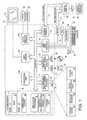
- FIG. 1is a block diagram of an exemplary computer architecture that supports the claimed subject matter
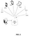
- FIG. 2is a block diagram of a wireless computer environment appropriate for embodiments of the subject matter of the present application
- FIG. 3is a flow diagram illustrating a method in accordance with an embodiment of the subject matter of the present application.
- FIG. 4is a flow diagram illustrating a method in accordance with an embodiment of the subject matter of the present application.
- the disclosed embodimentshave relevance to a wide variety of applications and architectures in addition to those described below.
- the functionality of the subject matter of the present applicationcan be implemented in software, hardware, or a combination of software and hardware.
- the hardware portioncan be implemented using specialized logic; the software portion can be stored in a memory or recording medium and executed by a suitable instruction execution system such as a microprocessor.
- FIG. 1depicted is an exemplary computing system for implementing the embodiments and includes a general purpose computing device in the form of a computer 10 .
- Components of the computer 10may include, but are not limited to, a processing unit 20 , a system memory 30 , and a system bus 21 that couples various system components including the system memory 30 to the processing unit 20 .
- the system bus 21may be any of several types of bus structures including, but not limited to, a memory bus or memory controller, a peripheral bus, and/or a local bus using any of a variety of bus architectures.
- such architecturesinclude Industry Standard Architecture (ISA) bus, Micro Channel Architecture (MCA) bus, Enhanced ISA (EISA) bus, Video Electronics Standards Association (VESA) local bus, and Peripheral Component Interconnect (PCI) bus also known as Mezzanine bus.
- ISAIndustry Standard Architecture
- MCAMicro Channel Architecture
- EISAEnhanced ISA
- VESAVideo Electronics Standards Association
- PCIPeripheral Component Interconnect
- the computer 10typically includes a variety of computer readable media.
- Computer readable mediacan be any available media that can be accessed by the computer 10 and includes both volatile and nonvolatile media, and removable and non-removable media.
- Computer readable mediamay comprise computer storage media and communication media.
- Computer storage mediaincludes volatile and nonvolatile, removable and non-removable media implemented in any method or technology for storage of information such as computer readable instructions, data structures, program modules or other data.
- Computer storage mediaincludes, but is not limited to, RAM, ROM, EEPROM, flash memory or other memory technology, CD-ROM, digital versatile disks (DVD) or other optical disk storage, magnetic cassettes, magnetic tape, magnetic disk storage or other magnetic storage devices, or any other medium which can be used to store the desired information and which can be accessed by the computer 10 .
- Communication mediatypically embodies computer readable instructions, data structures, program modules or other data in a modulated data signal such as a carrier wave or other transport mechanism and includes any information delivery media.
- modulated data signalmeans a signal that has one or more of its characteristics set or changed in such a manner as to encode information in the signal.
- communication mediaincludes wired media such as a wired network or direct-wired connection, and wireless media such as acoustic, RF, infrared and other wireless media. Combinations of the any of the above should also be included within the scope of computer readable media.
- the system memory 30includes computer storage media in the form of volatile and/or nonvolatile memory such as read only memory (ROM) 31 and random access memory (RAM) 32 .
- ROMread only memory
- RAMrandom access memory
- BIOSbasic input/output system 33
- RAM 32typically contains data and/or program modules that are immediately accessible to and/or presently being operated on by processing unit 20 .
- FIG. 1illustrates operating system 34 , application programs 35 , other program modules 36 , and program data 37 .
- FIG. 1is shown with program modules 36 including a guiding module in accordance with an embodiment as described herein.
- the computer 10may also include other removable/non-removable, volatile/nonvolatile computer storage media.
- FIG. 1illustrates a hard disk drive 41 that reads from or writes to non-removable, nonvolatile magnetic media, a magnetic disk drive 51 that reads from or writes to a removable, nonvolatile magnetic disk 52 , and an optical disk drive 55 that reads from or writes to a removable, nonvolatile optical disk 56 such as a CD ROM or other optical media.
- removable/non-removable, volatile/nonvolatile computer storage mediathat can be used in the exemplary operating environment include, but are not limited to, magnetic tape cassettes, flash memory cards, digital versatile disks, digital video tape, solid state RAM, solid state ROM, or the like.
- the hard disk drive 41is typically connected to the system bus 21 through a non-removable memory interface such as interface 40
- magnetic disk drive 51 and optical disk drive 55are typically connected to the system bus 21 by a removable memory interface, such as interface 50 .
- the drives and their associated computer storage mediaprovide storage of computer readable instructions, data structures, program modules and other data for the computer 10 .
- hard disk drive 41is illustrated as storing operating system 44 , application programs 45 , and other program modules, such as guiding module 46 and program data 47 .
- Program modules 46is shown including an guiding module, which can be configured as either located in guiding modules 36 or 46 , or both locations, as one with skill in the art will appreciate. Note that these components can either be the same as or different from operating system 34 , application programs 35 , other program modules, guiding module 36 , and program data 37 .
- Operating system 44application programs 45 , guiding module 46 , and program data 47 are given different numbers here to illustrate that, at a minimum, they are different copies.
- a usermay enter commands and information into the computer 10 through input devices such as a tablet or electronic digitizer 64 , a microphone 63 , a keyboard 62 and pointing device 61 , commonly referred to as a mouse, trackball or touch pad.
- Other input devicesmay include a joystick, game pad, satellite dish, scanner, or the like.
- These and other input devicesare often connected to the processing unit 20 through a user input interface 60 that is coupled to the system bus, but may be connected by other interface and bus structures, such as a parallel port, game port or a universal serial bus (USB).
- USBuniversal serial bus
- a monitor 91 or other type of display deviceis also connected to the system bus 21 via an interface, such as a video interface 90 .
- the monitor 91may also be integrated with a touch-screen panel or the like.
- the monitor and/or touch screen panelcan be physically coupled to a housing in which the computing device 10 is incorporated, such as in a tablet-type personal computer.
- computers such as the computing device 10may also include other peripheral output devices such as speakers 97 and printer 96 , which may be connected through an output peripheral interface 95 or the like.
- a display devicefor purposes of this patent application can include an e-paper display, a liquid crystal display or the like.
- the computer 10may operate in a networked environment using logical connections to one or more remote computers, such as a remote computer 80 .
- the remote computer 80may be a personal computer, a server, a router, a network PC, a peer device or other common network node, and typically includes many or all of the elements described above relative to the computer 10 , although only a memory storage device 81 has been illustrated in FIG. 1 .
- the logical connections depicted in FIG. 1include a local area network (LAN) 71 and a wide area network (WAN) 73 , but may also include other networks.
- LANlocal area network
- WANwide area network
- the computer system 10may comprise the source machine from which data is being migrated, and the remote computer 80 may comprise the destination machine.
- source and destination machinesneed not be connected by a network or any other means, but instead, data may be migrated via any media capable of being written by the source platform and read by the destination platform or platforms.
- the computer 10When used in a LAN or WLAN networking environment, the computer 10 is connected to the LAN through a network interface or adapter 70 .
- the computer 10When used in a WAN networking environment, the computer 10 typically includes a modem 72 or other means for establishing communications over the WAN 73 , such as the Internet.
- the modem 72which may be internal or external, may be connected to the system bus 21 via the user input interface 60 or other appropriate mechanism.
- program modules depicted relative to the computer 10may be stored in the remote memory storage device.
- FIG. 1illustrates remote application programs 85 as residing on memory device 81 . It will be appreciated that the network connections shown are exemplary and other means of establishing a communications link between the computers may be used.
- the wireless networkincludes a base station 200 , which can be coupled to a server 210 .
- Base station 200interacts with a plurality of wireless components 220 , which may be receivers only (or with receive and transmit capability), designed to receive real time images and associated data as correlated and transmitted by server 210 .
- Componentsinteract with base station 200 via wireless connection 230 .
- the wireless connection 230could include cellular modems, a radio-frequency (RF) methods and/or wireless local area network (WLAN).
- RFradio-frequency
- WLANwireless local area network
- a wireless connectionmay include a portion of the route between the endpoints transmitted via a wired line, e.g.
- a fiber Internet backbone or an internal wired network coupling the server with wireless transmission hardware or base stationAnother type of wireless connection could be a tracking tag system. Tracking tags typically communicate with a base station, each tag transmitting a unique code to identify a display device to which it is attached.
- WLANsoperate by connecting mobile devices to a base station and using signal strength sensing to determine a location of a mobile device.
- Other wireless connections appropriate for embodimentsinclude satellite connections, IEEE 802.11 connections or Bluetooth-type connections or the like as one of skill in the art with the benefit of the present disclosure will appreciate.
- Components 220can include receivers and transmitters to interact with server 210 .
- Components 220are shown including different types of components, including components 220 ( 1 ) which could be a simple device capable of only receiving and displaying data and images. The data may include one or more of written directions, a map, and images or the like.
- Component 220 ( 2 )is shown as a personal electronic assistant, which could be configured to both send and/or receive data, display maps and/or directions as generated by server 210 .
- Component 220 ( 3 )is shown as a tablet personal computer (PC) which can also be configured to both send and/or receive data.
- Component 220 ( 4 )is shown as a laptop or notebook computer which can also send and/or receive data and/or directions.
- Components 220 ( 5 )could be implemented as a simple mobile device which could be configured to receive and display images that could be in real time.
- Component 220 ( 6 )could be implemented as a cellular telephone or pager and include a display configured to show a map and images in accordance with embodiments herein.
- Components 220may include electronics for determining a location, which could include sensing location via signal received by satellite such as GPS or GLONASS, motion sensors such as accelerometers or gyroscopes, or means for triangulating position via sensing power and/or distance from cellular towers or other landmarks, etc.
- components 220could be devices that are not coupled to a wireless network of any kind Rather, in the embodiment, a component 220 could be configured to receive data and store data internally for later mobile use.
- Block 310provides for receiving a request for the map-based guide. More particularly, in an embodiment, the request can include an identifier associated with a destination in a predefined area and a location parameter identifying a starting location, the request being for a map-based guide from the starting location to the destination. Also, the receiving a request can include receiving a transmission from a mobile device wirelessly transmitting the request to a server.
- Block 320provides for determining a location associated with the request.
- the determiningcan be accomplished by associating the request with a data store entry in the data store, the data store identifying whether a source of the request is entitled to a supported map-based guide.
- a supported map-based guidecan mean a map-based guide that is supported as determined by a server.
- a supported map-based guidecan also mean a map-based guide for which compensation for the map-based guide is provided by another form of support than the source of the request.
- the compensation for the map-based guidecan come from advertisers that would have the server provide a map-based guide that directs the source past locations chosen by the advertiser.
- the supported map-based guidecan include any guide for which compensation is from an advertiser, at least in part.
- the data storecan provide entries associated with sources that have provided compensation. If a source has no entry associated in the data store, in an embodiment, the server can assume that no compensation has been provided.
- Matching the association with a data store entry in the data storecan also include comparing the source to a list of sources that have provided remuneration for the map-based guide and determining a level associated with the remuneration if the source has provided remuneration.
- the number of locations an advertiser would prefer to have the source receive in a routecan be limited.
- the route through the predefined areacan be a function of the level associated with the remuneration.
- the map-based guidecould provide an efficient route through the predefined area if the level indicates a higher level of remuneration from the source. Conversely, a lower level of remuneration from the source could cause the server to provide a higher level of advertiser-chosen locations in a route to be provided to the source.
- the map-based guidecan be configured to be source-centric.
- providing a source-centric route through the predefined areacan include adjusting an influence of either or both of a profit motive and/or goodwill if the level associated with remuneration indicates a higher level of remuneration from the source.
- the remunerationcan be in the form of payment or in the form of charitable works. For example, if a source has volunteered for an organization, rather than payment, the remuneration can be in the form of volunteer hours performed or the like.
- Block 330provides for preparing a route in accordance with the location associated with the request and in accordance with at least one of a profit-motive and/or a goodwill factor.
- the preparingcan include determining a supported map-based guide for transmission, the supported map-based guide providing the route.
- the routecan include guiding past one or more locations associated with compensation for providing the route past the location, guiding based on a profit motive, and/or guiding based on a server-directed decision-making process and/or a goodwill motive.
- the preparing in accordance with a profit motive and/or a goodwill factorcan include preparing a route in accordance with the profit motive, the profit motive including a revenue-generating goal known to a server preparing the route.
- the routecan include commercial establishments as a function of meeting the revenue-generating goal. Thus, for example, if the revenue-generating goal is met, the route can include fewer or no commercial establishments.
- preparing a route in accordance with the goodwill factorcan include directing the route past one or more server-directed locations that are determined according to a predetermined number of visitors for the one or more server-directed locations.
- the routecan include directing patrons past a location to increase goodwill for the location or an establishment near the location. For example, an amusement park with a new ride therein can develop goodwill for the new ride by having a server direct patrons past the new ride.
- the goodwillcan be a business-related goodwill or goodwill that is independent of a business relationship.
- goodwillcan be based on charitable goals known to a server, such as guiding past a humane society establishment to encourage those following the route to adopt homeless animals or the like.
- Block 340provides for transmitting the map-based guide.
- the map-based guide of the predefined area to the sourcecan include a bundle of one or more advertising locations in the map-based guide.
- Block 350provides for determining the route according to an advertiser method if the source of the request is identified in a data store.
- the determining the route according to an advertiser method if the source of the request is identified in the data storecan include associating the identifier with a status hierarchy, the status hierarchy providing a number of advertiser locations by which the route is directed.
- Block 360provides for recording the request and the map-based guide transmitted to the source of the request.
- the recording the request and the map-based guide transmitted to the source of the requestcan include altering the data store to indicate the request, and associating one or more locations on the route with the source of the request.
- Block 410provides for transmitting a request for the map-based guide of the predefined area, the request including an identifier associated with the display device.
- the requestcan include the identifier to enable determining whether the identifier is located on a data store on a server. More particularly, a server receiving the identifier can use the identifier to determine the route through the predefined area according to a server-based decision-making process by matching the identifier to an entry on the data store to determine a number of advertiser locations to include with the route.
- Block 420provides for receiving the map-based guide of the predefined area, the map-based guide including a route through the predefined area based on the identifier.
- the identifiercan enable a server-based decision-making process to determine the routing.
- the receiving the map-based guide of the predefined area, the map-based guide including a route through the predefined area based on the identifier, the identifier enabling a server-based decision-making process to determine the routingcan include receiving one or more advertisements with the map-based guide, the advertisements associated with one or more locations on the route through the predefined area.
- the receivingcan also include connecting with a server, the server determining the route through the predefined area according to the server-based decision-making process.
- the connecting to the servercan be over a wireless network by transmitting via one of a wireless LAN (WLAN), an IEEE 802 type wireless network, a cellular wireless network, a Bluetooth type wireless network, and/or a satellite network.
- WLANwireless LAN
- Block 430provides for displaying the map-based guide on the display device, the map-based guide providing the route to a destination included in the request.
- a computer systemincludes a module, shown in FIG. 1 as map-based guide modules 36 and 46 .
- Map-based guide modules 36 and 46can be coupled to a computer system memory and processor.
- a map-based guide module coupled to the memorycan include but is not limited to a map-based guide module with all module components within the memory, a map-based guide module only partially coupled to the memory and partially coupled to other components such as to firmware, and/or a map-based guide module including only some components coupled to the memory and other components in another memory, such as RAM or ROM or a storage that can be manipulated.
- the map-based guide moduleis configurable to create one or more map-based guides for a predefined area.
- the map-based guide modulecan be included with a mobile device or can be included as part of a server, such as server 210 that creates transmissions for the mobile device to display. If a server performs the processing, an embodiment includes a transmitter configured to transmit the map-based guide to the mobile device.
- the map-based guidecan also be transmitted to a fixed device, such as a display device.
- a computer systemcan include a processor, a memory coupled to the processor, a receiver coupled to the processor, and/or a map-based guide module coupled to the receiver and the memory.
- the map-based guide moduleincludes a data store configurable to hold data related to routes through a predefined area. More particularly, the data can include many possible routes through an area including, but not limited to, routes going past locations related to advertisers supporting the computer system via remuneration.
- the data storecan also include a table of identifiers associated with possible sources of requests for map-based guides.
- the map-based guide modulefurther includes a route determination module coupled to the data store.
- the route determination modulecan be configurable to determine a route through the predefined area based on an identifier received by the receiver.
- an identifiercan be from a source of a request for a map-based guide.
- the identifiercan be determinative of a number of locations and a type of locations to include with a route to include in a map-based guide through the predefined area.
- the identifiercan identify whether the map-based guide providing the route should include guiding past one or more locations associated with compensation for providing the route past the location, guiding based on a profit motive, and/or guiding based on a server-directed decision-making process.
- the computer systemincludes a transmitter coupled to the processor.
- the transmittercan be configurable to transmit the map-based guide to a display device.
- the display devicebe a mobile device, such as a cell phone, a computer device, a PDA or the like configurable to transmit a request for the map-based guide to include the route being through the predefined area.
- an implementermay opt for a mainly hardware and/or firmware vehicle; alternatively, if flexibility is paramount, the implementer may opt for a mainly software implementation; or, yet again alternatively, the implementer may opt for some combination of hardware, software, and/or firmware.
- any vehicle to be utilizedis a choice dependent upon the context in which the vehicle will be deployed and the specific concerns (e.g., speed, flexibility, or predictability) of the implementer, any of which may vary.
- Those skilled in the artwill recognize that optical aspects of implementations will typically employ optically-oriented hardware, software, and or firmware.
- a signal bearing mediainclude, but are not limited to, the following: recordable type media such as floppy disks, hard disk drives, CD ROMs, digital tape, and computer memory; and transmission type media such as digital and analog communication links using TDM or IP based communication links (e.g., packet links).
- any two components so associatedcan also be viewed as being “operably connected”, or “operably coupled”, to each other to achieve the desired functionality, and any two components capable of being so associated can also be viewed as being “operably couplable”, to each other to achieve the desired functionality.
- operably couplableinclude but are not limited to physically mateable and/or physically interacting components and/or wirelessly interactable and/or wirelessly interacting components and/or logically interacting and/or logically interactable components.
Landscapes
- Engineering & Computer Science (AREA)
- Remote Sensing (AREA)
- Radar, Positioning & Navigation (AREA)
- Physics & Mathematics (AREA)
- General Physics & Mathematics (AREA)
- Theoretical Computer Science (AREA)
- Automation & Control Theory (AREA)
- Databases & Information Systems (AREA)
- Business, Economics & Management (AREA)
- Signal Processing (AREA)
- Computer Networks & Wireless Communication (AREA)
- Educational Technology (AREA)
- Educational Administration (AREA)
- Mathematical Physics (AREA)
- Data Mining & Analysis (AREA)
- General Engineering & Computer Science (AREA)
- Navigation (AREA)
- User Interface Of Digital Computer (AREA)
Abstract
Description
Claims (20)
Priority Applications (4)
| Application Number | Priority Date | Filing Date | Title |
|---|---|---|---|
| US14/927,116US9702713B2 (en) | 2005-01-31 | 2015-10-29 | Map-based guide system and method |
| US14/946,462US9797737B2 (en) | 2005-01-31 | 2015-11-19 | Map display system and method |
| US15/053,788US9599486B2 (en) | 2005-01-31 | 2016-02-25 | Image mapping to provide visual geographic path |
| US15/791,783US20180094940A1 (en) | 2015-10-29 | 2017-10-24 | Map display system and method |
Applications Claiming Priority (23)
| Application Number | Priority Date | Filing Date | Title |
|---|---|---|---|
| US11/047,465US7729708B2 (en) | 2005-01-31 | 2005-01-31 | Method and system for interactive mapping to provide goal-oriented instructions |
| US11/066,112US7756300B2 (en) | 2005-02-25 | 2005-02-25 | Image mapping to provide visual geographic path |
| US11/086,973US20060217880A1 (en) | 2005-03-22 | 2005-03-22 | Map-based guide system and method |
| US11/124,626US7522996B2 (en) | 2005-04-30 | 2005-04-30 | Map display system and method |
| US11/998,450US9188454B2 (en) | 2005-03-22 | 2007-11-28 | Map-based guide system and method |
| US11/998,827US8635014B2 (en) | 2005-03-22 | 2007-11-29 | Map-based guide system and method |
| US11/998,871US20080215435A1 (en) | 2005-03-22 | 2007-11-30 | Map-based guide system and method |
| US12/231,325US7734073B2 (en) | 2005-02-25 | 2008-08-29 | Image mapping to provide visual geographic path |
| US12/231,314US7764811B2 (en) | 2005-02-25 | 2008-08-29 | Image mapping to provide visual geographic path |
| US12/406,478US7860648B2 (en) | 2005-04-30 | 2009-03-18 | Map display system and method |
| US12/800,954US9965954B2 (en) | 2005-01-31 | 2010-05-26 | Method and system for interactive mapping to provide goal-oriented instructions |
| US12/802,441US8107691B2 (en) | 2005-02-25 | 2010-06-07 | Image mapping to provide visual geographic path |
| US12/804,021US8077928B2 (en) | 2005-02-25 | 2010-07-12 | Image mapping to provide visual geographic path |
| US12/804,708US8270683B2 (en) | 2005-02-25 | 2010-07-26 | Image mapping to provide visual geographic path |
| US92844610A | 2010-12-09 | 2010-12-09 | |
| US201113134848A | 2011-06-17 | 2011-06-17 | |
| US13/136,600US8392114B2 (en) | 2005-04-30 | 2011-08-04 | Map display system and method |
| US13/622,337US8582827B2 (en) | 2005-02-25 | 2012-09-18 | Image mapping to provide visual geographic path |
| US13/757,538US8768610B2 (en) | 2011-08-04 | 2013-02-01 | Map display system and method |
| US14/046,842US8805027B2 (en) | 2005-02-25 | 2013-10-04 | Image mapping to provide visual geographic path |
| US14/276,791US9214033B2 (en) | 2005-06-01 | 2014-05-13 | Map display system and method |
| US14/321,544US9286729B2 (en) | 2005-02-25 | 2014-07-01 | Image mapping to provide visual geographic path |
| US14/927,116US9702713B2 (en) | 2005-01-31 | 2015-10-29 | Map-based guide system and method |
Related Parent Applications (2)
| Application Number | Title | Priority Date | Filing Date |
|---|---|---|---|
| US14/276,791Continuation-In-PartUS9214033B2 (en) | 2005-01-31 | 2014-05-13 | Map display system and method |
| US14/321,544Continuation-In-PartUS9286729B2 (en) | 2005-01-31 | 2014-07-01 | Image mapping to provide visual geographic path |
Related Child Applications (1)
| Application Number | Title | Priority Date | Filing Date |
|---|---|---|---|
| US14/946,462Continuation-In-PartUS9797737B2 (en) | 2005-01-31 | 2015-11-19 | Map display system and method |
Publications (2)
| Publication Number | Publication Date |
|---|---|
| US20160109247A1 US20160109247A1 (en) | 2016-04-21 |
| US9702713B2true US9702713B2 (en) | 2017-07-11 |
Family
ID=55748782
Family Applications (1)
| Application Number | Title | Priority Date | Filing Date |
|---|---|---|---|
| US14/927,116Expired - Fee RelatedUS9702713B2 (en) | 2005-01-31 | 2015-10-29 | Map-based guide system and method |
Country Status (1)
| Country | Link |
|---|---|
| US (1) | US9702713B2 (en) |
Cited By (3)
| Publication number | Priority date | Publication date | Assignee | Title |
|---|---|---|---|---|
| US20180276764A1 (en)* | 2017-03-21 | 2018-09-27 | Hrb Innovations, Inc. | Location-based tracking system |
| US11337177B2 (en) | 2020-09-23 | 2022-05-17 | Glowstik, Inc. | System and method for generating amorphous dynamic display icons |
| US12243079B2 (en) | 2018-08-06 | 2025-03-04 | Olive Seed Industries, Llc | Methods and systems for personalizing visitor experience at a non-profit venue using machine learning to predict visitor sentiment |
Citations (120)
| Publication number | Priority date | Publication date | Assignee | Title |
|---|---|---|---|---|
| US4301506A (en) | 1980-07-07 | 1981-11-17 | Turco Daniel J | Auto routing computer for eliminating the need for maps or travel instructions |
| US4528552A (en) | 1981-06-15 | 1985-07-09 | Toyota Jidosha Kogyo Kabushiki Kaisha | Travel locus display device |
| US4546439A (en) | 1982-03-10 | 1985-10-08 | Natividad Gene Esparza | Method and apparatus for determining route from a present location to a desired destination in a city |
| US4570227A (en) | 1981-08-17 | 1986-02-11 | Agency Of Industrial Science & Technology | Portable map display apparatus |
| US4646089A (en) | 1983-01-17 | 1987-02-24 | Nippondenso Co., Ltd. | Travel guidance system for vehicles |
| US4734863A (en) | 1985-03-06 | 1988-03-29 | Etak, Inc. | Apparatus for generating a heading signal for a land vehicle |
| US4764873A (en) | 1987-02-13 | 1988-08-16 | Dalmo Victor, Inc., Div. Of The Singer Company | Path blockage determination system and method |
| US4796189A (en) | 1985-03-20 | 1989-01-03 | Nissan Motor Company, Limited | Navigation system for automotive vehicle with automatic navigation start and navigation end point search and automatic route selection |
| US4866626A (en) | 1987-09-18 | 1989-09-12 | Egli Werner H | Navigation by a video-camera sensed ground array |
| US4876651A (en) | 1988-05-11 | 1989-10-24 | Honeywell Inc. | Digital map system |
| US4890104A (en) | 1983-03-25 | 1989-12-26 | Nippondenso Co., Ltd. | Electronic map display system for use on vehicle |
| US4914605A (en) | 1984-10-22 | 1990-04-03 | Etak, Inc. | Apparatus and method for displaying a map |
| US4926336A (en) | 1987-12-28 | 1990-05-15 | Aisin Aw Co., Ltd. | Route searching system of navigation apparatus |
| US4937753A (en) | 1987-12-28 | 1990-06-26 | Aisin Aw Co., Ltd. | Route end node series preparing system of navigation apparatus |
| US4954958A (en) | 1988-08-19 | 1990-09-04 | Hacowie Corporation | Directional information system |
| US4962458A (en) | 1987-08-28 | 1990-10-09 | U.S. Philips Corporation | Route planner device |
| US4974170A (en) | 1988-01-21 | 1990-11-27 | Directional Data, Inc. | Electronic directory for identifying a selected group of subscribers |
| US5031104A (en) | 1988-12-05 | 1991-07-09 | Sumitomo Electric Industries, Ltd. | Adaptive in-vehicle route guidance system |
| US5041983A (en) | 1989-03-31 | 1991-08-20 | Aisin Seiki K. K. | Method and apparatus for searching for route |
| US5067081A (en) | 1989-08-30 | 1991-11-19 | Person Carl E | Portable electronic navigation aid |
| US5115399A (en) | 1987-12-28 | 1992-05-19 | Kabushiki Kaisha Shinsangyokaihatsu | Position input system for vehicular navigation apparatus |
| US5115339A (en) | 1989-07-03 | 1992-05-19 | Cambridge Instruments Inc. | Stereomicroscope |
| US5168452A (en) | 1987-12-28 | 1992-12-01 | Aisin Aw Co., Ltd. | Route exploration method of navigation apparatus |
| US5170353A (en) | 1988-11-17 | 1992-12-08 | U.S. Philips Corporation | Bucket-oriented route planning method, and navigation system comprising a route planner for carrying out such a method |
| US5172321A (en) | 1990-12-10 | 1992-12-15 | Motorola, Inc. | Vehicle route planning system |
| US5189430A (en) | 1989-10-24 | 1993-02-23 | Mitsubishi Denki Kabushiki Kaisha | Navigation system for movable body |
| US5191532A (en) | 1987-12-05 | 1993-03-02 | Aisin Aw Co., Ltd. | Navigation apparatus |
| US5191406A (en) | 1990-04-20 | 1993-03-02 | Nikon Corporation | Method and apparatus for rapid scanning of color images |
| US5231584A (en) | 1987-12-28 | 1993-07-27 | Aisin Aw Co., Ltd. | Navigation apparatus with non-volatile memory for return to initial departure point |
| US5270937A (en) | 1991-04-26 | 1993-12-14 | Motorola, Inc. | Vehicle map position determining apparatus |
| US5274387A (en) | 1990-06-06 | 1993-12-28 | Mazda Motor Corporation | Navigation apparatus for vehicles |
| US5293163A (en) | 1990-06-06 | 1994-03-08 | Mazda Motor Corporation | Navigation apparatus for vehicles |
| US5739772A (en) | 1995-08-25 | 1998-04-14 | Aisin Aw Co., Ltd. | Navigation system for vehicles |
| US5802526A (en) | 1995-11-15 | 1998-09-01 | Microsoft Corporation | System and method for graphically displaying and navigating through an interactive voice response menu |
| US5844570A (en) | 1995-05-02 | 1998-12-01 | Ames Research Laboratories | Method and apparatus for generating digital map images of a uniform format |
| US5848373A (en) | 1994-06-24 | 1998-12-08 | Delorme Publishing Company | Computer aided map location system |
| US5884262A (en) | 1996-03-28 | 1999-03-16 | Bell Atlantic Network Services, Inc. | Computer network audio access and conversion system |
| US5948040A (en) | 1994-06-24 | 1999-09-07 | Delorme Publishing Co. | Travel reservation information and planning system |
| US6009403A (en) | 1995-08-09 | 1999-12-28 | Toyota Jidosha Kabushiki Kaisha | Travel plan preparing device |
| US6084882A (en) | 1991-06-18 | 2000-07-04 | Fujitsu Limited | Detour path determination method |
| US6104790A (en) | 1999-01-29 | 2000-08-15 | International Business Machines Corporation | Graphical voice response system and method therefor |
| US6119095A (en) | 1996-01-22 | 2000-09-12 | Toyota Jidosha Kabushiki Kaisha | System for planning and revising an itinerary based on intended travel time and expected consumption time |
| US6240360B1 (en) | 1995-08-16 | 2001-05-29 | Sean Phelan | Computer system for indentifying local resources |
| US6321158B1 (en) | 1994-06-24 | 2001-11-20 | Delorme Publishing Company | Integrated routing/mapping information |
| US6351710B1 (en) | 2000-09-28 | 2002-02-26 | Michael F. Mays | Method and system for visual addressing |
| US20020032035A1 (en) | 2000-05-23 | 2002-03-14 | Toru Teshima | Apparatus and method for delivery of advertisement information to mobile units |
| US6381534B2 (en) | 2000-02-14 | 2002-04-30 | Fujitsu Limited | Navigation information presenting apparatus and method thereof |
| US20020077745A1 (en) | 2000-08-04 | 2002-06-20 | Hiroshi Ohmura | System for distributing map information and the like |
| US20020102993A1 (en) | 2000-08-07 | 2002-08-01 | Hendrey Geoffrey R. | Method and system for analyzing advertisements delivered to a mobile unit |
| US20020156739A1 (en) | 2001-03-30 | 2002-10-24 | Kazumichi Hirai | Navigation apparatus and program |
| US20020174003A1 (en) | 2001-05-15 | 2002-11-21 | Redmann William Gibbens | Method and apparatus for providing visitors with a personalized itinerary and managed access to attractions |
| US6498983B2 (en) | 2000-04-28 | 2002-12-24 | Pioneer Corporation | Navigation apparatus, navigation method and information recording medium containing navigation program readable by computer |
| US6498982B2 (en) | 1993-05-28 | 2002-12-24 | Mapquest. Com, Inc. | Methods and apparatus for displaying a travel route and/or generating a list of places of interest located near the travel route |
| US20030011467A1 (en) | 2001-07-12 | 2003-01-16 | Riku Suomela | System and method for accessing ubiquitous resources in an intelligent environment |
| US20030036955A1 (en) | 2001-08-16 | 2003-02-20 | Fujitsu Limited | Advertising server, method, program and recording medium |
| US6526352B1 (en) | 2001-07-19 | 2003-02-25 | Intelligent Technologies International, Inc. | Method and arrangement for mapping a road |
| US6542593B1 (en) | 1999-06-02 | 2003-04-01 | Accenture Llp | Rules database server in a hybrid communication system architecture |
| US6553309B2 (en) | 2000-02-03 | 2003-04-22 | Pioneer Corporation | Navigation system |
| US6570595B2 (en) | 1999-06-24 | 2003-05-27 | Xoucin, Inc. | Exclusive use display surface areas and persistently visible display of contents including advertisements |
| US20030134648A1 (en) | 2001-10-04 | 2003-07-17 | Reed Mark Jefferson | Machine for providing a dynamic data base of geographic location information for a plurality of wireless devices and process for making same |
| US6636803B1 (en) | 2001-11-30 | 2003-10-21 | Corus Home Realty | Real-estate information search and retrieval system |
| US20030212567A1 (en) | 2002-05-07 | 2003-11-13 | Hitachi Ltd. | Witness information service with image capturing and sharing |
| US20030210806A1 (en) | 2002-05-07 | 2003-11-13 | Hitachi, Ltd. | Navigational information service with image capturing and sharing |
| US20030236818A1 (en)* | 2002-06-25 | 2003-12-25 | Bruner John D. | Server-based navigation system having dynamic transmittal of route information |
| US6680999B1 (en) | 1995-08-15 | 2004-01-20 | Mumps Audiofax, Inc. | Interactive telephony system |
| US20040015293A1 (en) | 2002-04-02 | 2004-01-22 | William S. Randazzo | Navcell pier to pier GPS |
| US20040030493A1 (en) | 2002-04-30 | 2004-02-12 | Telmap Ltd | Navigation system using corridor maps |
| US20040054428A1 (en) | 2002-03-01 | 2004-03-18 | Sheha Michael A. | Method and apparatus for sending, retrieving and planning location relevant information |
| US6718017B1 (en) | 1999-04-09 | 2004-04-06 | Convergys Customer Management Group, Inc. | System and method for creating and controlling interactive voice response applications |
| US20040070620A1 (en) | 2002-10-11 | 2004-04-15 | Hirotoshi Fujisawa | Display device, display method, and program |
| US6728731B2 (en) | 2001-05-15 | 2004-04-27 | Yahoo!, Inc. | Method and apparatus for accessing targeted, personalized voice/audio web content through wireless devices |
| US6731625B1 (en) | 1997-02-10 | 2004-05-04 | Mci Communications Corporation | System, method and article of manufacture for a call back architecture in a hybrid network with support for internet telephony |
| US6751626B2 (en) | 2001-05-03 | 2004-06-15 | International Business Machines Corporation | Method, system, and program for mining data in a personal information manager database |
| US20040172192A1 (en) | 2002-01-09 | 2004-09-02 | Knutson James Irwin | Mapping travel routes |
| US20040193707A1 (en) | 2003-03-28 | 2004-09-30 | Microsoft Corporation | Architecture and system for location awareness |
| US6801604B2 (en) | 2001-06-25 | 2004-10-05 | International Business Machines Corporation | Universal IP-based and scalable architectures across conversational applications using web services for speech and audio processing resources |
| US20040201501A1 (en)* | 2001-12-10 | 2004-10-14 | Yasuhiro Daizen | Intersection search apparatus and intersection search method therefor |
| US20040217884A1 (en) | 2003-04-30 | 2004-11-04 | Ramin Samadani | Systems and methods of viewing, modifying, and interacting with "path-enhanced" multimedia |
| US6816779B2 (en) | 2002-02-15 | 2004-11-09 | International Business Machines Corporation | Programmatically computing street intersections using street geometry |
| US20040224703A1 (en) | 2003-05-09 | 2004-11-11 | Takaki Steven M. | Method and system for enhancing venue participation by venue participants |
| US6826474B2 (en) | 2001-09-03 | 2004-11-30 | Pioneer Corporation | Communication navigation system and method, communication center apparatus, communication navigation terminal, program storage device and computer data signal embodied in carrier wave |
| US20040249955A1 (en) | 2003-06-05 | 2004-12-09 | Randy Wuerful | Method and apparatus for passing call control application information within a network signaling protocol |
| US20040254723A1 (en) | 2003-06-13 | 2004-12-16 | Tu Ihung S. | Display method and apparatus for arranging order of listing points of interest for navigation system |
| US6839023B1 (en) | 2003-06-23 | 2005-01-04 | Lucent Technologies Inc. | Network support for access to location information of a mobile device |
| US20050032556A1 (en) | 1997-01-10 | 2005-02-10 | David Bennett | Peer-to-peer communication in a radio network |
| US6862524B1 (en)* | 2001-07-03 | 2005-03-01 | At Road, Inc. | Using location data to determine traffic and route information |
| US6868333B2 (en) | 2003-01-15 | 2005-03-15 | Toyota Infotechnology Center Co., Ltd. | Group interaction system for interaction with other vehicles of a group |
| US20050072116A1 (en) | 1997-12-19 | 2005-04-07 | Henkel Kgaa | Configuration for isolating cavities |
| US20050102099A1 (en) | 2003-11-06 | 2005-05-12 | Jian-Liang Linn | Method and apparatus for updating unfinished destinations specified in navigation system |
| US20050102245A1 (en) | 2003-11-07 | 2005-05-12 | International Business Machines Corporation | System, method, and service for negotiating schedules while preserving privacy through a shared representation |
| US20050113123A1 (en) | 2003-11-20 | 2005-05-26 | Marko Torvinen | Method and system for location based group formation |
| US20050131643A1 (en) | 2003-12-10 | 2005-06-16 | Cisco Technology, Inc. | Method and system for communicating navigation information |
| US6957250B1 (en) | 1999-11-30 | 2005-10-18 | Pioneer Corporation | Map-information providing system using computer network |
| US6993350B2 (en) | 2001-05-31 | 2006-01-31 | Nec Corporation | Navigation system using mobile terminal |
| US20060040670A1 (en) | 2002-09-13 | 2006-02-23 | Hui Li | Method for routing a connection from a first mobile station to a second mobile station, wireless communication system, central routing device, and mobile station |
| US7012564B2 (en) | 2004-08-05 | 2006-03-14 | Global Locate, Inc. | Method and apparatus for adjusting a measurement cycle in a satellite positioning system signal receiver |
| US20060058948A1 (en) | 2004-07-28 | 2006-03-16 | Ms. Melanie Blass | Recordable location-based reminder system organizer |
| US7058507B2 (en) | 2001-10-29 | 2006-06-06 | Matsushita Electric Industrial Co., Ltd. | Navigation system |
| US20060123014A1 (en) | 2004-12-07 | 2006-06-08 | David Ng | Ranking Internet Search Results Based on Number of Mobile Device Visits to Physical Locations Related to the Search Results |
| US20060129313A1 (en)* | 2004-12-14 | 2006-06-15 | Becker Craig H | System and method for driving directions based on non-map criteria |
| US20060168592A1 (en) | 2004-12-14 | 2006-07-27 | Intrado Inc. | System and method for many-to-many information coordination and distribution |
| US7103472B2 (en) | 2003-01-21 | 2006-09-05 | Sony Corporation | Information terminal apparatus, navigation system, information processing method, and computer program |
| US7116977B1 (en) | 2000-12-19 | 2006-10-03 | Bellsouth Intellectual Property Corporation | System and method for using location information to execute an action |
| US7148861B2 (en) | 2003-03-01 | 2006-12-12 | The Boeing Company | Systems and methods for providing enhanced vision imaging with decreased latency |
| US7236173B2 (en) | 1996-10-30 | 2007-06-26 | Autodesk, Inc. | Method and apparatus for providing access to maps on a thin client |
| US7292935B2 (en) | 2003-02-12 | 2007-11-06 | Lg Electronics Inc. | Apparatus and method for guiding location of the other party in navigation system |
| US7342516B2 (en) | 2003-10-08 | 2008-03-11 | Hitachi, Ltd. | Method and apparatus for communicating map and route guidance information for vehicle navigation |
| US20080114542A1 (en)* | 2004-05-07 | 2008-05-15 | Ippei Nambata | Route Searching Device, Route Searching Method, and Route Searching Processing Program |
| US7376510B1 (en) | 2004-11-05 | 2008-05-20 | Navteq North America, Llc | Map display for a navigation system |
| US7447593B2 (en) | 2004-03-26 | 2008-11-04 | Raytheon Company | System and method for adaptive path planning |
| US20090006190A1 (en)* | 2007-06-28 | 2009-01-01 | Google Inc. | Determining location-based commercial information |
| US7519372B2 (en) | 2001-04-03 | 2009-04-14 | At&T Mobility Ii Llc | Methods and apparatus for mobile station location estimation |
| US7565155B2 (en) | 2002-04-10 | 2009-07-21 | Networks In Motion | Method and system for dynamic estimation and predictive route generation |
| US7577520B2 (en) | 2004-01-20 | 2009-08-18 | Xanavi Informatics Corporation | Method for updating map data used in on-vehicle navigation apparatus, map data update system, authentication key generation apparatus and navigation apparatus |
| US7734019B1 (en) | 2004-12-09 | 2010-06-08 | Level 3 Communications, Llc | Systems and methods for third party emergency call termination |
| US7890376B2 (en) | 2004-11-05 | 2011-02-15 | Ebay Inc. | System and method for location based content correlation |
| US8095467B2 (en) | 2000-02-14 | 2012-01-10 | Bettinger David S | Internet news compensation system |
| US8296335B2 (en) | 1995-01-11 | 2012-10-23 | Civix-Ddi, Llc | Method for advertising information |
| US8504284B2 (en) | 2003-09-09 | 2013-08-06 | Harman Becker Automotive Systems Gmbh | Navigation system for determining and utilizing monetary cost information |
| US9020751B1 (en)* | 2007-05-10 | 2015-04-28 | Allstate Insurance Company | Route risk mitigation |
- 2015
- 2015-10-29USUS14/927,116patent/US9702713B2/ennot_activeExpired - Fee Related
Patent Citations (122)
| Publication number | Priority date | Publication date | Assignee | Title |
|---|---|---|---|---|
| US4301506A (en) | 1980-07-07 | 1981-11-17 | Turco Daniel J | Auto routing computer for eliminating the need for maps or travel instructions |
| US4528552A (en) | 1981-06-15 | 1985-07-09 | Toyota Jidosha Kogyo Kabushiki Kaisha | Travel locus display device |
| US4570227A (en) | 1981-08-17 | 1986-02-11 | Agency Of Industrial Science & Technology | Portable map display apparatus |
| US4546439A (en) | 1982-03-10 | 1985-10-08 | Natividad Gene Esparza | Method and apparatus for determining route from a present location to a desired destination in a city |
| US4646089A (en) | 1983-01-17 | 1987-02-24 | Nippondenso Co., Ltd. | Travel guidance system for vehicles |
| US4890104A (en) | 1983-03-25 | 1989-12-26 | Nippondenso Co., Ltd. | Electronic map display system for use on vehicle |
| US4914605A (en) | 1984-10-22 | 1990-04-03 | Etak, Inc. | Apparatus and method for displaying a map |
| US4734863A (en) | 1985-03-06 | 1988-03-29 | Etak, Inc. | Apparatus for generating a heading signal for a land vehicle |
| US4796189A (en) | 1985-03-20 | 1989-01-03 | Nissan Motor Company, Limited | Navigation system for automotive vehicle with automatic navigation start and navigation end point search and automatic route selection |
| US4764873A (en) | 1987-02-13 | 1988-08-16 | Dalmo Victor, Inc., Div. Of The Singer Company | Path blockage determination system and method |
| US4962458A (en) | 1987-08-28 | 1990-10-09 | U.S. Philips Corporation | Route planner device |
| US4866626A (en) | 1987-09-18 | 1989-09-12 | Egli Werner H | Navigation by a video-camera sensed ground array |
| US5191532A (en) | 1987-12-05 | 1993-03-02 | Aisin Aw Co., Ltd. | Navigation apparatus |
| US4926336A (en) | 1987-12-28 | 1990-05-15 | Aisin Aw Co., Ltd. | Route searching system of navigation apparatus |
| US4937753A (en) | 1987-12-28 | 1990-06-26 | Aisin Aw Co., Ltd. | Route end node series preparing system of navigation apparatus |
| US5231584A (en) | 1987-12-28 | 1993-07-27 | Aisin Aw Co., Ltd. | Navigation apparatus with non-volatile memory for return to initial departure point |
| US5115399A (en) | 1987-12-28 | 1992-05-19 | Kabushiki Kaisha Shinsangyokaihatsu | Position input system for vehicular navigation apparatus |
| US5168452A (en) | 1987-12-28 | 1992-12-01 | Aisin Aw Co., Ltd. | Route exploration method of navigation apparatus |
| US4974170A (en) | 1988-01-21 | 1990-11-27 | Directional Data, Inc. | Electronic directory for identifying a selected group of subscribers |
| US4876651A (en) | 1988-05-11 | 1989-10-24 | Honeywell Inc. | Digital map system |
| US4954958A (en) | 1988-08-19 | 1990-09-04 | Hacowie Corporation | Directional information system |
| US5170353A (en) | 1988-11-17 | 1992-12-08 | U.S. Philips Corporation | Bucket-oriented route planning method, and navigation system comprising a route planner for carrying out such a method |
| US5031104A (en) | 1988-12-05 | 1991-07-09 | Sumitomo Electric Industries, Ltd. | Adaptive in-vehicle route guidance system |
| US5041983A (en) | 1989-03-31 | 1991-08-20 | Aisin Seiki K. K. | Method and apparatus for searching for route |
| US5115339A (en) | 1989-07-03 | 1992-05-19 | Cambridge Instruments Inc. | Stereomicroscope |
| US5067081A (en) | 1989-08-30 | 1991-11-19 | Person Carl E | Portable electronic navigation aid |
| US5189430A (en) | 1989-10-24 | 1993-02-23 | Mitsubishi Denki Kabushiki Kaisha | Navigation system for movable body |
| US5191406A (en) | 1990-04-20 | 1993-03-02 | Nikon Corporation | Method and apparatus for rapid scanning of color images |
| US5274387A (en) | 1990-06-06 | 1993-12-28 | Mazda Motor Corporation | Navigation apparatus for vehicles |
| US5293163A (en) | 1990-06-06 | 1994-03-08 | Mazda Motor Corporation | Navigation apparatus for vehicles |
| US5172321A (en) | 1990-12-10 | 1992-12-15 | Motorola, Inc. | Vehicle route planning system |
| US5270937A (en) | 1991-04-26 | 1993-12-14 | Motorola, Inc. | Vehicle map position determining apparatus |
| US6084882A (en) | 1991-06-18 | 2000-07-04 | Fujitsu Limited | Detour path determination method |
| US6498982B2 (en) | 1993-05-28 | 2002-12-24 | Mapquest. Com, Inc. | Methods and apparatus for displaying a travel route and/or generating a list of places of interest located near the travel route |
| US5948040A (en) | 1994-06-24 | 1999-09-07 | Delorme Publishing Co. | Travel reservation information and planning system |
| US5848373A (en) | 1994-06-24 | 1998-12-08 | Delorme Publishing Company | Computer aided map location system |
| US6321158B1 (en) | 1994-06-24 | 2001-11-20 | Delorme Publishing Company | Integrated routing/mapping information |
| US8296335B2 (en) | 1995-01-11 | 2012-10-23 | Civix-Ddi, Llc | Method for advertising information |
| US5844570A (en) | 1995-05-02 | 1998-12-01 | Ames Research Laboratories | Method and apparatus for generating digital map images of a uniform format |
| US6009403A (en) | 1995-08-09 | 1999-12-28 | Toyota Jidosha Kabushiki Kaisha | Travel plan preparing device |
| US6680999B1 (en) | 1995-08-15 | 2004-01-20 | Mumps Audiofax, Inc. | Interactive telephony system |
| US6240360B1 (en) | 1995-08-16 | 2001-05-29 | Sean Phelan | Computer system for indentifying local resources |
| US5739772A (en) | 1995-08-25 | 1998-04-14 | Aisin Aw Co., Ltd. | Navigation system for vehicles |
| US5802526A (en) | 1995-11-15 | 1998-09-01 | Microsoft Corporation | System and method for graphically displaying and navigating through an interactive voice response menu |
| US6119095A (en) | 1996-01-22 | 2000-09-12 | Toyota Jidosha Kabushiki Kaisha | System for planning and revising an itinerary based on intended travel time and expected consumption time |
| US5884262A (en) | 1996-03-28 | 1999-03-16 | Bell Atlantic Network Services, Inc. | Computer network audio access and conversion system |
| US7236173B2 (en) | 1996-10-30 | 2007-06-26 | Autodesk, Inc. | Method and apparatus for providing access to maps on a thin client |
| US20050032556A1 (en) | 1997-01-10 | 2005-02-10 | David Bennett | Peer-to-peer communication in a radio network |
| US6731625B1 (en) | 1997-02-10 | 2004-05-04 | Mci Communications Corporation | System, method and article of manufacture for a call back architecture in a hybrid network with support for internet telephony |
| US20050072116A1 (en) | 1997-12-19 | 2005-04-07 | Henkel Kgaa | Configuration for isolating cavities |
| US6104790A (en) | 1999-01-29 | 2000-08-15 | International Business Machines Corporation | Graphical voice response system and method therefor |
| US6718017B1 (en) | 1999-04-09 | 2004-04-06 | Convergys Customer Management Group, Inc. | System and method for creating and controlling interactive voice response applications |
| US6542593B1 (en) | 1999-06-02 | 2003-04-01 | Accenture Llp | Rules database server in a hybrid communication system architecture |
| US6570595B2 (en) | 1999-06-24 | 2003-05-27 | Xoucin, Inc. | Exclusive use display surface areas and persistently visible display of contents including advertisements |
| US6957250B1 (en) | 1999-11-30 | 2005-10-18 | Pioneer Corporation | Map-information providing system using computer network |
| US6553309B2 (en) | 2000-02-03 | 2003-04-22 | Pioneer Corporation | Navigation system |
| US6381534B2 (en) | 2000-02-14 | 2002-04-30 | Fujitsu Limited | Navigation information presenting apparatus and method thereof |
| US8095467B2 (en) | 2000-02-14 | 2012-01-10 | Bettinger David S | Internet news compensation system |
| US6498983B2 (en) | 2000-04-28 | 2002-12-24 | Pioneer Corporation | Navigation apparatus, navigation method and information recording medium containing navigation program readable by computer |
| US6687610B2 (en) | 2000-04-28 | 2004-02-03 | Pioneer Corporation | Navigation apparatus, navigation method and information recording medium containing navigation program readable by computer |
| US20020032035A1 (en) | 2000-05-23 | 2002-03-14 | Toru Teshima | Apparatus and method for delivery of advertisement information to mobile units |
| US20020077745A1 (en) | 2000-08-04 | 2002-06-20 | Hiroshi Ohmura | System for distributing map information and the like |
| US20020102993A1 (en) | 2000-08-07 | 2002-08-01 | Hendrey Geoffrey R. | Method and system for analyzing advertisements delivered to a mobile unit |
| US6351710B1 (en) | 2000-09-28 | 2002-02-26 | Michael F. Mays | Method and system for visual addressing |
| US7116977B1 (en) | 2000-12-19 | 2006-10-03 | Bellsouth Intellectual Property Corporation | System and method for using location information to execute an action |
| US20020156739A1 (en) | 2001-03-30 | 2002-10-24 | Kazumichi Hirai | Navigation apparatus and program |
| US7519372B2 (en) | 2001-04-03 | 2009-04-14 | At&T Mobility Ii Llc | Methods and apparatus for mobile station location estimation |
| US6751626B2 (en) | 2001-05-03 | 2004-06-15 | International Business Machines Corporation | Method, system, and program for mining data in a personal information manager database |
| US6728731B2 (en) | 2001-05-15 | 2004-04-27 | Yahoo!, Inc. | Method and apparatus for accessing targeted, personalized voice/audio web content through wireless devices |
| US20020174003A1 (en) | 2001-05-15 | 2002-11-21 | Redmann William Gibbens | Method and apparatus for providing visitors with a personalized itinerary and managed access to attractions |
| US6993350B2 (en) | 2001-05-31 | 2006-01-31 | Nec Corporation | Navigation system using mobile terminal |
| US6801604B2 (en) | 2001-06-25 | 2004-10-05 | International Business Machines Corporation | Universal IP-based and scalable architectures across conversational applications using web services for speech and audio processing resources |
| US6862524B1 (en)* | 2001-07-03 | 2005-03-01 | At Road, Inc. | Using location data to determine traffic and route information |
| US20030011467A1 (en) | 2001-07-12 | 2003-01-16 | Riku Suomela | System and method for accessing ubiquitous resources in an intelligent environment |
| US6526352B1 (en) | 2001-07-19 | 2003-02-25 | Intelligent Technologies International, Inc. | Method and arrangement for mapping a road |
| US20030036955A1 (en) | 2001-08-16 | 2003-02-20 | Fujitsu Limited | Advertising server, method, program and recording medium |
| US6826474B2 (en) | 2001-09-03 | 2004-11-30 | Pioneer Corporation | Communication navigation system and method, communication center apparatus, communication navigation terminal, program storage device and computer data signal embodied in carrier wave |
| US20030134648A1 (en) | 2001-10-04 | 2003-07-17 | Reed Mark Jefferson | Machine for providing a dynamic data base of geographic location information for a plurality of wireless devices and process for making same |
| US7058507B2 (en) | 2001-10-29 | 2006-06-06 | Matsushita Electric Industrial Co., Ltd. | Navigation system |
| US6636803B1 (en) | 2001-11-30 | 2003-10-21 | Corus Home Realty | Real-estate information search and retrieval system |
| US20040201501A1 (en)* | 2001-12-10 | 2004-10-14 | Yasuhiro Daizen | Intersection search apparatus and intersection search method therefor |
| US20040172192A1 (en) | 2002-01-09 | 2004-09-02 | Knutson James Irwin | Mapping travel routes |
| US6816779B2 (en) | 2002-02-15 | 2004-11-09 | International Business Machines Corporation | Programmatically computing street intersections using street geometry |
| US20040054428A1 (en) | 2002-03-01 | 2004-03-18 | Sheha Michael A. | Method and apparatus for sending, retrieving and planning location relevant information |
| US20040015293A1 (en) | 2002-04-02 | 2004-01-22 | William S. Randazzo | Navcell pier to pier GPS |
| US7565155B2 (en) | 2002-04-10 | 2009-07-21 | Networks In Motion | Method and system for dynamic estimation and predictive route generation |
| US20040030493A1 (en) | 2002-04-30 | 2004-02-12 | Telmap Ltd | Navigation system using corridor maps |
| US20050033511A1 (en) | 2002-04-30 | 2005-02-10 | Telmap Ltd. | Dynamic navigation system |
| US20030210806A1 (en) | 2002-05-07 | 2003-11-13 | Hitachi, Ltd. | Navigational information service with image capturing and sharing |
| US20030212567A1 (en) | 2002-05-07 | 2003-11-13 | Hitachi Ltd. | Witness information service with image capturing and sharing |
| US20030236818A1 (en)* | 2002-06-25 | 2003-12-25 | Bruner John D. | Server-based navigation system having dynamic transmittal of route information |
| US20060040670A1 (en) | 2002-09-13 | 2006-02-23 | Hui Li | Method for routing a connection from a first mobile station to a second mobile station, wireless communication system, central routing device, and mobile station |
| US20040070620A1 (en) | 2002-10-11 | 2004-04-15 | Hirotoshi Fujisawa | Display device, display method, and program |
| US6868333B2 (en) | 2003-01-15 | 2005-03-15 | Toyota Infotechnology Center Co., Ltd. | Group interaction system for interaction with other vehicles of a group |
| US7103472B2 (en) | 2003-01-21 | 2006-09-05 | Sony Corporation | Information terminal apparatus, navigation system, information processing method, and computer program |
| US7292935B2 (en) | 2003-02-12 | 2007-11-06 | Lg Electronics Inc. | Apparatus and method for guiding location of the other party in navigation system |
| US7148861B2 (en) | 2003-03-01 | 2006-12-12 | The Boeing Company | Systems and methods for providing enhanced vision imaging with decreased latency |
| US20040193707A1 (en) | 2003-03-28 | 2004-09-30 | Microsoft Corporation | Architecture and system for location awareness |
| US20040217884A1 (en) | 2003-04-30 | 2004-11-04 | Ramin Samadani | Systems and methods of viewing, modifying, and interacting with "path-enhanced" multimedia |
| US20040224703A1 (en) | 2003-05-09 | 2004-11-11 | Takaki Steven M. | Method and system for enhancing venue participation by venue participants |
| US20040249955A1 (en) | 2003-06-05 | 2004-12-09 | Randy Wuerful | Method and apparatus for passing call control application information within a network signaling protocol |
| US20040254723A1 (en) | 2003-06-13 | 2004-12-16 | Tu Ihung S. | Display method and apparatus for arranging order of listing points of interest for navigation system |
| US6839023B1 (en) | 2003-06-23 | 2005-01-04 | Lucent Technologies Inc. | Network support for access to location information of a mobile device |
| US8504284B2 (en) | 2003-09-09 | 2013-08-06 | Harman Becker Automotive Systems Gmbh | Navigation system for determining and utilizing monetary cost information |
| US7342516B2 (en) | 2003-10-08 | 2008-03-11 | Hitachi, Ltd. | Method and apparatus for communicating map and route guidance information for vehicle navigation |
| US20050102099A1 (en) | 2003-11-06 | 2005-05-12 | Jian-Liang Linn | Method and apparatus for updating unfinished destinations specified in navigation system |
| US20050102245A1 (en) | 2003-11-07 | 2005-05-12 | International Business Machines Corporation | System, method, and service for negotiating schedules while preserving privacy through a shared representation |
| US20050113123A1 (en) | 2003-11-20 | 2005-05-26 | Marko Torvinen | Method and system for location based group formation |
| US20050131643A1 (en) | 2003-12-10 | 2005-06-16 | Cisco Technology, Inc. | Method and system for communicating navigation information |
| US7577520B2 (en) | 2004-01-20 | 2009-08-18 | Xanavi Informatics Corporation | Method for updating map data used in on-vehicle navigation apparatus, map data update system, authentication key generation apparatus and navigation apparatus |
| US7447593B2 (en) | 2004-03-26 | 2008-11-04 | Raytheon Company | System and method for adaptive path planning |
| US20080114542A1 (en)* | 2004-05-07 | 2008-05-15 | Ippei Nambata | Route Searching Device, Route Searching Method, and Route Searching Processing Program |
| US20060058948A1 (en) | 2004-07-28 | 2006-03-16 | Ms. Melanie Blass | Recordable location-based reminder system organizer |
| US7012564B2 (en) | 2004-08-05 | 2006-03-14 | Global Locate, Inc. | Method and apparatus for adjusting a measurement cycle in a satellite positioning system signal receiver |
| US7376510B1 (en) | 2004-11-05 | 2008-05-20 | Navteq North America, Llc | Map display for a navigation system |
| US7890376B2 (en) | 2004-11-05 | 2011-02-15 | Ebay Inc. | System and method for location based content correlation |
| US20060123014A1 (en) | 2004-12-07 | 2006-06-08 | David Ng | Ranking Internet Search Results Based on Number of Mobile Device Visits to Physical Locations Related to the Search Results |
| US7734019B1 (en) | 2004-12-09 | 2010-06-08 | Level 3 Communications, Llc | Systems and methods for third party emergency call termination |
| US20060168592A1 (en) | 2004-12-14 | 2006-07-27 | Intrado Inc. | System and method for many-to-many information coordination and distribution |
| US20060129313A1 (en)* | 2004-12-14 | 2006-06-15 | Becker Craig H | System and method for driving directions based on non-map criteria |
| US9020751B1 (en)* | 2007-05-10 | 2015-04-28 | Allstate Insurance Company | Route risk mitigation |
| US20090006190A1 (en)* | 2007-06-28 | 2009-01-01 | Google Inc. | Determining location-based commercial information |
Non-Patent Citations (12)
| Title |
|---|
| "ESPATIAL: iSMART" Overview; bearing adate of Feb. 8, 2005; 3 pp.; located at www.espatial.com/page455 html. |
| "Introduction to Augmented Reality"; bearing a date of Dec. 15, 2004; 11 pages; located at www.se.rit.edu/-jrv/research/ar/introduction html. |
| "Seattle Area Traffic Home Web Page"; bearing a date of Dec. 10, 2004, 11:14 A.M.; located at www.esdot.wa.gov/traffic/seattle. |
| "TomTom Navigator-Traffic Plug-In"; Tomtom Navigator; created on Dec. 8, 2015; pp. 1-14; TomTom B.V., The Netherlands. |
| "TomTom Navigator—Traffic Plug-In"; Tomtom Navigator; created on Dec. 8, 2015; pp. 1-14; TomTom B.V., The Netherlands. |
| Bobrich, Joachim, et al.; "Augmented Maps"; Symposium on Geospatial Theory, Processing and Applications; bearing a date of 2002; University of Hanover. |
| Gluck, Myke, Ph.D., et al.; "Augmented Seriation: Usability of a Visual and Auditory Tool for Geographic Pattern Discovery with Risk Perception Data"; GeoComputation; bearing a date of 1999; p. 1. |
| Hall, T. Brett et al.; "A Novel Interactivity Environment for Integrated Intelligent Transportation and Telematic Systems"; 5th Intl. IEEE Conf.; bearing a date of Sep. 3, 2002; Singapore. |
| Hristova et al.; "Ad-me: Wireless Advertising Adapted to the User Location, Device and Emotions"; 37th Hawaii International Conference on System Sciences; bearing a date of 2004; pp. 1-10; 0-7695-2056-1/04; © 2004 IEEE. |
| Lowe, Jonathan W.; "Raster-Oriented Technology Supports Public Internet Applications That Manage Larger Raster Collections," Geospatial Solutions; bearing a date of Oct. 2004; 4 pages. |
| Wei, Li-Yi and LeVoy, Marc; "Fast Texture Synthesis Using Tree-Structured Vector Quantization"; pp. 1-10; Stanford University. |
| Zhong, David X.; "Color Space Analysis and Color Image Segmentation"; pp. 1-5; School of Electrical and Information Engineering, The University of Sydney. |
Cited By (10)
| Publication number | Priority date | Publication date | Assignee | Title |
|---|---|---|---|---|
| US20180276764A1 (en)* | 2017-03-21 | 2018-09-27 | Hrb Innovations, Inc. | Location-based tracking system |
| US11195235B2 (en)* | 2017-03-21 | 2021-12-07 | Hrb Innovations, Inc. | Location-based tracking system |
| US12243079B2 (en) | 2018-08-06 | 2025-03-04 | Olive Seed Industries, Llc | Methods and systems for personalizing visitor experience at a non-profit venue using machine learning to predict visitor sentiment |
| US12265994B2 (en) | 2018-08-06 | 2025-04-01 | Olive Seed Industries, Llc | Methods and systems for developing a personalized non-profit venue experience and presenting personalized multimedia to a mobile computing device |
| US12265995B2 (en) | 2018-08-06 | 2025-04-01 | Olive Seed Industries, Llc | Methods and systems for personalizing visitor experience and encouraging philanthropic activity as part of non-profit venue management |
| US12265996B2 (en) | 2018-08-06 | 2025-04-01 | Olive Seed Industries, Llc | Methods and systems for personalizing visitor experience at a non-profit venue using high-resolution composite photography |
| US12277581B2 (en) | 2018-08-06 | 2025-04-15 | Olive Seed Industries, Llc | Methods and systems for personalizing non-profit venue referrals to a prospective visitor |
| US12277580B2 (en) | 2018-08-06 | 2025-04-15 | Olive Seed Industries, Llc | Methods and systems for personalizing visitor experience, encouraging philanthropic activity and social networking |
| US11337177B2 (en) | 2020-09-23 | 2022-05-17 | Glowstik, Inc. | System and method for generating amorphous dynamic display icons |
| US11956751B2 (en) | 2020-09-23 | 2024-04-09 | Glowstik, Inc. | System and method for generating amorphous dynamic display icons |
Also Published As
| Publication number | Publication date |
|---|---|
| US20160109247A1 (en) | 2016-04-21 |
Similar Documents
| Publication | Publication Date | Title |
|---|---|---|
| US8635014B2 (en) | Map-based guide system and method | |
| US9188454B2 (en) | Map-based guide system and method | |
| US8582827B2 (en) | Image mapping to provide visual geographic path | |
| US8392114B2 (en) | Map display system and method | |
| US8396001B2 (en) | Interactive queued mapping method and system | |
| US10250297B2 (en) | System and method of providing a service using a near field communication tag | |
| US8566162B2 (en) | Information distribution device, information distribution method, and program | |
| CN101469999A (en) | Manage differences between geodatabase versions | |
| US20090012706A1 (en) | System and method for providing a travel information using a personal portable terminal | |
| US20090319349A1 (en) | Mobile member operation method | |
| US9702713B2 (en) | Map-based guide system and method | |
| US20080215435A1 (en) | Map-based guide system and method | |
| US8805027B2 (en) | Image mapping to provide visual geographic path | |
| US9286729B2 (en) | Image mapping to provide visual geographic path | |
| US20060217880A1 (en) | Map-based guide system and method | |
| US9214033B2 (en) | Map display system and method | |
| US8768610B2 (en) | Map display system and method | |
| US20160252364A1 (en) | Image Mapping to Provide Visual Geographic Path | |
| US9797737B2 (en) | Map display system and method | |
| TWM627161U (en) | A push broadcast device that provides auxiliary information according to the itinerary | |
| US20080235037A1 (en) | Bonus Point System to Create a Profile of a Person | |
| JP2007048106A (en) | Street information provision system |
Legal Events
| Date | Code | Title | Description |
|---|---|---|---|
| AS | Assignment | Owner name:THE INVENTION SCIENCE FUND I, LLC, WASHINGTON Free format text:ASSIGNMENT OF ASSIGNORS INTEREST;ASSIGNOR:SEARETE LLC;REEL/FRAME:039930/0983 Effective date:20161004 | |
| AS | Assignment | Owner name:LOCATION BASED SERVICES LLC, TEXAS Free format text:ASSIGNMENT OF ASSIGNORS INTEREST;ASSIGNOR:THE INVENTION SCIENCE FUND I, LLC;REEL/FRAME:040999/0321 Effective date:20161209 | |
| AS | Assignment | Owner name:THE INVENTION SCIENCE FUND I, LLC, WASHINGTON Free format text:ASSIGNMENT OF ASSIGNORS INTEREST;ASSIGNOR:SEARETE LLC;REEL/FRAME:040675/0208 Effective date:20161219 | |
| AS | Assignment | Owner name:LOCATION BASED SERVICES, LLC, TEXAS Free format text:SECURITY INTEREST;ASSIGNOR:THE INVENTION SCIENCE FUND I, LLC;REEL/FRAME:041217/0466 Effective date:20161208 | |
| STCF | Information on status: patent grant | Free format text:PATENTED CASE | |
| FEPP | Fee payment procedure | Free format text:MAINTENANCE FEE REMINDER MAILED (ORIGINAL EVENT CODE: REM.); ENTITY STATUS OF PATENT OWNER: LARGE ENTITY | |
| FEPP | Fee payment procedure | Free format text:SURCHARGE FOR LATE PAYMENT, LARGE ENTITY (ORIGINAL EVENT CODE: M1554); ENTITY STATUS OF PATENT OWNER: LARGE ENTITY | |
| MAFP | Maintenance fee payment | Free format text:PAYMENT OF MAINTENANCE FEE, 4TH YEAR, LARGE ENTITY (ORIGINAL EVENT CODE: M1551); ENTITY STATUS OF PATENT OWNER: LARGE ENTITY Year of fee payment:4 | |
| FEPP | Fee payment procedure | Free format text:MAINTENANCE FEE REMINDER MAILED (ORIGINAL EVENT CODE: REM.); ENTITY STATUS OF PATENT OWNER: LARGE ENTITY | |
| LAPS | Lapse for failure to pay maintenance fees | Free format text:PATENT EXPIRED FOR FAILURE TO PAY MAINTENANCE FEES (ORIGINAL EVENT CODE: EXP.); ENTITY STATUS OF PATENT OWNER: LARGE ENTITY | |
| STCH | Information on status: patent discontinuation | Free format text:PATENT EXPIRED DUE TO NONPAYMENT OF MAINTENANCE FEES UNDER 37 CFR 1.362 | |
| FP | Lapsed due to failure to pay maintenance fee | Effective date:20250711 |