US9538499B2 - Method and system for providing enhanced location based information for wireless handsets - Google Patents
Method and system for providing enhanced location based information for wireless handsetsDownload PDFInfo
- Publication number
- US9538499B2 US9538499B2US15/131,124US201615131124AUS9538499B2US 9538499 B2US9538499 B2US 9538499B2US 201615131124 AUS201615131124 AUS 201615131124AUS 9538499 B2US9538499 B2US 9538499B2
- Authority
- US
- United States
- Prior art keywords
- location
- mobile device
- value
- information
- trilateration
- Prior art date
- Legal status (The legal status is an assumption and is not a legal conclusion. Google has not performed a legal analysis and makes no representation as to the accuracy of the status listed.)
- Active
Links
- 238000000034methodMethods0.000titleclaimsabstractdescription161
- 238000004891communicationMethods0.000claimsabstractdescription116
- 230000004044responseEffects0.000claimsabstractdescription32
- 230000001133accelerationEffects0.000claimsdescription26
- 238000000638solvent extractionMethods0.000claims2
- 230000008569processEffects0.000description42
- 238000004364calculation methodMethods0.000description41
- 239000013598vectorSubstances0.000description35
- 238000005259measurementMethods0.000description34
- 238000005516engineering processMethods0.000description33
- 238000010586diagramMethods0.000description25
- 230000001413cellular effectEffects0.000description22
- 230000006870functionEffects0.000description20
- 238000013459approachMethods0.000description19
- 230000006872improvementEffects0.000description9
- 239000011159matrix materialSubstances0.000description9
- 238000004422calculation algorithmMethods0.000description8
- 230000008901benefitEffects0.000description7
- 238000010295mobile communicationMethods0.000description6
- 239000000969carrierSubstances0.000description5
- 238000012937correctionMethods0.000description5
- 230000033001locomotionEffects0.000description5
- 230000008859changeEffects0.000description4
- 230000009429distressEffects0.000description4
- 238000007726management methodMethods0.000description4
- 230000011664signalingEffects0.000description4
- 230000003416augmentationEffects0.000description3
- 230000005540biological transmissionEffects0.000description3
- 238000001914filtrationMethods0.000description3
- 230000004927fusionEffects0.000description3
- 230000007774longtermEffects0.000description3
- 238000012545processingMethods0.000description3
- 230000007704transitionEffects0.000description3
- 235000017060Arachis glabrataNutrition0.000description2
- 241001553178Arachis glabrataSpecies0.000description2
- 235000010777Arachis hypogaeaNutrition0.000description2
- 235000018262Arachis monticolaNutrition0.000description2
- 238000009825accumulationMethods0.000description2
- 230000015556catabolic processEffects0.000description2
- 238000006731degradation reactionMethods0.000description2
- 238000013461designMethods0.000description2
- 230000005670electromagnetic radiationEffects0.000description2
- 230000007613environmental effectEffects0.000description2
- 230000000977initiatory effectEffects0.000description2
- 238000012544monitoring processMethods0.000description2
- 230000003287optical effectEffects0.000description2
- 235000020232peanutNutrition0.000description2
- 238000000926separation methodMethods0.000description2
- OKTJSMMVPCPJKN-UHFFFAOYSA-NCarbonChemical compound[C]OKTJSMMVPCPJKN-UHFFFAOYSA-N0.000description1
- QVGXLLKOCUKJST-UHFFFAOYSA-Natomic oxygenChemical compound[O]QVGXLLKOCUKJST-UHFFFAOYSA-N0.000description1
- 230000003190augmentative effectEffects0.000description1
- 230000036760body temperatureEffects0.000description1
- 229910052799carbonInorganic materials0.000description1
- 238000004590computer programMethods0.000description1
- 230000008878couplingEffects0.000description1
- 238000010168coupling processMethods0.000description1
- 238000005859coupling reactionMethods0.000description1
- 230000007423decreaseEffects0.000description1
- 230000003247decreasing effectEffects0.000description1
- 230000007812deficiencyEffects0.000description1
- 230000001934delayEffects0.000description1
- 230000001419dependent effectEffects0.000description1
- 230000000694effectsEffects0.000description1
- 239000012530fluidSubstances0.000description1
- 230000002452interceptive effectEffects0.000description1
- 238000002955isolationMethods0.000description1
- 238000012804iterative processMethods0.000description1
- 239000002184metalSubstances0.000description1
- 238000012986modificationMethods0.000description1
- 230000004048modificationEffects0.000description1
- 229910052760oxygenInorganic materials0.000description1
- 239000001301oxygenSubstances0.000description1
- 238000007670refiningMethods0.000description1
- 238000012552reviewMethods0.000description1
- 230000008054signal transmissionEffects0.000description1
- 230000001360synchronised effectEffects0.000description1
- 230000008685targetingEffects0.000description1
- 230000002123temporal effectEffects0.000description1
- 238000012546transferMethods0.000description1
- 238000013519translationMethods0.000description1
- 230000001960triggered effectEffects0.000description1
- 238000010200validation analysisMethods0.000description1
Images


Classifications
- H—ELECTRICITY
- H04—ELECTRIC COMMUNICATION TECHNIQUE
- H04W—WIRELESS COMMUNICATION NETWORKS
- H04W64/00—Locating users or terminals or network equipment for network management purposes, e.g. mobility management
- H—ELECTRICITY
- H04—ELECTRIC COMMUNICATION TECHNIQUE
- H04W—WIRELESS COMMUNICATION NETWORKS
- H04W4/00—Services specially adapted for wireless communication networks; Facilities therefor
- H04W4/02—Services making use of location information
- H04W4/025—Services making use of location information using location based information parameters
- G—PHYSICS
- G01—MEASURING; TESTING
- G01C—MEASURING DISTANCES, LEVELS OR BEARINGS; SURVEYING; NAVIGATION; GYROSCOPIC INSTRUMENTS; PHOTOGRAMMETRY OR VIDEOGRAMMETRY
- G01C17/00—Compasses; Devices for ascertaining true or magnetic north for navigation or surveying purposes
- G01C17/02—Magnetic compasses
- G—PHYSICS
- G01—MEASURING; TESTING
- G01C—MEASURING DISTANCES, LEVELS OR BEARINGS; SURVEYING; NAVIGATION; GYROSCOPIC INSTRUMENTS; PHOTOGRAMMETRY OR VIDEOGRAMMETRY
- G01C21/00—Navigation; Navigational instruments not provided for in groups G01C1/00 - G01C19/00
- G01C21/10—Navigation; Navigational instruments not provided for in groups G01C1/00 - G01C19/00 by using measurements of speed or acceleration
- G01C21/12—Navigation; Navigational instruments not provided for in groups G01C1/00 - G01C19/00 by using measurements of speed or acceleration executed aboard the object being navigated; Dead reckoning
- G01C21/16—Navigation; Navigational instruments not provided for in groups G01C1/00 - G01C19/00 by using measurements of speed or acceleration executed aboard the object being navigated; Dead reckoning by integrating acceleration or speed, i.e. inertial navigation
- G01C21/165—Navigation; Navigational instruments not provided for in groups G01C1/00 - G01C19/00 by using measurements of speed or acceleration executed aboard the object being navigated; Dead reckoning by integrating acceleration or speed, i.e. inertial navigation combined with non-inertial navigation instruments
- G01C21/1654—Navigation; Navigational instruments not provided for in groups G01C1/00 - G01C19/00 by using measurements of speed or acceleration executed aboard the object being navigated; Dead reckoning by integrating acceleration or speed, i.e. inertial navigation combined with non-inertial navigation instruments with electromagnetic compass
- G—PHYSICS
- G01—MEASURING; TESTING
- G01C—MEASURING DISTANCES, LEVELS OR BEARINGS; SURVEYING; NAVIGATION; GYROSCOPIC INSTRUMENTS; PHOTOGRAMMETRY OR VIDEOGRAMMETRY
- G01C5/00—Measuring height; Measuring distances transverse to line of sight; Levelling between separated points; Surveyors' levels
- G01C5/06—Measuring height; Measuring distances transverse to line of sight; Levelling between separated points; Surveyors' levels by using barometric means
- G—PHYSICS
- G01—MEASURING; TESTING
- G01P—MEASURING LINEAR OR ANGULAR SPEED, ACCELERATION, DECELERATION, OR SHOCK; INDICATING PRESENCE, ABSENCE, OR DIRECTION, OF MOVEMENT
- G01P15/00—Measuring acceleration; Measuring deceleration; Measuring shock, i.e. sudden change of acceleration
- G—PHYSICS
- G01—MEASURING; TESTING
- G01S—RADIO DIRECTION-FINDING; RADIO NAVIGATION; DETERMINING DISTANCE OR VELOCITY BY USE OF RADIO WAVES; LOCATING OR PRESENCE-DETECTING BY USE OF THE REFLECTION OR RERADIATION OF RADIO WAVES; ANALOGOUS ARRANGEMENTS USING OTHER WAVES
- G01S19/00—Satellite radio beacon positioning systems; Determining position, velocity or attitude using signals transmitted by such systems
- G01S19/01—Satellite radio beacon positioning systems transmitting time-stamped messages, e.g. GPS [Global Positioning System], GLONASS [Global Orbiting Navigation Satellite System] or GALILEO
- G01S19/13—Receivers
- G—PHYSICS
- G01—MEASURING; TESTING
- G01S—RADIO DIRECTION-FINDING; RADIO NAVIGATION; DETERMINING DISTANCE OR VELOCITY BY USE OF RADIO WAVES; LOCATING OR PRESENCE-DETECTING BY USE OF THE REFLECTION OR RERADIATION OF RADIO WAVES; ANALOGOUS ARRANGEMENTS USING OTHER WAVES
- G01S19/00—Satellite radio beacon positioning systems; Determining position, velocity or attitude using signals transmitted by such systems
- G01S19/38—Determining a navigation solution using signals transmitted by a satellite radio beacon positioning system
- G01S19/39—Determining a navigation solution using signals transmitted by a satellite radio beacon positioning system the satellite radio beacon positioning system transmitting time-stamped messages, e.g. GPS [Global Positioning System], GLONASS [Global Orbiting Navigation Satellite System] or GALILEO
- G01S19/42—Determining position
- G01S19/48—Determining position by combining or switching between position solutions derived from the satellite radio beacon positioning system and position solutions derived from a further system
- G—PHYSICS
- G01—MEASURING; TESTING
- G01S—RADIO DIRECTION-FINDING; RADIO NAVIGATION; DETERMINING DISTANCE OR VELOCITY BY USE OF RADIO WAVES; LOCATING OR PRESENCE-DETECTING BY USE OF THE REFLECTION OR RERADIATION OF RADIO WAVES; ANALOGOUS ARRANGEMENTS USING OTHER WAVES
- G01S5/00—Position-fixing by co-ordinating two or more direction or position line determinations; Position-fixing by co-ordinating two or more distance determinations
- G01S5/0009—Transmission of position information to remote stations
- G01S5/0072—Transmission between mobile stations, e.g. anti-collision systems
- G—PHYSICS
- G01—MEASURING; TESTING
- G01S—RADIO DIRECTION-FINDING; RADIO NAVIGATION; DETERMINING DISTANCE OR VELOCITY BY USE OF RADIO WAVES; LOCATING OR PRESENCE-DETECTING BY USE OF THE REFLECTION OR RERADIATION OF RADIO WAVES; ANALOGOUS ARRANGEMENTS USING OTHER WAVES
- G01S5/00—Position-fixing by co-ordinating two or more direction or position line determinations; Position-fixing by co-ordinating two or more distance determinations
- G01S5/02—Position-fixing by co-ordinating two or more direction or position line determinations; Position-fixing by co-ordinating two or more distance determinations using radio waves
- G01S5/0205—Details
- G01S5/0226—Transmitters
- G01S5/0231—Emergency, distress or locator beacons
- G—PHYSICS
- G01—MEASURING; TESTING
- G01S—RADIO DIRECTION-FINDING; RADIO NAVIGATION; DETERMINING DISTANCE OR VELOCITY BY USE OF RADIO WAVES; LOCATING OR PRESENCE-DETECTING BY USE OF THE REFLECTION OR RERADIATION OF RADIO WAVES; ANALOGOUS ARRANGEMENTS USING OTHER WAVES
- G01S5/00—Position-fixing by co-ordinating two or more direction or position line determinations; Position-fixing by co-ordinating two or more distance determinations
- G01S5/02—Position-fixing by co-ordinating two or more direction or position line determinations; Position-fixing by co-ordinating two or more distance determinations using radio waves
- G01S5/0257—Hybrid positioning
- G01S5/0263—Hybrid positioning by combining or switching between positions derived from two or more separate positioning systems
- G01S5/0264—Hybrid positioning by combining or switching between positions derived from two or more separate positioning systems at least one of the systems being a non-radio wave positioning system
- G—PHYSICS
- G01—MEASURING; TESTING
- G01S—RADIO DIRECTION-FINDING; RADIO NAVIGATION; DETERMINING DISTANCE OR VELOCITY BY USE OF RADIO WAVES; LOCATING OR PRESENCE-DETECTING BY USE OF THE REFLECTION OR RERADIATION OF RADIO WAVES; ANALOGOUS ARRANGEMENTS USING OTHER WAVES
- G01S5/00—Position-fixing by co-ordinating two or more direction or position line determinations; Position-fixing by co-ordinating two or more distance determinations
- G01S5/02—Position-fixing by co-ordinating two or more direction or position line determinations; Position-fixing by co-ordinating two or more distance determinations using radio waves
- G01S5/0284—Relative positioning
- G01S5/0289—Relative positioning of multiple transceivers, e.g. in ad hoc networks
- G—PHYSICS
- G01—MEASURING; TESTING
- G01S—RADIO DIRECTION-FINDING; RADIO NAVIGATION; DETERMINING DISTANCE OR VELOCITY BY USE OF RADIO WAVES; LOCATING OR PRESENCE-DETECTING BY USE OF THE REFLECTION OR RERADIATION OF RADIO WAVES; ANALOGOUS ARRANGEMENTS USING OTHER WAVES
- G01S5/00—Position-fixing by co-ordinating two or more direction or position line determinations; Position-fixing by co-ordinating two or more distance determinations
- G01S5/02—Position-fixing by co-ordinating two or more direction or position line determinations; Position-fixing by co-ordinating two or more distance determinations using radio waves
- G01S5/0294—Trajectory determination or predictive filtering, e.g. target tracking or Kalman filtering
- H—ELECTRICITY
- H04—ELECTRIC COMMUNICATION TECHNIQUE
- H04M—TELEPHONIC COMMUNICATION
- H04M1/00—Substation equipment, e.g. for use by subscribers
- H04M1/72—Mobile telephones; Cordless telephones, i.e. devices for establishing wireless links to base stations without route selection
- H04M1/724—User interfaces specially adapted for cordless or mobile telephones
- H04M1/72403—User interfaces specially adapted for cordless or mobile telephones with means for local support of applications that increase the functionality
- H04M1/72418—User interfaces specially adapted for cordless or mobile telephones with means for local support of applications that increase the functionality for supporting emergency services
- H04M1/72421—User interfaces specially adapted for cordless or mobile telephones with means for local support of applications that increase the functionality for supporting emergency services with automatic activation of emergency service functions, e.g. upon sensing an alarm
- H—ELECTRICITY
- H04—ELECTRIC COMMUNICATION TECHNIQUE
- H04M—TELEPHONIC COMMUNICATION
- H04M1/00—Substation equipment, e.g. for use by subscribers
- H04M1/72—Mobile telephones; Cordless telephones, i.e. devices for establishing wireless links to base stations without route selection
- H04M1/724—User interfaces specially adapted for cordless or mobile telephones
- H04M1/72448—User interfaces specially adapted for cordless or mobile telephones with means for adapting the functionality of the device according to specific conditions
- H04M1/72457—User interfaces specially adapted for cordless or mobile telephones with means for adapting the functionality of the device according to specific conditions according to geographic location
- H04M1/72538—
- H04M1/72572—
- H—ELECTRICITY
- H04—ELECTRIC COMMUNICATION TECHNIQUE
- H04W—WIRELESS COMMUNICATION NETWORKS
- H04W4/00—Services specially adapted for wireless communication networks; Facilities therefor
- H04W4/02—Services making use of location information
- H—ELECTRICITY
- H04—ELECTRIC COMMUNICATION TECHNIQUE
- H04W—WIRELESS COMMUNICATION NETWORKS
- H04W4/00—Services specially adapted for wireless communication networks; Facilities therefor
- H04W4/02—Services making use of location information
- H04W4/021—Services related to particular areas, e.g. point of interest [POI] services, venue services or geofences
- H—ELECTRICITY
- H04—ELECTRIC COMMUNICATION TECHNIQUE
- H04W—WIRELESS COMMUNICATION NETWORKS
- H04W4/00—Services specially adapted for wireless communication networks; Facilities therefor
- H04W4/02—Services making use of location information
- H04W4/023—Services making use of location information using mutual or relative location information between multiple location based services [LBS] targets or of distance thresholds
- H—ELECTRICITY
- H04—ELECTRIC COMMUNICATION TECHNIQUE
- H04W—WIRELESS COMMUNICATION NETWORKS
- H04W4/00—Services specially adapted for wireless communication networks; Facilities therefor
- H04W4/02—Services making use of location information
- H04W4/025—Services making use of location information using location based information parameters
- H04W4/026—Services making use of location information using location based information parameters using orientation information, e.g. compass
- H—ELECTRICITY
- H04—ELECTRIC COMMUNICATION TECHNIQUE
- H04W—WIRELESS COMMUNICATION NETWORKS
- H04W4/00—Services specially adapted for wireless communication networks; Facilities therefor
- H04W4/02—Services making use of location information
- H04W4/025—Services making use of location information using location based information parameters
- H04W4/027—Services making use of location information using location based information parameters using movement velocity, acceleration information
- H04W4/028—
- H—ELECTRICITY
- H04—ELECTRIC COMMUNICATION TECHNIQUE
- H04W—WIRELESS COMMUNICATION NETWORKS
- H04W4/00—Services specially adapted for wireless communication networks; Facilities therefor
- H04W4/02—Services making use of location information
- H04W4/029—Location-based management or tracking services
- H—ELECTRICITY
- H04—ELECTRIC COMMUNICATION TECHNIQUE
- H04W—WIRELESS COMMUNICATION NETWORKS
- H04W4/00—Services specially adapted for wireless communication networks; Facilities therefor
- H04W4/06—Selective distribution of broadcast services, e.g. multimedia broadcast multicast service [MBMS]; Services to user groups; One-way selective calling services
- H04W4/08—User group management
- H04W4/22—
- H—ELECTRICITY
- H04—ELECTRIC COMMUNICATION TECHNIQUE
- H04W—WIRELESS COMMUNICATION NETWORKS
- H04W4/00—Services specially adapted for wireless communication networks; Facilities therefor
- H04W4/90—Services for handling of emergency or hazardous situations, e.g. earthquake and tsunami warning systems [ETWS]
- H—ELECTRICITY
- H04—ELECTRIC COMMUNICATION TECHNIQUE
- H04W—WIRELESS COMMUNICATION NETWORKS
- H04W64/00—Locating users or terminals or network equipment for network management purposes, e.g. mobility management
- H04W64/006—Locating users or terminals or network equipment for network management purposes, e.g. mobility management with additional information processing, e.g. for direction or speed determination
- H—ELECTRICITY
- H04—ELECTRIC COMMUNICATION TECHNIQUE
- H04M—TELEPHONIC COMMUNICATION
- H04M2250/00—Details of telephonic subscriber devices
- H04M2250/10—Details of telephonic subscriber devices including a GPS signal receiver
- Y—GENERAL TAGGING OF NEW TECHNOLOGICAL DEVELOPMENTS; GENERAL TAGGING OF CROSS-SECTIONAL TECHNOLOGIES SPANNING OVER SEVERAL SECTIONS OF THE IPC; TECHNICAL SUBJECTS COVERED BY FORMER USPC CROSS-REFERENCE ART COLLECTIONS [XRACs] AND DIGESTS
- Y02—TECHNOLOGIES OR APPLICATIONS FOR MITIGATION OR ADAPTATION AGAINST CLIMATE CHANGE
- Y02D—CLIMATE CHANGE MITIGATION TECHNOLOGIES IN INFORMATION AND COMMUNICATION TECHNOLOGIES [ICT], I.E. INFORMATION AND COMMUNICATION TECHNOLOGIES AIMING AT THE REDUCTION OF THEIR OWN ENERGY USE
- Y02D30/00—Reducing energy consumption in communication networks
- Y02D30/70—Reducing energy consumption in communication networks in wireless communication networks
Definitions
- the present applicationrelates generally to a wireless mobile communication system, and more particularly to methods and systems that provide enhanced location information for wireless mobile devices.
- Wireless communication technologies and mobile electronic deviceshave grown in popularity and use over the past several years.
- mobile electronic deviceshave become more powerful and feature rich, and now commonly include global positioning system (GPS) receivers, sensors, and many other components for connecting users to friends, work, leisure activities and entertainment.
- GPSglobal positioning system
- mobile devicesremain lacking in their ability to provide effective location based services, information, or communications.
- generating enhanced location information for mobile devicesis expected to become an important and challenging design criterion for mobile device manufactures and network engineers.
- Embodiment methodsmay include determining, by a processor of the mobile device, an initial position of the mobile device, generating local position information, generating external position information based on location information received from an external location tracking system; generating proximity position information based on distance information received via the antenna from a second mobile device, generating final location information based on the determined initial position, the generated local position information, the generated external position information, and the generated proximity position information, and using the generated final location information set to provide a location based service.
- the final location estimation setmay include a position, a velocity and an acceleration, each having a latitude component, a longitude component, and an altitude component.
- generating any of the local position information, the external position information, or the proximity position informationmay further include separating, by the processor, location information into a set of latitude components, a set of longitude components, and a set of altitude components; and executing, by the processor, a kalman filter on each of the set of latitude components, the set of longitude components, and the set of altitude components to produce position information.
- Such embodimentsmay include, determining an error associated with generation of the position information.
- Some embodimentsmay include, updating the local position information after a predetermined time interval to produce updated local position information; updating the external position information after a predetermined time interval to produce updated external position information; and updating proximity position information after a predetermined time interval to produce updated proximity position information.
- Such embodimentsmay include updating the final location estimation set based on the updated local position information, the updated external position information, the updated proximity position information and the final location estimation set to produce an updated final location estimation set.
- updating any of the local position information, external position information, or proximity position informationmay include determining whether updated location information or updated distance information is available, combining current location information or current distance information with an error value, in response to determining that updated location information or updated distance information is not available.
- the predetermined intervalmay be a time interval between successive determinations of the local position information.
- the distance informationmay comprise a distance from the mobile device to the second mobile device.
- the local position informationmay be obtained using dead reckoning.
- local position informationmay be obtained using combination of local sensor outputs.
- the external location tracking systemmay be a global positioning (GPS).
- GPSglobal positioning
- Embodimentsinclude a multi-technology communication device having one or more processors or processor cores configured with processor-executable instructions to perform operations of one or more of the embodiment methods described above.
- Embodimentsinclude a non-transitory processor-readable medium having stored thereon processor-executable software instructions to cause a processor to perform operations of one or more of the embodiment methods described above.
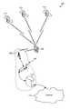
- FIG. 1is a communication system block diagram illustrating network components of an example telecommunication system suitable for use in a mobile-device centric approach for determining the location of a mobile device in accordance with various embodiments.
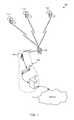
- FIG. 2is a communication system block diagram illustrating network components of an example telecommunication system suitable for use in a network centric approach for determining the location of a mobile device in accordance with various embodiments.
- FIG. 3is an illustration of an example mobile device suitable for use in grouping with other mobile devices and computing precise location information in accordance with the various embodiments.
- FIG. 4Ais a communication system block diagram illustrating network components of an example LTE communication system suitable for use with various embodiments
- FIG. 4Bis a block diagram illustrating logical components, communication links and information flows in an embodiment communication system.
- FIGS. 5A-5Care component block diagrams illustrating functional components, communication links, and information flows in an embodiment method of grouping mobile devices and sharing location information between grouped mobile devices.
- FIG. 5Dis a process flow diagram illustrating an embodiment mobile device method for grouping mobile devices and sharing location information between grouped mobile devices and the network to compute enhanced location information.
- FIGS. 6A-6Dare component block diagrams illustrating functional components, communication links, and information flows in an embodiment method for computing location information in which the grouped/paired mobile devices are updated with their respective location information.
- FIG. 6Eis a process flow diagram illustrating an embodiment system method of determining the location of two or more grouped mobile devices.
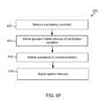
- FIG. 6Fis a process flow diagram illustrating an embodiment mobile device method of adjusting the update intervals in response to detecting a low battery condition.
- FIG. 7is a component block diagram illustrating functional components, communication links, and information flows in embodiment method of periodically scan for cells.
- FIG. 8is a process flow diagram illustrating an embodiment mobile device method for determining the location of a mobile device in a wireless network.
- FIGS. 9A-9Eare component block diagrams illustrating various logical and functional components, information flows and data suitable for use in various embodiments.
- FIG. 10is a sequence diagram illustrating an embodiment hybrid lateration method by which mobile devices may calculate position accurately with the help of the network.
- FIG. 11is a sequence diagram illustrating another embodiment hybrid lateration method in which a mobile device cannot locate a network due coverage problems.
- FIGS. 12A-12Care component block diagrams illustrating functional components, communication links, and information flows in an embodiment method of transferring a connection from a local radio system to the small cell system.
- FIGS. 13A-13Care component block diagrams illustrating functional components, communication links, and information flows in an embodiment method of identifying and responding to a distressed mobile device.
- FIG. 14is a component block diagrams illustrating functional components, communication links, and information flows in an embodiment method of performing dead reckoning grouping mobile devices in an ad-hoc scheme.
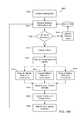
- FIG. 15is a process flow diagram illustrating an embodiment mobile device method for determining the location of a mobile device.
- FIGS. 16A-Bare process flow diagrams illustrating an embodiment methods of obtaining position information for a mobile device in a wireless network.
- FIG. 17is a process flow diagram illustrating an embodiment method of updating location information in the absence of new location measurements.
- FIG. 18is a process flow diagram illustrating an embodiment method to produce precise location information.
- FIG. 19is a component block diagram of a mobile device suitable for use with an embodiment.
- FIG. 20is a component block diagram of a server suitable for use with an embodiment.
- mobile devicecellular telephone
- cell phonerefers to any one or all of cellular telephones, smartphones, personal data assistants (PDA's), laptop computers, tablet computers, ultrabooks, palm-top computers, wireless electronic mail receivers, multimedia Internet enabled cellular telephones, wireless gaming controllers, and similar personal electronic devices which include a programmable processor, a memory and circuitry for sending and/or receiving wireless communication signals. While the various embodiments are particularly useful in mobile devices, such as cellular telephones, which have limited battery life, the embodiments are generally useful in any computing device that may be used to wirelessly communicate information.
- wireless networkmay be a radio access point (e.g., a cell tower), which provides the radio link to the mobile device so that the mobile device can communicate with the core network.
- radio access pointe.g., a cell tower
- Such services and standardsinclude, e.g., third generation partnership project (3GPP), long term evolution (LTE) systems, third generation wireless mobile communication technology (3G), fourth generation wireless mobile communication technology (4G), global system for mobile communications (GSM), universal mobile telecommunications system (UMTS), 3GSM, general packet radio service (GPRS), code division multiple access (CDMA) systems (e.g., cdmaOne, CDMA2000TM), enhanced data rates for GSM evolution (EDGE), advanced mobile phone system (AMPS), digital AMPS (IS-136/TDMA), evolution-data optimized (EV-DO), digital enhanced cordless telecommunications (DECT), Worldwide Interoperability for Microwave Access (WiMAX), wireless local area network (WLAN), public switched telephone network (PSTN), Wi-Fi Protected Access I & II (WPA, WPA2), Bluetooth®, integrated digital enhanced network (iden), and
- 3GPPthird generation partnership project
- LTElong term evolution
- 4Gfourth generation wireless mobile communication technology
- GSMglobal system for mobile
- solutionsA number of different methods, technologies, solutions, and/or techniques (herein collectively “solutions”) are currently available for determining the location of mobile device, any or all of which may be implemented by, included in, and/or used by the various embodiments.
- solutionsinclude, e.g., global positioning system (GPS) based solutions, assisted GPS (A-GPS) solutions, and cell-based positioning solutions such as cell of origin (COO), time of arrival (TOA), observed time difference of arrival (OTDOA), advanced forward link trilateration (AFLT), and angle of arrival (AOA).
- GPSglobal positioning system
- A-GPSassisted GPS
- COOcell of origin
- TOAtime of arrival
- OOAobserved time difference of arrival
- AFLTadvanced forward link trilateration
- AOAangle of arrival
- WWANswireless wide area networks
- WLANswireless local area networks
- WPANswireless personal area networks
- a WWANmay be a Code Division Multiple Access (CDMA) network, a Frequency Division Multiple Access (FDMA) network, an OFDMA network, a 3GPP LTE network, a WiMAX (IEEE 802.16) network, and so on.
- the WPANmay be a Bluetooth network, an IEEE 802.15x network, and so on.
- a WLANmay be an IEEE 802.11x network, and so on.
- a CDMA networkmay implement one or more radio access technologies (RATs) such as CDMA2000, Wideband-CDMA (W-CDMA), and so on.
- RATsradio access technologies
- Various embodiments discussed hereinmay generate, compute, and/or make use of location information pertaining to one or more mobile devices. Such location information may be useful for providing and/or implementing a variety of location-based services, including emergency location services, commercial location services, internal location services, and lawful intercept location services.
- emergency location servicesmay include services relating to the provision of location and/or identification information to emergency service personal and/or emergency systems (e.g., to 911 system); commercial location services may include any general or value-added service (e.g., asset tracking services, navigation services, location-based advertising services, etc); internal location services may include services pertaining to the management of the wireless service provider network (e.g., radio resource management services, message delivery services, paging services, call delivery services, services for providing position/location network enhancements, etc.); and lawful intercept location services may include any service that provides public safety and/or law enforcement agencies with identification and/or location information pertaining to a mobile device or a mobile device user. While the various embodiments are particularly useful in applications that fall within one or more of the categories/types of location based services discussed above, the embodiments are generally useful in any application or service that benefits from location information.
- Modern mobile electronic devicestypically include one or more geospatial positioning systems/components for determining the geographic location of the mobile device. Location information obtained by these geospatial systems may be used by location-aware mobile software applications (e.g., Google® Maps, Yelp®, Twitter® Places, “Find my Friends” on Apple®, etc.) to provide users with information regarding the mobile device's physical location at a given point in time.
- location-based services and software applicationshave increased in popularity and use, and now enable mobile device users to navigate cities, read reviews of nearby restaurants and services, track assets or friends, obtain location-based safety advice, and/or take advantage of many other location-based services on their mobile devices.
- the various embodimentsovercome these and other limitations of existing solutions by collecting information from multiple mobile devices, generating more precise location information on or about one or more mobile devices, generating advanced three-dimensional location and position information on or about one or more mobile devices, and using the generated location/position information to provide mobile device users with more accurate, more powerful, and more reliable location based services.
- One of the challenges associated with using geo-spatial positioning technology on a mobile deviceis that the mobile device's ability to acquire satellite signals and navigation data to calculate its geospatial location (called “performing a fix”) may be hindered when the mobile device is indoors, below grade, and/or when the satellites are obstructed (e.g., by tall buildings, etc.).
- the presence of physical obstacles, such as metal beams or walls,may cause multipath interference and signal degradation of the wireless communication signals when the mobile device is indoors or in urban environments that include tall buildings or skyscrapers.
- the mobile devicemay not have sufficient access to satellite communications (e.g., to a global positioning system satellite) to effectively ascertain the mobile device's current location.
- satellite communicationse.g., to a global positioning system satellite
- the various embodimentsinclude improved location determination solutions that determine the location of a mobile device at the level of position accuracy which is suitable for use in emergency location services, commercial location services, internal location services, and lawful intercept location services.
- a mobile-device centric approacha mobile-device centric approach
- a network centric approacha hybrid approach that may include aspects of both the mobile device centric approach and the network centric approach.
- FIG. 1illustrates an example communication system 100 suitable for implementing a mobile-device centric approach for determining the location of a mobile device 102 in accordance with various embodiments.
- the mobile device 102may include a global positioning system (GPS) receiver in communication with multiple geo-spatial positioning and navigation satellites 110 and a base tower 104 of a communication network 106 .
- the mobile device 102may receive (e.g., via the GPS receiver) radio signals emitted by the satellites 110 , measure the time required for the signals to reach the mobile device 102 , and use trilateration techniques to determine the geographical coordinates (e.g., latitude and longitude coordinates) of the mobile device 102 .
- the mobile device 102may send the geographical coordinates to the communication network 106 at various times and/or in response to various conditions or events, such as upon initial acquisition with the communication network 106 , in response to network-based requests, in response to third party requests, etc.
- the communication networkmay be a cellular telephone network.
- a typical cellular telephone networkincludes a plurality of cellular base stations 104 coupled to a network operations center 108 , which operates to connect voice and data calls between mobile devices 102 (e.g., mobile phones) and other network destinations, such as via telephone land lines (e.g., a POTS network, not shown) and the Internet 114 .
- Communications between the mobile devices 102 and the cellular telephone network 11may be accomplished via two-way wireless communication links, such as 4G, 3G, CDMA, TDMA, and other cellular telephone communication technologies.
- the network 106may also include one or more servers 112 coupled to or within the network operations center 108 that provide connections to the Internet 114 .
- the mobile device 102may be configured to communicate with a radio access node, which can include any wireless base station or radio access point such as LTE, CDMA2000/EVDO, WCDMA/HSPA, IS-136, GSM, WiMax, WiFi, AMPS, DECT, TD-SCDMA, or TD-CDMA and switch, Land Mobile Radio (LMR) interoperability equipment, a satellite Fixed Service Satellite (FSS) for remote interconnection to the Internet and PSTN.
- LMRLand Mobile Radio
- FSSSatellite Fixed Service Satellite
- FIG. 2illustrates an example communication system 200 suitable for implementing a network centric approach for determining the location of a mobile device 102 in accordance with various embodiments.
- the mobile device 102may include a circuitry for wirelessly sending and receiving radio signals.
- the communication system 200may include a plurality of radio access points 204 , 206 having installed thereon additional radio equipment 208 for measuring the location of the mobile devices in the communication system.
- the mobile device 102may transmit radio signals for reception by one or more (e.g., typically three) radio access points 204 , and the radio access points may receive the transmitted signals and measure the signal strength and/or radio energy of the received signals to identify the location of the mobile device 102 .
- the radio access points 204may be configured to determine the location of the mobile device relative to a known location of a network component, such as the illustrated radio access point 206 .
- the additional radio equipment 208 installed on the radio access points 204 , 206provides the communication system 200 with similar functionality as is provided by a GPS receiver for signals received from the mobile device.
- the radio equipment on one or more of the radio access points 204may measure how long it takes for the radio signal to travel from the mobile device 102 to another radio access point 206 , and using trilateration techniques (e.g., time of arrival, angle of arrival, or a combination thereof), the mobile device 102 or a network server 210 may estimate the location of the mobile device 102 to within an accuracy of 100 to 300 meters.
- this informationmay be used to determine the geo-spatial location of the mobile device 102 , which may be communicated to other systems, servers or components via the Internet 114 .
- Various embodimentsmay implement and/or make use of a hybrid approach for determining the location of mobile devices in a communication network, which may include aspects of both the device-centric and the network-centric approaches discussed above with reference to FIGS. 1 and 2 .
- an embodiment system, mobile device or network componente.g., severs, radio access points, etc.
- dead reckoningalso known as “deduced reckoning”
- system, devices and/or componentsmay be configured to implement a hybrid approach in which the GPS capabilities of mobile devices, the measured signal strengths and/or radio energy of radio signals transmitted from the mobile devices, and known locations of network components may be used in combination to estimate the locations of one or more mobile devices in the network.
- system, devices and/or componentsmay be configured to dynamically determine the factors (e.g., radio signal strength, GPS, etc.) to measure and/or use in determining the location of the mobile devices.
- FIG. 3illustrates sample components of a mobile device 102 in the form of a phone that may be used with the various embodiments.
- the phonemay include a speaker 304 , user input elements 306 , microphones 308 , an antenna 312 for sending and receiving electromagnetic radiation, an electronic display 314 , a processor 324 , a memory 326 and other well known components of modern electronic devices.
- the phonemay also include one or more sensors 310 for monitoring physical conditions (e.g., location, motion, acceleration, orientation, altitude, etc.).
- the sensorsmay include any or all of a gyroscope, an accelerometer, a magnetometer, a magnetic compass, an altimeter, an odometer, and a pressure sensor.
- the sensorsmay also include various bio-sensors (e.g., heart rate monitor, body temperature sensor, carbon sensor, oxygen sensor, etc.) for collecting information pertaining to environment and/or user conditions.
- the sensorsmay also be external to the mobile device and paired or grouped to the mobile device via a wired or wireless connection (e.g., Bluetooth®, etc.).
- the mobile device 102may include two or more of the same type of sensor (e.g., two accelerometers, etc.).
- the phonemay also include a GPS receiver 318 configured to receive GPS signals from GPS satellites to determine the geographic location of the phone.
- the phonemay also include circuitry 320 for transmitting wireless signals to radio access points and/or other network components.
- the phonemay further include other components/sensors 322 for determining the geographic position/location of the phone, such as components for determining the radio signal delays (e.g., with respect to cell-phone towers and/or cell sites), performing trilateration and/or multilateration operations, identifying proximity to known networks (e.g., Bluetooth® networks, WLAN networks, WiFi, etc.), and/or for implementing other known geographic location technologies.
- known networkse.g., Bluetooth® networks, WLAN networks, WiFi, etc.
- the phonemay also include a system acquisition function configured to access and use information contained in a subscriber identity module (SIM), universal subscriber identity module (USIM), and/or preferred roaming list (PRL) to, for example, determine the order in which listed frequencies or channels will be attempted when the phone is to acquire/connect to a wireless network or system.
- SIMsubscriber identity module
- USIMuniversal subscriber identity module
- PRLpreferred roaming list
- the phonemay be configured to attempt to acquire network access (i.e., attempt to locate a channel or frequency with which it can access the wireless/communication network) at initial power-on and/or when a current channel or frequency is lost (which may occur for a variety of reasons).
- the phonemay include pre-built in USIM, SIM, PRL or access point information.
- the mobile devicemay be configured for first responders and/or public safety network by, for example, setting the incident radio system as the default and/or preferred communication system.
- determining the specific location of a mobile device 102 in a wireless networkremains a challenging task for a variety of reasons, including the variability of environmental conditions in which mobile devices are often used by consumers, deficiencies in existing technologies for computing and/or measuring location information on mobile devices, and the lack of uniform standards.
- mobile device designers and wireless network operators, in conjunction with local public safety and third party providersare using a variety of inefficient, incoherent, and sometimes incompatible methods, technologies, solutions, and/or techniques to determine the location of a mobile device and/or to provide location based services.
- Phase IPhase I
- Phase IIPhase II
- the FCCrequested cellular service providers upgrade their systems in two phases.
- cellular service providerswere to upgrade their systems so that emergency calls (e.g., 911 calls) are routed to the public service answering point (PSAP) closest to the cell-tower antenna with which the mobile device is connected, and so that PSAP call-takers can view the phone number of the mobile device and the location of the connecting cell-tower.
- PSAPpublic service answering point
- the location of the connecting cell-towermay be used to identify the general location of the mobile device within a 3-6 mile radius.
- cellular service providerswere to upgrade their systems so that PSAP call-takers could identify the location of the mobile device to within 300 meters.
- wireless service providershave implemented a variety of technologies, and depending on the technology used, can generally identify the location of the mobile device to within 50-300 meters.
- a network-based solutione.g., triangulation of nearby cell towers, etc.
- the location of a mobile devicecan be determined within an accuracy of 100 meters 67% of the time, and to within an accuracy of 300 meters 95% of the time.
- a mobile device-based solutione.g., embedded global positioning system receivers, etc.
- the location of the mobile devicemay be determined to within 50 meters 67% of the time, and to within 150 meters 95% of the time.
- phase I and II solutionsare not adequate for generating location information having sufficient accuracy or detail for use in providing accurate, powerful, and reliable location based services.
- Various embodimentsmay use some or all of the capabilities built into existing systems (e.g., as part of phase I and II upgrades, device-centric systems, network-centric systems, etc.), in conjunction with more advanced location determination techniques, to compute location information suitable for the advanced location based services demanded by today's consumers.
- a single-carrier signal transmitted between a transceiver and a mobile devicecan be received via multiple paths (i.e., multipath), and the multiple paths of the signal can have different received powers and arrival times.
- the received signalmay be cross-correlated to distinguish the multiple paths of the received signal.
- the first-arrival pathe.g., first detected signal, strongest signal, etc.
- this first-arrival pathis the strongest path due to zero or fewer reflections, relative to the other paths, between the transceiver and the mobile device.
- the first-arrival time of the identified first-arrival pathmay be used in addition to other parameters (e.g., an estimated signal transmission time and/or a time offset between clocks of the transceiver and the mobile device, etc.) to estimate distance between a mobile device and a network component (e.g., another mobile device, a transceiver, an access point, a base station, etc.).
- the first-arrival timemay be estimated by the mobile device (e.g., based on the downlink received signal) or by the network component (e.g., based on an uplink received signal).
- the location of the mobile devicemay also be determined by estimating the distance between the mobile device and a network component or other signal sources (e.g., a transceiver, ground or satellite-based signal sources, etc.). For example, the location of the mobile device may be determined by performing trilateration using estimated distances between multiple (e.g., three or more) transceivers and the mobile device.
- a network component or other signal sourcese.g., a transceiver, ground or satellite-based signal sources, etc.
- the location of the mobile devicemay be determined by performing trilateration using estimated distances between multiple (e.g., three or more) transceivers and the mobile device.
- Another location determination solutionmay include computing an observed time difference of arrival (OTDOA) value by measuring the timing of signals received from three network components (e.g., mobile devices, transceivers, access points, etc.).
- OTDAobserved time difference of arrival
- a mobile devicemay be configured to compute two hyperbolas based on a time difference of arrival between a reference transceiver signal and signals of two neighbor transceivers. The intersection of the computed hyperbolas may define a position on the surface of the earth that may be used by various embodiments to determine the location of the mobile device.
- OTDOA solutionsmay be a function of the resolution of the time difference measurements and the geometry of the neighboring transceivers. As such, implementing an OTDOA solution may require determining the precise timing relationship between the neighboring transceivers. However, in existing asynchronous networks, this precise timing relationship may be difficult to ascertain.
- location measurement unitsmay be added throughout a deployment region of an asynchronous network to measure/compute timing information for one or more network components (e.g., transceivers) relative to a high quality timing reference signal.
- a mobile device or an LMUmay determine the observed time difference between frame timing of transceiver signals, and the observed time difference may be sent to the transceiver or a radio network controller of the communication network to determine the location of the mobile device.
- the location of the mobile devicemay also be determined based on the observed time difference and assistance data (e.g., position of the reference and neighbor transceivers) received from the communication network.
- Another location determination solutionmay include computing an uplink-time difference of arrival (U-TDOA) based on network measurements of the time of arrival of a known signal sent from the mobile device and received at multiple (e.g., four or more) LMUs.
- U-TDOAuplink-time difference of arrival
- LMUsmay be positioned in the geographic vicinity of the mobile device to accurately measure the time of arrival of known signal bursts, and the location of the mobile device may be determined using hyperbolic trilateration based on the known geographical coordinates of the LMUs and the measured time-of-arrival values.
- location determination solutionsare typically based on single-carrier signals.
- the various embodimentsinclude a ground-based location determination solution based on multi-carrier signals.
- a location determination solution based on multi-carrier signalsmay improve the accuracy of the computed location information by, for example, improving the accuracy of the timing estimation (e.g., by expanding the bandwidth of cellular signals).
- Location determination solutions based on multiple carriersmay be used in both the device-centric (e.g., mobile device-based) and network-centric (e.g., base station-based) approaches, and may be applied to both 3GPP and 3GPP2 wireless communication technologies.
- a mobile devicemay be configured to determine its geospatial location based on information collected from mobile device sensors (e.g. gyroscope, accelerometer, magnetometer, pressure sensor, etc.), information received from other mobile devices, and information received from network components in a communication system.
- mobile device sensorse.g. gyroscope, accelerometer, magnetometer, pressure sensor, etc.
- FIG. 4Aillustrates an example communication system within which the various embodiments may be implemented.
- the mobile device 102may be configured to send and receive communication signals to and from a network 406 , and ultimately the Internet 114 , using a variety of communication systems/technologies (e.g., GPRS, UMTS, LTE, cdmaOne, CDMA2000TM).
- LTElong term evolution
- eNBeNodeB
- S-GWserving gateway
- the mobile device 102 or serving gateway 408may also send signaling (control plane) information (e.g., information pertaining to security, authentication, etc.) to a mobility management entity (MME) 410 .
- MMEmobility management entity
- the MME 410may request user and subscription information from a home subscriber server (HSS) 412 , perform various administrative tasks (e.g., user authentication, enforcement of roaming restrictions, etc.), and send various user and control information to the S-GW 408 .
- the S-GW 408may receive and store the information sent by the MME 410 (e.g., parameters of the IP bearer service, network internal routing information, etc.), generate data packets, and forward the data packets to a packet data network gateway (P-GW) 416 .
- the P-GW 416may process and forward the packets to a policy and control enforcement function (PCEF) 414 which receives the packets and requests charging/control policies for the connection from a policy and charging rules function (PCRF) 415 .
- PCEFpolicy and control enforcement function
- the PCRF 415provides the PCEF 414 with policy rules that it enforces to control the bandwidth, the quality of service (QoS), and the characteristics of the data and services being communicated between the network (e.g., Internet, service network, etc.) and the mobile device 102 .
- the PCEF 414may be a part of, or perform operations typically associated with, the P-GW 416 .
- Policy and Charging Control Architecturemay be found in “3rd Generation Partnership Project Technical Specification Group Services and System Aspects, Policy and Charging Control Architecture,” TS 23.203, the entire contents of which are incorporated herein by reference.
- the network 406may also include an Evolved Serving Mobile Location Center (E-SMLC) 418 .
- E-SMLCEvolved Serving Mobile Location Center
- the E-SMLC 418collects and maintains tracking information about the mobile device 102 .
- the E-SMLC 418may be configured to provide location services via a lightweight presentation protocol (LLP), which supports the provision of application services on top of TCP/IP networks.
- LLPlightweight presentation protocol
- the E-SMLC 418may send or receive (e.g., via LPP) almanac and/or assistance data to and from the MME 410 and/or eNB 404 .
- the E-SMLC 418may also forward external or network initiated location service requests to the MME 410 .
- the mobile device 102may receive information from the serving eNodeB 404 via System Information Blocks that includes the neighbor cells to scan that are on the same system using the same frequencies or different frequencies, Home eNB (HeNB), in addition to CDMA, GERAN and UTRA cells.
- HeNBHome eNB
- FIG. 4Billustrates logical components, communication links, and information flows in an embodiment communication system 450 suitable for use in determining the location of the mobile device.
- the communication system 450may include a network location based system 452 , a core network 454 , and a radio access network 456 .
- the communication system 450may also include an application module 458 , a position calculation module 460 , a wireless grouping module 462 , and a sensor data module 464 , any or all of which may be included in a mobile device 102 .
- the application module 458e.g., client software
- the network location based system 452(or another client attached to, or within, the core network 454 ) may request and receive location information from the application module 458 .
- the mobile device 102may be configured to determine its geospatial location based on information collected from mobile device sensors (e.g. gyroscope, accelerometer, magnetometer, pressure sensor, etc.), information received from other mobile devices, and information received from network components in a communication system.
- the collection and reporting of sensor informationmay be controlled/performed by the sensor data module 464 .
- the application module 458may retrieve/receive sensor information from the sensor data module 464 and send the sensor information to the position calculation module 460 to compute the location of the mobile device locally for position updates and/or position augmentation.
- the application module 458may also send the computed location information to the network location based system 452 and or other mobile devices.
- the mobile device 102may be configured to determine its geospatial location based on information collected from other mobile devices.
- two or more mobile devicesmay be organized into groups.
- Each mobile devicemay also share its location information with the other mobile devices with which the mobile device is grouped.
- mobile devicesmay be configured to share their current location and/or position information (e.g., latitude, longitude, altitude, velocity, etc.) and an estimate of a distance between themselves and a target mobile device with other mobile devices in their group.
- the grouping of mobile devicesmay be controlled by the wireless grouping module 462 .
- the application module 458may retrieve wireless group information (e.g., information pertaining to the locations of other mobile devices) from the wireless grouping module 462 , and send the group information to the position calculation module 460 to perform local calculations for position updates and/or position augmentation.
- the position calculation module 460may perform the local calculations based on both sensor information received from the sensor data module 464 and group information received from the wireless grouping module 462 .
- the mobile device 102may be configured to automatically share its location information with other mobile devices upon discovery of the other mobile devices.
- Mobile devicesmay augment their location information (e.g., position coordinates) with information received from other mobile devices within same geographic location, and in a controlled pseudo ad-hoc environment. Since the shared location information (e.g., latitude, longitude, altitude, velocity, etc.) involves a relatively small amount of data, in an embodiment the mobile devices may receive such information from a network server by in-band and or out-of-band signaling.
- the various embodimentsmay include an E-SMLC 418 component configured to send and receive location information (e.g., latitude, longitude, altitude, velocity, etc.) to and from the mobile devices, which may be achieved both on-net and off-net.
- location informatione.g., latitude, longitude, altitude, velocity, etc.
- the location informationmay be delivered in standard formats, such as those for cell-based or geographical co-ordinates, together with the estimated errors (uncertainty) of the location, position, altitude, and velocity of a mobile device and, if available, the positioning method (or the list of the methods) used to obtain the position estimate
- 3GPP-LTE networkshave standardized several reference signals. Various embodiments may use these reference signals for timing based location and positioning solutions. Such reference signals may include the primary and secondary synchronization signals and the cell specific reference signals.
- two or more mobile devicesmay be organized into groups.
- Mobile devices within the same groupmay be part of the same network, or may be associated with different networks and/or network technologies.
- the mobile devices within the same groupmay also operate on different network operating systems (NOSs) and/or radio access networks (RANs).
- NOSsnetwork operating systems
- RANsradio access networks
- FIGS. 5A-5Cillustrate functional components, communication links, and information flows in an embodiment method of grouping mobile devices and sharing location information between grouped mobile devices.
- the mobile device 102may scan the airwaves for predefined and/or preferred radio frequency carriers and/or systems with which the mobile device 102 may connect to the network. If the mobile device 102 does not find an appropriate network with which it may connect (or loses its connection) the mobile device 102 may scan the airwaves for other radio access systems (e.g., mobile network, radio access point associated with a mobile device, etc.) to acquire (i.e., connect to) until a connection to a network/Internet 510 is established. These operations may also be performed in the event of a dropped call or power interruption.
- radio access systemse.g., mobile network, radio access point associated with a mobile device, etc.
- the mobile device 102may also begin acquiring GPS signals while scanning the airwaves for radio frequency carriers and/or systems. If the mobile device 102 cannot acquire GPS signals, a network component (not illustrated) may help determine the relative position of the mobile device 102 based on one or more of the location determination solutions discussed herein (e.g., based on the antenna used for the radio access point, the time delay, angle of arrival, etc.).
- the mobile device 102may acquire (i.e., connect to) an appropriate radio access system, radio frequency carrier and/or system via the mobile device's system acquisition system.
- the mobile device 102establishes a connection to a network 510 via an eNodeB 404 .
- any or all of the communication technologies discussed aboveare contemplated and within the scope of the various embodiments.
- the network 510i.e., a component in the network such as a server
- the network 510will know the approximate location of the mobile device 102 (e.g., via one or more of the location determination solutions discussed above, such as proximity to base towers).
- the mobile device 102may compute its current location (e.g., via GPS and/or the location determination solutions discussed above), store the computations in a memory of the mobile device, and report its current location to the network 510 .
- the network 510may also be informed of the locations of other mobile devices 502 and the proximity of the other mobile devices 502 to the recently acquired mobile device 102 .
- FIG. 5Billustrates that the network 510 may send instructions/commands to the mobile devices 102 , 502 to cause the mobile devices 102 , 502 to group with mobile devices 102 , 502 and possibly others.
- the network 510may be configured to automatically group the mobile devices 102 , 502 based on the proximity of the devices 102 , 502 with respect to one another.
- the network 510may be configured to allow an incident command system (ICS) commander to group the devices.
- ICSincident command system
- the network 510may be configured to allow the mobile devices to form groups based on their proximity to one another.
- 5Cillustrates that the mobile device 102 may pair/group with another mobile device 502 and/or establish communication links so that the mobile devices 102 , 502 may share real-time relative location information with each other.
- Two or more grouped/paired mobile devices 102 and 502may identify their relative positions to each other by sending relative location information over the established communication links.
- the relative location informationmay include time-to-arrival, angle-of-arrival, and existing or self-aware location information.
- the mobile devices 102 , 502may be configured report sensor information to each other and/or the network 510 .
- the sensor informationmay include x, y, z coordinate information and velocity information.
- the sensor informationmay be polled on a continuous basis, may be requested periodically, and/or made available on demand in response to network/system requests.
- a mobile device 102 , 502may be configured to report sensor information in response to determining that there is a high likelihood that there has been change in a location of the mobile device 102 , 502 (e.g., in response to detecting motion).
- the mobile devices 102 , 502may also be configured collect and report sensor information to the network 510 in response to receiving an instruction/command from the network 510 (i.e., a component in the network such as a server or E-SLMC 418 illustrated in FIG. 4 ).
- the network 510(i.e., a component in the network) may be configured receive the sensor and location information from the mobile devices 102 , 502 , and compute and store information about the distances (e.g., in time delay and angle of arrival with respect to the mobile devices 102 , 502 ).
- the reporting of sensor informationmay be based on local parameter settings.
- the mobile devices 102 , 502may be configured to transmit sensor information when any of the measured parameters (e.g., x, y, z and velocity information) meet or exceed a threshold value (e.g., exceed a rate-of-change, meet a timeout limit), which may be identified by local parameter settings stored in a memory of the mobile devices 102 , 502 .
- the mobile devices 102 , 502may be configured to re-compute and/or update their location information in response to determining that the measured parameters (e.g., x, y, and z coordinates and velocity information) meet or exceed a threshold value.
- a mobile device 102 and/or the network 510may be configured to compare collected sensor information to computed latitude and longitude coordinates, relative altitude information, and other available information to determine if there is a discrepancy between the collected/measured values and the expected values.
- the mobile device 102 and/or network 510may perform additional measurements to improve the location accuracy of the measurements/location information.
- FIG. 5Dillustrates an embodiment mobile device method 550 for grouping mobile devices and sharing location information between grouped mobile devices and the network to compute enhanced location information.
- the mobile devicemay scan the airwaves for predefined and/or preferred radio frequency carriers and/or systems with which the mobile device may connect.
- the mobile devicemay begin acquiring GPS signals while scanning the airwaves for radio frequency carriers and/or systems. If the mobile device cannot acquire GPS signals, the mobile device or a network component may, as part of block 554 , determine the relative position of the mobile device based on one or more of the location determination solutions discussed herein.
- the mobile devicemay acquire (i.e., connect to) an appropriate radio access system, radio frequency carrier, system and/or network.
- the mobile devicemay compute its current location (e.g., via GPS and/or the location determination solutions discussed above), store the computations in a memory, and report its current location to the network.
- the mobile devicemay group with other mobile devices in response to receiving instructions/commands from a network component and/or in response to detecting that the other mobile devices are within a predefined proximity to the mobile device (i.e., within a threshold distance).
- the mobile devicemay share its current location information, as well as information collected from sensors, with the grouped mobile devices.
- the mobile devicemay receive location and/or sensor information from the grouped mobile devices.
- the sensor informationmay include x, y, z coordinate information, bearing, and velocity information.
- the mobile devicemay identify the relative positions of the other mobile devices, which may be achieve by evaluating the location and sensor information received from the other mobile devices and/or via any or all of the location determination solutions discussed herein.
- the mobile devicemay send the relative location information, its current location information, and/or sensor information to a network component and/or the other mobile devices, which may receive the sensor and location information and compute updated location information (e.g., based on distance in time delay and angle of arrival, relative altitude information, etc.).
- the mobile devicemay receive updated location information from the network component and/or the other grouped mobile devices.
- the mobile devicemay update its current location calculation and/or information based on the information received from the network component and/or the other grouped mobile devices.
- the operations of blocks 562 - 572may be repeated until the desired level of precision is achieved for the location information.
- FIGS. 6A-6Dillustrate functional components, communication links, and information flows in an embodiment method for computing location information in which the grouped/paired mobile devices 102 , 502 are updated with their respective location information.
- FIG. 6Aillustrates that the mobile device 102 may communicate with a serving eNodeB 404 to relay its location information to the network 510 and/or to receive location information from the network 510 .
- FIG. 6Billustrates that another mobile device 502 may also communicate with the serving eNodeB 404 to relay its location information to the network 510 and/or to receive location information from the network 510 .
- FIG. 6Cillustrates that the grouped/paired mobile devices 102 , 502 may communicate with each other to determine the distance between each other, which may be achieved by the mobile devices 102 , 502 communicating various types of information, such as time-of-arrival, relative position with angle-of-arrival measurements, and other similar values, measurements, or computations.
- the mobile devices 102 , 502may then re-compute, refine, and/or update their current location calculations and/or location information based on information received from the other mobile devices 102 , 502 .
- FIG. 6Dillustrates that the grouped/paired mobile devices 102 and 502 may send their self-aware location information and/or relative location information to the network 510 (via the serving eNodeB 404 ), and receive updated location information from the network 510 .
- the mobile devices 102 and 502may send their present location coordinates, distances between mobile device (e.g., distance to each other), altitude, and bearings (e.g., where mobile device 102 is with respect to mobile device 502 ) to the network 220 .
- the networkmay compute updated location information based on the received information (e.g., coordinates, sensor information, proximity information, etc.), and send the updated location information to the mobile devices 102 , 502 .
- the mobile devices 102 , 502may then re-compute, refine, and/or update their current location calculations and/or location information based on information received from the network.
- the operations discussed above with respect to FIGS. 6A-6Dmay be repeated so that the mobile devices 102 , 502 recursively, continuously, and/or periodically re-compute, refine, and/or update their current location calculations and/or location information based on updated information received from the other mobile devices and/or the network 510 until the desired level of precision is achieved for the location information.
- FIG. 6Eillustrates an embodiment system method 650 of determining the location of two or more grouped mobile devices.
- a first mobile devicemay send and/or receive current location information to and from a network component.
- a second mobile devicemay send and/or receive current location information to and from a network component.
- the first and second mobile devicesmay communicate with each other to determine the relative distances between each other, which may be achieved by communicating various types of information, including time-of-arrival, relative position with angle-of-arrival measurements, velocity, altitude, etc.
- the first and/or second mobile devicesmay re-compute, refine, and/or update their current location calculations and/or location information based on information received from the other mobile devices and/or the network.
- the first and/or second mobile devicesmay send their updated current location calculations and/or location information to the network component, which may receive the calculations/information and compute updated location information (e.g., based on distance in time delay and angle of arrival, relative altitude information, etc.).
- the first and/or second mobile devicesmay receive updated location information from the network. The operations in blocks 658 - 662 may be repeated until the desired level of precision is achieved for the location information.
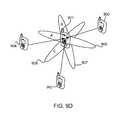
- the methods and operations discussed above with reference to FIGS. 5A-5D and 6A-6Fmay also be performed such that they include more than two devices.
- the mobile devicesmay be grouped into units of four (4) such that each mobile device may triangulate its position relative to the other mobile devices in the same group.
- a mobile device 102 and/or a network componentmay store relative location information for all the mobile devices within each group, based on the type of grouping. For example, a network component may store relative location information for all the mobile devices grouped/paired by an incident command system (ICS) commander. Likewise, the network component may store relative location information for all the mobile devices grouped/paired based on their proximity to each another.
- ICSincident command system
- the mobile device 102may be configured to detect a low battery condition, and initiate operations to conserve battery. For example, a mobile device 102 may be configured to turn off its radio and/or terminate or reduce its participation in the group/pairing information exchange. As another example, a mobile device 102 may be flagged or identified as having a low battery condition, and the other grouped/paired mobiles devices may be informed of the low battery situation so that update intervals may be adjusted to reduce battery consumption.
- FIG. 6Fillustrates an embodiment method 670 of adjusting the update intervals in a mobile device in response to detecting a low battery condition.
- the mobile devicemay detect/determine that the amount of power remaining in the mobile device battery is below a predetermined threshold.
- the mobile devicemay transmit a signal or otherwise inform grouped mobile devices of the detected low battery condition.
- the mobile devicemay initiate operations to converse power, such as by turn off its radio and/or reducing its participation in exchanging information with grouped mobile devices.
- the mobile device and/or the informed grouped mobile devicesmay adjust the update intervals with respect to the mobile device to reduce the load on the mobile device.
- grouped mobile devicesmay share various types of information to improve the accuracy of the location determination calculations.
- a comparisonmay be made for the path, range, between the mobile devices using any or all of the information available to the mobile devices (e.g., location coordinates, sensor information, proximity information, etc.). If the two mobile devices report relative positional information that is within a user or network defined range tolerance as being acceptable this is information may be forwarded to the network. If the relative positional information is not within the user or network defined range tolerance, additional polling operations may be performed to improve the accuracy of the measurements or location information. The above-mentioned operations may be repeated until the desired level of accuracy is achieved. In an embodiment, the number of times the above-mentioned operations are repeated may determined based on a user-definable values which can be set by the network, user or algorithm used.
- a mobile device 102may include two or more of the same type of sensor.
- the mobile device 102includes more than one of the same type of sensor (e.g., includes two accelerometers)
- one of the sensorse.g., one the two accelerometers
- the values measures by each sensormay be compared, and if the difference between the values falls within a tolerance range, the values measured by the master sensor may be used to compute the sensor parameters (e.g., x,y,z and velocity parameters). If the difference between the values falls outside a tolerance range, the mobile device may use information collected from other sensors (of the same or different types) to determine if the values measured by the master sensor are consistent with expected values.
- the mobile devicemay use information collected from various other types of sensors to compute sensor parameters (e.g., x,y,z and velocity parameters), and compare the computed sensor parameters to similar sensor parameters computed based on the values measured on the master sensor to determine if the master sensor is functioning correctly. Values measured on the master sensor may also be compared to information stored in the network or other mobile devices to determine if the master sensor is functioning correctly. If it is determined that the master sensor is not functioning correctly, a secondary sensor may be designated as the master sensor. The previous master sensor may be demoted to standby status (i.e., for use if the primary sensor has a failure) and not used for immediate positional calculations.
- sensor parameterse.g., x,y,z and velocity parameters
- the mobile devicesmay be asked to group/pair with more devices.
- the number devices that a mobile device can group/pair withmay be restricted by user configuration, through the system, and/or user intervention so as to conserve battery and computational efforts (e.g., when the mobile device detects a low battery condition).
- proximity groupingmay be used in the x, y and z coordinates/fields and/or for velocity and acceleration information.
- the mobile devicemay group with yet another mobile device in an ad-hoc fashion. If no mobile device is pairable with the mobile device, it may rely on its own geographic and/or and sensor information to report to the network.
- the systemmay be configured so that an approval from the incident commander or user is required before the mobile is degrouped/depaired. In an embodiment, this may be achieved may transmitting a signal to a mobile device of the incident commander or user requesting approval, to which the incident commander or user may send a reply approving or disapproving of the request to degroup/depair.
- the degrouping/depairing processmay be transparent to the mobile device users.
- polling for informationmay be performed once the network has lost communication with the mobile device.
- Mobile devices that and known to be grouped to the mobile devicemay be instructed to communicate with the disconnected mobile even when it is trying to reacquire the network.
- a logical sequence based on proximity, signal quality to the network, and/or battery strengthmay be used to determine which mobile device will be used as a relay for communicating with the network.
- the relayed telemetry informationmay include more than just positional information.
- the telemetry informationmay also include bio sensor and user bio information reporting on the environment and user conditions, including heart rate and temperature, CO, 02 and other sensor information.
- the networkmay continuously measure/monitor the connected mobile devices. Knowing their location and relative location to each of the other mobile devices enables the network to continuously measure the uplink and downlink communication paths. If a communication path degradation occurs and begins to fall within a defined system quality range (which may be user defined), a mobile device may be instructed to either handover to another radio access node for the same network and/or network technology, or be instructed to initiate to perform relay operations to relay communications though a defined mobile device as a secondary signal path.
- a defined system quality rangewhich may be user defined
- the mobile devicemay attempt to acquire itself on another network. While the acquisition process is underway, a mobile device may act as a mesh device. Other mobile devices in the proximity group may also connect as a mesh network.
- the mobile devicesmay utilize dead reckoning techniques to compute location information.
- Mobile devicesmay store the information for use in calculating more accurate location information, and may eventually relay to another mobile device which has network access or until one of the mobile devices or both devices have access to the initial network or another network and granted access to whether it is public or a private network.
- FIG. 7illustrates normal operating conditions in which a mobile device 102 will periodically scan for other cells 704 , including its serving cell 903 . If the radio access points are part of the network then the mobile device will report the identity and signaling information required by the existing network to determine (e.g., via triangulating and/or trilateration) the mobile device's location based on a network approach. If the mobile device detects a radio access point is not part of its preferred cell selection process, it may attempt to read the coordinates and positional information from the access point that is broadcast.
- the mobile devicemay determine the timing difference and other requisite information to help determine its relative location and distance from the access point. This information may be related to the location system used by the mobile device to help refine its current location calculations.
- the mobile devicemay be configured to compare each cell read to its own coordinate and using bearing and time difference for all the cells it reads. The mobile device may then triangulate on its own position.
- a software application on the distressed mobile devicemay be executed.
- the software applicationmay access an active neighbor list, read the overhead of each cell, and use that information to triangulate on the mobile device's own positions.
- the mobile devicemay also read the time offset for each of the cells.
- the systembegins to try and locate the distressed mobiles position with more precision an accuracy to assist First Responders with triangulating on the distressed mobiles position and sending the information to the incident commander and/or public service answering point (PSAP) with a relative distance to target indication that is updated on pre-defined intervals. If the mobile device has lost contact with the 911 center, PSAP then the last location is continuously display and any velocity information is also relayed to assist the first responders.
- PSAPpublic service answering point
- the mobile device 102may be configured to send its location information to the network.
- the mobile device 102may be configured to automatically send its location information in response to detecting the emergency, or may provide the user with an option to send the location information.
- the mobile device 102may be configured to send its location information in response to a network initiated command.
- Each mobile devicemay become an access point (AP).
- the decision to be the access pointmay be periodically updated while still in communication with the network, or when no network is found.
- each mobile devicemay act as a client, and on a pseudo random time interval, the mobile devices may become an access point and then a client.
- the location based methodologymay be the same for a frequency-division duplexing (FDD) and a time-division duplexing (TDD) system.
- FDDfrequency-division duplexing
- TDDtime-division duplexing
- the mobile devicemay be configured to relay its telemetry information through another mobile device having network access.
- all information sent via wireless communication linksmay be digital.
- the informationmay be encrypted to a requisite advanced encryption standard (AES) standards level or the appropriate encryption level needed for the requisite communication system and access method used.
- AESadvanced encryption standard
- the location based systemsmay utilize reactive or proactive based methods.
- the mobile devicesmay synchronously interact with each other on a time basis or some other predetermined update method.
- the mobile devicesmay update their location information based on a set of predetermined event conditions using an algorithm.
- the various embodimentsmay include both reactive and proactive aspects, taking the best of both approaches to enhance location accuracy and precision.
- Various embodimentsmay include location determination solutions that utilize horizontal data (i.e., a set of reference points on the Earth's surface against which position measurements are made) and/or vertical data.
- Horizontal datadefine the origin and orientation of the coordinate system and are prerequisites for referring a position relative to the Earth's surface.
- Vertical dataare based on geoids, which primarily serves as a basis to determine the height of a position relative to means sea level for which the geoids act as a benchmark for origin and orientation.
- Various embodimentsmay utilize horizontal and vertical data to provide/generate enhanced three dimensional location information.
- the horizontal and vertical datacan be global, national, local or custom depending on the locality and positioning reference system utilized.
- Global dataare used for initial position fixing if possible and are based on GPS coordinates.
- Local dataare based on a particular position on the surface of the earth, which allows for a non GPS based location based services to take place.
- the various embodimentsmay use global data, local data, or both.
- GPSmay be used to help identify the initial positional fix, and may be augmented by dead reckoning and a hybrid trilateration solution that utilizes both network and terminal based positioning.
- both local and global datamay be used.
- the initial positionmay be sent to the same position as that of the reporting mobile or a distance that is estimated using received signal strength indication (“RSSI”) and/or time of flight such that 0.5 of the estimated distance is applied to the horizontal component and vertical component of the reporting mobile device and the altitude, which may also be reported by the additional mobile devices.
- RSSIreceived signal strength indication
- a hybrid lateration and trilateration solutionincludes a mobile device performing a measurement and sending it to the network, and a network component performing the location determination calculations.
- the various embodimentsinclude a hybrid lateration and trilateration solution in which the mobile device performs the location determination calculations, with and without the support of the network components.
- Various embodimentsmay include sensor fusion operations in which a collaborative approach is used so that the sensors do not act as individual sensors, but as a collective team.
- the mobile devicemay include various sensors (e.g., accelerometer, gyros, magnetic compass, altimeters, odometers, etc.) capable of generating heading, orientation, distance traveled, and velocity as part of the sensor information collected on the mobile device.
- information collected from any or all the internal sensorsmay be used for improving location or positioning accuracy and/or confidence improvements.
- Various embodimentsmay compute location information based on information from multiple sensors, with or without the aid of radio frequency propagation information.
- the sensor fusion operationsmay include the sharing of telemetry including sensor data indicating relative movement of the individual mobile device, which enables temporal readings to assist in the location estimate, either with external assistance or dead reckoning.
- FIG. 8illustrates an embodiment mobile device method 800 for determining the location of a mobile device in a wireless network.
- a mobile devicemay determine its current location using any of the above mentioned location determination solutions to produce a final location estimate.
- the mobile devicemay share its location information (i.e., the final location estimate) with other grouped mobile devices and/or receive location information from other grouped mobile devices.
- the mobile devicemay compute and send a final location estimate, updated distance vector and sensor information to a network component for improved positional fix.
- the mobile devicemay receive updated location information from the network component, and perform its own positional fix based on mobile data information received from the network.
- the mobile devicemay update its location information and/or confirm its location information using dead reckoning to enhance positional accuracy.
- Dead reckoningmay provide the needed positional corrections as a local datum method for positioning when GPS or other network related positioning solutions are not available. Additionally dead reckoning may enhance the location position accuracy and precision calculations by providing and additional horizontal and vertical datum comparisons.
- the current positionmay be deduced (or extrapolated) from the last known position.
- the dead reckoning accuracyrequires a known starting point which either can be provided by the network, GPS, near field communication link, RF beacon, a predetermined zero position, or via another mobile device.
- the initial positionmay be set to zero or a distance that is estimated using RSSI or time of flight between another mobile device such that 0.5 of the estimated distance between the mobile device and a measurement location (e.g., another mobile device) is applied to the horizontal component and vertical component of the reporting mobile device and the altitude, which may be reported by the additional mobile device
- a dead reckoning systemmay be dependent upon the accuracy of measured distance and heading, and the accuracy of the known origin.
- error accumulationcaused by sensor drift (i.e., differences or errors in values computed/collected from one or more sensors).
- sensor drifti.e., differences or errors in values computed/collected from one or more sensors.
- magnetic, accelerometers and gyroscopesare susceptible to sensor drift.
- the error accumulation for any of the sensorsmay increase over undulating terrain, as compared to flat terrain. Bias error and step size error are leading contributors to dead reckoning errors.
- any bias drift associated with the sensorsmay be address by utilizing a kalman filter to reduce the errors from the primary and/or secondary sensors (e.g., gyroscopes).
- the mobile devicemay be configured to include velocity computations as part of the location determination computations to account for position changes that occur.
- the step size (via velocity computation) and compass bias errorsmay be estimated by an Enhanced Kalman Filter (EKF).
- EKFEnhanced Kalman Filter
- the compassmay also be able to identify slow motion changes due to changes in magnetic inclination. The compass may be relied upon for motion computations in addition to that of accelerometers and gyroscopes, with and without the availability of GPS.
- the mobile devicemay be configured to not only use its own internal sensors to compute the location/positional information, but may also communicate with other mobile devices to leverage their location/positional information to enhance its own location/positional information. In essence, the mobile devices may act as RF base stations, proving the lateration capability to improve the positional accuracy of other mobile devices.
- a mobile devicemay be configured to poll one or more other mobile devices to gain a better positional fix on its location.
- Mobile devicesmay be grouped together, either through assignment by the network or through the mobile device acquiring/detecting/connecting to other mobile devices (which may or may not be in the same network) as part of a discovery method for sharing location information.
- Location informationmay be shared via the use of a near field communications system (e.g., Bluetooth®, ultrawideband, peanut radios, etc.), infrared, ultrasonic, and other similar technologies, such as via the use of WiFi.
- the wireless communicationsmay also be ad hoc or infrastructure based, or based on a TDD system, such as LTE, SD-CDMA, TD-CDMA, or any other TDD methods.
- the mobile devicemay be configured to initiate the sharing of location/position information in response to receiving a network-driven grouping request from a network component.
- the mobile devicewhen it has lost contact with the network, it may attempt to find a suitable mobile device to help in its location determination computations, and for possible connection to the network (e.g., via a relay).
- the mobile devicemay be configured to send a request for location information to another mobile device.
- the requestmay be sent after the authentication process between mobile devices, and may include a time stamp which may be sub-seconds in size (milliseconds).
- Another mobile devicemay respond with a message that also has its time stamp and when it received the time stamp from the initiating mobile device.
- Several messagesmay be exchanged quickly between the mobile devices to establish time synchronization and share location/positional information that includes horizontal, vertical, and altitude coordinates (e.g. x, y, and z coordinates), a velocity, and acceleration component in each message.
- location/positional informationthat includes horizontal, vertical, and altitude coordinates (e.g. x, y, and z coordinates), a velocity, and acceleration component in each message.
- the time differences along with the x, y, and z coordinatesmay be compared with possible pulses or pings to establish an estimated distance vector between the devices.
- a point-to-point fixmay be established. This process may be repeated for all the mobile devices in a group that has been assigned or created by the mobile device itself. Having multiple distance vectors from other points to the mobile will enhance the positioning accuracy.
- a mobile devicemay be configured to report back to the network location server the distance vectors it has found between different mobiles.
- the other mobile devices also involved with the positioning enhancementmay also report their distance vectors to the network to have their overall position accuracy improved as well.
- the positional accuracyis meant to be done in incremental steps and the process will continue until no more positional improvements will be achievable.
- the positional accuracy improvement thresholdmay be operator defined, and may be stored in a mobile device memory.
- the hybrid lateration methodmay be used in various embodiments to augment the positioning accuracy and confidence for network based position request due to boundary changes or paging requests or other position location triggered events.
- FIGS. 9A-9Eillustrate various logical components, information flows and data suitable for use in various embodiments.
- FIG. 9Aillustrates that mobile devices 901 , 902 , 903 , and 904 are communicating with the wireless network via multiple cell sites/radio access points/eNodeBs 911 .
- the mobile devices 901 , 902 , 903 , and 904may compute a relative fix on their initial location using any of the location determination solutions discussed above.
- a first mobile device 901may be instructed to find and communicate with the other mobile devices 902 , 903 and 904 , and/or any or all of mobile devices 902 , 903 and 904 may be instructed to communicate with the first mobile device 901 .
- the mobile devices 901 , 902 , 903 , and 904may be grouped together (e.g., via one of the grouping methods discussed above).
- the networkmay also designate one of the mobile devices 901 (e.g., a mobile device having a high position confidence) to be used as the reference or beacon for the other mobile devices 902 , 903 , and 904 within the group of mobile devices 901 , 902 , 903 , and 904 .
- FIG. 9Billustrates that a combination of circular and hyperbolic trilateration operations may be performed as part of an embodiment location determination solution. For example, if any of the coordinate data provided by the sensors and/or mobile devices is in latitude and longitudinal coordinates, it may be converted to Cartesian coordinates to facilitate a hybrid lateration calculation. In the example illustrated in FIG.
- the mobile devices 901has been designated as reference mobile device
- reference number 912identifies the position to be determined/computed (i.e., with a high level of accuracy) with respect to mobile device 901
- reference number 910identifies a three dimensional sphere that encompass the mobile device 901
- reference number 914identifies an area of the three dimensional sphere (with x, y and z coordinates) within which the device exists.
- FIG. 9C-9Dillustrate that distance vectors may be computed between the mobile devices 901 , 902 , 903 , and 904 as part of an embodiment location determination solution.
- mobile 901 using the hybrid trilateration methoddetermines is relative position with respect to mobile devices 902 , 903 and 904 respectively.
- reference numbers 915 , 909 , and 916identify the relative areas of mobile devices 902 , 903 , and 904 , respectively.
- mobile devices 902 , 903 , and 904may locate mobile device 901 , and the mobile device 901 may compute a distance vector between itself and mobile devices 902 , 903 and or 904 .
- the mobile device 901may initiate communications with mobile device 902 (although mobile device 902 could initiate the communication) and exchange time stamps, positional information, sensor data. The same process may occur with respect to mobile devices 904 and 903 , in which positional and sensor information is exchanged.
- the mobile devices 902 , 903 , and 904may establish a distance vector between themselves and mobile device 901 .
- the same processmay occur with respect to mobile devices 902 , 903 and/or 904 , in which positional and sensor information is exchanged.
- mobile device 901may use mobiles 902 , 903 , 904 to enhance it positional information and mobile device 902 may use mobiles 901 , 903 and 904 to enhance its positional information, and so forth for all the mobile devices that are grouped together.
- the three circles or ellipses 909 , 915 and 916 illustrated in FIG. 9C and the three circles or ellipses 906 , 907 and 908 illustrated in FIG. 9Ddo not intersect at a given point, but span an area of a particular size depending on the range involved.
- FIG. 9Eillustrates an embodiment hybrid trilateration method in which the position of mobile device 901 is validated or improved upon.
- separate calculation operationsmay be required for each set of x, y and z coordinates, in addition to accounting for velocity and acceleration.
- the ability to have three mobile devices 902 , 903 , and 904 locate mobile device 901may present an error window (or an error area) for each coordinate plane represented by reference number 930 .
- the error window/areamay be a combination of range errors from the mobile devices 902 , 903 , and 904 .
- the error area 930is a combination of determining the range between the other mobile devices and mobile device 901 .
- the hyperbolic laterationis a typical calculation method used in location based systems and is based on the principal that the range between two locations is the same. However the range determined for the points may not be constant since both can be moving toward, away or together at a similar velocity and trajectory.
- An iterative processmay be used for position improvement, which may include the use of a least squares calculation fit to approximate the position solution in a step wise basis. The process may continue until the range difference measured does not produce any noticeable accuracy improvement, which may be user-defined, either at the mobile device or network or both.
- the multi-lateration calculationsmay include estimating a location of a mobile device based upon estimated distances to three or more measurement locations (i.e., locations of three other mobile devices or wireless transceivers).
- the lateration operationsmay include performing a least squares computation, which may accomplished by a processor calculating the following formula: min (x,y) ⁇ ( d i ⁇ MS i ⁇ ( x,y ) ⁇ ) 2 where: g. d i is the distance calculated based on a measured signal strength value; h. MS i corresponds to the known location/position of the mobile device; and i. the minimization value of (x, y) is the estimated position of other mobile devices.
- the velocity and acceleration of the mobile device with respect to the three or more reference locationsmay be determined along with the estimated distance from each reference location to the mobile device.
- the estimated distances to three or more measurement locationsi.e., locations of three other mobile devices or wireless transceivers
- velocities, and acceleration calculationsmay have their components separated into a horizontal component set, a vertical component set, and an altitude component set respectively.
- each of the component setsmay contain the distance component, velocity component, and acceleration component for each of the reference locations.
- an “x” component setmay contain the distance x components, velocity x components, and acceleration x components associated with all reference locations.
- Some embodimentsmay include executing a kalman filtering procedure on the component sets individually to produce an estimated position of the mobile device.
- FIG. 10illustrates an embodiment hybrid lateration method 100 in which mobile devices may gain access to the network.
- the mobile devicesmay be instructed to be grouped by the network.
- Mobile devices 901 and 902may initiate sharing of information for position location, either due to the network driven grouping request or when the mobile device has lost contact with the network and attempts to find a suitable mobile device to help in its position location and possible connection to the network via a relay or to another network.
- Mobile device 901may send a request for position information to mobile device 902 .
- the informationmay be sent after the authentication process between mobile devices, and may include a time stamp.
- the time stampmay be sub seconds in size (e.g., milliseconds).
- the mobile device 902may respond with a message that also has a time stamp, and timing information pertaining to when the mobile device 902 received the time stamp from mobile device 901 .
- Three messagesmay be transferred quickly to establish time synchronization.
- the time differencesmay then be compared, along with possible pulses or pings, to establish an estimated distance vector between the mobile devices. Knowing the distance vector and the x, y, and z coordinates of both 901 and 902 , a point-to-point fix may be established.
- the position fixmay be extrapolated to synchronize the trilateration time stamp with a time stamp of a dead reckoning calculation.
- the time interval adopted for dead reckoning calculation updatesmay be adopted as the time interval between trilateration recalculations.
- the mobile device 901may then initiate communication with mobile devices 903 , 904 and repeat the operations discussed above with respect to mobile device 902 for each of mobile device 903 , 904 . After obtaining two or more distance vectors along with positional information, the mobile device 901 may compare the new coordinates to its previously computed current location, and adjust the location computations accordingly.
- the positional information distance vectorsmay be sent to the network for positional processing with other network positional information.
- the networki.e., a component in the network, such as a network server or E-SMLC
- the networkmay instruct the mobile device to adjust its positional information.
- the mobile device 901may also make a positional correction if the network either does not respond in time, which may result in a message update time out. Alternatively, when the network cannot make the necessary correction, and the positional information may used by another component and/or other mobile devices to perform the necessary corrections.
- the erroris greater than x % for a lower positional confidence level then no update is required.
- the mobilereceives other sensor data and more than a pre-described distance in any direction or a combined distance vector than the positional update process begins again.
- additional positional updatesmay be made with the grouped mobile devices (e.g., iteratively) to improve the confidence level of the positional information.
- that mobile devices datamay be selected to not be used for this iterative step of performing positional updates with other grouped mobile devices. However it will continue to be queried as part of the process since its position location could be corrected in one of the steps it is taking to improve its position location as well.
- the last position of the mobile devicemay be re-used and the amount of error increased. It will also be possible to continue to maintain a communication link by establishing a network relay connection with another of the mobile devices in the same group which still has communication with the network itself.
- FIG. 11illustrates another embodiment hybrid lateration method 100 in which a mobile device cannot locate a network due coverage problems.
- the mobile device 901may operate in an autonomous mode and attempt to locate another mobile device.
- the other mobile devicecould be used to relay information to the network and possibly set up a near field communication bridge in addition to providing location enhancement capability.
- mobile device 901establishes a near field LAN inviting other mobile devices in proximity to communicate with it. Positional information can then be shared and the mobile device 901 can have its location improved and the positional information can be relayed back to the core network via another mobile device.
- the mobile device 901may also communicate its positional information and establish near field communication link with a mobile device that is not part of the home network associated with mobile device 901 .
- the mobile devicesmay have the USIM, SIM, PRL or access point information pre-built in.
- the mobile device for first respondersmay have the incident radio system set as their preferred system, or in the case that the radio access system being used as a public safety network.
- first respondersFor first responders to utilize a wireless mobile network (e.g., LTE) the position location information accuracy needs to improved for in building environments in addition to providing more accurate location information about where the mobile devices are actually located. Whether the mobile device is used by a first responder, commercial cellular user or a combination of both.
- LTEwireless mobile network
- the positional location improvement for first respondersmay be helpful to improve situation awareness, improved telemetry and overall communication with the incident commander. Since all incidents for first responders tend to be fluid the ability to account for a dynamic environment of mobile devices will come into and out of the incident area. In addition the mobile devices proximity location to other mobile devices can and will change as the incident situation changes where resources are added and or reassigned as the need arises for operational requirements.
- the use of network and terminal driven position enhancement techniques previously discussedmay be exploited.
- the grouping of mobile devicesmay be done either as part of pre-plan, with intervention by the incident commander or driven from the commercial wireless network, public safety wireless network or local incident communication system (ICS) 1204 based on reported proximity of the mobile devices.
- ICSlocal incident communication system
- FIG. 12Aillustrates that upon arriving at the incident scene, a mobile device 102 may recognize the existence of a local radio network 1202 . If there is no ICS radio network 1204 with which the mobile device may connect, the mobile device 102 will continue to communicate via a commercial or other wireless network, 1202 .
- FIG. 12Billustrates that the mobile device 102 may determine that there is a valid local radio system 1202 with which it may communicate, and may have a priority access to small cell system 1204 a based on a preferred network and cell selection process the mobile device 102 has been instructed to use.
- FIG. 12Cillustrates that the mobile device 102 may transfer the connection from the local radio system 1202 to the small cell system 1204 .
- the location based processcan be used to help in the search and rescue of the person.
- FIG. 13Aillustrates that the mobile device 102 may be identified by the network as being in distress via network monitoring of the mobile device 102 or via the mobile device transmitting a distress signal.
- the distressed mobile device 102may determine that it has lost communication with the network, and may instruct the wearer/user to either disable or initiate a distress signal.
- the mobile device 102upon initiation of a distress signal, may begin a grouping process previously defined.
- FIG. 13Billustrates that the network 510 to which the serving eNodeB 404 is connected to may instruct a mobile device 1302 in the same group as the distressed mobile device 102 to report the last known location of the mobile device 102 and time stamp.
- FIG. 13Cillustrates that the network 510 may instruct additional mobiles devices 1304 to attempt to group with the distressed mobile device 102 .
- FIG. 14illustrates that when the mobile device 102 is unable to communicate with the network 510 , it may been operating under a dead reckoning process and continue to attempt to locate other mobile devices 1402 , 1404 and group with them under an ad-hoc scheme.
- the relative location of the mobile devicewill be sent to all the mobile devices that are in active search for that mobile device.
- the selection of which mobile devices will be searchedmay be determined by operator intervention and selection.
- the various embodimentsinclude methods, and mobile devices configured to implement the methods, of determining a location of a mobile device, which may include determining an approximate location of the mobile device, grouping the mobile device with a wireless transceiver (e.g., a second mobile device, etc.) that is in proximity to the mobile device to form a communication group, sending the determined approximate location of the mobile device to the wireless transceiver, receiving on the mobile device location information (e.g., a latitude coordinate, a longitude coordinate, an altitude coordinate, etc.) from the wireless transceiver, and determining a more precise location of the mobile device based on the location information received from the wireless transceiver.
- a wireless transceivere.g., a second mobile device, etc.
- the methodmay include grouping the mobile device with a plurality of wireless transceivers in proximity to the mobile device to form the communication group, and receiving location information from the plurality of wireless transceivers in the communication group.
- the methodmay also include sending information relating to the determined more precise location of the mobile device and the received location information to a server, receiving updated location information from the server, and re-computing the more precise location of the mobile device based on the updated location information (i.e. the information received from the server).
- a mobile devicemay be configured determine its current location using any of a number location determination solutions to produce a final location estimate, share its location information (i.e., the final location estimate) with other grouped mobile devices and/or receive location information from other grouped mobile devices, compute and send a final location estimate (and updated distance vector and sensor information) to a network component for an improved positional fix, receive updated location information from the network component, and perform its own positional fix based on mobile data information received from the network. The mobile device may then update its location information and/or confirm its location information using dead reckoning to enhance its positional accuracy.
- the mobile computing devicemay be configured to determine an initial position, generate at least one set of local position information based on locally determined location information, receive location information from one or more external location tracking systems, generate at least one set of external position information based on the location information received from the external location tracking systems, receive distance information from multiple mobile devices in a communication group, generate proximity position information based on the location information received from the multiple mobile devices in the communication group, and generate a final location estimation set (a position, velocity, and acceleration value) based on the local position information, the external position information, the proximity position information and the initial position.
- the mobile computing devicemay then use the final location estimation set to provide a location based service (e.g., an emergency location service, commercial location service, internal location service, lawful intercept location service, etc.).
- a location based servicee.g., an emergency location service, commercial location service, internal location service, lawful intercept location service, etc.
- FIG. 15illustrates a method 1500 of determining the location of a mobile device via a wireless network in accordance with an embodiment.
- the operations of method 1500may be performed by a processor or processing core in a mobile device 102 .
- the mobile device 102may receive location information, such as GPS or cell-based location information, from one or more external systems (e.g., an external location tracking system, GPS system, a base station, a network server, etc.).
- the mobile devicemay determine its initial position, which may include performing any or all of the above-described location or position determination techniques, algorithms, or methods to determine or compute an initial position value. For example, the mobile device may determine its initial position (or the initial position value) based on GPS coordinates and/or GPS-determined position information received in its GPS circuitry from a GPS system.
- the initial position valuemay be an information structure that includes one or more information fields, component vectors, location information, position information, coordinate information, etc.
- the mobile devicemay include, generate, compute, determine or use a dead reckoning position estimate value, a combined sensor position estimate value, a trilateration position estimate value, a final location estimate value, and various temporary position and error values, any or all of which may be information structures that each include one or more information fields, component vectors, location/position information such as coordinates, and/or other similar information.
- the mobile devicemay include a dead reckoning module that is configured to determine whether a dead reckoning position estimate value is available, as well as to generate time stamps, use dead reckoning techniques to compute location information, set the dead reckoning position estimate value, and/or perform other similar operations.
- a dead reckoning modulethat is configured to determine whether a dead reckoning position estimate value is available, as well as to generate time stamps, use dead reckoning techniques to compute location information, set the dead reckoning position estimate value, and/or perform other similar operations.
- the mobile devicemay determine whether GPS data (e.g., GPS coordinates or GPS determined position information) is available in the device.
- the mobile devicemay also determine, generate, or compute an temporary position value in response to determining that GPS data is not available, and set the initial position value to the determined temporary position value (e.g., by performing a deep or shallow copy of the temporary position value information structure).
- the mobile devicemay determine or compute the temporary position value and/or set the initial position value to zero (0), to the last known location stored in memory, or to the RSSI or time of flight with/between another mobile device such that 0.5 of the estimated distance is applied to the horizontal component and vertical component of the reporting mobile device.
- the mobile devicemay also derive, determine, or compute an initial altitude value (or generate initial altitude information) based on information reported by other or additional mobile devices, and use this initial altitude value to compute the temporary position value and/or to set the initial position value.
- the mobile devicemay determine whether a dead reckoning position estimate value is available, which may include determining whether the device may utilize one or more dead reckoning techniques to compute or generate location information for the mobile device based on information that is stored in its memory or based on information that may be collected from its components (e.g., sensors, etc.).
- the mobile devicemay wait for a predetermined amount of time (or for the occurrence of an event, a trigger, notification, collection of data, etc.) and repeat the operations of determination block 1506 . Said another way, the mobile device may wait until it determines that it has access to sufficient information to use dead reckoning techniques/methods to compute its current location and set the dead reckoning position estimate value, or until it times out, a timer expires, etc.
- the mobile devicemay determine, compute, or calculate an error value (e.g., in the form of a variance, etc.) that identifies the error associated with the determined local-position or dead reckoning estimate value in block 1508 .
- the mobile devicemay determine whether a combined sensor position estimate value is available (e.g., is determinable from information collect from sensors or stored in memory, etc.) for the current time.
- the mobile devicemay be configured to calculate/determine the inputs for computing or determining the combined sensor position estimate value by filtering the output of environmental sensors, such as the accelerometer, barometer, gyro, magnetometer and/or thermometer, and using the filtered sensor outputs as the inputs to an algorithm or method for computing the combined sensor position estimate value.
- the mobile devicemay execute or perform a single variable kalman filter using the combined or “fused” sensor outputs to obtain, determine, or compute the combined sensor position estimate value.
- the single variable kalman filtermay be a procedure, algorithm, method, technique, or sequence of operations for accomplishing the function of a kalman filter.
- the mobile devicemay determine, compute, or calculate an error value (e.g., in the form of a variance value, etc.) that identifies an error/variance associated with the external position estimate in block 1512 .
- the mobile devicemay extrapolate the last available combined sensor position estimate value to fit a time stamp established or determined by the dead reckoning module of the mobile device.
- the mobile devicemay be configured to increase or increment the error/variance value associated with the combined sensor position estimate value so as to compensate for a potential inaccuracy of the calculation. Said another way, the mobile device may be configured to update the combined sensor position estimate error value in block 1512 to better account for potential inaccuracies in its computations or location/position determinations.
- the mobile devicemay determine an error/variance value for the external position estimate value in block 1514 . Said another, in block 1514 the mobile device may determine, compute, or calculate an external position estimate error value in response to determining that a combined sensor position estimate value is available.
- the mobile devicemay determine whether a trilateration position estimate value for a current time is available. As described above, the mobile device may obtain more accurate position information by calculating its own location based on the distance between the mobile device and three or more reference locations. Some embodiments may include obtaining distance information from several reference locations and executing a kalman filter on the obtained coordinates to produce a single estimate of position, velocity, and acceleration in block 1516 . In response to determining that a trilateration position estimate value for the current time is not available (i.e., determination block 1516 equals or evaluates to “No”), in block 1518 the mobile device may extrapolate the last available trilateration location information to a current time stamp established by the dead reckoning module.
- the mobile devicemay determine the error/variance associated with the trilateration position estimate value in block 1520 .
- the mobile devicemay compute, calculate, or determine a final location estimate value based on the dead reckoning position estimate value, the combined sensor position estimate value, the trilateration position estimate value, and the location information received from external systems (e.g., GPS coordinates, etc.).
- the mobile devicemay set the values of one or more fields in the final location estimate value to be equal to the product of executing a kalman filter on the sets of location information/values, which may include (or may be based on) a position information estimate/value, velocity information estimate/value, and an acceleration information estimate/value.
- the mobile devicemay update the a final location estimate value with the calculated estimate/values and/or calculate or determine a gain value.
- the mobile devicemay wait for a pre-determined amount of time (or wait until a time interval lapses) return to block 1516 to repeat the operations of method 1500 to begin updating the location information for the current time.
- the time intervalmay be synched to the time of the dead reckoning module.
- each subsequent updating of the dead reckoning location informationmay represent the beginning of another final location information recalculation.
- FIGS. 16A-16Billustrate embodiment mobile device methods 1600 for calculating location information estimates.
- the operations of method 1600may be performed by a processor or processing core in a mobile device 102 .
- an embodiment method for implementing a trilateration techniquemay include the execution of a kalman filter on distance information to produce a more accurate location, velocity, and acceleration estimate.
- the mobile devicemay initialize a starting point in the same manner as described with reference to block 1502 of FIG. 15 .
- the mobile devicemay receive location information from three or more reference locations (e.g., other mobile devices, access points, etc.) and may calculate a distance between the mobile device and each of the reference locations. The mobile device may further calculate a velocity and acceleration of the mobile device with respect to each of the reference locations.
- the mobile devicemay check for the presence of received inputs from at least three separate reference locations.
- the processmay proceed to block 1610 . If the mobile device has not received a sufficient number of inputs from the reference locations, it may in block 1608 wait to receive further input. In some embodiments, while the mobile device waits for additional reference location information, it may update previous trilateration information according to the embodiment method 1700 described below with reference to FIG. 17 .
- the mobile devicemay calculate an error or variance associated with the distance calculation.
- the calculated distance information, along with the associated velocities and acceleration calculationsmay be separated into their directional components and grouped into vectors with like components from each reference location.
- the calculationsmay be separated into Cartesian or radial coordinate components, and a z component vector may contain the z components of the distance, velocity, and acceleration information for all location information received from the at least three reference locations.
- a kalman filtermay be executed on each of the component vectors.
- the component vectors of all the kalman filter functionsmay be combined to calculate a three dimensional position estimate in the manner described with reference to embodiment method 1800 and FIG. 18 .
- the processor of the mobile devicemay update the trilateration position information with the estimate calculated in block 1620 , and may further calculate a process gain.
- the mobile devicemay wait a predetermined interval of time, as established by the time stamp of the dead reckoning module, and may then return to block 1604 , to begin updating the trilateration location information.
- FIG. 16Billustrates an embodiment mobile device method for calculating location estimates and proceeds in the manner described with reference to FIG. 16A above, but does not receive information from reference locations.
- the mobile devicemay initialize a starting position for the combined sensor location information calculation.
- the mobile devicemay collect data generated by local sensors such as an accelerometer, barometer, gyro, magnetometer and thermometer.
- the various sensor outputsmay include position, velocity, and acceleration information and may be utilized by the mobile device in the same manner as the trilateration inputs.
- the methodmay proceed as described above with respect to steps 1606 through 1624 of FIG. 16A .
- the combined sensor location informationmay be used as input for dead reckoning.
- FIG. 17illustrates an embodiment mobile device method for updating location information. From block 1608 of embodiment method 1600 , there may be a lack of sufficient input for a given time interval to permit accurate location calculation. In block 1702 , the mobile device may extrapolate a previous set of location information (e.g., position, velocity, and acceleration information) to a current time interval and. The error associated with the calculation may be increased in block 1704 . The resulting location information and adjusted error may be returned to block 1604 for use in determining an updated set of location information.
- a previous set of location informatione.g., position, velocity, and acceleration information
- FIG. 18illustrates an embodiment mobile device method of executing a recursive, linear filter on location information.
- the filtermay generate a new state estimate by combining new measurements with a predicted state estimate based on the measurements of a preceding time interval.
- location estimatesare produced using only the new set of measurement vectors and values stored from the previous cycle.
- the state three measurements for each inputmay be stored to facilitate calculation of a three dimensional position.
- the state estimate “L”may be considered to be current for a time “k” or predicted for a time “k ⁇ .”
- the state, or location estimatemay be a nine element vector including an estimated position, velocity, and acceleration for each coordinate component of a coordinate system.
- the vectormay be separated into multiple smaller vectors including all elements associated with a coordinate component, thereby enabling easy isolation of position, velocity, and acceleration information with respect to a single axis of translation.
- the current state “L k ”may depend only on the predicted state for the previous time interval, new input measurements “G” (e.g., a new location information input), a transition matrix “H” and the kalman gain “K.”
- Gnew input measurements
- Htransition matrix
- Kkalman gain
- a starting position “L 0 ” and associated covariance “P 0 ”may be initialized using GPS coordinates or local sensor output for a position, velocity, and acceleration.
- the estimated covariance matrix “P”may comprise the variance of an Lvector along the diagonal and the off diagonal elements set to zero. If no sensor output location information or externally provided starting coordinates are available, the initial values may be set at either 0 or an estimated distance using RSSI and or Time of Flight (TOF) from a reference location (e.g., another mobile device), such that 0.5 of the estimated distance will be applied to the X and Y component of the reporting reference location and the altitude, Z, will use as that reported by the other reference locations.
- RSSI and or Time of FlightTOF
- Block 1802an error or covariance P may be determined, along with weight factors.
- a and “B”are state transition matrices that may map a state from a time “k ⁇ 1” to “k.
- the parameter w k-1is a vector of elements representing the uncertainty in the noise for each of the parameters in the state vector L, and “u k ” is a parameter nulled out during calculation.
- the mean noise “w” along with a standard deviation of the noise “v k ”may enable convergence of location and sensor input datum, which are non-Gaussian.
- updating phasemay begin, and the location estimate “L” may be updated.
- This phasemay begin by computing the Kalman gain “K” for the current time interval.
- the current location estimatemay be updated using the current location estimate expression.
- Kalman gaindepends on the current state estimate and the accuracy of the measurements. As the accuracy of the measurements increase the Kalman gain will be high placing higher weight on the measurements.
- the time kmay be larger, thus decreasing the accuracy of the measurements (due to staleness of the measurement) resulting in a low Kalman gain placing more weight on prediction than on the measurements. With a high gain, more weight will be placed on measurements than on the predicted value.
- the current covariance “P”may be computed. Over multiple iterations of the filter, the off-diagonal elements of the covariance matrix may become non-zero elements.
- the current location “L” and a current process covariance matrix Pmay be the outputs of the updating phase and may be passed as input to the beginning of the prediction phase in block 1808 for the next iteration of the filter.
- the mobile devicemay predict the location matrix/matrices and process covariance “P” matrix for a time “k+1” may and pass them as input to the second step of the predicting phase in block 1802 .
- the current location estimatemay also be used as current position, velocity, and acceleration information for location based services, and may be passed to the network in accordance with various embodiments.
- the current location estimatemay be passed as input to a second kalman filter and combined with other location inputs to produce a final location estimate.
- the systems, methods, and devicesmay execute a kalman filter in three separate instances within the embodiment method 1500 described with reference to FIG. 15 . These instances may include execution of a kalman filter on the combined sensor location information, the trilateration location information, and the final location estimate, which combines the sensor location information, trilateration location information, and all other location input sources. For each instance, the inputs must be synchronized with the time stamp used by the dead reckoning module and may be extrapolated to fit a current dead reckoning time.
- the mobile devicemay utilize a kalman filter process to determine accurate location information for a mobile device.
- Multiple kalman filtersmay be executed on location information from varied sources.
- the output of filtering location information from multiple sourcesmay be input for a final stage kalman filter process that may reduce the noise of inaccurate location information by recursively combining and estimating the combination of location information from different sources to produce a final location estimate.
- FIG. 19is a system block diagram of a mobile transceiver device in the form of a smartphone/cell phone 1900 suitable for use with any of the embodiments.
- the cell phone 1900may include a processor 1901 coupled to internal memory 1902 , a display 1903 , and to a speaker 1954 . Additionally, the cell phone 1900 may include an antenna 1904 for sending and receiving electromagnetic radiation that may be connected to a wireless data link and/or cellular telephone transceiver 1905 coupled to the processor 1901 .
- Cell phones 1900typically also include menu selection buttons or rocker switches 1908 for receiving user inputs.
- a typical cell phone 1900also includes a sound encoding/decoding (CODEC) circuit 1924 which digitizes sound received from a microphone into data packets suitable for wireless transmission and decodes received sound data packets to generate analog signals that are provided to the speaker 1954 to generate sound.
- CODECsound encoding/decoding
- one or more of the processor 1901 , wireless transceiver 1905 and CODEC 1924may include a digital signal processor (DSP) circuit (not shown separately).
- DSPdigital signal processor
- the cell phone 1900may further include a peanut or a ZigBee transceiver (i.e., an IEEE 802.15.4 transceiver) 1913 for low-power short-range communications between wireless devices, or other similar communication circuitry (e.g., circuitry implementing the Bluetooth® or WiFi protocols, etc.).
- Such a server 2000typically includes one or more processors 2001 , 2002 coupled to volatile memory 2003 and a large capacity nonvolatile memory, such as a disk drive 2004 .
- the server 2000may also include a floppy disc drive, compact disc (CD) or DVD disc drive 2006 coupled to the processor 2001 .
- the server 2000may also include network access ports 2006 coupled to the processor 2001 for establishing data connections with a network 2005 , such as a local area network coupled to other communication system computers and servers.
- the processors 1901 , 2001 , and 2002may be any programmable microprocessor, microcomputer or multiple processor chip or chips that can be configured by software instructions (applications) to perform a variety of functions, including the functions of the various embodiments described below.
- multicore processors 2002may be provided, such as one processor core dedicated to wireless communication functions and one processor core dedicated to running other applications.
- software applicationsmay be stored in the internal memory 1902 , 2003 , and 2004 before they are accessed and loaded into the processor 1901 , 2001 , and 2002 .
- the processor 1901 , 2001 , and 2002may include internal memory sufficient to store the application software instructions.
- a WWANmay be a Code Division Multiple Access (CDMA) network, a Frequency Division Multiple Access (FDMA) network, a Time Division Multiple Access (TDMA) network, an OFDMA network, a 3GPP LTE network, a WiMAX (IEEE 802.16) network, and so on.
- CDMACode Division Multiple Access
- FDMAFrequency Division Multiple Access
- TDMATime Division Multiple Access
- OFDMAOFDMA
- 3GPP LTE3GPP LTE
- WiMAXIEEE 802.16
- a CDMA networkmay implement one or more radio access technologies (RATs) such as CDMA2000, Wideband-CDMA (W-CDMA), and so on.
- RATsradio access technologies
- CDMA2000includes IS-95, IS-2000, and IS-856 standards.
- W-CDMAis described in documents from a consortium named “3rd Generation Partnership Project” (3GPP).
- CDMA2000is described in documents from a consortium named “3rd Generation Partnership Project 2” (3GPP2).
- 3GPP and 3GPP2 documentsare publicly available.
- a WLANmay be an IEEE 802.11x network
- a WPANmay be a Bluetooth network, an IEEE 802.15x, or some other type of network.
- the techniquesmay also be implemented in conjunction with any combination of WWAN, WLAN, and/or WPAN.
- the various embodimentsmay include enhancements to the current location based service methodologies used for wireless mobile communications. Determining the location of the mobile device in a wireless network is becoming more and more important in recent years both for commercial and public safety positioning applications. Services and applications based on accurate knowledge of the location of a mobile device are becoming more prevalent in the current and future wireless communication systems Additionally Public Safety is also embarking on the use of commercial cellular technology, LTE, as a communication protocol of choice. Of specific importance is the need for improved situation awareness at an incident with first responders.
- GPSprovides a good estimate of the mobile devices current location under optimum conditions.
- 3GPPthird generation partnership project
- LTElong-term evolution
- the various embodimentsprovide the ability to improve the positional location information for both new and existing wireless networks.
- the ability to have the mobile device improve location specific information within a multiple story building, in an urban environment or within a mallprovides both network radio resource improvements and has unique advertising targeting capabilities as well as applications for improved fleet management, asset tracking and various machine to machine communications applications where positional determination is required to be highly accurate.
- the need for improves position location information accuracyis most needed for in-building environments where the location of the mobile device can be more accurately pin pointed for location based services
- the advantage of law enforcement with improved positional informationwill enable the tracking of mobile devices inside a building to enable determination of what floor or part of the building the device is being used is located without the need for replacing radio beacons or location aware access points.
- this enhancementenables mobile devices which are in the same scene to help augment their position coordinates with each other in a controlled ad-hoc environment.
- the positional information sharednot only includes latitude and longitude but also altitude and velocity. Since this information involves a small amount of data the mobile devices can have the E-SMLC in the case of LTE share the information both on net and off-net.
- sensorsincluding accelerometers, gyroscopes, magnetometers and pressure sensors along with GPS receivers with mobile devices is becoming more prevalent. Therefore the enhancements for positional location will give the E-SMLC in the case of LTE the ability to not only utilize GPS or Network derived coordinate information but also to have an augmentation with sensors associated the mobile device which can include accelerometers, gyroscopes, magnetometer and pressure sensors for refining and reducing some of the positional uncertainties that are in inherent to wireless positional determination.
- Wireless mobile networklike LTE the position location information accuracy needs to be improved for in building environments in addition to providing more accurate location information about where the mobile devices are actually located. Whether the mobile device is used by a first responder, commercial cellular user or a combination of both.
- Positional location improvementenable improved situation awareness, improved telemetry, and improved overall communication with the incident commander.
- the mobile devices proximity location to other mobile devicescan and will change dynamically allowing for resources to be added and/or reassigned as the need arises for operational requirements.
- DSPdigital signal processor
- ASICapplication specific integrated circuit
- FPGAfield programmable gate array
- a general-purpose processormay be a microprocessor, but, in the alternative, the processor may be any conventional processor, controller, microcontroller, or state machine.
- a processormay also be implemented as a combination of computing devices, e.g., a combination of a DSP and a microprocessor, a plurality of microprocessors, one or more microprocessors in conjunction with a DSP core, or any other such configuration. Alternatively, some blocks or methods may be performed by circuitry that is specific to a given function.
- the functions describedmay be implemented in hardware, software, firmware, or any combination thereof. If implemented in software, the functions may be stored as one or more instructions or code on a non-transitory computer-readable medium or non-transitory processor-readable medium. The steps of a method or algorithm disclosed herein may be embodied in a processor-executable software module which may reside on a non-transitory computer-readable or processor-readable storage medium. Non-transitory computer-readable or processor-readable storage media may be any storage media that may be accessed by a computer or a processor.
- non-transitory computer-readable or processor-readable mediamay include RAM, ROM, EEPROM, FLASH memory, CD-ROM or other optical disk storage, magnetic disk storage or other magnetic storage devices, or any other medium that may be used to store desired program code in the form of instructions or data structures and that may be accessed by a computer.
- Disk and discincludes compact disc (CD), laser disc, optical disc, digital versatile disc (DVD), floppy disk, and blu-ray disc where disks usually reproduce data magnetically, while discs reproduce data optically with lasers. Combinations of the above are also included within the scope of non-transitory computer-readable and processor-readable media.
- the operations of a method or algorithmmay reside as one or any combination or set of codes and/or instructions on a non-transitory processor-readable medium and/or computer-readable medium, which may be incorporated into a computer program product.
Landscapes
- Engineering & Computer Science (AREA)
- Radar, Positioning & Navigation (AREA)
- Remote Sensing (AREA)
- Computer Networks & Wireless Communication (AREA)
- Signal Processing (AREA)
- Physics & Mathematics (AREA)
- General Physics & Mathematics (AREA)
- Emergency Management (AREA)
- Business, Economics & Management (AREA)
- Environmental & Geological Engineering (AREA)
- Human Computer Interaction (AREA)
- Multimedia (AREA)
- Automation & Control Theory (AREA)
- Health & Medical Sciences (AREA)
- Public Health (AREA)
- Electromagnetism (AREA)
- Telephone Function (AREA)
- Position Fixing By Use Of Radio Waves (AREA)
- Telephonic Communication Services (AREA)
- Mobile Radio Communication Systems (AREA)
- Navigation (AREA)
Abstract
Description
r=pi+error
ri=√(Xi−x)2+(Yi−y)2+(Zi−z)2
Range difference=dij=ri−rj
di=√(S0/Sii)
where:
a. diis the estimated separation distance between a measurement location and the mobile device;
b. Siis the measured signal strength; and
c. S0is the strength of the signal transmitted by the other mobile device).
RSSIi=a−cblog10(di)
where:
d. a is the signal strength at di=1 meter;
e. b is the path loss exponent; and
f. c is the pathloss slope with 20 being used for free space.
min(x,y)Σ(di−∥MSi−(x,y)∥)2
where:
g. diis the distance calculated based on a measured signal strength value;
h. MSicorresponds to the known location/position of the mobile device; and
i. the minimization value of (x, y) is the estimated position of other mobile devices.
Lk=[x,y,z,vx,vy,vz,ax,ay,az]
Lxk=[x,vx,ax]
Lyk=[y,vy,ay]
Lzk=[z,vz,az]
Lk=Lk−+Kk(Gk−H·Lk−)
Lk=ALk-1+Buk+Wk-1
Pk−=APk-1AT+Q
Kk=Pk−·HT·(H·Pk−·HT+R)−1
Pk=(1−KkH)·Pk−
Claims (20)
Priority Applications (2)
| Application Number | Priority Date | Filing Date | Title |
|---|---|---|---|
| US15/131,124US9538499B2 (en) | 2011-08-18 | 2016-04-18 | Method and system for providing enhanced location based information for wireless handsets |
| US15/362,046US9774999B2 (en) | 2011-08-18 | 2016-11-28 | Method and system for providing enhanced location based information for wireless handsets |
Applications Claiming Priority (7)
| Application Number | Priority Date | Filing Date | Title |
|---|---|---|---|
| US201161575300P | 2011-08-18 | 2011-08-18 | |
| US201161573636P | 2011-09-09 | 2011-09-09 | |
| US13/585,125US8787944B2 (en) | 2011-08-18 | 2012-08-14 | Method and system for providing enhanced location based information for wireless handsets |
| US14/293,056US9232354B2 (en) | 2011-08-18 | 2014-06-02 | Method and system for providing enhanced location based information for wireless handsets |
| US14/690,713US9173065B2 (en) | 2011-08-18 | 2015-04-20 | Method and system for providing enhanced location based information for wireless handsets |
| US14/834,790US9351112B2 (en) | 2011-08-18 | 2015-08-25 | Method and system for providing enhanced location based information for wireless handsets |
| US15/131,124US9538499B2 (en) | 2011-08-18 | 2016-04-18 | Method and system for providing enhanced location based information for wireless handsets |
Related Parent Applications (1)
| Application Number | Title | Priority Date | Filing Date |
|---|---|---|---|
| US14/834,790ContinuationUS9351112B2 (en) | 2011-08-18 | 2015-08-25 | Method and system for providing enhanced location based information for wireless handsets |
Related Child Applications (1)
| Application Number | Title | Priority Date | Filing Date |
|---|---|---|---|
| US15/362,046ContinuationUS9774999B2 (en) | 2011-08-18 | 2016-11-28 | Method and system for providing enhanced location based information for wireless handsets |
Publications (2)
| Publication Number | Publication Date |
|---|---|
| US20160234803A1 US20160234803A1 (en) | 2016-08-11 |
| US9538499B2true US9538499B2 (en) | 2017-01-03 |
Family
ID=47713009
Family Applications (18)
| Application Number | Title | Priority Date | Filing Date |
|---|---|---|---|
| US13/585,125ActiveUS8787944B2 (en) | 2011-08-18 | 2012-08-14 | Method and system for providing enhanced location based information for wireless handsets |
| US14/293,056ActiveUS9232354B2 (en) | 2011-08-18 | 2014-06-02 | Method and system for providing enhanced location based information for wireless handsets |
| US14/690,713Active - ReinstatedUS9173065B2 (en) | 2011-08-18 | 2015-04-20 | Method and system for providing enhanced location based information for wireless handsets |
| US14/735,210ActiveUS9258675B2 (en) | 2011-08-18 | 2015-06-10 | Method and system for providing enhanced location based information for wireless handsets using dead reckoning |
| US14/823,294ActiveUS9253602B2 (en) | 2011-08-18 | 2015-08-11 | Method and system for providing enhanced location based information for wireless handsets |
| US14/823,244ActiveUS9332386B2 (en) | 2011-08-18 | 2015-08-11 | Method and system for providing enhanced location based information for wireless handsets |
| US14/834,790ActiveUS9351112B2 (en) | 2011-08-18 | 2015-08-25 | Method and system for providing enhanced location based information for wireless handsets |
| US14/834,758Active - ReinstatedUS9338608B2 (en) | 2011-08-18 | 2015-08-25 | Method and system for providing enhanced location based information for wireless handsets |
| US14/950,595Active - ReinstatedUS9344848B2 (en) | 2011-08-18 | 2015-11-24 | Method and system for providing enhanced location based information for wireless handsets |
| US14/951,662ActiveUS9538498B2 (en) | 2011-08-18 | 2015-11-25 | Method and system for providing enhanced location based information for wireless handsets using dead reckoning |
| US14/961,088ActiveUS9568585B2 (en) | 2011-08-18 | 2015-12-07 | Method and system for providing enhanced location based service (ELBS) trilateration using a single device |
| US15/083,760ActiveUS9609616B2 (en) | 2011-08-18 | 2016-03-29 | Method and system for providing enhanced location based information for wireless handsets |
| US15/131,124ActiveUS9538499B2 (en) | 2011-08-18 | 2016-04-18 | Method and system for providing enhanced location based information for wireless handsets |
| US15/345,441ActiveUS9838997B2 (en) | 2011-08-18 | 2016-11-07 | Method and system for enhanced location based information for fixed platforms |
| US15/362,046Active2032-10-10US9774999B2 (en) | 2011-08-18 | 2016-11-28 | Method and system for providing enhanced location based information for wireless handsets |
| US15/361,966ActiveUS9860868B2 (en) | 2011-08-18 | 2016-11-28 | Method and system for providing enhanced location based information for wireless handsets using dead reckoning |
| US15/392,171ActiveUS9843900B2 (en) | 2011-08-18 | 2016-12-28 | Method and system for providing enhanced location based service (ELBS) trilateration using a single device |
| US15/431,274ActiveUS10057721B2 (en) | 2011-08-18 | 2017-02-13 | Method and system for providing enhanced location based information for wireless handsets |
Family Applications Before (12)
| Application Number | Title | Priority Date | Filing Date |
|---|---|---|---|
| US13/585,125ActiveUS8787944B2 (en) | 2011-08-18 | 2012-08-14 | Method and system for providing enhanced location based information for wireless handsets |
| US14/293,056ActiveUS9232354B2 (en) | 2011-08-18 | 2014-06-02 | Method and system for providing enhanced location based information for wireless handsets |
| US14/690,713Active - ReinstatedUS9173065B2 (en) | 2011-08-18 | 2015-04-20 | Method and system for providing enhanced location based information for wireless handsets |
| US14/735,210ActiveUS9258675B2 (en) | 2011-08-18 | 2015-06-10 | Method and system for providing enhanced location based information for wireless handsets using dead reckoning |
| US14/823,294ActiveUS9253602B2 (en) | 2011-08-18 | 2015-08-11 | Method and system for providing enhanced location based information for wireless handsets |
| US14/823,244ActiveUS9332386B2 (en) | 2011-08-18 | 2015-08-11 | Method and system for providing enhanced location based information for wireless handsets |
| US14/834,790ActiveUS9351112B2 (en) | 2011-08-18 | 2015-08-25 | Method and system for providing enhanced location based information for wireless handsets |
| US14/834,758Active - ReinstatedUS9338608B2 (en) | 2011-08-18 | 2015-08-25 | Method and system for providing enhanced location based information for wireless handsets |
| US14/950,595Active - ReinstatedUS9344848B2 (en) | 2011-08-18 | 2015-11-24 | Method and system for providing enhanced location based information for wireless handsets |
| US14/951,662ActiveUS9538498B2 (en) | 2011-08-18 | 2015-11-25 | Method and system for providing enhanced location based information for wireless handsets using dead reckoning |
| US14/961,088ActiveUS9568585B2 (en) | 2011-08-18 | 2015-12-07 | Method and system for providing enhanced location based service (ELBS) trilateration using a single device |
| US15/083,760ActiveUS9609616B2 (en) | 2011-08-18 | 2016-03-29 | Method and system for providing enhanced location based information for wireless handsets |
Family Applications After (5)
| Application Number | Title | Priority Date | Filing Date |
|---|---|---|---|
| US15/345,441ActiveUS9838997B2 (en) | 2011-08-18 | 2016-11-07 | Method and system for enhanced location based information for fixed platforms |
| US15/362,046Active2032-10-10US9774999B2 (en) | 2011-08-18 | 2016-11-28 | Method and system for providing enhanced location based information for wireless handsets |
| US15/361,966ActiveUS9860868B2 (en) | 2011-08-18 | 2016-11-28 | Method and system for providing enhanced location based information for wireless handsets using dead reckoning |
| US15/392,171ActiveUS9843900B2 (en) | 2011-08-18 | 2016-12-28 | Method and system for providing enhanced location based service (ELBS) trilateration using a single device |
| US15/431,274ActiveUS10057721B2 (en) | 2011-08-18 | 2017-02-13 | Method and system for providing enhanced location based information for wireless handsets |
Country Status (10)
| Country | Link |
|---|---|
| US (18) | US8787944B2 (en) |
| EP (1) | EP2745585A4 (en) |
| JP (1) | JP5856675B2 (en) |
| KR (1) | KR101469429B1 (en) |
| CN (1) | CN104025677B (en) |
| AU (1) | AU2012296566B2 (en) |
| CA (1) | CA2843913C (en) |
| MX (1) | MX2014001745A (en) |
| RU (1) | RU2571825C2 (en) |
| WO (4) | WO2013025824A1 (en) |
Cited By (5)
| Publication number | Priority date | Publication date | Assignee | Title |
|---|---|---|---|---|
| US10306449B2 (en) | 2016-08-26 | 2019-05-28 | Intrinsic Value, Llc | Systems, devices, and methods for emergency responses and safety |
| US10506413B2 (en) | 2017-08-28 | 2019-12-10 | Intrinsic Value, Llc | Systems, devices, and methods for emergency responses and safety |
| US10708715B2 (en) | 2017-10-16 | 2020-07-07 | Christopher Anthony Silva | Method and system for 3-D location of mobile devices |
| US11259165B2 (en) | 2016-08-26 | 2022-02-22 | Intrinsic Value, Llc | Systems, devices, and methods for emergency responses and safety |
| US20230194696A1 (en)* | 2021-12-21 | 2023-06-22 | Continental Automotive Gmbh | Method for locating a communication device in proximity to a vehicle |
Families Citing this family (381)
| Publication number | Priority date | Publication date | Assignee | Title |
|---|---|---|---|---|
| US9501669B2 (en) | 2004-12-17 | 2016-11-22 | Intel Corporation | Method and apparatus for location-based recovery of stolen mobile devices |
| US8261345B2 (en) | 2006-10-23 | 2012-09-04 | Endeavors Technologies, Inc. | Rule-based application access management |
| US8892738B2 (en) | 2007-11-07 | 2014-11-18 | Numecent Holdings, Inc. | Deriving component statistics for a stream enabled application |
| EP3086619A1 (en) | 2008-09-10 | 2016-10-26 | Nextnav, LLC | Wide area positioning system |
| US9035829B2 (en) | 2008-09-10 | 2015-05-19 | Nextnav, Llc | Wide area positioning systems and methods |
| US9119165B2 (en) | 2009-09-10 | 2015-08-25 | Nextnav, Llc | Coding in a wide area positioning system (WAPS) |
| US9057606B2 (en) | 2009-09-10 | 2015-06-16 | Nextnav, Llc | Wide area positioning system |
| US9291712B2 (en) | 2009-09-10 | 2016-03-22 | Nextnav, Llc | Cell organization and transmission schemes in a wide area positioning system (WAPS) |
| US9372266B2 (en) | 2009-09-10 | 2016-06-21 | Nextnav, Llc | Cell organization and transmission schemes in a wide area positioning system (WAPS) |
| CN102036368B (en)* | 2009-09-30 | 2015-03-25 | 国际商业机器公司 | Method and system for determining position of mobile wireless communication device |
| US10277727B2 (en) | 2010-08-03 | 2019-04-30 | Enlighted, Inc. | Distributed network of a structure that provides location-based human interaction and intelligence |
| US9247377B2 (en) | 2011-05-23 | 2016-01-26 | Apple Inc. | Setting a reminder that is triggered by a target user device |
| US10715380B2 (en) | 2011-05-23 | 2020-07-14 | Apple Inc. | Setting a reminder that is triggered by a target user device |
| US8971924B2 (en) | 2011-05-23 | 2015-03-03 | Apple Inc. | Identifying and locating users on a mobile network |
| US8676938B2 (en) | 2011-06-28 | 2014-03-18 | Numecent Holdings, Inc. | Local streaming proxy server |
| US9176217B2 (en) | 2011-08-02 | 2015-11-03 | Nextnav, Llc | Cell organization and transmission schemes in a wide area positioning system (WAPS) |
| EP4101399B1 (en) | 2011-08-05 | 2025-04-09 | Route 92 Medical, Inc. | System for treatment of acute ischemic stroke |
| US10779855B2 (en) | 2011-08-05 | 2020-09-22 | Route 92 Medical, Inc. | Methods and systems for treatment of acute ischemic stroke |
| US9485623B2 (en) | 2011-08-18 | 2016-11-01 | Rivada Research, Llc | Method and system for providing enhanced location based trilateration |
| US10237688B2 (en) | 2011-08-18 | 2019-03-19 | Rivada Research, Llc | Method and system for improving the location of fixed wireless CBSD nodes |
| US8787944B2 (en)* | 2011-08-18 | 2014-07-22 | Rivada Research, Llc | Method and system for providing enhanced location based information for wireless handsets |
| US9641978B2 (en)* | 2011-08-18 | 2017-05-02 | Rivada Research, Llc | Method and system for providing enhanced location based information for wireless handsets |
| US10045153B2 (en) | 2011-08-18 | 2018-08-07 | Rivada Research, Llc | Enhanced location based information enabling self-realized leases |
| US9877299B2 (en) | 2011-08-18 | 2018-01-23 | Rivada Research, Llc | Method and system for performing trilateration for fixed infrastructure nodes (FIN) based on enhanced location based information |
| US20170164315A1 (en)* | 2011-08-18 | 2017-06-08 | Rivada Research, Llc | Method and System for Performing Trilateration for Fixed Infrastructure Nodes (FIN) Based On Enhanced Location Based Information |
| US20130150002A1 (en)* | 2011-10-21 | 2013-06-13 | Point Inside, Inc. | Identify a Radio Frequency Device by MAC Address System and Method |
| US20130281062A1 (en)* | 2011-10-21 | 2013-10-24 | Point Inside, Inc. | Identify a radio frequency device by mac address system and method |
| US9191756B2 (en)* | 2012-01-06 | 2015-11-17 | Iii Holdings 4, Llc | System and method for locating a hearing aid |
| US9386057B2 (en) | 2012-01-18 | 2016-07-05 | Numecent Holdings, Inc. | Application streaming and execution system for localized clients |
| EP2810486B1 (en)* | 2012-01-31 | 2019-07-10 | Nokia Solutions and Networks Oy | Permitting direct mode communications for public safety only in certain geographical areas |
| CN102595317B (en)* | 2012-02-27 | 2015-11-18 | 歌尔声学股份有限公司 | A kind of communication signal self-adapting transmission method and system |
| US9315004B2 (en) | 2012-03-06 | 2016-04-19 | Apple Inc. | Accessory units for consumer electronic devices and related assemblies and methods |
| CN102595322B (en)* | 2012-03-19 | 2018-11-30 | Vid拓展公司 | Method and device for reminding user by using mobile terminal based on set position |
| WO2013144760A1 (en)* | 2012-03-29 | 2013-10-03 | Ramot At Tel-Aviv University Ltd | Localization, synchronization and navigation using passive sensor networks |
| US9936363B2 (en)* | 2013-04-19 | 2018-04-03 | Key2mobile LLC | Multi-standard in building mobile radio access network |
| US9485304B2 (en) | 2012-04-30 | 2016-11-01 | Numecent Holdings, Inc. | Asset streaming and delivery |
| EP2667280A1 (en)* | 2012-05-23 | 2013-11-27 | Nxp B.V. | Device Control System And Method Of Determining Altitude |
| US8781507B2 (en)* | 2012-06-01 | 2014-07-15 | Qualcomm Incorporated | Obtaining timing of LTE wireless base stations using aggregated OTDOA assistance data |
| US8954089B2 (en) | 2012-06-01 | 2015-02-10 | Qualcomm Incorporated | Positioning LTE wireless base stations using aggregated OTDOA assistance data |
| WO2013184701A1 (en) | 2012-06-05 | 2013-12-12 | Arun Raghupathy | Systems and methods for location positioning of user device |
| US20130325924A1 (en)* | 2012-06-05 | 2013-12-05 | Mehran Moshfeghi | Method and system for server-assisted remote probing and data collection in a cloud computing environment |
| US9063208B2 (en)* | 2012-06-07 | 2015-06-23 | Walkbase Oy | Assisted global navigation satellite system for indoor positioning |
| KR101895455B1 (en)* | 2012-06-19 | 2018-10-04 | 삼성전자주식회사 | Method and apparatus for providing semantic location in electronic device |
| US8953841B1 (en)* | 2012-09-07 | 2015-02-10 | Amazon Technologies, Inc. | User transportable device with hazard monitoring |
| US9390279B2 (en) | 2012-09-11 | 2016-07-12 | Nextnav, Llc | Systems and methods for providing conditional access to transmitted information |
| US9286490B2 (en) | 2013-09-10 | 2016-03-15 | Nextnav, Llc | Systems and methods for providing conditional access to transmitted information |
| KR20140033858A (en)* | 2012-09-11 | 2014-03-19 | 삼성전자주식회사 | Method for providing service of estimating location based on change of state of user terminal and the user terminal thereof |
| WO2014043277A2 (en) | 2012-09-11 | 2014-03-20 | Numecent Holdings Ltd. | Application streaming using pixel streaming |
| US20160307155A1 (en)* | 2012-09-21 | 2016-10-20 | General Electric Company | Routing device for network optimization |
| US9282436B2 (en) | 2012-10-17 | 2016-03-08 | Cellco Partnership | Method and system for adaptive location determination for mobile device |
| US9295087B2 (en) | 2012-10-17 | 2016-03-22 | Cellco Partnership | Mobile device smart button that adapts to device status |
| US10021528B2 (en)* | 2012-11-26 | 2018-07-10 | Red Hat, Inc. | Providing specification of a location of a communication device |
| US10182487B2 (en)* | 2012-11-30 | 2019-01-15 | Enlighted, Inc. | Distributed fixture beacon management |
| US9585228B2 (en)* | 2012-11-30 | 2017-02-28 | Enlighted, Inc. | Associating information with an asset or a physical space |
| US9496971B2 (en)* | 2012-12-10 | 2016-11-15 | Qualcomm Incorporated | Techniques for determining actual and/or near states of proximity between mobile devices |
| JP2014120799A (en)* | 2012-12-13 | 2014-06-30 | Panasonic Corp | Locator system, portable information terminal, and locator |
| WO2014109694A2 (en)* | 2013-01-09 | 2014-07-17 | Telefonaktiebolaget L M Ericsson (Publ) | Supporting and enhancing image-based positioning |
| US9661048B2 (en)* | 2013-01-18 | 2017-05-23 | Numecent Holding, Inc. | Asset streaming and delivery |
| US8989773B2 (en) | 2013-01-29 | 2015-03-24 | Apple Inc. | Sharing location information among devices |
| US9549288B2 (en) | 2013-02-07 | 2017-01-17 | Qualcomm Incorporated | Determination of differential forward link calibration in LTE networks for positioning |
| US9237417B2 (en) | 2013-02-07 | 2016-01-12 | Qualcomm Incorporated | Terrestrial positioning system calibration |
| US20140279658A1 (en) | 2013-03-12 | 2014-09-18 | United Parcel Service Of America, Inc. | Systems and methods of suggesting attended delivery/pickup locations |
| US20140278838A1 (en)* | 2013-03-14 | 2014-09-18 | Uber Technologies, Inc. | Determining an amount for a toll based on location data points provided by a computing device |
| US20140349637A1 (en)* | 2013-03-15 | 2014-11-27 | Elwha LLC, a limited liability corporation of the State of Delaware | Facilitating wireless communication in conjunction with orientation position |
| US9491637B2 (en) | 2013-03-15 | 2016-11-08 | Elwha Llc | Portable wireless node auxiliary relay |
| US9198002B2 (en)* | 2013-03-15 | 2015-11-24 | Microsoft Technology Licensing, Llc | Peer-to-peer device movement communications |
| US9793596B2 (en) | 2013-03-15 | 2017-10-17 | Elwha Llc | Facilitating wireless communication in conjunction with orientation position |
| US9681311B2 (en) | 2013-03-15 | 2017-06-13 | Elwha Llc | Portable wireless node local cooperation |
| US10530051B2 (en)* | 2013-03-15 | 2020-01-07 | 3Z Telecom, Inc. | Antenna alignment device and methods for aligning antennas |
| US9608862B2 (en)* | 2013-03-15 | 2017-03-28 | Elwha Llc | Frequency accommodation |
| US9557404B1 (en)* | 2013-03-20 | 2017-01-31 | Iotera, Inc. | Circuit and antenna design for small form factor internet of things devices |
| WO2014182313A1 (en)* | 2013-05-10 | 2014-11-13 | Empire Technology Development Llc | Estimation of missed information |
| US9629020B2 (en) | 2013-05-28 | 2017-04-18 | Rivada Networks, Llc | Methods and systems for data context and management via dynamic spectrum controller and dynamic spectrum policy controller |
| US9648545B2 (en) | 2013-05-28 | 2017-05-09 | Rivada Networks, Llc | Methods and system for dynamic spectrum arbitrage policy driven quality of service |
| US9736018B2 (en) | 2013-05-28 | 2017-08-15 | Rivada Networks, Llc | Method and system for a flexible dynamic spectrum arbitrage system |
| US9226193B2 (en) | 2013-05-28 | 2015-12-29 | Rivada Networks, Llc | Methods and systems for performing dynamic spectrum arbitrage based on eNodeB transition states |
| US20140358759A1 (en) | 2013-05-28 | 2014-12-04 | Rivada Networks, Llc | Interfacing between a Dynamic Spectrum Policy Controller and a Dynamic Spectrum Controller |
| US9338704B2 (en)* | 2013-05-28 | 2016-05-10 | Rivada Networks, Llc | Methods and systems for intelligent selection of devices for handins |
| US9094899B2 (en) | 2013-05-28 | 2015-07-28 | Rivada Networks, Llc | Cell selection in dynamic spectrum arbitrage system |
| US9203714B2 (en) | 2013-05-29 | 2015-12-01 | Rivada Networks, Llc | Methods and systems for dynamic spectrum arbitrage with home eNodeBs |
| US9094958B2 (en) | 2013-05-29 | 2015-07-28 | Rivada Networks, Llc | Methods and systems for dynamic spectrum arbitrage user profile management |
| US10390231B2 (en) | 2013-05-29 | 2019-08-20 | Rivada Networks, Llc | Methods and systems for using location based service information to enable self-realized leases |
| US9357469B2 (en) | 2013-05-29 | 2016-05-31 | Rivada Networks, Llc | Methods and system for dynamic spectrum arbitrage with mobility management |
| US20140358434A1 (en)* | 2013-06-02 | 2014-12-04 | Hangzhou Haicun Information Technology Co. Ltd. | Peer-Assisted Dead Reckoning |
| BR112015031865A2 (en) | 2013-06-19 | 2017-07-25 | Zoll Medical Corp | systems and methods of determining location using a medical device |
| US9648458B2 (en)* | 2013-07-03 | 2017-05-09 | Qualcomm Incorporated | Systems and methods for labeling crowd sourced data |
| EP3008965A4 (en)* | 2013-07-12 | 2016-11-16 | Mediatek Singapore Pte Ltd | Method of channel access control in wireless local area networks |
| JP6211846B2 (en)* | 2013-07-31 | 2017-10-11 | 株式会社Nttドコモ | Mobile station |
| US10101789B2 (en)* | 2013-08-08 | 2018-10-16 | Honeywell International Inc. | Battery management in wireless mesh networks |
| CN105492925B (en)* | 2013-08-29 | 2017-08-15 | Lg电子株式会社 | Method and device for measuring distance between terminals based on device-to-device direct communication in wireless communication system |
| US10469982B2 (en)* | 2013-09-11 | 2019-11-05 | Invensense, Inc. | System and method for enhanced integrated navigation with wireless angle of arrival |
| US9755802B2 (en)* | 2013-09-25 | 2017-09-05 | Collision Communications, Inc. | Methods, systems, and computer program products for parameter estimation based on historical context information |
| US20150092048A1 (en) | 2013-09-27 | 2015-04-02 | Qualcomm Incorporated | Off-Target Tracking Using Feature Aiding in the Context of Inertial Navigation |
| US9332476B2 (en)* | 2013-10-04 | 2016-05-03 | Blackberry Limited | Method and apparatus to correct indoor positioning by utilizing Wi-Fi handovers |
| US9807724B2 (en) | 2013-10-08 | 2017-10-31 | Gozio Inc. | Use of RF-based fingerprinting for indoor positioning by mobile technology platforms |
| US10244362B2 (en) | 2013-10-08 | 2019-03-26 | Gozio Inc. | Use of RF-based fingerprinting for indoor positioning by mobile technology platforms |
| WO2015057734A2 (en) | 2013-10-14 | 2015-04-23 | United Parcel Service Of America, Inc. | Systems and methods for confirming an identity of an indivdiual, for example, at a locker bank |
| US20150116161A1 (en) | 2013-10-28 | 2015-04-30 | Skycross, Inc. | Antenna structures and methods thereof for determining a frequency offset based on a signal magnitude measurement |
| US9986529B2 (en) | 2013-11-12 | 2018-05-29 | Qualcomm Incorporated | Methods and apparatuses for use in determining an altitude of a mobile device |
| US9781106B1 (en)* | 2013-11-20 | 2017-10-03 | Knowles Electronics, Llc | Method for modeling user possession of mobile device for user authentication framework |
| US9699756B2 (en)* | 2013-11-25 | 2017-07-04 | At&T Mobility Ii Llc | Methods, devices, and computer readable storage devices for collecting and reporting location data with a high accuracy |
| US9301082B2 (en) | 2013-12-06 | 2016-03-29 | Apple Inc. | Mobile device sensor data subscribing and sharing |
| US9106519B1 (en) | 2013-12-20 | 2015-08-11 | Sprint Communications Company L.P. | Wireless communication system for determining user equipment quality of service |
| US9265512B2 (en) | 2013-12-23 | 2016-02-23 | Silk Road Medical, Inc. | Transcarotid neurovascular catheter |
| FR3016446B1 (en)* | 2014-01-13 | 2018-11-16 | Etienne Vautherin | METHOD FOR TELETRANSMISSION OF INFORMATION |
| US9602962B2 (en)* | 2014-01-15 | 2017-03-21 | Qualcomm Incorporated | Methods and systems for providing location based services in a venue using femtocells |
| US10386454B2 (en)* | 2014-02-07 | 2019-08-20 | Signify Holding B.V. | Network centric localization for determining the location of mobile devices |
| JP6430125B2 (en)* | 2014-02-14 | 2018-11-28 | 三菱重工機械システム株式会社 | Position detection system and position detection method of position detection system |
| US9817101B2 (en)* | 2014-02-24 | 2017-11-14 | Skyhook Wireless, Inc. | Certified location for mobile devices |
| WO2015139026A2 (en) | 2014-03-14 | 2015-09-17 | Go Tenna Inc. | System and method for digital communication between computing devices |
| US20150281901A1 (en)* | 2014-03-26 | 2015-10-01 | Approach Me, Inc | System and method for locating people |
| US9369982B2 (en)* | 2014-03-28 | 2016-06-14 | Intel Corporation | Online adaptive fusion framework for mobile device indoor localization |
| CN106416309B (en)* | 2014-04-02 | 2020-05-12 | 索尼公司 | Electronic device, mobile terminal and proximity detection method |
| US9877177B2 (en)* | 2014-04-03 | 2018-01-23 | Comcast Cable Communications, Llc | Emergency information delivery |
| CN110191440B (en) | 2014-04-22 | 2024-03-01 | 华为技术有限公司 | D2D communication discovery method, device and system |
| US10382378B2 (en) | 2014-05-31 | 2019-08-13 | Apple Inc. | Live location sharing |
| CA2951993C (en) | 2014-06-12 | 2018-10-30 | Motorola Solutions, Inc. | Methods and systems for automatic creation of talkgroups based on received signal strength indicator (rssi) |
| CN105282841A (en) | 2014-06-12 | 2016-01-27 | 中兴通讯股份有限公司 | Positioning method, positioning device, positioning center and terminal |
| CN107106071B (en) | 2014-07-10 | 2021-09-07 | 穆罕默德·R·马赫福兹 | Bone Reconstruction and Orthopedic Implants |
| US9674698B2 (en) | 2014-07-22 | 2017-06-06 | Nokia Technologies Oy | Method and apparatus for providing an anonymous communication session |
| FR3024318B1 (en) | 2014-07-28 | 2018-03-09 | Ezee World | METHOD FOR LOCATING A RECEIVER DEVICE USING A NETWORK OF AUTONOMOUS RADIO EMITTER DEVICES OF THE BEACON TYPE |
| EP3180633B1 (en)* | 2014-08-12 | 2018-10-10 | Philips Lighting Holding B.V. | Method and apparatus for locating a mobile device |
| CN106662442A (en)* | 2014-08-15 | 2017-05-10 | 索尼公司 | Telecommunications apparatus and methods |
| US9918646B2 (en) | 2014-09-02 | 2018-03-20 | Apple Inc. | Sensor fusion approach to energy expenditure estimation |
| CN105472531A (en)* | 2014-09-05 | 2016-04-06 | 联想(北京)有限公司 | Information processing method and first electronic equipment |
| US9713117B2 (en)* | 2014-09-25 | 2017-07-18 | Intel Corporation | Device-to-device assisted positioning in wireless cellular technologies |
| US20160095092A1 (en)* | 2014-09-25 | 2016-03-31 | Intel Corporation | Resource allocation and use for device-to-device assisted positioning in wireless cellular technologies |
| US20160099862A1 (en)* | 2014-10-01 | 2016-04-07 | Allied Telesis Holdings Kabushiki Kaisha | Redundant network formation |
| US9173064B1 (en) | 2014-10-06 | 2015-10-27 | Polaris Wireless, Inc. | Estimating proximity to a mobile station by manipulating an interfering signal |
| US9730026B2 (en) | 2014-10-13 | 2017-08-08 | Motorola Solutions, Inc. | Method and apparatus for forming communication group based on location history |
| CN105578404B (en) | 2014-10-17 | 2021-05-11 | 中兴通讯股份有限公司 | Positioning method and corresponding terminal and system |
| US10212546B2 (en)* | 2014-10-20 | 2019-02-19 | Huawei Technologies Co., Ltd. | Collaborative positioning method and wireless terminal |
| EP3213596A4 (en)* | 2014-10-29 | 2018-08-22 | Thandisizwe Ezwenilethu Pama | Geospatial location verification |
| US10260871B1 (en)* | 2014-11-10 | 2019-04-16 | Invensense, Inc. | Trajectory estimation system |
| WO2016080986A1 (en)* | 2014-11-19 | 2016-05-26 | Hewlett-Packard Development Company, L.P. | Tracking a mobile device |
| DE102014223668A1 (en)* | 2014-11-20 | 2016-05-25 | Bayerische Motoren Werke Aktiengesellschaft | Device and method for determining at least one position of a mobile terminal |
| US10177846B2 (en)* | 2014-12-01 | 2019-01-08 | Infineon Technologies Ag | Transceiver device, access control devices, a transmitter device and a receiver device |
| US10122449B2 (en) | 2014-12-01 | 2018-11-06 | Infineon Technologies Ag | Access control devices and a transceiver device |
| TWI556665B (en)* | 2014-12-03 | 2016-11-01 | 楊恆迪 | A mobile information server system |
| US20180011863A1 (en)* | 2014-12-10 | 2018-01-11 | Cyberdor Llc | Geo-based information provision, search and access method and software system |
| US11599593B2 (en)* | 2014-12-10 | 2023-03-07 | Alfred X. Xin | Geo-based information provision, search and access method and software system |
| US20160171543A1 (en)* | 2014-12-10 | 2016-06-16 | Alfred Xueliang Xin | On-site sales and new products advertisements search method and system |
| US10713327B2 (en)* | 2014-12-10 | 2020-07-14 | Alfred X. Xin | Geo-based data provision, search and access system and methods |
| WO2016094681A1 (en)* | 2014-12-10 | 2016-06-16 | Rivada Research LLC | Method and system for providing enhanced location based information for wireless handsets |
| US9641974B2 (en) | 2014-12-10 | 2017-05-02 | Qualcomm Incorporated | Techniques for determining a position fix of an object using one or more mobile devices co-located with the object |
| CN104601800A (en)* | 2014-12-18 | 2015-05-06 | 惠州Tcl移动通信有限公司 | User demand based reminding device and method |
| US10261165B2 (en) | 2014-12-31 | 2019-04-16 | Qualcomm Incorporated | Determining network synchronization status |
| KR102280542B1 (en)* | 2015-01-13 | 2021-07-22 | 삼성전자 주식회사 | Electronic device, Wireless relay device, and Method for providing location information of the wireless relay device |
| EA201791593A8 (en)* | 2015-01-13 | 2018-11-30 | Ривада Ресеч, Ллс | METHOD AND SYSTEM FOR PROVIDING IMPROVED TRILATERATION BASED ON LOCATION |
| CN105988127A (en)* | 2015-01-30 | 2016-10-05 | 上海可鲁系统软件有限公司 | Firefighter indoor positioning device and firefighter indoor positioning method based on compound positioning system |
| TWI602462B (en) | 2015-01-30 | 2017-10-11 | 財團法人資訊工業策進會 | User equipment, device to device user equipment, backhaul device and positioning method thereof |
| GB201501723D0 (en)* | 2015-02-03 | 2015-03-18 | Merino Jose And Wilkinson Simon And Camilleri Michael | Winics |
| JPWO2016125489A1 (en)* | 2015-02-03 | 2017-11-24 | 日本電気株式会社 | POSITION ESTIMATION DEVICE, POSITION ESTIMATION SYSTEM, POSITION ESTIMATION METHOD, AND POSITION ESTIMATION PROGRAM |
| CN119949953A (en) | 2015-02-04 | 2025-05-09 | 92号医疗公司 | Intravascular access system, dilator and system including dilator |
| US11065019B1 (en) | 2015-02-04 | 2021-07-20 | Route 92 Medical, Inc. | Aspiration catheter systems and methods of use |
| US10426497B2 (en) | 2015-07-24 | 2019-10-01 | Route 92 Medical, Inc. | Anchoring delivery system and methods |
| US10028084B2 (en) | 2015-02-10 | 2018-07-17 | Qualcomm Incorporated | Adaptive position indicator |
| US9743238B2 (en)* | 2015-02-13 | 2017-08-22 | Qualcomm Incorporated | Proximity based device usage |
| US10244948B2 (en) | 2015-03-06 | 2019-04-02 | Apple Inc. | Statistical heart rate monitoring for estimating calorie expenditure |
| US10376169B2 (en) | 2015-03-24 | 2019-08-13 | Zoll Medical Corporation | Systems and methods of determining location using a medical device |
| US9668100B2 (en) | 2015-04-03 | 2017-05-30 | International Business Machines Corporation | Locating misplaced mobile computing devices |
| US9826364B2 (en)* | 2015-04-03 | 2017-11-21 | Qualcomm Incorporated | Systems and methods for location-based tuning |
| US10051684B2 (en)* | 2015-05-04 | 2018-08-14 | Qualcomm Incorporated | Transfer of uncompensated barometric pressure information |
| US9838838B2 (en) | 2015-06-05 | 2017-12-05 | Apple Inc. | Location determination using a companion device |
| US10045148B2 (en)* | 2015-06-26 | 2018-08-07 | Intel Corporation | Location-based wireless device presentation and connection |
| US10012719B2 (en)* | 2015-07-31 | 2018-07-03 | At&T Mobility Ii Llc | E911 locating by nearby proxy device location |
| CN107925707B (en)* | 2015-08-10 | 2020-10-20 | 精工爱普生株式会社 | Location information utilization system, gateway device, and wearable device |
| US10334507B2 (en)* | 2015-08-19 | 2019-06-25 | Microsoft Technology Licensing, Llc | Opportunistic use of spectrum |
| US10699594B2 (en) | 2015-09-16 | 2020-06-30 | Apple Inc. | Calculating an estimate of wind resistance experienced by a cyclist |
| US10620232B2 (en) | 2015-09-22 | 2020-04-14 | Apple Inc. | Detecting controllers in vehicles using wearable devices |
| CN105228102A (en)* | 2015-09-25 | 2016-01-06 | 宇龙计算机通信科技(深圳)有限公司 | Wi-Fi localization method, system and mobile terminal |
| US10205731B2 (en) | 2015-09-25 | 2019-02-12 | Microsoft Technology Licensing, Llc | Contextually-aware location sharing services |
| US20170094450A1 (en)* | 2015-09-30 | 2017-03-30 | Apple Inc. | Crowdsourcing activity detection for group activities |
| US10165400B2 (en) | 2015-10-14 | 2018-12-25 | Unified Messaging Systems Asa | Methods and systems for sending location based alert messages |
| US10317243B2 (en)* | 2015-10-15 | 2019-06-11 | Intertrust Technologies Corporation | Sensor information management systems and methods |
| WO2017070543A1 (en)* | 2015-10-21 | 2017-04-27 | Wengrovitz Michael S | Wearable smart router |
| CN108476260A (en) | 2015-11-02 | 2018-08-31 | 快速求救公司 | The method and system of Situation Awareness for emergency response |
| KR101693304B1 (en)* | 2015-11-18 | 2017-01-06 | 한국항공우주연구원 | Apparatus for accuracy position determination and method for accuracy position determination on woodland using thereof |
| CN109416394B (en) | 2015-12-26 | 2023-09-05 | 英特尔公司 | Two-dimensional intruder location detection |
| WO2017116973A1 (en)* | 2015-12-28 | 2017-07-06 | Rivada Research, Llc | Method and system for enhanced location based information for fixed platforms |
| US9869751B2 (en)* | 2016-01-05 | 2018-01-16 | Intel IP Corporation | Two way time of flight positioning and security using eavesdropping |
| US10004010B2 (en)* | 2016-01-08 | 2018-06-19 | Altiostar Networks, Inc. | User equipment selection for detecting physical cell identifier confusion |
| US9973887B2 (en) | 2016-01-21 | 2018-05-15 | Google Llc | Sharing navigation data among co-located computing devices |
| JP6687835B2 (en)* | 2016-02-10 | 2020-04-28 | 株式会社Jvcケンウッド | Mobile terminal device and program |
| WO2017143023A1 (en)* | 2016-02-16 | 2017-08-24 | Rivada Research, Llc | Method and system for performing trilateration for fixed infrastructure nodes (fin) based on enhanced location based information |
| WO2017147493A1 (en) | 2016-02-24 | 2017-08-31 | Incept, Llc | Enhanced flexibility neurovascular catheter |
| US10393856B2 (en) | 2016-02-25 | 2019-08-27 | Honeywell International Inc. | Using bluetooth beacons to automatically update the location within a portable gas detector's logs |
| US9986404B2 (en) | 2016-02-26 | 2018-05-29 | Rapidsos, Inc. | Systems and methods for emergency communications amongst groups of devices based on shared data |
| CN106255055A (en)* | 2016-03-07 | 2016-12-21 | 上海驴徒电子商务有限公司 | A kind of outdoor activities group members based on LBS alignment system management system and method |
| WO2017156368A1 (en)* | 2016-03-11 | 2017-09-14 | Rivada Research, Llc | Method and system for improving the location of fixed wireless cbsd nodes |
| JP6242930B2 (en)* | 2016-03-17 | 2017-12-06 | 株式会社東芝 | Sensor data management device, sensor data management method and program |
| US10694994B2 (en) | 2016-03-22 | 2020-06-30 | Apple Inc. | Techniques for jointly calibrating load and aerobic capacity |
| US9544264B1 (en)* | 2016-03-22 | 2017-01-10 | International Business Machines Corporation | Augmenting location of social media posts based on proximity of other posts |
| US11277811B2 (en)* | 2016-03-31 | 2022-03-15 | Sony Group Corporation | Network communication device, user communication device and corresponding methods for determining position of a user communication device in a communication |
| US10178737B2 (en) | 2016-04-02 | 2019-01-08 | Enlighted, Inc. | Monitoring occupancy of a desktop with a desktop apparatus |
| CN107305247B (en)* | 2016-04-25 | 2021-04-20 | 华为技术有限公司 | Channel model formula correction method, device and equipment |
| MX2018013813A (en) | 2016-05-09 | 2019-09-10 | Rapidsos Inc | SYSTEMS AND METHODS FOR EMERGENCY COMMUNICATIONS. |
| US9948733B2 (en)* | 2016-05-09 | 2018-04-17 | Dstillery, Inc. | Evaluating authenticity of geographic data associated with media requests |
| US20170328680A1 (en) | 2016-05-11 | 2017-11-16 | Rivada Research, Llc | Method and System for Using Enhanced Location-Based Information to Guide Munitions |
| US9906914B2 (en)* | 2016-05-11 | 2018-02-27 | Mapsted Corp. | Scalable indoor navigation and positioning systems and methods |
| US10469653B2 (en) | 2016-05-15 | 2019-11-05 | Fmr Llc | Proximity and movement detection of a mobile computing device during a user session |
| US9686644B1 (en)* | 2016-05-15 | 2017-06-20 | Fmr Llc | Geospatial-based detection of mobile computing device movement |
| US9883403B2 (en) | 2016-05-15 | 2018-01-30 | Fmr Llc | Monitoring presence of authorized user during user session based upon mobile computing device motion |
| EP3249358B1 (en)* | 2016-05-25 | 2024-04-24 | Sonos Vox France Sas | Means for identifying stop periods of a device in a location |
| US11959751B2 (en)* | 2016-05-26 | 2024-04-16 | Apple Inc. | Correcting compass view using map data |
| US10687707B2 (en) | 2016-06-07 | 2020-06-23 | Apple Inc. | Detecting activity by a wheelchair user |
| US10939486B2 (en) | 2016-06-10 | 2021-03-02 | Apple Inc. | Location source control |
| US10282763B1 (en)* | 2016-07-20 | 2019-05-07 | Musa Sulejmani | Queue wait time estimation system |
| US10810636B1 (en) | 2016-07-20 | 2020-10-20 | Musa Sulejmani | Queue wait time estimation |
| EP3279688B1 (en)* | 2016-08-01 | 2021-03-17 | Continental Teves AG & Co. OHG | Method for monitoring the position of a mobile radio interface by means of a vehicle and vehicle |
| PL3497403T3 (en) | 2016-08-11 | 2022-01-10 | Axon Vibe AG | Geo-locating individuals based on a derived social network |
| US10709933B2 (en) | 2016-08-17 | 2020-07-14 | Apple Inc. | Pose and heart rate energy expenditure for yoga |
| GB2553141B (en)* | 2016-08-26 | 2019-12-11 | Raytheon Systems Ltd | Method and apparatus for position estimation |
| US9942719B2 (en)* | 2016-08-26 | 2018-04-10 | Qualcomm Incorporated | OTDOA positioning via local wireless transmitters |
| US10687752B2 (en) | 2016-08-29 | 2020-06-23 | Apple Inc. | Detecting unmeasurable loads using heart rate and work rate |
| US10600022B2 (en) | 2016-08-31 | 2020-03-24 | United Parcel Service Of America, Inc. | Systems and methods for synchronizing delivery of related parcels via a computerized locker bank |
| US10617912B2 (en) | 2016-08-31 | 2020-04-14 | Apple Inc. | Systems and methods of swimming calorimetry |
| KR102252269B1 (en) | 2016-08-31 | 2021-05-14 | 애플 인크. | Swimming analysis system and method |
| US11896368B2 (en) | 2016-08-31 | 2024-02-13 | Apple Inc. | Systems and methods for determining swimming metrics |
| US10512406B2 (en) | 2016-09-01 | 2019-12-24 | Apple Inc. | Systems and methods for determining an intensity level of an exercise using photoplethysmogram (PPG) |
| EP3293535A1 (en)* | 2016-09-07 | 2018-03-14 | Danmarks Tekniske Universitet | Method for determining localisation and/or velocity information of one or more portable devices |
| US10650621B1 (en) | 2016-09-13 | 2020-05-12 | Iocurrents, Inc. | Interfacing with a vehicular controller area network |
| US10655961B2 (en)* | 2016-09-16 | 2020-05-19 | Nextnav, Llc | Systems and methods for determining an altitude error value associated with an estimated altitude of a mobile device |
| US9992761B2 (en)* | 2016-09-16 | 2018-06-05 | Nextnav, Llc | Systems and methods for transmitting information used to estimate a position of a mobile device |
| US10003658B2 (en) | 2016-09-19 | 2018-06-19 | Qualcomm Incorporated | Method and apparatus for enablement of location data sources during emergency positioning session |
| US11215688B2 (en)* | 2016-09-20 | 2022-01-04 | Deeyook Location Technologies Ltd. | Identifying angle of departure of multi-antenna transmitters |
| US11550024B2 (en) | 2016-09-20 | 2023-01-10 | Deeyook Location Technologies Ltd. | Interferometric location sensing |
| JP6901069B2 (en) | 2016-09-26 | 2021-07-14 | 株式会社Where | Distance calculation method |
| US9679539B1 (en) | 2016-10-14 | 2017-06-13 | Aztek Securities Llc | Real-time presentation of geolocated entities for emergency response |
| JP2018074242A (en) | 2016-10-25 | 2018-05-10 | 株式会社Where | beacon |
| US10034262B2 (en)* | 2016-10-27 | 2018-07-24 | Hewlett Packard Enterprise Development Lp | Beacon sensor based network fingerprint |
| EP3535598B1 (en)* | 2016-11-01 | 2021-02-24 | Telefonaktiebolaget LM Ericsson (publ) | Providing estimated accuracy of mobile station synchronziation to the network |
| US20190253998A1 (en)* | 2016-11-04 | 2019-08-15 | Telefonaktiebolaget Lm Ericsson (Publ) | Methods, Wireless Communication Device and Location Node for Managing a Location Request |
| WO2018099568A1 (en)* | 2016-12-01 | 2018-06-07 | U-Blox Ag | Intercepting an uplink signal to assist in timing or positioning calculations |
| CN108156658B (en)* | 2016-12-06 | 2021-05-14 | 华为技术有限公司 | Location method based on cooperative node, node to be located and cooperative node |
| JP6407946B2 (en)* | 2016-12-12 | 2018-10-17 | ファナック株式会社 | Device information and position information management device and management system |
| JP6825349B2 (en)* | 2016-12-16 | 2021-02-03 | 富士ゼロックス株式会社 | Information processing equipment, image processing equipment and programs |
| US10440570B2 (en)* | 2016-12-21 | 2019-10-08 | Silicon Laboratories Inc. | Systems and methods for initial authentication of wireless communication |
| US9924320B1 (en)* | 2016-12-30 | 2018-03-20 | Uber Technologies, Inc. | Locating a user device |
| JP7264581B2 (en) | 2017-01-06 | 2023-04-25 | インセプト、リミテッド、ライアビリティ、カンパニー | Antithrombotic coating for aneurysm treatment devices |
| CN110392591B (en) | 2017-01-10 | 2022-06-03 | 92号医疗公司 | Aspiration catheter system and method of use |
| US10864350B2 (en) | 2017-01-20 | 2020-12-15 | Route 92 Medical, Inc. | Single operator intracranial medical device delivery systems and methods of use |
| US10311304B2 (en) | 2017-02-07 | 2019-06-04 | International Business Machines Corporation | Mobile device accident avoidance system |
| CN108446151B (en) | 2017-02-14 | 2022-01-25 | 阿里巴巴集团控股有限公司 | Communication method and device |
| US12314638B2 (en) | 2017-02-22 | 2025-05-27 | Middle Chart, LLC | Methods and apparatus for secure persistent location based digital content associated with a three-dimensional reference |
| US10984146B2 (en) | 2017-02-22 | 2021-04-20 | Middle Chart, LLC | Tracking safety conditions of an area |
| US11436389B2 (en) | 2017-02-22 | 2022-09-06 | Middle Chart, LLC | Artificial intelligence based exchange of geospatial related digital content |
| US11481527B2 (en) | 2017-02-22 | 2022-10-25 | Middle Chart, LLC | Apparatus for displaying information about an item of equipment in a direction of interest |
| US10740503B1 (en) | 2019-01-17 | 2020-08-11 | Middle Chart, LLC | Spatial self-verifying array of nodes |
| US10740502B2 (en) | 2017-02-22 | 2020-08-11 | Middle Chart, LLC | Method and apparatus for position based query with augmented reality headgear |
| US11475177B2 (en) | 2017-02-22 | 2022-10-18 | Middle Chart, LLC | Method and apparatus for improved position and orientation based information display |
| US11625510B2 (en) | 2017-02-22 | 2023-04-11 | Middle Chart, LLC | Method and apparatus for presentation of digital content |
| US11900023B2 (en) | 2017-02-22 | 2024-02-13 | Middle Chart, LLC | Agent supportable device for pointing towards an item of interest |
| US11468209B2 (en) | 2017-02-22 | 2022-10-11 | Middle Chart, LLC | Method and apparatus for display of digital content associated with a location in a wireless communications area |
| US10824774B2 (en) | 2019-01-17 | 2020-11-03 | Middle Chart, LLC | Methods and apparatus for healthcare facility optimization |
| US12400048B2 (en) | 2020-01-28 | 2025-08-26 | Middle Chart, LLC | Methods and apparatus for two dimensional location based digital content |
| US11194938B2 (en) | 2020-01-28 | 2021-12-07 | Middle Chart, LLC | Methods and apparatus for persistent location based digital content |
| US11900021B2 (en) | 2017-02-22 | 2024-02-13 | Middle Chart, LLC | Provision of digital content via a wearable eye covering |
| US11507714B2 (en) | 2020-01-28 | 2022-11-22 | Middle Chart, LLC | Methods and apparatus for secure persistent location based digital content |
| US12086507B2 (en) | 2017-02-22 | 2024-09-10 | Middle Chart, LLC | Method and apparatus for construction and operation of connected infrastructure |
| US10902160B2 (en) | 2017-02-22 | 2021-01-26 | Middle Chart, LLC | Cold storage environmental control and product tracking |
| US11237001B2 (en)* | 2017-03-03 | 2022-02-01 | Huawei Technologies Co., Ltd. | Method, apparatus, and terminal for obtaining route |
| RU2679727C2 (en)* | 2017-03-23 | 2019-02-12 | Общество с ограниченной ответственностью "Инностар" | System for determining the location of the object inside the room |
| JP6848601B2 (en)* | 2017-03-29 | 2021-03-24 | 横浜ゴム株式会社 | Information display device, information display system, information output method and control program |
| WO2018187612A1 (en)* | 2017-04-05 | 2018-10-11 | Parketing Intelligence LLC | Node based customer segmentation in parking garages |
| JP6300216B1 (en)* | 2017-05-01 | 2018-03-28 | タメコ株式会社 | LOCATION METHOD, LOCATION DEVICE, AND PROGRAM |
| US11051720B2 (en) | 2017-06-01 | 2021-07-06 | Apple Inc. | Fitness tracking for constrained-arm usage |
| US11064335B2 (en)* | 2017-06-12 | 2021-07-13 | Lg Electronics Inc. | Method and apparatus for transmitting or receiving data by using bluetooth low energy technology |
| AU2018204321A1 (en)* | 2017-06-15 | 2019-01-17 | Flex Ltd. | Systems and methods for pallet tracking with mixed local-area and wide-area trackers |
| EP3646646B1 (en) | 2017-06-30 | 2024-07-24 | Hewlett-Packard Development Company, L.P. | Electronic devices with location coordinates obtained from mobile devices |
| DE102017006849A1 (en)* | 2017-07-21 | 2019-01-24 | Lukas HEINDL | Method for determining the relative positions of at least two mobile terminals relative to one another |
| KR102435726B1 (en)* | 2017-07-28 | 2022-08-24 | 한국전자통신연구원 | Method for measuring relative coordinates between devices and device thereof |
| US9949232B1 (en)* | 2017-07-28 | 2018-04-17 | Bank Of America Corporation | Network device loss prevention using a distributed wireless network |
| US12008910B2 (en)* | 2017-08-04 | 2024-06-11 | ideaForge Technology Pvt. Ltd | UAV system emergency path planning on communication failure |
| RU2736885C1 (en)* | 2017-08-11 | 2020-11-23 | Телефонактиеболагет Лм Эрикссон (Пабл) | Method and apparatus for controlling positioning of target device in communication network |
| EP3451708A1 (en) | 2017-09-01 | 2019-03-06 | BlackBerry Limited | Method and system for load balancing of sensors |
| GB2566075A (en)* | 2017-09-04 | 2019-03-06 | Faxi Ltd | A method, system and device for determining a shared journey |
| US10670735B2 (en)* | 2017-09-11 | 2020-06-02 | Apple Inc. | Determining vehicle orientation for enhanced navigation experience |
| US10267891B1 (en) | 2017-09-27 | 2019-04-23 | The United States Of America As Represented By The Secretary Of The Air Force | Rapid transfer of GNSS information from advantaged platform |
| US10898756B2 (en) | 2017-10-11 | 2021-01-26 | Under Armour, Inc. | System and method for tracking movement |
| US10805900B2 (en)* | 2017-10-16 | 2020-10-13 | Sharp & Sharper Oy | Method and device for deriving location |
| US10349221B1 (en) | 2018-10-10 | 2019-07-09 | Mapsted Corp. | Method and system for mobile device processing timeout based localization |
| TW201919011A (en)* | 2017-11-03 | 2019-05-16 | 財團法人資訊工業策進會 | Safety status sensing system and safety status sensing method thereof |
| US10852411B2 (en) | 2017-12-06 | 2020-12-01 | Cognitive Systems Corp. | Motion detection and localization based on bi-directional channel sounding |
| US20200289771A1 (en)* | 2017-12-08 | 2020-09-17 | Fisher & Paykel Healthcare Limited | Medical device location tracking |
| US10667232B2 (en)* | 2018-01-12 | 2020-05-26 | Idosens | Wireless computer network and method for locating a node in said network |
| US10772024B2 (en) | 2018-01-12 | 2020-09-08 | At&T Intellectual Property I, L.P. | Adaptive multiple antenna transmission scheme for uplink data transmission in wireless communication systems |
| CN108334085A (en)* | 2018-01-24 | 2018-07-27 | 北京墨丘科技有限公司 | Smart collaboration method, apparatus, system, intelligent terminal and storage medium |
| AR114096A1 (en) | 2018-02-08 | 2020-07-22 | Ericsson Telefon Ab L M | METHOD AND APPARATUS FOR MANAGING THE POSITIONING OF A TARGET DEVICE |
| US10944669B1 (en) | 2018-02-09 | 2021-03-09 | GoTenna, Inc. | System and method for efficient network-wide broadcast in a multi-hop wireless network using packet echos |
| US10820181B2 (en)* | 2018-02-09 | 2020-10-27 | Rapidsos, Inc. | Emergency location analysis system |
| WO2019195662A1 (en)* | 2018-04-05 | 2019-10-10 | Starry, Inc. | System and method for facilitating installation of user nodes in fixed wireless data network |
| WO2019204228A1 (en) | 2018-04-16 | 2019-10-24 | Rapidsos, Inc. | Emergency data management and access system |
| US11395665B2 (en) | 2018-05-01 | 2022-07-26 | Incept, Llc | Devices and methods for removing obstructive material, from an intravascular site |
| AU2019262972B2 (en) | 2018-05-01 | 2025-02-27 | Incept, Llc | Devices and methods for removing obstructive material from an intravascular site |
| JP6985207B2 (en)* | 2018-05-09 | 2021-12-22 | トヨタ自動車株式会社 | Autonomous driving system |
| JP7616642B2 (en) | 2018-05-17 | 2025-01-17 | ルート92メディカル・インコーポレイテッド | Suction catheter system and method of use |
| WO2019227375A1 (en) | 2018-05-31 | 2019-12-05 | Qualcomm Incorporated | Inspection route communications |
| WO2019228520A1 (en)* | 2018-06-01 | 2019-12-05 | Beijing Didi Infinity Technology And Development Co., Ltd. | Systems and methods for indoor positioning |
| CN108966120B (en)* | 2018-06-09 | 2021-01-15 | 中国电子科技集团公司第五十四研究所 | A combined trilateration method and system for dynamic cluster network improvement |
| US10805786B2 (en) | 2018-06-11 | 2020-10-13 | Rapidsos, Inc. | Systems and user interfaces for emergency data integration |
| WO2019240635A1 (en) | 2018-06-12 | 2019-12-19 | Telefonaktiebolaget Lm Ericsson (Publ) | Methods and nodes for managing position information associated with a group of wireless devices |
| CN108802787B (en)* | 2018-06-29 | 2022-07-22 | 深圳市乐驭智能技术有限公司 | Positioning method, positioning device, computer equipment and storage medium |
| IL260406B2 (en)* | 2018-07-03 | 2024-04-01 | Elbit Systems Land & C4I Ltd | System and method for determining real-world geographic locations of multiple members |
| US11517335B2 (en) | 2018-07-06 | 2022-12-06 | Incept, Llc | Sealed neurovascular extendable catheter |
| US11471582B2 (en) | 2018-07-06 | 2022-10-18 | Incept, Llc | Vacuum transfer tool for extendable catheter |
| WO2020011345A1 (en)* | 2018-07-11 | 2020-01-16 | Telefonaktiebolaget Lm Ericsson (Publ) | Paging a wireless device in a group of wireless devices |
| CA3107919A1 (en) | 2018-07-27 | 2020-01-30 | GoTenna, Inc. | Vinetm: zero-control routing using data packet inspection for wireless mesh networks |
| US11917514B2 (en) | 2018-08-14 | 2024-02-27 | Rapidsos, Inc. | Systems and methods for intelligently managing multimedia for emergency response |
| US10810747B2 (en)* | 2018-09-06 | 2020-10-20 | Disney Enterprises, Inc. | Dead reckoning positional prediction for augmented reality and virtual reality applications |
| US10234538B1 (en)* | 2018-09-24 | 2019-03-19 | Science Applications International Corporation | System and method for dismounted assured position, navigation and timing (DAPNT) |
| US10674785B2 (en) | 2018-10-05 | 2020-06-09 | Under Armour, Inc. | System and method for tracking movement |
| EP3640665A1 (en)* | 2018-10-16 | 2020-04-22 | Aptiv Technologies Limited | Method to improve the determination of a position of a roadside unit, roadside unit and system to provide position information |
| US10977927B2 (en) | 2018-10-24 | 2021-04-13 | Rapidsos, Inc. | Emergency communication flow management and notification system |
| US10555178B1 (en) | 2018-11-07 | 2020-02-04 | International Business Machines Corporation | Wireless communication network-based detection of GPS spoofing |
| US11309947B2 (en)* | 2018-11-19 | 2022-04-19 | Facebook Technologies, Llc | Systems and methods for maintaining directional wireless links of motile devices |
| US10378907B1 (en) | 2018-11-20 | 2019-08-13 | Pointr Limited | Methods and systems for determining vertical location in enclosed spaces |
| WO2020107141A1 (en)* | 2018-11-26 | 2020-06-04 | 华为技术有限公司 | Positioning method and device |
| CA3129082A1 (en) | 2019-02-06 | 2020-08-13 | Blind InSites, LLC | Methods and systems for wireless acquisition and presentation of local spatial information |
| WO2020172612A1 (en) | 2019-02-22 | 2020-08-27 | Rapidsos, Inc. | Systems & methods for automated emergency response |
| WO2020185707A1 (en) | 2019-03-08 | 2020-09-17 | goTenna Inc. | Method for utilization-based traffic throttling in a wireless mesh network |
| US11146680B2 (en) | 2019-03-29 | 2021-10-12 | Rapidsos, Inc. | Systems and methods for emergency data integration |
| US11766539B2 (en) | 2019-03-29 | 2023-09-26 | Incept, Llc | Enhanced flexibility neurovascular catheter |
| AU2020254292B2 (en) | 2019-03-29 | 2025-08-28 | Rapidsos, Inc. | Systems and methods for emergency data integration |
| US10849006B1 (en)* | 2019-04-30 | 2020-11-24 | Cognitive Systems Corp. | Controlling measurement rates in wireless sensing systems |
| US20220312170A1 (en)* | 2019-06-06 | 2022-09-29 | Telefonaktiebolaget Lm Ericsson (Publ) | Provision of Message Service Center Address |
| US11228891B2 (en) | 2019-07-03 | 2022-01-18 | Rapidsos, Inc. | Systems and methods for emergency medical communications |
| WO2021006932A1 (en)* | 2019-07-08 | 2021-01-14 | Middle Chart, LLC | Spatially self-verifying array of nodes |
| US11937904B2 (en) | 2019-09-09 | 2024-03-26 | Apple Inc. | Detecting the end of cardio machine activities on a wearable device |
| US12109453B2 (en) | 2019-09-27 | 2024-10-08 | Apple Inc. | Detecting outdoor walking workouts on a wearable device |
| US20240054820A1 (en)* | 2019-10-08 | 2024-02-15 | Eagle Pass Technologies Corporation | Methods and system for geo-differentiated virtual toll booth |
| US10819849B1 (en) | 2019-10-10 | 2020-10-27 | Motorola Solutions Inc. | Device, system and method for address validation |
| US11134859B2 (en) | 2019-10-15 | 2021-10-05 | Imperative Care, Inc. | Systems and methods for multivariate stroke detection |
| EP4052066A4 (en) | 2019-10-31 | 2022-12-14 | Cognitive Systems Corp. | TRIGGERING MIMO TRANSMISSIONS FROM WIRELESS COMMUNICATION DEVICES |
| CN114599992B (en) | 2019-10-31 | 2025-07-29 | 认知系统公司 | Using MIMO training fields for motion detection |
| US11570712B2 (en) | 2019-10-31 | 2023-01-31 | Cognitive Systems Corp. | Varying a rate of eliciting MIMO transmissions from wireless communication devices |
| US11665594B2 (en) | 2019-12-02 | 2023-05-30 | Cisco Technology, Inc. | Telemetry data correlation for device-level assurance in wireless networks |
| US11638637B2 (en) | 2019-12-18 | 2023-05-02 | Imperative Care, Inc. | Method of removing embolic material with thrombus engagement tool |
| EP4076611A4 (en) | 2019-12-18 | 2023-11-15 | Imperative Care, Inc. | Methods and systems for treating venous thromboembolic disease |
| US20210316127A1 (en) | 2019-12-18 | 2021-10-14 | Imperative Care, Inc. | Hemostasis valve |
| US12273848B2 (en) | 2019-12-31 | 2025-04-08 | Deeyook Location Technologies Ltd | Interferometric location sensing |
| CN111239716B (en)* | 2020-01-21 | 2022-05-06 | 蔡小雨 | Multi-WIFI rapid positioning method and device |
| US11640486B2 (en) | 2021-03-01 | 2023-05-02 | Middle Chart, LLC | Architectural drawing based exchange of geospatial related digital content |
| US11678348B2 (en)* | 2020-01-31 | 2023-06-13 | Qualcomm Incorporated | Sidelink-assisted information transfer |
| CN112513576B (en)* | 2020-02-28 | 2022-05-06 | 华为技术有限公司 | Positioning method and device |
| CN113747934B (en) | 2020-03-10 | 2024-07-09 | 因普瑞缇夫护理公司 | Enhanced flexibility neurovascular catheter |
| WO2021223206A1 (en)* | 2020-05-08 | 2021-11-11 | Nokia Shanghai Bell Co., Ltd. | Methods and apparatuses for positioning |
| CN113709763B (en)* | 2020-05-20 | 2025-02-25 | 展讯通信(上海)有限公司 | Access control method and device, storage medium, and terminal |
| US11134368B1 (en)* | 2020-05-29 | 2021-09-28 | T-Mobile Usa, Inc. | Conveying precise civic address with an emergency call |
| US11399271B2 (en) | 2020-06-01 | 2022-07-26 | T-Mobile Usa, Inc. | Conveying user equipment location with an emergency call |
| WO2021250524A1 (en) | 2020-06-11 | 2021-12-16 | Nextnav, Llc | Characterizing height above terrain confidence |
| DE102020208850A1 (en)* | 2020-07-15 | 2022-01-20 | Continental Automotive Gmbh | Procedure for locating objects |
| CN111896986B (en)* | 2020-08-03 | 2024-02-06 | 成都中科微信息技术研究院有限公司 | System and method for enhancing area by fusing high-speed wireless communication and navigation positioning |
| US11207497B1 (en) | 2020-08-11 | 2021-12-28 | Imperative Care, Inc. | Catheter with enhanced tensile strength |
| EP4201085A1 (en)* | 2020-08-24 | 2023-06-28 | Qualcomm Incorporated | Methods and apparatus for enhanced wifi positioning using civic location for 4g and 5g |
| CA3188465A1 (en) | 2020-08-31 | 2022-03-03 | Mohammad Omer | Controlling motion topology in a standardized wireless communication network |
| EP3961267B1 (en)* | 2020-09-01 | 2025-05-07 | Sandvik Mining and Construction Oy | Underground worksite vehicle positioning control |
| WO2022076893A1 (en) | 2020-10-09 | 2022-04-14 | Route 92 Medical, Inc. | Aspiration catheter systems and methods of use |
| US11070399B1 (en) | 2020-11-30 | 2021-07-20 | Cognitive Systems Corp. | Filtering channel responses for motion detection |
| US11528583B2 (en) | 2020-12-08 | 2022-12-13 | Motorola Solutions, Inc. | Device, method and system for determining a primary location of a public-safety unit |
| US11902894B2 (en) | 2020-12-10 | 2024-02-13 | Nokia Technologies Oy | Determining radio frequency (RF) conditions using sensing information |
| US11627549B2 (en) | 2020-12-10 | 2023-04-11 | Nokia Technologies Oy | Associating sensing information with a user |
| US20240057025A1 (en)* | 2020-12-21 | 2024-02-15 | Nokia Solutions And Networks Oy | Methods, apparatuses, and computer readable media for autonomous grouping |
| US20230384443A1 (en)* | 2020-12-23 | 2023-11-30 | Qualcomm Incorporated | Enhanced sidelink-aided hybrid network positioning |
| CN112697152A (en)* | 2020-12-29 | 2021-04-23 | 恒玄科技(上海)股份有限公司 | Positioning method, electronic device and storage medium |
| US11877212B2 (en)* | 2020-12-30 | 2024-01-16 | Arris Enterprises Llc | System and method for device location |
| US20220256631A1 (en)* | 2021-02-10 | 2022-08-11 | Qualcomm Incorporated | Methods and apparatus to switch between wireless networks |
| WO2022187192A2 (en)* | 2021-03-01 | 2022-09-09 | University Of South Florida | Systems and methods for authentication using antenna array geometries |
| US12225142B2 (en) | 2021-03-01 | 2025-02-11 | University Of South Florida | 3D printed physically unclonable wireless systems (PUWS) |
| US11974212B2 (en)* | 2021-03-23 | 2024-04-30 | Verizon Patent And Licensing Inc. | Method and system for cellular device-satellite communications |
| WO2022220935A1 (en)* | 2021-04-13 | 2022-10-20 | Qualcomm Incorporated | Prs measurement sharing for virtual ue |
| CN117280233A (en)* | 2021-04-13 | 2023-12-22 | 高通股份有限公司 | PRS measurement sharing |
| US20230052862A1 (en) | 2021-08-12 | 2023-02-16 | Imperative Care, Inc. | Sterile packaging assembly for robotic interventional device |
| USD1077996S1 (en) | 2021-10-18 | 2025-06-03 | Imperative Care, Inc. | Inline fluid filter |
| TWI784773B (en) | 2021-10-27 | 2022-11-21 | 財團法人工業技術研究院 | Method for obtaining enrichment information and controller |
| CN116055987A (en)* | 2021-10-28 | 2023-05-02 | 富泰华工业(深圳)有限公司 | Indoor positioning method, computer readable storage medium and electronic device |
| WO2023120881A1 (en)* | 2021-12-23 | 2023-06-29 | Samsung Electronics Co., Ltd. | Intelligent dynamic multi lead mechanism with anchor-less ultra wideband |
| US12150057B2 (en)* | 2022-03-28 | 2024-11-19 | Qualcomm Incorporated | Iterative wake up signaling for power saving |
| JPWO2023199527A1 (en)* | 2022-04-15 | 2023-10-19 | ||
| US12439369B2 (en)* | 2022-08-16 | 2025-10-07 | Qualcomm Incorporated | Signaling of measurement prioritization criteria in user equipment based radio frequency fingerprinting positioning |
| US20240385330A1 (en)* | 2023-05-15 | 2024-11-21 | Blue White Robotics Ltd | Brokering real time kinematics (rtk) positioning data for dynamically defined zones |
Citations (31)
| Publication number | Priority date | Publication date | Assignee | Title |
|---|---|---|---|---|
| WO2004008171A1 (en) | 2002-07-15 | 2004-01-22 | Qualcomm Incorporated | Apparatus and method of position determination of a first mobile device using information from a second mobile device |
| JP2005331423A (en) | 2004-05-21 | 2005-12-02 | Hitachi Ltd | Position detection method, position detection system, and position detection server device |
| US7142873B2 (en)* | 2002-08-05 | 2006-11-28 | Technocom Corporation | System and method for calibration of a wireless network |
| US7236879B2 (en)* | 2003-02-27 | 2007-06-26 | Hitachi, Ltd. | Method for calculating the position of a mobile terminal, positioning system, and position calculation apparatus |
| US20070232319A1 (en) | 2006-03-28 | 2007-10-04 | Research In Motion Limited | Estimating a location of a mobile device |
| US20070275730A1 (en) | 2003-09-30 | 2007-11-29 | Mark Bienas | Method for determining the local position of at least one mobile radio communication device based on predetermined local positions of adjacent radio communication devices, associated radio communication device and radio communication system |
| CN101305567A (en) | 2005-09-13 | 2008-11-12 | Iwics公司 | Position determination of mobile stations in a wireless network |
| US7474646B2 (en)* | 2005-05-27 | 2009-01-06 | Hitachi, Ltd. | Wireless communication system, node position calculation method and node |
| US20090047973A1 (en) | 2005-03-18 | 2009-02-19 | Seeker Wireless Pty. Limited | Enhanced Mobile Location |
| US20090079622A1 (en) | 2007-09-26 | 2009-03-26 | Broadcom Corporation | Sharing of gps information between mobile devices |
| US20090149202A1 (en) | 2007-12-07 | 2009-06-11 | Christian Steele | System and method for determination of position |
| US20100062792A1 (en) | 2006-11-07 | 2010-03-11 | Sk Telecom Co., Ltd. | Method and system for providing location measurement of network based to mobile communication terminal by using g-pcell database |
| JP2010069910A (en) | 2008-09-16 | 2010-04-02 | Zenrin Datacom Co Ltd | Information providing system, information providing server, method of providing information, and computer program |
| CN101720058A (en) | 2009-11-23 | 2010-06-02 | 中兴通讯股份有限公司 | Mobile phone positioning method and user equipment |
| US7764231B1 (en) | 1996-09-09 | 2010-07-27 | Tracbeam Llc | Wireless location using multiple mobile station location techniques |
| US20110009130A1 (en) | 2009-07-09 | 2011-01-13 | Chih-Hsiang Wu | Method of Handling Location Service and Related Communication Device |
| WO2011037214A1 (en) | 2009-09-24 | 2011-03-31 | 日本電気株式会社 | Base station, terminal station, radio system, radio control method, and storage medium |
| US20110124347A1 (en) | 2009-09-15 | 2011-05-26 | Byron Hua Chen | Method And Apparatus for UE Positioning in LTE Networks |
| US20110151892A1 (en) | 2006-04-07 | 2011-06-23 | Pelago, Inc. | Proximity-Based User Interaction |
| US20110171973A1 (en) | 2010-01-08 | 2011-07-14 | Andrew, Llc | System and Method for Mobile Location By Proximity Detection |
| US20110227788A1 (en) | 2010-03-16 | 2011-09-22 | David Lundgren | Method and system for generating and propagating location information by a mobile device using sensory data |
| US8131818B2 (en)* | 2009-12-02 | 2012-03-06 | International Business Machines Corporation | Optimizing caching period of location data for network based location services |
| US20120276565A1 (en) | 2009-08-20 | 2012-11-01 | Wolfgang Roedel | Stabilization of enzymes with stable coenzymes |
| US20120286997A1 (en) | 2011-05-13 | 2012-11-15 | Microsoft Corporation | Modeling and location inference based on ordered beacon sets |
| US8320931B2 (en) | 1999-01-08 | 2012-11-27 | Trueposition, Inc. | Geo-fencing in a wireless location system |
| US8359643B2 (en) | 2008-09-18 | 2013-01-22 | Apple Inc. | Group formation using anonymous broadcast information |
| US8504077B2 (en)* | 2010-12-04 | 2013-08-06 | Wavemarket, Inc. | System and method for monitoring and disseminating mobile device location information |
| US8566022B1 (en) | 2010-02-09 | 2013-10-22 | Google Inc. | Managing use of location-identification services |
| US8639267B2 (en) | 2008-03-14 | 2014-01-28 | William J. Johnson | System and method for location based exchanges of data facilitating distributed locational applications |
| US8849305B2 (en) | 2012-09-27 | 2014-09-30 | Blackberry Limited | System and method for improving location estimates of co-located sectored cell sites for location services |
| US8977284B2 (en) | 2001-10-04 | 2015-03-10 | Traxcell Technologies, LLC | Machine for providing a dynamic data base of geographic location information for a plurality of wireless devices and process for making same |
Family Cites Families (61)
| Publication number | Priority date | Publication date | Assignee | Title |
|---|---|---|---|---|
| US6391147B2 (en) | 1994-04-28 | 2002-05-21 | Tokyo Electron Limited | Plasma treatment method and apparatus |
| US6236365B1 (en)* | 1996-09-09 | 2001-05-22 | Tracbeam, Llc | Location of a mobile station using a plurality of commercial wireless infrastructures |
| US6085090A (en)* | 1997-10-20 | 2000-07-04 | Motorola, Inc. | Autonomous interrogatable information and position device |
| US6421009B2 (en)* | 1998-05-08 | 2002-07-16 | Peter Suprunov | Mobile station position tracking system for public safety |
| US6587692B1 (en)* | 2000-03-30 | 2003-07-01 | Lucent Technologies Inc. | Location determination using weighted ridge regression |
| US6397147B1 (en) | 2000-06-06 | 2002-05-28 | Csi Wireless Inc. | Relative GPS positioning using a single GPS receiver with internally generated differential correction terms |
| US7224984B2 (en)* | 2000-08-15 | 2007-05-29 | University Of Maryland, College Park | Method, system and computer program product for positioning and synchronizing wireless communications nodes |
| US7499710B2 (en)* | 2001-08-30 | 2009-03-03 | Alcatel-Lucent Usa Inc. | Integrity monitoring for geo-location systems |
| US20110285842A1 (en)* | 2002-06-04 | 2011-11-24 | General Electric Company | Mobile device positioning system and method |
| KR100913881B1 (en)* | 2002-12-18 | 2009-08-26 | 삼성전자주식회사 | System and method for providing location information of a portable communication terminal |
| EP1432174B1 (en) | 2002-12-20 | 2011-07-27 | Siemens Enterprise Communications GmbH & Co. KG | Method for quality analysis when transmitting realtime data in a packet switched network |
| JP2006523836A (en)* | 2003-04-17 | 2006-10-19 | セクレタリー・オヴ・ステイト・フォー・ディフェンス | Correction of Troposhare Guidance Error in Global Positioning System |
| KR100518852B1 (en) | 2003-08-25 | 2005-09-30 | 엘지전자 주식회사 | Method for dead reckoning for backward improvement of mobile |
| US7545941B2 (en)* | 2003-09-16 | 2009-06-09 | Nokia Corporation | Method of initializing and using a security association for middleware based on physical proximity |
| WO2005029897A1 (en)* | 2003-09-19 | 2005-03-31 | Bell Mobility Inc. | Mobile user position locating system |
| RU2247406C1 (en)* | 2004-02-10 | 2005-02-27 | Закрытое акционерное общество "НПО Космического Приборостроения" | Method for increasing kinematic mode range of real-time determination of relative coordinates of object |
| US20050221843A1 (en)* | 2004-03-30 | 2005-10-06 | Kimberley Friedman | Distribution of location specific advertising information via wireless communication network |
| JP2007537614A (en)* | 2004-09-17 | 2007-12-20 | ラディアント テクノロジーズ,インク. | Mobile communication terminal location determination method and system based on grid pattern matching |
| GB0421721D0 (en) | 2004-09-30 | 2004-11-03 | Sec Dep For The Home Departmen | Improvements in and relating to investigations |
| US7848765B2 (en)* | 2005-05-27 | 2010-12-07 | Where, Inc. | Location-based services |
| US8219075B2 (en) | 2005-09-01 | 2012-07-10 | Juergen Voss | Method for testing performance of a mobile telecommunications network |
| US8838481B2 (en)* | 2011-07-26 | 2014-09-16 | Golba Llc | Method and system for location based hands-free payment |
| EP2118810B1 (en)* | 2007-02-05 | 2012-08-15 | Andrew Corporation | System and method for optimizing location estimate of mobile unit |
| US20080227462A1 (en)* | 2007-03-13 | 2008-09-18 | General Instrument Corporation | Methods and Apparatus for Locating Access Device |
| US8116731B2 (en)* | 2007-11-01 | 2012-02-14 | Finsphere, Inc. | System and method for mobile identity protection of a user of multiple computer applications, networks or devices |
| KR101328948B1 (en)* | 2007-03-30 | 2013-11-13 | 엘지전자 주식회사 | Method for processing a broadcast signal and broadcast receiver |
| EP2133776B1 (en)* | 2007-04-03 | 2015-06-10 | Sharp Kabushiki Kaisha | Mobile information terminal device and mobile telephone |
| US8385946B2 (en)* | 2007-06-28 | 2013-02-26 | Apple Inc. | Disfavored route progressions or locations |
| US8290513B2 (en)* | 2007-06-28 | 2012-10-16 | Apple Inc. | Location-based services |
| US8180379B2 (en)* | 2007-06-28 | 2012-05-15 | Apple Inc. | Synchronizing mobile and vehicle devices |
| US8046169B2 (en) | 2008-01-03 | 2011-10-25 | Andrew, Llc | System and method for determining the geographic location of a device |
| KR101425361B1 (en) | 2008-01-29 | 2014-08-06 | 삼성전자주식회사 | A positioning service system and a method of operating the same in a wireless communication system |
| US8633853B2 (en) | 2008-07-31 | 2014-01-21 | Honeywell International Inc. | Method and apparatus for location detection using GPS and WiFi/WiMAX |
| US8798916B2 (en) | 2008-09-19 | 2014-08-05 | Microsoft Corporation | Location based services with combinatorial data sources |
| US8260320B2 (en)* | 2008-11-13 | 2012-09-04 | Apple Inc. | Location specific content |
| WO2010060440A2 (en)* | 2008-11-25 | 2010-06-03 | Metaio Gmbh | Computer-implemented method for providing location related content to a mobile device |
| US8254886B2 (en)* | 2008-12-19 | 2012-08-28 | Tecore, Inc. | Intelligent network access controller and method |
| FR2946825B1 (en)* | 2009-06-12 | 2011-08-05 | Univ Paris Curie | GEOLOCATION OF A MOBILE STATION OF A WIRELESS TELEPHONY NETWORK |
| US8416071B2 (en) | 2009-08-03 | 2013-04-09 | Raytheon Company | Relative location determination of mobile sensor nodes |
| US8335522B2 (en)* | 2009-11-15 | 2012-12-18 | Nokia Corporation | Method and apparatus for mobile assisted event detection and area of interest determination |
| US8374632B2 (en)* | 2010-01-04 | 2013-02-12 | Alcatel Lucent | Method and apparatus for providing geo-location enablement for wireless device |
| US8508361B2 (en)* | 2010-01-15 | 2013-08-13 | Paul S. Paolini | Personal locator device for a child having an integrated mobile communication device that qualifies to be carried in an educational setting |
| US9103917B2 (en)* | 2010-02-12 | 2015-08-11 | Broadcom Corporation | Method and system for determining location within a building based on historical location information |
| US20120052836A1 (en)* | 2010-08-26 | 2012-03-01 | Richard Michael Buratti | Method and system for personal emergency mobile communication |
| EP2434751A3 (en)* | 2010-09-28 | 2014-06-18 | Nokia Corporation | Method and apparatus for determining roles for media generation and compilation |
| JP5879735B2 (en)* | 2010-09-29 | 2016-03-08 | ブラザー工業株式会社 | Portable device program, portable device, and portable device control method |
| US8174931B2 (en) | 2010-10-08 | 2012-05-08 | HJ Laboratories, LLC | Apparatus and method for providing indoor location, position, or tracking of a mobile computer using building information |
| US8374628B1 (en)* | 2010-11-10 | 2013-02-12 | Google Inc. | Providing geographic location information on a telephone device |
| US8743782B1 (en) | 2010-11-18 | 2014-06-03 | Cellco Partnership | Automated method to determine position of Wi-Fi access point to enable location based services |
| US20120129545A1 (en)* | 2010-11-19 | 2012-05-24 | IIlume Software, Inc. | Systems and methods for selectively invoking positioning systems for mobile device control applications using multiple sensing modalities |
| US8761799B2 (en)* | 2011-07-21 | 2014-06-24 | At&T Mobility Ii Llc | Location analytics employing timed fingerprint location information |
| EP2744539B1 (en) | 2011-08-17 | 2022-11-02 | Artio Medical, Inc. | System to increase the overall diameter of a peripheral artery |
| US8787944B2 (en)* | 2011-08-18 | 2014-07-22 | Rivada Research, Llc | Method and system for providing enhanced location based information for wireless handsets |
| US8626198B2 (en)* | 2011-11-16 | 2014-01-07 | Qualcomm Incorporated | Characterizing an indoor structure based on detected movements and/or position locations of a mobile device |
| US9503856B2 (en) | 2012-03-05 | 2016-11-22 | Qualcomm Incorporated | Method for determining wireless device location based on proximate sensor devices |
| US9277524B2 (en) | 2012-04-20 | 2016-03-01 | Blackberry Limited | Cooperative localization of portable electronic devices |
| US8886782B2 (en)* | 2012-05-03 | 2014-11-11 | Nokia Corporation | Method and apparatus for binding devices into one or more groups |
| US9693691B2 (en) | 2013-01-18 | 2017-07-04 | ZOLL Medical Corpoaration | Systems and methods for determining spatial locations of patient data gathering devices |
| US9262915B2 (en)* | 2013-05-09 | 2016-02-16 | KERBspace, Inc | Intelligent urban communications portal and methods |
| US9936340B2 (en)* | 2013-11-14 | 2018-04-03 | At&T Mobility Ii Llc | Wirelessly receiving information related to a mobile device at which another mobile device is pointed |
| US9161175B1 (en)* | 2014-05-31 | 2015-10-13 | Apple Inc. | Location transition determination |
- 2012
- 2012-08-14USUS13/585,125patent/US8787944B2/enactiveActive
- 2012-08-15CNCN201280050710.4Apatent/CN104025677B/enactiveActive
- 2012-08-15KRKR1020147007076Apatent/KR101469429B1/ennot_activeExpired - Fee Related
- 2012-08-15EPEP12824068.6Apatent/EP2745585A4/ennot_activeWithdrawn
- 2012-08-15JPJP2014526179Apatent/JP5856675B2/enactiveActive
- 2012-08-15WOPCT/US2012/050981patent/WO2013025824A1/enactiveApplication Filing
- 2012-08-15AUAU2012296566Apatent/AU2012296566B2/ennot_activeCeased
- 2012-08-15CACA2843913Apatent/CA2843913C/enactiveActive
- 2012-08-15RURU2014109421/07Apatent/RU2571825C2/enactiveIP Right Revival
- 2012-08-15MXMX2014001745Apatent/MX2014001745A/enactiveIP Right Grant
- 2014
- 2014-06-02USUS14/293,056patent/US9232354B2/enactiveActive
- 2015
- 2015-04-20USUS14/690,713patent/US9173065B2/enactiveActive - Reinstated
- 2015-06-10USUS14/735,210patent/US9258675B2/enactiveActive
- 2015-08-11USUS14/823,294patent/US9253602B2/enactiveActive
- 2015-08-11USUS14/823,244patent/US9332386B2/enactiveActive
- 2015-08-25USUS14/834,790patent/US9351112B2/enactiveActive
- 2015-08-25USUS14/834,758patent/US9338608B2/enactiveActive - Reinstated
- 2015-11-24USUS14/950,595patent/US9344848B2/enactiveActive - Reinstated
- 2015-11-25USUS14/951,662patent/US9538498B2/enactiveActive
- 2015-12-07USUS14/961,088patent/US9568585B2/enactiveActive
- 2016
- 2016-03-29USUS15/083,760patent/US9609616B2/enactiveActive
- 2016-04-18USUS15/131,124patent/US9538499B2/enactiveActive
- 2016-04-19WOPCT/US2016/028240patent/WO2016172077A1/ennot_activeCeased
- 2016-06-07WOPCT/US2016/036231patent/WO2016200821A1/ennot_activeCeased
- 2016-11-07USUS15/345,441patent/US9838997B2/enactiveActive
- 2016-11-28USUS15/362,046patent/US9774999B2/enactiveActive
- 2016-11-28USUS15/361,966patent/US9860868B2/enactiveActive
- 2016-12-01WOPCT/US2016/064335patent/WO2017100068A1/ennot_activeCeased
- 2016-12-28USUS15/392,171patent/US9843900B2/enactiveActive
- 2017
- 2017-02-13USUS15/431,274patent/US10057721B2/enactiveActive
Patent Citations (32)
| Publication number | Priority date | Publication date | Assignee | Title |
|---|---|---|---|---|
| US7764231B1 (en) | 1996-09-09 | 2010-07-27 | Tracbeam Llc | Wireless location using multiple mobile station location techniques |
| US8320931B2 (en) | 1999-01-08 | 2012-11-27 | Trueposition, Inc. | Geo-fencing in a wireless location system |
| US8977284B2 (en) | 2001-10-04 | 2015-03-10 | Traxcell Technologies, LLC | Machine for providing a dynamic data base of geographic location information for a plurality of wireless devices and process for making same |
| CN1688892A (en) | 2002-07-15 | 2005-10-26 | 高通股份有限公司 | Apparatus and method for determining the location of a first mobile device using information from a second mobile device |
| WO2004008171A1 (en) | 2002-07-15 | 2004-01-22 | Qualcomm Incorporated | Apparatus and method of position determination of a first mobile device using information from a second mobile device |
| US7142873B2 (en)* | 2002-08-05 | 2006-11-28 | Technocom Corporation | System and method for calibration of a wireless network |
| US7236879B2 (en)* | 2003-02-27 | 2007-06-26 | Hitachi, Ltd. | Method for calculating the position of a mobile terminal, positioning system, and position calculation apparatus |
| US20070275730A1 (en) | 2003-09-30 | 2007-11-29 | Mark Bienas | Method for determining the local position of at least one mobile radio communication device based on predetermined local positions of adjacent radio communication devices, associated radio communication device and radio communication system |
| JP2005331423A (en) | 2004-05-21 | 2005-12-02 | Hitachi Ltd | Position detection method, position detection system, and position detection server device |
| US20090047973A1 (en) | 2005-03-18 | 2009-02-19 | Seeker Wireless Pty. Limited | Enhanced Mobile Location |
| US7474646B2 (en)* | 2005-05-27 | 2009-01-06 | Hitachi, Ltd. | Wireless communication system, node position calculation method and node |
| CN101305567A (en) | 2005-09-13 | 2008-11-12 | Iwics公司 | Position determination of mobile stations in a wireless network |
| US20070232319A1 (en) | 2006-03-28 | 2007-10-04 | Research In Motion Limited | Estimating a location of a mobile device |
| US20110151892A1 (en) | 2006-04-07 | 2011-06-23 | Pelago, Inc. | Proximity-Based User Interaction |
| US20100062792A1 (en) | 2006-11-07 | 2010-03-11 | Sk Telecom Co., Ltd. | Method and system for providing location measurement of network based to mobile communication terminal by using g-pcell database |
| US20090079622A1 (en) | 2007-09-26 | 2009-03-26 | Broadcom Corporation | Sharing of gps information between mobile devices |
| US20090149202A1 (en) | 2007-12-07 | 2009-06-11 | Christian Steele | System and method for determination of position |
| US8639267B2 (en) | 2008-03-14 | 2014-01-28 | William J. Johnson | System and method for location based exchanges of data facilitating distributed locational applications |
| JP2010069910A (en) | 2008-09-16 | 2010-04-02 | Zenrin Datacom Co Ltd | Information providing system, information providing server, method of providing information, and computer program |
| US8359643B2 (en) | 2008-09-18 | 2013-01-22 | Apple Inc. | Group formation using anonymous broadcast information |
| US20110009130A1 (en) | 2009-07-09 | 2011-01-13 | Chih-Hsiang Wu | Method of Handling Location Service and Related Communication Device |
| US20120276565A1 (en) | 2009-08-20 | 2012-11-01 | Wolfgang Roedel | Stabilization of enzymes with stable coenzymes |
| US20110124347A1 (en) | 2009-09-15 | 2011-05-26 | Byron Hua Chen | Method And Apparatus for UE Positioning in LTE Networks |
| WO2011037214A1 (en) | 2009-09-24 | 2011-03-31 | 日本電気株式会社 | Base station, terminal station, radio system, radio control method, and storage medium |
| CN101720058A (en) | 2009-11-23 | 2010-06-02 | 中兴通讯股份有限公司 | Mobile phone positioning method and user equipment |
| US8131818B2 (en)* | 2009-12-02 | 2012-03-06 | International Business Machines Corporation | Optimizing caching period of location data for network based location services |
| US20110171973A1 (en) | 2010-01-08 | 2011-07-14 | Andrew, Llc | System and Method for Mobile Location By Proximity Detection |
| US8566022B1 (en) | 2010-02-09 | 2013-10-22 | Google Inc. | Managing use of location-identification services |
| US20110227788A1 (en) | 2010-03-16 | 2011-09-22 | David Lundgren | Method and system for generating and propagating location information by a mobile device using sensory data |
| US8504077B2 (en)* | 2010-12-04 | 2013-08-06 | Wavemarket, Inc. | System and method for monitoring and disseminating mobile device location information |
| US20120286997A1 (en) | 2011-05-13 | 2012-11-15 | Microsoft Corporation | Modeling and location inference based on ordered beacon sets |
| US8849305B2 (en) | 2012-09-27 | 2014-09-30 | Blackberry Limited | System and method for improving location estimates of co-located sectored cell sites for location services |
Non-Patent Citations (20)
| Title |
|---|
| "Comments of Motorola Mobility, Inc. and Motorola Solutions, Inc." before the Federal Communications Commission, Washington, DC 20554, Matter of Wireless E911 Location Accuracy Requirements (PS Docket No. 07-114) vs. E911 Requirements for IP-Enabled Service Providers (WC Docket No. 05-196), pp. 1-20, (Jan. 19, 2011). |
| 3GPP, "3rd Generation Partnership Project; Technical Specification Group Core Network; Universal Geographical Area Description (GAD), (Release 1999)", 3G TS 23.032, V3.1.0, pp. 1-29, (Mar. 2000). |
| 3GPP, "3rd Generation Partnership Project; Technical Specification Group Radio Access Network; Evolved Universal Terrestial Radio Access Network (E-UTRAN); Stage 2 functional specification of User Equipment (UE) positioning in E-UTRAN (Release 9)", 3GPP TS 36.305, V9.3.0, pp. 1-52, (Jun. 2010). |
| 3GPP, "LTE; Evolved Universal Terrestrial Radio Access (E-UTRA); Physical layer procedures (3GPP TS 36.213 version 10.1.0 Release 10)", ETSI TS 136 213 V10.1.0, pp. 1-117, (Apr. 2011). |
| 3GPP, LTE; Evolved Universal Terrestrial Radio Access (E-UTRA); LTE Positioning Protocol (LPP), (3GPP TS 36.355 version 10.0.0 Release 10), ETSI TS 136 355, V10.0.0, pp. 1-115, (Jan. 2011). |
| 3GPP, LTE; NAS Signalling for Control Plane LCS in Evolved Packet System (EPS), (3GPP TS 24.171 version 9.0.0 Release 9), ETSI TS 124 171, V9.0.0, pp. 1-19, (Apr. 2010). |
| Chinese Office Action Decision of Rejection for Chinese Application No. 201280050710.4 entitled "Method and System for Providing Enhanced Location Based Information for Wireless Handsets", Issued May 5, 2016. |
| Chinese Office Action Issued by the Chinese Patent Office for Chinese Application No. 201280050710.4 on Mar. 20, 2015. |
| Communication Pursuant to Rules 70(2) and 70a(2) EPC Issued by the European Patent Office for European Application No. 12824068.6-1812 on Mar. 5, 2015. |
| Extended European Search Report Issued by the European Patent Office for European Application No. 12824068.6-1812 on Feb. 16, 2015. |
| First Office Action Issued by State Intellectual Property Office for Chinese Application No. 201280050710.4 on Oct. 31, 2014. |
| International Preliminary Report on Patentability and Written Opinion for PCT/US2012/050981 issue Feb. 18, 2014. |
| International Search Report and Written Opinion issued in PCT Application No. PCT/US2012/050981, mailed on Jan. 29, 2013. |
| Japanese Office Action Issued by the Japanese Patent Office for Japanese Application No. 2014-526179 on May 12, 2015 corresponding to PCT/US2012/050981. |
| Keithley, "OFDM/MIMO Master Class Understanding the Physical layer principles of WLAN, WiMAX and LTE", www.keithley.com, pp. 1-119, (2004). |
| Mexican Office Action Issued by the Mexican Patent Office for Mexican Application No. MX/a/2014/001745 on May 19, 2015. |
| MultiService Forum, MSF Whitepaper on Location Services in LTE Networks, MultiService Forum, MSF-TR-SERVICES-005-FINAL, p. 1-19, (2009). |
| Russian Office Action Issued by the Russian Patent Office for Russian Application No. 2014109421/07(014916) on May 16, 2015 corresponding to PCT/US2012/050981. |
| Xiong, et al., "SecureAngle: Improving Wireless Security Using Angle-of-Arrival Information", Hotnets, pp. 1-6, (Oct. 20-21, 2010). |
| Zyren, Overview of the 3GPP Long Term Evolution Physical Layer, Freescale Semiconductor, 3GPPEVOLUTIONWPP, pp. 1-27, (Jul. 2007). |
Cited By (10)
| Publication number | Priority date | Publication date | Assignee | Title |
|---|---|---|---|---|
| US10306449B2 (en) | 2016-08-26 | 2019-05-28 | Intrinsic Value, Llc | Systems, devices, and methods for emergency responses and safety |
| US10516983B2 (en) | 2016-08-26 | 2019-12-24 | Intrinsic Value, Llc | Systems, devices, and methods for emergency responses and safety |
| US10531265B2 (en) | 2016-08-26 | 2020-01-07 | Intrinsic Value, Llc | Systems, devices, and methods for emergency responses and safety |
| US10609542B2 (en) | 2016-08-26 | 2020-03-31 | Intrinsic Value, Llc | Systems, devices, and methods for emergency responses and safety |
| US10869181B2 (en) | 2016-08-26 | 2020-12-15 | Intrinsic Value, Llc | Systems, devices, and methods for emergency responses and safety |
| US11259165B2 (en) | 2016-08-26 | 2022-02-22 | Intrinsic Value, Llc | Systems, devices, and methods for emergency responses and safety |
| US10506413B2 (en) | 2017-08-28 | 2019-12-10 | Intrinsic Value, Llc | Systems, devices, and methods for emergency responses and safety |
| US10708715B2 (en) | 2017-10-16 | 2020-07-07 | Christopher Anthony Silva | Method and system for 3-D location of mobile devices |
| US20230194696A1 (en)* | 2021-12-21 | 2023-06-22 | Continental Automotive Gmbh | Method for locating a communication device in proximity to a vehicle |
| US12339350B2 (en)* | 2021-12-21 | 2025-06-24 | Continental Automotive Gmbh | Method for locating a communication device in proximity to a vehicle |
Also Published As
Similar Documents
| Publication | Publication Date | Title |
|---|---|---|
| US9774999B2 (en) | Method and system for providing enhanced location based information for wireless handsets | |
| US9641978B2 (en) | Method and system for providing enhanced location based information for wireless handsets | |
| US20170164315A1 (en) | Method and System for Performing Trilateration for Fixed Infrastructure Nodes (FIN) Based On Enhanced Location Based Information | |
| WO2017116973A1 (en) | Method and system for enhanced location based information for fixed platforms |
Legal Events
| Date | Code | Title | Description |
|---|---|---|---|
| AS | Assignment | Owner name:RIVADA RESEARCH, LLC, COLORADO Free format text:ASSIGNMENT OF ASSIGNORS INTEREST;ASSIGNORS:SMITH, CLINT;SURAMPUDI, PURNIMA;SIGNING DATES FROM 20160518 TO 20160619;REEL/FRAME:039037/0858 | |
| STCF | Information on status: patent grant | Free format text:PATENTED CASE | |
| AS | Assignment | Owner name:DEAN & COMPANY STRATEGY CONSULTANTS, LLC, VIRGINIA Free format text:COURT ORDER;ASSIGNOR:RIVADA RESEARCH, LLC;REEL/FRAME:046246/0145 Effective date:20180417 | |
| FEPP | Fee payment procedure | Free format text:MAINTENANCE FEE REMINDER MAILED (ORIGINAL EVENT CODE: REM.); ENTITY STATUS OF PATENT OWNER: SMALL ENTITY | |
| FEPP | Fee payment procedure | Free format text:SURCHARGE FOR LATE PAYMENT, SMALL ENTITY (ORIGINAL EVENT CODE: M2554); ENTITY STATUS OF PATENT OWNER: SMALL ENTITY | |
| MAFP | Maintenance fee payment | Free format text:PAYMENT OF MAINTENANCE FEE, 4TH YR, SMALL ENTITY (ORIGINAL EVENT CODE: M2551); ENTITY STATUS OF PATENT OWNER: SMALL ENTITY Year of fee payment:4 | |
| AS | Assignment | Owner name:RIVADA NETWORKS, INC., VIRGINIA Free format text:PATENT ASSIGNMENT;ASSIGNOR:DEAN & COMPANY STRATEGY CONSULTANTS, LLC;REEL/FRAME:055953/0058 Effective date:20210104 | |
| AS | Assignment | Owner name:WILMINGTON TRUST, NATIONAL ASSOCIATION, NEW YORK Free format text:AMENDED AND RESTATED INTELLECTUAL PROPERTY SECURITY AGREEMENT;ASSIGNORS:RIVADA NETWORKS INC.;ARPENT, LLC;RIVADA RESEARCH, LLC;AND OTHERS;REEL/FRAME:067381/0926 Effective date:20240331 Owner name:DUKHAN INVESTMENT COMPANY, QATAR Free format text:AMENDED AND RESTATED INTELLECTUAL PROPERTY SECURITY AGREEMENT;ASSIGNORS:RIVADA NETWORKS INC.;ARPENT, LLC;RIVADA RESEARCH, LLC;AND OTHERS;REEL/FRAME:067381/0926 Effective date:20240331 |