US9497275B2 - System and method for generating three-dimensional geofeeds, orientation-based geofeeds, and geofeeds based on ambient conditions based on content provided by social media content providers - Google Patents
System and method for generating three-dimensional geofeeds, orientation-based geofeeds, and geofeeds based on ambient conditions based on content provided by social media content providersDownload PDFInfo
- Publication number
- US9497275B2 US9497275B2US15/018,767US201615018767AUS9497275B2US 9497275 B2US9497275 B2US 9497275B2US 201615018767 AUS201615018767 AUS 201615018767AUS 9497275 B2US9497275 B2US 9497275B2
- Authority
- US
- United States
- Prior art keywords
- content
- ambient condition
- attributes
- geofeed
- condition attributes
- Prior art date
- Legal status (The legal status is an assumption and is not a legal conclusion. Google has not performed a legal analysis and makes no representation as to the accuracy of the status listed.)
- Active
Links
Images


Classifications
- H04L67/18—
- H—ELECTRICITY
- H04—ELECTRIC COMMUNICATION TECHNIQUE
- H04L—TRANSMISSION OF DIGITAL INFORMATION, e.g. TELEGRAPHIC COMMUNICATION
- H04L67/00—Network arrangements or protocols for supporting network services or applications
- H04L67/50—Network services
- H04L67/52—Network services specially adapted for the location of the user terminal
- G—PHYSICS
- G06—COMPUTING OR CALCULATING; COUNTING
- G06F—ELECTRIC DIGITAL DATA PROCESSING
- G06F16/00—Information retrieval; Database structures therefor; File system structures therefor
- G06F16/20—Information retrieval; Database structures therefor; File system structures therefor of structured data, e.g. relational data
- G06F16/29—Geographical information databases
- G—PHYSICS
- G06—COMPUTING OR CALCULATING; COUNTING
- G06F—ELECTRIC DIGITAL DATA PROCESSING
- G06F16/00—Information retrieval; Database structures therefor; File system structures therefor
- G06F16/40—Information retrieval; Database structures therefor; File system structures therefor of multimedia data, e.g. slideshows comprising image and additional audio data
- G06F16/44—Browsing; Visualisation therefor
- G06F16/444—Spatial browsing, e.g. 2D maps, 3D or virtual spaces
- G06F17/30061—
- H04L67/20—
- H—ELECTRICITY
- H04—ELECTRIC COMMUNICATION TECHNIQUE
- H04L—TRANSMISSION OF DIGITAL INFORMATION, e.g. TELEGRAPHIC COMMUNICATION
- H04L67/00—Network arrangements or protocols for supporting network services or applications
- H04L67/50—Network services
- H04L67/53—Network services using third party service providers
- H—ELECTRICITY
- H04—ELECTRIC COMMUNICATION TECHNIQUE
- H04W—WIRELESS COMMUNICATION NETWORKS
- H04W4/00—Services specially adapted for wireless communication networks; Facilities therefor
- H04W4/02—Services making use of location information
- H04W4/023—Services making use of location information using mutual or relative location information between multiple location based services [LBS] targets or of distance thresholds
- H—ELECTRICITY
- H04—ELECTRIC COMMUNICATION TECHNIQUE
- H04W—WIRELESS COMMUNICATION NETWORKS
- H04W4/00—Services specially adapted for wireless communication networks; Facilities therefor
- H04W4/02—Services making use of location information
- H04W4/025—Services making use of location information using location based information parameters
- H04W4/026—Services making use of location information using location based information parameters using orientation information, e.g. compass
- H—ELECTRICITY
- H04—ELECTRIC COMMUNICATION TECHNIQUE
- H04W—WIRELESS COMMUNICATION NETWORKS
- H04W4/00—Services specially adapted for wireless communication networks; Facilities therefor
- H04W4/18—Information format or content conversion, e.g. adaptation by the network of the transmitted or received information for the purpose of wireless delivery to users or terminals
- H04W4/185—Information format or content conversion, e.g. adaptation by the network of the transmitted or received information for the purpose of wireless delivery to users or terminals by embedding added-value information into content, e.g. geo-tagging
- H04W4/206—
- H—ELECTRICITY
- H04—ELECTRIC COMMUNICATION TECHNIQUE
- H04W—WIRELESS COMMUNICATION NETWORKS
- H04W4/00—Services specially adapted for wireless communication networks; Facilities therefor
- H04W4/20—Services signaling; Auxiliary data signalling, i.e. transmitting data via a non-traffic channel
- H04W4/21—Services signaling; Auxiliary data signalling, i.e. transmitting data via a non-traffic channel for social networking applications
Definitions
- the disclosurerelates to systems and methods for generating three-dimensional geofeeds, orientation-based geofeeds, and geofeeds based on ambient conditions, where the geofeed comprises content that is related to geographically definable locations and is aggregated from a plurality of social media or other content providers.
- the disclosurerelates to systems and methods for generating a geofeed based on one or more geofeed parameters including altitude parameters, ambient condition parameters, and orientation parameters, where the geofeed comprises content that is related to geographically definable locations and is aggregated from a plurality of social media or other content providers.
- the systemmay include a computer that facilitates generating a geofeed based on one or more geofeed parameters.
- the computermay include one or more processors configured to perform some or all of a functionality of a plurality of modules.
- the one or more processorsmay be configured to execute a geofeed creation module, an altitude module, an ambient condition module, an orientation module, a communication module, a user interface module, and/or other modules.
- the geofeed creation modulemay be configured to receive a request to create a geofeed based on a specification of one or more geo-locations.
- the requestmay include one or more geofeed parameters which may include an altitude parameter (e.g., at a certain altitude, within a certain altitude range, below/above a certain altitude, etc.), an ambient condition parameter (e.g., at a certain temperature, within a certain temperature range, below/above a certain temperature, etc.), and an orientation parameter (e.g., “facing Southeast,” “Azimuth of 125 degrees,” “facing the White House,” etc.), and/or other parameters.
- the one or more geofeed parametersmay be used to filter content into the geofeed and/or out of the geofeed.
- the geofeed creation modulemay generate a geofeed definition that includes the specification of the one or more geo-locations, the one or more geofeed parameters, and/or other information related to the geofeed.
- the geofeed definitionmay be updated.
- the specification of the one or more geo-locations, the one or more geofeed parameters, and/or other information of the geofeed definitionmay be updated.
- various parameters related to geofeedsmay be defined or updated at the time of specifying the geofeeds and/or after the geofeeds have been specified.
- the geofeed creation modulemay obtain the specification of the one or more geo-locations from the geofeed definition and generate requests that specify the one or more geo-locations specifically for individual ones of the plurality of content providers.
- the geofeed creation modulemay create a single geofeed having a plurality of geo-locations that are grouped with respect to one another.
- the geofeed creation modulemay create multiple distinct geofeeds, which may each be associated with one or more geo-locations that are grouped with respect to one another. In these embodiments, each set of individual content may correspond to a single geofeed.
- the altitude modulemay be configured to identify and/or obtain one or more altitude parameters that specify one or more altitude attributes related to content.
- An altitude parametermay be specified in various forms. It may be defined as a value of a particular altitude (e.g., at 50 feet), as an altitude range (e.g., from 50 feet to 100 feet), and/or as a minimum/maximum altitude (e.g., below/above 50 feet).
- a content providermay determine or otherwise provide one or more altitude attributes associated with content. In this manner, the content provided by the content provider and received by the computer may already have altitude attributes embedded in the content. One or more altitude attributes may be generated and/or embedded into the content by obtaining altitude data from a device equipped with a barometric pressure sensor and/or based on user input.
- a content providermay not determine or otherwise provide one or more altitude attributes associated with content.
- the computermay receive from the content provider the content not yet associated with an altitude attribute.
- the altitude modulemay be configured to determine one or more altitude attributes related to the content.
- the altitude modulemay determine the one or more altitude attributes related to the content based on a correlation between the content and other content that are currently associated with one or more altitude attributes. In some implementations, the altitude module may determine the one or more altitude attributes related to the content based on address information where the address information may identify a particular floor level of a building on which the place is located.
- the ambient condition modulemay be configured to identify and/or obtain one or more ambient condition parameters that specify one or more ambient condition attributes related to content.
- Ambient conditionsmay include weather-related information such as temperature, humidity, air pressure, wind velocity and/or other environmental conditions.
- An ambient condition parametermay be specified in various forms. It may be defined as a value of a particular ambient condition (e.g., temperature of 90° F.), as a range (e.g., from 30° F. to 40° F.), and/or as a minimum/maximum threshold (e.g., below/above 90° F.).
- a content providermay determine or otherwise provide one or more ambient condition attributes associated with content.
- the content provided by the content provider and received by the computermay already have ambient condition attributes embedded in the content.
- One or more ambient condition attributesmay be generated and/or embedded into the content by obtaining ambient condition data from a device equipped with one or more sensors, by querying an external database based on one or more geo-locations and/or a creation/update time of the content, and/or based on user input.
- a content providermay not determine or otherwise provide one or more ambient condition attributes associated with content.
- the computermay receive from the content provider the content not yet associated with an ambient condition attribute.
- the ambient condition modulemay be configured to determine one or more ambient condition attributes related to the content by accessing an external database based on geo-locations and/or a creation/update time of the content.
- the orientation modulemay be configured to identify and/or obtain one or more orientation parameters that specify one or more orientation attributes related to the content.
- a content consumermay request a geofeed having content that was created with respect to a particular spatial orientation.
- An orientation parametermay be specified in various forms. It may be defined as a reference point from which content was created. The reference point may include a particular point of interest (e.g., “facing the White House”), a particular reference direction (e.g., “facing Southeast”), and/or a particular azimuth value (e.g., “Azimuth of 125 degrees”).
- a content providermay determine or otherwise provide one or more orientation attributes associated with content. In this manner, the content provided by the content provider and received by the computer may already have orientation attributes embedded in the content.
- One or more orientation attributesmay be generated and/or embedded into the content by obtaining orientation data from a device equipped with a GPS unit and a compass and/or accelerometer/tilt angle sensor, and/or based on user input.
- a content providermay not determine or otherwise provide one or more orientation attributes to be associated with content.
- the computermay receive from the content provider the content not yet associated with an orientation attribute.
- the orientation modulemay be configured to determine one or more orientation attributes related to the content based on analyzing the content and determining whether the content itself indicates a particular reference point.
- the communication modulemay be configured to communicate the geofeed comprising the content that is associated with one or more altitude attributes, ambient condition attributes, and/or orientation attributes, and/or other attributes that meet the criteria defined by the one or more geofeed parameters.
- the geofeedmay be communicated to the content consumer via the user interface communicated via the user interface module and/or other communication channel.
- FIG. 1illustrates a system of generating a geofeed based on one or more geofeed parameters including altitude parameters, ambient condition parameters, and orientation parameters, according to an aspect of the invention.
- FIG. 2illustrates a process for generating a geofeed based on one or more geofeed parameters including altitude parameters, ambient condition parameters, and orientation parameters, according to an aspect of the invention.
- FIG. 3illustrates a screenshot of an interface for communicating a geofeed including content associated with an altitude attribute that corresponds to an altitude value defined by an altitude parameter, according to an aspect of the invention.
- FIG. 4illustrates a screenshot of an interface for communicating a geofeed including content associated with an altitude attribute that is within an altitude range defined by an altitude parameter, according to an aspect of the invention.
- FIG. 5illustrates a screenshot of an interface for communicating a geofeed including content associated with an ambient condition attribute that satisfies an ambient condition parameter, according to an aspect of the invention.
- FIG. 6illustrates a screenshot of an interface for communicating a geofeed including content associated with an orientation attribute that satisfies an orientation parameter, according to an aspect of the invention.
- FIG. 7illustrates a graphical representation of generating a plurality of views of geofeed content based on location and orientation data, according to an aspect of the invention.
- FIG. 1illustrates a system 100 of generating a geofeed based on one or more geofeed parameters including altitude parameters, ambient condition parameters, and orientation parameters, according to an aspect of the invention.
- a geofeedincludes a collection of content, aggregated from various content providers, that is relevant to a geographically definable location (hereinafter, a “geo-location”).
- the aggregated contentalso referred to herein as “geofeed content” may include, for example, video, audio, images, text, hyperlinks, and/or other content that may be relevant to a geo-location.
- the content providersmay include, for example, social media platforms (e.g., FACEBOOK, TWITTER, INSTAGRAM, FLICKR, etc.), online knowledge databases, and/or other providers that can distribute content that may be relevant to a geo-location.
- the geo-locationmay be specified by a boundary, geo coordinates (e.g., latitude, longitude, altitude/depth), an address, a school, a place name, a point of interest, a zip code, a city, a state, a country, and/or other information that can spatially identify an area.
- the contentmay be generated by content sources such as individuals, corporations, and/or other entities that may create content.
- a location“a geo-location,” “a geographically definable location,” and similar language is not limited to a single location but may also refer to one or more such locations.
- the created contentcan be automatically tagged with information such as user identifications, date/time information or geographic information (e.g., hereinafter, a “geo-tag”) that specifies a location where the content was created.
- informationsuch as user identifications, date/time information or geographic information (e.g., hereinafter, a “geo-tag”) that specifies a location where the content was created.
- GPSGlobal Positioning Satellite
- modern hand-held devicessuch as smartphones may be equipped with a GPS sensor, which allows users to generate content (text, photos and videos) with their devices and immediately share the content through a plurality of social networks.
- some devicesallow users to manually input the foregoing and other information for embedding into the content.
- editing softwaremay allow a user to embed or otherwise associate information along with the content after the content was created.
- System 100may include a computer 110 , a geofeed API 122 , a content consumer device 160 , provider APIs 140 , content providers 150 , and/or other components.
- computer 110may include one or more processors 120 configured to perform some or all of a functionality of a plurality of modules, which may be stored in a memory 121 .
- the one or more processorsmay be configured to execute a geofeed creation module 111 , an altitude module 112 , an ambient condition module 113 , an orientation module 114 , a communication module 115 , a user interface module 116 , and/or other modules 119 .
- Geofeed creation module 111may be configured to create one or more geofeeds 101 (illustrated in FIG. 1 as geofeed 101 A, 101 B, . . . , 101 N), as described in U.S. patent application Ser. No. 13/284,455, filed Oct. 28, 2011, entitled “SYSTEM AND METHOD FOR AGGREGATING AND DISTRIBUTING GEOTAGGED CONTENT,” and U.S. patent application Ser. No. 13/619,888, filed Sep. 14, 2012, entitled “SYSTEM AND METHOD FOR GENERATING, ACCESSING, AND UPDATING GEOFEEDS” both of which are incorporated by reference herein in their entirety.
- Geofeed creation module 111may format a request for a geofeed specific for different provider APIs 140 (illustrated in FIG. 1 as API 140 A, 140 B, . . . , 140 N).
- the provider APIsmay facilitate receiving content from corresponding content providers 150 (illustrated in FIG. 1 as content providers 150 A, 150 B, 150 C).
- geofeed creation module 111may format a request directly for content provider 150 N without using a corresponding API. Formatting instructions may be stored at a provider profile 134 .
- a content consumer device 160may request and view geofeeds 101 created by geofeed creation module 111 .
- geofeed creation module 111may receive a request to create a geofeed based on a specification of one or more geo-locations.
- the requestmay include one or more geofeed parameters which may include an altitude parameter (e.g., at a certain altitude, within a certain altitude range, below/above a certain altitude, etc.), an ambient condition parameter (e.g., at a certain temperature, within a certain temperature range, below/above a certain temperature, etc.), and an orientation parameter (e.g., “facing Southeast,” “Azimuth of 125 degrees,” “facing the White House,” etc.), and/or other parameters.
- altitude parametere.g., at a certain altitude, within a certain altitude range, below/above a certain altitude, etc.
- an ambient condition parametere.g., at a certain temperature, within a certain temperature range, below/above a certain temperature, etc.
- an orientation parametere.g., “facing Southeast,” “Azimuth of
- a content consumermay search for geofeed content that have been created when the temperature of that location of creation was over 90 degrees Fahrenheit (° F.).
- the requestmay include a plurality of geofeed parameters in some instances.
- a content consumermay be interested in receiving geofeed content that have been created at a certain specified altitude below a certain specified temperature.
- the geofeed parameters which accompany the requestmay be used to request from content providers content that satisfies both of the geofeed parameters.
- the geofeed parametersmay be used to filter content into the geofeed and/or out of the geofeed after computer 110 receives the content from content providers.
- geofeed creation module 111may obtain the one or more geofeed parameters after computer 110 receives the geofeed content from content providers. For example, once the geofeed content related to one or more geo-locations have been retrieved, a content consumer may specify, via a user interface, an altitude parameter (e.g., at 50 feet of altitude), an ambient condition parameter (e.g., above 90° F.), an orientation parameter (e.g., facing the “White House”), and/or other parameters to filter content into the geofeed and/or out of the geofeed.
- an altitude parametere.g., at 50 feet of altitude
- an ambient condition parametere.g., above 90° F.
- an orientation parametere.g., facing the “White House”
- the geofeed parameters including altitude parameters, ambient condition parameters, orientation parameters, and/or other parametersmay be stored in and/or retrieved from geofeed parameters database 136 .
- Altitude module 112may be configured to identify and/or obtain one or more altitude parameters that specify one or more altitude attributes related to content.
- the one or more altitude parametersmay be user-specified and/or system-generated. For example, a content consumer may specify an altitude parameter to search for geofeed content that is associated with one or more altitude attributes that meet the criteria defined by the altitude parameter.
- An altitude parametermay be specified in various forms. It may be defined as a value of a particular altitude (e.g., at 50 feet), as an altitude range (e.g., from 50 feet to 100 feet), and/or as a minimum/maximum altitude (e.g., below/above 50 feet).
- altitude parametersmay be defined based on a map input. For example, a content consumer may specify a three-dimensional geo-location via a map interface by drawing a circle, cylinder, or sphere above (or below) ground level.
- an altitude parametermay be specified as a text input by entering a particular altitude value, altitude range, altitude threshold, etc.
- an altitude parametermay include one or more keywords, phrases, addresses, and/or other information that may be used to identify an altitude. For example, if an altitude parameter includes a phrase such as “at the highest point of Washington D.C.,” altitude module 112 may convert this phrase to an altitude value, range, and/or threshold that corresponds to the description provided by that phrase. In doing so, altitude module 112 may access an external database and/or other database storage that may store and/or maintain altitude data of various buildings, mountains, etc. of the specified region.
- an altitude parametermay include an address that may specify a place located on a certain floor level (e.g., 17 th floor) of a building. In such a case, altitude module 112 may convert this address to an altitude value, range, and/or threshold related to that floor level based on the altitude data stored in an external database and/or other database storage.
- a content providermay determine or otherwise provide one or more altitude attributes associated with content.
- the content provided by the content provider and received by computer 110may already have altitude attributes embedded in the content.
- the contentmay have been created using a device (e.g., a mobile device) with a barometric pressure sensor that may be used to capture one or more altitude attributes at the time of creation of the content.
- the captured altitude attributesmay be embedded into the content.
- the creator of the contentmay manually input one or more altitude attributes which may be embedded into the content.
- a content providermay not determine or otherwise provide one or more altitude attributes associated with content.
- Computer 110may receive from the content provider the content not yet associated with an altitude attribute.
- altitude module 112may be configured to determine one or more altitude attributes related to the content.
- altitude module 112may determine the one or more altitude attributes related to the content based on a correlation between the content and other content that are currently associated with one or more altitude attributes. For example, a content creator may have created content via a content provider at a particular geographical location and manually tagged the content with one or more altitude attributes. The content consumer subsequently posts new content at the same geographical location but does not provide altitude information related to the new content. In this case, altitude module 112 may determine that the subsequent content should be associated with the same altitude attributes as the previous content because they share a common geographical location with one another and have been created by the same content creator.
- altitude module 112may determine the one or more altitude attributes related to the content based on address information related to the content. For example, the geo-tag of the content and/or the content itself may include address information from which altitude module 112 may retrieve one or more altitude attributes. If the address specifies a particular floor level of a building, altitude module 112 may convert this address to an altitude value corresponding to that floor level based on altitude data stored in an external database and/or other database storage.
- Ambient condition module 113may be configured to identify and/or obtain one or more ambient condition parameters that specify one or more ambient condition attributes related to content.
- Ambient conditionsmay include weather-related information such as temperature, humidity, air pressure, wind velocity and/or other environmental conditions.
- the one or more ambient condition parametersmay be user-specified and/or system-generated. For example, a content consumer may specify an ambient condition parameter to search for geofeed content that is associated with one or more ambient condition attributes that meet the criteria defined by the ambient condition parameter.
- An ambient condition parametermay be specified in various forms. It may be defined as a value of a particular ambient condition (e.g., temperature of 90° F.), as a range (e.g., from 30° F. to 40° F.), and/or as a minimum/maximum threshold (e.g., below/above 90° F.).
- an ambient condition parametermay specify a condition caused by weather variations (e.g., heat wave). For example, a content consumer may request geofeed content created during a heat wave.
- a content providermay determine or otherwise provide one or more ambient condition attributes associated with content.
- the content provided by the content provider and received by computer 110may already have ambient condition attributes embedded in the content.
- the content providermay access an external database and/or other database storage to acquire one or more ambient condition attributes related to the content.
- Ambient conditionsmay be location-specific and/or time-specific, which means that ambient conditions may be conditions measured at a particular location and/or at a particular time.
- the content providermay query the external database (and/or other database storage) based on one or more geo-locations specified for a geofeed (and/or the geo-tag associated with the content) and/or a creation/update time of the content.
- one or more ambient condition attributes related to contentmay be manually input by the creator of the content.
- the contentmay have been created using a device (e.g., a mobile device) including one or more sensors that may capture one or more ambient condition attributes of where the device is located. In this case, the captured ambient condition attributes may be embedded into the content.
- a content providermay not determine or otherwise provide one or more ambient condition attributes associated with content.
- Computer 110may receive from the content provider the content not yet associated with an ambient condition attribute.
- ambient condition module 113may be configured to determine one or more ambient condition attributes related to the content.
- ambient condition module 113may determine the one or more ambient condition attributes related to the content by accessing an external database and/or other database storage that stores and/or maintains information related to ambient conditions. Ambient condition module 113 may obtain the one or more ambient condition attributes from the external database and/or other database storage based on the geo-locations specified for creating a geofeed (and/or the geo-tag associated with the content) and/or a creation/update time of the content.
- a content provider and/or ambient condition module 113may search the external database and/or other database storage to obtain average ambient conditions (e.g., seasonal average temperature) based on one or more geo-locations specified for the geofeed (and/or the geo-tag associated with the content).
- the average ambient conditionsmay be compared to ambient conditions measured at a creation/update time of the content. For example, if the difference between the average temperature and the temperature measured at the creation/update time of the content is sufficiently large (e.g., above a certain threshold), ambient condition module 113 may determine that the content was created during a heat wave.
- the resulting geofeed contentmay include only the content that was created during a heat wave, allowing the content consumer to track this type of variation in weather.
- Orientation module 114may be configured to identify and/or obtain one or more orientation parameters that specify one or more orientation attributes related to the content.
- the one or more orientation parametersmay be user-specified and/or system-generated.
- a content consumermay specify an orientation parameter to search for geofeed content that is associated with one or more orientation attributes that meet the criteria defined by the orientation parameter.
- the content consumermay request a geofeed having content that was created with respect to a particular spatial orientation.
- An orientation parametermay be specified in various forms. It may be defined as a reference point from which content was created.
- the reference pointmay include a particular point of interest (e.g., “facing the White House”), a particular reference direction (e.g., “facing Southeast”), and/or a particular azimuth value (e.g., “Azimuth of 125 degrees”).
- a particular point of intereste.g., “facing the White House”
- a particular reference directione.g., “facing Southeast”
- a particular azimuth valuee.g., “Azimuth of 125 degrees”.
- videos taken while facing a reference point or images of celestial object viewed from a location at particular anglesmay be included in the geofeed content.
- a content providermay determine or otherwise provide one or more orientation attributes associated with content.
- the content providermay obtain one or more orientation attributes from a device (e.g., a mobile device) that is used to create the content.
- the device locationmay be determined by a GPS unit of the device.
- the device orientationmay be determined by obtaining compass data and/or accelerometer data from a compass and/or accelerometer/tilt angle sensor linked to the device.
- the device location and orientation informationmay be embedded into the content.
- the creator of the contentmay manually input one or more orientation attributes which may be embedded into the content. The content creator may indicate that the content has been created while facing the White House, for example.
- a content providermay not determine or otherwise provide one or more orientation attributes to be associated with content.
- Computer 110may receive from the content provider the content not yet associated with an orientation attribute.
- orientation module 114may be configured to determine one or more orientation attributes related to the content. For example, orientation module 114 may analyze the content and determine whether the content itself indicates a particular reference point. In this example, if the content shows a picture of the White House while the geo-location specified for creating a geofeed (and/or the geo-tag associated with the content) is near the location of the White House, orientation module 114 may determine that that the picture was taken while facing the White House.
- Communication module 115may be configured to communicate the geofeed comprising the content that is associated with one or more altitude attributes, ambient condition attributes, and/or orientation attributes, and/or other attributes that meet the criteria defined by the one or more geofeed parameters.
- the geofeedmay be communicated to the content consumer via the user interface communicated via user interface module 116 and/or other communication channel.
- FIGS. 3-6Exemplary screenshots of interfaces for generated by user interface module 116 are illustrated in FIGS. 3-6 .
- computer 110 and content consumer device 160may each comprise one or more processors, one or more interfaces (to various peripheral devices or components), memory, one or more storage devices, and/or other components coupled via a bus.
- the memorymay comprise random access memory (RAM), read only memory (ROM), or other memory.
- RAMrandom access memory
- ROMread only memory
- the memorymay store computer-executable instructions to be executed by the processor as well as data that may be manipulated by the processor.
- the storage devicesmay comprise floppy disks, hard disks, optical disks, tapes, or other storage devices for storing computer-executable instructions and/or data.
- One or more applicationsmay be loaded into memory and run on an operating system of computer 110 and/or consumer device 160 .
- computer 110 and consumer device 160may each comprise a server device, a desktop computer, a laptop, a cell phone, a smart phone, a Personal Digital Assistant, a pocket PC, or other device.
- Network 102may include any one or more of, for instance, the Internet, an intranet, a PAN (Personal Area Network), a LAN (Local Area Network), a WAN (Wide Area Network), a SAN (Storage Area Network), a MAN (Metropolitan Area Network), a wireless network, a cellular communications network, a Public Switched Telephone Network, and/or other network.
- a PANPersonal Area Network
- LANLocal Area Network
- WANWide Area Network
- SANStorage Area Network
- MANMetropolitan Area Network
- wireless networka wireless network
- cellular communications networka cellular communications network
- Public Switched Telephone Networkand/or other network.
- FIG. 2illustrates a process 200 for generating a geofeed based on one or more geofeed parameters including altitude parameters, ambient condition parameters, and orientation parameters, according to an aspect of the invention.
- the various processing operations and/or data flows depicted in FIG. 2are described in greater detail herein. The described operations may be accomplished using some or all of the system components described in detail above and, in some implementations, various operations may be performed in different sequences and various operations may be omitted. Additional operations may be performed along with some or all of the operations shown in the depicted flow diagrams. One or more operations may be performed simultaneously. Accordingly, the operations as illustrated (and described in greater detail below) are exemplary by nature and, as such, should not be viewed as limiting.
- process 200may include obtaining content associated with a geofeed.
- the geofeedmay be created and/or retrieved by computer 110 .
- process 200may include identifying and/or selecting one or more geofeed parameters which may include an altitude parameter (e.g., at a certain altitude, within a certain altitude range, below/above a certain altitude, etc.), an ambient condition parameter (e.g., at a certain temperature, within a certain temperature range, below/above a certain temperature, etc.), and an orientation parameter (e.g., “facing Southeast,” “Azimuth of 125 degrees,” “facing the White House,” etc.), and/or other parameters.
- the one or more geofeed parametersmay be used to filter content into the geofeed and/or out of the geofeed.
- process 200may include determining whether the one or more geofeed parameters include an altitude parameter. If process 200 determines that the one or more geofeed parameters include an altitude parameter, process 200 may include determining one or more altitude attributes related to the content in an operation 204 . On the other hand, if the one or more geofeed parameters do not include an altitude parameter, process 200 may include determining whether the one or more geofeed parameters include an ambient condition parameter in an operation 213 .
- process 200may include determining one or more ambient condition attributes related to the content in an operation 214 .
- process 200may include determining whether the one or more geofeed parameters include an orientation parameter in an operation 223 .
- process 200may include determining one or more orientation attributes related to the content in an operation 224 . On the other hand, if the one or more geofeed parameters do not include an orientation parameter, process 200 may proceed to an operation 250 .
- process 200may include filtering the content into the geofeed and/or out of the geofeed based on the altitude parameter and the one or more altitude attributes related to the content. For example, if a content item is associated with an altitude value that falls outside of the altitude range identified by the altitude parameter, the content item may be filtered out (or excluded) from the geofeed.
- process 200may include filtering the content into the geofeed and/or out of the geofeed based on the ambient condition parameter and the one or more ambient condition attributes related to the content. For example, if a content item is associated with a temperature value that does not satisfy the ambient condition parameter (e.g., above 95° F.), the content item may be filtered out (or excluded) from the geofeed.
- the ambient condition parametere.g., above 95° F.
- process 200may include filtering the content into the geofeed and/or out of the geofeed based on the orientation parameter and the one or more orientation attributes related to the content. For example, if a content item has been created while facing a particular direction that is not the same as the direction identified by the orientation parameter, the content item may be filtered out (or excluded) from the geofeed.
- process 200may include communicating the geofeed comprising the filtered content.
- the geofeed having filtered contentmay be communicated via one or more communication channels such as, for example, SMS text, email, content delivered to a client application such as a mobile application, a website, and/or other communication channel.
- the geofeedmay be communicated via a user interface such as a web page, mobile application, and/or other interface.
- FIG. 3illustrates a screenshot of an interface 300 for communicating a geofeed including content associated with an altitude attribute that corresponds to an altitude value defined by an altitude parameter, according to an aspect of the invention.
- the screenshots illustrated in FIG. 3 and other drawing figuresare for illustrative purposes only. Various components may be added, deleted, moved, or otherwise changed so that the configuration, appearance, and/or content of the screenshots may be different than as illustrated in the figures. Accordingly, the graphical user interface objects as illustrated (and described in greater detail below) are exemplary by nature and, as such, should not be viewed as limiting.
- Interface 300 and other interfaces described hereinmay be implemented as a web page communicated from computer 110 to a client, an application such as a mobile application executing on the client that receives generates the interface based on information communicated from computer 110 , and/or other interface. Whichever type of interface is used, computer 110 may communicate the data and/or formatting instructions related to the interface to the client, causing the client to generate the various interfaces of FIG. 3 and other drawing figures. Furthermore, computer 110 may receive data from the client via the various interfaces, as would be appreciated.
- interface 300may include a geofeed (as illustrated as a circle 301 in solid line) having content items 311 - 315 , 321 - 325 , and 331 - 332 whose latitude and longitude coordinates reside within a geo-location specified for the geofeed.
- Individual content items 311 - 315 , 321 - 325 , and 331 - 332may be associated with one or more altitude attributes.
- content item 325may be associated with an altitude value of zero.
- Interface 300may include a circle 302 (in dotted line) that may indicate the geofeed having content items 311 - 315 (shown in solid line) that are associated with the particular altitude value identified by the altitude parameter.
- Content items 321 - 325 and 331 - 332 associated with altitude values that are different from the altitude parametermay be displayed differently (e.g., in dotted line) from content items 311 - 315 and/or may be filtered out (or excluded) from the geofeed.
- the geofeed comprising the filtered content(as illustrated as circle 302 and content items 311 - 315 ) may be communicated via interface 300 to the content consumer.
- FIG. 4illustrates a screenshot of an interface 400 for communicating a geofeed including content associated with an altitude attribute that is within an altitude range defined by an altitude parameter, according to an aspect of the invention.
- interface 400may include a geofeed (as illustrated as a circle 401 in solid line) having content items 411 - 416 , 421 - 425 , and 431 - 432 whose latitude and longitude coordinates reside within a geo-location specified for the geofeed.
- Individual content items 411 - 416 , 421 - 425 , and 431 - 432may be associated with one or more altitude attributes.
- content item 425may be associated with an altitude value of zero.
- Interface 400may include a cylinder 402 (in dotted line) that may indicate the geofeed having content items 411 - 416 where content items 411 - 416 (shown in solid line) may be associated with altitude values that are within the particular altitude range identified by the altitude parameter.
- Content items 421 - 425 and 431 - 432 associated with altitude values that fall outside of the altitude range identified by the altitude parametermay be displayed differently (e.g., in dotted line) from content items 411 - 416 and/or may be filtered out (or excluded) from the geofeed.
- the geofeed comprising the filtered content(as illustrated as cylinder 402 and content items 411 - 416 ) may be communicated via interface 400 to the content consumer.
- FIG. 5illustrates a screenshot of an interface 500 for communicating a geofeed including content associated with an ambient condition attribute that satisfies an ambient condition parameter, according to an aspect of the invention.
- interface 500may include a geofeed (as illustrated as a circle 501 ) having content items 511 , 512 , 521 , 522 , and 523 whose latitude and longitude coordinates reside within a geo-location specified for the geofeed.
- Individual content items 511 , 512 , 521 , 522 , and 523may be associated with one or more ambient condition attributes.
- content item 521may be associated with a temperature value of 105° F.
- the content consumermay also specify an ambient condition parameter (e.g., at a certain temperature, within a certain temperature range, below/above a certain temperature, etc.). For example, a content consumer may search for geofeed content that have been created when the temperature was above 95° F.
- interface 500may display a geofeed having content items 521 , 522 , and 523 (shown in solid line) where content items 521 , 522 , and 523 are associated with a temperature value that is above 95° F. (therefore satisfies the ambient condition parameter).
- content items 511 and 512associated with temperature values that are below 95° F.
- the geofeedcomprising the filtered content (as illustrated as circle 501 and content items 521 , 522 , and 523 ) may be communicated via interface 500 to the content consumer.
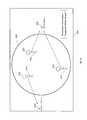
- FIG. 6illustrates a screenshot of an interface 600 for communicating a geofeed including content associated with an orientation attribute that satisfies an orientation parameter, according to an aspect of the invention.
- interface 600may include a geofeed (as illustrated as a circle 601 ) having content items 621 , 622 , and 631 which have been created by content creators 611 , 612 , and 613 , respectively.
- Individual content items 611 , 612 , and 613may be associated with one or more orientation attributes.
- content item 621may be associated with a reference point 620 because content creator 611 created content item 621 while facing reference point 620 .
- the content consumermay also specify an orientation parameter (e.g., “facing the White House,” “facing Southeast,” “Azimuth of 125 degrees,” etc.).
- an orientation parametere.g., “facing the White House,” “facing Southeast,” “Azimuth of 125 degrees,” etc.
- a content consumermay search for geofeed content that have been created while facing the White House (illustrated as reference point 620 ).
- interface 600may display a geofeed having content items 621 and 622 (shown in solid line) where content items 621 and 622 were created while content creators 611 and 612 were facing the White House (therefore satisfies the orientation parameter).
- content item 631which has been created by content creator 613 while facing the Lafayette Square (illustrated as a reference point 630 ) (therefore does not satisfy the orientation parameter) may be displayed differently (e.g., in dotted line) from content items 621 and 622 and/or may be filtered out (or excluded) from the geofeed.
- the geofeed comprising the filtered content(as illustrated as circle 601 and content items 621 and 622 ) may be communicated via interface 600 to the content consumer.
- FIG. 7illustrates a graphical representation 700 of generating a plurality of views of geofeed content based on location and orientation data, according to an aspect of the invention.
- graphical representation 700may include a geofeed (as illustrated as a circle 701 ) having content items 721 , 722 , and 731 .
- Content items 721 and 722may be associated with an orientation attribute that is common to each other (e.g., a reference point 720 ) whereas content items 731 may be associated with a different orientation attribute (e.g., a reference point 730 ).
- the creator of content item 731may have created content item 731 while facing the Boulder Square (illustrated as reference point 730 ) while the creators of content items 721 and 722 may have created content items 721 and 722 while facing the White House (illustrated as reference point 720 ).
- a content consumer 710visits the President's Park in Washington D.C. and searches for geofeed content around the area using a mobile device. Based on the device location (which may be determined by a GPS unit of the device) and the device orientation (which may be determined by obtaining compass data and/or accelerometer data from a compass and/or accelerometer/tilt angle sensor linked to the device), content consumer 710 may obtain different views of the geofeed content. For example, if content consumer 710 holds the device facing the White House (illustrated as reference point 720 ), content consumer 710 may get a front-view 711 which displays content items 721 and 722 , a rear-view 712 which displays content item 731 , and/or other views.
Landscapes
- Engineering & Computer Science (AREA)
- Computer Networks & Wireless Communication (AREA)
- Signal Processing (AREA)
- Theoretical Computer Science (AREA)
- Databases & Information Systems (AREA)
- Data Mining & Analysis (AREA)
- Physics & Mathematics (AREA)
- General Engineering & Computer Science (AREA)
- General Physics & Mathematics (AREA)
- Multimedia (AREA)
- Remote Sensing (AREA)
- Information Transfer Between Computers (AREA)
Abstract
Description
Claims (24)
Priority Applications (2)
| Application Number | Priority Date | Filing Date | Title |
|---|---|---|---|
| US15/018,767US9497275B2 (en) | 2013-03-15 | 2016-02-08 | System and method for generating three-dimensional geofeeds, orientation-based geofeeds, and geofeeds based on ambient conditions based on content provided by social media content providers |
| US15/347,180US9838485B2 (en) | 2013-03-15 | 2016-11-09 | System and method for generating three-dimensional geofeeds, orientation-based geofeeds, and geofeeds based on ambient conditions based on content provided by social media content providers |
Applications Claiming Priority (3)
| Application Number | Priority Date | Filing Date | Title |
|---|---|---|---|
| US13/843,832US8849935B1 (en) | 2013-03-15 | 2013-03-15 | Systems and method for generating three-dimensional geofeeds, orientation-based geofeeds, and geofeeds based on ambient conditions based on content provided by social media content providers |
| US14/500,832US9258373B2 (en) | 2013-03-15 | 2014-09-29 | System and method for generating three-dimensional geofeeds, orientation-based geofeeds, and geofeeds based on ambient conditions based on content provided by social media content providers |
| US15/018,767US9497275B2 (en) | 2013-03-15 | 2016-02-08 | System and method for generating three-dimensional geofeeds, orientation-based geofeeds, and geofeeds based on ambient conditions based on content provided by social media content providers |
Related Parent Applications (1)
| Application Number | Title | Priority Date | Filing Date |
|---|---|---|---|
| US14/500,832ContinuationUS9258373B2 (en) | 2013-03-15 | 2014-09-29 | System and method for generating three-dimensional geofeeds, orientation-based geofeeds, and geofeeds based on ambient conditions based on content provided by social media content providers |
Related Child Applications (1)
| Application Number | Title | Priority Date | Filing Date |
|---|---|---|---|
| US15/347,180ContinuationUS9838485B2 (en) | 2013-03-15 | 2016-11-09 | System and method for generating three-dimensional geofeeds, orientation-based geofeeds, and geofeeds based on ambient conditions based on content provided by social media content providers |
Publications (2)
| Publication Number | Publication Date |
|---|---|
| US20160182656A1 US20160182656A1 (en) | 2016-06-23 |
| US9497275B2true US9497275B2 (en) | 2016-11-15 |
Family
ID=51533453
Family Applications (4)
| Application Number | Title | Priority Date | Filing Date |
|---|---|---|---|
| US13/843,832ActiveUS8849935B1 (en) | 2013-03-15 | 2013-03-15 | Systems and method for generating three-dimensional geofeeds, orientation-based geofeeds, and geofeeds based on ambient conditions based on content provided by social media content providers |
| US14/500,832ActiveUS9258373B2 (en) | 2013-03-15 | 2014-09-29 | System and method for generating three-dimensional geofeeds, orientation-based geofeeds, and geofeeds based on ambient conditions based on content provided by social media content providers |
| US15/018,767ActiveUS9497275B2 (en) | 2013-03-15 | 2016-02-08 | System and method for generating three-dimensional geofeeds, orientation-based geofeeds, and geofeeds based on ambient conditions based on content provided by social media content providers |
| US15/347,180ActiveUS9838485B2 (en) | 2013-03-15 | 2016-11-09 | System and method for generating three-dimensional geofeeds, orientation-based geofeeds, and geofeeds based on ambient conditions based on content provided by social media content providers |
Family Applications Before (2)
| Application Number | Title | Priority Date | Filing Date |
|---|---|---|---|
| US13/843,832ActiveUS8849935B1 (en) | 2013-03-15 | 2013-03-15 | Systems and method for generating three-dimensional geofeeds, orientation-based geofeeds, and geofeeds based on ambient conditions based on content provided by social media content providers |
| US14/500,832ActiveUS9258373B2 (en) | 2013-03-15 | 2014-09-29 | System and method for generating three-dimensional geofeeds, orientation-based geofeeds, and geofeeds based on ambient conditions based on content provided by social media content providers |
Family Applications After (1)
| Application Number | Title | Priority Date | Filing Date |
|---|---|---|---|
| US15/347,180ActiveUS9838485B2 (en) | 2013-03-15 | 2016-11-09 | System and method for generating three-dimensional geofeeds, orientation-based geofeeds, and geofeeds based on ambient conditions based on content provided by social media content providers |
Country Status (1)
| Country | Link |
|---|---|
| US (4) | US8849935B1 (en) |
Cited By (7)
| Publication number | Priority date | Publication date | Assignee | Title |
|---|---|---|---|---|
| US9619489B2 (en) | 2013-03-15 | 2017-04-11 | Geofeedia, Inc. | View of a physical space augmented with social media content originating from a geo-location of the physical space |
| US9805060B2 (en) | 2013-03-15 | 2017-10-31 | Tai Technologies, Inc. | System and method for predicting a geographic origin of content and accuracy of geotags related to content obtained from social media and other content providers |
| US9838485B2 (en)* | 2013-03-15 | 2017-12-05 | Tai Technologies, Inc. | System and method for generating three-dimensional geofeeds, orientation-based geofeeds, and geofeeds based on ambient conditions based on content provided by social media content providers |
| US9906576B2 (en) | 2013-03-07 | 2018-02-27 | Tai Technologies, Inc. | System and method for creating and managing geofeeds |
| US10044732B2 (en) | 2013-03-07 | 2018-08-07 | Tai Technologies, Inc. | System and method for targeted messaging, workflow management, and digital rights management for geofeeds |
| US10158497B2 (en) | 2012-12-07 | 2018-12-18 | Tai Technologies, Inc. | System and method for generating and managing geofeed-based alerts |
| US10523768B2 (en) | 2012-09-14 | 2019-12-31 | Tai Technologies, Inc. | System and method for generating, accessing, and updating geofeeds |
Families Citing this family (16)
| Publication number | Priority date | Publication date | Assignee | Title |
|---|---|---|---|---|
| US8655983B1 (en) | 2012-12-07 | 2014-02-18 | Geofeedr, Inc. | System and method for location monitoring based on organized geofeeds |
| US9307353B2 (en) | 2013-03-07 | 2016-04-05 | Geofeedia, Inc. | System and method for differentially processing a location input for content providers that use different location input formats |
| US9704169B2 (en) | 2013-07-23 | 2017-07-11 | Echosec Systems Ltd. | Digital publication monitoring by geo-location |
| US9485318B1 (en) | 2015-07-29 | 2016-11-01 | Geofeedia, Inc. | System and method for identifying influential social media and providing location-based alerts |
| WO2017091214A1 (en) | 2015-11-24 | 2017-06-01 | Social Sentinel, Inc. | Systems and methods for identifying relationships in social media content |
| US10334134B1 (en)* | 2016-06-20 | 2019-06-25 | Maximillian John Suiter | Augmented real estate with location and chattel tagging system and apparatus for virtual diary, scrapbooking, game play, messaging, canvasing, advertising and social interaction |
| US11785161B1 (en) | 2016-06-20 | 2023-10-10 | Pipbin, Inc. | System for user accessibility of tagged curated augmented reality content |
| US11201981B1 (en) | 2016-06-20 | 2021-12-14 | Pipbin, Inc. | System for notification of user accessibility of curated location-dependent content in an augmented estate |
| US11876941B1 (en) | 2016-06-20 | 2024-01-16 | Pipbin, Inc. | Clickable augmented reality content manager, system, and network |
| US11044393B1 (en) | 2016-06-20 | 2021-06-22 | Pipbin, Inc. | System for curation and display of location-dependent augmented reality content in an augmented estate system |
| US10638256B1 (en)* | 2016-06-20 | 2020-04-28 | Pipbin, Inc. | System for distribution and display of mobile targeted augmented reality content |
| US11184766B1 (en)* | 2016-09-07 | 2021-11-23 | Locurity Inc. | Systems and methods for continuous authentication, identity assurance and access control |
| US10902461B2 (en) | 2018-08-03 | 2021-01-26 | International Business Machines Corporation | Environmental modification using tone model analysis |
| US11333794B2 (en)* | 2018-10-23 | 2022-05-17 | International Business Machines Corporation | Multimedia derived wind map |
| US11899163B2 (en)* | 2019-12-30 | 2024-02-13 | Kristopher Heineman | System and method of evaluating and predicting sports conditions |
| CN118450881A (en) | 2021-12-30 | 2024-08-06 | 高露洁-棕榄公司 | Oral care compositions comprising a flavoring system |
Citations (148)
| Publication number | Priority date | Publication date | Assignee | Title |
|---|---|---|---|---|
| WO1999015995A1 (en) | 1997-09-23 | 1999-04-01 | Information Architects Corporation | System for indexing and displaying requested data having heterogeneous content and representation |
| US6026368A (en) | 1995-07-17 | 2000-02-15 | 24/7 Media, Inc. | On-line interactive system and method for providing content and advertising information to a targeted set of viewers |
| EP1045345A1 (en) | 1999-04-13 | 2000-10-18 | Idc Ltd. | Navigation system display of search engine retrieved data selected according to user-given geographical criteria |
| US20020029384A1 (en) | 2000-07-20 | 2002-03-07 | Griggs Theodore L. | Mechanism for distributing content data |
| US20020029226A1 (en) | 2000-09-05 | 2002-03-07 | Gang Li | Method for combining data with maps |
| US6363320B1 (en) | 2000-08-18 | 2002-03-26 | Geospatial Technologies Inc. | Thin-client real-time interpretive object tracking system |
| US20020116505A1 (en) | 2001-02-19 | 2002-08-22 | Geoff Higgins | Content provider and method for a computer system |
| US20020128908A1 (en) | 2000-09-15 | 2002-09-12 | Levin Brian E. | System for conducting user-specific promotional campaigns using multiple communications device platforms |
| US20020188669A1 (en) | 2001-06-11 | 2002-12-12 | Levine Marc Jay | Integrated method for disseminating large spatial data sets in a distributed form via the internet |
| US20030018607A1 (en) | 2000-08-04 | 2003-01-23 | Lennon Alison Joan | Method of enabling browse and search access to electronically-accessible multimedia databases |
| US20030025832A1 (en) | 2001-08-03 | 2003-02-06 | Swart William D. | Video and digital multimedia aggregator content coding and formatting |
| US20030040971A1 (en) | 2001-08-21 | 2003-02-27 | Candace Freedenberg | User selectable earth imagery on-line e-commerce and fulfillment system |
| US20030088609A1 (en) | 1997-05-02 | 2003-05-08 | Mgi Software Corporation | Method and system for providing on-line interactivity over a server-client network |
| US6591266B1 (en) | 2000-07-14 | 2003-07-08 | Nec Corporation | System and method for intelligent caching and refresh of dynamically generated and static web content |
| US20040205585A1 (en) | 2002-06-28 | 2004-10-14 | Microsoft Corporation | XML storage solution and data interchange file format structure |
| US20040203854A1 (en) | 2002-04-26 | 2004-10-14 | Nowak Steven P. | Formatting location information based on output device specifications |
| US20040225635A1 (en) | 2003-05-09 | 2004-11-11 | Microsoft Corporation | Browsing user interface for a geo-coded media database |
| US20050034074A1 (en) | 2003-06-27 | 2005-02-10 | Cds Business Mapping, Llc | System for increasing accuracy of geocode data |
| US20060002317A1 (en) | 2004-07-01 | 2006-01-05 | Punaganti Venkata Murali Krish | Information feeder framework |
| US20060106778A1 (en) | 2004-10-29 | 2006-05-18 | Microsoft Corporation | System and method for providing a geographic search function |
| US20060184968A1 (en) | 2005-02-11 | 2006-08-17 | Clayton Richard M | Automatic content update for a target device |
| US20060200305A1 (en) | 2005-03-07 | 2006-09-07 | Networks In Motion, Inc. | Method and system for identifying and defining geofences |
| US20070043721A1 (en) | 2005-08-22 | 2007-02-22 | Sanjay Ghemawat | Removing documents |
| US20070112729A1 (en) | 2005-11-04 | 2007-05-17 | Microsoft Corporation | Geo-tagged based listing service and mapping engine |
| US20070121843A1 (en) | 2005-09-02 | 2007-05-31 | Ron Atazky | Advertising and incentives over a social network |
| US20070143345A1 (en) | 2005-10-12 | 2007-06-21 | Jones Michael T | Entity display priority in a distributed geographic information system |
| US20070210937A1 (en) | 2005-04-21 | 2007-09-13 | Microsoft Corporation | Dynamic rendering of map information |
| US20070276919A1 (en) | 2006-05-12 | 2007-11-29 | Daniel Buchmann | Services for data access based on a data ownership directory in distributed system landscapes |
| US20070294299A1 (en) | 2006-01-17 | 2007-12-20 | Hanoch Goldstein | Methods for using geospatial information as geospatial session files |
| US20080092054A1 (en) | 2006-10-17 | 2008-04-17 | Soujanya Bhumkar | Method and system for displaying photos, videos, rss and other media content in full-screen immersive view and grid-view using a browser feature |
| US20080104019A1 (en) | 2006-10-26 | 2008-05-01 | Microsoft Corporation | Associating Geographic-Related Information with Objects |
| US20080125969A1 (en) | 2006-11-20 | 2008-05-29 | Yih-Farn Chen | Method and apparatus for providing geospatial and temporal navigation |
| US20080147674A1 (en) | 2006-02-24 | 2008-06-19 | Srinivasarao Nandiwada | System and method for managing distribution of multi-formatted content |
| US20080162540A1 (en) | 2006-12-29 | 2008-07-03 | Yahoo! Inc. | Identifying offensive content using user click data |
| US20080189099A1 (en) | 2005-01-12 | 2008-08-07 | Howard Friedman | Customizable Delivery of Audio Information |
| US20080192934A1 (en) | 2001-06-29 | 2008-08-14 | Nokia Corporation | Conditional access system |
| US20080250031A1 (en) | 2007-04-03 | 2008-10-09 | Yahoo! Inc. | Systems and methods for providing syndicated content |
| US20080294603A1 (en) | 2007-05-25 | 2008-11-27 | Google Inc. | Providing Profile Information to Partner Content Providers |
| US20090005968A1 (en) | 2007-04-13 | 2009-01-01 | Vengroff Darren E | Location-based information determination |
| US7522940B2 (en) | 2004-11-16 | 2009-04-21 | Sony Ericsson Mobile Communications Ab | Methods and mobile terminals for display of mobile terminal density information |
| US20090102859A1 (en) | 2007-10-18 | 2009-04-23 | Yahoo! Inc. | User augmented reality for camera-enabled mobile devices |
| US20090132435A1 (en) | 2007-11-21 | 2009-05-21 | Microsoft Corporation | Popularity based licensing of user generated content |
| US20090138497A1 (en) | 2007-11-06 | 2009-05-28 | Walter Bruno Zavoli | Method and system for the use of probe data from multiple vehicles to detect real world changes for use in updating a map |
| US20090210426A1 (en) | 2008-02-14 | 2009-08-20 | Ambercore Software Inc. | System and method for efficient management of distributed spatial data |
| US20090217232A1 (en) | 2004-11-22 | 2009-08-27 | Fulcrum Microsystems, Inc. | Logic synthesis of multi-level domino asynchronous pipelines |
| US20090222482A1 (en) | 2008-02-28 | 2009-09-03 | Research In Motion Limited | Method of automatically geotagging data |
| US20090297118A1 (en) | 2008-06-03 | 2009-12-03 | Google Inc. | Web-based system for generation of interactive games based on digital videos |
| US20090300528A1 (en) | 2006-09-29 | 2009-12-03 | Stambaugh Thomas M | Browser event tracking for distributed web-based processing, spatial organization and display of information |
| US20090327232A1 (en) | 2008-06-27 | 2009-12-31 | Surfmap, Inc. | Hosted system for enabling enterprises to build and operate online communities |
| US20100010907A1 (en) | 2008-07-08 | 2010-01-14 | Verizon Data Services Llc. | Method and System for Providing Location Aware Classified Content |
| US20100030648A1 (en) | 2008-08-01 | 2010-02-04 | Microsoft Corporation | Social media driven advertisement targeting |
| US7680796B2 (en) | 2003-09-03 | 2010-03-16 | Google, Inc. | Determining and/or using location information in an ad system |
| US20100076968A1 (en) | 2008-05-27 | 2010-03-25 | Boyns Mark R | Method and apparatus for aggregating and presenting data associated with geographic locations |
| US20100083124A1 (en) | 2008-09-26 | 2010-04-01 | Fwix, Inc. | System and method for aggregating web feeds relevant to a geographical locale from multiple sources |
| US20100079338A1 (en) | 2008-09-30 | 2010-04-01 | Clear Channel Management Services, Inc. | Promotion Using Geopositioning Technology |
| WO2010049918A1 (en) | 2008-10-31 | 2010-05-06 | France Telecom | User interface to provide plurality of inter-related geo-content |
| EP2187594A1 (en) | 2008-11-18 | 2010-05-19 | Alcatel Lucent | Open content distribution platform for media delivery systems |
| US20100145947A1 (en) | 2008-12-05 | 2010-06-10 | Bliin B.V. | Method and apparatus for an inventive geo-network |
| US20100149399A1 (en) | 2007-05-31 | 2010-06-17 | Tsutomu Mukai | Image capturing apparatus, additional information providing server, and additional information filtering system |
| US20100153386A1 (en) | 2008-12-12 | 2010-06-17 | Research In Motion Limited | Method and system for storing multiple geo-tagged media files and rendering the same |
| US20100153410A1 (en) | 2008-12-15 | 2010-06-17 | Verizon Data Services Llc | Distributing and sharing content in a network |
| US20100174998A1 (en) | 2009-01-06 | 2010-07-08 | Kiha Software Inc. | Calendaring Location-Based Events and Associated Travel |
| US20100180001A1 (en) | 2009-01-11 | 2010-07-15 | Dick Clarence Hardt | Contextual messaging and notification system |
| US20100177120A1 (en) | 2009-01-13 | 2010-07-15 | Balfour Technologies Llc | System and method for stretching 3d/4d spatial hierarchy models for improved viewing |
| US20110007941A1 (en) | 2004-07-09 | 2011-01-13 | Ching-Chien Chen | Precisely locating features on geospatial imagery |
| US20110010674A1 (en) | 2009-07-13 | 2011-01-13 | Raytheon Company | Displaying situational information based on geospatial data |
| US20110035284A1 (en) | 2009-08-06 | 2011-02-10 | Mehran Moshfeghi | Location-aware content and location-based advertising with a mobile device |
| US20110040894A1 (en) | 2009-08-13 | 2011-02-17 | Cox Communications, Inc. | Side Loading |
| US20110055176A1 (en) | 2009-09-02 | 2011-03-03 | Korea Advanced Institute Of Science And Technology | Media mediator system and method for managing contents of various formats |
| US7912451B2 (en) | 2007-02-26 | 2011-03-22 | Sony Ericsson Mobile Communications Ab | Limiting use of electronic equipment features based on location |
| US20110072106A1 (en) | 2009-09-22 | 2011-03-24 | Thwapr, Inc. | Hybrid transcoding for mobile media sharing |
| US20110078584A1 (en) | 2009-09-29 | 2011-03-31 | Winterwell Associates Ltd | System for organising social media content to support analysis, workflow and automation |
| US20110083013A1 (en) | 2009-10-07 | 2011-04-07 | Microsoft Corporation | Privacy vault for maintaining the privacy of user profiles |
| US20110113096A1 (en) | 2009-11-10 | 2011-05-12 | Kevin Long | System and method for monitoring activity of a specified user on internet-based social networks |
| US20110131496A1 (en) | 2008-08-06 | 2011-06-02 | David Anthony Shaw Abram | Selection of content to form a presentation ordered sequence and output thereof |
| US20110137561A1 (en) | 2009-12-04 | 2011-06-09 | Nokia Corporation | Method and apparatus for measuring geographic coordinates of a point of interest in an image |
| US20110142347A1 (en) | 2004-07-09 | 2011-06-16 | Ching-Chien Chen | Processing time-based geospatial data |
| US20110153368A1 (en) | 2009-12-17 | 2011-06-23 | XtremeGIS, Inc. | User Interactive Reinsurance Risk Analysis Application |
| US7974983B2 (en) | 2008-11-13 | 2011-07-05 | Buzzient, Inc. | Website network and advertisement analysis using analytic measurement of online social media content |
| US20110202544A1 (en) | 2010-02-12 | 2011-08-18 | Praized Media Inc. | Real time aggregation and filtering of local data feeds |
| US20110227699A1 (en) | 2010-03-22 | 2011-09-22 | Google Inc. | Personalized location tags |
| US20110270940A1 (en) | 2010-04-09 | 2011-11-03 | Weather Decision Technologies | Multimedia alerting |
| US20110288917A1 (en) | 2010-05-21 | 2011-11-24 | James Wanek | Systems and methods for providing mobile targeted advertisements |
| US20110307307A1 (en) | 2010-06-09 | 2011-12-15 | Akram Benmbarek | Systems and methods for location based branding |
| US20120001938A1 (en) | 2010-06-30 | 2012-01-05 | Nokia Corporation | Methods, apparatuses and computer program products for providing a constant level of information in augmented reality |
| US8103741B2 (en) | 2008-03-31 | 2012-01-24 | Verizon Data Services Llc | Location based content aggregation and distribution systems and methods |
| US20120047219A1 (en) | 2010-08-18 | 2012-02-23 | At&T Intellectual Property I, L.P. | Systems and Methods for Social Media Data Mining |
| US20120078503A1 (en) | 2009-06-10 | 2012-03-29 | Ancestralhunt Partners, Llc | System and method for the collaborative collection, assignment, visualization, analysis, and modification of probable genealogical relationships based on geo-spatial and temporal proximity |
| US20120077521A1 (en) | 2010-09-24 | 2012-03-29 | Boldyrev Sergey | Method and apparatus for information aggregation around locations |
| US20120084323A1 (en) | 2010-10-02 | 2012-04-05 | Microsoft Corporation | Geographic text search using image-mined data |
| US20120101880A1 (en) | 2010-10-05 | 2012-04-26 | WeatherAlpha, LLC. | Digital Communication Management System |
| US20120124161A1 (en) | 2010-11-12 | 2012-05-17 | Justin Tidwell | Apparatus and methods ensuring data privacy in a content distribution network |
| US20120150901A1 (en) | 2009-07-10 | 2012-06-14 | Geodex, Llc | Computerized System and Method for Tracking the Geographic Relevance of Website Listings and Providing Graphics and Data Regarding the Same |
| US20120158536A1 (en) | 2010-12-16 | 2012-06-21 | Dish Network L.L.C. | Identifying content purchasing options based on user preferences |
| US20120166367A1 (en) | 2010-12-22 | 2012-06-28 | Yahoo! Inc | Locating a user based on aggregated tweet content associated with a location |
| US20120212398A1 (en) | 2010-02-28 | 2012-08-23 | Osterhout Group, Inc. | See-through near-eye display glasses including a partially reflective, partially transmitting optical element |
| US20120221687A1 (en) | 2011-02-27 | 2012-08-30 | Broadcastr, Inc. | Systems, Methods and Apparatus for Providing a Geotagged Media Experience |
| US20120233158A1 (en) | 2011-03-07 | 2012-09-13 | David Edward Braginsky | Automated Location Check-In for Geo-Social Networking System |
| US20120239763A1 (en) | 2011-03-14 | 2012-09-20 | Shazam Entertainment Ltd. | Systems and Methods for Aggregating and Filtering Content of Social Media Activity |
| US20120254774A1 (en) | 2011-03-30 | 2012-10-04 | Banjo, Inc. | Method for managing a local messaging platform |
| US20120259791A1 (en) | 2011-04-07 | 2012-10-11 | Sabina Zoidze | System and method for social networking |
| US20120276848A1 (en) | 2011-04-26 | 2012-11-01 | Xirrus, Inc. | Wireless array device and system for managing wireless arrays having magnetometers |
| US20120276918A1 (en) | 2011-04-26 | 2012-11-01 | Xirrus, Inc. | Method for determining a geospatial location of a client in signal communication with a wireless array |
| US20120323687A1 (en) | 2011-06-20 | 2012-12-20 | Shopping Made Mobile, Inc. | Mobile Messaging and Data Tracking Platform |
| US8341223B1 (en) | 2011-06-07 | 2012-12-25 | Banjo, Inc. | Method for relevant content discovery |
| US20120330959A1 (en) | 2011-06-27 | 2012-12-27 | Raytheon Company | Method and Apparatus for Assessing a Person's Security Risk |
| US20130013713A1 (en) | 2010-01-22 | 2013-01-10 | Google Inc. | Automated agent for social media systems |
| US20130018957A1 (en) | 2011-07-14 | 2013-01-17 | Parnaby Tracey J | System and Method for Facilitating Management of Structured Sentiment Content |
| US20130054672A1 (en) | 2011-08-31 | 2013-02-28 | Roy Peter John Stilling | Systems and methods for contextualizing a toolbar |
| US20130051611A1 (en) | 2011-08-24 | 2013-02-28 | Michael A. Hicks | Image overlaying and comparison for inventory display auditing |
| US20130060796A1 (en) | 2011-09-07 | 2013-03-07 | Thomas J. Gilg | Content aggregation and mapping |
| US20130073389A1 (en) | 2011-09-15 | 2013-03-21 | Stephan HEATH | System and method for providing sports and sporting events related social/geo/promo link promotional data sets for end user display of interactive ad links, promotions and sale of products, goods, gambling and/or services integrated with 3d spatial geomapping, company and local information for selected worldwide locations and social networking |
| US20130073388A1 (en) | 2011-09-15 | 2013-03-21 | Stephan HEATH | System and method for using impressions tracking and analysis, location information, 2d and 3d mapping, mobile mapping, social media, and user behavior and information for generating mobile and internet posted promotions or offers for, and/or sales of, products and/or services |
| US8428228B1 (en) | 2012-09-18 | 2013-04-23 | Weerawan Wongmanee | Unified communication system |
| US20130110631A1 (en) | 2011-10-28 | 2013-05-02 | Scott Mitchell | System And Method For Aggregating And Distributing Geotagged Content |
| US20130110641A1 (en) | 2011-10-28 | 2013-05-02 | Justin Ormont | Social media network user analysis and related advertising methods |
| US20130124437A1 (en) | 2011-11-16 | 2013-05-16 | Marco Pennacchiotti | Social media user recommendation system and method |
| US20130131918A1 (en) | 2011-11-10 | 2013-05-23 | GM Global Technology Operations LLC | System and method for an information and entertainment system of a motor vehicle |
| US20130132194A1 (en) | 2011-11-17 | 2013-05-23 | Giridhar Rajaram | Targeting advertisements to users of a social networking system based on events |
| US20130150015A1 (en) | 2011-12-13 | 2013-06-13 | Telefonaktiebolaget L M Ericsson (Publ) | Method and apparatus for caching |
| US20130159463A1 (en) | 2011-12-20 | 2013-06-20 | Frisco Smartapps, LLC | Method and system for targeted transmission of content |
| US8484224B1 (en) | 2012-12-07 | 2013-07-09 | Geofeedr, Inc. | System and method for ranking geofeeds and content within geofeeds |
| US20130201182A1 (en) | 2012-02-08 | 2013-08-08 | Canon Kabushiki Kaisha | Image display apparatus, imaging apparatus, image display method, control method for imaging apparatus, and program |
| WO2013133870A2 (en) | 2012-03-07 | 2013-09-12 | Snap Trends, Inc. | Methods and systems of aggregating information of social networks based on geographical locations via a network |
| US20130238658A1 (en) | 2012-03-07 | 2013-09-12 | Snap Trends, Inc. | Methods and Systems of Aggregating Information of Social Networks Based on Changing Geographical Locations of a Computing Device Via a Network |
| US20130290554A1 (en) | 2012-04-26 | 2013-10-31 | Qiming Chen | Open station as a stream analysis operator container |
| US8595317B1 (en) | 2012-09-14 | 2013-11-26 | Geofeedr, Inc. | System and method for generating, accessing, and updating geofeeds |
| US20130325964A1 (en) | 2012-05-30 | 2013-12-05 | Henry Berberat | Location-Based Social Networking System |
| US8612533B1 (en) | 2013-03-07 | 2013-12-17 | Geofeedr, Inc. | System and method for creating and managing geofeeds |
| US20130346563A1 (en) | 2012-06-20 | 2013-12-26 | Tencent Technology (Shenzhen) Company Limited | Method, System, And Apparatus For Exchanging Data Between Client Devices |
| US20140025911A1 (en) | 2011-10-06 | 2014-01-23 | Crossroads Systems, Inc. | System, method and computer program product for optimization of tape performance using distributed file copies |
| US8639767B1 (en) | 2012-12-07 | 2014-01-28 | Geofeedr, Inc. | System and method for generating and managing geofeed-based alerts |
| US20140040371A1 (en) | 2009-12-01 | 2014-02-06 | Topsy Labs, Inc. | Systems and methods for identifying geographic locations of social media content collected over social networks |
| US8655983B1 (en) | 2012-12-07 | 2014-02-18 | Geofeedr, Inc. | System and method for location monitoring based on organized geofeeds |
| US20140089343A1 (en) | 2012-09-25 | 2014-03-27 | Snap Trends, Inc. | Methods and Systems for Monitoring and Controlling Social Network Communications Over a Network at a Secure Location |
| US20140095509A1 (en) | 2012-10-02 | 2014-04-03 | Banjo, Inc. | Method of tagging content lacking geotags with a location |
| US20140195918A1 (en) | 2013-01-07 | 2014-07-10 | Steven Friedlander | Eye tracking user interface |
| US20140222950A1 (en) | 2013-02-04 | 2014-08-07 | Navteq B.V. | Predictive Mobile Map Download |
| US8812951B1 (en) | 2010-12-28 | 2014-08-19 | Amazon Technologies, Inc. | Publisher formatting controls |
| US20140236882A1 (en) | 2013-02-20 | 2014-08-21 | The Florida International University Board Of Trustees | Geolocating social media |
| US20140256355A1 (en) | 2013-03-07 | 2014-09-11 | Geofeedr, Inc. | System and method for differentially processing a location input for content providers that use different location input formats |
| US20140259113A1 (en) | 2013-03-07 | 2014-09-11 | Geofeedr. Inc. | System and method for targeted messaging, workflow management, and digital rights management for geofeeds |
| US20140280103A1 (en) | 2013-03-15 | 2014-09-18 | Geofeedr, Inc. | System and method for predicting a geographic origin of content and accuracy of geotags related to content obtained from social media and other content providers |
| US20140280569A1 (en) | 2013-03-15 | 2014-09-18 | Geofeedr, Inc. | System and method for generating three-dimensional geofeeds, orientation-based geofeeds, and geofeeds based on ambient conditions based on content provided by social media content providers |
| US20140280278A1 (en) | 2013-03-15 | 2014-09-18 | Geofeedia, Inc. | View of a physical space augmented with social media content originating from a geo-location of the physical space |
| US20140297740A1 (en) | 2013-03-27 | 2014-10-02 | Chandrasekher Narayanan | Scoring User Characteristics |
| US20150019866A1 (en) | 2011-08-31 | 2015-01-15 | Sonic Ip, Inc. | Systems and Methods for Automatically Generating Top Level Index Files |
| US20150172396A1 (en) | 2013-12-16 | 2015-06-18 | Co Everywhere, Inc. | Systems and methods for enriching geographically delineated content |
Family Cites Families (10)
| Publication number | Priority date | Publication date | Assignee | Title |
|---|---|---|---|---|
| US7076737B2 (en)* | 1998-12-18 | 2006-07-11 | Tangis Corporation | Thematic response to a computer user's context, such as by a wearable personal computer |
| US20120200403A1 (en)* | 2011-02-09 | 2012-08-09 | Robert Paul Morris | Methods, systems, and computer program products for directing attention to a sequence of viewports of an automotive vehicle |
| US20130262168A1 (en) | 2012-03-30 | 2013-10-03 | Sap Ag | Systems and methods for customer relationship management |
| US20130290207A1 (en) | 2012-04-30 | 2013-10-31 | Gild, Inc. | Method, apparatus and computer program product to generate psychological, emotional, and personality information for electronic job recruiting |
| US8612348B1 (en) | 2012-05-23 | 2013-12-17 | Mp Platforms, Llc | Systems and methods for interfacing merchants with third-party service providers |
| US8910220B2 (en) | 2012-07-12 | 2014-12-09 | Time Warner Cable Enterprises Llc | Multi-format distribution of content |
| US20140143346A1 (en) | 2012-11-16 | 2014-05-22 | International Business Machines Corporation | Identifying And Classifying Travelers Via Social Media Messages |
| US8971930B2 (en) | 2012-12-11 | 2015-03-03 | Blackberry Limited | Geofencing system and method |
| US9485318B1 (en) | 2015-07-29 | 2016-11-01 | Geofeedia, Inc. | System and method for identifying influential social media and providing location-based alerts |
| US20170032384A1 (en) | 2015-07-29 | 2017-02-02 | Geofeedia, Inc. | System and Method for Analyzing Social Media Users Based on User Content Posted from Monitored Locations |
- 2013
- 2013-03-15USUS13/843,832patent/US8849935B1/enactiveActive
- 2014
- 2014-09-29USUS14/500,832patent/US9258373B2/enactiveActive
- 2016
- 2016-02-08USUS15/018,767patent/US9497275B2/enactiveActive
- 2016-11-09USUS15/347,180patent/US9838485B2/enactiveActive
Patent Citations (188)
| Publication number | Priority date | Publication date | Assignee | Title |
|---|---|---|---|---|
| US6026368A (en) | 1995-07-17 | 2000-02-15 | 24/7 Media, Inc. | On-line interactive system and method for providing content and advertising information to a targeted set of viewers |
| US20030088609A1 (en) | 1997-05-02 | 2003-05-08 | Mgi Software Corporation | Method and system for providing on-line interactivity over a server-client network |
| WO1999015995A1 (en) | 1997-09-23 | 1999-04-01 | Information Architects Corporation | System for indexing and displaying requested data having heterogeneous content and representation |
| EP1045345A1 (en) | 1999-04-13 | 2000-10-18 | Idc Ltd. | Navigation system display of search engine retrieved data selected according to user-given geographical criteria |
| US6591266B1 (en) | 2000-07-14 | 2003-07-08 | Nec Corporation | System and method for intelligent caching and refresh of dynamically generated and static web content |
| US20020029384A1 (en) | 2000-07-20 | 2002-03-07 | Griggs Theodore L. | Mechanism for distributing content data |
| US20030018607A1 (en) | 2000-08-04 | 2003-01-23 | Lennon Alison Joan | Method of enabling browse and search access to electronically-accessible multimedia databases |
| US6363320B1 (en) | 2000-08-18 | 2002-03-26 | Geospatial Technologies Inc. | Thin-client real-time interpretive object tracking system |
| US20020029226A1 (en) | 2000-09-05 | 2002-03-07 | Gang Li | Method for combining data with maps |
| US20020128908A1 (en) | 2000-09-15 | 2002-09-12 | Levin Brian E. | System for conducting user-specific promotional campaigns using multiple communications device platforms |
| US20020116505A1 (en) | 2001-02-19 | 2002-08-22 | Geoff Higgins | Content provider and method for a computer system |
| US20020188669A1 (en) | 2001-06-11 | 2002-12-12 | Levine Marc Jay | Integrated method for disseminating large spatial data sets in a distributed form via the internet |
| US20080192934A1 (en) | 2001-06-29 | 2008-08-14 | Nokia Corporation | Conditional access system |
| US20030025832A1 (en) | 2001-08-03 | 2003-02-06 | Swart William D. | Video and digital multimedia aggregator content coding and formatting |
| US20030040971A1 (en) | 2001-08-21 | 2003-02-27 | Candace Freedenberg | User selectable earth imagery on-line e-commerce and fulfillment system |
| US20040203854A1 (en) | 2002-04-26 | 2004-10-14 | Nowak Steven P. | Formatting location information based on output device specifications |
| US20040205585A1 (en) | 2002-06-28 | 2004-10-14 | Microsoft Corporation | XML storage solution and data interchange file format structure |
| US20040225635A1 (en) | 2003-05-09 | 2004-11-11 | Microsoft Corporation | Browsing user interface for a geo-coded media database |
| US20050034074A1 (en) | 2003-06-27 | 2005-02-10 | Cds Business Mapping, Llc | System for increasing accuracy of geocode data |
| US7680796B2 (en) | 2003-09-03 | 2010-03-16 | Google, Inc. | Determining and/or using location information in an ad system |
| US20060002317A1 (en) | 2004-07-01 | 2006-01-05 | Punaganti Venkata Murali Krish | Information feeder framework |
| US20110007941A1 (en) | 2004-07-09 | 2011-01-13 | Ching-Chien Chen | Precisely locating features on geospatial imagery |
| US20110142347A1 (en) | 2004-07-09 | 2011-06-16 | Ching-Chien Chen | Processing time-based geospatial data |
| US20110123066A9 (en) | 2004-07-09 | 2011-05-26 | Ching-Chien Chen | Precisely locating features on geospatial imagery |
| US20060106778A1 (en) | 2004-10-29 | 2006-05-18 | Microsoft Corporation | System and method for providing a geographic search function |
| US7522940B2 (en) | 2004-11-16 | 2009-04-21 | Sony Ericsson Mobile Communications Ab | Methods and mobile terminals for display of mobile terminal density information |
| US20090217232A1 (en) | 2004-11-22 | 2009-08-27 | Fulcrum Microsystems, Inc. | Logic synthesis of multi-level domino asynchronous pipelines |
| US20080189099A1 (en) | 2005-01-12 | 2008-08-07 | Howard Friedman | Customizable Delivery of Audio Information |
| US20060184968A1 (en) | 2005-02-11 | 2006-08-17 | Clayton Richard M | Automatic content update for a target device |
| US20060200305A1 (en) | 2005-03-07 | 2006-09-07 | Networks In Motion, Inc. | Method and system for identifying and defining geofences |
| US20070210937A1 (en) | 2005-04-21 | 2007-09-13 | Microsoft Corporation | Dynamic rendering of map information |
| US20070043721A1 (en) | 2005-08-22 | 2007-02-22 | Sanjay Ghemawat | Removing documents |
| US20070121843A1 (en) | 2005-09-02 | 2007-05-31 | Ron Atazky | Advertising and incentives over a social network |
| US20070143345A1 (en) | 2005-10-12 | 2007-06-21 | Jones Michael T | Entity display priority in a distributed geographic information system |
| US20070112729A1 (en) | 2005-11-04 | 2007-05-17 | Microsoft Corporation | Geo-tagged based listing service and mapping engine |
| US20070294299A1 (en) | 2006-01-17 | 2007-12-20 | Hanoch Goldstein | Methods for using geospatial information as geospatial session files |
| US20080147674A1 (en) | 2006-02-24 | 2008-06-19 | Srinivasarao Nandiwada | System and method for managing distribution of multi-formatted content |
| US20070276919A1 (en) | 2006-05-12 | 2007-11-29 | Daniel Buchmann | Services for data access based on a data ownership directory in distributed system landscapes |
| US20090300528A1 (en) | 2006-09-29 | 2009-12-03 | Stambaugh Thomas M | Browser event tracking for distributed web-based processing, spatial organization and display of information |
| US20080092054A1 (en) | 2006-10-17 | 2008-04-17 | Soujanya Bhumkar | Method and system for displaying photos, videos, rss and other media content in full-screen immersive view and grid-view using a browser feature |
| US7698336B2 (en) | 2006-10-26 | 2010-04-13 | Microsoft Corporation | Associating geographic-related information with objects |
| US20080104019A1 (en) | 2006-10-26 | 2008-05-01 | Microsoft Corporation | Associating Geographic-Related Information with Objects |
| US20080125969A1 (en) | 2006-11-20 | 2008-05-29 | Yih-Farn Chen | Method and apparatus for providing geospatial and temporal navigation |
| US20080162540A1 (en) | 2006-12-29 | 2008-07-03 | Yahoo! Inc. | Identifying offensive content using user click data |
| US7912451B2 (en) | 2007-02-26 | 2011-03-22 | Sony Ericsson Mobile Communications Ab | Limiting use of electronic equipment features based on location |
| US20080250031A1 (en) | 2007-04-03 | 2008-10-09 | Yahoo! Inc. | Systems and methods for providing syndicated content |
| US20090005968A1 (en) | 2007-04-13 | 2009-01-01 | Vengroff Darren E | Location-based information determination |
| US20080294603A1 (en) | 2007-05-25 | 2008-11-27 | Google Inc. | Providing Profile Information to Partner Content Providers |
| US20100149399A1 (en) | 2007-05-31 | 2010-06-17 | Tsutomu Mukai | Image capturing apparatus, additional information providing server, and additional information filtering system |
| US20090102859A1 (en) | 2007-10-18 | 2009-04-23 | Yahoo! Inc. | User augmented reality for camera-enabled mobile devices |
| US20090138497A1 (en) | 2007-11-06 | 2009-05-28 | Walter Bruno Zavoli | Method and system for the use of probe data from multiple vehicles to detect real world changes for use in updating a map |
| US20090132435A1 (en) | 2007-11-21 | 2009-05-21 | Microsoft Corporation | Popularity based licensing of user generated content |
| US20090210426A1 (en) | 2008-02-14 | 2009-08-20 | Ambercore Software Inc. | System and method for efficient management of distributed spatial data |
| US20090222482A1 (en) | 2008-02-28 | 2009-09-03 | Research In Motion Limited | Method of automatically geotagging data |
| US8103741B2 (en) | 2008-03-31 | 2012-01-24 | Verizon Data Services Llc | Location based content aggregation and distribution systems and methods |
| US20100076968A1 (en) | 2008-05-27 | 2010-03-25 | Boyns Mark R | Method and apparatus for aggregating and presenting data associated with geographic locations |
| US20090297118A1 (en) | 2008-06-03 | 2009-12-03 | Google Inc. | Web-based system for generation of interactive games based on digital videos |
| US20090327232A1 (en) | 2008-06-27 | 2009-12-31 | Surfmap, Inc. | Hosted system for enabling enterprises to build and operate online communities |
| US20100010907A1 (en) | 2008-07-08 | 2010-01-14 | Verizon Data Services Llc. | Method and System for Providing Location Aware Classified Content |
| US20100030648A1 (en) | 2008-08-01 | 2010-02-04 | Microsoft Corporation | Social media driven advertisement targeting |
| US20110131496A1 (en) | 2008-08-06 | 2011-06-02 | David Anthony Shaw Abram | Selection of content to form a presentation ordered sequence and output thereof |
| US20100083124A1 (en) | 2008-09-26 | 2010-04-01 | Fwix, Inc. | System and method for aggregating web feeds relevant to a geographical locale from multiple sources |
| US20100079338A1 (en) | 2008-09-30 | 2010-04-01 | Clear Channel Management Services, Inc. | Promotion Using Geopositioning Technology |
| WO2010049918A1 (en) | 2008-10-31 | 2010-05-06 | France Telecom | User interface to provide plurality of inter-related geo-content |
| US7974983B2 (en) | 2008-11-13 | 2011-07-05 | Buzzient, Inc. | Website network and advertisement analysis using analytic measurement of online social media content |
| EP2187594A1 (en) | 2008-11-18 | 2010-05-19 | Alcatel Lucent | Open content distribution platform for media delivery systems |
| US20100145947A1 (en) | 2008-12-05 | 2010-06-10 | Bliin B.V. | Method and apparatus for an inventive geo-network |
| US20100153386A1 (en) | 2008-12-12 | 2010-06-17 | Research In Motion Limited | Method and system for storing multiple geo-tagged media files and rendering the same |
| US20100153410A1 (en) | 2008-12-15 | 2010-06-17 | Verizon Data Services Llc | Distributing and sharing content in a network |
| US20100174998A1 (en) | 2009-01-06 | 2010-07-08 | Kiha Software Inc. | Calendaring Location-Based Events and Associated Travel |
| US20100180001A1 (en) | 2009-01-11 | 2010-07-15 | Dick Clarence Hardt | Contextual messaging and notification system |
| US20100177120A1 (en) | 2009-01-13 | 2010-07-15 | Balfour Technologies Llc | System and method for stretching 3d/4d spatial hierarchy models for improved viewing |
| US20120078503A1 (en) | 2009-06-10 | 2012-03-29 | Ancestralhunt Partners, Llc | System and method for the collaborative collection, assignment, visualization, analysis, and modification of probable genealogical relationships based on geo-spatial and temporal proximity |
| US20120150901A1 (en) | 2009-07-10 | 2012-06-14 | Geodex, Llc | Computerized System and Method for Tracking the Geographic Relevance of Website Listings and Providing Graphics and Data Regarding the Same |
| US20110010674A1 (en) | 2009-07-13 | 2011-01-13 | Raytheon Company | Displaying situational information based on geospatial data |
| US20110035284A1 (en) | 2009-08-06 | 2011-02-10 | Mehran Moshfeghi | Location-aware content and location-based advertising with a mobile device |
| US20110040894A1 (en) | 2009-08-13 | 2011-02-17 | Cox Communications, Inc. | Side Loading |
| US20110055176A1 (en) | 2009-09-02 | 2011-03-03 | Korea Advanced Institute Of Science And Technology | Media mediator system and method for managing contents of various formats |
| EP2293566A2 (en) | 2009-09-02 | 2011-03-09 | Korea Advanced Institute of Science and Technology | Media mediator system and method for managing contents of various formats |
| US20110072114A1 (en) | 2009-09-22 | 2011-03-24 | Thwapr, Inc. | Subscribing to mobile media sharing |
| US20110072106A1 (en) | 2009-09-22 | 2011-03-24 | Thwapr, Inc. | Hybrid transcoding for mobile media sharing |
| US20110078584A1 (en) | 2009-09-29 | 2011-03-31 | Winterwell Associates Ltd | System for organising social media content to support analysis, workflow and automation |
| US20110083013A1 (en) | 2009-10-07 | 2011-04-07 | Microsoft Corporation | Privacy vault for maintaining the privacy of user profiles |
| US20110113096A1 (en) | 2009-11-10 | 2011-05-12 | Kevin Long | System and method for monitoring activity of a specified user on internet-based social networks |
| US20140040371A1 (en) | 2009-12-01 | 2014-02-06 | Topsy Labs, Inc. | Systems and methods for identifying geographic locations of social media content collected over social networks |
| US20110137561A1 (en) | 2009-12-04 | 2011-06-09 | Nokia Corporation | Method and apparatus for measuring geographic coordinates of a point of interest in an image |
| US20110153368A1 (en) | 2009-12-17 | 2011-06-23 | XtremeGIS, Inc. | User Interactive Reinsurance Risk Analysis Application |
| US20120232939A1 (en) | 2009-12-17 | 2012-09-13 | Xtreme GIS, Inc. | Method for Rendering Layer Images and Providing Information |
| US20130013713A1 (en) | 2010-01-22 | 2013-01-10 | Google Inc. | Automated agent for social media systems |
| US20110202544A1 (en) | 2010-02-12 | 2011-08-18 | Praized Media Inc. | Real time aggregation and filtering of local data feeds |
| US20120212398A1 (en) | 2010-02-28 | 2012-08-23 | Osterhout Group, Inc. | See-through near-eye display glasses including a partially reflective, partially transmitting optical element |
| US20110227699A1 (en) | 2010-03-22 | 2011-09-22 | Google Inc. | Personalized location tags |
| US20110270940A1 (en) | 2010-04-09 | 2011-11-03 | Weather Decision Technologies | Multimedia alerting |
| US20110288917A1 (en) | 2010-05-21 | 2011-11-24 | James Wanek | Systems and methods for providing mobile targeted advertisements |
| US20110307307A1 (en) | 2010-06-09 | 2011-12-15 | Akram Benmbarek | Systems and methods for location based branding |
| US20120001938A1 (en) | 2010-06-30 | 2012-01-05 | Nokia Corporation | Methods, apparatuses and computer program products for providing a constant level of information in augmented reality |
| US20120047219A1 (en) | 2010-08-18 | 2012-02-23 | At&T Intellectual Property I, L.P. | Systems and Methods for Social Media Data Mining |
| US20120077521A1 (en) | 2010-09-24 | 2012-03-29 | Boldyrev Sergey | Method and apparatus for information aggregation around locations |
| US20120084323A1 (en) | 2010-10-02 | 2012-04-05 | Microsoft Corporation | Geographic text search using image-mined data |
| US20120101880A1 (en) | 2010-10-05 | 2012-04-26 | WeatherAlpha, LLC. | Digital Communication Management System |
| US20120124161A1 (en) | 2010-11-12 | 2012-05-17 | Justin Tidwell | Apparatus and methods ensuring data privacy in a content distribution network |
| US20120158536A1 (en) | 2010-12-16 | 2012-06-21 | Dish Network L.L.C. | Identifying content purchasing options based on user preferences |
| US20120166367A1 (en) | 2010-12-22 | 2012-06-28 | Yahoo! Inc | Locating a user based on aggregated tweet content associated with a location |
| US8812951B1 (en) | 2010-12-28 | 2014-08-19 | Amazon Technologies, Inc. | Publisher formatting controls |
| US20120221687A1 (en) | 2011-02-27 | 2012-08-30 | Broadcastr, Inc. | Systems, Methods and Apparatus for Providing a Geotagged Media Experience |
| US20120233158A1 (en) | 2011-03-07 | 2012-09-13 | David Edward Braginsky | Automated Location Check-In for Geo-Social Networking System |
| US20120239763A1 (en) | 2011-03-14 | 2012-09-20 | Shazam Entertainment Ltd. | Systems and Methods for Aggregating and Filtering Content of Social Media Activity |
| US20120254774A1 (en) | 2011-03-30 | 2012-10-04 | Banjo, Inc. | Method for managing a local messaging platform |
| US20120259791A1 (en) | 2011-04-07 | 2012-10-11 | Sabina Zoidze | System and method for social networking |
| US20120276848A1 (en) | 2011-04-26 | 2012-11-01 | Xirrus, Inc. | Wireless array device and system for managing wireless arrays having magnetometers |
| US20120276918A1 (en) | 2011-04-26 | 2012-11-01 | Xirrus, Inc. | Method for determining a geospatial location of a client in signal communication with a wireless array |
| US8341223B1 (en) | 2011-06-07 | 2012-12-25 | Banjo, Inc. | Method for relevant content discovery |
| US20130073631A1 (en) | 2011-06-07 | 2013-03-21 | Banjo, Inc. | Method for relevant content discovery |
| US20120323687A1 (en) | 2011-06-20 | 2012-12-20 | Shopping Made Mobile, Inc. | Mobile Messaging and Data Tracking Platform |
| US20120330959A1 (en) | 2011-06-27 | 2012-12-27 | Raytheon Company | Method and Apparatus for Assessing a Person's Security Risk |
| US20130018957A1 (en) | 2011-07-14 | 2013-01-17 | Parnaby Tracey J | System and Method for Facilitating Management of Structured Sentiment Content |
| US20130051611A1 (en) | 2011-08-24 | 2013-02-28 | Michael A. Hicks | Image overlaying and comparison for inventory display auditing |
| US20130054672A1 (en) | 2011-08-31 | 2013-02-28 | Roy Peter John Stilling | Systems and methods for contextualizing a toolbar |
| US20150019866A1 (en) | 2011-08-31 | 2015-01-15 | Sonic Ip, Inc. | Systems and Methods for Automatically Generating Top Level Index Files |
| US20130060796A1 (en) | 2011-09-07 | 2013-03-07 | Thomas J. Gilg | Content aggregation and mapping |
| US20130073389A1 (en) | 2011-09-15 | 2013-03-21 | Stephan HEATH | System and method for providing sports and sporting events related social/geo/promo link promotional data sets for end user display of interactive ad links, promotions and sale of products, goods, gambling and/or services integrated with 3d spatial geomapping, company and local information for selected worldwide locations and social networking |
| US20130073388A1 (en) | 2011-09-15 | 2013-03-21 | Stephan HEATH | System and method for using impressions tracking and analysis, location information, 2d and 3d mapping, mobile mapping, social media, and user behavior and information for generating mobile and internet posted promotions or offers for, and/or sales of, products and/or services |
| US20140025911A1 (en) | 2011-10-06 | 2014-01-23 | Crossroads Systems, Inc. | System, method and computer program product for optimization of tape performance using distributed file copies |
| US20130110641A1 (en) | 2011-10-28 | 2013-05-02 | Justin Ormont | Social media network user analysis and related advertising methods |
| US20130110631A1 (en) | 2011-10-28 | 2013-05-02 | Scott Mitchell | System And Method For Aggregating And Distributing Geotagged Content |
| US20140164368A1 (en) | 2011-10-28 | 2014-06-12 | Geofeedia, Inc. | System and method for aggregating and distributing geotagged content |
| US8655873B2 (en) | 2011-10-28 | 2014-02-18 | Geofeedr, Inc. | System and method for aggregating and distributing geotagged content |
| US20130131918A1 (en) | 2011-11-10 | 2013-05-23 | GM Global Technology Operations LLC | System and method for an information and entertainment system of a motor vehicle |
| US20130124437A1 (en) | 2011-11-16 | 2013-05-16 | Marco Pennacchiotti | Social media user recommendation system and method |
| US20130132194A1 (en) | 2011-11-17 | 2013-05-23 | Giridhar Rajaram | Targeting advertisements to users of a social networking system based on events |
| US20130150015A1 (en) | 2011-12-13 | 2013-06-13 | Telefonaktiebolaget L M Ericsson (Publ) | Method and apparatus for caching |
| US20130159463A1 (en) | 2011-12-20 | 2013-06-20 | Frisco Smartapps, LLC | Method and system for targeted transmission of content |
| US20130201182A1 (en) | 2012-02-08 | 2013-08-08 | Canon Kabushiki Kaisha | Image display apparatus, imaging apparatus, image display method, control method for imaging apparatus, and program |
| US20140089296A1 (en) | 2012-03-07 | 2014-03-27 | Snap Trends, Inc. | Methods and Systems of Aggregating Information of Social Networks Based on Changing Geographical Locations of a Computing Device Via a Network |
| US20130238658A1 (en) | 2012-03-07 | 2013-09-12 | Snap Trends, Inc. | Methods and Systems of Aggregating Information of Social Networks Based on Changing Geographical Locations of a Computing Device Via a Network |
| WO2013133870A2 (en) | 2012-03-07 | 2013-09-12 | Snap Trends, Inc. | Methods and systems of aggregating information of social networks based on geographical locations via a network |
| US20130238652A1 (en) | 2012-03-07 | 2013-09-12 | Snap Trends, Inc. | Methods and Systems of Aggregating Information of Social Networks Based on Geographical Locations Via a Network |
| US20130268558A1 (en) | 2012-03-07 | 2013-10-10 | Snap Trends, Inc. | Methods and Systems of Aggregating Information of Social Networks Based on Changing Geographical Locations of a Computing Device Via a Network |
| US8843515B2 (en) | 2012-03-07 | 2014-09-23 | Snap Trends, Inc. | Methods and systems of aggregating information of social networks based on geographical locations via a network |
| WO2013134451A1 (en) | 2012-03-07 | 2013-09-12 | Snap Trends, Inc. | Methods and systems of aggregating information of social networks based on changing geographical locations of a computing device via a network |
| US20130238599A1 (en) | 2012-03-07 | 2013-09-12 | Snap Trends, Inc. | Methods and Systems of Aggregating Information of Social Networks Based on Geographical Locations Via a Network |
| US20130290554A1 (en) | 2012-04-26 | 2013-10-31 | Qiming Chen | Open station as a stream analysis operator container |
| US20130325964A1 (en) | 2012-05-30 | 2013-12-05 | Henry Berberat | Location-Based Social Networking System |
| US20130346563A1 (en) | 2012-06-20 | 2013-12-26 | Tencent Technology (Shenzhen) Company Limited | Method, System, And Apparatus For Exchanging Data Between Client Devices |
| US9055074B2 (en) | 2012-09-14 | 2015-06-09 | Geofeedia, Inc. | System and method for generating, accessing, and updating geofeeds |
| US20160014219A1 (en) | 2012-09-14 | 2016-01-14 | Geofeedia, Inc. | System and method for generating, accessing, and updating geofeeds |
| US8595317B1 (en) | 2012-09-14 | 2013-11-26 | Geofeedr, Inc. | System and method for generating, accessing, and updating geofeeds |
| US20140089461A1 (en) | 2012-09-14 | 2014-03-27 | Geofeedr, Inc. | System and method for generating, accessing, and updating geofeeds |
| US8428228B1 (en) | 2012-09-18 | 2013-04-23 | Weerawan Wongmanee | Unified communication system |
| US20140089343A1 (en) | 2012-09-25 | 2014-03-27 | Snap Trends, Inc. | Methods and Systems for Monitoring and Controlling Social Network Communications Over a Network at a Secure Location |
| US20140095509A1 (en) | 2012-10-02 | 2014-04-03 | Banjo, Inc. | Method of tagging content lacking geotags with a location |
| US8655983B1 (en) | 2012-12-07 | 2014-02-18 | Geofeedr, Inc. | System and method for location monitoring based on organized geofeeds |
| US8484224B1 (en) | 2012-12-07 | 2013-07-09 | Geofeedr, Inc. | System and method for ranking geofeeds and content within geofeeds |
| US20150381380A1 (en) | 2012-12-07 | 2015-12-31 | Geofeedia, Inc. | System and method for generating and managing geofeed-based alerts |
| US20150256632A1 (en) | 2012-12-07 | 2015-09-10 | Geofeedia, Inc. | System and method for location monitoring based on organized geofeeds |
| US20140274148A1 (en) | 2012-12-07 | 2014-09-18 | Geofeedia, Inc. | System and method for location monitoring based on organized geofeeds |
| US9077675B2 (en) | 2012-12-07 | 2015-07-07 | Geofeedia, Inc. | System and method for generating and managing geofeed-based alerts |
| US20140207893A1 (en) | 2012-12-07 | 2014-07-24 | Geofeedia, Inc. | System and method for generating and managing geofeed-based alerts |
| US8639767B1 (en) | 2012-12-07 | 2014-01-28 | Geofeedr, Inc. | System and method for generating and managing geofeed-based alerts |
| US9369533B2 (en) | 2012-12-07 | 2016-06-14 | Geofeedia, Inc. | System and method for location monitoring based on organized geofeeds |
| US8990346B2 (en) | 2012-12-07 | 2015-03-24 | Geofeedia, Inc. | System and method for location monitoring based on organized geofeeds |
| US20140195918A1 (en) | 2013-01-07 | 2014-07-10 | Steven Friedlander | Eye tracking user interface |
| US20140222950A1 (en) | 2013-02-04 | 2014-08-07 | Navteq B.V. | Predictive Mobile Map Download |
| US20140236882A1 (en) | 2013-02-20 | 2014-08-21 | The Florida International University Board Of Trustees | Geolocating social media |
| US9077782B2 (en) | 2013-03-07 | 2015-07-07 | Geofeedia, Inc. | System and method for creating and managing geofeeds |
| US20140258451A1 (en) | 2013-03-07 | 2014-09-11 | Geofeedr, Inc. | System and method for creating and managing geofeeds |
| US9443090B2 (en) | 2013-03-07 | 2016-09-13 | Geofeedia, Inc. | System and method for targeted messaging, workflow management, and digital rights management for geofeeds |
| US20150020208A1 (en) | 2013-03-07 | 2015-01-15 | Geofeedia, Inc. | System and method for targeted messaging, workflow management, and digital rights management for geofeeds |
| US20160219403A1 (en) | 2013-03-07 | 2016-07-28 | Geofeedia, Inc. | System and method for differentially processing a location input for content providers that use different location input formats |
| US8612533B1 (en) | 2013-03-07 | 2013-12-17 | Geofeedr, Inc. | System and method for creating and managing geofeeds |
| US9307353B2 (en) | 2013-03-07 | 2016-04-05 | Geofeedia, Inc. | System and method for differentially processing a location input for content providers that use different location input formats |
| US8850531B1 (en) | 2013-03-07 | 2014-09-30 | Geofeedia, Inc. | System and method for targeted messaging, workflow management, and digital rights management for geofeeds |
| US20140256355A1 (en) | 2013-03-07 | 2014-09-11 | Geofeedr, Inc. | System and method for differentially processing a location input for content providers that use different location input formats |
| US20160006783A1 (en) | 2013-03-07 | 2016-01-07 | Geofeedia, Inc. | System and method for creating and managing geofeeds |
| US20140259113A1 (en) | 2013-03-07 | 2014-09-11 | Geofeedr. Inc. | System and method for targeted messaging, workflow management, and digital rights management for geofeeds |
| US20140280103A1 (en) | 2013-03-15 | 2014-09-18 | Geofeedr, Inc. | System and method for predicting a geographic origin of content and accuracy of geotags related to content obtained from social media and other content providers |
| US20140280569A1 (en) | 2013-03-15 | 2014-09-18 | Geofeedr, Inc. | System and method for generating three-dimensional geofeeds, orientation-based geofeeds, and geofeeds based on ambient conditions based on content provided by social media content providers |
| US20140280278A1 (en) | 2013-03-15 | 2014-09-18 | Geofeedia, Inc. | View of a physical space augmented with social media content originating from a geo-location of the physical space |
| US9258373B2 (en)* | 2013-03-15 | 2016-02-09 | Geofeedia, Inc. | System and method for generating three-dimensional geofeeds, orientation-based geofeeds, and geofeeds based on ambient conditions based on content provided by social media content providers |
| US20150032739A1 (en) | 2013-03-15 | 2015-01-29 | Geofeedia, Inc. | System and method for predicting a geographic origin of content and accuracy of geotags related to content obtained from social media and other content providers |
| US9317600B2 (en) | 2013-03-15 | 2016-04-19 | Geofeedia, Inc. | View of a physical space augmented with social media content originating from a geo-location of the physical space |
| US8849935B1 (en) | 2013-03-15 | 2014-09-30 | Geofeedia, Inc. | Systems and method for generating three-dimensional geofeeds, orientation-based geofeeds, and geofeeds based on ambient conditions based on content provided by social media content providers |
| US20150019648A1 (en) | 2013-03-15 | 2015-01-15 | Geofeedia, Inc. | System and method for generating three-dimensional geofeeds, orientation-based geofeeds, and geofeeds based on ambient conditions based on content provided by social media content providers |
| US20160232182A1 (en) | 2013-03-15 | 2016-08-11 | Geofeedia, Inc. | View of a physical space augmented with social media content originating from a geo-location of the physical space |
| US9436690B2 (en) | 2013-03-15 | 2016-09-06 | Geofeedia, Inc. | System and method for predicting a geographic origin of content and accuracy of geotags related to content obtained from social media and other content providers |
| US8862589B2 (en) | 2013-03-15 | 2014-10-14 | Geofeedia, Inc. | System and method for predicting a geographic origin of content and accuracy of geotags related to content obtained from social media and other content providers |
| US20140297740A1 (en) | 2013-03-27 | 2014-10-02 | Chandrasekher Narayanan | Scoring User Characteristics |
| US20150172396A1 (en) | 2013-12-16 | 2015-06-18 | Co Everywhere, Inc. | Systems and methods for enriching geographically delineated content |
Non-Patent Citations (65)
| Title |
|---|
| Amitay et al., "Web-a-Where: Geotaqqinq Web Content", Proceedings of the 27th Annual International ACM SIGIR Conference on Research and Development in Information Retrieval (SIGIR), 2004, pp. 273-280. |
| Bao, Jie, et al.. "GeoFeed: A Location-Aware News Feed System", IEEE Xplore Digital Library, Published in 2012 IEEE 28th International Conference on Data Engineering, Apr. 1-5, 2012, 14 pages. |
| Chow et al., "Towards Location-Based Social Networking Services", LBSN 2010 Proceedings of the 2nd ACM SIGSPATIAL International Workshop on Location Based Social Networks, Nov. 2, 2010, pp. 31-38. |
| Lee et al., "Tag-Geotag Correlation in Social Networks", Proceedings of the 2008 ACM Workshop on Search in Social Media, 2008, pp. 59-66. |
| Sarwat, Mohamed, et al., "Sindbad: A Location-Based Social Networking System", SIGMOD '12, Scottsdale, Arizona, May 20-24, 2012, 4 pages. |
| U.S. Appl. No. 13/284,455, a non-final Office Action, mailed Jan. 7, 2013, 18 pages. |
| U.S. Appl. No. 13/284,455, a non-final Office Action, mailed Jun. 4, 2013, 28 pages. |
| U.S. Appl. No. 13/284,455, a Notice of Allowance, mailed Oct. 4, 2013, 17 pages. |
| U.S. Appl. No. 13/619,888, a non-final Office Action, mailed Mar. 1, 2013, 15 pages. |
| U.S. Appl. No. 13/619,888, a Notice of Allowance, mailed Jul. 9, 2013, 10 pages. |
| U.S. Appl. No. 13/708,404, a Notice of Allowance, mailed May 24, 2013, 12 pages. |
| U.S. Appl. No. 13/708,466, a non-final Office Action, mailed Apr. 17, 2013, 15 pages. |
| U.S. Appl. No. 13/708,466, a Notice of Allowance, mailed Sep. 3, 2013, 11 pages. |
| U.S. Appl. No. 13/708,516, a non-final Office Action, mailed May 15, 2013, 11 pages. |
| U.S. Appl. No. 13/708,516, a Notice of Allowance, mailed Jun. 7, 2013, 14 pages. |
| U.S. Appl. No. 13/788,760, a Notice of Allowance, mailed Jul. 26, 2013, 12 pages. |
| U.S. Appl. No. 13/788,843, a final Office Action, mailed Jan. 21, 2014, 25 pages. |
| U.S. Appl. No. 13/788,843, a non-final Office Action, mailed Aug. 5, 2013, 17 pages. |
| U.S. Appl. No. 13/788,843, a non-final Office Action, mailed Feb. 20, 2015, 26 pages. |
| U.S. Appl. No. 13/788,843, a Notice of Allowance, mailed Dec. 3, 2015, 18 pages. |
| U.S. Appl. No. 13/788,909, a non-final Office Action, mailed Aug. 12, 2013, 17 pages. |
| U.S. Appl. No. 13/788,909, a Notice of Allowance, mailed Jan. 24, 2014, 12 pages. |
| U.S. Appl. No. 13/788,909, a Notice of Allowance, mailed Jun. 24, 2014, 11 pages. |
| U.S. Appl. No. 13/843,832, a non-final Office Action, mailed Sep. 13, 2013, 12 pages. |
| U.S. Appl. No. 13/843,832, a Notice of Allowance, mailed Jan. 24, 2014, 6 pages. |
| U.S. Appl. No. 13/843,832, a Notice of Allowance, mailed May 20, 2014, 7 pages. |
| U.S. Appl. No. 13/843,949, a non-final Office Action, mailed Aug. 29, 2013, 12 pages. |
| U.S. Appl. No. 13/843,949, a Notice of Allowance, mailed Feb. 3, 2014, 11 pages. |
| U.S. Appl. No. 13/843,949, a Notice of Allowance, mailed May 9, 2014, 10 pages. |
| U.S. Appl. No. 14/089,631, a final Office Action, mailed Jan. 2, 2015, 8 pages. |
| U.S. Appl. No. 14/089,631, a non-final Office Action, mailed Jul. 8, 2014, 21 pages. |
| U.S. Appl. No. 14/089,631, a Notice of Allowance, mailed Feb. 2, 2015, 10 pages. |
| U.S. Appl. No. 14/108,301, a non-final Office Action, mailed Sep. 11, 2014, 10 pages. |
| U.S. Appl. No. 14/108,301, a Notice of Allowance, mailed Feb. 20, 2015, 13 pages. |
| U.S. Appl. No. 14/164,362, a non-final Office Action, mailed Oct. 23, 2014, 15 pages. |
| U.S. Appl. No. 14/164,362, a Notice of Allowance, mailed Feb. 24, 2015, 22 pages. |
| U.S. Appl. No. 14/180,473, a final Office Action, mailed Jan. 5, 2015, 7 pages. |
| U.S. Appl. No. 14/180,473, a non-final Office Action, mailed Jul. 8, 2014, 18 pages. |
| U.S. Appl. No. 14/180,473, a Notice of Allowance, mailed Jan. 27, 2015, 8 pages. |
| U.S. Appl. No. 14/180,845, a final Office Action, mailed Feb. 22, 2016, 43 pages. |
| U.S. Appl. No. 14/180,845, a final Office Action, mailed Feb. 25, 2015, 32 pages. |
| U.S. Appl. No. 14/180,845, a non-final Office Action, mailed Aug. 27, 2015, 43 pages. |
| U.S. Appl. No. 14/180,845, a non-final Office Action, mailed Jul. 7, 2016, 51 pages. |
| U.S. Appl. No. 14/180,845, a non-final Office Action, mailed Oct. 23, 2014, 32 pages. |
| U.S. Appl. No. 14/215,612, a final Office Action, mailed Nov. 28, 2014, 31 pages. |
| U.S. Appl. No. 14/215,612, a non-final Office Action, mailed Aug. 18, 2015, 27 pages. |
| U.S. Appl. No. 14/215,612, a non-final Office Action, mailed Jul. 11, 2014, 16 pages. |
| U.S. Appl. No. 14/500,832, a non-final Office Action, mailed May 21, 2015, 13 pages. |
| U.S. Appl. No. 14/500,881, a non-final Office Action, mailed Dec. 21, 2015, 24 pages. |
| U.S. Appl. No. 14/500,881, a non-final Office Action, mailed Sep. 21, 2015, 5 pages. |
| U.S. Appl. No. 14/512,293, a Final Office Action, mailed Apr. 6, 2016, 9 pages. |
| U.S. Appl. No. 14/512,293, a final Office Action, mailed Aug. 14, 2015, 15 pages. |
| U.S. Appl. No. 14/512,293, a non-final Office Action, mailed Dec. 9, 2015, 14 pages. |
| U.S. Appl. No. 14/512,293, a non-final Office Action, mailed Jan. 28, 2015, 18 pages. |
| U.S. Appl. No. 14/666,056, a Final Office Action, mailed Jan. 4, 2016, 11 pages. |
| U.S. Appl. No. 14/666,056, a non-final Office Action, mailed Aug. 10, 2015, 17 pages. |
| U.S. Appl. No. 14/733,715, a Final Office Action, mailed Aug. 17, 2016, 21 pages. |
| U.S. Appl. No. 14/733,715, a non-final Office Action, mailed Mar. 11, 2016, 25 pages. |
| U.S. Appl. No. 14/792,538, a non-final Office Action, mailed Feb. 26, 2016, 20 pages. |
| U.S. Appl. No. 14/813,031, a final Office Action, mailed Mar. 21, 2016, 41 pages. |
| U.S. Appl. No. 14/813,031, a non-final Office Action, mailed Aug. 5, 2016, 46 pages. |
| U.S. Appl. No. 14/813,031, a non-final Office Action, mailed Nov. 24, 2015, 23 pages. |
| U.S. Appl. No. 14/813,039, a Final Office Action, mailed May 16, 2016, 14 pages. |
| U.S. Appl. No. 14/813,039, a non-final Office Action, mailed Jan. 20, 2016, 20 pages. |
| U.S. Appl. No. 15/130,289, a non-final Office Action, mailed Aug. 10, 2016, 42 pages. |
Cited By (8)
| Publication number | Priority date | Publication date | Assignee | Title |
|---|---|---|---|---|
| US10523768B2 (en) | 2012-09-14 | 2019-12-31 | Tai Technologies, Inc. | System and method for generating, accessing, and updating geofeeds |
| US10158497B2 (en) | 2012-12-07 | 2018-12-18 | Tai Technologies, Inc. | System and method for generating and managing geofeed-based alerts |
| US9906576B2 (en) | 2013-03-07 | 2018-02-27 | Tai Technologies, Inc. | System and method for creating and managing geofeeds |
| US10044732B2 (en) | 2013-03-07 | 2018-08-07 | Tai Technologies, Inc. | System and method for targeted messaging, workflow management, and digital rights management for geofeeds |
| US10530783B2 (en) | 2013-03-07 | 2020-01-07 | Tai Technologies, Inc. | System and method for targeted messaging, workflow management, and digital rights management for geofeeds |
| US9619489B2 (en) | 2013-03-15 | 2017-04-11 | Geofeedia, Inc. | View of a physical space augmented with social media content originating from a geo-location of the physical space |
| US9805060B2 (en) | 2013-03-15 | 2017-10-31 | Tai Technologies, Inc. | System and method for predicting a geographic origin of content and accuracy of geotags related to content obtained from social media and other content providers |
| US9838485B2 (en)* | 2013-03-15 | 2017-12-05 | Tai Technologies, Inc. | System and method for generating three-dimensional geofeeds, orientation-based geofeeds, and geofeeds based on ambient conditions based on content provided by social media content providers |
Also Published As
| Publication number | Publication date |
|---|---|
| US9258373B2 (en) | 2016-02-09 |
| US9838485B2 (en) | 2017-12-05 |
| US20140280569A1 (en) | 2014-09-18 |
| US20160182656A1 (en) | 2016-06-23 |
| US8849935B1 (en) | 2014-09-30 |
| US20150019648A1 (en) | 2015-01-15 |
| US20170064017A1 (en) | 2017-03-02 |
Similar Documents
| Publication | Publication Date | Title |
|---|---|---|
| US9838485B2 (en) | System and method for generating three-dimensional geofeeds, orientation-based geofeeds, and geofeeds based on ambient conditions based on content provided by social media content providers | |
| US9805060B2 (en) | System and method for predicting a geographic origin of content and accuracy of geotags related to content obtained from social media and other content providers | |
| US9619489B2 (en) | View of a physical space augmented with social media content originating from a geo-location of the physical space | |
| US10523768B2 (en) | System and method for generating, accessing, and updating geofeeds | |
| US8484224B1 (en) | System and method for ranking geofeeds and content within geofeeds | |
| US9307353B2 (en) | System and method for differentially processing a location input for content providers that use different location input formats | |
| US10021524B2 (en) | Displaying location-based images that match the weather conditions | |
| US9805065B2 (en) | Computer-vision-assisted location accuracy augmentation | |
| US9906576B2 (en) | System and method for creating and managing geofeeds | |
| US9830337B2 (en) | Computer-vision-assisted location check-in | |
| US9563850B2 (en) | Method and interface for displaying locations associated with annotations | |
| US20120313780A1 (en) | Creating and monitoring alerts for a geographical area | |
| WO2011114202A1 (en) | Methods, devices, and computer program products for classifying digital media files based on associated geographical identification metadata | |
| Ennis et al. | High-level geospatial information discovery and fusion for geocoded multimedia |
Legal Events
| Date | Code | Title | Description |
|---|---|---|---|
| AS | Assignment | Owner name:GEOFEEDR, INC., FLORIDA Free format text:ASSIGNMENT OF ASSIGNORS INTEREST;ASSIGNORS:HARRIS, PHILIP B.;MITCHELL, SCOTT K.;MULROY, MICHAEL J.;REEL/FRAME:037689/0247 Effective date:20130315 Owner name:GEOFEEDIA, INC., ILLINOIS Free format text:MERGER;ASSIGNOR:GEOFEEDR, INC.;REEL/FRAME:037690/0510 Effective date:20120628 | |
| STCF | Information on status: patent grant | Free format text:PATENTED CASE | |
| AS | Assignment | Owner name:TAI TECHNOLOGIES, INC., FLORIDA Free format text:ASSIGNMENT OF ASSIGNORS INTEREST;ASSIGNOR:GEOFEEDIA, INC.;REEL/FRAME:042250/0195 Effective date:20170428 | |
| AS | Assignment | Owner name:TRIPLEPOINT CAPITAL LLC, CALIFORNIA Free format text:SECURITY INTEREST;ASSIGNOR:SOCIAL SENTINEL, INC.;REEL/FRAME:052287/0700 Effective date:20200324 | |
| MAFP | Maintenance fee payment | Free format text:PAYMENT OF MAINTENANCE FEE, 4TH YR, SMALL ENTITY (ORIGINAL EVENT CODE: M2551); ENTITY STATUS OF PATENT OWNER: SMALL ENTITY Year of fee payment:4 | |
| AS | Assignment | Owner name:SOCIAL SENTINEL, INC., VERMONT Free format text:RELEASE BY SECURED PARTY;ASSIGNOR:TRIPLEPOINT CAPITAL LLC;REEL/FRAME:054267/0098 Effective date:20201019 | |
| MAFP | Maintenance fee payment | Free format text:PAYMENT OF MAINTENANCE FEE, 8TH YR, SMALL ENTITY (ORIGINAL EVENT CODE: M2552); ENTITY STATUS OF PATENT OWNER: SMALL ENTITY Year of fee payment:8 |