US9439041B2 - Systems and methods for calibration based indoor geolocation - Google Patents
Systems and methods for calibration based indoor geolocationDownload PDFInfo
- Publication number
- US9439041B2 US9439041B2US13/932,646US201313932646AUS9439041B2US 9439041 B2US9439041 B2US 9439041B2US 201313932646 AUS201313932646 AUS 201313932646AUS 9439041 B2US9439041 B2US 9439041B2
- Authority
- US
- United States
- Prior art keywords
- map
- location
- data
- point
- grid
- Prior art date
- Legal status (The legal status is an assumption and is not a legal conclusion. Google has not performed a legal analysis and makes no representation as to the accuracy of the status listed.)
- Expired - Fee Related, expires
Links
Images


Classifications
- H—ELECTRICITY
- H04—ELECTRIC COMMUNICATION TECHNIQUE
- H04W—WIRELESS COMMUNICATION NETWORKS
- H04W4/00—Services specially adapted for wireless communication networks; Facilities therefor
- H04W4/02—Services making use of location information
- H04W4/025—Services making use of location information using location based information parameters
- H—ELECTRICITY
- H04—ELECTRIC COMMUNICATION TECHNIQUE
- H04W—WIRELESS COMMUNICATION NETWORKS
- H04W4/00—Services specially adapted for wireless communication networks; Facilities therefor
- H04W4/02—Services making use of location information
- H04W4/029—Location-based management or tracking services
- H04W4/043—
- H—ELECTRICITY
- H04—ELECTRIC COMMUNICATION TECHNIQUE
- H04W—WIRELESS COMMUNICATION NETWORKS
- H04W4/00—Services specially adapted for wireless communication networks; Facilities therefor
- H04W4/30—Services specially adapted for particular environments, situations or purposes
- H04W4/33—Services specially adapted for particular environments, situations or purposes for indoor environments, e.g. buildings
Definitions
- TOAtime-of-arrival
- RSSreceived-signal-strength
- the signal strength of a known referenceis used to find the distance between a fixed station and a mobile station, and again the location of the mobile station is found using trilateration or triangulation.
- Another approachuses the signal strengths from all the nearby fixed stations to build a database of locations with their respective signal strengths. The location of an unknown mobile station is determined by fingerprinting. In such systems the new signal strength measurements can be compared to the database and the best matching location can be found from the database.
- GPSTraditional location techniques such as GPS are shown to be unsuccessful in indoor environments because physical barriers degrade GPS signals.
- GPSrelies on accurate distance estimation between the fixed station (GPS satellite) and mobile station (the receiver). This distance is obtained accurately if and only if the link between the two stations is not blocked by any other objects and line-of-sight (LOS) conditions exist between the transmitter and receiver.
- LOSline-of-sight
- the GPS signalsare blocked by different objects, so they are attenuated to such an extent that they are either not detectable by the receiver or the distance estimation process yields highly inaccurate distance.
- TOA techniques in indoor environmentsalso suffer from the same problem.
- the signals between stationsare usually blocked by interior objects in the indoor environment, so the line-of-sight component of the signal is not detectable.
- This problemis referred to as the non-line-of-sight (NLOS) problem in positioning literature.
- NLOSnon-line-of-sight
- the NLOS conditionis shown to be the most problematic cause of inaccurate indoor location for TOA techniques. Therefore, it is suggested that for indoor environments, the performance of the RSS technique is superior to the performance of the TOA technique.
- the signal strengthis usually related to the distance via a path-loss model which predicts the received signal strength at any specific distance based on the transmit power, signal attenuation gradient (known as path-loss exponent), number of attenuators and their respective attenuation level, and the distance to the stations.
- path-loss modelshighly depend on the correct and stable measurement of the signal strength.
- signal powerchanges rapidly over time. The stations in indoor environments suffer even more from this change as they face lots of obstacles within indoor environments. Therefore, such RSS systems also have found limited use for indoor positioning.
- RFradio frequency
- these RF sourcescan change over time, causing the fingerprint database to become out of date.
- a store operatormay simply move an access point (AP) from the front of the store to the back, causing the observed RF characteristics of the AP to change.
- a storemay change ownership, and as such, an existing RF source may no longer be present and/or may be replaced by another one, that has different characteristics. New APs may be added, and the existing ones may be removed, over time.
- the yield of a signala measure of how often the signal is detected over a period of time or how many times it is detected over a number of observations during signal monitoring.
- the quality of the fingerprint databasecan be improved alternatively, or in addition to considering the yield information, by performing frequent calibrations of the database/map-point grid.
- a skilled engineer or technicianis required to accurately record the calibrator's location and the observed RF data, and many such personnel may have to be employed frequently, so as to accurately calibrate a large map-point grid.
- Such a calibrationcan be prohibitively expensive. Calibrations can be performed in a cost-effective manner using unskilled persons, but these calibrations can be unreliable due to human errors in calibration. Therefore, new and improved systems and methods are needed to perform fingerprint database in an efficient and cost-effective manner.
- Various embodiments of the present inventionfeature systems/methods that facilitate on going, accurate calibration of a fingerprint database using unskilled persons, so as to minimize the calibration cost.
- these systems/methodscan improve the accuracy of map points in the database. This is achieved, in part, by providing a mechanism to verify the accuracy of at least some of the data received from a calibrator's device. The verification can be performed, at least in part, by comparing a piece of data received from a calibrator (also called user) with corresponding expected data stored in a database.
- the accuracy of RF data received from a usercan be determined, at least in part, by correlating those and/or other user-supplied data with sensor data received from one or more sensors installed in the user's device. These correlations can also be used in computing the location of a different user who is not the calibrator. Based on the determined accuracy, a weight is assigned to the RF data received from the user's device and used to synthesize a fingerprint, such that the readings determined to contain an error are weighted less than the readings determined to be substantially error free.
- a high quality fingerprint databasecan be obtained without having to rely on trained personnel for calibration.
- a method for determining a location of a user within an indoor environmentincludes receiving radio frequency (RF) signal data from each RF source from several RF sources. For each RF source, the yield thereof is computed based on the received data. The method also includes selecting a subset of fingerprints from a database of fingerprints, based on, at least in part, the yield associated with each one of the several RF sources. In addition, the method includes receiving tracking data from a sensor, such as an inertial navigation system (INS), and determining a location of a user based on, at least in part: (i) the RF signal data received from each of the RF sources in the subset, and (ii) the received tracking data.
- INSinertial navigation system
- a method of determining a location of a user within an indoor environmentincludes receiving at a first time instant (e.g., t0), a first set of radio frequency (RF) data from a number of RF sources, and computing, based at least in part on the first set of RF data, a first location estimate and a second location estimate, (e.g., L1 and L2).
- a second time instante.g., t2
- a second set of RF dataare received from several RF sources, and tracking data from an inertial navigation system are obtained as well.
- the methodfurther includes computing, based at least in part on the second set of RF data, a third location estimate and a fourth location estimate (e.g., L3 and L4).
- a fifth location estimate(e.g., L5) is computed based in part on the first location estimate (e.g., L1)
- a sixth location estimate(e.g., L6) is computed based in part on the second location estimate (e.g., L2). Computation of both the fifth and sixth location estimates is also based in part on the received tracking data.
- the methodalso includes computing an error metric by comparing: (i) the fifth location estimate with the third and/or fourth location estimates, and (ii) the sixth location estimate with the third and/or fourth location estimates.
- the methodfinally includes designating based at least in part on the computed error metric: either the first location estimate or the second location estimate (e.g., L1 or L2) as a location of the user at the first time instant (e.g., t0), and either the third location estimate or the fourth location estimate (e.g., L3 or L4) as a location of the user at the second time instant (e.g., t2).
- the first location estimate or the second location estimatee.g., L1 or L2
- the third location estimate or the fourth location estimatee.g., L3 or L4
- the methodfurther includes associating an accuracy parameter with one of the first, second, third, and fourth location estimates, and the error metric may be based on, at least in part, the accuracy parameter.
- the accuracy parametermay be based on, at least in part, one or more of a type of a building, number the RF sources, power of the RF source, types of the RF sources, yield of the RF sources, tracking data, and statistics associated with tracking data.
- the methodfurther includes computing a seventh location estimate based at least in part on the first set of RF data, and computing an eighth location estimate based at least in part on the second set of RF data.
- a ninth location estimate based at least in part on the seventh location estimate and the tracking dataare computed as well.
- the error metricis computed based in part on one or more of the seventh, eighth, and ninth location estimates.
- a method of calibrating a map-point grid for indoor location determinationin which the grid includes a number of map points, each having a radio frequency (RF) data fingerprint being associated therewith, includes receiving one or more of: (i) RF signal data from several RF sources, (ii) a user specified location indication, and (ii) tracking data from a sensor, the tracking data indicating a user's movement relative to a base map point.
- the methodalso includes updating the map-point grid based on, at least in part, one or more of (i) adjusted RF data, (ii) the tracking data, and (iii) the location indication.
- the adjusted RF datamay be obtained by performing a systematic analysis of the received RF data.
- Updating the map-point gridincludes one or more of updating fingerprints associated with one or more map points, updating the RF data associated with a map point and used in computing the fingerprint corresponding to the map point, and adding a new map point that has associated therewith a new location and a new fingerprint.
- updating the map-point gridincludes computing an RF data fingerprint based on the received RF signal data, and computing a location of the user based on, at least in part, the tracking data.
- the computed locationis different than the base map point.
- a new location and new fingerprint associated with that locationare created.
- the methodalso includes adding a new map point to the grid, and associating the new map point with the computed location and the computed RF data fingerprint.
- the map-point gridis enhanced with an additional map point that was previously not included in the grid.
- updating the map-point gridincludes computing a spatial and directional orientation of the user at the base map point with respect to at least one of the several RF sources based on, at least in part, the tracking data. Thus, it may be determined whether the calibrator/user was facing a certain RF source and/or whether the user was standing steadily or moving about while the RF data was recorded.
- the methodalso includes updating a fingerprint associated with a map point in the grid, based on, at least in part, both the received RF data and the computed orientation. For example, if the user were not facing the RF source directly, the RF data corresponding to that source and/or the fingerprint associated with the map point may be underweighted.
- the RF data corresponding to that certain RF source and/or the fingerprint associated with the map pointmay be underweighted.
- the map point for which the fingerprint is updatedcan be the same as the base map point, or another map point in the grid.
- updating the map-point gridincludes computing a location of a user based on, at least in part, the tracking data, and designating the computed location as a new map point.
- a set of other map pointsare associated with the new map point.
- the RF signal data received at the new map point from at least one of the several RF sourcesis updated, based on, at least in part, RF signal data received from that same RF source at each of the other map points in the set that is associated with the new map point.
- An RF data fingerprintis computed based in part on the updated RF signal data, and the computed RF data fingerprint is associated with the new map point.
- the RF data observed from a certain RF source, and to be used in computing the fingerprintmay be refined based on how RF data from that source was recorded at some other map points that may be near the new map point. This can increase the accuracy of the fingerprint associated with the new map point.
- Updating the received RF signal datamay include computing an average of a parameter of the received RF signal data. The average can be a weighted average, and the parameter may be RF signal power, yield data, or a combination thereof.
- the location confirmation signalcan be provided, e.g., in response to a user indicating his or her presence at a certain location, e.g., by tapping on a corresponding location in a map displayed on the user's device.
- the methodmay include determining if the computed location is substantially same as the received location.
- the new map pointmay be added if the comparison is successful.
- the methodincludes selecting a map point based on, at least in part, the received tracking data, the received location indication, or both, and associating a set of other map points with the selected map point.
- the systematic analysis of the received RF dataincludes computing a fingerprint as a function of the RF signal data associated with each of the other map points in the set, and updating the map-point grid includes associating the computed fingerprint with the selected map point.
- the functionmay be interpolation, and the interpolation may be simple averaging or weighted averaging.
- the sensor systemmay determine that the user/calibrator is present at a certain location associated with a map point in the grid.
- the usermay indicate his or her presence at such a map point, e.g., by tapping on a location/map point in a map displayed on the user's device.
- the identified locationmay correspond to a new location to be added to the grid.
- a fingerprint at the new locationis updated or computed based on, at least in part, the fingerprints corresponding to several other map points, such as map points in the vicinity of the selected map point.
- any spurious data that may have been used in the computation of the fingerprint for the selected map pointmay be smoothed using RF data observations and/or fingerprints associated with one or more other map points in the grid.
- the gridincludes several routes, and each route corresponds to a set of map points that include a reference map point.
- a radio frequency (RF) data fingerprintis associated with each map point in the set of map points corresponding to each route.
- receiving the user specified location indicationincludes receiving from a device associated with a user, an identification of a map point and an identification of a route. It is expected that the identified map point is substantially same as the reference map point.
- updating the map-point gridincludes updating a weight associated with the RF data fingerprint associated with each map point in the set of map points corresponding to the identified route, if the identified map point is determined not to represent the reference map point corresponding to the identified route.
- the reference map pointmay be a start map point, representing a starting point of the identified route, or an end map point, representing an end point of the identified route, or any other map point on or associated with the route.
- Identification of the routemay be received by receiving a designated route number and/or a designated route name.
- the identification of the routemay be received by receiving a selection of the route from a specified list of routes that is displayed on the user's device.
- receiving the RF signal datamay include receiving, from the device associated with the user, RF data associated with each map point in the set of map points corresponding to the identified route.
- the fingerprint associated with each map pointmay be based on, at least in part, the received RF data associated with the corresponding map point.
- the gridincludes a route corresponding to a set of map points
- receiving the RF signal dataincludes receiving several calibration scans corresponding to the route.
- Receiving each scanincludes receiving sensor data associated with each map point in the set of map points corresponding to the route.
- a value of a route parameteris determined, based on, at least in part, the sensor data corresponding to the scan.
- a weightis assigned to each calibration scan, based on, at least in part, a comparison of the determined value of the route parameter and a statistical value associated with the route parameter.
- the route parametermay include one or more of a list of access points observable on the route, a power of an access point observable on the route, a yield of an access point observable on the route, a number of turns on a route, a length of a segment of the route, an orientation of a segment of the route, acceleration observable on the route, altitude associated with the route, and barometric pressure observable on the route.
- the sensor datamay include inertial navigation sensor data, barometric data, etc.
- the gridincludes a number of segments, and each segment includes a set of map points such that each map point corresponds to a map location.
- the systematic analysis in these embodimentsincludes designating a segment from the several segments as a candidate segment, and excluding from a data set used by a location-determination engine to compute a device location, radio frequency (RF) data associated with each map point in the set of map points associated with the candidate segment.
- RFradio frequency
- a subset of map pointsis selected from the set of map points associated with the candidate segment, and a reference location is determined based on, at least in part, map locations corresponding to each map point in the subset.
- the methodalso includes obtaining from the location-determination engine a location, based on, at least in part, RF data associated with each map point in the subset.
- a weight associated with the candidate segmentis adjusted in the data set used by the location-determination engine, based on, at least in part, a comparison of the obtained location with the reference location.
- the systematic analysisfurther includes selecting a set of segments, such that each segment in the set includes a map point that is within a specified distance (e.g., a few feet, tens of feet, etc.) from a map point corresponding to the candidate segment.
- a specified distancee.g., a few feet, tens of feet, etc.
- the segments in the setare likely to be close to the candidate segment.
- a fitness measurebased on a comparison of a fingerprint associated with the map point corresponding to the candidate segment and map points corresponding to the segments in the selected set may be computed. As map points of nearby segments are likely to have similar map points, the fitness measure can indicate accuracy of the fingerprint associated with the candidate segment. Therefore, the method may include further adjusting the weight associated with the candidate segment based on, at least in part, the fitness measure.
- the candidate segmentmay include a first sub-segment and a second sub-segment connected to the first sub-segment at an angle other than 180°.
- a single segment of a routemay include not only a path along a straight line, but also paths that include turns.
- he subsetconsists essentially of a single map point, and the reference location includes the map location corresponding to the single map point.
- the gridincludes a number of segments, each segment includes a set of map points, and each map point corresponds to a map location.
- the systematic analysis for updating the fingerprint databaseincludes designating a segment from the several segments as a candidate segment.
- a set of segmentsis selected such that each segment in the set includes a map point within a specified distance from a map point corresponding to the candidate segment.
- a fitness measureis computed based on a comparison of a fingerprint associated with the map point corresponding to the candidate segment and map points corresponding to the segments in the selected set.
- a weight associated with the candidate segmentis adjusted based on, at least in part, the fitness measure.
- a system for determining a location of a user within an indoor environmentincludes a receiver adapted to receive (i) radio frequency (RF) signal data from each RF source from a number of RF sources, and (ii) tracking data from a sensor.
- the systemalso includes a processor adapted to: (i) compute a yield of the RF source based on the received data, (ii) select a subset of fingerprints from a database of fingerprints, based on, at least in part, the yield associated with each one of the several sources, and (iii) determine a location of a user based on, at least in part: (a) the RF signal data received from each of the RF sources in the subset, and (b) the received tracking data.
- RFradio frequency
- the sensorcan be an inertial navigation sensor, and the system may include the sensor and/or memory to store various received data and/or intermediate and/or final data generated as a result of processing the received data.
- the systemis installable on a mobile communication device such as a cell phone, a smart phone, a PDA, a tablet, a laptop, etc.
- a system for determining a location of a user within an indoor environmentincludes a receiver adapted to: (i) receive at a first time instant, a first set of radio frequency (RF) data from a number of RF sources, (ii) receive at a second time instant: (a) a second set of RF data from the several RF sources, and (b) tracking data from an inertial navigation system.
- RFradio frequency
- the systemalso includes a processor adapted to compute: (i) based at least in part on the first set of RF data, a first location estimate and a second location estimate, (ii) based at least in part on the second set of RF data, a third location estimate and a fourth location estimate, (iii) a fifth location estimate based in part on the first location estimate, and a sixth location estimate based in part on the second location estimate, both the fifth and sixth location estimates also being based in part on the tracking data, and (iv) an error metric by comparing: (a) the fifth location estimate with at least one of the third and fourth location estimates, and (b) the sixth location estimate with at least one of the third and fourth location estimates.
- the processoris further adapted to designate based at least in part on the error metric: (i) one of the first and second location estimates as a location of the user at the first time instant, and (ii) one of the third and fourth location estimates as a location of the user at the second time instant.
- the systemmay include the INS and/or another sensor and/or memory to store various received data and/or intermediate and/or final data generated as a result of processing the received data.
- the systemis installable on a mobile communication device such as a cell phone, a smart phone, a PDA, a tablet, a laptop, etc.
- a systemfor calibrating a map-point grid for indoor location determination.
- the gridincludes several map points, each having a radio frequency (RF) data fingerprint being associated therewith.
- the systemincludes a receiver adapted to receive at least one of: (i) RF signal data from several RF sources, (ii) a user specified location indication, and (ii) tracking data from a sensor, the tracking data indicating a user's movement relative to a base map point.
- the systemalso includes a processor adapted to update the map-point grid based on, at least in part, at least one of (i) adjusted RF data, the received RF data being adjusted by the processor using systematic analysis thereof, (ii) the tracking data, and (iii) the location indication.
- the systemmay include the INS and/or another sensor and/or memory to store various received data and/or intermediate and/or final data generated as a result of processing the received data.
- the systemis installable on a mobile communication device such as a cell phone, a smart phone, a PDA, a tablet, a laptop, etc.
- an article of manufactureincludes a non-transitory machine-readable medium storing instructions. Those instructions, when executed by a machine, configure the machine for calibrating a map-point grid for indoor location determination.
- the gridincludes a number of map points, each having a radio frequency (RF) data fingerprint being associated therewith.
- the instructionsconfigure the machine to receive at least one of: (i) RF signal data from several RF sources, (ii) a user specified location indication, and (ii) tracking data from a sensor, the tracking data indicating a user's movement relative to a base map point.
- the instructionsalso configure the machine to update the map-point grid based on, at least in part, at least one of (i) adjusted RF data, the received RF data being adjusted using systematic analysis thereof, (ii) the tracking data, and (iii) the location indication.
- FIG. 1Aschematically depicts an indoor geolocation and calibration system according to an illustrative embodiment
- FIGS. 1B and 1Cdepict maps of exemplary indoor environments in which various illustrated embodiments can perform location determination and/or calibration
- FIG. 2is a schematic diagram of a wireless device which can be a stand-alone indoor geolocation system, according to an illustrative embodiment
- FIG. 3is a schematic diagram of a client-server architecture-based indoor geolocation system, according to an illustrative embodiment
- FIG. 4depicts a flow chart of indoor location determination using sensor data, according to an illustrative embodiment
- FIG. 5illustrates calibration of a map-point grid, in which a new map point is added to the grid, using sensor data, according to an illustrative embodiment
- FIG. 6illustrates calibration of a map-point grid using sensor data, according to an illustrative embodiment
- FIG. 7illustrates indoor location determination using sensor data, according to an exemplary embodiment
- FIG. 8illustrates calibration of a map-point grid, in which a fingerprint associated with a map point is adjusted using analysis of fingerprints associated with other map points, according to an illustrative embodiment
- FIG. 9illustrates calibration of a map-point grid, in which a new map point is added to the grid using analysis of fingerprints associated with other map points, according to an illustrative embodiment
- FIG. 10illustrates calibration of a map-point grid using pre-selected routes, according to an illustrative embodiment
- FIG. 11illustrates calibration of a map-point grid based on, at least in part, testing using segments of a route, according to an illustrative embodiment.
- FIG. 1Ais a schematic diagram of a system 100 for indoor geolocation, i.e. determining one's location in an indoor environment, according to an illustrative embodiment of the invention.
- FIG. 1B and FIG. 1Care examples of maps of indoor environments in which the system 100 may be used.
- the indoor geolocation system 100includes a mobile device 102 and a location system 110 .
- the user 108uses the mobile device 102 to determine his location within an indoor environment 118 .
- the mobile device 102enables this by monitoring identifiable wireless radio frequency (RF) signals received over a period of time and transmitting the wireless signal data to the location system 110 .
- RFradio frequency
- the data collected by the mobile device 102includes, for each signal detected, the signal source's identification information, such as a MAC or EUI identifier or the signal's frequency; the signal's average signal strength; the standard deviation of its signal strength; and its yield, which is a measure of how often the signal is detected over a given time period, such as 60 seconds, or how many times the signal is detected over a number of observations, such as 60 observations.
- the mobile device 102collects a plurality of samples, or “polls”, of the detectable signals.
- one instance of signal monitoringmay contain 60 polls over a duration of 60 seconds, with one poll taken per second, though the frequency of polling and the overall time during which signals are polled may vary without departing from the scope of the invention.
- Yieldmay be calculated as a percentage of polls in which the signal was detected, the number of polls in which the signal was detected, the fraction of polls in which the signal was detected, or the number of polls in which the signal strength was above a given power threshold, such as ⁇ 90 dB.
- the location system 110determines the location of the mobile device 102 and transmits that location back to the mobile device 102 .
- the mobile device 102displays the location to the user 108 on a graphical user interface.
- wireless signalscan originate from WiFi access points 112 , BLUETOOTHTM devices 114 , and/or other RF wireless stations 116 , which may include ZIGBEETM devices, RFID readers, or any such device which emits a wireless signal, if the mobile device is equipped with an appropriate receiver.
- these wireless signal sourceswill be referred to as “signal sources.”
- the signal sources 112 - 116are already present in the indoor environment 118 , so the system uses existing infrastructure and no new infrastructure is needed.
- the mobile devicealso may receive signals from cell towers 106 and/or GPS satellites 104 .
- Cellular towers 106can provide location information using triangulation or other methods; however, it is challenging to precisely determine one's location based on cell phone triangulation. While GPS satellites 104 send signals that may be received by the mobile device 102 while it is outside of the indoor environment 118 , GPS signals do not usually effectively reach such devices inside most indoor environments. Therefore, rather than relying solely on cellular and GPS signals, the system 100 as described herein will also utilize WiFi, BLUETOOTHTM, and other RF wireless signals within the indoor environment 118 for precise, reliable indoor geolocation.
- the mobile device 102is depicted as a mobile wireless device such as a cell phone or smart phone. However, it may be any portable device, such as a laptop, notebook, tablet computer, palm-sized computer, or any electronic device with capability to receive wireless signals.
- FIGS. 1B and 1Care two examples of maps of indoor environments inside of which the user 108 could use the indoor geolocation system 100 .
- FIG. 1Bdepicts a map of a shopping mall 120 containing a typical blend of retail stores, eateries, and kiosks.
- the shopping mall 120includes a variety of wireless signals that may be present within a typical mall, which can be used by the mobile device 102 and location system 110 to determine the location of the mobile device 102 within the mall.
- the coffee shop 122 and restaurant 124both provide WiFi access to customers. These WiFi signals, identified by the MAC addresses encoded therein of their source devices, can be received by the mobile device 102 from FIG. 1A when the mobile device is within range of the signal sources.
- the retail stores 126 and 128utilize an electronic article surveillance system using RF signals to prevent theft.
- RF article surveillance systemstypically have a transmitting antenna on one side of a doorway and a receiving antenna on the other. When a product with an active RFID tag passes through the doorway, the tag responds to the signal sent from the transmitter antenna and a different signal is sent by the tag. This signal from the tag is received by the receiving antenna, and store employees are alerted. Since the transmitting antenna of an RF article surveillance system is constantly emitting a signal, the mobile device 102 can detect these RF signals when within range and use its frequency band to distinguish it from other signals.
- the electronics store 130likely stocks a variety of devices emitting wireless signals.
- the electronics store 130is sselling BLUETOOTHTM devices, such as headsets, computers and peripherals, television boxes, and alarm clocks.
- the video game store 132also has BLUETOOTHTM technology on display, in this case video game consoles with wireless controllers used for gaming systems such as Nintendo WIITM, Microsoft XBOXTM, or Sony PLAYSTATIONTM.
- the BLUETOOTHTM receiver on the mobile device 102detects these signals from the electronics store 130 and the video game store 132 when they are within range and uses their device names or other transmitted information to identify them.
- the kiosk 134uses BLUETOOTHTM advertising to send messages to customers in the area.
- BLUETOOTHTM advertisingis a method of mobile advertising in which a transmitter sends a message to mobile devices in its vicinity asking whether the user of the mobile device would like to receive an advertisement. Should the user opt to receive the advertisement, a message, such as a text message, video clip, or animation is sent to the mobile device via the BLUETOOTHTM connection.
- the mobile device 102When the mobile device 102 is within range of the BLUETOOTHTM advertising transmitter at kiosk 134 , it will receive the signal and can access the typical BLUETOOTHTM identifiers such as device name of the transmitter.
- FIG. 1Cdepicts a map of an office building 140 containing offices and several services typically found within a large office building.
- a person who wants to enter the office building 140must first pass an access point equipped with an RF reader 148 , also known as an RF interrogator.
- the rightmost officehas an additional RF reader 150 restricting access to employees of that office only.
- These RF readerswork with passive RFID tags by emitting a signal that would excite an RFID tag within range to transmit its ID back to the reader. Since the RF readers 148 and 150 are constantly emitting signals, the mobile device 102 can detect the signals when they are within range for use in indoor geolocation.
- a coffee shop 152that provides WiFi to its customers. This is similar to the coffee shop 122 in the shopping mall.
- a bank 142is also at the entry to the office building. This bank uses wireless security cameras to monitor activities in the bank. Wireless security cameras often send digital signals to a receiver over wireless local area networks. The mobile device 102 can use the MAC addresses to identify the wireless security cameras and/or the receiver.
- the office building 140has a call center 144 as one of its tenants.
- This call center's representativesuse BLUETOOTHTM headsets coupled with base stations. Similar to the electronics store 130 and video game store 132 that both emitted BLUETOOTHTM signals, the mobile device 102 can use the BLUETOOTHTM signals emitted from these headsets and base stations for indoor geolocation.
- Another tenantis an office with WiFi 146 .
- the mobile device 102can use the office's WiFi signal for indoor geolocation similarly to how it uses WiFi signal from the coffee shops 122 and 152 and the restaurant 124 .
- FIG. 2is a schematic diagram of the mobile device component 200 of an alternative embodiment of an indoor geolocation system.
- the mobile device 200determines the mobile device's location.
- the memory 206 of the mobile device 200contains both a database of maps 208 and a location application 210 used to determine and display the mobile device's location.
- the location application 210includes a graphical user interface (GUI), a locator process, and a wireless monitoring process.
- the map database 208includes maps for all locations for which the indoor geolocation system has been trained. In the case of multi-floor buildings, there is a separate map associated with each floor.
- the mobile device 200may only store a subset of the full map database in its memory, based on location information obtained through GPS satellites or cell towers, user input, or through other means.
- the map database 208could be received and/or updated through a mobile phone provider's network, through a WiFi connection, through a physical connection to a computer, or through other means.
- the location application 210When the location application 210 is run, though, it references a map database 208 stored within the memory 206 of the mobile device 200 rather than interacting with a remote location system.
- the mobile device 200contains several receivers and transceivers, including WiFi transceiver 212 , BLUETOOTHTM transceiver 214 , other wireless RF signal receivers or transceivers 216 , GPS receiver 218 , and cellular transceiver 220 . These receivers and transceivers receive external wireless signals from signal sources 104 , 106 , and 112 - 116 depicted in FIG. 1A .
- the mobile device 200also includes signal processors 202 , such as analog to digital converters, digital signal processors, or any such processor required to process and characterize the wireless signals received.
- the mobile device 200also includes a CPU 204 , which receives information about the detected wireless signals through the signal processors 202 and executes the location application 210 stored in memory 206 to determine the location of the mobile device 200 using the signal information.
- the mobile device 200collects data over a period of time from the wireless signals it detects within range using the transceivers 212 - 218 to obtain for each signal detected the source signal's identification information, such as a MAC or EUI identifier or the signal's frequency; its average signal strength; its standard deviation of the signal strength; and its yield, as defined above. Suitable periods of time include, without limitation, 10 seconds, 20 seconds, 30 seconds, 40 seconds, 50 seconds, or 60 seconds.
- the location applicationthen processes the signal, as described with reference to any of FIGS. 4 through 11 , to determine and output the user's location on a display of the mobile device through the graphical user interface (GUI) provided by the location application, and/or to calibrate the fingerprint database/map-points.
- GUIgraphical user interface
- FIG. 3is a schematic diagram of an alternative indoor geolocation system 300 , according to an illustrative embodiment of the invention similar to the system of FIG. 1 , in which the remote location system 110 determines the location of the mobile device 102 and transmits the location to the mobile device for display.
- the mobile device 102is similar to mobile device 200 , except the mobile device 102 does not have a map database in its memory, and the location application 310 on the mobile device 102 does not include the locator process to determine the location of the mobile device 102 .
- the mobile deviceincludes a WiFi transceiver 312 , BLUETOOTHTM transceiver 314 , other wireless signal transceivers 316 , GPS receiver 318 , and cellular transceiver 320 similar to receiver/transceivers 212 - 220 in mobile device 200 of FIG. 2 .
- the mobile device 102also includes signal processors 302 , which handle the outputs of these receivers/transceivers in the same fashion as the signal processors 202 .
- the location application 310 in mobile device 102includes computer executable instructions for displaying a GUI in the display of the mobile device, accepting input from the user 108 via the GUI, monitoring the available wireless signals 104 , 106 , and 112 - 116 , sending the data outputted from the signal processors 302 to the location system 110 , accepting the output from the location system 110 , and displaying the location on the mobile device 102 to the user 108 via the GUI.
- the location system 110accepts data sent from the mobile device 102 from the monitoring of the signal sources 112 - 116 .
- the monitoring results for each signalinclude the source signal's identification information, such as a MAC or EUI identifier or the signal's frequency; its average signal strength; its standard deviation of the signal strength; and its yield.
- the location system 110includes a variety of servers: application servers 322 - 326 , which perform the analysis of the data received; neural network server 328 , which takes the processed data output by one or more application servers and uses a neural network to determine the location of the mobile device; database server 330 , which stores databases used by the other servers, such as a database of all possible maps; and load balancing server 320 , which balances the processing load between the servers, particularly application servers 322 - 326 . Each of the servers is attached to the local area network (LAN) connecting the components of the location system 110 .
- LANlocal area network
- a user's locationcan be determined using a combination of RF and tracking data.
- INSinertial navigation sensors
- the INScan be installed in the user's device such as a cellphone, tablet, BlackBerry, etc.
- the useris not a calibrator, while in some embodiments, the user is one who seeks location information and also supplies data for calibration.
- the INS dataare processed at step 406 , e.g., to obtain statistical information such as mean and standard deviation of velocity and/or angular momentum.
- RF dataare recorded in step 408 and processed, e.g., to determine yield and/or other statistical parameters, in step 410 .
- the sensor and RF datamay be combined in the user's device at step 412 and sent to a server at step 414 .
- the user's deviceis configured to perform the steps 416 through 420 .
- the server and/or the user deviceselects from a database/map-point grid a subset of location fingerprints that match the current RF readings recorded in the step 408 .
- the subset selectionmay also be based on the yield associated with the RF source used in synthesizing the fingerprints.
- the INS dataare used to rank the selected fingerprints.
- the fingerprints of four map points A, B, C, and Dmay match the RF data, but the INS data may suggest that the user is not near the map point C, for example.
- the fingerprint associated with the map point Cis underweighted or ranked lower than some or all of the other fingerprints.
- the user's locationis determined according to the weighted or ranked fingerprints. In some embodiments, underweighting includes setting the weight to about zero, so that the corresponding fingerprint from the subset (e.g., fingerprint associated with the map point C in the example above), is effectively omitted in determining the user's location.
- the INS dataare used to determine a user's location between periodic scans. For example, the location is determined based on the observed RF data and the fingerprint data when the scan is performed. Between two consecutive scans, however, the location is determined using the INS data.
- more than one estimates of the user's locationare obtained using the RF data and the fingerprint database. These estimates can be ranked, and one or more estimates can be eliminated, based on the tracking data obtained from the INS. For example, if the INS data indicate that the user moved 10 feet in a certain direction, estimates of locations that are not within 10 feet in that direction from the previous location may be underweighted or eliminated.
- a “location grid”in general includes locations at a granularity that may be finer than that of a map-point grid.
- a location gridmay include more location points than the number of map points on a corresponding map-point grid.
- points A, B, and Care location points on a location grid 502 .
- points A and Bare map points 512 , 514 on a map-point grid 504 , as well.
- the location point Calso becomes a map point 516 , and is then included in the updated or calibrated map-point grid 504 .
- points A, B, and Care illustrative only, and that in general both location and map-point grids may include fewer and or more (typically tens, hundreds, etc.) location and map points, respectively. It should also be understood that during calibration of a map-point grid, all location points may not be updated as map-points.
- a location of a user/calibratoris determined based on, at least in part RF signal data and received tracking data.
- the usermarks location at point A (indicating that the user is located at point A), begins scan, walks to point B, stops scan, and marks point B.
- calibration of a map-point grid for indoor location determinationcan be performed by computing a spatial and directional orientation of the user while the RF data are scanned. That information is then used to update and/or synthesize a fingerprint associated with a map point. Scans are performed during different time periods, and for each time period, we capture RF data and the user's spatial and directional orientation and we use individual scan parameters and aggregate scan parameters to update data associated with original fingerprint or compute a new fingerprint.
- the INS datamay be used to determine if the user is: (i) standing still, and (ii) facing in a desired direction, etc. If one or more of these conditions are not met, the computed fingerprint may be rejected during calibration.
- a weightis associated to that fingerprint and the fingerprint is then used according to that weight.
- three scansare performed during time periods S 1 , S 2 , and S 3 .
- the period S 1it is determined that the user's orientation 602 was generally 345° with respect to a reference (not shown), and that the user was turning, changing orientations in a range 612 .
- An acceleration factor corresponding to the movementwas about 1.
- the period S 2it is determined that the user's orientation 604 was generally 225° with respect to the reference, and that the user was changing orientations in a range 614 .
- An acceleration factor corresponding to the movement in the period S 2was also about 1.
- the user's orientation 606was generally 135° with respect to the reference, and that the user was changing orientations in a range 616 , with a corresponding acceleration factor of about 0.9. It was also observed that during the period S 1 , RF powers from access points AP 1 , AP 2 , and AP 3 were observed to be about ⁇ 85 dB, ⁇ 90 dB, and ⁇ 75 dB, while during the period S 2 , the powers from the same set of Aps were observed to be ⁇ 84 dB, ⁇ 89 dB, and ⁇ 77 dB, respectively.
- an RF data set corresponding to a certain time periodmay be rejected, or a low weight, indicating that the data are less reliable for calibration, may be assigned to that RF data set.
- the weights and/or decision to reject a data setcan also be based on the other observed characteristics such as whether the user was steady during the scan or was moving quickly, in a random manner, as indicated by acceleration or angular velocity factors.
- a new fingerprintmay be synthesized based on the weights assigned to the RF data.
- the sensor dataare used to adjust the weight assigned to a previously computed fingerprint.
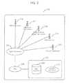
- a location of a user(who may or may not be a calibrator) can be determined within an indoor environment by using both RF data and tracking data from an inertial navigation system.
- RF datato estimate user location.
- the estimationsuggests that user may be in any one of locations “First” 702 , “Second” 704 , and “Seventh” 706 at time t 0 .
- the three estimatesare illustrative; in other embodiments fewer (e.g., one or two) or more (e.g., four, seven, etc.) estimates may be obtained at time t 0 based on RF data.
- One of these three estimates “First,” “Second,” and “Seventh”is likely to be more accurate than the others.
- the usermay, in fact, be at or near the location 2 .
- Tracking data from the INSindicates that the user may be at one of the locations “Fifth” 708 , “Sixth” 710 , or “Ninth” 712 .
- the useris estimated to be at the location “Fifth” 708 .
- the useris assumed to be at the location “Second” 704 at time t 0 , according to the INS data, the user is estimated to be at location “Sixth” 710 at time t 1 , and at location “Ninth” 712 , if the user is assumed to be at location “Seventh” 706 at time t 0 .
- one of the location estimates “Fifth,” “Sixth,” and “Ninth”is likely to be more accurate than the other ones.
- RF data at time t 1to estimate the user's location to be “Third” 714 , “Fourth” 716 , or “Eighth” 718 .
- a comparison of the RF-data-based location estimates “Third,” “Fourth,” and “Eighth” and INS-data-based location estimates “Fifth,” “Sixth,” and “Ninth”is used to determine the most likely location of the user at time t 1 and also at time t 0 .
- the estimated locations “Sixth” 710 and “Eighth” 718are closest to each other, and as such, one of these two estimates (i.e., “Sixth” and “Eighth”) is likely to be the most accurate estimate at time t 1 .
- the difference between pairs of estimatesis only one method of determining the accuracy of an estimate.
- Other methodssuch as assigning a quality score to the individual points based on weighting statistics such as standard deviation of accelerometer data and number of access points visible, or clustering points to determine which is more likely to be representative of location at t 0 based on its proximity to all of the other potential points—may also be used to select one of the various location estimates obtained at time t 1 to be the most likely location of the user.
- the locations estimated from the INS dataare not compared with the locations estimated from the RF data. Instead, only the RF data based estimates are compared with each other, based on the quality scores to determine the one that is most accurate.
- the locations estimated from the INS dataare compared with the locations estimated from the RF data, and in addition, other factors such as a quality score for the INS data and/or a quality score for the RF data are also considered.
- a quality score for the INS dataand/or a quality score for the RF data are also considered.
- an error metriccomprised of type of the building, number of RF sources at each RF reading, strength of RF data, yield of each RF source, tracking data from device, and other statistics associated with RF and tracking data and use it to validate which of the location estimates “Third” 714 , “Fourth” 716 , or “Eighth” 718 is more accurate.
- a map-point grid for indoor location determinationis calibrated by updating the received RF signal data at a map point with RF signal data received at other map points.
- Point 1is a map point that has a fingerprint associated therewith.
- Points 2 - 5represent a set of other points that are within a set threshold distance (e.g., less than ten feet, tens of feet, etc.) from Point 1 .
- Fingerprintsare associated with each of Points 2 - 5 .
- We update the fingerprint statistics for Point 1by averaging fingerprint statistics from Points 2 - 5 .
- a set that includes four additional pointsis illustrative only, and that in general, a set used for smoothing may include as few as one and more than four (e.g., 6, 10, 20, etc.) additional map points.
- a map-point grid for indoor location determinationis calibrated by computing a new fingerprint at a given map point as a function of fingerprints associated with other map points.
- Point 1represents a point that does not have an associated fingerprint in the database/grid.
- Points 2 - 6represent points within a set threshold distance from Point 1 , as described with reference to FIG. 8 .
- Fingerprintsare associated with each of Points 2 - 6 .
- We use fingerprint statistics from Points 2 - 6e.g., access points (APs) seen, power, yield, etc.
- APsaccess points
- Point 1e.g., power, yield, etc.
- a personIn performing a calibration, a person typically marks a calibration point on a map displayed on a user device (e.g., a phone app) and then takes sensor readings, e.g., RF signal data, inertial navigation data, etc., using the device.
- sensor readingse.g., RF signal data, inertial navigation data, etc.
- the user/calibratoris unskilled that the person made an error in recording data.
- the usermay mark his or her location as point A on the map, when the person is actually standing at point B.
- Various measuresare taken that, individually or in combination with one or more other measures, can reduce the impact of such errors on the quality of the fingerprint database.
- any usermay take one or more routes, and different users may repeat one or more of the pre-designated routes.
- the usercan identify the route being calibrated by providing the name and/or number of the route or by selecting a route from a list displayed on the user's device.
- the usercan also identify a location on the route or associated therewith, e.g., by tapping on that location in a map displayed on the user's device.
- Each routecorresponds to at least one map point, such as a starting map point, an ending map point, or another map point.
- Scan # 7from twelve scans
- Such a determinationcan be performed by comparing statistics of RF and/or sensor data for different calibrations of the same route.
- the statisticsmay related to the list of WiFi access points visible, powers of the visible WiFi access points and a variation in the recorded power, and yields of access points observable on the route.
- the statisticsmay also be related to sensor data such as a number of turns on a route, a length of a segment of the route, an orientation of a segment of the route, acceleration observable on the route, altitude associated with the route, and barometric pressure observable on the route.
- a route 1102includes segments # 66 , # 67 , and # 68 .
- the route 1102may include additional segments.
- the segment # 67includes map points 1112 , 1114 , 1116 , and 1118 .
- a routeincludes fewer or more than three segments, and a segments that include fewer or more than four map points are within the scope of the present invention.
- the fingerprint databaseincludes RF data associated with scans corresponding to segment of various routes, e.g., tens or hundreds of scans.
- the RF data associated with a selected segmentis excluded from the fingerprint database, and instead, some of the excluded data are used as test input to the location-determination engine in a synthetic “location request.” If data are collected correctly, the location returned by the engine should be within reasonable distance of the map points of the excluded segment.
- the RF data associated with the map points 1112 - 1118 of the segment # 67are excluded from the database.
- One or more of the map points 1112 - 1118are selected to form a subset, and the RF data observed at the map points in the subset are provided to the location determination engine as input.
- the data observed at the map point is 1114is provided to the location determination engine. If the engine returns a location that is substantially the same as the location of the map point 1114 it can be concluded that the RF data associated with the segment # 67 are valid.
- the data observed at map points 1114 and 1116are provided to the location determination engine. If the engine returns a location that is in the middle of the locations of the map points 1114 , 1116 , it can be concluded again that the RF data associated with the segment # 67 are valid. On the other hand, in any of these instances, if the location determination engine returns a location that is substantially different than the one expected, the data associated with the segment # 67 can be discarded or underweighted. It should be noted that in some embodiments more than one subsets of the map points associated with a segment may be explored as described above, while in other embodiments, only one subset may be explored. Some or all segments in the fingerprint database may be evaluated, and weights may be assigned to the evaluated segments and/or some of the evaluated segments may be discarded from the fingerprint database.
- a set of segmentsis selected, such that each segment in the set includes a map point that is within a specified distance (e.g., a few feet, tens of feet, etc.) from a map point corresponding to the candidate segment, i.e., the segment to be excluded.
- segment # 68 of the route 1102 and segment # 73 of another route 1104include map points 1120 and 1122 , respectively, that are within a specified distance from the map point 1118 of the candidate segment # 67 . Therefore, segments # 68 and # 73 are included in the set.
- a fitness measurebased on a comparison of a fingerprint associated with the map point 1118 and map points 1120 , 1122 is computed.
- the weight associated with the map points corresponding to segment # 67is adjusted based on, at least in part, the fitness measure. This adjustment can be in addition to, or instead of the weight adjustment based on location request, as described above. It should be understood that the set of segments, in general can include only one segment or several (e.g., 5, 8, 14 segments). Similarly, more than one map points of the candidate segment (e.g., segment # 67 ) can be compared with one or more map points of various segments in the set, in computing the fitness measure.
- the methods and systems described hereinare not limited to a particular hardware or software configuration, and may find applicability in many computing or processing environments.
- the methods and systemscan be implemented in hardware or software, or a combination of hardware and software.
- the methods and systemscan be implemented in one or more computer programs, where a computer program can be understood to include one or more processor executable instructions.
- the computer program(s)can execute on one or more programmable processors, and can be stored on one or more storage medium readable by the processor (including volatile and non-volatile memory and/or storage elements), one or more input devices, and/or one or more output devices.
- the processorthus can access one or more input devices to obtain input data, and can access one or more output devices to communicate output data.
- the input and/or output devicescan include one or more of the following: Random Access Memory (RAM), Redundant Array of Independent Disks (RAID), floppy drive, CD, DVD, magnetic disk, internal hard drive, external hard drive, memory stick, or other storage device capable of being accessed by a processor as provided herein, where such aforementioned examples are not exhaustive, and are for illustration and not limitation.
- RAMRandom Access Memory
- RAIDRedundant Array of Independent Disks
- floppy driveCD, DVD, magnetic disk, internal hard drive, external hard drive, memory stick, or other storage device capable of being accessed by a processor as provided herein, where such aforementioned examples are not exhaustive, and are for illustration and not limitation.
- the computer program(s)can be implemented using one or more high level procedural or object-oriented programming languages to communicate with a computer system; however, the program(s) can be implemented in assembly or machine language, if desired.
- the languagecan be compiled or interpreted.
- the processor(s)can thus be embedded in one or more devices that can be operated independently or together in a networked environment, where the network can include, for example, a Local Area Network (LAN), wide area network (WAN), and/or can include an intranet and/or the Internet and/or another network.
- the network(s)can be wired or wireless or a combination thereof and can use one or more communications protocols to facilitate communications between the different processors.
- the processorscan be configured for distributed processing and can utilize, in some embodiments, a client-server model as needed. Accordingly, the methods and systems can utilize multiple processors and/or processor devices, and the processor instructions can be divided amongst such single or multiple processor/devices.
- the device(s) or computer systems that integrate with the processor(s)can include, for example, a personal computer(s), workstation (e.g., Sun, HP), personal digital assistant (PDA), handheld device such as cellular telephone, laptop, handheld, or another device capable of being integrated with a processor(s) that can operate as provided herein. Accordingly, the devices provided herein are not exhaustive and are provided for illustration and not limitation.
- workstatione.g., Sun, HP
- PDApersonal digital assistant
- handheld devicesuch as cellular telephone, laptop, handheld, or another device capable of being integrated with a processor(s) that can operate as provided herein. Accordingly, the devices provided herein are not exhaustive and are provided for illustration and not limitation.
- references to “a microprocessor” and “a processor”, or “the microprocessor” and “the processor,”can be understood to include one or more microprocessors that can communicate in a stand-alone and/or a distributed environment(s), and can thus can be configured to communicate via wired or wireless communications with other processors, where such one or more processor can be configured to operate on one or more processor-controlled devices that can be similar or different devices.
- Use of such “microprocessor” or “processor” terminologycan thus also be understood to include a central processing unit, an arithmetic logic unit, an application-specific integrated circuit (IC), and/or a task engine, with such examples provided for illustration and not limitation.
- references to memorycan include one or more processor-readable and accessible memory elements and/or components that can be internal to the processor-controlled device, external to the processor-controlled device, and/or can be accessed via a wired or wireless network using a variety of communications protocols, and unless otherwise specified, can be arranged to include a combination of external and internal memory devices, where such memory can be contiguous and/or partitioned based on the application.
- references to a databasecan be understood to include one or more memory associations, where such references can include commercially available database products (e.g., SQL, Informix, Oracle) and also proprietary databases, and may also include other structures for associating memory such as links, queues, graphs, trees, with such structures provided for illustration and not limitation.
- references to a networkare not limited to the full Internet, and can include portions thereof. References herein to microprocessor instructions or microprocessor-executable instructions, in accordance with the above, can be understood to include programmable hardware.
Landscapes
- Engineering & Computer Science (AREA)
- Computer Networks & Wireless Communication (AREA)
- Signal Processing (AREA)
- Position Fixing By Use Of Radio Waves (AREA)
Abstract
Description
Claims (38)
Priority Applications (1)
| Application Number | Priority Date | Filing Date | Title |
|---|---|---|---|
| US13/932,646US9439041B2 (en) | 2012-06-29 | 2013-07-01 | Systems and methods for calibration based indoor geolocation |
Applications Claiming Priority (2)
| Application Number | Priority Date | Filing Date | Title |
|---|---|---|---|
| US201261666520P | 2012-06-29 | 2012-06-29 | |
| US13/932,646US9439041B2 (en) | 2012-06-29 | 2013-07-01 | Systems and methods for calibration based indoor geolocation |
Publications (2)
| Publication Number | Publication Date |
|---|---|
| US20140018095A1 US20140018095A1 (en) | 2014-01-16 |
| US9439041B2true US9439041B2 (en) | 2016-09-06 |
Family
ID=49914410
Family Applications (1)
| Application Number | Title | Priority Date | Filing Date |
|---|---|---|---|
| US13/932,646Expired - Fee RelatedUS9439041B2 (en) | 2012-06-29 | 2013-07-01 | Systems and methods for calibration based indoor geolocation |
Country Status (1)
| Country | Link |
|---|---|
| US (1) | US9439041B2 (en) |
Cited By (153)
| Publication number | Priority date | Publication date | Assignee | Title |
|---|---|---|---|---|
| US9652955B1 (en)* | 2016-06-21 | 2017-05-16 | Link Labs, Inc. | Real-time asset location system and method with long-range wireless backhaul |
| CN107290715A (en)* | 2017-07-18 | 2017-10-24 | 华中科技大学 | It is a kind of that the indoor orientation method changed with fingerprint is calibrated based on fingerprint |
| US10123166B2 (en) | 2015-01-26 | 2018-11-06 | Snap Inc. | Content request by location |
| US10154192B1 (en) | 2014-07-07 | 2018-12-11 | Snap Inc. | Apparatus and method for supplying content aware photo filters |
| US10157449B1 (en) | 2015-01-09 | 2018-12-18 | Snap Inc. | Geo-location-based image filters |
| US10182311B2 (en) | 2014-06-13 | 2019-01-15 | Snap Inc. | Prioritization of messages within a message collection |
| US10203855B2 (en) | 2016-12-09 | 2019-02-12 | Snap Inc. | Customized user-controlled media overlays |
| US10219111B1 (en) | 2018-04-18 | 2019-02-26 | Snap Inc. | Visitation tracking system |
| US10219110B2 (en) | 2016-06-28 | 2019-02-26 | Snap Inc. | System to track engagement of media items |
| US10223397B1 (en) | 2015-03-13 | 2019-03-05 | Snap Inc. | Social graph based co-location of network users |
| US10237913B2 (en) | 2017-06-17 | 2019-03-19 | Link Labs, Inc. | BLE networking systems and methods providing central and peripheral role reversal thereof while movable between locations |
| US10244377B2 (en) | 2017-06-17 | 2019-03-26 | Link Labs, Inc. | BLE networking systems and methods providing central and peripheral role reversal according to network provisioned timing therefor |
| US10244373B2 (en) | 2017-06-17 | 2019-03-26 | Link Labs, Inc. | BLE networking systems and methods providing central and peripheral role reversal |
| US10264436B1 (en) | 2018-05-29 | 2019-04-16 | Link Labs, Inc. | BLE networking systems and methods providing central and peripheral role reversal with independent peripheral network connectivity |
| US10319149B1 (en) | 2017-02-17 | 2019-06-11 | Snap Inc. | Augmented reality anamorphosis system |
| US10327096B1 (en) | 2018-03-06 | 2019-06-18 | Snap Inc. | Geo-fence selection system |
| US10334307B2 (en) | 2011-07-12 | 2019-06-25 | Snap Inc. | Methods and systems of providing visual content editing functions |
| US10348662B2 (en) | 2016-07-19 | 2019-07-09 | Snap Inc. | Generating customized electronic messaging graphics |
| US10349209B1 (en) | 2014-01-12 | 2019-07-09 | Investment Asset Holdings Llc | Location-based messaging |
| US10354425B2 (en) | 2015-12-18 | 2019-07-16 | Snap Inc. | Method and system for providing context relevant media augmentation |
| US10366543B1 (en) | 2015-10-30 | 2019-07-30 | Snap Inc. | Image based tracking in augmented reality systems |
| US10387730B1 (en) | 2017-04-20 | 2019-08-20 | Snap Inc. | Augmented reality typography personalization system |
| US10387514B1 (en) | 2016-06-30 | 2019-08-20 | Snap Inc. | Automated content curation and communication |
| US10412539B2 (en) | 2016-10-14 | 2019-09-10 | OneMarket Network LLC | Systems and methods to determine a location of a mobile device |
| US10423983B2 (en) | 2014-09-16 | 2019-09-24 | Snap Inc. | Determining targeting information based on a predictive targeting model |
| US10430838B1 (en) | 2016-06-28 | 2019-10-01 | Snap Inc. | Methods and systems for generation, curation, and presentation of media collections with automated advertising |
| US10474321B2 (en) | 2015-11-30 | 2019-11-12 | Snap Inc. | Network resource location linking and visual content sharing |
| US10484932B2 (en) | 2017-06-17 | 2019-11-19 | Link Labs, Inc. | BLE networking systems and methods providing central and peripheral role reversal with enhanced peripheral location determination using ultrasonic waveform |
| US10499191B1 (en) | 2017-10-09 | 2019-12-03 | Snap Inc. | Context sensitive presentation of content |
| US10499196B2 (en) | 2017-06-17 | 2019-12-03 | Link Labs, Inc. | BLE networking systems and methods providing central and peripheral role reversal with enhanced peripheral location determination |
| US10506498B1 (en) | 2018-11-01 | 2019-12-10 | Link Labs, Inc. | BLE networking systems and methods providing central and peripheral role reversal with enhanced peripheral location determination using ultrasonic waveform and correlation therefor |
| US10523625B1 (en) | 2017-03-09 | 2019-12-31 | Snap Inc. | Restricted group content collection |
| US10565795B2 (en) | 2017-03-06 | 2020-02-18 | Snap Inc. | Virtual vision system |
| US10573043B2 (en) | 2017-10-30 | 2020-02-25 | Snap Inc. | Mobile-based cartographic control of display content |
| US10580458B2 (en) | 2014-12-19 | 2020-03-03 | Snap Inc. | Gallery of videos set to an audio time line |
| US10592574B2 (en) | 2015-05-05 | 2020-03-17 | Snap Inc. | Systems and methods for automated local story generation and curation |
| US10616239B2 (en) | 2015-03-18 | 2020-04-07 | Snap Inc. | Geo-fence authorization provisioning |
| US10616476B1 (en) | 2014-11-12 | 2020-04-07 | Snap Inc. | User interface for accessing media at a geographic location |
| US10623666B2 (en) | 2016-11-07 | 2020-04-14 | Snap Inc. | Selective identification and order of image modifiers |
| US10678818B2 (en) | 2018-01-03 | 2020-06-09 | Snap Inc. | Tag distribution visualization system |
| US10679389B2 (en) | 2016-02-26 | 2020-06-09 | Snap Inc. | Methods and systems for generation, curation, and presentation of media collections |
| US10679393B2 (en) | 2018-07-24 | 2020-06-09 | Snap Inc. | Conditional modification of augmented reality object |
| US10708970B2 (en) | 2017-06-17 | 2020-07-07 | Link Labs, Inc. | BLE networking systems and methods providing central and peripheral role reversal with enhanced peripheral location determination using constant tone extension analysis for a same channel |
| US10740974B1 (en) | 2017-09-15 | 2020-08-11 | Snap Inc. | Augmented reality system |
| US10817898B2 (en) | 2015-08-13 | 2020-10-27 | Placed, Llc | Determining exposures to content presented by physical objects |
| US10824654B2 (en) | 2014-09-18 | 2020-11-03 | Snap Inc. | Geolocation-based pictographs |
| US10834525B2 (en) | 2016-02-26 | 2020-11-10 | Snap Inc. | Generation, curation, and presentation of media collections |
| US10862951B1 (en) | 2007-01-05 | 2020-12-08 | Snap Inc. | Real-time display of multiple images |
| US10885136B1 (en) | 2018-02-28 | 2021-01-05 | Snap Inc. | Audience filtering system |
| US10911575B1 (en) | 2015-05-05 | 2021-02-02 | Snap Inc. | Systems and methods for story and sub-story navigation |
| US10915911B2 (en) | 2017-02-03 | 2021-02-09 | Snap Inc. | System to determine a price-schedule to distribute media content |
| US10933311B2 (en) | 2018-03-14 | 2021-03-02 | Snap Inc. | Generating collectible items based on location information |
| US10948717B1 (en) | 2015-03-23 | 2021-03-16 | Snap Inc. | Reducing boot time and power consumption in wearable display systems |
| US10952013B1 (en) | 2017-04-27 | 2021-03-16 | Snap Inc. | Selective location-based identity communication |
| US10963529B1 (en) | 2017-04-27 | 2021-03-30 | Snap Inc. | Location-based search mechanism in a graphical user interface |
| US10979752B1 (en) | 2018-02-28 | 2021-04-13 | Snap Inc. | Generating media content items based on location information |
| US10990697B2 (en) | 2014-05-28 | 2021-04-27 | Snap Inc. | Apparatus and method for automated privacy protection in distributed images |
| US10993069B2 (en) | 2015-07-16 | 2021-04-27 | Snap Inc. | Dynamically adaptive media content delivery |
| US10997760B2 (en) | 2018-08-31 | 2021-05-04 | Snap Inc. | Augmented reality anthropomorphization system |
| US10997783B2 (en) | 2015-11-30 | 2021-05-04 | Snap Inc. | Image and point cloud based tracking and in augmented reality systems |
| US11017173B1 (en) | 2017-12-22 | 2021-05-25 | Snap Inc. | Named entity recognition visual context and caption data |
| US11023514B2 (en) | 2016-02-26 | 2021-06-01 | Snap Inc. | Methods and systems for generation, curation, and presentation of media collections |
| US11128715B1 (en) | 2019-12-30 | 2021-09-21 | Snap Inc. | Physical friend proximity in chat |
| US11163941B1 (en) | 2018-03-30 | 2021-11-02 | Snap Inc. | Annotating a collection of media content items |
| US11170393B1 (en) | 2017-04-11 | 2021-11-09 | Snap Inc. | System to calculate an engagement score of location based media content |
| US11182383B1 (en) | 2012-02-24 | 2021-11-23 | Placed, Llc | System and method for data collection to validate location data |
| US11189299B1 (en) | 2017-02-20 | 2021-11-30 | Snap Inc. | Augmented reality speech balloon system |
| US11199957B1 (en) | 2018-11-30 | 2021-12-14 | Snap Inc. | Generating customized avatars based on location information |
| US11206615B2 (en) | 2019-05-30 | 2021-12-21 | Snap Inc. | Wearable device location systems |
| US11218838B2 (en) | 2019-10-31 | 2022-01-04 | Snap Inc. | Focused map-based context information surfacing |
| US11216869B2 (en) | 2014-09-23 | 2022-01-04 | Snap Inc. | User interface to augment an image using geolocation |
| US11228551B1 (en) | 2020-02-12 | 2022-01-18 | Snap Inc. | Multiple gateway message exchange |
| US11232040B1 (en) | 2017-04-28 | 2022-01-25 | Snap Inc. | Precaching unlockable data elements |
| US11250075B1 (en) | 2017-02-17 | 2022-02-15 | Snap Inc. | Searching social media content |
| US11249614B2 (en) | 2019-03-28 | 2022-02-15 | Snap Inc. | Generating personalized map interface with enhanced icons |
| US11249617B1 (en) | 2015-01-19 | 2022-02-15 | Snap Inc. | Multichannel system |
| US11265273B1 (en) | 2017-12-01 | 2022-03-01 | Snap, Inc. | Dynamic media overlay with smart widget |
| US11290851B2 (en) | 2020-06-15 | 2022-03-29 | Snap Inc. | Location sharing using offline and online objects |
| US11294936B1 (en) | 2019-01-30 | 2022-04-05 | Snap Inc. | Adaptive spatial density based clustering |
| US11297399B1 (en) | 2017-03-27 | 2022-04-05 | Snap Inc. | Generating a stitched data stream |
| US11301117B2 (en) | 2019-03-08 | 2022-04-12 | Snap Inc. | Contextual information in chat |
| US11314776B2 (en) | 2020-06-15 | 2022-04-26 | Snap Inc. | Location sharing using friend list versions |
| US11343323B2 (en) | 2019-12-31 | 2022-05-24 | Snap Inc. | Augmented reality objects registry |
| US11349796B2 (en) | 2017-03-27 | 2022-05-31 | Snap Inc. | Generating a stitched data stream |
| US11361493B2 (en) | 2019-04-01 | 2022-06-14 | Snap Inc. | Semantic texture mapping system |
| US11372608B2 (en) | 2014-12-19 | 2022-06-28 | Snap Inc. | Gallery of messages from individuals with a shared interest |
| US11429618B2 (en) | 2019-12-30 | 2022-08-30 | Snap Inc. | Surfacing augmented reality objects |
| US11430091B2 (en) | 2020-03-27 | 2022-08-30 | Snap Inc. | Location mapping for large scale augmented-reality |
| US11455082B2 (en) | 2018-09-28 | 2022-09-27 | Snap Inc. | Collaborative achievement interface |
| US11475254B1 (en) | 2017-09-08 | 2022-10-18 | Snap Inc. | Multimodal entity identification |
| US11474191B2 (en) | 2018-07-26 | 2022-10-18 | Signify Holding B.V. | Method for configuring a tracking system, tracking system, lighting system incorporating a tracking system and computer program |
| US11483267B2 (en) | 2020-06-15 | 2022-10-25 | Snap Inc. | Location sharing using different rate-limited links |
| US11500525B2 (en) | 2019-02-25 | 2022-11-15 | Snap Inc. | Custom media overlay system |
| US11503432B2 (en) | 2020-06-15 | 2022-11-15 | Snap Inc. | Scalable real-time location sharing framework |
| US11507614B1 (en) | 2018-02-13 | 2022-11-22 | Snap Inc. | Icon based tagging |
| US11516167B2 (en) | 2020-03-05 | 2022-11-29 | Snap Inc. | Storing data based on device location |
| US11558709B2 (en) | 2018-11-30 | 2023-01-17 | Snap Inc. | Position service to determine relative position to map features |
| US11574431B2 (en) | 2019-02-26 | 2023-02-07 | Snap Inc. | Avatar based on weather |
| US11601888B2 (en) | 2021-03-29 | 2023-03-07 | Snap Inc. | Determining location using multi-source geolocation data |
| US11601783B2 (en) | 2019-06-07 | 2023-03-07 | Snap Inc. | Detection of a physical collision between two client devices in a location sharing system |
| US20230070440A1 (en)* | 2020-05-31 | 2023-03-09 | Oriient New Media Ltd. | Magnetic indoor positioning with magnetometer calibration errors equaliziation |
| US11606755B2 (en) | 2019-05-30 | 2023-03-14 | Snap Inc. | Wearable device location systems architecture |
| US11616745B2 (en) | 2017-01-09 | 2023-03-28 | Snap Inc. | Contextual generation and selection of customized media content |
| US11619501B2 (en) | 2020-03-11 | 2023-04-04 | Snap Inc. | Avatar based on trip |
| US11625443B2 (en) | 2014-06-05 | 2023-04-11 | Snap Inc. | Web document enhancement |
| US11631276B2 (en) | 2016-03-31 | 2023-04-18 | Snap Inc. | Automated avatar generation |
| US11645324B2 (en) | 2021-03-31 | 2023-05-09 | Snap Inc. | Location-based timeline media content system |
| US11675831B2 (en) | 2017-05-31 | 2023-06-13 | Snap Inc. | Geolocation based playlists |
| US11676378B2 (en) | 2020-06-29 | 2023-06-13 | Snap Inc. | Providing travel-based augmented reality content with a captured image |
| US11714535B2 (en) | 2019-07-11 | 2023-08-01 | Snap Inc. | Edge gesture interface with smart interactions |
| US11734712B2 (en) | 2012-02-24 | 2023-08-22 | Foursquare Labs, Inc. | Attributing in-store visits to media consumption based on data collected from user devices |
| US11751015B2 (en) | 2019-01-16 | 2023-09-05 | Snap Inc. | Location-based context information sharing in a messaging system |
| US11776256B2 (en) | 2020-03-27 | 2023-10-03 | Snap Inc. | Shared augmented reality system |
| US11778540B1 (en) | 2022-10-12 | 2023-10-03 | Link Labs, Inc. | BLE networking systems and methods including filtering for selectively collecting and processing advertisement data |
| US11799811B2 (en) | 2018-10-31 | 2023-10-24 | Snap Inc. | Messaging and gaming applications communication platform |
| US11809624B2 (en) | 2019-02-13 | 2023-11-07 | Snap Inc. | Sleep detection in a location sharing system |
| US11816853B2 (en) | 2016-08-30 | 2023-11-14 | Snap Inc. | Systems and methods for simultaneous localization and mapping |
| US11821742B2 (en) | 2019-09-26 | 2023-11-21 | Snap Inc. | Travel based notifications |
| US11829834B2 (en) | 2021-10-29 | 2023-11-28 | Snap Inc. | Extended QR code |
| US11842411B2 (en) | 2017-04-27 | 2023-12-12 | Snap Inc. | Location-based virtual avatars |
| US11843456B2 (en) | 2016-10-24 | 2023-12-12 | Snap Inc. | Generating and displaying customized avatars in media overlays |
| US11852554B1 (en) | 2019-03-21 | 2023-12-26 | Snap Inc. | Barometer calibration in a location sharing system |
| US11860888B2 (en) | 2018-05-22 | 2024-01-02 | Snap Inc. | Event detection system |
| US11868414B1 (en) | 2019-03-14 | 2024-01-09 | Snap Inc. | Graph-based prediction for contact suggestion in a location sharing system |
| US11870743B1 (en) | 2017-01-23 | 2024-01-09 | Snap Inc. | Customized digital avatar accessories |
| US11877211B2 (en) | 2019-01-14 | 2024-01-16 | Snap Inc. | Destination sharing in location sharing system |
| US11893208B2 (en) | 2019-12-31 | 2024-02-06 | Snap Inc. | Combined map icon with action indicator |
| US20240063926A1 (en)* | 2017-06-14 | 2024-02-22 | Fraunhofer-Gesellschaft Zur Foerderung Der Angewandten Forschung E.V. | Apparatus, system and method for improving position estimation and/or communication performance in a wireless communication network |
| US11925869B2 (en) | 2012-05-08 | 2024-03-12 | Snap Inc. | System and method for generating and displaying avatars |
| US11943192B2 (en) | 2020-08-31 | 2024-03-26 | Snap Inc. | Co-location connection service |
| US11962645B2 (en) | 2015-01-13 | 2024-04-16 | Snap Inc. | Guided personal identity based actions |
| US11972529B2 (en) | 2019-02-01 | 2024-04-30 | Snap Inc. | Augmented reality system |
| US12001750B2 (en) | 2022-04-20 | 2024-06-04 | Snap Inc. | Location-based shared augmented reality experience system |
| US12020384B2 (en) | 2022-06-21 | 2024-06-25 | Snap Inc. | Integrating augmented reality experiences with other components |
| US12020386B2 (en) | 2022-06-23 | 2024-06-25 | Snap Inc. | Applying pregenerated virtual experiences in new location |
| US12026362B2 (en) | 2021-05-19 | 2024-07-02 | Snap Inc. | Video editing application for mobile devices |
| US12113764B2 (en) | 2014-10-02 | 2024-10-08 | Snap Inc. | Automated management of ephemeral message collections |
| US12143884B2 (en) | 2012-02-24 | 2024-11-12 | Fouresquare Labs, Inc. | Inference pipeline system and method |
| US12160792B2 (en) | 2019-05-30 | 2024-12-03 | Snap Inc. | Wearable device location accuracy systems |
| US12166839B2 (en) | 2021-10-29 | 2024-12-10 | Snap Inc. | Accessing web-based fragments for display |
| US12164109B2 (en) | 2022-04-29 | 2024-12-10 | Snap Inc. | AR/VR enabled contact lens |
| US12216702B1 (en) | 2015-12-08 | 2025-02-04 | Snap Inc. | Redirection to digital content based on image-search |
| US12242979B1 (en) | 2019-03-12 | 2025-03-04 | Snap Inc. | Departure time estimation in a location sharing system |
| US12243167B2 (en) | 2022-04-27 | 2025-03-04 | Snap Inc. | Three-dimensional mapping using disparate visual datasets |
| US12244549B2 (en) | 2020-03-30 | 2025-03-04 | Snap Inc. | Off-platform messaging system |
| US12265664B2 (en) | 2023-02-28 | 2025-04-01 | Snap Inc. | Shared augmented reality eyewear device with hand tracking alignment |
| US12278791B2 (en) | 2019-07-05 | 2025-04-15 | Snap Inc. | Event planning in a content sharing platform |
| US12335211B2 (en) | 2022-06-02 | 2025-06-17 | Snap Inc. | External messaging function for an interaction system |
| US12361664B2 (en) | 2023-04-19 | 2025-07-15 | Snap Inc. | 3D content display using head-wearable apparatuses |
| US12406416B2 (en) | 2016-06-30 | 2025-09-02 | Snap Inc. | Avatar based ideogram generation |
| US12411834B1 (en) | 2018-12-05 | 2025-09-09 | Snap Inc. | Version control in networked environments |
| US12439223B2 (en) | 2019-03-28 | 2025-10-07 | Snap Inc. | Grouped transmission of location data in a location sharing system |
| US12443670B2 (en) | 2023-12-11 | 2025-10-14 | Snap Inc. | Web document enhancement |
Families Citing this family (45)
| Publication number | Priority date | Publication date | Assignee | Title |
|---|---|---|---|---|
| WO2013175048A1 (en)* | 2012-05-22 | 2013-11-28 | Nokia Corporation | Method and apparatus for triggering handover between access points based on gathered history data of series of access points |
| US9179331B2 (en)* | 2012-10-31 | 2015-11-03 | Soongsil University Research Consortium Techno-Park | Wireless localization method and wireless localization apparatus using fingerprinting technique |
| US9226111B2 (en)* | 2012-11-21 | 2015-12-29 | Apple Inc. | Pathway matching |
| US20150154621A1 (en)* | 2013-03-06 | 2015-06-04 | Google Inc. | System and method for generating incentives |
| US20140278838A1 (en)* | 2013-03-14 | 2014-09-18 | Uber Technologies, Inc. | Determining an amount for a toll based on location data points provided by a computing device |
| US9686766B2 (en)* | 2013-08-26 | 2017-06-20 | Telefonaktiebolaget Lm Ericsson (Publ) | Location positioning using M2M ecosystem |
| US9820233B2 (en)* | 2013-11-25 | 2017-11-14 | Qualcomm Incorporated | Motion state based mobile device positioning |
| US9253672B1 (en)* | 2013-12-31 | 2016-02-02 | Joingo, Llc | System and method for measuring the quantity, type and transmission quality of mobile communication devices within a defined geographical area |
| US8725170B1 (en)* | 2013-12-31 | 2014-05-13 | Joingo, Llc | System and method for measuring the quantity, type and transmission quality of mobile communication devices within a defined geographical area |
| US9185542B1 (en)* | 2013-12-31 | 2015-11-10 | Joingo, Llc | System and method for measuring the quantity, type and transmission quality of mobile communication devices within a defined geographical area |
| DE102014004673A1 (en)* | 2014-03-31 | 2015-10-01 | Audi Ag | Method for storing a shipment in a motor vehicle and associated motor vehicle |
| WO2015167172A1 (en)* | 2014-04-28 | 2015-11-05 | 삼성전자 주식회사 | System and method for positioning, mapping and data management by using crowdsourcing |
| US9510154B2 (en) | 2014-04-28 | 2016-11-29 | Samsung Electronics Co., Ltd | Location determination, mapping, and data management through crowdsourcing |
| US9510191B2 (en)* | 2014-06-20 | 2016-11-29 | Facebook, Inc. | Authorization of network address tracking |
| WO2016025895A1 (en)* | 2014-08-15 | 2016-02-18 | Qualcomm Incorporated | Mobile-assisted determination of the altitude of a mobile device |
| US9541404B2 (en) | 2014-08-29 | 2017-01-10 | Samsung Electronics Co., Ltd. | System for determining the location of entrances and areas of interest |
| US9806809B2 (en) | 2014-11-06 | 2017-10-31 | Facebook, Inc. | Deploying line-of-sight communication networks |
| US9661552B2 (en) | 2014-11-06 | 2017-05-23 | Facebook, Inc. | Association in line-of-sight communication networks |
| US9793988B2 (en) | 2014-11-06 | 2017-10-17 | Facebook, Inc. | Alignment in line-of-sight communication networks |
| CN105783917B (en)* | 2014-12-18 | 2019-05-07 | 阿里巴巴集团控股有限公司 | Mobile terminal locating method and its device based on earth magnetism |
| US10051684B2 (en)* | 2015-05-04 | 2018-08-14 | Qualcomm Incorporated | Transfer of uncompensated barometric pressure information |
| CN104849692A (en)* | 2015-05-08 | 2015-08-19 | 深圳市华颖泰科电子技术有限公司 | Calibration method |
| TWI577968B (en)* | 2015-06-18 | 2017-04-11 | 金寶電子工業股份有限公司 | Positioning navigation method and electronic apparatus thereof |
| US9686767B2 (en) | 2015-08-24 | 2017-06-20 | Qualcomm Incorporated | Device, method, and system for determining location |
| CN105223547B (en)* | 2015-10-13 | 2018-05-29 | 四川星网云联科技有限公司 | A kind of centralized Wifi indoor orientation methods of ios device |
| US10228448B2 (en)* | 2015-10-29 | 2019-03-12 | Massachusettts Institute of Technology | Variable resource allocation for localization |
| US10415978B2 (en) | 2015-11-20 | 2019-09-17 | Samsung Electronics Co., Ltd. | Landmark location determination |
| US9848302B2 (en)* | 2016-03-31 | 2017-12-19 | Intel Corporation | Self-learning locator for mobile device |
| GB2549983A (en)* | 2016-05-06 | 2017-11-08 | Here Global Bv | Improving a positioning performance |
| US10003928B2 (en)* | 2016-09-28 | 2018-06-19 | Mapsted Corp. | Crowd-sourced passive positioning and calibration |
| JP2020501112A (en)* | 2016-10-06 | 2020-01-16 | インドアアトラス オサケ ユキチュア | Processing device, computer program code, and method |
| US9900749B1 (en) | 2016-12-12 | 2018-02-20 | Here Global B.V. | Detection of infrastructure changes in opportunity signal data |
| WO2018201229A1 (en)* | 2017-05-03 | 2018-11-08 | Meemim Inc. | Method, system and computer program product for geospatial calibration |
| US9980100B1 (en) | 2017-08-31 | 2018-05-22 | Snap Inc. | Device location based on machine learning classifications |
| EP3460405B1 (en)* | 2017-09-25 | 2021-04-28 | Mapsted Corp. | Crowd-sourced passive positioning and calibration |
| US10257658B1 (en) | 2017-11-30 | 2019-04-09 | Mapsted Corp. | Self-learning localization data repository |
| US10145701B1 (en)* | 2018-01-12 | 2018-12-04 | Mapsted Corp. | Method and system for crowd-sourced navigation profile options |
| US10877160B2 (en) | 2018-02-26 | 2020-12-29 | Cisco Technology, Inc. | Compensating for access point orientation errors with respect to a predefined area orientation |
| US10145689B1 (en) | 2018-03-02 | 2018-12-04 | Mapsted Corp. | Method and system of pedestrian localization |
| US10419880B1 (en)* | 2018-08-22 | 2019-09-17 | Facebook, Inc. | Robotics for indoor data curation |
| EP3644096B1 (en)* | 2018-10-23 | 2025-01-22 | HERE Global B.V. | Radio maps for location and/or positioning services |
| TWI666954B (en)* | 2018-11-28 | 2019-07-21 | 國立虎尾科技大學 | Multi-signal positioning method for internet of things devices |
| US10555274B1 (en)* | 2019-05-10 | 2020-02-04 | Honeywell International Inc. | Monitoring an identification and positioning system |
| CN116055987A (en)* | 2021-10-28 | 2023-05-02 | 富泰华工业(深圳)有限公司 | Indoor positioning method, computer readable storage medium and electronic device |
| US11843993B2 (en)* | 2021-12-06 | 2023-12-12 | Qualcomm Incorporated | Beam-based machine learning-enabled RFFP positioning |
Citations (7)
| Publication number | Priority date | Publication date | Assignee | Title |
|---|---|---|---|---|
| US20020196188A1 (en)* | 2001-06-25 | 2002-12-26 | Harris Corporation | System and method for determining the location of a transmitter using passive reflectors or refractors as proxy receivers and using database querying |
| US20060089153A1 (en)* | 2004-10-27 | 2006-04-27 | Leonid Sheynblat | Location-sensitive calibration data |
| US20120007779A1 (en)* | 2009-03-19 | 2012-01-12 | Martin Klepal | location and tracking system |
| US20130084892A1 (en)* | 2011-10-03 | 2013-04-04 | Oumer Teyeb | Methods and Arrangements for Proximity Detection |
| US20130166193A1 (en)* | 2011-12-22 | 2013-06-27 | David Allan Goldman | Systems, methods, and apparatus for providing indoor navigation |
| US20130293416A1 (en)* | 2012-05-02 | 2013-11-07 | Texas Instruments Incorporated | Apparatus and method for indoor positioning |
| US20140295878A1 (en)* | 2012-05-01 | 2014-10-02 | Shao-Wen Yang | Simultaneous localization and mapping using spatial and temporal coherence for indoor location |
- 2013
- 2013-07-01USUS13/932,646patent/US9439041B2/ennot_activeExpired - Fee Related
Patent Citations (7)
| Publication number | Priority date | Publication date | Assignee | Title |
|---|---|---|---|---|
| US20020196188A1 (en)* | 2001-06-25 | 2002-12-26 | Harris Corporation | System and method for determining the location of a transmitter using passive reflectors or refractors as proxy receivers and using database querying |
| US20060089153A1 (en)* | 2004-10-27 | 2006-04-27 | Leonid Sheynblat | Location-sensitive calibration data |
| US20120007779A1 (en)* | 2009-03-19 | 2012-01-12 | Martin Klepal | location and tracking system |
| US20130084892A1 (en)* | 2011-10-03 | 2013-04-04 | Oumer Teyeb | Methods and Arrangements for Proximity Detection |
| US20130166193A1 (en)* | 2011-12-22 | 2013-06-27 | David Allan Goldman | Systems, methods, and apparatus for providing indoor navigation |
| US20140295878A1 (en)* | 2012-05-01 | 2014-10-02 | Shao-Wen Yang | Simultaneous localization and mapping using spatial and temporal coherence for indoor location |
| US20130293416A1 (en)* | 2012-05-02 | 2013-11-07 | Texas Instruments Incorporated | Apparatus and method for indoor positioning |
Cited By (363)
| Publication number | Priority date | Publication date | Assignee | Title |
|---|---|---|---|---|
| US10862951B1 (en) | 2007-01-05 | 2020-12-08 | Snap Inc. | Real-time display of multiple images |
| US11588770B2 (en) | 2007-01-05 | 2023-02-21 | Snap Inc. | Real-time display of multiple images |
| US12335324B2 (en) | 2007-01-05 | 2025-06-17 | Snap Inc. | Real-time display of multiple images |
| US11451856B2 (en) | 2011-07-12 | 2022-09-20 | Snap Inc. | Providing visual content editing functions |
| US11750875B2 (en) | 2011-07-12 | 2023-09-05 | Snap Inc. | Providing visual content editing functions |
| US10999623B2 (en) | 2011-07-12 | 2021-05-04 | Snap Inc. | Providing visual content editing functions |
| US10334307B2 (en) | 2011-07-12 | 2019-06-25 | Snap Inc. | Methods and systems of providing visual content editing functions |
| US12212804B2 (en) | 2011-07-12 | 2025-01-28 | Snap Inc. | Providing visual content editing functions |
| US11182383B1 (en) | 2012-02-24 | 2021-11-23 | Placed, Llc | System and method for data collection to validate location data |
| US11734712B2 (en) | 2012-02-24 | 2023-08-22 | Foursquare Labs, Inc. | Attributing in-store visits to media consumption based on data collected from user devices |
| US12143884B2 (en) | 2012-02-24 | 2024-11-12 | Fouresquare Labs, Inc. | Inference pipeline system and method |
| US11925869B2 (en) | 2012-05-08 | 2024-03-12 | Snap Inc. | System and method for generating and displaying avatars |
| US12200563B2 (en) | 2014-01-12 | 2025-01-14 | Investment Asset Holdings, Llc | Map interface with message marker for location-based messages |
| US12127068B2 (en) | 2014-01-12 | 2024-10-22 | Investment Asset Holdings Llc | Map interface with icon for location-based messages |
| US12041508B1 (en) | 2014-01-12 | 2024-07-16 | Investment Asset Holdings Llc | Location-based messaging |
| US10349209B1 (en) | 2014-01-12 | 2019-07-09 | Investment Asset Holdings Llc | Location-based messaging |
| US11972014B2 (en) | 2014-05-28 | 2024-04-30 | Snap Inc. | Apparatus and method for automated privacy protection in distributed images |
| US10990697B2 (en) | 2014-05-28 | 2021-04-27 | Snap Inc. | Apparatus and method for automated privacy protection in distributed images |
| US11625443B2 (en) | 2014-06-05 | 2023-04-11 | Snap Inc. | Web document enhancement |
| US11921805B2 (en) | 2014-06-05 | 2024-03-05 | Snap Inc. | Web document enhancement |
| US10524087B1 (en) | 2014-06-13 | 2019-12-31 | Snap Inc. | Message destination list mechanism |
| US10659914B1 (en) | 2014-06-13 | 2020-05-19 | Snap Inc. | Geo-location based event gallery |
| US10623891B2 (en) | 2014-06-13 | 2020-04-14 | Snap Inc. | Prioritization of messages within a message collection |
| US10182311B2 (en) | 2014-06-13 | 2019-01-15 | Snap Inc. | Prioritization of messages within a message collection |
| US10779113B2 (en) | 2014-06-13 | 2020-09-15 | Snap Inc. | Prioritization of messages within a message collection |
| US10200813B1 (en) | 2014-06-13 | 2019-02-05 | Snap Inc. | Geo-location based event gallery |
| US11166121B2 (en) | 2014-06-13 | 2021-11-02 | Snap Inc. | Prioritization of messages within a message collection |
| US11317240B2 (en) | 2014-06-13 | 2022-04-26 | Snap Inc. | Geo-location based event gallery |
| US10448201B1 (en) | 2014-06-13 | 2019-10-15 | Snap Inc. | Prioritization of messages within a message collection |
| US10432850B1 (en) | 2014-07-07 | 2019-10-01 | Snap Inc. | Apparatus and method for supplying content aware photo filters |
| US11849214B2 (en) | 2014-07-07 | 2023-12-19 | Snap Inc. | Apparatus and method for supplying content aware photo filters |
| US11122200B2 (en) | 2014-07-07 | 2021-09-14 | Snap Inc. | Supplying content aware photo filters |
| US10154192B1 (en) | 2014-07-07 | 2018-12-11 | Snap Inc. | Apparatus and method for supplying content aware photo filters |
| US10602057B1 (en) | 2014-07-07 | 2020-03-24 | Snap Inc. | Supplying content aware photo filters |
| US11595569B2 (en) | 2014-07-07 | 2023-02-28 | Snap Inc. | Supplying content aware photo filters |
| US10423983B2 (en) | 2014-09-16 | 2019-09-24 | Snap Inc. | Determining targeting information based on a predictive targeting model |
| US11625755B1 (en) | 2014-09-16 | 2023-04-11 | Foursquare Labs, Inc. | Determining targeting information based on a predictive targeting model |
| US10824654B2 (en) | 2014-09-18 | 2020-11-03 | Snap Inc. | Geolocation-based pictographs |
| US11741136B2 (en) | 2014-09-18 | 2023-08-29 | Snap Inc. | Geolocation-based pictographs |
| US11281701B2 (en) | 2014-09-18 | 2022-03-22 | Snap Inc. | Geolocation-based pictographs |
| US11216869B2 (en) | 2014-09-23 | 2022-01-04 | Snap Inc. | User interface to augment an image using geolocation |
| US12393977B2 (en) | 2014-09-23 | 2025-08-19 | Snap Inc. | User interface to augment an image using geolocation |
| US12155617B1 (en) | 2014-10-02 | 2024-11-26 | Snap Inc. | Automated chronological display of ephemeral message gallery |
| US12155618B2 (en) | 2014-10-02 | 2024-11-26 | Snap Inc. | Ephemeral message collection UI indicia |
| US12113764B2 (en) | 2014-10-02 | 2024-10-08 | Snap Inc. | Automated management of ephemeral message collections |
| US11190679B2 (en) | 2014-11-12 | 2021-11-30 | Snap Inc. | Accessing media at a geographic location |
| US11956533B2 (en) | 2014-11-12 | 2024-04-09 | Snap Inc. | Accessing media at a geographic location |
| US10616476B1 (en) | 2014-11-12 | 2020-04-07 | Snap Inc. | User interface for accessing media at a geographic location |
| US11803345B2 (en) | 2014-12-19 | 2023-10-31 | Snap Inc. | Gallery of messages from individuals with a shared interest |
| US12236148B2 (en) | 2014-12-19 | 2025-02-25 | Snap Inc. | Gallery of messages from individuals with a shared interest |
| US10811053B2 (en) | 2014-12-19 | 2020-10-20 | Snap Inc. | Routing messages by message parameter |
| US11372608B2 (en) | 2014-12-19 | 2022-06-28 | Snap Inc. | Gallery of messages from individuals with a shared interest |
| US10580458B2 (en) | 2014-12-19 | 2020-03-03 | Snap Inc. | Gallery of videos set to an audio time line |
| US11783862B2 (en) | 2014-12-19 | 2023-10-10 | Snap Inc. | Routing messages by message parameter |
| US11250887B2 (en) | 2014-12-19 | 2022-02-15 | Snap Inc. | Routing messages by message parameter |
| US11301960B2 (en) | 2015-01-09 | 2022-04-12 | Snap Inc. | Object recognition based image filters |
| US10157449B1 (en) | 2015-01-09 | 2018-12-18 | Snap Inc. | Geo-location-based image filters |
| US10380720B1 (en) | 2015-01-09 | 2019-08-13 | Snap Inc. | Location-based image filters |
| US11734342B2 (en) | 2015-01-09 | 2023-08-22 | Snap Inc. | Object recognition based image overlays |
| US12056182B2 (en) | 2015-01-09 | 2024-08-06 | Snap Inc. | Object recognition based image overlays |
| US12388892B2 (en) | 2015-01-13 | 2025-08-12 | Snap Inc. | Guided personal identity based actions |
| US11962645B2 (en) | 2015-01-13 | 2024-04-16 | Snap Inc. | Guided personal identity based actions |
| US11249617B1 (en) | 2015-01-19 | 2022-02-15 | Snap Inc. | Multichannel system |
| US11910267B2 (en) | 2015-01-26 | 2024-02-20 | Snap Inc. | Content request by location |
| US11528579B2 (en) | 2015-01-26 | 2022-12-13 | Snap Inc. | Content request by location |
| US10123167B2 (en) | 2015-01-26 | 2018-11-06 | Snap Inc. | Content request by location |
| US10932085B1 (en) | 2015-01-26 | 2021-02-23 | Snap Inc. | Content request by location |
| US12256283B2 (en) | 2015-01-26 | 2025-03-18 | Snap Inc. | Content request by location |
| US10536800B1 (en) | 2015-01-26 | 2020-01-14 | Snap Inc. | Content request by location |
| US10123166B2 (en) | 2015-01-26 | 2018-11-06 | Snap Inc. | Content request by location |
| US10223397B1 (en) | 2015-03-13 | 2019-03-05 | Snap Inc. | Social graph based co-location of network users |
| US10616239B2 (en) | 2015-03-18 | 2020-04-07 | Snap Inc. | Geo-fence authorization provisioning |
| US10893055B2 (en) | 2015-03-18 | 2021-01-12 | Snap Inc. | Geo-fence authorization provisioning |
| US11902287B2 (en) | 2015-03-18 | 2024-02-13 | Snap Inc. | Geo-fence authorization provisioning |
| US12231437B2 (en) | 2015-03-18 | 2025-02-18 | Snap Inc. | Geo-fence authorization provisioning |
| US10948717B1 (en) | 2015-03-23 | 2021-03-16 | Snap Inc. | Reducing boot time and power consumption in wearable display systems |
| US11662576B2 (en) | 2015-03-23 | 2023-05-30 | Snap Inc. | Reducing boot time and power consumption in displaying data content |
| US12164105B2 (en) | 2015-03-23 | 2024-12-10 | Snap Inc. | Reducing boot time and power consumption in displaying data content |
| US11320651B2 (en) | 2015-03-23 | 2022-05-03 | Snap Inc. | Reducing boot time and power consumption in displaying data content |
| US12265573B2 (en) | 2015-05-05 | 2025-04-01 | Snap Inc. | Automated local story generation and curation |
| US11392633B2 (en) | 2015-05-05 | 2022-07-19 | Snap Inc. | Systems and methods for automated local story generation and curation |
| US10592574B2 (en) | 2015-05-05 | 2020-03-17 | Snap Inc. | Systems and methods for automated local story generation and curation |
| US11449539B2 (en) | 2015-05-05 | 2022-09-20 | Snap Inc. | Automated local story generation and curation |
| US11496544B2 (en) | 2015-05-05 | 2022-11-08 | Snap Inc. | Story and sub-story navigation |
| US10911575B1 (en) | 2015-05-05 | 2021-02-02 | Snap Inc. | Systems and methods for story and sub-story navigation |
| US12317150B2 (en) | 2015-07-16 | 2025-05-27 | Snap Inc. | Dynamically adaptive media content delivery |
| US10993069B2 (en) | 2015-07-16 | 2021-04-27 | Snap Inc. | Dynamically adaptive media content delivery |
| US10817898B2 (en) | 2015-08-13 | 2020-10-27 | Placed, Llc | Determining exposures to content presented by physical objects |
| US11961116B2 (en) | 2015-08-13 | 2024-04-16 | Foursquare Labs, Inc. | Determining exposures to content presented by physical objects |
| US10366543B1 (en) | 2015-10-30 | 2019-07-30 | Snap Inc. | Image based tracking in augmented reality systems |
| US11769307B2 (en) | 2015-10-30 | 2023-09-26 | Snap Inc. | Image based tracking in augmented reality systems |
| US11315331B2 (en) | 2015-10-30 | 2022-04-26 | Snap Inc. | Image based tracking in augmented reality systems |
| US10733802B2 (en) | 2015-10-30 | 2020-08-04 | Snap Inc. | Image based tracking in augmented reality systems |
| US10997783B2 (en) | 2015-11-30 | 2021-05-04 | Snap Inc. | Image and point cloud based tracking and in augmented reality systems |
| US12282646B2 (en) | 2015-11-30 | 2025-04-22 | Snap Inc. | Network resource location linking and visual content sharing |
| US10474321B2 (en) | 2015-11-30 | 2019-11-12 | Snap Inc. | Network resource location linking and visual content sharing |
| US11380051B2 (en) | 2015-11-30 | 2022-07-05 | Snap Inc. | Image and point cloud based tracking and in augmented reality systems |
| US12079931B2 (en) | 2015-11-30 | 2024-09-03 | Snap Inc. | Image and point cloud based tracking and in augmented reality systems |
| US11599241B2 (en) | 2015-11-30 | 2023-03-07 | Snap Inc. | Network resource location linking and visual content sharing |
| US12216702B1 (en) | 2015-12-08 | 2025-02-04 | Snap Inc. | Redirection to digital content based on image-search |
| US10354425B2 (en) | 2015-12-18 | 2019-07-16 | Snap Inc. | Method and system for providing context relevant media augmentation |
| US11830117B2 (en) | 2015-12-18 | 2023-11-28 | Snap Inc | Media overlay publication system |
| US12387403B2 (en) | 2015-12-18 | 2025-08-12 | Snap Inc. | Media overlay publication system |
| US11468615B2 (en) | 2015-12-18 | 2022-10-11 | Snap Inc. | Media overlay publication system |
| US10679389B2 (en) | 2016-02-26 | 2020-06-09 | Snap Inc. | Methods and systems for generation, curation, and presentation of media collections |
| US11889381B2 (en) | 2016-02-26 | 2024-01-30 | Snap Inc. | Generation, curation, and presentation of media collections |
| US11197123B2 (en) | 2016-02-26 | 2021-12-07 | Snap Inc. | Generation, curation, and presentation of media collections |
| US12248506B2 (en) | 2016-02-26 | 2025-03-11 | Snap Inc. | Generation, curation, and presentation of media collections |
| US10834525B2 (en) | 2016-02-26 | 2020-11-10 | Snap Inc. | Generation, curation, and presentation of media collections |
| US11023514B2 (en) | 2016-02-26 | 2021-06-01 | Snap Inc. | Methods and systems for generation, curation, and presentation of media collections |
| US11611846B2 (en) | 2016-02-26 | 2023-03-21 | Snap Inc. | Generation, curation, and presentation of media collections |
| US11631276B2 (en) | 2016-03-31 | 2023-04-18 | Snap Inc. | Automated avatar generation |
| US9652955B1 (en)* | 2016-06-21 | 2017-05-16 | Link Labs, Inc. | Real-time asset location system and method with long-range wireless backhaul |
| US10430838B1 (en) | 2016-06-28 | 2019-10-01 | Snap Inc. | Methods and systems for generation, curation, and presentation of media collections with automated advertising |
| US10885559B1 (en) | 2016-06-28 | 2021-01-05 | Snap Inc. | Generation, curation, and presentation of media collections with automated advertising |
| US10506371B2 (en) | 2016-06-28 | 2019-12-10 | Snap Inc. | System to track engagement of media items |
| US10785597B2 (en) | 2016-06-28 | 2020-09-22 | Snap Inc. | System to track engagement of media items |
| US11640625B2 (en) | 2016-06-28 | 2023-05-02 | Snap Inc. | Generation, curation, and presentation of media collections with automated advertising |
| US10327100B1 (en) | 2016-06-28 | 2019-06-18 | Snap Inc. | System to track engagement of media items |
| US12033191B2 (en) | 2016-06-28 | 2024-07-09 | Snap Inc. | Generation, curation, and presentation of media collections with automated advertising |
| US10735892B2 (en) | 2016-06-28 | 2020-08-04 | Snap Inc. | System to track engagement of media items |
| US10219110B2 (en) | 2016-06-28 | 2019-02-26 | Snap Inc. | System to track engagement of media items |
| US11445326B2 (en) | 2016-06-28 | 2022-09-13 | Snap Inc. | Track engagement of media items |
| US10387514B1 (en) | 2016-06-30 | 2019-08-20 | Snap Inc. | Automated content curation and communication |
| US12406416B2 (en) | 2016-06-30 | 2025-09-02 | Snap Inc. | Avatar based ideogram generation |
| US11895068B2 (en) | 2016-06-30 | 2024-02-06 | Snap Inc. | Automated content curation and communication |
| US11080351B1 (en) | 2016-06-30 | 2021-08-03 | Snap Inc. | Automated content curation and communication |
| US10348662B2 (en) | 2016-07-19 | 2019-07-09 | Snap Inc. | Generating customized electronic messaging graphics |
| US11509615B2 (en) | 2016-07-19 | 2022-11-22 | Snap Inc. | Generating customized electronic messaging graphics |
| US12002232B2 (en) | 2016-08-30 | 2024-06-04 | Snap Inc. | Systems and methods for simultaneous localization and mapping |
| US11816853B2 (en) | 2016-08-30 | 2023-11-14 | Snap Inc. | Systems and methods for simultaneous localization and mapping |
| US10481240B2 (en) | 2016-10-14 | 2019-11-19 | OneMarket Network LLC | Systems and methods to determine a location of a mobile device |
| US10412539B2 (en) | 2016-10-14 | 2019-09-10 | OneMarket Network LLC | Systems and methods to determine a location of a mobile device |
| US12206635B2 (en) | 2016-10-24 | 2025-01-21 | Snap Inc. | Generating and displaying customized avatars in electronic messages |
| US12113760B2 (en) | 2016-10-24 | 2024-10-08 | Snap Inc. | Generating and displaying customized avatars in media overlays |
| US12316589B2 (en) | 2016-10-24 | 2025-05-27 | Snap Inc. | Generating and displaying customized avatars in media overlays |
| US11876762B1 (en) | 2016-10-24 | 2024-01-16 | Snap Inc. | Generating and displaying customized avatars in media overlays |
| US11843456B2 (en) | 2016-10-24 | 2023-12-12 | Snap Inc. | Generating and displaying customized avatars in media overlays |
| US11233952B2 (en) | 2016-11-07 | 2022-01-25 | Snap Inc. | Selective identification and order of image modifiers |
| US12231804B2 (en) | 2016-11-07 | 2025-02-18 | Snap Inc. | Selective identification and order of image modifiers |
| US11750767B2 (en) | 2016-11-07 | 2023-09-05 | Snap Inc. | Selective identification and order of image modifiers |
| US10623666B2 (en) | 2016-11-07 | 2020-04-14 | Snap Inc. | Selective identification and order of image modifiers |
| US10754525B1 (en) | 2016-12-09 | 2020-08-25 | Snap Inc. | Customized media overlays |
| US12099707B2 (en) | 2016-12-09 | 2024-09-24 | Snap Inc. | Customized media overlays |
| US11397517B2 (en) | 2016-12-09 | 2022-07-26 | Snap Inc. | Customized media overlays |
| US10203855B2 (en) | 2016-12-09 | 2019-02-12 | Snap Inc. | Customized user-controlled media overlays |
| US12028301B2 (en) | 2017-01-09 | 2024-07-02 | Snap Inc. | Contextual generation and selection of customized media content |
| US11616745B2 (en) | 2017-01-09 | 2023-03-28 | Snap Inc. | Contextual generation and selection of customized media content |
| US12363056B2 (en) | 2017-01-23 | 2025-07-15 | Snap Inc. | Customized digital avatar accessories |
| US11870743B1 (en) | 2017-01-23 | 2024-01-09 | Snap Inc. | Customized digital avatar accessories |
| US10915911B2 (en) | 2017-02-03 | 2021-02-09 | Snap Inc. | System to determine a price-schedule to distribute media content |
| US11861795B1 (en) | 2017-02-17 | 2024-01-02 | Snap Inc. | Augmented reality anamorphosis system |
| US12340475B2 (en) | 2017-02-17 | 2025-06-24 | Snap Inc. | Augmented reality anamorphosis system |
| US10319149B1 (en) | 2017-02-17 | 2019-06-11 | Snap Inc. | Augmented reality anamorphosis system |
| US11250075B1 (en) | 2017-02-17 | 2022-02-15 | Snap Inc. | Searching social media content |
| US11720640B2 (en) | 2017-02-17 | 2023-08-08 | Snap Inc. | Searching social media content |
| US12050654B2 (en) | 2017-02-17 | 2024-07-30 | Snap Inc. | Searching social media content |
| US12197884B2 (en) | 2017-02-20 | 2025-01-14 | Snap Inc. | Augmented reality speech balloon system |
| US11748579B2 (en) | 2017-02-20 | 2023-09-05 | Snap Inc. | Augmented reality speech balloon system |
| US11189299B1 (en) | 2017-02-20 | 2021-11-30 | Snap Inc. | Augmented reality speech balloon system |
| US11961196B2 (en) | 2017-03-06 | 2024-04-16 | Snap Inc. | Virtual vision system |
| US10565795B2 (en) | 2017-03-06 | 2020-02-18 | Snap Inc. | Virtual vision system |
| US11037372B2 (en) | 2017-03-06 | 2021-06-15 | Snap Inc. | Virtual vision system |
| US11670057B2 (en) | 2017-03-06 | 2023-06-06 | Snap Inc. | Virtual vision system |
| US12333666B2 (en) | 2017-03-06 | 2025-06-17 | Snap Inc. | Virtual vision system |
| US10523625B1 (en) | 2017-03-09 | 2019-12-31 | Snap Inc. | Restricted group content collection |
| US11258749B2 (en) | 2017-03-09 | 2022-02-22 | Snap Inc. | Restricted group content collection |
| US12355719B2 (en) | 2017-03-09 | 2025-07-08 | Snap Inc. | Restricted group content collection |
| US12047344B2 (en) | 2017-03-09 | 2024-07-23 | Snap Inc. | Restricted group content collection |
| US10887269B1 (en) | 2017-03-09 | 2021-01-05 | Snap Inc. | Restricted group content collection |
| US11558678B2 (en) | 2017-03-27 | 2023-01-17 | Snap Inc. | Generating a stitched data stream |
| US11349796B2 (en) | 2017-03-27 | 2022-05-31 | Snap Inc. | Generating a stitched data stream |
| US11297399B1 (en) | 2017-03-27 | 2022-04-05 | Snap Inc. | Generating a stitched data stream |
| US11170393B1 (en) | 2017-04-11 | 2021-11-09 | Snap Inc. | System to calculate an engagement score of location based media content |
| US12394127B2 (en) | 2017-04-20 | 2025-08-19 | Snap Inc. | Augmented reality typography personalization system |
| US11195018B1 (en) | 2017-04-20 | 2021-12-07 | Snap Inc. | Augmented reality typography personalization system |
| US12033253B2 (en) | 2017-04-20 | 2024-07-09 | Snap Inc. | Augmented reality typography personalization system |
| US10387730B1 (en) | 2017-04-20 | 2019-08-20 | Snap Inc. | Augmented reality typography personalization system |
| US12086381B2 (en) | 2017-04-27 | 2024-09-10 | Snap Inc. | Map-based graphical user interface for multi-type social media galleries |
| US10963529B1 (en) | 2017-04-27 | 2021-03-30 | Snap Inc. | Location-based search mechanism in a graphical user interface |
| US11893647B2 (en) | 2017-04-27 | 2024-02-06 | Snap Inc. | Location-based virtual avatars |
| US12393318B2 (en) | 2017-04-27 | 2025-08-19 | Snap Inc. | Map-based graphical user interface for ephemeral social media content |
| US11418906B2 (en) | 2017-04-27 | 2022-08-16 | Snap Inc. | Selective location-based identity communication |
| US12131003B2 (en) | 2017-04-27 | 2024-10-29 | Snap Inc. | Map-based graphical user interface indicating geospatial activity metrics |
| US11474663B2 (en) | 2017-04-27 | 2022-10-18 | Snap Inc. | Location-based search mechanism in a graphical user interface |
| US11782574B2 (en) | 2017-04-27 | 2023-10-10 | Snap Inc. | Map-based graphical user interface indicating geospatial activity metrics |
| US12340064B2 (en) | 2017-04-27 | 2025-06-24 | Snap Inc. | Map-based graphical user interface indicating geospatial activity metrics |
| US11995288B2 (en) | 2017-04-27 | 2024-05-28 | Snap Inc. | Location-based search mechanism in a graphical user interface |
| US11842411B2 (en) | 2017-04-27 | 2023-12-12 | Snap Inc. | Location-based virtual avatars |
| US12112013B2 (en) | 2017-04-27 | 2024-10-08 | Snap Inc. | Location privacy management on map-based social media platforms |
| US10952013B1 (en) | 2017-04-27 | 2021-03-16 | Snap Inc. | Selective location-based identity communication |
| US11556221B2 (en) | 2017-04-27 | 2023-01-17 | Snap Inc. | Friend location sharing mechanism for social media platforms |
| US11451956B1 (en) | 2017-04-27 | 2022-09-20 | Snap Inc. | Location privacy management on map-based social media platforms |
| US11409407B2 (en) | 2017-04-27 | 2022-08-09 | Snap Inc. | Map-based graphical user interface indicating geospatial activity metrics |
| US12223156B2 (en) | 2017-04-27 | 2025-02-11 | Snap Inc. | Low-latency delivery mechanism for map-based GUI |
| US12058583B2 (en) | 2017-04-27 | 2024-08-06 | Snap Inc. | Selective location-based identity communication |
| US11392264B1 (en) | 2017-04-27 | 2022-07-19 | Snap Inc. | Map-based graphical user interface for multi-type social media galleries |
| US11385763B2 (en) | 2017-04-27 | 2022-07-12 | Snap Inc. | Map-based graphical user interface indicating geospatial activity metrics |
| US11232040B1 (en) | 2017-04-28 | 2022-01-25 | Snap Inc. | Precaching unlockable data elements |
| US11675831B2 (en) | 2017-05-31 | 2023-06-13 | Snap Inc. | Geolocation based playlists |
| US12189685B2 (en) | 2017-05-31 | 2025-01-07 | Snap Inc. | Geolocation based playlists |
| US12381641B2 (en)* | 2017-06-14 | 2025-08-05 | Fraunhofer-Gesellschaft Zur Foerderung Der Angewandten Forschung E.V. | Apparatus, system and method for improving position estimation and/or communication performance in a wireless communication network |
| US20240063926A1 (en)* | 2017-06-14 | 2024-02-22 | Fraunhofer-Gesellschaft Zur Foerderung Der Angewandten Forschung E.V. | Apparatus, system and method for improving position estimation and/or communication performance in a wireless communication network |
| US10237913B2 (en) | 2017-06-17 | 2019-03-19 | Link Labs, Inc. | BLE networking systems and methods providing central and peripheral role reversal thereof while movable between locations |
| US10244377B2 (en) | 2017-06-17 | 2019-03-26 | Link Labs, Inc. | BLE networking systems and methods providing central and peripheral role reversal according to network provisioned timing therefor |
| US10708970B2 (en) | 2017-06-17 | 2020-07-07 | Link Labs, Inc. | BLE networking systems and methods providing central and peripheral role reversal with enhanced peripheral location determination using constant tone extension analysis for a same channel |
| US10484932B2 (en) | 2017-06-17 | 2019-11-19 | Link Labs, Inc. | BLE networking systems and methods providing central and peripheral role reversal with enhanced peripheral location determination using ultrasonic waveform |
| US10499196B2 (en) | 2017-06-17 | 2019-12-03 | Link Labs, Inc. | BLE networking systems and methods providing central and peripheral role reversal with enhanced peripheral location determination |
| US10244373B2 (en) | 2017-06-17 | 2019-03-26 | Link Labs, Inc. | BLE networking systems and methods providing central and peripheral role reversal |
| CN107290715A (en)* | 2017-07-18 | 2017-10-24 | 华中科技大学 | It is a kind of that the indoor orientation method changed with fingerprint is calibrated based on fingerprint |
| US12164603B2 (en) | 2017-09-08 | 2024-12-10 | Snap Inc. | Multimodal entity identification |
| US11475254B1 (en) | 2017-09-08 | 2022-10-18 | Snap Inc. | Multimodal entity identification |
| US10740974B1 (en) | 2017-09-15 | 2020-08-11 | Snap Inc. | Augmented reality system |
| US11721080B2 (en) | 2017-09-15 | 2023-08-08 | Snap Inc. | Augmented reality system |
| US12266062B2 (en) | 2017-09-15 | 2025-04-01 | Snap Inc. | Augmented reality system |
| US11335067B2 (en) | 2017-09-15 | 2022-05-17 | Snap Inc. | Augmented reality system |
| US11006242B1 (en) | 2017-10-09 | 2021-05-11 | Snap Inc. | Context sensitive presentation of content |
| US12010582B2 (en) | 2017-10-09 | 2024-06-11 | Snap Inc. | Context sensitive presentation of content |
| US10499191B1 (en) | 2017-10-09 | 2019-12-03 | Snap Inc. | Context sensitive presentation of content |
| US11617056B2 (en) | 2017-10-09 | 2023-03-28 | Snap Inc. | Context sensitive presentation of content |
| US11670025B2 (en) | 2017-10-30 | 2023-06-06 | Snap Inc. | Mobile-based cartographic control of display content |
| US10573043B2 (en) | 2017-10-30 | 2020-02-25 | Snap Inc. | Mobile-based cartographic control of display content |
| US12229857B2 (en) | 2017-10-30 | 2025-02-18 | Snap Inc. | Mobile-based cartographic control of display content |
| US11030787B2 (en) | 2017-10-30 | 2021-06-08 | Snap Inc. | Mobile-based cartographic control of display content |
| US11558327B2 (en) | 2017-12-01 | 2023-01-17 | Snap Inc. | Dynamic media overlay with smart widget |
| US11943185B2 (en) | 2017-12-01 | 2024-03-26 | Snap Inc. | Dynamic media overlay with smart widget |
| US11265273B1 (en) | 2017-12-01 | 2022-03-01 | Snap, Inc. | Dynamic media overlay with smart widget |
| US12056454B2 (en) | 2017-12-22 | 2024-08-06 | Snap Inc. | Named entity recognition visual context and caption data |
| US11687720B2 (en) | 2017-12-22 | 2023-06-27 | Snap Inc. | Named entity recognition visual context and caption data |
| US11017173B1 (en) | 2017-12-22 | 2021-05-25 | Snap Inc. | Named entity recognition visual context and caption data |
| US11983215B2 (en) | 2018-01-03 | 2024-05-14 | Snap Inc. | Tag distribution visualization system |
| US11487794B2 (en) | 2018-01-03 | 2022-11-01 | Snap Inc. | Tag distribution visualization system |
| US10678818B2 (en) | 2018-01-03 | 2020-06-09 | Snap Inc. | Tag distribution visualization system |
| US11841896B2 (en) | 2018-02-13 | 2023-12-12 | Snap Inc. | Icon based tagging |
| US11507614B1 (en) | 2018-02-13 | 2022-11-22 | Snap Inc. | Icon based tagging |
| US10979752B1 (en) | 2018-02-28 | 2021-04-13 | Snap Inc. | Generating media content items based on location information |
| US10885136B1 (en) | 2018-02-28 | 2021-01-05 | Snap Inc. | Audience filtering system |
| US12399943B2 (en) | 2018-02-28 | 2025-08-26 | Snap Inc. | Audience filtering system |
| US11523159B2 (en) | 2018-02-28 | 2022-12-06 | Snap Inc. | Generating media content items based on location information |
| US11722837B2 (en) | 2018-03-06 | 2023-08-08 | Snap Inc. | Geo-fence selection system |
| US11570572B2 (en) | 2018-03-06 | 2023-01-31 | Snap Inc. | Geo-fence selection system |
| US11044574B2 (en) | 2018-03-06 | 2021-06-22 | Snap Inc. | Geo-fence selection system |
| US10327096B1 (en) | 2018-03-06 | 2019-06-18 | Snap Inc. | Geo-fence selection system |
| US12382244B2 (en) | 2018-03-06 | 2025-08-05 | Snap Inc. | Geo-fence selection system |
| US10524088B2 (en) | 2018-03-06 | 2019-12-31 | Snap Inc. | Geo-fence selection system |
| US11998833B2 (en) | 2018-03-14 | 2024-06-04 | Snap Inc. | Generating collectible items based on location information |
| US11491393B2 (en) | 2018-03-14 | 2022-11-08 | Snap Inc. | Generating collectible items based on location information |
| US10933311B2 (en) | 2018-03-14 | 2021-03-02 | Snap Inc. | Generating collectible items based on location information |
| US12056441B2 (en) | 2018-03-30 | 2024-08-06 | Snap Inc. | Annotating a collection of media content items |
| US11163941B1 (en) | 2018-03-30 | 2021-11-02 | Snap Inc. | Annotating a collection of media content items |
| US11683657B2 (en) | 2018-04-18 | 2023-06-20 | Snap Inc. | Visitation tracking system |
| US12342241B2 (en) | 2018-04-18 | 2025-06-24 | Snap Inc. | Visitation tracking system |
| US11297463B2 (en) | 2018-04-18 | 2022-04-05 | Snap Inc. | Visitation tracking system |
| US12035198B2 (en) | 2018-04-18 | 2024-07-09 | Snap Inc. | Visitation tracking system |
| US10924886B2 (en) | 2018-04-18 | 2021-02-16 | Snap Inc. | Visitation tracking system |
| US10219111B1 (en) | 2018-04-18 | 2019-02-26 | Snap Inc. | Visitation tracking system |
| US10779114B2 (en) | 2018-04-18 | 2020-09-15 | Snap Inc. | Visitation tracking system |
| US10681491B1 (en) | 2018-04-18 | 2020-06-09 | Snap Inc. | Visitation tracking system |
| US10448199B1 (en) | 2018-04-18 | 2019-10-15 | Snap Inc. | Visitation tracking system |
| US11860888B2 (en) | 2018-05-22 | 2024-01-02 | Snap Inc. | Event detection system |
| US10264436B1 (en) | 2018-05-29 | 2019-04-16 | Link Labs, Inc. | BLE networking systems and methods providing central and peripheral role reversal with independent peripheral network connectivity |
| US10943381B2 (en) | 2018-07-24 | 2021-03-09 | Snap Inc. | Conditional modification of augmented reality object |
| US11670026B2 (en) | 2018-07-24 | 2023-06-06 | Snap Inc. | Conditional modification of augmented reality object |
| US12039649B2 (en) | 2018-07-24 | 2024-07-16 | Snap Inc. | Conditional modification of augmented reality object |
| US11367234B2 (en) | 2018-07-24 | 2022-06-21 | Snap Inc. | Conditional modification of augmented reality object |
| US10789749B2 (en) | 2018-07-24 | 2020-09-29 | Snap Inc. | Conditional modification of augmented reality object |
| US10679393B2 (en) | 2018-07-24 | 2020-06-09 | Snap Inc. | Conditional modification of augmented reality object |
| US11474191B2 (en) | 2018-07-26 | 2022-10-18 | Signify Holding B.V. | Method for configuring a tracking system, tracking system, lighting system incorporating a tracking system and computer program |
| US11450050B2 (en) | 2018-08-31 | 2022-09-20 | Snap Inc. | Augmented reality anthropomorphization system |
| US11676319B2 (en) | 2018-08-31 | 2023-06-13 | Snap Inc. | Augmented reality anthropomorphtzation system |
| US10997760B2 (en) | 2018-08-31 | 2021-05-04 | Snap Inc. | Augmented reality anthropomorphization system |
| US11704005B2 (en) | 2018-09-28 | 2023-07-18 | Snap Inc. | Collaborative achievement interface |
| US12105938B2 (en) | 2018-09-28 | 2024-10-01 | Snap Inc. | Collaborative achievement interface |
| US11455082B2 (en) | 2018-09-28 | 2022-09-27 | Snap Inc. | Collaborative achievement interface |
| US11799811B2 (en) | 2018-10-31 | 2023-10-24 | Snap Inc. | Messaging and gaming applications communication platform |
| US10506498B1 (en) | 2018-11-01 | 2019-12-10 | Link Labs, Inc. | BLE networking systems and methods providing central and peripheral role reversal with enhanced peripheral location determination using ultrasonic waveform and correlation therefor |
| US11199957B1 (en) | 2018-11-30 | 2021-12-14 | Snap Inc. | Generating customized avatars based on location information |
| US11558709B2 (en) | 2018-11-30 | 2023-01-17 | Snap Inc. | Position service to determine relative position to map features |
| US11698722B2 (en) | 2018-11-30 | 2023-07-11 | Snap Inc. | Generating customized avatars based on location information |
| US11812335B2 (en) | 2018-11-30 | 2023-11-07 | Snap Inc. | Position service to determine relative position to map features |
| US12153788B2 (en) | 2018-11-30 | 2024-11-26 | Snap Inc. | Generating customized avatars based on location information |
| US12411834B1 (en) | 2018-12-05 | 2025-09-09 | Snap Inc. | Version control in networked environments |
| US11877211B2 (en) | 2019-01-14 | 2024-01-16 | Snap Inc. | Destination sharing in location sharing system |
| US12213028B2 (en) | 2019-01-14 | 2025-01-28 | Snap Inc. | Destination sharing in location sharing system |
| US11751015B2 (en) | 2019-01-16 | 2023-09-05 | Snap Inc. | Location-based context information sharing in a messaging system |
| US12192854B2 (en) | 2019-01-16 | 2025-01-07 | Snap Inc. | Location-based context information sharing in a messaging system |
| US11693887B2 (en) | 2019-01-30 | 2023-07-04 | Snap Inc. | Adaptive spatial density based clustering |
| US12299004B2 (en) | 2019-01-30 | 2025-05-13 | Snap Inc. | Adaptive spatial density based clustering |
| US11294936B1 (en) | 2019-01-30 | 2022-04-05 | Snap Inc. | Adaptive spatial density based clustering |
| US11972529B2 (en) | 2019-02-01 | 2024-04-30 | Snap Inc. | Augmented reality system |
| US11809624B2 (en) | 2019-02-13 | 2023-11-07 | Snap Inc. | Sleep detection in a location sharing system |
| US11500525B2 (en) | 2019-02-25 | 2022-11-15 | Snap Inc. | Custom media overlay system |
| US11954314B2 (en) | 2019-02-25 | 2024-04-09 | Snap Inc. | Custom media overlay system |
| US11574431B2 (en) | 2019-02-26 | 2023-02-07 | Snap Inc. | Avatar based on weather |
| US11301117B2 (en) | 2019-03-08 | 2022-04-12 | Snap Inc. | Contextual information in chat |
| US12242979B1 (en) | 2019-03-12 | 2025-03-04 | Snap Inc. | Departure time estimation in a location sharing system |
| US12141215B2 (en) | 2019-03-14 | 2024-11-12 | Snap Inc. | Graph-based prediction for contact suggestion in a location sharing system |
| US11868414B1 (en) | 2019-03-14 | 2024-01-09 | Snap Inc. | Graph-based prediction for contact suggestion in a location sharing system |
| US11852554B1 (en) | 2019-03-21 | 2023-12-26 | Snap Inc. | Barometer calibration in a location sharing system |
| US11249614B2 (en) | 2019-03-28 | 2022-02-15 | Snap Inc. | Generating personalized map interface with enhanced icons |
| US11740760B2 (en) | 2019-03-28 | 2023-08-29 | Snap Inc. | Generating personalized map interface with enhanced icons |
| US12439223B2 (en) | 2019-03-28 | 2025-10-07 | Snap Inc. | Grouped transmission of location data in a location sharing system |
| US12210725B2 (en) | 2019-03-28 | 2025-01-28 | Snap Inc. | Generating personalized map interface with enhanced icons |
| US11361493B2 (en) | 2019-04-01 | 2022-06-14 | Snap Inc. | Semantic texture mapping system |
| US12039658B2 (en) | 2019-04-01 | 2024-07-16 | Snap Inc. | Semantic texture mapping system |
| US11785549B2 (en) | 2019-05-30 | 2023-10-10 | Snap Inc. | Wearable device location systems |
| US12160792B2 (en) | 2019-05-30 | 2024-12-03 | Snap Inc. | Wearable device location accuracy systems |
| US11206615B2 (en) | 2019-05-30 | 2021-12-21 | Snap Inc. | Wearable device location systems |
| US12207199B2 (en) | 2019-05-30 | 2025-01-21 | Snap Inc. | Wearable device location systems |
| US11606755B2 (en) | 2019-05-30 | 2023-03-14 | Snap Inc. | Wearable device location systems architecture |
| US11963105B2 (en) | 2019-05-30 | 2024-04-16 | Snap Inc. | Wearable device location systems architecture |
| US11601783B2 (en) | 2019-06-07 | 2023-03-07 | Snap Inc. | Detection of a physical collision between two client devices in a location sharing system |
| US11917495B2 (en) | 2019-06-07 | 2024-02-27 | Snap Inc. | Detection of a physical collision between two client devices in a location sharing system |
| US12278791B2 (en) | 2019-07-05 | 2025-04-15 | Snap Inc. | Event planning in a content sharing platform |
| US12147654B2 (en) | 2019-07-11 | 2024-11-19 | Snap Inc. | Edge gesture interface with smart interactions |
| US11714535B2 (en) | 2019-07-11 | 2023-08-01 | Snap Inc. | Edge gesture interface with smart interactions |
| US11821742B2 (en) | 2019-09-26 | 2023-11-21 | Snap Inc. | Travel based notifications |
| US11218838B2 (en) | 2019-10-31 | 2022-01-04 | Snap Inc. | Focused map-based context information surfacing |
| US11128715B1 (en) | 2019-12-30 | 2021-09-21 | Snap Inc. | Physical friend proximity in chat |
| US11429618B2 (en) | 2019-12-30 | 2022-08-30 | Snap Inc. | Surfacing augmented reality objects |
| US11977553B2 (en) | 2019-12-30 | 2024-05-07 | Snap Inc. | Surfacing augmented reality objects |
| US12298987B2 (en) | 2019-12-30 | 2025-05-13 | Snap Inc. | Surfacing augmented reality objects |
| US11343323B2 (en) | 2019-12-31 | 2022-05-24 | Snap Inc. | Augmented reality objects registry |
| US11943303B2 (en) | 2019-12-31 | 2024-03-26 | Snap Inc. | Augmented reality objects registry |
| US11893208B2 (en) | 2019-12-31 | 2024-02-06 | Snap Inc. | Combined map icon with action indicator |
| US11228551B1 (en) | 2020-02-12 | 2022-01-18 | Snap Inc. | Multiple gateway message exchange |
| US11888803B2 (en) | 2020-02-12 | 2024-01-30 | Snap Inc. | Multiple gateway message exchange |
| US11516167B2 (en) | 2020-03-05 | 2022-11-29 | Snap Inc. | Storing data based on device location |
| US11765117B2 (en) | 2020-03-05 | 2023-09-19 | Snap Inc. | Storing data based on device location |
| US11619501B2 (en) | 2020-03-11 | 2023-04-04 | Snap Inc. | Avatar based on trip |
| US11776256B2 (en) | 2020-03-27 | 2023-10-03 | Snap Inc. | Shared augmented reality system |
| US11430091B2 (en) | 2020-03-27 | 2022-08-30 | Snap Inc. | Location mapping for large scale augmented-reality |
| US11915400B2 (en) | 2020-03-27 | 2024-02-27 | Snap Inc. | Location mapping for large scale augmented-reality |
| US12244549B2 (en) | 2020-03-30 | 2025-03-04 | Snap Inc. | Off-platform messaging system |
| US12405133B2 (en)* | 2020-05-31 | 2025-09-02 | Oriient New Media Ltd | Magnetic indoor positioning with magnetometer calibration errors equalization |
| US20230070440A1 (en)* | 2020-05-31 | 2023-03-09 | Oriient New Media Ltd. | Magnetic indoor positioning with magnetometer calibration errors equaliziation |
| US11314776B2 (en) | 2020-06-15 | 2022-04-26 | Snap Inc. | Location sharing using friend list versions |
| US11503432B2 (en) | 2020-06-15 | 2022-11-15 | Snap Inc. | Scalable real-time location sharing framework |
| US11483267B2 (en) | 2020-06-15 | 2022-10-25 | Snap Inc. | Location sharing using different rate-limited links |
| US11290851B2 (en) | 2020-06-15 | 2022-03-29 | Snap Inc. | Location sharing using offline and online objects |
| US11676378B2 (en) | 2020-06-29 | 2023-06-13 | Snap Inc. | Providing travel-based augmented reality content with a captured image |
| US12062235B2 (en) | 2020-06-29 | 2024-08-13 | Snap Inc. | Providing travel-based augmented reality content with a captured image |
| US11943192B2 (en) | 2020-08-31 | 2024-03-26 | Snap Inc. | Co-location connection service |
| US12335876B2 (en) | 2021-03-29 | 2025-06-17 | Snap Inc. | Scheduling requests for location data |
| US11606756B2 (en) | 2021-03-29 | 2023-03-14 | Snap Inc. | Scheduling requests for location data |
| US11601888B2 (en) | 2021-03-29 | 2023-03-07 | Snap Inc. | Determining location using multi-source geolocation data |
| US12262326B2 (en) | 2021-03-29 | 2025-03-25 | Snap Inc. | Determining location using multi-source geolocation data |
| US11902902B2 (en) | 2021-03-29 | 2024-02-13 | Snap Inc. | Scheduling requests for location data |
| US11645324B2 (en) | 2021-03-31 | 2023-05-09 | Snap Inc. | Location-based timeline media content system |
| US12026362B2 (en) | 2021-05-19 | 2024-07-02 | Snap Inc. | Video editing application for mobile devices |
| US11829834B2 (en) | 2021-10-29 | 2023-11-28 | Snap Inc. | Extended QR code |
| US12166839B2 (en) | 2021-10-29 | 2024-12-10 | Snap Inc. | Accessing web-based fragments for display |
| US12001750B2 (en) | 2022-04-20 | 2024-06-04 | Snap Inc. | Location-based shared augmented reality experience system |
| US12243167B2 (en) | 2022-04-27 | 2025-03-04 | Snap Inc. | Three-dimensional mapping using disparate visual datasets |
| US12164109B2 (en) | 2022-04-29 | 2024-12-10 | Snap Inc. | AR/VR enabled contact lens |
| US12335211B2 (en) | 2022-06-02 | 2025-06-17 | Snap Inc. | External messaging function for an interaction system |
| US12387444B2 (en) | 2022-06-21 | 2025-08-12 | Snap Inc. | Integrating augmented reality experiences with other components |
| US12020384B2 (en) | 2022-06-21 | 2024-06-25 | Snap Inc. | Integrating augmented reality experiences with other components |
| US12020386B2 (en) | 2022-06-23 | 2024-06-25 | Snap Inc. | Applying pregenerated virtual experiences in new location |
| US11778540B1 (en) | 2022-10-12 | 2023-10-03 | Link Labs, Inc. | BLE networking systems and methods including filtering for selectively collecting and processing advertisement data |
| US12265664B2 (en) | 2023-02-28 | 2025-04-01 | Snap Inc. | Shared augmented reality eyewear device with hand tracking alignment |
| US12361664B2 (en) | 2023-04-19 | 2025-07-15 | Snap Inc. | 3D content display using head-wearable apparatuses |
| US12443670B2 (en) | 2023-12-11 | 2025-10-14 | Snap Inc. | Web document enhancement |
Also Published As
| Publication number | Publication date |
|---|---|
| US20140018095A1 (en) | 2014-01-16 |
Similar Documents
| Publication | Publication Date | Title |
|---|---|---|
| US9439041B2 (en) | Systems and methods for calibration based indoor geolocation | |
| US8350758B1 (en) | Systems and methods for indoor geolocation based on yield of RF signals | |
| US20130162481A1 (en) | Systems and methods for calibration of indoor geolocation | |
| EP2832162B1 (en) | Locating a mobile device | |
| JP5980122B2 (en) | Location of electromagnetic signal source | |
| US9215685B2 (en) | Position estimation via proximate fingerprints | |
| Curran et al. | An evaluation of indoor location determination technologies | |
| US8983490B2 (en) | Locating a mobile device | |
| US8838481B2 (en) | Method and system for location based hands-free payment | |
| US20170245116A1 (en) | Indoor positioning system and method having improved accuracy | |
| US8874139B2 (en) | Position location system and method | |
| EP3304121B1 (en) | Systems and methods for locating and determining the orientation of a handheld device | |
| WO2018172279A1 (en) | Supporting a tracking of mobile devices | |
| Jeong et al. | SALA: Smartphone-assisted localization algorithm for positioning indoor IoT devices | |
| CN103809153A (en) | Method and system for accurate straight line distance estimation between two communication devices | |
| CN101923118A (en) | Building impact estimation device and building impact estimation method | |
| Xie et al. | BPNN based indoor fingerprinting localization algorithm against environmental fluctuations | |
| US12181598B2 (en) | Stable and accurate indoor localization based on predictive hyperbolic location fingerprinting | |
| Hu | Wi-Fi based indoor positioning system using smartphone | |
| Mohsin et al. | Study of Activity Tracking through Bluetooth Low Energy‐Based Network | |
| US10547964B2 (en) | Method and device for estimating accuracy of a position determination | |
| CN114979955B (en) | Floor positioning method and device, electronic equipment and storage medium | |
| KR101342215B1 (en) | Method and system for determining position based on radio frequency identification | |
| Knauth | Study and evaluation of selected RSSI-based positioning algorithms | |
| JP2011217267A (en) | Area estimation apparatus, area estimation method and program |
Legal Events
| Date | Code | Title | Description |
|---|---|---|---|
| AS | Assignment | Owner name:LIGHTHOUSE SIGNAL SYSTEMS, LLC, MASSACHUSETTS Free format text:ASSIGNMENT OF ASSIGNORS INTEREST;ASSIGNORS:PAVIZI, PARVIZ;HEIDARI, MOHAMMAD;REEL/FRAME:030866/0866 Effective date:20130703 | |
| AS | Assignment | Owner name:LIGHTHOUSE SIGNAL SYSTEMS, LLC, MASSACHUSETTS Free format text:ASSIGNMENT OF ASSIGNORS INTEREST;ASSIGNORS:PARVIZI, PARVIZ;HEIDARI, MOHAMMAD;REEL/FRAME:031530/0342 Effective date:20131004 | |
| ZAAA | Notice of allowance and fees due | Free format text:ORIGINAL CODE: NOA | |
| ZAAB | Notice of allowance mailed | Free format text:ORIGINAL CODE: MN/=. | |
| STCF | Information on status: patent grant | Free format text:PATENTED CASE | |
| CC | Certificate of correction | ||
| MAFP | Maintenance fee payment | Free format text:PAYMENT OF MAINTENANCE FEE, 4TH YR, SMALL ENTITY (ORIGINAL EVENT CODE: M2551); ENTITY STATUS OF PATENT OWNER: SMALL ENTITY Year of fee payment:4 | |
| FEPP | Fee payment procedure | Free format text:MAINTENANCE FEE REMINDER MAILED (ORIGINAL EVENT CODE: REM.); ENTITY STATUS OF PATENT OWNER: SMALL ENTITY | |
| LAPS | Lapse for failure to pay maintenance fees | Free format text:PATENT EXPIRED FOR FAILURE TO PAY MAINTENANCE FEES (ORIGINAL EVENT CODE: EXP.); ENTITY STATUS OF PATENT OWNER: SMALL ENTITY | |
| STCH | Information on status: patent discontinuation | Free format text:PATENT EXPIRED DUE TO NONPAYMENT OF MAINTENANCE FEES UNDER 37 CFR 1.362 | |
| FP | Lapsed due to failure to pay maintenance fee | Effective date:20240906 |