US9436690B2 - System and method for predicting a geographic origin of content and accuracy of geotags related to content obtained from social media and other content providers - Google Patents
System and method for predicting a geographic origin of content and accuracy of geotags related to content obtained from social media and other content providersDownload PDFInfo
- Publication number
- US9436690B2 US9436690B2US14/512,293US201414512293AUS9436690B2US 9436690 B2US9436690 B2US 9436690B2US 201414512293 AUS201414512293 AUS 201414512293AUS 9436690 B2US9436690 B2US 9436690B2
- Authority
- US
- United States
- Prior art keywords
- content
- location
- social media
- media content
- computer
- Prior art date
- Legal status (The legal status is an assumption and is not a legal conclusion. Google has not performed a legal analysis and makes no representation as to the accuracy of the status listed.)
- Active
Links
Images


Classifications
- G06F17/30041—
- G—PHYSICS
- G06—COMPUTING OR CALCULATING; COUNTING
- G06F—ELECTRIC DIGITAL DATA PROCESSING
- G06F16/00—Information retrieval; Database structures therefor; File system structures therefor
- G06F16/40—Information retrieval; Database structures therefor; File system structures therefor of multimedia data, e.g. slideshows comprising image and additional audio data
- G06F16/48—Retrieval characterised by using metadata, e.g. metadata not derived from the content or metadata generated manually
- G06F16/487—Retrieval characterised by using metadata, e.g. metadata not derived from the content or metadata generated manually using geographical or spatial information, e.g. location
- G—PHYSICS
- G06—COMPUTING OR CALCULATING; COUNTING
- G06F—ELECTRIC DIGITAL DATA PROCESSING
- G06F16/00—Information retrieval; Database structures therefor; File system structures therefor
- G06F16/20—Information retrieval; Database structures therefor; File system structures therefor of structured data, e.g. relational data
- G06F16/23—Updating
- G06F16/2365—Ensuring data consistency and integrity
- G—PHYSICS
- G06—COMPUTING OR CALCULATING; COUNTING
- G06F—ELECTRIC DIGITAL DATA PROCESSING
- G06F16/00—Information retrieval; Database structures therefor; File system structures therefor
- G06F16/20—Information retrieval; Database structures therefor; File system structures therefor of structured data, e.g. relational data
- G06F16/29—Geographical information databases
- G—PHYSICS
- G06—COMPUTING OR CALCULATING; COUNTING
- G06F—ELECTRIC DIGITAL DATA PROCESSING
- G06F16/00—Information retrieval; Database structures therefor; File system structures therefor
- G06F16/90—Details of database functions independent of the retrieved data types
- G06F16/95—Retrieval from the web
- G06F16/953—Querying, e.g. by the use of web search engines
- G06F16/9537—Spatial or temporal dependent retrieval, e.g. spatiotemporal queries
- G06F17/3087—
Definitions
- the disclosurerelates to systems and methods for predicting where content was created when the content lacks geotag data and predicting the accuracy of geotag data when the content includes geotag data, where the content is obtained from social media and other content providers.
- Geotag data(also referred to as a “geotag”), which includes geographic information that indicates where content was created, may provide a basis for such organization. Some geotag data may be automatically generated and associated with the content (e.g., a camera may create photographs that are automatically geotagged with location information) while others may be added after the content is created. Such geotag information may be used to search for and obtain content that was created from particular locations.
- geotagsmay be useful in organizing the large amount of content from social networks and other content providers, much of the social media and other content are not geotagged, either because users have privacy concerns related to geotagging or they are simply not aware of geotagging capabilities. In either case, content that otherwise could be geotagged oftentimes is not.
- profile locationa location specified in a user profile (hereinafter, “profile location”) of a given user. This approach infers that content created by the given user was created at the profile location. However, this is inaccurate in many instances, as the user may create content at locations other than the profile location. Thus, even when content is geotagged, there may be some doubt as to the accuracy of the geographic information indicated by a corresponding geotag.
- the disclosurerelates to systems and methods for predicting where content was created when the content lacks geotag data and predicting the accuracy of geotag data when the content includes geotag data, where the content is obtained from social media and other content providers.
- the systemmay include a computer that facilitates managing geotag data associated with content within a geofeed.
- the computermay include one or more processors configured to perform some or all of a functionality of a plurality of modules.
- the one or more processorsmay be configured to execute a geofeed creation module, a profile-based geo-searching module, a location prediction module, a location accuracy determination module, a communication module, a user interface module, and/or other modules.
- the geofeed creation modulemay be configured to receive a request to create a geofeed based on a specification of one or more geo-locations (hereinafter, a “geo-location specification”) and/or retrieve a previously requested geofeed (hereinafter, “geofeed request”).
- the requestmay include one or more geofeed parameters such as, for example, content providers to include (or exclude), types of content to include (or exclude), date ranges, content matching patterns, keywords, and/or other parameters that instruct the system as to which content should be included in the geofeed.
- the one or more geofeed parametersmay be used to filter content into the geofeed and/or out of the geofeed.
- the geofeed creation modulemay generate a geofeed definition that includes the specification of the one or more geo-locations, the one or more geofeed parameters, and/or other information related to the geofeed.
- the geofeed definitionmay be updated.
- the geofeed creation modulemay obtain the geo-location specification from the geofeed definition and generate requests that specify the one or more geo-locations specifically for individual ones of a plurality of content providers.
- the profile-based geo-searching modulemay be configured to use a profile location of a user who created particular content to estimate the location of the content. For example, profile-based geo-searching module may obtain a profile location of a particular user from a content provider and determine that content that is created by the particular user was created at the profile location. In this manner, content items that are not geotagged (also referred to as “non-geotagged content”) may still be found to satisfy a geo-location specification of a geofeed definition based on the profile location associated with the non-geotagged content.
- non-geotagged contentmay be obtained from content providers, such as when a geofeed definition does not specify a geo-location.
- the location prediction modulemay be configured to predict where content was created. In other words, the location prediction module may determine geotag data for non-geotagged content.
- the location prediction modulemay predict where content was created using one or more techniques or combination of techniques.
- the location prediction modulemay perform recognition techniques such as text recognition, image recognition, speech recognition, context-based recognition (e.g., recognizing buildings, signage, other indication of a particular landmark or place, and/or other geographical features in non-geotagged content and/or its associated metadata), and/or other recognition techniques that can be used to recognize location-identifying features within or related to the non-geotagged content.
- recognition techniquessuch as text recognition, image recognition, speech recognition, context-based recognition (e.g., recognizing buildings, signage, other indication of a particular landmark or place, and/or other geographical features in non-geotagged content and/or its associated metadata), and/or other recognition techniques that can be used to recognize location-identifying features within or related to the non-geotagged content.
- the location prediction modulemay be configured to automatically crawl hyperlinks included in the content, automatically correlate non-geotagged content and geo-tagged content (e.g., determining a correlation between non-geotagged content and geotagged content and/or tagging the non-geotagged content with geotag data associated with the geotagged content), and/or make other automatic determinations to predict where non-geotagged content was created.
- the location accuracy determination modulemay be configured to predict, estimate, and/or otherwise determine the accuracy of a geotag assigned to and/or associated with content. For example, location accuracy determination module may calculate or otherwise determine a geotag confidence level that indicates a likelihood (which may be expressed as a probability) that the geotag accurately indicates a location from which the content was created. The geotag confidence level may also be indicative of the likelihood that the content associated with the particular geotag was actually created within the geo-location specified in the geofeed request.
- the location accuracy determination modulemay calculate or otherwise determine the confidence level based on a source from which the geotag information originated (“geotag sources”).
- Geotag sourcesmay include, for example, a GPS-enabled device, different types of location sensors used, a user input, a content provider, a user profile, the location prediction module, and/or other sources of location information. Some geotag sources may be deemed more trustworthy than others.
- the location accuracy determination modulemay assign a higher or lower confidence levels to geotags depending on its geotag source. For example, a first geotag that is based on a GPS-enabled device may be deemed to be more accurate than a second geotag that is based on the location profile. As such, the location accuracy determination module may assign a higher confidence level for the first geotag than for the second geotag.
- Location accuracy determination modulemay use a combination of geotag sources to determine the confidence level as well. For example, if both the first geotag and the second geotag in the foregoing example indicate the same or similar location for a given content, then the confidence level for a location prediction for the content item may be higher than if only one was available or they do not match with one another.
- the communication modulemay be configured to communicate the geofeed comprising the content that is associated with geotags obtained from one or more geotag sources.
- the geofeedmay be communicated to the content consumer via the user interface communicated via the user interface module and/or other communication channel.
- the user interface modulemay be configured to generate a user interface that displays the content within a geofeed along with a confidence level indicating the accuracy of the geotag associated with the content and/or a corresponding geotag source.
- the user interface modulemay display a scrollbar, a text input box, and/or other input fields that can receive a user input for a threshold confidence level.
- a usermay via an input field indicate a threshold confidence level and the user interface module may highlight or otherwise differentially display content with a confidence level that is higher than the threshold value from content with a confidence level that is lower than the threshold value.
- FIG. 1illustrates a system of managing geotag data associated with content within a geofeed, according to an aspect of the invention.
- FIG. 2illustrates a process for managing geotag data associated with content within a geofeed and determining a geotag confidence level associated with the geotag data, according to an aspect of the invention.
- FIG. 3illustrates a process for managing geotag data associated with content within a geofeed and determining a geotag confidence level associated with the geotag data based on a geotag source related to the geotag data, according to an aspect of the invention.
- FIG. 4illustrates a process for managing geotag data associated with content within a geofeed and determining a geotag confidence level associated with the geotag data where the geotag data has been obtained based on a user profile of a content creator who created the content, according to an aspect of the invention.
- FIG. 5illustrates a screenshot of an interface for communicating a geofeed comprising content associated with geotag data obtained from one or more geotag sources, according to an aspect of the invention, according to an aspect of the invention.
- FIG. 6illustrates a screenshot of an interface for communicating a geofeed comprising content associated with geotag data that is obtained based on a user profile of a content creator who created the content, according to an aspect of the invention.
- FIG. 7illustrates a screenshot of an interface for communicating content within a geofeed based on geotag data confidence level selected by a user, according to an aspect of the invention.
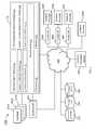
- FIG. 1illustrates a system 100 of managing geotag data associated with content in a geofeed, according to an aspect of the invention.
- a geofeedincludes a collection of content, aggregated from various content providers, that is relevant to a geographically definable location (hereinafter, a “geo-location”).
- the aggregated contentalso referred to herein as “geofeed content” may include, for example, video, audio, images, text, hyperlinks, and/or other content that may be relevant to a geo-location.
- the content providersmay include, for example, social media platforms (e.g., FACEBOOK, TWITTER, INSTAGRAM, FLICKR, etc.), online knowledge databases, and/or other providers that can distribute content that may be relevant to a geo-location.
- the geo-locationmay be specified by a boundary, geo coordinates (e.g., latitude, longitude, altitude/depth), an address, a school, a place name, a point of interest, a zip code, a city, a state, a country, and/or other information that can spatially identify an area.
- Social media platformsmay, for example, register users so that the users may post content, which is distributed by the social media platform to other users.
- the contentmay be generated by content sources such as individuals, corporations, and/or other entities that may create content.
- a locationAs used hereinafter, “a location,” “a geo-location,” “a geographically definable location,” and similar language is not limited to a single location but may also refer to one or more such locations.
- System 100may include a computer 110 , a geofeed API 122 , a content consumer device 160 , provider APIs 140 , content providers 150 , and/or other components.
- computer 110may include one or more processors 120 configured to perform some or all of a functionality of a plurality of modules, which may be stored in a memory 121 .
- the one or more processorsmay be configured to execute a geofeed creation module 111 , a profile-based geo-searching module 112 , a location prediction module 113 , a location accuracy determination module 114 , a communication module 115 , a user interface module 116 , and/or other modules 119 .
- Geofeed creation module 111may be configured to create one or more geofeeds 101 (illustrated in FIG. 1 as geofeed 101 A, 101 B, . . . , 101 N), as described in U.S. patent application Ser. No. 13/284,455, filed Oct. 28, 2011, entitled “SYSTEM AND METHOD FOR AGGREGATING AND DISTRIBUTING GEOTAGGED CONTENT,” and U.S. patent application Ser. No. 13/619,888, filed Sep. 14, 2012, entitled “SYSTEM AND METHOD FOR GENERATING, ACCESSING, AND UPDATING GEOFEEDS” both of which are incorporated by reference herein in their entirety.
- geofeed creation module 111may be configured to receive a request to create a geofeed and/or retrieve a previously requested geofeed (hereinafter, “geofeed request”).
- the requestmay include a specification of one or more geo-locations (hereinafter, a “geo-location specification”) and one or more geofeed parameters such as, for example, providers to include (or exclude), types of content to include (or exclude), date ranges, content matching patterns, keywords, and/or other parameters that instruct the system as to which content should be included in the geofeed.
- Geofeed creation module 111may format a geofeed request specific for different provider APIs 140 (illustrated in FIG. 1 as API 140 A, 140 B, . . . , 140 N).
- the provider APIsmay facilitate receiving content from corresponding content providers 150 (illustrated in FIG. 1 as content providers 150 A, 150 B, 150 C).
- geofeed creation module 111may format a request directly for content provider 150 N without using a corresponding API. Formatting instructions may be stored at a provider profile 134 .
- a content consumer device 160may request and view geofeeds 101 created by geofeed creation module 111 .
- Content provided by content providers 150 in response to a geofeed requestmay already have geotag data embedded in the content.
- the contentmay have been automatically geotagged (e.g., by a GPS-enabled device), geotagged based on a user input (e.g., the content creator manually inputting a geo-location when creating a social media post), geotagged by a content provider (e.g., the content provider creating geotag data using various techniques as apparent to those of ordinary skill in the art), geotagged using a location specified in a user profile (hereinafter, “profile location”) of the content creator who created the particular content, and/or geotagged with other types of geotag data (hereinafter, “geotagged content”).
- profile locationa location specified in a user profile
- geotagged contentgeotagged with other types of geotag data
- a user profile of a content creatoroften contains geographic location information such as a “home” location of the content creator since many content providers require content creators (e.g., social media users) to indicate their “home” locations in their profiles when they initially sign up for social media services.
- a particular content providermay use a profile location associated with the content creator to define a location of where the content was created and/or geotag the content with the profile location.
- profile-based geo-searching module 112may be configured to identify a profile location associated with the content and/or use the profile location to determine whether the content is related to one or more geo-locations specified in the geofeed request. This capability to search for content based on the profile location may be enabled or disabled. When it is enabled, profile-based geo-searching module 112 may identify a profile location associated with content by accessing the user profile of the content creator who created the particular content and/or create a geotag for the content using the profile location.
- profile-based geo-searching module 112may identify a profile location and compare it with the one or more geo-locations specified in the geofeed request to determine whether the content is related to the one or more geo-locations.
- content provided by content providers 150 in response to a geofeed requestmay include content that is not already associated with a geotag when the content is acquired by geofeed creation module 111 (hereinafter, “non-geotagged content”).
- non-geotagged contentmay be deemed responsive to the geofeed request when other tags/metadata (e.g., keywords, creation time/date, etc.) associated with the non-geotagged content match the criteria defined by one or more geofeed parameters (e.g., keywords, date ranges, etc.) of the geofeed request.
- Location prediction module 113may be configured to determine geotag data for non-geotagged content that is not already associated with a geotag when the content is acquired by geofeed creation module 111 and/or to link the determined geotag data to the content. Location prediction module 113 may determine the geotag data that would most accurately describes a location where the content was created using various geotag recognition techniques including text, image, or speech recognition, context-based recognition, automated crawling of hyperlinks, automated correlation between non-geotagged content and geo-tagged content, or any combination thereof.
- location prediction module 113may determine geotag data by recognizing buildings, signage, other indication of a particular landmark or place, and/or other geographical features in the non-geotagged content.
- non-geotagged contentmay comprise a status update (e.g. FACEBOOK “status update”) referring to the Empire State Building: “I am at the Empire State Building.”
- Location prediction module 113may recognize the word “the Empire State Building” as an indication of geo-location and/or retrieve a geo-location (e.g., geographic coordinates) that corresponds to the known location of the Empire State Building.
- non-geotagged contentmay comprise a photograph that shows the White House. Location prediction module 113 may utilize an image recognition technique to recognize that the photograph includes an image of the White House and the photograph may be geotagged with the geographic coordinates of the White House.
- the non-geotagged contentmay be automatically tagged with geotag data by analyzing hyperlinks included in the content.
- the non-geotagged contentmay include a hyperlink that links and/or points to geotagged content.
- a geotagmay be retrieved from the geotagged content and/or automatically applied to the non-geotagged content or it may be configured to be applied only if certain conditions have been satisfied. For instance, whether the non-geotagged content should adopt the geotag may be determined based on a temporal proximity of the creation date/time of the geotagged content to the creation date/time of the non-geotagged content. Such a condition may be necessary to ensure that the geotag data that is applied to the non-geotagged content accurately describes the location where the non-geotagged content was created.
- a content creatormay create a social media post that includes a hyperlink that links and/or points to a geotagged image of the place where he/she is at (e.g., “I am here right now, http:// . . . ”) soon after the image was created.
- the content creatormay create a social media post about the geotagged image after a predefined time has elapsed since the image was created (e.g., “I was here yesterday, http:// . . . ”). If a predefined time has elapsed since the geotagged image was created, the geotag data associated with the image may no longer be relevant to the location where a subsequent post about the image is eventually created.
- Metadatamay contain any number of other types of metadata (e.g., tags) other than a geotag such as a title, comment, description, identification of a content creator, creation/modification date/time, content type, etc.
- location prediction module 113may search through such metadata associated with non-geotagged content to identify metadata that may provide an indication of geo-location.
- non-geotagged contentmay comprise a photograph that may be titled “the Empire State Building,” in which case location prediction module 113 may tag the content with the geo-location associated with the Empire State Building.
- location prediction module 113may utilize metadata associated with other content that the non-geotagged content has a relationship with.
- the non-geotagged content and the other contentmay have a hierarchical relationship with each other.
- a photographmay belong to a photo album that is titled “Red Sox game.”
- Location prediction module 113may recognize this title of the photo album as an indication of geo-location (e.g., the Fenway Park, Boston, Mass.) and tag the photograph within the album with that geo-location.
- geographic location information of a place/locationmay be obtained and/or retrieved from an external database and/or other database storage that may store and/or maintain geographic information related to popular landmarks, places, etc.
- location prediction module 113may be configured to make an automatic correlation between non-geotagged content and geotagged content.
- the geotagged contentmay include geotagged content that was obtained by geofeed creation module 111 in response to the current geofeed request, geotagged content that was previously obtained by geofeed creation module 111 based on past geofeed requests, content in which geotag data have been embedded by location prediction module 112 , and/or any other geotagged content.
- Previously obtained geotagged contentmay be retrieved from a geofeed database 132 , for example. Once a correlation is identified between the non-geotagged content and geotagged content, location prediction module 113 may tag the non-geotagged content with a geotag associated with the geotagged content.
- location prediction module 113may also identify a correlation between non-geotagged content and geotagged content based on similarity in content and/or similarity between metadata (e.g., creation/modification date/time, identification of a content creator, etc.) associated with the non-geotagged content and metadata associated with the geotagged content.
- metadatae.g., creation/modification date/time, identification of a content creator, etc.
- location prediction module 113may determine that a correlation exists between them and/or tag the non-geotagged content with a geotag included in the geotagged content.
- location prediction module 113may correlate non-geotagged content with geotagged content at least in part on the basis of similarity between metadata associated with the non-geotagged content and metadata associated with the geotagged content. For example, if the same content creator created both the non-geotagged content and the geotagged content around the same time (e.g., the content creator created the non-geotagged content within few minutes before/after the creation time of the geotagged content), location prediction module 113 may determine that a correlation exists between them and/or tag the non-geotagged content with a geotag included in the geotagged content.
- Location accuracy determination module 114may be configured to predict, estimate, and/or otherwise determine the accuracy of a geotag assigned and/or associated with content by calculating or otherwise determining a confidence level of location information defined in the geotag (“geotag confidence level”).
- geotag confidence levelmay indicate a likelihood (and/or probability) that the geotag accurately describes and/or matches a location from which the content was created. This confidence level may also be indicative of likelihood that the content associated with the particular geotag was actually created within the geo-location specified in the geofeed request.
- location accuracy determination module 114may calculate or otherwise determine the confidence level by identifying a source from which the geotag originated (“geotag sources”).
- Geotag sourcesmay include, for example, a GPS-enabled device (e.g., smartphone), a user input (e.g., the content creator manually inputting a geo-location when creating a social media post), a content provider (e.g., the content provider creating geotag data using various techniques as apparent to those of ordinary skill in the art), a user profile (e.g., the “home” location of the content creator), and/or location prediction module 113 (e.g., geotagged by crawling hyperlinks within content, automatic correlation, and/or other ways as discussed herein with respect to location prediction module 113 ).
- geotags provided by geotag sourcessuch as a GPS-enabled device and/or user input may be more likely to be accurate than the ones provided by a user profile and/or location prediction module 113 , and thus may be assigned a higher confidence level.
- a geotag confidence levelmay have a different predetermined and/or predefined confidence level value.
- a geotag provided by a GPS-enabled devicemay be assigned a predetermined confidence level (e.g., 95%) that may be different from a predetermined confidence level (e.g., 75%) that may be assigned to a geotag provided by a user profile.
- location accuracy determination module 114may be configured to determine a geotag confidence level for the profile-based geofeed result based on a statistical analysis on a large quantity of geotagged content that has been geotagged by a geotag source other than a user profile (“non-profile-based geotagged content”) (e.g., content that is geotagged with geographical coordinates) where the non-profile-based geotagged content was created within a geo-location specified in a geofeed request.
- non-profile-based geotagged contente.g., content that is geotagged with geographical coordinates
- location accuracy determination module 114may obtain from content providers a large quantity of non-profile-based geotagged content that are located within the specified geo-location from which the profile-based geofeed result also originated. Location accuracy determination module 114 may identify and/or obtain a profile location associated with individual non-profile-based geotagged content based on the user profile of the content creator who created the particular content. This profile location may be compared to the geographical coordinates (or other geo-location information) defined in the geotag of the individual non-profile-based geotagged content to determine whether the profile location matches with and/or correspond to the geotag data. A geotag location and a profile location may match and/or correspond to each other when they are directed to a location that is common to each other (e.g., two locations having an overlapping area).
- location accuracy determination module 114may calculate, based on the comparison, a percentage of non-profile-based geotagged content whose geotag location match with and/or correspond to its profile location in a total quantity of non-profile-based geotagged content obtained by location accuracy determination module 114 .
- This percentage valuemay indicate a confidence level that the profile-based geofeed result actually originated from the specified geo-location. In other words, it may indicate a degree of likelihood that the profile location associated with the profile-based geofeed result accurately corresponds to the location where the content related to the profile-based geofeed result was actually created.
- location accuracy determination module 114may count the number of non-profile-based geotagged content whose geotag location (e.g., geographical coordinates) match with and/or correspond to its profile location and divide this counted number by the total number of non-profile-based geotagged content obtained by location accuracy determination module 114 . As such, the higher this counted number is, the higher the confidence level determined for the profile-based geofeed result will be.
- geotag locatione.g., geographical coordinates
- Communication module 115may be configured to communicate the geofeed comprising the content that is associated with geotags obtained from one or more geotag sources.
- the geofeedmay be communicated to the content consumer via the user interface communicated via user interface module 116 and/or other communication channel.
- User interface module 116may be configured to generate a user interface that displays the content within a geofeed along with a confidence level indicating the accuracy of the geotag associated with the content and/or a corresponding geotag source.
- user interface module 116may display a scrollbar, a text input box, and/or other input fields that can receive a user input for a threshold confidence level.
- a usermay via an input field indicate a threshold confidence level and user interface module 116 may highlight or otherwise differentially display content with a confidence level that is higher than the threshold value from content with a confidence level that is lower than the threshold value.
- FIGS. 5-7Exemplary screenshots of interfaces generated by user interface module 116 are illustrated in FIGS. 5-7 .
- computer 110 and content consumer device 160may each comprise one or more processors, one or more interfaces (to various peripheral devices or components), memory, one or more storage devices, and/or other components coupled via a bus.
- the memorymay comprise random access memory (RAM), read only memory (ROM), or other memory.
- RAMrandom access memory
- ROMread only memory
- the memorymay store computer-executable instructions to be executed by the processor as well as data that may be manipulated by the processor.
- the storage devicesmay comprise floppy disks, hard disks, optical disks, tapes, or other storage devices for storing computer-executable instructions and/or data.
- One or more applicationsmay be loaded into memory and run on an operating system of computer 110 and/or consumer device 160 .
- computer 110 and consumer device 160may each comprise a server device, a desktop computer, a laptop, a cell phone, a smart phone, a Personal Digital Assistant, a pocket PC, or other device.
- Network 102may include any one or more of, for instance, the Internet, an intranet, a PAN (Personal Area Network), a LAN (Local Area Network), a WAN (Wide Area Network), a SAN (Storage Area Network), a MAN (Metropolitan Area Network), a wireless network, a cellular communications network, a Public Switched Telephone Network, and/or other network.
- a PANPersonal Area Network
- LANLocal Area Network
- WANWide Area Network
- SANStorage Area Network
- MANMetropolitan Area Network
- wireless networka wireless network
- cellular communications networka cellular communications network
- Public Switched Telephone Networkand/or other network.
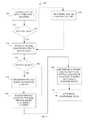
- FIG. 2illustrates a process 200 for managing geotag data associated with content within a geofeed and determining a geotag confidence level associated with the geotag data, according to an aspect of the invention.
- the various processing operations and/or data flows depicted in FIG. 2are described in greater detail herein. The described operations may be accomplished using some or all of the system components described in detail above and, in some implementations, various operations may be performed in different sequences and various operations may be omitted. Additional operations may be performed along with some or all of the operations shown in the depicted flow diagrams. One or more operations may be performed simultaneously. Accordingly, the operations as illustrated (and described in greater detail below) are exemplary by nature and, as such, should not be viewed as limiting.
- process 200may include obtaining content associated with a geofeed.
- the geofeedmay be created and/or retrieved by computer 110 .
- process 200may include determining whether metadata associated with the obtained content includes geotag data. If process 200 determines that the metadata associated with the content includes geotag data, process 200 may include determining a geotag confidence level associated with the geotag data in an operation 206 . On the other hand, if the metadata associated with the content does not include geotag data, process 200 may include determining geotag data for the content in an operation 208 .
- process 200may include determining the geotag data to be associated with the content in response to determining that the metadata associated with the content does not include the geotag data.
- Process 200may determine the geotag data that would most accurately describes a location where the content was created using various geotag recognition techniques including text, image, or speech recognition, context-based recognition, automated crawling of hyperlinks, automated correlation between non-geotagged content and geo-tagged content, or any combination thereof.
- process 200may identify a hyperlink in the content where the hyperlink points and/or links to other geotagged content whose metadata includes geotag data.
- Process 200may retrieve the geotag data from the geotagged content and/or apply to the content.
- process 200may include determining a geotag confidence level associated with the geotag data where the geotag data may have been already embedded in the content obtained in operation 202 or determined using one or more geotag recognition techniques in operation 208 .
- Process 200may include predicting, estimating, and/or otherwise determining the accuracy of geotag data assigned and/or associated with content by calculating or otherwise determining a confidence level of location information defined in the geotag data (“geotag confidence level”).
- geotag confidence levelmay indicate a likelihood (and/or probability) that the geotag data accurately describes and/or matches a location from which the content was created. This confidence level may also be indicative of likelihood that the content associated with the particular geotag was actually created within the geo-location specified in the geofeed request.
- FIG. 3illustrates a process 300 for managing geotag data associated with content within a geofeed and determining a geotag confidence level associated with the geotag data based on a geotag source related to the geotag data, according to an aspect of the invention.
- process 300may include obtaining content associated with a geofeed.
- the geofeedmay be created and/or retrieved by computer 110 .
- process 300may include determining whether metadata associated with the obtained content includes geotag data. If process 300 determines that the metadata associated with the content includes geotag data, process 300 may include identifying a geotag source related to the geotag data in an operation 306 . On the other hand, if the metadata associated with the content does not include geotag data, process 300 may include determining geotag data for the content in an operation 308 .
- process 300may include determining the geotag data to be associated with the content in response to determining that the metadata associated with the content does not include the geotag data.
- Process 300may determine the geotag data that would most accurately describes a location where the content was created using various geotag recognition techniques including text, image, or speech recognition, context-based recognition, automated crawling of hyperlinks, automated correlation between non-geotagged content and geo-tagged content, or any combination thereof. For example, process 300 may identify a hyperlink in the content where the hyperlink points and/or links to other geotagged content whose metadata includes geotag data. Process 300 may retrieve the geotag data from the geotagged content and/or apply to the content.
- process 300may include identifying a source from which the geotag data originated (“geotag sources”).
- Geotag sourcesmay include, for example, a GPS-enabled device (e.g., smartphone), a user input (e.g., the content creator manually inputting a geo-location when creating a social media post), a content provider (e.g., the content provider creating geotag data using various techniques as apparent to those of ordinary skill in the art), a user profile (e.g., the “home” location of the content creator), and/or location prediction module 113 (e.g., geotagged by crawling hyperlinks within content, automatic correlation, and/or other ways as discussed herein with respect to location prediction module 113 ).
- a GPS-enabled devicee.g., smartphone
- a user inpute.g., the content creator manually inputting a geo-location when creating a social media post
- a content providere.g., the content provider creating geotag data using various techniques as apparent to those of ordinary skill in the art
- the geotag data determined in operation 308may be associated with a geotag source such as location prediction module 113 whereas the geotag data already embedded in the content obtained in operation 302 may be associated with a geotag source such as a GPS-enabled device, a user input, a content provider, a user profile, etc.
- a geotag sourcesuch as a GPS-enabled device, a user input, a content provider, a user profile, etc.
- process 300may include determining a geotag confidence level associated with the geotag data based on the geotag source identified in operation 306 .
- geotags provided by geotag sourcessuch as a GPS-enabled device and/or user input may be more likely to be accurate than the ones provided by a user profile and/or location prediction module 113 , and thus may be assigned a higher confidence level.
- FIG. 4illustrates a process 400 for managing geotag data associated with content within a geofeed and determining a geotag confidence level associated with the geotag data where the geotag data has been obtained based on a user profile of a content creator who created the content, according to an aspect of the invention.
- process 400may include obtaining content associated with a geofeed.
- the geofeedmay be created and/or retrieved by computer 110 .
- process 400may include determining whether metadata associated with the obtained content includes geotag data. If process 400 determines that the metadata associated with the content includes geotag data, process 400 may include identifying a geotag source related to the geotag data in an operation 406 . On the other hand, if the metadata associated with the content does not include geotag data, process 400 may include determining geotag data for the content in an operation 408 .
- process 400may include determining the geotag data to be associated with the content in response to determining that the metadata associated with the content does not include the geotag data.
- Process 400may determine the geotag data that would most accurately describes a location where the content was created using various geotag recognition techniques including text, image, or speech recognition, context-based recognition, automated crawling of hyperlinks, automated correlation between non-geotagged content and geo-tagged content, or any combination thereof. For example, process 400 may identify a hyperlink in the content where the hyperlink points and/or links to other geotagged content whose metadata includes geotag data. Process 400 may retrieve the geotag data from the geotagged content and/or apply to the content.
- process 400may include identifying a source from which the geotag data originated (“geotag sources”).
- Geotag sourcesmay include, for example, a GPS-enabled device (e.g., smartphone), a user input (e.g., the content creator manually inputting a geo-location when creating a social media post), a content provider (e.g., the content provider creating geotag data using various techniques as apparent to those of ordinary skill in the art), a user profile (e.g., the “home” location of the content creator), and/or location prediction module 113 (e.g., geotagged by crawling hyperlinks within content, automatic correlation, and/or other ways as discussed herein with respect to location prediction module 113 ).
- a GPS-enabled devicee.g., smartphone
- a user inpute.g., the content creator manually inputting a geo-location when creating a social media post
- a content providere.g., the content provider creating geotag data using various techniques as apparent to those of ordinary skill in the art
- the geotag data determined in operation 408may be associated with a geotag source such as location prediction module 113 whereas the geotag data already embedded in the content obtained in operation 402 may be associated with a geotag source such as a GPS-enabled device, a user input, a content provider, a user profile, etc.
- a geotag sourcesuch as a GPS-enabled device, a user input, a content provider, a user profile, etc.
- process 400may include determining whether the geotag source identified in operation 406 is a user profile. If process 400 determines that the geotag source identified in operation 406 is not a user profile, process 400 may proceed to an operation 418 . On the other hand, if the geotag source identified in operation 406 is a user profile, process 400 may include obtaining from content providers a large quantity of non-profile-based geotagged content that are located within a geo-location specified in the geofeed request in an operation 412 .
- process 400may include identifying and/or obtaining a profile location associated with individual non-profile-based geotagged content based on the user profile of the content creator who created the particular content.
- process 400may include determining whether the geotag data and the profile location of the non-profile-based geotagged content match. In doing so, the profile location may be compared to the geographical coordinates (or other geo-location information) defined in the geotag data of the individual non-profile-based geotagged content to determine whether the profile location matches with and/or correspond to the geotag data. For example, a geotag location and a profile location may match and/or correspond to each other when they are directed to a location that is common to each other (e.g., two locations having an overlapping area).
- process 400may include determining a geotag confidence level associated with the geotag data of the content (“profile-based geofeed result”) wherein the geotag data has been generated based on the user profile of the content creator who created the content. In doing so, process 400 may include calculating a percentage of non-profile-based geotagged content whose geotag location match with and/or correspond to its profile location in a total quantity of non-profile-based geotagged content obtained in operation 412 . This percentage value may indicate a confidence level that the profile-based geofeed result actually originated from the specified geo-location. In other words, it may indicate a degree of likelihood that the profile location associated with the profile-based geofeed result accurately corresponds to the location where the content related to the profile-based geofeed result was actually created.
- FIG. 5illustrates a screenshot of an interface 500 for communicating a geofeed comprising content associated with geotag data obtained from one or more geotag sources, according to an aspect of the invention.
- the screenshots illustrated in FIG. 5 and other drawing figuresare for illustrative purposes only. Various components may be added, deleted, moved, or otherwise changed so that the configuration, appearance, and/or content of the screenshots may be different than as illustrated in the figures. Accordingly, the graphical user interface objects as illustrated (and described in greater detail below) are exemplary by nature and, as such, should not be viewed as limiting.
- Interface 500 and other interfaces described hereinmay be implemented as a web page communicated from computer 110 to a client, an application such as a mobile application executing on the client that receives generates the interface based on information communicated from computer 110 , and/or other interface. Whichever type of interface is used, computer 110 may communicate the data and/or formatting instructions related to the interface to the client, causing the client to generate the various interfaces of FIG. 5 and other drawing figures. Furthermore, computer 110 may receive data from the client via the various interfaces, as would be appreciated.
- interface 500may include a geofeed bounded by a geo-location defined by polygon 501 .
- the geofeedmay include content items 510 - 515 whose locations reside within the geo-location defined by polygon 501 .
- Individual content items 510 - 515may be associated with a geotag that has been obtained from one or more geotag sources.
- Geotag sourcesmay include, for example, a GPS-enabled device (e.g., smartphone), a user input (e.g., the content creator manually inputting a geo-location when creating a social media post), a content provider (e.g., the content provider creating geotag data using various techniques as apparent to those of ordinary skill in the art), a user profile (e.g., the “home” location of the content creator), and/or location prediction module 113 (e.g., geotagged by crawling hyperlinks within content, automatic correlation, and/or other ways as discussed herein with respect to location prediction module 113 ).
- a GPS-enabled devicee.g., smartphone
- a user inpute.g., the content creator manually inputting a geo-location when creating a social media post
- a content providere.g., the content provider creating geotag data using various techniques as apparent to those of ordinary skill in the art
- a user profilee.g., the “home” location of the content creator
- Geotag detail element 510 Amay include information related to the geotag associated with content item 510 such as, for example, a geotag source (e.g., GPS-enabled device) that provided the geotag and/or a confidence level associated with the geotag.
- the confidence levelmay indicate a likelihood (and/or probability) that the geotag accurately describes and/or matches a location from which content item 510 was created. This confidence level may also be indicative of likelihood that content item 510 associated with the particular geotag was actually created within the geo-location defined by polygon 501 .
- FIG. 6illustrates a screenshot of an interface 600 for communicating a geofeed comprising content associated with geotag data that is obtained based on a user profile of a content creator who created the content, according to an aspect of the invention.
- Interface 600may include a geofeed bounded by a geo-location defined by polygon 601 .
- the geofeedmay include profile-based geofeed result 610 which has been geotagged based on a profile location included in a user profile of a content creator who created the content in profile-based geofeed result 610 .
- Computer 110may determine a geotag confidence level indicative of a likelihood that the profile location associated with profile-based geofeed result 610 accurately corresponds to the location where the content related to profile-based geofeed result 610 was actually created based on a statistical analysis on a large quantity of geotagged content that has been geotagged by a geotag source other than a user profile (“non-profile-based geotagged content”) (e.g., content that is geotagged with geographical coordinates) where the non-profile-based geotagged content was created within the geo-location specified for the geofeed.
- interface 600may include non-profile-based geotagged content items 611 - 613 whose geotag locations are within the geo-location defined by polygon 601 .
- Computer 110may identify and/or obtain a profile location associated with individual non-profile-based geotagged content items 611 - 613 by accessing the user profile of the content creator who created the particular content. This profile location may be compared to the geographical coordinates (or other geo-location information) defined in the geotag of the individual non-profile-based geotagged content items 611 - 613 to determine whether the profile location matches or otherwise correspond to the geotag data. As illustrated, non-profile-based geotagged content item 611 may be associated with a geotag which comprises latitude and longitude coordinates of (39.098, ⁇ 94.519).
- Computer 110may look up a user profile of the content creator who created content item 611 to determine a profile location which may be a “home” location (e.g., Kansas City, Mo.) for the content creator.
- Computer 110may compare the geographic coordinates of the geotag and the profile location to determine whether the geotag location and the profile location match and/or correspond to each other. For example, the geographic coordinates of content item 611 and content item 612 are located within the corresponding profile locations. On the other hand, the geographic coordinates of content item 613 and its profile location are spatially distant from each other and/or are not directed to a location that is common to each other.
- computer 110may set the confidence level for profile-based geofeed result 610 to be 75% since 2 out of 3 non-profile-based geotagged content items are associated with geotag locations that match with and/or correspond to their associated profile locations.
- FIG. 7illustrates a screenshot of an interface 700 for communicating content within a geofeed based on geotag data confidence level selected by a user, according to an aspect of the invention.
- Interface 700may include a geofeed bounded by a geo-location defined by polygon 701 .
- the geofeedmay include content items 710 - 715 whose locations reside within the geo-location defined by polygon 501 .
- Individual content items 710 - 715may be associated with a geotag that has been obtained from one or more geotag sources.
- Geotag sourcesmay include, for example, a GPS-enabled device (e.g., smartphone), a user input (e.g., the content creator manually inputting a geo-location when creating a social media post), a content provider (e.g., the content provider creating geotag data using various techniques as apparent to those of ordinary skill in the art), a user profile (e.g., the “home” location of the content creator), and/or location prediction module 113 (e.g., geotagged by crawling hyperlinks within content, automatic correlation, and/or other ways as discussed herein with respect to location prediction module 113 ).
- Computer 110may determine a geotag confidence level for individual content items 710 - 715 based on the type of geotag source that provided the geotag for the particular content item and/or using any other techniques discussed herein.
- Interface 700may include an input field that may receive a threshold confidence level selected by a user.
- the input fieldmay include a scrollbar, a text input box, and/or other input mechanisms.
- interface 700may include scrollbar 720 having movable indicator 721 for indicating a threshold confidence level against which the geotag confidence level for individual content items 710 - 715 is compared.
- Interface 700may highlight or otherwise differentially display content with a confidence level that is higher than the threshold confidence level from content with a confidence level that is lower than the threshold confidence level. For example, a user may using movable indicator 721 indicate a threshold confidence level of 80%. Interface 700 may display content items 710 , 712 , 713 whose associated geotag confidence levels are above 80% in solid line and content items 711 , 714 , 715 whose associated geotag confidence levels are below 80% in dotted line. In another example, interface 700 may cause content items 711 , 714 , 715 to disappear since their associated geotag confidence levels are below the threshold confidence level set by the user.
Landscapes
- Engineering & Computer Science (AREA)
- Theoretical Computer Science (AREA)
- Databases & Information Systems (AREA)
- General Physics & Mathematics (AREA)
- Physics & Mathematics (AREA)
- General Engineering & Computer Science (AREA)
- Data Mining & Analysis (AREA)
- Remote Sensing (AREA)
- Library & Information Science (AREA)
- Multimedia (AREA)
- Computer Security & Cryptography (AREA)
- Information Retrieval, Db Structures And Fs Structures Therefor (AREA)
- Information Transfer Between Computers (AREA)
Abstract
Description
Claims (17)
Priority Applications (3)
| Application Number | Priority Date | Filing Date | Title |
|---|---|---|---|
| US14/512,293US9436690B2 (en) | 2013-03-15 | 2014-10-10 | System and method for predicting a geographic origin of content and accuracy of geotags related to content obtained from social media and other content providers |
| US15/241,836US9805060B2 (en) | 2013-03-15 | 2016-08-19 | System and method for predicting a geographic origin of content and accuracy of geotags related to content obtained from social media and other content providers |
| US15/797,766US20180060353A1 (en) | 2013-03-15 | 2017-10-30 | System and method for predicting a geographic origin of content and accuracy of geotags related to content obtained from social media and other content providers |
Applications Claiming Priority (2)
| Application Number | Priority Date | Filing Date | Title |
|---|---|---|---|
| US13/843,949US8862589B2 (en) | 2013-03-15 | 2013-03-15 | System and method for predicting a geographic origin of content and accuracy of geotags related to content obtained from social media and other content providers |
| US14/512,293US9436690B2 (en) | 2013-03-15 | 2014-10-10 | System and method for predicting a geographic origin of content and accuracy of geotags related to content obtained from social media and other content providers |
Related Parent Applications (1)
| Application Number | Title | Priority Date | Filing Date |
|---|---|---|---|
| US13/843,949ContinuationUS8862589B2 (en) | 2013-03-15 | 2013-03-15 | System and method for predicting a geographic origin of content and accuracy of geotags related to content obtained from social media and other content providers |
Related Child Applications (1)
| Application Number | Title | Priority Date | Filing Date |
|---|---|---|---|
| US15/241,836ContinuationUS9805060B2 (en) | 2013-03-15 | 2016-08-19 | System and method for predicting a geographic origin of content and accuracy of geotags related to content obtained from social media and other content providers |
Publications (2)
| Publication Number | Publication Date |
|---|---|
| US20150032739A1 US20150032739A1 (en) | 2015-01-29 |
| US9436690B2true US9436690B2 (en) | 2016-09-06 |
Family
ID=51533114
Family Applications (4)
| Application Number | Title | Priority Date | Filing Date |
|---|---|---|---|
| US13/843,949ActiveUS8862589B2 (en) | 2013-03-15 | 2013-03-15 | System and method for predicting a geographic origin of content and accuracy of geotags related to content obtained from social media and other content providers |
| US14/512,293ActiveUS9436690B2 (en) | 2013-03-15 | 2014-10-10 | System and method for predicting a geographic origin of content and accuracy of geotags related to content obtained from social media and other content providers |
| US15/241,836ActiveUS9805060B2 (en) | 2013-03-15 | 2016-08-19 | System and method for predicting a geographic origin of content and accuracy of geotags related to content obtained from social media and other content providers |
| US15/797,766AbandonedUS20180060353A1 (en) | 2013-03-15 | 2017-10-30 | System and method for predicting a geographic origin of content and accuracy of geotags related to content obtained from social media and other content providers |
Family Applications Before (1)
| Application Number | Title | Priority Date | Filing Date |
|---|---|---|---|
| US13/843,949ActiveUS8862589B2 (en) | 2013-03-15 | 2013-03-15 | System and method for predicting a geographic origin of content and accuracy of geotags related to content obtained from social media and other content providers |
Family Applications After (2)
| Application Number | Title | Priority Date | Filing Date |
|---|---|---|---|
| US15/241,836ActiveUS9805060B2 (en) | 2013-03-15 | 2016-08-19 | System and method for predicting a geographic origin of content and accuracy of geotags related to content obtained from social media and other content providers |
| US15/797,766AbandonedUS20180060353A1 (en) | 2013-03-15 | 2017-10-30 | System and method for predicting a geographic origin of content and accuracy of geotags related to content obtained from social media and other content providers |
Country Status (1)
| Country | Link |
|---|---|
| US (4) | US8862589B2 (en) |
Cited By (8)
| Publication number | Priority date | Publication date | Assignee | Title |
|---|---|---|---|---|
| US9479557B2 (en) | 2013-03-07 | 2016-10-25 | Geofeedia, Inc. | System and method for creating and managing geofeeds |
| US9485318B1 (en) | 2015-07-29 | 2016-11-01 | Geofeedia, Inc. | System and method for identifying influential social media and providing location-based alerts |
| US9497275B2 (en) | 2013-03-15 | 2016-11-15 | Geofeedia, Inc. | System and method for generating three-dimensional geofeeds, orientation-based geofeeds, and geofeeds based on ambient conditions based on content provided by social media content providers |
| US9619489B2 (en) | 2013-03-15 | 2017-04-11 | Geofeedia, Inc. | View of a physical space augmented with social media content originating from a geo-location of the physical space |
| US9805060B2 (en) | 2013-03-15 | 2017-10-31 | Tai Technologies, Inc. | System and method for predicting a geographic origin of content and accuracy of geotags related to content obtained from social media and other content providers |
| US10044732B2 (en) | 2013-03-07 | 2018-08-07 | Tai Technologies, Inc. | System and method for targeted messaging, workflow management, and digital rights management for geofeeds |
| US10158497B2 (en) | 2012-12-07 | 2018-12-18 | Tai Technologies, Inc. | System and method for generating and managing geofeed-based alerts |
| US10523768B2 (en) | 2012-09-14 | 2019-12-31 | Tai Technologies, Inc. | System and method for generating, accessing, and updating geofeeds |
Families Citing this family (22)
| Publication number | Priority date | Publication date | Assignee | Title |
|---|---|---|---|---|
| US8655983B1 (en) | 2012-12-07 | 2014-02-18 | Geofeedr, Inc. | System and method for location monitoring based on organized geofeeds |
| US9307353B2 (en) | 2013-03-07 | 2016-04-05 | Geofeedia, Inc. | System and method for differentially processing a location input for content providers that use different location input formats |
| US9454544B1 (en)* | 2013-03-15 | 2016-09-27 | Google Inc. | Selecting destinations or points of interest |
| US20150066925A1 (en)* | 2013-08-27 | 2015-03-05 | Qualcomm Incorporated | Method and Apparatus for Classifying Data Items Based on Sound Tags |
| US20150172396A1 (en)* | 2013-12-16 | 2015-06-18 | Co Everywhere, Inc. | Systems and methods for enriching geographically delineated content |
| JP6075298B2 (en)* | 2014-01-14 | 2017-02-08 | トヨタ自動車株式会社 | Information processing apparatus and mobile terminal |
| US9361317B2 (en)* | 2014-03-04 | 2016-06-07 | Qbase, LLC | Method for entity enrichment of digital content to enable advanced search functionality in content management systems |
| US20150304368A1 (en)* | 2014-04-16 | 2015-10-22 | Facebook, Inc. | Sharing Locations with Friends on Online Social Networks |
| US10031925B2 (en)* | 2014-10-15 | 2018-07-24 | Thinkcx Technologies, Inc. | Method and system of using image recognition and geolocation signal analysis in the construction of a social media user identity graph |
| US20160267144A1 (en)* | 2015-03-12 | 2016-09-15 | WeLink, Inc. | Collecting and generating geo-tagged social media data through a network router interface |
| US9405743B1 (en) | 2015-05-13 | 2016-08-02 | International Business Machines Corporation | Dynamic modeling of geospatial words in social media |
| CN105279271A (en)* | 2015-10-28 | 2016-01-27 | 田磊 | Message push method and apparatus |
| WO2017109796A2 (en)* | 2015-12-26 | 2017-06-29 | Attinad Software Pvt. Ltd. | System and method of geotagging of metadata in dynamic forms |
| US20170337205A1 (en)* | 2016-05-18 | 2017-11-23 | National Central University | Geospatial Web Crawler Architecture |
| US10678780B2 (en)* | 2017-01-05 | 2020-06-09 | Serelay Limited | Cross verification of data captured by a consumer electronic device |
| WO2018195334A2 (en)* | 2017-04-20 | 2018-10-25 | Mylio, LLC | Systems and methods to autonomously add geolocation information to media objects |
| US10924560B2 (en)* | 2018-07-30 | 2021-02-16 | Facebook, Inc. | Determining geographic locations of network devices |
| US20220158961A1 (en)* | 2019-03-04 | 2022-05-19 | Twitter, Inc. | Media content capture and presentation |
| US11550863B2 (en)* | 2019-12-20 | 2023-01-10 | Atlassian Pty Ltd. | Spatially dynamic document retrieval |
| US11645349B2 (en)* | 2020-09-16 | 2023-05-09 | Adobe Inc. | Generating location based photo discovery suggestions |
| CN112925774B (en)* | 2021-02-01 | 2022-12-02 | 大箴(杭州)科技有限公司 | Method and device for cleaning address data, storage medium and computer equipment |
| US12153550B2 (en) | 2021-03-31 | 2024-11-26 | Atlassian Pty Ltd. | Predictive document recommendation in document collaboration server systems using temporally correlated document viewing sequence sets |
Citations (146)
| Publication number | Priority date | Publication date | Assignee | Title |
|---|---|---|---|---|
| WO1999015995A1 (en) | 1997-09-23 | 1999-04-01 | Information Architects Corporation | System for indexing and displaying requested data having heterogeneous content and representation |
| US6026368A (en) | 1995-07-17 | 2000-02-15 | 24/7 Media, Inc. | On-line interactive system and method for providing content and advertising information to a targeted set of viewers |
| EP1045345A1 (en) | 1999-04-13 | 2000-10-18 | Idc Ltd. | Navigation system display of search engine retrieved data selected according to user-given geographical criteria |
| US20020029384A1 (en) | 2000-07-20 | 2002-03-07 | Griggs Theodore L. | Mechanism for distributing content data |
| US20020029226A1 (en) | 2000-09-05 | 2002-03-07 | Gang Li | Method for combining data with maps |
| US6363320B1 (en) | 2000-08-18 | 2002-03-26 | Geospatial Technologies Inc. | Thin-client real-time interpretive object tracking system |
| US20020116505A1 (en) | 2001-02-19 | 2002-08-22 | Geoff Higgins | Content provider and method for a computer system |
| US20020128908A1 (en) | 2000-09-15 | 2002-09-12 | Levin Brian E. | System for conducting user-specific promotional campaigns using multiple communications device platforms |
| US20020188669A1 (en) | 2001-06-11 | 2002-12-12 | Levine Marc Jay | Integrated method for disseminating large spatial data sets in a distributed form via the internet |
| US20030018607A1 (en) | 2000-08-04 | 2003-01-23 | Lennon Alison Joan | Method of enabling browse and search access to electronically-accessible multimedia databases |
| US20030025832A1 (en) | 2001-08-03 | 2003-02-06 | Swart William D. | Video and digital multimedia aggregator content coding and formatting |
| US20030040971A1 (en) | 2001-08-21 | 2003-02-27 | Candace Freedenberg | User selectable earth imagery on-line e-commerce and fulfillment system |
| US20030088609A1 (en) | 1997-05-02 | 2003-05-08 | Mgi Software Corporation | Method and system for providing on-line interactivity over a server-client network |
| US6591266B1 (en) | 2000-07-14 | 2003-07-08 | Nec Corporation | System and method for intelligent caching and refresh of dynamically generated and static web content |
| US20040203854A1 (en) | 2002-04-26 | 2004-10-14 | Nowak Steven P. | Formatting location information based on output device specifications |
| US20040205585A1 (en) | 2002-06-28 | 2004-10-14 | Microsoft Corporation | XML storage solution and data interchange file format structure |
| US20040225635A1 (en) | 2003-05-09 | 2004-11-11 | Microsoft Corporation | Browsing user interface for a geo-coded media database |
| US20050034074A1 (en)* | 2003-06-27 | 2005-02-10 | Cds Business Mapping, Llc | System for increasing accuracy of geocode data |
| US20060002317A1 (en) | 2004-07-01 | 2006-01-05 | Punaganti Venkata Murali Krish | Information feeder framework |
| US20060106778A1 (en) | 2004-10-29 | 2006-05-18 | Microsoft Corporation | System and method for providing a geographic search function |
| US20060184968A1 (en) | 2005-02-11 | 2006-08-17 | Clayton Richard M | Automatic content update for a target device |
| US20060200305A1 (en) | 2005-03-07 | 2006-09-07 | Networks In Motion, Inc. | Method and system for identifying and defining geofences |
| US20070043721A1 (en) | 2005-08-22 | 2007-02-22 | Sanjay Ghemawat | Removing documents |
| US20070112729A1 (en) | 2005-11-04 | 2007-05-17 | Microsoft Corporation | Geo-tagged based listing service and mapping engine |
| US20070121843A1 (en) | 2005-09-02 | 2007-05-31 | Ron Atazky | Advertising and incentives over a social network |
| US20070143345A1 (en) | 2005-10-12 | 2007-06-21 | Jones Michael T | Entity display priority in a distributed geographic information system |
| US20070210937A1 (en) | 2005-04-21 | 2007-09-13 | Microsoft Corporation | Dynamic rendering of map information |
| US20070276919A1 (en) | 2006-05-12 | 2007-11-29 | Daniel Buchmann | Services for data access based on a data ownership directory in distributed system landscapes |
| US20070294299A1 (en) | 2006-01-17 | 2007-12-20 | Hanoch Goldstein | Methods for using geospatial information as geospatial session files |
| US20080092054A1 (en) | 2006-10-17 | 2008-04-17 | Soujanya Bhumkar | Method and system for displaying photos, videos, rss and other media content in full-screen immersive view and grid-view using a browser feature |
| US20080104019A1 (en) | 2006-10-26 | 2008-05-01 | Microsoft Corporation | Associating Geographic-Related Information with Objects |
| US20080125969A1 (en) | 2006-11-20 | 2008-05-29 | Yih-Farn Chen | Method and apparatus for providing geospatial and temporal navigation |
| US20080147674A1 (en) | 2006-02-24 | 2008-06-19 | Srinivasarao Nandiwada | System and method for managing distribution of multi-formatted content |
| US20080162540A1 (en) | 2006-12-29 | 2008-07-03 | Yahoo! Inc. | Identifying offensive content using user click data |
| US20080189099A1 (en) | 2005-01-12 | 2008-08-07 | Howard Friedman | Customizable Delivery of Audio Information |
| US20080192934A1 (en) | 2001-06-29 | 2008-08-14 | Nokia Corporation | Conditional access system |
| US20080250031A1 (en) | 2007-04-03 | 2008-10-09 | Yahoo! Inc. | Systems and methods for providing syndicated content |
| US20080294603A1 (en) | 2007-05-25 | 2008-11-27 | Google Inc. | Providing Profile Information to Partner Content Providers |
| US20090005968A1 (en) | 2007-04-13 | 2009-01-01 | Vengroff Darren E | Location-based information determination |
| US7522940B2 (en) | 2004-11-16 | 2009-04-21 | Sony Ericsson Mobile Communications Ab | Methods and mobile terminals for display of mobile terminal density information |
| US20090102859A1 (en) | 2007-10-18 | 2009-04-23 | Yahoo! Inc. | User augmented reality for camera-enabled mobile devices |
| US20090132435A1 (en) | 2007-11-21 | 2009-05-21 | Microsoft Corporation | Popularity based licensing of user generated content |
| US20090138497A1 (en) | 2007-11-06 | 2009-05-28 | Walter Bruno Zavoli | Method and system for the use of probe data from multiple vehicles to detect real world changes for use in updating a map |
| US20090210426A1 (en) | 2008-02-14 | 2009-08-20 | Ambercore Software Inc. | System and method for efficient management of distributed spatial data |
| US20090217232A1 (en) | 2004-11-22 | 2009-08-27 | Fulcrum Microsystems, Inc. | Logic synthesis of multi-level domino asynchronous pipelines |
| US20090222482A1 (en) | 2008-02-28 | 2009-09-03 | Research In Motion Limited | Method of automatically geotagging data |
| US20090297118A1 (en) | 2008-06-03 | 2009-12-03 | Google Inc. | Web-based system for generation of interactive games based on digital videos |
| US20090300528A1 (en) | 2006-09-29 | 2009-12-03 | Stambaugh Thomas M | Browser event tracking for distributed web-based processing, spatial organization and display of information |
| US20090327232A1 (en) | 2008-06-27 | 2009-12-31 | Surfmap, Inc. | Hosted system for enabling enterprises to build and operate online communities |
| US20100010907A1 (en) | 2008-07-08 | 2010-01-14 | Verizon Data Services Llc. | Method and System for Providing Location Aware Classified Content |
| US20100030648A1 (en) | 2008-08-01 | 2010-02-04 | Microsoft Corporation | Social media driven advertisement targeting |
| US7680796B2 (en) | 2003-09-03 | 2010-03-16 | Google, Inc. | Determining and/or using location information in an ad system |
| US20100076968A1 (en) | 2008-05-27 | 2010-03-25 | Boyns Mark R | Method and apparatus for aggregating and presenting data associated with geographic locations |
| US20100083124A1 (en) | 2008-09-26 | 2010-04-01 | Fwix, Inc. | System and method for aggregating web feeds relevant to a geographical locale from multiple sources |
| US20100079338A1 (en) | 2008-09-30 | 2010-04-01 | Clear Channel Management Services, Inc. | Promotion Using Geopositioning Technology |
| WO2010049918A1 (en) | 2008-10-31 | 2010-05-06 | France Telecom | User interface to provide plurality of inter-related geo-content |
| EP2187594A1 (en) | 2008-11-18 | 2010-05-19 | Alcatel Lucent | Open content distribution platform for media delivery systems |
| US20100145947A1 (en) | 2008-12-05 | 2010-06-10 | Bliin B.V. | Method and apparatus for an inventive geo-network |
| US20100149399A1 (en) | 2007-05-31 | 2010-06-17 | Tsutomu Mukai | Image capturing apparatus, additional information providing server, and additional information filtering system |
| US20100153386A1 (en) | 2008-12-12 | 2010-06-17 | Research In Motion Limited | Method and system for storing multiple geo-tagged media files and rendering the same |
| US20100153410A1 (en) | 2008-12-15 | 2010-06-17 | Verizon Data Services Llc | Distributing and sharing content in a network |
| US20100174998A1 (en) | 2009-01-06 | 2010-07-08 | Kiha Software Inc. | Calendaring Location-Based Events and Associated Travel |
| US20100177120A1 (en) | 2009-01-13 | 2010-07-15 | Balfour Technologies Llc | System and method for stretching 3d/4d spatial hierarchy models for improved viewing |
| US20100180001A1 (en) | 2009-01-11 | 2010-07-15 | Dick Clarence Hardt | Contextual messaging and notification system |
| US20110010674A1 (en) | 2009-07-13 | 2011-01-13 | Raytheon Company | Displaying situational information based on geospatial data |
| US20110007941A1 (en)* | 2004-07-09 | 2011-01-13 | Ching-Chien Chen | Precisely locating features on geospatial imagery |
| US20110035284A1 (en) | 2009-08-06 | 2011-02-10 | Mehran Moshfeghi | Location-aware content and location-based advertising with a mobile device |
| US20110040894A1 (en) | 2009-08-13 | 2011-02-17 | Cox Communications, Inc. | Side Loading |
| US20110055176A1 (en) | 2009-09-02 | 2011-03-03 | Korea Advanced Institute Of Science And Technology | Media mediator system and method for managing contents of various formats |
| US7912451B2 (en) | 2007-02-26 | 2011-03-22 | Sony Ericsson Mobile Communications Ab | Limiting use of electronic equipment features based on location |
| US20110072114A1 (en) | 2009-09-22 | 2011-03-24 | Thwapr, Inc. | Subscribing to mobile media sharing |
| US20110078584A1 (en) | 2009-09-29 | 2011-03-31 | Winterwell Associates Ltd | System for organising social media content to support analysis, workflow and automation |
| US20110083013A1 (en) | 2009-10-07 | 2011-04-07 | Microsoft Corporation | Privacy vault for maintaining the privacy of user profiles |
| US20110113096A1 (en) | 2009-11-10 | 2011-05-12 | Kevin Long | System and method for monitoring activity of a specified user on internet-based social networks |
| US20110131496A1 (en) | 2008-08-06 | 2011-06-02 | David Anthony Shaw Abram | Selection of content to form a presentation ordered sequence and output thereof |
| US20110137561A1 (en) | 2009-12-04 | 2011-06-09 | Nokia Corporation | Method and apparatus for measuring geographic coordinates of a point of interest in an image |
| US20110142347A1 (en)* | 2004-07-09 | 2011-06-16 | Ching-Chien Chen | Processing time-based geospatial data |
| US20110153368A1 (en) | 2009-12-17 | 2011-06-23 | XtremeGIS, Inc. | User Interactive Reinsurance Risk Analysis Application |
| US7974983B2 (en) | 2008-11-13 | 2011-07-05 | Buzzient, Inc. | Website network and advertisement analysis using analytic measurement of online social media content |
| US20110202544A1 (en) | 2010-02-12 | 2011-08-18 | Praized Media Inc. | Real time aggregation and filtering of local data feeds |
| US20110227699A1 (en) | 2010-03-22 | 2011-09-22 | Google Inc. | Personalized location tags |
| US20110270940A1 (en) | 2010-04-09 | 2011-11-03 | Weather Decision Technologies | Multimedia alerting |
| US20110288917A1 (en) | 2010-05-21 | 2011-11-24 | James Wanek | Systems and methods for providing mobile targeted advertisements |
| US20110307307A1 (en) | 2010-06-09 | 2011-12-15 | Akram Benmbarek | Systems and methods for location based branding |
| US20120001938A1 (en) | 2010-06-30 | 2012-01-05 | Nokia Corporation | Methods, apparatuses and computer program products for providing a constant level of information in augmented reality |
| US8103741B2 (en) | 2008-03-31 | 2012-01-24 | Verizon Data Services Llc | Location based content aggregation and distribution systems and methods |
| US20120047219A1 (en) | 2010-08-18 | 2012-02-23 | At&T Intellectual Property I, L.P. | Systems and Methods for Social Media Data Mining |
| US20120078503A1 (en) | 2009-06-10 | 2012-03-29 | Ancestralhunt Partners, Llc | System and method for the collaborative collection, assignment, visualization, analysis, and modification of probable genealogical relationships based on geo-spatial and temporal proximity |
| US20120077521A1 (en) | 2010-09-24 | 2012-03-29 | Boldyrev Sergey | Method and apparatus for information aggregation around locations |
| US20120084323A1 (en) | 2010-10-02 | 2012-04-05 | Microsoft Corporation | Geographic text search using image-mined data |
| US20120101880A1 (en) | 2010-10-05 | 2012-04-26 | WeatherAlpha, LLC. | Digital Communication Management System |
| US20120124161A1 (en) | 2010-11-12 | 2012-05-17 | Justin Tidwell | Apparatus and methods ensuring data privacy in a content distribution network |
| US20120150901A1 (en) | 2009-07-10 | 2012-06-14 | Geodex, Llc | Computerized System and Method for Tracking the Geographic Relevance of Website Listings and Providing Graphics and Data Regarding the Same |
| US20120158536A1 (en) | 2010-12-16 | 2012-06-21 | Dish Network L.L.C. | Identifying content purchasing options based on user preferences |
| US20120166367A1 (en) | 2010-12-22 | 2012-06-28 | Yahoo! Inc | Locating a user based on aggregated tweet content associated with a location |
| US20120212398A1 (en) | 2010-02-28 | 2012-08-23 | Osterhout Group, Inc. | See-through near-eye display glasses including a partially reflective, partially transmitting optical element |
| US20120221687A1 (en) | 2011-02-27 | 2012-08-30 | Broadcastr, Inc. | Systems, Methods and Apparatus for Providing a Geotagged Media Experience |
| US20120233158A1 (en) | 2011-03-07 | 2012-09-13 | David Edward Braginsky | Automated Location Check-In for Geo-Social Networking System |
| US20120239763A1 (en) | 2011-03-14 | 2012-09-20 | Shazam Entertainment Ltd. | Systems and Methods for Aggregating and Filtering Content of Social Media Activity |
| US20120254774A1 (en) | 2011-03-30 | 2012-10-04 | Banjo, Inc. | Method for managing a local messaging platform |
| US20120259791A1 (en) | 2011-04-07 | 2012-10-11 | Sabina Zoidze | System and method for social networking |
| US20120276848A1 (en)* | 2011-04-26 | 2012-11-01 | Xirrus, Inc. | Wireless array device and system for managing wireless arrays having magnetometers |
| US20120276918A1 (en)* | 2011-04-26 | 2012-11-01 | Xirrus, Inc. | Method for determining a geospatial location of a client in signal communication with a wireless array |
| US20120323687A1 (en) | 2011-06-20 | 2012-12-20 | Shopping Made Mobile, Inc. | Mobile Messaging and Data Tracking Platform |
| US8341223B1 (en) | 2011-06-07 | 2012-12-25 | Banjo, Inc. | Method for relevant content discovery |
| US20120330959A1 (en) | 2011-06-27 | 2012-12-27 | Raytheon Company | Method and Apparatus for Assessing a Person's Security Risk |
| US20130013713A1 (en) | 2010-01-22 | 2013-01-10 | Google Inc. | Automated agent for social media systems |
| US20130018957A1 (en) | 2011-07-14 | 2013-01-17 | Parnaby Tracey J | System and Method for Facilitating Management of Structured Sentiment Content |
| US20130051611A1 (en) | 2011-08-24 | 2013-02-28 | Michael A. Hicks | Image overlaying and comparison for inventory display auditing |
| US20130054672A1 (en) | 2011-08-31 | 2013-02-28 | Roy Peter John Stilling | Systems and methods for contextualizing a toolbar |
| US20130060796A1 (en) | 2011-09-07 | 2013-03-07 | Thomas J. Gilg | Content aggregation and mapping |
| US20130073388A1 (en) | 2011-09-15 | 2013-03-21 | Stephan HEATH | System and method for using impressions tracking and analysis, location information, 2d and 3d mapping, mobile mapping, social media, and user behavior and information for generating mobile and internet posted promotions or offers for, and/or sales of, products and/or services |
| US20130073389A1 (en) | 2011-09-15 | 2013-03-21 | Stephan HEATH | System and method for providing sports and sporting events related social/geo/promo link promotional data sets for end user display of interactive ad links, promotions and sale of products, goods, gambling and/or services integrated with 3d spatial geomapping, company and local information for selected worldwide locations and social networking |
| US8428228B1 (en) | 2012-09-18 | 2013-04-23 | Weerawan Wongmanee | Unified communication system |
| US20130110631A1 (en) | 2011-10-28 | 2013-05-02 | Scott Mitchell | System And Method For Aggregating And Distributing Geotagged Content |
| US20130110641A1 (en) | 2011-10-28 | 2013-05-02 | Justin Ormont | Social media network user analysis and related advertising methods |
| US20130124437A1 (en) | 2011-11-16 | 2013-05-16 | Marco Pennacchiotti | Social media user recommendation system and method |
| US20130131918A1 (en) | 2011-11-10 | 2013-05-23 | GM Global Technology Operations LLC | System and method for an information and entertainment system of a motor vehicle |
| US20130132194A1 (en) | 2011-11-17 | 2013-05-23 | Giridhar Rajaram | Targeting advertisements to users of a social networking system based on events |
| US20130150015A1 (en) | 2011-12-13 | 2013-06-13 | Telefonaktiebolaget L M Ericsson (Publ) | Method and apparatus for caching |
| US20130159463A1 (en) | 2011-12-20 | 2013-06-20 | Frisco Smartapps, LLC | Method and system for targeted transmission of content |
| US8484224B1 (en) | 2012-12-07 | 2013-07-09 | Geofeedr, Inc. | System and method for ranking geofeeds and content within geofeeds |
| US20130201182A1 (en) | 2012-02-08 | 2013-08-08 | Canon Kabushiki Kaisha | Image display apparatus, imaging apparatus, image display method, control method for imaging apparatus, and program |
| WO2013133870A2 (en) | 2012-03-07 | 2013-09-12 | Snap Trends, Inc. | Methods and systems of aggregating information of social networks based on geographical locations via a network |
| US20130238658A1 (en) | 2012-03-07 | 2013-09-12 | Snap Trends, Inc. | Methods and Systems of Aggregating Information of Social Networks Based on Changing Geographical Locations of a Computing Device Via a Network |
| US8595317B1 (en) | 2012-09-14 | 2013-11-26 | Geofeedr, Inc. | System and method for generating, accessing, and updating geofeeds |
| US8612533B1 (en) | 2013-03-07 | 2013-12-17 | Geofeedr, Inc. | System and method for creating and managing geofeeds |
| US20130346563A1 (en) | 2012-06-20 | 2013-12-26 | Tencent Technology (Shenzhen) Company Limited | Method, System, And Apparatus For Exchanging Data Between Client Devices |
| US20140025911A1 (en) | 2011-10-06 | 2014-01-23 | Crossroads Systems, Inc. | System, method and computer program product for optimization of tape performance using distributed file copies |
| US8639767B1 (en) | 2012-12-07 | 2014-01-28 | Geofeedr, Inc. | System and method for generating and managing geofeed-based alerts |
| US20140040371A1 (en) | 2009-12-01 | 2014-02-06 | Topsy Labs, Inc. | Systems and methods for identifying geographic locations of social media content collected over social networks |
| US8655983B1 (en) | 2012-12-07 | 2014-02-18 | Geofeedr, Inc. | System and method for location monitoring based on organized geofeeds |
| US20140089343A1 (en) | 2012-09-25 | 2014-03-27 | Snap Trends, Inc. | Methods and Systems for Monitoring and Controlling Social Network Communications Over a Network at a Secure Location |
| US20140095509A1 (en) | 2012-10-02 | 2014-04-03 | Banjo, Inc. | Method of tagging content lacking geotags with a location |
| US20140195918A1 (en) | 2013-01-07 | 2014-07-10 | Steven Friedlander | Eye tracking user interface |
| US20140222950A1 (en)* | 2013-02-04 | 2014-08-07 | Navteq B.V. | Predictive Mobile Map Download |
| US8812951B1 (en) | 2010-12-28 | 2014-08-19 | Amazon Technologies, Inc. | Publisher formatting controls |
| US20140236882A1 (en) | 2013-02-20 | 2014-08-21 | The Florida International University Board Of Trustees | Geolocating social media |
| US20140259113A1 (en) | 2013-03-07 | 2014-09-11 | Geofeedr. Inc. | System and method for targeted messaging, workflow management, and digital rights management for geofeeds |
| US20140256355A1 (en) | 2013-03-07 | 2014-09-11 | Geofeedr, Inc. | System and method for differentially processing a location input for content providers that use different location input formats |
| US20140280569A1 (en) | 2013-03-15 | 2014-09-18 | Geofeedr, Inc. | System and method for generating three-dimensional geofeeds, orientation-based geofeeds, and geofeeds based on ambient conditions based on content provided by social media content providers |
| US20140280278A1 (en) | 2013-03-15 | 2014-09-18 | Geofeedia, Inc. | View of a physical space augmented with social media content originating from a geo-location of the physical space |
| US20140280103A1 (en) | 2013-03-15 | 2014-09-18 | Geofeedr, Inc. | System and method for predicting a geographic origin of content and accuracy of geotags related to content obtained from social media and other content providers |
| US20140297740A1 (en) | 2013-03-27 | 2014-10-02 | Chandrasekher Narayanan | Scoring User Characteristics |
| US20150019866A1 (en) | 2011-08-31 | 2015-01-15 | Sonic Ip, Inc. | Systems and Methods for Automatically Generating Top Level Index Files |
| US20150172396A1 (en) | 2013-12-16 | 2015-06-18 | Co Everywhere, Inc. | Systems and methods for enriching geographically delineated content |
Family Cites Families (11)
| Publication number | Priority date | Publication date | Assignee | Title |
|---|---|---|---|---|
| US7076737B2 (en) | 1998-12-18 | 2006-07-11 | Tangis Corporation | Thematic response to a computer user's context, such as by a wearable personal computer |
| US20120200403A1 (en) | 2011-02-09 | 2012-08-09 | Robert Paul Morris | Methods, systems, and computer program products for directing attention to a sequence of viewports of an automotive vehicle |
| US20130262168A1 (en) | 2012-03-30 | 2013-10-03 | Sap Ag | Systems and methods for customer relationship management |
| US9338061B2 (en) | 2012-04-26 | 2016-05-10 | Hewlett Packard Enterprise Development Lp | Open station as a stream analysis operator container |
| US20130290207A1 (en) | 2012-04-30 | 2013-10-31 | Gild, Inc. | Method, apparatus and computer program product to generate psychological, emotional, and personality information for electronic job recruiting |
| US8612348B1 (en) | 2012-05-23 | 2013-12-17 | Mp Platforms, Llc | Systems and methods for interfacing merchants with third-party service providers |
| US9319470B2 (en) | 2012-05-30 | 2016-04-19 | Henry Berberat | Location-based social networking system |
| US8910220B2 (en) | 2012-07-12 | 2014-12-09 | Time Warner Cable Enterprises Llc | Multi-format distribution of content |
| US20140143346A1 (en) | 2012-11-16 | 2014-05-22 | International Business Machines Corporation | Identifying And Classifying Travelers Via Social Media Messages |
| US9485318B1 (en) | 2015-07-29 | 2016-11-01 | Geofeedia, Inc. | System and method for identifying influential social media and providing location-based alerts |
| US20170032384A1 (en) | 2015-07-29 | 2017-02-02 | Geofeedia, Inc. | System and Method for Analyzing Social Media Users Based on User Content Posted from Monitored Locations |
- 2013
- 2013-03-15USUS13/843,949patent/US8862589B2/enactiveActive
- 2014
- 2014-10-10USUS14/512,293patent/US9436690B2/enactiveActive
- 2016
- 2016-08-19USUS15/241,836patent/US9805060B2/enactiveActive
- 2017
- 2017-10-30USUS15/797,766patent/US20180060353A1/ennot_activeAbandoned
Patent Citations (182)
| Publication number | Priority date | Publication date | Assignee | Title |
|---|---|---|---|---|
| US6026368A (en) | 1995-07-17 | 2000-02-15 | 24/7 Media, Inc. | On-line interactive system and method for providing content and advertising information to a targeted set of viewers |
| US20030088609A1 (en) | 1997-05-02 | 2003-05-08 | Mgi Software Corporation | Method and system for providing on-line interactivity over a server-client network |
| WO1999015995A1 (en) | 1997-09-23 | 1999-04-01 | Information Architects Corporation | System for indexing and displaying requested data having heterogeneous content and representation |
| EP1045345A1 (en) | 1999-04-13 | 2000-10-18 | Idc Ltd. | Navigation system display of search engine retrieved data selected according to user-given geographical criteria |
| US6591266B1 (en) | 2000-07-14 | 2003-07-08 | Nec Corporation | System and method for intelligent caching and refresh of dynamically generated and static web content |
| US20020029384A1 (en) | 2000-07-20 | 2002-03-07 | Griggs Theodore L. | Mechanism for distributing content data |
| US20030018607A1 (en) | 2000-08-04 | 2003-01-23 | Lennon Alison Joan | Method of enabling browse and search access to electronically-accessible multimedia databases |
| US6363320B1 (en) | 2000-08-18 | 2002-03-26 | Geospatial Technologies Inc. | Thin-client real-time interpretive object tracking system |
| US20020029226A1 (en) | 2000-09-05 | 2002-03-07 | Gang Li | Method for combining data with maps |
| US20020128908A1 (en) | 2000-09-15 | 2002-09-12 | Levin Brian E. | System for conducting user-specific promotional campaigns using multiple communications device platforms |
| US20020116505A1 (en) | 2001-02-19 | 2002-08-22 | Geoff Higgins | Content provider and method for a computer system |
| US20020188669A1 (en) | 2001-06-11 | 2002-12-12 | Levine Marc Jay | Integrated method for disseminating large spatial data sets in a distributed form via the internet |
| US20080192934A1 (en) | 2001-06-29 | 2008-08-14 | Nokia Corporation | Conditional access system |
| US20030025832A1 (en) | 2001-08-03 | 2003-02-06 | Swart William D. | Video and digital multimedia aggregator content coding and formatting |
| US20030040971A1 (en) | 2001-08-21 | 2003-02-27 | Candace Freedenberg | User selectable earth imagery on-line e-commerce and fulfillment system |
| US20040203854A1 (en) | 2002-04-26 | 2004-10-14 | Nowak Steven P. | Formatting location information based on output device specifications |
| US20040205585A1 (en) | 2002-06-28 | 2004-10-14 | Microsoft Corporation | XML storage solution and data interchange file format structure |
| US20040225635A1 (en) | 2003-05-09 | 2004-11-11 | Microsoft Corporation | Browsing user interface for a geo-coded media database |
| US20050034074A1 (en)* | 2003-06-27 | 2005-02-10 | Cds Business Mapping, Llc | System for increasing accuracy of geocode data |
| US7680796B2 (en) | 2003-09-03 | 2010-03-16 | Google, Inc. | Determining and/or using location information in an ad system |
| US20060002317A1 (en) | 2004-07-01 | 2006-01-05 | Punaganti Venkata Murali Krish | Information feeder framework |
| US20110123066A9 (en)* | 2004-07-09 | 2011-05-26 | Ching-Chien Chen | Precisely locating features on geospatial imagery |
| US20110142347A1 (en)* | 2004-07-09 | 2011-06-16 | Ching-Chien Chen | Processing time-based geospatial data |
| US20110007941A1 (en)* | 2004-07-09 | 2011-01-13 | Ching-Chien Chen | Precisely locating features on geospatial imagery |
| US20060106778A1 (en) | 2004-10-29 | 2006-05-18 | Microsoft Corporation | System and method for providing a geographic search function |
| US7522940B2 (en) | 2004-11-16 | 2009-04-21 | Sony Ericsson Mobile Communications Ab | Methods and mobile terminals for display of mobile terminal density information |
| US20090217232A1 (en) | 2004-11-22 | 2009-08-27 | Fulcrum Microsystems, Inc. | Logic synthesis of multi-level domino asynchronous pipelines |
| US20080189099A1 (en) | 2005-01-12 | 2008-08-07 | Howard Friedman | Customizable Delivery of Audio Information |
| US20060184968A1 (en) | 2005-02-11 | 2006-08-17 | Clayton Richard M | Automatic content update for a target device |
| US20060200305A1 (en) | 2005-03-07 | 2006-09-07 | Networks In Motion, Inc. | Method and system for identifying and defining geofences |
| US20070210937A1 (en) | 2005-04-21 | 2007-09-13 | Microsoft Corporation | Dynamic rendering of map information |
| US20070043721A1 (en) | 2005-08-22 | 2007-02-22 | Sanjay Ghemawat | Removing documents |
| US20070121843A1 (en) | 2005-09-02 | 2007-05-31 | Ron Atazky | Advertising and incentives over a social network |
| US20070143345A1 (en) | 2005-10-12 | 2007-06-21 | Jones Michael T | Entity display priority in a distributed geographic information system |
| US20070112729A1 (en) | 2005-11-04 | 2007-05-17 | Microsoft Corporation | Geo-tagged based listing service and mapping engine |
| US20070294299A1 (en) | 2006-01-17 | 2007-12-20 | Hanoch Goldstein | Methods for using geospatial information as geospatial session files |
| US20080147674A1 (en) | 2006-02-24 | 2008-06-19 | Srinivasarao Nandiwada | System and method for managing distribution of multi-formatted content |
| US20070276919A1 (en) | 2006-05-12 | 2007-11-29 | Daniel Buchmann | Services for data access based on a data ownership directory in distributed system landscapes |
| US20090300528A1 (en) | 2006-09-29 | 2009-12-03 | Stambaugh Thomas M | Browser event tracking for distributed web-based processing, spatial organization and display of information |
| US20080092054A1 (en) | 2006-10-17 | 2008-04-17 | Soujanya Bhumkar | Method and system for displaying photos, videos, rss and other media content in full-screen immersive view and grid-view using a browser feature |
| US20080104019A1 (en) | 2006-10-26 | 2008-05-01 | Microsoft Corporation | Associating Geographic-Related Information with Objects |
| US7698336B2 (en) | 2006-10-26 | 2010-04-13 | Microsoft Corporation | Associating geographic-related information with objects |
| US20080125969A1 (en) | 2006-11-20 | 2008-05-29 | Yih-Farn Chen | Method and apparatus for providing geospatial and temporal navigation |
| US20080162540A1 (en) | 2006-12-29 | 2008-07-03 | Yahoo! Inc. | Identifying offensive content using user click data |
| US7912451B2 (en) | 2007-02-26 | 2011-03-22 | Sony Ericsson Mobile Communications Ab | Limiting use of electronic equipment features based on location |
| US20080250031A1 (en) | 2007-04-03 | 2008-10-09 | Yahoo! Inc. | Systems and methods for providing syndicated content |
| US20090005968A1 (en) | 2007-04-13 | 2009-01-01 | Vengroff Darren E | Location-based information determination |
| US20080294603A1 (en) | 2007-05-25 | 2008-11-27 | Google Inc. | Providing Profile Information to Partner Content Providers |
| US20100149399A1 (en) | 2007-05-31 | 2010-06-17 | Tsutomu Mukai | Image capturing apparatus, additional information providing server, and additional information filtering system |
| US20090102859A1 (en) | 2007-10-18 | 2009-04-23 | Yahoo! Inc. | User augmented reality for camera-enabled mobile devices |
| US20090138497A1 (en) | 2007-11-06 | 2009-05-28 | Walter Bruno Zavoli | Method and system for the use of probe data from multiple vehicles to detect real world changes for use in updating a map |
| US20090132435A1 (en) | 2007-11-21 | 2009-05-21 | Microsoft Corporation | Popularity based licensing of user generated content |
| US20090210426A1 (en) | 2008-02-14 | 2009-08-20 | Ambercore Software Inc. | System and method for efficient management of distributed spatial data |
| US20090222482A1 (en) | 2008-02-28 | 2009-09-03 | Research In Motion Limited | Method of automatically geotagging data |
| US8103741B2 (en) | 2008-03-31 | 2012-01-24 | Verizon Data Services Llc | Location based content aggregation and distribution systems and methods |
| US20100076968A1 (en) | 2008-05-27 | 2010-03-25 | Boyns Mark R | Method and apparatus for aggregating and presenting data associated with geographic locations |
| US20090297118A1 (en) | 2008-06-03 | 2009-12-03 | Google Inc. | Web-based system for generation of interactive games based on digital videos |
| US20090327232A1 (en) | 2008-06-27 | 2009-12-31 | Surfmap, Inc. | Hosted system for enabling enterprises to build and operate online communities |
| US20100010907A1 (en) | 2008-07-08 | 2010-01-14 | Verizon Data Services Llc. | Method and System for Providing Location Aware Classified Content |
| US20100030648A1 (en) | 2008-08-01 | 2010-02-04 | Microsoft Corporation | Social media driven advertisement targeting |
| US20110131496A1 (en) | 2008-08-06 | 2011-06-02 | David Anthony Shaw Abram | Selection of content to form a presentation ordered sequence and output thereof |
| US20100083124A1 (en) | 2008-09-26 | 2010-04-01 | Fwix, Inc. | System and method for aggregating web feeds relevant to a geographical locale from multiple sources |
| US20100079338A1 (en) | 2008-09-30 | 2010-04-01 | Clear Channel Management Services, Inc. | Promotion Using Geopositioning Technology |
| WO2010049918A1 (en) | 2008-10-31 | 2010-05-06 | France Telecom | User interface to provide plurality of inter-related geo-content |
| US7974983B2 (en) | 2008-11-13 | 2011-07-05 | Buzzient, Inc. | Website network and advertisement analysis using analytic measurement of online social media content |
| EP2187594A1 (en) | 2008-11-18 | 2010-05-19 | Alcatel Lucent | Open content distribution platform for media delivery systems |
| US20100145947A1 (en) | 2008-12-05 | 2010-06-10 | Bliin B.V. | Method and apparatus for an inventive geo-network |
| US20100153386A1 (en) | 2008-12-12 | 2010-06-17 | Research In Motion Limited | Method and system for storing multiple geo-tagged media files and rendering the same |
| US20100153410A1 (en) | 2008-12-15 | 2010-06-17 | Verizon Data Services Llc | Distributing and sharing content in a network |
| US20100174998A1 (en) | 2009-01-06 | 2010-07-08 | Kiha Software Inc. | Calendaring Location-Based Events and Associated Travel |
| US20100180001A1 (en) | 2009-01-11 | 2010-07-15 | Dick Clarence Hardt | Contextual messaging and notification system |
| US20100177120A1 (en) | 2009-01-13 | 2010-07-15 | Balfour Technologies Llc | System and method for stretching 3d/4d spatial hierarchy models for improved viewing |
| US20120078503A1 (en) | 2009-06-10 | 2012-03-29 | Ancestralhunt Partners, Llc | System and method for the collaborative collection, assignment, visualization, analysis, and modification of probable genealogical relationships based on geo-spatial and temporal proximity |
| US20120150901A1 (en) | 2009-07-10 | 2012-06-14 | Geodex, Llc | Computerized System and Method for Tracking the Geographic Relevance of Website Listings and Providing Graphics and Data Regarding the Same |
| US20110010674A1 (en) | 2009-07-13 | 2011-01-13 | Raytheon Company | Displaying situational information based on geospatial data |
| US20110035284A1 (en) | 2009-08-06 | 2011-02-10 | Mehran Moshfeghi | Location-aware content and location-based advertising with a mobile device |
| US20110040894A1 (en) | 2009-08-13 | 2011-02-17 | Cox Communications, Inc. | Side Loading |
| EP2293566A2 (en) | 2009-09-02 | 2011-03-09 | Korea Advanced Institute of Science and Technology | Media mediator system and method for managing contents of various formats |
| US20110055176A1 (en) | 2009-09-02 | 2011-03-03 | Korea Advanced Institute Of Science And Technology | Media mediator system and method for managing contents of various formats |
| US20110072114A1 (en) | 2009-09-22 | 2011-03-24 | Thwapr, Inc. | Subscribing to mobile media sharing |
| US20110072106A1 (en) | 2009-09-22 | 2011-03-24 | Thwapr, Inc. | Hybrid transcoding for mobile media sharing |
| US20110078584A1 (en) | 2009-09-29 | 2011-03-31 | Winterwell Associates Ltd | System for organising social media content to support analysis, workflow and automation |
| US20110083013A1 (en) | 2009-10-07 | 2011-04-07 | Microsoft Corporation | Privacy vault for maintaining the privacy of user profiles |
| US20110113096A1 (en) | 2009-11-10 | 2011-05-12 | Kevin Long | System and method for monitoring activity of a specified user on internet-based social networks |
| US20140040371A1 (en) | 2009-12-01 | 2014-02-06 | Topsy Labs, Inc. | Systems and methods for identifying geographic locations of social media content collected over social networks |
| US20110137561A1 (en) | 2009-12-04 | 2011-06-09 | Nokia Corporation | Method and apparatus for measuring geographic coordinates of a point of interest in an image |
| US20120232939A1 (en) | 2009-12-17 | 2012-09-13 | Xtreme GIS, Inc. | Method for Rendering Layer Images and Providing Information |
| US20110153368A1 (en) | 2009-12-17 | 2011-06-23 | XtremeGIS, Inc. | User Interactive Reinsurance Risk Analysis Application |
| US20130013713A1 (en) | 2010-01-22 | 2013-01-10 | Google Inc. | Automated agent for social media systems |
| US20110202544A1 (en) | 2010-02-12 | 2011-08-18 | Praized Media Inc. | Real time aggregation and filtering of local data feeds |
| US20120212398A1 (en) | 2010-02-28 | 2012-08-23 | Osterhout Group, Inc. | See-through near-eye display glasses including a partially reflective, partially transmitting optical element |
| US20110227699A1 (en) | 2010-03-22 | 2011-09-22 | Google Inc. | Personalized location tags |
| US20110270940A1 (en) | 2010-04-09 | 2011-11-03 | Weather Decision Technologies | Multimedia alerting |
| US20110288917A1 (en) | 2010-05-21 | 2011-11-24 | James Wanek | Systems and methods for providing mobile targeted advertisements |
| US20110307307A1 (en) | 2010-06-09 | 2011-12-15 | Akram Benmbarek | Systems and methods for location based branding |
| US20120001938A1 (en) | 2010-06-30 | 2012-01-05 | Nokia Corporation | Methods, apparatuses and computer program products for providing a constant level of information in augmented reality |
| US20120047219A1 (en) | 2010-08-18 | 2012-02-23 | At&T Intellectual Property I, L.P. | Systems and Methods for Social Media Data Mining |
| US20120077521A1 (en) | 2010-09-24 | 2012-03-29 | Boldyrev Sergey | Method and apparatus for information aggregation around locations |
| US20120084323A1 (en) | 2010-10-02 | 2012-04-05 | Microsoft Corporation | Geographic text search using image-mined data |
| US20120101880A1 (en) | 2010-10-05 | 2012-04-26 | WeatherAlpha, LLC. | Digital Communication Management System |
| US20120124161A1 (en) | 2010-11-12 | 2012-05-17 | Justin Tidwell | Apparatus and methods ensuring data privacy in a content distribution network |
| US20120158536A1 (en) | 2010-12-16 | 2012-06-21 | Dish Network L.L.C. | Identifying content purchasing options based on user preferences |
| US20120166367A1 (en) | 2010-12-22 | 2012-06-28 | Yahoo! Inc | Locating a user based on aggregated tweet content associated with a location |
| US8812951B1 (en) | 2010-12-28 | 2014-08-19 | Amazon Technologies, Inc. | Publisher formatting controls |
| US20120221687A1 (en) | 2011-02-27 | 2012-08-30 | Broadcastr, Inc. | Systems, Methods and Apparatus for Providing a Geotagged Media Experience |
| US20120233158A1 (en) | 2011-03-07 | 2012-09-13 | David Edward Braginsky | Automated Location Check-In for Geo-Social Networking System |
| US20120239763A1 (en) | 2011-03-14 | 2012-09-20 | Shazam Entertainment Ltd. | Systems and Methods for Aggregating and Filtering Content of Social Media Activity |
| US20120254774A1 (en) | 2011-03-30 | 2012-10-04 | Banjo, Inc. | Method for managing a local messaging platform |
| US20120259791A1 (en) | 2011-04-07 | 2012-10-11 | Sabina Zoidze | System and method for social networking |
| US20120276848A1 (en)* | 2011-04-26 | 2012-11-01 | Xirrus, Inc. | Wireless array device and system for managing wireless arrays having magnetometers |
| US20120276918A1 (en)* | 2011-04-26 | 2012-11-01 | Xirrus, Inc. | Method for determining a geospatial location of a client in signal communication with a wireless array |
| US20130073631A1 (en) | 2011-06-07 | 2013-03-21 | Banjo, Inc. | Method for relevant content discovery |
| US8341223B1 (en) | 2011-06-07 | 2012-12-25 | Banjo, Inc. | Method for relevant content discovery |
| US20120323687A1 (en) | 2011-06-20 | 2012-12-20 | Shopping Made Mobile, Inc. | Mobile Messaging and Data Tracking Platform |
| US20120330959A1 (en) | 2011-06-27 | 2012-12-27 | Raytheon Company | Method and Apparatus for Assessing a Person's Security Risk |
| US20130018957A1 (en) | 2011-07-14 | 2013-01-17 | Parnaby Tracey J | System and Method for Facilitating Management of Structured Sentiment Content |
| US20130051611A1 (en) | 2011-08-24 | 2013-02-28 | Michael A. Hicks | Image overlaying and comparison for inventory display auditing |
| US20130054672A1 (en) | 2011-08-31 | 2013-02-28 | Roy Peter John Stilling | Systems and methods for contextualizing a toolbar |
| US20150019866A1 (en) | 2011-08-31 | 2015-01-15 | Sonic Ip, Inc. | Systems and Methods for Automatically Generating Top Level Index Files |
| US20130060796A1 (en) | 2011-09-07 | 2013-03-07 | Thomas J. Gilg | Content aggregation and mapping |
| US20130073389A1 (en) | 2011-09-15 | 2013-03-21 | Stephan HEATH | System and method for providing sports and sporting events related social/geo/promo link promotional data sets for end user display of interactive ad links, promotions and sale of products, goods, gambling and/or services integrated with 3d spatial geomapping, company and local information for selected worldwide locations and social networking |
| US20130073388A1 (en) | 2011-09-15 | 2013-03-21 | Stephan HEATH | System and method for using impressions tracking and analysis, location information, 2d and 3d mapping, mobile mapping, social media, and user behavior and information for generating mobile and internet posted promotions or offers for, and/or sales of, products and/or services |
| US20140025911A1 (en) | 2011-10-06 | 2014-01-23 | Crossroads Systems, Inc. | System, method and computer program product for optimization of tape performance using distributed file copies |
| US20130110641A1 (en) | 2011-10-28 | 2013-05-02 | Justin Ormont | Social media network user analysis and related advertising methods |
| US20140164368A1 (en) | 2011-10-28 | 2014-06-12 | Geofeedia, Inc. | System and method for aggregating and distributing geotagged content |
| US8655873B2 (en) | 2011-10-28 | 2014-02-18 | Geofeedr, Inc. | System and method for aggregating and distributing geotagged content |
| US20130110631A1 (en) | 2011-10-28 | 2013-05-02 | Scott Mitchell | System And Method For Aggregating And Distributing Geotagged Content |
| US20130131918A1 (en) | 2011-11-10 | 2013-05-23 | GM Global Technology Operations LLC | System and method for an information and entertainment system of a motor vehicle |
| US20130124437A1 (en) | 2011-11-16 | 2013-05-16 | Marco Pennacchiotti | Social media user recommendation system and method |
| US20130132194A1 (en) | 2011-11-17 | 2013-05-23 | Giridhar Rajaram | Targeting advertisements to users of a social networking system based on events |
| US20130150015A1 (en) | 2011-12-13 | 2013-06-13 | Telefonaktiebolaget L M Ericsson (Publ) | Method and apparatus for caching |
| US20130159463A1 (en) | 2011-12-20 | 2013-06-20 | Frisco Smartapps, LLC | Method and system for targeted transmission of content |
| US20130201182A1 (en) | 2012-02-08 | 2013-08-08 | Canon Kabushiki Kaisha | Image display apparatus, imaging apparatus, image display method, control method for imaging apparatus, and program |
| US20130238658A1 (en) | 2012-03-07 | 2013-09-12 | Snap Trends, Inc. | Methods and Systems of Aggregating Information of Social Networks Based on Changing Geographical Locations of a Computing Device Via a Network |
| US20130268558A1 (en) | 2012-03-07 | 2013-10-10 | Snap Trends, Inc. | Methods and Systems of Aggregating Information of Social Networks Based on Changing Geographical Locations of a Computing Device Via a Network |
| US8843515B2 (en) | 2012-03-07 | 2014-09-23 | Snap Trends, Inc. | Methods and systems of aggregating information of social networks based on geographical locations via a network |
| WO2013133870A2 (en) | 2012-03-07 | 2013-09-12 | Snap Trends, Inc. | Methods and systems of aggregating information of social networks based on geographical locations via a network |
| WO2013134451A1 (en) | 2012-03-07 | 2013-09-12 | Snap Trends, Inc. | Methods and systems of aggregating information of social networks based on changing geographical locations of a computing device via a network |
| US20130238652A1 (en) | 2012-03-07 | 2013-09-12 | Snap Trends, Inc. | Methods and Systems of Aggregating Information of Social Networks Based on Geographical Locations Via a Network |
| US20130238599A1 (en) | 2012-03-07 | 2013-09-12 | Snap Trends, Inc. | Methods and Systems of Aggregating Information of Social Networks Based on Geographical Locations Via a Network |
| US20140089296A1 (en) | 2012-03-07 | 2014-03-27 | Snap Trends, Inc. | Methods and Systems of Aggregating Information of Social Networks Based on Changing Geographical Locations of a Computing Device Via a Network |
| US20130346563A1 (en) | 2012-06-20 | 2013-12-26 | Tencent Technology (Shenzhen) Company Limited | Method, System, And Apparatus For Exchanging Data Between Client Devices |
| US20160014219A1 (en) | 2012-09-14 | 2016-01-14 | Geofeedia, Inc. | System and method for generating, accessing, and updating geofeeds |
| US20140089461A1 (en) | 2012-09-14 | 2014-03-27 | Geofeedr, Inc. | System and method for generating, accessing, and updating geofeeds |
| US9055074B2 (en) | 2012-09-14 | 2015-06-09 | Geofeedia, Inc. | System and method for generating, accessing, and updating geofeeds |
| US8595317B1 (en) | 2012-09-14 | 2013-11-26 | Geofeedr, Inc. | System and method for generating, accessing, and updating geofeeds |
| US8428228B1 (en) | 2012-09-18 | 2013-04-23 | Weerawan Wongmanee | Unified communication system |
| US20140089343A1 (en) | 2012-09-25 | 2014-03-27 | Snap Trends, Inc. | Methods and Systems for Monitoring and Controlling Social Network Communications Over a Network at a Secure Location |
| US20140095509A1 (en) | 2012-10-02 | 2014-04-03 | Banjo, Inc. | Method of tagging content lacking geotags with a location |
| US8639767B1 (en) | 2012-12-07 | 2014-01-28 | Geofeedr, Inc. | System and method for generating and managing geofeed-based alerts |
| US8484224B1 (en) | 2012-12-07 | 2013-07-09 | Geofeedr, Inc. | System and method for ranking geofeeds and content within geofeeds |
| US9077675B2 (en) | 2012-12-07 | 2015-07-07 | Geofeedia, Inc. | System and method for generating and managing geofeed-based alerts |
| US20150381380A1 (en) | 2012-12-07 | 2015-12-31 | Geofeedia, Inc. | System and method for generating and managing geofeed-based alerts |
| US8990346B2 (en) | 2012-12-07 | 2015-03-24 | Geofeedia, Inc. | System and method for location monitoring based on organized geofeeds |
| US9369533B2 (en) | 2012-12-07 | 2016-06-14 | Geofeedia, Inc. | System and method for location monitoring based on organized geofeeds |
| US20150256632A1 (en) | 2012-12-07 | 2015-09-10 | Geofeedia, Inc. | System and method for location monitoring based on organized geofeeds |
| US20140274148A1 (en) | 2012-12-07 | 2014-09-18 | Geofeedia, Inc. | System and method for location monitoring based on organized geofeeds |
| US20140207893A1 (en) | 2012-12-07 | 2014-07-24 | Geofeedia, Inc. | System and method for generating and managing geofeed-based alerts |
| US8655983B1 (en) | 2012-12-07 | 2014-02-18 | Geofeedr, Inc. | System and method for location monitoring based on organized geofeeds |
| US20140195918A1 (en) | 2013-01-07 | 2014-07-10 | Steven Friedlander | Eye tracking user interface |
| US20140222950A1 (en)* | 2013-02-04 | 2014-08-07 | Navteq B.V. | Predictive Mobile Map Download |
| US20140236882A1 (en) | 2013-02-20 | 2014-08-21 | The Florida International University Board Of Trustees | Geolocating social media |
| US9307353B2 (en) | 2013-03-07 | 2016-04-05 | Geofeedia, Inc. | System and method for differentially processing a location input for content providers that use different location input formats |
| US20160006783A1 (en) | 2013-03-07 | 2016-01-07 | Geofeedia, Inc. | System and method for creating and managing geofeeds |
| US8850531B1 (en) | 2013-03-07 | 2014-09-30 | Geofeedia, Inc. | System and method for targeted messaging, workflow management, and digital rights management for geofeeds |
| US8612533B1 (en) | 2013-03-07 | 2013-12-17 | Geofeedr, Inc. | System and method for creating and managing geofeeds |
| US20150020208A1 (en) | 2013-03-07 | 2015-01-15 | Geofeedia, Inc. | System and method for targeted messaging, workflow management, and digital rights management for geofeeds |
| US9077782B2 (en) | 2013-03-07 | 2015-07-07 | Geofeedia, Inc. | System and method for creating and managing geofeeds |
| US20140256355A1 (en) | 2013-03-07 | 2014-09-11 | Geofeedr, Inc. | System and method for differentially processing a location input for content providers that use different location input formats |
| US20140259113A1 (en) | 2013-03-07 | 2014-09-11 | Geofeedr. Inc. | System and method for targeted messaging, workflow management, and digital rights management for geofeeds |
| US20140258451A1 (en) | 2013-03-07 | 2014-09-11 | Geofeedr, Inc. | System and method for creating and managing geofeeds |
| US20140280569A1 (en) | 2013-03-15 | 2014-09-18 | Geofeedr, Inc. | System and method for generating three-dimensional geofeeds, orientation-based geofeeds, and geofeeds based on ambient conditions based on content provided by social media content providers |
| US20150019648A1 (en) | 2013-03-15 | 2015-01-15 | Geofeedia, Inc. | System and method for generating three-dimensional geofeeds, orientation-based geofeeds, and geofeeds based on ambient conditions based on content provided by social media content providers |
| US8862589B2 (en) | 2013-03-15 | 2014-10-14 | Geofeedia, Inc. | System and method for predicting a geographic origin of content and accuracy of geotags related to content obtained from social media and other content providers |
| US8849935B1 (en) | 2013-03-15 | 2014-09-30 | Geofeedia, Inc. | Systems and method for generating three-dimensional geofeeds, orientation-based geofeeds, and geofeeds based on ambient conditions based on content provided by social media content providers |
| US9258373B2 (en) | 2013-03-15 | 2016-02-09 | Geofeedia, Inc. | System and method for generating three-dimensional geofeeds, orientation-based geofeeds, and geofeeds based on ambient conditions based on content provided by social media content providers |
| US20140280103A1 (en) | 2013-03-15 | 2014-09-18 | Geofeedr, Inc. | System and method for predicting a geographic origin of content and accuracy of geotags related to content obtained from social media and other content providers |
| US9317600B2 (en) | 2013-03-15 | 2016-04-19 | Geofeedia, Inc. | View of a physical space augmented with social media content originating from a geo-location of the physical space |
| US20140280278A1 (en) | 2013-03-15 | 2014-09-18 | Geofeedia, Inc. | View of a physical space augmented with social media content originating from a geo-location of the physical space |
| US20160182656A1 (en) | 2013-03-15 | 2016-06-23 | Geofeedia, Inc. | System and method for generating three-dimensional geofeeds, orientation-based geofeeds, and geofeeds based on ambient conditions based on content provided by social media content providers |
| US20140297740A1 (en) | 2013-03-27 | 2014-10-02 | Chandrasekher Narayanan | Scoring User Characteristics |
| US20150172396A1 (en) | 2013-12-16 | 2015-06-18 | Co Everywhere, Inc. | Systems and methods for enriching geographically delineated content |
Non-Patent Citations (59)
| Title |
|---|
| Amitay et al., "Web-a-Where: Geotagging Web Content", Proceedings of the 27th Annual International ACM SIGIR Conference on Research and Development in Information Retrieval (SIGIR), 2004, pp. 273-280. |
| Bao, Jie, et al., "GeoFeed: A Location-Aware News Feed System", IEEE Xplore® Digital Library, Published in 2012 IEEE 28th International Conference on Data Engineering, Apr. 1-5, 2012, 14 pages. |
| Chow et al., "Towards Location-Based Social Networking Services", LBSN 2010 Proceedings of the 2nd ACM SIGSPATIAL International Workshop on Location Based Social Networks, Nov. 2, 2010, pp. 31-38. |
| Lee et al., "Tag-Geotag Correlation in Social Networks", Proceedings of the 2008 ACM Workshop on Search in Social Media, 2008, pp. 59-66. |
| Sarwat, Mohamed, et al., "Sindbad: A Location-Based Social Networking System", SIGMOD '12, Scottsdale, Arizona, May 20-24, 2012, 4 pages. |
| U.S. Appl. No. 13/284,455, a non-final Office Action, mailed Jan. 7, 2013, 18 pages. |
| U.S. Appl. No. 13/284,455, a non-final Office Action, mailed Jun. 4, 2013, 28 pages. |
| U.S. Appl. No. 13/284,455, a Notice of Allowance, mailed Oct. 4, 2013, 17 pages. |
| U.S. Appl. No. 13/619,888, a non-final Office Action, mailed Mar. 1, 2013, 15 pages. |
| U.S. Appl. No. 13/619,888, a Notice of Allowance issued, mailed Jul. 9, 2013, 10 pages. |
| U.S. Appl. No. 13/708,404, a Notice of Allowance, mailed May 24, 2013, 12 pages. |
| U.S. Appl. No. 13/708,466, a non-final Office Action, mailed Apr. 17, 2013, 15 pages. |
| U.S. Appl. No. 13/708,466, a Notice of Allowance, mailed Sep. 3, 2013, 11 pages. |
| U.S. Appl. No. 13/708,516, a non-final Office Action, mailed May 15, 2013, 11 pages. |
| U.S. Appl. No. 13/708,516, a Notice of Allowance, mailed Jun. 7, 2013, 14 pages. |
| U.S. Appl. No. 13/788,760, a Notice of Allowance, mailed Jul. 26, 2013, 12 pages. |
| U.S. Appl. No. 13/788,843, a final Office Action, mailed Jan. 21, 2014, 25 pages. |
| U.S. Appl. No. 13/788,843, a non-final Office Action, mailed Aug. 5, 2013, 17 pages. |
| U.S. Appl. No. 13/788,843, a non-final Office Action, mailed Feb. 20, 2015, 26 pages. |
| U.S. Appl. No. 13/788,843, a Notice of Allowance, mailed Dec. 3, 2015, 18 pages. |
| U.S. Appl. No. 13/788,909, a non-final Office Action, mailed Aug. 12, 2013, 17 pages. |
| U.S. Appl. No. 13/788,909, a Notice of Allowance, mailed Jan. 24, 2014, 12 pages. |
| U.S. Appl. No. 13/788,909, a Notice of Allowance, mailed Jun. 24, 2014, 11 pages. |
| U.S. Appl. No. 13/843,832, a non-final Office Action, mailed Sep. 13, 2013, 12 pages. |
| U.S. Appl. No. 13/843,832, a Notice of Allowance, mailed Jan. 24, 2014, 6 pages. |
| U.S. Appl. No. 13/843,832, a Notice of Allowance, mailed May 20, 2014, 7 pages. |
| U.S. Appl. No. 13/843,949, a non-final Office Action, mailed Aug. 29, 2013, 12 pages. |
| U.S. Appl. No. 13/843,949, a Notice of Allowance, mailed Feb. 3, 2014, 11 pages. |
| U.S. Appl. No. 13/843,949, a Notice of Allowance, mailed May 9, 2014, 10 pages. |
| U.S. Appl. No. 14/089,631, a final Office Action, mailed Jan. 2, 2015, 8 pages. |
| U.S. Appl. No. 14/089,631, a non-final Office Action, mailed Jul. 8, 2014, 21 pages. |
| U.S. Appl. No. 14/089,631, a Notice of Allowance, mailed Feb. 2, 2015, 10 pages. |
| U.S. Appl. No. 14/108,301, a non-final Office Action, mailed Sep. 11, 2014, 10 pages. |
| U.S. Appl. No. 14/108,301, a Notice of Allowance, mailed Feb. 20, 2015, 13 pages. |
| U.S. Appl. No. 14/164,362, a non-final Office Action, mailed Oct. 23, 2014, 15 pages. |
| U.S. Appl. No. 14/164,362, a Notice of Allowance, mailed Feb. 24, 2015, 22 pages. |
| U.S. Appl. No. 14/180,473, a final Office Action, mailed Jan. 5, 2015, 7 pages. |
| U.S. Appl. No. 14/180,473, a non-final Office Action, mailed Jul. 8, 2014, 18 pages. |
| U.S. Appl. No. 14/180,473, a Notice of Allowance, mailed Jan. 27, 2015, 8 pages. |
| U.S. Appl. No. 14/180,845, a final Office Action, mailed Feb. 22, 2016, 43 pages. |
| U.S. Appl. No. 14/180,845, a final Office Action, mailed Feb. 25, 2015, 32 pages. |
| U.S. Appl. No. 14/180,845, a non-final Office Action, mailed Aug. 27, 2015, 43 pages. |
| U.S. Appl. No. 14/180,845, a non-final Office Action, mailed Jul. 7, 2016, 51 pages. |
| U.S. Appl. No. 14/180,845, a non-final Office Action, mailed Oct. 23, 2014, 32 pages. |
| U.S. Appl. No. 14/215,612, a final Office Action, mailed Nov. 28, 2014, 31 pages. |
| U.S. Appl. No. 14/215,612, a non-final Office Action, mailed Aug. 18, 2015, 27 pages. |
| U.S. Appl. No. 14/215,612, a non-final Office Action, mailed Jul. 11, 2014, 16 pages. |
| U.S. Appl. No. 14/500,832, a non-final Office Action, mailed May 21, 2015, 13 pages. |
| U.S. Appl. No. 14/500,881, a non-final Office Action, mailed Dec. 21, 2015, 24 pages. |
| U.S. Appl. No. 14/500,881, a non-final Office Action, mailed Sep. 21, 2015, 5 pages. |
| U.S. Appl. No. 14/666,056, a Final Office Action, mailed Jan. 4, 2016, 11 pages. |
| U.S. Appl. No. 14/666,056, a non-final Office Action, mailed Aug. 10, 2015, 17 pages. |
| U.S. Appl. No. 14/733,715, a non-final Office Action, mailed Mar. 11, 2016, 25 pages. |
| U.S. Appl. No. 14/792,538, a non-final Office Action, mailed Feb. 26, 2016, 20 pages. |
| U.S. Appl. No. 14/813,031, a final Office Action, mailed Mar. 21, 2016, 41 pages. |
| U.S. Appl. No. 14/813,031, a non-final Office Action, mailed Nov. 24, 2015, 23 pages. |
| U.S. Appl. No. 14/813,039, a Final Office Action, mailed May 16, 2016, 14 pages. |
| U.S. Appl. No. 14/813,039, a non-final Office Action, mailed Jan. 20, 2016, 20 pages. |
| U.S. Appl. No. 15/018,767, a non-final Office Action, mailed Jun. 6, 2016, 19 pages. |
Cited By (11)
| Publication number | Priority date | Publication date | Assignee | Title |
|---|---|---|---|---|
| US10523768B2 (en) | 2012-09-14 | 2019-12-31 | Tai Technologies, Inc. | System and method for generating, accessing, and updating geofeeds |
| US10158497B2 (en) | 2012-12-07 | 2018-12-18 | Tai Technologies, Inc. | System and method for generating and managing geofeed-based alerts |
| US9479557B2 (en) | 2013-03-07 | 2016-10-25 | Geofeedia, Inc. | System and method for creating and managing geofeeds |
| US9906576B2 (en) | 2013-03-07 | 2018-02-27 | Tai Technologies, Inc. | System and method for creating and managing geofeeds |
| US10044732B2 (en) | 2013-03-07 | 2018-08-07 | Tai Technologies, Inc. | System and method for targeted messaging, workflow management, and digital rights management for geofeeds |
| US10530783B2 (en) | 2013-03-07 | 2020-01-07 | Tai Technologies, Inc. | System and method for targeted messaging, workflow management, and digital rights management for geofeeds |
| US9497275B2 (en) | 2013-03-15 | 2016-11-15 | Geofeedia, Inc. | System and method for generating three-dimensional geofeeds, orientation-based geofeeds, and geofeeds based on ambient conditions based on content provided by social media content providers |
| US9619489B2 (en) | 2013-03-15 | 2017-04-11 | Geofeedia, Inc. | View of a physical space augmented with social media content originating from a geo-location of the physical space |
| US9805060B2 (en) | 2013-03-15 | 2017-10-31 | Tai Technologies, Inc. | System and method for predicting a geographic origin of content and accuracy of geotags related to content obtained from social media and other content providers |
| US9838485B2 (en) | 2013-03-15 | 2017-12-05 | Tai Technologies, Inc. | System and method for generating three-dimensional geofeeds, orientation-based geofeeds, and geofeeds based on ambient conditions based on content provided by social media content providers |
| US9485318B1 (en) | 2015-07-29 | 2016-11-01 | Geofeedia, Inc. | System and method for identifying influential social media and providing location-based alerts |
Also Published As
| Publication number | Publication date |
|---|---|
| US20180060353A1 (en) | 2018-03-01 |
| US20140280103A1 (en) | 2014-09-18 |
| US8862589B2 (en) | 2014-10-14 |
| US9805060B2 (en) | 2017-10-31 |
| US20160357783A1 (en) | 2016-12-08 |
| US20150032739A1 (en) | 2015-01-29 |
Similar Documents
| Publication | Publication Date | Title |
|---|---|---|
| US9805060B2 (en) | System and method for predicting a geographic origin of content and accuracy of geotags related to content obtained from social media and other content providers | |
| US9838485B2 (en) | System and method for generating three-dimensional geofeeds, orientation-based geofeeds, and geofeeds based on ambient conditions based on content provided by social media content providers | |
| US11263492B2 (en) | Automatic event recognition and cross-user photo clustering | |
| US8595317B1 (en) | System and method for generating, accessing, and updating geofeeds | |
| US9563850B2 (en) | Method and interface for displaying locations associated with annotations | |
| US9619489B2 (en) | View of a physical space augmented with social media content originating from a geo-location of the physical space | |
| US9805065B2 (en) | Computer-vision-assisted location accuracy augmentation | |
| US9830337B2 (en) | Computer-vision-assisted location check-in | |
| US11861516B2 (en) | Methods and system for associating locations with annotations | |
| JP6109970B2 (en) | Proposal for tagging images on online social networks | |
| US11232149B2 (en) | Establishment anchoring with geolocated imagery | |
| Ennis et al. | High-level geospatial information discovery and fusion for geocoded multimedia |
Legal Events
| Date | Code | Title | Description |
|---|---|---|---|
| AS | Assignment | Owner name:GEOFEEDR, INC., FLORIDA Free format text:ASSIGNMENT OF ASSIGNORS INTEREST;ASSIGNORS:HARRIS, PHILIP B.;MITCHELL, SCOTT K.;MULROY, MICHAEL J.;REEL/FRAME:033940/0829 Effective date:20130315 Owner name:GEOFEEDIA, INC., FLORIDA Free format text:MERGER;ASSIGNOR:GEOFEEDR, INC.;REEL/FRAME:033940/0842 Effective date:20120628 | |
| STCF | Information on status: patent grant | Free format text:PATENTED CASE | |
| CC | Certificate of correction | ||
| AS | Assignment | Owner name:TAI TECHNOLOGIES, INC., FLORIDA Free format text:ASSIGNMENT OF ASSIGNORS INTEREST;ASSIGNOR:GEOFEEDIA, INC.;REEL/FRAME:042250/0195 Effective date:20170428 | |
| MAFP | Maintenance fee payment | Free format text:PAYMENT OF MAINTENANCE FEE, 4TH YR, SMALL ENTITY (ORIGINAL EVENT CODE: M2551); ENTITY STATUS OF PATENT OWNER: SMALL ENTITY Year of fee payment:4 | |
| AS | Assignment | Owner name:TRIPLEPOINT CAPITAL LLC, CALIFORNIA Free format text:SECURITY INTEREST;ASSIGNOR:SOCIAL SENTINEL, INC.;REEL/FRAME:052287/0700 Effective date:20200324 | |
| AS | Assignment | Owner name:SOCIAL SENTINEL, INC., VERMONT Free format text:RELEASE BY SECURED PARTY;ASSIGNOR:TRIPLEPOINT CAPITAL LLC;REEL/FRAME:054267/0098 Effective date:20201019 | |
| MAFP | Maintenance fee payment | Free format text:PAYMENT OF MAINTENANCE FEE, 8TH YR, SMALL ENTITY (ORIGINAL EVENT CODE: M2552); ENTITY STATUS OF PATENT OWNER: SMALL ENTITY Year of fee payment:8 |