US9354633B1 - System and method for ground navigation - Google Patents
System and method for ground navigationDownload PDFInfo
- Publication number
- US9354633B1 US9354633B1US12/263,282US26328208AUS9354633B1US 9354633 B1US9354633 B1US 9354633B1US 26328208 AUS26328208 AUS 26328208AUS 9354633 B1US9354633 B1US 9354633B1
- Authority
- US
- United States
- Prior art keywords
- aircraft
- wing
- velocity
- heading
- velocities
- Prior art date
- Legal status (The legal status is an assumption and is not a legal conclusion. Google has not performed a legal analysis and makes no representation as to the accuracy of the status listed.)
- Active, expires
Links
Images


Classifications
- G—PHYSICS
- G05—CONTROLLING; REGULATING
- G05D—SYSTEMS FOR CONTROLLING OR REGULATING NON-ELECTRIC VARIABLES
- G05D1/00—Control of position, course, altitude or attitude of land, water, air or space vehicles, e.g. using automatic pilots
- G05D1/0011—Control of position, course, altitude or attitude of land, water, air or space vehicles, e.g. using automatic pilots associated with a remote control arrangement
- G05D1/0022—Control of position, course, altitude or attitude of land, water, air or space vehicles, e.g. using automatic pilots associated with a remote control arrangement characterised by the communication link
- G—PHYSICS
- G05—CONTROLLING; REGULATING
- G05D—SYSTEMS FOR CONTROLLING OR REGULATING NON-ELECTRIC VARIABLES
- G05D1/00—Control of position, course, altitude or attitude of land, water, air or space vehicles, e.g. using automatic pilots
- G05D1/0083—Control of position, course, altitude or attitude of land, water, air or space vehicles, e.g. using automatic pilots to help an aircraft pilot in the rolling phase
- G—PHYSICS
- G01—MEASURING; TESTING
- G01S—RADIO DIRECTION-FINDING; RADIO NAVIGATION; DETERMINING DISTANCE OR VELOCITY BY USE OF RADIO WAVES; LOCATING OR PRESENCE-DETECTING BY USE OF THE REFLECTION OR RERADIATION OF RADIO WAVES; ANALOGOUS ARRANGEMENTS USING OTHER WAVES
- G01S13/00—Systems using the reflection or reradiation of radio waves, e.g. radar systems; Analogous systems using reflection or reradiation of waves whose nature or wavelength is irrelevant or unspecified
- G01S13/02—Systems using reflection of radio waves, e.g. primary radar systems; Analogous systems
- G01S13/50—Systems of measurement based on relative movement of target
- G01S13/58—Velocity or trajectory determination systems; Sense-of-movement determination systems
- G01S13/60—Velocity or trajectory determination systems; Sense-of-movement determination systems wherein the transmitter and receiver are mounted on the moving object, e.g. for determining ground speed, drift angle, ground track
- G—PHYSICS
- G01—MEASURING; TESTING
- G01S—RADIO DIRECTION-FINDING; RADIO NAVIGATION; DETERMINING DISTANCE OR VELOCITY BY USE OF RADIO WAVES; LOCATING OR PRESENCE-DETECTING BY USE OF THE REFLECTION OR RERADIATION OF RADIO WAVES; ANALOGOUS ARRANGEMENTS USING OTHER WAVES
- G01S13/00—Systems using the reflection or reradiation of radio waves, e.g. radar systems; Analogous systems using reflection or reradiation of waves whose nature or wavelength is irrelevant or unspecified
- G01S13/87—Combinations of radar systems, e.g. primary radar and secondary radar
- G—PHYSICS
- G01—MEASURING; TESTING
- G01S—RADIO DIRECTION-FINDING; RADIO NAVIGATION; DETERMINING DISTANCE OR VELOCITY BY USE OF RADIO WAVES; LOCATING OR PRESENCE-DETECTING BY USE OF THE REFLECTION OR RERADIATION OF RADIO WAVES; ANALOGOUS ARRANGEMENTS USING OTHER WAVES
- G01S13/00—Systems using the reflection or reradiation of radio waves, e.g. radar systems; Analogous systems using reflection or reradiation of waves whose nature or wavelength is irrelevant or unspecified
- G01S13/88—Radar or analogous systems specially adapted for specific applications
- G01S13/95—Radar or analogous systems specially adapted for specific applications for meteorological use
- G01S13/953—Radar or analogous systems specially adapted for specific applications for meteorological use mounted on aircraft
- G—PHYSICS
- G01—MEASURING; TESTING
- G01S—RADIO DIRECTION-FINDING; RADIO NAVIGATION; DETERMINING DISTANCE OR VELOCITY BY USE OF RADIO WAVES; LOCATING OR PRESENCE-DETECTING BY USE OF THE REFLECTION OR RERADIATION OF RADIO WAVES; ANALOGOUS ARRANGEMENTS USING OTHER WAVES
- G01S3/00—Direction-finders for determining the direction from which infrasonic, sonic, ultrasonic, or electromagnetic waves, or particle emission, not having a directional significance, are being received
- G01S3/02—Direction-finders for determining the direction from which infrasonic, sonic, ultrasonic, or electromagnetic waves, or particle emission, not having a directional significance, are being received using radio waves
- G01S3/04—Details
- G01S3/043—Receivers
- G—PHYSICS
- G05—CONTROLLING; REGULATING
- G05D—SYSTEMS FOR CONTROLLING OR REGULATING NON-ELECTRIC VARIABLES
- G05D1/00—Control of position, course, altitude or attitude of land, water, air or space vehicles, e.g. using automatic pilots
- G05D1/02—Control of position or course in two dimensions
- G05D1/021—Control of position or course in two dimensions specially adapted to land vehicles
- G05D1/0257—Control of position or course in two dimensions specially adapted to land vehicles using a radar
- Y—GENERAL TAGGING OF NEW TECHNOLOGICAL DEVELOPMENTS; GENERAL TAGGING OF CROSS-SECTIONAL TECHNOLOGIES SPANNING OVER SEVERAL SECTIONS OF THE IPC; TECHNICAL SUBJECTS COVERED BY FORMER USPC CROSS-REFERENCE ART COLLECTIONS [XRACs] AND DIGESTS
- Y02—TECHNOLOGIES OR APPLICATIONS FOR MITIGATION OR ADAPTATION AGAINST CLIMATE CHANGE
- Y02A—TECHNOLOGIES FOR ADAPTATION TO CLIMATE CHANGE
- Y02A90/00—Technologies having an indirect contribution to adaptation to climate change
- Y02A90/10—Information and communication technologies [ICT] supporting adaptation to climate change, e.g. for weather forecasting or climate simulation
Definitions
- the present disclosurerelates generally to the field of aircraft navigation. More particularly, the disclosure relates to aircraft navigation using multiple radar antennas.
- Inertial Navigation SimulatorsINS
- Altitude Heading Reference SystemsAHRS
- Air Data ComputersADC
- Magnetic compassescan provide heading information, but operate poorly during ground operations due to interference from ground infrastructure.
- Velocity and trackcan be derived from GPS position data, but when the aircraft is stationary or performing low speed turning operations (e.g., turning 90 degrees from a hold line onto a runway) cannot be adequately measured by changes in aircraft position without using a Satellite Based Augmentation System (SBAS) to obtain additional messages broadcast by satellites or a Ground Based Augmentation System (GBAS) to obtain additional ground-based radio messages.
- SBASSatellite Based Augmentation System
- GBASGround Based Augmentation System
- a GPSdoes provide accurate position information (latitude, longitude, and altitude). Aircraft velocity and track can be determined from a change in aircraft position over time. If more than one GPS antenna is installed, aircraft heading can be determined or derived from the difference between the two positions. However, the error in a standard positioning system is greater than the length of most aircraft. SBAS can bring the nominal error down to 7.5 meters 95% of the time and GBAS can bring the nominal error down to 2 meters 95% of the time, however, the smaller the aircraft, the closer the two antennas must be. For many aircraft, the distance between the two antennas is less than the error for standard GPS and not much bigger than the error for a system including an SBAS or GBAS. Further, GPS is subject to multi-path problems during ground operations.
- the navigation systemfor use on an aircraft for determining a heading, velocity, and/or position of the aircraft.
- the navigation systemincludes a first radar antenna for mounting to a first wing of the aircraft and configured to receive radar returns and a second radar antenna for mounting to a second wing of the aircraft and configured to receive radar returns where the first wing and the second wing extend from opposite sides of the aircraft.
- the navigation systemalso includes processing electronics configured to determine a velocity of the first and second wings based on the radar returns. The processing electronics calculate the heading, velocity, and/or position of the aircraft based on the determined wing velocities.
- Another embodiment of the disclosurerelates to a method for determining a heading, velocity, and/or position of an aircraft.
- the methodincludes receiving a first radar return at a radar antenna for mounting to a first wing of the aircraft and receiving a second radar return at a radar antenna mounted to a second wing of the aircraft where the first wing and the second wing extend from opposite sides of the aircraft.
- the methodalso includes determining a velocity of each wing based on the radar returns using processing electronics and calculating the heading, velocity, and/or position of the aircraft based on the determined wing velocities using the processing electronics.
- the apparatusincludes means for receiving a first radar return at a first wing of the aircraft and means for receiving a second radar return at a second wing of the aircraft where the first wing and the second wing extend from opposite sides of the aircraft.
- the apparatusalso includes means for determining a velocity of each wing based on the radar returns and means for calculating the heading, velocity, and/or position of the aircraft based on the determined wing velocities.
- FIG. 1is an illustration of an aircraft control center or cockpit according to an exemplary embodiment.
- FIG. 2is an overhead view of an aircraft including an aircraft control center and radar system according to an exemplary embodiment.
- FIG. 3Ais an overhead view of a map with a north-up orientation on a display screen according to an exemplary embodiment.
- FIG. 3Bis an overhead view of a map with a track-up orientation on a display screen according to an exemplary embodiment.
- FIG. 4is a block diagram of a radar system for the aircraft of FIG. 2 according to an exemplary embodiment.
- FIG. 5is a block diagram of a radar system for the aircraft of FIG. 2 according to another exemplary embodiment.
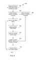
- FIG. 6is a flow chart illustrating a method for calculating velocity and track information of an aircraft according to an exemplary embodiment.
- FIG. 7is a flow chart illustrating a method for calculating velocity and track information of an aircraft according to another exemplary embodiment.
- FIG. 8is a flow chart illustrating a method for calculating velocity and track information of an aircraft according to another exemplary embodiment.
- FIG. 9is a flow chart illustrating a method for calculating velocity and track information of an aircraft according to another exemplary embodiment.
- FIG. 10is a side view of an aircraft and various radar returns and angles that can be used to determine velocity according to an exemplary embodiment.
- FIG. 11is a graph illustrating a signature of ground echoes of radar returns according to an exemplary embodiment.
- the inventionincludes, but is not limited to a novel structural combination of conventional data/signal processing components and communications circuits, and not in the particular detailed configurations thereof. Accordingly, the structure, methods, functions, control and arrangement of conventional components software, and circuits have, for the most part, been illustrated in the drawings by readily understandable block representations and schematic diagrams, in order not to obscure the disclosure with structural details which will be readily apparent to those skilled in the art, having the benefit of the description herein. Further, the invention is not limited to the particular embodiments depicted in the exemplary diagrams, but should be construed in accordance with the language in the claims.
- the systemcan include an electronic display, a weather radar or other type of radar system, and a navigation system.
- the methodcan include receiving radar returns at the wings of the aircraft, determining a velocity of each wing based on the radar returns, and calculating the heading, velocity, and/or position of the aircraft based on the determined wing velocities.
- Aircraft control center 10includes flight displays 20 .
- Flight displays 20can be used to provide information to the flight crew, thereby increasing visual range and enhancing decision-making abilities.
- at least one of the displays of the flight displays 20is configured to provide an indication to a flight crew as to the velocity, heading, and/or position of the aircraft.
- flight displays 20can provide an output from a radar system of the aircraft.
- Flight displays 20can include displays used for surface operations, such as an electronic moving map of an airport with an indication of present position. Such a display with a moving map may include user selectable options for providing the map with a north-up or track-up mode of operation.
- Flight displays 20may include cultural features, for example buildings, signage, lighting structures, trees, etc.
- Flight displays 20can also include a weather display, a joint display, a weather radar map, and a terrain or obstacle display. Further, flight displays 20 may include an electronic display or a synthetic vision system (SVS). For example, flight displays 20 can include a display configured to display a three dimensional perspective image of terrain, obstacle, and/or weather information. Other view of terrain, obstacles, and/or weather information may also be provided (e.g. plan view, horizontal view, vertical view, etc.). Additionally, flight displays 20 can be implemented using any of a variety of display technologies, including CRT, LCD, organic LED, dot matrix display, and others. Flight displays 20 can also include head-up displays (HUD) with or without a projector.
- HUDhead-up displays
- Aircraft control center 10additionally includes one or more user interface (UI) elements 21 .
- UI elements 21can include dials, switches, buttons, touch screens, or any other user input device.
- UI elements 21can be used to adjust features of flight displays 20 , such as contrast, brightness, width, and length.
- UI elements 21can also (or alternatively) be used by an occupant to interface with or change the displays of flight displays 20 .
- UI elements 21can additionally be used to calibrate or adjust an indication of aircraft heading, velocity, and/or position provided by flight displays 20 . Further, UI elements 21 can be used to calibrate or set an aircraft configuration used to determine the aircraft heading, velocity, and/or position.
- Wings 102 and 104each include a radar sensor or antenna 106 and 108 , respectively. While radar antennas 106 and 108 are shown at the tips of wings 106 and 108 , according to other exemplary embodiments radar antennas 106 and 108 can be located anywhere along respective wings 106 and 108 as long as the antennas are generally equal in distance from the center or fuselage of aircraft 100 . According to other exemplary embodiments, radar antennas 106 and 108 can be located on the tail wings of aircraft 100 .
- Radar antennas 106 and 108are each configured to transmit radar pulses and receive radar returns independent of one another. According to various exemplary embodiments, radar antennas 106 and 108 can be any radar antenna capable of transmitting radar pulses and receiving radar returns, for example transmitting pulses towards ground targets and receiving associated returns.
- radar antennas 106 and 108may be generally short-range radar sensors. Radar antennas 106 and 108 may be configured to transmit radar pulses to locate potential obstructions relative to the position of the aircraft, for example lighting systems, signage, other aircraft, ground vehicles, etc. The radar returns received by radar antennas 106 and 108 may also be used to determine the velocity of the wings 102 and 104 relative to the ground. Heading or track rate can be derived from the difference in the velocity of left and right wings 102 and 104 . The velocity of wings 102 and 104 can also be used to determine velocity of aircraft 100 .
- Electronic display 300may be generally configured for use with surface operations and display an electronic moving map of an airport with an indication of the present position of aircraft 100 .
- Display 300includes indications of a runway/taxiway 302 , a building 304 , and signage 306 , but can include indications of other cultural features or obstacles (e.g., lighting structures, towers, etc.)
- Display 300can also be configured to illustrate other aircraft or terrain near runway/taxiway 302 .
- Display 300is shown with a north-up orientation and the illustrated map updates as aircraft 100 moves, but north remains at the top of the screen.
- an electronic display 310is similar to electronic display 300 , but has a track-up orientation according to an exemplary embodiment.
- the mapmoves or illustrates updates as aircraft 100 moves, but the with an orientation where the nose of aircraft 100 remains pointing at the top of the screen.
- Electronics display 300 and/or 310may include user selectable options for providing the map with a north-up or track-up mode of operation as desired.
- the color of the obstacles shown in electronic display 300 or 310may be configured to be different colors to allow the aircrew to quickly recognize a potential hazard.
- the obstaclemay be configured to flash, enlarge, turn red or any combination thereof to provide a warning signal to the aircrew.
- electronic display 300 or 310may be configured to provide an indicator to warn the flight crew of nearby obstacles or obstacles in the aircraft path.
- the indicatorcan be an icon, text, string, symbol, synthetic image, LED indicator, audible tone, or any other visible and/or audible alarm provided by electronic display 300 or 310 , another aircraft display, an audio system, etc.
- a navigation system 400is configured to determine and provide velocity, heading, and/or position data of aircraft 100 .
- Navigation system 400may also determine and provide obstacle avoidance information.
- Navigation system 400generally includes a radar antenna 406 on left wing 102 , a radar antenna 408 on right wing 104 , processing electronics 410 , a display 412 , and a user interface 414 .
- Radar antennas 406 and 408are configured in a similar manner as described with reference to radar antennas 106 and 108 of FIG. 2 .
- Radar antennas 406 and 408are generally configured to cast one or more radar beams from, and to receive radar returns.
- Radar antennas 406 and 408may perform multiple radar sweeps.
- the radar sweepscan include horizontal sweeps, vertical sweeps, or a combination of horizontal and vertical sweeps.
- Radar antennas 406 and 408can be steered or directed in various directions in order to perform the radar sweeps.
- Processing electronics 410are configured to interpret radar returns received at radar antennas 406 and 408 .
- Processing electronics 410may determine a velocity of first and second wings 102 and 104 based on radar returns received at radar antennas 406 and 408 .
- the velocity of wings 104 and 106may be relative to the ground, relative to each other, relative to terrain or an obstacle, relative to weather, etc.
- the velocity of wings 104 and 106can be determined relative to a runway, a taxiway, signage, a building, or other ground structure.
- processing electronics 410can calculate the heading, velocity, and/or position of the aircraft relative to the ground, to terrain or an obstacle, to weather, etc.
- the headingmay be determined by comparing the wing velocities. If the wing velocities are the same, the aircraft is moving in a straight line or stationary. If the wing velocities are different, the aircraft is turning. The wing with the higher velocity is the outside wing of the turn (e.g., if left wing 102 is faster, the aircraft is turning right and vice versa).
- the position of the aircraftcan be determined from a history of velocity and heading determinations from an initial starting position.
- Processing electronics 410can also be configured to use the radar return data to determine navigation solutions to stay centered in runways and taxiways in order to avoid fixed obstacles such as signage, lighting, etc. and/or to avoid traffic (e.g., aircraft and ground vehicles). According to various exemplary embodiments, processing electronics 410 can be any hardware and/or software processor or processing architecture capable of executing instructions and processing radar returns.
- Display 412(e.g., an electronic display) can be used to display information from processing electronics 410 , for example obstacle avoidance data and/or velocity, heading, and/or position data of aircraft 100 .
- display 412can be similar to display 32 or can be any other display capable of providing velocity, heading, and/or position data of the aircraft.
- User interface 414can be used to select what data is shown on display 412 or to select aircraft configuration. For example, obstacle avoidance data, velocity data, heading data, and/or position data.
- a navigation system 500is configured to determine and provide velocity, heading, and/or position data of aircraft 100 .
- Navigation system 500may also determine and provide obstacle avoidance information.
- Navigation system 500is similar to navigation system 400 and generally includes a radar antenna 506 on left wing 102 , a radar antenna 508 on right wing 104 , processing electronics 510 , a display 512 , and a user interface 514 .
- Radar antennas 506 and 508 , display 512 , and user interface 514are similar in configuration to radar antennas 406 and 408 , display 412 , and user interface 414 .
- Navigation system 500also includes a display driver 516 , an aircraft configuration module 518 , a global positioning device 520 , and a memory device 522 .
- Processing electronics 510are configured to interpret radar returns received at radar antennas 506 and 508 .
- Processing electronics 510may determine a velocity of first and second wings 102 and 104 based on radar returns received at radar antennas 506 and 508 . Based on the determined velocity of wings 102 and 104 , processing electronics 510 can calculate the heading, velocity, and/or position of the aircraft.
- Processing electronics 510can also be configured to use the radar return data to determine navigation solutions to stay centered in runways and taxiways in order to avoid fixed obstacles such as signage, lighting, etc. and/or to avoid traffic (e.g., aircraft and ground vehicles).
- processing electronics 510can be any hardware and/or software processor or processing architecture capable of executing instructions and processing radar returns.
- Aircraft configuration module 518is configured to store and/or provide various information related to a state or configuration of aircraft 100 .
- aircraft configuration module 518may store information related to a center of gravity of aircraft 100 , a landing gear position of aircraft 100 , a position of radar antennas 506 and 508 , and/or a position of a GPS antenna (e.g., for global positioning device 520 ).
- aircraft configuration modulemay be any hardware and/or software architecture capable of storing and/or providing aircraft configuration information, for example a database.
- Global positioning device 520can be any device configured to communicate with satellites in a global positioning system to determine a velocity, heading, and/or position of aircraft 100 .
- Memory 522is configured to store instructions for execution by processing electronics 510 and/or to store data for use by processing electronics 510 such as a history of calculated velocities, headings, and/or positions of the aircraft.
- Memory 522may be a volatile or non-volatile memory.
- Processing electronics 510are further configured to use information received from aircraft configuration module 518 , global positioning device 520 , and memory device 522 to determine the velocity of wings 102 and 104 and determine the presence of obstacles. Processing electronics 510 may “blend” the inputs from radar antenna 506 , radar antenna 508 , and global positioning device 520 , for example, processing electronics 510 may determine a generally high-precision solution for the velocity, heading, and position of the aircraft based on the inputs from these devices. The determination of the velocity, heading, and/or position of aircraft 100 may be adjusted depending on the information received from aircraft configuration module 518 or additional information can be derived from aircraft configuration module 518 . For example, while basic information such as the velocity of the aircraft and turn rate can be derived from velocity of the wing tips, the actual track of the landing gear through a turn can be derived using the relative location of each set of wheels compared to the location of the radar antennas.
- Display driver 516is configured to process data from processing electronics for use by display 512 . While user interface 514 can be directly coupled to processing electronics 510 as illustrated, according to other exemplary embodiments, input received from user interface 514 can also be processed by display driver 516 for output to display 516 . Display driver 516 can then communicate the received input to various other components. Display driver 516 can be any computer hardware and/or software that enables display 512 to communicate with and receive data from processing electronics 512 or other components.
- a method 600is configured to determine a heading, velocity, and/or position of aircraft 100 using a navigation system (e.g., navigation system 400 or 500 ) according to an exemplary embodiment.
- a radar antenna of wing 102e.g., antenna 406 or 506
- receives a first radar returnstep 602
- a radar antenna of wing 104e.g., antenna 408 or 508
- receives a second radar returnstep 604
- Processing electronicse.g., processing electronics 410 or 510
- the processing electronicsdetermine or calculate the heading, velocity, and/or position of the aircraft based on the determined wing velocities (step 608 ).
- a method 700is configured to determine a heading, velocity, and/or position of aircraft 100 using a navigation system (e.g., navigation system 400 or 500 ) according to another exemplary embodiment.
- a radar antenna of wing 102e.g., antenna 406 or 506
- receives a first radar returnstep 702
- a radar antenna of wing 104e.g., antenna 408 or 508
- receives a second radar returnstep 704
- Processing electronicse.g., processing electronics 410 or 510
- Global positioning device 520determines a position of aircraft 100 (step 708 ).
- the processing electronicsdetermine or calculate the heading, velocity, and/or position of the aircraft based on the determined wing velocities from step 706 and the determined position of the aircraft at step 708 (step 710 ).
- a displaye.g., display 412 or 512 ) then shows the calculated heading, velocity, and/or position of aircraft 100 .
- a method 800is configured to determine a heading, velocity, and/or position of aircraft 100 using a navigation system (e.g., navigation system 400 or 500 ) according to another exemplary embodiment.
- Global positioning device 520(or the processing electronics using global position device 520 ) determines a position of aircraft 100 (step 802 ).
- the processing electronicsdetermine or update the heading, velocity, and/or position of the aircraft based on the position of the aircraft determined at step 802 (step 804 ) and a display (e.g., display 412 or 512 ) shows an indication of the updated heading, velocity, and/or position of the aircraft (step 806 ).
- a radar antenna of wing 102receives a first radar return (step 808 ) and a radar antenna of wing 104 (e.g., antenna 408 or 508 ) receives a second radar return (step 810 ).
- the processing electronicsdetermine a velocity of each wing based on the radar returns (step 812 ) and update, correct, or override the heading, velocity, and/or position of the aircraft based on the determined wing velocities from step 812 (step 814 ).
- the displaythen shows the updated heading, velocity, and/or position of aircraft 100 at step 806 .
- the processing electronicsdetermine whether it is time for a global positioning update (step 816 ).
- the navigation systemcontinues to update the heading, velocity, and/or position of the aircraft using radar returns to determine the wing velocity. If it is time for a global positioning device update, method 800 returns to step 802 to update the heading, velocity, and/or position using global positioning data. It is noted that alternatively, the processing electronics may poll the global positioning device at fixed intervals or between radar updates without checking to see if global positioning updates are available.
- a method 900is configured to determine a heading, velocity, and/or position of aircraft 100 using a navigation system (e.g., navigation system 400 or 500 ) according to another exemplary embodiment.
- Processing electronicse.g., processing electronics 410 or 510 receives an aircraft configuration (step 902 ), for example a center of gravity of aircraft 100 , a landing gear position of aircraft 100 , a position of radar antennas 506 and 508 , and/or a position of a GPS antenna.
- the processing electronicsdetermine or update the heading, velocity, and/or position of the aircraft based on the configuration information from step 902 and previous radar returns or global positioning updates (step 904 ).
- a display(e.g., display 412 or 512 ) shows an indication of the updated heading, velocity, and/or position of the aircraft (step 906 ).
- a radar antenna of wing 102(e.g., antenna 406 or 506 ) receives a first radar return (step 908 ) and a radar antenna of wing 104 (e.g., antenna 408 or 508 ) receives a second radar return (step 910 ).
- the processing electronicsdetermine a velocity of each wing based on the radar returns (step 912 ) and update, override, or correct the heading, velocity, and/or position of the aircraft based on the determined wing velocities from step 912 (step 914 ).
- the displaythen shows the updated heading, velocity, and/or position of aircraft 100 at step 806 .
- the methodsmay determine the heading, velocity, and/or position of the aircraft using radar returns, global positioning information, and aircraft configuration information. Furthermore, there may be no check for a global positioning update (step 816 ) but the system may simply poll the current data at fixed time periods. According to other exemplary embodiments, additional steps may be included or various steps can be omitted from the illustrated methods.
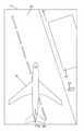
- a side view of aircraft 100illustrates various radar returns and geometries that may be used to determine a velocity vector 1000 of wing 102 or wing 104 .
- the wing speedis determined by Doppler shift in ground echoes or returns.
- Each individual ground patch echohas a Doppler value that is a function of the range and geometry of observation, the angle of elevation & azimuth with reference to the wing speed vector. For example, an angle 1002 between a radar pulse 1004 and wing velocity vector 1000 .
- the Doppler value or frequencyis generally equal to twice the measured velocity divided by the wavelength of the radar return at the frequency of operation.
- navigation system 400 or 500collects echoes from the radar antennas and classifies the echoes into a Range ⁇ Doppler Matrix (RDM) 1100 . The number of echoes are summed by column. In a first pre-selection, the navigation system determines the N ⁇ Doppler values that totalize the greater number of echoes. Processing electronics 410 or 510 then performs a best fit algorithm between the measured RDM and the ground echoes theoretical signature to determine wing velocity 1000 .
- RDMRange ⁇ Doppler Matrix
- To estimate the wing velocity processing electronics 410 or 510may execute a Recursive Least Square algorithm that estimates the wing velocity using the data measurements and adaptative time varying filtering to estimate the parameters at a specific time “n.”
- the parameters at time “n”are determined based on an estimation of time “n ⁇ 1” and measured data at time “n”.
- a Bayesian estimation algorithmcan be used to estimate the wing velocity.
- the heading of aircraft 100may be determined by comparing the wing velocities. If the wing velocities are the same, the aircraft is moving in a straight line or stationary. If the wing velocities are different, the aircraft is turning. The wing with the higher velocity is the outside wing of the turn (e.g., if left wing 102 is faster, the aircraft is turning right and vice versa).
- the position of the aircraftcan be determined from a history of velocity and heading determinations from an initial starting position.
Landscapes
- Engineering & Computer Science (AREA)
- Radar, Positioning & Navigation (AREA)
- Remote Sensing (AREA)
- Physics & Mathematics (AREA)
- General Physics & Mathematics (AREA)
- Aviation & Aerospace Engineering (AREA)
- Computer Networks & Wireless Communication (AREA)
- Automation & Control Theory (AREA)
- Electromagnetism (AREA)
- Radar Systems Or Details Thereof (AREA)
- Traffic Control Systems (AREA)
Abstract
Description
The present disclosure relates generally to the field of aircraft navigation. More particularly, the disclosure relates to aircraft navigation using multiple radar antennas.
Conventional efforts in aircraft to implement tactical situation awareness displays and situational awareness displays with a track-up orientation for low-visibility surface operations are hampered by low quality navigation systems that support ground operations. Inertial Navigation Simulators (INS), Altitude Heading Reference Systems (AHRS), and Air Data Computers (ADC) do not provide velocity and/or heading data at speeds below about 40 or 50 knots (e.g., at taxiing speed). Magnetic compasses can provide heading information, but operate poorly during ground operations due to interference from ground infrastructure.
Velocity and track (heading) can be derived from GPS position data, but when the aircraft is stationary or performing low speed turning operations (e.g., turning 90 degrees from a hold line onto a runway) cannot be adequately measured by changes in aircraft position without using a Satellite Based Augmentation System (SBAS) to obtain additional messages broadcast by satellites or a Ground Based Augmentation System (GBAS) to obtain additional ground-based radio messages.
A GPS does provide accurate position information (latitude, longitude, and altitude). Aircraft velocity and track can be determined from a change in aircraft position over time. If more than one GPS antenna is installed, aircraft heading can be determined or derived from the difference between the two positions. However, the error in a standard positioning system is greater than the length of most aircraft. SBAS can bring the nominal error down to 7.5 meters 95% of the time and GBAS can bring the nominal error down to 2 meters 95% of the time, however, the smaller the aircraft, the closer the two antennas must be. For many aircraft, the distance between the two antennas is less than the error for standard GPS and not much bigger than the error for a system including an SBAS or GBAS. Further, GPS is subject to multi-path problems during ground operations.
Therefore, what is needed is a high quality navigation system and method for implementing with tactical situation awareness displays and situational awareness displays with a track-up orientation for low-visibility surface operations. What is also needed is a system and method for accurately providing velocity and heading information of an aircraft during low speed maneuvers or when stationary.
One embodiment of the disclosure relates to a navigation system for use on an aircraft for determining a heading, velocity, and/or position of the aircraft. The navigation system includes a first radar antenna for mounting to a first wing of the aircraft and configured to receive radar returns and a second radar antenna for mounting to a second wing of the aircraft and configured to receive radar returns where the first wing and the second wing extend from opposite sides of the aircraft. The navigation system also includes processing electronics configured to determine a velocity of the first and second wings based on the radar returns. The processing electronics calculate the heading, velocity, and/or position of the aircraft based on the determined wing velocities.
Another embodiment of the disclosure relates to a method for determining a heading, velocity, and/or position of an aircraft. The method includes receiving a first radar return at a radar antenna for mounting to a first wing of the aircraft and receiving a second radar return at a radar antenna mounted to a second wing of the aircraft where the first wing and the second wing extend from opposite sides of the aircraft. The method also includes determining a velocity of each wing based on the radar returns using processing electronics and calculating the heading, velocity, and/or position of the aircraft based on the determined wing velocities using the processing electronics.
Another embodiment of the disclosure relates to an apparatus for determining a heading, velocity, and/or position of an aircraft. The apparatus includes means for receiving a first radar return at a first wing of the aircraft and means for receiving a second radar return at a second wing of the aircraft where the first wing and the second wing extend from opposite sides of the aircraft. The apparatus also includes means for determining a velocity of each wing based on the radar returns and means for calculating the heading, velocity, and/or position of the aircraft based on the determined wing velocities.
The disclosure will become more fully understood from the following detailed description, taken in conjunction with the accompanying drawings.
Before describing in detail the particular improved system and method, it should be observed that the invention includes, but is not limited to a novel structural combination of conventional data/signal processing components and communications circuits, and not in the particular detailed configurations thereof. Accordingly, the structure, methods, functions, control and arrangement of conventional components software, and circuits have, for the most part, been illustrated in the drawings by readily understandable block representations and schematic diagrams, in order not to obscure the disclosure with structural details which will be readily apparent to those skilled in the art, having the benefit of the description herein. Further, the invention is not limited to the particular embodiments depicted in the exemplary diagrams, but should be construed in accordance with the language in the claims.
Referring generally to the figures, a system and method for determining a heading, velocity, and/or position of an aircraft is shown. The system can include an electronic display, a weather radar or other type of radar system, and a navigation system. The method can include receiving radar returns at the wings of the aircraft, determining a velocity of each wing based on the radar returns, and calculating the heading, velocity, and/or position of the aircraft based on the determined wing velocities.
Referring toFIG. 1 , an illustration of an aircraft control center orcockpit 10 is shown, according to one exemplary embodiment.Aircraft control center 10 includes flight displays20.Flight displays 20 can be used to provide information to the flight crew, thereby increasing visual range and enhancing decision-making abilities. According to an exemplary embodiment, at least one of the displays of theflight displays 20 is configured to provide an indication to a flight crew as to the velocity, heading, and/or position of the aircraft.
In an exemplary embodiment,flight displays 20 can provide an output from a radar system of the aircraft.Flight displays 20 can include displays used for surface operations, such as an electronic moving map of an airport with an indication of present position. Such a display with a moving map may include user selectable options for providing the map with a north-up or track-up mode of operation. Flight displays20 may include cultural features, for example buildings, signage, lighting structures, trees, etc.
Referring toFIG. 2 , an overhead view of anaircraft 100 is shown withaircraft control center 10,left wing 102, andright wing 104 according to an exemplary embodiment.Wings antenna radar antennas wings embodiments radar antennas respective wings aircraft 100. According to other exemplary embodiments,radar antennas aircraft 100.Radar antennas radar antennas
According to some exemplary embodiments,radar antennas Radar antennas radar antennas wings right wings wings aircraft 100.
Referring toFIG. 3A , anelectronic display 300 is shown, according to an exemplary embodiment.Electronic display 300 may be generally configured for use with surface operations and display an electronic moving map of an airport with an indication of the present position ofaircraft 100.Display 300 includes indications of a runway/taxiway 302, abuilding 304, andsignage 306, but can include indications of other cultural features or obstacles (e.g., lighting structures, towers, etc.)Display 300 can also be configured to illustrate other aircraft or terrain near runway/taxiway 302.Display 300 is shown with a north-up orientation and the illustrated map updates asaircraft 100 moves, but north remains at the top of the screen.
Referring also toFIG. 3B , anelectronic display 310 is similar toelectronic display 300, but has a track-up orientation according to an exemplary embodiment. The map moves or illustrates updates asaircraft 100 moves, but the with an orientation where the nose ofaircraft 100 remains pointing at the top of the screen. Electronics display300 and/or310 may include user selectable options for providing the map with a north-up or track-up mode of operation as desired.
According to an exemplary embodiment, the color of the obstacles shown inelectronic display electronic display electronic display
Referring toFIG. 4 , anavigation system 400 is configured to determine and provide velocity, heading, and/or position data ofaircraft 100.Navigation system 400 may also determine and provide obstacle avoidance information.Navigation system 400 generally includes aradar antenna 406 onleft wing 102, aradar antenna 408 onright wing 104, processingelectronics 410, adisplay 412, and auser interface 414.Radar antennas radar antennas FIG. 2 .Radar antennas Radar antennas Radar antennas
Display412 (e.g., an electronic display) can be used to display information from processingelectronics 410, for example obstacle avoidance data and/or velocity, heading, and/or position data ofaircraft 100. According to various exemplary embodiments,display 412 can be similar to display32 or can be any other display capable of providing velocity, heading, and/or position data of the aircraft.User interface 414 can be used to select what data is shown ondisplay 412 or to select aircraft configuration. For example, obstacle avoidance data, velocity data, heading data, and/or position data.
Referring toFIG. 5 , anavigation system 500 is configured to determine and provide velocity, heading, and/or position data ofaircraft 100.Navigation system 500 may also determine and provide obstacle avoidance information.Navigation system 500 is similar tonavigation system 400 and generally includes aradar antenna 506 onleft wing 102, aradar antenna 508 onright wing 104, processingelectronics 510, adisplay 512, and auser interface 514.Radar antennas display 512, anduser interface 514 are similar in configuration toradar antennas display 412, anduser interface 414.Navigation system 500 also includes adisplay driver 516, anaircraft configuration module 518, aglobal positioning device 520, and amemory device 522.
Referring toFIG. 6 , amethod 600 is configured to determine a heading, velocity, and/or position ofaircraft 100 using a navigation system (e.g.,navigation system 400 or500) according to an exemplary embodiment. A radar antenna of wing102 (e.g.,antenna 406 or506) receives a first radar return (step602) and a radar antenna of wing104 (e.g.,antenna 408 or508) receives a second radar return (step604). Processing electronics (e.g., processingelectronics 410 or510) determine a velocity of each wing based on the radar returns (step606). The processing electronics then determine or calculate the heading, velocity, and/or position of the aircraft based on the determined wing velocities (step608).
Referring toFIG. 7 , amethod 700 is configured to determine a heading, velocity, and/or position ofaircraft 100 using a navigation system (e.g.,navigation system 400 or500) according to another exemplary embodiment. A radar antenna of wing102 (e.g.,antenna 406 or506) receives a first radar return (step702) and a radar antenna of wing104 (e.g.,antenna 408 or508) receives a second radar return (step704). Processing electronics (e.g., processingelectronics 410 or510) determine a velocity of each wing based on the radar returns (step706). Global positioning device520 (or the processing electronics using global position device520) determines a position of aircraft100 (step708). The processing electronics determine or calculate the heading, velocity, and/or position of the aircraft based on the determined wing velocities fromstep 706 and the determined position of the aircraft at step708 (step710). A display (e.g.,display 412 or512) then shows the calculated heading, velocity, and/or position ofaircraft 100.
Referring toFIG. 8 , amethod 800 is configured to determine a heading, velocity, and/or position ofaircraft 100 using a navigation system (e.g.,navigation system 400 or500) according to another exemplary embodiment. Global positioning device520 (or the processing electronics using global position device520) determines a position of aircraft100 (step802). The processing electronics determine or update the heading, velocity, and/or position of the aircraft based on the position of the aircraft determined at step802 (step804) and a display (e.g.,display 412 or512) shows an indication of the updated heading, velocity, and/or position of the aircraft (step806). A radar antenna of wing102 (e.g.,antenna 406 or506) receives a first radar return (step808) and a radar antenna of wing104 (e.g.,antenna 408 or508) receives a second radar return (step810). The processing electronics determine a velocity of each wing based on the radar returns (step812) and update, correct, or override the heading, velocity, and/or position of the aircraft based on the determined wing velocities from step812 (step814). The display then shows the updated heading, velocity, and/or position ofaircraft 100 atstep 806. The processing electronics then determine whether it is time for a global positioning update (step816). If it is not time for a global positioning update, the navigation system continues to update the heading, velocity, and/or position of the aircraft using radar returns to determine the wing velocity. If it is time for a global positioning device update,method 800 returns to step802 to update the heading, velocity, and/or position using global positioning data. It is noted that alternatively, the processing electronics may poll the global positioning device at fixed intervals or between radar updates without checking to see if global positioning updates are available.
Referring toFIG. 9 amethod 900 is configured to determine a heading, velocity, and/or position ofaircraft 100 using a navigation system (e.g.,navigation system 400 or500) according to another exemplary embodiment. Processing electronics (e.g., processingelectronics 410 or510) receives an aircraft configuration (step902), for example a center of gravity ofaircraft 100, a landing gear position ofaircraft 100, a position ofradar antennas step 902 and previous radar returns or global positioning updates (step904). A display (e.g.,display 412 or512) shows an indication of the updated heading, velocity, and/or position of the aircraft (step906). A radar antenna of wing102 (e.g.,antenna 406 or506) receives a first radar return (step908) and a radar antenna of wing104 (e.g.,antenna 408 or508) receives a second radar return (step910). The processing electronics determine a velocity of each wing based on the radar returns (step912) and update, override, or correct the heading, velocity, and/or position of the aircraft based on the determined wing velocities from step912 (step914). The display then shows the updated heading, velocity, and/or position ofaircraft 100 atstep 806.
Furthermore, it should be appreciated that the specific sequences of processes shown in the embodiments ofFIGS. 6-9 are by way of example only. For example, the methods may determine the heading, velocity, and/or position of the aircraft using radar returns, global positioning information, and aircraft configuration information. Furthermore, there may be no check for a global positioning update (step816) but the system may simply poll the current data at fixed time periods. According to other exemplary embodiments, additional steps may be included or various steps can be omitted from the illustrated methods.
Referring toFIG. 10 , a side view ofaircraft 100 illustrates various radar returns and geometries that may be used to determine avelocity vector 1000 ofwing 102 orwing 104. The wing speed is determined by Doppler shift in ground echoes or returns. Each individual ground patch echo has a Doppler value that is a function of the range and geometry of observation, the angle of elevation & azimuth with reference to the wing speed vector. For example, anangle 1002 between aradar pulse 1004 andwing velocity vector 1000. The Doppler value or frequency is generally equal to twice the measured velocity divided by the wavelength of the radar return at the frequency of operation. A ground patch echo from a given Range R, will have a velocity V given by V=Vwing×cos(elevation), where the elevation=arcsine (H/R) and H is the height of the radar.
Referring also toFIG. 11 ,navigation system Processing electronics wing velocity 1000.
To estimate the wingvelocity processing electronics
The heading ofaircraft 100 may be determined by comparing the wing velocities. If the wing velocities are the same, the aircraft is moving in a straight line or stationary. If the wing velocities are different, the aircraft is turning. The wing with the higher velocity is the outside wing of the turn (e.g., ifleft wing 102 is faster, the aircraft is turning right and vice versa). The position of the aircraft can be determined from a history of velocity and heading determinations from an initial starting position.
While the detailed drawings, specific examples, detailed algorithms, and particular configurations given describe preferred and exemplary embodiments, they serve the purpose of illustration only. The inventions disclosed are not limited to the specific forms shown. For example, the methods may be performed in any of a variety of sequence of steps or according to any of a variety of mathematical formulas. The hardware and software configurations shown and described may differ depending on the chosen performance characteristics and physical characteristics of the radar and processing devices. For example, the type of system components and their interconnections may differ. The systems and methods depicted and described are not limited to the precise details and conditions disclosed. The flow charts show preferred exemplary operations only. The specific data types and operations are shown in a non-limiting fashion. For example, the scope of the claims are intended to cover any technique that uses a selectable fractional aperture unless literally delineated from the claims. Furthermore, other substitutions, modifications, changes, and omissions may be made in the design, operating conditions, and arrangement of the exemplary embodiments without departing from the scope of the invention as expressed in the appended claims.
Claims (20)
1. A navigation system for use on an aircraft for determining a heading, velocity, and/or position of the aircraft, comprising:
a first radar antenna for mounting to a first wing of the aircraft and configured to receive radar returns;
a second radar antenna for mounting to a second wing of the aircraft and configured to receive radar returns, the first wing and second wing extending from opposite sides of the aircraft; and
processing electronics configured to determine a velocity of the first and second wings based on the radar returns, the processing electronics calculating the heading, velocity, and/or position of the aircraft based on the determined wing velocities.
2. The navigation system ofclaim 1 , wherein the radar antennas are configured to be located at or near tips of the first and second wings.
3. The navigation system ofclaim 1 , further comprising:
a global positioning device for mounting to the aircraft and configured to determine the position of the aircraft,
wherein the processing electronics determine the heading, velocity, and/or position of the aircraft based on the wing velocities and the position of the aircraft determined by the global positioning device.
4. The navigation system ofclaim 3 , wherein the processing electronics update the heading, velocity, and/or position of the aircraft using the wing velocities at time periods between updates of the heading, velocity, and/or position based on the position of the aircraft determined by the global positioning device.
5. The navigation system ofclaim 3 , wherein the processing electronics use the heading, velocity, and/or position of the aircraft determined from the wing velocities to override or correct the heading, velocity, and/or position of the aircraft determined from the position of the aircraft determined by the global positioning device.
6. The navigation system ofclaim 1 , wherein the processing electronics use aircraft configuration information to determine the heading, velocity, and/or position of the aircraft.
7. The navigation system ofclaim 6 , wherein the aircraft configuration information comprises at least one of a location of an aircraft center of gravity, a landing gear position, a position of one or both the radar antennas, and a global positioning system position.
8. The navigation system ofclaim 1 , wherein the first and second radar antennas are also used to locate potential obstructions relative to the position of the aircraft.
9. The navigation system ofclaim 1 , wherein the processing electronics calculate the heading of the aircraft based on a difference between the wing velocities, the processing electronics calculate the velocity of the aircraft based on a history of differences between the wing velocities, and the processing electronics calculate the position of the aircraft based on a predetermined starting point of the aircraft and a history of calculated velocities of the aircraft.
10. The navigation system ofclaim 1 , wherein the wing velocities are velocities relative to the ground, velocities relative to each other, velocities relative to weather, velocities relative to terrain, or velocities relative to an obstacle.
11. The navigation system ofclaim 1 , wherein the determined heading, velocity, and/or position of the aircraft is stored in a memory device and/or displayed on an electronic display.
12. The navigation system ofclaim 1 , wherein the aircraft is taxiing or on a runway and the wing velocities are determined relative to the ground.
13. A method for determining a heading, velocity, and/or position of an aircraft, comprising:
receiving a first radar return at a radar antenna for mounting to a first wing of the aircraft;
receiving a second radar return at a radar antenna mounted to a second wing of the aircraft, the first wing and the second wing extending from opposite sides of the aircraft;
determining a velocity of each wing based on the radar returns using processing electronics; and
calculating the heading, velocity, and/or position of the aircraft based on the determined wing velocities using the processing electronics.
14. The method ofclaim 13 , wherein the radar antennas for mounting to the first and second wings are configured to be located at or near tips of the first and second wings.
15. The method ofclaim 13 , further comprising:
determining a position of the aircraft at a global positioning device for mounting on the aircraft,
wherein the processing electronics determine the heading, velocity, and/or position of the aircraft based on the wing velocities and based on the position of the aircraft determined by the global positioning device.
16. The method ofclaim 15 , further comprising:
updating the heading, velocity, and/or position of the aircraft using the wing velocities at time periods between updates of the heading, velocity, and/or position based on the position of the aircraft determined by the global positioning device.
17. The method ofclaim 13 , further comprising:
receiving an aircraft configuration at the processing electronics, the processing electronics using the aircraft configuration to determine the heading, velocity, and/or position of the aircraft,
wherein the aircraft configuration comprises at least one of a location of an aircraft center of gravity, a landing gear position, a position of one or both the radar antennas, and a global positioning system position.
18. The method ofclaim 17 , wherein the processing electronics calculate the heading of the aircraft based on a difference between the wing velocities, the processing electronics calculate the velocity of the aircraft based on a history of differences between the wing velocities, and the processing electronics calculate the position of the aircraft based on a predetermined starting point of the aircraft and a history of calculated velocities of the aircraft.
19. The method ofclaim 13 , wherein the wing velocities are velocities relative to the ground, to each other, to signage, to lighting structures, or to buildings.
20. An apparatus for determining a heading, velocity, and/or position of an aircraft, comprising:
means for receiving a first radar return at a first wing of the aircraft;
means for receiving a second radar return at a second wing of the aircraft, the first wing and the second wing extending from opposite sides of the aircraft;
means for determining a velocity of each wing based on the radar returns; and
means for calculating the heading, velocity, and/or position of the aircraft based on the determined wing velocities.
Priority Applications (3)
| Application Number | Priority Date | Filing Date | Title |
|---|---|---|---|
| US12/263,282US9354633B1 (en) | 2008-10-31 | 2008-10-31 | System and method for ground navigation |
| US14/536,330US9939526B2 (en) | 2007-09-06 | 2014-11-07 | Display system and method using weather radar sensing |
| HK16107526.0AHK1219541A1 (en) | 2007-09-06 | 2016-06-28 | Display system and method using weather radar sensing |
Applications Claiming Priority (1)
| Application Number | Priority Date | Filing Date | Title |
|---|---|---|---|
| US12/263,282US9354633B1 (en) | 2008-10-31 | 2008-10-31 | System and method for ground navigation |
Publications (1)
| Publication Number | Publication Date |
|---|---|
| US9354633B1true US9354633B1 (en) | 2016-05-31 |
Family
ID=56027806
Family Applications (1)
| Application Number | Title | Priority Date | Filing Date |
|---|---|---|---|
| US12/263,282Active2034-10-22US9354633B1 (en) | 2007-09-06 | 2008-10-31 | System and method for ground navigation |
Country Status (1)
| Country | Link |
|---|---|
| US (1) | US9354633B1 (en) |
Cited By (10)
| Publication number | Priority date | Publication date | Assignee | Title |
|---|---|---|---|---|
| US20150026662A1 (en)* | 2013-07-16 | 2015-01-22 | Alan B. Moore | Method And Apparatus For Configuring Control Software For Radar Systems Having Different Hardware Architectures And Related Software Products |
| US9557406B2 (en) | 2013-07-16 | 2017-01-31 | Raytheon Command And Control Solutions Llc | Method, system, and software for supporting multiple radar mission types |
| US9733349B1 (en) | 2007-09-06 | 2017-08-15 | Rockwell Collins, Inc. | System for and method of radar data processing for low visibility landing applications |
| US9911189B1 (en)* | 2016-06-30 | 2018-03-06 | Kitty Hawk Corporation | Navigation based on downward facing sensors |
| US9939526B2 (en) | 2007-09-06 | 2018-04-10 | Rockwell Collins, Inc. | Display system and method using weather radar sensing |
| US10228460B1 (en) | 2016-05-26 | 2019-03-12 | Rockwell Collins, Inc. | Weather radar enabled low visibility operation system and method |
| US10353068B1 (en) | 2016-07-28 | 2019-07-16 | Rockwell Collins, Inc. | Weather radar enabled offshore operation system and method |
| US10705201B1 (en) | 2015-08-31 | 2020-07-07 | Rockwell Collins, Inc. | Radar beam sharpening system and method |
| US10928510B1 (en) | 2014-09-10 | 2021-02-23 | Rockwell Collins, Inc. | System for and method of image processing for low visibility landing applications |
| US11378986B2 (en)* | 2019-04-01 | 2022-07-05 | Honeywell International Inc. | Systems and methods for landing and takeoff guidance |
Citations (394)
| Publication number | Priority date | Publication date | Assignee | Title |
|---|---|---|---|---|
| US2416155A (en) | 1943-03-27 | 1947-02-18 | Westinghouse Electric Corp | Position locator |
| US2849184A (en) | 1956-08-16 | 1958-08-26 | Gen Precision Lab Inc | Wind computer |
| US2929059A (en) | 1955-03-14 | 1960-03-15 | Decca Record Co Ltd | Radio antennae systems |
| US2930035A (en) | 1954-07-12 | 1960-03-22 | Goodyear Aircraft Corp | Terrain clearance control apparatus |
| US2948892A (en) | 1949-09-28 | 1960-08-09 | Cutler Hammer Inc | Precision indicating radar system |
| US2965894A (en) | 1956-12-26 | 1960-12-20 | Bell Telephone Labor Inc | Altitude control system |
| US2994966A (en) | 1957-03-13 | 1961-08-08 | Sperry Rand Corp | System for predicting radar terrain reflection |
| US3031660A (en) | 1956-06-22 | 1962-04-24 | Robert E Young | Plan position indicator with elevation indication in color |
| US3049702A (en) | 1958-05-15 | 1962-08-14 | Sperry Rand Corp | Single target height indicator |
| US3064252A (en) | 1952-03-31 | 1962-11-13 | Arthur A Varela | Height finding radar system |
| US3070795A (en) | 1954-01-25 | 1962-12-25 | Torrence H Chambers | Elevation angle computer for stacked beam height finding radar system |
| US3071766A (en) | 1958-08-27 | 1963-01-01 | United Aircraft Corp | Radar altitude control |
| US3072903A (en) | 1953-06-22 | 1963-01-08 | Lab For Electronics Inc | Signal switching apparatus |
| US3107351A (en) | 1955-04-29 | 1963-10-15 | Robert A Milam | Radar resolutions |
| US3113310A (en) | 1961-02-10 | 1963-12-03 | Avco Corp | Null scanning radar |
| US3129425A (en) | 1957-09-27 | 1964-04-14 | Westinghouse Electric Corp | Three beam monopulse radar system and apparatus |
| US3153234A (en) | 1958-12-17 | 1964-10-13 | Robert H Begeman | Fixed antenna terrain clearance system |
| US3175215A (en) | 1954-09-08 | 1965-03-23 | Hughes Aircraft Co | Single channel monopulse radar system |
| US3212088A (en) | 1960-12-21 | 1965-10-12 | Ibm | Radar display system |
| US3221328A (en) | 1961-12-01 | 1965-11-30 | Siemens Ag Albis | Sum-difference direction-finding device |
| US3241141A (en) | 1957-11-21 | 1966-03-15 | North American Aviation Inc | Terrain viewing radar system |
| US3274593A (en) | 1953-03-26 | 1966-09-20 | Arthur A Varela | Height finding radar system |
| US3325807A (en) | 1957-12-20 | 1967-06-13 | North American Aviation Inc | Ground clearance warning system |
| US3334344A (en) | 1965-09-20 | 1967-08-01 | Lab For Electronics Inc | Doppler radar altimeter |
| US3339199A (en) | 1964-12-24 | 1967-08-29 | Thomson Houston Comp Francaise | Single-channel signal-processing network and monopulse receiver systems embodying the same |
| US3373423A (en) | 1965-05-26 | 1968-03-12 | Gen Precision Systems Inc | Low-level flight system |
| US3397397A (en) | 1966-12-20 | 1968-08-13 | Texas Instruments Inc | Terrain-following radar |
| US3448450A (en) | 1966-09-01 | 1969-06-03 | Thomson Houston Comp Francaise | Pulse radar for determining angles of elevation |
| US3618090A (en) | 1960-04-05 | 1971-11-02 | Us Navy | Radar |
| US3680094A (en) | 1966-04-04 | 1972-07-25 | North American Aviation Inc | Terrain-warning radar system |
| US3716855A (en) | 1970-07-15 | 1973-02-13 | Texas Instruments Inc | Glideslope position detection system for use with an independent aircraft landing monitor |
| US3739380A (en) | 1960-04-04 | 1973-06-12 | North American Aviation Inc | Slant range tracking terrain avoidance system |
| US3781878A (en) | 1971-07-29 | 1973-12-25 | G Kirkpatrick | Means for suppressing ground clutter in airborne radar |
| US3810175A (en) | 1972-01-17 | 1974-05-07 | Hughes Aircraft Co | Along track terrain avoidance contouring system |
| US3815132A (en) | 1960-06-03 | 1974-06-04 | Rockwell International Corp | Radar for automatic terrain avoidance |
| US3866222A (en) | 1973-08-27 | 1975-02-11 | David W Young | Perspective radar display using linear vertical sweep |
| US3885237A (en) | 1971-07-29 | 1975-05-20 | George M Kirkpatrick | Phased array sequential switching between short and long distance targets |
| US3956749A (en) | 1973-04-16 | 1976-05-11 | The United States Of America As Represented By The Secretary Of The Navy | Bearing measurement device for a portable attack warning radar |
| US4024537A (en) | 1976-05-24 | 1977-05-17 | Hart Gerald E | Doppler-radar, projected terrain-clearance system |
| US4058701A (en) | 1974-05-14 | 1977-11-15 | Schoeller & Co. Elektrotechnische Fabrik Gmbh & Co. | Glow element arrangement for electric cigarette lighters |
| US4058710A (en) | 1975-03-14 | 1977-11-15 | Dornier Gmbh. | Process for preventing undesired contact with land or water by low-flying aircraft |
| US4063218A (en) | 1974-10-22 | 1977-12-13 | Basov Nikolai G | Aircraft take-off and landing system and method for using same |
| US4277845A (en) | 1977-07-29 | 1981-07-07 | Rockwell International Corporation | Meteor scatter burst communication system |
| US4405986A (en) | 1981-04-17 | 1983-09-20 | The United States Of America As Represented By The Secretary Of The Army | GSP/Doppler sensor velocity derived attitude reference system |
| US4435707A (en) | 1981-03-09 | 1984-03-06 | Sperry Corporation | Weather radar with signal compensation for precipitation |
| US4481519A (en) | 1981-11-05 | 1984-11-06 | Raytheon Company | Radio frequency signal direction finding apparatus |
| US4532515A (en) | 1982-02-10 | 1985-07-30 | Cantrell Ben H | Angle of arrival measurements for two unresolved sources |
| US4594676A (en) | 1982-12-27 | 1986-06-10 | Rockwell International Corporation | Aircraft groundspeed measurement system and technique |
| US4595925A (en) | 1983-03-28 | 1986-06-17 | The United States Of America As Represented By The Secretary Of The Navy | Altitude determining radar using multipath discrimination |
| US4598292A (en) | 1983-12-23 | 1986-07-01 | Grumman Aerospace Corporation | Electronic standby flight instrument |
| US4628318A (en) | 1983-12-02 | 1986-12-09 | Rockwell International Corporation | Ground clutter suppression technique |
| US4646244A (en) | 1984-02-02 | 1987-02-24 | Sundstrand Data Control, Inc. | Terrain advisory system |
| US4649388A (en) | 1985-11-08 | 1987-03-10 | David Atlas | Radar detection of hazardous small scale weather disturbances |
| US4654665A (en) | 1983-07-21 | 1987-03-31 | Nec Corporation | Radar system |
| US4685149A (en) | 1977-07-29 | 1987-08-04 | Rockwell International Corporation | Meteor scatter burst communication system |
| US4760396A (en) | 1986-07-11 | 1988-07-26 | Merit Technology Incorporated | Apparatus and method for adjusting set clearance altitude in a terrain following radar system |
| US4828382A (en) | 1986-04-18 | 1989-05-09 | Sundstrand Data Control, Inc. | Passive radio altimeter |
| US4843398A (en) | 1979-08-07 | 1989-06-27 | The Marconi Company Limited | Tracking radar system |
| US4912477A (en)* | 1988-11-18 | 1990-03-27 | Grumman Aerospace Corporation | Radar system for determining angular position utilizing a linear phased array antenna |
| US4914436A (en) | 1987-04-06 | 1990-04-03 | Sundstrand Data Control, Inc. | Ground proximity approach warning system without landing flap input |
| US4924401A (en) | 1987-10-30 | 1990-05-08 | The United States Of America As Represented By The Secretary Of The Air Force | Aircraft ground collision avoidance and autorecovery systems device |
| US4939513A (en) | 1983-05-13 | 1990-07-03 | Sundstrand Data Control, Inc. | System for alerting a pilot of a dangerous flight profile during low level maneuvering |
| US4951059A (en) | 1988-11-02 | 1990-08-21 | Westinghouse Electric Corp. | Dual stacked beam radar |
| US4953972A (en) | 1988-12-27 | 1990-09-04 | Environmental Research Institute Of Michigan | Range dispersion sensor |
| US4965573A (en) | 1988-10-03 | 1990-10-23 | Delco Electronics Corporation | Forward looking windshear detection system |
| US4987419A (en) | 1986-03-20 | 1991-01-22 | British Aerospace Public Limited Company | Stabilizing air to ground radar |
| US5045855A (en) | 1989-07-07 | 1991-09-03 | Deutsche Forschungsanstalt Fur Luft- Und Raumfahrt E.V. | Method for extracting motion errors of a platform carrying a coherent imaging radar system from the raw radar data and device for executing the method |
| US5047779A (en) | 1990-08-28 | 1991-09-10 | Honeywell Inc. | Aircraft radar altimeter with multiple target tracking capability |
| US5047781A (en) | 1968-06-05 | 1991-09-10 | Hughes Aircraft Company | Radar sensing generator in a monopulse radar system |
| US5049886A (en) | 1990-09-26 | 1991-09-17 | Rockwell International Corporation | Weather radar system with improved display characteristics |
| US5166688A (en) | 1989-07-07 | 1992-11-24 | Deutsche Forschungsanstalt Fur Luft -Und Raumfahrt E.V. | Method for extracting motion errors of a platform carrying a coherent imaging radar system from the raw radar data and device for executing the method |
| US5173703A (en) | 1980-12-29 | 1992-12-22 | Raytheon Company | All weather strike system (AWTSS) and method of operation |
| US5175554A (en) | 1980-12-29 | 1992-12-29 | Raytheon Company | All weather tactical strike system (AWTSS) and method of operation |
| US5198819A (en) | 1992-03-02 | 1993-03-30 | Thermwood Corporation | Weather radar display system |
| US5202690A (en) | 1992-06-02 | 1993-04-13 | Frederick Philip R | Automatic horizontal and vertical scanning radar |
| US5247303A (en) | 1992-07-20 | 1993-09-21 | University Corporation For Atmospheric Research | Data quality and ambiguity resolution in a doppler radar system |
| US5311183A (en) | 1991-06-13 | 1994-05-10 | Westinghouse Electric Corp. | Windshear radar system with upper and lower elevation radar scans |
| US5332998A (en) | 1992-04-30 | 1994-07-26 | Thomson-Csf | Procedure for detection and localization of objects on relatively flat ground and a device for application of the procedure |
| US5345241A (en) | 1992-12-07 | 1994-09-06 | Litton Systems, Inc. | Self-contained method for correction of an inertial system over a body of water |
| US5442364A (en)* | 1993-07-22 | 1995-08-15 | The United States Of America As Represented By The Secretary Of The Navy | Alignment and beam spreading for ground radial airborne radar |
| US5539409A (en) | 1994-06-30 | 1996-07-23 | Westinghouse Electric Corp. | Apparatus and method for windshear data processing |
| US5559515A (en) | 1981-11-27 | 1996-09-24 | Northrop Grumman Norden Systems | Channel switching interferometric AMTI radar |
| US5559518A (en) | 1981-11-27 | 1996-09-24 | Northrop Grumman Corporation | Low target velocity interferometric AMTI radar |
| US5592178A (en) | 1994-06-01 | 1997-01-07 | Raytheon Company | Wideband interference suppressor in a phased array radar |
| DE19649838C1 (en) | 1996-12-02 | 1998-04-02 | Forschungsgesellschaft Fuer An | Controlled antennae coherent radar measurement method for ship and aircraft identification |
| US5736957A (en) | 1995-06-30 | 1998-04-07 | The Johns Hopkins University | Delay compensated doppler radar altimeter |
| US5820080A (en) | 1996-03-14 | 1998-10-13 | Trimble Navigation Limited | Precision equivalent landing system using gps and an altimeter |
| US5828332A (en) | 1996-03-11 | 1998-10-27 | Imaging Accessories, Inc. | Automatic horizontal and vertical scanning radar with terrain display |
| US5831570A (en) | 1996-05-14 | 1998-11-03 | Alliedsignal, Inc. | Radar resolution using monopulse beam sharpening |
| US5839080A (en) | 1995-07-31 | 1998-11-17 | Alliedsignal, Inc. | Terrain awareness system |
| US5867119A (en) | 1997-10-02 | 1999-02-02 | Mcdonnell Douglas Corporation | Precision height measuring device |
| US5894286A (en) | 1986-04-23 | 1999-04-13 | Dassault Electronique | Interferometric receiver for electromagnetic signals |
| US5920276A (en) | 1996-03-11 | 1999-07-06 | Imaging Accessories, Inc. | Automatic horizontal and vertical scanning radar with terrain display |
| US5923279A (en) | 1997-02-17 | 1999-07-13 | Deutsches Zentrum Fur Luft-Und Raumfahrt E.V. | Method of correcting an object-dependent spectral shift in radar interferograms |
| US5936575A (en) | 1998-02-13 | 1999-08-10 | Science And Applied Technology, Inc. | Apparatus and method for determining angles-of-arrival and polarization of incoming RF signals |
| US5978715A (en) | 1997-10-15 | 1999-11-02 | Dassault Aviation | Apparatus and method for aircraft display and control |
| US6002347A (en) | 1996-04-23 | 1999-12-14 | Alliedsignal Inc. | Integrated hazard avoidance system |
| US6023240A (en) | 1999-05-17 | 2000-02-08 | Rockwell Collins, Inc. | Method for determining a phase measurement error map using rotating antenna information |
| US6061022A (en) | 1999-06-04 | 2000-05-09 | Itt Manufacturing Enterprises, Inc. | Azimuth and elevation direction finding system based on hybrid amplitude/phase comparison |
| US6061016A (en) | 1997-11-12 | 2000-05-09 | Thomson-Csf | Method for the attenuation of the clutter coming from the reflection lobes of a radar antenna |
| US6064942A (en) | 1997-05-30 | 2000-05-16 | Rockwell Collins, Inc. | Enhanced precision forward observation system and method |
| US6075484A (en) | 1999-05-03 | 2000-06-13 | Motorola, Inc. | Method and apparatus for robust estimation of directions of arrival for antenna arrays |
| US6092009A (en) | 1995-07-31 | 2000-07-18 | Alliedsignal | Aircraft terrain information system |
| US6112141A (en) | 1997-10-15 | 2000-08-29 | Dassault Aviation | Apparatus and method for graphically oriented aircraft display and control |
| US6112570A (en) | 1996-08-09 | 2000-09-05 | Laurie Alfred Venning | Method for making slots in metal pipe |
| US6128553A (en) | 1998-07-24 | 2000-10-03 | Rockwell Collins, Inc. | Menu control knob |
| US6138060A (en) | 1995-07-31 | 2000-10-24 | Alliedsignal Inc. | Terrain awareness system |
| US6150901A (en) | 1998-11-20 | 2000-11-21 | Rockwell Collins, Inc. | Programmable RF/IF bandpass filter utilizing MEM devices |
| US6154169A (en) | 1998-07-06 | 2000-11-28 | Allied Signal | Scan management and automatic tilt control for airborne radars |
| US6154151A (en) | 1998-06-16 | 2000-11-28 | Rockwell Collins, Inc. | Integrated vertical situation display for aircraft |
| US6157891A (en) | 1998-11-16 | 2000-12-05 | Lin; Ching-Fang | Positioning and ground proximity warning method and system thereof for vehicle |
| US6157339A (en) | 1998-07-07 | 2000-12-05 | Nec Corporation | Radar for enabling accurate determination of false image of target |
| US6163021A (en) | 1998-12-15 | 2000-12-19 | Rockwell Collins, Inc. | Navigation system for spinning projectiles |
| US6166661A (en) | 1999-01-22 | 2000-12-26 | Rockwell Collins, Inc. | System for detecting ice on an aircraft |
| US6169770B1 (en) | 1998-01-08 | 2001-01-02 | Rockwell Collins, Inc. | Preemptive processor for mode S squitter message reception |
| US6178391B1 (en) | 1998-04-15 | 2001-01-23 | Rockwell Collins, Inc. | Method for partitioning an integrated ground air traffic management communications system |
| US6184816B1 (en) | 1998-07-06 | 2001-02-06 | Alliedsignal Inc. | Apparatus and method for determining wind profiles and for predicting clear air turbulence |
| US6188330B1 (en) | 1999-02-01 | 2001-02-13 | Alliedsignal, Inc. | Windshear detection system |
| US6194980B1 (en) | 1999-05-19 | 2001-02-27 | Rockwell Collins, Inc. | Quadrature hybrid RF combining system |
| US6199008B1 (en) | 1998-09-17 | 2001-03-06 | Noegenesis, Inc. | Aviation, terrain and weather display system |
| US6201494B1 (en) | 1999-07-30 | 2001-03-13 | Rockwell Collins, Inc. | Automatic storm finding weather radar |
| US6205400B1 (en) | 1998-11-27 | 2001-03-20 | Ching-Fang Lin | Vehicle positioning and data integrating method and system thereof |
| US6204806B1 (en) | 1999-02-26 | 2001-03-20 | Rockwell Collins, Inc. | Method of enhancing receiver autonomous GPS navigation integrity monitoring and GPS receiver implementing the same |
| US6208284B1 (en) | 1998-06-16 | 2001-03-27 | Rockwell Science Center, Inc. | Radar augmented TCAS |
| US6233522B1 (en) | 1998-07-06 | 2001-05-15 | Alliedsignal Inc. | Aircraft position validation using radar and digital terrain elevation database |
| US6236351B1 (en) | 1998-07-06 | 2001-05-22 | Alliedsignal Inc. | Method and apparatus for implementing automatic tilt control of a radar antenna on an aircraft |
| US6259400B1 (en) | 2000-03-15 | 2001-07-10 | Rockwell Collins, Inc. | Fast acquisition of GPS signal corrupted by doppler or time delay effects |
| US6266114B1 (en) | 1999-07-14 | 2001-07-24 | Rockwell Collins, Inc. | Method and apparatus for compensating a liquid crystal display |
| US6278799B1 (en) | 1997-03-10 | 2001-08-21 | Efrem H. Hoffman | Hierarchical data matrix pattern recognition system |
| US6281832B1 (en) | 1999-08-31 | 2001-08-28 | Rockwell Collins | Method and apparatus for using statistical data processing in altimeter and terrain awareness integrity monitoring systems |
| US6285298B1 (en) | 2000-02-24 | 2001-09-04 | Rockwell Collins | Safety critical system with a common sensor detector |
| US6285337B1 (en) | 2000-09-05 | 2001-09-04 | Rockwell Collins | Ferroelectric based method and system for electronically steering an antenna |
| US6285926B1 (en) | 2000-04-28 | 2001-09-04 | Rockwell Collins | Selected hover altitude deviation display and method |
| US6289277B1 (en) | 1999-10-07 | 2001-09-11 | Honeywell International Inc. | Interfaces for planning vehicle routes |
| US20010023390A1 (en) | 1999-06-28 | 2001-09-20 | Min-Chung Gia | Path planning, terrain avoidance and situation awareness system for general aviation |
| US6317468B1 (en) | 1998-06-17 | 2001-11-13 | Rockwell Collins | IF exciter for radio transmitter |
| US6317872B1 (en) | 1997-07-11 | 2001-11-13 | Rockwell Collins, Inc. | Real time processor optimized for executing JAVA programs |
| US6340946B1 (en) | 2000-08-03 | 2002-01-22 | Massachusetts Institue Of Technology | Method for determining storm predictability |
| US6345127B1 (en) | 1999-02-26 | 2002-02-05 | Rockwell Collins, Inc. | Video data compression preprocessor using holographic optical correlation and feedback |
| US6359585B1 (en) | 2000-05-22 | 2002-03-19 | Rockwell Collins, Inc. | Apparatus and method of determining an orientation of a GPS receiver |
| US20020039070A1 (en) | 2000-09-29 | 2002-04-04 | Honeywell International Inc. | Alerting and notification system |
| US6373418B1 (en) | 2000-05-25 | 2002-04-16 | Rockwell Collins, Inc. | Nyquist response restoring delta-sigma modulator based analog to digital and digital to analog conversion |
| US6374286B1 (en) | 1998-04-06 | 2002-04-16 | Rockwell Collins, Inc. | Real time processor capable of concurrently running multiple independent JAVA machines |
| US6377892B1 (en) | 2000-05-02 | 2002-04-23 | Rockwell Collins, Inc. | Integrated navigation system |
| US6377202B1 (en) | 2000-03-24 | 2002-04-23 | The United States Of America As Represented By The Secretary Of Commerce | Icing hazard avoidance system and method using dual-polarization airborne radar |
| US6388607B1 (en) | 2000-09-22 | 2002-05-14 | Rockwell Collins, Inc. | Multi-sweep method and system for mapping terrain with a weather radar system |
| US6389354B1 (en) | 1999-07-02 | 2002-05-14 | Bae Systems Plc | Terrain navigation apparatus |
| US6388608B1 (en) | 2000-09-22 | 2002-05-14 | Rockwell Collins, Inc. | Method and system for detecting turbulence with reduced errors resulting from vertical shear components |
| US6411890B1 (en) | 1997-11-27 | 2002-06-25 | Honeywell International Inc. | Method for guiding aircraft on taxiways |
| US6421603B1 (en) | 1999-08-11 | 2002-07-16 | Honeywell International Inc. | Hazard detection for a travel plan |
| US6421000B1 (en) | 2000-06-08 | 2002-07-16 | Rockwell Collins, Inc. | GPS multipath mitigation using a multi-element antenna array |
| US6424288B1 (en) | 2000-09-22 | 2002-07-23 | Rockwell Collins, Inc. | Multi-sweep method and system for detecting and displaying weather information on a weather radar system |
| US6426720B1 (en) | 1998-03-03 | 2002-07-30 | General Electric Company | System and method for directing an adaptive antenna array |
| US6427122B1 (en) | 2000-12-23 | 2002-07-30 | American Gnc Corporation | Positioning and data integrating method and system thereof |
| US6426717B1 (en) | 2001-05-11 | 2002-07-30 | Rockwell Collins, Inc. | Single antenna FM radio altimeter operating in a continuous wave mode and an interrupted continuous wave mode |
| US20020111717A1 (en) | 2000-11-22 | 2002-08-15 | Bruno Scherzinger | AINS land surveyor system with reprocessing, AINS-LSSRP |
| US6441773B1 (en) | 2000-08-24 | 2002-08-27 | Rockwell Collins, Inc. | Weather radar system integrating ground-based weather radar with on-board aircraft weather radar |
| US6445310B1 (en) | 1999-02-01 | 2002-09-03 | Honeywell International, Inc. | Apparatus, methods, computer program products for generating a runway field clearance floor envelope about a selected runway |
| US6448922B1 (en) | 2000-08-24 | 2002-09-10 | Rockwell Collins, Inc. | Retrofit solution for the integration of ground-based weather radar images with on-board weather radar |
| US6452511B1 (en) | 2001-08-08 | 2002-09-17 | Rockwell Collins, Inc. | Method and system for providing ground proximity warnings |
| US6456238B1 (en) | 2001-05-15 | 2002-09-24 | Raytheon Company | Dynamic signal routing in electronically scanned antenna systems |
| US6456236B1 (en) | 2001-04-24 | 2002-09-24 | Rockwell Collins, Inc. | Ferroelectric/paraelectric/composite material loaded phased array network |
| US6462703B2 (en) | 2000-07-27 | 2002-10-08 | Innovative Solutions & Support, Inc. | Method and system for high precision altitude measurement over hostile terrain |
| US6473026B1 (en) | 1998-01-23 | 2002-10-29 | Centre National De La Recherche Scientifique (Cnrs) | Technique for estimating rainfall from a meteorological radar with polarization diversity |
| US6473037B2 (en) | 2000-12-12 | 2002-10-29 | Harris Corporation | Phased array antenna system having prioritized beam command and data transfer and related methods |
| US6473240B1 (en) | 2000-09-19 | 2002-10-29 | Rockwell Collins | Apparatus and method for using orthogonally polarized light in projection cockpit displays |
| US20020158256A1 (en) | 2000-03-09 | 2002-10-31 | Yuka Yamada | Optoelectronic material and device application, and method for manufacturing optoelectronic material |
| US6492934B1 (en) | 2001-08-06 | 2002-12-10 | Rockwell Collins | Method of deriving ground speed for descending aircraft |
| US20020185600A1 (en) | 1999-03-05 | 2002-12-12 | Kerr Jones Richard | Enhanced vision system sensitive to infrared radiation |
| US6501424B1 (en) | 2000-01-28 | 2002-12-31 | Rockwell Collins | Use of GPS correction data on trans-oceanic routes |
| US6512476B1 (en) | 2001-06-21 | 2003-01-28 | Rockwell Collins, Inc. | Adaptive radar scanning system |
| US6512527B1 (en) | 1999-09-08 | 2003-01-28 | Rockwell Collins, Inc. | Method and apparatus for interactively selecting display parameters for an avionices flight display |
| US20030021491A1 (en) | 2001-07-06 | 2003-01-30 | Brust Clifford S. | System and method for synthetic vision terrain display |
| US6516283B2 (en) | 2000-07-25 | 2003-02-04 | American Gnc Corp. | Core inertial measurement unit |
| US6520056B1 (en) | 1999-08-26 | 2003-02-18 | Rockwell Collins, Inc. | Method and apparatus for cutting optical films having precision alignment of optical axes with optical film edges |
| US6525674B1 (en) | 2001-08-08 | 2003-02-25 | Rockwell Collins, Inc. | Conditional hazard alerting display |
| US6531669B1 (en) | 2001-05-02 | 2003-03-11 | Rockwell Collins, Inc. | Method and system for illuminating a mechanical rotary push-button switch |
| US6549161B1 (en) | 2001-06-21 | 2003-04-15 | Rockwell Collins, Inc. | Multiple altitude radar system |
| US20030071828A1 (en) | 2001-10-11 | 2003-04-17 | Wilkins Robert Ryan | Precision perspective flight guidance symbology system |
| US20030093187A1 (en)* | 2001-10-01 | 2003-05-15 | Kline & Walker, Llc | PFN/TRAC systemTM FAA upgrades for accountable remote and robotics control to stop the unauthorized use of aircraft and to improve equipment management and public safety in transportation |
| US6567728B1 (en) | 2001-08-08 | 2003-05-20 | Rockwell Collins, Inc. | Terrain awareness system having nuisance alarm filter for use during approach |
| US6574030B1 (en) | 2001-05-18 | 2003-06-03 | Rockwell Collins, Inc. | Multi-mode display using an electronically controlled mirror |
| US20030102999A1 (en) | 2001-06-29 | 2003-06-05 | Jameson Bergin | Site-specific doppler navigation system for back-up and verification of gps |
| US6577947B1 (en) | 2002-03-01 | 2003-06-10 | Rockwell Collins, Inc. | Method and apparatus for identification of hazards along an intended travel route |
| US6590528B1 (en) | 2001-12-05 | 2003-07-08 | Rockwell Collins, Inc. | Low cost interference reduction system for GPS receivers |
| US6600443B2 (en) | 2000-06-05 | 2003-07-29 | Tc (Bermuda) License, Ltd. | Method and apparatus to determine the direction to a transponder in a modulated backscatter communication system |
| US6603425B1 (en) | 2000-09-22 | 2003-08-05 | Rockwell Collins, Inc. | Method and system for suppressing ground clutter returns on an airborne weather radar |
| US20030160718A1 (en) | 2002-02-27 | 2003-08-28 | Hitachi, Ltd. | Monopulse radar system |
| US20030195672A1 (en) | 2002-04-12 | 2003-10-16 | Gang He | Terrain augmented 3d flight path display for flight management systems |
| US6650275B1 (en) | 2001-09-17 | 2003-11-18 | Rockwell Collins, Inc. | Image processing for hazard recognition in on-board weather radar |
| US6650291B1 (en) | 2002-05-08 | 2003-11-18 | Rockwell Collins, Inc. | Multiband phased array antenna utilizing a unit cell |
| US20030216859A1 (en) | 2001-05-04 | 2003-11-20 | Martell David Kenneth | System |
| US6653947B2 (en) | 2002-02-20 | 2003-11-25 | Honeywell International Inc. | Apparatus for the display of weather and terrain information on a single display |
| US20030222887A1 (en) | 2001-10-11 | 2003-12-04 | Wilkins Robert Ryan | Control system providing perspective flight guidance |
| US6667710B2 (en) | 2001-06-29 | 2003-12-23 | Honeywell International Inc. | 3-D weather buffer display system |
| US6690298B1 (en) | 2002-01-23 | 2004-02-10 | Rockwell Collins, Inc. | Enhanced vertical terrain profile display |
| US6690299B1 (en) | 1998-01-12 | 2004-02-10 | Rockwell Collins, Inc. | Primary flight display with tactical 3-D display including three view slices |
| US6690317B2 (en) | 2001-07-17 | 2004-02-10 | Honeywell International Inc. | Terrain database based ground return suppression |
| US6697012B2 (en) | 2001-05-04 | 2004-02-24 | Lockheed Martin Corporation | Altitude estimation system and method |
| US6697008B1 (en) | 2003-02-28 | 2004-02-24 | Rockwell Collins, Inc. | Distributed electronic warfare system |
| US20040044445A1 (en) | 2002-08-30 | 2004-03-04 | David Burdon | Quiet mode operation for cockpit weather displays |
| US6710663B1 (en) | 2002-10-25 | 2004-03-23 | Rockwell Collins | Temperature compensation of a rubidium frequency standard |
| US20040059473A1 (en) | 2002-09-23 | 2004-03-25 | Gang He | Situation dependent lateral terrain maps for avionics displays |
| US6714186B1 (en) | 2001-05-18 | 2004-03-30 | Rockwell Collins, Inc. | Avionic display with tunable filter |
| US20040072575A1 (en) | 2001-05-17 | 2004-04-15 | Sirf Technology, Inc. | System and method for receiving digital satellite radio and GPS |
| US6724344B1 (en) | 2003-05-05 | 2004-04-20 | Rockwell Collins | Computational enhancements for space-frequency adaptive processing (SFAP). |
| US20040083038A1 (en) | 2002-10-28 | 2004-04-29 | Gang He | Method for producing 3D perspective view avionics terrain displays |
| US6731236B1 (en) | 2003-06-11 | 2004-05-04 | Honeywell International Inc. | Methods and apparatus for optimizing interferometric radar altimeter cross track accuracy |
| US6738011B1 (en) | 2003-05-16 | 2004-05-18 | Honeywell International Inc. | Ground elimination technique in vertical profile radar displays |
| US6741203B1 (en) | 2002-10-28 | 2004-05-25 | Rockwell Collins | Adaptive radar thresholds system and method |
| US6741208B1 (en) | 2003-05-06 | 2004-05-25 | Rockwell Collins | Dual-mode switched aperture/weather radar antenna array feed |
| US6744408B1 (en) | 2003-03-04 | 2004-06-01 | Rockwell Collins | Enhancements for GPS based bi-static radar |
| US6744382B1 (en) | 2002-04-19 | 2004-06-01 | Rockwell Collins | Method and apparatus for guiding an aircraft through a cluster of hazardous areas |
| US6757624B1 (en) | 2002-12-03 | 2004-06-29 | Rockwell Collins | Synthetic pressure altitude determining system and method of integrity monitoring from a pressure sensor |
| US6771626B1 (en) | 2000-08-29 | 2004-08-03 | Rockwell Collins, Inc. | Data communication techniques for real time data transmission |
| US20040160341A1 (en) | 2003-02-18 | 2004-08-19 | Honeywell International, Inc. | Display methodology for encoding simultaneous absolute and relative altitude terrain data |
| US20040160364A1 (en)* | 2002-10-29 | 2004-08-19 | Zvi Regev | Digital instantaneous direction finding system |
| US6782392B1 (en) | 1998-05-26 | 2004-08-24 | Rockwell Collins, Inc. | System software architecture for a passenger entertainment system, method and article of manufacture |
| US20040181318A1 (en) | 2003-03-14 | 2004-09-16 | Aviation Communication Surveillance Systems Llc | Display for terrain avoidance |
| US6799095B1 (en) | 1999-09-08 | 2004-09-28 | Rockwell Collins | Method and apparatus for interactively displaying a route window for a flight management system |
| US6804614B1 (en) | 2002-12-03 | 2004-10-12 | Rockwell Collins | Synthetic pressure altitude determining system and method |
| US6807538B1 (en) | 1998-05-26 | 2004-10-19 | Rockwell Collins | Passenger entertainment system, method and article of manufacture employing object oriented system software |
| US6806846B1 (en) | 2003-01-30 | 2004-10-19 | Rockwell Collins | Frequency agile material-based reflectarray antenna |
| US6813777B1 (en) | 1998-05-26 | 2004-11-02 | Rockwell Collins | Transaction dispatcher for a passenger entertainment system, method and article of manufacture |
| US6819983B1 (en) | 2002-12-03 | 2004-11-16 | Rockwell Collins | Synthetic pressure altitude determining system and method with wind correction |
| US6822617B1 (en) | 2002-10-18 | 2004-11-23 | Rockwell Collins | Construction approach for an EMXT-based phased array antenna |
| US6825804B1 (en) | 2003-07-09 | 2004-11-30 | Rockwell Collins, Inc. | Interference-aided navigation with cyclic jammer cancellation |
| US20040264549A1 (en) | 1997-02-06 | 2004-12-30 | Elliott Hoole | Delay compensation |
| US6839017B1 (en) | 2003-07-30 | 2005-01-04 | Rockwell Collins | Method and apparatus for using anti-jam technology to determine the location of an electromagnetic radiation source |
| US20050004748A1 (en)* | 2001-02-28 | 2005-01-06 | Enpoint, Llc. | Attitude measurement using a single GPS receiver with two closely-spaced antennas |
| US6850185B1 (en) | 2003-07-31 | 2005-02-01 | Rockwell Collins | Runway obstacle detection system and method |
| US6862323B1 (en) | 2001-08-08 | 2005-03-01 | Rockwell Collins | Low pass filters for high dynamic range wideband direct conversion receiver |
| US20050052451A1 (en) | 2002-11-22 | 2005-03-10 | Xavier Servantie | Method for the synthesis of a 3D intervisibility image |
| US6879886B2 (en) | 2001-10-11 | 2005-04-12 | The Boeing Company | Flight guidance system providing perspective flight guidance symbology |
| US6879280B1 (en) | 2004-06-28 | 2005-04-12 | Rockwell Collins, Inc. | Vertical weather profile display system and method |
| US6882302B1 (en) | 2003-09-22 | 2005-04-19 | Rockwell Collins | Enhanced adaptive weather thresholds for identification of hazards system and method |
| US6918134B1 (en) | 2000-09-27 | 2005-07-12 | Rockwell Collins | Data request method without using dedicated connections |
| US20050174350A1 (en) | 2004-02-06 | 2005-08-11 | Richard Ridenour | Systems and methods for displaying hazards |
| US6933885B1 (en) | 2004-09-30 | 2005-08-23 | Rockwell Collins | Miniaturized digital GPS anti-jam for space and size constrained applications |
| US6938258B1 (en) | 1998-05-26 | 2005-08-30 | Rockwell Collins | Message processor for a passenger entertainment system, method and article of manufacture |
| US20050200502A1 (en) | 2004-03-12 | 2005-09-15 | Reusser Trent C. | Method and apparatus for displaying attitude, heading, and terrain data |
| US6950062B1 (en) | 2002-10-18 | 2005-09-27 | Rockwell Collins | Method and structure for phased array antenna interconnect using an array of substrate slats |
| US20050230563A1 (en)* | 2004-02-21 | 2005-10-20 | Corcoran James J Iii | Automatic formation flight control system |
| US6959057B1 (en) | 2001-04-27 | 2005-10-25 | Rockwell Collins | Method of enhancing signal tracking in global positioning system receivers |
| US6972727B1 (en) | 2003-06-10 | 2005-12-06 | Rockwell Collins | One-dimensional and two-dimensional electronically scanned slotted waveguide antennas using tunable band gap surfaces |
| US6977608B1 (en) | 2004-12-15 | 2005-12-20 | Rockwell Collins | Atmospheric data aggregation and forecasting system |
| US20060004497A1 (en) | 2004-06-30 | 2006-01-05 | Rockwell Collins, Inc. | Terrain maneuver advisory envelope system and method |
| US6990022B2 (en) | 2003-05-20 | 2006-01-24 | Sharp Kabushiki Kaisha | Semiconductor memory device and portable electronic apparatus |
| US6992614B1 (en) | 2004-04-22 | 2006-01-31 | Honeywell International Inc. | Radar altimeter |
| US6995726B1 (en) | 2004-07-15 | 2006-02-07 | Rockwell Collins | Split waveguide phased array antenna with integrated bias assembly |
| US6999027B1 (en) | 2003-07-28 | 2006-02-14 | Rockwell Collins | Accommodation of anti-jamming delays in GNSS receivers |
| US6998908B1 (en) | 2003-06-10 | 2006-02-14 | Rockwell Collins, Inc. | Adaptive interference cancellation receiving system using synthesizer phase accumulation |
| US6999022B1 (en) | 2003-09-02 | 2006-02-14 | Rockwell Collins | Surveillance system |
| US7002546B1 (en) | 2002-05-15 | 2006-02-21 | Rockwell Collins, Inc. | Luminance and chromaticity control of an LCD backlight |
| US7023375B2 (en) | 2001-04-26 | 2006-04-04 | Eads Deutschland Gmbh | Radar system for obstacle warning and imaging of the surface of the earth |
| US7026956B1 (en) | 2003-10-23 | 2006-04-11 | Rockwell Collins, Inc. | Method of integrating speed deviation cues in a vehicle navigation display |
| US7028304B1 (en) | 1998-05-26 | 2006-04-11 | Rockwell Collins | Virtual line replaceable unit for a passenger entertainment system, method and article of manufacture |
| US7034753B1 (en) | 2004-07-01 | 2006-04-25 | Rockwell Collins, Inc. | Multi-band wide-angle scan phased array antenna with novel grating lobe suppression |
| US20060097895A1 (en) | 2002-12-20 | 2006-05-11 | Zachary Reynolds | Aircraft terrain warning systems and methods |
| US7053796B1 (en) | 2003-02-27 | 2006-05-30 | Rockwell Collins, Inc. | Multi-dimensional instruments for monitoring engine and system parameters |
| US7057549B2 (en) | 2000-10-10 | 2006-06-06 | Sandel Avionics, Inc. | Method and apparatus for predictive altitude display |
| US7069120B1 (en) | 2003-10-22 | 2006-06-27 | Rockwell Collins, Inc. | Position sensing system |
| US20060164284A1 (en) | 2005-01-25 | 2006-07-27 | Pauplis Barbara E | Adaptive array |
| US7089092B1 (en) | 2002-07-18 | 2006-08-08 | Rockwell Collins, Inc. | Airborne system and method for improving the integrity of electronic landing aids |
| US7092645B1 (en) | 2002-12-13 | 2006-08-15 | Rockwell Collins, Inc. | Electro optical microwave communications system |
| US7098913B1 (en) | 2002-07-30 | 2006-08-29 | Rockwell Collins, Inc. | Method and system for providing depth cues by attenuating distant displayed terrain |
| US7109912B1 (en) | 2004-05-04 | 2006-09-19 | Rockwell Collins, Inc. | Weather radar hazard detection system and method |
| US7109913B1 (en) | 2004-05-04 | 2006-09-19 | Rockwell Collins, Inc. | Airborne weather radar system and radar display |
| US20060227012A1 (en) | 2005-04-12 | 2006-10-12 | Honeywell International Inc. | System and method for facilitating target aiming and aircraft control using aircraft displays |
| US7129885B1 (en) | 2003-07-31 | 2006-10-31 | Rockwell Collins | Adaptive weather radar detection system and method used in continental and maritime environments |
| US20060244636A1 (en) | 2005-04-28 | 2006-11-02 | Honeywell International Inc. | Multiple miniature avionic displays |
| US7145501B1 (en) | 2005-09-26 | 2006-12-05 | Honeywell International Inc. | Methods and systems for measuring terrain height |
| US7148816B1 (en) | 2004-08-30 | 2006-12-12 | Rockwell Collins, Inc. | Aircraft traffic source selection and display system and method |
| US7151507B1 (en) | 2005-06-16 | 2006-12-19 | Rockwell Collins, Inc. | Low-loss, dual-band electromagnetic band gap electronically scanned antenna utilizing frequency selective surfaces |
| US7158072B1 (en) | 2006-09-08 | 2007-01-02 | Rockwell Collins, Inc. | Ethernet connection of airborne radar over fiber optic cable |
| US20070001897A1 (en) | 2005-07-01 | 2007-01-04 | Alland Stephen W | Digital beamforming for an electronically scanned radar system |
| US20070002078A1 (en) | 2005-06-29 | 2007-01-04 | Gang He | Perspective view primary flight display with terrain-tracing lines and method |
| US7161525B1 (en) | 2005-02-22 | 2007-01-09 | Rockwell Collins, Inc. | Turbulence display presentation |
| US20070008214A1 (en) | 2003-08-25 | 2007-01-11 | Richard Wasiewicz | Phased null radar |
| US20070013575A1 (en) | 2005-07-14 | 2007-01-18 | Lee Gregory S | System and method for microwave imaging with suppressed sidelobes using a sparse antenna array |
| US20070018887A1 (en) | 2005-06-29 | 2007-01-25 | Honeywell International Inc | Displaying obstacles in perspective view |
| US7170959B1 (en) | 1999-09-21 | 2007-01-30 | Rockwell Collins, Inc. | Tailored response cascaded integrator comb digital filter and methodology for parallel integrator processing |
| US7170446B1 (en) | 2004-09-24 | 2007-01-30 | Rockwell Collins, Inc. | Phased array antenna interconnect having substrate slat structures |
| US20070032951A1 (en) | 2005-04-19 | 2007-02-08 | Jaymart Sensors, Llc | Miniaturized Inertial Measurement Unit and Associated Methods |
| US7180476B1 (en) | 1999-06-30 | 2007-02-20 | The Boeing Company | Exterior aircraft vision system using a helmet-mounted display |
| US7191406B1 (en) | 2002-01-23 | 2007-03-13 | Rockwell Collins, Inc. | Avionics display system for memorization of display configuration to phase of flight pushbuttons |
| US20070060063A1 (en) | 1995-11-14 | 2007-03-15 | Harris Corporation | Wireless, frequency-agile spread spectrum ground link-based aircraft data communication system |
| US7196329B1 (en) | 2004-06-17 | 2007-03-27 | Rockwell Collins, Inc. | Head-down enhanced vision system |
| US7205933B1 (en) | 2004-09-10 | 2007-04-17 | Rockwell Collins, Inc. | Hostile platform position location utilizing networked communications |
| US7209070B2 (en) | 2004-10-07 | 2007-04-24 | Honeywell International, Inc. | System and method for enhanced situational awareness of terrain in a vertical situation display |
| US7218268B2 (en) | 2003-05-14 | 2007-05-15 | Veridian Systems | Self-calibrating interferometric synthetic aperture radar altimeter |
| US7219011B1 (en) | 2004-09-09 | 2007-05-15 | Rockwell Collins, Inc. | Vertical deviation indication and prediction system |
| US20070146364A1 (en) | 2005-12-22 | 2007-06-28 | Aspen Sven D | Methods and systems for displaying shaded terrain maps |
| US7242343B1 (en) | 2004-09-15 | 2007-07-10 | Rockwell Collins, Inc. | Directed sequential hazard assessment weather radar |
| US7242345B2 (en) | 2003-02-03 | 2007-07-10 | Telefonaktiebolaget Lm Ericsson (Publ) | Method for controlling a radar antenna |
| US20070171094A1 (en) | 2006-01-20 | 2007-07-26 | Keith Alter | Real-time, three-dimensional synthetic vision display of sensor-validated terrain data |
| US7250903B1 (en) | 2006-04-17 | 2007-07-31 | Rockwell Collins | GPS spoofer and repeater mitigation system using digital spatial nulling |
| US20070176794A1 (en) | 2005-10-13 | 2007-08-02 | Honeywell International Inc. | Synthetic Vision Final Approach Terrain Fading |
| US7265710B2 (en) | 2004-11-12 | 2007-09-04 | Northrop Grumman Corporation | Multipath height finding method |
| US7269657B1 (en) | 2002-05-10 | 2007-09-11 | Rockwell Collins, Inc. | Method and system for providing a mobile IP network with non-path dependent intra domain quality of service |
| US7272472B1 (en) | 2004-07-15 | 2007-09-18 | Rockwell Collins, Inc. | System and method for improving aircraft formation flying accuracy and integrity |
| US20070247350A1 (en) | 2006-03-29 | 2007-10-25 | Ryan Dean E | Method and apparatus of compressing terrain data |
| US7289058B2 (en) | 2004-06-21 | 2007-10-30 | Fujitsu Ten Limited | Radar apparatus |
| US7292180B2 (en) | 2005-06-13 | 2007-11-06 | Raytheon Company | System and method for passively estimating angle and range of a source using signal samples collected simultaneously from a multi-aperture antenna |
| US7292178B1 (en) | 2005-07-28 | 2007-11-06 | Rockwell Collins, Inc. | Aircraft hazard detection and alerting in terminal areas |
| US7295150B2 (en) | 2005-09-28 | 2007-11-13 | Honeywell International Inc. | Methods and systems for identifying high-quality phase angle measurements in an interferometric radar system |
| US7295901B1 (en) | 2006-09-25 | 2007-11-13 | Honeywell International, Inc. | System and method for indicating a position of an aircraft to a user |
| US7301496B2 (en) | 2004-08-04 | 2007-11-27 | Fujitsu Ten Limited | Radar apparatus |
| US20070279253A1 (en) | 2006-05-30 | 2007-12-06 | Calspan Corporation | Dual-Axis Loadmeter |
| US7307583B1 (en) | 2005-06-09 | 2007-12-11 | Rockwell Collins, Inc. | Antenna adjustment system and method for an aircraft weather radar system |
| US7307577B1 (en) | 2006-09-28 | 2007-12-11 | Rockwell Collins, Inc. | Storm top detection |
| US7307576B1 (en) | 2005-09-23 | 2007-12-11 | Rockwell Collins, Inc. | Hazardous and non-hazardous weather identification system and method |
| US7312725B2 (en) | 2003-07-08 | 2007-12-25 | Supersonic Aerospace International, Llc | Display system for operating a device with reduced out-the-window visibility |
| US7321332B2 (en) | 2002-12-04 | 2008-01-22 | Robert Bosch Gmbh | Device for measuring angle positions |
| US20080018524A1 (en) | 2006-07-20 | 2008-01-24 | Honeywell International Inc. | System and method for estimating airborne radar antenna pointing errors |
| US20080051947A1 (en) | 2006-08-24 | 2008-02-28 | Honeywell International, Inc. | System and method for alerting a user of an aircraft of a possible entrance into a selected airspace |
| US20080074308A1 (en) | 2006-09-27 | 2008-03-27 | Honeywell International Inc. | Method and system of improving altimeter accuracy by use of a separate peak return signal tracking |
| US7372394B1 (en) | 2005-03-08 | 2008-05-13 | Rockwell Collins, Inc. | Variable loop gain and resolution pulse system and method with point target editing capability |
| US7373223B2 (en) | 2004-02-13 | 2008-05-13 | The Boeing Company | Global navigation satellite system landing systems and methods |
| US20080111731A1 (en) | 2006-11-09 | 2008-05-15 | Oliver Hugh Hubbard | Dual beam radar system |
| US7379014B1 (en) | 2004-09-15 | 2008-05-27 | Rockwell Collins, Inc. | Taxi obstacle detecting radar |
| US7379796B2 (en) | 2003-08-30 | 2008-05-27 | Eads Deutschland Gmbh | Low-altitude flight guidance system, warning system for low-altitude flight guidance, warning generator for low-altitude flight guidance and method for low-altitude flight guidance |
| US20080180351A1 (en) | 2007-01-26 | 2008-07-31 | Honeywell International Inc. | Vehicle display system and method with enhanced vision system and synthetic vision system image display |
| US7417579B1 (en) | 2006-09-12 | 2008-08-26 | Rockwell Collins, Inc. | Weather radar with significance determination |
| US7423578B1 (en) | 2006-06-09 | 2008-09-09 | Lockheed Martin Corporation | Split aperture array for increased short range target coverage |
| US7446697B2 (en) | 2007-01-16 | 2008-11-04 | Honeywell International Inc. | Method and system for calibrating radar altimeters |
| US7479920B2 (en) | 2002-12-29 | 2009-01-20 | Haim Niv | Obstacle and terrain avoidance sensor |
| US7486220B1 (en) | 2006-09-28 | 2009-02-03 | Rockwell Collins, Inc. | Storm top detection and prediction |
| US7486291B2 (en) | 2003-07-08 | 2009-02-03 | Berson Barry L | Systems and methods using enhanced vision to provide out-the-window displays for a device |
| US7492304B1 (en) | 2005-01-20 | 2009-02-17 | Rockwell Collins, Inc. | Automatic bright band detection and compensation |
| US7492305B1 (en) | 2006-09-27 | 2009-02-17 | Rockwell Collins, Inc. | Weather profile display system and method with uncertainty indication |
| US7515088B1 (en) | 2003-07-31 | 2009-04-07 | Rockwell Collins, Inc. | Weather radar detection system and method that is adaptive to weather characteristics |
| US7515087B1 (en) | 2006-03-07 | 2009-04-07 | Rockwell Collins, Inc. | Weather radar system and method using data from a lightning sensor |
| US7525448B1 (en) | 2006-09-28 | 2009-04-28 | Rockwell Collins, Inc. | Enhanced vision system and method for an aircraft |
| US7541970B1 (en) | 2006-08-31 | 2009-06-02 | Rockwell Collins, Inc. | Weather radar with spurious reflection lobe mitigation |
| US20090152391A1 (en)* | 2006-03-04 | 2009-06-18 | Mcwhirk Bruce Kimberly | Multibody aircrane |
| US20090164067A1 (en) | 2003-03-20 | 2009-06-25 | Whitehead Michael L | Multiple-antenna gnss control system and method |
| US7557735B1 (en) | 2006-09-05 | 2009-07-07 | Rockwell Collins, Inc. | Predictive and reactive windshear detection system and method |
| US7576680B1 (en) | 2006-08-09 | 2009-08-18 | Rockwell Collins, Inc. | Pulse pattern for weather phenomenon and incursion detection system and method |
| US20090207048A1 (en) | 2005-06-29 | 2009-08-20 | Honeywell International Inc. | System and method for increasing visibility of critical flight information on aircraft displays |
| US7603209B2 (en) | 2003-11-25 | 2009-10-13 | Honeywell International Inc. | Perspective vertical situation display system and method |
| US7609200B1 (en) | 2007-05-29 | 2009-10-27 | Rockwell Collins, Inc. | Radar derived perspective display system |
| US7612706B2 (en) | 2004-07-16 | 2009-11-03 | Fujitsu Ten Limited | Monopulse radar apparatus and antenna switch |
| US7616150B1 (en) | 2007-09-27 | 2009-11-10 | Rockwell Collins, Inc. | Null steering system and method for terrain estimation |
| US7633430B1 (en) | 2007-09-14 | 2009-12-15 | Rockwell Collins, Inc. | Terrain awareness system with false alert suppression |
| US7633428B1 (en) | 2004-12-15 | 2009-12-15 | Rockwell Collins, Inc. | Weather data aggregation and display system for airborne network of member aircraft |
| US7639175B1 (en) | 2007-09-27 | 2009-12-29 | Rockwell Collins, Inc. | Method and apparatus for estimating terrain elevation using a null response |
| US20100033499A1 (en) | 2005-03-25 | 2010-02-11 | Honeywell International Inc. | System and method for eliminating confusion between weather data and terrain data in aircraft displays |
| US7664601B2 (en) | 1999-11-10 | 2010-02-16 | Honeywell International Inc. | Weather incident prediction |
| US7675461B1 (en) | 2007-09-18 | 2010-03-09 | Rockwell Collins, Inc. | System and method for displaying radar-estimated terrain |
| US7693621B1 (en) | 2006-06-27 | 2010-04-06 | Toyota Motor Sales, U.S.A., Inc. | Apparatus and methods for displaying arrival, approach, and departure information on a display device in an aircraft |
| US7696921B1 (en) | 2008-05-06 | 2010-04-13 | Rockwell Collins, Inc. | System and method for turbulence detection |
| US7733264B1 (en) | 2007-09-27 | 2010-06-08 | Rockwell Collins, Inc. | System and method for generating weather radar information |
| US7783427B1 (en) | 2006-07-14 | 2010-08-24 | Rockwell Collins, Inc. | Combined runway obstacle detection system and method |
| US7783429B2 (en) | 2005-02-18 | 2010-08-24 | Charite'-Universitatsmedizin Berlin | Peptide sequencing from peptide fragmentation mass spectra |
| US7791529B2 (en) | 2005-05-19 | 2010-09-07 | Eurocopter | System for estimating the speed of an aircraft, and an application thereof to detecting obstacles |
| US7808422B1 (en) | 2003-07-31 | 2010-10-05 | Rockwell Collins, Inc. | Predictive and adaptive weather radar detection system and method |
| US7843380B1 (en) | 2007-09-27 | 2010-11-30 | Rockwell Collins, Inc. | Half aperture antenna resolution system and method |
| US20100312461A1 (en) | 2009-06-08 | 2010-12-09 | Haynie Michael B | System and method for vitally determining position and position uncertainty of a railroad vehicle employing diverse sensors including a global positioning system sensor |
| US20100312428A1 (en) | 2003-03-20 | 2010-12-09 | Roberge Andre C | Gnss guidance and machine control |
| US7859449B1 (en) | 2007-09-06 | 2010-12-28 | Rockwell Collins, Inc. | System and method for a terrain database and/or position validation |
| US7859448B1 (en) | 2007-09-06 | 2010-12-28 | Rockwell Collins, Inc. | Terrain avoidance system and method using weather radar for terrain database generation |
| US7864103B2 (en) | 2007-04-27 | 2011-01-04 | Accipiter Radar Technologies, Inc. | Device and method for 3D height-finding avian radar |
| US7868811B1 (en) | 2006-03-07 | 2011-01-11 | Rockwell Collins, Inc. | Weather radar system and method using data from a lightning sensor |
| US7872594B1 (en) | 2008-06-04 | 2011-01-18 | Rockwell Collins, Inc. | Radar-based terrain awareness warning system attenuation alert |
| US7889118B1 (en) | 2008-09-22 | 2011-02-15 | Rockwell Collins, Inc. | Radar system and method using pulse compression |
| US7889117B1 (en) | 2008-07-02 | 2011-02-15 | Rockwell Collins, Inc. | Less than full aperture high resolution phase process for terrain elevation estimation |
| US20110054729A1 (en) | 2004-03-19 | 2011-03-03 | Whitehead Michael L | Multi-antenna gnss control system and method |
| US7965223B1 (en) | 2009-02-03 | 2011-06-21 | Rockwell Collins, Inc. | Forward-looking radar system, module, and method for generating and/or presenting airport surface traffic information |
| US7965225B1 (en) | 2008-07-02 | 2011-06-21 | Rockwell Collins, Inc. | Radar antenna stabilization enhancement using vertical beam switching |
| US8035547B1 (en) | 2008-03-17 | 2011-10-11 | Garmin Switzerland Gmbh | System and method of assisted aerial navigation |
| US8059025B2 (en) | 2008-07-11 | 2011-11-15 | Agence Spatiale Europeenne | Altimetry method and system |
| US20110282580A1 (en) | 2010-05-11 | 2011-11-17 | Honeywell International Inc. | Method of image based navigation for precision guidance and landing |
| US8068984B2 (en) | 2006-10-17 | 2011-11-29 | Ut-Battelle, Llc | Triply redundant integrated navigation and asset visibility system |
| US8077078B1 (en) | 2008-07-25 | 2011-12-13 | Rockwell Collins, Inc. | System and method for aircraft altitude measurement using radar and known runway position |
| US20120053831A1 (en) | 2010-08-25 | 2012-03-01 | Halder Bibhrajit | Machine navigation system having integrity checking |
| US8159464B1 (en) | 2008-09-26 | 2012-04-17 | Rockwell Collins, Inc. | Enhanced flight display with improved touchscreen interface |
| US20120150426A1 (en) | 2010-12-10 | 2012-06-14 | The Boeing Company | Aircraft path conformance monitoring |
| US20120174445A1 (en) | 2003-03-20 | 2012-07-12 | Jones Keith R | Gnss guidance and machine control |
| US8232917B2 (en) | 2007-05-16 | 2012-07-31 | Trimble Navigation Limited | Post-mission high accuracy position and orientation system |
| US20120215410A1 (en) | 2003-03-20 | 2012-08-23 | Mcclure John A | Gnss based control for dispensing material from vehicle |
| US8373580B2 (en) | 2010-08-24 | 2013-02-12 | Honeywell International Inc. | Systems and methods for rapid updating of embedded text in radar picture data |
| US20130041529A1 (en) | 2011-08-11 | 2013-02-14 | Honeywell International Inc. | Aircraft vision system having redundancy for low altitude approaches |
| US8410975B1 (en) | 2010-09-28 | 2013-04-02 | Rockwell Collins, Inc. | Systems and methods for generating and verifying altitude data |
| US8477062B1 (en) | 2009-09-29 | 2013-07-02 | Rockwell Collins, Inc. | Radar-based system, module, and method for presenting steering symbology on an aircraft display unit |
| US8493241B2 (en) | 2010-11-30 | 2013-07-23 | Honeywell International Inc. | Systems, methods and computer readable media for displaying multiple overlaid images to a pilot of an aircraft during flight |
| US8515600B1 (en) | 2007-09-06 | 2013-08-20 | Rockwell Collins, Inc. | System and method for sensor-based terrain avoidance |
| US8558731B1 (en) | 2008-07-02 | 2013-10-15 | Rockwell Collins, Inc. | System for and method of sequential lobing using less than full aperture antenna techniques |
| US8576112B2 (en) | 2009-09-04 | 2013-11-05 | Thales | Broadband multifunction airborne radar device with a wide angular coverage for detection and tracking, notably for a sense-and-avoid function |
| US8603288B2 (en) | 2008-01-18 | 2013-12-10 | Rockwell Collins, Inc. | Planarization treatment of pressure sensitive adhesive for rigid-to-rigid substrate lamination |
| US8643533B1 (en) | 2010-09-28 | 2014-02-04 | Rockwell Collins, Inc. | Altitude sensor system |
| US8691043B2 (en) | 2005-08-30 | 2014-04-08 | Rockwell Collins, Inc. | Substrate lamination system and method |
| US8717226B2 (en) | 2008-11-04 | 2014-05-06 | Thales | Method for processing signals of an airborne radar with correction of the error in the radar beam pointing angle and corresponding device |
| US8936057B2 (en) | 2005-08-30 | 2015-01-20 | Rockwell Collins, Inc. | Substrate lamination system and method |
- 2008
- 2008-10-31USUS12/263,282patent/US9354633B1/enactiveActive
Patent Citations (435)
| Publication number | Priority date | Publication date | Assignee | Title |
|---|---|---|---|---|
| US2416155A (en) | 1943-03-27 | 1947-02-18 | Westinghouse Electric Corp | Position locator |
| US2948892A (en) | 1949-09-28 | 1960-08-09 | Cutler Hammer Inc | Precision indicating radar system |
| US3064252A (en) | 1952-03-31 | 1962-11-13 | Arthur A Varela | Height finding radar system |
| US3274593A (en) | 1953-03-26 | 1966-09-20 | Arthur A Varela | Height finding radar system |
| US3072903A (en) | 1953-06-22 | 1963-01-08 | Lab For Electronics Inc | Signal switching apparatus |
| US3070795A (en) | 1954-01-25 | 1962-12-25 | Torrence H Chambers | Elevation angle computer for stacked beam height finding radar system |
| US2930035A (en) | 1954-07-12 | 1960-03-22 | Goodyear Aircraft Corp | Terrain clearance control apparatus |
| US3175215A (en) | 1954-09-08 | 1965-03-23 | Hughes Aircraft Co | Single channel monopulse radar system |
| US2929059A (en) | 1955-03-14 | 1960-03-15 | Decca Record Co Ltd | Radio antennae systems |
| US3107351A (en) | 1955-04-29 | 1963-10-15 | Robert A Milam | Radar resolutions |
| US3031660A (en) | 1956-06-22 | 1962-04-24 | Robert E Young | Plan position indicator with elevation indication in color |
| US2849184A (en) | 1956-08-16 | 1958-08-26 | Gen Precision Lab Inc | Wind computer |
| US2965894A (en) | 1956-12-26 | 1960-12-20 | Bell Telephone Labor Inc | Altitude control system |
| US2994966A (en) | 1957-03-13 | 1961-08-08 | Sperry Rand Corp | System for predicting radar terrain reflection |
| US3129425A (en) | 1957-09-27 | 1964-04-14 | Westinghouse Electric Corp | Three beam monopulse radar system and apparatus |
| US3241141A (en) | 1957-11-21 | 1966-03-15 | North American Aviation Inc | Terrain viewing radar system |
| US3325807A (en) | 1957-12-20 | 1967-06-13 | North American Aviation Inc | Ground clearance warning system |
| US3049702A (en) | 1958-05-15 | 1962-08-14 | Sperry Rand Corp | Single target height indicator |
| US3071766A (en) | 1958-08-27 | 1963-01-01 | United Aircraft Corp | Radar altitude control |
| US3153234A (en) | 1958-12-17 | 1964-10-13 | Robert H Begeman | Fixed antenna terrain clearance system |
| US3739380A (en) | 1960-04-04 | 1973-06-12 | North American Aviation Inc | Slant range tracking terrain avoidance system |
| US3618090A (en) | 1960-04-05 | 1971-11-02 | Us Navy | Radar |
| US3815132A (en) | 1960-06-03 | 1974-06-04 | Rockwell International Corp | Radar for automatic terrain avoidance |
| US3212088A (en) | 1960-12-21 | 1965-10-12 | Ibm | Radar display system |
| US3113310A (en) | 1961-02-10 | 1963-12-03 | Avco Corp | Null scanning radar |
| US3221328A (en) | 1961-12-01 | 1965-11-30 | Siemens Ag Albis | Sum-difference direction-finding device |
| US3339199A (en) | 1964-12-24 | 1967-08-29 | Thomson Houston Comp Francaise | Single-channel signal-processing network and monopulse receiver systems embodying the same |
| US3373423A (en) | 1965-05-26 | 1968-03-12 | Gen Precision Systems Inc | Low-level flight system |
| US3334344A (en) | 1965-09-20 | 1967-08-01 | Lab For Electronics Inc | Doppler radar altimeter |
| US3680094A (en) | 1966-04-04 | 1972-07-25 | North American Aviation Inc | Terrain-warning radar system |
| US3448450A (en) | 1966-09-01 | 1969-06-03 | Thomson Houston Comp Francaise | Pulse radar for determining angles of elevation |
| US3397397A (en) | 1966-12-20 | 1968-08-13 | Texas Instruments Inc | Terrain-following radar |
| US5047781A (en) | 1968-06-05 | 1991-09-10 | Hughes Aircraft Company | Radar sensing generator in a monopulse radar system |
| US3716855A (en) | 1970-07-15 | 1973-02-13 | Texas Instruments Inc | Glideslope position detection system for use with an independent aircraft landing monitor |
| US3781878A (en) | 1971-07-29 | 1973-12-25 | G Kirkpatrick | Means for suppressing ground clutter in airborne radar |
| US3885237A (en) | 1971-07-29 | 1975-05-20 | George M Kirkpatrick | Phased array sequential switching between short and long distance targets |
| US3810175A (en) | 1972-01-17 | 1974-05-07 | Hughes Aircraft Co | Along track terrain avoidance contouring system |
| US3956749A (en) | 1973-04-16 | 1976-05-11 | The United States Of America As Represented By The Secretary Of The Navy | Bearing measurement device for a portable attack warning radar |
| US3866222A (en) | 1973-08-27 | 1975-02-11 | David W Young | Perspective radar display using linear vertical sweep |
| US4058701A (en) | 1974-05-14 | 1977-11-15 | Schoeller & Co. Elektrotechnische Fabrik Gmbh & Co. | Glow element arrangement for electric cigarette lighters |
| US4063218A (en) | 1974-10-22 | 1977-12-13 | Basov Nikolai G | Aircraft take-off and landing system and method for using same |
| US4058710A (en) | 1975-03-14 | 1977-11-15 | Dornier Gmbh. | Process for preventing undesired contact with land or water by low-flying aircraft |
| US4024537A (en) | 1976-05-24 | 1977-05-17 | Hart Gerald E | Doppler-radar, projected terrain-clearance system |
| US4277845A (en) | 1977-07-29 | 1981-07-07 | Rockwell International Corporation | Meteor scatter burst communication system |
| US4685149A (en) | 1977-07-29 | 1987-08-04 | Rockwell International Corporation | Meteor scatter burst communication system |
| US4843398A (en) | 1979-08-07 | 1989-06-27 | The Marconi Company Limited | Tracking radar system |
| US5173703A (en) | 1980-12-29 | 1992-12-22 | Raytheon Company | All weather strike system (AWTSS) and method of operation |
| US5175554A (en) | 1980-12-29 | 1992-12-29 | Raytheon Company | All weather tactical strike system (AWTSS) and method of operation |
| US4435707A (en) | 1981-03-09 | 1984-03-06 | Sperry Corporation | Weather radar with signal compensation for precipitation |
| US4405986A (en) | 1981-04-17 | 1983-09-20 | The United States Of America As Represented By The Secretary Of The Army | GSP/Doppler sensor velocity derived attitude reference system |
| US4481519A (en) | 1981-11-05 | 1984-11-06 | Raytheon Company | Radio frequency signal direction finding apparatus |
| US5559515A (en) | 1981-11-27 | 1996-09-24 | Northrop Grumman Norden Systems | Channel switching interferometric AMTI radar |
| US5559518A (en) | 1981-11-27 | 1996-09-24 | Northrop Grumman Corporation | Low target velocity interferometric AMTI radar |
| US4532515A (en) | 1982-02-10 | 1985-07-30 | Cantrell Ben H | Angle of arrival measurements for two unresolved sources |
| US4594676A (en) | 1982-12-27 | 1986-06-10 | Rockwell International Corporation | Aircraft groundspeed measurement system and technique |
| US4595925A (en) | 1983-03-28 | 1986-06-17 | The United States Of America As Represented By The Secretary Of The Navy | Altitude determining radar using multipath discrimination |
| US4939513A (en) | 1983-05-13 | 1990-07-03 | Sundstrand Data Control, Inc. | System for alerting a pilot of a dangerous flight profile during low level maneuvering |
| US4654665A (en) | 1983-07-21 | 1987-03-31 | Nec Corporation | Radar system |
| US4628318A (en) | 1983-12-02 | 1986-12-09 | Rockwell International Corporation | Ground clutter suppression technique |
| US4598292A (en) | 1983-12-23 | 1986-07-01 | Grumman Aerospace Corporation | Electronic standby flight instrument |
| US4646244A (en) | 1984-02-02 | 1987-02-24 | Sundstrand Data Control, Inc. | Terrain advisory system |
| US4649388A (en) | 1985-11-08 | 1987-03-10 | David Atlas | Radar detection of hazardous small scale weather disturbances |
| US4987419A (en) | 1986-03-20 | 1991-01-22 | British Aerospace Public Limited Company | Stabilizing air to ground radar |
| US4828382A (en) | 1986-04-18 | 1989-05-09 | Sundstrand Data Control, Inc. | Passive radio altimeter |
| US5894286A (en) | 1986-04-23 | 1999-04-13 | Dassault Electronique | Interferometric receiver for electromagnetic signals |
| US4760396A (en) | 1986-07-11 | 1988-07-26 | Merit Technology Incorporated | Apparatus and method for adjusting set clearance altitude in a terrain following radar system |
| US4914436A (en) | 1987-04-06 | 1990-04-03 | Sundstrand Data Control, Inc. | Ground proximity approach warning system without landing flap input |
| US4924401A (en) | 1987-10-30 | 1990-05-08 | The United States Of America As Represented By The Secretary Of The Air Force | Aircraft ground collision avoidance and autorecovery systems device |
| US4965573A (en) | 1988-10-03 | 1990-10-23 | Delco Electronics Corporation | Forward looking windshear detection system |
| US4951059A (en) | 1988-11-02 | 1990-08-21 | Westinghouse Electric Corp. | Dual stacked beam radar |
| US4912477A (en)* | 1988-11-18 | 1990-03-27 | Grumman Aerospace Corporation | Radar system for determining angular position utilizing a linear phased array antenna |
| US4953972A (en) | 1988-12-27 | 1990-09-04 | Environmental Research Institute Of Michigan | Range dispersion sensor |
| US5045855A (en) | 1989-07-07 | 1991-09-03 | Deutsche Forschungsanstalt Fur Luft- Und Raumfahrt E.V. | Method for extracting motion errors of a platform carrying a coherent imaging radar system from the raw radar data and device for executing the method |
| US5166688A (en) | 1989-07-07 | 1992-11-24 | Deutsche Forschungsanstalt Fur Luft -Und Raumfahrt E.V. | Method for extracting motion errors of a platform carrying a coherent imaging radar system from the raw radar data and device for executing the method |
| US5047779A (en) | 1990-08-28 | 1991-09-10 | Honeywell Inc. | Aircraft radar altimeter with multiple target tracking capability |
| US5049886A (en) | 1990-09-26 | 1991-09-17 | Rockwell International Corporation | Weather radar system with improved display characteristics |
| US5311183A (en) | 1991-06-13 | 1994-05-10 | Westinghouse Electric Corp. | Windshear radar system with upper and lower elevation radar scans |
| US5198819A (en) | 1992-03-02 | 1993-03-30 | Thermwood Corporation | Weather radar display system |
| US5332998A (en) | 1992-04-30 | 1994-07-26 | Thomson-Csf | Procedure for detection and localization of objects on relatively flat ground and a device for application of the procedure |
| US5202690A (en) | 1992-06-02 | 1993-04-13 | Frederick Philip R | Automatic horizontal and vertical scanning radar |
| US5247303A (en) | 1992-07-20 | 1993-09-21 | University Corporation For Atmospheric Research | Data quality and ambiguity resolution in a doppler radar system |
| US5345241A (en) | 1992-12-07 | 1994-09-06 | Litton Systems, Inc. | Self-contained method for correction of an inertial system over a body of water |
| US5442364A (en)* | 1993-07-22 | 1995-08-15 | The United States Of America As Represented By The Secretary Of The Navy | Alignment and beam spreading for ground radial airborne radar |
| US5592178A (en) | 1994-06-01 | 1997-01-07 | Raytheon Company | Wideband interference suppressor in a phased array radar |
| US5539409A (en) | 1994-06-30 | 1996-07-23 | Westinghouse Electric Corp. | Apparatus and method for windshear data processing |
| US5736957A (en) | 1995-06-30 | 1998-04-07 | The Johns Hopkins University | Delay compensated doppler radar altimeter |
| US5839080B1 (en) | 1995-07-31 | 2000-10-17 | Allied Signal Inc | Terrain awareness system |
| US6219592B1 (en) | 1995-07-31 | 2001-04-17 | Alliedsignal Inc. | Method and apparatus for terrain awareness |
| US6122570A (en) | 1995-07-31 | 2000-09-19 | Alliedsignal Inc. | System and method for assisting the prevention of controlled flight into terrain accidents |
| US5839080A (en) | 1995-07-31 | 1998-11-17 | Alliedsignal, Inc. | Terrain awareness system |
| US6138060A (en) | 1995-07-31 | 2000-10-24 | Alliedsignal Inc. | Terrain awareness system |
| US6092009A (en) | 1995-07-31 | 2000-07-18 | Alliedsignal | Aircraft terrain information system |
| US20070060063A1 (en) | 1995-11-14 | 2007-03-15 | Harris Corporation | Wireless, frequency-agile spread spectrum ground link-based aircraft data communication system |
| US5828332A (en) | 1996-03-11 | 1998-10-27 | Imaging Accessories, Inc. | Automatic horizontal and vertical scanning radar with terrain display |
| US5920276A (en) | 1996-03-11 | 1999-07-06 | Imaging Accessories, Inc. | Automatic horizontal and vertical scanning radar with terrain display |
| US5820080A (en) | 1996-03-14 | 1998-10-13 | Trimble Navigation Limited | Precision equivalent landing system using gps and an altimeter |
| US6127944A (en) | 1996-04-23 | 2000-10-03 | Allied Signal Inc. | Integrated hazard avoidance system |
| US6002347A (en) | 1996-04-23 | 1999-12-14 | Alliedsignal Inc. | Integrated hazard avoidance system |
| US6591171B1 (en) | 1996-05-14 | 2003-07-08 | Honeywell International Inc. | Autonomous landing guidance system |
| US6311108B1 (en) | 1996-05-14 | 2001-10-30 | Danny F. Ammar | Autonomous landing guidance system |
| US5945926A (en) | 1996-05-14 | 1999-08-31 | Alliedsignal Inc. | Radar based terrain and obstacle alerting function |
| US5831570A (en) | 1996-05-14 | 1998-11-03 | Alliedsignal, Inc. | Radar resolution using monopulse beam sharpening |
| US6112570A (en) | 1996-08-09 | 2000-09-05 | Laurie Alfred Venning | Method for making slots in metal pipe |
| DE19649838C1 (en) | 1996-12-02 | 1998-04-02 | Forschungsgesellschaft Fuer An | Controlled antennae coherent radar measurement method for ship and aircraft identification |
| US20040264549A1 (en) | 1997-02-06 | 2004-12-30 | Elliott Hoole | Delay compensation |
| US5923279A (en) | 1997-02-17 | 1999-07-13 | Deutsches Zentrum Fur Luft-Und Raumfahrt E.V. | Method of correcting an object-dependent spectral shift in radar interferograms |
| US6278799B1 (en) | 1997-03-10 | 2001-08-21 | Efrem H. Hoffman | Hierarchical data matrix pattern recognition system |
| US6064942A (en) | 1997-05-30 | 2000-05-16 | Rockwell Collins, Inc. | Enhanced precision forward observation system and method |
| US6317872B1 (en) | 1997-07-11 | 2001-11-13 | Rockwell Collins, Inc. | Real time processor optimized for executing JAVA programs |
| US5867119A (en) | 1997-10-02 | 1999-02-02 | Mcdonnell Douglas Corporation | Precision height measuring device |
| US6112141A (en) | 1997-10-15 | 2000-08-29 | Dassault Aviation | Apparatus and method for graphically oriented aircraft display and control |
| US5978715A (en) | 1997-10-15 | 1999-11-02 | Dassault Aviation | Apparatus and method for aircraft display and control |
| US6061016A (en) | 1997-11-12 | 2000-05-09 | Thomson-Csf | Method for the attenuation of the clutter coming from the reflection lobes of a radar antenna |
| US6411890B1 (en) | 1997-11-27 | 2002-06-25 | Honeywell International Inc. | Method for guiding aircraft on taxiways |
| US6169770B1 (en) | 1998-01-08 | 2001-01-02 | Rockwell Collins, Inc. | Preemptive processor for mode S squitter message reception |
| US6690299B1 (en) | 1998-01-12 | 2004-02-10 | Rockwell Collins, Inc. | Primary flight display with tactical 3-D display including three view slices |
| US6473026B1 (en) | 1998-01-23 | 2002-10-29 | Centre National De La Recherche Scientifique (Cnrs) | Technique for estimating rainfall from a meteorological radar with polarization diversity |
| US5936575A (en) | 1998-02-13 | 1999-08-10 | Science And Applied Technology, Inc. | Apparatus and method for determining angles-of-arrival and polarization of incoming RF signals |
| US6426720B1 (en) | 1998-03-03 | 2002-07-30 | General Electric Company | System and method for directing an adaptive antenna array |
| US6374286B1 (en) | 1998-04-06 | 2002-04-16 | Rockwell Collins, Inc. | Real time processor capable of concurrently running multiple independent JAVA machines |
| US6178391B1 (en) | 1998-04-15 | 2001-01-23 | Rockwell Collins, Inc. | Method for partitioning an integrated ground air traffic management communications system |
| US6938258B1 (en) | 1998-05-26 | 2005-08-30 | Rockwell Collins | Message processor for a passenger entertainment system, method and article of manufacture |
| US7028304B1 (en) | 1998-05-26 | 2006-04-11 | Rockwell Collins | Virtual line replaceable unit for a passenger entertainment system, method and article of manufacture |
| US6813777B1 (en) | 1998-05-26 | 2004-11-02 | Rockwell Collins | Transaction dispatcher for a passenger entertainment system, method and article of manufacture |
| US6782392B1 (en) | 1998-05-26 | 2004-08-24 | Rockwell Collins, Inc. | System software architecture for a passenger entertainment system, method and article of manufacture |
| US6807538B1 (en) | 1998-05-26 | 2004-10-19 | Rockwell Collins | Passenger entertainment system, method and article of manufacture employing object oriented system software |
| US6154151A (en) | 1998-06-16 | 2000-11-28 | Rockwell Collins, Inc. | Integrated vertical situation display for aircraft |
| US6208284B1 (en) | 1998-06-16 | 2001-03-27 | Rockwell Science Center, Inc. | Radar augmented TCAS |
| US6317468B1 (en) | 1998-06-17 | 2001-11-13 | Rockwell Collins | IF exciter for radio transmitter |
| US6236351B1 (en) | 1998-07-06 | 2001-05-22 | Alliedsignal Inc. | Method and apparatus for implementing automatic tilt control of a radar antenna on an aircraft |
| US6184816B1 (en) | 1998-07-06 | 2001-02-06 | Alliedsignal Inc. | Apparatus and method for determining wind profiles and for predicting clear air turbulence |
| US6233522B1 (en) | 1998-07-06 | 2001-05-15 | Alliedsignal Inc. | Aircraft position validation using radar and digital terrain elevation database |
| US6154169A (en) | 1998-07-06 | 2000-11-28 | Allied Signal | Scan management and automatic tilt control for airborne radars |
| US6157339A (en) | 1998-07-07 | 2000-12-05 | Nec Corporation | Radar for enabling accurate determination of false image of target |
| US6128553A (en) | 1998-07-24 | 2000-10-03 | Rockwell Collins, Inc. | Menu control knob |
| US6199008B1 (en) | 1998-09-17 | 2001-03-06 | Noegenesis, Inc. | Aviation, terrain and weather display system |
| US6157891A (en) | 1998-11-16 | 2000-12-05 | Lin; Ching-Fang | Positioning and ground proximity warning method and system thereof for vehicle |
| US6150901A (en) | 1998-11-20 | 2000-11-21 | Rockwell Collins, Inc. | Programmable RF/IF bandpass filter utilizing MEM devices |
| US6205400B1 (en) | 1998-11-27 | 2001-03-20 | Ching-Fang Lin | Vehicle positioning and data integrating method and system thereof |
| US6163021A (en) | 1998-12-15 | 2000-12-19 | Rockwell Collins, Inc. | Navigation system for spinning projectiles |
| US6166661A (en) | 1999-01-22 | 2000-12-26 | Rockwell Collins, Inc. | System for detecting ice on an aircraft |
| US6188330B1 (en) | 1999-02-01 | 2001-02-13 | Alliedsignal, Inc. | Windshear detection system |
| US6445310B1 (en) | 1999-02-01 | 2002-09-03 | Honeywell International, Inc. | Apparatus, methods, computer program products for generating a runway field clearance floor envelope about a selected runway |
| US6345127B1 (en) | 1999-02-26 | 2002-02-05 | Rockwell Collins, Inc. | Video data compression preprocessor using holographic optical correlation and feedback |
| US6204806B1 (en) | 1999-02-26 | 2001-03-20 | Rockwell Collins, Inc. | Method of enhancing receiver autonomous GPS navigation integrity monitoring and GPS receiver implementing the same |
| US20020185600A1 (en) | 1999-03-05 | 2002-12-12 | Kerr Jones Richard | Enhanced vision system sensitive to infrared radiation |
| US6075484A (en) | 1999-05-03 | 2000-06-13 | Motorola, Inc. | Method and apparatus for robust estimation of directions of arrival for antenna arrays |
| US6023240A (en) | 1999-05-17 | 2000-02-08 | Rockwell Collins, Inc. | Method for determining a phase measurement error map using rotating antenna information |
| US6194980B1 (en) | 1999-05-19 | 2001-02-27 | Rockwell Collins, Inc. | Quadrature hybrid RF combining system |
| US6061022A (en) | 1999-06-04 | 2000-05-09 | Itt Manufacturing Enterprises, Inc. | Azimuth and elevation direction finding system based on hybrid amplitude/phase comparison |
| US6401038B2 (en) | 1999-06-28 | 2002-06-04 | Min-Chung Gia | Path planning, terrain avoidance and situation awareness system for general aviation |
| US6317690B1 (en) | 1999-06-28 | 2001-11-13 | Min-Chung Gia | Path planning, terrain avoidance and situation awareness system for general aviation |
| US20010023390A1 (en) | 1999-06-28 | 2001-09-20 | Min-Chung Gia | Path planning, terrain avoidance and situation awareness system for general aviation |
| US7180476B1 (en) | 1999-06-30 | 2007-02-20 | The Boeing Company | Exterior aircraft vision system using a helmet-mounted display |
| US6389354B1 (en) | 1999-07-02 | 2002-05-14 | Bae Systems Plc | Terrain navigation apparatus |
| US6266114B1 (en) | 1999-07-14 | 2001-07-24 | Rockwell Collins, Inc. | Method and apparatus for compensating a liquid crystal display |
| US6201494B1 (en) | 1999-07-30 | 2001-03-13 | Rockwell Collins, Inc. | Automatic storm finding weather radar |
| US6421603B1 (en) | 1999-08-11 | 2002-07-16 | Honeywell International Inc. | Hazard detection for a travel plan |
| US6520056B1 (en) | 1999-08-26 | 2003-02-18 | Rockwell Collins, Inc. | Method and apparatus for cutting optical films having precision alignment of optical axes with optical film edges |
| US6281832B1 (en) | 1999-08-31 | 2001-08-28 | Rockwell Collins | Method and apparatus for using statistical data processing in altimeter and terrain awareness integrity monitoring systems |
| US6512527B1 (en) | 1999-09-08 | 2003-01-28 | Rockwell Collins, Inc. | Method and apparatus for interactively selecting display parameters for an avionices flight display |
| US6799095B1 (en) | 1999-09-08 | 2004-09-28 | Rockwell Collins | Method and apparatus for interactively displaying a route window for a flight management system |
| US7170959B1 (en) | 1999-09-21 | 2007-01-30 | Rockwell Collins, Inc. | Tailored response cascaded integrator comb digital filter and methodology for parallel integrator processing |
| US6289277B1 (en) | 1999-10-07 | 2001-09-11 | Honeywell International Inc. | Interfaces for planning vehicle routes |
| US7664601B2 (en) | 1999-11-10 | 2010-02-16 | Honeywell International Inc. | Weather incident prediction |
| US6501424B1 (en) | 2000-01-28 | 2002-12-31 | Rockwell Collins | Use of GPS correction data on trans-oceanic routes |
| US6285298B1 (en) | 2000-02-24 | 2001-09-04 | Rockwell Collins | Safety critical system with a common sensor detector |
| US20020158256A1 (en) | 2000-03-09 | 2002-10-31 | Yuka Yamada | Optoelectronic material and device application, and method for manufacturing optoelectronic material |
| US6259400B1 (en) | 2000-03-15 | 2001-07-10 | Rockwell Collins, Inc. | Fast acquisition of GPS signal corrupted by doppler or time delay effects |
| US6377202B1 (en) | 2000-03-24 | 2002-04-23 | The United States Of America As Represented By The Secretary Of Commerce | Icing hazard avoidance system and method using dual-polarization airborne radar |
| US6285926B1 (en) | 2000-04-28 | 2001-09-04 | Rockwell Collins | Selected hover altitude deviation display and method |
| US6377892B1 (en) | 2000-05-02 | 2002-04-23 | Rockwell Collins, Inc. | Integrated navigation system |
| US6359585B1 (en) | 2000-05-22 | 2002-03-19 | Rockwell Collins, Inc. | Apparatus and method of determining an orientation of a GPS receiver |
| US6373418B1 (en) | 2000-05-25 | 2002-04-16 | Rockwell Collins, Inc. | Nyquist response restoring delta-sigma modulator based analog to digital and digital to analog conversion |
| US6600443B2 (en) | 2000-06-05 | 2003-07-29 | Tc (Bermuda) License, Ltd. | Method and apparatus to determine the direction to a transponder in a modulated backscatter communication system |
| US6421000B1 (en) | 2000-06-08 | 2002-07-16 | Rockwell Collins, Inc. | GPS multipath mitigation using a multi-element antenna array |
| US6516283B2 (en) | 2000-07-25 | 2003-02-04 | American Gnc Corp. | Core inertial measurement unit |
| US6462703B2 (en) | 2000-07-27 | 2002-10-08 | Innovative Solutions & Support, Inc. | Method and system for high precision altitude measurement over hostile terrain |
| US6340946B1 (en) | 2000-08-03 | 2002-01-22 | Massachusetts Institue Of Technology | Method for determining storm predictability |
| US6448922B1 (en) | 2000-08-24 | 2002-09-10 | Rockwell Collins, Inc. | Retrofit solution for the integration of ground-based weather radar images with on-board weather radar |
| US6441773B1 (en) | 2000-08-24 | 2002-08-27 | Rockwell Collins, Inc. | Weather radar system integrating ground-based weather radar with on-board aircraft weather radar |
| US6771626B1 (en) | 2000-08-29 | 2004-08-03 | Rockwell Collins, Inc. | Data communication techniques for real time data transmission |
| US6285337B1 (en) | 2000-09-05 | 2001-09-04 | Rockwell Collins | Ferroelectric based method and system for electronically steering an antenna |
| US6473240B1 (en) | 2000-09-19 | 2002-10-29 | Rockwell Collins | Apparatus and method for using orthogonally polarized light in projection cockpit displays |
| US6388608B1 (en) | 2000-09-22 | 2002-05-14 | Rockwell Collins, Inc. | Method and system for detecting turbulence with reduced errors resulting from vertical shear components |
| US6603425B1 (en) | 2000-09-22 | 2003-08-05 | Rockwell Collins, Inc. | Method and system for suppressing ground clutter returns on an airborne weather radar |
| US6388607B1 (en) | 2000-09-22 | 2002-05-14 | Rockwell Collins, Inc. | Multi-sweep method and system for mapping terrain with a weather radar system |
| US6424288B1 (en) | 2000-09-22 | 2002-07-23 | Rockwell Collins, Inc. | Multi-sweep method and system for detecting and displaying weather information on a weather radar system |
| US6918134B1 (en) | 2000-09-27 | 2005-07-12 | Rockwell Collins | Data request method without using dedicated connections |
| US20020039070A1 (en) | 2000-09-29 | 2002-04-04 | Honeywell International Inc. | Alerting and notification system |
| US7057549B2 (en) | 2000-10-10 | 2006-06-06 | Sandel Avionics, Inc. | Method and apparatus for predictive altitude display |
| US20020111717A1 (en) | 2000-11-22 | 2002-08-15 | Bruno Scherzinger | AINS land surveyor system with reprocessing, AINS-LSSRP |
| US6473037B2 (en) | 2000-12-12 | 2002-10-29 | Harris Corporation | Phased array antenna system having prioritized beam command and data transfer and related methods |
| US6516272B2 (en) | 2000-12-23 | 2003-02-04 | American Gnc Corporation | Positioning and data integrating method and system thereof |
| US20020116126A1 (en) | 2000-12-23 | 2002-08-22 | Ching-Fang Lin | Positioning and data integrating method and system thereof |
| US20020116125A1 (en) | 2000-12-23 | 2002-08-22 | Ching-Fang Lin | Positioning & data integrating method and system thereof |
| US6427122B1 (en) | 2000-12-23 | 2002-07-30 | American Gnc Corporation | Positioning and data integrating method and system thereof |
| US20050004748A1 (en)* | 2001-02-28 | 2005-01-06 | Enpoint, Llc. | Attitude measurement using a single GPS receiver with two closely-spaced antennas |
| US6456236B1 (en) | 2001-04-24 | 2002-09-24 | Rockwell Collins, Inc. | Ferroelectric/paraelectric/composite material loaded phased array network |
| US7023375B2 (en) | 2001-04-26 | 2006-04-04 | Eads Deutschland Gmbh | Radar system for obstacle warning and imaging of the surface of the earth |
| US6959057B1 (en) | 2001-04-27 | 2005-10-25 | Rockwell Collins | Method of enhancing signal tracking in global positioning system receivers |
| US6531669B1 (en) | 2001-05-02 | 2003-03-11 | Rockwell Collins, Inc. | Method and system for illuminating a mechanical rotary push-button switch |
| US20030216859A1 (en) | 2001-05-04 | 2003-11-20 | Martell David Kenneth | System |
| US6697012B2 (en) | 2001-05-04 | 2004-02-24 | Lockheed Martin Corporation | Altitude estimation system and method |
| US6426717B1 (en) | 2001-05-11 | 2002-07-30 | Rockwell Collins, Inc. | Single antenna FM radio altimeter operating in a continuous wave mode and an interrupted continuous wave mode |
| US6456238B1 (en) | 2001-05-15 | 2002-09-24 | Raytheon Company | Dynamic signal routing in electronically scanned antenna systems |
| US20040072575A1 (en) | 2001-05-17 | 2004-04-15 | Sirf Technology, Inc. | System and method for receiving digital satellite radio and GPS |
| US6714186B1 (en) | 2001-05-18 | 2004-03-30 | Rockwell Collins, Inc. | Avionic display with tunable filter |
| US6574030B1 (en) | 2001-05-18 | 2003-06-03 | Rockwell Collins, Inc. | Multi-mode display using an electronically controlled mirror |
| US6549161B1 (en) | 2001-06-21 | 2003-04-15 | Rockwell Collins, Inc. | Multiple altitude radar system |
| US6512476B1 (en) | 2001-06-21 | 2003-01-28 | Rockwell Collins, Inc. | Adaptive radar scanning system |
| US6667710B2 (en) | 2001-06-29 | 2003-12-23 | Honeywell International Inc. | 3-D weather buffer display system |
| US20030102999A1 (en) | 2001-06-29 | 2003-06-05 | Jameson Bergin | Site-specific doppler navigation system for back-up and verification of gps |
| US6593875B2 (en) | 2001-06-29 | 2003-07-15 | Information Systems Laboratories, Inc. | Site-specific doppler navigation system for back-up and verification of GPS |
| US20030021491A1 (en) | 2001-07-06 | 2003-01-30 | Brust Clifford S. | System and method for synthetic vision terrain display |
| US7123260B2 (en) | 2001-07-06 | 2006-10-17 | L-3 Communications Avionics Systems, Inc. | System and method for synthetic vision terrain display |
| US6690317B2 (en) | 2001-07-17 | 2004-02-10 | Honeywell International Inc. | Terrain database based ground return suppression |
| US6492934B1 (en) | 2001-08-06 | 2002-12-10 | Rockwell Collins | Method of deriving ground speed for descending aircraft |
| US6567728B1 (en) | 2001-08-08 | 2003-05-20 | Rockwell Collins, Inc. | Terrain awareness system having nuisance alarm filter for use during approach |
| US6525674B1 (en) | 2001-08-08 | 2003-02-25 | Rockwell Collins, Inc. | Conditional hazard alerting display |
| US6452511B1 (en) | 2001-08-08 | 2002-09-17 | Rockwell Collins, Inc. | Method and system for providing ground proximity warnings |
| US6862323B1 (en) | 2001-08-08 | 2005-03-01 | Rockwell Collins | Low pass filters for high dynamic range wideband direct conversion receiver |
| US6650275B1 (en) | 2001-09-17 | 2003-11-18 | Rockwell Collins, Inc. | Image processing for hazard recognition in on-board weather radar |
| US20030093187A1 (en)* | 2001-10-01 | 2003-05-15 | Kline & Walker, Llc | PFN/TRAC systemTM FAA upgrades for accountable remote and robotics control to stop the unauthorized use of aircraft and to improve equipment management and public safety in transportation |
| US7010398B2 (en) | 2001-10-11 | 2006-03-07 | The Boeing Company | Control system providing perspective flight guidance |
| US6879886B2 (en) | 2001-10-11 | 2005-04-12 | The Boeing Company | Flight guidance system providing perspective flight guidance symbology |
| US20030071828A1 (en) | 2001-10-11 | 2003-04-17 | Wilkins Robert Ryan | Precision perspective flight guidance symbology system |
| US20030222887A1 (en) | 2001-10-11 | 2003-12-04 | Wilkins Robert Ryan | Control system providing perspective flight guidance |
| US6590528B1 (en) | 2001-12-05 | 2003-07-08 | Rockwell Collins, Inc. | Low cost interference reduction system for GPS receivers |
| US6690298B1 (en) | 2002-01-23 | 2004-02-10 | Rockwell Collins, Inc. | Enhanced vertical terrain profile display |
| US7191406B1 (en) | 2002-01-23 | 2007-03-13 | Rockwell Collins, Inc. | Avionics display system for memorization of display configuration to phase of flight pushbuttons |
| US6653947B2 (en) | 2002-02-20 | 2003-11-25 | Honeywell International Inc. | Apparatus for the display of weather and terrain information on a single display |
| US20030160718A1 (en) | 2002-02-27 | 2003-08-28 | Hitachi, Ltd. | Monopulse radar system |
| US6577947B1 (en) | 2002-03-01 | 2003-06-10 | Rockwell Collins, Inc. | Method and apparatus for identification of hazards along an intended travel route |
| US20030195672A1 (en) | 2002-04-12 | 2003-10-16 | Gang He | Terrain augmented 3d flight path display for flight management systems |
| US6744382B1 (en) | 2002-04-19 | 2004-06-01 | Rockwell Collins | Method and apparatus for guiding an aircraft through a cluster of hazardous areas |
| US6650291B1 (en) | 2002-05-08 | 2003-11-18 | Rockwell Collins, Inc. | Multiband phased array antenna utilizing a unit cell |
| US7269657B1 (en) | 2002-05-10 | 2007-09-11 | Rockwell Collins, Inc. | Method and system for providing a mobile IP network with non-path dependent intra domain quality of service |
| US7002546B1 (en) | 2002-05-15 | 2006-02-21 | Rockwell Collins, Inc. | Luminance and chromaticity control of an LCD backlight |
| US7089092B1 (en) | 2002-07-18 | 2006-08-08 | Rockwell Collins, Inc. | Airborne system and method for improving the integrity of electronic landing aids |
| US7098913B1 (en) | 2002-07-30 | 2006-08-29 | Rockwell Collins, Inc. | Method and system for providing depth cues by attenuating distant displayed terrain |
| US20040044445A1 (en) | 2002-08-30 | 2004-03-04 | David Burdon | Quiet mode operation for cockpit weather displays |
| US6865452B2 (en) | 2002-08-30 | 2005-03-08 | Honeywell International Inc. | Quiet mode operation for cockpit weather displays |
| US20040059473A1 (en) | 2002-09-23 | 2004-03-25 | Gang He | Situation dependent lateral terrain maps for avionics displays |
| US6822617B1 (en) | 2002-10-18 | 2004-11-23 | Rockwell Collins | Construction approach for an EMXT-based phased array antenna |
| US6950062B1 (en) | 2002-10-18 | 2005-09-27 | Rockwell Collins | Method and structure for phased array antenna interconnect using an array of substrate slats |
| US6710663B1 (en) | 2002-10-25 | 2004-03-23 | Rockwell Collins | Temperature compensation of a rubidium frequency standard |
| US20040083038A1 (en) | 2002-10-28 | 2004-04-29 | Gang He | Method for producing 3D perspective view avionics terrain displays |
| US6741203B1 (en) | 2002-10-28 | 2004-05-25 | Rockwell Collins | Adaptive radar thresholds system and method |
| US6862501B2 (en) | 2002-10-28 | 2005-03-01 | Honeywell International Inc. | Method for producing 3D perspective view avionics terrain displays |
| US20040160364A1 (en)* | 2002-10-29 | 2004-08-19 | Zvi Regev | Digital instantaneous direction finding system |
| US20050052451A1 (en) | 2002-11-22 | 2005-03-10 | Xavier Servantie | Method for the synthesis of a 3D intervisibility image |
| US6757624B1 (en) | 2002-12-03 | 2004-06-29 | Rockwell Collins | Synthetic pressure altitude determining system and method of integrity monitoring from a pressure sensor |
| US6819983B1 (en) | 2002-12-03 | 2004-11-16 | Rockwell Collins | Synthetic pressure altitude determining system and method with wind correction |
| US6804614B1 (en) | 2002-12-03 | 2004-10-12 | Rockwell Collins | Synthetic pressure altitude determining system and method |
| US7321332B2 (en) | 2002-12-04 | 2008-01-22 | Robert Bosch Gmbh | Device for measuring angle positions |
| US7092645B1 (en) | 2002-12-13 | 2006-08-15 | Rockwell Collins, Inc. | Electro optical microwave communications system |
| US7570177B2 (en) | 2002-12-20 | 2009-08-04 | Aviation Communication & Surveillance Systems Llc | Aircraft terrain warning systems and methods |
| US20060290531A1 (en) | 2002-12-20 | 2006-12-28 | Zachary Reynolds | Aircraft terrain warning systems and methods |
| US7064680B2 (en) | 2002-12-20 | 2006-06-20 | Aviation Communications & Surveillance Systems Llc | Aircraft terrain warning systems and methods |
| US20060097895A1 (en) | 2002-12-20 | 2006-05-11 | Zachary Reynolds | Aircraft terrain warning systems and methods |
| US7479920B2 (en) | 2002-12-29 | 2009-01-20 | Haim Niv | Obstacle and terrain avoidance sensor |
| US6806846B1 (en) | 2003-01-30 | 2004-10-19 | Rockwell Collins | Frequency agile material-based reflectarray antenna |
| US7242345B2 (en) | 2003-02-03 | 2007-07-10 | Telefonaktiebolaget Lm Ericsson (Publ) | Method for controlling a radar antenna |
| US20040160341A1 (en) | 2003-02-18 | 2004-08-19 | Honeywell International, Inc. | Display methodology for encoding simultaneous absolute and relative altitude terrain data |
| US7053796B1 (en) | 2003-02-27 | 2006-05-30 | Rockwell Collins, Inc. | Multi-dimensional instruments for monitoring engine and system parameters |
| US6697008B1 (en) | 2003-02-28 | 2004-02-24 | Rockwell Collins, Inc. | Distributed electronic warfare system |
| US6744408B1 (en) | 2003-03-04 | 2004-06-01 | Rockwell Collins | Enhancements for GPS based bi-static radar |
| US20040181318A1 (en) | 2003-03-14 | 2004-09-16 | Aviation Communication Surveillance Systems Llc | Display for terrain avoidance |
| US8140223B2 (en) | 2003-03-20 | 2012-03-20 | Hemisphere Gps Llc | Multiple-antenna GNSS control system and method |
| US8634993B2 (en) | 2003-03-20 | 2014-01-21 | Agjunction Llc | GNSS based control for dispensing material from vehicle |
| US20090164067A1 (en) | 2003-03-20 | 2009-06-25 | Whitehead Michael L | Multiple-antenna gnss control system and method |
| US8639416B2 (en) | 2003-03-20 | 2014-01-28 | Agjunction Llc | GNSS guidance and machine control |
| US20100312428A1 (en) | 2003-03-20 | 2010-12-09 | Roberge Andre C | Gnss guidance and machine control |
| US20120174445A1 (en) | 2003-03-20 | 2012-07-12 | Jones Keith R | Gnss guidance and machine control |
| US8594879B2 (en) | 2003-03-20 | 2013-11-26 | Agjunction Llc | GNSS guidance and machine control |
| US20120215410A1 (en) | 2003-03-20 | 2012-08-23 | Mcclure John A | Gnss based control for dispensing material from vehicle |
| US6724344B1 (en) | 2003-05-05 | 2004-04-20 | Rockwell Collins | Computational enhancements for space-frequency adaptive processing (SFAP). |
| US6741208B1 (en) | 2003-05-06 | 2004-05-25 | Rockwell Collins | Dual-mode switched aperture/weather radar antenna array feed |
| US7218268B2 (en) | 2003-05-14 | 2007-05-15 | Veridian Systems | Self-calibrating interferometric synthetic aperture radar altimeter |
| US6738011B1 (en) | 2003-05-16 | 2004-05-18 | Honeywell International Inc. | Ground elimination technique in vertical profile radar displays |
| US6990022B2 (en) | 2003-05-20 | 2006-01-24 | Sharp Kabushiki Kaisha | Semiconductor memory device and portable electronic apparatus |
| US6972727B1 (en) | 2003-06-10 | 2005-12-06 | Rockwell Collins | One-dimensional and two-dimensional electronically scanned slotted waveguide antennas using tunable band gap surfaces |
| US6998908B1 (en) | 2003-06-10 | 2006-02-14 | Rockwell Collins, Inc. | Adaptive interference cancellation receiving system using synthesizer phase accumulation |
| US6731236B1 (en) | 2003-06-11 | 2004-05-04 | Honeywell International Inc. | Methods and apparatus for optimizing interferometric radar altimeter cross track accuracy |
| US7486291B2 (en) | 2003-07-08 | 2009-02-03 | Berson Barry L | Systems and methods using enhanced vision to provide out-the-window displays for a device |
| US7312725B2 (en) | 2003-07-08 | 2007-12-25 | Supersonic Aerospace International, Llc | Display system for operating a device with reduced out-the-window visibility |
| US6825804B1 (en) | 2003-07-09 | 2004-11-30 | Rockwell Collins, Inc. | Interference-aided navigation with cyclic jammer cancellation |
| US6999027B1 (en) | 2003-07-28 | 2006-02-14 | Rockwell Collins | Accommodation of anti-jamming delays in GNSS receivers |
| US6839017B1 (en) | 2003-07-30 | 2005-01-04 | Rockwell Collins | Method and apparatus for using anti-jam technology to determine the location of an electromagnetic radiation source |
| US7129885B1 (en) | 2003-07-31 | 2006-10-31 | Rockwell Collins | Adaptive weather radar detection system and method used in continental and maritime environments |
| US6850185B1 (en) | 2003-07-31 | 2005-02-01 | Rockwell Collins | Runway obstacle detection system and method |
| US7515088B1 (en) | 2003-07-31 | 2009-04-07 | Rockwell Collins, Inc. | Weather radar detection system and method that is adaptive to weather characteristics |
| US7808422B1 (en) | 2003-07-31 | 2010-10-05 | Rockwell Collins, Inc. | Predictive and adaptive weather radar detection system and method |
| US20070008214A1 (en) | 2003-08-25 | 2007-01-11 | Richard Wasiewicz | Phased null radar |
| US7379796B2 (en) | 2003-08-30 | 2008-05-27 | Eads Deutschland Gmbh | Low-altitude flight guidance system, warning system for low-altitude flight guidance, warning generator for low-altitude flight guidance and method for low-altitude flight guidance |
| US6999022B1 (en) | 2003-09-02 | 2006-02-14 | Rockwell Collins | Surveillance system |
| US6882302B1 (en) | 2003-09-22 | 2005-04-19 | Rockwell Collins | Enhanced adaptive weather thresholds for identification of hazards system and method |
| US7069120B1 (en) | 2003-10-22 | 2006-06-27 | Rockwell Collins, Inc. | Position sensing system |
| US7026956B1 (en) | 2003-10-23 | 2006-04-11 | Rockwell Collins, Inc. | Method of integrating speed deviation cues in a vehicle navigation display |
| US7603209B2 (en) | 2003-11-25 | 2009-10-13 | Honeywell International Inc. | Perspective vertical situation display system and method |
| US20050174350A1 (en) | 2004-02-06 | 2005-08-11 | Richard Ridenour | Systems and methods for displaying hazards |
| US7042387B2 (en) | 2004-02-06 | 2006-05-09 | Aviation Communication & Surveillance Systems Llc | Systems and methods for displaying hazards |
| US7312743B2 (en) | 2004-02-06 | 2007-12-25 | Aviation Communication & Sureillance Systems, Llc | Systems and methods for displaying hazards |
| US7373223B2 (en) | 2004-02-13 | 2008-05-13 | The Boeing Company | Global navigation satellite system landing systems and methods |
| US20050230563A1 (en)* | 2004-02-21 | 2005-10-20 | Corcoran James J Iii | Automatic formation flight control system |
| US20050200502A1 (en) | 2004-03-12 | 2005-09-15 | Reusser Trent C. | Method and apparatus for displaying attitude, heading, and terrain data |
| US8583315B2 (en) | 2004-03-19 | 2013-11-12 | Agjunction Llc | Multi-antenna GNSS control system and method |
| US20110054729A1 (en) | 2004-03-19 | 2011-03-03 | Whitehead Michael L | Multi-antenna gnss control system and method |
| US6992614B1 (en) | 2004-04-22 | 2006-01-31 | Honeywell International Inc. | Radar altimeter |
| US7109912B1 (en) | 2004-05-04 | 2006-09-19 | Rockwell Collins, Inc. | Weather radar hazard detection system and method |
| US7109913B1 (en) | 2004-05-04 | 2006-09-19 | Rockwell Collins, Inc. | Airborne weather radar system and radar display |
| US7196329B1 (en) | 2004-06-17 | 2007-03-27 | Rockwell Collins, Inc. | Head-down enhanced vision system |
| US7289058B2 (en) | 2004-06-21 | 2007-10-30 | Fujitsu Ten Limited | Radar apparatus |
| US6879280B1 (en) | 2004-06-28 | 2005-04-12 | Rockwell Collins, Inc. | Vertical weather profile display system and method |
| US7337043B2 (en) | 2004-06-30 | 2008-02-26 | Rockwell Collins, Inc. | Terrain maneuver advisory envelope system and method |
| US20060004497A1 (en) | 2004-06-30 | 2006-01-05 | Rockwell Collins, Inc. | Terrain maneuver advisory envelope system and method |
| US7034753B1 (en) | 2004-07-01 | 2006-04-25 | Rockwell Collins, Inc. | Multi-band wide-angle scan phased array antenna with novel grating lobe suppression |
| US7272472B1 (en) | 2004-07-15 | 2007-09-18 | Rockwell Collins, Inc. | System and method for improving aircraft formation flying accuracy and integrity |
| US6995726B1 (en) | 2004-07-15 | 2006-02-07 | Rockwell Collins | Split waveguide phased array antenna with integrated bias assembly |
| US7612706B2 (en) | 2004-07-16 | 2009-11-03 | Fujitsu Ten Limited | Monopulse radar apparatus and antenna switch |
| US7301496B2 (en) | 2004-08-04 | 2007-11-27 | Fujitsu Ten Limited | Radar apparatus |
| US7148816B1 (en) | 2004-08-30 | 2006-12-12 | Rockwell Collins, Inc. | Aircraft traffic source selection and display system and method |
| US7219011B1 (en) | 2004-09-09 | 2007-05-15 | Rockwell Collins, Inc. | Vertical deviation indication and prediction system |
| US7205933B1 (en) | 2004-09-10 | 2007-04-17 | Rockwell Collins, Inc. | Hostile platform position location utilizing networked communications |
| US7379014B1 (en) | 2004-09-15 | 2008-05-27 | Rockwell Collins, Inc. | Taxi obstacle detecting radar |
| US7242343B1 (en) | 2004-09-15 | 2007-07-10 | Rockwell Collins, Inc. | Directed sequential hazard assessment weather radar |
| US7170446B1 (en) | 2004-09-24 | 2007-01-30 | Rockwell Collins, Inc. | Phased array antenna interconnect having substrate slat structures |
| US6933885B1 (en) | 2004-09-30 | 2005-08-23 | Rockwell Collins | Miniaturized digital GPS anti-jam for space and size constrained applications |
| US7209070B2 (en) | 2004-10-07 | 2007-04-24 | Honeywell International, Inc. | System and method for enhanced situational awareness of terrain in a vertical situation display |
| US7265710B2 (en) | 2004-11-12 | 2007-09-04 | Northrop Grumman Corporation | Multipath height finding method |
| US6977608B1 (en) | 2004-12-15 | 2005-12-20 | Rockwell Collins | Atmospheric data aggregation and forecasting system |
| US7633428B1 (en) | 2004-12-15 | 2009-12-15 | Rockwell Collins, Inc. | Weather data aggregation and display system for airborne network of member aircraft |
| US7492304B1 (en) | 2005-01-20 | 2009-02-17 | Rockwell Collins, Inc. | Automatic bright band detection and compensation |
| US7541971B1 (en) | 2005-01-20 | 2009-06-02 | Rockwell Collins, Inc. | Automatic bright band detection and compensation |
| US7317427B2 (en) | 2005-01-25 | 2008-01-08 | Raytheon Company | Adaptive array |
| US20060164284A1 (en) | 2005-01-25 | 2006-07-27 | Pauplis Barbara E | Adaptive array |
| US7783429B2 (en) | 2005-02-18 | 2010-08-24 | Charite'-Universitatsmedizin Berlin | Peptide sequencing from peptide fragmentation mass spectra |
| US7161525B1 (en) | 2005-02-22 | 2007-01-09 | Rockwell Collins, Inc. | Turbulence display presentation |
| US7528765B1 (en) | 2005-03-08 | 2009-05-05 | Rockwell Collins, Inc. | Variable loop gain and resolution pulse system and method with point target editing capability |
| US7372394B1 (en) | 2005-03-08 | 2008-05-13 | Rockwell Collins, Inc. | Variable loop gain and resolution pulse system and method with point target editing capability |
| US7417578B1 (en) | 2005-03-08 | 2008-08-26 | Rockwell Collins, Inc. | Removal of spurious aircraft detections on weather radar |
| US20100033499A1 (en) | 2005-03-25 | 2010-02-11 | Honeywell International Inc. | System and method for eliminating confusion between weather data and terrain data in aircraft displays |
| US20060227012A1 (en) | 2005-04-12 | 2006-10-12 | Honeywell International Inc. | System and method for facilitating target aiming and aircraft control using aircraft displays |
| US20070032951A1 (en) | 2005-04-19 | 2007-02-08 | Jaymart Sensors, Llc | Miniaturized Inertial Measurement Unit and Associated Methods |
| US20060244636A1 (en) | 2005-04-28 | 2006-11-02 | Honeywell International Inc. | Multiple miniature avionic displays |
| US7791529B2 (en) | 2005-05-19 | 2010-09-07 | Eurocopter | System for estimating the speed of an aircraft, and an application thereof to detecting obstacles |
| US7307583B1 (en) | 2005-06-09 | 2007-12-11 | Rockwell Collins, Inc. | Antenna adjustment system and method for an aircraft weather radar system |
| US7292180B2 (en) | 2005-06-13 | 2007-11-06 | Raytheon Company | System and method for passively estimating angle and range of a source using signal samples collected simultaneously from a multi-aperture antenna |
| US7151507B1 (en) | 2005-06-16 | 2006-12-19 | Rockwell Collins, Inc. | Low-loss, dual-band electromagnetic band gap electronically scanned antenna utilizing frequency selective surfaces |
| US20070018887A1 (en) | 2005-06-29 | 2007-01-25 | Honeywell International Inc | Displaying obstacles in perspective view |
| US20070002078A1 (en) | 2005-06-29 | 2007-01-04 | Gang He | Perspective view primary flight display with terrain-tracing lines and method |
| US7375678B2 (en) | 2005-06-29 | 2008-05-20 | Honeywell International, Inc. | Displaying obstacles in perspective view |
| US7212216B2 (en) | 2005-06-29 | 2007-05-01 | Honeywell International, Inc. | Perspective view primary flight display with terrain-tracing lines and method |
| US20090207048A1 (en) | 2005-06-29 | 2009-08-20 | Honeywell International Inc. | System and method for increasing visibility of critical flight information on aircraft displays |
| US20070001897A1 (en) | 2005-07-01 | 2007-01-04 | Alland Stephen W | Digital beamforming for an electronically scanned radar system |
| US7474262B2 (en) | 2005-07-01 | 2009-01-06 | Delphi Technologies, Inc. | Digital beamforming for an electronically scanned radar system |
| US7280068B2 (en) | 2005-07-14 | 2007-10-09 | Agilent Technologies, Inc. | System and method for microwave imaging with suppressed sidelobes using a sparse antenna array |
| US20070013575A1 (en) | 2005-07-14 | 2007-01-18 | Lee Gregory S | System and method for microwave imaging with suppressed sidelobes using a sparse antenna array |
| US7292178B1 (en) | 2005-07-28 | 2007-11-06 | Rockwell Collins, Inc. | Aircraft hazard detection and alerting in terminal areas |
| US8691043B2 (en) | 2005-08-30 | 2014-04-08 | Rockwell Collins, Inc. | Substrate lamination system and method |
| US8936057B2 (en) | 2005-08-30 | 2015-01-20 | Rockwell Collins, Inc. | Substrate lamination system and method |
| US7307576B1 (en) | 2005-09-23 | 2007-12-11 | Rockwell Collins, Inc. | Hazardous and non-hazardous weather identification system and method |
| US7145501B1 (en) | 2005-09-26 | 2006-12-05 | Honeywell International Inc. | Methods and systems for measuring terrain height |
| US7295150B2 (en) | 2005-09-28 | 2007-11-13 | Honeywell International Inc. | Methods and systems for identifying high-quality phase angle measurements in an interferometric radar system |
| US20070176794A1 (en) | 2005-10-13 | 2007-08-02 | Honeywell International Inc. | Synthetic Vision Final Approach Terrain Fading |
| US20070146364A1 (en) | 2005-12-22 | 2007-06-28 | Aspen Sven D | Methods and systems for displaying shaded terrain maps |
| US7352292B2 (en) | 2006-01-20 | 2008-04-01 | Keith Alter | Real-time, three-dimensional synthetic vision display of sensor-validated terrain data |
| US20090040070A1 (en) | 2006-01-20 | 2009-02-12 | Mercury Computer Systems, Inc. | Real-time, three-dimensional synthetic vision display of sensor-validated terrain data |
| US20070171094A1 (en) | 2006-01-20 | 2007-07-26 | Keith Alter | Real-time, three-dimensional synthetic vision display of sensor-validated terrain data |
| US20090152391A1 (en)* | 2006-03-04 | 2009-06-18 | Mcwhirk Bruce Kimberly | Multibody aircrane |
| US7515087B1 (en) | 2006-03-07 | 2009-04-07 | Rockwell Collins, Inc. | Weather radar system and method using data from a lightning sensor |
| US7868811B1 (en) | 2006-03-07 | 2011-01-11 | Rockwell Collins, Inc. | Weather radar system and method using data from a lightning sensor |
| US20070247350A1 (en) | 2006-03-29 | 2007-10-25 | Ryan Dean E | Method and apparatus of compressing terrain data |
| US7250903B1 (en) | 2006-04-17 | 2007-07-31 | Rockwell Collins | GPS spoofer and repeater mitigation system using digital spatial nulling |
| US20070279253A1 (en) | 2006-05-30 | 2007-12-06 | Calspan Corporation | Dual-Axis Loadmeter |
| US7423578B1 (en) | 2006-06-09 | 2008-09-09 | Lockheed Martin Corporation | Split aperture array for increased short range target coverage |
| US7693621B1 (en) | 2006-06-27 | 2010-04-06 | Toyota Motor Sales, U.S.A., Inc. | Apparatus and methods for displaying arrival, approach, and departure information on a display device in an aircraft |
| US7783427B1 (en) | 2006-07-14 | 2010-08-24 | Rockwell Collins, Inc. | Combined runway obstacle detection system and method |
| US20080018524A1 (en) | 2006-07-20 | 2008-01-24 | Honeywell International Inc. | System and method for estimating airborne radar antenna pointing errors |
| US7576680B1 (en) | 2006-08-09 | 2009-08-18 | Rockwell Collins, Inc. | Pulse pattern for weather phenomenon and incursion detection system and method |
| US8072368B1 (en) | 2006-08-09 | 2011-12-06 | Rockwell Collins, Inc. | Pulse pattern for weather phenomenon and incursion detection system and method |
| US20080051947A1 (en) | 2006-08-24 | 2008-02-28 | Honeywell International, Inc. | System and method for alerting a user of an aircraft of a possible entrance into a selected airspace |
| US7541970B1 (en) | 2006-08-31 | 2009-06-02 | Rockwell Collins, Inc. | Weather radar with spurious reflection lobe mitigation |
| US7557735B1 (en) | 2006-09-05 | 2009-07-07 | Rockwell Collins, Inc. | Predictive and reactive windshear detection system and method |
| US7158072B1 (en) | 2006-09-08 | 2007-01-02 | Rockwell Collins, Inc. | Ethernet connection of airborne radar over fiber optic cable |
| US7417579B1 (en) | 2006-09-12 | 2008-08-26 | Rockwell Collins, Inc. | Weather radar with significance determination |
| US7295901B1 (en) | 2006-09-25 | 2007-11-13 | Honeywell International, Inc. | System and method for indicating a position of an aircraft to a user |
| US20080074308A1 (en) | 2006-09-27 | 2008-03-27 | Honeywell International Inc. | Method and system of improving altimeter accuracy by use of a separate peak return signal tracking |
| US7492305B1 (en) | 2006-09-27 | 2009-02-17 | Rockwell Collins, Inc. | Weather profile display system and method with uncertainty indication |
| US7714767B1 (en) | 2006-09-28 | 2010-05-11 | Rockwell Collins, Inc. | Storm top detection and prediction |
| US7486220B1 (en) | 2006-09-28 | 2009-02-03 | Rockwell Collins, Inc. | Storm top detection and prediction |
| US7307577B1 (en) | 2006-09-28 | 2007-12-11 | Rockwell Collins, Inc. | Storm top detection |
| US7525448B1 (en) | 2006-09-28 | 2009-04-28 | Rockwell Collins, Inc. | Enhanced vision system and method for an aircraft |
| US8068984B2 (en) | 2006-10-17 | 2011-11-29 | Ut-Battelle, Llc | Triply redundant integrated navigation and asset visibility system |
| US20080111731A1 (en) | 2006-11-09 | 2008-05-15 | Oliver Hugh Hubbard | Dual beam radar system |
| US7446697B2 (en) | 2007-01-16 | 2008-11-04 | Honeywell International Inc. | Method and system for calibrating radar altimeters |
| US20080180351A1 (en) | 2007-01-26 | 2008-07-31 | Honeywell International Inc. | Vehicle display system and method with enhanced vision system and synthetic vision system image display |
| US7864103B2 (en) | 2007-04-27 | 2011-01-04 | Accipiter Radar Technologies, Inc. | Device and method for 3D height-finding avian radar |
| US8232917B2 (en) | 2007-05-16 | 2012-07-31 | Trimble Navigation Limited | Post-mission high accuracy position and orientation system |
| US7609200B1 (en) | 2007-05-29 | 2009-10-27 | Rockwell Collins, Inc. | Radar derived perspective display system |
| US7859448B1 (en) | 2007-09-06 | 2010-12-28 | Rockwell Collins, Inc. | Terrain avoidance system and method using weather radar for terrain database generation |
| US7859449B1 (en) | 2007-09-06 | 2010-12-28 | Rockwell Collins, Inc. | System and method for a terrain database and/or position validation |
| US8515600B1 (en) | 2007-09-06 | 2013-08-20 | Rockwell Collins, Inc. | System and method for sensor-based terrain avoidance |
| US7633430B1 (en) | 2007-09-14 | 2009-12-15 | Rockwell Collins, Inc. | Terrain awareness system with false alert suppression |
| US7675461B1 (en) | 2007-09-18 | 2010-03-09 | Rockwell Collins, Inc. | System and method for displaying radar-estimated terrain |
| US7616150B1 (en) | 2007-09-27 | 2009-11-10 | Rockwell Collins, Inc. | Null steering system and method for terrain estimation |
| US7843380B1 (en) | 2007-09-27 | 2010-11-30 | Rockwell Collins, Inc. | Half aperture antenna resolution system and method |
| US7733264B1 (en) | 2007-09-27 | 2010-06-08 | Rockwell Collins, Inc. | System and method for generating weather radar information |
| US7639175B1 (en) | 2007-09-27 | 2009-12-29 | Rockwell Collins, Inc. | Method and apparatus for estimating terrain elevation using a null response |
| US8603288B2 (en) | 2008-01-18 | 2013-12-10 | Rockwell Collins, Inc. | Planarization treatment of pressure sensitive adhesive for rigid-to-rigid substrate lamination |
| US8035547B1 (en) | 2008-03-17 | 2011-10-11 | Garmin Switzerland Gmbh | System and method of assisted aerial navigation |
| US7696921B1 (en) | 2008-05-06 | 2010-04-13 | Rockwell Collins, Inc. | System and method for turbulence detection |
| US7872594B1 (en) | 2008-06-04 | 2011-01-18 | Rockwell Collins, Inc. | Radar-based terrain awareness warning system attenuation alert |
| US7965225B1 (en) | 2008-07-02 | 2011-06-21 | Rockwell Collins, Inc. | Radar antenna stabilization enhancement using vertical beam switching |
| US7889117B1 (en) | 2008-07-02 | 2011-02-15 | Rockwell Collins, Inc. | Less than full aperture high resolution phase process for terrain elevation estimation |
| US8558731B1 (en) | 2008-07-02 | 2013-10-15 | Rockwell Collins, Inc. | System for and method of sequential lobing using less than full aperture antenna techniques |
| US8059025B2 (en) | 2008-07-11 | 2011-11-15 | Agence Spatiale Europeenne | Altimetry method and system |
| US8077078B1 (en) | 2008-07-25 | 2011-12-13 | Rockwell Collins, Inc. | System and method for aircraft altitude measurement using radar and known runway position |
| US7889118B1 (en) | 2008-09-22 | 2011-02-15 | Rockwell Collins, Inc. | Radar system and method using pulse compression |
| US8159464B1 (en) | 2008-09-26 | 2012-04-17 | Rockwell Collins, Inc. | Enhanced flight display with improved touchscreen interface |
| US8717226B2 (en) | 2008-11-04 | 2014-05-06 | Thales | Method for processing signals of an airborne radar with correction of the error in the radar beam pointing angle and corresponding device |
| US7965223B1 (en) | 2009-02-03 | 2011-06-21 | Rockwell Collins, Inc. | Forward-looking radar system, module, and method for generating and/or presenting airport surface traffic information |
| US8296065B2 (en) | 2009-06-08 | 2012-10-23 | Ansaldo Sts Usa, Inc. | System and method for vitally determining position and position uncertainty of a railroad vehicle employing diverse sensors including a global positioning system sensor |
| US20100312461A1 (en) | 2009-06-08 | 2010-12-09 | Haynie Michael B | System and method for vitally determining position and position uncertainty of a railroad vehicle employing diverse sensors including a global positioning system sensor |
| US8576112B2 (en) | 2009-09-04 | 2013-11-05 | Thales | Broadband multifunction airborne radar device with a wide angular coverage for detection and tracking, notably for a sense-and-avoid function |
| US8477062B1 (en) | 2009-09-29 | 2013-07-02 | Rockwell Collins, Inc. | Radar-based system, module, and method for presenting steering symbology on an aircraft display unit |
| US20110282580A1 (en) | 2010-05-11 | 2011-11-17 | Honeywell International Inc. | Method of image based navigation for precision guidance and landing |
| US8373580B2 (en) | 2010-08-24 | 2013-02-12 | Honeywell International Inc. | Systems and methods for rapid updating of embedded text in radar picture data |
| US20120053831A1 (en) | 2010-08-25 | 2012-03-01 | Halder Bibhrajit | Machine navigation system having integrity checking |
| US8643533B1 (en) | 2010-09-28 | 2014-02-04 | Rockwell Collins, Inc. | Altitude sensor system |
| US8410975B1 (en) | 2010-09-28 | 2013-04-02 | Rockwell Collins, Inc. | Systems and methods for generating and verifying altitude data |
| US8493241B2 (en) | 2010-11-30 | 2013-07-23 | Honeywell International Inc. | Systems, methods and computer readable media for displaying multiple overlaid images to a pilot of an aircraft during flight |
| US20120150426A1 (en) | 2010-12-10 | 2012-06-14 | The Boeing Company | Aircraft path conformance monitoring |
| US20130041529A1 (en) | 2011-08-11 | 2013-02-14 | Honeywell International Inc. | Aircraft vision system having redundancy for low altitude approaches |
Non-Patent Citations (113)
| Title |
|---|
| "MountainScope(TM) on a TabletPC," PCAvionics(TM), printed from website www.pcavionics.com on Aug. 28, 2007, 1 page. |
| "MountainScope™ on a TabletPC," PCAvionics™, printed from website www.pcavionics.com on Aug. 28, 2007, 1 page. |
| "TAWS Terrain Awareness and Warning System," Universal® Avionics, printed from website www.uasc.com on Aug. 28, 2007, 2 pages. |
| Adams, Charlotte, "Synthetic Vision: Picturing the Future," Avionics magazine, Oct. 1, 2006, printed from website www.aviationtoday.com, 4 pages. |
| Adams, Charlotte, "Synthetic Vision: Picturing the Future," Avionics magazine, Solutions for Global Airspace Electronics, Oct. 2006, cover and pp. 22-29. |
| Airports Authority of India, Chapter 7: Visual Aids for Navigation-Lights, available prior to Jan. 1, 2005, retrieved from the internet at: http://www.aai.aero/aai-employees/chapter-7.pdf on Sep. 26, 2014, 33 pages. |
| Blue Mountain Avionics' Products, printed from website www.bluemountainavionics.com on Aug. 28, 2007, 4 pages. |
| Brailovsky et al., REVS122: A Radar-Based Enhanced Vision System for Degraded Visual Environments, Proc. of SPIE vol. 9087 908708-1, retrieved from the internet at http://proceedings.spiedigitallibrary.org on Jun. 25, 2014, 13 pages. |
| Carter, S. P., D. D. Blankenship, M. E. Peters, D. A. Young, J. W. Holt, and D. L. Morse (2007), Radar-based subglacial lake classification in Antarctica, Geochem. Geophys. Geosyst., 8, 003016, doi:10.1029/2006GC001408, 20 pages. |
| Federal Aviation Administration, Advisory Circular AC 90-106, "Enhanced Flight Vision Systems", initiated by AFS-400, dated Jun. 2, 2010, 55 pages. |
| Federal Aviation Administration, Aeronautical Information Manual (AIM) Basic Flight Information and ATC Procedures, dated Jul. 24, 2014, 2 pages. |
| Final Office Action on U.S. Appl. No. 13/250,307 Dated Jun. 11, 2014, 8 pages. |
| Final Office Action on U.S. Appl. No. 13/250,798 Dated Aug. 7, 2015, 21 pages. |
| Final Office Action on U.S. Appl. No. 13/250,798 dated Sep. 4, 2014, 22 pages. |
| Fountain, J.R., Digital Terrain Systems, Airborne Navigation Systems Workshop (Digest No. 1997/169), IEE Colloquium, pp. 4/1-4/6, Feb. 21, 1997. |
| G2000, Garmin, printed from website https://buy.garmin.com/shop/shop.do?cID=153&pID=97668 on Jun. 28, 2011, 2 pages. |
| G3000, Garmin, printed from website https://buy.garmin.com/shop/shop.do?cID=153&pID=66916 on Jun. 28, 2011, 2 pages. |
| G5000, Garmin, printed from website https://buy.garmin.com/shop/shop.do?cID=153&pID=90821&ra=true on Apr. 20, 2011, 2 pages. |
| Honeywell, RDR-4B Forward looking windshear detection / weather radar system user's manual with radar operating guidelines, Rev. 6, Jul. 2003, 106 pages. |
| Johnson, A., et al., Vision Guided Landing of an Autonomous Helicopter in Hazardous Terrain, Robotics and Automation, 2005. ICRA 2005. Proceedings of the 2005 IEEE International Conference, pp. 3966-3971, Apr. 18-22, 2005. |
| Kuntman, D., Airborne system to address leading cause of injuries in non-fatal airline accidents, ICAO Journal, Mar. 2000, 4 pages. |
| Non-Final Office Action on U.S. Appl. No. 13/250,798 dated Feb. 26, 2016, 9 pages. |
| Non-Final Office Action on U.S. Appl. No. 13/250,798 Dated Mar. 18, 2015, 21 pages. |
| Non-Final Office Action on U.S. Appl. No. 14/301,199 dated Sep. 9, 2015, 18 pages. |
| Notice of Allowance for U.S. Appl. No. 11/863,215, mail date Oct. 13, 2009, 8 pages. |
| Notice of Allowance for U.S. Appl. No. 11/863,219, mail date Jun. 23, 2009, 7 pages. |
| Notice of Allowance for U.S. Appl. No. 11/863,221, mail date Aug. 2, 2010, 9 pages. |
| Notice of Allowance for U.S. Appl. No. 11/899,801, mail date Aug. 19, 2010, 5 pages. |
| Notice of Allowance for U.S. Appl. No. 11/900,002, mail date Sep. 14, 2010, 5 pages. |
| Notice of Allowance for U.S. Appl. No. 12/167,200, mail date Oct. 28, 2010, 5 pages. |
| Notice of Allowance for U.S. Appl. No. 12/167,203, mail date Jun. 21, 2013, 7 pages. |
| Notice of Allowance for U.S. Appl. No. 12/167,208, mail date Mar. 21, 2011, 8 pages. |
| Notice of Allowance for U.S. Appl. No. 12/180,293, mail date Aug. 4, 2011, 8 pages. |
| Notice of Allowance on U.S. Appl. No. 13/241,051 Dated Aug. 28, 2014, 9 pages. |
| Notice of Allowance on U.S. Appl. No. 13/247,742 Dated Jul. 30, 2014, 9 pages. |
| Notice of Allowance on U.S. Appl. No. 14/301,199 dated Mar. 1, 2016, 11 pages. |
| Office Action for U.S. Appl. No. 11/851,323, mail date Aug. 6, 2009, 23 pages. |
| Office Action for U.S. Appl. No. 11/851,323, mail date Dec. 15, 2010, 13 pages. |
| Office Action for U.S. Appl. No. 11/851,323, mail date Jul. 5, 2012, 23 pages. |
| Office Action for U.S. Appl. No. 11/863,215, mail date May 27, 2009, 5 pages. |
| Office Action for U.S. Appl. No. 11/863,215, mail date Nov. 12, 2008, 8 pages. |
| Office Action for U.S. Appl. No. 11/863,219, mail date Dec. 12, 2008, 7 pages. |
| Office Action for U.S. Appl. No. 11/863,221, mail date Dec. 18, 2009, 5 pages. |
| Office Action for U.S. Appl. No. 11/863,221, mail date Dec. 8, 2008, 8 pages. |
| Office Action for U.S. Appl. No. 11/863,221, mail date May 26, 2009, 5 pages. |
| Office Action for U.S. Appl. No. 12/167,200, mail date Jul. 21, 2010, 6 pages. |
| Office Action for U.S. Appl. No. 12/167,203, mail date Aug. 26, 2010, 9 pages. |
| Office Action for U.S. Appl. No. 12/167,203, mail date Jul. 20, 2011, 6 pages. |
| Office Action for U.S. Appl. No. 12/167,203, mail date Mar. 7, 2013, 5 pages. |
| Office Action for U.S. Appl. No. 12/167,203, mail date Oct. 31, 2011, 5 pages. |
| Office Action for U.S. Appl. No. 12/167,203, mail date Sep. 21, 2012, 6 pages. |
| Office Action for U.S. Appl. No. 12/167,208, mail date Dec. 30, 2009, 10 pages. |
| Office Action for U.S. Appl. No. 12/167,208, mail date Feb. 7, 2011, 8 pages. |
| Office Action for U.S. Appl. No. 12/167,208, mail date Jun. 3, 2010, 11 pages. |
| Office Action for U.S. Appl. No. 12/167,208, mail date Oct. 19, 2010, 8 pages. |
| Office Action for U.S. Appl. No. 12/180,293, mail date Jan. 4, 2011, 5 pages. |
| Office Action for U.S. Appl. No. 12/180,293, mail date Jul. 28, 2010, 8 pages. |
| Office Action for U.S. Appl. No. 12/263,282, mail date Jan. 5, 2012, 10 pages. |
| Office Action for U.S. Appl. No. 12/892,563, mail date Feb. 19, 2013, 12 pages. |
| Office Action for U.S. Appl. No. 12/976,871, mail date Feb. 15, 2012, 8 pages. |
| Office Action for U.S. Appl. No. 12/976,871, mail date Jul. 10, 2012, 4 pages. |
| Office Action for U.S. Appl. No. 12/976,871, mail date May 6, 2013, 5 pages. |
| Office Action for U.S. Appl. No. 12/976,871, mail date Nov. 21, 2012, 5 pages. |
| Office Action for U.S. Appl. No. 12/976,871, mail date Oct. 9, 2013, 5 pages. |
| Office Action for U.S. Appl. No. 13/183,314, mail date Aug. 14, 2013, 11 pages. |
| Office Action for U.S. Appl. No. 13/183,314, mail date Mar. 28, 2013, 12 pages. |
| Office Action for U.S. Appl. No. 13/224,992, mail date Feb. 28, 2013, 10 pages. |
| Office Action for U.S. Appl. No. 13/250,307, mail date Nov. 5, 2013, 11 pages. |
| Office Action for U.S. Appl. No. 13/474,559, mail date Aug. 28, 2013, 10 pages. |
| Office Action for U.S. Appl. No. 13/474,559, mail date Dec. 28, 2012, 8 pages. |
| Office Action for U.S. Appl. No. 13/743,182, mail date Apr. 8, 2013, 10 pages. |
| Office Action on U.S. Appl. No. 11/787,460, mail date Mar. 19, 2010, 16 pages. |
| Office Action on U.S. Appl. No. 11/787,460, mail date Sep. 16, 2009, 15 pages. |
| Office Action on U.S. Appl. No. 12/236,464, mail date Feb. 11, 2014, 21 pages. |
| Office Action on U.S. Appl. No. 12/236,464, mail date Jul. 12, 2013, 17 pages. |
| Office Action on U.S. Appl. No. 12/236,464, mail date Jun. 22, 2011, 14 pages. |
| Office Action on U.S. Appl. No. 12/892,563, mail date May 7, 2013, 6 pages. |
| Office Action on U.S. Appl. No. 12/892,563, mail date Oct. 10, 2012, 12 pages. |
| Office Action on U.S. Appl. No. 13/241,051 Dated Feb. 27, 2014, 21 pages. |
| Office Action on U.S. Appl. No. 13/247,742 Dated Dec. 3, 2013, 11 pages. |
| Office Action on U.S. Appl. No. 13/250,798 Dated Apr. 23, 2014, 15 pages. |
| Office Action on U.S. Appl. No. 13/627,788, mail date Jul. 28, 2014, 10 pages. |
| Office Action U.S. Appl. No. 11/787,460, mail date Aug. 31, 2010, 18 pages. |
| Pictures of DELPHINS, printed from website www.tunnel-in-the-sky.tudelft.nl on Aug. 28, 2007, 4 pages. |
| REVS Product Information Sheet, Sierra Nevada Corporation, dated May 7, 2014, 2 pages. |
| Skolnik, Introduction to Radar Systems, McGraw Hill Book Company, 2001, 3 pages. |
| Skolnik, Radar Handbook (McGraw Hill Book Company), 1990, 23 pages. |
| Synthetic Vision System, en.wikipedia.org/wiki/Synthetic-vision-system, retrieved Feb. 28, 2013, 4 pages. |
| TAWS Class A and Class B, Terrain Awareness and Warning Systems, Universal® Avionics Systems Corporation, Sep. 2007, 6 pages. |
| Technical Standard Order, TSO-C115b, Airborne Area Navigation Equipment Using Multi-Sensor Inputs, Department of Transportation, Federal Aviation Administration, Sep. 30, 1994, 11 pages. |
| U.S. Appl. No. 11/851,323, filed Sep. 6, 2007, McCusker. |
| U.S. Appl. No. 11/863,219, filed Sep. 27, 2007, Woodell. |
| U.S. Appl. No. 11/863,221, filed Sep. 27, 2007, Woodell. |
| U.S. Appl. No. 11/899,801, filed Sep. 6, 2007, Woodell et al. |
| U.S. Appl. No. 11/900,002, filed Sep. 6, 2007, Woodell et al. |
| U.S. Appl. No. 12/167,200, filed Jul. 2, 2008, Woodell et al. |
| U.S. Appl. No. 12/167,203, filed Jul. 2, 2008, Woodell. |
| U.S. Appl. No. 12/167,208, filed Jul. 2, 2008, Dickerson et al. |
| U.S. Appl. No. 12/180,293, filed Jul. 25, 2008, Woodell et al. |
| U.S. Appl. No. 12/236,464, filed Sep. 23, 2008, Rockwell Collins. |
| U.S. Appl. No. 13/224,992, filed Sep. 2, 2011, Hufnagel et al. |
| U.S. Appl. No. 13/250,307, filed Sep. 30, 2011, Jinkins. |
| U.S. Appl. No. 13/250,798, filed Sep. 30, 2011, Jinkins. |
| U.S. Appl. No. 13/250,798, filed Sep. 30, 2011, Rockwell Collins. |
| U.S. Appl. No. 13/627,788, filed Sep. 26, 2012, Rockwell Collins. |
| U.S. Appl. No. 13/857,955, filed Apr. 5, 2013, Barber et al. |
| U.S. Appl. No. 14/301,199, filed Jun. 10, 2014, Rockwell Collins. |
| U.S. Appl. No. 14/482,681, filed Sep. 10, 2014, Rockwell Collins. |
| US Office Action on U.S. Appl. No. 11/900,002 Dated Jun. 8, 2010, 7 pages. |
| US Office Action on U.S. Appl. No. 13/247,742 Dated Apr. 16, 2014, 15 pages. |
| Vadlamani, A., et al., Improving the detection capability of spatial failure modes using downward-looking sensors in terrain database integrity monitors, Digital Avionics Systems Conference, 2003. DASC-03. The 22nd, vol. 2, pp. 9C.5-91-12 vol. 2, Oct. 12-16, 2003. |
| Van Kasteren, Joost, "Tunnel-in-the-Sky, Synthetic vision simplifies the pilot's job and enhances safety," printed from website www.delftoutlook.tudelft.nl on Aug. 28, 2007, 13 pages. |
| Wang et al., A Simple Based on DSP Antenna Controller of Weather Radar, 2001 CIE International Conference, 4 pages. |
Cited By (13)
| Publication number | Priority date | Publication date | Assignee | Title |
|---|---|---|---|---|
| US9733349B1 (en) | 2007-09-06 | 2017-08-15 | Rockwell Collins, Inc. | System for and method of radar data processing for low visibility landing applications |
| US9939526B2 (en) | 2007-09-06 | 2018-04-10 | Rockwell Collins, Inc. | Display system and method using weather radar sensing |
| US20150026662A1 (en)* | 2013-07-16 | 2015-01-22 | Alan B. Moore | Method And Apparatus For Configuring Control Software For Radar Systems Having Different Hardware Architectures And Related Software Products |
| US9489195B2 (en)* | 2013-07-16 | 2016-11-08 | Raytheon Company | Method and apparatus for configuring control software for radar systems having different hardware architectures and related software products |
| US9557406B2 (en) | 2013-07-16 | 2017-01-31 | Raytheon Command And Control Solutions Llc | Method, system, and software for supporting multiple radar mission types |
| US10928510B1 (en) | 2014-09-10 | 2021-02-23 | Rockwell Collins, Inc. | System for and method of image processing for low visibility landing applications |
| US10705201B1 (en) | 2015-08-31 | 2020-07-07 | Rockwell Collins, Inc. | Radar beam sharpening system and method |
| US10228460B1 (en) | 2016-05-26 | 2019-03-12 | Rockwell Collins, Inc. | Weather radar enabled low visibility operation system and method |
| US10955548B1 (en) | 2016-05-26 | 2021-03-23 | Rockwell Collins, Inc. | Weather radar enabled low visibility operation system and method |
| US10186046B2 (en)* | 2016-06-30 | 2019-01-22 | Kitty Hawk Corporation | Navigation based on downward facing sensors |
| US9911189B1 (en)* | 2016-06-30 | 2018-03-06 | Kitty Hawk Corporation | Navigation based on downward facing sensors |
| US10353068B1 (en) | 2016-07-28 | 2019-07-16 | Rockwell Collins, Inc. | Weather radar enabled offshore operation system and method |
| US11378986B2 (en)* | 2019-04-01 | 2022-07-05 | Honeywell International Inc. | Systems and methods for landing and takeoff guidance |
Similar Documents
| Publication | Publication Date | Title |
|---|---|---|
| US9354633B1 (en) | System and method for ground navigation | |
| US7852236B2 (en) | Aircraft synthetic vision system for approach and landing | |
| US8742952B1 (en) | Traffic awareness systems and methods | |
| EP1896797B1 (en) | Perspective view primary flight display with terrain-tracing lines | |
| US9851219B2 (en) | Methods and systems for route-based scrolling of a navigational map | |
| US9472109B2 (en) | Obstacle detection system providing context awareness | |
| EP3073225B1 (en) | Aircraft synthetic vision systems utilizing data from local area augmentation systems, and methods for operating such aircraft synthetic vision systems | |
| US7834779B2 (en) | System and method for increasing visibility of critical flight information on aircraft displays | |
| US20210407306A1 (en) | Flight management system departure and arrival performance display based on weather data uplink | |
| US7917289B2 (en) | Perspective view primary flight display system and method with range lines | |
| US8140260B2 (en) | System for enhancing a vehicle operator's orientation and ability to navigate | |
| EP3029419B1 (en) | System and method for aiding a pilot in locating an out of view landing site | |
| US20140331161A1 (en) | System and method for graphically displaying weather hazards in a perspective view | |
| US10242582B1 (en) | Visualization of glide distance for increased situational awareness | |
| US8519997B2 (en) | Apparatus and method for display and functionality of a vehicle display system cursor control device | |
| US8185301B1 (en) | Aircraft traffic awareness system and methods | |
| EP2770302A1 (en) | A system and method for displaying visual flight reference points | |
| JPH07272200A (en) | Avionics | |
| EP2927639B1 (en) | Avionics system and method for displaying optimised ownship position on a navigation display | |
| US20190130766A1 (en) | System and method for a virtual vehicle system | |
| US11200749B2 (en) | Systems and methods of augmented reality visualization based on sensor data | |
| US11156461B1 (en) | System and method for optimizing hold and divert operations | |
| EP4000982B1 (en) | Systems and methods of augmented reality visualization based on sensor data | |
| EP4513469A1 (en) | Method and system for taxi assist path generation based on guidance lines of an airport | |
| EP4564331A1 (en) | Method and system for determing visual approach guidance for an aircraft |
Legal Events
| Date | Code | Title | Description |
|---|---|---|---|
| AS | Assignment | Owner name:ROCKWELL COLLINS, INC., IOWA Free format text:ASSIGNMENT OF ASSIGNORS INTEREST;ASSIGNORS:MCCUSKER, PATRICK D.;CHAIGNEAU, BERTRAND;ITCIA, ERIC;SIGNING DATES FROM 20080923 TO 20080925;REEL/FRAME:021779/0197 | |
| STCF | Information on status: patent grant | Free format text:PATENTED CASE | |
| MAFP | Maintenance fee payment | Free format text:PAYMENT OF MAINTENANCE FEE, 4TH YEAR, LARGE ENTITY (ORIGINAL EVENT CODE: M1551); ENTITY STATUS OF PATENT OWNER: LARGE ENTITY Year of fee payment:4 | |
| MAFP | Maintenance fee payment | Free format text:PAYMENT OF MAINTENANCE FEE, 8TH YEAR, LARGE ENTITY (ORIGINAL EVENT CODE: M1552); ENTITY STATUS OF PATENT OWNER: LARGE ENTITY Year of fee payment:8 |