US9218003B2 - Adaptive mapping with spatial summaries of sensor data - Google Patents
Adaptive mapping with spatial summaries of sensor dataDownload PDFInfo
- Publication number
- US9218003B2 US9218003B2US14/307,402US201414307402AUS9218003B2US 9218003 B2US9218003 B2US 9218003B2US 201414307402 AUS201414307402 AUS 201414307402AUS 9218003 B2US9218003 B2US 9218003B2
- Authority
- US
- United States
- Prior art keywords
- pose
- grids
- environment
- mapping system
- robot
- Prior art date
- Legal status (The legal status is an assumption and is not a legal conclusion. Google has not performed a legal analysis and makes no representation as to the accuracy of the status listed.)
- Active
Links
Images


Classifications
- G—PHYSICS
- G01—MEASURING; TESTING
- G01C—MEASURING DISTANCES, LEVELS OR BEARINGS; SURVEYING; NAVIGATION; GYROSCOPIC INSTRUMENTS; PHOTOGRAMMETRY OR VIDEOGRAMMETRY
- G01C21/00—Navigation; Navigational instruments not provided for in groups G01C1/00 - G01C19/00
- G01C21/38—Electronic maps specially adapted for navigation; Updating thereof
- G01C21/3863—Structures of map data
- G01C21/387—Organisation of map data, e.g. version management or database structures
- G01C21/3881—Tile-based structures
- G—PHYSICS
- G05—CONTROLLING; REGULATING
- G05D—SYSTEMS FOR CONTROLLING OR REGULATING NON-ELECTRIC VARIABLES
- G05D1/00—Control of position, course, altitude or attitude of land, water, air or space vehicles, e.g. using automatic pilots
- G05D1/02—Control of position or course in two dimensions
- G05D1/021—Control of position or course in two dimensions specially adapted to land vehicles
- G05D1/0268—Control of position or course in two dimensions specially adapted to land vehicles using internal positioning means
- G05D1/0274—Control of position or course in two dimensions specially adapted to land vehicles using internal positioning means using mapping information stored in a memory device
- G—PHYSICS
- G01—MEASURING; TESTING
- G01C—MEASURING DISTANCES, LEVELS OR BEARINGS; SURVEYING; NAVIGATION; GYROSCOPIC INSTRUMENTS; PHOTOGRAMMETRY OR VIDEOGRAMMETRY
- G01C21/00—Navigation; Navigational instruments not provided for in groups G01C1/00 - G01C19/00
- G01C21/20—Instruments for performing navigational calculations
- G01C21/206—Instruments for performing navigational calculations specially adapted for indoor navigation
- G—PHYSICS
- G05—CONTROLLING; REGULATING
- G05B—CONTROL OR REGULATING SYSTEMS IN GENERAL; FUNCTIONAL ELEMENTS OF SUCH SYSTEMS; MONITORING OR TESTING ARRANGEMENTS FOR SUCH SYSTEMS OR ELEMENTS
- G05B15/00—Systems controlled by a computer
- G—PHYSICS
- G05—CONTROLLING; REGULATING
- G05D—SYSTEMS FOR CONTROLLING OR REGULATING NON-ELECTRIC VARIABLES
- G05D1/00—Control of position, course, altitude or attitude of land, water, air or space vehicles, e.g. using automatic pilots
- G05D1/0088—Control of position, course, altitude or attitude of land, water, air or space vehicles, e.g. using automatic pilots characterized by the autonomous decision making process, e.g. artificial intelligence, predefined behaviours
- G—PHYSICS
- G05—CONTROLLING; REGULATING
- G05D—SYSTEMS FOR CONTROLLING OR REGULATING NON-ELECTRIC VARIABLES
- G05D1/00—Control of position, course, altitude or attitude of land, water, air or space vehicles, e.g. using automatic pilots
- G05D1/02—Control of position or course in two dimensions
- G05D1/021—Control of position or course in two dimensions specially adapted to land vehicles
- G05D1/0231—Control of position or course in two dimensions specially adapted to land vehicles using optical position detecting means
- G05D1/0238—Control of position or course in two dimensions specially adapted to land vehicles using optical position detecting means using obstacle or wall sensors
- G—PHYSICS
- G05—CONTROLLING; REGULATING
- G05D—SYSTEMS FOR CONTROLLING OR REGULATING NON-ELECTRIC VARIABLES
- G05D1/00—Control of position, course, altitude or attitude of land, water, air or space vehicles, e.g. using automatic pilots
- G05D1/02—Control of position or course in two dimensions
- G05D1/021—Control of position or course in two dimensions specially adapted to land vehicles
- G05D1/0231—Control of position or course in two dimensions specially adapted to land vehicles using optical position detecting means
- G05D1/0246—Control of position or course in two dimensions specially adapted to land vehicles using optical position detecting means using a video camera in combination with image processing means
- G05D2201/0216—
- Y—GENERAL TAGGING OF NEW TECHNOLOGICAL DEVELOPMENTS; GENERAL TAGGING OF CROSS-SECTIONAL TECHNOLOGIES SPANNING OVER SEVERAL SECTIONS OF THE IPC; TECHNICAL SUBJECTS COVERED BY FORMER USPC CROSS-REFERENCE ART COLLECTIONS [XRACs] AND DIGESTS
- Y10—TECHNICAL SUBJECTS COVERED BY FORMER USPC
- Y10S—TECHNICAL SUBJECTS COVERED BY FORMER USPC CROSS-REFERENCE ART COLLECTIONS [XRACs] AND DIGESTS
- Y10S901/00—Robots
Definitions
- the inventionrelates to a technique for generating a map of an environment using a plurality of sub-maps.
- the inventionrelates to a system and method for combining sensor data into a plurality of sub-maps based upon the location of the sensor when the data was acquired and the certainty with its location was known.
- SLAMSimultaneous Localization and Mapping
- mapin the field of SLAM generally refers to a spatial arrangement of observed landmarks or features. If these landmarks correspond to obstacle locations (such as the measurements collected with a Laser Range Finder), then the “map” yields an occupancy map denoting the floor plan of the space in which the robot is operating. In other cases, in which the landmark information does not correspond to obstacle locations (such as the measurements taken with a camera), the “map” estimated with SLAM techniques is dissociated from the locations of obstacles (occupancy map). However, an occupancy map is required for the robot to properly make decisions and navigate the environment.
- a number of SLAM techniqueshave been proposed for simultaneously estimating the poses (i.e. localization) and building the map. Some methods re-estimate past poses instead of only the latest pose as new information is collected, achieving an improvement in the estimate of the robot trajectory as the localization system is updated.
- Laser scansfor example, are collected as a mobile robot moves through an indoor environment. These scans are combined with odometry information to estimate the robot's trajectory to yield a map showing the floor plan of the building. As more information is collected, the accuracy of the map improves because the estimates of the past poses of the robot are improved.
- a disadvantage of this systemis that all sensor readings and their associated poses must be stored to allow the sensor data to be re-processed when new information arrives. This results in storage requirements that grow linearly with time. There is therefore a need for a localization and mapping technique that efficiently creates an occupancy map using new information to improve accuracy of the map without the storage requirement growing linearly with time.
- the inventionin the preferred embodiment features a system and method for mapping parameter data acquired by a robot or other mapping system that travels through an environment.
- the methodgenerally comprises: measuring parameters that characterize the environment while driving the robot through the environment; generating estimates of the current robot pose, mapping parameter data to a current grid associated with an anchor node until the estimated pose uncertainty between with the current pose and the prior anchor node exceeds a threshold.
- the robotWhen the threshold is exceeded, the robot generates a new grid associated with a new anchor node to record parameter data.
- the robotrepeatedly generates new grids associated with different anchor nodes for purpose of recording parameter data.
- the estimated positions of the anchor nodesare updated over time as the robot refines its estimates of the locations of landmarks from which it estimates its position in the environment.
- an occupancy map or other global parameter mapis required, the robot merges local grids into a comprehensive map indicating the parameter data in a global reference frame.
- the robotmay map new parameter data to a new local parameter grid or to a pre-existing parameter grid. Data is recorded to a pre-existing parameter grid if the uncertainty between the current robot pose estimate and the pose estimate associated with the pre-existing grid is below a predetermined threshold.
- the robotcan limit the memory requirements necessary to map the environment without the memory requirements growing linearly in time.
- FIG. 1is a functional block diagram of a robotic system, in accordance with the preferred embodiment of the present invention
- FIG. 2Ais a diagrammatic illustration of the of a mobile robotic system in a global reference frame, in accordance with the preferred embodiment of the present invention
- FIG. 2Bis a diagrammatic illustration of a local grid at a location coinciding with an anchor node in the global reference frame, in accordance with the preferred embodiment of the present invention
- FIG. 3Ais a robot trajectory showing nodes and corresponding sensor data, in accordance with the preferred embodiment of the present invention.
- FIG. 3Bis a robot trajectory showing an anchor node and summary of sensor data, in accordance with the preferred embodiment of the present invention.
- FIG. 3Cis a robot trajectory showing an anchor node and summary of sensor data, in accordance with the preferred embodiment of the present invention.
- FIG. 4is a flowchart showing process of summarizing sensor data, in accordance with the preferred embodiment of the present invention.
- FIG. 5Ais a robot trajectory showing nodes, in accordance with the preferred embodiment of the present invention.
- FIG. 5Bshows a plurality of local parameter grids, in accordance with the preferred embodiment of the present invention.
- FIG. 6Ais a robot trajectory showing nodes, in accordance with the preferred embodiment of the present invention.
- FIG. 6Bshows a plurality of local parameter grids, in accordance with the preferred embodiment of the present invention.
- FIG. 7Ais an occupancy map depicting clear spaces in the environment explored by the robotic system, in accordance with the preferred embodiment of the present invention.
- FIG. 7Bis an occupancy map depicting obstacles in the environment explored by the robotic system, in accordance with the preferred embodiment of the present invention.
- FIG. 8is a flowchart of the process of concurrent localization and parameter mapping, in accordance with the preferred embodiment of the present invention.
- the robotic system 100includes one or more sensors 110 , a central processing unit 130 , one or more databases for storing relevant data, and a drive mechanism 150 including drive wheels 152 , for example.
- the one or more sensors 110include one or more visual sensors 112 , i.e., cameras, video cameras, imagers including CCD imagers, CMOS imagers, and infrared imagers, for example, for acquiring images of the environment in which the robot is roving.
- the set of sensors in the preferred embodimentalso includes one or more wheel odometers 158 for measuring the rotation of the wheels of the drive system.
- the set of sensorsmay further include one or more bump sensors 118 for generating a signal indicating the presence of an obstacle in the path of the mobile robot.
- Data from the sensors 112 , 114may undergo preprocessing at processing unit 116 .
- the processing unit 116may extract visual features from the image data for purposes of recognizing known landmarks, and process odometry data to convert wheel encoder signals or other odometry data to distance and rotation estimates.
- odometry datamay be used to detect and compensate for situations in which the drive wheels slip due to wet, slick, or carpeted surfaces.
- Data from the bump sensor 118may undergo preprocessing at the processing unit 120 to determine when the robot encounters and obstacle as well as the position of the obstacle with respect to the robot path.
- the set of sensors 110includes range finders, including laser, infrared (IR), and acoustic range finders; proximity sensors including lateral proximity sensors for determining lateral distance to objects in the environment; drop sensors for detecting staircases and other locations that are unsuitable for travel by the robot; and floor surface sensors, including sensors for measuring dirt concentration, slippage, and soil characteristics.
- range findersincluding laser, infrared (IR), and acoustic range finders
- proximity sensorsincluding lateral proximity sensors for determining lateral distance to objects in the environment
- drop sensorsfor detecting staircases and other locations that are unsuitable for travel by the robot
- floor surface sensorsincluding sensors for measuring dirt concentration, slippage, and soil characteristics.
- the mobile robot system 100further includes at least one processor 130 configured to perform localization, generate maps of properties characterizing the environment in which the robot is operating, and navigate through the environment.
- the localization module 132determines the location of landmarks as well as the mobile robot with visual and odometry data using a technique called Simultaneous Localization and Mapping (SLAM) 134 taught in U.S. Pat. No. 7,135,992 hereby incorporated by reference herein.
- SLAMSimultaneous Localization and Mapping
- landmarksare visually identified using visual features from the image data are extracted and matched using a Scale Invariant Feature Transform (SIFT), Speeded Up Robust Features (SURF), Gradient Location and Orientation Histogram (GLOH), Binary Robust Independent Elementary Features (BRIEF), or other type of visual feature known to those skilled in the art.
- SIFTScale Invariant Feature Transform
- SURFSpeeded Up Robust Features
- GLOHGradient Location and Orientation Histogram
- BRIEFBinary Robust Independent Elementary Features
- the parameter mapping module 136is configured to generate a plurality of sub-maps or grids comprising local parameters and build global parameter maps based on those grids.
- the module 136builds grids that depict the properties of the environment in proximity to associated anchor nodes, i.e, reference points fixed in their respective local reference frames. Estimates of the locations of the anchor nodes within the global reference frame are continually updated as the SLAM module 134 refines the localization map characterizing the environment.
- the parameters being mapped by the mapping module 136include obstacles and clear spaces through which the robot system is free to navigate, as is explained in more detail below.
- Each of the anchor nodesis stored in node database 144 and the associated grid stored in the grid database 146 .
- the mapping moduleincludes an uncertainty tracking module 138 for measuring the uncertainty associated with the anchor nodes' localization estimate which is stored together with the anchor nodes' coordinates and heading in the global reference frame.
- the processor 130 in the preferred embodimentfurther includes a navigation module 140 configured to generate signals that control the movement of the robot.
- the navigation modulecan provide control signals to instruct the robot to move forward, to stop, to move backward, to turn, to rotate about a vertical axis.
- the navigation module 140can also perform path planning to efficiently guide the robot system to a desired destination and/or to achieve a desired goal.
- path planningis based on a parameter map that is generated from a plurality of parameter grids using current estimates of the poses of the anchors nodes corresponding to those grids.
- the robot system 100further includes a drive mechanism 150 for moving the robot around its environment, which may be indoors, outdoors, or a combination thereof.
- the drive mechanismincludes two or more wheels drive wheels 152 powers by a motor 154 and battery pack 156 , for example.
- the robot systemmay also incorporate other forms of locomotion including tracks, rollers, propellers, legs, and the like, to move around.
- the drive systemmay further include one or more optical wheel encoders 158 , for example, for measuring the wheel rotation and estimating the distance traveled by the robot system.
- the difference in the rotation of opposing wheelscan indicate changes in heading.
- dead reckoningWith wheel encoders 158 or other type of dead reckoning, the robot system can compute course and distance traveled from a previous position and orientation (pose) and use this information to estimate a current (pose). While relatively accurate over relatively short distances, dead reckoning sensing is prone to drift over time.
- Other forms of dead reckoningcan include a pedometer (for walking robots), measurements from an inertial measurement unit, optical sensors such as those used in optical mouse devices, and the like.
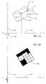
- the robot system 210tracks its current location, path, or combination thereof with respect to a global reference frame represented by Cartesian (x-y) coordinates 250 , as shown in FIG. 2 .
- Cartesian (x-y) coordinates 250can also be used.
- a horizontal axis 252corresponds to the x-axis
- a vertical axis 254corresponds to the y-axis.
- the origin 256 of the coordinate systemmay coincide with the robot's starting position, position or a prior anchor node, or other arbitrary location.
- the pose, including position and orientation, of the robotic systemmay be recorded in terms of the Cartesian coordinates and angle theta, ⁇ .
- a grid in the preferred embodimentincludes a map of local parameter data located relative to an anchor node in a local reference frame. As shown in FIG. 2B , properties of the environment in proximity to the anchor node are mapped to the grid 260 relative to the position of the anchor node A 1 .
- the grid 260is therefore a local map describing the environment in the region around the anchor node.
- each gridincludes a two dimensional Cartesian representation depicting the locations of obstacles (black cells) detect by the bump sensor 118 and open spaces (white cells) traversed by the robot (not to scale).
- an axis of the grid's Cartesian coordinate systemcoincides with robot's orientation anchor node, ⁇ , which is generally different than the orientation of the x-axis 252 and y-axis 254 in the global reference frame.
- an anchor nodeis typically a point along the path of the robot while navigating through the environment.
- grids in the preferred embodimentare shown as two dimensional (2D) Cartesian sub-maps, the grids may effectively record local parameter data using other reference systems including spherical and cylindrical coordinates systems for example.
- the parameter datais represented with pixels in a Cartesian coordinate system in the preferred embodiment.
- gridsmay represent local parameter data as (1) pixels in a cylindrical coordinate system, (2) polygons with an arbitrary number of sides, or (3) other arbitrary shape, for example.
- the robotic system 100 in the exemplary embodimentis configured to traverses a path through an environment.
- the pathmay be predetermined by the navigation module, determined ad hoc, or manually determined by a human driver or navigator, for example.
- the localization moduleacquires image data with which it generates new landmarks and recognizes known landmarks for purposes of mapping the environment and locating the robotic system within the environment.
- the landmark informationin combination with the odometry information, enables the robotic system to make accurate estimates of the robot's location in the environment.
- the robotic systemgenerates a map of one or more parameters of interest in parallel with the location determination.
- the parameter mapping modulesenses properties of the environment and generates a parameter map depicting those properties. Referring to FIG. 3A , the mapping process begins by taking measurements of these properties and various locations or poses in the environment.
- the robot posesare represented as circles N 1 -N 8 and the parameters observed at each of the respective poses is poses are represented as squares A-H.
- the parameter datawould generally grow linearly in time as the robot continues to collect measurements.
- the robotic system in the present inventiongenerates spatial summaries that effectively summarize parameter data is specific geographic locations. Referring to FIG.
- the robot systemis configured to combine parameter readings for different poses if the relative uncertainty between those poses is small. For example, if Pose 1 and Pose 2 in FIG. 3A have a relative pose transformation with low uncertainty, Sensor Data B and C can be combined into one summary corresponding to Pose A 1 shown in FIG. 3B .
- the pose associated with the summary of Sensor Data Band Cis tied to one root poses referred to herein as an anchor node.
- the pose selected to be the anchor nodemay be the pose associated with Pose 2 , Pose 3 , or a new pose created from the combination of the Pose 2 and 3 .
- Successive poseslike Pose 2 and Pose 3 , generally have a relatively low relative uncertainty (due to the accuracy of the dead reckoning sensors) and may, therefore be combined into a single summary in many cases.
- the uncertainty of the relative pose between anchor nodes of two summarieswill decrease.
- the relative pose between two anchor nodesbecomes sufficiently certain—the relative uncertainty drops below a threshold—the summaries associated with multiple nodes may be combined into a single summary that is then associated with a single anchor node.
- the summary of Sensor Data B and Cis combined with the summary of Sensor Data H and G to create a single new summary associated with the anchor node A 1 .
- the summary including Sensor Data B, C, G, and His referred to herein as a spatial summary.
- multiple pairs of anchor node posesare compared. In the extreme, the pose for each anchor is compared to the pose for every other anchor node. If the uncertainty associated with the relative pose between the anchor nodes is below a threshold, the decision block is answered in the affirmative and the summaries (comprised of sensor data) for the anchor nodes are combined into a single summary associated with a single anchor node. If, however, the uncertainty exceeds the threshold, the pair of anchor nodes is not combined and new sensor data added to the grid associated with the current node.
- the “uncertainty” of relative poses between anchor nodesis, in the preferred embodiment, the sum of the diagonal elements of the covariance matrix of the relative pose estimate.
- the method of measuring relative uncertaintyincludes generating a Mahalanobis distance, or like uncertainty estimating metric.
- the parameter data from a plurality of gridsmay be merged in a single summary associated with a single anchor nodes based on the relative pose uncertainty.
- Other criteriamay also be used when determining whether to combine grids. These criteria may include, but are not limited to: (a) whether the summary reduces the memory requirements, i.e., whether the number of anchor nodes and grids data is reduced; (b) whether the summary improves performance, i.e., whether the summary reduces the time needed to compute a complete parameter map; (c) whether the map quality improves, i.e., whether merging or eliminating relatively “old” and outdated maps while retaining relatively “newer” maps improves the accuracy of the parameter map; or (d) any combination thereof
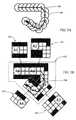
- FIG. 5AIllustrated in FIG. 5A is a robot path 500 and a plurality of corresponding nodes 510 , and illustrated in FIG. 5B are the anchor nodes and associated grids that summarize the sensor data for the nodes 510 shown in FIG. 5A .
- the robot systemcollects sensor data while traverse a trajectory 500 through the environment.
- the sensor dataincluding obstacles, for example are associated with the pose of the robot at the time the sensor data was taken. Due to the volume of this data, however, the robotic system summarizes this data in the manner illustrated in FIG. 5B .
- Anchor nodes A 1 -A 4are shown in FIG. 5B as circles and the grids 520 - 523 shown as rectangles.
- the sensor dataincludes bump sensor data that indicates the presence of obstacles.
- Each gridthus, depicts the locations of areas that are clear to traverse (shown as white cells) as well as obstacles or occupied areas (shown as black cells) in proximity to their respective anchor node.
- the parameter mapping module 136identifies nodes having a relative pose uncertainty below a threshold, combines the sensor data for these poses into a single grid, and associates the grid with a single anchor node.
- the parameter data from grids 520 - 523can be combined by overlaying the respective grids 520 - 523 as shown by the superposition 530 of grids.
- the plurality of gridsmay overlap in physical extent, possess different orientations in their respective local reference frames, and be of different sizes.
- data from the superposition 530 of gridsmay be combined into a single spatial summary associated with a new anchor node, for example.
- the superposition of spatial summariesmay be used to build a global parameter map used to, for example, plan a new path for the robot through the environment. Exemplary parameter maps are shown and discussed in reference to FIGS. 7A and 7B .
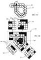
- FIG. 6A-6Billustrates a robot path with corresponding nodes and anchor nodes with associated grids.
- the trajectory of the mobile robothas circled back on itself. In doing so, the robot traverses an area that it previously traversed earlier in its trajectory.
- the robotby looping back, the robot is able to collect additional sensor data that can be used to update one or more previous grids and even modify sensor data used to populate the old version of the same grid. If the current pose of the robotic system is known with sufficient certainty relative to a prior pose, the anchor node associated with the prior pose is retrieved and the new sensor mapped to the grid associated with the prior anchor node.
- cells 520 , 521 in the grid associated with anchor node A 1 and A 2show occupied areas (or unsearched areas) in FIG. 5B .
- the same cells 650 , 652 in corresponding grids 620 , 621 for anchor A 1 and A 2were updated to show those cells as “clear areas” after the robot traverses the same area a second time.
- new parameter data from sensors 110is used to introduce new cells 654 to grid 523 in FIG. 5B to create the updated and expanded grid 623 in FIG. 6B .
- new sensor data collected while looping backis added to a prior grid because the uncertainty associated with the initial pose and later pose was below the acceptable threshold.
- the mapping module 136effectively updates existing grids with new information without creating new anchor nodes or grids.
- the present inventiontherefore, effectively enables the parameter map to be continually updated with new sensor data without the storage requirements for the sensor data growing linearly with time.
- the gridsmay be combined to generate a complete parameter map of the entire environment or a portion of the environment for purposes of path planning, for example.
- a representative parameter mapis shown in FIGS. 7A and 7B .
- the plurality of grids depicting the presences of obstaclesare combined to form an occupancy map of “clear” areas (i.e., open areas free of obstacles) in FIG. 7A and an occupancy map of “obstacles” (e.g., walls that bound the open areas) in FIG. 7B .
- Gridsalso known as summaries when merged—may be combined by overlaying the grids at their respective locations in the global reference frame. The location of each individual grid is defined by the most current estimate of the position and orientation of the respective anchor point.
- each anchor nodeis regularly updated within the global reference frame as new SLAM data is received and the uncertainties associated with the pose estimates is reduced.
- the occupancy map shown in FIGS. 7A and 7Bare rendered in two dimensions (2D). In other embodiments, the occupancy map or other parameter map may be rendered in three dimensions (3D) if the sensor data and corresponding grids include elevational information, for example.
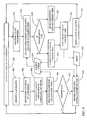
- FIG. 8Illustrated in FIG. 8 is a flow chart showing the method of localization and parameter mapping, in accordance with the preferred embodiment of the present invention.
- the location and parameter mappingoccur concurrently or substantially concurrently while the robotic system navigates 802 through the environment.
- the robotic systemrepeatedly acquires images of the environment with which it identifies 804 landmarks. As the robot traverses the environment, it generally acquires multiple images or other measurements of each landmark which enables it to determine 806 the locations of the landmarks in two dimension (2D) or three dimensional (3D) space.
- 2Dtwo dimension
- 3Dthree dimensional
- the localization systemmay update the estimated locations of the anchor nodes to generate an occupancy map, for example, in the global reference frame. If an occupancy map is required for path planning for example, the decision block 812 is answered in the affirmative and the updated estimates of the locations of the anchor nodes used to superimpose the associated grids and render 814 the grids into a cohesive map as shown in FIGS. 7A and 7B .
- the robotic systemnavigates 802 through the environment, it measures 816 local parameters using on-board sensors including the bump sensor.
- the parameter mapping moduleuses the estimate of the current pose, the parameter mapping module searches for and identifies 818 an existing anchor node having the lowest relative pose uncertainty with respect to the current node.
- the identified nodemay be the preceding node in the robot path, or a prior node that is closest in distance to the current node. If the relative pose uncertainty between the current node and a prior node is below a predetermined threshold, the decision block 820 is answered in the affirmative. In this case, the grid associated with the prior anchor node is selected 822 to be the current grid and incoming sensor data mapped 826 to this current grid.
- the uncertaintyis determined from the covariance matrix describing the positional uncertainties associated with the localization using the visual SLAM module and odometry sensors, for example. If, however, the uncertainty exceeds the predetermined threshold, the decision block 820 is answered in the negative. In this case, a new anchor node is generated 824 and the incoming sensor data mapped 826 to a new grid associated with the new anchor node. The process of mapping 826 incoming parameter data continues while the uncertainty remains sufficiently low. Over relatively short distances, dead reckoning measurements, such as those obtained from odometry readings, can be quite accurate. As such, the uncertainty remains low and incoming sensor data generally used to populate the current parameter. New nodes tend to be generated after the robot has traveled some distance in a previously unexplored area. New anchor nodes 830 are recorded in the node database 144 and new and updated grids 828 recorded in the grid database 146 .
- the parameter data from a plurality of local gridsis merged 832 into one or more spatial summaries.
- gridsmay be combined into spatial summaries if the uncertainty associated with the relative pose between the respective anchor nodes is below a threshold.
- the mapping module 136periodically attempts to generate spatial summaries in response to any of a number of events or conditions including: (1) elapse time; (2) space covered by the mobile robot or area mapped by the mobile robot; (3) grid memory limitation; (4) total number of grids or anchor nodes; or combination thereof.
- the process of rending a plurality of grids into a global parameter mapmay be repeated as necessary based on the conditions stated above.
- the robotic system of the present inventioncan be implemented in systems include hardware, software, firmware, or a combination thereof.
- Hardwarecan include one or more general purpose computers, microprocessors, application specific integrated circuits (ASICs), field programmable gate arrays (FPGAs), and the like, as well as combinations thereof linked by networking systems, for example.
- Softwaremay include computer-readable instructions for execution on various processors, computers, servers, or like circuit board or chips.
- the computer-readable instructionsmay be affixed in volatile or non-volatile memory including memory chips, hard drives, on compact discs, for example.
- the present inventionmay also be implement in a plurality of platforms including a distributed platform including two or more network-enabled robots that cooperate with a remote central processing unit (CPU), for example, to collect landmark information from a relatively large environment.
- the CPUmay include a personal computer, mobile phone, tablet computer, server, or like device that perform the computation of the processor 130 .
- the present inventionis implemented with a fleet of robots that periodically exchange positioning information and parameter maps (either rendered a single map or as a collection of individual sub-maps) while traversing the environment so that each robot has information on all the parameters explored by other robots.
Landscapes
- Engineering & Computer Science (AREA)
- Radar, Positioning & Navigation (AREA)
- Remote Sensing (AREA)
- Physics & Mathematics (AREA)
- General Physics & Mathematics (AREA)
- Automation & Control Theory (AREA)
- Aviation & Aerospace Engineering (AREA)
- Electromagnetism (AREA)
- Computer Vision & Pattern Recognition (AREA)
- Multimedia (AREA)
- Databases & Information Systems (AREA)
- General Engineering & Computer Science (AREA)
- Business, Economics & Management (AREA)
- Health & Medical Sciences (AREA)
- Artificial Intelligence (AREA)
- Evolutionary Computation (AREA)
- Game Theory and Decision Science (AREA)
- Medical Informatics (AREA)
- Control Of Position, Course, Altitude, Or Attitude Of Moving Bodies (AREA)
Abstract
Description
Claims (19)
Priority Applications (4)
| Application Number | Priority Date | Filing Date | Title |
|---|---|---|---|
| US14/307,402US9218003B2 (en) | 2011-09-30 | 2014-06-17 | Adaptive mapping with spatial summaries of sensor data |
| US14/944,152US9404756B2 (en) | 2011-09-30 | 2015-11-17 | Adaptive mapping with spatial summaries of sensor data |
| US15/225,158US9952053B2 (en) | 2011-09-30 | 2016-08-01 | Adaptive mapping with spatial summaries of sensor data |
| US15/921,085US10962376B2 (en) | 2011-09-30 | 2018-03-14 | Adaptive mapping with spatial summaries of sensor data |
Applications Claiming Priority (3)
| Application Number | Priority Date | Filing Date | Title |
|---|---|---|---|
| US201161541749P | 2011-09-30 | 2011-09-30 | |
| US13/632,997US8798840B2 (en) | 2011-09-30 | 2012-10-01 | Adaptive mapping with spatial summaries of sensor data |
| US14/307,402US9218003B2 (en) | 2011-09-30 | 2014-06-17 | Adaptive mapping with spatial summaries of sensor data |
Related Parent Applications (1)
| Application Number | Title | Priority Date | Filing Date |
|---|---|---|---|
| US13/632,997ContinuationUS8798840B2 (en) | 2011-09-30 | 2012-10-01 | Adaptive mapping with spatial summaries of sensor data |
Related Child Applications (1)
| Application Number | Title | Priority Date | Filing Date |
|---|---|---|---|
| US14/944,152ContinuationUS9404756B2 (en) | 2011-09-30 | 2015-11-17 | Adaptive mapping with spatial summaries of sensor data |
Publications (2)
| Publication Number | Publication Date |
|---|---|
| US20150261223A1 US20150261223A1 (en) | 2015-09-17 |
| US9218003B2true US9218003B2 (en) | 2015-12-22 |
Family
ID=49778963
Family Applications (5)
| Application Number | Title | Priority Date | Filing Date |
|---|---|---|---|
| US13/632,997Active2032-11-10US8798840B2 (en) | 2011-09-30 | 2012-10-01 | Adaptive mapping with spatial summaries of sensor data |
| US14/307,402ActiveUS9218003B2 (en) | 2011-09-30 | 2014-06-17 | Adaptive mapping with spatial summaries of sensor data |
| US14/944,152ActiveUS9404756B2 (en) | 2011-09-30 | 2015-11-17 | Adaptive mapping with spatial summaries of sensor data |
| US15/225,158ActiveUS9952053B2 (en) | 2011-09-30 | 2016-08-01 | Adaptive mapping with spatial summaries of sensor data |
| US15/921,085Active2033-07-08US10962376B2 (en) | 2011-09-30 | 2018-03-14 | Adaptive mapping with spatial summaries of sensor data |
Family Applications Before (1)
| Application Number | Title | Priority Date | Filing Date |
|---|---|---|---|
| US13/632,997Active2032-11-10US8798840B2 (en) | 2011-09-30 | 2012-10-01 | Adaptive mapping with spatial summaries of sensor data |
Family Applications After (3)
| Application Number | Title | Priority Date | Filing Date |
|---|---|---|---|
| US14/944,152ActiveUS9404756B2 (en) | 2011-09-30 | 2015-11-17 | Adaptive mapping with spatial summaries of sensor data |
| US15/225,158ActiveUS9952053B2 (en) | 2011-09-30 | 2016-08-01 | Adaptive mapping with spatial summaries of sensor data |
| US15/921,085Active2033-07-08US10962376B2 (en) | 2011-09-30 | 2018-03-14 | Adaptive mapping with spatial summaries of sensor data |
Country Status (6)
| Country | Link |
|---|---|
| US (5) | US8798840B2 (en) |
| EP (2) | EP3018603B1 (en) |
| JP (3) | JP5931287B2 (en) |
| AU (3) | AU2013327774B2 (en) |
| CA (4) | CA2952355C (en) |
| WO (1) | WO2014055278A1 (en) |
Cited By (24)
| Publication number | Priority date | Publication date | Assignee | Title |
|---|---|---|---|---|
| US20150228077A1 (en)* | 2014-02-08 | 2015-08-13 | Honda Motor Co., Ltd. | System and method for mapping, localization and pose correction |
| US10215571B2 (en)* | 2016-08-09 | 2019-02-26 | Nauto, Inc. | System and method for precision localization and mapping |
| US10453150B2 (en) | 2017-06-16 | 2019-10-22 | Nauto, Inc. | System and method for adverse vehicle event determination |
| US10589931B2 (en) | 2016-09-30 | 2020-03-17 | Staples, Inc. | Hybrid modular storage fetching system |
| US10683171B2 (en) | 2016-09-30 | 2020-06-16 | Staples, Inc. | Hybrid modular storage fetching system |
| US10802495B2 (en)* | 2016-04-14 | 2020-10-13 | Deka Products Limited Partnership | User control device for a transporter |
| US10803420B2 (en) | 2016-09-30 | 2020-10-13 | Staples, Inc. | Hybrid modular storage fetching system |
| US10908045B2 (en) | 2016-02-23 | 2021-02-02 | Deka Products Limited Partnership | Mobility device |
| US10926756B2 (en) | 2016-02-23 | 2021-02-23 | Deka Products Limited Partnership | Mobility device |
| US10962376B2 (en) | 2011-09-30 | 2021-03-30 | Irobot Corporation | Adaptive mapping with spatial summaries of sensor data |
| US11084410B1 (en) | 2018-08-07 | 2021-08-10 | Staples, Inc. | Automated guided vehicle for transporting shelving units |
| US11119487B2 (en) | 2018-12-31 | 2021-09-14 | Staples, Inc. | Automated preparation of deliveries in delivery vehicles using automated guided vehicles |
| US11124401B1 (en) | 2019-03-31 | 2021-09-21 | Staples, Inc. | Automated loading of delivery vehicles |
| US11180069B2 (en) | 2018-12-31 | 2021-11-23 | Staples, Inc. | Automated loading of delivery vehicles using automated guided vehicles |
| US20220105958A1 (en)* | 2020-10-07 | 2022-04-07 | Hyundai Motor Company | Autonomous driving apparatus and method for generating precise map |
| US11392131B2 (en) | 2018-02-27 | 2022-07-19 | Nauto, Inc. | Method for determining driving policy |
| US11399995B2 (en) | 2016-02-23 | 2022-08-02 | Deka Products Limited Partnership | Mobility device |
| US11526182B2 (en) | 2019-03-25 | 2022-12-13 | Cbn Nano Technologies Inc. | Sensing and operation of devices in viscous flow using derived parameters to reduce data-handling requirements |
| US11590997B1 (en) | 2018-08-07 | 2023-02-28 | Staples, Inc. | Autonomous shopping cart |
| US11630447B1 (en) | 2018-08-10 | 2023-04-18 | Staples, Inc. | Automated guided vehicle for transporting objects |
| US11681293B2 (en) | 2018-06-07 | 2023-06-20 | Deka Products Limited Partnership | System and method for distributed utility service execution |
| US12038756B2 (en) | 2017-12-19 | 2024-07-16 | Carnegie Mellon University | Intelligent cleaning robot |
| USD1047785S1 (en) | 2017-05-20 | 2024-10-22 | Deka Products Limited Partnership | Toggle control device |
| US12440401B2 (en) | 2024-05-22 | 2025-10-14 | Deka Products Limited Partnership | Mobility device |
Families Citing this family (196)
| Publication number | Priority date | Publication date | Assignee | Title |
|---|---|---|---|---|
| US8401560B2 (en) | 2009-03-31 | 2013-03-19 | Empire Technology Development Llc | Infrastructure for location discovery |
| JP5745067B2 (en)* | 2010-09-24 | 2015-07-08 | アイロボット・コーポレーション | System and method for VSLAM optimization |
| US9453734B2 (en)* | 2012-06-05 | 2016-09-27 | Apple Inc. | Smart loading of map tiles |
| US9020637B2 (en)* | 2012-11-02 | 2015-04-28 | Irobot Corporation | Simultaneous localization and mapping for a mobile robot |
| US20140267703A1 (en)* | 2013-03-15 | 2014-09-18 | Robert M. Taylor | Method and Apparatus of Mapping Landmark Position and Orientation |
| DE102013207904A1 (en)* | 2013-04-30 | 2014-10-30 | Bayerische Motoren Werke Aktiengesellschaft | Provide an efficient environment map for a vehicle |
| KR101560274B1 (en)* | 2013-05-31 | 2015-10-14 | 삼성에스디에스 주식회사 | Apparatus and Method for Analyzing Data |
| US11858738B2 (en) | 2013-08-09 | 2024-01-02 | Ocado Innovation Limited | Apparatus for retrieving units from a storage system |
| GB201404870D0 (en) | 2014-03-18 | 2014-04-30 | Ocado Ltd | Robotic service device and handling method |
| GB201314313D0 (en) | 2013-08-09 | 2013-09-25 | Ocado Ltd | Apparatus for retrieving units from a storage system |
| ITGE20130095A1 (en)* | 2013-09-27 | 2015-03-28 | Nicolo' Spallarossa | DEVICE FOR THE SURVEY OF INTERIORS AND ARCHITECTURAL PARTIALS AND METHOD OF DETECTION AND RECONSTRUCTION OF PLANTS OF INTERNAL ENVIRONMENTS |
| KR20150058679A (en)* | 2013-11-20 | 2015-05-29 | 한국전자통신연구원 | Apparatus and method for localization of autonomous vehicle in a complex |
| TWI534453B (en)* | 2014-02-18 | 2016-05-21 | 原相科技股份有限公司 | Relative position positioning system and tracking system |
| DE102014002821A1 (en)* | 2014-02-26 | 2015-08-27 | Audi Ag | Method and system for locating a mobile device |
| JP2015215651A (en)* | 2014-05-08 | 2015-12-03 | 株式会社日立製作所 | Robot and self-position estimation method |
| GB201409883D0 (en) | 2014-06-03 | 2014-07-16 | Ocado Ltd | Methods, systems, and apparatus for controlling movement of transporting devices |
| DE102014210770A1 (en) | 2014-06-05 | 2015-12-17 | Conti Temic Microelectronic Gmbh | METHOD AND SYSTEM FOR DETERMINING A VEHICLE POSITION OF A VEHICLE |
| ES2675363T3 (en) | 2014-06-05 | 2018-07-10 | Softbank Robotics Europe | Procedure for constructing a probability map between the absence and the presence of obstacles for an autonomous robot |
| US9971320B2 (en)* | 2014-07-03 | 2018-05-15 | Google Llc | Methods and systems for adaptive triggering of data collection |
| CN105224582B (en)* | 2014-07-03 | 2018-11-09 | 联想(北京)有限公司 | Information processing method and equipment |
| US10127667B2 (en) | 2014-08-01 | 2018-11-13 | Locuslabs, Inc. | Image-based object location system and process |
| JP6626248B2 (en)* | 2014-11-12 | 2019-12-25 | 村田機械株式会社 | Moving amount estimating apparatus, autonomous moving body, and moving amount estimating method |
| US10096240B2 (en)* | 2015-02-06 | 2018-10-09 | Jung H BYUN | Method and server for traffic signal regulation based on crowdsourcing data |
| US9849882B2 (en)* | 2015-02-06 | 2017-12-26 | Jung H BYUN | Vehicle control based on crowdsourcing data |
| CN107850644B (en)* | 2015-02-27 | 2020-11-03 | Abb瑞士股份有限公司 | Localization, mapping and haptic feedback for inspecting enclosed spaces inside a machine |
| US12084824B2 (en) | 2015-03-06 | 2024-09-10 | Walmart Apollo, Llc | Shopping facility assistance systems, devices and methods |
| WO2016142794A1 (en) | 2015-03-06 | 2016-09-15 | Wal-Mart Stores, Inc | Item monitoring system and method |
| US20180099846A1 (en) | 2015-03-06 | 2018-04-12 | Wal-Mart Stores, Inc. | Method and apparatus for transporting a plurality of stacked motorized transport units |
| US12366043B2 (en) | 2015-03-06 | 2025-07-22 | Walmart Apollo, Llc | Overriding control of motorized transport unit systems, devices and methods |
| US10358326B2 (en) | 2015-03-06 | 2019-07-23 | Walmart Apollo, Llc | Shopping facility assistance systems, devices and methods |
| US9630319B2 (en) | 2015-03-18 | 2017-04-25 | Irobot Corporation | Localization and mapping using physical features |
| US9304003B1 (en) | 2015-03-18 | 2016-04-05 | Microsoft Technology Licensing, Llc | Augmented reality navigation |
| JP6651295B2 (en)* | 2015-03-23 | 2020-02-19 | 株式会社メガチップス | Moving object control device, program and integrated circuit |
| KR101697857B1 (en)* | 2015-04-08 | 2017-01-18 | 엘지전자 주식회사 | Moving robot and method for recognizing a location of the same |
| EP3078935A1 (en) | 2015-04-10 | 2016-10-12 | The European Atomic Energy Community (EURATOM), represented by the European Commission | Method and device for real-time mapping and localization |
| CN104807465B (en)* | 2015-04-27 | 2018-03-13 | 安徽工程大学 | Robot synchronously positions and map creating method and device |
| US9616773B2 (en) | 2015-05-11 | 2017-04-11 | Uber Technologies, Inc. | Detecting objects within a vehicle in connection with a service |
| DE102015109775B3 (en) | 2015-06-18 | 2016-09-22 | RobArt GmbH | Optical triangulation sensor for distance measurement |
| KR101734654B1 (en)* | 2015-06-25 | 2017-05-11 | 현대자동차주식회사 | System and Method for writing Occupancy Grid Map of sensor centered coordinate system using laser scanner |
| US9940542B2 (en)* | 2015-08-11 | 2018-04-10 | Google Llc | Managing feature data for environment mapping on an electronic device |
| CN105043396B (en)* | 2015-08-14 | 2018-02-02 | 北京进化者机器人科技有限公司 | The method and system of self-built map in a kind of mobile robot room |
| DE102015114883A1 (en) | 2015-09-04 | 2017-03-09 | RobArt GmbH | Identification and localization of a base station of an autonomous mobile robot |
| US9849591B2 (en)* | 2015-10-02 | 2017-12-26 | X Development Llc | Localization of a robot in an environment using detected edges of a camera image from a camera of the robot and detected edges derived from a three-dimensional model of the environment |
| WO2017059194A1 (en)* | 2015-10-02 | 2017-04-06 | Verselus, Llc | System and method for autonomously teaching working points in a robotic disk test apparatus |
| US10209063B2 (en)* | 2015-10-03 | 2019-02-19 | X Development Llc | Using sensor-based observations of agents in an environment to estimate the pose of an object in the environment and to estimate an uncertainty measure for the pose |
| DE102015119501A1 (en) | 2015-11-11 | 2017-05-11 | RobArt GmbH | Subdivision of maps for robot navigation |
| DE102015119865B4 (en) | 2015-11-17 | 2023-12-21 | RobArt GmbH | Robot-assisted processing of a surface using a robot |
| US10712160B2 (en) | 2015-12-10 | 2020-07-14 | Uatc, Llc | Vehicle traction map for autonomous vehicles |
| DE102015121666B3 (en) | 2015-12-11 | 2017-05-24 | RobArt GmbH | Remote control of a mobile, autonomous robot |
| CN205671994U (en) | 2015-12-16 | 2016-11-09 | 小米科技有限责任公司 | Automatic cleaning equipment |
| US9840256B1 (en) | 2015-12-16 | 2017-12-12 | Uber Technologies, Inc. | Predictive sensor array configuration system for an autonomous vehicle |
| US9841763B1 (en) | 2015-12-16 | 2017-12-12 | Uber Technologies, Inc. | Predictive sensor array configuration system for an autonomous vehicle |
| DE102016102644A1 (en) | 2016-02-15 | 2017-08-17 | RobArt GmbH | Method for controlling an autonomous mobile robot |
| DE102016203547A1 (en) | 2016-03-03 | 2017-09-07 | Kuka Roboter Gmbh | Method for updating an occupancy card and autonomous vehicle |
| US9990548B2 (en) | 2016-03-09 | 2018-06-05 | Uber Technologies, Inc. | Traffic signal analysis system |
| US9864377B2 (en)* | 2016-04-01 | 2018-01-09 | Locus Robotics Corporation | Navigation using planned robot travel paths |
| CA2961938A1 (en) | 2016-04-01 | 2017-10-01 | Wal-Mart Stores, Inc. | Systems and methods for moving pallets via unmanned motorized unit-guided forklifts |
| US10328577B2 (en)* | 2016-04-19 | 2019-06-25 | Xiaoyu Arasive Inc. | Autonomous navigational system for floor preparation and maintenance equipment |
| US10241514B2 (en) | 2016-05-11 | 2019-03-26 | Brain Corporation | Systems and methods for initializing a robot to autonomously travel a trained route |
| CN105973265B (en)* | 2016-05-19 | 2019-03-19 | 杭州申昊科技股份有限公司 | A kind of mileage estimation method based on scanning laser sensor |
| US9965689B2 (en)* | 2016-06-09 | 2018-05-08 | Qualcomm Incorporated | Geometric matching in visual navigation systems |
| US9987752B2 (en) | 2016-06-10 | 2018-06-05 | Brain Corporation | Systems and methods for automatic detection of spills |
| US10282849B2 (en) | 2016-06-17 | 2019-05-07 | Brain Corporation | Systems and methods for predictive/reconstructive visual object tracker |
| US10016896B2 (en) | 2016-06-30 | 2018-07-10 | Brain Corporation | Systems and methods for robotic behavior around moving bodies |
| US20180005052A1 (en)* | 2016-07-01 | 2018-01-04 | Uber Technologies, Inc. | Static object detection for operating autonomous vehicle |
| CN109478338B (en)* | 2016-07-19 | 2023-04-04 | 松下电器(美国)知识产权公司 | Three-dimensional data creation method, three-dimensional data transmission method, three-dimensional data creation device, and three-dimensional data transmission device |
| EP3494447B1 (en)* | 2016-08-04 | 2021-05-19 | Reification Inc. | Methods for simultaneous localization and mapping (slam) and related apparatus and systems |
| JP7073336B2 (en) | 2016-08-05 | 2022-05-23 | ロブアート ゲーエムベーハー | How to control an autonomous mobile robot |
| JP7015506B2 (en)* | 2016-08-31 | 2022-02-15 | 国立研究開発法人 海上・港湾・航空技術研究所 | Positioning method using landmarks |
| US10282854B2 (en)* | 2016-10-12 | 2019-05-07 | Faro Technologies, Inc. | Two-dimensional mapping system and method of operation |
| US20180100927A1 (en)* | 2016-10-12 | 2018-04-12 | Faro Technologies, Inc. | Two-dimensional mapping system and method of operation |
| US10274325B2 (en)* | 2016-11-01 | 2019-04-30 | Brain Corporation | Systems and methods for robotic mapping |
| US9940729B1 (en)* | 2016-11-18 | 2018-04-10 | Here Global B.V. | Detection of invariant features for localization |
| EP3324209A1 (en) | 2016-11-18 | 2018-05-23 | Dibotics | Methods and systems for vehicle environment map generation and updating |
| US10723018B2 (en) | 2016-11-28 | 2020-07-28 | Brain Corporation | Systems and methods for remote operating and/or monitoring of a robot |
| CN107121142B (en)* | 2016-12-30 | 2019-03-19 | 深圳市杉川机器人有限公司 | The topological map creation method and air navigation aid of mobile robot |
| US10852730B2 (en) | 2017-02-08 | 2020-12-01 | Brain Corporation | Systems and methods for robotic mobile platforms |
| EP3974934A1 (en) | 2017-03-02 | 2022-03-30 | Robart GmbH | Method for controlling an autonomous mobile robot |
| US10379606B2 (en)* | 2017-03-30 | 2019-08-13 | Microsoft Technology Licensing, Llc | Hologram anchor prioritization |
| GB201706129D0 (en)* | 2017-04-18 | 2017-05-31 | Blue Vision Labs Uk Ltd | Distributed device mapping |
| US10921816B2 (en)* | 2017-04-21 | 2021-02-16 | Korea Advanced Institute Of Science And Technology | Method and apparatus for producing map based on hierarchical structure using 2D laser scanner |
| US10697779B2 (en)* | 2017-04-21 | 2020-06-30 | X Development Llc | Landmark placement for localization |
| DE102017109219A1 (en) | 2017-04-28 | 2018-10-31 | RobArt GmbH | Method for robot navigation |
| US9939814B1 (en)* | 2017-05-01 | 2018-04-10 | Savioke, Inc. | Computer system and method for automated mapping by robots |
| US10769844B1 (en)* | 2017-05-12 | 2020-09-08 | Alarm.Com Incorporated | Marker aided three-dimensional mapping and object labeling |
| CN108931246B (en)* | 2017-05-26 | 2020-12-11 | 杭州海康机器人技术有限公司 | Method and device for detecting existence probability of obstacle at unknown position |
| US20220171399A1 (en)* | 2017-05-26 | 2022-06-02 | Hangzhou Hikrobot Technology Co., Ltd. | Method for detecting presence probability of obstacle in unknown position, terminal, and storage medium |
| CN107168331B (en)* | 2017-06-20 | 2021-04-02 | 南京阿凡达机器人科技有限公司 | Robot indoor map creation method based on displacement detection of optical mouse sensor |
| DE102017113612A1 (en)* | 2017-06-20 | 2018-12-20 | Vorwerk & Co. Interholding Gmbh | Autonomous cleaning system and cleaning process |
| US10885714B2 (en)* | 2017-07-07 | 2021-01-05 | Niantic, Inc. | Cloud enabled augmented reality |
| CN109588060B (en) | 2017-07-28 | 2021-05-11 | 谷歌有限责任公司 | Method for controlling a sensor and corresponding device, vehicle, system and computer-readable storage medium |
| WO2019019136A1 (en) | 2017-07-28 | 2019-01-31 | Qualcomm Incorporated | Systems and methods for utilizing semantic information for navigation of a robotic device |
| WO2019019157A1 (en)* | 2017-07-28 | 2019-01-31 | Qualcomm Incorporated | Image sensor initialization in a robotic vehicle |
| US10012996B1 (en) | 2017-09-15 | 2018-07-03 | Savioke, Inc. | Route planning for a mobile robot using configuration-based preferences |
| CN107728614B (en)* | 2017-09-21 | 2023-02-21 | 南京中高知识产权股份有限公司 | Guide robot for blind people and working method thereof |
| DE102017122440A1 (en) | 2017-09-27 | 2019-03-28 | Valeo Schalter Und Sensoren Gmbh | A method for locating and further developing a digital map by a motor vehicle; localization device |
| CN107908185A (en)* | 2017-10-14 | 2018-04-13 | 北醒(北京)光子科技有限公司 | A kind of robot autonomous global method for relocating and robot |
| CN107807643B (en)* | 2017-10-30 | 2019-09-03 | 珠海市一微半导体有限公司 | Robot walking prediction and control method |
| CN107898393B (en)* | 2017-11-17 | 2020-12-04 | 北京奇虎科技有限公司 | Block adjustment method, device and robot for cleaning robot |
| US11077756B2 (en)* | 2017-11-23 | 2021-08-03 | Intel Corporation | Area occupancy determining device |
| CN108008409B (en) | 2017-11-28 | 2019-12-10 | 深圳市杉川机器人有限公司 | Region contour drawing method and device |
| US10989538B2 (en) | 2017-12-15 | 2021-04-27 | Uatc, Llc | IMU data offset compensation for an autonomous vehicle |
| US10638906B2 (en) | 2017-12-15 | 2020-05-05 | Neato Robotics, Inc. | Conversion of cleaning robot camera images to floorplan for user interaction |
| CN109974719A (en)* | 2017-12-28 | 2019-07-05 | 周秦娜 | A kind of control method and device of the mobile robot environment sensing based on cloud computing |
| CN108319655B (en) | 2017-12-29 | 2021-05-07 | 百度在线网络技术(北京)有限公司 | Method and device for generating grid map |
| CN108344999B (en)* | 2018-01-09 | 2020-08-11 | 浙江大学 | Sonar map construction and repositioning method for underwater robot navigation |
| CN111630460A (en)* | 2018-01-24 | 2020-09-04 | 福特全球技术公司 | Path planning for autonomous mobile devices |
| CN108663041B (en)* | 2018-02-09 | 2020-04-24 | 意诺科技有限公司 | Method and device for drawing navigation map |
| US10852146B2 (en) | 2018-02-28 | 2020-12-01 | Ford Global Technologies, Llc | Localization technique selection |
| EP3534235B1 (en)* | 2018-02-28 | 2021-04-14 | Honda Research Institute Europe GmbH | Unsupervised learning of metric representations from slow features |
| CN108508891B (en)* | 2018-03-19 | 2019-08-09 | 珠海市一微半导体有限公司 | A method for robot relocation |
| US10503760B2 (en)* | 2018-03-29 | 2019-12-10 | Aurora Innovation, Inc. | Use of relative atlas in an autonomous vehicle |
| US11256729B2 (en)* | 2018-03-29 | 2022-02-22 | Aurora Operations, Inc. | Autonomous vehicle relative atlas incorporating hypergraph data structure |
| US10521913B2 (en)* | 2018-03-29 | 2019-12-31 | Aurora Innovation, Inc. | Relative atlas for autonomous vehicle and generation thereof |
| EP3781367B1 (en) | 2018-04-20 | 2025-03-05 | Covidien LP | Methods for surgical robotic cart placement |
| WO2019204800A1 (en)* | 2018-04-20 | 2019-10-24 | WeRide Corp. | Method and system for generating high definition map |
| US11687092B2 (en) | 2018-04-23 | 2023-06-27 | Sharkninja Operating Llc | Techniques for bounding cleaning operations of a robotic surface cleaning device within a region of interest |
| US11334753B2 (en) | 2018-04-30 | 2022-05-17 | Uatc, Llc | Traffic signal state classification for autonomous vehicles |
| CN108638062B (en)* | 2018-05-09 | 2021-08-13 | 科沃斯商用机器人有限公司 | Robot positioning method, device, positioning equipment and storage medium |
| DE102018113015A1 (en)* | 2018-05-30 | 2019-12-05 | Armin Stark | Autonomous, mobile work machine |
| US11946761B2 (en) | 2018-06-04 | 2024-04-02 | The Research Foundation For The State University Of New York | System and method associated with expedient determination of location of one or more object(s) within a bounded perimeter of 3D space based on mapping and navigation to a precise POI destination using a smart laser pointer device |
| CN108724188B (en)* | 2018-06-14 | 2022-02-25 | 西安电子科技大学 | Multi-robot cooperative motion control method |
| DE102018114892B4 (en)* | 2018-06-20 | 2023-11-09 | RobArt GmbH | Autonomous mobile robot and method for controlling an autonomous mobile robot |
| JP7123656B2 (en)* | 2018-06-22 | 2022-08-23 | 東芝ライフスタイル株式会社 | autonomous vacuum cleaner |
| CN108955688B (en)* | 2018-07-12 | 2021-12-28 | 苏州大学 | Method and system for positioning double-wheel differential mobile robot |
| US10946518B2 (en)* | 2018-07-24 | 2021-03-16 | Invia Robotics, Inc. | Spatiotemporal controller for controlling robot operation |
| DE102018121365A1 (en) | 2018-08-31 | 2020-04-23 | RobArt GmbH | EXPLORATION OF A ROBOT APPLICATION AREA BY AN AUTONOMOUS MOBILE ROBOT |
| EP3617749B1 (en)* | 2018-09-03 | 2020-11-11 | Zenuity AB | Method and arrangement for sourcing of location information, generating and updating maps representing the location |
| JP2020042726A (en)* | 2018-09-13 | 2020-03-19 | 株式会社東芝 | OGM compression circuit, OGM compression / decompression system, and mobile system |
| JP7135690B2 (en)* | 2018-10-04 | 2022-09-13 | ソニーグループ株式会社 | Information processing device and method, program, and mobile body control system |
| CN109269506A (en)* | 2018-10-31 | 2019-01-25 | 北京猎户星空科技有限公司 | Map creating method, device, robot and the system of mobile robot |
| US20210396543A1 (en)* | 2018-11-06 | 2021-12-23 | Sony Group Corporation | Information processing apparatus, information processing method, and program |
| US10739777B2 (en)* | 2018-11-20 | 2020-08-11 | Waymo Llc | Trajectory representation in behavior prediction systems |
| US11034348B2 (en) | 2018-11-20 | 2021-06-15 | Waymo Llc | Agent prioritization for autonomous vehicles |
| US11048253B2 (en) | 2018-11-21 | 2021-06-29 | Waymo Llc | Agent prioritization for autonomous vehicles |
| CN111238465B (en) | 2018-11-28 | 2022-02-18 | 台达电子工业股份有限公司 | Map building equipment and map building method thereof |
| CN109668566B (en)* | 2018-12-05 | 2022-05-13 | 大连理工大学 | Robot scene cognition map construction and navigation method based on mouse brain positioning cells |
| US10809073B2 (en)* | 2018-12-05 | 2020-10-20 | Here Global B.V. | Local window-based 2D occupancy grids for localization of autonomous vehicles |
| US11798293B2 (en) | 2018-12-28 | 2023-10-24 | Sony Group Corporation | Optical vehicle positioning |
| US11486701B2 (en) | 2019-02-06 | 2022-11-01 | Faro Technologies, Inc. | System and method for performing a real-time wall detection |
| JP7245084B2 (en)* | 2019-03-15 | 2023-03-23 | 日立Astemo株式会社 | Autonomous driving system |
| EP3949817B1 (en)* | 2019-03-28 | 2024-05-01 | LG Electronics Inc. | Artificial intelligence cleaner and operation method thereof |
| CN109916393B (en)* | 2019-03-29 | 2023-03-31 | 电子科技大学 | Multi-grid-value navigation method based on robot pose and application thereof |
| CN113678429B (en)* | 2019-04-09 | 2025-04-18 | 托罗公司 | Autonomous machine navigation in low-light conditions |
| CN112013844B (en)* | 2019-05-31 | 2022-02-11 | 北京小米智能科技有限公司 | Method and device for establishing indoor environment map |
| DE102019208384A1 (en)* | 2019-06-07 | 2020-12-10 | Robert Bosch Gmbh | Method for creating a universally applicable feature map |
| TWI701423B (en)* | 2019-07-01 | 2020-08-11 | 東元電機股份有限公司 | Auxiliary positioning system with reflective sticker |
| KR102224637B1 (en) | 2019-07-05 | 2021-03-08 | 엘지전자 주식회사 | Moving robot and control method thereof |
| KR102275300B1 (en) | 2019-07-05 | 2021-07-08 | 엘지전자 주식회사 | Moving robot and control method thereof |
| AU2020310932A1 (en)* | 2019-07-10 | 2022-01-27 | Deka Products Limited Partnership | System and method for real time control of an autonomous device |
| KR102297496B1 (en) | 2019-07-11 | 2021-09-02 | 엘지전자 주식회사 | A ROBOT CLEANER Using artificial intelligence AND CONTROL METHOD THEREOF |
| KR102361130B1 (en) | 2019-07-11 | 2022-02-09 | 엘지전자 주식회사 | Moving robot and control method thereof |
| KR102302575B1 (en)* | 2019-07-16 | 2021-09-14 | 엘지전자 주식회사 | Moving robot and control method thereof |
| US12353210B2 (en) | 2019-07-25 | 2025-07-08 | Ag Leader Technology | Apparatus, systems and methods for automated navigation of agricultural equipment |
| CN110580740B (en)* | 2019-08-27 | 2021-08-20 | 清华大学 | Multi-agent collaborative 3D modeling method and device |
| JP7214881B2 (en)* | 2019-09-26 | 2023-01-30 | ヤマハ発動機株式会社 | Environmental mapping device and method, self-localization device, autonomous mobile body |
| US11927692B2 (en)* | 2019-11-13 | 2024-03-12 | Faro Technologies, Inc. | Correcting positions after loop closure in simultaneous localization and mapping algorithm |
| CN111136655B (en)* | 2019-12-10 | 2021-06-29 | 深圳市优必选科技股份有限公司 | Method and device for acquiring inspection point |
| CN111024100B (en)* | 2019-12-20 | 2021-10-29 | 深圳市优必选科技股份有限公司 | Navigation map updating method and device, readable storage medium and robot |
| CN111121753A (en)* | 2019-12-30 | 2020-05-08 | 炬星科技(深圳)有限公司 | Robot joint graph building method and device and computer readable storage medium |
| CN111174758B (en)* | 2020-01-18 | 2021-07-16 | 湖南工学院 | A method for robot terrain detection without signal |
| JPWO2021182020A1 (en)* | 2020-03-10 | 2021-09-16 | ||
| CN111444852A (en)* | 2020-03-27 | 2020-07-24 | 深圳市银星智能科技股份有限公司 | Loop detection method and device and robot |
| US11448512B2 (en) | 2020-04-06 | 2022-09-20 | Here Global B.V. | Systems and methods for verifying mapping information |
| KR102319015B1 (en)* | 2020-04-09 | 2021-10-29 | 한국과학기술원 | Method and Apparatus for Adaptive Kernel Inference for Dense and Sharp Occupancy Grids |
| SE544298C2 (en)* | 2020-04-14 | 2022-03-29 | Husqvarna Ab | Robotic work tool system and method for defining a working area |
| CN111912417B (en)* | 2020-07-10 | 2022-08-02 | 上海商汤临港智能科技有限公司 | Map construction method, map construction device, map construction equipment and storage medium |
| US11687077B2 (en) | 2020-08-07 | 2023-06-27 | Waymo Llc | Ranking agents near autonomous vehicles by mutual importance |
| US11592573B2 (en)* | 2020-09-15 | 2023-02-28 | Irobot Corporation | Particle filters and WiFi robot localization and mapping |
| CN112363158B (en)* | 2020-10-23 | 2024-03-12 | 浙江华睿科技股份有限公司 | Pose estimation method for robot, robot and computer storage medium |
| CN112325770B (en)* | 2020-10-26 | 2022-08-02 | 武汉中海庭数据技术有限公司 | Method and system for evaluating confidence of relative precision of monocular vision measurement at vehicle end |
| CN112700495B (en)* | 2020-11-25 | 2024-08-16 | 北京旷视机器人技术有限公司 | Pose determination method, pose determination device, robot, electronic equipment and storage medium |
| CN112224793B (en)* | 2020-12-14 | 2021-03-02 | 湖南中拓信息科技有限公司 | Intelligent logistics selection path planning system |
| US11356801B1 (en)* | 2020-12-25 | 2022-06-07 | Mapsted Corp. | Method and system for targeted calibration |
| CN112828311B (en)* | 2021-01-03 | 2022-05-24 | 苏州星祥益精密制造有限公司 | Metal additive manufacturing online track adjusting method based on real-time three-dimensional detection |
| US11568649B2 (en) | 2021-01-15 | 2023-01-31 | Continental Automotive Systems, Inc. | Landmark-less simultaneous localization and mapping |
| ES2995866T3 (en)* | 2021-02-17 | 2025-02-11 | Interdigital Patent Holdings Inc | Method and system for 5gs and eps interworking for uav communication |
| CN116982011A (en) | 2021-03-15 | 2023-10-31 | 欧姆龙株式会社 | Method and device for updating an environment map used by a robot for self-localization |
| US12403950B2 (en) | 2021-04-19 | 2025-09-02 | Ag Leader Technology | Automatic steering systems and methods |
| CN113296500B (en)* | 2021-04-30 | 2023-04-25 | 浙江吉利控股集团有限公司 | A local path planning method and system |
| JP7561683B2 (en)* | 2021-05-13 | 2024-10-04 | 日立Astemo株式会社 | Map generation and self-location estimation device |
| CN113263500B (en)* | 2021-05-25 | 2022-10-21 | 深圳市优必选科技股份有限公司 | Robot autonomous operation method and device, robot and storage medium |
| US11886188B2 (en) | 2021-06-10 | 2024-01-30 | R-Go Robotics, Ltd. | Techniques for environmental parameter mapping |
| WO2023018947A1 (en) | 2021-08-13 | 2023-02-16 | Sharkninja Operating Llc | Robotic cleaner |
| US12325450B2 (en)* | 2021-08-23 | 2025-06-10 | Ford Global Technologies, Llc | Systems and methods for generating multilevel occupancy and occlusion grids for controlling navigation of vehicles |
| US11675362B1 (en)* | 2021-12-17 | 2023-06-13 | Motional Ad Llc | Methods and systems for agent prioritization |
| EP4443411A4 (en)* | 2021-12-17 | 2025-04-16 | Kubota Corporation | MAP GENERATION SYSTEM AND METHOD |
| US20230194305A1 (en)* | 2021-12-22 | 2023-06-22 | Eduardo Jose Ramirez Llanos | Mapping for autonomous vehicle parking |
| CN114676713B (en)* | 2022-02-22 | 2025-09-16 | 原力聚合(重庆)机器人科技有限公司 | Positioning method, positioning device, storage medium and program product |
| US20230296365A1 (en)* | 2022-03-15 | 2023-09-21 | Metal-Era, Llc | System of measuring objects in an environment |
| US12307915B2 (en) | 2022-03-29 | 2025-05-20 | Flir Unmanned Aerial Systems Ulc | Collision detection and avoidance for unmanned aerial vehicle systems and methods |
| US12400888B2 (en) | 2022-03-31 | 2025-08-26 | Tokyo Electron Limited | Data fusion of multiple sensors |
| US12300477B2 (en) | 2022-04-27 | 2025-05-13 | Tokyo Electron Limited | Autonomous operation of plasma processing tool |
| WO2023240170A1 (en)* | 2022-06-10 | 2023-12-14 | The Regents Of The University Of California | Device localization and navigation using rf sensing |
| WO2025157460A1 (en)* | 2024-01-22 | 2025-07-31 | Sew-Eurodrive Gmbh & Co Kg | Method for operating a technical installation, and technical installation |
| CN118857305B (en)* | 2024-09-24 | 2025-01-03 | 天津市品茗科技有限公司 | Path planning method and system for artificial intelligent robot |
Citations (113)
| Publication number | Priority date | Publication date | Assignee | Title |
|---|---|---|---|---|
| US4628453A (en) | 1983-10-17 | 1986-12-09 | Hitachi, Ltd. | Navigation apparatus for mobile system |
| US4815840A (en) | 1986-05-16 | 1989-03-28 | Benayad Cherif Faycal E K | Position locating system for a vehicle |
| US4846297A (en) | 1987-09-28 | 1989-07-11 | Tennant Company | Automated guided vehicle |
| US4942539A (en) | 1988-12-21 | 1990-07-17 | Gmf Robotics Corporation | Method and system for automatically determining the position and orientation of an object in 3-D space |
| US4954962A (en) | 1988-09-06 | 1990-09-04 | Transitions Research Corporation | Visual navigation and obstacle avoidance structured light system |
| EP0390052A2 (en) | 1989-03-31 | 1990-10-03 | Honeywell Inc. | Landmark recognition system and process |
| US5040116A (en) | 1988-09-06 | 1991-08-13 | Transitions Research Corporation | Visual navigation and obstacle avoidance structured light system |
| US5083257A (en) | 1989-04-27 | 1992-01-21 | Motorola, Inc. | Bit plane partitioning for graphic displays |
| US5109425A (en) | 1988-09-30 | 1992-04-28 | The United States Of America As Represented By The United States National Aeronautics And Space Administration | Method and apparatus for predicting the direction of movement in machine vision |
| US5111401A (en) | 1990-05-19 | 1992-05-05 | The United States Of America As Represented By The Secretary Of The Navy | Navigational control system for an autonomous vehicle |
| US5155775A (en) | 1988-10-13 | 1992-10-13 | Brown C David | Structured illumination autonomous machine vision system |
| US5170352A (en) | 1990-05-07 | 1992-12-08 | Fmc Corporation | Multi-purpose autonomous vehicle with path plotting |
| US5321614A (en) | 1991-06-06 | 1994-06-14 | Ashworth Guy T D | Navigational control apparatus and method for autonomus vehicles |
| US5517419A (en) | 1993-07-22 | 1996-05-14 | Synectics Corporation | Advanced terrain mapping system |
| US5525882A (en) | 1993-10-25 | 1996-06-11 | International Business Machines Corporation | Method and system for maneuvering a mobile robot |
| US5525883A (en) | 1994-07-08 | 1996-06-11 | Sara Avitzour | Mobile robot location determination employing error-correcting distributed landmarks |
| US5581629A (en) | 1995-01-30 | 1996-12-03 | David Sarnoff Research Center, Inc | Method for estimating the location of an image target region from tracked multiple image landmark regions |
| US5677836A (en)* | 1994-03-11 | 1997-10-14 | Siemens Aktiengesellschaft | Method for producing a cellularly structured environment map of a self-propelled, mobile unit that orients itself in the environment at least with the assistance of sensors based on wave refection |
| US5793934A (en) | 1994-06-22 | 1998-08-11 | Siemens Aktiengesellschaft | Method for the orientation, route planning and control of an autonomous mobile unit |
| US5911767A (en) | 1994-10-04 | 1999-06-15 | Garibotto; Giovanni | Navigation system for an autonomous mobile robot |
| US5957984A (en) | 1994-09-06 | 1999-09-28 | Siemens Aktiengesellschaft | Method of determining the position of a landmark in the environment map of a self-propelled unit, the distance of the landmark from the unit being determined dynamically by the latter |
| US5961571A (en) | 1994-12-27 | 1999-10-05 | Siemens Corporated Research, Inc | Method and apparatus for automatically tracking the location of vehicles |
| US6005610A (en) | 1998-01-23 | 1999-12-21 | Lucent Technologies Inc. | Audio-visual object localization and tracking system and method therefor |
| US6009359A (en) | 1996-09-18 | 1999-12-28 | National Research Council Of Canada | Mobile system for indoor 3-D mapping and creating virtual environments |
| US6108597A (en) | 1996-03-06 | 2000-08-22 | Gmd-Forschungszentrum Informationstechnik Gmbh | Autonomous mobile robot system for sensor-based and map-based navigation in pipe networks |
| US6243657B1 (en) | 1997-12-23 | 2001-06-05 | Pii North America, Inc. | Method and apparatus for determining location of characteristics of a pipeline |
| US6256581B1 (en) | 1998-07-30 | 2001-07-03 | Nippon Telegraph And Telephone Corporation | Navigation method, device, system and computer readable medium |
| US6266068B1 (en) | 1998-03-13 | 2001-07-24 | Compaq Computer Corporation | Multi-layer image-based rendering for video synthesis |
| US6269763B1 (en) | 1998-02-20 | 2001-08-07 | Richard Lawrence Ken Woodland | Autonomous marine vehicle |
| US6285393B1 (en) | 1993-09-08 | 2001-09-04 | Sumitomo Electric Industries, Ltd. | Object recognition apparatus and method |
| US6288704B1 (en) | 1999-06-08 | 2001-09-11 | Vega, Vista, Inc. | Motion detection and tracking system to control navigation and display of object viewers |
| US6299699B1 (en)* | 1999-04-01 | 2001-10-09 | Aqua Products Inc. | Pool cleaner directional control method and apparatus |
| US6301370B1 (en) | 1998-04-13 | 2001-10-09 | Eyematic Interfaces, Inc. | Face recognition from video images |
| US6330858B1 (en) | 1998-06-05 | 2001-12-18 | Navigation Technologies Corporation | Method and system for scrolling a map display in a navigation application |
| US20020072848A1 (en)* | 2000-12-12 | 2002-06-13 | Hiroyuki Hamada | Landmark update system and navigation device |
| US20020095239A1 (en) | 1999-11-24 | 2002-07-18 | Wallach Bret A. | Autonomous multi-platform robot system |
| US6427118B1 (en) | 1999-10-15 | 2002-07-30 | Yazaki Corporation | Vehicle-mounted navigation system, and recording medium having recorded thereon a processing program for use therewith |
| US6453223B1 (en) | 1996-11-05 | 2002-09-17 | Carnegie Mellon University | Infrastructure independent position determining system |
| US6459955B1 (en) | 1999-11-18 | 2002-10-01 | The Procter & Gamble Company | Home cleaning robot |
| US6463368B1 (en)* | 1998-08-10 | 2002-10-08 | Siemens Aktiengesellschaft | Method and device for determining a path around a defined reference position |
| US6496754B2 (en) | 2000-11-17 | 2002-12-17 | Samsung Kwangju Electronics Co., Ltd. | Mobile robot and course adjusting method thereof |
| US20030007682A1 (en) | 2001-05-02 | 2003-01-09 | Takamasa Koshizen | Image recognizing apparatus and method |
| US6516267B1 (en)* | 1997-10-16 | 2003-02-04 | Navigation Technologies Corporation | System and method for updating, enhancing or refining a geographic database using feedback |
| US20030025472A1 (en) | 2001-06-12 | 2003-02-06 | Jones Joseph L. | Method and system for multi-mode coverage for an autonomous robot |
| US20030030398A1 (en) | 2001-08-13 | 2003-02-13 | Stephen Jacobs | Mapped robot system |
| US20030044048A1 (en) | 2001-06-18 | 2003-03-06 | Zhengyou Zhang | Incremental motion estimation through local bundle adjustment |
| US6552729B1 (en) | 1999-01-08 | 2003-04-22 | California Institute Of Technology | Automatic generation of animation of synthetic characters |
| US6711293B1 (en) | 1999-03-08 | 2004-03-23 | The University Of British Columbia | Method and apparatus for identifying scale invariant features in an image and use of same for locating an object in an image |
| US6742613B2 (en) | 1999-01-25 | 2004-06-01 | Aqua Products Inc. | Water jet reversing propulsion and directional controls for automated swimming pool cleaners |
| US20040122587A1 (en) | 2002-12-18 | 2004-06-24 | Hiroyuki Kanemitsu | Driving support system, driving support apparatus and driving support method |
| US6766245B2 (en) | 2002-03-14 | 2004-07-20 | Microsoft Corporation | Landmark-based location of users |
| US6771932B2 (en) | 2002-05-24 | 2004-08-03 | Omnilux, Inc. | Method and system for automatically determining lines of sight between nodes |
| US20040167669A1 (en) | 2002-12-17 | 2004-08-26 | Karlsson L. Niklas | Systems and methods for using multiple hypotheses in a visual simultaneous localization and mapping system |
| US6836701B2 (en) | 2002-05-10 | 2004-12-28 | Royal Appliance Mfg. Co. | Autonomous multi-platform robotic system |
| US20050007057A1 (en) | 1995-05-30 | 2005-01-13 | Friendly Robotics, Ltd. | Navigation method and system for autonomous machines with markers defining the working area |
| US20050010330A1 (en) | 2003-07-11 | 2005-01-13 | Shai Abramson | Autonomous machine for docking with a docking station and method for docking |
| US6856901B2 (en) | 2003-06-02 | 2005-02-15 | Alpine Electronics, Inc. | Display method and apparatus for navigation system |
| US6904360B2 (en) | 2002-04-30 | 2005-06-07 | Telmap Ltd. | Template-based map distribution system |
| US6915008B2 (en) | 2001-03-08 | 2005-07-05 | Point Grey Research Inc. | Method and apparatus for multi-nodal, three-dimensional imaging |
| US6917855B2 (en) | 2002-05-10 | 2005-07-12 | Honda Motor Co., Ltd. | Real-time target tracking of an unpredictable target amid unknown obstacles |
| US6922632B2 (en)* | 2002-08-09 | 2005-07-26 | Intersense, Inc. | Tracking, auto-calibration, and map-building system |
| US20050182518A1 (en)* | 2004-02-13 | 2005-08-18 | Evolution Robotics, Inc. | Robust sensor fusion for mapping and localization in a simultaneous localization and mapping (SLAM) system |
| US20050213082A1 (en) | 2004-03-29 | 2005-09-29 | Evolution Robotics, Inc. | Methods and apparatus for position estimation using reflected light sources |
| US20050234679A1 (en) | 2004-02-13 | 2005-10-20 | Evolution Robotics, Inc. | Sequential selective integration of sensor data |
| US20050238200A1 (en) | 2004-04-27 | 2005-10-27 | Rakesh Gupta | Simultaneous localization and mapping using multiple view feature descriptors |
| US7031496B2 (en) | 2000-06-28 | 2006-04-18 | Matsushita Electric Industrial.Co., Ltd. | Method and apparatus for object recognition using a plurality of cameras and databases |
| US7082350B2 (en) | 2000-12-04 | 2006-07-25 | Abb Ab | Robot system |
| US20060293809A1 (en) | 2005-06-28 | 2006-12-28 | Harwig Jeffrey L | Methods to prevent wheel slip in an autonomous floor cleaner |
| US7162056B2 (en) | 2002-08-16 | 2007-01-09 | Evolution Robotics, Inc. | Systems and methods for the automated sensing of motion in a mobile robot using visual data |
| US20070045018A1 (en) | 2005-08-25 | 2007-03-01 | Carter Scott J | Systems and methods for controlling powered vehicles near a restricted region |
| US7211980B1 (en)* | 2006-07-05 | 2007-05-01 | Battelle Energy Alliance, Llc | Robotic follow system and method |
| US7225552B2 (en) | 2005-01-14 | 2007-06-05 | Samsung Electronics Co., Ltd. | Method and system to detect an orientation of a moving object |
| US20070156286A1 (en) | 2005-12-30 | 2007-07-05 | Irobot Corporation | Autonomous Mobile Robot |
| US20070179670A1 (en) | 2002-01-24 | 2007-08-02 | Irobot Corporation | Navigational control system for a robotic device |
| US20070244610A1 (en) | 2005-12-02 | 2007-10-18 | Ozick Daniel N | Autonomous coverage robot navigation system |
| US20070271011A1 (en) | 2006-05-12 | 2007-11-22 | Samsung Electronics Co., Ltd. | Indoor map building apparatus, method, and medium for mobile robot |
| US20070293985A1 (en)* | 2006-06-20 | 2007-12-20 | Samsung Electronics Co., Ltd. | Method, apparatus, and medium for building grid map in mobile robot and method, apparatus, and medium for cell decomposition that uses grid map |
| US20080012518A1 (en) | 2006-03-30 | 2008-01-17 | Kabushiki Kaisha Toshiba | Docking system |
| US20080155768A1 (en) | 2005-02-18 | 2008-07-03 | Irobot Corporation | Autonomous surface cleaning robot for wet and dry cleaning |
| US20080273791A1 (en)* | 2006-07-05 | 2008-11-06 | Samsung Electronics Co., Ltd. | Apparatus, method, and medium for dividing regions by using feature points and mobile robot using the same |
| US20080294338A1 (en)* | 2005-12-09 | 2008-11-27 | Nakju Doh | Method of Mapping and Navigating Mobile Robot by Artificial Landmark and Local Coordinate |
| US20090024251A1 (en)* | 2007-07-18 | 2009-01-22 | Samsung Electronics Co., Ltd. | Method and apparatus for estimating pose of mobile robot using particle filter |
| US20090055020A1 (en)* | 2007-06-28 | 2009-02-26 | Samsung Electronics Co., Ltd. | Apparatus, method and medium for simultaneously performing cleaning and creation of map for mobile robot |
| US20090081923A1 (en) | 2007-09-20 | 2009-03-26 | Evolution Robotics | Robotic game systems and methods |
| US20090093907A1 (en)* | 2007-10-05 | 2009-04-09 | Ryoso Masaki | Robot System |
| US20090281661A1 (en) | 2008-04-24 | 2009-11-12 | Evolution Robotics | Application of localization, positioning & navigation systems for robotic enabled mobile products |
| US20100020093A1 (en) | 2008-07-25 | 2010-01-28 | Stroila Matei N | Open area maps based on vector graphics format images |
| US20100040279A1 (en)* | 2008-08-12 | 2010-02-18 | Samsung Electronics Co., Ltd | Method and apparatus to build 3-dimensional grid map and method and apparatus to control automatic traveling apparatus using the same |
| US20100049391A1 (en)* | 2008-08-25 | 2010-02-25 | Murata Machinery, Ltd. | Autonomous moving apparatus |
| US20100070078A1 (en)* | 2008-09-16 | 2010-03-18 | Samsung Electronics Co., Ltd. | Apparatus and method for building map |
| US20100198443A1 (en) | 2007-07-17 | 2010-08-05 | Toyota Jidosha Kabushiki Kaisha | Path planning device, path planning method, and moving body |
| US20100235033A1 (en) | 2006-09-11 | 2010-09-16 | Kenjiro Yamamoto | Moving device |
| US20100241289A1 (en) | 2006-06-22 | 2010-09-23 | Roy Sandberg | Method and apparatus for path planning, selection, and visualization |
| US20110010033A1 (en)* | 2008-02-26 | 2011-01-13 | Toyota Jidosha Kabushiki Kaisha | Autonomous mobile robot, self position estimation method, environmental map generation method, environmental map generation apparatus, and data structure for environmental map |
| US7912633B1 (en)* | 2005-12-01 | 2011-03-22 | Adept Mobilerobots Llc | Mobile autonomous updating of GIS maps |
| US20110082585A1 (en)* | 2009-08-31 | 2011-04-07 | Neato Robotics, Inc. | Method and apparatus for simultaneous localization and mapping of mobile robot environment |
| WO2011052827A1 (en) | 2009-10-30 | 2011-05-05 | 주식회사 유진로봇 | Slip detection apparatus and method for a mobile robot |
| US20110125323A1 (en) | 2009-11-06 | 2011-05-26 | Evolution Robotics, Inc. | Localization by learning of wave-signal distributions |
| US20110167574A1 (en)* | 2009-11-06 | 2011-07-14 | Evolution Robotics, Inc. | Methods and systems for complete coverage of a surface by an autonomous robot |
| US20110178668A1 (en)* | 2008-09-16 | 2011-07-21 | Murata Machinery, Ltd. | Environmental map correction device and autonomous mobile device |
| US20120029698A1 (en)* | 2006-11-16 | 2012-02-02 | Samsung Electronics Co., Ltd | Method, apparatus, and medium for estimating pose of mobile robot using particle filter |
| US20120089295A1 (en)* | 2010-10-07 | 2012-04-12 | Samsung Electronics Co., Ltd. | Moving robot and method to build map for the same |
| US20120106828A1 (en)* | 2010-11-03 | 2012-05-03 | Samsung Electronics Co., Ltd | Mobile robot and simultaneous localization and map building method thereof |
| US20120121161A1 (en) | 2010-09-24 | 2012-05-17 | Evolution Robotics, Inc. | Systems and methods for vslam optimization |
| US20120213443A1 (en)* | 2009-10-30 | 2012-08-23 | Yujin Robot Co., Ltd. | Map generating and updating method for mobile robot position recognition |
| US20120230550A1 (en)* | 2011-03-10 | 2012-09-13 | Jacob Kraut | Method and Apparatus for Generating a Map from Landmarks |
| US20120232795A1 (en)* | 2009-09-18 | 2012-09-13 | Patrick Robertson | Method for creating a map relating to location-related data on the probability of future movement of a person |
| US20130060382A1 (en)* | 2009-04-24 | 2013-03-07 | Robert Bosch Gmbh | Method of accurate mapping with mobile robots |
| US8396592B2 (en) | 2001-06-12 | 2013-03-12 | Irobot Corporation | Method and system for multi-mode coverage for an autonomous robot |
| US8412377B2 (en) | 2000-01-24 | 2013-04-02 | Irobot Corporation | Obstacle following sensor scheme for a mobile robot |
| US8428778B2 (en) | 2002-09-13 | 2013-04-23 | Irobot Corporation | Navigational control system for a robotic device |
| US20130216098A1 (en)* | 2010-09-17 | 2013-08-22 | Tokyo Institute Of Technology | Map generation apparatus, map generation method, moving method for moving body, and robot apparatus |
| US20140005933A1 (en)* | 2011-09-30 | 2014-01-02 | Evolution Robotics, Inc. | Adaptive Mapping with Spatial Summaries of Sensor Data |
Family Cites Families (48)
| Publication number | Priority date | Publication date | Assignee | Title |
|---|---|---|---|---|
| JPH07271434A (en) | 1994-03-30 | 1995-10-20 | Nippon Telegr & Teleph Corp <Ntt> | Environmental map creation method using multiple mobile robots |
| US20030007662A1 (en) | 2001-07-03 | 2003-01-09 | Koninklijke Philips Electronics N.V. | Enhanced watermark computing method |
| US6496764B1 (en) | 2001-08-23 | 2002-12-17 | General Motors Corporation | Vehicle impact-sensing method with improved severity discrimination |
| JP3968501B2 (en)* | 2001-11-30 | 2007-08-29 | ソニー株式会社 | Robot self-position identification system and self-position identification method |
| US6829568B2 (en)* | 2002-04-26 | 2004-12-07 | Simon Justin Julier | Method and apparatus for fusing signals with partially known independent error components |
| US7334002B2 (en) | 2004-02-27 | 2008-02-19 | Microsoft Corporation | System and method for recovery units in databases |
| US7974738B2 (en)* | 2006-07-05 | 2011-07-05 | Battelle Energy Alliance, Llc | Robotics virtual rail system and method |
| US8271132B2 (en)* | 2008-03-13 | 2012-09-18 | Battelle Energy Alliance, Llc | System and method for seamless task-directed autonomy for robots |
| US7668621B2 (en)* | 2006-07-05 | 2010-02-23 | The United States Of America As Represented By The United States Department Of Energy | Robotic guarded motion system and method |
| US8965578B2 (en)* | 2006-07-05 | 2015-02-24 | Battelle Energy Alliance, Llc | Real time explosive hazard information sensing, processing, and communication for autonomous operation |
| JP4882575B2 (en)* | 2006-07-27 | 2012-02-22 | トヨタ自動車株式会社 | Self-position estimation device |
| US9395190B1 (en)* | 2007-05-31 | 2016-07-19 | Trx Systems, Inc. | Crowd sourced mapping with robust structural features |
| US8751151B2 (en)* | 2012-06-12 | 2014-06-10 | Trx Systems, Inc. | System and method for localizing a trackee at a location and mapping the location using inertial sensor information |
| JP2011039969A (en)* | 2009-08-18 | 2011-02-24 | Mitsubishi Electric Corp | Fault diagnosis support system |
| JP2011043419A (en)* | 2009-08-21 | 2011-03-03 | Sony Corp | Information processor, information processing method, and program |
| JP5393413B2 (en)* | 2009-11-19 | 2014-01-22 | 三菱重工業株式会社 | Autonomous traveling vehicle and autonomous traveling method |
| US8224516B2 (en) | 2009-12-17 | 2012-07-17 | Deere & Company | System and method for area coverage using sector decomposition |
| KR101750340B1 (en)* | 2010-11-03 | 2017-06-26 | 엘지전자 주식회사 | Robot cleaner and controlling method of the same |
| KR20120070291A (en)* | 2010-12-21 | 2012-06-29 | 삼성전자주식회사 | Walking robot and simultaneous localization and mapping method thereof |
| US8594923B2 (en) | 2011-06-14 | 2013-11-26 | Crown Equipment Limited | Method and apparatus for sharing map data associated with automated industrial vehicles |
| US10027952B2 (en)* | 2011-08-04 | 2018-07-17 | Trx Systems, Inc. | Mapping and tracking system with features in three-dimensional space |
| US8706413B2 (en)* | 2011-10-17 | 2014-04-22 | Qualcomm Incorporated | Determining a likelihood of a directional transition at a junction in an encoded routability graph description |
| FI124665B (en)* | 2012-01-11 | 2014-11-28 | Indooratlas Oy | Creation of a magnetic field map for indoor positioning |
| US8880340B2 (en)* | 2013-01-04 | 2014-11-04 | The Boeing Company | Augmented mobile platform localization |
| US8705893B1 (en)* | 2013-03-14 | 2014-04-22 | Palo Alto Research Center Incorporated | Apparatus and method for creating floor plans |
| US9746330B2 (en)* | 2013-08-03 | 2017-08-29 | Robotic Research, Llc | System and method for localizing two or more moving nodes |
| EP2884364B1 (en)* | 2013-12-12 | 2018-09-26 | Hexagon Technology Center GmbH | Autonomous gardening vehicle with camera |
| US9723109B2 (en)* | 2014-05-28 | 2017-08-01 | Alexander Hertel | Platform for constructing and consuming realm and object feature clouds |
| US10068373B2 (en)* | 2014-07-01 | 2018-09-04 | Samsung Electronics Co., Ltd. | Electronic device for providing map information |
| US11576543B2 (en)* | 2014-07-18 | 2023-02-14 | Ali Ebrahimi Afrouzi | Robotic vacuum with rotating cleaning apparatus |
| EP3103043B1 (en)* | 2014-09-05 | 2018-08-15 | SZ DJI Technology Co., Ltd. | Multi-sensor environmental mapping |
| US10185775B2 (en)* | 2014-12-19 | 2019-01-22 | Qualcomm Technologies, Inc. | Scalable 3D mapping system |
| US20170021497A1 (en)* | 2015-07-24 | 2017-01-26 | Brandon Tseng | Collaborative human-robot swarm |
| US10037028B2 (en)* | 2015-07-24 | 2018-07-31 | The Trustees Of The University Of Pennsylvania | Systems, devices, and methods for on-board sensing and control of micro aerial vehicles |
| US10360718B2 (en)* | 2015-08-14 | 2019-07-23 | Samsung Electronics Co., Ltd. | Method and apparatus for constructing three dimensional model of object |
| GB2541884A (en)* | 2015-08-28 | 2017-03-08 | Imp College Of Science Tech And Medicine | Mapping a space using a multi-directional camera |
| GB2550347A (en)* | 2016-05-13 | 2017-11-22 | The Imp College Of Science Tech & Medicine | Real-Time Height Mapping |
| US10203209B2 (en)* | 2016-05-25 | 2019-02-12 | Regents Of The University Of Minnesota | Resource-aware large-scale cooperative 3D mapping using multiple mobile devices |
| US10584971B1 (en)* | 2016-10-28 | 2020-03-10 | Zoox, Inc. | Verification and updating of map data |
| US10962647B2 (en)* | 2016-11-30 | 2021-03-30 | Yujin Robot Co., Ltd. | Lidar apparatus based on time of flight and moving object |
| CN110832348B (en)* | 2016-12-30 | 2023-08-15 | 辉达公司 | Point cloud data enrichment for high-definition maps of autonomous vehicles |
| US10436595B2 (en)* | 2017-02-02 | 2019-10-08 | Baidu Usa Llc | Method and system for updating localization maps of autonomous driving vehicles |
| WO2019000417A1 (en)* | 2017-06-30 | 2019-01-03 | SZ DJI Technology Co., Ltd. | SYSTEMS AND METHODS OF GENERATING CARDS |
| US10203210B1 (en)* | 2017-11-03 | 2019-02-12 | Toyota Research Institute, Inc. | Systems and methods for road scene change detection using semantic segmentation |
| US11022971B2 (en)* | 2018-01-16 | 2021-06-01 | Nio Usa, Inc. | Event data recordation to identify and resolve anomalies associated with control of driverless vehicles |
| US11127203B2 (en)* | 2018-05-16 | 2021-09-21 | Samsung Electronics Co., Ltd. | Leveraging crowdsourced data for localization and mapping within an environment |
| US10890663B2 (en)* | 2018-06-28 | 2021-01-12 | Zoox, Inc. | Loading multi-resolution maps for localization |
| US11004332B2 (en)* | 2019-12-20 | 2021-05-11 | Intel Corporation | Cooperative mapping for autonomous vehicles, robots or multi-agent systems |
- 2012
- 2012-10-01USUS13/632,997patent/US8798840B2/enactiveActive
- 2013
- 2013-09-23CACA2952355Apatent/CA2952355C/enactiveActive
- 2013-09-23EPEP15200594.8Apatent/EP3018603B1/enactiveActive
- 2013-09-23EPEP13843954.2Apatent/EP2839399B1/enactiveActive
- 2013-09-23AUAU2013327774Apatent/AU2013327774B2/enactiveActive
- 2013-09-23WOPCT/US2013/061208patent/WO2014055278A1/enactiveApplication Filing
- 2013-09-23CACA2935223Apatent/CA2935223C/enactiveActive
- 2013-09-23CACA2968561Apatent/CA2968561C/enactiveActive
- 2013-09-23CACA2870381Apatent/CA2870381C/enactiveActive
- 2013-09-23JPJP2015517500Apatent/JP5931287B2/ennot_activeExpired - Fee Related
- 2014
- 2014-06-17USUS14/307,402patent/US9218003B2/enactiveActive
- 2015
- 2015-11-17USUS14/944,152patent/US9404756B2/enactiveActive
- 2016
- 2016-04-20AUAU2016202515Apatent/AU2016202515B2/enactiveActive
- 2016-04-26JPJP2016087863Apatent/JP6445995B2/enactiveActive
- 2016-08-01USUS15/225,158patent/US9952053B2/enactiveActive
- 2016-08-11AUAU2016213835Apatent/AU2016213835B2/enactiveActive
- 2018
- 2018-03-14USUS15/921,085patent/US10962376B2/enactiveActive
- 2018-11-30JPJP2018224469Apatent/JP6759307B2/enactiveActive
Patent Citations (152)
| Publication number | Priority date | Publication date | Assignee | Title |
|---|---|---|---|---|
| US4628453A (en) | 1983-10-17 | 1986-12-09 | Hitachi, Ltd. | Navigation apparatus for mobile system |
| US4815840A (en) | 1986-05-16 | 1989-03-28 | Benayad Cherif Faycal E K | Position locating system for a vehicle |
| US4846297A (en) | 1987-09-28 | 1989-07-11 | Tennant Company | Automated guided vehicle |
| US4954962A (en) | 1988-09-06 | 1990-09-04 | Transitions Research Corporation | Visual navigation and obstacle avoidance structured light system |
| US5040116A (en) | 1988-09-06 | 1991-08-13 | Transitions Research Corporation | Visual navigation and obstacle avoidance structured light system |
| US5109425A (en) | 1988-09-30 | 1992-04-28 | The United States Of America As Represented By The United States National Aeronautics And Space Administration | Method and apparatus for predicting the direction of movement in machine vision |
| US5155775A (en) | 1988-10-13 | 1992-10-13 | Brown C David | Structured illumination autonomous machine vision system |
| US4942539A (en) | 1988-12-21 | 1990-07-17 | Gmf Robotics Corporation | Method and system for automatically determining the position and orientation of an object in 3-D space |
| EP0390052A2 (en) | 1989-03-31 | 1990-10-03 | Honeywell Inc. | Landmark recognition system and process |
| US5144685A (en) | 1989-03-31 | 1992-09-01 | Honeywell Inc. | Landmark recognition for autonomous mobile robots |
| US5083257A (en) | 1989-04-27 | 1992-01-21 | Motorola, Inc. | Bit plane partitioning for graphic displays |
| US5170352A (en) | 1990-05-07 | 1992-12-08 | Fmc Corporation | Multi-purpose autonomous vehicle with path plotting |
| US5111401A (en) | 1990-05-19 | 1992-05-05 | The United States Of America As Represented By The Secretary Of The Navy | Navigational control system for an autonomous vehicle |
| US5321614A (en) | 1991-06-06 | 1994-06-14 | Ashworth Guy T D | Navigational control apparatus and method for autonomus vehicles |
| US5517419A (en) | 1993-07-22 | 1996-05-14 | Synectics Corporation | Advanced terrain mapping system |
| US6285393B1 (en) | 1993-09-08 | 2001-09-04 | Sumitomo Electric Industries, Ltd. | Object recognition apparatus and method |
| US5525882A (en) | 1993-10-25 | 1996-06-11 | International Business Machines Corporation | Method and system for maneuvering a mobile robot |
| US5677836A (en)* | 1994-03-11 | 1997-10-14 | Siemens Aktiengesellschaft | Method for producing a cellularly structured environment map of a self-propelled, mobile unit that orients itself in the environment at least with the assistance of sensors based on wave refection |
| US5793934A (en) | 1994-06-22 | 1998-08-11 | Siemens Aktiengesellschaft | Method for the orientation, route planning and control of an autonomous mobile unit |
| US5525883A (en) | 1994-07-08 | 1996-06-11 | Sara Avitzour | Mobile robot location determination employing error-correcting distributed landmarks |
| US5957984A (en) | 1994-09-06 | 1999-09-28 | Siemens Aktiengesellschaft | Method of determining the position of a landmark in the environment map of a self-propelled unit, the distance of the landmark from the unit being determined dynamically by the latter |
| US5911767A (en) | 1994-10-04 | 1999-06-15 | Garibotto; Giovanni | Navigation system for an autonomous mobile robot |
| US5961571A (en) | 1994-12-27 | 1999-10-05 | Siemens Corporated Research, Inc | Method and apparatus for automatically tracking the location of vehicles |
| US5581629A (en) | 1995-01-30 | 1996-12-03 | David Sarnoff Research Center, Inc | Method for estimating the location of an image target region from tracked multiple image landmark regions |
| US20050007057A1 (en) | 1995-05-30 | 2005-01-13 | Friendly Robotics, Ltd. | Navigation method and system for autonomous machines with markers defining the working area |
| US6108597A (en) | 1996-03-06 | 2000-08-22 | Gmd-Forschungszentrum Informationstechnik Gmbh | Autonomous mobile robot system for sensor-based and map-based navigation in pipe networks |
| US6009359A (en) | 1996-09-18 | 1999-12-28 | National Research Council Of Canada | Mobile system for indoor 3-D mapping and creating virtual environments |
| US6453223B1 (en) | 1996-11-05 | 2002-09-17 | Carnegie Mellon University | Infrastructure independent position determining system |
| US6516267B1 (en)* | 1997-10-16 | 2003-02-04 | Navigation Technologies Corporation | System and method for updating, enhancing or refining a geographic database using feedback |
| US6243657B1 (en) | 1997-12-23 | 2001-06-05 | Pii North America, Inc. | Method and apparatus for determining location of characteristics of a pipeline |
| US6005610A (en) | 1998-01-23 | 1999-12-21 | Lucent Technologies Inc. | Audio-visual object localization and tracking system and method therefor |
| US6269763B1 (en) | 1998-02-20 | 2001-08-07 | Richard Lawrence Ken Woodland | Autonomous marine vehicle |
| US6266068B1 (en) | 1998-03-13 | 2001-07-24 | Compaq Computer Corporation | Multi-layer image-based rendering for video synthesis |
| US6301370B1 (en) | 1998-04-13 | 2001-10-09 | Eyematic Interfaces, Inc. | Face recognition from video images |
| US6330858B1 (en) | 1998-06-05 | 2001-12-18 | Navigation Technologies Corporation | Method and system for scrolling a map display in a navigation application |
| US6256581B1 (en) | 1998-07-30 | 2001-07-03 | Nippon Telegraph And Telephone Corporation | Navigation method, device, system and computer readable medium |
| US6463368B1 (en)* | 1998-08-10 | 2002-10-08 | Siemens Aktiengesellschaft | Method and device for determining a path around a defined reference position |
| US6552729B1 (en) | 1999-01-08 | 2003-04-22 | California Institute Of Technology | Automatic generation of animation of synthetic characters |
| US7827643B2 (en) | 1999-01-25 | 2010-11-09 | Aqua Products, Inc. | Automated swimming pool cleaner with stationary projecting pivot member |
| US6742613B2 (en) | 1999-01-25 | 2004-06-01 | Aqua Products Inc. | Water jet reversing propulsion and directional controls for automated swimming pool cleaners |
| US6711293B1 (en) | 1999-03-08 | 2004-03-23 | The University Of British Columbia | Method and apparatus for identifying scale invariant features in an image and use of same for locating an object in an image |
| US6299699B1 (en)* | 1999-04-01 | 2001-10-09 | Aqua Products Inc. | Pool cleaner directional control method and apparatus |
| US6288704B1 (en) | 1999-06-08 | 2001-09-11 | Vega, Vista, Inc. | Motion detection and tracking system to control navigation and display of object viewers |
| US6427118B1 (en) | 1999-10-15 | 2002-07-30 | Yazaki Corporation | Vehicle-mounted navigation system, and recording medium having recorded thereon a processing program for use therewith |
| US6459955B1 (en) | 1999-11-18 | 2002-10-01 | The Procter & Gamble Company | Home cleaning robot |
| US20020095239A1 (en) | 1999-11-24 | 2002-07-18 | Wallach Bret A. | Autonomous multi-platform robot system |
| US8412377B2 (en) | 2000-01-24 | 2013-04-02 | Irobot Corporation | Obstacle following sensor scheme for a mobile robot |
| US7031496B2 (en) | 2000-06-28 | 2006-04-18 | Matsushita Electric Industrial.Co., Ltd. | Method and apparatus for object recognition using a plurality of cameras and databases |
| US6496754B2 (en) | 2000-11-17 | 2002-12-17 | Samsung Kwangju Electronics Co., Ltd. | Mobile robot and course adjusting method thereof |
| US7082350B2 (en) | 2000-12-04 | 2006-07-25 | Abb Ab | Robot system |
| US20020072848A1 (en)* | 2000-12-12 | 2002-06-13 | Hiroyuki Hamada | Landmark update system and navigation device |
| US6728635B2 (en) | 2000-12-12 | 2004-04-27 | Matsushita Electric Industrial Co., Ltd. | Landmark update system and navigation device |
| US6915008B2 (en) | 2001-03-08 | 2005-07-05 | Point Grey Research Inc. | Method and apparatus for multi-nodal, three-dimensional imaging |
| US20030007682A1 (en) | 2001-05-02 | 2003-01-09 | Takamasa Koshizen | Image recognizing apparatus and method |
| US20030025472A1 (en) | 2001-06-12 | 2003-02-06 | Jones Joseph L. | Method and system for multi-mode coverage for an autonomous robot |
| US8396592B2 (en) | 2001-06-12 | 2013-03-12 | Irobot Corporation | Method and system for multi-mode coverage for an autonomous robot |
| US20030044048A1 (en) | 2001-06-18 | 2003-03-06 | Zhengyou Zhang | Incremental motion estimation through local bundle adjustment |
| US20030030398A1 (en) | 2001-08-13 | 2003-02-13 | Stephen Jacobs | Mapped robot system |
| US20070179670A1 (en) | 2002-01-24 | 2007-08-02 | Irobot Corporation | Navigational control system for a robotic device |
| US6898518B2 (en) | 2002-03-14 | 2005-05-24 | Microsoft Corporation | Landmark-based location of users |
| US6766245B2 (en) | 2002-03-14 | 2004-07-20 | Microsoft Corporation | Landmark-based location of users |
| US6904360B2 (en) | 2002-04-30 | 2005-06-07 | Telmap Ltd. | Template-based map distribution system |
| US6836701B2 (en) | 2002-05-10 | 2004-12-28 | Royal Appliance Mfg. Co. | Autonomous multi-platform robotic system |
| US6917855B2 (en) | 2002-05-10 | 2005-07-12 | Honda Motor Co., Ltd. | Real-time target tracking of an unpredictable target amid unknown obstacles |
| US6771932B2 (en) | 2002-05-24 | 2004-08-03 | Omnilux, Inc. | Method and system for automatically determining lines of sight between nodes |
| US20060027404A1 (en)* | 2002-08-09 | 2006-02-09 | Intersense, Inc., A Delaware Coroporation | Tracking, auto-calibration, and map-building system |
| US6922632B2 (en)* | 2002-08-09 | 2005-07-26 | Intersense, Inc. | Tracking, auto-calibration, and map-building system |
| US7162056B2 (en) | 2002-08-16 | 2007-01-09 | Evolution Robotics, Inc. | Systems and methods for the automated sensing of motion in a mobile robot using visual data |
| US8428778B2 (en) | 2002-09-13 | 2013-04-23 | Irobot Corporation | Navigational control system for a robotic device |
| US20070090973A1 (en) | 2002-12-17 | 2007-04-26 | Evolution Robotics, Inc. | Systems and methods for using multiple hypotheses in a visual simultaneous localization and mapping system |
| US7774158B2 (en)* | 2002-12-17 | 2010-08-10 | Evolution Robotics, Inc. | Systems and methods for landmark generation for visual simultaneous localization and mapping |
| US7573403B2 (en) | 2002-12-17 | 2009-08-11 | Evolution Robotics, Inc. | Systems and methods for controlling a density of visual landmarks in a visual simultaneous localization and mapping system |
| US8095336B2 (en) | 2002-12-17 | 2012-01-10 | Evolution Robotics, Inc. | Systems and methods for determining whether to add a landmark for visual simultaneous localization and mapping |
| US20060012493A1 (en)* | 2002-12-17 | 2006-01-19 | Karlsson L N | Systems and methods for incrementally updating a pose of a mobile device calculated by visual simultaneous localization and mapping techniques |
| US20040167669A1 (en) | 2002-12-17 | 2004-08-26 | Karlsson L. Niklas | Systems and methods for using multiple hypotheses in a visual simultaneous localization and mapping system |
| US7015831B2 (en) | 2002-12-17 | 2006-03-21 | Evolution Robotics, Inc. | Systems and methods for incrementally updating a pose of a mobile device calculated by visual simultaneous localization and mapping techniques |
| US20040167667A1 (en) | 2002-12-17 | 2004-08-26 | Goncalves Luis Filipe Domingues | Systems and methods for filtering potentially unreliable visual data for visual simultaneous localization and mapping |
| US7679532B2 (en) | 2002-12-17 | 2010-03-16 | Evolution Robotics, Inc. | Systems and methods for using multiple hypotheses in a visual simultaneous localization and mapping system |
| US7135992B2 (en) | 2002-12-17 | 2006-11-14 | Evolution Robotics, Inc. | Systems and methods for using multiple hypotheses in a visual simultaneous localization and mapping system |
| US7145478B2 (en) | 2002-12-17 | 2006-12-05 | Evolution Robotics, Inc. | Systems and methods for controlling a density of visual landmarks in a visual simultaneous localization and mapping system |
| US8150650B2 (en) | 2002-12-17 | 2012-04-03 | Evolution Robotics, Inc. | Systems and methods for filtering potentially unreliable visual data for visual simultaneous localization and mapping |
| US7162338B2 (en) | 2002-12-17 | 2007-01-09 | Evolution Robotics, Inc. | Systems and methods for computing a relative pose for global localization in a visual simultaneous localization and mapping system |
| US20040168148A1 (en) | 2002-12-17 | 2004-08-26 | Goncalves Luis Filipe Domingues | Systems and methods for landmark generation for visual simultaneous localization and mapping |
| US7177737B2 (en) | 2002-12-17 | 2007-02-13 | Evolution Robotics, Inc. | Systems and methods for correction of drift via global localization with a visual landmark |
| US20100286905A1 (en) | 2002-12-17 | 2010-11-11 | Evolution Robotics, Inc. | Systems and methods for filtering potentially unreliable visual data for visual simultaneous localization and mapping |
| US20040167688A1 (en)* | 2002-12-17 | 2004-08-26 | Karlsson L. Niklas | Systems and methods for correction of drift via global localization with a visual landmark |
| US20100284621A1 (en) | 2002-12-17 | 2010-11-11 | Evolution Robotics, Inc. | Systems and methods for adding a landmarks for visual simultaneous localization and mapping |
| US20040167716A1 (en) | 2002-12-17 | 2004-08-26 | Goncalves Luis Filipe Domingues | Systems and methods for controlling a density of visual landmarks in a visual simultaneous localization and mapping system |
| US20100280754A1 (en) | 2002-12-17 | 2010-11-04 | Evolution Robotics, Inc. | Systems and methods for adding landmarks for visual simultaneous localization and mapping |
| US20040167670A1 (en)* | 2002-12-17 | 2004-08-26 | Goncalves Luis Filipe Domingues | Systems and methods for computing a relative pose for global localization in a visual simultaneous localization and mapping system |
| US7272467B2 (en) | 2002-12-17 | 2007-09-18 | Evolution Robotics, Inc. | Systems and methods for filtering potentially unreliable visual data for visual simultaneous localization and mapping |
| US8086419B2 (en) | 2002-12-17 | 2011-12-27 | Evolution Robotics, Inc. | Systems and methods for adding landmarks for visual simultaneous localization and mapping |
| US20070262884A1 (en) | 2002-12-17 | 2007-11-15 | Evolution Robotics, Inc. | Systems and methods for controlling a density of visual landmarks in a visual simultaneous localization and mapping system |
| US8274406B2 (en) | 2002-12-17 | 2012-09-25 | Evolution Robotics, Inc. | Systems and methods for using multiple hypotheses in a visual simultaneous localization and mapping system |
| US20040122587A1 (en) | 2002-12-18 | 2004-06-24 | Hiroyuki Kanemitsu | Driving support system, driving support apparatus and driving support method |
| US6856901B2 (en) | 2003-06-02 | 2005-02-15 | Alpine Electronics, Inc. | Display method and apparatus for navigation system |
| US20050010330A1 (en) | 2003-07-11 | 2005-01-13 | Shai Abramson | Autonomous machine for docking with a docking station and method for docking |
| US7689321B2 (en) | 2004-02-13 | 2010-03-30 | Evolution Robotics, Inc. | Robust sensor fusion for mapping and localization in a simultaneous localization and mapping (SLAM) system |
| US20050182518A1 (en)* | 2004-02-13 | 2005-08-18 | Evolution Robotics, Inc. | Robust sensor fusion for mapping and localization in a simultaneous localization and mapping (SLAM) system |
| US20050234679A1 (en) | 2004-02-13 | 2005-10-20 | Evolution Robotics, Inc. | Sequential selective integration of sensor data |
| US8295955B2 (en) | 2004-03-29 | 2012-10-23 | Evolutions Robotics, Inc. | Methods and apparatus for position estimation using reflected light sources |
| US7720554B2 (en) | 2004-03-29 | 2010-05-18 | Evolution Robotics, Inc. | Methods and apparatus for position estimation using reflected light sources |
| US20050213082A1 (en) | 2004-03-29 | 2005-09-29 | Evolution Robotics, Inc. | Methods and apparatus for position estimation using reflected light sources |
| US20120022785A1 (en) | 2004-03-29 | 2012-01-26 | Evolution Robotics, Inc. | Methods and apparatus for position estimation using reflected light sources |
| US7996097B2 (en) | 2004-03-29 | 2011-08-09 | Evolution Robotics, Inc. | Methods and apparatus for position estimation using reflected light sources |
| US20130245937A1 (en) | 2004-03-29 | 2013-09-19 | Evolution Robotics, Inc. | Methods and apparatus for position estimation using reflected light sources |
| US20050238200A1 (en) | 2004-04-27 | 2005-10-27 | Rakesh Gupta | Simultaneous localization and mapping using multiple view feature descriptors |
| US7225552B2 (en) | 2005-01-14 | 2007-06-05 | Samsung Electronics Co., Ltd. | Method and system to detect an orientation of a moving object |
| US20080155768A1 (en) | 2005-02-18 | 2008-07-03 | Irobot Corporation | Autonomous surface cleaning robot for wet and dry cleaning |
| US20060293809A1 (en) | 2005-06-28 | 2006-12-28 | Harwig Jeffrey L | Methods to prevent wheel slip in an autonomous floor cleaner |
| US20070045018A1 (en) | 2005-08-25 | 2007-03-01 | Carter Scott J | Systems and methods for controlling powered vehicles near a restricted region |
| US20110208745A1 (en)* | 2005-12-01 | 2011-08-25 | Adept Technology, Inc. | Mobile autonomous updating of gis maps |
| US7912633B1 (en)* | 2005-12-01 | 2011-03-22 | Adept Mobilerobots Llc | Mobile autonomous updating of GIS maps |
| US8380350B2 (en) | 2005-12-02 | 2013-02-19 | Irobot Corporation | Autonomous coverage robot navigation system |
| US20070244610A1 (en) | 2005-12-02 | 2007-10-18 | Ozick Daniel N | Autonomous coverage robot navigation system |
| US20080294338A1 (en)* | 2005-12-09 | 2008-11-27 | Nakju Doh | Method of Mapping and Navigating Mobile Robot by Artificial Landmark and Local Coordinate |
| US20070156286A1 (en) | 2005-12-30 | 2007-07-05 | Irobot Corporation | Autonomous Mobile Robot |
| US20080012518A1 (en) | 2006-03-30 | 2008-01-17 | Kabushiki Kaisha Toshiba | Docking system |
| US20070271011A1 (en) | 2006-05-12 | 2007-11-22 | Samsung Electronics Co., Ltd. | Indoor map building apparatus, method, and medium for mobile robot |
| US20070293985A1 (en)* | 2006-06-20 | 2007-12-20 | Samsung Electronics Co., Ltd. | Method, apparatus, and medium for building grid map in mobile robot and method, apparatus, and medium for cell decomposition that uses grid map |
| US20100241289A1 (en) | 2006-06-22 | 2010-09-23 | Roy Sandberg | Method and apparatus for path planning, selection, and visualization |
| US7211980B1 (en)* | 2006-07-05 | 2007-05-01 | Battelle Energy Alliance, Llc | Robotic follow system and method |
| US20080273791A1 (en)* | 2006-07-05 | 2008-11-06 | Samsung Electronics Co., Ltd. | Apparatus, method, and medium for dividing regions by using feature points and mobile robot using the same |
| US20100235033A1 (en) | 2006-09-11 | 2010-09-16 | Kenjiro Yamamoto | Moving device |
| US20120029698A1 (en)* | 2006-11-16 | 2012-02-02 | Samsung Electronics Co., Ltd | Method, apparatus, and medium for estimating pose of mobile robot using particle filter |
| US20090055020A1 (en)* | 2007-06-28 | 2009-02-26 | Samsung Electronics Co., Ltd. | Apparatus, method and medium for simultaneously performing cleaning and creation of map for mobile robot |
| US20100198443A1 (en) | 2007-07-17 | 2010-08-05 | Toyota Jidosha Kabushiki Kaisha | Path planning device, path planning method, and moving body |
| US20090024251A1 (en)* | 2007-07-18 | 2009-01-22 | Samsung Electronics Co., Ltd. | Method and apparatus for estimating pose of mobile robot using particle filter |
| US20090081923A1 (en) | 2007-09-20 | 2009-03-26 | Evolution Robotics | Robotic game systems and methods |
| US20090093907A1 (en)* | 2007-10-05 | 2009-04-09 | Ryoso Masaki | Robot System |
| US20110010033A1 (en)* | 2008-02-26 | 2011-01-13 | Toyota Jidosha Kabushiki Kaisha | Autonomous mobile robot, self position estimation method, environmental map generation method, environmental map generation apparatus, and data structure for environmental map |
| US8452450B2 (en) | 2008-04-24 | 2013-05-28 | Evolution Robotics, Inc. | Application of localization, positioning and navigation systems for robotic enabled mobile products |
| US20090281661A1 (en) | 2008-04-24 | 2009-11-12 | Evolution Robotics | Application of localization, positioning & navigation systems for robotic enabled mobile products |
| US20100020093A1 (en) | 2008-07-25 | 2010-01-28 | Stroila Matei N | Open area maps based on vector graphics format images |
| US20100040279A1 (en)* | 2008-08-12 | 2010-02-18 | Samsung Electronics Co., Ltd | Method and apparatus to build 3-dimensional grid map and method and apparatus to control automatic traveling apparatus using the same |
| US20100049391A1 (en)* | 2008-08-25 | 2010-02-25 | Murata Machinery, Ltd. | Autonomous moving apparatus |
| US20110178668A1 (en)* | 2008-09-16 | 2011-07-21 | Murata Machinery, Ltd. | Environmental map correction device and autonomous mobile device |
| US20100070078A1 (en)* | 2008-09-16 | 2010-03-18 | Samsung Electronics Co., Ltd. | Apparatus and method for building map |
| US20130060382A1 (en)* | 2009-04-24 | 2013-03-07 | Robert Bosch Gmbh | Method of accurate mapping with mobile robots |
| US20110082585A1 (en)* | 2009-08-31 | 2011-04-07 | Neato Robotics, Inc. | Method and apparatus for simultaneous localization and mapping of mobile robot environment |
| US20120232795A1 (en)* | 2009-09-18 | 2012-09-13 | Patrick Robertson | Method for creating a map relating to location-related data on the probability of future movement of a person |
| US20120219207A1 (en) | 2009-10-30 | 2012-08-30 | Yujin Robot Co., Ltd. | Slip detection apparatus and method for a mobile robot |
| US20120213443A1 (en)* | 2009-10-30 | 2012-08-23 | Yujin Robot Co., Ltd. | Map generating and updating method for mobile robot position recognition |
| WO2011052827A1 (en) | 2009-10-30 | 2011-05-05 | 주식회사 유진로봇 | Slip detection apparatus and method for a mobile robot |
| US20110125323A1 (en) | 2009-11-06 | 2011-05-26 | Evolution Robotics, Inc. | Localization by learning of wave-signal distributions |
| US20110167574A1 (en)* | 2009-11-06 | 2011-07-14 | Evolution Robotics, Inc. | Methods and systems for complete coverage of a surface by an autonomous robot |
| US20130216098A1 (en)* | 2010-09-17 | 2013-08-22 | Tokyo Institute Of Technology | Map generation apparatus, map generation method, moving method for moving body, and robot apparatus |
| US20120121161A1 (en) | 2010-09-24 | 2012-05-17 | Evolution Robotics, Inc. | Systems and methods for vslam optimization |
| US20120089295A1 (en)* | 2010-10-07 | 2012-04-12 | Samsung Electronics Co., Ltd. | Moving robot and method to build map for the same |
| US20120106828A1 (en)* | 2010-11-03 | 2012-05-03 | Samsung Electronics Co., Ltd | Mobile robot and simultaneous localization and map building method thereof |
| US20120230550A1 (en)* | 2011-03-10 | 2012-09-13 | Jacob Kraut | Method and Apparatus for Generating a Map from Landmarks |
| US20140005933A1 (en)* | 2011-09-30 | 2014-01-02 | Evolution Robotics, Inc. | Adaptive Mapping with Spatial Summaries of Sensor Data |
Non-Patent Citations (56)
| Title |
|---|
| Adam et al.; Fusion of Fixation and Odemetry for Vehicle Navigation; (1999); IEEE; 29(6): 593-603. |
| Agrawal et al., CenSurE: Center Surround Extremas for Realtime Feature Detection and Matching, Lecture Notes in Computer Science, Computer Vision-ECCV (2008), 5305: 102-115. |
| Bay et al., Speeded-up Robust Features (SURF). Computer Vision and Image Understanding, (2008), 110(3) : 346-359 [Available Online Dec. 15, 2007]. |
| Castellanos et al., Multisensor Fusion for Simultaneous Localization and Map Building; (2001); IEEE; 17(6): 908-914. |
| Castle et al., Video-rate localization in multiple maps for wearable augmented reality. In Proc 12th IEEE Int Symp on Wearable Computers (2008), Pittsburgh PA, Sep. 28-Oct. 1, 2008, pp. 15-22. |
| Circirelli, et al.; Position Estimation for a Mobile Robot using Data Fusion; Intelligent Control, IEEE, May 1995, pp. 565-570. |
| Davison et al., Monoslam: Real-time single camera slam. IEEE Trans. Pattern Anal. Mach. Intell., (2007), 29(6): 1052-1067. |
| Davison., Real-time simultaneous localisation and mapping with a single camera. In Proc. 9th IEEE International Conference on Computer Vision (ICCV'03), Nice, France, (Oct. 2003), pp. 1403-1410. |
| Digiclops, versatile digital camera [online], [retrieved on Sep. 23, 2003]. Point Grey Research. Retrieved from the Internet: . |
| Digiclops, versatile digital camera [online], [retrieved on Sep. 23, 2003]. Point Grey Research. Retrieved from the Internet: <URL: http://www.ptgrey.com/products/digiclops/digiclops.pdf>. |
| Dissanayake, et al., A Computationally Efficient Solution to the Simultaneous Localisation and Map Building (SLAM) Problem, Proceedings of the 2000 IEEE international Conference on Robotics & Automation (ICRA) Apr. 2000, pp. 1009-1014. |
| Eade et al., Monocular SLAM as a graph of coalesced observations. In Proc.11th IEEE International Conference on Computer Vision (ICCV'07), Rio de Janeiro, Brazil, (Oct. 2007), pp. 1-8. |
| Eade et al., Unified Loop Closing and Recovery for Real Time Monocular Slam. In Proc. British Machine Vision Conference (BM VC '08), Leeds, BMVA, (Sep. 2008), pp. 53-62. |
| Faugeras, et al., Chapter 8, "Three Views: The trifocal geometry" in The Geometry of Multiple Images, (Cambridge, The MIT Press, 2001), pp. 409-500. |
| Fischler et al., Random sample consensus: A paradigm for model fitting with applications to image analysis and automated cartography. Communications of the ACM, (Jun. 1981), 24(6): 381-395. |
| Fox, et al., "Particle Filters for Mobile Robot Localization" in: Doucet, A., Freitas, N., and Gordon, N., Sequential Monte Carlo Methods in Practice (New York, Springer Verlag, 2001), pp. 401-428. |
| Fox. et al., "Markov Localization for mobile robots in dynamic environments" Journal of Artificial Intelligence Research , vol. 11 (1999), pp. 391-427. |
| Gaspar, et al.; Vision-Based Navigation and Environmental Representation with an Omnidirectional Camera; 2000; IEEE; pp. 890-898. |
| Goncalves et al., A visual frontend for simultaneous localization and mapping. In Proc. of Int. Conf. on Robotics and Automation (ICRA), Barcelona, Spain, (Apr. 2005), pp. 44-49. |
| Grisetti et al., Online Constraint Network Optimization for Efficient Maximum Likelihood Map Learning. Robotics and Automation IEEE Conference (ICRA), Pasadena, California, (May 2008), pp. 1880-1885. |
| Ila et al., Vision-based Loop Closing for Delayed State Robot Mapping, Proceedings of the 2007 IEEE/RSJ International, San Diego, CA (Oct. 2007), pp. 3892-3897. |
| International Search Report and Written Opinion dated Jan. 19, 2012 for PCT application PCT/US2011/053122, filed Sep. 23, 2011. |
| International Search Report dated Jun. 30, 2004 for PCT application PCT/US03/39996, filed Dec. 17, 2003. |
| Jan. 27, 2014 PCT Search Report Written Opinion for International Application No. PCT/US2013/061208. |
| Johannes Strom et al. "Occupancy Grid Rasterization in Large Environments for Teams of Robots," 2011 IEEE/RSJ Int'l Conf. on Int. Robots and Systems, Sep. 2011 pp. 4271-4276. |
| Kalman, R.E., "A New Approach to Linear Filtering and Prediction Problems" Transactions of the ASME-Journal of Basic Engineering, vol. 82D, (1960) pp. 35-45. |
| Karlsson et al., The vSLAM Algorithm for Robust Localization and Mapping, Proc of Int Conf on Robotics & Automation (ICRA), (2005) [Online: http://ieeexplore.ieee.org/xpl/freeabs-all.jsp?arnumber=1570091]. |
| Klein et al., Parallel tracking and mapping for small AR workspaces. In Proc. 6thh IEEE and ACM Int'l Symp. Mixed and Augmented Reality, (2007) pp. 1-10. |
| Konolige et al., Frame-frame matching for realtime consistent visual mapping. In Proc. 2007 IEEE International Conference on Robotics and Automation (ICRA '07), Rome, Italy, (Apr. 2007) pp. 2803-2810. |
| Konolige, K., SLAM via Variable Reduction from Constraint Maps. Proceedings of the 2005 IEEE International Conference, Barcelona, Spain, In ICRA, Robotics and Automation (Apr. 2005) pp. 667-672. |
| Konolige, K., View-based maps. In Proceedings of Robotics: Science and Systems, Seattle, USA, (Jun. 2009), pp. 1-14. |
| Kretzschmar et al., Lifelong Map Learning for Graph-based SLAM in Static Environments. KI-Künstliche Intelligenz, (May 2010) 24(3), 199-206. |
| Lowe D. G., Distinctive image features from scale-invariant keypoints. International Journal of Computer Vision, (2004), 60(2): 91-100. |
| Lowe, D.G., "Local Feature View Clustering for 3D Object Recognition" Proceedings of the IEEE Conference on Computer Vision and Pattern Recognition, Kauai, Hawaii (Dec. 2001), pp. 682-688 (pp. 1-7). |
| Lowe, David G., "Object Recognition from Local Scale-Invariant Features" Proceedings of the International Conference on Computer Vision, Corfu, Greece (Sep. 1999), pp. 1150-1157 (pp. 1-8). |
| Matas et al., Robust wide baseline stereo from maximally stable extremal regions. In Proc. British Machine Vision Conference (BMVC '02) , Cardiff, (Sep. 2002) pp. 384-393. |
| Mikolajcyk et al., A performance evaluation of local descriptors. IEEE Transactions on Pattern Analysis and Machine Intelligence (PAMI), (2005), 27(10): 1615-1630. |
| Montemerlo et al., FastSLAM 2.0: An Improved Particle Filtering Algorithm for Simultaneous Localization and Mapping that Provably Converges., Proc. 18th International Joint Conference on Artificial Intelligence (IJCAI'03), Acapulco, Mexico, (Aug. 2003) pp. 1-6. |
| Montemerlo et al., FastSLAM: A Factored Solution to the Simultaneous Localization and Mapping Problem, Proceedings of the American Association for Artificial Intelligence (AAAI) National Conference on Artificial Intelligence, Edmonton, Canada (2002), pp. 1-6. |
| Nister et al., Scalable recognition with a vocabulary tree. In Proc. IEEE Intl. Conference on Computer Vision and Pattern Recognition (CVPR '06), pp. 2161-2168, New York, NY, USA, . IEEE Computer Society (Jun. 2006), pp. 2161-2168. |
| Nister, D., An Efficient Solution to the Five-Point Relative Pose Problem. IEEE Trans Pattern Anal Mach Intell. (PAMI), (Jun. 2004), 26(6): 756-777. |
| Roumeliotis, et al., "Bayesian estimation and Kalman filtering: A unified framework for mobile robot localization" Proceedings of the IEEE International Conference on Robotics and Automation (ICRA), San Francisco, CA (2000) pp. 2985-2992. |
| Se, et al., "Local and Global Localization for Mobile Robots using Visual Landmarks" Proceedings of the 2001 IEEE/RSJ International Conference on Intelligent Robots and Systems, Maui, Hawaii, (2001) pp. 414-420. |
| Se, et al., "Mobile Robot Localization and Mapping with Uncertainty using Scale-Invariant Visual Landmarks" The International Journal of Robotics Research, vol. 21, No. 8, (Sage Publications Aug. 2002), pp. 735-758. |
| Se, et al., "Vision-based Mobile Robot Localization and Mapping using Scale-Invariant Features" Proceedings of IEEE International Conference on Robotics and Automation, Seoul, Korea, May 2001 (ICRA 2001), pp. 2051-2058. |
| Shewchuk, J. R., An Introduction to the Conjugate Gradient Method without the agonizing pain. Technical report, Pittsburgh, PA, USA, (1994) pp. 1-64. |
| Sivic et al., Video Google: A text retrieval approach to object matching in videos. In Proc. 9th IEEE International Conference on Computer Vision (ICCV'03), Nice, France, (Oct. 2003), pp. 1470-1477. |
| Stella, et al., Position Estimation for a Mobile Robot using Data Fusion. Intelligent Control, IEEE, May 1995, pp. 565-570. |
| Thrun et al., Multi-Robot SLAM With Sparce Extended Information Filers, Robotics Research, Springer Tracts in Advanced Robotics, (2005) 15: 1-12. [Online: http://springerlink.com/content/255jw4Inhhwq6k1l]. |
| Thrun et al., The GraphSLAM Algorithm with Applications to Large-scale Mapping of Urban Structures. International Journal on Robotics Research, (2005) 25(5/6): 403-430. |
| Thrun, et al., "A Probabilistic Approach to Concurrent Mapping and Localization for Mobile Robots" Machine Learning, vol. 31, No. 1-3 (1998) pp. 29-53. |
| Thrun, S. "Probabilistic Algorithms in Robotics" Technical Report, CMU-CS-00-126, Carnegie Mellon University, Pittsburgh, PA, (Apr. 2000), pp. 1-18. |
| Thrun, S. "Robotic Mapping: A Survey" Technical Report, CMU-CS-02-111, Carnegie Mellon University, Pittsburgh, PA (Feb. 2000) pp. 1-29. |
| Triggs et al., Bundle adjustment-A Modern Synthesis. In B. Triggs, A. Zisserman, and R. Szeliski, editors, Vision Algorithms: Theory and Practice, Lecture Notes in Computer Science, (2000) 1883: 298-372. |
| Williams et al., An image-to-map loop closing method for monocular slam. In Proc. 2007 IEEE Int. Conf. Intelligent Robots and Systems, (2008) pp. 1-7. |
| Wolf, et al., "Robust Vision-based Localization for Mobile Robots Using an Image Retrieval System Based on Invariant Features" Proceedings of the 2002 IEEE International Conference on Robotics and Automation, Washington, DC, (May 2002) pp. 359-363. |
Cited By (41)
| Publication number | Priority date | Publication date | Assignee | Title |
|---|---|---|---|---|
| US10962376B2 (en) | 2011-09-30 | 2021-03-30 | Irobot Corporation | Adaptive mapping with spatial summaries of sensor data |
| US9342888B2 (en)* | 2014-02-08 | 2016-05-17 | Honda Motor Co., Ltd. | System and method for mapping, localization and pose correction of a vehicle based on images |
| US9443309B2 (en)* | 2014-02-08 | 2016-09-13 | Honda Motor Co., Ltd. | System and method for image based mapping, localization, and pose correction of a vehicle with landmark transform estimation |
| US20150228077A1 (en)* | 2014-02-08 | 2015-08-13 | Honda Motor Co., Ltd. | System and method for mapping, localization and pose correction |
| US11794722B2 (en) | 2016-02-23 | 2023-10-24 | Deka Products Limited Partnership | Mobility device |
| US11679044B2 (en) | 2016-02-23 | 2023-06-20 | Deka Products Limited Partnership | Mobility device |
| US10908045B2 (en) | 2016-02-23 | 2021-02-02 | Deka Products Limited Partnership | Mobility device |
| US10926756B2 (en) | 2016-02-23 | 2021-02-23 | Deka Products Limited Partnership | Mobility device |
| US12023285B2 (en) | 2016-02-23 | 2024-07-02 | Deka Products Limited Partnership | Mobility device |
| US11399995B2 (en) | 2016-02-23 | 2022-08-02 | Deka Products Limited Partnership | Mobility device |
| US12240440B2 (en) | 2016-02-23 | 2025-03-04 | Deka Products Limited Partnership | Mobility device |
| US12117842B2 (en) | 2016-04-14 | 2024-10-15 | Deka Products Limited Partnership | User control device for a transporter |
| US11720115B2 (en) | 2016-04-14 | 2023-08-08 | Deka Products Limited Partnership | User control device for a transporter |
| US10802495B2 (en)* | 2016-04-14 | 2020-10-13 | Deka Products Limited Partnership | User control device for a transporter |
| US11175145B2 (en) | 2016-08-09 | 2021-11-16 | Nauto, Inc. | System and method for precision localization and mapping |
| US10215571B2 (en)* | 2016-08-09 | 2019-02-26 | Nauto, Inc. | System and method for precision localization and mapping |
| US11697554B2 (en) | 2016-09-30 | 2023-07-11 | Staples, Inc. | Hybrid modular storage fetching system |
| US10683171B2 (en) | 2016-09-30 | 2020-06-16 | Staples, Inc. | Hybrid modular storage fetching system |
| US12037195B2 (en) | 2016-09-30 | 2024-07-16 | Staples, Inc. | Hybrid modular storage fetching system |
| US11893535B2 (en) | 2016-09-30 | 2024-02-06 | Staples, Inc. | Hybrid modular storage fetching system |
| US10589931B2 (en) | 2016-09-30 | 2020-03-17 | Staples, Inc. | Hybrid modular storage fetching system |
| US10803420B2 (en) | 2016-09-30 | 2020-10-13 | Staples, Inc. | Hybrid modular storage fetching system |
| US11702287B2 (en) | 2016-09-30 | 2023-07-18 | Staples, Inc. | Hybrid modular storage fetching system |
| USD1047785S1 (en) | 2017-05-20 | 2024-10-22 | Deka Products Limited Partnership | Toggle control device |
| US12400269B2 (en) | 2017-06-16 | 2025-08-26 | Nauto, Inc. | System and method for adverse vehicle event determination |
| US11017479B2 (en) | 2017-06-16 | 2021-05-25 | Nauto, Inc. | System and method for adverse vehicle event determination |
| US11164259B2 (en) | 2017-06-16 | 2021-11-02 | Nauto, Inc. | System and method for adverse vehicle event determination |
| US10453150B2 (en) | 2017-06-16 | 2019-10-22 | Nauto, Inc. | System and method for adverse vehicle event determination |
| US12038756B2 (en) | 2017-12-19 | 2024-07-16 | Carnegie Mellon University | Intelligent cleaning robot |
| US11392131B2 (en) | 2018-02-27 | 2022-07-19 | Nauto, Inc. | Method for determining driving policy |
| US11681293B2 (en) | 2018-06-07 | 2023-06-20 | Deka Products Limited Partnership | System and method for distributed utility service execution |
| US11590997B1 (en) | 2018-08-07 | 2023-02-28 | Staples, Inc. | Autonomous shopping cart |
| US11084410B1 (en) | 2018-08-07 | 2021-08-10 | Staples, Inc. | Automated guided vehicle for transporting shelving units |
| US11630447B1 (en) | 2018-08-10 | 2023-04-18 | Staples, Inc. | Automated guided vehicle for transporting objects |
| US11180069B2 (en) | 2018-12-31 | 2021-11-23 | Staples, Inc. | Automated loading of delivery vehicles using automated guided vehicles |
| US11119487B2 (en) | 2018-12-31 | 2021-09-14 | Staples, Inc. | Automated preparation of deliveries in delivery vehicles using automated guided vehicles |
| US11526182B2 (en) | 2019-03-25 | 2022-12-13 | Cbn Nano Technologies Inc. | Sensing and operation of devices in viscous flow using derived parameters to reduce data-handling requirements |
| US11124401B1 (en) | 2019-03-31 | 2021-09-21 | Staples, Inc. | Automated loading of delivery vehicles |
| US20220105958A1 (en)* | 2020-10-07 | 2022-04-07 | Hyundai Motor Company | Autonomous driving apparatus and method for generating precise map |
| US12168457B2 (en)* | 2020-10-07 | 2024-12-17 | Hyundai Motor Company | Autonomous driving apparatus and method for generating precise map |
| US12440401B2 (en) | 2024-05-22 | 2025-10-14 | Deka Products Limited Partnership | Mobility device |
Also Published As
| Publication number | Publication date |
|---|---|
| AU2016213835B2 (en) | 2017-11-09 |
| CA2952355A1 (en) | 2014-04-10 |
| AU2016202515A1 (en) | 2016-05-12 |
| CA2935223C (en) | 2017-11-28 |
| JP2019057312A (en) | 2019-04-11 |
| CA2870381A1 (en) | 2014-04-10 |
| JP6759307B2 (en) | 2020-09-23 |
| US20150261223A1 (en) | 2015-09-17 |
| EP2839399B1 (en) | 2019-12-25 |
| US20170052033A1 (en) | 2017-02-23 |
| WO2014055278A1 (en) | 2014-04-10 |
| EP2839399A1 (en) | 2015-02-25 |
| US9952053B2 (en) | 2018-04-24 |
| EP3018603B1 (en) | 2017-08-30 |
| CA2935223A1 (en) | 2014-04-10 |
| JP5931287B2 (en) | 2016-06-08 |
| CA2968561A1 (en) | 2014-04-10 |
| JP2016157473A (en) | 2016-09-01 |
| US10962376B2 (en) | 2021-03-30 |
| JP2015519677A (en) | 2015-07-09 |
| US9404756B2 (en) | 2016-08-02 |
| AU2016202515B2 (en) | 2017-11-16 |
| AU2016213835A1 (en) | 2016-09-01 |
| CA2968561C (en) | 2018-07-31 |
| EP3018603A1 (en) | 2016-05-11 |
| AU2013327774A1 (en) | 2014-10-30 |
| CA2870381C (en) | 2017-02-14 |
| US20160069691A1 (en) | 2016-03-10 |
| AU2013327774B2 (en) | 2016-05-19 |
| EP2839399A4 (en) | 2016-06-15 |
| US20180299275A1 (en) | 2018-10-18 |
| US8798840B2 (en) | 2014-08-05 |
| JP6445995B2 (en) | 2018-12-26 |
| US20140005933A1 (en) | 2014-01-02 |
| CA2952355C (en) | 2017-11-28 |
Similar Documents
| Publication | Publication Date | Title |
|---|---|---|
| US10962376B2 (en) | Adaptive mapping with spatial summaries of sensor data | |
| JP7082545B2 (en) | Information processing methods, information processing equipment and programs | |
| Wang et al. | Intelligent vehicle self-localization based on double-layer features and multilayer LIDAR | |
| TWI827649B (en) | Apparatuses, systems and methods for vslam scale estimation | |
| Shu et al. | Last-mile navigation using smartphones | |
| KR101430103B1 (en) | Golf ball pick up robot | |
| KR20180079428A (en) | Apparatus and method for automatic localization | |
| KR20120046974A (en) | Moving robot and simultaneous localization and map-buliding method thereof | |
| JP2009294214A (en) | Method and system for navigation based on topographic structure | |
| US20200292320A1 (en) | On-Vehicle Processing Device | |
| JP2016080460A (en) | Moving body | |
| CN112487234B (en) | Track analysis method, device and storage medium based on split hierarchical clustering | |
| Llofriu et al. | Mapping under changing trajectory estimates | |
| US20240427343A1 (en) | Mobile apparatus, method for determining position, and non-transitory recording medium | |
| CN120010337A (en) | Positioning system, control method and lawn mower |
Legal Events
| Date | Code | Title | Description |
|---|---|---|---|
| STCF | Information on status: patent grant | Free format text:PATENTED CASE | |
| AS | Assignment | Owner name:EVOLUTION ROBOTICS, INC., CALIFORNIA Free format text:ASSIGNMENT OF ASSIGNORS INTEREST;ASSIGNORS:FONG, PHILIP;EADE, ETHAN;MUNICH, MARIO E.;SIGNING DATES FROM 20130614 TO 20130621;REEL/FRAME:046301/0894 Owner name:IROBOT CORPORATION, MASSACHUSETTS Free format text:ASSIGNMENT OF ASSIGNORS INTEREST;ASSIGNOR:EVOLUTION ROBOTICS, INC.;REEL/FRAME:046301/0926 Effective date:20130812 | |
| MAFP | Maintenance fee payment | Free format text:PAYMENT OF MAINTENANCE FEE, 4TH YEAR, LARGE ENTITY (ORIGINAL EVENT CODE: M1551); ENTITY STATUS OF PATENT OWNER: LARGE ENTITY Year of fee payment:4 | |
| AS | Assignment | Owner name:BANK OF AMERICA, N.A., AS ADMINISTRATIVE AGENT, NORTH CAROLINA Free format text:SECURITY INTEREST;ASSIGNOR:IROBOT CORPORATION;REEL/FRAME:061878/0097 Effective date:20221002 | |
| MAFP | Maintenance fee payment | Free format text:PAYMENT OF MAINTENANCE FEE, 8TH YEAR, LARGE ENTITY (ORIGINAL EVENT CODE: M1552); ENTITY STATUS OF PATENT OWNER: LARGE ENTITY Year of fee payment:8 | |
| AS | Assignment | Owner name:IROBOT CORPORATION, MASSACHUSETTS Free format text:RELEASE BY SECURED PARTY;ASSIGNOR:BANK OF AMERICA, N.A., AS ADMINISTRATIVE AGENT;REEL/FRAME:064430/0001 Effective date:20230724 | |
| AS | Assignment | Owner name:TCG SENIOR FUNDING L.L.C., AS COLLATERAL AGENT, NEW YORK Free format text:SECURITY INTEREST;ASSIGNOR:IROBOT CORPORATION;REEL/FRAME:064532/0856 Effective date:20230807 |