US9070101B2 - Peer-to-peer neighborhood delivery multi-copter and method - Google Patents
Peer-to-peer neighborhood delivery multi-copter and methodDownload PDFInfo
- Publication number
- US9070101B2 US9070101B2US14/207,679US201414207679AUS9070101B2US 9070101 B2US9070101 B2US 9070101B2US 201414207679 AUS201414207679 AUS 201414207679AUS 9070101 B2US9070101 B2US 9070101B2
- Authority
- US
- United States
- Prior art keywords
- copter
- neighborhood
- autonomous
- autonomous neighborhood
- user
- Prior art date
- Legal status (The legal status is an assumption and is not a legal conclusion. Google has not performed a legal analysis and makes no representation as to the accuracy of the status listed.)
- Expired - Fee Related
Links
Images


Classifications
- G—PHYSICS
- G06—COMPUTING OR CALCULATING; COUNTING
- G06Q—INFORMATION AND COMMUNICATION TECHNOLOGY [ICT] SPECIALLY ADAPTED FOR ADMINISTRATIVE, COMMERCIAL, FINANCIAL, MANAGERIAL OR SUPERVISORY PURPOSES; SYSTEMS OR METHODS SPECIALLY ADAPTED FOR ADMINISTRATIVE, COMMERCIAL, FINANCIAL, MANAGERIAL OR SUPERVISORY PURPOSES, NOT OTHERWISE PROVIDED FOR
- G06Q10/00—Administration; Management
- G06Q10/08—Logistics, e.g. warehousing, loading or distribution; Inventory or stock management
- G06Q10/083—Shipping
- G06Q10/0832—Special goods or special handling procedures, e.g. handling of hazardous or fragile goods
- B—PERFORMING OPERATIONS; TRANSPORTING
- B64—AIRCRAFT; AVIATION; COSMONAUTICS
- B64C—AEROPLANES; HELICOPTERS
- B64C19/00—Aircraft control not otherwise provided for
- G—PHYSICS
- G01—MEASURING; TESTING
- G01C—MEASURING DISTANCES, LEVELS OR BEARINGS; SURVEYING; NAVIGATION; GYROSCOPIC INSTRUMENTS; PHOTOGRAMMETRY OR VIDEOGRAMMETRY
- G01C1/00—Measuring angles
- G—PHYSICS
- G01—MEASURING; TESTING
- G01C—MEASURING DISTANCES, LEVELS OR BEARINGS; SURVEYING; NAVIGATION; GYROSCOPIC INSTRUMENTS; PHOTOGRAMMETRY OR VIDEOGRAMMETRY
- G01C21/00—Navigation; Navigational instruments not provided for in groups G01C1/00 - G01C19/00
- G01C21/20—Instruments for performing navigational calculations
- G—PHYSICS
- G01—MEASURING; TESTING
- G01C—MEASURING DISTANCES, LEVELS OR BEARINGS; SURVEYING; NAVIGATION; GYROSCOPIC INSTRUMENTS; PHOTOGRAMMETRY OR VIDEOGRAMMETRY
- G01C21/00—Navigation; Navigational instruments not provided for in groups G01C1/00 - G01C19/00
- G01C21/26—Navigation; Navigational instruments not provided for in groups G01C1/00 - G01C19/00 specially adapted for navigation in a road network
- G01C21/34—Route searching; Route guidance
- G01C21/3407—Route searching; Route guidance specially adapted for specific applications
- G—PHYSICS
- G05—CONTROLLING; REGULATING
- G05D—SYSTEMS FOR CONTROLLING OR REGULATING NON-ELECTRIC VARIABLES
- G05D1/00—Control of position, course, altitude or attitude of land, water, air or space vehicles, e.g. using automatic pilots
- G05D1/10—Simultaneous control of position or course in three dimensions
- G05D1/101—Simultaneous control of position or course in three dimensions specially adapted for aircraft
- G05D1/102—Simultaneous control of position or course in three dimensions specially adapted for aircraft specially adapted for vertical take-off of aircraft
- G—PHYSICS
- G06—COMPUTING OR CALCULATING; COUNTING
- G06Q—INFORMATION AND COMMUNICATION TECHNOLOGY [ICT] SPECIALLY ADAPTED FOR ADMINISTRATIVE, COMMERCIAL, FINANCIAL, MANAGERIAL OR SUPERVISORY PURPOSES; SYSTEMS OR METHODS SPECIALLY ADAPTED FOR ADMINISTRATIVE, COMMERCIAL, FINANCIAL, MANAGERIAL OR SUPERVISORY PURPOSES, NOT OTHERWISE PROVIDED FOR
- G06Q10/00—Administration; Management
- G06Q10/08—Logistics, e.g. warehousing, loading or distribution; Inventory or stock management
- G06Q10/083—Shipping
- G06Q10/0833—Tracking
- G—PHYSICS
- G06—COMPUTING OR CALCULATING; COUNTING
- G06Q—INFORMATION AND COMMUNICATION TECHNOLOGY [ICT] SPECIALLY ADAPTED FOR ADMINISTRATIVE, COMMERCIAL, FINANCIAL, MANAGERIAL OR SUPERVISORY PURPOSES; SYSTEMS OR METHODS SPECIALLY ADAPTED FOR ADMINISTRATIVE, COMMERCIAL, FINANCIAL, MANAGERIAL OR SUPERVISORY PURPOSES, NOT OTHERWISE PROVIDED FOR
- G06Q10/00—Administration; Management
- G06Q10/08—Logistics, e.g. warehousing, loading or distribution; Inventory or stock management
- G06Q10/087—Inventory or stock management, e.g. order filling, procurement or balancing against orders
- G—PHYSICS
- G06—COMPUTING OR CALCULATING; COUNTING
- G06Q—INFORMATION AND COMMUNICATION TECHNOLOGY [ICT] SPECIALLY ADAPTED FOR ADMINISTRATIVE, COMMERCIAL, FINANCIAL, MANAGERIAL OR SUPERVISORY PURPOSES; SYSTEMS OR METHODS SPECIALLY ADAPTED FOR ADMINISTRATIVE, COMMERCIAL, FINANCIAL, MANAGERIAL OR SUPERVISORY PURPOSES, NOT OTHERWISE PROVIDED FOR
- G06Q10/00—Administration; Management
- G06Q10/10—Office automation; Time management
- G—PHYSICS
- G06—COMPUTING OR CALCULATING; COUNTING
- G06Q—INFORMATION AND COMMUNICATION TECHNOLOGY [ICT] SPECIALLY ADAPTED FOR ADMINISTRATIVE, COMMERCIAL, FINANCIAL, MANAGERIAL OR SUPERVISORY PURPOSES; SYSTEMS OR METHODS SPECIALLY ADAPTED FOR ADMINISTRATIVE, COMMERCIAL, FINANCIAL, MANAGERIAL OR SUPERVISORY PURPOSES, NOT OTHERWISE PROVIDED FOR
- G06Q20/00—Payment architectures, schemes or protocols
- G06Q20/22—Payment schemes or models
- G06Q20/24—Credit schemes, i.e. "pay after"
- G—PHYSICS
- G06—COMPUTING OR CALCULATING; COUNTING
- G06Q—INFORMATION AND COMMUNICATION TECHNOLOGY [ICT] SPECIALLY ADAPTED FOR ADMINISTRATIVE, COMMERCIAL, FINANCIAL, MANAGERIAL OR SUPERVISORY PURPOSES; SYSTEMS OR METHODS SPECIALLY ADAPTED FOR ADMINISTRATIVE, COMMERCIAL, FINANCIAL, MANAGERIAL OR SUPERVISORY PURPOSES, NOT OTHERWISE PROVIDED FOR
- G06Q20/00—Payment architectures, schemes or protocols
- G06Q20/38—Payment protocols; Details thereof
- G06Q20/384—Payment protocols; Details thereof using social networks
- G—PHYSICS
- G06—COMPUTING OR CALCULATING; COUNTING
- G06Q—INFORMATION AND COMMUNICATION TECHNOLOGY [ICT] SPECIALLY ADAPTED FOR ADMINISTRATIVE, COMMERCIAL, FINANCIAL, MANAGERIAL OR SUPERVISORY PURPOSES; SYSTEMS OR METHODS SPECIALLY ADAPTED FOR ADMINISTRATIVE, COMMERCIAL, FINANCIAL, MANAGERIAL OR SUPERVISORY PURPOSES, NOT OTHERWISE PROVIDED FOR
- G06Q20/00—Payment architectures, schemes or protocols
- G06Q20/38—Payment protocols; Details thereof
- G06Q20/40—Authorisation, e.g. identification of payer or payee, verification of customer or shop credentials; Review and approval of payers, e.g. check credit lines or negative lists
- G06Q20/401—Transaction verification
- G06Q20/4015—Transaction verification using location information
- G—PHYSICS
- G06—COMPUTING OR CALCULATING; COUNTING
- G06Q—INFORMATION AND COMMUNICATION TECHNOLOGY [ICT] SPECIALLY ADAPTED FOR ADMINISTRATIVE, COMMERCIAL, FINANCIAL, MANAGERIAL OR SUPERVISORY PURPOSES; SYSTEMS OR METHODS SPECIALLY ADAPTED FOR ADMINISTRATIVE, COMMERCIAL, FINANCIAL, MANAGERIAL OR SUPERVISORY PURPOSES, NOT OTHERWISE PROVIDED FOR
- G06Q30/00—Commerce
- G06Q30/02—Marketing; Price estimation or determination; Fundraising
- G06Q30/0241—Advertisements
- H—ELECTRICITY
- H04—ELECTRIC COMMUNICATION TECHNIQUE
- H04L—TRANSMISSION OF DIGITAL INFORMATION, e.g. TELEGRAPHIC COMMUNICATION
- H04L67/00—Network arrangements or protocols for supporting network services or applications
- H04L67/01—Protocols
- H04L67/10—Protocols in which an application is distributed across nodes in the network
- H04L67/104—Peer-to-peer [P2P] networks
- G—PHYSICS
- G06—COMPUTING OR CALCULATING; COUNTING
- G06Q—INFORMATION AND COMMUNICATION TECHNOLOGY [ICT] SPECIALLY ADAPTED FOR ADMINISTRATIVE, COMMERCIAL, FINANCIAL, MANAGERIAL OR SUPERVISORY PURPOSES; SYSTEMS OR METHODS SPECIALLY ADAPTED FOR ADMINISTRATIVE, COMMERCIAL, FINANCIAL, MANAGERIAL OR SUPERVISORY PURPOSES, NOT OTHERWISE PROVIDED FOR
- G06Q50/00—Information and communication technology [ICT] specially adapted for implementation of business processes of specific business sectors, e.g. utilities or tourism
- G06Q50/01—Social networking
- H—ELECTRICITY
- H04—ELECTRIC COMMUNICATION TECHNIQUE
- H04L—TRANSMISSION OF DIGITAL INFORMATION, e.g. TELEGRAPHIC COMMUNICATION
- H04L67/00—Network arrangements or protocols for supporting network services or applications
- H04L67/01—Protocols
- H04L67/12—Protocols specially adapted for proprietary or special-purpose networking environments, e.g. medical networks, sensor networks, networks in vehicles or remote metering networks
Definitions
- This disclosurerelates generally to the technical fields of communications and, in one example embodiment, to a method, apparatus, and system of a peer-to-peer neighborhood delivery multi-copter and method.
- Individualsmay wish to acquire a variety of items. However, these individuals may not have the time and/or means to pick up these goods. Individuals may not have access to a vehicle and/or may live in an area where public transportation and/or other means of travel are unreliable, expensive and/or unsafe. Those with access to means of transportation may not wish to waste hours traveling to and from locations and/or attaining items. Individuals may not have time to complete these errands as work and/or other engagements may get in the way. Additionally, individuals may not wish to order online as they lack the time to wait for shipping. As a result, precious time may be wasted and/or errands foregone as a result of a lack of ability to complete them.
- Home delivery servicesmay be expensive, require tips and/or have inconvenient hours of operation and/or uncertain arrival times. Furthermore, individuals may not trust currier services to handle items and/or may feel that their items are not secure in transit. Individuals may have no way to conveniently acquire and/or deliver items without investing significant amounts of time, money and/or effort. As a result, time and money may be wasted and/or valuable opportunities for commerce may be lost.
- an autonomous neighborhood multi-copterincludes a storage compartment of the autonomous neighborhood multi-copter in which items are storable, a computer system of the autonomous neighborhood multi-copter that is communicatively coupled to a commerce server of a neighborhood communication system through a wireless network to autonomously navigate the autonomous neighborhood multi-copter to a destination in the neighborhood specified by the commerce server using a peer-to-peer network of client side devices in the neighborhood that are geo-constrained to a location of a defined neighborhood, and a navigation server of the autonomous neighborhood multi-copter to provide a remote sensing capability to the autonomous neighborhood multi-copter such that the autonomous neighborhood multi-copter is autonomously navigable to the destination using the peer-to-peer network.
- an autonomous neighborhood multi-copterincludes a set of wheels and a set of propellers aligned in a pattern to provide the autonomous neighborhood multi-copter stability when traversing a flight path, a sidewalk, a bike lane, and a roadway.
- the autonomous neighborhood multi-coptercan both fly and traverse land (e.g., when battery is low and when conditions warrant).
- the autonomous neighborhood multi-copteralso comprises of a storage compartment of the autonomous neighborhood multi-copter in which items are storable, an electronic locking mechanism of the storage compartment, a computer system of the autonomous neighborhood multi-copter that is communicatively coupled to a commerce server of a neighborhood communication system through a wireless network to autonomously navigate the autonomous neighborhood multi-copter to a destination specified by the commerce server, and a navigation server of the autonomous neighborhood multi-copter to provide a remote sensing capability to the autonomous neighborhood multi-copter such that the autonomous neighborhood multi-copter is autonomously navigable to the destination.
- a sensor fusion algorithmmay be utilized through which at least some of an ultrasound unit, a radar unit, a light sensor, a LIDAR unit, a propeller/wheel encoding sensor, an accelerometer sensor, a gyroscopic sensor, a compass sensor, and/or a stereo optical sensor operate in concert to provide a three dimensional environmental view of an environment surrounding the autonomous neighborhood multi-copter to the autonomous neighborhood multi-copter.
- a sidewalk detection sensormay provide a sidewalk detection sensor through which the autonomous neighborhood multi-copter may detect a gradation rise caused by a sidewalk start location and/or a gradation drop caused by a sidewalk end location.
- a telescoping platform coupled to a base of the autonomous neighborhood multi-coptermay automatically displace a set of front wheels to rise and/or fall based on the detected one of the gradation rise caused by the sidewalk start location and/or the gradation drop caused by the sidewalk end location to provide mechanical stability for the item in the storage compartment of the autonomous neighborhood multi-copter.
- a heartbeat messagemay be periodically transmitted to the commerce server having a set of current geo-spatial coordinates of the autonomous neighborhood multi-copter, a time stamp, a date stamp, and/or an operational status of the vehicle.
- An emergency broadcast messagemay be automatically generated to a set of neighbors in a geo-spatial vicinity of the autonomous neighborhood multi-copter when the autonomous neighborhood multi-copter detects a failure condition comprising an impact, a mechanical failure, an electrical failure, and/or a damage condition.
- the emergency broadcast messagemay include a photo data, a geo-spatial coordinates data, a video data, an audio data, a timeout condition of the heartbeat message receipt at the commerce server, and/or a textual data associated with the failure condition.
- the autonomous neighborhood multi-coptermay automatically park itself in a garage structure associated with an operator of the autonomous neighborhood multi-copter adjacent to a passenger vehicle, wherein the operator is at least one an individual, a family, a business, an owner, and/or a lessee, according to one embodiment.
- the storage compartmentmay be temperature regulated to maintain a temperature of an item in transit between a starting address associated with a merchant and/or a neighbor in a neighborhood in a geospatial vicinity of the autonomous neighborhood multi-copter, and/or a destination address associated with a recipient of the item in the neighborhood in the geospatial vicinity of the autonomous neighborhood multi-copter, wherein the neighborhood boundary is defined through a neighborhood boundary data provider.
- the autonomous neighborhood multi-coptermay be in a form of an autonomous neighborhood aerial vehicle having a detachable storage compartment thereon, and/or having an ability to autonomously traverse through flight paths based on commands from the commerce server.
- a method of an autonomous neighborhood multi-coptercomprising associating the autonomous neighborhood multi-copter with a non-transient location and determining, through a commerce server of a neighborhood communication system, that a destination in a threshold radial distance from the non-transient location is received by the autonomous neighborhood multi-copter through a wireless network.
- the methodalso includes determining an optimal route from the current location of the autonomous neighborhood multi-copter to the destination and traveling autonomously on the optimal route to the destination.
- a current location of the autonomous neighborhood multi-coptermay be periodically determined through a processor.
- the current location of the autonomous neighborhood multi-coptermay be communicated to the commerce server.
- a set of light emitting diodes encompassing the autonomous neighborhood multi-coptermay be automatically activated when a light sensor detects that an environmental brightness is below a threshold luminosity.
- An envelopemay be generated around the autonomous neighborhood multi-copter, wherein the envelope includes a set of minimum ranges.
- the set of minimum rangesmay include a minimum distance that must be kept in a direction in front, behind, to a left, to a right, above, and/or below the autonomous neighborhood multi-copter.
- a range of speed the autonomous vehiclemay reach and a minimum and/or a maximum distance traveled by the autonomous neighborhood multi-copter may be established.
- the minimum and/or the maximum distance traveled by the autonomous neighborhood multi-coptermay be set for a per trip, per day and/or a per delivery distance traveled.
- a maximum magnitude of decelerationmay be established.
- the maximum magnitude of decelerationmay be measured in feet per second squared.
- a minimum crosswalk proximity at which the autonomous neighborhood multi-copter is permitted to stopmay be established.
- the predetermined interval for determining if a different route is more efficient than the optimal route existsmay include constantly determining, determining every minute, determining every one hundred yards, when the autonomous neighborhood multi-copter encounters traffic, when the autonomous neighborhood multi-copter encounters the object.
- a different routemay be calculated. The different route may be traveled along as long as the different route remains a most efficient route. It may be determined when an alternate field of view is needed.
- Established constraints of the envelope, the speed, the distance traveled, the maximum magnitude of deceleration and/or the minimum crosswalk proximitymay be prioritized in respect to the need to establish the alternate field of view.
- An optimal alternate field of view that does not violate established constraints prioritized above obtaining the alternate field of viewmay be determined.
- the optimal alternate field of viewmay be obtained without violating constraints prioritized above obtaining the alternate field of view.
- Obtaining the optimal alternate field of view without violating constraints prioritized above obtaining the alternate field of viewmay involve switching sensors, moving the autonomous neighborhood multi-copter and/or moving sensors.
- the set of minimum ranges of the envelopemay depend on a speed of the autonomous neighborhood multi-copter, a set of weather conditions, an environment of the autonomous neighborhood multi-copter, the item, and/or a nature of the object that is in close proximity with the autonomous neighborhood multi-copter.
- the storage compartmentmay be temperature regulated to maintain a temperature and/or a humidity of an item in transit between a starting address associated with a merchant and/or a neighbor in a neighborhood in a geospatial vicinity of the autonomous neighborhood multi-copter, and/or a destination location associated with a recipient of the item in the neighborhood in the geospatial vicinity of the autonomous neighborhood multi-copter.
- the neighborhood boundarymay be defined through a neighborhood boundary data provider, and/or the storage compartment may be equipped with a suspension device to protect the item in the storage compartment while in transit.
- An emergency broadcast messagemay be automatically generated to a set of neighbors in a geo-spatial vicinity of the autonomous neighborhood multi-copter when the autonomous neighborhood multi-copter detects a failure condition comprising an impact, a mechanical failure, an electrical failure, and/or a damage condition.
- the emergency broadcast messagemay include a photo data, a geo-spatial coordinates data, a video data, an audio data, a timeout condition of a heartbeat message receipt at the commerce server, and/or a textual data associated with the failure condition.
- a heartbeat messagemay be periodically transmitted to the commerce server having a set of current geo-spatial coordinates of the autonomous neighborhood multi-copter, a time stamp, a date stamp, and/or an operational status of the vehicle.
- Emergency response servicesmay be automatically contacted when the autonomous neighborhood multi-copter detects a crime, an accident involving third parties and/or an attempted tampering with the autonomous neighborhood multi-copter.
- the contactingmay include a time stamp, the geo-spatial coordinates data, the photo data, the video data, the audio data, and/or the textual data.
- Emergency response servicesmay include a police station, a fire station and/or a medical responder.
- a set of predicted behaviors of detected objects within a threshold distance from the autonomous neighborhood multi-coptermay be calculated.
- Confidence levels for the predicted behaviorsmay be determined.
- the confidence levelsmay be a number and/or a percentage of the probability of each predicted behavior occurring.
- Confidence levels for the predicted behaviorsmay be adjusted based on a change in location, a change in speed, a change of direction, a change in angle and/or observed behavior.
- An itemmay be vended from the storage compartment and ejecting the item from an ejection module.
- the itemmay be ejected through an air based propulsion system aligned through a camera adjacent to the ejection module.
- a stop signmay be detected and/or the autonomous neighborhood multi-copter may automatically stop at the appropriate point when the stop sign is detected.
- a yield signmay be detected and/or the autonomous neighborhood multi-copter may automatically monitor and/or yield to a traffic flow at an intersection in the neighborhood. It may be detected when a pedestrian is walking and/or an entity is air born in a path proximate to the autonomous neighborhood multi-copter. It may be detected when a bicyclist is biking in a path proximate to the autonomous neighborhood multi-copter.
- a credit paymentmay be accepted using a magnetic card reader of the autonomous neighborhood multi-copter, a near-field credit scanner of the autonomous neighborhood multi-copter, and/or a biometric payment reader of the autonomous neighborhood multi-copter.
- the commerce servermay be in a privacy server of the neighborhood communication system that may be wirelessly coupled with the autonomous neighborhood multi-copter.
- the privacy servermay be a community network comprising verifying that each user of the community network lives at a residence associated with a claimable residential address of the community network formed through a social community module of a privacy server using a processor and/or a memory.
- the privacy servermay be a community network comprising obtaining from each user of the community network, using the processor of a data processing system, member data associated with each user, the member data including an address, and associating the address with a profile of each user.
- the privacy servermay be a community network comprising determining a location of each user based on the member data, storing the member data in a database, and obtaining a personal address privacy preference from each user, the personal address privacy preference specifying if the address should be displayed to other users.
- a geospatial representation of a set of points on a map defining residences associated with each user of the community network having the member datamay be generated using a mapping server associated with the privacy server through a network.
- a particular user of a third-party applicationmay be authenticated, using a verify module of the privacy server, as being a verified user of the neighborhood communication system having a verified residential address in the neighborhood communication system.
- a social graph of the particular usermay be communicated, using the verify module of the privacy server, based on the personal address privacy preference of the particular user to the third-party application.
- the verified residential addressmay be provided, using the verify module of the privacy server, to the third-party application based on the authentication of the particular user of the third-party application as being the verified user of the neighborhood communication system.
- An address verification algorithm associated with each user of the online communitymay be applied to verify that each user lives at a residence associated with a claimable residential address of an online community formed through a social community module of the privacy server using the processor and/or the memory.
- the mapping servermay generate a latitudinal data and/or a longitudinal data associated with each claimable residential address of the online community associated with each user of the online community.
- the privacy servermay automatically determine a set of access privileges in the online community associated with each user of the online community by constraining access in the online community based on a neighborhood boundary determined using a Bezier curve algorithm of the privacy server.
- the privacy servermay transform the claimable residential address into a claimed address upon an occurrence of an event.
- the privacy servermay instantiate the event when a particular user is associated with the claimable residential address based on a verification of the particular user as living at a particular residential address associated with the claimable residential address using the privacy server.
- the privacy servermay constrain the particular user to communicate through the online community only with a set of neighbors having verified addresses using the privacy server.
- the privacy servermay define the set of neighbors as other users of the online community that have each verified their addresses in the online community using the privacy server and/or which have each claimed residential addresses that are in a threshold radial distance from the claimed address of the particular user.
- a neighborhood communication systemcomprising a commerce server, a wireless network, and a set of autonomous neighborhood multi-copters that are communicatively coupled to the commerce server of the neighborhood communication system through the wireless network to autonomously travel to destinations specified by the commerce server.
- Each of the set of autonomous neighborhood multi-coptersperiodically transmits heartbeat messages to the commerce server having a set of current geo-spatial coordinates of each of the autonomous neighborhood multi-copters, a time stamp, a date stamp, and an operational status of each of the autonomous neighborhood multi-copters.
- At least some of the autonomous neighborhood multi-coptersare in a form of autonomous neighborhood aerial vehicles each having a detachable storage compartment thereon, and having an ability to autonomously traverse through bicycle lanes adjacent to a roadway based on commands from the commerce server.
- a sensory fusion algorithmmay be utilized through which at least some of an ultrasound unit, a radar unit, a light sensor, a LIDAR unit, a wheel encoding sensor, an accelerometer sensor, a gyroscopic sensor, a compass sensor, and/or a stereo optical sensor operate in concert to provide a three dimensional environmental view to the autonomous neighborhood multi-copter of an environment surrounding each of the autonomous neighborhood multi-copter.
- a particular autonomous neighborhood multi-coptermay automatically generate an emergency broadcast message to a set of neighbors in a geo-spatial vicinity of the particular autonomous neighborhood multi-copter when the particular autonomous neighborhood multi-copter detects a failure condition comprising an impact, a mechanical failure, an electrical failure, and/or a damage condition, wherein the emergency broadcast message includes a photo data, a geo-spatial coordinates data, a video data, an audio data, a timeout condition of the heartbeat message receipt at the commerce server, and/or a textual data associated with the failure condition.
- Each of the autonomous neighborhood multi-coptersautomatically may be able to park themselves in a garage structure associated with an operator of the autonomous neighborhood multi-copter adjacent to a passenger vehicle.
- the operatormay be at least one an individual, a family, a business, an owner, and/or a lessee.
- the storage compartmentmay be temperature regulated to maintain a temperature of an item in transit between a starting address associated with a merchant and/or a neighbor in a neighborhood in a geospatial vicinity of the autonomous neighborhood multi-copter, and/or a destination address associated with a recipient of the item in the neighborhood in the geospatial vicinity of the autonomous neighborhood multi-copter.
- the neighborhood boundarymay be defined through a neighborhood boundary data provider.
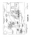
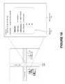
- FIG. 1Ais a view of an autonomous neighborhood multi-copter, according to one embodiment.
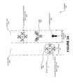
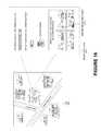
- FIG. 1Bis a neighborhood view of the autonomous neighborhood multi-copter of FIG. 1A operating in a neighborhood environment, according to one environment.
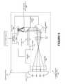
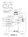
- FIG. 2is a functional block diagram illustrating the autonomous neighborhood multi-copter of FIG. 1A , according to one embodiment.
- FIG. 3Ais a scenario of the autonomous neighborhood on the side of the road predicting bicycle behavior, according to one embodiment.
- FIG. 3Bis a scenario of the autonomous neighborhood multi-copter predicting car behavior, according to one embodiment.
- FIG. 3Cis a scenario of the autonomous neighborhood multi-copter in a bike lane predicating bicycle behavior, according to one embodiment.
- FIG. 4is a scan view of the autonomous neighborhood multi-copter of FIG. 1 A detecting an object, according to one embodiment.
- FIG. 5Ais a multi scan view of the autonomous neighborhood multi-copter of FIG. 1A performing a multi sensor scan of its environment, according to one embodiment.
- FIG. 5Bis a multi scan view of the autonomous neighborhood multi-copter of FIG. 5A using multiple sensor systems to scan overlapping fields of view, according to one embodiment.
- FIG. 6is an internal sensor system view of the sensor system, according to one embodiment.
- FIG. 7illustrates the sensor system as a LIDAR sensor, according to one embodiment.
- FIG. 8is a path adjustment view 850 of the autonomous neighborhood multi-copter of FIG. 1A rerouting around an object, according to one embodiment.
- FIG. 9Ais an envelope view of an envelope of the autonomous neighborhood multi-copter of FIG. 1A , according to one embodiment.
- FIG. 9Bis an envelope implementation view of the autonomous neighborhood multi-copter of FIG. 9A maintaining its envelope in pedestrian traffic, according to one embodiment.
- FIG. 9Cis a caravan view of the autonomous neighborhood multi-copter of FIG. 9B in a caravan with multiple other autonomous neighborhood multi-copters, according to one embodiment.
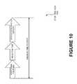
- FIG. 10is a break time view of a minimum break time calculation, according to one embodiment.
- FIG. 11is a GPS monitoring view of a possible autonomous neighborhood multi-copter location, according to one embodiment.
- FIG. 12is a location identification view determining the location of the autonomous neighborhood multi-copter from possible locations, according to one embodiment.
- FIG. 13Ais an exemplary range scan of a first range scan, according to one embodiment.
- FIG. 13Bis an exemplary range scan of a second range scan, according to one embodiment.
- FIG. 14is a user interface view of a group view associated with particular geographical location, according to one embodiment.
- FIG. 15is a user interface view of claim view, according to one embodiment.
- FIG. 16is a user interface view of a building builder, according to one embodiment.
- FIG. 17is a systematic view of communication of claimable data, according to one embodiment.
- FIG. 18is a systematic view of a network view, according to one embodiment.
- FIG. 19is a block diagram of a database, according to one embodiment.
- FIG. 20is an exemplary graphical user interface view for data collection, according to one embodiment.
- FIG. 21is an exemplary graphical user interface view of image collection, according to one embodiment.
- FIG. 22is an exemplary graphical user interface view of an invitation, according to one embodiment.
- FIG. 23is a flowchart of inviting the invitee(s) by the registered user, notifying the registered user upon the acceptance of the invitation by the invitee(s) and, processing and storing the input data associated with the user in the database, according to one embodiment.
- FIG. 24is a flowchart of adding the neighbor to the queue, according to one embodiment.
- FIG. 25is a flowchart of communicating brief profiles of the registered users, processing a hyperlink selection from the verified registered user and calculating and ensuring the Nmax degree of separation of the registered users away from verified registered users, according to one embodiment.
- FIG. 26is an N degree separation view, according to one embodiment.
- FIG. 27is a user interface view showing a map, according to one embodiment.
- FIG. 28Ais a process flow chart of searching a map based community and neighborhood contribution, according to one embodiment.
- FIG. 28Bis a continuation of process flow of FIG. 28A showing additional processes, according to one embodiment.
- FIG. 28Cis a continuation of process flow of FIG. 28B showing additional processes, according to one embodiment.
- FIG. 28Dis a continuation of process flow of FIG. 28C showing additional processes, according to one embodiment.
- FIG. 28Eis a continuation of process flow of FIG. 28D showing additional processes, according to one embodiment.
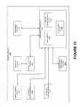
- FIG. 29is a system view of a global neighborhood environment communicating with the neighborhood(s) through a network, an advertiser(s), a global map data and an occupant data according to one embodiment.
- FIG. 30is an exploded view of a social community module of FIG. 29 , according to one embodiment.
- FIG. 31is an exploded view of a search module of FIG. 29 , according to one embodiment.
- FIG. 32is an exploded view of a claimable module of FIG. 29 , according to one embodiment.
- FIG. 33is an exploded view of a commerce module of FIG. 29 , according to one embodiment.
- FIG. 34is an exploded view of a map module of FIG. 29 , according to one embodiment.
- FIG. 35is a table view of user address details, according to one embodiment.
- FIG. 36is a social community view of a social community module, according to one embodiment.
- FIG. 37is a profile view of a profile module, according to one embodiment.
- FIG. 38is a contribute view of a neighborhood network module, according to one embodiment.
- FIG. 39is a diagrammatic system view of a data processing system in which any of the embodiments disclosed herein may be performed, according to one embodiment.
- FIG. 40Ais a user interface view of mapping user profile of the geographical location, according to one embodiment.
- FIG. 40Bis a user interface view of mapping of the claimable profile, according to one embodiment.
- FIG. 41Ais a user interface view of mapping of a claimable profile of the commercial user, according to one embodiment.
- FIG. 41Bis a user interface view of mapping of customizable business profile of the commercial user, according to one embodiment.
- FIG. 42is a neighborhood communication network view of a commerce server having a radial distribution module communicating with a data processing system that generates a radial broadcast through an internet protocol network using a radial algorithm of the radial distribution module of the commerce server, according to one embodiment.
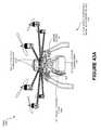
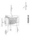
- FIG. 43Ashows an autonomous neighborhood bicycle, according to one embodiment.
- FIG. 43Bshows the autonomous neighborhood bicycle of FIG. 43A after being collapsed, according to one embodiment.
- FIG. 44is a cross sectional view of a storage compartment showing separate compartments and an ejection module, according to one embodiment.
- FIG. 45is a cross sectional view of a storage compartment showing an item and warming trays, according to one embodiment.
- FIG. 46Ais a sidewalk traversing view of the autonomous neighborhood multi-copter mounting a sidewalk, according to one embodiment.
- FIG. 46Bis a sidewalk traversing view of the autonomous neighborhood multi-copter dismounting a sidewalk, according to one embodiment.
- FIG. 47is a collision identification view of trajectory paths, according to one embodiment.
- FIG. 48is a collision identification view of identification of midway position index locations of each boundary box, according to one embodiment.
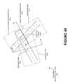
- FIG. 49is a collision identification view of subdivided boundary box regeneration, according to one embodiment.
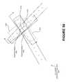
- FIG. 50is a collision identification view showing the identification of the midway position index locations of each regeneration boundary box, according to one embodiment.
- FIG. 51is a collision identification view of a final set of regenerated boundary boxes, according to one embodiment.
- FIG. 52is an intersection view of the autonomous neighborhood multi-copter of FIG. 1A at an intersection, according to one embodiment.
- FIG. 53is a user interface view of the data processing system of FIG. 42 displaying an autonomous neighborhood multi-copter map, according to one embodiment.
- FIG. 54is an autonomous neighborhood multi-copter alert user interface view of the data processing system of FIG. 42 receiving an autonomous neighborhood multi-copter alert, according to one embodiment.
- FIG. 55is a three dimensional environmental view of the autonomous neighborhood multi-copter of FIG. 1A using a LIDAR sensor to scan its environment, according to one embodiment.
- FIG. 56is a garage view of a family garage with the autonomous neighborhood multi-copter of FIG. 1A and two autonomous cars, according to one embodiment.
- FIG. 57is an emergency broadcast view of the data processing system of FIG. 42 receiving an emergency broadcast message, according to one embodiment.
- FIG. 58Ais a weather traversing view of the autonomous neighborhood multi-copter traveling in windy conditions, according to one embodiment.
- FIG. 58Bis a weather traversing view of the autonomous neighborhood multi-copter of FIG. 58A traveling in windy conditions, according to one embodiment.
- FIG. 59is an aerial traffic navigation view of the autonomous neighborhood multi-copter interacting with other autonomous neighborhood multi-copters in the same air space, according to one embodiment.
- FIG. 60is a notification graphical process flow of an order being delivered, according to one embodiment.
- FIG. 61Ais a view of a neighborhood flying football, according to one embodiment.
- FIG. 61Bis a view of a neighborhood flying football being controlled by a user, according to one embodiment.
- an autonomous neighborhood multi-copterincludes a storage compartment of the autonomous neighborhood multi-copter in which items are storable, a computer system of the autonomous neighborhood multi-copter that is communicatively coupled to a commerce server of a neighborhood communication system through a wireless network to autonomously navigate the autonomous neighborhood multi-copter to a destination in the neighborhood specified by the commerce server using a peer-to-peer network of client side devices in the neighborhood that are geo-constrained to a location of a defined neighborhood, and a navigation server of the autonomous neighborhood multi-copter to provide a remote sensing capability to the autonomous neighborhood multi-copter such that the autonomous neighborhood multi-copter is autonomously navigable to the destination using the peer-to-peer network.
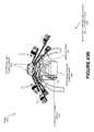
- FIG. 1Ashows an autonomous neighborhood multi-copter.
- FIG. 1Ashows the autonomous neighborhood multi-copter 100 , a storage compartment 101 , a sensor system 102 , a user interface 104 , an electronic locking mechanism 106 , a telescoping platform 107 , a path lighting device 108 , a foldable all-terrain wheels 109 , an ejection module 110 , a sidewalk detection sensor 111 , and a propellers 113 .
- a propulsion system 208shown in FIG.
- the autonomous neighborhood multi-copter 100may be powered by solar and/or wind power, according to one embodiment.
- the autonomous neighborhood multi-coptermay be a wheeled vehicle, a treaded vehicle, an aerial vehicle, an aquatic vehicle, and/or a hybrid terrain vehicle (e.g., one capable of transitioning between air, land, and/or water).
- the autonomous neighborhood multi-copter 100may comprise of a set of wheels aligned in a way to provide the autonomous neighborhood multi-copter 100 (e.g., neighborhood rover vehicle) stability when traveling to and/or from destinations (e.g., on sidewalks, bike lanes, a roadway, over rocks, over grass).
- the storage compartment 101may be any shape that enables the autonomous neighborhood multi-copter 100 to adequately store desired item(s) 4502 (e.g., a rectangular shape, a spherical shape, a cone shape).
- the storage compartment 101may be made of metallic materials, wood, and/or a polymer based material.
- the interior of the storage compartmentmay be temperature controlled via the temperature control module 246 (e.g., heated, cooled, kept at a certain humidity) and/or may be comprised of (e.g., be made of, lined with, reinforced with, padded with) materials to aid in transport and/or storage of items 4502 .
- the storage compartment 101may be lined with vinyl, nylon and/or Cordura to aid in keeping contents heated.
- the storage compartment 101may be padded and/or be equipped with a suspensions system to protect fragile contents.
- the contentsmay be a gastronomical item, a perishable item, a retail good, an electronic device, a piece of mail, an organ (e.g., for medical use), and/or any item capable of being transported via the autonomous neighborhood multi-copter 100 .
- the storage compartment 101may have compartments (e.g., separate sections capable of being maintained at different temperatures and/or humidity, trays, compartmentalized areas) and/or may have separate openings on the surface of the storage compartment 101 for each compartment(s).
- the autonomous neighborhood multi-copter 100may comprise of an ejection module 110 , according to one embodiment.
- the ejection module 110may be communicatively couple with a camera (e.g., a separate camera from that of a sensor system 102 ) and/or may eject items 4502 (e.g., packages, letters, non-fragile items) from the storage compartment 101 using pressurized air.
- the autonomous neighborhood multi-copter 100may be able to eject items 4502 in a specific compartment of the storage compartment 101 while not ejecting items 4502 in another compartment and/or keeping other items 4502 controlled at a certain temperature and/or humidity.
- the sensor system 102may be comprised of several sensors (e.g., several types, several of the same kind).
- the autonomous neighborhood multi-copter 100may possess multiple sensor systems 102 .
- the sensor system 102may be physically associated with the autonomous neighborhood multi-copter 100 so that the vehicle is able to capture and/or analyze its surrounding environment and/or navigate.
- the sensor system 102may be comprised of a global positioning system 218 , an internal measurement unit 220 , a radar unit 222 , a laser rangefinder/LIDAR unit 224 , a camera 226 , and/or an ultrasound unit 228 (e.g., as described in FIG. 2 ).
- the autonomous neighborhood multi-copter 100may have a user interface 104 physically associated with it.
- the user interface 104may be a touch screen system, a key-pad based system, an audio based system (e.g., voice command), etc.
- the user interface 104may enable individuals (e.g., a user of the autonomous neighborhood multi-copter 100 ) to enter commands (e.g., a destination, a set of details about the pick-up and/or drop-off, a set of constraints for the vehicle's operation).
- the user interface 104may require a user verification (e.g., passcode, voice recognition, a biometric scan) before access to the user interface 104 may be granted.
- the user interface 104may be covered and/or encased by a protective surface until activated (e.g., unlocked) for use.
- An electronic locking mechanism 106may be physically associated with the autonomous neighborhood multi-copter 100 , according to one embodiment.
- the electronic locking mechanism 106may be a combination lock, an electronic lock, a signal based lock, a passcode lock, a biometric scanner (e.g., fingerprint reader) and/or may keep the contents of the autonomous neighborhood multi-copter 100 secure.
- the electronic locking mechanism 106may be unlocked and/or locked via the user interface 104 .
- the electronic locking mechanism 106may automatically unlock when the autonomous neighborhood multi-copter 100 arrives at its destination.
- the electronic locking mechanism 106may unlock when the sender (e.g., owner, user) of the autonomous neighborhood multi-copter 100 remotely unlocks the electronic locking mechanism 106 (e.g., using a data processing system 4204 (e.g., a smart phone, a tablet, a mobile device, a computer, a laptop).
- a passcodemay be sent to the recipient (e.g., store, individual, company) (e.g., via text message, via a push notification, via an update on a profile, in an email, etc.).
- the passcode to the electronic locking mechanism 106may be changed on a predetermined basis (e.g., with every use, daily, weekly, hourly, upon request of the owner, upon request of the user (e.g., sender)).
- the electronic locking mechanism 106may be unlocked using a near-field communication technology such as iBeacon, NFC and/or a keypad unlock code.
- the path lighting device 108 of the autonomous neighborhood multi-copter 100may automatically active a set of light emitting diodes encompassing the autonomous neighborhood multi-copter 100 when a light sensor detects that an environmental brightness is below a threshold lumens.
- the path lighting device 108may be comprised of multiple light sources.
- the autonomous neighborhood multi-copter 100may have multiple path lighting devices 108 .
- the autonomous neighborhood multi-copter 100may have all terrain wheels 109 .
- the all terrain wheels 109may be shock absorbing, on/off road, airless, puncture-sealing, run-flat etc.
- the all-terrain wheels 109may be foldable (e.g., capable of being folded, retracted, and/or stored in such a way to enable optimal air travel).
- the propellers 113may be comprised of metallic, rubber, polymer material and/or any other material known in the art.
- the propellers 113may be constructed and/or aligned in such a way as to enable the autonomous neighborhood multi-copter 100 to have stability in flight and/or transport (e.g., carry, support and/or hold) the items it carries.
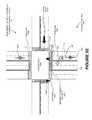
- the autonomous neighborhood multi-copter 100may have a sidewalk detection sensor 111 to provide a mechanism through which the autonomous neighborhood multi-copter is able to detect a gradation ride caused by a sidewalk start location and a gradation drop caused by a sidewalk end location (e.g., curb).
- the sidewalk detection sensor 111may be a LIDAR, a RADAR, a setero optical sensor, an ultrasound unit 228 , and/or another type of sensor.
- the telescoping platform 107may enable the autonomous neighborhood multi-copter 100 to traverse the sidewalk (e.g., move from the sidewalk to the road (e.g., bike lane) and/or from the road to the sidewalk) without disturbing, damaging and/or shifting its contents.
- the telescoping platform 107is better described in FIGS. 43A and 43 b.
- the autonomous neighborhood multi-copter 100may have mobile network capabilities and/or WiFi capabilities.
- the autonomous neighborhood multi-copter 100may have built in 2G, 3G, 4G etc. cellular capabilities. Users may be able to activate the mobile network capability (e.g., 4G cellular capability) if, for example, they wish to take the autonomous neighborhood multi-copter 100 beyond the range of their WiFi access point. If the user elects to activate this feature, they may pay a fee (e.g., a monthly fee, an annual fee, a per minute fee, a fee per unit or data) to the geospatially constrained social network 4242 (e.g., Fatdoor.com). This way, the user may not be required to contact the mobile carrier or alter their existing mobile plan.
- the usermay be able to stop (e.g., turn off, deactivate, and/or suspend) the service using a data processing system (e.g., the data processing system 4204 shown in FIG. 42 ).
- FIG. 1Bis a neighborhood view 151 of the autonomous neighborhood multi-copter 100 traveling along a flight path in an environment of the autonomous neighborhood multi-copter 152 .
- FIG. 1Bshows a sidewalk 112 , a roadway 114 , a claimable residential addresses 115 , an environmental brightness 117 , a set of weather conditions 119 , and a flight path 120 .
- the autonomous neighborhood multi-copter 100may travel along the flight path 120 .
- FIG. 1Balso shows an autonomous neighborhood multi-copter 100 B traveling on a sidewalk while making a delivery, according to one embodiment.
- the autonomous neighborhood multi-copter(e.g., the autonomous neighborhood multi-copter 100 B) may travel on sidewalks 112 , bike lanes 304 , and/or roadways 114 . These paths, along with other possible routes of travel through the neighborhood, may be mapped (e.g., input to the global positioning system 218 , input to the computer system 200 , by transporting the autonomous neighborhood multi-copter 100 through the neighborhood previously in order to create a map via the sensor system 102 ) on and/or by the autonomous neighborhood multi-copter 100 .
- mappede.g., input to the global positioning system 218 , input to the computer system 200 , by transporting the autonomous neighborhood multi-copter 100 through the neighborhood previously in order to create a map via the sensor system 102 .
- the aerial space of the neighborhoodmay also be mapped (e.g., using FAA rules and/or regulations, flight path data compiled from multiple autonomous neighborhood multi-copters 100 , and/or accounting for the elevation of markers (e.g., trees, telephone poles, power lines, and/or buildings) in the neighborhood.
- the autonomous neighborhood multi-coptercan both fly and traverse land (e.g., when battery is low and when conditions warrant).
- the sidewalk detection sensor 111may scan the path of the autonomous neighborhood multi-copter 100 and may detect that the sidewalk 112 is ending.
- the telescoping platform 107may allow any number of the autonomous neighborhood multi-copter's 100 wheels to be lowered and/or raised independent of the other wheels.
- the front set of wheelsmay by lowered off the curb to meet the roadway 114 below as the rear wheels remain on the sidewalk 112 .
- the rear set of wheelsmay then be lowered from the sidewalk 112 to the roadway 114 as the autonomous neighborhood multi-copter 100 moves from the sidewalk 112 to the roadway 114 .
- the autonomous neighborhood multi-copter 100may be completely on the roadway 114 , all wheels may be returned to their original positions. This way, the autonomous neighborhood multi-copter 100 may be able to seamlessly transition from the roadway 114 to the sidewalk 112 and/or from the sidewalk 112 to the roadway 114 .
- FIG. 2is a functional block diagram 250 illustrating an autonomous neighborhood multi-copter, according to an example embodiment.
- the autonomous neighborhood multi-copter 100could be configured to operate fully or partially in an autonomous mode.
- the autonomous neighborhood multi-copter 100could control itself while in the autonomous mode, and may be operable to determine a current state of the vehicle and its environment, determine a predicted behavior of at least one other entity (e.g., a plane, a vehicle, a pedestrian, a biker, an animal) in the environment, determine a confidence level that may correspond to a likelihood of the at least one other vehicle to perform the predicted behavior, and/or control the autonomous neighborhood multi-copter 100 based on the determined information (described in FIGS. 3A-C ). While in autonomous mode, the autonomous neighborhood multi-copter 100 may be configured to operate without human interaction.
- the autonomous neighborhood multi-copter 100may be configured to operate without human interaction.
- the autonomous neighborhood multi-copter 100could include various subsystems such as a computer system 200 , a propulsion system 208 , a sensor system 102 , a control system 230 , one or more peripherals 248 , as well as a power supply 258 .
- the autonomous neighborhood multi-copter 100may include more or fewer subsystems and each subsystem could include multiple elements. Further, each of the subsystems and elements of autonomous neighborhood multi-copter 100 could be interconnected. Thus, one or more of the described functions of the autonomous neighborhood multi-copter 100 may be divided up into additional functional or physical components, or combined into fewer functional or physical components. In some further examples, additional functional and/or physical components may be added to the examples illustrated by FIG. 2 .
- the propulsion system 208may include components operable to provide powered motion for the autonomous neighborhood multi-copter 100 .
- the propulsion system 208could include the propellers 113 , an engine/motor 210 , an energy source 212 , a transmission 214 , and/or wheels/tires 216 (e.g., the wheels 109 ).
- the engine/motor 210could be any combination of an internal combustion engine, an electric motor, steam engine, Stirling engine, a solar powered engine, or other types of engines and/or motors.
- the engine/motor 210may be configured to convert energy source 212 into mechanical energy.
- the propulsion system 208could include multiple types of engines and/or motors.
- a gas-electric hybrid vehiclecould include a gasoline engine and an electric motor.
- engine/motors 210may be used to propel the wheels 109 and the propellers 113 .
- the engine/motor 210may propel both the wheels 109 and the propellers 113 .
- the energy source 212could represent a source of energy that may, in full or in part, power the engine/motor 210 . That is, the engine/motor 210 could be configured to convert the energy source 212 into mechanical energy. Examples of energy sources 212 include gasoline, diesel, other petroleum-based fuels, propane, other compressed gas-based fuels, ethanol, solar panels, batteries, and other sources of electrical power. The energy source(s) 212 could additionally or alternatively include any combination of fuel tanks, batteries, capacitors, and/or flywheels. The energy source 212 could also provide energy for other systems of the autonomous neighborhood multi-copter 100 . In one embodiment, separate energy sources 212 and/or power supplies 258 may power the wheels 109 and propellers 113 . In another embodiment, the wheels 109 and propellers 113 may use the same power supply 258 and/or energy source 212 .
- the transmission 214could include elements that are operable to transmit mechanical power from the engine/motor 210 to the propellers 109 and/or wheels/tires 216 .
- the transmission 214could include a gearbox, clutch, differential, and drive shafts.
- the transmission 214could include other elements.
- the drive shaftscould include one or more axles that could be coupled to the one or more propeller 109 and/or wheels/tires 216 .
- multiple transmissions 214may be used to operate the propellers 113 and/or wheels 109 .
- the wheels/tires 216 of autonomous neighborhood multi-copter 100could be configured in various formats, including a unicycle, bicycle/motorcycle, tricycle, or a four-wheel format, a treaded system. Other wheel/tire geometries are possible, such as those including six or more wheels. Any combination of the wheels/tires 216 of autonomous neighborhood multi-copter 100 may be operable to rotate differentially with respect to other wheels/tires 216 .
- the wheels/tires 216could represent at least one wheel that is fixedly attached to the transmission 214 and at least one tire coupled to a rim of the wheel that could make contact with the driving surface.
- the wheels/tires 216could include any combination of metal and rubber, or another combination of materials.
- the wheels/tires 216 and/or propellers 109may include a propeller/wheel encoding sensor 223 .
- the propellers 113 of autonomous neighborhood multi-copter 100could be configured in various formats, including a single propeller, a bi-propeller configuration, a three propeller configuration, a configuration similar to that of a helicopter, or a four-wheel format, a treaded system. Other propeller 113 geometries are possible, such as those including six or more propellers. Any combination of the propellers 113 of autonomous neighborhood multi-copter 100 may be operable to rotate differentially with respect to other propellers 113 .
- the propellers 113could represent at least one propeller that is fixedly attached to the transmission 214 and at least propeller 113 coupled to a rim of the propeller 113 that could make contact with the driving surface.
- the propellers 113could include any combination of metal and rubber, or another combination of materials.
- the wheels/tires 216 and/or propellers 113may include a propeller/wheel encoding sensor 223 .
- the sensor system 102may include a number of sensors configured to sense information about the environment of the autonomous neighborhood multi-copter 152 .
- the sensor system 102could include a Global Positioning System (GPS) 218 , an accelerometer sensor 219 , an inertial measurement unit (IMU) 220 , a gyroscopic sensor 221 , a RADAR unit 222 , a propeller/wheel encoding sensor 223 , a laser rangefinder/LIDAR unit 224 , a compass sensor 225 , a camera 226 , a stereo optical sensor 227 , and/or an ultrasound unit 228 .
- GPSGlobal Positioning System
- IMUinertial measurement unit
- the sensor system 102could also include sensors configured to monitor internal systems of the autonomous neighborhood multi-copter 100 (e.g., O.sub.2 monitor, fuel gauge, engine oil temperature). Other sensors are possible as well.
- One or more of the sensors included in sensor system 102could be configured to be actuated separately and/or collectively in order to modify a position and/or an orientation of the one or more sensors.
- the GPS 218may be any sensor configured to estimate a geographic location of the autonomous neighborhood multi-copter 100 .
- GPS 218could include a transceiver operable to provide information regarding the position of the autonomous neighborhood multi-copter 100 with respect to the Earth.
- the GPS 218may be communicatively coupled with the commerce server 4200 allowing a state of the autonomous neighborhood multi-copter 100 and/or a location of the autonomous neighborhood multi-copter to be relayed to the server.
- GPS 218may be physically associated with the autonomous neighborhood multi-copter 100 so that the vehicle is able to periodically (e.g., continuously, every minute, at a predetermined point) communicate its location to the garage sale server through a network 2904 and/or a cellular network 4208 .
- the global positioning system 218may be communicatively coupled with the processor 202 , a memory (e.g., the data storage 204 ), the LIDAR unit 224 , the RADAR 222 , and/or the camera 226 .
- the IMU 220could include any combination of sensors (e.g., accelerometers and gyroscopes) configured to sense position and orientation changes of the autonomous neighborhood multi-copter 100 based on inertial acceleration. In one embodiment, the IMU 220 may be used to calculate the magnitude of deceleration.
- sensorse.g., accelerometers and gyroscopes
- the IMU 220may be used to calculate the magnitude of deceleration.
- the RADAR unit 222may represent a system that utilizes radio signals to sense objects within the local environment of the autonomous neighborhood multi-copter 152 .
- the RADAR unit 222may additionally be configured to sense the speed and/or heading of the objects.
- the RADAR unit 222may determine a range, an altitude, a direction, a shape, and/or speed of objects.
- the autonomous neighborhood multi-copter 100may be able to travel on sidewalks, bike lanes, the side of the road, in streams, rivers, and/or may be able to stop at stop lights, wait to cross the road, navigate vehicle and/or pedestrian traffic, obey traffic laws etc.
- the autonomous neighborhood multi-copter 100may have upon it infrared sensors, laser sensors and/or an on board navigation.
- the laser rangefinder or LIDAR unit 224may be any sensor configured to sense objects in the environment in which the autonomous neighborhood multi-copter 100 is located using lasers.
- the laser rangefinder/LIDAR unit 224could include one or more laser sources, a laser scanner, and one or more detectors, among other system components.
- the laser rangefinder/LIDAR unit 224could be configured to operate in a coherent (e.g., using heterodyne detection) or an incoherent detection mode.
- the LIDAR 108may use ultraviolet, visible and/or near infrared light to image objects in a 360 degree field of view.
- the objects imaged by the LIDAR 108may include non-metallic objects, metallic objects, rocks, people, vehicles, rain, traffic cones, traffic lights and/or signs etc.
- the LIDAR 108may be communicatively couple to the navigation server to provide remote sensing capability to the autonomous neighborhood multi-copter 100 such that the autonomous neighborhood multi-copter 100 is autonomously (E.g., and/or pilotlessly) navigable to the destination.
- the camera 226could include one or more devices configured to capture a plurality of images of the environment of the autonomous neighborhood multi-copter 152 .
- the camera 226could be a still camera or a video camera.
- the camera 226may be a set of cameras, a single multidirectional camera, a camera with a 360 degree view, a rotating camera, a stereo optic camera etc.
- the control system 230may be configured to control operation of the autonomous neighborhood multi-copter 100 and its components.
- control system 230could include various elements include steering unit 232 , throttle 234 , deceleration unit 236 , a sensor fusion algorithm 238 , a computer vision system 240 , a navigation server 242 , an obstacle avoidance system 244 , a temperature control module 246 , and an air control system 247 .
- the air control system 247may be used to navigate the autonomous neighborhood multi-copter 100 while in aerial mode (e.g., a separate mode from land based travel).
- the steering unit 232could represent any combination of mechanisms that may be operable to adjust the heading (e.g., directional heading and/or the altitude) of autonomous neighborhood multi-copter 100 .
- the throttle 234could be configured to control, for instance, the operating speed of the engine/motor 210 and, in turn, control the speed of the autonomous neighborhood multi-copter 100 .
- the deceleration unit 236could include any combination of mechanisms configured to decelerate the autonomous neighborhood multi-copter 100 .
- the deceleration unit 236could use friction to slow the wheels/tires 216 . In other embodiments, the deceleration unit 236 could convert the kinetic energy of the wheels/tires 216 to electric current.
- the deceleration unit 236may take other forms as well.
- the deceleration unit 236may slow the air born autonomous neighborhood multi-copter 100 by deploying flaps and/or reversing the direction of motion (e.g., reversing the propeller direction and/or orientation to propel the multi-copter in the opposite direction thereby slowing the current velocity of motion).
- the sensor fusion algorithm 238may be an algorithm (or a computer program product storing an algorithm) configured to accept data from the sensor system 102 as an input.
- the datamay include, for example, data representing information sensed at the sensors of the sensor system 102 .
- the sensor fusion algorithm 238could include, for instance, a Kalman filter, Bayesian network, or other algorithm.
- the sensor fusion algorithm 238could further provide various assessments based on the data from sensor system 102 .
- the assessmentscould include evaluations of individual objects and/or features in the environment of autonomous neighborhood multi-copter 100 , evaluation of a particular situation, and/or evaluate possible impacts based on the particular situation.
- the sensor fusion algorithmmay determine that a sidewalk is ending and/or beginning (e.g., by sensing a curb).
- the autonomous neighborhood multi-coptermay be able to adjust its path to avoid and/or intersect with the curb and/or sidewalk (e.g., traversing the curb to move from a bike lane to a sidewalk or vice versa).
- Other assessmentsare possible.
- the autonomous neighborhood multi-copter 100may be able to use the sensor fusion algorithm 238 to use multiple sources of data to navigate intersections (e.g., while turning in an intersection) without use of lanes, painted lines, demarcated paths etc. This may be especially useful for aerial travel.
- the computer vision system 240may be any system operable to process and analyze images captured by camera 226 in order to identify objects and/or features in the environment of autonomous neighborhood multi-copter 100 that could include traffic signals, road way boundaries, and obstacles.
- the computer vision system 240could use an object recognition algorithm, a Structure From Motion (SFM) algorithm, video tracking, and other computer vision techniques.
- the computer vision system 240could be additionally configured to map an environment, track objects, estimate the speed of objects, etc.
- the navigation and pathing system 242may be any system configured to determine a flight and/or driving path for the autonomous neighborhood multi-copter 100 .
- the navigation and pathing system 242may additionally be configured to update the driving path dynamically while the autonomous neighborhood multi-copter 100 is in operation.
- the navigation and pathing system 242could be configured to incorporate data from the sensor fusion algorithm 238 , the GPS 218 , and one or more predetermined maps so as to determine the driving path for autonomous neighborhood multi-copter 100 .
- the obstacle avoidance system 244could represent a control system configured to identify, evaluate, and avoid or otherwise negotiate potential obstacles (e.g., tree tops, buildings, pedestrians, vehicles, bicycles, sidewalks (e.g., curbs, paved sidewalks), traffic cones, downed tree branches) in the environment of the autonomous neighborhood multi-copter 152 .
- the control system 230may additionally or alternatively include components other than those shown and described.
- Peripherals 248may be configured to allow interaction between the autonomous neighborhood multi-copter 100 and external sensors, other vehicles, other computer systems, and/or a user.
- Peripherals 248could include a wireless communication system 251 , the user interface 104 , a microphone 254 , a speaker 256 , the path lighting device 108 , and/or the ejection module 110 .
- the path lighting devicemay include a set of light emitting diodes 270 and/or a light sensor 272 to detect that an environmental brightness is below a threshold luminosity
- the speaker 1352may play a message recorded (e.g., through the microphone 254 and/or a mobile device and/or computer that sends the message to the autonomous neighborhood multi-copter).
- the microphone 254may pick up and/or record noise from the autonomous neighborhood multi-copter's environment.
- the speaker 256may play the message (e.g., instructions to an individual at a destination (e.g., an order)) and/or announce actions of the autonomous neighborhood multi-copter 100 (e.g., announce that the autonomous neighborhood multi-copter 100 is about to make a left turn and/or break).
- the autonomous neighborhood multi-copter 100may have one or more turn signals and/or break lights.
- the speaker 256 , microphone 254 , and/or the wireless communication system 251may record and/or play an audio message (e.g., from the sender to the recipient and/or vice versa) recorded on the autonomous neighborhood multi-copter 100 itself and/or sent to the autonomous neighborhood multi-copter 100 from the commerce server 4200 through the network.
- the wireless communication system 251may enable the autonomous neighborhood multi-copter 100 to communicate through the network with other autonomous neighborhood multi-copters 100 (e.g., in the network, within a threshold radial distance 4219 , owned by the same owner, sent by the same sender, sent to the same recipient). In one embodiment, this communication may be used to maximize efficiency of routes, coordinate and/or ensure timely delivery, to form a convoy etc.
- the Peripherals 248could provide, for instance, means for a user of the autonomous neighborhood multi-copter 100 to interact with the user interface 104 .
- the user interface 104could provide information to a user of autonomous neighborhood multi-copter 100 .
- the user interface 104could also be operable to accept input from the user via a touchscreen.
- the touchscreenmay be configured to sense at least one of a position and a movement of a user's finger via capacitive sensing, resistance sensing, or a surface acoustic wave process, among other possibilities.
- the touchscreenmay be capable of sensing finger movement in a direction parallel or planar to the touchscreen surface, in a direction normal to the touchscreen surface, or both, and may also be capable of sensing a level of pressure applied to the touchscreen surface.
- the touchscreenmay be formed of one or more translucent or transparent insulating layers and one or more translucent or transparent conducting layers.
- the touchscreenmay take other forms as well.
- the Peripherals 248may provide means for the autonomous neighborhood multi-copter 100 to communicate with devices within its environment.
- the microphone 254may be configured to receive audio (e.g., a voice command or other audio input) from a user of the autonomous neighborhood multi-copter 100 .
- the speakers 256may be configured to output audio to the user of the autonomous neighborhood multi-copter 100 .
- the ejection module 110may be coupled with a camera and/or may enable the autonomous neighborhood multi-copter 100 to eject item(s) 4502 using pressurized air (e.g., deliver packages to a door step without leaving the air or sidewalk 112 ).
- the wireless communication system 251could be configured to wirelessly communicate with one or more devices directly or via a communication network.
- wireless communication system 251could use 3G cellular communication, such as CDMA, EVDO, GSM/GPRS, or 4G cellular communication, such as WiMAX or LTE.
- wireless communication system 251could communicate with a wireless local area network (WLAN), for example, using WiFi.
- WLANwireless local area network
- wireless communication system 251could communicate directly with a device, for example, using an infrared link, Bluetooth, or ZigBee.
- Other wireless protocolssuch as various vehicular communication systems, are possible within the context of the disclosure.
- the wireless communication system 251could include one or more dedicated short range communications (DSRC) devices that could include public and/or private data communications between vehicles and/or roadside stations.
- DSRCdedicated short range communications
- the wireless communication system 251may also enable the autonomous neighborhood multi-copter 100 to communicate and/or coordinate with other autonomous neighborhood multi-copters 100 .
- the power supply 258may provide power to various components of autonomous neighborhood multi-copter 100 and could represent, for example, a rechargeable lithium-ion, lithium-sulfur, or lead-acid battery. In some embodiments, one or more banks of such batteries could be configured to provide electrical power. Other power supply materials and configurations are possible. In some embodiments, the power supply 258 and energy source 212 could be implemented together, as in some all-electric cars.
- the autonomous neighborhood multi-copter 100may autonomously direct itself to a charging station (e.g., a set non-transitory charging stations, a nearest charging station, a nearest preapproved (e.g., claimed) charging station) and/or conduct necessary operations to charge itself when an energy supply reaches a threshold level, at a certain time of day, when a certain amount of time has elapsed, when a certain distance has been traveled etc.
- a charging statione.g., a set non-transitory charging stations, a nearest charging station, a nearest preapproved (e.g., claimed) charging station
- Computer system 200may include at least one processor 202 (which could include at least one microprocessor) that executes instructions 206 stored in a non-transitory computer readable medium, such as the data storage 204 .
- the processor 202may be communicatively coupled to the commerce server 4200 (shown in FIG. 42 ) of the neighborhood communication system 2950 through a wireless network (e.g., the network of FIG. 42 ) to autonomously navigate the autonomous neighborhood multi-copter (e.g., the neighborhood rover vehicle) to a destination specified by the commerce server 4200 .
- the computer system 200may also represent a plurality of computing devices that may serve to control individual components or subsystems of the autonomous neighborhood multi-copter 100 in a distributed fashion.
- data storage 204may contain instructions 206 (e.g., program logic) executable by the processor 202 to execute various functions of autonomous neighborhood multi-copter 100 , including those described above in connection with FIG. 2 .
- Data storage 204may contain additional instructions as well, including instructions to transmit data to, receive data from, interact with, and/or control one or more of the propulsion system 208 , the sensor system 102 , the control system 230 , and the Peripherals 248 .
- the data storage 204may store data such as air space maps, roadway maps, path information, among other information.
- the autonomous neighborhood multi-copter 100may include a user interface 104 for providing information to or receiving input from a user of the autonomous neighborhood multi-copter 100 .
- the user interface 104could control or enable control of content and/or the layout of interactive images that could be displayed on the touchscreen. Further, the user interface 104 could include one or more input/output devices within the set of Peripherals 248 , such as the wireless communication system 251 , the user interface 104 , the microphone 254 , and the speaker 256 .
- the computer system 200may control the function of the autonomous neighborhood multi-copter 100 based on inputs received from various subsystems (e.g., propulsion system 208 , sensor system 102 , and control system 230 ), as well as from the user interface 104 .
- the computer system 200may utilize input from the control system 230 in order to control the steering unit 232 to avoid an obstacle detected by the sensor system 102 and the obstacle avoidance system 244 .
- the computer system 200could be operable to provide control over many aspects of the autonomous neighborhood multi-copter 100 and its subsystems.
- the components of autonomous neighborhood multi-copter 100could be configured to work in an interconnected fashion with other components within or outside their respective systems.
- the camera 226could capture a plurality of images that could represent information about a state of an environment of the autonomous neighborhood multi-copter 152 operating in an autonomous mode.
- the environmentcould include another vehicle.
- the computer vision system 240could recognize the other vehicle as such based on object recognition models stored in data storage 204 .
- the computer system 200could carry out several determinations based on the information. For example, the computer system 200 could determine one or more predicted behaviors 305 of the other vehicle. The predicted behavior could be based on several factors including the current state of the autonomous neighborhood multi-copter 100 (e.g., multi-copter speed, current lane, etc.) and the current state of the environment of the autonomous neighborhood multi-copter 152 (e.g., speed limit, number of available lanes, position and relative motion of other vehicles, etc.).
- the current state of the autonomous neighborhood multi-copter 100e.g., multi-copter speed, current lane, etc.
- the current state of the environment of the autonomous neighborhood multi-copter 152e.g., speed limit, number of available lanes, position and relative motion of other vehicles, etc.
- autonomous neighborhood vehicle 100For instance, in a first scenario in which the autonomous neighborhood vehicle 100 is traveling on land, if another vehicle is rapidly overtaking the autonomous neighborhood multi-copter 100 from a left-hand lane, while autonomous neighborhood multi-copter 100 is in a center lane, one predicted behavior could be that the other vehicle will continue to overtake the autonomous neighborhood multi-copter 100 from the left-hand lane.
- a predicted behaviorcould be that the other vehicle may cut in front of autonomous neighborhood multi-copter 100 .
- the computer system 200could further determine a confidence level corresponding to each predicted behavior. For instance, in the first scenario, if the left-hand lane is open for the other vehicle to proceed, the computer system 200 could determine that it is highly likely that the other vehicle will continue to overtake autonomous neighborhood multi-copter 100 and remain in the left-hand lane. Thus, the confidence level corresponding to the first predicted behavior (that the other vehicle will maintain its lane and continue to overtake) could be high, such as 90%.
- the computer system 200could determine that there is a 50% chance that the other vehicle may cut in front of autonomous neighborhood multi-copter 100 since the other vehicle could simply slow and stay in the left-hand lane behind the third vehicle. Accordingly, the computer system 200 could assign a 50% confidence level (or another signifier) to the second predicted behavior in which the other vehicle may cut in front of the autonomous neighborhood multi-copter 100 .
- the computer system 200could work with data storage 204 and other systems in order to control the control system 230 based on at least on the predicted behavior, the confidence level, the current state of the autonomous neighborhood multi-copter 100 , and the current state of the environment of the autonomous neighborhood multi-copter 152 .
- the computer system 200may elect to adjust nothing as the likelihood (confidence level) of the other vehicle staying in its own lane is high.
- the computer system 200may elect to control autonomous neighborhood multi-copter 100 to slow down slightly (by reducing throttle 234 ) or to shift slightly to the right (by controlling steering unit 232 ) within the current lane in order to avoid a potential collision.
- Other examples of interconnection between the components of autonomous neighborhood multi-copter 100are numerous and possible within the context of the disclosure.
- FIG. 2shows various components of autonomous neighborhood multi-copter 100 , i.e., wireless communication system 251 , computer system 200 , data storage 204 , and user interface 104 , as being integrated into the autonomous neighborhood multi-copter 100
- one or more of these componentscould be mounted or associated separately from the autonomous neighborhood multi-copter 100 .
- data storage 204could, in part or in full, exist separate from the autonomous neighborhood multi-copter 100 .
- the autonomous neighborhood multi-copter 100could be provided in the form of device elements that may be located separately or together.
- the device elements that make up autonomous neighborhood multi-copter 100could be communicatively coupled together in a wired and/or wireless fashion.
- the autonomous neighborhood multi-copter 100may have a flight recorder module 249 . While not shown in FIG. 2 , it should be appreciated that the flight recorder module 249 may be included as part of the computer system 200 , the control system 230 , the peripherals 248 and/or any other system in the autonomous neighborhood multi-copter 100 . In one embodiment, the flight recorder module 249 may not be included in the above mentioned system(s) and/or may be a USB dongle which attaches to the autonomous neighborhood multi-copter 100 . The flight module 249 may add data storage to the multi-copter (e.g., 4 GB of storage) and/or GPS tracking and/or navigation.
- data storagee.g., 4 GB of storage
- the flight recorder module's 249 GPS tracking and/or navigationmay be the global positioning system 218 and/or navigation server 242 . In one embodiment, the global positioning system 218 and/or navigation server 242 may be separate from the flight recorder module 249 .
- the flight recorder module 249may allow pilots (e.g., users of the autonomous neighborhood multi-copter 100 ) to define the flight path 120 by selecting a series of waypoints that the autonomous neighborhood vehicle 100 will follow. In one embodiment, the user may be able to create their own flight plans (e.g., flight paths 120 ) with multiple intermediate points in 3D that the autonomous neighborhood multi-copter 100 will automatically follow.
- the flight recorder module 249may record flight settings (e.g., up to 350 flight settings) and/or may act as a “black box” for the autonomous neighborhood multi-copter 100 .
- the autonomous neighborhood multi-copter 100may be fully and/or partially autonomous and/or be able to switch between autonomous and/or non-autonomous (e.g., partially autonomous and/or non-autonomous) modes.
- the flight recorder module 249may record flights and/or videos using flash memory (e.g., 4 GB flash memories). Users may be able to review their flights (e.g., from different angles) modeled in 3D on a map displayed on the data processing system 104 .
- the stability of the autonomous neighborhood multi-copter 100 in flight and/or on landmay be improved using the flight recorder module's 249 GPS sensors.
- FIG. 3Aillustrates a scenario 350 involving bike lane 307 a flight lane 304 A and 304 B.
- An autonomous neighborhood multi-copter 100 Ce.g., an autonomous neighborhood aerial vehicle 4300 shown in FIG. 43A
- An autonomous neighborhood multi-copter 100could be operating in an autonomous mode in the flight lane 304 A.
- the autonomous neighborhood multi-copter 100may have the ability to travel autonomously in a bike lane 307 flight lane 304 A.
- the autonomous neighborhood multi-copter 100 and the autonomous neighborhood multi-copter 100 Ccould be travelling at the same speed.
- a bird 302 Acould be in the flight lane 304 B (e.g., a predetermined area surrounding the flight path of the entity) and approaching the autonomous neighborhood multi-copter 100 C from behind at a higher rate of speed.
- the sensor system 102e.g., the LIDAR 108 , the RADAR unit 222 , the camera 226 , an ultrasound unit 228 ) of the autonomous neighborhood multi-copter 100 could be capturing sensor data based on an environment of the autonomous neighborhood multi-copter 100 .
- the sensor system 102is shown on the top of the autonomous neighborhood multi-copter 100 , it should be appreciated that the sensor system 102 may be located internally, on the front, on the sides etc. of the autonomous neighborhood multi-copter 100 .
- the camera 226could capture a plurality of images of the autonomous neighborhood multi-copter 100 C, the other bird 302 A, as well as other features in the environment so as to help the computer system of the autonomous neighborhood multi-copter 100 to determine the current state of the environment of the autonomous neighborhood multi-copter 152 .
- Other sensors associated with the autonomous neighborhood multi-copter 100could be operable to provide the speed, heading, altitude, location, and other data such that the computer system of the autonomous neighborhood multi-copter 100 could determine the current state of the autonomous neighborhood multi-copter 100 .
- the computer system in autonomous neighborhood multi-copter 100could further determine a predicted behavior of at least one other entity in the environment of the autonomous neighborhood multi-copter 152 .
- a set of predicted behaviors 305 Ae.g., a predicted behavior, a number of predicted behaviors
- the computer system of the autonomous neighborhood multi-copter 100could take into account factors such as the speed of the respective autonomous neighborhood multi-copters 100 , their headings, the weather conditions 119 , and other available paths, among other factors.
- a change in speed 306 of the bird 302 Amay be part of a criteria used to determine predicted behaviors 305 A.
- the autonomous neighborhood aerial vehicle 100 Ccould have a predicted behavior of proceeding at the same speed, and within the same flight lane. Depending on the embodiment, such a predicted behavior that maintains a ‘status quo’ may be considered a default predicted behavior.
- Predicted behaviors 305 A for the bird 302 Acould include the bird 302 A slowing down to match the speed of the autonomous neighborhood multi-copter 100 C.
- the other bird 302 Acould change flight lanes to a different flight lane not currently occupied or the other bird 302 A could change flight lanes to the flight lane 304 A and cut off the autonomous neighborhood multi-copter 100 .
- predicted behaviors 305 of other autonomous neighborhood multi-copters 100could be possible.
- Possible predicted behaviors 305could include, but are not limited to, other entities changing flight lanes, accelerating, decelerating, changing heading (e.g., direction and/or altitude), or entities (e.g., objects, animals, vehicles) exiting the air space.
- Predicted behaviors 305could also include other entities (e.g., other autonomous neighborhood multi-copters 100 , other vehicles (e.g., cars), bicyclists, pedestrians, animals) pulling over due to an emergency situation, colliding with an obstacle, and colliding with another entity.
- Predicted behaviors 305could be based on what another entity may do in response to the autonomous neighborhood multi-copter 100 or in response to a third entity (e.g., bird, bicyclist). Other predicted behaviors 305 could be determined that relate to any entity (e.g., autonomous neighborhood multi-copter, car, bicycle) behavior observable and/or predictable based on the methods and apparatus disclosed herein.
- entitye.g., autonomous neighborhood multi-copter, car, bicycle
- the computer system of autonomous neighborhood multi-copter 100could determine corresponding confidence levels.
- the confidence levelscould be determined based on the likelihood that the given entity (e.g., animal or vehicle) will perform the given predicted behavior. For instance, if the autonomous neighborhood multi-copter 100 C is highly likely to perform the predicted behavior (staying in the current flight lane, maintaining current speed), the corresponding confidence level could be determined to be high (e.g., 90%). In some embodiments, the confidence level could be represented as a number, a percentage, or in some other form.
- possible confidence levelscould be expressed as follows: slowing down to match speed of autonomous neighborhood multi-copter 100 C—40%, maintaining speed and staying in the flight lane 304 B 304 —40%, maintaining speed and changing to another flight path 300 —20%.
- the computer systemcould control autonomous neighborhood multi-copter 100 in the autonomous mode based on at least the determined predicted behaviors 305 and confidence levels. For instance, the computer system could take into account the fact the autonomous neighborhood multi-copter 100 C is highly unlikely to change its rate of speed or flight lane and as such, the computer system could consider autonomous neighborhood multi-copter 100 C as a ‘moving obstacle’ that limits the navigable portion of the path for both the autonomous neighborhood multi-copter 100 as well as the bird 302 A. The computer system may further consider that there is some finite probability that the bird 302 A will pull into the flight path 304 A and cut off the autonomous neighborhood multi-copter 100 . As such, the computer system may cause the autonomous neighborhood multi-copter 100 to slow down slightly, for instance by reducing the throttle, so as to allow a margin of safety if the bird 302 A elects to cut in front.
- FIG. 3Billustrates a scenario 351 similar to that in FIG. 3A .
- a remote controlled plane 310 Bhas changed its heading towards the flight lane 304 C and has moved closer to the autonomous neighborhood multi-copter 100 .
- the computer system of autonomous neighborhood multi-copter 100may continuously update the state of the remote controlled plane 310 B as well as its environment, for instance at a rate of thirty times per second. Accordingly, the computer system may be dynamically determining predicted behaviors 305 and their corresponding confidence levels for remote controlled plane 310 B in the environment of the autonomous neighborhood multi-copter 152 .
- a new predicted behaviorcould be determined for remote controlled plane 310 B.
- the autonomous neighborhood multi-copter 100may make way for the remote controlled plane 310 B by slowing down.
- the predicted behaviors 305 and corresponding confidence levels 307could change dynamically.
- the computer system of autonomous neighborhood multi-copter 100could update the confidence level of the predicted behavior of the other entities (e.g., remote controlled plane 310 B). For instance, since the remote controlled plane 310 B has changed its heading from flight lane 304 D toward the flight lane 304 C and has moved nearer to the autonomous neighborhood multi-copter 100 , it may be determined that the remote controlled plane 310 B is highly likely to change lanes into the flight lane 304 C based on an observed change in angle 308 and/or a change in direction 309 , according to one embodiment.
- the remote controlled plane 310 Bsince the remote controlled plane 310 B has changed its heading from flight lane 304 D toward the flight lane 304 C and has moved nearer to the autonomous neighborhood multi-copter 100 , it may be determined that the remote controlled plane 310 B is highly likely to change lanes into the flight lane 304 C based on an observed change in angle 308 and/or a change in direction 309 , according to one embodiment.
- the computer system of the autonomous neighborhood multi-copter 100could control the deceleration unit to abruptly slow the autonomous neighborhood multi-copter 100 so as to avoid a collision with the remote controlled plane 310 B.
- the computer system of autonomous neighborhood multi-copter 100could carry out a range of different control actions in response to varying predicted behaviors 305 B (e.g., a set of predicated behaviors) and their confidence levels.
- autonomous neighborhood multi-copter 100could react by aggressively decelerating or steering the autonomous neighborhood multi-copter 100 evasively to avoid a collision.
- the autonomous neighborhood multi-copter 100may predict a collision between remote controlled planes 310 A and 310 B.
- the autonomous neighborhood multi-coptermay be able to adjust its speed and/or course to avoid being involved in the collision.
- FIG. 3Cis a top view of an autonomous neighborhood multi-copter 100 operating scenario 352 .
- an autonomous neighborhood multi-copter 100 with a sensor system 102could be operating in an autonomous mode on land.
- the sensor system 102could be obtaining data from the environment of the autonomous neighborhood multi-copter 152 and the computer system of the autonomous neighborhood multi-copter 100 could be determining a current state of the autonomous neighborhood multi-copter 100 and a current state of the environment of the autonomous neighborhood multi-copter 152 .
- Scenario 352includes a bicyclist 302 A traveling at the same speed and in the same bike lane 307 as the autonomous neighborhood multi-copter 100 .
- a bicyclist 302 Bcould be traveling at a higher speed in the side of the road 300 .
- the computer system of autonomous neighborhood multi-copter 100could determine predicted behaviors 305 A (e.g., a set of predicted behaviors) for the bicyclist 302 A and bicyclist 302 B.
- the bicyclist 302 Bcould continue at its current speed and within its current lane.
- a ‘default’ predicted behaviorcould be determined.
- the bicyclist 302 Bmay also change lanes into the bike lane 307 and cut off the autonomous neighborhood multi-copter 100 .
- the computer system of autonomous neighborhood multi-copter 100could determine a default predicted behavior for the bicyclist 302 B (e.g., the bicyclist 302 B will maintain present speed and lane).
- the computer system of autonomous neighborhood multi-copter 100could determine confidence levels 307 for each predicted behavior. For instance, the confidence level for the bicyclist 302 A maintaining speed and the same lane could be relatively high. The confidence level of the bicyclist 302 B to change lanes into the bike lane 307 and cut off the autonomous neighborhood multi-copter 100 could be determined to be relatively low, for instance, because the space between the bicyclist 302 A and the autonomous neighborhood multi-copter 100 is too small to safely execute a lane change. Further, the confidence level of the bicyclist 302 B maintaining its speed and its current lane may be determined to be relatively high, at least in part because the side of the road 300 is clear ahead.
- the computer system of autonomous neighborhood multi-copter 100could control the autonomous neighborhood multi-copter 100 to maintain its current speed and heading in bike lane 307 .
- a change in location 311could be used to determine a confidence level for predicted behaviors 305 .
- FIG. 4is a scan view 450 of the autonomous neighborhood multi-copter 100 .
- the sensor system 102e.g., the LIDAR 108 , the RADAR unit 222 , the camera 226 , a stereo optic sensor, and/or an ultrasound unit 228 ), a longitudinal axis, an angle ⁇ 404 , an angle ⁇ 406 , an object 408 , and a nature of the object 409 .
- the sensor system 102may be panned (or oscillated) in, along and/or out of the longitudinal axis to create a 3D scanning volume 410 , as shown in FIG. 4 .
- FIG. 4defines the scanning volume 410 by the angle ⁇ 404 (in the vertical scanning direction) and the angle ⁇ 406 (in the horizontal scanning direction).
- the angle ⁇ 404may range from 30 to 70 degrees, at angular speeds ranging from 100-1000 degrees per second.
- the angle ⁇ 406i.e., the panning angle
- the imaging sensor system 102typically can completely scan the 3D scanning volume 410 at more than two times a second.
- geospatial positional data of the instantaneous vehicle positionis utilized by processor (e.g., the processor 202 ) to calculate based on the distance of the object from the autonomous neighborhood multi-copter 100 and its direction from the autonomous neighborhood multi-copter 100 , the geospatial location of the objects in the field of view.
- the processormay include a personal computer running on a Linux operating system, and the algorithms may be programmed in Java programming language.
- the processormay be communicatively coupled with a real time positioning device, such as for example the global positioning system (GPS) 218 and/or the internal measurement unit 1324 , that transmits the location, heading, altitude, and speed of the vehicle multiple times per second to processor.
- the real time positioning devicemay typically be mounted to the autonomous neighborhood multi-copter 100 and may transmit data (such as location, heading, altitude, and speed of the vehicle) to all imaging sensors (e.g., other LIDAR, radar, ultrasound units 228 and/or cameras) (and all processors) on the autonomous neighborhood multi-copter 100 .
- processor objects 102may be able to determine a position of an object in the field of view to an accuracy of better than 10 cm.
- the processor 202may correlate GPS position, LADAR measurements, and/or angle of deflection data to produce a map of obstacles in a path of the autonomous neighborhood multi-copter 100 .
- the accuracy of the mapmay depend on the accuracy of the data from the positioning device (e.g., the global positioning system 218 ).
- the followingare illustrative examples of the accuracies of such data: position 10 cm, forward velocity 0.07 km/hr, acceleration 0.01%, roll/pitch 0.03 degrees, heading 0.1 degrees, lateral velocity 0.2%.
- a Kalman filtersorts through all data inputs to the processor (e.g., the processor 202 ).
- a Kalman filteris a known method of estimating the state of a system based upon recursive measurement of noisy data. In this instance, the Kalman filter is able to much more accurately estimate vehicle position by taking into account the type of noise inherent in each type of sensor and then constructing an optimal estimate of the actual position.
- Such filteringis described by A. Kelly, in “A 3d State Space Formulation of a Navigation Kalman Filter for Autonomous Vehicles,” CMU Robotics Institute, Tech. Rep., 1994, the entire contents of which are incorporated herein by reference.
- the Kalman filteris a set of mathematical equations that provides an efficient computational (recursive) means to estimate the state of a process, in a way that minimizes the mean of the squared error.
- the filteris very powerful in several aspects: it supports estimations of past, present, and even future states, and it can do so even when the precise nature of the modeled system is unknown.
- the positioning deviceby including GPS and/or INS data, may be able to provide complementary data to the processor.
- GPS and INSmay have reciprocal errors. That is GPS may be noisy with finite drift, while INS may not be noisy but may have infinite drift.
- the processormay be configured to accept additional inputs (discussed below) to reduce drift in its estimate of vehicle position when, for example the GPS data may not be available.
- the nature of the object 409may include its size, shape, position and/or identity.
- FIG. 5Ais a multi scan view 550 of the autonomous neighborhood multi-copter 100 according to the present invention depicting one embodiment in which multiple sensors systems 102 (e.g., LIDAR, radar, ultrasound, and/or camera(s)) are used.
- the imaging sensorse.g., sensor systems 306
- the imaging sensorsis dedicated to scanning for the detection of objects 408 nearby the autonomous neighborhood multi-copter 100 (e.g., within 50 m) while another of the imaging sensors is dedicated to scanning for the detection of objects farther away from the autonomous neighborhood multi-copter 100 (e.g., beyond 50 m).
- the autonomous neighborhood multi-copter 100may determine that an alternate field of view is needed. For example, the autonomous neighborhood multi-copter 100 may come to an intersection (while operating on land). However, a car may block the autonomous neighborhood multi-copter's 100 ability to gain a view of the intersection to the right. As the autonomous neighborhood multi-copter may plan to make a left turn, it must be aware of a traffic flow 5210 (shown in FIG. 52 ) coming from the right. The autonomous neighborhood multi-copter 100 may prioritize its established constraints (e.g., the minimum crosswalk stopping distance, the envelope 900 , the magnitude of deceleration).
- the autonomous neighborhood multi-copter 100may determine an optimal alternate field of view that does not violate established constraints prioritized above obtaining the alternate field of view. Achieving this alternate field of view may include moving (rotating, shifting) sensors and/or moving the autonomous neighborhood multi-copter 100 , according to one environment.
- FIG. 5Ashows an alternate field of view 502 and an optimal alternate field of view 504 .
- the autonomous neighborhood multi-copter 100may arrive at a stop sign 5206 at an intersection 5200 .
- a car in a next lanemay block the view of the autonomous neighborhood multi-copter 100 .
- the autonomous neighborhood multi-copter 100may require the blocked view in order to assess a traffic flow 5210 before continuing along the route.
- the autonomous neighborhood multi-coptermay determine that an alternate field of view 502 is required.
- the autonomous neighborhood multi-coptermay identify a number of alternative fields of view 502 and/or select the alternate field of view that is most efficient at capturing the desired field of view, requires the least amount of time and/or effort to attain, and/or does not violate constraints that have been prioritized above attaining the alternative field of view 502 (e.g., maintaining an envelope 900 ).
- the optimal alternate field of viewmay be that which satisfies on or more of the above mentioned criteria. In the embodiment of FIG. 5A , the alternate field of view 502 and the optimal alternate field of view 504 are the same. It should be appreciated that this may not always be the case.
- FIG. 5Bis a multi scan view 551 of an autonomous neighborhood multi-copter 100 according to the present invention depicting one embodiment in which multiple imaging sensors systems 102 are used to scan the same or overlapping fields of view.
- This configurationmay provide redundant coverage in the center of the path so that, if one imaging sensor (e.g., the sensor system 102 ) fails, the other one can still sense obstacles most likely to be directly in the autonomous neighborhood multi-copter's 100 path.
- the data from the imaging sensorsmay be correlated by placing all data onto the same elevation grid.
- the imaging sensorsmay be configured to locate objects removed from an autonomous neighborhood multi-copter 100 ; and processor (e.g., a sensorprocessor 600 shown in FIG. 6 , the processor 202 and/or the processor 202 ) may be configured to direct one of the sensors to scan a first sector associated with a path of the autonomous neighborhood multi-copter 100 , while directing another of the sensors to scan a second sector identified with an obstacle (e.g., the object 408 ).
- processore.g., a sensorprocessor 600 shown in FIG. 6 , the processor 202 and/or the processor 202
- processormay be configured to direct one of the sensors to scan a first sector associated with a path of the autonomous neighborhood multi-copter 100 , while directing another of the sensors to scan a second sector identified with an obstacle (e.g., the object 408 ).
- the first and/or second sector determinationscan be based on a number of factors including, but not limited to an autonomous neighborhood multi-copter 100 speed, an identified obstacle location, a projected path of the autonomous neighborhood multi-copter 100 , a resolution required to resolve a complex obstacle or a collection of obstacles to be resolved, sensory input other than from the sensors, an identified priority sector in which an obstacle has been identified, and auxiliary information indicating the presence of an obstacle (e.g., the object 408 ), a moving obstacle (e.g., a bird, a car, a pedestrian, a bike, and/or an animal), another autonomous neighborhood multi-copter 100 , a landmark, or an area of interest.
- an obstaclee.g., the object 408
- a moving obstaclee.g., a bird, a car, a pedestrian, a bike, and/or an animal
- another autonomous neighborhood multi-copter 100e.g., a landmark, or an area of interest.
- the processore.g., the sensor processor 600 shown in FIG. 6 , the processor 202 shown in FIG. 2
- the processorcan direct one sensor to scan (using an angle ⁇ 404 A, an angle ⁇ 404 B, an angle ⁇ 406 A, an/or an angle ⁇ 406 B as described in FIG. 4 ) a first sector associated with a path of the autonomous neighborhood multi-copter 100 , and in a programmed manner direct the same sensor (e.g., in a dynamic fashion) to scan a second sector identified with an object 408 .
- Factors which determine the programmed duty cycle by which one sensor scans the first sector and then a second sectorinclude for example the speed of the autonomous neighborhood multi-copter 100 , the proximity of the obstacle (e.g., the object 408 ), any movement of the obstacle, an identified status of the obstacle (e.g., friend or foe), the proximity of the obstacle to the projected path of the autonomous neighborhood multi-copter 100 , and the calculated clearance from the autonomous neighborhood multi-copter 100 to the obstacle.
- one of the imaging sensorse.g., sensor systems 306
- another imaging sensoris directed to scan in the vertical direction.
- Scan information from this unitpermits the processor to better identify the general terrain and terrain curvature from which obstacles can be identified.
- Complementary data from both horizontal and vertical scanshelps identity the edges of composite obstacles (groups of individual obstacles that should be treated as one obstacle) more accurately.
- One of the issues with handling moving obstaclesis determining the full proportions of an obstacle.
- multiple “independent” obstaclesare intelligently grouped to form one larger composite obstacle when for example the data points representing the independent objects 408 (e.g., obstacles) are within a set distance of each other (e.g., within 100 cm).
- the grouping into composite obstaclesis set by more than just a distance of separation between points normally qualifying as an obstacle point.
- Other factors that can be used in the determinationinclude for example the number of times each point identified as an obstacle is seen, whether the obstacle point moves spatially in time, and whether (as discussed elsewhere) if there is confirmation of the obstacle by other image sensors or stereographic cameras.
- the obstaclesbeing viewed from two separate dimensions (i.e., from top to bottom and from left to right). Since the beams tend to wrap around the curvature of an obstacle, this provides accurate estimations of the size and orientation of a composite obstacle. For instance, consider a spherical boulder. While the backside of the spherical boulder cannot be seen, the sensing beam maps out a contour of the spherical boulder providing the aforementioned size and orientation, providing an estimate of the full size of the spherical boulder.
- FIG. 6is an internal sensor system view 650 of the sensor system 102 , according to one embodiment.
- the sensor system 102includes a detector 604 for detecting return of an echoed signal.
- a detector focusing lens 606may focus the signal on the detector 604 .
- the sensor system 102utilizes a sensor processor 600 for controlling the timing and emission of the laser pulses 601 and for correlating emission of the laser pulses 601 with reception of the echoed signal 20 .
- the sensor processor 600may be on-board the autonomous neighborhood multi-copter 100 or a part of the sensor system 102 .
- laser pulses 601 from emitter 602pass through a beam expander 614 and a collimator 610 .
- the laser pulses 601are reflected at a stationary mirror 612 to a rotating mirror 616 and then forwarded through lens 618 and a telescope 620 to form a beam for the laser pulses 601 with a diameter of 1-10 mm, providing a corresponding resolution for the synthesized three-dimensional field of view.
- the telescope 620serves to collect light reflected from objects 22 .
- the detector 604is configured to detect light only of a wavelength of the emitted light in order to discriminate the laser light reflected from the object back to the detector from background light. Accordingly, the sensor system 102 operates, in one embodiment of the present invention, by sending out a laser pulse that is reflected by an object 208 and measured by the detector 604 provided the object is within range of the sensitivity of the detector 604 . The elapsed time between emission and reception of the laser pulse permits the sensor processor 600 is used to calculate the distance between the object 408 and the detector 604 .
- the opticse.g., the beam expander 614 , the collimator 610 , the rotating mirror 616 , the stationary mirror 612 , the lens 618 , and the telescope 620
- the detector 604is a field-programmable gate array for reception of the received signals at predetermined angular positions corresponding to a respective angular direction a.
- laser pulses 601are swept through a radial sector a within plane defined with respect to the longitudinal axis 402 .
- the rotating minor 616is rotated across an angular displacement ranging from 30 to 90 degrees, at angular speeds ranging from 100-10000 degrees per second.
- a 90 degree scanning rangecan be scanned 75 times per second or an 80 degree scanning range can be scanned between 5 and 100 times per second.
- the angular resolutioncan be dynamically adjusted (e.g., providing on command angular resolutions of 0.01, 0.5, 0.75, or 1 degrees for different commercially available sensors (e.g., the sensor system 102 , the LIDAR 108 , the RADAR unit 222 , the camera 226 , and/or the ultrasound unit 228 ).
- sensorse.g., the sensor system 102 , the LIDAR 108 , the RADAR unit 222 , the camera 226 , and/or the ultrasound unit 228 ).
- the emitter 602 and the detector 604can be used for the emitter 602 and the detector 604 to provide ranging measurements.
- the emitter 602 , the detector 604 , and the associated opticsconstitute a laser radar (LADAR) system, but other systems capable of making precise distance measurements can be used in the present invention, such as for example a light detection and ranging (LIDAR) sensor, a radar, or a camera.
- LIDARLight Detection and Ranging; or Laser Imaging Detection and Ranging
- LADARLaser Detection and Ranging
- the term laser radaris also in use, but with laser radar laser light (and not radio waves) are used.
- LIDARThe primary difference between LIDAR and radar may be that with LIDAR, much shorter wavelengths of the electromagnetic spectrum are used, typically in the ultraviolet, visible, or near infrared. In general it is possible to image a feature or object only about the same size as the wavelength, or larger. Thus, LIDAR may provide more accurate mapping than radar systems. Moreover, an object may need to produce a dielectric discontinuity in order to reflect the transmitted wave. At radar (microwave or radio) frequencies, a metallic object may produce a significant reflection. However non-metallic objects, such as rain and rocks may produce weaker reflections, and some materials may produce no detectable reflection at all, meaning some objects or features may be effectively invisible at radar frequencies. Lasers may provide one solution to these problems. The beam densities and coherency may be excellent. Moreover the wavelengths may be much smaller than can be achieved with radio systems, and range from about 10 micrometers to the UV (e.g., 250 nm). At these wavelengths, a LIDAR system can offer much higher resolution than radar.
- FIG. 7is a detailed schematic illustration of sensor system 102 of the present invention.
- FIG. 7presents a frontal view of sensor system 102 .
- FIG. 7shows a motor 702 configured to oscillate the sensor system 102 (e.g., the LIDAR 108 , the RADAR unit 222 , and/or the camera 226 ) in and out of a plane normal to a predetermined axis (e.g., the longitudinal axis 402 ) of the imaging sensor (e.g., the sensor system 102 ).
- a 12-volt DC motor operating at a speed of 120 RPMis used to oscillate the sensor system 102 in and out the plane.
- Other motors with reciprocating speeds different than 120 RPMcan be used.
- an absolute rotary encoder 704is placed on a shaft 706 that is oscillating.
- the encoder 704provides an accurate reading of the angle at which the shaft 706 is instantaneously located.
- the encoder 704an accurate measurement of the direction that the sensor system 102 is pointed, at the time of the scan, is known.
- the encoder 704is an ethernet optical encoder (commercially available from Fraba Posital), placed on shaft 706 to provide both the angular position and angular velocity of the shaft.
- a separate 100 MBit ethernet connection with its own dedicated ethernet cardconnected the sensor processor 600 (shown in FIG. 6 ) with the encoder.
- LADAR scane.g., LADAR scan
- the velocity of the encoderis multiplied times the communications delay of 0.013 seconds to calculate the angular offset due to the delay.
- This angular offset(which was either negative or positive depending on the direction of oscillation) was then added to the encoder's position, giving the actual angle at the time when the scan occurred.
- This processingpermits the orientation of the platform (e.g., LADAR platform) to be accurate within 0.05 degrees.
- the metal shaft 706is attached to a detector bracket 708 which is supported by a metal casing 710 with bearing 712 .
- Bearing 712is attached to metal casing 710 with a fastening mechanism such as bolts 714 and 716 .
- Detector bracket 708is attached to metal shaft 706 .
- metal shaft 718is attached to bearing 720 .
- Bearing 720is attached to metal casing 710 with a fastening mechanism such as bolts 722 and 724 .
- Push rod 726is attached to detector bracket 708 with ball joint 728 on slot 730 .
- Push rod 726is attached to pivot spacer 732 with ball joint 734 .
- Pivot spacer 732is attached to servo arm 736 on slot 738 .
- Servo arm 736is attached to metal shaft 740 .
- Motor 702is attached to servo arm 736 and is suspended from metal casing 710 by motor mounts 742 .
- the sensor system 102operates, in one embodiment, by oscillating a measurement sensor laterally about an axis of the autonomous neighborhood multi-copter 100 , as shown in FIG. 4 .
- the shaft 740 of motor 702rotates at a constant speed, causing servo arm 736 to also spin at a constant speed.
- One end of Push rod 726moves with servo arm 736 , causing detector bracket 708 to oscillate back and forth.
- the degree of rotationcan be adjusted by moving the mount point of ball joint 728 along slot 730 , and/or the mount point of ball joint 734 along slot 738 . Moving the mount point closer to shaft 718 increases the angle of rotation, while moving the mount point away from shaft 718 decreases the angle of rotation.
- the absolute rotary encoder 704operates as an angular position mechanism, and transmits the absolute angle of deflection of detector bracket 708 to sensor processor 600 .
- a real time positioning devicesuch as a global positioning system (GPS) 218 or an inertial navigation system (INS), transmits the location, heading, altitude, and speed of the vehicle multiple times per second to sensor processor 600 .
- Software running on the sensor processor 600integrates the data, and, in one embodiment, uses matrix transformations to transform the YZ measurements from each 2D scan (as shown in FIG. 4 ) into a 3D view of the surrounding environment. Due to the use of the real time positioning device, in the present invention, a terrain map can be calculated even while the vehicle is moving at speeds in excess of 20 miles per hour.
- FIG. 8is a path adjustment view 850 that illustrates results of path planning.
- the sensor system 102 of the autonomous neighborhood multi-copter 100identifies an object 408 in an optimal route 802 .
- the processor 202determines that there is adequate clearance to permit the autonomous neighborhood multi-copter 100 to deviate to the right as it advances to the obstacle 408 and then deviate left to return to the optimal route 802 .
- the projected path of the autonomous neighborhood multi-copter 100is shown by different route 804 .
- the autonomous neighborhood multi-copter 100may determine that multiple objects 408 block the optimal route 802 .
- the processor 202working in concert with a sensor fusion algorithm 1338 (shown in FIG. 2 ), may divide the path and a data map into sectors.
- the first portion of the pathmay contain no obstacles and require no deviation along the optimal route 802 .
- the second sectionmay contain the object 408 , and a third section may contain an additional obstacle.
- the object 408 in the second section of the pathmay require the processor 202 to determine clearance and a path around the object 408 .
- deviation from the pathmay require controlling the speed of the autonomous neighborhood multi-copter 100 so as to safely pass the object 408 (e.g., building) at a speed suited for the radius of the turn.
- the autonomous neighborhood multi-copter 100may determine if the autonomous neighborhood multi-copter 100 should remain on the different route 804 (e.g., the path taken to avoid the object 408 located in the second section), return to the optimal route 802 , or take an alternate different route (not show) to avoid the second object 408 .
- the different route 804e.g., the path taken to avoid the object 408 located in the second section
- FIG. 9Ais an envelope view 950 of the autonomous neighborhood multi-copter 100 with an envelope 900 defined by a set of minimum ranges 902 .
- a minimum distance 911 in a direction in front 916 , behind 918 , to a right 914 , to a left 913 , above, and/or below the autonomous neighborhood multi-copter 100may compose the envelope 900 .
- ultrasound signalse.g., emitted, relayed and/or processed by an ultrasound unit 228 ) may be used to monitor and/or maintain the set of minimum ranges 902 .
- the set of minimum ranges 902may depend on a speed 5307 of the autonomous neighborhood multi-copter, a set of weather conditions 119 , the environment of the autonomous neighborhood multi-copter 152 , the item 4502 , and a nature of the object 409 that is in close proximity with the autonomous neighborhood multi-copter etc.
- the set of minimum rangesare defined in four directions around the vehicle and are useful to define an exemplary envelope 900 around the autonomous neighborhood multi-copter 100 .
- Such an envelope 900can be used to control the autonomous neighborhood multi-copter 100 by monitoring object tracks and changing neighborhood autonomous vehicle's 100 speed and course to avoid other objects (e.g., the object 408 ) entering the envelope 900 .
- communication with other vehiclese.g., other autonomous neighborhood multi-copter
- FIG. 9Bis an envelope implementation view 951 illustrating the envelope 900 of the autonomous neighborhood multi-copter 100 being maintained in pedestrian traffic on the sidewalk 112 .
- the autonomous neighborhood multi-copter 100may use a radar signal 908 to detect a range 906 A from an object (e.g., the pedestrian 904 A).
- the autonomous neighborhood multi-copter 100may adjust speed and/or course to ensure that the envelope 900 is not breached and avoid collisions.
- the autonomous neighborhood multi-copter 100may use ultrasonic ranging signals 910 (e.g., ultrasound) to detect a range (e.g., a range 906 B) from an object (e.g., the pedestrian 904 B).
- ultrasonic ranging signals 910e.g., ultrasound
- the autonomous neighborhood multi-copter 100may use its sensors (e.g., the LIDAR 108 , the RADAR unit 222 , the camera 226 , the sensor system 102 , and/or the ultrasound unit 228 ) and/or sensor fusion algorithm 1338 to locate and/or calculate an optimal route through obstacles (e.g., pedestrian traffic) in order to maximize travel efficiency (e.g., minimize travel time) while maintaining the envelope 900 .
- sensorse.g., the LIDAR 108 , the RADAR unit 222 , the camera 226 , the sensor system 102 , and/or the ultrasound unit 228
- sensor fusion algorithm 1338e.g., the optimal route through obstacles (e.g., pedestrian traffic) in order to maximize travel efficiency (e.g., minimize travel time) while maintaining the envelope 900 .
- the autonomous neighborhood multi-copter 100may draft off objects (e.g., bikers, pedestrians), increasing fuel economy.
- the autonomous neighborhood multi-copter 100may be able to communicate with a traffic server in order to gain access to traffic patterns and/or traffic light patters.
- the autonomous neighborhood multi-copter 100may be able to integrate this information along with pedestrian monitoring techniques to calculate and/or plan an optimal route and/or reroute to an optimal path (e.g., when the autonomous neighborhood multi-copter 100 encounters traffic, delays, construction). Additionally, by integrating pedestrian monitoring techniques with vehicle control methods and by enforcing minimum desirable ranges, the autonomous neighborhood multi-copter 100 may be able to maximize efficiency while increasing safety.
- the autonomous neighborhood multi-copter 100may be able to automatically park, deliver items, recharge or refuel (e.g., by automatically traveling to a fueling area when energy levels reach a threshold level and/or perform necessary steps to charge itself), send the itself for maintenance, pick up parcels, perform any other similar tasks, and/or return at a set time or on command to a predetermined location.
- deliver itemse.g., by automatically traveling to a fueling area when energy levels reach a threshold level and/or perform necessary steps to charge itself
- send the itself for maintenancepick up parcels, perform any other similar tasks, and/or return at a set time or on command to a predetermined location.
- FIG. 9Cis a caravan view 952 of three autonomous neighborhood multi-copters 100 in a caravan 912 on the sidewalk 112 .
- autonomous neighborhood multi-copters 100may be caravanned.
- urbanized areascan use platooned vehicles to implement mass deliveries.
- a caravan 912can make circuitous routes in an urban area, making scheduled stops or drive-byes to load and/or unload items in the caravan 912 .
- Platoonsmay be formed (e.g., set up to execute large deliveries together) and/or formed on route (e.g., autonomous neighborhood multi-copters 100 may be able to meet up to form a platoon when forming a platoon would improve the capabilities of the autonomous neighborhood multi-copters 100 (e.g., allowing them to draft off one another, to expedite deliveries and/or pick-ups, to coordinate delivery and/or pick up times)).
- Autonomous neighborhood multi-copters 100may not need to have the same owner, cargo, settings (e.g., envelope settings, speed settings etc.) in order to form the caravan 912 .
- Caravans 912may allow the autonomous neighborhood multi-copters 100 to travel in closer proximity to one another (e.g., with smaller sets of minimum rangers 902 of the envelopes 900 ) than would otherwise be permitted.
- Minimum ranges for the autonomous neighborhood multi-copter 100are desirable in controlling the autonomous neighborhood multi-copter 100 , as described in methods above in FIG. 9B .
- a number of methods to define the set of minimum ranges 902are known.
- FIG. 10is a stop time view 1000 that describes one exemplary method to formulate a minimum desirable range in front of the autonomous neighborhood multi-copter 100 , in accordance with the present disclosure.
- a minimum stopping timeis described to include a time defined by a minimum time to decelerate, a control reaction time, and additional factors affecting time to stop.
- a minimum time to stopdescribes a deceleration capacity of the autonomous neighborhood multi-copter 100 at the present speed.
- a deceleration capacitycan be determined for a particular autonomous neighborhood multi-copter 100 through many methods, for example, by testing the autonomous neighborhood multi-copter 100 at various speeds. It will be appreciated that deceleration capacity for different autonomous neighborhood multi-copter 100 s will be different values, for example, with a large autonomous neighborhood multi-copter 100 requiring a greater time to stop than a smaller autonomous neighborhood multi-copter 100 .
- a control reaction timeincludes both mechanical responses in the autonomous neighborhood multi-copter 100 to an operator or control module ordering a stop and a response time of the operator or the control module to an impetus describing a need to stop.
- Factors affecting a time to stopinclude road conditions, weather conditions, autonomous neighborhood multi-copter 100 maintenance conditions, including conditions of the deceleration devices on the autonomous neighborhood multi-copter 100 and tire tread (when stopping the multi-copter driving on land); operability of autonomous neighborhood multi-copter 100 control systems such as anti-lock braking and lateral stability control.
- Factorscan include a selectable or automatically calibrating factor for occupants (e.g., items) in the autonomous neighborhood multi-copter 100 .
- the weight of the multi-copter with the itemmay impact the stopping time as well. Time to stop values can readily be converted to minimum desirable ranges by one having ordinary skill in the art.
- the above mentioned method for determining the minimum time to stopmay be used to calculate a magnitude of deceleration. If the calculated magnitude of deceleration is greater than the established maximum magnitude of deceleration, the autonomous neighborhood multi-copter 100 may determine if there is an alternative action that will not break an established constraint (e.g., the envelope 900 and/or an established maximum speed). The autonomous neighborhood multi-copter may also prioritize constraints and choose to maintain ones that are prioritized higher than others (e.g., the autonomous neighborhood multi-copter 100 may exceed that maximum magnitude of deceleration in order to avoid a collision when no other viable actions are available).
- an established constrainte.g., the envelope 900 and/or an established maximum speed.
- the autonomous neighborhood multi-coptermay also prioritize constraints and choose to maintain ones that are prioritized higher than others (e.g., the autonomous neighborhood multi-copter 100 may exceed that maximum magnitude of deceleration in order to avoid a collision when no other viable actions are available).
- the autonomous neighborhood multi-copter 100may combine the above mentioned calculations of minimum time to stop (e.g., break when the vehicle is traveling on land) with the predicted behaviors 305 mentioned in FIGS. 3A-C ) to decrease speed, alter the path of the autonomous neighborhood multi-copter 100 , increase speed etc. For example, if the autonomous neighborhood multi-copter 100 determines that the likelihood of occurrence of a predicted behavior that would cause the autonomous vehicle to need to decelerate at a magnitude greater than the maximum magnitude of deceleration is above a threshold level, the autonomous neighborhood multi-copter 100 may take proactive measures to avoid such a scenario (e.g., reduce the speed of the autonomous neighborhood multi-copter 100 ).
- FIG. 11is a GPS monitoring view 1150 depicting an exemplary GPS coordinate monitored through a GPS device combined with 3D map data for the GPS coordinate.
- a nominal location 1102 identified through a GPS devicecan be used to describe an area wherein the device can be located.
- the nominal location 1102 combined with GPS error 1106yields an area wherein the GPS device in the autonomous neighborhood multi-copter 100 can be located or an area of possible autonomous neighborhood multi-copter 100 locations.
- the nominal location 1102is located in a flight path 112 H while the possible autonomous neighborhood multi-copter location 1104 includes areas in a flight lane 112 G.
- the coordinate of the nominal location 1102can be coordinated with corresponding coordinates in 3D map data, and the area of possible autonomous neighborhood multi-copter locations 1104 can be projected onto a map.
- the sensor fusion algorithm 1338may combine information from multiple sensors on the autonomous neighborhood multi-copter 100 to more accurately locate the autonomous neighborhood multi-copter 100 .
- FIG. 12is a location identification view 1250 depicting an identification of a lateral position as well as an angular orientation with respect to the flight lanes (e.g., a flight lane 304 H and a flight lane 304 I).
- This informationcan be used to place the autonomous neighborhood multi-copter 100 within the area of possible autonomous neighborhood multi-copter 100 locations.
- lane markerscan be examined, for example, utilizing a dotted line versus a solid line to identify a lane of travel from possible lanes of travel within the possible autonomous neighborhood multi-copter 100 locations (when the autonomous neighborhood multi-copter 100 travels on land (e.g., bike lanes and/or roadways)).
- any recognizable features identified within the camera datacan be used to fix a location.
- Recognizable features that can be identified and used in conjunction with a 3D map database to determine locationinclude occurrence of an intersection, an off-ramp or on-ramp, encountering a bridge or overpass, approaching an identifiable building, or any other similar details contained within the 3D map data.
- Methods utilized in FIG. 12can sufficiently locate the autonomous neighborhood multi-copter 100 or may designate a range of locations or alternate locations where the autonomous neighborhood multi-copter 100 might be located.
- a directional signalsuch as a radio signal from a known source or a radar signal return, may be used to localize the position of an autonomous neighborhood multi-copter 100 .
- a range of possible vehicle locations 1200has been determined
- a directional signal from the radio tower depictedallows an intersection between the range of positions within the lane determined in FIG. 12 and the direction to the radio tower (not shown) to determine a fixed location of the autonomous neighborhood multi-copter 100 . In this way, a combination of information sources can be utilized to determine a fixed location of an autonomous neighborhood multi-copter 100 with reasonable accuracy.
- a location of an autonomous neighborhood multi-copter 100may be fixed, refining an approximate location originating from a GPS coordinate and a digital map database, first with visual data or radar data and then with a radio or other wireless directional signal.
- a number of methods to localize the position of an autonomous neighborhood multi-copter 100can be utilized equally to fix the location of the autonomous neighborhood multi-copter 100 to enable the methods described herein.
- a plurality of radio, radar, or similar signals originating from known sourcescan be utilized to localize a position of an autonomous neighborhood multi-copter 100 .
- a local communications networkcould contain a local correction factor specific to that geographic location to correct position determined by GPS coordinates. The disclosure is not intended to be limited to the particular examples described herein.
- radar returns or radio returns from two known objectscan be used to triangulate position of an autonomous neighborhood multi-copter 100 on a map.
- another methodcould determine an estimated change in position of the autonomous neighborhood multi-copter 100 by estimating motion of the autonomous neighborhood multi-copter 100 , for example, assuming travel along the present sidewalk 112 based upon a monitored speed, through use of a gyroscopic or accelerometer device, or based upon determining a GPS error margin by comparing the last fixed location to the GPS nominal position at that instant and assuming the GPS error margin to be similar for some period.
- a GPS error marginby comparing the last fixed location to the GPS nominal position at that instant and assuming the GPS error margin to be similar for some period.
- an exemplary infrastructure deviceincludes a GPS differential device, for example, that can be located along roads, communicate with passing vehicles, and provide a GPS offset value to the autonomous neighborhood multi-copters 100 for a localized area.
- a GPS nominal location for the deviceis compared to a fixed, known position for the device, and the difference yields a GPS offset value that can be utilized by vehicles (e.g., the autonomous neighborhood multi-copter 100 ) operating in the area.
- vehiclese.g., the autonomous neighborhood multi-copter 100
- sensor readings and calculations to triangulate a location of a host vehicleare unnecessary.
- Using methods to determine a location of a leader vehicle in a caravan 912 (e.g., convoy) and coordinate a number of vehicles based upon the operation of the leader vehiclecan be of great advantage to streamlining travel within a densely populated or urban area.
- Object trackingis a method whereby a host vehicle utilizes information such as radar returns to determine sequential relative positions of a target object to the host vehicle.
- positions for a first objecte.g., the autonomous neighborhood multi-copter 100
- O.sub.1 and a second objectO.sub.2
- T.sub.1-T.sub.3positions for object O.sub.1
- the three plotted positions of object O.sub.1describe an object getting sequentially closer to the host vehicle.
- Such a trackcan be utilized in a number of ways by the host vehicle (e.g., the autonomous neighborhood multi-copter 100 ), for example, by comparing a range to O.sub.1 to a minimum allowable range or by determining a likelihood of collision between O.sub.1 and the host vehicle (e.g., the autonomous neighborhood multi-copter 100 ).
- the host vehiclee.g., the autonomous neighborhood multi-copter 100
- comparing a range to O.sub.1 to a minimum allowable rangeor by determining a likelihood of collision between O.sub.1 and the host vehicle (e.g., the autonomous neighborhood multi-copter 100 ).
- FIG. 12further depicts exemplary analysis of a vehicle's lateral position and angle of the autonomous neighborhood multi-copter with respect to the lane 1202 (theta) based upon sensor information, in accordance with the present disclosure.
- the autonomous neighborhood multi-copter 100is depicted including in the sidewalk 112 .
- a visual fieldcan be described by an area that is represented in a visual image. Boundaries of a visual field that can be analyzed through a visual image can be described as an angular area extending outward from the camera capturing the image.
- image recognition methodsBy utilizing image recognition methods, lane markers, road features, landmarks, other vehicles on the road, or other recognizable images can be utilized to estimate a vehicle position and orientation with respect to sidewalk 112 .
- a lateral position within lane(e.g., the sidewalk 112 ), defined by terms A and B defining lateral positioning in the lane, can be estimated, for example, according to distances a and b from the lane markers.
- orientation of the autonomous neighborhood multi-copter 100 within the lanecan be estimated and described as angle theta.
- the angle of the autonomous neighborhood multi-copter with respect to the lane 1202may refer to an angle of the autonomous neighborhood multi-copter with respect to the path (e.g., the planned path, the optimal path). This may allow the autonomous neighborhood multi-copter 100 to autonomously travel and/or navigate without a need for lane markers, designated lines, and/or paths.
- the abovementioned methodsmay be used in a three dimensional approach that accounts for altitude and volume of the flight path.
- FIGS. 13A and 13Bare exemplary range scans 1350 and 1351 for the autonomous neighborhood multi-copter 100 .
- FIG. 13Adepicts a first range scan 1300 along the road (not shown), in which the segments a-b 1 and c 1 -d represent a sidewalk on either side of the road, segments b 1 -b 2 and c 1 -c 2 represent a curb adjacent to each sidewalk, and the middle segment b 2 -c 2 represents the road.
- FIG. 13Bdepicts a second range scan 1302 further along the road, in which the segment e-f, in between the segment b-c, represents an obstacle such as a car on the road in front of the autonomous neighborhood multi-copter 100 .
- FIGS. 13Adepicts a first range scan 1300 along the road (not shown), in which the segments a-b 1 and c 1 -d represent a sidewalk on either side of the road, segments b 1 -b 2 and c 1 -c 2 represent a curb adjacent to each
- the beam lines R 0 , R i , and R mextending from an origin O for each of range scans 1300 and 1302 , represent the distances (ranges) from the laser scanner to the points a, i, and d.
- the angle ⁇is the azimuth angle of the line O-i with respect to the laser scanner reference.
- the method of the inventionbuilds a three-dimensional road model from cumulated range scans, which are gathered by the laser scanner, and from geo-locations, which are obtained from the navigation unit.
- This three-dimensional road modelwhich represents a ground plane, is formulated as a constrained quadratic surface.
- the inputted range scan dataafter being transformed into world coordinate points of the three-dimensional road model, can then be correctly classified based on heights above the ground plane. While the embodiments of FIGS. 13A and 13B relate to land based travel, it will be appreciated by one skilled in the art that the method may be applied to aerial travel and detection of objects in the air.
- FIG. 14is a user interface view of a group view 1402 associated with particular geographical location, according to one embodiment.
- the map view 1400may display map view of the geographical location of the specific group of the global neighborhood environment 1800 (e.g., the privacy server 2900 of FIG. 29 ).
- the groups view 1402may contain the information (e.g., address, occupant, etc.) associated with the particular group of the specific geographical location (e.g., the geographical location displayed in the map 1400 ) of the global neighborhood environment 1800 (e.g., the privacy server 2900 of FIG. 29 ).
- the members 1404may contain the information about the members associated with the group (e.g., the group associated with geographical location displayed in the map) of the global neighborhood environment 1800 (e.g., the privacy server 2900 of FIG. 29 ).
- FIG. 15is a user interface view of claim view 1550 , according to one embodiment.
- the claim view 1550may enable the user to claim the geographical location of the registered user. Also, the claim view 1550 may facilitate the user of the global neighborhood environment 1800 (e.g., the privacy server 2900 of FIG. 29 ) to claim the geographical location of property under dispute.
- the global neighborhood environment 1800e.g., the privacy server 2900 of FIG. 29
- the operation 1502may allow the registered user of the global neighborhood environment 1800 (e.g., the privacy server 2900 of FIG. 29 ) to claim the address of the geographic location claimed by the registered user.
- the operation 1504 illustrated in example embodiment of FIG. 15may enable the user to delist the claim of the geographical location.
- the operation 1506may offer information associated with the document to be submitted by the registered users of the global neighborhood environment 1800 (e.g., the privacy server 2900 of FIG. 29 ) to claim the geographical location.
- FIG. 16is a user interface view of a building builder 1602 , according to one embodiment. Particularly the FIG. 16 illustrates, a map 1600 , a building builder 1602 , according to one embodiment.
- the map 1600may display the geographical location in which the verified registered user (e.g., the verified registered user 4110 of FIG. 41A-B ) may create and/or modify empty claimable profiles (e.g., the claimable profile 4006 of FIG. 40A-41B , the claimable profile 4102 of FIG. 41A , the claimable profile 1704 of FIG. 17 ), building layouts, social network pages, and floor levels structures housing residents and businesses in the neighborhood (e.g., the neighborhood 2902 A-N of FIG. 29 ).
- the verified registered usere.g., the verified registered user 4110 of FIG. 41A-B
- empty claimable profilese.g., the claimable profile 4006 of FIG. 40A-41B , the claimable profile 4102 of FIG. 41A , the claimable
- the building builder 1602may enable the verified registered users (e.g., the verified registered user 4110 of FIG. 41A-B ) of the global neighborhood environment 1800 (e.g., the privacy server 2900 of FIG. 29 ) to draw floor level structures, add neighbor's profiles and/or may also enable to select the floor number, claimable type, etc. as illustrated in example embodiment of FIG. 16 .
- verified registered userse.g., the verified registered user 4110 of FIG. 41A-B
- the global neighborhood environment 1800e.g., the privacy server 2900 of FIG. 29
- the building builder 1602may enable the verified registered users (e.g., the verified registered user 4110 of FIG. 41A-B ) of the global neighborhood environment 1800 (e.g., the privacy server 2900 of FIG. 29 ) to draw floor level structures, add neighbor's profiles and/or may also enable to select the floor number, claimable type, etc. as illustrated in example embodiment of FIG. 16 .
- the verified registered user 4110may be verified registered user of the global neighborhood environment 1800 (e.g., the privacy server 2900 of FIG. 29 ) interested in creating and/or modifying claimable profiles (e.g., the claimable profile 4006 of FIG. 40A-41B , the claimable profile 4102 of FIG. 41A , the claimable profile 1704 of FIG. 17 ), building layouts, social network pages, and floor level structure housing residents and businesses in the neighborhood (e.g., the neighborhood 2902 A-N of FIG. 29 ) in the building builder 1602 .
- claimable profilese.g., the claimable profile 4006 of FIG. 40A-41B , the claimable profile 4102 of FIG. 41A , the claimable profile 1704 of FIG. 17
- building layoutse.g., the neighborhood 2902 A-N of FIG. 29
- floor level structurehousing residents and businesses in the neighborhood (e.g., the neighborhood 2902 A-N of FIG. 29 ) in the building builder 1602 .
- a social community module(e.g., a social community module 2906 of FIG. 29 ) of the global neighborhood environment 1800 (e.g., the privacy server 2900 of FIG. 29 ) may generate a building creator (e.g., the building builder 1602 of FIG. 16 ) in which the registered users may create and/or modify empty claimable profiles (e.g., the claimable profile 4006 of FIG. 40A-41B , the claimable profile 4102 of FIG. 41A , the claimable profile 1704 of FIG. 17 ), building layouts, social network pages, and floor levels structures housing residents and/or businesses in the neighborhood (e.g., the neighborhood 2902 A-N of FIG. 29 ).
- a building creatore.g., the building builder 1602 of FIG. 16
- empty claimable profilese.g., the claimable profile 4006 of FIG. 40A-41B , the claimable profile 4102 of FIG. 41A , the claimable profile 1704 of FIG. 17
- building layoutse.
- FIG. 17is a systematic view of communication of claimable data, according to one embodiment. Particularly FIG. 17 illustrates a map 1701 , verified user profile 1702 , choices 1708 and a new claimable page 1706 , according to one embodiment.
- the map 1701may locate the details of the address of the registered user of the global neighborhood environment 1800 (e.g., the privacy server 2900 of FIG. 29 ).
- the verified user profile 1702may store the profiles of the verified user of the global neighborhood environment 1800 (e.g., the privacy server 2900 of FIG. 29 .
- the claimable profile 1704may be the profiles of the registered user who may claim them in the global neighborhood environment 1800 (e.g., the privacy server 2900 of FIG. 29 ).
- the search for the user profile(e.g., the user profile 29200 of FIG. 40A ) is been carried whom the registered user may be searching.
- the new claimable page 1706may solicit for the details of a user whom the registered user is searching for in the global neighborhood environment 1800 (e.g., the privacy server 2900 of FIG. 29 ).
- the choices 1708may ask whether the requested search is any among the displayed names.
- the new claimable page 1706may request for the details of location such as country, state and/or city.
- the operation 1700may communicate with the choices 1708 , and the new claimable page 1706 .
- a no-match modulee.g., a no-match module 3112 of FIG. 31 of the search module (e.g., the search module 2908 of FIG. 29 ) to request additional information from the verified registered user about a person, place, and business having no listing in the global neighborhood environment 1800 (e.g., the privacy server 2900 of FIG. 29 ) when no matches are found in a search query of the verified registered user (e.g., the verified registered user 4110 of FIG. 41A-B ), and to create a new claimable page 1706 based on a response of the verified registered user 1702 about the at least one person, place, and business not previously indexed in the global neighborhood environment 1800 (e.g., the privacy server 2900 of FIG. 29 ).
- the search modulee.g., the search module 2908 of FIG. 29
- FIG. 18is a systematic view of a network view 1850 , according to one embodiment. Particularly it may include a GUI display 1802 , a GUI display 1804 , device 1806 , a device 1808 , a network 1810 , a router 1812 , a switch 1814 , a firewall 1816 , a load balancer 1818 , an application server #3 1820 , an application server #2 1822 , an application server#1 1824 , a web application server 1826 , an inter-process communication 1828 , a computer server 1830 , an image server 1832 , a multiple servers 1834 , a switch 1836 , a database storage 1838 , database software 1840 and a mail server 1842 , according to one embodiment.
- a GUI display 1802a GUI display 1804 , device 1806 , a device 1808 , a network 1810 , a router 1812 , a switch 1814 , a firewall 1816 , a load balancer 1818
- the GUI display 1802 and GUI display 1804may display particular case of user interface for interacting with a device capable of representing data (e.g., computer, cellular telephones, television sets etc.) which employs graphical images and widgets in addition to text to represent the information and actions available to the user (e.g., the user 2916 of FIG. 29 ).
- the device 1806 and device 1808may be any device capable of presenting data (e.g., computer, cellular telephones, television sets etc.).
- the network 1810may be any collection of networks (e.g., internet, private networks, university social system, private network of a company etc.) that may transfer any data to the user (e.g., the user 2916 of FIG. 29 ) and the global neighborhood environment 1800 (e.g., the privacy server 2900 of FIG. 29 ).
- the router 1812may forward packets between networks and/or information packets between the global neighborhood environment 1800 (e.g., the privacy server 2900 of FIG. 29 ) and registered user over the network (e.g., internet).
- the switch 1814may act as a gatekeeper to and from the network (e.g., internet) and the device.
- the firewall 1816may provides protection (e.g., permit, deny or proxy data connections) from unauthorized access to the global neighborhood environment 1800 (e.g., the privacy server 2900 of FIG. 29 .
- the load balancer 1818may balance the traffic load across multiple mirrored servers in the global neighborhood environment 1800 (e.g., the privacy server 2900 of FIG. 29 ) and may be used to increase the capacity of a server farm beyond that of a single server and/or may allow the service to continue even in the face of server down time due to server failure and/or server maintenance.
- the application server #2 1822may be server computer on a computer network dedicated to running certain software applications of the global neighborhood environment 1800 (e.g., the privacy server 2900 of FIG. 29 ).
- the web application server 1826may be server holding all the web pages associated with the global neighborhood environment 1800 (e.g., the privacy server 2900 of FIG. 29 ).
- the inter-process communication 1828may be set of rules for organizing and un-organizing factors and results regarding the global neighborhood environment 1800 (e.g., the privacy server 2900 of FIG. 29 ).
- the computer server 1830may serve as the application layer in the multiple servers of the global neighborhood environment 1800 (e.g., the privacy server 2900 of FIG.
- a central processing unitCPU
- RAMrandom access memory
- ROMread only memory
- the image server 1832may store and provide digital images of the registered user of the global neighborhood environment 1800 (e.g., the privacy server 2900 of FIG. 29 ).
- the multiple servers 1834may be multiple computers or devices on a network that may manages network resources connecting the registered user and the global neighborhood environment 1800 (e.g., the privacy server 2900 of FIG. 29 ).
- the database storage 1838may store software, descriptive data, digital images, system data and any other data item that may be related to the user (e.g., the user 2916 of FIG. 29 ) of the global neighborhood environment 1800 (e.g., the privacy server 2900 of FIG. 29 ).
- the database software 1840may be provided a database management system that may support the global neighborhood environment 1800 (e.g., the neighborhood environment 2900 of FIG. 29 .
- the mail server 1842may be provided for sending, receiving and storing mails.
- the device 1806 and 1808may communicate with the GUI display(s) 1802 and 1804 , the router 1812 through the network 1810 and the global neighborhood environment 1800 (e.g., the privacy server 2900 of FIG. 29 ).
- FIG. 19is a block diagram of a database, according to one embodiment. Particularly the block diagram of the database 1900 of FIG. 19 illustrates a user data 1902 , a location data, a zip codes data 1906 , a profiles data 1908 , a photos data 1910 , a testimonials data 1912 , a search parameters data 1914 , a neighbor data 1916 , a friends requests data 1918 , a invites data 1920 , a bookmarks data 1922 , a messages data 1924 and a bulletin board data 1926 , according to one embodiment.
- the database 1900be may include descriptive data, preference data, relationship data, and/or other data items regarding the registered user of the global neighborhood environment 1800 (e.g., the privacy server 2900 of FIG. 29 .
- the user data 1902may be a descriptive data referring to information that may describe a user (e.g., the user 2916 of FIG. 29 ). It may include elements in a certain format for example Id may be formatted as integer, Firstname may be in text, Lastname may be in text, Email may be in text, Verify may be in integer, Password may be in text, Gender may be in m/f, Orientation may be in integer, Relationship may be in y/n, Dating may be in y/n, Friends may be in y/n, Activity may be in y/n, Status may be in integer, Dob may be in date, Country may be in text, Zip code may be in text, Postalcode may be in text, State may be in text, City may be in text, Occupation may be in text, Location may be in text, Hometown may be in text, Photo may be in integer, Membersince may be in date, Lastlogin may be in date, Lastupdate may be in date, recruiter may be in a
- the locations data 1904may clarify the location details in formatted approach. For example Zip code may be formatted as integer, City may be in text and/or State may be in text.
- the zip codes data 1906may provide information of a user location in formatted manner. For example Zip code may be formatted as text, Latitude may be in integer and/or Longitude may be in integer.
- the profile data 1908may clutch personnel descriptive data that may be formatted.
- IDmay be formatted as integer
- Interestsmay be in text
- Favoritemusicmay be in text
- Favaoritebooksmay be in text
- Favoritetvmay be in text
- Favoritemoviesmay be in text
- Aboutmemay be in text
- Wanttommetmay be in text
- Ethnicitymay be in integer
- Hairmay be in integer
- Eyesmay be in integer
- Heightmay be in integer
- Bodymay be in integer
- Educationmay be in integer
- Incomemay be in integer
- Religionmay be in integer
- the photos data 1910may represent a digital image and/or a photograph of the user formatted in certain approach.
- Idmay be formatted as integer
- Usermay be in integer
- Fileidmay be in integer
- Moderationmay be in integer.
- the testimonials data 1912may allow users to write “testimonials” 1912 , or comments, about each other and in these testimonials, users may describe their relationship to an individual and their comments about that individual. For example the user might write a testimonial that states “Rohan has been a friend of mine since graduation days.
- testimonials data 1912may be formatted as Id may be in integer, User may be in integer, Sender may be integer, Approved may be in y/n, Date may be in date and/or Body may be formatted in text.
- the search parameters data 1914may be preference data referring to the data that may describe preferences one user has with respect to another (For example, the user may indicate that he is looking for a female who is seeking a male for a serious relationship).
- the elements of the search parameters data 1914may be formatted as User 1902 may be in integer, Photosonly may be in y/n, Justphotos may be in y/n, Male may be in y/n, Female may be in y/n, Men may be in y/n, Women may be in y/n, Helptohelp may be in y/n, Friends may be in y/n, Dating may be in y/n, Serious may be in y/n, Activity may be in y/n, Minage may be in integer, Maxage may be in integer, Distance may be in integer, Single may be in y/n, Relationship may be in y/n, Married may be in y/n and/or Openmarriage may be in y/n.
- the neighbor's data 1916may generally refer to relationships among registered users of the global neighborhood environment 1800 (e.g., the privacy server 2900 of FIG. 29 ) that have been verified and the user has requested another individual to join the system as neighbor 1916 , and the request may be accepted.
- the elements of the neighbors data 1916may be formatted as user1 may be in integer and/or user2 may be in integer.
- the friend requests data 1918may tracks requests by users within the neighborhood (e.g., the neighborhood 2902 A-N of FIG. 29 ) to other individuals, which requests have not yet been accepted and may contain elements originator and/or respondent formatted in integer.
- the invites data 1920may describe the status of a request by the user to invite an individual outside the neighborhood (e.g., the neighborhood 2902 A-N of FIG. 29 ) to join the neighborhood (e.g., the neighborhood 2902 A-N of FIG. 29 ) and clarify either the request has been accepted, ignored and/or pending.
- the elements of the invites data 1920may be formatted as Id may be in integer, Key may be in integer, Sender may be in integer, Email may be in text, Date may be in date format, Clicked may be in y/n, Joined may be in y/n and/or Joineduser may be in integer.
- the bookmarks data 1922may be provide the data for a process allowed wherein a registered user of the global neighborhood environment 1800 (e.g., the privacy server 2900 of FIG. 29 ) may indicate an interest in the profile of another registered user.
- the bookmark data 1922 elementsmay be formatted as Owner may be in integer, User may be in integer and/or Visible may be in y/n.
- the message data 1924may allow the users to send one another private messages.
- the message data 1924may be formatted as Id may be in integer, User may be in integer, Sender may be in integer, New may be in y/n, Folder may be in text, Date may be in date format, Subject may be in text and/or Body may be in text format.
- the bulletin board data 1926may supports the function of a bulletin board that users may use to conduct online discussions, conversation and/or debate.
- the claimable data 1928may share the user profiles (e.g., the user profile 29200 of FIG. 40A ) in the neighborhood (e.g., the neighborhood 2902 A-N of FIG. 29 ) and its elements may be formatted as claimablesinputed and/or others may be in text format.
- FIG. 20is an exemplary graphical user interface view for data collection, according to one embodiment.
- FIG. 20illustrates exemplary screens 2002 , 2004 that may be provided to the user (e.g., the user 2916 of FIG. 29 ) through a user interface 1802 may be through the network (e.g., Internet), to obtain user descriptive data.
- the screen 2002may collect data allowing the user (e.g., the user 2916 of FIG. 29 ) to login securely and be identified by the neighborhood (e.g., the neighborhood 2902 A-N of FIG. 29 ).
- This screen 2002may allow the user to identify the reason he/she is joining the neighborhood. For example, a user may be joining the neighborhood for “neighborhood watch”.
- the screen 2004may show example of how further groups may be joined.
- the usere.g., the user 2916 of FIG. 29
- the user 2916 of FIG. 29may be willing to join a group “Raj for city council”. It may also enclose the data concerning Dob, country, zip/postal code, hometown, occupation and/or interest.
- FIG. 21is an exemplary graphical user interface view of image collection, according to one embodiment.
- a screen 2100may be interface provided to the user (e.g., the user 2916 of FIG. 29 ) over the network (e.g., internet) may be to obtain digital images from system user.
- the interface 2102may allow the user (e.g., the user 2916 of FIG. 29 ) to browse files on his/her computer, select them, and then upload them to the neighborhood (e.g., the neighborhood 2902 A-N of FIG. 29 ).
- the usere.g., the user 2916 of FIG. 29
- the usermay be able to upload a JPG, GIF, PNG and/or BMP file in the screen 2100 .
- FIG. 22is an exemplary graphical user interface view of an invitation, according to one embodiment.
- An exemplary screen 2200may be provided to a user through a user interface 2202 may be over the network (e.g., internet) to allow users to invite neighbor or acquaintances to join the neighborhood (e.g., the neighborhood 2902 A-N of FIG. 29 ).
- the user interface 2202may allow the user (e.g., the user 2916 of FIG. 29 ) to enter one or a plurality of e-mail addresses for friends they may like to invite to the neighborhood (e.g., the neighborhood 2902 A-N of FIG. 29 ).
- the exemplary screen 2200may include the “subject”, “From”, “To”, “Optional personnel message”, and/or “Message body” sections. In the “Subject” section a standard language text may be included for joining the neighborhood (e.g., invitation to join Fatdoor from John Doe, a neighborhood.).
- the “From” sectionmay include the senders email id (e.g., user@domain.com).
- the “To” sectionmay be provided to add the email id of the person to whom the sender may want to join the neighborhood (e.g., the neighborhood 2902 A-N of FIG. 29 ).
- the message that may be sent to the friends and/or acquaintancesmay include standard language describing the present neighborhood, the benefits of joining and the steps required to join the neighborhood (e.g., the neighborhood 2902 A-N of FIG. 29 ).
- the usere.g., the user 2916 of FIG. 29
- the usere.g., the user 2916 of FIG. 29
- the systemmay further notify the inviting user when her invitee accepts or declines the invitation to join the neighborhood (e.g., the neighborhood 2902 A-N of FIG. 29 ).
- FIG. 23is a flowchart of inviting the invitee(s) by the registered user, notifying the registered user upon the acceptance of the invitation by the invitee(s) and, processing and storing the input data associated with the user (e.g., the user 2916 of FIG. 29 ) in the database, according to one embodiment.
- the verified registered usere.g., the verified registered user 4110 of FIG. 41A-B , the verified registered user 4110 of FIG. 16
- the email address and the related data of the inviteemay be stored in the database.
- the invitation content for inviting the inviteemay be generated from the data stored in the database.
- the registered usersends invitation to the invitee(s).
- response from the usermay be determined.
- the operation 2312if the invitee doesn't respond to invitation sent by the registered user then registered user may resend the invitation for a predefined number of times.
- the processmay be terminated automatically.
- systemmay notify the registered user that the invitee has accepted the invitation.
- the input from the present invitee(s) that may contain the descriptive data about the friende.g., registered user
- each registered user associated e-mail addresses of individuals who are not registered usersmay be stored and identified by each registered user as neighbors.
- An invitation to become a new usere.g., the user 2916 of FIG. 29
- neighbore.g., the neighbors neighbor of FIG. 29
- An acceptance of the neighbore.g., the neighbor 2920 of FIG. 29 ) to whom the invitation was sent may be processed.
- the neighbormay be added to a database and/or storing of the neighbor (e.g., the neighbor 2920 of FIG. 29 ), a user ID and a set of user IDs of registered users who are directly connected to the neighbor (e.g., the neighbor 2920 of FIG. 29 ), the set of user IDs stored of the neighbor (e.g., the neighbor 2920 of FIG. 29 ) including at least the user ID of the verified registered user (e.g., the verified registered user 4110 of FIG. 41A-B , the verified registered user 4110 of FIG. 16 ). Furthermore, the verified registered user may be notified that the invitation to the neighbor (e.g., the neighbor 2920 of FIG. 29 ) has been accepted when an acceptance is processed. Also, inputs from the neighbor (e.g., the neighbor 2920 of FIG. 29 ) having descriptive data about the friend may be processed and the inputs in the database may be stored.
- the neighbore.g., the neighbor 2920 of FIG. 29
- FIG. 24is a flowchart of adding the neighbor (e.g., the neighbor 2920 of FIG. 29 ) to the queue, according to one embodiment.
- the systemmay start with the empty connection list and empty queue.
- the usermay be added to the queue.
- the neighborse.g., the neighbor 2920 of FIG. 29
- next neighbor Nmay be taken from the list.
- the neighbore.g., the neighbor 2920 of FIG. 29
- the neighbormay be added to the queue.
- the neighbor Nmay be further determined whether the geographical location (e.g., the geographical location 4004 of FIG. 40A ) from where the neighbor (e.g., the neighbor 2920 of FIG. 29 ) has encountered previously is the same place or closer to that place.
- the friendmay be added to the queue. If it may be determined that friend is not encountered at the same place or closer to that place then it may be again checked that all the friends have processed.
- operation 2426if it is determined that the person P is user B than the connection may be added to the connection list and after adding the connection to connection list it follows the operation 2412 .
- operation 2428if it may be determined that queue is empty then the operation may return the connections list.
- a first user ID with the verified registered usere.g., the verified registered user 4110 of FIG. 41A-B , the verified registered user 4110 of FIG. 16
- a second user IDmay be applied to the different registered user.
- the verified registered usere.g., the verified registered user 4110 of FIG. 41A-B , the verified registered user 4110 of FIG. 16
- the verified registered user with the different registered usermay be connected with each other through at least one of a geo-positioning data associated with the first user ID and the second user ID.
- a maximum degree of separation (Nmax) of at least two that is allowed for connecting any two registered users(e.g., the two registered users who may be directly connected may be deemed to be separated by one degree of separation and two registered users who may be connected through no less than one other registered user may be deemed to be separated by two degrees of separation and two registered users who may be connected through not less than N other registered users may be deemed to be separated by N+1 degrees of separation).
- the user ID of the different registered usermay be searched (e.g., the method limits the searching of the different registered user in the sets of user IDs that may be stored as registered users who are less than Nmax degrees of separation away from the verified registered user (e.g., the verified registered user 4110 of FIG. 41A-B , the verified registered user 4110 of FIG. 16 ), such that the verified registered user (e.g., the verified registered user 4110 of FIG. 41A-B , the verified registered user 4110 of FIG.
- the verified registered user(e.g., the verified registered user 4110 of FIG. 41A-B , the verified registered user 4110 of FIG. 16 ) may be connected to the different registered user if the user ID of the different registered user may be found in one of the searched sets.
- the sets of user IDs that may be stored of registered usersmay be searched initially who are directly connected to the verified registered user (e.g., the verified registered user 4110 of FIG. 41A-B , the verified registered user 4110 of FIG. 16 ).
- a profile of the different registered usermay be communicated to the verified registered user (e.g., the verified registered user 4110 of FIG. 41A-B , the verified registered user 4110 of FIG. 16 ) to display through a marker associating the verified registered user (e.g., the verified registered user 4110 of FIG. 41A-B , the verified registered user 4110 of FIG. 16 ) with the different registered user.
- a connection path between the verified registered usere.g., the verified registered user 4110 of FIG.
- the connection path indicating at least one other registered usermay be stored through whom the connection path between the verified registered user (e.g., the verified registered user 4110 of FIG. 41A-B , the verified registered user 4110 of FIG. 16 ) and the different registered user is made.
- connection path between the verified registered usere.g., the verified registered user 4110 of FIG. 41A-B , the verified registered user 4110 of FIG. 16
- the different registered usermay be communicated to the verified registered user to display.
- a hyperlink in the connection path of each of the at least one registered usersmay be embedded through whom the connection path between the verified registered user (e.g., the verified registered user 4110 of FIG. 41A-B , the verified registered user 4110 of FIG. 16 ) and the different registered user is made.
- FIG. 25is a flowchart of communicating brief profiles of the registered users, processing a hyperlink selection from the verified registered user (e.g., the verified registered user 4110 of FIG. 41A-B , the verified registered user 4110 of FIG. 16 ) and calculating and ensuring the Nmax degree of separation of the registered users away from verified registered users (e.g., the verified registered user 4110 of FIG. 41A-B , the verified registered user 4110 of FIG. 16 ), according to one embodiment.
- the data of the registered usersmay be collected from the database.
- the relational path between the first user and the second usermay be calculated (e.g., the Nmax degree of separation between verified registered user (e.g., the verified registered user 4110 of FIG. 41A-B , the verified registered user 4110 of FIG. 16 ) and the registered user).
- the brief profiles of registered usersincluding a brief profile of the different registered user, to the verified registered user (e.g., the verified registered user 4110 of FIG. 41A-B , the verified registered user 4110 of FIG. 16 ) for display, each of the brief profiles including a hyperlink to a corresponding full profile may be communicated.
- the verified registered usere.g., the verified registered user 4110 of FIG. 41A-B , the verified registered user 4110 of FIG. 16
- each of the brief profiles including a hyperlink to a corresponding full profilemay be communicated.
- the hyperlink selection from the verified registered usermay be processed (e.g., upon processing the hyperlink selection of the full profile of the different registered user, the full profile of the different registered user may be communicated to the verified registered user (e.g., the verified registered user 4110 of FIG. 41A-B , the verified registered user 4110 of FIG. 16 ) for display).
- the brief profiles of those registered usersmay be ensured who are more than Nmax degrees of separation away from the verified registered user (e.g., the verified registered user 4110 of FIG. 41A-B , the verified registered user 4110 of FIG. 16 ) are not communicated to the verified registered user (e.g., the verified registered user 4110 of FIG. 41A-B , the verified registered user 4110 of FIG. 16 ) for display.
- FIG. 26is an N degree separation view 2650 , according to one embodiment.
- MEmay be a verified registered user (e.g., the verified registered user 4110 of FIG. 41A-B , the verified registered user 4110 of FIG. 16 ) of the global neighborhood environment 1800 (e.g., the privacy server 2900 of FIG. 29 ) centered in the neighborhood network.
- A, B, C, D, E, F, G, H, I, J, K, L, M, N, O, P, Q, R, S, T, and/or Umay be the other registered user of the neighborhood network.
- the member of the neighborhood networkmay be separated from the centered verified registered user (e.g., the verified registered user 4110 of FIG. 41A-B , the verified registered user 4110 of FIG.
- the registered user A, B and Cmay be directly connected and are deemed to be separated by one degree of separation from verified registered user (e.g., the verified registered user 4110 of FIG. 41A-B , the verified registered user 4110 of FIG. 16 ) ME.
- the registered user D, E, F, G, and Hmay be connected through no less than one other registered user may be deemed to be separated by two degree of separation from verified registered user (e.g., the verified registered user 4110 of FIG. 41A-B , the verified registered user 4110 of FIG. 16 ) ME.
- the registered user I, J, K, and Lmay be connected through no less than N ⁇ 1 other registered user may be deemed to be separated by N degree of separation from verified registered user (e.g., the verified registered user 4110 of FIG. 41A-B , the verified registered user 4110 of FIG. 16 ) ME.
- verified registered usere.g., the verified registered user 4110 of FIG. 41A-B , the verified registered user 4110 of FIG. 16
- the registered user M, N, O, P, Q, R S, T and Umay be all registered user.
- FIG. 27is a user interface view 2700 showing a map, according to one embodiment.
- FIG. 27illustrates a satellite photo of a physical world.
- the registered user of the global neighborhood environment 1800e.g., the privacy server 2900 of FIG. 29
- the registered usermay use this for exploring the geographical location (e.g., the geographical location 4004 of FIG. 40A ) of the neighbors (e.g., the neighbor 2920 of FIG. 29 ).
- the registered usere.g., the verified registered user 4110 of FIG. 41A-B , the verified registered user 4110 of FIG. 16
- FIG. 28Ais a process flow of searching map based community and neighborhood contribution, according to one embodiment.
- a verified registered usere.g., a verified registered user 4110 of FIG. 41A-13B , a verified registered user 4110 of FIG. 16
- a user profilee.g., a user profile 29200 of FIG. 40A
- the user profilee.g., the user profile 29200 of FIG. 40A
- a specific geographic locatione.g., a geographic location 4004 of FIG. 40A ).
- a map(e.g., a map 4002 of FIG. 40A-41B , a map 1400 of FIG. 14 , a map 1600 of FIG. 16 , a map 1701 of FIG. 17 ) may be generated concurrently displaying the user profile (e.g., the user profile 29200 of FIG. 40A ) and the specific geographic location (e.g., the geographic location 4004 of FIG. 40A ).
- claimable profilese.g., a claimable profile 4006 of FIG. 40 A-B, a claimable profile 4102 of FIG. 41A , a claimable profile 1704 of FIG. 17
- the specific geographic locatione.g., the geographic location 4004 of FIG. 40A
- the user profilee.g., the user profile 29200 of FIG. 40A
- a query of at least one of the user profile (e.g., the user profile 29200 of FIG. 40A ) and the specific geographic location (e.g., the geographic location 4004 of FIG. 40A )may be processed.
- a particular claimable profile of the claimable profilese.g., the claimable profile 4006 of FIG. 40A-B , the claimable profile 4102 of FIG. 41A , the claimable profile 1704 of FIG. 17
- another user profilee.g., the user profile 29200 of FIG. 40A
- a different registered user claims a particular geographic location to the specific geographic locatione.g., the geographic location 4004 of FIG.
- the user profilee.g., the user profile 29200 of FIG. 40A
- the particular claimable profilee.g., the claimable profile 4006 of FIG. 40A-41B , the claimable profile 4102 of FIG. 41A , the claimable profile 1704 of FIG. 17
- the particular claimable profilee.g., the claimable profile 4006 of FIG. 40A-41B , the claimable profile 4102 of FIG. 41A , the claimable profile 1704 of FIG. 17
- a neighboring propertyto the specific property in the neighborhood
- a certain claimable profile(e.g., the claimable profile 4006 of FIG. 40A-41B , the claimable profile 4102 of FIG. 41A , the claimable profile 1704 of FIG. 17 ) of the claimable profiles (e.g., the claimable profile 4006 of FIG. 40A-B , the claimable profile 4102 of FIG. 41A , the claimable profile 1704 of FIG. 17 ) may be delisted when a private registered user claims a certain geographic location (e.g., the geographic location 4004 of FIG. 40A ) adjacent to at least one of the specific geographic location and the particular geographic location (e.g., the geographic location 4004 of FIG. 40A ).
- a certain geographic locatione.g., the geographic location 4004 of FIG. 40A
- the certain claimable profilee.g., the claimable profile 4006 of FIG. 40A-B , the claimable profile 4102 of FIG. 41A , the claimable profile 1704 of FIG. 17
- the mape.g., the map 4002 of FIG. 40A-B , the map 1400 of FIG. 14 , the map 1600 of FIG. 16 , the map 1701 of FIG. 17
- the certain claimable profilemay be delisted and/or be masked through the request of the private registered user.
- FIG. 28Bis a continuation of process flow of FIG. 28A showing additional processes, according to one embodiment.
- a tag data associated with at least one of the specific geographic location, the particular geographic location (e.g., the geographic location 4004 of FIG. 40A ), and the delisted geographic locationmay be processed.
- a frequent one of the tag datamay be displayed when at least one of the specific geographic location and the particular geographic location (e.g., the geographic location 4004 of FIG. 40A ) may be made active, but not when the geographic location (e.g., the geographic location 4004 of FIG. 40A ) may be delisted.
- a commercial usere.g., a commercial user 4100 of FIG. 41A-B
- a customizable business profilee.g., a customizable business profile 4104 of FIG. 41B
- the verified registered usere.g., the verified registered user 4110 of FIG. 41A-B , the verified registered user 4110 of FIG. 16
- the neighborhoode.g., the neighborhood 2902 A- 2902 N of FIG. 29
- the neighborhoodmay be enabled based on a selectable distance range away from the specific geographic location.
- a payment of the commercial usere.g., the commercial user 4100 of FIG. 41A-B
- the verified registered usere.g., the verified registered user 4110 of FIG. 41A-B , the verified registered user 4110 of FIG. 16
- the verified registered usermay be permitted to edit any information in the claimable profiles (e.g., the claimable profile 4006 of FIG. 40A-B , the claimable profile 4102 of FIG. 41A , the claimable profile 1704 of FIG. 17 ) including the particular claimable profile and the certain claimable profile until the certain claimable profile may be claimed by at least one of the different registered user and the private registered user.
- a claimant of any claimable profilemay be enabled to control what information is displayed on their user profile (e.g., the user profile 29200 of FIG. 40A ).
- the claimant to segregate certain information on their user profilemay be allowed such that only other registered users directly connected to the claimant are able to view data on their user profile (e.g., the user profile 29200 of FIG. 40A ).
- FIG. 28Cis a continuation of process flow of FIG. 28B showing additional processes, according to one embodiment.
- a first user ID with the verified registered usere.g., the verified registered user 4110 of FIG. 41A-B , the verified registered user 4110 of FIG. 16
- a second user ID to the different registered usermay be applied.
- the verified registered usere.g., the verified registered user 4110 of FIG. 41A-B , the verified registered user 4110 of FIG. 16
- the verified registered user with the different registered user with each othermay be connected through at least one of associated with the first user ID and the second user ID.
- a maximum degree of separation (Nmax) of at least twomay be set that is allowed for connecting any two registered users, wherein two registered users who are directly connected may be deemed to be separated by one degree of separation and two registered users who are connected through no less than one other registered user may be deemed to be separated by two degrees of separation and two registered users who may be connected through no less than N other registered users are deemed to be separated by N+1 degrees of separation.
- the user ID of the different registered usermay be searched in a set of user IDs that are stored of registered users who are less than Nmax degrees of separation away from the verified registered user (e.g., the verified registered user 4110 of FIG. 41A-B , the verified registered user 4110 of FIG.
- the verified registered user(e.g., the verified registered user 4110 of FIG. 41A-B , the verified registered user 4110 of FIG. 16 ) may be connected to the different registered user if the user ID of the different registered user may be found in one of the searched sets, wherein the method limits the searching of the different registered user in the sets of user IDs that may be stored of registered users who may be less than Nmax degrees of separation away from the verified registered user (e.g., the verified registered user 4110 of FIG. 41A-B , the verified registered user 4110 of FIG. 16 ), such that the verified registered user (e.g., the verified registered user 4110 of FIG. 41A-B , the verified registered user 4110 of FIG.
- FIG. 28Dis a continuation of process flow of FIG. 28C showing additional processes, according to one embodiment.
- a profile of the different registered user to the verified registered usere.g., the verified registered user 4110 of FIG. 41A-B , the verified registered user 4110 of FIG. 16
- a marker associating the verified registered usere.g., the verified registered user 4110 of FIG. 41A-B , the verified registered user 4110 of FIG. 16
- a connection path between the verified registered user (e.g., the verified registered user 4110 of FIG. 41A-B , the verified registered user 4110 of FIG. 16 ) and the different registered user, the connection path indicating at least one other registered usermay be stored through whom the connection path between the verified registered user (e.g., the verified registered user 4110 of FIG. 41A-B , the verified registered user 4110 of FIG. 16 ) and the different registered user may be made.
- connection path between the verified registered usere.g., the verified registered user 4110 of FIG. 41A-B , the verified registered user 4110 of FIG. 16
- the different registered user to the verified registered usere.g., the verified registered user 4110 of FIG. 41A-B , the verified registered user 4110 of FIG. 16
- a hyperlink in the connection path of each of the at least one registered usersmay be embedded through whom the connection path between the verified registered user (e.g., the verified registered user 4110 of FIG. 41A-B , the verified registered user 4110 of FIG. 16 ) and the different registered user may be made.
- each registered user associated e-mail addresses of individuals who are not registered usersmay be stored and identified by each registered user as neighbors (e.g., a neighbor 2920 of FIG. 29 ).
- an invitationmay be communicated to become a new user (e.g., a user 2916 of FIG. 29 ) to neighbors (e.g., the neighbor 2920 of FIG. 29 ) of the particular user.
- neighborse.g., the neighbor 2920 of FIG. 29
- an acceptance of the neighbore.g., the neighbor 2920 of FIG. 29
- the neighbore.g., the neighbor 2920 of FIG. 29
- the neighbor 2920 of FIG. 29to a database and storing of the neighbor (e.g., the neighbor 2920 of FIG. 29 ), a user ID and the set of user IDs of registered users may be added who are directly connected to the neighbor (e.g., the neighbor 2920 of FIG.
- the set of user IDs stored of the neighbore.g., the neighbor 2920 of FIG. 29
- the set of user IDs stored of the neighborincluding at least the user ID of the verified registered user (e.g., the verified registered user 4110 of FIG. 41A-B , the verified registered user 4110 of FIG. 16 ).
- FIG. 28Eis a continuation of process flow of FIG. 28D showing additional processes, according to one embodiment.
- the verified registered usere.g., the verified registered user 4110 of FIG. 41A-B , the verified registered user 4110 of FIG. 16
- the invitation to the neighbore.g., the neighbor 2920 of FIG. 29
- the neighbor 2920 of FIG. 29may be notified when the acceptance is processed.
- inputs from the neighbore.g., the neighbor 2920 of FIG. 29
- the neighbore.g., the neighbor 2920 of FIG. 29
- brief profiles of registered usersincluding a brief profile of the different registered user may be communicated, to the verified registered user (e.g., the verified registered user 4110 of FIG. 41A-B , the verified registered user 4110 of FIG. 16 ) for display, each of the brief profiles including the hyperlink to a corresponding full profile.
- the hyperlink selection from the verified registered usermay be processed, wherein, upon processing the hyperlink selection of the full profile of the different registered user, the full profile of the different registered user is communicated to the verified registered user (e.g., the verified registered user 4110 of FIG. 41A-B , the verified registered user 4110 of FIG. 16 ) for display.
- brief profiles of those registered users who may be more than Nmax degrees of separation away from the verified registered usermay not communicated to the verified registered user (e.g., the verified registered user 4110 of FIG. 41A-B , the verified registered user 4110 of FIG. 16 ) may be ensured for display.
- a neighborhood communication system 2950includes a privacy server 2900 to apply an address verification algorithm 2903 (e.g., using verify module 3006 of FIG. 30 ) associated with each user of the online community (e.g., as shown in the social community view 3650 of FIG. 36 formed through the neighborhood network module as described in FIG. 38 ) to verify that each user lives at a residence associated with a claimable residential address 4247 (e.g., using sub-modules of the claimable module 2910 as described in FIG. 31 ) of an online community (e.g., as shown in the social community view 3650 of FIG. 36 formed through the neighborhood network module as described in FIG. 38 ) formed through a social community module 2906 of the privacy server 2900 using a processor 3902 and a memory (e.g., as described in FIG. 39 ).
- an address verification algorithm 2903e.g., using verify module 3006 of FIG. 30
- each user of the online communitye.g., as shown in the social community view 3650 of FIG. 36 formed
- a network 2904 , and a mapping server 2926communicatively coupled with the privacy server 2900 through the network 2904 generate a latitudinal data and a longitudinal data associated with each claimable residential address 4247 (e.g., using sub-modules of the claimable module 2910 as described in FIG. 31 ) of the online community (e.g., as shown in the social community view 3650 of FIG. 36 formed through the neighborhood network module as described in FIG. 38 ) associated with each user of the online community (e.g., as shown in the social community view 3650 of FIG. 36 formed through the neighborhood network module as described in FIG. 38 ) in this embodiment.
- a mapping server 2926e.g., providing global map data
- the neighborhood communication system 2950may operate the various multi-copters 100 of FIG. 1 in a peer-to-peer topology.
- the peer-to-peer (P2P) networks formed in the various embodiments described in FIGS. 1-59may include a type of decentralized and distributed network architecture in which individual multi-copters (e.g., the multi-copters of FIG. 1 ) and client side devices (e.g., mobile devices of neighbors, desktop computers of neighbors) in the network (e.g., “peers”) act as both suppliers and consumers of resources, in contrast to the centralized client-server model where client nodes request access to resources provided by central servers, according to one embodiment.
- client side devicese.g., mobile devices of neighbors, desktop computers of neighbors
- controlling the multi-copter 100 functionsmay be are shared amongst multiple interconnected peers who each make a portion of their resources (such as processing power, disk storage or network bandwidth) directly available to other network participants, without the need for centralized coordination by servers, according to one embodiment.
- the privacy server 2900automatically determines a set of access privileges in the online community (e.g., as shown in the social community view 3650 of FIG. 31 formed through the neighborhood network module as described in FIG. 38 ) associated with each user of the online community (e.g., as shown in the social community view 3650 of FIG. 36 formed through the neighborhood network module as described in FIG. 38 ) by constraining access in the online community (e.g., as shown in the social community view 3650 of FIG. 36 formed through the neighborhood network module as described in FIG. 38 ) based on a neighborhood boundary determined using a Bezier curve algorithm 3040 of the privacy server 2900 in this embodiment.
- a set of access privileges in the online communitye.g., as shown in the social community view 3650 of FIG. 31 formed through the neighborhood network module as described in FIG. 38
- each user of the online communitye.g., as shown in the social community view 3650 of FIG. 36 formed through the neighborhood network module as described in FIG. 38
- constraining access in the online community
- the privacy server 2900may transform the claimable residential address 4247 (e.g., using sub-modules of the claimable module 2910 as described in FIG. 31 ) into a claimed address upon an occurrence of an event.
- the privacy server 2900may instantiate the event when a particular user 2916 is associated with the claimable residential address 4247 (e.g., using sub-modules of the claimable module 2910 as described in FIG. 31 ) based on a verification of the particular user 2916 as living at a particular residential address (e.g., associated with the residence 2918 of FIG.
- the privacy server 2900may constrain the particular user 2916 to communicate through the online community (e.g., as shown in the social community view 3650 of FIG. 36 formed through the neighborhood network module as described in FIG. 38 ) only with a database of neighbors 2928 (e.g., such as the neighbor 2920 of FIG. 29 forming an occupant data) having verified addresses using the privacy server 2900 .
- the privacy server 2900may define the database of neighbors 2928 (e.g., such as the neighbor 2920 of FIG.
- the privacy server 2900may constrain the threshold radial distance 4219 to be less than a distance of the neighborhood boundary using the Bezier curve algorithm 3040 .
- the privacy server 2900may permit the neighborhood boundary to take on a variety of shapes based on an associated geographic connotation, a historical connotation, a political connotation, and/or a cultural connotation of neighborhood boundaries.
- the privacy server 2900may apply a database of constraints (e.g., the databases of FIG. 30 including the places database 3018 ) associated with neighborhood boundaries that are imposed on a map view of the online community (e.g., as shown in the social community view 3650 of FIG. 36 formed through the neighborhood network module as described in FIG. 38 ) when permitting the neighborhood boundary to take on the variety of shapes.
- the privacy server 2900may generate a user-generated boundary in a form of a polygon describing geospatial boundaries defining the particular neighborhood when a first user of a particular neighborhood that verifies a first residential address of the particular neighborhood using the privacy server 2900 prior to other users in that particular neighborhood verifying their addresses in that particular neighborhood places a set of points defining the particular neighborhood using a set of drawing tools in the map view of the online community (e.g., as shown in the social community view 3650 of FIG. 36 formed through the neighborhood network module as described in FIG. 38 ).
- the privacy server 2900may optionally extend the threshold radial distance 4219 to an adjacent boundary of an adjacent neighborhood based a request of the particular user 2916 .
- the privacy server 2900may generate a separate login to the online community (e.g., as shown in the social community view 3650 of FIG. 36 formed through the neighborhood network module as described in FIG. 38 ) designed to be usable by a police department, a municipal agency, a neighborhood association, and/or a neighborhood leader associated with the particular neighborhood.
- the online communitye.g., as shown in the social community view 3650 of FIG. 36 formed through the neighborhood network module as described in FIG. 38 .
- the separate loginmay permit the police department, the municipal agency, the neighborhood association, and/or the neighborhood leader to: (1) invite residents of the particular neighborhood themselves (e.g., see the user interface view of FIG. 22 ) using the privacy server 2900 using a self-authenticating access code that permits new users that enter the self-authenticating access code in the online community (e.g., as shown in the social community view 3650 of FIG. 36 formed through the neighborhood network module as described in FIG. 38 ) to automatically join the particular neighborhood as verified users (e.g., the verified user 4110 of FIG.
- the privacy server 2900may permit each of the restricted group of users verified in the particular neighborhood using the privacy server 2900 to: (1) share information about a suspicious activity that is likely to affect several neighborhoods, (2) explain about a lost pet that might have wandered into an adjoining neighborhood, (3) rally support from neighbors 2920 (e.g., such as the neighbor 2920 of FIG. 29 ) from multiple neighborhoods to address civic issues, (4) spread information about events comprising a local theater production and/or a neighborhood garage sale, and/or (5) solicit advice and/or recommendations from the restricted group of users verified in the particular neighborhood and/or optionally in the adjacent neighborhood.
- neighbors 2920e.g., such as the neighbor 2920 of FIG. 29
- the privacy server 2900may flag a neighborhood feed from the particular neighborhood and/or optionally from the adjacent neighborhood as being inappropriate.
- the privacy server 2900may suspend users that repeatedly communicate self-promotional messages that are inappropriate as voted based on a sensibility of any one of the verified users (e.g., the verified user 4110 of FIG. 41A ) of the particular neighborhood and/or optionally from the adjacent neighborhood.
- the privacy server 2900may personalize which nearby neighborhoods that verified users (e.g., the verified user 4110 of FIG. 41A ) are able to communicate through based on a request of the particular user 2916 .
- the privacy server 2900may permit the neighborhood leader to communicate privately with leaders of an adjoining neighborhood to plan and/or organize on behalf of an entire constituency of verified users (e.g., a plurality of the verified user 4110 of FIG. 41A ) of the particular neighborhood associated with the neighborhood leader.
- verified userse.g., a plurality of the verified user 4110 of FIG. 41A
- the privacy server 2900may filter feeds to only display messages from the particular neighborhood associated with each verified user.
- the privacy server 2900may restrict posts only in the particular neighborhood to verified users (e.g., the verified user 4110 of FIG. 41A ) having verified addresses within the neighborhood boundary (e.g., the claim view 1550 of FIG. 15 describes a claiming process of an address).
- the address verification algorithme.g., using verify module 3006 of FIG.
- the privacy server 2900utilizes a set of verification methods to perform verification of the particular user 2916 through any of a: (1) a postcard verification method through which the privacy server 2900 generates a physical postcard that is postal mailed to addresses of requesting users in the particular neighborhood and/or having a unique alphanumeric sequence in a form of an access code printed thereon which authenticates users that enter the access code to view and/or search privileges in the particular neighborhood of the online community (e.g., as shown in the social community view 3650 of FIG. 36 formed through the neighborhood network module as described in FIG.
- a postcard verification methodthrough which the privacy server 2900 generates a physical postcard that is postal mailed to addresses of requesting users in the particular neighborhood and/or having a unique alphanumeric sequence in a form of an access code printed thereon which authenticates users that enter the access code to view and/or search privileges in the particular neighborhood of the online community (e.g., as shown in the social community view 3650 of FIG. 36 formed through the neighborhood network module as described in FIG.
- a credit card verification methodthrough which the privacy server 2900 verifies the claimable residential address 4247 (e.g., using sub-modules of the claimable module 2910 as described in FIG. 31 ) when at least one a credit card billing address and/or a debit card billing address is matched with an inputted address through an authentication services provider
- a privately-published access code methodthrough which the privacy server 2900 communicates to user profiles of the police department, the municipal agency, the neighborhood association, and/or the neighborhood leader an instant access code that is printable at town hall meetings and/or gatherings sponsored by any one of the police department, the municipal agency, the neighborhood association, and/or the neighborhood leader
- (4) a neighbor vouching methodthrough which the privacy server 2900 authenticates new users when existing verified users (e.g., the verified user 4110 of FIG.
- the privacy server 2900may initially set the particular neighborhood to a pilot phase status in which the online community (e.g., as shown in the social community view 3650 of FIG. 36 formed through the neighborhood network module as described in FIG. 38 ) of the particular neighborhood is provisionally defined until a minimum number of users verify their residential addresses in the particular neighborhood through the privacy server 2900 .
- the privacy server 2900may automatically delete profiles of users that remain unverified after a threshold window of time.
- the neighborhood communication system 2950may be designed to create private websites to facilitate communication among neighbors 2920 (e.g., such as the neighbor 2920 of FIG. 29 ) and/or build stronger neighborhoods.
- a method of a neighborhood communication system 2950includes applying an address verification algorithm (e.g., using verify module 3006 of FIG. 30 ) associated with each user of the online community (e.g., as shown in the social community view 3650 of FIG. 36 formed through the neighborhood network module as described in FIG. 38 ) using a privacy server 2900 , verifying that each user lives at a residence associated with a claimable residential address 4247 (e.g., using sub-modules of the claimable module 2910 as described in FIG. 31 ) of an online community (e.g., as shown in the social community view 3650 of FIG. 36 formed through the neighborhood network module as described in FIG.
- a social community module 2906 of the privacy server 2900using a processor 3902 and a memory (e.g., as described in FIG. 39 ), generating a latitudinal data and a longitudinal data associated with each claimable residential address 4247 (e.g., using sub-modules of the claimable module 2910 as described in FIG. 31 ) of the online community (e.g., as shown in the social community view 3650 of FIG. 36 formed through the neighborhood network module as described in FIG. 38 ) associated with each user of the online community (e.g., as shown in the social community view 3650 of FIG. 36 formed through the neighborhood network module as described in FIG.
- the methodmay transform the claimable residential address 4247 (e.g., using sub-modules of the claimable module 2910 as described in FIG. 31 ) into a claimed address upon an occurrence of an event.
- the methodmay instantiate the event when a particular user 2916 is associated with the claimable residential address 4247 (e.g., using sub-modules of the claimable module 2910 as described in FIG. 31 ) based on a verification of the particular user 2916 as living at a particular residential address (e.g., associated with the residence 2918 of FIG. 29 ) associated with the claimable residential address 4247 (e.g., using sub-modules of the claimable module 2910 as described in FIG. 31 ) using the privacy server 2900 .
- the methodmay constrain the particular user 2916 to communicate through the online community (e.g., as shown in the social community view 3650 of FIG. 36 formed through the neighborhood network module as described in FIG. 38 ) only with a database of neighbors 2928 (e.g., such as the neighbor 2920 of FIG. 29 ) having verified addresses using the privacy server 2900 .
- the methodmay define the database of neighbors 2928 (e.g., such as the neighbor 2920 of FIG. 29 ) as other users of the online community (e.g., as shown in the social community view 3650 of FIG. 36 formed through the neighborhood network module as described in FIG. 38 ) that have each verified their addresses in the online community (e.g., as shown in the social community view 3650 of FIG. 36 formed through the neighborhood network module as described in FIG. 38 ) using the privacy server 2900 and/or which have each claimed residential addresses that are in a threshold radial distance 4219 from the claimed address of the particular user 2916 .
- the methodmay constrain the threshold radial distance 4219 to be less than a distance of the neighborhood boundary using the Bezier curve algorithm 3040 .
- the methodmay define a neighborhood boundary to take on a variety of shapes based on an associated geographic connotation, a historical connotation, a political connotation, and/or a cultural connotation of neighborhood boundaries.
- the methodmay apply a database of constraints (e.g., the databases of FIG. 30 including the places database 3018 ) associated with neighborhood boundaries that are imposed on a map view of the online community (e.g., as shown in the social community view 3650 of FIG. 36 formed through the neighborhood network module as described in FIG. 38 ) when permitting the neighborhood boundary to take on the variety of shapes.
- the methodmay generate a user-generated boundary in a form of a polygon describing geospatial boundaries defining the particular neighborhood when a first user of a particular neighborhood that verifies a first residential address of the particular neighborhood using the privacy server 2900 prior to other users in that particular neighborhood verifying their addresses in that particular neighborhood places a set of points defining the particular neighborhood using a set of drawing tools in the map view of the online community (e.g., as shown in the social community view 3650 of FIG. 36 formed through the neighborhood network module as described in FIG. 38 ).
- the methodmay optionally extend the threshold radial distance 4219 to an adjacent boundary of an adjacent neighborhood based a request of the particular user 2916 .
- the methodmay generate a separate login to the online community (e.g., as shown in the social community view 3650 of FIG. 36 formed through the neighborhood network module as described in FIG. 38 ) designed to be usable by a police department, a municipal agency, a neighborhood association, and/or a neighborhood leader associated with the particular neighborhood.
- a separate login to the online communitye.g., as shown in the social community view 3650 of FIG. 36 formed through the neighborhood network module as described in FIG. 38 ) designed to be usable by a police department, a municipal agency, a neighborhood association, and/or a neighborhood leader associated with the particular neighborhood.
- the methodmay permit the police department, the municipal agency, the neighborhood association, and/or the neighborhood leader to: (1) invite residents of the particular neighborhood themselves (e.g., see the user interface view of FIG. 22 ) using the privacy server 2900 using a self-authenticating access code that permits new users that enter the self-authenticating access code in the online community (e.g., as shown in the social community view 3650 of FIG. 36 formed through the neighborhood network module as described in FIG. 38 ) to automatically join the particular neighborhood as verified users (e.g., the verified user 4110 of FIG.
- the methodmay permit each of the restricted group of users verified in the particular neighborhood using the privacy server 2900 to: (1) share information about a suspicious activity that is likely to affect several neighborhoods, (2) explain about a lost pet that might have wandered into an adjoining neighborhood, (3) rally support from neighbors 2920 (e.g., such as the neighbor 2920 of FIG. 29 ) from multiple neighborhoods to address civic issues, (4) spread information about events comprising a local theater production and/or a neighborhood garage sale, and/or (5) solicit advice and/or recommendations from the restricted group of users verified in the particular neighborhood and/or optionally in the adjacent neighborhood.
- neighbors 2920e.g., such as the neighbor 2920 of FIG. 29
- solicit advice and/or recommendations from the restricted group of users verified in the particular neighborhood and/or optionally in the adjacent neighborhoodsolicit advice and/or recommendations from the restricted group of users verified in the particular neighborhood and/or optionally in the adjacent neighborhood.
- the methodmay flag a neighborhood feed from the particular neighborhood and/or optionally from the adjacent neighborhood as being inappropriate.
- the methodmay suspend users that repeatedly communicate self-promotional messages that are inappropriate as voted based on a sensibility of any one of the verified users (e.g., the verified user 4110 of FIG. 41A ) of the particular neighborhood and/or optionally from the adjacent neighborhood.
- the methodmay personalize which nearby neighborhoods that verified users (e.g., the verified user 4110 of FIG. 41A ) are able to communicate through based on a request of the particular user 2916 .
- the methodmay permit the neighborhood leader to communicate privately with leaders of an adjoining neighborhood to plan and/or organize on behalf of an entire constituency of verified users of the particular neighborhood associated with the neighborhood leader.
- the methodmay filter feeds to only display messages from the particular neighborhood associated with each verified user.
- the methodmay restrict posts only in the particular neighborhood to verified users (e.g., the verified user 4110 of FIG. 41A ) having verified addresses within the neighborhood boundary (e.g., the claim view 1550 of FIG. 15 describes a claiming process of an address).
- the methodmay utilize a set of verification methods to perform verification of the particular user 2916 through: (1) generating a physical postcard that is postal mailed to addresses of requesting users in the particular neighborhood and/or having a unique alphanumeric sequence in a form of an access code printed thereon which authenticates users that enter the access code to view and/or search privileges in the particular neighborhood of the online community (e.g., as shown in the social community view 3650 of FIG.
- the methodmay initially set the particular neighborhood to a pilot phase status in which the online community (e.g., as shown in the social community view 3650 of FIG. 36 formed through the neighborhood network module as described in FIG. 38 ) of the particular neighborhood is provisionally defined until a minimum number of users verify their residential addresses in the particular neighborhood through the privacy server 2900 .
- the methodmay automatically delete profiles of users that remain unverified after a threshold window of time.
- the neighborhood communication system 2950may be designed to create private websites to facilitate communication among neighbors 2920 (e.g., such as the neighbor 2920 of FIG. 29 ) and/or build stronger neighborhoods.
- another neighborhood communication system 2950includes a privacy server 2900 to apply an address verification algorithm (e.g., using verify module 3006 of FIG. 30 ) associated with each user of the online community (e.g., as shown in the social community view 3650 of FIG. 36 formed through the neighborhood network module as described in FIG. 38 ) to verify that each user lives at a residence associated with a claimable residential address 4247 (e.g., using sub-modules of the claimable module 2910 as described in FIG. 31 ) of an online community (e.g., as shown in the social community view 3650 of FIG. 36 formed through the neighborhood network module as described in FIG.
- an address verification algorithme.g., using verify module 3006 of FIG. 30
- each user of the online communitye.g., as shown in the social community view 3650 of FIG. 36 formed through the neighborhood network module as described in FIG.
- a social community module 2906 of the privacy server 2900using a processor 3902 and a memory (e.g., as described in FIG. 39 ), a network 2904 , and a mapping server 2926 (e.g., providing global map data) communicatively coupled with the privacy server 2900 through the network 2904 to generate a latitudinal data and a longitudinal data associated with each claimable residential address 4247 (e.g., using sub-modules of the claimable module 2910 as described in FIG. 31 ) of the online community (e.g., as shown in the social community view 3650 of FIG. 36 formed through the neighborhood network module as described in FIG.
- a mapping server 2926e.g., providing global map data
- the privacy server 2900automatically determines a set of access privileges in the online community (e.g., as shown in the social community view 3650 of FIG. 36 formed through the neighborhood network module as described in FIG. 38 ) associated with each user of the online community (e.g., as shown in the social community view 3650 of FIG. 36 formed through the neighborhood network module as described in FIG. 38 ) by constraining access in the online community (e.g., as shown in the social community view 3650 of FIG. 36 formed through the neighborhood network module as described in FIG. 38 ) based on a neighborhood boundary determined using a Bezier curve algorithm 3040 of the privacy server 2900 in this embodiment.
- the privacy server 2900transforms the claimable residential address 4247 (e.g., using sub-modules of the claimable module 2910 as described in FIG. 31 ) into a claimed address upon an occurrence of an event.
- the privacy server 2900instantiates the event when a particular user 2916 is associated with the claimable residential address 4247 (e.g., using sub-modules of the claimable module 2910 as described in FIG. 31 ) based on a verification of the particular user 2916 as living at a particular residential address (e.g., associated with the residence 2918 of FIG. 29 ) associated with the claimable residential address 4247 (e.g., using sub-modules of the claimable module 2910 as described in FIG.
- the privacy server 2900constrains the particular user 2916 to communicate through the online community (e.g., as shown in the social community view 3650 of FIG. 36 formed through the neighborhood network module as described in FIG. 38 ) only with a database of neighbors 2928 (e.g., such as the neighbor 2920 of FIG. 29 ) having verified addresses using the privacy server 2900 in this yet another embodiment.
- the privacy server 2900defines the database of neighbors 2928 (e.g., such as the neighbor 2920 of FIG. 29 ) as other users of the online community (e.g., as shown in the social community view 3650 of FIG. 36 formed through the neighborhood network module as described in FIG.
- FIG. 29is a system view of a privacy server 2900 communicating with neighborhood(s) 2902 A-N through a network 2904 , an advertiser(s) 2924 , a mapping server 2926 , an a database of neighbors 2928 (e.g., occupant data), according to one embodiment.
- FIG. 29illustrates the privacy server 2900 , the neighborhood 2902 A-N, the network 2904 , advertiser(s) 2924 , mapping server 2926 , and the database of neighbors 2928 (e.g., occupant data), according to one embodiment.
- the privacy server 2900may contain a social community module 2906 , a search module 2908 , a claimable module 2910 , a commerce module 2912 and a map module 2914 .
- the neighborhoodmay include a user 2916 , a community center 2921 , a residence 2918 , a neighbor 2920 and a business 2922 , according to one embodiment.
- the privacy server 2900may include any number of neighborhoods having registered users and/or unregistered users.
- the neighborhood(s) 2902may be a geographically localized community in a larger city, town, and/or suburb.
- the network 2904may be search engines, blogs, social networks, professional networks and static website that may unite individuals, groups and/or community.
- the social community module 2906may generate a building creator in which the registered users may create and/or modify empty claimable profiles (e.g., a claimable profile 4006 of FIG. 40A-41B , a claimable profile 4102 of FIG. 41A , a claimable profile 1704 of FIG. 17 ).
- the search module 2908may include searching of information of an individual, group and/or community.
- the social community module 2906(e.g., that applies the Bezier curve algorithm 3040 of FIG. 30 using a series of modules working in concert as described in FIG. 30 ), as a function/module of the emergency response server, may determine the location of the user 2916 , the distance between the user 2916 and other verified users (e.g., the verified user 4110 of FIG. 41A ), and the distance between the user 2916 and locations of interest. With that information, the social community module 2906 (e.g., that applies the Bezier curve algorithm 3040 of FIG. 30 using a series of modules working in concert as described in FIG. 30 ) may further determine which verified users (e.g., the verified user 4110 of FIG.
- This set of verified users within the vicinity of another verified usermay then be determined to be receptive to broadcasts transmitted by the user 2916 and to be available as transmitters of broadcasts to the user 2916 .
- the social community module 2906(e.g., that applies the Bezier curve algorithm 3040 of FIG. 30 using a series of modules working in concert as described in FIG. 30 ) in effect may create a link between verified users of the network 2904 that allows the users to communicate with each other, and this link may be based on the physical distance between the users as measured relative to a current geospatial location of the device (e.g., the device 1806 , the device 1808 of FIG.
- non-transitory locatione.g., a home location, a work location
- the transitory location of the usere.g., their current location, a current location of their vehicle and/or mobile phone
- the other usersmay also be used by the radial algorithm (e.g., the Bezier curve algorithm 3040 of FIG. 30 ) to determine an appropriate threshold distance for broadcasting a message.
- the social community module 2906may automatically update a set of pages associated with profiles of individuals and/or businesses that have not yet joined the network based on preseeded address information.
- the social community module 2906e.g., that applies the Bezier curve algorithm 3040 of FIG. 30 using a series of modules working in concert as described in FIG. 30
- the social community module 2906may leave ‘inboxes’ and/or post ‘alerts’ on pages created for users that have not yet signed up based on a confirmed address of the users through a public and/or a private data source (e.g., from Infogroup®, from a white page directory, etc.).
- a private data sourcee.g., from Infogroup®, from a white page directory, etc.
- the social community module 2906(e.g., that applies the Bezier curve algorithm 3040 of FIG. 30 using a series of modules working in concert as described in FIG. 30 ) of the privacy server 2900 may be different from previous implementations because it is the first implementation to simulate the experience of local radio transmission between individuals using the internet and non-radio network technology by basing their network broadcast range on the proximity of verified users to one another, according to one embodiment.
- the Bezier curve algorithm 3040may operate as follows, according to one embodiment.
- the radial algorithme.g., the Bezier curve algorithm 3040 of FIG. 30
- may utilize a radial distribution functione.g., a pair correlation function
- g ( r )a radial distribution function
- the radial distribution functionmay describe how density varies as a function of distance from a user 2916 , according to one embodiment.
- the local time-averaged density at a distance r from Ois ⁇ g ( r ) according to one embodiment.
- This simplified definitionmay hold for a homogeneous and isotropic type of recipients (e.g., other users of the neighborhood communication system 2950 such as neighbors 2920 of FIG. 29 ), according to one embodiment of the Bezier curve algorithm 3040 .
- a more anisotropic distribution (e.g., exhibiting properties with different values when measured in different directions) of the recipients (e.g., other users of the neighborhood communication system 2950 such as neighbors 2920 of FIG. 29 )will be described below, according to one embodiment of the Bezier curve algorithm 3040 .
- itmay be a measure of the probability of finding a recipient at a distance of r away from a given user 2916 , relative to that for an ideal distribution scenario, according to one embodiment.
- the anisotropic algorithminvolves determining how many recipients (e.g., other users of the neighborhood communication system 2950 such as neighbors 2920 of FIG. 29 ) are within a distance of r and r+dr away from the user 2916 , according to one embodiment.
- the Bezier curve algorithm 3040may be determined by calculating the distance between all user pairs and binning them into a user histogram, according to one embodiment.
- the histogrammay then be normalized with respect to an ideal user at the origin o, where user histograms are completely uncorrelated, according to one embodiment.
- the radial distribution function of the Bezier curve algorithm 3040can be computed either via computer simulation methods like the Monte Carlo method, or via the Ornstein-Zernike equation, using approximative closure relations like the Percus-Yevick approximation or the Hypernetted Chain Theory, according to one embodiment.
- the social community module 2906may replicate the experience of local radio broadcasting and enable verified users to communicate information to their immediate neighbors as well as receive information from their immediate neighbors in areas that they care about, according to one embodiment.
- Such methodologiescan be complemented with hyperlocal advertising targeted to potential users of the privacy server 2900 on preseeded profile pages and/or active user pages of the privacy server 2900 .
- Advertisement communicationsthus may become highly specialized and localized resulting in an increase in their value and interest to the local verified users of the network through the privacy server 2900 . For example, advertisers may wish to communicate helpful home security devices to a set of users located in a geospatial area with a high concentration of home break-in broadcasts.
- the social community module 2906(e.g., that applies the Bezier curve algorithm 3040 of FIG. 30 using a series of modules working in concert as described in FIG. 30 ) may also have wide application as it may solve the problem of trying to locate a receptive audience to a verified user's broadcasts, whether that broadcast may a personal emergency, an one's personal music, an advertisement for a car for sale, a solicitation for a new employee, and/or a recommendation for a good restaurant in the area.
- This social community module 2906(e.g., that applies the Bezier curve algorithm 3040 of FIG. 30 using a series of modules working in concert as described in FIG.
- the radial algorithm(e.g., the Bezier curve algorithm 3040 of FIG. 30 ) saves both time (which may be critical and limited in an emergency context) and effort of every user involved by transmitting information only to areas that a user cares about, according to one embodiment.
- the radial algorithm (e.g., the Bezier curve algorithm 3040 of FIG. 30 ) of the emergency response serverenables users to notify people around locations that are cared about (e.g., around where they live, work, and/or where they are physically located).
- the user 2916can be provided ‘feedback’ and/or a communication that the neighbor 2920 may be responding to the emergency after the neighborhood broadcast data may be delivered to the recipients (e.g., other users of the neighborhood communication system 2950 such as neighbors 2920 of FIG. 29 ) and/or to the neighborhood services using the social community module 2906 (e.g., that applies the Bezier curve algorithm 3040 of FIG. 30 using a series of modules working in concert as described in FIG.
- the devicee.g., the device 1806 , the device 1808 of FIG. 18
- the devicemay display a message saying: “3256 neighbors around a 1 radius from you have been notified on their profile pages of your crime broadcast in Menlo Park and 4 people are responding” and/or “8356 neighbors and two hospitals around a 2.7 radius from you have been notified of your medical emergency.”
- the various embodiments described herein of the privacy server 2900 using the social community module 2906may solve a central problem of internet radio service providers (e.g., Pandora) by retaining cultural significance related to a person's locations of association.
- the social community module 2906e.g., that applies the Bezier curve algorithm 3040 of FIG. 30 using a series of modules working in concert as described in FIG.
- the information providedcan be actionable in that the user 2916 may be able to secure new opportunities through face to face human interaction and physical meeting not otherwise possible in internet radio scenarios.
- the radial algorithmmay be a set of instructions that may enable users (e.g., verified users, non-verified users) of the Nextdoor.com and Fatdoor.com websites and applications to broadcast their activities (e.g., garage sale, t-shirt sale, crime alert) to surrounding neighbors within a claimed neighborhood and to guests of a claimed neighborhood, according to one embodiment.
- the radial algorithme.g., the Bezier curve algorithm 3040 of FIG. 30
- users of the networkmay communicate with one another in a locally defined manner, which may present more relevant information and activities, according to one embodiment. For example, if a verified user of the network broadcasts an emergency, locally defined neighbors of the verified user may be much more interested in responding than if they observed an emergency on a general news broadcast on traditional radio, according to one embodiment.
- the social community module 2906may solve the problem of neighbors living in the locally defined geospatial area who don't typically interact, and allows them to connect within a virtual space that did not exist before, according to one embodiment.
- Community boardsmay have been a primary method of distributing content in a surrounding neighborhood effectively prior to the disclosures described herein.
- content related to exigent circumstances and/or with urgencyin a broadcast-like manner to those listening around a neighborhood through mobile devices until the various embodiments applying the social community module 2906 as described herein.
- a Bezier curve algorithm 3040may be a method of calculating a sequence of operations, and in this case a sequence of radio operations, according to one embodiment. Starting from an initial state and initial input, the Bezier curve algorithm 3040 describes a computation that, when executed, proceeds through a finite number of well-defined successive states, eventually producing radial patterned distribution (e.g., simulating a local radio station), according to one embodiment.
- the privacy server 2900may solve technical challenges through the social community module 2906 (e.g., that applies the Bezier curve algorithm 3040 of FIG. 30 using a series of modules working in concert as described in FIG. 30 ) by implementing a vigorous screening process to screen out any lewd or vulgar content in one embodiment.
- a vigorous screening processto screen out any lewd or vulgar content in one embodiment.
- what may be considered lewd contentsometimes could be subjective, and verified users could argue that the operator of the privacy server 2900 is restricting their constitutional right to freedom of speech (e.g., if the emergency response server is operated by a government entity) through a crowd-moderation capability enabled by the social community module 2906 (e.g., that applies the Bezier curve algorithm 3040 of FIG. 30 using a series of modules working in concert as described in FIG. 30 ), according to one embodiment.
- verified usersmay sign an electronic agreement to screen their content and agree that the neighborhood communication system 2950 may delete any content that it deems inappropriate for broadcasting, through the social community module 2906 (e.g., that applies the Bezier curve algorithm 3040 of FIG. 30 using a series of modules working in concert as described in FIG. 30 ) according to one embodiment. For example, it may be determined that a lost item such as a misplaced set of car keys does not qualify as an “emergency” that should be broadcast.
- the social community module 2906(e.g., that applies the Bezier curve algorithm 3040 of FIG. 30 using a series of modules working in concert as described in FIG. 30 ), in addition to neighborhood broadcasts (e.g., such as emergency broadcasts), may allow verified users to create and broadcast their own radio show, e.g., music, talk show, commercial, instructional contents, etc., and to choose their neighborhood(s) for broadcasting based on a claimed location, according to one embodiment.
- the social community module 2906(e.g., that applies the Bezier curve algorithm 3040 of FIG. 30 using a series of modules working in concert as described in FIG. 30 ) may allow users to choose the neighborhoods that they would want to receive the broadcasts, live and recorded broadcasts, and/or the types and topics (e.g., minor crimes, property crimes, medical emergencies) of broadcasts that interest them.
- the social community module 2906(e.g., that applies the Bezier curve algorithm 3040 of FIG. 30 using a series of modules working in concert as described in FIG. 30 ) based approach of the privacy server 2900 may be a completely different concept from the currently existing neighborhood (e.g., geospatial) social networking options.
- the social community module 2906(e.g., that applies the Bezier curve algorithm 3040 of FIG. 30 using a series of modules working in concert as described in FIG. 30 ) may also allow the user to create his/her own radio station, television station and/or other content such as the neighborhood broadcast data and distribute this content around locations to users and preseeded profiles around them.
- the social community module 2906(e.g., that applies the Bezier curve algorithm 3040 of FIG. 30 using a series of modules working in concert as described in FIG. 30 ) can allow verified users to create their content and broadcast in the selected geospatial area. It also allows verified listeners to listen to only the relevant local broadcasts of their choice.
- the social community module 2906(e.g., that applies the Bezier curve algorithm 3040 of FIG. 30 using a series of modules working in concert as described in FIG. 30 ) may be important because it may provide any verified user the opportunity to create his/her own radial broadcast message (e.g., can be audio, video, pictorial and/or textual content) and distribute this content to a broad group.
- Social community module 2906(e.g., that applies the Bezier curve algorithm 3040 of FIG. 30 using a series of modules working in concert as described in FIG. 30 ) may also allow verified listeners to listen to any missed live broadcasts through the prerecorded features, according to one embodiment.
- the social community module 2906changes the way social networks (e.g., Nextdoor®, Fatdoor®, Facebook®, Path®, etc.) operate by enabling location centric broadcasting to regions that a user cares about, according to one embodiment.
- social networkse.g., Nextdoor®, Fatdoor®, Facebook®, Path®, etc.
- Social community module 2906e.g., that applies the Bezier curve algorithm 3040 of FIG. 30 using a series of modules working in concert as described in FIG.
- the 30may solve a technical challenge by defining ranges based on a type of an emergency type, a type of neighborhood, and/or boundary condition of a neighborhood by analyzing whether the neighborhood broadcast data may be associated with a particular kind of recipient, a particular neighborhood, a temporal limitation, and/or through another criteria.
- the user 2916may be able to filter irrelevant offers and information provided by broadcasts.
- only the broadcasting usere.g., the user 2916
- recipientse.g., other users of the neighborhood communication system 2950 such as neighbors 2920 of FIG. 29
- the broadcastmay not need to be verified users of the emergency response network.
- the social community module 2906(e.g., that applies the Bezier curve algorithm 3040 of FIG. 30 using a series of modules working in concert as described in FIG. 30 ) of the privacy server 2900 may be able to identify the origins and nature of each group of incoming information and locate recipients (e.g., other users of the neighborhood communication system 2950 such as neighbors 2920 of FIG. 29 ) that are relevant/interested in the neighborhood broadcast data, maximizing the effective use of each broadcast.
- the neighbor 2920may be able to specify that they own a firearm so that they would be a relevant neighbor 2920 for broadcast data to respond to a school shooting.
- the neighbor 2920may specify that they are a medical professional (e.g., paramedic, physician) such that they may receive medical emergency broadcasts, according to one embodiment.
- the social community module 2906(e.g., that applies the Bezier curve algorithm 3040 of FIG. 30 using a series of modules working in concert as described in FIG. 30 ) of the privacy server 2900 may process the input data from the device (e.g., the device 1806 , the device 1808 of FIG. 18 ) (e.g., a mobile version of the device 1806 of FIG. 18 (e.g., a mobile phone, a tablet computer)) in order to identify which notification(s) to broadcast to which individual(s). This may be separate from a traditional radio broadcast as it not only geographically constrains broadcasters and recipients (e.g., other users of the neighborhood communication system 2950 such as neighbors 2920 of FIG.
- the Bezier curve algorithm 3040may be also unique from a neighborhood social network (e.g., the privacy server 2900 ) as it permits users to broadcast emergencies, information, audio, video etc. to other users, allowing users to create their own stations.
- geospatial datamay need to be collected and amassed in order to create a foundation on which users may sign up and verify themselves by claiming a specific address, associating themselves with that geospatial location.
- the social community module 2906(e.g., that applies the Bezier curve algorithm 3040 of FIG. 30 using a series of modules working in concert as described in FIG. 30 ) may then be able to utilize the geospatial database 4222 to filter out surrounding noise and deliver only relevant data to recipients (e.g., other users of the neighborhood communication system 2950 such as neighbors 2920 of FIG. 29 ).
- the social community module 2906may be able to verify the reliability of geospatial coordinates, time stamps, and user information associated with the device (e.g., the device 1806 , the device 1808 of FIG. 18 ) (e.g., a mobile version of the device 1806 of FIG. 18 (e.g., a mobile phone, a tablet computer)).
- threshold geospatial radii, private neighborhood boundaries, and personal preferencesmay be established in the privacy server 2900 and accommodated using the social community module 2906 (e.g., that applies the Bezier curve algorithm 3040 of FIG.
- the geospatial database 4222may work in concert with the social community module 2906 (e.g., that applies the Bezier curve algorithm 3040 of FIG. 30 using a series of modules working in concert as described in FIG. 30 ) to store, organize, and manage broadcasts, pushpins, user profiles, preseeded user profiles, metadata, and epicenter 4244 locations associated with the privacy server 2900 (e.g., a neighborhood social network such as Fatdoor.com, Nextdoor.com).
- the privacy server 2900e.g., a neighborhood social network such as Fatdoor.com, Nextdoor.com.
- the Bezier curve algorithm 3040may be used to calculate relative distances between each one of millions of records as associated with each placed geo-spatial coordinate in the privacy server 2900 (e.g., a neighborhood social network such as Fatdoor.com, Nextdoor.com). Calculations of relative distance between each geospatial coordinate can be a large computational challenge because of the high number of reads, writes, modify, and creates associated with each geospatial coordinate added to the privacy server 2900 and subsequent recalculations of surrounding geospatial coordinates associated with other users and/or other profile pages based a relative distance away from a newly added set of geospatial coordinates (e.g., associated with the neighborhood broadcast data and/or with other pushpin types).
- a neighborhood social networksuch as Fatdoor.com, Nextdoor.com
- the radial algorithm(e.g., the Bezier curve algorithm 3040 of FIG. 30 ) may leverage a massively parallel computing architecture 4246 through which processing functions are distributed across a large set of processors accessed in a distributed computing system 4248 through the network 2904 .
- the social community module 2906constructs a series of tables based on an ordered geospatial ranking based on frequency of interaction through a set of ‘n’ number of users simultaneously interacting with the privacy server 2900 , in one preferred embodiment.
- sessions of access between the privacy server 2900 and users of the privacy server 2900may be monitored based on geospatial claimed areas of the user (e.g., a claimed work and/or home location of the user), and/or a present geospatial location of the user.
- tables associated with data related to claimed geospatial areas of the user and/or the present geospatial location of the usermay be anticipatorily cached in the memory 2924 to ensure that a response time of the privacy server 2900 may be not constrained by delays caused by extraction, retrieval, and transformation of tables that are not likely to be required for a current and/or anticipated set of sessions between users and the privacy server 2900 .
- an elastic computing environmentmay be used by the social community module 2906 to provide for increase/decreases of capacity within minutes of a database function requirement.
- the social community module 2906can adapt to workload changes based on number of requests of processing simultaneous and/or concurrent requests associated with neighborhood broadcast data by provisioning and de-provisioning resources in an autonomic manner, such that at each point in time the available resources match the current demand as closely as possible.
- the social community module 2906may be a concept whereby a server communicating data to a dispersed group of recipients (e.g., other users of the neighborhood communication system 2950 such as neighbors 2920 of FIG. 29 ) over a network 2904 , which may be an internet protocol based wide area network (as opposed to a network communicating by radio frequency communications) communicates that data only to a geospatially-constrained group of recipients (e.g., other users of the neighborhood communication system 2950 such as neighbors 2920 of FIG. 29 ).
- the social community module 2906(e.g., that applies the Bezier curve algorithm 3040 of FIG.
- FIG. 30using a series of modules working in concert as described in FIG. 30 ) may apply a geospatial constraint related to a radial distance away from an origin point, or a constraint related to regional, state, territory, county, municipal, neighborhood, building, community, district, locality, and/or other geospatial boundaries.
- the social community module 2906(e.g., that applies the Bezier curve algorithm 3040 of FIG. 30 using a series of modules working in concert as described in FIG. 30 ) may be new as applied to data traveling over wide area networks using internet protocol topology in a geospatial social networking and commerce context, according to one embodiment. While radio broadcasts, by their nature, are transmitted in a radial pattern surrounding the origin point, there may be no known mechanism for restricting access to the data only to verified users of a service subscribing to the broadcast.
- geospatial constraintAs applied to wired computer networks, while techniques for applying geospatial constraints have been applied to search results, and to other limited uses, there has as yet been no application of geospatial constraint as applied to the various embodiments described herein using the social community module 2906 (e.g., that applies the Bezier curve algorithm 3040 of FIG. 30 using a series of modules working in concert as described in FIG. 30 ).
- the social community module 2906(e.g., that applies the Bezier curve algorithm 3040 of FIG. 30 using a series of modules working in concert as described in FIG. 30 ) may be roughly analogous to broadcast radio communications such as a) in broadcast radio, b) in wireless computer networking, and c) in mobile telephony. However, all of these systems broadcast their information promiscuously, making the data transmitted available to anyone within range of the transmitter who may be equipped with the appropriate receiving device.
- the social community module 2906(e.g., that applies the Bezier curve algorithm 3040 of FIG. 30 using a series of modules working in concert as described in FIG. 30 ) herein describes a system in which networks are used to transmit data in a selective manner in that information may be distributed around a physical location of homes or businesses in areas of interest/relevancy.
- the social community module 2906may solve a problem of restricting data transmitted over networks to specific users who are within a specified distance from the individual who originates the data.
- the social community module 2906may enable the privacy server 2900 (e.g., a neighborhood social network such as Fatdoor.com, Nextdoor.com) communications, attacking the serious social conditions of anonymity and disengagement in community that afflict the nation and, increasingly, the world.
- the privacy server 2900e.g., a neighborhood social network such as Fatdoor.com, Nextdoor.com
- the social community module 2906may comprise one or more modules that instruct the privacy server 2900 to restrict the broadcasting of the neighborhood broadcast data to one or more parts of the geospatial area 117 .
- the social community module 2906e.g., that applies the Bezier curve algorithm 3040 of FIG. 30 using a series of modules working in concert as described in FIG. 30
- the social community module 2906may allow the privacy server 2900 to function in manner that simulates a traditional radio broadcast (e.g., using a radio tower to transmit a radio frequency signal) in that both the privacy server 2900 and the radio broadcast are restricted in the geospatial scope of the broadcast transmission.
- the social community module 2906e.g., that applies the Bezier curve algorithm 3040 of FIG. 30 using a series of modules working in concert as described in FIG. 30
- the social community module 2906may analyze the neighborhood broadcast data to determine which recipients (e.g., other users of the neighborhood communication system 2950 such as neighbors 2920 of FIG. 29 ) may receive notification data 4212 within the threshold radial distance 4219 (e.g., set by the user 2916 and/or auto calculated based on a type of emergency posting).
- the social community module 2906(e.g., that applies the Bezier curve algorithm 3040 of FIG. 30 using a series of modules working in concert as described in FIG. 30 ) may use a variety of parameters, including information associated with the neighborhood broadcast data (e.g., location of the broadcast, type of broadcast, etc.) to determine the threshold radial distance 4219 .
- the social community module 2906may also determine which verified addresses associated with recipients (e.g., other users of the neighborhood communication system 2950 such as neighbors 2920 of FIG. 29 ) having verified user profiles are located within the threshold radial distance 4219 .
- the social community module 2906(e.g., that applies the Bezier curve algorithm 3040 of FIG. 30 using a series of modules working in concert as described in FIG. 30 ) may then broadcast the notification data 4212 to the profiles and/or mobile devices of the verified users having verified addresses within the threshold radial distance 4219 .
- the social community module 2906may therefore simulate traditional radio broadcasting (e.g., from a radio station transmission tower) over the IP network.
- the social community module 2906e.g., that applies the Bezier curve algorithm 3040 of FIG. 30 using a series of modules working in concert as described in FIG. 30
- the social community module 2906may allow the broadcast to include information and data that traditional radio broadcasts may not be able to convey, for example geospatial coordinates and/or real-time bi-directional communications.
- the social community module 2906e.g., that applies the Bezier curve algorithm 3040 of FIG. 30 using a series of modules working in concert as described in FIG. 30
- FCCFederal Communications Commission
- Another advantage of this broadcast via the social community module 2906may be that it may bypass obstructions that traditionally disrupt radio waves such as mountains and/or atmospheric disturbances.
- Yet another advantage of the social community module 2906e.g., that applies the Bezier curve algorithm 3040 of FIG. 30 using a series of modules working in concert as described in FIG. 30
- the social community module 2906e.g., that applies the Bezier curve algorithm 3040 of FIG. 30 using a series of modules working in concert as described in FIG. 30
- the claimable module 2910may enable the registered users to create and/or update their information.
- a ‘claimable’e.g., may be enabled through the claimable module 2910 ) can be defined as a perpetual collective work of many authors. Similar to a blog in structure and logic, a claimable allows anyone to edit, delete or modify content that has been placed on the Web site using a browser interface, including the work of previous authors. In contrast, a blog (e.g., or a social network page), typically authored by an individual, may not allow visitors to change the original posted material, only add comments to the original content.
- the term claimablerefers to either the web site or the software used to create the site.
- the term ‘claimable’also implies fast creation, ease of creation, and community approval in many software contexts (e.g., claimable means “quick” in Hawaiian).
- the commerce module 2912may provide an advertisement system to a business that may enable the users to purchase location in the neighborhood(s) 2902 .
- the map module 2914may be indulged in study, practice, representing and/or generating maps, or globes.
- the user 2916may be an individuals and/or households that may purchase and/or use goods and services and/or be an active member of any group or community and/or resident and/or a part of any neighborhood(s) 2902 .
- the residence 2918may be a house, a place to live and/or like a nursing home in a neighborhood(s) 2902 .
- the community center 2921may be public locations where members of a community may gather for group activities, social support, public information, and other purposes.
- the business 2922may be a customer service, finance, sales, production, communications/public relations and/or marketing organization that may be located in the neighborhood(s) 2902 .
- the advertiser(s) 2924may be an individual and/or a firm drawing public who may be responsible in encouraging the people attention to goods and/or services by promoting businesses, and/or may perform through a variety of media.
- the mapping server 2926may contain the details/maps of any area, region and/or neighborhood.
- the social community module 2906 of the privacy server 2900may communicate with the neighborhood(s) 2902 through the network 2904 and/or the search module 2908 .
- the social community module 2906 of the privacy server 2900may communicate with the advertiser(s) 2924 through the commerce module, the database of neighbors 2928 (e.g., occupant data) and/or mapping server 2926 through the map module 2914 .
- the neighborhoods 2902 A-Nmay have registered users and/or unregistered users of a privacy server 2900 .
- the social community module 2906 of the privacy server 2900may generate a building creator (e.g., building builder 1602 of FIG. 16 ) in which the registered users may create and/or modify empty claimable profiles, building layouts, social network pages, and/or floor levels structures housing residents and/or businesses in the neighborhood.
- the claimable module 2910 of the privacy server 2900may enable the registered users to create a social network page of themselves, and/or may edit information associated with the unregistered users identifiable through a viewing of physical properties in which, the unregistered users reside when the registered users have knowledge of characteristics associated with the unregistered users.
- the search module 2908 of the privacy server 2900may enable a people search (e.g., the people search widget 3100 of FIG. 31 ), a business search (e.g., the business search module 3102 of FIG. 31 ), and/or a category search (e.g., the category search widget 3104 of FIG. 31 ) of any data in the social community module 2906 and/or may enable embedding of any content in the privacy server 2900 in other search engines, blogs, social networks, professional networks and/or static websites.
- a people searche.g., the people search widget 3100 of FIG. 31
- a business searche.g., the business search module 3102 of FIG. 31
- a category searche.g., the category search widget 3104 of FIG. 31
- the commerce module 2912 of the privacy server 2900may provide an advertisement system to a business who purchase their location in the privacy server 2900 in which the advertisement may be viewable concurrently with a map indicating a location of the business, and/or in which revenue may be attributed to the privacy server 2900 when the registered users and/or the unregistered users click-in on a simultaneously displayed data of the advertisement along with the map indicating a location of the business.
- a map module 2914 of the privacy server 2900may include a map data associated with a satellite data (e.g., generated by the satellite data module 3400 of FIG. 34 ) which may serve as a basis of rendering the map in the privacy server 2900 and/or which includes a simplified map generator which may transform the map to a fewer color and/or location complex form using a parcel data which identifies some residence, civic, and/or business locations in the satellite data.
- a satellite datae.g., generated by the satellite data module 3400 of FIG. 34
- a simplified map generatorwhich may transform the map to a fewer color and/or location complex form using a parcel data which identifies some residence, civic, and/or business locations in the satellite data.
- a first instruction setmay enable a social network to reside above a map data, in which the social network may be associated with specific geographical locations identifiable in the map data.
- a second instruction set integrated with the first instruction setmay enable users of the social network to create profiles of other people through a forum which provides a free form of expression of the users sharing information about any entities and/or people residing in any geographical location identifiable in the satellite map data, and/or to provide a technique of each of the users to claim a geographic location (e.g., a geographic location 29024 of FIG. 40A ) to control content in their respective claimed geographic locations (e.g., a geographic location 29024 of FIG. 40A ).
- a third instruction set integrated with the first instruction set and the second instruction setmay enable searching of people in the privacy server 2900 by indexing each of the data shared by the user 2916 of any of the people and/or the entities residing in any geographic location (e.g., a geographic location 29024 of FIG. 40A ).
- a fourth instruction setmay provide a moderation of content about each other posted of the users 2916 through trusted users of the privacy server 2900 who have an ability to ban specific users and/or delete any offensive and libelous content in the privacy server 2900 .
- a fifth instruction setmay enable an insertion of any content generated in the privacy server 2900 in other search engines through a syndication and/or advertising relationship between the privacy server 2900 and/or other internet commerce and search portals.
- a sixth instruction setmay grow the social network through neighborhood groups, local politicians, block watch communities, issue activism groups, and neighbor(s) 2920 who invite other known parties and/or members to share profiles of themselves and/or learn characteristics and information about other supporters and/or residents in a geographic area of interest through the privacy server 2900 .
- a seventh instruction setmay determine quantify an effect on at least one of a desirability of a location, a popularity of a location, and a market value of a location based on an algorithm that considers a number of demographic and social characteristics of a region surrounding the location through a reviews module.
- FIG. 30is an exploded view of the social community module 2906 of FIG. 29 , according to one embodiment.
- FIG. 30illustrates a building builder module 3000 , an N th degree module 3002 , a tagging module 3004 , a verify module 3006 , a groups generator module 3008 , a pushpin module 3010 , a profile module 3012 , an announce module 3014 , a people database 3016 , a places database 3018 , a business database 3020 , a friend finder module 3022 and a neighbor-neighbor help module 3024 , according to one embodiment.
- the N th degree module 3002may enable the particular registered user to communicate with an unknown registered user through a common registered user who may be a friend and/or a member of a common community.
- the tagging module 3004may enable the user 2916 to leave brief comments on each of the claimable profiles (e.g., the claimable profile 4006 of FIG. 40A-41B , the claimable profile 4102 of FIG. 41A , the claimable profile 1704 of FIG. 17 ) and social network pages in the global neighborhood environment 1800 (e.g., the privacy server 2900 of FIG. 29 ).
- the verify module 3006may validate the data, profiles and/or email addresses received from various registered user(s) before any changes may be included.
- the groups generator module 3008may enable the registered users to form groups may be depending on common interest, culture, style, hobbies and/or caste.
- the pushpin module 3010may generate customized indicators of different types of users, locations, and interests directly in the map.
- the profile module 3012may enable the user to create a set of profiles of the registered users and to submit media content of themselves, identifiable through a map.
- the announce module 3014may distribute a message in a specified range of distance away from the registered users when a registered user purchases a message to communicate to certain ones of the registered users surrounding a geographic vicinity adjacent to the particular registered user originating the message.
- the people database 3016may keep records of the visitor/users (e.g., a user 2916 of FIG. 29 ).
- the places database module 3018may manage the data related to the location of the user (e.g., address of the registered user).
- the business database 3020may manage an extensive list of leading information related to business.
- the friend finder module 3022may match the profile of the registered user with common interest and/or help the registered user to get in touch with new friends or acquaintances.
- the verify module 3006 of the social community module 2906 of FIG. 29may authenticate an email address of a registered user prior to enabling the registered user to edit information associated with the unregistered users through an email response and/or a digital signature technique.
- the groups generator module 3008 of the social community modulee.g., the social community module 2906 of FIG. 29
- the tagging module 3004 of the social community modulemay enable the registered users and/or the unregistered users to leave brief comments on each of the claimable profiles (e.g., the claimable profile 4006 of FIG. 40A-41B , the claimable profile 4102 of FIG. 41A , the claimable profile 1704 of FIG. 17 ) and/or social network pages in the global neighborhood environment 1800 (e.g., the privacy server 2900 of FIG. 29 ), in which the brief comments may be simultaneously displayed when a pointing device rolls over a pushpin indicating a physical property associated with any of the registered users and/or the unregistered users.
- the pushpin module 3010 of the social community module 2906 of FIG. 29may be generating customized indicators of different types of users, locations, and/or interests directly in the map.
- the announce module 3014 of the social community module 2906 of FIG. 29may distribute a message in a specified range of distance away from the registered users when a registered user purchases a message to communicate to certain ones of the registered users surrounding a geographic vicinity adjacent to the particular registered user originating the message, wherein the particular registered user purchases the message through a governmental currency and/or a number of tokens collected by the particular user (e.g. the user 2916 of FIG. 29 ) through a creation of content in the global neighborhood environment 1800 (e.g., the privacy server 2900 of FIG. 29 ).
- the N th degree module 3002 of the social community module 2906 of FIG. 29may enable the particular registered user to communicate with an unknown registered user through a common registered user known by the particular registered user and/or the unknown registered user that is an N th degree of separation away from the particular registered user and/or the unknown registered user.
- the profile module 3012 of the social community module 2906 of FIG. 29may create a set of profiles of each one of the registered users and to enable each one of the registered users to submit media content of themselves, other registered users, and unregistered users identifiable through the map.
- FIG. 31is an exploded view of the search module 2908 of FIG. 29 , according to one embodiment. Particularly FIG. 31 illustrates a people search widget 3100 , a business search module 3102 , a category search widget 3104 , a communication module 3106 , a directory assistance module 3108 , an embedding module 3110 , a no-match module 3112 , a range selector module 3114 , a chat widget 3116 , a group announcement widget 3118 , a Voice Over IP widget 3120 , according to one embodiment.
- the people search widget 3100may help in getting the information like the address, phone number and/or e-mail id of the people of particular interest from a group and/or community.
- the business search module 3102may help the users (e.g., the user 2916 of FIG. 29 ) to find the companies, products, services, and/or business related information they need to know about.
- the category search widget 3104may narrow down searches from a broader scope (e.g., if one is interested in information from a particular center, one can go to the category under the center and enter one's query there and it will return results from that particular category only).
- the communication module 3106may provide/facilitate multiple by which one can communicate, people to communicate with, and subjects to communicate about among different members of the global neighborhood environment 1800 (e.g., the privacy server 2900 of FIG. 29 ).
- the directory assistance module 3108may provide voice response assistance to users (e.g., the user 2916 of FIG. 29 ) assessable through a web and telephony interface of any category, business and search queries of user's of any search engine contents.
- the embedding module 3110may automatically extract address and/or contact info from other social networks, search engines, and content providers.
- the no-match module 3112may request additional information from a verified registered user (e.g., a verified registered user 4110 of FIG. 41A-B , a verified registered user 4110 of FIG. 16 ) about a person, place, and business having no listing in the global neighborhood environment 1800 (e.g., the privacy server 2900 of FIG. 29 ) when no matches are found in a search query of the verified registered user (e.g., a verified registered user 4110 of FIG. 41A-B , a verified registered user 4110 of FIG. 16 ).
- a verified registered usere.g., a verified registered user 4110 of FIG. 41A-B , a verified registered user 4110 of FIG. 16
- the chat widget 3116may provide people to chat online, which is a way of communicating by broadcasting messages to people on the same site in real time.
- the group announcement widget 3118may communicate with a group and/or community in may be by Usenet, Mailing list, calling and/or E-mail message sent to notify subscribers.
- the Voice over IP widget 3120may help in routing of voice conversations over the Internet and/or through any other IP-based network.
- the communication module 3106may communicate directly with the people search widget 3100 , the business search module 3102 , the category search widget 3104 , the directory assistance module 3108 , the embedding module 3110 may communicate with the no-match module 3112 through the range selector module 3114 .
- a search module 2908 of the global neighborhood environment 1800may enable the people search, the business search, and the category search of any data in the social community module (e.g., the social community module 2906 of FIG. 29 ) and/or may enable embedding of any content in the global neighborhood environment 1800 (e.g., the privacy server 2900 of FIG. 29 ) in other search engines, blogs, social networks, professional networks and/or static websites.
- the communicate module 3106 of the search module 2906may enable voice over internet, live chat, and/or group announcement functionality in the global neighborhood environment 1800 (e.g., the privacy server 2900 of FIG. 29 ) among different members of the global neighborhood environment 1800 (e.g., the privacy server 2900 of FIG. 29 ).
- the directory assistance module 3108 of the search module 2908may provide voice response assistance to users (e.g., the user 2916 of FIG. 29 ) assessable through a web and/or telephony interface of any category, business, community, and residence search queries of users (e.g., the user 2916 of FIG. 29 ) of any search engine embedding content of the global neighborhood environment 1800 (e.g., the privacy server 2900 of FIG. 29 ).
- userse.g., the user 2916 of FIG. 29
- any search engineembedding content of the global neighborhood environment 1800 (e.g., the privacy server 2900 of FIG. 29 ).
- the embedding module 3110 of the search module 2908may automatically extract address and/or contact info from other social networks, search engines, and content providers, and/or to enable automatic extraction of group lists from contact databases of instant messaging platforms.
- the no-match module 3112 of the search module 2908to request additional information from the verified registered user (e.g., the verified registered user 4110 of FIG. 41A-B ) about a person, place, and/or business having no listing in the global neighborhood environment 1800 (e.g., the privacy server 2900 of FIG. 29 ) when no matches are found in a search query of the verified registered user (e.g., the verified registered user 4110 of FIG. 41A-B , the verified registered user 4110 of FIG. 16 ) and to create a new claimable page based on a response of the verified registered user (e.g., the verified registered user 4110 of FIG. 41A-B , the verified registered user 4110 of FIG. 16 ) about the at least one person, place, and/or business not previously indexed in the global neighborhood environment 1800 (e.g., the privacy server 2900 of FIG. 29 ).
- the verified registered usere.g., the verified registered user 4110 of FIG. 41A-B
- FIG. 32is an exploded view of the claimable module 2910 of FIG. 29 , according to one embodiment. Particularly FIG. 32 illustrates a user-place claimable module 3200 , a user-user claimable module 3202 , a user-neighbor claimable module 3204 , a user-business claimable module 3206 , a reviews module 3208 , a defamation prevention module 3210 , a claimable-social network conversion module 3212 , a claim module 3214 , a data segment module 3216 , a dispute resolution module 3218 and a media manage module 3220 , according to one embodiment.
- the user-place claimable module 3200may manage the information of the user (e.g., the user 2916 of FIG. 29 ) location in the global neighborhood environment 1800 (e.g., the privacy server 2900 of FIG. 29 ).
- the user-user claimable module 3202may manage the user (e.g., the user 2916 of FIG. 29 ) to view a profile of another user and geographical location in the neighborhood.
- the user-neighbor claimable module 3204may manage the user (e.g., the users 2916 of FIG. 29 ) to view the profile of the registered neighbor and/or may trace the geographical location of the user in the global neighborhood environment 1800 (e.g., the privacy server 2900 of FIG. 29 ).
- the user-business claimable module 3206may manage the profile of the user (e.g., the user 2916 of FIG. 29 ) managing a commercial business in the neighborhood environment.
- the reviews module 3208may provide remarks, local reviews and/or ratings of various businesses as contributed by the users (e.g., the user 2916 of FIG. 29 ) of the global neighborhood environment 1800 (e.g., the privacy server 2900 of FIG. 29 ).
- the defamation prevention module 3210may enable the registered users to modify the information associated with the unregistered users identifiable through the viewing of the physical properties.
- the claimable-social network conversion module 3212 of the claimable module 2910 of FIG. 29may transform the claimable profiles (e.g., the claimable profile 4006 of FIG. 40A-41B , the claimable profile 4102 of FIG. 41A , the claimable profile 1704 of FIG. 17 ) to social network profiles when the registered users claim the claimable profiles (e.g., the claimable profile 4006 of FIG. 40A-41B , the claimable profile 4102 of FIG. 41A , the claimable profile 1704 of FIG. 17 ).
- the claim module 3214may enable the unregistered users to claim the physical properties associated with their residence (e.g., the residence 2918 of FIG. 29 ).
- the dispute resolution module 3218may determine a legitimate user among different unregistered users who claim a same physical property.
- the media manage module 3220may allow users (e.g., the user 2916 of FIG. 29 ) to manage and/or review a list any product from product catalog using a fully integrated, simple to use interface.
- the media manage module 3220may communicate with the user-place claimable module 3200 , user-place claimable module 3200 , user-user claimable module 3202 , the user-neighbor claimable module 3204 and the reviews module 3208 through user-business claimable module 3206 .
- the user-place claimable module 3200may communicate with the dispute resolution module 3218 through the claim module 3214 .
- the user-user claimable module 3202may communicate with the data segment module 3216 through the claimable-social network conversion module 3212 .
- the user-neighbor claimable module 3204may communicate with the defamation prevention module 3210 .
- the user-business claimable module 3206may communicate with the reviews module 3208 .
- the claimable-social network conversion module 3212may communicate with the claim module 3214 .
- the claimable module 2910 of the global neighborhood environment 1800may enable the registered users to create the social network page of themselves, and may edit information associated with the unregistered users identifiable through a viewing of physical properties in which the unregistered users reside when the registered users have knowledge of characteristics associated with the unregistered users.
- the claim module 3214 of claimable module 2910may enable the unregistered users to claim the physical properties associated with their residence.
- the dispute resolution module 3218 of the claimable module 2910may determine a legitimate user of different unregistered users who claim a same physical property.
- the defamation prevention module 3210 of the claimable module 2910may enable the registered users to modify the information associated with the unregistered users identifiable through the viewing of the physical properties, and/or to enable registered user voting of an accuracy of the information associated with the unregistered users.
- the reviews module of the claimable module 2910may provide comments, local reviews and/or ratings of various businesses as contributed by the registered users and/or unregistered users of the global network environment (e.g., the privacy server 2900 of FIG. 29 ).
- the claimable-social network conversion module 3212 of the claimable module 2910 of FIG. 29may transform the claimable profiles (e.g., the claimable profile 4006 of FIG. 40A-41B , the claimable profile 4102 of FIG. 41A , the claimable profile 1704 of FIG. 17 ) to social network profiles when the registered users claim the claimable profiles (e.g., the claimable profile 4006 of FIG. 40A-41B , the claimable profile 4102 of FIG. 41A , the claimable profile 1704 of FIG. 17 ).
- FIG. 33is an exploded view of the commerce module 2912 of FIG. 29 , according to one embodiment. Particularly FIG. 33 illustrates a resident announce payment module 3300 , a business display advertisement module 3302 , a geo position advertisement ranking module 3304 , a content syndication module 3306 , a text advertisement module 3308 , a community marketplace module 3310 , a click-in tracking module 3312 , a click-through tracking module 3314 , according to one embodiment.
- the community marketplace module 3310may contain garage sales 3316 , a free stuff 3318 , a block party 3320 and a services 3322 , according to one embodiment.
- the geo-position advertisement ranking module 3304may determine an order of the advertisement in a series of other advertisements provided in the global neighborhood environment 1800 (e.g., the privacy server 2900 of FIG. 29 ) by other advertisers.
- the click-through tracking module 3314may determine a number of clicks-through from the advertisement to a primary website of the business.
- a click-in tracking module 3312may determine a number of user (e.g., the user 2916 of FIG. 29 ) who clicked in to the advertisement simultaneously.
- the community marketplace module 3310may provide a forum in which the registered users can trade and/or announce messages of trading events with at least each other.
- the content syndication module 3306may enable any data in the commerce module (e.g., the commerce module 2912 of FIG. 29 ) to be syndicated to other network based trading platforms.
- the business display advertisement module 3302may impart advertisements related to business (e.g., the business 2922 of FIG. 29 ), public relations, personal selling, and/or sales promotion to promote commercial goods and services.
- the text advertisement module 3308may enable visibility of showing advertisements in the form of text in all dynamically created pages in the directory.
- the resident announce payment module 3300may take part as component in a broader and complex process, like a purchase, a contract, etc.
- the block party 3320may be a large public celebration in which many members of a single neighborhood (e.g., the neighborhood 2902 A-N of FIG. 29 ) congregate to observe a positive event of some importance.
- the free stuff 3318may be the free services (e.g., advertisement, links, etc.) available on the net.
- the garage sales 3316may be services that may be designed to make the process of advertising and/or may find a garage sale more efficient and effective.
- the services 3322may be non-material equivalent of a good designed to provide a list of services that may be available for the user (e.g., the user 2916 of FIG. 29 ).
- the geo position advertisement ranking module 3304may communicate with the resident announce payment module 3300 , the business display advertisement module 3302 , the content syndication module 3306 , the text advertisement module 3308 , the community marketplace module 3310 , the click-in tracking module 3312 and the click-through tracking module 3314 .
- the commerce module 2908 of the global neighborhood environment 1800may provide an advertisement system to a business which may purchase their location in the global neighborhood environment 1800 (e.g., the privacy server 2900 of FIG. 29 ) in which the advertisement may be viewable concurrently with a map indicating a location of the business, and/or in which revenue may be attributed to the global neighborhood environment 1800 (e.g., the privacy server 2900 of FIG. 29 ) when the registered users and/or the unregistered users click-in on a simultaneously displayed data of the advertisement along with the map indicating a location of the business.
- the geo-position advertisement ranking module 3304 of the commerce module 2912to determine an order of the advertisement in a series of other advertisements provided in the global neighborhood environment 1800 (e.g., the privacy server 2900 of FIG. 29 ) by other advertisers, wherein the advertisement may be a display advertisement, a text advertisement, and/or an employment recruiting portal associated with the business that may be simultaneously displayed with the map indicating the location of the business.
- the advertisementmay be a display advertisement, a text advertisement, and/or an employment recruiting portal associated with the business that may be simultaneously displayed with the map indicating the location of the business.
- the click-through tracking module 3314 of the commerce module 2912 of FIG. 29may determine a number of click-through from the advertisement to a primary website of the business.
- the click in tracking module 3312 of the commerce module 2912may determine the number of users (e.g., the user 2916 of FIG. 29 ) who clicked in to the advertisement simultaneously displayed with the map indicating the location of the business.
- the community marketplace module 3310 of the commerce module 2912 of FIG. 29may provide a forum in which the registered users may trade and/or announce messages of trading events with certain registered users in geographic proximity from each other.
- the content syndication module 3306 of the commerce module 2912 of the FIG. 29may enable any data in the commerce module 2912 to be syndicated to other network based trading platforms.
- FIG. 34is an exploded view of a map module 2914 of FIG. 29 , according to one embodiment.
- Particularly FIG. 34may include a satellite data module 3400 , a simplified map generator module 3402 , a cartoon map converter module 3404 , a profile pointer module 3406 , a parcel module 3408 and occupant module 3410 , according to one embodiment.
- the satellite data module 3400may help in mass broadcasting (e.g., maps) and/or as telecommunications relays in the map module 2914 of FIG. 29 .
- the simplified map generator module 3402may receive the data (e.g., maps) from the satellite data module 3400 and/or may convert this complex map into a simplified map with fewer colors.
- the cartoon map converter module 3404may apply a filter to the satellite data (e.g., data generated by the satellite data module 3400 of FIG. 34 ) into a simplified polygon based representation.
- the parcel module 3408may identify some residence, civic, and business locations in the satellite data (e.g., the satellite data module 3400 of FIG. 34 ).
- the occupant module 3410may detect the geographical location of the registered user in the global neighborhood environment 1800 (e.g., the privacy server 2900 of FIG. 29 ).
- the profile pointer module 3406may detect the profiles of the registered user via the data received from the satellite.
- the cartoon map converter module 3404may communicate with, the satellite data module 3400 , the simplified map generator module 3402 , the profile pointer module 3406 and the occupant module 3410 .
- the parcel module 3408may communicate with the satellite data module 3400 .
- a map module 2914 of the global neighborhood environment 1800may include a map data associated with a satellite data (e.g., data generated by the satellite data module 3400 of FIG. 34 ) which serves as a basis of rendering the map in the global neighborhood environment 1800 (e.g., the privacy server 2900 of FIG. 29 ) and/or which includes a simplified map generator (e.g., the simplified map generator module 3402 of FIG. 34 ) which may transform the map to a fewer color and location complex form using a parcel data which identifies residence, civic, and business locations in the satellite data.
- a simplified map generatore.g., the simplified map generator module 3402 of FIG. 34
- the cartoon map converter module 3404 in the map module 2914may apply a filter to the satellite data (e.g., data generated by the satellite data module 3400 of FIG. 34 ) to transform the satellite data into a simplified polygon based representation using a Bezier curve algorithm that converts point data of the satellite data to a simplified form.
- a filterto the satellite data (e.g., data generated by the satellite data module 3400 of FIG. 34 ) to transform the satellite data into a simplified polygon based representation using a Bezier curve algorithm that converts point data of the satellite data to a simplified form.
- FIG. 35is a table view of user address details, according to one embodiment.
- the table 3550 of FIG. 35illustrates a user field 3500 , a verified? field 3502 , a range field 3504 , a principle address field 3506 , a links field 3508 , a contributed? field 3510 and an others field 3512 , according to one embodiment.
- the table 3550may include the information related to the address verification of the user (e.g., the user 2916 of FIG. 29 ).
- the user field 3500may include information such as the names of the registered users in a global neighborhood environment 1800 (e.g., a privacy server 2900 of FIG. 29 ).
- the verified? field 3502may indicate the status whether the data, profiles and/or email address received from various registered user are validated or not.
- the range field 3504may correspond to the distance of a particular registered user geographical location in the global neighborhood environment 1800 (e.g., the privacy server 2900 of FIG. 29 ).
- the principal address field 3506may display primary address of the registered user in the global neighborhood environment 1800 (e.g., the privacy server 2900 of FIG. 29 ).
- the links field 3508may further give more accurate details and/or links of the address of the user (e.g., the user 2916 of FIG. 29 ).
- the contributed? field 3510may provide the user with the details of another individual and/or users contribution towards the neighborhood environment (e.g., the privacy server 2900 of FIG. 29 ).
- the other(s) field 3512may display the details like the state, city, zip and/or others of the user's location in the global neighborhood environment 1800 (e.g., the privacy server 2900 of FIG. 29 ).
- the user field 3500displays “Joe” in the first row and “Jane” in the second row of the user field 3500 column of the table 3550 illustrated in FIG. 7 .
- the verified field? 3502displays “Yes” in the first row and “No” in the second row of the verified? field 3502 column of the table 3550 illustrated in FIG. 7 .
- the range field 3504displays “5 miles” in the first row and “Not enabled” in the second row of the range field 3504 column of the table 3550 illustrated in FIG. 7 .
- the principal address field 3506displays “500 Clifford Cupertino, Calif.” in the first row and “500 Johnson Cupertino, Calif.” in the second row of the principle address field 3506 column of the table 3550 illustrated in FIG. 7 .
- the links field 3508displays “859 Bette, 854 Bette” in the first row and “851 Bette 2900 Steven's Road” in the second row of the links field 3508 column of the table 3550 illustrated in FIG. 7 .
- the contributed? field 3510displays “858 Bette Cupertino, Calif., Farallone, Calif.” in the first row and “500 Hamilton, Palo Alto, Calif., 1905E. University” in the second row of the contributed field 3510 column of the table 3550 illustrated in FIG. 7 .
- the other(s) field 3512displays “City, State, Zip, other” in the first row of the other(s) field 3512 column of the table 3550 illustrated in FIG. 7 .
- FIG. 36is a user interface view of the social community module 2906 , according to one embodiment.
- the user interface view 3650may display the information associated with the social community module (e.g., the social community module 2906 of FIG. 29 ).
- the user interface 3650may display map of the specific geographic location associated with the user profile of the social community module (e.g., the social community module 2906 of FIG. 29 ).
- the user interface view 3650may display the map based geographic location associated with the user profile (e.g., the user profile 4000 of FIG. 40A ) only after verifying the address of the registered user of the global neighborhood environment 1800 (e.g., the privacy server 2900 of FIG. 29 ).
- the user interface 3650may provide a building creator (e.g., the building builder 1602 of FIG. 16 ), in which the registered users of the global neighborhood environment 1800 (e.g., the privacy server 2900 of FIG. 29 ) may create and/or modify empty claimable profiles (e.g., a claimable profile 4006 of FIG. 40A-41B , a claimable profile 4102 of FIG. 41A , a claimable profile 1704 of FIG. 17 ), building layouts, social network pages, etc.
- the user interface view 3650 of the social community module 2906may enable access to the user (e.g., the user 2916 of FIG.
- the user interface 3650 of the social community modulemay enable the registered user of the global neighborhood environment 1800 (e.g., the privacy server 2900 of FIG. 29 ) to contribute information about their neighbors (e.g., the neighbor 2920 of FIG. 29 ).
- FIG. 37is a profile view 3750 of a profile module 3700 , according to one embodiment.
- the profile view 3750 of profile module 3700may offer the registered user to access the profile about the neighbors (e.g., the neighbor 2920 of FIG. 29 ).
- the profile view 3750 of profile module 3700may indicate the information associated with the profile of the registered user of the global neighborhood environment 1800 (e.g., the privacy server 2900 of FIG. 29 ).
- the profile view 3750may display the address of the registered user.
- the profile view 3750may also display events organized by the neighbors (e.g., the neighbor 2920 of FIG. 29 ), history of the neighbors (e.g., the neighbor 2920 of FIG.
- the 29may also offer the information (e.g., public, private, etc.) associated with the family of the neighbors (e.g., the neighbor 2920 of FIG. 29 ) located in the locality of the user (e.g., the user(s) 2916 of FIG. 29 ) of the global neighborhood environment 1800 (e.g., the privacy server 2900 of FIG. 29 ).
- the informatione.g., public, private, etc.
- the neighbor 2920 of FIG. 29located in the locality of the user (e.g., the user(s) 2916 of FIG. 29 ) of the global neighborhood environment 1800 (e.g., the privacy server 2900 of FIG. 29 ).
- FIG. 38is a contribute view 3850 of a neighborhood network module 3800 , according to one embodiment.
- the contribute view 3850 of the neighborhood network module 3800may enable the registered user of the global neighborhood environment 1800 (e.g., the privacy server 2900 of FIG. 29 ) to add information about their neighbors in the neighborhood network.
- the contribute view 3850 of the neighborhood network module 3800may offer registered user of the global neighborhood environment 1800 (e.g., the privacy server 2900 of FIG. 29 ) to add valuable notes associated with the family, events, private information, etc.
- FIG. 39is a diagrammatic system view, according to one embodiment.
- FIG. 39is a diagrammatic system view 3900 of a data processing system 4204 in which any of the embodiments disclosed herein may be performed, according to one embodiment.
- the system view 3900 of FIG. 39illustrates a processor 3902 , a main memory 3904 , a static memory 3906 , a bus 3908 , a video display 3910 , an alpha-numeric input device 3912 , a cursor control device 3914 , a drive unit 3916 , a signal generation device 3918 , a network interface device 3920 , a machine readable medium 3922 , instructions 3924 , and a network 3926 , according to one embodiment.
- the diagrammatic system view 3900may indicate a personal computer and/or a data processing system 4204 in which one or more operations disclosed herein are performed.
- the processor 3902may be microprocessor, a state machine, an application specific integrated circuit, a field programmable gate array, etc. (e.g., Intel® Pentium® processor).
- the main memory 3904may be a dynamic random access memory and/or a primary memory of a computer system.
- the static memory 3906may be a hard drive, a flash drive, and/or other memory information associated with the data processing system 4204 .
- the bus 3908may be an interconnection between various circuits and/or structures of the data processing system 4204 .
- the video display 3910may provide graphical representation of information on the data processing system 4204 .
- the alpha-numeric input device 3912may be a keypad, keyboard and/or any other input device of text (e.g., a special device to aid the physically handicapped).
- the cursor control device 3914may be a pointing device such as a mouse.
- the drive unit 3916may be a hard drive, a storage system, and/or other longer term storage subsystem.
- the signal generation device 3918may be a bios and/or a functional operating system of the data processing system 4204 .
- the machine readable medium 3922may provide instructions on which any of the methods disclosed herein may be performed.
- the instructions 3924may provide source code and/or data code to the processor 3902 to enable any one/or more operations disclosed herein.
- FIG. 40Ais a user interface view of mapping a user profile 4000 of the geographic location 4004 , according to one embodiment.
- the user profile 4000may contain the information associated with the geographic location 4004 .
- the user profile 4000may contain the information associated with the registered user.
- the user profile 4000may contain information such as address user of the specific geographic location, name of the occupant, profession of the occupant, details, phone number, educational qualification, etc.
- the map 4002may indicate the global neighborhood environment 1800 (e.g., the privacy server 2900 of FIG. 29 ) of the geographical location 4004 , a claimable profile 4006 (e.g., the claimable profile 4102 of FIG. 41A , the claimable profile 1704 of FIG. 17 ), and a delisted profile 4008 .
- the geographical location 4004may be associated with the user profile 4000 .
- the claimable profile 4006may be the claimable profile 4006 associated with the neighboring property surrounding the geographic location 4004 .
- the delisted profile 4008 illustrated in example embodiment of FIG. 40Amay be the claimable profile 4006 that may be delisted when the registered user claims the physical property.
- the tag 4010 illustrated in the example embodiment of FIG. 40Amay be associated with hobbies, personal likes, etc.
- the block 4016may be associated with events, requirements, etc. that may be displayed by the members of the global neighborhood environment 1800 (e.g., the privacy server 2900 of FIG. 29 ).
- a verified registered usere.g., a verified registered user 4110 of FIG. 41A-B , a verified registered user 4110 of FIG. 16
- the user profile 4000may be associated with a specific geographic location.
- a map concurrently displaying the user profile 4000 and the specific geographic location 4004may be generated.
- the claimable profiles 4006 associated with different geographic locations surrounding the specific geographic location associated with the user profile 4000may be simultaneously generated in the map.
- a query of the user profile 4000 and/or the specific geographic locationmay be processed.
- a tag data(e.g., the tags 4010 of FIG. 40A ) associated with the specific geographic locations, a particular geographic location, and the delisted geographic location may be processed.
- a frequent one of the tag data(e.g., the tags 4010 of FIG. 40A ) may be displayed when the specific geographic location and/or the particular geographic location is made active, but not when a geographic location is delisted.
- FIG. 40Bis a user interface view of mapping of the claimable profile 4006 , according to one embodiment.
- the map 4002may indicate the geographic locations in the global neighborhood environment 1800 (e.g., the privacy server 2900 of FIG. 29 ) and/or may also indicate the geographic location of the claimable profile 4006 .
- the claimable profile 4006may display the information associated with the registered user of the global neighborhood environment 1800 (e.g., the privacy server 2900 of FIG. 29 ).
- the link claim this profile 4012may enable the registered user to claim the claimable profile 4006 and/or may also allow the verified registered user (e.g., the verified registered user 4110 of FIG. 41A-B ) to edit any information in the claimable profiles 4006 .
- the block 4014may display the information posted by any of the verified registered users (e.g., the verified registered user 4110 of FIG. 41A-B , the verified registered user 4110 of FIG. 16 ) of the global neighborhood environment 1800 (e.g., the privacy server 2900 of FIG. 29 ).
- the verified registered userse.g., the verified registered user 4110 of FIG. 41A-B , the verified registered user 4110 of FIG. 16
- the global neighborhood environment 1800e.g., the privacy server 2900 of FIG. 29 .
- a particular claimable profile(e.g., the particular claimable profile may be associated with a neighboring property to the specific property in the neighborhood) of the claimable profiles (e.g., the claimable profile 4102 of FIG. 41A , the claimable profile 1704 of FIG. 17 ) may be converted to another user profile (e.g., the user profile may be tied to a specific property in a neighborhood) when a different registered user (e.g., the user 2916 of FIG. 29 ) claims a particular geographic location to the specific geographic location associated with the particular claimable profile.
- a certain claimable profile of the claimable profilesmay be delisted when a private registered user claims a certain geographic location (e.g., the geographical location 4004 of FIG. 40A ) adjacent to the specific geographic location and/or the particular geographic location. Also, the certain claimable profile in the map 4002 may be masked when the certain claimable profile is delisted through the request of the private registered user.
- a tag data(e.g., the tags 4010 of FIG. 40A ) associated with the specific geographic location, the particular geographic location, and the delisted geographic location may be processed.
- a frequent one of the tag datamay be displayed when the specific geographic location and/or the particular geographic location are made active, but not when a geographic location is delisted.
- the verified registered user(e.g., the verified registered user 4110 of FIG. 41A-B , the verified registered user 4110 of FIG. 16 ) may be permitted to edit any information in the claimable profiles 4006 including the particular claimable profile 4006 and/or the certain claimable profile until the certain claimable profile may be claimed by the different registered user and/or the private registered user.
- a claimant of any claimable profile 4006may be enabled to control what information is displayed on their user profile.
- the claimantmay be allowed to segregate certain information on their user profile 4000 such that only other registered users directly connected to the claimant are able to view data on their user profile 4000 .
- FIG. 41Ais a user interface view of mapping of a claimable profile 4102 of the commercial user 4100 , according to one embodiment.
- the commercial user 4100may be associated with the customizable business profile 4104 located in the commercial geographical location.
- the claimable profile 4102may contain the information associated with the commercial user 4100 .
- the claimable profile 4102may contain the information such as address, name, profession, tag, details (e.g., ratings), and educational qualification etc. of the commercial user 4100 .
- the verified registered user 4110may be user associated with the global neighborhood environment 1800 (e.g., the privacy server 2900 of FIG. 29 ) and may communicate a message to the neighborhood commercial user 4100 . For example, a payment of the commercial user 4100 and the verified registered user 4110 may be processed.
- FIG. 41Bis a user interface view of mapping of customizable business profile 4104 of the commercial user 4100 , according to one embodiment.
- the commercial user 4100may be associated with the customizable business profile 4104 .
- the customizable business profile 4104may be profile of any business firm (e.g., restaurant, hotels, supermarket, etc.) that may contain information such as address, occupant name, profession of the customizable business.
- the customizable business profile 4104may also enable the verified registered user 4110 to place online order for the products.
- the commercial user 4100may be permitted to purchase a customizable business profile 4104 associated with a commercial geographic location.
- the verified registered user 4110may be enabled to communicate a message to the global neighborhood environment 1800 (e.g., the privacy server 2900 of FIG. 29 ) based on a selectable distance range away from the specific geographic location.
- a payment of the commercial user 4100 and/or the verified registered user 4110may be processed.
- a target advertisement 4106may display the information associated with the offers and/or events of the customizable business.
- the display advertisement 4108may display ads of the products of the customizable business that may be displayed to urge the verified registered user 4110 to buy the products of the customizable business.
- the verified registered user 4110may be user associated with the global neighborhood environment 1800 (e.g., the privacy server 2900 of FIG. 29 ) that may communicate a message to the commercial user 4100 and/or may be interested in buying the products of the customizable business.
- FIG. 42is a network view of a commerce server having a radial distribution module communicating with a data processing system that generates a radial broadcast through an internet protocol network using a radial algorithm of the radial distribution module of the commerce server, according to one embodiment.
- FIG. 42illustrates a view of the community network view 4250 , according to one embodiment.
- the embodiment of FIG. 42describes a commerce server 4200 , the network 2904 , a broadcast data 4202 , a set of geospatial coordinates 4203 , a data processing system 4204 (e.g., a smart phone, a tablet, a laptop, a computer, and/or a personal electronic device), the user 2916 , a cellular network 2908 , service providers 4209 (including a repair service provider, an emergency response provider (e.g., a police station, a fire station, an ambulance), a retail establishment, a restaurant, a grocery store), a notification data 4212 , a set of recipients 4214 , an area outside the threshold radial distance 4215 , a geospatial area 4217 , a threshold radial distance 4219 , a processor 4220 , a geospatial database 4222 , a memory 4224 , a radial distribution module
- a geospatially constrained social network 4242a geospatially constrained social network 4242 , an epicenter 4244 , a massively parallel computing architecture 4246 , the autonomous neighborhood multi-copter 100 , a distributed computing system 4248 , a heartbeat message 4260 , a current geo-spatial coordinates of the autonomous neighborhood multi-copter 4262 , a time stamp 4264 , a date stamp 4266 , and an operational status of the vehicle 4268 .
- the commerce server 4200includes a processor 4220 , a memory 4224 , and a geospatial database 4222 , according to the embodiment of FIG. 42 .
- the commerce server 4200may be one or more server side data processing systems (e.g., web servers operating in concert with each other) that operate in a manner that provide a set of instructions to any number of client side devices (e.g., the data processing system 4204 (e.g., a smart phone, a laptop, a tablet, a computer) communicatively coupled with the commerce server 4200 through the network 2904 .
- the data processing system 4204e.g., a smart phone, a laptop, a tablet, a computer
- the commerce server 4200may be a computing system (e.g., or a group of computing systems) that operates in a larger client-server database framework (e.g., such as in a social networking software such as Nextdoor.com, Fatdoor.com, Facebook.com, etc.).
- a computing systeme.g., or a group of computing systems
- a larger client-server database frameworke.g., such as in a social networking software such as Nextdoor.com, Fatdoor.com, Facebook.com, etc.
- the data processing system 4204may access the commerce server 4200 through the network 2904 using a browser application of the data processing system (e.g., Google® Chrome) and/or through a client-side application downloaded to the data processing system 4204 (e.g., a Nextdoor.com mobile application, a Fatdoor.com mobile application) operated by the user 2916 .
- a non-mobile computing devicesuch as a desktop computer (not shown) may access the commerce server 4200 through the network 2904 .
- the broadcast data 4202may be communicated from the data processing system 4204 to the commerce server 4200 through the network 2904 .
- the broadcast data 4202may include information about a garage sale offered by the user 2916 to recipients 4214 through the network 2904 .
- the work opportunitymay relate to a paid position of regular employment offered by the user 2916 and/or a task, a casual/occasional garage sale offered by the user 2916 to the recipients 4214 and/or the service providers 4209 .
- the broadcast data 4202may be generated and distributed through an application of the radial distribution module 4240 (e.g., that applies the radial algorithm 4241 using a series of modules working in concert) of the commerce server 4200 .
- the radial distribution module 4240(e.g., that applies the radial algorithm 4241 using a series of modules working in concert) may be a series of software functions/processes that simulates the experience of transmitting and receiving local broadcasts for the verified user (e.g., the user 2916 that has claimed a geospatial location), according to one embodiment.
- the commerce server 4200may be able to use the radial distribution module 4240 (e.g., that applies the radial algorithm 4241 using a series of modules working in concert) to simulate a radio frequency (RF) based communication network using an IP network topology of the network 2904 .
- the radial distribution module 4240e.g., that applies the radial algorithm 4241 using a series of modules working in concert
- RFradio frequency
- the broadcast data 4202can be distributed using the commerce server 4200 to a geo-constrained area (e.g., the recipients 4214 in the geospatial area 4217 and/or the service providers 4209 in a geo-constrained area around an area in which the data processing system 4204 operates without requiring expensive broadcast towers, transceivers, transmitters, amplifiers, antennas, tuners and/or wave generating and interpreting hardware (e.g., as may be required in local ham radio communication, frequency modulation (FM) audio systems, etc.).
- a geo-constrained areae.g., the recipients 4214 in the geospatial area 4217 and/or the service providers 4209 in a geo-constrained area around an area in which the data processing system 4204 operates without requiring expensive broadcast towers, transceivers, transmitters, amplifiers, antennas, tuners and/or wave generating and interpreting hardware (e.g., as may be required in local ham radio communication, frequency modulation (FM) audio systems, etc.).
- the radial distribution module 4240may recreate an experience of communication between parties in a geospatially restricted area (e.g., for example in the same city, in the surrounding neighborhood, in the same zip code, in the same building, in the same claimed neighborhood) through the use of an Internet protocol network.
- a geospatially restricted areae.g., for example in the same city, in the surrounding neighborhood, in the same zip code, in the same building, in the same claimed neighborhood
- the commerce server 4200may overcome technical challenges of determining a user's geospatial location, calculating distance to other verified users based on relative geospatial locations, and/or coordinating information with a database of geo-coded information of interest (e.g., using the geospatial database 4222 ) using the radial distribution module 4240 (e.g., that applies the radial algorithm 4241 using a series of modules working in concert).
- a database of geo-coded information of intereste.g., using the geospatial database 4222
- the radial distribution module 4240e.g., that applies the radial algorithm 4241 using a series of modules working in concert.
- the radial distribution module 4240(e.g., that applies the radial algorithm 4241 using a series of modules working in concert), as a function/module of the commerce server, may determine the location of the user 2916 , the distance between the user 2916 and other verified users, and the distance between the user 2916 and locations of interest. With that information, the radial distribution module 4240 (e.g., that applies the radial algorithm 4241 using a series of modules working in concert) may further determine which verified users are within a predetermined vicinity of a user 2916 . This set of verified users within the vicinity of another verified user may then be determined to be receptive to broadcasts transmitted by the user 2916 and to be available as transmitters of broadcasts to the user 2916 .
- the radial distribution module 4240(e.g., that applies the radial algorithm 4241 using a series of modules working in concert) in effect may create a link between verified users of the network 2904 that allows the users to communicate with each other, and this link may be based on the physical distance between the users as measured relative to a current geospatial location of the data processing system 4204 with a claimed and verified (e.g., through a verification mechanism such as a postcard verification, a utility bill verification, and/or a vouching of the user with other users) non-transitory location (e.g., a home location, a work location) of the user and/or other users.
- a verification mechanismsuch as a postcard verification, a utility bill verification, and/or a vouching of the user with other users
- non-transitory locatione.g., a home location, a work location
- the transitory location of the usere.g., their current location, a current location of their vehicle and/or mobile phone
- the other usersmay also be used by the radial algorithm 4241 to determine an appropriate threshold distance for broadcasting a message.
- the radial distribution module 4240may automatically update a set of pages associated with profiles of individuals and/or businesses that have not yet joined the network based on preseeded address information.
- the radial distribution module 4240e.g., that applies the radial algorithm 4241 using a series of modules working in concert
- the radial distribution module 4240may leave ‘inboxes’ and/or post ‘alerts’ on pages created for users that have not yet signed up based on a confirmed address of the users through a public and/or a private data source (e.g., from Infogroup®, from a white page directory, etc.).
- a public and/or a private data sourcee.g., from Infogroup®, from a white page directory, etc.
- the radial distribution module 4240(e.g., that applies the radial algorithm 4241 using a series of modules working in concert) of the commerce server 4200 may be different from previous implementations because it is the first implementation to simulate the experience of local radio transmission between individuals using the internet and non-radio network technology by basing their network broadcast range on the proximity of verified users to one another, according to one embodiment.
- FIG. 42illustrates a number of operations between the data processing system 4204 and the recipients 4214 and/or the service providers 4209 .
- circle ‘ 1 ’ of FIG. 42illustrates that the user of the data processing system 4204 communicates the broadcast data 4202 to the commerce server 4200 using the network 2904 .
- the commerce server 4200After applying the radial algorithm 4241 utilizing the radial distribution module 4240 , the commerce server 4200 generates and communicates an appropriate notification data (e.g., the notification data 4212 ) associated with the broadcast data 4202 to a geospatially distributed set of recipients 4214 in a radial area (radius represented as ‘r’ of FIG. 42 ) in a geospatial vicinity from an epicenter 4244 associated a present geospatial location with the data processing system 4204 as illustrated as circle ‘2’ in FIG. 42 .
- an appropriate notification datae.g., the notification data 4212
- the radial algorithm 4241may operate as follows, according to one embodiment.
- the radial algorithmmay utilize a radial distribution function (e.g., a pair correlation function) g ( r )
- the radial distribution functionmay describe how density varies as a function of distance from a user 2916 , according to one embodiment.
- the local time-averaged density at a distance r from Ois ⁇ g ( r ) according to one embodiment.
- This simplified definitionmay hold for a homogeneous and isotropic type of recipients 4214 , according to one embodiment of the radial algorithm 4241 .
- a more anisotropic distribution (e.g., exhibiting properties with different values when measured in different directions) of the recipients 4214will be described below, according to one embodiment of the radial algorithm 4241 .
- itmay be a measure of the probability of finding a recipient at a distance of r away from a given user 2916 , relative to that for an ideal distribution scenario, according to one embodiment.
- the anisotropic algorithminvolves determining how many recipients 4214 are within a distance of r and r+dr away from the user 2916 , according to one embodiment.
- the radial algorithm 4241may be determined by calculating the distance between all user pairs and binning them into a user histogram, according to one embodiment.
- the histogrammay then be normalized with respect to an ideal user at the origin o, where user histograms are completely uncorrelated, according to one embodiment.
- the radial distribution function of the radial algorithm 4241can be computed either via computer simulation methods like the Monte Carlo method, or via the Ornstein-Zernike equation, using approximate closure relations like the Percus-Yevick approximation or the Hypernetted Chain Theory, according to one embodiment
- the radial distribution module 4240may replicate the experience of local radio broadcasting and enable verified users to communicate information to their immediate neighbors as well as receive information from their immediate neighbors in areas that they care about, according to one embodiment.
- Such methodologiescan be complemented with hyperlocal advertising targeted to potential users of the commerce server 4200 on preseeded profile pages and/or active user pages of the commerce server 4200 . Advertisement communications thus may become highly specialized and localized resulting in an increase in their value and interest to the local verified users of the network through the commerce server 4200 .
- the radial distribution module 4240may solve the problem of trying to locate a receptive audience to a verified user's broadcasts, whether that broadcast may be one's personal music, an advertisement for a car for sale, a solicitation for a new employee, and/or a recommendation for a good restaurant in the area.
- This radial distribution module 4240(e.g., that applies the radial algorithm 4241 using a series of modules working in concert) may eliminate unnecessarily broadcasting that information to those who are not receptive to it, both as a transmitter and as a recipient of the broadcast.
- the radial algorithm 4241saves both time and effort of every user involved by transmitting information only to areas that a user cares about, according to one embodiment.
- the radial algorithm 4241 of the commerce server 4200enables users to notify people around locations that are cared about (e.g., around where they live, work, and/or where they are physically located).
- the user 2916can be provided ‘feedback’ after the broadcast data 4202 may be delivered to the recipients 4214 and/or to the service providers 4209 using the radial distribution module 4240 (e.g., that applies the radial algorithm 4241 using a series of modules working in concert) of the commerce server 4200 .
- the data processing system 4204may display a message saying: “3256 neighbors around a 1 mile radius from you have been notified on their profile pages of your delivery notification in Menlo Park” and/or “8356 neighbors around a 1 mile radius from you have been notified of your request to rent an autonomous neighborhood multi-copter.”
- the various embodiments described herein of the commerce server 4200 using the radial distribution module 4240may solve a central problem of internet radio service providers (e.g., Pandora) by retaining cultural significance related to a person's locations of association.
- internet radio service providerse.g., Pandora
- the radial distribution module 4240may be used to ‘create’ new radio stations, television stations, and/or mini alert broadcasts to a geospatially constrained area on one end, and provide a means for those ‘tuning in’ to consume information posted in a geospatial area that the listener cares about and/or associates themselves with.
- the information providedcan be actionable in that the user 2916 may be able to secure new opportunities through face to face human interaction and physical meeting not otherwise possible in internet radio scenarios.
- the radial algorithm 4241may be a set of instructions that may enable users (e.g., verified users, non-verified users) of the Nextdoor.com and Fatdoor.com websites and applications to broadcast their activities (e.g., deliveries, pick-ups, errands, garage sale, t-shirt sale, crime alert) to surrounding neighbors within a claimed neighborhood and to guests of a claimed neighborhood, according to one embodiment.
- the radial algorithm 4241may be new because current technology does not allow for users of a network (e.g., Nextdoor.com, Fatdoor.com) to locally broadcast their activity to a locally defined geospatial area.
- users of the networkmay communicate with one another in a locally defined manner, which may present more relevant information and activities, according to one embodiment. For example, if a verified user of the network broadcasts a task for the autonomous neighborhood multi-copter, locally defined neighbors of the verified user may be much more interested in the tasks and needs of individuals in their neighborhood compared to if the task was for someone or something in a different town or city, according to one embodiment.
- the radial distribution module 4240may solve the problem of neighbors living in the locally defined geospatial area who don't typically interact, and allows them to connect within a virtual space that did not exist before, according to one embodiment.
- a radial algorithm 4241may be a method of calculating a sequence of operations, and in this case a sequence of radio operations, according to one embodiment. Starting from an initial state and initial input, the radial algorithm 4241 describes a computation that, when executed, proceeds through a finite number of well-defined successive states, eventually producing radial patterned distribution (e.g., simulating a local radio station), according to one embodiment.
- the commerce server 4200may solve technical challenges through the radial distribution module 4240 (e.g., that applies the radial algorithm 4241 using a series of modules working in concert) by implementing a vigorous screening process to screen out any lewd or vulgar content in one embodiment. For example, what may be considered lewd content sometimes could be subjective, and verified users could argue that we are restricting their constitutional right to freedom of speech through a crowd-moderation capability enabled by the radial distribution module 4240 (e.g., that applies the radial algorithm 4241 using a series of modules working in concert), according to one embodiment.
- verified usersmay sign an electronic agreement to screen their content and agree that the view of the community network view 4250 may delete any content that it deems inappropriate for broadcasting, through the radial distribution module 4240 (e.g., that applies the radial algorithm 4241 using a series of modules working in concert) according to one embodiment.
- the radial distribution module 4240may allow verified users to create and broadcast their own radio show, e.g., music, talk show, commercial, instructional contents, etc., and to choose their neighborhood(s) for broadcasting based on a claimed location, according to one embodiment.
- the radial distribution module 4240(e.g., that applies the radial algorithm 4241 using a series of modules working in concert) may allow users to choose the neighborhoods that they would want to receive the broadcasts, live and recorded broadcasts, and/or the types and topics of broadcasts that interest them.
- the radial distribution module 4240(e.g., that applies the radial algorithm 4241 using a series of modules working in concert) based approach of the commerce server 4200 may be a completely different concept from the currently existing neighborhood (e.g. geospatial) social networking options.
- the radial distribution module 4240(e.g., that applies the radial algorithm 4241 using a series of modules working in concert) may also allow the user to create his/her own radio station, television station and/or other content such as the broadcast data 4202 and distribute this content around locations to users and preseeded profiles around them.
- the radial distribution module 4240(e.g., that applies the radial algorithm 4241 using a series of modules working in concert) can allow verified users to create their content and broadcast in the selected geospatial area. It also allows verified listeners to listen to only the relevant local broadcasts of their choice.
- the radial distribution module 4240may be important because it may provide any verified user the opportunity to create his/her own radial broadcast message (e.g., can be audio, video, pictorial and/or textual content) and distribute this content to a broad group.
- Radial distribution module 4240(e.g., that applies the radial algorithm 4241 using a series of modules working in concert) may also allow verified listeners to listen to any missed live broadcasts through the prerecorded features, according to one embodiment.
- the radial distribution module 4240changes the way social networks (e.g., Nextdoor, Fatdoor, Facebook, Path, etc.) operate by enabling location centric broadcasting to regions that a user cares about, according to one embodiment.
- Radial distribution module 4240(e.g., that applies the radial algorithm 4241 using a series of modules working in concert) may solve a technical challenge by defining ranges based on a type of job posting, a type of neighborhood, and/or boundary condition of a neighborhood by analyzing whether the broadcast data 4202 may be associated with a particular kind of job, a particular neighborhood, a temporal limitation, and/or through another criteria.
- the verified user 2916may be able to filter irrelevant offers and information provided by broadcasts.
- only the broadcasting usere.g., the user 2916
- recipients 4214 of the broadcastmay not need to be verified users of the garage sale network.
- the radial distribution module 4240(e.g., that applies the radial algorithm 4241 using a series of modules working in concert) of the commerce server 4200 may able to identify the origins and nature of each group of incoming information and locate recipients 4214 that are relevant/interested in the broadcast data 4202 , maximizing the effective use of each broadcast.
- the radial distribution module 4240(e.g., that applies the radial algorithm 4241 using a series of modules working in concert) of the commerce server 4200 may process the input data from the data processing system 4204 in order to identify which notification(s) to broadcast to which individual(s). This may be separate from a traditional radio broadcast as it not only geographically constrains broadcasters and recipients 4214 but also makes use of user preferences in order to allow broadcasters to target an optimal audience and allow recipients 4214 to alter and customize what they consume.
- the user 2916may associate himself/herself with a non-transitory address in order to remain constantly connected to their neighborhood and/or neighbors even when they themselves or their neighbors are away.
- the radial algorithm 4241may be also unique from a neighborhood social network (e.g., the geospatially constrained social network 4242 ) as it permits users to broadcast offers, information, audio, video etc. to other users, allowing users to create their own stations.
- a neighborhood social networke.g., the geospatially constrained social network 4242
- geospatial datamay need to be collected and amassed in order to create a foundation on which users may sign up and verify themselves by claiming a specific address, associating themselves with that geospatial location.
- the radial distribution module 4240(e.g., that applies the radial algorithm 4241 using a series of modules working in concert) may then be able to utilize the geospatial database 4222 to filter out surrounding noise and deliver only relevant data to recipients 4214 .
- the radial distribution module 4240may be able to verify the reliability of geospatial coordinates, time stamps, and user information associated with the data processing system 4204 (e.g., a data processing system 504 ).
- threshold geospatial radii, private neighborhood boundaries, and personal preferencesmay be established in the commerce server 4200 and accommodated using the radial distribution module 4240 (e.g., that applies the radial algorithm 4241 using a series of modules working in concert).
- the geospatial database 4222may work in concert with the radial distribution module 4240 (e.g., that applies the radial algorithm 4241 using a series of modules working in concert) to store, organize, and manage broadcasts, pushpins, user profiles, preseeded user profiles, metadata, and epicenter 4244 locations associated with the geospatially constrained social network 4242 (e.g., a neighborhood social network such as Fatdoor.com, Nextdoor.com).
- a neighborhood social networksuch as Fatdoor.com, Nextdoor.com.
- the radial algorithm 4241may be used to calculate relative distances between each one of millions of records as associated with each placed geo-spatial coordinate in the geospatially constrained social network 4242 (e.g., a neighborhood social network such as Fatdoor.com, Nextdoor.com). Calculations of relative distance between each geospatial coordinate can be a large computational challenge because of the high number of reads, writes, modifies, and creates associated with each geospatial coordinate added to the geospatially constrained social network 4242 and subsequent recalculations of surrounding geospatial coordinates associated with other users and/or other profile pages based a relative distance away from a newly added set of geospatial coordinates (e.g., associated with the broadcast data 4202 and/or with other pushpin types). To overcome this computational challenge, the radial algorithm may leverage a massively parallel computing architecture 4246 through which processing functions are distributed across a large set of processors accessed in a distributed computing system 4248 through the network 2904 .
- the radial distribution module 4240constructs a series of tables based on an ordered geospatial ranking based on frequency of interaction through a set of ‘n’ number of users simultaneously interacting with the geospatially constrained social network 4242 , in one preferred embodiment.
- sessions of access between the commerce server 4200 and users of the commerce server 4200may be monitored based on geospatial claimed areas of the user (e.g., a claimed work and/or home location of the user), and/or a present geospatial location of the user.
- geospatial claimed areas of the usere.g., a claimed work and/or home location of the user
- tables associated with data related to claimed geospatial areas of the user and/or the present geospatial location of the usermay be anticipatorily cached in the memory 4224 to ensure that a response time of the geospatially constrained social network 4242 may be not constrained by delays caused by extraction, retrieval, and transformation of tables that are not likely to be required for a current and/or anticipated set of sessions between users and the commerce server 4200 .
- an elastic computing environmentmay be used by the radial distribution module 4240 to provide for increase/decreases of capacity within minutes of a database function requirement.
- the radial distribution module 4240can adapt to workload changes based on number of requests of processing simultaneous and/or concurrent requests associated with broadcast data 4202 by provisioning and deprovisioning resources in an autonomic manner, such that at each point in time the available resources match the current demand as closely as possible.
- the radial distribution module 4240may be a concept whereby a server communicating data to a dispersed group of recipients 4214 over a network 2904 , which may be an internet protocol based wide area network (as opposed to a network communicating by radio frequency communications) communicates that data only to a geospatially-constrained group of recipients 4214 .
- the radial distribution module 4240may apply a geospatial constraint related to a radial distance away from an origin point, or a constraint related to regional, state, territory, county, municipal, neighborhood, building, community, district, locality, and/or other geospatial boundaries.
- the radial distribution module 4240may be new as applied to data traveling over wide area networks using internet protocol topology in a geospatial social networking and commerce context, according to one embodiment. While radio broadcasts, by their nature, are transmitted in a radial pattern surrounding the origin point, there may be no known mechanism for restricting access to the data only to verified users of a service subscribing to the broadcast.
- the radial distribution module 4240(e.g., that applies the radial algorithm 4241 using a series of modules working in concert) may be roughly analogous to broadcast radio communications such as a) in broadcast radio, b) in wireless computer networking, and c) in mobile telephony. However, all of these systems broadcast their information promiscuously, making the data transmitted available to anyone within range of the transmitter who may be equipped with the appropriate receiving device.
- the radial distribution module 4240e.g., that applies the radial algorithm 4241 using a series of modules working in concert
- hereindescribes a system in which networks are used to transmit data in a selective manner in that information may be distributed around a physical location of homes or businesses in areas of interest/relevancy.
- the radial distribution module 4240may solve a problem of restricting data transmitted over networks to specific users who are within a specified distance from the individual who originates the data.
- the radial distribution module 4240may enable the geospatially constrained social network 4242 (e.g., a neighborhood social network such as Fatdoor.com, Nextdoor.com) communications, attacking the serious social conditions of anonymity and disengagement in community that afflict the nation and, increasingly, the world.
- the radial distribution module 4240may comprise one or more modules that instruct the commerce server 4200 to restrict the broadcasting of the broadcast data 4202 to one or more parts of the geospatial area 4217 .
- the radial distribution module 4240e.g., that applies the radial algorithm 4241 using a series of modules working in concert
- the radial distribution module 4240may allow the commerce server 4200 to function in manner that simulates a traditional radio broadcast (e.g., using a radio tower to transmit a radio frequency signal) in that both the commerce server 4200 and the radio broadcast are restricted in the geospatial scope of the broadcast transmission.
- a traditional radio broadcaste.g., using a radio tower to transmit a radio frequency signal
- the radial distribution module 4240may prevent the broadcast of the broadcast data 4202 to any geospatial area to which the user 2916 does not wish to transmit the broadcast data 4202 , and/or to users that have either muted and/or selectively subscribed to a set of broadcast feeds.
- the radial distribution module 4240may analyze the broadcast data 4202 to determine which recipients 4214 may receive notification data 4212 within a threshold radial distance 4219 (e.g., set by the user 2916 and/or auto calculated based on a type of broadcast).
- the radial distribution module 4240(e.g., that applies the radial algorithm 4241 using a series of modules working in concert) may use a variety of parameters, including information associated with the broadcast data to determine the threshold radial distance 4219 .
- the radial distribution module 4240may also determine which verified addresses associated with recipients 4214 having verified user profiles are located within the threshold radial distance 4219 .
- the radial distribution module 4240(e.g., that applies the radial algorithm 4241 using a series of modules working in concert) may then broadcast the notification data 4212 to the profiles and/or data processing systems of the verified users having verified addresses within the threshold radial distance 4219 .
- the radial distribution module 4240may therefore simulate traditional radio broadcasting (e.g. from a radio station transmission tower) over the IP network.
- the radial distribution module 4240e.g., that applies the radial algorithm 4241 using a series of modules working in concert
- the radial distribution module 4240(e.g., that applies the radial algorithm 4241 using a series of modules working in concert) may allow individual users low-entry broadcast capability without resort to expensive equipment and/or licensing by the Federal Communications Commission (FCC).
- FCCFederal Communications Commission
- Another advantage of this broadcast via the radial distribution module 4240may be that it may bypass obstructions that traditionally disrupt radio waves such as mountains and/or atmospheric disturbances.
- Yet another advantage of the radial distribution module 4240e.g., that applies the radial algorithm 4241 using a series of modules working in concert
- the radial distribution module 4240may allow for almost unlimited channels and/or stations as compared to traditional radio where only a narrow band of electromagnetic radiation has been appropriated for use among a small number of entities by government regulators (e.g. the FCC).
- the user 2916may be an individual who operates the data processing system 4204 (e.g., a data processing system 504 ) to generate the broadcast data 4202 .
- the verified nature of the usermay be an optional characteristic in an alternate embodiment. This means that in an alternate embodiment, any user (whether verified or not) may generate the broadcast data 4202 through the data processing system 4204 .
- the user 2916may be an electronic sensor, such as a detection sensor device (e.g., a sensory detection sensor device such as a motion detector, a chemical detection device, etc.), and/or an appliance (e.g., such as a refrigerator, a home security network, and/or a motion detector).
- a detection sensor devicee.g., a sensory detection sensor device such as a motion detector, a chemical detection device, etc.
- an appliancee.g., such as a refrigerator, a home security network, and/or a motion detector.
- any computing devicewhether mobile/portable or fixed in location may generate the broadcast data 4202
- the cellular network 2908may be associated with a telephone carrier (e.g., such as AT&T, Sprint, etc.) that provides an infrastructure through which communications are generated between the commerce server 4200 and the service providers 4209 using the radial algorithm 4241 .
- a telephone carriere.g., such as AT&T, Sprint, etc.
- the cellular network 2908may provide a communication infrastructure through which the broadcast data 4202 may be communicated as voice and/or text messages through telephones (e.g., standard telephones and/or smart phones) operated by at least some of the service providers 4209 of FIG. 42 .
- the service providers 4209are paid subscribers/customers of the geospatially constrained social network 4242 in a manner such that each of the service providers 4209 may pay a fee per received broadcast data 4202 , and/or each hired engagement to the geospatially constrained social network 4242 .
- the service providers 4209may pay extra to be permitted access to receive the broadcast data 4202 even when they do not have a transitory and/or non-transitory connection to a neighborhood if they service that neighborhood area though operating their business outside of it. For this reason, FIG. 42 visually illustrates that the service providers 4209 may be located (e.g., principal business address) outside the threshold radial distance 4219 .
- the cellular network 2908(e.g., a mobile network) may be a wireless network distributed over land areas called cells, each served by at least one fixed-location transceiver, known as a cell site or base station through which the broadcast data 4202 is distributed from the commerce server 4200 to telephones of the service providers 4209 using the radial distribution module 4240 (e.g., that applies the radial algorithm 4241 using a series of modules working in concert), according to one embodiment.
- the cellular network 2908may use a set of frequencies from neighboring cells, to avoid interference and provide guaranteed bandwidth within each cell, in one embodiment.
- these cells of the cellular network 2908may provide radio coverage over a wide geographic area through the cellular network 2908 in a manner that ensures that the broadcast data 4202 may be simultaneously communicated via both IP networks (e.g., to the recipients 4214 ) and/or to the service providers 4209 through the cellular network 2908 .
- the radial distribution module 4240(e.g., that applies the radial algorithm 4241 using a series of modules working in concert) in effect permits simultaneous updates to claimed user pages, unclaimed (preseeded) user pages in a geospatially constrained social network 4242 (e.g., neighborhood social network) based on a geospatial location of the data processing system 4204 in a manner that simulates a radio (RF) based network separately from the concepts described in conjunction with the cellular network 2908 .
- RFradio
- the radial distribution module 4240(e.g., that applies the radial algorithm 4241 using a series of modules working in concert) may be not restricted to such topology and can multimodally communicate through different networks, such as through the cellular network 2908 described in FIG. 42 .
- the service providers 4209may be locations, devices, and/or mobile phones associated with individuals and/or agencies.
- the service providers 4209may be notified when a garage sale in a local area including a non-transitory location (e.g., around where they live and/or work, regardless of where they currently are) and a transitory location (e.g., where they currently are) is posted using the data processing system 4204 as the broadcast data 4202 .
- the service providers 4209may include the businesses 2922 , emergency services (e.g., police, firefighters, and/or medical first responders), food related establishments, retail establishments, and/or repair services).
- emergency servicese.g., police, firefighters, and/or medical first responders
- food related establishmentse.g., retail establishments, and/or repair services
- data processing systems 4304 and/or desktop computers operated by the service providers 4209may be alerted whenever the broadcast data 4202 is posted in and/or around their neighborhood through a push notification (e.g., an alert popping up on their phone), through an email, a telephone call, and/or a voice message delivered to the particular data processing system operated by each of the service providers 4209 using the radial distribution module 4240 (e.g., that applies the radial algorithm 4241 using a series of modules working in concert).
- the broadcast data 4202may be delivered as notification data 4212 from the commerce server 4200 to the recipients 4214 and/or to the service providers 4209 using the radial distribution module 4240 (e.g., that applies the radial algorithm 4241 using a series of modules working in concert) of the commerce server 4200 .
- the radial distribution module 4240e.g., that applies the radial algorithm 4241 using a series of modules working in concert
- the recipients 4214may be individuals that have claimed a profile (e.g., verified their profile through a postcard, a telephone lookup, a utility bill) associated with a particular non-transitory address (e.g., a home address, a work address) through a geospatial social network (e.g., a geospatially constrained social network 4242 (e.g., a neighborhood social network such as Fatdoor.com, Nextdoor.com)) through which the commerce server 4200 operates.
- a profilee.g., verified their profile through a postcard, a telephone lookup, a utility bill
- a particular non-transitory addresse.g., a home address, a work address
- a geospatial social networke.g., a geospatially constrained social network 4242 (e.g., a neighborhood social network such as Fatdoor.com, Nextdoor.com)
- the recipients 4214may be in a geo-fenced area, in that an epicenter 4244 of a broadcast message from the data processing system 4204 (e.g., a data processing system 504 ) may be a center through which a radial distance is calculated based on a characteristic of the broadcast data 4202 .
- a short term jobe.g., moving furniture
- a permanent job openingmay be automatically delivered to a broader 0.6 mile radius either automatically and/or through a user defined preference (e.g., set by the user 2916 ).
- the autonomous neighborhood multi-copter 100may periodically transmit the heartbeat message 4260 to the commerce server 4200 .
- the heartbeat messagemay include the current geo-spatial coordinates of the autonomous neighborhood multi-copter 4262 , a time stamp 4264 , a date stamp 4266 , and/or an operational status of the vehicle 4268 .
- FIG. 43Ashows a form 4302 of an autonomous neighborhood aerial vehicle 4300 , according to one embodiment.
- the autonomous neighborhood aerial vehicle 4300may be comprised of the same systems or similar systems as illustrated in FIG. 1A and FIG. 2 .
- the autonomous neighborhood aerial vehicle 4300may have the same capabilities as the autonomous neighborhood multi-copter 100 .
- the autonomous neighborhood aerial vehicle 4300may not have land based travel capabilities (e.g., may not have wheels).
- the autonomous neighborhood multi-coptermay have a detachable storage compartment 4301 physically associated with it.
- the storage compartment 101may be detachable from the autonomous neighborhood aerial vehicle 4300 and/or may be the same as or similar to the storage compartment discussed in FIG. 1A .
- a detachable hook device 4304may enable the autonomous neighborhood aerial vehicle 100 to pick up (e.g., hook) a package (e.g., a bag, a container, an item) and/or travel (e.g., fly) with the package and/or drop the package off (e.g., unhook) without human intervention.
- the autonomous neighborhood multi-copter 100e.g., the autonomous neighborhood aerial vehicle 4300
- the mobile hooking and/or grabbing mechanismmay have a separate sensor system to enable guiding and/or operating of the mobile hooking and/or grabbing mechanism.
- the autonomous neighborhood aerial vehicle 4300may have multiple battery compartments 4306 and/or automatic switch over capabilities to enable the autonomous neighborhood aerial vehicle 4300 to seamlessly switch between batteries (e.g., when one battery runs out).
- the autonomous neighborhood aerial vehicle 4300may have a battery or set of batteries for the trip to a destination and a separate battery or set of batteries for the trip back.
- FIG. 43Bshows the autonomous neighborhood aerial vehicle 4300 of FIG. 43A , according to one embodiment.
- the autonomous neighborhood aerial vehicle 4300may be capable of being collapsed (e.g., compacted and/or folded). This collapsing may enable the autonomous neighborhood aerial vehicle 4300 to be more efficiently stored and/or transported.
- the detachable storage compartment 4301 and/or detachable hooking device 4304may be detached.
- the autonomous neighborhood aerial vehicle 4300may be capable of being collapsed without detaching the storage compartment 101 , as shown in FIG. 43B .
- the autonomous neighborhood aerial vehicle 4300may be portable (e.g., able to fit in the trunk of a car) when collapsed and/or not collapsed.
- the autonomous neighborhood aerial vehicle 4300may be able to be deployed (e.g., given an assignment (e.g., a pick-up and/or delivery) and/or able to execute the assignment) remotely when stored in the trunk of an autonomous vehicle.
- an individualmay have an autonomous car and an autonomous neighborhood multi-copter 4300 .
- the individualmay store their autonomous neighborhood aerial vehicle 4300 in the trunk of their autonomous car.
- the individualmay be out to dinner and realize they left their wallet at home.
- the individualmay be able to send an order to their autonomous neighborhood aerial vehicle 4300 through their mobile device (either communicating directly to the autonomous neighborhood multi-copter 4300 and/or the autonomous car) to retrieve their wallet from their house.
- the autonomous carmay open its trunk and the autonomous neighborhood aerial vehicle 4300 may be able to situate itself (e.g., unfold and/or configure itself into an operational condition) complete the pick-up, delivering the wallet to the restaurant, re-collapse itself, and return to the trunk of the autonomous car. Rather than missing the dinner or burdening another individual, the individual may be able to retrieve their wallet by simply walking outside the restaurant and removing their wallet from the storage compartment.
- the autonomous neighborhood aerial vehicle 4300may be able to situate itself (e.g., unfold and/or configure itself into an operational condition) complete the pick-up, delivering the wallet to the restaurant, re-collapse itself, and return to the trunk of the autonomous car.
- the individualmay be able to retrieve their wallet by simply walking outside the restaurant and removing their wallet from the storage compartment.
- FIG. 44is a cross sectional view 4450 of a storage compartment 4400 of the autonomous neighborhood multi-copter 100 , according to one embodiment.
- the storage compartment 4400may have separate compartments 4401 capable of keeping their contents separate from other compartments 4401 and/or other items 4502 in the same compartment 4401 .
- the compartment(s) 4401may have a suspension system capable of keeping the contents of the compartment(s) 4401 stable and/or protected.
- the compartments 4401may be able to be kept at different temperatures and/or humidity levels via the temperature control module 246 .
- the compartments 4401may be separated by barriers 4403 capable of absorbing, deflecting, canceling etc. temperatures and able to keep humidity levels and temperatures separate between compartments 4401 .
- the autonomous neighborhood multi-copter 100 and/or the storage compartment 4400may have a loading mechanism 4402 capable of loading items 4502 from any number and/or combination of compartments 4401 to the ejection module 110 .
- An air based propulsion system 4406may work in concert with the camera adjacent to the ejection module 4408 to eject the object from the ejection module 110 to a targeted destination.
- the autonomous neighborhood multi-copter 100 and/or the storage compartment 4400may possess multiple ejection modules 110 , air based propulsion systems 4406 and/or cameras adjacent to the ejection module 4408 .
- the usere.g., recipient 4214
- FIG. 45is a cross sectional view 4550 of a storage compartment 4500 of the autonomous neighborhood multi-copter 100 , according to one embodiment. Particularly, FIG. 45 shows the storage compartment 4500 , an item 4502 , and warming trays 4504 .
- the storage compartment 4500may have several trays capable of storing items 4502 on separate levels.
- the traysmay be warming trays 4504 capable of warming items (e.g., pizza boxes) placed on the tray and/or cooling trays capable of cooling items 4502 placed on the tray (not shown).
- a suspension device 4506may keep the item 4502 stable in transit and/or may absorb shocks and/or correct for forces acting on the interior of the storage compartment 101 .
- the recipient 4214may be able to pay using a magnetic card reader 4508 on the autonomous neighborhood multi-copter 100 .
- FIG. 46Ais a sidewalk traversing view 4650 of the autonomous neighborhood multi-copter using the telescoping platform to mount a sidewalk, according to one embodiment.
- the sidewalk detection sensor 111may detect that a sidewalk is present (e.g., blocking the path of the autonomous neighborhood multi-copter 100 ) by sensing a gradation rise 4600 of a sidewalk start location 4602 .
- the telescoping platform 107may elevate the autonomous neighborhood multi-copter 100 from the roadway 114 so that the wheels are level with the surface of the sidewalk 112 .
- the telescoping platformmay shift the autonomous neighborhood multi-copter 100 in such a way that the wheels meet the sidewalk 112 surface.
- the telescoping platform 107may return (e.g., re-ascend and/or collapse) itself to its original position and/or orientation (e.g., at the base of the autonomous neighborhood multi-copter 4601 now located on the sidewalk 112 ).
- the telescoping platformmay be capable of rotating 360 degrees around a vertical axis, allowing the autonomous neighborhood multi-copter 100 to mount the sidewalk 112 at a 90 degree angle from where it was facing on the roadway 114 . It will be appreciated by one with skill in the art that other methods for raising and/or lowering the autonomous neighborhood multi-copter 100 so as to traverse a gradation change are possible.
- FIG. 46Bis a sidewalk traversing view 4651 of the autonomous neighborhood multi-copter using the telescoping platform to dismount a sidewalk, according to one embodiment.
- the sidewalk detection sensor 111may detect that a sidewalk is ending by sensing a gradation drop 4604 of a sidewalk end location 4606 .
- the telescoping platform 107may first lower a set of front wheels 4608 to the roadway 114 .
- the autonomous neighborhood multi-copter 100may move itself forward off the sidewalk 112 with its set of front wheels 4608 on the roadway 114 and its rear wheels on the sidewalk 112 .
- FIG. 46Balso shows a pattern 4608 of the wheels allowing the autonomous neighborhood multi-copter to traverse obstacles and/or different terrains.
- a remote sensing capability 4612 of the autonomous neighborhood multi-copter 100is shown.
- FIGS. 47-51illustrate collision identification view 4750 , 4850 , 4950 , 5050 , and 5150 of exemplary steps for rapidly identifying the location of the potential collision.
- FIG. 47illustrates the trajectory path 4700 (e.g., the optimal route 802 ) of the autonomous neighborhood multi-copter 100 and the trajectory path 4702 of another entity (e.g., a car, another autonomous neighborhood multi-copter 100 , a bicycle, an animal).
- the trajectory path 4700 of the autonomous neighborhood multi-copter 100is viewed as a plurality of line segments with each line segment constructed between positions of time.
- a first line segmentis represented by a line constructed between t h(0) and t h(1)
- a second line segmentis represented by a line constructed between t h(1) and t h(2)
- the trajectory path of another entityis also viewed as line segments constructed between time positions.
- a first line segmentis represented by a line constructed between t r(0) and t r(1)
- a second line segmentis represented by a line constructed between t r(1) and t r(2) , and so forth.
- the location of the potential intersection of the trajectory path 4700 of the autonomous neighborhood multi-copter 100 and the trajectory path 4702 of the another entityis at a location where the line segment of the autonomous neighborhood multi-copter 100 represented by t h(n-1) and t h(n) , hereinafter referred to as line segment 4704 , intersects with line segment of the another entity represented by t r(n-1) and t r(n) t h(n) hereinafter referred to as line segment 4706 .
- a determination of where the intersection is locatedcan be computationally extensive if all line segments of the autonomous neighborhood multi-copter 100 and the line segments of the another entity required intersecting analysis. That is, a comprehensive analysis would require that the first line segment of the trajectory path 4700 of the autonomous neighborhood multi-copter 100 and the first line segment of the trajectory path 4702 of the another entity are analyzed to determine if an intersection is present.
- the first line segment of the trajectory path 4700 of the autonomous neighborhood multi-copter 100is sequentially checked for an intersection with all the remaining line segments of the trajectory path 4702 of the another entity. If no intersection is detected, then a second line segment of the trajectory path would be sequentially analyzed for an intersection with all the line segments of the trajectory path 4702 of another entity. Each remaining line segment of the trajectory path 4700 of the autonomous neighborhood multi-copter 100 would be sequentially analyzed with the each line segment of the trajectory path 4702 of the another entity until an intersection is detected. Depending on the number of line segments, such an assessment could be time consuming and computationally extensive.
- a boundary box 4708is constructed around the trajectory path boundary 4710
- a boundary box 4712is constructed around the trajectory path boundary 4714 .
- Boundary boxes 4708 and 4712in the shape of rectangles, form envelopes (separate from the envelope 900 ) around the entire trajectory path boundary of each vehicle and/or entity.
- midway position index locations of each boundary box 4708 and 4712are identified as represented by position indexes 4800 and 4802 , respectively. It should be understood that the midway of the index locations that contain the boundary box is used to divide the boundary box into portions, which may not be the midway point of the boundary box itself. Therefore, the subdivided boundary boxes may not be equal halves. Position indexes containing the boundary box 4708 and 4712 are each subdivided into two portions at the position indexes 4800 and 4802 . The subdivided boundary boxes of each respective trajectory path that contain the intersecting line segments 4704 and 4706 are selected as represented by 4804 and 4806 .
- subdivided boundary boxes 4804 and 4806are regenerated.
- the boundary boxesmay be regenerated by either the length and/or width based on the trajectory path of each entity (e.g., the autonomous neighborhood multi-copter 100 and/or the another entity).
- the regenerated boxesare not required to align to a same axis the previous boundary boxes were positioned. Rather, the routine allows each boundary box to be configured to the targeted portion of the trajectory path that the routine is analyzing. As a result, the boundary box can be repositioned to accommodate to varying change of directions along the trajectory path.
- the boundary boxesare configured adapt to the trajectory paths at the location of the collision.
- each regenerated boundary box 4804 and 4806are identified.
- Boundary boxes 4804 and 4806are further subdivided into portions using the position indexes 4900 and 4902 .
- the intersection of the subdivided portionsis determined and a next set of intersecting boundary boxes are regenerated.
- the next set of regenerated boundary boxesincludes the intersection of the trajectory paths.
- the routinerepeatedly subdivides and regenerates the boundary boxes until only the respective intersecting line segments 4704 and 4706 are contained within the final boundary boxes. It should be understood that the subdividing of the boundary boxes may require more or less subdividing than what is shown.
- the subdividing of the boundary boxends when a respective remaining boundary box contains only two of the position index locations. The two positions will form line segment.
- FIG. 51illustrates a final set of regenerated boundary boxes 5100 and 5102 where the line segments 4704 and 4706 intersect within their respective margins. As is shown, the only line segments that are disposed within each respective boundary box are their respective line segments. It should be understood that the technique described can used a set of index positions for identifying the intersection as opposed to the line segments. For example, it is determined that the intersection occurs between t h(n-1) and t h(n) for the autonomous neighborhood multi-copter 100 , and that the respective boundary box for the autonomous neighborhood multi-copter 100 could be subdivided and regenerated based on the boundary box containing the set of point indexes t h(n-1) and t h(n) in contrast to a line segment. While the above method for collision identification has been described in the context of land based travel, it will be appreciated by one with skill in the art that this method may be applied to identifying collisions in aerial environments and/or travel.
- FIG. 52is an intersection view 5250 of the autonomous neighborhood multi-copter 100 functioning at an intersection, according to one embodiment.
- the autonomous neighborhood multi-copter 100may use its various components (e.g., sensor system 102 ) to detect the vehicle's location as well as objects external to the vehicle.
- autonomous neighborhood multi-copter 100may use data from the geographic position component (e.g., the global positioning system 218 ) to identify location coordinates or an address associated with the current location of the autonomous neighborhood multi-copter 100 .
- the autonomous neighborhood multi-copter 100may then access road-graph data corresponding to this location.
- the autonomous neighborhood multi-copter's 100 computer system 200may use data from the sensor system 102 to detect objects in the autonomous neighborhood multi-copter's 100 surroundings (e.g., the environment of the autonomous neighborhood multi-copter 152 ). As the sensor (e.g., laser, camera 226 , ultrasound unit 228 ) moves along, it may collect range (distance) and intensity information for the same location (point or area) from several directions and/or at different times.
- FIG. 52depicts an exemplary display of sensor data collected as the autonomous neighborhood multi-copter 100 approaches an intersection 5200 .
- the autonomous neighborhood multi-copter 100may be able to detect lane lines, a crosswalk 5202 , traffic signs and/or lights etc.
- the computer system 200 , sensor fusion algorithm 238 and/or sensor system 102may use the road-graph and data from the sensor system 102 to increase the accuracy of the current location of the autonomous neighborhood multi-copter 100 , for example by comparing lane lines of intersection 5200 to lane lines of the road-graph, etc.
- the autonomous neighborhood multi-copter 100may be able to navigate autonomously without use of and/or need for lane lines.
- the autonomous neighborhood multi-copter 100may stop at a minimum crosswalk proximity 5304 .
- the autonomous neighborhood multi-coptermay identify (e.g., sense and/or identify) a stop sign 5206 , a yield sign 5208 and/or a traffic light) and proceed appropriately.
- the computer system 200 , sensor fusion algorithm 238 and/or sensor system 102may also detect the existence and geographic location of moving objects (e.g., the bicyclist 302 , the a car, the pedestrian 804 and/or an animal).
- the computer system 200 , sensor fusion algorithm 238 and/or sensor system 102may determine whether an object is moving or not based on the autonomous neighborhood multi-copter's 100 own speed and acceleration, etc., and the data received from the sensor.
- the sensor datamay be used to detect objects 610 , 611 , and 620 , corresponding to the pedestrians and bicyclist of FIG. 48 , as well as their locations relative to the current location of the vehicle. This relative location information may be used to identify an actual location of the object.
- computer 110may determine that these features are moving based on a change in their location relative to intersection 5200 .
- the autonomous neighborhood multi-copter 100may identify lane lines from the laser data as lane lines of the road-graph.
- objectse.g., a bicyclist 306 E, a bicyclist 306 F, a pedestrian 904 C and/or a pedestrian 904 D
- a bicyclist 306 Ee.g., a bicyclist 306 E, a bicyclist 306 F, a pedestrian 904 C and/or a pedestrian 904 D
- These moving (or non-static) objectsmay also be compared to the road-graph data for identification.
- Objects which are located completely or partly within a pre-defined area of the road-graphmay be identified based on the area identifier.
- the geographic locations of the objectsmay be compared to the corresponding geographic locations in the road-graph.
- Objectsmay be identified by the autonomous neighborhood multi-copter 100 as pedestrians based on their location (e.g., in the crosswalk 5202 ).
- bicyclists 302 E and 302 Fappear within bike lane 307
- the autonomous neighborhood multi-copter 100may identify the objects as a bicyclists based on their location in the bicycle lane 304 identifier, shape and/or speed.
- the identifier associated with a pre-defined areamay be a hint or indication that objects in these areas may be more likely to be pedestrians or bicyclists.
- the autonomous neighborhood multi-copter's 100 computer system 200 and/or sensor fusion algorithm 238may consider a variety of sensor data and map data which may indicate a moving object's type. These indications may include laser point cloud density, surface normal distribution, object height, object radius, camera image color, object shape, object moving speed, object motion in the past N seconds, etc.
- the autonomous neighborhood multi-copter 100may then consider the object's type based on the sum of these indications, for example, by using a machine learning algorithm which classifies the type of object.
- the machine learning algorithmmay include various decision trees.
- the pre-defined regionsmay therefore allow the computer to identify certain objects, such as pedestrians and bicyclists, faster.
- the moving objectcannot be identified based on the area identifiers, other identification methods may be used. For example, image and pattern matching techniques involving comparing one or more images (or laser data) of the moving object to a set of pre-identified images (or laser data), may be used to identify the moving object.
- the computer system 200may use this information to control the autonomous neighborhood multi-copter 100 .
- the computer system 200may operate the autonomous neighborhood multi-copter 100 in order to avoid injury to nearby people or the autonomous neighborhood multi-copter 100 by maintaining a safe minimum distance, for example several yards, from pedestrians or bicyclists while the autonomous neighborhood multi-copter is moving.
- an autonomous neighborhood multi-copter 100may stop where the pedestrian 904 D is identified in the crosswalk 5250 in front of the autonomous neighborhood multi-copter 100 , or the autonomous neighborhood multi-copter 100 may not pass the bicyclist 302 F unless the autonomous neighborhood multi-copter 100 is able to maintain the minimal distance (e.g., in compliance with the envelope 900 ).
- the type of actionmay be based on the object detected by the autonomous neighborhood multi-copter 100 and/or the conditions in which the autonomous neighborhood multi-copter operates (e.g., the state of the environment of the autonomous neighborhood multi-copter 152 ).
- the autonomous neighborhood multi-coptermay have a larger minimum distance at which it may stop at crosswalks 5202 when it is raining and/or may have a larger minimum distance that must be maintained between the autonomous neighborhood multi-copter 100 and a pedestrian than between the autonomous neighborhood multi-copter 100 and a traffic cone.
- the pedestrian 904 Dmay have to clear the crosswalk 5202 and/or the roadway 114 .
- the bicyclist 302 Emay be required to exit the intersection 5200 before the autonomous neighborhood multi-copter 100 may continue along its route.
- FIG. 53is a user interface view 5350 of the data processing system 4204 showing the autonomous neighborhood multi-copter in a neighborhood, according to one embodiment.
- the user of the autonomous neighborhood multi-copter 100e.g., the user 2916 , a renter and/or an owner
- the usermay be able to view the location of the autonomous neighborhood multi-copter 100 on a neighborhood map on the data processing system 4204 .
- the usere.g., the user 2916
- a stop functionmay allow the user to remotely stop the autonomous neighborhood multi-copter 100
- a go functionmay allow the user to remotely make the autonomous neighborhood multi-copter 100 move and/or begin the task submitted by the user.
- the autonomous neighborhood multi-copter 100may operate in the limit of the Wi-Fi connection with the control device and/or commerce server 4200 .
- the usermay be able to select a destination on the autonomous neighborhood multi-copter map 5300 , set an altitude and/or cruising speed (e.g., speed 5307 ).
- the usermay be able to change the route taken by the autonomous neighborhood multi-copter, the destination and/or return location by selecting a reroute function.
- a change details functionmay allow the user to alter aspects of the task (e.g., pick-up and/or delivery).
- the usermay be able to update a shopping list, alter a desired pick-up and/or drop-off time, alter humidity levels, alter temperature, alter constrains of the autonomous neighborhood multi-copter (e.g., the envelope 900 and/or a maximum speed).
- the autonomous neighborhood multi-coptermay have set constraints that may not be altered and/or have set ranges that allow users to alter constraints within the set ranges.
- the usermay be able to select a switch views function that may enable the user to switch between an aerial view (shown in FIG. 53 ), a street view (e.g., a view through the camera 226 ), a view through any other sensor and/or a rear view).
- a “take off” functionmay enable the user to signal to the autonomous neighborhood multi-copter 100 to begin its task.
- a rescue functionmay contact repair services and/or notify the owner of the autonomous neighborhood multi-copter if there is an issue (e.g., breakdown, blown tire, the autonomous neighborhood multi-copter gets stuck).
- the user interfacemay show an autonomous neighborhood multi-copter map 5300 with a current location of the autonomous neighborhood multi-copter 5406 (shown in FIG. 54 ), a geospatial vicinity 5302 , a neighborhood boundary 5303 , the neighbor 2920 , a destination 5306 , and/or other autonomous neighborhood multi-copters 100 .
- the usermay be able to view the profile of the neighbor 2920 and/or create bi-directional communication with the neighbor 2920 (e.g., request to use their autonomous neighborhood multi-copter 100 ) by selecting the neighbor's icon on the map of the neighborhood 1402 A (e.g., the autonomous neighborhood multi-copter map 5300 .
- the usermay be able to view a starting address 5308 of the autonomous neighborhood multi-copter 100 , a destination address 5312 , and/or a merchant 5310 and/or destination 5306 .
- the usermay be able to record a video and/or audio (e.g., using the sensor system 102 of the autonomous neighborhood multi-copter 100 ), take pictures, alter the speed, alter the temperature of the storage compartment 101 (e.g., using the temperature control module 246 ), and/or order the autonomous neighborhood multi-copter to return (e.g., to the start location (e.g., start address 5308 ), claimed geo-spatial location and/or the user location 5408 ).
- the usermay be able to view the amount of energy of the autonomous neighborhood multi-copter 100 that remains.
- the usermay be able to view a radius (e.g., maximum distance) the autonomous neighborhood multi-copter is able to travel.
- the usermay be able to view a time to arrival 5412 (shown in FIG. 54 ).
- Altering the speedmay include increasing and/or decreasing the speed 5307 .
- a range of speed 5721may be a minimum and/or a maximum speed at which the autonomous neighborhood multi-copter 100 may travel.
- a predetermined interval 5374may be set automatically or by the user for when the autonomous neighborhood multi-copter 100 determines is a different route that is more efficient than the optimal route exists.
- the autonomous neighborhood multi-copter 100may calculate the route and travel along the route once it is determined to exist.
- FIG. 54is an autonomous neighborhood multi-copter alert user interface view 5450 of a data processing system 4204 receiving an autonomous neighborhood multi-copter alert, according to one embodiment.
- FIG. 49shows an autonomous neighborhood multi-copter alert 1302 , the autonomous neighborhood multi-copter map 5300 , the autonomous neighborhood multi-copter's current location 5406 , a user location 5408 , a delivery details 5410 , the recipient 4214 , a time to arrival view 5412 , an action selector 5414 , action 5416 A, action 5416 B, action 5416 C, a non-transient location 5418 , a credit payment 5420 , a particular user 5422 , a delivery time 5412 , a minimum travel distance 5426 , a minimum travel distance per trip 5428 , minimum travel distance per day 5432 , and minimum travel distance per delivery 5430 .
- the user 2916(e.g., owner of the autonomous neighborhood multi-copter, user of the autonomous neighborhood multi-copter) may be able to receive autonomous neighborhood multi-copter alerts 5402 on the data processing system 4204 associated with the user 2916 .
- the autonomous neighborhood multi-copter alert 5402may alert the user 2916 when the autonomous neighborhood multi-copter 100 arrives at the destination 5306 , departs from the destination 5306 , when items 4502 (shown in FIG.
- the user 2916may be able to view the autonomous neighborhood multi-copter map 5300 via the data processing system 4204 .
- the autonomous neighborhood multi-copter map 5404may display the current autonomous neighborhood multi-copter location 5406 and/or the user location 5408 (e.g., the user's current location and/or the claimed geospatial location 700 ).
- the autonomous neighborhood multi-copter map 5300may also display the destination 5306 , according to one embodiment.
- other users of the geospatially constrained social network 4242may be able to view the current location of the autonomous neighborhood multi-copter 5406 and/or may be able to request use of the autonomous neighborhood multi-copter 100 if the autonomous neighborhood multi-copter 100 (e.g., autonomous neighborhood aerial vehicle 4300 ) is within a threshold radial distance 4219 from the location of the other users (e.g., current location and/or claimed location(s)).
- the autonomous neighborhood multi-copter 100e.g., autonomous neighborhood aerial vehicle 4300
- a threshold radial distance 4219from the location of the other users
- the delivery details 5410may allow the user to view confirmation that a task (e.g., a delivery and/or a pick-up) has been completed, that the item 4502 (shown in FIG. 45 ) has been placed in the autonomous neighborhood multi-copter 100 , to indicate a status of the autonomous neighborhood multi-copter 100 etc.
- a financial transactionmay be completed through the commerce server 4200 .
- the user 2916e.g., owner of the autonomous neighborhood multi-copter and/or sender of the items delivered by the autonomous neighborhood multi-copter
- the other usermay be able to submit comments to the user 2916 (e.g., information about the delivery, a thank you, a request for further deliveries, a request for use of the autonomous neighborhood multi-copter etc.).
- commentse.g., information about the delivery, a thank you, a request for further deliveries, a request for use of the autonomous neighborhood multi-copter etc.
- the time to arrival view 5412may indicate the time (e.g., time remaining, estimated time of arrival) until the autonomous neighborhood multi-copter 100 arrives at its destination 5306 and/or returns from its destination 5306 .
- the action selector 5414may allow the user to select an action in response to the autonomous neighborhood multi-copter alert 5402 .
- the usermay select any number of actions (e.g., action 5416 A and/or action 5416 B and/or action 5416 C).
- Action 5416 Amay enable the user to contact the destination (e.g., the individual, the shop, the company) and/or establish bi-directional communication.
- Action 5416 Bmay allow the user to contact repair services (e.g., in the case of a break down).
- Action 5416 Cmay allow the user to command the autonomous neighborhood multi-copter 100 to return to the user's location (e.g., the owner's current location and/or the owner's claimed geospatial location(s), the user's (e.g., renter's) current location).
- the usermay be able to allow other users to user (e.g., rent) the autonomous neighborhood multi-copter 100 via the action selector 5414 , change a destination, and/or add additional destinations to the route.
- FIG. 55is a three dimensional environmental view 5500 of the laser rangefinder/LIDAR unit of the sensor system creating a map of the environment of the autonomous neighborhood multi-copter, according to one embodiment.
- the laser rangefinder/LIDAR unit 224 of the autonomous neighborhood multi-copter's 100 sensor system 102may use multiple lasers to map its surroundings, measuring a time-to-distance correlation of each laser in a series to capture the distance data from each point.
- the multiple lasersmay be emitted in such a way that a 360 degree scan may be gathered. This may allow the autonomous neighborhood multi-copter to gather very large amounts of data in a short amount of time, creating detailed scans of its surroundings.
- the sensor system 102 of the autonomous neighborhood multi-copter 100detects multiple objects in its environment.
- the autonomous neighborhood multi-copter 100may, using the sensor fusion algorithm 238 , be able to identify an object 408 A as a pedestrian based on its shape, speed and/or location (e.g., on the sidewalk).
- An object 408 Bmay be identified as a car based on similar criteria.
- the autonomous neighborhood multi-copter 100may have multiple laser rangefinder/LIDAR units 224 so that a 360 degree scan can be achieved.
- the three dimensional environmental view 5500may be captured and/or created by multiple sensors working in concert.
- FIG. 56is a garage view 5650 of a garage structure 5600 contacting two passenger vehicles 5604 (autonomous cars), an operator of the autonomous neighborhood multi-copter 5602 , and an autonomous neighborhood multi-copter 100 , according to one embodiment.
- Individualsmay be able to purchase the autonomous neighborhood multi-copter 100 and/or store it in their garage. Families may have multiple autonomous cars for personnel transportation along with the autonomous neighborhood multi-copter 100 for running errands.
- the autonomous neighborhood multi-copter 100has an internal sensor system (e.g., no sensors mounted on top of or on the surface of the autonomous neighborhood multi-copter).
- the autonomous carsare shown with one having a top mounted sensor system 102 (e.g., a LIDAR sensor) and one having an internal sensor system (e.g., a non-surface mounted sensor system).
- FIG. 57is an emergency broadcast view 5750 of the data processing system of FIG. 42 receiving an emergency broadcast message, according to one embodiment.
- FIG. 57shows an emergency broadcast message 5702 , a failure condition 5703 , an impact 5704 , an accident 5705 , a mechanical failure 5706 , a crime 5707 , an electrical failure 5708 , an attempted tampering 5709 , a video data 5710 , a fire station 5711 , an audio data 5712 , a police station 5713 , a photo data 5714 , a medical responder 5715 , a time out 5716 , a damage condition 5718 , a geo-spatial coordinates data 5720 , a longitudinal data 5722 , a latitudinal data 5724 , an event 5726 , an occurrence 5728 , an online community 5730 , a map 5734 , a geospatial representation
- the emergency broadcast message 5702may be sent to the data processing system 4204 of a recipient 4214 having a verified address in a threshold distance from the event (e.g., the occurrence 5728 of the failure condition 5703 ). In one embodiment, the emergency broadcast message 5702 may be sent to a service provider 4209 (e.g., the fire station 5711 , the police station 5713 , and/or the medical responder 5715 ).
- a service provider 4209e.g., the fire station 5711 , the police station 5713 , and/or the medical responder 5715 .
- the recipient 4214 of the emergency broadcast message 5702may be able to respond to the message, see the location of the event 5726 on the map 5734 (e.g., the current location of the autonomous neighborhood multi-copter 5406 ), view video data 5710 , audio data 5712 , photo data 5714 and/or the geo-spatial coordinates data 5720 .
- the usere.g., the recipient 4214
- FIG. 58Ais a weather traversing view 5850 of the autonomous neighborhood multi-copter 100 traveling in windy conditions.
- the sensor system 102 and/or air control system 247 of the autonomous neighborhood multi-copter 100may detect weather patterns, disturbances, wind, turbulence etc. and/or the autonomous neighborhood multi-copter 100 may use information about such conditions (e.g., from a weather data provider) to effectively travel in different sets of weather conditions 119 .
- the autonomous neighborhood multi-copter 100may account for a weather force to the left 5802 and/or a weather force to the right 5802 .
- the weather forcesmay impact the autonomous neighborhood multi-copter's 100 ability to remain on the flight path 120 and/or may make the flight path 120 (e.g., the optimal route 802 ) no longer desirable and/or possible.
- the autonomous neighborhood multi-copter 100may identify and/or take the different route 804 A and/or be forced to land (e.g., abandon the task and/or switch to a driving mode using wheels on the ground.
- the optimal routemay comprise of aerial and land-based travel sections (and/or aquatic sections).
- the autonomous neighborhood multi-copter 100may calculate the different route 804 A using information about the weather forces to the left and/or to the right.
- the autonomous neighborhood multi-copter 100may determine that the weather force to the left 5802 will force the autonomous neighborhood multi-copter 100 from the flight path 120 . However, it may also determine that the weather force to the right 5804 will act to correct this digression. Thus, the autonomous neighborhood multi-copter 100 may determine that no corrective measures are needed as the autonomous neighborhood multi-copter 100 will return to the flight path on its own (or with only minimal correction that does away will a need to actively determine and/or take an alternate path).
- the weather traversing view 5851 of FIG. 58Billustrates an alternate embodiment in which the autonomous neighborhood multi-copter 100 determines that corrective measures are necessary.
- the autonomous neighborhood multi-copter 100may determine that the weather force to the left 5802 is much stronger than the weather force to the right 5804 .
- the autonomous neighborhood vehicle 100may take the different route 804 B, veering from the flight path 120 to the right.
- the weather force to the lefte.g., wind
- the autonomous neighborhood multi-copter 100may determine that the weather force to the right 5804 will largely correct the digression.
- the autonomous neighborhood multi-copter 100may determine that this correction is sufficient to allow the autonomous neighborhood multi-copter 100 to maximize efficiency of travel and largely maintain the flight path 120 .
- the autonomous neighborhood multi-coptermay leverage and/or adapt to weather and other aerial travel conditions to maximize efficiency.
- FIG. 59is an aerial traffic navigation view 5950 of autonomous neighborhood multi-copters 100 C-E operating in the same air space.
- the autonomous neighborhood multi-copter 100 Cmay determine that the flight path 120 A of the autonomous neighborhood multi-copter 100 D and flight path 120 B of the autonomous neighborhood multi-copter 100 E are in a collision course with the autonomous neighborhood multi-copter's 100 C flight path 120 C.
- the autonomous neighborhood multi-copter 100 Cmay alter its course to avoid a collision. In one embodiment, if the autonomous neighborhood multi-copter 100 C determines that autonomous neighborhood multi-copters 100 D and 100 E will collide, the autonomous neighborhood multi-copter 100 C may select a different route that is cleared of the anticipated collision.
- the autonomous neighborhood multi-copters 100 C-Emay be able to communicate with one another (e.g., through the wireless communication system 251 ) in order to coordinate alternate flight paths. This may prevent autonomous neighborhood multi-copters from selecting alternate flight paths (in order to avoid the first collision) that are still conflicting. By communicating different flight paths 804 (e.g., alternate flight paths) with one another, the autonomous neighborhood multi-copters can avoid creating collisions while trying to avoid the original collision.
- a prioritization algorithmmay be applied in order to avoid cycling (e.g., never ending selecting of alternate routes by all entities involved).
- the autonomous neighborhood multi-copter 100 traveling the fastestmay be prioritized first, having its course selected as a default. Other autonomous neighborhood multi-copters 100 with conflicting flight paths may reroute around the default path. Other methods for selecting an order and/or system of establishing alternate routes in order to avoid collisions are possible.
- FIG. 60is a notification graphical process flow 6050 of an order being delivered, according to one embodiment. Particularly, FIG. 60 shows an order 6000 , a delivery notification 6002 , an order detail view 6004 , a price 6006 , a closest multi-copter 6008 , a multi-copter availability 6010 , and a commercial user location 6012 .
- Circle 1shows the user 2916 using the data processing system 4204 to place an order 6000 for a pizza.
- the user 4204may access the website of a commercial user 4100 (e.g., Bob's Pizza) and/or log in to the geospatially constrained social network 4242 (e.g., Fatdoor.com).
- a commercial user 4100e.g., Bob's Pizza
- the geospatially constrained social network 4242e.g., Fatdoor.com
- the usermay be able to call the commercial user 4100 , according to one embodiment.
- the user 2916may select a claimed geospatial location associated with the user 2916 (e.g., a guest access address, a work address and/or a home address (e.g., the claimed residential address 5378 )) as the destination 5306 for the delivery.
- a claimed geospatial location associated with the user 2916e.g., a guest access address, a work address and/or a home address (e.g., the claimed residential address 5378 )
- Circle 2shows the data processing system 4204 displaying an order detail view 6004 .
- the user 2916may be able to input and/or view the order 6000 , a price 6006 , and/or make a credit payment 5420 using the order detail view 6004 .
- the user 2916may be able to select a method of attaining the order (e.g., pick up, delivery and/or dine in).
- a delivery methodmay include multi-copter delivery. Delivery (e.g., multi-copter delivery) may include an additional charge (e.g., 5 dollars).
- the order detail view 6004may show a multi-copter availability 6010 .
- the multi-copter availability 6010may show the number, location, estimated wait time (e.g., estimated time of arrival and/or estimated time of delivery) etc. of available autonomous neighborhood multi-copters 100 in the user's 2916 neighborhood 2902 .
- the user 2916may be able to view a closest multi-copter 6008 (e.g., the autonomous neighborhood vehicle 100 in the nearest geographic proximity to the destination 5306 and/or the commercial user 4100 , the autonomous neighborhood multi-copter 100 with the fastest estimated time of arrival and/or estimated time of delivery, the autonomous neighborhood multi-copter 100 with the least amount of distance to travel to complete the delivery).
- the user 2916may be able to view an autonomous neighborhood multi-copter map 5300 .
- the autonomous neighborhood multi-copter map 5300may display the destination 5306 , user location 5408 (e.g., destination 5306 ), the commercial user location 6012 , and/or the current locations of the autonomous neighborhood multi-copters 5406 .
- the user 2916may receive notifications at each step of the delivers (e.g., when the autonomous neighborhood multi-copter 100 begins the delivers, when it receives the order 6000 , and/or when it arrives at the destination) and/or may be able to track the progress of the autonomous neighborhood multi-copter 100 on a map (e.g., the autonomous neighborhood multi-copter map 5300 ).
- the commerce server 100may take into account preparation time (e.g., cooking time) while calculating availability of the autonomous neighborhood multi-copters 100 , which multi-copter is the closest multi-copter 6008 , and/or when delivery may be completed.
- the usermay be able to reserve an available autonomous neighborhood multi-copter 100 and/or reserve any autonomous neighborhood multi-copter 100 in the neighborhood 2902 .
- the user 2916may be able make it so the closest multi-copter 6008 is automatically selected (e.g., reserved).
- a reserved autonomous neighborhood multi-copter 100may automatically begin the delivery of the order 6000 once it becomes available (e.g., completes orders prioritized (e.g., placed, belonging to a VIP user, going to a certain destination) before the order 6000 and/or when the order is ready to be picked-up).
- completes orders prioritizede.g., placed, belonging to a VIP user, going to a certain destination
- Circle 3shows the autonomous neighborhood multi-copter 100 at the location of the commercial user 4100 .
- the commercial user 4100is shown as Bob's Pizza.
- the commercial user 4100e.g., an employee
- the ordered itemse.g., the pizzas
- the commercial user 4100may use the user interface 104 and/or the data processing system 4204 to send the autonomous neighborhood multi-copter 100 to the destination 5306 and/or confirm that the order 6000 was placed in the storage compartment 101 .
- the autonomous neighborhood multi-copter 100may be able to sense that an item was placed into the storage compartment and/or may automatically complete the delivery upon receiving the item.
- Circle 4shows the autonomous neighborhood multi-copter 100 at the destination 5306 .
- the autonomous neighborhood multi-copter 100 and/or commerce server 4200may send a delivery notification 6002 to the data processing system 4204 associated with the user 2916 when the autonomous neighborhood multi-copter 100 has arrived or is in a set proximity to the destination (e.g., a set distance and/or a set amount of time away).
- the proximitymay be set by the user 2916 and/or the commerce server 4200 .
- the user 2916may be able to view the delivery notification 6002 and/or confirm the delivery, add a tip, send the multi-copter back to its non-transient location, the location of the commercial user 4100 , and/or originating location, send a message and/or rating to the commercial user 4100 , and/or place an additional order using the data processing system.
- the autonomous neighborhood multi-copter 100may be equipped with a speaker and/or may be able to announce its arrival, record a message, and/or play a message.
- FIG. 61Ais a view of a neighborhood flying football 6100 A, according to one embodiment. Particularly, FIG. 61A shows a set of propellers 6102 , a power source 6104 , a USB port 6106 , a camera 6108 , a storage compartment 6110 , and a body 6112 .
- the set of propellers 6102may be the propellers 113 and/or function in the same or similar way to the propellers 113 .
- the set of propellers 6102may include any number of propellers aligned in a manner to provide stability and/or flight efficiency to the neighborhood flying football 6100 A while in flight.
- the neighborhood flying football 6100 Amay be the autonomous neighborhood multi-copter 100 , the autonomous neighborhood aerial vehicle 4300 , and/or the neighborhood flying football 6100 B (shown in FIG. 61B ) and/or have the same or similar components, functions, capabilities etc. as the autonomous neighborhood multi-copter 100 , the neighborhood flying football 6100 B and/or autonomous neighborhood aerial vehicle 4300 .
- the set of propellers 6102may be removable from the body 6112 of the neighborhood flying football 6100 A.
- the body 6112may be in the form of a football, a basketball, a soccer ball, and/or any other recreational object.
- the body 6112 in the shape of a football(as shown in FIG. 61A ) may be balanced and capable of being effectively thrown and/or caught like any other football when detached from the set of propellers 6102 .
- the body 6112may comprise of NERF ⁇ material, other types of foam, and/or any other material capable of being lifted by the propellers and thrown and/or caught.
- the camera 6108may be set (e.g., imbedded, set into and/or on) the nose (e.g., the front nose) of the body 6112 .
- the camera 6108may be the same as or similar to the camera 226 .
- the camera 6108may be capable of taking video, audio, photographs, and/or any combination of the three.
- the camera 6108may be capable of resisting impacts, collisions, water, and/or may have a stabilization system to keep picture from blurring while the body 6112 is in motion.
- a lens of the camera 6108may be scratch and/or impact resistant and/or proof.
- the camera 6108may have a memory item (e.g., a memory card) associated with it.
- Information captured by the cameramay be stored by the neighborhood flying football 6100 A, the commerce server 4200 , and/or the data processing system 4204 .
- the information captured by the cameramay be capable of being downloaded and/or uploaded via the USB port 6196 .
- the USB port 6106may be associated with the body 6112 (e.g., located on the surface of the body 6112 and/or within the body 6112 ).
- the USB port 6106may be communicatively coupled with the camera 6108 and/or a memory of the neighborhood flying football.
- the USB port 6106may enable the user to access from and/or download data to the neighborhood flying football 6100 A.
- the datamay include, but is in no way limited to, audio data, video data, pictorial data, GPS related data, usage data, energy usage data, flight record data and/or recorded messages (e.g., messages to and/or from other users).
- the USB port 6106may be capable of being used to charge (e.g., supply power to) the neighborhood flying football 6100 A.
- the USB port 6106may supply power to the power source 6104 .
- the power source 6104may be the same as and/or similar to the energy source 212 , the power supply 258 , and/or the batteries placed in the multiple battery compartments 4306 .
- the power sourcemay be solar powered, harness power from air resistance and/or air flow around (e.g., through grooves on the body's 6112 surface) the neighborhood flying football 6100 A, and/or generate power from the motion of the body 6112 when in motion (e.g., from gyroscopic motion and/or rotating motion when the body 6112 is thrown).
- the power supply 6104may supply power to the camera 6108 .
- the neighborhood flying football 6100 Amay have any number of power sources 6104 and/or may use separate power sources 6104 to power the propellers, camera, and/or any other system of the neighborhood flying football 6100 A.
- the storage compartment 6110may be within the body 6112 and/or may be capable of being accessed from the exterior of the body 6112 .
- the storage compartmentmay possess the capabilities and/or features of, be the same as and/or similar to the detachable storage compartment 4301 and/or storage compartment 101 .
- the storage compartment 6110may be capable of storing contents in such a way as to maintain a balance and/or center of gravity of the body 6112 and/or neighborhood flying football 6100 A so as to enable the body 6112 to be used as a normal recreational device (e.g., thrown and/or caught like a normal football) and/or to enable the neighborhood flying football 6100 A to effectively and/or efficiently travel.
- the storage compartment 6110 , power source 6104 , USB port 6106 , camera 6108 and/or any other component of the body 6112may be arranged is a manner to provide balance, stability, and/or center of gravity to enable the body 6112 to be used as a normal recreational device (e.g., thrown and/or caught like a normal football) and/or to enable the neighborhood flying football 6100 A to effectively and/or efficiently travel.
- the neighborhood flying football 6100 Amay be capable of being controlled and/or communicatively coupled with the data processing system 4204 .
- FIG. 61Bis a view of a neighborhood flying football 6100 B being controlled by the data processing system 4204 , according to one embodiment.
- the neighborhood flying football 6100 Bmay be the same as the neighborhood flying football 6100 B and/or possess the same or similar components and/or capabilities.
- the neighborhood flying football 6100 Bmay have a rotor 6114 and set of rotor blades 6116 .
- the rotor 6114 and/or set of rotor blades 6116may be arranged in a helicopter alignment.
- the neighborhood flying football 6100 Bmay be able to be controlled by the data processing system 4204 .
- the data processing system 4204may be communicatively coupled with the neighborhood flying football 6100 B and/or may be able to view and/or communicate the information and/or actions shown in FIGS. 53-54 and 57 .
- the neighborhood flying football 6100 Bmay keep flight records, usage records and/or flight recordings and/or communicate the data to the data processing system 4204 .
- the data processing system 4204may display the images captured by the camera 6108 .
- the camera 6108may be capable of being moved, rotated, zoom in and/or out etc.
- the body 6112may be designed to protect the camera 6108 , USB port 6106 etc.
- the body 6112may have a shape so as to allow the neighborhood flying football 6100 B to land safely and stably.
- the body 6112may have detachable and/or retractable landing mechanisms (e.g., legs, landing platform(s), and/or gears) to enable the neighborhood flying football 6100 B to fly, hover, and/or land effectively.
- a social network for people who want to get to know their neighbors and/or neighborhoodsincludes: A social network for people who want to get to know their neighbors and/or neighborhoods. Particularly, one in which a set of maps of neighborhoods (e.g., such as those on Zillow.com or provided through Google® or Microsoft®) are used as a basis on which a user can identify themselves with a particular address. This address may be verified through one or more of the modules on FIG. 29 . Particularly, this address may be the current address of the user is living, a previous address where the user used to live, etc.
- a set of maps of neighborhoodse.g., such as those on Zillow.com or provided through Google® or Microsoft®
- This addressmay be verified through one or more of the modules on FIG. 29 . Particularly, this address may be the current address of the user is living, a previous address where the user used to live, etc.
- the addressmay be verified through a credit check of the user, or a copy of the user's drivers license. Once the user is approved in a particular home/location, the user can leave their comments about their home. They can mark their home information proprietary, so that no one else can contribute to their info without their permission. They can have separate private and public sections, in which the private section is shared with only verified addresses of neighbors, and the public section is shared with anybody viewing their profile. The user can then create separate social networking pages for homes, churches, locations, etc. surrounding his verified address. As such, the user can express him/herself through their profile, and contribute information about what they're neighborhood is like and who lives there. Only verified individuals or entities might be able to view information in that neighborhood.
- a markere.g., a number of stars
- additional services offered to the neighborsuch as the ability to search a profiles of neighbors in a larger distance range from a verified address of the user.
- the usermay only be able to search profiles within 1 mile on their principal, current home after being verified as living in there.
- they create a profiles for themselves and/or contribute profiles of other peoplethey may widen their net of private profiles they may be allowed to search (e.g., because they become a trusted party in the neighborhood by offering civic information). Neighbors can leave feedback for each other, and arrange private block parties, etc. through their private profile.
- FIGS. 1A-61Billustrate various embodiments that may be realized. While a description is given here, a self-evident description can be derived for the software and various methods, software, and hardware directly from the attached Figures.
- a neighborhood expression and user contribution systemis disclosed.
- the technologyallows users to see the value of millions of homes across the United States and/or the world, not just those that the user themselves own or live in, because they can share information about their neighbors. People living in apartments or condos can use the apartment/condo modeler wizard (e.g., as illustrated in FIG. 29 ) to create models (e.g. 2 or 3d) of their building and share information about their apartment/home and of their neighbors with others.
- the technologyhas an integrated targeted advertising system for enabling advertisers to make money through the social community module 2900 by delivering targeted and non-targeted advertisements.
- the systemmay also provide value estimates of homes it may also offers several unique features including value changes of each home in a given time frame (e.g. 1, 5, or 10 years) and aerial views of homes as well as the price of the surrounding homes in the area. It may also provides basic data of a given home such as square footage and the number of bedrooms and bathrooms. Users may can also obtain current estimates of homes if there was a significant change made such as recently modeled kitchen.
- the user interface view of the social community modulemay include a searchable map interface and/or a social networking page on the right when one clicks a particular home/location.
- the map interfacemay/may not include information about prices of a home, or information about the number of bedrooms of a home, etc. In essence, certain critical input information may be divided as follows:
- Business location or civic locatione.g., park, govt. building, church, etc.: (1) name of the business/location (2) email of the manager of the business/location (3) phone number of the business/location if known (4) anything else people want to say about the business (good or bad), for example, contributable through a claimable.
- an owner of an entity locationwishes to mark their location private, and uneditable by the public without their permission, they will need to pay (e.g., a monthly fixed fee) through the social community module.
- the owner of the entity locationmay not need to pay to mark the location as private and uneditable by the public without the owner's permission.
- Example embodiments of the social community modulemay feature info about businesses. They may also feature info about people that live in the homes, and may/may not display information on prices, number of bedrooms, etc.
- the social community modulemay be a search engine (e.g., Google®, Yahoo®, etc.) that uses maps (e.g., satellite map views) instead of text displays to show information, user profiles, reviews, promotions, ads, directions, events, etc. relevant to user searches.
- search enginee.g., Google®, Yahoo®, etc.
- mapse.g., satellite map views
- the example systems and methods illustrated in FIGS. 1A-61Bmay facilitate a social network membership that spreads virally by users inviting their friends. For example, every person that registers has their own profile, but registration may not be required to contribute content. However, registration may be required to “own” content on your own home, and have override permission to delete things that you don't like about yourself listed about you by others.
- the social community modulemay need to confirm the user's identity and address (e.g., using digital signature tools, drivers license verification, etc.), and/or the user may need to pay a monthly fixed fee (e.g., through a credit card) to control their identity.
- Profiles of usersmay be created and/or generated on the fly, e.g., when one clicks on a home.
- directionse.g., routes
- Userscan leave their opinions on businesses, but the social community module also enables users to leave opinions on neighbors, occupants or any entity having a profile on the map display.
- the social community modulemay not attempt to restrict freedom of speech by the users, but may voluntarily delete slanderous, libelous information on the request of an owner manually at any time.
- the methods and systems illustrated in FIGS. 1A-61Benable people to search for things they want e.g. nearby pizzas etc. (e.g., by distance away). Advertisers can ‘own’ their listing by placing a display ad on nextdoor.com. Instead of click-through revenues when someone leaves the site, revenues will be realized when the link is clicked and someone views a preview html on the right of the visual map. Targeted advertisements may also be placed when someone searches a particular street, name, city, etc.
- the social community modulemay enable users of the social network to populate profiles for apartments, buildings, condos, etc. People can create floors, layout, etc. of their building, and add social network pages on the fly when they click on a location that has multiple residents, tenants, or lessees.
- a user interface associated with the social community module 2900may be clean, simple, and uncluttered (e.g., Simple message of “get to know your neighbors”). For example, the map interface shows neighbors. Methods and systems associated with the features described may focus on user experience, e.g., ensuring a compelling message to invite friends and/or others to join.
- a seed phase for implementation of the methods and systems illustrated in FIGS. 1A-61Bmay be identified for building a membership associated with the social community module.
- a user having extensive networks in a certain areamay seed those communities as well.
- the social networkmay encourage user expression, user content creation, ease of use on site to get maximum users/distribution as quickly as possible.
- the social community modulemay ensure that infrastructure associated with operation of the social community module (e.g., servers) are able to handle load (e.g., data traffic) and keep up with expected growth.
- the user interface view illustrated in the various figuresshows an example embodiment of the social community module of FIG. 29 .
- the user interface viewmay include a publicly editable profile wall section allowing public postings that owners of the profile can edit. For example, any user may be able to post on an empty profile wall, but a user must claim the location to own the profile (e.g., may minimize barriers to users posting comments on profile walls).
- Names featured on the profile wallmay be links to the user profiles on the map (e.g., giving an immediate sense for the location of admirers (or detractors) relative to user location).
- an actione.g., mouse-over
- the user interface viewmay also utilize the mapping interface to link comments to locations.
- the various embodimentsillustrate a comment announcing a garage sale, that is tied to a mappable location on the mapping interface. (e.g., allows people to browse references directly from people's profiles.).
- a comment announcing a garage salethat is tied to a mappable location on the mapping interface.
- a mappable location on the mapping interfacee.g., allows people to browse references directly from people's profiles.
- an example display of the mapping interfaceis illustrated.
- housesare shown in green
- a churchis shown in white
- the red houseshows the selected location and/or the profile owner's house
- question marksindicate locations without profile owners
- blue buildingsare commercial locations
- the pink buildingrepresents an apartment complex.
- Houses with starsindicate people associated with (e.g., “friends”) of the current user.
- a user actione.g., mouse-over
- a commercial property displayed in the mapping interfacemay pull up a star (e.g., “***) rating based on user reviews, and/or a link to the profile for the property.
- a mouse-over action on the apartment complexmay pull up a building schematic for the complex with floor plans, on which the user can see friends/profiles for various floors or rooms.
- Question marks indicated in the displaymay prompt users to own that profile or post comments on the wall for that space.
- a user action on any house displayed in the mapping interfacemay pull up a profile link, summary info such as status, profession, interests, etc. associated with the profile owner, a link to add the person as a friend, and/or a link to send a message to the user (e.g., the profile owner).
- a default profile view shownis that of the current user (e.g., logged in), and if the user clicks on any other profile, it may show their profile in that space instead (with few text changes to indicate different person).
- the events in your area view of the profile display inmay have a default radius for notification of events (e.g., by street, by block, by neighborhood, county, etc.) Events are associated with user profiles and may link to locations displayed on the mapping interfaces.
- the hot picks sectionmay be an ad/promotional zone, with default settings for radius of alerts also configurable.
- the “Find a Friend” sectionmay permit users to search by name, address, interests, status, profession, favorite movies/music/food etc. Users are also able to search within a given radius of their location.
- the user interface viewmay include a link for the user to invite other people to join the network (e.g., may encourage users who see a question-mark on a house or a location on the mapping interface that corresponds to a real location associated with someone they know to contact that person and encourage them to join and own that profile through the social community module).
- Search enginethat provides a visual map (e.g., rather than text) display of information relevant to user queries.
- Userscan search on the map for other people having certain professional, educational, personal, extracurricular, cultural, political and/or family etc. profiles or interests, within any location range.
- Userscan search for information on the map, that is accessible directly through profile displays. For example, the user may search for information about a certain subject and be directed to a profile of another user having information about the subject. Alternatively, the user may view the search subject itself as a visible item (e.g., if applicable to the search query) having a profile on the map display, along with additional information associated with the item (e.g., contributed by other users).
- a visible iteme.g., if applicable to the search query
- additional information associated with the iteme.g., contributed by other users.
- Userscan find friends, business associates, vendors, romantic partners, etc. on the map within any location range (e.g., in their neighborhood, street, subdivision, etc.) by browsing the map display or searching for people with certain profile characteristics and/or similar interests.
- any location rangee.g., in their neighborhood, street, subdivision, etc.
- EntitiesUsers can view, browse and post comments/information/reviews about entity locations and/or people associated with those locations (e.g., occupants of a house, families, apartment residents, businesses, non-governmental entities, etc.), even for locations that do not have a profile owner.
- entity locations visible on the map displaymay link to a profiles on which any user can post comments.
- the occupant(s)would have to join the network associated with the social community module and become the owner of the profile.
- the profile ownerwould then become visible in the map display (e.g., entity locations without profile owners may only be visible as questions marks on the map, having blank profiles but public comment sections).
- Automatically notifies users of events and promotions in an areae.g., scope of area can be selected by the user
- highlights venues and user profiles on the mape.g., scope of area can be selected by the user
- Userscan post reviews about entity locations (e.g., businesses) such that ratings for entity locations are visible on the map. Other users can trace the location of the users that posted the comments on the map.
- entity locationse.g., businesses
- Users who post comments on other profilescan be traced directly on the map through their comments.
- userscan choose to submit anonymous postings or comments on other user/entity profiles, and/or may choose not to be traceable on the map through their comments.
- Userscan visually determine routes/directions/orientation to locations that they can browse within the map display. Additionally, users can generate written driving, walking or public transit directions between points of interest (e.g., from the user's house to a friend's house) within the map display.
- Userscan communicate (e.g., through live chat) directly with other users in the area based on an association determined through their profiles
- Business entity locationscan generate targeted ads and promotions within locations on the map display (e.g., virtual billboards).
- the social community modulecan realize revenue based on ad clickthroughs by users, without the users being directed away from the interface. For example, when a user clicks on any targeted ad/promotion displayed on the map, the profile of the entity associated with the ad/promotion may be generated alongside the map display.
- Neighborhoodis a geographically localized community located within a larger city or suburb.
- the residents of a given neighborhoodare called neighbors (or neighbors), although this term may also be used across much larger distances in rural areas.
- a neighborhoodis small enough that the neighbors are all able to know each other.
- neighborsmay not know one another very well at all.
- Villagesaren't divided into neighborhoods, because they are already small enough that the villagers can all know each other.
- a neighborhood or neighborhood(see spelling differences) is a geographically localized community located within a larger city or suburb.
- the residents of a given neighborhoodare called neighbors (or neighbors), although this term may also be used across much larger distances in rural areas.
- a block partyis a large public celebration in which many members of a single neighborhood congregate to observe a positive event of some importance. Many times, there will be celebration in the form of playing music and dance. Block parties gained popularity in the United States during the 1970s. Block Parties were often held outdoors and power for the DJ's sound system was taken illegally from street lights. This was famously referenced in the song “South Bronx” by KRS-One with the line:
- block partiesare commonly held on holidays such as Fourth of July or Labor Day. Sometimes the occasion may be a theme such a “Welcome to the Neighborhood” for a new family or a recent popular movie. Often block parties involve barbecuing, lawn games such as Simon Says and group dancing such as the Electric Slide, the Macarena or line dancing.
- a block partyhas come to mean any informal public celebration.
- a block partycan be conducted via television even though there is no real block in the observance. The same is true for the Internet.
- the block partyis closely related to the beach party.
- the British equivalentis the street party.
- a neighborhood watchalso called a crime watch or neighborhood crime watch
- a neighborhood watchis a citizens' organization devoted to crime and vandalism prevention within a neighborhood. It is not a vigilante organization, since members are expected not to directly intervene in possible criminal activity. Instead, neighborhood watch members are to stay alert to unusual activity and contact the authorities. It builds on the concept of a town watch from Colonial America.
- FIGS. 1A-61Bcan be applied to creating online community organizations of neighborhoods of any form.
- peopleDuring human growth and maturation, people encounter sets of other individuals and experiences. Infants encounter first, their immediate family, then extended family, and then local community (such as school and work). They thus develop individual and group identity through associations that connect them to life-long community experiences.
- SocializationThe process of learning to adopt the behavior patterns of the community is called socialization.
- the most fertile time of socializationis usually the early stages of life, during which individuals develop the skills and knowledge and learn the roles necessary to function within their culture and social environment.
- the most important period of socializationis between the ages of 1 and 10. But socialization also includes adults moving into a significantly different environment, where they must learn a new set of behaviors.
- Socializationis influenced primarily by the family, through which children first learn community norms. Other important influences include school, peer groups, mass media, the workplace and government. The degree to which the norms of a particular society or community are adopted determines one's willingness to engage with others. The norms of tolerance, reciprocity and trust are important “habits of the heart,” as de Tocqueville put it, in an individual's involvement in community.
- SCISense of Community Index
- Effective communication practices in group and organizational settingsare important to the formation and maintenance of communities. How ideas and values are communicated within communities are important to the induction of new members, the formulation of agendas, the selection of leaders and many other aspects.
- Organizational communicationis the study of how people communicate within an organizational context and the influences and interactions within organizational structures. Group members depend on the flow of communication to establish their own identity within these structures and learn to function in the group setting. Although organizational communication, as a field of study, is usually geared toward companies and business groups, these may also be seen as communities. The principles can also be applied to other types of communities.
- Azadi Toweris a town square in modern Iran.
- Social capitalis defined by Robert D. Putnam as “the collective value of all social networks (who people know) and the inclinations that arise from these networks to do things for each other (norms of reciprocity).”
- Social capital in actioncan be seen in groups of varying formality, including neighbors keeping an eye on each others' homes.
- Bowling AloneThe Collapse and Revival of American Community (30000), social capital has been falling in the United States. Putnam found that over the past 25 years, attendance at club meetings has fallen 58 percent, family dinners are down 33 percent, and having friends visit has fallen 45 percent.
- Community organizingis sometimes focused on more than just resolving specific issues. Organizing often means building a widely accessible power structure, often with the end goal of distributing power equally throughout the community. Community organizers generally seek to build groups that are open and democratic in governance. Such groups facilitate and encourage consensus decision-making with a focus on the general health of the community rather than a specific interest group.
- the three basic types of community organizingare grassroots organizing, coalition building, and faith-based community organizing (also called “institution-based community organizing,” “broad-based community organizing” or “congregation-based community organizing”).
- a municipalityis an administrative local area generally composed of a clearly defined territory and commonly referring to a town or village. Although large cities are also municipalities, they are often thought of as a collection of communities, due to their diversity.
- a neighborhoodis a geographically localized community, often within a larger city or suburb.
- a planned communityis one that was designed from scratch and grew up more or less following the plan.
- Several of the world's capital citiesare planned cities, notably Washington, D.C., in the United States, Canberra in Australia, and Brasilia in Brazil. It was also common during the European colonization of the Americas to build according to a plan either on fresh ground or on the ruins of earlier Amerindian cities.
- IdentityIn some contexts, “community” indicates a group of people with a common identity other than location. Members often interact regularly. Common examples in everyday usage include:
- a “professional community”is a group of people with the same or related occupations. Some of those members may join a professional society, making a more defined and formalized group.
- a virtual communityis a group of people primarily or initially communicating or interacting with each other by means of information technologies, typically over the Internet, rather than in person. These may be either communities of interest, practice or communion. (See below.) Research interest is evolving in the motivations for contributing to online communities.
- a retirement communityis designated and at least usually designed for retirees and seniors—often restricted to those over a certain age, such as 55. It differs from a retirement home, which is a single building or small complex, by having a number of autonomous households.
- An intentional communityis a deliberate residential community with a much higher degree of social interaction than other communities.
- the members of an intentional communitytypically hold a common social, political or spiritual vision and share responsibilities and resources.
- Intentional communitiesinclude Amish villages, ashrams, cohousing, communes, ecovillages, housing cooperatives, kibbutzim, and land trusts.
- Embodiments described herein in FIGS. 14-41Bgovern a new kind of social network for neighborhoods, according to one embodiment (e.g., may be private and/or wiki-editable search engine based). It should be noted that in some embodiments, the address of an user may be masked from the public search (but still may be used for privacy considerations), according to one embodiment. Some embodiments have no preseeded data, whereas others might. Embodiments described herein may present rich, location specific information on individual residents and businesses.
- a usercan “Claim” one or more Business Pages and/or a Residential Pages, according to one embodiment.
- the usermay verify their location associated with the Business Page and/or Residential page within 30 days, or the page becomes released to the community, according to one embodiment.
- a usercan only have a maximum of 3 unverified Claims out at any given time, according to one embodiment.
- When a user clicks on “Claim this Page” on Business Profile page and/or a Residential Profile pagethey can indicate the manner in which they intend to verify their claim, according to one embodiment.
- Benefits of Claiming a Business Page and/or Residential pagemay enable the user to mark their page ‘Self-Editable only’ from the default ‘Fully Editable’ status, and see “Private” listings in a claimed neighborhood around the verified location, according to one embodiment.
- Each edit by a user on a Residential Profile page and/or a Business Profile pagemay be made visible on the profile page, along with a date stamp, according to one embodiment.
- the browse functionmay display a local map populated with pushpins for location-specific information, and a news feed, made up of business page edits, public people page edits, any recent broadcasts, etc., according to one embodiment.
- the news feedmay show up on each Business Page and each Residential Page, based on activity in the surrounding area, according to one embodiment.
- Secure a Neighborhood functionMay allow the user to identify and “secure” a neighborhood, restricting certain types of access to verified residents, according to one embodiment.
- Add a Pushpin functionMay allow any registered or verified user to add any type of Pushpin (as described in FIG. 36 ), to one embodiment.
- the search results pagemay display a news feed, made up of business page edits, public people page edits, any recent broadcasts, and autogenerated alerts who has moved into the neighborhood, who has moved out of the neighborhood, any recent reviews in the neighborhood, any pushpins placed in the immediate area, etc., according to one embodiment.
- the news feedmay prioritize entries relating to the search results, and will take into account privacy policies and preferences, according to one embodiment.
- Example Newsfeedsmay include:
- This contentmay feed each Profile Page and helps to increase Search Engine value for content on the site, according to one embodiment.
- Alertsmay be created and curated (prioritized, filtered) automatically and/or through crowdsourcing, to keep each page vibrant and actively updating on a regular basis (ideally once a day or more), according to one embodiment.
- a Multi-Family Residence pagewill display a list of residents in the entire building, according to one embodiment. Clicking on any resident will display a Single Family Residence page corresponding to the individual living unit where that person resides, according to one embodiment.
- the broadcast feature(e.g., associated with the neighborhood broadcast data and generated by the Bezier curve algorithm 3040 of the social community module 2906 ) may be a “Radio” like function that uses the mobile device's current geospatial location to send out information to neighbors around the present geospatial location of the user, according to one embodiment.
- Broadcastsmay be posted to neighbor pages in the geospatial vicinity (e.g., in the same neighborhood) on public and private pages in the geospatial social network, according to one embodiment. These broadcasts may enable any user, whether they live in a neighborhood or not to communicate their thoughts to those that live or work (or have claimed) a profile in the neighborhood around where the broadcaster is physically at, regardless of where the broadcaster lives, according to one embodiment.
- Broadcastscan be audio, video, pictures, and or text, according to one embodiment. For accountability, the broadcaster may be a verified user and their identity made public to all users who receive the broadcast in one embodiment.
- the broadcast featuremay be restricted to be used only by devices (e.g., mobile phones) that have a GPS chip (or other geolocation device) that an identify a present location of where the broadcast is originating from, according to one embodiment.
- the broadcastmay be sent to all users who have claimed a profile in the geo spatial vicinity where the broadcast originates, according to one embodiment. This can either be broadcast live to whoever is “tuned” in to a broadcast of video, audio, picture, and text in their neighborhood, or can be posted on each users profile if they do not hear the broadcast to the neighborhood in a live mode in one embodiment.
- This broadcastmay be shared with neighbors around Menlo park, and or in Cupertino. This way, Raj's neighbors and those in Cupertino can know what is happening in their neighborhoods, according to one embodiment. In one embodiment, the broadcast only goes to one area (Cupertino or Menlo park in the example above).
- Broadcastscould be constrained to devices that have geospatial accuracy of present location and a current only (mobile devices for example). Otherwise, broadcasts won't mean much, according to one embodiment (would otherwise be just like thoughts/video upload without this). Broadcasts shouldn't be confused with ‘upload videos’, according to one embodiment. Different concepts. Why? Broadcasts have an accuracy of time and location that cannot be altered by a user, according to one embodiment, Hence, mobile is the most likely medium for this not desktop computer, according to one embodiment. We should not let the user set their own location for broadcasts (like other pushpin types), according to one embodiment. Also time is fixed, according to one embodiment.
- Fixing and not making these two variables editablegive users confidence that the broadcast was associated with a particular time and place, and creates a very unique feature, according to one embodiment. For example, it would be not useful if the broadcast is untrusted as to location of origination, according to one embodiment. E.g., I broadcast when I am somewhere only about the location I am at, according to one embodiment.
- Broadcastsare different that other pushpins because location of where a broadcast, and time of broadcast is *current location* and *current time*, according to one embodiment. They are initiated wherever a broadcaster is presently at, and added to the news feed in the broadcasters neighborhood and in the area wherever a broadcaster is presently at, according to one embodiment.
- Broadcast rulesmay include:
- Privacy settingsFor each verified residential or business location, the user may set Privacy to Default, Public, Private, or Inactive, according to one embodiment.
- the Default setting(which is the default) means that the profile will be public, until the neighborhood is secured; in a secured neighborhood, the profile will be Private, according to one embodiment.
- the usermay force the profile to be Public or Private, regardless of whether the neighborhood is secured, according to one embodiment.
- the usermay set edit access to Group Editable or Self Editable, according to one embodiment.
- the residential profilescan be: Public: anyone can search, browse, or view the user profile, according to one embodiment. This is the default setting for unsecured neighborhoods (initially, all the content on the site), according to one embodiment. Private: only people in my neighborhood can search, browse, or view the user's profile, according to one embodiment. This is the default for secured neighborhoods, according to one embodiment. Inactive: nobody can search, browse, or view the profile, even within a secured neighborhood, according to one embodiment.
- a usermay have at least one active (public or private), verified profile in order to have edit capabilities, according to one embodiment; if the user makes all profiles inactive, that user is treated (for edit purposes) as an unverified user, according to one embodiment.
- Verified userscan edit the privacy setting for their profile and override the default, according to one embodiment.
- Group Editableanyone with access to a profile based on the privacy roles above can edit the profile, according to one embodiment. This is the default setting, according to one embodiment Self Editable, only the verified owner of a profile can edit that profile, according to one embodiment.
- a verified user in another neighborhoodis given “Guest” access to a neighborhood for a maximum of 340 days by a verified user in the neighborhood in which the guest access is given, according to one embodiment. In effect, the guest becomes a member of the neighborhood for a limited period, according to one embodiment.
- FriendWhen a user has self-elected being friends with someone in a different neighborhood, they can view each other's profiles only (not their neighbors), according to one embodiment.
- One way for a user to verify a locationis to submit a scanned utility bill, according to one embodiment.
- the screenWhen a moderator selects the Verify Utility Bills function, the screen will display a list of items for processing, according to one embodiment. Accept the utility bill as a means of verification, according to one embodiment. This will verify the user's location, and will also generate an e-mail to the user, according to one embodiment. Or Decline the utility bill as a means of verification, according to one embodiment. There will be a drop-down list to allow the moderator to select a reason, according to one embodiment; this reason will be included in an e-mail message to the user. Reasons may include: Name does not match, address does not match, name/address can't be read, not a valid utility bill, according to one embodiment.
- a methodincludes associating a verified registered user (e.g., a verified registered user 4110 of FIG. 41A-B , a verified registered user 4110 of FIG. 16 ) with a user profile, associating the user profile (e.g., the user profile 4000 of FIG. 40A ) with a specific geographic location, generating a map (e.g., a map 1701 of FIG. 17 ) concurrently displaying the user profile and/or the specific geographic location and simultaneously generating, in the map (e.g., the map 1701 of FIG. 17 ), claimable profiles (e.g., a claimable profile 4006 of FIG. 40A-41B , a claimable profile 4102 of FIG. 41A , a claimable profile 1704 of FIG. 17 ) associated with different geographic locations surrounding the specific geographic location associated with the user profile (e.g., the user profile 4000 of FIG. 40A ).
- a verified registered usere.g., a verified registered user 4110 of FIG. 41
- a systemin another embodiment, includes a plurality of neighborhoods (e.g., the neighborhood(s) 2902 A-N Of FIG. 29 ) having registered users and/or unregistered users of a global neighborhood environment 1800 (e.g., a privacy server 2900 of FIG. 29 ), a social community module (e.g., a social community module 2906 of FIG. 29 , a social community module 2906 of FIG. 30 ) of the global neighborhood environment 1800 (e.g., the privacy server 2900 of FIG. 29 ) to generate a building creator (e.g., through building builder 3000 of FIG. 30 ) in which the registered users may create and/or modify empty claimable profiles (e.g., the claimable profile 4006 of FIG.
- a building creatore.g., through building builder 3000 of FIG. 30
- the claimable profile 4102 of FIG. 41Athe claimable profile 1704 of FIG. 17
- building layouts, social network pages, and/or floor levels structures housing residents and businesses in the neighborhoode.g., the neighborhood 2900 of FIG. 29
- a claimable modulee.g., a claimable module 2910 of FIG. 29 , a claimable module 2910 of FIG. 32
- the global neighborhood environment 1800e.g., the privacy server 2900 of FIG. 29
- the privacy server 2900 of FIG. 29to enable the registered users to create a social network page of themselves, and/or to edit information associated with the unregistered users identifiable through a viewing of physical properties in which the unregistered users reside when the registered users have knowledge of characteristics associated with the unregistered users.
- the systemmay include search module (e.g., a search module 2908 of FIG. 29 , a search module 2908 of FIG. 31 ) of the global neighborhood environment 1800 (e.g., the privacy server 2900 of FIG. 29 ) to enable a people search (e.g., information stored in people database 3016 of FIG. 30 ), a business search (e.g., information stored in business database 3020 of FIG. 30 ), and a category search of any data in the social community module (a social community module 2906 of FIG. 29 , a social community module 2906 of FIG. 30 ) and/or to enable embedding of any content in the global neighborhood environment 1800 (e.g., the privacy server 2900 of FIG.
- a commerce modulee.g., a commerce module 2912 of FIG. 29 , a commerce module 2912 of FIG. 33
- the global neighborhood environment 1800e.g., the privacy server 2900 of FIG. 29 .
- the systemmay also provide an advertisement system to a business (e.g., through business display advertisement module 3302 of FIG. 33 ) who purchase their location in the global neighborhood environment 1800 (e.g., the privacy server 2900 of FIG. 29 ) in which the advertisement is viewable concurrently with a map indicating a location of the business, and in which revenue is attributed to the global neighborhood environment 1800 (e.g., the privacy server 2900 of FIG. 29 ) when the registered users and/or the unregistered users click-in on a simultaneously displayed data of the advertisement along with the map indicating a location of the business, a map module (a map module 2914 of FIG. 29 ) of the global neighborhood environment 1800 (e.g., the privacy server 2900 of FIG.
- a map data associated with a satellite datawhich serves as a basis of rendering the map in the global neighborhood environment 1800 (e.g., the privacy server 2900 of FIG. 29 ) and/or which includes a simplified map generator (e.g., simplified map generator module 3402 of FIG. 34 ) which can transform the map to a fewer color and location complex form using a parcel data which identifies at least some residence, civic, and/or business locations in the satellite data.
- a simplified map generatore.g., simplified map generator module 3402 of FIG. 34
- a global neighborhood environment 1800(e.g., a privacy server 2900 of FIG. 29 ) includes a first instruction set to enable a social network to reside above a map data, in which the social network may be associated with specific geographical locations identifiable in the map data, a second instruction set integrated with the first instruction set to enable the users (e.g., the user 2916 of FIG. 29 ) of the social network to create profiles of other people through a forum which provides a free form of expression of the users sharing information about any entities and/or people residing in any geographical location identifiable in the satellite map data, and/or to provide a technique of each of the users (e.g., the user 2916 of FIG. 29 ) to claim a geographic location (a geographic location 4004 of FIG.
- an autonomous neighborhood multi-copter 100comprising a set of wheels 301 aligned in a pattern 4610 to provide the autonomous neighborhood multi-copter 100 stability when traversing a sidewalk 112 , a bike lane 307 , and a roadway 114 .
- the autonomous neighborhood multi-copter 100also comprises of a storage compartment 101 of the autonomous neighborhood multi-copter 100 in which items are storable, an electronic locking mechanism 106 of the storage compartment, a computer system 200 of the autonomous neighborhood multi-copter 100 that is communicatively coupled to a commerce server 4200 of a neighborhood communication system 2950 through a wireless network 2904 to autonomously navigate the autonomous neighborhood multi-copter 100 to a destination 5306 specified by the commerce server 4200 , and a navigation server 242 of the autonomous neighborhood multi-copter 100 to provide a remote sensing capability 4612 to the autonomous neighborhood multi-copter 100 such that the autonomous neighborhood multi-copter 100 is autonomously navigable to the destination 5306 .
- the autonomous neighborhood multi-copter 100may utilize a sensor fusion algorithm 238 through which at least some of an ultrasound unit 228 , a radar unit 222 , a path lighting device 108 , a LIDAR unit 224 , a propeller/wheel encoding sensor 223 , an accelerometer sensor 219 , a gyroscopic sensor 221 , a compass sensor 225 , and/or a stereo optical sensor 227 to operate in concert to provide a three dimensional environmental view 5550 of an environment surrounding the autonomous neighborhood multi-copter 152 to the autonomous neighborhood multi-copter 100 .
- a sensor fusion algorithm 238through which at least some of an ultrasound unit 228 , a radar unit 222 , a path lighting device 108 , a LIDAR unit 224 , a propeller/wheel encoding sensor 223 , an accelerometer sensor 219 , a gyroscopic sensor 221 , a compass sensor 225 , and/or a stereo optical sensor 2
- the autonomous neighborhood multi-copter 100may include a sidewalk detection sensor 111 through which the autonomous neighborhood multi-copter 100 may detect a gradation rise 4600 caused by a sidewalk start location 4602 and/or a gradation drop 4604 caused by a sidewalk end location 4606 .
- a telescoping platform 107 coupled to a base of the autonomous neighborhood multi-copter 4601may automatically displace a set of front wheels 4608 to rise and/or fall based on the detected one of the gradation rise 4600 caused by the sidewalk start location 4602 and/or the gradation drop 4604 caused by the sidewalk end location 4606 to provide mechanical stability for contents in the storage compartment of the autonomous neighborhood multi-copter 100 .
- the autonomous neighborhood multi-copter 100may periodically transmit a heartbeat message 4260 to the commerce server 4200 having a set of current geo-spatial coordinates of the autonomous neighborhood multi-copter 4262 , a time stamp 4264 , a date stamp 4266 , and/or an operational status of the vehicle 4268 .
- the autonomous neighborhood multi-copter 100automatically may generate an emergency broadcast message 5702 to a set of neighbors 2902 in a geo-spatial vicinity 5302 of the autonomous neighborhood multi-copter 100 when the autonomous neighborhood multi-copter 100 detects a failure condition 5703 comprising an impact 5704 , a mechanical failure 5706 , an electrical failure 5708 , and/or a damage condition 5718 .
- the emergency broadcast message 5702may include a photo data 5714 , a geo-spatial coordinates data 5720 , a video data 5710 , an audio data 5712 , a timeout condition of the heartbeat message receipt 5716 at the commerce server 4200 , and/or a textual data associated with the failure condition 5703 .
- the autonomous neighborhood multi-copter 100may automatically park itself in a garage structure 5600 associated with an operator of the autonomous neighborhood multi-copter 100 5602 adjacent to a passenger vehicle 5604 , wherein the operator is at least one an individual, a family, a business, an owner, and/or a lease, according to one embodiment.
- the storage compartmentmay be temperature regulated to maintain a temperature 5305 of an item 4502 in transit between a starting address 5308 associated with a merchant 5310 and/or a neighbor 2920 in a neighborhood 2902 in a geospatial vicinity 5302 of the autonomous neighborhood multi-copter 100 , and/or a destination 5306 address associated with a recipient 4214 of the item 4502 in the neighborhood 2902 in the geospatial vicinity 5302 of the autonomous neighborhood multi-copter 100 , wherein a neighborhood boundary 5303 is defined through a neighborhood boundary data provider 4249 .
- the autonomous neighborhood multi-copter 100may be in a form 4302 of an autonomous neighborhood aerial vehicle 4300 having a detachable storage compartment 4301 thereon, and/or having an ability 303 to autonomously traverse through bicycle lanes adjacent to a roadway 114 based on commands from the commerce server 4200 .
- a method of an autonomous neighborhood multi-copter 100comprising associating the autonomous neighborhood multi-copter 100 with a non-transient location 5418 and determining, through a commerce server 4200 of a neighborhood communication system 2950 , that a destination 5306 in a threshold radial distance 4219 from the non-transient location 5418 is received by the autonomous neighborhood multi-copter 100 through a wireless network 2904 .
- the methodalso includes determining an optimal route 802 from the current location of the autonomous neighborhood multi-copter 5406 to the destination 5306 and traveling autonomously on the optimal route 802 to the destination 5306 .
- the methodmay include periodically determining, through a processor 202 , a current location of the autonomous neighborhood multi-copter 5406 , communicating the current location of the autonomous neighborhood multi-copter 5406 to the commerce server 4200 , and automatically activating a set of light emitting diodes 270 encompassing the autonomous neighborhood multi-copter 100 when a light sensor 272 detects that an environmental brightness 117 is below a threshold luminosity 5307 .
- the methodmay include creating an envelope 900 around the autonomous neighborhood multi-copter 100 , wherein the envelope 900 includes a set of minimum ranges 902 .
- the set of minimum ranges 902may include a minimum distance that must be kept in a direction in front 916 , a direction behind 918 , a direction to a left 913 , a direction to a right 914 , above, and/or below the autonomous neighborhood multi-copter 100 .
- the methodmay include establishing a range of speed 5721 the autonomous vehicle may reach and establishing a distance traveled 5420 range by the autonomous neighborhood multi-copter 100 , wherein the distance traveled 5420 range by the autonomous neighborhood multi-copter 100 is set for a per trip, per day and/or a per delivery distance traveled 5420 .
- the methodmay include establishing a maximum magnitude of deceleration 5372 , wherein the maximum magnitude of deceleration 5372 is measured in feet per second squared, and establishing a minimum crosswalk proximity 5204 at which the autonomous neighborhood multi-copter 100 is permitted to stop.
- the methodmay include determining at a predetermined interval 5374 if a different route 804 that is more efficient than the optimal route 802 exists based on a delivery time 5424 , a pendency of time, and/or a minimal travel distance 5426 .
- the predetermined interval 5374 for determining if a different route 804 is more efficient than the optimal route 802 existsmay include constantly determining, determining every minute, determining different route 804 every one hundred yard, when the autonomous neighborhood multi-copter 100 encounters traffic, when the autonomous neighborhood multi-copter 100 encounters the object 408 .
- the methodmay include calculating the different route 804 and traveling along the different route 804 as long as the different route 804 remains a most efficient route.
- the methodmay include determining when an alternate field of view 502 is needed, prioritizing established constraints of the envelope 900 , the speed 5307 , the distance traveled 5420 , the maximum magnitude of deceleration 5372 and/or the minimum crosswalk proximity 5204 in respect to the need to establish the alternate field of view 502 , determining an optimal alternate field of view 504 that does not violate established constraints prioritized above obtaining the alternate field of view 502 , and obtaining the optimal alternate field of view 504 without violating constraints prioritized above obtaining the alternate field of view 502 .
- obtaining the optimal alternate field of view 504 without violating constraints prioritized above obtaining the alternate field of view 502involves switching sensors, moving the autonomous neighborhood multi-copter 100 and/or moving sensors.
- the set of minimum ranges 902 of the envelope 900may depend on a speed 5307 of the autonomous neighborhood multi-copter 100 , a set of weather conditions 119 , an environment of the autonomous neighborhood multi-copter 152 , the item 4402 , and/or a nature of the object 409 that is in close proximity with the autonomous neighborhood multi-copter 100 .
- the storage compartmentmay be temperature regulated to maintain a temperature 5305 and/or a humidity 5376 of an item 4502 in transit between a starting address 5308 associated with a merchant 5310 and/or a neighbor 2920 in a neighborhood 2902 in a geospatial vicinity 5302 of the autonomous neighborhood multi-copter 100 , and/or a destination 5306 location associated with a recipient 4214 of the item 4502 in the neighborhood 2902 in the geospatial vicinity 5302 of the autonomous neighborhood multi-copter 100 .
- the neighborhood boundary 5303may be defined through a neighborhood boundary data provider 4249 , and/or the storage compartment 101 may be equipped with a suspension device 4506 to protect the item 4502 while in transit.
- the methodmay include automatically generating an emergency broadcast message 5702 to a set of neighbors 2902 in a geo-spatial vicinity 5302 of the autonomous neighborhood multi-copter 100 when the autonomous neighborhood multi-copter 100 detects a failure condition 5703 comprising an impact 5704 , a mechanical failure 5706 , an electrical failure 5708 , and/or a damage condition 5718 , wherein the emergency broadcast message 5702 includes a photo data 5714 , a geo-spatial coordinates data 5720 , a video data 5710 , an audio data 5712 , a timeout condition of a heartbeat message 4260 receipt 5716 at the commerce server 4200 , and/or a textual data associated with the failure condition 5703 .
- the methodmay include periodically transmitting a heartbeat message 4260 to the commerce server 4200 having a set of current geo-spatial coordinates 4262 of the autonomous neighborhood multi-copter 100 , a time stamp 4264 , a date stamp 4266 , and/or an operational status 4268 of the vehicle.
- the methodmay include automatically contacting emergency response services when the autonomous neighborhood multi-copter 100 detects a crime 5707 , an accident 5705 involving third parties and/or an attempted tampering 5709 with the autonomous neighborhood multi-copter 100 .
- the contactingmay include a time stamp 4264 , the geo-spatial coordinates data 5720 , the photo data 5714 , the video data 5710 , the audio data 5712 , and/or the textual data, and/or wherein emergency response services include a police station 5713 , a fire station 5711 and/or a medical responder 5715 .
- the methodmay include calculating a set of predicted behaviors 305 of detected objects within a threshold distance 4214 from the autonomous neighborhood multi-copter 100 and determining confidence levels 307 for the predicted behaviors 305 , wherein the confidence levels 307 are a number and/or a percentage 313 of the probability of each predicted behavior occurring.
- the methodmay include adjusting confidence levels 307 for the predicted behaviors 305 based on a change in location 311 , a change in speed 306 , a change of direction 309 , a change in angle 308 and/or observed behavior, according to one embodiment.
- the methodmay include vending an item 4502 from the storage compartment and ejecting the item 4502 from an ejection module 110 , wherein the item 45012 is ejected through an air based propulsion system 4406 aligned through a camera adjacent to the ejection module 4408 .
- the methodmay include detecting a stop sign 5206 and/or automatically stopping the autonomous neighborhood multi-copter 100 at the appropriate point when the stop sign 5206 is detected, detecting a yield sign 5208 and/or automatically monitoring and/or yielding to a traffic flow 5210 at an intersection 5200 in the neighborhood 2902 , detecting when a pedestrian 904 is walking in a path 903 proximate to the autonomous neighborhood multi-copter 100 , and/or detecting when a bicyclist 302 is biking in a path 903 proximate to the autonomous neighborhood multi-copter 100 .
- the methodmay include accepting a credit payment 5420 using a magnetic card reader 4508 of the autonomous neighborhood multi-copter 100 , a near-field credit scanner of the autonomous neighborhood multi-copter 100 , and/or a biometric payment reader 4410 of the autonomous neighborhood multi-copter 100 .
- the commerce server 4200may be in a privacy server 2900 of the neighborhood communication system 2950 that may be wirelessly coupled with the autonomous neighborhood multi-copter 100 .
- the privacy server 2900may be a community network 4250 comprising verifying that each user of the community network 4250 lives at a residence 2918 associated with a claimable residential address 115 of the community network 4250 formed through a social community module 2906 of a privacy server 2900 using a processor 202 and/or a memory.
- the privacy server 2900may be a community network 4250 comprising obtaining from each user of the community network 4250 , using the processor 202 of a data processing system 4204 , member data 5738 associated with each user, the member data 5738 including an address 5740 , and associating the address with a profile 5742 of each user.
- the privacy server 2900may be a community network 4250 comprising determining a location of each user based on the member data 5738 , storing the member data 5738 in a database 4222 , and obtaining a personal address privacy preference 5744 from each user, the personal address privacy preference 5744 specifying if the address should be displayed to other users.
- the methodmay include generating, using a mapping server 2926 associated with the privacy server 2900 through a network 2904 , a geospatial representation of a set of points 5732 on a map 5734 defining residences 2918 associated with each user of the community network 4250 having the member data 5738 , and authenticating, using a verify module 3006 of the privacy server 2900 , a particular user 5422 of a third-party application as being a verified user 4110 of the neighborhood communication system 2950 having a verified residential address 5378 in the neighborhood communication system 2950 .
- the methodmay include communicating, using the verify module 3006 of the privacy server 2900 , a social graph of the particular user 5422 based on the personal address privacy preference 5744 of the particular user 5422 to the third-party application.
- the methodmay include providing, using the verify module 3006 of the privacy server 2900 , the verified residential address 5378 to the third-party application based on the authentication of the particular user 5422 of the third-party application as being the verified user 4110 of the neighborhood communication system 2950 .
- the privacy server 2900 communicatively coupled with the mapping server 2926 through the network 2904may apply an address verification algorithm 2903 associated with each user of the online community 5730 to verify that each user lives at a residence 2918 associated with a claimable residential address 115 of an online community 5730 formed through a social community module 2906 of the privacy server 2900 using the processor 4220 and/or the 4224 memory.
- the mapping server 2926may generate a latitudinal data 5724 and/or a longitudinal data 5722 associated with each claimable residential address 115 of the online community 5730 associated with each user of the online community 5730 .
- the privacy server 2900may automatically determine a set of access privileges in the online community 5730 associated with each user of the online community 5730 by constraining access in the online community 5730 based on a neighborhood boundary 5303 determined using a Bezier curve algorithm 3040 of the privacy server 2900 .
- the privacy server 2900may transform the claimable residential address 115 into a claimed address 4247 upon an occurrence 5728 of an event 5726 .
- the privacy server 2900may instantiate the event when a particular user 5422 is associated with the claimable residential address 115 based on a verification 5746 of the particular user 5422 as living at a particular residential address 5748 associated with the claimable residential address 115 using the privacy server 2900 .
- the privacy server 2900may constrain the particular user 5422 to communicate through the online community 5730 only with a set of neighbors 2920 having verified residential addresses 5378 using the privacy server 2900 .
- the privacy server 2900may define the set of neighbors 2920 as other users of the online community 5730 that have each verified their addresses in the online community 5730 using the privacy server 2900 and/or which have each claimed residential addresses that are in a threshold radial distance 4219 from the claimed address of the particular user 5422 .
- a neighborhood communication system 2950comprising a commerce server 4200 , a wireless network 2904 , and a set of autonomous neighborhood multi-copters 100 that are communicatively coupled to the commerce server 4200 of the neighborhood communication system 2950 through the wireless network 2904 to autonomously travel to destinations 5306 specified by the commerce server 4200 .
- Each of the set of autonomous neighborhood multi-copters 100periodically transmits heartbeat messages 5700 to the commerce server 4200 having a set of current geo-spatial coordinates 4262 of each of the autonomous neighborhood multi-copters 100 , a time stamp 4264 , a date stamp 4266 , and an operational status 4268 of each of the autonomous neighborhood multi-copters 100 .
- At least some of the autonomous neighborhood multi-copters 100are in a form 4302 of autonomous neighborhood bicycles 4300 each having a detachable storage compartment 4301 thereon, and having an ability 303 to autonomously traverse through bicycle lanes adjacent to a roadway 114 based on commands from the commerce server 4200 .
- each of the autonomous neighborhood multi-copter 100utilizes a sensor fusion algorithm 238 through which at least some of an ultrasound unit 228 , a radar unit 222 , a light sensor 272 , a LIDAR unit 224 , a propeller/wheel encoding sensor 223 , an accelerometer sensor 219 , a gyroscopic sensor 221 , a compass sensor 225 , and/or a stereo optical sensor 227 to operate in concert to provide a three dimensional environmental view 5550 to the autonomous neighborhood multi-copter 100 of an environment surrounding each of the autonomous neighborhood multi-copter 152 .
- a sensor fusion algorithm 238through which at least some of an ultrasound unit 228 , a radar unit 222 , a light sensor 272 , a LIDAR unit 224 , a propeller/wheel encoding sensor 223 , an accelerometer sensor 219 , a gyroscopic sensor 221 , a compass sensor 225 , and/or a stereo optical
- a particular autonomous neighborhood multi-copters 100may automatically generate an emergency broadcast message 5702 to a set of neighbors 2920 in a geo-spatial vicinity of the particular autonomous neighborhood multi-copter 5302 when the particular autonomous neighborhood multi-copter 100 detects a failure condition 5703 comprising an impact 5704 , a mechanical failure 5706 , an electrical failure 5708 , and/or a damage condition 5718 , wherein the emergency broadcast message 5702 includes a photo data 5714 , a geo-spatial coordinates data 5720 , a video data 5710 , an audio data 5712 , a timeout condition of the heartbeat message 4260 receipt 5716 at the commerce server 4200 , and/or a textual data associated with the failure condition 5703 .
- Each of the autonomous neighborhood multi-copters 100automatically may be able to park themselves in a garage structure 5600 associated with an operator of the autonomous neighborhood multi-copter 5602 adjacent to a passenger vehicle 5604 , wherein the operator 5602 is at least one an individual, a family, a business, an owner, and/or a lease.
- the storage compartmentmay be temperature regulated to maintain a temperature 5305 of an item 4502 in transit between a starting address 5308 associated with a merchant 5310 and/or a neighbor 2920 in a neighborhood 2902 in a geospatial vicinity 5302 of the autonomous neighborhood multi-copter 100 , and/or a destination 5306 address associated with a recipient 4214 of the item 4502 in the neighborhood 2902 in the geospatial vicinity 5306 of the autonomous neighborhood multi-copter 100 , wherein the neighborhood boundary 5303 is defined through a neighborhood boundary data provider 4249 .
- Jennymay wish to sell some items in her home. She may alert her neighbors and/or inform them about the items for sale via the garage sale server 100 . Many of her neighbors may attend her garage sale. However, some neighbors who may be interested in certain items may be unable to travel to Jenny's house. These neighbors may be busy during the time of the garage sale and/or may not have access to transportation. Jenny may still be able to deliver items to these neighbors by using the autonomous neighborhood multi-copter 100 (e.g., the autonomous delivery box multi-copter).
- the autonomous neighborhood multi-copter 100e.g., the autonomous delivery box multi-copter
- Jenny's neighborJoe, may want to purchase her old computer that was listed through the garage sale server 100 as being included in the garage sale. Joe may be unable to attend the garage sale in person.
- Jennymay be able to place the computer in and/or on the autonomous neighborhood multi-copter 100 and enter a destination directly through the autonomous neighborhood multi-copter 100 and/or using the data processing system 104 .
- the autonomous neighborhood multi-copter 100may be able to autonomously deliver the computer to Joe's location using the multidirectional camera(s) 1202 and/or the GPS device while keeping the item safe in transit (e.g., using the lock 1204 ).
- the autonomous neighborhood multi-copter 100may be able to travel on sidewalks, the side of the road, in bike paths etc.
- a textmay be sent to Joe containing the passcode to the lock 1204 .
- Joemay be able to open the lock 1204 and retrieve his new computer without leaving his home.
- Jennymay have broken her leg and be unable to get out of bed. Her family may be out of town and she may have nobody to help her get groceries.
- Jennymay be able to use the autonomous neighborhood multi-copter 100 (e.g., use her own, rent one from a neighbor, a company and/or the geospatially constrained social network 4242 ) to receive food from a local grocery store.
- Jennymay be able to use the geospatially constrained social network 4242 to send the autonomous neighborhood multi-copter 100 to the store.
- Shemay be able to send the store (e.g., employee working at the store, the store's profile on the geospatially constrained network etc.) a shopping list and/or may instruct the autonomous neighborhood multi-copter 100 to relay the list to the store.
- An employee at the storemay load the requested items into the autonomous neighborhood multi-copter 100 and the vehicle may travel autonomously in the manor detailed above to Jenny's location, delivering the groceries.
- a financial transactionmay be carried out through the garage sale server 100 . Similar pick-ups and/or deliveries may be conducted with other entities such as Target ⁇ , Amazon ⁇ , retail stores, etc.
- a neighbor ‘Sam’may wish to sell his old iPhone to a neighbor Phil.
- Sammay use the Fatdoor app on his mobile phone to sell his iPhone to neighbor Phil.
- Sammay summon the Fatdoor rover (e.g., an autonomous neighborhood multi-copter 100 in Sam's neighborhood) to come and pick up his old iPhone.
- the Fatdoor rovermay be dispatched from a central location near City Hall, and come and pick up Sam's iPhone.
- Sam's phonemay get a text alert, notifying that Sam should load the rover once it arrives near his home in a few minutes.
- the text messagemay include an ‘unlock’ code to a storage chest (e.g., the storage compartment 101 ) of the autonomous Fatdoor rover.
- Sammay us the unlock code (e.g., using a near-field communication technology such as iBeacon, NFC and/or a keypad unlock code) to unlock the storage chest of the autonomous Fatdoor Rover (e.g., the autonomous neighborhood multi-copter 100 ).
- the unlock codee.g., using a near-field communication technology such as iBeacon, NFC and/or a keypad unlock code
- the Fatdoor rovermay know how to get to Sam's house and/or Phil's house based on a ‘pick up’ address of Sam and a ‘delivery’ address of Phil entered during the transaction. Further, an optimal pickup time may guide the Fatdoor rover to pick up and deliver items at desired times in the neighborhood.
- the Fatdoor rovermay be an electric vehicle with a limited 25 to 40 mile round trip range. Further, the Fatdoor rover may travel on sidewalks and/or bicycle lanes at a maximum speed of 30 miles per hour.
- the Fatdoor rovermay have upon it a camera (e.g., a LIBOR camera), infrared sensors, laser sensors, and on board navigation.
- Philmay purchase a pizza from the neighborhood ‘Famiglia Pizzaria’, the best pizza this side of Texas through his desktop computer using Fatdoor (e.g., and/or another website such as familiapizzariaofHouston.com having the Fatdoor Connect API integration).
- Fatdoore.g., and/or another website such as familiapizzariaofHouston.com having the Fatdoor Connect API integration.
- Famiglia Pizzariamay have purchased two Fatdoor rovers for pizza deliveries in the neighborhood.
- the Fatdoor rovers(branded on the side with Famiglia Pizzaria) may deliver pizza's to Phil's house once the pizzas come out of the oven.
- Philmay be able to track and view the progress and estimated delivery time of his pizzas through his mobile device, and may even see the current location of the Fatdoor rover assigned to deliver his pizza to him.
- the storage compartment of the Fatdoor rovers used by Famiglia pizzamay be heated to keep the pizzas warmth while in route.
- the Fatdoor roverse.g., the autonomous neighborhood multi-copter 100
- the Fatdoor roversmay keep a log and centrally store the video that they capture to ensure that there is no theft and/or breach of security of the storage compartment during transit. Further, the Fatdoor rovers may be able to safely be able to navigate over sidewalks, yield signs, stop signs, people, bikes, and cars in the roads as they navigate from Famiglia Pizzaria to Phil's home. Once the pizzas are delivered, the Fatdoor rovers purchased by Famiglia may automatically make their way back to Famiglia's pizza headquarters for the next delivery.
- a person confronted with an emergency situationmay send a broadcast on a geospatially constrained social network 4200 (e.g. Fatdoor.com, Nextdoor.com).
- a geospatially constrained social network 4200e.g. Fatdoor.com, Nextdoor.com
- the notification data 4212may include any information contained in the broadcast data 2902 such as the geospatial location, time, date, a textual description and live broadcast of audio and/or video generated by the user 2916 .
- the notification data 4212may then be radially distributed in the area with a threshold radial distance 4219 of the epicenter 4244 that may be the location of the device observing the emergency.
- the personmay be hoping for immediate assistance from other people living nearby (e.g. the recipients (e.g., other users of the neighborhood communication system 2950 such as neighbors 2920 of FIG. 29 )) to help confront the emergency situation. Rather than attempt to contact those living nearby individually, the person experiencing the emergency may broadcast the notification 4212 to proximate neighbors simultaneously, maximizing the chance that a relevant person will appreciate, view and/or respond to the broadcast.
- the broadcastmay even occur automatically upon the dialing of neighborhood services as to allow concurrent notification of nearby recipients (e.g., other users of the neighborhood communication system 2950 such as neighbors 2920 of FIG. 29 ) without detracting from a conventional mode of contacting emergency services (e.g. the emergency call 4000 ).
- the emergency call 4000may be monitored by the privacy server 2900 to automatically generate the neighborhood broadcast data, including live audio of the call which the privacy server 2900 may use to create a transcript 4004 .
- the transcript 4004along with metadata from the call that may include the geospatial location of the mobile device on which the call was made may then be broadcast according to the social community module 2906 to nearby recipients (e.g., other users of the neighborhood communication system 2950 such as neighbors 2920 of FIG. 29 ).
- the recipientse.g., other users of the neighborhood communication system 2950 such as neighbors 2920 of FIG. 29
- the threshold radial distance 4219may be set to a boundaries of the elementary school using the Bezier curve algorithm 3040 of the social community module 2906 ).
- a principal of the Sacred Brooks Elementary School Mr. Higginsmay hear gunshots that he believes are coming from an on-campus location. Screams of panicked teachers and children may soon follow.
- Mr. Higginsmay use his mobile device (e.g., his cellular phone) to call an emergency number ‘911’. Calling this emergency number ‘911’ may also trigger an automatic alert to the privacy server 2900 to generate the neighborhood broadcast data (or alternatively Mr.
- Higginsmay separately send an emergency broadcast (e.g., a neighborhood broadcast using the Bezier curve algorithm 3040 of the social community module 2906 ) using the Fatdoor mobile application). All teachers at the school and parents in adjacent neighborhoods may be instantly notified (e.g., through the creation of the neighborhood broadcast data distributed as the notification data 4212 ).
- an emergency broadcaste.g., a neighborhood broadcast using the Bezier curve algorithm 3040 of the social community module 2906
- All teachers at the school and parents in adjacent neighborhoodsmay be instantly notified (e.g., through the creation of the neighborhood broadcast data distributed as the notification data 4212 ).
- Wilson Brighton at the Fatdoor Emergency Centermay receive a message that there is an emergency at the Sacred Brooks Elementary school.
- Wilson Brightonmay open up a communication channel with Mr. Brighton and invite adjacent neighborhoods and medical professionals having claimed profiles and/or living in the area to help.
- Wilsonmay merge the emergency transmissions into a single session so that Mr. Higgins initial emergency broadcast (e.g., a neighborhood broadcast using the Bezier curve algorithm 3040 of the social community module 2906 ) is automatically merged with related other broadcasts by teachers, parents, staff, and children at the school.
- Mr. Higgins initial emergency broadcaste.g., a neighborhood broadcast using the Bezier curve algorithm 3040 of the social community module 2906
- This single thread of broadcasts related to the Sacred Brooks Elementary schoolmay be provided as live-feed emergency broadcast (e.g., a neighborhood broadcast using the Bezier curve algorithm 3040 of the social community module 2906 )s to all users of Fatdoor.com having a claimed profile (e.g., a home address and/or a work address) within the threshold radial distance 4219 from Mr. Higgins (e.g., the epicenter 4244 of the broadcast). Even when parents are at work, they may still receive the broadcast live on their mobile devices because they have downloaded the Fatdoor application and have claimed their home/business address around a location of the emergency.
- live-feed emergency broadcaste.g., a neighborhood broadcast using the Bezier curve algorithm 3040 of the social community module 2906
- a claimed profilee.g., a home address and/or a work address
- Mr. Higginse.g., the epicenter 4244 of the broadcast
- one recipient of Mr. Higgin's broadcastmay be Samuel Wilson (“Sam”), who has two children at Sacred Brooks Elementary School: John, a bright kindergartener 6, and Samantha, a talented artist of age 10.
- Sammay be alerted even when he is at work on a construction site 6 miles away from the Sacred Brooks Elementary School where John and Samatha are located.
- Sammay receive an alert on his mobile phone that there is an emergency in his neighborhood.
- Sammay drive to the school to render assistance, tuning in to the live broadcast as events unfold. Others may join in and as well and communicate and provide instructions and reassurance to Mr. Higgins and other broadcasters.
- Nearby resident Chen Suwhose backyard fence adjoins the playground of Sacred Brooks, may also receive the broadcast. Chen may run outside and unlock his gate, opening it so that children may not be trapped in the playground area. Chen may then send a separate broadcast a new escape route has been established. Mr. Higgins may gather as many nearby children as he can and lead them safety through Chen's gate.
- Henry Stewarta decorated army veteran who lives a few blocks away from Sacred Brooks Elementary, may also receive the broadcast. Alarmed for the safety of the children, and knowing that it may take the police several minutes to arrive at the school, Henry may decide that it will maximize the children chance at survival if he is the first responder. Equipping his .22 caliber rifle, he may run to the school and distract or defeat the shooter in time to save many lives.
- Dr. Juan Sanchez, M.D.may have an office in the neighborhood immediately adjacent to Sacred Brooks. Dr. Sanchez and his team of medical professionals may rush to the scene, engaging in bi-directional communications with the school staff during the live broadcast event so that he knows exactly which building to arrive at. Calming victims and putting pressure on wounds until ambulances arrive, Dr. Sanchez and his team may save the lives of wounded children.
- a user Bob Jonesmay be walking around Menlo Park, Calif. when he observes a robber pull out a knife and threaten to harm Paula Nelson in a parking lot if she does not give the robber her car keys.
- Bobmay take out his mobile device and select the emergency listing criteria “major violent crime” in the user interface of the mobile application that communicates with the emergency response server.
- Bobmay center his viewfinder on the unfolding robbery and select the “broadcast live” indicator on the user interface, as well as entering the brief description “Car jacking in progress” in a small data field.
- the broadcast dataincluding live video and audio, may be generated and sent to the emergency response server where it may be radially distributed to user profiles at a threshold radial distance 4219 from the epicenter 4244 centered on Bob's mobile device. Because Bob specified the emergency as a “major violent crime” its threshold radial distance 4219 may be larger than if Bob had selected mere “vandalism.”
- Patrick Sloanan off-duty police detective, is alerted to Bob Jones' broadcast data by a notification sent to his mobile device. Patrick, looks his mobile device to read Bob's brief description, and notices that the event is only “0.3 miles away.” Patrick selects the “respond indicator” to let Bob know he is on his way, and also selects “dial broadcaster” to establish a bi-directional communication with Bob.
- a map on Patrick's mobile device and a set of directionsmay show Patrick the fastest way to travel to the epicenter 4244 , along with warning Patrick when he is within 2900 yards of the emergency.
- Jason Steinbrennera retired surgeon, also receives Bob's broadcast. Jason opts to view Bob's live video feed. Jason notices that the robber severely lacerates Paula with his knife as he grabs Paula's keys away. Jason sees that he is only 0.7 miles away from the emergency and also selects the “respond indicator” to let Bob know he will arrive shortly. Through his user interface he sends Bob a text message “I'm a doctor.”
- Jane Doea resident living within the threshold radial distance 4219 also receives Bob's broadcast.
- Janegoes to her apartment window and looks outside.
- Janesees the woman's car, driven by the robber, headed down her street, trying to keep a low profile.
- Janegenerates her own broadcast including a video feed of the car stopped at a stoplight.
- Patrick Sloandriving his car to reach Bob's location, receives Jane's broadcast.
- Patricknow using Jane's epicenter 4244 , redirects his path to intercept the robber.
- Using Jane's live video broadcast to remotely view the intersection, Patrickis able to safely approach the robber from behind and surprise him at the stoplight, capturing him.
- Emergency serviceswhich may subscribe to all emergency broadcast (e.g., a neighborhood broadcast using the Bezier curve algorithm 3040 of the social community module 2906 )s within the threshold radial distance 4219 of the epicenter 4244 , may also have been notified.
- the police department and an ambulancearrive after Patrick catches the robber and Jason stabilizes the woman.
- Bob and Janemay receive a summary of their broadcast data that shows them how many recipients received his broadcast, the emergency services contacted, and who was responding. Their broadcast submissions may also include a unique identifies such that the live video, recorded by the emergency response server, which may be later retrieved to provide evidence against the robber with a unique identification code.
- Bob and Janemay live in the Lorelei neighborhood of Menlo Park, and for this reason receive the emergency broadcast data (e.g., a neighborhood broadcast generated by the social community module 2906 ).
- the emergency broadcast datae.g., a neighborhood broadcast generated by the social community module 2906 .
- Bobmay choose to restrict dissemination of his emergency broadcast just to the Lorelei neighborhood because it is an ‘active’ neighborhood around where Bob lives.
- a minimum number of Bob's neighbors in the Lorelei neighborhoodsuch as 10 neighbors in the Lorelei neighborhood, may have signed up and verified their profiles through an online neighborhood social network (e.g., Fatdoor.com).
- Bobis the first user that creates a private network for his neighborhood (e.g., a ‘founding member’)
- hemay need to draw geospatial boundaries and/or claim geospatial boundaries around his neighborhood and invite a threshold number of neighbors (e.g., 10 neighbors) to activate it.
- An amount of time for Bob to invite and activate his neighborhoodmay be limited (e.g., 21 days).
- Bobmay request an extension of time from the privacy server 2900 if Bob needs more time to invite users, and the privacy server 2900 may grant this extra time.
- Bobmay have the ability to define the neighborhood boundary and choose the neighborhood name.
- the privacy server 2900may internally make corrections to either the boundaries or name that Bob set based on feedback from other neighbors and/or based on internal policies.
- These internal policiesmay include a preference for a use of official names for a community (e.g., based on local thoroughfares, a nearby park, or landmark for inspiration), a neighborhood name that is short and sweet (e.g., eliminating unnecessary words like city, state, neighbors, neighborhood, HOA, friends, etc.), with correct capitalization (e.g., to ensure that a first letter of each word is capitalized), and/or use of spaces between each word in a neighborhood name.
- Bobmay designate neighborhood ‘leads’ who can adjust boundaries of their neighborhood through an adjust boundaries tool.
- Bobmay be part of an elite group of neighborhood ‘leads’ who keep the privacy server 2900 operating smoothly by organizing information and posting neighborhood-wide information.
- the neighborhood leads like Bobmay have special privileges such as removing inappropriate messages, adjusting neighborhood boundaries, verifying unverified members, editing the about section on a neighborhood feed, and/or promoting other members to become neighborhood leads.
- Bob and his neighborsmay have each verified their addresses through a postcard verification system in which they received a postcard at their home with an access code that permits each of them to access their private Lorelei neighborhood community information including emergency broadcast alerts in the online neighborhood social network (e.g., the Fatmail postcard system through which an access code may have been received at a respective Lorelei home that uniquely identifies and verifies a home in the Lorelei neighborhood).
- Bobmay have invited a threshold number (e.g., 10) of his Lorelei neighbors prior to the Lorelei neighborhood becoming active.
- Bobmay choose to disseminate his emergency broadcast data to a neighborhood adjacent to Lorelei, such as Menlo Park downtown (e.g., using the Bezier curve algorithm 3040 of the social community module 2906 ).
- Bobmay choose to restrict his emergency broadcast data just to Lorelei neighbors (e.g., using the Bezier curve algorithm 3040 of the social community module 2906 ).
- users of the neighborhood social network in an entirely different neighborhoodsuch as the Financial District neighborhood of San Francisco (about 20 miles away) may not be able to access the emergency broadcast data that Bob generates.
- the emergency broadcast datamay be disseminated to adjacent neighborhoods that have been claimed by different users in a manner such that the emergency broadcast data is optionally disseminated to the surrounding claimed neighborhoods based on Bob's preference.
- the social community module 2906may restrict dissemination of broadcast data by verified users to claimed neighborhoods in a private neighborhood social network (e.g. the privacy server 2900 may be a private social network, the neighborhood curation system described herein may also be part of the private neighborhood social network) in which the broadcaster resides (e.g., has a home) using the radial algorithm 4241 (e.g., the Bezier curve algorithm 3040 of FIG. 30 ).
- the privacy server 2900may include online communities designed to easily create private websites to facilitate communication among neighbors and build stronger neighborhoods (e.g., to help neighbors build stronger and safer neighborhoods).
- the threshold radial distance 4219 generated through the Bezier curve algorithm 3040 of FIG. 30may take on a variety of shapes other than purely circular and is defined to encompass a variety of shapes based on associated geographic, historical, political and/or cultural connotations of associated boundaries of neighborhoods and/or as defined by a city, municipality, government, and/or data provider (e.g., Maponics®, Urban Mapping®), in one embodiment.
- the threshold radial distance 4219may be based on a particular context, such as a school boundary, a neighborhood boundary, a college campus boundary, a subdivision boundary, a parcel boundary, and/or a zip code boundary.
- a first claiming user 2916 in a particular neighborhoodmay draw a polygon to indicate a preferred boundary.
- the threshold radial distance 4219 generated using the Bezier curve algorithm 3040 by the privacy server 2900may be restricted to a shared apartment building (e.g., and/or an office building).
- the privacy server 2900may be operate as a function of the privacy server 2900 (e.g., a neighborhood social network).
- the neighborhood broadcast datais generated by the police department (e.g., and/or others of the neighborhood services) in the form of crime alerts, health alerts, fire alerts, and other emergency alerts and provided as a feed (e.g., a Real Simple Syndication (RSS) feed) to the privacy server 2900 for distribution to relevant ones of the claimed neighborhoods in the privacy server 2900 .
- a feede.g., a Real Simple Syndication (RSS) feed
- RSSReal Simple Syndication
- the neighborhood broadcast datamay appear in a ‘feed’ provided to users of the privacy server 2900 (e.g., a private social network for neighbors) on their profile pages based on access control privileges set by the social community module module using the Bezier curve algorithm 3040 .
- access to the neighborhood broadcast datamay be limited to just a claimed neighborhood (e.g., as defined by neighborhood boundaries) and/or optionally adjacent neighborhoods.
- the privacy server 2900may provide police departments and other municipal agencies with a separate login in which they can invite neighbors themselves, provide for a virtual neighborhood watch and emergency preparedness groups, and conduct high value crime and safety related discussions from local police and fire officials without requiring any technical integration. This may provide police departments and municipalities with a single channel to easily broadcast information across neighborhoods that they manage, and receive and track neighborhood level membership and activity to identify leaders of a neighborhood.
- communications defined from one broadcasting user to an adjacent neighborhood omay involve sharing information about a suspicious activity that might affect several neighborhoods, explaining about a lost pet that might have wandered into an adjoining neighborhood, to rally support from neighbors from multiple neighborhoods to address civic issues, to spread the word about events like local theater production or neighborhood garage sales, and/or to ask for advice or recommendations from the widest range of people in a community).
- the privacy server 2900may prevent self-promotional messages that are inappropriate (e.g., a user sending such messages may be suspended from the geospatially constrained social network 4242 using the crowd sourced moderation algorithm 3004 .
- the user 2916may personalize nearby neighborhoods so that the user can choose exactly which nearby neighborhoods (if any) they wish to communicate with.
- the user 2916may be able to flag a neighborhood feeds from adjacent neighborhoods.
- leaders from a particular neighborhoodmay be able to communicate privately with leaders of an adjoining neighborhood to plan and organize on behalf of an entire constituency.
- users 2906may be able to filter feeds to only display messages from the neighborhood that they reside in.
- the user 2916may be able to restrict posts (e.g., pushpin placements) only in the neighborhood they are presently in.
- nearby neighborsmay (or may not) be able to access profiles of adjacent neighborhoods.
- usersmay be ‘verified through alternate means, for example through a utility bill verification (e.g., to verify that a user's address on a utility bill matches the residential address they seek to claim), a credit card verification (e.g., or debit card verification), a phone number verification (e.g., reverse phone number lookup), a privately-published access code (e.g., distributed to a neighborhood association president, and/or distributed at a neighborhood gathering), and a neighbor vouching method (e.g., in which an existing verified neighbor ‘vouches’ for a new neighbor as being someone that they personally know to be living in a neighborhood.
- a utility bill verificatione.g., to verify that a user's address on a utility bill matches the residential address they seek to claim
- a credit card verificatione.g., or debit card verification
- a phone number verificatione.g., reverse phone number lookup
- a privately-published access codee.g., distributed to a neighborhood association president, and/or distributed
- the privacy server 2900ensures a secure and trusted environment for a neighborhood website by requiring all members to verify their address. In this embodiment, verification may provide assurance the assurance that new members are indeed residing at the address they provided when registering for an account in the privacy server 2900 . Once a neighborhood has launched out of pilot status, only members who have verified their address may be able access to their neighborhood website content.
- a user of the privacy server 2900may uses the following methods to verify the address of every member:
- the privacy server 2900can send a postcard to the address listed on an account of the user 2916 with a unique code printed on it (e.g., using the Fatmail postcard campaign).
- the codemay allow the user 2916 to log in and verify their account.
- the privacy server 2900may be able to verify a home address through a credit or debit card billing address. In one embodiment, billing address may be confirmed without storing personally identifiable information and/or charging a credit card.
- a user 2916has a landline phone, the user may receive an automated phone call from the privacy server 2900 that may provide with a unique code to verify an account of the user 2916 .
- a neighborhood leader of the geospatially constrained social networkcan use a verify neighbors feature of the privacy server 2900 to vouch for and verify neighbors.
- a user 2916may receive a call to a mobile phone associated with the user 2916 to verify their account.
- a neighbor who is a verified member of the privacy server 2900can vouch for, and may invite another neighbor to join the privacy server 2900 . Accepting such an invitation may allow the user 2916 to join the privacy server 2900 as a verified member, according to one embodiment.
- the privacy server 2900can verify a home address when the user 2916 provides the last 4 digits of a SSN (e.g., not stored by the privacy server 2900 for privacy reasons).
- neighborhood boundariesare defined by the social community module 2906 using the Bezier curve algorithm 3040 of FIG. 30 may be constrained to work in neighborhoods having a threshold number of homes (e.g., 10 homes, alternatively 2900 homes in a neighborhood) and more (e.g., up to thousands of homes) as this may be needed to reach the critical mass of active posters that is needed to help the privacy server 2900 succeed.
- ‘groups’may be creatable in smaller neighborhoods having fewer than the threshold number of homes for communications in micro-communities within a claimed neighborhood.
- a mobile devicee.g., the device 1806 , the device 1808 of FIG. 18
- a mobile devicemay be a desktop computer, a laptop computer, and/or a non-transitory broadcasting module.
- the prepopulated datae.g., preseeded data
- the various devices, modules, analyzers, generators, etc. described hereinmay be enabled and operated using hardware circuitry (e.g., CMOS based logic circuitry), firmware, software and/or any combination of hardware, firmware, and/or software (e.g., embodied in a machine readable medium).
- hardware circuitrye.g., CMOS based logic circuitry
- firmware, software and/or any combination of hardware, firmware, and/or softwaree.g., embodied in a machine readable medium.
- the various electrical structure and methodsmay be embodied using transistors, logic gates, and electrical circuits (e.g., application specific integrated ASIC circuitry and/or in Digital Signal; Processor DSP circuitry).
- 1A-61Bmay be embodied through the social community circuit, the search circuit, the claimable circuit, the commerce circuit, the map circuit, the building builder circuit, the N th degree circuit, the tagging circuit, the verify circuit, the groups circuit, the pushpin circuit, the profile circuit, the announce circuit, the friends finder circuit, the neighbor-neighbor help circuit, the business search circuit, the communicate circuit, the embedding circuit, the no-match circuit, the range selector circuit, the user-place claimable circuit, the user-user claimable circuit, the user—neighbor claimable circuit, the user-business circuit, the reviews circuit, the defamation prevention circuit, the claimable social network conversion circuit, the claim circuit, the data segment circuit, the dispute resolution circuit, the resident announce payment circuit, the business display advertisement circuit, the geo-position advertisement ranking circuit, the content syndication circuit, the text advertisement circuit, the community market place circuit, the click-in tracking circuit, the satellite data circuit, the cartoon map converter circuit, the profile pointer circuit, the parcel circuit, the occupant circuit using one or
Landscapes
- Business, Economics & Management (AREA)
- Engineering & Computer Science (AREA)
- Strategic Management (AREA)
- Physics & Mathematics (AREA)
- General Physics & Mathematics (AREA)
- Economics (AREA)
- Theoretical Computer Science (AREA)
- General Business, Economics & Management (AREA)
- Entrepreneurship & Innovation (AREA)
- Development Economics (AREA)
- Accounting & Taxation (AREA)
- Marketing (AREA)
- Finance (AREA)
- Human Resources & Organizations (AREA)
- Operations Research (AREA)
- Tourism & Hospitality (AREA)
- Quality & Reliability (AREA)
- Remote Sensing (AREA)
- Radar, Positioning & Navigation (AREA)
- Game Theory and Decision Science (AREA)
- Aviation & Aerospace Engineering (AREA)
- Automation & Control Theory (AREA)
- Signal Processing (AREA)
- Computer Networks & Wireless Communication (AREA)
- Data Mining & Analysis (AREA)
- Computer Security & Cryptography (AREA)
- Navigation (AREA)
- Traffic Control Systems (AREA)
Abstract
Description
- (1) U.S. Utility patent application Ser. No. 11/653,194 titled ‘LODGING AND REAL PROPERTY IN A GEO-SPATIAL MAPPING ENVIRONMENT’ filed on Jan. 12, 2007.
- (2) U.S. Utility patent application Ser. No. 11/731,465 titled ‘WHITE PAGES AND YELLOW PAGE DIRECTORIES IN A GEO-SPATIAL ENVIRONMENT, filed on Mar. 29, 2007.
- (3) U.S. Utility patent application Ser. No. 11/827,400 titled ‘HOT NEWS NEIGHBORHOOD BANTER IN A GEO-SPATIAL SOCIAL NETWORK’ filed on Jul. 10, 2007.
- (4) U.S. Utility patent application Ser. No. 14/142,764 titled ‘DRIVERLESS VEHICLE COMMERCE NETWORK AND COMMUNITY’ filed on Dec. 28, 2013.
- (5) U.S. Utility patent application Ser. No. 14/157,540 titled ‘AUTONOMOUS NEIGHBORHOOD VEHICLE COMMERCE NETWORK AND COMMUNITY’ filed on Jan. 17, 2014.
g(r)
ρp=N/V
is the average number density of recipients (e.g., other users of the
ρg(r)
according to one embodiment. This simplified definition may hold for a homogeneous and isotropic type of recipients (e.g., other users of the
g(r)I=4πr2ρdr,
where ρ may be the user density, according to one embodiment of the
g(r)
ρ=N/V
is the average number density of
ρg(r)
according to one embodiment. This simplified definition may hold for a homogeneous and isotropic type of
g(r)I=4πr2ρdr,
where ρ may be the user density, according to one embodiment of the


Claims (20)
Priority Applications (3)
| Application Number | Priority Date | Filing Date | Title |
|---|---|---|---|
| US14/207,679US9070101B2 (en) | 2007-01-12 | 2014-03-13 | Peer-to-peer neighborhood delivery multi-copter and method |
| US14/288,417US20140330456A1 (en) | 2006-03-17 | 2014-05-28 | Landing site designation in an autonomous delivery network |
| US14/291,008US20140277900A1 (en) | 2006-03-17 | 2014-05-30 | Mapping search engine offering sidewalk maps |
Applications Claiming Priority (6)
| Application Number | Priority Date | Filing Date | Title |
|---|---|---|---|
| US11/653,194US20070219712A1 (en) | 2006-03-17 | 2007-01-12 | Lodging and real property in a geo-spatial mapping environment |
| US11/731,465US20080240397A1 (en) | 2007-03-29 | 2007-03-29 | White page and yellow page directories in a geo-spatial environment |
| US11/827,400US9098545B2 (en) | 2007-07-10 | 2007-07-10 | Hot news neighborhood banter in a geo-spatial social network |
| US14/142,764US9459622B2 (en) | 2007-01-12 | 2013-12-28 | Driverless vehicle commerce network and community |
| US14/157,540US9373149B2 (en) | 2006-03-17 | 2014-01-17 | Autonomous neighborhood vehicle commerce network and community |
| US14/207,679US9070101B2 (en) | 2007-01-12 | 2014-03-13 | Peer-to-peer neighborhood delivery multi-copter and method |
Related Parent Applications (3)
| Application Number | Title | Priority Date | Filing Date |
|---|---|---|---|
| US11/653,194ContinuationUS20070219712A1 (en) | 2005-12-23 | 2007-01-12 | Lodging and real property in a geo-spatial mapping environment |
| US11/653,194Continuation-In-PartUS20070219712A1 (en) | 2005-12-23 | 2007-01-12 | Lodging and real property in a geo-spatial mapping environment |
| US14/203,531Continuation-In-PartUS8775328B1 (en) | 2006-03-17 | 2014-03-10 | Geo-spatially constrained private neighborhood social network |
Related Child Applications (1)
| Application Number | Title | Priority Date | Filing Date |
|---|---|---|---|
| US14/157,540Continuation-In-PartUS9373149B2 (en) | 2006-03-17 | 2014-01-17 | Autonomous neighborhood vehicle commerce network and community |
Publications (2)
| Publication Number | Publication Date |
|---|---|
| US20140180914A1 US20140180914A1 (en) | 2014-06-26 |
| US9070101B2true US9070101B2 (en) | 2015-06-30 |
Family
ID=50975796
Family Applications (1)
| Application Number | Title | Priority Date | Filing Date |
|---|---|---|---|
| US14/207,679Expired - Fee RelatedUS9070101B2 (en) | 2006-03-17 | 2014-03-13 | Peer-to-peer neighborhood delivery multi-copter and method |
Country Status (1)
| Country | Link |
|---|---|
| US (1) | US9070101B2 (en) |
Cited By (62)
| Publication number | Priority date | Publication date | Assignee | Title |
|---|---|---|---|---|
| US20150145696A1 (en)* | 2013-11-25 | 2015-05-28 | Kt Corporation | Sns based incident management |
| US20150356501A1 (en)* | 2014-06-09 | 2015-12-10 | Clowd Lab LLC | Delivery to mobile devices |
| US9488979B1 (en)* | 2015-04-14 | 2016-11-08 | Zipline International Inc. | System and method for human operator intervention in autonomous vehicle operations |
| US9536216B1 (en)* | 2014-12-18 | 2017-01-03 | Amazon Technologies, Inc. | Delivery of packages by unmanned aerial vehicles |
| US9747808B2 (en) | 2015-01-22 | 2017-08-29 | Zipline International Inc. | Unmanned aerial vehicle management system |
| US9841757B2 (en) | 2015-12-03 | 2017-12-12 | At&T Intellectual Property I, L.P. | Drone piggybacking on vehicles |
| WO2018098131A1 (en)* | 2016-11-22 | 2018-05-31 | Wal-Mart Stores, Inc. | System and method for intelligent and secure storage unit |
| US20180172463A1 (en)* | 2016-12-16 | 2018-06-21 | Osvaldo Morales | Geo-location tracking system and method |
| USD825381S1 (en) | 2017-07-13 | 2018-08-14 | Fat Shark Technology SEZC | Unmanned aerial vehicle |
| US10118696B1 (en) | 2016-03-31 | 2018-11-06 | Steven M. Hoffberg | Steerable rotating projectile |
| US20190002103A1 (en)* | 2017-06-30 | 2019-01-03 | Intel Corporation | Unmanned aerial vehicles and related methods and systems |
| US10179647B1 (en) | 2017-07-13 | 2019-01-15 | Fat Shark Technology SEZC | Unmanned aerial vehicle |
| CN109218285A (en)* | 2018-07-25 | 2019-01-15 | 浙江工业大学 | A kind of passback supervisory systems of emergent broadcast |
| US10207805B2 (en)* | 2017-01-06 | 2019-02-19 | Michael Steward Evans | Drone transport system |
| US10216190B2 (en)* | 2016-09-20 | 2019-02-26 | International Business Machines Corporation | Managing autonomous vehicles needing energy replenishment |
| WO2019040578A1 (en)* | 2017-08-25 | 2019-02-28 | Walmart Apollo, Llc | Systems and methods for delivering products to a customer via another customer and an autonomous transport vehicle |
| US10232940B2 (en)* | 2016-09-09 | 2019-03-19 | Wing Aviation Llc | Methods and systems for raising and lowering a payload |
| USD848383S1 (en) | 2017-07-13 | 2019-05-14 | Fat Shark Technology SEZC | Printed circuit board |
| US10293938B2 (en) | 2016-03-02 | 2019-05-21 | Walmart Apollo, Llc | Unmanned aircraft systems with a customer interface system and methods of delivery utilizing unmanned aircraft systems |
| US10364030B2 (en) | 2016-09-09 | 2019-07-30 | Wing Aviation Llc | Methods and systems for user interaction and feedback via control of tether |
| US10377489B2 (en)* | 2016-07-15 | 2019-08-13 | Angad Singh Sawhney | Dispenser for unmanned aerial vehicles, platforms and systems |
| WO2019191000A1 (en)* | 2018-03-28 | 2019-10-03 | Zoox, Inc. | Temporal prediction model for semantic intent understanding |
| US10460280B2 (en) | 2016-10-11 | 2019-10-29 | International Business Machines Corporation | Methods and systems for multiple drone delivery system |
| US10717528B1 (en)* | 2019-10-03 | 2020-07-21 | Trung Vo Tran | Automatic flying delivery drone in precalculated flight routes and method for delivering merchandises |
| US10759534B2 (en) | 2017-07-03 | 2020-09-01 | George A. Miller | Method and system from controlling an unmanned aerial vehicle |
| USRE48294E1 (en)* | 2015-11-05 | 2020-11-03 | Uber Technologies, Inc. | Cooperative system and method for precise autonomous delivery |
| KR102187654B1 (en)* | 2020-07-09 | 2020-12-07 | 주식회사 이노드 | Low altitude drone and Crop Cultivating Information Acquisition System including the same |
| US10928210B2 (en) | 2015-11-16 | 2021-02-23 | Uber Technologies, Inc. | Method and system for shared transport |
| US10937115B2 (en) | 2017-02-14 | 2021-03-02 | Uber Technologies, Inc. | Network system to filter requests by destination and deadline |
| US10963824B2 (en) | 2017-03-23 | 2021-03-30 | Uber Technologies, Inc. | Associating identifiers based on paired data sets |
| US11004042B2 (en)* | 2015-05-10 | 2021-05-11 | Ramzi Khalil Maalouf | Device for mechanized automation of diagnostics and upgrades for portable multifunction devices |
| US11038985B2 (en) | 2016-12-30 | 2021-06-15 | Lyft, Inc. | Navigation using proximity information |
| US11074545B2 (en) | 2016-12-21 | 2021-07-27 | Walmart Apollo, Llc | Systems and methods for delivering products via unmanned aerial vehicles to delivery locations designated by customers |
| US20210245860A1 (en)* | 2020-01-13 | 2021-08-12 | Skydio, Inc. | Environment Illumination For Autonomous Aerial Vehicles |
| US20210334736A1 (en)* | 2017-08-31 | 2021-10-28 | Crc R&D, Llc | Management of vehicular traffic at a facility having allocable space resources |
| US11164276B2 (en)* | 2014-08-21 | 2021-11-02 | Uber Technologies, Inc. | Computer system arranging transport services for users based on the estimated time of arrival information |
| US11196838B2 (en) | 2017-08-11 | 2021-12-07 | Uber Technologies, Inc. | Dynamic scheduling system for planned service requests |
| US11205311B2 (en)* | 2014-09-30 | 2021-12-21 | SZ DJI Technology Co., Ltd. | System and method for data recording and analysis |
| RU2770426C2 (en)* | 2017-08-09 | 2022-04-18 | Абзеро Срлс | Structure of unmanned aerial vehicle for transportation of material with adjustable temperature |
| US11397913B2 (en) | 2019-05-17 | 2022-07-26 | Ford Global Technologies, Llc | Systems and methods for automated multimodal delivery |
| US11466993B2 (en) | 2014-05-06 | 2022-10-11 | Uber Technologies, Inc. | Systems and methods for travel planning that calls for at least one transportation vehicle unit |
| USD967266S1 (en) | 2016-11-14 | 2022-10-18 | Lyft, Inc. | Electronic device with display |
| WO2022251498A1 (en)* | 2021-05-26 | 2022-12-01 | Ids Technology Llc | Systems and methods for automatic generation of social media networks and interactions |
| US11526861B1 (en) | 2019-10-22 | 2022-12-13 | Wells Fargo Bank, N.A. | Cash container for unmanned vehicle enabling delivery for multiple customers per trip |
| US11551325B2 (en) | 2015-12-10 | 2023-01-10 | Uber Technologies, Inc. | Travel coordination system implementing pick-up location optimization |
| US11570276B2 (en) | 2020-01-17 | 2023-01-31 | Uber Technologies, Inc. | Forecasting requests based on context data for a network-based service |
| US11574262B2 (en) | 2016-12-30 | 2023-02-07 | Lyft, Inc. | Location accuracy using local device communications |
| US11669785B2 (en) | 2014-05-06 | 2023-06-06 | Uber Technologies, Inc. | System and methods for verifying that one or more directives that direct transport of a second end user does not conflict with one or more obligations to transport a first end user |
| US11669786B2 (en) | 2020-02-14 | 2023-06-06 | Uber Technologies, Inc. | On-demand transport services |
| US11674810B2 (en) | 2017-11-05 | 2023-06-13 | Uber Technologies, Inc. | Network computer system to arrange pooled transport services |
| US11712637B1 (en) | 2018-03-23 | 2023-08-01 | Steven M. Hoffberg | Steerable disk or ball |
| US11741838B2 (en) | 2016-03-21 | 2023-08-29 | Uber Technologies, Inc. | Target addressing system |
| USD997988S1 (en) | 2020-03-30 | 2023-09-05 | Lyft, Inc. | Transportation communication device |
| US11887386B1 (en) | 2020-03-30 | 2024-01-30 | Lyft, Inc. | Utilizing an intelligent in-cabin media capture device in conjunction with a transportation matching system |
| US11887206B2 (en) | 2015-10-09 | 2024-01-30 | Lyft, Inc. | System to facilitate a correct identification of a service provider |
| US11910452B2 (en)* | 2019-05-28 | 2024-02-20 | Lyft, Inc. | Automatically connecting wireless computing devices based on recurring wireless signal detections |
| US12001975B2 (en) | 2014-05-06 | 2024-06-04 | Uber Technologies, Inc. | Systems and methods for transporting multiple end users |
| US12020341B2 (en) | 2016-09-30 | 2024-06-25 | Lyft, Inc. | Identifying matched requestors and providers |
| US12024285B1 (en) | 2022-03-10 | 2024-07-02 | Skypad Tech, Inc. | Modular mobility system including thrusters movably connected to a support structure |
| US12282872B2 (en) | 2014-05-06 | 2025-04-22 | Uber Technologies, Inc. | Real-time carpool coordinating system |
| US12362051B2 (en) | 2020-10-30 | 2025-07-15 | Express Scripts Strategic Development, Inc. | Shipping disruption predictive technology |
| US12400157B2 (en) | 2014-05-06 | 2025-08-26 | Uber Technologies, Inc. | System and methods for transporting end users |
Families Citing this family (197)
| Publication number | Priority date | Publication date | Assignee | Title |
|---|---|---|---|---|
| US9341485B1 (en)* | 2003-06-19 | 2016-05-17 | Here Global B.V. | Method and apparatus for representing road intersections |
| US8849183B2 (en) | 2007-10-05 | 2014-09-30 | Qualcomm Incorporated | Location and time based filtering of broadcast information |
| US8092251B2 (en)* | 2007-12-29 | 2012-01-10 | Apple Inc. | Active electronic media device packaging |
| US9128981B1 (en) | 2008-07-29 | 2015-09-08 | James L. Geer | Phone assisted ‘photographic memory’ |
| US8775454B2 (en) | 2008-07-29 | 2014-07-08 | James L. Geer | Phone assisted ‘photographic memory’ |
| US20120016733A1 (en)* | 2010-07-13 | 2012-01-19 | Visible Brands, Inc. | System and method for correlating electronic advertisements presented to consumers on computing devices with consumer visits to retail environments |
| GB201215193D0 (en)* | 2012-08-25 | 2012-10-10 | Dalp Daniel | Order delivery system |
| JP6161043B2 (en)* | 2012-10-31 | 2017-07-19 | 国立大学法人徳島大学 | Conveying apparatus and flying object control method |
| AU2013204965B2 (en) | 2012-11-12 | 2016-07-28 | C2 Systems Limited | A system, method, computer program and data signal for the registration, monitoring and control of machines and devices |
| US9159994B2 (en)* | 2013-03-15 | 2015-10-13 | Wildcat Discovery Technologies, Inc. | High energy materials for a battery and methods for making and use |
| US8818572B1 (en) | 2013-03-15 | 2014-08-26 | State Farm Mutual Automobile Insurance Company | System and method for controlling a remote aerial device for up-close inspection |
| JP2014212479A (en)* | 2013-04-19 | 2014-11-13 | ソニー株式会社 | Control device, control method, and computer program |
| US20140330741A1 (en)* | 2013-05-03 | 2014-11-06 | Iwona Bialynicka-Birula | Delivery estimate prediction and visualization system |
| US9256852B1 (en)* | 2013-07-01 | 2016-02-09 | Google Inc. | Autonomous delivery platform |
| US20150032412A1 (en)* | 2013-07-25 | 2015-01-29 | Icu Sensor Llc | Low power movement sensor |
| US9158304B2 (en) | 2013-11-10 | 2015-10-13 | Google Inc. | Methods and systems for alerting and aiding an emergency situation |
| US10133548B2 (en)* | 2014-01-27 | 2018-11-20 | Roadwarez Inc. | System and method for providing mobile personal security platform |
| US10176517B2 (en)* | 2014-03-13 | 2019-01-08 | Gary Goralnick | Advertising-integrated car |
| US9646326B2 (en)* | 2014-03-13 | 2017-05-09 | Gary Goralnick | Advertising-integrated car |
| US10078136B2 (en)* | 2014-03-25 | 2018-09-18 | Amazon Technologies, Inc. | Sense and avoid for automated mobile vehicles |
| US9681320B2 (en) | 2014-04-22 | 2017-06-13 | Pc-Tel, Inc. | System, apparatus, and method for the measurement, collection, and analysis of radio signals utilizing unmanned aerial vehicles |
| US9336506B2 (en) | 2014-05-02 | 2016-05-10 | Google Inc. | Machine-readable delivery platform for automated package delivery |
| US9824324B2 (en)* | 2014-05-13 | 2017-11-21 | Google Llc | Automated package relocation from an unmanned kiosk |
| JP6289284B2 (en)* | 2014-06-20 | 2018-03-07 | ルネサスエレクトロニクス株式会社 | Semiconductor device and control method |
| US9550577B1 (en)* | 2014-06-26 | 2017-01-24 | Amazon Technologies, Inc. | Electricity generation in automated aerial vehicles |
| US10110724B2 (en) | 2014-07-02 | 2018-10-23 | Titan Health & Security Technologies, Inc. | Community safety, security, health communication and emergency notification system with inter-organizational compatibility |
| US10033992B1 (en)* | 2014-09-09 | 2018-07-24 | Google Llc | Generating a 3D video of an event using crowd sourced data |
| US9791282B2 (en)* | 2014-09-27 | 2017-10-17 | Intel Corporation | Technologies for route navigation sharing in a community cloud |
| US9406294B2 (en)* | 2014-10-01 | 2016-08-02 | Shout to Me, LLC | Information-sharing system |
| US9244147B1 (en) | 2014-10-22 | 2016-01-26 | Google Inc. | Automated package delivery to a delivery receptacle |
| US9798995B1 (en) | 2014-10-22 | 2017-10-24 | Google Inc. | Mobile delivery receptacle |
| US9547985B2 (en)* | 2014-11-05 | 2017-01-17 | Here Global B.V. | Method and apparatus for providing access to autonomous vehicles based on user context |
| US9994313B2 (en) | 2014-11-26 | 2018-06-12 | XCraft Enterprises, LLC | High speed multi-rotor vertical takeoff and landing aircraft |
| WO2016090282A1 (en)* | 2014-12-05 | 2016-06-09 | Cowbyt Technologies Llc | Autonomous navigation system |
| US9928474B1 (en) | 2014-12-12 | 2018-03-27 | Amazon Technologies, Inc. | Mobile base utilizing transportation units for delivering items |
| US9656805B1 (en) | 2014-12-12 | 2017-05-23 | Amazon Technologies, Inc. | Mobile base utilizing transportation units for receiving items |
| US9832606B1 (en)* | 2014-12-16 | 2017-11-28 | Amazon Technologies, Inc. | Modifying user service environments |
| US11182870B2 (en) | 2014-12-24 | 2021-11-23 | Mcafee, Llc | System and method for collective and collaborative navigation by a group of individuals |
| JP6073387B2 (en)* | 2015-01-16 | 2017-02-01 | 富士重工業株式会社 | Flight path search device and flight path search program |
| US9678199B2 (en)* | 2015-01-30 | 2017-06-13 | Qualcomm Incorporated | Propulsion device lidar system and method |
| CN112902975B (en)* | 2015-02-10 | 2024-04-30 | 御眼视觉技术有限公司 | Autonomous vehicle navigation method, readable device, server, vehicle and system |
| KR20170116141A (en)* | 2015-02-13 | 2017-10-18 | 에스코 코포레이션 | Monitoring ground bonding products for earthworks |
| US10176447B2 (en) | 2015-02-16 | 2019-01-08 | International Business Machines Corporation | Autonomous delivery of items |
| US11336603B2 (en)* | 2015-02-28 | 2022-05-17 | Boris Shoihat | System and method for messaging in a networked setting |
| US20180099846A1 (en) | 2015-03-06 | 2018-04-12 | Wal-Mart Stores, Inc. | Method and apparatus for transporting a plurality of stacked motorized transport units |
| WO2016142794A1 (en) | 2015-03-06 | 2016-09-15 | Wal-Mart Stores, Inc | Item monitoring system and method |
| US10358326B2 (en) | 2015-03-06 | 2019-07-23 | Walmart Apollo, Llc | Shopping facility assistance systems, devices and methods |
| US12366043B2 (en) | 2015-03-06 | 2025-07-22 | Walmart Apollo, Llc | Overriding control of motorized transport unit systems, devices and methods |
| US12084824B2 (en) | 2015-03-06 | 2024-09-10 | Walmart Apollo, Llc | Shopping facility assistance systems, devices and methods |
| US9738380B2 (en)* | 2015-03-16 | 2017-08-22 | XCraft Enterprises, LLC | Unmanned aerial vehicle with detachable computing device |
| WO2016146879A1 (en)* | 2015-03-16 | 2016-09-22 | Nokia Technologies Oy | Location privacy |
| US9911326B2 (en)* | 2015-03-31 | 2018-03-06 | Here Global B.V. | Method and apparatus for detecting pedestrian mode from probe data |
| US9786187B1 (en)* | 2015-06-09 | 2017-10-10 | Amazon Technologies, Inc. | Transportation network utilizing autonomous vehicles for transporting items |
| US20160377367A1 (en)* | 2015-06-24 | 2016-12-29 | Ilj Corporation | Light-tag system |
| US10386188B2 (en) | 2015-06-29 | 2019-08-20 | Yuneec Technology Co., Limited | Geo-location or navigation camera, and aircraft and navigation method therefor |
| US20170011423A1 (en)* | 2015-07-10 | 2017-01-12 | Capital One Services, Llc | Systems and methods for user detection and interaction |
| US9659503B2 (en)* | 2015-07-14 | 2017-05-23 | International Business Machines Corporation | Ambulatory route management based on a personal drone |
| US11461717B2 (en)* | 2015-07-21 | 2022-10-04 | Avaya, Inc. | Device, system, and method for automated vehicle guidance system |
| DE102015111888A1 (en)* | 2015-07-22 | 2017-01-26 | Deutsche Post Ag | Method, distribution vehicle and system for the autonomous delivery and / or collection of at least one shipment |
| US10933997B2 (en)* | 2015-10-02 | 2021-03-02 | Insitu, Inc. | Aerial launch and/or recovery for unmanned aircraft, and associated systems and methods |
| CN105069726B (en)* | 2015-10-08 | 2021-08-03 | 常州信息职业技术学院 | Dormitory safety management system based on Near Field Communication (NFC) technology |
| US9818304B2 (en) | 2015-10-28 | 2017-11-14 | Here Global B.V. | Method and apparatus for representing an aerial delivery path |
| US9934630B2 (en)* | 2015-10-30 | 2018-04-03 | Capital One Services, Llc | Secure delivery via unmanned vehicles |
| US10029790B2 (en) | 2016-01-28 | 2018-07-24 | Panasonic Intellectual Property Corporation Of America | Device that controls flight altitude of unmanned aerial vehicle |
| WO2017135944A1 (en)* | 2016-02-03 | 2017-08-10 | Ford Global Technologies, Llc | System and method for wireless communication using a parked vehicle |
| EP3419856A4 (en)* | 2016-02-24 | 2019-09-25 | Venturelli, Davide | RECIPROCATING AND RECHARGING STATION FOR AERIAL VEHICLES WITHOUT A CREW CAPABLE OF A MOVEMENT ON THE GROUND |
| US11573325B2 (en) | 2016-03-11 | 2023-02-07 | Kaarta, Inc. | Systems and methods for improvements in scanning and mapping |
| US20190346271A1 (en)* | 2016-03-11 | 2019-11-14 | Kaarta, Inc. | Laser scanner with real-time, online ego-motion estimation |
| US10989542B2 (en) | 2016-03-11 | 2021-04-27 | Kaarta, Inc. | Aligning measured signal data with slam localization data and uses thereof |
| EP3427008B1 (en) | 2016-03-11 | 2022-09-07 | Kaarta, Inc. | Laser scanner with real-time, online ego-motion estimation |
| US11567201B2 (en) | 2016-03-11 | 2023-01-31 | Kaarta, Inc. | Laser scanner with real-time, online ego-motion estimation |
| US9817403B2 (en) | 2016-03-31 | 2017-11-14 | Intel Corporation | Enabling dynamic sensor discovery in autonomous devices |
| CA2961938A1 (en) | 2016-04-01 | 2017-10-01 | Wal-Mart Stores, Inc. | Systems and methods for moving pallets via unmanned motorized unit-guided forklifts |
| US10048081B2 (en)* | 2016-04-26 | 2018-08-14 | Earthsweep Llc | Method and system for electronic monitoring |
| US10730626B2 (en) | 2016-04-29 | 2020-08-04 | United Parcel Service Of America, Inc. | Methods of photo matching and photo confirmation for parcel pickup and delivery |
| US10726381B2 (en) | 2016-04-29 | 2020-07-28 | United Parcel Service Of America, Inc. | Methods for dispatching unmanned aerial delivery vehicles |
| WO2017190794A1 (en)* | 2016-05-06 | 2017-11-09 | Rwe International Se | Traffic system |
| US10339491B2 (en)* | 2016-05-11 | 2019-07-02 | Amazon Technologies, Inc. | Mobile pickup units |
| US10192427B2 (en) | 2016-05-27 | 2019-01-29 | Titan Health & Security Technologies, Inc. | Community emergency notification system with inter-organizational compatibility |
| US9996082B2 (en)* | 2016-06-14 | 2018-06-12 | The Boeing Company | Autonomous vehicle re-tasking during performance of a programmed task based on detection of a task interruption scenario |
| US9909889B2 (en)* | 2016-06-21 | 2018-03-06 | David R. Hall | Mobile vehicle refueling method |
| US10023298B1 (en)* | 2016-06-27 | 2018-07-17 | Amazon Technologies, Inc. | Propeller sound alteration for a drone |
| JP6637622B2 (en)* | 2016-06-27 | 2020-01-29 | アマゾン テクノロジーズ インコーポレイテッド | Drone noise reduction by simultaneous propeller modulation |
| US10023297B1 (en) | 2016-06-27 | 2018-07-17 | Amazon Technologies, Inc. | Drone noise reduction |
| US10118692B1 (en) | 2016-06-27 | 2018-11-06 | Amazon Technologies, Inc. | Drone noise reduction via simultaneous propeller modulation |
| US10351262B1 (en) | 2016-08-05 | 2019-07-16 | Amazon Technologies, Inc. | Static inverse desymmetrized propellers |
| CN109478182A (en)* | 2016-07-11 | 2019-03-15 | 深圳市大疆创新科技有限公司 | System and method for mobile article volume tracing and analysis |
| US10216188B2 (en) | 2016-07-25 | 2019-02-26 | Amazon Technologies, Inc. | Autonomous ground vehicles based at delivery locations |
| US11880784B2 (en)* | 2016-08-05 | 2024-01-23 | Starship Technologies Oü | System and mobile freight station and method for distribution, delivery, and collection of freight |
| US10395544B1 (en) | 2016-08-29 | 2019-08-27 | Amazon Technologies, Inc. | Electronic landing marker |
| US11104438B2 (en) | 2016-09-09 | 2021-08-31 | Wing Aviation Llc | Payload coupling apparatus for UAV and method of delivering a payload |
| US10793272B2 (en) | 2016-09-09 | 2020-10-06 | Wing Aviation Llc | Unmanned aerial vehicle and techniques for securing a payload to the UAV in a desired orientation |
| US10414488B2 (en) | 2016-09-09 | 2019-09-17 | Wing Aviation Llc | Methods and systems for damping oscillations of a payload |
| US10793274B2 (en) | 2016-09-09 | 2020-10-06 | Wing Aviation Llc | Payload coupling apparatus for UAV and method of delivering a payload |
| US10000285B2 (en)* | 2016-09-09 | 2018-06-19 | X Development Llc | Methods and systems for detecting and resolving failure events when raising and lowering a payload |
| US10248120B1 (en) | 2016-09-16 | 2019-04-02 | Amazon Technologies, Inc. | Navigable path networks for autonomous vehicles |
| US10783430B2 (en) | 2016-09-26 | 2020-09-22 | The Boeing Company | Signal removal to examine a spectrum of another signal |
| US10241516B1 (en) | 2016-09-29 | 2019-03-26 | Amazon Technologies, Inc. | Autonomous ground vehicles deployed from facilities |
| US10062048B2 (en) | 2016-09-29 | 2018-08-28 | Walmart Apollo, Llc | Systems and methods to distribute and authenticate product delivery lockers |
| US10222798B1 (en) | 2016-09-29 | 2019-03-05 | Amazon Technologies, Inc. | Autonomous ground vehicles congregating in meeting areas |
| US10245993B1 (en)* | 2016-09-29 | 2019-04-02 | Amazon Technologies, Inc. | Modular autonomous ground vehicles |
| US10303171B1 (en) | 2016-09-29 | 2019-05-28 | Amazon Technologies, Inc. | Autonomous ground vehicles providing ordered items in pickup areas |
| GR20160100513A (en)* | 2016-10-05 | 2018-06-27 | Ανωνυμη Εταιρεια Ερευνας Και Αναπτυξης Συστηματων Και Υπηρεσιων | TELEPHONE SERVICES DEFENSE SYSTEM THROUGH URBAN VEHICLE VEHICLES |
| EP3306344A1 (en)* | 2016-10-07 | 2018-04-11 | Leica Geosystems AG | Flying sensor |
| US10353388B2 (en)* | 2016-10-17 | 2019-07-16 | X Development Llc | Drop-off location planning for delivery vehicle |
| US10710603B2 (en)* | 2016-10-19 | 2020-07-14 | Here Global B.V. | Segment activity planning based on route characteristics |
| US10490068B2 (en)* | 2016-10-31 | 2019-11-26 | Veniam, Inc. | Systems and methods for achieving road action consensus, for example among autonomous vehicles, in a network of moving things |
| US20180130159A1 (en) | 2016-11-10 | 2018-05-10 | Wal-Mart Stores, Inc. | Systems and methods for delivering products via autonomous ground vehicles to restricted areas designated by customers |
| US10514690B1 (en) | 2016-11-15 | 2019-12-24 | Amazon Technologies, Inc. | Cooperative autonomous aerial and ground vehicles for item delivery |
| US10370093B1 (en)* | 2016-11-16 | 2019-08-06 | Amazon Technologies, Inc. | On-demand drone noise measurements |
| US11068837B2 (en)* | 2016-11-21 | 2021-07-20 | International Business Machines Corporation | System and method of securely sending and receiving packages via drones |
| US10196058B2 (en) | 2016-11-28 | 2019-02-05 | drive.ai Inc. | Method for influencing entities at a roadway intersection |
| US10261513B2 (en)* | 2016-12-19 | 2019-04-16 | drive.ai Inc. | Methods for communicating state, intent, and context of an autonomous vehicle |
| US10717524B1 (en)* | 2016-12-20 | 2020-07-21 | Amazon Technologies, Inc. | Unmanned aerial vehicle configuration and deployment |
| US10583922B1 (en)* | 2016-12-20 | 2020-03-10 | Amazon Technologies, Inc. | Swappable avionics for unmanned aerial vehicle |
| US10310499B1 (en) | 2016-12-23 | 2019-06-04 | Amazon Technologies, Inc. | Distributed production of items from locally sourced materials using autonomous vehicles |
| US10310500B1 (en) | 2016-12-23 | 2019-06-04 | Amazon Technologies, Inc. | Automated access to secure facilities using autonomous vehicles |
| US10308430B1 (en) | 2016-12-23 | 2019-06-04 | Amazon Technologies, Inc. | Distribution and retrieval of inventory and materials using autonomous vehicles |
| US10458808B2 (en)* | 2017-01-04 | 2019-10-29 | Uber Technologies, Inc. | Optimization of network service based on an existing service |
| US20180189704A1 (en)* | 2017-01-04 | 2018-07-05 | Honeywell International Inc. | Methods and Apparatus for Providing Fuel Tankering Data Onboard and Aircraft |
| WO2018132647A1 (en)* | 2017-01-13 | 2018-07-19 | Wal-Mart Stores, Inc. | Electronic communications in connection with a package delivery |
| SG10201702017VA (en)* | 2017-03-13 | 2018-10-30 | Mastercard Asia Pacific Pte Ltd | System For Purchasing Goods |
| US20180330325A1 (en) | 2017-05-12 | 2018-11-15 | Zippy Inc. | Method for indicating delivery location and software for same |
| GB2551909A (en)* | 2017-06-01 | 2018-01-03 | Daimler Ag | Mobile locker device and method for operating such a mobile locker device |
| US10538190B1 (en) | 2017-06-12 | 2020-01-21 | Amazon Technologies, Inc. | Storage compartment vehicles |
| US10775792B2 (en) | 2017-06-13 | 2020-09-15 | United Parcel Service Of America, Inc. | Autonomously delivering items to corresponding delivery locations proximate a delivery route |
| US11727812B2 (en)* | 2017-07-27 | 2023-08-15 | Beihang University | Airplane flight path planning method and device based on the pigeon-inspired optimization |
| US10621448B2 (en) | 2017-08-02 | 2020-04-14 | Wing Aviation Llc | Systems and methods for determining path confidence for unmanned vehicles |
| US10393528B2 (en) | 2017-08-02 | 2019-08-27 | Wing Aviation Llc | Systems and methods for navigation path determination for unmanned vehicles |
| US10545500B2 (en) | 2017-08-02 | 2020-01-28 | Wing Aviation Llc | Model for determining drop-off spot at delivery location |
| US20190041860A1 (en)* | 2017-08-03 | 2019-02-07 | Walmart Apollo, Llc | Modular robotic rover |
| US10599138B2 (en)* | 2017-09-08 | 2020-03-24 | Aurora Flight Sciences Corporation | Autonomous package delivery system |
| US10426393B2 (en) | 2017-09-22 | 2019-10-01 | Aurora Flight Sciences Corporation | Systems and methods for monitoring pilot health |
| EP3688684B1 (en) | 2017-09-29 | 2025-02-26 | United Parcel Service Of America, Inc. | Predictive parcel damage identification, analysis, and mitigation |
| US10921422B2 (en)* | 2017-10-25 | 2021-02-16 | The Boeing Company | Below-noise after transmit (BAT) Chirp Radar |
| US10007941B1 (en) | 2017-11-07 | 2018-06-26 | Capital One Services, Llc | Location-based obfuscation of user information |
| WO2019099605A1 (en) | 2017-11-17 | 2019-05-23 | Kaarta, Inc. | Methods and systems for geo-referencing mapping systems |
| TWI657011B (en)* | 2017-11-30 | 2019-04-21 | 財團法人工業技術研究院 | Unmanned aerial vehicle, control system for unmanned aerial vehicle and control method thereof |
| US20190173911A1 (en)* | 2017-12-01 | 2019-06-06 | Duckyworx, Inc. | Systems and Methods for Operation of a Secure Unmanned Vehicle Ecosystem |
| US20190228352A1 (en) | 2018-01-19 | 2019-07-25 | Walmart Apollo, Llc | Systems and methods for combinatorial resource optimization |
| WO2019146580A1 (en)* | 2018-01-23 | 2019-08-01 | 株式会社Nttドコモ | Information processing device and information processing method |
| US20200150695A1 (en)* | 2018-02-13 | 2020-05-14 | Honeywell International Inc. | Environment-adaptive sense and avoid system for unmanned vehicles |
| WO2019165194A1 (en) | 2018-02-23 | 2019-08-29 | Kaarta, Inc. | Methods and systems for processing and colorizing point clouds and meshes |
| KR102004241B1 (en)* | 2018-02-26 | 2019-07-26 | 충북대학교 산학협력단 | An unmanned air vehicle capable of plying according to traffic system and a system including the same |
| WO2019195270A1 (en) | 2018-04-03 | 2019-10-10 | Kaarta, Inc. | Methods and systems for real or near real-time point cloud map data confidence evaluation |
| US11002819B2 (en) | 2018-04-24 | 2021-05-11 | The Boeing Company | Angular resolution of targets using separate radar receivers |
| JP7106965B2 (en) | 2018-04-25 | 2022-07-27 | 富士通株式会社 | Information processing device, authentication control system, and authentication control program |
| US10474986B1 (en) | 2018-04-25 | 2019-11-12 | Capital One Services, Llc | Facilitating delivery of a product |
| US20190354074A1 (en)* | 2018-05-17 | 2019-11-21 | Johnson Controls Technology Company | Building management system control using occupancy data |
| WO2020009826A1 (en) | 2018-07-05 | 2020-01-09 | Kaarta, Inc. | Methods and systems for auto-leveling of point clouds and 3d models |
| DE102018118437A1 (en)* | 2018-07-31 | 2020-02-06 | Airbus Defence and Space GmbH | System and method for monitoring the condition of an unmanned aircraft |
| CN110857146B (en)* | 2018-08-24 | 2021-12-24 | 北京理工大学 | Carry on many rotor unmanned aerial vehicle's delivery system |
| EP3850562A1 (en)* | 2018-09-14 | 2021-07-21 | Flirtey Holdings, Inc. | Uav facility |
| US11136120B2 (en) | 2018-10-05 | 2021-10-05 | Aurora Flight Sciences Corporation | Ground operations for autonomous object pickup |
| WO2020074567A1 (en)* | 2018-10-09 | 2020-04-16 | Starship Technologies Oü | Method and system for planning item deliveries |
| US11615368B2 (en)* | 2018-11-01 | 2023-03-28 | Walmart Apollo, Llc | Systems and methods for determining delivery time and route assignments |
| US11392130B1 (en) | 2018-12-12 | 2022-07-19 | Amazon Technologies, Inc. | Selecting delivery modes and delivery areas using autonomous ground vehicles |
| US10817732B2 (en)* | 2018-12-20 | 2020-10-27 | Trimble Inc. | Automated assessment of collision risk based on computer vision |
| US11062405B2 (en)* | 2019-01-31 | 2021-07-13 | Toyota Motor Engineering & Manufacturing North America, Inc. | Dynamic ordering system |
| US11307575B2 (en)* | 2019-04-16 | 2022-04-19 | The Boeing Company | Autonomous ground attack system |
| US10414357B1 (en)* | 2019-06-03 | 2019-09-17 | Wild Energy, Inc. | System to selectively provide power to recreational vehicles with a SaaS application accessed via mobile devices |
| FR3097045B1 (en)* | 2019-06-06 | 2021-05-14 | Safran Electronics & Defense | Method and device for resetting an inertial unit of a means of transport from information delivered by a viewfinder of the means of transport |
| CN110209754B (en)* | 2019-06-06 | 2020-08-14 | 广东电网有限责任公司 | Road planning navigation system capable of automatically generating survey map |
| US11506502B2 (en)* | 2019-07-12 | 2022-11-22 | Honda Motor Co., Ltd. | Robust localization |
| US10796562B1 (en) | 2019-09-26 | 2020-10-06 | Amazon Technologies, Inc. | Autonomous home security devices |
| US11260970B2 (en) | 2019-09-26 | 2022-03-01 | Amazon Technologies, Inc. | Autonomous home security devices |
| KR20190117422A (en)* | 2019-09-27 | 2019-10-16 | 엘지전자 주식회사 | Transporting robot and method for operating the same, system for controlling robot |
| JP6880334B1 (en) | 2019-11-25 | 2021-06-02 | 楽天グループ株式会社 | Package delivery method, package delivery system, and delivery management device |
| CN113128013B (en)* | 2019-12-30 | 2024-09-20 | 富联精密电子(天津)有限公司 | Environmental state analysis method, device, computer device and storage medium |
| JP7022776B2 (en)* | 2020-02-28 | 2022-02-18 | 楽天グループ株式会社 | Package delivery method, package delivery system, and delivery management device |
| CN115485526A (en) | 2020-03-28 | 2022-12-16 | 德卡产品有限公司 | System and method for intersection management of autonomous vehicles |
| WO2021250763A1 (en)* | 2020-06-08 | 2021-12-16 | 株式会社エアロネクスト | Flying body and method for transporting load using same |
| WO2021261680A1 (en)* | 2020-06-26 | 2021-12-30 | 주식회사 에스오에스랩 | Sensor data sharing and utilizing method |
| GB2599346B (en)* | 2020-08-21 | 2024-04-17 | Hill Group Tech Limited | Helicopter ground movement system and method |
| JP7110289B2 (en)* | 2020-09-04 | 2022-08-01 | 楽天グループ株式会社 | Information processing device, information processing method, and information processing system |
| US11667402B2 (en) | 2020-09-08 | 2023-06-06 | Wing Aviation Llc | Landing pad with charging and loading functionality for unmanned aerial vehicle |
| US20220084136A1 (en)* | 2020-09-17 | 2022-03-17 | Laura Leigh Donovan | Personal communication drones |
| US20220114888A1 (en)* | 2020-10-14 | 2022-04-14 | Deka Products Limited Partnership | System and Method for Intersection Navigation |
| US12423987B2 (en) | 2020-10-23 | 2025-09-23 | Deka Products Limited Partnership | System and method for determining object characteristics in real-time |
| JP7501334B2 (en)* | 2020-12-07 | 2024-06-18 | トヨタ自動車株式会社 | Delivery System |
| US11494069B2 (en)* | 2020-12-22 | 2022-11-08 | Aztek Securities, LLC | System and method for fire incident mitigation |
| US12045767B1 (en)* | 2021-02-25 | 2024-07-23 | Amazon Technologies, Inc. | System for determining and augmenting delivery routes |
| US12100853B2 (en) | 2021-04-06 | 2024-09-24 | United Parcel Service Of America, Inc. | Pneumatic delivery system and method for use with unmanned vehicle systems |
| CN113110584A (en)* | 2021-04-26 | 2021-07-13 | 福州大学 | Multi-rotor aircraft cloud background network system and control method thereof |
| US11697434B2 (en)* | 2021-05-05 | 2023-07-11 | Argo AI, LLC | Methods and systems for managing access to seats and storage in autonomous vehicles |
| CN117859074A (en) | 2021-06-11 | 2024-04-09 | 网络无人机公司 | System and method for unmanned aerial vehicle group wireless communication |
| US11810049B2 (en)* | 2021-08-20 | 2023-11-07 | Ford Global Technologies, Llc | Systems and methods to generate a last mile travel route for a delivery robot |
| CA3227384A1 (en)* | 2021-08-26 | 2023-03-02 | Julian Bell | Locking mechanism and container for delivering items |
| US12080907B2 (en) | 2021-08-26 | 2024-09-03 | United Parcel Service Of America, Inc. | Locking mechanism and container for delivering items |
| US12062004B2 (en)* | 2021-09-27 | 2024-08-13 | 7-Eleven, Inc. | Autonomous delivery mechanism data integration in an application platform |
| US12280889B1 (en) | 2022-06-30 | 2025-04-22 | Amazon Technologies, Inc. | Indoor navigation and obstacle avoidance for unmanned aerial vehicles |
| US12358780B2 (en)* | 2022-08-15 | 2025-07-15 | Caterpillar Inc. | System and method for autonomously controlling fluid refill station |
| US12346128B1 (en) | 2022-09-30 | 2025-07-01 | Amazon Technologies, Inc. | Indoor altitude determination for aerial vehicles |
| US12405126B1 (en)* | 2022-12-12 | 2025-09-02 | Amazon Technologies, Inc. | Position and mapping management system |
| US12202634B1 (en) | 2023-03-30 | 2025-01-21 | Amazon Technologies, Inc. | Indoor aerial vehicles with advanced safety features |
| US12205483B1 (en)* | 2023-06-26 | 2025-01-21 | Amazon Technologies, Inc. | Selecting paths for indoor obstacle avoidance by unmanned aerial vehicles |
| US12227318B1 (en) | 2023-09-28 | 2025-02-18 | Amazon Technologies, Inc. | Aerial vehicles with proximity sensors for safety |
Citations (756)
| Publication number | Priority date | Publication date | Assignee | Title |
|---|---|---|---|---|
| US2035218A (en) | 1932-07-26 | 1936-03-24 | Bloom Isaac Herman | Direct by mail advertising device |
| US3253806A (en) | 1964-05-20 | 1966-05-31 | Eickmann Karl | Control means in a hydraulic driven helicopter |
| US3556438A (en) | 1969-09-02 | 1971-01-19 | Ludwig F Meditz | Airborne vehicle |
| US3762669A (en) | 1971-11-02 | 1973-10-02 | A Curci | High-speed helicopter |
| US4161843A (en) | 1978-09-01 | 1979-07-24 | Hui Danny C T | Electrically powered toy aircraft |
| US5032989A (en) | 1986-03-19 | 1991-07-16 | Realpro, Ltd. | Real estate search and location system and method |
| US5325294A (en) | 1992-06-29 | 1994-06-28 | Keene Sharon A | Medical privacy system |
| US5521817A (en) | 1994-08-08 | 1996-05-28 | Honeywell Inc. | Airborne drone formation control system |
| US5581630A (en) | 1992-12-21 | 1996-12-03 | Texas Instruments Incorporated | Personal identification |
| US5584025A (en) | 1993-10-29 | 1996-12-10 | The Real Estate Network | Apparatus and method for interactive communication for tracking and viewing data |
| US5590062A (en) | 1993-07-02 | 1996-12-31 | Matsushita Electric Industrial Co., Ltd. | Simulator for producing various living environments mainly for visual perception |
| US5617319A (en) | 1992-02-18 | 1997-04-01 | Pioneer Electronic Corporation | Navigation apparatus with enhanced positional display function |
| US5630103A (en) | 1995-03-20 | 1997-05-13 | Smith; Patrick C. | Radio transmission system for distribution of newspaper copy in computer format to personal computers for viewing |
| US5671342A (en) | 1994-11-30 | 1997-09-23 | Intel Corporation | Method and apparatus for displaying information relating to a story and a story indicator in a computer system |
| WO1998008055A1 (en) | 1996-08-22 | 1998-02-26 | Go2 Software, Inc. | Geographic location referencing system and method |
| US5774133A (en) | 1991-01-09 | 1998-06-30 | 3Dlabs Ltd. | Computer system with improved pixel processing capabilities |
| US5805810A (en) | 1995-04-27 | 1998-09-08 | Maxwell; Robert L. | Apparatus and methods for converting an electronic mail to a postal mail at the receiving station |
| US5819269A (en) | 1996-06-21 | 1998-10-06 | Robert G. Uomini | Dynamic subgrouping in a news network |
| US5826244A (en) | 1995-08-23 | 1998-10-20 | Xerox Corporation | Method and system for providing a document service over a computer network using an automated brokered auction |
| US5831664A (en) | 1995-12-15 | 1998-11-03 | Mediaone Group, Inc. | Method and system for synchronizing data between at least one mobile interface device and an interactive terminal |
| US5835896A (en) | 1996-03-29 | 1998-11-10 | Onsale, Inc. | Method and system for processing and transmitting electronic auction information |
| US5852810A (en) | 1996-01-29 | 1998-12-22 | Student Housing Network | Geographic specific information search system and method |
| US5905499A (en) | 1995-07-05 | 1999-05-18 | Fakespace, Inc. | Method and system for high performance computer-generated virtual environments |
| US5907322A (en) | 1996-10-16 | 1999-05-25 | Catch Tv Acquisition Corp. | Television event marking system |
| US5926765A (en) | 1996-02-02 | 1999-07-20 | Nec Corporation | Mobile telephone system for determining a position of a mobile telephone |
| US5930474A (en) | 1996-01-31 | 1999-07-27 | Z Land Llc | Internet organizer for accessing geographically and topically based information |
| US5937413A (en) | 1994-11-30 | 1999-08-10 | Electronics And Telecommunications Research Institure | Data audits based on timestamp criteria in replicated data bases within digital mobile telecommunication system |
| US5940806A (en) | 1996-08-28 | 1999-08-17 | Danial; Jeffrey | Method and apparatus for receiving, storing and providing data corresponding to geometrically describable raw materials |
| WO1999056143A1 (en) | 1998-04-28 | 1999-11-04 | Snaptrack, Inc. | Distributed satellite position system processing and application network |
| US5991737A (en) | 1996-03-11 | 1999-11-23 | Connexus Corporation | Automated consumer response to publicly broadcast information |
| US6024288A (en) | 1996-12-27 | 2000-02-15 | Graphic Technology, Inc. | Promotion system including an ic-card memory for obtaining and tracking a plurality of transactions |
| US6029195A (en) | 1994-11-29 | 2000-02-22 | Herz; Frederick S. M. | System for customized electronic identification of desirable objects |
| US6029141A (en) | 1997-06-27 | 2000-02-22 | Amazon.Com, Inc. | Internet-based customer referral system |
| US6034618A (en) | 1996-10-31 | 2000-03-07 | Matsushita Electric Industrial Co., Ltd. | Device authentication system which allows the authentication function to be changed |
| US6036601A (en) | 1999-02-24 | 2000-03-14 | Adaboy, Inc. | Method for advertising over a computer network utilizing virtual environments of games |
| US6047194A (en) | 1997-09-23 | 2000-04-04 | Telefonaktiebolaget L M Ericsson (Publ) | Method, and associated apparatus, for selectively permitting transmission of packet data to a mobile terminal |
| US6049778A (en) | 1997-10-31 | 2000-04-11 | Walker Asset Management Limited Partnership | Method and apparatus for administering a reward program |
| US6073138A (en) | 1998-06-11 | 2000-06-06 | Boardwalk A.G. | System, method, and computer program product for providing relational patterns between entities |
| US6088702A (en) | 1998-02-25 | 2000-07-11 | Plantz; Scott H. | Group publishing system |
| US6092076A (en) | 1998-03-24 | 2000-07-18 | Navigation Technologies Corporation | Method and system for map display in a navigation application |
| US6092105A (en) | 1996-07-12 | 2000-07-18 | Intraware, Inc. | System and method for vending retail software and other sets of information to end users |
| US6101484A (en) | 1999-03-31 | 2000-08-08 | Mercata, Inc. | Dynamic market equilibrium management system, process and article of manufacture |
| US6108639A (en) | 1996-09-04 | 2000-08-22 | Priceline.Com Incorporated | Conditional purchase offer (CPO) management system for collectibles |
| WO2000054170A2 (en) | 1999-03-05 | 2000-09-14 | Ac Properties B.V. | A system, method and article of manufacture for advanced mobile communication and computing |
| US6148260A (en) | 1996-11-08 | 2000-11-14 | Zip2 | Interactive network directory service with integrated maps and directions |
| US6175831B1 (en) | 1997-01-17 | 2001-01-16 | Six Degrees, Inc. | Method and apparatus for constructing a networking database and system |
| US6199076B1 (en) | 1996-10-02 | 2001-03-06 | James Logan | Audio program player including a dynamic program selection controller |
| US6229533B1 (en) | 1996-08-02 | 2001-05-08 | Fujitsu Limited | Ghost object for a virtual world |
| US20010005829A1 (en) | 1999-12-10 | 2001-06-28 | Raveis William M. | System and method for managing customer relationships over a distributed computer network |
| US6269369B1 (en) | 1997-11-02 | 2001-07-31 | Amazon.Com Holdings, Inc. | Networked personal contact manager |
| WO2001063423A1 (en) | 2000-02-25 | 2001-08-30 | Ikimbo, Inc. | System and method for information and application distribution |
| US20010020955A1 (en) | 2000-02-16 | 2001-09-13 | Teruhiko Nakagawa | Information display method and information display system |
| US20010029501A1 (en) | 2000-03-31 | 2001-10-11 | Yasuko Yokobori | Network community supporting method and system |
| US6308177B1 (en) | 1996-10-25 | 2001-10-23 | Vijaya S. Israni | System and method for use and storage of geographic data on physical media |
| US20010036833A1 (en) | 1995-07-25 | 2001-11-01 | Ace K Computer Co., Ltd. | Position display system of mobile terminal |
| US20010037721A1 (en) | 2000-04-28 | 2001-11-08 | Yamaha Corporation | Apparatus and method for creating content comprising a combination of text data and music data |
| US6317718B1 (en) | 1999-02-26 | 2001-11-13 | Accenture Properties (2) B.V. | System, method and article of manufacture for location-based filtering for shopping agent in the physical world |
| US20010042087A1 (en) | 1998-04-17 | 2001-11-15 | Jeffrey Owen Kephart | An automated assistant for organizing electronic documents |
| US20010049616A1 (en) | 1999-12-22 | 2001-12-06 | Khuzadi Mbuyi N. | Group funding forum for networked computer systems |
| US20010049636A1 (en) | 2000-04-17 | 2001-12-06 | Amir Hudda | System and method for wireless purchases of goods and services |
| US6336111B1 (en) | 1998-02-06 | 2002-01-01 | Richard A. Ashby | Support for alternative names in a geographic database used with a navigation program and methods for use and formation thereof |
| WO2002001455A2 (en) | 2000-06-20 | 2002-01-03 | Robert Kleinbaum | Method and system for network-based community for sharing information services |
| US6339745B1 (en) | 1998-10-13 | 2002-01-15 | Integrated Systems Research Corporation | System and method for fleet tracking |
| US20020019739A1 (en) | 2000-08-04 | 2002-02-14 | Juneau Brad Joseph | Online reactivation of an account or service |
| US20020026388A1 (en) | 2000-08-01 | 2002-02-28 | Chris Roebuck | Method of distributing a product, providing incentives to a consumer, and collecting data on the activities of a consumer |
| US20020029350A1 (en) | 2000-02-11 | 2002-03-07 | Cooper Robin Ross | Web based human services conferencing network |
| WO2002019236A1 (en) | 2000-08-30 | 2002-03-07 | Converge, Inc. | Internet based method for asset recovery maximization through reverse logistics optimization and utilizing new seller incentive methodology |
| US20020030689A1 (en) | 2000-01-11 | 2002-03-14 | Eichel Lauranne P. | Methods, systems and computer program products for generating storyboards of interior design surface treatments for interior spaces |
| US20020038225A1 (en) | 2000-09-28 | 2002-03-28 | Klasky Benjamin R. | Method and system for matching donations |
| US20020046243A1 (en) | 1997-05-20 | 2002-04-18 | America Online, Inc. | Self-policing, rate limiting online forums |
| US20020049617A1 (en) | 1999-12-30 | 2002-04-25 | Choicelinx Corporation | System and method for facilitating selection of benefits |
| US6381537B1 (en) | 2000-06-02 | 2002-04-30 | Navigation Technologies Corp. | Method and system for obtaining geographic data using navigation systems |
| US20020059201A1 (en) | 2000-05-09 | 2002-05-16 | Work James Duncan | Method and apparatus for internet-based human network brokering |
| WO2002041115A2 (en) | 2000-11-20 | 2002-05-23 | General Electric Capital Corporation | Method and system for aggregating real estate information content in an on-line computing environment |
| US20020065739A1 (en) | 2000-10-23 | 2002-05-30 | Florance Andrew C. | System and method for collection, distribution, and use of information in connection with commercial real estate |
| US20020065691A1 (en) | 2000-05-18 | 2002-05-30 | Ilan Twig | Method and system for presenting on-line "Yellow Pages" particularly in association with location data |
| US6405123B1 (en) | 1999-12-21 | 2002-06-11 | Televigation, Inc. | Method and system for an efficient operating environment in a real-time navigation system |
| US20020072848A1 (en) | 2000-12-12 | 2002-06-13 | Hiroyuki Hamada | Landmark update system and navigation device |
| US20020070967A1 (en) | 2000-12-08 | 2002-06-13 | Tanner Timothy T. | Method and apparatus for map display of news stories |
| US6408307B1 (en) | 1995-01-11 | 2002-06-18 | Civix-Ddi, Llc | System and methods for remotely accessing a selected group of items of interest from a database |
| US20020078171A1 (en) | 2000-12-19 | 2002-06-20 | Robert Schneider | Document delivery system with integrated feedback generation facilities |
| US20020077060A1 (en) | 2000-12-20 | 2002-06-20 | Nokia Corporation | System and method for accessing local services with a mobile terminal |
| US20020077901A1 (en) | 2000-12-19 | 2002-06-20 | Catalina Marketing International, Inc. | Paired promotion architecture |
| US20020087506A1 (en) | 2000-12-29 | 2002-07-04 | Reddy Sada L. | Method and system for interactively enabling venture financing for entrepreneurs |
| US20020090996A1 (en) | 2000-11-17 | 2002-07-11 | Kazutoyo Maehiro | Game machine, server system, information service method and recording medium |
| US20020091556A1 (en) | 2001-01-08 | 2002-07-11 | Onepub.Com.Inc. | Systems and methods for travel networking |
| US20020099693A1 (en) | 2000-12-01 | 2002-07-25 | Tev Kofsky | Method and apparatus for performing automated trademark and domain name correlation |
| US20020097267A1 (en) | 2000-12-26 | 2002-07-25 | Numedeon, Inc. | Graphical interactive interface for immersive online communities |
| US20020103813A1 (en) | 2000-11-15 | 2002-08-01 | Mark Frigon | Method and apparatus for obtaining information relating to the existence of at least one object in an image |
| US20020103892A1 (en) | 2000-03-14 | 2002-08-01 | Rieger Charles J. | System for communicating through maps |
| US20020124053A1 (en) | 2000-12-28 | 2002-09-05 | Robert Adams | Control of access control lists based on social networks |
| US20020124009A1 (en) | 2001-03-05 | 2002-09-05 | International Business Machines Corporation | Web based resource distribution system |
| US6453339B1 (en) | 1999-01-20 | 2002-09-17 | Computer Associates Think, Inc. | System and method of presenting channelized data |
| US20020130906A1 (en) | 2001-03-16 | 2002-09-19 | Ken Miyaki | Point-of interest icon and point-of- interest mark display method |
| US20020133292A1 (en) | 2001-03-13 | 2002-09-19 | Ken Miyaki | Route search method in navigation system |
| US20020143462A1 (en) | 2001-03-23 | 2002-10-03 | David Warren | Method and apparatus for providing location based data services |
| US20020147638A1 (en) | 2001-04-05 | 2002-10-10 | International Business Machines Corporation | Business method for e-commerce through customized activity-based advertising |
| US20020156782A1 (en) | 2001-04-19 | 2002-10-24 | Rubert Amy L. | Controlling access to database |
| US20020156917A1 (en) | 2001-01-11 | 2002-10-24 | Geosign Corporation | Method for providing an attribute bounded network of computers |
| US20020160762A1 (en) | 2001-04-27 | 2002-10-31 | Zvika Nave | Cellular broadcasting media |
| US20020161666A1 (en) | 2000-12-29 | 2002-10-31 | Johanna Fraki | Mehtod and system for administering digital collectible cards |
| US6480885B1 (en) | 1998-09-15 | 2002-11-12 | Michael Olivier | Dynamically matching users for group communications based on a threshold degree of matching of sender and recipient predetermined acceptance criteria |
| US20020169662A1 (en) | 2001-05-10 | 2002-11-14 | Infospace, Inc. | System and method for aggregating and distributing electronic coupons |
| US20020184496A1 (en) | 2001-04-16 | 2002-12-05 | Mitchell Christopher E. | Methods and arrangements for selectively maintaining parental access consent in a network environment |
| US6498982B2 (en) | 1993-05-28 | 2002-12-24 | Mapquest. Com, Inc. | Methods and apparatus for displaying a travel route and/or generating a list of places of interest located near the travel route |
| US20030004802A1 (en) | 2001-03-19 | 2003-01-02 | Jeff Callegari | Methods for providing a virtual coupon |
| US20030005035A1 (en) | 2001-06-04 | 2003-01-02 | Hewlett Packard Company | Peer-to-peer content popularity |
| US6507776B1 (en) | 2000-10-26 | 2003-01-14 | Fox, Iii Angus C. | Autopilot for aircraft having automatic descent function in the event of cabin depressurization |
| US20030018521A1 (en) | 2001-07-17 | 2003-01-23 | International Business Machines Corporation | Advertising based upon events reported from a GPS enabled event report system |
| US6513069B1 (en) | 1996-03-08 | 2003-01-28 | Actv, Inc. | Enhanced video programming system and method for providing a distributed community network |
| US20030023489A1 (en) | 2001-06-14 | 2003-01-30 | Mcguire Myles P. | Method and system for providing network based target advertising |
| US20030023586A1 (en) | 2000-03-03 | 2003-01-30 | Super Internet Site System Pty Ltd. | On-line geographical directory |
| US20030033176A1 (en) | 1996-08-22 | 2003-02-13 | Hancock S. Lee | Geographic location multiple listing service identifier and method of assigning and using the same |
| US6532007B1 (en) | 1998-09-30 | 2003-03-11 | Sony Corporation | Method, apparatus and presentation medium for multiple auras in a virtual shared space |
| US20030055983A1 (en) | 2001-03-19 | 2003-03-20 | Jeff Callegari | Methods for providing a virtual journal |
| US20030061503A1 (en) | 2001-09-27 | 2003-03-27 | Eyal Katz | Authentication for remote connections |
| US6542813B1 (en) | 1999-03-23 | 2003-04-01 | Sony International (Europe) Gmbh | System and method for automatic managing geolocation information and associated references for geographic information systems |
| US6542936B1 (en) | 1997-07-03 | 2003-04-01 | Ipac Acquisition Subsidiary I, Llc | System for creating messages including image information |
| US20030064705A1 (en) | 2001-10-02 | 2003-04-03 | Desiderio Piero L. | Communication of real estate information utilizing moving map GPS and wireless telecommunications to access MLS and other property specific information from remote databases |
| US20030065716A1 (en) | 2001-09-12 | 2003-04-03 | Hiroshi Kyusojin | Service providing system and method therefor |
| US20030063072A1 (en) | 2000-04-04 | 2003-04-03 | Brandenberg Carl Brock | Method and apparatus for scheduling presentation of digital content on a personal communication device |
| US20030069002A1 (en) | 2001-10-10 | 2003-04-10 | Hunter Charles Eric | System and method for emergency notification content delivery |
| US20030069693A1 (en) | 2001-01-16 | 2003-04-10 | Snapp Douglas N. | Geographic pointing device |
| US20030078897A1 (en) | 2000-10-23 | 2003-04-24 | Florance Andrew C. | System and method for collection, distribution, and use of information in connection with commercial real estate |
| US6557013B1 (en) | 1999-03-24 | 2003-04-29 | Successes.Com, Inc. | Story workflow management system and method |
| US20030088520A1 (en) | 2001-11-07 | 2003-05-08 | International Business Machines Corporation | System, method, and business methods for enforcing privacy preferences on personal-data exchanges across a network |
| US6587787B1 (en) | 2000-03-15 | 2003-07-01 | Alpine Electronics, Inc. | Vehicle navigation system apparatus and method providing enhanced information regarding geographic entities |
| US20030145093A1 (en) | 2001-03-19 | 2003-07-31 | Elan Oren | System and method for peer-to-peer file exchange mechanism from multiple sources |
| US20030154213A1 (en) | 2000-06-09 | 2003-08-14 | Jong-Sun Ahn | Automatic community generation system and method on network |
| US20030154020A1 (en) | 2002-02-11 | 2003-08-14 | Polidi Ari Israel | Method of representing a location in a database for a vehicle navigation system |
| US20030158668A1 (en) | 2002-02-15 | 2003-08-21 | Anderson James J. | System and method of geospatially mapping topological regions and displaying their attributes |
| US6615039B1 (en) | 1999-05-10 | 2003-09-02 | Expanse Networks, Inc | Advertisement subgroups for digital streams |
| US20030177019A1 (en) | 2002-03-18 | 2003-09-18 | Santos Richard A. | System and method for visual representation of an electroni community |
| US20030177192A1 (en) | 2002-03-14 | 2003-09-18 | Kabushiki Kaisha Toshiba | Apparatus and method for extracting and sharing information |
| US6629136B1 (en) | 1999-11-15 | 2003-09-30 | @ Security Broadband Corp. | System and method for providing geographically-related content over a network |
| US6633311B1 (en) | 2000-02-18 | 2003-10-14 | Hewlett-Packard Company, L.P. | E-service to manage and export contact information |
| US6636803B1 (en) | 2001-11-30 | 2003-10-21 | Corus Home Realty | Real-estate information search and retrieval system |
| US20030200192A1 (en) | 2002-04-18 | 2003-10-23 | Bell Brian L. | Method of organizing information into topical, temporal, and location associations for organizing, selecting, and distributing information |
| US6643663B1 (en) | 1999-10-08 | 2003-11-04 | The Belo Company | Method and system for operating a content management system |
| US6647383B1 (en) | 2000-09-01 | 2003-11-11 | Lucent Technologies Inc. | System and method for providing interactive dialogue and iterative search functions to find information |
| US6654800B1 (en) | 2000-03-14 | 2003-11-25 | Rieger, Iii Charles J. | System for communicating through maps |
| US20030218253A1 (en) | 2001-12-13 | 2003-11-27 | Avanzino Steven C. | Process for formation of a wiring network using a porous interlevel dielectric and related structures |
| US20030220807A1 (en) | 2002-05-23 | 2003-11-27 | Kevin Hoffman | Automated method and system for managing and/or transferring real estate information |
| US6658410B1 (en) | 2000-03-23 | 2003-12-02 | Casio Computer Co., Ltd. | System and method for intermediating information |
| US20030222918A1 (en) | 2002-05-29 | 2003-12-04 | International Business Machines Corporation | Toggleable widget for a user interface |
| US20030225632A1 (en) | 2002-05-30 | 2003-12-04 | Vincent Tong | Method and system for providing personalized online shopping service |
| US20030225833A1 (en) | 2002-05-31 | 2003-12-04 | Paul Pilat | Establishing multiparty communications based on common attributes |
| US6662016B1 (en) | 2000-05-05 | 2003-12-09 | Openwave Systems, Inc. | Providing graphical location information for mobile resources using a data-enabled network |
| US20040003283A1 (en) | 2002-06-26 | 2004-01-01 | Goodman Joshua Theodore | Spam detector with challenges |
| US20040002871A1 (en) | 2002-06-27 | 2004-01-01 | Geranio Nicholas L. | Integrated property database and search engine |
| US6684196B1 (en) | 1999-07-07 | 2004-01-27 | Ziprealty, Inc. | Beginning-to-end online automation of real estate transactions |
| US6687878B1 (en) | 1999-03-15 | 2004-02-03 | Real Time Image Ltd. | Synchronizing/updating local client notes with annotations previously made by other clients in a notes database |
| US20040024846A1 (en) | 2000-08-22 | 2004-02-05 | Stephen Randall | Method of enabling a wireless information device to access data services |
| US20040021584A1 (en) | 2001-11-30 | 2004-02-05 | Hartz Daniel K. | Market status icons in real-estate information search and retrieval system |
| US6691114B1 (en) | 2000-06-28 | 2004-02-10 | Shobunsha Publications, Inc. | Geographical information distribution system, geographical information distribution method, geographical information distribution server, and user service providing server |
| US20040030741A1 (en) | 2001-04-02 | 2004-02-12 | Wolton Richard Ernest | Method and apparatus for search, visual navigation, analysis and retrieval of information from networks with remote notification and content delivery |
| US20040030525A1 (en) | 2001-10-18 | 2004-02-12 | Gary Robinson | Method and system for identifying high-quality items |
| US20040039581A1 (en) | 2002-08-23 | 2004-02-26 | Wheeler Cynthia R. | System for real estate sale management |
| US20040054428A1 (en) | 2002-03-01 | 2004-03-18 | Sheha Michael A. | Method and apparatus for sending, retrieving and planning location relevant information |
| US6711414B1 (en) | 2000-02-25 | 2004-03-23 | Charmed Technology, Inc. | Wearable computing device capable of responding intelligently to surroundings |
| US6716101B1 (en) | 2000-06-28 | 2004-04-06 | Bellsouth Intellectual Property Corporation | System and method for monitoring the location of individuals via the world wide web using a wireless communications network |
| US6719570B2 (en) | 2001-05-22 | 2004-04-13 | Murata Manufacturing Co., Ltd. | Card-type portable device |
| US6721748B1 (en) | 1999-05-11 | 2004-04-13 | Maquis Techtrix, Llc. | Online content provider system and method |
| US20040088177A1 (en) | 2002-11-04 | 2004-05-06 | Electronic Data Systems Corporation | Employee performance management method and system |
| US6745196B1 (en) | 1999-10-08 | 2004-06-01 | Intuit, Inc. | Method and apparatus for mapping a community through user interactions on a computer network |
| US20040109012A1 (en) | 2002-12-10 | 2004-06-10 | Science Applications International Corporation | Virtual Environment capture |
| US20040111302A1 (en) | 2002-11-08 | 2004-06-10 | Falk Robert J. | System and process for electronic subrogation, inter-organization workflow management, inter-organization transaction processing and optimized web-based user interaction |
| US6750881B1 (en) | 1997-02-24 | 2004-06-15 | America Online, Inc. | User definable on-line co-user lists |
| US20040122693A1 (en) | 2002-12-23 | 2004-06-24 | Michael Hatscher | Community builder |
| US20040128215A1 (en) | 2000-10-23 | 2004-07-01 | Florance Andrew C. | System and method for accessing geographic-based data |
| US20040135805A1 (en) | 2003-01-10 | 2004-07-15 | Gottsacker Neal F. | Document composition system and method |
| US20040139034A1 (en) | 2000-08-11 | 2004-07-15 | Telanon, Inc. | Automated consumer to business electronic marketplace system |
| US20040139049A1 (en) | 1996-08-22 | 2004-07-15 | Wgrs Licensing Company, Llc | Unified geographic database and method of creating, maintaining and using the same |
| US20040148275A1 (en) | 2003-01-29 | 2004-07-29 | Dimitris Achlioptas | System and method for employing social networks for information discovery |
| US20040145593A1 (en) | 2003-01-29 | 2004-07-29 | Kathrin Berkner | Resolution sensitive layout of document regions |
| US20040153466A1 (en) | 2000-03-15 | 2004-08-05 | Ziff Susan Janette | Content development management system and method |
| US20040158488A1 (en) | 2003-02-07 | 2004-08-12 | Johnson Kurt D. | Internet based automated real estate post card mailout system |
| US20040162064A1 (en) | 1999-09-10 | 2004-08-19 | Himmelstein Richard B. | System and method for matching users based on proximity and/or user-defined profiles |
| US20040166878A1 (en) | 2003-02-25 | 2004-08-26 | Boston Communications Group, Inc. | Method and system for providing supervisory control over wireless phone usage |
| US20040167787A1 (en) | 2003-02-21 | 2004-08-26 | Arteis, Inc | Systems and methods for network-based design submission and management |
| US20040186766A1 (en) | 2003-03-19 | 2004-09-23 | International Business Machines Corporation | Apparatus and method for marketing to instant messaging service users |
| US6798407B1 (en) | 2000-11-28 | 2004-09-28 | William J. Benman | System and method for providing a functional virtual environment with real time extracted and transplanted images |
| US20040210661A1 (en) | 2003-01-14 | 2004-10-21 | Thompson Mark Gregory | Systems and methods of profiling, matching and optimizing performance of large networks of individuals |
| US20040215559A1 (en) | 2003-04-22 | 2004-10-28 | Qwest Communications International Inc (Patent Prosecution) Law Department | Methods and systems for associating customized advertising materials with billing statements |
| US20040220903A1 (en) | 2003-04-30 | 2004-11-04 | Emarkmonitor Inc. | Method and system to correlate trademark data to internet domain name data |
| US20040220906A1 (en) | 2003-04-30 | 2004-11-04 | Ullas Gargi | Systems and methods for location-based real estate service |
| US20040217884A1 (en) | 2003-04-30 | 2004-11-04 | Ramin Samadani | Systems and methods of viewing, modifying, and interacting with "path-enhanced" multimedia |
| US20040217980A1 (en) | 2003-02-19 | 2004-11-04 | Radburn Andrew John | Image streaming |
| US6816850B2 (en) | 1997-08-01 | 2004-11-09 | Ask Jeeves, Inc. | Personalized search methods including combining index entries for catagories of personal data |
| US6819267B1 (en) | 2000-05-31 | 2004-11-16 | International Business Machines Corporation | System and method for proximity bookmarks using GPS and pervasive computing |
| US6834229B2 (en) | 2000-02-09 | 2004-12-21 | Travelfusion Limited | Integrated journey planner |
| US20040257340A1 (en) | 2002-10-07 | 2004-12-23 | Bjorn Jawerth | Method and software for navigation of data on a device display |
| US20040260604A1 (en) | 2001-12-27 | 2004-12-23 | Bedingfield James C. | Methods and systems for location-based yellow page services |
| US20040267625A1 (en) | 2003-06-24 | 2004-12-30 | Andrew Feng | System and method for community centric resource sharing based on a publishing subscription model |
| US20050015488A1 (en) | 2003-05-30 | 2005-01-20 | Pavan Bayyapu | Selectively managing data conveyance between computing devices |
| US20050021750A1 (en) | 2003-06-16 | 2005-01-27 | Friendster Inc., A California Corporation | System, method and apparatus for connecting users in an online computer system based on their relationships within social networks |
| US20050018177A1 (en) | 2003-06-30 | 2005-01-27 | Rosenberg Paul K. | Methods for assembling an optical transceiver |
| US20050027723A1 (en) | 2002-09-18 | 2005-02-03 | Chris Jones | Method and apparatus to report policy violations in messages |
| US20050034075A1 (en) | 2003-06-05 | 2005-02-10 | Ch2M Hill, Inc. | GIS-based emergency management |
| US20050044061A1 (en) | 2003-08-22 | 2005-02-24 | Klemow Jason L. | Method and system for providing interactive business directory services |
| US20050049971A1 (en) | 2000-02-14 | 2005-03-03 | Bettinger David S. | Internet news compensation system |
| US20050055353A1 (en) | 2003-01-30 | 2005-03-10 | Marx Peter Samuel | Acquiring, managing, distributing, and presenting contextual data relating to a known postion for location-based services to and between users |
| US6871140B1 (en) | 2000-02-25 | 2005-03-22 | Costar Group, Inc. | System and method for collection, distribution, and use of information in connection with commercial real estate |
| US6882307B1 (en) | 2003-05-09 | 2005-04-19 | Concentrax, Inc. | Interactive system for monitoring and inventory of emergency vehicles and equipment and associated methods |
| US20050086309A1 (en) | 2003-10-06 | 2005-04-21 | Galli Marcio Dos S. | System and method for seamlessly bringing external services into instant messaging session |
| US6883748B2 (en) | 2001-06-04 | 2005-04-26 | Rafi Yoeli | Vehicles particularly useful as VTOL vehicles |
| US20050091027A1 (en) | 2003-10-24 | 2005-04-28 | Microsoft Corporation | System and method for processing digital annotations |
| US20050091209A1 (en) | 2000-02-22 | 2005-04-28 | Metacarta, Inc. | Relevance ranking of spatially coded documents |
| US6889213B1 (en) | 2000-02-18 | 2005-05-03 | Hewlett-Packard Development Company, L.P. | E-service to manage contact information with privacy levels |
| US20050097319A1 (en) | 2003-11-04 | 2005-05-05 | Yahoo! Inc. | System and method for managing a trusted email datastore |
| US20050096977A1 (en) | 2003-11-03 | 2005-05-05 | Rossides Michael T. | Method and system for paying decision makers for attention |
| US20050108520A1 (en) | 2002-06-12 | 2005-05-19 | Sumitomo Heavy Industries, Ltd. | Authentication apparatus and method, network system, recording medium and computer program |
| US20050114527A1 (en) | 2003-10-08 | 2005-05-26 | Hankey Michael R. | System and method for personal communication over a global computer network |
| US20050114783A1 (en) | 2003-11-26 | 2005-05-26 | Yahoo, Inc. | Visibility profile |
| US20050114759A1 (en) | 2003-10-24 | 2005-05-26 | Caringfamily, Llc | Influencing communications among a social support network |
| US20050120084A1 (en) | 2003-10-28 | 2005-06-02 | Yu Hu | Method of and system for creating, maintaining, and utilizing an online universal address book |
| US20050131761A1 (en) | 2003-12-16 | 2005-06-16 | Trika Sanjeev N. | Mobile digital coupons |
| US20050137015A1 (en) | 2003-08-19 | 2005-06-23 | Lawrence Rogers | Systems and methods for a role-playing game having a customizable avatar and differentiated instant messaging environment |
| US20050144065A1 (en) | 2003-12-19 | 2005-06-30 | Palo Alto Research Center Incorporated | Keyword advertisement management with coordinated bidding among advertisers |
| US20050149432A1 (en) | 2003-07-21 | 2005-07-07 | Mark Galey | System and method of online real estate listing and advertisement |
| US20050154639A1 (en) | 2004-01-09 | 2005-07-14 | Zetmeir Karl D. | Business method and model for integrating social networking into electronic auctions and ecommerce venues. |
| US20050159970A1 (en) | 2004-01-21 | 2005-07-21 | Orkut Buyukkokten | Methods and systems for the display and navigation of a social network |
| US20050171954A1 (en) | 2004-01-29 | 2005-08-04 | Yahoo! Inc. | Selective electronic messaging within an online social network for SPAM detection |
| US20050171832A1 (en) | 2004-01-29 | 2005-08-04 | Yahoo! Inc. | Method and system for sharing portal subscriber information in an online social network |
| US20050171955A1 (en) | 2004-01-29 | 2005-08-04 | Yahoo! Inc. | System and method of information filtering using measures of affinity of a relationship |
| US20050171799A1 (en) | 2004-01-29 | 2005-08-04 | Yahoo! Inc. | Method and system for seeding online social network contacts |
| US6926233B1 (en) | 2004-02-21 | 2005-08-09 | Corcoran, Iii James John | Automatic formation flight control system (AFFCS)—a system for automatic formation flight control of vehicles not limited to aircraft, helicopters, or space platforms |
| US20050177385A1 (en) | 2004-01-29 | 2005-08-11 | Yahoo! Inc. | Method and system for customizing views of information associated with a social network user |
| US20050187823A1 (en) | 2004-02-23 | 2005-08-25 | Howes Jeffrey V. | Method and system for geographically-targeted internet advertising |
| US20050192912A1 (en) | 2000-05-05 | 2005-09-01 | Pitney Bowes Inc. | System and method for instant online postage metering |
| US20050192859A1 (en) | 2004-02-27 | 2005-09-01 | Mertins Karl-Heinz O. | Method and system of establishing a wind-powered electrical energy facility |
| US20050192999A1 (en) | 2003-11-21 | 2005-09-01 | Cook Scott J. | System and method of virtualizing physical locations |
| US20050197775A1 (en) | 2003-03-01 | 2005-09-08 | User-Centric Enterprises, Inc. | User-centric event reporting |
| US20050198305A1 (en) | 2004-03-04 | 2005-09-08 | Peter Pezaris | Method and system for associating a thread with content in a social networking environment |
| US20050198020A1 (en) | 2002-11-15 | 2005-09-08 | Eric Garland | Systems and methods to monitor file storage and transfer on a peer-to-peer network |
| US20050197846A1 (en) | 2004-03-04 | 2005-09-08 | Peter Pezaris | Method and system for generating a proximity index in a social networking environment |
| US20050198031A1 (en) | 2004-03-04 | 2005-09-08 | Peter Pezaris | Method and system for controlling access to user information in a social networking environment |
| US20050203768A1 (en) | 2000-10-23 | 2005-09-15 | Florance Andrew C. | System and method for associating aerial images, map features, and information |
| US20050203769A1 (en) | 2004-03-05 | 2005-09-15 | Weild David Iv | Data structure with market capitalization breakdown |
| US20050203807A1 (en) | 1999-04-09 | 2005-09-15 | Bezos Jeffrey P. | Computer services for identifying and exposing associations between user communities and items in a catalog |
| US6950791B1 (en) | 2000-09-13 | 2005-09-27 | Antartica Systems, Inc. | Method for describing objects in a virtual space |
| US20050216300A1 (en) | 2004-03-15 | 2005-09-29 | Barry Appelman | Sharing social network information |
| US20050216186A1 (en) | 2004-03-24 | 2005-09-29 | Dorfman Barnaby M | System and method for displaying images in an online directory |
| US20050216550A1 (en) | 2004-03-26 | 2005-09-29 | Paseman William G | Communication mode and group integration for social networks |
| US20050219044A1 (en) | 2004-03-16 | 2005-10-06 | Science Traveller International Inc | Emergency, contingency and incident management system and method |
| US20050240580A1 (en) | 2003-09-30 | 2005-10-27 | Zamir Oren E | Personalization of placed content ordering in search results |
| WO2005103624A2 (en) | 2004-04-20 | 2005-11-03 | Keith Kreft | Information mapping approaches |
| US20050256756A1 (en) | 2004-05-17 | 2005-11-17 | Lam Chuck P | System and method for utilizing social networks for collaborative filtering |
| US6968179B1 (en) | 2000-07-27 | 2005-11-22 | Microsoft Corporation | Place specific buddy list services |
| US6968513B1 (en) | 1999-03-18 | 2005-11-22 | Shopntown.Com, Inc. | On-line localized business referral system and revenue generation system |
| US20050259648A1 (en) | 2004-05-21 | 2005-11-24 | Kodialam Muralidharan S | Routing for networks with content filtering |
| US20050273346A1 (en) | 2004-06-02 | 2005-12-08 | Frost Richard N | Real property information management system and method |
| US20050270299A1 (en) | 2004-03-23 | 2005-12-08 | Rasmussen Jens E | Generating and serving tiles in a digital mapping system |
| US6976031B1 (en) | 1999-12-06 | 2005-12-13 | Sportspilot, Inc. | System and method for automatically generating a narrative report of an event, such as a sporting event |
| US20050283497A1 (en) | 2004-06-17 | 2005-12-22 | Nurminen Jukka K | System and method for search operations |
| US20050289650A1 (en) | 2004-06-24 | 2005-12-29 | Kabushiki Kaisha Toshiba | Network node security analysis method |
| US20050288957A1 (en) | 2004-06-16 | 2005-12-29 | David Eraker | Web-based real estate mapping system |
| US20050288958A1 (en) | 2004-06-16 | 2005-12-29 | David Eraker | Online markerplace for real estate transactions |
| US6983139B2 (en) | 1998-11-17 | 2006-01-03 | Eric Morgan Dowling | Geographical web browser, methods, apparatus and systems |
| US20060004703A1 (en) | 2004-02-23 | 2006-01-05 | Radar Networks, Inc. | Semantic web portal and platform |
| US20060004680A1 (en) | 1998-12-18 | 2006-01-05 | Robarts James O | Contextual responses based on automated learning techniques |
| US20060004734A1 (en) | 2004-05-21 | 2006-01-05 | Peter Malkin | Method, system, and article to provide data analysis or searching |
| US6987976B2 (en) | 2000-12-15 | 2006-01-17 | Koninklijke Philips Electronics N.V. | Method of providing position information of mobile terminals |
| US20060023881A1 (en) | 2004-07-27 | 2006-02-02 | Hitoshi Akiyama | Receiver and receiving method |
| US20060026147A1 (en) | 2004-07-30 | 2006-02-02 | Cone Julian M | Adaptive search engine |
| US20060022048A1 (en) | 2000-06-07 | 2006-02-02 | Johnson William J | System and method for anonymous location based services |
| US20060036748A1 (en) | 2004-07-28 | 2006-02-16 | Nusbaum Edward S | Apparatus and method for computerized information management |
| US7006881B1 (en) | 1991-12-23 | 2006-02-28 | Steven Hoffberg | Media recording device with remote graphic user interface |
| US20060047825A1 (en) | 2004-08-24 | 2006-03-02 | Jack Steenstra | Location based service (LBS) system and method for creating a social network |
| US20060048059A1 (en) | 2004-08-26 | 2006-03-02 | Henry Etkin | System and method for dynamically generating, maintaining, and growing an online social network |
| US20060042483A1 (en) | 2004-09-02 | 2006-03-02 | Work James D | Method and system for reputation evaluation of online users in a social networking scheme |
| US20060052091A1 (en) | 2004-05-12 | 2006-03-09 | Richard Onyon | Advanced contact identification system |
| US7013292B1 (en) | 1999-06-10 | 2006-03-14 | Felicite.Com Inc. | Method and system for universal gift registry |
| US20060059023A1 (en) | 2002-08-02 | 2006-03-16 | Alex Mashinsky | Method system and apparatus for providing transportation services |
| US20060058952A1 (en) | 2004-09-07 | 2006-03-16 | Cooper Clive W | System and method of wireless downloads of map and geographic based data to portable computing devices |
| US20060064431A1 (en) | 2004-09-20 | 2006-03-23 | Microsoft Corporation | Method, system, and apparatus for creating a knowledge interchange profile |
| US7024397B1 (en) | 2000-07-05 | 2006-04-04 | J. J. Donahue & Company | Method and apparatus for negotiating a real estate lease using a computer network |
| US20060075335A1 (en) | 2004-10-01 | 2006-04-06 | Tekflo, Inc. | Temporal visualization algorithm for recognizing and optimizing organizational structure |
| US20060080613A1 (en) | 2004-10-12 | 2006-04-13 | Ray Savant | System and method for providing an interactive social networking and role playing game within a virtual community |
| US20060085419A1 (en) | 2004-10-19 | 2006-04-20 | Rosen James S | System and method for location based social networking |
| US20060089882A1 (en) | 2000-07-31 | 2006-04-27 | Yair Shimansky | On-line shopping system |
| US7038681B2 (en) | 2000-03-29 | 2006-05-02 | Sourceprose Corporation | System and method for georeferencing maps |
| US20060100892A1 (en) | 2004-11-05 | 2006-05-11 | Manohar Ellanti | System and method for neighborhood affinity based online environments |
| US7047202B2 (en) | 2000-07-13 | 2006-05-16 | Amit Jaipuria | Method and apparatus for optimizing networking potential using a secured system for an online community |
| US20060113425A1 (en) | 2004-06-24 | 2006-06-01 | Hermann Rader | Vertical take-off and landing aircraft with adjustable center-of-gravity position |
| US20060123053A1 (en) | 2004-12-02 | 2006-06-08 | Insignio Technologies, Inc. | Personalized content processing and delivery system and media |
| US20060136419A1 (en) | 2004-05-17 | 2006-06-22 | Antony Brydon | System and method for enforcing privacy in social networks |
| US20060136127A1 (en) | 2004-12-17 | 2006-06-22 | Information Patterns Llc | Methods and apparatus for geo-collaboration |
| US7068309B2 (en) | 2001-10-09 | 2006-06-27 | Microsoft Corp. | Image exchange with image annotation |
| US20060143183A1 (en) | 2004-12-23 | 2006-06-29 | Goldberg Adam J | System and method for providing collection sub-groups |
| US20060143067A1 (en) | 2004-12-23 | 2006-06-29 | Hermann Calabria | Vendor-driven, social-network enabled review system with flexible syndication |
| US20060143066A1 (en) | 2004-12-23 | 2006-06-29 | Hermann Calabria | Vendor-driven, social-network enabled review syndication system |
| US7072849B1 (en) | 1988-07-15 | 2006-07-04 | International Business Machines Corporation | Method for presenting advertising in an interactive service |
| US20060149624A1 (en) | 2004-12-30 | 2006-07-06 | Shumeet Baluja | Generating and/or serving local area advertisements, such as advertisements for devices with call functionality |
| US7076409B2 (en) | 2000-03-17 | 2006-07-11 | Microsoft Corporation | System and method for abstracting and visualizing a route map |
| US7080019B1 (en) | 2001-03-04 | 2006-07-18 | Ducktrip, Llc | Ride share contact system |
| US7080096B1 (en) | 1999-11-02 | 2006-07-18 | Matsushita Electric Works, Ltd. | Housing space-related commodity sale assisting system, housing space-related commodity sale assisting method, program for assisting housing space-related commodity sale, and computer-readable recorded medium on which program for assisting housing space-related commodity sale is recorded |
| US20060161599A1 (en) | 2004-10-19 | 2006-07-20 | Rosen James S | System and method for location based matching and promotion |
| US20060178972A1 (en) | 2005-02-04 | 2006-08-10 | Searete Llc, A Limited Liability Corporation Of The State Of Delaware | Resolution of virtual world revocable transfers |
| US20060184617A1 (en) | 2005-02-11 | 2006-08-17 | Nicholas Frank C | Method and system for the creating, managing, and delivery of feed formatted content |
| US20060190281A1 (en) | 2005-02-22 | 2006-08-24 | Microsoft Corporation | Systems and methods to facilitate self regulation of social networks through trading and gift exchange |
| US20060190279A1 (en) | 2005-02-24 | 2006-08-24 | Brent Heflin | System and method for marketing and managing real property |
| US7099745B2 (en) | 2003-10-24 | 2006-08-29 | Sap Aktiengesellschaft | Robot system using virtual world |
| US7099862B2 (en) | 2001-08-02 | 2006-08-29 | International Business Machines Corporation | Programmatic discovery of common contacts |
| US20060194186A1 (en) | 2005-02-28 | 2006-08-31 | Amit Nanda | Method and apparatus for automatically grouping within a networking database and system for parents |
| US20060200384A1 (en) | 2005-03-03 | 2006-09-07 | Arutunian Ethan B | Enhanced map imagery, such as for location-based advertising and location-based reporting |
| US20060217885A1 (en) | 2005-03-24 | 2006-09-28 | Mark Crady | User location driven identification of service vehicles |
| US20060218226A1 (en) | 2005-03-23 | 2006-09-28 | Matsushita Electric Industrial Co., Ltd. | Automatic recording based on preferences |
| US20060218225A1 (en) | 2005-03-28 | 2006-09-28 | Hee Voon George H | Device for sharing social network information among users over a network |
| US20060223518A1 (en) | 2005-04-04 | 2006-10-05 | Haney Richard D | Location sharing and tracking using mobile phones or other wireless devices |
| US20060229063A1 (en) | 2005-04-12 | 2006-10-12 | Microsoft Corporation | Systems and methods automatically updating contact information |
| US20060226281A1 (en) | 2004-11-17 | 2006-10-12 | Walton Joh-Paul C | Ducted fan vertical take-off and landing vehicle |
| US20060242581A1 (en) | 2005-04-20 | 2006-10-26 | Microsoft Corporation | Collaboration spaces |
| US20060242139A1 (en) | 2005-04-21 | 2006-10-26 | Yahoo! Inc. | Interestingness ranking of media objects |
| US20060238383A1 (en) | 2005-04-21 | 2006-10-26 | Microsoft Corporation | Virtual earth rooftop overlay and bounding |
| US20060242178A1 (en) | 2005-04-21 | 2006-10-26 | Yahoo! Inc. | Media object metadata association and ranking |
| US20060247940A1 (en) | 2005-04-28 | 2006-11-02 | Friendster, Inc. | Compatibility scoring of users in a social network |
| US20060248573A1 (en) | 2005-04-28 | 2006-11-02 | Content Guard Holdings, Inc. | System and method for developing and using trusted policy based on a social model |
| US20060251292A1 (en) | 2005-05-09 | 2006-11-09 | Salih Burak Gokturk | System and method for recognizing objects from images and identifying relevancy amongst images and information |
| US20060253491A1 (en) | 2005-05-09 | 2006-11-09 | Gokturk Salih B | System and method for enabling search and retrieval from image files based on recognized information |
| US20060256008A1 (en) | 2005-05-13 | 2006-11-16 | Outland Research, Llc | Pointing interface for person-to-person information exchange |
| US20060265417A1 (en) | 2004-05-04 | 2006-11-23 | Amato Jerry S | Enhanced graphical interfaces for displaying visual data |
| US20060264209A1 (en) | 2003-03-24 | 2006-11-23 | Cannon Kabushiki Kaisha | Storing and retrieving multimedia data and associated annotation data in mobile telephone system |
| US20060265277A1 (en) | 2005-03-07 | 2006-11-23 | Vadim Yasinovsky | Systems, methods, and programming for Internet games, including dating games |
| US20060271287A1 (en) | 2004-03-24 | 2006-11-30 | Gold Jonathan A | Displaying images in a network or visual mapping system |
| US20060270421A1 (en) | 2005-05-27 | 2006-11-30 | Alan Phillips | Location-based services |
| US20060271472A1 (en) | 2005-05-24 | 2006-11-30 | First American Real Estate Solutions, L.P. | Method and apparatus for advanced mortgage diagnostic analytics |
| US20060270419A1 (en) | 2004-05-12 | 2006-11-30 | Crowley Dennis P | Location-based social software for mobile devices |
| US20060294011A1 (en) | 2005-06-24 | 2006-12-28 | Smith Robert E | System and method for the maintenance and management of commercial property data |
| US20060293976A1 (en) | 2005-06-24 | 2006-12-28 | Musicsoft Co., Ltd. | System and method for managing online record store |
| US7158878B2 (en) | 2004-03-23 | 2007-01-02 | Google Inc. | Digital mapping system |
| US20070002057A1 (en) | 2004-10-12 | 2007-01-04 | Matt Danzig | Computer-implemented system and method for home page customization and e-commerce support |
| US20070003182A1 (en) | 2005-06-29 | 2007-01-04 | Hunn David L | Fiber optic impact sensing system and method of using same |
| US20070005683A1 (en) | 2005-07-01 | 2007-01-04 | Pierre Omidyar | Cost-based community feedback |
| US20070011148A1 (en) | 1998-11-12 | 2007-01-11 | Accenture Llp | System, method and article of manufacture for advanced information gathering for targetted activities |
| US20070011617A1 (en) | 2005-07-06 | 2007-01-11 | Mitsunori Akagawa | Three-dimensional graphical user interface |
| US20070016689A1 (en) | 2005-07-14 | 2007-01-18 | Michael Birch | Drawing tool used with social network computer systems |
| US20070027920A1 (en) | 2005-08-01 | 2007-02-01 | Billy Alvarado | Context aware data presentation |
| US20070032942A1 (en) | 2005-08-04 | 2007-02-08 | Microsoft Corporation | Ranking landmarks in a geographical area |
| US20070033064A1 (en) | 2004-02-27 | 2007-02-08 | Abrahamsohn Daniel A A | Method of and system for capturing data |
| US7177872B2 (en) | 2003-06-23 | 2007-02-13 | Sony Corporation | Interface for media publishing |
| US20070038646A1 (en) | 2005-08-04 | 2007-02-15 | Microsoft Corporation | Ranking blog content |
| US7178720B1 (en) | 2004-09-30 | 2007-02-20 | West Corporation | Methods, computer-readable media, and computer program product for intelligent selection of items encoded onto portable machine-playable entertainment media |
| US20070043947A1 (en) | 2005-08-19 | 2007-02-22 | Mizikovsky Semyon B | Providing multimedia system security to removable user identity modules |
| US20070050360A1 (en) | 2005-08-23 | 2007-03-01 | Hull Jonathan J | Triggering applications based on a captured text in a mixed media environment |
| US20070061128A1 (en) | 2005-09-09 | 2007-03-15 | Odom Paul S | System and method for networked decision making support |
| US20070061405A1 (en) | 2005-09-15 | 2007-03-15 | Keohane Susann M | Automatically setting an avoidance threshold and adjusting a chat presence based on user avoidance of chat sessions |
| US20070067219A1 (en) | 2003-10-06 | 2007-03-22 | Utbk, Inc. | Methods and apparatuses to manage multiple advertisements |
| US20070078747A1 (en) | 2005-09-28 | 2007-04-05 | Baack James H | System and method for providing bidding on real estate among previously identified parties. |
| US20070078772A1 (en) | 2005-09-16 | 2007-04-05 | Burnlounge, Inc. | System and method for the distribution of digital content |
| US7209803B2 (en) | 2003-02-17 | 2007-04-24 | Matsushita Electric Industrial Co., Ltd. | Article handling system and method and article management system and method |
| US20070099609A1 (en) | 2005-10-28 | 2007-05-03 | Lucent Technologies Inc. | Methods and systems for controlling services provided to shared plan subscribers |
| US20070106627A1 (en) | 2005-10-05 | 2007-05-10 | Mohit Srivastava | Social discovery systems and methods |
| US20070105536A1 (en) | 2005-11-07 | 2007-05-10 | Tingo George Jr | Methods and apparatus for providing SMS notification, advertisement and e-commerce systems for university communities |
| US20070112645A1 (en) | 2000-10-11 | 2007-05-17 | Ebay Inc. | Sales system with sales activity feedback |
| US20070112729A1 (en) | 2005-11-04 | 2007-05-17 | Microsoft Corporation | Geo-tagged based listing service and mapping engine |
| US20070118525A1 (en) | 2005-11-18 | 2007-05-24 | Flashpoint Technology, Inc. | System and method for controlling access to assets in a network-based media sharing system using tagging |
| US7228232B2 (en) | 2005-01-24 | 2007-06-05 | International Business Machines Corporation | Navigating a UAV with obstacle avoidance algorithms |
| US7233942B2 (en) | 2000-10-10 | 2007-06-19 | Truelocal Inc. | Method and apparatus for providing geographically authenticated electronic documents |
| US20070150375A1 (en) | 2000-12-08 | 2007-06-28 | Ping Yang | Method and apparatus for efficient meal delivery |
| US20070150603A1 (en) | 2005-12-22 | 2007-06-28 | Catalog. Com, Inc. | System and method for cross-domain social networking |
| US20070156429A1 (en) | 2005-12-30 | 2007-07-05 | Godar Joseph F | Online transaction related to vacation rental property |
| US20070159651A1 (en) | 2006-01-09 | 2007-07-12 | Aaron Disario | Publishing and subscribing to digital image feeds |
| US20070162458A1 (en) | 2006-01-10 | 2007-07-12 | Fasciano Mark J | Method and apparatus for collecting and storing information about individuals in a social network |
| US20070162547A1 (en) | 2006-01-11 | 2007-07-12 | Groope.Com Llc | Methods and apparatus for community organization |
| US20070162432A1 (en) | 2006-01-10 | 2007-07-12 | Aol Llc | Searching Recent Content Publication Activity |
| US20070162942A1 (en) | 2006-01-09 | 2007-07-12 | Kimmo Hamynen | Displaying network objects in mobile devices based on geolocation |
| US20070168852A1 (en) | 2006-01-13 | 2007-07-19 | Berna Erol | Methods for computing a navigation path |
| US20070167204A1 (en) | 2006-01-11 | 2007-07-19 | Lyle John W | Character for computer game and method |
| US7249123B2 (en) | 2002-10-31 | 2007-07-24 | International Business Machines Corporation | System and method for building social networks based on activity around shared virtual objects |
| US7249732B2 (en) | 2002-01-07 | 2007-07-31 | Ufoz, Llc | Aerodynamically stable, VTOL aircraft |
| US20070179905A1 (en) | 2006-01-31 | 2007-08-02 | Microsoft Corporation | Stateless Human Detection For Real-Time Messaging Systems |
| US20070185906A1 (en) | 2006-02-03 | 2007-08-09 | Stan Humphries | Automatically determining a current value for a home |
| US20070192299A1 (en) | 2005-12-14 | 2007-08-16 | Mark Zuckerberg | Systems and methods for social mapping |
| US20070203644A1 (en) | 2006-02-04 | 2007-08-30 | Microsoft Corporation | Maps for social networking and geo blogs |
| US20070208916A1 (en) | 2004-02-10 | 2007-09-06 | Sony Corporation | Data-recording method, data-recording apparatus, and data-recording system |
| US20070207755A1 (en) | 2004-07-09 | 2007-09-06 | Luc Julia | File sharing system for use with a network |
| US20070208613A1 (en) | 2006-02-09 | 2007-09-06 | Alejandro Backer | Reputation system for web pages and online entities |
| US20070208802A1 (en) | 2006-03-03 | 2007-09-06 | Gogroups | Method And System For Messaging And Communication Based On Groups |
| US20070214141A1 (en) | 2005-12-23 | 2007-09-13 | Aaron Sittig | Systems and methods for generating a social timeline |
| US20070219659A1 (en) | 2006-03-17 | 2007-09-20 | Fatdoor, Inc. | Multi-occupant structure in a geo-spatial environment |
| US20070219712A1 (en) | 2006-03-17 | 2007-09-20 | Raj Vasant Abhyanker | Lodging and real property in a geo-spatial mapping environment |
| US20070220174A1 (en) | 2006-03-17 | 2007-09-20 | Fatdoor, Inc. | Marker placement in a mapping environment |
| US20070226314A1 (en) | 2006-03-22 | 2007-09-27 | Sss Research Inc. | Server-based systems and methods for enabling interactive, collabortive thin- and no-client image-based applications |
| US20070233375A1 (en) | 2006-03-31 | 2007-10-04 | Ashutosh Garg | Providing advertising in aerial imagery |
| US20070233367A1 (en) | 2006-03-31 | 2007-10-04 | Geospot, Inc. | Methods for Interaction, Sharing, and Exploration over Geographical Locations |
| US20070233291A1 (en) | 2006-03-06 | 2007-10-04 | Cbs Corporation | Online waiting room system, method & computer program product |
| US20070239648A1 (en) | 2006-03-20 | 2007-10-11 | Microsoft Corporation | Adaptive engine for processing geographic data |
| US20070239352A1 (en) | 2006-04-10 | 2007-10-11 | Microsoft Corporation | Embedded dynamic map generation |
| US20070239552A1 (en) | 2006-03-30 | 2007-10-11 | Neelakantan Sundaresan | Community based network shopping |
| US20070245002A1 (en) | 2006-04-15 | 2007-10-18 | Huy Nguyen | Community-based information view, management and delivery system with micro-access control for data view and data scope |
| US20070250321A1 (en) | 2006-04-24 | 2007-10-25 | E3 Infosystems, Inc. | Personal and remote article-on-demand system |
| US20070250511A1 (en) | 2006-04-21 | 2007-10-25 | Yahoo! Inc. | Method and system for entering search queries |
| US20070255785A1 (en) | 2006-04-28 | 2007-11-01 | Yahoo! Inc. | Multimedia sharing in social networks for mobile devices |
| US20070255831A1 (en) | 2006-04-28 | 2007-11-01 | Yahoo! Inc. | Contextual mobile local search based on social network vitality information |
| US7293019B2 (en) | 2004-03-02 | 2007-11-06 | Microsoft Corporation | Principles and methods for personalizing newsfeeds via an analysis of information novelty and dynamics |
| US20070260599A1 (en) | 2004-09-15 | 2007-11-08 | Mcguire Heather A | Social network analysis |
| US20070259654A1 (en) | 2006-05-02 | 2007-11-08 | Sony Ericsson Mobile Communications Ab | Contacts list |
| US20070258642A1 (en) | 2006-04-20 | 2007-11-08 | Microsoft Corporation | Geo-coding images |
| US20070261071A1 (en) | 2006-04-20 | 2007-11-08 | Wisdomark, Inc. | Collaborative system and method for generating biographical accounts |
| US7296026B2 (en) | 2003-12-15 | 2007-11-13 | J2 Global Communications | Method and apparatus for automatically performing an online content distribution campaign |
| US20070266003A1 (en) | 2006-05-09 | 2007-11-15 | 0752004 B.C. Ltd. | Method and system for constructing dynamic and interacive family trees based upon an online social network |
| US20070266118A1 (en) | 2006-05-09 | 2007-11-15 | Wilkins John T | Contact management system and method |
| US20070266097A1 (en) | 2006-04-25 | 2007-11-15 | Pagebites, Inc. | Method for information gathering and dissemination in a social network |
| US20070270163A1 (en) | 2006-05-19 | 2007-11-22 | Vinod Anupam | Provision of location-based services utilizing user movement statistics |
| US20070271367A1 (en) | 2006-05-09 | 2007-11-22 | Zohar Yardeni | Systems and methods for location-based social web interaction and instant messaging system |
| US20070273558A1 (en) | 2005-04-21 | 2007-11-29 | Microsoft Corporation | Dynamic map rendering as a function of a user parameter |
| US20070281690A1 (en) | 2006-06-01 | 2007-12-06 | Flipt, Inc | Displaying and tagging places of interest on location-aware mobile communication devices in a local area network |
| US20070281689A1 (en) | 2006-06-01 | 2007-12-06 | Flipt, Inc | Displaying the location of individuals on an interactive map display on a mobile communication device |
| US20070281716A1 (en) | 2006-06-01 | 2007-12-06 | Flipt, Inc | Message transmission system for users of location-aware mobile communication devices in a local area network |
| US20070282987A1 (en) | 2006-05-31 | 2007-12-06 | Red. Hat, Inc. | Identity management for open overlay for social networks and online services |
| US20070282621A1 (en) | 2006-06-01 | 2007-12-06 | Flipt, Inc | Mobile dating system incorporating user location information |
| US7306186B2 (en) | 2002-06-28 | 2007-12-11 | Tom Kusic | Tandem powered power tilting aircraft |
| US20070288164A1 (en) | 2006-06-08 | 2007-12-13 | Microsoft Corporation | Interactive map application |
| US20070288621A1 (en) | 2006-05-11 | 2007-12-13 | Veerabhadra Gundu | Methods for managing presence information in a real-time communications network |
| US20070294357A1 (en) | 2006-06-20 | 2007-12-20 | Lennox Bertrand Antoine | Geospatial community facilitator |
| US20080005076A1 (en) | 2006-06-28 | 2008-01-03 | Microsoft Corporation | Entity-specific search model |
| US20080005231A1 (en) | 2006-06-14 | 2008-01-03 | Digital Sports, Inc. | Method of providing a digital athlete profile |
| US20080010343A1 (en) | 2006-05-24 | 2008-01-10 | Digital Sports, Inc. | Method of providing a digital athlete profile |
| US20080016051A1 (en) | 2001-12-21 | 2008-01-17 | Andrew Schiller | Method for analyzing demographic data |
| US20080020814A1 (en) | 2006-06-02 | 2008-01-24 | Nicolas Kernene | Broadband gaming system and method |
| US20080032703A1 (en) | 2006-08-07 | 2008-02-07 | Microsoft Corporation | Location based notification services |
| US20080033652A1 (en) | 2006-08-05 | 2008-02-07 | Patrick Hensley | Determining and displaying the geographic location of articles |
| US20080033776A1 (en) | 2006-05-24 | 2008-02-07 | Archetype Media, Inc. | System and method of storing data related to social publishers and associating the data with electronic brand data |
| US20080033641A1 (en) | 2006-07-25 | 2008-02-07 | Medalia Michael J | Method of generating a three-dimensional interactive tour of a geographic location |
| US20080032666A1 (en) | 2006-08-07 | 2008-02-07 | Microsoft Corporation | Location based notification services |
| US20080033739A1 (en) | 2006-08-02 | 2008-02-07 | Facebook, Inc. | Systems and methods for dynamically generating segmented community flyers |
| US20080040370A1 (en) | 2006-08-11 | 2008-02-14 | Andrew Bosworth | Systems and methods for generating dynamic relationship-based content personalized for members of a web-based social network |
| US20080040475A1 (en) | 2006-08-11 | 2008-02-14 | Andrew Bosworth | Systems and methods for measuring user affinity in a social network environment |
| US20080040428A1 (en) | 2006-04-26 | 2008-02-14 | Xu Wei | Method for establishing a social network system based on motif, social status and social attitude |
| US20080040673A1 (en) | 2006-08-11 | 2008-02-14 | Mark Zuckerberg | System and method for dynamically providing a news feed about a user of a social network |
| US20080040474A1 (en) | 2006-08-11 | 2008-02-14 | Mark Zuckerberg | Systems and methods for providing dynamically selected media content to a user of an electronic device in a social network environment |
| US20080046976A1 (en) | 2006-07-25 | 2008-02-21 | Facebook, Inc. | Systems and methods for dynamically generating a privacy summary |
| US20080043037A1 (en) | 2006-08-21 | 2008-02-21 | Brian Carroll | Systems and methods for generating user specified information from a map |
| US20080043020A1 (en) | 2006-08-18 | 2008-02-21 | Microsoft Corporation | User interface for viewing street side imagery |
| US20080051932A1 (en) | 2006-08-25 | 2008-02-28 | Checkpoint Systems, Inc. | Anonymity-ensured system for providing affinity-based deliverables to library patrons |
| US20080048065A1 (en) | 2004-12-23 | 2008-02-28 | Julian Kuntz | Flying Device With Improved Movement on The Ground |
| US20080059992A1 (en) | 2006-09-06 | 2008-03-06 | Qurio Holdings, Inc. | System and method for controlled viral distribution of digital content in a social network |
| US7343564B2 (en) | 2003-08-11 | 2008-03-11 | Core Mobility, Inc. | Systems and methods for displaying location-based maps on communication devices |
| US20080065321A1 (en) | 2006-09-11 | 2008-03-13 | Dacosta Behram Mario | Map-based browser |
| US20080065611A1 (en) | 1999-07-22 | 2008-03-13 | Markmonitor Inc. | Method and system for searching and monitoring internet trademark usage |
| US20080071929A1 (en) | 2006-09-18 | 2008-03-20 | Yann Emmanuel Motte | Methods and apparatus for selection of information and web page generation |
| US20080070697A1 (en) | 2006-09-15 | 2008-03-20 | Icebreaker, Inc. | Social interaction games and activities |
| US20080070593A1 (en) | 2006-06-01 | 2008-03-20 | Altman Samuel H | Secure and private location sharing for location-aware mobile communication devices |
| US20080077642A1 (en) | 2006-07-14 | 2008-03-27 | Carbone John N | Geographical Information Display System and Method |
| US20080077581A1 (en) | 2006-09-25 | 2008-03-27 | Jay Drayer | System and method for providing medical disposition sensitive content |
| US20080077708A1 (en) | 2006-09-26 | 2008-03-27 | Disney Enterprises, Inc. | System and method for electronically managing and routing news content |
| US7353199B1 (en) | 1999-03-22 | 2008-04-01 | Perfect Web Technologies, Inc. | Method of moderating external access to an electronic document authoring development and distribution system |
| US7353114B1 (en) | 2005-06-27 | 2008-04-01 | Google Inc. | Markup language for an interactive geographic information system |
| US20080086368A1 (en) | 2006-10-05 | 2008-04-10 | Google Inc. | Location Based, Content Targeted Online Advertising |
| US7359871B1 (en) | 1999-03-02 | 2008-04-15 | Alticor Investments Inc. | System and method for managing recurring orders in a computer network |
| US7359894B1 (en) | 2004-06-30 | 2008-04-15 | Google Inc. | Methods and systems for requesting and providing information in a social network |
| US20080091461A1 (en) | 2004-02-19 | 2008-04-17 | Celeritasworks, Llc | Community Awareness Management Systems and Methods |
| US20080091723A1 (en) | 2006-10-11 | 2008-04-17 | Mark Zuckerberg | System and method for tagging digital media |
| US20080097999A1 (en) | 2006-10-10 | 2008-04-24 | Tim Horan | Dynamic creation of information sharing social networks |
| US20080098090A1 (en) | 2006-10-20 | 2008-04-24 | J.S.B.K. Inc. | Computer implemented system and methods for mapping using web-based content |
| US20080098313A1 (en) | 2006-10-23 | 2008-04-24 | Instabuddy Llc | System and method for developing and managing group social networks |
| US20080104227A1 (en) | 2006-11-01 | 2008-05-01 | Yahoo! Inc. | Searching and route mapping based on a social network, location, and time |
| US20080103959A1 (en) | 2006-10-27 | 2008-05-01 | Chason Carroll | Location Based Credit |
| US20080109718A1 (en) | 2006-11-06 | 2008-05-08 | International Business Machines Corporation | Combining calendar entries with map views |
| US20080115226A1 (en) | 2006-11-15 | 2008-05-15 | Bharat Welingkar | Over-the-air device kill pill and lock |
| US20080115082A1 (en) | 2006-11-13 | 2008-05-15 | Simmons Hillery D | Knowledge discovery system |
| US20080117928A1 (en) | 2006-11-22 | 2008-05-22 | Fatdoor, Inc. | Communication capture in a geo-spatial environment |
| US20080126478A1 (en) | 2004-12-16 | 2008-05-29 | Renovo Limited | Information Collection System |
| US20080125969A1 (en) | 2006-11-20 | 2008-05-29 | Yih-Farn Chen | Method and apparatus for providing geospatial and temporal navigation |
| US20080126476A1 (en) | 2004-08-04 | 2008-05-29 | Nicholas Frank C | Method and System for the Creating, Managing, and Delivery of Enhanced Feed Formatted Content |
| US20080126411A1 (en) | 2006-09-26 | 2008-05-29 | Microsoft Corporation | Demographic prediction using a social link network |
| US20080126355A1 (en) | 2006-11-29 | 2008-05-29 | Peter Andrew Rowley | Entry group tags |
| US7383251B2 (en) | 2000-10-31 | 2008-06-03 | Might Robert J | Method and apparatus for gathering and evaluating information |
| US20080133495A1 (en) | 2006-11-30 | 2008-06-05 | Donald Fischer | Search results weighted by real-time sharing activity |
| US20080134035A1 (en) | 2006-12-01 | 2008-06-05 | Red Hat, Inc. | Method and System for Aggregating and Displaying an Event Stream |
| US20080133649A1 (en) | 2006-11-30 | 2008-06-05 | Red Hat, Inc. | Automated screen saver with shared media |
| US7386542B2 (en) | 2004-08-30 | 2008-06-10 | The Mitre Corporation | Personalized broadcast news navigator |
| US20080148156A1 (en) | 2006-12-18 | 2008-06-19 | Microsoft Corporation | Community network navigation |
| US20080154733A1 (en) | 2001-03-13 | 2008-06-26 | Jason Wolfe | Method of automatically placing discount offers into a private folder of a consumer |
| US20080155019A1 (en) | 2006-12-20 | 2008-06-26 | Andrew Wallace | System, apparatus and method to facilitate interactions between real world and proprietary environments |
| US20080162260A1 (en) | 2006-12-29 | 2008-07-03 | Google Inc. | Network node ad targeting |
| US20080162211A1 (en) | 2005-05-09 | 2008-07-03 | Addington Don W | System and Method For Buying and Selling Event Tickets |
| US20080168175A1 (en) | 2007-01-04 | 2008-07-10 | Truong Tran | Method and system for local search and social networking with content validation |
| US20080168068A1 (en) | 2007-01-10 | 2008-07-10 | Hutheesing Vivek A | Methods and systems for a geographically defined communication platform |
| US20080172244A1 (en) | 2007-01-16 | 2008-07-17 | Gb Internet Solutions, Inc. | Systems And Methods For Displaying Current Prices, Including Hotel Room Rental Rates, With Markers Simultaneously On A Map |
| US20080172173A1 (en) | 2007-01-17 | 2008-07-17 | Microsoft Corporation | Location mapping for key-point based services |
| US20080172288A1 (en) | 2007-01-02 | 2008-07-17 | Washington State University Research Foundation | Method and system of determining and issuing user incentives on a web server via assessment of user-generated content relevance and value |
| US20080189380A1 (en) | 2007-02-02 | 2008-08-07 | Andrew Bosworth | System and method for curtailing objectionable behavior in a web-based social network |
| US20080189768A1 (en) | 2007-02-02 | 2008-08-07 | Ezra Callahan | System and method for determining a trust level in a social network environment |
| US20080189292A1 (en) | 2007-02-02 | 2008-08-07 | Jed Stremel | System and method for automatic population of a contact file with contact content and expression content |
| US20080195483A1 (en) | 2005-02-01 | 2008-08-14 | Moore James F | Widget management systems and advertising systems related thereto |
| US20080201156A1 (en) | 2007-02-21 | 2008-08-21 | Fatdoor, Inc. | User-generated community publication in a geo-spatial environment |
| US20080208969A1 (en) | 2007-02-28 | 2008-08-28 | Henri Han Van Riel | Automatic selection of online content for sharing |
| US20080208956A1 (en) | 2005-12-14 | 2008-08-28 | Spiridellis Gregg N | Content aggregation and sharing system |
| US20080215994A1 (en) | 2007-03-01 | 2008-09-04 | Phil Harrison | Virtual world avatar control, interactivity and communication interactive messaging |
| WO2008105766A1 (en) | 2007-02-28 | 2008-09-04 | Facebook, Inc. | Systems and methods for automatically locating web-based social network members |
| US7424541B2 (en) | 2004-02-09 | 2008-09-09 | Proxpro, Inc. | Method and computer system for matching mobile device users for business and social networking |
| US7424438B2 (en) | 2002-03-19 | 2008-09-09 | Marc Vianello | Apparatus and methods for providing career and employment services |
| US20080221846A1 (en) | 2006-06-27 | 2008-09-11 | International Business Machines Corporation | Context-Aware, Adaptive Approach to Information Selection for Interactive Information Analysis |
| US20080221984A1 (en) | 2007-03-08 | 2008-09-11 | Fatdoor, Inc. | User-managed coupons in a geo-spatial environment |
| US20080222308A1 (en) | 2007-03-07 | 2008-09-11 | Fatdoor, Inc. | Wiki groups of an online community |
| US20080222140A1 (en) | 2007-02-20 | 2008-09-11 | Wright State University | Comparative web search system and method |
| WO2008108772A1 (en) | 2007-03-08 | 2008-09-12 | Center'd Corporation | User-managed coupons in a geo-spatial environment |
| US20080229424A1 (en) | 2007-03-13 | 2008-09-18 | Fatdoor, Inc. | Dispute resolution in a geo-spatial environment |
| US20080228719A1 (en) | 2007-03-13 | 2008-09-18 | Fatdoor, Inc. | People and business search result optimization |
| US20080228775A1 (en) | 2007-03-15 | 2008-09-18 | Fatdoor, Inc. | Youth communities in a geo-spatial environment |
| US20080231630A1 (en) | 2005-07-20 | 2008-09-25 | Victor Shenkar | Web Enabled Three-Dimensional Visualization |
| US20080240397A1 (en) | 2007-03-29 | 2008-10-02 | Fatdoor, Inc. | White page and yellow page directories in a geo-spatial environment |
| US20080243598A1 (en) | 2007-03-29 | 2008-10-02 | Fatdoor, Inc. | Campaign in a geo-spatial environment |
| US20080243830A1 (en) | 2007-03-30 | 2008-10-02 | Fatdoor, Inc. | User suggested ordering to influence search result ranking |
| US20080242317A1 (en) | 2007-03-26 | 2008-10-02 | Fatdoor, Inc. | Mobile content creation, sharing, and commerce in a geo-spatial environment |
| US20080243667A1 (en) | 2006-03-13 | 2008-10-02 | Lecomte Patrick P | Instruments and market for hedging risks in commercial real estate assets |
| WO2008118119A1 (en) | 2007-03-26 | 2008-10-02 | Center'd Corporation | Mobile content creation, sharing, and commerce in a geo-spatial environment |
| US20080238941A1 (en) | 2007-03-29 | 2008-10-02 | Microsoft Corporation | Adding custom content to mapping applications |
| US7433832B1 (en) | 1999-11-19 | 2008-10-07 | Amazon.Com, Inc. | Methods and systems for distributing information within a dynamically defined community |
| US7433868B1 (en) | 1999-04-14 | 2008-10-07 | Canon Kabushiki Kaisha | Information providing method, information providing system, terminal apparatus, and storage medium storing information providing program |
| US20080250025A1 (en) | 2007-04-04 | 2008-10-09 | Fatdoor, Inc. | Demand aggregation in a geo-spatial network |
| US7437368B1 (en) | 2005-07-05 | 2008-10-14 | Chitika, Inc. | Method and system for interactive product merchandizing |
| WO2008123851A1 (en) | 2007-04-04 | 2008-10-16 | Center'd Corporation | Demand aggregation in a geo-spatial network |
| US20080256230A1 (en) | 2007-04-10 | 2008-10-16 | Handley John C | Method and system for detecting an anomalous networked device |
| US20080255759A1 (en) | 2007-04-11 | 2008-10-16 | Fatdoor, Inc. | Travel arrangements through buddy lists in a geosocial environment |
| US7441031B2 (en) | 2001-05-21 | 2008-10-21 | Sridhar Shrinivasan | System using registration information set by a user to allow other users to access updated portion of contact information of the user |
| US20080263460A1 (en) | 2007-04-20 | 2008-10-23 | Utbk, Inc. | Methods and Systems to Connect People for Virtual Meeting in Virtual Reality |
| US20080270615A1 (en) | 2007-04-27 | 2008-10-30 | Centola Damon M T | Establishing a social network |
| US20080270158A1 (en) | 2007-04-30 | 2008-10-30 | Fatdoor, Inc. | Method and apparatus for geo-spatial and social relationship analysis |
| US20080270945A1 (en) | 2007-04-24 | 2008-10-30 | Fatdoor, Inc. | Interior spaces in a geo-spatial environment |
| US20080270366A1 (en) | 2005-06-28 | 2008-10-30 | Metacarta, Inc. | User interface for geographic search |
| US7447771B1 (en) | 2000-05-26 | 2008-11-04 | Newsstand, Inc. | Method and system for forming a hyperlink reference and embedding the hyperlink reference within an electronic version of a paper |
| US7447509B2 (en) | 1999-12-22 | 2008-11-04 | Celeritasworks, Llc | Geographic management system |
| WO2008111929A3 (en) | 2007-03-08 | 2008-11-06 | Ct D Corp | Wiki groups of an online community |
| US20080281854A1 (en) | 2007-05-07 | 2008-11-13 | Fatdoor, Inc. | Opt-out community network based on preseeded data |
| US7454524B2 (en) | 2001-01-06 | 2008-11-18 | Yong-Seok Jeong | Method and apparatus for domain hosting by using logo domain |
| US20080288612A1 (en) | 2005-03-15 | 2008-11-20 | Nhn Corporation | Online Social Network Management System and Method For Simulating Users to Build Various Faces of Relation |
| US20080294747A1 (en) | 2007-05-22 | 2008-11-27 | Fatdoor, Inc. | Property billboarding and financial revenue distribution to property owner in a geo-spatial environment |
| US20080294678A1 (en) | 2007-02-13 | 2008-11-27 | Sean Gorman | Method and system for integrating a social network and data repository to enable map creation |
| US20080300979A1 (en) | 2007-05-31 | 2008-12-04 | Fatdoor, Inc. | Method and apparatus of customer relationship management and maketing |
| US20080301565A1 (en) | 2007-06-01 | 2008-12-04 | Fatdoor, Inc. | Bookmarking and lassoing in a geo-spatial environment |
| US20080307066A1 (en) | 2007-06-07 | 2008-12-11 | Qurio Holdings, Inc. | Systems and Methods of Providing Collaborative Consumer-Controlled Advertising Environments |
| US20080307053A1 (en) | 2007-06-08 | 2008-12-11 | Mitnick Craig R | System and Method for Permitting Geographically-Pertinent Information to be Ranked by Users According to Users' Geographic Proximity to Information and to Each Other for Affecting the Ranking of Such Information |
| US20080306754A1 (en) | 2007-06-08 | 2008-12-11 | Fatdoor, Inc. | Pet commerce and pet groups in a geo-spatial environment |
| US20080307320A1 (en) | 2006-09-05 | 2008-12-11 | Payne John M | Online system and method for enabling social search and structured communications among social networks |
| US20080319806A1 (en) | 2007-06-22 | 2008-12-25 | Fatdoor, Inc. | Mealtime commerce and publishing in a geo-spatial environment |
| US20080316021A1 (en) | 2006-01-26 | 2008-12-25 | Manz Paul C | System and method for tactical distributed event warning notification for individual entities, and computer program product therefor |
| US20080319778A1 (en) | 2007-06-22 | 2008-12-25 | Fatdoor, Inc. | Neighborhood bartering in a geo-spatial network |
| US20090006473A1 (en) | 2007-06-29 | 2009-01-01 | John Elliott | Community driven program access system and method |
| US20090007195A1 (en) | 2007-06-26 | 2009-01-01 | Verizon Data Services Inc. | Method And System For Filtering Advertisements In A Media Stream |
| US20090003265A1 (en) | 2007-06-27 | 2009-01-01 | Anjana Agarwal | Ims network providing purchasing sessions to mobile devices that are located proximate to a business |
| US20090006177A1 (en) | 2007-06-28 | 2009-01-01 | Microsoft Corporation | Providing ads to unconnected client devices |
| US7477285B1 (en) | 2003-12-12 | 2009-01-13 | Careview Communication, Inc. | Non-intrusive data transmission network for use in an enterprise facility and method for implementing |
| US7478324B1 (en) | 1999-11-25 | 2009-01-13 | Shuichi Ohtsu | Electronic publication system |
| US20090019122A1 (en) | 2007-07-12 | 2009-01-15 | Fatdoor, Inc. | Direct mailing in a geo-spatial environment |
| US20090018850A1 (en) | 2007-07-10 | 2009-01-15 | Fatdoor, Inc. | Security in a geo-spatial environment |
| US20090019366A1 (en) | 2007-07-12 | 2009-01-15 | Fatdoor, Inc. | Character expression in a geo-spatial environment |
| US20090019085A1 (en) | 2007-07-10 | 2009-01-15 | Fatdoor, Inc. | Hot news neighborhood banter in a geo-spatial social network |
| US20090018925A1 (en) | 2007-07-10 | 2009-01-15 | Fatdoor, Inc. | Holiday commerce and holiday expressions in a geo-spatial environment |
| US20090019373A1 (en) | 2007-07-12 | 2009-01-15 | Fatdoor, Inc. | Government structures in a geo-spatial environment |
| US20090019004A1 (en) | 2007-07-13 | 2009-01-15 | Fatdoor, Inc. | Notifications in a geo-spatial social network |
| US7480867B1 (en) | 2003-03-31 | 2009-01-20 | Unisys Corporation | Logistic management system having user interface with customizable data fields |
| US20090024740A1 (en) | 2007-07-20 | 2009-01-22 | Fatdoor, Inc. | Neighborhood block communication method and system |
| US20090031245A1 (en) | 2007-07-25 | 2009-01-29 | Matthew Brezina | Method and System for Collecting and Presenting Historical Communication Data |
| US20090031301A1 (en) | 2007-05-24 | 2009-01-29 | D Angelo Adam | Personalized platform for accessing internet applications |
| US20090030927A1 (en) | 2007-07-25 | 2009-01-29 | Moises Cases | Method and apparatus for managing organizational resources |
| US20090031006A1 (en) | 2000-06-07 | 2009-01-29 | Johnson William J | System and method for alerting a first mobile data processing system nearby a second mobile data processing system |
| US20090029672A1 (en) | 2006-01-26 | 2009-01-29 | Manz Paul C | System and method for centralized event warnig notification for individual entities, and computer program product therefor |
| US20090043650A1 (en) | 2007-08-08 | 2009-02-12 | Legalforce, Inc. | Segmented services having a global structure of networked independent entities |
| US20090044254A1 (en) | 2007-08-08 | 2009-02-12 | Ricoh Company, Limited | Intelligent electronic document content processing |
| US20090049037A1 (en) | 2007-08-14 | 2009-02-19 | John Nicholas Gross | Temporal Document Sorter and Method |
| US20090049070A1 (en) | 2007-08-15 | 2009-02-19 | Arieh Steinberg | Web-based social network badges |
| US20090049127A1 (en) | 2007-08-16 | 2009-02-19 | Yun-Fang Juan | System and method for invitation targeting in a web-based social network |
| US20090048922A1 (en) | 2007-05-08 | 2009-02-19 | Morgenstern Jared S | Systems and methods for classified advertising in an authenticated web-based social network |
| US7496603B2 (en) | 2000-10-17 | 2009-02-24 | Mekiki Co., Ltd. | Human relationships registering system, method and device for registering human relationships, program for registering human relationships, and medium storing human relationships registering program and readable by computer |
| US20090063500A1 (en) | 2007-08-31 | 2009-03-05 | Microsoft Corporation | Extracting data content items using template matching |
| US20090064011A1 (en) | 2007-08-30 | 2009-03-05 | Fatdoor, Inc. | Generational views in a geo-spatial environment |
| US20090063467A1 (en) | 2007-08-30 | 2009-03-05 | Fatdoor, Inc. | Persona management in a geo-spatial environment |
| US20090064144A1 (en) | 2007-08-30 | 2009-03-05 | Fatdoor, Inc. | Community boundaries in a geo-spatial environment |
| US20090061883A1 (en) | 2007-08-30 | 2009-03-05 | Fatdoor, Inc. | Business reviews claiming in a geo-spatial environment |
| US20090063252A1 (en) | 2007-08-28 | 2009-03-05 | Fatdoor, Inc. | Polling in a geo-spatial environment |
| US20090069034A1 (en) | 2007-09-10 | 2009-03-12 | Fatdoor, Inc | Neighbor to neighbor relay in a geo-spatial environment |
| US20090070334A1 (en) | 2007-09-07 | 2009-03-12 | Ezra Callahan | Dynamically updating privacy settings in a social network |
| US20090070435A1 (en) | 2007-09-10 | 2009-03-12 | Fatdoor, Inc. | Targeted websites based on a user profile |
| US7505919B2 (en) | 1999-12-13 | 2009-03-17 | Richardson Mary L | Method and system for employment placement |
| US7520466B2 (en) | 2005-03-17 | 2009-04-21 | Nicolae Bostan | Gyro-stabilized air vehicle |
| US20090102644A1 (en) | 2007-10-17 | 2009-04-23 | Hayden Robert L | Alert notification system and method for neighborhood and like groups |
| US20090132504A1 (en) | 2007-11-16 | 2009-05-21 | Iac Search & Media, Inc. | Categorization in a system and method for conducting a search |
| US20090132644A1 (en) | 2007-11-16 | 2009-05-21 | Iac Search & Medie, Inc. | User interface and method in a local search system with related search results |
| US20090171950A1 (en) | 2000-02-22 | 2009-07-02 | Harvey Lunenfeld | Metasearching A Client's Request For Displaying Different Order Books On The Client |
| US20090177577A1 (en) | 2008-01-07 | 2009-07-09 | Garcia John Andrew | Rental network security system and method |
| US7562023B2 (en) | 2001-09-05 | 2009-07-14 | Panasonic Corporation | Method and processing apparatus for settling purchase and providing information about subsequent act to be performed |
| US7580862B1 (en) | 2001-05-31 | 2009-08-25 | The Servicemaster Company | Method and system to select, schedule and purchase home services |
| US7581702B2 (en) | 2006-06-09 | 2009-09-01 | Insitu, Inc. | Wirelessly controlling unmanned aircraft and accessing associated surveillance data |
| US20090228305A1 (en) | 2004-08-10 | 2009-09-10 | Goran Gustafsson | Method for providing services available within a neighborhood |
| US7596511B2 (en) | 2000-08-22 | 2009-09-29 | Iclosings.Com | Closing system for closing real-estate transactions between a plurality of parties |
| US7599795B1 (en) | 2000-02-29 | 2009-10-06 | Smarter Agent, Llc | Mobile location aware search engine and method of providing content for same |
| US20090254971A1 (en) | 1999-10-27 | 2009-10-08 | Pinpoint, Incorporated | Secure data interchange |
| US20090271524A1 (en) | 2008-04-25 | 2009-10-29 | John Christopher Davi | Associating User Comments to Events Presented in a Media Stream |
| US20090271417A1 (en) | 2008-04-25 | 2009-10-29 | John Toebes | Identifying User Relationships from Situational Analysis of User Comments Made on Media Content |
| US20090282353A1 (en) | 2008-05-11 | 2009-11-12 | Nokia Corp. | Route selection by drag and drop |
| US20090284530A1 (en) | 2006-12-19 | 2009-11-19 | Celeritasworks, Llc | Campaign awareness management systems and methods |
| US20090287682A1 (en) | 2008-03-17 | 2009-11-19 | Robb Fujioka | Social based search engine, system and method |
| US7636687B2 (en) | 2000-11-20 | 2009-12-22 | General Electric Capital Corporation | Method and system for completing a lease for real property in an on-line computing environment |
| US20100024045A1 (en) | 2007-06-30 | 2010-01-28 | Sastry Manoj R | Methods and apparatuses for privacy in location-aware systems |
| US7658346B2 (en) | 2005-02-25 | 2010-02-09 | Honeywell International Inc. | Double ducted hovering air-vehicle |
| US7668405B2 (en) | 2006-04-07 | 2010-02-23 | Eastman Kodak Company | Forming connections between image collections |
| US20100051740A1 (en) | 2008-09-02 | 2010-03-04 | Urban Aeronautics Ltd. | Vtol vehicle with coaxially tilted or tiltable rotors |
| US20100064007A1 (en) | 2008-09-09 | 2010-03-11 | Locamoda, Inc. | Automatic Content Retrieval Based on Location-Based Screen Tags |
| US20100082683A1 (en) | 2008-09-26 | 2010-04-01 | Microsoft Corporation | Visitor-assisted user profile creation |
| US20100083125A1 (en) | 2008-09-30 | 2010-04-01 | Verizon Data Services Llc | Connected address book systems and methods |
| US7693953B2 (en) | 2007-01-12 | 2010-04-06 | Microsoft Corporation | Providing Web services for wireless communication devices |
| US20100088015A1 (en) | 2008-10-02 | 2010-04-08 | Mstar Semiconductor, Inc. | Navigation System Having Simplified Display Mode and Display Method Thereof |
| US20100094548A1 (en) | 2008-07-09 | 2010-04-15 | Tadman Frank P | Methods and systems of advanced real estate searching |
| US20100106731A1 (en) | 2000-10-02 | 2010-04-29 | Verisign, Inc. | Determining Alternative Textual Identifiers Such as For Registered Domain Names |
| US20100108801A1 (en) | 2008-08-22 | 2010-05-06 | Orville Olm | Dual rotor helicopter with tilted rotational axes |
| US20100118025A1 (en) | 2005-04-21 | 2010-05-13 | Microsoft Corporation | Mode information displayed in a mapping application |
| US20100120422A1 (en) | 2005-06-28 | 2010-05-13 | Microsoft Corporation | Positioning service utilizing existing radio base stations |
| US20100138318A1 (en) | 2003-07-09 | 2010-06-03 | Chun Myong-Sun | Method For Estate Transaction By Network of Member Store |
| US20100138259A1 (en) | 2007-02-16 | 2010-06-03 | Delk Louis D | Service management systems and associated methods |
| US7734254B2 (en) | 2003-08-29 | 2010-06-08 | Affinity Labs Of Texas, Llc | Radio controller system and method for remote devices |
| US20100191798A1 (en) | 2009-01-26 | 2010-07-29 | Bernhard Seefeld | System and method of transmitting search results based on arbitrary queries |
| US20100198684A1 (en) | 2005-02-01 | 2010-08-05 | Redfin Corporation | Interactive map-based search and advertising |
| US20100214250A1 (en) | 2001-05-16 | 2010-08-26 | Synaptics Incorporated | Touch screen with user interface enhancement |
| US7792815B2 (en) | 2006-03-06 | 2010-09-07 | Veveo, Inc. | Methods and systems for selecting and presenting content based on context sensitive user preferences |
| US20100231383A1 (en) | 2009-03-16 | 2010-09-16 | Uri Levine | Condition-based activation, shut-down and management of applications of mobile devices |
| WO2010103163A1 (en) | 2009-03-09 | 2010-09-16 | Zokem Oy | Mobile terminal and method for providing life observations and a related server arrangement and method with data analysis, distribution and terminal guiding features |
| US7802290B1 (en) | 2005-12-08 | 2010-09-21 | At&T Intellectual Property Ii, L.P. | Digital social network trust propagation |
| US7801542B1 (en) | 2005-12-19 | 2010-09-21 | Stewart Brett B | Automatic management of geographic information pertaining to social networks, groups of users, or assets |
| US20100243794A1 (en) | 2009-03-24 | 2010-09-30 | Alien Technologies Ltd | Flying apparatus |
| US7809709B1 (en) | 2003-07-11 | 2010-10-05 | Harrison Jr Shelton E | Search engine system, method and device |
| US7810037B1 (en) | 2000-02-11 | 2010-10-05 | Sony Corporation | Online story collaboration |
| US7809805B2 (en) | 2007-02-28 | 2010-10-05 | Facebook, Inc. | Systems and methods for automatically locating web-based social network members |
| US7812717B1 (en) | 2007-02-02 | 2010-10-12 | Resource Consortium Limited | Situational network |
| US7823073B2 (en) | 2006-07-28 | 2010-10-26 | Microsoft Corporation | Presence-based location and/or proximity awareness |
| US7827265B2 (en) | 2007-03-23 | 2010-11-02 | Facebook, Inc. | System and method for confirming an association in a web-based social network |
| US7831917B1 (en) | 2005-12-30 | 2010-11-09 | Google Inc. | Method, system, and graphical user interface for identifying and communicating with meeting spots |
| US7840224B2 (en) | 2006-04-07 | 2010-11-23 | Pelago, Inc. | Facilitating user interactions based on proximity |
| US20100306016A1 (en) | 2009-05-27 | 2010-12-02 | Microsoft Corporation | Personalized task recommendations |
| US7860889B1 (en) | 2004-05-12 | 2010-12-28 | Cisco Technology, Inc. | Methods and apparatus for redetermining social maps upon expectation of change |
| US20110001020A1 (en) | 2009-07-02 | 2011-01-06 | Pavol Forgac | Quad tilt rotor aerial vehicle with stoppable rotors |
| US20110015954A1 (en) | 2009-07-16 | 2011-01-20 | Sean Ward | Systems and methods for automated rental management |
| US20110022540A1 (en) | 2009-07-23 | 2011-01-27 | Fmr Llc | Location-Based Address Determination and Real Estate Valuation |
| US7881864B2 (en) | 2006-05-31 | 2011-02-01 | Garmin Switzerland Gmbh | Method and apparatus for utilizing geographic location information |
| US7886024B2 (en) | 2004-07-01 | 2011-02-08 | Microsoft Corporation | Sharing media objects in a network |
| US20110040692A1 (en) | 2009-08-14 | 2011-02-17 | Erik Ahroon | System and method for acquiring, comparing and evaluating property condition |
| US20110040681A1 (en) | 2009-08-14 | 2011-02-17 | Erik Mikael Ahroon | System and method for acquiring, comparing and evaluating property condition |
| US7904366B2 (en) | 2005-09-02 | 2011-03-08 | General Electric Capital Corporation | Method and system to determine resident qualifications |
| US20110061018A1 (en) | 2009-09-09 | 2011-03-10 | Deutsche Telekom Ag | System and method for real-time map-based lost & found |
| US20110066588A1 (en) | 2009-09-16 | 2011-03-17 | Microsoft Corporation | Construction of photo trip patterns based on geographical information |
| US20110066648A1 (en) | 2009-09-14 | 2011-03-17 | Raj Vasant Abhyanker | Simultaneous reservation of brand identity |
| US20110078012A1 (en) | 2006-02-15 | 2011-03-31 | Rent2Buy America, Llc | Method for Encouraging Home Ownership |
| US20110082747A1 (en) | 2009-10-06 | 2011-04-07 | Samsung Electronics Co. Ltd. | Mobile social networking enabled by bar codes |
| US20110093340A1 (en) | 2006-01-30 | 2011-04-21 | Hoozware, Inc. | System for providing a service to venues where people perform transactions |
| US20110093498A1 (en) | 2004-06-14 | 2011-04-21 | Facebook, Inc. | Clarifying Search Results Using Social-Networking Information |
| US7933810B2 (en) | 2007-02-02 | 2011-04-26 | Facebook, Inc. | Collectively giving gifts in a social network environment |
| US20110106658A1 (en) | 2009-10-30 | 2011-05-05 | Barry Britt | Internet portal for mortgagee/renter pass-through subscription |
| US7949714B1 (en) | 2005-12-05 | 2011-05-24 | Google Inc. | System and method for targeting advertisements or other information using user geographical information |
| US20110131172A1 (en) | 2009-12-02 | 2011-06-02 | Microsoft Corporation | Identifying geospatial patterns from device data |
| US20110128144A1 (en) | 2009-11-30 | 2011-06-02 | Baron Services, Inc. | System and method of providing real-time site specific information |
| US7958011B1 (en) | 2006-08-04 | 2011-06-07 | Associations, Inc. | Obtaining community association data in a direct, efficient manner |
| US7961986B1 (en) | 2008-06-30 | 2011-06-14 | Google Inc. | Ranking of images and image labels |
| US20110151898A1 (en) | 2009-12-23 | 2011-06-23 | Nokia Corporation | Method and apparatus for grouping points-of-interest according to area names |
| US7969606B2 (en) | 2005-07-21 | 2011-06-28 | Yu-Chung Chu | Method and system for distributing consumer photograph-based advertisement and/or information |
| US20110174920A1 (en) | 2005-04-15 | 2011-07-21 | Urban Aeronautics Ltd. | Flight control system especially suited for vtol vehicles |
| US20110181470A1 (en) | 2010-01-25 | 2011-07-28 | Di Qiu | Geosecurity methods and devices using geotags derived from noisy location data from multiple sources |
| US7991703B1 (en) | 2008-09-09 | 2011-08-02 | United Services Automobile Association (Usaa) | Systems and methods for providing a real estate and rental marketplace |
| US20110231268A1 (en) | 2010-03-17 | 2011-09-22 | Jay Ungos | Online barcode directory and systems for facilitating transactions utilizing the same |
| US8027943B2 (en) | 2007-08-16 | 2011-09-27 | Facebook, Inc. | Systems and methods for observing responses to invitations by users in a web-based social network |
| KR101069834B1 (en) | 2010-10-26 | 2011-10-04 | 동국대학교 경주캠퍼스 산학협력단 | Apparatus and method for providing collaborative contents between neighbors in Pumadazon network using location information of smartphone |
| US20110246258A1 (en) | 2010-04-02 | 2011-10-06 | Jason Cragun | Sales management tool |
| US20110258028A1 (en) | 2009-01-21 | 2011-10-20 | Billshrink, Inc. | System and method for providing a geographic map of alternative savings opportunities in association with a financial transaction data |
| US20110256895A1 (en) | 2010-04-19 | 2011-10-20 | Nokia Corporation | Apparatus for facilitating peripheral device selection |
| US20110264692A1 (en) | 2010-04-23 | 2011-10-27 | MobileRealtyApps.com, LLC | System for searching property listings based on location |
| US8060555B2 (en) | 2005-08-17 | 2011-11-15 | Canada Post Corporation | Electronic content management systems and methods |
| US20110291851A1 (en) | 2010-05-25 | 2011-12-01 | Public Engines, Inc. | Systems and methods for transmitting alert messages relating to events that occur within a pre-defined area |
| US20120047448A1 (en) | 2009-04-29 | 2012-02-23 | Waldeck Technology, Llc | System and method for social browsing using aggregated profiles |
| US20120047102A1 (en) | 2009-03-25 | 2012-02-23 | Waldeck Technology Llc | Predicting or recommending a users future location based on crowd data |
| US8136145B2 (en) | 2007-03-13 | 2012-03-13 | Facebook, Inc. | Network authentication for accessing social networking system information by a third party application |
| US8145661B1 (en) | 2008-03-31 | 2012-03-27 | Unites Services Automobile Association (USAA) | Systems and methods for a home area recommender |
| US20120077523A1 (en) | 2009-03-18 | 2012-03-29 | Wavemarket, Inc. | User contribution based mapping system and method |
| US8149113B2 (en) | 2005-12-23 | 2012-04-03 | Darrell Diem | Apparatus and method for conveying location event information based on access codes |
| US20120096098A1 (en) | 2010-10-14 | 2012-04-19 | Edward Balassanian | System and method for aggregating and displaying user provided content |
| US8167234B1 (en) | 2010-03-21 | 2012-05-01 | Michael Moore | Insect-like micro air vehicle having perching, energy scavenging, crawling, and offensive payload capabilities |
| US20120123667A1 (en) | 2010-11-14 | 2012-05-17 | Gueziec Andre | Crowd sourced traffic reporting |
| US8190476B2 (en) | 1999-11-17 | 2012-05-29 | Heavy Hammer, Inc. | Method, system, and software for geographically focused network advertising |
| US8204952B2 (en) | 2007-02-02 | 2012-06-19 | Facebook, Inc. | Digital file distribution in a social network system |
| US20120163206A1 (en) | 2010-08-24 | 2012-06-28 | Kenneth Man-Kin Leung | Method and apparatus for analysis of user traffic within a predefined area |
| US20120166935A1 (en) | 2010-12-24 | 2012-06-28 | Trademarkia, Inc. | Automatic association of government brand information with domain and social media availability |
| US20120175468A1 (en) | 2011-01-12 | 2012-07-12 | Eric Zerof | Remote Controlled Drone Aircraft to Mist and Cool Roofs |
| US8229470B1 (en) | 2010-10-22 | 2012-07-24 | Narus, Inc. | Correlating user interests and location in a mobile network |
| US20120191606A1 (en) | 2011-01-25 | 2012-07-26 | Milne Benjamin P | Social network transaction processing system |
| US8249943B2 (en) | 2007-05-31 | 2012-08-21 | Facebook, Inc. | Auction based polling |
| US8275546B2 (en) | 2009-09-29 | 2012-09-25 | Microsoft Corporation | Travelogue-based travel route planning |
| US20120246024A1 (en) | 2011-03-23 | 2012-09-27 | Bank Of America | Self-service home buying |
| US20120254774A1 (en) | 2011-03-30 | 2012-10-04 | Banjo, Inc. | Method for managing a local messaging platform |
| US20120259688A1 (en) | 2009-12-18 | 2012-10-11 | Eunsoon Kim | System and method for selling and operating hotel rooms |
| US20120264447A1 (en) | 2011-04-14 | 2012-10-18 | Rieger Iii Charles J | Location Tracking |
| US8301743B2 (en) | 2008-07-24 | 2012-10-30 | Go Daddy Operating Company, LLC | Enhanced domain name generation and registration |
| US20120278743A1 (en) | 2011-04-29 | 2012-11-01 | Microsoft Corporation | Common interface for multiple network services |
| KR20120121376A (en) | 2012-07-09 | 2012-11-05 | 주식회사 이음소시어스 | A method for social network service and a system for the same |
| US8328130B2 (en) | 2008-12-08 | 2012-12-11 | Honeywell International Inc. | Vertical take off and landing unmanned aerial vehicle airframe structure |
| US20120331002A1 (en) | 2005-03-08 | 2012-12-27 | Unearthed Land Technologies, Llc | Method and system for retrieving and serving regulatory history for a property |
| US20130005307A1 (en) | 2004-12-20 | 2013-01-03 | Kim Jae-Ho | Apparatus and method for processing call and message-related events in a wireless terminal |
| US20130024108A1 (en) | 2011-07-19 | 2013-01-24 | Gruen Raimund | Method of operating a navigation system to provide geographic location information |
| US8370003B2 (en) | 2008-05-27 | 2013-02-05 | Wilfred So | System and method for multiple aircraft lifting a common payload |
| US20130041862A1 (en) | 2010-04-23 | 2013-02-14 | Thomson Loicensing | Method and system for providing recommendations in a social network |
| US20130055163A1 (en) | 2007-06-22 | 2013-02-28 | Michael Matas | Touch Screen Device, Method, and Graphical User Interface for Providing Maps, Directions, and Location-Based Information |
| US20130054317A1 (en) | 2011-08-24 | 2013-02-28 | Raj Vasant Abhyanker | Geospatially constrained gastronomic bidding |
| US20130072114A1 (en) | 2011-09-20 | 2013-03-21 | Raj Vasant Abhyanker | Near-field communication enabled wearable apparel garment and method to capture geospatial and socially relevant data of a wearer of the wearable apparel garment and/or a user of a reader device associated therewith |
| US20130073474A1 (en) | 2011-09-16 | 2013-03-21 | Sarah Young | Social network and location-based employment placement system and method |
| US20130068876A1 (en) | 2011-09-16 | 2013-03-21 | Bogdan Radu | Flying Vehicle |
| US20130103437A1 (en) | 2011-10-21 | 2013-04-25 | Mark J. Nelson | Digital method for providing transportation services related applications |
| US8433650B1 (en) | 2003-10-21 | 2013-04-30 | Neil Thomas | Computerized process to, for example, automate the home sale, mortgage loan financing and settlement process, and the home mortgage loan refinancing and settlement processes |
| US20130110631A1 (en) | 2011-10-28 | 2013-05-02 | Scott Mitchell | System And Method For Aggregating And Distributing Geotagged Content |
| US20130105635A1 (en) | 2011-10-31 | 2013-05-02 | King Abdullah II Design and Development Bureau | Quad tilt rotor vertical take off and landing (vtol) unmanned aerial vehicle (uav) with 45 degree rotors |
| US8438156B2 (en) | 2010-08-18 | 2013-05-07 | Facebook Inc. | Location ranking using social graph information |
| US8443107B2 (en) | 2009-11-11 | 2013-05-14 | Digital Envoy, Inc. | Method, computer program product and electronic device for hyper-local geo-targeting |
| US8463295B1 (en) | 2011-12-07 | 2013-06-11 | Ebay Inc. | Systems and methods for generating location-based group recommendations |
| US20130159127A1 (en) | 2011-06-10 | 2013-06-20 | Lucas J. Myslinski | Method of and system for rating sources for fact checking |
| US8493849B2 (en) | 2009-02-13 | 2013-07-23 | Miraveo, Inc. | Systems and methods for creating, managing and communicating users and applications on spontaneous area networks |
| US8510268B1 (en) | 2007-11-13 | 2013-08-13 | Google Inc. | Editable geographic data for maps, and applications thereof |
| US8521656B2 (en) | 2007-12-07 | 2013-08-27 | Z-Firm, LLC | Systems and methods for providing extended shipping options |
| US8560515B2 (en) | 2009-03-31 | 2013-10-15 | Microsoft Corporation | Automatic generation of markers based on social interaction |
| US20130282842A1 (en) | 2012-03-06 | 2013-10-24 | Genesys Telecommunications Laboratories, Inc. | Process for sending an electronic file to at least one contact of a user |
| US8584091B2 (en) | 2007-04-27 | 2013-11-12 | International Business Machines Corporation | Management of graphical information notes |
| US20130311009A1 (en) | 2009-07-06 | 2013-11-21 | Honeywell International Inc. | Flight technical control management for an unmanned aerial vehicle |
| WO2013188762A1 (en) | 2012-06-15 | 2013-12-19 | Pathfinders International, Llc | Gps pathfinder cell phone and method |
| US8627506B2 (en) | 2007-05-24 | 2014-01-07 | Facebook, Inc. | Providing privacy settings for applications associated with a user profile |
| US20140032034A1 (en) | 2012-05-09 | 2014-01-30 | Singularity University | Transportation using network of unmanned aerial vehicles |
| US8650103B2 (en) | 2001-10-17 | 2014-02-11 | Ebay, Inc. | Verification of a person identifier received online |
| US8660541B1 (en) | 2012-04-11 | 2014-02-25 | WhitePages, Inc. | Provision of location-based venue information |
| US8666660B2 (en) | 2011-10-19 | 2014-03-04 | Blackberry Limited | Method, system and apparatus for determining geofence data based on estimated time of arrival |
| US20140067167A1 (en) | 2012-07-17 | 2014-03-06 | Elwha LLC, a limited liability company of the State of Delaware | Unmanned device interaction methods and systems |
| US20140067704A1 (en) | 2011-09-20 | 2014-03-06 | Raj V. Abhyanker | Job broadcast data publication through a work-opportunity listing server using a radial algorithm to automatically distribute the job broadcast data in a threshold radial distance from a set of geospatial coordinates associated with a mobile device |
| US8671106B1 (en) | 2012-05-23 | 2014-03-11 | Google Inc. | Indicators for entities corresponding to search suggestions |
| US20140087780A1 (en) | 2006-03-17 | 2014-03-27 | Raj V. Abhyanker | Emergency including crime broadcast in a neighborhood social network |
| US20140095293A1 (en) | 2006-11-22 | 2014-04-03 | Raj V. Abhyanker | Social connections through tagable apparel |
| US8694605B1 (en) | 2012-05-31 | 2014-04-08 | Google Inc. | Systems and methods for disseminating content to remote devices |
| US20140100900A1 (en) | 2006-03-17 | 2014-04-10 | Raj V. Abhyanker | Short-term residential spaces in a geo-spatial environment |
| US8695919B2 (en) | 2010-11-12 | 2014-04-15 | Sky Sapience Ltd. | Aerial unit and method for elevating payloads |
| US20140108556A1 (en) | 2006-11-22 | 2014-04-17 | Raj V. Abhyanker | Holiday expression and mapping in a geospatially constrained social network |
| US20140108540A1 (en) | 2005-11-14 | 2014-04-17 | C.S. Lee Crawford | Method of conducting social network application operations |
| US20140115671A1 (en) | 2006-11-22 | 2014-04-24 | Raj Abhyanker | Map based neighborhood search and community contribution |
| US20140114866A1 (en) | 2006-11-22 | 2014-04-24 | Raj V. Abhyanker | Automobile sharing by users of a neighborhood social network using a radial algorithm |
| US20140123247A1 (en) | 2006-11-22 | 2014-05-01 | Raj Abhyanker | Nextdoor neighbor connect |
| US20140123246A1 (en) | 2006-11-22 | 2014-05-01 | Raj Abhyanker | Multi-occupant structure in a geo-spatial environment |
| US20140130140A1 (en) | 2006-03-17 | 2014-05-08 | Raj Abhyanker | Security in a geo-spatial environment |
| US20140136624A1 (en) | 2006-11-22 | 2014-05-15 | Raj V. Abhyanker | Smart lists in a geo-spatial social network |
| US20140136414A1 (en) | 2006-03-17 | 2014-05-15 | Raj Abhyanker | Autonomous neighborhood vehicle commerce network and community |
| US20140136328A1 (en) | 2006-11-22 | 2014-05-15 | Raj Abhyanker | Immediate communication between neighboring users surrounding a specific geographic location |
| US8732846B2 (en) | 2007-08-15 | 2014-05-20 | Facebook, Inc. | Platform for providing a social context to software applications |
| US8732219B1 (en) | 2010-08-25 | 2014-05-20 | United Services Automobile Association (Usaa) | Method and system for determining correlated geographic areas |
| US20140143061A1 (en) | 2006-11-22 | 2014-05-22 | Raj Abhyanker | Garage sales in a geo-spatial social network |
| US20140149244A1 (en) | 2006-11-22 | 2014-05-29 | Raj Abhyanker | Demand aggregation to enable efficient neighborhood delivery |
| US20140165091A1 (en) | 2006-11-22 | 2014-06-12 | Raj Abhyanker | Television and radio stations broadcasted by users of a neighborhood social network using a radial algorithm |
| US20140172727A1 (en) | 2005-12-23 | 2014-06-19 | Raj V. Abhyanker | Short-term automobile rentals in a geo-spatial environment |
| US8794566B2 (en) | 2012-08-02 | 2014-08-05 | Neurosciences Research Foundation, Inc. | Vehicle capable of stabilizing a payload when in motion |
| USD710454S1 (en) | 2013-08-15 | 2014-08-05 | Traxxas Lp | Canopy for a quadrotor model helicopter |
| US8799253B2 (en) | 2009-06-26 | 2014-08-05 | Microsoft Corporation | Presenting an assembled sequence of preview videos |
| US20140222908A1 (en) | 2013-02-01 | 2014-08-07 | Nextdoor.Com, Inc. | Methods and systems for a location-based online social network |
| US8832556B2 (en) | 2007-02-21 | 2014-09-09 | Facebook, Inc. | Systems and methods for implementation of a structured query language interface in a distributed database environment |
| US20140254896A1 (en) | 2011-07-18 | 2014-09-11 | Tiger T G Zhou | Unmanned drone, robot system for delivering mail, goods, humanoid security, crisis negotiation, mobile payments, smart humanoid mailbox and wearable personal exoskeleton heavy load flying machine |
| US20140277834A1 (en) | 2012-12-19 | 2014-09-18 | Elwha LLC, a limited liability corporation of the State of Delaware | Inter-vehicle flight attribute communication for an unoccupied flying vehicle (ufv) |
- 2014
- 2014-03-13USUS14/207,679patent/US9070101B2/ennot_activeExpired - Fee Related
Patent Citations (954)
| Publication number | Priority date | Publication date | Assignee | Title |
|---|---|---|---|---|
| US2035218A (en) | 1932-07-26 | 1936-03-24 | Bloom Isaac Herman | Direct by mail advertising device |
| US3253806A (en) | 1964-05-20 | 1966-05-31 | Eickmann Karl | Control means in a hydraulic driven helicopter |
| US3556438A (en) | 1969-09-02 | 1971-01-19 | Ludwig F Meditz | Airborne vehicle |
| US3762669A (en) | 1971-11-02 | 1973-10-02 | A Curci | High-speed helicopter |
| US4161843A (en) | 1978-09-01 | 1979-07-24 | Hui Danny C T | Electrically powered toy aircraft |
| US5032989A (en) | 1986-03-19 | 1991-07-16 | Realpro, Ltd. | Real estate search and location system and method |
| US7072849B1 (en) | 1988-07-15 | 2006-07-04 | International Business Machines Corporation | Method for presenting advertising in an interactive service |
| US5774133A (en) | 1991-01-09 | 1998-06-30 | 3Dlabs Ltd. | Computer system with improved pixel processing capabilities |
| US7006881B1 (en) | 1991-12-23 | 2006-02-28 | Steven Hoffberg | Media recording device with remote graphic user interface |
| US5617319A (en) | 1992-02-18 | 1997-04-01 | Pioneer Electronic Corporation | Navigation apparatus with enhanced positional display function |
| US6122592A (en) | 1992-02-18 | 2000-09-19 | Pioneer Electronic Corporation | Navigation apparatus with enhanced positional display function |
| US5325294A (en) | 1992-06-29 | 1994-06-28 | Keene Sharon A | Medical privacy system |
| US5581630A (en) | 1992-12-21 | 1996-12-03 | Texas Instruments Incorporated | Personal identification |
| US6498982B2 (en) | 1993-05-28 | 2002-12-24 | Mapquest. Com, Inc. | Methods and apparatus for displaying a travel route and/or generating a list of places of interest located near the travel route |
| US5590062A (en) | 1993-07-02 | 1996-12-31 | Matsushita Electric Industrial Co., Ltd. | Simulator for producing various living environments mainly for visual perception |
| US5584025A (en) | 1993-10-29 | 1996-12-10 | The Real Estate Network | Apparatus and method for interactive communication for tracking and viewing data |
| US5521817A (en) | 1994-08-08 | 1996-05-28 | Honeywell Inc. | Airborne drone formation control system |
| US6029195A (en) | 1994-11-29 | 2000-02-22 | Herz; Frederick S. M. | System for customized electronic identification of desirable objects |
| US5671342A (en) | 1994-11-30 | 1997-09-23 | Intel Corporation | Method and apparatus for displaying information relating to a story and a story indicator in a computer system |
| US5937413A (en) | 1994-11-30 | 1999-08-10 | Electronics And Telecommunications Research Institure | Data audits based on timestamp criteria in replicated data bases within digital mobile telecommunication system |
| US6408307B1 (en) | 1995-01-11 | 2002-06-18 | Civix-Ddi, Llc | System and methods for remotely accessing a selected group of items of interest from a database |
| US5630103A (en) | 1995-03-20 | 1997-05-13 | Smith; Patrick C. | Radio transmission system for distribution of newspaper copy in computer format to personal computers for viewing |
| US5805810A (en) | 1995-04-27 | 1998-09-08 | Maxwell; Robert L. | Apparatus and methods for converting an electronic mail to a postal mail at the receiving station |
| US5905499A (en) | 1995-07-05 | 1999-05-18 | Fakespace, Inc. | Method and system for high performance computer-generated virtual environments |
| US20010036833A1 (en) | 1995-07-25 | 2001-11-01 | Ace K Computer Co., Ltd. | Position display system of mobile terminal |
| US6078906A (en) | 1995-08-23 | 2000-06-20 | Xerox Corporation | Method and system for providing a document service over a computer network using an automated brokered auction |
| US5826244A (en) | 1995-08-23 | 1998-10-20 | Xerox Corporation | Method and system for providing a document service over a computer network using an automated brokered auction |
| US5831664A (en) | 1995-12-15 | 1998-11-03 | Mediaone Group, Inc. | Method and system for synchronizing data between at least one mobile interface device and an interactive terminal |
| US5852810A (en) | 1996-01-29 | 1998-12-22 | Student Housing Network | Geographic specific information search system and method |
| US5930474A (en) | 1996-01-31 | 1999-07-27 | Z Land Llc | Internet organizer for accessing geographically and topically based information |
| US5926765A (en) | 1996-02-02 | 1999-07-20 | Nec Corporation | Mobile telephone system for determining a position of a mobile telephone |
| US6513069B1 (en) | 1996-03-08 | 2003-01-28 | Actv, Inc. | Enhanced video programming system and method for providing a distributed community network |
| US5991737A (en) | 1996-03-11 | 1999-11-23 | Connexus Corporation | Automated consumer response to publicly broadcast information |
| US5835896A (en) | 1996-03-29 | 1998-11-10 | Onsale, Inc. | Method and system for processing and transmitting electronic auction information |
| US5819269A (en) | 1996-06-21 | 1998-10-06 | Robert G. Uomini | Dynamic subgrouping in a news network |
| US6092105A (en) | 1996-07-12 | 2000-07-18 | Intraware, Inc. | System and method for vending retail software and other sets of information to end users |
| US6236990B1 (en) | 1996-07-12 | 2001-05-22 | Intraware, Inc. | Method and system for ranking multiple products according to user's preferences |
| US6229533B1 (en) | 1996-08-02 | 2001-05-08 | Fujitsu Limited | Ghost object for a virtual world |
| US6597983B2 (en) | 1996-08-22 | 2003-07-22 | Wgrs Licensing Company, Llc | Geographic location multiple listing service identifier and method of assigning and using the same |
| WO1998008055A1 (en) | 1996-08-22 | 1998-02-26 | Go2 Software, Inc. | Geographic location referencing system and method |
| US6356834B2 (en) | 1996-08-22 | 2002-03-12 | Go2 Systems, Inc. | Geographic location referencing system and method |
| US8112419B2 (en) | 1996-08-22 | 2012-02-07 | Wgrs Licensing Company, Llc | Unified geographic database and method of creating, maintaining and using the same |
| US6047236A (en) | 1996-08-22 | 2000-04-04 | Go2 Software, Inc. | Geographic location referencing system and method |
| US20020087260A1 (en) | 1996-08-22 | 2002-07-04 | Hancock S. Lee | System and method for locating points of interest |
| US20010029426A1 (en) | 1996-08-22 | 2001-10-11 | Go2 Systems, Inc. | Geographic location referencing system and method |
| US20040139049A1 (en) | 1996-08-22 | 2004-07-15 | Wgrs Licensing Company, Llc | Unified geographic database and method of creating, maintaining and using the same |
| US20090077100A1 (en) | 1996-08-22 | 2009-03-19 | Hancock S Lee | Unified geograhic database and methods of creating, maintaining and using the same |
| US20030033176A1 (en) | 1996-08-22 | 2003-02-13 | Hancock S. Lee | Geographic location multiple listing service identifier and method of assigning and using the same |
| US5940806A (en) | 1996-08-28 | 1999-08-17 | Danial; Jeffrey | Method and apparatus for receiving, storing and providing data corresponding to geometrically describable raw materials |
| US6108639A (en) | 1996-09-04 | 2000-08-22 | Priceline.Com Incorporated | Conditional purchase offer (CPO) management system for collectibles |
| US6199076B1 (en) | 1996-10-02 | 2001-03-06 | James Logan | Audio program player including a dynamic program selection controller |
| US5907322A (en) | 1996-10-16 | 1999-05-25 | Catch Tv Acquisition Corp. | Television event marking system |
| US6308177B1 (en) | 1996-10-25 | 2001-10-23 | Vijaya S. Israni | System and method for use and storage of geographic data on physical media |
| US6034618A (en) | 1996-10-31 | 2000-03-07 | Matsushita Electric Industrial Co., Ltd. | Device authentication system which allows the authentication function to be changed |
| US6148260A (en) | 1996-11-08 | 2000-11-14 | Zip2 | Interactive network directory service with integrated maps and directions |
| US6024288A (en) | 1996-12-27 | 2000-02-15 | Graphic Technology, Inc. | Promotion system including an ic-card memory for obtaining and tracking a plurality of transactions |
| US6175831B1 (en) | 1997-01-17 | 2001-01-16 | Six Degrees, Inc. | Method and apparatus for constructing a networking database and system |
| US6750881B1 (en) | 1997-02-24 | 2004-06-15 | America Online, Inc. | User definable on-line co-user lists |
| US20020046243A1 (en) | 1997-05-20 | 2002-04-18 | America Online, Inc. | Self-policing, rate limiting online forums |
| US6029141A (en) | 1997-06-27 | 2000-02-22 | Amazon.Com, Inc. | Internet-based customer referral system |
| US6542936B1 (en) | 1997-07-03 | 2003-04-01 | Ipac Acquisition Subsidiary I, Llc | System for creating messages including image information |
| US6816850B2 (en) | 1997-08-01 | 2004-11-09 | Ask Jeeves, Inc. | Personalized search methods including combining index entries for catagories of personal data |
| US6047194A (en) | 1997-09-23 | 2000-04-04 | Telefonaktiebolaget L M Ericsson (Publ) | Method, and associated apparatus, for selectively permitting transmission of packet data to a mobile terminal |
| US6049778A (en) | 1997-10-31 | 2000-04-11 | Walker Asset Management Limited Partnership | Method and apparatus for administering a reward program |
| US6269369B1 (en) | 1997-11-02 | 2001-07-31 | Amazon.Com Holdings, Inc. | Networked personal contact manager |
| US6336111B1 (en) | 1998-02-06 | 2002-01-01 | Richard A. Ashby | Support for alternative names in a geographic database used with a navigation program and methods for use and formation thereof |
| US6088702A (en) | 1998-02-25 | 2000-07-11 | Plantz; Scott H. | Group publishing system |
| US6092076A (en) | 1998-03-24 | 2000-07-18 | Navigation Technologies Corporation | Method and system for map display in a navigation application |
| US20010042087A1 (en) | 1998-04-17 | 2001-11-15 | Jeffrey Owen Kephart | An automated assistant for organizing electronic documents |
| WO1999056143A1 (en) | 1998-04-28 | 1999-11-04 | Snaptrack, Inc. | Distributed satellite position system processing and application network |
| US6677894B2 (en) | 1998-04-28 | 2004-01-13 | Snaptrack, Inc | Method and apparatus for providing location-based information via a computer network |
| US6073138A (en) | 1998-06-11 | 2000-06-06 | Boardwalk A.G. | System, method, and computer program product for providing relational patterns between entities |
| US20020059379A1 (en) | 1998-09-15 | 2002-05-16 | Jamey Harvey | System and method for information and application distribution |
| US6480885B1 (en) | 1998-09-15 | 2002-11-12 | Michael Olivier | Dynamically matching users for group communications based on a threshold degree of matching of sender and recipient predetermined acceptance criteria |
| US6487583B1 (en) | 1998-09-15 | 2002-11-26 | Ikimbo, Inc. | System and method for information and application distribution |
| US6519629B2 (en) | 1998-09-15 | 2003-02-11 | Ikimbo, Inc. | System for creating a community for users with common interests to interact in |
| US6532007B1 (en) | 1998-09-30 | 2003-03-11 | Sony Corporation | Method, apparatus and presentation medium for multiple auras in a virtual shared space |
| US6339745B1 (en) | 1998-10-13 | 2002-01-15 | Integrated Systems Research Corporation | System and method for fleet tracking |
| US20070011148A1 (en) | 1998-11-12 | 2007-01-11 | Accenture Llp | System, method and article of manufacture for advanced information gathering for targetted activities |
| US6983139B2 (en) | 1998-11-17 | 2006-01-03 | Eric Morgan Dowling | Geographical web browser, methods, apparatus and systems |
| US20060004680A1 (en) | 1998-12-18 | 2006-01-05 | Robarts James O | Contextual responses based on automated learning techniques |
| US6453339B1 (en) | 1999-01-20 | 2002-09-17 | Computer Associates Think, Inc. | System and method of presenting channelized data |
| US6036601A (en) | 1999-02-24 | 2000-03-14 | Adaboy, Inc. | Method for advertising over a computer network utilizing virtual environments of games |
| US6317718B1 (en) | 1999-02-26 | 2001-11-13 | Accenture Properties (2) B.V. | System, method and article of manufacture for location-based filtering for shopping agent in the physical world |
| US7359871B1 (en) | 1999-03-02 | 2008-04-15 | Alticor Investments Inc. | System and method for managing recurring orders in a computer network |
| US6401085B1 (en) | 1999-03-05 | 2002-06-04 | Accenture Llp | Mobile communication and computing system and method |
| WO2000054170A2 (en) | 1999-03-05 | 2000-09-14 | Ac Properties B.V. | A system, method and article of manufacture for advanced mobile communication and computing |
| US6687878B1 (en) | 1999-03-15 | 2004-02-03 | Real Time Image Ltd. | Synchronizing/updating local client notes with annotations previously made by other clients in a notes database |
| US6968513B1 (en) | 1999-03-18 | 2005-11-22 | Shopntown.Com, Inc. | On-line localized business referral system and revenue generation system |
| US7353199B1 (en) | 1999-03-22 | 2008-04-01 | Perfect Web Technologies, Inc. | Method of moderating external access to an electronic document authoring development and distribution system |
| US6542813B1 (en) | 1999-03-23 | 2003-04-01 | Sony International (Europe) Gmbh | System and method for automatic managing geolocation information and associated references for geographic information systems |
| US6557013B1 (en) | 1999-03-24 | 2003-04-29 | Successes.Com, Inc. | Story workflow management system and method |
| US6101484A (en) | 1999-03-31 | 2000-08-08 | Mercata, Inc. | Dynamic market equilibrium management system, process and article of manufacture |
| US20050203807A1 (en) | 1999-04-09 | 2005-09-15 | Bezos Jeffrey P. | Computer services for identifying and exposing associations between user communities and items in a catalog |
| US7433868B1 (en) | 1999-04-14 | 2008-10-07 | Canon Kabushiki Kaisha | Information providing method, information providing system, terminal apparatus, and storage medium storing information providing program |
| US7500258B1 (en) | 1999-05-10 | 2009-03-03 | Prime Research Alliance E., Inc. | Advertisement subgroups for digital streams |
| US20050193410A1 (en) | 1999-05-10 | 2005-09-01 | Eldering Charles A. | Advertisement subgroups for digital streams |
| US6615039B1 (en) | 1999-05-10 | 2003-09-02 | Expanse Networks, Inc | Advertisement subgroups for digital streams |
| US6721748B1 (en) | 1999-05-11 | 2004-04-13 | Maquis Techtrix, Llc. | Online content provider system and method |
| US7013292B1 (en) | 1999-06-10 | 2006-03-14 | Felicite.Com Inc. | Method and system for universal gift registry |
| US6684196B1 (en) | 1999-07-07 | 2004-01-27 | Ziprealty, Inc. | Beginning-to-end online automation of real estate transactions |
| US20080065611A1 (en) | 1999-07-22 | 2008-03-13 | Markmonitor Inc. | Method and system for searching and monitoring internet trademark usage |
| US20040162064A1 (en) | 1999-09-10 | 2004-08-19 | Himmelstein Richard B. | System and method for matching users based on proximity and/or user-defined profiles |
| US6963879B2 (en) | 1999-10-08 | 2005-11-08 | Intuit, Inc. | Method and apparatus for mapping a community through user interactions on a computer network |
| US6745196B1 (en) | 1999-10-08 | 2004-06-01 | Intuit, Inc. | Method and apparatus for mapping a community through user interactions on a computer network |
| US6643663B1 (en) | 1999-10-08 | 2003-11-04 | The Belo Company | Method and system for operating a content management system |
| US20040236771A1 (en) | 1999-10-08 | 2004-11-25 | Wallace Colver | Method and apparatus for mapping a community through user interactions on a computer network |
| US20090254971A1 (en) | 1999-10-27 | 2009-10-08 | Pinpoint, Incorporated | Secure data interchange |
| US7080096B1 (en) | 1999-11-02 | 2006-07-18 | Matsushita Electric Works, Ltd. | Housing space-related commodity sale assisting system, housing space-related commodity sale assisting method, program for assisting housing space-related commodity sale, and computer-readable recorded medium on which program for assisting housing space-related commodity sale is recorded |
| US6629136B1 (en) | 1999-11-15 | 2003-09-30 | @ Security Broadband Corp. | System and method for providing geographically-related content over a network |
| US8190476B2 (en) | 1999-11-17 | 2012-05-29 | Heavy Hammer, Inc. | Method, system, and software for geographically focused network advertising |
| US8412576B2 (en) | 1999-11-17 | 2013-04-02 | Heavy Hammer, Inc. | Method, system, and software for geographically focused network advertising |
| US7433832B1 (en) | 1999-11-19 | 2008-10-07 | Amazon.Com, Inc. | Methods and systems for distributing information within a dynamically defined community |
| US7478324B1 (en) | 1999-11-25 | 2009-01-13 | Shuichi Ohtsu | Electronic publication system |
| US6976031B1 (en) | 1999-12-06 | 2005-12-13 | Sportspilot, Inc. | System and method for automatically generating a narrative report of an event, such as a sporting event |
| US20010005829A1 (en) | 1999-12-10 | 2001-06-28 | Raveis William M. | System and method for managing customer relationships over a distributed computer network |
| US7505919B2 (en) | 1999-12-13 | 2009-03-17 | Richardson Mary L | Method and system for employment placement |
| US6405123B1 (en) | 1999-12-21 | 2002-06-11 | Televigation, Inc. | Method and system for an efficient operating environment in a real-time navigation system |
| US20010049616A1 (en) | 1999-12-22 | 2001-12-06 | Khuzadi Mbuyi N. | Group funding forum for networked computer systems |
| US7447509B2 (en) | 1999-12-22 | 2008-11-04 | Celeritasworks, Llc | Geographic management system |
| US20020049617A1 (en) | 1999-12-30 | 2002-04-25 | Choicelinx Corporation | System and method for facilitating selection of benefits |
| US20020030689A1 (en) | 2000-01-11 | 2002-03-14 | Eichel Lauranne P. | Methods, systems and computer program products for generating storyboards of interior design surface treatments for interior spaces |
| US6834229B2 (en) | 2000-02-09 | 2004-12-21 | Travelfusion Limited | Integrated journey planner |
| US20020029350A1 (en) | 2000-02-11 | 2002-03-07 | Cooper Robin Ross | Web based human services conferencing network |
| US7810037B1 (en) | 2000-02-11 | 2010-10-05 | Sony Corporation | Online story collaboration |
| US20050049971A1 (en) | 2000-02-14 | 2005-03-03 | Bettinger David S. | Internet news compensation system |
| US20010020955A1 (en) | 2000-02-16 | 2001-09-13 | Teruhiko Nakagawa | Information display method and information display system |
| US6633311B1 (en) | 2000-02-18 | 2003-10-14 | Hewlett-Packard Company, L.P. | E-service to manage and export contact information |
| US6889213B1 (en) | 2000-02-18 | 2005-05-03 | Hewlett-Packard Development Company, L.P. | E-service to manage contact information with privacy levels |
| US20060036588A1 (en) | 2000-02-22 | 2006-02-16 | Metacarta, Inc. | Searching by using spatial document and spatial keyword document indexes |
| US20050091209A1 (en) | 2000-02-22 | 2005-04-28 | Metacarta, Inc. | Relevance ranking of spatially coded documents |
| US20090171950A1 (en) | 2000-02-22 | 2009-07-02 | Harvey Lunenfeld | Metasearching A Client's Request For Displaying Different Order Books On The Client |
| US20040157648A1 (en) | 2000-02-25 | 2004-08-12 | Charmed Technology, Inc. | Wearable computing device capable of responding intelligently to surroundings |
| WO2001063423A1 (en) | 2000-02-25 | 2001-08-30 | Ikimbo, Inc. | System and method for information and application distribution |
| US6711414B1 (en) | 2000-02-25 | 2004-03-23 | Charmed Technology, Inc. | Wearable computing device capable of responding intelligently to surroundings |
| US6871140B1 (en) | 2000-02-25 | 2005-03-22 | Costar Group, Inc. | System and method for collection, distribution, and use of information in connection with commercial real estate |
| US7254559B2 (en) | 2000-02-25 | 2007-08-07 | Costar Group, Inc. | System and method for collection, distribution, and use of information in connection with commercial real estate |
| US20100023388A1 (en) | 2000-02-29 | 2010-01-28 | Blumberg Brad W | Mobile location aware search engine and method of providing content for same |
| US8473199B2 (en) | 2000-02-29 | 2013-06-25 | Smarter Agent, Llc | Mobile location aware search engine and method of providing content for same |
| US7599795B1 (en) | 2000-02-29 | 2009-10-06 | Smarter Agent, Llc | Mobile location aware search engine and method of providing content for same |
| US8065291B2 (en) | 2000-03-03 | 2011-11-22 | Siss Business Systems Limited | On-line geographical directory |
| US20070033182A1 (en) | 2000-03-03 | 2007-02-08 | Super Internet Site System Pty Ltd. | On-line geographical directory |
| US20030023586A1 (en) | 2000-03-03 | 2003-01-30 | Super Internet Site System Pty Ltd. | On-line geographical directory |
| US7136915B2 (en) | 2000-03-14 | 2006-11-14 | Rieger Iii Charles J | System for communicating through maps |
| US6654800B1 (en) | 2000-03-14 | 2003-11-25 | Rieger, Iii Charles J. | System for communicating through maps |
| US20020103892A1 (en) | 2000-03-14 | 2002-08-01 | Rieger Charles J. | System for communicating through maps |
| US20040153466A1 (en) | 2000-03-15 | 2004-08-05 | Ziff Susan Janette | Content development management system and method |
| US6587787B1 (en) | 2000-03-15 | 2003-07-01 | Alpine Electronics, Inc. | Vehicle navigation system apparatus and method providing enhanced information regarding geographic entities |
| US7076409B2 (en) | 2000-03-17 | 2006-07-11 | Microsoft Corporation | System and method for abstracting and visualizing a route map |
| US6658410B1 (en) | 2000-03-23 | 2003-12-02 | Casio Computer Co., Ltd. | System and method for intermediating information |
| US7038681B2 (en) | 2000-03-29 | 2006-05-02 | Sourceprose Corporation | System and method for georeferencing maps |
| US7024455B2 (en) | 2000-03-31 | 2006-04-04 | Fujitsu Limited | Network community supporting method and system |
| US20010029501A1 (en) | 2000-03-31 | 2001-10-11 | Yasuko Yokobori | Network community supporting method and system |
| US20030063072A1 (en) | 2000-04-04 | 2003-04-03 | Brandenberg Carl Brock | Method and apparatus for scheduling presentation of digital content on a personal communication device |
| US20010049636A1 (en) | 2000-04-17 | 2001-12-06 | Amir Hudda | System and method for wireless purchases of goods and services |
| US20010037721A1 (en) | 2000-04-28 | 2001-11-08 | Yamaha Corporation | Apparatus and method for creating content comprising a combination of text data and music data |
| US6662016B1 (en) | 2000-05-05 | 2003-12-09 | Openwave Systems, Inc. | Providing graphical location information for mobile resources using a data-enabled network |
| US20050192912A1 (en) | 2000-05-05 | 2005-09-01 | Pitney Bowes Inc. | System and method for instant online postage metering |
| US20020059201A1 (en) | 2000-05-09 | 2002-05-16 | Work James Duncan | Method and apparatus for internet-based human network brokering |
| US20020065691A1 (en) | 2000-05-18 | 2002-05-30 | Ilan Twig | Method and system for presenting on-line "Yellow Pages" particularly in association with location data |
| US7447771B1 (en) | 2000-05-26 | 2008-11-04 | Newsstand, Inc. | Method and system for forming a hyperlink reference and embedding the hyperlink reference within an electronic version of a paper |
| US6819267B1 (en) | 2000-05-31 | 2004-11-16 | International Business Machines Corporation | System and method for proximity bookmarks using GPS and pervasive computing |
| US6381537B1 (en) | 2000-06-02 | 2002-04-30 | Navigation Technologies Corp. | Method and system for obtaining geographic data using navigation systems |
| US6640187B1 (en) | 2000-06-02 | 2003-10-28 | Navigation Technologies Corp. | Method for obtaining information for a geographic database |
| US20120270567A1 (en) | 2000-06-07 | 2012-10-25 | Apple Inc. | System and method for anonymous location based services |
| US20060022048A1 (en) | 2000-06-07 | 2006-02-02 | Johnson William J | System and method for anonymous location based services |
| US20090031006A1 (en) | 2000-06-07 | 2009-01-29 | Johnson William J | System and method for alerting a first mobile data processing system nearby a second mobile data processing system |
| US8060389B2 (en) | 2000-06-07 | 2011-11-15 | Apple Inc. | System and method for anonymous location based services |
| US20030154213A1 (en) | 2000-06-09 | 2003-08-14 | Jong-Sun Ahn | Automatic community generation system and method on network |
| US20020023018A1 (en) | 2000-06-20 | 2002-02-21 | Robert Kleinbaum | Method and system for network-based community for sharing information services |
| WO2002001455A2 (en) | 2000-06-20 | 2002-01-03 | Robert Kleinbaum | Method and system for network-based community for sharing information services |
| US6716101B1 (en) | 2000-06-28 | 2004-04-06 | Bellsouth Intellectual Property Corporation | System and method for monitoring the location of individuals via the world wide web using a wireless communications network |
| US6691114B1 (en) | 2000-06-28 | 2004-02-10 | Shobunsha Publications, Inc. | Geographical information distribution system, geographical information distribution method, geographical information distribution server, and user service providing server |
| US7024397B1 (en) | 2000-07-05 | 2006-04-04 | J. J. Donahue & Company | Method and apparatus for negotiating a real estate lease using a computer network |
| US7047202B2 (en) | 2000-07-13 | 2006-05-16 | Amit Jaipuria | Method and apparatus for optimizing networking potential using a secured system for an online community |
| US6968179B1 (en) | 2000-07-27 | 2005-11-22 | Microsoft Corporation | Place specific buddy list services |
| US20060089882A1 (en) | 2000-07-31 | 2006-04-27 | Yair Shimansky | On-line shopping system |
| US20020026388A1 (en) | 2000-08-01 | 2002-02-28 | Chris Roebuck | Method of distributing a product, providing incentives to a consumer, and collecting data on the activities of a consumer |
| US20020019739A1 (en) | 2000-08-04 | 2002-02-14 | Juneau Brad Joseph | Online reactivation of an account or service |
| US20040139034A1 (en) | 2000-08-11 | 2004-07-15 | Telanon, Inc. | Automated consumer to business electronic marketplace system |
| US20050091175A9 (en) | 2000-08-11 | 2005-04-28 | Telanon, Inc. | Automated consumer to business electronic marketplace system |
| US7596511B2 (en) | 2000-08-22 | 2009-09-29 | Iclosings.Com | Closing system for closing real-estate transactions between a plurality of parties |
| US20040024846A1 (en) | 2000-08-22 | 2004-02-05 | Stephen Randall | Method of enabling a wireless information device to access data services |
| WO2002019236A1 (en) | 2000-08-30 | 2002-03-07 | Converge, Inc. | Internet based method for asset recovery maximization through reverse logistics optimization and utilizing new seller incentive methodology |
| US6647383B1 (en) | 2000-09-01 | 2003-11-11 | Lucent Technologies Inc. | System and method for providing interactive dialogue and iterative search functions to find information |
| US6950791B1 (en) | 2000-09-13 | 2005-09-27 | Antartica Systems, Inc. | Method for describing objects in a virtual space |
| US20020038225A1 (en) | 2000-09-28 | 2002-03-28 | Klasky Benjamin R. | Method and system for matching donations |
| US20100106731A1 (en) | 2000-10-02 | 2010-04-29 | Verisign, Inc. | Determining Alternative Textual Identifiers Such as For Registered Domain Names |
| US7447685B2 (en) | 2000-10-10 | 2008-11-04 | Truelocal Inc. | Method and apparatus for providing geographically authenticated electronic documents |
| US7233942B2 (en) | 2000-10-10 | 2007-06-19 | Truelocal Inc. | Method and apparatus for providing geographically authenticated electronic documents |
| US20070112645A1 (en) | 2000-10-11 | 2007-05-17 | Ebay Inc. | Sales system with sales activity feedback |
| US7496603B2 (en) | 2000-10-17 | 2009-02-24 | Mekiki Co., Ltd. | Human relationships registering system, method and device for registering human relationships, program for registering human relationships, and medium storing human relationships registering program and readable by computer |
| US7640204B2 (en) | 2000-10-23 | 2009-12-29 | Costar Group, Inc. | System and method for collection, distribution, and use of information in connection with commercial real estate |
| US7487114B2 (en) | 2000-10-23 | 2009-02-03 | Costar Group, Inc. | System and method for associating aerial images, map features, and information |
| US20020065739A1 (en) | 2000-10-23 | 2002-05-30 | Florance Andrew C. | System and method for collection, distribution, and use of information in connection with commercial real estate |
| US20030078897A1 (en) | 2000-10-23 | 2003-04-24 | Florance Andrew C. | System and method for collection, distribution, and use of information in connection with commercial real estate |
| US7174301B2 (en) | 2000-10-23 | 2007-02-06 | Costar Group, Inc. | System and method for accessing geographic-based data |
| US20040128215A1 (en) | 2000-10-23 | 2004-07-01 | Florance Andrew C. | System and method for accessing geographic-based data |
| US20050203768A1 (en) | 2000-10-23 | 2005-09-15 | Florance Andrew C. | System and method for associating aerial images, map features, and information |
| US6507776B1 (en) | 2000-10-26 | 2003-01-14 | Fox, Iii Angus C. | Autopilot for aircraft having automatic descent function in the event of cabin depressurization |
| US7383251B2 (en) | 2000-10-31 | 2008-06-03 | Might Robert J | Method and apparatus for gathering and evaluating information |
| US20020103813A1 (en) | 2000-11-15 | 2002-08-01 | Mark Frigon | Method and apparatus for obtaining information relating to the existence of at least one object in an image |
| US20020090996A1 (en) | 2000-11-17 | 2002-07-11 | Kazutoyo Maehiro | Game machine, server system, information service method and recording medium |
| US20030036963A1 (en) | 2000-11-20 | 2003-02-20 | Jeffrey Jacobson | Method and system for aggregating real estate information content in an on-line computing environment |
| WO2002041115A2 (en) | 2000-11-20 | 2002-05-23 | General Electric Capital Corporation | Method and system for aggregating real estate information content in an on-line computing environment |
| US7636687B2 (en) | 2000-11-20 | 2009-12-22 | General Electric Capital Corporation | Method and system for completing a lease for real property in an on-line computing environment |
| US6798407B1 (en) | 2000-11-28 | 2004-09-28 | William J. Benman | System and method for providing a functional virtual environment with real time extracted and transplanted images |
| US20020099693A1 (en) | 2000-12-01 | 2002-07-25 | Tev Kofsky | Method and apparatus for performing automated trademark and domain name correlation |
| US20020070967A1 (en) | 2000-12-08 | 2002-06-13 | Tanner Timothy T. | Method and apparatus for map display of news stories |
| US20070150375A1 (en) | 2000-12-08 | 2007-06-28 | Ping Yang | Method and apparatus for efficient meal delivery |
| US6728635B2 (en) | 2000-12-12 | 2004-04-27 | Matsushita Electric Industrial Co., Ltd. | Landmark update system and navigation device |
| US20020072848A1 (en) | 2000-12-12 | 2002-06-13 | Hiroyuki Hamada | Landmark update system and navigation device |
| US6987976B2 (en) | 2000-12-15 | 2006-01-17 | Koninklijke Philips Electronics N.V. | Method of providing position information of mobile terminals |
| US20020078171A1 (en) | 2000-12-19 | 2002-06-20 | Robert Schneider | Document delivery system with integrated feedback generation facilities |
| US20020077901A1 (en) | 2000-12-19 | 2002-06-20 | Catalina Marketing International, Inc. | Paired promotion architecture |
| US6847823B2 (en) | 2000-12-20 | 2005-01-25 | Nokia Corporation | System and method for accessing local services with a mobile terminal |
| US20020077060A1 (en) | 2000-12-20 | 2002-06-20 | Nokia Corporation | System and method for accessing local services with a mobile terminal |
| US20020097267A1 (en) | 2000-12-26 | 2002-07-25 | Numedeon, Inc. | Graphical interactive interface for immersive online communities |
| US20020124053A1 (en) | 2000-12-28 | 2002-09-05 | Robert Adams | Control of access control lists based on social networks |
| US20020161666A1 (en) | 2000-12-29 | 2002-10-31 | Johanna Fraki | Mehtod and system for administering digital collectible cards |
| US20040172280A1 (en) | 2000-12-29 | 2004-09-02 | Johanna Fraki | Method and system for administering digital collectible cards |
| US20020087506A1 (en) | 2000-12-29 | 2002-07-04 | Reddy Sada L. | Method and system for interactively enabling venture financing for entrepreneurs |
| US7454524B2 (en) | 2001-01-06 | 2008-11-18 | Yong-Seok Jeong | Method and apparatus for domain hosting by using logo domain |
| US20020091556A1 (en) | 2001-01-08 | 2002-07-11 | Onepub.Com.Inc. | Systems and methods for travel networking |
| US20020156917A1 (en) | 2001-01-11 | 2002-10-24 | Geosign Corporation | Method for providing an attribute bounded network of computers |
| US20030069693A1 (en) | 2001-01-16 | 2003-04-10 | Snapp Douglas N. | Geographic pointing device |
| US7080019B1 (en) | 2001-03-04 | 2006-07-18 | Ducktrip, Llc | Ride share contact system |
| US20020124009A1 (en) | 2001-03-05 | 2002-09-05 | International Business Machines Corporation | Web based resource distribution system |
| US7251647B2 (en) | 2001-03-05 | 2007-07-31 | International Business Machines Corporation | Web based resource distribution system |
| US20020133292A1 (en) | 2001-03-13 | 2002-09-19 | Ken Miyaki | Route search method in navigation system |
| US20080154733A1 (en) | 2001-03-13 | 2008-06-26 | Jason Wolfe | Method of automatically placing discount offers into a private folder of a consumer |
| US6542817B2 (en) | 2001-03-13 | 2003-04-01 | Alpine Electronics, Inc. | Route search method in navigation system |
| US20020130906A1 (en) | 2001-03-16 | 2002-09-19 | Ken Miyaki | Point-of interest icon and point-of- interest mark display method |
| US7076741B2 (en) | 2001-03-16 | 2006-07-11 | Alpine Electronics, Inc. | Point-of-interest icon and point-of-interest mark display method |
| US20030004802A1 (en) | 2001-03-19 | 2003-01-02 | Jeff Callegari | Methods for providing a virtual coupon |
| US20030145093A1 (en) | 2001-03-19 | 2003-07-31 | Elan Oren | System and method for peer-to-peer file exchange mechanism from multiple sources |
| US20030055983A1 (en) | 2001-03-19 | 2003-03-20 | Jeff Callegari | Methods for providing a virtual journal |
| US6611751B2 (en) | 2001-03-23 | 2003-08-26 | 981455 Alberta Ltd. | Method and apparatus for providing location based data services |
| US20020143462A1 (en) | 2001-03-23 | 2002-10-03 | David Warren | Method and apparatus for providing location based data services |
| US20040030741A1 (en) | 2001-04-02 | 2004-02-12 | Wolton Richard Ernest | Method and apparatus for search, visual navigation, analysis and retrieval of information from networks with remote notification and content delivery |
| US20020147638A1 (en) | 2001-04-05 | 2002-10-10 | International Business Machines Corporation | Business method for e-commerce through customized activity-based advertising |
| US20020184496A1 (en) | 2001-04-16 | 2002-12-05 | Mitchell Christopher E. | Methods and arrangements for selectively maintaining parental access consent in a network environment |
| US20020156782A1 (en) | 2001-04-19 | 2002-10-24 | Rubert Amy L. | Controlling access to database |
| US7324810B2 (en) | 2001-04-27 | 2008-01-29 | Zvika Nave | Cellular broadcasting Media |
| US20020160762A1 (en) | 2001-04-27 | 2002-10-31 | Zvika Nave | Cellular broadcasting media |
| US20020169662A1 (en) | 2001-05-10 | 2002-11-14 | Infospace, Inc. | System and method for aggregating and distributing electronic coupons |
| US8402372B2 (en) | 2001-05-16 | 2013-03-19 | Synaptics Incorporated | Touch screen with user interface enhancement |
| US20100214250A1 (en) | 2001-05-16 | 2010-08-26 | Synaptics Incorporated | Touch screen with user interface enhancement |
| US20100275033A1 (en) | 2001-05-16 | 2010-10-28 | Synaptics Incorporated | Touch screen with user interface enhancement |
| US7441031B2 (en) | 2001-05-21 | 2008-10-21 | Sridhar Shrinivasan | System using registration information set by a user to allow other users to access updated portion of contact information of the user |
| US6719570B2 (en) | 2001-05-22 | 2004-04-13 | Murata Manufacturing Co., Ltd. | Card-type portable device |
| US7580862B1 (en) | 2001-05-31 | 2009-08-25 | The Servicemaster Company | Method and system to select, schedule and purchase home services |
| US20030005035A1 (en) | 2001-06-04 | 2003-01-02 | Hewlett Packard Company | Peer-to-peer content popularity |
| US6883748B2 (en) | 2001-06-04 | 2005-04-26 | Rafi Yoeli | Vehicles particularly useful as VTOL vehicles |
| US20030023489A1 (en) | 2001-06-14 | 2003-01-30 | Mcguire Myles P. | Method and system for providing network based target advertising |
| US20030018521A1 (en) | 2001-07-17 | 2003-01-23 | International Business Machines Corporation | Advertising based upon events reported from a GPS enabled event report system |
| US7099862B2 (en) | 2001-08-02 | 2006-08-29 | International Business Machines Corporation | Programmatic discovery of common contacts |
| US7562023B2 (en) | 2001-09-05 | 2009-07-14 | Panasonic Corporation | Method and processing apparatus for settling purchase and providing information about subsequent act to be performed |
| US20030065716A1 (en) | 2001-09-12 | 2003-04-03 | Hiroshi Kyusojin | Service providing system and method therefor |
| US7483960B2 (en) | 2001-09-12 | 2009-01-27 | Sony Corporation | System and method for providing a service to a terminal having data format specifications |
| US20030061503A1 (en) | 2001-09-27 | 2003-03-27 | Eyal Katz | Authentication for remote connections |
| US20030064705A1 (en) | 2001-10-02 | 2003-04-03 | Desiderio Piero L. | Communication of real estate information utilizing moving map GPS and wireless telecommunications to access MLS and other property specific information from remote databases |
| US7068309B2 (en) | 2001-10-09 | 2006-06-27 | Microsoft Corp. | Image exchange with image annotation |
| US20030069002A1 (en) | 2001-10-10 | 2003-04-10 | Hunter Charles Eric | System and method for emergency notification content delivery |
| US8650103B2 (en) | 2001-10-17 | 2014-02-11 | Ebay, Inc. | Verification of a person identifier received online |
| US20040030525A1 (en) | 2001-10-18 | 2004-02-12 | Gary Robinson | Method and system for identifying high-quality items |
| US20030088520A1 (en) | 2001-11-07 | 2003-05-08 | International Business Machines Corporation | System, method, and business methods for enforcing privacy preferences on personal-data exchanges across a network |
| US6636803B1 (en) | 2001-11-30 | 2003-10-21 | Corus Home Realty | Real-estate information search and retrieval system |
| US20040021584A1 (en) | 2001-11-30 | 2004-02-05 | Hartz Daniel K. | Market status icons in real-estate information search and retrieval system |
| US20030218253A1 (en) | 2001-12-13 | 2003-11-27 | Avanzino Steven C. | Process for formation of a wiring network using a porous interlevel dielectric and related structures |
| US7680859B2 (en) | 2001-12-21 | 2010-03-16 | Location Inc. Group Corporation a Massachusetts corporation | Method for analyzing demographic data |
| US20080016051A1 (en) | 2001-12-21 | 2008-01-17 | Andrew Schiller | Method for analyzing demographic data |
| WO2003058540A1 (en) | 2001-12-26 | 2003-07-17 | Mobilecomnetworks, Inc. | System for communicating through maps |
| US20040260604A1 (en) | 2001-12-27 | 2004-12-23 | Bedingfield James C. | Methods and systems for location-based yellow page services |
| US7249732B2 (en) | 2002-01-07 | 2007-07-31 | Ufoz, Llc | Aerodynamically stable, VTOL aircraft |
| US6622086B2 (en) | 2002-02-11 | 2003-09-16 | Horizon Navigation, Inc. | Method of representing a location in a database for a vehicle navigation system |
| US20030154020A1 (en) | 2002-02-11 | 2003-08-14 | Polidi Ari Israel | Method of representing a location in a database for a vehicle navigation system |
| US7085650B2 (en) | 2002-02-15 | 2006-08-01 | Gis Data Resources, Inc. | System and method of geospatially mapping topological regions and displaying their attributes |
| US20030158668A1 (en) | 2002-02-15 | 2003-08-21 | Anderson James J. | System and method of geospatially mapping topological regions and displaying their attributes |
| US20050209781A1 (en) | 2002-02-15 | 2005-09-22 | Gis Data Resources, Llc (Gdr) | System and method of geospatially mapping topological regions and displaying their attributes |
| US7913179B2 (en) | 2002-03-01 | 2011-03-22 | Telecommunication Systems, Inc. | Method and apparatus for sending, retrieving and planning location relevant information |
| US20040054428A1 (en) | 2002-03-01 | 2004-03-18 | Sheha Michael A. | Method and apparatus for sending, retrieving and planning location relevant information |
| US8621374B2 (en) | 2002-03-01 | 2013-12-31 | Telecommunication Systems, Inc. | Method and apparatus for sending, retrieving, and planning location relevant information |
| US20030177192A1 (en) | 2002-03-14 | 2003-09-18 | Kabushiki Kaisha Toshiba | Apparatus and method for extracting and sharing information |
| US20030177019A1 (en) | 2002-03-18 | 2003-09-18 | Santos Richard A. | System and method for visual representation of an electroni community |
| US7424438B2 (en) | 2002-03-19 | 2008-09-09 | Marc Vianello | Apparatus and methods for providing career and employment services |
| US20030200192A1 (en) | 2002-04-18 | 2003-10-23 | Bell Brian L. | Method of organizing information into topical, temporal, and location associations for organizing, selecting, and distributing information |
| US20030220807A1 (en) | 2002-05-23 | 2003-11-27 | Kevin Hoffman | Automated method and system for managing and/or transferring real estate information |
| US20030222918A1 (en) | 2002-05-29 | 2003-12-04 | International Business Machines Corporation | Toggleable widget for a user interface |
| US20030225632A1 (en) | 2002-05-30 | 2003-12-04 | Vincent Tong | Method and system for providing personalized online shopping service |
| US20030225833A1 (en) | 2002-05-31 | 2003-12-04 | Paul Pilat | Establishing multiparty communications based on common attributes |
| US20050108520A1 (en) | 2002-06-12 | 2005-05-19 | Sumitomo Heavy Industries, Ltd. | Authentication apparatus and method, network system, recording medium and computer program |
| US20040003283A1 (en) | 2002-06-26 | 2004-01-01 | Goodman Joshua Theodore | Spam detector with challenges |
| US20040002871A1 (en) | 2002-06-27 | 2004-01-01 | Geranio Nicholas L. | Integrated property database and search engine |
| US7306186B2 (en) | 2002-06-28 | 2007-12-11 | Tom Kusic | Tandem powered power tilting aircraft |
| US20060059023A1 (en) | 2002-08-02 | 2006-03-16 | Alex Mashinsky | Method system and apparatus for providing transportation services |
| US7680673B2 (en) | 2002-08-23 | 2010-03-16 | Wheeler Cynthia R | System for real estate sale management |
| US20040039581A1 (en) | 2002-08-23 | 2004-02-26 | Wheeler Cynthia R. | System for real estate sale management |
| US20050027723A1 (en) | 2002-09-18 | 2005-02-03 | Chris Jones | Method and apparatus to report policy violations in messages |
| US20040257340A1 (en) | 2002-10-07 | 2004-12-23 | Bjorn Jawerth | Method and software for navigation of data on a device display |
| US20070168888A1 (en) | 2002-10-07 | 2007-07-19 | Summus, Inc. | Method and software for navigation of data on a device display |
| US7249123B2 (en) | 2002-10-31 | 2007-07-24 | International Business Machines Corporation | System and method for building social networks based on activity around shared virtual objects |
| US20040088177A1 (en) | 2002-11-04 | 2004-05-06 | Electronic Data Systems Corporation | Employee performance management method and system |
| US20040111302A1 (en) | 2002-11-08 | 2004-06-10 | Falk Robert J. | System and process for electronic subrogation, inter-organization workflow management, inter-organization transaction processing and optimized web-based user interaction |
| US20050198020A1 (en) | 2002-11-15 | 2005-09-08 | Eric Garland | Systems and methods to monitor file storage and transfer on a peer-to-peer network |
| US20040109012A1 (en) | 2002-12-10 | 2004-06-10 | Science Applications International Corporation | Virtual Environment capture |
| US20040122693A1 (en) | 2002-12-23 | 2004-06-24 | Michael Hatscher | Community builder |
| US20040135805A1 (en) | 2003-01-10 | 2004-07-15 | Gottsacker Neal F. | Document composition system and method |
| US20040210661A1 (en) | 2003-01-14 | 2004-10-21 | Thompson Mark Gregory | Systems and methods of profiling, matching and optimizing performance of large networks of individuals |
| US20040145593A1 (en) | 2003-01-29 | 2004-07-29 | Kathrin Berkner | Resolution sensitive layout of document regions |
| US20040146199A1 (en) | 2003-01-29 | 2004-07-29 | Kathrin Berkner | Reformatting documents using document analysis information |
| US20060041543A1 (en) | 2003-01-29 | 2006-02-23 | Microsoft Corporation | System and method for employing social networks for information discovery |
| US20040148275A1 (en) | 2003-01-29 | 2004-07-29 | Dimitris Achlioptas | System and method for employing social networks for information discovery |
| US20050055353A1 (en) | 2003-01-30 | 2005-03-10 | Marx Peter Samuel | Acquiring, managing, distributing, and presenting contextual data relating to a known postion for location-based services to and between users |
| US20040158488A1 (en) | 2003-02-07 | 2004-08-12 | Johnson Kurt D. | Internet based automated real estate post card mailout system |
| US7209803B2 (en) | 2003-02-17 | 2007-04-24 | Matsushita Electric Industrial Co., Ltd. | Article handling system and method and article management system and method |
| US20040217980A1 (en) | 2003-02-19 | 2004-11-04 | Radburn Andrew John | Image streaming |
| US20040167787A1 (en) | 2003-02-21 | 2004-08-26 | Arteis, Inc | Systems and methods for network-based design submission and management |
| US20040166878A1 (en) | 2003-02-25 | 2004-08-26 | Boston Communications Group, Inc. | Method and system for providing supervisory control over wireless phone usage |
| US20050197775A1 (en) | 2003-03-01 | 2005-09-08 | User-Centric Enterprises, Inc. | User-centric event reporting |
| US20040186766A1 (en) | 2003-03-19 | 2004-09-23 | International Business Machines Corporation | Apparatus and method for marketing to instant messaging service users |
| US20060264209A1 (en) | 2003-03-24 | 2006-11-23 | Cannon Kabushiki Kaisha | Storing and retrieving multimedia data and associated annotation data in mobile telephone system |
| US7480867B1 (en) | 2003-03-31 | 2009-01-20 | Unisys Corporation | Logistic management system having user interface with customizable data fields |
| US20040215559A1 (en) | 2003-04-22 | 2004-10-28 | Qwest Communications International Inc (Patent Prosecution) Law Department | Methods and systems for associating customized advertising materials with billing statements |
| US20040217884A1 (en) | 2003-04-30 | 2004-11-04 | Ramin Samadani | Systems and methods of viewing, modifying, and interacting with "path-enhanced" multimedia |
| US20040220906A1 (en) | 2003-04-30 | 2004-11-04 | Ullas Gargi | Systems and methods for location-based real estate service |
| US20040220903A1 (en) | 2003-04-30 | 2004-11-04 | Emarkmonitor Inc. | Method and system to correlate trademark data to internet domain name data |
| US8051089B2 (en) | 2003-04-30 | 2011-11-01 | Hewlett-Packard Development Company, L.P. | Systems and methods for location-based real estate service |
| US6882307B1 (en) | 2003-05-09 | 2005-04-19 | Concentrax, Inc. | Interactive system for monitoring and inventory of emergency vehicles and equipment and associated methods |
| US20050015488A1 (en) | 2003-05-30 | 2005-01-20 | Pavan Bayyapu | Selectively managing data conveyance between computing devices |
| US20050034075A1 (en) | 2003-06-05 | 2005-02-10 | Ch2M Hill, Inc. | GIS-based emergency management |
| US20070005750A1 (en) | 2003-06-16 | 2007-01-04 | Christopher Lunt | System and method for managing connections in an online social network |
| US7069308B2 (en) | 2003-06-16 | 2006-06-27 | Friendster, Inc. | System, method and apparatus for connecting users in an online computer system based on their relationships within social networks |
| US7117254B2 (en) | 2003-06-16 | 2006-10-03 | Friendster, Inc. | Method of inducing content uploads in a social network |
| US7188153B2 (en) | 2003-06-16 | 2007-03-06 | Friendster, Inc. | System and method for managing connections in an online social network |
| US20050021750A1 (en) | 2003-06-16 | 2005-01-27 | Friendster Inc., A California Corporation | System, method and apparatus for connecting users in an online computer system based on their relationships within social networks |
| US20050235062A1 (en) | 2003-06-16 | 2005-10-20 | Friendster, Inc. | Method of inducing content uploads in a social network |
| US7177872B2 (en) | 2003-06-23 | 2007-02-13 | Sony Corporation | Interface for media publishing |
| US20040267625A1 (en) | 2003-06-24 | 2004-12-30 | Andrew Feng | System and method for community centric resource sharing based on a publishing subscription model |
| US20050018177A1 (en) | 2003-06-30 | 2005-01-27 | Rosenberg Paul K. | Methods for assembling an optical transceiver |
| US20100138318A1 (en) | 2003-07-09 | 2010-06-03 | Chun Myong-Sun | Method For Estate Transaction By Network of Member Store |
| US7809709B1 (en) | 2003-07-11 | 2010-10-05 | Harrison Jr Shelton E | Search engine system, method and device |
| US20050149432A1 (en) | 2003-07-21 | 2005-07-07 | Mark Galey | System and method of online real estate listing and advertisement |
| US7343564B2 (en) | 2003-08-11 | 2008-03-11 | Core Mobility, Inc. | Systems and methods for displaying location-based maps on communication devices |
| US20050137015A1 (en) | 2003-08-19 | 2005-06-23 | Lawrence Rogers | Systems and methods for a role-playing game having a customizable avatar and differentiated instant messaging environment |
| US20050143174A1 (en) | 2003-08-19 | 2005-06-30 | Goldman Daniel P. | Systems and methods for data mining via an on-line, interactive game |
| US20050044061A1 (en) | 2003-08-22 | 2005-02-24 | Klemow Jason L. | Method and system for providing interactive business directory services |
| US7734254B2 (en) | 2003-08-29 | 2010-06-08 | Affinity Labs Of Texas, Llc | Radio controller system and method for remote devices |
| US20050240580A1 (en) | 2003-09-30 | 2005-10-27 | Zamir Oren E | Personalization of placed content ordering in search results |
| US8103734B2 (en) | 2003-10-06 | 2012-01-24 | Aol Inc. | System and method for seamlessly bringing external services into instant messaging session |
| US20050086309A1 (en) | 2003-10-06 | 2005-04-21 | Galli Marcio Dos S. | System and method for seamlessly bringing external services into instant messaging session |
| US20070067219A1 (en) | 2003-10-06 | 2007-03-22 | Utbk, Inc. | Methods and apparatuses to manage multiple advertisements |
| US7870199B2 (en) | 2003-10-06 | 2011-01-11 | Aol Inc. | System and method for seamlessly bringing external services into instant messaging session |
| US20110078270A1 (en) | 2003-10-06 | 2011-03-31 | Galli Marcio Dos Santos | System and method for seamlessly bringing external services into instant messaging session |
| US20050114527A1 (en) | 2003-10-08 | 2005-05-26 | Hankey Michael R. | System and method for personal communication over a global computer network |
| US8433650B1 (en) | 2003-10-21 | 2013-04-30 | Neil Thomas | Computerized process to, for example, automate the home sale, mortgage loan financing and settlement process, and the home mortgage loan refinancing and settlement processes |
| US7099745B2 (en) | 2003-10-24 | 2006-08-29 | Sap Aktiengesellschaft | Robot system using virtual world |
| US20050114759A1 (en) | 2003-10-24 | 2005-05-26 | Caringfamily, Llc | Influencing communications among a social support network |
| US20050091027A1 (en) | 2003-10-24 | 2005-04-28 | Microsoft Corporation | System and method for processing digital annotations |
| US20050120084A1 (en) | 2003-10-28 | 2005-06-02 | Yu Hu | Method of and system for creating, maintaining, and utilizing an online universal address book |
| US20050096977A1 (en) | 2003-11-03 | 2005-05-05 | Rossides Michael T. | Method and system for paying decision makers for attention |
| US20050097319A1 (en) | 2003-11-04 | 2005-05-05 | Yahoo! Inc. | System and method for managing a trusted email datastore |
| US20050192999A1 (en) | 2003-11-21 | 2005-09-01 | Cook Scott J. | System and method of virtualizing physical locations |
| US20050114783A1 (en) | 2003-11-26 | 2005-05-26 | Yahoo, Inc. | Visibility profile |
| US7477285B1 (en) | 2003-12-12 | 2009-01-13 | Careview Communication, Inc. | Non-intrusive data transmission network for use in an enterprise facility and method for implementing |
| US7296026B2 (en) | 2003-12-15 | 2007-11-13 | J2 Global Communications | Method and apparatus for automatically performing an online content distribution campaign |
| US20050131761A1 (en) | 2003-12-16 | 2005-06-16 | Trika Sanjeev N. | Mobile digital coupons |
| US20050144065A1 (en) | 2003-12-19 | 2005-06-30 | Palo Alto Research Center Incorporated | Keyword advertisement management with coordinated bidding among advertisers |
| US20050154639A1 (en) | 2004-01-09 | 2005-07-14 | Zetmeir Karl D. | Business method and model for integrating social networking into electronic auctions and ecommerce venues. |
| US20050159970A1 (en) | 2004-01-21 | 2005-07-21 | Orkut Buyukkokten | Methods and systems for the display and navigation of a social network |
| US7599935B2 (en) | 2004-01-29 | 2009-10-06 | Yahoo! Inc. | Control for enabling a user to preview display of selected content based on another user's authorization level |
| US20050171832A1 (en) | 2004-01-29 | 2005-08-04 | Yahoo! Inc. | Method and system for sharing portal subscriber information in an online social network |
| US20050177385A1 (en) | 2004-01-29 | 2005-08-11 | Yahoo! Inc. | Method and system for customizing views of information associated with a social network user |
| US20060184578A1 (en) | 2004-01-29 | 2006-08-17 | Yahoo! Inc. | Control for enabling a user to preview display of selected content based on another user's authorization level |
| US20060184997A1 (en) | 2004-01-29 | 2006-08-17 | Yahoo! Inc. | Control for inviting an unauthenticated user to gain access to display of content that is otherwise accessible with an authentication mechanism |
| US7269590B2 (en) | 2004-01-29 | 2007-09-11 | Yahoo! Inc. | Method and system for customizing views of information associated with a social network user |
| US20050171799A1 (en) | 2004-01-29 | 2005-08-04 | Yahoo! Inc. | Method and system for seeding online social network contacts |
| US20050171955A1 (en) | 2004-01-29 | 2005-08-04 | Yahoo! Inc. | System and method of information filtering using measures of affinity of a relationship |
| US20060230061A1 (en) | 2004-01-29 | 2006-10-12 | Yahoo! Inc. | Displaying aggregated new content by selected other user based on their authorization level |
| US20050171954A1 (en) | 2004-01-29 | 2005-08-04 | Yahoo! Inc. | Selective electronic messaging within an online social network for SPAM detection |
| US7424541B2 (en) | 2004-02-09 | 2008-09-09 | Proxpro, Inc. | Method and computer system for matching mobile device users for business and social networking |
| US20070208916A1 (en) | 2004-02-10 | 2007-09-06 | Sony Corporation | Data-recording method, data-recording apparatus, and data-recording system |
| US7827120B1 (en) | 2004-02-19 | 2010-11-02 | Celeritasworks Llc | Community awareness management systems and methods |
| US20080091461A1 (en) | 2004-02-19 | 2008-04-17 | Celeritasworks, Llc | Community Awareness Management Systems and Methods |
| US8046309B2 (en) | 2004-02-19 | 2011-10-25 | Celeritasworks, Llc | Community awareness management systems and methods |
| US6926233B1 (en) | 2004-02-21 | 2005-08-09 | Corcoran, Iii James John | Automatic formation flight control system (AFFCS)—a system for automatic formation flight control of vehicles not limited to aircraft, helicopters, or space platforms |
| US20050187823A1 (en) | 2004-02-23 | 2005-08-25 | Howes Jeffrey V. | Method and system for geographically-targeted internet advertising |
| US20060004703A1 (en) | 2004-02-23 | 2006-01-05 | Radar Networks, Inc. | Semantic web portal and platform |
| US20070033064A1 (en) | 2004-02-27 | 2007-02-08 | Abrahamsohn Daniel A A | Method of and system for capturing data |
| US20050192859A1 (en) | 2004-02-27 | 2005-09-01 | Mertins Karl-Heinz O. | Method and system of establishing a wind-powered electrical energy facility |
| US7293019B2 (en) | 2004-03-02 | 2007-11-06 | Microsoft Corporation | Principles and methods for personalizing newsfeeds via an analysis of information novelty and dynamics |
| US20050198305A1 (en) | 2004-03-04 | 2005-09-08 | Peter Pezaris | Method and system for associating a thread with content in a social networking environment |
| US20050198031A1 (en) | 2004-03-04 | 2005-09-08 | Peter Pezaris | Method and system for controlling access to user information in a social networking environment |
| US20050197846A1 (en) | 2004-03-04 | 2005-09-08 | Peter Pezaris | Method and system for generating a proximity index in a social networking environment |
| US20050203769A1 (en) | 2004-03-05 | 2005-09-15 | Weild David Iv | Data structure with market capitalization breakdown |
| US20050216300A1 (en) | 2004-03-15 | 2005-09-29 | Barry Appelman | Sharing social network information |
| US20050219044A1 (en) | 2004-03-16 | 2005-10-06 | Science Traveller International Inc | Emergency, contingency and incident management system and method |
| US7158878B2 (en) | 2004-03-23 | 2007-01-02 | Google Inc. | Digital mapping system |
| US20050270299A1 (en) | 2004-03-23 | 2005-12-08 | Rasmussen Jens E | Generating and serving tiles in a digital mapping system |
| US7962281B2 (en) | 2004-03-23 | 2011-06-14 | Google Inc. | Generating and serving tiles in a digital mapping system |
| US7587276B2 (en) | 2004-03-24 | 2009-09-08 | A9.Com, Inc. | Displaying images in a network or visual mapping system |
| US8543323B1 (en) | 2004-03-24 | 2013-09-24 | A9.Com, Inc. | Displaying representative images in a visual mapping system |
| US20050216186A1 (en) | 2004-03-24 | 2005-09-29 | Dorfman Barnaby M | System and method for displaying images in an online directory |
| US20060271287A1 (en) | 2004-03-24 | 2006-11-30 | Gold Jonathan A | Displaying images in a network or visual mapping system |
| US20050216550A1 (en) | 2004-03-26 | 2005-09-29 | Paseman William G | Communication mode and group integration for social networks |
| US20050251331A1 (en) | 2004-04-20 | 2005-11-10 | Keith Kreft | Information mapping approaches |
| US8649976B2 (en) | 2004-04-20 | 2014-02-11 | Never-Search, Inc. | Information mapping approaches |
| US7373244B2 (en) | 2004-04-20 | 2008-05-13 | Keith Kreft | Information mapping approaches |
| WO2005103624A2 (en) | 2004-04-20 | 2005-11-03 | Keith Kreft | Information mapping approaches |
| US20060265417A1 (en) | 2004-05-04 | 2006-11-23 | Amato Jerry S | Enhanced graphical interfaces for displaying visual data |
| US20060052091A1 (en) | 2004-05-12 | 2006-03-09 | Richard Onyon | Advanced contact identification system |
| US20100011081A1 (en) | 2004-05-12 | 2010-01-14 | Crowley Dennis P | Location-Based Social Software for Mobile Devices |
| US7860889B1 (en) | 2004-05-12 | 2010-12-28 | Cisco Technology, Inc. | Methods and apparatus for redetermining social maps upon expectation of change |
| US20060270419A1 (en) | 2004-05-12 | 2006-11-30 | Crowley Dennis P | Location-based social software for mobile devices |
| US20060136419A1 (en) | 2004-05-17 | 2006-06-22 | Antony Brydon | System and method for enforcing privacy in social networks |
| US20050256756A1 (en) | 2004-05-17 | 2005-11-17 | Lam Chuck P | System and method for utilizing social networks for collaborative filtering |
| US20060004734A1 (en) | 2004-05-21 | 2006-01-05 | Peter Malkin | Method, system, and article to provide data analysis or searching |
| US20050259648A1 (en) | 2004-05-21 | 2005-11-24 | Kodialam Muralidharan S | Routing for networks with content filtering |
| US20050273346A1 (en) | 2004-06-02 | 2005-12-08 | Frost Richard N | Real property information management system and method |
| US20110093498A1 (en) | 2004-06-14 | 2011-04-21 | Facebook, Inc. | Clarifying Search Results Using Social-Networking Information |
| US20050288958A1 (en) | 2004-06-16 | 2005-12-29 | David Eraker | Online markerplace for real estate transactions |
| US20050288957A1 (en) | 2004-06-16 | 2005-12-29 | David Eraker | Web-based real estate mapping system |
| US20130254670A1 (en) | 2004-06-16 | 2013-09-26 | Redfin Corporation | User Interfaces for Displaying Geographic Information |
| US20050283497A1 (en) | 2004-06-17 | 2005-12-22 | Nurminen Jukka K | System and method for search operations |
| US20060113425A1 (en) | 2004-06-24 | 2006-06-01 | Hermann Rader | Vertical take-off and landing aircraft with adjustable center-of-gravity position |
| US20050289650A1 (en) | 2004-06-24 | 2005-12-29 | Kabushiki Kaisha Toshiba | Network node security analysis method |
| US7359894B1 (en) | 2004-06-30 | 2008-04-15 | Google Inc. | Methods and systems for requesting and providing information in a social network |
| US7886024B2 (en) | 2004-07-01 | 2011-02-08 | Microsoft Corporation | Sharing media objects in a network |
| US8195744B2 (en) | 2004-07-09 | 2012-06-05 | Orb Networks, Inc. | File sharing system for use with a network |
| US20070207755A1 (en) | 2004-07-09 | 2007-09-06 | Luc Julia | File sharing system for use with a network |
| US20060023881A1 (en) | 2004-07-27 | 2006-02-02 | Hitoshi Akiyama | Receiver and receiving method |
| US20060036748A1 (en) | 2004-07-28 | 2006-02-16 | Nusbaum Edward S | Apparatus and method for computerized information management |
| US20060026147A1 (en) | 2004-07-30 | 2006-02-02 | Cone Julian M | Adaptive search engine |
| US20080126476A1 (en) | 2004-08-04 | 2008-05-29 | Nicholas Frank C | Method and System for the Creating, Managing, and Delivery of Enhanced Feed Formatted Content |
| US20090228305A1 (en) | 2004-08-10 | 2009-09-10 | Goran Gustafsson | Method for providing services available within a neighborhood |
| US20060047825A1 (en) | 2004-08-24 | 2006-03-02 | Jack Steenstra | Location based service (LBS) system and method for creating a social network |
| US20060048059A1 (en) | 2004-08-26 | 2006-03-02 | Henry Etkin | System and method for dynamically generating, maintaining, and growing an online social network |
| US7386542B2 (en) | 2004-08-30 | 2008-06-10 | The Mitre Corporation | Personalized broadcast news navigator |
| US20060042483A1 (en) | 2004-09-02 | 2006-03-02 | Work James D | Method and system for reputation evaluation of online users in a social networking scheme |
| US20130297589A1 (en) | 2004-09-02 | 2013-11-07 | Linkedln Corporation | Identifying people a person may know |
| US20060058952A1 (en) | 2004-09-07 | 2006-03-16 | Cooper Clive W | System and method of wireless downloads of map and geographic based data to portable computing devices |
| US20070260599A1 (en) | 2004-09-15 | 2007-11-08 | Mcguire Heather A | Social network analysis |
| US20060064431A1 (en) | 2004-09-20 | 2006-03-23 | Microsoft Corporation | Method, system, and apparatus for creating a knowledge interchange profile |
| US7178720B1 (en) | 2004-09-30 | 2007-02-20 | West Corporation | Methods, computer-readable media, and computer program product for intelligent selection of items encoded onto portable machine-playable entertainment media |
| US20060075335A1 (en) | 2004-10-01 | 2006-04-06 | Tekflo, Inc. | Temporal visualization algorithm for recognizing and optimizing organizational structure |
| US20060080613A1 (en) | 2004-10-12 | 2006-04-13 | Ray Savant | System and method for providing an interactive social networking and role playing game within a virtual community |
| US20070002057A1 (en) | 2004-10-12 | 2007-01-04 | Matt Danzig | Computer-implemented system and method for home page customization and e-commerce support |
| US20060161599A1 (en) | 2004-10-19 | 2006-07-20 | Rosen James S | System and method for location based matching and promotion |
| US20060085419A1 (en) | 2004-10-19 | 2006-04-20 | Rosen James S | System and method for location based social networking |
| US20060100892A1 (en) | 2004-11-05 | 2006-05-11 | Manohar Ellanti | System and method for neighborhood affinity based online environments |
| US20060226281A1 (en) | 2004-11-17 | 2006-10-12 | Walton Joh-Paul C | Ducted fan vertical take-off and landing vehicle |
| US20060123053A1 (en) | 2004-12-02 | 2006-06-08 | Insignio Technologies, Inc. | Personalized content processing and delivery system and media |
| US20080126478A1 (en) | 2004-12-16 | 2008-05-29 | Renovo Limited | Information Collection System |
| US20060136127A1 (en) | 2004-12-17 | 2006-06-22 | Information Patterns Llc | Methods and apparatus for geo-collaboration |
| US20130005307A1 (en) | 2004-12-20 | 2013-01-03 | Kim Jae-Ho | Apparatus and method for processing call and message-related events in a wireless terminal |
| US20060143183A1 (en) | 2004-12-23 | 2006-06-29 | Goldberg Adam J | System and method for providing collection sub-groups |
| US20080048065A1 (en) | 2004-12-23 | 2008-02-28 | Julian Kuntz | Flying Device With Improved Movement on The Ground |
| US20060143067A1 (en) | 2004-12-23 | 2006-06-29 | Hermann Calabria | Vendor-driven, social-network enabled review system with flexible syndication |
| US20060143066A1 (en) | 2004-12-23 | 2006-06-29 | Hermann Calabria | Vendor-driven, social-network enabled review syndication system |
| US20060149624A1 (en) | 2004-12-30 | 2006-07-06 | Shumeet Baluja | Generating and/or serving local area advertisements, such as advertisements for devices with call functionality |
| US7228232B2 (en) | 2005-01-24 | 2007-06-05 | International Business Machines Corporation | Navigating a UAV with obstacle avoidance algorithms |
| US20100198684A1 (en) | 2005-02-01 | 2010-08-05 | Redfin Corporation | Interactive map-based search and advertising |
| US20080195483A1 (en) | 2005-02-01 | 2008-08-14 | Moore James F | Widget management systems and advertising systems related thereto |
| US20060178972A1 (en) | 2005-02-04 | 2006-08-10 | Searete Llc, A Limited Liability Corporation Of The State Of Delaware | Resolution of virtual world revocable transfers |
| US20060184617A1 (en) | 2005-02-11 | 2006-08-17 | Nicholas Frank C | Method and system for the creating, managing, and delivery of feed formatted content |
| US20060190281A1 (en) | 2005-02-22 | 2006-08-24 | Microsoft Corporation | Systems and methods to facilitate self regulation of social networks through trading and gift exchange |
| US20060190279A1 (en) | 2005-02-24 | 2006-08-24 | Brent Heflin | System and method for marketing and managing real property |
| US7658346B2 (en) | 2005-02-25 | 2010-02-09 | Honeywell International Inc. | Double ducted hovering air-vehicle |
| US20060194186A1 (en) | 2005-02-28 | 2006-08-31 | Amit Nanda | Method and apparatus for automatically grouping within a networking database and system for parents |
| US20060200384A1 (en) | 2005-03-03 | 2006-09-07 | Arutunian Ethan B | Enhanced map imagery, such as for location-based advertising and location-based reporting |
| US20060265277A1 (en) | 2005-03-07 | 2006-11-23 | Vadim Yasinovsky | Systems, methods, and programming for Internet games, including dating games |
| US20120331002A1 (en) | 2005-03-08 | 2012-12-27 | Unearthed Land Technologies, Llc | Method and system for retrieving and serving regulatory history for a property |
| US20140074736A1 (en) | 2005-03-08 | 2014-03-13 | Unearthed Land Technologies, Llc | Method and system for retrieving and serving regulatory history for a property |
| US20080288612A1 (en) | 2005-03-15 | 2008-11-20 | Nhn Corporation | Online Social Network Management System and Method For Simulating Users to Build Various Faces of Relation |
| US7520466B2 (en) | 2005-03-17 | 2009-04-21 | Nicolae Bostan | Gyro-stabilized air vehicle |
| US20060218226A1 (en) | 2005-03-23 | 2006-09-28 | Matsushita Electric Industrial Co., Ltd. | Automatic recording based on preferences |
| US20060217885A1 (en) | 2005-03-24 | 2006-09-28 | Mark Crady | User location driven identification of service vehicles |
| US20060218225A1 (en) | 2005-03-28 | 2006-09-28 | Hee Voon George H | Device for sharing social network information among users over a network |
| US8712441B2 (en) | 2005-04-04 | 2014-04-29 | Xone, Inc. | Methods and systems for temporarily sharing position data between mobile-device users |
| US20060223518A1 (en) | 2005-04-04 | 2006-10-05 | Haney Richard D | Location sharing and tracking using mobile phones or other wireless devices |
| US7353034B2 (en) | 2005-04-04 | 2008-04-01 | X One, Inc. | Location sharing and tracking using mobile phones or other wireless devices |
| US8538458B2 (en) | 2005-04-04 | 2013-09-17 | X One, Inc. | Location sharing and tracking using mobile phones or other wireless devices |
| US20060229063A1 (en) | 2005-04-12 | 2006-10-12 | Microsoft Corporation | Systems and methods automatically updating contact information |
| US20110174920A1 (en) | 2005-04-15 | 2011-07-21 | Urban Aeronautics Ltd. | Flight control system especially suited for vtol vehicles |
| US20060242581A1 (en) | 2005-04-20 | 2006-10-26 | Microsoft Corporation | Collaboration spaces |
| US20060242178A1 (en) | 2005-04-21 | 2006-10-26 | Yahoo! Inc. | Media object metadata association and ranking |
| US20060238383A1 (en) | 2005-04-21 | 2006-10-26 | Microsoft Corporation | Virtual earth rooftop overlay and bounding |
| US20100057555A1 (en) | 2005-04-21 | 2010-03-04 | Yahoo! Inc. | Media object metadata association and ranking |
| US20100118025A1 (en) | 2005-04-21 | 2010-05-13 | Microsoft Corporation | Mode information displayed in a mapping application |
| US20070273558A1 (en) | 2005-04-21 | 2007-11-29 | Microsoft Corporation | Dynamic map rendering as a function of a user parameter |
| US20060242139A1 (en) | 2005-04-21 | 2006-10-26 | Yahoo! Inc. | Interestingness ranking of media objects |
| US20060247940A1 (en) | 2005-04-28 | 2006-11-02 | Friendster, Inc. | Compatibility scoring of users in a social network |
| US20060248573A1 (en) | 2005-04-28 | 2006-11-02 | Content Guard Holdings, Inc. | System and method for developing and using trusted policy based on a social model |
| US20060251292A1 (en) | 2005-05-09 | 2006-11-09 | Salih Burak Gokturk | System and method for recognizing objects from images and identifying relevancy amongst images and information |
| US20080162211A1 (en) | 2005-05-09 | 2008-07-03 | Addington Don W | System and Method For Buying and Selling Event Tickets |
| US20060253491A1 (en) | 2005-05-09 | 2006-11-09 | Gokturk Salih B | System and method for enabling search and retrieval from image files based on recognized information |
| US20060256008A1 (en) | 2005-05-13 | 2006-11-16 | Outland Research, Llc | Pointing interface for person-to-person information exchange |
| US20060271472A1 (en) | 2005-05-24 | 2006-11-30 | First American Real Estate Solutions, L.P. | Method and apparatus for advanced mortgage diagnostic analytics |
| US7853518B2 (en) | 2005-05-24 | 2010-12-14 | Corelogic Information Solutions, Inc. | Method and apparatus for advanced mortgage diagnostic analytics |
| US7848765B2 (en) | 2005-05-27 | 2010-12-07 | Where, Inc. | Location-based services |
| US20060270421A1 (en) | 2005-05-27 | 2006-11-30 | Alan Phillips | Location-based services |
| US20060293976A1 (en) | 2005-06-24 | 2006-12-28 | Musicsoft Co., Ltd. | System and method for managing online record store |
| US20060294011A1 (en) | 2005-06-24 | 2006-12-28 | Smith Robert E | System and method for the maintenance and management of commercial property data |
| US7353114B1 (en) | 2005-06-27 | 2008-04-01 | Google Inc. | Markup language for an interactive geographic information system |
| US20080270366A1 (en) | 2005-06-28 | 2008-10-30 | Metacarta, Inc. | User interface for geographic search |
| US20100120422A1 (en) | 2005-06-28 | 2010-05-13 | Microsoft Corporation | Positioning service utilizing existing radio base stations |
| US20070003182A1 (en) | 2005-06-29 | 2007-01-04 | Hunn David L | Fiber optic impact sensing system and method of using same |
| US20070005683A1 (en) | 2005-07-01 | 2007-01-04 | Pierre Omidyar | Cost-based community feedback |
| US7437368B1 (en) | 2005-07-05 | 2008-10-14 | Chitika, Inc. | Method and system for interactive product merchandizing |
| US20070011617A1 (en) | 2005-07-06 | 2007-01-11 | Mitsunori Akagawa | Three-dimensional graphical user interface |
| US20070016689A1 (en) | 2005-07-14 | 2007-01-18 | Michael Birch | Drawing tool used with social network computer systems |
| US20080231630A1 (en) | 2005-07-20 | 2008-09-25 | Victor Shenkar | Web Enabled Three-Dimensional Visualization |
| US7969606B2 (en) | 2005-07-21 | 2011-06-28 | Yu-Chung Chu | Method and system for distributing consumer photograph-based advertisement and/or information |
| US20070027920A1 (en) | 2005-08-01 | 2007-02-01 | Billy Alvarado | Context aware data presentation |
| US8412675B2 (en) | 2005-08-01 | 2013-04-02 | Seven Networks, Inc. | Context aware data presentation |
| US7853563B2 (en) | 2005-08-01 | 2010-12-14 | Seven Networks, Inc. | Universal data aggregation |
| US20070032942A1 (en) | 2005-08-04 | 2007-02-08 | Microsoft Corporation | Ranking landmarks in a geographical area |
| US20070038646A1 (en) | 2005-08-04 | 2007-02-15 | Microsoft Corporation | Ranking blog content |
| US8060555B2 (en) | 2005-08-17 | 2011-11-15 | Canada Post Corporation | Electronic content management systems and methods |
| US8595292B2 (en) | 2005-08-17 | 2013-11-26 | Canada Post Corporation | Electronic content management systems and methods |
| US20120023196A1 (en) | 2005-08-17 | 2012-01-26 | Canada Post Corporation | Electronic content management systems and methods |
| US20070043947A1 (en) | 2005-08-19 | 2007-02-22 | Mizikovsky Semyon B | Providing multimedia system security to removable user identity modules |
| US20070050360A1 (en) | 2005-08-23 | 2007-03-01 | Hull Jonathan J | Triggering applications based on a captured text in a mixed media environment |
| US7904366B2 (en) | 2005-09-02 | 2011-03-08 | General Electric Capital Corporation | Method and system to determine resident qualifications |
| US20070061128A1 (en) | 2005-09-09 | 2007-03-15 | Odom Paul S | System and method for networked decision making support |
| US20130151455A1 (en) | 2005-09-09 | 2013-06-13 | Kang Jo Mgmt. Limited Liability Company | System and method for networked decision making support |
| US20070061405A1 (en) | 2005-09-15 | 2007-03-15 | Keohane Susann M | Automatically setting an avoidance threshold and adjusting a chat presence based on user avoidance of chat sessions |
| US20070078772A1 (en) | 2005-09-16 | 2007-04-05 | Burnlounge, Inc. | System and method for the distribution of digital content |
| US20070078747A1 (en) | 2005-09-28 | 2007-04-05 | Baack James H | System and method for providing bidding on real estate among previously identified parties. |
| US20070106627A1 (en) | 2005-10-05 | 2007-05-10 | Mohit Srivastava | Social discovery systems and methods |
| US20070099609A1 (en) | 2005-10-28 | 2007-05-03 | Lucent Technologies Inc. | Methods and systems for controlling services provided to shared plan subscribers |
| US20070118430A1 (en) | 2005-11-04 | 2007-05-24 | Microsoft Corporation | Query analysis for geographic-based listing service |
| US7840558B2 (en) | 2005-11-04 | 2010-11-23 | Microsoft Corporation | Geo-tagged based listing service and mapping engine |
| US20070112729A1 (en) | 2005-11-04 | 2007-05-17 | Microsoft Corporation | Geo-tagged based listing service and mapping engine |
| US20070105536A1 (en) | 2005-11-07 | 2007-05-10 | Tingo George Jr | Methods and apparatus for providing SMS notification, advertisement and e-commerce systems for university communities |
| US20140108540A1 (en) | 2005-11-14 | 2014-04-17 | C.S. Lee Crawford | Method of conducting social network application operations |
| US20070118525A1 (en) | 2005-11-18 | 2007-05-24 | Flashpoint Technology, Inc. | System and method for controlling access to assets in a network-based media sharing system using tagging |
| US8554852B2 (en) | 2005-12-05 | 2013-10-08 | Google Inc. | System and method for targeting advertisements or other information using user geographical information |
| US7949714B1 (en) | 2005-12-05 | 2011-05-24 | Google Inc. | System and method for targeting advertisements or other information using user geographical information |
| US7802290B1 (en) | 2005-12-08 | 2010-09-21 | At&T Intellectual Property Ii, L.P. | Digital social network trust propagation |
| US20070192299A1 (en) | 2005-12-14 | 2007-08-16 | Mark Zuckerberg | Systems and methods for social mapping |
| US20080208956A1 (en) | 2005-12-14 | 2008-08-28 | Spiridellis Gregg N | Content aggregation and sharing system |
| US7801542B1 (en) | 2005-12-19 | 2010-09-21 | Stewart Brett B | Automatic management of geographic information pertaining to social networks, groups of users, or assets |
| US8391909B2 (en) | 2005-12-19 | 2013-03-05 | Behemoth Development Co. L.L.C. | Social networking system which provides notification of user location based on distance |
| US8594715B1 (en) | 2005-12-19 | 2013-11-26 | Behemoth Development Co. L.L.C. | Automatic management of geographic information pertaining to social networks, groups of users, or assets |
| US20070150603A1 (en) | 2005-12-22 | 2007-06-28 | Catalog. Com, Inc. | System and method for cross-domain social networking |
| US7725492B2 (en) | 2005-12-23 | 2010-05-25 | Facebook, Inc. | Managing information about relationships in a social network via a social timeline |
| US20140172727A1 (en) | 2005-12-23 | 2014-06-19 | Raj V. Abhyanker | Short-term automobile rentals in a geo-spatial environment |
| US20070214141A1 (en) | 2005-12-23 | 2007-09-13 | Aaron Sittig | Systems and methods for generating a social timeline |
| US8149113B2 (en) | 2005-12-23 | 2012-04-03 | Darrell Diem | Apparatus and method for conveying location event information based on access codes |
| US8223012B1 (en) | 2005-12-23 | 2012-07-17 | Geofence Data Access Controls Llc | System and method for conveying object location information |
| US7831917B1 (en) | 2005-12-30 | 2010-11-09 | Google Inc. | Method, system, and graphical user interface for identifying and communicating with meeting spots |
| US20070156429A1 (en) | 2005-12-30 | 2007-07-05 | Godar Joseph F | Online transaction related to vacation rental property |
| US20110041084A1 (en) | 2005-12-30 | 2011-02-17 | Karam Joseph F | Method, System, and Graphical User Interface for Identifying and Communicating with Meeting Spots |
| US20070162942A1 (en) | 2006-01-09 | 2007-07-12 | Kimmo Hamynen | Displaying network objects in mobile devices based on geolocation |
| US20070159651A1 (en) | 2006-01-09 | 2007-07-12 | Aaron Disario | Publishing and subscribing to digital image feeds |
| US20070174389A1 (en) | 2006-01-10 | 2007-07-26 | Aol Llc | Indicating Recent Content Publication Activity By A User |
| US20080288277A1 (en) | 2006-01-10 | 2008-11-20 | Mark Joseph Fasciano | Methods for encouraging charitable social networking |
| US20070162432A1 (en) | 2006-01-10 | 2007-07-12 | Aol Llc | Searching Recent Content Publication Activity |
| US20070162458A1 (en) | 2006-01-10 | 2007-07-12 | Fasciano Mark J | Method and apparatus for collecting and storing information about individuals in a social network |
| US20070167204A1 (en) | 2006-01-11 | 2007-07-19 | Lyle John W | Character for computer game and method |
| US20070162547A1 (en) | 2006-01-11 | 2007-07-12 | Groope.Com Llc | Methods and apparatus for community organization |
| US7761789B2 (en) | 2006-01-13 | 2010-07-20 | Ricoh Company, Ltd. | Methods for computing a navigation path |
| US20070168852A1 (en) | 2006-01-13 | 2007-07-19 | Berna Erol | Methods for computing a navigation path |
| US20090029672A1 (en) | 2006-01-26 | 2009-01-29 | Manz Paul C | System and method for centralized event warnig notification for individual entities, and computer program product therefor |
| US20080316021A1 (en) | 2006-01-26 | 2008-12-25 | Manz Paul C | System and method for tactical distributed event warning notification for individual entities, and computer program product therefor |
| US20110093340A1 (en) | 2006-01-30 | 2011-04-21 | Hoozware, Inc. | System for providing a service to venues where people perform transactions |
| US20070179905A1 (en) | 2006-01-31 | 2007-08-02 | Microsoft Corporation | Stateless Human Detection For Real-Time Messaging Systems |
| US20070185906A1 (en) | 2006-02-03 | 2007-08-09 | Stan Humphries | Automatically determining a current value for a home |
| US20070203644A1 (en) | 2006-02-04 | 2007-08-30 | Microsoft Corporation | Maps for social networking and geo blogs |
| US20070208613A1 (en) | 2006-02-09 | 2007-09-06 | Alejandro Backer | Reputation system for web pages and online entities |
| US20110078012A1 (en) | 2006-02-15 | 2011-03-31 | Rent2Buy America, Llc | Method for Encouraging Home Ownership |
| US20070208802A1 (en) | 2006-03-03 | 2007-09-06 | Gogroups | Method And System For Messaging And Communication Based On Groups |
| US20070233291A1 (en) | 2006-03-06 | 2007-10-04 | Cbs Corporation | Online waiting room system, method & computer program product |
| US7792815B2 (en) | 2006-03-06 | 2010-09-07 | Veveo, Inc. | Methods and systems for selecting and presenting content based on context sensitive user preferences |
| US20080243667A1 (en) | 2006-03-13 | 2008-10-02 | Lecomte Patrick P | Instruments and market for hedging risks in commercial real estate assets |
| US20140136414A1 (en) | 2006-03-17 | 2014-05-15 | Raj Abhyanker | Autonomous neighborhood vehicle commerce network and community |
| US20070220174A1 (en) | 2006-03-17 | 2007-09-20 | Fatdoor, Inc. | Marker placement in a mapping environment |
| US20070219712A1 (en) | 2006-03-17 | 2007-09-20 | Raj Vasant Abhyanker | Lodging and real property in a geo-spatial mapping environment |
| US20070219659A1 (en) | 2006-03-17 | 2007-09-20 | Fatdoor, Inc. | Multi-occupant structure in a geo-spatial environment |
| US20140087780A1 (en) | 2006-03-17 | 2014-03-27 | Raj V. Abhyanker | Emergency including crime broadcast in a neighborhood social network |
| US8190357B2 (en) | 2006-03-17 | 2012-05-29 | Google Inc. | Multi-occupant structure in a geo-spatial environment |
| WO2007108927A2 (en) | 2006-03-17 | 2007-09-27 | Center'd Corporation | Marker placement in a mapping environment |
| US20070233582A1 (en) | 2006-03-17 | 2007-10-04 | Fatdoor, Inc. | Neighborhood commerce in a geo-spatial environment |
| WO2007108928A2 (en) | 2006-03-17 | 2007-09-27 | Center'd Corporation | Map based neighborhood search and community contribution |
| US20140100900A1 (en) | 2006-03-17 | 2014-04-10 | Raj V. Abhyanker | Short-term residential spaces in a geo-spatial environment |
| US20140130140A1 (en) | 2006-03-17 | 2014-05-08 | Raj Abhyanker | Security in a geo-spatial environment |
| US8732091B1 (en) | 2006-03-17 | 2014-05-20 | Raj Abhyanker | Security in a geo-spatial environment |
| US20070239648A1 (en) | 2006-03-20 | 2007-10-11 | Microsoft Corporation | Adaptive engine for processing geographic data |
| US20070226314A1 (en) | 2006-03-22 | 2007-09-27 | Sss Research Inc. | Server-based systems and methods for enabling interactive, collabortive thin- and no-client image-based applications |
| US20070239552A1 (en) | 2006-03-30 | 2007-10-11 | Neelakantan Sundaresan | Community based network shopping |
| US7996270B2 (en) | 2006-03-30 | 2011-08-09 | Ebay Inc. | Community based network shopping |
| US20070233367A1 (en) | 2006-03-31 | 2007-10-04 | Geospot, Inc. | Methods for Interaction, Sharing, and Exploration over Geographical Locations |
| US20070233375A1 (en) | 2006-03-31 | 2007-10-04 | Ashutosh Garg | Providing advertising in aerial imagery |
| US7840224B2 (en) | 2006-04-07 | 2010-11-23 | Pelago, Inc. | Facilitating user interactions based on proximity |
| US7668405B2 (en) | 2006-04-07 | 2010-02-23 | Eastman Kodak Company | Forming connections between image collections |
| US20070239352A1 (en) | 2006-04-10 | 2007-10-11 | Microsoft Corporation | Embedded dynamic map generation |
| US20070245002A1 (en) | 2006-04-15 | 2007-10-18 | Huy Nguyen | Community-based information view, management and delivery system with micro-access control for data view and data scope |
| US20070261071A1 (en) | 2006-04-20 | 2007-11-08 | Wisdomark, Inc. | Collaborative system and method for generating biographical accounts |
| US20070258642A1 (en) | 2006-04-20 | 2007-11-08 | Microsoft Corporation | Geo-coding images |
| US20070250511A1 (en) | 2006-04-21 | 2007-10-25 | Yahoo! Inc. | Method and system for entering search queries |
| US20070250321A1 (en) | 2006-04-24 | 2007-10-25 | E3 Infosystems, Inc. | Personal and remote article-on-demand system |
| US20070266097A1 (en) | 2006-04-25 | 2007-11-15 | Pagebites, Inc. | Method for information gathering and dissemination in a social network |
| US20080040428A1 (en) | 2006-04-26 | 2008-02-14 | Xu Wei | Method for establishing a social network system based on motif, social status and social attitude |
| US20070255831A1 (en) | 2006-04-28 | 2007-11-01 | Yahoo! Inc. | Contextual mobile local search based on social network vitality information |
| US20070255785A1 (en) | 2006-04-28 | 2007-11-01 | Yahoo! Inc. | Multimedia sharing in social networks for mobile devices |
| US20070259654A1 (en) | 2006-05-02 | 2007-11-08 | Sony Ericsson Mobile Communications Ab | Contacts list |
| US20070266118A1 (en) | 2006-05-09 | 2007-11-15 | Wilkins John T | Contact management system and method |
| US20070271367A1 (en) | 2006-05-09 | 2007-11-22 | Zohar Yardeni | Systems and methods for location-based social web interaction and instant messaging system |
| US20070266003A1 (en) | 2006-05-09 | 2007-11-15 | 0752004 B.C. Ltd. | Method and system for constructing dynamic and interacive family trees based upon an online social network |
| US20070288621A1 (en) | 2006-05-11 | 2007-12-13 | Veerabhadra Gundu | Methods for managing presence information in a real-time communications network |
| US20070270163A1 (en) | 2006-05-19 | 2007-11-22 | Vinod Anupam | Provision of location-based services utilizing user movement statistics |
| US20080010343A1 (en) | 2006-05-24 | 2008-01-10 | Digital Sports, Inc. | Method of providing a digital athlete profile |
| US20080033776A1 (en) | 2006-05-24 | 2008-02-07 | Archetype Media, Inc. | System and method of storing data related to social publishers and associating the data with electronic brand data |
| US7881864B2 (en) | 2006-05-31 | 2011-02-01 | Garmin Switzerland Gmbh | Method and apparatus for utilizing geographic location information |
| US20070282987A1 (en) | 2006-05-31 | 2007-12-06 | Red. Hat, Inc. | Identity management for open overlay for social networks and online services |
| US20080070593A1 (en) | 2006-06-01 | 2008-03-20 | Altman Samuel H | Secure and private location sharing for location-aware mobile communication devices |
| US20070281690A1 (en) | 2006-06-01 | 2007-12-06 | Flipt, Inc | Displaying and tagging places of interest on location-aware mobile communication devices in a local area network |
| US20070281689A1 (en) | 2006-06-01 | 2007-12-06 | Flipt, Inc | Displaying the location of individuals on an interactive map display on a mobile communication device |
| US20070281716A1 (en) | 2006-06-01 | 2007-12-06 | Flipt, Inc | Message transmission system for users of location-aware mobile communication devices in a local area network |
| US20070282621A1 (en) | 2006-06-01 | 2007-12-06 | Flipt, Inc | Mobile dating system incorporating user location information |
| US20080020814A1 (en) | 2006-06-02 | 2008-01-24 | Nicolas Kernene | Broadband gaming system and method |
| US20070288164A1 (en) | 2006-06-08 | 2007-12-13 | Microsoft Corporation | Interactive map application |
| US7581702B2 (en) | 2006-06-09 | 2009-09-01 | Insitu, Inc. | Wirelessly controlling unmanned aircraft and accessing associated surveillance data |
| US20080005231A1 (en) | 2006-06-14 | 2008-01-03 | Digital Sports, Inc. | Method of providing a digital athlete profile |
| US20070294357A1 (en) | 2006-06-20 | 2007-12-20 | Lennox Bertrand Antoine | Geospatial community facilitator |
| US20080221846A1 (en) | 2006-06-27 | 2008-09-11 | International Business Machines Corporation | Context-Aware, Adaptive Approach to Information Selection for Interactive Information Analysis |
| US20080005076A1 (en) | 2006-06-28 | 2008-01-03 | Microsoft Corporation | Entity-specific search model |
| US8290943B2 (en) | 2006-07-14 | 2012-10-16 | Raytheon Company | Geographical information display system and method |
| US20080077642A1 (en) | 2006-07-14 | 2008-03-27 | Carbone John N | Geographical Information Display System and Method |
| US8225376B2 (en) | 2006-07-25 | 2012-07-17 | Facebook, Inc. | Dynamically generating a privacy summary |
| US20080033641A1 (en) | 2006-07-25 | 2008-02-07 | Medalia Michael J | Method of generating a three-dimensional interactive tour of a geographic location |
| US20080046976A1 (en) | 2006-07-25 | 2008-02-21 | Facebook, Inc. | Systems and methods for dynamically generating a privacy summary |
| US7823073B2 (en) | 2006-07-28 | 2010-10-26 | Microsoft Corporation | Presence-based location and/or proximity awareness |
| US7797256B2 (en) | 2006-08-02 | 2010-09-14 | Facebook, Inc. | Generating segmented community flyers in a social networking system |
| US20080033739A1 (en) | 2006-08-02 | 2008-02-07 | Facebook, Inc. | Systems and methods for dynamically generating segmented community flyers |
| US7958011B1 (en) | 2006-08-04 | 2011-06-07 | Associations, Inc. | Obtaining community association data in a direct, efficient manner |
| US20110202426A1 (en) | 2006-08-04 | 2011-08-18 | Community Archives, Inc. | Method, computer program product, and system for obtaining community association data in a direct, efficient manner |
| US20080033652A1 (en) | 2006-08-05 | 2008-02-07 | Patrick Hensley | Determining and displaying the geographic location of articles |
| US20080032703A1 (en) | 2006-08-07 | 2008-02-07 | Microsoft Corporation | Location based notification services |
| US20080032666A1 (en) | 2006-08-07 | 2008-02-07 | Microsoft Corporation | Location based notification services |
| US20080040474A1 (en) | 2006-08-11 | 2008-02-14 | Mark Zuckerberg | Systems and methods for providing dynamically selected media content to a user of an electronic device in a social network environment |
| US8171128B2 (en) | 2006-08-11 | 2012-05-01 | Facebook, Inc. | Communicating a newsfeed of media content based on a member's interactions in a social network environment |
| US20080040673A1 (en) | 2006-08-11 | 2008-02-14 | Mark Zuckerberg | System and method for dynamically providing a news feed about a user of a social network |
| US7669123B2 (en) | 2006-08-11 | 2010-02-23 | Facebook, Inc. | Dynamically providing a news feed about a user of a social network |
| US8402094B2 (en) | 2006-08-11 | 2013-03-19 | Facebook, Inc. | Providing a newsfeed based on user affinity for entities and monitored actions in a social network environment |
| US20080040475A1 (en) | 2006-08-11 | 2008-02-14 | Andrew Bosworth | Systems and methods for measuring user affinity in a social network environment |
| US20080040370A1 (en) | 2006-08-11 | 2008-02-14 | Andrew Bosworth | Systems and methods for generating dynamic relationship-based content personalized for members of a web-based social network |
| US7827208B2 (en) | 2006-08-11 | 2010-11-02 | Facebook, Inc. | Generating a feed of stories personalized for members of a social network |
| US20080043020A1 (en) | 2006-08-18 | 2008-02-21 | Microsoft Corporation | User interface for viewing street side imagery |
| US20080043037A1 (en) | 2006-08-21 | 2008-02-21 | Brian Carroll | Systems and methods for generating user specified information from a map |
| US7561169B2 (en) | 2006-08-21 | 2009-07-14 | Geo-Softworks, LLC | Systems and methods for generating user specified information from a map |
| US20080051932A1 (en) | 2006-08-25 | 2008-02-28 | Checkpoint Systems, Inc. | Anonymity-ensured system for providing affinity-based deliverables to library patrons |
| US20080307320A1 (en) | 2006-09-05 | 2008-12-11 | Payne John M | Online system and method for enabling social search and structured communications among social networks |
| US20080059992A1 (en) | 2006-09-06 | 2008-03-06 | Qurio Holdings, Inc. | System and method for controlled viral distribution of digital content in a social network |
| US20080065321A1 (en) | 2006-09-11 | 2008-03-13 | Dacosta Behram Mario | Map-based browser |
| US20080086458A1 (en) | 2006-09-15 | 2008-04-10 | Icebreaker, Inc. | Social interaction tagging |
| US20080070697A1 (en) | 2006-09-15 | 2008-03-20 | Icebreaker, Inc. | Social interaction games and activities |
| US20080071929A1 (en) | 2006-09-18 | 2008-03-20 | Yann Emmanuel Motte | Methods and apparatus for selection of information and web page generation |
| US20080077581A1 (en) | 2006-09-25 | 2008-03-27 | Jay Drayer | System and method for providing medical disposition sensitive content |
| US20080077708A1 (en) | 2006-09-26 | 2008-03-27 | Disney Enterprises, Inc. | System and method for electronically managing and routing news content |
| US8364757B2 (en) | 2006-09-26 | 2013-01-29 | Disney Enterprises, Inc. | System and method for electronically managing and routing news content |
| US20080126411A1 (en) | 2006-09-26 | 2008-05-29 | Microsoft Corporation | Demographic prediction using a social link network |
| US20080086368A1 (en) | 2006-10-05 | 2008-04-10 | Google Inc. | Location Based, Content Targeted Online Advertising |
| US20080097999A1 (en) | 2006-10-10 | 2008-04-24 | Tim Horan | Dynamic creation of information sharing social networks |
| US20080091723A1 (en) | 2006-10-11 | 2008-04-17 | Mark Zuckerberg | System and method for tagging digital media |
| US7945653B2 (en) | 2006-10-11 | 2011-05-17 | Facebook, Inc. | Tagging digital media |
| US20080098090A1 (en) | 2006-10-20 | 2008-04-24 | J.S.B.K. Inc. | Computer implemented system and methods for mapping using web-based content |
| US20080098313A1 (en) | 2006-10-23 | 2008-04-24 | Instabuddy Llc | System and method for developing and managing group social networks |
| US20080103959A1 (en) | 2006-10-27 | 2008-05-01 | Chason Carroll | Location Based Credit |
| US20080104227A1 (en) | 2006-11-01 | 2008-05-01 | Yahoo! Inc. | Searching and route mapping based on a social network, location, and time |
| US8108501B2 (en) | 2006-11-01 | 2012-01-31 | Yahoo! Inc. | Searching and route mapping based on a social network, location, and time |
| US20080109718A1 (en) | 2006-11-06 | 2008-05-08 | International Business Machines Corporation | Combining calendar entries with map views |
| US20080115082A1 (en) | 2006-11-13 | 2008-05-15 | Simmons Hillery D | Knowledge discovery system |
| US20080115226A1 (en) | 2006-11-15 | 2008-05-15 | Bharat Welingkar | Over-the-air device kill pill and lock |
| US20080125969A1 (en) | 2006-11-20 | 2008-05-29 | Yih-Farn Chen | Method and apparatus for providing geospatial and temporal navigation |
| US20140142848A1 (en) | 2006-11-20 | 2014-05-22 | At&T Intellectual Property I, L.P. | Method and apparatus for providing geospatial and temporal navigation |
| US20140115671A1 (en) | 2006-11-22 | 2014-04-24 | Raj Abhyanker | Map based neighborhood search and community contribution |
| US20140136624A1 (en) | 2006-11-22 | 2014-05-15 | Raj V. Abhyanker | Smart lists in a geo-spatial social network |
| US20140136328A1 (en) | 2006-11-22 | 2014-05-15 | Raj Abhyanker | Immediate communication between neighboring users surrounding a specific geographic location |
| US20140108556A1 (en) | 2006-11-22 | 2014-04-17 | Raj V. Abhyanker | Holiday expression and mapping in a geospatially constrained social network |
| US20140123247A1 (en) | 2006-11-22 | 2014-05-01 | Raj Abhyanker | Nextdoor neighbor connect |
| US20140123246A1 (en) | 2006-11-22 | 2014-05-01 | Raj Abhyanker | Multi-occupant structure in a geo-spatial environment |
| US20140095293A1 (en) | 2006-11-22 | 2014-04-03 | Raj V. Abhyanker | Social connections through tagable apparel |
| US20080117928A1 (en) | 2006-11-22 | 2008-05-22 | Fatdoor, Inc. | Communication capture in a geo-spatial environment |
| US20140165091A1 (en) | 2006-11-22 | 2014-06-12 | Raj Abhyanker | Television and radio stations broadcasted by users of a neighborhood social network using a radial algorithm |
| US20140149244A1 (en) | 2006-11-22 | 2014-05-29 | Raj Abhyanker | Demand aggregation to enable efficient neighborhood delivery |
| US20140143061A1 (en) | 2006-11-22 | 2014-05-22 | Raj Abhyanker | Garage sales in a geo-spatial social network |
| US8738545B2 (en) | 2006-11-22 | 2014-05-27 | Raj Abhyanker | Map based neighborhood search and community contribution |
| US20140114866A1 (en) | 2006-11-22 | 2014-04-24 | Raj V. Abhyanker | Automobile sharing by users of a neighborhood social network using a radial algorithm |
| US20080126355A1 (en) | 2006-11-29 | 2008-05-29 | Peter Andrew Rowley | Entry group tags |
| US20080133649A1 (en) | 2006-11-30 | 2008-06-05 | Red Hat, Inc. | Automated screen saver with shared media |
| US20080133495A1 (en) | 2006-11-30 | 2008-06-05 | Donald Fischer | Search results weighted by real-time sharing activity |
| US20080134035A1 (en) | 2006-12-01 | 2008-06-05 | Red Hat, Inc. | Method and System for Aggregating and Displaying an Event Stream |
| US20080148156A1 (en) | 2006-12-18 | 2008-06-19 | Microsoft Corporation | Community network navigation |
| US20090284530A1 (en) | 2006-12-19 | 2009-11-19 | Celeritasworks, Llc | Campaign awareness management systems and methods |
| US20080155019A1 (en) | 2006-12-20 | 2008-06-26 | Andrew Wallace | System, apparatus and method to facilitate interactions between real world and proprietary environments |
| US20080162260A1 (en) | 2006-12-29 | 2008-07-03 | Google Inc. | Network node ad targeting |
| US20080172288A1 (en) | 2007-01-02 | 2008-07-17 | Washington State University Research Foundation | Method and system of determining and issuing user incentives on a web server via assessment of user-generated content relevance and value |
| US20080168175A1 (en) | 2007-01-04 | 2008-07-10 | Truong Tran | Method and system for local search and social networking with content validation |
| US20100100937A1 (en) | 2007-01-04 | 2010-04-22 | Truong Tran | Method and system for local search and social networking with content validation |
| US20120084289A1 (en) | 2007-01-10 | 2012-04-05 | Rblock, Inc. | Methods and systems for a geographically defined communication platform |
| US20080168068A1 (en) | 2007-01-10 | 2008-07-10 | Hutheesing Vivek A | Methods and systems for a geographically defined communication platform |
| US20110087667A1 (en) | 2007-01-10 | 2011-04-14 | Rblock, Inc. | Methods and systems for a geographically defined communication platform |
| US8428565B2 (en) | 2007-01-12 | 2013-04-23 | Microsoft Corporation | Managing web services data and presence data |
| US20140149508A1 (en) | 2007-01-12 | 2014-05-29 | Microsoft Corporation | Managing Web Services Data and Presence Data |
| US7693953B2 (en) | 2007-01-12 | 2010-04-06 | Microsoft Corporation | Providing Web services for wireless communication devices |
| US20080172244A1 (en) | 2007-01-16 | 2008-07-17 | Gb Internet Solutions, Inc. | Systems And Methods For Displaying Current Prices, Including Hotel Room Rental Rates, With Markers Simultaneously On A Map |
| US7751971B2 (en) | 2007-01-17 | 2010-07-06 | Microsoft Corporation | Location mapping for key-point based services |
| US20080172173A1 (en) | 2007-01-17 | 2008-07-17 | Microsoft Corporation | Location mapping for key-point based services |
| US7812717B1 (en) | 2007-02-02 | 2010-10-12 | Resource Consortium Limited | Situational network |
| US20080189292A1 (en) | 2007-02-02 | 2008-08-07 | Jed Stremel | System and method for automatic population of a contact file with contact content and expression content |
| US7933810B2 (en) | 2007-02-02 | 2011-04-26 | Facebook, Inc. | Collectively giving gifts in a social network environment |
| US8296373B2 (en) | 2007-02-02 | 2012-10-23 | Facebook, Inc. | Automatically managing objectionable behavior in a web-based social network |
| US20080189380A1 (en) | 2007-02-02 | 2008-08-07 | Andrew Bosworth | System and method for curtailing objectionable behavior in a web-based social network |
| US7970657B2 (en) | 2007-02-02 | 2011-06-28 | Facebook, Inc. | Giving gifts and displaying assets in a social network environment |
| US20080189768A1 (en) | 2007-02-02 | 2008-08-07 | Ezra Callahan | System and method for determining a trust level in a social network environment |
| US8204952B2 (en) | 2007-02-02 | 2012-06-19 | Facebook, Inc. | Digital file distribution in a social network system |
| US20080294678A1 (en) | 2007-02-13 | 2008-11-27 | Sean Gorman | Method and system for integrating a social network and data repository to enable map creation |
| US20100138259A1 (en) | 2007-02-16 | 2010-06-03 | Delk Louis D | Service management systems and associated methods |
| US20080222140A1 (en) | 2007-02-20 | 2008-09-11 | Wright State University | Comparative web search system and method |
| US20080201156A1 (en) | 2007-02-21 | 2008-08-21 | Fatdoor, Inc. | User-generated community publication in a geo-spatial environment |
| US8832556B2 (en) | 2007-02-21 | 2014-09-09 | Facebook, Inc. | Systems and methods for implementation of a structured query language interface in a distributed database environment |
| WO2008103149A1 (en) | 2007-02-21 | 2008-08-28 | Center'd Corporation | User-generated community publication in a geo-spatial environment |
| US20080208969A1 (en) | 2007-02-28 | 2008-08-28 | Henri Han Van Riel | Automatic selection of online content for sharing |
| US8683342B2 (en) | 2007-02-28 | 2014-03-25 | Red Hat, Inc. | Automatic selection of online content for sharing |
| WO2008105766A1 (en) | 2007-02-28 | 2008-09-04 | Facebook, Inc. | Systems and methods for automatically locating web-based social network members |
| US7809805B2 (en) | 2007-02-28 | 2010-10-05 | Facebook, Inc. | Systems and methods for automatically locating web-based social network members |
| US20080215994A1 (en) | 2007-03-01 | 2008-09-04 | Phil Harrison | Virtual world avatar control, interactivity and communication interactive messaging |
| US20080222308A1 (en) | 2007-03-07 | 2008-09-11 | Fatdoor, Inc. | Wiki groups of an online community |
| WO2008108772A1 (en) | 2007-03-08 | 2008-09-12 | Center'd Corporation | User-managed coupons in a geo-spatial environment |
| US20080221984A1 (en) | 2007-03-08 | 2008-09-11 | Fatdoor, Inc. | User-managed coupons in a geo-spatial environment |
| WO2008111929A3 (en) | 2007-03-08 | 2008-11-06 | Ct D Corp | Wiki groups of an online community |
| US8136145B2 (en) | 2007-03-13 | 2012-03-13 | Facebook, Inc. | Network authentication for accessing social networking system information by a third party application |
| US20080229424A1 (en) | 2007-03-13 | 2008-09-18 | Fatdoor, Inc. | Dispute resolution in a geo-spatial environment |
| US20080228719A1 (en) | 2007-03-13 | 2008-09-18 | Fatdoor, Inc. | People and business search result optimization |
| US20080228775A1 (en) | 2007-03-15 | 2008-09-18 | Fatdoor, Inc. | Youth communities in a geo-spatial environment |
| US7827265B2 (en) | 2007-03-23 | 2010-11-02 | Facebook, Inc. | System and method for confirming an association in a web-based social network |
| US20080242317A1 (en) | 2007-03-26 | 2008-10-02 | Fatdoor, Inc. | Mobile content creation, sharing, and commerce in a geo-spatial environment |
| US20110184643A1 (en) | 2007-03-26 | 2011-07-28 | Raj Vasant Abhyanker | Mobile content creation, sharing, and commerce in a geo-spatial environment |
| WO2008118119A1 (en) | 2007-03-26 | 2008-10-02 | Center'd Corporation | Mobile content creation, sharing, and commerce in a geo-spatial environment |
| US20080240397A1 (en) | 2007-03-29 | 2008-10-02 | Fatdoor, Inc. | White page and yellow page directories in a geo-spatial environment |
| US8064590B2 (en) | 2007-03-29 | 2011-11-22 | Dealmap Inc. | Campaign in a geo-spatial environment |
| US20080238941A1 (en) | 2007-03-29 | 2008-10-02 | Microsoft Corporation | Adding custom content to mapping applications |
| US20080243598A1 (en) | 2007-03-29 | 2008-10-02 | Fatdoor, Inc. | Campaign in a geo-spatial environment |
| US20080243830A1 (en) | 2007-03-30 | 2008-10-02 | Fatdoor, Inc. | User suggested ordering to influence search result ranking |
| US8095430B2 (en) | 2007-04-04 | 2012-01-10 | Google Inc. | Demand aggregation in a geo-spatial network |
| WO2008123851A1 (en) | 2007-04-04 | 2008-10-16 | Center'd Corporation | Demand aggregation in a geo-spatial network |
| US20080250025A1 (en) | 2007-04-04 | 2008-10-09 | Fatdoor, Inc. | Demand aggregation in a geo-spatial network |
| US8117486B2 (en) | 2007-04-10 | 2012-02-14 | Xerox Corporation | Method and system for detecting an anomalous networked device |
| US20080256230A1 (en) | 2007-04-10 | 2008-10-16 | Handley John C | Method and system for detecting an anomalous networked device |
| US20080255759A1 (en) | 2007-04-11 | 2008-10-16 | Fatdoor, Inc. | Travel arrangements through buddy lists in a geosocial environment |
| US20080263460A1 (en) | 2007-04-20 | 2008-10-23 | Utbk, Inc. | Methods and Systems to Connect People for Virtual Meeting in Virtual Reality |
| US20080270945A1 (en) | 2007-04-24 | 2008-10-30 | Fatdoor, Inc. | Interior spaces in a geo-spatial environment |
| US8713143B2 (en) | 2007-04-27 | 2014-04-29 | President And Fellows Of Harvard College | Establishing a social network |
| US8584091B2 (en) | 2007-04-27 | 2013-11-12 | International Business Machines Corporation | Management of graphical information notes |
| US20080270615A1 (en) | 2007-04-27 | 2008-10-30 | Centola Damon M T | Establishing a social network |
| US20080270158A1 (en) | 2007-04-30 | 2008-10-30 | Fatdoor, Inc. | Method and apparatus for geo-spatial and social relationship analysis |
| US20080281854A1 (en) | 2007-05-07 | 2008-11-13 | Fatdoor, Inc. | Opt-out community network based on preseeded data |
| US20090048922A1 (en) | 2007-05-08 | 2009-02-19 | Morgenstern Jared S | Systems and methods for classified advertising in an authenticated web-based social network |
| US20080294747A1 (en) | 2007-05-22 | 2008-11-27 | Fatdoor, Inc. | Property billboarding and financial revenue distribution to property owner in a geo-spatial environment |
| US8627506B2 (en) | 2007-05-24 | 2014-01-07 | Facebook, Inc. | Providing privacy settings for applications associated with a user profile |
| US20090031301A1 (en) | 2007-05-24 | 2009-01-29 | D Angelo Adam | Personalized platform for accessing internet applications |
| US20080300979A1 (en) | 2007-05-31 | 2008-12-04 | Fatdoor, Inc. | Method and apparatus of customer relationship management and maketing |
| US8249943B2 (en) | 2007-05-31 | 2012-08-21 | Facebook, Inc. | Auction based polling |
| US20080301565A1 (en) | 2007-06-01 | 2008-12-04 | Fatdoor, Inc. | Bookmarking and lassoing in a geo-spatial environment |
| US20080307066A1 (en) | 2007-06-07 | 2008-12-11 | Qurio Holdings, Inc. | Systems and Methods of Providing Collaborative Consumer-Controlled Advertising Environments |
| US20080306754A1 (en) | 2007-06-08 | 2008-12-11 | Fatdoor, Inc. | Pet commerce and pet groups in a geo-spatial environment |
| US20080307053A1 (en) | 2007-06-08 | 2008-12-11 | Mitnick Craig R | System and Method for Permitting Geographically-Pertinent Information to be Ranked by Users According to Users' Geographic Proximity to Information and to Each Other for Affecting the Ranking of Such Information |
| US20080319778A1 (en) | 2007-06-22 | 2008-12-25 | Fatdoor, Inc. | Neighborhood bartering in a geo-spatial network |
| US20080319806A1 (en) | 2007-06-22 | 2008-12-25 | Fatdoor, Inc. | Mealtime commerce and publishing in a geo-spatial environment |
| US20130055163A1 (en) | 2007-06-22 | 2013-02-28 | Michael Matas | Touch Screen Device, Method, and Graphical User Interface for Providing Maps, Directions, and Location-Based Information |
| US20090007195A1 (en) | 2007-06-26 | 2009-01-01 | Verizon Data Services Inc. | Method And System For Filtering Advertisements In A Media Stream |
| US20090003265A1 (en) | 2007-06-27 | 2009-01-01 | Anjana Agarwal | Ims network providing purchasing sessions to mobile devices that are located proximate to a business |
| US20090006177A1 (en) | 2007-06-28 | 2009-01-01 | Microsoft Corporation | Providing ads to unconnected client devices |
| US20090006473A1 (en) | 2007-06-29 | 2009-01-01 | John Elliott | Community driven program access system and method |
| US20100024045A1 (en) | 2007-06-30 | 2010-01-28 | Sastry Manoj R | Methods and apparatuses for privacy in location-aware systems |
| US20090018925A1 (en) | 2007-07-10 | 2009-01-15 | Fatdoor, Inc. | Holiday commerce and holiday expressions in a geo-spatial environment |
| US20090018850A1 (en) | 2007-07-10 | 2009-01-15 | Fatdoor, Inc. | Security in a geo-spatial environment |
| US20090019085A1 (en) | 2007-07-10 | 2009-01-15 | Fatdoor, Inc. | Hot news neighborhood banter in a geo-spatial social network |
| US20090019366A1 (en) | 2007-07-12 | 2009-01-15 | Fatdoor, Inc. | Character expression in a geo-spatial environment |
| US20090019122A1 (en) | 2007-07-12 | 2009-01-15 | Fatdoor, Inc. | Direct mailing in a geo-spatial environment |
| US20110219318A1 (en) | 2007-07-12 | 2011-09-08 | Raj Vasant Abhyanker | Character expression in a geo-spatial environment |
| US20090019373A1 (en) | 2007-07-12 | 2009-01-15 | Fatdoor, Inc. | Government structures in a geo-spatial environment |
| US7966567B2 (en) | 2007-07-12 | 2011-06-21 | Center'd Corp. | Character expression in a geo-spatial environment |
| US20090019004A1 (en) | 2007-07-13 | 2009-01-15 | Fatdoor, Inc. | Notifications in a geo-spatial social network |
| US20090024740A1 (en) | 2007-07-20 | 2009-01-22 | Fatdoor, Inc. | Neighborhood block communication method and system |
| US20090030927A1 (en) | 2007-07-25 | 2009-01-29 | Moises Cases | Method and apparatus for managing organizational resources |
| US20090031245A1 (en) | 2007-07-25 | 2009-01-29 | Matthew Brezina | Method and System for Collecting and Presenting Historical Communication Data |
| US20090043650A1 (en) | 2007-08-08 | 2009-02-12 | Legalforce, Inc. | Segmented services having a global structure of networked independent entities |
| US20090044254A1 (en) | 2007-08-08 | 2009-02-12 | Ricoh Company, Limited | Intelligent electronic document content processing |
| US8775405B2 (en) | 2007-08-14 | 2014-07-08 | John Nicholas Gross | Method for identifying and ranking news sources |
| US20090049018A1 (en) | 2007-08-14 | 2009-02-19 | John Nicholas Gross | Temporal Document Sorter and Method Using Semantic Decoding and Prediction |
| US20090049037A1 (en) | 2007-08-14 | 2009-02-19 | John Nicholas Gross | Temporal Document Sorter and Method |
| US8442923B2 (en) | 2007-08-14 | 2013-05-14 | John Nicholas Gross | Temporal document trainer and method |
| US8671095B2 (en) | 2007-08-14 | 2014-03-11 | John Nicholas Gross | Method for providing search results including relevant location based content |
| US20090049070A1 (en) | 2007-08-15 | 2009-02-19 | Arieh Steinberg | Web-based social network badges |
| US8732846B2 (en) | 2007-08-15 | 2014-05-20 | Facebook, Inc. | Platform for providing a social context to software applications |
| US8027943B2 (en) | 2007-08-16 | 2011-09-27 | Facebook, Inc. | Systems and methods for observing responses to invitations by users in a web-based social network |
| US20090049127A1 (en) | 2007-08-16 | 2009-02-19 | Yun-Fang Juan | System and method for invitation targeting in a web-based social network |
| US20090063252A1 (en) | 2007-08-28 | 2009-03-05 | Fatdoor, Inc. | Polling in a geo-spatial environment |
| US8204776B2 (en) | 2007-08-28 | 2012-06-19 | Google Inc. | Polling in a geo-spatial environment |
| US20090064011A1 (en) | 2007-08-30 | 2009-03-05 | Fatdoor, Inc. | Generational views in a geo-spatial environment |
| US20090061883A1 (en) | 2007-08-30 | 2009-03-05 | Fatdoor, Inc. | Business reviews claiming in a geo-spatial environment |
| US20090064144A1 (en) | 2007-08-30 | 2009-03-05 | Fatdoor, Inc. | Community boundaries in a geo-spatial environment |
| US20090063467A1 (en) | 2007-08-30 | 2009-03-05 | Fatdoor, Inc. | Persona management in a geo-spatial environment |
| US20090063500A1 (en) | 2007-08-31 | 2009-03-05 | Microsoft Corporation | Extracting data content items using template matching |
| US20090070334A1 (en) | 2007-09-07 | 2009-03-12 | Ezra Callahan | Dynamically updating privacy settings in a social network |
| US8713055B2 (en) | 2007-09-07 | 2014-04-29 | Ezra Callahan | Dynamically updating privacy settings in a social network |
| US20090069034A1 (en) | 2007-09-10 | 2009-03-12 | Fatdoor, Inc | Neighbor to neighbor relay in a geo-spatial environment |
| US20090070435A1 (en) | 2007-09-10 | 2009-03-12 | Fatdoor, Inc. | Targeted websites based on a user profile |
| US20090102644A1 (en) | 2007-10-17 | 2009-04-23 | Hayden Robert L | Alert notification system and method for neighborhood and like groups |
| US7808378B2 (en) | 2007-10-17 | 2010-10-05 | Hayden Robert L | Alert notification system and method for neighborhood and like groups |
| US8510268B1 (en) | 2007-11-13 | 2013-08-13 | Google Inc. | Editable geographic data for maps, and applications thereof |
| US8732155B2 (en) | 2007-11-16 | 2014-05-20 | Iac Search & Media, Inc. | Categorization in a system and method for conducting a search |
| US20090132504A1 (en) | 2007-11-16 | 2009-05-21 | Iac Search & Media, Inc. | Categorization in a system and method for conducting a search |
| US8145703B2 (en) | 2007-11-16 | 2012-03-27 | Iac Search & Media, Inc. | User interface and method in a local search system with related search results |
| US20090132644A1 (en) | 2007-11-16 | 2009-05-21 | Iac Search & Medie, Inc. | User interface and method in a local search system with related search results |
| US20130317999A1 (en) | 2007-12-07 | 2013-11-28 | Z-Firm, LLC | Systems and methods for providing extended shipping options |
| US8521656B2 (en) | 2007-12-07 | 2013-08-27 | Z-Firm, LLC | Systems and methods for providing extended shipping options |
| US20090177577A1 (en) | 2008-01-07 | 2009-07-09 | Garcia John Andrew | Rental network security system and method |
| US7933808B2 (en) | 2008-01-07 | 2011-04-26 | Garcia John Andrew | Rental network security system and method |
| US8463764B2 (en) | 2008-03-17 | 2013-06-11 | Fuhu Holdings, Inc. | Social based search engine, system and method |
| US20090287682A1 (en) | 2008-03-17 | 2009-11-19 | Robb Fujioka | Social based search engine, system and method |
| US8145661B1 (en) | 2008-03-31 | 2012-03-27 | Unites Services Automobile Association (USAA) | Systems and methods for a home area recommender |
| US20090271524A1 (en) | 2008-04-25 | 2009-10-29 | John Christopher Davi | Associating User Comments to Events Presented in a Media Stream |
| US20090271417A1 (en) | 2008-04-25 | 2009-10-29 | John Toebes | Identifying User Relationships from Situational Analysis of User Comments Made on Media Content |
| US20090282353A1 (en) | 2008-05-11 | 2009-11-12 | Nokia Corp. | Route selection by drag and drop |
| WO2009138559A1 (en) | 2008-05-11 | 2009-11-19 | Nokia Corporation | Route selection by drag and drop |
| US8370003B2 (en) | 2008-05-27 | 2013-02-05 | Wilfred So | System and method for multiple aircraft lifting a common payload |
| US8326091B1 (en) | 2008-06-30 | 2012-12-04 | Google Inc. | Ranking of images and image labels |
| US7961986B1 (en) | 2008-06-30 | 2011-06-14 | Google Inc. | Ranking of images and image labels |
| US20100094548A1 (en) | 2008-07-09 | 2010-04-15 | Tadman Frank P | Methods and systems of advanced real estate searching |
| US8301743B2 (en) | 2008-07-24 | 2012-10-30 | Go Daddy Operating Company, LLC | Enhanced domain name generation and registration |
| US20120138732A1 (en) | 2008-08-22 | 2012-06-07 | Draganfly Innovations Inc. | Helicopter with folding rotor arms |
| US8292215B2 (en) | 2008-08-22 | 2012-10-23 | Draganfly Innovations Inc. | Helicopter with folding rotor arms |
| US20100108801A1 (en) | 2008-08-22 | 2010-05-06 | Orville Olm | Dual rotor helicopter with tilted rotational axes |
| US20100051740A1 (en) | 2008-09-02 | 2010-03-04 | Urban Aeronautics Ltd. | Vtol vehicle with coaxially tilted or tiltable rotors |
| US8380638B1 (en) | 2008-09-09 | 2013-02-19 | United Services Automobile Association (Usaa) | Systems and methods for providing a real estate and rental marketplace |
| US20100064007A1 (en) | 2008-09-09 | 2010-03-11 | Locamoda, Inc. | Automatic Content Retrieval Based on Location-Based Screen Tags |
| US20140108613A1 (en) | 2008-09-09 | 2014-04-17 | Monster Patents, Llc | Automatic content retrieval based on location-based screen tags |
| US7991703B1 (en) | 2008-09-09 | 2011-08-02 | United Services Automobile Association (Usaa) | Systems and methods for providing a real estate and rental marketplace |
| US8615565B2 (en) | 2008-09-09 | 2013-12-24 | Monster Patents, Llc | Automatic content retrieval based on location-based screen tags |
| US8620827B1 (en) | 2008-09-09 | 2013-12-31 | United Services Automobile Association (Usaa) | Systems and methods for providing a real estate and rental marketplace |
| US8195601B2 (en) | 2008-09-26 | 2012-06-05 | Microsoft Corporation | Visitor-assisted user profile creation |
| US20100082683A1 (en) | 2008-09-26 | 2010-04-01 | Microsoft Corporation | Visitor-assisted user profile creation |
| US20100083125A1 (en) | 2008-09-30 | 2010-04-01 | Verizon Data Services Llc | Connected address book systems and methods |
| US20100088015A1 (en) | 2008-10-02 | 2010-04-08 | Mstar Semiconductor, Inc. | Navigation System Having Simplified Display Mode and Display Method Thereof |
| US8328130B2 (en) | 2008-12-08 | 2012-12-11 | Honeywell International Inc. | Vertical take off and landing unmanned aerial vehicle airframe structure |
| US20110258028A1 (en) | 2009-01-21 | 2011-10-20 | Billshrink, Inc. | System and method for providing a geographic map of alternative savings opportunities in association with a financial transaction data |
| US20100191798A1 (en) | 2009-01-26 | 2010-07-29 | Bernhard Seefeld | System and method of transmitting search results based on arbitrary queries |
| US20130301405A1 (en) | 2009-02-13 | 2013-11-14 | Miraveo, Inc. | Systems and Methods for Creating, Managing and Communicating Users and Applications on Spontaneous Area Networks |
| US8493849B2 (en) | 2009-02-13 | 2013-07-23 | Miraveo, Inc. | Systems and methods for creating, managing and communicating users and applications on spontaneous area networks |
| US20110099142A1 (en) | 2009-03-09 | 2011-04-28 | Zokem Oy | Mobile terminal and method for providing life observations and a related server arrangement and method with data analysis, distribution and terminal guiding |
| WO2010103163A1 (en) | 2009-03-09 | 2010-09-16 | Zokem Oy | Mobile terminal and method for providing life observations and a related server arrangement and method with data analysis, distribution and terminal guiding features |
| US20100231383A1 (en) | 2009-03-16 | 2010-09-16 | Uri Levine | Condition-based activation, shut-down and management of applications of mobile devices |
| US8271057B2 (en) | 2009-03-16 | 2012-09-18 | Waze Mobile Ltd. | Condition-based activation, shut-down and management of applications of mobile devices |
| US8447810B2 (en) | 2009-03-18 | 2013-05-21 | Wavemarket, Inc. | User contribution based mapping system and method |
| US20120077523A1 (en) | 2009-03-18 | 2012-03-29 | Wavemarket, Inc. | User contribution based mapping system and method |
| US20100243794A1 (en) | 2009-03-24 | 2010-09-30 | Alien Technologies Ltd | Flying apparatus |
| US8620532B2 (en) | 2009-03-25 | 2013-12-31 | Waldeck Technology, Llc | Passive crowd-sourced map updates and alternate route recommendations |
| US8589330B2 (en) | 2009-03-25 | 2013-11-19 | Waldeck Technology, Llc | Predicting or recommending a users future location based on crowd data |
| US20120047102A1 (en) | 2009-03-25 | 2012-02-23 | Waldeck Technology Llc | Predicting or recommending a users future location based on crowd data |
| US8560515B2 (en) | 2009-03-31 | 2013-10-15 | Microsoft Corporation | Automatic generation of markers based on social interaction |
| US20120047448A1 (en) | 2009-04-29 | 2012-02-23 | Waldeck Technology, Llc | System and method for social browsing using aggregated profiles |
| US8554770B2 (en) | 2009-04-29 | 2013-10-08 | Waldeck Technology, Llc | Profile construction using location-based aggregate profile information |
| US20100306016A1 (en) | 2009-05-27 | 2010-12-02 | Microsoft Corporation | Personalized task recommendations |
| US8799253B2 (en) | 2009-06-26 | 2014-08-05 | Microsoft Corporation | Presenting an assembled sequence of preview videos |
| US20110001020A1 (en) | 2009-07-02 | 2011-01-06 | Pavol Forgac | Quad tilt rotor aerial vehicle with stoppable rotors |
| US8600602B1 (en) | 2009-07-06 | 2013-12-03 | Honeywell International Inc. | Flight technical control management for an unmanned aerial vehicle |
| US20130311009A1 (en) | 2009-07-06 | 2013-11-21 | Honeywell International Inc. | Flight technical control management for an unmanned aerial vehicle |
| US20110015954A1 (en) | 2009-07-16 | 2011-01-20 | Sean Ward | Systems and methods for automated rental management |
| US20110022540A1 (en) | 2009-07-23 | 2011-01-27 | Fmr Llc | Location-Based Address Determination and Real Estate Valuation |
| US20110040692A1 (en) | 2009-08-14 | 2011-02-17 | Erik Ahroon | System and method for acquiring, comparing and evaluating property condition |
| US20110040681A1 (en) | 2009-08-14 | 2011-02-17 | Erik Mikael Ahroon | System and method for acquiring, comparing and evaluating property condition |
| US20110061018A1 (en) | 2009-09-09 | 2011-03-10 | Deutsche Telekom Ag | System and method for real-time map-based lost & found |
| US20110066648A1 (en) | 2009-09-14 | 2011-03-17 | Raj Vasant Abhyanker | Simultaneous reservation of brand identity |
| US20110066588A1 (en) | 2009-09-16 | 2011-03-17 | Microsoft Corporation | Construction of photo trip patterns based on geographical information |
| US8626699B2 (en) | 2009-09-16 | 2014-01-07 | Microsoft Corporation | Construction of photo trip patterns based on geographical information |
| US8275546B2 (en) | 2009-09-29 | 2012-09-25 | Microsoft Corporation | Travelogue-based travel route planning |
| US20110082747A1 (en) | 2009-10-06 | 2011-04-07 | Samsung Electronics Co. Ltd. | Mobile social networking enabled by bar codes |
| US20110106658A1 (en) | 2009-10-30 | 2011-05-05 | Barry Britt | Internet portal for mortgagee/renter pass-through subscription |
| US8443107B2 (en) | 2009-11-11 | 2013-05-14 | Digital Envoy, Inc. | Method, computer program product and electronic device for hyper-local geo-targeting |
| US20110128144A1 (en) | 2009-11-30 | 2011-06-02 | Baron Services, Inc. | System and method of providing real-time site specific information |
| US8427308B1 (en) | 2009-11-30 | 2013-04-23 | Baron Services, Inc. | Method and system of providing real-time site specific information |
| US8504512B2 (en) | 2009-12-02 | 2013-08-06 | Microsoft Corporation | Identifying geospatial patterns from device data |
| US20110131172A1 (en) | 2009-12-02 | 2011-06-02 | Microsoft Corporation | Identifying geospatial patterns from device data |
| US20140040179A1 (en) | 2009-12-02 | 2014-02-06 | Microsoft Corporation | Identifying geospatial patterns from device data |
| US20120259688A1 (en) | 2009-12-18 | 2012-10-11 | Eunsoon Kim | System and method for selling and operating hotel rooms |
| US20130303197A1 (en) | 2009-12-23 | 2013-11-14 | Nokia Corporation | Method and apparatus for grouping points-of-interest according to area names |
| US20110151898A1 (en) | 2009-12-23 | 2011-06-23 | Nokia Corporation | Method and apparatus for grouping points-of-interest according to area names |
| US8543143B2 (en) | 2009-12-23 | 2013-09-24 | Nokia Corporation | Method and apparatus for grouping points-of-interest according to area names |
| US20110181470A1 (en) | 2010-01-25 | 2011-07-28 | Di Qiu | Geosecurity methods and devices using geotags derived from noisy location data from multiple sources |
| US8315389B2 (en) | 2010-01-25 | 2012-11-20 | The Board Of Trustees Of The Leland Stanford Junior University | Geosecurity methods and devices using geotags derived from noisy location data from multiple sources |
| US20110231268A1 (en) | 2010-03-17 | 2011-09-22 | Jay Ungos | Online barcode directory and systems for facilitating transactions utilizing the same |
| US8167234B1 (en) | 2010-03-21 | 2012-05-01 | Michael Moore | Insect-like micro air vehicle having perching, energy scavenging, crawling, and offensive payload capabilities |
| US20110246258A1 (en) | 2010-04-02 | 2011-10-06 | Jason Cragun | Sales management tool |
| US20110256895A1 (en) | 2010-04-19 | 2011-10-20 | Nokia Corporation | Apparatus for facilitating peripheral device selection |
| US8391789B2 (en) | 2010-04-19 | 2013-03-05 | Nokia Corporation | Apparatus for facilitating peripheral device selection |
| US20130041862A1 (en) | 2010-04-23 | 2013-02-14 | Thomson Loicensing | Method and system for providing recommendations in a social network |
| US20110264692A1 (en) | 2010-04-23 | 2011-10-27 | MobileRealtyApps.com, LLC | System for searching property listings based on location |
| US8723679B2 (en) | 2010-05-25 | 2014-05-13 | Public Engines, Inc. | Systems and methods for transmitting alert messages relating to events that occur within a pre-defined area |
| US20110291851A1 (en) | 2010-05-25 | 2011-12-01 | Public Engines, Inc. | Systems and methods for transmitting alert messages relating to events that occur within a pre-defined area |
| US8438156B2 (en) | 2010-08-18 | 2013-05-07 | Facebook Inc. | Location ranking using social graph information |
| US20120163206A1 (en) | 2010-08-24 | 2012-06-28 | Kenneth Man-Kin Leung | Method and apparatus for analysis of user traffic within a predefined area |
| US8732219B1 (en) | 2010-08-25 | 2014-05-20 | United Services Automobile Association (Usaa) | Method and system for determining correlated geographic areas |
| US20120096098A1 (en) | 2010-10-14 | 2012-04-19 | Edward Balassanian | System and method for aggregating and displaying user provided content |
| US8229470B1 (en) | 2010-10-22 | 2012-07-24 | Narus, Inc. | Correlating user interests and location in a mobile network |
| KR101069834B1 (en) | 2010-10-26 | 2011-10-04 | 동국대학교 경주캠퍼스 산학협력단 | Apparatus and method for providing collaborative contents between neighbors in Pumadazon network using location information of smartphone |
| US8695919B2 (en) | 2010-11-12 | 2014-04-15 | Sky Sapience Ltd. | Aerial unit and method for elevating payloads |
| US8718910B2 (en) | 2010-11-14 | 2014-05-06 | Pelmorex Canada Inc. | Crowd sourced traffic reporting |
| US20120123667A1 (en) | 2010-11-14 | 2012-05-17 | Gueziec Andre | Crowd sourced traffic reporting |
| US20120166935A1 (en) | 2010-12-24 | 2012-06-28 | Trademarkia, Inc. | Automatic association of government brand information with domain and social media availability |
| US20120175468A1 (en) | 2011-01-12 | 2012-07-12 | Eric Zerof | Remote Controlled Drone Aircraft to Mist and Cool Roofs |
| US20120191606A1 (en) | 2011-01-25 | 2012-07-26 | Milne Benjamin P | Social network transaction processing system |
| US20120209775A1 (en) | 2011-01-25 | 2012-08-16 | Milne Benjamin P | Social network transaction processing system |
| US20120246024A1 (en) | 2011-03-23 | 2012-09-27 | Bank Of America | Self-service home buying |
| US8688594B2 (en) | 2011-03-23 | 2014-04-01 | Bank Of America Corporation | Self-service home buying |
| US20120254774A1 (en) | 2011-03-30 | 2012-10-04 | Banjo, Inc. | Method for managing a local messaging platform |
| US8548493B2 (en) | 2011-04-14 | 2013-10-01 | Navteq B.V. | Location tracking |
| US20120264447A1 (en) | 2011-04-14 | 2012-10-18 | Rieger Iii Charles J | Location Tracking |
| US20120278743A1 (en) | 2011-04-29 | 2012-11-01 | Microsoft Corporation | Common interface for multiple network services |
| US20130159127A1 (en) | 2011-06-10 | 2013-06-20 | Lucas J. Myslinski | Method of and system for rating sources for fact checking |
| US20140254896A1 (en) | 2011-07-18 | 2014-09-11 | Tiger T G Zhou | Unmanned drone, robot system for delivering mail, goods, humanoid security, crisis negotiation, mobile payments, smart humanoid mailbox and wearable personal exoskeleton heavy load flying machine |
| US20130024108A1 (en) | 2011-07-19 | 2013-01-24 | Gruen Raimund | Method of operating a navigation system to provide geographic location information |
| US8433609B2 (en) | 2011-08-24 | 2013-04-30 | Raj Vasant Abhyanker | Geospatially constrained gastronomic bidding |
| US20130080217A1 (en) | 2011-08-24 | 2013-03-28 | EatBid, Inc. | Geospatially constrained gastronomic bidding |
| US20130054317A1 (en) | 2011-08-24 | 2013-02-28 | Raj Vasant Abhyanker | Geospatially constrained gastronomic bidding |
| US20130068876A1 (en) | 2011-09-16 | 2013-03-21 | Bogdan Radu | Flying Vehicle |
| US20130073474A1 (en) | 2011-09-16 | 2013-03-21 | Sarah Young | Social network and location-based employment placement system and method |
| US20130073375A1 (en) | 2011-09-20 | 2013-03-21 | Trademarkia, Inc. | Near-field communication enabled wearable apparel garment and method to capture geospatial and socially relevant data of a wearer of the wearable apparel garment and/or a user of a reader device associated therewith |
| US8660897B2 (en) | 2011-09-20 | 2014-02-25 | Raj V. Abhyanker | Near-field communication enabled wearable apparel garment and method to capture geospatial and socially relevant data of a wearer of the wearable apparel garment and/or a user of a reader device associated therewith |
| US20130072114A1 (en) | 2011-09-20 | 2013-03-21 | Raj Vasant Abhyanker | Near-field communication enabled wearable apparel garment and method to capture geospatial and socially relevant data of a wearer of the wearable apparel garment and/or a user of a reader device associated therewith |
| US20140067704A1 (en) | 2011-09-20 | 2014-03-06 | Raj V. Abhyanker | Job broadcast data publication through a work-opportunity listing server using a radial algorithm to automatically distribute the job broadcast data in a threshold radial distance from a set of geospatial coordinates associated with a mobile device |
| US20140135039A1 (en) | 2011-10-19 | 2014-05-15 | Blackberry Limited | Method, system and apparatus for determining geofence data based on estimated time of arrival |
| US8666660B2 (en) | 2011-10-19 | 2014-03-04 | Blackberry Limited | Method, system and apparatus for determining geofence data based on estimated time of arrival |
| US20130103437A1 (en) | 2011-10-21 | 2013-04-25 | Mark J. Nelson | Digital method for providing transportation services related applications |
| US8655873B2 (en) | 2011-10-28 | 2014-02-18 | Geofeedr, Inc. | System and method for aggregating and distributing geotagged content |
| US20130110631A1 (en) | 2011-10-28 | 2013-05-02 | Scott Mitchell | System And Method For Aggregating And Distributing Geotagged Content |
| US20130105635A1 (en) | 2011-10-31 | 2013-05-02 | King Abdullah II Design and Development Bureau | Quad tilt rotor vertical take off and landing (vtol) unmanned aerial vehicle (uav) with 45 degree rotors |
| US8463295B1 (en) | 2011-12-07 | 2013-06-11 | Ebay Inc. | Systems and methods for generating location-based group recommendations |
| US20130282842A1 (en) | 2012-03-06 | 2013-10-24 | Genesys Telecommunications Laboratories, Inc. | Process for sending an electronic file to at least one contact of a user |
| US8660541B1 (en) | 2012-04-11 | 2014-02-25 | WhitePages, Inc. | Provision of location-based venue information |
| US20140032034A1 (en) | 2012-05-09 | 2014-01-30 | Singularity University | Transportation using network of unmanned aerial vehicles |
| US8671106B1 (en) | 2012-05-23 | 2014-03-11 | Google Inc. | Indicators for entities corresponding to search suggestions |
| US8694605B1 (en) | 2012-05-31 | 2014-04-08 | Google Inc. | Systems and methods for disseminating content to remote devices |
| WO2013188762A1 (en) | 2012-06-15 | 2013-12-19 | Pathfinders International, Llc | Gps pathfinder cell phone and method |
| KR20120121376A (en) | 2012-07-09 | 2012-11-05 | 주식회사 이음소시어스 | A method for social network service and a system for the same |
| US20140067167A1 (en) | 2012-07-17 | 2014-03-06 | Elwha LLC, a limited liability company of the State of Delaware | Unmanned device interaction methods and systems |
| US8794566B2 (en) | 2012-08-02 | 2014-08-05 | Neurosciences Research Foundation, Inc. | Vehicle capable of stabilizing a payload when in motion |
| US20140277834A1 (en) | 2012-12-19 | 2014-09-18 | Elwha LLC, a limited liability corporation of the State of Delaware | Inter-vehicle flight attribute communication for an unoccupied flying vehicle (ufv) |
| US20140222908A1 (en) | 2013-02-01 | 2014-08-07 | Nextdoor.Com, Inc. | Methods and systems for a location-based online social network |
| WO2014121145A1 (en) | 2013-02-01 | 2014-08-07 | Nextdoor.Com, Inc. | Methods and systems for a location-based online social network |
| USD710454S1 (en) | 2013-08-15 | 2014-08-05 | Traxxas Lp | Canopy for a quadrotor model helicopter |
Non-Patent Citations (80)
| Title |
|---|
| "A social influence model of consumer participation in network- and small-group-based virtual communities", International Journal of Research in Marketing, 2004 by Utpal M, Dholakia et al. (pp. 23) http://www-bcf.usc.edu/~douglast/620/bettina1.pdf. |
| "A social influence model of consumer participation in network- and small-group-based virtual communities", International Journal of Research in Marketing, 2004 by Utpal M, Dholakia et al. (pp. 23) http://www-bcf.usc.edu/˜douglast/620/bettina1.pdf. |
| "BuzzMaps: a prototype social proxy for predictive utility", ACM Digital Library, 2003 by Azzari Caillier Jarrett et al. (Pages) http://dl.acm.org/citation.cfm?id=948547&dl=ACM&coll=DL&CFID=456946313&CFTOKEN=50139062. |
| "ChipIn-the easy way to collect money", Louis' Really Useful Finds, Mar. 12. (p. 1) http://reallyusefulthings.tumblr.com/post/28688782/chipin-the-easy-way-to-collect-money. |
| "Computer Systems and the Design of Organizational Interaction", by Fernando Flores et al. (pp. 20) http://cpe.njit.edu/dlnotes/CIS/CIS735/ComputerSystemsandDesign.pdf. |
| "Direct Annotation: A Drag-and-Drop Strategy for Labeling Photos", University of Maryland, 2000 by Ben Shneiderman et al. (pp. 8) http://hcil2.cs.umd.edu/trs/2000-06/2000-06.pdf. |
| "Friends and Neighbors on the Web", 2001 by Lada A. Adamic et al. (pp. 9) http://www.hpl.hp.com/research/idl/papers/web10/fnn2.pdf |
| "HT06, Tagging Paper, Taxonomy, Flickr, Academic Article, ToRead", Yahoo Research Berkeley, CA, 2006 by Cameron Marlow et al. (pp. 9) http://www.danah.org/papers/Hypertext2006.pdf. |
| "Notification for Shared Annotation of Digital Documents", Technical Report MSR-TR-2001-87, Sep. 19, 2001 by A. J. Bernheim Brush et al. (pp. 9) http://research.microsoft.com/pubs/69880/tr-2001-87.pdf. |
| Advocacy Strategy for the Age of Connectivity, Netcentric Advocacy: fatdoor.com (alpha), Jun. 23, 2007 (p. 1) http://www.network-centricadvocacy.net/2007/06/fatdoorcom-alph.html. |
| AirBed&Breakfast for Connecting '07-Oct. 10, 2007 (1 Page) http://www.core77.com/blog/events/airbed-breakfast-for-connecting-07-7715.asp. |
| Benchmark-Backed Nextdoor Launches as a Private Social Network for Neighborhoods, Techcrunch Article, Oct. 26, 2011 by Leena Rao (6 Pages) http://techcrunch.com/2011/10/26/benchmark-backed-nextdoor-launches-as-a-private-social-network-for-neighborhoods/. |
| Case No. 111-CV-212924 Abhyanker v. Benchmark Capital Partners L.P., Superior Court of California, County of Santa Clara, Nov. 10, 2011 (pp. 78) http://www.scribd.com/doc/72441873/Stamped-COMPLAINT-Abhyanker-v-Benchmark-Capital-Et-Al-FILED-PUBLIC. |
| Case No. 3:12-cv-05667-EMC Complaint Nextdoor v. Abhyanker, Northern District of California, Nov. 5, 2012 (pp. 46). |
| Case No. 5:14-cv-03844-PSG, Complaint Fatdoor, Inc. v. IP Analytics LLC and Google Inc.,Northern District of California, Aug. 25, 2014, (pp. 16). |
| Case No. 5-14-cv-02335-BLF Complaint Fatdoor v. Nextdoor, Northern District of California, with Exhibits A, B and C {Part 1 (pp. 258)} and Exhibits D, E, F, G and H {Part 2 (pp. 222)}, Jul. 15, 2014. |
| eDirectree Brings Group Wiki Twist to Social Networking, Techcrunch Article, Feb. 1, 2008 by Mark Hendrickson, (pp. 2) http://techcrunch.com/2008/02/01/edirectree-brings-group-wiki-twist-to-social-networking/. |
| Exhibits of Expert Report-Patent of Jeffrey G. Sheldon, Nextdoor v. Abhyanker, with Attachments A, B, C, D and E (1/2) {Part 1 (pp. 46)} and Attachments E (2/2) and F {Part 2 (pp. 41)} . |
| Expert Report-Forensics of Jon Berryhill, Report, Nextdoor v. Abhyanker, Aug. 8, 2014, by Berryhill Computer forensics Inc. (pp. 23). |
| Expert Report-Patent of Jeffrey G. Sheldon, Nextdoor v. Abhyanker, Aug. 8, 2014 (pp. 7). |
| Facebook Engineers bring Google+ Circles to Facebook, Article on ZDNet by Emil Protalinski, Jul. 3, 2011, (pp. 2) http://www.zdnet.com/blog/facebook/facebook-engineers-bring-google-circles-to-facebook/1885. |
| Fatdoor CEO Talks About Balancing Security with Community, Wired Magazine, May 31, 2007, by Terrence Russell (2 Pages) http://www.wired.com/2007/05/fatdoor-ceo-tal/. |
| Fatdoor Founder Sues Benchmark Capital, Saying it Stole His Idea for Nextdoor, All Things Digital Article, Nov. 11, 2011, by Liz Gannes (7 Pages) http://allthingsd.com/20111111/fatdoor-founder-sues-benchmark-capital-saying-it-stole-his-idea-for-nextdoor/. |
| Fatdoor Launches Social Network for Your Neighborhood, Mashable Article, May 28, 2007, by Kristen Nicole (3 Pages) http://mashable.com/2007/05/28/fatdoor/. |
| Fatdoor turns neighborhoods into online social networks, VentureBeat News Article, May 28, 2007, by Dan Kaplan (pp. 4) http://venturebeat.com/2007/05/28/fatdoor-turns-neighborhoods-into-online-social-networks/. |
| Fatdoor where 2.0 Launch Coverage Report, Jun. 21, 2007, by Sterling Communications (pp. 24). |
| Frontporchforum. screenshots. Jul. 19, 2006 webarchive.org 1-15 (herein FrontPorch) (pp. 15). |
| Halloween Just Got Easier: Nextdoor Debuts Halloween Treat Map, Nextdoor Blog, Oct. 17, 2013, by Anne Dreshfield (pp. 6) http://blog.nextdoor.com/2013/10/17/halloween-just-got-easier-nextdoor-debuts-halloween-treat-map/. |
| Helping Neighbors Connect, Screenshot from FrontPorchForum website-screenshots of Aug. 21, 2014 (3 Pages) http://frontporchforum.com/. |
| http://cs.wellesley.edu/~cs315/315-PPTs/L19-SocialNetworks/Stuff/wellesley.pdf. |
| http://cs.wellesley.edu/˜cs315/315-PPTs/L19-SocialNetworks/Stuff/wellesley.pdf. |
| http://global.remax.com/AdvancedListingSearch.aspx. |
| http://wp.superpages.com/. |
| http://www.anywho.com/whitepages. |
| http://www.coldwellbanker.com/real-estate-search;jsessionid=S8ok3kaZtBh5GKHoo-Yzo28Z.sky-node04. |
| http://www.househunt.com/. |
| http://www.magicbricks.com/property-requirement-to-buy-rent/residential-commercial. |
| http://www.mapmyindia.com/solutions/enterprises/geo-tagging. |
| http://www.mapmyindia.com/solutions/tracking-lbs/asset-tracking. |
| http://www.mapmyindia.com/solutions/tracking-lbs/vehicle-tracking. |
| http://www.realtor.com/realestateforsale. |
| http://www.realtor.com/rentals. |
| http://www.remax.com/advancedsearch/. |
| http://www.switchboard.corn/. |
| http://www.trulia.com/for-rent/New-York,NY. |
| http://www.trulia.com/home-prices/. |
| http://www.usa-people-search.com/. |
| http://www.whitepages.com/. |
| http://www.zdnetcom/news/perspective-social-networking-for-all/149441. |
| http://www.zillow.com/. |
| http://www.zillow.com/homes/for-rent/. |
| http://www.zillow.com/homes/for-sale/days-sort/53.409532,-64.072266,19.352611,-129.550781-rect/3-zm/. |
| http://www-personal.umich.edu/~ladamic/papers/socialsearch/adamicsocialsearch.pdf. |
| http://www-personal.umich.edu/˜ladamic/papers/socialsearch/adamicsocialsearch.pdf. |
| https://www.i-neighbors.org/. |
| Neighbors Stop Diaper and Formula Thief in his Tracks, Nextdoor Blog, Aug. 15, 2014, by Anne Dreshfield (pp. 12) http://blog.nextdoor.com/. |
| Palo Alto News on Topix, Aug. 27, 2014, (pp. 3) http://www.topix.com/palo-alto. |
| Screenshot of AirBnB website with its features-Aug. 21, 2014 (pp. 4) http://www.airbnb.com/. |
| Screenshot of Dehood website, Aug. 27, 2014, (p. 1) http://www.dehood.com/home. |
| Screenshot of Facebook website for groups, Aug. 27, 2014, (p. 1) https://www.facebook.com/about/groups. |
| Screenshot of Fatdoor on Wikipedia, Apr. 12, 2007 (p. 1). |
| Screenshot of Fatdoor website with its features-Aug. 21, 2014 (pp. 6) http://www.fatdoor.com/. |
| Screenshot of i-neighbors website, Aug. 27, 2014 (pp. 3) https://www.i-neighbors.org/howitworks.php. |
| Screenshot of Lyft website, Aug. 27, 2014, (pp. 5) https://www.lyft.com/. |
| Screenshot of Meetey on CrunchBase, Aug. 27, 2014, (pp. 3) http://www.crunchbase.com/organization/meetey. |
| Screenshot of My Neighbourhoods on CrunchBase, Aug. 27, 2014 (pp. 2) http://www.crunchbase.com/organization/my-neighbourhoods. |
| Screenshot of patch media website, Aug. 27, 2014 (pp. 6) http://patch.com/. |
| Screenshot of sidecar website, Aug. 27, 2014 (p. 1) http://www.sidecar.com/. |
| Screenshot of Uber website, Aug. 27, 2014, (pp. 5) https://www.uber.com/. |
| Screenshots of Nextdoor website and its features-as submitted in Case5:14-cv-02335-BLF on Jul. 15, 2014 (Pages 19) http://www.nextdoor.com/. |
| Silicon Valley venture capital and legal globalization Blog, WayBack Machine Blogs Apr. 8, 2008, by Raj V. Abhyanker (pp. 2) https://web.archive.org/web/20080706001509/http:/abhyanker.blogspot.com/. |
| Wikipedia entry AirBnB website-Aug. 21, 2014 (pp. 16) http://en.wikipedia.org/wiki/Airbnb. |
| Wikipedia entry Autonomous car-Aug. 27, 2014 (pp. 15) http://en.wikipedia.org/wiki/Autonomous-car. |
| Wikipedia entry Google driverless car-Aug. 27, 2014 (pp. 4) http://en.wikipedia.org/wiki/Google-driverless-car. |
| Wikipedia entry Google Maps website-Aug. 27, 2014 (p. 18) http://en.wikipedia.org/wiki/Google-Maps. |
| Wikipedia entry Meetup website-Aug. 27, 2014 (p. 1) http://en.wikipedia.org/wiki/Meetup-(website). |
| Wikipedia entry Patch Media website-Aug. 27, 2014 (pp. 2) http://en.wikipedia.org/wiki/Patch-Media. |
| Wikipedia entry the Freecycle Network website-Aug. 27, 2014 (pp. 3) http://en.wikipedia.org/wiki/The-Freecycle-Network. |
| Wikipedia entry Uber (company)-Aug. 27, 2014 (pp. 7) http://en.wikipedia.org/wiki/Uber-(company). |
| Wikipedia entry Yahoo! Groups website-Aug. 27, 2014 (pp. 7) http://en.wikipedia.org/wiki/Yahoo-groups. |
Cited By (98)
| Publication number | Priority date | Publication date | Assignee | Title |
|---|---|---|---|---|
| US9622048B2 (en)* | 2013-11-25 | 2017-04-11 | Kt Corporation | SNS based incident management |
| US20150145696A1 (en)* | 2013-11-25 | 2015-05-28 | Kt Corporation | Sns based incident management |
| US12001975B2 (en) | 2014-05-06 | 2024-06-04 | Uber Technologies, Inc. | Systems and methods for transporting multiple end users |
| US12400157B2 (en) | 2014-05-06 | 2025-08-26 | Uber Technologies, Inc. | System and methods for transporting end users |
| US12282872B2 (en) | 2014-05-06 | 2025-04-22 | Uber Technologies, Inc. | Real-time carpool coordinating system |
| US11669785B2 (en) | 2014-05-06 | 2023-06-06 | Uber Technologies, Inc. | System and methods for verifying that one or more directives that direct transport of a second end user does not conflict with one or more obligations to transport a first end user |
| US11466993B2 (en) | 2014-05-06 | 2022-10-11 | Uber Technologies, Inc. | Systems and methods for travel planning that calls for at least one transportation vehicle unit |
| US20150356501A1 (en)* | 2014-06-09 | 2015-12-10 | Clowd Lab LLC | Delivery to mobile devices |
| US12293428B2 (en) | 2014-08-21 | 2025-05-06 | Uber Technologies, Inc. | Computer system arranging transport services for users based on the estimated time of arrival information |
| US11908034B2 (en) | 2014-08-21 | 2024-02-20 | Uber Technologies, Inc. | Computer system arranging transport services for users based on the estimated time of arrival information |
| US11164276B2 (en)* | 2014-08-21 | 2021-11-02 | Uber Technologies, Inc. | Computer system arranging transport services for users based on the estimated time of arrival information |
| US11205311B2 (en)* | 2014-09-30 | 2021-12-21 | SZ DJI Technology Co., Ltd. | System and method for data recording and analysis |
| US9536216B1 (en)* | 2014-12-18 | 2017-01-03 | Amazon Technologies, Inc. | Delivery of packages by unmanned aerial vehicles |
| US10510036B1 (en) | 2014-12-18 | 2019-12-17 | Amazon Technologies, Inc. | Delivery of packages by unmanned aerial vehicles |
| US11120391B1 (en)* | 2014-12-18 | 2021-09-14 | Amazon Technologies, Inc. | Delivery of packages by unmanned aerial vehicles |
| US9747808B2 (en) | 2015-01-22 | 2017-08-29 | Zipline International Inc. | Unmanned aerial vehicle management system |
| US11113976B2 (en) | 2015-01-22 | 2021-09-07 | Zipline International Inc. | Unmanned aerial vehicle management system |
| US12125396B2 (en) | 2015-01-22 | 2024-10-22 | Zipline International Inc. | Unmanned aerial vehicle management system |
| US9910432B1 (en)* | 2015-04-14 | 2018-03-06 | Zipline International Inc. | System and method for human operator intervention in autonomous vehicle operations |
| US11016510B2 (en)* | 2015-04-14 | 2021-05-25 | Zipline International Inc. | System and method for human operator intervention in autonomous vehicle operations |
| US10365645B1 (en)* | 2015-04-14 | 2019-07-30 | Zipline International Inc. | System and method for human operator intervention in autonomous vehicle operations |
| US9488979B1 (en)* | 2015-04-14 | 2016-11-08 | Zipline International Inc. | System and method for human operator intervention in autonomous vehicle operations |
| US11004042B2 (en)* | 2015-05-10 | 2021-05-11 | Ramzi Khalil Maalouf | Device for mechanized automation of diagnostics and upgrades for portable multifunction devices |
| US11887206B2 (en) | 2015-10-09 | 2024-01-30 | Lyft, Inc. | System to facilitate a correct identification of a service provider |
| USRE48294E1 (en)* | 2015-11-05 | 2020-11-03 | Uber Technologies, Inc. | Cooperative system and method for precise autonomous delivery |
| US11754407B2 (en) | 2015-11-16 | 2023-09-12 | Uber Technologies, Inc. | Method and system for shared transport |
| US10928210B2 (en) | 2015-11-16 | 2021-02-23 | Uber Technologies, Inc. | Method and system for shared transport |
| US10134290B2 (en) | 2015-12-03 | 2018-11-20 | At&T Intellectual Property I, L.P. | Drone piggybacking on vehicles |
| US9841757B2 (en) | 2015-12-03 | 2017-12-12 | At&T Intellectual Property I, L.P. | Drone piggybacking on vehicles |
| US11551325B2 (en) | 2015-12-10 | 2023-01-10 | Uber Technologies, Inc. | Travel coordination system implementing pick-up location optimization |
| US10293938B2 (en) | 2016-03-02 | 2019-05-21 | Walmart Apollo, Llc | Unmanned aircraft systems with a customer interface system and methods of delivery utilizing unmanned aircraft systems |
| US11741838B2 (en) | 2016-03-21 | 2023-08-29 | Uber Technologies, Inc. | Target addressing system |
| US12125384B2 (en) | 2016-03-21 | 2024-10-22 | Uber Technologies, Inc. | Target addressing system |
| US11230375B1 (en) | 2016-03-31 | 2022-01-25 | Steven M. Hoffberg | Steerable rotating projectile |
| US10118696B1 (en) | 2016-03-31 | 2018-11-06 | Steven M. Hoffberg | Steerable rotating projectile |
| US10377489B2 (en)* | 2016-07-15 | 2019-08-13 | Angad Singh Sawhney | Dispenser for unmanned aerial vehicles, platforms and systems |
| US10364030B2 (en) | 2016-09-09 | 2019-07-30 | Wing Aviation Llc | Methods and systems for user interaction and feedback via control of tether |
| US11905018B2 (en) | 2016-09-09 | 2024-02-20 | Wing Aviation Llc | Methods and systems for user interaction and feedback via control of tether |
| US11713122B2 (en)* | 2016-09-09 | 2023-08-01 | Wing Aviation Llc | Methods and systems for raising and lowering a payload |
| US10232940B2 (en)* | 2016-09-09 | 2019-03-19 | Wing Aviation Llc | Methods and systems for raising and lowering a payload |
| US11993380B2 (en) | 2016-09-09 | 2024-05-28 | Wing Aviation Llc | Methods and systems for raising and lowering a payload |
| US20210107651A1 (en)* | 2016-09-09 | 2021-04-15 | Wing Aviation Llc | Methods and Systems for Raising and Lowering a Payload |
| US10981651B2 (en) | 2016-09-09 | 2021-04-20 | Wing Aviation Llc | Methods and systems for user interaction and feedback via control of tether |
| US10216190B2 (en)* | 2016-09-20 | 2019-02-26 | International Business Machines Corporation | Managing autonomous vehicles needing energy replenishment |
| US10409285B2 (en) | 2016-09-20 | 2019-09-10 | International Business Machines Corporation | Managing autonomous vehicles needing energy replenishment |
| US12020341B2 (en) | 2016-09-30 | 2024-06-25 | Lyft, Inc. | Identifying matched requestors and providers |
| US10460280B2 (en) | 2016-10-11 | 2019-10-29 | International Business Machines Corporation | Methods and systems for multiple drone delivery system |
| USD967266S1 (en) | 2016-11-14 | 2022-10-18 | Lyft, Inc. | Electronic device with display |
| WO2018098131A1 (en)* | 2016-11-22 | 2018-05-31 | Wal-Mart Stores, Inc. | System and method for intelligent and secure storage unit |
| GB2570432A (en)* | 2016-11-22 | 2019-07-24 | Walmart Apollo Llc | System and method for intelligent and secure storage unit |
| US20180172463A1 (en)* | 2016-12-16 | 2018-06-21 | Osvaldo Morales | Geo-location tracking system and method |
| US10234299B2 (en)* | 2016-12-16 | 2019-03-19 | Osvaldo Morales | Geo-location tracking system and method |
| US11074545B2 (en) | 2016-12-21 | 2021-07-27 | Walmart Apollo, Llc | Systems and methods for delivering products via unmanned aerial vehicles to delivery locations designated by customers |
| US11038985B2 (en) | 2016-12-30 | 2021-06-15 | Lyft, Inc. | Navigation using proximity information |
| US11716408B2 (en) | 2016-12-30 | 2023-08-01 | Lyft, Inc. | Navigation using proximity information |
| US12095887B2 (en) | 2016-12-30 | 2024-09-17 | Lyft, Inc. | Navigation using proximity information |
| US11574262B2 (en) | 2016-12-30 | 2023-02-07 | Lyft, Inc. | Location accuracy using local device communications |
| US10207805B2 (en)* | 2017-01-06 | 2019-02-19 | Michael Steward Evans | Drone transport system |
| US10937115B2 (en) | 2017-02-14 | 2021-03-02 | Uber Technologies, Inc. | Network system to filter requests by destination and deadline |
| US11599964B2 (en) | 2017-02-14 | 2023-03-07 | Uber Technologies, Inc. | Network system to filter requests by destination and deadline |
| US10963824B2 (en) | 2017-03-23 | 2021-03-30 | Uber Technologies, Inc. | Associating identifiers based on paired data sets |
| US10507916B2 (en)* | 2017-06-30 | 2019-12-17 | Intel Corporation | Unmanned aerial vehicles and related methods and systems |
| US20190002103A1 (en)* | 2017-06-30 | 2019-01-03 | Intel Corporation | Unmanned aerial vehicles and related methods and systems |
| US11591088B2 (en) | 2017-07-03 | 2023-02-28 | George A. Miller | Method and system for controlling an unmanned aerial vehicle |
| US10759534B2 (en) | 2017-07-03 | 2020-09-01 | George A. Miller | Method and system from controlling an unmanned aerial vehicle |
| USD848383S1 (en) | 2017-07-13 | 2019-05-14 | Fat Shark Technology SEZC | Printed circuit board |
| USD825381S1 (en) | 2017-07-13 | 2018-08-14 | Fat Shark Technology SEZC | Unmanned aerial vehicle |
| US10179647B1 (en) | 2017-07-13 | 2019-01-15 | Fat Shark Technology SEZC | Unmanned aerial vehicle |
| RU2770426C2 (en)* | 2017-08-09 | 2022-04-18 | Абзеро Срлс | Structure of unmanned aerial vehicle for transportation of material with adjustable temperature |
| US11196838B2 (en) | 2017-08-11 | 2021-12-07 | Uber Technologies, Inc. | Dynamic scheduling system for planned service requests |
| US11924308B2 (en) | 2017-08-11 | 2024-03-05 | Uber Technologies, Inc. | Dynamic scheduling system for planned service requests |
| US12261924B2 (en) | 2017-08-11 | 2025-03-25 | Uber Technologies, Inc. | Dynamic scheduling system for service requests |
| US11582328B2 (en) | 2017-08-11 | 2023-02-14 | Uber Technologies, Inc. | Dynamic scheduling system for planned service requests |
| WO2019040578A1 (en)* | 2017-08-25 | 2019-02-28 | Walmart Apollo, Llc | Systems and methods for delivering products to a customer via another customer and an autonomous transport vehicle |
| US10535036B2 (en) | 2017-08-25 | 2020-01-14 | Walmart Apollo, Llc | Systems and methods for delivering products to a customer via another customer and an autonomous transport vehicle |
| US20210334736A1 (en)* | 2017-08-31 | 2021-10-28 | Crc R&D, Llc | Management of vehicular traffic at a facility having allocable space resources |
| US11674810B2 (en) | 2017-11-05 | 2023-06-13 | Uber Technologies, Inc. | Network computer system to arrange pooled transport services |
| US11712637B1 (en) | 2018-03-23 | 2023-08-01 | Steven M. Hoffberg | Steerable disk or ball |
| US10627818B2 (en)* | 2018-03-28 | 2020-04-21 | Zoox, Inc. | Temporal prediction model for semantic intent understanding |
| WO2019191000A1 (en)* | 2018-03-28 | 2019-10-03 | Zoox, Inc. | Temporal prediction model for semantic intent understanding |
| CN109218285A (en)* | 2018-07-25 | 2019-01-15 | 浙江工业大学 | A kind of passback supervisory systems of emergent broadcast |
| US11397913B2 (en) | 2019-05-17 | 2022-07-26 | Ford Global Technologies, Llc | Systems and methods for automated multimodal delivery |
| US11910452B2 (en)* | 2019-05-28 | 2024-02-20 | Lyft, Inc. | Automatically connecting wireless computing devices based on recurring wireless signal detections |
| US10717528B1 (en)* | 2019-10-03 | 2020-07-21 | Trung Vo Tran | Automatic flying delivery drone in precalculated flight routes and method for delivering merchandises |
| US11797959B1 (en) | 2019-10-22 | 2023-10-24 | Wells Fargo Bank, N.A. | Cash container for unmanned vehicle enabling delivery for multiple customers per trip |
| US11526861B1 (en) | 2019-10-22 | 2022-12-13 | Wells Fargo Bank, N.A. | Cash container for unmanned vehicle enabling delivery for multiple customers per trip |
| US20210245860A1 (en)* | 2020-01-13 | 2021-08-12 | Skydio, Inc. | Environment Illumination For Autonomous Aerial Vehicles |
| US12219035B2 (en) | 2020-01-17 | 2025-02-04 | Uber Technologies, Inc. | Forecasting requests based on context data for a network-based service |
| US11570276B2 (en) | 2020-01-17 | 2023-01-31 | Uber Technologies, Inc. | Forecasting requests based on context data for a network-based service |
| US12008492B2 (en) | 2020-02-14 | 2024-06-11 | Uber Technologies, Inc. | On-demand transport services |
| US12277514B2 (en) | 2020-02-14 | 2025-04-15 | Uber Technologies, Inc. | On-demand transport services |
| US11669786B2 (en) | 2020-02-14 | 2023-06-06 | Uber Technologies, Inc. | On-demand transport services |
| US11887386B1 (en) | 2020-03-30 | 2024-01-30 | Lyft, Inc. | Utilizing an intelligent in-cabin media capture device in conjunction with a transportation matching system |
| USD997988S1 (en) | 2020-03-30 | 2023-09-05 | Lyft, Inc. | Transportation communication device |
| KR102187654B1 (en)* | 2020-07-09 | 2020-12-07 | 주식회사 이노드 | Low altitude drone and Crop Cultivating Information Acquisition System including the same |
| US12362051B2 (en) | 2020-10-30 | 2025-07-15 | Express Scripts Strategic Development, Inc. | Shipping disruption predictive technology |
| WO2022251498A1 (en)* | 2021-05-26 | 2022-12-01 | Ids Technology Llc | Systems and methods for automatic generation of social media networks and interactions |
| US12024285B1 (en) | 2022-03-10 | 2024-07-02 | Skypad Tech, Inc. | Modular mobility system including thrusters movably connected to a support structure |
Also Published As
| Publication number | Publication date |
|---|---|
| US20140180914A1 (en) | 2014-06-26 |
Similar Documents
| Publication | Publication Date | Title |
|---|---|---|
| US9070101B2 (en) | Peer-to-peer neighborhood delivery multi-copter and method | |
| US9373149B2 (en) | Autonomous neighborhood vehicle commerce network and community | |
| US20150202770A1 (en) | Sidewalk messaging of an autonomous robot | |
| US9002754B2 (en) | Campaign in a geo-spatial environment | |
| US20140149244A1 (en) | Demand aggregation to enable efficient neighborhood delivery | |
| US20140143061A1 (en) | Garage sales in a geo-spatial social network | |
| US12150006B2 (en) | Systems and methods for geofence security | |
| US8732091B1 (en) | Security in a geo-spatial environment | |
| US8738545B2 (en) | Map based neighborhood search and community contribution | |
| US9904900B2 (en) | Systems and methods for on-demand transportation | |
| US20140123247A1 (en) | Nextdoor neighbor connect | |
| US9064288B2 (en) | Government structures and neighborhood leads in a geo-spatial environment | |
| US20140136328A1 (en) | Immediate communication between neighboring users surrounding a specific geographic location | |
| US8965409B2 (en) | User-generated community publication in an online neighborhood social network | |
| US20140136624A1 (en) | Smart lists in a geo-spatial social network | |
| US20140123246A1 (en) | Multi-occupant structure in a geo-spatial environment | |
| US8863245B1 (en) | Nextdoor neighborhood social network method, apparatus, and system | |
| US9037516B2 (en) | Direct mailing in a geo-spatial environment | |
| US20160027307A1 (en) | Short-term automobile rentals in a geo-spatial environment | |
| US20140172727A1 (en) | Short-term automobile rentals in a geo-spatial environment | |
| US20150185034A1 (en) | Driverless vehicle commerce network and community | |
| Michael et al. | The social and behavioural implications of location-based services | |
| US20140200963A1 (en) | Neighborhood polling in a geo-spatial environment | |
| US20160364823A1 (en) | Systems and methods for on-demand transportation | |
| US20140143004A1 (en) | Event publication in a neighborhood social network |
Legal Events
| Date | Code | Title | Description |
|---|---|---|---|
| AS | Assignment | Owner name:FATDOOR, INC., CALIFORNIA Free format text:ASSIGNMENT OF ASSIGNORS INTEREST;ASSIGNOR:ABHYANKER, RAJ;REEL/FRAME:033451/0713 Effective date:20140707 | |
| STCF | Information on status: patent grant | Free format text:PATENTED CASE | |
| AS | Assignment | Owner name:ABHYANKER, RAJ, CALIFORNIA Free format text:ASSIGNMENT OF ASSIGNORS INTEREST;ASSIGNOR:FATDOOR.COM, INC.;REEL/FRAME:039917/0072 Effective date:20160831 | |
| FEPP | Fee payment procedure | Free format text:MAINTENANCE FEE REMINDER MAILED (ORIGINAL EVENT CODE: REM.); ENTITY STATUS OF PATENT OWNER: SMALL ENTITY | |
| LAPS | Lapse for failure to pay maintenance fees | Free format text:PATENT EXPIRED FOR FAILURE TO PAY MAINTENANCE FEES (ORIGINAL EVENT CODE: EXP.); ENTITY STATUS OF PATENT OWNER: SMALL ENTITY | |
| STCH | Information on status: patent discontinuation | Free format text:PATENT EXPIRED DUE TO NONPAYMENT OF MAINTENANCE FEES UNDER 37 CFR 1.362 | |
| FP | Lapsed due to failure to pay maintenance fee | Effective date:20190630 | |
| PRDP | Patent reinstated due to the acceptance of a late maintenance fee | Effective date:20201028 | |
| FEPP | Fee payment procedure | Free format text:SURCHARGE, PETITION TO ACCEPT PYMT AFTER EXP, UNINTENTIONAL. (ORIGINAL EVENT CODE: M2558); ENTITY STATUS OF PATENT OWNER: SMALL ENTITY Free format text:PETITION RELATED TO MAINTENANCE FEES FILED (ORIGINAL EVENT CODE: PMFP); ENTITY STATUS OF PATENT OWNER: SMALL ENTITY Free format text:PETITION RELATED TO MAINTENANCE FEES GRANTED (ORIGINAL EVENT CODE: PMFG); ENTITY STATUS OF PATENT OWNER: SMALL ENTITY | |
| MAFP | Maintenance fee payment | Free format text:PAYMENT OF MAINTENANCE FEE, 4TH YR, SMALL ENTITY (ORIGINAL EVENT CODE: M2551); ENTITY STATUS OF PATENT OWNER: SMALL ENTITY Year of fee payment:4 | |
| STCF | Information on status: patent grant | Free format text:PATENTED CASE | |
| FEPP | Fee payment procedure | Free format text:MAINTENANCE FEE REMINDER MAILED (ORIGINAL EVENT CODE: REM.); ENTITY STATUS OF PATENT OWNER: SMALL ENTITY | |
| LAPS | Lapse for failure to pay maintenance fees | Free format text:PATENT EXPIRED FOR FAILURE TO PAY MAINTENANCE FEES (ORIGINAL EVENT CODE: EXP.); ENTITY STATUS OF PATENT OWNER: SMALL ENTITY | |
| STCH | Information on status: patent discontinuation | Free format text:PATENT EXPIRED DUE TO NONPAYMENT OF MAINTENANCE FEES UNDER 37 CFR 1.362 | |
| FP | Lapsed due to failure to pay maintenance fee | Effective date:20230630 |