US8799799B1 - Interactive geospatial map - Google Patents
Interactive geospatial mapDownload PDFInfo
- Publication number
- US8799799B1 US8799799B1US13/917,571US201313917571AUS8799799B1US 8799799 B1US8799799 B1US 8799799B1US 201313917571 AUS201313917571 AUS 201313917571AUS 8799799 B1US8799799 B1US 8799799B1
- Authority
- US
- United States
- Prior art keywords
- objects
- features
- user
- map
- metadata
- Prior art date
- Legal status (The legal status is an assumption and is not a legal conclusion. Google has not performed a legal analysis and makes no representation as to the accuracy of the status listed.)
- Active
Links
Images


Classifications
- G—PHYSICS
- G06—COMPUTING OR CALCULATING; COUNTING
- G06T—IMAGE DATA PROCESSING OR GENERATION, IN GENERAL
- G06T11/00—2D [Two Dimensional] image generation
- G06T11/60—Editing figures and text; Combining figures or text
- G—PHYSICS
- G06—COMPUTING OR CALCULATING; COUNTING
- G06F—ELECTRIC DIGITAL DATA PROCESSING
- G06F16/00—Information retrieval; Database structures therefor; File system structures therefor
- G06F16/20—Information retrieval; Database structures therefor; File system structures therefor of structured data, e.g. relational data
- G06F16/29—Geographical information databases
- G—PHYSICS
- G06—COMPUTING OR CALCULATING; COUNTING
- G06F—ELECTRIC DIGITAL DATA PROCESSING
- G06F3/00—Input arrangements for transferring data to be processed into a form capable of being handled by the computer; Output arrangements for transferring data from processing unit to output unit, e.g. interface arrangements
- G06F3/01—Input arrangements or combined input and output arrangements for interaction between user and computer
- G06F3/048—Interaction techniques based on graphical user interfaces [GUI]
- G06F3/0481—Interaction techniques based on graphical user interfaces [GUI] based on specific properties of the displayed interaction object or a metaphor-based environment, e.g. interaction with desktop elements like windows or icons, or assisted by a cursor's changing behaviour or appearance
- G—PHYSICS
- G06—COMPUTING OR CALCULATING; COUNTING
- G06F—ELECTRIC DIGITAL DATA PROCESSING
- G06F3/00—Input arrangements for transferring data to be processed into a form capable of being handled by the computer; Output arrangements for transferring data from processing unit to output unit, e.g. interface arrangements
- G06F3/01—Input arrangements or combined input and output arrangements for interaction between user and computer
- G06F3/048—Interaction techniques based on graphical user interfaces [GUI]
- G06F3/0484—Interaction techniques based on graphical user interfaces [GUI] for the control of specific functions or operations, e.g. selecting or manipulating an object, an image or a displayed text element, setting a parameter value or selecting a range
- G06F3/04842—Selection of displayed objects or displayed text elements
- G—PHYSICS
- G06—COMPUTING OR CALCULATING; COUNTING
- G06T—IMAGE DATA PROCESSING OR GENERATION, IN GENERAL
- G06T11/00—2D [Two Dimensional] image generation
- G06T11/001—Texturing; Colouring; Generation of texture or colour
- G—PHYSICS
- G09—EDUCATION; CRYPTOGRAPHY; DISPLAY; ADVERTISING; SEALS
- G09B—EDUCATIONAL OR DEMONSTRATION APPLIANCES; APPLIANCES FOR TEACHING, OR COMMUNICATING WITH, THE BLIND, DEAF OR MUTE; MODELS; PLANETARIA; GLOBES; MAPS; DIAGRAMS
- G09B29/00—Maps; Plans; Charts; Diagrams, e.g. route diagram
- G09B29/10—Map spot or coordinate position indicators; Map reading aids
- G09B29/106—Map spot or coordinate position indicators; Map reading aids using electronic means
Definitions
- the present disclosurerelates to systems and techniques for geographical data integration, analysis, and visualization. More specifically, the present disclosure relates to interactive maps including data objects.
- Interactive geographical mapssuch as web-based mapping service applications and Geographical Information Systems (GIS) are available from a number of providers. Such maps generally comprise satellite images or generic base layers overlaid by roads. Users of such systems may generally search for and view locations of a small number of landmarks, and determine directions from one location to another. In some interactive graphical maps, 3D terrain and/or 3D buildings may be visible in the interface.
- GISGeographical Information Systems
- the systems, methods, and devices of the present disclosuremay provide, among other features, high-performance, interactive geospatial and/or data object map capabilities in which large amounts of geographical, geospatial, and other types of data, geodata, objects, features, and/or metadata are efficiently presented to a user on a map interface.
- an interactive geospatial map system(also referred to as an interactive data object map system) may enable rapid and deep analysis of various objects, features, and/or metadata by the user.
- a layer ontologymay be displayed to the user.
- when the user rolls a selection cursor over an object/featurean outline of the object/feature is displayed. Selection of an object/feature may cause display of metadata associated with that object/feature.
- the interactive data object map systemmay automatically generate feature/object lists and/or histograms based on selections made by the user.
- Various aspects of the present disclosuremay enable the user to perform geosearches, generate heatmaps, and/or perform keyword searches, among other actions.
- a computer systemcomprising an electronic data structure configured to store a plurality of features or objects, wherein each of the features or objects is associated with metadata; a computer readable medium storing software modules including computer executable instructions; one or more hardware processors in communication with the electronic data structure and the computer readable medium, and configured to execute a user interface module of the software modules in order to: display an interactive map on an electronic display of the computer system; include on the interactive map one or more features or objects, wherein the features or objects are selectable by a user of the computer system, and wherein the features or objects are accessed from the electronic data structure; receive a first input from the user selecting one or more of the included features or objects; and in response to the first input, access, from the electronic data structure, the metadata associated with each of the selected features or objects; determine one or more metadata categories based on the accessed metadata; organize the selected features or objects into one or more histograms based on the determined metadata categories and the accessed metadata; and display the one or more histograms on the electronic display
- the features or objectsmay comprise vector data.
- the features or objectsmay comprise at least one of roads, terrain, lakes, rivers, vegetation, utilities, street lights, railroads, hotels or motels, schools, hospitals, buildings or structures, regions, transportation objects, entities, events, or documents.
- the metadata associated with the features or objectsmay comprise at least one of a location, a city, a county, a state, a country, an address, a district, a grade level, a phone number, a speed, a width, or other related attributes.
- the features or objectsmay be selectable by a user using a mouse and/or a touch interface.
- each histogram of the one or more histogramsmay be specific to a particular metadata category.
- each histogram of the one or more histogramsmay comprise a list of items of metadata specific to the particular metadata category of the histogram, wherein the list of items is organized in descending order from an item having the largest number of related objects or features to an item having the smallest number of related objects or features.
- the one or more histograms displayed on the electronic displaymay be displayed so as to partially overlay the displayed interactive map.
- the one or more hardware processorsmay be further configured to execute the user interface module in order to: receive a second input from the user selecting a second one or more features or objects from the one or more histograms; and in response to the second input, update the interactive map to display the second one or more features or objects on the display; and highlight the second one or more features or objects on the interactive map.
- updating the interactive mapmay comprise panning and/or zooming.
- highlighting the second one or more featuresmay comprise at least one of outlining, changing color, bolding, or changing contrast.
- the one or more hardware processorsmay be further configured to execute the user interface module in order to: receive a third input from the user selecting a drill-down group of features or objects from the one or more histograms; and in response to the third input, drill-down on the selected drill-down group of features or objects by: accessing the metadata associated with each of the features or objects of the selected drill-down group; determining one or more drill-down metadata categories based on the accessed metadata associated with each of the features or objects of the selected drill-down group; organizing the features or objects of the selected drill-down group into one or more drill-down histograms based on the determined drill-down metadata categories and the accessed metadata associated with each of the features or objects of the selected drill-down group; and displaying on the interactive map the one or more drill-down histograms.
- the one or more hardware processorsmay be further configured to execute the user interface module in order to enable the user to further drill down into the one or more drill-down histograms.
- the one or more hardware processorsmay be further configured to execute the user interface module in order to: receive a feature or object hover over input from the user; and in response to receiving the hover over input, highlight, on the electronic display, metadata associated with the particular hovered over feature or object to the user.
- one or more hardware processorsmay be further configured to execute the user interface module in order to: receive a feature or object selection input from the user; and in response to receiving the selection input, display, on the electronic display, metadata associated with the particular selected feature or object to the user.
- a computer systemcomprising: an electronic data structure configured to store a plurality of features or objects, wherein each of the features or objects is associated with metadata; a computer readable medium storing software modules including computer executable instructions; one or more hardware processors in communication with the electronic data structure and the computer readable medium, and configured to execute a user interface module of the software modules in order to: display an interactive map on a display of the computer system, the interactive map comprising a plurality of map tiles accessed from the electronic data structure, the map tiles each comprising an image composed of one or more vector layers; include on the interactive map a plurality of features or objects accessed from the electronic data structure, the features or objects being selectable by a user, each of the features or objects including associated metadata; receive an input from a user including at least one of a zoom action, a pan action, a feature or object selection, a layer selection, a geosearch, a heatmap, and a keyword search; and in response to the input from the user: request, from a server, updated
- the one or more vector layersmay comprise at least one of a regions layer, a buildings/structures layer, a terrain layer, a transportation layer, or a utilities/infrastructure layer.
- each of the one or more vector layersmay be comprised of one or more sub-vector layers.
- a computer systemcomprising: one or more hardware processors in communication with the computer readable medium, and configured to execute a user interface module of the software modules in order to: display an interactive map on a display of the computer system, the interactive map comprising a plurality of map layers; determine a list of available map layers; organizing the list of available map layers according to a hierarchical layer ontology, wherein like map layers are grouped together; and display on the interactive map the hierarchical layer ontology, wherein the user may select one or more of the displayed layers, and wherein each of the available map layers is associated with one or more feature or object types.
- the map layersmay comprise at least one of vector layers and base layers.
- FIG. 1illustrates a sample user interface of the interactive data object map system, according to an embodiment of the present disclosure.
- FIG. 2Aillustrates a sample user interface of the interactive data object map system in which map layers are displayed to a user, according to an embodiment of the present disclosure.
- FIG. 2Billustrates an example map layer ontology, according to an embodiment of the present disclosure.
- FIG. 2Cillustrates a sample user interface of the interactive data object map system in which various objects are displayed, according to an embodiment of the present disclosure.
- FIG. 3Aillustrates a sample user interface of the interactive data object map system in which objects are selected, according to an embodiment of the present disclosure.
- FIGS. 3B-3Gillustrate sample user interfaces of the interactive data object map system in which objects are selected and a histogram is displayed, according to embodiments of the present disclosure.
- FIGS. 3H-3Iillustrate sample user interfaces of the interactive data object map system in which objects are selected and a list of objects is displayed, according to embodiments of the present disclosure.
- FIGS. 3J-3Killustrate sample user interfaces of the interactive data object map system in which objects are outlined when hovered over, according to embodiments of the present disclosure.
- FIGS. 4A-4Dillustrate sample user interfaces of the interactive data object map system in which a radius geosearch is displayed, according to embodiments of the present disclosure.
- FIGS. 5A-5Dillustrate sample user interfaces of the interactive data object map system in which a heatmap is displayed, according to embodiments of the present disclosure.
- FIGS. 5E-5Fillustrate sample user interfaces of the interactive data object map system in which a shape-based geosearch is displayed, according to embodiments of the present disclosure.
- FIG. 5Gillustrates a sample user interface of the interactive data object map system in which a keyword object search is displayed, according to an embodiment of the present disclosure.
- FIG. 5Hillustrates an example of a UTF grid of the interactive data object map system, according to an embodiment of the present disclosure.
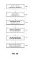
- FIG. 6Ashows a flow diagram depicting illustrative client-side operations of the interactive data object map system, according to an embodiment of the present disclosure.
- FIG. 6Bshows a flow diagram depicting illustrative client-side metadata retrieval of the interactive data object map system, according to an embodiment of the present disclosure.
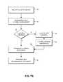
- FIG. 7Ashows a flow diagram depicting illustrative server-side operations of the interactive data object map system, according to an embodiment of the present disclosure.
- FIG. 7Bshows a flow diagram depicting illustrative server-side layer composition of the interactive data object map system, according to an embodiment of the present disclosure.
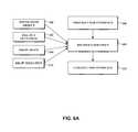
- FIG. 8Aillustrates one embodiment of a database system using an ontology.
- FIG. 8Billustrates one embodiment of a system for creating data in a data store using a dynamic ontology.
- FIG. 8Cillustrates a sample user interface using relationships described in a data store using a dynamic ontology.
- FIG. 8Dillustrates a computer system with which certain methods discussed herein may be implemented.
- a high-performance, interactive data object map system(or “map system”) is disclosed in which large amounts of geographical, geospatial, and other types of data, geodata, objects, features, and/or metadata are efficiently presented to a user on a map interface.
- the interactive data object map systemallows for rapid and deep analysis of various objects, features, and/or metadata by the user. For example, millions of data objects and/or features may be simultaneously viewed and selected by the user on the map interface. A layer ontology may be displayed to the user that allows the user to select and view particular layers.
- a selection cursor over an object/featureand/or otherwise selects the object/feature
- an outline of the object/featureis displayed. Selection of an object/feature may cause display of metadata associated with that object/feature.
- the usermay rapidly zoom in and out and/or move and pan around the map interface to variously see more or less detail, and more or fewer objects.
- the interactive data object map systemmay automatically generate feature/object lists and/or histograms based on selections made by the user.
- the usermay perform geosearches (based on any selections and/or drawn shapes), generate heatmaps, and/or perform keyword searches, among other actions as described below.
- the interactive data object map systemincludes server-side computer components and/or client-side computer components.
- the client-side componentsmay implement, for example, displaying map tiles, showing object outlines, allowing the user to draw shapes, and/or allowing the user to select objects/features, among other actions.
- the server-side componentsmay implement, for example, composition of layers into map tiles, caching of composed map tiles and/or layers, and/or providing object/feature metadata, among other actions. Such functions may be distribution in any other manner.
- object/feature outlines and/or highlightingare accomplished on the client-side through the use of a UTF grid.
- OntologyA hierarchical arrangement and/or grouping of data according to similarities and differences.
- the present disclosuredescribes two ontologies.
- the firstrelates to the arrangement of vector layers consisting of map and object data as used by the interactive data object map system (as described below with reference to FIGS. 2A-2B ).
- the secondrelates to the storage and arrangement of data objects in one or more databases (as described below with reference to FIGS. 8A-8C ).
- the stored datamay comprise definitions for object types and property types for data in a database, and how objects and properties may be related.
- DatabaseA broad term for any data structure for storing and/or organizing data, including, but not limited to, relational databases (Oracle database, mySQL database, etc.), spreadsheets, XML files, and text file, among others.
- Data Object, Object, or FeatureA data container for information representing specific things in the world that have a number of definable properties.
- a data objectcan represent an entity such as a person, a place, an organization, a market instrument, or other noun.
- a data objectcan represent an event that happens at a point in time or for a duration.
- a data objectcan represent a document or other unstructured data source such as an e-mail message, a news report, or a written paper or article.
- Each data objectmay be associated with a unique identifier that uniquely identifies the data object.
- the object's attributese.g. metadata about the object
- the terms “feature,” “data object,” and “object”may be used interchangeably to refer to items displayed on the map interface of the interactive data object map system, and/or otherwise accessible to the user through the interactive data object map system.
- Features/objectsmay generally include, but are not limited to, roads, terrain (such as hills, mountains, rivers, and vegetation, among others), street lights (which may be represented by a streetlight icon), railroads, hotels/motels (which may be represented by a bed icon), schools (which may be represented by a parent-child icon), hospitals, other types of buildings or structures, regions, transportation objects, and other types of entities, events, and documents, among others.
- Objects displayed on the map interfacegenerally comprise vector data, although other types of data may also be displayed. Objects generally have associated metadata and/or properties.
- Object TypeType of a data object (e.g., Person, Event, or Document).
- Object typesmay be defined by an ontology and may be modified or updated to include additional object types.
- An object definitione.g., in an ontology
- An object definitionmay include how the object is related to other objects, such as being a sub-object type of another object type (e.g. an agent may be a sub-object type of a person object type), and the properties the object type may have.
- Metadataincludes attributes of a data object/feature. At a minimum, each property/metadata of a data object has a type (such as a property type) and a value or values. Properties/metadata associated with features/objects may include any information relevant to that feature/object.
- metadata associated with a school objectmay include an address (for example, 123 S. Orange Street), a district (for example, 509c), a grade level (for example, K-6), and/or a phone number (for example, 800-0000), among other items of metadata.
- metadata associated with a road objectmay include a speed (for example, 25 mph), a width (for example, 2 lanes), and/or a county (for example, Arlington), among other items of metadata.
- Property TypeThe data type of a property, such as a string, an integer, or a double.
- Property typesmay include complex property types, such as a series data values associated with timed ticks (e.g. a time series), etc.
- Property ValueThe value associated with a property, which is of the type indicated in the property type associated with the property.
- a propertymay have multiple values.
- LinkA connection between two data objects, based on, for example, a relationship, an event, and/or matching properties. Links may be directional, such as one representing a payment from person A to B, or bidirectional.
- Link SetSet of multiple links that are shared between two or more data objects.
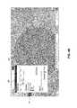
- FIG. 1illustrates a sample user interface of the interactive data object map system, according to an embodiment of the present disclosure.
- the user interfaceincludes a map interface 100 , a selection button/icon 102 , a shape button/icon 104 , a layers button/icon 106 , a geosearch button/icon 108 , a heat map button/icon 110 , a search box 112 , a feature information box 114 , a coordinates information box 116 , map scale information 118 , zoom selectors 120 , and highlighted features 122 .
- the functionality of the interactive data object map systemmay be implemented in one or more computer modules and/or processors, as is described below with reference to FIG. 8D .
- the map interface 100 of FIG. 1is composed of multiple map tiles.
- the map tilesare generally composed of multiple layers of geographical, vector, and/or other types of data.
- Vector data layersalso referred to as vector layers
- vector layersmay include associated and/or linked data objects/features.
- vector layersare composed of data objects/features.
- the various data objects and/or features associated with a particular vector layermay be displayed to the user when that particular vector layer is activated.
- a transportation vector layermay include road, railroad, and bike path objects and/or features that may be displayed to the user when the transportation layer is selected.
- composition of map tilesis accomplished by server-side components of the interactive data object map system.
- composed map tilesmay be cached by the server-side components to speed up map tile delivery to client-side components.
- the map tilesmay then be transmitted to the client-side components of the interactive data object map system where they are composed into the map interface 100 .
- the user interface of FIG. 1is displayed on an electronic display viewable by a user of the interactive data object map system.
- the user of the interactive data object map systemmay interact with the user interface of FIG. 1 by, for example, touching the display when the display is touch-enabled and/or using a mouse pointer to click on the various elements of the user interface.
- the map interface 100includes various highlighted features 122 and feature icons.
- the map interface 100includes roads, buildings and structures, utilities, lakes, rivers, vegetation, and railroads, among other features.
- the usermay interact with the map interface 100 by, for example, rolling over and/or clicking on various features.
- rolling over and/or placing the mouse pointer over a featurecauses the feature to be outlined and/or otherwise highlighted.
- the name of the feature and/or other information about the featuremay be shown in the feature information box 114 .
- the user of the map systemmay interact with the user interface of FIG. 1 by scrolling or panning up, down, and/or side to side; zooming in or out; selecting features; drawing shapes; selecting layers; performing a geosearch; generating a heat map; and/or performing a keyword search; among other actions as are described below.
- Various user actionsmay reveal more or less map detail, and/or more or fewer features/objects.
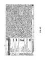
- FIG. 2Aillustrates a sample user interface of the map system in which map layers are displayed to a user, according to an embodiment of the present disclosure.
- the layers window 202includes a list of base layers, vector layers, and user layers.
- the base layersinclude, for example, overhead imagery, topographic, blank (Mercator), base map, aviation, and blank (unprojected).
- the vector layersinclude general categories such as, for example, regions, buildings/structures, terrain, transportation, and utilities/infrastructure. While no user layers are included in the user interface of FIG. 2A , user layers may be added by the user of the map system, as is described below.
- the usermay select one or more of the base layers which may be used during composition of the map tiles. For example, selection of the overhead imagery base layer will produce map tiles in which the underlying map tile imagery is made up of recent aerial imagery. Similarly, selection of the topographic base layer will produce map tiles in which the underlying map tile imagery includes topographic map imagery.
- the usermay select one or more of the vector layers which may be used during composition of the map tiles.
- selecting the transportation layerresults in transportation-related objects and/or features being displayed on the map tiles.
- Transportation-related featuresmay include, for example, roads, railroads, street signs, and/or street lights, among others. Examples of transportation-related features may be seen in the user interface of FIG. 2A where various roads, railroads, and street light icons are displayed.
- the user of the map systemmay create and save map layers. These saved map layers may be listed as user layers in the layers window 202 .
- FIG. 2Billustrates an example map layer ontology, according to an embodiment of the present disclosure.
- the list of vector layers in the layers window 202may include general categories/layers such as regions, buildings/structures, terrain, transportation, and utilities/infrastructure.
- the vector layers available in the map systemmay be further organized into an ontology, or hierarchical arrangement.
- the buildings/structures category 208may be further subdivided into layers including structures, government, medical, education, and commercial.
- the terrain category 210may include vegetation and/or water/hydrography layers.
- the utilities/infrastructure categorymay include fire and/or storage/draining.
- the user of the map systemmay select one or more of the layers and/or sub-layers of the layer ontology. As shown in FIG. 2B , the user has deselected the vegetation sub-layer, and all of the utilities/infrastructure layers. Selecting and deselecting vector layers, or toggling vectors layers on and off, may cause the vector objects and/or features associated with those layers to be displayed or not displayed in the map interface. For example, when the user selects the transportation category/layer, road objects associated with the transportation layer may be displayed on the map interface. Likewise, when a user deselects the transportation category/layer, road objects associated with the transportation layer may be removed from the map interface.
- additional hierarchical levels of layersmay be displayed to the user.
- the vector layers window 206may include sub-sub-layers (for example, the education sub-layer may be divided into elementary schools, secondary schools, and post-secondary schools). Alternatively, fewer hierarchical levels may be displayed to the user.
- each of the vector layers shown in the vector layers window 206may be made up of many layers of map vector data.
- the map systemmay advantageously generate a simplified layer ontology, such as the one shown in 206 .
- the simplified layer ontologyallows the user to easily select layers of interest from a reduced number of layers, rather than a large number of discrete layers.
- vector layersmay contain data regarding associated features and/or objects. Thus, features visible in the map interface correspond to the currently active/selected layers.
- the layer ontologymay have an arbitrary depth.
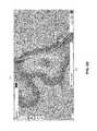
- FIG. 2Cillustrates a sample user interface of the map system in which various objects are displayed, according to an embodiment of the present disclosure.
- the user interface of FIG. 2Cincludes a map interface 214 , an outlined feature 216 , and feature information box 114 indicating that the outlined feature 216 is called “Union Park.”
- Various features/objectsmay be seen in the map interface 214 including, for example, roads, buildings, terrain, street lights (represented by a streetlight icon), railroads, hotels/motels (represented by a bed icon), and schools (represented by a parent-child icon), among other features.
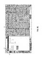
- FIG. 3Aillustrates a sample user interface of the map system in which objects are selected, according to an embodiment of the present disclosure.
- the user interface of FIG. 3Aincludes a highlighted user selection rectangle 302 .
- the highlighted user selection rectangle 302illustrates the user actively selecting a particular region of the map interface so as to select the features/objects that fall within the bounds of that rectangle.
- visible featuresmay be selected by the user, while features that are not currently visible are not selectable. For example, features related to layers that are not currently active are not selected when the user performs a selection. In another embodiment, even features that are not visible in a selected area may be selected.
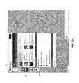
- FIGS. 3B-3Cillustrate sample user interfaces of the map system in which objects are selected and a feature histogram 304 is displayed in a selection window, according to embodiments of the present disclosure.
- the selected objects/features of FIG. 3B(including roads 310 and other features 312 ) may have been selected via the highlighted user selection rectangle 302 of FIG. 3A .
- Selected featuresare indicated by highlighting and/or altered colors on the map tiles making up the map interface.
- Feature histogram 304is shown in a selection window included in the user interface of FIG. 3B .
- the histogram 304shows a categorized histogram of all objects/features selected by the user in the map interface.
- the histogramdivides the features into common buckets and/or categories based on related metadata (also referred to as metadata categories). For example, at 306 , “Belongs to Layer” indicates that the following histogram includes all selected features organized by layer category. In this example there are over 70,000 selected buildings/structures features, over 40,000 selected facility features, and over 6,000 selected road features, among others.
- the feature histogram 304includes histograms of the selected objects organized by account and acreage.
- the map systemmay select histogram categories and/or metadata categories based on, for example, the features selected and/or types of features selected, among others. Any other categorization of selected features may be displayed in the histograms of the feature histogram 304 .
- the user of the map systemmay select a subset of the selected features for further analysis and/or histogram generation. For example, the user may select a subset comprising selected objects belonging to the road category by, for example, clicking on the roads item 308 . This selection may result in “drilling down” to histograms of that subset of features, as shown in FIG. 3C .
- a drill-down group of features/objects(for example, the subset of features/objects) may be used by the map system to determine new drill-down metadata categories, or buckets of related metadata.
- the arrow iconindicates that of the originally selected 124,172 features
- the feature histogramnow shows an analysis of the 6,724 features belonging to the road category (see item 316 ).
- the feature histogram window of FIG. 3Cthus shows a new set of histograms organized by layer, address, addressed, and agency, among others. The user may thus “drill down” and “drill up” through the selected features via the displayed histograms.
- items selected in the feature histogramare correspondingly highlighted in the map interface of the map system.
- the userhas selected the roads in the histogram at 308 .
- Corresponding featuresare thus highlighted in the map interface (as shown at 310 ).
- FIGS. 3D-3Gillustrate additional example user interfaces of the map system in which objects are selected from a histogram and correspondingly highlighted in the map interface, according to embodiments of the present disclosure.
- the userin the selection window, the user is viewing a histogram of all selected roads organized in a histogram according to the road speed limit.
- the userhas selected (at 318 ) roads with speed limits of 55 and 65.
- the corresponding road featuresare highlighted in the map interface at, for example 320 .
- FIG. 3Ethe user has selected (at 322 ) roads with speed limits of 35, 45, 40, 55, and 65.
- the corresponding road featuresare highlighted in the map interface at, for example 324 .
- the userhas selected (at 326 ) roads with speed limits of 25.
- the corresponding road featuresare highlighted in the map interface at, for example 328 .
- the usermay “drill down” into the histogram by, for example, right clicking on an item and selecting “Remove other objects in histogram” ( 330 ).
- FIGS. 3H and 3Iillustrate sample user interfaces of the map system in which objects are selected and a list of selected objects 332 is displayed in the selection window, according to embodiments of the present disclosure.
- the list of features 332indicates that the user has drilled down further into the selected features of FIG. 3G by selecting a subset of selected features consisting of only roads with speed limits of 20.
- the subset of the example of FIG. 3Hincludes the 163 features that are roads with speed limits of 20.
- the userhas additionally selected to view the list of features 332 in the selection window (rather than the feature histogram).
- the list of features 332lists each individual feature that is included in the currently selected subset. For example, the list includes S Central Av 334 , among others.
- the userhas selected feature Hamilton St at 336 .
- the map interfaceautomatically zooms to the location of that feature.
- the usermay select the feature from the list of features by clicking on the name of the feature and/or the displayed thumbnail.
- the map interfaceonly zooms to the feature when the user clicks on, and/or selects, the thumbnail associated with the feature.
- the map interfaceis automatically zoomed to the location of the selected Hamilton St, and the selected feature is highlighted ( 338 ). Additionally, the name of the selected feature is shown in the feature information box 114 .
- the name of the selected featureis shown in the feature information box 114 when the user hovers the cursor over the thumbnail associated with the feature in the list of features.
- the selected featuremay be any other type of object, and may be outlined or otherwise highlighted when selected.
- the user of the map systemmay select either the list of features, or the feature histogram, of the selection window to view information about the selected features.
- FIGS. 3J-3Killustrate sample user interfaces of the map system in which objects are outlined when hovered over, according to embodiments of the present disclosure.
- the useris hovering over a building feature with the mouse cursor.
- the feature being hovered overis automatically outlined ( 340 ).
- the name of the featureis displayed in the feature information box 114 .
- the useris hovering over a shelter feature with the mouse cursor.
- the feature being hovered overis automatically outlined ( 342 ), and the name of the feature is displayed in the feature information box 114 .
- the user of the map systemmay, at any time, highlight and/or outline any feature/object by rolling over, hovering over, selecting, and/or touching that feature/object in the map interface.
- the usermay select a feature in order to view a feature information window.
- the feature information windowmay include, for example, metadata associated with the selected feature.
- the usermay select a building feature, resulting in a display of information associated with that building feature such as the building size, the building name, and/or the building address or location, among others.
- Metadata associated with features/objectsmay include any information relevant to that feature/object.
- metadata associated with a schoolmay include an address (for example, 123 S. Orange Street), a district (for example, 509c), a grade level (for example, K-6), and/or a phone number (for example, 800-0000), among other items of metadata.
- a history of the object, changes made to the object, and/or user notes related to the object, among other itemsmay be displayed.
- a usermay edit metadata associated with a selected feature.
- FIGS. 4A-4Dillustrate sample user interfaces of the map system in which a radius geosearch is displayed, according to embodiments of the present disclosure.
- the userhas selected the shape button 104 and is drawing a circle selection 404 on the map interface by first selecting a center and then a radius.
- Shape window 402indicates the coordinates of the center of the circle selection, as well as the radius of the circle selection.
- any type of polygon or other shapemay be drawn on the map interface to select features.
- a geosearchcomprises a search through one or more databases of data objects, and metadata associated with those data objects, for any objects that meet the criteria of the geosearch.
- a geosearchmay search for any objects with geographic metadata and/or properties that indicate the object may be geographically within, for example, selection circle 408 .
- a geosearch within a selected circlemay be referred to as a radius search.
- Geosearch window 406indicates various items of information related to the radius search, and includes various parameters that may be adjusted by the user.
- the geosearch window 406includes a search area slider that the user may slide to increase or decrease the radius of the selection circle 408 .
- the usermay also indicate a time range for the geosearch.
- objects/features shown and/or searchable in the map systemmay include a time component and/or time metadata.
- the user of the map systemmay specify a date or time period, resulting in the display of any objects/features with associated time metadata, for example, falling within the specified time period.
- associated time metadatamay indicate, for example, a time the feature was created, a time the feature was added to a database of features, a time the feature was previously added to a vector layer, a time the feature was last accessed by the map system and/or a user, a time the feature was built, and/or any combination of the foregoing.
- the usermay select and/or search for objects/features within particular time periods, as shown in FIG. 4B .
- the geosearch window 406also allows the user to specify the types of objects to be searched, for example, entities, events, and/or documents, among others.
- the user of the map systemmay perform a search by clicking and/or touching a search button.
- the map systemmay then perform a search of an object database for any objects matching the criteria specified in the geosearch.
- the map systemwill search for any objects with associated location information that falls within the selection circle 408 .
- Objects searched by the map systemmay include objects other than those shown on the map interface.
- the map systemmay access one or more databases of objects (and object metadata) that may be unrelated to the features currently shown in the map interface, or features related to the currently selected vector layers.
- the databases accessedmay include databases external to any database storing data associated with the map system. Any objects found in the geosearch may then be made available to the user (as shown in FIG. 4B ), and the user may be given the option of adding the objects to a new layer in the map interface (as shown in the geosearch information window 406 ).
- FIG. 4Cshows objects added to the map interface following the geosearch in FIG. 4B .
- the search resultsare also shown in the feature histogram 410 .
- the returned objectsinclude various entities and events.
- FIG. 4Dshows the user has selected, in the feature histogram, all search result objects with related metadata indicating a drug law violation. Those selected objects are additionally highlighted in the map interface of FIG. 4D .
- geosearchmay be used to determine, for example, that many crimes are concentrated in a downtown area of a city, while DUIs are more common in areas with slow roads.
- FIGS. 5A-5Dillustrate sample user interfaces of the map system in which a heatmap is displayed, according to embodiments of the present disclosure.
- the userhas selected the heatmap button 110 so as to create a heatmap 504 based on the objects selected in FIG. 4D .
- a heatmap information window 502is displayed in which the user may specify various parameters related to the generation of heatmap. For example, referring now to FIG. 5B , the user may adjust a radius ( 506 ) of the circular heatmap related to each selected object, an opacity ( 508 ) of the heatmap, a scale of the heatmap, and an auto scale setting.
- the userhas decreased the opacity of the generated heatmap and zoomed in on the map interface so as to more clearly view various objects and the underlying map tiles.
- FIG. 5Cshows the user selecting various objects and/or features while the heatmap is displayed using the rectangle selection tool, such as to view information regarding the features in a histogram.
- FIG. 5Dshows the selected objects, selected in FIG. 5C , now highlighted ( 512 ).
- a heatmapmay be generated on any object type, and/or on multiple object types.
- different heatmap radiusesmay be set for different object types.
- the usermay generate a heatmap in which streetlights have a 20 m radius, while hospitals have a 500 m radius.
- the heatmapmay be generated based on arbitrary shapes.
- the heatmapmay be rectangular-based or ellipse-based.
- the heatmapmay be generated based on error ellipses and/or tolerance ellipses.
- a heatmap based on error ellipsesmay be advantageous when the relevant objects have associated error regions. For example, when a location of an object is uncertain, or multiple datapoints associated with an object are available, an error ellipse may help the user determine the actual location of the object.
- FIGS. 5E-5Fillustrate sample user interfaces of the map system in which a shape-based geosearch is displayed, according to embodiments of the present disclosure.
- the userhas selected the shape button 104 , and a shape information window 514 is shown.
- the userhas drawn lines 518 , however any shapes may be drawn on the map interface.
- Information related to the drawn lines 518is displayed in the shape information window 514 . For example, at 516 the starting points, distance, and azimuth related to each line are displayed. Further, a total distance from the start to the end of the line is shown.
- FIG. 5Fshows a geosearch performed on the line shape drawn in FIG. 5E .
- Geosearch information window 520indicates a search area 522 , a time range 524 , and an object type 526 as described above with reference to FIG. 4B .
- the search areais indicated on the map interface by the highlighted area 528 along the drawn line.
- the geosearchmay be performed, and results may be shown, in a manner similar to that described above with reference to FIGS. 4B-4D . For example, geosearch along a path may be used to determine points of interest along that path.
- FIG. 5Gillustrates a sample user interface of the map system in which a keyword object search is displayed, according to an embodiment of the present disclosure.
- the usermay type words, keywords, numbers, and/or geographic coordinates, among others, into the search box 112 .
- the userhas typed Bank ( 530 ).
- the map systemautomatically searches for objects and/or features that match the information typed. Matching may be performed based on object data and/or metadata. Search results are displayed as shown at 532 in FIG. 5G . In the example, a list of banks (bank features) is shown. The user may then select from the list shown, at which point the map system automatically zooms to the selected feature and indicates the selected feature with an arrow 534 .
- the selected featuremay be indicated by highlighting, outlining, and/or any other type of indicator.
- the search box 112may be linked to a gazetteer so as to enable simple word searches for particular geographic locations. For example, a search for a city name, New York, may be linked with the geographic coordinates of the city, taking the user directly to that location on the map interface.
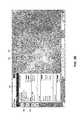
- FIG. 5Hillustrates an example of a UTF grid of the map system, according to an embodiment of the present disclosure.
- the UTF gridenables feature outlining and/or highlighting of many objects with client-side components.
- each map tile (or image) of the map interfaceincludes an associated textual UTF (UCS Transformation Format) grid.
- UTFUTF Transformation Format
- FIG. 5Han example map tile 526 is shown next to an associated example UTF grid 538 .
- the map tile and associated UTF gridare generated by the server-side components and sent to the client-side components.
- each characterrepresents a pixel in the map tile image, and each character indicates what feature is associated with the pixel.
- Each character in the UTF gridmay additionally be associated with a feature identifier which may be used to request metadata associated with that feature.
- Contiguous regions of characters in the UTF gridindicate the bounds of a particular feature, and may be used by the client-side components to provide the feature highlighting and/or outlining. For example, when a user hovers a mouse pointer over a feature on a map tile, the map system determines the character and portion of the UTF grid associated with the pixel hovered over, draws a feature outline based on the UTF grid, and may additionally access metadata associated with the feature based on the feature identifier associated with the feature.
- the UTF gridis sent to the client-side components in a JSON (JavaScript Object Notation) format.
- FIG. 6Ashows a flow diagram depicting illustrative client-side operations of the map system, according to an embodiment of the present disclosure. In various embodiments, fewer blocks or additional blocks may be included in the process, or various blocks may be performed in an order different from that shown in FIG. 6A . In an embodiment, one or more blocks in FIG. 6A may be performed by client-side components of the map system, for example, computer system 800 (described below in reference to FIG. 8D ).
- the map systemprovides a user interface (for example, the user interface of FIG. 1 ) to the user.
- the user interfacemay be provided to the user through any electronic device, such as a desktop computer, a laptop computer, a mobile smartphone, and/or a tablet, among others.
- an inputis received from the user of the map system.
- the usermay use a mouse to roll over and/or click on an item of the user interface, or the user may touch the display of the interface (in the example of a touch screen device).
- Inputs received from the usermay include, for example, hovering over, rolling over, and/or touching and object in the user interface ( 606 ); filling out a text field ( 614 ); drawing a shape in the user interface ( 608 ), and/or drawing a selection box and/or shape in the user interface ( 610 ); among other actions or inputs as described above.
- any of inputs 606 , 614 , 608 , and 610may cause the map system to perform client-side actions to update the user interface. For example, hovering over an object ( 606 ) may result in the client-side components of the map system to access the UTF grid, determine the boundaries of the object, and draw an outline around the hovered-over object.
- filling out a text field ( 614 )may include the user inputting data into the map system.
- the usermay input geographic coordinates, metadata, and/or other types of data to the map system.
- the user inputting coordinatesmay result in the map interface being updated to display the inputted information, such as an inputted name overlaying a particular object.
- the actions/inputs of drawing a shape ( 608 ) and/or drawing a selection ( 610 )may result in the client-side components of the map system to update the user interface with colored and/or highlighted shapes (see, for example, FIG. 3A ).
- one or more blocks in FIG. 6Amay be performed by server-side components of the map system, for example, server 830 (described below in reference to FIG. 8D ).
- FIG. 6Bshows a flow diagram depicting illustrative client-side metadata retrieval of the map system, according to an embodiment of the present disclosure.
- fewer blocks or additional blocksmay be included in the process, or various blocks may be performed in an order different from that shown in FIG. 6B .
- one or more blocks in FIG. 6Bmay be performed by client-side components of the map system, for example, computer system 800 .
- the client-side components of the map systemdetect that the user is hovering over and/or touching an object in the user interface.
- the client-side componentsmay access the UTF grid to determine the feature identifier and object boundaries associated with the hovered-over object.
- the client-side componentsmay render the feature shape on the image or map interface.
- the feature shapemay be rendered as an outline and/or other highlighting.
- the client-side componentsdetect whether the user has selected the object. Objects may be selected, for example, if the user clicks on the object and or touches the object. If the user has selected the object, then at block 628 , the client-side components query the server-side components to retrieve metadata associated with the selected object. In an embodiment, querying of the server-side components may include transmitting the feature identifier associated with the selected object to the server, the server retrieving from a database the relevant metadata, and the server transmitting the retrieved metadata back to the client-side components.
- the metadatais received by the client-side components and displayed to the user.
- the metadata associated with the selected objectmay be displayed to the user in the user interface in a dedicated metadata window, among other possibilities.
- one or more blocks in FIG. 6Bmay be performed by server-side components of the map system, for example, server 830 .
- FIG. 7Ashows a flow diagram depicting illustrative server-side operations of the map system, according to an embodiment of the present disclosure. In various embodiments, fewer blocks or additional blocks may be included in the process, or various blocks may be performed in an order different from that shown in FIG. 7A . In an embodiment, one or more blocks in FIG. 7A may be performed by server-side components of the map system, for example, server 830 .
- Server-side operations of the map systemmay include composing and updating the map tiles that make up the map interface. For example, when the user changes the selection of the base layer and/or one or more of the vector layers, the map tiles are re-composed and updated in the map interface to reflect the user's selection. Selection of objects resulting in highlighting of those objects may also involve re-composition of the map tiles. Further, UTF grids may be generated by the server-side components for each map tile composed.
- the user interfaceis provided to the user.
- an input from the useris received.
- Inputs received from the user that may result in server-side operationsmay include, for example, an object selection ( 706 ), a change in layer selection ( 708 ), a geosearch ( 710 ), generating a heatmap ( 712 ), searching from the search box ( 714 ), and/or panning or zooming the map interface, among others.
- the client-side components of the map systemmay query the server-side components in response to any of inputs 706 , 708 , 710 , 712 , and 714 from the user.
- the server-side componentsthen update and re-compose the map tiles and UTF grids of the map interface in accordance with the user input (as described below in reference to FIG. 7B ), and transmits those updated map tiles and UTF grids back to the client-side components.
- the client-side componentsreceive the updated map tile information from the server, and at block 720 the user interface is updated with the received information.
- additional information and/or datain addition to updated map tiles, may be transmitted to the client-side components from the server-side components.
- object metadatamay be transmitted in response to a user selecting an object.
- one or more blocks in FIG. 7Amay be performed by client-side components of the map system, for example, computer system 800 .
- FIG. 7Bshows a flow diagram depicting illustrative server-side layer composition of the map system, according to an embodiment of the present disclosure.
- fewer blocks or additional blocksmay be included in the process, or various blocks may be performed in an order different from that shown in FIG. 7B .
- one or more blocks in FIG. 7Bmay be performed by server-side components of the map system, for example, server 830 .
- a queryis received by the server-side components from the client-side components. Such a query may originate, for example, at block 716 of FIG. 7A .
- the server-side componentsdetermine the map tile composition based on the query. For example, if the user has selected an object or group of objects, the map tiles containing those objects may be updated to include highlighted objects. In another example, if the user has changed the layer selection, the map tiles may be updated to include only those layers that are currently selected. In the example of FIG. 7B , the layers currently selected are determined, and the layers are composed and/or rendered into the map tiles.
- the map tilesare updated to include those search result objects.
- the map tilesare updated to show the generated heatmap.
- the selected objectsmay be highlighted in the re-composed map tiles.
- the map tilesare updated to reflect the new view selected by the user. In all cases, and updated UTF grid may also be generated for each composed map tile.
- the map systemdetermines whether the layers necessary to compose the requested map tiles are cached. For example, when a layer is selected by the user, that layer may be composed by the map system and placed in a memory of the server-side components for future retrieval. Caching of composed layers may obviate the need for recomposing those layers later, which advantageously may save time and/or processing power.
- the layersare composed into the requested map tiles and, at block 742 , transmitted to the client-side components.
- the server-side componentscalculate and/or compose the requested layer and or layers, and may then, at block 738 , optionally cache the newly composed layers for future retrieval. Then, at blocks 740 and 742 , the layers are composed into map tiles and provided to the client-side components.
- map tilesmay be cached by the server-side components.
- the size and/or quality of the map tiles that make up that map interfacemay be selected and/or dynamically selected based on at least one of: the bandwidth available for transmitting the map tiles to the client-side components, the size of the map interface, and/or the complexity of the layer composition, among other factors.
- the map tilescomprise images, for example, in one or more of the following formats: PNG, GIF, JPEG, TIFF, BMP, and/or any other type of appropriate image format.
- the layer and object data composed into layers and map tilescomprises vector data.
- the vector data(for example, object data) may include associated metadata, as described above.
- the vector, layer, and/or object data and associated metadatamay originate from one or more databases and/or electronic data stores.
- one or more blocks in FIG. 7Bmay be performed by client-side components of the map system, for example, computer system 800 .
- the map systemmay display more than 50 million selectable features to a user simultaneously.
- the map systemmay support tens or hundreds of concurrent users accessing the same map and object data.
- map and object data used by the map systemmay be mirrored and/or spread across multiple computers, servers, and/or server-side components.
- the map systemmay show an approximation of the selection to the user based on client-side processing.
- a usermay drag and drop files, for example, vector data and/or vector layers, onto the user interface of the map system, causing the map system to automatically render the file in the map interface.
- filesfor example, vector data and/or vector layers
- icons and/or styles associated with various objects in the map interfacemay be updated and/or changed by the user.
- the styles of the various objectsmay be specified in or by a style data file.
- the style data filemay be formatted according to a particular format or standard readable by the map system.
- the style data fileis formatted according to the JSON format standard. The user may thus change the look of the objects and shapes rendered in the map interface of the map system by changing the style data file.
- the style data filemay further define the looks for object and terrain (among other items and data) at various zoom levels.
- objects, notes, metadata, and/or other types of datamay be added to the map system by the user through the user interface.
- user added informationmay be shared between multiple users of the map system.
- a user of the map systemmay add annotations and shapes to the map interface that may be saved and shared with other users.
- a user of the map systemmay share a selection of objects with one or more other users.
- the user interface of the map systemmay include a timeline window.
- the timeline windowmay enable the user to view objects and layers specific to particular moments in time and/or time periods.
- the usermay view tolerance ellipses overlaid on the map interface indicating the likely position of an object across a particular time period.
- the map systemmay include elevation profiling. Elevation profiling may allow a user of the system to determine the elevation along a path on the map interface, to perform a viewshed analysis (determine objects and/or terrain viewable from a particular location), to perform a reverse-viewshed analysis (for a particular location, determine objects and/or terrain that may view the location), among others.
- Elevation profilingmay allow a user of the system to determine the elevation along a path on the map interface, to perform a viewshed analysis (determine objects and/or terrain viewable from a particular location), to perform a reverse-viewshed analysis (for a particular location, determine objects and/or terrain that may view the location), among others.
- vector data, object data, metadata, and/or other types of datamay be prepared before it is entered into or accessed by the map system.
- the datamay be converted from one format to another, may be crawled for common items of metadata, and/or may be prepared for application of a style file or style information, among other action.
- a layer ontologymay be automatically generated based on a group of data.
- the map systemmay access common data sources available on the Internet, for example, road data available from openstreetmap.org.
- roads shown in the map interfaceare labeled with their names, and buildings are rendered in faux-3D to indicate the building heights.
- Blue Force Trackingmay be integrated into the map system as a layer with the characteristics of both a static vector layer and a dynamic selection layer.
- a Blue Force layermay enable the use of the map system for live operational analysis.
- the map systemmay quickly render detailed chloropleths or heatmaps with minimal data transfer. For example, the system may render a chloropleth with a property value on the individual shapes of the properties themselves, rather than aggregating this information on a county or zip code level.
- the map systemdisplays many items of data, objects, features, and/or layers in a single map interface.
- a usermay easily interact with things on the map and gather information by hovering over or selecting features, even though those features may not be labeled.
- the usermay select features, may “drill down” on a particular type of feature (for example, roads), may view features through histograms, may use histograms to determine common characteristics (for example, determine the most common speed limit), and/or may determine correlations among features (for example, see that slower speed limit areas are centered around schools).
- the map systemmay be useful in many different situations. For example, the system may be useful to operational planners and/or disaster relief personnel.
- the map systemaccomplishes at least three core ideas: providing a robust and fast back-end (server-side) renderer, keeping data on the back-end, and only transferring the data necessary to have interactivity.
- the primary function of the server-side componentsis rendering map tiles.
- the serveris capable of drawing very detailed maps with a variety of styles that can be based on vector metadata. Rendered map tiles for a vector layer are cached, and several of these layer tiles are drawn on top of one another to produce the final tile that is sent to the client-side browser. Map tile rendering is fast enough for displaying dynamic tiles for selection and highlight to the user.
- Server-side operationsallow for dynamic selections of very large numbers of features, calculation of the histogram, determining the number of items shown and/or selected, and drawing the selection, for example.
- the heatmapmay include large numbers of points without incurring the cost of transferring those points to the client-side browser.
- transferring only as much data as necessary to have interactivityenables quick server rendering of dynamic selections and vector layers.
- highlighting hovered-over featuresmay be performed client-side nearly instantaneously, and provides useful feedback that enhances the interactivity of the map system.
- the geometries of objectsin the map tiles and UTF grid
- map tilesmay be rendered and presented to a user of the map system in a dynamic and useable manner.
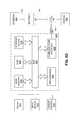
- an example database system 1210 using an ontology 1205will now be described. This description is provided for the purpose of providing an example and is not intended to limit the techniques to the example data model, the example database system, or the example database system's use of an ontology to represent information.
- a body of datais conceptually structured according to an object-centric data model represented by ontology 1205 .
- the conceptual data modelis independent of any particular database used for durably storing one or more database(s) 1209 based on the ontology 1205 .
- each object of the conceptual data modelmay correspond to one or more rows in a relational database or an entry in Lightweight Directory Access Protocol (LDAP) database, or any combination of one or more databases.
- LDAPLightweight Directory Access Protocol
- FIG. 8Aillustrates an object-centric conceptual data model according to an embodiment.
- An ontology 1205may include stored information providing a data model for storage of data in the database 1209 .
- the ontology 1205may be defined by one or more object types, which may each be associated with one or more property types.
- data object 1201is a container for information representing things in the world.
- data object 1201can represent an entity such as a person, a place, an organization, a market instrument, or other noun.
- Data object 1201can represent an event that happens at a point in time or for a duration.
- Data object 1201can represent a document or other unstructured data source such as an e-mail message, a news report, or a written paper or article. Each data object 1201 is associated with a unique identifier that uniquely identifies the data object within the database system.
- Each property 1203 as represented by data in the database system 1210may have a property type defined by the ontology 1205 used by the database 1205 .
- Objectsmay be instantiated in the database 1209 in accordance with the corresponding object definition for the particular object in the ontology 1205 .
- a specific monetary paymente.g., an object of type “event” of US$30.00 (e.g., a property of type “currency”) taking place on Mar. 27, 2009 (e.g., a property of type “date”) may be stored in the database 1209 as an event object with associated currency and date properties as defined within the ontology 1205 .
- the data objects defined in the ontology 1205may support property multiplicity.
- a data object 1201may be allowed to have more than one property 1203 of the same property type.
- a “Person” data objectmight have multiple “Address” properties or multiple “Name” properties.
- Each link 1202represents a connection between two data objects 1201 .
- the connectionis either through a relationship, an event, or through matching properties.
- a relationship connectionmay be asymmetrical or symmetrical.
- “Person” data object Amay be connected to “Person” data object B by a “Child Of” relationship (where “Person” data object B has an asymmetric “Parent Of” relationship to “Person” data object A), a “Kin Of” symmetric relationship to “Person” data object C, and an asymmetric “Member Of” relationship to “Organization” data object X.
- the type of relationship between two data objectsmay vary depending on the types of the data objects.
- “Person” data object Amay have an “Appears In” relationship with “Document” data object Y or have a “Participate In” relationship with “Event” data object E.
- Eventdata object E
- two “Person” data objectsmay be connected by an “Airline Flight” data object representing a particular airline flight if they traveled together on that flight, or by a “Meeting” data object representing a particular meeting if they both attended that meeting.
- when two data objects are connected by an eventthey are also connected by relationships, in which each data object has a specific relationship to the event, such as, for example, an “Appears In” relationship.
- a link between two data objectsmay be established based on similar or matching properties (e.g., property types and/or property values) of the data objects.
- similar or matching propertiese.g., property types and/or property values
- a documentmight contain references to two different objects.
- a documentmay contain a reference to a payment (one object), and a person (a second object).
- a link between these two objectsmay represent a connection between these two entities through their co-occurrence within the same document.
- Each data object 1201can have multiple links with another data object 1201 to form a link set 1204 .
- two “Person” data objects representing a husband and a wifecould be linked through a “Spouse Of” relationship, a matching “Address” property, and one or more matching “Event” properties (e.g., a wedding).
- Each link 1202 as represented by data in a databasemay have a link type defined by the database ontology used by the database.
- FIG. 8Bis a block diagram illustrating exemplary components and data that may be used in identifying and storing data according to an ontology.
- the ontologymay be configured, and data in the data model populated, by a system of parsers and ontology configuration tools.
- input data 1300is provided to parser 1302 .
- the input datamay comprise data from one or more sources.
- an institutionmay have one or more databases with information on credit card transactions, rental cars, and people.
- the databasesmay contain a variety of related information and attributes about each type of data, such as a “date” for a credit card transaction, an address for a person, and a date for when a rental car is rented.
- the parser 1302is able to read a variety of source input data types and determine which type of data it is reading.
- the example ontology 1205comprises stored information providing the data model of data stored in database 1209 , and the ontology is defined by one or more object types 1310 , one or more property types 1316 , and one or more link types 1330 .
- the ontologyis defined by one or more object types 1310 , one or more property types 1316 , and one or more link types 1330 .
- one or more data objects 1201may be instantiated in the database 209 based on respective determined object types 1310 , and each of the objects 1201 has one or more properties 1203 that are instantiated based on property types 1316 .
- Two data objects 1201may be connected by one or more links 1202 that may be instantiated based on link types 1330 .
- the property types 1316each may comprise one or more data types 1318 , such as a string, number, etc.
- Property types 1316may be instantiated based on a base property type 1320 .
- a base property type 1320may be “Locations” and a property type 1316 may be “Home.”
- a user of the systemuses an object type editor 1324 to create and/or modify the object types 1310 and define attributes of the object types.
- a user of the systemuses a property type editor 1326 to create and/or modify the property types 1316 and define attributes of the property types.
- a user of the systemuses link type editor 1328 to create the link types 1330 .
- other programs, processes, or programmatic controlsmay be used to create link types and property types and define attributes, and using editors is not required.
- creating a property type 1316 using the property type editor 1326involves defining at least one parser definition using a parser editor 1322 .
- a parser definitioncomprises metadata that informs parser 1302 how to parse input data 1300 to determine whether values in the input data can be assigned to the property type 1316 that is associated with the parser definition.
- each parser definitionmay comprise a regular expression parser 1304 A or a code module parser 1304 B. In other embodiments, other kinds of parser definitions may be provided using scripts or other programmatic elements. Once defined, both a regular expression parser 1304 A and a code module parser 1304 B can provide input to parser 1302 to control parsing of input data 1300 .
- input data 1300may be parsed by the parser 1302 determine which object type 1310 should receive data from a record created from the input data, and which property types 1316 should be assigned to data from individual field values in the input data. Based on the object-property mapping 1301 , the parser 1302 selects one of the parser definitions that is associated with a property type in the input data. The parser parses an input data field using the selected parser definition, resulting in creating new or modified data 1303 . The new or modified data 1303 is added to the database 1209 according to ontology 205 by storing values of the new or modified data in a property of the specified property type.
- input data 1300 having varying format or syntaxcan be created in database 1209 .
- the ontology 1205may be modified at any time using object type editor 1324 , property type editor 1326 , and link type editor 1328 , or under program control without human use of an editor.
- Parser editor 1322enables creating multiple parser definitions that can successfully parse input data 1300 having varying format or syntax and determine which property types should be used to transform input data 300 into new or modified input data 1303 .
- FIG. 8Cdisplays a user interface showing a graph representation 1403 of relationships (including relationships and/or links 1404 , 1405 , 1406 , 1407 , 1408 , 1409 , 1410 , 1411 , 1412 , and 1413 ) between the data objects (including data objects 1421 , 1422 , 1423 , 1424 , 1425 , 1426 , 1427 , 1428 , and 1429 ) that are represented as nodes in the example of FIG. 8C .
- relationshipsincluding relationships and/or links 1404 , 1405 , 1406 , 1407 , 1408 , 1409 , 1410 , 1411 , 1412 , and 1413
- the data objectsinclude person objects 1421 , 1422 , 1423 , 1424 , 1425 , and 1426 ; a flight object 1427 ; a financial account 1428 ; and a computer object 1429 .
- each person node (associated with person data objects), flight node (associated with flight data objects), financial account node (associated with financial account data objects), and computer node (associated with computer data objects)may have relationships and/or links with any of the other nodes through, for example, other objects such as payment objects.
- relationship 1404is based on a payment associated with the individuals indicated in person data objects 1421 and 1423 .
- the link 1404represents these shared payments (for example, the individual associated with data object 1421 may have paid the individual associated with data object 1423 on three occasions).
- the relationshipis further indicated by the common relationship between person data objects 1421 and 1423 and financial account data object 1428 .
- link 1411indicates that person data object 1421 transferred money into financial account data object 1428 , while person data object 1423 transferred money out of financial account data object 1428 .
- the relationships between person data objects 1424 and 1425 and flight data object 1427are indicated by links 1406 , 1409 , and 1410 .
- person data objects 1424 and 1425have a common address and were passengers on the same flight data object 1427 .
- further details related to the relationships between the various objectsmay be displayed.
- links 1411 and 1412may, in some embodiments, indicate the timing of the respective money transfers.
- the time of the flight associated with the flight data object 1427may be shown.
- Relationships between data objectsmay be stored as links, or in some embodiments, as properties, where a relationship may be detected between the properties.
- the linksmay be directional.
- a payment linkmay have a direction associated with the payment, where one person object is a receiver of a payment, and another person object is the payer of payment.
- data objectsmay further include geographical metadata and/or links.
- geographical metadatamay be accessed by the interactive data object map system for displaying objects and features on the map interface (as described above).
- the user interfacemay allow various other manipulations.
- the objects within database 1108may be searched using a search interface 1450 (e.g., text string matching of object properties), inspected (e.g., properties and associated data viewed), filtered (e.g., narrowing the universe of objects into sets and subsets by properties or relationships), and statistically aggregated (e.g., numerically summarized based on summarization criteria), among other operations and visualizations.
- a search interface 1450e.g., text string matching of object properties
- inspectede.g., properties and associated data viewed
- filterede.g., narrowing the universe of objects into sets and subsets by properties or relationships
- statistically aggregatede.g., numerically summarized based on summarization criteria
- the interactive data object map system and other methods and techniques described hereinare implemented by one or more special-purpose computing devices.
- the special-purpose computing devicesmay be hard-wired to perform the techniques, or may include digital electronic devices such as one or more application-specific integrated circuits (ASICs) or field programmable gate arrays (FPGAs) that are persistently programmed to perform the techniques, or may include one or more general purpose hardware processors programmed to perform the techniques pursuant to program instructions in firmware, memory, other storage, or a combination.
- ASICsapplication-specific integrated circuits
- FPGAsfield programmable gate arrays
- Such special-purpose computing devicesmay also combine custom hard-wired logic, ASICs, or FPGAs with custom programming to accomplish the techniques.
- the special-purpose computing devicesmay be desktop computer systems, server computer systems, portable computer systems, handheld devices, networking devices or any other device or combination of devices that incorporate hard-wired and/or program logic to implement the techniques.
- Computing device(s)are generally controlled and coordinated by operating system software, such as iOS, Android, Chrome OS, Windows XP, Windows Vista, Windows 7, Windows 8, Windows Server, Windows CE, Unix, Linux, SunOS, Solaris, iOS, Blackberry OS, VxWorks, or other compatible operating systems.
- operating system softwaresuch as iOS, Android, Chrome OS, Windows XP, Windows Vista, Windows 7, Windows 8, Windows Server, Windows CE, Unix, Linux, SunOS, Solaris, iOS, Blackberry OS, VxWorks, or other compatible operating systems.
- the computing devicemay be controlled by a proprietary operating system.
- Conventional operating systemscontrol and schedule computer processes for execution, perform memory management, provide file system, networking, I/O services, and provide a user interface functionality, such as a graphical user interface (“GUI”), among other things.
- GUIgraphical user interface
- FIG. 8Dis a block diagram that illustrates a computer system 800 upon which the various systems and methods discussed herein may be implemented.
- Computer system 800includes a bus 802 or other communication mechanism for communicating information, and a hardware processor, or multiple processors, 804 coupled with bus 802 for processing information.
- Hardware processor(s) 804may be, for example, one or more general purpose microprocessors.
- Computer system 800also includes a main memory 806 , such as a random access memory (RAM), cache and/or other dynamic storage devices, coupled to bus 802 for storing information and instructions to be executed by processor 804 .
- Main memory 806also may be used for storing temporary variables or other intermediate information during execution of instructions to be executed by processor 804 .
- Such instructionswhen stored in storage media accessible to processor 804 , render computer system 800 into a special-purpose machine that is customized to perform the operations specified in the instructions.
- Computer system 800further includes a read only memory (ROM) 808 or other static storage device coupled to bus 802 for storing static information and instructions for processor 804 .
- ROMread only memory
- a storage device 810such as a magnetic disk, optical disk, or USB thumb drive (Flash drive), etc., is provided and coupled to bus 802 for storing information and instructions.
- Computer system 800may be coupled via bus 802 to a display 812 , such as a cathode ray tube (CRT), LCD display, or touch screen display, for displaying information to a computer user and/or receiving input from the user.
- a display 812such as a cathode ray tube (CRT), LCD display, or touch screen display
- An input device 814is coupled to bus 802 for communicating information and command selections to processor 804 .
- cursor control 816is Another type of user input device, such as a mouse, a trackball, or cursor direction keys for communicating direction information and command selections to processor 804 and for controlling cursor movement on display 812 .
- This input devicetypically has two degrees of freedom in two axes, a first axis (e.g., x) and a second axis (e.g., y), that allows the device to specify positions in a plane.
- a first axise.g., x
- a second axise.g., y
- the same direction information and command selections as cursor controlmay be implemented via receiving touches on a touch screen without a cursor.
- Computing system 800may include a user interface module, and/or various other types of modules to implement a GUI, a map interface, and the various other aspects of the interactive data object map system.
- the modulesmay be stored in a mass storage device as executable software codes that are executed by the computing device(s).
- This and other modulesmay include, by way of example, components, such as software components, object-oriented software components, class components and task components, processes, functions, attributes, procedures, subroutines, segments of program code, drivers, firmware, microcode, circuitry, data, databases, data structures, tables, arrays, and variables.
- modulerefers to logic embodied in hardware or firmware, or to a collection of software instructions, possibly having entry and exit points, written in a programming language, such as, for example, Java, Lua, C or C++.
- a software modulemay be compiled and linked into an executable program, installed in a dynamic link library, or may be written in an interpreted programming language such as, for example, BASIC, Perl, or Python. It will be appreciated that software modules may be callable from other modules or from themselves, and/or may be invoked in response to detected events or interrupts.
- Software modules configured for execution on computing devicesmay be provided on a computer readable medium, such as a compact disc, digital video disc, flash drive, magnetic disc, or any other tangible medium, or as a digital download (and may be originally stored in a compressed or installable format that requires installation, decompression or decryption prior to execution).
- Such software codemay be stored, partially or fully, on a memory device of the executing computing device, for execution by the computing device.
- Software instructionsmay be embedded in firmware, such as an EPROM.
- hardware modulesmay be comprised of connected logic units, such as gates and flip-flops, and/or may be comprised of programmable units, such as programmable gate arrays or processors.
- the modules or computing device functionality described hereinare preferably implemented as software modules, but may be represented in hardware or firmware. Generally, the modules described herein refer to logical modules that may be combined with other modules or divided into sub-modules despite their physical organization or storage
- Computer system 800may implement the techniques described herein using customized hard-wired logic, one or more ASICs or FPGAs, firmware and/or program logic which in combination with the computer system causes or programs computer system 800 to be a special-purpose machine. According to one embodiment, the techniques herein are performed by computer system 800 in response to processor(s) 804 executing one or more sequences of one or more modules and/or instructions contained in main memory 806 . Such instructions may be read into main memory 806 from another storage medium, such as storage device 810 . Execution of the sequences of instructions contained in main memory 806 causes processor(s) 804 to perform the process steps described herein. In alternative embodiments, hard-wired circuitry may be used in place of or in combination with software instructions.
- non-transitory mediarefers to any media that store data and/or instructions that cause a machine to operate in a specific fashion. Such non-transitory media may comprise non-volatile media and/or volatile media.
- Non-volatile mediaincludes, for example, optical or magnetic disks, such as storage device 810 .
- Volatile mediaincludes dynamic memory, such as main memory 806 .
- non-transitory mediainclude, for example, a floppy disk, a flexible disk, hard disk, solid state drive, magnetic tape, or any other magnetic data storage medium, a CD-ROM, any other optical data storage medium, any physical medium with patterns of holes, a RAM, a PROM, and EPROM, a FLASH-EPROM, NVRAM, any other memory chip or cartridge, and networked versions of the same.
- Non-transitory mediais distinct from but may be used in conjunction with transmission media.
- Transmission mediaparticipates in transferring information between nontransitory media.
- transmission mediaincludes coaxial cables, copper wire and fiber optics, including the wires that comprise bus 802 .
- transmission mediacan also take the form of acoustic or light waves, such as those generated during radio-wave and infra-red data communications.
- Various forms of mediamay be involved in carrying one or more sequences of one or more instructions to processor 804 for execution.
- the instructionsmay initially be carried on a magnetic disk or solid state drive of a remote computer.
- the remote computercan load the instructions and/or modules into its dynamic memory and send the instructions over a telephone line using a modem.
- a modem local to computer system 800can receive the data on the telephone line and use an infra-red transmitter to convert the data to an infra-red signal.
- An infra-red detectorcan receive the data carried in the infra-red signal and appropriate circuitry can place the data on bus 802 .
- Bus 802carries the data to main memory 806 , from which processor 804 retrieves and executes the instructions.
- the instructions received by main memory 806may optionally be stored on storage device 810 either before or after execution by processor 804 .
- Computer system 800also includes a communication interface 818 coupled to bus 802 .
- Communication interface 818provides a two-way data communication coupling to a network link 820 that is connected to a local network 822 .
- communication interface 818may be an integrated services digital network (ISDN) card, cable modem, satellite modem, or a modem to provide a data communication connection to a corresponding type of telephone line.
- ISDNintegrated services digital network
- communication interface 818may be a local area network (LAN) card to provide a data communication connection to a compatible LAN (or WAN component to communicated with a WAN).
- LANlocal area network
- Wireless linksmay also be implemented.
- communication interface 818sends and receives electrical, electromagnetic or optical signals that carry digital data streams representing various types of information.
- Network link 820typically provides data communication through one or more networks to other data devices.
- network link 820may provide a connection through local network 822 to a host computer 824 or to data equipment operated by an Internet Service Provider (ISP) 826 .
- ISP 826in turn provides data communication services through the world wide packet data communication network now commonly referred to as the “Internet” 828 .
- Internet 828uses electrical, electromagnetic or optical signals that carry digital data streams.
- the signals through the various networks and the signals on network link 820 and through communication interface 818which carry the digital data to and from computer system 800 , are example forms of transmission media.
- Computer system 800can send messages and receive data, including program code, through the network(s), network link 820 and communication interface 818 .
- a server 830might transmit a requested code for an application program through Internet 828 , ISP 826 , local network 822 and communication interface 818 .
- Server-side components of the interactive data object map system described abovemay be implemented in the server 830 .
- the server 830may compose map layers and tiles, and transmit those map tiles to the computer system 800 .
- the computer system 800may implement the client-side components of the map system as described above (for example, with reference to FIGS. 6A and 6B ).
- the computer systemmay receive map tiles and/or other code that may be executed by processor 804 as it is received, and/or stored in storage device 810 , or other non-volatile storage for later execution.
- the computer system 800may further compose the map interface from the map tiles, display the map interface to the user, generate object outlines and other functionality, and/or receive input from the user.
- the map systemmay be accessible by the user through a web-based viewer, such as a web browser.
- the map interfacemay be generated by the server 830 and/or the computer system 800 and transmitted to the web browser of the user. The user may then interact with the map interface through the web-browser.
- the computer system 800may comprise a mobile electronic device, such as a cell phone, smartphone, and/or tablet. The map system may be accessible by the user through such a mobile electronic device, among other types of electronic devices.
- Conditional languagesuch as, among others, “can,” “could,” “might,” or “may,” unless specifically stated otherwise, or otherwise understood within the context as used, is generally intended to convey that certain embodiments include, while other embodiments do not include, certain features, elements and/or steps. Thus, such conditional language is not generally intended to imply that features, elements and/or steps are in any way required for one or more embodiments or that one or more embodiments necessarily include logic for deciding, with or without user input or prompting, whether these features, elements and/or steps are included or are to be performed in any particular embodiment.
Landscapes
- Engineering & Computer Science (AREA)
- Theoretical Computer Science (AREA)
- Physics & Mathematics (AREA)
- General Physics & Mathematics (AREA)
- General Engineering & Computer Science (AREA)
- Databases & Information Systems (AREA)
- Human Computer Interaction (AREA)
- Educational Technology (AREA)
- Educational Administration (AREA)
- Business, Economics & Management (AREA)
- Mathematical Physics (AREA)
- Remote Sensing (AREA)
- Data Mining & Analysis (AREA)
- User Interface Of Digital Computer (AREA)
Abstract
Description
Claims (12)
Priority Applications (14)
| Application Number | Priority Date | Filing Date | Title |
|---|---|---|---|
| US13/917,571US8799799B1 (en) | 2013-05-07 | 2013-06-13 | Interactive geospatial map |
| AU2014202442AAU2014202442A1 (en) | 2013-05-07 | 2014-05-05 | Interactive geospatial map |
| NZ624557ANZ624557B (en) | 2013-05-07 | 2014-05-05 | Interactive geospatial map |
| CA2851096ACA2851096A1 (en) | 2013-05-07 | 2014-05-06 | Interactive geospatial map |
| DE102014208515.2ADE102014208515B4 (en) | 2013-05-07 | 2014-05-07 | Interactive geospatial map |
| GB1408025.3AGB2516155B (en) | 2013-05-07 | 2014-05-07 | Interactive geospatial map |
| NL2012778ANL2012778B1 (en) | 2013-05-07 | 2014-05-07 | Interactive Geospatial Map. |
| GB1620827.4AGB2542517B (en) | 2013-05-07 | 2014-05-07 | Interactive Geospatial map |
| US14/323,881US9953445B2 (en) | 2013-05-07 | 2014-07-03 | Interactive data object map |
| US14/323,878US10360705B2 (en) | 2013-05-07 | 2014-07-03 | Interactive data object map |
| US16/516,041US10783686B2 (en) | 2013-05-07 | 2019-07-18 | Interactive data object map |
| US17/027,498US11295498B2 (en) | 2013-05-07 | 2020-09-21 | Interactive data object map |
| US17/711,881US11830116B2 (en) | 2013-05-07 | 2022-04-01 | Interactive data object map |
| US18/491,296US12374011B2 (en) | 2013-05-07 | 2023-10-20 | Interactive data object map |
Applications Claiming Priority (2)
| Application Number | Priority Date | Filing Date | Title |
|---|---|---|---|
| US201361820608P | 2013-05-07 | 2013-05-07 | |
| US13/917,571US8799799B1 (en) | 2013-05-07 | 2013-06-13 | Interactive geospatial map |
Related Child Applications (2)
| Application Number | Title | Priority Date | Filing Date |
|---|---|---|---|
| US14/323,881ContinuationUS9953445B2 (en) | 2013-05-07 | 2014-07-03 | Interactive data object map |
| US14/323,878ContinuationUS10360705B2 (en) | 2013-05-07 | 2014-07-03 | Interactive data object map |
Publications (1)
| Publication Number | Publication Date |
|---|---|
| US8799799B1true US8799799B1 (en) | 2014-08-05 |
Family
ID=51229235
Family Applications (7)
| Application Number | Title | Priority Date | Filing Date |
|---|---|---|---|
| US13/917,571ActiveUS8799799B1 (en) | 2013-05-07 | 2013-06-13 | Interactive geospatial map |
| US14/323,878Active2035-11-04US10360705B2 (en) | 2013-05-07 | 2014-07-03 | Interactive data object map |
| US14/323,881Active2035-04-30US9953445B2 (en) | 2013-05-07 | 2014-07-03 | Interactive data object map |
| US16/516,041ActiveUS10783686B2 (en) | 2013-05-07 | 2019-07-18 | Interactive data object map |
| US17/027,498ActiveUS11295498B2 (en) | 2013-05-07 | 2020-09-21 | Interactive data object map |
| US17/711,881ActiveUS11830116B2 (en) | 2013-05-07 | 2022-04-01 | Interactive data object map |
| US18/491,296ActiveUS12374011B2 (en) | 2013-05-07 | 2023-10-20 | Interactive data object map |
Family Applications After (6)
| Application Number | Title | Priority Date | Filing Date |
|---|---|---|---|
| US14/323,878Active2035-11-04US10360705B2 (en) | 2013-05-07 | 2014-07-03 | Interactive data object map |
| US14/323,881Active2035-04-30US9953445B2 (en) | 2013-05-07 | 2014-07-03 | Interactive data object map |
| US16/516,041ActiveUS10783686B2 (en) | 2013-05-07 | 2019-07-18 | Interactive data object map |
| US17/027,498ActiveUS11295498B2 (en) | 2013-05-07 | 2020-09-21 | Interactive data object map |
| US17/711,881ActiveUS11830116B2 (en) | 2013-05-07 | 2022-04-01 | Interactive data object map |
| US18/491,296ActiveUS12374011B2 (en) | 2013-05-07 | 2023-10-20 | Interactive data object map |
Country Status (5)
| Country | Link |
|---|---|
| US (7) | US8799799B1 (en) |
| AU (1) | AU2014202442A1 (en) |
| CA (1) | CA2851096A1 (en) |
| DE (1) | DE102014208515B4 (en) |
| NL (1) | NL2012778B1 (en) |
Cited By (239)
| Publication number | Priority date | Publication date | Assignee | Title |
|---|---|---|---|---|
| US20140310655A1 (en)* | 2013-04-11 | 2014-10-16 | General Electric Company | Visual representation of map navigation history |
| US8868486B2 (en) | 2013-03-15 | 2014-10-21 | Palantir Technologies Inc. | Time-sensitive cube |
| US20140337772A1 (en)* | 2013-05-07 | 2014-11-13 | Palantir Technologies Inc. | Interactive data object map |
| US8917274B2 (en) | 2013-03-15 | 2014-12-23 | Palantir Technologies Inc. | Event matrix based on integrated data |
| US8924872B1 (en) | 2013-10-18 | 2014-12-30 | Palantir Technologies Inc. | Overview user interface of emergency call data of a law enforcement agency |
| US9009171B1 (en) | 2014-05-02 | 2015-04-14 | Palantir Technologies Inc. | Systems and methods for active column filtering |
| US9009827B1 (en) | 2014-02-20 | 2015-04-14 | Palantir Technologies Inc. | Security sharing system |
| US9021384B1 (en) | 2013-11-04 | 2015-04-28 | Palantir Technologies Inc. | Interactive vehicle information map |
| US9021260B1 (en) | 2014-07-03 | 2015-04-28 | Palantir Technologies Inc. | Malware data item analysis |
| US9043696B1 (en) | 2014-01-03 | 2015-05-26 | Palantir Technologies Inc. | Systems and methods for visual definition of data associations |
| US9043894B1 (en) | 2014-11-06 | 2015-05-26 | Palantir Technologies Inc. | Malicious software detection in a computing system |
| US20150199381A1 (en)* | 2014-01-16 | 2015-07-16 | Courage Services, Inc. | System for analysis and geospatial visualization |
| US20150227288A1 (en)* | 2014-02-11 | 2015-08-13 | Google Inc. | Selection of Third-Party Content Layers for a Digital Map |
| US9116975B2 (en) | 2013-10-18 | 2015-08-25 | Palantir Technologies Inc. | Systems and user interfaces for dynamic and interactive simultaneous querying of multiple data stores |
| US9123086B1 (en) | 2013-01-31 | 2015-09-01 | Palantir Technologies, Inc. | Automatically generating event objects from images |
| US9129219B1 (en) | 2014-06-30 | 2015-09-08 | Palantir Technologies, Inc. | Crime risk forecasting |
| CN104899239A (en)* | 2015-03-03 | 2015-09-09 | 江苏科技大学 | Road surface spectrum and GIS vector data fusion method and system based on semantic technology |
| US9202249B1 (en) | 2014-07-03 | 2015-12-01 | Palantir Technologies Inc. | Data item clustering and analysis |
| US20150363074A1 (en)* | 2014-06-12 | 2015-12-17 | Environmental Protection Administration, R.O.C. (Taiwan) | Real-time interactive mobile device for on-site investigation |
| US9223773B2 (en) | 2013-08-08 | 2015-12-29 | Palatir Technologies Inc. | Template system for custom document generation |
| US20160033295A1 (en)* | 2014-07-29 | 2016-02-04 | Google Inc. | Presenting hierarchies of map data at different zoom levels |
| US9256664B2 (en) | 2014-07-03 | 2016-02-09 | Palantir Technologies Inc. | System and method for news events detection and visualization |
| US9335911B1 (en)* | 2014-12-29 | 2016-05-10 | Palantir Technologies Inc. | Interactive user interface for dynamic data analysis exploration and query processing |
| US9335897B2 (en) | 2013-08-08 | 2016-05-10 | Palantir Technologies Inc. | Long click display of a context menu |
| US9367872B1 (en) | 2014-12-22 | 2016-06-14 | Palantir Technologies Inc. | Systems and user interfaces for dynamic and interactive investigation of bad actor behavior based on automatic clustering of related data in various data structures |
| US9383911B2 (en) | 2008-09-15 | 2016-07-05 | Palantir Technologies, Inc. | Modal-less interface enhancements |
| CN105740311A (en)* | 2014-12-26 | 2016-07-06 | 商业对象软件有限公司 | System and method of data wrangling |
| US9390086B2 (en) | 2014-09-11 | 2016-07-12 | Palantir Technologies Inc. | Classification system with methodology for efficient verification |
| EP3070622A1 (en)* | 2015-03-16 | 2016-09-21 | Palantir Technologies, Inc. | Interactive user interfaces for location-based data analysis |
| US9454785B1 (en) | 2015-07-30 | 2016-09-27 | Palantir Technologies Inc. | Systems and user interfaces for holistic, data-driven investigation of bad actor behavior based on clustering and scoring of related data |
| US9454281B2 (en) | 2014-09-03 | 2016-09-27 | Palantir Technologies Inc. | System for providing dynamic linked panels in user interface |
| US9460175B1 (en)* | 2015-06-03 | 2016-10-04 | Palantir Technologies Inc. | Server implemented geographic information system with graphical interface |
| US9471452B2 (en) | 2014-12-01 | 2016-10-18 | Uptake Technologies, Inc. | Adaptive handling of operating data |
| US9483546B2 (en) | 2014-12-15 | 2016-11-01 | Palantir Technologies Inc. | System and method for associating related records to common entities across multiple lists |
| US9483162B2 (en) | 2014-02-20 | 2016-11-01 | Palantir Technologies Inc. | Relationship visualizations |
| US9501851B2 (en) | 2014-10-03 | 2016-11-22 | Palantir Technologies Inc. | Time-series analysis system |
| US9514414B1 (en) | 2015-12-11 | 2016-12-06 | Palantir Technologies Inc. | Systems and methods for identifying and categorizing electronic documents through machine learning |
| US20160371584A1 (en) | 2015-06-05 | 2016-12-22 | Uptake Technologies, Inc. | Local Analytics at an Asset |
| US9552615B2 (en) | 2013-12-20 | 2017-01-24 | Palantir Technologies Inc. | Automated database analysis to detect malfeasance |
| US9557882B2 (en) | 2013-08-09 | 2017-01-31 | Palantir Technologies Inc. | Context-sensitive views |
| EP3133510A1 (en)* | 2015-08-17 | 2017-02-22 | Palantir Technologies, Inc. | Interactive geospatial map |
| US9600146B2 (en)* | 2015-08-17 | 2017-03-21 | Palantir Technologies Inc. | Interactive geospatial map |
| US9619557B2 (en) | 2014-06-30 | 2017-04-11 | Palantir Technologies, Inc. | Systems and methods for key phrase characterization of documents |
| US9639580B1 (en) | 2015-09-04 | 2017-05-02 | Palantir Technologies, Inc. | Computer-implemented systems and methods for data management and visualization |
| US20170126519A1 (en)* | 2015-11-04 | 2017-05-04 | International Business Machines Corporation | Visualization of cyclical patterns in metric data |
| US9646396B2 (en) | 2013-03-15 | 2017-05-09 | Palantir Technologies Inc. | Generating object time series and data objects |
| US9654549B2 (en) | 2015-05-18 | 2017-05-16 | Somchai Akkarawittayapoom | Systems and methods for creating user-managed online pages (MAPpages) linked to locations on an interactive digital map |
| WO2017106424A1 (en)* | 2015-12-16 | 2017-06-22 | Google Inc. | Split tile map rendering |
| US9727560B2 (en) | 2015-02-25 | 2017-08-08 | Palantir Technologies Inc. | Systems and methods for organizing and identifying documents via hierarchies and dimensions of tags |
| US9727622B2 (en) | 2013-12-16 | 2017-08-08 | Palantir Technologies, Inc. | Methods and systems for analyzing entity performance |
| US9760556B1 (en) | 2015-12-11 | 2017-09-12 | Palantir Technologies Inc. | Systems and methods for annotating and linking electronic documents |
| US9767172B2 (en) | 2014-10-03 | 2017-09-19 | Palantir Technologies Inc. | Data aggregation and analysis system |
| US9785317B2 (en) | 2013-09-24 | 2017-10-10 | Palantir Technologies Inc. | Presentation and analysis of user interaction data |
| US9785773B2 (en) | 2014-07-03 | 2017-10-10 | Palantir Technologies Inc. | Malware data item analysis |
| US9785328B2 (en) | 2014-10-06 | 2017-10-10 | Palantir Technologies Inc. | Presentation of multivariate data on a graphical user interface of a computing system |
| US9792020B1 (en) | 2015-12-30 | 2017-10-17 | Palantir Technologies Inc. | Systems for collecting, aggregating, and storing data, generating interactive user interfaces for analyzing data, and generating alerts based upon collected data |
| US9817563B1 (en) | 2014-12-29 | 2017-11-14 | Palantir Technologies Inc. | System and method of generating data points from one or more data stores of data items for chart creation and manipulation |
| US9823818B1 (en) | 2015-12-29 | 2017-11-21 | Palantir Technologies Inc. | Systems and interactive user interfaces for automatic generation of temporal representation of data objects |
| US9830388B2 (en)* | 2014-04-30 | 2017-11-28 | Excalibur Ip, Llc | Modular search object framework |
| US9857958B2 (en) | 2014-04-28 | 2018-01-02 | Palantir Technologies Inc. | Systems and user interfaces for dynamic and interactive access of, investigation of, and analysis of data objects stored in one or more databases |
| US9864493B2 (en) | 2013-10-07 | 2018-01-09 | Palantir Technologies Inc. | Cohort-based presentation of user interaction data |
| US9870205B1 (en) | 2014-12-29 | 2018-01-16 | Palantir Technologies Inc. | Storing logical units of program code generated using a dynamic programming notebook user interface |
| US9880987B2 (en) | 2011-08-25 | 2018-01-30 | Palantir Technologies, Inc. | System and method for parameterizing documents for automatic workflow generation |
| WO2018018066A1 (en)* | 2016-07-29 | 2018-02-01 | Queensland Electricity Transmission Corporation | Geospatial mapping system |
| US9886467B2 (en) | 2015-03-19 | 2018-02-06 | Plantir Technologies Inc. | System and method for comparing and visualizing data entities and data entity series |
| US9898335B1 (en) | 2012-10-22 | 2018-02-20 | Palantir Technologies Inc. | System and method for batch evaluation programs |
| US9898528B2 (en) | 2014-12-22 | 2018-02-20 | Palantir Technologies Inc. | Concept indexing among database of documents using machine learning techniques |
| US9898509B2 (en) | 2015-08-28 | 2018-02-20 | Palantir Technologies Inc. | Malicious activity detection system capable of efficiently processing data accessed from databases and generating alerts for display in interactive user interfaces |
| CN107749074A (en)* | 2017-09-30 | 2018-03-02 | 北京知道创宇信息技术有限公司 | A kind of method, apparatus and computing device for map making |
| US9946738B2 (en) | 2014-11-05 | 2018-04-17 | Palantir Technologies, Inc. | Universal data pipeline |
| US9965937B2 (en) | 2013-03-15 | 2018-05-08 | Palantir Technologies Inc. | External malware data item clustering and analysis |
| US9965534B2 (en) | 2015-09-09 | 2018-05-08 | Palantir Technologies, Inc. | Domain-specific language for dataset transformations |
| US9984428B2 (en) | 2015-09-04 | 2018-05-29 | Palantir Technologies Inc. | Systems and methods for structuring data from unstructured electronic data files |
| US9984133B2 (en) | 2014-10-16 | 2018-05-29 | Palantir Technologies Inc. | Schematic and database linking system |
| US9996229B2 (en) | 2013-10-03 | 2018-06-12 | Palantir Technologies Inc. | Systems and methods for analyzing performance of an entity |
| US9996595B2 (en) | 2015-08-03 | 2018-06-12 | Palantir Technologies, Inc. | Providing full data provenance visualization for versioned datasets |
| EP3336724A1 (en)* | 2016-12-13 | 2018-06-20 | Palantir Technologies Inc. | Zoom-adaptive data granularity to achieve a flexible high-performance interface for a geospatial mapping system |
| US20180173686A1 (en)* | 2015-06-30 | 2018-06-21 | Hyundai Mnsoft, Inc. | System and method for displaying graphic-based web vector map |
| US10007677B1 (en)* | 2014-12-04 | 2018-06-26 | Google Llc | System and method for geospatial indexing |
| US10037383B2 (en) | 2013-11-11 | 2018-07-31 | Palantir Technologies, Inc. | Simple web search |
| US10037314B2 (en) | 2013-03-14 | 2018-07-31 | Palantir Technologies, Inc. | Mobile reports |
| US10068199B1 (en) | 2016-05-13 | 2018-09-04 | Palantir Technologies Inc. | System to catalogue tracking data |
| US10102369B2 (en) | 2015-08-19 | 2018-10-16 | Palantir Technologies Inc. | Checkout system executable code monitoring, and user account compromise determination system |
| US10109094B2 (en) | 2015-12-21 | 2018-10-23 | Palantir Technologies Inc. | Interface to index and display geospatial data |
| US10133621B1 (en) | 2017-01-18 | 2018-11-20 | Palantir Technologies Inc. | Data analysis system to facilitate investigative process |
| US10133783B2 (en) | 2017-04-11 | 2018-11-20 | Palantir Technologies Inc. | Systems and methods for constraint driven database searching |
| US10146412B2 (en)* | 2014-09-15 | 2018-12-04 | Samsung Electronics Co., Ltd. | Method and electronic device for providing information |
| US10152531B2 (en) | 2013-03-15 | 2018-12-11 | Palantir Technologies Inc. | Computer-implemented systems and methods for comparing and associating objects |
| US10169135B1 (en) | 2018-03-02 | 2019-01-01 | Uptake Technologies, Inc. | Computer system and method of detecting manufacturing network anomalies |
| US10176279B2 (en) | 2015-06-05 | 2019-01-08 | Uptake Technologies, Inc. | Dynamic execution of predictive models and workflows |
| US10180977B2 (en) | 2014-03-18 | 2019-01-15 | Palantir Technologies Inc. | Determining and extracting changed data from a data source |
| US10180929B1 (en) | 2014-06-30 | 2019-01-15 | Palantir Technologies, Inc. | Systems and methods for identifying key phrase clusters within documents |
| USD839288S1 (en) | 2014-04-30 | 2019-01-29 | Oath Inc. | Display screen with graphical user interface for displaying search results as a stack of overlapping, actionable cards |
| US10198515B1 (en) | 2013-12-10 | 2019-02-05 | Palantir Technologies Inc. | System and method for aggregating data from a plurality of data sources |
| US10210037B2 (en) | 2016-08-25 | 2019-02-19 | Uptake Technologies, Inc. | Interface tool for asset fault analysis |
| US10216801B2 (en) | 2013-03-15 | 2019-02-26 | Palantir Technologies Inc. | Generating data clusters |
| RU2681361C1 (en)* | 2018-04-18 | 2019-03-06 | Федеральное государственное казенное военное образовательное учреждение высшего образования Академия Федеральной службы охраны Российской Федерации | User interface formation system for the vector spatial data input, display and modification |
| US10229284B2 (en) | 2007-02-21 | 2019-03-12 | Palantir Technologies Inc. | Providing unique views of data based on changes or rules |
| US10230746B2 (en) | 2014-01-03 | 2019-03-12 | Palantir Technologies Inc. | System and method for evaluating network threats and usage |
| USD842866S1 (en)* | 2016-10-18 | 2019-03-12 | Facebook, Inc. | Display screen or portion thereof with graphical user interface, including bar charts, for an advertisement management application |
| US10228925B2 (en) | 2016-12-19 | 2019-03-12 | Uptake Technologies, Inc. | Systems, devices, and methods for deploying one or more artifacts to a deployment environment |
| US10249033B1 (en) | 2016-12-20 | 2019-04-02 | Palantir Technologies Inc. | User interface for managing defects |
| US10255526B2 (en) | 2017-06-09 | 2019-04-09 | Uptake Technologies, Inc. | Computer system and method for classifying temporal patterns of change in images of an area |
| US10270727B2 (en) | 2016-12-20 | 2019-04-23 | Palantir Technologies, Inc. | Short message communication within a mobile graphical map |
| US10275778B1 (en) | 2013-03-15 | 2019-04-30 | Palantir Technologies Inc. | Systems and user interfaces for dynamic and interactive investigation based on automatic malfeasance clustering of related data in various data structures |
| CN109716316A (en)* | 2016-09-19 | 2019-05-03 | 电子湾有限公司 | Interactive real-time visualization of streaming data |
| US10291732B2 (en) | 2015-09-17 | 2019-05-14 | Uptake Technologies, Inc. | Computer systems and methods for sharing asset-related information between data platforms over a network |
| US10296569B2 (en) | 2015-05-18 | 2019-05-21 | Somchai Akkarawittayapoom | Systems and methods for creating user-managed online pages (MAPpages) linked to locations on an interactive digital map |
| US10296617B1 (en) | 2015-10-05 | 2019-05-21 | Palantir Technologies Inc. | Searches of highly structured data |
| US10318630B1 (en) | 2016-11-21 | 2019-06-11 | Palantir Technologies Inc. | Analysis of large bodies of textual data |
| US10324609B2 (en) | 2016-07-21 | 2019-06-18 | Palantir Technologies Inc. | System for providing dynamic linked panels in user interface |
| US10333775B2 (en) | 2016-06-03 | 2019-06-25 | Uptake Technologies, Inc. | Facilitating the provisioning of a local analytics device |
| US10356032B2 (en) | 2013-12-26 | 2019-07-16 | Palantir Technologies Inc. | System and method for detecting confidential information emails |
| US10362133B1 (en) | 2014-12-22 | 2019-07-23 | Palantir Technologies Inc. | Communication data processing architecture |
| US10360238B1 (en) | 2016-12-22 | 2019-07-23 | Palantir Technologies Inc. | Database systems and user interfaces for interactive data association, analysis, and presentation |
| USD854555S1 (en)* | 2017-05-25 | 2019-07-23 | Palantir Technologies Inc. | Display screen or portion thereof with transitional graphical user interface |
| US10365804B1 (en)* | 2014-02-20 | 2019-07-30 | Google Llc | Manipulation of maps as documents |
| US10371537B1 (en) | 2017-11-29 | 2019-08-06 | Palantir Technologies Inc. | Systems and methods for flexible route planning |
| US10372879B2 (en) | 2014-12-31 | 2019-08-06 | Palantir Technologies Inc. | Medical claims lead summary report generation |
| US10379982B2 (en) | 2017-10-31 | 2019-08-13 | Uptake Technologies, Inc. | Computer system and method for performing a virtual load test |
| US10387834B2 (en) | 2015-01-21 | 2019-08-20 | Palantir Technologies Inc. | Systems and methods for accessing and storing snapshots of a remote application in a document |
| US10397304B2 (en) | 2018-01-30 | 2019-08-27 | Excentus Corporation | System and method to standardize and improve implementation efficiency of user interface content |
| US10402742B2 (en) | 2016-12-16 | 2019-09-03 | Palantir Technologies Inc. | Processing sensor logs |
| US10403011B1 (en) | 2017-07-18 | 2019-09-03 | Palantir Technologies Inc. | Passing system with an interactive user interface |
| US10415989B2 (en) | 2016-09-06 | 2019-09-17 | International Business Machines Corporation | Navigation personalization through analysis of present and historical user data |
| US10423582B2 (en) | 2011-06-23 | 2019-09-24 | Palantir Technologies, Inc. | System and method for investigating large amounts of data |
| US20190295197A1 (en)* | 2016-02-26 | 2019-09-26 | Navigatorsvrs, Inc. | Graphical platform for interacting with unstructured data |
| US10429197B1 (en) | 2018-05-29 | 2019-10-01 | Palantir Technologies Inc. | Terrain analysis for automatic route determination |
| US10430444B1 (en) | 2017-07-24 | 2019-10-01 | Palantir Technologies Inc. | Interactive geospatial map and geospatial visualization systems |
| US10430073B2 (en) | 2015-07-17 | 2019-10-01 | Crown Equipment Corporation | Processing device having a graphical user interface for industrial vehicle |
| US10437612B1 (en) | 2015-12-30 | 2019-10-08 | Palantir Technologies Inc. | Composite graphical interface with shareable data-objects |
| US10437840B1 (en) | 2016-08-19 | 2019-10-08 | Palantir Technologies Inc. | Focused probabilistic entity resolution from multiple data sources |
| US10452678B2 (en) | 2013-03-15 | 2019-10-22 | Palantir Technologies Inc. | Filter chains for exploring large data sets |
| US10460602B1 (en) | 2016-12-28 | 2019-10-29 | Palantir Technologies Inc. | Interactive vehicle information mapping system |
| US10467435B1 (en) | 2018-10-24 | 2019-11-05 | Palantir Technologies Inc. | Approaches for managing restrictions for middleware applications |
| US10474932B2 (en) | 2016-09-01 | 2019-11-12 | Uptake Technologies, Inc. | Detection of anomalies in multivariate data |
| US10484407B2 (en) | 2015-08-06 | 2019-11-19 | Palantir Technologies Inc. | Systems, methods, user interfaces, and computer-readable media for investigating potential malicious communications |
| US20190354537A1 (en)* | 2018-05-17 | 2019-11-21 | James A. La Maire | System and Method for Increasing the Speed at Which Critical Safety Information is Provided or Accessed |
| US10489391B1 (en) | 2015-08-17 | 2019-11-26 | Palantir Technologies Inc. | Systems and methods for grouping and enriching data items accessed from one or more databases for presentation in a user interface |
| US10509844B1 (en) | 2017-01-19 | 2019-12-17 | Palantir Technologies Inc. | Network graph parser |
| US10510006B2 (en) | 2016-03-09 | 2019-12-17 | Uptake Technologies, Inc. | Handling of predictive models based on asset location |
| US10515109B2 (en) | 2017-02-15 | 2019-12-24 | Palantir Technologies Inc. | Real-time auditing of industrial equipment condition |
| US10545975B1 (en) | 2016-06-22 | 2020-01-28 | Palantir Technologies Inc. | Visual analysis of data using sequenced dataset reduction |
| US10552246B1 (en) | 2017-10-24 | 2020-02-04 | Uptake Technologies, Inc. | Computer system and method for handling non-communicative assets |
| US10552994B2 (en) | 2014-12-22 | 2020-02-04 | Palantir Technologies Inc. | Systems and interactive user interfaces for dynamic retrieval, analysis, and triage of data items |
| US10552002B1 (en) | 2016-09-27 | 2020-02-04 | Palantir Technologies Inc. | User interface based variable machine modeling |
| US10554518B1 (en) | 2018-03-02 | 2020-02-04 | Uptake Technologies, Inc. | Computer system and method for evaluating health of nodes in a manufacturing network |
| US10563990B1 (en) | 2017-05-09 | 2020-02-18 | Palantir Technologies Inc. | Event-based route planning |
| US10572496B1 (en) | 2014-07-03 | 2020-02-25 | Palantir Technologies Inc. | Distributed workflow system and database with access controls for city resiliency |
| US10572487B1 (en) | 2015-10-30 | 2020-02-25 | Palantir Technologies Inc. | Periodic database search manager for multiple data sources |
| US10579932B1 (en) | 2018-07-10 | 2020-03-03 | Uptake Technologies, Inc. | Computer system and method for creating and deploying an anomaly detection model based on streaming data |
| US10581954B2 (en) | 2017-03-29 | 2020-03-03 | Palantir Technologies Inc. | Metric collection and aggregation for distributed software services |
| US10579750B2 (en) | 2015-06-05 | 2020-03-03 | Uptake Technologies, Inc. | Dynamic execution of predictive models |
| US10579961B2 (en) | 2017-01-26 | 2020-03-03 | Uptake Technologies, Inc. | Method and system of identifying environment features for use in analyzing asset operation |
| US10579239B1 (en) | 2017-03-23 | 2020-03-03 | Palantir Technologies Inc. | Systems and methods for production and display of dynamically linked slide presentations |
| US10623294B2 (en) | 2015-12-07 | 2020-04-14 | Uptake Technologies, Inc. | Local analytics device |
| US10635095B2 (en) | 2018-04-24 | 2020-04-28 | Uptake Technologies, Inc. | Computer system and method for creating a supervised failure model |
| US10635519B1 (en) | 2017-11-30 | 2020-04-28 | Uptake Technologies, Inc. | Systems and methods for detecting and remedying software anomalies |
| US10664136B2 (en) | 2017-12-14 | 2020-05-26 | Canon Kabushiki Kaisha | Method, system and apparatus for selecting items in a graphical user interface |
| US10671039B2 (en) | 2017-05-03 | 2020-06-02 | Uptake Technologies, Inc. | Computer system and method for predicting an abnormal event at a wind turbine in a cluster |
| US10678860B1 (en) | 2015-12-17 | 2020-06-09 | Palantir Technologies, Inc. | Automatic generation of composite datasets based on hierarchical fields |
| US10691662B1 (en) | 2012-12-27 | 2020-06-23 | Palantir Technologies Inc. | Geo-temporal indexing and searching |
| US10698756B1 (en) | 2017-12-15 | 2020-06-30 | Palantir Technologies Inc. | Linking related events for various devices and services in computer log files on a centralized server |
| US10698938B2 (en) | 2016-03-18 | 2020-06-30 | Palantir Technologies Inc. | Systems and methods for organizing and identifying documents via hierarchies and dimensions of tags |
| US10706434B1 (en) | 2015-09-01 | 2020-07-07 | Palantir Technologies Inc. | Methods and systems for determining location information |
| US10706056B1 (en) | 2015-12-02 | 2020-07-07 | Palantir Technologies Inc. | Audit log report generator |
| US10719188B2 (en) | 2016-07-21 | 2020-07-21 | Palantir Technologies Inc. | Cached database and synchronization system for providing dynamic linked panels in user interface |
| US10726507B1 (en) | 2016-11-11 | 2020-07-28 | Palantir Technologies Inc. | Graphical representation of a complex task |
| US10754466B2 (en) | 2016-11-22 | 2020-08-25 | Crown Equipment Corporation | User interface device for industrial vehicle |
| US10754822B1 (en) | 2018-04-18 | 2020-08-25 | Palantir Technologies Inc. | Systems and methods for ontology migration |
| US10762471B1 (en) | 2017-01-09 | 2020-09-01 | Palantir Technologies Inc. | Automating management of integrated workflows based on disparate subsidiary data sources |
| US10769171B1 (en) | 2017-12-07 | 2020-09-08 | Palantir Technologies Inc. | Relationship analysis and mapping for interrelated multi-layered datasets |
| US10796235B2 (en) | 2016-03-25 | 2020-10-06 | Uptake Technologies, Inc. | Computer systems and methods for providing a visualization of asset event and signal data |
| US10795749B1 (en) | 2017-05-31 | 2020-10-06 | Palantir Technologies Inc. | Systems and methods for providing fault analysis user interface |
| US10795723B2 (en) | 2014-03-04 | 2020-10-06 | Palantir Technologies Inc. | Mobile tasks |
| US10815966B1 (en) | 2018-02-01 | 2020-10-27 | Uptake Technologies, Inc. | Computer system and method for determining an orientation of a wind turbine nacelle |
| US10817513B2 (en) | 2013-03-14 | 2020-10-27 | Palantir Technologies Inc. | Fair scheduling for mixed-query loads |
| US10830599B2 (en) | 2018-04-03 | 2020-11-10 | Palantir Technologies Inc. | Systems and methods for alternative projections of geographical information |
| US10839144B2 (en) | 2015-12-29 | 2020-11-17 | Palantir Technologies Inc. | Real-time document annotation |
| US10853378B1 (en) | 2015-08-25 | 2020-12-01 | Palantir Technologies Inc. | Electronic note management via a connected entity graph |
| US10860599B2 (en) | 2018-06-11 | 2020-12-08 | Uptake Technologies, Inc. | Tool for creating and deploying configurable pipelines |
| US10866936B1 (en) | 2017-03-29 | 2020-12-15 | Palantir Technologies Inc. | Model object management and storage system |
| US10871878B1 (en) | 2015-12-29 | 2020-12-22 | Palantir Technologies Inc. | System log analysis and object user interaction correlation system |
| US10877984B1 (en) | 2017-12-07 | 2020-12-29 | Palantir Technologies Inc. | Systems and methods for filtering and visualizing large scale datasets |
| US10878385B2 (en) | 2015-06-19 | 2020-12-29 | Uptake Technologies, Inc. | Computer system and method for distributing execution of a predictive model |
| US10885021B1 (en) | 2018-05-02 | 2021-01-05 | Palantir Technologies Inc. | Interactive interpreter and graphical user interface |
| US10896208B1 (en) | 2016-08-02 | 2021-01-19 | Palantir Technologies Inc. | Mapping content delivery |
| US10896234B2 (en) | 2018-03-29 | 2021-01-19 | Palantir Technologies Inc. | Interactive geographical map |
| US10895946B2 (en) | 2017-05-30 | 2021-01-19 | Palantir Technologies Inc. | Systems and methods for using tiled data |
| US10902655B1 (en) | 2016-02-01 | 2021-01-26 | United Parcel Service Of America, Inc. | Editing cached map titles |
| US10908800B2 (en)* | 2019-04-05 | 2021-02-02 | Orbital Insight, Inc. | Dynamic graphical user interface for analyzing sensor captured data |
| US10956406B2 (en) | 2017-06-12 | 2021-03-23 | Palantir Technologies Inc. | Propagated deletion of database records and derived data |
| US10975841B2 (en) | 2019-08-02 | 2021-04-13 | Uptake Technologies, Inc. | Computer system and method for detecting rotor imbalance at a wind turbine |
| USD916762S1 (en)* | 2016-07-14 | 2021-04-20 | Nasdaq, Inc. | Display screen or portion thereof with animated graphical user interface |
| US11025672B2 (en) | 2018-10-25 | 2021-06-01 | Palantir Technologies Inc. | Approaches for securing middleware data access |
| US11030067B2 (en) | 2019-01-29 | 2021-06-08 | Uptake Technologies, Inc. | Computer system and method for presenting asset insights at a graphical user interface |
| US11031118B2 (en)* | 2019-08-12 | 2021-06-08 | Biosense Webster (Israel) Ltd. | Mixed electroanatomical map coloring tool having draggable geodesic overlay |
| US11035690B2 (en) | 2009-07-27 | 2021-06-15 | Palantir Technologies Inc. | Geotagging structured data |
| US20210181930A1 (en)* | 2019-12-17 | 2021-06-17 | Palantir Technologies Inc. | Image tiling and distributive modification |
| US20210224466A1 (en)* | 2020-01-21 | 2021-07-22 | TerraQuest, LLC | Methods and systems for geographic map generation and rendering and unique miles and routes navigation |
| US11119472B2 (en) | 2018-09-28 | 2021-09-14 | Uptake Technologies, Inc. | Computer system and method for evaluating an event prediction model |
| US11119630B1 (en) | 2018-06-19 | 2021-09-14 | Palantir Technologies Inc. | Artificial intelligence assisted evaluations and user interface for same |
| US11126638B1 (en) | 2018-09-13 | 2021-09-21 | Palantir Technologies Inc. | Data visualization and parsing system |
| US11138180B2 (en) | 2011-09-02 | 2021-10-05 | Palantir Technologies Inc. | Transaction protocol for reading database values |
| US11150917B2 (en) | 2015-08-26 | 2021-10-19 | Palantir Technologies Inc. | System for data aggregation and analysis of data from a plurality of data sources |
| US11181894B2 (en) | 2018-10-15 | 2021-11-23 | Uptake Technologies, Inc. | Computer system and method of defining a set of anomaly thresholds for an anomaly detection model |
| US11208986B2 (en) | 2019-06-27 | 2021-12-28 | Uptake Technologies, Inc. | Computer system and method for detecting irregular yaw activity at a wind turbine |
| CN113961589A (en)* | 2021-12-22 | 2022-01-21 | 中经未来(北京)传媒科技有限责任公司 | Internet information collection processing method and system |
| US11232371B2 (en) | 2017-10-19 | 2022-01-25 | Uptake Technologies, Inc. | Computer system and method for detecting anomalies in multivariate data |
| US11263382B1 (en) | 2017-12-22 | 2022-03-01 | Palantir Technologies Inc. | Data normalization and irregularity detection system |
| US11294928B1 (en) | 2018-10-12 | 2022-04-05 | Palantir Technologies Inc. | System architecture for relating and linking data objects |
| US11295217B2 (en) | 2016-01-14 | 2022-04-05 | Uptake Technologies, Inc. | Localized temporal model forecasting |
| US20220108507A1 (en)* | 2020-10-05 | 2022-04-07 | Tableau Software, LLC | Map Data Visualizations with Multiple Superimposed Marks Layers |
| US11314721B1 (en) | 2017-12-07 | 2022-04-26 | Palantir Technologies Inc. | User-interactive defect analysis for root cause |
| US11334216B2 (en)* | 2017-05-30 | 2022-05-17 | Palantir Technologies Inc. | Systems and methods for visually presenting geospatial information |
| US11373752B2 (en) | 2016-12-22 | 2022-06-28 | Palantir Technologies Inc. | Detection of misuse of a benefit system |
| USD960931S1 (en)* | 2019-01-31 | 2022-08-16 | Hitachi Energy Switzerland Ag | Display screen or portion thereof with a computer icon |
| US11480934B2 (en) | 2019-01-24 | 2022-10-25 | Uptake Technologies, Inc. | Computer system and method for creating an event prediction model |
| US20230014504A1 (en)* | 2019-12-02 | 2023-01-19 | Wsp Global Inc. | Railway management system with data repository |
| US11585672B1 (en) | 2018-04-11 | 2023-02-21 | Palantir Technologies Inc. | Three-dimensional representations of routes |
| US20230059277A1 (en)* | 2021-08-20 | 2023-02-23 | Beijing Baidu Netcom Science Technology Co., Ltd. | Map data processing method and apparatus, and storage medium |
| US11599369B1 (en) | 2018-03-08 | 2023-03-07 | Palantir Technologies Inc. | Graphical user interface configuration system |
| US11599706B1 (en) | 2017-12-06 | 2023-03-07 | Palantir Technologies Inc. | Systems and methods for providing a view of geospatial information |
| US20230081861A1 (en)* | 2021-09-10 | 2023-03-16 | Bindu Rama Rao | Mapping system displaying maps with video data layers and multiview video displays |
| US20230080647A1 (en)* | 2017-12-29 | 2023-03-16 | Lyft, Inc. | Optimizing transportation networks through dynamic user interfaces |
| US11615695B2 (en) | 2018-06-12 | 2023-03-28 | Intergraph Corporation | Coverage agent for computer-aided dispatch systems |
| USD984468S1 (en)* | 2019-02-13 | 2023-04-25 | Palantir Technologies Inc. | Display screen or portion thereof with graphical user interface |
| US20230152116A1 (en)* | 2021-11-12 | 2023-05-18 | Rockwell Collins, Inc. | System and method for chart thumbnail image generation |
| US11797550B2 (en) | 2019-01-30 | 2023-10-24 | Uptake Technologies, Inc. | Data science platform |
| US11892830B2 (en) | 2020-12-16 | 2024-02-06 | Uptake Technologies, Inc. | Risk assessment at power substations |
| CN117593405A (en)* | 2024-01-17 | 2024-02-23 | 武汉智图科技有限责任公司 | Method for automatically generating map drawing color band |
| US20240326862A1 (en)* | 2021-07-20 | 2024-10-03 | Mitsubishi Electric Corporation | Traveling trajectory generating apparatus |
| US12204845B2 (en) | 2016-07-21 | 2025-01-21 | Palantir Technologies Inc. | Cached database and synchronization system for providing dynamic linked panels in user interface |
| US12254282B2 (en) | 2021-11-12 | 2025-03-18 | Rockwell Collins, Inc. | Method for automatically matching chart names |
| US12304648B2 (en) | 2021-11-12 | 2025-05-20 | Rockwell Collins, Inc. | System and method for separating avionics charts into a plurality of display panels |
| US12353678B2 (en) | 2019-10-17 | 2025-07-08 | Palantir Technologies Inc. | Object-centric data analysis system and associated graphical user interfaces |
| US20250245887A1 (en)* | 2024-01-31 | 2025-07-31 | Toyota Jidosha Kabushiki Kaisha | Scalable road graph generation |
| USD1096778S1 (en)* | 2023-03-10 | 2025-10-07 | Evernorth Strategic Development, Inc. | Display screen having a graphical user interface |
| US12443336B2 (en) | 2017-10-13 | 2025-10-14 | Palantir Technologies Inc. | Interactive user interface for dynamically updating data and data analysis and query processing |
Families Citing this family (36)
| Publication number | Priority date | Publication date | Assignee | Title |
|---|---|---|---|---|
| USD882582S1 (en)* | 2014-06-20 | 2020-04-28 | Google Llc | Display screen with animated graphical user interface |
| USD774062S1 (en) | 2014-06-20 | 2016-12-13 | Google Inc. | Display screen with graphical user interface |
| US10515100B2 (en)* | 2014-09-25 | 2019-12-24 | School Maps Online Llc | Systems and methods for interactive boundary mapping |
| KR101559838B1 (en)* | 2014-11-19 | 2015-10-13 | 엔쓰리엔 주식회사 | Visualizaion method and system, and integrated data file generating method and apparatus for 4d data |
| KR102289141B1 (en)* | 2014-11-28 | 2021-08-12 | 현대엠엔소프트 주식회사 | Method for displaying of web vector map based on graphic |
| RU2608568C2 (en)* | 2015-02-12 | 2017-01-23 | Общество С Ограниченной Ответственностью "Яндекс" | Method for making heat map and computer system for its making |
| US11481854B1 (en) | 2015-02-23 | 2022-10-25 | ImageKeeper LLC | Property measurement with automated document production |
| US10282562B1 (en) | 2015-02-24 | 2019-05-07 | ImageKeeper LLC | Secure digital data collection |
| US10223329B2 (en) | 2015-03-20 | 2019-03-05 | International Business Machines Corporation | Policy based data collection, processing, and negotiation for analytics |
| US20170061660A1 (en)* | 2015-09-02 | 2017-03-02 | RippleNami Inc. | Data Visualization Mapping Platform |
| CN106528554A (en)* | 2015-09-10 | 2017-03-22 | 中国科学院上海高等研究院 | System for quickly determining initial position of personnel and construction parameters |
| US10664570B1 (en) | 2015-10-27 | 2020-05-26 | Blue Cross Blue Shield Institute, Inc. | Geographic population health information system |
| US20170161837A1 (en)* | 2015-12-04 | 2017-06-08 | Praedicat, Inc. | User interface for latent risk assessment |
| WO2018009523A1 (en) | 2016-07-05 | 2018-01-11 | Austin Christopher B | Dynamic data set modification and mapping |
| CN107766375B (en) | 2016-08-19 | 2020-06-09 | 华为技术有限公司 | A method and apparatus for generating a heat map |
| CN107862030B (en)* | 2017-11-01 | 2020-07-31 | 平安科技(深圳)有限公司 | Method and device for determining emergency standby position, computer equipment and storage medium |
| US10270899B1 (en) | 2018-03-06 | 2019-04-23 | Titan Health & Security Technologies, Inc. | Community safety, security, health communication and emergency notification system providing emergency source tracking |
| US11120070B2 (en) | 2018-05-21 | 2021-09-14 | Microsoft Technology Licensing, Llc | System and method for attribute-based visual search over a computer communication network |
| US11212416B2 (en)* | 2018-07-06 | 2021-12-28 | ImageKeeper LLC | Secure digital media capture and analysis |
| US10942952B1 (en) | 2018-08-16 | 2021-03-09 | Palantir Technologies Inc. | Graph analysis of geo-temporal information |
| US11222470B1 (en) | 2018-08-21 | 2022-01-11 | Palantir Technologies Inc. | Systems and methods for generating augmented reality content |
| CN109446285B (en)* | 2018-09-26 | 2022-02-22 | 阜阳职业技术学院 | College campus space cognition and activity interaction system and method, and processor |
| CN109635056B (en)* | 2018-11-16 | 2021-01-22 | 海南电网有限责任公司信息通信分公司 | Power utilization address data processing method and device, computer equipment and storage medium |
| USD926209S1 (en)* | 2019-01-17 | 2021-07-27 | Beijing Baidu Netcom Science And Technology Co., Ltd. | Mobile phone or portion thereof with graphical user interface |
| USD911371S1 (en)* | 2019-01-17 | 2021-02-23 | Beijing Baidu Netcom Science And Technology Co., Ltd. | Mobile phone or portion thereof with graphical user interface |
| USD913309S1 (en)* | 2019-01-17 | 2021-03-16 | Beijing Baidu Netcom Science And Technology Co., Ltd. | Mobile phone or portion thereof with graphical user interface |
| USD911375S1 (en)* | 2019-01-17 | 2021-02-23 | Beijing Baidu Netcom Science And Technology Co., Ltd. | Mobile phone or portion thereof with graphical user interface |
| US11468198B2 (en) | 2020-04-01 | 2022-10-11 | ImageKeeper LLC | Secure digital media authentication and analysis |
| USD949185S1 (en)* | 2020-06-21 | 2022-04-19 | Apple Inc. | Display screen or portion thereof with graphical user interface |
| US11553105B2 (en) | 2020-08-31 | 2023-01-10 | ImageKeeper, LLC | Secure document certification and execution system |
| US11657100B2 (en) | 2020-10-29 | 2023-05-23 | Kyndryl, Inc. | Cognitively rendered event timeline display |
| US12154674B2 (en) | 2021-03-31 | 2024-11-26 | Blue Cross And Blue Shield Association | Interactive visualization of health information |
| FR3124618B1 (en)* | 2021-06-24 | 2024-04-05 | Thales Sa | Method and device for enriching an aircraft obstacle database |
| US11455089B1 (en)* | 2021-07-26 | 2022-09-27 | Quantarium Group, LLC | Smart mapping |
| US12276523B2 (en)* | 2022-04-15 | 2025-04-15 | Onxmaps, Inc. | Methods and systems for providing a real-time viewshed visualization |
| US12271403B1 (en)* | 2022-06-29 | 2025-04-08 | Goldman Sachs & Co. LLC | System and method supporting intelligent geospatial analyses and machine learning predictions |
Citations (183)
| Publication number | Priority date | Publication date | Assignee | Title |
|---|---|---|---|---|
| US4899161A (en) | 1988-07-21 | 1990-02-06 | International Business Machines Corporation | High accuracy coordinate conversion method for air traffic control applications |
| US4958305A (en) | 1987-11-04 | 1990-09-18 | General Electric Company | Polygon edge clipping |
| US5329108A (en)* | 1991-11-22 | 1994-07-12 | Cherloc | Map with indexes for a geographical information system and system for applying same |
| US5754182A (en) | 1994-11-09 | 1998-05-19 | Matsushita Electric Industrial Co., Ltd. | Shape model generation device for generating shape models with a reduced number of polygons while maintaining quality of the two-dimensional image of the generated shape models |
| US5781195A (en) | 1996-04-16 | 1998-07-14 | Microsoft Corporation | Method and system for rendering two-dimensional views of a three-dimensional surface |
| US5781704A (en) | 1996-10-11 | 1998-07-14 | Environmental Criminology Research, Inc. | Expert system method of performing crime site analysis |
| US6157747A (en) | 1997-08-01 | 2000-12-05 | Microsoft Corporation | 3-dimensional image rotation method and apparatus for producing image mosaics |
| US6161098A (en) | 1998-09-14 | 2000-12-12 | Folio (Fn), Inc. | Method and apparatus for enabling small investors with a portfolio of securities to manage taxable events within the portfolio |
| US6219053B1 (en) | 1998-02-09 | 2001-04-17 | Fujitsu Limited | Icon display and method which reflect the intuitive perspective of correlation between icons which have hierarchical relationships |
| US6232971B1 (en) | 1998-09-23 | 2001-05-15 | International Business Machines Corporation | Variable modality child windows |
| US6247019B1 (en)* | 1998-03-17 | 2001-06-12 | Prc Public Sector, Inc. | Object-based geographic information system (GIS) |
| US6279018B1 (en) | 1998-12-21 | 2001-08-21 | Kudrollis Software Inventions Pvt. Ltd. | Abbreviating and compacting text to cope with display space constraint in computer software |
| US20010021936A1 (en) | 1998-06-02 | 2001-09-13 | Randal Lee Bertram | Method and system for reducing the horizontal space required for displaying a column containing text data |
| US20020003539A1 (en) | 1999-12-27 | 2002-01-10 | Yoshihisa Abe | Method and apparatus for reducing three-dimensional shape data |
| US6341310B1 (en) | 1996-10-15 | 2002-01-22 | Mercury Interactive Corporation | System and methods for facilitating the viewing and analysis of web site usage data |
| US6369835B1 (en) | 1999-05-18 | 2002-04-09 | Microsoft Corporation | Method and system for generating a movie file from a slide show presentation |
| US6389289B1 (en) | 1998-05-07 | 2002-05-14 | Hughes Electronics Corporation | Earth tiling system for providing regional based service in a mobile satellite communication network |
| US6414683B1 (en) | 1996-11-01 | 2002-07-02 | International Business Machines Corporation | Surface simplification preserving a solid volume |
| US20020116120A1 (en)* | 2001-02-16 | 2002-08-22 | Patrick Ruiz | Bundled map guide |
| EP0763201B1 (en) | 1994-05-23 | 2002-08-28 | Coulter International Corporation | Detection de réticulocytes avec la Coriphosphine O |
| US20020130907A1 (en) | 2001-03-15 | 2002-09-19 | Chi Ed H. | Method for visualizing user path through a web site and a path's associated information scent |
| US20020130867A1 (en) | 2001-03-14 | 2002-09-19 | Kai-Shu Yang | Method of constructing progressive mesh |
| US6483509B1 (en) | 1999-04-09 | 2002-11-19 | International Business Machines Corp. | Curve contour smoothing |
| US20020174201A1 (en) | 1999-09-30 | 2002-11-21 | Ramer Jon E. | Dynamic configuration of context-sensitive personal sites and membership channels |
| US6529900B1 (en) | 1999-01-14 | 2003-03-04 | International Business Machines Corporation | Method and apparatus for data visualization |
| US20030052896A1 (en) | 2000-03-29 | 2003-03-20 | Higgins Darin Wayne | System and method for synchronizing map images |
| US6549944B1 (en) | 1996-10-15 | 2003-04-15 | Mercury Interactive Corporation | Use of server access logs to generate scripts and scenarios for exercising and evaluating performance of web sites |
| US20030103049A1 (en) | 2001-11-30 | 2003-06-05 | Caterpillar Inc. | Cuts removal system for triangulated CAD models |
| US6631496B1 (en)* | 1999-03-22 | 2003-10-07 | Nec Corporation | System for personalizing, organizing and managing web information |
| US20030200217A1 (en) | 2002-04-17 | 2003-10-23 | Ackerman David M. | Method for user verification and authentication and multimedia processing for interactive database management and method for viewing the multimedia |
| US20030225755A1 (en)* | 2002-05-28 | 2003-12-04 | Hitachi, Ltd. | Document search method and system, and document search result display system |
| US6662103B1 (en) | 1999-03-22 | 2003-12-09 | Arc Second Inc. | Method and system for creating a user-selectable arbitrary coordinate frame |
| US20040030492A1 (en) | 2002-08-07 | 2004-02-12 | Hrl Laboratories, Llc | Method and apparatus for geographic shape preservation for identification |
| US20040039498A1 (en) | 2002-08-23 | 2004-02-26 | Mark Ollis | System and method for the creation of a terrain density model |
| US6714936B1 (en) | 1999-05-25 | 2004-03-30 | Nevin, Iii Rocky Harry W. | Method and apparatus for displaying data stored in linked nodes |
| US20040098236A1 (en) | 2002-07-19 | 2004-05-20 | Evans & Sutherland Computer Corporation | System and method for modeling a spheroid world database |
| US6757445B1 (en) | 2000-10-04 | 2004-06-29 | Pixxures, Inc. | Method and apparatus for producing digital orthophotos using sparse stereo configurations and external models |
| US20040181554A1 (en) | 1998-06-25 | 2004-09-16 | Heckerman David E. | Apparatus and accompanying methods for visualizing clusters of data and hierarchical cluster classifications |
| US6839745B1 (en) | 2000-07-19 | 2005-01-04 | Verizon Corporate Services Group Inc. | System and method for generating reports in a telecommunication system |
| US20050028094A1 (en) | 1999-07-30 | 2005-02-03 | Microsoft Corporation | Modeless child windows for application programs |
| US20050034062A1 (en) | 2003-06-18 | 2005-02-10 | Bufkin Michael P. | Methods and systems for encoding geographic coordinates and features in a portable document format file |
| US20050080769A1 (en)* | 2003-10-14 | 2005-04-14 | Microsoft Corporation | System and process for presenting search results in a histogram/cluster format |
| US20050125715A1 (en) | 2003-12-04 | 2005-06-09 | Fabrizio Di Franco | Method of saving data in a graphical user interface |
| US20050182793A1 (en)* | 2004-02-18 | 2005-08-18 | Keenan Viktor M. | Map structure and method for producing |
| US20050182502A1 (en) | 2004-02-12 | 2005-08-18 | International Business Machines Corporation | System and method for detecting generalized space-time clusters |
| US20050180330A1 (en) | 2004-02-17 | 2005-08-18 | Touchgraph Llc | Method of animating transitions and stabilizing node motion during dynamic graph navigation |
| US6985950B1 (en)* | 2001-03-06 | 2006-01-10 | Microsoft Corporation | System for creating a space-efficient document categorizer for training and testing of automatic categorization engines |
| US20060026170A1 (en)* | 2003-05-20 | 2006-02-02 | Jeremy Kreitler | Mapping method and system |
| US20060045470A1 (en) | 2004-08-25 | 2006-03-02 | Thomas Poslinski | Progess bar with multiple portions |
| US20060074866A1 (en) | 2004-09-27 | 2006-04-06 | Microsoft Corporation | One click conditional formatting method and system for software programs |
| US20060080619A1 (en) | 2004-10-07 | 2006-04-13 | International Business Machines Corporation | Method and system for document draft reminder based on inactivity |
| US7036085B2 (en)* | 1999-07-22 | 2006-04-25 | Barbara L. Barros | Graphic-information flow method and system for visually analyzing patterns and relationships |
| US20060129746A1 (en) | 2004-12-14 | 2006-06-15 | Ithink, Inc. | Method and graphic interface for storing, moving, sending or printing electronic data to two or more locations, in two or more formats with a single save function |
| US20060139375A1 (en)* | 2004-03-23 | 2006-06-29 | Rasmussen Jens E | Secondary map in digital mapping system |
| US20060146050A1 (en) | 2005-01-05 | 2006-07-06 | Hideaki Yamauchi | Vertex reduction graphic drawing method and device |
| US20060251307A1 (en) | 2005-04-13 | 2006-11-09 | Charles Florin | Method and apparatus for generating a 2D image having pixels corresponding to voxels of a 3D image |
| US7139800B2 (en) | 2002-01-16 | 2006-11-21 | Xerox Corporation | User interface for a message-based system having embedded information management capabilities |
| US20060271277A1 (en)* | 2005-05-27 | 2006-11-30 | Jianing Hu | Interactive map-based travel guide |
| US7158878B2 (en)* | 2004-03-23 | 2007-01-02 | Google Inc. | Digital mapping system |
| US20070011150A1 (en)* | 2005-06-28 | 2007-01-11 | Metacarta, Inc. | User Interface For Geographic Search |
| US20070016363A1 (en)* | 2005-07-15 | 2007-01-18 | Oracle International Corporation | Interactive map-based user interface for transportation planning |
| US7171427B2 (en) | 2002-04-26 | 2007-01-30 | Oracle International Corporation | Methods of navigating a cube that is implemented as a relational object |
| US20070024620A1 (en) | 2005-08-01 | 2007-02-01 | Muller-Fischer Matthias H | Method of generating surface defined by boundary of three-dimensional point cloud |
| US20070078832A1 (en)* | 2005-09-30 | 2007-04-05 | Yahoo! Inc. | Method and system for using smart tags and a recommendation engine using smart tags |
| US20070188516A1 (en) | 2006-02-10 | 2007-08-16 | Ioup Elias Z K | Method for Efficiently Transforming a raster image from one map projection to another map projection |
| US7278105B1 (en) | 2000-08-21 | 2007-10-02 | Vignette Corporation | Visualization and analysis of user clickpaths |
| US20070258642A1 (en) | 2006-04-20 | 2007-11-08 | Microsoft Corporation | Geo-coding images |
| US20070266336A1 (en) | 2001-03-29 | 2007-11-15 | International Business Machines Corporation | Method and system for providing feedback for docking a content pane in a host window |
| US20070294643A1 (en)* | 2004-03-30 | 2007-12-20 | Kyle Henry M | System for managing the navigational usability of an interactive map |
| US20080010605A1 (en) | 2006-06-12 | 2008-01-10 | Metacarta, Inc. | Systems and methods for generating and correcting location references extracted from text |
| US20080040684A1 (en)* | 2006-08-14 | 2008-02-14 | Richard Crump | Intelligent Pop-Up Window Method and Apparatus |
| US20080077642A1 (en)* | 2006-07-14 | 2008-03-27 | Carbone John N | Geographical Information Display System and Method |
| US20080077597A1 (en) | 2006-08-24 | 2008-03-27 | Lance Butler | Systems and methods for photograph mapping |
| US20080082578A1 (en) | 2006-09-29 | 2008-04-03 | Andrew Hogue | Displaying search results on a one or two dimensional graph |
| US20080098085A1 (en) | 2006-10-20 | 2008-04-24 | Sap Ag | Service enabled tagged user interfaces |
| US20080104019A1 (en)* | 2006-10-26 | 2008-05-01 | Microsoft Corporation | Associating Geographic-Related Information with Objects |
| US7375732B2 (en) | 2004-03-17 | 2008-05-20 | Microsoft Corporation | Methods and apparatus for navigating an image |
| US7379903B2 (en) | 2001-12-17 | 2008-05-27 | Siebel Systems, Inc. | User interface for a complex order processing system |
| US20080163073A1 (en) | 2006-11-13 | 2008-07-03 | Tele Atlas North America, Inc. | System and method for providing multiple participants with a central access portal to geographic point of interest data |
| US20080192053A1 (en) | 2007-02-08 | 2008-08-14 | Microsoft Corporation | Transforming Offline Maps into Interactive Online Maps |
| US7426654B2 (en) | 2005-04-14 | 2008-09-16 | Verizon Business Global Llc | Method and system for providing customer controlled notifications in a managed network services system |
| US20080223834A1 (en) | 2007-03-16 | 2008-09-18 | Eggfusion, Inc. | Method and apparatus for laser marking objects |
| US20080263468A1 (en) | 2007-04-17 | 2008-10-23 | Guava Technologies, Inc. | Graphical User Interface for Analysis and Comparison of Location-Specific Multiparameter Data Sets |
| US20080270468A1 (en) | 2007-04-25 | 2008-10-30 | Magellan Navigation, Inc. | Adjusting spatial operations based on map density |
| US20080278311A1 (en)* | 2006-08-10 | 2008-11-13 | Loma Linda University Medical Center | Advanced Emergency Geographical Information System |
| US7454466B2 (en) | 2002-01-16 | 2008-11-18 | Xerox Corporation | Method and system for flexible workflow management |
| US7457706B2 (en) | 2000-08-16 | 2008-11-25 | Harris Corporation | 3-dimensional interactive image modeling system |
| US20080294678A1 (en) | 2007-02-13 | 2008-11-27 | Sean Gorman | Method and system for integrating a social network and data repository to enable map creation |
| US20080301643A1 (en)* | 2007-05-28 | 2008-12-04 | Google Inc. | Map Gadgets |
| US7467375B2 (en) | 2001-05-11 | 2008-12-16 | Computer Associates Think, Inc. | Method and system for transforming legacy software applications into modern object-oriented systems |
| US20090027418A1 (en)* | 2007-07-24 | 2009-01-29 | Maru Nimit H | Map-based interfaces for storing and locating information about geographical areas |
| US7502786B2 (en)* | 2006-01-12 | 2009-03-10 | International Business Machines Corporation | Visual method and apparatus for enhancing search result navigation |
| US20090076845A1 (en) | 2003-12-29 | 2009-03-19 | Eran Bellin | System and method for monitoring patient care |
| US7519470B2 (en) | 2006-03-15 | 2009-04-14 | Microsoft Corporation | Location-based caching for mobile devices |
| US20090100018A1 (en) | 2007-10-12 | 2009-04-16 | Jonathan Roberts | System and method for capturing, integrating, discovering, and using geo-temporal data |
| US7525422B2 (en) | 2005-04-14 | 2009-04-28 | Verizon Business Global Llc | Method and system for providing alarm reporting in a managed network services environment |
| US7529195B2 (en) | 2004-07-30 | 2009-05-05 | Fortiusone, Inc. | System and method of mapping and analyzing vulnerabilities in networks |
| US20090115786A1 (en) | 2006-04-24 | 2009-05-07 | Takamasa Shimasaki | Drawing device, and drawing method |
| US20090132953A1 (en)* | 2007-11-16 | 2009-05-21 | Iac Search & Media, Inc. | User interface and method in local search system with vertical search results and an interactive map |
| US7539666B2 (en) | 2004-04-06 | 2009-05-26 | International Business Machines Corporation | Method, system and program for managing geographic data stored in a database |
| US20090144262A1 (en)* | 2007-12-04 | 2009-06-04 | Microsoft Corporation | Search query transformation using direct manipulation |
| US20090158185A1 (en) | 2007-12-17 | 2009-06-18 | Socialexplorer, Inc. | Adaptive map layer visibility control |
| US20090164934A1 (en) | 2007-12-21 | 2009-06-25 | Sukadev Bhattiprolu | Method of displaying tab titles |
| US20090171939A1 (en)* | 2007-12-28 | 2009-07-02 | Yahoo! Inc. | User-generated activity maps |
| US7558677B2 (en)* | 2005-08-23 | 2009-07-07 | R.A. Smith National, Inc. | High accuracy survey-grade GIS system |
| US7574428B2 (en)* | 2005-10-11 | 2009-08-11 | Telmap Ltd | Geometry-based search engine for navigation systems |
| US20090222400A1 (en)* | 2005-12-16 | 2009-09-03 | Nextbio | Categorization and filtering of scientific data |
| US7617232B2 (en) | 2004-09-02 | 2009-11-10 | Microsoft Corporation | Centralized terminology and glossary development |
| US20090281839A1 (en) | 2002-05-17 | 2009-11-12 | Lawrence A. Lynn | Patient safety processor |
| US7620628B2 (en)* | 2004-12-06 | 2009-11-17 | Yahoo! Inc. | Search processing with automatic categorization of queries |
| US20090287470A1 (en) | 2008-05-16 | 2009-11-19 | Research In Motion Limited | Intelligent elision |
| US20090292626A1 (en)* | 2008-04-22 | 2009-11-26 | Oxford J Craig | System and method for interactive map, database, and social networking engine |
| US7627812B2 (en) | 2005-10-27 | 2009-12-01 | Microsoft Corporation | Variable formatting of cells |
| US7634717B2 (en) | 2006-01-23 | 2009-12-15 | Microsoft Corporation | Multiple conditional formatting |
| US7663621B1 (en) | 2006-11-03 | 2010-02-16 | Nvidia Corporation | Cylindrical wrapping using shader hardware |
| US20100057716A1 (en)* | 2008-08-28 | 2010-03-04 | Stefik Mark J | System And Method For Providing A Topic-Directed Search |
| US20100070897A1 (en) | 2008-09-15 | 2010-03-18 | Andrew Aymeloglu | Modal-less interface enhancements |
| US20100070523A1 (en)* | 2008-07-11 | 2010-03-18 | Lior Delgo | Apparatus and software system for and method of performing a visual-relevance-rank subsequent search |
| US20100076968A1 (en) | 2008-05-27 | 2010-03-25 | Boyns Mark R | Method and apparatus for aggregating and presenting data associated with geographic locations |
| US7703021B1 (en) | 2002-05-24 | 2010-04-20 | Sparta Systems, Inc. | Defining user access in highly-configurable systems |
| US20100106420A1 (en) | 2008-03-31 | 2010-04-29 | The Boeing Company | System and method for forming optimized perimeter surveillance |
| US7716077B1 (en) | 1999-11-22 | 2010-05-11 | Accenture Global Services Gmbh | Scheduling and planning maintenance and service in a network-based supply chain environment |
| US7770100B2 (en) | 2006-02-27 | 2010-08-03 | Microsoft Corporation | Dynamic thresholds for conditional formats |
| US20100198684A1 (en)* | 2005-02-01 | 2010-08-05 | Redfin Corporation | Interactive map-based search and advertising |
| US20100199225A1 (en)* | 2009-01-30 | 2010-08-05 | Navico Holdings As | Method, apparatus and computer program product for synchronizing cursor events |
| US7809703B2 (en)* | 2006-12-22 | 2010-10-05 | International Business Machines Corporation | Usage of development context in search operations |
| US7818658B2 (en) | 2003-12-09 | 2010-10-19 | Yi-Chih Chen | Multimedia presentation system |
| US20100293174A1 (en)* | 2009-05-12 | 2010-11-18 | Microsoft Corporation | Query classification |
| US20100325581A1 (en) | 2006-11-10 | 2010-12-23 | Microsoft Corporation | Data object linking and browsing tool |
| US20100321399A1 (en)* | 2009-06-18 | 2010-12-23 | Patrik Ellren | Maps from Sparse Geospatial Data Tiles |
| US20110047159A1 (en) | 2009-08-19 | 2011-02-24 | International Business Machines Corporation | System, method, and apparatus for multidimensional exploration of content items in a content store |
| US20110060753A1 (en) | 2009-04-05 | 2011-03-10 | Guy Shaked | Methods for effective processing of time series |
| US7920963B2 (en)* | 2007-02-22 | 2011-04-05 | Iac Search & Media, Inc. | Map interface with a movable marker |
| US7945852B1 (en) | 2006-05-19 | 2011-05-17 | Washington State University Research Foundation | Strategies for annotating digital maps |
| US7962281B2 (en)* | 2004-03-23 | 2011-06-14 | Google Inc. | Generating and serving tiles in a digital mapping system |
| US20110167105A1 (en) | 2008-02-22 | 2011-07-07 | Ipath Technologies Private Limited | Techniques for enterprise resource mobilization |
| US20110170799A1 (en)* | 2010-01-12 | 2011-07-14 | John Antonio Carrino | Techniques for density mapping |
| US8001465B2 (en) | 2001-06-26 | 2011-08-16 | Kudrollis Software Inventions Pvt. Ltd. | Compacting an information array display to cope with two dimensional display space constraint |
| US20110208724A1 (en)* | 2005-10-12 | 2011-08-25 | Google Inc. | Entity Display Priority In A Distributed Geographic Information System |
| US8015487B2 (en) | 1999-12-07 | 2011-09-06 | Adobe Systems Incorporated | Formatting content by example |
| US8065080B2 (en) | 2006-10-31 | 2011-11-22 | At&T Intellectual Property I, Lp | Location stamping and logging of electronic events and habitat generation |
| US8085268B2 (en) | 2009-10-20 | 2011-12-27 | Palantir Technologies, Inc. | Techniques for drawing geodetic polygons |
| US20120066296A1 (en)* | 2007-05-28 | 2012-03-15 | Google Inc. | Inter-Domain Communication |
| US8145703B2 (en)* | 2007-11-16 | 2012-03-27 | Iac Search & Media, Inc. | User interface and method in a local search system with related search results |
| US20120144335A1 (en) | 2010-12-02 | 2012-06-07 | Microsoft Corporation | Data visualizations including interactive time line representations |
| US8214361B1 (en)* | 2008-09-30 | 2012-07-03 | Google Inc. | Organizing search results in a topic hierarchy |
| US8225201B2 (en) | 2007-05-03 | 2012-07-17 | Garmin Würzburg GmbH | Device and method for generating a text object |
| US8229947B2 (en)* | 2007-03-30 | 2012-07-24 | Canon Kabushiki Kaisha | Image processing apparatus and method for controlling image processing apparatus |
| US8230333B2 (en) | 2007-12-26 | 2012-07-24 | Vistracks, Inc. | Analysis of time-based geospatial mashups using AD HOC visual queries |
| US20120208636A1 (en)* | 2010-10-19 | 2012-08-16 | Oliver Feige | Methods, Server System and Browser Clients for Providing a Game Map of a Browser-Based Online Multi-Player Game |
| US20120206469A1 (en) | 2011-02-15 | 2012-08-16 | Tudor Hulubei | Efficient pre-computing of simplified vector data for rendering at multiple zoom levels |
| US20120221580A1 (en) | 2005-09-27 | 2012-08-30 | Patentratings, Llc | Method and system for probabilistically quantifying and visualizing relevance between two or more citationally or contextually related data objects |
| US20120246148A1 (en) | 2011-03-22 | 2012-09-27 | Intergraph Technologies Company | Contextual Display and Scrolling of Search Results in Graphical Environment |
| US8325178B1 (en) | 2007-12-05 | 2012-12-04 | The United States Of America, As Represented By The Secretary Of The Navy | Lines-of-sight and viewsheds determination system |
| US20120323888A1 (en)* | 2011-06-17 | 2012-12-20 | Osann Jr Robert | Automatic Webpage Characterization and Search Results Annotation |
| US20120330973A1 (en) | 2006-09-11 | 2012-12-27 | Ghuneim Mark D | System and method for collecting and processing data |
| US20130021445A1 (en) | 2010-04-12 | 2013-01-24 | Alexandre Cossette-Pacheco | Camera Projection Meshes |
| US20130046842A1 (en) | 2005-05-10 | 2013-02-21 | Netseer, Inc. | Methods and apparatus for distributed community finding |
| US8397171B2 (en)* | 2006-03-31 | 2013-03-12 | Reaearch In Motion Limited | User interface methods and apparatus for controlling the visual display of maps having selectable map elements in mobile communication devices |
| US8400448B1 (en) | 2007-12-05 | 2013-03-19 | The United States Of America, As Represented By The Secretary Of The Navy | Real-time lines-of-sight and viewsheds determination system |
| US20130073377A1 (en) | 2011-09-15 | 2013-03-21 | Stephan HEATH | Mobile device system and method providing 3d geo-target location-based mobile commerce searching/purchases, discounts/coupons products, goods, and services, and social networking |
| US20130076732A1 (en) | 2011-09-28 | 2013-03-28 | Clearwater International, Llc | Simplifying a polygon |
| US8412707B1 (en)* | 2008-06-13 | 2013-04-02 | Ustringer LLC | Method and apparatus for distributing content |
| US8422825B1 (en) | 2008-11-05 | 2013-04-16 | Hover Inc. | Method and system for geometry extraction, 3D visualization and analysis using arbitrary oblique imagery |
| US20130097482A1 (en) | 2011-10-13 | 2013-04-18 | Microsoft Corporation | Search result entry truncation using pixel-based approximation |
| US8447722B1 (en) | 2009-03-25 | 2013-05-21 | Mcafee, Inc. | System and method for data mining and security policy management |
| US8463036B1 (en)* | 2010-09-30 | 2013-06-11 | A9.Com, Inc. | Shape-based search of a collection of content |
| US20130179420A1 (en)* | 2012-01-09 | 2013-07-11 | Brightedge Technologies, Inc. | Search engine optimization for category specific search results |
| US20130176321A1 (en)* | 2012-01-06 | 2013-07-11 | Google Inc. | System and method for displaying information local to a selected area |
| US8489641B1 (en)* | 2010-07-08 | 2013-07-16 | Google Inc. | Displaying layers of search results on a map |
| US8489331B2 (en)* | 2010-04-29 | 2013-07-16 | Microsoft Corporation | Destination maps user interface |
| US8498984B1 (en)* | 2011-11-21 | 2013-07-30 | Google Inc. | Categorization of search results |
| US8515207B2 (en)* | 2007-05-25 | 2013-08-20 | Google Inc. | Annotations in panoramic images, and applications thereof |
| US8514082B2 (en) | 2009-08-28 | 2013-08-20 | Deal Magic, Inc. | Asset monitoring and tracking system |
| US20130262527A1 (en) | 2012-04-02 | 2013-10-03 | Nicolas M. Hunter | Smart progress indicator |
| US8554579B2 (en) | 2008-10-13 | 2013-10-08 | Fht, Inc. | Management, reporting and benchmarking of medication preparation |
| US20130268520A1 (en)* | 2012-04-04 | 2013-10-10 | Microsoft Corporation | Incremental Visualization for Structured Data in an Enterprise-level Data Store |
| US20130290825A1 (en) | 2012-04-26 | 2013-10-31 | Henrik Arndt | Switch control in report generation |
| US8577911B1 (en) | 2010-03-23 | 2013-11-05 | Google Inc. | Presenting search term refinements |
| US20140019936A1 (en) | 2012-07-12 | 2014-01-16 | Oracle International Corporation | Dynamic Scripts To Extend Static Applications |
| US20140032506A1 (en) | 2012-06-12 | 2014-01-30 | Quality Attributes Software, Inc. | System and methods for real-time detection, correction, and transformation of time series data |
| US20140033010A1 (en) | 2009-09-17 | 2014-01-30 | Adobe Systems Incorporated | Method and system for dynamic assembly of form fragments |
| US8689108B1 (en) | 2013-09-24 | 2014-04-01 | Palantir Technologies, Inc. | Presentation and analysis of user interaction data |
Family Cites Families (684)
| Publication number | Priority date | Publication date | Assignee | Title |
|---|---|---|---|---|
| CA2017969C (en) | 1989-08-07 | 1999-04-20 | Richard Alan Becker | Dynamic graphics arrangement for displaying spatial-time-series data |
| US5109399A (en) | 1989-08-18 | 1992-04-28 | Alamo City Technologies, Inc. | Emergency call locating system |
| US5283562A (en) | 1990-04-17 | 1994-02-01 | Pioneer Electronic Corporation | Map display apparatus |
| US5632987A (en) | 1992-12-31 | 1997-05-27 | Mycogen Corporation | Bacillus thuringiensis toxins active against corn rootworm larvae |
| US5241625A (en) | 1990-11-27 | 1993-08-31 | Farallon Computing, Inc. | Screen image sharing among heterogeneous computers |
| US5632009A (en) | 1993-09-17 | 1997-05-20 | Xerox Corporation | Method and system for producing a table image showing indirect data representations |
| US5670987A (en) | 1993-09-21 | 1997-09-23 | Kabushiki Kaisha Toshiba | Virtual manipulating apparatus and method |
| US6877137B1 (en) | 1998-04-09 | 2005-04-05 | Rose Blush Software Llc | System, method and computer program product for mediating notes and note sub-notes linked or otherwise associated with stored or networked web pages |
| EP1701321B1 (en) | 1994-11-14 | 2008-02-20 | Xanavi Informatics Corporation | Road map display apparatus for motor vehicle |
| JP3781795B2 (en) | 1995-01-20 | 2006-05-31 | 三菱電機株式会社 | Mobile navigation device |
| US5777549A (en) | 1995-03-29 | 1998-07-07 | Cabletron Systems, Inc. | Method and apparatus for policy-based alarm notification in a distributed network management environment |
| US5999911A (en) | 1995-06-02 | 1999-12-07 | Mentor Graphics Corporation | Method and system for managing workflow |
| JPH08339162A (en) | 1995-06-12 | 1996-12-24 | Alpine Electron Inc | Map plotting method |
| US6366933B1 (en) | 1995-10-27 | 2002-04-02 | At&T Corp. | Method and apparatus for tracking and viewing changes on the web |
| EP1426910A3 (en) | 1996-04-16 | 2006-11-02 | Xanavi Informatics Corporation | Map display device, navigation device and map display method |
| US5845300A (en) | 1996-06-05 | 1998-12-01 | Microsoft Corporation | Method and apparatus for suggesting completions for a partially entered data item based on previously-entered, associated data items |
| US5798769A (en) | 1996-08-15 | 1998-08-25 | Xerox Corporation | Method and apparatus for maintaining links between graphic objects in a free-form graphics display system |
| US6584498B2 (en)* | 1996-09-13 | 2003-06-24 | Planet Web, Inc. | Dynamic preloading of web pages |
| US6178432B1 (en) | 1996-09-30 | 2001-01-23 | Informative Graphics Corp. | Method and apparatus for creating interactive web page objects |
| CA2190043C (en) | 1996-11-12 | 2001-10-16 | Don E. Hameluck | Buffered screen capturing software tool usability testing of computer applications |
| US6430305B1 (en) | 1996-12-20 | 2002-08-06 | Synaptics, Incorporated | Identity verification methods |
| US6065026A (en) | 1997-01-09 | 2000-05-16 | Document.Com, Inc. | Multi-user electronic document authoring system with prompted updating of shared language |
| US6026233A (en) | 1997-05-27 | 2000-02-15 | Microsoft Corporation | Method and apparatus for presenting and selecting options to modify a programming language statement |
| US6091956A (en) | 1997-06-12 | 2000-07-18 | Hollenberg; Dennis D. | Situation information system |
| US7596755B2 (en)* | 1997-12-22 | 2009-09-29 | Ricoh Company, Ltd. | Multimedia visualization and integration environment |
| US6055569A (en)* | 1998-01-27 | 2000-04-25 | Go Ahead Software Inc. | Accelerating web access by predicting user action |
| US6173067B1 (en) | 1998-04-07 | 2001-01-09 | Hughes Electronics Corporation | System and method for rapid determination of visibility-based terrain properties over broad regions |
| US6243706B1 (en) | 1998-07-24 | 2001-06-05 | Avid Technology, Inc. | System and method for managing the creation and production of computer generated works |
| US6577304B1 (en) | 1998-08-14 | 2003-06-10 | I2 Technologies Us, Inc. | System and method for visually representing a supply chain |
| US6338066B1 (en) | 1998-09-25 | 2002-01-08 | International Business Machines Corporation | Surfaid predictor: web-based system for predicting surfer behavior |
| US7213030B1 (en) | 1998-10-16 | 2007-05-01 | Jenkins Steven R | Web-enabled transaction and collaborative management system |
| US7039863B1 (en) | 1999-07-23 | 2006-05-02 | Adobe Systems Incorporated | Computer generation of documents using layout elements and content elements |
| US6560620B1 (en) | 1999-08-03 | 2003-05-06 | Aplix Research, Inc. | Hierarchical document comparison system and method |
| US20050028191A1 (en)* | 1999-08-17 | 2005-02-03 | Sullivan Gary E. | Content control system |
| US6684240B1 (en)* | 1999-12-15 | 2004-01-27 | Gateway, Inc. | Method of setting parental lock levels based on example content |
| US6976210B1 (en) | 1999-08-31 | 2005-12-13 | Lucent Technologies Inc. | Method and apparatus for web-site-independent personalization from multiple sites having user-determined extraction functionality |
| US6523019B1 (en) | 1999-09-21 | 2003-02-18 | Choicemaker Technologies, Inc. | Probabilistic record linkage model derived from training data |
| JP2003519828A (en) | 1999-09-21 | 2003-06-24 | チョイスメーカー テクノロジーズ インコーポレイテッド | Probabilistic record link model derived from training data |
| US6990238B1 (en) | 1999-09-30 | 2006-01-24 | Battelle Memorial Institute | Data processing, analysis, and visualization system for use with disparate data types |
| WO2001025906A1 (en) | 1999-10-01 | 2001-04-12 | Global Graphics Software Limited | Method and system for arranging a workflow using graphical user interface |
| US6674434B1 (en) | 1999-10-25 | 2004-01-06 | Navigation Technologies Corp. | Method and system for automatic generation of shape and curvature data for a geographic database |
| US7216115B1 (en) | 1999-11-10 | 2007-05-08 | Fastcase.Com, Inc. | Apparatus and method for displaying records responsive to a database query |
| US6370538B1 (en) | 1999-11-22 | 2002-04-09 | Xerox Corporation | Direct manipulation interface for document properties |
| FR2806183B1 (en) | 1999-12-01 | 2006-09-01 | Cartesis S A | DEVICE AND METHOD FOR INSTANT CONSOLIDATION, ENRICHMENT AND "REPORTING" OR BACKGROUND OF INFORMATION IN A MULTIDIMENSIONAL DATABASE |
| US6944821B1 (en) | 1999-12-07 | 2005-09-13 | International Business Machines Corporation | Copy/paste mechanism and paste buffer that includes source information for copied data |
| US20020032677A1 (en) | 2000-03-01 | 2002-03-14 | Jeff Morgenthaler | Methods for creating, editing, and updating searchable graphical database and databases of graphical images and information and displaying graphical images from a searchable graphical database or databases in a sequential or slide show format |
| US6859909B1 (en) | 2000-03-07 | 2005-02-22 | Microsoft Corporation | System and method for annotating web-based documents |
| US20010030667A1 (en) | 2000-04-10 | 2001-10-18 | Kelts Brett R. | Interactive display interface for information objects |
| US6456997B1 (en) | 2000-04-12 | 2002-09-24 | International Business Machines Corporation | System and method for dynamically generating an invisible hierarchy in a planning system |
| JP4325075B2 (en) | 2000-04-21 | 2009-09-02 | ソニー株式会社 | Data object management device |
| US7269786B1 (en) | 2000-05-04 | 2007-09-11 | International Business Machines Corporation | Navigating an index to access a subject multi-dimensional database |
| US6915289B1 (en) | 2000-05-04 | 2005-07-05 | International Business Machines Corporation | Using an index to access a subject multi-dimensional database |
| US6642945B1 (en) | 2000-05-04 | 2003-11-04 | Microsoft Corporation | Method and system for optimizing a visual display for handheld computer systems |
| IE20010467A1 (en) | 2000-05-16 | 2001-11-28 | Garrett O'carroll | A document processing system and method |
| US8386945B1 (en) | 2000-05-17 | 2013-02-26 | Eastman Kodak Company | System and method for implementing compound documents in a production printing workflow |
| US6594672B1 (en) | 2000-06-01 | 2003-07-15 | Hyperion Solutions Corporation | Generating multidimensional output using meta-models and meta-outlines |
| US6742033B1 (en) | 2000-06-12 | 2004-05-25 | Gateway, Inc. | System, method and computer program product that pre-caches content to provide timely information to a user |
| US6792422B1 (en) | 2000-06-19 | 2004-09-14 | Microsoft Corporation | Automatic categorization of financial transactions |
| AU2001213635A1 (en) | 2000-06-20 | 2002-01-02 | Globexplorer, Inc. | Method, system and computer program product for delivering spatially referenced information in a global computer network |
| US6983203B1 (en) | 2000-07-28 | 2006-01-03 | Alpine Electronics, Inc. | POI icon display method and navigation system |
| US6967589B1 (en) | 2000-08-11 | 2005-11-22 | Oleumtech Corporation | Gas/oil well monitoring system |
| US6795868B1 (en) | 2000-08-31 | 2004-09-21 | Data Junction Corp. | System and method for event-driven data transformation |
| US20020065708A1 (en) | 2000-09-22 | 2002-05-30 | Hikmet Senay | Method and system for interactive visual analyses of organizational interactions |
| AUPR033800A0 (en) | 2000-09-25 | 2000-10-19 | Telstra R & D Management Pty Ltd | A document categorisation system |
| US6829621B2 (en) | 2000-10-06 | 2004-12-07 | International Business Machines Corporation | Automatic determination of OLAP cube dimensions |
| US8707185B2 (en) | 2000-10-10 | 2014-04-22 | Addnclick, Inc. | Dynamic information management system and method for content delivery and sharing in content-, metadata- and viewer-based, live social networking among users concurrently engaged in the same and/or similar content |
| US8117281B2 (en) | 2006-11-02 | 2012-02-14 | Addnclick, Inc. | Using internet content as a means to establish live social networks by linking internet users to each other who are simultaneously engaged in the same and/or similar content |
| JP2002123530A (en) | 2000-10-12 | 2002-04-26 | Hitachi Ltd | Method and apparatus for visualizing multidimensional data |
| US6754640B2 (en) | 2000-10-30 | 2004-06-22 | William O. Bozeman | Universal positive pay match, authentication, authorization, settlement and clearing system |
| US6738770B2 (en) | 2000-11-04 | 2004-05-18 | Deep Sky Software, Inc. | System and method for filtering and sorting data |
| US6978419B1 (en) | 2000-11-15 | 2005-12-20 | Justsystem Corporation | Method and apparatus for efficient identification of duplicate and near-duplicate documents and text spans using high-discriminability text fragments |
| US20020103705A1 (en) | 2000-12-06 | 2002-08-01 | Forecourt Communication Group | Method and apparatus for using prior purchases to select activities to present to a customer |
| US7529698B2 (en) | 2001-01-16 | 2009-05-05 | Raymond Anthony Joao | Apparatus and method for providing transaction history information, account history information, and/or charge-back information |
| US6850317B2 (en) | 2001-01-23 | 2005-02-01 | Schlumberger Technology Corporation | Apparatus and methods for determining velocity of oil in a flow stream |
| AUPR313301A0 (en) | 2001-02-15 | 2001-03-08 | Topshop Holdings Pty Ltd | Method & system for avoiding channel conflict in electronic commerce |
| US7921123B2 (en) | 2001-02-20 | 2011-04-05 | Hartford Fire Insurance Company | Method and system for processing physician claims over a network |
| US20100057622A1 (en) | 2001-02-27 | 2010-03-04 | Faith Patrick L | Distributed Quantum Encrypted Pattern Generation And Scoring |
| US7076741B2 (en) | 2001-03-16 | 2006-07-11 | Alpine Electronics, Inc. | Point-of-interest icon and point-of-interest mark display method |
| US6775675B1 (en) | 2001-04-04 | 2004-08-10 | Sagemetrics Corporation | Methods for abstracting data from various data structures and managing the presentation of the data |
| US6980984B1 (en) | 2001-05-16 | 2005-12-27 | Kanisa, Inc. | Content provider systems and methods using structured data |
| US7877421B2 (en) | 2001-05-25 | 2011-01-25 | International Business Machines Corporation | Method and system for mapping enterprise data assets to a semantic information model |
| US7865427B2 (en) | 2001-05-30 | 2011-01-04 | Cybersource Corporation | Method and apparatus for evaluating fraud risk in an electronic commerce transaction |
| US20060197763A1 (en) | 2002-02-11 | 2006-09-07 | Landnet Corporation | Document geospatial shape tagging, searching, archiving, and retrieval software |
| US6828920B2 (en) | 2001-06-04 | 2004-12-07 | Lockheed Martin Orincon Corporation | System and method for classifying vehicles |
| US6665683B1 (en) | 2001-06-22 | 2003-12-16 | E. Intelligence, Inc. | System and method for adjusting a value within a multidimensional aggregation tree |
| US20020196229A1 (en) | 2001-06-26 | 2002-12-26 | Frank Chen | Graphics-based calculator capable of directly editing data points on graph |
| US7003566B2 (en) | 2001-06-29 | 2006-02-21 | International Business Machines Corporation | Method and system for predictive directional data caching |
| US20040205492A1 (en) | 2001-07-26 | 2004-10-14 | Newsome Mark R. | Content clipping service |
| US20030039948A1 (en) | 2001-08-09 | 2003-02-27 | Donahue Steven J. | Voice enabled tutorial system and method |
| US7082365B2 (en) | 2001-08-16 | 2006-07-25 | Networks In Motion, Inc. | Point of interest spatial rating search method and system |
| US20030036927A1 (en) | 2001-08-20 | 2003-02-20 | Bowen Susan W. | Healthcare information search system and user interface |
| US7149366B1 (en) | 2001-09-12 | 2006-12-12 | Flight Landata, Inc. | High-definition hyperspectral imaging system |
| US8660869B2 (en) | 2001-10-11 | 2014-02-25 | Adobe Systems Incorporated | System, method, and computer program product for processing and visualization of information |
| US6971004B1 (en) | 2001-11-19 | 2005-11-29 | Cypress Semiconductor Corp. | System and method of dynamically reconfiguring a programmable integrated circuit |
| AU2002349692A1 (en) | 2001-12-06 | 2003-06-17 | Mitsubishi Chemical Corporation | Oxidation reactor, method for producing (meth)acrylic acid or the like, and method for analyzing easily polymerizable compound |
| US7611602B2 (en) | 2001-12-13 | 2009-11-03 | Urban Mapping, Llc | Method of producing maps and other objects configured for presentation of spatially-related layers of data |
| US7970240B1 (en) | 2001-12-17 | 2011-06-28 | Google Inc. | Method and apparatus for archiving and visualizing digital images |
| US7174377B2 (en) | 2002-01-16 | 2007-02-06 | Xerox Corporation | Method and apparatus for collaborative document versioning of networked documents |
| US7640173B2 (en) | 2002-01-17 | 2009-12-29 | Applied Medical Software, Inc. | Method and system for evaluating a physician's economic performance and gainsharing of physician services |
| US7546245B2 (en) | 2002-01-17 | 2009-06-09 | Amsapplied Medical Software, Inc. | Method and system for gainsharing of physician services |
| US7305444B2 (en) | 2002-01-23 | 2007-12-04 | International Business Machines Corporation | Method and system for controlling delivery of information in a forum |
| US7813937B1 (en) | 2002-02-15 | 2010-10-12 | Fair Isaac Corporation | Consistency modeling of healthcare claims to detect fraud and abuse |
| WO2003081376A2 (en) | 2002-03-20 | 2003-10-02 | Catalina Marketing International Inc. | Targeted incentives based upon predicted behavior |
| US7533026B2 (en) | 2002-04-12 | 2009-05-12 | International Business Machines Corporation | Facilitating management of service elements usable in providing information technology service offerings |
| US20040126840A1 (en) | 2002-12-23 | 2004-07-01 | Affymetrix, Inc. | Method, system and computer software for providing genomic ontological data |
| US20040012633A1 (en) | 2002-04-26 | 2004-01-22 | Affymetrix, Inc., A Corporation Organized Under The Laws Of Delaware | System, method, and computer program product for dynamic display, and analysis of biological sequence data |
| US20030229848A1 (en) | 2002-06-05 | 2003-12-11 | Udo Arend | Table filtering in a computer user interface |
| WO2004006046A2 (en) | 2002-06-24 | 2004-01-15 | Xymphonic Systems As | Method for data-centric collaboration |
| US7103854B2 (en) | 2002-06-27 | 2006-09-05 | Tele Atlas North America, Inc. | System and method for associating text and graphical views of map information |
| EP1535203A1 (en) | 2002-08-13 | 2005-06-01 | Highdeal | Editor and method for editing formulae for calculating the price of a service and system for automatic costing of a service |
| CA2398103A1 (en) | 2002-08-14 | 2004-02-14 | March Networks Corporation | Multi-dimensional table filtering system |
| US7127352B2 (en) | 2002-09-30 | 2006-10-24 | Lucent Technologies Inc. | System and method for providing accurate local maps for a central service |
| US20040111410A1 (en) | 2002-10-14 | 2004-06-10 | Burgoon David Alford | Information reservoir |
| US8799023B2 (en) | 2002-10-18 | 2014-08-05 | Medimpact Healthcare Systems, Inc. | Mass customization for management of healthcare |
| US20040143602A1 (en) | 2002-10-18 | 2004-07-22 | Antonio Ruiz | Apparatus, system and method for automated and adaptive digital image/video surveillance for events and configurations using a rich multimedia relational database |
| GB0224589D0 (en) | 2002-10-22 | 2002-12-04 | British Telecomm | Method and system for processing or searching user records |
| US20040085318A1 (en) | 2002-10-31 | 2004-05-06 | Philipp Hassler | Graphics generation and integration |
| US20040111480A1 (en) | 2002-12-09 | 2004-06-10 | Yue Jonathan Zhanjun | Message screening system and method |
| IL153535A (en) | 2002-12-19 | 2007-12-03 | Rafael Advanced Defense Sys | Method and system for processing and analyzing digital terrain data |
| US8589273B2 (en) | 2002-12-23 | 2013-11-19 | Ge Corporate Financial Services, Inc. | Methods and systems for managing risk management information |
| US7752117B2 (en) | 2003-01-31 | 2010-07-06 | Trading Technologies International, Inc. | System and method for money management in electronic trading environment |
| US20040153418A1 (en) | 2003-02-05 | 2004-08-05 | Hanweck Gerald Alfred | System and method for providing access to data from proprietary tools |
| US7103852B2 (en)* | 2003-03-10 | 2006-09-05 | International Business Machines Corporation | Dynamic resizing of clickable areas of touch screen applications |
| US7627552B2 (en) | 2003-03-27 | 2009-12-01 | Microsoft Corporation | System and method for filtering and organizing items based on common elements |
| US7280038B2 (en) | 2003-04-09 | 2007-10-09 | John Robinson | Emergency response data transmission system |
| US7086028B1 (en) | 2003-04-09 | 2006-08-01 | Autodesk, Inc. | Simplified generation of design change information on a drawing in a computer aided design (CAD) environment |
| KR100996029B1 (en) | 2003-04-29 | 2010-11-22 | 삼성전자주식회사 | Apparatus and method for encoding low density parity check code |
| US6906643B2 (en) | 2003-04-30 | 2005-06-14 | Hewlett-Packard Development Company, L.P. | Systems and methods of viewing, modifying, and interacting with “path-enhanced” multimedia |
| US8386377B1 (en) | 2003-05-12 | 2013-02-26 | Id Analytics, Inc. | System and method for credit scoring using an identity network connectivity |
| US20050027705A1 (en) | 2003-05-20 | 2005-02-03 | Pasha Sadri | Mapping method and system |
| US20040236711A1 (en) | 2003-05-21 | 2004-11-25 | Bentley Systems, Inc. | System and method for automating the extraction of information contained within an engineering document |
| US7620648B2 (en) | 2003-06-20 | 2009-11-17 | International Business Machines Corporation | Universal annotation configuration and deployment |
| US7441219B2 (en) | 2003-06-24 | 2008-10-21 | National Semiconductor Corporation | Method for creating, modifying, and simulating electrical circuits over the internet |
| US20040267746A1 (en) | 2003-06-26 | 2004-12-30 | Cezary Marcjan | User interface for controlling access to computer objects |
| US8412566B2 (en) | 2003-07-08 | 2013-04-02 | Yt Acquisition Corporation | High-precision customer-based targeting by individual usage statistics |
| US7055110B2 (en) | 2003-07-28 | 2006-05-30 | Sig G Kupka | Common on-screen zone for menu activation and stroke input |
| AU2003903994A0 (en) | 2003-07-31 | 2003-08-14 | Canon Kabushiki Kaisha | Collaborative editing with automatic layout |
| CA2436312C (en) | 2003-08-01 | 2011-04-05 | Perry Peterson | Close-packed, uniformly adjacent, multiresolutional, overlapping spatial data ordering |
| US7363581B2 (en) | 2003-08-12 | 2008-04-22 | Accenture Global Services Gmbh | Presentation generator |
| US20060143075A1 (en) | 2003-09-22 | 2006-06-29 | Ryan Carr | Assumed demographics, predicted behaviour, and targeted incentives |
| US7516086B2 (en) | 2003-09-24 | 2009-04-07 | Idearc Media Corp. | Business rating placement heuristic |
| US7949960B2 (en)* | 2003-09-30 | 2011-05-24 | Sap Ag | Predictive rendering of user interfaces |
| US7584172B2 (en) | 2003-10-16 | 2009-09-01 | Sap Ag | Control for selecting data query and visual configuration |
| US7441182B2 (en) | 2003-10-23 | 2008-10-21 | Microsoft Corporation | Digital negatives |
| US20050091186A1 (en) | 2003-10-24 | 2005-04-28 | Alon Elish | Integrated method and apparatus for capture, storage, and retrieval of information |
| US20050154769A1 (en) | 2004-01-13 | 2005-07-14 | Llumen, Inc. | Systems and methods for benchmarking business performance data against aggregated business performance data |
| US20050154628A1 (en) | 2004-01-13 | 2005-07-14 | Illumen, Inc. | Automated management of business performance information |
| US7872669B2 (en) | 2004-01-22 | 2011-01-18 | Massachusetts Institute Of Technology | Photo-based mobile deixis system and related techniques |
| US20050166144A1 (en) | 2004-01-22 | 2005-07-28 | Mathcom Inventions Ltd. | Method and system for assigning a background to a document and document having a background made according to the method and system |
| US7343552B2 (en) | 2004-02-12 | 2008-03-11 | Fuji Xerox Co., Ltd. | Systems and methods for freeform annotations |
| US20060053097A1 (en) | 2004-04-01 | 2006-03-09 | King Martin T | Searching and accessing documents on private networks for use with captures from rendered documents |
| US7596285B2 (en) | 2004-02-26 | 2009-09-29 | International Business Machines Corporation | Providing a portion of an electronic mail message at a reduced resolution |
| US20050210409A1 (en) | 2004-03-19 | 2005-09-22 | Kenny Jou | Systems and methods for class designation in a computerized social network application |
| US20060026120A1 (en) | 2004-03-24 | 2006-02-02 | Update Publications Lp | Method and system for collecting, processing, and distributing residential property data |
| US20060031779A1 (en) | 2004-04-15 | 2006-02-09 | Citrix Systems, Inc. | Selectively sharing screen data |
| SG136964A1 (en) | 2004-04-26 | 2007-11-29 | Right90 Inc | Forecasting data with real-time updates |
| US20050246327A1 (en) | 2004-04-30 | 2005-11-03 | Yeung Simon D | User interfaces and methods of using the same |
| US8041701B2 (en) | 2004-05-04 | 2011-10-18 | DG FastChannel, Inc | Enhanced graphical interfaces for displaying visual data |
| US7689601B2 (en) | 2004-05-06 | 2010-03-30 | Oracle International Corporation | Achieving web documents using unique document locators |
| US20050251786A1 (en) | 2004-05-07 | 2005-11-10 | International Business Machines Corporation | System and method for dynamic software installation instructions |
| JP4829223B2 (en) | 2004-05-25 | 2011-12-07 | グーグル インコーポレイテッド | Electronic message source reputation information system |
| US7280897B2 (en) | 2004-05-28 | 2007-10-09 | Lockheed Martin Corporation | Intervisibility determination |
| GB2415317B (en) | 2004-06-15 | 2007-08-15 | Orange Personal Comm Serv Ltd | Provision of group services in a telecommunications network |
| US9058388B2 (en) | 2004-06-22 | 2015-06-16 | Digimarc Corporation | Internet and database searching with handheld devices |
| US7558822B2 (en)* | 2004-06-30 | 2009-07-07 | Google Inc. | Accelerating user interfaces by predicting user actions |
| FR2872653B1 (en) | 2004-06-30 | 2006-12-29 | Skyrecon Systems Sa | SYSTEM AND METHODS FOR SECURING COMPUTER STATIONS AND / OR COMMUNICATIONS NETWORKS |
| WO2006012645A2 (en) | 2004-07-28 | 2006-02-02 | Sarnoff Corporation | Method and apparatus for total situational awareness and monitoring |
| US7870487B2 (en) | 2004-07-29 | 2011-01-11 | International Business Machines Corporation | Inserting into a document a screen image of a computer software application |
| US7653883B2 (en)* | 2004-07-30 | 2010-01-26 | Apple Inc. | Proximity detector in handheld device |
| US20070016435A1 (en) | 2004-08-05 | 2007-01-18 | William Bevington | Visualization tool |
| US7493333B2 (en) | 2004-09-03 | 2009-02-17 | Biowisdom Limited | System and method for parsing and/or exporting data from one or more multi-relational ontologies |
| US20060059423A1 (en) | 2004-09-13 | 2006-03-16 | Stefan Lehmann | Apparatus, system, and method for creating customized workflow documentation |
| US7712049B2 (en) | 2004-09-30 | 2010-05-04 | Microsoft Corporation | Two-dimensional radial user interface for computer software applications |
| US7788589B2 (en) | 2004-09-30 | 2010-08-31 | Microsoft Corporation | Method and system for improved electronic task flagging and management |
| US20060074881A1 (en) | 2004-10-02 | 2006-04-06 | Adventnet, Inc. | Structure independent searching in disparate databases |
| US20060080139A1 (en) | 2004-10-08 | 2006-04-13 | Woodhaven Health Services | Preadmission health care cost and reimbursement estimation tool |
| US8892571B2 (en) | 2004-10-12 | 2014-11-18 | International Business Machines Corporation | Systems for associating records in healthcare database with individuals |
| JP4463661B2 (en)* | 2004-11-01 | 2010-05-19 | 株式会社日立製作所 | Computer system, computer, database access method and database system |
| US7574409B2 (en) | 2004-11-04 | 2009-08-11 | Vericept Corporation | Method, apparatus, and system for clustering and classification |
| US7797197B2 (en) | 2004-11-12 | 2010-09-14 | Amazon Technologies, Inc. | Method and system for analyzing the performance of affiliate sites |
| US7529734B2 (en) | 2004-11-12 | 2009-05-05 | Oracle International Corporation | Method and apparatus for facilitating a database query using a query criteria template |
| US8938434B2 (en) | 2004-11-22 | 2015-01-20 | Intelius, Inc. | Household grouping based on public records |
| US7899796B1 (en) | 2004-11-23 | 2011-03-01 | Andrew Borthwick | Batch automated blocking and record matching |
| US7451397B2 (en) | 2004-12-15 | 2008-11-11 | Microsoft Corporation | System and method for automatically completing spreadsheet formulas |
| US7849395B2 (en) | 2004-12-15 | 2010-12-07 | Microsoft Corporation | Filter and sort by color |
| US7630762B2 (en) | 2004-12-15 | 2009-12-08 | Medtronic Emergency Response Systems, Inc. | Medical device with resuscitation prompts depending on elapsed time |
| US7467349B1 (en)* | 2004-12-15 | 2008-12-16 | Amazon Technologies, Inc. | Method and system for displaying a hyperlink at multiple levels of prominence based on user interaction |
| US9020887B2 (en) | 2004-12-21 | 2015-04-28 | Proofpoint, Inc. | Managing the status of documents in a distributed storage system |
| US8700414B2 (en) | 2004-12-29 | 2014-04-15 | Sap Ag | System supported optimization of event resolution |
| US20060143079A1 (en) | 2004-12-29 | 2006-06-29 | Jayanta Basak | Cross-channel customer matching |
| US7660823B2 (en) | 2004-12-30 | 2010-02-09 | Sas Institute Inc. | Computer-implemented system and method for visualizing OLAP and multidimensional data in a calendar format |
| US7614006B2 (en) | 2005-02-11 | 2009-11-03 | International Business Machines Corporation | Methods and apparatus for implementing inline controls for transposing rows and columns of computer-based tables |
| US20060190295A1 (en) | 2005-02-22 | 2006-08-24 | Richard Merkin | Systems and methods for assessing and optimizing healthcare administration |
| US20060200384A1 (en) | 2005-03-03 | 2006-09-07 | Arutunian Ethan B | Enhanced map imagery, such as for location-based advertising and location-based reporting |
| US8646080B2 (en) | 2005-09-16 | 2014-02-04 | Avg Technologies Cy Limited | Method and apparatus for removing harmful software |
| US8091784B1 (en) | 2005-03-09 | 2012-01-10 | Diebold, Incorporated | Banking system controlled responsive to data bearing records |
| US20060242630A1 (en) | 2005-03-09 | 2006-10-26 | Maxis Co., Ltd. | Process for preparing design procedure document and apparatus for the same |
| US8504548B2 (en)* | 2008-10-03 | 2013-08-06 | Adaptive Computing Enterprises, Inc. | System and method for dynamically managing data centric searches |
| US7676845B2 (en) | 2005-03-24 | 2010-03-09 | Microsoft Corporation | System and method of selectively scanning a file on a computing device for malware |
| US7596528B1 (en) | 2005-03-31 | 2009-09-29 | Trading Technologies International, Inc. | System and method for dynamically regulating order entry in an electronic trading environment |
| US20100262901A1 (en) | 2005-04-14 | 2010-10-14 | Disalvo Dean F | Engineering process for a real-time user-defined data collection, analysis, and optimization tool (dot) |
| US20060242040A1 (en) | 2005-04-20 | 2006-10-26 | Aim Holdings Llc | Method and system for conducting sentiment analysis for securities research |
| US8639757B1 (en) | 2011-08-12 | 2014-01-28 | Sprint Communications Company L.P. | User localization using friend location information |
| US8082172B2 (en) | 2005-04-26 | 2011-12-20 | The Advisory Board Company | System and method for peer-profiling individual performance |
| US7672968B2 (en) | 2005-05-12 | 2010-03-02 | Apple Inc. | Displaying a tooltip associated with a concurrently displayed database object |
| US20060259527A1 (en) | 2005-05-13 | 2006-11-16 | Devarakonda Murthy V | Changed files list with time buckets for efficient storage management |
| US7617314B1 (en) | 2005-05-20 | 2009-11-10 | Network General Technology | HyperLock technique for high-speed network data monitoring |
| US8024778B2 (en) | 2005-05-24 | 2011-09-20 | CRIF Corporation | System and method for defining attributes, decision rules, or both, for remote execution, claim set I |
| US8161122B2 (en) | 2005-06-03 | 2012-04-17 | Messagemind, Inc. | System and method of dynamically prioritized electronic mail graphical user interface, and measuring email productivity and collaboration trends |
| US20060277460A1 (en) | 2005-06-03 | 2006-12-07 | Scott Forstall | Webview applications |
| EP1732034A1 (en) | 2005-06-06 | 2006-12-13 | First Data Corporation | System and method for authorizing electronic payment transactions |
| US8341259B2 (en) | 2005-06-06 | 2012-12-25 | Adobe Systems Incorporated | ASP for web analytics including a real-time segmentation workbench |
| US20060294223A1 (en) | 2005-06-24 | 2006-12-28 | Microsoft Corporation | Pre-fetching and DNS resolution of hyperlinked content |
| US8560413B1 (en) | 2005-07-14 | 2013-10-15 | John S. Quarterman | Method and system for detecting distributed internet crime |
| WO2007052285A2 (en) | 2005-07-22 | 2007-05-10 | Yogesh Chunilal Rathod | Universal knowledge management and desktop search system |
| US7421429B2 (en) | 2005-08-04 | 2008-09-02 | Microsoft Corporation | Generate blog context ranking using track-back weight, context weight and, cumulative comment weight |
| JP3989527B2 (en) | 2005-08-04 | 2007-10-10 | 松下電器産業株式会社 | Search article estimation apparatus and method, and search article estimation apparatus server |
| US7529726B2 (en) | 2005-08-22 | 2009-05-05 | International Business Machines Corporation | XML sub-document versioning method in XML databases using record storages |
| US7917841B2 (en) | 2005-08-29 | 2011-03-29 | Edgar Online, Inc. | System and method for rendering data |
| JP2007079641A (en) | 2005-09-09 | 2007-03-29 | Canon Inc | Information processing apparatus, information processing method, program, and storage medium |
| US8095866B2 (en) | 2005-09-09 | 2012-01-10 | Microsoft Corporation | Filtering user interface for a data summary table |
| US7958147B1 (en) | 2005-09-13 | 2011-06-07 | James Luke Turner | Method for providing customized and automated security assistance, a document marking regime, and central tracking and control for sensitive or classified documents in electronic format |
| US7941336B1 (en) | 2005-09-14 | 2011-05-10 | D2C Solutions, LLC | Segregation-of-duties analysis apparatus and method |
| US8468441B2 (en) | 2005-09-15 | 2013-06-18 | Microsoft Corporation | Cross-application support of charts |
| US8306986B2 (en) | 2005-09-30 | 2012-11-06 | American Express Travel Related Services Company, Inc. | Method, system, and computer program product for linking customer information |
| US7870493B2 (en) | 2005-10-03 | 2011-01-11 | Microsoft Corporation | Distributed clipboard |
| US7487139B2 (en) | 2005-10-12 | 2009-02-03 | International Business Machines Corporation | Method and system for filtering a table |
| US20070094389A1 (en) | 2005-10-23 | 2007-04-26 | Bill Nussey | Provision of rss feeds based on classification of content |
| US20090168163A1 (en) | 2005-11-01 | 2009-07-02 | Global Bionic Optics Pty Ltd. | Optical lens systems |
| US20100198858A1 (en) | 2005-11-21 | 2010-08-05 | Anti-Gang Enforcement Networking Technology, Inc. | System and Methods for Linking Multiple Events Involving Firearms and Gang Related Activities |
| US7663671B2 (en) | 2005-11-22 | 2010-02-16 | Eastman Kodak Company | Location based image classification with map segmentation |
| US20070136095A1 (en) | 2005-12-09 | 2007-06-14 | Arizona Board Of Regents On Behalf Of The University Of Arizona | Icon Queues for Workflow Management |
| US8185819B2 (en) | 2005-12-12 | 2012-05-22 | Google Inc. | Module specification for a module to be incorporated into a container document |
| US7730082B2 (en) | 2005-12-12 | 2010-06-01 | Google Inc. | Remote module incorporation into a container document |
| US7730109B2 (en) | 2005-12-12 | 2010-06-01 | Google, Inc. | Message catalogs for remote modules |
| US7725530B2 (en) | 2005-12-12 | 2010-05-25 | Google Inc. | Proxy server collection of data for module incorporation into a container document |
| US8726144B2 (en) | 2005-12-23 | 2014-05-13 | Xerox Corporation | Interactive learning-based document annotation |
| US20070150369A1 (en) | 2005-12-28 | 2007-06-28 | Zivin Michael A | Method and system for determining the optimal travel route by which customers can purchase local goods at the lowest total cost |
| US7788296B2 (en) | 2005-12-29 | 2010-08-31 | Guidewire Software, Inc. | Method and apparatus for managing a computer-based address book for incident-related work |
| US8712828B2 (en) | 2005-12-30 | 2014-04-29 | Accenture Global Services Limited | Churn prediction and management system |
| US7694239B2 (en)* | 2006-01-23 | 2010-04-06 | International Business Machines Corporation | Selection and deselection of objects at multiple levels of a hierarchy |
| US20070185867A1 (en) | 2006-02-03 | 2007-08-09 | Matteo Maga | Statistical modeling methods for determining customer distribution by churn probability within a customer population |
| US7818291B2 (en) | 2006-02-03 | 2010-10-19 | The General Electric Company | Data object access system and method using dedicated task object |
| US7579965B2 (en) | 2006-03-03 | 2009-08-25 | Andrew Bucholz | Vehicle data collection and processing system |
| US7899611B2 (en) | 2006-03-03 | 2011-03-01 | Inrix, Inc. | Detecting anomalous road traffic conditions |
| US20070208498A1 (en) | 2006-03-03 | 2007-09-06 | Inrix, Inc. | Displaying road traffic condition information and user controls |
| US20080052142A1 (en) | 2006-03-13 | 2008-02-28 | Bailey Maurice G T | System and method for real-time display of emergencies, resources and personnel |
| US7512578B2 (en) | 2006-03-30 | 2009-03-31 | Emc Corporation | Smart containers |
| US7743056B2 (en) | 2006-03-31 | 2010-06-22 | Aol Inc. | Identifying a result responsive to a current location of a client device |
| WO2007117518A2 (en) | 2006-04-03 | 2007-10-18 | Secure64 Software Corporation | Method and system for data-structure management |
| US20070240062A1 (en) | 2006-04-07 | 2007-10-11 | Christena Jennifer Y | Method and System for Restricting User Operations in a Graphical User Inerface Window |
| US7490298B2 (en) | 2006-04-12 | 2009-02-10 | International Business Machines Corporation | Creating documentation screenshots on demand |
| US20080040275A1 (en) | 2006-04-25 | 2008-02-14 | Uc Group Limited | Systems and methods for identifying potentially fraudulent financial transactions and compulsive spending behavior |
| US8739278B2 (en) | 2006-04-28 | 2014-05-27 | Oracle International Corporation | Techniques for fraud monitoring and detection using application fingerprinting |
| US7747749B1 (en) | 2006-05-05 | 2010-06-29 | Google Inc. | Systems and methods of efficiently preloading documents to client devices |
| WO2007133206A1 (en) | 2006-05-12 | 2007-11-22 | Drawing Management Incorporated | Spatial graphical user interface and method for using the same |
| US7756843B1 (en) | 2006-05-25 | 2010-07-13 | Juniper Networks, Inc. | Identifying and processing confidential information on network endpoints |
| US9195985B2 (en) | 2006-06-08 | 2015-11-24 | Iii Holdings 1, Llc | Method, system, and computer program product for customer-level data verification |
| US7468662B2 (en) | 2006-06-16 | 2008-12-23 | International Business Machines Corporation | Method for spatio-temporal event detection using composite definitions for camera systems |
| US7657626B1 (en) | 2006-09-19 | 2010-02-02 | Enquisite, Inc. | Click fraud detection |
| US7933955B2 (en) | 2006-07-11 | 2011-04-26 | Igor Khalatian | One-click universal screen sharing |
| US20130150004A1 (en) | 2006-08-11 | 2013-06-13 | Michael Rosen | Method and apparatus for reducing mobile phone usage while driving |
| US20080051989A1 (en) | 2006-08-25 | 2008-02-28 | Microsoft Corporation | Filtering of data layered on mapping applications |
| JP4778865B2 (en) | 2006-08-30 | 2011-09-21 | 株式会社ソニー・コンピュータエンタテインメント | Image viewer, image display method and program |
| US8230332B2 (en) | 2006-08-30 | 2012-07-24 | Compsci Resources, Llc | Interactive user interface for converting unstructured documents |
| US7725547B2 (en) | 2006-09-06 | 2010-05-25 | International Business Machines Corporation | Informing a user of gestures made by others out of the user's line of sight |
| US8589869B2 (en)* | 2006-09-07 | 2013-11-19 | Wolfram Alpha Llc | Methods and systems for determining a formula |
| US8054756B2 (en) | 2006-09-18 | 2011-11-08 | Yahoo! Inc. | Path discovery and analytics for network data |
| US20080082486A1 (en) | 2006-09-29 | 2008-04-03 | Yahoo! Inc. | Platform for user discovery experience |
| US9183321B2 (en) | 2006-10-16 | 2015-11-10 | Oracle International Corporation | Managing compound XML documents in a repository |
| US20080148398A1 (en) | 2006-10-31 | 2008-06-19 | Derek John Mezack | System and Method for Definition and Automated Analysis of Computer Security Threat Models |
| US7792353B2 (en) | 2006-10-31 | 2010-09-07 | Hewlett-Packard Development Company, L.P. | Retraining a machine-learning classifier using re-labeled training samples |
| US8229902B2 (en) | 2006-11-01 | 2012-07-24 | Ab Initio Technology Llc | Managing storage of individually accessible data units |
| US20080109714A1 (en) | 2006-11-03 | 2008-05-08 | Sap Ag | Capturing screen information |
| KR100861652B1 (en) | 2006-11-17 | 2008-10-02 | 엔에이치엔(주) | Map service system and method |
| US7962495B2 (en) | 2006-11-20 | 2011-06-14 | Palantir Technologies, Inc. | Creating data in a data store using a dynamic ontology |
| US7680939B2 (en) | 2006-12-20 | 2010-03-16 | Yahoo! Inc. | Graphical user interface to manipulate syndication data feeds |
| US20080162616A1 (en) | 2006-12-29 | 2008-07-03 | Sap Ag | Skip relation pattern for graph structures |
| US8290838B1 (en) | 2006-12-29 | 2012-10-16 | Amazon Technologies, Inc. | Indicating irregularities in online financial transactions |
| US20080177782A1 (en) | 2007-01-10 | 2008-07-24 | Pado Metaware Ab | Method and system for facilitating the production of documents |
| US7900142B2 (en) | 2007-01-15 | 2011-03-01 | Microsoft Corporation | Selective undo of editing operations performed on data objects |
| US8171418B2 (en) | 2007-01-31 | 2012-05-01 | Salesforce.Com, Inc. | Method and system for presenting a visual representation of the portion of the sets of data that a query is expected to return |
| US7812717B1 (en) | 2007-02-02 | 2010-10-12 | Resource Consortium Limited | Situational network |
| US20080195474A1 (en) | 2007-02-14 | 2008-08-14 | Perception Digital Limited | Method of providing media content for a portable media player |
| US20080208735A1 (en) | 2007-02-22 | 2008-08-28 | American Expresstravel Related Services Company, Inc., A New York Corporation | Method, System, and Computer Program Product for Managing Business Customer Contacts |
| US8352881B2 (en) | 2007-03-08 | 2013-01-08 | International Business Machines Corporation | Method, apparatus and program storage device for providing customizable, immediate and radiating menus for accessing applications and actions |
| JP4833890B2 (en) | 2007-03-12 | 2011-12-07 | 東京エレクトロン株式会社 | Plasma processing apparatus and plasma distribution correction method |
| US8266116B2 (en) | 2007-03-12 | 2012-09-11 | Broadcom Corporation | Method and apparatus for dual-hashing tables |
| US7720936B2 (en)* | 2007-03-12 | 2010-05-18 | Citrix Systems, Inc. | Systems and methods of freshening and prefreshening a DNS cache |
| WO2008115519A1 (en) | 2007-03-20 | 2008-09-25 | President And Fellows Of Harvard College | A system for estimating a distribution of message content categories in source data |
| US8036971B2 (en) | 2007-03-30 | 2011-10-11 | Palantir Technologies, Inc. | Generating dynamic date sets that represent market conditions |
| US8229458B2 (en) | 2007-04-08 | 2012-07-24 | Enhanced Geographic Llc | Systems and methods to determine the name of a location visited by a user of a wireless device |
| US20080255973A1 (en) | 2007-04-10 | 2008-10-16 | Robert El Wade | Sales transaction analysis tool and associated method of use |
| US8312546B2 (en) | 2007-04-23 | 2012-11-13 | Mcafee, Inc. | Systems, apparatus, and methods for detecting malware |
| US20090013246A1 (en) | 2007-04-27 | 2009-01-08 | Bea Systems, Inc. | Web based application constructor using extensibility points for page components, page layouts/templates, security roles, shells, and associating data spaces with templates |
| US20080267107A1 (en) | 2007-04-27 | 2008-10-30 | Outland Research, Llc | Attraction wait-time inquiry apparatus, system and method |
| US7880921B2 (en) | 2007-05-01 | 2011-02-01 | Michael Joseph Dattilo | Method and apparatus to digitally whiteout mistakes on a printed form |
| US8090603B2 (en) | 2007-05-11 | 2012-01-03 | Fansnap, Inc. | System and method for selecting event tickets |
| US8010507B2 (en) | 2007-05-24 | 2011-08-30 | Pado Metaware Ab | Method and system for harmonization of variants of a sequential file |
| WO2009038822A2 (en) | 2007-05-25 | 2009-03-26 | The Research Foundation Of State University Of New York | Spectral clustering for multi-type relational data |
| US7930547B2 (en) | 2007-06-15 | 2011-04-19 | Alcatel-Lucent Usa Inc. | High accuracy bloom filter using partitioned hashing |
| US20090125359A1 (en) | 2007-07-09 | 2009-05-14 | Robert Knapic | Integrating a methodology management system with project tasks in a project management system |
| US7966199B1 (en) | 2007-07-19 | 2011-06-21 | Intuit Inc. | Method and system for identification of geographic condition zones using aggregated claim data |
| US8234298B2 (en) | 2007-07-25 | 2012-07-31 | International Business Machines Corporation | System and method for determining driving factor in a data cube |
| US10762080B2 (en) | 2007-08-14 | 2020-09-01 | John Nicholas and Kristin Gross Trust | Temporal document sorter and method |
| US20090055251A1 (en) | 2007-08-20 | 2009-02-26 | Weblistic, Inc., A California Corporation | Directed online advertising system and method |
| KR101423928B1 (en) | 2007-08-20 | 2014-07-28 | 삼성전자주식회사 | Image reproducing apparatus which uses the image files comprised in the electronic map, image reproducing method for the same, and recording medium which records the program for carrying the same method. |
| US20130066673A1 (en) | 2007-09-06 | 2013-03-14 | Digg, Inc. | Adapting thresholds |
| WO2009039391A1 (en) | 2007-09-21 | 2009-03-26 | The Methodist Hospital System | Systems, methods and apparatuses for generating and using representations of individual or aggregate human medical data |
| EP2051173A3 (en) | 2007-09-27 | 2009-08-12 | Magix Ag | System and method for dynamic content insertion from the internet into a multimedia work |
| US8191005B2 (en) | 2007-09-27 | 2012-05-29 | Rockwell Automation Technologies, Inc. | Dynamically generating visualizations in industrial automation environment as a function of context and state information |
| US20090088964A1 (en) | 2007-09-28 | 2009-04-02 | Dave Schaaf | Map scrolling method and apparatus for navigation system for selectively displaying icons |
| US8849728B2 (en) | 2007-10-01 | 2014-09-30 | Purdue Research Foundation | Visual analytics law enforcement tools |
| US8484115B2 (en) | 2007-10-03 | 2013-07-09 | Palantir Technologies, Inc. | Object-oriented time series generator |
| WO2009046333A1 (en) | 2007-10-05 | 2009-04-09 | Autodesk, Inc. | User defined scenarios in a three dimensional geo-spatial system |
| US8965888B2 (en)* | 2007-10-08 | 2015-02-24 | Sony Computer Entertainment America Llc | Evaluating appropriateness of content |
| US20090094270A1 (en) | 2007-10-08 | 2009-04-09 | Alirez Baldomero J | Method of building a validation database |
| US8214308B2 (en) | 2007-10-23 | 2012-07-03 | Sas Institute Inc. | Computer-implemented systems and methods for updating predictive models |
| US20090125369A1 (en) | 2007-10-26 | 2009-05-14 | Crowe Horwath Llp | System and method for analyzing and dispositioning money laundering suspicious activity alerts |
| WO2009055814A1 (en) | 2007-10-26 | 2009-04-30 | Ingram Micro Inc. | System and method for knowledge management |
| US7650310B2 (en) | 2007-10-30 | 2010-01-19 | Intuit Inc. | Technique for reducing phishing |
| US8510743B2 (en) | 2007-10-31 | 2013-08-13 | Google Inc. | Terminating computer applications |
| US8200618B2 (en) | 2007-11-02 | 2012-06-12 | International Business Machines Corporation | System and method for analyzing data in a report |
| US8019709B2 (en) | 2007-11-09 | 2011-09-13 | Vantrix Corporation | Method and system for rule-based content filtering |
| US20090144247A1 (en) | 2007-11-09 | 2009-06-04 | Eric Wistrand | Point-of-interest panning on a displayed map with a persistent search on a wireless phone using persistent point-of-interest criterion |
| WO2011085360A1 (en) | 2010-01-11 | 2011-07-14 | Panjiva, Inc. | Evaluating public records of supply transactions for financial investment decisions |
| US9898767B2 (en) | 2007-11-14 | 2018-02-20 | Panjiva, Inc. | Transaction facilitating marketplace platform |
| US8626618B2 (en) | 2007-11-14 | 2014-01-07 | Panjiva, Inc. | Using non-public shipper records to facilitate rating an entity based on public records of supply transactions |
| KR20090050577A (en) | 2007-11-16 | 2009-05-20 | 삼성전자주식회사 | User interface for displaying and playing multimedia contents, apparatus and control method thereof |
| US20090143052A1 (en) | 2007-11-29 | 2009-06-04 | Michael Bates | Systems and methods for personal information management and contact picture synchronization and distribution |
| US8682696B1 (en) | 2007-11-30 | 2014-03-25 | Intuit Inc. | Healthcare claims navigator |
| US20090150868A1 (en) | 2007-12-10 | 2009-06-11 | Al Chakra | Method and System for Capturing Movie Shots at the Time of an Automated Graphical User Interface Test Failure |
| US8774374B2 (en) | 2007-12-13 | 2014-07-08 | Verizon Patent And Licensing Inc. | Managing visual voicemail from multiple devices |
| US8095434B1 (en) | 2007-12-17 | 2012-01-10 | Zillow, Inc. | Automatically performing varying levels of summarization of geographic data points in response to a user's selection of zoom level |
| US8599203B2 (en) | 2007-12-20 | 2013-12-03 | Yahoo! Inc. | Systems and methods for presenting visualizations of media access patterns |
| US8010886B2 (en) | 2008-01-04 | 2011-08-30 | Microsoft Corporation | Intelligently representing files in a view |
| CN101482864B (en) | 2008-01-08 | 2012-07-25 | 国际商业机器公司 | Method and apparatus used for checking correctness of GIS data |
| US8055633B2 (en) | 2008-01-21 | 2011-11-08 | International Business Machines Corporation | Method, system and computer program product for duplicate detection |
| US8239245B2 (en) | 2008-01-22 | 2012-08-07 | International Business Machines Corporation | Method and apparatus for end-to-end retail store site optimization |
| KR100915295B1 (en) | 2008-01-22 | 2009-09-03 | 성균관대학교산학협력단 | System and method for search service having a function of automatic classification of search results |
| US20090199106A1 (en) | 2008-02-05 | 2009-08-06 | Sony Ericsson Mobile Communications Ab | Communication terminal including graphical bookmark manager |
| US7805457B1 (en) | 2008-02-14 | 2010-09-28 | Securus Technologies, Inc. | System and method for identifying members of a gang or security threat group |
| US8606807B2 (en) | 2008-02-28 | 2013-12-10 | Red Hat, Inc. | Integration of triple tags into a tagging tool and text browsing |
| US20090222760A1 (en) | 2008-02-29 | 2009-09-03 | Halverson Steven G | Method, System and Computer Program Product for Automating the Selection and Ordering of Column Data in a Table for a User |
| US7765489B1 (en) | 2008-03-03 | 2010-07-27 | Shah Shalin N | Presenting notifications related to a medical study on a toolbar |
| US20090234720A1 (en) | 2008-03-15 | 2009-09-17 | Gridbyte | Method and System for Tracking and Coaching Service Professionals |
| US9830366B2 (en) | 2008-03-22 | 2017-11-28 | Thomson Reuters Global Resources | Online analytic processing cube with time stamping |
| CN102084386A (en) | 2008-03-24 | 2011-06-01 | 姜旻秀 | Keyword-advertisement method using meta-information related to digital contents and system thereof |
| US8069124B2 (en) | 2008-03-26 | 2011-11-29 | Intel Corporation | Combining speculative physics modeling with goal-based artificial intelligence |
| US20090249178A1 (en) | 2008-04-01 | 2009-10-01 | Ambrosino Timothy J | Document linking |
| US8856088B2 (en) | 2008-04-01 | 2014-10-07 | Microsoft Corporation | Application-managed file versioning |
| US20090254970A1 (en) | 2008-04-04 | 2009-10-08 | Avaya Inc. | Multi-tier security event correlation and mitigation |
| US8121962B2 (en) | 2008-04-25 | 2012-02-21 | Fair Isaac Corporation | Automated entity identification for efficient profiling in an event probability prediction system |
| US20090282068A1 (en) | 2008-05-12 | 2009-11-12 | Shockro John J | Semantic packager |
| WO2009149063A1 (en) | 2008-06-02 | 2009-12-10 | Azuki Systems, Inc. | Media mashup system |
| US20090307049A1 (en) | 2008-06-05 | 2009-12-10 | Fair Isaac Corporation | Soft Co-Clustering of Data |
| US8924469B2 (en) | 2008-06-05 | 2014-12-30 | Headwater Partners I Llc | Enterprise access control and accounting allocation for access networks |
| WO2009154479A1 (en) | 2008-06-20 | 2009-12-23 | Business Intelligence Solutions Safe B.V. | A method of optimizing a tree structure for graphical representation |
| US8860754B2 (en) | 2008-06-22 | 2014-10-14 | Tableau Software, Inc. | Methods and systems of automatically generating marks in a graphical view |
| US8301904B1 (en) | 2008-06-24 | 2012-10-30 | Mcafee, Inc. | System, method, and computer program product for automatically identifying potentially unwanted data as unwanted |
| WO2010000014A1 (en) | 2008-07-02 | 2010-01-07 | Pacific Knowledge Systems Pty. Ltd. | Method and system for generating text |
| US9141640B2 (en) | 2008-07-09 | 2015-09-22 | MLSListings, Inc. | Methods and systems of advanced real estate searching |
| GB2461771A (en) | 2008-07-11 | 2010-01-20 | Icyte Pty Ltd | Annotation of electronic documents with preservation of document as originally annotated |
| US8301464B1 (en) | 2008-07-18 | 2012-10-30 | Cave Consulting Group, Inc. | Method and system for producing statistical analysis of medical care information |
| KR101383573B1 (en) | 2008-08-01 | 2014-04-09 | 삼성전자주식회사 | Electronic apparatus and web-information providing method thereof |
| EP2329357A4 (en) | 2008-08-04 | 2013-09-25 | Quid Inc | PERFORMANCE ANALYZING MACHINES FOR UNITS |
| US8677018B2 (en) | 2008-08-25 | 2014-03-18 | Google Inc. | Parallel, side-effect based DNS pre-caching |
| US20110078055A1 (en) | 2008-09-05 | 2011-03-31 | Claude Faribault | Methods and systems for facilitating selecting and/or purchasing of items |
| WO2010028169A2 (en) | 2008-09-05 | 2010-03-11 | Fotonauts, Inc. | Reverse tagging of images in system for managing and sharing digital images |
| US8041714B2 (en) | 2008-09-15 | 2011-10-18 | Palantir Technologies, Inc. | Filter chains with associated views for exploring large data sets |
| US20100070845A1 (en) | 2008-09-17 | 2010-03-18 | International Business Machines Corporation | Shared web 2.0 annotations linked to content segments of web documents |
| US20100114887A1 (en) | 2008-10-17 | 2010-05-06 | Google Inc. | Textual Disambiguation Using Social Connections |
| US8391584B2 (en) | 2008-10-20 | 2013-03-05 | Jpmorgan Chase Bank, N.A. | Method and system for duplicate check detection |
| US8108933B2 (en) | 2008-10-21 | 2012-01-31 | Lookout, Inc. | System and method for attack and malware prevention |
| US8411046B2 (en) | 2008-10-23 | 2013-04-02 | Microsoft Corporation | Column organization of content |
| US7782610B2 (en) | 2008-11-17 | 2010-08-24 | Incase Designs Corp. | Portable electronic device case with battery |
| US20100131502A1 (en) | 2008-11-25 | 2010-05-27 | Fordham Bradley S | Cohort group generation and automatic updating |
| US20100131457A1 (en) | 2008-11-26 | 2010-05-27 | Microsoft Corporation | Flattening multi-dimensional data sets into de-normalized form |
| US8762869B2 (en) | 2008-12-23 | 2014-06-24 | Intel Corporation | Reduced complexity user interface |
| US8719350B2 (en) | 2008-12-23 | 2014-05-06 | International Business Machines Corporation | Email addressee verification |
| US8055687B2 (en) | 2009-01-20 | 2011-11-08 | Hewlett-Packard Development Company, L.P. | System and method for determining intervals of a space filling curve in a query box |
| US20100262688A1 (en) | 2009-01-21 | 2010-10-14 | Daniar Hussain | Systems, methods, and devices for detecting security vulnerabilities in ip networks |
| US20100191563A1 (en) | 2009-01-23 | 2010-07-29 | Doctors' Administrative Solutions, Llc | Physician Practice Optimization Tracking |
| WO2010085773A1 (en) | 2009-01-24 | 2010-07-29 | Kontera Technologies, Inc. | Hybrid contextual advertising and related content analysis and display techniques |
| US8321509B2 (en) | 2009-02-02 | 2012-11-27 | Waldeck Technology, Llc | Handling crowd requests for large geographic areas |
| US8073857B2 (en) | 2009-02-17 | 2011-12-06 | International Business Machines Corporation | Semantics-based data transformation over a wire in mashups |
| US9177264B2 (en) | 2009-03-06 | 2015-11-03 | Chiaramail, Corp. | Managing message categories in a network |
| US8473454B2 (en) | 2009-03-10 | 2013-06-25 | Xerox Corporation | System and method of on-demand document processing |
| US20100235915A1 (en) | 2009-03-12 | 2010-09-16 | Nasir Memon | Using host symptoms, host roles, and/or host reputation for detection of host infection |
| US8754889B2 (en) | 2009-03-18 | 2014-06-17 | National Instruments Corporation | Cursor synchronization in a plurality of graphs |
| US9767427B2 (en) | 2009-04-30 | 2017-09-19 | Hewlett Packard Enterprise Development Lp | Modeling multi-dimensional sequence data over streams |
| US8392957B2 (en) | 2009-05-01 | 2013-03-05 | T-Mobile Usa, Inc. | Automatic content tagging, such as tagging digital images via a wireless cellular network using metadata and facial recognition |
| US8966414B2 (en) | 2009-05-29 | 2015-02-24 | Cypress Semiconductor Corporation | Implementing a circuit using an integrated circuit including parametric analog elements |
| US8856691B2 (en) | 2009-05-29 | 2014-10-07 | Microsoft Corporation | Gesture tool |
| US8140646B2 (en) | 2009-06-04 | 2012-03-20 | Microsoft Corporation | Network application performance enhancement using speculative execution |
| US8495151B2 (en) | 2009-06-05 | 2013-07-23 | Chandra Bodapati | Methods and systems for determining email addresses |
| US9268761B2 (en) | 2009-06-05 | 2016-02-23 | Microsoft Technology Licensing, Llc | In-line dynamic text with variable formatting |
| US20100313239A1 (en) | 2009-06-09 | 2010-12-09 | International Business Machines Corporation | Automated access control for rendered output |
| CN101930295B (en)* | 2009-06-24 | 2012-11-07 | 宏达国际电子股份有限公司 | Method for dynamically adjusting long press delay time and electronic device thereof |
| US20100332324A1 (en) | 2009-06-25 | 2010-12-30 | Microsoft Corporation | Portal services based on interactions with points of interest discovered via directional device information |
| KR101076887B1 (en) | 2009-06-26 | 2011-10-25 | 주식회사 하이닉스반도체 | Method of fabricating landing plug in semiconductor device |
| US20110004498A1 (en) | 2009-07-01 | 2011-01-06 | International Business Machines Corporation | Method and System for Identification By A Cardholder of Credit Card Fraud |
| US20110022312A1 (en) | 2009-07-23 | 2011-01-27 | Fmr Llc | Generating and Tracking Activity Patterns for Mobile Devices |
| US9104695B1 (en) | 2009-07-27 | 2015-08-11 | Palantir Technologies, Inc. | Geotagging structured data |
| US8515957B2 (en) | 2009-07-28 | 2013-08-20 | Fti Consulting, Inc. | System and method for displaying relationships between electronically stored information to provide classification suggestions via injection |
| US8321533B2 (en)* | 2009-08-03 | 2012-11-27 | Limelight Networks, Inc. | Systems and methods thereto for acceleration of web pages access using next page optimization, caching and pre-fetching techniques |
| MX2012001497A (en) | 2009-08-14 | 2012-06-19 | Telogis Inc | Real time map rendering with data clustering and expansion and overlay. |
| US20110047540A1 (en) | 2009-08-24 | 2011-02-24 | Embarcadero Technologies Inc. | System and Methodology for Automating Delivery, Licensing, and Availability of Software Products |
| JP5431235B2 (en) | 2009-08-28 | 2014-03-05 | 株式会社日立製作所 | Equipment condition monitoring method and apparatus |
| US20110066933A1 (en) | 2009-09-02 | 2011-03-17 | Ludwig Lester F | Value-driven visualization primitives for spreadsheets, tabular data, and advanced spreadsheet visualization |
| US9280777B2 (en) | 2009-09-08 | 2016-03-08 | Target Brands, Inc. | Operations dashboard |
| US8214490B1 (en) | 2009-09-15 | 2012-07-03 | Symantec Corporation | Compact input compensating reputation data tracking mechanism |
| US9009177B2 (en) | 2009-09-25 | 2015-04-14 | Microsoft Corporation | Recommending points of interests in a region |
| US20110074811A1 (en) | 2009-09-25 | 2011-03-31 | Apple Inc. | Map Layout for Print Production |
| US20110078173A1 (en) | 2009-09-30 | 2011-03-31 | Avaya Inc. | Social Network User Interface |
| US8917272B2 (en) | 2009-09-30 | 2014-12-23 | Mckesson Financial Holdings | Methods, apparatuses, and computer program products for facilitating visualization and analysis of medical data |
| US8390462B2 (en) | 2009-10-15 | 2013-03-05 | At&T Intellectual Property I, L.P. | System and method to monitor a person in a residence with use of a set-top box device |
| US8595058B2 (en) | 2009-10-15 | 2013-11-26 | Visa U.S.A. | Systems and methods to match identifiers |
| US8554699B2 (en) | 2009-10-20 | 2013-10-08 | Google Inc. | Method and system for detecting anomalies in time series data |
| US20110099048A1 (en) | 2009-10-23 | 2011-04-28 | Cadio, Inc. | Performing studies of consumer behavior determined using electronically-captured consumer location data |
| CN102054015B (en) | 2009-10-28 | 2014-05-07 | 财团法人工业技术研究院 | System and method for organizing community intelligence information using an organic object data model |
| US20110099133A1 (en) | 2009-10-28 | 2011-04-28 | Industrial Technology Research Institute | Systems and methods for capturing and managing collective social intelligence information |
| US8312367B2 (en) | 2009-10-30 | 2012-11-13 | Synopsys, Inc. | Technique for dynamically sizing columns in a table |
| IL202062A0 (en) | 2009-11-11 | 2010-11-30 | Dror Nadam | Apparatus, system and method for self orientation |
| EP3528392B1 (en) | 2009-11-13 | 2024-01-03 | Zoll Medical Corporation | Community-based response system |
| JP4873068B2 (en)* | 2009-11-20 | 2012-02-08 | 株式会社デンソー | Collision damage reduction device |
| US11122009B2 (en) | 2009-12-01 | 2021-09-14 | Apple Inc. | Systems and methods for identifying geographic locations of social media content collected over social networks |
| JP5445085B2 (en) | 2009-12-04 | 2014-03-19 | ソニー株式会社 | Information processing apparatus and program |
| US8645478B2 (en) | 2009-12-10 | 2014-02-04 | Mcafee, Inc. | System and method for monitoring social engineering in a computer network environment |
| US20110153368A1 (en) | 2009-12-17 | 2011-06-23 | XtremeGIS, Inc. | User Interactive Reinsurance Risk Analysis Application |
| US20110153384A1 (en) | 2009-12-17 | 2011-06-23 | Matthew Donald Horne | Visual comps builder |
| US8676597B2 (en) | 2009-12-28 | 2014-03-18 | General Electric Company | Methods and systems for mapping healthcare services analytics for volume and trends |
| US20110167710A1 (en) | 2010-01-14 | 2011-07-14 | Boys Donald R | Trap |
| US8271461B2 (en) | 2010-01-18 | 2012-09-18 | Battelle Memorial Institute | Storing and managing information artifacts collected by information analysts using a computing device |
| US9026552B2 (en) | 2010-01-18 | 2015-05-05 | Salesforce.Com, Inc. | System and method for linking contact records to company locations |
| US8290926B2 (en) | 2010-01-21 | 2012-10-16 | Microsoft Corporation | Scalable topical aggregation of data feeds |
| US8683363B2 (en) | 2010-01-26 | 2014-03-25 | Apple Inc. | Device, method, and graphical user interface for managing user interface content and user interface elements |
| US20110208565A1 (en) | 2010-02-23 | 2011-08-25 | Michael Ross | complex process management |
| US20110218934A1 (en) | 2010-03-03 | 2011-09-08 | Jeremy Elser | System and methods for comparing real properties for purchase and for generating heat maps to aid in identifying price anomalies of such real properties |
| US8478709B2 (en) | 2010-03-08 | 2013-07-02 | Hewlett-Packard Development Company, L.P. | Evaluation of client status for likelihood of churn |
| US8863279B2 (en) | 2010-03-08 | 2014-10-14 | Raytheon Company | System and method for malware detection |
| US20110225482A1 (en) | 2010-03-15 | 2011-09-15 | Wizpatent Pte Ltd | Managing and generating citations in scholarly work |
| US20110231296A1 (en) | 2010-03-16 | 2011-09-22 | UberMedia, Inc. | Systems and methods for interacting with messages, authors, and followers |
| US20110238553A1 (en) | 2010-03-26 | 2011-09-29 | Ashwin Raj | Electronic account-to-account funds transfer |
| US8725706B2 (en) | 2010-03-26 | 2014-05-13 | Nokia Corporation | Method and apparatus for multi-item searching |
| US20120102013A1 (en) | 2010-04-09 | 2012-04-26 | Christopher Martini | Method and Apparatus for Duration-Based Search |
| US8306846B2 (en) | 2010-04-12 | 2012-11-06 | First Data Corporation | Transaction location analytics systems and methods |
| US20110251951A1 (en) | 2010-04-13 | 2011-10-13 | Dan Kolkowitz | Anti-fraud event correlation |
| US8572023B2 (en) | 2010-04-14 | 2013-10-29 | Bank Of America Corporation | Data services framework workflow processing |
| US8255399B2 (en) | 2010-04-28 | 2012-08-28 | Microsoft Corporation | Data classifier |
| US8874432B2 (en) | 2010-04-28 | 2014-10-28 | Nec Laboratories America, Inc. | Systems and methods for semi-supervised relationship extraction |
| US8799812B2 (en)* | 2010-04-29 | 2014-08-05 | Cheryl Parker | System and method for geographic based data visualization and extraction |
| US8595234B2 (en) | 2010-05-17 | 2013-11-26 | Wal-Mart Stores, Inc. | Processing data feeds |
| US20110289407A1 (en) | 2010-05-18 | 2011-11-24 | Naik Devang K | Font recommendation engine |
| JP5161267B2 (en) | 2010-05-19 | 2013-03-13 | 株式会社日立製作所 | Screen customization support system, screen customization support method, and screen customization support program |
| US20110289397A1 (en) | 2010-05-19 | 2011-11-24 | Mauricio Eastmond | Displaying Table Data in a Limited Display Area |
| US8723679B2 (en) | 2010-05-25 | 2014-05-13 | Public Engines, Inc. | Systems and methods for transmitting alert messages relating to events that occur within a pre-defined area |
| US20110295649A1 (en) | 2010-05-31 | 2011-12-01 | International Business Machines Corporation | Automatic churn prediction |
| US8756224B2 (en) | 2010-06-16 | 2014-06-17 | Rallyverse, Inc. | Methods, systems, and media for content ranking using real-time data |
| US20110310005A1 (en) | 2010-06-17 | 2011-12-22 | Qualcomm Incorporated | Methods and apparatus for contactless gesture recognition |
| US8380719B2 (en) | 2010-06-18 | 2013-02-19 | Microsoft Corporation | Semantic content searching |
| US8352883B2 (en) | 2010-07-08 | 2013-01-08 | Alexey Kashik | Analysis of complex data objects and multiple parameter systems |
| US8407341B2 (en) | 2010-07-09 | 2013-03-26 | Bank Of America Corporation | Monitoring communications |
| CN102483767B (en) | 2010-07-09 | 2015-10-21 | 松下电器(美国)知识产权公司 | Object association means, method of mapping, program and recording medium |
| US20120019559A1 (en) | 2010-07-20 | 2012-01-26 | Siler Lucas C | Methods and Apparatus for Interactive Display of Images and Measurements |
| US8554653B2 (en) | 2010-07-22 | 2013-10-08 | Visa International Service Association | Systems and methods to identify payment accounts having business spending activities |
| DE102010036906A1 (en) | 2010-08-06 | 2012-02-09 | Tavendo Gmbh | Configurable pie menu |
| US20120036013A1 (en) | 2010-08-09 | 2012-02-09 | Brent Lee Neuhaus | System and method for determining a consumer's location code from payment transaction data |
| EP2604048B1 (en) | 2010-08-13 | 2019-09-25 | Nokia Technologies Oy | Method and apparatus for secure shared personal map layer |
| US20120050293A1 (en) | 2010-08-25 | 2012-03-01 | Apple, Inc. | Dynamically smoothing a curve |
| US8775530B2 (en) | 2010-08-25 | 2014-07-08 | International Business Machines Corporation | Communication management method and system |
| US20120066166A1 (en) | 2010-09-10 | 2012-03-15 | International Business Machines Corporation | Predictive Analytics for Semi-Structured Case Oriented Processes |
| US8661335B2 (en) | 2010-09-20 | 2014-02-25 | Blackberry Limited | Methods and systems for identifying content elements |
| US9747270B2 (en) | 2011-01-07 | 2017-08-29 | Microsoft Technology Licensing, Llc | Natural input for spreadsheet actions |
| US8549004B2 (en) | 2010-09-30 | 2013-10-01 | Hewlett-Packard Development Company, L.P. | Estimation of unique database values |
| US20120084118A1 (en) | 2010-09-30 | 2012-04-05 | International Business Machines Corporation | Sales predication for a new store based on on-site market survey data and high resolution geographical information |
| US8396740B1 (en) | 2010-10-29 | 2013-03-12 | NOI Engineering PLLC | Method for monitoring and displaying of utility consumption |
| US8781169B2 (en) | 2010-11-03 | 2014-07-15 | Endeavoring, Llc | Vehicle tracking and locating system |
| US8316030B2 (en) | 2010-11-05 | 2012-11-20 | Nextgen Datacom, Inc. | Method and system for document classification or search using discrete words |
| CN102467596B (en) | 2010-11-15 | 2016-09-21 | 商业对象软件有限公司 | Instrument board evaluator |
| JP5706137B2 (en) | 2010-11-22 | 2015-04-22 | インターナショナル・ビジネス・マシーンズ・コーポレーションInternational Business Machines Corporation | Method and computer program for displaying a plurality of posts (groups of data) on a computer screen in real time along a plurality of axes |
| CA2914169C (en) | 2010-11-24 | 2018-01-23 | Logrhythm, Inc. | Scalable analytical processing of structured data |
| SG190383A1 (en) | 2010-11-26 | 2013-06-28 | Agency Science Tech & Res | Method for creating a report from radiological images using electronic report templates |
| US20120137235A1 (en) | 2010-11-29 | 2012-05-31 | Sabarish T S | Dynamic user interface generation |
| US8407180B1 (en) | 2010-11-29 | 2013-03-26 | Teradata Us, Inc. | Eliminating inner joins based on a temporal relationship constraint |
| US9032314B2 (en) | 2010-12-01 | 2015-05-12 | Microsoft Technology Licensing, Llc | Proposing visual display components for processing data |
| CN102546446A (en) | 2010-12-13 | 2012-07-04 | 太仓市浏河镇亿网行网络技术服务部 | Email device |
| US9141405B2 (en) | 2010-12-15 | 2015-09-22 | International Business Machines Corporation | User interface construction |
| US20120159363A1 (en) | 2010-12-16 | 2012-06-21 | Microsoft Corporation | Z-order bands |
| US9378294B2 (en) | 2010-12-17 | 2016-06-28 | Microsoft Technology Licensing, Llc | Presenting source regions of rendered source web pages in target regions of target web pages |
| US20120159399A1 (en) | 2010-12-17 | 2012-06-21 | International Business Machines Corporation | System for organizing and navigating data within a table |
| US20120158527A1 (en) | 2010-12-21 | 2012-06-21 | Class6Ix, Llc | Systems, Methods and/or Computer Readable Storage Media Facilitating Aggregation and/or Personalized Sequencing of News Video Content |
| US9881257B2 (en) | 2010-12-29 | 2018-01-30 | Tickr, Inc. | Multi-dimensional visualization of temporal information |
| US20120173381A1 (en) | 2011-01-03 | 2012-07-05 | Stanley Benjamin Smith | Process and system for pricing and processing weighted data in a federated or subscription based data source |
| US10475212B2 (en) | 2011-01-04 | 2019-11-12 | The Climate Corporation | Methods for generating soil maps and application prescriptions |
| US8510154B2 (en) | 2011-01-27 | 2013-08-13 | Leroy Robinson | Method and system for searching for, and monitoring assessment of, original content creators and the original content thereof |
| US8447263B2 (en) | 2011-01-28 | 2013-05-21 | Don Reich | Emergency call analysis system |
| US8437731B2 (en) | 2011-01-28 | 2013-05-07 | Don Reich | Emergency call analysis system |
| US20120197660A1 (en) | 2011-01-31 | 2012-08-02 | Ez Derm, Llc | Systems and methods to faciliate medical services |
| US20120197657A1 (en) | 2011-01-31 | 2012-08-02 | Ez Derm, Llc | Systems and methods to facilitate medical services |
| IL211163A0 (en) | 2011-02-10 | 2011-04-28 | Univ Ben Gurion | A method for generating a randomized data structure for representing sets, based on bloom filters |
| JP6002159B2 (en) | 2011-02-24 | 2016-10-05 | レクシスネクシス ア ディヴィジョン オブ リード エルザヴィア インコーポレイテッド | Electronic document search method and electronic document search graphical display method |
| US8682764B2 (en) | 2011-03-01 | 2014-03-25 | Early Warning Services, Llc | System and method for suspect entity detection and mitigation |
| US9449010B2 (en) | 2011-04-02 | 2016-09-20 | Open Invention Network, Llc | System and method for managing sensitive data using intelligent mobile agents on a network |
| US10185932B2 (en) | 2011-05-06 | 2019-01-22 | Microsoft Technology Licensing, Llc | Setting permissions for links forwarded in electronic messages |
| EP2716024B1 (en) | 2011-06-03 | 2018-09-19 | UC Group Limited | Systems and methods for registration, validation, and monitoring of users over multiple websites |
| US8640246B2 (en) | 2011-06-27 | 2014-01-28 | Raytheon Company | Distributed malware detection |
| US8725307B2 (en) | 2011-06-28 | 2014-05-13 | Schneider Electric It Corporation | System and method for measurement aided prediction of temperature and airflow values in a data center |
| US20130006725A1 (en) | 2011-06-30 | 2013-01-03 | Accenture Global Services Limited | Tolling integration technology |
| CA2837454A1 (en) | 2011-07-01 | 2013-01-10 | Truecar, Inc. | Method and system for selection, filtering or presentation of available sales outlets |
| US9026944B2 (en) | 2011-07-14 | 2015-05-05 | Microsoft Technology Licensing, Llc | Managing content through actions on context based menus |
| US8751399B2 (en) | 2011-07-15 | 2014-06-10 | Wal-Mart Stores, Inc. | Multi-channel data driven, real-time anti-money laundering system for electronic payment cards |
| US8982130B2 (en) | 2011-07-15 | 2015-03-17 | Green Charge Networks | Cluster mapping to highlight areas of electrical congestion |
| US8726379B1 (en) | 2011-07-15 | 2014-05-13 | Norse Corporation | Systems and methods for dynamic protection from electronic attacks |
| US20130024268A1 (en) | 2011-07-22 | 2013-01-24 | Ebay Inc. | Incentivizing the linking of internet content to products for sale |
| US8666919B2 (en) | 2011-07-29 | 2014-03-04 | Accenture Global Services Limited | Data quality management for profiling, linking, cleansing and migrating data |
| EP2560134A1 (en) | 2011-08-19 | 2013-02-20 | Agor Services BVBA | A platform and method enabling collaboration between value chain partners |
| US20130046635A1 (en) | 2011-08-19 | 2013-02-21 | Bank Of America Corporation | Triggering offers based on detected location of a mobile point of sale device |
| US8732574B2 (en) | 2011-08-25 | 2014-05-20 | Palantir Technologies, Inc. | System and method for parameterizing documents for automatic workflow generation |
| US8630892B2 (en) | 2011-08-31 | 2014-01-14 | Accenture Global Services Limited | Churn analysis system |
| US8533204B2 (en) | 2011-09-02 | 2013-09-10 | Xerox Corporation | Text-based searching of image data |
| US10031646B2 (en) | 2011-09-07 | 2018-07-24 | Mcafee, Llc | Computer system security dashboard |
| US8949164B1 (en) | 2011-09-08 | 2015-02-03 | George O. Mohler | Event forecasting system |
| US20130226318A1 (en) | 2011-09-22 | 2013-08-29 | Dariusz Procyk | Process transformation and transitioning apparatuses, methods and systems |
| US8903355B2 (en) | 2011-09-26 | 2014-12-02 | Solacom Technologies Inc. | Answering or releasing emergency calls from a map display for an emergency services platform |
| US8807948B2 (en) | 2011-09-29 | 2014-08-19 | Cadence Design Systems, Inc. | System and method for automated real-time design checking |
| US20130086482A1 (en) | 2011-09-30 | 2013-04-04 | Cbs Interactive, Inc. | Displaying plurality of content items in window |
| WO2013052872A2 (en) | 2011-10-05 | 2013-04-11 | Mastercard International Incorporated | Nomination engine |
| US20130101159A1 (en) | 2011-10-21 | 2013-04-25 | Qualcomm Incorporated | Image and video based pedestrian traffic estimation |
| WO2013063088A2 (en) | 2011-10-26 | 2013-05-02 | Google Inc. | Indicating location status |
| US9411797B2 (en) | 2011-10-31 | 2016-08-09 | Microsoft Technology Licensing, Llc | Slicer elements for filtering tabular data |
| US8918424B2 (en) | 2011-10-31 | 2014-12-23 | Advanced Community Services | Managing homeowner association messages |
| US8843421B2 (en) | 2011-11-01 | 2014-09-23 | Accenture Global Services Limited | Identification of entities likely to engage in a behavior |
| US9053083B2 (en) | 2011-11-04 | 2015-06-09 | Microsoft Technology Licensing, Llc | Interaction between web gadgets and spreadsheets |
| US8738595B2 (en) | 2011-11-22 | 2014-05-27 | Navteq B.V. | Location based full text search |
| US8412234B1 (en) | 2011-12-07 | 2013-04-02 | Sprint Communications Company L.P. | Clustering location and time for location prediction |
| US9159024B2 (en) | 2011-12-07 | 2015-10-13 | Wal-Mart Stores, Inc. | Real-time predictive intelligence platform |
| CN103167093A (en) | 2011-12-08 | 2013-06-19 | 青岛海信移动通信技术股份有限公司 | Filling method of mobile phone email address |
| US20130151305A1 (en) | 2011-12-09 | 2013-06-13 | Sap Ag | Method and Apparatus for Business Drivers and Outcomes to Enable Scenario Planning and Simulation |
| US9026364B2 (en) | 2011-12-12 | 2015-05-05 | Toyota Jidosha Kabushiki Kaisha | Place affinity estimation |
| US20130151388A1 (en) | 2011-12-12 | 2013-06-13 | Visa International Service Association | Systems and methods to identify affluence levels of accounts |
| US20130157234A1 (en) | 2011-12-14 | 2013-06-20 | Microsoft Corporation | Storyline visualization |
| US20130166550A1 (en) | 2011-12-21 | 2013-06-27 | Sap Ag | Integration of Tags and Object Data |
| US9026480B2 (en) | 2011-12-21 | 2015-05-05 | Telenav, Inc. | Navigation system with point of interest classification mechanism and method of operation thereof |
| US8880420B2 (en) | 2011-12-27 | 2014-11-04 | Grubhub, Inc. | Utility for creating heatmaps for the study of competitive advantage in the restaurant marketplace |
| WO2013102892A1 (en) | 2012-01-06 | 2013-07-11 | Technologies Of Voice Interface Ltd | A system and method for generating personalized sensor-based activation of software |
| BR112014016608A8 (en) | 2012-01-06 | 2017-07-04 | 3M Innovative Properties Co | analysis of information trends regarding the offending offender's geospatial location |
| US8843431B2 (en) | 2012-01-16 | 2014-09-23 | International Business Machines Corporation | Social network analysis for churn prediction |
| US8909648B2 (en) | 2012-01-18 | 2014-12-09 | Technion Research & Development Foundation Limited | Methods and systems of supervised learning of semantic relatedness |
| US8965422B2 (en) | 2012-02-23 | 2015-02-24 | Blackberry Limited | Tagging instant message content for retrieval using mobile communication devices |
| WO2013126887A2 (en) | 2012-02-24 | 2013-08-29 | Jerry Wolfe | System and method for providing flavor advisement and enhancement |
| EP2820574A1 (en) | 2012-02-29 | 2015-01-07 | Google, Inc. | Interactive query completion templates |
| US20130232045A1 (en) | 2012-03-04 | 2013-09-05 | Oracle International Corporation | Automatic Detection Of Fraud And Error Using A Vector-Cluster Model |
| JP2013191187A (en) | 2012-03-15 | 2013-09-26 | Fujitsu Ltd | Processing device, program and processing system |
| US8787939B2 (en) | 2012-03-27 | 2014-07-22 | Facebook, Inc. | Dynamic geographic beacons for geographic-positioning-capable devices |
| US20130263019A1 (en) | 2012-03-30 | 2013-10-03 | Maria G. Castellanos | Analyzing social media |
| US9071653B2 (en) | 2012-04-05 | 2015-06-30 | Verizon Patent And Licensing Inc. | Reducing cellular network traffic |
| US8792677B2 (en) | 2012-04-19 | 2014-07-29 | Intelligence Based Integrated Security Systems, Inc. | Large venue security method |
| US9298856B2 (en) | 2012-04-23 | 2016-03-29 | Sap Se | Interactive data exploration and visualization tool |
| US8742934B1 (en) | 2012-04-29 | 2014-06-03 | Intel-Based Solutions, LLC | System and method for facilitating the execution of law enforcement duties and enhancing anti-terrorism and counter-terrorism capabilities |
| US10061474B2 (en) | 2012-05-04 | 2018-08-28 | Planet Labs, Inc. | Overhead image viewing systems and methods |
| US10304036B2 (en) | 2012-05-07 | 2019-05-28 | Nasdaq, Inc. | Social media profiling for one or more authors using one or more social media platforms |
| EP2662782A1 (en) | 2012-05-10 | 2013-11-13 | Siemens Aktiengesellschaft | Method and system for storing data in a database |
| US8750570B2 (en)* | 2012-05-25 | 2014-06-10 | Security Pacific Capital Corporation | Methods, systems and apparatus for automated authentication |
| US8983778B2 (en) | 2012-06-05 | 2015-03-17 | Apple Inc. | Generation of intersection information by a mapping service |
| US9146125B2 (en) | 2012-06-05 | 2015-09-29 | Apple Inc. | Navigation application with adaptive display of graphical directional indicators |
| WO2013184528A2 (en) | 2012-06-05 | 2013-12-12 | Apple Inc. | Interactive map |
| US20140033120A1 (en) | 2012-07-26 | 2014-01-30 | David BENTAL | System and methods for presenting market analyses using intuitive information presentation |
| US8698895B2 (en) | 2012-08-06 | 2014-04-15 | Cloudparc, Inc. | Controlling use of parking spaces using multiple cameras |
| US20140047319A1 (en) | 2012-08-13 | 2014-02-13 | Sap Ag | Context injection and extraction in xml documents based on common sparse templates |
| US8554875B1 (en) | 2012-08-13 | 2013-10-08 | Ribbon Labs, Inc. | Communicating future locations in a social network |
| US10311062B2 (en) | 2012-08-21 | 2019-06-04 | Microsoft Technology Licensing, Llc | Filtering structured data using inexact, culture-dependent terms |
| US8676857B1 (en) | 2012-08-23 | 2014-03-18 | International Business Machines Corporation | Context-based search for a data store related to a graph node |
| US10163158B2 (en) | 2012-08-27 | 2018-12-25 | Yuh-Shen Song | Transactional monitoring system |
| JP5904909B2 (en) | 2012-08-31 | 2016-04-20 | 株式会社日立製作所 | Supplier search device and supplier search program |
| US20140068487A1 (en) | 2012-09-05 | 2014-03-06 | Roche Diagnostics Operations, Inc. | Computer Implemented Methods For Visualizing Correlations Between Blood Glucose Data And Events And Apparatuses Thereof |
| US20140074855A1 (en) | 2012-09-13 | 2014-03-13 | Verance Corporation | Multimedia content tags |
| US20140095273A1 (en) | 2012-09-28 | 2014-04-03 | Catalina Marketing Corporation | Basket aggregator and locator |
| US20140095509A1 (en) | 2012-10-02 | 2014-04-03 | Banjo, Inc. | Method of tagging content lacking geotags with a location |
| CN104838324B (en) | 2012-10-08 | 2017-09-12 | 费希尔-罗斯蒙特系统公司 | dynamic reusable class |
| US9104786B2 (en) | 2012-10-12 | 2015-08-11 | International Business Machines Corporation | Iterative refinement of cohorts using visual exploration and data analytics |
| US8688573B1 (en) | 2012-10-16 | 2014-04-01 | Intuit Inc. | Method and system for identifying a merchant payee associated with a cash transaction |
| US20140108068A1 (en) | 2012-10-17 | 2014-04-17 | Jonathan A. Williams | System and Method for Scheduling Tee Time |
| US8914886B2 (en) | 2012-10-29 | 2014-12-16 | Mcafee, Inc. | Dynamic quarantining for malware detection |
| US9501761B2 (en) | 2012-11-05 | 2016-11-22 | Palantir Technologies, Inc. | System and method for sharing investigation results |
| US9501799B2 (en) | 2012-11-08 | 2016-11-22 | Hartford Fire Insurance Company | System and method for determination of insurance classification of entities |
| US8924910B2 (en) | 2012-11-09 | 2014-12-30 | Analog Devices, Inc. | Filter design tool |
| US9378030B2 (en) | 2013-10-01 | 2016-06-28 | Aetherpal, Inc. | Method and apparatus for interactive mobile device guidance |
| US10504127B2 (en) | 2012-11-15 | 2019-12-10 | Home Depot Product Authority, Llc | System and method for classifying relevant competitors |
| US20140143009A1 (en) | 2012-11-16 | 2014-05-22 | International Business Machines Corporation | Risk reward estimation for company-country pairs |
| US9146969B2 (en) | 2012-11-26 | 2015-09-29 | The Boeing Company | System and method of reduction of irrelevant information during search |
| US20140156527A1 (en) | 2012-11-30 | 2014-06-05 | Bank Of America Corporation | Pre-payment authorization categorization |
| US20140157172A1 (en) | 2012-11-30 | 2014-06-05 | Drillmap | Geographic layout of petroleum drilling data and methods for processing data |
| US10672008B2 (en) | 2012-12-06 | 2020-06-02 | Jpmorgan Chase Bank, N.A. | System and method for data analytics |
| US9497289B2 (en) | 2012-12-07 | 2016-11-15 | Genesys Telecommunications Laboratories, Inc. | System and method for social message classification based on influence |
| US9104293B1 (en) | 2012-12-19 | 2015-08-11 | Amazon Technologies, Inc. | User interface points of interest approaches for mapping applications |
| US20140176606A1 (en) | 2012-12-20 | 2014-06-26 | Analytical Graphics Inc. | Recording and visualizing images using augmented image data |
| US9294576B2 (en) | 2013-01-02 | 2016-03-22 | Microsoft Technology Licensing, Llc | Social media impact assessment |
| US20140195515A1 (en) | 2013-01-10 | 2014-07-10 | I3 Analytics | Methods and systems for querying and displaying data using interactive three-dimensional representations |
| US8819604B2 (en) | 2013-01-20 | 2014-08-26 | International Business Machines Corporation | Real-time display of electronic device design changes between schematic and/or physical representation and simplified physical representation of design |
| US9805407B2 (en) | 2013-01-25 | 2017-10-31 | Illumina, Inc. | Methods and systems for using a cloud computing environment to configure and sell a biological sample preparation cartridge and share related data |
| US20140218400A1 (en) | 2013-02-05 | 2014-08-07 | PropertyRadar, Inc. | Method for Providing Real Estate Data on an Interactive Map |
| US20140222793A1 (en) | 2013-02-07 | 2014-08-07 | Parlance Corporation | System and Method for Automatically Importing, Refreshing, Maintaining, and Merging Contact Sets |
| US20140222521A1 (en) | 2013-02-07 | 2014-08-07 | Ibms, Llc | Intelligent management and compliance verification in distributed work flow environments |
| US8983494B1 (en) | 2013-02-08 | 2015-03-17 | Urban Airship, Inc. | Processing location information |
| US9264393B2 (en) | 2013-02-13 | 2016-02-16 | International Business Machines Corporation | Mail server-based dynamic workflow management |
| US8744890B1 (en) | 2013-02-14 | 2014-06-03 | Aktana, Inc. | System and method for managing system-level workflow strategy and individual workflow activity |
| US20140244284A1 (en) | 2013-02-25 | 2014-08-28 | Complete Consent, Llc | Communication of medical claims |
| US20140244388A1 (en) | 2013-02-28 | 2014-08-28 | MetroStar Systems, Inc. | Social Content Synchronization |
| US9218675B2 (en) | 2013-03-07 | 2015-12-22 | Google Inc. | Presenting multiple map results with on-map labels |
| US9286618B2 (en) | 2013-03-08 | 2016-03-15 | Mastercard International Incorporated | Recognizing and combining redundant merchant designations in a transaction database |
| US10140664B2 (en) | 2013-03-14 | 2018-11-27 | Palantir Technologies Inc. | Resolving similar entities from a transaction database |
| GB2513720A (en) | 2013-03-15 | 2014-11-05 | Palantir Technologies Inc | Computer-implemented systems and methods for comparing and associating objects |
| US8924388B2 (en) | 2013-03-15 | 2014-12-30 | Palantir Technologies Inc. | Computer-implemented systems and methods for comparing and associating objects |
| US9501202B2 (en) | 2013-03-15 | 2016-11-22 | Palantir Technologies, Inc. | Computer graphical user interface with genomic workflow |
| US8937619B2 (en) | 2013-03-15 | 2015-01-20 | Palantir Technologies Inc. | Generating an object time series from data objects |
| GB2513721A (en) | 2013-03-15 | 2014-11-05 | Palantir Technologies Inc | Computer-implemented systems and methods for comparing and associating objects |
| US8868486B2 (en) | 2013-03-15 | 2014-10-21 | Palantir Technologies Inc. | Time-sensitive cube |
| US8818892B1 (en) | 2013-03-15 | 2014-08-26 | Palantir Technologies, Inc. | Prioritizing data clusters with customizable scoring strategies |
| US8917274B2 (en) | 2013-03-15 | 2014-12-23 | Palantir Technologies Inc. | Event matrix based on integrated data |
| US9740369B2 (en) | 2013-03-15 | 2017-08-22 | Palantir Technologies Inc. | Systems and methods for providing a tagging interface for external content |
| US9372929B2 (en) | 2013-03-20 | 2016-06-21 | Securboration, Inc. | Methods and systems for node and link identification |
| US20140310266A1 (en) | 2013-04-10 | 2014-10-16 | Google Inc. | Systems and Methods for Suggesting Places for Persons to Meet |
| GB2542517B (en) | 2013-05-07 | 2018-01-24 | Palantir Technologies Inc | Interactive Geospatial map |
| US8799799B1 (en) | 2013-05-07 | 2014-08-05 | Palantir Technologies Inc. | Interactive geospatial map |
| US20140351006A1 (en) | 2013-05-22 | 2014-11-27 | Cube, Co. | System and method for generating and utilizing global information from transaction records |
| US9576248B2 (en) | 2013-06-01 | 2017-02-21 | Adam M. Hurwitz | Record linkage sharing using labeled comparison vectors and a machine learning domain classification trainer |
| US9536325B2 (en) | 2013-06-09 | 2017-01-03 | Apple Inc. | Night mode |
| US8620790B2 (en) | 2013-07-11 | 2013-12-31 | Scvngr | Systems and methods for dynamic transaction-payment routing |
| US20150019394A1 (en) | 2013-07-11 | 2015-01-15 | Mastercard International Incorporated | Merchant information correction through transaction history or detail |
| US9389761B2 (en) | 2013-07-19 | 2016-07-12 | General Electric Company | Systems and methods for dynamically controlling content displayed on a condition monitoring system |
| US9041708B2 (en) | 2013-07-23 | 2015-05-26 | Palantir Technologies, Inc. | Multiple viewshed analysis |
| US9280618B1 (en) | 2013-07-26 | 2016-03-08 | Applied Predictive Technologies, Inc. | Systems and methods for control strategy criteria selection |
| GB2518745A (en) | 2013-08-08 | 2015-04-01 | Palantir Technologies Inc | Template system for custom document generation |
| US9477372B2 (en) | 2013-08-08 | 2016-10-25 | Palantir Technologies Inc. | Cable reader snippets and postboard |
| US9223773B2 (en) | 2013-08-08 | 2015-12-29 | Palatir Technologies Inc. | Template system for custom document generation |
| US9565152B2 (en) | 2013-08-08 | 2017-02-07 | Palantir Technologies Inc. | Cable reader labeling |
| US9335897B2 (en) | 2013-08-08 | 2016-05-10 | Palantir Technologies Inc. | Long click display of a context menu |
| US8713467B1 (en)* | 2013-08-09 | 2014-04-29 | Palantir Technologies, Inc. | Context-sensitive views |
| US9787760B2 (en) | 2013-09-24 | 2017-10-10 | Chad Folkening | Platform for building virtual entities using equity systems |
| US9785317B2 (en) | 2013-09-24 | 2017-10-10 | Palantir Technologies Inc. | Presentation and analysis of user interaction data |
| US8938686B1 (en)* | 2013-10-03 | 2015-01-20 | Palantir Technologies Inc. | Systems and methods for analyzing performance of an entity |
| US8812960B1 (en) | 2013-10-07 | 2014-08-19 | Palantir Technologies Inc. | Cohort-based presentation of user interaction data |
| US20150112772A1 (en) | 2013-10-11 | 2015-04-23 | Crowdpac, Inc. | Interface and methods for tracking and analyzing political ideology and interests |
| US8924872B1 (en) | 2013-10-18 | 2014-12-30 | Palantir Technologies Inc. | Overview user interface of emergency call data of a law enforcement agency |
| US9116975B2 (en) | 2013-10-18 | 2015-08-25 | Palantir Technologies Inc. | Systems and user interfaces for dynamic and interactive simultaneous querying of multiple data stores |
| US20150112963A1 (en) | 2013-10-23 | 2015-04-23 | Tilofy, Inc. | Time and location based information search and discovery |
| US9021384B1 (en) | 2013-11-04 | 2015-04-28 | Palantir Technologies Inc. | Interactive vehicle information map |
| US8832594B1 (en) | 2013-11-04 | 2014-09-09 | Palantir Technologies Inc. | Space-optimized display of multi-column tables with selective text truncation based on a combined text width |
| US8868537B1 (en) | 2013-11-11 | 2014-10-21 | Palantir Technologies, Inc. | Simple web search |
| US9235638B2 (en) | 2013-11-12 | 2016-01-12 | International Business Machines Corporation | Document retrieval using internal dictionary-hierarchies to adjust per-subject match results |
| US9356937B2 (en) | 2013-11-13 | 2016-05-31 | International Business Machines Corporation | Disambiguating conflicting content filter rules |
| US9165100B2 (en) | 2013-12-05 | 2015-10-20 | Honeywell International Inc. | Methods and apparatus to map schematic elements into a database |
| US20150172396A1 (en) | 2013-12-16 | 2015-06-18 | Co Everywhere, Inc. | Systems and methods for enriching geographically delineated content |
| EP2884440A1 (en) | 2013-12-16 | 2015-06-17 | Palantir Technologies, Inc. | Methods and systems for analyzing entity performance |
| US20150169694A1 (en) | 2013-12-16 | 2015-06-18 | Co Everywhere, Inc. | Systems and methods for detecting geographically delineated content incongruities |
| US9727622B2 (en) | 2013-12-16 | 2017-08-08 | Palantir Technologies, Inc. | Methods and systems for analyzing entity performance |
| US20150178825A1 (en) | 2013-12-23 | 2015-06-25 | Citibank, N.A. | Methods and Apparatus for Quantitative Assessment of Behavior in Financial Entities andTransactions |
| US10356032B2 (en) | 2013-12-26 | 2019-07-16 | Palantir Technologies Inc. | System and method for detecting confidential information emails |
| US10545986B2 (en) | 2013-12-27 | 2020-01-28 | General Electric Company | Systems and methods for dynamically grouping data analysis content |
| US20150186821A1 (en) | 2014-01-02 | 2015-07-02 | Palantir Technologies Inc. | Computer-implemented methods and systems for analyzing healthcare data |
| US9043696B1 (en) | 2014-01-03 | 2015-05-26 | Palantir Technologies Inc. | Systems and methods for visual definition of data associations |
| US8832832B1 (en) | 2014-01-03 | 2014-09-09 | Palantir Technologies Inc. | IP reputation |
| US9836502B2 (en) | 2014-01-30 | 2017-12-05 | Splunk Inc. | Panel templates for visualization of data within an interactive dashboard |
| US9483162B2 (en) | 2014-02-20 | 2016-11-01 | Palantir Technologies Inc. | Relationship visualizations |
| US9009827B1 (en) | 2014-02-20 | 2015-04-14 | Palantir Technologies Inc. | Security sharing system |
| US9922359B2 (en) | 2014-04-08 | 2018-03-20 | Imaginestics, Llc | Three-dimensional image searching using active label technology |
| US9313265B2 (en) | 2014-04-25 | 2016-04-12 | Google Inc. | System and method for providing individualized portable asset applications |
| US9857958B2 (en) | 2014-04-28 | 2018-01-02 | Palantir Technologies Inc. | Systems and user interfaces for dynamic and interactive access of, investigation of, and analysis of data objects stored in one or more databases |
| US9009171B1 (en) | 2014-05-02 | 2015-04-14 | Palantir Technologies Inc. | Systems and methods for active column filtering |
| US20150324868A1 (en) | 2014-05-12 | 2015-11-12 | Quixey, Inc. | Query Categorizer |
| US9129219B1 (en) | 2014-06-30 | 2015-09-08 | Palantir Technologies, Inc. | Crime risk forecasting |
| US9256664B2 (en) | 2014-07-03 | 2016-02-09 | Palantir Technologies Inc. | System and method for news events detection and visualization |
| US9021260B1 (en) | 2014-07-03 | 2015-04-28 | Palantir Technologies Inc. | Malware data item analysis |
| US20160026923A1 (en) | 2014-07-22 | 2016-01-28 | Palantir Technologies Inc. | System and method for determining a propensity of entity to take a specified action |
| US20160055501A1 (en) | 2014-08-19 | 2016-02-25 | Palantir Technologies Inc. | System and method for determining a cohort |
| US9454281B2 (en) | 2014-09-03 | 2016-09-27 | Palantir Technologies Inc. | System for providing dynamic linked panels in user interface |
| US9043894B1 (en) | 2014-11-06 | 2015-05-26 | Palantir Technologies Inc. | Malicious software detection in a computing system |
| US9959624B2 (en)* | 2014-12-22 | 2018-05-01 | Volkswagen Ag | Early detection of turning condition identification using perception technology |
| US9891808B2 (en) | 2015-03-16 | 2018-02-13 | Palantir Technologies Inc. | Interactive user interfaces for location-based data analysis |
| US9600146B2 (en) | 2015-08-17 | 2017-03-21 | Palantir Technologies Inc. | Interactive geospatial map |
| EP3133510A1 (en) | 2015-08-17 | 2017-02-22 | Palantir Technologies, Inc. | Interactive geospatial map |
| US10706434B1 (en) | 2015-09-01 | 2020-07-07 | Palantir Technologies Inc. | Methods and systems for determining location information |
| US10854011B2 (en)* | 2018-04-09 | 2020-12-01 | Direct Current Capital LLC | Method for rendering 2D and 3D data within a 3D virtual environment |
- 2013
- 2013-06-13USUS13/917,571patent/US8799799B1/enactiveActive
- 2014
- 2014-05-05AUAU2014202442Apatent/AU2014202442A1/ennot_activeAbandoned
- 2014-05-06CACA2851096Apatent/CA2851096A1/ennot_activeAbandoned
- 2014-05-07DEDE102014208515.2Apatent/DE102014208515B4/enactiveActive
- 2014-05-07NLNL2012778Apatent/NL2012778B1/ennot_activeIP Right Cessation
- 2014-07-03USUS14/323,878patent/US10360705B2/enactiveActive
- 2014-07-03USUS14/323,881patent/US9953445B2/enactiveActive
- 2019
- 2019-07-18USUS16/516,041patent/US10783686B2/enactiveActive
- 2020
- 2020-09-21USUS17/027,498patent/US11295498B2/enactiveActive
- 2022
- 2022-04-01USUS17/711,881patent/US11830116B2/enactiveActive
- 2023
- 2023-10-20USUS18/491,296patent/US12374011B2/enactiveActive
Patent Citations (201)
| Publication number | Priority date | Publication date | Assignee | Title |
|---|---|---|---|---|
| US4958305A (en) | 1987-11-04 | 1990-09-18 | General Electric Company | Polygon edge clipping |
| US4899161A (en) | 1988-07-21 | 1990-02-06 | International Business Machines Corporation | High accuracy coordinate conversion method for air traffic control applications |
| US5329108A (en)* | 1991-11-22 | 1994-07-12 | Cherloc | Map with indexes for a geographical information system and system for applying same |
| EP0763201B1 (en) | 1994-05-23 | 2002-08-28 | Coulter International Corporation | Detection de réticulocytes avec la Coriphosphine O |
| US5754182A (en) | 1994-11-09 | 1998-05-19 | Matsushita Electric Industrial Co., Ltd. | Shape model generation device for generating shape models with a reduced number of polygons while maintaining quality of the two-dimensional image of the generated shape models |
| US5781195A (en) | 1996-04-16 | 1998-07-14 | Microsoft Corporation | Method and system for rendering two-dimensional views of a three-dimensional surface |
| US5781704A (en) | 1996-10-11 | 1998-07-14 | Environmental Criminology Research, Inc. | Expert system method of performing crime site analysis |
| US5781704C1 (en) | 1996-10-11 | 2002-07-16 | Environmental Criminology Res | Expert system method of performing crime site analysis |
| US6341310B1 (en) | 1996-10-15 | 2002-01-22 | Mercury Interactive Corporation | System and methods for facilitating the viewing and analysis of web site usage data |
| US6549944B1 (en) | 1996-10-15 | 2003-04-15 | Mercury Interactive Corporation | Use of server access logs to generate scripts and scenarios for exercising and evaluating performance of web sites |
| US6414683B1 (en) | 1996-11-01 | 2002-07-02 | International Business Machines Corporation | Surface simplification preserving a solid volume |
| US6157747A (en) | 1997-08-01 | 2000-12-05 | Microsoft Corporation | 3-dimensional image rotation method and apparatus for producing image mosaics |
| US6219053B1 (en) | 1998-02-09 | 2001-04-17 | Fujitsu Limited | Icon display and method which reflect the intuitive perspective of correlation between icons which have hierarchical relationships |
| US6247019B1 (en)* | 1998-03-17 | 2001-06-12 | Prc Public Sector, Inc. | Object-based geographic information system (GIS) |
| US6389289B1 (en) | 1998-05-07 | 2002-05-14 | Hughes Electronics Corporation | Earth tiling system for providing regional based service in a mobile satellite communication network |
| US7962848B2 (en) | 1998-06-02 | 2011-06-14 | International Business Machines Corporation | Method and system for reducing the horizontal space required for displaying a column containing text data |
| US20010021936A1 (en) | 1998-06-02 | 2001-09-13 | Randal Lee Bertram | Method and system for reducing the horizontal space required for displaying a column containing text data |
| US20040181554A1 (en) | 1998-06-25 | 2004-09-16 | Heckerman David E. | Apparatus and accompanying methods for visualizing clusters of data and hierarchical cluster classifications |
| US6161098A (en) | 1998-09-14 | 2000-12-12 | Folio (Fn), Inc. | Method and apparatus for enabling small investors with a portfolio of securities to manage taxable events within the portfolio |
| US6232971B1 (en) | 1998-09-23 | 2001-05-15 | International Business Machines Corporation | Variable modality child windows |
| US6279018B1 (en) | 1998-12-21 | 2001-08-21 | Kudrollis Software Inventions Pvt. Ltd. | Abbreviating and compacting text to cope with display space constraint in computer software |
| US6529900B1 (en) | 1999-01-14 | 2003-03-04 | International Business Machines Corporation | Method and apparatus for data visualization |
| US6631496B1 (en)* | 1999-03-22 | 2003-10-07 | Nec Corporation | System for personalizing, organizing and managing web information |
| US6662103B1 (en) | 1999-03-22 | 2003-12-09 | Arc Second Inc. | Method and system for creating a user-selectable arbitrary coordinate frame |
| US6483509B1 (en) | 1999-04-09 | 2002-11-19 | International Business Machines Corp. | Curve contour smoothing |
| US6369835B1 (en) | 1999-05-18 | 2002-04-09 | Microsoft Corporation | Method and system for generating a movie file from a slide show presentation |
| US6714936B1 (en) | 1999-05-25 | 2004-03-30 | Nevin, Iii Rocky Harry W. | Method and apparatus for displaying data stored in linked nodes |
| US7036085B2 (en)* | 1999-07-22 | 2006-04-25 | Barbara L. Barros | Graphic-information flow method and system for visually analyzing patterns and relationships |
| US20050028094A1 (en) | 1999-07-30 | 2005-02-03 | Microsoft Corporation | Modeless child windows for application programs |
| US20020174201A1 (en) | 1999-09-30 | 2002-11-21 | Ramer Jon E. | Dynamic configuration of context-sensitive personal sites and membership channels |
| US7716077B1 (en) | 1999-11-22 | 2010-05-11 | Accenture Global Services Gmbh | Scheduling and planning maintenance and service in a network-based supply chain environment |
| US8015487B2 (en) | 1999-12-07 | 2011-09-06 | Adobe Systems Incorporated | Formatting content by example |
| US20020003539A1 (en) | 1999-12-27 | 2002-01-10 | Yoshihisa Abe | Method and apparatus for reducing three-dimensional shape data |
| US20030052896A1 (en) | 2000-03-29 | 2003-03-20 | Higgins Darin Wayne | System and method for synchronizing map images |
| US6839745B1 (en) | 2000-07-19 | 2005-01-04 | Verizon Corporate Services Group Inc. | System and method for generating reports in a telecommunication system |
| US7457706B2 (en) | 2000-08-16 | 2008-11-25 | Harris Corporation | 3-dimensional interactive image modeling system |
| US7278105B1 (en) | 2000-08-21 | 2007-10-02 | Vignette Corporation | Visualization and analysis of user clickpaths |
| US6757445B1 (en) | 2000-10-04 | 2004-06-29 | Pixxures, Inc. | Method and apparatus for producing digital orthophotos using sparse stereo configurations and external models |
| US20050031197A1 (en) | 2000-10-04 | 2005-02-10 | Knopp David E. | Method and apparatus for producing digital orthophotos using sparse stereo configurations and external models |
| US20020116120A1 (en)* | 2001-02-16 | 2002-08-22 | Patrick Ruiz | Bundled map guide |
| US6985950B1 (en)* | 2001-03-06 | 2006-01-10 | Microsoft Corporation | System for creating a space-efficient document categorizer for training and testing of automatic categorization engines |
| US20020130867A1 (en) | 2001-03-14 | 2002-09-19 | Kai-Shu Yang | Method of constructing progressive mesh |
| US20020130907A1 (en) | 2001-03-15 | 2002-09-19 | Chi Ed H. | Method for visualizing user path through a web site and a path's associated information scent |
| US20070266336A1 (en) | 2001-03-29 | 2007-11-15 | International Business Machines Corporation | Method and system for providing feedback for docking a content pane in a host window |
| US7467375B2 (en) | 2001-05-11 | 2008-12-16 | Computer Associates Think, Inc. | Method and system for transforming legacy software applications into modern object-oriented systems |
| US20130290011A1 (en) | 2001-05-17 | 2013-10-31 | Lawrence A. Lynn | Patient safety processor |
| US8001465B2 (en) | 2001-06-26 | 2011-08-16 | Kudrollis Software Inventions Pvt. Ltd. | Compacting an information array display to cope with two dimensional display space constraint |
| US20030103049A1 (en) | 2001-11-30 | 2003-06-05 | Caterpillar Inc. | Cuts removal system for triangulated CAD models |
| US7379903B2 (en) | 2001-12-17 | 2008-05-27 | Siebel Systems, Inc. | User interface for a complex order processing system |
| US7139800B2 (en) | 2002-01-16 | 2006-11-21 | Xerox Corporation | User interface for a message-based system having embedded information management capabilities |
| US7454466B2 (en) | 2002-01-16 | 2008-11-18 | Xerox Corporation | Method and system for flexible workflow management |
| US20030200217A1 (en) | 2002-04-17 | 2003-10-23 | Ackerman David M. | Method for user verification and authentication and multimedia processing for interactive database management and method for viewing the multimedia |
| US7171427B2 (en) | 2002-04-26 | 2007-01-30 | Oracle International Corporation | Methods of navigating a cube that is implemented as a relational object |
| US20090281839A1 (en) | 2002-05-17 | 2009-11-12 | Lawrence A. Lynn | Patient safety processor |
| US7703021B1 (en) | 2002-05-24 | 2010-04-20 | Sparta Systems, Inc. | Defining user access in highly-configurable systems |
| US20030225755A1 (en)* | 2002-05-28 | 2003-12-04 | Hitachi, Ltd. | Document search method and system, and document search result display system |
| US20040098236A1 (en) | 2002-07-19 | 2004-05-20 | Evans & Sutherland Computer Corporation | System and method for modeling a spheroid world database |
| US7872647B2 (en) | 2002-07-19 | 2011-01-18 | Rockwell Collins Simulation And Training Solutions Llc | System and method for modeling a spheroid world database |
| US20040030492A1 (en) | 2002-08-07 | 2004-02-12 | Hrl Laboratories, Llc | Method and apparatus for geographic shape preservation for identification |
| US20040039498A1 (en) | 2002-08-23 | 2004-02-26 | Mark Ollis | System and method for the creation of a terrain density model |
| US20060026170A1 (en)* | 2003-05-20 | 2006-02-02 | Jeremy Kreitler | Mapping method and system |
| US20050034062A1 (en) | 2003-06-18 | 2005-02-10 | Bufkin Michael P. | Methods and systems for encoding geographic coordinates and features in a portable document format file |
| US20050080769A1 (en)* | 2003-10-14 | 2005-04-14 | Microsoft Corporation | System and process for presenting search results in a histogram/cluster format |
| US8214764B2 (en)* | 2003-10-14 | 2012-07-03 | Microsoft Corporation | System and process for presenting search results in a histogram/cluster format |
| US20050125715A1 (en) | 2003-12-04 | 2005-06-09 | Fabrizio Di Franco | Method of saving data in a graphical user interface |
| US7818658B2 (en) | 2003-12-09 | 2010-10-19 | Yi-Chih Chen | Multimedia presentation system |
| US20090076845A1 (en) | 2003-12-29 | 2009-03-19 | Eran Bellin | System and method for monitoring patient care |
| US20050182502A1 (en) | 2004-02-12 | 2005-08-18 | International Business Machines Corporation | System and method for detecting generalized space-time clusters |
| US20050180330A1 (en) | 2004-02-17 | 2005-08-18 | Touchgraph Llc | Method of animating transitions and stabilizing node motion during dynamic graph navigation |
| US20050182793A1 (en)* | 2004-02-18 | 2005-08-18 | Keenan Viktor M. | Map structure and method for producing |
| US7375732B2 (en) | 2004-03-17 | 2008-05-20 | Microsoft Corporation | Methods and apparatus for navigating an image |
| US7962281B2 (en)* | 2004-03-23 | 2011-06-14 | Google Inc. | Generating and serving tiles in a digital mapping system |
| US7894984B2 (en)* | 2004-03-23 | 2011-02-22 | Google Inc. | Digital mapping system |
| US7158878B2 (en)* | 2004-03-23 | 2007-01-02 | Google Inc. | Digital mapping system |
| US20060139375A1 (en)* | 2004-03-23 | 2006-06-29 | Rasmussen Jens E | Secondary map in digital mapping system |
| US7379811B2 (en)* | 2004-03-23 | 2008-05-27 | Google Inc. | Digital mapping system |
| US20070294643A1 (en)* | 2004-03-30 | 2007-12-20 | Kyle Henry M | System for managing the navigational usability of an interactive map |
| US7539666B2 (en) | 2004-04-06 | 2009-05-26 | International Business Machines Corporation | Method, system and program for managing geographic data stored in a database |
| US7529195B2 (en) | 2004-07-30 | 2009-05-05 | Fortiusone, Inc. | System and method of mapping and analyzing vulnerabilities in networks |
| US20060045470A1 (en) | 2004-08-25 | 2006-03-02 | Thomas Poslinski | Progess bar with multiple portions |
| US7617232B2 (en) | 2004-09-02 | 2009-11-10 | Microsoft Corporation | Centralized terminology and glossary development |
| US20060074866A1 (en) | 2004-09-27 | 2006-04-06 | Microsoft Corporation | One click conditional formatting method and system for software programs |
| US20060080619A1 (en) | 2004-10-07 | 2006-04-13 | International Business Machines Corporation | Method and system for document draft reminder based on inactivity |
| US7620628B2 (en)* | 2004-12-06 | 2009-11-17 | Yahoo! Inc. | Search processing with automatic categorization of queries |
| US20060129746A1 (en) | 2004-12-14 | 2006-06-15 | Ithink, Inc. | Method and graphic interface for storing, moving, sending or printing electronic data to two or more locations, in two or more formats with a single save function |
| US20060146050A1 (en) | 2005-01-05 | 2006-07-06 | Hideaki Yamauchi | Vertex reduction graphic drawing method and device |
| US20100198684A1 (en)* | 2005-02-01 | 2010-08-05 | Redfin Corporation | Interactive map-based search and advertising |
| US20060251307A1 (en) | 2005-04-13 | 2006-11-09 | Charles Florin | Method and apparatus for generating a 2D image having pixels corresponding to voxels of a 3D image |
| US7525422B2 (en) | 2005-04-14 | 2009-04-28 | Verizon Business Global Llc | Method and system for providing alarm reporting in a managed network services environment |
| US7426654B2 (en) | 2005-04-14 | 2008-09-16 | Verizon Business Global Llc | Method and system for providing customer controlled notifications in a managed network services system |
| US20130046842A1 (en) | 2005-05-10 | 2013-02-21 | Netseer, Inc. | Methods and apparatus for distributed community finding |
| US20060271277A1 (en)* | 2005-05-27 | 2006-11-30 | Jianing Hu | Interactive map-based travel guide |
| US20070011150A1 (en)* | 2005-06-28 | 2007-01-11 | Metacarta, Inc. | User Interface For Geographic Search |
| US20070016363A1 (en)* | 2005-07-15 | 2007-01-18 | Oracle International Corporation | Interactive map-based user interface for transportation planning |
| US20070024620A1 (en) | 2005-08-01 | 2007-02-01 | Muller-Fischer Matthias H | Method of generating surface defined by boundary of three-dimensional point cloud |
| US7558677B2 (en)* | 2005-08-23 | 2009-07-07 | R.A. Smith National, Inc. | High accuracy survey-grade GIS system |
| US20120221580A1 (en) | 2005-09-27 | 2012-08-30 | Patentratings, Llc | Method and system for probabilistically quantifying and visualizing relevance between two or more citationally or contextually related data objects |
| US20070078832A1 (en)* | 2005-09-30 | 2007-04-05 | Yahoo! Inc. | Method and system for using smart tags and a recommendation engine using smart tags |
| US7574428B2 (en)* | 2005-10-11 | 2009-08-11 | Telmap Ltd | Geometry-based search engine for navigation systems |
| US8290942B2 (en)* | 2005-10-12 | 2012-10-16 | Google Inc. | Entity display priority in a distributed geographic information system |
| US20110208724A1 (en)* | 2005-10-12 | 2011-08-25 | Google Inc. | Entity Display Priority In A Distributed Geographic Information System |
| US7627812B2 (en) | 2005-10-27 | 2009-12-01 | Microsoft Corporation | Variable formatting of cells |
| US20090222400A1 (en)* | 2005-12-16 | 2009-09-03 | Nextbio | Categorization and filtering of scientific data |
| US7502786B2 (en)* | 2006-01-12 | 2009-03-10 | International Business Machines Corporation | Visual method and apparatus for enhancing search result navigation |
| US7634717B2 (en) | 2006-01-23 | 2009-12-15 | Microsoft Corporation | Multiple conditional formatting |
| US20100122152A1 (en) | 2006-01-23 | 2010-05-13 | Microsoft Corporation | Multiple conditional formatting |
| US20070188516A1 (en) | 2006-02-10 | 2007-08-16 | Ioup Elias Z K | Method for Efficiently Transforming a raster image from one map projection to another map projection |
| US7791616B2 (en) | 2006-02-10 | 2010-09-07 | The United States Of America As Represented By The Secretary Of The Navy | Method for efficiently transforming a raster image from one map projection to another map projection |
| US7770100B2 (en) | 2006-02-27 | 2010-08-03 | Microsoft Corporation | Dynamic thresholds for conditional formats |
| US7519470B2 (en) | 2006-03-15 | 2009-04-14 | Microsoft Corporation | Location-based caching for mobile devices |
| US8397171B2 (en)* | 2006-03-31 | 2013-03-12 | Reaearch In Motion Limited | User interface methods and apparatus for controlling the visual display of maps having selectable map elements in mobile communication devices |
| US20070258642A1 (en) | 2006-04-20 | 2007-11-08 | Microsoft Corporation | Geo-coding images |
| US20090115786A1 (en) | 2006-04-24 | 2009-05-07 | Takamasa Shimasaki | Drawing device, and drawing method |
| US7945852B1 (en) | 2006-05-19 | 2011-05-17 | Washington State University Research Foundation | Strategies for annotating digital maps |
| US20080010605A1 (en) | 2006-06-12 | 2008-01-10 | Metacarta, Inc. | Systems and methods for generating and correcting location references extracted from text |
| US20080077642A1 (en)* | 2006-07-14 | 2008-03-27 | Carbone John N | Geographical Information Display System and Method |
| US20080278311A1 (en)* | 2006-08-10 | 2008-11-13 | Loma Linda University Medical Center | Advanced Emergency Geographical Information System |
| US20080040684A1 (en)* | 2006-08-14 | 2008-02-14 | Richard Crump | Intelligent Pop-Up Window Method and Apparatus |
| US20080077597A1 (en) | 2006-08-24 | 2008-03-27 | Lance Butler | Systems and methods for photograph mapping |
| US20120330973A1 (en) | 2006-09-11 | 2012-12-27 | Ghuneim Mark D | System and method for collecting and processing data |
| US20080082578A1 (en) | 2006-09-29 | 2008-04-03 | Andrew Hogue | Displaying search results on a one or two dimensional graph |
| US20080098085A1 (en) | 2006-10-20 | 2008-04-24 | Sap Ag | Service enabled tagged user interfaces |
| US20080104019A1 (en)* | 2006-10-26 | 2008-05-01 | Microsoft Corporation | Associating Geographic-Related Information with Objects |
| US8065080B2 (en) | 2006-10-31 | 2011-11-22 | At&T Intellectual Property I, Lp | Location stamping and logging of electronic events and habitat generation |
| US7663621B1 (en) | 2006-11-03 | 2010-02-16 | Nvidia Corporation | Cylindrical wrapping using shader hardware |
| US20100325581A1 (en) | 2006-11-10 | 2010-12-23 | Microsoft Corporation | Data object linking and browsing tool |
| US20080163073A1 (en) | 2006-11-13 | 2008-07-03 | Tele Atlas North America, Inc. | System and method for providing multiple participants with a central access portal to geographic point of interest data |
| US7809703B2 (en)* | 2006-12-22 | 2010-10-05 | International Business Machines Corporation | Usage of development context in search operations |
| US8368695B2 (en)* | 2007-02-08 | 2013-02-05 | Microsoft Corporation | Transforming offline maps into interactive online maps |
| US20080192053A1 (en) | 2007-02-08 | 2008-08-14 | Microsoft Corporation | Transforming Offline Maps into Interactive Online Maps |
| US20080294678A1 (en) | 2007-02-13 | 2008-11-27 | Sean Gorman | Method and system for integrating a social network and data repository to enable map creation |
| US7920963B2 (en)* | 2007-02-22 | 2011-04-05 | Iac Search & Media, Inc. | Map interface with a movable marker |
| US20080223834A1 (en) | 2007-03-16 | 2008-09-18 | Eggfusion, Inc. | Method and apparatus for laser marking objects |
| US8229947B2 (en)* | 2007-03-30 | 2012-07-24 | Canon Kabushiki Kaisha | Image processing apparatus and method for controlling image processing apparatus |
| US20080263468A1 (en) | 2007-04-17 | 2008-10-23 | Guava Technologies, Inc. | Graphical User Interface for Analysis and Comparison of Location-Specific Multiparameter Data Sets |
| US20080270468A1 (en) | 2007-04-25 | 2008-10-30 | Magellan Navigation, Inc. | Adjusting spatial operations based on map density |
| US8225201B2 (en) | 2007-05-03 | 2012-07-17 | Garmin Würzburg GmbH | Device and method for generating a text object |
| US8515207B2 (en)* | 2007-05-25 | 2013-08-20 | Google Inc. | Annotations in panoramic images, and applications thereof |
| US20120066296A1 (en)* | 2007-05-28 | 2012-03-15 | Google Inc. | Inter-Domain Communication |
| US20080301643A1 (en)* | 2007-05-28 | 2008-12-04 | Google Inc. | Map Gadgets |
| US20090027418A1 (en)* | 2007-07-24 | 2009-01-29 | Maru Nimit H | Map-based interfaces for storing and locating information about geographical areas |
| US20090100018A1 (en) | 2007-10-12 | 2009-04-16 | Jonathan Roberts | System and method for capturing, integrating, discovering, and using geo-temporal data |
| US20090132953A1 (en)* | 2007-11-16 | 2009-05-21 | Iac Search & Media, Inc. | User interface and method in local search system with vertical search results and an interactive map |
| US8145703B2 (en)* | 2007-11-16 | 2012-03-27 | Iac Search & Media, Inc. | User interface and method in a local search system with related search results |
| US20090144262A1 (en)* | 2007-12-04 | 2009-06-04 | Microsoft Corporation | Search query transformation using direct manipulation |
| US8325178B1 (en) | 2007-12-05 | 2012-12-04 | The United States Of America, As Represented By The Secretary Of The Navy | Lines-of-sight and viewsheds determination system |
| US8400448B1 (en) | 2007-12-05 | 2013-03-19 | The United States Of America, As Represented By The Secretary Of The Navy | Real-time lines-of-sight and viewsheds determination system |
| US20090158185A1 (en) | 2007-12-17 | 2009-06-18 | Socialexplorer, Inc. | Adaptive map layer visibility control |
| US8001482B2 (en) | 2007-12-21 | 2011-08-16 | International Business Machines Corporation | Method of displaying tab titles |
| US20090164934A1 (en) | 2007-12-21 | 2009-06-25 | Sukadev Bhattiprolu | Method of displaying tab titles |
| US8230333B2 (en) | 2007-12-26 | 2012-07-24 | Vistracks, Inc. | Analysis of time-based geospatial mashups using AD HOC visual queries |
| US20090171939A1 (en)* | 2007-12-28 | 2009-07-02 | Yahoo! Inc. | User-generated activity maps |
| US20110167105A1 (en) | 2008-02-22 | 2011-07-07 | Ipath Technologies Private Limited | Techniques for enterprise resource mobilization |
| US20100106420A1 (en) | 2008-03-31 | 2010-04-29 | The Boeing Company | System and method for forming optimized perimeter surveillance |
| US20090292626A1 (en)* | 2008-04-22 | 2009-11-26 | Oxford J Craig | System and method for interactive map, database, and social networking engine |
| US20090287470A1 (en) | 2008-05-16 | 2009-11-19 | Research In Motion Limited | Intelligent elision |
| US8620641B2 (en) | 2008-05-16 | 2013-12-31 | Blackberry Limited | Intelligent elision |
| US20100076968A1 (en) | 2008-05-27 | 2010-03-25 | Boyns Mark R | Method and apparatus for aggregating and presenting data associated with geographic locations |
| US8412707B1 (en)* | 2008-06-13 | 2013-04-02 | Ustringer LLC | Method and apparatus for distributing content |
| US8452790B1 (en)* | 2008-06-13 | 2013-05-28 | Ustringer LLC | Method and apparatus for distributing content |
| US20100070523A1 (en)* | 2008-07-11 | 2010-03-18 | Lior Delgo | Apparatus and software system for and method of performing a visual-relevance-rank subsequent search |
| US20100057716A1 (en)* | 2008-08-28 | 2010-03-04 | Stefik Mark J | System And Method For Providing A Topic-Directed Search |
| US8010545B2 (en)* | 2008-08-28 | 2011-08-30 | Palo Alto Research Center Incorporated | System and method for providing a topic-directed search |
| US20100070897A1 (en) | 2008-09-15 | 2010-03-18 | Andrew Aymeloglu | Modal-less interface enhancements |
| US8214361B1 (en)* | 2008-09-30 | 2012-07-03 | Google Inc. | Organizing search results in a topic hierarchy |
| US8554579B2 (en) | 2008-10-13 | 2013-10-08 | Fht, Inc. | Management, reporting and benchmarking of medication preparation |
| US8422825B1 (en) | 2008-11-05 | 2013-04-16 | Hover Inc. | Method and system for geometry extraction, 3D visualization and analysis using arbitrary oblique imagery |
| US20100199225A1 (en)* | 2009-01-30 | 2010-08-05 | Navico Holdings As | Method, apparatus and computer program product for synchronizing cursor events |
| US8447722B1 (en) | 2009-03-25 | 2013-05-21 | Mcafee, Inc. | System and method for data mining and security policy management |
| US20110060753A1 (en) | 2009-04-05 | 2011-03-10 | Guy Shaked | Methods for effective processing of time series |
| US20100293174A1 (en)* | 2009-05-12 | 2010-11-18 | Microsoft Corporation | Query classification |
| US20100321399A1 (en)* | 2009-06-18 | 2010-12-23 | Patrik Ellren | Maps from Sparse Geospatial Data Tiles |
| US20110047159A1 (en) | 2009-08-19 | 2011-02-24 | International Business Machines Corporation | System, method, and apparatus for multidimensional exploration of content items in a content store |
| US8514082B2 (en) | 2009-08-28 | 2013-08-20 | Deal Magic, Inc. | Asset monitoring and tracking system |
| US20140033010A1 (en) | 2009-09-17 | 2014-01-30 | Adobe Systems Incorporated | Method and system for dynamic assembly of form fragments |
| US8085268B2 (en) | 2009-10-20 | 2011-12-27 | Palantir Technologies, Inc. | Techniques for drawing geodetic polygons |
| US20110170799A1 (en)* | 2010-01-12 | 2011-07-14 | John Antonio Carrino | Techniques for density mapping |
| US8577911B1 (en) | 2010-03-23 | 2013-11-05 | Google Inc. | Presenting search term refinements |
| US20130021445A1 (en) | 2010-04-12 | 2013-01-24 | Alexandre Cossette-Pacheco | Camera Projection Meshes |
| US8489331B2 (en)* | 2010-04-29 | 2013-07-16 | Microsoft Corporation | Destination maps user interface |
| US8489641B1 (en)* | 2010-07-08 | 2013-07-16 | Google Inc. | Displaying layers of search results on a map |
| US8463036B1 (en)* | 2010-09-30 | 2013-06-11 | A9.Com, Inc. | Shape-based search of a collection of content |
| US20120208636A1 (en)* | 2010-10-19 | 2012-08-16 | Oliver Feige | Methods, Server System and Browser Clients for Providing a Game Map of a Browser-Based Online Multi-Player Game |
| US20120144335A1 (en) | 2010-12-02 | 2012-06-07 | Microsoft Corporation | Data visualizations including interactive time line representations |
| US20120206469A1 (en) | 2011-02-15 | 2012-08-16 | Tudor Hulubei | Efficient pre-computing of simplified vector data for rendering at multiple zoom levels |
| US20120246148A1 (en) | 2011-03-22 | 2012-09-27 | Intergraph Technologies Company | Contextual Display and Scrolling of Search Results in Graphical Environment |
| US20120323888A1 (en)* | 2011-06-17 | 2012-12-20 | Osann Jr Robert | Automatic Webpage Characterization and Search Results Annotation |
| US20130073377A1 (en) | 2011-09-15 | 2013-03-21 | Stephan HEATH | Mobile device system and method providing 3d geo-target location-based mobile commerce searching/purchases, discounts/coupons products, goods, and services, and social networking |
| US20130100134A1 (en) | 2011-09-28 | 2013-04-25 | Palantir Technologies, Inc. | Simplifying a polygon |
| US20130076732A1 (en) | 2011-09-28 | 2013-03-28 | Clearwater International, Llc | Simplifying a polygon |
| EP2575107A2 (en) | 2011-09-28 | 2013-04-03 | Palantir Technologies, Inc. | Simplifying a polygon |
| US20130097482A1 (en) | 2011-10-13 | 2013-04-18 | Microsoft Corporation | Search result entry truncation using pixel-based approximation |
| US8498984B1 (en)* | 2011-11-21 | 2013-07-30 | Google Inc. | Categorization of search results |
| US20130176321A1 (en)* | 2012-01-06 | 2013-07-11 | Google Inc. | System and method for displaying information local to a selected area |
| US20130179420A1 (en)* | 2012-01-09 | 2013-07-11 | Brightedge Technologies, Inc. | Search engine optimization for category specific search results |
| US20130262527A1 (en) | 2012-04-02 | 2013-10-03 | Nicolas M. Hunter | Smart progress indicator |
| US20130268520A1 (en)* | 2012-04-04 | 2013-10-10 | Microsoft Corporation | Incremental Visualization for Structured Data in an Enterprise-level Data Store |
| US20130290825A1 (en) | 2012-04-26 | 2013-10-31 | Henrik Arndt | Switch control in report generation |
| US20140032506A1 (en) | 2012-06-12 | 2014-01-30 | Quality Attributes Software, Inc. | System and methods for real-time detection, correction, and transformation of time series data |
| US20140019936A1 (en) | 2012-07-12 | 2014-01-16 | Oracle International Corporation | Dynamic Scripts To Extend Static Applications |
| US8689108B1 (en) | 2013-09-24 | 2014-04-01 | Palantir Technologies, Inc. | Presentation and analysis of user interaction data |
Non-Patent Citations (56)
| Title |
|---|
| "A First Look: Predicting Market Demand for Food Retail using a Huff Analysis," TRF Policy Solutions, Jul. 2012, pp. 30. |
| "Andy Turner's GISRUK 2012 Notes" https://docs.google.com/document/d/1cTmxg7mVx5gd89lqblCYvCEnHA4QAivH4I4WpyPsqE4/edit?pli=1 printed Sep. 16, 2013 in 15 pages. |
| Acklen, Laura, "Absolute Beginner's Guide to Microsoft Word 2003," Dec. 24, 2003, pp. 15-18, 34-41, 308-316. |
| Ananiev et al., "The New Modality API," http://web.archive.org/web/20061211011958/http://java.sun.com/developer/technicalArticles/J2SE/Desktop/javase6/modality/ Jan. 2006, pp. 8. |
| Barnes et al., "Viewshed Analysis", GIS-ARC/INFO 2001, www.evsc.virginia.edu/~jhp7e/evsc466/student-pres/Rounds.pdf. |
| Barnes et al., "Viewshed Analysis", GIS-ARC/INFO 2001, www.evsc.virginia.edu/˜jhp7e/evsc466/student—pres/Rounds.pdf. |
| Bugzilla@Mozilla, "Bug 18726-[feature] Long-click means of invoking contextual menus not supported," http://bugzilla.mozilla.org/show-bug.cgi?id=18726 printed Jun. 13, 2013 in 11 pages. |
| Carver et al., "Real-Time Visibility Analysis and Rapid Viewshed Calculation Using a Voxel-Based Modelling Approach," GISRUK 2012 Conference, Apr. 11-13, Lancaster UK, Apr. 13, 2012, pp. 6. |
| Dramowicz, Ela, "Retail Trade Area Analysis Using the Huff Model," Directions Magazine, Jul. 2, 2005 in 10 pages, http://www.directionsmag.com/articles/retail-trade-area-analysis-using-the-huff-model/123411. |
| European Search Report in European Application No. EP10195798.3, dated May 17, 2011. |
| European Search Report in European Application No. EP12186236.1, dated May 17, 2013. |
| Ghosh, P., "A Solution of Polygon Containment, Spatial Planning, and Other Related Problems Using Minkowski Operations," Computer Vision, Graphics, and Image Processing, 1990, vol. 49, pp. 1-35. |
| GIS-NET 3 Public-Department of Regional Planning. Planning & Zoning Information for Unincorporated LA County. Retrieved Oct. 2, 2013 from . |
| GIS-NET 3 Public—Department of Regional Planning. Planning & Zoning Information for Unincorporated LA County. Retrieved Oct. 2, 2013 from <gis.planning.lacounty.gov/GIS-NET3—Public/Viewer.html>. |
| Griffith, Daniel A., "A Generalized Huff Model," Geographical Analysis, Apr. 1982, vol. 14, No. 2, pp. 135-144. |
| H. Chen and S. T. Dumais. "Bringing order to the web: Automatically categorizing search results". In Proc. of CHI'00, pp. 145-152, Aug. 2000.* |
| Haralick et al., "Image Analysis Using Mathematical Morphology," Pattern Analysis and Machine Intelligence, IEEE Transactions, Jul. 1987, vol. PAMI-9, No. 4, pp. 532-550. |
| Hibbert et al., "Prediction of Shopping Behavior Using a Huff Model Within a GIS Framework," Healthy Eating in Context Mar. 18, 2011, pp. 16. |
| Huff et al., "Calibrating the Huff Model Using ArcGIS Business Analyst," ESRI, Sep. 2008, pp. 33. |
| Huff, David L., "Parameter Estimation in the Huff Model," ESRI, ArcUser, Oct.-Dec. 2003, pp. 34-36. |
| International Search Report and Written Opinion in Application No. PCT/US2009/056703, dated Mar. 15, 2010. |
| Ipbucker, C., "Inverse Transformation for Several Pseudo-cylindrical Map Projections Using Jacobian Matrix," ICCSA 2009, Part 1 LNCS 5592, pp. 553-564. |
| Levine, N., "Crime Mapping and the Crimestat Program," Geographical Analysis, 2006, vol. 38, pp. 41-56. |
| Liu, Tianshun, "Combining GIS and the Huff Model to Analyze Suitable Locations for a New Asian Supermarket in the Minneapolis and St. Paul, Minnesota USA," Papers in Resource Analysis, 2012, vol. 14, pp. 8. |
| Mandagere, Nagapramod, "Buffer Operations in GIS," http://www-users.cs.umn.edu/~npramod/enc-pdf.pdf printed Jan. 28, 2010, pp. 7. |
| Mandagere, Nagapramod, "Buffer Operations in GIS," http://www-users.cs.umn.edu/˜npramod/enc—pdf.pdf printed Jan. 28, 2010, pp. 7. |
| Manske, "File Saving Dialogs," http://www mozilla.org/editor/ui-specs/FileSaveDialogs. html, Jan. 20, 1999, pp. 7. |
| Map Builder, "Rapid Mashup Development Tool for Google and Yahoo Maps!" http://web.archive.org/web/20090626224734/http://www.mapbuilder.net/ printed Jul. 20, 2012 in 2 pages. |
| Map of San Jose, CA. Retrieved Oct. 2, 2013 from . |
| Map of San Jose, CA. Retrieved Oct. 2, 2013 from <maps.bing.com>. |
| Map of San Jose, CA. Retrieved Oct. 2, 2013 from <maps.google.com>. |
| Map of San Jose, CA. Retrieved Oct. 2, 2013 from <maps.yahoo.com>. |
| Microsoft Office-Visio, "About connecting shapes," http://office.microsoft.com/en-us/visio-help/about-connecting-shapes-HP085050369.aspx printed Aug. 4, 2011 in 6 pages. |
| Microsoft Office-Visio, "Add and glue connectors with the Connector tool," http://office.microsoft.com/en-us/visio-help/add-and-glue-connectors-with-the-connector-tool-HA010048532.aspx?CTT=1 printed Aug. 4, 2011 in 1 page. |
| Microsoft-Developer Network, "Getting Started with VBA in Word 2010," Apr. 2010, http://msdn.microsoft.com/en-us/library/ff604039%28v=office.14%29.aspx as printed Apr. 4, 2014 in 17 pages. |
| Murray, C., Oracle Spatial Developer's Guide-6 Coordinate Systems (Spatial Reference Systems), http://docs.oracle.com/cd/B28359-01/appdev.111/b28400.pdf, Jun. 2009. |
| Official Communication in Australian Application No. AU2010227081, dated Mar. 18, 2011. |
| Official Communication in Australian Application No. AU2010257305, dated Apr. 12, 2011. |
| Official Communication in Australian Application No. AU2010257305, dated Sep. 22, 2011. |
| Official Communication in New Zealand Application No. 616167 dated Oct. 10, 2013. |
| Open Street Map, "Amm's Diary:Unconnected ways and other data quality issues," http://www.openstreetmap.org/user/amm/diary printed Jul. 23, 2012 in 3 pages. |
| POI Editor, "How To: Create Your Own Points of Interest," http://www.poieditor.com/articles/how-to-create-your-own-points-of-interest/ printed Jul. 22, 2012 in 4 pages. |
| Pozzi et al., "Vegetation and Population Density in Urban and Suburban Areas in the U.S.A." Third International Symposium of Remote Sensing of Urban Areas Istanbul, Turkey, Jun. 2002, pp. 8. |
| Qiu, Fang, "3d Analysis and Surface Modeling", http://web.archive.org/web/20091202221925/http://www.utsa.edu/lrsg/Teaching/EES6513/08-3D.pdf printed Sep. 16, 2013 in 26 pages. |
| Reddy et al., "Under the hood of GeoVRML 1.0," SRI International, Proceedings of the fifth symposium on Vurtual Reality Modeling Language (Web3D-VRML), New York, NY, Feb. 2000, pp. 23-28. http://pdf.aminer.org/000/648/038/under-the-hood-of-geovrml.pdf. |
| Reibel et al., "Areal Interpolation of Population Counts Using Pre-classified Land Cover Data," Population Research and Policy Review, 2007, vol. 26, pp. 619-633. |
| Reibel, M., "Geographic Information Systems and Spatial Data Processing in Demography: a Review," Population Research and Policy Review, 2007, vol. 26, pp. 601-618. |
| Rizzardi et al., "Interfacing U.S. Census Map Files with Statistical Graphics Software: Application and Use in Epidemiology," Statistics in Medicine, Oct. 1993, vol. 12, No. 19-20, pp. 1953-1964. |
| Snyder, "Map Projections-A Working Manual," U.S. Geological Survey Professional paper 1395, United States Government Printing Office, Washington: 1987, pp. 11-21 and 60-70. |
| Sonris, "Using the Area of Interest Tools," http://web.archive.org/web/20061001053327/http://sonris-www.dnr.state.la.us/gis/instruct-files/tutslide12 printed Jan. 3, 2013 in 1 page. |
| Tangelder et al., "Freeform Shape Matching Using Minkowski Operations," The Netherlands, Jun. 1996, pp. 12. |
| VB Forums, "Buffer a Polygon," Internet Citation, http://www.vbforums.com/showthread.php?198436-Buffer-a-Polygon, Specifically Thread #1, #5 & #11 retrieved on May 2, 2013, pp. 8. |
| Vivid Solutions, "JTS Topology Suite: Technical Specifications," http://www.vividsolutions.com/jts/bin/JTS%20Technical%20Specs.pdf Version 1.4, 2003, pp. 36. |
| Wikipedia, "Douglas-Peucker-Algorithms," http://de.wikipedia.org/w/index.php?title=Douglas-Peucker-Algorithmus&oldid=91846042 printed Jul. 2011, pp. 2. |
| Wikipedia, "Ramer-Douglas-Peucker Algorithm," http://en.wikipedia.org/wiki/Ramer%E2/%80%93Douglas%E2%80%93Peucker-algorithm printed Jul. 2011, pp. 3. |
| Woodbridge, Stephen, "[geos-devel] Polygon simplification," http://lists.osgeo.org/pipermail/geos-devel/2011-May/005210.html dated May 8, 2011, pp. 3. |
Cited By (457)
| Publication number | Priority date | Publication date | Assignee | Title |
|---|---|---|---|---|
| US10719621B2 (en) | 2007-02-21 | 2020-07-21 | Palantir Technologies Inc. | Providing unique views of data based on changes or rules |
| US10229284B2 (en) | 2007-02-21 | 2019-03-12 | Palantir Technologies Inc. | Providing unique views of data based on changes or rules |
| US10248294B2 (en) | 2008-09-15 | 2019-04-02 | Palantir Technologies, Inc. | Modal-less interface enhancements |
| US10747952B2 (en) | 2008-09-15 | 2020-08-18 | Palantir Technologies, Inc. | Automatic creation and server push of multiple distinct drafts |
| US9383911B2 (en) | 2008-09-15 | 2016-07-05 | Palantir Technologies, Inc. | Modal-less interface enhancements |
| US11035690B2 (en) | 2009-07-27 | 2021-06-15 | Palantir Technologies Inc. | Geotagging structured data |
| US10423582B2 (en) | 2011-06-23 | 2019-09-24 | Palantir Technologies, Inc. | System and method for investigating large amounts of data |
| US11392550B2 (en) | 2011-06-23 | 2022-07-19 | Palantir Technologies Inc. | System and method for investigating large amounts of data |
| US9880987B2 (en) | 2011-08-25 | 2018-01-30 | Palantir Technologies, Inc. | System and method for parameterizing documents for automatic workflow generation |
| US10706220B2 (en) | 2011-08-25 | 2020-07-07 | Palantir Technologies, Inc. | System and method for parameterizing documents for automatic workflow generation |
| US11138180B2 (en) | 2011-09-02 | 2021-10-05 | Palantir Technologies Inc. | Transaction protocol for reading database values |
| US11182204B2 (en) | 2012-10-22 | 2021-11-23 | Palantir Technologies Inc. | System and method for batch evaluation programs |
| US9898335B1 (en) | 2012-10-22 | 2018-02-20 | Palantir Technologies Inc. | System and method for batch evaluation programs |
| US10691662B1 (en) | 2012-12-27 | 2020-06-23 | Palantir Technologies Inc. | Geo-temporal indexing and searching |
| US10313833B2 (en) | 2013-01-31 | 2019-06-04 | Palantir Technologies Inc. | Populating property values of event objects of an object-centric data model using image metadata |
| US9380431B1 (en) | 2013-01-31 | 2016-06-28 | Palantir Technologies, Inc. | Use of teams in a mobile application |
| US9123086B1 (en) | 2013-01-31 | 2015-09-01 | Palantir Technologies, Inc. | Automatically generating event objects from images |
| US10743133B2 (en) | 2013-01-31 | 2020-08-11 | Palantir Technologies Inc. | Populating property values of event objects of an object-centric data model using image metadata |
| US10037314B2 (en) | 2013-03-14 | 2018-07-31 | Palantir Technologies, Inc. | Mobile reports |
| US10997363B2 (en) | 2013-03-14 | 2021-05-04 | Palantir Technologies Inc. | Method of generating objects and links from mobile reports |
| US10817513B2 (en) | 2013-03-14 | 2020-10-27 | Palantir Technologies Inc. | Fair scheduling for mixed-query loads |
| US9852195B2 (en) | 2013-03-15 | 2017-12-26 | Palantir Technologies Inc. | System and method for generating event visualizations |
| US9965937B2 (en) | 2013-03-15 | 2018-05-08 | Palantir Technologies Inc. | External malware data item clustering and analysis |
| US10452678B2 (en) | 2013-03-15 | 2019-10-22 | Palantir Technologies Inc. | Filter chains for exploring large data sets |
| US10216801B2 (en) | 2013-03-15 | 2019-02-26 | Palantir Technologies Inc. | Generating data clusters |
| US10482097B2 (en) | 2013-03-15 | 2019-11-19 | Palantir Technologies Inc. | System and method for generating event visualizations |
| US9779525B2 (en) | 2013-03-15 | 2017-10-03 | Palantir Technologies Inc. | Generating object time series from data objects |
| US10152531B2 (en) | 2013-03-15 | 2018-12-11 | Palantir Technologies Inc. | Computer-implemented systems and methods for comparing and associating objects |
| US10275778B1 (en) | 2013-03-15 | 2019-04-30 | Palantir Technologies Inc. | Systems and user interfaces for dynamic and interactive investigation based on automatic malfeasance clustering of related data in various data structures |
| US9852205B2 (en) | 2013-03-15 | 2017-12-26 | Palantir Technologies Inc. | Time-sensitive cube |
| US10453229B2 (en) | 2013-03-15 | 2019-10-22 | Palantir Technologies Inc. | Generating object time series from data objects |
| US9646396B2 (en) | 2013-03-15 | 2017-05-09 | Palantir Technologies Inc. | Generating object time series and data objects |
| US12238136B2 (en) | 2013-03-15 | 2025-02-25 | Palantir Technologies Inc. | Malware data clustering |
| US8917274B2 (en) | 2013-03-15 | 2014-12-23 | Palantir Technologies Inc. | Event matrix based on integrated data |
| US8868486B2 (en) | 2013-03-15 | 2014-10-21 | Palantir Technologies Inc. | Time-sensitive cube |
| US10264014B2 (en) | 2013-03-15 | 2019-04-16 | Palantir Technologies Inc. | Systems and user interfaces for dynamic and interactive investigation based on automatic clustering of related data in various data structures |
| US10977279B2 (en) | 2013-03-15 | 2021-04-13 | Palantir Technologies Inc. | Time-sensitive cube |
| US9465513B2 (en)* | 2013-04-11 | 2016-10-11 | General Electric Company | Visual representation of map navigation history |
| US20140310655A1 (en)* | 2013-04-11 | 2014-10-16 | General Electric Company | Visual representation of map navigation history |
| US20240203007A1 (en)* | 2013-05-07 | 2024-06-20 | Palantir Technologies Inc. | Interactive data object map |
| US11295498B2 (en)* | 2013-05-07 | 2022-04-05 | Palantir Technologies Inc. | Interactive data object map |
| US10783686B2 (en)* | 2013-05-07 | 2020-09-22 | Palantir Technologies Inc. | Interactive data object map |
| US12374011B2 (en)* | 2013-05-07 | 2025-07-29 | Palantir Technologies Inc. | Interactive data object map |
| US20140337772A1 (en)* | 2013-05-07 | 2014-11-13 | Palantir Technologies Inc. | Interactive data object map |
| US9953445B2 (en)* | 2013-05-07 | 2018-04-24 | Palantir Technologies Inc. | Interactive data object map |
| US20220222879A1 (en)* | 2013-05-07 | 2022-07-14 | Palantir Technologies Inc. | Interactive data object map |
| US10360705B2 (en)* | 2013-05-07 | 2019-07-23 | Palantir Technologies Inc. | Interactive data object map |
| US11830116B2 (en)* | 2013-05-07 | 2023-11-28 | Palantir Technologies Inc. | Interactive data object map |
| US10699071B2 (en) | 2013-08-08 | 2020-06-30 | Palantir Technologies Inc. | Systems and methods for template based custom document generation |
| US10976892B2 (en) | 2013-08-08 | 2021-04-13 | Palantir Technologies Inc. | Long click display of a context menu |
| US9223773B2 (en) | 2013-08-08 | 2015-12-29 | Palatir Technologies Inc. | Template system for custom document generation |
| US9335897B2 (en) | 2013-08-08 | 2016-05-10 | Palantir Technologies Inc. | Long click display of a context menu |
| US10545655B2 (en) | 2013-08-09 | 2020-01-28 | Palantir Technologies Inc. | Context-sensitive views |
| US9557882B2 (en) | 2013-08-09 | 2017-01-31 | Palantir Technologies Inc. | Context-sensitive views |
| US9921734B2 (en) | 2013-08-09 | 2018-03-20 | Palantir Technologies Inc. | Context-sensitive views |
| US10732803B2 (en) | 2013-09-24 | 2020-08-04 | Palantir Technologies Inc. | Presentation and analysis of user interaction data |
| US9785317B2 (en) | 2013-09-24 | 2017-10-10 | Palantir Technologies Inc. | Presentation and analysis of user interaction data |
| US9996229B2 (en) | 2013-10-03 | 2018-06-12 | Palantir Technologies Inc. | Systems and methods for analyzing performance of an entity |
| US9864493B2 (en) | 2013-10-07 | 2018-01-09 | Palantir Technologies Inc. | Cohort-based presentation of user interaction data |
| US10635276B2 (en) | 2013-10-07 | 2020-04-28 | Palantir Technologies Inc. | Cohort-based presentation of user interaction data |
| US10042524B2 (en) | 2013-10-18 | 2018-08-07 | Palantir Technologies Inc. | Overview user interface of emergency call data of a law enforcement agency |
| US9116975B2 (en) | 2013-10-18 | 2015-08-25 | Palantir Technologies Inc. | Systems and user interfaces for dynamic and interactive simultaneous querying of multiple data stores |
| US10719527B2 (en) | 2013-10-18 | 2020-07-21 | Palantir Technologies Inc. | Systems and user interfaces for dynamic and interactive simultaneous querying of multiple data stores |
| US9514200B2 (en) | 2013-10-18 | 2016-12-06 | Palantir Technologies Inc. | Systems and user interfaces for dynamic and interactive simultaneous querying of multiple data stores |
| US10877638B2 (en) | 2013-10-18 | 2020-12-29 | Palantir Technologies Inc. | Overview user interface of emergency call data of a law enforcement agency |
| US8924872B1 (en) | 2013-10-18 | 2014-12-30 | Palantir Technologies Inc. | Overview user interface of emergency call data of a law enforcement agency |
| US10262047B1 (en) | 2013-11-04 | 2019-04-16 | Palantir Technologies Inc. | Interactive vehicle information map |
| US9021384B1 (en) | 2013-11-04 | 2015-04-28 | Palantir Technologies Inc. | Interactive vehicle information map |
| US10037383B2 (en) | 2013-11-11 | 2018-07-31 | Palantir Technologies, Inc. | Simple web search |
| US11100174B2 (en) | 2013-11-11 | 2021-08-24 | Palantir Technologies Inc. | Simple web search |
| US11138279B1 (en) | 2013-12-10 | 2021-10-05 | Palantir Technologies Inc. | System and method for aggregating data from a plurality of data sources |
| US10198515B1 (en) | 2013-12-10 | 2019-02-05 | Palantir Technologies Inc. | System and method for aggregating data from a plurality of data sources |
| US10025834B2 (en) | 2013-12-16 | 2018-07-17 | Palantir Technologies Inc. | Methods and systems for analyzing entity performance |
| US9727622B2 (en) | 2013-12-16 | 2017-08-08 | Palantir Technologies, Inc. | Methods and systems for analyzing entity performance |
| US9734217B2 (en) | 2013-12-16 | 2017-08-15 | Palantir Technologies Inc. | Methods and systems for analyzing entity performance |
| US9552615B2 (en) | 2013-12-20 | 2017-01-24 | Palantir Technologies Inc. | Automated database analysis to detect malfeasance |
| US10356032B2 (en) | 2013-12-26 | 2019-07-16 | Palantir Technologies Inc. | System and method for detecting confidential information emails |
| US10120545B2 (en) | 2014-01-03 | 2018-11-06 | Palantir Technologies Inc. | Systems and methods for visual definition of data associations |
| US10901583B2 (en) | 2014-01-03 | 2021-01-26 | Palantir Technologies Inc. | Systems and methods for visual definition of data associations |
| US9043696B1 (en) | 2014-01-03 | 2015-05-26 | Palantir Technologies Inc. | Systems and methods for visual definition of data associations |
| US10805321B2 (en) | 2014-01-03 | 2020-10-13 | Palantir Technologies Inc. | System and method for evaluating network threats and usage |
| US10230746B2 (en) | 2014-01-03 | 2019-03-12 | Palantir Technologies Inc. | System and method for evaluating network threats and usage |
| US9594771B2 (en)* | 2014-01-16 | 2017-03-14 | Courage Services, Inc. | System for analysis and geospatial visualization |
| US20150199381A1 (en)* | 2014-01-16 | 2015-07-16 | Courage Services, Inc. | System for analysis and geospatial visualization |
| US20150227288A1 (en)* | 2014-02-11 | 2015-08-13 | Google Inc. | Selection of Third-Party Content Layers for a Digital Map |
| US9009827B1 (en) | 2014-02-20 | 2015-04-14 | Palantir Technologies Inc. | Security sharing system |
| US10365804B1 (en)* | 2014-02-20 | 2019-07-30 | Google Llc | Manipulation of maps as documents |
| US10873603B2 (en) | 2014-02-20 | 2020-12-22 | Palantir Technologies Inc. | Cyber security sharing and identification system |
| US9483162B2 (en) | 2014-02-20 | 2016-11-01 | Palantir Technologies Inc. | Relationship visualizations |
| US10402054B2 (en) | 2014-02-20 | 2019-09-03 | Palantir Technologies Inc. | Relationship visualizations |
| US9923925B2 (en) | 2014-02-20 | 2018-03-20 | Palantir Technologies Inc. | Cyber security sharing and identification system |
| US10795723B2 (en) | 2014-03-04 | 2020-10-06 | Palantir Technologies Inc. | Mobile tasks |
| US10180977B2 (en) | 2014-03-18 | 2019-01-15 | Palantir Technologies Inc. | Determining and extracting changed data from a data source |
| US12248671B2 (en) | 2014-04-28 | 2025-03-11 | Palantir Technologies Inc. | Systems and user interfaces for dynamic and interactive access of, investigation of, and analysis of data objects stored in one or more databases |
| US10871887B2 (en) | 2014-04-28 | 2020-12-22 | Palantir Technologies Inc. | Systems and user interfaces for dynamic and interactive access of, investigation of, and analysis of data objects stored in one or more databases |
| US9857958B2 (en) | 2014-04-28 | 2018-01-02 | Palantir Technologies Inc. | Systems and user interfaces for dynamic and interactive access of, investigation of, and analysis of data objects stored in one or more databases |
| USD839288S1 (en) | 2014-04-30 | 2019-01-29 | Oath Inc. | Display screen with graphical user interface for displaying search results as a stack of overlapping, actionable cards |
| US9830388B2 (en)* | 2014-04-30 | 2017-11-28 | Excalibur Ip, Llc | Modular search object framework |
| US9449035B2 (en) | 2014-05-02 | 2016-09-20 | Palantir Technologies Inc. | Systems and methods for active column filtering |
| US9009171B1 (en) | 2014-05-02 | 2015-04-14 | Palantir Technologies Inc. | Systems and methods for active column filtering |
| US20150363074A1 (en)* | 2014-06-12 | 2015-12-17 | Environmental Protection Administration, R.O.C. (Taiwan) | Real-time interactive mobile device for on-site investigation |
| US10180929B1 (en) | 2014-06-30 | 2019-01-15 | Palantir Technologies, Inc. | Systems and methods for identifying key phrase clusters within documents |
| US11341178B2 (en) | 2014-06-30 | 2022-05-24 | Palantir Technologies Inc. | Systems and methods for key phrase characterization of documents |
| US9836694B2 (en) | 2014-06-30 | 2017-12-05 | Palantir Technologies, Inc. | Crime risk forecasting |
| US10162887B2 (en) | 2014-06-30 | 2018-12-25 | Palantir Technologies Inc. | Systems and methods for key phrase characterization of documents |
| US9129219B1 (en) | 2014-06-30 | 2015-09-08 | Palantir Technologies, Inc. | Crime risk forecasting |
| US9619557B2 (en) | 2014-06-30 | 2017-04-11 | Palantir Technologies, Inc. | Systems and methods for key phrase characterization of documents |
| US9998485B2 (en) | 2014-07-03 | 2018-06-12 | Palantir Technologies, Inc. | Network intrusion data item clustering and analysis |
| US9344447B2 (en) | 2014-07-03 | 2016-05-17 | Palantir Technologies Inc. | Internal malware data item clustering and analysis |
| US9256664B2 (en) | 2014-07-03 | 2016-02-09 | Palantir Technologies Inc. | System and method for news events detection and visualization |
| US9298678B2 (en) | 2014-07-03 | 2016-03-29 | Palantir Technologies Inc. | System and method for news events detection and visualization |
| US10929436B2 (en) | 2014-07-03 | 2021-02-23 | Palantir Technologies Inc. | System and method for news events detection and visualization |
| US9875293B2 (en) | 2014-07-03 | 2018-01-23 | Palanter Technologies Inc. | System and method for news events detection and visualization |
| US9785773B2 (en) | 2014-07-03 | 2017-10-10 | Palantir Technologies Inc. | Malware data item analysis |
| US9021260B1 (en) | 2014-07-03 | 2015-04-28 | Palantir Technologies Inc. | Malware data item analysis |
| US9881074B2 (en) | 2014-07-03 | 2018-01-30 | Palantir Technologies Inc. | System and method for news events detection and visualization |
| US10572496B1 (en) | 2014-07-03 | 2020-02-25 | Palantir Technologies Inc. | Distributed workflow system and database with access controls for city resiliency |
| US10798116B2 (en) | 2014-07-03 | 2020-10-06 | Palantir Technologies Inc. | External malware data item clustering and analysis |
| US9202249B1 (en) | 2014-07-03 | 2015-12-01 | Palantir Technologies Inc. | Data item clustering and analysis |
| US9689703B2 (en)* | 2014-07-29 | 2017-06-27 | Google Inc. | Presenting hierarchies of map data at different zoom levels |
| US20160033295A1 (en)* | 2014-07-29 | 2016-02-04 | Google Inc. | Presenting hierarchies of map data at different zoom levels |
| US9454281B2 (en) | 2014-09-03 | 2016-09-27 | Palantir Technologies Inc. | System for providing dynamic linked panels in user interface |
| US9880696B2 (en) | 2014-09-03 | 2018-01-30 | Palantir Technologies Inc. | System for providing dynamic linked panels in user interface |
| US10866685B2 (en) | 2014-09-03 | 2020-12-15 | Palantir Technologies Inc. | System for providing dynamic linked panels in user interface |
| US12204527B2 (en) | 2014-09-03 | 2025-01-21 | Palantir Technologies Inc. | System for providing dynamic linked panels in user interface |
| US9390086B2 (en) | 2014-09-11 | 2016-07-12 | Palantir Technologies Inc. | Classification system with methodology for efficient verification |
| US10146412B2 (en)* | 2014-09-15 | 2018-12-04 | Samsung Electronics Co., Ltd. | Method and electronic device for providing information |
| US9767172B2 (en) | 2014-10-03 | 2017-09-19 | Palantir Technologies Inc. | Data aggregation and analysis system |
| US9501851B2 (en) | 2014-10-03 | 2016-11-22 | Palantir Technologies Inc. | Time-series analysis system |
| US10360702B2 (en) | 2014-10-03 | 2019-07-23 | Palantir Technologies Inc. | Time-series analysis system |
| US11004244B2 (en) | 2014-10-03 | 2021-05-11 | Palantir Technologies Inc. | Time-series analysis system |
| US10664490B2 (en) | 2014-10-03 | 2020-05-26 | Palantir Technologies Inc. | Data aggregation and analysis system |
| US9785328B2 (en) | 2014-10-06 | 2017-10-10 | Palantir Technologies Inc. | Presentation of multivariate data on a graphical user interface of a computing system |
| US10437450B2 (en) | 2014-10-06 | 2019-10-08 | Palantir Technologies Inc. | Presentation of multivariate data on a graphical user interface of a computing system |
| US9984133B2 (en) | 2014-10-16 | 2018-05-29 | Palantir Technologies Inc. | Schematic and database linking system |
| US11275753B2 (en) | 2014-10-16 | 2022-03-15 | Palantir Technologies Inc. | Schematic and database linking system |
| US9946738B2 (en) | 2014-11-05 | 2018-04-17 | Palantir Technologies, Inc. | Universal data pipeline |
| US10191926B2 (en) | 2014-11-05 | 2019-01-29 | Palantir Technologies, Inc. | Universal data pipeline |
| US10853338B2 (en) | 2014-11-05 | 2020-12-01 | Palantir Technologies Inc. | Universal data pipeline |
| US9043894B1 (en) | 2014-11-06 | 2015-05-26 | Palantir Technologies Inc. | Malicious software detection in a computing system |
| US9558352B1 (en) | 2014-11-06 | 2017-01-31 | Palantir Technologies Inc. | Malicious software detection in a computing system |
| US10135863B2 (en) | 2014-11-06 | 2018-11-20 | Palantir Technologies Inc. | Malicious software detection in a computing system |
| US10728277B2 (en) | 2014-11-06 | 2020-07-28 | Palantir Technologies Inc. | Malicious software detection in a computing system |
| US10176032B2 (en) | 2014-12-01 | 2019-01-08 | Uptake Technologies, Inc. | Subsystem health score |
| US9910751B2 (en) | 2014-12-01 | 2018-03-06 | Uptake Technologies, Inc. | Adaptive handling of abnormal-condition indicator criteria |
| US9471452B2 (en) | 2014-12-01 | 2016-10-18 | Uptake Technologies, Inc. | Adaptive handling of operating data |
| US10417076B2 (en) | 2014-12-01 | 2019-09-17 | Uptake Technologies, Inc. | Asset health score |
| US10754721B2 (en) | 2014-12-01 | 2020-08-25 | Uptake Technologies, Inc. | Computer system and method for defining and using a predictive model configured to predict asset failures |
| US10025653B2 (en) | 2014-12-01 | 2018-07-17 | Uptake Technologies, Inc. | Computer architecture and method for modifying intake data rate based on a predictive model |
| US10545845B1 (en) | 2014-12-01 | 2020-01-28 | Uptake Technologies, Inc. | Mesh network routing based on availability of assets |
| US11144378B2 (en) | 2014-12-01 | 2021-10-12 | Uptake Technologies, Inc. | Computer system and method for recommending an operating mode of an asset |
| US10261850B2 (en) | 2014-12-01 | 2019-04-16 | Uptake Technologies, Inc. | Aggregate predictive model and workflow for local execution |
| US9842034B2 (en) | 2014-12-01 | 2017-12-12 | Uptake Technologies, Inc. | Mesh network routing based on availability of assets |
| US9864665B2 (en) | 2014-12-01 | 2018-01-09 | Uptake Technologies, Inc. | Adaptive handling of operating data based on assets' external conditions |
| US10838988B2 (en) | 2014-12-04 | 2020-11-17 | Google Llc | System and method for efficient geospatial indexing |
| US10007677B1 (en)* | 2014-12-04 | 2018-06-26 | Google Llc | System and method for geospatial indexing |
| US10242072B2 (en) | 2014-12-15 | 2019-03-26 | Palantir Technologies Inc. | System and method for associating related records to common entities across multiple lists |
| US9483546B2 (en) | 2014-12-15 | 2016-11-01 | Palantir Technologies Inc. | System and method for associating related records to common entities across multiple lists |
| US9589299B2 (en) | 2014-12-22 | 2017-03-07 | Palantir Technologies Inc. | Systems and user interfaces for dynamic and interactive investigation of bad actor behavior based on automatic clustering of related data in various data structures |
| US10362133B1 (en) | 2014-12-22 | 2019-07-23 | Palantir Technologies Inc. | Communication data processing architecture |
| US10447712B2 (en) | 2014-12-22 | 2019-10-15 | Palantir Technologies Inc. | Systems and user interfaces for dynamic and interactive investigation of bad actor behavior based on automatic clustering of related data in various data structures |
| US11252248B2 (en) | 2014-12-22 | 2022-02-15 | Palantir Technologies Inc. | Communication data processing architecture |
| US9367872B1 (en) | 2014-12-22 | 2016-06-14 | Palantir Technologies Inc. | Systems and user interfaces for dynamic and interactive investigation of bad actor behavior based on automatic clustering of related data in various data structures |
| US9898528B2 (en) | 2014-12-22 | 2018-02-20 | Palantir Technologies Inc. | Concept indexing among database of documents using machine learning techniques |
| US10552994B2 (en) | 2014-12-22 | 2020-02-04 | Palantir Technologies Inc. | Systems and interactive user interfaces for dynamic retrieval, analysis, and triage of data items |
| CN105740311A (en)* | 2014-12-26 | 2016-07-06 | 商业对象软件有限公司 | System and method of data wrangling |
| CN105740311B (en)* | 2014-12-26 | 2020-08-11 | 商业对象软件有限公司 | System and method for data collation |
| US9817563B1 (en) | 2014-12-29 | 2017-11-14 | Palantir Technologies Inc. | System and method of generating data points from one or more data stores of data items for chart creation and manipulation |
| US9870389B2 (en)* | 2014-12-29 | 2018-01-16 | Palantir Technologies Inc. | Interactive user interface for dynamic data analysis exploration and query processing |
| US10157200B2 (en)* | 2014-12-29 | 2018-12-18 | Palantir Technologies Inc. | Interactive user interface for dynamic data analysis exploration and query processing |
| US9335911B1 (en)* | 2014-12-29 | 2016-05-10 | Palantir Technologies Inc. | Interactive user interface for dynamic data analysis exploration and query processing |
| US10127021B1 (en) | 2014-12-29 | 2018-11-13 | Palantir Technologies Inc. | Storing logical units of program code generated using a dynamic programming notebook user interface |
| US20170102863A1 (en)* | 2014-12-29 | 2017-04-13 | Palantir Technologies Inc. | Interactive user interface for dynamic data analysis exploration and query processing |
| US9870205B1 (en) | 2014-12-29 | 2018-01-16 | Palantir Technologies Inc. | Storing logical units of program code generated using a dynamic programming notebook user interface |
| US20170116259A1 (en)* | 2014-12-29 | 2017-04-27 | Palantir Technologies Inc. | Interactive user interface for dynamic data analysis exploration and query processing |
| US10838697B2 (en) | 2014-12-29 | 2020-11-17 | Palantir Technologies Inc. | Storing logical units of program code generated using a dynamic programming notebook user interface |
| US10552998B2 (en) | 2014-12-29 | 2020-02-04 | Palantir Technologies Inc. | System and method of generating data points from one or more data stores of data items for chart creation and manipulation |
| US10678783B2 (en)* | 2014-12-29 | 2020-06-09 | Palantir Technologies Inc. | Interactive user interface for dynamic data analysis exploration and query processing |
| US10372879B2 (en) | 2014-12-31 | 2019-08-06 | Palantir Technologies Inc. | Medical claims lead summary report generation |
| US11030581B2 (en) | 2014-12-31 | 2021-06-08 | Palantir Technologies Inc. | Medical claims lead summary report generation |
| US10387834B2 (en) | 2015-01-21 | 2019-08-20 | Palantir Technologies Inc. | Systems and methods for accessing and storing snapshots of a remote application in a document |
| US9727560B2 (en) | 2015-02-25 | 2017-08-08 | Palantir Technologies Inc. | Systems and methods for organizing and identifying documents via hierarchies and dimensions of tags |
| US10474326B2 (en) | 2015-02-25 | 2019-11-12 | Palantir Technologies Inc. | Systems and methods for organizing and identifying documents via hierarchies and dimensions of tags |
| CN104899239A (en)* | 2015-03-03 | 2015-09-09 | 江苏科技大学 | Road surface spectrum and GIS vector data fusion method and system based on semantic technology |
| US12147657B2 (en) | 2015-03-16 | 2024-11-19 | Palantir Technologies Inc. | Interactive user interfaces for location-based data analysis |
| EP3070622A1 (en)* | 2015-03-16 | 2016-09-21 | Palantir Technologies, Inc. | Interactive user interfaces for location-based data analysis |
| US9891808B2 (en) | 2015-03-16 | 2018-02-13 | Palantir Technologies Inc. | Interactive user interfaces for location-based data analysis |
| US10459619B2 (en) | 2015-03-16 | 2019-10-29 | Palantir Technologies Inc. | Interactive user interfaces for location-based data analysis |
| US9886467B2 (en) | 2015-03-19 | 2018-02-06 | Plantir Technologies Inc. | System and method for comparing and visualizing data entities and data entity series |
| US9654549B2 (en) | 2015-05-18 | 2017-05-16 | Somchai Akkarawittayapoom | Systems and methods for creating user-managed online pages (MAPpages) linked to locations on an interactive digital map |
| US10296569B2 (en) | 2015-05-18 | 2019-05-21 | Somchai Akkarawittayapoom | Systems and methods for creating user-managed online pages (MAPpages) linked to locations on an interactive digital map |
| US10776443B2 (en) | 2015-05-18 | 2020-09-15 | Somchai Akkarawittayapoom | Systems and methods for creating user-managed online pages (MAPpages) linked to locations on an interactive digital map |
| US9460175B1 (en)* | 2015-06-03 | 2016-10-04 | Palantir Technologies Inc. | Server implemented geographic information system with graphical interface |
| US10437850B1 (en) | 2015-06-03 | 2019-10-08 | Palantir Technologies Inc. | Server implemented geographic information system with graphical interface |
| US9886491B2 (en) | 2015-06-03 | 2018-02-06 | Palantir Technologies Inc. | Server implemented geographic information system with graphical interface |
| US10254751B2 (en) | 2015-06-05 | 2019-04-09 | Uptake Technologies, Inc. | Local analytics at an asset |
| US20160371584A1 (en) | 2015-06-05 | 2016-12-22 | Uptake Technologies, Inc. | Local Analytics at an Asset |
| US10579750B2 (en) | 2015-06-05 | 2020-03-03 | Uptake Technologies, Inc. | Dynamic execution of predictive models |
| US10176279B2 (en) | 2015-06-05 | 2019-01-08 | Uptake Technologies, Inc. | Dynamic execution of predictive models and workflows |
| US10878385B2 (en) | 2015-06-19 | 2020-12-29 | Uptake Technologies, Inc. | Computer system and method for distributing execution of a predictive model |
| US11036902B2 (en) | 2015-06-19 | 2021-06-15 | Uptake Technologies, Inc. | Dynamic execution of predictive models and workflows |
| US20180173686A1 (en)* | 2015-06-30 | 2018-06-21 | Hyundai Mnsoft, Inc. | System and method for displaying graphic-based web vector map |
| US11899871B2 (en) | 2015-07-17 | 2024-02-13 | Crown Equipment Corporation | Processing device having a graphical user interface for industrial vehicle |
| US10949083B2 (en) | 2015-07-17 | 2021-03-16 | Crown Equipment Corporation | Processing device having a graphical user interface for industrial vehicle |
| US10430073B2 (en) | 2015-07-17 | 2019-10-01 | Crown Equipment Corporation | Processing device having a graphical user interface for industrial vehicle |
| US10223748B2 (en) | 2015-07-30 | 2019-03-05 | Palantir Technologies Inc. | Systems and user interfaces for holistic, data-driven investigation of bad actor behavior based on clustering and scoring of related data |
| US11501369B2 (en) | 2015-07-30 | 2022-11-15 | Palantir Technologies Inc. | Systems and user interfaces for holistic, data-driven investigation of bad actor behavior based on clustering and scoring of related data |
| US9454785B1 (en) | 2015-07-30 | 2016-09-27 | Palantir Technologies Inc. | Systems and user interfaces for holistic, data-driven investigation of bad actor behavior based on clustering and scoring of related data |
| US9996595B2 (en) | 2015-08-03 | 2018-06-12 | Palantir Technologies, Inc. | Providing full data provenance visualization for versioned datasets |
| US10484407B2 (en) | 2015-08-06 | 2019-11-19 | Palantir Technologies Inc. | Systems, methods, user interfaces, and computer-readable media for investigating potential malicious communications |
| US9600146B2 (en)* | 2015-08-17 | 2017-03-21 | Palantir Technologies Inc. | Interactive geospatial map |
| US10996823B2 (en)* | 2015-08-17 | 2021-05-04 | Palantir Technologies Inc. | Interactive geospatial map |
| US10444941B2 (en)* | 2015-08-17 | 2019-10-15 | Palantir Technologies Inc. | Interactive geospatial map |
| US10489391B1 (en) | 2015-08-17 | 2019-11-26 | Palantir Technologies Inc. | Systems and methods for grouping and enriching data items accessed from one or more databases for presentation in a user interface |
| EP3133510A1 (en)* | 2015-08-17 | 2017-02-22 | Palantir Technologies, Inc. | Interactive geospatial map |
| US10444940B2 (en)* | 2015-08-17 | 2019-10-15 | Palantir Technologies Inc. | Interactive geospatial map |
| US10102369B2 (en) | 2015-08-19 | 2018-10-16 | Palantir Technologies Inc. | Checkout system executable code monitoring, and user account compromise determination system |
| US10922404B2 (en) | 2015-08-19 | 2021-02-16 | Palantir Technologies Inc. | Checkout system executable code monitoring, and user account compromise determination system |
| US10853378B1 (en) | 2015-08-25 | 2020-12-01 | Palantir Technologies Inc. | Electronic note management via a connected entity graph |
| US11150917B2 (en) | 2015-08-26 | 2021-10-19 | Palantir Technologies Inc. | System for data aggregation and analysis of data from a plurality of data sources |
| US11934847B2 (en) | 2015-08-26 | 2024-03-19 | Palantir Technologies Inc. | System for data aggregation and analysis of data from a plurality of data sources |
| US11048706B2 (en) | 2015-08-28 | 2021-06-29 | Palantir Technologies Inc. | Malicious activity detection system capable of efficiently processing data accessed from databases and generating alerts for display in interactive user interfaces |
| US9898509B2 (en) | 2015-08-28 | 2018-02-20 | Palantir Technologies Inc. | Malicious activity detection system capable of efficiently processing data accessed from databases and generating alerts for display in interactive user interfaces |
| US10346410B2 (en) | 2015-08-28 | 2019-07-09 | Palantir Technologies Inc. | Malicious activity detection system capable of efficiently processing data accessed from databases and generating alerts for display in interactive user interfaces |
| US12105719B2 (en) | 2015-08-28 | 2024-10-01 | Palantir Technologies Inc. | Malicious activity detection system capable of efficiently processing data accessed from databases and generating alerts for display in interactive user interfaces |
| US10706434B1 (en) | 2015-09-01 | 2020-07-07 | Palantir Technologies Inc. | Methods and systems for determining location information |
| US9996553B1 (en) | 2015-09-04 | 2018-06-12 | Palantir Technologies Inc. | Computer-implemented systems and methods for data management and visualization |
| US9639580B1 (en) | 2015-09-04 | 2017-05-02 | Palantir Technologies, Inc. | Computer-implemented systems and methods for data management and visualization |
| US9984428B2 (en) | 2015-09-04 | 2018-05-29 | Palantir Technologies Inc. | Systems and methods for structuring data from unstructured electronic data files |
| US11080296B2 (en) | 2015-09-09 | 2021-08-03 | Palantir Technologies Inc. | Domain-specific language for dataset transformations |
| US9965534B2 (en) | 2015-09-09 | 2018-05-08 | Palantir Technologies, Inc. | Domain-specific language for dataset transformations |
| US10291732B2 (en) | 2015-09-17 | 2019-05-14 | Uptake Technologies, Inc. | Computer systems and methods for sharing asset-related information between data platforms over a network |
| US10291733B2 (en) | 2015-09-17 | 2019-05-14 | Uptake Technologies, Inc. | Computer systems and methods for governing a network of data platforms |
| US10296617B1 (en) | 2015-10-05 | 2019-05-21 | Palantir Technologies Inc. | Searches of highly structured data |
| US10572487B1 (en) | 2015-10-30 | 2020-02-25 | Palantir Technologies Inc. | Periodic database search manager for multiple data sources |
| US10044577B2 (en)* | 2015-11-04 | 2018-08-07 | International Business Machines Corporation | Visualization of cyclical patterns in metric data |
| US10601685B2 (en)* | 2015-11-04 | 2020-03-24 | International Business Machines Corporation | Visualization of cyclical patterns in metric data |
| US20170126519A1 (en)* | 2015-11-04 | 2017-05-04 | International Business Machines Corporation | Visualization of cyclical patterns in metric data |
| US10706056B1 (en) | 2015-12-02 | 2020-07-07 | Palantir Technologies Inc. | Audit log report generator |
| US10623294B2 (en) | 2015-12-07 | 2020-04-14 | Uptake Technologies, Inc. | Local analytics device |
| US9760556B1 (en) | 2015-12-11 | 2017-09-12 | Palantir Technologies Inc. | Systems and methods for annotating and linking electronic documents |
| US10817655B2 (en) | 2015-12-11 | 2020-10-27 | Palantir Technologies Inc. | Systems and methods for annotating and linking electronic documents |
| US9514414B1 (en) | 2015-12-11 | 2016-12-06 | Palantir Technologies Inc. | Systems and methods for identifying and categorizing electronic documents through machine learning |
| US9972125B2 (en) | 2015-12-16 | 2018-05-15 | Google Inc. | Split tile map rendering |
| US10424111B2 (en) | 2015-12-16 | 2019-09-24 | Google Llc | Split tile map rendering |
| WO2017106424A1 (en)* | 2015-12-16 | 2017-06-22 | Google Inc. | Split tile map rendering |
| US10678860B1 (en) | 2015-12-17 | 2020-06-09 | Palantir Technologies, Inc. | Automatic generation of composite datasets based on hierarchical fields |
| US11238632B2 (en) | 2015-12-21 | 2022-02-01 | Palantir Technologies Inc. | Interface to index and display geospatial data |
| US10733778B2 (en) | 2015-12-21 | 2020-08-04 | Palantir Technologies Inc. | Interface to index and display geospatial data |
| US10109094B2 (en) | 2015-12-21 | 2018-10-23 | Palantir Technologies Inc. | Interface to index and display geospatial data |
| US10839144B2 (en) | 2015-12-29 | 2020-11-17 | Palantir Technologies Inc. | Real-time document annotation |
| US10540061B2 (en) | 2015-12-29 | 2020-01-21 | Palantir Technologies Inc. | Systems and interactive user interfaces for automatic generation of temporal representation of data objects |
| US11625529B2 (en) | 2015-12-29 | 2023-04-11 | Palantir Technologies Inc. | Real-time document annotation |
| US9823818B1 (en) | 2015-12-29 | 2017-11-21 | Palantir Technologies Inc. | Systems and interactive user interfaces for automatic generation of temporal representation of data objects |
| US10871878B1 (en) | 2015-12-29 | 2020-12-22 | Palantir Technologies Inc. | System log analysis and object user interaction correlation system |
| US9792020B1 (en) | 2015-12-30 | 2017-10-17 | Palantir Technologies Inc. | Systems for collecting, aggregating, and storing data, generating interactive user interfaces for analyzing data, and generating alerts based upon collected data |
| US10460486B2 (en) | 2015-12-30 | 2019-10-29 | Palantir Technologies Inc. | Systems for collecting, aggregating, and storing data, generating interactive user interfaces for analyzing data, and generating alerts based upon collected data |
| US10437612B1 (en) | 2015-12-30 | 2019-10-08 | Palantir Technologies Inc. | Composite graphical interface with shareable data-objects |
| US12067501B2 (en) | 2016-01-14 | 2024-08-20 | Uptake Technologies, Inc. | Localized temporal model forecasting |
| US11295217B2 (en) | 2016-01-14 | 2022-04-05 | Uptake Technologies, Inc. | Localized temporal model forecasting |
| US10902655B1 (en) | 2016-02-01 | 2021-01-26 | United Parcel Service Of America, Inc. | Editing cached map titles |
| US20190295197A1 (en)* | 2016-02-26 | 2019-09-26 | Navigatorsvrs, Inc. | Graphical platform for interacting with unstructured data |
| US10839468B2 (en)* | 2016-02-26 | 2020-11-17 | Navigatorsrvs, Inc. | Graphical platform for interacting with unstructured data |
| US10510006B2 (en) | 2016-03-09 | 2019-12-17 | Uptake Technologies, Inc. | Handling of predictive models based on asset location |
| US10698938B2 (en) | 2016-03-18 | 2020-06-30 | Palantir Technologies Inc. | Systems and methods for organizing and identifying documents via hierarchies and dimensions of tags |
| US11017302B2 (en) | 2016-03-25 | 2021-05-25 | Uptake Technologies, Inc. | Computer systems and methods for creating asset-related tasks based on predictive models |
| US10796235B2 (en) | 2016-03-25 | 2020-10-06 | Uptake Technologies, Inc. | Computer systems and methods for providing a visualization of asset event and signal data |
| US10346799B2 (en) | 2016-05-13 | 2019-07-09 | Palantir Technologies Inc. | System to catalogue tracking data |
| US10068199B1 (en) | 2016-05-13 | 2018-09-04 | Palantir Technologies Inc. | System to catalogue tracking data |
| US10333775B2 (en) | 2016-06-03 | 2019-06-25 | Uptake Technologies, Inc. | Facilitating the provisioning of a local analytics device |
| US10545975B1 (en) | 2016-06-22 | 2020-01-28 | Palantir Technologies Inc. | Visual analysis of data using sequenced dataset reduction |
| US11269906B2 (en) | 2016-06-22 | 2022-03-08 | Palantir Technologies Inc. | Visual analysis of data using sequenced dataset reduction |
| US12204552B2 (en) | 2016-06-22 | 2025-01-21 | Palantir Technologies Inc. | Visual analysis of data using sequenced dataset reduction |
| USD916762S1 (en)* | 2016-07-14 | 2021-04-20 | Nasdaq, Inc. | Display screen or portion thereof with animated graphical user interface |
| US10698594B2 (en) | 2016-07-21 | 2020-06-30 | Palantir Technologies Inc. | System for providing dynamic linked panels in user interface |
| US10324609B2 (en) | 2016-07-21 | 2019-06-18 | Palantir Technologies Inc. | System for providing dynamic linked panels in user interface |
| US10719188B2 (en) | 2016-07-21 | 2020-07-21 | Palantir Technologies Inc. | Cached database and synchronization system for providing dynamic linked panels in user interface |
| US12204845B2 (en) | 2016-07-21 | 2025-01-21 | Palantir Technologies Inc. | Cached database and synchronization system for providing dynamic linked panels in user interface |
| WO2018018066A1 (en)* | 2016-07-29 | 2018-02-01 | Queensland Electricity Transmission Corporation | Geospatial mapping system |
| US10896208B1 (en) | 2016-08-02 | 2021-01-19 | Palantir Technologies Inc. | Mapping content delivery |
| US11652880B2 (en) | 2016-08-02 | 2023-05-16 | Palantir Technologies Inc. | Mapping content delivery |
| US10437840B1 (en) | 2016-08-19 | 2019-10-08 | Palantir Technologies Inc. | Focused probabilistic entity resolution from multiple data sources |
| US10210037B2 (en) | 2016-08-25 | 2019-02-19 | Uptake Technologies, Inc. | Interface tool for asset fault analysis |
| US10474932B2 (en) | 2016-09-01 | 2019-11-12 | Uptake Technologies, Inc. | Detection of anomalies in multivariate data |
| US10415989B2 (en) | 2016-09-06 | 2019-09-17 | International Business Machines Corporation | Navigation personalization through analysis of present and historical user data |
| US11391591B2 (en) | 2016-09-06 | 2022-07-19 | International Business Machines Corporation | Navigation personalization through analysis of present and historical user data |
| CN109716316A (en)* | 2016-09-19 | 2019-05-03 | 电子湾有限公司 | Interactive real-time visualization of streaming data |
| CN109716316B (en)* | 2016-09-19 | 2024-01-23 | 电子湾有限公司 | Interactive real-time visualization of streaming data |
| US10552002B1 (en) | 2016-09-27 | 2020-02-04 | Palantir Technologies Inc. | User interface based variable machine modeling |
| US11954300B2 (en) | 2016-09-27 | 2024-04-09 | Palantir Technologies Inc. | User interface based variable machine modeling |
| US10942627B2 (en) | 2016-09-27 | 2021-03-09 | Palantir Technologies Inc. | User interface based variable machine modeling |
| USD842866S1 (en)* | 2016-10-18 | 2019-03-12 | Facebook, Inc. | Display screen or portion thereof with graphical user interface, including bar charts, for an advertisement management application |
| US10726507B1 (en) | 2016-11-11 | 2020-07-28 | Palantir Technologies Inc. | Graphical representation of a complex task |
| US11715167B2 (en) | 2016-11-11 | 2023-08-01 | Palantir Technologies Inc. | Graphical representation of a complex task |
| US11227344B2 (en) | 2016-11-11 | 2022-01-18 | Palantir Technologies Inc. | Graphical representation of a complex task |
| US12079887B2 (en) | 2016-11-11 | 2024-09-03 | Palantir Technologies Inc. | Graphical representation of a complex task |
| US10318630B1 (en) | 2016-11-21 | 2019-06-11 | Palantir Technologies Inc. | Analysis of large bodies of textual data |
| US10936183B2 (en) | 2016-11-22 | 2021-03-02 | Crown Equipment Corporation | User interface device for industrial vehicle |
| US12405722B2 (en) | 2016-11-22 | 2025-09-02 | Crown Equipment Corporation | User interface device for industrial vehicle |
| US10754466B2 (en) | 2016-11-22 | 2020-08-25 | Crown Equipment Corporation | User interface device for industrial vehicle |
| US11054980B2 (en) | 2016-11-22 | 2021-07-06 | Crown Equipment Corporation | User interface device for industrial vehicle |
| US11663694B2 (en) | 2016-12-13 | 2023-05-30 | Palantir Technologies Inc. | Zoom-adaptive data granularity to achieve a flexible high-performance interface for a geospatial mapping system |
| EP3336724A1 (en)* | 2016-12-13 | 2018-06-20 | Palantir Technologies Inc. | Zoom-adaptive data granularity to achieve a flexible high-performance interface for a geospatial mapping system |
| US10515433B1 (en) | 2016-12-13 | 2019-12-24 | Palantir Technologies Inc. | Zoom-adaptive data granularity to achieve a flexible high-performance interface for a geospatial mapping system |
| US11042959B2 (en) | 2016-12-13 | 2021-06-22 | Palantir Technologies Inc. | Zoom-adaptive data granularity to achieve a flexible high-performance interface for a geospatial mapping system |
| US10402742B2 (en) | 2016-12-16 | 2019-09-03 | Palantir Technologies Inc. | Processing sensor logs |
| US10885456B2 (en) | 2016-12-16 | 2021-01-05 | Palantir Technologies Inc. | Processing sensor logs |
| US10228925B2 (en) | 2016-12-19 | 2019-03-12 | Uptake Technologies, Inc. | Systems, devices, and methods for deploying one or more artifacts to a deployment environment |
| US10270727B2 (en) | 2016-12-20 | 2019-04-23 | Palantir Technologies, Inc. | Short message communication within a mobile graphical map |
| US10839504B2 (en) | 2016-12-20 | 2020-11-17 | Palantir Technologies Inc. | User interface for managing defects |
| US10541959B2 (en) | 2016-12-20 | 2020-01-21 | Palantir Technologies Inc. | Short message communication within a mobile graphical map |
| US10249033B1 (en) | 2016-12-20 | 2019-04-02 | Palantir Technologies Inc. | User interface for managing defects |
| US10360238B1 (en) | 2016-12-22 | 2019-07-23 | Palantir Technologies Inc. | Database systems and user interfaces for interactive data association, analysis, and presentation |
| US11373752B2 (en) | 2016-12-22 | 2022-06-28 | Palantir Technologies Inc. | Detection of misuse of a benefit system |
| US11250027B2 (en) | 2016-12-22 | 2022-02-15 | Palantir Technologies Inc. | Database systems and user interfaces for interactive data association, analysis, and presentation |
| US10460602B1 (en) | 2016-12-28 | 2019-10-29 | Palantir Technologies Inc. | Interactive vehicle information mapping system |
| US10762471B1 (en) | 2017-01-09 | 2020-09-01 | Palantir Technologies Inc. | Automating management of integrated workflows based on disparate subsidiary data sources |
| US11126489B2 (en) | 2017-01-18 | 2021-09-21 | Palantir Technologies Inc. | Data analysis system to facilitate investigative process |
| US11892901B2 (en) | 2017-01-18 | 2024-02-06 | Palantir Technologies Inc. | Data analysis system to facilitate investigative process |
| US10133621B1 (en) | 2017-01-18 | 2018-11-20 | Palantir Technologies Inc. | Data analysis system to facilitate investigative process |
| US10509844B1 (en) | 2017-01-19 | 2019-12-17 | Palantir Technologies Inc. | Network graph parser |
| US10579961B2 (en) | 2017-01-26 | 2020-03-03 | Uptake Technologies, Inc. | Method and system of identifying environment features for use in analyzing asset operation |
| US10515109B2 (en) | 2017-02-15 | 2019-12-24 | Palantir Technologies Inc. | Real-time auditing of industrial equipment condition |
| US10579239B1 (en) | 2017-03-23 | 2020-03-03 | Palantir Technologies Inc. | Systems and methods for production and display of dynamically linked slide presentations |
| US11054975B2 (en) | 2017-03-23 | 2021-07-06 | Palantir Technologies Inc. | Systems and methods for production and display of dynamically linked slide presentations |
| US11487414B2 (en) | 2017-03-23 | 2022-11-01 | Palantir Technologies Inc. | Systems and methods for production and display of dynamically linked slide presentations |
| US10581954B2 (en) | 2017-03-29 | 2020-03-03 | Palantir Technologies Inc. | Metric collection and aggregation for distributed software services |
| US11526471B2 (en) | 2017-03-29 | 2022-12-13 | Palantir Technologies Inc. | Model object management and storage system |
| US10866936B1 (en) | 2017-03-29 | 2020-12-15 | Palantir Technologies Inc. | Model object management and storage system |
| US11907175B2 (en) | 2017-03-29 | 2024-02-20 | Palantir Technologies Inc. | Model object management and storage system |
| US10133783B2 (en) | 2017-04-11 | 2018-11-20 | Palantir Technologies Inc. | Systems and methods for constraint driven database searching |
| US10915536B2 (en) | 2017-04-11 | 2021-02-09 | Palantir Technologies Inc. | Systems and methods for constraint driven database searching |
| US12099509B2 (en) | 2017-04-11 | 2024-09-24 | Palantir Technologies Inc. | Systems and methods for constraint driven database searching |
| US10671039B2 (en) | 2017-05-03 | 2020-06-02 | Uptake Technologies, Inc. | Computer system and method for predicting an abnormal event at a wind turbine in a cluster |
| US11761771B2 (en) | 2017-05-09 | 2023-09-19 | Palantir Technologies Inc. | Event-based route planning |
| US10563990B1 (en) | 2017-05-09 | 2020-02-18 | Palantir Technologies Inc. | Event-based route planning |
| US11199418B2 (en) | 2017-05-09 | 2021-12-14 | Palantir Technologies Inc. | Event-based route planning |
| USD1062773S1 (en) | 2017-05-25 | 2025-02-18 | Palantir Technologies Inc. | Display screen or portion thereof with graphical user interface |
| USD1004610S1 (en) | 2017-05-25 | 2023-11-14 | Palantir Technologies Inc. | Display screen or portion thereof with graphical user interface |
| USD877757S1 (en) | 2017-05-25 | 2020-03-10 | Palantir Technologies, Inc. | Display screen or portion thereof with transitional graphical user interface |
| USD899447S1 (en) | 2017-05-25 | 2020-10-20 | Palantir Technologies, Inc. | Display screen or portion thereof with transitional graphical user interface |
| USD854555S1 (en)* | 2017-05-25 | 2019-07-23 | Palantir Technologies Inc. | Display screen or portion thereof with transitional graphical user interface |
| US10895946B2 (en) | 2017-05-30 | 2021-01-19 | Palantir Technologies Inc. | Systems and methods for using tiled data |
| US20220276766A1 (en)* | 2017-05-30 | 2022-09-01 | Palantir Technologies Inc. | Systems and methods for visually presenting geospatial information |
| US11334216B2 (en)* | 2017-05-30 | 2022-05-17 | Palantir Technologies Inc. | Systems and methods for visually presenting geospatial information |
| US11809682B2 (en)* | 2017-05-30 | 2023-11-07 | Palantir Technologies Inc. | Systems and methods for visually presenting geospatial information |
| US10795749B1 (en) | 2017-05-31 | 2020-10-06 | Palantir Technologies Inc. | Systems and methods for providing fault analysis user interface |
| US10255526B2 (en) | 2017-06-09 | 2019-04-09 | Uptake Technologies, Inc. | Computer system and method for classifying temporal patterns of change in images of an area |
| US10956406B2 (en) | 2017-06-12 | 2021-03-23 | Palantir Technologies Inc. | Propagated deletion of database records and derived data |
| US10403011B1 (en) | 2017-07-18 | 2019-09-03 | Palantir Technologies Inc. | Passing system with an interactive user interface |
| US10430444B1 (en) | 2017-07-24 | 2019-10-01 | Palantir Technologies Inc. | Interactive geospatial map and geospatial visualization systems |
| US11269931B2 (en) | 2017-07-24 | 2022-03-08 | Palantir Technologies Inc. | Interactive geospatial map and geospatial visualization systems |
| CN107749074A (en)* | 2017-09-30 | 2018-03-02 | 北京知道创宇信息技术有限公司 | A kind of method, apparatus and computing device for map making |
| CN107749074B (en)* | 2017-09-30 | 2021-06-04 | 北京知道创宇信息技术股份有限公司 | Method and device for drawing map and computing equipment |
| US12443336B2 (en) | 2017-10-13 | 2025-10-14 | Palantir Technologies Inc. | Interactive user interface for dynamically updating data and data analysis and query processing |
| US11232371B2 (en) | 2017-10-19 | 2022-01-25 | Uptake Technologies, Inc. | Computer system and method for detecting anomalies in multivariate data |
| US12175339B2 (en) | 2017-10-19 | 2024-12-24 | Uptake Technologies, Inc. | Computer system and method for detecting anomalies in multivariate data |
| US10552246B1 (en) | 2017-10-24 | 2020-02-04 | Uptake Technologies, Inc. | Computer system and method for handling non-communicative assets |
| US10379982B2 (en) | 2017-10-31 | 2019-08-13 | Uptake Technologies, Inc. | Computer system and method for performing a virtual load test |
| US11199416B2 (en) | 2017-11-29 | 2021-12-14 | Palantir Technologies Inc. | Systems and methods for flexible route planning |
| US10371537B1 (en) | 2017-11-29 | 2019-08-06 | Palantir Technologies Inc. | Systems and methods for flexible route planning |
| US11953328B2 (en) | 2017-11-29 | 2024-04-09 | Palantir Technologies Inc. | Systems and methods for flexible route planning |
| US10635519B1 (en) | 2017-11-30 | 2020-04-28 | Uptake Technologies, Inc. | Systems and methods for detecting and remedying software anomalies |
| US12333237B2 (en) | 2017-12-06 | 2025-06-17 | Palantir Technologies Inc. | Systems and methods for providing a view of geospatial information |
| US11599706B1 (en) | 2017-12-06 | 2023-03-07 | Palantir Technologies Inc. | Systems and methods for providing a view of geospatial information |
| US11308117B2 (en) | 2017-12-07 | 2022-04-19 | Palantir Technologies Inc. | Relationship analysis and mapping for interrelated multi-layered datasets |
| US11314721B1 (en) | 2017-12-07 | 2022-04-26 | Palantir Technologies Inc. | User-interactive defect analysis for root cause |
| US11789931B2 (en) | 2017-12-07 | 2023-10-17 | Palantir Technologies Inc. | User-interactive defect analysis for root cause |
| US11874850B2 (en) | 2017-12-07 | 2024-01-16 | Palantir Technologies Inc. | Relationship analysis and mapping for interrelated multi-layered datasets |
| US10877984B1 (en) | 2017-12-07 | 2020-12-29 | Palantir Technologies Inc. | Systems and methods for filtering and visualizing large scale datasets |
| US10769171B1 (en) | 2017-12-07 | 2020-09-08 | Palantir Technologies Inc. | Relationship analysis and mapping for interrelated multi-layered datasets |
| US10664136B2 (en) | 2017-12-14 | 2020-05-26 | Canon Kabushiki Kaisha | Method, system and apparatus for selecting items in a graphical user interface |
| US10698756B1 (en) | 2017-12-15 | 2020-06-30 | Palantir Technologies Inc. | Linking related events for various devices and services in computer log files on a centralized server |
| US12147295B2 (en) | 2017-12-15 | 2024-11-19 | Palantir Technologies Inc. | Linking related events for various devices and services in computer log files on a centralized server |
| US11263382B1 (en) | 2017-12-22 | 2022-03-01 | Palantir Technologies Inc. | Data normalization and irregularity detection system |
| US20230341988A1 (en)* | 2017-12-29 | 2023-10-26 | Lyft, Inc. | Optimizing transportation networks through dynamic user interfaces |
| US11709575B2 (en)* | 2017-12-29 | 2023-07-25 | Lyft, Inc. | Optimizing transportation networks through dynamic user interfaces |
| US12321561B2 (en)* | 2017-12-29 | 2025-06-03 | Lyft, Inc. | Optimizing transportation networks through dynamic user interfaces |
| US20230080647A1 (en)* | 2017-12-29 | 2023-03-16 | Lyft, Inc. | Optimizing transportation networks through dynamic user interfaces |
| US12126670B2 (en) | 2018-01-30 | 2024-10-22 | Excentus Corporation | System and method to standardize and improve implementation efficiency of user interface content |
| US11677807B2 (en) | 2018-01-30 | 2023-06-13 | Excentus Corporation | System and method to standardize and improve implementation efficiency of user interface content |
| US10938880B2 (en) | 2018-01-30 | 2021-03-02 | Excentus Corporation | System and method to standardize and improve implementation efficiency of user interface content |
| US11349902B2 (en) | 2018-01-30 | 2022-05-31 | Excentus Corporation | System and method to standardize and improve implementation efficiency of user interface content |
| US10397304B2 (en) | 2018-01-30 | 2019-08-27 | Excentus Corporation | System and method to standardize and improve implementation efficiency of user interface content |
| US10815966B1 (en) | 2018-02-01 | 2020-10-27 | Uptake Technologies, Inc. | Computer system and method for determining an orientation of a wind turbine nacelle |
| US10554518B1 (en) | 2018-03-02 | 2020-02-04 | Uptake Technologies, Inc. | Computer system and method for evaluating health of nodes in a manufacturing network |
| US10552248B2 (en) | 2018-03-02 | 2020-02-04 | Uptake Technologies, Inc. | Computer system and method of detecting manufacturing network anomalies |
| US10169135B1 (en) | 2018-03-02 | 2019-01-01 | Uptake Technologies, Inc. | Computer system and method of detecting manufacturing network anomalies |
| US11599369B1 (en) | 2018-03-08 | 2023-03-07 | Palantir Technologies Inc. | Graphical user interface configuration system |
| US10896234B2 (en) | 2018-03-29 | 2021-01-19 | Palantir Technologies Inc. | Interactive geographical map |
| US12038991B2 (en) | 2018-03-29 | 2024-07-16 | Palantir Technologies Inc. | Interactive geographical map |
| US11774254B2 (en) | 2018-04-03 | 2023-10-03 | Palantir Technologies Inc. | Systems and methods for alternative projections of geographical information |
| US10830599B2 (en) | 2018-04-03 | 2020-11-10 | Palantir Technologies Inc. | Systems and methods for alternative projections of geographical information |
| US11280626B2 (en) | 2018-04-03 | 2022-03-22 | Palantir Technologies Inc. | Systems and methods for alternative projections of geographical information |
| US12025457B2 (en) | 2018-04-11 | 2024-07-02 | Palantir Technologies Inc. | Three-dimensional representations of routes |
| US11585672B1 (en) | 2018-04-11 | 2023-02-21 | Palantir Technologies Inc. | Three-dimensional representations of routes |
| US10754822B1 (en) | 2018-04-18 | 2020-08-25 | Palantir Technologies Inc. | Systems and methods for ontology migration |
| RU2681361C1 (en)* | 2018-04-18 | 2019-03-06 | Федеральное государственное казенное военное образовательное учреждение высшего образования Академия Федеральной службы охраны Российской Федерации | User interface formation system for the vector spatial data input, display and modification |
| US10635095B2 (en) | 2018-04-24 | 2020-04-28 | Uptake Technologies, Inc. | Computer system and method for creating a supervised failure model |
| US10885021B1 (en) | 2018-05-02 | 2021-01-05 | Palantir Technologies Inc. | Interactive interpreter and graphical user interface |
| US20190354537A1 (en)* | 2018-05-17 | 2019-11-21 | James A. La Maire | System and Method for Increasing the Speed at Which Critical Safety Information is Provided or Accessed |
| US11703339B2 (en) | 2018-05-29 | 2023-07-18 | Palantir Technologies Inc. | Terrain analysis for automatic route determination |
| US11274933B2 (en) | 2018-05-29 | 2022-03-15 | Palantir Technologies Inc. | Terrain analysis for automatic route determination |
| US10697788B2 (en) | 2018-05-29 | 2020-06-30 | Palantir Technologies Inc. | Terrain analysis for automatic route determination |
| US10429197B1 (en) | 2018-05-29 | 2019-10-01 | Palantir Technologies Inc. | Terrain analysis for automatic route determination |
| US10860599B2 (en) | 2018-06-11 | 2020-12-08 | Uptake Technologies, Inc. | Tool for creating and deploying configurable pipelines |
| US12106657B2 (en) | 2018-06-12 | 2024-10-01 | Intergraph Corporation | Similarity agent for computer-aided dispatch systems |
| US11735028B2 (en) | 2018-06-12 | 2023-08-22 | Intergraph Corporation | Artificial intelligence applications for computer-aided dispatch systems |
| US11615695B2 (en) | 2018-06-12 | 2023-03-28 | Intergraph Corporation | Coverage agent for computer-aided dispatch systems |
| US12125368B2 (en) | 2018-06-12 | 2024-10-22 | Intergraph Corporation | Statistic agent for computer-aided dispatch systems |
| US12147647B2 (en) | 2018-06-19 | 2024-11-19 | Palantir Technologies Inc. | Artificial intelligence assisted evaluations and user interface for same |
| US11119630B1 (en) | 2018-06-19 | 2021-09-14 | Palantir Technologies Inc. | Artificial intelligence assisted evaluations and user interface for same |
| US10579932B1 (en) | 2018-07-10 | 2020-03-03 | Uptake Technologies, Inc. | Computer system and method for creating and deploying an anomaly detection model based on streaming data |
| US11126638B1 (en) | 2018-09-13 | 2021-09-21 | Palantir Technologies Inc. | Data visualization and parsing system |
| US11119472B2 (en) | 2018-09-28 | 2021-09-14 | Uptake Technologies, Inc. | Computer system and method for evaluating an event prediction model |
| US11294928B1 (en) | 2018-10-12 | 2022-04-05 | Palantir Technologies Inc. | System architecture for relating and linking data objects |
| US12210543B2 (en) | 2018-10-12 | 2025-01-28 | Palantir Technologies Inc. | System architecture for relating and linking data objects |
| US11181894B2 (en) | 2018-10-15 | 2021-11-23 | Uptake Technologies, Inc. | Computer system and method of defining a set of anomaly thresholds for an anomaly detection model |
| US10467435B1 (en) | 2018-10-24 | 2019-11-05 | Palantir Technologies Inc. | Approaches for managing restrictions for middleware applications |
| US11138342B2 (en) | 2018-10-24 | 2021-10-05 | Palantir Technologies Inc. | Approaches for managing restrictions for middleware applications |
| US11681829B2 (en) | 2018-10-24 | 2023-06-20 | Palantir Technologies Inc. | Approaches for managing restrictions for middleware applications |
| US11025672B2 (en) | 2018-10-25 | 2021-06-01 | Palantir Technologies Inc. | Approaches for securing middleware data access |
| US11818171B2 (en) | 2018-10-25 | 2023-11-14 | Palantir Technologies Inc. | Approaches for securing middleware data access |
| US11480934B2 (en) | 2019-01-24 | 2022-10-25 | Uptake Technologies, Inc. | Computer system and method for creating an event prediction model |
| US11868101B2 (en) | 2019-01-24 | 2024-01-09 | Uptake Technologies, Inc. | Computer system and method for creating an event prediction model |
| US11711430B2 (en) | 2019-01-29 | 2023-07-25 | Uptake Technologies, Inc. | Computer system and method for presenting asset insights at a graphical user interface |
| US11030067B2 (en) | 2019-01-29 | 2021-06-08 | Uptake Technologies, Inc. | Computer system and method for presenting asset insights at a graphical user interface |
| US11797550B2 (en) | 2019-01-30 | 2023-10-24 | Uptake Technologies, Inc. | Data science platform |
| USD960931S1 (en)* | 2019-01-31 | 2022-08-16 | Hitachi Energy Switzerland Ag | Display screen or portion thereof with a computer icon |
| USD984468S1 (en)* | 2019-02-13 | 2023-04-25 | Palantir Technologies Inc. | Display screen or portion thereof with graphical user interface |
| USD1069833S1 (en) | 2019-02-13 | 2025-04-08 | Palantir Technologies Inc. | Display screen or portion thereof with graphical user interface |
| US10908800B2 (en)* | 2019-04-05 | 2021-02-02 | Orbital Insight, Inc. | Dynamic graphical user interface for analyzing sensor captured data |
| US11208986B2 (en) | 2019-06-27 | 2021-12-28 | Uptake Technologies, Inc. | Computer system and method for detecting irregular yaw activity at a wind turbine |
| US10975841B2 (en) | 2019-08-02 | 2021-04-13 | Uptake Technologies, Inc. | Computer system and method for detecting rotor imbalance at a wind turbine |
| US11031118B2 (en)* | 2019-08-12 | 2021-06-08 | Biosense Webster (Israel) Ltd. | Mixed electroanatomical map coloring tool having draggable geodesic overlay |
| US12353678B2 (en) | 2019-10-17 | 2025-07-08 | Palantir Technologies Inc. | Object-centric data analysis system and associated graphical user interfaces |
| US20230014504A1 (en)* | 2019-12-02 | 2023-01-19 | Wsp Global Inc. | Railway management system with data repository |
| US20210181930A1 (en)* | 2019-12-17 | 2021-06-17 | Palantir Technologies Inc. | Image tiling and distributive modification |
| US11977723B2 (en)* | 2019-12-17 | 2024-05-07 | Palantir Technologies Inc. | Image tiling and distributive modification |
| US20210224466A1 (en)* | 2020-01-21 | 2021-07-22 | TerraQuest, LLC | Methods and systems for geographic map generation and rendering and unique miles and routes navigation |
| CN116075816A (en)* | 2020-10-05 | 2023-05-05 | 塔谱软件有限责任公司 | Map data visualization with multiple overlay mark layers |
| US11715245B2 (en)* | 2020-10-05 | 2023-08-01 | Tableau Software, LLC | Map data visualizations with multiple superimposed marks layers |
| US20220108507A1 (en)* | 2020-10-05 | 2022-04-07 | Tableau Software, LLC | Map Data Visualizations with Multiple Superimposed Marks Layers |
| US11892830B2 (en) | 2020-12-16 | 2024-02-06 | Uptake Technologies, Inc. | Risk assessment at power substations |
| US20240326862A1 (en)* | 2021-07-20 | 2024-10-03 | Mitsubishi Electric Corporation | Traveling trajectory generating apparatus |
| US12198236B2 (en)* | 2021-08-20 | 2025-01-14 | Beijing Baidu Netcom Science Technology Co., Ltd. | Map data processing method and apparatus, and storage medium |
| US20230059277A1 (en)* | 2021-08-20 | 2023-02-23 | Beijing Baidu Netcom Science Technology Co., Ltd. | Map data processing method and apparatus, and storage medium |
| US20230081861A1 (en)* | 2021-09-10 | 2023-03-16 | Bindu Rama Rao | Mapping system displaying maps with video data layers and multiview video displays |
| US12254282B2 (en) | 2021-11-12 | 2025-03-18 | Rockwell Collins, Inc. | Method for automatically matching chart names |
| US12306007B2 (en)* | 2021-11-12 | 2025-05-20 | Rockwell Collins, Inc. | System and method for chart thumbnail image generation |
| US12304648B2 (en) | 2021-11-12 | 2025-05-20 | Rockwell Collins, Inc. | System and method for separating avionics charts into a plurality of display panels |
| US20230152116A1 (en)* | 2021-11-12 | 2023-05-18 | Rockwell Collins, Inc. | System and method for chart thumbnail image generation |
| CN113961589A (en)* | 2021-12-22 | 2022-01-21 | 中经未来(北京)传媒科技有限责任公司 | Internet information collection processing method and system |
| USD1096778S1 (en)* | 2023-03-10 | 2025-10-07 | Evernorth Strategic Development, Inc. | Display screen having a graphical user interface |
| CN117593405A (en)* | 2024-01-17 | 2024-02-23 | 武汉智图科技有限责任公司 | Method for automatically generating map drawing color band |
| CN117593405B (en)* | 2024-01-17 | 2024-03-19 | 武汉智图科技有限责任公司 | Method for automatically generating map drawing color band |
| US20250245887A1 (en)* | 2024-01-31 | 2025-07-31 | Toyota Jidosha Kabushiki Kaisha | Scalable road graph generation |
Also Published As
| Publication number | Publication date |
|---|---|
| US10360705B2 (en) | 2019-07-23 |
| NL2012778B1 (en) | 2016-07-04 |
| US20220222879A1 (en) | 2022-07-14 |
| US20140333651A1 (en) | 2014-11-13 |
| NL2012778A (en) | 2014-11-10 |
| US10783686B2 (en) | 2020-09-22 |
| US11295498B2 (en) | 2022-04-05 |
| CA2851096A1 (en) | 2014-11-07 |
| US12374011B2 (en) | 2025-07-29 |
| AU2014202442A1 (en) | 2014-11-27 |
| US20210005001A1 (en) | 2021-01-07 |
| US20140337772A1 (en) | 2014-11-13 |
| US9953445B2 (en) | 2018-04-24 |
| US11830116B2 (en) | 2023-11-28 |
| US20190371026A1 (en) | 2019-12-05 |
| NZ624557A (en) | 2014-08-29 |
| DE102014208515A1 (en) | 2014-12-11 |
| US20240203007A1 (en) | 2024-06-20 |
| DE102014208515B4 (en) | 2024-07-18 |
Similar Documents
| Publication | Publication Date | Title |
|---|---|---|
| US12374011B2 (en) | Interactive data object map | |
| US10996823B2 (en) | Interactive geospatial map | |
| GB2542517A (en) | Interactive Geospatial map | |
| EP3133510A1 (en) | Interactive geospatial map | |
| US10824632B2 (en) | System and method for generating event visualizations | |
| US10545655B2 (en) | Context-sensitive views | |
| EP3547153B1 (en) | Interactive geographical map | |
| US10055428B2 (en) | Spatially driven content presentation in a cellular environment | |
| De Chiara et al. | A chorem-based approach for visually analyzing spatial data | |
| NZ624557B (en) | Interactive geospatial map | |
| Bjørkevoll et al. | The Smithsonian’s Human Origins Program Database: Relating scientific data through time and space |
Legal Events
| Date | Code | Title | Description |
|---|---|---|---|
| AS | Assignment | Owner name:PALANTIR TECHNOLOGIES, INC., CALIFORNIA Free format text:ASSIGNMENT OF ASSIGNORS INTEREST;ASSIGNORS:CERVELLI, DAN;GOGWILT, CAI;PROCHNOW, BOBBY;REEL/FRAME:030788/0519 Effective date:20130612 | |
| STCF | Information on status: patent grant | Free format text:PATENTED CASE | |
| CC | Certificate of correction | ||
| MAFP | Maintenance fee payment | Free format text:PAYMENT OF MAINTENANCE FEE, 4TH YEAR, LARGE ENTITY (ORIGINAL EVENT CODE: M1551) Year of fee payment:4 | |
| AS | Assignment | Owner name:ROYAL BANK OF CANADA, AS ADMINISTRATIVE AGENT, CANADA Free format text:SECURITY INTEREST;ASSIGNOR:PALANTIR TECHNOLOGIES INC.;REEL/FRAME:051709/0471 Effective date:20200127 Owner name:MORGAN STANLEY SENIOR FUNDING, INC., AS ADMINISTRATIVE AGENT, NEW YORK Free format text:SECURITY INTEREST;ASSIGNOR:PALANTIR TECHNOLOGIES INC.;REEL/FRAME:051713/0149 Effective date:20200127 | |
| AS | Assignment | Owner name:PALANTIR TECHNOLOGIES INC., CALIFORNIA Free format text:RELEASE BY SECURED PARTY;ASSIGNOR:ROYAL BANK OF CANADA;REEL/FRAME:052856/0382 Effective date:20200604 Owner name:MORGAN STANLEY SENIOR FUNDING, INC., NEW YORK Free format text:SECURITY INTEREST;ASSIGNOR:PALANTIR TECHNOLOGIES INC.;REEL/FRAME:052856/0817 Effective date:20200604 | |
| AS | Assignment | Owner name:PALANTIR TECHNOLOGIES INC., CALIFORNIA Free format text:CORRECTIVE ASSIGNMENT TO CORRECT THE ERRONEOUSLY LISTED PATENT BY REMOVING APPLICATION NO. 16/832267 FROM THE RELEASE OF SECURITY INTEREST PREVIOUSLY RECORDED ON REEL 052856 FRAME 0382. ASSIGNOR(S) HEREBY CONFIRMS THE RELEASE OF SECURITY INTEREST;ASSIGNOR:ROYAL BANK OF CANADA;REEL/FRAME:057335/0753 Effective date:20200604 | |
| MAFP | Maintenance fee payment | Free format text:PAYMENT OF MAINTENANCE FEE, 8TH YEAR, LARGE ENTITY (ORIGINAL EVENT CODE: M1552); ENTITY STATUS OF PATENT OWNER: LARGE ENTITY Year of fee payment:8 | |
| AS | Assignment | Owner name:WELLS FARGO BANK, N.A., NORTH CAROLINA Free format text:ASSIGNMENT OF INTELLECTUAL PROPERTY SECURITY AGREEMENTS;ASSIGNOR:MORGAN STANLEY SENIOR FUNDING, INC.;REEL/FRAME:060572/0640 Effective date:20220701 Owner name:WELLS FARGO BANK, N.A., NORTH CAROLINA Free format text:SECURITY INTEREST;ASSIGNOR:PALANTIR TECHNOLOGIES INC.;REEL/FRAME:060572/0506 Effective date:20220701 |