US8787944B2 - Method and system for providing enhanced location based information for wireless handsets - Google Patents
Method and system for providing enhanced location based information for wireless handsetsDownload PDFInfo
- Publication number
- US8787944B2 US8787944B2US13/585,125US201213585125AUS8787944B2US 8787944 B2US8787944 B2US 8787944B2US 201213585125 AUS201213585125 AUS 201213585125AUS 8787944 B2US8787944 B2US 8787944B2
- Authority
- US
- United States
- Prior art keywords
- mobile device
- location
- processor
- information
- wireless transceiver
- Prior art date
- Legal status (The legal status is an assumption and is not a legal conclusion. Google has not performed a legal analysis and makes no representation as to the accuracy of the status listed.)
- Active
Links
- 238000000034methodMethods0.000titleclaimsabstractdescription110
- 238000004891communicationMethods0.000claimsdescription113
- 230000004044responseEffects0.000claimsdescription19
- 230000033001locomotionEffects0.000claimsdescription13
- 238000004364calculation methodMethods0.000abstractdescription30
- 239000013589supplementSubstances0.000abstract1
- 238000005516engineering processMethods0.000description31
- 230000008569processEffects0.000description28
- 230000001413cellular effectEffects0.000description24
- 238000010586diagramMethods0.000description23
- 239000013598vectorSubstances0.000description22
- 238000013459approachMethods0.000description18
- 238000005259measurementMethods0.000description18
- 230000006870functionEffects0.000description14
- 230000006872improvementEffects0.000description9
- 230000008901benefitEffects0.000description7
- 238000010295mobile communicationMethods0.000description6
- 238000004422calculation algorithmMethods0.000description5
- 239000000969carrierSubstances0.000description5
- 238000012937correctionMethods0.000description5
- 230000008859changeEffects0.000description4
- 230000009429distressEffects0.000description4
- 238000007726management methodMethods0.000description4
- 230000011664signalingEffects0.000description4
- 230000003416augmentationEffects0.000description3
- 230000005540biological transmissionEffects0.000description3
- 238000013461designMethods0.000description3
- 230000004927fusionEffects0.000description3
- 230000007774longtermEffects0.000description3
- 235000017060Arachis glabrataNutrition0.000description2
- 241001553178Arachis glabrataSpecies0.000description2
- 235000010777Arachis hypogaeaNutrition0.000description2
- 235000018262Arachis monticolaNutrition0.000description2
- 238000009825accumulationMethods0.000description2
- 230000015556catabolic processEffects0.000description2
- 230000008878couplingEffects0.000description2
- 238000010168coupling processMethods0.000description2
- 238000005859coupling reactionMethods0.000description2
- 238000006731degradation reactionMethods0.000description2
- 238000001514detection methodMethods0.000description2
- 230000005670electromagnetic radiationEffects0.000description2
- 230000000977initiatory effectEffects0.000description2
- 230000007246mechanismEffects0.000description2
- 238000012544monitoring processMethods0.000description2
- 230000003287optical effectEffects0.000description2
- 235000020232peanutNutrition0.000description2
- 238000000926separation methodMethods0.000description2
- OKTJSMMVPCPJKN-UHFFFAOYSA-NCarbonChemical compound[C]OKTJSMMVPCPJKN-UHFFFAOYSA-N0.000description1
- 230000001133accelerationEffects0.000description1
- QVGXLLKOCUKJST-UHFFFAOYSA-Natomic oxygenChemical compound[O]QVGXLLKOCUKJST-UHFFFAOYSA-N0.000description1
- 230000003190augmentative effectEffects0.000description1
- 230000036760body temperatureEffects0.000description1
- 229910052799carbonInorganic materials0.000description1
- 238000004590computer programMethods0.000description1
- 230000007423decreaseEffects0.000description1
- 230000007812deficiencyEffects0.000description1
- 230000001934delayEffects0.000description1
- 230000001419dependent effectEffects0.000description1
- 230000000694effectsEffects0.000description1
- 230000007613environmental effectEffects0.000description1
- 239000011152fibreglassSubstances0.000description1
- 239000012530fluidSubstances0.000description1
- 230000002452interceptive effectEffects0.000description1
- 238000012804iterative processMethods0.000description1
- 239000002184metalSubstances0.000description1
- 238000012986modificationMethods0.000description1
- 230000004048modificationEffects0.000description1
- 229910052760oxygenInorganic materials0.000description1
- 239000001301oxygenSubstances0.000description1
- 238000012545processingMethods0.000description1
- 238000007670refiningMethods0.000description1
- 238000012552reviewMethods0.000description1
- 230000008054signal transmissionEffects0.000description1
- 230000008685targetingEffects0.000description1
- 230000002123temporal effectEffects0.000description1
- 238000012546transferMethods0.000description1
- 230000001960triggered effectEffects0.000description1
- 238000010200validation analysisMethods0.000description1
Images


Classifications
- H—ELECTRICITY
- H04—ELECTRIC COMMUNICATION TECHNIQUE
- H04W—WIRELESS COMMUNICATION NETWORKS
- H04W4/00—Services specially adapted for wireless communication networks; Facilities therefor
- H04W4/02—Services making use of location information
- H04W4/025—Services making use of location information using location based information parameters
- G—PHYSICS
- G01—MEASURING; TESTING
- G01C—MEASURING DISTANCES, LEVELS OR BEARINGS; SURVEYING; NAVIGATION; GYROSCOPIC INSTRUMENTS; PHOTOGRAMMETRY OR VIDEOGRAMMETRY
- G01C17/00—Compasses; Devices for ascertaining true or magnetic north for navigation or surveying purposes
- G01C17/02—Magnetic compasses
- G—PHYSICS
- G01—MEASURING; TESTING
- G01C—MEASURING DISTANCES, LEVELS OR BEARINGS; SURVEYING; NAVIGATION; GYROSCOPIC INSTRUMENTS; PHOTOGRAMMETRY OR VIDEOGRAMMETRY
- G01C21/00—Navigation; Navigational instruments not provided for in groups G01C1/00 - G01C19/00
- G01C21/10—Navigation; Navigational instruments not provided for in groups G01C1/00 - G01C19/00 by using measurements of speed or acceleration
- G01C21/12—Navigation; Navigational instruments not provided for in groups G01C1/00 - G01C19/00 by using measurements of speed or acceleration executed aboard the object being navigated; Dead reckoning
- G01C21/16—Navigation; Navigational instruments not provided for in groups G01C1/00 - G01C19/00 by using measurements of speed or acceleration executed aboard the object being navigated; Dead reckoning by integrating acceleration or speed, i.e. inertial navigation
- G01C21/165—Navigation; Navigational instruments not provided for in groups G01C1/00 - G01C19/00 by using measurements of speed or acceleration executed aboard the object being navigated; Dead reckoning by integrating acceleration or speed, i.e. inertial navigation combined with non-inertial navigation instruments
- G01C21/1654—Navigation; Navigational instruments not provided for in groups G01C1/00 - G01C19/00 by using measurements of speed or acceleration executed aboard the object being navigated; Dead reckoning by integrating acceleration or speed, i.e. inertial navigation combined with non-inertial navigation instruments with electromagnetic compass
- G—PHYSICS
- G01—MEASURING; TESTING
- G01S—RADIO DIRECTION-FINDING; RADIO NAVIGATION; DETERMINING DISTANCE OR VELOCITY BY USE OF RADIO WAVES; LOCATING OR PRESENCE-DETECTING BY USE OF THE REFLECTION OR RERADIATION OF RADIO WAVES; ANALOGOUS ARRANGEMENTS USING OTHER WAVES
- G01S19/00—Satellite radio beacon positioning systems; Determining position, velocity or attitude using signals transmitted by such systems
- G01S19/01—Satellite radio beacon positioning systems transmitting time-stamped messages, e.g. GPS [Global Positioning System], GLONASS [Global Orbiting Navigation Satellite System] or GALILEO
- G01S19/13—Receivers
- G—PHYSICS
- G01—MEASURING; TESTING
- G01S—RADIO DIRECTION-FINDING; RADIO NAVIGATION; DETERMINING DISTANCE OR VELOCITY BY USE OF RADIO WAVES; LOCATING OR PRESENCE-DETECTING BY USE OF THE REFLECTION OR RERADIATION OF RADIO WAVES; ANALOGOUS ARRANGEMENTS USING OTHER WAVES
- G01S19/00—Satellite radio beacon positioning systems; Determining position, velocity or attitude using signals transmitted by such systems
- G01S19/38—Determining a navigation solution using signals transmitted by a satellite radio beacon positioning system
- G01S19/39—Determining a navigation solution using signals transmitted by a satellite radio beacon positioning system the satellite radio beacon positioning system transmitting time-stamped messages, e.g. GPS [Global Positioning System], GLONASS [Global Orbiting Navigation Satellite System] or GALILEO
- G01S19/42—Determining position
- G01S19/48—Determining position by combining or switching between position solutions derived from the satellite radio beacon positioning system and position solutions derived from a further system
- G—PHYSICS
- G01—MEASURING; TESTING
- G01S—RADIO DIRECTION-FINDING; RADIO NAVIGATION; DETERMINING DISTANCE OR VELOCITY BY USE OF RADIO WAVES; LOCATING OR PRESENCE-DETECTING BY USE OF THE REFLECTION OR RERADIATION OF RADIO WAVES; ANALOGOUS ARRANGEMENTS USING OTHER WAVES
- G01S5/00—Position-fixing by co-ordinating two or more direction or position line determinations; Position-fixing by co-ordinating two or more distance determinations
- G01S5/0009—Transmission of position information to remote stations
- G01S5/0072—Transmission between mobile stations, e.g. anti-collision systems
- G—PHYSICS
- G01—MEASURING; TESTING
- G01S—RADIO DIRECTION-FINDING; RADIO NAVIGATION; DETERMINING DISTANCE OR VELOCITY BY USE OF RADIO WAVES; LOCATING OR PRESENCE-DETECTING BY USE OF THE REFLECTION OR RERADIATION OF RADIO WAVES; ANALOGOUS ARRANGEMENTS USING OTHER WAVES
- G01S5/00—Position-fixing by co-ordinating two or more direction or position line determinations; Position-fixing by co-ordinating two or more distance determinations
- G01S5/02—Position-fixing by co-ordinating two or more direction or position line determinations; Position-fixing by co-ordinating two or more distance determinations using radio waves
- G01S5/0257—Hybrid positioning
- G01S5/0263—Hybrid positioning by combining or switching between positions derived from two or more separate positioning systems
- G01S5/0264—Hybrid positioning by combining or switching between positions derived from two or more separate positioning systems at least one of the systems being a non-radio wave positioning system
- G—PHYSICS
- G01—MEASURING; TESTING
- G01S—RADIO DIRECTION-FINDING; RADIO NAVIGATION; DETERMINING DISTANCE OR VELOCITY BY USE OF RADIO WAVES; LOCATING OR PRESENCE-DETECTING BY USE OF THE REFLECTION OR RERADIATION OF RADIO WAVES; ANALOGOUS ARRANGEMENTS USING OTHER WAVES
- G01S5/00—Position-fixing by co-ordinating two or more direction or position line determinations; Position-fixing by co-ordinating two or more distance determinations
- G01S5/02—Position-fixing by co-ordinating two or more direction or position line determinations; Position-fixing by co-ordinating two or more distance determinations using radio waves
- G01S5/0284—Relative positioning
- G01S5/0289—Relative positioning of multiple transceivers, e.g. in ad hoc networks
- G—PHYSICS
- G01—MEASURING; TESTING
- G01S—RADIO DIRECTION-FINDING; RADIO NAVIGATION; DETERMINING DISTANCE OR VELOCITY BY USE OF RADIO WAVES; LOCATING OR PRESENCE-DETECTING BY USE OF THE REFLECTION OR RERADIATION OF RADIO WAVES; ANALOGOUS ARRANGEMENTS USING OTHER WAVES
- G01S5/00—Position-fixing by co-ordinating two or more direction or position line determinations; Position-fixing by co-ordinating two or more distance determinations
- G01S5/02—Position-fixing by co-ordinating two or more direction or position line determinations; Position-fixing by co-ordinating two or more distance determinations using radio waves
- G01S5/0294—Trajectory determination or predictive filtering, e.g. target tracking or Kalman filtering
- H—ELECTRICITY
- H04—ELECTRIC COMMUNICATION TECHNIQUE
- H04M—TELEPHONIC COMMUNICATION
- H04M1/00—Substation equipment, e.g. for use by subscribers
- H04M1/72—Mobile telephones; Cordless telephones, i.e. devices for establishing wireless links to base stations without route selection
- H04M1/724—User interfaces specially adapted for cordless or mobile telephones
- H04M1/72403—User interfaces specially adapted for cordless or mobile telephones with means for local support of applications that increase the functionality
- H04M1/72418—User interfaces specially adapted for cordless or mobile telephones with means for local support of applications that increase the functionality for supporting emergency services
- H04M1/72421—User interfaces specially adapted for cordless or mobile telephones with means for local support of applications that increase the functionality for supporting emergency services with automatic activation of emergency service functions, e.g. upon sensing an alarm
- H—ELECTRICITY
- H04—ELECTRIC COMMUNICATION TECHNIQUE
- H04M—TELEPHONIC COMMUNICATION
- H04M1/00—Substation equipment, e.g. for use by subscribers
- H04M1/72—Mobile telephones; Cordless telephones, i.e. devices for establishing wireless links to base stations without route selection
- H04M1/724—User interfaces specially adapted for cordless or mobile telephones
- H04M1/72448—User interfaces specially adapted for cordless or mobile telephones with means for adapting the functionality of the device according to specific conditions
- H04M1/72457—User interfaces specially adapted for cordless or mobile telephones with means for adapting the functionality of the device according to specific conditions according to geographic location
- H—ELECTRICITY
- H04—ELECTRIC COMMUNICATION TECHNIQUE
- H04W—WIRELESS COMMUNICATION NETWORKS
- H04W4/00—Services specially adapted for wireless communication networks; Facilities therefor
- H04W4/02—Services making use of location information
- H—ELECTRICITY
- H04—ELECTRIC COMMUNICATION TECHNIQUE
- H04W—WIRELESS COMMUNICATION NETWORKS
- H04W4/00—Services specially adapted for wireless communication networks; Facilities therefor
- H04W4/02—Services making use of location information
- H04W4/021—Services related to particular areas, e.g. point of interest [POI] services, venue services or geofences
- H—ELECTRICITY
- H04—ELECTRIC COMMUNICATION TECHNIQUE
- H04W—WIRELESS COMMUNICATION NETWORKS
- H04W4/00—Services specially adapted for wireless communication networks; Facilities therefor
- H04W4/02—Services making use of location information
- H04W4/023—Services making use of location information using mutual or relative location information between multiple location based services [LBS] targets or of distance thresholds
- H—ELECTRICITY
- H04—ELECTRIC COMMUNICATION TECHNIQUE
- H04W—WIRELESS COMMUNICATION NETWORKS
- H04W4/00—Services specially adapted for wireless communication networks; Facilities therefor
- H04W4/02—Services making use of location information
- H04W4/025—Services making use of location information using location based information parameters
- H04W4/026—Services making use of location information using location based information parameters using orientation information, e.g. compass
- H—ELECTRICITY
- H04—ELECTRIC COMMUNICATION TECHNIQUE
- H04W—WIRELESS COMMUNICATION NETWORKS
- H04W4/00—Services specially adapted for wireless communication networks; Facilities therefor
- H04W4/02—Services making use of location information
- H04W4/025—Services making use of location information using location based information parameters
- H04W4/027—Services making use of location information using location based information parameters using movement velocity, acceleration information
- H—ELECTRICITY
- H04—ELECTRIC COMMUNICATION TECHNIQUE
- H04W—WIRELESS COMMUNICATION NETWORKS
- H04W4/00—Services specially adapted for wireless communication networks; Facilities therefor
- H04W4/02—Services making use of location information
- H04W4/029—Location-based management or tracking services
- H—ELECTRICITY
- H04—ELECTRIC COMMUNICATION TECHNIQUE
- H04W—WIRELESS COMMUNICATION NETWORKS
- H04W4/00—Services specially adapted for wireless communication networks; Facilities therefor
- H04W4/06—Selective distribution of broadcast services, e.g. multimedia broadcast multicast service [MBMS]; Services to user groups; One-way selective calling services
- H04W4/08—User group management
- H—ELECTRICITY
- H04—ELECTRIC COMMUNICATION TECHNIQUE
- H04W—WIRELESS COMMUNICATION NETWORKS
- H04W4/00—Services specially adapted for wireless communication networks; Facilities therefor
- H04W4/90—Services for handling of emergency or hazardous situations, e.g. earthquake and tsunami warning systems [ETWS]
- H—ELECTRICITY
- H04—ELECTRIC COMMUNICATION TECHNIQUE
- H04W—WIRELESS COMMUNICATION NETWORKS
- H04W64/00—Locating users or terminals or network equipment for network management purposes, e.g. mobility management
- H04W64/006—Locating users or terminals or network equipment for network management purposes, e.g. mobility management with additional information processing, e.g. for direction or speed determination
- H—ELECTRICITY
- H04—ELECTRIC COMMUNICATION TECHNIQUE
- H04M—TELEPHONIC COMMUNICATION
- H04M2250/00—Details of telephonic subscriber devices
- H04M2250/10—Details of telephonic subscriber devices including a GPS signal receiver
- Y—GENERAL TAGGING OF NEW TECHNOLOGICAL DEVELOPMENTS; GENERAL TAGGING OF CROSS-SECTIONAL TECHNOLOGIES SPANNING OVER SEVERAL SECTIONS OF THE IPC; TECHNICAL SUBJECTS COVERED BY FORMER USPC CROSS-REFERENCE ART COLLECTIONS [XRACs] AND DIGESTS
- Y02—TECHNOLOGIES OR APPLICATIONS FOR MITIGATION OR ADAPTATION AGAINST CLIMATE CHANGE
- Y02D—CLIMATE CHANGE MITIGATION TECHNOLOGIES IN INFORMATION AND COMMUNICATION TECHNOLOGIES [ICT], I.E. INFORMATION AND COMMUNICATION TECHNOLOGIES AIMING AT THE REDUCTION OF THEIR OWN ENERGY USE
- Y02D30/00—Reducing energy consumption in communication networks
- Y02D30/70—Reducing energy consumption in communication networks in wireless communication networks
Definitions
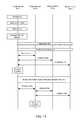
- FIG. 10is a sequence diagram illustrating an embodiment hybrid lateration method by which mobile devices may gain access to the network.
- the MME 410may request user and subscription information from a home subscriber server (HSS) 412 , perform various administrative tasks (e.g., user authentication, enforcement of roaming restrictions, etc.), and send various user and control information to the S-GW 408 .
- the S-GW 408may receive and store the information sent by the MME 410 (e.g., parameters of the IP bearer service, network internal routing information, etc.), generate data packets, and forward the data packets to a packet data network gateway (P-GW) 416 .
- the P-GW 416may process and forward the packets to a policy and control enforcement function (PCEF) 414 which receives the packets and requests charging/control policies for the connection from a policy and charging rules function (PCRF) 415 .
- PCEFpolicy and control enforcement function
- the mobile devicemay identify the relative positions of the other mobile devices, which may be achieve by evaluating the location and sensor information received from the other mobile devices and/or via any or all of the location determination solutions discussed herein.
- the mobile devicemay send the relative location information, its current location information, and/or sensor information to a network component and/or the other mobile devices, which may receive the sensor and location information and compute updated location information (e.g., based on distance in time delay and angle of arrival, relative altitude information, etc.).
- the mobile devicemay receive updated location information from the network component and/or the other grouped mobile devices.
- the systembegins to try and locate the distressed mobiles position with more precision an accuracy to assist First Responders with triangulating on the distressed mobiles position and sending the information to the incident commander and/or public service answering point (PSAP) with a relative distance to target indication that is updated on pre-defined intervals. If the mobile device has lost contact with the 911 center, PSAP then the last location is continuously display and any velocity information is also relayed to assist the first responders.
- PSAPpublic service answering point
- Various embodimentsmay include sensor fusion operations in which a collaborative approach is used so that the sensors do not act as individual sensors, but as a collective team.
- the mobile devicemay include various sensors (e.g., accelerometer, gyros, magnetic compass, altimeters, odometers, etc.) capable of generating heading, orientation, distance traveled, and velocity as part of the sensor information collected on the mobile device.
- information collected from any or all the internal sensorsmay be used for improving location or positioning accuracy and/or confidence improvements.
- Various embodimentsmay compute location information based on information from multiple sensors, with or without the aid of radio frequency propagation information.
- d iis the distance calculated based on a measured signal strength value
- FIG. 12Aillustrates that upon arriving at the incident scene, a mobile device 102 may recognize the existence of a local radio network 1202 . If there is no ICS radio network 1204 with which the mobile device may connect, the mobile device 102 will continue to communicate via a commercial or other wireless network, 1202 .
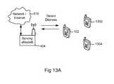
- FIG. 13Aillustrates that the mobile device 102 may be identified by the network as being in distress via network monitoring of the mobile device 102 or via the mobile device transmitting a distress signal.
- the distressed mobile device 102may determine that it has lost communication with the network, and may instruct the wearer/user to either disable or initiate a distress signal.
- the mobile device 102upon initiation of a distress signal, may begin a grouping process previously defined.
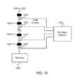
- FIG. 15illustrates an embodiment enhanced antenna scheme 1500 that may be used by wireless network operators or first responders to improve the positional accuracy for the mobile device.
- the enhanced antenna scheme 1500may include a radome 1515 that is curved over a series of patch antennas 1520 . Several antennas 1520 may be used achieve better angle of arrival measurement.
- the enhanced antenna scheme 1500may include an array of antennas 1520 on flexible circuit boards so they can conform to the radome 1515 .
- this enhancementenables mobile devices which are in the same scene to help augment their position coordinates with each other in a controlled ad-hoc environment.
- the positional information sharednot only includes latitude and longitude but also altitude and velocity. Since this information involves a small amount of data the mobile devices can have the E-SMLC in the case of LTE share the information both on net and off-net.
- a general-purpose processormay be a microprocessor, but, in the alternative, the processor may be any conventional processor, controller, microcontroller, or state machine
- a processormay also be implemented as a combination of computing devices, e.g., a combination of a DSP and a microprocessor, a plurality of microprocessors, one or more microprocessors in conjunction with a DSP core, or any other such configuration. Alternatively, some blocks or methods may be performed by circuitry that is specific to a given function.
Landscapes
- Engineering & Computer Science (AREA)
- Radar, Positioning & Navigation (AREA)
- Remote Sensing (AREA)
- Computer Networks & Wireless Communication (AREA)
- Signal Processing (AREA)
- Physics & Mathematics (AREA)
- General Physics & Mathematics (AREA)
- Emergency Management (AREA)
- Business, Economics & Management (AREA)
- Environmental & Geological Engineering (AREA)
- Human Computer Interaction (AREA)
- Multimedia (AREA)
- Automation & Control Theory (AREA)
- Health & Medical Sciences (AREA)
- Public Health (AREA)
- Electromagnetism (AREA)
- Telephone Function (AREA)
- Position Fixing By Use Of Radio Waves (AREA)
- Telephonic Communication Services (AREA)
- Mobile Radio Communication Systems (AREA)
- Navigation (AREA)
Abstract
Description
r=pi+error
ri=√(Xi−x)2+(Yi−y)2+(Zi−z)2
Range difference=dij=ri−rj
di=√(S0/Sii)
where:
RSSIi=a−cblog10(di)
where:
min(x,y)Σ(di−∥MSi−(x, y)∥)2
where:
Claims (39)
Priority Applications (38)
| Application Number | Priority Date | Filing Date | Title |
|---|---|---|---|
| US13/585,125US8787944B2 (en) | 2011-08-18 | 2012-08-14 | Method and system for providing enhanced location based information for wireless handsets |
| AU2012296566AAU2012296566B2 (en) | 2011-08-18 | 2012-08-15 | Method and system for providing enhanced location based information for wireless handsets |
| KR1020147007076AKR101469429B1 (en) | 2011-08-18 | 2012-08-15 | Method and system for providing enhanced location based information for wireless handsets |
| RU2014109421/07ARU2571825C2 (en) | 2011-08-18 | 2012-08-15 | Method and system for providing enhanced location information for wireless mobile devices |
| CA2843913ACA2843913C (en) | 2011-08-18 | 2012-08-15 | Method and system for providing enhanced location based information for wireless handsets |
| MX2014001745AMX2014001745A (en) | 2011-08-18 | 2012-08-15 | Method and system for providing enhanced location based information for wireless handsets. |
| JP2014526179AJP5856675B2 (en) | 2011-08-18 | 2012-08-15 | Method and system for providing advanced location-based information to a wireless handset |
| CN201280050710.4ACN104025677B (en) | 2011-08-18 | 2012-08-15 | Method and System for Providing Enhanced Location Based Information for Wireless Handsets |
| HK15101016.1AHK1200635B (en) | 2011-08-18 | 2012-08-15 | Method and system for providing enhanced location based information for wireless handsets |
| EP12824068.6AEP2745585A4 (en) | 2011-08-18 | 2012-08-15 | Method and system for providing enhanced location based information for wireless handsets |
| PCT/US2012/050981WO2013025824A1 (en) | 2011-08-18 | 2012-08-15 | Method and system for providing enhanced location based information for wireless handsets |
| US14/293,056US9232354B2 (en) | 2011-08-18 | 2014-06-02 | Method and system for providing enhanced location based information for wireless handsets |
| US14/690,713US9173065B2 (en) | 2011-08-18 | 2015-04-20 | Method and system for providing enhanced location based information for wireless handsets |
| US14/735,210US9258675B2 (en) | 2011-08-18 | 2015-06-10 | Method and system for providing enhanced location based information for wireless handsets using dead reckoning |
| US14/823,294US9253602B2 (en) | 2011-08-18 | 2015-08-11 | Method and system for providing enhanced location based information for wireless handsets |
| US14/823,244US9332386B2 (en) | 2011-08-18 | 2015-08-11 | Method and system for providing enhanced location based information for wireless handsets |
| US14/834,790US9351112B2 (en) | 2011-08-18 | 2015-08-25 | Method and system for providing enhanced location based information for wireless handsets |
| US14/834,758US9338608B2 (en) | 2011-08-18 | 2015-08-25 | Method and system for providing enhanced location based information for wireless handsets |
| US14/950,595US9344848B2 (en) | 2011-08-18 | 2015-11-24 | Method and system for providing enhanced location based information for wireless handsets |
| US14/951,662US9538498B2 (en) | 2011-08-18 | 2015-11-25 | Method and system for providing enhanced location based information for wireless handsets using dead reckoning |
| US14/961,088US9568585B2 (en) | 2011-08-18 | 2015-12-07 | Method and system for providing enhanced location based service (ELBS) trilateration using a single device |
| US14/963,989US9641978B2 (en) | 2011-08-18 | 2015-12-09 | Method and system for providing enhanced location based information for wireless handsets |
| US14/993,618US9485623B2 (en) | 2011-08-18 | 2016-01-12 | Method and system for providing enhanced location based trilateration |
| US15/083,760US9609616B2 (en) | 2011-08-18 | 2016-03-29 | Method and system for providing enhanced location based information for wireless handsets |
| US15/131,124US9538499B2 (en) | 2011-08-18 | 2016-04-18 | Method and system for providing enhanced location based information for wireless handsets |
| US15/284,806US9723453B2 (en) | 2011-08-18 | 2016-10-04 | Method and system for providing enhanced location based trilateration |
| US15/345,441US9838997B2 (en) | 2011-08-18 | 2016-11-07 | Method and system for enhanced location based information for fixed platforms |
| US15/362,046US9774999B2 (en) | 2011-08-18 | 2016-11-28 | Method and system for providing enhanced location based information for wireless handsets |
| US15/361,966US9860868B2 (en) | 2011-08-18 | 2016-11-28 | Method and system for providing enhanced location based information for wireless handsets using dead reckoning |
| US15/392,171US9843900B2 (en) | 2011-08-18 | 2016-12-28 | Method and system for providing enhanced location based service (ELBS) trilateration using a single device |
| US15/431,274US10057721B2 (en) | 2011-08-18 | 2017-02-13 | Method and system for providing enhanced location based information for wireless handsets |
| US15/434,024US20170164315A1 (en) | 2011-08-18 | 2017-02-15 | Method and System for Performing Trilateration for Fixed Infrastructure Nodes (FIN) Based On Enhanced Location Based Information |
| US15/434,017US9877299B2 (en) | 2011-08-18 | 2017-02-15 | Method and system for performing trilateration for fixed infrastructure nodes (FIN) based on enhanced location based information |
| US15/455,101US20170238136A1 (en) | 2011-08-18 | 2017-03-09 | Method and System for Improving the Location of Fixed Wireless CBSD Nodes |
| US15/455,092US10237688B2 (en) | 2011-08-18 | 2017-03-09 | Method and system for improving the location of fixed wireless CBSD nodes |
| US15/463,599US20170195843A1 (en) | 2011-08-18 | 2017-03-20 | Method and System for Providing Enhanced Location Based Information for Wireless Handsets |
| US15/465,781US10045153B2 (en) | 2011-08-18 | 2017-03-22 | Enhanced location based information enabling self-realized leases |
| US15/630,589US20170295461A1 (en) | 2011-08-18 | 2017-06-22 | Method and System for Providing Enhanced Location Based Trilateration |
Applications Claiming Priority (3)
| Application Number | Priority Date | Filing Date | Title |
|---|---|---|---|
| US201161575300P | 2011-08-18 | 2011-08-18 | |
| US201161573636P | 2011-09-09 | 2011-09-09 | |
| US13/585,125US8787944B2 (en) | 2011-08-18 | 2012-08-14 | Method and system for providing enhanced location based information for wireless handsets |
Related Child Applications (1)
| Application Number | Title | Priority Date | Filing Date |
|---|---|---|---|
| US14/293,056ContinuationUS9232354B2 (en) | 2011-08-18 | 2014-06-02 | Method and system for providing enhanced location based information for wireless handsets |
Publications (2)
| Publication Number | Publication Date |
|---|---|
| US20130045759A1 US20130045759A1 (en) | 2013-02-21 |
| US8787944B2true US8787944B2 (en) | 2014-07-22 |
Family
ID=47713009
Family Applications (18)
| Application Number | Title | Priority Date | Filing Date |
|---|---|---|---|
| US13/585,125ActiveUS8787944B2 (en) | 2011-08-18 | 2012-08-14 | Method and system for providing enhanced location based information for wireless handsets |
| US14/293,056ActiveUS9232354B2 (en) | 2011-08-18 | 2014-06-02 | Method and system for providing enhanced location based information for wireless handsets |
| US14/690,713Active - ReinstatedUS9173065B2 (en) | 2011-08-18 | 2015-04-20 | Method and system for providing enhanced location based information for wireless handsets |
| US14/735,210ActiveUS9258675B2 (en) | 2011-08-18 | 2015-06-10 | Method and system for providing enhanced location based information for wireless handsets using dead reckoning |
| US14/823,294ActiveUS9253602B2 (en) | 2011-08-18 | 2015-08-11 | Method and system for providing enhanced location based information for wireless handsets |
| US14/823,244ActiveUS9332386B2 (en) | 2011-08-18 | 2015-08-11 | Method and system for providing enhanced location based information for wireless handsets |
| US14/834,790ActiveUS9351112B2 (en) | 2011-08-18 | 2015-08-25 | Method and system for providing enhanced location based information for wireless handsets |
| US14/834,758Active - ReinstatedUS9338608B2 (en) | 2011-08-18 | 2015-08-25 | Method and system for providing enhanced location based information for wireless handsets |
| US14/950,595Active - ReinstatedUS9344848B2 (en) | 2011-08-18 | 2015-11-24 | Method and system for providing enhanced location based information for wireless handsets |
| US14/951,662ActiveUS9538498B2 (en) | 2011-08-18 | 2015-11-25 | Method and system for providing enhanced location based information for wireless handsets using dead reckoning |
| US14/961,088ActiveUS9568585B2 (en) | 2011-08-18 | 2015-12-07 | Method and system for providing enhanced location based service (ELBS) trilateration using a single device |
| US15/083,760ActiveUS9609616B2 (en) | 2011-08-18 | 2016-03-29 | Method and system for providing enhanced location based information for wireless handsets |
| US15/131,124ActiveUS9538499B2 (en) | 2011-08-18 | 2016-04-18 | Method and system for providing enhanced location based information for wireless handsets |
| US15/345,441ActiveUS9838997B2 (en) | 2011-08-18 | 2016-11-07 | Method and system for enhanced location based information for fixed platforms |
| US15/362,046Active2032-10-10US9774999B2 (en) | 2011-08-18 | 2016-11-28 | Method and system for providing enhanced location based information for wireless handsets |
| US15/361,966ActiveUS9860868B2 (en) | 2011-08-18 | 2016-11-28 | Method and system for providing enhanced location based information for wireless handsets using dead reckoning |
| US15/392,171ActiveUS9843900B2 (en) | 2011-08-18 | 2016-12-28 | Method and system for providing enhanced location based service (ELBS) trilateration using a single device |
| US15/431,274ActiveUS10057721B2 (en) | 2011-08-18 | 2017-02-13 | Method and system for providing enhanced location based information for wireless handsets |
Family Applications After (17)
| Application Number | Title | Priority Date | Filing Date |
|---|---|---|---|
| US14/293,056ActiveUS9232354B2 (en) | 2011-08-18 | 2014-06-02 | Method and system for providing enhanced location based information for wireless handsets |
| US14/690,713Active - ReinstatedUS9173065B2 (en) | 2011-08-18 | 2015-04-20 | Method and system for providing enhanced location based information for wireless handsets |
| US14/735,210ActiveUS9258675B2 (en) | 2011-08-18 | 2015-06-10 | Method and system for providing enhanced location based information for wireless handsets using dead reckoning |
| US14/823,294ActiveUS9253602B2 (en) | 2011-08-18 | 2015-08-11 | Method and system for providing enhanced location based information for wireless handsets |
| US14/823,244ActiveUS9332386B2 (en) | 2011-08-18 | 2015-08-11 | Method and system for providing enhanced location based information for wireless handsets |
| US14/834,790ActiveUS9351112B2 (en) | 2011-08-18 | 2015-08-25 | Method and system for providing enhanced location based information for wireless handsets |
| US14/834,758Active - ReinstatedUS9338608B2 (en) | 2011-08-18 | 2015-08-25 | Method and system for providing enhanced location based information for wireless handsets |
| US14/950,595Active - ReinstatedUS9344848B2 (en) | 2011-08-18 | 2015-11-24 | Method and system for providing enhanced location based information for wireless handsets |
| US14/951,662ActiveUS9538498B2 (en) | 2011-08-18 | 2015-11-25 | Method and system for providing enhanced location based information for wireless handsets using dead reckoning |
| US14/961,088ActiveUS9568585B2 (en) | 2011-08-18 | 2015-12-07 | Method and system for providing enhanced location based service (ELBS) trilateration using a single device |
| US15/083,760ActiveUS9609616B2 (en) | 2011-08-18 | 2016-03-29 | Method and system for providing enhanced location based information for wireless handsets |
| US15/131,124ActiveUS9538499B2 (en) | 2011-08-18 | 2016-04-18 | Method and system for providing enhanced location based information for wireless handsets |
| US15/345,441ActiveUS9838997B2 (en) | 2011-08-18 | 2016-11-07 | Method and system for enhanced location based information for fixed platforms |
| US15/362,046Active2032-10-10US9774999B2 (en) | 2011-08-18 | 2016-11-28 | Method and system for providing enhanced location based information for wireless handsets |
| US15/361,966ActiveUS9860868B2 (en) | 2011-08-18 | 2016-11-28 | Method and system for providing enhanced location based information for wireless handsets using dead reckoning |
| US15/392,171ActiveUS9843900B2 (en) | 2011-08-18 | 2016-12-28 | Method and system for providing enhanced location based service (ELBS) trilateration using a single device |
| US15/431,274ActiveUS10057721B2 (en) | 2011-08-18 | 2017-02-13 | Method and system for providing enhanced location based information for wireless handsets |
Country Status (10)
| Country | Link |
|---|---|
| US (18) | US8787944B2 (en) |
| EP (1) | EP2745585A4 (en) |
| JP (1) | JP5856675B2 (en) |
| KR (1) | KR101469429B1 (en) |
| CN (1) | CN104025677B (en) |
| AU (1) | AU2012296566B2 (en) |
| CA (1) | CA2843913C (en) |
| MX (1) | MX2014001745A (en) |
| RU (1) | RU2571825C2 (en) |
| WO (4) | WO2013025824A1 (en) |
Cited By (34)
| Publication number | Priority date | Publication date | Assignee | Title |
|---|---|---|---|---|
| US20120190369A1 (en)* | 2009-09-30 | 2012-07-26 | International Business Machines Corporation | Method and system for determining position of moving wireless communication |
| US20160100290A1 (en)* | 2011-08-18 | 2016-04-07 | Rivada Research, Llc | Method and System for Providing Enhanced Location Based Information for Wireless Handsets |
| US20160099862A1 (en)* | 2014-10-01 | 2016-04-07 | Allied Telesis Holdings Kabushiki Kaisha | Redundant network formation |
| US20160286624A1 (en)* | 2012-11-30 | 2016-09-29 | Enlighted, Inc. | Associating information with an asset or a physical space |
| US9544264B1 (en)* | 2016-03-22 | 2017-01-10 | International Business Machines Corporation | Augmenting location of social media posts based on proximity of other posts |
| US9557404B1 (en)* | 2013-03-20 | 2017-01-31 | Iotera, Inc. | Circuit and antenna design for small form factor internet of things devices |
| US20170127495A1 (en)* | 2012-11-30 | 2017-05-04 | Enlighted, Inc. | Distributed light fixture beacon management |
| US20170188327A1 (en)* | 2016-09-16 | 2017-06-29 | Nextnav, Llc | Systems and methods for transmitting information used to estimate a position of a mobile device |
| US9730026B2 (en) | 2014-10-13 | 2017-08-08 | Motorola Solutions, Inc. | Method and apparatus for forming communication group based on location history |
| US9756549B2 (en) | 2014-03-14 | 2017-09-05 | goTenna Inc. | System and method for digital communication between computing devices |
| US20170276762A1 (en)* | 2014-10-29 | 2017-09-28 | Thandisizwe Ezwenilethu Pama | Geospatial location verification |
| US9794729B2 (en) | 2013-12-06 | 2017-10-17 | Apple Inc. | Mobile device sensor data subscribing and sharing |
| US9826364B2 (en)* | 2015-04-03 | 2017-11-21 | Qualcomm Incorporated | Systems and methods for location-based tuning |
| US9838838B2 (en) | 2015-06-05 | 2017-12-05 | Apple Inc. | Location determination using a companion device |
| US9942719B2 (en)* | 2016-08-26 | 2018-04-10 | Qualcomm Incorporated | OTDOA positioning via local wireless transmitters |
| US9973887B2 (en)* | 2016-01-21 | 2018-05-15 | Google Llc | Sharing navigation data among co-located computing devices |
| US10178737B2 (en) | 2016-04-02 | 2019-01-08 | Enlighted, Inc. | Monitoring occupancy of a desktop with a desktop apparatus |
| US10267891B1 (en) | 2017-09-27 | 2019-04-23 | The United States Of America As Represented By The Secretary Of The Air Force | Rapid transfer of GNSS information from advantaged platform |
| US10277727B2 (en) | 2010-08-03 | 2019-04-30 | Enlighted, Inc. | Distributed network of a structure that provides location-based human interaction and intelligence |
| US10306449B2 (en) | 2016-08-26 | 2019-05-28 | Intrinsic Value, Llc | Systems, devices, and methods for emergency responses and safety |
| US10311304B2 (en) | 2017-02-07 | 2019-06-04 | International Business Machines Corporation | Mobile device accident avoidance system |
| WO2019111216A1 (en)* | 2017-12-08 | 2019-06-13 | Fisher & Paykel Healthcare Limited | Medical device location tracking |
| US10359503B2 (en)* | 2015-02-03 | 2019-07-23 | Nec Corporation | Position estimation apparatus, position estimation system, position estimation method and recording medium for position estimation |
| US10506413B2 (en) | 2017-08-28 | 2019-12-10 | Intrinsic Value, Llc | Systems, devices, and methods for emergency responses and safety |
| US10939486B2 (en) | 2016-06-10 | 2021-03-02 | Apple Inc. | Location source control |
| US10944669B1 (en) | 2018-02-09 | 2021-03-09 | GoTenna, Inc. | System and method for efficient network-wide broadcast in a multi-hop wireless network using packet echos |
| US11082344B2 (en) | 2019-03-08 | 2021-08-03 | GoTenna, Inc. | Method for utilization-based traffic throttling in a wireless mesh network |
| US11259165B2 (en) | 2016-08-26 | 2022-02-22 | Intrinsic Value, Llc | Systems, devices, and methods for emergency responses and safety |
| US11392658B2 (en) | 2019-02-06 | 2022-07-19 | Blind Insites, Llc. | Methods and systems for wireless acquisition and presentation of local spatial information |
| US11627549B2 (en) | 2020-12-10 | 2023-04-11 | Nokia Technologies Oy | Associating sensing information with a user |
| US20230194696A1 (en)* | 2021-12-21 | 2023-06-22 | Continental Automotive Gmbh | Method for locating a communication device in proximity to a vehicle |
| US11811642B2 (en) | 2018-07-27 | 2023-11-07 | GoTenna, Inc. | Vine™: zero-control routing using data packet inspection for wireless mesh networks |
| US11902894B2 (en) | 2020-12-10 | 2024-02-13 | Nokia Technologies Oy | Determining radio frequency (RF) conditions using sensing information |
| US12021941B2 (en) | 2021-10-27 | 2024-06-25 | Industrial Technology Research Institute | Method for obtaining enrichment information and controller |
Families Citing this family (352)
| Publication number | Priority date | Publication date | Assignee | Title |
|---|---|---|---|---|
| US9501669B2 (en) | 2004-12-17 | 2016-11-22 | Intel Corporation | Method and apparatus for location-based recovery of stolen mobile devices |
| US8261345B2 (en) | 2006-10-23 | 2012-09-04 | Endeavors Technologies, Inc. | Rule-based application access management |
| US8892738B2 (en) | 2007-11-07 | 2014-11-18 | Numecent Holdings, Inc. | Deriving component statistics for a stream enabled application |
| EP3086619A1 (en) | 2008-09-10 | 2016-10-26 | Nextnav, LLC | Wide area positioning system |
| US9035829B2 (en) | 2008-09-10 | 2015-05-19 | Nextnav, Llc | Wide area positioning systems and methods |
| US9119165B2 (en) | 2009-09-10 | 2015-08-25 | Nextnav, Llc | Coding in a wide area positioning system (WAPS) |
| US9057606B2 (en) | 2009-09-10 | 2015-06-16 | Nextnav, Llc | Wide area positioning system |
| US9291712B2 (en) | 2009-09-10 | 2016-03-22 | Nextnav, Llc | Cell organization and transmission schemes in a wide area positioning system (WAPS) |
| US9372266B2 (en) | 2009-09-10 | 2016-06-21 | Nextnav, Llc | Cell organization and transmission schemes in a wide area positioning system (WAPS) |
| US9247377B2 (en) | 2011-05-23 | 2016-01-26 | Apple Inc. | Setting a reminder that is triggered by a target user device |
| US10715380B2 (en) | 2011-05-23 | 2020-07-14 | Apple Inc. | Setting a reminder that is triggered by a target user device |
| US8971924B2 (en) | 2011-05-23 | 2015-03-03 | Apple Inc. | Identifying and locating users on a mobile network |
| US8676938B2 (en) | 2011-06-28 | 2014-03-18 | Numecent Holdings, Inc. | Local streaming proxy server |
| US9176217B2 (en) | 2011-08-02 | 2015-11-03 | Nextnav, Llc | Cell organization and transmission schemes in a wide area positioning system (WAPS) |
| EP4101399B1 (en) | 2011-08-05 | 2025-04-09 | Route 92 Medical, Inc. | System for treatment of acute ischemic stroke |
| US10779855B2 (en) | 2011-08-05 | 2020-09-22 | Route 92 Medical, Inc. | Methods and systems for treatment of acute ischemic stroke |
| US9485623B2 (en) | 2011-08-18 | 2016-11-01 | Rivada Research, Llc | Method and system for providing enhanced location based trilateration |
| US10237688B2 (en) | 2011-08-18 | 2019-03-19 | Rivada Research, Llc | Method and system for improving the location of fixed wireless CBSD nodes |
| US8787944B2 (en)* | 2011-08-18 | 2014-07-22 | Rivada Research, Llc | Method and system for providing enhanced location based information for wireless handsets |
| US10045153B2 (en) | 2011-08-18 | 2018-08-07 | Rivada Research, Llc | Enhanced location based information enabling self-realized leases |
| US9877299B2 (en) | 2011-08-18 | 2018-01-23 | Rivada Research, Llc | Method and system for performing trilateration for fixed infrastructure nodes (FIN) based on enhanced location based information |
| US20170164315A1 (en)* | 2011-08-18 | 2017-06-08 | Rivada Research, Llc | Method and System for Performing Trilateration for Fixed Infrastructure Nodes (FIN) Based On Enhanced Location Based Information |
| US20130150002A1 (en)* | 2011-10-21 | 2013-06-13 | Point Inside, Inc. | Identify a Radio Frequency Device by MAC Address System and Method |
| US20130281062A1 (en)* | 2011-10-21 | 2013-10-24 | Point Inside, Inc. | Identify a radio frequency device by mac address system and method |
| US9191756B2 (en)* | 2012-01-06 | 2015-11-17 | Iii Holdings 4, Llc | System and method for locating a hearing aid |
| US9386057B2 (en) | 2012-01-18 | 2016-07-05 | Numecent Holdings, Inc. | Application streaming and execution system for localized clients |
| EP2810486B1 (en)* | 2012-01-31 | 2019-07-10 | Nokia Solutions and Networks Oy | Permitting direct mode communications for public safety only in certain geographical areas |
| CN102595317B (en)* | 2012-02-27 | 2015-11-18 | 歌尔声学股份有限公司 | A kind of communication signal self-adapting transmission method and system |
| US9315004B2 (en) | 2012-03-06 | 2016-04-19 | Apple Inc. | Accessory units for consumer electronic devices and related assemblies and methods |
| CN102595322B (en)* | 2012-03-19 | 2018-11-30 | Vid拓展公司 | Method and device for reminding user by using mobile terminal based on set position |
| WO2013144760A1 (en)* | 2012-03-29 | 2013-10-03 | Ramot At Tel-Aviv University Ltd | Localization, synchronization and navigation using passive sensor networks |
| US9936363B2 (en)* | 2013-04-19 | 2018-04-03 | Key2mobile LLC | Multi-standard in building mobile radio access network |
| US9485304B2 (en) | 2012-04-30 | 2016-11-01 | Numecent Holdings, Inc. | Asset streaming and delivery |
| EP2667280A1 (en)* | 2012-05-23 | 2013-11-27 | Nxp B.V. | Device Control System And Method Of Determining Altitude |
| US8781507B2 (en)* | 2012-06-01 | 2014-07-15 | Qualcomm Incorporated | Obtaining timing of LTE wireless base stations using aggregated OTDOA assistance data |
| US8954089B2 (en) | 2012-06-01 | 2015-02-10 | Qualcomm Incorporated | Positioning LTE wireless base stations using aggregated OTDOA assistance data |
| WO2013184701A1 (en) | 2012-06-05 | 2013-12-12 | Arun Raghupathy | Systems and methods for location positioning of user device |
| US20130325924A1 (en)* | 2012-06-05 | 2013-12-05 | Mehran Moshfeghi | Method and system for server-assisted remote probing and data collection in a cloud computing environment |
| US9063208B2 (en)* | 2012-06-07 | 2015-06-23 | Walkbase Oy | Assisted global navigation satellite system for indoor positioning |
| KR101895455B1 (en)* | 2012-06-19 | 2018-10-04 | 삼성전자주식회사 | Method and apparatus for providing semantic location in electronic device |
| US8953841B1 (en)* | 2012-09-07 | 2015-02-10 | Amazon Technologies, Inc. | User transportable device with hazard monitoring |
| US9390279B2 (en) | 2012-09-11 | 2016-07-12 | Nextnav, Llc | Systems and methods for providing conditional access to transmitted information |
| US9286490B2 (en) | 2013-09-10 | 2016-03-15 | Nextnav, Llc | Systems and methods for providing conditional access to transmitted information |
| KR20140033858A (en)* | 2012-09-11 | 2014-03-19 | 삼성전자주식회사 | Method for providing service of estimating location based on change of state of user terminal and the user terminal thereof |
| WO2014043277A2 (en) | 2012-09-11 | 2014-03-20 | Numecent Holdings Ltd. | Application streaming using pixel streaming |
| US20160307155A1 (en)* | 2012-09-21 | 2016-10-20 | General Electric Company | Routing device for network optimization |
| US9282436B2 (en) | 2012-10-17 | 2016-03-08 | Cellco Partnership | Method and system for adaptive location determination for mobile device |
| US9295087B2 (en) | 2012-10-17 | 2016-03-22 | Cellco Partnership | Mobile device smart button that adapts to device status |
| US10021528B2 (en)* | 2012-11-26 | 2018-07-10 | Red Hat, Inc. | Providing specification of a location of a communication device |
| US9496971B2 (en)* | 2012-12-10 | 2016-11-15 | Qualcomm Incorporated | Techniques for determining actual and/or near states of proximity between mobile devices |
| JP2014120799A (en)* | 2012-12-13 | 2014-06-30 | Panasonic Corp | Locator system, portable information terminal, and locator |
| WO2014109694A2 (en)* | 2013-01-09 | 2014-07-17 | Telefonaktiebolaget L M Ericsson (Publ) | Supporting and enhancing image-based positioning |
| US9661048B2 (en)* | 2013-01-18 | 2017-05-23 | Numecent Holding, Inc. | Asset streaming and delivery |
| US8989773B2 (en) | 2013-01-29 | 2015-03-24 | Apple Inc. | Sharing location information among devices |
| US9549288B2 (en) | 2013-02-07 | 2017-01-17 | Qualcomm Incorporated | Determination of differential forward link calibration in LTE networks for positioning |
| US9237417B2 (en) | 2013-02-07 | 2016-01-12 | Qualcomm Incorporated | Terrestrial positioning system calibration |
| US20140279658A1 (en) | 2013-03-12 | 2014-09-18 | United Parcel Service Of America, Inc. | Systems and methods of suggesting attended delivery/pickup locations |
| US20140278838A1 (en)* | 2013-03-14 | 2014-09-18 | Uber Technologies, Inc. | Determining an amount for a toll based on location data points provided by a computing device |
| US20140349637A1 (en)* | 2013-03-15 | 2014-11-27 | Elwha LLC, a limited liability corporation of the State of Delaware | Facilitating wireless communication in conjunction with orientation position |
| US9491637B2 (en) | 2013-03-15 | 2016-11-08 | Elwha Llc | Portable wireless node auxiliary relay |
| US9198002B2 (en)* | 2013-03-15 | 2015-11-24 | Microsoft Technology Licensing, Llc | Peer-to-peer device movement communications |
| US9793596B2 (en) | 2013-03-15 | 2017-10-17 | Elwha Llc | Facilitating wireless communication in conjunction with orientation position |
| US9681311B2 (en) | 2013-03-15 | 2017-06-13 | Elwha Llc | Portable wireless node local cooperation |
| US10530051B2 (en)* | 2013-03-15 | 2020-01-07 | 3Z Telecom, Inc. | Antenna alignment device and methods for aligning antennas |
| US9608862B2 (en)* | 2013-03-15 | 2017-03-28 | Elwha Llc | Frequency accommodation |
| WO2014182313A1 (en)* | 2013-05-10 | 2014-11-13 | Empire Technology Development Llc | Estimation of missed information |
| US9629020B2 (en) | 2013-05-28 | 2017-04-18 | Rivada Networks, Llc | Methods and systems for data context and management via dynamic spectrum controller and dynamic spectrum policy controller |
| US9648545B2 (en) | 2013-05-28 | 2017-05-09 | Rivada Networks, Llc | Methods and system for dynamic spectrum arbitrage policy driven quality of service |
| US9736018B2 (en) | 2013-05-28 | 2017-08-15 | Rivada Networks, Llc | Method and system for a flexible dynamic spectrum arbitrage system |
| US9226193B2 (en) | 2013-05-28 | 2015-12-29 | Rivada Networks, Llc | Methods and systems for performing dynamic spectrum arbitrage based on eNodeB transition states |
| US20140358759A1 (en) | 2013-05-28 | 2014-12-04 | Rivada Networks, Llc | Interfacing between a Dynamic Spectrum Policy Controller and a Dynamic Spectrum Controller |
| US9338704B2 (en)* | 2013-05-28 | 2016-05-10 | Rivada Networks, Llc | Methods and systems for intelligent selection of devices for handins |
| US9094899B2 (en) | 2013-05-28 | 2015-07-28 | Rivada Networks, Llc | Cell selection in dynamic spectrum arbitrage system |
| US9203714B2 (en) | 2013-05-29 | 2015-12-01 | Rivada Networks, Llc | Methods and systems for dynamic spectrum arbitrage with home eNodeBs |
| US9094958B2 (en) | 2013-05-29 | 2015-07-28 | Rivada Networks, Llc | Methods and systems for dynamic spectrum arbitrage user profile management |
| US10390231B2 (en) | 2013-05-29 | 2019-08-20 | Rivada Networks, Llc | Methods and systems for using location based service information to enable self-realized leases |
| US9357469B2 (en) | 2013-05-29 | 2016-05-31 | Rivada Networks, Llc | Methods and system for dynamic spectrum arbitrage with mobility management |
| US20140358434A1 (en)* | 2013-06-02 | 2014-12-04 | Hangzhou Haicun Information Technology Co. Ltd. | Peer-Assisted Dead Reckoning |
| BR112015031865A2 (en) | 2013-06-19 | 2017-07-25 | Zoll Medical Corp | systems and methods of determining location using a medical device |
| US9648458B2 (en)* | 2013-07-03 | 2017-05-09 | Qualcomm Incorporated | Systems and methods for labeling crowd sourced data |
| EP3008965A4 (en)* | 2013-07-12 | 2016-11-16 | Mediatek Singapore Pte Ltd | Method of channel access control in wireless local area networks |
| JP6211846B2 (en)* | 2013-07-31 | 2017-10-11 | 株式会社Nttドコモ | Mobile station |
| US10101789B2 (en)* | 2013-08-08 | 2018-10-16 | Honeywell International Inc. | Battery management in wireless mesh networks |
| CN105492925B (en)* | 2013-08-29 | 2017-08-15 | Lg电子株式会社 | Method and device for measuring distance between terminals based on device-to-device direct communication in wireless communication system |
| US10469982B2 (en)* | 2013-09-11 | 2019-11-05 | Invensense, Inc. | System and method for enhanced integrated navigation with wireless angle of arrival |
| US9755802B2 (en)* | 2013-09-25 | 2017-09-05 | Collision Communications, Inc. | Methods, systems, and computer program products for parameter estimation based on historical context information |
| US20150092048A1 (en) | 2013-09-27 | 2015-04-02 | Qualcomm Incorporated | Off-Target Tracking Using Feature Aiding in the Context of Inertial Navigation |
| US9332476B2 (en)* | 2013-10-04 | 2016-05-03 | Blackberry Limited | Method and apparatus to correct indoor positioning by utilizing Wi-Fi handovers |
| US9807724B2 (en) | 2013-10-08 | 2017-10-31 | Gozio Inc. | Use of RF-based fingerprinting for indoor positioning by mobile technology platforms |
| US10244362B2 (en) | 2013-10-08 | 2019-03-26 | Gozio Inc. | Use of RF-based fingerprinting for indoor positioning by mobile technology platforms |
| WO2015057734A2 (en) | 2013-10-14 | 2015-04-23 | United Parcel Service Of America, Inc. | Systems and methods for confirming an identity of an indivdiual, for example, at a locker bank |
| US20150116161A1 (en) | 2013-10-28 | 2015-04-30 | Skycross, Inc. | Antenna structures and methods thereof for determining a frequency offset based on a signal magnitude measurement |
| US9986529B2 (en) | 2013-11-12 | 2018-05-29 | Qualcomm Incorporated | Methods and apparatuses for use in determining an altitude of a mobile device |
| US9781106B1 (en)* | 2013-11-20 | 2017-10-03 | Knowles Electronics, Llc | Method for modeling user possession of mobile device for user authentication framework |
| US9699756B2 (en)* | 2013-11-25 | 2017-07-04 | At&T Mobility Ii Llc | Methods, devices, and computer readable storage devices for collecting and reporting location data with a high accuracy |
| US9106519B1 (en) | 2013-12-20 | 2015-08-11 | Sprint Communications Company L.P. | Wireless communication system for determining user equipment quality of service |
| US9265512B2 (en) | 2013-12-23 | 2016-02-23 | Silk Road Medical, Inc. | Transcarotid neurovascular catheter |
| FR3016446B1 (en)* | 2014-01-13 | 2018-11-16 | Etienne Vautherin | METHOD FOR TELETRANSMISSION OF INFORMATION |
| US9602962B2 (en)* | 2014-01-15 | 2017-03-21 | Qualcomm Incorporated | Methods and systems for providing location based services in a venue using femtocells |
| US10386454B2 (en)* | 2014-02-07 | 2019-08-20 | Signify Holding B.V. | Network centric localization for determining the location of mobile devices |
| JP6430125B2 (en)* | 2014-02-14 | 2018-11-28 | 三菱重工機械システム株式会社 | Position detection system and position detection method of position detection system |
| US9817101B2 (en)* | 2014-02-24 | 2017-11-14 | Skyhook Wireless, Inc. | Certified location for mobile devices |
| US20150281901A1 (en)* | 2014-03-26 | 2015-10-01 | Approach Me, Inc | System and method for locating people |
| US9369982B2 (en)* | 2014-03-28 | 2016-06-14 | Intel Corporation | Online adaptive fusion framework for mobile device indoor localization |
| CN106416309B (en)* | 2014-04-02 | 2020-05-12 | 索尼公司 | Electronic device, mobile terminal and proximity detection method |
| US9877177B2 (en)* | 2014-04-03 | 2018-01-23 | Comcast Cable Communications, Llc | Emergency information delivery |
| CN110191440B (en) | 2014-04-22 | 2024-03-01 | 华为技术有限公司 | D2D communication discovery method, device and system |
| US10382378B2 (en) | 2014-05-31 | 2019-08-13 | Apple Inc. | Live location sharing |
| CA2951993C (en) | 2014-06-12 | 2018-10-30 | Motorola Solutions, Inc. | Methods and systems for automatic creation of talkgroups based on received signal strength indicator (rssi) |
| CN105282841A (en) | 2014-06-12 | 2016-01-27 | 中兴通讯股份有限公司 | Positioning method, positioning device, positioning center and terminal |
| CN107106071B (en) | 2014-07-10 | 2021-09-07 | 穆罕默德·R·马赫福兹 | Bone Reconstruction and Orthopedic Implants |
| US9674698B2 (en) | 2014-07-22 | 2017-06-06 | Nokia Technologies Oy | Method and apparatus for providing an anonymous communication session |
| FR3024318B1 (en) | 2014-07-28 | 2018-03-09 | Ezee World | METHOD FOR LOCATING A RECEIVER DEVICE USING A NETWORK OF AUTONOMOUS RADIO EMITTER DEVICES OF THE BEACON TYPE |
| EP3180633B1 (en)* | 2014-08-12 | 2018-10-10 | Philips Lighting Holding B.V. | Method and apparatus for locating a mobile device |
| CN106662442A (en)* | 2014-08-15 | 2017-05-10 | 索尼公司 | Telecommunications apparatus and methods |
| US9918646B2 (en) | 2014-09-02 | 2018-03-20 | Apple Inc. | Sensor fusion approach to energy expenditure estimation |
| CN105472531A (en)* | 2014-09-05 | 2016-04-06 | 联想(北京)有限公司 | Information processing method and first electronic equipment |
| US9713117B2 (en)* | 2014-09-25 | 2017-07-18 | Intel Corporation | Device-to-device assisted positioning in wireless cellular technologies |
| US20160095092A1 (en)* | 2014-09-25 | 2016-03-31 | Intel Corporation | Resource allocation and use for device-to-device assisted positioning in wireless cellular technologies |
| US9173064B1 (en) | 2014-10-06 | 2015-10-27 | Polaris Wireless, Inc. | Estimating proximity to a mobile station by manipulating an interfering signal |
| CN105578404B (en) | 2014-10-17 | 2021-05-11 | 中兴通讯股份有限公司 | Positioning method and corresponding terminal and system |
| US10212546B2 (en)* | 2014-10-20 | 2019-02-19 | Huawei Technologies Co., Ltd. | Collaborative positioning method and wireless terminal |
| US10260871B1 (en)* | 2014-11-10 | 2019-04-16 | Invensense, Inc. | Trajectory estimation system |
| WO2016080986A1 (en)* | 2014-11-19 | 2016-05-26 | Hewlett-Packard Development Company, L.P. | Tracking a mobile device |
| DE102014223668A1 (en)* | 2014-11-20 | 2016-05-25 | Bayerische Motoren Werke Aktiengesellschaft | Device and method for determining at least one position of a mobile terminal |
| US10177846B2 (en)* | 2014-12-01 | 2019-01-08 | Infineon Technologies Ag | Transceiver device, access control devices, a transmitter device and a receiver device |
| US10122449B2 (en) | 2014-12-01 | 2018-11-06 | Infineon Technologies Ag | Access control devices and a transceiver device |
| TWI556665B (en)* | 2014-12-03 | 2016-11-01 | 楊恆迪 | A mobile information server system |
| US20180011863A1 (en)* | 2014-12-10 | 2018-01-11 | Cyberdor Llc | Geo-based information provision, search and access method and software system |
| US11599593B2 (en)* | 2014-12-10 | 2023-03-07 | Alfred X. Xin | Geo-based information provision, search and access method and software system |
| US20160171543A1 (en)* | 2014-12-10 | 2016-06-16 | Alfred Xueliang Xin | On-site sales and new products advertisements search method and system |
| US10713327B2 (en)* | 2014-12-10 | 2020-07-14 | Alfred X. Xin | Geo-based data provision, search and access system and methods |
| WO2016094681A1 (en)* | 2014-12-10 | 2016-06-16 | Rivada Research LLC | Method and system for providing enhanced location based information for wireless handsets |
| US9641974B2 (en) | 2014-12-10 | 2017-05-02 | Qualcomm Incorporated | Techniques for determining a position fix of an object using one or more mobile devices co-located with the object |
| CN104601800A (en)* | 2014-12-18 | 2015-05-06 | 惠州Tcl移动通信有限公司 | User demand based reminding device and method |
| US10261165B2 (en) | 2014-12-31 | 2019-04-16 | Qualcomm Incorporated | Determining network synchronization status |
| KR102280542B1 (en)* | 2015-01-13 | 2021-07-22 | 삼성전자 주식회사 | Electronic device, Wireless relay device, and Method for providing location information of the wireless relay device |
| EA201791593A8 (en)* | 2015-01-13 | 2018-11-30 | Ривада Ресеч, Ллс | METHOD AND SYSTEM FOR PROVIDING IMPROVED TRILATERATION BASED ON LOCATION |
| CN105988127A (en)* | 2015-01-30 | 2016-10-05 | 上海可鲁系统软件有限公司 | Firefighter indoor positioning device and firefighter indoor positioning method based on compound positioning system |
| TWI602462B (en) | 2015-01-30 | 2017-10-11 | 財團法人資訊工業策進會 | User equipment, device to device user equipment, backhaul device and positioning method thereof |
| GB201501723D0 (en)* | 2015-02-03 | 2015-03-18 | Merino Jose And Wilkinson Simon And Camilleri Michael | Winics |
| CN119949953A (en) | 2015-02-04 | 2025-05-09 | 92号医疗公司 | Intravascular access system, dilator and system including dilator |
| US11065019B1 (en) | 2015-02-04 | 2021-07-20 | Route 92 Medical, Inc. | Aspiration catheter systems and methods of use |
| US10426497B2 (en) | 2015-07-24 | 2019-10-01 | Route 92 Medical, Inc. | Anchoring delivery system and methods |
| US10028084B2 (en) | 2015-02-10 | 2018-07-17 | Qualcomm Incorporated | Adaptive position indicator |
| US9743238B2 (en)* | 2015-02-13 | 2017-08-22 | Qualcomm Incorporated | Proximity based device usage |
| US10244948B2 (en) | 2015-03-06 | 2019-04-02 | Apple Inc. | Statistical heart rate monitoring for estimating calorie expenditure |
| US10376169B2 (en) | 2015-03-24 | 2019-08-13 | Zoll Medical Corporation | Systems and methods of determining location using a medical device |
| US9668100B2 (en) | 2015-04-03 | 2017-05-30 | International Business Machines Corporation | Locating misplaced mobile computing devices |
| US10051684B2 (en)* | 2015-05-04 | 2018-08-14 | Qualcomm Incorporated | Transfer of uncompensated barometric pressure information |
| US10045148B2 (en)* | 2015-06-26 | 2018-08-07 | Intel Corporation | Location-based wireless device presentation and connection |
| US10012719B2 (en)* | 2015-07-31 | 2018-07-03 | At&T Mobility Ii Llc | E911 locating by nearby proxy device location |
| CN107925707B (en)* | 2015-08-10 | 2020-10-20 | 精工爱普生株式会社 | Location information utilization system, gateway device, and wearable device |
| US10334507B2 (en)* | 2015-08-19 | 2019-06-25 | Microsoft Technology Licensing, Llc | Opportunistic use of spectrum |
| US10699594B2 (en) | 2015-09-16 | 2020-06-30 | Apple Inc. | Calculating an estimate of wind resistance experienced by a cyclist |
| US10620232B2 (en) | 2015-09-22 | 2020-04-14 | Apple Inc. | Detecting controllers in vehicles using wearable devices |
| CN105228102A (en)* | 2015-09-25 | 2016-01-06 | 宇龙计算机通信科技(深圳)有限公司 | Wi-Fi localization method, system and mobile terminal |
| US10205731B2 (en) | 2015-09-25 | 2019-02-12 | Microsoft Technology Licensing, Llc | Contextually-aware location sharing services |
| US20170094450A1 (en)* | 2015-09-30 | 2017-03-30 | Apple Inc. | Crowdsourcing activity detection for group activities |
| US10165400B2 (en) | 2015-10-14 | 2018-12-25 | Unified Messaging Systems Asa | Methods and systems for sending location based alert messages |
| US10317243B2 (en)* | 2015-10-15 | 2019-06-11 | Intertrust Technologies Corporation | Sensor information management systems and methods |
| WO2017070543A1 (en)* | 2015-10-21 | 2017-04-27 | Wengrovitz Michael S | Wearable smart router |
| CN108476260A (en) | 2015-11-02 | 2018-08-31 | 快速求救公司 | The method and system of Situation Awareness for emergency response |
| KR101693304B1 (en)* | 2015-11-18 | 2017-01-06 | 한국항공우주연구원 | Apparatus for accuracy position determination and method for accuracy position determination on woodland using thereof |
| CN109416394B (en) | 2015-12-26 | 2023-09-05 | 英特尔公司 | Two-dimensional intruder location detection |
| WO2017116973A1 (en)* | 2015-12-28 | 2017-07-06 | Rivada Research, Llc | Method and system for enhanced location based information for fixed platforms |
| US9869751B2 (en)* | 2016-01-05 | 2018-01-16 | Intel IP Corporation | Two way time of flight positioning and security using eavesdropping |
| US10004010B2 (en)* | 2016-01-08 | 2018-06-19 | Altiostar Networks, Inc. | User equipment selection for detecting physical cell identifier confusion |
| JP6687835B2 (en)* | 2016-02-10 | 2020-04-28 | 株式会社Jvcケンウッド | Mobile terminal device and program |
| WO2017143023A1 (en)* | 2016-02-16 | 2017-08-24 | Rivada Research, Llc | Method and system for performing trilateration for fixed infrastructure nodes (fin) based on enhanced location based information |
| WO2017147493A1 (en) | 2016-02-24 | 2017-08-31 | Incept, Llc | Enhanced flexibility neurovascular catheter |
| US10393856B2 (en) | 2016-02-25 | 2019-08-27 | Honeywell International Inc. | Using bluetooth beacons to automatically update the location within a portable gas detector's logs |
| US9986404B2 (en) | 2016-02-26 | 2018-05-29 | Rapidsos, Inc. | Systems and methods for emergency communications amongst groups of devices based on shared data |
| CN106255055A (en)* | 2016-03-07 | 2016-12-21 | 上海驴徒电子商务有限公司 | A kind of outdoor activities group members based on LBS alignment system management system and method |
| WO2017156368A1 (en)* | 2016-03-11 | 2017-09-14 | Rivada Research, Llc | Method and system for improving the location of fixed wireless cbsd nodes |
| JP6242930B2 (en)* | 2016-03-17 | 2017-12-06 | 株式会社東芝 | Sensor data management device, sensor data management method and program |
| US10694994B2 (en) | 2016-03-22 | 2020-06-30 | Apple Inc. | Techniques for jointly calibrating load and aerobic capacity |
| US11277811B2 (en)* | 2016-03-31 | 2022-03-15 | Sony Group Corporation | Network communication device, user communication device and corresponding methods for determining position of a user communication device in a communication |
| CN107305247B (en)* | 2016-04-25 | 2021-04-20 | 华为技术有限公司 | Channel model formula correction method, device and equipment |
| MX2018013813A (en) | 2016-05-09 | 2019-09-10 | Rapidsos Inc | SYSTEMS AND METHODS FOR EMERGENCY COMMUNICATIONS. |
| US9948733B2 (en)* | 2016-05-09 | 2018-04-17 | Dstillery, Inc. | Evaluating authenticity of geographic data associated with media requests |
| US20170328680A1 (en) | 2016-05-11 | 2017-11-16 | Rivada Research, Llc | Method and System for Using Enhanced Location-Based Information to Guide Munitions |
| US9906914B2 (en)* | 2016-05-11 | 2018-02-27 | Mapsted Corp. | Scalable indoor navigation and positioning systems and methods |
| US10469653B2 (en) | 2016-05-15 | 2019-11-05 | Fmr Llc | Proximity and movement detection of a mobile computing device during a user session |
| US9686644B1 (en)* | 2016-05-15 | 2017-06-20 | Fmr Llc | Geospatial-based detection of mobile computing device movement |
| US9883403B2 (en) | 2016-05-15 | 2018-01-30 | Fmr Llc | Monitoring presence of authorized user during user session based upon mobile computing device motion |
| EP3249358B1 (en)* | 2016-05-25 | 2024-04-24 | Sonos Vox France Sas | Means for identifying stop periods of a device in a location |
| US11959751B2 (en)* | 2016-05-26 | 2024-04-16 | Apple Inc. | Correcting compass view using map data |
| US10687707B2 (en) | 2016-06-07 | 2020-06-23 | Apple Inc. | Detecting activity by a wheelchair user |
| US10282763B1 (en)* | 2016-07-20 | 2019-05-07 | Musa Sulejmani | Queue wait time estimation system |
| US10810636B1 (en) | 2016-07-20 | 2020-10-20 | Musa Sulejmani | Queue wait time estimation |
| EP3279688B1 (en)* | 2016-08-01 | 2021-03-17 | Continental Teves AG & Co. OHG | Method for monitoring the position of a mobile radio interface by means of a vehicle and vehicle |
| PL3497403T3 (en) | 2016-08-11 | 2022-01-10 | Axon Vibe AG | Geo-locating individuals based on a derived social network |
| US10709933B2 (en) | 2016-08-17 | 2020-07-14 | Apple Inc. | Pose and heart rate energy expenditure for yoga |
| GB2553141B (en)* | 2016-08-26 | 2019-12-11 | Raytheon Systems Ltd | Method and apparatus for position estimation |
| US10687752B2 (en) | 2016-08-29 | 2020-06-23 | Apple Inc. | Detecting unmeasurable loads using heart rate and work rate |
| US10600022B2 (en) | 2016-08-31 | 2020-03-24 | United Parcel Service Of America, Inc. | Systems and methods for synchronizing delivery of related parcels via a computerized locker bank |
| US10617912B2 (en) | 2016-08-31 | 2020-04-14 | Apple Inc. | Systems and methods of swimming calorimetry |
| KR102252269B1 (en) | 2016-08-31 | 2021-05-14 | 애플 인크. | Swimming analysis system and method |
| US11896368B2 (en) | 2016-08-31 | 2024-02-13 | Apple Inc. | Systems and methods for determining swimming metrics |
| US10512406B2 (en) | 2016-09-01 | 2019-12-24 | Apple Inc. | Systems and methods for determining an intensity level of an exercise using photoplethysmogram (PPG) |
| EP3293535A1 (en)* | 2016-09-07 | 2018-03-14 | Danmarks Tekniske Universitet | Method for determining localisation and/or velocity information of one or more portable devices |
| US10650621B1 (en) | 2016-09-13 | 2020-05-12 | Iocurrents, Inc. | Interfacing with a vehicular controller area network |
| US10655961B2 (en)* | 2016-09-16 | 2020-05-19 | Nextnav, Llc | Systems and methods for determining an altitude error value associated with an estimated altitude of a mobile device |
| US10003658B2 (en) | 2016-09-19 | 2018-06-19 | Qualcomm Incorporated | Method and apparatus for enablement of location data sources during emergency positioning session |
| US11215688B2 (en)* | 2016-09-20 | 2022-01-04 | Deeyook Location Technologies Ltd. | Identifying angle of departure of multi-antenna transmitters |
| US11550024B2 (en) | 2016-09-20 | 2023-01-10 | Deeyook Location Technologies Ltd. | Interferometric location sensing |
| JP6901069B2 (en) | 2016-09-26 | 2021-07-14 | 株式会社Where | Distance calculation method |
| US9679539B1 (en) | 2016-10-14 | 2017-06-13 | Aztek Securities Llc | Real-time presentation of geolocated entities for emergency response |
| JP2018074242A (en) | 2016-10-25 | 2018-05-10 | 株式会社Where | beacon |
| US10034262B2 (en)* | 2016-10-27 | 2018-07-24 | Hewlett Packard Enterprise Development Lp | Beacon sensor based network fingerprint |
| EP3535598B1 (en)* | 2016-11-01 | 2021-02-24 | Telefonaktiebolaget LM Ericsson (publ) | Providing estimated accuracy of mobile station synchronziation to the network |
| US20190253998A1 (en)* | 2016-11-04 | 2019-08-15 | Telefonaktiebolaget Lm Ericsson (Publ) | Methods, Wireless Communication Device and Location Node for Managing a Location Request |
| WO2018099568A1 (en)* | 2016-12-01 | 2018-06-07 | U-Blox Ag | Intercepting an uplink signal to assist in timing or positioning calculations |
| CN108156658B (en)* | 2016-12-06 | 2021-05-14 | 华为技术有限公司 | Location method based on cooperative node, node to be located and cooperative node |
| JP6407946B2 (en)* | 2016-12-12 | 2018-10-17 | ファナック株式会社 | Device information and position information management device and management system |
| JP6825349B2 (en)* | 2016-12-16 | 2021-02-03 | 富士ゼロックス株式会社 | Information processing equipment, image processing equipment and programs |
| US10440570B2 (en)* | 2016-12-21 | 2019-10-08 | Silicon Laboratories Inc. | Systems and methods for initial authentication of wireless communication |
| US9924320B1 (en)* | 2016-12-30 | 2018-03-20 | Uber Technologies, Inc. | Locating a user device |
| JP7264581B2 (en) | 2017-01-06 | 2023-04-25 | インセプト、リミテッド、ライアビリティ、カンパニー | Antithrombotic coating for aneurysm treatment devices |
| CN110392591B (en) | 2017-01-10 | 2022-06-03 | 92号医疗公司 | Aspiration catheter system and method of use |
| US10864350B2 (en) | 2017-01-20 | 2020-12-15 | Route 92 Medical, Inc. | Single operator intracranial medical device delivery systems and methods of use |
| CN108446151B (en) | 2017-02-14 | 2022-01-25 | 阿里巴巴集团控股有限公司 | Communication method and device |
| US12314638B2 (en) | 2017-02-22 | 2025-05-27 | Middle Chart, LLC | Methods and apparatus for secure persistent location based digital content associated with a three-dimensional reference |
| US10984146B2 (en) | 2017-02-22 | 2021-04-20 | Middle Chart, LLC | Tracking safety conditions of an area |
| US11436389B2 (en) | 2017-02-22 | 2022-09-06 | Middle Chart, LLC | Artificial intelligence based exchange of geospatial related digital content |
| US11481527B2 (en) | 2017-02-22 | 2022-10-25 | Middle Chart, LLC | Apparatus for displaying information about an item of equipment in a direction of interest |
| US10740503B1 (en) | 2019-01-17 | 2020-08-11 | Middle Chart, LLC | Spatial self-verifying array of nodes |
| US10740502B2 (en) | 2017-02-22 | 2020-08-11 | Middle Chart, LLC | Method and apparatus for position based query with augmented reality headgear |
| US11475177B2 (en) | 2017-02-22 | 2022-10-18 | Middle Chart, LLC | Method and apparatus for improved position and orientation based information display |
| US11625510B2 (en) | 2017-02-22 | 2023-04-11 | Middle Chart, LLC | Method and apparatus for presentation of digital content |
| US11900023B2 (en) | 2017-02-22 | 2024-02-13 | Middle Chart, LLC | Agent supportable device for pointing towards an item of interest |
| US11468209B2 (en) | 2017-02-22 | 2022-10-11 | Middle Chart, LLC | Method and apparatus for display of digital content associated with a location in a wireless communications area |
| US10824774B2 (en) | 2019-01-17 | 2020-11-03 | Middle Chart, LLC | Methods and apparatus for healthcare facility optimization |
| US12400048B2 (en) | 2020-01-28 | 2025-08-26 | Middle Chart, LLC | Methods and apparatus for two dimensional location based digital content |
| US11194938B2 (en) | 2020-01-28 | 2021-12-07 | Middle Chart, LLC | Methods and apparatus for persistent location based digital content |
| US11900021B2 (en) | 2017-02-22 | 2024-02-13 | Middle Chart, LLC | Provision of digital content via a wearable eye covering |
| US11507714B2 (en) | 2020-01-28 | 2022-11-22 | Middle Chart, LLC | Methods and apparatus for secure persistent location based digital content |
| US12086507B2 (en) | 2017-02-22 | 2024-09-10 | Middle Chart, LLC | Method and apparatus for construction and operation of connected infrastructure |
| US10902160B2 (en) | 2017-02-22 | 2021-01-26 | Middle Chart, LLC | Cold storage environmental control and product tracking |
| US11237001B2 (en)* | 2017-03-03 | 2022-02-01 | Huawei Technologies Co., Ltd. | Method, apparatus, and terminal for obtaining route |
| RU2679727C2 (en)* | 2017-03-23 | 2019-02-12 | Общество с ограниченной ответственностью "Инностар" | System for determining the location of the object inside the room |
| JP6848601B2 (en)* | 2017-03-29 | 2021-03-24 | 横浜ゴム株式会社 | Information display device, information display system, information output method and control program |
| WO2018187612A1 (en)* | 2017-04-05 | 2018-10-11 | Parketing Intelligence LLC | Node based customer segmentation in parking garages |
| JP6300216B1 (en)* | 2017-05-01 | 2018-03-28 | タメコ株式会社 | LOCATION METHOD, LOCATION DEVICE, AND PROGRAM |
| US11051720B2 (en) | 2017-06-01 | 2021-07-06 | Apple Inc. | Fitness tracking for constrained-arm usage |
| US11064335B2 (en)* | 2017-06-12 | 2021-07-13 | Lg Electronics Inc. | Method and apparatus for transmitting or receiving data by using bluetooth low energy technology |
| AU2018204321A1 (en)* | 2017-06-15 | 2019-01-17 | Flex Ltd. | Systems and methods for pallet tracking with mixed local-area and wide-area trackers |
| EP3646646B1 (en) | 2017-06-30 | 2024-07-24 | Hewlett-Packard Development Company, L.P. | Electronic devices with location coordinates obtained from mobile devices |
| DE102017006849A1 (en)* | 2017-07-21 | 2019-01-24 | Lukas HEINDL | Method for determining the relative positions of at least two mobile terminals relative to one another |
| KR102435726B1 (en)* | 2017-07-28 | 2022-08-24 | 한국전자통신연구원 | Method for measuring relative coordinates between devices and device thereof |
| US9949232B1 (en)* | 2017-07-28 | 2018-04-17 | Bank Of America Corporation | Network device loss prevention using a distributed wireless network |
| US12008910B2 (en)* | 2017-08-04 | 2024-06-11 | ideaForge Technology Pvt. Ltd | UAV system emergency path planning on communication failure |
| RU2736885C1 (en)* | 2017-08-11 | 2020-11-23 | Телефонактиеболагет Лм Эрикссон (Пабл) | Method and apparatus for controlling positioning of target device in communication network |
| EP3451708A1 (en) | 2017-09-01 | 2019-03-06 | BlackBerry Limited | Method and system for load balancing of sensors |
| GB2566075A (en)* | 2017-09-04 | 2019-03-06 | Faxi Ltd | A method, system and device for determining a shared journey |
| US10670735B2 (en)* | 2017-09-11 | 2020-06-02 | Apple Inc. | Determining vehicle orientation for enhanced navigation experience |
| US10898756B2 (en) | 2017-10-11 | 2021-01-26 | Under Armour, Inc. | System and method for tracking movement |
| US10805900B2 (en)* | 2017-10-16 | 2020-10-13 | Sharp & Sharper Oy | Method and device for deriving location |
| US10708715B2 (en) | 2017-10-16 | 2020-07-07 | Christopher Anthony Silva | Method and system for 3-D location of mobile devices |
| US10349221B1 (en) | 2018-10-10 | 2019-07-09 | Mapsted Corp. | Method and system for mobile device processing timeout based localization |
| TW201919011A (en)* | 2017-11-03 | 2019-05-16 | 財團法人資訊工業策進會 | Safety status sensing system and safety status sensing method thereof |
| US10852411B2 (en) | 2017-12-06 | 2020-12-01 | Cognitive Systems Corp. | Motion detection and localization based on bi-directional channel sounding |
| US10667232B2 (en)* | 2018-01-12 | 2020-05-26 | Idosens | Wireless computer network and method for locating a node in said network |
| US10772024B2 (en) | 2018-01-12 | 2020-09-08 | At&T Intellectual Property I, L.P. | Adaptive multiple antenna transmission scheme for uplink data transmission in wireless communication systems |
| CN108334085A (en)* | 2018-01-24 | 2018-07-27 | 北京墨丘科技有限公司 | Smart collaboration method, apparatus, system, intelligent terminal and storage medium |
| AR114096A1 (en) | 2018-02-08 | 2020-07-22 | Ericsson Telefon Ab L M | METHOD AND APPARATUS FOR MANAGING THE POSITIONING OF A TARGET DEVICE |
| US10820181B2 (en)* | 2018-02-09 | 2020-10-27 | Rapidsos, Inc. | Emergency location analysis system |
| WO2019195662A1 (en)* | 2018-04-05 | 2019-10-10 | Starry, Inc. | System and method for facilitating installation of user nodes in fixed wireless data network |
| WO2019204228A1 (en) | 2018-04-16 | 2019-10-24 | Rapidsos, Inc. | Emergency data management and access system |
| US11395665B2 (en) | 2018-05-01 | 2022-07-26 | Incept, Llc | Devices and methods for removing obstructive material, from an intravascular site |
| AU2019262972B2 (en) | 2018-05-01 | 2025-02-27 | Incept, Llc | Devices and methods for removing obstructive material from an intravascular site |
| JP6985207B2 (en)* | 2018-05-09 | 2021-12-22 | トヨタ自動車株式会社 | Autonomous driving system |
| JP7616642B2 (en) | 2018-05-17 | 2025-01-17 | ルート92メディカル・インコーポレイテッド | Suction catheter system and method of use |
| WO2019227375A1 (en) | 2018-05-31 | 2019-12-05 | Qualcomm Incorporated | Inspection route communications |
| WO2019228520A1 (en)* | 2018-06-01 | 2019-12-05 | Beijing Didi Infinity Technology And Development Co., Ltd. | Systems and methods for indoor positioning |
| CN108966120B (en)* | 2018-06-09 | 2021-01-15 | 中国电子科技集团公司第五十四研究所 | A combined trilateration method and system for dynamic cluster network improvement |
| US10805786B2 (en) | 2018-06-11 | 2020-10-13 | Rapidsos, Inc. | Systems and user interfaces for emergency data integration |
| WO2019240635A1 (en) | 2018-06-12 | 2019-12-19 | Telefonaktiebolaget Lm Ericsson (Publ) | Methods and nodes for managing position information associated with a group of wireless devices |
| CN108802787B (en)* | 2018-06-29 | 2022-07-22 | 深圳市乐驭智能技术有限公司 | Positioning method, positioning device, computer equipment and storage medium |
| IL260406B2 (en)* | 2018-07-03 | 2024-04-01 | Elbit Systems Land & C4I Ltd | System and method for determining real-world geographic locations of multiple members |
| US11517335B2 (en) | 2018-07-06 | 2022-12-06 | Incept, Llc | Sealed neurovascular extendable catheter |
| US11471582B2 (en) | 2018-07-06 | 2022-10-18 | Incept, Llc | Vacuum transfer tool for extendable catheter |
| WO2020011345A1 (en)* | 2018-07-11 | 2020-01-16 | Telefonaktiebolaget Lm Ericsson (Publ) | Paging a wireless device in a group of wireless devices |
| US11917514B2 (en) | 2018-08-14 | 2024-02-27 | Rapidsos, Inc. | Systems and methods for intelligently managing multimedia for emergency response |
| US10810747B2 (en)* | 2018-09-06 | 2020-10-20 | Disney Enterprises, Inc. | Dead reckoning positional prediction for augmented reality and virtual reality applications |
| US10234538B1 (en)* | 2018-09-24 | 2019-03-19 | Science Applications International Corporation | System and method for dismounted assured position, navigation and timing (DAPNT) |
| US10674785B2 (en) | 2018-10-05 | 2020-06-09 | Under Armour, Inc. | System and method for tracking movement |
| EP3640665A1 (en)* | 2018-10-16 | 2020-04-22 | Aptiv Technologies Limited | Method to improve the determination of a position of a roadside unit, roadside unit and system to provide position information |
| US10977927B2 (en) | 2018-10-24 | 2021-04-13 | Rapidsos, Inc. | Emergency communication flow management and notification system |
| US10555178B1 (en) | 2018-11-07 | 2020-02-04 | International Business Machines Corporation | Wireless communication network-based detection of GPS spoofing |
| US11309947B2 (en)* | 2018-11-19 | 2022-04-19 | Facebook Technologies, Llc | Systems and methods for maintaining directional wireless links of motile devices |
| US10378907B1 (en) | 2018-11-20 | 2019-08-13 | Pointr Limited | Methods and systems for determining vertical location in enclosed spaces |
| WO2020107141A1 (en)* | 2018-11-26 | 2020-06-04 | 华为技术有限公司 | Positioning method and device |
| WO2020172612A1 (en) | 2019-02-22 | 2020-08-27 | Rapidsos, Inc. | Systems & methods for automated emergency response |
| US11146680B2 (en) | 2019-03-29 | 2021-10-12 | Rapidsos, Inc. | Systems and methods for emergency data integration |
| US11766539B2 (en) | 2019-03-29 | 2023-09-26 | Incept, Llc | Enhanced flexibility neurovascular catheter |
| AU2020254292B2 (en) | 2019-03-29 | 2025-08-28 | Rapidsos, Inc. | Systems and methods for emergency data integration |
| US10849006B1 (en)* | 2019-04-30 | 2020-11-24 | Cognitive Systems Corp. | Controlling measurement rates in wireless sensing systems |
| US20220312170A1 (en)* | 2019-06-06 | 2022-09-29 | Telefonaktiebolaget Lm Ericsson (Publ) | Provision of Message Service Center Address |
| US11228891B2 (en) | 2019-07-03 | 2022-01-18 | Rapidsos, Inc. | Systems and methods for emergency medical communications |
| WO2021006932A1 (en)* | 2019-07-08 | 2021-01-14 | Middle Chart, LLC | Spatially self-verifying array of nodes |
| US11937904B2 (en) | 2019-09-09 | 2024-03-26 | Apple Inc. | Detecting the end of cardio machine activities on a wearable device |
| US12109453B2 (en) | 2019-09-27 | 2024-10-08 | Apple Inc. | Detecting outdoor walking workouts on a wearable device |
| US20240054820A1 (en)* | 2019-10-08 | 2024-02-15 | Eagle Pass Technologies Corporation | Methods and system for geo-differentiated virtual toll booth |
| US10819849B1 (en) | 2019-10-10 | 2020-10-27 | Motorola Solutions Inc. | Device, system and method for address validation |
| US11134859B2 (en) | 2019-10-15 | 2021-10-05 | Imperative Care, Inc. | Systems and methods for multivariate stroke detection |
| EP4052066A4 (en) | 2019-10-31 | 2022-12-14 | Cognitive Systems Corp. | TRIGGERING MIMO TRANSMISSIONS FROM WIRELESS COMMUNICATION DEVICES |
| CN114599992B (en) | 2019-10-31 | 2025-07-29 | 认知系统公司 | Using MIMO training fields for motion detection |
| US11570712B2 (en) | 2019-10-31 | 2023-01-31 | Cognitive Systems Corp. | Varying a rate of eliciting MIMO transmissions from wireless communication devices |
| US11665594B2 (en) | 2019-12-02 | 2023-05-30 | Cisco Technology, Inc. | Telemetry data correlation for device-level assurance in wireless networks |
| US11638637B2 (en) | 2019-12-18 | 2023-05-02 | Imperative Care, Inc. | Method of removing embolic material with thrombus engagement tool |
| EP4076611A4 (en) | 2019-12-18 | 2023-11-15 | Imperative Care, Inc. | Methods and systems for treating venous thromboembolic disease |
| US20210316127A1 (en) | 2019-12-18 | 2021-10-14 | Imperative Care, Inc. | Hemostasis valve |
| US12273848B2 (en) | 2019-12-31 | 2025-04-08 | Deeyook Location Technologies Ltd | Interferometric location sensing |
| CN111239716B (en)* | 2020-01-21 | 2022-05-06 | 蔡小雨 | Multi-WIFI rapid positioning method and device |
| US11640486B2 (en) | 2021-03-01 | 2023-05-02 | Middle Chart, LLC | Architectural drawing based exchange of geospatial related digital content |
| US11678348B2 (en)* | 2020-01-31 | 2023-06-13 | Qualcomm Incorporated | Sidelink-assisted information transfer |
| CN112513576B (en)* | 2020-02-28 | 2022-05-06 | 华为技术有限公司 | Positioning method and device |
| CN113747934B (en) | 2020-03-10 | 2024-07-09 | 因普瑞缇夫护理公司 | Enhanced flexibility neurovascular catheter |
| WO2021223206A1 (en)* | 2020-05-08 | 2021-11-11 | Nokia Shanghai Bell Co., Ltd. | Methods and apparatuses for positioning |
| CN113709763B (en)* | 2020-05-20 | 2025-02-25 | 展讯通信(上海)有限公司 | Access control method and device, storage medium, and terminal |
| US11134368B1 (en)* | 2020-05-29 | 2021-09-28 | T-Mobile Usa, Inc. | Conveying precise civic address with an emergency call |
| US11399271B2 (en) | 2020-06-01 | 2022-07-26 | T-Mobile Usa, Inc. | Conveying user equipment location with an emergency call |
| WO2021250524A1 (en) | 2020-06-11 | 2021-12-16 | Nextnav, Llc | Characterizing height above terrain confidence |
| DE102020208850A1 (en)* | 2020-07-15 | 2022-01-20 | Continental Automotive Gmbh | Procedure for locating objects |
| CN111896986B (en)* | 2020-08-03 | 2024-02-06 | 成都中科微信息技术研究院有限公司 | System and method for enhancing area by fusing high-speed wireless communication and navigation positioning |
| US11207497B1 (en) | 2020-08-11 | 2021-12-28 | Imperative Care, Inc. | Catheter with enhanced tensile strength |
| EP4201085A1 (en)* | 2020-08-24 | 2023-06-28 | Qualcomm Incorporated | Methods and apparatus for enhanced wifi positioning using civic location for 4g and 5g |
| CA3188465A1 (en) | 2020-08-31 | 2022-03-03 | Mohammad Omer | Controlling motion topology in a standardized wireless communication network |
| EP3961267B1 (en)* | 2020-09-01 | 2025-05-07 | Sandvik Mining and Construction Oy | Underground worksite vehicle positioning control |
| WO2022076893A1 (en) | 2020-10-09 | 2022-04-14 | Route 92 Medical, Inc. | Aspiration catheter systems and methods of use |
| US11070399B1 (en) | 2020-11-30 | 2021-07-20 | Cognitive Systems Corp. | Filtering channel responses for motion detection |
| US11528583B2 (en) | 2020-12-08 | 2022-12-13 | Motorola Solutions, Inc. | Device, method and system for determining a primary location of a public-safety unit |
| US20240057025A1 (en)* | 2020-12-21 | 2024-02-15 | Nokia Solutions And Networks Oy | Methods, apparatuses, and computer readable media for autonomous grouping |
| US20230384443A1 (en)* | 2020-12-23 | 2023-11-30 | Qualcomm Incorporated | Enhanced sidelink-aided hybrid network positioning |
| CN112697152A (en)* | 2020-12-29 | 2021-04-23 | 恒玄科技(上海)股份有限公司 | Positioning method, electronic device and storage medium |
| US11877212B2 (en)* | 2020-12-30 | 2024-01-16 | Arris Enterprises Llc | System and method for device location |
| US20220256631A1 (en)* | 2021-02-10 | 2022-08-11 | Qualcomm Incorporated | Methods and apparatus to switch between wireless networks |
| WO2022187192A2 (en)* | 2021-03-01 | 2022-09-09 | University Of South Florida | Systems and methods for authentication using antenna array geometries |
| US12225142B2 (en) | 2021-03-01 | 2025-02-11 | University Of South Florida | 3D printed physically unclonable wireless systems (PUWS) |
| US11974212B2 (en)* | 2021-03-23 | 2024-04-30 | Verizon Patent And Licensing Inc. | Method and system for cellular device-satellite communications |
| WO2022220935A1 (en)* | 2021-04-13 | 2022-10-20 | Qualcomm Incorporated | Prs measurement sharing for virtual ue |
| CN117280233A (en)* | 2021-04-13 | 2023-12-22 | 高通股份有限公司 | PRS measurement sharing |
| US20230052862A1 (en) | 2021-08-12 | 2023-02-16 | Imperative Care, Inc. | Sterile packaging assembly for robotic interventional device |
| USD1077996S1 (en) | 2021-10-18 | 2025-06-03 | Imperative Care, Inc. | Inline fluid filter |
| CN116055987A (en)* | 2021-10-28 | 2023-05-02 | 富泰华工业(深圳)有限公司 | Indoor positioning method, computer readable storage medium and electronic device |
| WO2023120881A1 (en)* | 2021-12-23 | 2023-06-29 | Samsung Electronics Co., Ltd. | Intelligent dynamic multi lead mechanism with anchor-less ultra wideband |
| US12150057B2 (en)* | 2022-03-28 | 2024-11-19 | Qualcomm Incorporated | Iterative wake up signaling for power saving |
| JPWO2023199527A1 (en)* | 2022-04-15 | 2023-10-19 | ||
| US12439369B2 (en)* | 2022-08-16 | 2025-10-07 | Qualcomm Incorporated | Signaling of measurement prioritization criteria in user equipment based radio frequency fingerprinting positioning |
| US20240385330A1 (en)* | 2023-05-15 | 2024-11-21 | Blue White Robotics Ltd | Brokering real time kinematics (rtk) positioning data for dynamically defined zones |
Citations (12)
| Publication number | Priority date | Publication date | Assignee | Title |
|---|---|---|---|---|
| US20070232319A1 (en) | 2006-03-28 | 2007-10-04 | Research In Motion Limited | Estimating a location of a mobile device |
| US20090047973A1 (en) | 2005-03-18 | 2009-02-19 | Seeker Wireless Pty. Limited | Enhanced Mobile Location |
| US20090079622A1 (en) | 2007-09-26 | 2009-03-26 | Broadcom Corporation | Sharing of gps information between mobile devices |
| US20090149202A1 (en) | 2007-12-07 | 2009-06-11 | Christian Steele | System and method for determination of position |
| US20100062792A1 (en) | 2006-11-07 | 2010-03-11 | Sk Telecom Co., Ltd. | Method and system for providing location measurement of network based to mobile communication terminal by using g-pcell database |
| US7764231B1 (en) | 1996-09-09 | 2010-07-27 | Tracbeam Llc | Wireless location using multiple mobile station location techniques |
| US20110009130A1 (en) | 2009-07-09 | 2011-01-13 | Chih-Hsiang Wu | Method of Handling Location Service and Related Communication Device |
| US20110124347A1 (en) | 2009-09-15 | 2011-05-26 | Byron Hua Chen | Method And Apparatus for UE Positioning in LTE Networks |
| US20110151892A1 (en)* | 2006-04-07 | 2011-06-23 | Pelago, Inc. | Proximity-Based User Interaction |
| US20110171973A1 (en) | 2010-01-08 | 2011-07-14 | Andrew, Llc | System and Method for Mobile Location By Proximity Detection |
| US20110227788A1 (en) | 2010-03-16 | 2011-09-22 | David Lundgren | Method and system for generating and propagating location information by a mobile device using sensory data |
| US8359643B2 (en)* | 2008-09-18 | 2013-01-22 | Apple Inc. | Group formation using anonymous broadcast information |
Family Cites Families (79)
| Publication number | Priority date | Publication date | Assignee | Title |
|---|---|---|---|---|
| US6391147B2 (en) | 1994-04-28 | 2002-05-21 | Tokyo Electron Limited | Plasma treatment method and apparatus |
| US6236365B1 (en)* | 1996-09-09 | 2001-05-22 | Tracbeam, Llc | Location of a mobile station using a plurality of commercial wireless infrastructures |
| US6085090A (en)* | 1997-10-20 | 2000-07-04 | Motorola, Inc. | Autonomous interrogatable information and position device |
| US6421009B2 (en)* | 1998-05-08 | 2002-07-16 | Peter Suprunov | Mobile station position tracking system for public safety |
| US7783299B2 (en)* | 1999-01-08 | 2010-08-24 | Trueposition, Inc. | Advanced triggers for location-based service applications in a wireless location system |
| US6587692B1 (en)* | 2000-03-30 | 2003-07-01 | Lucent Technologies Inc. | Location determination using weighted ridge regression |
| US6397147B1 (en) | 2000-06-06 | 2002-05-28 | Csi Wireless Inc. | Relative GPS positioning using a single GPS receiver with internally generated differential correction terms |
| US7224984B2 (en)* | 2000-08-15 | 2007-05-29 | University Of Maryland, College Park | Method, system and computer program product for positioning and synchronizing wireless communications nodes |
| US7499710B2 (en)* | 2001-08-30 | 2009-03-03 | Alcatel-Lucent Usa Inc. | Integrity monitoring for geo-location systems |
| US8977284B2 (en)* | 2001-10-04 | 2015-03-10 | Traxcell Technologies, LLC | Machine for providing a dynamic data base of geographic location information for a plurality of wireless devices and process for making same |
| US20110285842A1 (en)* | 2002-06-04 | 2011-11-24 | General Electric Company | Mobile device positioning system and method |
| US7084809B2 (en)* | 2002-07-15 | 2006-08-01 | Qualcomm, Incorporated | Apparatus and method of position determination using shared information |
| US6993318B2 (en)* | 2002-08-05 | 2006-01-31 | Technocom Corporation | System and method for network assisted calibration in a wireless network |
| KR100913881B1 (en)* | 2002-12-18 | 2009-08-26 | 삼성전자주식회사 | System and method for providing location information of a portable communication terminal |
| EP1432174B1 (en) | 2002-12-20 | 2011-07-27 | Siemens Enterprise Communications GmbH & Co. KG | Method for quality analysis when transmitting realtime data in a packet switched network |
| JP3930818B2 (en)* | 2003-02-27 | 2007-06-13 | 株式会社日立製作所 | Mobile terminal position calculation method, positioning system, and position calculation apparatus |
| JP2006523836A (en)* | 2003-04-17 | 2006-10-19 | セクレタリー・オヴ・ステイト・フォー・ディフェンス | Correction of Troposhare Guidance Error in Global Positioning System |
| KR100518852B1 (en) | 2003-08-25 | 2005-09-30 | 엘지전자 주식회사 | Method for dead reckoning for backward improvement of mobile |
| US7545941B2 (en)* | 2003-09-16 | 2009-06-09 | Nokia Corporation | Method of initializing and using a security association for middleware based on physical proximity |
| WO2005029897A1 (en)* | 2003-09-19 | 2005-03-31 | Bell Mobility Inc. | Mobile user position locating system |
| DE10345511B4 (en)* | 2003-09-30 | 2005-11-17 | Siemens Ag | Method for determining the spatial position of at least one mobile radio communication device, associated radio communication device and radio communication system |
| RU2247406C1 (en)* | 2004-02-10 | 2005-02-27 | Закрытое акционерное общество "НПО Космического Приборостроения" | Method for increasing kinematic mode range of real-time determination of relative coordinates of object |
| US20050221843A1 (en)* | 2004-03-30 | 2005-10-06 | Kimberley Friedman | Distribution of location specific advertising information via wireless communication network |
| JP4367233B2 (en)* | 2004-05-21 | 2009-11-18 | 株式会社日立製作所 | Position detection method, position detection system, and position detection server device |
| JP2007537614A (en)* | 2004-09-17 | 2007-12-20 | ラディアント テクノロジーズ,インク. | Mobile communication terminal location determination method and system based on grid pattern matching |
| GB0421721D0 (en) | 2004-09-30 | 2004-11-03 | Sec Dep For The Home Departmen | Improvements in and relating to investigations |
| US7848765B2 (en)* | 2005-05-27 | 2010-12-07 | Where, Inc. | Location-based services |
| JP4568641B2 (en)* | 2005-05-27 | 2010-10-27 | 株式会社日立製作所 | Wireless communication system, node position calculation method, and node |
| US8219075B2 (en) | 2005-09-01 | 2012-07-10 | Juergen Voss | Method for testing performance of a mobile telecommunications network |
| US8838481B2 (en)* | 2011-07-26 | 2014-09-16 | Golba Llc | Method and system for location based hands-free payment |
| EP2118810B1 (en)* | 2007-02-05 | 2012-08-15 | Andrew Corporation | System and method for optimizing location estimate of mobile unit |
| US20080227462A1 (en)* | 2007-03-13 | 2008-09-18 | General Instrument Corporation | Methods and Apparatus for Locating Access Device |
| US8116731B2 (en)* | 2007-11-01 | 2012-02-14 | Finsphere, Inc. | System and method for mobile identity protection of a user of multiple computer applications, networks or devices |
| KR101328948B1 (en)* | 2007-03-30 | 2013-11-13 | 엘지전자 주식회사 | Method for processing a broadcast signal and broadcast receiver |
| EP2133776B1 (en)* | 2007-04-03 | 2015-06-10 | Sharp Kabushiki Kaisha | Mobile information terminal device and mobile telephone |
| US8385946B2 (en)* | 2007-06-28 | 2013-02-26 | Apple Inc. | Disfavored route progressions or locations |
| US8290513B2 (en)* | 2007-06-28 | 2012-10-16 | Apple Inc. | Location-based services |
| US8180379B2 (en)* | 2007-06-28 | 2012-05-15 | Apple Inc. | Synchronizing mobile and vehicle devices |
| US8046169B2 (en) | 2008-01-03 | 2011-10-25 | Andrew, Llc | System and method for determining the geographic location of a device |
| KR101425361B1 (en) | 2008-01-29 | 2014-08-06 | 삼성전자주식회사 | A positioning service system and a method of operating the same in a wireless communication system |
| US8639267B2 (en)* | 2008-03-14 | 2014-01-28 | William J. Johnson | System and method for location based exchanges of data facilitating distributed locational applications |
| US8633853B2 (en) | 2008-07-31 | 2014-01-21 | Honeywell International Inc. | Method and apparatus for location detection using GPS and WiFi/WiMAX |
| JP5238422B2 (en)* | 2008-09-16 | 2013-07-17 | 株式会社ゼンリンデータコム | Information provision system |
| US8798916B2 (en) | 2008-09-19 | 2014-08-05 | Microsoft Corporation | Location based services with combinatorial data sources |
| US8260320B2 (en)* | 2008-11-13 | 2012-09-04 | Apple Inc. | Location specific content |
| WO2010060440A2 (en)* | 2008-11-25 | 2010-06-03 | Metaio Gmbh | Computer-implemented method for providing location related content to a mobile device |
| US8254886B2 (en)* | 2008-12-19 | 2012-08-28 | Tecore, Inc. | Intelligent network access controller and method |
| FR2946825B1 (en)* | 2009-06-12 | 2011-08-05 | Univ Paris Curie | GEOLOCATION OF A MOBILE STATION OF A WIRELESS TELEPHONY NETWORK |
| US8416071B2 (en) | 2009-08-03 | 2013-04-09 | Raytheon Company | Relative location determination of mobile sensor nodes |
| EP2292751A1 (en) | 2009-08-20 | 2011-03-09 | Roche Diagnostics GmbH | Stabilisation of enzymes with stable coenzymes |
| WO2011037214A1 (en)* | 2009-09-24 | 2011-03-31 | 日本電気株式会社 | Base station, terminal station, radio system, radio control method, and storage medium |
| US8335522B2 (en)* | 2009-11-15 | 2012-12-18 | Nokia Corporation | Method and apparatus for mobile assisted event detection and area of interest determination |
| CN101720058A (en)* | 2009-11-23 | 2010-06-02 | 中兴通讯股份有限公司 | Mobile phone positioning method and user equipment |
| US8131818B2 (en)* | 2009-12-02 | 2012-03-06 | International Business Machines Corporation | Optimizing caching period of location data for network based location services |
| US8374632B2 (en)* | 2010-01-04 | 2013-02-12 | Alcatel Lucent | Method and apparatus for providing geo-location enablement for wireless device |
| US8508361B2 (en)* | 2010-01-15 | 2013-08-13 | Paul S. Paolini | Personal locator device for a child having an integrated mobile communication device that qualifies to be carried in an educational setting |
| US8566022B1 (en)* | 2010-02-09 | 2013-10-22 | Google Inc. | Managing use of location-identification services |
| US9103917B2 (en)* | 2010-02-12 | 2015-08-11 | Broadcom Corporation | Method and system for determining location within a building based on historical location information |
| US20120052836A1 (en)* | 2010-08-26 | 2012-03-01 | Richard Michael Buratti | Method and system for personal emergency mobile communication |
| EP2434751A3 (en)* | 2010-09-28 | 2014-06-18 | Nokia Corporation | Method and apparatus for determining roles for media generation and compilation |
| JP5879735B2 (en)* | 2010-09-29 | 2016-03-08 | ブラザー工業株式会社 | Portable device program, portable device, and portable device control method |
| US8174931B2 (en) | 2010-10-08 | 2012-05-08 | HJ Laboratories, LLC | Apparatus and method for providing indoor location, position, or tracking of a mobile computer using building information |
| US8374628B1 (en)* | 2010-11-10 | 2013-02-12 | Google Inc. | Providing geographic location information on a telephone device |
| US8743782B1 (en) | 2010-11-18 | 2014-06-03 | Cellco Partnership | Automated method to determine position of Wi-Fi access point to enable location based services |
| US20120129545A1 (en)* | 2010-11-19 | 2012-05-24 | IIlume Software, Inc. | Systems and methods for selectively invoking positioning systems for mobile device control applications using multiple sensing modalities |
| US8504077B2 (en)* | 2010-12-04 | 2013-08-06 | Wavemarket, Inc. | System and method for monitoring and disseminating mobile device location information |
| US8665154B2 (en)* | 2011-05-13 | 2014-03-04 | Microsoft Corporation | Modeling and location inference based on ordered beacon sets |
| US8761799B2 (en)* | 2011-07-21 | 2014-06-24 | At&T Mobility Ii Llc | Location analytics employing timed fingerprint location information |
| EP2744539B1 (en) | 2011-08-17 | 2022-11-02 | Artio Medical, Inc. | System to increase the overall diameter of a peripheral artery |
| US8787944B2 (en)* | 2011-08-18 | 2014-07-22 | Rivada Research, Llc | Method and system for providing enhanced location based information for wireless handsets |
| US8626198B2 (en)* | 2011-11-16 | 2014-01-07 | Qualcomm Incorporated | Characterizing an indoor structure based on detected movements and/or position locations of a mobile device |
| US9503856B2 (en) | 2012-03-05 | 2016-11-22 | Qualcomm Incorporated | Method for determining wireless device location based on proximate sensor devices |
| US9277524B2 (en) | 2012-04-20 | 2016-03-01 | Blackberry Limited | Cooperative localization of portable electronic devices |
| US8886782B2 (en)* | 2012-05-03 | 2014-11-11 | Nokia Corporation | Method and apparatus for binding devices into one or more groups |
| US8849305B2 (en)* | 2012-09-27 | 2014-09-30 | Blackberry Limited | System and method for improving location estimates of co-located sectored cell sites for location services |
| US9693691B2 (en) | 2013-01-18 | 2017-07-04 | ZOLL Medical Corpoaration | Systems and methods for determining spatial locations of patient data gathering devices |
| US9262915B2 (en)* | 2013-05-09 | 2016-02-16 | KERBspace, Inc | Intelligent urban communications portal and methods |
| US9936340B2 (en)* | 2013-11-14 | 2018-04-03 | At&T Mobility Ii Llc | Wirelessly receiving information related to a mobile device at which another mobile device is pointed |
| US9161175B1 (en)* | 2014-05-31 | 2015-10-13 | Apple Inc. | Location transition determination |
- 2012
- 2012-08-14USUS13/585,125patent/US8787944B2/enactiveActive
- 2012-08-15CNCN201280050710.4Apatent/CN104025677B/enactiveActive
- 2012-08-15KRKR1020147007076Apatent/KR101469429B1/ennot_activeExpired - Fee Related
- 2012-08-15EPEP12824068.6Apatent/EP2745585A4/ennot_activeWithdrawn
- 2012-08-15JPJP2014526179Apatent/JP5856675B2/enactiveActive
- 2012-08-15WOPCT/US2012/050981patent/WO2013025824A1/enactiveApplication Filing
- 2012-08-15AUAU2012296566Apatent/AU2012296566B2/ennot_activeCeased
- 2012-08-15CACA2843913Apatent/CA2843913C/enactiveActive
- 2012-08-15RURU2014109421/07Apatent/RU2571825C2/enactiveIP Right Revival
- 2012-08-15MXMX2014001745Apatent/MX2014001745A/enactiveIP Right Grant
- 2014
- 2014-06-02USUS14/293,056patent/US9232354B2/enactiveActive
- 2015
- 2015-04-20USUS14/690,713patent/US9173065B2/enactiveActive - Reinstated
- 2015-06-10USUS14/735,210patent/US9258675B2/enactiveActive
- 2015-08-11USUS14/823,294patent/US9253602B2/enactiveActive
- 2015-08-11USUS14/823,244patent/US9332386B2/enactiveActive
- 2015-08-25USUS14/834,790patent/US9351112B2/enactiveActive
- 2015-08-25USUS14/834,758patent/US9338608B2/enactiveActive - Reinstated
- 2015-11-24USUS14/950,595patent/US9344848B2/enactiveActive - Reinstated
- 2015-11-25USUS14/951,662patent/US9538498B2/enactiveActive
- 2015-12-07USUS14/961,088patent/US9568585B2/enactiveActive
- 2016
- 2016-03-29USUS15/083,760patent/US9609616B2/enactiveActive
- 2016-04-18USUS15/131,124patent/US9538499B2/enactiveActive
- 2016-04-19WOPCT/US2016/028240patent/WO2016172077A1/ennot_activeCeased
- 2016-06-07WOPCT/US2016/036231patent/WO2016200821A1/ennot_activeCeased
- 2016-11-07USUS15/345,441patent/US9838997B2/enactiveActive
- 2016-11-28USUS15/362,046patent/US9774999B2/enactiveActive
- 2016-11-28USUS15/361,966patent/US9860868B2/enactiveActive
- 2016-12-01WOPCT/US2016/064335patent/WO2017100068A1/ennot_activeCeased
- 2016-12-28USUS15/392,171patent/US9843900B2/enactiveActive
- 2017
- 2017-02-13USUS15/431,274patent/US10057721B2/enactiveActive
Patent Citations (12)
| Publication number | Priority date | Publication date | Assignee | Title |
|---|---|---|---|---|
| US7764231B1 (en) | 1996-09-09 | 2010-07-27 | Tracbeam Llc | Wireless location using multiple mobile station location techniques |
| US20090047973A1 (en) | 2005-03-18 | 2009-02-19 | Seeker Wireless Pty. Limited | Enhanced Mobile Location |
| US20070232319A1 (en) | 2006-03-28 | 2007-10-04 | Research In Motion Limited | Estimating a location of a mobile device |
| US20110151892A1 (en)* | 2006-04-07 | 2011-06-23 | Pelago, Inc. | Proximity-Based User Interaction |
| US20100062792A1 (en) | 2006-11-07 | 2010-03-11 | Sk Telecom Co., Ltd. | Method and system for providing location measurement of network based to mobile communication terminal by using g-pcell database |
| US20090079622A1 (en) | 2007-09-26 | 2009-03-26 | Broadcom Corporation | Sharing of gps information between mobile devices |
| US20090149202A1 (en) | 2007-12-07 | 2009-06-11 | Christian Steele | System and method for determination of position |
| US8359643B2 (en)* | 2008-09-18 | 2013-01-22 | Apple Inc. | Group formation using anonymous broadcast information |
| US20110009130A1 (en) | 2009-07-09 | 2011-01-13 | Chih-Hsiang Wu | Method of Handling Location Service and Related Communication Device |
| US20110124347A1 (en) | 2009-09-15 | 2011-05-26 | Byron Hua Chen | Method And Apparatus for UE Positioning in LTE Networks |
| US20110171973A1 (en) | 2010-01-08 | 2011-07-14 | Andrew, Llc | System and Method for Mobile Location By Proximity Detection |
| US20110227788A1 (en) | 2010-03-16 | 2011-09-22 | David Lundgren | Method and system for generating and propagating location information by a mobile device using sensory data |
Non-Patent Citations (12)
| Title |
|---|
| "Comments of Motorola Mobility, Inc. and Motorola Solutions, Inc." before the Federal Communications Commission, Washington, DC 20554, Matter of Wireless E911 Location Accuracy Requirements (PS Docket No. 07-114) vs. E911 Requirements for IP-Enabled Service Providers (WC Docket No. 05-196), pp. 1-20, (Jan. 19, 2011). |
| 3GPP, "3rd Generation Partnership Project Technical Specification Group Core Network; Universal Geographical Area Description (GAD), (Release 1999)", 3G TS 23.032, V3.1.0, pp. 1-29, (Mar. 2000). |
| 3GPP, "3rd Generation Partnership Project; Technical Specification Group Radio Access Network; Evolved Universal Terrestial Radio Access Network (E-UTRAN); Stage 2 functional specification of User Equipment (UE) positioning in E-UTRAN (Release 9)", 3GPP TS 36.305, V9.3.0, pp. 1-52, (Jun. 2010). |
| 3GPP, "LTE; Evolved Universal Terrestrial Radio Access (E-UTRA); Physical layer procedures (3GPP TS 36.213 version 10.1.0 Release 10)", ETSI TS 136 213 V10.1.0, pp. 1-117, (Apr. 2011). |
| 3GPP, LTE; Evolved Universal Terrestrial Radio Access (E-UTRA); LTE Positioning Protocol (LPP), (3GPP TS 36.355 version 10.0.0 Release 10), ETSI TS 136 355, V10.0.0, pp. 1-115, (Jan. 2011). |
| 3GPP, LTE; NAS Signalling for Control Plane LCS in Evolved Packet System (EPS), (3GPP TS 24.171 version 9.0.0 Release 9), ETSI TS 124 171, V9.0.0, pp. 1-19, (Apr. 2010). |
| International Preliminary Report on Patentability and Written Opinion for PCT/US2012/050981 (1735-001WO) issue Feb. 18, 2014. |
| International Search Report and Written Opinion issued in PCT Application No. PCT/US2012/050981, mailed on Jan. 29, 2013. |
| Keithley, "OFDM/MIMO Master Class Understanding the Physical layer principles of WLAN, WiMAX and LTE", www.keithley.com, pp. 1-119, (2004). |
| MultiService Forum, MSF Whitepaper on Location Services in LTE Networks, MultiService Forum, MSF-TR-SERVICES-005-FINAL, p. 1-19, (2009). |
| Xiong, et al., "SecureAngle: Improving Wireless Security Using Angle-of-Arrival Information", Hotnets, pp. 1-6, (Oct. 20-21, 2010). |
| Zyren, Overview of the 3GPP Long Term Evolution Physical Layer, Freescale Semiconductor, 3GPPEVOLUTIONWPP, pp. 1-27, (Jul. 2007). |
Cited By (55)
| Publication number | Priority date | Publication date | Assignee | Title |
|---|---|---|---|---|
| US8942736B2 (en)* | 2009-09-30 | 2015-01-27 | International Business Machines Corporation | Method and system for determining position of moving wireless communication |
| US20120190369A1 (en)* | 2009-09-30 | 2012-07-26 | International Business Machines Corporation | Method and system for determining position of moving wireless communication |
| US10277727B2 (en) | 2010-08-03 | 2019-04-30 | Enlighted, Inc. | Distributed network of a structure that provides location-based human interaction and intelligence |
| US9641978B2 (en)* | 2011-08-18 | 2017-05-02 | Rivada Research, Llc | Method and system for providing enhanced location based information for wireless handsets |
| US20160100290A1 (en)* | 2011-08-18 | 2016-04-07 | Rivada Research, Llc | Method and System for Providing Enhanced Location Based Information for Wireless Handsets |
| US20170195843A1 (en)* | 2011-08-18 | 2017-07-06 | Rivada Research, Llc | Method and System for Providing Enhanced Location Based Information for Wireless Handsets |
| US20170127372A1 (en)* | 2012-11-30 | 2017-05-04 | Enlighted, Inc. | Associating information with an asset or a physical space |
| US9585228B2 (en)* | 2012-11-30 | 2017-02-28 | Enlighted, Inc. | Associating information with an asset or a physical space |
| US10182487B2 (en)* | 2012-11-30 | 2019-01-15 | Enlighted, Inc. | Distributed fixture beacon management |
| US20170127495A1 (en)* | 2012-11-30 | 2017-05-04 | Enlighted, Inc. | Distributed light fixture beacon management |
| US10117308B2 (en)* | 2012-11-30 | 2018-10-30 | Enlighted, Inc. | Associating information with an asset or a physical space |
| US20160286624A1 (en)* | 2012-11-30 | 2016-09-29 | Enlighted, Inc. | Associating information with an asset or a physical space |
| US9557404B1 (en)* | 2013-03-20 | 2017-01-31 | Iotera, Inc. | Circuit and antenna design for small form factor internet of things devices |
| US9794729B2 (en) | 2013-12-06 | 2017-10-17 | Apple Inc. | Mobile device sensor data subscribing and sharing |
| US9756549B2 (en) | 2014-03-14 | 2017-09-05 | goTenna Inc. | System and method for digital communication between computing devices |
| US10602424B2 (en) | 2014-03-14 | 2020-03-24 | goTenna Inc. | System and method for digital communication between computing devices |
| US10015720B2 (en) | 2014-03-14 | 2018-07-03 | GoTenna, Inc. | System and method for digital communication between computing devices |
| US20160099862A1 (en)* | 2014-10-01 | 2016-04-07 | Allied Telesis Holdings Kabushiki Kaisha | Redundant network formation |
| US9781574B2 (en) | 2014-10-13 | 2017-10-03 | Motorola Solutions, Inc. | Method and apparatus for forming communication group based on location history |
| US9730026B2 (en) | 2014-10-13 | 2017-08-08 | Motorola Solutions, Inc. | Method and apparatus for forming communication group based on location history |
| US20170276762A1 (en)* | 2014-10-29 | 2017-09-28 | Thandisizwe Ezwenilethu Pama | Geospatial location verification |
| US10359503B2 (en)* | 2015-02-03 | 2019-07-23 | Nec Corporation | Position estimation apparatus, position estimation system, position estimation method and recording medium for position estimation |
| US9826364B2 (en)* | 2015-04-03 | 2017-11-21 | Qualcomm Incorporated | Systems and methods for location-based tuning |
| US9838838B2 (en) | 2015-06-05 | 2017-12-05 | Apple Inc. | Location determination using a companion device |
| US9973887B2 (en)* | 2016-01-21 | 2018-05-15 | Google Llc | Sharing navigation data among co-located computing devices |
| US10492029B2 (en) | 2016-01-21 | 2019-11-26 | Google Llc | Sharing navigation data among co-located computing devices |
| US9544264B1 (en)* | 2016-03-22 | 2017-01-10 | International Business Machines Corporation | Augmenting location of social media posts based on proximity of other posts |
| US9887948B2 (en)* | 2016-03-22 | 2018-02-06 | International Business Machines Corporation | Augmenting location of social media posts based on proximity of other posts |
| US10178737B2 (en) | 2016-04-02 | 2019-01-08 | Enlighted, Inc. | Monitoring occupancy of a desktop with a desktop apparatus |
| US10939486B2 (en) | 2016-06-10 | 2021-03-02 | Apple Inc. | Location source control |
| US10516983B2 (en) | 2016-08-26 | 2019-12-24 | Intrinsic Value, Llc | Systems, devices, and methods for emergency responses and safety |
| US10306449B2 (en) | 2016-08-26 | 2019-05-28 | Intrinsic Value, Llc | Systems, devices, and methods for emergency responses and safety |
| US9942719B2 (en)* | 2016-08-26 | 2018-04-10 | Qualcomm Incorporated | OTDOA positioning via local wireless transmitters |
| US10869181B2 (en) | 2016-08-26 | 2020-12-15 | Intrinsic Value, Llc | Systems, devices, and methods for emergency responses and safety |
| US10531265B2 (en) | 2016-08-26 | 2020-01-07 | Intrinsic Value, Llc | Systems, devices, and methods for emergency responses and safety |
| US11259165B2 (en) | 2016-08-26 | 2022-02-22 | Intrinsic Value, Llc | Systems, devices, and methods for emergency responses and safety |
| US10609542B2 (en) | 2016-08-26 | 2020-03-31 | Intrinsic Value, Llc | Systems, devices, and methods for emergency responses and safety |
| US20170188327A1 (en)* | 2016-09-16 | 2017-06-29 | Nextnav, Llc | Systems and methods for transmitting information used to estimate a position of a mobile device |
| US9992761B2 (en)* | 2016-09-16 | 2018-06-05 | Nextnav, Llc | Systems and methods for transmitting information used to estimate a position of a mobile device |
| US10311304B2 (en) | 2017-02-07 | 2019-06-04 | International Business Machines Corporation | Mobile device accident avoidance system |
| US10506413B2 (en) | 2017-08-28 | 2019-12-10 | Intrinsic Value, Llc | Systems, devices, and methods for emergency responses and safety |
| US10267891B1 (en) | 2017-09-27 | 2019-04-23 | The United States Of America As Represented By The Secretary Of The Air Force | Rapid transfer of GNSS information from advantaged platform |
| WO2019111216A1 (en)* | 2017-12-08 | 2019-06-13 | Fisher & Paykel Healthcare Limited | Medical device location tracking |
| US11750505B1 (en) | 2018-02-09 | 2023-09-05 | goTenna Inc. | System and method for efficient network-wide broadcast in a multi-hop wireless network using packet echos |
| US10944669B1 (en) | 2018-02-09 | 2021-03-09 | GoTenna, Inc. | System and method for efficient network-wide broadcast in a multi-hop wireless network using packet echos |
| US11811642B2 (en) | 2018-07-27 | 2023-11-07 | GoTenna, Inc. | Vine™: zero-control routing using data packet inspection for wireless mesh networks |
| US11392658B2 (en) | 2019-02-06 | 2022-07-19 | Blind Insites, Llc. | Methods and systems for wireless acquisition and presentation of local spatial information |
| US11558299B2 (en) | 2019-03-08 | 2023-01-17 | GoTenna, Inc. | Method for utilization-based traffic throttling in a wireless mesh network |
| US11082344B2 (en) | 2019-03-08 | 2021-08-03 | GoTenna, Inc. | Method for utilization-based traffic throttling in a wireless mesh network |
| US11627549B2 (en) | 2020-12-10 | 2023-04-11 | Nokia Technologies Oy | Associating sensing information with a user |
| US11902894B2 (en) | 2020-12-10 | 2024-02-13 | Nokia Technologies Oy | Determining radio frequency (RF) conditions using sensing information |
| US12219521B2 (en) | 2020-12-10 | 2025-02-04 | Nokia Technologies Oy | Associating sensing information with a user |
| US12021941B2 (en) | 2021-10-27 | 2024-06-25 | Industrial Technology Research Institute | Method for obtaining enrichment information and controller |
| US20230194696A1 (en)* | 2021-12-21 | 2023-06-22 | Continental Automotive Gmbh | Method for locating a communication device in proximity to a vehicle |
| US12339350B2 (en)* | 2021-12-21 | 2025-06-24 | Continental Automotive Gmbh | Method for locating a communication device in proximity to a vehicle |
Also Published As
Similar Documents
| Publication | Publication Date | Title |
|---|---|---|
| US10057721B2 (en) | Method and system for providing enhanced location based information for wireless handsets | |
| US9641978B2 (en) | Method and system for providing enhanced location based information for wireless handsets | |
| US20180020329A1 (en) | Method and System for Internet of Things (iOT) Enhanced Location Based Services Trilateration | |
| WO2016094681A1 (en) | Method and system for providing enhanced location based information for wireless handsets | |
| WO2017116973A1 (en) | Method and system for enhanced location based information for fixed platforms |
Legal Events
| Date | Code | Title | Description |
|---|---|---|---|
| AS | Assignment | Owner name:RIVADA RESEARCH, LLC., COLORADO Free format text:ASSIGNMENT OF ASSIGNORS INTEREST;ASSIGNOR:SMITH, CLINT;REEL/FRAME:028782/0782 Effective date:20120814 | |
| STCF | Information on status: patent grant | Free format text:PATENTED CASE | |
| FEPP | Fee payment procedure | Free format text:MAINTENANCE FEE REMINDER MAILED (ORIGINAL EVENT CODE: REM.) | |
| AS | Assignment | Owner name:DEAN & COMPANY STRATEGY CONSULTANTS, LLC, VIRGINIA Free format text:COURT ORDER;ASSIGNOR:RIVADA RESEARCH, LLC;REEL/FRAME:046246/0145 Effective date:20180417 | |
| FEPP | Fee payment procedure | Free format text:SURCHARGE FOR LATE PAYMENT, SMALL ENTITY (ORIGINAL EVENT CODE: M2554) | |
| MAFP | Maintenance fee payment | Free format text:PAYMENT OF MAINTENANCE FEE, 4TH YR, SMALL ENTITY (ORIGINAL EVENT CODE: M2551) Year of fee payment:4 | |
| AS | Assignment | Owner name:RIVADA NETWORKS, INC., VIRGINIA Free format text:PATENT ASSIGNMENT;ASSIGNOR:DEAN & COMPANY STRATEGY CONSULTANTS, LLC;REEL/FRAME:055953/0058 Effective date:20210104 | |
| MAFP | Maintenance fee payment | Free format text:PAYMENT OF MAINTENANCE FEE, 8TH YR, SMALL ENTITY (ORIGINAL EVENT CODE: M2552); ENTITY STATUS OF PATENT OWNER: SMALL ENTITY Year of fee payment:8 | |
| AS | Assignment | Owner name:WILMINGTON TRUST, NATIONAL ASSOCIATION, NEW YORK Free format text:AMENDED AND RESTATED INTELLECTUAL PROPERTY SECURITY AGREEMENT;ASSIGNORS:RIVADA NETWORKS INC.;ARPENT, LLC;RIVADA RESEARCH, LLC;AND OTHERS;REEL/FRAME:067381/0926 Effective date:20240331 Owner name:DUKHAN INVESTMENT COMPANY, QATAR Free format text:AMENDED AND RESTATED INTELLECTUAL PROPERTY SECURITY AGREEMENT;ASSIGNORS:RIVADA NETWORKS INC.;ARPENT, LLC;RIVADA RESEARCH, LLC;AND OTHERS;REEL/FRAME:067381/0926 Effective date:20240331 |