US8743699B1 - RFID tag assisted GPS receiver system - Google Patents
RFID tag assisted GPS receiver systemDownload PDFInfo
- Publication number
- US8743699B1 US8743699B1US12/954,490US95449010AUS8743699B1US 8743699 B1US8743699 B1US 8743699B1US 95449010 AUS95449010 AUS 95449010AUS 8743699 B1US8743699 B1US 8743699B1
- Authority
- US
- United States
- Prior art keywords
- rfid
- assistance
- tag
- receiver
- ragps
- Prior art date
- Legal status (The legal status is an assumption and is not a legal conclusion. Google has not performed a legal analysis and makes no representation as to the accuracy of the status listed.)
- Expired - Fee Related, expires
Links
- 238000000034methodMethods0.000claimsabstractdescription45
- 238000012546transferMethods0.000claimsabstractdescription5
- 238000005516engineering processMethods0.000description3
- 238000012935AveragingMethods0.000description2
- 238000013459approachMethods0.000description2
- 230000000903blocking effectEffects0.000description2
- 238000004364calculation methodMethods0.000description2
- 102100034112Alkyldihydroxyacetonephosphate synthase, peroxisomalHuman genes0.000description1
- 101000799143Homo sapiens Alkyldihydroxyacetonephosphate synthase, peroxisomalProteins0.000description1
- 230000009286beneficial effectEffects0.000description1
- 230000005540biological transmissionEffects0.000description1
- 230000010485copingEffects0.000description1
- 238000013500data storageMethods0.000description1
- 238000012423maintenanceMethods0.000description1
Images


Classifications
- G—PHYSICS
- G01—MEASURING; TESTING
- G01S—RADIO DIRECTION-FINDING; RADIO NAVIGATION; DETERMINING DISTANCE OR VELOCITY BY USE OF RADIO WAVES; LOCATING OR PRESENCE-DETECTING BY USE OF THE REFLECTION OR RERADIATION OF RADIO WAVES; ANALOGOUS ARRANGEMENTS USING OTHER WAVES
- G01S19/00—Satellite radio beacon positioning systems; Determining position, velocity or attitude using signals transmitted by such systems
- G01S19/01—Satellite radio beacon positioning systems transmitting time-stamped messages, e.g. GPS [Global Positioning System], GLONASS [Global Orbiting Navigation Satellite System] or GALILEO
- G01S19/03—Cooperating elements; Interaction or communication between different cooperating elements or between cooperating elements and receivers
- G01S19/05—Cooperating elements; Interaction or communication between different cooperating elements or between cooperating elements and receivers providing aiding data
- G—PHYSICS
- G01—MEASURING; TESTING
- G01S—RADIO DIRECTION-FINDING; RADIO NAVIGATION; DETERMINING DISTANCE OR VELOCITY BY USE OF RADIO WAVES; LOCATING OR PRESENCE-DETECTING BY USE OF THE REFLECTION OR RERADIATION OF RADIO WAVES; ANALOGOUS ARRANGEMENTS USING OTHER WAVES
- G01S19/00—Satellite radio beacon positioning systems; Determining position, velocity or attitude using signals transmitted by such systems
- G01S19/01—Satellite radio beacon positioning systems transmitting time-stamped messages, e.g. GPS [Global Positioning System], GLONASS [Global Orbiting Navigation Satellite System] or GALILEO
- G01S19/03—Cooperating elements; Interaction or communication between different cooperating elements or between cooperating elements and receivers
- G01S19/10—Cooperating elements; Interaction or communication between different cooperating elements or between cooperating elements and receivers providing dedicated supplementary positioning signals
- G—PHYSICS
- G01—MEASURING; TESTING
- G01S—RADIO DIRECTION-FINDING; RADIO NAVIGATION; DETERMINING DISTANCE OR VELOCITY BY USE OF RADIO WAVES; LOCATING OR PRESENCE-DETECTING BY USE OF THE REFLECTION OR RERADIATION OF RADIO WAVES; ANALOGOUS ARRANGEMENTS USING OTHER WAVES
- G01S1/00—Beacons or beacon systems transmitting signals having a characteristic or characteristics capable of being detected by non-directional receivers and defining directions, positions, or position lines fixed relatively to the beacon transmitters; Receivers co-operating therewith
- G01S1/02—Beacons or beacon systems transmitting signals having a characteristic or characteristics capable of being detected by non-directional receivers and defining directions, positions, or position lines fixed relatively to the beacon transmitters; Receivers co-operating therewith using radio waves
- G01S1/68—Marker, boundary, call-sign, or like beacons transmitting signals not carrying directional information
Definitions
- This inventionrelates to improving the speed of operation and accuracy of a GPS receiver, specifically by obtaining up-to-date information of the current location estimate, ephemeris data and almanac data from a RFID device.
- the reception of global positioning system (GPS) satellite position datamay be problematic and may negatively impact the performance of GPS receiver.
- the conventional approach to using global positioning system (GPS) satellites to determine a receiver's positionrequires the receiver to download navigation messages from four or more visible satellites, extract the broadcast ephemerides for each satellite from the navigation messages, and utilize this ephemeris data to compute the position of the satellites in the ECEF (earth-centered earth-fixed) coordinate system at a specific time.
- the broadcast ephemerides for each satelliteare provided in a frame of data that takes about 30 seconds to send/receive.
- the broadcast ephemeridesare valid for a period of four hours starting from the time the satellite starts to broadcast the navigation data.
- a control stationuploads the data to the satellite less frequently, usually a couple of times a day. After a four-hour period, the receiver has to again download the latest broadcast ephemerides. This process is sometimes referred to a obtaining a “GPS fix”.
- the GPS receivermay not have valid ephemerides, and so it may have to wait until at least four satellites have been acquired and their broadcast ephemerides extracted before estimating a position. This extends the time required to acquire valid ephemerides to beyond 30 seconds, perhaps to several minutes, which may not be acceptable to a user.
- the signal-to-noise ratio of the signal from one or more satellitesmay fall below the receiver's threshold to decode the navigation message.
- assistance systemssuch as GSM/CDMA assistance (AGPS/3GPP/3GPPS2) although other assistance schemes require network connectivity, and the components may be expensive.
- Embodiments of the inventionprovide a solution for two perennial problems with GPS receivers.
- the problemsare obtaining an estimate of the current location, and obtaining ephemeris and almanac data. If up-to-date location data is available in advance, the time required to get a location fix is dramatically improved.
- Embodiments of the inventionare based on a RFID assisted GPS receiver (RAGPS receiver) and one or more RFID assistance tags that are located in geographically dispersed areas of interest. These RFID assistance tags are capable of storing all or part of the location data that includes a current location estimate, ephemeris and almanac data.
- the RAGPS receiverincludes a GPS receiver, a RFID tag reader, a RFID transmitter and a controller.
- the RAGPS receiveris capable of storing the location data including current location estimate-, ephemeris and almanac data.
- the controllerincludes software that transfers the location data to and from the RAGPS receiver and the one or more RFID assistance tags,
- the RAGPS receiverhas up-to-date location data as compared with a RFID assistance tag
- the RAGPStransmits location data to the RFID assistance tag and updates the location data in the RFID assistance tag.
- the RFID assistance tagupdates the location data of the RAGPS receiver.
- the location data of the RAGPS receivermay also be updated by a GPS satellite or a network connection.
- a method for updating a RAGPS receivercomprising the steps of: using the system comprising a RAGPS receiver and one or more RFID assistance tags.
- the first stepis determining if one of the one or more RFID assistance tags is in range of the RAGPS receiver and connecting the RAGPS receiver with one of the one or more RFID assistance tags that is in range of the RAGPS receiver.
- the next stepis determining the up-to-date status of the location data of the RFID assistance tag and the location data of the RAGPS receiver.
- the controllerdetermines if either the location data of the RFID assistance tag, or the location data of the RAGPS receiver, or neither is be updated. Based on this determination, the next step is updating the location data of the RFID assistance tag or the location data of the RAGPS receiver or updating neither.
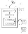
- FIG. 1Aillustrates a RFID assisted GPS system that is updated by a GPS satellite or by an assistance server in accordance with an embodiment of the present invention.
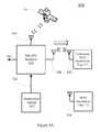
- FIG. 1Billustrates a RFID assisted GPS system that is updated by a RFID assistance tag in accordance with an embodiment of the present invention
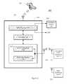
- FIG. 2illustrates a RFID assisted GPS (RAGPS) receiver in accordance with an embodiment of the present invention.
- RGPSRFID assisted GPS
- FIG. 3Ais a flowchart that determines the status of the location data stored in a RFID assisted GPS (RAGPS) receiver as compared to the location data stored in a RFID assistance tag in accordance with an embodiment of the present invention.
- RFID assisted GPSGPS
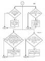
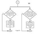
- FIG. 3Bis a flowchart that shows four scenarios from the determination of the location data status of FIG. 3A .
- FIG. 4is a flowchart for an updating method when the RAGPS receiver lacks up-to-date location data available in a RFID assistance tag in accordance with an embodiment of the present invention.
- FIG. 5is a flowchart for an updating method when the RFID assistance tag lacks up-to-date location data available in a RAGPS receiver in accordance with an embodiment of the present invention.
- FIG. 6is a flowchart for an updating method when the RAGPS receiver and the RFID assistance tag have up-to-date location data in accordance with an embodiment of the present invention.
- FIG. 7is a flowchart for the status when neither the RFID assistance tag nor the RAGPS receiver has up-to-date location data in accordance with an embodiment of the present invention.
- the present inventionutilizes RFID assistance tags that are geographically dispersed as a method to provide updated location data to the GPS receivers.
- RFID assistance tagsare cheap and ubiquitous, easy to replace, and do not require maintenance.
- the present inventionincludes RFID tags that can store location data including current location estimate, ephemeris data, and almanac data and suitable GPS receivers which may write this location data to the RFID tags in range if they have up-to-date location data, and they may read the location data of the RFID tag for assistance if they do not have up-to-date location data.
- ephemeris and almanac datais either obtained by decoding it from the sky (which can take up to 36 seconds), or by injecting it from an assistance server (which requires a network connection to, for example, a mobile phone service or a wireless connection to the internet) or by self-prediction methods (which require previously obtained ephemeris data that is not too old, and significant amounts of computation, or a network connection at an earlier stage to obtain the prediction data).
- an assistance serverwhich requires a network connection to, for example, a mobile phone service or a wireless connection to the internet
- self-prediction methodswhich require previously obtained ephemeris data that is not too old, and significant amounts of computation, or a network connection at an earlier stage to obtain the prediction data.
- the methods for overcoming stale or inaccurate datahave their own costs and weaknesses.
- An alternative approach to update the location data in GPS receiversis to utilize geographically dispersed RFID assistance tags.
- RFID assistance tagsmay be distributed liberally around car payment meters in underground garages, at the entrance of and within shops, shopping malls, airports and government buildings, on lamp posts, in tunnels, and so on.
- GPS receiversmay be designed with RFID readers built into them, and with suitable control software.
- These RFID assisted GPS receiversare referred to as RAGPS receivers.
- the RAGPS receiverscan read location, almanac and ephemeris assistance data from any nearby RFID assistance tags, and similarly if they have such location data already, they can write it to any nearby assistance tags that do not have such location data, or whose location data is old or out of date.
- RAGPS receivershelp each other by caching useful location data in ubiquitous RFID assistance tags for other RAGPS receivers to use.
- RFID tagshave been incorporated in GPS receivers to support asset tracking applications.
- the GPS receiverincludes a RFID tag that can be read by a tag reader, as a form of asset tracking.
- this RFID systeman inexpensive wireless data transfer service
- RFID tagsThere are two types of RFID tags: passive and active. Passive tags are very inexpensive and do not require batteries, but they currently typically only store a small amount of data—enough for a location data structure consisting of longitude and latitude to within 10 cm. Active tags can typically currently store more data (easily coping with the 15-20 kb of data required for the current location estimate, ephemeris and almanac data structures), but require batteries or a power supply, and are more expensive. As the technology advances the two types of RFID tags may converge and it is expected that inexpensive passive RFID tags with significant data storage capacity will become available. In the meantime, existing technology is useable.
- the RFID assistance tagtypically has its memory organized into a data structure that allows it to store (depending on memory size).
- FIG. 1Aillustrates one embodiment of the present invention—embodiment 100 .
- Embodiment 100includes RAGPS receiver 101 , connected RFID assistance tag 111 , GPS satellite 121 , and assistance server 123 .
- the assistance server 123is coupled to the RAGPS receiver 101 by signal line 122 .
- the RAGPS receiver 101communicates with GPS satellite 121 via antenna 107 .
- GPS satellite 121represents multiple GPS satellites that may be present in the sky at a particular point in time.
- RAGPS receiver 101may receive a signal from either GPS satellite 121 or assistance server 123 .
- the received signalmay comprise location data, including current location estimate, ephemeris data and almanac data.
- the location data in RAGPS receiver 101may be updated from either GPS satellite 121 or assistance server 123 .
- FIG. 1Aalso shows RFID assistance tag 113 with antenna 114 that are not in range and are not connected to RAGPS receiver 101 .
- the RAGPS receiver 101provides an output via signal 124 .
- FIG. 1Billustrates a second embodiment of the present invention—embodiment 150 .
- Embodiment 150includes RAGPS receiver 101 and connected RFID assistance tag 111 .
- GPS satellite 121is unable to communicate with RAGPS receiver 101 due to blockage 125 .
- the RAGPS receiver 101communicates with connected RFID assistance tag 111 to determine if connected RFID assistance tag 111 has location data that is up-to-date as compared with the location data of the RAGPS receiver 101 .
- the up-to-date location data of the connected RFID assistance tag 111is transmitted from the connected RFID assistance tag 111 to the RAGPS receiver 101 via antenna 112 to antenna 108 . Hence, the location data of the RAGPS has been updated.
- FIG. 2illustrates an embodiment 200 for a RAGPS receiver 201 .
- RAGPS receiver 201includes GPS receiver 206 , controller 202 , RFID subsystem 203 , antenna 207 and antenna 208 .
- the RFID subsystem 203further includes RFID transmitter 204 and RFID tag reader 205 .
- the GPS receiver 206includes a GPS receiver with memory that is capable of storing location data. Alternatively, the location data may be stored in the controller 202 .
- the location data of GPS receiver 206may be updated by GPS satellite 221 via antenna 207 or assistance server 223 via signal line 222 . This updating action was previously described in the discussion related to FIG. 1A .
- the RAGPS receiver 201provides an output via signal 224 .
- the GPS receiver 206may also be updated by the connected RFID assistance tag 211 .
- Controller 202includes control software for transferring location data to and from the GPS subsystem to the tag reader system, and to and from any suitable RFID assistance tags detected in the vicinity. This data transfer is implemented by the RFID transmitter 204 and RFID tag reader 205 that wirelessly communicate to the connected RFID assistance tag 211 via antennas 208 and antenna 212 .
- embodiment 200illustrates one or more RFID assistance tags.
- Connected RFID assistance tag 211is in range of RAGPS receiver 201 and RAGPS receiver 201 is able to communicate with connected RFID assistance tag 211 via antennas 208 and antenna 212 .
- RFID assistance tag 213 with antenna 214is not in range of RAGPS receiver 201 .
- RAGPS receiver 201may not communicate with RFID assistance tag 213 .
- RAGPS receiver 201comes within range of connected RFID assistance tag 211 , one of four scenarios applies:
- Scenario BConnected RFID assistance tag 211 lacks up-to-date location data available in the RAGPS receiver 201 .
- Scenario CThe RAGPS receiver 201 and connected RFID assistance tag 211 have up-to-date location data.
- the RAGPS receiver 201may still help the RFID tag improve its location data.
- the connected RFID assistance tag 211will have a slightly different location than the RAGPS receiver.
- active RFID tagshave a read range of up to 30 meters
- passive RFID tagshave a read range of up to 7 meters at the moment, so these distances are added to the GPS receiver's position inaccuracy.
- the RFID location informationmay be over-written with an averaging algorithm. If the connected RFID assistance tag 211 cannot perform the averaging calculation, this is done by the RAGPS receiver 201 .
- Scenario DNeither connected RFID assistance tag 211 nor RAGPS receiver 201 have up-to-date location data.
- the RAGPS receivermay include one or more integrated circuits.
- Each of the one or more RFID assistance tagsmay include one or more integrated circuits.
- FIGS. 3A-3B and 4 - 7A method for updating location data in a GPS receiver utilizing RFID assistance tags is now described. This method is based on the operation of the previously described control system. The operation of the control software is disclosed in FIGS. 3A-3B and 4 - 7 , including flowcharts 300 - 350 and 400 - 700 . These flowcharts illustrate a method for updating RAGPS receiver 201 as disclosed in embodiment 100 , 150 and 200 .
- the methodbegins with starting the process (step 301 ) and determining if one of the one or more RFID assistance tags is in range of the RAGPS receiver 201 (step 302 ). If there is no RFID assistance tag in range of the RAGPS receiver 201 , the RAGPS receiver 201 may move to a different location (step 309 ). If one or more RFID assistance tags are in range of the RAGPS receiver 201 , then the RAGPS receiver 201 connects with one of the one or more RFID assistance tags that is in range of the RAGPS receiver 201 (step 303 ).
- Additional method stepsinclude determining the up-to-date status of the location data of the connected RFID assistance tag 211 and the location data of the RAGPS receiver 201 (step 304 ), and further determining if either the location data of the connected RFID assistance tag 211 , or the location data of the RAGPS receiver 201 , or neither, is be updated (step 305 ). Finally, updating the location data of the connected RFID assistance tag 211 , or the location data of the RAGPS receiver 201 , or neither based on determination of the up-to-data status (step 306 ).
- this stepmay include four possible scenarios.
- flow chart 350begins with step 304 , that is determining the up-to-date status of the location data of the connected RFID assistance tag 211 and the location data of the RAGPS receiver 201 (step 304 ).
- Step 304results in four possible scenarios, as previously disclosed:
- the updating of the location data of the connected RFID assistance tag 211 or the location data of the RAGPS receiver 201is determined by the methods disclosed in flowcharts 400 - 700 .
- the outcome of step 305 Ais indicated by item “A”.
- Per flowchart 400 on FIG. 4the method is described for updating the RAGPS receiver 201 .
- the methodincludes transmitting location data from the connected RFID assistance tag 211 to the RAGPS receiver 201 (step 402 ).
- the methodincludes transmitting the ephemeris and/or almanac data from the connected RFID assistance tag 211 to the RAGPS receiver 201 (step 404 ).
- the methodincludes transmitting the sufficiently up-to-date and usable ephemeris data from the connected RFID assistance tag 211 to the RAGPS receiver 201 and generating useable synthetic ephemeris data in the RAGPS receiver 201 (step 406 ).
- the methodincludes transmitting the ephemeris and/or almanac data from the RAGPS receiver 201 to the connected RFID assistance tag 211 (step 408 ).
- step 305 Bif the connected RFID assistance tag 211 lacks up-to-date location data available in the RAGPS receiver 201 , the outcome of step 305 B is indicated by item “B”.
- Per flowchart 500 on FIG. 5the method is described for updating the connected RFID assistance tag 211 .
- the methodincludes transmitting current location estimate from the RAGPS receiver 201 to the connected RFID assistance tag 211 (step 502 ).
- the methodincludes transmitting ephemeris data and/or almanac data from the RAGPS receiver to the RFID assistance tag (step 504 ).
- the methodfurther includes the steps of updating the connected RFID assistance tag 211 .
- the outcome of step 305 Cis indicated by item “C”.
- the methodincludes steps updating the latitude and longitude in the connected RFID assistance tag 211 .
- the first stepincludes, in the RAGPS receiver 201 , reading the connected RFID assistance tag's 211 current location estimate, and number of previous receivers that have contributed to this location (step 601 ).
- the next stepincludes determining longitude difference between the RAGPS receiver's 201 longitude and the connected RFID assistance tag's 211 longitude (step 602 ), then calculating a new longitude for the connected RFID assistance tag 211 by adding the current longitude to the longitude difference divided by the number of previous receivers (step 604 ).
- the latitudeis calculated by determining the latitude difference between the RAGPS receiver's 201 latitude and the connected RFID assistance tag's 211 latitude (step 603 ), then calculating a new latitude for the connected RFID assistance tag 211 by adding the current latitude to the latitude difference divided the number of previous receivers (step 605 ).
- the methodincludes transmitting the new longitude and new latitude from the RAGPS receiver 201 to the connected RFID assistance tag 211 (step 606 ).
Landscapes
- Engineering & Computer Science (AREA)
- Radar, Positioning & Navigation (AREA)
- Remote Sensing (AREA)
- Computer Networks & Wireless Communication (AREA)
- Physics & Mathematics (AREA)
- General Physics & Mathematics (AREA)
- Position Fixing By Use Of Radio Waves (AREA)
Abstract
Description
- RFID assistance tags refer to RFID tags that are used in a system with RAGPS receivers in the present invention. If a RFID assistance tag is in range of a RAGPS receiver and is communicating with that RAGPS receiver, the RFID assistance tag is referred to as a “connected RFID assistance tag”. In the figures, a “connected RFID assistance tag” may be referred to as a “RFID tag”.
- RFID assisted GPS receivers are referred to as RAGPS receivers. Also, a “receiver” may be referred to as a “RCVR” in the figures.
- “Location data” includes current location estimate, ephemeris data and almanac data. The location data in the RAGPS receiver and RFID assistance tags is time stamped with the time and date the location data was updated. A time and date when the location data expires is also noted.
- Current location estimate—The estimate of the current latitude and longitude of the GPS receiver. In the figures, “current location estimate” is referred to as “location estimate”.
- Ephemeris data—GPS satellites include ephemeris data in the signals they transmit to GPS receivers. Ephemeris data is a set of parameters that can be used to accurately calculate the location of a GPS satellite at a particular point in time. It describes the path that the satellite is following as it orbits Earth. To accurately calculate your location, ephemeris data is only usable for a limited time (a few hours or less). Up-to-date data is required to minimize error that results from minor variations in a satellite's orbit. Ephemeris data may be based on the type of GPS satellite system (e.g. Navistar, SBAS, Galileo, etc.)
- Almanac data—GPS receivers use almanac data to predict which satellites are nearby when they're looking for GPS signals. Almanac data includes a set of parameters for each GPS satellite that can be used to calculate its approximate location in orbit. Using almanac data saves time by letting the receiver skip looking for satellites that are below the horizon. GPS satellites include almanac data in the signals they transmit to GPS receivers. Although variations in satellite orbits can accumulate with time, almanac data doesn't need to be highly accurate to be useful. Data collected before your receiver was last switched off may remain usable for weeks or months. Almanac data may be based on the type of GPS satellite system (e.g. Navistar, SBAS, Galileo, etc.)
- a GPS receiver is turned off prior to boarding a flight, and is then turned back on when the plane lands,
- or where a receiver enters a large signal blocking building such as a shopping mall, and leaves it some time later from a different distant exit. A thick forest would also be a large signal blocking environment.
- a) RFID assistance tags inexpensive and easy to use, they and can be stuck around signal-blocking locations quickly.
- b) RFID tags can store location data for long periods of time, can have new location data written to them and can send stored location data wirelessly to suitable tag readers.
- Longitude
- Latitude
- Ephemeris data for Navistar satellites PRN1-32 (or even Atheros Extended Ephemeris data)
- Ephemeris data for SBAS satellites
- Ephemeris data for other GPS satellites such as Galileo
- Almanac data for the above satellites
- The time and date the above data was last updated or written and when the location data expires. (timestamp)
- The
RAGPS receiver 101 may connect with a RFID assistance tag that is in range, such as connected RFID assistance tag111. After connecting, if theRAGPS receiver 101 determines its location data is up-to-date as compared with the location data in the connected RFID assistance tag111, theRAGPS receiver 101 transmits the location data in its memory to the connected RFID assistance tag111. This transmission is coupled fromantenna 108 toantenna 112. Accordingly, the connected RFID assistance tag111 updates the location data in its memory. In addition to storing location data, the time and date this location data was last updated or written is also stored in the RFID memory (i.e. time stamped). A time and date when the location data expires is also noted.
- The
- If
RAGPS receiver 201 lacks a location fix and lacks a current location estimate and the connected RFID assistance tag211 has this data, theRAGPS receiver 201 may read the current location estimate from connected RFID assistance tag211. - If the
RAGPS receiver 201 lacks valid ephemeris or almanac data and the connected RFID assistance tag211 has this data, theRAGPS receiver 201 may read the ephemeris and almanac data from the connected RFID assistance tag211. - If the
RAGPS receiver 201 lacks valid ephemeris or almanac data, and lacks invalid ephemeris or almanac data that is usable by a self-prediction algorithm for producing synthetic ephemeris data, and the connected RFID assistance tag211 has invalid ephemeris data that is still young enough for use by self-prediction algorithms, thenRAGPS receiver 201 may download the stale yet usable ephemeris data and may use it for generating useable synthetic ephemeris data. - If the connected RFID assistance tag211 has no ephemeris and/or almanac data, or it has ephemeris and/or almanac data that is older than the ephemeris or almanac data in the
RAGPS receiver 201, theRAGPS receiver 201 may over-write the ephemeris and/or almanac data on the connected RFID assistance tag211 with its fresh ephemeris and/or almanac data.
- If
- If the connected RFID assistance tag211 lacks a current location estimate, and
RAGPS receiver 201 has this data, theRAGPS receiver 201 may write a fix location to the connected RFID assistance tag211. - If the RFID tag lacks ephemeris or almanac data, or connected RFID assistance tag's211 data is older than the
RAGPS receiver 201, theRAGPS receiver 201 may overwrite the connected RFID assistance tag's211 ephemeris and almanac data.
- If the connected RFID assistance tag211 lacks a current location estimate, and
- 1. The
RAGPS receiver 201 reads the connected RFID assistance tag211's current stored location, and the number of previous RAGPS receivers that have contributed to this location (Define this number as k). - 2. Calculate the longitude difference between the
RAGPS receiver 201's longitude and the connected RFID assistance tag211's longitude. Define this longitude calculation as δE and similarly for latitude: δN. If the RFID assistance tag211's old position was - N, E then the connected RFID assistance tag211's new position is N+(δN/k), E+(δE/k).
- Effectively each previous RAGPS receiver contributing a new location estimate is averaged in with all previous RAGPS receivers' location estimates.
- 3. The
RAGPS receiver 201 writes back the new location estimate to the connected RFID assistance tag211.
- 1. The
- Nothing is done in this case
- Scenarios A—
RAGPS Receiver 201 lacks up-to-date location data that connected RFID assistance tag211 has (step 305A) - Scenarios B—Connected RFID assistance tag211 lacks up-to-date location data that
RAGPS receiver 201 has (step 305B) - Scenarios C—The
RAGPS receiver 201 and connected RFID assistance tag211 have up-to-date location data (step 305C) - Scenarios D—Nether connected RFID assistance tag211 nor
RAGPS receiver 201 have up-to-date location data (step 305D)
- Scenarios A—
Claims (18)
Priority Applications (1)
| Application Number | Priority Date | Filing Date | Title |
|---|---|---|---|
| US12/954,490US8743699B1 (en) | 2010-05-07 | 2010-11-24 | RFID tag assisted GPS receiver system |
Applications Claiming Priority (3)
| Application Number | Priority Date | Filing Date | Title |
|---|---|---|---|
| US33264010P | 2010-05-07 | 2010-05-07 | |
| US12/840,155US8675539B1 (en) | 2010-05-07 | 2010-07-20 | Management-packet communication of GPS satellite positions |
| US12/954,490US8743699B1 (en) | 2010-05-07 | 2010-11-24 | RFID tag assisted GPS receiver system |
Related Parent Applications (1)
| Application Number | Title | Priority Date | Filing Date |
|---|---|---|---|
| US12/840,155Continuation-In-PartUS8675539B1 (en) | 2010-05-07 | 2010-07-20 | Management-packet communication of GPS satellite positions |
Publications (1)
| Publication Number | Publication Date |
|---|---|
| US8743699B1true US8743699B1 (en) | 2014-06-03 |
Family
ID=50781302
Family Applications (1)
| Application Number | Title | Priority Date | Filing Date |
|---|---|---|---|
| US12/954,490Expired - Fee RelatedUS8743699B1 (en) | 2010-05-07 | 2010-11-24 | RFID tag assisted GPS receiver system |
Country Status (1)
| Country | Link |
|---|---|
| US (1) | US8743699B1 (en) |
Cited By (3)
| Publication number | Priority date | Publication date | Assignee | Title |
|---|---|---|---|---|
| US20140218241A1 (en)* | 2013-02-04 | 2014-08-07 | Research In Motion Limited | Augmenting location data at a mobile device |
| CN112492520A (en)* | 2020-12-15 | 2021-03-12 | 北京百度网讯科技有限公司 | Positioning method, device, equipment and storage medium |
| US20240295623A1 (en)* | 2017-03-28 | 2024-09-05 | Automaton, Inc. | Methods and apparatus for locating rfid tags |
Citations (35)
| Publication number | Priority date | Publication date | Assignee | Title |
|---|---|---|---|---|
| EP0320913A2 (en) | 1987-12-18 | 1989-06-21 | Nokia-Mobira Oy | A method for locating a mobile station, as well as a mobile station and a base station for carrying out the method |
| US6108558A (en) | 1998-04-21 | 2000-08-22 | Motorola, Inc. | Method for calculating a location of a remote Unit utilizing observed time difference (OTD) and real time difference (RTD) measurements. |
| EP1253437A2 (en) | 2001-04-23 | 2002-10-30 | Itt Manufacturing Enterprises, Inc. | Method and apparatus for high-accuracy position location using search mode ranging techniques |
| US20020194266A1 (en) | 2001-06-14 | 2002-12-19 | Gavin Brebner | Device and method for outputting location information |
| US20030103475A1 (en) | 2001-07-09 | 2003-06-05 | Heppe Stephen B. | Two-way timing and calibration methods for time division multiple access radio networks |
| US20030118015A1 (en) | 2001-12-20 | 2003-06-26 | Magnus Gunnarsson | Location based notification of wlan availability via wireless communication network |
| US6801782B2 (en) | 1999-08-02 | 2004-10-05 | Itt Manufacturing Enterprises, Inc. | Method and apparatus for determining the position of a mobile communication device |
| WO2005006593A1 (en) | 2003-06-27 | 2005-01-20 | Qualcomm Incorporated | Method and apparatus for communication of gps ephemeris |
| US20050124355A1 (en) | 2003-12-04 | 2005-06-09 | International Business Machines Corporation | Self-directed access point location validation |
| US20050124319A1 (en) | 2003-12-05 | 2005-06-09 | Motion Picture Association Of America | Digital rights management using a triangulating geographic locating device |
| EP1587255A1 (en) | 2004-04-12 | 2005-10-19 | Samsung Electronics Co., Ltd. | Method and system for synchronising two end terminals in a wireless communication system |
| US20060052115A1 (en) | 2004-09-07 | 2006-03-09 | Sanjeev Khushu | Procedure to increase position location availabilty |
| US7057557B2 (en) | 2001-04-20 | 2006-06-06 | Lg Electronics Inc. | Apparatus and method for estimating position of mobile communication terminal |
| US7065369B2 (en) | 2002-01-24 | 2006-06-20 | Huawei Technologies Co., Ltd. | Method of locating and measuring a mobile station |
| US20060148486A1 (en) | 2002-12-02 | 2006-07-06 | Kim Jin-Kyeong | Communication device having function for searching access point of wireless local area network and method thereof |
| US20070025296A1 (en) | 2005-08-01 | 2007-02-01 | Jae-Dong Jung | System and method for handoff using hybrid network |
| US7215966B2 (en) | 2003-06-05 | 2007-05-08 | Meshnetworks, Inc. | System and method for determining location of a device in a wireless communication network |
| US20070103303A1 (en)* | 2005-11-07 | 2007-05-10 | Radiofy Llc, A California Limited Liability Company | Wireless RFID networking systems and methods |
| US20070121560A1 (en) | 2005-11-07 | 2007-05-31 | Edge Stephen W | Positioning for wlans and other wireless networks |
| US20070276583A1 (en)* | 2006-05-09 | 2007-11-29 | Dobeck Brian R | power management apparatus and methods for portable data terminals |
| US20080109885A1 (en) | 2006-11-07 | 2008-05-08 | Lg Electronics Inc. | Performing presence service in a wireless communication system |
| US20080291883A1 (en) | 2007-05-25 | 2008-11-27 | Lg Electronics Inc. | Management procedure in wireless communication system and station supporting management procedure |
| US20090079622A1 (en) | 2007-09-26 | 2009-03-26 | Broadcom Corporation | Sharing of gps information between mobile devices |
| US20090093956A1 (en) | 2007-10-09 | 2009-04-09 | Microsoft Corporation | Transmitting location data in wireless networks |
| US20090121927A1 (en)* | 2007-11-14 | 2009-05-14 | Radiofy Llc | Systems and Methods of Assisted GPS |
| US7574216B2 (en) | 2004-03-17 | 2009-08-11 | Koninklijke Philips Electronics N.V. | Making time-of-flight measurements in master/slave and ad hoc networks by eaves-dropping on messages |
| US20090224967A1 (en) | 2008-03-06 | 2009-09-10 | Atheros Communications, Inc. | High precision positioning system |
| US20100135178A1 (en) | 2008-11-21 | 2010-06-03 | Qualcomm Incorporated | Wireless position determination using adjusted round trip time measurements |
| US7877100B2 (en) | 2001-12-14 | 2011-01-25 | Qualcomm Incorporated | Position determination system that uses A cellular communication system |
| US8026850B2 (en) | 2005-12-08 | 2011-09-27 | Electronics And Telecommunications Research Institute | Apparatus and method for computing location of a moving beacon using time difference of arrival and multi-frequencies |
| US8160609B2 (en) | 2008-11-26 | 2012-04-17 | Andrew Llc | System and method for multiple range estimation location |
| US8184038B2 (en) | 2008-08-20 | 2012-05-22 | Qualcomm Incorporated | Two-way ranging with inter-pulse transmission and reception |
| US8233457B1 (en) | 2009-09-03 | 2012-07-31 | Qualcomm Atheros, Inc. | Synchronization-free station locator in wireless network |
| US8335173B2 (en) | 2008-04-11 | 2012-12-18 | Cisco Technology, Inc. | Inserting time of departure information in frames to support multi-channel location techniques |
| US8370629B1 (en) | 2010-05-07 | 2013-02-05 | Qualcomm Incorporated | Trusted hybrid location system |
- 2010
- 2010-11-24USUS12/954,490patent/US8743699B1/ennot_activeExpired - Fee Related
Patent Citations (37)
| Publication number | Priority date | Publication date | Assignee | Title |
|---|---|---|---|---|
| EP0320913A2 (en) | 1987-12-18 | 1989-06-21 | Nokia-Mobira Oy | A method for locating a mobile station, as well as a mobile station and a base station for carrying out the method |
| US6108558A (en) | 1998-04-21 | 2000-08-22 | Motorola, Inc. | Method for calculating a location of a remote Unit utilizing observed time difference (OTD) and real time difference (RTD) measurements. |
| US6801782B2 (en) | 1999-08-02 | 2004-10-05 | Itt Manufacturing Enterprises, Inc. | Method and apparatus for determining the position of a mobile communication device |
| US7057557B2 (en) | 2001-04-20 | 2006-06-06 | Lg Electronics Inc. | Apparatus and method for estimating position of mobile communication terminal |
| EP1253437A2 (en) | 2001-04-23 | 2002-10-30 | Itt Manufacturing Enterprises, Inc. | Method and apparatus for high-accuracy position location using search mode ranging techniques |
| US20020194266A1 (en) | 2001-06-14 | 2002-12-19 | Gavin Brebner | Device and method for outputting location information |
| US20030103475A1 (en) | 2001-07-09 | 2003-06-05 | Heppe Stephen B. | Two-way timing and calibration methods for time division multiple access radio networks |
| US7877100B2 (en) | 2001-12-14 | 2011-01-25 | Qualcomm Incorporated | Position determination system that uses A cellular communication system |
| US20030118015A1 (en) | 2001-12-20 | 2003-06-26 | Magnus Gunnarsson | Location based notification of wlan availability via wireless communication network |
| US7065369B2 (en) | 2002-01-24 | 2006-06-20 | Huawei Technologies Co., Ltd. | Method of locating and measuring a mobile station |
| US20060148486A1 (en) | 2002-12-02 | 2006-07-06 | Kim Jin-Kyeong | Communication device having function for searching access point of wireless local area network and method thereof |
| US7215966B2 (en) | 2003-06-05 | 2007-05-08 | Meshnetworks, Inc. | System and method for determining location of a device in a wireless communication network |
| WO2005006593A1 (en) | 2003-06-27 | 2005-01-20 | Qualcomm Incorporated | Method and apparatus for communication of gps ephemeris |
| US20050124355A1 (en) | 2003-12-04 | 2005-06-09 | International Business Machines Corporation | Self-directed access point location validation |
| US20050124319A1 (en) | 2003-12-05 | 2005-06-09 | Motion Picture Association Of America | Digital rights management using a triangulating geographic locating device |
| US7574216B2 (en) | 2004-03-17 | 2009-08-11 | Koninklijke Philips Electronics N.V. | Making time-of-flight measurements in master/slave and ad hoc networks by eaves-dropping on messages |
| EP1587255A1 (en) | 2004-04-12 | 2005-10-19 | Samsung Electronics Co., Ltd. | Method and system for synchronising two end terminals in a wireless communication system |
| US20060052115A1 (en) | 2004-09-07 | 2006-03-09 | Sanjeev Khushu | Procedure to increase position location availabilty |
| US20070025296A1 (en) | 2005-08-01 | 2007-02-01 | Jae-Dong Jung | System and method for handoff using hybrid network |
| US20070121560A1 (en) | 2005-11-07 | 2007-05-31 | Edge Stephen W | Positioning for wlans and other wireless networks |
| US20070103303A1 (en)* | 2005-11-07 | 2007-05-10 | Radiofy Llc, A California Limited Liability Company | Wireless RFID networking systems and methods |
| US8026850B2 (en) | 2005-12-08 | 2011-09-27 | Electronics And Telecommunications Research Institute | Apparatus and method for computing location of a moving beacon using time difference of arrival and multi-frequencies |
| US20070276583A1 (en)* | 2006-05-09 | 2007-11-29 | Dobeck Brian R | power management apparatus and methods for portable data terminals |
| US20080109885A1 (en) | 2006-11-07 | 2008-05-08 | Lg Electronics Inc. | Performing presence service in a wireless communication system |
| US20080291883A1 (en) | 2007-05-25 | 2008-11-27 | Lg Electronics Inc. | Management procedure in wireless communication system and station supporting management procedure |
| US20090079622A1 (en) | 2007-09-26 | 2009-03-26 | Broadcom Corporation | Sharing of gps information between mobile devices |
| US20090093956A1 (en) | 2007-10-09 | 2009-04-09 | Microsoft Corporation | Transmitting location data in wireless networks |
| US20090121927A1 (en)* | 2007-11-14 | 2009-05-14 | Radiofy Llc | Systems and Methods of Assisted GPS |
| US7800531B2 (en) | 2008-03-06 | 2010-09-21 | Atheros Communications, Inc. | High precision positioning system |
| US20090224967A1 (en) | 2008-03-06 | 2009-09-10 | Atheros Communications, Inc. | High precision positioning system |
| US8335173B2 (en) | 2008-04-11 | 2012-12-18 | Cisco Technology, Inc. | Inserting time of departure information in frames to support multi-channel location techniques |
| US8184038B2 (en) | 2008-08-20 | 2012-05-22 | Qualcomm Incorporated | Two-way ranging with inter-pulse transmission and reception |
| US20100135178A1 (en) | 2008-11-21 | 2010-06-03 | Qualcomm Incorporated | Wireless position determination using adjusted round trip time measurements |
| US8160609B2 (en) | 2008-11-26 | 2012-04-17 | Andrew Llc | System and method for multiple range estimation location |
| US8233457B1 (en) | 2009-09-03 | 2012-07-31 | Qualcomm Atheros, Inc. | Synchronization-free station locator in wireless network |
| US20120269170A1 (en) | 2009-09-03 | 2012-10-25 | Qualcomm Atheros, Inc. | Synchronization-Free Station Locator In Wireless Network |
| US8370629B1 (en) | 2010-05-07 | 2013-02-05 | Qualcomm Incorporated | Trusted hybrid location system |
Cited By (4)
| Publication number | Priority date | Publication date | Assignee | Title |
|---|---|---|---|---|
| US20140218241A1 (en)* | 2013-02-04 | 2014-08-07 | Research In Motion Limited | Augmenting location data at a mobile device |
| US9164161B2 (en)* | 2013-02-04 | 2015-10-20 | Blackberry Limited | Augmenting location data at a mobile device |
| US20240295623A1 (en)* | 2017-03-28 | 2024-09-05 | Automaton, Inc. | Methods and apparatus for locating rfid tags |
| CN112492520A (en)* | 2020-12-15 | 2021-03-12 | 北京百度网讯科技有限公司 | Positioning method, device, equipment and storage medium |
Similar Documents
| Publication | Publication Date | Title |
|---|---|---|
| US12332365B2 (en) | On demand positioning | |
| US8648747B2 (en) | Method of downloading ephemeris data based on user activity | |
| JP5095623B2 (en) | Method for providing assistance data to a mobile station of a satellite positioning system | |
| EP1851564B1 (en) | Method and apparatus for enhanced autonomous gps | |
| CA2641335C (en) | Method for position determination with measurement stitching | |
| US9071935B2 (en) | Self positioning of a wireless station | |
| CN103399328B (en) | Qualifying coarse position injection in position determination systems | |
| US8532571B2 (en) | Method and system for determining a location for a RF communication device based on its proximity to a mobile device | |
| US9562976B2 (en) | Method and apparatus for distinguishing direct GNSS signals from reflections | |
| US10698117B2 (en) | Systems and methods for location assistance with personal area network devices | |
| US20140062770A1 (en) | Satellite Signal Receiver and Method for Updating Ephemeris Information Thereby | |
| JP2006502417A (en) | Method and apparatus for using long-term satellite tracking data in a remote receiver | |
| JP2009515156A5 (en) | ||
| CN101389975A (en) | Positioning system for portable electronic devices | |
| CN104136937B (en) | Processing ephemeris extension data | |
| US7342533B2 (en) | Method and apparatus for obtaining satellite trajectory data at a satellite positioning system receiver | |
| US8743699B1 (en) | RFID tag assisted GPS receiver system | |
| KR102268380B1 (en) | Method for measuring distance between mobile station using precise position measurement and system and method for measuring distance between golfer and hole cup using the same | |
| US20100094554A1 (en) | Systems and Methods for Accessing Data Over a Short-range Data Link to Enhance the Performance of a Navigational Unit | |
| KR20100062678A (en) | A system of decreasing cold start time of gps and a method thereof | |
| CA2619282C (en) | Method of downloading ephemeris data based on user activity | |
| US12140683B2 (en) | System and method for combined ranging and GNSS positioning | |
| EP4375711A1 (en) | Method and apparatus for positioning smart wearable device, device and storage medium | |
| KR20170021183A (en) | Global navigation satellite system receiver, satellite communication method thereof and operation method of system on chip having the same |
Legal Events
| Date | Code | Title | Description |
|---|---|---|---|
| AS | Assignment | Owner name:ATHEROS COMMUNICATIONS, INC., CALIFORNIA Free format text:ASSIGNMENT OF ASSIGNORS INTEREST;ASSIGNORS:FINLOW-BATES, KEIR;VISKARI, JOONAS;NGO, TERRY FK;SIGNING DATES FROM 20101105 TO 20101122;REEL/FRAME:025421/0441 | |
| AS | Assignment | Owner name:QUALCOMM ATHEROS, INC., CALIFORNIA Free format text:MERGER;ASSIGNOR:ATHEROS COMMUNICATIONS, INC.;REEL/FRAME:026944/0411 Effective date:20110524 | |
| AS | Assignment | Owner name:QUALCOMM INCORPORATED, CALIFORNIA Free format text:ASSIGNMENT OF ASSIGNORS INTEREST;ASSIGNOR:QUALCOMM ATHEROS, INC.;REEL/FRAME:029291/0219 Effective date:20121022 | |
| FEPP | Fee payment procedure | Free format text:PAYOR NUMBER ASSIGNED (ORIGINAL EVENT CODE: ASPN); ENTITY STATUS OF PATENT OWNER: LARGE ENTITY Free format text:PAYER NUMBER DE-ASSIGNED (ORIGINAL EVENT CODE: RMPN); ENTITY STATUS OF PATENT OWNER: LARGE ENTITY | |
| FEPP | Fee payment procedure | Free format text:MAINTENANCE FEE REMINDER MAILED (ORIGINAL EVENT CODE: REM.) | |
| LAPS | Lapse for failure to pay maintenance fees | Free format text:PATENT EXPIRED FOR FAILURE TO PAY MAINTENANCE FEES (ORIGINAL EVENT CODE: EXP.) | |
| STCH | Information on status: patent discontinuation | Free format text:PATENT EXPIRED DUE TO NONPAYMENT OF MAINTENANCE FEES UNDER 37 CFR 1.362 | |
| FP | Lapsed due to failure to pay maintenance fee | Effective date:20180603 |