US8738289B2 - Advanced routing of vehicle fleets - Google Patents
Advanced routing of vehicle fleetsDownload PDFInfo
- Publication number
- US8738289B2 US8738289B2US12/984,180US98418011AUS8738289B2US 8738289 B2US8738289 B2US 8738289B2US 98418011 AUS98418011 AUS 98418011AUS 8738289 B2US8738289 B2US 8738289B2
- Authority
- US
- United States
- Prior art keywords
- destination
- vehicle
- location
- current location
- destination region
- Prior art date
- Legal status (The legal status is an assumption and is not a legal conclusion. Google has not performed a legal analysis and makes no representation as to the accuracy of the status listed.)
- Active, expires
Links
Images


Classifications
- G—PHYSICS
- G01—MEASURING; TESTING
- G01C—MEASURING DISTANCES, LEVELS OR BEARINGS; SURVEYING; NAVIGATION; GYROSCOPIC INSTRUMENTS; PHOTOGRAMMETRY OR VIDEOGRAMMETRY
- G01C21/00—Navigation; Navigational instruments not provided for in groups G01C1/00 - G01C19/00
- G01C21/26—Navigation; Navigational instruments not provided for in groups G01C1/00 - G01C19/00 specially adapted for navigation in a road network
- G01C21/34—Route searching; Route guidance
- G01C21/3453—Special cost functions, i.e. other than distance or default speed limit of road segments
- G—PHYSICS
- G08—SIGNALLING
- G08G—TRAFFIC CONTROL SYSTEMS
- G08G1/00—Traffic control systems for road vehicles
- G08G1/20—Monitoring the location of vehicles belonging to a group, e.g. fleet of vehicles, countable or determined number of vehicles
- G08G1/202—Dispatching vehicles on the basis of a location, e.g. taxi dispatching
Definitions
- the present applicationgenerally relates to routing of fleets of vehicles. More particularly, the present application relates to finding traffic routes by which owners of the fleets can maximize their profits from the fleets.
- the fleets of commercial vehiclesare occupied by at least one passenger
- drivers of the fleets of vehiclesoften arbitrarily take any one of available traffic routes known to those drivers.
- the occupied vehiclese.g., taxies with passengers
- the occupied vehiclessometimes enter into a heavy traffic road even though there is an alternative traffic route that has less traffic.
- passengersget off the vehicles before the vehicle arrive at their destination locations, when the vehicles enter into heavy traffic roads. Then, the vehicles become unoccupied in a middle of the heavy traffic roads and spend their resources (e.g., fuels) without running meters.
- profits of the owners of the fleets of the vehiclesmay be reduced, e.g., especially when the vehicles are operated based on flat rates (e.g., charging fees based on driving distances without a consideration of driving times) or when time is charged at a minimum per-minute rate. Passengers are also unhappy when their vehicle drivers take heavy traffic roads.
- current path calculatorse.g., Google® Maps, Mapquest, etc.
- Google® Maps, Mapquest, etc.provide traffic routing information between an origination location and a destination location
- those current path calculatorscannot predict travel time based on real-time traffic information.
- those path calculatorsfail to provide any indication of desirable routes having a potential demand (i.e., potential number of passengers) in or along a traffic route.
- a system, method and computer program productfor obtaining a traffic route for a vehicle (e.g., taxi) to maximize a profit in operating the vehicle. For example, by driving along the obtained traffic route, a driver of the vehicle can pick-up potential passengers.
- a vehiclee.g., taxi
- a system, method and computer program productfor obtaining a traffic route for a vehicle.
- the systemincludes, but is not limited to: a memory device and a processor being connected to the memory device.
- the systemreceives information of a current location of the vehicle.
- the systemdetermines a destination location or destination region of the vehicle.
- the systemcomputes a plurality of available traffic routes from the current location to the destination location or to the destination region.
- the systemestimates a potential demand for at least one potential passenger from the current location to the destination location or to the destination region per each available traffic route.
- the systemrecommends, to a driver of the vehicle, an available traffic route that has a highest estimated potential demand among a plurality of the available traffic routes.
- the systemretrieves historical passenger demand data from a database.
- the systemuses the retrieved historical passenger demand data to estimate a probable destination location or destination region and to estimate the potential demand to the probable destination location or region.
- the systemdetermines the destination location or the destination region.
- the systemobtains information of the destination location or the destination region from a passenger of the vehicle.
- the systeminfers the destination location or the destination region based on the current location of the vehicle, a current driving direction of the vehicle, prior destination locations of the vehicle, prior destination regions of the vehicle, a current time of day, and a current day of week.
- a GPS device associated with the vehicleprovides the information of the current location of vehicle to the system.
- a TPTTraffic Prediction Tool predicts the travel time from the current location to the destination location or to the destination region per each available traffic route.
- FIG. 1is a diagram that illustrates method steps and system components for obtaining a traffic route for a vehicle in one embodiment.
- FIG. 2illustrates an exemplary hardware configuration for running the method steps in FIG. 1 in one embodiment.
- FIGS. 3A-3Billustrate exemplary tables stored in database in one embodiment.
- FIG. 4illustrates exemplary traffic routes for a vehicle in one embodiment.
- FIG. 1is a diagram that illustrates method steps and system components for obtaining a traffic route for a vehicle in one embodiment.
- a vehicleincludes, but is not limited to: a taxi, a bus, a limousine, a truck, any other commercial vehicle, etc.
- a vehiclemay include a computing system (e.g., a computing system 200 shown in FIG. 2 ).
- a computing systemincludes, but is not limited to: a tablet computer, a laptop, a netbook, a smart phone, an Apple® MacBookTM, etc.
- the computing systemis configured to evaluate whether a destination location (i.e., a specific place) of the vehicle is known or, if not, whether a destination region (e.g., a particular neighborhood or part of a city) can be inferred. For example, if a taxi has a passenger, the passenger tells his/her destination location to a driver of the taxi, and the driver enters information of the destination location to the computing system, e.g., via an input/output interface, then the computing system determines that the destination location is known. If a driver of the vehicle does not enter information of the destination location to the computing system but the vehicle is moving, the computing system determines that the destination location is unknown and may be inferred by the computing system.
- a destination locationi.e., a specific place
- a destination regione.g., a particular neighborhood or part of a city
- the driver of the vehicleenters the information of the destination location to the computing system, e.g., via an input/output interface, a keyboard, a mouse, touch screen, etc.
- the computing systemdetects the movement of the vehicle, e.g., through a GPS device 125 attached to the vehicle, etc.
- the computing systemalso receives information (e.g., latitude and longitude) of a current location of the vehicle, e.g., from the GPS device 125 attached to the vehicle. For example, if the vehicle is not moving, the information of the current location of the vehicle from the GPS device 125 does not change for a pre-determined time period, e.g., at least for 10 minute. Otherwise, the GPS device 125 may provide, to the computing system, updated information of the current location of the vehicle periodically, e.g., every 1 minute.
- the computing systemUpon determining that the destination location of the vehicle is unknown, at step 105 , the computing system is configured to learn the destination location or the destination region. In one embodiment, the computing system is configured to infer the destination location or the destination region based on the current location of the vehicle, a current driving direction of the vehicle, prior destination regions of the vehicle, prior destination locations of the vehicle, a current time of day, and/or a current day of week. In a further embodiment, the computing system receives the information of the current location of vehicle, the current driving direction of the vehicle, the prior destination region of the vehicle, and the prior destination location of the vehicle, e.g., from the GPS device 125 attached to the vehicle.
- the GPS device 125may transmit these information, for example, in binary numbers (not shown) that represent a data structure (not shown; e.g., an array, a linked list, etc.) storing these information, e.g., via a wired or wireless communication link 150 between the computing system and the GPS device 125 .
- the computing systemdeduces a possible destination location or destination region of the vehicle, e.g., by correlating the information of the current location of the vehicle with known map artifacts (e.g.
- the computing systemmay be configured to identify similar prior trips, e.g., by searching a vehicle's own historical records or other vehicles' historical records stored in a database 130 . Based on the similar prior trips, the computing system produces a list (not shown) of possible destination locations or destination regions, for example, for each day of the week and a time of day.
- the database 130stores this list of possible destination locations or destination regions for each day of the week and a time of day, etc.
- the database 130may also store a list of possible destination locations or destination regions according to weather characteristics (e.g., rain, snow, very cold or hot temperatures, etc.).
- An exemplary list of possible destination location for a particular taxi, on Friday afternoon from 5:00 PM to 7:00 PM,may show that typical destination locations from a lower Manhattan location include Penn Station, Grand Central Station, the Upper East Side from 60 th to 92 nd Street and Upper West Sides from 70 th street to 90 th Street.
- the computing systemmay remove and/or add some possible destination locations based on a current driving direction of the vehicle.
- the computing systemcomputes for each element (i.e., each possible destination location) on the list an associated confidence score, for example, computed from the historical records.
- the list of possible destination locationsmay include, e.g., Penn Station whose confidence score is 40% and Grand Central whose confidence score is 45%.
- the computing systemmay compute these confidence scores, e.g., by calculating each probability of each destination location among the samples that have characteristics of that a day is 10 th day of a month, a time is 12 PM, weather is sunny and a location is Battery Park in Manhattan, N.Y.
- the computing systemmay select a destination location whose confidence score is the highest as the destination location of the vehicle.
- the computing systemupon knowing the destination location or destination region of the vehicle, e.g., through an input from the driver of the vehicle and knowing the current location of the vehicle, e.g., through the GPS device 125 via a wired or wireless connection 155 between the GPS device 125 and the computing system, the computing system defines the destination location or destination region of the vehicle according to the input from driver and define the current location of the vehicle according to information (e.g., latitude and longitude) from the GPS device 125 .
- informatione.g., latitude and longitude
- the computing systemcomputes a plurality of available traffic routes from the current location to the selected or defined destination location or destination region, e.g., by running one or more of path calculators 140 and/or running a shortest path algorithm 145 with the current location of the vehicle and the selected or defined destination location or destination region.
- the path calculators 140include, but are not limited to: GoogleTM Maps, MapQuestTM, Yahoo!® Maps, other traffic route finding application, etc.
- the computing systemconstructs a data structure, e.g., a graph, a linked list, a vector, etc., based on at least one electronic map (e.g., GoogleTM Maps, MapQuestTM, Yahoo!® Maps, Navteq® map, etc.).
- an electronic mapcan be considered as a graph.
- FIG. 4illustrates an exemplary graph 400 .
- a nodee.g., a node “A” 410
- Each edgee.g., an edge 460
- the graphrepresents a traffic link between two traffic nodes (e.g., two traffic intersections).
- Each edgemay include at least one weight (not shown) that represents a length of the traffic link or a predicted travel time to travel or cross the traffic link.
- the electronic mapmay provide the length of each traffic link.
- a Traffic Prediction Tool (TPT) 135may provide the predicted travel time per each traffic link.
- a traffic routeincludes at least one traffic link. For example, a first traffic route 490 that connects the current location 405 of the vehicle and the selected or defined destination location or destination region 420 of the vehicle includes three traffic links: a first traffic link 445 , a second traffic link 450 and a third traffic link 455 .
- the shortest path algorithm 145finds a traffic route between two nodes, e.g., a node representing the current location of the vehicle and another node representing the destination location or destination region of the vehicle, that minimizes total cost (e.g., minimizes total predicted travel times) to travel between the two nodes.
- a Traffic Prediction Tool (TPT) 135predicts vehicle travel times along a traffic link between two traffic nodes in real-time.
- TPTTraffic Prediction Tool
- the TPT 135receives real-time traffic information between the two nodes, for example, from a real-time traffic information provider (e.g., Automotive Solutions of INRIX®, Inc., Radar-based Field Vehicle Counter TC-RS50-D from SenSource, Inc., etc.).
- the real-time traffic informationmay include, but is not limited to: a volume of the traffic, an average speed of the traffic, an occurrence of a car accident, street/road repairs, street/road constructions, etc.
- the real-time traffic information providermay provide this real-time traffic information to the TPT 135 , for example, as binary representations (bits or bytes) of a character string (not shown) or a numerical string (not shown).
- the computing systempredicts a travel time per each available traffic route between the current location of the vehicle and the selected or defined destination location or destination region of the vehicle. For example, as shown in FIG. 4 , if there are three available traffic routes (i.e., the first traffic route 490 , a second traffic route 495 , a third traffic route 500 ) between the current location of the vehicle 415 and the destination location or destination region of the vehicle 420 , the TPT predicts travel times of each traffic link (e.g., the first traffic link 445 , the second traffic link 450 , the third traffic link 455 , etc.).
- the TPTpredicts travel times of each traffic link (e.g., the first traffic link 445 , the second traffic link 450 , the third traffic link 455 , etc.).
- the TPT 135may predict by using a statistical modeling technique, for example, a travel time of the first traffic link 445 , e.g., as 7 minutes.
- the TPT 135may predict, for example, a travel time of the second traffic link 450 , e.g., as 10 minutes.
- the TPT 135may predict, for example, a travel time of the third traffic link 455 , e.g., as 10 minutes.
- the computing systemdetermines that a predicted travel time of the first traffic route 490 is, for example, 27 minutes.
- the computing systemmay calculate a predicted travel time of the second traffic route 495 and a predicted travel time of the third traffic route 500 .
- the computing systemrecommends the driver, e.g., via a display device (e.g., a display device 238 in FIG. 2 ), to take a traffic route whose predicted travel time from the current location to the destination location or to the destination region is the shortest, especially when the vehicle has at least one passenger.
- a display devicee.g., a display device 238 in FIG. 2
- the computing systemestimates a demand (i.e., the number of potential customers) from the current location of the vehicle to the selected or defined destination location or destination region of the vehicle per each available traffic route.
- a demandi.e., the number of potential customers
- the computing systemretrieves historical passenger demand data from a database 130 , and uses the retrieved historical passenger demand data to estimate a probable destination location or destination region and to estimate the potential demand to the probable destination location or destination region.
- a company that controls a plurality of taxismay record and update this historical passenger demand data in the database 130 whenever a passenger gets in a taxi controlled by the company and whenever a passenger gets off a taxi controlled by the company.
- the historical passenger demand datainclude, but are not limited to: historical record of demand arranged per each vehicle, per each location, per each traffic link, by time of a day, by a day of a week, by a week of a month, by a month of a year, according to a weather condition, according to holidays, and according to events.
- the database 130stores this historical passenger demand data in one or more tables.
- FIGS. 3A-3Billustrate exemplary tables 300 - 305 that describe historical passenger demand data.
- Table 300 in FIG. 3Adescribes average number of customers per each location.
- Table 305 in FIG. 3Bdescribes average number of customers per each time of a day.
- the database 130may also store the historical passenger demand data in a table (not shown) that includes a plurality of columns that represent the average number of demands, at each location, at each time of a day, at each traffic link, for each day of a week, for each week of a month, for each month of a year, at each weather condition, for each holiday, on each event, etc.
- a table(not shown) that includes a plurality of columns that represent the average number of demands, at each location, at each time of a day, at each traffic link, for each day of a week, for each week of a month, for each month of a year, at each weather condition, for each holiday, on each event, etc.
- the computing systemcan estimate a demand per each available traffic route from the current location of the vehicle to the selected or defined destination location or destination region of the vehicle.
- the retrieved historical passenger demand datamay describe that an average number of customers of the first traffic link 445 at a current time is, e.g., three, that an average number of customers of the second traffic link 450 at the current time is, e.g., three, and that an average number of customers of the third traffic link 455 at the current time is, e.g., four.
- the computing systeminforms, e.g., via the display device 238 in FIG. 2 , that the driver of the vehicle can expect around ten customers by taking the first traffic route 490 .
- the computing systemcalculates the number of expected customers per each available traffic route between the current location of the vehicle and the selected or defined destination location or destination region of the vehicle. Then, the computing system recommends the driver of the vehicle, e.g., via the display device 238 in FIG. 2 , to take a traffic route that has the highest estimated demand (i.e., the highest number of expected customers).
- each vehicleincludes the computing system that runs the method steps 100 - 120 in FIG. 1 .
- a recommended traffic route from a computing system in a vehicleis not known to other drivers of other vehicles.
- the vehiclesshare their routing information each other.
- the computing system in each vehiclemay run the method steps 100 - 120 in FIG. 1 in real-time.
- a company that controls a fleet of vehiclese.g., taxis, etc.
- has one central computere.g., workstation, server device, etc.
- the central computing systemis configured to, e.g., by running the method steps in FIG.
- each vehicle run by the companymay not include the computing system to run the method steps shown in FIG. 1 .
- the computing systemruns the method steps 100 - 120 in real-time.
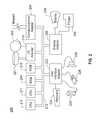
- FIG. 2illustrates an exemplary hardware configuration of the computing system 200 that runs method steps described in FIG. 1 in one embodiment.
- the hardware configurationpreferably has at least one processor or central processing unit (CPU) 211 .
- the CPUs 211are interconnected via a system bus 212 to a random access memory (RAM) 214 , read-only memory (ROM) 216 , input/output (I/O) adapter 218 (for connecting peripheral devices such as disk units 221 and tape drives 240 to the bus 212 ), user interface adapter 222 (for connecting a keyboard 224 , mouse 226 , speaker 228 , microphone 232 , and/or other user interface device to the bus 212 ), a communication adapter 234 for connecting the system 200 to a data processing network, the Internet, an Intranet, a local area network (LAN), etc., and a display adapter 236 for connecting the bus 212 to a display device 238 and/or printer 239 (e.g., a digital printer of the like).
- aspects of the present inventionmay be embodied as a system, method or computer program product. Accordingly, aspects of the present invention may take the form of an entirely hardware embodiment, an entirely software embodiment (including firmware, resident software, micro-code, etc.) or an embodiment combining software and hardware aspects that may all generally be referred to herein as a “circuit,” “module” or “system.” Furthermore, aspects of the present invention may take the form of a computer program product embodied in one or more computer readable medium(s) having computer readable program code embodied thereon.
- the computer readable mediummay be a computer readable signal medium or a computer readable storage medium.
- a computer readable storage mediummay be, for example, but not limited to, an electronic, magnetic, optical, electromagnetic, infrared, or semiconductor system, apparatus, or device, or any suitable combination of the foregoing.
- a computer readable storage mediummay be any tangible medium that can contain, or store a program for use by or in connection with a system, apparatus, or device running an instruction.
- a computer readable signal mediummay include a propagated data signal with computer readable program code embodied therein, for example, in baseband or as part of a carrier wave. Such a propagated signal may take any of a variety of forms, including, but not limited to, electro-magnetic, optical, or any suitable combination thereof,
- a computer readable signal mediummay be any computer readable medium that is not a computer readable storage medium and that can communicate, propagate, or transport a program for use by or in connection with a system, apparatus, or device running an instruction.
- Program code embodied on a computer readable mediummay be transmitted using any appropriate medium, including but not limited to wireless, wireline, optical fiber cable, RF, etc., or any suitable combination of the foregoing.
- Computer program code for carrying out operations for aspects of the present inventionmay be written in any combination of one or more programming languages, including an object oriented programming language such as Java, Smalltalk, C++ or the like and conventional procedural programming languages, such as the “C” programming language or similar programming languages.
- the program codemay run entirely on the user's computer, partly on the user's computer, as a stand-alone software package, partly on the user's computer and partly on a remote computer or entirely on the remote computer or server.
- the remote computermay be connected to the user's computer through any type of network, including a local area network (LAN) or a wide area network (WAN), or the connection may be made to an external computer (for example, through the Internet using an Internet Service Provider).
- LANlocal area network
- WANwide area network
- Internet Service Providerfor example, AT&T, MCI, Sprint, EarthLink, MSN, GTE, etc.
- These computer program instructionsmay also be stored in a computer readable medium that can direct a computer, other programmable data processing apparatus, or other devices to function in a particular manner, such that the instructions stored in the computer readable medium produce an article of manufacture including instructions which implement the function/act specified in the flowchart and/or block diagram block or blocks.
- the computer program instructionsmay also be loaded onto a computer, other programmable data processing apparatus, or other devices to cause a series of operational steps to be performed on the computer, other programmable apparatus or other devices to produce a computer implemented process such that the instructions which run on the computer or other programmable apparatus provide processes for implementing the functions/acts specified in the flowchart and/or block diagram block or blocks.
- each block in the flowchart or block diagramsmay represent a module, segment, or portion of code, which comprises one or more operable instructions for implementing the specified logical function(s).
- the functions noted in the blockmay occur out of the order noted in the figures. For example, two blocks shown in succession may, in fact, be run substantially concurrently, or the blocks may sometimes be run in the reverse order, depending upon the functionality involved.
Landscapes
- Engineering & Computer Science (AREA)
- Radar, Positioning & Navigation (AREA)
- Remote Sensing (AREA)
- Physics & Mathematics (AREA)
- General Physics & Mathematics (AREA)
- Automation & Control Theory (AREA)
- Navigation (AREA)
- Traffic Control Systems (AREA)
Abstract
Description
Claims (21)
Priority Applications (1)
| Application Number | Priority Date | Filing Date | Title |
|---|---|---|---|
| US12/984,180US8738289B2 (en) | 2011-01-04 | 2011-01-04 | Advanced routing of vehicle fleets |
Applications Claiming Priority (1)
| Application Number | Priority Date | Filing Date | Title |
|---|---|---|---|
| US12/984,180US8738289B2 (en) | 2011-01-04 | 2011-01-04 | Advanced routing of vehicle fleets |
Publications (2)
| Publication Number | Publication Date |
|---|---|
| US20120173136A1 US20120173136A1 (en) | 2012-07-05 |
| US8738289B2true US8738289B2 (en) | 2014-05-27 |
Family
ID=46381497
Family Applications (1)
| Application Number | Title | Priority Date | Filing Date |
|---|---|---|---|
| US12/984,180Active2032-03-30US8738289B2 (en) | 2011-01-04 | 2011-01-04 | Advanced routing of vehicle fleets |
Country Status (1)
| Country | Link |
|---|---|
| US (1) | US8738289B2 (en) |
Cited By (8)
| Publication number | Priority date | Publication date | Assignee | Title |
|---|---|---|---|---|
| US20170213180A1 (en)* | 2016-01-26 | 2017-07-27 | Oracle International Corporation | System and method for efficient storage of point-to-point traffic patterns |
| US10006776B2 (en)* | 2015-12-22 | 2018-06-26 | Honda Motor Co., Ltd. | Route searching system, storage medium which stores route searching program, and route searching method |
| US10360521B2 (en) | 2015-06-12 | 2019-07-23 | Sap Se | Dynamic location recommendation for public service vehicles |
| US10769946B1 (en)* | 2017-04-24 | 2020-09-08 | Ronald M Harstad | Incentive-compatible, asymmetric-information, real-time traffic-routing differential-advice |
| US11030570B2 (en)* | 2017-05-24 | 2021-06-08 | Tata Colsultancy Services Limited | System and method for dynamic fleet management |
| US20210295224A1 (en)* | 2020-03-23 | 2021-09-23 | Lyft, Inc. | Utilizing a requestor device forecasting model with forward and backward looking queue filters to pre-dispatch provider devices |
| US11466997B1 (en) | 2019-02-15 | 2022-10-11 | State Fram Mutual Automobile Insurance Company | Systems and methods for dynamically generating optimal routes for vehicle operation management |
| US11466998B1 (en) | 2019-02-15 | 2022-10-11 | State Farm Mutual Automobile Insurance Company | Systems and methods for dynamically generating optimal routes for management of multiple vehicles |
Families Citing this family (20)
| Publication number | Priority date | Publication date | Assignee | Title |
|---|---|---|---|---|
| DE102011011062A1 (en)* | 2011-02-11 | 2012-08-16 | Init Innovative Informatikanwendungen In Transport-, Verkehrs- Und Leitsystemen Gmbh | Method for planning journeys in passenger transport |
| US20130073327A1 (en)* | 2011-09-20 | 2013-03-21 | Benjamin J. Edelberg | Urban transportation system and method |
| US9286801B2 (en) | 2013-03-06 | 2016-03-15 | International Business Machines Corporation | Leveraging information for use in a traffic prediction scenario |
| US9714831B2 (en)* | 2014-07-07 | 2017-07-25 | Microsoft Technology Licensing, Llc | Travel path identification based upon statistical relationships between path costs |
| CN105045858B (en)* | 2015-07-10 | 2018-04-13 | 湖南科技大学 | Taxi pickup point based on ballot recommends method |
| US20170147976A1 (en)* | 2015-11-23 | 2017-05-25 | At&T Intellectual Property I, L.P. | Method and system of coordinating a delivery by a selected delivery agent to a delivery recipient |
| US10692028B2 (en)* | 2015-12-09 | 2020-06-23 | Sap Se | Optimal demand-based allocation |
| US11205240B2 (en)* | 2015-12-30 | 2021-12-21 | Waymo Llc | Autonomous vehicle services |
| US9843500B2 (en) | 2016-01-29 | 2017-12-12 | International Business Machines Corporation | Accurate mobile traffic information acquisition with minimal transmission cost and optional V2V extension |
| CN105825310A (en)* | 2016-04-11 | 2016-08-03 | 湖南科技大学 | Taxi passenger-searching path recommendation method based on information entropy |
| US10559209B2 (en)* | 2016-11-10 | 2020-02-11 | Sap Se | Vehicle position planning |
| US9934625B1 (en)* | 2017-01-31 | 2018-04-03 | Uber Technologies, Inc. | Detecting vehicle collisions based on moble computing device data |
| CN107038886B (en)* | 2017-05-11 | 2019-05-28 | 厦门大学 | A kind of taxi based on track data is cruised path recommended method and system |
| CN107766969B (en)* | 2017-09-28 | 2021-02-19 | 东南大学 | Large station fast line layout method based on subway service capacity bottleneck section identification |
| US10775186B2 (en) | 2017-12-29 | 2020-09-15 | ANI Technologies Private Limited | Method and system for predicting traffic conditions |
| CN112219217B (en)* | 2018-06-08 | 2024-08-13 | 索尼公司 | Information processing device, information processing method, and program |
| CN110163405B (en)* | 2018-07-23 | 2022-03-25 | 腾讯大地通途(北京)科技有限公司 | Method, device, terminal and storage medium for determining transit time |
| US11082529B2 (en)* | 2018-10-23 | 2021-08-03 | Uber Technologies, Inc. | Prediction engine for a network-based service |
| US11012809B2 (en) | 2019-02-08 | 2021-05-18 | Uber Technologies, Inc. | Proximity alert system |
| PH12021553168B1 (en) | 2019-06-27 | 2024-06-14 | Grabtaxi Holdings Pte Ltd | Processing route information |
Citations (37)
| Publication number | Priority date | Publication date | Assignee | Title |
|---|---|---|---|---|
| US5889477A (en) | 1996-03-25 | 1999-03-30 | Mannesmann Aktiengesellschaft | Process and system for ascertaining traffic conditions using stationary data collection devices |
| EP1127727A2 (en) | 2000-02-23 | 2001-08-29 | Hitachi, Ltd. | Cruise control device for a vehicle |
| US20010029425A1 (en) | 2000-03-17 | 2001-10-11 | David Myr | Real time vehicle guidance and traffic forecasting system |
| US6317686B1 (en) | 2000-07-21 | 2001-11-13 | Bin Ran | Method of providing travel time |
| US20020049687A1 (en) | 2000-10-23 | 2002-04-25 | David Helsper | Enhanced computer performance forecasting system |
| US6470262B2 (en) | 2000-05-10 | 2002-10-22 | Daimlerchrysler Ag | Method for traffic situation determination on the basis of reporting vehicle data for a traffic network with traffic-controlled network nodes |
| US6496773B1 (en) | 1998-01-30 | 2002-12-17 | Kjell Olsson | Method and means for network control of traffic |
| US6587779B1 (en) | 1998-08-08 | 2003-07-01 | Daimlerchrysler Ag | Traffic surveillance method and vehicle flow control in a road network |
| US20030216858A1 (en)* | 2002-04-09 | 2003-11-20 | Akira Sakai | Navigation apparatus, navigation method, navigation program and recording medium storing the program |
| US20040038671A1 (en) | 2000-06-26 | 2004-02-26 | Ros Trayford | Method and system for providing traffic and related information |
| US6721650B2 (en) | 2001-02-23 | 2004-04-13 | Hitachi, Ltd. | Method of presuming traffic conditions by using floating car data and system for presuming and presenting traffic conditions by using floating data |
| US20040073361A1 (en) | 2002-10-15 | 2004-04-15 | Assimakis Tzamaloukas | Enhanced mobile communication device, and transportation application thereof |
| US20040143385A1 (en) | 2002-11-22 | 2004-07-22 | Mobility Technologies | Method of creating a virtual traffic network |
| US20050033511A1 (en)* | 2002-04-30 | 2005-02-10 | Telmap Ltd. | Dynamic navigation system |
| US20050091176A1 (en) | 2003-10-24 | 2005-04-28 | Mitsubishi Denki Kabushiki Kaisha | Forecasting apparatus |
| US20050125195A1 (en) | 2001-12-21 | 2005-06-09 | Juergen Brendel | Method, apparatus and sofware for network traffic management |
| US20060058940A1 (en) | 2004-09-13 | 2006-03-16 | Masatoshi Kumagai | Traffic information prediction system |
| US20060122846A1 (en) | 2002-08-29 | 2006-06-08 | Jonathan Burr | Apparatus and method for providing traffic information |
| US7082364B2 (en)* | 2003-06-24 | 2006-07-25 | Bellsouth Intellectual Property Corporation | Methods, systems and computer program products for ride matching based on current location information |
| US20060206256A1 (en) | 2005-03-09 | 2006-09-14 | Hitachi, Ltd. | Traffic information system |
| US20070208496A1 (en) | 2006-03-03 | 2007-09-06 | Downs Oliver B | Obtaining road traffic condition data from mobile data sources |
| US20070208498A1 (en) | 2006-03-03 | 2007-09-06 | Inrix, Inc. | Displaying road traffic condition information and user controls |
| US20070208492A1 (en) | 2006-03-03 | 2007-09-06 | Inrix, Inc. | Dynamic time series prediction of future traffic conditions |
| US7274306B2 (en) | 2003-12-24 | 2007-09-25 | Publicover Mark W | Traffic management device and system |
| US20080030371A1 (en) | 2006-08-07 | 2008-02-07 | Xanavi Informatics Corporation | Traffic Information Providing Device, Traffic Information Providing System, Traffic Information Transmission Method, and Traffic Information Request Method |
| US20080046165A1 (en) | 2006-08-18 | 2008-02-21 | Inrix, Inc. | Rectifying erroneous road traffic sensor data |
| US7363144B2 (en) | 2005-02-07 | 2008-04-22 | International Business Machines Corporation | Method and apparatus for predicting future travel times over a transportation network |
| WO2008063225A2 (en) | 2006-07-25 | 2008-05-29 | United Parcel Service Of America, Inc. | Systems and methods for monitoring travel conditions |
| US20080175161A1 (en) | 2007-01-24 | 2008-07-24 | Yasuo Amemiya | Method and structure for vehicular traffic prediction with link interactions |
| US7427930B2 (en) | 2001-09-27 | 2008-09-23 | Wavetronix Llc | Vehicular traffic sensor |
| US20080235398A1 (en) | 2005-05-17 | 2008-09-25 | Technische Universität Dresden | Method For Coordination of Concurrent Processes or for Control of the Transport of Mobile Units Within a Network |
| US7433889B1 (en) | 2002-08-07 | 2008-10-07 | Navteq North America, Llc | Method and system for obtaining traffic sign data using navigation systems |
| US20090099760A1 (en) | 2007-10-16 | 2009-04-16 | Roger Lederman | Method and system for expansion of real-time data on traffic networks |
| US7610151B2 (en) | 2006-06-27 | 2009-10-27 | Microsoft Corporation | Collaborative route planning for generating personalized and context-sensitive routing recommendations |
| US20100042549A1 (en)* | 2003-06-24 | 2010-02-18 | Maria Adamczyk | Methods, systems and computer program products for ride matching based on selection criteria and driver characteristic information |
| US7668946B1 (en) | 2001-08-31 | 2010-02-23 | Aol Advertising Inc. | Traffic estimation |
| US7680596B2 (en) | 2004-04-06 | 2010-03-16 | Honda Motor Co., Ltd. | Route calculation method for a vehicle navigation system |
- 2011
- 2011-01-04USUS12/984,180patent/US8738289B2/enactiveActive
Patent Citations (42)
| Publication number | Priority date | Publication date | Assignee | Title |
|---|---|---|---|---|
| US5889477A (en) | 1996-03-25 | 1999-03-30 | Mannesmann Aktiengesellschaft | Process and system for ascertaining traffic conditions using stationary data collection devices |
| US6496773B1 (en) | 1998-01-30 | 2002-12-17 | Kjell Olsson | Method and means for network control of traffic |
| US6587779B1 (en) | 1998-08-08 | 2003-07-01 | Daimlerchrysler Ag | Traffic surveillance method and vehicle flow control in a road network |
| EP1127727A2 (en) | 2000-02-23 | 2001-08-29 | Hitachi, Ltd. | Cruise control device for a vehicle |
| US20010029425A1 (en) | 2000-03-17 | 2001-10-11 | David Myr | Real time vehicle guidance and traffic forecasting system |
| US6470262B2 (en) | 2000-05-10 | 2002-10-22 | Daimlerchrysler Ag | Method for traffic situation determination on the basis of reporting vehicle data for a traffic network with traffic-controlled network nodes |
| US20040038671A1 (en) | 2000-06-26 | 2004-02-26 | Ros Trayford | Method and system for providing traffic and related information |
| US6317686B1 (en) | 2000-07-21 | 2001-11-13 | Bin Ran | Method of providing travel time |
| US6876988B2 (en) | 2000-10-23 | 2005-04-05 | Netuitive, Inc. | Enhanced computer performance forecasting system |
| US20020049687A1 (en) | 2000-10-23 | 2002-04-25 | David Helsper | Enhanced computer performance forecasting system |
| US6721650B2 (en) | 2001-02-23 | 2004-04-13 | Hitachi, Ltd. | Method of presuming traffic conditions by using floating car data and system for presuming and presenting traffic conditions by using floating data |
| US7668946B1 (en) | 2001-08-31 | 2010-02-23 | Aol Advertising Inc. | Traffic estimation |
| US7427930B2 (en) | 2001-09-27 | 2008-09-23 | Wavetronix Llc | Vehicular traffic sensor |
| US20050125195A1 (en) | 2001-12-21 | 2005-06-09 | Juergen Brendel | Method, apparatus and sofware for network traffic management |
| US20030216858A1 (en)* | 2002-04-09 | 2003-11-20 | Akira Sakai | Navigation apparatus, navigation method, navigation program and recording medium storing the program |
| US20050033511A1 (en)* | 2002-04-30 | 2005-02-10 | Telmap Ltd. | Dynamic navigation system |
| US7433889B1 (en) | 2002-08-07 | 2008-10-07 | Navteq North America, Llc | Method and system for obtaining traffic sign data using navigation systems |
| US20060122846A1 (en) | 2002-08-29 | 2006-06-08 | Jonathan Burr | Apparatus and method for providing traffic information |
| US20040073361A1 (en) | 2002-10-15 | 2004-04-15 | Assimakis Tzamaloukas | Enhanced mobile communication device, and transportation application thereof |
| US20040143385A1 (en) | 2002-11-22 | 2004-07-22 | Mobility Technologies | Method of creating a virtual traffic network |
| US7082364B2 (en)* | 2003-06-24 | 2006-07-25 | Bellsouth Intellectual Property Corporation | Methods, systems and computer program products for ride matching based on current location information |
| US20100042549A1 (en)* | 2003-06-24 | 2010-02-18 | Maria Adamczyk | Methods, systems and computer program products for ride matching based on selection criteria and driver characteristic information |
| US20050091176A1 (en) | 2003-10-24 | 2005-04-28 | Mitsubishi Denki Kabushiki Kaisha | Forecasting apparatus |
| US7472099B2 (en) | 2003-10-24 | 2008-12-30 | Mitsubishi Denki Kabushiki Kaisha | Forecasting apparatus |
| US7274306B2 (en) | 2003-12-24 | 2007-09-25 | Publicover Mark W | Traffic management device and system |
| US7680596B2 (en) | 2004-04-06 | 2010-03-16 | Honda Motor Co., Ltd. | Route calculation method for a vehicle navigation system |
| US20060058940A1 (en) | 2004-09-13 | 2006-03-16 | Masatoshi Kumagai | Traffic information prediction system |
| US7363144B2 (en) | 2005-02-07 | 2008-04-22 | International Business Machines Corporation | Method and apparatus for predicting future travel times over a transportation network |
| US20060206256A1 (en) | 2005-03-09 | 2006-09-14 | Hitachi, Ltd. | Traffic information system |
| US20080235398A1 (en) | 2005-05-17 | 2008-09-25 | Technische Universität Dresden | Method For Coordination of Concurrent Processes or for Control of the Transport of Mobile Units Within a Network |
| US8103434B2 (en) | 2005-05-17 | 2012-01-24 | Eth Zuerich | Method for coordination of competing processes or for control of the transport of mobile units within a network |
| US20070208496A1 (en) | 2006-03-03 | 2007-09-06 | Downs Oliver B | Obtaining road traffic condition data from mobile data sources |
| US20070208498A1 (en) | 2006-03-03 | 2007-09-06 | Inrix, Inc. | Displaying road traffic condition information and user controls |
| US20070208492A1 (en) | 2006-03-03 | 2007-09-06 | Inrix, Inc. | Dynamic time series prediction of future traffic conditions |
| US7610151B2 (en) | 2006-06-27 | 2009-10-27 | Microsoft Corporation | Collaborative route planning for generating personalized and context-sensitive routing recommendations |
| WO2008063225A2 (en) | 2006-07-25 | 2008-05-29 | United Parcel Service Of America, Inc. | Systems and methods for monitoring travel conditions |
| US7555381B2 (en) | 2006-08-07 | 2009-06-30 | Xanavi Informatics Corporation | Traffic information providing device, traffic information providing system, traffic information transmission method, and traffic information request method |
| US20080030371A1 (en) | 2006-08-07 | 2008-02-07 | Xanavi Informatics Corporation | Traffic Information Providing Device, Traffic Information Providing System, Traffic Information Transmission Method, and Traffic Information Request Method |
| US7706965B2 (en) | 2006-08-18 | 2010-04-27 | Inrix, Inc. | Rectifying erroneous road traffic sensor data |
| US20080046165A1 (en) | 2006-08-18 | 2008-02-21 | Inrix, Inc. | Rectifying erroneous road traffic sensor data |
| US20080175161A1 (en) | 2007-01-24 | 2008-07-24 | Yasuo Amemiya | Method and structure for vehicular traffic prediction with link interactions |
| US20090099760A1 (en) | 2007-10-16 | 2009-04-16 | Roger Lederman | Method and system for expansion of real-time data on traffic networks |
Non-Patent Citations (4)
| Title |
|---|
| Gung, R. R., et al., "Demand Forecasting TODAY", OR/MS Today, Dec. 2002. |
| Liao, L., et al., "Learning and Inferring Transportation Routines", Journal Artificial Intelligence, Apr. 2007, vol. 171 Issue 5-6. |
| Williams, C. A., "A Data Mining Approach to Rapidly Learning Traveler Activity Patterns for Mobile Applications", University of Illinois at Chicago, 2010. |
| Williams, C. A., et al., "Mining Sequential Association Rules for Traveler Context Prediction", Proceeding Mobiquitous '08 Proceedings of the 5th Annual International Conference on Mobile and Ubiquitous Systems: Computing, Networking, and Services, 2008. |
Cited By (14)
| Publication number | Priority date | Publication date | Assignee | Title |
|---|---|---|---|---|
| US10360521B2 (en) | 2015-06-12 | 2019-07-23 | Sap Se | Dynamic location recommendation for public service vehicles |
| US10006776B2 (en)* | 2015-12-22 | 2018-06-26 | Honda Motor Co., Ltd. | Route searching system, storage medium which stores route searching program, and route searching method |
| US20170213180A1 (en)* | 2016-01-26 | 2017-07-27 | Oracle International Corporation | System and method for efficient storage of point-to-point traffic patterns |
| US10546254B2 (en)* | 2016-01-26 | 2020-01-28 | Oracle International Corporation | System and method for efficient storage of point-to-point traffic patterns |
| US10769946B1 (en)* | 2017-04-24 | 2020-09-08 | Ronald M Harstad | Incentive-compatible, asymmetric-information, real-time traffic-routing differential-advice |
| US11030570B2 (en)* | 2017-05-24 | 2021-06-08 | Tata Colsultancy Services Limited | System and method for dynamic fleet management |
| US11493345B1 (en) | 2019-02-15 | 2022-11-08 | State Farm Mutual Automobile Insurance Company | Systems and methods for dynamically generating optimal routes for vehicle delivery management |
| US11466997B1 (en) | 2019-02-15 | 2022-10-11 | State Fram Mutual Automobile Insurance Company | Systems and methods for dynamically generating optimal routes for vehicle operation management |
| US11466998B1 (en) | 2019-02-15 | 2022-10-11 | State Farm Mutual Automobile Insurance Company | Systems and methods for dynamically generating optimal routes for management of multiple vehicles |
| US12112283B1 (en) | 2019-02-15 | 2024-10-08 | State Farm Mutual Automobile Insurance Company | Systems and methods for dynamically generating optimal routes and routed vehicle analytics |
| US12174033B2 (en) | 2019-02-15 | 2024-12-24 | State Farm Mutual Automobile Insurance Company | Systems and methods for dynamically generating optimal routes for management of multiple vehicles |
| US12181299B2 (en) | 2019-02-15 | 2024-12-31 | State Farm Mutual Automobile Insurance Company | Systems and methods for dynamically generating optimal routes for vehicle delivery management |
| US12181300B2 (en) | 2019-02-15 | 2024-12-31 | State Farm Mutual Automobile Insurance Company | Systems and methods for dynamically generating optimal routes for vehicle operation management |
| US20210295224A1 (en)* | 2020-03-23 | 2021-09-23 | Lyft, Inc. | Utilizing a requestor device forecasting model with forward and backward looking queue filters to pre-dispatch provider devices |
Also Published As
| Publication number | Publication date |
|---|---|
| US20120173136A1 (en) | 2012-07-05 |
Similar Documents
| Publication | Publication Date | Title |
|---|---|---|
| US8738289B2 (en) | Advanced routing of vehicle fleets | |
| US10859391B2 (en) | Method, apparatus, and computer program product for predicting range of an electric vehicle | |
| US10928209B2 (en) | Assessing inter-modal passenger travel options | |
| US9689693B2 (en) | Systems and methods for learning and displaying customized geographical navigational options | |
| US11692837B2 (en) | Automatic discovery of optimal routes for flying cars and drones | |
| US20210295706A1 (en) | Avoiding missed rideshare connections | |
| USRE47985E1 (en) | Method and system for fleet navigation, dispatching and multi-vehicle, multi-destination routing | |
| JP6423520B2 (en) | System and method for managing service supply status | |
| US9534913B2 (en) | Systems and methods for simultaneous electronic display of various modes of transportation for viewing and comparing | |
| US8538686B2 (en) | Transport-dependent prediction of destinations | |
| CN101622653B (en) | Traffic information adaptive to a user's travel | |
| CN101620781B (en) | System for Predicting Passenger Information, System and Method for Searching Passenger Information | |
| US11733050B2 (en) | Method and apparatus for providing an isoline map of a time to park at a destination | |
| US20150253144A1 (en) | Methods and route planning systems for dynamic trip modifications and quick and easy alternative routes | |
| JP2023535828A (en) | Routing method, device, equipment and medium | |
| US20220120572A9 (en) | Real-time ride sharing solutions for unanticipated changes during a ride | |
| US20160117610A1 (en) | Transportation service reservation method, transportation service reservation apparatus, and computer-readable storage medium | |
| US9959339B2 (en) | Journey time estimation | |
| US20180314998A1 (en) | Resource Allocation in a Network System | |
| JP7062553B2 (en) | Information processing equipment, information processing methods and computer programs | |
| US20220004199A1 (en) | Accounting for driver reaction time when providing driving instructions | |
| US20170178268A1 (en) | Management of mobile objects and resources | |
| US20120283945A1 (en) | Wireless sensor network traffic navigation analytics | |
| CN113739815A (en) | Path planning method and device based on road comfort | |
| Li et al. | Navigating the transit network: Understanding riders’ information seeking behavior using trip planning data |
Legal Events
| Date | Code | Title | Description |
|---|---|---|---|
| AS | Assignment | Owner name:INTERNATIONAL BUSINESS MACHINES CORPORATION, NEW Y Free format text:ASSIGNMENT OF ASSIGNORS INTEREST;ASSIGNORS:GHOTING, AMOL;TURAGA, DEEPAK S.;WYNTER, LAURA;SIGNING DATES FROM 20101208 TO 20101217;REEL/FRAME:025579/0831 | |
| STCF | Information on status: patent grant | Free format text:PATENTED CASE | |
| AS | Assignment | Owner name:GLOBALFOUNDRIES U.S. 2 LLC, NEW YORK Free format text:ASSIGNMENT OF ASSIGNORS INTEREST;ASSIGNOR:INTERNATIONAL BUSINESS MACHINES CORPORATION;REEL/FRAME:036550/0001 Effective date:20150629 | |
| AS | Assignment | Owner name:GLOBALFOUNDRIES INC., CAYMAN ISLANDS Free format text:ASSIGNMENT OF ASSIGNORS INTEREST;ASSIGNORS:GLOBALFOUNDRIES U.S. 2 LLC;GLOBALFOUNDRIES U.S. INC.;REEL/FRAME:036779/0001 Effective date:20150910 | |
| MAFP | Maintenance fee payment | Free format text:PAYMENT OF MAINTENANCE FEE, 4TH YEAR, LARGE ENTITY (ORIGINAL EVENT CODE: M1551) Year of fee payment:4 | |
| AS | Assignment | Owner name:WILMINGTON TRUST, NATIONAL ASSOCIATION, DELAWARE Free format text:SECURITY AGREEMENT;ASSIGNOR:GLOBALFOUNDRIES INC.;REEL/FRAME:049490/0001 Effective date:20181127 | |
| AS | Assignment | Owner name:GLOBALFOUNDRIES U.S. INC., CALIFORNIA Free format text:ASSIGNMENT OF ASSIGNORS INTEREST;ASSIGNOR:GLOBALFOUNDRIES INC.;REEL/FRAME:054633/0001 Effective date:20201022 | |
| AS | Assignment | Owner name:GLOBALFOUNDRIES INC., CAYMAN ISLANDS Free format text:RELEASE BY SECURED PARTY;ASSIGNOR:WILMINGTON TRUST, NATIONAL ASSOCIATION;REEL/FRAME:054636/0001 Effective date:20201117 | |
| AS | Assignment | Owner name:GLOBALFOUNDRIES U.S. INC., NEW YORK Free format text:RELEASE BY SECURED PARTY;ASSIGNOR:WILMINGTON TRUST, NATIONAL ASSOCIATION;REEL/FRAME:056987/0001 Effective date:20201117 | |
| MAFP | Maintenance fee payment | Free format text:PAYMENT OF MAINTENANCE FEE, 8TH YEAR, LARGE ENTITY (ORIGINAL EVENT CODE: M1552); ENTITY STATUS OF PATENT OWNER: LARGE ENTITY Year of fee payment:8 |