US8718673B2 - System and method for location assurance of a mobile device - Google Patents
System and method for location assurance of a mobile deviceDownload PDFInfo
- Publication number
- US8718673B2 US8718673B2US13/112,669US201113112669AUS8718673B2US 8718673 B2US8718673 B2US 8718673B2US 201113112669 AUS201113112669 AUS 201113112669AUS 8718673 B2US8718673 B2US 8718673B2
- Authority
- US
- United States
- Prior art keywords
- location
- measurements
- satellites
- estimated
- estimated location
- Prior art date
- Legal status (The legal status is an assumption and is not a legal conclusion. Google has not performed a legal analysis and makes no representation as to the accuracy of the status listed.)
- Expired - Fee Related, expires
Links
- 238000000034methodMethods0.000titleclaimsabstractdescription55
- 238000005259measurementMethods0.000claimsabstractdescription109
- 238000005516engineering processMethods0.000claimsabstractdescription23
- 238000004891communicationMethods0.000claimsdescription19
- 230000001413cellular effectEffects0.000claimsdescription13
- 230000010363phase shiftEffects0.000claimsdescription2
- 230000011664signalingEffects0.000claimsdescription2
- 230000005540biological transmissionEffects0.000description10
- 238000004590computer programMethods0.000description10
- 230000008569processEffects0.000description10
- 239000005433ionosphereSubstances0.000description8
- 238000004364calculation methodMethods0.000description7
- 230000006870functionEffects0.000description5
- 239000005436troposphereSubstances0.000description5
- 230000000903blocking effectEffects0.000description4
- 238000012937correctionMethods0.000description4
- 238000010586diagramMethods0.000description4
- 230000003287optical effectEffects0.000description4
- 238000012545processingMethods0.000description4
- 238000012986modificationMethods0.000description3
- 230000004048modificationEffects0.000description3
- 230000000644propagated effectEffects0.000description3
- 238000012795verificationMethods0.000description3
- 239000004165Methyl ester of fatty acidsSubstances0.000description2
- 230000008901benefitEffects0.000description2
- 230000001934delayEffects0.000description2
- 238000001514detection methodMethods0.000description2
- 230000000694effectsEffects0.000description2
- 230000003993interactionEffects0.000description2
- 230000004044responseEffects0.000description2
- 238000013515scriptMethods0.000description2
- 238000000926separation methodMethods0.000description2
- 230000001360synchronised effectEffects0.000description2
- 230000003247decreasing effectEffects0.000description1
- 230000007812deficiencyEffects0.000description1
- 230000036541healthEffects0.000description1
- 238000012804iterative processMethods0.000description1
- 239000004973liquid crystal related substanceSubstances0.000description1
- 238000012544monitoring processMethods0.000description1
- 230000000505pernicious effectEffects0.000description1
- 238000009420retrofittingMethods0.000description1
- 239000004065semiconductorSubstances0.000description1
- 230000035945sensitivityEffects0.000description1
- 238000001228spectrumMethods0.000description1
- 239000000758substrateSubstances0.000description1
- 238000012360testing methodMethods0.000description1
- 238000012546transferMethods0.000description1
- 239000002699waste materialSubstances0.000description1
Images


Classifications
- H—ELECTRICITY
- H04—ELECTRIC COMMUNICATION TECHNIQUE
- H04W—WIRELESS COMMUNICATION NETWORKS
- H04W4/00—Services specially adapted for wireless communication networks; Facilities therefor
- H04W4/02—Services making use of location information
- H04W4/025—Services making use of location information using location based information parameters
- G—PHYSICS
- G01—MEASURING; TESTING
- G01S—RADIO DIRECTION-FINDING; RADIO NAVIGATION; DETERMINING DISTANCE OR VELOCITY BY USE OF RADIO WAVES; LOCATING OR PRESENCE-DETECTING BY USE OF THE REFLECTION OR RERADIATION OF RADIO WAVES; ANALOGOUS ARRANGEMENTS USING OTHER WAVES
- G01S19/00—Satellite radio beacon positioning systems; Determining position, velocity or attitude using signals transmitted by such systems
- G01S19/01—Satellite radio beacon positioning systems transmitting time-stamped messages, e.g. GPS [Global Positioning System], GLONASS [Global Orbiting Navigation Satellite System] or GALILEO
- G01S19/03—Cooperating elements; Interaction or communication between different cooperating elements or between cooperating elements and receivers
- G—PHYSICS
- G01—MEASURING; TESTING
- G01S—RADIO DIRECTION-FINDING; RADIO NAVIGATION; DETERMINING DISTANCE OR VELOCITY BY USE OF RADIO WAVES; LOCATING OR PRESENCE-DETECTING BY USE OF THE REFLECTION OR RERADIATION OF RADIO WAVES; ANALOGOUS ARRANGEMENTS USING OTHER WAVES
- G01S19/00—Satellite radio beacon positioning systems; Determining position, velocity or attitude using signals transmitted by such systems
- G01S19/01—Satellite radio beacon positioning systems transmitting time-stamped messages, e.g. GPS [Global Positioning System], GLONASS [Global Orbiting Navigation Satellite System] or GALILEO
- G01S19/13—Receivers
- G01S19/21—Interference related issues ; Issues related to cross-correlation, spoofing or other methods of denial of service
- G01S19/215—Interference related issues ; Issues related to cross-correlation, spoofing or other methods of denial of service issues related to spoofing
- G—PHYSICS
- G01—MEASURING; TESTING
- G01S—RADIO DIRECTION-FINDING; RADIO NAVIGATION; DETERMINING DISTANCE OR VELOCITY BY USE OF RADIO WAVES; LOCATING OR PRESENCE-DETECTING BY USE OF THE REFLECTION OR RERADIATION OF RADIO WAVES; ANALOGOUS ARRANGEMENTS USING OTHER WAVES
- G01S19/00—Satellite radio beacon positioning systems; Determining position, velocity or attitude using signals transmitted by such systems
- G01S19/38—Determining a navigation solution using signals transmitted by a satellite radio beacon positioning system
- G01S19/39—Determining a navigation solution using signals transmitted by a satellite radio beacon positioning system the satellite radio beacon positioning system transmitting time-stamped messages, e.g. GPS [Global Positioning System], GLONASS [Global Orbiting Navigation Satellite System] or GALILEO
- G01S19/42—Determining position
- G01S19/48—Determining position by combining or switching between position solutions derived from the satellite radio beacon positioning system and position solutions derived from a further system
- H—ELECTRICITY
- H04—ELECTRIC COMMUNICATION TECHNIQUE
- H04W—WIRELESS COMMUNICATION NETWORKS
- H04W12/00—Security arrangements; Authentication; Protecting privacy or anonymity
- H04W12/12—Detection or prevention of fraud
- H—ELECTRICITY
- H04—ELECTRIC COMMUNICATION TECHNIQUE
- H04W—WIRELESS COMMUNICATION NETWORKS
- H04W12/00—Security arrangements; Authentication; Protecting privacy or anonymity
- H04W12/60—Context-dependent security
- H04W12/63—Location-dependent; Proximity-dependent
- H—ELECTRICITY
- H04—ELECTRIC COMMUNICATION TECHNIQUE
- H04W—WIRELESS COMMUNICATION NETWORKS
- H04W24/00—Supervisory, monitoring or testing arrangements
- H04W24/10—Scheduling measurement reports ; Arrangements for measurement reports
- H—ELECTRICITY
- H04—ELECTRIC COMMUNICATION TECHNIQUE
- H04W—WIRELESS COMMUNICATION NETWORKS
- H04W64/00—Locating users or terminals or network equipment for network management purposes, e.g. mobility management
Definitions
- Radio communication systemsgenerally provide two-way voice and data communication between remote locations. Examples of such systems are cellular and personal communication system (“PCS”) radio systems, trunked radio systems, dispatch radio networks, and global mobile personal communication systems (“GMPCS”) such as satellite-based systems. Communication in these systems is conducted according to a pre-defined standard. Mobile devices or stations, also known as handsets, portables or radiotelephones, conform to the system standard to communicate with one or more fixed base stations. It is important to determine the location of such a device capable of radio communication especially in an emergency situation. In addition, in 2001 the United States Federal Communications Commission (“FCC”) required that cellular handsets must be geographically locatable. This capability is desirable for emergency systems such as Enhanced 911 (“E-911”). The FCC requires stringent accuracy and availability performance objectives and demands that cellular handsets be locatable within 100 meters 67% of the time for network based solutions and within 50 meters 67% of the time for handset based solutions.
- PCSpersonal communication system
- GPCSglobal mobile personal communication systems
- E-911Enhanced 911
- GNSSGlobal Navigation Satellite System
- GPSGlobal Positioning System
- FIG. 1is a schematic representation of a constellation 100 of GPS satellites 101 .
- GPSmay include a constellation of GPS satellites 101 in non-geosynchronous orbits around the earth.
- the GPS satellites 101travel in six orbital planes 102 with four of the GPS satellites 101 in each plane.
- Each orbital planehas an inclination of 55 degrees relative to the equator.
- each orbital planehas an altitude of approximately 20,200 km (10,900 miles).
- the time required to travel the entire orbitis just under 12 hours. Thus, at any given location on the surface of the earth with clear view of the sky, at least five GPS satellites are generally visible at any given time.
- GPS position determinationis made based on the time of arrival (“TOA”) of various satellite signals.
- TOAtime of arrival
- Each of the orbiting GPS satellites 101broadcasts spread spectrum microwave signals encoded with satellite ephemeris information and other information that allows a position to be calculated by the receiver.
- GPS measurementscorresponding to each correlator channel with a locked GPS satellite signal are available for GPS receivers.
- the two carrier signals, L1 and L2possess frequencies of 1.5754 GHz and 1.2276 GHz, or wavelengths of 0.1903 m and 0.2442 m, respectively.
- the L1 frequencycarries the navigation data as well as the standard positioning code, while the L2 frequency carries the P code and is used for precision positioning code for military applications.
- the signalsare modulated using bi-phase shift keying techniques.
- the signalsare broadcast at precisely known times and at precisely known intervals and each signal is encoded with its precise transmission time.
- the LC2C signalis a second civilian frequency transmitted by GPS satellites.
- L1transmits the Coarse Acquisition (“C/A”) code.
- L2Ctransmits L2CM (civil-moderate) and L2CL (civil long) codes. These codes allow a device to differentiate between satellites that are all transmitting on the same frequency.
- the C/A codeis 1 milliseconds long, the L2CM is 20 milliseconds long and the L2CL is 1.5 seconds long.
- the L2C codesprovide a more robust cross-correlation performance so that reception of weak GPS signals is less affected by simultaneously received strong GPS signals.
- the civil navigation message (“CNAV”)is the broadcast model that can be transmitted on the L2C and provides a more accurate and frequent message than the legacy navigation message.
- GPS receiversmeasure and analyze signals from the satellites, and estimate the corresponding coordinates of the receiver position, as well as the instantaneous receiver clock bias. GPS receivers may also measure the velocity of the receiver. The quality of these estimates depends upon the number and the geometry of satellites in view, measurement error and residual biases. Residual biases generally include satellite ephemeris bias, satellite and receiver clock errors, and ionospheric and tropospheric delays. If receiver clocks were perfectly synchronized with the satellite clocks, only three range measurements would be needed to allow a user to compute a three-dimensional position. This process is known as multilateration.
- This clock biasis determined by computing a measurement from a fourth satellite using a processor in the receiver that correlates the ranges measured from each satellite. This process requires four or more satellites from which four or more measurements can be obtained to estimate four unknowns x, y, z, b.
- the unknownsare latitude, longitude, altitude and receiver clock offset.
- the amount b, by which the processor has added or subtracted time,is the instantaneous bias between the receiver clock and the satellite clock. It is possible to calculate a location with only three satellites when additional information is available.
- an arbitrary satellite measurementmay be included that is centered at the center of the earth and possesses a range defined as the distance from the center of the earth to the known altitude of the handset or mobile device.
- the altitude of the handsetmay be known from another sensor or from information from the cell location in the case where the handset is in a cellular network.
- A-GPSAssisted-GPS
- TTFFtime to first fix
- a communications network and associated infrastructuremay be utilized to assist the mobile GPS receiver, either as a standalone device or integrated with a mobile station or device.
- the general concept of A-GPSis to establish a GPS reference network (and/or a wide-area D-GPS network or a wide area reference network (“WARN”)) including receivers with clear views of the sky that may operate continuously.
- This reference networkmay also be connected with the cellular infrastructure, may continuously monitor the real-time constellation status, and may provide data for each satellite at a particular epoch time.
- the reference networkmay provide ephemeris information, UTC model information, ionosphere model information, and other broadcast information to the cellular infrastructure.
- the GPS reference receiver and its servermay be located at any surveyed location with an open view of the sky.
- Typical A-GPS informationmay include, but is not limited to, data for determining a GPS receiver's approximate position, time synchronization mark, satellite ephemerides, various model information and satellite dopplers. Different A-GPS services may omit some of these parameters; however, another component of the supplied information is the identification of the satellites for which a device or GPS receiver should search.
- a mobile devicemay attempt to search for and acquire satellite signals for the satellites included in the assistance data. If, however, satellites are included in the assistance data that are not measurable by the mobile device (e.g., the satellite is no longer visible, etc.), then the mobile device may waste time and considerable power attempting to acquire measurements for the satellite.
- Civilian GPS signalsare vulnerable to attacks such as blocking, jamming and spoofing.
- the goal of such attacksgenerally is to prevent a position lock (e.g., blocking and jamming) or to feed a receiver false information so that the receiver computes an erroneous time or location (e.g., spoofing).
- GPS receiversare generally aware when blocking or jamming is occurring because the receivers encounter a loss of signal. Spoofing, however, is a surreptitious attack.
- GPS signalsare widely used by government and private industries for important applications, including, but not limited to, public safety services, navigation, geolocation, hiking, surveying, robotics, tracking, etc.
- civilian GPS signalsare not secure. Since GPS signal strength, measured at the Earth's surface at about ⁇ 160 dBw (1 ⁇ 10 ⁇ 16 watts), is roughly equivalent to viewing a 25 watt light bulb from a distance of 10,000 miles, GPS signals may be blocked by destroying or shielding a receiver's antenna and may be jammed by a signal of a similar frequency but greater strength. As stated above, however, blocking and jamming are not the greatest security risk.
- a more pernicious attackinvolves feeding the receiver fake or forged satellite signals so that the receiver believes it is located somewhere in space and time that it is not.
- Spoofingmay be accomplished by utilizing a GPS satellite simulator. Such simulators are uncontrolled and widely available. To conduct the spoofing attack, an adversary may broadcast a forged satellite signal with a higher signal strength than the true signal, and the GPS receiver believes that the forged signal is actually a true GPS signal. The receiver may then proceed to calculate erroneous position or time information based on this forged signal.
- location spoofingit is also possible for an unscrupulous user or intermediary to alter the software in a wireless device to manipulate satellite measurements thereby causing a location determining system to calculate an incorrect location.
- This method of spoofingis generally termed as location spoofing.
- location spoofingGenerally, if satellite measurements are manipulated in a wireless device randomly, it is likely that a resulting position calculation may fail because the position of the respective satellites may be too far away from the actual code phase indicated location; however, a skillful user may calculate required code phases resulting in the calculation of a spoofed or false location by the location determining system.
- spoofing detectionhas focused on detecting false radio frequency signals arriving at the GPS receiver front-end and/or authenticating location results provided to a third party.
- PCFposition calculation function
- An LSmay generally be a node in a wireless network providing GPS assistance data to an A-GPS capable device. The device may utilize the assistance data to lock onto satellites much faster than if no assistance data were available and may also allow the device to lock onto weaker signals reducing TTFF and increasing yield.
- the LSmay also determine the location of the device using measurements from the device and/or the respective network.
- the LSmay also require the device to provide true and accurate measurements (rather than falsified measurements) to determined an accurate location for the device.
- the integrity of the resulting locationis important as it may be used by emergency services operators, used to provide value-added services, etc.
- embodiments of the present subject mattermay not prevent spoofing attacks, these embodiments may alert a wireless device user and/or an operator of a location determining system to such suspicious activity thereby decreasing the probability that a spoofing attack succeeds. Further embodiments of the present subject matter may be implemented easily and inexpensively by retrofitting existing GPS receivers and exemplary location determining systems.
- an embodiment of the present subject matterprovides a method for determining whether an estimated location of a wireless device includes one or more forged location measurements.
- the methodmay include determining a first estimated location of the wireless device using a first set of location measurements and determining a second estimated location of the wireless device using a second set of location measurements.
- the first estimated locationmay then be compared to the second estimated location. If the comparison between the first estimated location and second estimated location is greater than a predetermined threshold, then one of the determined locations may be identified as having one or more forged location measurements.
- Another embodiment of the present subject matterprovides a method for determining whether an estimated location of a wireless device includes a forged location measurement.
- the methodmay include determining a first estimated location of the wireless device from information or signals provided by a cellular network and determining a second estimated location of the wireless device from signals received from a set of satellites. The first and second estimated locations may then be compared. If the comparison between the first estimated location and second estimated location is greater than a predetermined threshold, then the second estimated location may be identified as having one or more forged signals.
- a further embodiment of the present subject mattermay provide a system for determining whether an estimated location of a wireless device includes one or more forged location measurements.
- the systemmay include circuitry for determining a first estimated location of the wireless device from a first set of location measurements and circuitry for determining a second estimated location of the wireless device from a second set of location measurements.
- the systemmay also include circuitry for comparing the first estimated location to the second estimated location and circuitry for identifying one of the determined locations as having one or more forged location measurements if the comparison between the first estimated location and second estimated location is greater than a predetermined threshold.
- FIG. 1is a schematic representation of a constellation of GPS satellites.
- FIG. 2is a representation of an exemplary A-GPS server in a wireless network.
- FIG. 3is a schematic representation of a SET falsifying its location to the SLP of FIG. 2 .
- FIG. 4is an illustration of a network-initiated, SET-assisted process.
- FIG. 5is an illustration of a SET-initiated, SET-assisted process.
- FIG. 6is a schematic representation of one embodiment of the present subject matter.
- FIG. 7is a schematic representation of another embodiment of the present subject matter.
- FIG. 8is a schematic representation of a further embodiment of the present subject matter.
- FIG. 9is a schematic representation of an additional embodiment of the present subject matter.
- FIG. 10is a block diagram of one embodiment of the present subject matter.
- FIG. 11is a block diagram of one embodiment of the present subject matter.
- the present disclosurerelates to a mobile appliance, handset or device and a location determining system using satellite signals and/or measurements of these satellite signals as well as location measurements from other networks and location technologies.
- the satellitesmay be considered as part of a Global Navigation Satellite System (“GNSS”), such as, but not limited to, the U.S. Global Positioning System (“GPS”). While the following description references the GPS system, this in no way should be interpreted as limiting the scope of the claims appended herewith.
- GNSSGlobal Navigation Satellite System
- GPSGlobal Positioning System
- GNSS systemsoperate, for the purposes of this disclosure, similarly to GPS, such as, but not limited to, the European Satellite project, Galileo; the Russian satellite navigation system, GLONASS; the Japanese Quasi-Zenith Satellite System (“QZSS”), the Indian Regional Navigational Satellite System (“IRNSS”), and the Chinese satellite navigation and positioning system called Beidou (or Compass). Therefore, references in the disclosure to GPS and/or GNSS, where applicable, as known to those of skill in the art, apply to the above-listed GNSS systems as well as other GNSS systems not listed above. Further, the terms spoofed, falsified, forged, and various tenses and forms thereof are utilized interchangeably throughout this disclosure and such use should in no way should be interpreted as limiting the scope of the claims appended herewith.
- A-GPS devices or handsetsmay have a low TTFF as the devices are supplied with assistance data from an exemplary communications network to assist in locking onto or acquiring satellites quickly.
- Exemplary A-GPS devicesmay include, but are not limited to, a cellular device, text messaging device, computer, portable computer, vehicle locating device, vehicle security device, communication device, and wireless transceiver. These devices may provide satellite measurements back to a location determining system to perform a position calculation.
- Exemplary network elements that supply the assistance data and/or perform the position calculationmay be a location determining system such as a Mobile Location Center (“MLC”), location information server or system (“LIS” or “LS”), or other comparable network element.
- MLCMobile Location Center
- LISlocation information server or system
- LSlocation information server or system
- the location determining systemmay generally be a node in a wireless network performing or determining the location of a mobile device.
- the location determining systemgenerally requires a wireless device to provide true and accurate measurements (rather than forged measurements) to determine an accurate location of a device or provide accurate assistance data for the device.
- true and accurate measurementsrather than forged measurements
- the integrity of the resulting locationis important as the location may be used by emergency services operators to find an injured person, may be used for location-based services, etc.
- an exemplary methodmay be utilized to determine whether a geographic location of a mobile or wireless device (or signals used therefor) has been spoofed or forged.
- a wireless networkOne exemplary A-GPS server in a wireless network according to an embodiment of the present subject matter is shown in FIG. 2 .
- an exemplary LSmay be, but is not limited to, a Secure User Plane Location (SUPL) Location Platform (SLP) 210 .
- SLPSecure User Plane Location
- the LSmay be a Serving Mobile Location Center (SMLC), a Standalone SMLC (SAS) in a UMTS network, or another type of network and/or node therein.
- SMLCServing Mobile Location Center
- SASStandalone SMLC
- the SLP 210may generally be a network entity facilitating the location determination of devices in the network.
- a User Plane Location Protocol(ULP) (an HTTP-based protocol) may be, in one embodiment, employed between the SLP 210 and the wireless device or a SUPL-Enabled Terminal (SET) 212 .
- ULPUser Plane Location Protocol
- SETSUPL-Enabled Terminal
- An exemplary SLP 210may be provided with a connection to a GNSS Reference Server (GRS) 220 to retrieve and/or cache assistance data.
- the GRS 220may include a network of reference receivers 222 , e.g., GNSS receivers, and a central system adaptable to collate assistance data from any number of satellites 224 so assistance data may be available upon request.
- the SLP 210may also be provided with a connection to a time server using Network Time Protocol (NTP) 230 to maintain the correct time thereon. Location requests may be initiated either from the SET 212 (i.e., a SET-initiated transaction) or from the network (i.e., a Network-initiated transaction).
- NTPNetwork Time Protocol
- a Network-initiated requestmay be provided by a Location Based Application (LBA) 240 to the SLP 210 for the location of a target SET 212 .
- LBALocation Based Application
- the LBA 240may provide value added services such as a find-a-friend application, an emergency services application, or another location based services application.
- the SLP 210may thus perform applicable messaging functions with the SET 212 and may determine a location of the SET 212 before returning that location to the LBA 240 .
- the SLP 210may determine GPS assistance data specific to an approximate location of the SET 212 .
- an approximate locationmay be provided by the coverage area of the serving cell 252 .
- the approximate location of the SET 212may be provided by any number of means and such an example should not limit the claims appended herewith.
- the SET 212may then provide an identification of the serving cell 252 (e.g., Cell-ID) to the SLP 210 , and the SLP 210 may determine which satellites 224 are in view from the approximate location and provide applicable assistance data for those satellites 224 to the SET 212 .
- Exemplary assistance datamay, in one embodiment, depend upon the mode of A-GPS.
- the SLP 210may provide the navigation model, ionosphere model, reference time, and reference location whereby the SET 212 utilizes this information to lock onto satellites 224 and determine its respective location.
- the SLP 210may provide acquisition assistance and reference time to allow the SET 212 to lock onto satellites 224 and return the applicable measurements to the SLP 210 .
- the SLP 210may then, in one embodiment, invoke a PCF 214 to determine the SET's location.
- the LBA 240may, in one embodiment, transmit a request to the SLP 210 for the location of a target SET 212 .
- the SLP 210may then transmit a message to the SET 212 to commence the location determination transaction whereby the SET 212 provides a message in response to the SLP 210 including, for example, the Cell-ID of the serving base station 252 .
- the SLP 210may then determine the coverage area of the cell and employ this as an initial uncertainty area 254 .
- the SLP 210may then determine appropriate GPS assistance data utilizing the uncertainty area 254 and may provide the same to the SET 212 .
- the SET 212would then utilize the assistance data to lock onto a number of satellites 224 and return satellite measurements to the SLP 210 .
- the SLP 210may then determine the location of the SET 212 utilizing the satellite measurements provided by the SET 212 and provide the determined location of the SET 212 to the LBA 240 .
- Table 1 belowprovides fields that may be sent from the SET 212 to the SLP 210 and utilized by the SLP 210 to determine the location of the SET 212 .
- the location of the SET 212may be determined by the SLP 210 using, for example, code phase measurements (whole chips and fractional chips), Doppler measurements, and/or additional measurements provided by the network, such as, but not limited to, Carrier to Noise ratio (C/N O ), a Multipath indicator, a Pseudorange RMS error, or other measurements that provide information regarding the quality of satellite measurements.
- Additional data provided by the SET 212 as discussed abovemay be, but is not limited to, the identification of the serving cell (Cell-ID).
- the SLP 210may utilize the Cell-ID to determine appropriate cell information from a database. This cell information may include the location of the cell which can then be employed by the SLP 210 as an initial location to calculate assistance data or may also be utilized as a seed location for an exemplary position calculation.
- GPS TOWThe GPS time of week Satellite ID 0-63 The identifier of the satellite. TO convert to PRN, add 1. C/N o 0-63 db-Hz SET's estimate of the carrier to noise ratio. Doppler +/1 6553.6 Hz Doppler shift measured by SET for a satellite signal. Whole chips 0-1022 chips Whole value of the code phase measurement in units of 1 chip. Fractional 0 to ⁇ 1 chips Fractional value of the code phase chips measurement. Multipath Indicator of the multipath as indicator measured by the SET and is set to low, medium or high. Pseudorange 0 to 112 meters Measured RMS error in meters. RMS error
- the LSe.g., SLP
- the locationmay be provided to the requesting network entity. If the LS is trusted by the recipient of the location, then the location may be considered to be valid even though the location may not be valid.
- the integrity of the location calculated by the LSis important as it may be utilized by emergency services operators, may be used to gain restricted access to location based services, etc.
- an unscrupulous user or intermediary who successfully spoofs or falsifies one or more location measurementsmay fraudulently gain access to a broadcast restricted to a particular set of geographically located users, may provide the authorities with an incorrect location to, e.g., a tracked shipment, may disguise criminal activities by deceiving a law-enforcement LBA, etc.
- the aim of the spoofermay thus be to convince an LS to provide a location that the spoofer desires by falsifying measurement data such that the location provided by the LS is effectively predetermined by the spoofer.
- a usermay need the satellite ephemeris which is generally employed to determine the location of the satellites for a given time.
- the usermay determine the range to each satellite in view of the desired location and use these as a basis for determining pseudorange measurements. These measurements are generally converted to pseudoranges by simulating a clock error and/or introducing other errors such as ionosphere, troposphere and other random errors.
- FIG. 3provides an example of an SET falsifying its location to the SLP of FIG. 2 .
- an LBA 240may request the location of a SET 300 .
- the SET 300may be positioned at a certain location 302 but is desirous to indicate that the user or SET 300 is in another location 304 .
- the spoofing SET 300may utilize satellite ephemeris to calculate GPS measurements and send the calculated GPS measurements to the SLP 210 which may then employ a PCF to determine the location of the spoofing SET 300 .
- the determined location 304 of the SET 300may then be provided to the LBA 240 .
- a spoofermay thus employ ephemeris to determine the location of the satellites (and hence the predicted pseudorange measurements).
- the ephemerismay be from a request to the SLP 210 for assistance data or may be provided from another source (e.g., the Internet, the International GNSS Service (IGS), etc.).
- One piece of information required by the spoofing SET 300may be the Cell-ID. From the Cell-ID, the SLP 210 may determine the coverage area of the cell, calculate appropriate assistance data, and the Cell-ID may be utilized as the initial location estimate for the PCF.
- the Cell-IDmay also, in one embodiment, be employed for location assurance on the SLP 210 as will be discussed below.
- the Cell-IDmay be employed to request assistance data which is then utilized to determine the location of the satellites in view and calculate pseudoranges. These pseudoranges may then be manipulated to introduce errors, converted to code phases, and sent to the SLP 210 to spoof a desired location. Falsifying locations outside the current cell may, however, require the spoofing SET to know the Cell-ID for the desired location via a database or other method.
- the spoofing SETmay require the ephemeris and/or ionosphere model, the GPS time at which to calculate the location (normally the current time), the desired location (WGS 84 latitude, longitude, altitude), and/or a Cell-ID in the vicinity of the desired location.
- the LSis an SLP
- FIG. 4messaging between the SLP and the spoofing SET is illustrated in FIG. 4 .
- an LBA 410may request the location of a SET 430 and send a Mobile Location Protocol (MLP) Standard Location Immediate Request (SLIR) to an SLP 420 (step 401 ).
- MLPMobile Location Protocol
- SLIRStandard Location Immediate Request
- the SLP 420may then send, at step 402 , a SUPL INIT message to the spoofing SET 430 via, e.g., a WAP gateway 422 .
- the spoofing SET 430may then determine the Cell-ID in the vicinity of a desired location at step 403 .
- the Cell IDmay then be provided to the SLP 420 so assistance data that the SET 430 receives is relevant to the desired location.
- the Cell-IDmay in one instance be provided by a cell database 432 .
- a cell database 432may be, but is not limited to, an external entity such as a database on the Internet or a local database or a database provided by the spoofer over time.
- the spoofing SET 430may, in step 404 , provide a SUPL POS INIT message to the SLP 420 with the spoofed cell and the requested assistance data.
- the SLP 420may return a SUPL POS message with the required assistance data, and in step 406 the spoofing SET 430 may employ the assistance data to determine the measurements to the satellites from the desired location and sends the same in a SUPL POS message.
- the SLP 420may then, in step 407 , provide a SUPL END message to the spoofing SET 430 to terminate the location transaction and return a falsified location to the LBA 410 in a Standard Location Immediate Answer (SLIA) message in step 408 .
- SLIAStandard Location Immediate Answer
- This proceduremay generally enable a spoofing SET to simulate locations anywhere on the Earth if the SET 430 has access to an adequate cell database 432 .
- assistance datamay be provided from a source separate to the SLP 420 (e.g., the Internet or another network source); thus, in step 404 , the SET 430 may indicate that assistance data is unnecessary and may receive a SUPL POS message (step 405 ) without assistance data.
- the SET 430may then employ its external source of assistance data as an input to spoofing the GPS measurements.
- FIG. 5is an illustration of a SET-initiated, SET-assisted process.
- a spoofing SET 530may determine a Cell-ID for a cell in the vicinity of a desired location at step 501 and send the same to the SLP 520 with details of the capabilities of the SET 530 in a SUPL START message at step 502 .
- the SLP 520may provide a SUPL RESPONSE message with the positioning method to use in step 503 .
- the SET 530may then send a SUPL POS INIT message to the SLP 520 with the requested assistance data in step 504 .
- the SLP 520may then return a SUPL POS message with the required assistance data in step 505 .
- the spoofing SET 530may utilize the assistance data to determine the applicable measurements from the satellites with respect to the desired location and send the measurements in a SUPL POS message, in step 506 , to the SLP 520 .
- the SLP 520determines a location (the desired location of the spoofing SET 530 ) and may cache the determined location (for subsequent location requests).
- the SLP 520may then send a SUPL END message to the spoofing SET 530 , in step 507 , with the location of the SET 530 to terminate the location transaction.
- the spoofing SETmay determine the location of all of certain GPS satellites at the time of transmission and determine the elevation of satellites relative to the desired location while discarding any that are below the horizon.
- the spoofing SETmay also determine the ionosphere delay between the desired location and a satellite using, e.g., the Klobuchar ionosphere model and may add applicable delays to the measurements.
- the spoofing SETmay also determine the troposphere delay between the desired location and a satellite using, e.g., the Hopfield troposphere model and add the delay to the measurements.
- the spoofing SETmay apply a satellite clock correction and group delay to the range which may ultimately result in an LS determining a location for the SET within a meter of the desired location.
- This type of spoofingmay be easily detected by an LS as the receiver clock error provided by the spoofing SET would be very small (e.g., less than 1*10 ⁇ 10 seconds), the residuals determined as part of the least squares process would be small, and/or the uncertainty ellipse would be small (e.g., less than 1 meter of uncertainty).
- a more sophisticated spoofermay manipulate the measurements by introducing random errors to each measurement and/or manipulate all of the measurements by a fixed amount thereby simulating a handset clock error.
- a more sophisticated spoofermay also send a subset of the satellite measurements instead of the complete set of satellites in view.
- a spoofing SETmay thus be employed to validate anti-spoofing protection on an LS and may also be used as a verification tool to simulate location measurements from anywhere on the Earth.
- the location of all of the GPS satellites at the time of transmission of the signalshould be determined.
- the time of transmissionmay provide the time that a satellite signal took to travel from the satellite to the receiver and hence the range.
- the satellitehas moved from the location where it was when it transmitted the signal and the time of transmission should be corrected through, in one embodiment, an iterative process whereby at each iteration the range may be re-calculated based upon a respective transmission time until the range between one iteration and the next changes by a small amount.
- a mask anglemay also be applied to discard satellites that are below a specific angle. Unhealthy satellites may be discarded utilizing health bits in the ephemeris. The remaining set of satellites may now include all possible healthy satellites in view of the desired location.
- a spoofing SETmay then discard a certain number of the satellites to provide measurements for a configured number of satellites or a random number of satellites (e.g., greater than the minimum to calculate a location).
- a normal GPS receiveris able to make range measurements to all possible satellites in view, this may be used by an LS to determine that a SET is spoofing; therefore, the SET may discard a subset of satellites to disguise the fact that it is indeed spoofing its location or respective measurement(s).
- a spoofing SETmay thus be utilized to validate anti-spoofing protection on an exemplary LS and/or used as a verification tool to simulate location measurements.
- satRangecalculatedRange ⁇ s
- an exemplary SLPmay determine the distance between the location determined from a cell lookup and the GPS-calculated location. If the distance is larger than a predetermined threshold, then the SLP may deem that the measurements are invalid and may not provide the spoofed location to the LBA.
- An exemplary and non-limiting distance for location assurance protectionmay be 50 km or less.
- a spoofing SETmay, however, invalidate certain methods of location assurance protection by having a comprehensive cell ID database so the desired location is within the vicinity of one of the cells in the database. Additional integrity checking and location assurance may also be provided in additional embodiments of the present subject matter.
- another embodiment of the present subject mattermay include an aspect of integrity checking by using a location calculated by alternate location technology methods.
- the location selected by an exemplary MLCe.g., the location having the most precise location technology or smallest uncertainty
- the location of a target SETmay be determined by multiple location technologies of various accuracy levels.
- the location of the SETmay be determined utilizing Cell-ID followed by A-GPS.
- the processmay involve any number of other location methods in series or parallel such as, but not limited to, Assisted Global Navigation Satellite System (A-GNSS), Observed Time Difference of Arrival (OTDOA), Enhanced Observed Time Difference (EOTD), Enhanced Cell-ID (e-CID), Angle of Arrival (AOA), Time Difference of Arrival (TDOA), Power Difference of Arrival (PDOA), Power of Arrival (POA), Time of Arrival (TOA), Frequency Difference of Arrival (FDOA), Global Navigation Satellite System (GNSS), Radio Frequency Identification (RFID), Near field communications (NFC), hybrid technologies, proximity location technologies, and combinations thereof.
- A-GNSSAssisted Global Navigation Satellite System
- OTDOAObserved Time Difference of Arrival
- EOTDEnhanced Observed Time Difference
- e-CIDEnhanced Cell-ID
- AOAAngle of Arrival
- TDOATime Difference of Arrival
- PDOAPower Difference of Arrival
- POAPower of Arrival
- TOATime of Arrival
- an embodiment of the present subject mattermay check the selected location of a target SET or device against any number or combinations of the other location(s) to determine whether or not they are consistent.
- Each of these respective locationsmay have an uncertainty at a given confidence, and the locations may be deemed to be consistent if their boundaries are within a predefined threshold.
- additional satellite measurementsmay also be utilized as a source for detecting location spoofing, such as, but not limited to, GNSS signal strength, satellite identification codes, number of satellite signals received, time intervals, clock bias, code phases, Doppler shift, and combinations thereof.
- FIG. 6is a schematic representation of one embodiment of the present subject matter.
- a Cell-ID calculated location 610 with an uncertainty circle 612 for an omnicell and a GPS calculated location 620 with its uncertainty ellipse 622are provided. These locations may be determined as consistent or valid as, for example, the GPS uncertainty ellipse 622 (or location 620 ) is within the uncertainty circle 612 from the Cell-ID location 610 .
- FIG. 7is a schematic representation of another embodiment of the present subject matter.
- a Cell-ID calculated location 710 with an uncertainty circle 712 and a GPS calculated location 720 with its uncertainty ellipse 722are provided where the GPS calculated location 720 does not lie within the boundary of the Cell-ID location and uncertainty circle 712 .
- the locationsmay be deemed to be consistent or valid. If, however, the distance 730 is greater than the threshold, then the location 720 may be determined as invalid.
- the MLCmay return an error, mark the respective location transaction as including a potentially spoofed or falsified location, and/or remove the falsified measurement(s) and determine a location of the SET through any number or combinations of other methods.
- the consistency threshold for the distance between the uncertainty boundariesmay also be different for different location technologies depending upon the reliability of the locations calculated.
- FIG. 8is a schematic representation of a further embodiment of the present subject matter.
- a Cell-ID calculated location 810 and uncertainty circle 812are provided along with a GPS calculated location 820 and uncertainty ellipse 822 and an RTT range ring 830 .
- the GPS location 820 and/or ellipse 822is consistent with all of the other location results and may thus be determined as a valid location.
- FIG. 9is a schematic representation of an additional embodiment of the present subject matter.
- a Cell-ID calculated location 910 and uncertainty circle 912are provided with a GPS calculated location 920 and uncertainty ellipse 922 and an RTT range ring 930 .
- the location 920may still pass the threshold test for the Cell-ID location but fail the consistency check with the RTT range ring 930 .
- the locationmay be determined as invalid, and the MLC may return an error, mark the respective location transaction as including a potentially spoofed or falsified location, or remove the falsified measurement(s), and/or determine the location through any number or combinations of other methods.
- the aforementioned embodiments illustrated in FIGS. 6-9may include location determinations using any number of location methods, such as, but not limited to, OTDOA, EOTD, e-CID, AOA, TDOA, PDOA, POA, TOA, FDOA, GNSS, RFID, NFC, hybrid technologies, proximity location technologies, and combinations thereof, and such embodiments should not limit the scope of the claims appended herewith.
- Cell-ID integritymay be provided where an exemplary SLP may utilize network signaling to validate and/or check the reported Cell-ID. For example, when the SLP receives a Cell ID from the SET, the SLP may send a message through nodes in the respective network to validate whether the SET is actually attached to that cell. The only way for a spoofing SET to avoid this protection is to utilize the Cell-ID to which the spoofing SET is attached. Thus, if the spoofing SET desires to falsify a location on the other side of the Earth from that cell, assistance data must be retrieved from an external entity such as described above as the SLP may provide assistance data specific to the supplied Cell-ID.
- a spoofing SETis restricted to spoofing locations within the vicinity of that cell thereby providing location assurance protection to a respective server of 50 km or less.
- the LSmay, in one embodiment, include Cell-ID integrity by default.
- an SMLC in a GERAN network or a SAS in a UTRAN networkmay provide Cell-IDs rather than the Cell-ID being provided by a SET.
- a spoofing SETmay be restricted to falsifying a location within the vicinity of the cell if location assurance according to embodiments of the present subject matter is enabled.
- FIG. 10is a block diagram of one embodiment of the present subject matter.
- a method 1000is provided for determining whether an estimated location of a wireless device includes one or more forged location measurements. The method may include at step 1010 determining a first estimated location of the wireless device using a first set of location measurements and at step 1020 , determining a second estimated location of the wireless device using a second set of location measurements.
- the first set and second set of location measurementsmay be produced using a location technology such as, but not limited to, Cell-ID, A-GNSS, OTDOA, EOTD, e-CID, AOA, TDOA, PDOA, POA, TOA, FDOA, GNSS, RFID, NFC, hybrid technologies, proximity location technologies, and combinations thereof.
- the second set of location measurementsmay be produced using a location technology different than the location technology used to produce the first set of location measurements.
- the first set of location measurementsmay be provided by a database having information from a reference station network. Further, the first estimated location may be determined as a function of coarse acquisition (“C/A”) code phase shift information, Doppler information or signals provided by a cellular network.
- C/Acoarse acquisition
- the first estimated locationmay be determined using location measurements from signals received from a first set of satellites
- the second estimated locationmay be determined using location measurements from signals received from a second set of satellites.
- the second set of satellitesmay be mutually exclusive or a subset of the first set of satellites.
- the first estimated locationmay be compared to the second estimated location, and at step 1040 , one of the determined locations identified as having one or more forged location measurements if the comparison between the first estimated location and second estimated location is greater than a predetermined threshold.
- the predetermined thresholdmay be a function of the uncertainty of the location technology utilized to produce the first and/or second set of location measurements.
- step 1030may include comparing the first estimated location and the first estimated location's uncertainty at a given confidence to the second estimated location and the second estimated location's uncertainty at a given confidence.
- the method 1000may include determining a third estimated location of the wireless device from signals using a third set of location measurements, the third set excluding one or more location measurements from the set of location measurements having a forged measurement.
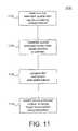
- FIG. 11is a block diagram of one embodiment of the present subject matter.
- a method 1100is provided for determining whether an estimated location of a wireless device includes one or more forged location measurements.
- the method 1100may include at step 1110 determining a first estimated location of the wireless device from information or signals provided by a cellular network and at step 1120 determining a second estimated location of the wireless device from signals received from a set of satellites.
- the first and second estimated locationsmay then be compared at step 1130 , and the second estimated location identified as having one or more forged signals if the comparison between the first estimated location and second estimated location is greater than a predetermined threshold at step 1140 .
- step 1130may include comparing the first estimated location and the first estimated location's uncertainty at a given confidence to the second estimated location and the second estimated location's uncertainty at a given confidence.
- Embodiments of the subject matter described in this specificationcan be implemented as one or more computer program products, i.e., one or more modules of computer program instructions encoded on a tangible program carrier for execution by, or to control the operation of a data processing apparatus.
- the tangible program carriercan be a propagated signal or a computer readable medium.
- the propagated signalis an artificially generated signal, e.g., a machine-generated electrical, optical, or electromagnetic signal that is generated to encode information for transmission to suitable receiver apparatus for execution by a computer.
- the computer readable mediumcan be a machine-readable storage device, a machine-readable storage substrate, a memory device, a composition of matter affecting a machine-readable propagated signal, or a combination of one or more of them.
- data processing apparatusencompasses all apparatus, devices, and machines for processing data, including by way of example a programmable processor, a computer, or multiple processors or computers.
- the apparatuscan include, in addition to hardware, code that creates an execution environment for the computer program in question, e.g., code that constitutes processor firmware, a protocol stack, a database management system, an operating system, or a combination of one or more of them.
- a computer program(also known as a program, software, software application, script, or code) may be written in any form of programming language, including compiled or interpreted languages, or declarative or procedural languages, and it can be deployed in any form, including as a stand-alone program or as a module, component, subroutine, or other unit suitable for use in a computing environment.
- a computer programdoes not necessarily correspond to a file in a file system.
- a programcan be stored in a portion of a file that holds other programs or data (e.g., one or more scripts stored in a markup language document), in a single file dedicated to the program in question, or in multiple coordinated files (e.g., files that store one or more modules, subprograms, or portions of code).
- a computer programmay also be deployed to be executed on one computer or on multiple computers that are located at one site or distributed across multiple sites and interconnected by a communication network.
- the processes and logic flows described hereinmay be performed by one or more programmable processors executing one or more computer programs to perform functions by operating on input data and generating output.
- the processes and logic flowscan also be performed by, and apparatus can also be implemented as, special purpose logic circuitry, e.g., an FPGA (field programmable gate array) or an ASIC (application specific integrated circuit).
- processors suitable for the execution of a computer programinclude, by way of example, both general and special purpose microprocessors, and any one or more processors of any kind of digital computer.
- a processormay receive instructions and data from a read only memory or a random access memory or both.
- the essential elements of a computerare a processor for performing instructions and one or more memory devices for storing instructions and data.
- a computermay also include, or be operatively coupled to receive data from or transfer data to, or both, one or more mass storage devices for storing data, e.g., magnetic, magneto optical disks, or optical disks.
- mass storage devicesfor storing data
- a computerneed not have such devices.
- a computercan be embedded in another device, e.g., a mobile telephone, a personal digital assistant (PDA), a mobile audio or video player, a game console, a GNSS receiver, to name just a few.
- Computer readable media suitable for storing computer program instructions and datainclude all forms of non volatile memory, media and memory devices, including by way of example semiconductor memory devices, e.g., EPROM, EEPROM, and flash memory devices; magnetic disks, e.g., internal hard disks or removable disks; magneto optical disks; and CD ROM and DVD-ROM disks.
- semiconductor memory devicese.g., EPROM, EEPROM, and flash memory devices
- magnetic diskse.g., internal hard disks or removable disks
- magneto optical diskse.g., CD ROM and DVD-ROM disks.
- the processor and the memorycan be supplemented by, or incorporated in, special purpose logic circuitry.
- embodiments of the subject matter described in this specificationcan be implemented on a computer having a display device, e.g., a CRT (cathode ray tube) or LCD (liquid crystal display) monitor, for displaying information to the user and a keyboard and a pointing device, e.g., a mouse or a trackball, by which the user can provide input to the computer.
- a display devicee.g., a CRT (cathode ray tube) or LCD (liquid crystal display) monitor
- keyboard and a pointing devicee.g., a mouse or a trackball
- Other kinds of devicescan be used to provide for interaction with a user as well; for example, input from the user can be received in any form, including acoustic, speech, or tactile input.
- Embodiments of the subject matter described in this specificationcan be implemented in a computing system that includes a back end component, e.g., as a data server, or that includes a middleware component, e.g., an application server, or that includes a front end component, e.g., a client computer having a graphical user interface or a Web browser through which a user can interact with an implementation of the subject matter described is this specification, or any combination of one or more such back end, middleware, or front end components.
- the components of the systemcan be interconnected by any form or medium of digital data communication, e.g., a communication network. Examples of communication networks include a local area network (“LAN”) and a wide area network (“WAN”), e.g., the Internet.
- the computing systemcan include clients and servers.
- a client and serverare generally remote from each other and typically interact through a communication network. The relationship of client and server arises by virtue of computer programs running on the respective computers and having a client-server relationship to each other.
- FIGS. 1-11As shown by the various configurations and embodiments illustrated in FIGS. 1-11 , a method and system for location assurance of a mobile device location have been described.
Landscapes
- Engineering & Computer Science (AREA)
- Radar, Positioning & Navigation (AREA)
- Remote Sensing (AREA)
- Computer Networks & Wireless Communication (AREA)
- Physics & Mathematics (AREA)
- General Physics & Mathematics (AREA)
- Signal Processing (AREA)
- Computer Security & Cryptography (AREA)
- Position Fixing By Use Of Radio Waves (AREA)
Abstract
Description
| TABLE 1 | |||
| Parameter | Range | Units | Notes |
| GPS TOW | The GPS time of week | ||
| Satellite ID | 0-63 | The identifier of the satellite. TO | |
| convert to PRN, add 1. | |||
| C/No | 0-63 | db-Hz | SET's estimate of the carrier to noise |
| ratio. | |||
| Doppler | +/1 6553.6 | Hz | Doppler shift measured by SET for a |
| satellite signal. | |||
| Whole chips | 0-1022 | chips | Whole value of the code phase |
| measurement in units of 1 chip. | |||
| Fractional | 0 to <1 | chips | Fractional value of the code phase |
| chips | measurement. | ||
| Multipath | Indicator of the multipath as | ||
| indicator | measured by the SET and is set to | ||
| low, medium or high. | |||
| 0 to 112 | meters | Measured RMS error in meters. | |
| RMS error | |||
Claims (15)
Priority Applications (3)
| Application Number | Priority Date | Filing Date | Title |
|---|---|---|---|
| US13/112,669US8718673B2 (en) | 2010-05-21 | 2011-05-20 | System and method for location assurance of a mobile device |
| US14/168,818US9648460B2 (en) | 2010-05-21 | 2014-01-30 | System and method for location assurance of a mobile device |
| US15/041,562US20160165401A1 (en) | 2010-05-21 | 2016-02-11 | System and method for location assurance of a mobile device |
Applications Claiming Priority (2)
| Application Number | Priority Date | Filing Date | Title |
|---|---|---|---|
| US34722510P | 2010-05-21 | 2010-05-21 | |
| US13/112,669US8718673B2 (en) | 2010-05-21 | 2011-05-20 | System and method for location assurance of a mobile device |
Related Child Applications (1)
| Application Number | Title | Priority Date | Filing Date |
|---|---|---|---|
| US14/168,818DivisionUS9648460B2 (en) | 2010-05-21 | 2014-01-30 | System and method for location assurance of a mobile device |
Publications (2)
| Publication Number | Publication Date |
|---|---|
| US20110287779A1 US20110287779A1 (en) | 2011-11-24 |
| US8718673B2true US8718673B2 (en) | 2014-05-06 |
Family
ID=44972894
Family Applications (3)
| Application Number | Title | Priority Date | Filing Date |
|---|---|---|---|
| US13/112,669Expired - Fee RelatedUS8718673B2 (en) | 2010-05-21 | 2011-05-20 | System and method for location assurance of a mobile device |
| US14/168,818Expired - Fee RelatedUS9648460B2 (en) | 2010-05-21 | 2014-01-30 | System and method for location assurance of a mobile device |
| US15/041,562AbandonedUS20160165401A1 (en) | 2010-05-21 | 2016-02-11 | System and method for location assurance of a mobile device |
Family Applications After (2)
| Application Number | Title | Priority Date | Filing Date |
|---|---|---|---|
| US14/168,818Expired - Fee RelatedUS9648460B2 (en) | 2010-05-21 | 2014-01-30 | System and method for location assurance of a mobile device |
| US15/041,562AbandonedUS20160165401A1 (en) | 2010-05-21 | 2016-02-11 | System and method for location assurance of a mobile device |
Country Status (1)
| Country | Link |
|---|---|
| US (3) | US8718673B2 (en) |
Cited By (6)
| Publication number | Priority date | Publication date | Assignee | Title |
|---|---|---|---|---|
| US20120188880A1 (en)* | 2012-01-31 | 2012-07-26 | Comtech Ef Data Corp. | Method and System for Performing Multi-Layer, Multi-Dimensional Link Budget Analysis (LBA) Using Real-Time Network, Weather, Satellite Ephemeras and Ionospheric Information |
| US20140274122A1 (en)* | 2013-03-15 | 2014-09-18 | Erick Tseng | Multi-Factor Location Verification |
| US20150268354A1 (en)* | 2014-03-21 | 2015-09-24 | Thales | Geopositioning method with trust index, and associated terminal |
| US20150356860A1 (en)* | 2014-06-05 | 2015-12-10 | Integrity Tracking, Llc | Systems and methods for automatically reporting location change in user monitoring systems |
| US20170031026A1 (en)* | 2015-07-31 | 2017-02-02 | Verizon Patent And Licensing Inc. | Methods and Systems for Detecting Potential Interference with a Tracking Device Associated with a Vehicle |
| US11451538B2 (en) | 2019-04-05 | 2022-09-20 | University Of South Florida | Methods and systems of authenticating of personal communications |
Families Citing this family (96)
| Publication number | Priority date | Publication date | Assignee | Title |
|---|---|---|---|---|
| WO2012011855A1 (en)* | 2010-07-19 | 2012-01-26 | Telefonaktiebolaget L M Ericsson (Publ) | Pre-scaling of a-gps positioning accuracy data |
| US8565798B2 (en)* | 2010-07-26 | 2013-10-22 | Rincon Research Corporation | Geo-directed adaptive antenna array |
| GB2483713B (en)* | 2010-09-20 | 2016-04-06 | St Microelectronics Res & Dev | Signal verification |
| US9182495B2 (en)* | 2011-09-21 | 2015-11-10 | Lockheed Martin Corporation | System and method for monitoring integrity of a global navigation satellite system |
| US8635023B2 (en)* | 2011-11-22 | 2014-01-21 | Google Inc. | Position indication controls for device locations |
| US20130143585A1 (en)* | 2011-12-02 | 2013-06-06 | Peter Kenington | Method and apparatus for geolocating a wireless communication unit |
| US8959189B2 (en)* | 2012-02-07 | 2015-02-17 | Comtech Ef Data Corp. | Method and system for modeling a network using historical weather information and operation with adaptive coding and modulation (ACM) |
| EP2820630A4 (en)* | 2012-03-02 | 2016-03-23 | Telecomm Systems Inc | Location agent geofence |
| CN102636791B (en)* | 2012-03-26 | 2013-11-20 | 北京空间飞行器总体设计部 | Calculation method for mutual interference of navigation systems |
| WO2013155386A1 (en)* | 2012-04-12 | 2013-10-17 | P.W. Precyse Wireless Ltd. | Gps positioning system |
| US20130271324A1 (en)* | 2012-04-17 | 2013-10-17 | Andrew Sendonaris | Systems and methods configured to estimate receiver position using timing data associated with reference locations in three-dimensional space |
| US9572124B2 (en)* | 2012-06-20 | 2017-02-14 | Qualcomm Incorporated | D-SLP service area detection using area ID |
| US9709680B2 (en) | 2012-09-08 | 2017-07-18 | Schweitzer Engineering Laboratories, Inc. | Quality of precision time sources |
| US20140077991A1 (en)* | 2012-09-20 | 2014-03-20 | California Institute Of Technology | Enhanced broadcast ephemeris for high accuracy assisted gps positioning |
| US8989774B2 (en) | 2012-10-11 | 2015-03-24 | Telefonaktiebolaget L M Ericsson (Publ) | Method and system of semnatic indoor positioning using significant places as satellites |
| US9703274B2 (en)* | 2012-10-12 | 2017-07-11 | Telefonaktiebolaget L M Ericsson (Publ) | Method for synergistic occupancy sensing in commercial real estates |
| BR112015008072A2 (en) | 2012-10-19 | 2017-07-04 | Schweitzer Engineering Lab Inc | method, system, and time distribution device |
| US9400330B2 (en)* | 2012-10-19 | 2016-07-26 | Schweitzer Engineering Laboratories, Inc. | Manipulation resilient time distribution network |
| US9599719B2 (en) | 2012-10-19 | 2017-03-21 | Schweitzer Engineering Laboratories, Inc. | Detection of manipulated satellite time signals |
| ES2552829B1 (en) | 2012-10-19 | 2017-03-23 | Schweitzer Engineering Laboratories, Inc. | Time Distribution Switch |
| US9709682B2 (en) | 2013-05-06 | 2017-07-18 | Schweitzer Engineering Laboratories, Inc. | Multi-constellation GNSS integrity check for detection of time signal manipulation |
| US9759816B2 (en) | 2013-01-11 | 2017-09-12 | Schweitzer Engineering Laboratories, Inc. | Multi-constellation GNSS integrity check for detection of time signal manipulation |
| US10271233B2 (en) | 2013-03-15 | 2019-04-23 | DGS Global Systems, Inc. | Systems, methods, and devices for automatic signal detection with temporal feature extraction within a spectrum |
| US12256233B2 (en) | 2013-03-15 | 2025-03-18 | Digital Global Systems, Inc. | Systems and methods for automated financial settlements for dynamic spectrum sharing |
| US9078162B2 (en) | 2013-03-15 | 2015-07-07 | DGS Global Systems, Inc. | Systems, methods, and devices for electronic spectrum management |
| US10257728B2 (en) | 2013-03-15 | 2019-04-09 | DGS Global Systems, Inc. | Systems, methods, and devices for electronic spectrum management |
| US10122479B2 (en) | 2017-01-23 | 2018-11-06 | DGS Global Systems, Inc. | Systems, methods, and devices for automatic signal detection with temporal feature extraction within a spectrum |
| US10231206B2 (en) | 2013-03-15 | 2019-03-12 | DGS Global Systems, Inc. | Systems, methods, and devices for electronic spectrum management for identifying signal-emitting devices |
| US10237770B2 (en) | 2013-03-15 | 2019-03-19 | DGS Global Systems, Inc. | Systems, methods, and devices having databases and automated reports for electronic spectrum management |
| US10257729B2 (en) | 2013-03-15 | 2019-04-09 | DGS Global Systems, Inc. | Systems, methods, and devices having databases for electronic spectrum management |
| US10299149B2 (en) | 2013-03-15 | 2019-05-21 | DGS Global Systems, Inc. | Systems, methods, and devices for electronic spectrum management |
| US9537586B2 (en) | 2013-03-15 | 2017-01-03 | DGS Global Systems, Inc. | Systems, methods, and devices for electronic spectrum management with remote access to data in a virtual computing network |
| US12356206B2 (en) | 2013-03-15 | 2025-07-08 | Digital Global Systems, Inc. | Systems and methods for automated financial settlements for dynamic spectrum sharing |
| US10219163B2 (en) | 2013-03-15 | 2019-02-26 | DGS Global Systems, Inc. | Systems, methods, and devices for electronic spectrum management |
| US10257727B2 (en) | 2013-03-15 | 2019-04-09 | DGS Global Systems, Inc. | Systems methods, and devices having databases and automated reports for electronic spectrum management |
| US8750156B1 (en) | 2013-03-15 | 2014-06-10 | DGS Global Systems, Inc. | Systems, methods, and devices for electronic spectrum management for identifying open space |
| US10244504B2 (en) | 2013-03-15 | 2019-03-26 | DGS Global Systems, Inc. | Systems, methods, and devices for geolocation with deployable large scale arrays |
| US11646918B2 (en) | 2013-03-15 | 2023-05-09 | Digital Global Systems, Inc. | Systems, methods, and devices for electronic spectrum management for identifying open space |
| DE102013205486A1 (en)* | 2013-03-27 | 2014-10-02 | Deere & Company | Arrangement and method for position detection with a hand-held device |
| US9179428B2 (en)* | 2013-06-26 | 2015-11-03 | Broadcom Corporation | Communications device with direct cellular-to-collocated device communication channel interface |
| US9402163B2 (en) | 2013-07-19 | 2016-07-26 | Qualcomm Incorporated | In-building location security and privacy |
| US9319100B2 (en) | 2013-08-12 | 2016-04-19 | Schweitzer Engineering Laboratories, Inc. | Delay compensation for variable cable length |
| US9326096B1 (en)* | 2013-12-18 | 2016-04-26 | Sprint Spectrum L.P. | Method and apparatus for managing use of location determination |
| WO2015120128A1 (en)* | 2014-02-05 | 2015-08-13 | Verve Wireless, Inc. | Methods and apparatus for identification and ranking of synthetic locations for mobile applications |
| US10495759B2 (en)* | 2014-02-13 | 2019-12-03 | The Mitre Corporation | GPS spoofing detection techniques |
| US9270442B2 (en) | 2014-04-29 | 2016-02-23 | Schweitzer Engineering Laboratories, Inc. | Time signal propagation delay correction |
| US9425652B2 (en) | 2014-06-16 | 2016-08-23 | Schweitzer Engineering Laboratories, Inc. | Adaptive holdover timing error estimation and correction |
| MY189316A (en)* | 2014-07-02 | 2022-02-04 | Mimos Berhad | A system and method for detecting global positioning system anomalies |
| US9813173B2 (en) | 2014-10-06 | 2017-11-07 | Schweitzer Engineering Laboratories, Inc. | Time signal verification and distribution |
| US9910160B2 (en)* | 2014-11-24 | 2018-03-06 | The Boeing Company | Detecting and removing spoofing signals |
| WO2016142225A1 (en)* | 2015-03-09 | 2016-09-15 | Philips Lighting Holding B.V. | Detection of falsification of mobile terminal location |
| DE102015204259A1 (en)* | 2015-03-10 | 2016-09-15 | Siemens Aktiengesellschaft | Method and arrangement for position determination |
| US10024973B1 (en) | 2015-04-03 | 2018-07-17 | Interstate Electronics Corporation | Global navigation satellite system spoofer identification technique |
| US10031234B1 (en)* | 2015-04-03 | 2018-07-24 | Interstate Electronics Corporation | Global navigation satellite system beam based attitude determination |
| KR102460360B1 (en)* | 2015-05-12 | 2022-11-01 | 삼성전자주식회사 | Apparatus and method for estimating location in wirleess communicnation system |
| US11086019B2 (en)* | 2015-06-12 | 2021-08-10 | Robotic Researchh, LLC | Atomic clock base navigation system for on-the-move radar, obfuscation, sensing, and ad-hoc third party localization |
| US9880259B2 (en)* | 2015-10-29 | 2018-01-30 | The United States of America as represented by Scretary of the Navy | Method for estimating the position of a mobile station using TOA, AOA, and doppler-shift |
| US10375108B2 (en) | 2015-12-30 | 2019-08-06 | Schweitzer Engineering Laboratories, Inc. | Time signal manipulation and spoofing detection based on a latency of a communication system |
| US9571978B1 (en)* | 2016-03-16 | 2017-02-14 | Google Inc. | User equipment positioning utilizing motion of high altitude platform |
| US10545246B1 (en) | 2016-07-08 | 2020-01-28 | Interstate Electronics Corporation | Global navigation satellite system spoofer identification technique based on carrier to noise ratio signatures |
| US9854398B1 (en)* | 2016-08-03 | 2017-12-26 | International Business Machines Corporation | System, method and recording medium for location verification |
| WO2018059676A1 (en)* | 2016-09-28 | 2018-04-05 | Telefonaktiebolaget Lm Ericsson (Publ) | Validation of position indication |
| US10700794B2 (en) | 2017-01-23 | 2020-06-30 | Digital Global Systems, Inc. | Systems, methods, and devices for automatic signal detection based on power distribution by frequency over time within an electromagnetic spectrum |
| US10459020B2 (en) | 2017-01-23 | 2019-10-29 | DGS Global Systems, Inc. | Systems, methods, and devices for automatic signal detection based on power distribution by frequency over time within a spectrum |
| US12205477B2 (en) | 2017-01-23 | 2025-01-21 | Digital Global Systems, Inc. | Unmanned vehicle recognition and threat management |
| US10529241B2 (en) | 2017-01-23 | 2020-01-07 | Digital Global Systems, Inc. | Unmanned vehicle recognition and threat management |
| US12183213B1 (en) | 2017-01-23 | 2024-12-31 | Digital Global Systems, Inc. | Unmanned vehicle recognition and threat management |
| US10498951B2 (en) | 2017-01-23 | 2019-12-03 | Digital Global Systems, Inc. | Systems, methods, and devices for unmanned vehicle detection |
| US10408942B2 (en)* | 2017-01-30 | 2019-09-10 | The Boeing Company | Systems and methods to detect GPS spoofing |
| US10527732B2 (en) | 2017-02-09 | 2020-01-07 | Schweitzer Engineering Laboratories, Inc. | Verification of time sources |
| US10542518B2 (en)* | 2017-04-06 | 2020-01-21 | Qualcomm Incorporated | Mobile access point detection |
| JP6942414B2 (en)* | 2017-07-04 | 2021-09-29 | アルパイン株式会社 | In-vehicle device |
| US10911956B2 (en)* | 2017-11-10 | 2021-02-02 | Comcast Cable Communications, Llc | Methods and systems to detect rogue hotspots |
| US10725182B2 (en) | 2018-01-04 | 2020-07-28 | Interstate Electronics Corporation | Systems and methods for providing anti-spoofing capability to a global navigation satellite system receiver |
| US11280912B2 (en) | 2018-01-12 | 2022-03-22 | The Regents Of The University Of Colorado | Hybrid interference localization |
| CN111801588B (en)* | 2018-03-26 | 2024-01-23 | 阿尔卑斯阿尔派株式会社 | Position estimation device, position estimation system, position estimation method, and program |
| US11181644B2 (en)* | 2018-04-03 | 2021-11-23 | Gas Technology Institute | Method and apparatus for improved GNSS location detection |
| US11656076B2 (en) | 2018-05-15 | 2023-05-23 | Javad Gnss, Inc. | Method of calibrating a total station using a GNSS device |
| US11630424B2 (en) | 2018-07-13 | 2023-04-18 | Schweitzer Engineering Laboratories, Inc. | Time signal manipulation detection using remotely managed time |
| US10943461B2 (en) | 2018-08-24 | 2021-03-09 | Digital Global Systems, Inc. | Systems, methods, and devices for automatic signal detection based on power distribution by frequency over time |
| CN110907967B (en)* | 2018-09-17 | 2022-02-08 | 千寻位置网络有限公司 | High-precision integrity convection layer pipe abnormity monitoring method and device |
| US10819727B2 (en) | 2018-10-15 | 2020-10-27 | Schweitzer Engineering Laboratories, Inc. | Detecting and deterring network attacks |
| US10912104B2 (en) | 2019-02-01 | 2021-02-02 | Schweitzer Engineering Laboratories, Inc. | Interleaved, static time division multiple access (TDMA) for minimizing power usage in delay-sensitive applications |
| US11277747B2 (en)* | 2019-04-03 | 2022-03-15 | Google Llc | Base station location authentication |
| CN111866733B (en)* | 2019-04-29 | 2022-04-22 | 华为技术有限公司 | Method and device for determining location of terminal equipment |
| NL2023416B1 (en)* | 2019-07-01 | 2021-02-02 | Fugro N V | A device, a system and method of identifying interfering devices in position measurements |
| US11808866B2 (en) | 2019-08-16 | 2023-11-07 | Javad Gnss, Inc. | Total station with GNSS device |
| US10694372B1 (en)* | 2019-09-06 | 2020-06-23 | International Business Machines Corporation | Independent agent-based location verification |
| US11638153B2 (en)* | 2020-04-01 | 2023-04-25 | Higher Ground Llc | Interferometry-based satellite location accuracy |
| EP4139712A1 (en)* | 2020-04-22 | 2023-03-01 | Qualcomm Incorporated | Sps spoofing detection |
| CN112533134B (en)* | 2020-11-06 | 2022-06-17 | 浙江工业大学 | A security location method for wireless sensor network based on double detection |
| DE102021104445A1 (en)* | 2021-02-24 | 2022-08-25 | Robert Bosch Gesellschaft mit beschränkter Haftung | Method for GNSS-based localization of a vehicle with 5G signals |
| US11536850B2 (en) | 2021-04-05 | 2022-12-27 | Qualcomm Incorporated | GNSS spoofing detection and recovery |
| CN119895919A (en)* | 2022-07-29 | 2025-04-25 | 上海诺基亚贝尔股份有限公司 | Mechanism for location verification |
| WO2024262131A1 (en)* | 2023-06-23 | 2024-12-26 | パナソニックIpマネジメント株式会社 | 3d measurement data processing method and 3d measurement data processing device |
| CN119245642A (en)* | 2024-08-23 | 2025-01-03 | 西安空间无线电技术研究所 | A three-station hybrid target positioning method based on combined intra-station and inter-station measurements |
Citations (135)
| Publication number | Priority date | Publication date | Assignee | Title |
|---|---|---|---|---|
| US3150372A (en) | 1959-06-23 | 1964-09-22 | Motorola Inc | Computing system |
| US3659085A (en) | 1970-04-30 | 1972-04-25 | Sierra Research Corp | Computer determining the location of objects in a coordinate system |
| US4728959A (en) | 1986-08-08 | 1988-03-01 | Ventana Sciences Inc. | Direction finding localization system |
| US4814751A (en) | 1987-02-27 | 1989-03-21 | Wildlife Materials, Inc. | Patient tracking system |
| US4845504A (en) | 1987-04-08 | 1989-07-04 | M/A-Com, Inc. | Mobile radio network for nationwide communications |
| US4891650A (en) | 1988-05-16 | 1990-01-02 | Trackmobile Inc. | Vehicle location system |
| US5056106A (en) | 1990-08-02 | 1991-10-08 | Wang James J | Golf course ranging and direction-finding system using spread-spectrum radiolocation techniques |
| US5218618A (en) | 1990-11-07 | 1993-06-08 | Hughes Aircraft Company | Cellular telephone service using spread spectrum transmission |
| US5317323A (en) | 1993-03-05 | 1994-05-31 | E-Systems, Inc. | Passive high accuracy geolocation system and method |
| US5327144A (en) | 1993-05-07 | 1994-07-05 | Associated Rt, Inc. | Cellular telephone location system |
| US5365544A (en) | 1990-12-05 | 1994-11-15 | Interdigital Technology Corporation | CDMA communications and geolocation system and method |
| US5372144A (en) | 1992-12-01 | 1994-12-13 | Scimed Life Systems, Inc. | Navigability improved guidewire construction and method of using same |
| US5404376A (en) | 1993-09-09 | 1995-04-04 | Ericsson-Ge Mobile Communications Inc. | Navigation assistance for call handling in mobile telephone systems |
| US5423067A (en) | 1991-09-09 | 1995-06-06 | Nec Corporation | Digital mobile communications system and method for providing intensity/coverage reference maps using base stations and mobile stations |
| US5465289A (en) | 1993-03-05 | 1995-11-07 | E-Systems, Inc. | Cellular based traffic sensor system |
| US5506864A (en) | 1990-12-05 | 1996-04-09 | Interdigital Technology Corporation | CDMA communications and geolocation system and method |
| US5506863A (en) | 1993-08-25 | 1996-04-09 | Motorola, Inc. | Method and apparatus for operating with a hopping control channel in a communication system |
| US5508708A (en) | 1995-05-08 | 1996-04-16 | Motorola, Inc. | Method and apparatus for location finding in a CDMA system |
| US5512908A (en) | 1994-07-08 | 1996-04-30 | Lockheed Sanders, Inc. | Apparatus and method for locating cellular telephones |
| US5515419A (en) | 1992-06-01 | 1996-05-07 | Trackmobile | Tracking system and method for tracking a movable object carrying a cellular phone unit, and integrated personal protection system incorporating the tracking system |
| US5519760A (en) | 1994-06-22 | 1996-05-21 | Gte Laboratories Incorporated | Cellular network-based location system |
| US5592180A (en) | 1992-08-20 | 1997-01-07 | Nexus1994 Limited | Direction finding and mobile location system for trunked mobile radio systems |
| US5614914A (en) | 1994-09-06 | 1997-03-25 | Interdigital Technology Corporation | Wireless telephone distribution system with time and space diversity transmission for determining receiver location |
| US5675344A (en) | 1996-06-28 | 1997-10-07 | Motorola, Inc. | Method and apparatus for locating a mobile station in a spread spectrum communication system |
| US5815538A (en) | 1993-06-25 | 1998-09-29 | Omniplex, Inc. | Method and apparatus for determining location of a subscriber device in a wireless cellular communications system |
| US5825887A (en) | 1995-12-28 | 1998-10-20 | Trimble Navigation Limited | Transmitting and receiving apparatus for full code correlation operation under encryption for satellite positioning system |
| US5870029A (en) | 1996-07-08 | 1999-02-09 | Harris Corporation | Remote mobile monitoring and communication system |
| US5920278A (en) | 1997-05-28 | 1999-07-06 | Gregory D. Gibbons | Method and apparatus for identifying, locating, tracking, or communicating with remote objects |
| US5952969A (en) | 1997-08-18 | 1999-09-14 | Telefonakiebolaget L M Ericsson (Publ) | Method and system for determining the position of mobile radio terminals |
| US5959580A (en) | 1994-11-03 | 1999-09-28 | Ksi Inc. | Communications localization system |
| US5960341A (en) | 1994-09-28 | 1999-09-28 | U S West, Inc. | Positioning system having an RF-measurements databank |
| US5973643A (en) | 1997-04-11 | 1999-10-26 | Corsair Communications, Inc. | Method and apparatus for mobile emitter location |
| US5987329A (en) | 1997-07-30 | 1999-11-16 | Ericsson Inc | System and method for mobile telephone location measurement using a hybrid technique |
| US6014102A (en) | 1998-04-17 | 2000-01-11 | Motorola, Inc. | Method and apparatus for calibrating location finding equipment within a communication system |
| US6047192A (en) | 1996-05-13 | 2000-04-04 | Ksi Inc. | Robust, efficient, localization system |
| US6091362A (en) | 1999-01-08 | 2000-07-18 | Trueposition, Inc. | Bandwidth synthesis for wireless location system |
| US6097959A (en) | 1998-01-29 | 2000-08-01 | Ericsson Inc. | System and method for accurate positioning of mobile terminals |
| US6097709A (en) | 1996-12-10 | 2000-08-01 | Nec Corporation | TDMA cellular communication system using a receiver station for detecting a timing difference between adjacent base stations |
| US6101178A (en) | 1997-07-10 | 2000-08-08 | Ksi Inc. | Pseudolite-augmented GPS for locating wireless telephones |
| US6108555A (en) | 1996-05-17 | 2000-08-22 | Ksi, Inc. | Enchanced time difference localization system |
| US6108558A (en) | 1998-04-21 | 2000-08-22 | Motorola, Inc. | Method for calculating a location of a remote Unit utilizing observed time difference (OTD) and real time difference (RTD) measurements. |
| US6115605A (en) | 1997-08-29 | 2000-09-05 | Ppm, Inc. | Communication system and device using dynamic receiver addressing |
| US6144711A (en) | 1996-08-29 | 2000-11-07 | Cisco Systems, Inc. | Spatio-temporal processing for communication |
| US6188351B1 (en) | 1998-08-13 | 2001-02-13 | Ericsson Inc. | Method for improving signal acquistion in a global positioning system receiver |
| US6191738B1 (en) | 1999-09-30 | 2001-02-20 | Motorola, Inc. | Method and apparatus for locating a remote unit within a communication system |
| US6201499B1 (en) | 1998-02-03 | 2001-03-13 | Consair Communications | Time difference of arrival measurement system |
| US6201803B1 (en) | 1995-05-02 | 2001-03-13 | British Telecommunications Public Limited Company | Cellular radio location system |
| US6212319B1 (en) | 1997-11-27 | 2001-04-03 | Dassault Electronique | Electro-optical device, notably for optical distribution |
| US6233459B1 (en) | 1997-04-10 | 2001-05-15 | The Atlantis Company, Limited, Japan | System for providing Geolocation of a mobile transceiver |
| US6246884B1 (en) | 1998-08-19 | 2001-06-12 | Sigmaone Communications Corporation | System and method for measuring and locating a mobile station signal in a wireless communication system |
| US6269246B1 (en) | 1998-09-22 | 2001-07-31 | Ppm, Inc. | Location determination using RF fingerprinting |
| US6295455B1 (en) | 1999-06-11 | 2001-09-25 | Telefonaktiebolaget Lm Ericsson (Publ) | Methods and arrangements for locating a mobile telecommunications station |
| US6311043B1 (en) | 1998-10-27 | 2001-10-30 | Siemens Aktiengesellschaft | Method and measurement configuration for measuring the characteristics of radio channels |
| US6334059B1 (en) | 1999-01-08 | 2001-12-25 | Trueposition, Inc. | Modified transmission method for improving accuracy for e-911 calls |
| US6366241B2 (en) | 2000-06-26 | 2002-04-02 | Trueposition, Inc. | Enhanced determination of position-dependent signal characteristics of a wireless transmitter |
| US6388618B1 (en) | 1999-01-08 | 2002-05-14 | Trueposition, Inc. | Signal collection system for a wireless location system |
| US6393294B1 (en) | 1998-09-22 | 2002-05-21 | Polaris Wireless, Inc. | Location determination using RF fingerprinting |
| US6407703B1 (en) | 2000-08-07 | 2002-06-18 | Lockheed Martin Corporation | Multi-platform geolocation method and system |
| US6449486B1 (en) | 1998-05-27 | 2002-09-10 | Polaris Wireless, Inc. | Multiple location estimates in a cellular communication system |
| US6463290B1 (en) | 1999-01-08 | 2002-10-08 | Trueposition, Inc. | Mobile-assisted network based techniques for improving accuracy of wireless location system |
| US6470195B1 (en) | 2000-10-31 | 2002-10-22 | Raytheon Company | Method and apparatus for modeling a smart antenna in a network planning tool |
| US6477161B1 (en) | 1998-12-21 | 2002-11-05 | Nortel Networks Limited | Downlink beamforming approach for frequency division duplex cellular systems |
| US6501955B1 (en) | 2000-06-19 | 2002-12-31 | Intel Corporation | RF signal repeater, mobile unit position determination system using the RF signal repeater, and method of communication therefor |
| US6553322B1 (en) | 1999-09-29 | 2003-04-22 | Honeywell International Inc. | Apparatus and method for accurate pipeline surveying |
| US6571082B1 (en) | 1999-10-29 | 2003-05-27 | Verizon Laboratories Inc. | Wireless field test simulator |
| US20030139188A1 (en) | 2002-01-24 | 2003-07-24 | Chen Byron Hua | Geolocation using enhanced timing advance techniques |
| US6603761B1 (en) | 1999-09-17 | 2003-08-05 | Lucent Technologies Inc. | Using internet and internet protocols to bypass PSTN, GSM map, and ANSI-41 networks for wireless telephone call delivery |
| US20030190919A1 (en) | 2000-08-22 | 2003-10-09 | Jarko Niemenmaa | Method for positioning a mobile station |
| US6640106B2 (en) | 2001-09-20 | 2003-10-28 | Motorola, Inc. | Method and system for verifying the position of a mobile station using checkpoints |
| US20030203738A1 (en) | 2002-04-29 | 2003-10-30 | Brown Larry Michael | Method and apparatus for locating a remote unit within a communication system |
| US6646604B2 (en) | 1999-01-08 | 2003-11-11 | Trueposition, Inc. | Automatic synchronous tuning of narrowband receivers of a wireless location system for voice/traffic channel tracking |
| US20040043775A1 (en) | 2002-08-29 | 2004-03-04 | Kennedy Joseph P. | Tasking and reporting method and implementation for wireless appliance location systems |
| US20040132466A1 (en) | 2002-12-23 | 2004-07-08 | Kennedy Joseph P. | Method and apparatus for supporting multiple wireless carrier mobile station location requirements with a common network overlay location system |
| US6765531B2 (en) | 1999-01-08 | 2004-07-20 | Trueposition, Inc. | System and method for interference cancellation in a location calculation, for use in a wireless location system |
| US6771969B1 (en) | 2000-07-06 | 2004-08-03 | Harris Corporation | Apparatus and method for tracking and communicating with a mobile radio unit |
| US6782264B2 (en) | 1999-01-08 | 2004-08-24 | Trueposition, Inc. | Monitoring of call information in a wireless location system |
| US20040203539A1 (en) | 2002-12-11 | 2004-10-14 | Benes Stanley J. | Method and mobile station for autonomously determining an angle of arrival (AOA) estimation |
| US20040203921A1 (en) | 2003-03-21 | 2004-10-14 | Nicholas Bromhead | Sub-sector timing advance positions determinations |
| US20040218664A1 (en) | 2003-01-31 | 2004-11-04 | Kennedy Joseph P. | Method for angle of arrival determination on frequency hopping air interfaces |
| US20040252752A1 (en) | 2003-01-31 | 2004-12-16 | Kennedy Joseph P. | Method for calibrating an AOA location system for frequency hopping air interfaces |
| US6834234B2 (en) | 2000-11-22 | 2004-12-21 | Trimble Navigation, Limited | AINS land surveyor system with reprocessing, AINS-LSSRP |
| US6845240B2 (en) | 2000-12-11 | 2005-01-18 | Grayson Wireless | System and method for analog cellular radio geolocation |
| US6859172B2 (en) | 2003-02-17 | 2005-02-22 | Global Business Software Development Technologies, Inc. | System and method for locating a mobile phone |
| US20050058182A1 (en) | 2003-01-31 | 2005-03-17 | Kennedy Joseph P. | Method for calibrating an AOA location system for all frequencies in a frequency hopping signal |
| US6871077B2 (en) | 2001-10-09 | 2005-03-22 | Grayson Wireless | System and method for geolocating a wireless mobile unit from a single base station using repeatable ambiguous measurements |
| US6873290B2 (en) | 1999-01-08 | 2005-03-29 | Trueposition, Inc. | Multiple pass location processor |
| US6876859B2 (en) | 2001-07-18 | 2005-04-05 | Trueposition, Inc. | Method for estimating TDOA and FDOA in a wireless location system |
| US20050136945A1 (en) | 2003-12-19 | 2005-06-23 | Kennedy Joseph P. | E-OTD augmentation to U-TDOA location system |
| US6920329B2 (en) | 2001-01-16 | 2005-07-19 | Allen Telecom | Method and system for applying wireless geolocation technology |
| US6922170B2 (en) | 2002-01-24 | 2005-07-26 | Motorola, Inc. | Methods and apparatus for determining a direction of arrival in a wireless communication system |
| US20050192026A1 (en) | 2003-06-04 | 2005-09-01 | Carlson John P. | System and method for CDMA geolocation |
| US6944465B2 (en) | 1998-09-22 | 2005-09-13 | Polaris Wireless, Inc. | Estimating the location of a mobile unit based on the elimination of improbable locations |
| US6952158B2 (en) | 2000-12-11 | 2005-10-04 | Kennedy Jr Joseph P | Pseudolite positioning system and method |
| US20060003695A1 (en) | 2002-10-16 | 2006-01-05 | Kennedy Joseph P Jr | System and method of operation for network overlay geolocation systemwith repeaters |
| US20060003775A1 (en) | 1999-01-08 | 2006-01-05 | Bull Jeffrey F | Advanced triggers for location-based service applications in a wireless location system |
| US6987979B2 (en) | 2001-12-22 | 2006-01-17 | Telefonaktiebolaget Lm Ericsson (Publ) | Locating packet-switched mobile terminals using network initiated artificial cell hops |
| US6996392B2 (en) | 2002-09-03 | 2006-02-07 | Trueposition, Inc. | E911 overlay solution for GSM, for use in a wireless location system |
| US20060116130A1 (en) | 2002-10-16 | 2006-06-01 | Andrew Corporation | Network overlay location system and method for air interface with frequency stopping |
| WO2006088472A1 (en) | 2005-02-11 | 2006-08-24 | Trueposition, Inc. | Base transceiver station (bts) synchronization |
| US7116987B2 (en) | 2003-07-19 | 2006-10-03 | Polaris Wireless, Inc. | Location estimation of wireless terminals through pattern matching of deduced and empirical signal-strength measurements |
| US20060240836A1 (en) | 2003-03-03 | 2006-10-26 | Kennedy Joseph P Jr | Independently acquiring and tracking wireless communication system signaling channel assignments on communication links |
| US20070087689A1 (en) | 2003-09-26 | 2007-04-19 | Martin Alles | System and method of operation for network overlay geolocation system with repeaters using am golay hadamard signatures |
| US20070111746A1 (en) | 2005-11-16 | 2007-05-17 | Anderson Robert J | Transmit-power control for wireless mobile services |
| US7233799B2 (en) | 2003-02-24 | 2007-06-19 | Polaris Wireless, Inc. | Location estimation of wireless terminals based on combinations of signal strength measurements and geometry-of-arrival measurements |
| US20070155489A1 (en) | 2005-12-30 | 2007-07-05 | Frederic Beckley | Device and network enabled geo-fencing for area sensitive gaming enablement |
| US20070155401A1 (en) | 2005-12-30 | 2007-07-05 | Trueposition Inc. | User plane uplink time difference of arrival (u-tdoa) |
| US7250907B2 (en) | 2003-06-30 | 2007-07-31 | Microsoft Corporation | System and methods for determining the location dynamics of a portable computing device |
| US7257414B2 (en) | 1998-09-22 | 2007-08-14 | Polaris Wireless, Inc. | Estimating the Location of a Wireless Terminal Based on Non-Uniform Probabilities of Movement |
| US20070202885A1 (en) | 2003-06-24 | 2007-08-30 | Kennedy Joseph P Jr | Method For Sparse Network Deployment Accuracy Enhancements |
| US20080132244A1 (en) | 2006-12-01 | 2008-06-05 | Trueposition, Inc. | Subscriptionless location of wireless devices |
| US20080132247A1 (en) | 2006-12-01 | 2008-06-05 | Trueposition, Inc. | System for automatically determining cell transmitter parameters to facilitate the location of wireless devices |
| US20080137524A1 (en) | 2006-12-12 | 2008-06-12 | Trueposition, Inc. | Location of Wideband OFDM Transmitters With Limited Receiver Bandwidth |
| US20080160953A1 (en) | 2006-12-28 | 2008-07-03 | Trueposition, Inc. | Emergency wireless location system including a wireless transceiver |
| US20080160952A1 (en) | 2006-12-28 | 2008-07-03 | Trueposition, Inc. | Emergency wireless location system including a location determining receiver |
| US20080158059A1 (en) | 2006-12-27 | 2008-07-03 | Trueposition, Inc. | Portable, iterative geolocation of RF emitters |
| US7427952B2 (en) | 2005-04-08 | 2008-09-23 | Trueposition, Inc. | Augmentation of commercial wireless location system (WLS) with moving and/or airborne sensors for enhanced location accuracy and use of real-time overhead imagery for identification of wireless device locations |
| US7433695B2 (en) | 2002-11-18 | 2008-10-07 | Polaris Wireless, Inc. | Computationally-efficient estimation of the location of a wireless terminal based on pattern matching |
| US7433652B2 (en) | 2005-03-07 | 2008-10-07 | Polaris Wireless, Inc. | Electro-magnetic propagation modeling |
| US20080248811A1 (en) | 2003-12-30 | 2008-10-09 | Trueposition, Inc. | TDOA/GPS Hybrid Wireless Location System |
| US20080261613A1 (en) | 2007-04-18 | 2008-10-23 | Anderson Robert J | Sparsed U-TDOA Wireless Location Networks |
| US20080261614A1 (en) | 2007-04-18 | 2008-10-23 | Mia Rashidus S | Sparsed U-TDOA Wireless Location Networks |
| US20080261612A1 (en) | 2007-04-18 | 2008-10-23 | Mia Rashidus S | Sparsed U-TDOA Wireless Location Networks |
| US20080261611A1 (en) | 2007-04-18 | 2008-10-23 | Mia Rashidus S | Sparsed U-TDOA Wireless Location Networks |
| US7460505B2 (en) | 2003-02-04 | 2008-12-02 | Polaris Wireless, Inc. | Location estimation of wireless terminals through pattern matching of signal-strength differentials |
| US20090005061A1 (en) | 2005-12-30 | 2009-01-01 | Trueposition, Inc. | Location quality of service indicator |
| US7593738B2 (en) | 2005-12-29 | 2009-09-22 | Trueposition, Inc. | GPS synchronization for wireless communications stations |
| US7734298B2 (en) | 1998-09-22 | 2010-06-08 | Polaris Wireless, Inc. | Estimating the location of a wireless terminal based on signal path impairment |
| US7753278B2 (en) | 2006-05-22 | 2010-07-13 | Polaris Wireless, Inc. | Estimating the location of a wireless terminal based on non-uniform locations |
| US7796966B2 (en) | 2005-03-15 | 2010-09-14 | Polaris Wireless, Inc. | Estimating the location of a wireless terminal based on calibrated signal-strength measurements |
| US7899467B2 (en) | 1998-09-22 | 2011-03-01 | Polaris Wireless, Inc. | Estimating the location of a wireless terminal based on the traits of the multipath components of a signal |
| US8013785B2 (en) | 2009-12-31 | 2011-09-06 | Ntt Docomo, Inc. | Positioning system and positioning method |
| US20110227787A1 (en)* | 2010-03-22 | 2011-09-22 | Qualcomm Incorporated | Anti-spoofing detection system |
| US8106817B2 (en) | 2009-12-31 | 2012-01-31 | Polaris Wireless, Inc. | Positioning system and positioning method |
| US8106818B2 (en) | 2009-12-31 | 2012-01-31 | Polaris Wireless, Inc. | Positioning system and positioning method |
| US8155394B2 (en) | 2010-07-13 | 2012-04-10 | Polaris Wireless, Inc. | Wireless location and facial/speaker recognition system |
Family Cites Families (4)
| Publication number | Priority date | Publication date | Assignee | Title |
|---|---|---|---|---|
| JP2630200B2 (en) | 1993-06-07 | 1997-07-16 | 日本電気株式会社 | Orientation measuring method and apparatus |
| US6981032B2 (en) | 2001-07-27 | 2005-12-27 | International Business Machines Corporation | Enhanced multicast-based web server |
| US9066308B2 (en)* | 2007-12-04 | 2015-06-23 | Qualcomm Incorporated | Method and apparatus for using supported network information for positioning |
| US8195817B2 (en)* | 2009-02-11 | 2012-06-05 | Sprint Communications Company L.P. | Authentication of the geographic location of wireless communication devices |
- 2011
- 2011-05-20USUS13/112,669patent/US8718673B2/ennot_activeExpired - Fee Related
- 2014
- 2014-01-30USUS14/168,818patent/US9648460B2/ennot_activeExpired - Fee Related
- 2016
- 2016-02-11USUS15/041,562patent/US20160165401A1/ennot_activeAbandoned
Patent Citations (183)
| Publication number | Priority date | Publication date | Assignee | Title |
|---|---|---|---|---|
| US3150372A (en) | 1959-06-23 | 1964-09-22 | Motorola Inc | Computing system |
| US3659085A (en) | 1970-04-30 | 1972-04-25 | Sierra Research Corp | Computer determining the location of objects in a coordinate system |
| US4728959A (en) | 1986-08-08 | 1988-03-01 | Ventana Sciences Inc. | Direction finding localization system |
| US4814751A (en) | 1987-02-27 | 1989-03-21 | Wildlife Materials, Inc. | Patient tracking system |
| US4845504A (en) | 1987-04-08 | 1989-07-04 | M/A-Com, Inc. | Mobile radio network for nationwide communications |
| US4891650A (en) | 1988-05-16 | 1990-01-02 | Trackmobile Inc. | Vehicle location system |
| US5056106A (en) | 1990-08-02 | 1991-10-08 | Wang James J | Golf course ranging and direction-finding system using spread-spectrum radiolocation techniques |
| US5218618A (en) | 1990-11-07 | 1993-06-08 | Hughes Aircraft Company | Cellular telephone service using spread spectrum transmission |
| US5506864A (en) | 1990-12-05 | 1996-04-09 | Interdigital Technology Corporation | CDMA communications and geolocation system and method |
| US5365544A (en) | 1990-12-05 | 1994-11-15 | Interdigital Technology Corporation | CDMA communications and geolocation system and method |
| US5423067A (en) | 1991-09-09 | 1995-06-06 | Nec Corporation | Digital mobile communications system and method for providing intensity/coverage reference maps using base stations and mobile stations |
| US5515419A (en) | 1992-06-01 | 1996-05-07 | Trackmobile | Tracking system and method for tracking a movable object carrying a cellular phone unit, and integrated personal protection system incorporating the tracking system |
| US5592180A (en) | 1992-08-20 | 1997-01-07 | Nexus1994 Limited | Direction finding and mobile location system for trunked mobile radio systems |
| US5372144A (en) | 1992-12-01 | 1994-12-13 | Scimed Life Systems, Inc. | Navigability improved guidewire construction and method of using same |
| US5465289A (en) | 1993-03-05 | 1995-11-07 | E-Systems, Inc. | Cellular based traffic sensor system |
| US5559864A (en) | 1993-03-05 | 1996-09-24 | E-Systems, Inc. | Cellular based traffic sensor system |
| US5317323A (en) | 1993-03-05 | 1994-05-31 | E-Systems, Inc. | Passive high accuracy geolocation system and method |
| US5608410A (en) | 1993-05-07 | 1997-03-04 | Associated Rt, Inc. | System for locating a source of bursty transmissions cross reference to related applications |
| US5327144A (en) | 1993-05-07 | 1994-07-05 | Associated Rt, Inc. | Cellular telephone location system |
| US5815538A (en) | 1993-06-25 | 1998-09-29 | Omniplex, Inc. | Method and apparatus for determining location of a subscriber device in a wireless cellular communications system |
| US5506863A (en) | 1993-08-25 | 1996-04-09 | Motorola, Inc. | Method and apparatus for operating with a hopping control channel in a communication system |
| US5404376A (en) | 1993-09-09 | 1995-04-04 | Ericsson-Ge Mobile Communications Inc. | Navigation assistance for call handling in mobile telephone systems |
| US5519760A (en) | 1994-06-22 | 1996-05-21 | Gte Laboratories Incorporated | Cellular network-based location system |
| US5512908A (en) | 1994-07-08 | 1996-04-30 | Lockheed Sanders, Inc. | Apparatus and method for locating cellular telephones |
| US5614914A (en) | 1994-09-06 | 1997-03-25 | Interdigital Technology Corporation | Wireless telephone distribution system with time and space diversity transmission for determining receiver location |
| US5960341A (en) | 1994-09-28 | 1999-09-28 | U S West, Inc. | Positioning system having an RF-measurements databank |
| US6288675B1 (en) | 1994-11-03 | 2001-09-11 | Ksi, Inc. | Single station communications localization system |
| US6288676B1 (en) | 1994-11-03 | 2001-09-11 | Ksi, Inc. | Apparatus and method for single station communications localization |
| US5959580A (en) | 1994-11-03 | 1999-09-28 | Ksi Inc. | Communications localization system |
| US6127975A (en) | 1994-11-03 | 2000-10-03 | Ksi, Incorporated | Single station communications localization system |
| US6201803B1 (en) | 1995-05-02 | 2001-03-13 | British Telecommunications Public Limited Company | Cellular radio location system |
| US5736964A (en) | 1995-05-08 | 1998-04-07 | Motorola, Inc. | Method and apparatus for location finding in a CDMA system |
| US5508708A (en) | 1995-05-08 | 1996-04-16 | Motorola, Inc. | Method and apparatus for location finding in a CDMA system |
| US5825887A (en) | 1995-12-28 | 1998-10-20 | Trimble Navigation Limited | Transmitting and receiving apparatus for full code correlation operation under encryption for satellite positioning system |
| US7340259B2 (en) | 1996-05-13 | 2008-03-04 | Ksi Inc. | Robust, efficient, localization system |
| US6546256B1 (en) | 1996-05-13 | 2003-04-08 | Ksi Inc. | Robust, efficient, location-related measurement |
| US20080161015A1 (en) | 1996-05-13 | 2008-07-03 | Trueposition, Inc. | Robust, Efficient, Localization System |
| US6047192A (en) | 1996-05-13 | 2000-04-04 | Ksi Inc. | Robust, efficient, localization system |
| US6119013A (en) | 1996-05-17 | 2000-09-12 | Ksi, Inc. | Enhanced time-difference localization system |
| US6108555A (en) | 1996-05-17 | 2000-08-22 | Ksi, Inc. | Enchanced time difference localization system |
| US5675344A (en) | 1996-06-28 | 1997-10-07 | Motorola, Inc. | Method and apparatus for locating a mobile station in a spread spectrum communication system |
| US5870029A (en) | 1996-07-08 | 1999-02-09 | Harris Corporation | Remote mobile monitoring and communication system |
| US6144711A (en) | 1996-08-29 | 2000-11-07 | Cisco Systems, Inc. | Spatio-temporal processing for communication |
| US6097709A (en) | 1996-12-10 | 2000-08-01 | Nec Corporation | TDMA cellular communication system using a receiver station for detecting a timing difference between adjacent base stations |
| US6233459B1 (en) | 1997-04-10 | 2001-05-15 | The Atlantis Company, Limited, Japan | System for providing Geolocation of a mobile transceiver |
| US5973643A (en) | 1997-04-11 | 1999-10-26 | Corsair Communications, Inc. | Method and apparatus for mobile emitter location |
| US5920278A (en) | 1997-05-28 | 1999-07-06 | Gregory D. Gibbons | Method and apparatus for identifying, locating, tracking, or communicating with remote objects |
| US6101178A (en) | 1997-07-10 | 2000-08-08 | Ksi Inc. | Pseudolite-augmented GPS for locating wireless telephones |
| US6771625B1 (en) | 1997-07-10 | 2004-08-03 | Ksi, Inc. | Pseudolite-augmented GPS for locating wireless telephones |
| US5987329A (en) | 1997-07-30 | 1999-11-16 | Ericsson Inc | System and method for mobile telephone location measurement using a hybrid technique |
| US5952969A (en) | 1997-08-18 | 1999-09-14 | Telefonakiebolaget L M Ericsson (Publ) | Method and system for determining the position of mobile radio terminals |
| US6115605A (en) | 1997-08-29 | 2000-09-05 | Ppm, Inc. | Communication system and device using dynamic receiver addressing |
| US6591112B1 (en) | 1997-08-29 | 2003-07-08 | Ppm, Inc. | Communication system and device using dynamic receiver addressing |
| US6212319B1 (en) | 1997-11-27 | 2001-04-03 | Dassault Electronique | Electro-optical device, notably for optical distribution |
| US6097959A (en) | 1998-01-29 | 2000-08-01 | Ericsson Inc. | System and method for accurate positioning of mobile terminals |
| US6201499B1 (en) | 1998-02-03 | 2001-03-13 | Consair Communications | Time difference of arrival measurement system |
| US6014102A (en) | 1998-04-17 | 2000-01-11 | Motorola, Inc. | Method and apparatus for calibrating location finding equipment within a communication system |
| US6108558A (en) | 1998-04-21 | 2000-08-22 | Motorola, Inc. | Method for calculating a location of a remote Unit utilizing observed time difference (OTD) and real time difference (RTD) measurements. |
| US6449486B1 (en) | 1998-05-27 | 2002-09-10 | Polaris Wireless, Inc. | Multiple location estimates in a cellular communication system |
| US6188351B1 (en) | 1998-08-13 | 2001-02-13 | Ericsson Inc. | Method for improving signal acquistion in a global positioning system receiver |
| US6246884B1 (en) | 1998-08-19 | 2001-06-12 | Sigmaone Communications Corporation | System and method for measuring and locating a mobile station signal in a wireless communication system |
| US7257414B2 (en) | 1998-09-22 | 2007-08-14 | Polaris Wireless, Inc. | Estimating the Location of a Wireless Terminal Based on Non-Uniform Probabilities of Movement |
| US7167714B2 (en) | 1998-09-22 | 2007-01-23 | Polaris Wireless, Inc. | Location determination using RF fingerprints |
| US6269246B1 (en) | 1998-09-22 | 2001-07-31 | Ppm, Inc. | Location determination using RF fingerprinting |
| US7899467B2 (en) | 1998-09-22 | 2011-03-01 | Polaris Wireless, Inc. | Estimating the location of a wireless terminal based on the traits of the multipath components of a signal |
| US7383051B2 (en) | 1998-09-22 | 2008-06-03 | Polaris Wireless, Inc. | Estimating the location of a mobile unit based on the elimination of improbable locations |
| US6782265B2 (en) | 1998-09-22 | 2004-08-24 | Polaris Wireless, Inc. | Location determination using RF fingerprinting |
| US7725111B2 (en) | 1998-09-22 | 2010-05-25 | Polaris Wireless, Inc. | Location determination using RF fingerprinting |
| US7734298B2 (en) | 1998-09-22 | 2010-06-08 | Polaris Wireless, Inc. | Estimating the location of a wireless terminal based on signal path impairment |
| US8068855B2 (en) | 1998-09-22 | 2011-11-29 | Polaris Wireless, Inc. | Location determination using RF fingerprinting |
| US6944465B2 (en) | 1998-09-22 | 2005-09-13 | Polaris Wireless, Inc. | Estimating the location of a mobile unit based on the elimination of improbable locations |
| US6393294B1 (en) | 1998-09-22 | 2002-05-21 | Polaris Wireless, Inc. | Location determination using RF fingerprinting |
| US6311043B1 (en) | 1998-10-27 | 2001-10-30 | Siemens Aktiengesellschaft | Method and measurement configuration for measuring the characteristics of radio channels |
| US6477161B1 (en) | 1998-12-21 | 2002-11-05 | Nortel Networks Limited | Downlink beamforming approach for frequency division duplex cellular systems |
| US20020172223A1 (en) | 1999-01-08 | 2002-11-21 | Stilp Louis A. | Calibration for wireless location system |
| US6097336A (en) | 1999-01-08 | 2000-08-01 | Trueposition, Inc. | Method for improving the accuracy of a wireless location system |
| US6388618B1 (en) | 1999-01-08 | 2002-05-14 | Trueposition, Inc. | Signal collection system for a wireless location system |
| US6463290B1 (en) | 1999-01-08 | 2002-10-08 | Trueposition, Inc. | Mobile-assisted network based techniques for improving accuracy of wireless location system |
| US6351235B1 (en) | 1999-01-08 | 2002-02-26 | Trueposition, Inc. | Method and system for synchronizing receiver systems of a wireless location system |
| US6334059B1 (en) | 1999-01-08 | 2001-12-25 | Trueposition, Inc. | Modified transmission method for improving accuracy for e-911 calls |
| US6483460B2 (en) | 1999-01-08 | 2002-11-19 | Trueposition, Inc. | Baseline selection method for use in a wireless location system |
| US6873290B2 (en) | 1999-01-08 | 2005-03-29 | Trueposition, Inc. | Multiple pass location processor |
| US6492944B1 (en) | 1999-01-08 | 2002-12-10 | Trueposition, Inc. | Internal calibration method for receiver system of a wireless location system |
| US6317081B1 (en) | 1999-01-08 | 2001-11-13 | Trueposition, Inc. | Internal calibration method for receiver system of a wireless location system |
| US6519465B2 (en) | 1999-01-08 | 2003-02-11 | Trueposition, Inc. | Modified transmission method for improving accuracy for E-911 calls |
| US20030064734A1 (en) | 1999-01-08 | 2003-04-03 | Trueposition, Inc. | Modified transmission method for improving accuracy for E-911 calls |
| US6172644B1 (en) | 1999-01-08 | 2001-01-09 | Trueposition, Inc. | Emergency location method for a wireless location system |
| US20060003775A1 (en) | 1999-01-08 | 2006-01-05 | Bull Jeffrey F | Advanced triggers for location-based service applications in a wireless location system |
| US6563460B2 (en) | 1999-01-08 | 2003-05-13 | Trueposition, Inc. | Collision recovery in a wireless location system |
| US6115599A (en) | 1999-01-08 | 2000-09-05 | Trueposition, Inc. | Directed retry method for use in a wireless location system |
| US6317604B1 (en) | 1999-01-08 | 2001-11-13 | Trueposition, Inc. | Centralized database system for a wireless location system |
| US6400320B1 (en) | 1999-01-08 | 2002-06-04 | Trueposition, Inc. | Antenna selection method for a wireless location system |
| US20060030333A1 (en) | 1999-01-08 | 2006-02-09 | Ward Matthew L | Geo-fencing in a wireless location system |
| US6603428B2 (en) | 1999-01-08 | 2003-08-05 | Trueposition, Inc. | Multiple pass location processing |
| US7023383B2 (en) | 1999-01-08 | 2006-04-04 | Trueposition, Inc. | Multiple pass location processor |
| US6091362A (en) | 1999-01-08 | 2000-07-18 | Trueposition, Inc. | Bandwidth synthesis for wireless location system |
| US7271765B2 (en) | 1999-01-08 | 2007-09-18 | Trueposition, Inc. | Applications processor including a database system, for use in a wireless location system |
| US6646604B2 (en) | 1999-01-08 | 2003-11-11 | Trueposition, Inc. | Automatic synchronous tuning of narrowband receivers of a wireless location system for voice/traffic channel tracking |
| US6661379B2 (en) | 1999-01-08 | 2003-12-09 | Trueposition, Inc. | Antenna selection method for a wireless location system |
| US6184829B1 (en) | 1999-01-08 | 2001-02-06 | Trueposition, Inc. | Calibration for wireless location system |
| US7167713B2 (en) | 1999-01-08 | 2007-01-23 | Trueposition, Inc. | Monitoring of call information in a wireless location system |
| US6765531B2 (en) | 1999-01-08 | 2004-07-20 | Trueposition, Inc. | System and method for interference cancellation in a location calculation, for use in a wireless location system |
| US6285321B1 (en) | 1999-01-08 | 2001-09-04 | Trueposition, Inc. | Station based processing method for a wireless location system |
| US6281834B1 (en) | 1999-01-08 | 2001-08-28 | Trueposition, Inc. | Calibration for wireless location system |
| US6782264B2 (en) | 1999-01-08 | 2004-08-24 | Trueposition, Inc. | Monitoring of call information in a wireless location system |
| US6266013B1 (en) | 1999-01-08 | 2001-07-24 | Trueposition, Inc. | Architecture for a signal collection system of a wireless location system |
| US6295455B1 (en) | 1999-06-11 | 2001-09-25 | Telefonaktiebolaget Lm Ericsson (Publ) | Methods and arrangements for locating a mobile telecommunications station |
| US6603761B1 (en) | 1999-09-17 | 2003-08-05 | Lucent Technologies Inc. | Using internet and internet protocols to bypass PSTN, GSM map, and ANSI-41 networks for wireless telephone call delivery |
| US6553322B1 (en) | 1999-09-29 | 2003-04-22 | Honeywell International Inc. | Apparatus and method for accurate pipeline surveying |
| US6191738B1 (en) | 1999-09-30 | 2001-02-20 | Motorola, Inc. | Method and apparatus for locating a remote unit within a communication system |
| US6571082B1 (en) | 1999-10-29 | 2003-05-27 | Verizon Laboratories Inc. | Wireless field test simulator |
| US6839539B2 (en) | 2000-06-19 | 2005-01-04 | Intel Corporation | RF signal repeater in mobile communications systems |
| US6501955B1 (en) | 2000-06-19 | 2002-12-31 | Intel Corporation | RF signal repeater, mobile unit position determination system using the RF signal repeater, and method of communication therefor |
| US6366241B2 (en) | 2000-06-26 | 2002-04-02 | Trueposition, Inc. | Enhanced determination of position-dependent signal characteristics of a wireless transmitter |
| US6771969B1 (en) | 2000-07-06 | 2004-08-03 | Harris Corporation | Apparatus and method for tracking and communicating with a mobile radio unit |
| US6407703B1 (en) | 2000-08-07 | 2002-06-18 | Lockheed Martin Corporation | Multi-platform geolocation method and system |
| US20030190919A1 (en) | 2000-08-22 | 2003-10-09 | Jarko Niemenmaa | Method for positioning a mobile station |
| US6470195B1 (en) | 2000-10-31 | 2002-10-22 | Raytheon Company | Method and apparatus for modeling a smart antenna in a network planning tool |
| US6834234B2 (en) | 2000-11-22 | 2004-12-21 | Trimble Navigation, Limited | AINS land surveyor system with reprocessing, AINS-LSSRP |
| US6845240B2 (en) | 2000-12-11 | 2005-01-18 | Grayson Wireless | System and method for analog cellular radio geolocation |
| US6952158B2 (en) | 2000-12-11 | 2005-10-04 | Kennedy Jr Joseph P | Pseudolite positioning system and method |
| US20050164712A1 (en) | 2001-01-16 | 2005-07-28 | Kennedy Joseph P.Jr. | Method and system for applying wireless geolocation technology |
| US6920329B2 (en) | 2001-01-16 | 2005-07-19 | Allen Telecom | Method and system for applying wireless geolocation technology |
| US6876859B2 (en) | 2001-07-18 | 2005-04-05 | Trueposition, Inc. | Method for estimating TDOA and FDOA in a wireless location system |
| US6640106B2 (en) | 2001-09-20 | 2003-10-28 | Motorola, Inc. | Method and system for verifying the position of a mobile station using checkpoints |
| US6871077B2 (en) | 2001-10-09 | 2005-03-22 | Grayson Wireless | System and method for geolocating a wireless mobile unit from a single base station using repeatable ambiguous measurements |
| US6987979B2 (en) | 2001-12-22 | 2006-01-17 | Telefonaktiebolaget Lm Ericsson (Publ) | Locating packet-switched mobile terminals using network initiated artificial cell hops |
| US6922170B2 (en) | 2002-01-24 | 2005-07-26 | Motorola, Inc. | Methods and apparatus for determining a direction of arrival in a wireless communication system |
| US20030139188A1 (en) | 2002-01-24 | 2003-07-24 | Chen Byron Hua | Geolocation using enhanced timing advance techniques |
| US20030203738A1 (en) | 2002-04-29 | 2003-10-30 | Brown Larry Michael | Method and apparatus for locating a remote unit within a communication system |
| US20040043775A1 (en) | 2002-08-29 | 2004-03-04 | Kennedy Joseph P. | Tasking and reporting method and implementation for wireless appliance location systems |
| US6996392B2 (en) | 2002-09-03 | 2006-02-07 | Trueposition, Inc. | E911 overlay solution for GSM, for use in a wireless location system |
| US20060125695A1 (en) | 2002-10-16 | 2006-06-15 | Andrew Corporation | System and method for enhancing the accuracy of a location estimate |
| US20060141998A1 (en) | 2002-10-16 | 2006-06-29 | Andrew Corporation | Wireless communication network measurement data collection using infrastructure overlay-based handset location systems |
| US20060154607A1 (en) | 2002-10-16 | 2006-07-13 | .Andrew Corporation | System and method for estimating the multi-path delays in a signal using a spatially blind antenna array |
| US20060116130A1 (en) | 2002-10-16 | 2006-06-01 | Andrew Corporation | Network overlay location system and method for air interface with frequency stopping |
| US20060003695A1 (en) | 2002-10-16 | 2006-01-05 | Kennedy Joseph P Jr | System and method of operation for network overlay geolocation systemwith repeaters |
| US7433695B2 (en) | 2002-11-18 | 2008-10-07 | Polaris Wireless, Inc. | Computationally-efficient estimation of the location of a wireless terminal based on pattern matching |
| US7848762B2 (en) | 2002-11-18 | 2010-12-07 | Polaris Wireless, Inc. | Computationally-efficient estimation of the location of a wireless terminal based on pattern matching |
| US20040203539A1 (en) | 2002-12-11 | 2004-10-14 | Benes Stanley J. | Method and mobile station for autonomously determining an angle of arrival (AOA) estimation |
| US20040132466A1 (en) | 2002-12-23 | 2004-07-08 | Kennedy Joseph P. | Method and apparatus for supporting multiple wireless carrier mobile station location requirements with a common network overlay location system |
| US20040218664A1 (en) | 2003-01-31 | 2004-11-04 | Kennedy Joseph P. | Method for angle of arrival determination on frequency hopping air interfaces |
| US20050058182A1 (en) | 2003-01-31 | 2005-03-17 | Kennedy Joseph P. | Method for calibrating an AOA location system for all frequencies in a frequency hopping signal |
| US20040252752A1 (en) | 2003-01-31 | 2004-12-16 | Kennedy Joseph P. | Method for calibrating an AOA location system for frequency hopping air interfaces |
| US7460505B2 (en) | 2003-02-04 | 2008-12-02 | Polaris Wireless, Inc. | Location estimation of wireless terminals through pattern matching of signal-strength differentials |
| US6859172B2 (en) | 2003-02-17 | 2005-02-22 | Global Business Software Development Technologies, Inc. | System and method for locating a mobile phone |
| US7233799B2 (en) | 2003-02-24 | 2007-06-19 | Polaris Wireless, Inc. | Location estimation of wireless terminals based on combinations of signal strength measurements and geometry-of-arrival measurements |
| US20060240836A1 (en) | 2003-03-03 | 2006-10-26 | Kennedy Joseph P Jr | Independently acquiring and tracking wireless communication system signaling channel assignments on communication links |
| US20040203921A1 (en) | 2003-03-21 | 2004-10-14 | Nicholas Bromhead | Sub-sector timing advance positions determinations |
| US20050192026A1 (en) | 2003-06-04 | 2005-09-01 | Carlson John P. | System and method for CDMA geolocation |
| US20070202885A1 (en) | 2003-06-24 | 2007-08-30 | Kennedy Joseph P Jr | Method For Sparse Network Deployment Accuracy Enhancements |
| US7250907B2 (en) | 2003-06-30 | 2007-07-31 | Microsoft Corporation | System and methods for determining the location dynamics of a portable computing device |
| US7116987B2 (en) | 2003-07-19 | 2006-10-03 | Polaris Wireless, Inc. | Location estimation of wireless terminals through pattern matching of deduced and empirical signal-strength measurements |
| US20070087689A1 (en) | 2003-09-26 | 2007-04-19 | Martin Alles | System and method of operation for network overlay geolocation system with repeaters using am golay hadamard signatures |
| US20050136945A1 (en) | 2003-12-19 | 2005-06-23 | Kennedy Joseph P. | E-OTD augmentation to U-TDOA location system |
| US7440762B2 (en) | 2003-12-30 | 2008-10-21 | Trueposition, Inc. | TDOA/GPS hybrid wireless location system |
| US20080248811A1 (en) | 2003-12-30 | 2008-10-09 | Trueposition, Inc. | TDOA/GPS Hybrid Wireless Location System |
| WO2006088472A1 (en) | 2005-02-11 | 2006-08-24 | Trueposition, Inc. | Base transceiver station (bts) synchronization |
| US7433652B2 (en) | 2005-03-07 | 2008-10-07 | Polaris Wireless, Inc. | Electro-magnetic propagation modeling |
| US7796966B2 (en) | 2005-03-15 | 2010-09-14 | Polaris Wireless, Inc. | Estimating the location of a wireless terminal based on calibrated signal-strength measurements |
| US8068802B2 (en) | 2005-03-15 | 2011-11-29 | Polaris Wireless, Inc. | Estimating the location of a wireless terminal based on calibrated signal-strength measurements |
| US7427952B2 (en) | 2005-04-08 | 2008-09-23 | Trueposition, Inc. | Augmentation of commercial wireless location system (WLS) with moving and/or airborne sensors for enhanced location accuracy and use of real-time overhead imagery for identification of wireless device locations |
| US20070111746A1 (en) | 2005-11-16 | 2007-05-17 | Anderson Robert J | Transmit-power control for wireless mobile services |
| US7593738B2 (en) | 2005-12-29 | 2009-09-22 | Trueposition, Inc. | GPS synchronization for wireless communications stations |
| US20090005061A1 (en) | 2005-12-30 | 2009-01-01 | Trueposition, Inc. | Location quality of service indicator |
| US20070155401A1 (en) | 2005-12-30 | 2007-07-05 | Trueposition Inc. | User plane uplink time difference of arrival (u-tdoa) |
| US20070155489A1 (en) | 2005-12-30 | 2007-07-05 | Frederic Beckley | Device and network enabled geo-fencing for area sensitive gaming enablement |
| US7753278B2 (en) | 2006-05-22 | 2010-07-13 | Polaris Wireless, Inc. | Estimating the location of a wireless terminal based on non-uniform locations |
| US20080132247A1 (en) | 2006-12-01 | 2008-06-05 | Trueposition, Inc. | System for automatically determining cell transmitter parameters to facilitate the location of wireless devices |
| US20080132244A1 (en) | 2006-12-01 | 2008-06-05 | Trueposition, Inc. | Subscriptionless location of wireless devices |
| US20080137524A1 (en) | 2006-12-12 | 2008-06-12 | Trueposition, Inc. | Location of Wideband OFDM Transmitters With Limited Receiver Bandwidth |
| US20080158059A1 (en) | 2006-12-27 | 2008-07-03 | Trueposition, Inc. | Portable, iterative geolocation of RF emitters |
| US20080160953A1 (en) | 2006-12-28 | 2008-07-03 | Trueposition, Inc. | Emergency wireless location system including a wireless transceiver |
| US20080160952A1 (en) | 2006-12-28 | 2008-07-03 | Trueposition, Inc. | Emergency wireless location system including a location determining receiver |
| US20080261614A1 (en) | 2007-04-18 | 2008-10-23 | Mia Rashidus S | Sparsed U-TDOA Wireless Location Networks |
| US20080261611A1 (en) | 2007-04-18 | 2008-10-23 | Mia Rashidus S | Sparsed U-TDOA Wireless Location Networks |
| US20080261612A1 (en) | 2007-04-18 | 2008-10-23 | Mia Rashidus S | Sparsed U-TDOA Wireless Location Networks |
| US20080261613A1 (en) | 2007-04-18 | 2008-10-23 | Anderson Robert J | Sparsed U-TDOA Wireless Location Networks |
| US8013785B2 (en) | 2009-12-31 | 2011-09-06 | Ntt Docomo, Inc. | Positioning system and positioning method |
| US8106817B2 (en) | 2009-12-31 | 2012-01-31 | Polaris Wireless, Inc. | Positioning system and positioning method |
| US8106818B2 (en) | 2009-12-31 | 2012-01-31 | Polaris Wireless, Inc. | Positioning system and positioning method |
| US20110227787A1 (en)* | 2010-03-22 | 2011-09-22 | Qualcomm Incorporated | Anti-spoofing detection system |
| US8155394B2 (en) | 2010-07-13 | 2012-04-10 | Polaris Wireless, Inc. | Wireless location and facial/speaker recognition system |
Non-Patent Citations (39)
| Title |
|---|
| A.J. Paulraj, C.B. Papadias, "Space-Time Processing for Wireless Communications", IEEE Signal Processing Magazine, vol. 11, Nov. 1997, pp. 49-83. |
| Amir Leshem, Mati Wax, "Array Calibration in the Presence of Multipath," IEEE Transactions on Signal Processing, vol. 48, No. 1, pp. 53-59, Jan. 2000. |
| B. Yang, "Projection Approximation Subspace Tracking," IEEE Transactions on Signal Processing, vol. 43, No. 1, Jan. 1995, pp. 95-107. |
| C. Drane, M. MacNaughtan, and C. Scott, "Positioning GSM Telephones," IEEE Communications Magazine, Apr. 1998, pp. 46-54, 59. |
| C.B. Papadias, A.J. Paulraj , "Space-Time Signal Processing for Wireless Communications: A Survey", Information Systems Laboratory, Stanford University, Apr. 16-18, 1997, 4pages. |
| C.H. Knapp and G.C. Carter, "The Generalized Correlation Method for Estimation of Time Delay," IEEE Transactions on Acoustics, Speech, and Signal Processing, vol. ASSP-24, No. 4, Aug. 1976, pp. 320-327. |
| D.J. Torrieri, "Statistical Theory of Passive Location Systems", IEEE Transactions Aerospace and Electronic Systems, vol. AES-20, No. 2, Mar. 1984, pp. 183-198. |
| G.W.K. Colman, "A Comparison of the Accuracy of TDOA and TOA Location Algorithms with Equivalent Receiver Geometry," Defence R&D Canada Technical Memorandum (DREO TM 2001-063), Oct. 2001, pp. 1-53. |
| I. Ziskind and M. Wax, "Maximum Likelihood Localization of Multiple Sources by Alternating Projection," IEEE Transactions on Acoustics, Speech, and Signal Porcessing, vol. 36, No. 10, pp. 1553-1560, Oct. 1988. |
| J. Caffery, Jr., and G. Stuber, "Overview of Radiolocation in CDMA Cellular Systems," IEEE Communications Magazine, Apr. 1998, pp. 38-45. |
| J. Caffery, Jr., and G. Stuber, "Subscriber Location in CDMA Cellular Networks," IEEE Transactions on Vehicular Technology, vol. 47, No. 2, May 1998, pp. 406-416. |
| J. Caffery. Jr., "A New Approach to the Geometry of TOA Location," IEEE, VTC 2000, pp. 1943-1949. |
| J.D. Bard, and F.M. Ham, "Time Difference of Arrival Dilution of Precision and Applications," IEEE Transactions on Signal Processing, vol. 47, No. 2, pp. 521-523, Feb. 1999. |
| K.C. Ho, and W. Xu, "An Accurate Algebraic Solution for Moving Source Location Using TDOA and FDOA Measurements", IEEE Transactions on Signal Processing, vol. 52, No. 9, Sep. 2004, pp. 2453-2463. |
| L. Mailaender, "On the Geolocation Bounds for Round-Trip Time-of-Arrival and All Non-Line-of-Sight Channels", EURASIP Journal on Advances in Signal Processing, vol. 2008, pp. 1-10. |
| L.Cong and W. Zhuang, "Non-Line-of-Sight Error Mitigation in TDOA Mobile Location", Process IEEE Global Telecommunications Conference, vol. 1, Sep. 2001, pp. 680-684. |
| M. Haardt, C. Brunner, J. Nossek, "Joint Estimation of 2-D Arrival Angles, Propagation Delays, and Doppler Frequencies in Wireless Communications," Proc. IEEE Digital Signal Processing Workshop, vol. 1, pp. 1-4, Bryce Canyon National Park, Utah, Aug. 1998. |
| M. Rahnema, "Overview of the GSM System and Protocol Architecture," IEEE Communications Magazine, Apr. 1993, pp. 92-100. |
| M. Vanderveen, C. Papadias, A. Paulraj, "Joint Angle and Delay Estimation (JADE) for Multipath Signals Arriving at an Antenna Array," IEEE Communications Letters, vol. 1, No. 1, Jan. 1997, pp. 12-14. |
| M. Vanderveen, C.B. Papadias, and A. Paulraj, "Joint Angle and Delay Estimation (JADE) for Multipath Signals Arriving at an Antenna Array", IEEE Communications Letters, vol. 1, No. 1, Jan. 1997, pp. 12-14. |
| M. Wax and I. Ziskind, "On Unique Localization of Multiple Sources by Passive Sensor Arrays," IEEE Transactions on Acoustics, Speech, and Signal Processing, vol. 37, No. 7, Jul. 1989, pp. 996-1000. |
| M.P. Wylie and J. Holtzman, "The Non-Line of Sight Problem in Mobile Location Estimation", Process IEEE 5th International Conference on Universal Personal Communications, vol. 2, Oct. 1996, pp. 827-831. |
| M.Silventoinen and T. Rantalainen, "Mobile Station Emergency Locating in GSM", Process IEEE International Conference, Personal Wireless Communications, vol. 1, 1996, pp. 232-238. |
| Mati Wax, "Position Location from Sensors with Position Uncertainty," IEEE Transactions Aerospace and Electronic Systems, vol. AES-19, No. 5, Sep. 1983, pp. 658-662. |
| N. Agarwal, L. Chaudran-Wadi, and V. Apte, "Capacity Analysis of the GSM Short Message Service", Indian Institute of Technology Bombay, www.cse.iitb.ac.in/~varsha/allpapers/wireless/ncc03cam.pdf, 2004, pp. 1-5. |
| N. Agarwal, L. Chaudran-Wadi, and V. Apte, "Capacity Analysis of the GSM Short Message Service", Indian Institute of Technology Bombay, www.cse.iitb.ac.in/˜varsha/allpapers/wireless/ncc03cam.pdf, 2004, pp. 1-5. |
| N.J. Thomas, D.G.M. Cruickshank and D.I. Laurenson, "Performance of a TDOA-AOA Hybrid Mobile Location System", 3G Mobile Communication Technologies, Conference Publication No. 477, Mar. 2001, pp. 216-220. |
| P.C. Chen, "A Non-Line-of-Sight Error Mitigation Algorithm in Location Estimation", Process IEEE Conference on Wireless Communications Networking, vol. 1, 1999, pp. 316-320. |
| R. Schmidt, "Multiple Emitter Location and Signal Parameter Estimation," IEEE Transactions on Antennas and Propagation, vol. AP-34, No. 3, Mar. 1986, pp. 276-280. |
| R.G. Stansfield, "Statistical Theory of DF Fixing", Journal IEE 94, Part III A, Oct. 1947, pp. 762-770. |
| Rick Roberts, "Project: IEEE P802.15 Working Group for Wireless Personal Area Networks (WPANS)," Harris Corporation, Melbourne Florida, Oct. 4, 2004, pp. 1-11. |
| S. Stein, "Algorithms for Ambiguity Function Processing," IEEE Transactions on Acoustics, Speech, and Signal Processing, vol. ASSP-29, No. 3, Jun. 1981, pp. 588-599. |
| Stephanie Bell, A Beginners Guide to Uncertainty of Measurement, The National Physics Laboratory of the United Kingdom of Great Britain and Northern Ireland, Teddington, Middlesex, UK, 2001, pp. 1-41. |
| T. Rappaport, J.H. Reed and B.D. Woerner, "Position Location Using Wireless Communications on Highways of the Future," IEEE Communications Magazine, Oct. 1996, pp. 33-41. |
| W.H. Foy, "Position-Location Solutions by Taylor-Series Estimation", IEEE Transactions Aerospace and Electronic Systems, vol. AES-12, No. 2, Mar. 1976, pp. 187-194. |
| Xin Wang, Zongxin Wang and Bob O'Dea, "A TOA-Based Location Algorithm Reducing the Errors Due to Non-Line-of-Sight (NLOS) Propagation," IEEE Trans. Vehicular Technology, vol. 52, No. 1, Jan. 2003, pp. 112-116. |
| Y. Chen, M. Zoltowski, "Joint Angle and Delay Estimation for DS-CDMA with Application to Reduced Dimension Space-Time Rake Receivers," Mar. 1999, pp. 2933-2936. |
| Y. Zhao, "Standardization of Mobile Phone Positioning for 3G Systems," IEEE Communications Magazine, Jul. 2002, pp. 108-116. |
| Y.T. Chan and K.C. Ho, "A Simple and Efficient Estimator for Hyperbolic Location", IEEE Transactions Signal Processing, vol. 42, No. 8, Aug. 1994, pp. 1905-1915. |
Cited By (13)
| Publication number | Priority date | Publication date | Assignee | Title |
|---|---|---|---|---|
| US8914536B2 (en)* | 2012-01-31 | 2014-12-16 | Comtech Ef Data Corp. | Method and system for performing multi-layer, multi-dimensional link budget analysis (LBA) using real-time network, weather, satellite ephemeras and ionospheric information |
| US20120188880A1 (en)* | 2012-01-31 | 2012-07-26 | Comtech Ef Data Corp. | Method and System for Performing Multi-Layer, Multi-Dimensional Link Budget Analysis (LBA) Using Real-Time Network, Weather, Satellite Ephemeras and Ionospheric Information |
| US9715003B2 (en)* | 2013-03-15 | 2017-07-25 | Facebook, Inc. | Multi-factor location verification |
| US20140274122A1 (en)* | 2013-03-15 | 2014-09-18 | Erick Tseng | Multi-Factor Location Verification |
| US10551478B2 (en)* | 2013-03-15 | 2020-02-04 | Facebook, Inc. | Multi-factor location verification |
| US20150268354A1 (en)* | 2014-03-21 | 2015-09-24 | Thales | Geopositioning method with trust index, and associated terminal |
| US9989651B2 (en)* | 2014-03-21 | 2018-06-05 | Thales | Geopositioning method with trust index, and associated terminal |
| US20150356860A1 (en)* | 2014-06-05 | 2015-12-10 | Integrity Tracking, Llc | Systems and methods for automatically reporting location change in user monitoring systems |
| US20170031026A1 (en)* | 2015-07-31 | 2017-02-02 | Verizon Patent And Licensing Inc. | Methods and Systems for Detecting Potential Interference with a Tracking Device Associated with a Vehicle |
| US10598795B2 (en)* | 2015-07-31 | 2020-03-24 | Verizon Patent And Licensing Inc. | Methods and systems for detecting potential interference with a tracking device associated with a vehicle |
| US11531116B2 (en) | 2015-07-31 | 2022-12-20 | Verizon Patent And Licensing Inc. | Methods and systems for detecting potential interference with a tracking device associated with a vehicle |
| US11451538B2 (en) | 2019-04-05 | 2022-09-20 | University Of South Florida | Methods and systems of authenticating of personal communications |
| US12052239B2 (en) | 2019-04-05 | 2024-07-30 | University Of South Florida | Systems and methods for authenticating of personal communications cross reference to related applications |
Also Published As
| Publication number | Publication date |
|---|---|
| US20160165401A1 (en) | 2016-06-09 |
| US20140148202A1 (en) | 2014-05-29 |
| US20110287779A1 (en) | 2011-11-24 |
| US9648460B2 (en) | 2017-05-09 |
Similar Documents
| Publication | Publication Date | Title |
|---|---|---|
| US9648460B2 (en) | System and method for location assurance of a mobile device | |
| US7956803B2 (en) | System and method for protecting against spoofed A-GNSS measurement data | |
| US8035557B2 (en) | System and method for server side detection of falsified satellite measurements | |
| US7940213B2 (en) | System and method for determining falsified satellite measurements | |
| US7800533B2 (en) | System and method for determining falsified geographic location of a mobile device | |
| KR101000984B1 (en) | Method and apparatus for verifying position using distance change rate measurement in satellite positioning system | |
| KR100807607B1 (en) | Method and apparatus for using satellite status information in satellite positioning system | |
| EP2652523B1 (en) | Method and system for localizing mobile communications terminals | |
| US7893869B2 (en) | Global navigation satellite system | |
| US7916071B2 (en) | System and method for determining a reference location of a mobile device | |
| Ng et al. | Urban positioning: 3D mapping‐aided GNSS using dual‐frequency pseudorange measurements from smartphones | |
| KR20180050366A (en) | Methods and systems for joint GNSS (GLOBAL NAVIGATION SATELLITE SYSTEM) diagnostics | |
| US8742984B2 (en) | Integrity method for differential corrections | |
| US8467805B2 (en) | System and method for determining a reference location using cell table data mining | |
| US20100149031A1 (en) | System and method for determining forged radio frequency measurements | |
| Zhang et al. | Statistical analysis of spoofing detection based on TDOA | |
| Rizos | Trends in geopositioning for LBS, navigation and mapping | |
| Biacs et al. | The Qualcomm/SnapTrack wireless-assisted GPS hybrid positioning system and results from initial commercial deployments | |
| US20250291066A1 (en) | Gnss time error detection and mitigation | |
| Tunçyürek | Design and Implementation of L1 C/a Gps Transmitter for Spoofing Applications | |
| Boscaro | Parametric models for a database of realistic threats to GNSS receivers | |
| Leppäkoski | SAARA KUISMANEN VULNERABILITY OF MOBILE PHONES TO NAVIGATION SIGNAL SPOOFING | |
| Sairo | Error Detection in Personal Satellite Navigation | |
| Grönqvist | Field test of A-GPS on the SUPL platform and evaluation of hosted mapping services at TeliaSonera |
Legal Events
| Date | Code | Title | Description |
|---|---|---|---|
| AS | Assignment | Owner name:ANDREW, LLC, NORTH CAROLINA Free format text:ASSIGNMENT OF ASSIGNORS INTEREST;ASSIGNOR:HARPER, NEIL;REEL/FRAME:026317/0108 Effective date:20110520 | |
| AS | Assignment | Owner name:ANDREW, LLC, NORTH CAROLINA Free format text:CORRECTIVE ASSIGNMENT TO CORRECT THE ATTORNEY DOCKET NUMBER PREVIOUSLY RECORDED ON REEL 026317 FRAME 0108. ASSIGNOR(S) HEREBY CONFIRMS THE CORRECTIVE ASSIGNMENT;ASSIGNOR:HARPER, NEIL;REEL/FRAME:026335/0905 Effective date:20110520 | |
| AS | Assignment | Owner name:JPMORGAN CHASE BANK, N.A., AS COLLATERAL AGENT, NE Free format text:PATENT SECURITY AGREEMENT (ABL);ASSIGNORS:ALLEN TELECOM LLC;ANDREW LLC;COMMSCOPE, INC. OF NORTH CAROLINA;REEL/FRAME:029013/0044 Effective date:20120904 | |
| AS | Assignment | Owner name:JPMORGAN CHASE BANK, N.A., AS COLLATERAL AGENT, NE Free format text:PATENT SECURITY AGREEMENT (TL);ASSIGNORS:ALLEN TELECOM LLC;ANDREW LLC;COMMSCOPE, INC. OF NORTH CAROLINA;REEL/FRAME:029024/0899 Effective date:20120904 | |
| AS | Assignment | Owner name:ANDREW LLC, NORTH CAROLINA Free format text:PATENT RELEASE;ASSIGNOR:JPMORGAN CHASE BANK, N.A., AS COLLATERAL AGENT;REEL/FRAME:030656/0973 Effective date:20130618 Owner name:COMMSCOPE, INC. OF NORTH CAROLINA, NORTH CAROLINA Free format text:PATENT RELEASE;ASSIGNOR:JPMORGAN CHASE BANK, N.A., AS COLLATERAL AGENT;REEL/FRAME:030656/0973 Effective date:20130618 Owner name:ANDREW LLC, NORTH CAROLINA Free format text:PATENT RELEASE;ASSIGNOR:JPMORGAN CHASE BANK, N.A., AS COLLATERAL AGENT;REEL/FRAME:030656/0922 Effective date:20130618 Owner name:COMMSCOPE, INC. OF NORTH CAROLINA, NORTH CAROLINA Free format text:PATENT RELEASE;ASSIGNOR:JPMORGAN CHASE BANK, N.A., AS COLLATERAL AGENT;REEL/FRAME:030656/0922 Effective date:20130618 | |
| AS | Assignment | Owner name:MAPLE ACQUISITION LLC, MARYLAND Free format text:ASSIGNMENT OF ASSIGNORS INTEREST;ASSIGNORS:COMMSCOPE, INC. OF NORTH CAROLINA;ANDREW LLC;REEL/FRAME:030739/0969 Effective date:20130607 | |
| AS | Assignment | Owner name:TELECOMMUNICATION SYSTEMS, INC., MARYLAND Free format text:ASSIGNMENT OF ASSIGNORS INTEREST;ASSIGNOR:MAPLE ACQUISITION LLC;REEL/FRAME:037057/0781 Effective date:20151106 | |
| AS | Assignment | Owner name:CITIBANK N.A., AS ADMINISTRATIVE AGENT, NEW YORK Free format text:SECURITY AGREEMENT;ASSIGNORS:COMTECH EF DATA CORP.;COMTECH XICOM TECHNOLOGY, INC.;COMTECH MOBILE DATACOM CORPORATION;AND OTHERS;REEL/FRAME:037993/0001 Effective date:20160223 | |
| FEPP | Fee payment procedure | Free format text:MAINTENANCE FEE REMINDER MAILED (ORIGINAL EVENT CODE: REM.) | |
| LAPS | Lapse for failure to pay maintenance fees | Free format text:PATENT EXPIRED FOR FAILURE TO PAY MAINTENANCE FEES (ORIGINAL EVENT CODE: EXP.) | |
| STCH | Information on status: patent discontinuation | Free format text:PATENT EXPIRED DUE TO NONPAYMENT OF MAINTENANCE FEES UNDER 37 CFR 1.362 | |
| FP | Lapsed due to failure to pay maintenance fee | Effective date:20180506 | |
| AS | Assignment | Owner name:COMMSCOPE TECHNOLOGIES LLC, NORTH CAROLINA Free format text:RELEASE BY SECURED PARTY;ASSIGNOR:JPMORGAN CHASE BANK, N.A.;REEL/FRAME:048840/0001 Effective date:20190404 Owner name:ANDREW LLC, NORTH CAROLINA Free format text:RELEASE BY SECURED PARTY;ASSIGNOR:JPMORGAN CHASE BANK, N.A.;REEL/FRAME:048840/0001 Effective date:20190404 Owner name:COMMSCOPE, INC. OF NORTH CAROLINA, NORTH CAROLINA Free format text:RELEASE BY SECURED PARTY;ASSIGNOR:JPMORGAN CHASE BANK, N.A.;REEL/FRAME:048840/0001 Effective date:20190404 Owner name:REDWOOD SYSTEMS, INC., NORTH CAROLINA Free format text:RELEASE BY SECURED PARTY;ASSIGNOR:JPMORGAN CHASE BANK, N.A.;REEL/FRAME:048840/0001 Effective date:20190404 Owner name:ALLEN TELECOM LLC, ILLINOIS Free format text:RELEASE BY SECURED PARTY;ASSIGNOR:JPMORGAN CHASE BANK, N.A.;REEL/FRAME:048840/0001 Effective date:20190404 Owner name:REDWOOD SYSTEMS, INC., NORTH CAROLINA Free format text:RELEASE BY SECURED PARTY;ASSIGNOR:JPMORGAN CHASE BANK, N.A.;REEL/FRAME:049260/0001 Effective date:20190404 Owner name:COMMSCOPE, INC. OF NORTH CAROLINA, NORTH CAROLINA Free format text:RELEASE BY SECURED PARTY;ASSIGNOR:JPMORGAN CHASE BANK, N.A.;REEL/FRAME:049260/0001 Effective date:20190404 Owner name:COMMSCOPE TECHNOLOGIES LLC, NORTH CAROLINA Free format text:RELEASE BY SECURED PARTY;ASSIGNOR:JPMORGAN CHASE BANK, N.A.;REEL/FRAME:049260/0001 Effective date:20190404 Owner name:ALLEN TELECOM LLC, ILLINOIS Free format text:RELEASE BY SECURED PARTY;ASSIGNOR:JPMORGAN CHASE BANK, N.A.;REEL/FRAME:049260/0001 Effective date:20190404 Owner name:ANDREW LLC, NORTH CAROLINA Free format text:RELEASE BY SECURED PARTY;ASSIGNOR:JPMORGAN CHASE BANK, N.A.;REEL/FRAME:049260/0001 Effective date:20190404 |