US8648872B2 - Systems and methods for rapid three-dimensional modeling with real facade texture - Google Patents
Systems and methods for rapid three-dimensional modeling with real facade textureDownload PDFInfo
- Publication number
- US8648872B2 US8648872B2US13/903,683US201313903683AUS8648872B2US 8648872 B2US8648872 B2US 8648872B2US 201313903683 AUS201313903683 AUS 201313903683AUS 8648872 B2US8648872 B2US 8648872B2
- Authority
- US
- United States
- Prior art keywords
- image
- real façade
- façade texture
- images
- computer system
- Prior art date
- Legal status (The legal status is an assumption and is not a legal conclusion. Google has not performed a legal analysis and makes no representation as to the accuracy of the status listed.)
- Active
Links
Images


Classifications
- G—PHYSICS
- G06—COMPUTING OR CALCULATING; COUNTING
- G06T—IMAGE DATA PROCESSING OR GENERATION, IN GENERAL
- G06T17/00—Three dimensional [3D] modelling, e.g. data description of 3D objects
- G06T17/05—Geographic models
- G—PHYSICS
- G06—COMPUTING OR CALCULATING; COUNTING
- G06T—IMAGE DATA PROCESSING OR GENERATION, IN GENERAL
- G06T11/00—2D [Two Dimensional] image generation
- G06T11/001—Texturing; Colouring; Generation of texture or colour
- G—PHYSICS
- G06—COMPUTING OR CALCULATING; COUNTING
- G06T—IMAGE DATA PROCESSING OR GENERATION, IN GENERAL
- G06T15/00—3D [Three Dimensional] image rendering
- G06T15/04—Texture mapping
Definitions
- Three-dimensional models of city streetscan provide first responders information regarding current city developments including entryway locations, building recognition, and the like. This information is valuable in reducing response time during emergency conditions. Further, emergency personal can train for emergency situations through simulated scenarios provided by or with the three-dimensional models.
- oblique images obtained from aerial photographsare used to provide close-to-accurate representations of each building's surface within the three-dimensional model.
- it is difficult to obtain these oblique images with unobstructed views of the building's surfaceFor instance, most buildings in downtown regions of a major metropolitan city are close in proximity to one another. It becomes burdensome and time consuming to capture aerial images of each building without an obstruction, such as a neighboring building. Further, finding a single image without obstructions from the thousands of aerial images obtained, would be extremely time consuming and cost-prohibitive and may require three-dimensional modeling of all obstructing structures.
- Some three-dimensional modelsedit the obstructed portion of the oblique image by approximating the building's surface using other portions of the same building. Although this method does provide a representation of the building within the three-dimensional model, the representation goes on the assumption that all portions of the building are created equal. However, this assumption is problematic as an obstructed area may have uniquely placed doorways and/or windows that may be ignored by the approximation.
- a usercan manually manipulate two or more oblique images to form a single image having an unobstructed view of the façade. This type of manual manipulation is slow and tedious, and requires experience and expertise in the modeling field.
- the present inventionis related to a method of automatically generating a three-dimensional model of a structure.
- the three-dimensional model of the structurepreferably includes real façade textures obtained from geo-referenced oblique images.
- the geographical position of the real façade textureis provided using wire-frame data.
- a base oblique imageis selected from geo-referenced oblique images using the geographical positions obtained from the wire-frame data.
- the base oblique imageis selected from the geo-referenced oblique images based on analysis of the image raster content of the real façade texture, and the real façade texture of the base oblique image is then applied to the three-dimensional model.
- the real façade textureis analyzed to locate at least one occlusion.
- Occlusionscan include obstructions in the view of the real façade texture such as an overlapping building, image distortions within the base oblique images, and/or the like. Occlusions may be located using pattern recognition, contrast, and/or the like.
- Unoccluded image characteristics of the real façade textureare provided by at least one geo-referenced oblique image. The unoccluded image characteristics of the occlusion are applied to the real façade texture to form a mosaic image.
- the real façade textureis analyzed and corrected for misalignment.
- Misalignmentmay be corrected by shrinking and/or stretching the real façade texture, extracting portions of the real façade texture, and/or the like.
- the outer boundaries of the real façade texturemay be extracted using discontinuities in depth, discontinuities in surface orientation, variations in scene illumination, and/or the like.
- the wire-frame data of the three-dimensional modelis analyzed to locate the geographical position of a roof of the structure.
- Images containing the roofare provided and a base image is selected and applied to the three-dimensional model.
- the imagesmay be nadir images or oblique images.
- Selection of the base imageis based on the image raster content, for example, a base image may be preferred in which the image raster content contains a greater proportion of pixels associated with the roof as compared with other base images.
- the present inventionis related to a method of automatically generating a three-dimensional model having structures with real façade textures.
- the real façade texturesare obtained from geo-referenced aerial oblique images.
- Wire-frame datais analyzed to locate geographical positions of the real façade textures of the structures within a geographical area.
- An oblique image showing the real façade textureis selected.
- at least one incorrect area within at least a portion of the real façade texturemay be identified. The incorrect area within the portion of the real façade texture is automatically corrected.
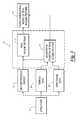
- FIG. 1is a block diagram of one embodiment of the rapid three-dimensional modeler system having real-façade textures obtained from geo-referenced images in accordance with the present invention.
- FIG. 2is a pictorial representation of a three-dimensional model having real façade textures.
- FIG. 3is a pictorial representation of wire-frame data providing a geographical position of a real façade texture of a structure.
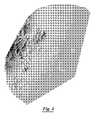
- FIG. 4is a pictorial representation of terrain data providing a geographical position of a real façade texture of a structure.
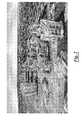
- FIG. 5is a pictorial representation of an exemplary oblique image obtained from an aerial camera, the oblique image displaying a real façade texture of a structure.
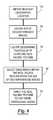
- FIG. 6is an exemplary function flow chart of a method for generating a three-dimensional model of a structure including real façade textures obtained from geo-referenced images.
- FIG. 7is a schematic block diagram of the formation of a mosaic image from a base image and a geo-referenced image including an unoccluded image characteristic.
- FIG. 8is a schematic block diagram of the formation of a mosaic image from a base image and a geo-referenced image including an unoccluded image characteristic, the base image and the geo-referenced image having different views.
- FIG. 9is a schematic diagram of an exemplary embodiment of a system for providing three-dimensional models having real façade textures in accordance with the present invention.
- FIGS. 1 and 2shown therein and designated by a reference numeral 10 is an exemplary system for rapidly creating a three-dimensional model 12 of a structure 14 including real façade textures 16 .
- the system 10provides real façade textures 16 obtained from geo-referenced images 18 .
- the three-dimensional model 12including the real façade textures 16 , provides an accurate representation of a geographic area.
- An exemplary three-dimensional model 12is shown in FIG. 2 and preferably includes structures such as buildings, thoroughfares, and other associated fixtures.
- Such featuresprovide real-life representation of the geographical area useful in strategic planning, tactical planning, tactical debriefing, simulation, real-time simulation, first response actions, engineering designs, and/or the like.
- the geographic areaapplies to physical characteristics of an area, it is not limited to the topographical features of the Earth's surface.
- the system and methods described hereinmay apply to rapid three-dimensional modeling techniques for medical imaging.
- the system 10identifies a geographical position 22 of at least one real façade texture 16 of the structure 14 .
- the system 10locates geo-referenced images 18 containing the real façade texture 16 and selects a base image 19 (See FIG. 7 ) having optimal image characteristics of the real façade texture 16 .
- This base image 19provides at least one real façade texture applied to the structure 14 forming the three-dimensional model 12 .
- the system 10identifies the geographical position 22 of the real façade textures 16 within the geo-referenced images 18 .
- the system 10uses wire-frame data 20 of the structure 14 to provide the geographical position 22 through the identification of boundaries ( 17 a , 17 b , 17 c , 17 d . . . ) of the real façade texture 16 , as best illustrated in FIG. 3 .
- the wire-frame data 20 of FIG. 3illustrates boundaries 17 a - 17 d of the real façade texture 16 as a rectangle, it will be appreciated by one skilled in the art, the boundaries 17 a - 17 d may comprise a circle, square, triangle, or any fanciful shape.
- wire-frame data 20is obtained from publicly available information of buildings, structures, elevations and the like.
- publicly available wire-frame data 20commonly stored as *.shp files may be used.
- wire-frame data 20 of the structure 14may be created based on the particular application of the present invention using techniques commonly known within the art.
- the system 10may also use terrain data 24 to provide the geographical position 22 of the real façade texture 16 .
- the systemmay identify boundaries ( 17 a , 17 b , 17 c , 17 d . . . ) of the real façade texture 16 as illustrated in FIG. 4 .
- FIG. 4illustrates boundaries 17 a - 17 d of the real façade texture 16 as a rectangle, it will be appreciated by one skilled in the art, the boundaries 17 a - 17 d may comprise a circle, square, triangle, or any fanciful shape.
- an edge-detection algorithmmay be used to locate the geographical position 22 of the real façade texture 16 within the terrain data.
- Terrain datamay include Digital Terrain Models (DTMs), Digital Elevation Models (DEMs), and/or the like.
- terrain data 24is comprised of sets of universal terrain map coordinates identifying location and elevation of geographical regions.
- the coordinate systemmay be any coordinate system including latitude and longitude or any other geographical coordinate system suitable for use with the present invention.
- the terrain data 24is a publicly available Digital Terrain Model.
- terrain data 24 for a geographical areamay be extracted or created from publicly available contour images, and/or may be created for the specific application intended.
- the geo-referenced image 18 providing the real façade texture 16may use any color space and be stored in any industry supported file format, such as TIFF, JPEG, GIF, BMP, ECW, and/or the like. Additionally, the geo-referenced images preferably contain or are referenced to or coordinated with information regarding the location and orientation of the camera, focal length, the physical size of the sensor, and/or the like.
- the geo-referenced images 18are preferably nadir images and/or oblique images.
- Nadir imagesas described herein, provide vertical or orthogonal views of the geographic area.
- Nadir imagesmay be an image captured from an overhead position, a position above the structure 14 , or at a right angle or an angle near to a right angle to the structure 14 .
- the imagemay be taken from an overhead position as related to the structure 14 at an eighty-seven degree angle or similar angle close to a ninety-degree angle.
- a nadir imagemay be rectified to fit an associated wire-frame, DTM, DEM, and/or the like. Rectifying a nadir image may entail mapping the pixels to the coordinates of the wire-frame, DTM, DEM, and/or the like.
- Oblique imageswill typically, but not exclusively, be used for the purposes of the present invention.
- Oblique imagesare images taken at an angle other than that of the nadir perspective or images derived from the nadir perspective.
- Oblique imagesprovide a perspective line of sight that generally reveals information not visible from an orthogonal or orthophoto view.
- an oblique imagemay have an angle to the structure 14 in the range of about zero degrees to about eighty-nine degrees.
- the first step 50 in generating a three-dimensional model having real façade textures 16is to obtain a relevant geographic location of the structure 14 .
- a set of geo-referenced images 18 representing the locationare obtained, which is the second step 52 .
- the geo-referenced images 18may be obtained as discussed above or in any other suitable fashion.
- the relevant geographical location 22may be determined internally, calculating a position based upon a mathematical formula, or through an external entity, for example, by a database or user.
- a userindicates an initial geographic location, for example, such that subsequent locations may be mathematically calculated using image boundaries.
- the third step 54is to locate the geographical position 22 of at least one real façade texture 16 of the structure 14 .
- Wire-frame data 20 and/or terrain datamay be used to locate the geographical position 22 coordinating to the structure 14 as previously discussed herein.
- the fourth step 56is to select a base image 19 containing the real façade texture 16 from the geo-referenced images 18 .
- the base image 19is preferably selected as one that accurately represents the real façade texture 16 and may be automatically selected by the system 10 or selected or determined by the user from a limited selection of geo-referenced images 18 provided by the system 10 .
- the base image 19 containing the real façade texture 16is selected from the geo-referenced images 18 of the structure 14 based upon a factorial analysis of the image raster content of each geo-referenced image 18 of the structure 14 .
- the factorial analysismay include a weighted determination based on the resolution of the image, colour depth of the image, proportional size of the real façade texture, contrast, time of day the image was captured, time of year the image was captured and/or the like. Foliage may also play a role in the factorial analysis.
- the base image 19may be selected based on the contrast in lighting conditions. Contrast may be measured as a histogram and provide information regarding shadows within the image. Such information is relevant in constructing replications of large geographical areas, as the three-dimensional model 12 would generally include real façade textures 16 representing the same approximate time of day and/or time of year.
- the fifth stepis to apply or relate the real façade texture 16 of the base image 19 to the three-dimensional model 12 .
- the three-dimensional model 12may comprise base factors such as wire-frame data and/or terrain data.
- the real façade texture 16 of the base image 19may be applied to the wire-frame of the structure 14 .
- the system 10may automatically rotate, stretch, or shrink the real façade texture 16 to align with edges of the wire-frame data 20 . Additionally, the system 10 may provide for user evaluation and/or manipulation of the real façade texture 16 .
- wire-frame data 20 and/or terrain data 22may provide a coordinate system for the three-dimensional model 12 such that the real façade texture 16 is geographically positioned within the three-dimensional model according to the corresponding coordinates of the wire-frame data and/or terrain data. Additionally, the real façade texture 16 may be applied to form the entire three-dimensional model 12 or, alternatively, at least a portion of the three-dimensional model 12 . Multiple base images 19 with multiple real façade textures 16 may form the three-dimensional model 12 .
- the real façade texturemay be further processed to correct occlusions 70 , as illustrated in FIGS. 7 and 8 .
- occlusions 70such as overlapping structures, visual distortions, and/or the like.
- FIG. 7illustrates the real façade texture 16 blocked by an overlapping structure 71 .
- This blocked overlapping structure 71causes an occlusion 70 within the real façade texture 16 .
- Multiple geo-referenced images 18may not be able to provide the real façade texture 16 without the blocked overlapping structure 71 . Therefore, methods are provided to correct for the occlusion 70 within the real façade texture 16 .
- the base image 19is analyzed to locate a geographical position 72 of the occlusion 70 .
- the geographical position 72may be identified using boundaries ( 74 a , 74 b , 74 c , 74 d . . . ).
- the boundaries 74 a - 74 dare illustrated as a rectangle, it will be appreciated by one skilled in the art, the boundaries 74 a - 74 d may comprise a circle, square, triangle, or any fanciful shape.
- an edge-detection algorithmmay be used to identify the geographical position of the occlusion 70 .
- the geo-referenced images 18 of the structure 14are analyzed to locate at least one image 76 having an unoccluded image characteristic 78 . As illustrated in FIG. 7 , the geo-referenced images 18 of the structure 14 correcting for the occlusion 70 are not required to be the same view as the base image 19 .
- the unoccluded image characteristicis applied to the real façade texture 16 forming a mosaic image 80 .
- pixels of the unoccluded image characteristic 78may replace pixels of the occlusion 70 of the real façade texture 16 .
- the mosaic image 80may include several unoccluded image characteristics 78 in addition to the real façade texture 16 of the base image 19 .
- Storage of the mosaic image 80may be problematic if the file size of the mosaic image 80 is extremely large. Thus, it may be beneficial to use an algorithm for storing the mosaic image 80 . For example, a rectangular area of the mosaic image 80 can be extracted and all information outside of the rectangular space cropped and removed. However, the geo-referencing information of the area would still be maintained within the mosaic image 80 .
- Occlusions 70are not limited to blocked areas on the real façade texture 16 but can also include misalignment of the real façade texture 16 when applied to the three-dimensional model 12 and/or undesirable background images within the real façade texture 16 .
- Occlusions 70 , misalignments, and background imagesmay be identified using pattern recognition, contrast, and/or the like.
- pattern recognitiontechnically can be used to analyze each pixel or a group of pixels to determine whether the pixel belongs to the real façade texture 16 or is part of the occlusion 70 .
- the three-dimensional geometry of the surrounding buildingsmay also be a key factor.
- the real façade texture 16may be optimized for depth complexity. Methods for optimizing depth complexity involve the system 10 first determining whether overlapping elements within the real façade texture 16 are occlusions 70 or desirable features of the real façade texture 16 . If the system 10 determines the overlapping elements are desirable features of the real façade texture 16 , the system 10 applies the real façade texture 16 of the overlapping structures to the three-dimensional model. For example, the system 10 may detect a small roof structure that is overlapping a large roof structure. The system 10 will assume that the small roof structure is an element on top of the large roof structure and considered desirably within the real façade texture 16 . The system will apply the real façade texture 16 of the overlapping structures to the three-dimensional model 12 .
- wallsare represented by vertical rectangles, from the top of the roof to the terrain.
- walls of the small roomare created only to the large roof and not to the terrain.
- the formation of the three-dimensional model 12 with real façade textures 16may be a continuous or intermittent process.
- the formation of the three-dimensional model 12is automatically performed by the system 10 to facilitate rapid modeling of an area.
- the system 10determines the geographic location of an area of interest and retrieves the appropriate wire-frame data 20 and/or terrain data 24 associated with the area.
- the system 10automatically locates and identifies structures 14 within the area based upon the wire-frame data 20 and/or terrain data 24 provided.
- Geo-referenced images 18 of the areaare located by the system 10 using the wire-frame data 20 and/or terrain data 24 .
- the base oblique image 19 of the structure 14is automatically selected by the system 10 based on the image raster content of each of the geo-referenced images 18 . If the base oblique image 19 contains more than one structure 14 , the system 10 may locate each real façade texture 16 independently or together. Once the real façade texture 16 is located, the system 10 may fix any occlusions if necessary and apply the real façade texture to the three-dimensional model 12 .
- the system 10is a computer system that is able to embody and/or execute the logic of the processes described herein.
- the logic embodiedmay be executed on any appropriate hardware such as, for example, a dedicated system or systems, personal computer system, distributed processing computer system, and/or the like.
- the system 10is preferably distributed, and includes a host system 112 , communicating with one or more user devices 114 via a network 116 .
- the network 116can be the Internet or other network.
- the host system 112typically includes one or more servers 118 configured to communicate with the network 116 via one or more gateways 120 .
- the network 116is the Internet, the primary user interface of the system 10 is delivered through a series of web pages, but the primary user interface can be replaced by another type of interface, such as a Windows-based application. This method is also used when deploying the system 10 in a stand-alone environment, such as a kiosk.
- the network 116can be almost any type of network, although Internet and Internet 2 networks are preferred because of the wide support of their underlying technologies.
- One embodiment of the network 116exists in an Internet environment, which means a TCP/IP-based network. It is conceivable that in the near future, the preferred or other embodiments, may wish to use more advanced networking topologies.
- the servers 120can be networked with a LAN 130 .
- the gateway 120is an entity responsible for providing access between the LAN 130 and the network 116 .
- the gateway 120can also be used as a security means to protect the LAN 130 from attack from external networks such as the network 116 .
- the LAN 130 networkcan be based on TCP/IP network such as the Internet, or it can based on another underlying network transport technology.
- TCP/IPTransmission Control Protocol/IP
- the preferred embodimentuses an Ethernet network with TCP/IP because of the availability and acceptance of underlying technologies, but other embodiments may use other types of networks such as Fibre Channel, SCSI, Gigabit Ethernet, etc.
- the host system 112includes the servers 118 .
- the configuration of the server hardwarewill depend upon the requirements and needs of the particular embodiment of the system 10 . Typical embodiments, including the preferred embodiment, will include multiple servers 118 with load balancing to increase stability and availability. It is envisioned that the servers 118 will include database servers and application/web servers. The database servers are preferably separated from the application/web servers to improve availability and to provide the database servers with improved hardware and storage.
- the user devices 14can be any number and type of device. Generally, user devices 14 involve a user 32 , using a computer 34 with a display 36 , keyboard 38 , and mouse 40 . It is contemplated user devices 14 may include a touch screen element on the display in addition to or in lieu of the keyboard 38 and/or mouse 40 .
- the user device 14uses a type of software called a “browser” as indicated by reference numeral 42 to render HTML/XHTML content that is generated when requesting resources from a source, such as the host system 112 .
- the system 10is designed to be compatible with major Web Browser vendors (Microsoft Internet Explorer, Netscape Navigator, and Opera). Other embodiments may wish to focus on one particular browser depending upon the common user base using the system 10 .
- user devices 14may interact with the system 10 through any suitable functional software, such as a program specifically designed for the individual embodiments of the system 10 .
- the user devices 14can also be implemented as a portable device such as a laptop computer 150 (or handheld computer); a cellular telephone 52 with a micro or embedded Web Browser; a Portable Digital Assistant 54 (PDA) capable of wireless network access; a pen-based or tablet computer 56 , and/or the like.
- the user device 14may be a cable box 60 or other similar device for viewing through a display 62 or television.
- Current embodiments of the system 10can also be modified to use any of these or similar future developed devices.
- the system 10is designed to provide flexibility in its deployment.
- the enginemay be designed to work in almost any environment such as a desktop application, a web application, a series of web services designed to communicate with an external application, and/or the like.
- the hardware and system softwareare designed with two key concerns: flexibility and scalability. Although some specifics for software and hardware components are described herein, it will be understood that a wide array of different components may be substituted. For example, different database vendors may be used, SML-based document stores may be used, and/or the like.
- such computer(s) and/or executionmay be conducted at a same geographical location or multiple geographic locations. Furthermore, the execution of the logic may be conducted continuously or at multiple discrete times.
- the system 10includes one or more computer readable medium storing instructions for displaying a pixel representation of one or more of the images described herein including the geo-referenced images 18 , the base oblique images 19 , wire frame data 20 , terrain data 24 , the three-dimensional model 12 , and the like.
- the computer readable mediummay be part of the host system 112 , the user devices 114 , or combination thereof.
- the system 10uses one or more databases or servers 118 to store the images in an organized format. For example, the geo-referenced images 18 of the structure 14 may be sorted and stored by the direction showing the particular real façade texture 16 .
- the system 10may also include instructions for (1) displaying pixel representations of the images as described above; (2) selecting the geographical location of interest; (3) altering and/or editing images; and (4) other similar tasks.
- the instructionstypically run on a combination of the user devices 114 and the host system 12 .
Landscapes
- Engineering & Computer Science (AREA)
- Physics & Mathematics (AREA)
- Theoretical Computer Science (AREA)
- General Physics & Mathematics (AREA)
- Computer Graphics (AREA)
- Geometry (AREA)
- Software Systems (AREA)
- Remote Sensing (AREA)
- Processing Or Creating Images (AREA)
- Instructional Devices (AREA)
- Computing Systems (AREA)
Abstract
Description
Claims (17)
Priority Applications (10)
| Application Number | Priority Date | Filing Date | Title |
|---|---|---|---|
| US13/903,683US8648872B2 (en) | 2007-12-03 | 2013-05-28 | Systems and methods for rapid three-dimensional modeling with real facade texture |
| US14/152,638US8970615B2 (en) | 2007-12-03 | 2014-01-10 | Systems and methods for rapid three-dimensional modeling with real facade texture |
| US14/633,285US9275496B2 (en) | 2007-12-03 | 2015-02-27 | Systems and methods for rapid three-dimensional modeling with real facade texture |
| US15/056,598US9520000B2 (en) | 2007-12-03 | 2016-02-29 | Systems and methods for rapid three-dimensional modeling with real facade texture |
| US15/374,358US9836882B2 (en) | 2007-12-03 | 2016-12-09 | Systems and methods for rapid three-dimensional modeling with real facade texture |
| US15/830,823US9972126B2 (en) | 2007-12-03 | 2017-12-04 | Systems and methods for rapid three-dimensional modeling with real facade texture |
| US15/977,848US10229532B2 (en) | 2007-12-03 | 2018-05-11 | Systems and methods for rapid three-dimensional modeling with real facade texture |
| US16/298,774US10573069B2 (en) | 2007-12-03 | 2019-03-11 | Systems and methods for rapid three-dimensional modeling with real facade texture |
| US16/799,034US10896540B2 (en) | 2007-12-03 | 2020-02-24 | Systems and methods for rapid three-dimensional modeling with real façade texture |
| US17/150,870US11263808B2 (en) | 2007-12-03 | 2021-01-15 | Systems and methods for rapid three-dimensional modeling with real façade texture |
Applications Claiming Priority (2)
| Application Number | Priority Date | Filing Date | Title |
|---|---|---|---|
| US11/998,974US8531472B2 (en) | 2007-12-03 | 2007-12-03 | Systems and methods for rapid three-dimensional modeling with real façade texture |
| US13/903,683US8648872B2 (en) | 2007-12-03 | 2013-05-28 | Systems and methods for rapid three-dimensional modeling with real facade texture |
Related Parent Applications (1)
| Application Number | Title | Priority Date | Filing Date |
|---|---|---|---|
| US11/998,974ContinuationUS8531472B2 (en) | 2007-12-03 | 2007-12-03 | Systems and methods for rapid three-dimensional modeling with real façade texture |
Related Child Applications (1)
| Application Number | Title | Priority Date | Filing Date |
|---|---|---|---|
| US14/152,638ContinuationUS8970615B2 (en) | 2007-12-03 | 2014-01-10 | Systems and methods for rapid three-dimensional modeling with real facade texture |
Publications (2)
| Publication Number | Publication Date |
|---|---|
| US20130293542A1 US20130293542A1 (en) | 2013-11-07 |
| US8648872B2true US8648872B2 (en) | 2014-02-11 |
Family
ID=40675227
Family Applications (11)
| Application Number | Title | Priority Date | Filing Date |
|---|---|---|---|
| US11/998,974Active2030-11-21US8531472B2 (en) | 2007-12-03 | 2007-12-03 | Systems and methods for rapid three-dimensional modeling with real façade texture |
| US13/903,683ActiveUS8648872B2 (en) | 2007-12-03 | 2013-05-28 | Systems and methods for rapid three-dimensional modeling with real facade texture |
| US14/152,638ActiveUS8970615B2 (en) | 2007-12-03 | 2014-01-10 | Systems and methods for rapid three-dimensional modeling with real facade texture |
| US14/633,285ActiveUS9275496B2 (en) | 2007-12-03 | 2015-02-27 | Systems and methods for rapid three-dimensional modeling with real facade texture |
| US15/056,598ActiveUS9520000B2 (en) | 2007-12-03 | 2016-02-29 | Systems and methods for rapid three-dimensional modeling with real facade texture |
| US15/374,358ActiveUS9836882B2 (en) | 2007-12-03 | 2016-12-09 | Systems and methods for rapid three-dimensional modeling with real facade texture |
| US15/830,823ActiveUS9972126B2 (en) | 2007-12-03 | 2017-12-04 | Systems and methods for rapid three-dimensional modeling with real facade texture |
| US15/977,848ActiveUS10229532B2 (en) | 2007-12-03 | 2018-05-11 | Systems and methods for rapid three-dimensional modeling with real facade texture |
| US16/298,774ActiveUS10573069B2 (en) | 2007-12-03 | 2019-03-11 | Systems and methods for rapid three-dimensional modeling with real facade texture |
| US16/799,034ActiveUS10896540B2 (en) | 2007-12-03 | 2020-02-24 | Systems and methods for rapid three-dimensional modeling with real façade texture |
| US17/150,870ActiveUS11263808B2 (en) | 2007-12-03 | 2021-01-15 | Systems and methods for rapid three-dimensional modeling with real façade texture |
Family Applications Before (1)
| Application Number | Title | Priority Date | Filing Date |
|---|---|---|---|
| US11/998,974Active2030-11-21US8531472B2 (en) | 2007-12-03 | 2007-12-03 | Systems and methods for rapid three-dimensional modeling with real façade texture |
Family Applications After (9)
| Application Number | Title | Priority Date | Filing Date |
|---|---|---|---|
| US14/152,638ActiveUS8970615B2 (en) | 2007-12-03 | 2014-01-10 | Systems and methods for rapid three-dimensional modeling with real facade texture |
| US14/633,285ActiveUS9275496B2 (en) | 2007-12-03 | 2015-02-27 | Systems and methods for rapid three-dimensional modeling with real facade texture |
| US15/056,598ActiveUS9520000B2 (en) | 2007-12-03 | 2016-02-29 | Systems and methods for rapid three-dimensional modeling with real facade texture |
| US15/374,358ActiveUS9836882B2 (en) | 2007-12-03 | 2016-12-09 | Systems and methods for rapid three-dimensional modeling with real facade texture |
| US15/830,823ActiveUS9972126B2 (en) | 2007-12-03 | 2017-12-04 | Systems and methods for rapid three-dimensional modeling with real facade texture |
| US15/977,848ActiveUS10229532B2 (en) | 2007-12-03 | 2018-05-11 | Systems and methods for rapid three-dimensional modeling with real facade texture |
| US16/298,774ActiveUS10573069B2 (en) | 2007-12-03 | 2019-03-11 | Systems and methods for rapid three-dimensional modeling with real facade texture |
| US16/799,034ActiveUS10896540B2 (en) | 2007-12-03 | 2020-02-24 | Systems and methods for rapid three-dimensional modeling with real façade texture |
| US17/150,870ActiveUS11263808B2 (en) | 2007-12-03 | 2021-01-15 | Systems and methods for rapid three-dimensional modeling with real façade texture |
Country Status (2)
| Country | Link |
|---|---|
| US (11) | US8531472B2 (en) |
| WO (1) | WO2009073726A1 (en) |
Cited By (5)
| Publication number | Priority date | Publication date | Assignee | Title |
|---|---|---|---|---|
| US9501700B2 (en) | 2012-02-15 | 2016-11-22 | Xactware Solutions, Inc. | System and method for construction estimation using aerial images |
| US9679227B2 (en) | 2013-08-02 | 2017-06-13 | Xactware Solutions, Inc. | System and method for detecting features in aerial images using disparity mapping and segmentation techniques |
| US9886774B2 (en) | 2014-10-22 | 2018-02-06 | Pointivo, Inc. | Photogrammetric methods and devices related thereto |
| US11094113B2 (en) | 2019-12-04 | 2021-08-17 | Geomni, Inc. | Systems and methods for modeling structures using point clouds derived from stereoscopic image pairs |
| US11514644B2 (en) | 2018-01-19 | 2022-11-29 | Enphase Energy, Inc. | Automated roof surface measurement from combined aerial LiDAR data and imagery |
Families Citing this family (99)
| Publication number | Priority date | Publication date | Assignee | Title |
|---|---|---|---|---|
| US8145578B2 (en)* | 2007-04-17 | 2012-03-27 | Eagel View Technologies, Inc. | Aerial roof estimation system and method |
| US8078436B2 (en) | 2007-04-17 | 2011-12-13 | Eagle View Technologies, Inc. | Aerial roof estimation systems and methods |
| CA2617119A1 (en)* | 2008-01-08 | 2009-07-08 | Pci Geomatics Enterprises Inc. | Service oriented architecture for earth observation image processing |
| IL190539A (en)* | 2008-03-31 | 2015-01-29 | Rafael Advanced Defense Sys | Methods for transferring points of interest between images with non-parallel viewing directions |
| US8497905B2 (en) | 2008-04-11 | 2013-07-30 | nearmap australia pty ltd. | Systems and methods of capturing large area images in detail including cascaded cameras and/or calibration features |
| US8675068B2 (en) | 2008-04-11 | 2014-03-18 | Nearmap Australia Pty Ltd | Systems and methods of capturing large area images in detail including cascaded cameras and/or calibration features |
| US20100085350A1 (en)* | 2008-10-02 | 2010-04-08 | Microsoft Corporation | Oblique display with additional detail |
| US8731234B1 (en) | 2008-10-31 | 2014-05-20 | Eagle View Technologies, Inc. | Automated roof identification systems and methods |
| US8170840B2 (en) | 2008-10-31 | 2012-05-01 | Eagle View Technologies, Inc. | Pitch determination systems and methods for aerial roof estimation |
| US8209152B2 (en) | 2008-10-31 | 2012-06-26 | Eagleview Technologies, Inc. | Concurrent display systems and methods for aerial roof estimation |
| US8422825B1 (en)* | 2008-11-05 | 2013-04-16 | Hover Inc. | Method and system for geometry extraction, 3D visualization and analysis using arbitrary oblique imagery |
| US9953459B2 (en)* | 2008-11-05 | 2018-04-24 | Hover Inc. | Computer vision database platform for a three-dimensional mapping system |
| US9098926B2 (en)* | 2009-02-06 | 2015-08-04 | The Hong Kong University Of Science And Technology | Generating three-dimensional façade models from images |
| WO2010088840A1 (en) | 2009-02-06 | 2010-08-12 | The Hong Kong University Of Science And Technology | Generating three-dimensional models from images |
| US8401222B2 (en) | 2009-05-22 | 2013-03-19 | Pictometry International Corp. | System and process for roof measurement using aerial imagery |
| US9330494B2 (en)* | 2009-10-26 | 2016-05-03 | Pictometry International Corp. | Method for the automatic material classification and texture simulation for 3D models |
| US8963943B2 (en)* | 2009-12-18 | 2015-02-24 | Electronics And Telecommunications Research Institute | Three-dimensional urban modeling apparatus and method |
| KR101314120B1 (en)* | 2009-12-18 | 2013-10-04 | 한국전자통신연구원 | Three-dimensional urban modeling apparatus and three-dimensional urban modeling method |
| FR2954520B1 (en)* | 2009-12-18 | 2012-09-21 | Thales Sa | METHOD FOR THE DESIGNATION OF A TARGET FOR A TERMINAL IMAGING GUIDED ARMING |
| AU2011210538B2 (en) | 2010-02-01 | 2015-03-26 | Eagle View Technologies, Inc. | Geometric correction of rough wireframe models derived from photographs |
| US8823732B2 (en)* | 2010-12-17 | 2014-09-02 | Pictometry International Corp. | Systems and methods for processing images with edge detection and snap-to feature |
| EP2495688A1 (en)* | 2011-03-02 | 2012-09-05 | Harman Becker Automotive Systems GmbH | Floor Number Determination in Buildings |
| US20150172628A1 (en)* | 2011-06-30 | 2015-06-18 | Google Inc. | Altering Automatically-Generated Three-Dimensional Models Using Photogrammetry |
| US8884950B1 (en) | 2011-07-29 | 2014-11-11 | Google Inc. | Pose data via user interaction |
| EP2758941A4 (en)* | 2011-09-21 | 2016-01-06 | Hover Inc | Three-dimensional map system |
| EP2764325A4 (en)* | 2011-10-04 | 2016-01-06 | Metalforming Inc | Using videogrammetry to fabricate parts |
| EP2786290B1 (en)* | 2011-11-29 | 2018-04-18 | Pictometry International Corp. | System for automatic structure footprint detection from oblique imagery |
| US9599466B2 (en) | 2012-02-03 | 2017-03-21 | Eagle View Technologies, Inc. | Systems and methods for estimation of building wall area |
| US10515414B2 (en) | 2012-02-03 | 2019-12-24 | Eagle View Technologies, Inc. | Systems and methods for performing a risk management assessment of a property |
| US10663294B2 (en) | 2012-02-03 | 2020-05-26 | Eagle View Technologies, Inc. | Systems and methods for estimation of building wall area and producing a wall estimation report |
| US8774525B2 (en) | 2012-02-03 | 2014-07-08 | Eagle View Technologies, Inc. | Systems and methods for estimation of building floor area |
| US12140419B2 (en) | 2012-02-03 | 2024-11-12 | Eagle View Technologies, Inc. | Systems and methods for estimation of building wall area and producing a wall estimation report |
| US9933257B2 (en) | 2012-02-03 | 2018-04-03 | Eagle View Technologies, Inc. | Systems and methods for estimation of building wall area |
| US8462155B1 (en) | 2012-05-01 | 2013-06-11 | Google Inc. | Merging three-dimensional models based on confidence scores |
| US8884955B1 (en) | 2012-05-04 | 2014-11-11 | Google Inc. | Surface simplification based on offset tiles |
| US9041711B1 (en) | 2012-05-08 | 2015-05-26 | Google Inc. | Generating reduced resolution textured model from higher resolution model |
| US8965107B1 (en) | 2012-05-18 | 2015-02-24 | Google Inc. | Feature reduction based on local densities for bundle adjustment of images |
| US8897543B1 (en) | 2012-05-18 | 2014-11-25 | Google Inc. | Bundle adjustment based on image capture intervals |
| US8941652B1 (en) | 2012-05-23 | 2015-01-27 | Google Inc. | Incremental surface hole filling |
| US9224233B2 (en) | 2012-05-24 | 2015-12-29 | Google Inc. | Blending 3D model textures by image projection |
| US8463024B1 (en) | 2012-05-25 | 2013-06-11 | Google Inc. | Combining narrow-baseline and wide-baseline stereo for three-dimensional modeling |
| US9129429B2 (en)* | 2012-10-24 | 2015-09-08 | Exelis, Inc. | Augmented reality on wireless mobile devices |
| US9959581B2 (en) | 2013-03-15 | 2018-05-01 | Eagle View Technologies, Inc. | Property management on a smartphone |
| US10909482B2 (en) | 2013-03-15 | 2021-02-02 | Pictometry International Corp. | Building materials estimation |
| US11587176B2 (en) | 2013-03-15 | 2023-02-21 | Eagle View Technologies, Inc. | Price estimation model |
| EP2787319A1 (en)* | 2013-04-05 | 2014-10-08 | Leica Geosystems AG | Control of an image triggering system for taking aerial photographs in nadir alignment for an unmanned aircraft |
| JP5997664B2 (en)* | 2013-06-14 | 2016-09-28 | 株式会社ジオ技術研究所 | Generating texture image data |
| US10140758B1 (en)* | 2013-06-27 | 2018-11-27 | The Boeing Company | Texturing models of structures |
| US9349211B1 (en)* | 2013-06-27 | 2016-05-24 | The Boeing Company | Texturing models of structures |
| DE102014201238A1 (en)* | 2014-01-23 | 2015-07-23 | Siemens Aktiengesellschaft | Method and system for creating a vector map |
| WO2016106365A1 (en)* | 2014-12-22 | 2016-06-30 | Robert Bosch Gmbh | System and methods for generating procedural window lighting effects |
| US12039230B2 (en) | 2015-04-14 | 2024-07-16 | ETAK Systems, LLC | Systems and methods for coordinating initiation, preparing, vetting, scheduling, constructing, and implementing a power plant implementation |
| US11797723B2 (en) | 2015-04-14 | 2023-10-24 | ETAK Systems, LLC | Systems and methods for coordinating initiation, preparing, vetting, scheduling, constructing, and implementing a power plant implementation |
| US12030630B2 (en) | 2015-04-14 | 2024-07-09 | ETAK Systems, LLC | Systems and methods for coordinating initiation, preparing, vetting, scheduling, constructing, and implementing a power plant implementation |
| US11790124B2 (en) | 2015-04-14 | 2023-10-17 | ETAK Systems, LLC | Systems and methods for coordinating initiation, preparing, vetting, scheduling, constructing, and implementing a power plant implementation |
| US10893419B2 (en)* | 2015-04-14 | 2021-01-12 | ETAK Systems, LLC | Systems and methods for coordinating initiation, preparing, vetting, scheduling, constructing, and implementing a small cell implementation |
| US10959107B2 (en)* | 2015-04-14 | 2021-03-23 | ETAK Systems, LLC | Systems and methods for delivering a close out package for work done at a telecommunications site |
| EP3345129A4 (en) | 2015-08-31 | 2019-07-24 | Cape Analytics, Inc. | SYSTEMS AND METHODS FOR ANALYZING REMOTE DETECTION IMAGING |
| US10217207B2 (en) | 2016-01-20 | 2019-02-26 | Ez3D, Llc | System and method for structural inspection and construction estimation using an unmanned aerial vehicle |
| US10140760B1 (en)* | 2016-02-09 | 2018-11-27 | Turbopatent Inc. | Method and system for consistent identification of numbered elements in multiple layered views captured from a 3D model |
| US10628802B2 (en) | 2016-05-19 | 2020-04-21 | Lockheed Martin Corporation | Systems and methods for assessing damage to infrastructure assets |
| US10032267B2 (en) | 2016-06-09 | 2018-07-24 | Lockheed Martin Corporation | Automating the assessment of damage to infrastructure assets |
| US10189567B2 (en)* | 2016-06-09 | 2019-01-29 | Skycatch, Inc. | Identifying camera position of a UAV in flight utilizing real time kinematic satellite navigation |
| CN106327573B (en)* | 2016-08-25 | 2019-03-12 | 成都慧途科技有限公司 | A kind of outdoor scene three-dimensional modeling method for urban architecture |
| US10521694B2 (en)* | 2016-09-09 | 2019-12-31 | The Chinese University Of Hong Kong | 3D building extraction apparatus, method and system |
| US10521664B2 (en) | 2016-11-04 | 2019-12-31 | Loveland Innovations, LLC | Systems and methods for autonomous perpendicular imaging of test squares |
| US9823658B1 (en) | 2016-11-04 | 2017-11-21 | Loveland Innovations, LLC | Systems and methods for adaptive property analysis via autonomous vehicles |
| CN107146286B (en)* | 2017-04-21 | 2020-07-24 | 广州市阿尔法软件信息技术有限公司 | Three-dimensional model automatic adjustment method based on image edge characteristics |
| US10984182B2 (en) | 2017-05-12 | 2021-04-20 | Loveland Innovations, LLC | Systems and methods for context-rich annotation and report generation for UAV microscan data |
| US10534962B2 (en)* | 2017-06-17 | 2020-01-14 | Matterport, Inc. | Automated classification based on photo-realistic image/model mappings |
| US10364027B2 (en) | 2017-10-24 | 2019-07-30 | Loveland Innovations, LLC | Crisscross boustrophedonic flight patterns for UAV scanning and imaging |
| CN109840338B (en)* | 2017-11-28 | 2023-04-25 | 南京国图信息产业有限公司 | Three-dimensional building model construction method applied to three-dimensional real estate information management |
| US11074746B2 (en)* | 2017-12-11 | 2021-07-27 | Locus Social Inc. | System and method of highly-scalable mapping and 3D terrain modeling with aerial images |
| US10503843B2 (en) | 2017-12-19 | 2019-12-10 | Eagle View Technologies, Inc. | Supervised automatic roof modeling |
| GB2569546B (en) | 2017-12-19 | 2020-10-14 | Sony Interactive Entertainment Inc | Determining pixel values using reference images |
| US10679372B2 (en) | 2018-05-24 | 2020-06-09 | Lowe's Companies, Inc. | Spatial construction using guided surface detection |
| US11210514B2 (en) | 2018-08-24 | 2021-12-28 | Loveland Innovations, LLC | Image analysis and estimation of rooftop solar exposure via solar ray mapping |
| US10366287B1 (en) | 2018-08-24 | 2019-07-30 | Loveland Innovations, LLC | Image analysis and estimation of rooftop solar exposure |
| US11205072B2 (en) | 2018-08-24 | 2021-12-21 | Loveland Innovations, LLC | Solar ray mapping via divergent beam modeling |
| EP3881161A1 (en) | 2018-11-14 | 2021-09-22 | Cape Analytics, Inc. | Systems, methods, and computer readable media for predictive analytics and change detection from remotely sensed imagery |
| WO2020106984A1 (en) | 2018-11-21 | 2020-05-28 | Eagle View Technologies, Inc. | Navigating unmanned aircraft using pitch |
| CN111145338B (en)* | 2019-12-17 | 2023-09-26 | 桂林理工大学 | Chair model reconstruction method and system based on single-view RGB image |
| CN111339600B (en)* | 2020-03-17 | 2020-11-10 | 飞燕航空遥感技术有限公司 | Layered household three-dimensional display method and system in building tilt model and storage medium |
| EP4133235A4 (en) | 2020-04-10 | 2024-04-03 | Cape Analytics, Inc. | GEOCODING SYSTEM AND METHOD |
| CN111222586B (en)* | 2020-04-20 | 2020-09-18 | 广州都市圈网络科技有限公司 | Inclined image matching method and device based on three-dimensional inclined model visual angle |
| DE102020111572A1 (en)* | 2020-04-28 | 2021-10-28 | Salamander Industrie-Produkte Gmbh | Method and apparatus for laying out a window structure |
| WO2021247603A1 (en) | 2020-06-02 | 2021-12-09 | Cape Analytics, Inc. | Method for property feature segmentation |
| WO2022082007A1 (en) | 2020-10-15 | 2022-04-21 | Cape Analytics, Inc. | Method and system for automated debris detection |
| US11532116B2 (en) | 2020-10-30 | 2022-12-20 | Loveland Innovations, Inc. | Graphical user interface for controlling a solar ray mapping |
| CN112598776B (en)* | 2020-12-29 | 2021-08-17 | 江苏星月测绘科技股份有限公司 | Three-dimensional geographic model visualization system based on holographic data processing |
| US11875413B2 (en) | 2021-07-06 | 2024-01-16 | Cape Analytics, Inc. | System and method for property condition analysis |
| CN113627630A (en)* | 2021-08-23 | 2021-11-09 | 安徽嘉拓信息科技有限公司 | Emergency command auxiliary decision-making system for power grid emergency |
| WO2023114027A1 (en) | 2021-12-16 | 2023-06-22 | Cape Analytics, Inc. | System and method for change analysis |
| AU2023208758A1 (en) | 2022-01-19 | 2024-06-20 | Cape Analytics, Inc. | System and method for object analysis |
| US11935276B2 (en) | 2022-01-24 | 2024-03-19 | Cape Analytics, Inc. | System and method for subjective property parameter determination |
| AU2023225698A1 (en)* | 2022-02-23 | 2024-10-03 | Hover, Inc. | Systems and methods for generating dimensionally coherent training data |
| US12229845B2 (en) | 2022-06-13 | 2025-02-18 | Cape Analytics, Inc. | System and method for property group analysis |
| US12189915B2 (en) | 2022-06-24 | 2025-01-07 | Lowe's Companies, Inc. | Simulated environment for presenting virtual objects and virtual resets |
| US12211161B2 (en) | 2022-06-24 | 2025-01-28 | Lowe's Companies, Inc. | Reset modeling based on reset and object properties |
Citations (25)
| Publication number | Priority date | Publication date | Assignee | Title |
|---|---|---|---|---|
| US6037945A (en) | 1997-12-16 | 2000-03-14 | Xactware, Inc. | Graphical method for modeling and estimating construction costs |
| EP1010966A1 (en) | 1998-12-15 | 2000-06-21 | Aerowest GmbH | Method for generating a three dimensional object description |
| US6810383B1 (en) | 2000-01-21 | 2004-10-26 | Xactware, Inc. | Automated task management and evaluation |
| US6826539B2 (en) | 1999-12-31 | 2004-11-30 | Xactware, Inc. | Virtual structure data repository and directory |
| US6829584B2 (en) | 1999-12-31 | 2004-12-07 | Xactware, Inc. | Virtual home data repository and directory |
| US20050024378A1 (en)* | 1998-11-06 | 2005-02-03 | Imagination Technologies Limited | Texturing systems for use in three-dimensional imaging systems |
| US7133551B2 (en) | 2002-02-07 | 2006-11-07 | National Central University | Semi-automatic reconstruction method of 3-D building models using building outline segments |
| US20070237420A1 (en)* | 2006-04-10 | 2007-10-11 | Microsoft Corporation | Oblique image stitching |
| US7376284B2 (en) | 2004-01-16 | 2008-05-20 | Microsoft Corporation | System, computer program and method for 3D object measurement, modeling and mapping from single imagery |
| US20080221843A1 (en) | 2005-09-01 | 2008-09-11 | Victor Shenkar | System and Method for Cost-Effective, High-Fidelity 3D-Modeling of Large-Scale Urban Environments |
| US7509241B2 (en) | 2001-07-06 | 2009-03-24 | Sarnoff Corporation | Method and apparatus for automatically generating a site model |
| US20090177458A1 (en) | 2007-06-19 | 2009-07-09 | Ch2M Hill, Inc. | Systems and methods for solar mapping, determining a usable area for solar energy production and/or providing solar information |
| US20090208095A1 (en) | 2008-02-15 | 2009-08-20 | Microsoft Corporation | Site modeling using image data fusion |
| US20090304227A1 (en) | 2008-02-01 | 2009-12-10 | Daniel Ian Kennedy | Methods and Systems for Provisioning Energy Systems |
| US7663636B2 (en)* | 2005-11-25 | 2010-02-16 | Electronics And Telecommunications Research Institute | Apparatus and method for automatically analyzing digital video quality |
| US7728833B2 (en) | 2004-08-18 | 2010-06-01 | Sarnoff Corporation | Method for generating a three-dimensional model of a roof structure |
| US20100241406A1 (en) | 2006-07-20 | 2010-09-23 | Harris Corporation | Geospatial modeling system providing building roof type identification features and related methods |
| US7832267B2 (en) | 2007-04-25 | 2010-11-16 | Ecometriks, Llc | Method for determining temporal solar irradiance values |
| US20100296693A1 (en) | 2009-05-22 | 2010-11-25 | Thornberry Dale R | System and process for roof measurement using aerial imagery |
| US7844499B2 (en) | 2005-12-23 | 2010-11-30 | Sharp Electronics Corporation | Integrated solar agent business model |
| US20110033110A1 (en) | 2008-04-23 | 2011-02-10 | Pasco Corporation | Building roof outline recognizing device, building roof outline recognizing method, and building roof outline recognizing program |
| US8078436B2 (en) | 2007-04-17 | 2011-12-13 | Eagle View Technologies, Inc. | Aerial roof estimation systems and methods |
| US8145578B2 (en) | 2007-04-17 | 2012-03-27 | Eagel View Technologies, Inc. | Aerial roof estimation system and method |
| US8170840B2 (en) | 2008-10-31 | 2012-05-01 | Eagle View Technologies, Inc. | Pitch determination systems and methods for aerial roof estimation |
| US8209152B2 (en) | 2008-10-31 | 2012-06-26 | Eagleview Technologies, Inc. | Concurrent display systems and methods for aerial roof estimation |
Family Cites Families (151)
| Publication number | Priority date | Publication date | Assignee | Title |
|---|---|---|---|---|
| US2273876A (en) | 1940-02-12 | 1942-02-24 | Frederick W Lutz | Apparatus for indicating tilt of cameras |
| US3153784A (en) | 1959-12-24 | 1964-10-20 | Us Industries Inc | Photo radar ground contour mapping system |
| US5345086A (en) | 1962-11-28 | 1994-09-06 | Eaton Corporation | Automatic map compilation system |
| US3621326A (en) | 1968-09-30 | 1971-11-16 | Itek Corp | Transformation system |
| US3594556A (en) | 1969-01-08 | 1971-07-20 | Us Navy | Optical sight with electronic image stabilization |
| US3661061A (en) | 1969-05-05 | 1972-05-09 | Atomic Energy Commission | Picture position finder |
| US3614410A (en) | 1969-06-12 | 1971-10-19 | Knight V Bailey | Image rectifier |
| US3716669A (en) | 1971-05-14 | 1973-02-13 | Japan Eng Dev Co | Mapping rectifier for generating polarstereographic maps from satellite scan signals |
| US3725563A (en) | 1971-12-23 | 1973-04-03 | Singer Co | Method of perspective transformation in scanned raster visual display |
| US3864513A (en) | 1972-09-11 | 1975-02-04 | Grumman Aerospace Corp | Computerized polarimetric terrain mapping system |
| US4015080A (en) | 1973-04-30 | 1977-03-29 | Elliott Brothers (London) Limited | Display devices |
| JPS5223975Y2 (en) | 1973-05-29 | 1977-05-31 | ||
| US3877799A (en) | 1974-02-06 | 1975-04-15 | United Kingdom Government | Method of recording the first frame in a time index system |
| DE2510044A1 (en) | 1975-03-07 | 1976-09-16 | Siemens Ag | ARRANGEMENT FOR RECORDING CHARACTERS USING MOSAIC PENCILS |
| US4707698A (en) | 1976-03-04 | 1987-11-17 | Constant James N | Coordinate measurement and radar device using image scanner |
| US4240108A (en) | 1977-10-03 | 1980-12-16 | Grumman Aerospace Corporation | Vehicle controlled raster display system |
| JPS5637416Y2 (en) | 1977-10-14 | 1981-09-02 | ||
| IT1095061B (en) | 1978-05-19 | 1985-08-10 | Conte Raffaele | EQUIPMENT FOR MAGNETIC REGISTRATION OF CASUAL EVENTS RELATED TO MOBILE VEHICLES |
| US4396942A (en) | 1979-04-19 | 1983-08-02 | Jackson Gates | Video surveys |
| FR2461305B1 (en) | 1979-07-06 | 1985-12-06 | Thomson Csf | MAP INDICATOR SYSTEM MORE PARTICULARLY FOR AIR NAVIGATION |
| DE2939681A1 (en) | 1979-09-29 | 1981-04-30 | Agfa-Gevaert Ag, 5090 Leverkusen | METHOD AND DEVICE FOR MONITORING THE QUALITY IN THE PRODUCTION OF PHOTOGRAPHIC IMAGES |
| DE2940871C2 (en) | 1979-10-09 | 1983-11-10 | Messerschmitt-Bölkow-Blohm GmbH, 8012 Ottobrunn | Photogrammetric method for aircraft and spacecraft for digital terrain display |
| US4387056A (en) | 1981-04-16 | 1983-06-07 | E. I. Du Pont De Nemours And Company | Process for separating zero-valent nickel species from divalent nickel species |
| US4382678A (en) | 1981-06-29 | 1983-05-10 | The United States Of America As Represented By The Secretary Of The Army | Measuring of feature for photo interpretation |
| US4463380A (en) | 1981-09-25 | 1984-07-31 | Vought Corporation | Image processing system |
| US4495500A (en) | 1982-01-26 | 1985-01-22 | Sri International | Topographic data gathering method |
| US4490742A (en) | 1982-04-23 | 1984-12-25 | Vcs, Incorporated | Encoding apparatus for a closed circuit television system |
| US4586138A (en) | 1982-07-29 | 1986-04-29 | The United States Of America As Represented By The United States Department Of Energy | Route profile analysis system and method |
| US4491399A (en) | 1982-09-27 | 1985-01-01 | Coherent Communications, Inc. | Method and apparatus for recording a digital signal on motion picture film |
| US4527055A (en) | 1982-11-15 | 1985-07-02 | Honeywell Inc. | Apparatus for selectively viewing either of two scenes of interest |
| FR2536851B1 (en) | 1982-11-30 | 1985-06-14 | Aerospatiale | RECOGNITION SYSTEM COMPRISING AN AIR VEHICLE TURNING AROUND ITS LONGITUDINAL AXIS |
| US4489322A (en) | 1983-01-27 | 1984-12-18 | The United States Of America As Represented By The Secretary Of The Air Force | Radar calibration using direct measurement equipment and oblique photometry |
| US4635136A (en) | 1984-02-06 | 1987-01-06 | Rochester Institute Of Technology | Method and apparatus for storing a massive inventory of labeled images |
| US4686474A (en) | 1984-04-05 | 1987-08-11 | Deseret Research, Inc. | Survey system for collection and real time processing of geophysical data |
| US4814711A (en) | 1984-04-05 | 1989-03-21 | Deseret Research, Inc. | Survey system and method for real time collection and processing of geophysicals data using signals from a global positioning satellite network |
| US4673988A (en) | 1985-04-22 | 1987-06-16 | E.I. Du Pont De Nemours And Company | Electronic mosaic imaging process |
| US4653136A (en) | 1985-06-21 | 1987-03-31 | Denison James W | Wiper for rear view mirror |
| DE211623T1 (en) | 1985-08-01 | 1987-07-02 | British Aerospace Plc, London | IDENTIFICATION OF GROUND TARGETS IN THE REFLECTED SIGNALS OF AN AIRCRAFT MONITORING RADAR. |
| US4953227A (en) | 1986-01-31 | 1990-08-28 | Canon Kabushiki Kaisha | Image mosaic-processing method and apparatus |
| US4653316A (en) | 1986-03-14 | 1987-03-31 | Kabushiki Kaisha Komatsu Seisakusho | Apparatus mounted on vehicles for detecting road surface conditions |
| US4688092A (en) | 1986-05-06 | 1987-08-18 | Ford Aerospace & Communications Corporation | Satellite camera image navigation |
| US4956872A (en) | 1986-10-31 | 1990-09-11 | Canon Kabushiki Kaisha | Image processing apparatus capable of random mosaic and/or oil-painting-like processing |
| JPS63202182A (en) | 1987-02-18 | 1988-08-22 | Olympus Optical Co Ltd | Tilted dot pattern forming method |
| US4814896A (en) | 1987-03-06 | 1989-03-21 | Heitzman Edward F | Real time video data acquistion systems |
| US5164825A (en) | 1987-03-30 | 1992-11-17 | Canon Kabushiki Kaisha | Image processing method and apparatus for mosaic or similar processing therefor |
| US4807024A (en) | 1987-06-08 | 1989-02-21 | The University Of South Carolina | Three-dimensional display methods and apparatus |
| US4899296A (en) | 1987-11-13 | 1990-02-06 | Khattak Anwar S | Pavement distress survey system |
| US4843463A (en) | 1988-05-23 | 1989-06-27 | Michetti Joseph A | Land vehicle mounted audio-visual trip recorder |
| GB8826550D0 (en) | 1988-11-14 | 1989-05-17 | Smiths Industries Plc | Image processing apparatus and methods |
| US4906198A (en) | 1988-12-12 | 1990-03-06 | International Business Machines Corporation | Circuit board assembly and contact pin for use therein |
| JP2765022B2 (en) | 1989-03-24 | 1998-06-11 | キヤノン販売株式会社 | 3D image forming device |
| US5617224A (en) | 1989-05-08 | 1997-04-01 | Canon Kabushiki Kaisha | Imae processing apparatus having mosaic processing feature that decreases image resolution without changing image size or the number of pixels |
| US5086314A (en) | 1990-05-21 | 1992-02-04 | Nikon Corporation | Exposure control apparatus for camera |
| JPH0316377A (en) | 1989-06-14 | 1991-01-24 | Kokusai Denshin Denwa Co Ltd <Kdd> | Binary image reduction method and device |
| US5166789A (en) | 1989-08-25 | 1992-11-24 | Space Island Products & Services, Inc. | Geographical surveying using cameras in combination with flight computers to obtain images with overlaid geographical coordinates |
| JP3147358B2 (en) | 1990-02-23 | 2001-03-19 | ミノルタ株式会社 | Camera that can record location data |
| US5335072A (en) | 1990-05-30 | 1994-08-02 | Minolta Camera Kabushiki Kaisha | Photographic system capable of storing information on photographed image data |
| EP0464263A3 (en) | 1990-06-27 | 1992-06-10 | Siemens Aktiengesellschaft | Device for obstacle detection for pilots of low flying aircrafts |
| US5191174A (en) | 1990-08-01 | 1993-03-02 | International Business Machines Corporation | High density circuit board and method of making same |
| US5200793A (en) | 1990-10-24 | 1993-04-06 | Kaman Aerospace Corporation | Range finding array camera |
| US5155597A (en) | 1990-11-28 | 1992-10-13 | Recon/Optical, Inc. | Electro-optical imaging array with motion compensation |
| JPH04250436A (en) | 1991-01-11 | 1992-09-07 | Pioneer Electron Corp | Image pickup device |
| US5265173A (en) | 1991-03-20 | 1993-11-23 | Hughes Aircraft Company | Rectilinear object image matcher |
| US5369443A (en) | 1991-04-12 | 1994-11-29 | Abekas Video Systems, Inc. | Digital video effects generator |
| DE69204345T2 (en) | 1991-04-16 | 1996-04-25 | Nippon Electric Co | Satellite twin image acquisition for imaging and control. |
| US5555018A (en) | 1991-04-25 | 1996-09-10 | Von Braun; Heiko S. | Large-scale mapping of parameters of multi-dimensional structures in natural environments |
| US5231435A (en) | 1991-07-12 | 1993-07-27 | Blakely Bruce W | Aerial camera mounting apparatus |
| DE69123578T2 (en) | 1991-09-05 | 1997-04-03 | Nippon Electric Co | Image acquisition system that can generate correct image signals of an object zone |
| US5677515A (en) | 1991-10-18 | 1997-10-14 | Trw Inc. | Shielded multilayer printed wiring board, high frequency, high isolation |
| US5402170A (en) | 1991-12-11 | 1995-03-28 | Eastman Kodak Company | Hand-manipulated electronic camera tethered to a personal computer |
| US5247356A (en) | 1992-02-14 | 1993-09-21 | Ciampa John A | Method and apparatus for mapping and measuring land |
| US5270756A (en) | 1992-02-18 | 1993-12-14 | Hughes Training, Inc. | Method and apparatus for generating high resolution vidicon camera images |
| US5251037A (en) | 1992-02-18 | 1993-10-05 | Hughes Training, Inc. | Method and apparatus for generating high resolution CCD camera images |
| US5506644A (en) | 1992-08-18 | 1996-04-09 | Olympus Optical Co., Ltd. | Camera |
| US5481479A (en) | 1992-12-10 | 1996-01-02 | Loral Fairchild Corp. | Nonlinear scanning to optimize sector scan electro-optic reconnaissance system performance |
| US5342999A (en) | 1992-12-21 | 1994-08-30 | Motorola, Inc. | Apparatus for adapting semiconductor die pads and method therefor |
| US5414462A (en) | 1993-02-11 | 1995-05-09 | Veatch; John W. | Method and apparatus for generating a comprehensive survey map |
| US5508736A (en) | 1993-05-14 | 1996-04-16 | Cooper; Roger D. | Video signal processing apparatus for producing a composite signal for simultaneous display of data and video information |
| US5467271A (en) | 1993-12-17 | 1995-11-14 | Trw, Inc. | Mapping and analysis system for precision farming applications |
| AU690693B2 (en) | 1994-05-19 | 1998-04-30 | Geospan Corporation | Method for collecting and processing visual and spatial position information |
| RU2153700C2 (en) | 1995-04-17 | 2000-07-27 | Спейс Системз/Лорал, Инк. | Orientation and image shaping control system (design versions) |
| US5604534A (en) | 1995-05-24 | 1997-02-18 | Omni Solutions International, Ltd. | Direct digital airborne panoramic camera system and method |
| US5668593A (en) | 1995-06-07 | 1997-09-16 | Recon/Optical, Inc. | Method and camera system for step frame reconnaissance with motion compensation |
| US5963664A (en) | 1995-06-22 | 1999-10-05 | Sarnoff Corporation | Method and system for image combination using a parallax-based technique |
| US5835133A (en) | 1996-01-23 | 1998-11-10 | Silicon Graphics, Inc. | Optical system for single camera stereo video |
| US5894323A (en) | 1996-03-22 | 1999-04-13 | Tasc, Inc, | Airborne imaging system using global positioning system (GPS) and inertial measurement unit (IMU) data |
| US5844602A (en) | 1996-05-07 | 1998-12-01 | Recon/Optical, Inc. | Electro-optical imaging array and camera system with pitch rate image motion compensation which can be used in an airplane in a dive bomb maneuver |
| US5798786A (en) | 1996-05-07 | 1998-08-25 | Recon/Optical, Inc. | Electro-optical imaging detector array for a moving vehicle which includes two axis image motion compensation and transfers pixels in row directions and column directions |
| US5841574A (en) | 1996-06-28 | 1998-11-24 | Recon/Optical, Inc. | Multi-special decentered catadioptric optical system |
| US6108032A (en) | 1996-11-05 | 2000-08-22 | Lockheed Martin Fairchild Systems | System and method for image motion compensation of a CCD image sensor |
| DE69720758T2 (en) | 1996-11-05 | 2004-03-04 | Bae Systems Information And Electronic Systems Integration Inc. | DEVICE FOR ELECTRO-OPTICAL REMOTE SENSING WITH MOTION COMPENSATION |
| RU2127075C1 (en) | 1996-12-11 | 1999-03-10 | Корженевский Александр Владимирович | Method for producing tomographic image of body and electrical-impedance tomographic scanner |
| US6222583B1 (en) | 1997-03-27 | 2001-04-24 | Nippon Telegraph And Telephone Corporation | Device and system for labeling sight images |
| US6597818B2 (en) | 1997-05-09 | 2003-07-22 | Sarnoff Corporation | Method and apparatus for performing geo-spatial registration of imagery |
| US6157747A (en) | 1997-08-01 | 2000-12-05 | Microsoft Corporation | 3-dimensional image rotation method and apparatus for producing image mosaics |
| US6097854A (en) | 1997-08-01 | 2000-08-01 | Microsoft Corporation | Image mosaic construction system and apparatus with patch-based alignment, global block adjustment and pair-wise motion-based local warping |
| WO1999018732A1 (en) | 1997-10-06 | 1999-04-15 | Ciampa John A | Digital-image mapping |
| US6434280B1 (en) | 1997-11-10 | 2002-08-13 | Gentech Corporation | System and method for generating super-resolution-enhanced mosaic images |
| US5852753A (en) | 1997-11-10 | 1998-12-22 | Lo; Allen Kwok Wah | Dual-lens camera with shutters for taking dual or single images |
| US6094215A (en) | 1998-01-06 | 2000-07-25 | Intel Corporation | Method of determining relative camera orientation position to create 3-D visual images |
| US6130705A (en) | 1998-07-10 | 2000-10-10 | Recon/Optical, Inc. | Autonomous electro-optical framing camera system with constant ground resolution, unmanned airborne vehicle therefor, and methods of use |
| JP4245699B2 (en) | 1998-09-16 | 2009-03-25 | オリンパス株式会社 | Imaging device |
| US6434265B1 (en) | 1998-09-25 | 2002-08-13 | Apple Computers, Inc. | Aligning rectilinear images in 3D through projective registration and calibration |
| US6167300A (en) | 1999-03-08 | 2000-12-26 | Tci Incorporated | Electric mammograph |
| DE19922341C2 (en) | 1999-05-14 | 2002-08-29 | Zsp Geodaetische Sys Gmbh | Method and arrangement for determining the spatial coordinates of at least one object point |
| AUPQ056099A0 (en) | 1999-05-25 | 1999-06-17 | Silverbrook Research Pty Ltd | A method and apparatus (pprint01) |
| JP5210473B2 (en) | 1999-06-21 | 2013-06-12 | 株式会社半導体エネルギー研究所 | Display device |
| US6639596B1 (en) | 1999-09-20 | 2003-10-28 | Microsoft Corporation | Stereo reconstruction from multiperspective panoramas |
| EP1242966B1 (en) | 1999-12-29 | 2012-11-07 | Geospan Corporation | Spherical rectification of image pairs |
| WO2001058129A2 (en) | 2000-02-03 | 2001-08-09 | Alst Technical Excellence Center | Image resolution improvement using a color mosaic sensor |
| CA2400975C (en) | 2000-03-16 | 2008-11-04 | The Johns Hopkins University | Light detection and ranging (lidar) mapping system |
| US20020041328A1 (en) | 2000-03-29 | 2002-04-11 | Astrovision International, Inc. | Direct broadcast imaging satellite system apparatus and method for providing real-time, continuous monitoring of earth from geostationary earth orbit and related services |
| US7184072B1 (en) | 2000-06-15 | 2007-02-27 | Power View Company, L.L.C. | Airborne inventory and inspection system and apparatus |
| US6834128B1 (en) | 2000-06-16 | 2004-12-21 | Hewlett-Packard Development Company, L.P. | Image mosaicing system and method adapted to mass-market hand-held digital cameras |
| US6484101B1 (en) | 2000-08-16 | 2002-11-19 | Imagelinks, Inc. | 3-dimensional interactive image modeling system |
| US7313289B2 (en) | 2000-08-30 | 2007-12-25 | Ricoh Company, Ltd. | Image processing method and apparatus and computer-readable storage medium using improved distortion correction |
| US6421610B1 (en) | 2000-09-15 | 2002-07-16 | Ernest A. Carroll | Method of preparing and disseminating digitized geospatial data |
| US6959120B1 (en) | 2000-10-27 | 2005-10-25 | Microsoft Corporation | Rebinning methods and arrangements for use in compressing image-based rendering (IBR) data |
| US7009638B2 (en) | 2001-05-04 | 2006-03-07 | Vexcel Imaging Gmbh | Self-calibrating, digital, large format camera with single or multiple detector arrays and single or multiple optical systems |
| US7046401B2 (en) | 2001-06-01 | 2006-05-16 | Hewlett-Packard Development Company, L.P. | Camera-based document scanning system using multiple-pass mosaicking |
| US20030043824A1 (en) | 2001-08-31 | 2003-03-06 | Remboski Donald J. | Vehicle active network and device |
| US6747686B1 (en) | 2001-10-05 | 2004-06-08 | Recon/Optical, Inc. | High aspect stereoscopic mode camera and method |
| US7262790B2 (en) | 2002-01-09 | 2007-08-28 | Charles Adams Bakewell | Mobile enforcement platform with aimable violation identification and documentation system for multiple traffic violation types across all lanes in moving traffic, generating composite display images and data to support citation generation, homeland security, and monitoring |
| US6894809B2 (en) | 2002-03-01 | 2005-05-17 | Orasee Corp. | Multiple angle display produced from remote optical sensing devices |
| JP4184703B2 (en) | 2002-04-24 | 2008-11-19 | 大日本印刷株式会社 | Image correction method and system |
| CN100578525C (en)* | 2002-07-10 | 2010-01-06 | 哈曼贝克自动系统股份有限公司 | System and method for generating a three-dimensional electronic model of an object |
| US7725258B2 (en) | 2002-09-20 | 2010-05-25 | M7 Visual Intelligence, L.P. | Vehicle based data collection and processing system and imaging sensor system and methods thereof |
| US6928194B2 (en) | 2002-09-19 | 2005-08-09 | M7 Visual Intelligence, Lp | System for mosaicing digital ortho-images |
| EP1540937A4 (en) | 2002-09-20 | 2008-11-12 | M7 Visual Intelligence Lp | Vehicule based data collection and porcessing system |
| EP1696204B1 (en) | 2002-11-08 | 2015-01-28 | Pictometry International Corp. | Method for capturing, geolocating and measuring oblique images |
| US7424133B2 (en) | 2002-11-08 | 2008-09-09 | Pictometry International Corporation | Method and apparatus for capturing, geolocating and measuring oblique images |
| US7018050B2 (en) | 2003-09-08 | 2006-03-28 | Hewlett-Packard Development Company, L.P. | System and method for correcting luminance non-uniformity of obliquely projected images |
| JP2005151536A (en) | 2003-10-23 | 2005-06-09 | Nippon Dempa Kogyo Co Ltd | Crystal oscillator |
| US7916940B2 (en) | 2004-01-31 | 2011-03-29 | Hewlett-Packard Development Company | Processing of mosaic digital images |
| BRPI0508226A (en) | 2004-02-27 | 2007-07-17 | Intergraph Software Tech Co | forming a single image from overlay images |
| US20050209774A1 (en) | 2004-03-22 | 2005-09-22 | Speedinfo | Digital map system |
| US20060011026A1 (en) | 2004-07-15 | 2006-01-19 | Mark Dickey | Ergonomic, handheld, power index punch |
| US20060028550A1 (en) | 2004-08-06 | 2006-02-09 | Palmer Robert G Jr | Surveillance system and method |
| US8078396B2 (en) | 2004-08-31 | 2011-12-13 | Meadow William D | Methods for and apparatus for generating a continuum of three dimensional image data |
| US7348895B2 (en) | 2004-11-03 | 2008-03-25 | Lagassey Paul J | Advanced automobile accident detection, data recordation and reporting system |
| US7142984B2 (en) | 2005-02-08 | 2006-11-28 | Harris Corporation | Method and apparatus for enhancing a digital elevation model (DEM) for topographical modeling |
| US7466244B2 (en) | 2005-04-21 | 2008-12-16 | Microsoft Corporation | Virtual earth rooftop overlay and bounding |
| US7554539B2 (en) | 2005-07-27 | 2009-06-30 | Balfour Technologies Llc | System for viewing a collection of oblique imagery in a three or four dimensional virtual scene |
| WO2008002875A2 (en) | 2006-06-26 | 2008-01-03 | Lockheed Martin Corporation | Method and system for providing a perspective view image by intelligent fusion of a plurality of sensor data |
| US7873238B2 (en) | 2006-08-30 | 2011-01-18 | Pictometry International Corporation | Mosaic oblique images and methods of making and using same |
| DE102007030781A1 (en) | 2006-10-11 | 2008-04-17 | Gta Geoinformatik Gmbh | Method for texturing virtual three-dimensional objects |
| IL179344A (en) | 2006-11-16 | 2014-02-27 | Rafael Advanced Defense Sys | Method for tracking a moving platform |
| US20090110267A1 (en) | 2007-09-21 | 2009-04-30 | The Regents Of The University Of California | Automated texture mapping system for 3D models |
| US20100204974A1 (en) | 2009-02-09 | 2010-08-12 | Utah State University | Lidar-Assisted Stero Imager |
| US20150213590A1 (en) | 2011-07-29 | 2015-07-30 | Google Inc. | Automatic Pose Setting Using Computer Vision Techniques |
| US9183538B2 (en) | 2012-03-19 | 2015-11-10 | Pictometry International Corp. | Method and system for quick square roof reporting |
- 2007
- 2007-12-03USUS11/998,974patent/US8531472B2/enactiveActive
- 2008
- 2008-12-03WOPCT/US2008/085410patent/WO2009073726A1/enactiveApplication Filing
- 2013
- 2013-05-28USUS13/903,683patent/US8648872B2/enactiveActive
- 2014
- 2014-01-10USUS14/152,638patent/US8970615B2/enactiveActive
- 2015
- 2015-02-27USUS14/633,285patent/US9275496B2/enactiveActive
- 2016
- 2016-02-29USUS15/056,598patent/US9520000B2/enactiveActive
- 2016-12-09USUS15/374,358patent/US9836882B2/enactiveActive
- 2017
- 2017-12-04USUS15/830,823patent/US9972126B2/enactiveActive
- 2018
- 2018-05-11USUS15/977,848patent/US10229532B2/enactiveActive
- 2019
- 2019-03-11USUS16/298,774patent/US10573069B2/enactiveActive
- 2020
- 2020-02-24USUS16/799,034patent/US10896540B2/enactiveActive
- 2021
- 2021-01-15USUS17/150,870patent/US11263808B2/enactiveActive
Patent Citations (26)
| Publication number | Priority date | Publication date | Assignee | Title |
|---|---|---|---|---|
| US6816819B1 (en) | 1997-12-16 | 2004-11-09 | Xactware, Inc. | Graphical method and system for modeling and estimating construction parameters |
| US6037945A (en) | 1997-12-16 | 2000-03-14 | Xactware, Inc. | Graphical method for modeling and estimating construction costs |
| US20050024378A1 (en)* | 1998-11-06 | 2005-02-03 | Imagination Technologies Limited | Texturing systems for use in three-dimensional imaging systems |
| EP1010966A1 (en) | 1998-12-15 | 2000-06-21 | Aerowest GmbH | Method for generating a three dimensional object description |
| US6826539B2 (en) | 1999-12-31 | 2004-11-30 | Xactware, Inc. | Virtual structure data repository and directory |
| US6829584B2 (en) | 1999-12-31 | 2004-12-07 | Xactware, Inc. | Virtual home data repository and directory |
| US6810383B1 (en) | 2000-01-21 | 2004-10-26 | Xactware, Inc. | Automated task management and evaluation |
| US7509241B2 (en) | 2001-07-06 | 2009-03-24 | Sarnoff Corporation | Method and apparatus for automatically generating a site model |
| US7133551B2 (en) | 2002-02-07 | 2006-11-07 | National Central University | Semi-automatic reconstruction method of 3-D building models using building outline segments |
| US7376284B2 (en) | 2004-01-16 | 2008-05-20 | Microsoft Corporation | System, computer program and method for 3D object measurement, modeling and mapping from single imagery |
| US7728833B2 (en) | 2004-08-18 | 2010-06-01 | Sarnoff Corporation | Method for generating a three-dimensional model of a roof structure |
| US20080221843A1 (en) | 2005-09-01 | 2008-09-11 | Victor Shenkar | System and Method for Cost-Effective, High-Fidelity 3D-Modeling of Large-Scale Urban Environments |
| US7663636B2 (en)* | 2005-11-25 | 2010-02-16 | Electronics And Telecommunications Research Institute | Apparatus and method for automatically analyzing digital video quality |
| US7844499B2 (en) | 2005-12-23 | 2010-11-30 | Sharp Electronics Corporation | Integrated solar agent business model |
| US20070237420A1 (en)* | 2006-04-10 | 2007-10-11 | Microsoft Corporation | Oblique image stitching |
| US20100241406A1 (en) | 2006-07-20 | 2010-09-23 | Harris Corporation | Geospatial modeling system providing building roof type identification features and related methods |
| US8078436B2 (en) | 2007-04-17 | 2011-12-13 | Eagle View Technologies, Inc. | Aerial roof estimation systems and methods |
| US8145578B2 (en) | 2007-04-17 | 2012-03-27 | Eagel View Technologies, Inc. | Aerial roof estimation system and method |
| US7832267B2 (en) | 2007-04-25 | 2010-11-16 | Ecometriks, Llc | Method for determining temporal solar irradiance values |
| US20090177458A1 (en) | 2007-06-19 | 2009-07-09 | Ch2M Hill, Inc. | Systems and methods for solar mapping, determining a usable area for solar energy production and/or providing solar information |
| US20090304227A1 (en) | 2008-02-01 | 2009-12-10 | Daniel Ian Kennedy | Methods and Systems for Provisioning Energy Systems |
| US20090208095A1 (en) | 2008-02-15 | 2009-08-20 | Microsoft Corporation | Site modeling using image data fusion |
| US20110033110A1 (en) | 2008-04-23 | 2011-02-10 | Pasco Corporation | Building roof outline recognizing device, building roof outline recognizing method, and building roof outline recognizing program |
| US8170840B2 (en) | 2008-10-31 | 2012-05-01 | Eagle View Technologies, Inc. | Pitch determination systems and methods for aerial roof estimation |
| US8209152B2 (en) | 2008-10-31 | 2012-06-26 | Eagleview Technologies, Inc. | Concurrent display systems and methods for aerial roof estimation |
| US20100296693A1 (en) | 2009-05-22 | 2010-11-25 | Thornberry Dale R | System and process for roof measurement using aerial imagery |
Non-Patent Citations (11)
| Title |
|---|
| AeroDach®Online Roof Evaluation Standard Delivery Format and 3D Data File: Document Version 01.00.2002 with publication in 2002, 13 pages. |
| Aerowest Pricelist of Geodata as of Oct. 21, 2005 and translations to English 3 pages. |
| Applicad Online Product Bulletin archive from Jan. 7, 2003, 4 pages. |
| Applicad Reports dated Nov. 25, 1999-Mar. 9, 2005, 50 pages. |
| Applicad Reports dated Nov. 25, 1999—Mar. 9, 2005, 50 pages. |
| Applicad Sorcerer Guide, Version 3, Sep. 8, 1999, 142 pages. |
| Bignone et al, Automatic Extraction of Generic House Roofs from High Resolution Aerial Imagery, Communication Technology Laboratory, Swiss Federal Institute of Technology ETH, CH-8092 Zurich, Switzerland, 12 pages, 1996. |
| Geospan 2007 Job proposal. |
| Noronha et al., "Detection and Modeling of Building from Multiple Aerial Images," Institute for Robotics and Intelligent Systems, University of Southern California, Nov. 27, 2001, 32 pages. |
| www.archive.org Web site showing archive of German AeroDach Web Site http://www.aerodach.de from Jun. 13, 2004 (retrieved Sep. 20, 2012) and translations to English 4 pages. |
| Xactimate Claims Estimating Software archive from Feb. 12, 2010, 8 pages. |
Cited By (14)
| Publication number | Priority date | Publication date | Assignee | Title |
|---|---|---|---|---|
| US12265758B2 (en) | 2012-02-15 | 2025-04-01 | Xactware Solutions, Inc. | System and method for construction estimation using aerial images |
| US10503842B2 (en) | 2012-02-15 | 2019-12-10 | Xactware Solutions, Inc. | System and method for construction estimation using aerial images |
| US11210433B2 (en) | 2012-02-15 | 2021-12-28 | Xactware Solutions, Inc. | System and method for construction estimation using aerial images |
| US9501700B2 (en) | 2012-02-15 | 2016-11-22 | Xactware Solutions, Inc. | System and method for construction estimation using aerial images |
| US11727163B2 (en) | 2012-02-15 | 2023-08-15 | Xactware Solutions, Inc. | System and method for construction estimation using aerial images |
| US9679227B2 (en) | 2013-08-02 | 2017-06-13 | Xactware Solutions, Inc. | System and method for detecting features in aerial images using disparity mapping and segmentation techniques |
| US10540577B2 (en) | 2013-08-02 | 2020-01-21 | Xactware Solutions, Inc. | System and method for detecting features in aerial images using disparity mapping and segmentation techniques |
| US10896353B2 (en) | 2013-08-02 | 2021-01-19 | Xactware Solutions, Inc. | System and method for detecting features in aerial images using disparity mapping and segmentation techniques |
| US12270648B2 (en) | 2013-08-02 | 2025-04-08 | Xactware Solutions, Inc. | System and method for detecting features in aerial images using disparity mapping and segmentation techniques |
| US11144795B2 (en) | 2013-08-02 | 2021-10-12 | Xactware Solutions, Inc. | System and method for detecting features in aerial images using disparity mapping and segmentation techniques |
| US9886774B2 (en) | 2014-10-22 | 2018-02-06 | Pointivo, Inc. | Photogrammetric methods and devices related thereto |
| US11514644B2 (en) | 2018-01-19 | 2022-11-29 | Enphase Energy, Inc. | Automated roof surface measurement from combined aerial LiDAR data and imagery |
| US11915368B2 (en) | 2019-12-04 | 2024-02-27 | Insurance Services Office, Inc. | Systems and methods for modeling structures using point clouds derived from stereoscopic image pairs |
| US11094113B2 (en) | 2019-12-04 | 2021-08-17 | Geomni, Inc. | Systems and methods for modeling structures using point clouds derived from stereoscopic image pairs |
Also Published As
| Publication number | Publication date |
|---|---|
| US11263808B2 (en) | 2022-03-01 |
| US9520000B2 (en) | 2016-12-13 |
| US20200193702A1 (en) | 2020-06-18 |
| US9972126B2 (en) | 2018-05-15 |
| US8970615B2 (en) | 2015-03-03 |
| US20170193694A1 (en) | 2017-07-06 |
| US20130293542A1 (en) | 2013-11-07 |
| US10573069B2 (en) | 2020-02-25 |
| WO2009073726A1 (en) | 2009-06-11 |
| US10229532B2 (en) | 2019-03-12 |
| US10896540B2 (en) | 2021-01-19 |
| US20190206125A1 (en) | 2019-07-04 |
| US20180261006A1 (en) | 2018-09-13 |
| US20150170413A1 (en) | 2015-06-18 |
| US20140125664A1 (en) | 2014-05-08 |
| US20180089891A1 (en) | 2018-03-29 |
| US20160180583A1 (en) | 2016-06-23 |
| US9275496B2 (en) | 2016-03-01 |
| US8531472B2 (en) | 2013-09-10 |
| US20210209843A1 (en) | 2021-07-08 |
| US20090141020A1 (en) | 2009-06-04 |
| US9836882B2 (en) | 2017-12-05 |
Similar Documents
| Publication | Publication Date | Title |
|---|---|---|
| US11263808B2 (en) | Systems and methods for rapid three-dimensional modeling with real façade texture | |
| US11080911B2 (en) | Mosaic oblique images and systems and methods of making and using same | |
| US8643720B2 (en) | Computer system for continuous oblique panning | |
| Soycan et al. | Perspective correction of building facade images for architectural applications | |
| AU2012205205B2 (en) | Mosaic oblique images and methods of making and using same |
Legal Events
| Date | Code | Title | Description |
|---|---|---|---|
| AS | Assignment | Owner name:PICTOMETRY INTERNATIONAL CORP., NEW YORK Free format text:ASSIGNMENT OF ASSIGNORS INTEREST;ASSIGNOR:IDAN COMPUTERS ENGINEERING (1979) LTD.;REEL/FRAME:031929/0343 Effective date:20110204 Owner name:IDAN COMPUTERS ENGINEERING (1979) LTD., ISRAEL Free format text:ASSIGNMENT OF ASSIGNORS INTEREST;ASSIGNORS:FREUND, JOSEPH G.;GAL, RAN;REEL/FRAME:031929/0299 Effective date:20080620 | |
| STCF | Information on status: patent grant | Free format text:PATENTED CASE | |
| AS | Assignment | Owner name:MORGAN STANLEY SENIOR FUNDING, INC., NEW YORK Free format text:FIRST LIEN PATENT SECURITY AGREEMENT;ASSIGNORS:PICTOMETRY INTERNATIONAL CORP.;EAGLE VIEW TECHNOLOGIES, INC.;REEL/FRAME:036130/0899 Effective date:20150715 Owner name:MORGAN STANLEY SENIOR FUNDING, INC., NEW YORK Free format text:SECOND LIEN PATENT SECURITY AGREEMENT;ASSIGNORS:PICTOMETRY INTERNATIONAL CORP.;EAGLE VIEW TECHNOLOGIES, INC.;REEL/FRAME:036130/0873 Effective date:20150715 | |
| FEPP | Fee payment procedure | Free format text:PAT HOLDER NO LONGER CLAIMS SMALL ENTITY STATUS, ENTITY STATUS SET TO UNDISCOUNTED (ORIGINAL EVENT CODE: STOL); ENTITY STATUS OF PATENT OWNER: LARGE ENTITY | |
| FPAY | Fee payment | Year of fee payment:4 | |
| AS | Assignment | Owner name:PICTOMETRY INTERNATIONAL CORP., NEW YORK Free format text:RELEASE OF SECOND LIEN SECURITY INTEREST;ASSIGNOR:MORGAN STANLEY SENIOR FUNDING, INC.;REEL/FRAME:043955/0128 Effective date:20170921 Owner name:EAGLE VIEW TECHNOLOGIES, INC., WASHINGTON Free format text:RELEASE OF SECOND LIEN SECURITY INTEREST;ASSIGNOR:MORGAN STANLEY SENIOR FUNDING, INC.;REEL/FRAME:043955/0128 Effective date:20170921 Owner name:OMNIEARTH, INC., VIRGINIA Free format text:RELEASE OF SECOND LIEN SECURITY INTEREST;ASSIGNOR:MORGAN STANLEY SENIOR FUNDING, INC.;REEL/FRAME:043955/0128 Effective date:20170921 | |
| AS | Assignment | Owner name:HPS INVESTMENT PARTNERS, LLC,, NEW YORK Free format text:SECOND LIEN PATENT SECURITY AGREEMENT;ASSIGNOR:PICTOMETRY INTERNATIONAL CORP.;REEL/FRAME:046823/0755 Effective date:20180814 | |
| AS | Assignment | Owner name:MORGAN STANLEY SENIOR FUNDING, INC., AS COLLATERAL AGENT, NEW YORK Free format text:FIRST LIEN PATENT SECURITY AGREEMENT;ASSIGNOR:PICTOMETRY INTERNATIONAL CORP.;REEL/FRAME:046919/0065 Effective date:20180814 Owner name:MORGAN STANLEY SENIOR FUNDING, INC., AS COLLATERAL Free format text:FIRST LIEN PATENT SECURITY AGREEMENT;ASSIGNOR:PICTOMETRY INTERNATIONAL CORP.;REEL/FRAME:046919/0065 Effective date:20180814 | |
| AS | Assignment | Owner name:EAGLE VIEW TECHNOLOGIES, INC., WASHINGTON Free format text:RELEASE OF FIRST LIEN SECURITY INTEREST IN PATENTS;ASSIGNOR:MORGAN STANLEY SENIOR FUNDING, INC., AS COLLATERAL AGENT;REEL/FRAME:046970/0875 Effective date:20180814 Owner name:PICTOMETRY INTERNATIONAL CORP., NEW YORK Free format text:RELEASE OF FIRST LIEN SECURITY INTEREST IN PATENTS;ASSIGNOR:MORGAN STANLEY SENIOR FUNDING, INC., AS COLLATERAL AGENT;REEL/FRAME:046970/0875 Effective date:20180814 Owner name:OMNIEARTH, INC., VIRGINIA Free format text:RELEASE OF FIRST LIEN SECURITY INTEREST IN PATENTS;ASSIGNOR:MORGAN STANLEY SENIOR FUNDING, INC., AS COLLATERAL AGENT;REEL/FRAME:046970/0875 Effective date:20180814 | |
| MAFP | Maintenance fee payment | Free format text:PAYMENT OF MAINTENANCE FEE, 8TH YEAR, LARGE ENTITY (ORIGINAL EVENT CODE: M1552); ENTITY STATUS OF PATENT OWNER: LARGE ENTITY Year of fee payment:8 | |
| AS | Assignment | Owner name:MORGAN STANLEY SENIOR FUNDING, INC., MARYLAND Free format text:FIRST LIEN SECURITY AGREEMENT;ASSIGNORS:EAGLE VIEW TECHNOLOGIES, INC.;PICTOMETRY INTERNATIONAL CORP.;REEL/FRAME:070671/0078 Effective date:20250327 | |
| AS | Assignment | Owner name:OMNIEARTH, INC., VIRGINIA Free format text:RELEASE OF FIRST LIEN SECURITY INTEREST IN PATENTS;ASSIGNOR:MORGAN STANLEY SENIOR FUNDING, INC.;REEL/FRAME:070786/0022 Effective date:20250407 Owner name:EAGLE VIEW TECHNOLOGIES, INC., WASHINGTON Free format text:RELEASE OF FIRST LIEN SECURITY INTEREST IN PATENTS;ASSIGNOR:MORGAN STANLEY SENIOR FUNDING, INC.;REEL/FRAME:070786/0022 Effective date:20250407 Owner name:PICTOMETRY INTERNATIONAL CORP., NEW YORK Free format text:RELEASE OF FIRST LIEN SECURITY INTEREST IN PATENTS;ASSIGNOR:MORGAN STANLEY SENIOR FUNDING, INC.;REEL/FRAME:070786/0022 Effective date:20250407 | |
| AS | Assignment | Owner name:PICTOMETRY INTERNATIONAL CORP., NEW YORK Free format text:RELEASE BY SECURED PARTY;ASSIGNOR:HPS INVESTMENT PARTNERS, LLC;REEL/FRAME:070828/0266 Effective date:20250411 | |
| MAFP | Maintenance fee payment | Free format text:PAYMENT OF MAINTENANCE FEE, 12TH YEAR, LARGE ENTITY (ORIGINAL EVENT CODE: M1553); ENTITY STATUS OF PATENT OWNER: LARGE ENTITY Year of fee payment:12 |