US8643541B2 - Method and apparatus for enhanced autonomous GPS - Google Patents
Method and apparatus for enhanced autonomous GPSDownload PDFInfo
- Publication number
- US8643541B2 US8643541B2US13/418,060US201213418060AUS8643541B2US 8643541 B2US8643541 B2US 8643541B2US 201213418060 AUS201213418060 AUS 201213418060AUS 8643541 B2US8643541 B2US 8643541B2
- Authority
- US
- United States
- Prior art keywords
- satellite
- data
- tracking data
- satellite tracking
- server
- Prior art date
- Legal status (The legal status is an assumption and is not a legal conclusion. Google has not performed a legal analysis and makes no representation as to the accuracy of the status listed.)
- Expired - Fee Related, expires
Links
Images


Classifications
- G—PHYSICS
- G01—MEASURING; TESTING
- G01S—RADIO DIRECTION-FINDING; RADIO NAVIGATION; DETERMINING DISTANCE OR VELOCITY BY USE OF RADIO WAVES; LOCATING OR PRESENCE-DETECTING BY USE OF THE REFLECTION OR RERADIATION OF RADIO WAVES; ANALOGOUS ARRANGEMENTS USING OTHER WAVES
- G01S19/00—Satellite radio beacon positioning systems; Determining position, velocity or attitude using signals transmitted by such systems
- G01S19/01—Satellite radio beacon positioning systems transmitting time-stamped messages, e.g. GPS [Global Positioning System], GLONASS [Global Orbiting Navigation Satellite System] or GALILEO
- G01S19/03—Cooperating elements; Interaction or communication between different cooperating elements or between cooperating elements and receivers
- G01S19/05—Cooperating elements; Interaction or communication between different cooperating elements or between cooperating elements and receivers providing aiding data
- G—PHYSICS
- G01—MEASURING; TESTING
- G01S—RADIO DIRECTION-FINDING; RADIO NAVIGATION; DETERMINING DISTANCE OR VELOCITY BY USE OF RADIO WAVES; LOCATING OR PRESENCE-DETECTING BY USE OF THE REFLECTION OR RERADIATION OF RADIO WAVES; ANALOGOUS ARRANGEMENTS USING OTHER WAVES
- G01S19/00—Satellite radio beacon positioning systems; Determining position, velocity or attitude using signals transmitted by such systems
- G01S19/01—Satellite radio beacon positioning systems transmitting time-stamped messages, e.g. GPS [Global Positioning System], GLONASS [Global Orbiting Navigation Satellite System] or GALILEO
- G01S19/13—Receivers
- G01S19/24—Acquisition or tracking or demodulation of signals transmitted by the system
- G01S19/25—Acquisition or tracking or demodulation of signals transmitted by the system involving aiding data received from a cooperating element, e.g. assisted GPS
- G01S19/258—Acquisition or tracking or demodulation of signals transmitted by the system involving aiding data received from a cooperating element, e.g. assisted GPS relating to the satellite constellation, e.g. almanac, ephemeris data, lists of satellites in view
- G—PHYSICS
- G01—MEASURING; TESTING
- G01S—RADIO DIRECTION-FINDING; RADIO NAVIGATION; DETERMINING DISTANCE OR VELOCITY BY USE OF RADIO WAVES; LOCATING OR PRESENCE-DETECTING BY USE OF THE REFLECTION OR RERADIATION OF RADIO WAVES; ANALOGOUS ARRANGEMENTS USING OTHER WAVES
- G01S19/00—Satellite radio beacon positioning systems; Determining position, velocity or attitude using signals transmitted by such systems
- G01S19/01—Satellite radio beacon positioning systems transmitting time-stamped messages, e.g. GPS [Global Positioning System], GLONASS [Global Orbiting Navigation Satellite System] or GALILEO
- G01S19/13—Receivers
- G01S19/24—Acquisition or tracking or demodulation of signals transmitted by the system
- G01S19/27—Acquisition or tracking or demodulation of signals transmitted by the system creating, predicting or correcting ephemeris or almanac data within the receiver
- G—PHYSICS
- G01—MEASURING; TESTING
- G01S—RADIO DIRECTION-FINDING; RADIO NAVIGATION; DETERMINING DISTANCE OR VELOCITY BY USE OF RADIO WAVES; LOCATING OR PRESENCE-DETECTING BY USE OF THE REFLECTION OR RERADIATION OF RADIO WAVES; ANALOGOUS ARRANGEMENTS USING OTHER WAVES
- G01S19/00—Satellite radio beacon positioning systems; Determining position, velocity or attitude using signals transmitted by such systems
- G01S19/01—Satellite radio beacon positioning systems transmitting time-stamped messages, e.g. GPS [Global Positioning System], GLONASS [Global Orbiting Navigation Satellite System] or GALILEO
- G01S19/13—Receivers
- G01S19/24—Acquisition or tracking or demodulation of signals transmitted by the system
- G01S19/30—Acquisition or tracking or demodulation of signals transmitted by the system code related
- G—PHYSICS
- G01—MEASURING; TESTING
- G01S—RADIO DIRECTION-FINDING; RADIO NAVIGATION; DETERMINING DISTANCE OR VELOCITY BY USE OF RADIO WAVES; LOCATING OR PRESENCE-DETECTING BY USE OF THE REFLECTION OR RERADIATION OF RADIO WAVES; ANALOGOUS ARRANGEMENTS USING OTHER WAVES
- G01S19/00—Satellite radio beacon positioning systems; Determining position, velocity or attitude using signals transmitted by such systems
- G01S19/38—Determining a navigation solution using signals transmitted by a satellite radio beacon positioning system
- G01S19/39—Determining a navigation solution using signals transmitted by a satellite radio beacon positioning system the satellite radio beacon positioning system transmitting time-stamped messages, e.g. GPS [Global Positioning System], GLONASS [Global Orbiting Navigation Satellite System] or GALILEO
- G01S19/42—Determining position
- G—PHYSICS
- G01—MEASURING; TESTING
- G01S—RADIO DIRECTION-FINDING; RADIO NAVIGATION; DETERMINING DISTANCE OR VELOCITY BY USE OF RADIO WAVES; LOCATING OR PRESENCE-DETECTING BY USE OF THE REFLECTION OR RERADIATION OF RADIO WAVES; ANALOGOUS ARRANGEMENTS USING OTHER WAVES
- G01S19/00—Satellite radio beacon positioning systems; Determining position, velocity or attitude using signals transmitted by such systems
- G01S19/01—Satellite radio beacon positioning systems transmitting time-stamped messages, e.g. GPS [Global Positioning System], GLONASS [Global Orbiting Navigation Satellite System] or GALILEO
- G01S19/03—Cooperating elements; Interaction or communication between different cooperating elements or between cooperating elements and receivers
- G01S19/05—Cooperating elements; Interaction or communication between different cooperating elements or between cooperating elements and receivers providing aiding data
- G01S19/06—Cooperating elements; Interaction or communication between different cooperating elements or between cooperating elements and receivers providing aiding data employing an initial estimate of the location of the receiver as aiding data or in generating aiding data
- G—PHYSICS
- G01—MEASURING; TESTING
- G01S—RADIO DIRECTION-FINDING; RADIO NAVIGATION; DETERMINING DISTANCE OR VELOCITY BY USE OF RADIO WAVES; LOCATING OR PRESENCE-DETECTING BY USE OF THE REFLECTION OR RERADIATION OF RADIO WAVES; ANALOGOUS ARRANGEMENTS USING OTHER WAVES
- G01S19/00—Satellite radio beacon positioning systems; Determining position, velocity or attitude using signals transmitted by such systems
- G01S19/01—Satellite radio beacon positioning systems transmitting time-stamped messages, e.g. GPS [Global Positioning System], GLONASS [Global Orbiting Navigation Satellite System] or GALILEO
- G01S19/13—Receivers
- G01S19/24—Acquisition or tracking or demodulation of signals transmitted by the system
- G01S19/25—Acquisition or tracking or demodulation of signals transmitted by the system involving aiding data received from a cooperating element, e.g. assisted GPS
- G01S19/252—Employing an initial estimate of location in generating assistance data
- G—PHYSICS
- G01—MEASURING; TESTING
- G01S—RADIO DIRECTION-FINDING; RADIO NAVIGATION; DETERMINING DISTANCE OR VELOCITY BY USE OF RADIO WAVES; LOCATING OR PRESENCE-DETECTING BY USE OF THE REFLECTION OR RERADIATION OF RADIO WAVES; ANALOGOUS ARRANGEMENTS USING OTHER WAVES
- G01S19/00—Satellite radio beacon positioning systems; Determining position, velocity or attitude using signals transmitted by such systems
- G01S19/01—Satellite radio beacon positioning systems transmitting time-stamped messages, e.g. GPS [Global Positioning System], GLONASS [Global Orbiting Navigation Satellite System] or GALILEO
- G01S19/13—Receivers
- G01S19/24—Acquisition or tracking or demodulation of signals transmitted by the system
- G01S19/25—Acquisition or tracking or demodulation of signals transmitted by the system involving aiding data received from a cooperating element, e.g. assisted GPS
- G01S19/254—Acquisition or tracking or demodulation of signals transmitted by the system involving aiding data received from a cooperating element, e.g. assisted GPS relating to Doppler shift of satellite signals
- G—PHYSICS
- G01—MEASURING; TESTING
- G01S—RADIO DIRECTION-FINDING; RADIO NAVIGATION; DETERMINING DISTANCE OR VELOCITY BY USE OF RADIO WAVES; LOCATING OR PRESENCE-DETECTING BY USE OF THE REFLECTION OR RERADIATION OF RADIO WAVES; ANALOGOUS ARRANGEMENTS USING OTHER WAVES
- G01S19/00—Satellite radio beacon positioning systems; Determining position, velocity or attitude using signals transmitted by such systems
- G01S19/01—Satellite radio beacon positioning systems transmitting time-stamped messages, e.g. GPS [Global Positioning System], GLONASS [Global Orbiting Navigation Satellite System] or GALILEO
- G01S19/13—Receivers
- G01S19/24—Acquisition or tracking or demodulation of signals transmitted by the system
- G01S19/25—Acquisition or tracking or demodulation of signals transmitted by the system involving aiding data received from a cooperating element, e.g. assisted GPS
- G01S19/256—Acquisition or tracking or demodulation of signals transmitted by the system involving aiding data received from a cooperating element, e.g. assisted GPS relating to timing, e.g. time of week, code phase, timing offset
Definitions
- the present inventiongenerally relates to a position location system and, more particularly, to using long term satellite tracking data in a remote receiver.
- GPS receiversuse measurements from several satellites to compute position. GPS receivers normally determine their position by computing time delays between transmission and reception of signals transmitted from satellites and received by the receiver on or near the surface of the earth. The time delays multiplied by the speed of light provide the distance from the receiver to each of the satellites that are in view of the receiver.
- the GPS satellitestransmit to the receivers satellite-positioning data, so called “ephemeris” data. In addition to the ephemeris data, the satellites transmit to the receiver absolute time information associated with the satellite signal, i.e., the absolute time signal is sent as a second of the week signal. This absolute time signal allows the receiver to unambiguously determine a time tag for when each received signal was transmitted by each satellite.
- the receiveruses the ephemeris data to calculate where each satellite was when it transmitted a signal. Finally, the receiver combines the knowledge of satellite positions with the computed distances to the satellites to compute the receiver position.
- GPS receiversreceive GPS signals transmitted from orbiting GPS satellites containing unique pseudo-random noise (PN) codes.
- the GPS receiversdetermine the time delays between transmission and reception of the signals by comparing time shifts between the received PN code signal sequence and internally generated PN signal sequences.
- PNpseudo-random noise
- Each transmitted GPS signalis a direct sequence spread spectrum signal.
- the signals available for commercial useare provided by the Standard Positioning Service. These signals utilize a direct sequence spreading signal with a 1.023 MHz spread rate on a carrier at 1575.42 MHz (the L1 frequency).
- Each satellitetransmits a unique PN code (known as the C/A code) that identifies the particular satellite, and allows signals transmitted simultaneously from several satellites to be received simultaneously by a receiver with very lithe interference of any one signal by another.
- the PN code sequence lengthis 1023 chips, corresponding to a 1 millisecond time period. One cycle of 1023 chips is called a PN frame.
- Each received GPS signalis constructed from the 1.023 MHz repetitive PN pattern of 1023 chips.
- the PN patternmay still be observed, to provide unambiguous time delay measurements, by processing, and essentially averaging, many PN frames. These measured time delays are called “sub-millisecond pseudoranges”, since they are known modulo the 1 millisecond PN frame boundaries. By resolving the integer number of milliseconds associated with each delay to each satellite, then one has true, unambiguous, pseudoranges. The process of resolving the unambiguous pseudoranges is known as “integer millisecond ambiguity resolution”.
- a set of four pseudoranges together with the knowledge of the absolute times of transmissions of the GPS signals and satellite positions at those absolute timesis sufficient to solve for the position of the GPS receiver.
- the absolute times of transmissionare needed in order to determine the positions of the satellites at the times of transmission and hence to determine the position of the GPS receiver.
- GPS satellitesmove at approximately 3.9 km/s, and thus the range of the satellite, observed from the earth, changes at a rate of at most ⁇ 800 m/s.
- Absolute timing errorsresult in range errors of up to 0.8 m for each millisecond of timing error. These range errors produce a similarly sized error in the GPS receiver position.
- absolute time accuracy of 10 msis sufficient for position accuracy of approximately 10 m.
- Absolute timing errors of much more than 10 mswill result in large position errors, and so typical GPS receivers have required absolute time to approximately 10 milliseconds accuracy or better.
- the GPS receivermeasures and transmits pseudoranges to a server and the server locates position of the GPS receiver.
- a systemis referred to herein as a “mobile-assisted” system.
- a mobile-assisted systemfor each position computation, there are four transactions between the GPS receiver and the server: a request for assistance from the receiver to the server, transmission of aiding information from the server to the receiver, transmission of pseudorange measurements from the receiver to the server, and finally transmission of position from the server to the receiver.
- a new request and new aiding informationare sent for each new position, since the assistance data is only valid for a short period of time (e.g., minutes).
- the total time to fix positionis deleteriously affected by the number of transactions between the receiver and the server.
- the receiverroams beyond the service area of the network that delivers the assistance data, the receiver must acquire satellite signals and compute position autonomously, assuming the receiver is even capable of autonomous operation.
- the GPS receiverlocates its own position using assistance data from a server.
- a serverSuch a system is referred to herein as a “mobile-based” system.
- the receiverrequests assistance from the server and the server sends aiding information to the receiver.
- the positionis computed inside the receiver using the aiding information.
- the aiding informationis ephemeris data valid between 2 to 4 hours. That is, the ephemeris data is the same data as broadcast by the satellites.
- the total time to fix positionmay be deleteriously affected if the receiver must compute position outside of the 2-to-4 hour period during which the aiding data is valid, since further transactions between the receiver and the server are required.
- the receiverroams beyond the service area of the network that delivers the assistance data for a period longer than 2-to-4 hours, the receiver must acquire satellite signals and compute position autonomously.
- long term satellite tracking datais received at a remote receiver from a server.
- the long term satellite tracking datamay include satellite orbit, satellite clock, or satellite orbit and clock information that is valid for a period of at least six hours into the future.
- the long term satellite tracking datamay be generated at the server using satellite tracking information obtained from a reference network, satellite control station, or both.
- the long term satellite tracking datamay be generated using blocks of satellite orbit and/or clock models, such as ephemeris data.
- the tong term satellite tracking datais used to compute acquisition assistance data in the remote receiver.
- acquisition assistance datamay comprise expected Doppler shifts for satellite signals transmitted by satellites in view of the remote receiver.
- the Doppler shiftsmay be computed using an estimated position, an estimated time of day, and the long term satellite tracking data.
- the remote receiveruses the acquisition assistance data to acquire satellite signals.
- the acquired satellite signalsmay be used to locate position of the remote receiver.
- long term satellite tracking datais obtained at a remote receiver.
- Satellite positioning system (SPS) satellitesare detected. Pseudoranges are determined from the remote receiver to the detected SPS satellites. Position of the remote receiver is computed using the pseudoranges and the long term satellite tracking data.
- SPS satellitesare detected using at least one of acquisition assistance data computed using a previously computed position and a blind search. Use of long term satellite tracking data obviates the need for the remote receiver to decode ephemeris from the satellites.
- position of the remote receiveris computed without obtaining an initial position estimate from a server or network.
- FIG. 1is a block diagram depicting an exemplary embodiment of a position location system
- FIG. 2is a block diagram depicting an exemplary embodiment of satellite tracking data
- FIG. 3is a block diagram depicting an exemplary embodiment of a remote receiver
- FIG. 4is a block diagram depicting an exemplary embodiment of a server
- FIG. 5is a flow diagram depicting an exemplary embodiment of a process for automatically transmitting satellite tracking data to a remote receiver
- FIGS. 6A through 6Cdepict a flow diagram of an exemplary embodiment of a process for locating position of a remote receiver using long term satellite tracking data
- FIG. 7is a flow diagram depicting an exemplary embodiment of a process for estimating a position of a remote receiver
- FIG. 8is a flow diagram depicting another exemplary embodiment of a method for locating position of a remote receiver in accordance with the invention.
- FIG. 9is a flow diagram depicting an exemplary embodiment of a method for locating position of a remote receiver using a blind search technique in accordance with the invention.
- FIG. 10is a flow diagram depicting another exemplary embodiment of a method for locating position of a remote receiver using a blind search technique in accordance with the invention.
- FIG. 11is a flow diagram depicting yet another exemplary embodiment of a method for locating position of a remote receiver using a blind search technique in accordance with the invention.
- FIG. 1is a block diagram depicting an exemplary embodiment of a position location system 100 .
- the system 100comprises a server 102 and a plurality of remote receivers 104 , illustratively, a remote receiver 104 1 , a remote receiver 104 2 , and a remote receiver 104 3 .
- the remote receivers 104measure pseudoranges to a plurality of satellites 106 in a constellation of satellites to locate position.
- the remote receivers 104may measure pseudoranges to a plurality of global positioning system (GPS) satellites in the GPS constellation.
- GPSglobal positioning system
- the server 102distributes data representative of satellite trajectory information, satellite clock information, or both to facilitate operation of the remote receivers 104 (“satellite tracking data”).
- the remote receivers 104may use the satellite tracking data to assist in acquiring satellite signals and/or compute position.
- the server 102may distribute the satellite tracking data to the remote receivers 104 using a communication link, such as a wireless communication system 108 or a network 110 .
- the remote receiver 104 1may be located in a service area 112 of the wireless communication system 108 .
- satellite tracking datamay be transmitted to the remote device 104 1 through a wireless link 114 between the remote device 104 1 and a basestation 116 located within the service area 112 of the wireless communication system 108 .
- the wireless communication system 108may be a cellular telephone network
- the service area 112may be a cell site
- the basestation 116may be a cell tower servicing the cell site.
- satellite tracking datamay be provided by the server 102 to the network 110 and transmitted to the remote receiver 104 2 .
- the remote receiver 104 2may download satellite tracking data from the Internet.
- one or more of the remote receivers 104e.g., the remote receiver 104 3
- the remote receiver 104 3may roam outside of the service area 112 and may not be capable of connecting to the wireless communication system 108 .
- the remote receiver 104 3may not be able to connect to the network 110 .
- the satellite tracking data distributed to the remote receivers 104 by the server 102is valid for a long time as compared to standard broadcast ephemeris (e.g., two to four days). As such, the remote receiver 104 3 may continue to operate for a significant duration despite the unavailability of a connection to the server 102 .
- the satellite tracking datamay be generated using various types of satellite measurement data (“satellite tracking information”).
- the server 102receives satellite tracking information from an external source, such as a network of tracking stations (“reference network 118 ”) or a satellite control station 120 , or both.
- the reference network 118may include several tracking stations that collect satellite tracking information from all the satellites in the constellation, or a few tracking stations, or a single tracking station that only collects satellite tracking information for a particular region of the world.
- the satellite tracking information received from the reference network 118includes, for example, at least one of satellite ephemeris, code phase measurements, carrier phase measurements, and Doppler measurements.
- An exemplary system for collecting and distributing ephemeris data using a reference networkis described in U.S. Pat.
- the server 102may receive satellite tracking information (e.g., ephemeris) from the satellite control station 120 (e.g., the Master Control Station in GPS) via a communication link 122 .
- satellite tracking informatione.g., ephemeris
- the satellite control station 120e.g., the Master Control Station in GPS
- An exemplary system for obtaining ephemeris information directly from a satellite control stationis described in U.S. patent application Ser. No. 10/081,164, filed Feb. 22, 2002, which is incorporated by reference herein in its entirety.
- the server 102generates satellite tracking data for distribution to the remote receivers 104 using the satellite tracking information received from the reference network 118 and/or the satellite control station 120 .
- the satellite tracking data generated by the server 102comprises satellite trajectory data, satellite clock data, or both.
- the satellite tracking datais valid for a long period of time as compared to the ephemeris data broadcast by the satellites 106 .
- the satellite trajectory datais valid for at least six hours.
- the satellite trajectory datais valid for up to four days.
- the satellite tracking data delivered to the remote receivers 104may be referred to herein as “long term satellite tracking data” in order to distinguish such data from the broadcast ephemeris, which is typically only valid between 2 and 4 hours.
- An exemplary system for generating satellite tracking datais described in U.S. Pat. No. 6,542,820, issued Apr. 1, 2003, which is incorporated by reference herein in its entirely.
- FIG. 2is a block diagram depicting an exemplary embodiment of satellite tracking data 200 .
- the satellite tracking data 200includes a plurality of models 202 1 through 202 N (collectively referred to as models 202 ), where N is an integer greater than or equal to one.
- Each of the models 202is valid for a particular period of time into the future (e.g., six hours in the present embodiment).
- Each of the models 202includes satellite trajectory data, satellite clock data, or both.
- the satellite trajectory data portion of each of the models 202may include one or more of data representative of satellite positions, satellite velocities, and satellite accelerations.
- the satellite clock data portion of each of the models 202may include one or more of data representative of satellite clock offsets, satellite clock drifts, and satellite clock drift rates.
- each of the models 202includes ephemeris data collected from the reference network 118 and/or the satellite control station 120 .
- each of the models 202may be in some other format for representing orbital parameters and/or clock parameters. Exemplary models for the satellite tracking data are described in U.S. Pat. No. 6,542,820.
- the satellite tracking data 200is defined by N sequential blocks of satellite orbit and/or clock data (i.e., the N models 202 ).
- N models 202are valid for a period of six hours and thus the satellite tracking data is valid for a 6N hours. It is to be understood, however, that each of the models 202 may be valid for other durations. For example, satellite tracking data valid for four days may be generated using 16 sequential ones of the models 202 .
- the satellite tracking data generated by the server 102is associated with all the satellites in the constellation. Thus, no matter where the remote receivers 104 compute position, the remote receivers 104 will have the correct information for the satellites that are in view.
- the satellite tracking data generated by the server 102is associated with only the satellites that will be visible in a particular region (e.g., country of operation of the remote receivers 104 ) during the period of validity of the orbit and clock data therein.
- the satellite tracking datamay be formed from 16 sequential 6-hour orbit and/or clock models covering a total of four days into the future.
- the server 102can be configured to remove these particular models from the satellite tracking data before the satellite tracking data is distributed to the remote devices 104 . Since the server 102 provides satellite tracking data for all possible satellites (e.g., all the satellite in the constellation or all satellites visible in a particular region), the data is not dependent on the position of the remote receivers 104 at the time of delivering the satellite tracking data, so long as the remote receivers are somewhere in the particular region.
- FIG. 3is a block diagram depicting an exemplary embodiment of a remote receiver 300 .
- the remote receiver 300may be used as any of the remote receivers 104 shown in FIG. 1 .
- the remote receiver 300illustratively comprises a satellite signal receiver 302 , a wireless transceiver 304 , a microcontroller 306 , a memory 308 , a modem 310 , and a clock 311 .
- the satellite signal receiver 302receives satellite signals via an antenna 312 .
- the satellite signal receiver 302processes the satellite signals to form pseudoranges in a well-known manner.
- An exemplary assisted-GPS signal receiveris described in U.S. Pat. No. 6,453,237, issued Sep. 17, 2002, which is incorporated by reference herein in its entirety.
- the clock 311may be used to establish an estimated time of day.
- the memory 300may be random access memory, read only memory, removable storage, hard disc storage, or any combination of such memory devices.
- the memory 308may store satellite tracking data 316 that can be used to assist in the acquisition of satellite signals or the computation of position or both.
- the satellite tracking data 316may be received via an antenna 314 using the wireless transceiver 304 , or via a computer network (e.g., Internet) using the modem 310 .
- the memory 300may also store a table of positions (“table 318 ”).
- the table 318may include any recently computed positions of the remote receiver 400 and/or any positions of basestations or cell sites with which the remote receiver 300 has recently communicated.
- the table 318may be used to establish an estimated position of the remote receiver 300 . As described below, an estimated position of the remote receiver 300 and an estimated time of day may be used to generate data to assist in the acquisition of the satellite signals from the satellite tracking data 316 (“acquisition assistance data” 320 ).
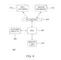
- FIG. 4is a block diagram depicting an exemplary embodiment of the server 400 .
- the server 400may be used as the server 102 shown in FIG. 1 .
- the server 400illustratively comprises a central processing unit (CPU) 402 , input/output (I/O) circuits 404 , support circuits 406 , and a memory 408 .
- the support circuits 406comprise well-known circuits that facilitate operation of the CPU 402 , such as clock circuits, cache, power supplies, and the like.
- the memory 408may be random access memory, read only memory, removable storage, hard disc storage, or any combination of such memory devices.
- Satellite tracking information 410(e.g., ephemeris, code phase measurements, carrier phase measurements, Doppler measurements) is received from an external source of such information (e.g., reference network and/or satellite control station) using the I/O circuits 404 and stored in the memory 408 .
- the server 400uses the satellite tracking information 410 to compute long term satellite tracking data for use by remote devices.
- the I/O circuits 404may also be coupled to a cell database 412 .
- the cell database 412stores a database of identification indicia (“cell ID”) for various basestations or cell sites of a wireless communication system along with the positions of the basestations or cell sites. As described below, basestation or cell site position may be used as an approximate position of the remote receiver. Alternatively, an approximate position of the remote receiver may be determined using a transition between cell sites or basestations, a last known location, or the like.
- the I/O circuits 404may also be coupled to a device database 414 .
- the device database 414may be used to keep track of when particular satellite tracking data was distributed to which remote receiver and when such satellite tracking data will expire.
- the server 400can determine when to update the remote receivers with new satellite tracking data. An exemplary process for transmitting satellite tracking data to a remote receiver is described below.
- Satellite tracking datamay be delivered to the remote receivers in response to requests from the remote receivers.
- a user of a remote receivermay manually request satellite tracking data from the server, or may initiate a position computation that requires satellite tracking data. Satellite tracking data may also be delivered automatically to the remote receivers.
- FIG. 5is a flow diagram depicting an exemplary embodiment of a process 500 for automatically transmitting satellite tracking data to a remote receiver.
- the process 500may be executed by either the server or the remote receiver. That is, the remote receiver may determine when it needs satellite tracking data or the server may determine when the remote receiver needs satellite tracking data.
- the process 500begins at step 502 , where the time elapsed since the last satellite tracking data transaction is determined.
- a determinationis made as to whether the elapsed time exceeds a predetermined threshold.
- the thresholdmay be a percentage of the validity period of the satellite tracking data. For example, if the satellite tracking data is valid for four days, the threshold may be set as two days. Thus, if two days have elapsed since the last satellite tracking data transaction, the threshold has been exceeded. If the threshold has been exceeded, the process 500 proceeds to step 506 . Otherwise, the process 500 returns to step 502 .
- new satellite tracking datais scheduled to be transmitted to the remote receiver during a low traffic period. Since the threshold of step 504 is set to a percentage of the validity period of the satellite tracking data, the remote receiver does not immediately require new satellite tracking data, as the currently stored satellite tracking data remains valid. Thus, new satellite tracking data may be sent to the remote receiver using either a wireless communication system or other network during a period of low activity on such network.
- step 506If, at step 506 , a connection is unavailable, the process 500 proceeds to step 510 .
- step 510a determination is made as to whether the elapsed time has exceeded the validity period of the satellite tracking data. If not, the process 500 proceeds to step 508 described above. That is, the server will schedule a transmission of new satellite tracking data to the remote receiver during a low traffic period. Since the threshold of step 504 is set to a percentage of the validity period of the satellite tracking data, the remote receiver does not immediately require new satellite tracking data. The remote receiver may continue to operate using valid satellite tracking data until a connection becomes available, at which time new satellite tracking data may be sent during a low traffic period.
- step 510If, at step 510 , the elapsed time has exceeded the validity period of the satellite tracking data, the process 500 proceeds to step 512 .
- step 512new satellite tracking data is scheduled to be transmitted to the remote receiver when a connection becomes available. That is, when the remote device again connects to the system, the new satellite tracking data may be uploaded to the remote device.
- remote receiverswill have valid satellite tracking data for almost all of the time that they are capable of connecting to the server.
- almost all of the remote receiverswill immediately benefit from assisted-GPS operation when they require a location fix, without having to make a request (or satellite tracking data or wait for satellite tracking data to be delivered.
- the number of server transactionsis minimized.
- Remote receivers that are not capable of connecting to the servermay continue to operate using the satellite tracking data for an extended period of time (e.g., four days) while disconnected from the server.
- the satellite tracking datais independent of the precise time at which the remote receivers will use it.
- FIGS. 6A through 6Cdepict a flow diagram of an exemplary embodiment of a process 600 for locating position of a remote receiver using long term satellite tracking data.
- the process 600begins at step 602 , where the time elapsed since the last satellite tracking data transaction is determined.
- step 606a determination is made as to whether a connection between the server and the remote receiver is available. If not, the process 600 proceeds to step 608 , where the connection is flagged as unavailable. Otherwise, the process 600 proceeds to step 607 .
- step 607new satellite tracking data is requested and received from the server at the remote receiver.
- step 609the stored satellite tracking data is updated with the new satellite tracking data. The process then proceeds to step 610 .
- time of dayis determined.
- an estimated time of daymay be determined using a clock within the remote receiver.
- a position of the remote receiveris estimated.
- acquisition assistance datais computed using the time of day, estimated position, and the stored satellite tracking data (or Almanac data).
- the acquisition assistance dataaids the remote receiver in acquiring satellite signals.
- the acquisition assistance datacomprises predicted Doppler shifts for each satellite in view of the remote receiver. In GPS, all of the satellite signals leave the satellites at the same frequency of exactly 1575.42 MHz. The frequency of the satellite signals observed at the remote receiver, however, will be shifted ⁇ 4.5 KHz due to relative satellite motion.
- a satellite rising over the horizonexhibits a Doppler shift up to 4.5 KHz higher, a setting satellite exhibits a Doppler shift up to 4.5. KHz lower, and a satellite at its zenith (the highest point in the sky from the point of view of the remote receiver) will exhibit no Doppler shift.
- the remote receivermay use the position estimate, the time of day, and the stored satellite tracking data (or Almanac data) to compute Doppler shifts relative to the estimate position of the remote receiver.
- the satellite tracking datais provided in the form of blocks of ephemeris data. If such satellite tracking data is used, the computation of Doppler shifts at the estimate position and time of day is performed in a conventional manner.
- the acquisition assistance dataprovides a window or range of uncertainty around the expected Doppler shifts. The size of the uncertainty range depends on the accuracy of the initial estimate of position and the time of day. The time of day has little impact on the size of the uncertainty range and may be in error by a few seconds of GPS time. The estimate of position has a greater effect on the uncertainty range.
- the Doppler rangemay be ⁇ 10 Hz. If the position estimate is within a wide area of the true position (e.g., within a particular country of operation or within 3000 km), then the Doppler range may be ⁇ 3000 Hz.
- An exemplary process for estimated the position of the remote receiveris described below. As is well known in the art, the search range for Doppler must also include the uncertainty of the local reference frequency in the remote receiver.
- satellite signalsare acquired at the remote receiver using the acquisition assistance data.
- the remote receiversearches for the satellite signals within the frequency range defined by the acquisition assistance data and local frequency reference.
- the time it takes to acquire the necessary satellite signals in order to compute an initial position(“time to first fix”) depends on the size of the frequency window. A smaller frequency window yields a faster time to first fix.
- ephemerisis decoded from the acquired satellite signals. While invalid or “old” satellite tracking data, or satellite almanac data, may be used to compute the acquisition assistance data at step 614 , such expired or imprecise satellite tracking data may not be used in order to compute position of the remote receiver.
- position of the remote receivermay be computed using the ephemeris information.
- FIG. 7is a flow diagram depicting an exemplary embodiment of a process 700 for estimating a position of a remote receiver.
- the process 700may be used in the step 612 of the process 600 as the primary estimation technique.
- Those skilled in the artwill appreciate that other position estimation techniques may be used that are known in the art, such as using transitions between cell cites or basestations of the remote receiver or using a last known location of the remote receiver.
- the process 700begins at step 702 , where the cell ID for the cell site in which the remote receiver is currently operating (“active cell site”) is determined. If there is no cell ID, or there is no active cell site, the process 700 proceeds to step 706 . Otherwise, the process 700 proceeds to step 704 .
- a recent position fixmay be a compute position less than three minutes old. Note that, in three minutes, if the remote receiver is traveling less than 200 km/h, then the remote receiver could have moved no more than 10 km. This is within the range of approximate position uncertainty that the remote receiver would obtain if using a position of a cell site. If there is a recent position fix, the process 700 proceeds to step 708 , where the recent position fix is used as the estimated position and the estimated position and uncertainty is output. In addition, the position table may be updated with the recent position at step 710 .
- step 712a determination is made as to whether a connection between the server and the remote receiver is available. If not, the process 700 proceeds to step 718 , where the position estimate is set to a wide area (e.g., country or region of operation). The process 700 proceeds from step 718 to step 708 , where the position estimate and uncertainty are output.
- a wide areae.g., country or region of operation
- step 714a position of the active cell site is requested from the server.
- the remote receivermay send the cell ID to the server if the cell ID has been obtained.
- step 716if a position is returned from the server, the process proceeds to step 708 , where the position estimate and uncertainty are output.
- the position tablemay be updated at step 710 with the newly returned position of the particular active cell site. If at step 716 the position is not returned from the server, the process 700 proceeds to step 718 , where the position estimate is set to a wide area.
- the remote receiversavoid unnecessary transactions with the server. Thus, rather than requesting a position for an active cell site using the cell ID, the remote receivers first determine if the information is stored locally.
- the long term satellite tracking datacontains satellite orbit and/or clock data that is valid for a period between two and four days.
- remote receiversmay continue to operate for up to four days without connecting to a server to receive updated information. If a remote receiver is not capable of connecting to the server (e.g., the remote receiver roams outside the service area of the network), the remote receiver may continue to use the long term satellite tracking data until the remote receiver is once again capable of connecting to the network. As such, the only transactions between the server and a remote device occurs once every two to four days, or when the remote device requires a position of a cell site or basestation from the server.
- the remote receivermay acquire satellite signals, determine pseudoranges to acquired satellites, and compute position using the pseudoranges and the long term satellite tracking data.
- the remote receivermay also use the long term satellite tracking data along with a position estimate and a time estimate to produce acquisition assistance data (e.g., expected Doppler shifts) to assist in the satellite signal acquisition process.
- acquisition assistance datae.g., expected Doppler shifts
- the position estimateis obtained from the network (e.g., using cell ID).
- the remote receivermay not be able to obtain an initial position from the network in order to compute acquisition assistance data.
- the remote receivermay be operating autonomously and outside the service area of the network.
- the remote receiverattempts to use a previously computed position as an initial position for computing acquisition assistance data and determining pseudoranges, rather than receiving a position estimate from the network.
- the remote receiverthen computes position using the pseudoranges and the long term satellite tracking data.
- the positionis then checked for validity and, if invalid, the remote receiver performs a blind search process to compute position.
- FIG. 8is a flow diagram depicting another exemplary embodiment of a method 800 for locating position of a remote receiver in accordance with the invention.
- the method 800is performed without obtaining an initial position estimate at the remote receiver form the network.
- the method 800begins at step 802 .
- long term satellite tracking datais obtained.
- the long term satellite tracking datamay be obtained from memory within the remote receiver.
- the remote receivermay have received the long term satellite tracking data from the network, as described above with respect to FIG. 5 .
- the remote receivermay periodically refresh the long term satellite tracking data, as described above with respect to FIG. 6 .
- the remote receivermay maintain a position cache in which computed positions are stored and from which a previously computed position may be obtained. If a previously computed position is unavailable, the method 800 proceeds to step 820 .
- positionis computed using a blind search process. Exemplary embodiments of a blind search process that may be used in step 820 are described below with respect to FIGS. 9-11 .
- the method 800proceeds to step 822 , where the position is stored for use as a previously computed position in a next iteration.
- step 806If, at step 806 , a previously computed position is available, the method 800 proceeds to step 808 .
- the previously computed positionis used as a position estimate and, together with the long term satellite tracking data, to compute acquisition assistance data (e.g., expected Doppler shifts).
- acquisition assistance datae.g., expected Doppler shifts.
- step 810satellite signals from satellite positioning system (SPS) satellites are acquired at the remote receiver using the acquisition assistance data.
- SPSsatellite positioning system
- the thresholdmay be two satellites.
- the method 800proceeds to step 814 . Otherwise, if only two or fewer satellites are acquired at step 810 , the method 800 proceeds to step 820 , where the blind search process is preformed to compute position.
- pseudorangesare determined to the detected SPS satellites.
- the remote receivermay measure sub-millisecond pseudoranges to the detected SPS satellites using a conventional correlation process.
- the integer millisecond portions of the sub-millisecond pseudorangesare fixed using the previously computed position that is being used as the position estimate.
- the integersmay be fixed by relating the sub-millisecond pseudoranges and expected pseudoranges between the previously computed position and estimated satellite positions derived from the long term satellite tracking data.
- position of the remote receiveris computed using the pseudoranges determined at step 814 and the long term satellite tracking data obtained at step 804 .
- the positionmay be computed using conventional navigation equations.
- a determinationis made as to whether the position computed at step 816 is valid.
- the integrity of the computed positionmay be determined using various integrity checking techniques known in the art. For example, the difference between the computed position and the previously computed position that was used as the position estimate may be computed and compared to a threshold. If the difference exceeds the threshold (e.g., 150 Km), then the computed position is flagged as invalid.
- the thresholde.g. 150 Km
- a determinationmay be made as to whether the altitude of the computed position is within a reasonable range (e.g., ⁇ 1 km to 15 km). If the altitude is outside the range, the computed position is flagged as being invalid.
- a-posteriori residualsmay be formed that are associated with the measured pseudoranges. The a-posteriori residuals may be analyzed to identify any erroneous pseudoranges. If any of the pseudoranges are found to be erroneous, the computed position is deemed to be invalid.
- An exemplary process for analyzing a-posteriori residualsis described in U.S. Pat. No. 6,734,821, referenced above.
- step 818the method 800 proceeds to step 820 , where the blind search process is performed to compute position. Otherwise, the method 800 proceeds to step 822 , where the computed position is stored for use as a previously computed position in the next iteration. The method 800 ends at step 824 .
- FIG. 9is a flow diagram depicting an exemplary embodiment of a method 900 for locating position of a remote receiver using a blind search technique in accordance with the invention.
- the method 900is performed without obtaining an initial position estimate at the remote receiver from the network.
- the method 900begins at step 902 .
- a blind searchis performed to detect SPS satellites. That is, the remote receiver searches for satellite signals in a conventional manner without the benefit of acquisition assistance data.
- pseudorangesare determined to the detected SPS satellites.
- the remote receivermay measure sub-millisecond pseudoranges to the detected SPS satellites using a conventional correlation process.
- the integer portions of the sub-millisecond pseudorangesare computed in a well-known manner by decoding a handover word (HOW) in a satellite navigation stream broadcast by a satellite to obtain a time-of-week (TOW) count value.
- HOWhandover word
- TOWtime-of-week
- position of the remote receiveris computed using the pseudoranges determined at step 906 and the long term satellite tracking data stored in the remote receiver. The position may be computed using conventional navigation equations.
- the method 900ends at step 910 .
- the method 900is performed without the need of an initial position or precise time from the network, which allows the method 900 to be performed when the remote receiver outside the service area of the network.
- the position computed using the method 900may be stored and used as a position estimate to compute acquisition assistance data in the next position location computation, as described above with respect to FIG. 8 .
- FIG. 10is a flow diagram depicting another exemplary embodiment of a method 1000 for locating position of a remote receiver using a blind search technique in accordance with the invention. Similar to the method 900 of FIG. 9 , the method 1000 may be performed without obtaining an initial position estimate at the remote receiver from the network.
- the method 1000begins at step 1002 .
- a blind searchis performed to detect SPS satellites.
- sub-millisecond pseudorangesare measured to the detected SPS satellites.
- pseudorange ratesare measured at the remote receiver. In one embodiment, the pseudorange rates may be measured by obtaining Doppler measurements. Alternatively, the pseudorange rates may be measured by computing the time-derivative of the sub-millisecond pseudoranges.
- an estimated position of the remote receiveris computed using long term satellite tracking data stored in the remote receiver and the pseudorange rates. In one embodiment, this may be done iteratively applying the following mathematical model:
- uis the vector of pseudorange rate residuals (i.e., the difference between the measured and expected pseudorange rates)
- ⁇denotes a partial derivative
- ⁇ dot over ( ⁇ ) ⁇ nis the nth pseudorange rate
- cdenotes the speed of light.
- the variables x, y, and zare the updates to an a-priori position. In the present embodiment, there is no provided initial position, thus the above model may be applied with an initial position at the center of the earth and iterated until the updates converge.
- the variable f cis the update to the a-priori reference frequency offset in the remote receiver. In one embodiment, the units of f c are seconds/second, the units of c are m/s, and the units of u are m/s.
- the expected pseudorange rates and the matrix entriesmay be computed using the long term satellite tracking data. The derivation of this model is described in more detail in commonly-assigned U.S.
- time-of-day offsetmay be included in the above-described computation, but since only an approximate position is required (e.g. to within 10 km), it is sufficient to use approximate time-of-day in the above calculation when computing the values of u and the entries in the matrix.
- an estimated position of the remote receivermay be computed at step 1010 using both the pseudorange rates and the sub-millisecond pseudoranges.
- the remote receiverwill not be able to compute position using only the range rates or only the pseudoranges without additional assistance data.
- the range rates and the pseudorangesmay be combined to provide sufficient measurements for computing position (e.g., four measurements for computing latitude, longitude, altitude, and common mode clock bias). Such a calculation is shown in U.S. patent application Ser. No. 10/617,559, referenced above.
- the integer portions of the sub-millisecond pseudoranges measured at step 1006are fixed using the estimated position computed at step 1010 .
- the integersmay be fixed by relating the sub-millisecond pseudoranges measured at step 1006 and expected pseudoranges between the position estimate and estimated satellite positions derived from the long term satellite tracking data.
- An exemplary process for computing pseudorange integersis described in U.S. Pat. No. 6,734,821, referenced above.
- the remote receivermay obtain precise satellite time by decoding the HOW to obtain the TOW count message.
- the remote receivermay initially obtain precise satellite time from the network and continue to track precise time thereafter. If precise time-of-day is known at the remote receiver, the method 1000 proceeds to step 1016 .
- position of the remote receiveris computed using the long term satellite tracking data and the full pseudoranges in a conventional navigation solution. If precise time-of-day is not known at the remote receiver, the method 1000 proceeds to step 1018 .
- position of the remote receiveris computed using the long term satellite tracking data and the full pseudoranges in a time-free navigation model.
- a mathematical modelis used to relate a residual difference between the actual pseudoranges and expected pseudoranges to updates of position (e.g., x, y, and z position) and time (e.g., local clock bias (t c ) and time-of-day error (t s )).
- the expected pseudorangesare based on the position estimate computed at step 1010 .
- the mathematical modelmay be defined as follows:
- uis a vector of pseudorange residuals (the difference between the expected pseudoranges and the actual pseudoranges); and the H matrix contains the well known line-of-sight vectors (first three columns) relating the position updates (x,y,z) to the pseudorange residuals; a well known column of constants (c the speed of light) relating the local clock bias (t c ) to the pseudorange residuals; and a column of range rates relating the time-of-day error (t s ) to the pseudorange residuals.
- the method 1000is performed without the need of an initial position or precise time from the network, which allows the method 1000 to be performed when the remote receiver outside the service area of the network.
- the position computed using the method 1000may be stored and used as a position estimate to compute acquisition assistance data in the next position location computation, as described above with respect to FIG. 8 .
- FIG. 11is a flow diagram depicting yet another exemplary embodiment of a method 1100 for locating position of a remote receiver using a blind search technique in accordance with the invention.
- the method 1100may be performed without obtaining an initial position estimate at the remote receiver from the network.
- the method 1100begins at step 1102 .
- a blind searchis performed to detect SPS satellites.
- sub-millisecond pseudorangesare determined to the detected SPS satellites.
- an a-priori position of the remote receiveris selected from a space of all possible positions.
- the space of all possible a-priori positionsmay be segmented, such as being divided into a 100 km ⁇ 100 km latitude-longitude grid, with altitude assigned from a look-up table of topographical altitudes.
- the integer portions of the sub-millisecond pseudorangesare fixed based on the a-priori position estimate.
- the integer portionsmay be fixed using a process similar to that performed in step 1012 of the method 1000 described above with respect to FIG. 10 .
- position of the remote receiveris computed using long term satellite tracking data stored in the remote receiver and the full pseudoranges.
- the positionmay be computed using conventional navigation equations (if precise time is available) or a time-free navigation model, as described above with respect to FIG. 10 .
- a determinationis made as to whether the computed position is valid. The validity of the computed position may be estimated as described above with respect to step 818 of the method 800 . If not, the method 1100 returns to step 1108 , where another a-priori position is selected from the space of possible positions. Otherwise, the method 1100 proceeds to step 1116 .
- the computed positionis output. The method 1100 ends at step 1118 .
- the position output using the method 1100may be stored and used as a position estimate to compute acquisition assistance data in the next position location computation, as described above with respect to FIG. 8 .
- GPSGlobal Positioning System
- Pseudolitesare ground-based transmitters that broadcast a PN code (similar to the GPS signal) that may be modulated on an L-band carrier signal, generally synchronized with GPS time.
- PN codesimilar to the GPS signal
- L-band carrier signalgenerally synchronized with GPS time.
- GPS signalsis intended to include GPS-like signals from pseudolites or equivalents of pseudolites.
Landscapes
- Engineering & Computer Science (AREA)
- Radar, Positioning & Navigation (AREA)
- Remote Sensing (AREA)
- Computer Networks & Wireless Communication (AREA)
- Physics & Mathematics (AREA)
- General Physics & Mathematics (AREA)
- Power Engineering (AREA)
- Position Fixing By Use Of Radio Waves (AREA)
- Navigation (AREA)
Abstract
Description
where u is the vector of pseudorange rate residuals (i.e., the difference between the measured and expected pseudorange rates), ∂ denotes a partial derivative, {dot over (ρ)}nis the nth pseudorange rate, and c denotes the speed of light. The variables x, y, and z are the updates to an a-priori position. In the present embodiment, there is no provided initial position, thus the above model may be applied with an initial position at the center of the earth and iterated until the updates converge. The variable fcis the update to the a-priori reference frequency offset in the remote receiver. In one embodiment, the units of fcare seconds/second, the units of c are m/s, and the units of u are m/s. The expected pseudorange rates and the matrix entries may be computed using the long term satellite tracking data. The derivation of this model is described in more detail in commonly-assigned U.S. patent application Ser. No. 10/617,559, filed Jul. 11, 2003, which is incorporated by reference herein in its entirety. Further terms, such as time-of-day offset, may be included in the above-described computation, but since only an approximate position is required (e.g. to within 10 km), it is sufficient to use approximate time-of-day in the above calculation when computing the values of u and the entries in the matrix.
where: u is a vector of pseudorange residuals (the difference between the expected pseudoranges and the actual pseudoranges); and the H matrix contains the well known line-of-sight vectors (first three columns) relating the position updates (x,y,z) to the pseudorange residuals; a well known column of constants (c the speed of light) relating the local clock bias (tc) to the pseudorange residuals; and a column of range rates relating the time-of-day error (ts) to the pseudorange residuals. For a detailed understanding of the above-described mathematical model, the reader is referred to U.S. Pat. No. 6,734,821, referenced above. Several iterations of the above-described mathematical model may be executed to converge on a position. The
Claims (20)
Priority Applications (1)
| Application Number | Priority Date | Filing Date | Title |
|---|---|---|---|
| US13/418,060US8643541B2 (en) | 2002-10-02 | 2012-03-12 | Method and apparatus for enhanced autonomous GPS |
Applications Claiming Priority (5)
| Application Number | Priority Date | Filing Date | Title |
|---|---|---|---|
| US41536402P | 2002-10-02 | 2002-10-02 | |
| US10/674,267US7158080B2 (en) | 2002-10-02 | 2003-09-29 | Method and apparatus for using long term satellite tracking data in a remote receiver |
| US11/057,060US7595752B2 (en) | 2002-10-02 | 2005-02-11 | Method and apparatus for enhanced autonomous GPS |
| US12/544,614US8134500B2 (en) | 2002-10-02 | 2009-08-20 | Method and apparatus for enhanced autonomous GPS |
| US13/418,060US8643541B2 (en) | 2002-10-02 | 2012-03-12 | Method and apparatus for enhanced autonomous GPS |
Related Parent Applications (1)
| Application Number | Title | Priority Date | Filing Date |
|---|---|---|---|
| US12/544,614ContinuationUS8134500B2 (en) | 2002-10-02 | 2009-08-20 | Method and apparatus for enhanced autonomous GPS |
Publications (2)
| Publication Number | Publication Date |
|---|---|
| US20120229335A1 US20120229335A1 (en) | 2012-09-13 |
| US8643541B2true US8643541B2 (en) | 2014-02-04 |
Family
ID=36793371
Family Applications (3)
| Application Number | Title | Priority Date | Filing Date |
|---|---|---|---|
| US11/057,060Expired - LifetimeUS7595752B2 (en) | 2002-10-02 | 2005-02-11 | Method and apparatus for enhanced autonomous GPS |
| US12/544,614Expired - Fee RelatedUS8134500B2 (en) | 2002-10-02 | 2009-08-20 | Method and apparatus for enhanced autonomous GPS |
| US13/418,060Expired - Fee RelatedUS8643541B2 (en) | 2002-10-02 | 2012-03-12 | Method and apparatus for enhanced autonomous GPS |
Family Applications Before (2)
| Application Number | Title | Priority Date | Filing Date |
|---|---|---|---|
| US11/057,060Expired - LifetimeUS7595752B2 (en) | 2002-10-02 | 2005-02-11 | Method and apparatus for enhanced autonomous GPS |
| US12/544,614Expired - Fee RelatedUS8134500B2 (en) | 2002-10-02 | 2009-08-20 | Method and apparatus for enhanced autonomous GPS |
Country Status (6)
| Country | Link |
|---|---|
| US (3) | US7595752B2 (en) |
| EP (1) | EP1851564B1 (en) |
| JP (1) | JP2008538234A (en) |
| KR (1) | KR100958090B1 (en) |
| CN (1) | CN101142495B (en) |
| WO (1) | WO2006086468A1 (en) |
Cited By (3)
| Publication number | Priority date | Publication date | Assignee | Title |
|---|---|---|---|---|
| US20240045079A1 (en)* | 2022-08-08 | 2024-02-08 | Qualcomm Incorporated | Satellite positioning for satellite-based communications |
| US12395237B2 (en) | 2022-07-18 | 2025-08-19 | Qualcomm Incorporated | Assistance data for orienting a mobile device for satellite-based communications |
| US12445192B2 (en) | 2022-08-19 | 2025-10-14 | Qualcomm Incorporated | Mobile device orientation guidance for satellite-based communications |
Families Citing this family (45)
| Publication number | Priority date | Publication date | Assignee | Title |
|---|---|---|---|---|
| US7443340B2 (en)* | 2001-06-06 | 2008-10-28 | Global Locate, Inc. | Method and apparatus for generating and distributing satellite tracking information |
| US20080129588A1 (en) | 2001-06-06 | 2008-06-05 | David Albert Lundgren | Method and apparatus for determining location information of a mobile device |
| US7133772B2 (en)* | 2002-07-30 | 2006-11-07 | Global Locate, Inc. | Method and apparatus for navigation using instantaneous Doppler measurements from satellites |
| US7595752B2 (en) | 2002-10-02 | 2009-09-29 | Global Locate, Inc. | Method and apparatus for enhanced autonomous GPS |
| US7623066B2 (en)* | 2004-11-12 | 2009-11-24 | Motorola, Inc. | Satellite positioning system receiver time determination in minimum satellite coverage |
| US7696923B2 (en)* | 2005-02-03 | 2010-04-13 | Mexens Intellectual Property Holding Llc | System and method for determining geographic location of wireless computing devices |
| US9392406B2 (en) | 2005-02-03 | 2016-07-12 | Trueposition, Inc. | Method and system for location-based monitoring of a mobile device |
| US7725695B2 (en)* | 2005-05-31 | 2010-05-25 | Arm Limited | Branch prediction apparatus for repurposing a branch to instruction set as a non-predicted branch |
| CA2558341C (en)* | 2005-09-01 | 2016-04-19 | Radio Ip Software Inc. | Gps data management module for use in location-based service systems |
| US7605752B2 (en)* | 2005-12-28 | 2009-10-20 | Gabriel Technologies Corp. | Apparatus and method for controlling autonomous and assisted GPS modes in a wireless mobile terminal |
| KR101036846B1 (en)* | 2006-02-07 | 2011-05-25 | 글로벌 로케이트, 인크. | Method and apparatus for calculating LTE and clock models with variable time-limits |
| US7589671B2 (en)* | 2006-08-25 | 2009-09-15 | Trimble Navigation Limited | GPS node locator using an intermediate node location for determining location of a remote node |
| US20080068262A1 (en)* | 2006-08-25 | 2008-03-20 | Peter Van Wyck Loomis | Remote node providing GPS signal samples for GPS positioning over a communication network |
| US7839330B2 (en)* | 2006-10-31 | 2010-11-23 | Sirf Technology, Inc. | Determining position without current broadcast ephemeris |
| US7551126B2 (en)* | 2007-03-08 | 2009-06-23 | Trimble Navigation Limited | GNSS sample processor for determining the location of an event |
| US7719467B2 (en) | 2007-03-08 | 2010-05-18 | Trimble Navigation Limited | Digital camera with GNSS picture location determination |
| CN100437144C (en)* | 2007-08-13 | 2008-11-26 | 北京航空航天大学 | Locating method for satellite navigation reinforcing system |
| US8368588B2 (en)* | 2007-11-26 | 2013-02-05 | Mediatek Inc. | Method and apparatus for updating transformation information parameters used in global navigation satellite system |
| US7786929B2 (en) | 2007-11-26 | 2010-08-31 | Mediatek Inc. | Method and device for predicting GNSS satellite trajectory extension data used in mobile apparatus |
| US7831216B1 (en) | 2007-11-27 | 2010-11-09 | Sprint Spectrum L.P. | Mobile-station-assisted low-cost-internet-base-station-(LCIB) location determination |
| US7800530B2 (en)* | 2007-12-07 | 2010-09-21 | Andrew, Llc | Method and system for providing assistance data for A-GPS location of handsets in wireless networks |
| US9250330B2 (en) | 2007-12-07 | 2016-02-02 | Telecommunication Systems, Inc. | Method and system for selecting optimal satellites for A-GPS location of handsets in wireless networks |
| US7928903B2 (en) | 2007-12-07 | 2011-04-19 | Andrew, Llc | Method and system for selecting optimal satellites for A-GPS location of handsets in wireless networks |
| US8120530B2 (en)* | 2008-04-15 | 2012-02-21 | Mediatek Inc. | Method and device for using GNSS satellite trajectory extension data in mobile apparatus |
| JP2010066099A (en)* | 2008-09-10 | 2010-03-25 | Seiko Epson Corp | Method of calculating parameter value, method of providing long-term prediction orbit data, information providing device, and positioning system |
| US7986267B2 (en)* | 2008-10-13 | 2011-07-26 | Broadcom Corporation | Method and system for customized full ephemeris compatible with standard AGPS network devices |
| JP5359187B2 (en)* | 2008-10-24 | 2013-12-04 | セイコーエプソン株式会社 | Method for determining reliability of long-term predicted orbit data, method for providing long-term predicted orbit data, and information providing apparatus |
| JP2010156631A (en)* | 2008-12-29 | 2010-07-15 | Seiko Epson Corp | Satellite orbit data compressing method, satellite orbit data providing method, satellite orbit data decompressing method, and data compressing device |
| US8417264B1 (en) | 2009-05-14 | 2013-04-09 | Spring Spectrum L.P. | Method and apparatus for determining location of a mobile station based on locations of multiple nearby mobile stations |
| GB2483713B (en)* | 2010-09-20 | 2016-04-06 | St Microelectronics Res & Dev | Signal verification |
| US9423505B2 (en)* | 2010-12-15 | 2016-08-23 | Qualcomm Incorporated | Recovery from position and time outliers in positioning |
| JP5740961B2 (en)* | 2010-12-17 | 2015-07-01 | セイコーエプソン株式会社 | Satellite signal capture suitability determination method and satellite signal capture suitability determination device |
| KR20120121475A (en)* | 2011-04-27 | 2012-11-06 | 삼성전자주식회사 | Apparatus and method for positioning in portable terminal |
| US9037109B1 (en) | 2012-03-02 | 2015-05-19 | Sprint Spectrum L.P. | Controlling billing for use of one system based on device location in other system |
| US8773305B1 (en)* | 2012-04-05 | 2014-07-08 | The United States Of America As Represented By The Secretary Of The Navy | Method for doppler-aided GPS carrier-tracking using P-step ramp unbiased finite impulse response predictor |
| TWI451115B (en) | 2012-12-05 | 2014-09-01 | Inst Information Industry | Satellite positioning method, satellite pesudorange calculation apparatus and satellite pesudorange calculation method |
| US9622209B1 (en) | 2013-08-15 | 2017-04-11 | Sprint Spectrum L.P. | Alternative location source for low-cost internet base station systems when satellite-based positioning system coverage is unavailable |
| WO2018102146A1 (en) | 2016-12-01 | 2018-06-07 | Google Llc | Methods and systems for location determination |
| US10721698B2 (en)* | 2017-07-01 | 2020-07-21 | ARRIS Enterprises, LLC | Identifying a synchronization master for radio nodes |
| US10591610B2 (en)* | 2017-09-22 | 2020-03-17 | Qualcomm Incorporated | Method and apparatus for optimizing GNSS search with wireless wide area networks |
| CN109639341B (en)* | 2018-12-17 | 2021-01-01 | 西南电子技术研究所(中国电子科技集团公司第十研究所) | Method for autonomously accessing low-orbit broadcast satellite without ephemeris |
| US12140686B2 (en) | 2019-03-01 | 2024-11-12 | Google Llc | Determining velocity using a reflected positioning signal |
| JP7196709B2 (en)* | 2019-03-19 | 2022-12-27 | セイコーエプソン株式会社 | Electronic clock and electronic clock control method |
| CN114268387B (en)* | 2019-03-26 | 2024-06-11 | 华为技术有限公司 | Switching method and device in satellite communication |
| EP3997485B1 (en) | 2019-07-08 | 2025-09-03 | Google LLC | Enhancing sensitivity to reflected gnss signals |
Citations (36)
| Publication number | Priority date | Publication date | Assignee | Title |
|---|---|---|---|---|
| US4445118A (en) | 1981-05-22 | 1984-04-24 | The United States Of America As Represented By The Administrator Of The National Aeronautics And Space Administration | Navigation system and method |
| US4894662A (en) | 1982-03-01 | 1990-01-16 | Western Atlas International, Inc. | Method and system for determining position on a moving platform, such as a ship, using signals from GPS satellites |
| US5119504A (en) | 1990-07-19 | 1992-06-02 | Motorola, Inc. | Position aided subscriber unit for a satellite cellular system |
| US5225842A (en) | 1991-05-09 | 1993-07-06 | Navsys Corporation | Vehicle tracking system employing global positioning system (gps) satellites |
| US5365450A (en) | 1992-12-17 | 1994-11-15 | Stanford Telecommunications, Inc. | Hybrid GPS/data line unit for rapid, precise, and robust position determination |
| US5430657A (en) | 1992-10-20 | 1995-07-04 | Caterpillar Inc. | Method and apparatus for predicting the position of a satellite in a satellite based navigation system |
| US5673256A (en) | 1995-07-25 | 1997-09-30 | Motorola, Inc. | Apparatus and method for sending data messages at an optimum time |
| US5726893A (en) | 1992-12-17 | 1998-03-10 | Stanford Telecommunications, Inc. | Cellular telephone with voice-in-data modem |
| US5841396A (en) | 1996-03-08 | 1998-11-24 | Snaptrack, Inc. | GPS receiver utilizing a communication link |
| US5889492A (en) | 1996-07-31 | 1999-03-30 | Motorola, Inc. | Method and apparatus for an acquisition-aided Geo-locating subscriber unit |
| WO1999019743A1 (en) | 1997-10-15 | 1999-04-22 | Ericsson Inc. | Reduced global positioning system receiver code shift search space for a cellular telephone system |
| US5917444A (en) | 1995-05-22 | 1999-06-29 | Trimble Navigation Ltd. | Reduction of time to first fix in an SATPS receiver |
| WO1999053338A2 (en) | 1998-04-16 | 1999-10-21 | Snaptrack, Inc. | Method and apparatus for determining time in a satellite positioning system |
| US6067045A (en) | 1998-09-01 | 2000-05-23 | Hughes Electronics Corporation | Communication network initialization apparatus and method for fast GPS-based positioning |
| WO2000058750A1 (en) | 1999-03-29 | 2000-10-05 | Qualcomm Incorporated | Method and apparatus for locating gps equipped wireless devices operating in analog mode |
| US6134483A (en) | 1999-02-12 | 2000-10-17 | Vayanos; Alkinoos Hector | Method and apparatus for efficient GPS assistance in a communication system |
| US6211819B1 (en) | 1999-08-27 | 2001-04-03 | Motorola, Inc. | Mobile station location determination in a radio communication system |
| US6215441B1 (en) | 1997-04-15 | 2001-04-10 | Snaptrack, Inc. | Satellite positioning reference system and method |
| US6222483B1 (en) | 1998-09-29 | 2001-04-24 | Nokia Mobile Phones Limited | GPS location for mobile phones using the internet |
| US6256475B1 (en) | 1997-09-11 | 2001-07-03 | Lucent Technologies, Inc. | Telecommunications-assisted satellite positioning system |
| USRE37408E1 (en) | 1993-05-21 | 2001-10-16 | Trimble Navigation Ltd. | Reduction of time to first fix in an SATPS receiver |
| US20020024461A1 (en) | 1997-04-15 | 2002-02-28 | Mark Moeglein | Satellite positioning reference system and method |
| EP1197761A2 (en) | 2000-10-11 | 2002-04-17 | eRide, Inc. | Satellite navigation receiver and method |
| US6411892B1 (en) | 2000-07-13 | 2002-06-25 | Global Locate, Inc. | Method and apparatus for locating mobile receivers using a wide area reference network for propagating ephemeris |
| US6453237B1 (en) | 1999-04-23 | 2002-09-17 | Global Locate, Inc. | Method and apparatus for locating and providing services to mobile devices |
| WO2002103383A2 (en) | 2001-06-19 | 2002-12-27 | Global Locate, Inc. | Method and apparatus for distributing satellite tracking information |
| US20030023379A1 (en) | 2001-07-25 | 2003-01-30 | Diggelen Frank Van | Method and apparatus for generating and distributing satellite tracking information in a compact format |
| US6542820B2 (en) | 2001-06-06 | 2003-04-01 | Global Locate, Inc. | Method and apparatus for generating and distributing satellite tracking information |
| US6636740B1 (en) | 1998-06-16 | 2003-10-21 | Ericsson Inc. | Apparatus and methods for position computation based on broadcast initialization data |
| US6642884B2 (en) | 2000-05-08 | 2003-11-04 | Sigtec Navigation Pty Ltd. | Satellite-based positioning system receiver for weak signal operation |
| US6734821B2 (en) | 2000-11-17 | 2004-05-11 | Global Locate, Inc. | Method and apparatus for processing of satellite signals without time of day information |
| US20040203853A1 (en) | 2002-04-24 | 2004-10-14 | Leonid Sheynblat | Position determination for a wireless terminal in a hybrid position determination system |
| US20050003833A1 (en) | 2001-03-15 | 2005-01-06 | Saed Younis | Time acquisition in a wireless position determination system |
| US6856282B2 (en) | 2002-02-08 | 2005-02-15 | Qualcomm Incorporated | Directly acquiring precision code GPS signals |
| US7158080B2 (en) | 2002-10-02 | 2007-01-02 | Global Locate, Inc. | Method and apparatus for using long term satellite tracking data in a remote receiver |
| US7595752B2 (en) | 2002-10-02 | 2009-09-29 | Global Locate, Inc. | Method and apparatus for enhanced autonomous GPS |
Family Cites Families (5)
| Publication number | Priority date | Publication date | Assignee | Title |
|---|---|---|---|---|
| ATE511662T1 (en)* | 1995-10-09 | 2011-06-15 | Snaptrack Inc | GPS RECEIVER AND METHOD FOR PROCESSING GPS SIGNALS |
| AU2003279161A1 (en) | 2002-10-04 | 2004-05-04 | Sigtec Navigation Pty Ltd | Satellite-based positioning system improvement |
| US7142157B2 (en)* | 2004-09-14 | 2006-11-28 | Sirf Technology, Inc. | Determining position without use of broadcast ephemeris information |
| JP2006084426A (en)* | 2004-09-17 | 2006-03-30 | Seiko Epson Corp | POSITIONING SYSTEM, INFORMATION PROVIDING DEVICE, INFORMATION PROVIDING DEVICE CONTROL PROGRAM, TERMINAL DEVICE, TERMINAL DEVICE CONTROL PROGRAM |
| US8116402B1 (en) | 2006-03-15 | 2012-02-14 | Alereon, Inc. | Method and system for cognitive radio |
- 2005
- 2005-02-11USUS11/057,060patent/US7595752B2/ennot_activeExpired - Lifetime
- 2006
- 2006-02-09WOPCT/US2006/004422patent/WO2006086468A1/enactiveApplication Filing
- 2006-02-09JPJP2007555190Apatent/JP2008538234A/enactivePending
- 2006-02-09KRKR1020077018480Apatent/KR100958090B1/ennot_activeExpired - Fee Related
- 2006-02-09EPEP06734581.9Apatent/EP1851564B1/enactiveActive
- 2006-02-09CNCN2006800046564Apatent/CN101142495B/enactiveActive
- 2009
- 2009-08-20USUS12/544,614patent/US8134500B2/ennot_activeExpired - Fee Related
- 2012
- 2012-03-12USUS13/418,060patent/US8643541B2/ennot_activeExpired - Fee Related
Patent Citations (42)
| Publication number | Priority date | Publication date | Assignee | Title |
|---|---|---|---|---|
| US4445118A (en) | 1981-05-22 | 1984-04-24 | The United States Of America As Represented By The Administrator Of The National Aeronautics And Space Administration | Navigation system and method |
| US4894662A (en) | 1982-03-01 | 1990-01-16 | Western Atlas International, Inc. | Method and system for determining position on a moving platform, such as a ship, using signals from GPS satellites |
| US5119504A (en) | 1990-07-19 | 1992-06-02 | Motorola, Inc. | Position aided subscriber unit for a satellite cellular system |
| US5225842A (en) | 1991-05-09 | 1993-07-06 | Navsys Corporation | Vehicle tracking system employing global positioning system (gps) satellites |
| US5430657A (en) | 1992-10-20 | 1995-07-04 | Caterpillar Inc. | Method and apparatus for predicting the position of a satellite in a satellite based navigation system |
| US5365450A (en) | 1992-12-17 | 1994-11-15 | Stanford Telecommunications, Inc. | Hybrid GPS/data line unit for rapid, precise, and robust position determination |
| US5726893A (en) | 1992-12-17 | 1998-03-10 | Stanford Telecommunications, Inc. | Cellular telephone with voice-in-data modem |
| USRE37408E1 (en) | 1993-05-21 | 2001-10-16 | Trimble Navigation Ltd. | Reduction of time to first fix in an SATPS receiver |
| US5917444A (en) | 1995-05-22 | 1999-06-29 | Trimble Navigation Ltd. | Reduction of time to first fix in an SATPS receiver |
| US5673256A (en) | 1995-07-25 | 1997-09-30 | Motorola, Inc. | Apparatus and method for sending data messages at an optimum time |
| US6064336A (en) | 1995-10-09 | 2000-05-16 | Snaptrack, Inc. | GPS receiver utilizing a communication link |
| US5841396A (en) | 1996-03-08 | 1998-11-24 | Snaptrack, Inc. | GPS receiver utilizing a communication link |
| US5889492A (en) | 1996-07-31 | 1999-03-30 | Motorola, Inc. | Method and apparatus for an acquisition-aided Geo-locating subscriber unit |
| US6411254B1 (en) | 1997-04-15 | 2002-06-25 | Snaptrack, Inc. | Satellite positioning reference system and method |
| US20020024461A1 (en) | 1997-04-15 | 2002-02-28 | Mark Moeglein | Satellite positioning reference system and method |
| US6215441B1 (en) | 1997-04-15 | 2001-04-10 | Snaptrack, Inc. | Satellite positioning reference system and method |
| US6256475B1 (en) | 1997-09-11 | 2001-07-03 | Lucent Technologies, Inc. | Telecommunications-assisted satellite positioning system |
| WO1999019743A1 (en) | 1997-10-15 | 1999-04-22 | Ericsson Inc. | Reduced global positioning system receiver code shift search space for a cellular telephone system |
| WO1999053338A2 (en) | 1998-04-16 | 1999-10-21 | Snaptrack, Inc. | Method and apparatus for determining time in a satellite positioning system |
| US6636740B1 (en) | 1998-06-16 | 2003-10-21 | Ericsson Inc. | Apparatus and methods for position computation based on broadcast initialization data |
| US6067045A (en) | 1998-09-01 | 2000-05-23 | Hughes Electronics Corporation | Communication network initialization apparatus and method for fast GPS-based positioning |
| US6222483B1 (en) | 1998-09-29 | 2001-04-24 | Nokia Mobile Phones Limited | GPS location for mobile phones using the internet |
| US6134483A (en) | 1999-02-12 | 2000-10-17 | Vayanos; Alkinoos Hector | Method and apparatus for efficient GPS assistance in a communication system |
| WO2000058750A1 (en) | 1999-03-29 | 2000-10-05 | Qualcomm Incorporated | Method and apparatus for locating gps equipped wireless devices operating in analog mode |
| US6453237B1 (en) | 1999-04-23 | 2002-09-17 | Global Locate, Inc. | Method and apparatus for locating and providing services to mobile devices |
| US6211819B1 (en) | 1999-08-27 | 2001-04-03 | Motorola, Inc. | Mobile station location determination in a radio communication system |
| US6642884B2 (en) | 2000-05-08 | 2003-11-04 | Sigtec Navigation Pty Ltd. | Satellite-based positioning system receiver for weak signal operation |
| US6411892B1 (en) | 2000-07-13 | 2002-06-25 | Global Locate, Inc. | Method and apparatus for locating mobile receivers using a wide area reference network for propagating ephemeris |
| EP1197761A2 (en) | 2000-10-11 | 2002-04-17 | eRide, Inc. | Satellite navigation receiver and method |
| US6734821B2 (en) | 2000-11-17 | 2004-05-11 | Global Locate, Inc. | Method and apparatus for processing of satellite signals without time of day information |
| US20050003833A1 (en) | 2001-03-15 | 2005-01-06 | Saed Younis | Time acquisition in a wireless position determination system |
| US6542820B2 (en) | 2001-06-06 | 2003-04-01 | Global Locate, Inc. | Method and apparatus for generating and distributing satellite tracking information |
| US6560534B2 (en) | 2001-06-06 | 2003-05-06 | Global Locate, Inc. | Method and apparatus for distributing satellite tracking information |
| WO2002103383A2 (en) | 2001-06-19 | 2002-12-27 | Global Locate, Inc. | Method and apparatus for distributing satellite tracking information |
| WO2003010912A2 (en) | 2001-07-25 | 2003-02-06 | Global Locate, Inc | Method and apparatus for generating and distributing satellite tracking information in a compact format |
| US20030023379A1 (en) | 2001-07-25 | 2003-01-30 | Diggelen Frank Van | Method and apparatus for generating and distributing satellite tracking information in a compact format |
| US6829535B2 (en) | 2001-07-25 | 2004-12-07 | Global Locate, Inc. | Method and apparatus for generating satellite tracking information in a compact format |
| US6856282B2 (en) | 2002-02-08 | 2005-02-15 | Qualcomm Incorporated | Directly acquiring precision code GPS signals |
| US20040203853A1 (en) | 2002-04-24 | 2004-10-14 | Leonid Sheynblat | Position determination for a wireless terminal in a hybrid position determination system |
| US7158080B2 (en) | 2002-10-02 | 2007-01-02 | Global Locate, Inc. | Method and apparatus for using long term satellite tracking data in a remote receiver |
| US7595752B2 (en) | 2002-10-02 | 2009-09-29 | Global Locate, Inc. | Method and apparatus for enhanced autonomous GPS |
| US8134500B2 (en) | 2002-10-02 | 2012-03-13 | Global Locate, Inc. | Method and apparatus for enhanced autonomous GPS |
Non-Patent Citations (52)
| Title |
|---|
| Aparicio et al., "GPS Satellite and Payload," Global Positioning System: Theory and Applications vol. I, Progress in Astronautics and Aeronautics, vol. 163, Ch. 6, 1996, 35 pages. |
| Bertiger et al., "GPS precise tracking of TOPEX/POSEIDON: Results and Implications," Journal of Geophysical Research, vol. 99, No. C12, pp. 24,449-24,464, Dec. 15, 1994, 16 pages. |
| Bertiger et al., "GPS precise tracking of Topex/Poseidon: Results and Implications," Submitted for Publication to JGR TOPEX/Poseidon Special Issue, http:l/hdl.handle.net/2014/33763, Nov. 1993, 70 pages. |
| Chansarkar et al., "Acquisition of GPS Signals at Very Low Signal to Noise Ratio," ION NTM 2000, Anaheim, CA, Jan. 26-28, 2000, 7 pages. |
| DiEsposti et al., "Of Mutual Benefit: Merging GPS and Wireless Communications," GPS World, vol. 9, No. 4, Apr. 1998, 7 pages. |
| DiEsposti et al., "The Benefits of Integrating GPS, INS and PCS," The Aerospace Corp., ION-GPS-98, 2 Session D1, Receiver Systems and Technology 1: New Receiver Architectures & Signal Processing Strategies, Nashville Convention Center, Nashville, Tennessee, Sep. 15-18, 1998, 5 pages. |
| Enge et al., "Wide Area Augmentation System," Global Positioning System: Theory and Applications vol. II, Progress in Astronautics and Aeronautics, vol. 164, Ch. 4, 1995, 29 pages. |
| European Patent Office Action in European Patent Application No. 03 799 351.6-2220, Dated Apr. 17, 2007, 6 pages. |
| European Patent Office Action in European Patent Application No. 03 799 351.6-2220, dated Aug. 18, 2005, 6 pages. |
| Expert Report of Stephen Heppe, dated Feb. 25, 2008, Regarding Invalidity of U.S. Patent Nos. 6,417,801, 6,606,346, 6,651,000, 6,704,651, 6,937,187, and 7,158,080, United States International Trade Commission Investigation No. 337-TA-602, Certain GPS Devices and Products Containing Same, 390 pages. |
| Fifth Supplemental Objections and Responses dated Apr. 3, 2008, by Respondents Mio Technology Limited, USA et al., to Global Locate, Inc.'s First Set of Interrogatories (Nos. 19, 21-23 and 27-28), United States International Trade Commission Investigation No. 337-TA-602, Certain GPS Devices and Products Containing Same, 2 pages. |
| File History of U.S. Appl. No. 10/081,164, filed Feb. 22, 2002 (now Abandoned), 218 pages. |
| First Amended Complaint by the Complainants, dated Feb. 8, 2008, under section 337 of the Tariff Act of 1930, as Amended, United States International Trade Commission Investigation NO. 337-TA-602, Certain GPS 45 Devices and Products Containing Same, 2 pages. |
| First Supplemental Corrected Notice of Prior Art by the Repsondents, dated Mar. 4, 2008, United States International Trade Commission Investigation No. 337-TA-602, Certain GPS Devices and Products Containing Same, 2 pages. |
| First Supplemental Objections and Responses dated Aug. 24, 2007, by Respondent SiRF Technology, Inc., to Global Locate, Inc's First Set of Interrogatories (Nos. 22, 23 and 49) and Exhibits 23-27, United States International Trade Commission Investigation No. 337-TA-602, Certain GPS Devices and Products Containing Same, 34 pages. |
| First Supplemental Report of Dr. Stephen Heppe, dated Apr. 14, 2008, Regarding Invalidity of U.S. Patent Nos. 6,417,801, 6,606,346, 6,937,187 and 7,158,080, United States International Trade Commission Investigation No. 337-TA-602, Certain GPS Devices and Products Containing Same, 6 pages. |
| Francisco, "GPS Operational Control Segment," Global Positioning System: Theory and Applications, Ch. 10, 1994, 32 pages. |
| Garin et al., "Wireless Assisted GPS-SiRF Architecture and Field Test Results," ION GPS '99, Nashville, TN, Sep. 14-17, 1999, 9 pages. |
| Hugentobler et al., "CODE IGS Analysis Center Technical Report 2000", International GPS Service for Geodynamics, 2000 Technical Reports, IGS Central Bureau, Jet Propulsion Laboratory, California Institute for Technology, Pasadena, CA, Nov. 2001, 76 pages. |
| Initial Determination by Administrative Law Judge Carl C. Charneski, dated Nov. 25, 2008, Public Version, United States International Trade Commission Investigation No. 337-TA-602, Certain GPS Devices and Products Containing Same, 221 pages. |
| International Search Report for International Patent Application No. PCT/US03/30872, mailed Mar. 17, 2004, 4 pages. |
| International Search Report for International Patent Application No. PCT/US06/04422, mailed May 15, 2006, 1 page. |
| LaMance et al., "Assisted GPS-Low Infrastructure Approach," GPS World, vol. 13, No. 3, Mar. 2002, 8 pages. |
| Melbourne et al., "Scientific Applications of GPS on Low Earth Orbiters," Jet Propulsion Laboratory, California Institute of Technology, Pasadena, CA, 1994, 26 pages. |
| Mueller et al., "1997 Technical Reports," International GPS Services for Geodynamics (IGS), IGS Central Bureau, Jet Propulsion Laboratory, California Institute of Technology, Pasadena, CA, Oct. 1998, 296 pages. |
| NAVSTAR GPS Space Segment / Navigation User Interfaces, ICD-GPS-200, Jul. 3, 1991, 145 pages. |
| NAVSTAR GPS, ICD-GPS-200, Revision C, Oct. 10, 1993, Oct. 13, 1995, Sep. 25, 1997, Oct. 1, 1999, Apr. 12, 2000, and Jan. 14, 2003, 198 pages. |
| NAVSTAR GPS, Interface Control Document GPS (200), Jul. 1, 1992, 146 pages. |
| Neilan et al., "The International GPS Service: A Global Resource for GPS Applications and Research," Institute of Navigation, ION GPS-97, 10th International Technical Meeting, Kansas City, Missouri, Sep. 16-19, 1997, 6 pages. |
| Notice of Prior Art by the Commission Investigative Staff, dated Feb. 15, 2008, by the United States International Trade Commission Investigation No. 337-TA-602, Certain GPS Devices and Products Containing Same, 2 pages. |
| Notice of Prior Art by the Complainant, dated Feb. 15, 2008, Pursuant to Ground Rule 5, United States International Trade Commission Investigation No. 337-TA-602, Certain GPS Devices and Products Containing Same, 12 pages. |
| Notice of Prior Art dated Feb. 15, 2008, by the Respondents, United States International Trade Commission Investigation No. 337-TA-602, Certain GPS Devices and Products Containing Same, 145 pages. |
| Opinion dated Jan. 27, 2009, by the Commission, United States International Trade Commission Investigation No. 337-TA-602, Certain GPS Devices and Products Containing Same, 29 pages. |
| Rebuttal Expert Report of Phil Dafesh, dated Mar. 10, 2008, Regarding U.S. Patent Nos. 6,651,000 and 7,158,080 in Response to Expert Report of Stephen Heppe (Redacted, Non-Confidential Version), United States International Trade Commission Investigation No. 337-TA-602, Certain GPS Devices and Products Containing Same, 94 pages. |
| Response to European Patent Office Action mailed on Apr. 17, 2007 in European Application No. 03 799 351.6-2220, dated Aug. 5, 2007, 4 pages. |
| RTCM Recommended Standards for Differential NAVSTAR GPS Service, Version 2.0, RTCM Special Committee No. 104, RTCM Paper 134-89/SC 104-68, Jan. 1, 1990, 95 pages. |
| Russell, et al. "Control Segment and User Performance," Navigation: Journal of the Institute of Navigation, vol. 25, No. 2, Summer 1978, 7 pages. |
| Schenewerk et al., "Rapid Turnaround GPS Ephermerides from the National Geodetic Survey," Proceedings of the ION GPS-93, Institute of Navigation, 1993, 9 pages. |
| Second Supplemental Report of Dr. Stephen Heppe, dated Apr. 8, 2008, Regarding Invalidity of U.S. Patent Nos. 7,158,080, 6,651,000 and 6,704,651, United States International Trade Commission Investigation No. 337-TA-602, Certain GPS Devices and Products Containing Same, 34 pages. |
| SiRf v. Broadcom, U.S. Court of Appeals for the Federal Circuit, 2009-1262, decided Apr. 12, 2010, 23 pages. |
| Sirola, "A Method for GPS Positioning Without Current Navigation Data," Tampere University of Technology, Department of Electrical Engineering, Master Science Thesis, Oct. 17, 2001, 52 pages. |
| Sixth Supplemental Objections and Repsonses dated Apr. 13, 2008. by Respondent SiRF Technology, Inc. to Global Locate, Inc.'s First Set of Interrogatories (Nos. 19, 21-23, and 27-28), United States International Trade Commission Investigation No. 337-TA-602, Certain GPS Devices and Products Containing Same, 7 pages. |
| Spilker Jr. et al., "Overview of GPS Operation and Design," Global Positioning System: Theory and Applications vol. 1, Progress in Astronautics and Aeronautics, vol. 163, Ch. 2, 1996, 30 pages. |
| Springer et al., "1999 Analysis Coordinator Report", International GPS Service or Geodynamics (IGS), IGS Central Bureau, Jet Propulsion Laboratory, California Institute of Technology, Pasadena, CA, Nov. 2000, 154 pages. |
| Syrjarinne, "Time Recovery through Fusion of Inaccurate Network Timing Assistance with GPS Measurements," Proc. 3rd Int. Conference on Information Fusion, Paris, France, vol. II, pp. WeD5-3-WeD5-10, Jul. 10-13, 2000, 9 pages. |
| van Diggelen, "Global Locate Indoor GPS Chipset and Services," ION-GPS-2001, Salt Lake City, Utah, Sep. 11-14, 2001, 7 pages. |
| Yiu et al., "A Low-Cost GPS Receiver for Land Navigation," Global Positioning System, Hewlett-Packard Laboratories, Palo Alto, CA, May 1982, 17 pages. |
| Young, et al., "GPS Precision Orbit Determination: Measured Receiver Performance," Jet Propulsion Laboratory, California Institute of Technology, http://hdl.handle.net/2014/35887, 1993, 13 pages. |
| Zhao, "Standardization of Mobile Phone Positioning for 3G Systems," IEEE Communications Magazine, Jul. 2002, 9 pages. |
| Zhao, Y, "Mobile Phone Location Determination and Its Impact on Intelligent Transportation Systems," IEEE Transactions on Intelligent Transportation Systems, vol. 1, No. 1, Mar. 2000, 10 pages. |
| Zumberge et al., "1996 Annual Report," International GPS Service for Geodynamics (IGS), IGS Central Bureau, Jet Propulsion Laboratory, California Institute of Technology, Pasadena, CA, Nov. 1997, 461 pages. |
| Zumberge et al., "Ephemeris and Clock Navigation Message Accuracy," Global Positioning System: Theory and Applications, Ch. 16, Jet Propulsion Laboratory, California Institute of Technology, Pasadena, CA, 1994, 15 pages. |
Cited By (3)
| Publication number | Priority date | Publication date | Assignee | Title |
|---|---|---|---|---|
| US12395237B2 (en) | 2022-07-18 | 2025-08-19 | Qualcomm Incorporated | Assistance data for orienting a mobile device for satellite-based communications |
| US20240045079A1 (en)* | 2022-08-08 | 2024-02-08 | Qualcomm Incorporated | Satellite positioning for satellite-based communications |
| US12445192B2 (en) | 2022-08-19 | 2025-10-14 | Qualcomm Incorporated | Mobile device orientation guidance for satellite-based communications |
Also Published As
| Publication number | Publication date |
|---|---|
| US20050212700A1 (en) | 2005-09-29 |
| KR100958090B1 (en) | 2010-05-14 |
| EP1851564B1 (en) | 2018-01-10 |
| JP2008538234A (en) | 2008-10-16 |
| US20090309794A1 (en) | 2009-12-17 |
| EP1851564A1 (en) | 2007-11-07 |
| WO2006086468A1 (en) | 2006-08-17 |
| HK1120308A1 (en) | 2009-03-27 |
| US20120229335A1 (en) | 2012-09-13 |
| CN101142495A (en) | 2008-03-12 |
| US8134500B2 (en) | 2012-03-13 |
| US7595752B2 (en) | 2009-09-29 |
| CN101142495B (en) | 2011-04-27 |
| KR20070110028A (en) | 2007-11-15 |
| EP1851564A4 (en) | 2011-11-23 |
Similar Documents
| Publication | Publication Date | Title |
|---|---|---|
| US8643541B2 (en) | Method and apparatus for enhanced autonomous GPS | |
| US7158080B2 (en) | Method and apparatus for using long term satellite tracking data in a remote receiver | |
| EP1697756B1 (en) | Method and apparatus for monitoring the integrity of satellite tracking data used by a remote receiver | |
| US7701389B2 (en) | Method and apparatus for determining absolute time-of-day in a mobile-assisted satellite positioning system | |
| US7987048B2 (en) | Method and apparatus for computing position using instantaneous doppler measurements from satellites | |
| KR100357409B1 (en) | Method and apparatus for assisted gps protocol | |
| US6958726B1 (en) | Method and apparatus for adjusting acquisition assistance data received by a mobile receiver from a server | |
| US20090219203A1 (en) | Method and apparatus for combining measurements and determining clock offsets between different global navigation satellite systems | |
| US7158882B2 (en) | Method and apparatus for locating position of a mobile receiver | |
| EP1835300B1 (en) | Method and apparatus for using long term satellite tracking data in a remote receiver | |
| HK1120308B (en) | Method and apparatus for enhanced autonomous gps |
Legal Events
| Date | Code | Title | Description |
|---|---|---|---|
| STCF | Information on status: patent grant | Free format text:PATENTED CASE | |
| CC | Certificate of correction | ||
| AS | Assignment | Owner name:BROADCOM CORPORATION, CALIFORNIA Free format text:ASSIGNMENT OF ASSIGNORS INTEREST;ASSIGNOR:GLOBAL LOCATE, INC.;REEL/FRAME:036617/0654 Effective date:20150908 | |
| AS | Assignment | Owner name:BANK OF AMERICA, N.A., AS COLLATERAL AGENT, NORTH CAROLINA Free format text:PATENT SECURITY AGREEMENT;ASSIGNOR:BROADCOM CORPORATION;REEL/FRAME:037806/0001 Effective date:20160201 Owner name:BANK OF AMERICA, N.A., AS COLLATERAL AGENT, NORTH Free format text:PATENT SECURITY AGREEMENT;ASSIGNOR:BROADCOM CORPORATION;REEL/FRAME:037806/0001 Effective date:20160201 | |
| AS | Assignment | Owner name:AVAGO TECHNOLOGIES GENERAL IP (SINGAPORE) PTE. LTD., SINGAPORE Free format text:ASSIGNMENT OF ASSIGNORS INTEREST;ASSIGNOR:BROADCOM CORPORATION;REEL/FRAME:041706/0001 Effective date:20170120 Owner name:AVAGO TECHNOLOGIES GENERAL IP (SINGAPORE) PTE. LTD Free format text:ASSIGNMENT OF ASSIGNORS INTEREST;ASSIGNOR:BROADCOM CORPORATION;REEL/FRAME:041706/0001 Effective date:20170120 | |
| AS | Assignment | Owner name:BROADCOM CORPORATION, CALIFORNIA Free format text:TERMINATION AND RELEASE OF SECURITY INTEREST IN PATENTS;ASSIGNOR:BANK OF AMERICA, N.A., AS COLLATERAL AGENT;REEL/FRAME:041712/0001 Effective date:20170119 | |
| FPAY | Fee payment | Year of fee payment:4 | |
| AS | Assignment | Owner name:AVAGO TECHNOLOGIES INTERNATIONAL SALES PTE. LIMITE Free format text:MERGER;ASSIGNOR:AVAGO TECHNOLOGIES GENERAL IP (SINGAPORE) PTE. LTD.;REEL/FRAME:047230/0910 Effective date:20180509 | |
| AS | Assignment | Owner name:AVAGO TECHNOLOGIES INTERNATIONAL SALES PTE. LIMITE Free format text:CORRECTIVE ASSIGNMENT TO CORRECT THE EFFECTIVE DATE OF THE MERGER PREVIOUSLY RECORDED AT REEL: 047230 FRAME: 0910. ASSIGNOR(S) HEREBY CONFIRMS THE MERGER;ASSIGNOR:AVAGO TECHNOLOGIES GENERAL IP (SINGAPORE) PTE. LTD.;REEL/FRAME:047351/0384 Effective date:20180905 | |
| AS | Assignment | Owner name:AVAGO TECHNOLOGIES INTERNATIONAL SALES PTE. LIMITE Free format text:CORRECTIVE ASSIGNMENT TO CORRECT THE ERROR IN RECORDING THE MERGER IN THE INCORRECT US PATENT NO. 8,876,094 PREVIOUSLY RECORDED ON REEL 047351 FRAME 0384. ASSIGNOR(S) HEREBY CONFIRMS THE MERGER;ASSIGNOR:AVAGO TECHNOLOGIES GENERAL IP (SINGAPORE) PTE. LTD.;REEL/FRAME:049248/0558 Effective date:20180905 | |
| FEPP | Fee payment procedure | Free format text:MAINTENANCE FEE REMINDER MAILED (ORIGINAL EVENT CODE: REM.); ENTITY STATUS OF PATENT OWNER: LARGE ENTITY | |
| LAPS | Lapse for failure to pay maintenance fees | Free format text:PATENT EXPIRED FOR FAILURE TO PAY MAINTENANCE FEES (ORIGINAL EVENT CODE: EXP.); ENTITY STATUS OF PATENT OWNER: LARGE ENTITY | |
| STCH | Information on status: patent discontinuation | Free format text:PATENT EXPIRED DUE TO NONPAYMENT OF MAINTENANCE FEES UNDER 37 CFR 1.362 | |
| FP | Lapsed due to failure to pay maintenance fee | Effective date:20220204 |