US8612134B2 - Mining correlation between locations using location history - Google Patents
Mining correlation between locations using location historyDownload PDFInfo
- Publication number
- US8612134B2 US8612134B2US12/711,130US71113010AUS8612134B2US 8612134 B2US8612134 B2US 8612134B2US 71113010 AUS71113010 AUS 71113010AUS 8612134 B2US8612134 B2US 8612134B2
- Authority
- US
- United States
- Prior art keywords
- location
- locations
- individual user
- individual
- stay
- Prior art date
- Legal status (The legal status is an assumption and is not a legal conclusion. Google has not performed a legal analysis and makes no representation as to the accuracy of the status listed.)
- Active, expires
Links
Images


Classifications
- G—PHYSICS
- G01—MEASURING; TESTING
- G01S—RADIO DIRECTION-FINDING; RADIO NAVIGATION; DETERMINING DISTANCE OR VELOCITY BY USE OF RADIO WAVES; LOCATING OR PRESENCE-DETECTING BY USE OF THE REFLECTION OR RERADIATION OF RADIO WAVES; ANALOGOUS ARRANGEMENTS USING OTHER WAVES
- G01S19/00—Satellite radio beacon positioning systems; Determining position, velocity or attitude using signals transmitted by such systems
- G01S19/01—Satellite radio beacon positioning systems transmitting time-stamped messages, e.g. GPS [Global Positioning System], GLONASS [Global Orbiting Navigation Satellite System] or GALILEO
- G01S19/13—Receivers
- G01S19/14—Receivers specially adapted for specific applications
Definitions
- a global positioning system (GPS) tracking unitidentifies a location or tracks a movement of a vehicle or a person when the vehicle or the person is in close proximity to a GPS device.
- the location or movementis recorded via GPS devices or phones.
- GPS informationis utilized in navigation systems. For example, individuals may search for information based on their present GPS location for driving or walking directions to a destination location.
- GPS informationis collected daily.
- the data collectionincludes tracking movements of people or vehicles and their visits to various locations.
- the GPS datamay be uploaded to the Internet by people to show their positions, to share travel experiences, and for a variety of other reasons.
- the GPS data in raw formis not usable for a number of reasons.
- One problem with the data in raw formis that there is no semantic meaning to identify the data. For example, there is no indication of whether the location data is for a lake, a restaurant, or a store.
- Another problemoccurs when individuals enter a building, which causes a loss of a satellite signal. This loss of the satellite signal makes it difficult to identify whether to include the information.
- a location correlation serviceconstructs a location model to identify locations with a time-stamp. To construct the model, the location correlation service uses global positioning system (GPS) logs of geospatial locations collected over time. The location correlation service identifies trajectories representing trips of the individual user and extracts stay points from the trajectories. Each stay point represents a geographical region where the individual user stayed over a time threshold within a distance threshold. A location history is formulated for the individual user based on a sequence of the extracted stay points to identify locations.
- GPSglobal positioning system
- a location correlation servicedetermines a correlation between identified locations.
- the location correlation serviceaccesses the location model to identify locations.
- the location correlation serviceintegrates travel experiences of individual users who have visited the locations in a weighted manner and identifies a common travel sequence which the individual users followed between the locations. Then, the location correlation service calculates the correlation between the identified locations.
- the correlationrecommends locations that may be of interest to other users.
- FIG. 1illustrates an architecture to support an exemplary environment for recommending a location to a user.
- FIG. 2is a flowchart showing an exemplary of mining correlation between locations, including constructing a location model, inferring each individual user's travel experiences, calculating a correlation between locations, and providing a recommendation.
- FIG. 3is a flowchart showing an exemplary process of constructing the location model.
- FIG. 4illustrates an exemplary process of extracting stay points.
- FIG. 5illustrates an exemplary process of clustering stay points.
- FIG. 6is a flowchart showing an exemplary process of inferring travel experiences of users from their location histories.
- FIG. 7illustrates an exemplary inference model used in the process of FIG. 6 .
- FIG. 8 aillustrates a flowchart showing an exemplary process of determining correlations between locations based at least in part on the location histories.
- FIG. 8 billustrates an exemplary process showing correlation between the locations.
- FIG. 9illustrates an exemplary process of calculating the correlation between the locations.
- FIG. 10is a block diagram showing an exemplary location correlation server usable with the environment of FIG. 1 .
- This disclosuredescribes identifying a correlation between locations to recommend a location that may be of interest to an individual user.
- the recommendationis based at least in part on recorded location histories.
- the location correlation serviceconstructs a location model to identify the locations.
- the modelis constructed by processing global positioning system (GPS) points that tracked the individual user.
- GPSglobal positioning system
- the tracking of individual usersmay be made possible through mobile phones via a global system for mobile communications (GSM) network, which leaves positioning logs with a timestamp of each log point.
- GSMglobal system for mobile communications
- GPS-enabled devicesmay record latitude and longitude positions.
- the logsmay also be obtained from geo-related web communities, websites, or forums.
- GPS logsmay be used as examples in the discussion, but the data may additionally or alternatively include other location data such as from GSM networks, personal area networks, and the like.
- the individual userswill be given notice of the GPS data collection and have the opportunity to provide or to deny consent for tracking purposes. For example, the individual users may choose to opt-in consent or to opt-out consent.
- the location correlation service described hereinidentifies trajectories from the GPS logs to transform the raw data into a usable form to construct the location model.
- the trajectoriesrepresent a single trip for the individual user based on a sequence of time-stamped points.
- the processextracts stay points from the trajectories.
- Each stay pointrepresents a geographical region where the individual user has stayed for a predetermined time interval.
- the process described hereindefines a particular semantic meaning for the stay points, such as identifying the stay point as a shopping mall or a restaurant.
- the processformulates the individual user's location history based on a sequence of stay points.
- the individual user's location history datais clustered into clusters to remove a top two clusters of stay points having a greatest number of stay points. Removing the top two clusters of stay points eliminates geographical regions that are private to the individual user, such as the user's home or office.
- the location correlation serviceclusters the stay points from multiple users' trajectories into several geographical regions to identify locations.
- the clusteringis based on a density-based clustering algorithm.
- the location modelprovides valuable meaning to the geographical regions that have been visited by multiple individual users, such as, a set of restaurants, stores along a main street, or an area for tourist attractions.
- the location correlation servicedetermines a correlation between identified locations.
- a location correlation servicemay access the inference model to infer individual users' travel experiences from their location histories. Based on the model, the process integrates travel experiences of individual users for the locations and identifies a common travel sequence followed between the locations. Then, the location correlation service calculates the correlation between the identified locations. The correlation indicates a relationship between the locations based on human behavior. The location correlation service recommends a location that may be of interest to the user based on the location histories of other users.
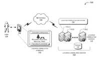
- FIG. 1illustrates an exemplary architectural environment 100 , usable to recommend locations that may be of interest to users, based on a correlation between identified locations from a location model.
- the environment 100includes an exemplary computing device 102 , which is illustrated as a personal digital assistant (PDA).
- PDApersonal digital assistant
- the computing device 102is configured to connect via one or more network(s) 104 to access a location correlation service 106 for a user 108 .
- the computing device 102may take a variety of forms, including, but not limited to, a portable handheld computing device (e.g., a personal digital assistant, a smart phone, a cellular phone), a personal navigation device, a laptop computer, a desktop computer, a portable media player, or any other device capable of connecting to one or more network(s) 104 to access the location correlation service 106 for the user 108 .
- a portable handheld computing devicee.g., a personal digital assistant, a smart phone, a cellular phone
- a personal navigation devicee.g., a personal navigation device, a laptop computer, a desktop computer, a portable media player, or any other device capable of connecting to one or more network(s) 104 to access the location correlation service 106 for the user 108 .
- the network(s) 104represents any type of communications network(s), including wire-based networks (e.g., public switched telephone, cable, and data networks) and wireless networks (e.g., cellular, satellite, WiFi, and Bluetooth).
- wire-based networkse.g., public switched telephone, cable, and data networks
- wireless networkse.g., cellular, satellite, WiFi, and Bluetooth.
- the location correlation service 106represents an application service that may be operated as part of any number of online service providers, such as a search engine, map service, social networking site, or the like. Also, the location correlation service 106 may include additional modules or work in conjunction with modules to perform the operations discussed below. In an implementation, the location correlation service 106 may be implemented at least in part by a location application stored in memory of the computing device 102 , by an application stored on servers of the location correlation service 106 , or both. Updates may be sent for the location application stored on a personal navigation device.
- the computing device 102may include a location correlation user interface (UI) 110 that is presented on a display of the computing device 102 .
- the user interface 110facilitates access to the location correlation service 106 that provides recommendations.
- the UI 110is a browser-based UI that presents a page received from the location correlation service 106 .
- the user 108employs the location correlation UI 110 when viewing a map of a region of interest.
- the UI 110may also allow for input of the region of interest by viewing the map.
- the UI 110may request and receive input for the region of interest.
- the location correlation service 106recommends a location of interest based on the user's present geospatial position.
- the user interface 110may display a place of interest, such as “Potomac Overlook Regional Park” to the user 108 , based on the user's present geospatial position, a prediction of the user's interest in a location, locations within a threshold, travel time, locations within a predetermined distance from the user's present geospatial location, and/or location histories of other users.
- the userwill be given notice of the GPS tracking their position or location and have the opportunity to provide or to deny consent for tracking purposes. For example, the user may choose to opt-in consent or to opt-out consent.
- the location correlation service 106is hosted on one or more location correlation servers, such as server 112 ( 1 ), 112 ( 2 ), . . . , 112 (S), accessible via the network(s) 104 .
- the location correlation servers 112 ( 1 )-(S)may be configured as plural independent servers, or as a collection of servers that are configured to perform larger scale functions accessible by the network(s) 104 .
- the location correlation servers 112may be administered or hosted by a network service provider that provides the location correlation service 106 to and from the computing device 102 .
- the location correlation service 106further includes a location correlation application 114 that executes on one or more of the location correlation servers 112 ( 1 )-(S).
- the location correlation application 114builds a location model to identify locations, in order to utilize GPS data.
- the location correlation application 114may preprocess the individual user data by collecting global positioning system (GPS) logs. To identify effective individual trips in the geographical locations, the location correlation application 114 identifies or parses trajectories from the logs. The trajectories help transform the raw GPS data to a usable form. The trajectory data is extracted to identify stay points. The extraction of the stay points involves identifying a stay point, which is a geographical region where the individual user has stayed over a time threshold within a distance threshold. The location correlation application 114 helps identify whether to use the stay point as absolute time or to calculate time intervals and associates semantic meaning to the stay points (e.g., whether it is a store or a restaurant). The location correlation application 114 also specifies a location history for the individual user based on a sequence of stay points with corresponding arrival times and departure times. This data is particularly valuable in understanding human behavior.
- GPSglobal positioning system
- the location correlation application 114clusters the stay points based on geographical regions to form clusters of stay points. Then, the location correlation application 114 removes a top two clusters of stay points having a greatest number of stay points to eliminate the geographical regions that are private to the individual user. For example, the location correlation application may remove clusters associated with the user's home and office locations.
- the location correlation application 114groups the stay points from multiple users' trajectories into a dataset and clusters the stay points into several geographical regions.
- the clusters of stay points from the multiple users' trajectoriesare used to represent locations.
- the locationsmay be further grouped into a trip, which is a sequence of locations that are consecutively visited by the individual user.
- the location correlation service 106is ready to infer the travel experiences of the individual users based on their location histories.
- the location correlation service 106may employ an inference model to evaluate the travel experiences of the individual user.
- Individual travel experience and location interesthave a mutual reinforcement relationship. For example, an individual user with rich travel experiences in a region would visit many interesting places in the region, and a very interesting place in that region may be accessed by many individual users with rich travel experiences.
- the location correlation service 106builds a matrix for location and user and uses a power iteration method to calculate the travel experiences.
- the location correlation service 106may access the location model to infer individual users' travel experiences from their location histories. Using the model, the process integrates travel experiences of the individual users for the locations and identifies a common travel sequence followed by the individual users between the locations. Then, the location correlation service 106 calculates the correlation between the identified locations. The correlation indicates a relationship between the locations based on human behavior. Based on the correlations, the location correlation service 106 recommends a location to the user.
- the user 108accesses the location correlation service 106 via the network 104 using their computing device 102 .
- the location correlation service 106presents the user interface (UI) 110 to receive a user query for a location of interest or to provide a recommendation for the location of interest.
- the user 108accesses a map for a particular region. Upon activating the particular region on the map, the location correlation service 106 may provide recommendations of locations of interest to the user 108 , based on the location correlation results.
- the user 108may receive a location of “Potomac Overlook Regional Park” based on his present geospatial location. Once the location is recommended, the user may submit a query by actuating a button “Find Similar Locations” on the UI 110 . Based on the user query, the location correlation application 114 searches the correlation results to find another location.
- the environment 100may include a database 116 , which may be stored on a separate server or the representative set of servers 112 that is accessible via the network(s) 104 .
- the database 116may store information, such as logs for the individuals which include a sequence of global positioning system (GPS) points, a trajectories archive, location models, locations identified by the model, a map generated of locations visited, mined location correlation results, and the like.
- GPSglobal positioning system
- the location model and the location correlation resultsare stored in the database 116 and are updated on a predetermined time interval.
- FIG. 2is a flowchart showing an exemplary process 200 showing high level functions performed by the location correlation service 106 .
- the process 200may be divided into four phases, an initial phase to construct a location model 202 , a second phase to infer each users' travel experiences 204 , a third phase to calculate a correlation between the locations 206 , and a fourth phase to recommend a location 208 .
- the phasesmay be used in the environment of FIG. 1 . These phases may be performed separately or in combination.
- the first phaseis constructing the location model of each individual user's location history 202 .
- the processcollects GPS logs of geospatial locations of the individual user.
- This disclosuredescribes transforming the GPS data into a form that may be readily used to construct the location model.
- the location modelmay be based on identifying trajectories and stay points from logs, associating location histories and locations from stay points, identifying trips and users.
- the location modelmay be constructed by the location correlation service 106 or in conjunction with a location model module. Additional details of constructing the location model of each individual user's location history 202 can be found in the discussion of FIGS. 3-5 below.
- the second phaseinferring each individual user's travel experience in a given region 204 , is performed using an inference model.
- the processbuilds an adjacent matrix between the individual users and locations of interest for locations visited by the individual user.
- the individual user's travel experience and the locations of interesthave a mutual reinforcement relationship.
- a power iteration processcalculates each individual user's travel experience and each location of interest to be used as input for a correlation. Additional details of inferring the travel experiences by using individual user data 204 can be found in the discussion of FIGS. 6 and 7 below.
- the third phasecalculating the correlation between the locations by integrating travel experiences 206 , uses a location correlation algorithm.
- the correlationtakes into consideration the user's travel experiences and a sequence of the locations in the individual user's trip. Furthermore, the correlation is based on category similarity and the geographical distance between the locations. This information may be stored in the database 116 for easy access by the location correlation service. Additional details of correlating locations by integrating the travel experiences of the users 206 can be found in the discussion of FIG. 8 a below.
- the fourth phaseis to provide a recommendation for a location 208 based on the correlation data between locations.
- the recommendationmay occur when the user is accessing a map of the region, accessing websites, submitting a query, or based on the user's geospatial location. Additional details of recommending a place of interest 208 can also be found in the discussion of FIG. 8 b below.
- FIGS. 3 , 6 , and 8 aare flowcharts showing exemplary processes for constructing the location model of each individual's location history 202 , inferring users' travel experiences from their location histories 204 , and calculating a correlation between the locations by integrating the travel experiences of the users 206 , respectively.
- the processesare illustrated as a collection of blocks in logical flowcharts, which represent a sequence of operations that can be implemented in hardware, software, or a combination. For discussion purposes, the processes are described with reference to the computing environment 100 shown in FIG. 1 . However, the processes may be performed using different environments and devices. Moreover, the environments and devices described herein may be used to perform different processes.
- FIG. 3is a flowchart illustrating an exemplary process 300 of preprocessing raw GPS data to model each individual user's location history with time-stamped locations.
- the process 300constructs a location model by collecting or receiving GPS logs of geospatial locations of individual users 302 .
- the logsmay be obtained from GPS sensors, tracking units, mobile phones, or any other device, as long as these devices are located in close proximity to each of the individuals.
- the GPS logis generally a collection of GPS points, which include a date, a time, a longitude, and a latitude.
- each GPS point p i ⁇ Pcontains latitude (p i ⁇ Lat), longitude (p i ⁇ Lngt) and timestamp (p i ⁇ T) values, such as a date and a time.
- the location correlation service 106may obtain GPS logs from GPS-log driven applications on the web.
- Each individual usermay be equipped with a GPS device for tracking data.
- the devicemay include a GPS navigation device, a GPS phone, or any other type of GPS sensor that collects GPS log data at a high sampling rate, such as every two to eight seconds per point.
- the GPS devicesmay be set to automatically track the position of the device at regular intervals.
- Modelingincludes parsing the GPS logs of each individual user to identify trajectories 304 . The trajectories are identified from the GPS logs to provide a representation of individual trips for the individual user.
- An individual user's trajectoryis a sequence of time-stamped points.
- the trajectorymay be represented by:
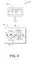
- FIG. 4A diagram illustrating the GPS log and stay points are shown in FIG. 4 .
- a sequence of stay pointsis formulated to represent a location history of the individual user 308 .
- Each stay pointcorresponds to a location visited by the individual user with corresponding arrival and departure times.
- the individual user's location history, his represented by:
- the stay points of each individual userare clustered to form clusters of the stay points 310 .
- the clusters of the stay points of the individual usersare further filtered.
- the filteringremoves the top two clusters having the greatest number of stay points, from the clustering results of the individual user.
- the filteringprotects the individual user's privacy, such as removing their home and workplace from the cluster of stay points.
- the stay pointsare reclustered after the removal.
- the processtransforms the individual stay point sequence into a location history sequence. Each stay point is substituted by the cluster it pertains to, with arrival and departure times of the stay point retained and associated with the cluster.
- a diagram of the clustering of stay points of individual usersis shown in FIG. 5 .
- the location histories of the individual usersmay tend to be inconsistent, as the stay points detected from various individual users' trajectories are not identical.
- the stay points that are identified from all of the individual user's trajectoriesare grouped into a dataset S and clustered 312 .
- the stay points from multiple individual users'are clustered into clusters of several geographical areas 312 by a clustering algorithm.
- the clusteringuses a density-based clustering algorithm, such as Ordering Points To Identify the Clustering Structure (OPTICS), to cluster the individual user stay points and to cluster the multiple users' stay points into clusters of geospatial regions.
- OPTICSmay detect clusters with irregular structures, such as a shopping street or a set of nearby restaurants. This approach helps filter out few sparsely distributed stay points, and to ensure that, each cluster has been accessed by multiple users.
- the two parameters used in OPTICSare a core-distance (dc) and a minimum number of points (minPt) falling in this core-distance.
- the OPTICS algorithmclusters the geographical regions into clusters by grouping and identifying similar places visited by the individual users. For example, stay points of the same place are directly clustered into a density-based cluster. However, clusters with valuable semantics and irregular structures may also be detected by using OPTICS clustering method, such as a set of restaurants or travelling areas near a lake.
- geographical regionsare identified 314 by the location correlation service 106 .
- the stay points that are similar in coordinate location or type of classification from the multiple usersmay be assigned to a same cluster. These geographical regions are identified to be used for correlation.
- the cluster of stay points detected from the multiple users' trajectoriesis defined as a collection of locations.
- s ⁇ S ⁇ , i ⁇ j, li ⁇ lj⁇ .
- a stay point in the user's location historymay be substituted with the cluster ID.
- the modelidentifies a trip as a sequence of locations consecutively visited by the individual user.
- the tripmay be represented by:
- Trip⁇ l 0 ⁇ ⁇ ⁇ ⁇ ⁇ t 1 ⁇ l 1 ⁇ ⁇ ⁇ ⁇ ⁇ t 2 , ... ⁇ , ⁇ ⁇ ⁇ ⁇ t k - 1 ⁇ l k ⁇
- ⁇ 0 ⁇ i ⁇ k, ⁇ t k ⁇ T p (a threshold) and li ⁇ Lis a stay-point-cluster ID.
- the location correlation service 106may use the trip data to further identify that a travel time spent between two consecutive stay points is to be used as a stay point or to be divided into two stay points. For example, if the location history of the individual user exceeds a predetermined threshold, in response, the location history of the individual user may be partitioned into more than one trip. On the other hand, if the travel time spent between two consecutive stay points does not exceed the predetermined threshold, the location history of the individual may be left as a single trip.
- the location correlation application 114defines a collection of users.
- the location modelidentifies locations based on each individual user's location history data. These locations are saved in the database 116 for further processing or may be used by the location correlation service 106 .
- FIG. 4illustrates an exemplary process 400 of extracting stay points from GPS logs 402 .
- Each point p i ⁇ Pcontains the latitude (p i ⁇ Lat), the longitude (p i ⁇ Lngt), and the timestamp (p i ⁇ T).
- the processconnects the GPS points, p 1 , p 2 , p 3 , . . . p 9 , according to their time series, into a GPS trajectory. As mentioned previously, the process extracts stay points based on the spatial and temporal values of the GPS points.
- the stay point 1is the geographical region where the individual user has remained stationary indoors at P 3 for over a threshold time period.
- stay pointsare detected based on the time threshold within the distance threshold. For example, this type of stay point may occur when the individual user enters a building, causing the satellite signal to be lost. Once the individual returns outdoors, the satellite signal is detected again.
- stay point 1is considered a geographical region (in this case, the location(s) where the signal was lost and regained) to be used in the location model.
- the stay point 2is the geographical region where the individual user may wander around within a spatial region for over a time period.
- the processconstructs the stay point using the mean longitude and latitude of the GPS points within the region. Typical, stay points of this type occur when the individual wanders around outdoor places that detect the satellite signal, like a park, a campus, and the like.
- Each stay point s icorresponds to some geographical region and a common travel sequence to be followed by individual users. There would be corresponding times for each stay point, s i ⁇ arvT and s i ⁇ levT of arriving and leaving a place.
- the processapplies density-based clustering by clustering the stay points into clusters of several geographical regions.
- the clustersare illustrated at C 4 and C 5 by 504 .
- Each stay pointis substituted by the cluster it pertains to, with arrival and departure times of the stay point retained and associated with the cluster.
- stay points S 1 and S 2may be substituted by C 1 , which is the cluster that S 1 and S 2 are currently located.
- FIG. 6is a flowchart showing an exemplary process 600 for inferring travel experiences of users from their location histories.
- the location correlation service 106employs an inference model to infer individual user's travel experiences from their location histories 602 .
- the inference modelregards the individual user's stay on a location as an implicitly directed link from the user to that location, i.e., an individual user would point to many locations and a location would be pointed to by many users.
- the user travel experience E and the location interesthave a mutual reinforcement relationship.
- the individual user with rich travel experiences in a regionwould visit many interesting places in that region, and a very interesting place in that region might be accessed by many individual users with rich travel experiences. More specifically, an individual user's travel experience may be represented by the sum of the interests of the locations accessed; the interest of a location may be calculated by integrating the experiences of the individual users visiting it.
- each user's travel experience and each location's interestmay be calculated.
- a diagram of the inference of travel experience and location interestis shown in FIG. 7 .
- the process 600may build an adjacent matrix M between users and locations 604 .
- an item r ijstands for the times that ui has stayed in location l j , 0 ⁇ i ⁇ , 0 ⁇ j ⁇
- the matrixmay be represented as:
- the inference modeluses n and En to denote location interests and travel experiences at the nth iteration.
- the processcalculates the final results using the power iteration method 610 .
- the algorithmmay perform w rounds before being converged.
- the computing complexity of this methodis (2w
- the algorithm depicting the iterative processis shown.
- InferUserExperienceU,L,H
- InputA collection of users U, their location histories H, and a collection of locations L detected from H.
- T kM T ⁇ M ⁇ Tk ⁇ 1 ; 5.
- E kM ⁇ M T ⁇ EK ⁇ 1; 6.
- T kTk/ Tk 1; //normalization 7.
- E kEk/ Ek 1; //normalization 8. While Ek ⁇ Ek ⁇ 1 1> ⁇ e or Tk ⁇ Tk ⁇ 1 1> ⁇ l 9.
- FIG. 7illustrates an exemplary process 700 of the inference model. Shown are user travel experience and locations of interest along the left side. A location is a cluster of stay points, l 0 , l 1 , l 2 , . . . l n . The individual user's visit to the location is viewed as an implicitly directed link 702 that extends from the individual user u 3 to the location l 3 . Shown at 704 is l 0 , which contains two stay points, one each from u 0 trajectory 706 and from u 1 trajectory 708 . This illustrates that the users access many locations, and the location is visited by many users. This is an illustration of the mutual reinforcement relationship.
- FIG. 8 aillustrates a flowchart showing an exemplary process 800 for correlating between the locations that have been identified through the location model.
- An algorithmcomputes the correlation between the locations by evaluating the individual user travel experience and the sequence of locations that have been visited 802 .
- the correlation between two locationsdepends on a number of users visiting the locations in a trip and rely on the individual users' travel experiences.
- the correlation between two locations that are continuously accessed by the individual usermay be more correlated than those being visited discontinuously.
- the correlation between the two locationsmay be calculated by integrating the travel experiences of the users U′ who have visited the locations in a trip in a weighted manner 804 .
- the location correlation service 106determines the correlation between the locations 808 .
- FIG. 8 bshows an exemplary process of correlating the locations.
- the diagram 810shows an illustration of the location correlation process 800 , which calculated the correlation between locations.
- the correlations between locationscover category similarity and geographical distance between locations based on human behavior. Thus, correlation may be discovered from location history.
- the correlationenables many valuable services, such as location recommendation system, sales promotion, bus routes design, mobile tour guides, and the like.
- Correlations between the locationsmay identify locations that are similar in type, close proximity to each other, and/or correlated from a perspective of human behavior.
- Human behavioridentifies location histories implying key factors, such as travel time, distance, accessibility, and sequence between the locations. If the individual user visited location A and then location B, it is presumed these two locations are within distance of each other. If there are additional data indicating individual users tend to follow the sequence from A to B, this may be implied as one-way road.
- the correlation processshows “Smithsonian” as being highly correlated to “Arlington National Cemetery” based on mining correlation data which shows individual users tend to visit both locations. Both of these locations have been clustered as tourist attractions, and as being near each other in the DC metro area.
- the “Potomac Overlook Regional Park”is also highly correlated to “Arlington National Cemetery”, based on analyzing individual user's location histories. Again, both of these are tourist attractions and located near each other.
- the “Smithsonian” and/or the “Potomac Overlook Regional Park”may be recommended to tourists whenever they travel to visit “Arlington National Cemetery”.
- the location correlation service 106may recommend “Potomac Overlook Regional Park”. Or as mentioned, if the user's current geo-spatial position is close to “Potomac Overlook Regional Park”, it may also appear as a recommended location. Otherwise, people might miss opportunities to visit sites that may be easily accessible and a place of interest with similar group identification.
- the location correlation service 106may find correlations among locations that are not similar in business categories but tend to follow a common travel sequence between locations. Restaurants are classified under the food category while museums and theatres are classified under entertainment. For example, the user 108 may be interested in going out to dinner at a restaurant first and then attending a show at the theatre. The location correlation service 106 recognizes the sequence and makes recommendations based on this. If the user 108 activates the map for directions for the restaurant or the theatre, the location correlation service 106 may recommend the other location.
- there are many advantages of correlating between locationssuch as to gain knowledge from travel experiences of individuals with a higher knowledge of the region and to understand travel sequences between the locations.
- FIG. 9illustrates an exemplary process 900 for calculating the correlation between the locations. Shown are three users (u 1 , 2 , u 3 ) who access three locations (A, B, C). The three users may access the locations in different manners to illustrate three trips (Trip 1 , Trip 2 , Trip 3 ). As shown in FIG. 9 , the number shown below each node denotes the index of this node in the sequence.
- the sequence for u 1 on Trip 1may be A, B, C at 902 ; the sequence for u 2 on Trip 2 may be A, C, B at 904 ; and the sequence for u 3 on Trip 3 may include B, A, C at 906 .
- ⁇ 1)1 ⁇ 2) as u 1 traveled to B before visiting C. Thus, the correlation between locations A and C from Trip 1 may not be as strong as the correlation between A and B, as they are not consecutively visited by u 1 . Thus, the learnings generated from the correlation of
- the location correlation application 114integrates these correlations that are inferred from each individual user's trips and obtain the following results:
- bis a constant, which is set to 2.
- stands for the number of locations contained in the Trip and Tri[i] represents the ith location in Trip. For example, regarding Trip 1 ,
- n trips in a datasetthere may be n trips in a dataset and the average length of a trip is m.
- the mining algorithmtakes
- ⁇ QO ⁇ ( 2 ⁇ w ⁇ ⁇ L ⁇ ⁇ ⁇ U ⁇ + 2 ⁇ ⁇ L ⁇ 2 + m ⁇ ( m - 1 ) 2 ⁇ n ) .
- the correlation resultsmay be mined. Shown below is an algorithm for mining the correlation
- lines 2-4illustrate detecting stay points and formulating location histories into a sequence of stay points.
- Lines 5 and 6illustrate the clustering of all of the users' stay points.
- Lines 7 and 8illustrate representing the location history by a sequence of stay point clusters called locations.
- Lines 9 and 10show the iterative model being used to learn each user's travel experience.
- Line 11illustrate the algorithm is used to calculate the correlation.
- resultsmay be stored in the database 116 .
- certain acts in processes 300 , 600 , and 800need not be performed in the order described, may be modified and/or may be omitted entirely, depending on the circumstances.
- FIG. 10is a block diagram showing an exemplary server usable with the environment of FIG. 1 .
- the server 112may be configured as any suitable system capable of services, which includes, but is not limited to, implementing the location correlation service 106 for online services, such as providing recommendations.
- the server 112comprises at least one processor 1000 , a memory 1002 , and a communication connection(s) 1004 .
- the communication connection(s) 1004may include access to a wide area network (WAN) module, a local area network module (e.g., WiFi), a personal area network module (e.g., Bluetooth), and/or any other suitable communication modules to allow the server 112 to communicate over the network(s) 104 .
- WANwide area network
- WiFilocal area network
- Bluetoothpersonal area network module
- the memory 1002may store an operating system 1006 , the module for the location correlation service 106 ( a ), the module for the location correlation application 114 ( a ), and one or more applications 1008 for implementing all or a part of applications and/or services using the location correlation service 106 .
- the one or more other applications 1008 or modulesmay include an email application, online services, a calendar application, a navigation module, a game, and the like.
- the memory 1002 in this implementationmay also include a location model module 1010 , an inference model module 1012 , and a location correlation algorithm or module 1014 .
- the location model module 1010transforms and processes the data to create the location model.
- the processincludes collecting GPS logs, parsing trajectories from the log data, extracting stay points from the trajectories, clustering stay points of individual users and of multiple users, and identifying locations.
- the memory 1002 in this implementationmay also include the inference model module 1012 .
- the module 1012integrates the travel experience of the user with locations of interest in locations visited by the individual user.
- the module 1012builds a matrix and performs an iterative process for generating results based on inferring users travel experiences and locations.
- the location correlation algorithm or module 1014determines a correlation between the locations that have been identified by the location model.
- the location correlation module 1014performs calculations by evaluating users' travel experiences, their location histories, location collection, and a threshold for trip partition. Based on this input, the module 1014 determines a correlation between the locations.
- the server 112may include a content storage 1016 to store the collection of GPS logs, trajectories, stay points, clusters, location model, correlation results, and the like. Alternatively, this information may be stored on database 116 .
- the server 112may also include additional removable storage 1018 and/or non-removable storage 1020 .
- Any memory described hereinmay include volatile memory (such as RAM), nonvolatile memory, removable memory, and/or non-removable memory, implemented in any method or technology for storage of information, such as computer-readable instructions, data structures, applications, program modules, emails, and/or other content.
- any of the processors described hereinmay include onboard memory in addition to or instead of the memory shown in the figures.
- the memorymay include storage media such as, but not limited to, random access memory (RAM), read only memory (ROM), flash memory, optical storage, magnetic disk storage or other magnetic storage devices, or any other medium which can be used to store the desired information and which can be accessed by the respective systems and devices.
- the server as described abovemay be implemented in various types of systems or networks.
- the servermay be a part of, including but is not limited to, a client-server system, a peer-to-peer computer network, a distributed network, an enterprise architecture, a local area network, a wide area network, a virtual private network, a storage area network, and the like.
- Various instructions, methods, techniques, applications, and modules described hereinmay be implemented as computer-executable instructions that are executable by one or more computers, servers, or telecommunication devices.
- program modulesinclude routines, programs, objects, components, data structures, etc. for performing particular tasks or implementing particular abstract data types.
- These program modules and the likemay be executed as native code or may be downloaded and executed, such as in a virtual machine or other just-in-time compilation execution environment.
- the functionality of the program modulesmay be combined or distributed as desired in various implementations.
- An implementation of these modules and techniquesmay be stored on or transmitted across some form of computer-readable media.
Landscapes
- Engineering & Computer Science (AREA)
- Radar, Positioning & Navigation (AREA)
- Remote Sensing (AREA)
- Computer Networks & Wireless Communication (AREA)
- Physics & Mathematics (AREA)
- General Physics & Mathematics (AREA)
- Navigation (AREA)
- Information Retrieval, Db Structures And Fs Structures Therefor (AREA)
Abstract
Description
- Traj=(p0, p1, . . . , pk), where pi(xi, yi, ti) (i=0, 1, . . . , k) is a timestamp ∀0≦i<k, ti<ti+1, and (xi,yi) are two-dimension coordinates of points.
P=(pm,m+1, . . . ,pn),
where ∀m<i≦n, Dist(pm, pi)≦Dr, Dist(pm, pn+1)>Dr and Int(pm, pn)≧Tr. Therefore, s=(x, y, ta, tl), where:
respectively stands for the average x and y coordinates of the collection P; s·ta=pm·tmis the individual user's arriving time on s and s·tl=pn·tnrepresents the individual user's leaving time. A diagram illustrating the GPS log and stay points are shown in
where ∀0≦i<n, si is a stay point and Δti=si+1·ta−si·tl is the time interval between two stay points.
L={l0,l1, . . . , ln}
where ∀0≦i≦n, li={s|sεS}, i≠j, li∩lj=Ø.
The individual users' location histories may be compared and integrated to infer the correlation between locations.
where ∀0≦i≦k, Δtk<Tp(a threshold) and liεL is a stay-point-cluster ID. In general, the individual user's location history may be regarded as a collection of trips, h={Trip}, and each Trip=(li→lj→ . . . ) is a sequence of locations represented by clusters of stay points.


ei=Σl
Ij=Σu
E=M·


En=M·MT·En-1

| InferUserExperience (U,L,H) |
| Input: A collection of users U, their location histories H, and |
| a collection of locations L detected from H. |
| Output: The collection of users' travel experiences E= (e0,1,...,em) . |
| 1. T0=E0=(1,1,...,1); |
| 2. k=1; |
| 3. Do |
| 4. Tk=MT·M·Tk−1 ; |
| 5. Ek=M·MT·EK−1; |
| 6. Tk= Tk/ |
| 7. Ek= Ek/ |
| 8. While Ek−Ek−1 1>εe or Tk−Tk−1 1> |
| 9. Return Ek; |
Cor(A,B)=Σu
where U′ is the collection of users who have visited locations A and B in a trip, ekis uk's travel experience, ukεU′, and 0<α≦1 is a dumping factor, which may decrease as the interval between these two locations' index in a trip increases. For example, if setting α=2−(|
Cor(A,B)=Σu
and with information from Trip1, the
| CalculateLocationCorrelation (L,E,H,Tp) |
| Input: A collection of users' travel experiences E and their location |
| histories H, location collection L, and a threshold Tp for trip partition. |
| Output: A matrix Cor describing the correlation between locations. |
| 1. Foreach location lp |
| 2. Foreach location lp∈L,p≠q Do |
| 3. | Cor lp,lq =0; | //initialize the |
| 4. Foreach hk∈H Do | //each user's |
| 5. | TP=TripPartition(hk,Tp); | //partition uk's location history |
| into |
| 6. | Foreach Trip in |
| 7. | For i=0;i< Trip ;i++ // ith location contained in Trip |
| 8. | For j=i+1;j< Trip ; |
| 9. | α=b−(j−i−1) ; // dumping factor, b is a constant |
| 10. | Cor Trip[i],Trip[j] +=α·ek ; |
| 11. Foreach lp |
| 12. | Foreach lq∈L,p≠q Do // |
| 13. | Cor (lp,lq) =Cor (lp,lq) /|| Cor (lp,l0) ,...,Cor |
| (lp,l|L|−1)||1 |
| 11. Return Cor; |
time. So, the overall computing complexity F of this approach is the combination of inferring user travel experience and calculating the location correlation, i.e.,
| MiningLocationCorrelation (U, TRAJ, Tr, Dr,Tp) |
| Input: A collection of users U and their trajectories TRAJ= Trajk , |
| a time threshold Tr and a distance threshold Dr for stay point detection, |
| and a Tp for trip partition. |
| Output: A matrix Cor of correlation between each pair of locations. |
| 1. S=φ; H= φ; // |
| 2. Foreach uk∈U do |
| 3. | ST=StayPointDetection(Trajk, Tr, Dr); // |
| 4. | hk = LocHistPresent(ST); //a sequence of stay points |
| 5. | S=S ∪ST; // a collection of all users' stay points |
| 6. L = Clustering(S); | //detect locations by clustering the stay points |
| 7. Foreach uk∈U do |
| 8. | hk = LocHistRepresent(  |
| 9. | H= H ∪hk, //a collection of all users' |
| 10. E=InferUserExperience(U,L,H); |
| 11. Cor=CalculateLocationCorrelation(L,E,H,Tp); |
| 12. Return Cor. |
Claims (20)
Priority Applications (1)
| Application Number | Priority Date | Filing Date | Title |
|---|---|---|---|
| US12/711,130US8612134B2 (en) | 2010-02-23 | 2010-02-23 | Mining correlation between locations using location history |
Applications Claiming Priority (1)
| Application Number | Priority Date | Filing Date | Title |
|---|---|---|---|
| US12/711,130US8612134B2 (en) | 2010-02-23 | 2010-02-23 | Mining correlation between locations using location history |
Publications (2)
| Publication Number | Publication Date |
|---|---|
| US20110208425A1 US20110208425A1 (en) | 2011-08-25 |
| US8612134B2true US8612134B2 (en) | 2013-12-17 |
Family
ID=44477210
Family Applications (1)
| Application Number | Title | Priority Date | Filing Date |
|---|---|---|---|
| US12/711,130Active2031-03-26US8612134B2 (en) | 2010-02-23 | 2010-02-23 | Mining correlation between locations using location history |
Country Status (1)
| Country | Link |
|---|---|
| US (1) | US8612134B2 (en) |
Cited By (38)
| Publication number | Priority date | Publication date | Assignee | Title |
|---|---|---|---|---|
| US20130337830A1 (en)* | 2012-06-18 | 2013-12-19 | Navteq B.V. | Method and apparatus for detecting points of interest or events based on geotagged data and geolocation seeds |
| US20140052497A1 (en)* | 2012-02-07 | 2014-02-20 | Thomas Varghese | Correlating location data |
| US20140108320A1 (en)* | 2012-10-16 | 2014-04-17 | Jim S. Baca | Preference prediction tool |
| US20140195110A1 (en)* | 2013-01-10 | 2014-07-10 | Lg Electronics Inc. | Vehicle terminal and location-based content sharing system having the same |
| US20140195157A1 (en)* | 2011-10-17 | 2014-07-10 | Qualcomm Incorporated | Applying an indication of a likelihood of a directional transition at a junction in an encoded routability graph description to a positioning function of a mobile device |
| US8909583B2 (en) | 2011-09-28 | 2014-12-09 | Nara Logics, Inc. | Systems and methods for providing recommendations based on collaborative and/or content-based nodal interrelationships |
| US20150019294A1 (en)* | 2013-07-10 | 2015-01-15 | PlacelQ, Inc. | Projecting Lower-Geographic-Resolution Data onto Higher-Geographic-Resolution Areas |
| US20150024784A1 (en)* | 2012-06-22 | 2015-01-22 | Google Inc. | Providing information about relevant elements from maps history based on location |
| US9009088B2 (en) | 2011-09-28 | 2015-04-14 | Nara Logics, Inc. | Apparatus and method for providing harmonized recommendations based on an integrated user profile |
| US9116982B1 (en) | 2012-04-27 | 2015-08-25 | Google Inc. | Identifying interesting commonalities between entities |
| US20150268058A1 (en)* | 2014-03-18 | 2015-09-24 | Sri International | Real-time system for multi-modal 3d geospatial mapping, object recognition, scene annotation and analytics |
| US9347779B1 (en)* | 2014-12-10 | 2016-05-24 | Here Global B.V. | Method and apparatus for determining a position of a vehicle based on driving behavior |
| US9410815B1 (en)* | 2014-03-26 | 2016-08-09 | Google Inc. | System and method for displaying dynamic text content with a digital map |
| US9414197B2 (en) | 2014-08-15 | 2016-08-09 | Google Technology Holdings LLC | Identifying personalized meaningful locations |
| US9565521B1 (en)* | 2015-08-14 | 2017-02-07 | Samsung Electronics Co., Ltd. | Automatic semantic labeling based on activity recognition |
| US9588988B2 (en) | 2013-03-15 | 2017-03-07 | Google Inc. | Visual indicators for temporal context on maps |
| US9683858B2 (en) | 2008-02-26 | 2017-06-20 | Microsoft Technology Licensing, Llc | Learning transportation modes from raw GPS data |
| US20170184408A1 (en)* | 2015-12-28 | 2017-06-29 | International Business Machines Corporation | GPS Map-matching Based on Space Map-matching |
| CN107645535A (en)* | 2016-07-21 | 2018-01-30 | 丰田自动车株式会社 | Information provider unit |
| CN107820214A (en)* | 2017-09-28 | 2018-03-20 | 长安大学 | A kind of user trajectory analysis system based on time suboptimal control |
| US10013639B1 (en) | 2013-12-16 | 2018-07-03 | Amazon Technologies, Inc. | Analyzing digital images based on criteria |
| US20180232397A1 (en)* | 2017-02-15 | 2018-08-16 | Uber Technologies, Inc. | Geospatial clustering for service coordination systems |
| CN109297492A (en)* | 2018-09-06 | 2019-02-01 | 中国电子科技集团公司电子科学研究院 | A method and device for determining the parking point of a moving track |
| US10387457B2 (en) | 2014-06-17 | 2019-08-20 | Sap Se | Grid-based analysis of geospatial trajectories |
| US10417648B2 (en) | 2015-11-09 | 2019-09-17 | Industrial Technology Research Institute | System and computer readable medium for finding crowd movements |
| US10467677B2 (en) | 2011-09-28 | 2019-11-05 | Nara Logics, Inc. | Systems and methods for providing recommendations based on collaborative and/or content-based nodal interrelationships |
| US10621508B2 (en) | 2016-08-22 | 2020-04-14 | Conduent Business Services, Llc | Method and system for correlation detection in multiple spatio-temporal datasets for event sensing |
| US10650621B1 (en) | 2016-09-13 | 2020-05-12 | Iocurrents, Inc. | Interfacing with a vehicular controller area network |
| US10789526B2 (en) | 2012-03-09 | 2020-09-29 | Nara Logics, Inc. | Method, system, and non-transitory computer-readable medium for constructing and applying synaptic networks |
| US20210182985A1 (en)* | 2019-12-16 | 2021-06-17 | Grand Rounds, Inc. | Systems and methods for travel optimization |
| US11151469B2 (en)* | 2013-06-19 | 2021-10-19 | International Business Machines Corporation | Privacy risk metrics in location based services |
| US11151617B2 (en) | 2012-03-09 | 2021-10-19 | Nara Logics, Inc. | Systems and methods for providing recommendations based on collaborative and/or content-based nodal interrelationships |
| US20210406786A1 (en)* | 2014-06-23 | 2021-12-30 | Sensia Netherlands B.V. | Systems and methods for cloud-based asset management and analysis regarding well devices |
| US11248924B2 (en) | 2019-04-05 | 2022-02-15 | Volvo Car Corporation | Systems and methods for the classification of geographic locations based on vehicle trip logs |
| US20220201045A1 (en)* | 2016-06-10 | 2022-06-23 | OneTrust, LLC | Data processing systems for data-transfer risk identification, cross-border visualization generation, and related methods |
| US11727249B2 (en) | 2011-09-28 | 2023-08-15 | Nara Logics, Inc. | Methods for constructing and applying synaptic networks |
| US12045266B2 (en) | 2016-06-10 | 2024-07-23 | OneTrust, LLC | Data processing systems for generating and populating a data inventory |
| US12387246B2 (en) | 2011-09-28 | 2025-08-12 | Nara Logics, Inc. | Systems and methods for providing results based on nodal interrelationships and updating nodal interrelationship strengths based on feedback regarding the results |
Families Citing this family (51)
| Publication number | Priority date | Publication date | Assignee | Title |
|---|---|---|---|---|
| JP5966930B2 (en)* | 2011-01-14 | 2016-08-10 | 日本電気株式会社 | Behavior pattern analysis device, behavior pattern analysis method, and behavior pattern analysis program |
| US8832003B1 (en) | 2011-03-25 | 2014-09-09 | Google Inc. | Provision of computer resources based on location history |
| US20120330719A1 (en)* | 2011-05-27 | 2012-12-27 | Ashutosh Malaviya | Enhanced systems, processes, and user interfaces for scoring assets associated with a population of data |
| WO2013030942A1 (en)* | 2011-08-30 | 2013-03-07 | トヨタ自動車 株式会社 | Behavior history management system, and behavior history management method |
| US20140012806A1 (en) | 2012-06-22 | 2014-01-09 | Jiwire, Inc. | Location graph based derivation of attributes |
| US8855931B2 (en) | 2012-06-25 | 2014-10-07 | Google Inc. | Location history filtering |
| US8781735B2 (en) | 2012-06-25 | 2014-07-15 | Google Inc. | Adaptive clustering of locations |
| EP2877935A4 (en)* | 2012-07-25 | 2016-01-20 | Aro Inc | Using mobile device data to create a storyline, model user routine and personality, and create customized recommendation agents |
| US9002373B2 (en) | 2012-12-14 | 2015-04-07 | Apple Inc. | Monitoring a location fingerprint database |
| WO2014127143A1 (en)* | 2013-02-13 | 2014-08-21 | Op40 Holdings, Inc. | Distributed cloud services and uses thereof |
| US10467554B2 (en)* | 2013-03-14 | 2019-11-05 | Lyft, Inc. | System for connecting a driver and a rider |
| US20140330766A1 (en)* | 2013-05-01 | 2014-11-06 | Mingji Lou | Positions and Interests Map |
| US9400181B2 (en) | 2013-06-27 | 2016-07-26 | Intel Corporation | Systems and methods for detection of magnetic and motion-based landmarks |
| US20150024711A1 (en) | 2013-07-19 | 2015-01-22 | James A. STOB | Method and system for compiling map data |
| US11392987B2 (en) | 2013-10-09 | 2022-07-19 | Mobile Technology Corporation | Systems and methods for using spatial and temporal analysis to associate data sources with mobile devices |
| WO2015054291A1 (en) | 2013-10-09 | 2015-04-16 | Mobile Technology Corporation, LLC | Systems and methods for using spatial and temporal analysis to associate data sources with mobile devices |
| US20150112808A1 (en)* | 2013-10-18 | 2015-04-23 | Google Inc. | Determining relevant business locations based on travel distances |
| KR20150093294A (en)* | 2014-02-06 | 2015-08-18 | 한국전자통신연구원 | Apparatus and method for sharing experience in mobile communication terminal |
| US9464908B2 (en)* | 2014-09-10 | 2016-10-11 | Volkswagen Ag | Apparatus, system and method for clustering points of interest in a navigation system |
| US9291700B1 (en) | 2015-01-09 | 2016-03-22 | NinthDecimal, Inc. | Systems and methods to identify home addresses of mobile devices |
| US10327094B2 (en) | 2016-06-07 | 2019-06-18 | NinthDecimal, Inc. | Systems and methods to track locations visited by mobile devices and determine neighbors of and distances among locations |
| US9307360B1 (en) | 2015-01-09 | 2016-04-05 | NinthDecimal, Inc. | Systems and methods to identify a predefined geographical region in which a mobile device is located |
| US10120381B2 (en)* | 2015-03-13 | 2018-11-06 | Nissan North America, Inc. | Identifying significant locations based on vehicle probe data |
| CN106682051B (en)* | 2015-11-09 | 2020-05-29 | 财团法人工业技术研究院 | Method for finding out crowd movement behaviors |
| US20210172759A1 (en)* | 2017-02-17 | 2021-06-10 | Dataspark Pte Ltd | Map Matching and Trajectory Analysis |
| US11112250B1 (en)* | 2018-01-11 | 2021-09-07 | Monsarrat, Inc. | System for automatic instantiation of a generically described location-based traveling experience to specific map coordinates and real-time conditions |
| CN108536851B (en)* | 2018-04-16 | 2021-04-16 | 武汉大学 | A User Identity Recognition Method Based on Similarity Comparison of Movement Trajectories |
| US10942952B1 (en)* | 2018-08-16 | 2021-03-09 | Palantir Technologies Inc. | Graph analysis of geo-temporal information |
| EP3837494B1 (en) | 2018-09-13 | 2023-08-02 | Huawei Technologies Co., Ltd. | Multimodal location sensing on a mobile phone |
| CN110910054B (en)* | 2018-09-17 | 2024-04-05 | 北京京东尚科信息技术有限公司 | Track determining method and device and time recommending method and device |
| CN111046895B (en)* | 2018-10-15 | 2023-11-07 | 北京京东振世信息技术有限公司 | Method and device for determining target area |
| US11092443B2 (en)* | 2018-11-20 | 2021-08-17 | Here Global B.V. | Method, apparatus, and system for categorizing a stay point based on probe data |
| US11032670B1 (en) | 2019-01-14 | 2021-06-08 | Snap Inc. | Destination sharing in location sharing system |
| US11294936B1 (en) | 2019-01-30 | 2022-04-05 | Snap Inc. | Adaptive spatial density based clustering |
| US11166123B1 (en) | 2019-03-28 | 2021-11-02 | Snap Inc. | Grouped transmission of location data in a location sharing system |
| CN110503032B (en)* | 2019-08-21 | 2021-08-31 | 中南大学 | Detection method of individual important places based on surveillance camera trajectory data |
| US10687174B1 (en) | 2019-09-25 | 2020-06-16 | Mobile Technology, LLC | Systems and methods for using spatial and temporal analysis to associate data sources with mobile devices |
| CN110727757A (en)* | 2019-10-22 | 2020-01-24 | 北京卡路里信息技术有限公司 | Track data processing method and device and electronic equipment |
| CN110990455B (en)* | 2019-11-29 | 2023-10-17 | 杭州数梦工场科技有限公司 | Method and system for recognizing house property by big data |
| JP6810978B1 (en)* | 2020-03-16 | 2021-01-13 | 株式会社ピース企画 | Cluster generator, cluster generation method and cluster generation program |
| CN111578933B (en)* | 2020-05-09 | 2022-03-11 | 北京上下文系统软件有限公司 | Method for quickly identifying user entering specific geographic area |
| CN112367608B (en)* | 2020-10-27 | 2022-09-20 | 上海世脉信息科技有限公司 | Fixed sensor spatial position mining method in big data environment |
| CN112597189B (en)* | 2020-12-28 | 2024-08-27 | 广州羊城通有限公司 | Travel track adjusting method and device based on riding records |
| JP6989185B1 (en)* | 2021-03-19 | 2022-01-05 | 株式会社ピース企画 | Cluster generator, cluster generator and cluster generator |
| US11800323B2 (en)* | 2021-08-17 | 2023-10-24 | Allstate Insurance Company | Vehicle mobility patterns based on user location data |
| CN114007186B (en)* | 2021-10-21 | 2022-12-09 | 腾讯科技(深圳)有限公司 | Positioning method and related product |
| CN116027367B (en)* | 2022-08-31 | 2023-10-20 | 荣耀终端有限公司 | Stop point identification method, device, equipment and storage medium |
| CN115687956B (en)* | 2022-10-21 | 2025-10-03 | 阿里云计算有限公司 | Trip chain processing method and device, storage medium and processor |
| CN117014803B (en)* | 2023-07-06 | 2024-08-27 | 荣耀终端有限公司 | Positioning method, recommending method, readable medium and electronic device |
| US12263407B1 (en) | 2024-09-17 | 2025-04-01 | Monsarrat, Inc. | Real world walking to control superhuman virtual world movement |
| US12249038B1 (en) | 2024-09-17 | 2025-03-11 | Monsarrat, Inc. | Navigating real and virtual worlds with disparate terrains in augmented reality |
Citations (142)
| Publication number | Priority date | Publication date | Assignee | Title |
|---|---|---|---|---|
| US5428546A (en) | 1992-10-16 | 1995-06-27 | Mobile Information Systems | Method and apparatus for tracking vehicle location |
| US6023241A (en) | 1998-11-13 | 2000-02-08 | Intel Corporation | Digital multimedia navigation player/recorder |
| US6091359A (en) | 1997-07-14 | 2000-07-18 | Motorola, Inc. | Portable dead reckoning system for extending GPS coverage |
| US6128279A (en) | 1997-10-06 | 2000-10-03 | Web Balance, Inc. | System for balancing loads among network servers |
| EP1087602A2 (en) | 1999-09-24 | 2001-03-28 | Cedardell Limited | Alarm system |
| US6351775B1 (en) | 1997-05-30 | 2002-02-26 | International Business Machines Corporation | Loading balancing across servers in a computer network |
| US20020032689A1 (en) | 1999-12-15 | 2002-03-14 | Abbott Kenneth H. | Storing and recalling information to augment human memories |
| US20020038360A1 (en) | 2000-05-31 | 2002-03-28 | Matthew Andrews | System and method for locating a closest server in response to a client domain name request |
| US20020044690A1 (en) | 2000-10-18 | 2002-04-18 | Burgess Ken L. | Method for matching geographic information with recorded images |
| US6385539B1 (en) | 1999-08-13 | 2002-05-07 | Daimlerchrysler Ag | Method and system for autonomously developing or augmenting geographical databases by mining uncoordinated probe data |
| US20020077749A1 (en) | 2000-12-15 | 2002-06-20 | Miwako Doi | Walker navigation system, walker navigation method, guidance data collection apparatus and guidance data collection method |
| US6446121B1 (en) | 1998-05-26 | 2002-09-03 | Cisco Technology, Inc. | System and method for measuring round trip times in a network using a TCP packet |
| US6496814B1 (en) | 2000-07-19 | 2002-12-17 | International Business Machines Corporation | Method and system for integrating spatial analysis, and scheduling to efficiently schedule and monitor infrastructure maintenance |
| US6513026B1 (en) | 2000-06-17 | 2003-01-28 | Microsoft Corporation | Decision theoretic principles and policies for notification |
| US20030053424A1 (en) | 2001-08-07 | 2003-03-20 | Srikanth Krishnamurthy | Method and apparatus for determining position and trajectory of gateways to optimize performance in hybrid non-terrestrial-terrestrial multi-hop mobile networks |
| US20030063133A1 (en) | 2001-09-28 | 2003-04-03 | Fuji Xerox Co., Ltd. | Systems and methods for providing a spatially indexed panoramic video |
| US20030069968A1 (en) | 1998-10-01 | 2003-04-10 | O'neil Kevin M. | System for balancing loads among network servers |
| US20030069893A1 (en) | 2000-03-29 | 2003-04-10 | Kabushiki Kaisha Toshiba | Scheme for multimedia data retrieval using event names and time/location information |
| US20030139898A1 (en) | 2002-01-23 | 2003-07-24 | Miller Daniel Halvard | Method for synchronizing operation across devices |
| US6606643B1 (en) | 2000-01-04 | 2003-08-12 | International Business Machines Corporation | Method of automatically selecting a mirror server for web-based client-host interaction |
| US6611881B1 (en) | 2000-03-15 | 2003-08-26 | Personal Data Network Corporation | Method and system of providing credit card user with barcode purchase data and recommendation automatically on their personal computer |
| US6625319B1 (en) | 1999-03-30 | 2003-09-23 | Koninklijke Philips Electronics N.V. | Image compression using content-based image similarity |
| US20030229697A1 (en) | 2002-06-10 | 2003-12-11 | 3Com Corporation | Method and apparatus for global server load balancing |
| US20040039798A1 (en) | 1999-03-03 | 2004-02-26 | Ultradns, Inc. | Domain name resolution system and method |
| US20040073640A1 (en) | 2002-09-23 | 2004-04-15 | Cricket Technologies Llc | Network load management apparatus, system, method, and electronically stored computer product |
| US6724733B1 (en) | 1999-11-02 | 2004-04-20 | Sun Microsystems, Inc. | Method and apparatus for determining approximate network distances using reference locations |
| US6732120B1 (en) | 1998-09-03 | 2004-05-04 | Geojet Information Solutions Inc. | System and method for processing and display of geographical data |
| US6785704B1 (en) | 1999-12-20 | 2004-08-31 | Fastforward Networks | Content distribution system for operation over an internetwork including content peering arrangements |
| US20040198386A1 (en) | 2002-01-16 | 2004-10-07 | Dupray Dennis J. | Applications for a wireless location gateway |
| US20040217884A1 (en) | 2003-04-30 | 2004-11-04 | Ramin Samadani | Systems and methods of viewing, modifying, and interacting with "path-enhanced" multimedia |
| US6816779B2 (en) | 2002-02-15 | 2004-11-09 | International Business Machines Corporation | Programmatically computing street intersections using street geometry |
| US20040264465A1 (en) | 2002-11-27 | 2004-12-30 | Dunk Craig A. | Data transfer from a host server via a tunnel server to a wireless device, and associating a temporary ipv6 address with a temporary ipv4 address for communicating in an ipv4 wireless network with the device |
| US20050004903A1 (en) | 2002-03-15 | 2005-01-06 | Fujitsu Limited | Regional information retrieving method and regional information retrieval apparatus |
| US20050031296A1 (en) | 2003-07-24 | 2005-02-10 | Grosvenor David Arthur | Method and apparatus for reviewing video |
| US20050075782A1 (en) | 2002-02-21 | 2005-04-07 | Torgunrud John Arnold | Vehicle and traffic information processing system |
| US20050075116A1 (en) | 2003-10-01 | 2005-04-07 | Laird Mark D. | Wireless virtual campus escort system |
| US20050108261A1 (en) | 2003-11-04 | 2005-05-19 | Joseph Glassy | Geodigital multimedia data processing system and method |
| US20050198286A1 (en) | 2004-01-30 | 2005-09-08 | Zhichen Xu | Selecting nodes close to another node in a network using location information for the nodes |
| US20050225678A1 (en) | 2004-04-08 | 2005-10-13 | Andrew Zisserman | Object retrieval |
| US20050265317A1 (en) | 2004-05-07 | 2005-12-01 | Zeus Technology Limited | Managing the flow of data traffic |
| US20050278371A1 (en) | 2004-06-15 | 2005-12-15 | Karsten Funk | Method and system for georeferential blogging, bookmarking a location, and advanced off-board data processing for mobile systems |
| US6981055B1 (en) | 2000-08-22 | 2005-12-27 | Internap Network Services Corporation | Method and system for optimizing routing through multiple available internet route providers |
| US20060020597A1 (en) | 2003-11-26 | 2006-01-26 | Yesvideo, Inc. | Use of image similarity in summarizing a collection of visual images |
| US20060036630A1 (en) | 2003-01-28 | 2006-02-16 | Microsoft Corporation | System and process for identifying objects and/or points nearby a given object or point |
| US7003555B1 (en) | 2000-06-23 | 2006-02-21 | Cloudshield Technologies, Inc. | Apparatus and method for domain name resolution |
| US7013517B2 (en) | 2002-12-13 | 2006-03-21 | Maytag Corp. | Rotating/tipping agitator for a washing machine |
| US20060090122A1 (en) | 2004-10-21 | 2006-04-27 | Nokia Corporation | Group editing of media content stored on wireless portable devices |
| US20060095540A1 (en) | 2004-11-01 | 2006-05-04 | Anderson Eric C | Using local networks for location information and image tagging |
| US20060101377A1 (en) | 2004-10-19 | 2006-05-11 | Microsoft Corporation | Parsing location histories |
| US7062562B1 (en) | 2001-04-11 | 2006-06-13 | Cisco Technology, Inc. | Methods and apparatus for content server selection |
| US20060129675A1 (en) | 2004-11-22 | 2006-06-15 | Intel Corporation | System and method to reduce platform power utilization |
| GB2421653A (en) | 2004-12-24 | 2006-06-28 | Trek Wireless Ltd | System for the collection and association of image and position data |
| US20060143442A1 (en) | 2004-12-24 | 2006-06-29 | Smith Sander A | Automated issuance of SSL certificates |
| US20060156209A1 (en) | 2003-02-25 | 2006-07-13 | Satoshi Matsuura | Application program prediction method and mobile terminal |
| US20060190602A1 (en) | 2005-02-23 | 2006-08-24 | At&T Corp. | Monitoring for replica placement and request distribution |
| US20060200539A1 (en) | 2005-03-03 | 2006-09-07 | Kappler Elizabeth M | Determining a boot server network address from which to download an operating system during a boot sequence |
| US7111061B2 (en) | 2000-05-26 | 2006-09-19 | Akamai Technologies, Inc. | Global load balancing across mirrored data centers |
| WO2006097907A2 (en) | 2005-03-18 | 2006-09-21 | Koninklijke Philips Electronics, N.V. | Video diary with event summary |
| US20060212217A1 (en) | 2004-10-01 | 2006-09-21 | Networks In Motion, Inc. | Method and system for enabling an off board navigation solution |
| US20060224773A1 (en) | 2005-03-31 | 2006-10-05 | International Business Machines Corporation | Systems and methods for content-aware load balancing |
| US20060224303A1 (en) | 2005-03-30 | 2006-10-05 | Denso Corporation | Navigation system and program for the same |
| US20060251292A1 (en) | 2005-05-09 | 2006-11-09 | Salih Burak Gokturk | System and method for recognizing objects from images and identifying relevancy amongst images and information |
| US7136932B1 (en) | 1999-03-22 | 2006-11-14 | Eric Schneider | Fictitious domain name method, product, and apparatus |
| US20060266830A1 (en) | 2005-05-31 | 2006-11-30 | Horozov Tzvetan T | Location-based recommendation system |
| US7152118B2 (en) | 2002-02-25 | 2006-12-19 | Broadcom Corporation | System, method and computer program product for caching domain name system information on a network gateway |
| US20070005419A1 (en)* | 2005-06-30 | 2007-01-04 | Microsoft Corporation | Recommending location and services via geospatial collaborative filtering |
| US20070016663A1 (en) | 2005-07-14 | 2007-01-18 | Brian Weis | Approach for managing state information by a group of servers that services a group of clients |
| US7171415B2 (en) | 2001-05-04 | 2007-01-30 | Sun Microsystems, Inc. | Distributed information discovery through searching selected registered information providers |
| US20070041393A1 (en) | 2005-08-19 | 2007-02-22 | Microsoft Corporation | Branch office DNS storage and resolution |
| US7194552B1 (en) | 1999-03-22 | 2007-03-20 | Eric Schneider | Method, product, and apparatus for requesting a network resource |
| US20070064633A1 (en) | 2003-04-09 | 2007-03-22 | Volker Fricke | Method, systems and comuter program products for data logging |
| US20070064715A1 (en) | 2002-07-25 | 2007-03-22 | Avaya, Inc. | Method and apparatus for the assessment and optimization of network traffic |
| US20070088974A1 (en) | 2005-09-26 | 2007-04-19 | Intel Corporation | Method and apparatus to detect/manage faults in a system |
| US20070100776A1 (en) | 2003-07-31 | 2007-05-03 | Pritam Shah | Route optimization of services provided by one or more service providers for combined links |
| US20070118668A1 (en) | 2005-11-21 | 2007-05-24 | Limelight Networks, Inc. | Domain Name Resolution Resource Allocation |
| US7228359B1 (en) | 2002-02-12 | 2007-06-05 | Cisco Technology, Inc. | Methods and apparatus for providing domain name service based on a client identifier |
| US20070127833A1 (en) | 2005-11-30 | 2007-06-07 | Singh Munindar P | Automatic Generation Of Metadata For A Digital Image Based On Ambient Conditions |
| US7233861B2 (en) | 2003-12-08 | 2007-06-19 | General Motors Corporation | Prediction of vehicle operator destinations |
| US20070226004A1 (en) | 2001-06-01 | 2007-09-27 | Landnet Corporation | Identification, storage and display of land data on a website |
| US7284051B1 (en) | 1998-12-28 | 2007-10-16 | Fujitsu Limited | Relaying apparatus for use in a network system |
| US20080016051A1 (en) | 2001-12-21 | 2008-01-17 | Andrew Schiller | Method for analyzing demographic data |
| US20080016233A1 (en) | 1999-03-22 | 2008-01-17 | Eric Schneider | Methods, systems, products, and devices for processing dns friendly identifiers |
| US7349768B2 (en) | 2005-04-25 | 2008-03-25 | The Boeing Company | Evacuation route planning tool |
| US20080076451A1 (en) | 2001-08-16 | 2008-03-27 | Networks In Motion, Inc. | Point of interest spatial rating search |
| US20080086574A1 (en) | 2006-10-05 | 2008-04-10 | Limelight Networks, Inc. | Remote Domain Name Service |
| US7366726B2 (en) | 2000-10-12 | 2008-04-29 | Qas Limited | Method and apparatus for retrieving data representing a postal address from a plurality of postal addresses |
| US7395250B1 (en) | 2000-10-11 | 2008-07-01 | International Business Machines Corporation | Methods and apparatus for outlier detection for high dimensional data sets |
| US20080201074A1 (en) | 2007-02-15 | 2008-08-21 | Garmin Ltd. | System and method for creating and sharing navigation routes with electronic devices |
| US20080215237A1 (en) | 2006-05-17 | 2008-09-04 | International Business Machines Corporation | Design structure for adaptive route planning for gps-based navigation |
| US20080235383A1 (en) | 2007-03-22 | 2008-09-25 | Eric Schneider | Methods, Systems, Products, And Devices For Generating And Processing DNS Friendly Identifiers |
| US7437239B2 (en) | 2002-01-09 | 2008-10-14 | Webraska Mobile Technologies | Method and device for determining the minimal cost path between two points in a road network |
| US20080268876A1 (en) | 2007-04-24 | 2008-10-30 | Natasha Gelfand | Method, Device, Mobile Terminal, and Computer Program Product for a Point of Interest Based Scheme for Improving Mobile Visual Searching Functionalities |
| US7447588B1 (en) | 2007-07-16 | 2008-11-04 | Wenshine Technology Ltd. | Method and system for partitioning a continental roadway network for an intelligent vehicle highway system |
| US20080319660A1 (en) | 2007-06-25 | 2008-12-25 | Microsoft Corporation | Landmark-based routing |
| US20080319974A1 (en) | 2007-06-21 | 2008-12-25 | Microsoft Corporation | Mining geographic knowledge using a location aware topic model |
| US20090005987A1 (en) | 2007-04-27 | 2009-01-01 | Vengroff Darren E | Determining locations of interest based on user visits |
| US20090019181A1 (en) | 2007-07-11 | 2009-01-15 | Samsung Electronics Co., Ltd. | Method and System for Preventing Service Disruption of Internet Protocol (IP) Based Services Due To Domain Name Resolution Failures |
| US7479897B2 (en) | 2003-06-04 | 2009-01-20 | Daimler Ag | Curve rollover warning system for trucks |
| US7493294B2 (en) | 2003-11-28 | 2009-02-17 | Manyworlds Inc. | Mutually adaptive systems |
| US20090063646A1 (en) | 2007-09-04 | 2009-03-05 | Nixle, Llc | System and method for collecting and organizing popular near real-time data in a virtual geographic grid |
| US20090083237A1 (en) | 2007-09-20 | 2009-03-26 | Nokia Corporation | Method, Apparatus and Computer Program Product for Providing a Visual Search Interface |
| US20090083128A1 (en) | 2007-09-24 | 2009-03-26 | Introspective Solutions, Llc | Predicted variable analysis based on evaluation variables relating to site selection |
| US7519690B1 (en) | 2002-02-28 | 2009-04-14 | Sprint Communications Company L.P. | Dynamically updateable parameters in integrated services hub |
| US20090100018A1 (en) | 2007-10-12 | 2009-04-16 | Jonathan Roberts | System and method for capturing, integrating, discovering, and using geo-temporal data |
| WO2009053411A1 (en) | 2007-10-26 | 2009-04-30 | Tomtom International B.V. | A method of creating map data |
| US20090138188A1 (en) | 2005-07-22 | 2009-05-28 | Andrej Kores | Method, device and system for modeling a road network graph |
| US7548936B2 (en) | 2005-01-12 | 2009-06-16 | Microsoft Corporation | Systems and methods to present web image search results for effective image browsing |
| US7561959B2 (en) | 2004-06-30 | 2009-07-14 | Nauteq North America, Llc | Method of collecting information for a geographic database for use with a navigation system |
| US7574508B1 (en) | 2002-08-07 | 2009-08-11 | Foundry Networks, Inc. | Canonical name (CNAME) handling for global server load balancing |
| US20090213844A1 (en) | 2008-02-22 | 2009-08-27 | Sage Connex, Llc | Telephony |
| US20090216435A1 (en) | 2008-02-26 | 2009-08-27 | Microsoft Corporation | System for logging life experiences using geographic cues |
| US20090216704A1 (en) | 2008-02-26 | 2009-08-27 | Microsoft Corporation | Learning transportation modes from raw gps data |
| US7584159B1 (en)* | 2005-10-31 | 2009-09-01 | Amazon Technologies, Inc. | Strategies for providing novel recommendations |
| US7584301B1 (en) | 2004-05-06 | 2009-09-01 | Foundry Networks, Inc. | Host-level policies for global server load balancing |
| US20090222581A1 (en) | 2008-03-03 | 2009-09-03 | Microsoft Corporation | Internet location coordinate enhanced domain name system |
| US20090228198A1 (en) | 2008-03-07 | 2009-09-10 | Microsoft Corporation | Selecting landmarks in shortest path computations |
| US20090239552A1 (en) | 2008-03-24 | 2009-09-24 | Yahoo! Inc. | Location-based opportunistic recommendations |
| US7603233B2 (en) | 2006-10-16 | 2009-10-13 | Alpine Electronics, Inc. | Map matching method and apparatus for navigation system |
| US7610151B2 (en) | 2006-06-27 | 2009-10-27 | Microsoft Corporation | Collaborative route planning for generating personalized and context-sensitive routing recommendations |
| US20090282122A1 (en) | 2008-05-09 | 2009-11-12 | Locomatix Inc. | Location tracking optimizations |
| US20090326802A1 (en) | 2008-06-30 | 2009-12-31 | General Motors Corporation | Method and System to Calculate Historical Traffic Data |
| US20100004997A1 (en)* | 2008-05-27 | 2010-01-07 | Chand Mehta | Methods and apparatus for generating user profile based on periodic location fixes |
| US7660441B2 (en) | 2004-07-09 | 2010-02-09 | Southern California, University | System and method for fusing geospatial data |
| US20100070171A1 (en) | 2006-09-14 | 2010-03-18 | University Of South Florida | System and Method for Real-Time Travel Path Prediction and Automatic Incident Alerts |
| US7685422B2 (en) | 2004-05-18 | 2010-03-23 | Kabushiki Kaisha Toshiba | Information processing apparatus, information processing method, and information processing program |
| US20100076968A1 (en)* | 2008-05-27 | 2010-03-25 | Boyns Mark R | Method and apparatus for aggregating and presenting data associated with geographic locations |
| US20100082611A1 (en) | 2008-09-23 | 2010-04-01 | Yahoo! Inc. | Trajectory Data Surfacing System: Surfacing Useful and Relevant Entity Annotations |
| US7706964B2 (en) | 2006-06-30 | 2010-04-27 | Microsoft Corporation | Inferring road speeds for context-sensitive routing |
| US7739040B2 (en) | 2006-06-30 | 2010-06-15 | Microsoft Corporation | Computation of travel routes, durations, and plans over multiple contexts |
| US7840407B2 (en) | 2006-10-13 | 2010-11-23 | Google Inc. | Business listing search |
| US20110022299A1 (en) | 2009-07-21 | 2011-01-27 | Alpine Electronics, Inc. | Method and apparatus to search and process poi information |
| US20110029224A1 (en) | 2006-03-03 | 2011-02-03 | Inrix, Inc. | Assessing road traffic flow conditions using data obtained from mobile data sources |
| US7904530B2 (en) | 2008-01-29 | 2011-03-08 | Palo Alto Research Center Incorporated | Method and apparatus for automatically incorporating hypothetical context information into recommendation queries |
| US7948400B2 (en) | 2007-06-29 | 2011-05-24 | Microsoft Corporation | Predictive models of road reliability for traffic sensor configuration and routing |
| US20110130947A1 (en) | 2009-11-30 | 2011-06-02 | Basir Otman A | Traffic profiling and road conditions-based trip time computing system with localized and cooperative assessment |
| US7984006B2 (en) | 2007-09-18 | 2011-07-19 | Palo Alto Research Center Incorporated | Learning a user's activity preferences from GPS traces and known nearby venues |
| US20110184949A1 (en)* | 2010-01-25 | 2011-07-28 | Jiebo Luo | Recommending places to visit |
| US8060462B2 (en) | 2006-08-28 | 2011-11-15 | Manyworlds, Inc. | Mutual interest inferencing system and method |
| US20110280453A1 (en) | 2004-07-09 | 2011-11-17 | Ching-Chien Chen | System and Method for Fusing Geospatial Data |
| US20120030029A1 (en) | 2004-05-20 | 2012-02-02 | Manyworlds, Inc. | System and Method for Adaptive Videos |
| US8117138B2 (en)* | 2008-03-11 | 2012-02-14 | International Business Machines Corporation | Method and apparatus for location evaluation and site selection |
| US8190649B2 (en) | 2006-04-25 | 2012-05-29 | Google Inc. | Ranking and clustering of geo-located objects |
Family Cites Families (21)
| Publication number | Priority date | Publication date | Assignee | Title |
|---|---|---|---|---|
| USRE38724E1 (en)* | 1991-02-01 | 2005-04-12 | Peterson Thomas D | Method and apparatus for providing shortest elapsed time route and tracking information to users |
| US5802492A (en)* | 1994-06-24 | 1998-09-01 | Delorme Publishing Company, Inc. | Computer aided routing and positioning system |
| US6091956A (en)* | 1997-06-12 | 2000-07-18 | Hollenberg; Dennis D. | Situation information system |
| WO2002010984A2 (en)* | 2000-07-21 | 2002-02-07 | Triplehop Technologies, Inc. | System and method for obtaining user preferences and providing user recommendations for unseen physical and information goods and services |
| US6584401B2 (en)* | 2001-11-27 | 2003-06-24 | Hewlett-Packard Development Company, Lp. | Automatic gathering and analysis of data on commute paths |
| US7848945B2 (en)* | 2003-07-03 | 2010-12-07 | Travelweb Llc | System and method for indexing travel accommodations in a network environment |
| US8010460B2 (en)* | 2004-09-02 | 2011-08-30 | Linkedin Corporation | Method and system for reputation evaluation of online users in a social networking scheme |
| CN102982092B (en)* | 2004-10-19 | 2017-06-09 | 飞扬管理有限公司 | For the system and method for location-based social networks |
| US7720652B2 (en)* | 2004-10-19 | 2010-05-18 | Microsoft Corporation | Modeling location histories |
| US7440955B2 (en)* | 2005-01-14 | 2008-10-21 | Im2, Inc | Method and system to compare data objects |
| US20070168208A1 (en)* | 2005-12-13 | 2007-07-19 | Ville Aikas | Location recommendation method and system |
| US7912628B2 (en)* | 2006-03-03 | 2011-03-22 | Inrix, Inc. | Determining road traffic conditions using data from multiple data sources |
| US20090173838A1 (en)* | 2006-08-15 | 2009-07-09 | Walter Grill | Narrow Wing System for Airplanes |
| US7596597B2 (en)* | 2006-08-31 | 2009-09-29 | Microsoft Corporation | Recommending contacts in a social network |
| US20080098313A1 (en)* | 2006-10-23 | 2008-04-24 | Instabuddy Llc | System and method for developing and managing group social networks |
| US7885791B2 (en)* | 2007-02-21 | 2011-02-08 | British Telecommunications Public Limited Company | Method for capturing local and evolving clusters |
| US8060525B2 (en)* | 2007-12-21 | 2011-11-15 | Napo Enterprises, Llc | Method and system for generating media recommendations in a distributed environment based on tagging play history information with location information |
| US20100111372A1 (en)* | 2008-11-03 | 2010-05-06 | Microsoft Corporation | Determining user similarities based on location histories |
| US20100153292A1 (en)* | 2008-12-11 | 2010-06-17 | Microsoft Corporation | Making Friend and Location Recommendations Based on Location Similarities |
| CN102906800B (en)* | 2010-02-01 | 2015-04-29 | 影视技术集成公司 | System and method for modeling and optimizing the performance of transportation networks |
| US8566035B2 (en)* | 2010-02-25 | 2013-10-22 | International Business Machines Corporation | Route optimization |
- 2010
- 2010-02-23USUS12/711,130patent/US8612134B2/enactiveActive
Patent Citations (152)
| Publication number | Priority date | Publication date | Assignee | Title |
|---|---|---|---|---|
| US5428546A (en) | 1992-10-16 | 1995-06-27 | Mobile Information Systems | Method and apparatus for tracking vehicle location |
| US6351775B1 (en) | 1997-05-30 | 2002-02-26 | International Business Machines Corporation | Loading balancing across servers in a computer network |
| US6091359A (en) | 1997-07-14 | 2000-07-18 | Motorola, Inc. | Portable dead reckoning system for extending GPS coverage |
| US6128279A (en) | 1997-10-06 | 2000-10-03 | Web Balance, Inc. | System for balancing loads among network servers |
| US6446121B1 (en) | 1998-05-26 | 2002-09-03 | Cisco Technology, Inc. | System and method for measuring round trip times in a network using a TCP packet |
| US6732120B1 (en) | 1998-09-03 | 2004-05-04 | Geojet Information Solutions Inc. | System and method for processing and display of geographical data |
| US20030069968A1 (en) | 1998-10-01 | 2003-04-10 | O'neil Kevin M. | System for balancing loads among network servers |
| US6023241A (en) | 1998-11-13 | 2000-02-08 | Intel Corporation | Digital multimedia navigation player/recorder |
| US7284051B1 (en) | 1998-12-28 | 2007-10-16 | Fujitsu Limited | Relaying apparatus for use in a network system |
| US20040039798A1 (en) | 1999-03-03 | 2004-02-26 | Ultradns, Inc. | Domain name resolution system and method |
| US7136932B1 (en) | 1999-03-22 | 2006-11-14 | Eric Schneider | Fictitious domain name method, product, and apparatus |
| US7194552B1 (en) | 1999-03-22 | 2007-03-20 | Eric Schneider | Method, product, and apparatus for requesting a network resource |
| US20080016233A1 (en) | 1999-03-22 | 2008-01-17 | Eric Schneider | Methods, systems, products, and devices for processing dns friendly identifiers |
| US6625319B1 (en) | 1999-03-30 | 2003-09-23 | Koninklijke Philips Electronics N.V. | Image compression using content-based image similarity |
| US6385539B1 (en) | 1999-08-13 | 2002-05-07 | Daimlerchrysler Ag | Method and system for autonomously developing or augmenting geographical databases by mining uncoordinated probe data |
| EP1087602A2 (en) | 1999-09-24 | 2001-03-28 | Cedardell Limited | Alarm system |
| US6724733B1 (en) | 1999-11-02 | 2004-04-20 | Sun Microsystems, Inc. | Method and apparatus for determining approximate network distances using reference locations |
| US20020032689A1 (en) | 1999-12-15 | 2002-03-14 | Abbott Kenneth H. | Storing and recalling information to augment human memories |
| US7155456B2 (en) | 1999-12-15 | 2006-12-26 | Tangis Corporation | Storing and recalling information to augment human memories |
| US6785704B1 (en) | 1999-12-20 | 2004-08-31 | Fastforward Networks | Content distribution system for operation over an internetwork including content peering arrangements |
| US6606643B1 (en) | 2000-01-04 | 2003-08-12 | International Business Machines Corporation | Method of automatically selecting a mirror server for web-based client-host interaction |
| US6611881B1 (en) | 2000-03-15 | 2003-08-26 | Personal Data Network Corporation | Method and system of providing credit card user with barcode purchase data and recommendation automatically on their personal computer |
| US20030069893A1 (en) | 2000-03-29 | 2003-04-10 | Kabushiki Kaisha Toshiba | Scheme for multimedia data retrieval using event names and time/location information |
| US7111061B2 (en) | 2000-05-26 | 2006-09-19 | Akamai Technologies, Inc. | Global load balancing across mirrored data centers |
| US20020038360A1 (en) | 2000-05-31 | 2002-03-28 | Matthew Andrews | System and method for locating a closest server in response to a client domain name request |
| US6513026B1 (en) | 2000-06-17 | 2003-01-28 | Microsoft Corporation | Decision theoretic principles and policies for notification |
| US7003555B1 (en) | 2000-06-23 | 2006-02-21 | Cloudshield Technologies, Inc. | Apparatus and method for domain name resolution |
| US20060075139A1 (en) | 2000-06-23 | 2006-04-06 | Cloudshield Technologies, Inc. | Apparatus and method for domain name resolution |
| US6496814B1 (en) | 2000-07-19 | 2002-12-17 | International Business Machines Corporation | Method and system for integrating spatial analysis, and scheduling to efficiently schedule and monitor infrastructure maintenance |
| US6981055B1 (en) | 2000-08-22 | 2005-12-27 | Internap Network Services Corporation | Method and system for optimizing routing through multiple available internet route providers |
| US7395250B1 (en) | 2000-10-11 | 2008-07-01 | International Business Machines Corporation | Methods and apparatus for outlier detection for high dimensional data sets |
| US7366726B2 (en) | 2000-10-12 | 2008-04-29 | Qas Limited | Method and apparatus for retrieving data representing a postal address from a plurality of postal addresses |
| US20020044690A1 (en) | 2000-10-18 | 2002-04-18 | Burgess Ken L. | Method for matching geographic information with recorded images |
| US6904160B2 (en) | 2000-10-18 | 2005-06-07 | Red Hen Systems, Inc. | Method for matching geographic information with recorded images |
| US20020077749A1 (en) | 2000-12-15 | 2002-06-20 | Miwako Doi | Walker navigation system, walker navigation method, guidance data collection apparatus and guidance data collection method |
| US7062562B1 (en) | 2001-04-11 | 2006-06-13 | Cisco Technology, Inc. | Methods and apparatus for content server selection |
| US7171415B2 (en) | 2001-05-04 | 2007-01-30 | Sun Microsystems, Inc. | Distributed information discovery through searching selected registered information providers |
| US20070226004A1 (en) | 2001-06-01 | 2007-09-27 | Landnet Corporation | Identification, storage and display of land data on a website |
| US20030053424A1 (en) | 2001-08-07 | 2003-03-20 | Srikanth Krishnamurthy | Method and apparatus for determining position and trajectory of gateways to optimize performance in hybrid non-terrestrial-terrestrial multi-hop mobile networks |
| US20080076451A1 (en) | 2001-08-16 | 2008-03-27 | Networks In Motion, Inc. | Point of interest spatial rating search |
| US20030063133A1 (en) | 2001-09-28 | 2003-04-03 | Fuji Xerox Co., Ltd. | Systems and methods for providing a spatially indexed panoramic video |
| US20080016051A1 (en) | 2001-12-21 | 2008-01-17 | Andrew Schiller | Method for analyzing demographic data |
| US7437239B2 (en) | 2002-01-09 | 2008-10-14 | Webraska Mobile Technologies | Method and device for determining the minimal cost path between two points in a road network |
| US20040198386A1 (en) | 2002-01-16 | 2004-10-07 | Dupray Dennis J. | Applications for a wireless location gateway |
| US20030139898A1 (en) | 2002-01-23 | 2003-07-24 | Miller Daniel Halvard | Method for synchronizing operation across devices |
| US7228359B1 (en) | 2002-02-12 | 2007-06-05 | Cisco Technology, Inc. | Methods and apparatus for providing domain name service based on a client identifier |
| US6816779B2 (en) | 2002-02-15 | 2004-11-09 | International Business Machines Corporation | Programmatically computing street intersections using street geometry |
| US20050075782A1 (en) | 2002-02-21 | 2005-04-07 | Torgunrud John Arnold | Vehicle and traffic information processing system |
| US7152118B2 (en) | 2002-02-25 | 2006-12-19 | Broadcom Corporation | System, method and computer program product for caching domain name system information on a network gateway |
| US7519690B1 (en) | 2002-02-28 | 2009-04-14 | Sprint Communications Company L.P. | Dynamically updateable parameters in integrated services hub |
| US20050004903A1 (en) | 2002-03-15 | 2005-01-06 | Fujitsu Limited | Regional information retrieving method and regional information retrieval apparatus |
| US20030229697A1 (en) | 2002-06-10 | 2003-12-11 | 3Com Corporation | Method and apparatus for global server load balancing |
| US20070064715A1 (en) | 2002-07-25 | 2007-03-22 | Avaya, Inc. | Method and apparatus for the assessment and optimization of network traffic |
| US7574508B1 (en) | 2002-08-07 | 2009-08-11 | Foundry Networks, Inc. | Canonical name (CNAME) handling for global server load balancing |
| US20040073640A1 (en) | 2002-09-23 | 2004-04-15 | Cricket Technologies Llc | Network load management apparatus, system, method, and electronically stored computer product |
| US20040264465A1 (en) | 2002-11-27 | 2004-12-30 | Dunk Craig A. | Data transfer from a host server via a tunnel server to a wireless device, and associating a temporary ipv6 address with a temporary ipv4 address for communicating in an ipv4 wireless network with the device |
| US7710984B2 (en) | 2002-11-27 | 2010-05-04 | Research In Motion Limited | Data transfer from a host server via a tunnel server to a wireless device, and associating a temporary IPV6 address with a temporary IPV4 address for communicating in an IPV4 wireless network with the device |
| US7013517B2 (en) | 2002-12-13 | 2006-03-21 | Maytag Corp. | Rotating/tipping agitator for a washing machine |
| US20060036630A1 (en) | 2003-01-28 | 2006-02-16 | Microsoft Corporation | System and process for identifying objects and/or points nearby a given object or point |
| US20060156209A1 (en) | 2003-02-25 | 2006-07-13 | Satoshi Matsuura | Application program prediction method and mobile terminal |
| US20070064633A1 (en) | 2003-04-09 | 2007-03-22 | Volker Fricke | Method, systems and comuter program products for data logging |
| US20040217884A1 (en) | 2003-04-30 | 2004-11-04 | Ramin Samadani | Systems and methods of viewing, modifying, and interacting with "path-enhanced" multimedia |
| US7479897B2 (en) | 2003-06-04 | 2009-01-20 | Daimler Ag | Curve rollover warning system for trucks |
| US20050031296A1 (en) | 2003-07-24 | 2005-02-10 | Grosvenor David Arthur | Method and apparatus for reviewing video |
| US20070100776A1 (en) | 2003-07-31 | 2007-05-03 | Pritam Shah | Route optimization of services provided by one or more service providers for combined links |
| US20050075116A1 (en) | 2003-10-01 | 2005-04-07 | Laird Mark D. | Wireless virtual campus escort system |
| US20050108261A1 (en) | 2003-11-04 | 2005-05-19 | Joseph Glassy | Geodigital multimedia data processing system and method |
| US20060020597A1 (en) | 2003-11-26 | 2006-01-26 | Yesvideo, Inc. | Use of image similarity in summarizing a collection of visual images |
| US7493294B2 (en) | 2003-11-28 | 2009-02-17 | Manyworlds Inc. | Mutually adaptive systems |
| US7233861B2 (en) | 2003-12-08 | 2007-06-19 | General Motors Corporation | Prediction of vehicle operator destinations |
| US20050198286A1 (en) | 2004-01-30 | 2005-09-08 | Zhichen Xu | Selecting nodes close to another node in a network using location information for the nodes |
| US20050225678A1 (en) | 2004-04-08 | 2005-10-13 | Andrew Zisserman | Object retrieval |
| US20100010991A1 (en) | 2004-05-06 | 2010-01-14 | Foundry Networks, Inc. | Host-level policies for global server load balancing |
| US7584301B1 (en) | 2004-05-06 | 2009-09-01 | Foundry Networks, Inc. | Host-level policies for global server load balancing |
| US20050265317A1 (en) | 2004-05-07 | 2005-12-01 | Zeus Technology Limited | Managing the flow of data traffic |
| US7685422B2 (en) | 2004-05-18 | 2010-03-23 | Kabushiki Kaisha Toshiba | Information processing apparatus, information processing method, and information processing program |
| US20120030064A1 (en) | 2004-05-20 | 2012-02-02 | Manyworlds, Inc. | Physiological-Responsive Recommender System and Device |
| US20120030029A1 (en) | 2004-05-20 | 2012-02-02 | Manyworlds, Inc. | System and Method for Adaptive Videos |
| US20050278371A1 (en) | 2004-06-15 | 2005-12-15 | Karsten Funk | Method and system for georeferential blogging, bookmarking a location, and advanced off-board data processing for mobile systems |
| US7561959B2 (en) | 2004-06-30 | 2009-07-14 | Nauteq North America, Llc | Method of collecting information for a geographic database for use with a navigation system |
| US20110280453A1 (en) | 2004-07-09 | 2011-11-17 | Ching-Chien Chen | System and Method for Fusing Geospatial Data |
| US7660441B2 (en) | 2004-07-09 | 2010-02-09 | Southern California, University | System and method for fusing geospatial data |
| US20060212217A1 (en) | 2004-10-01 | 2006-09-21 | Networks In Motion, Inc. | Method and system for enabling an off board navigation solution |
| US20060101377A1 (en) | 2004-10-19 | 2006-05-11 | Microsoft Corporation | Parsing location histories |
| US20060090122A1 (en) | 2004-10-21 | 2006-04-27 | Nokia Corporation | Group editing of media content stored on wireless portable devices |
| US20060095540A1 (en) | 2004-11-01 | 2006-05-04 | Anderson Eric C | Using local networks for location information and image tagging |
| US20060129675A1 (en) | 2004-11-22 | 2006-06-15 | Intel Corporation | System and method to reduce platform power utilization |
| US20060143442A1 (en) | 2004-12-24 | 2006-06-29 | Smith Sander A | Automated issuance of SSL certificates |
| GB2421653A (en) | 2004-12-24 | 2006-06-28 | Trek Wireless Ltd | System for the collection and association of image and position data |
| US7548936B2 (en) | 2005-01-12 | 2009-06-16 | Microsoft Corporation | Systems and methods to present web image search results for effective image browsing |
| US20060190602A1 (en) | 2005-02-23 | 2006-08-24 | At&T Corp. | Monitoring for replica placement and request distribution |
| US20060200539A1 (en) | 2005-03-03 | 2006-09-07 | Kappler Elizabeth M | Determining a boot server network address from which to download an operating system during a boot sequence |
| WO2006097907A2 (en) | 2005-03-18 | 2006-09-21 | Koninklijke Philips Electronics, N.V. | Video diary with event summary |
| US20060224303A1 (en) | 2005-03-30 | 2006-10-05 | Denso Corporation | Navigation system and program for the same |
| US20060224773A1 (en) | 2005-03-31 | 2006-10-05 | International Business Machines Corporation | Systems and methods for content-aware load balancing |
| US7349768B2 (en) | 2005-04-25 | 2008-03-25 | The Boeing Company | Evacuation route planning tool |
| US20060251292A1 (en) | 2005-05-09 | 2006-11-09 | Salih Burak Gokturk | System and method for recognizing objects from images and identifying relevancy amongst images and information |
| US20060266830A1 (en) | 2005-05-31 | 2006-11-30 | Horozov Tzvetan T | Location-based recommendation system |
| US20070005419A1 (en)* | 2005-06-30 | 2007-01-04 | Microsoft Corporation | Recommending location and services via geospatial collaborative filtering |
| US20070016663A1 (en) | 2005-07-14 | 2007-01-18 | Brian Weis | Approach for managing state information by a group of servers that services a group of clients |
| US20090138188A1 (en) | 2005-07-22 | 2009-05-28 | Andrej Kores | Method, device and system for modeling a road network graph |
| US20070041393A1 (en) | 2005-08-19 | 2007-02-22 | Microsoft Corporation | Branch office DNS storage and resolution |
| US20070088974A1 (en) | 2005-09-26 | 2007-04-19 | Intel Corporation | Method and apparatus to detect/manage faults in a system |
| US7584159B1 (en)* | 2005-10-31 | 2009-09-01 | Amazon Technologies, Inc. | Strategies for providing novel recommendations |
| US20070118668A1 (en) | 2005-11-21 | 2007-05-24 | Limelight Networks, Inc. | Domain Name Resolution Resource Allocation |
| US7707314B2 (en) | 2005-11-21 | 2010-04-27 | Limelight Networks, Inc. | Domain name resolution resource allocation |
| US20070127833A1 (en) | 2005-11-30 | 2007-06-07 | Singh Munindar P | Automatic Generation Of Metadata For A Digital Image Based On Ambient Conditions |
| US20110029224A1 (en) | 2006-03-03 | 2011-02-03 | Inrix, Inc. | Assessing road traffic flow conditions using data obtained from mobile data sources |
| US8190649B2 (en) | 2006-04-25 | 2012-05-29 | Google Inc. | Ranking and clustering of geo-located objects |
| US20080215237A1 (en) | 2006-05-17 | 2008-09-04 | International Business Machines Corporation | Design structure for adaptive route planning for gps-based navigation |
| US7610151B2 (en) | 2006-06-27 | 2009-10-27 | Microsoft Corporation | Collaborative route planning for generating personalized and context-sensitive routing recommendations |
| US7739040B2 (en) | 2006-06-30 | 2010-06-15 | Microsoft Corporation | Computation of travel routes, durations, and plans over multiple contexts |
| US7706964B2 (en) | 2006-06-30 | 2010-04-27 | Microsoft Corporation | Inferring road speeds for context-sensitive routing |
| US20110302209A1 (en) | 2006-08-28 | 2011-12-08 | Manyworlds, Inc. | Proximity-based People Matching System and Method |
| US8060462B2 (en) | 2006-08-28 | 2011-11-15 | Manyworlds, Inc. | Mutual interest inferencing system and method |
| US20100070171A1 (en) | 2006-09-14 | 2010-03-18 | University Of South Florida | System and Method for Real-Time Travel Path Prediction and Automatic Incident Alerts |
| US20080086574A1 (en) | 2006-10-05 | 2008-04-10 | Limelight Networks, Inc. | Remote Domain Name Service |
| US7840407B2 (en) | 2006-10-13 | 2010-11-23 | Google Inc. | Business listing search |
| US7603233B2 (en) | 2006-10-16 | 2009-10-13 | Alpine Electronics, Inc. | Map matching method and apparatus for navigation system |
| US20080201074A1 (en) | 2007-02-15 | 2008-08-21 | Garmin Ltd. | System and method for creating and sharing navigation routes with electronic devices |
| US20080235383A1 (en) | 2007-03-22 | 2008-09-25 | Eric Schneider | Methods, Systems, Products, And Devices For Generating And Processing DNS Friendly Identifiers |
| US20080268876A1 (en) | 2007-04-24 | 2008-10-30 | Natasha Gelfand | Method, Device, Mobile Terminal, and Computer Program Product for a Point of Interest Based Scheme for Improving Mobile Visual Searching Functionalities |
| US8135505B2 (en)* | 2007-04-27 | 2012-03-13 | Groupon, Inc. | Determining locations of interest based on user visits |
| US20090005987A1 (en) | 2007-04-27 | 2009-01-01 | Vengroff Darren E | Determining locations of interest based on user visits |
| US20080319974A1 (en) | 2007-06-21 | 2008-12-25 | Microsoft Corporation | Mining geographic knowledge using a location aware topic model |
| US20080319660A1 (en) | 2007-06-25 | 2008-12-25 | Microsoft Corporation | Landmark-based routing |
| US7948400B2 (en) | 2007-06-29 | 2011-05-24 | Microsoft Corporation | Predictive models of road reliability for traffic sensor configuration and routing |
| US20090019181A1 (en) | 2007-07-11 | 2009-01-15 | Samsung Electronics Co., Ltd. | Method and System for Preventing Service Disruption of Internet Protocol (IP) Based Services Due To Domain Name Resolution Failures |
| US7447588B1 (en) | 2007-07-16 | 2008-11-04 | Wenshine Technology Ltd. | Method and system for partitioning a continental roadway network for an intelligent vehicle highway system |
| US20090063646A1 (en) | 2007-09-04 | 2009-03-05 | Nixle, Llc | System and method for collecting and organizing popular near real-time data in a virtual geographic grid |
| US7984006B2 (en) | 2007-09-18 | 2011-07-19 | Palo Alto Research Center Incorporated | Learning a user's activity preferences from GPS traces and known nearby venues |
| US20090083237A1 (en) | 2007-09-20 | 2009-03-26 | Nokia Corporation | Method, Apparatus and Computer Program Product for Providing a Visual Search Interface |
| US20090083128A1 (en) | 2007-09-24 | 2009-03-26 | Introspective Solutions, Llc | Predicted variable analysis based on evaluation variables relating to site selection |
| US20090100018A1 (en) | 2007-10-12 | 2009-04-16 | Jonathan Roberts | System and method for capturing, integrating, discovering, and using geo-temporal data |
| WO2009053411A1 (en) | 2007-10-26 | 2009-04-30 | Tomtom International B.V. | A method of creating map data |
| US7904530B2 (en) | 2008-01-29 | 2011-03-08 | Palo Alto Research Center Incorporated | Method and apparatus for automatically incorporating hypothetical context information into recommendation queries |
| US20090213844A1 (en) | 2008-02-22 | 2009-08-27 | Sage Connex, Llc | Telephony |
| US20090216704A1 (en) | 2008-02-26 | 2009-08-27 | Microsoft Corporation | Learning transportation modes from raw gps data |
| US20090216435A1 (en) | 2008-02-26 | 2009-08-27 | Microsoft Corporation | System for logging life experiences using geographic cues |
| US7991879B2 (en) | 2008-03-03 | 2011-08-02 | Microsoft Corporation | Internet location coordinate enhanced domain name system |
| US20090222581A1 (en) | 2008-03-03 | 2009-09-03 | Microsoft Corporation | Internet location coordinate enhanced domain name system |
| US20090228198A1 (en) | 2008-03-07 | 2009-09-10 | Microsoft Corporation | Selecting landmarks in shortest path computations |
| US8117138B2 (en)* | 2008-03-11 | 2012-02-14 | International Business Machines Corporation | Method and apparatus for location evaluation and site selection |
| US20090239552A1 (en) | 2008-03-24 | 2009-09-24 | Yahoo! Inc. | Location-based opportunistic recommendations |
| US20090282122A1 (en) | 2008-05-09 | 2009-11-12 | Locomatix Inc. | Location tracking optimizations |
| US20100004997A1 (en)* | 2008-05-27 | 2010-01-07 | Chand Mehta | Methods and apparatus for generating user profile based on periodic location fixes |
| US20100076968A1 (en)* | 2008-05-27 | 2010-03-25 | Boyns Mark R | Method and apparatus for aggregating and presenting data associated with geographic locations |
| US20090326802A1 (en) | 2008-06-30 | 2009-12-31 | General Motors Corporation | Method and System to Calculate Historical Traffic Data |
| US20100082611A1 (en) | 2008-09-23 | 2010-04-01 | Yahoo! Inc. | Trajectory Data Surfacing System: Surfacing Useful and Relevant Entity Annotations |
| US20110022299A1 (en) | 2009-07-21 | 2011-01-27 | Alpine Electronics, Inc. | Method and apparatus to search and process poi information |
| US20110130947A1 (en) | 2009-11-30 | 2011-06-02 | Basir Otman A | Traffic profiling and road conditions-based trip time computing system with localized and cooperative assessment |
| US20110184949A1 (en)* | 2010-01-25 | 2011-07-28 | Jiebo Luo | Recommending places to visit |
Non-Patent Citations (272)
| Title |
|---|
| "Bikely Reviews", website, 2010, 1 page, retrieved on Apr. 16, 2010 at <<http://www.bikely.com/>>. |
| "Flow Control Platform (FCP) Solutions", at <<http://k2colocation.com/network-services/fcp.cfm>>, K2 Colocation, 2005, pp. 2. |
| "Global Server Load Balancing for Disaster Recovery, Business Continuity, Performance Optimization and Datacenter Management", at <<http://www.zeus.com/documents/en/ZXT/ZXTM—Global—Load—Balancer.pdf>>, Zeus Technology Limited, 1995-2007, pp. 4. |
| "GPS Track Route Exchange Forum", 2010 GPSXchange.com website, 3 pages, retrieved on Apr. 16, 2010 at <<http:// www.gpsxchange.com/phpBB2/index.php>>. |
| "GPS-Waypoints", retrieved on Apr. 15, 2010 at <<http://www.gps-waypoints.net/>>, 2010, pp. 1. |
| "Recommending Personalized Scenic Itinerary With Geo-Tagged Photos" by Chih Hua Tai et al., published between Jun. 23, 2008 and Apr. 26, 2008.* |
| "Share My Routes", retrieved on Apr. 15, 2010 at <<http://www.sharemyroutes.com/>>, 2010, pp. 1-2. |
| Abowd et al., "Cyberguide: A mobile context-aware tour guide", Wireless Networks, vol. 3, retrieved on Apr. 30, 2010 at <<http://graphics.cs.columbia.edu/courses/mobwear/resources/p421-abowd-97.pdf>>, Oct. 1997, pp. 421-433. |
| Adomavicius, Tuzhilin, "Toward the Next Generation of Recommender Systems: A Survey of the State-of-the-Art and Possible Extensions", retrieved on Dec. 29, 2009 at <<http://www.inf.unibz.it/˜ricci/ATIS/papers/state-of-the-art-2005.pdf>>, IEEE Transactions on Knowledge and Data Engineering, vol. 17, No. 6, Jun. 2005, pp. 734-749. |
| Adomavicius, Tuzhilin, "Toward the Next Generation of Recommender Systems: A Survey of the State-of-the-Art and Possible Extensions", retrieved on Dec. 29, 2009 at >, IEEE Transactions on Knowledge and Data Engineering, vol. 17, No. 6, Jun. 2005, pp. 734-749. |
| Agrawal, et al., "Mining Association Rules between Sets of Items in Large Databases", retrieved on Aug. 4, 2009 at <<http://rakesh.agrawal-family.com/papers/sigmod93assoc.pdf>>, ACM, Proceedings of SIGMOD 1993, 1993, pp. 207-216. |
| Agrawal, et al., "Mining Association Rules between Sets of Items in Large Databases", retrieved on Aug. 4, 2009 at >, ACM, Proceedings of SIGMOD 1993, 1993, pp. 207-216. |
| Agrawal, et al., "Mining Sequential Patterns", retrieved on Aug. 4, 2009 at <<http://www.almaden.ibm.com/cs/projects/iis/hdb/Publications/papers/icde95.ps. gz>>, Proceedings of ICDE 1995, 1995, pp. 3-14. |
| Agrawal, et al., "Mining Sequential Patterns", retrieved on Aug. 4, 2009 at >, Proceedings of ICDE 1995, 1995, pp. 3-14. |
| Ahern, et al., "World Explorer: Visualizing Aggregate Data From Unstructured Text in Geo-Referenced Collections", In the Proceedings of the 7th ACM/IEEE-CS Joint Conference on Digital Libraries, 2007, pp. 1-10. |
| Aizawa, "Digitizing Personal Experiences: Capture and Retrieval of Life Log", at <<http://ieeexplore.ieee.org/iel5/9520/30168/01385968.pdf?arnumber=1385968 >>, Proceedings of the 11th International Multimedia Modelling Conference (MMM'05), Jan. 2005, pp. 1 (abstract). |
| Aizawa, et al., "Capture and Efficient Retrieval of Life Log", available at least as early as Nov 16, 2007, at <<http://www.ii.ist.i.kyoto-u.ac.jp/˜sumi/pervasive04/program/Aizawa.pdf>>, In Pervasive 2004 Workshop on Memory and Sharing of Experiences, Apr. 2004, 6 pgs. |
| Allen, "Dredging-up the Past: Lifelogging, Memory and Surveillance", retrieved at <<http://lsr.nellco.org/cgi/viewcontent.cgi?article=1177&context=upenn/wps>>, University of Pennsylvania Law School, 2007, pp. 50. |
| Amato, et al., "Region Based Image Similarity Search Inspired by Text Search", retrieved from the internet at <<http://www.nmis.isti.cnr.it/amato/papers/ircdl07-1.pdf>>. |
| Amato, et al., "Region Based Image Similarity Search Inspired by Text Search", retrieved from the internet at >. |
| Ankerst et al., "OPTICS: Ordering Points to Identify the Clustering Structure", Proceedings of the ACM SIGMOD 1999 International Conference on Management of Data, Philadelphia, Pennsylvania, retrieved Apr. 30, 2010 at <<http://www.dbs.informatik.uni-muenchen.de/Publicationen/Papers/OPTICS.pdf>>, Jun. 1-3, 1999, 12 pages. |
| Belussi, et al, "Estimating the Selectivity of Spatial Queries Using the ‘Correlation’ Fractal Dimension", retrieved on Apr. 15, 2010 at <<http://www.vldb.org/conf/1995/P299.PDF>>, Proceedings of Conference on Very Large Data Bases (VLDB), Sep. 1995, pp. 299-310. |
| bing.com, Maps, Retrieved on Dec. 28, 2009 at <<http://cn.bing.com/ditu/>>, 2 pgs. |
| Bohm, "A Cost Model for Query Processing in High Dimensional Data Spaces", retrieved on Apr. 15, 2010 at <<http:// www.dbs.informatik.uni-muenchen.de/˜boehm/publications/tods-modeling.final.pdf>>, ACM Transactions on Database Systems, Jun. 2000, pp. 1-43. |
| Borzsonyi, et al., The Skyline Operator, In Proc. ICDE 2001, IEEE Press: 421-430, <<http://ieeexplore.ieee.org/stamp/stamp.jsp?tp=&arnumber=914855>>. |
| Borzsonyi, et al., The Skyline Operator, In Proc. ICDE 2001, IEEE Press: 421-430, >. |
| Brakatsoulas, et al., "On Map-Matching Vehicle Tracking Data", VLDB Endowment, In the Proceedings of the 31st International Conference on Very Large Data Bases, Sep. 2005, pp. 853-864. |
| Brauckhoff, et al., Applying PCA for Traffic Anomaly Detection: Problems and Solutions, IEEE, 2009, 5 pages. |
| Brkic, et al., Generative modeling of spatio-temporal traffic sign trajectories, Proceedings of the IEEE Conference on Computer Vision and Pattern Recognition, 2010, pp. 25-31, <<http://www.zemris.fer.hr/˜ssegvic/pubs/brkic10ucvp.pdf>>. |
| Brkic, et al., Generative modeling of spatio-temporal traffic sign trajectories, Proceedings of the IEEE Conference on Computer Vision and Pattern Recognition, 2010, pp. 25-31, >. |
| Brunato, Battiti, "A Location-Dependent Recommender System for the Web", retrieved on Dec. 29, 2009 at <<http://dit.unitn.it/˜brunato/pubblicazioni/MobEA.pdf>>, MobEA Workshop, Budapest, May 2003, pp. 1-5. |
| Brunato, Battiti, "A Location-Dependent Recommender System for the Web", retrieved on Dec. 29, 2009 at >, MobEA Workshop, Budapest, May 2003, pp. 1-5. |
| Bu, et al., Efficient Anomaly Monitoring Over Moving Object Trajectory Streams, KDD 2009, ACM, 2009, 9 pages. |
| Cai, "Indexing Spatio-Temporal Trajectories with Chebyshev Polynomials", retrieved on Apr. 15, 2010 at <<http://www.cs.ubc.ca/˜rng/psdepository/sigmod2004.pdf>>, ACM, Conference on Management of Data, Jun. 13-18, 2004, pp. 599-610. |
| Cao, et al., "Mining Frequent Spatio-temporal Sequential Patterns", retrieved on Aug. 4, 2009 at <<http://i.cs.hku.hk/˜nikos/icdm05.pdf>>, IEEE Computer Society, ICDM 2005, 2005, pp. 82-89. |
| Cao, et al., "Mining Frequent Spatio-temporal Sequential Patterns", retrieved on Aug. 4, 2009 at >, IEEE Computer Society, ICDM 2005, 2005, pp. 82-89. |
| Chan, et al, "Efficient Time Series Matching by Wavelets", retrieved on Apr. 15, 2010 at <<http://infolab.usc.edu/csci599/Fall2003/Time%20Series/Efficient%20Time%20Series%20Matching%20by%20Wavelets.pdf>>, IEEE Computer Society, Proceedings of Conference on Data Engineering (ICDE), Mar. 1999, pp. 126-133. |
| Chawathe, "Segment-Based Map Matching", In the Proceedings of the IEEE Intelligent Vehicles Symposium, Jun. 13-15, 2007, pp. 1190-1197. |
| Chen et al., "GeoTV: Navigating Geocoded RSS to Create an IPTV Experience", Proceedings of the 16th International World Wide Web Conference (WWW 2007), Banff, Alberta, Canada, May 8-12, 2007, pp. 1323-1324, retrieved Apr. 30, 2010 at <<http://www2007.org/posters/poster1042.pdf>>. |
| Chen et al., "Searching Trajectories by Locations—An Efficiency Study", 2010 Microsoft Research, to be presented at the ACM Conference on Management of Data (SIGMOD), Indianapolis, Indiana, Jun. 6-11, 2010, 12 pages, retrieved on Apr. 16, 2010 at <<http://www.itee.uq.edu.au/˜zxf/—papers/sigmod299-chen.pdf>>. |
| Chen, et al, "On the Marriage of Lp-norms and Edit Distance", retrieved on Apr. 15, 2010 at <<http://www.google.co.in/url?sa=t&source=web&ct=res&cd=3&ved=0CBEQFjAC&url=http%3A%2F%2Fciteseerx.ist.psu.edu%2Fviewdoc%2Fdownload%3Fdoi%3D10.1.1.1.7443%26rep%3Drep1%26type%3Dpdf&rct=j&q=On+the+marriage+of+lp-norms+and+edit+distance&ei=—ezGS62IE439—Aa1qlzZDA&usg=AFQjCNHFZScVkE4uy1b—oC-Pr4ur7KIBdQ>>, Proceedings of Conference on Very Large Data Bases (VLDB), Aug. 29-Sep. 3, 2004, pp. 792-803. |
| Chen, et al, "Robust and Fast Similarity Search for Moving Object Trajectories", retrieved on Apr. 15, 2010 at <<http:// citeseerx.ist.psu.edu/viewdoc/download;jsessionid=2C0EAC347F5F144727996F29CEFD49FB?doi=10.1.1.94.8191&rep=rep1&type=pdf>>, ACM, Conference on Management of Data, Jun. 2005, pp. 491-502. |
| Chen, et al., GLS-SOD: A Generalized Local Statistical Approach for Spatial Outlier Detection, Proceedings of KDD 2010, ACM, 2010, pp. 1069-1078. |
| Cranshaw, et al., Bridging the Gap between the Physical Location and Online Social Networks, In Proc. Ubicomp 2010, ACM Press (2010), <<http://www.eng.tau.ac.il/˜eran/papers/Cranshaw—Bridging—the—Gap.pdf>>. |
| Cranshaw, et al., Bridging the Gap between the Physical Location and Online Social Networks, In Proc. Ubicomp 2010, ACM Press (2010), >. |
| Das, et al., Anomaly Detection and Spatial-Temporal Analysis of Global Climate System, Proceedings of SensorKDD 2009, 9 pages, 2009 ACM. |
| Datta, et al., "Image Retrieval: Ideas, Influences, and Trends of the New Age", 2008 ACM, retrieved from the internet at <<http://infolab.stanford.edu/˜wangz/project/imsearch/review/JOUR/datta.pdf>>. |
| Datta, et al., "Image Retrieval: Ideas, Influences, and Trends of the New Age", 2008 ACM, retrieved from the internet at >. |
| Deerwester, et al., "Indexing by Latent Semantic Analysis", retrieved from the internet at <<http://citeseerx.ist.psu.edu/viewdoc/download;jsessionid=B056787B1E8B1F013D9FA98930DE10EE?doi=10.1.1.49.7546&rep=rep1&type=pdf>>. |
| Ding et al, "Querying and Mining of Time Series Data: Experimental Comparison of Representations and Distance Measures", retrieved on Apr. 15, 2010 at <<http://www.vldb.org/pvldb/1/1454226.pdf>>, VLDB Endowment, PVLDB'08, Aug. 23-28, 2008, pp. 1542-1552. |
| Domain Name System (DNS) A Guide to TCP/IP, retrieved at <<http://web.syr.edu/˜djmolta/ist452/ch—07.ppt>>, Thomson Learning Course Technology, pp. 1-56. |
| Domain Name System (DNS), retrieved on Apr. 29, 2008 at <<http://www.unix.org.ua/orelly/networking/firewall/ch08—10.htm>>, Unix, pp. 1-11. |
| Dubuisson, et al., "A Modified Hausdorff Distance for Object Matching", 1994 IEEE, retrieved from the internet at <<http://ieeexplore.ieee.org/stamp/stamp.jsp?tp=&isnumber=12513&arnumber=576361>>. |
| Dubuisson, et al., "A Modified Hausdorff Distance for Object Matching", 1994 IEEE, retrieved from the internet at >. |
| Eagle, et al., Community Computing: Comparisons between Rural and Urban Societies using Mobile Phone Data, IEEE Social Computing, 144-150, <<http://reality.media.mit.edu/pdfs/Eagle—community.pdf>>. |
| Eagle, et al., Community Computing: Comparisons between Rural and Urban Societies using Mobile Phone Data, IEEE Social Computing, 144-150, >. |
| Eagle, et al., Reality mining: sensing complex social systems. Personal Ubiquitous Computing, 10, 4: 255-268, 2006. <<http://robotics.usc.edu/˜sameera/CS546/readings/eagle—uc2006.pdf>>. |
| Eagle, et al., Reality mining: sensing complex social systems. Personal Ubiquitous Computing, 10, 4: 255-268, 2006. >. |
| Eagle, Pentland, "Reality mining: sensing complex social systems", retrieved on Dec. 29, 2009 at <<http://portal.acm.org/ft-gateway.cfm?id=1122745&type=pdf&coll=GUIDE&dl=GUIDE&CFID=70431904&CFTOKEN=80792866>>, Springer-Verlag London, Personal and Ubiquitous Computing, vol. 10, Issue 4, 2006, pp. 255-268. |
| Estivill-Castro, Lee, "Data Mining Techniques for Autonomous Exploration of Large Volumes of Geo-referenced Crime Data", retrieved on Dec. 29, 2009 at <<http://citeseer.ist.psu.edu/cache/papers/cs/28670/ftp: zSzzSzftp.cs.newcastle.edu.auzSzpubzSztechreportszSztr2001-09.pdf/estivill-castro01data.pdf>>, Proceedings of Conference on Geocomputation, 2001, pp. 1-12. |
| Estkowski, No Steiner Point Subdivision Simplification is NP-Complete, In Proceedings of the 10th Canadian Conference on Computational Geometry, pp. 11-20, 1998. |
| Faloutsos et al, "Fast Subsequence Matching in Time-Series Databases," Proceedings of the 1994 ACM SIGMOD International Conference on Management of Data , vol. 23, No. 2, Jun. 1994, 11 pgs. |
| Frentzos et al, "Algorithms for Nearest Neighbor Search on Moving Object Trajectories", retrieved on Apr. 15, 2010 at <<http://infolab.cs.unipi.gr/pubs/journals/FGPT06-Geoinformatica.pdf>>, Kluwer Academic Publishers, Geoinformatica, vol. 11, No. 2, Jun. 2007, pp. 1-32. |
| Frentzos et al, "Index-based Most Similar Trajectory Search", retrieved on Apr. 15, 2010 at <<http://isl.cs.unipi.gr/pubs/TR/UNIPI-ISL-TR-2006-01.pdf>>, IEEE Conference on Data Engineering (Technical Report UNIPI-ISL-TR-2006-01), Jun. 2006, pp. 1-12. |
| Ge, et al., An Energy-Efficient Mobile Recommender System. In Proc. KDD 2010, ACM Press 2010, <<http://pegasus.rutgers.edu/~kelixiao/papers/An%20Energy-Efficient%20Mobile%20Recommender%20System.pdf>>. |
| Ge, et al., An Energy-Efficient Mobile Recommender System. In Proc. KDD 2010, ACM Press 2010, <<http://pegasus.rutgers.edu/˜kelixiao/papers/An%20Energy-Efficient%20Mobile%20Recommender%20System.pdf>>. |
| Ge, et al., TOP-EYE: Top-k Evolving Trajectory Outlier Detection, Proceedings of CIKM 2010, Toronto, Canada, 4 pages. |
| Giannotti, et al., "Efficient Mining of Temporally Annotated Sequences", retrieved on Aug. 4, 2009 at <<http://www.siam.org/meetings/sdm06/proceedings/032giannottif.pdf>>, Proceedings of the Sixth SIAM Intl Conference on Data Mining, 2006, pp. 346-357. |
| Giannotti, et al., "Efficient Mining of Temporally Annotated Sequences", retrieved on Aug. 4, 2009 at >, Proceedings of the Sixth SIAM Intl Conference on Data Mining, 2006, pp. 346-357. |
| Giannotti, et al., "Trajectory Pattern Mining", retrieved on Aug. 4, 2009 at <<http://cs.gmu.edu/˜jessica/temp/p330-giannotti.pdf>>, ACM, KDD 2007, 2007, pp. 330-339. |
| Giannotti, et al., "Trajectory Pattern Mining", retrieved on Aug. 4, 2009 at >, ACM, KDD 2007, 2007, pp. 330-339. |
| Goldberg, et al., "Computing the Shortest Path: A Search Meets Graph Theory", SODA'05 Proceedings of the Sixteenth Annual ACM-SIAM Symposium on Discrete Algorithms, Jan. 2005, pp. 156-165, 10 pgs. |
| Gonzalez, et al., "Adaptive Fastest Path Computation on a Road Network: A Traffic Mining Approach", ACM, In the Proceedings of the 33rd International Conference on Very Large Data Bases, Sep. 23-28, 2007, pp. 794-805. |
| Gonzalez, Hidalgo, Barabasi, "Understanding individual human mobility patterns Supplementary Material", retrieved on Dec. 29, 2009 at <<http://www.barabasilab.com/pubs/CCNR-ALB-Publications/200806-05-Nature-MobilityPatterns/200806-05-Nature-MobilityPatterns-SuppMat13.pdf>>, Nature, vol. 453, 2008, pp. 779-782. |
| Graham, "GPS Gadgets Can Reveal More Than Your Location", Retrieved on Nov. 28, 2011 at <<http://www.google.com/#sclient=psy-ab&hl=en&source=hp&q=Graham%2C+GPS+Gadgets+Can+Reveal+More+Than+Your+Location&pbx=1&oq=Graham%2C+GPS+Gadgets+Can+Reveal+More+Than+Your+Location%22%2C+&aq=f&aqi=&aql=&gs-sm=d&gs-upl=2870l6708l0l10140l2l2l0l0l0l0l266l43810.1.1l2l0&bav=on.2,or.r-gc.r-pw.,cf.osb&fp=533a712cc6ce8ba0&biw=1280&bih=808>>, 2008, pp. 1-2. |
| Greenfeld, "Matching GPS Observations to Locations on a Digital Map", In the Proceedings of the 81st Annual Meeting of the Transportation Research Board, Washington DC, Jan. 2002, 13 pgs. |
| Guehnemann, et al., Monitoring traffic and emissions by floating car data. Institute of transport studies Australia; 2004, <<http://elib.dlr.de/6675/1/its—wp—04-07.pdf>>. |
| Guehnemann, et al., Monitoring traffic and emissions by floating car data. Institute of transport studies Australia; 2004, >. |
| Gustavsen, "Condor-an application framework for mobility-based context-aware applications", retrieved on Aug. 4, 2009 at <<http://www.comp.lancs.ac.uk/~dixa/conf/ubicomp2002-models/pdf/Gustavsen-goteborg%20sept-02.pdf>>, UBICOMP 2002, 2002, pp. 1-6. |
| Gustavsen, "Condor—an application framework for mobility-based context-aware applications", retrieved on Aug. 4, 2009 at <<http://www.comp.lancs.ac.uk/˜dixa/conf/ubicomp2002-models/pdf/Gustavsen-goteborg%20sept-02.pdf>>, UBICOMP 2002, 2002, pp. 1-6. |
| Gutman, "Reach-Based Routing: A New Approach to Shortest Path Algorithms Optimized for Road Networks", In the Proceedings of the Sixth Workshop on Algorithm Engineering and Experiments and the First Workshop on Analytic Algorithmics and Combinatorics, New Orleans, LA, USA, Jan. 10, 2004, 12 pgs. |
| Guttman, "R-Trees: A Dynamic Index Structure for Spatial Searching", retrieved on Apr. 15, 2010 at <<http://www.google.co.in/url?sa=t&source=web&ct=res&cd=1&ved=0CAcQFjAA&url=http%3A%2F%2Fciteseerx.ist.psu.edu%2Fviewdoc% 2Fdownload%3Fdoi%3D10.1.1.66.1675%26rep%3Drep1%26type%3Dpdf&rct=j&q=R-trees%3A+a+dynamic+index+structure+for+spatial+searching&ei=JfTGS6uRPJH0—AaCpICHDQ&usg=AFQjCNFtQUNVHCKYJQZcH052-KmCx1Z0g>>, ACM, Proceedings of Conference on Management of Data,1984, pp. 47-57. |
| Han, et al., "Frequent pattern mining: current status and future directions", retrieved on Aug. 4, 2009 at <<http://www.springerlink.com/content/9p5633hm18x55867/fulltextpdf>>, Springer Science+Business Media, LLC, 2007, pp. 55-86. |
| Han, et al., "Frequent pattern mining: current status and future directions", retrieved on Aug. 4, 2009 at >, Springer Science+Business Media, LLC, 2007, pp. 55-86. |
| Hariharan, et al., "Project Lachesis: Parsing and Modeling Location Histories", ACM, In the Proceedings of GIScience, 2004, pp. 106-124. |
| Hart, et al., "A Formal Basis for the Heuristic Determination of Minimum Cost Paths", In the Proceedings of IEEE Transactions of Systems Science and Cybernetics, vol. 4, No. 2, Feb. 12, 2007 (First Publication 1968), pp. 100-107. |
| Hirose, et al., Network Anomaly Detection based on Eigen Equation Compression, In Proceedings of the 15th SIGKDD Conference on Knowledge Discovery and Data Mining, pp. 1185-1194, 2009 ACM. <<http://www.ibis.t.u-tokyo.ac.jp/yamanishi/ID361—Network—Anomaly—Detection.pdf>>. |
| Hirose, et al., Network Anomaly Detection based on Eigen Equation Compression, In Proceedings of the 15th SIGKDD Conference on Knowledge Discovery and Data Mining, pp. 1185-1194, 2009 ACM. >. |
| Hjaltason, Samet, "Distance Browsing in Spatial Databases", retrieved on Apr. 15, 2010 at <<http://citeseerx.ist.psu.edu/viewdoc/download?doi=10.1.1.25.4224&rep=rep1&type=pdf>>, ACM Transactions on Database Systems, vol. 24, No. 2, Jun. 1999, pp. 265-318. |
| Horozov et al., "Using Location for Personalized POI Recommendations in Mobile Environments", Proceedings of the 2006 International Symposium on Applications and the Internet (SAINT 2006), Phoenix, Arizona, Jan. 23-27, 2006, pp. 124-129. |
| Huang, et al., "Project Report (draft version) Spatial Outlier Detection", retrieved on Dec. 12, 2008 at <<http://www-users.cs.umn.edu/˜joh/csci8715/P6.pdf>>, Computer Science Department, University of Minnesota, 2004, pp. 1-8. |
| Huang, Shekhar, Xiong, "Discovering Co-location Patterns from Spatial Datasets: A General Approach", retrieved on Dec. 29, 2009 at <<http://www.spatial.cs.umn.edu/paper—ps/coloc-tkde.pdf>>, IEEE Transactions on Knowledge and Data Engineering, vol. 16, Issue 12, Dec. 2004, pp. 1472-1485. |
| Huang, Shekhar, Xiong, "Discovering Co-location Patterns from Spatial Datasets: A General Approach", retrieved on Dec. 29, 2009 at >, IEEE Transactions on Knowledge and Data Engineering, vol. 16, Issue 12, Dec. 2004, pp. 1472-1485. |
| Jan, Horowitz, Peng, "Using GPS Data to Understand Variations in Path Choice", retrieved on Apr. 15, 2010 at <<https://pantherfile.uwm.edu/horowitz/www/pathchoice.pdf>>, National Research Council, Transportation Research Record 1725, 2000, pp. 37-44. |
| Jing, et al., "Hierarchical Optimization of Optimal Path Finding for Transportation Applications", (University of Michigan Research Paper, 1996, pp. 269-276) in the Proceedings of the Fifth International Conference on Informaton and Knowledge Management, 1996, pp. 261-268. |
| Kanoulas, Du, Xia, Zhang, "Finding Fastest Paths on a Road Network with Speed Patterns", retrieved on Dec. 24, 2009 at <<http://www.inf.unibz.it/dis/teaching/SDB/paper/kanoulasDXZ—icde06—fastestpath.pdf>>, IEEE Computer Society, Proceedings of Conference on Data Engineering (ICDE), 2006, pp. 1-10. |
| Kavouras, et al., "A Method for the Formalization and Integration of Geographic Categorizations", Draft version from the International Journal of Geographic Information Science, 16(5), 439-453, 2002, retrieved from the internet at <<http://ontogeo.ntua.gr/publications/kavouras—kokla—IGIS2002.pdf>>. |
| Kavouras, et al., "A Method for the Formalization and Integration of Geographic Categorizations", Draft version from the International Journal of Geographic Information Science, 16(5), 439-453, 2002, retrieved from the internet at >. |
| Ke, et al., "Correlated Pattern Mining in Quantitative Databases", ACM Transactions on Database Systems, vol. V, No. N, Apr. 2008, pp. 1-44, retrieved from the internet at <<http://www.cse.ust.hk/˜wilfred/paper/tods08a.pdf>>. |
| Ke, et al., "Correlated Pattern Mining in Quantitative Databases", ACM Transactions on Database Systems, vol. V, No. N, Apr. 2008, pp. 1-44, retrieved from the internet at >. |
| Ke, et al., "Efficient Correlations Search from Graph Databases", IEEE Transactions on Knowledge and Data Engineering, vol. X, No. X, XXX 200X, retrieved from the internet at <<http://www.cse.ust.hk/˜wilfred/paper/tkde08a.pdf>>. |
| Ke, et al., "Efficient Correlations Search from Graph Databases", IEEE Transactions on Knowledge and Data Engineering, vol. X, No. X, XXX 200X, retrieved from the internet at >. |
| Kharrat, Popa, Zeitouni, Faiz, "Clustering Algorithm for Network Constraint Trajectories", retrieved on Apr. 15, 2010 at <<http://www.prism.uvsq.fr/˜karima/papers/SDH—08.pdf>>, Springer Berlin, Symposium on Spatial Data Handling (SDH), 2008, pp. 631-647. |
| Kindberg, et al., Urban computing. Pervasive computing. IEEE Computer Society. 6, 3, pp. 18-20. Aug. 2007, <<http://ieeexplore.ieee.org/stamp/stamp.jsp?tp=&arnumber=4287439&userType=inst>>. |
| Kindberg, et al., Urban computing. Pervasive computing. IEEE Computer Society. 6, 3, pp. 18-20. Aug. 2007, >. |
| Korn, Pagel, Faloutsos, "On the ‘Dimensionality Curse’ and the ‘Self-Similarity Blessing’", retrieved on Apr. 15, 2010 at <<http://www.informedia.cs.cmu.edu/documents/korn—dimcurse—2001.pdf>>, IEEE Educational Activities Department, Transactions on Knowledge and Data Engineering, vol. 13, No. 1, Jan. 2001, pp. 96-111. |
| Kostakos, et al., Urban computing to bridge online and real-world social networks. Handbook of Research on Urban Informatics, 2008, <<http://hci.uma.pt/courses/ubicomp/papers/social/kostakos-08.pdf>>. |
| Kostakos, et al., Urban computing to bridge online and real-world social networks. Handbook of Research on Urban Informatics, 2008, >. |
| Kou, et al., "Spatial Weighted Outlier Detection", retrieved on Dec. 12, 2008 at <<http://www.siam.org/proceedings/datamining/2006/dm06—072kouy.pdf>>, SIAM Conference on Data Mining, 2006, pp. 614-618. |
| Krumm, et al., "LOCADIO: Inferring Motion and Location from Wi-Fi Signal Strengths", retrieved on Aug. 4, 2009 at <<http://research.microsoft.com/en-us/um/people/horvitz/locadio.pdf>>, Proceedings of Mobiquitous 2004, 2004, pp. 4-13. |
| Krumm, et al., "LOCADIO: Inferring Motion and Location from Wi-Fi Signal Strengths", retrieved on Aug. 4, 2009 at >, Proceedings of Mobiquitous 2004, 2004, pp. 4-13. |
| Krumm, et al., "Predestination: Inferring Destinations from Partial Trajectories", retrieved on Aug. 4, 2009 at <<http://research.microsoft.com/en-us/um/people/horvitz/predestination.pdf>>, UBICOMP 2006, 2006, pp. 1-18. |
| Krumm, et al., "Predestination: Inferring Destinations from Partial Trajectories", retrieved on Aug. 4, 2009 at >, UBICOMP 2006, 2006, pp. 1-18. |
| Krumm, et al., "Predestination: Where Do You Want to Go Today?", retrieved on Aug. 4, 2009 at <<http://research.microsoft.com/en-us/um/people/horvitz/predestination-ieee.pdf>>, IEEE Computer Magazine, vol. 40, No. 4, Apr. 2007, pp. 105-107. |
| Krumm, et al., "Predestination: Where Do You Want to Go Today?", retrieved on Aug. 4, 2009 at >, IEEE Computer Magazine, vol. 40, No. 4, Apr. 2007, pp. 105-107. |
| Lakhina, et al., Diagnosing Network-Wide Traffic Anomalies, In Proceedings of the SIGCOMM 2004 Conference, 12 pages, 2004 ACM. |
| Lavondes, et al., "Geo::PostalAddress—Country-specific postal address parsing/formatting", retrieved on Dec. 16, 2008 at <<http://search.cpan.org/˜pauamma/Geo-PostalAddress-0.04/PostalAddress.pm>>, CPAN, 2004, pp. 1-8. |
| Lee, et al., "TraClass: Trajectory Classification Using Hierarchical Region-Based and Trajectory-Based Clustering", retrieved on Aug. 4, 2009 at <<http://www.cs.uiuc.edu/homes/hanj/pdf/vldb08—jglee.pdf>>, ACM, VLDB 2008, vol. 1, Issue 1, 2008, pp. 1081-1094. |
| Lee, et al., "TraClass: Trajectory Classification Using Hierarchical Region-Based and Trajectory-Based Clustering", retrieved on Aug. 4, 2009 at >, ACM, VLDB 2008, vol. 1, Issue 1, 2008, pp. 1081-1094. |
| Lee, et al., "Trajectory Clustering: A Partition-and-Group Framework", retrieved on Aug. 4, 2009 at <<http://www.cs.uiuc.edu/homes/hanj/pdf/sigmod07—jglee.pdf>>, ACM, SIGMOD 2007, 2007, pp. 1-12. |
| Lee, et al., "Trajectory Clustering: A Partition-and-Group Framework", retrieved on Aug. 4, 2009 at >, ACM, SIGMOD 2007, 2007, pp. 1-12. |
| Lee, et al., "Trajectory Outlier Detection: A Partition-and-Detect Framework", retrieved on Aug. 4, 2009 at <<http://www.cs.uiuc.edu/homes/hanj/pdf/icde08—jaegil—Iee.pdf>>, IEEE Computer Society, ICDE 2008, 2008, pp. 1-10. |
| Lee, et al., "Trajectory Outlier Detection: A Partition-and-Detect Framework", retrieved on Aug. 4, 2009 at >, IEEE Computer Society, ICDE 2008, 2008, pp. 1-10. |
| Lee, et al., Trajectory Clustering: A Partition-and-group Framework, In Proceedings of the 26th ACM SIGMOD International Conference on Management of Data 2007, pp. 593-604, 2007. |
| Lemire, Maclachlan, "Slope One Predictors for Online Rating-Based Collaborative Filtering", retrieved on Dec. 29, 2009 at <<http://www.daniel-lemire.com/fr/documents/publications/lemiremaclachlan—sdm05.pdf>>, SIAM Proceedings of Data Mining (SDM), 2005, pp. 1-5. |
| Lemire, Maclachlan, "Slope One Predictors for Online Rating-Based Collaborative Filtering", retrieved on Dec. 29, 2009 at >, SIAM Proceedings of Data Mining (SDM), 2005, pp. 1-5. |
| Li, et al. "A Connectivity-Based Map Matching Algorithm", AARS, Asian Journal of Geoinformatics, 2005, vol. 5, No. 3, pp. 69-76. |
| Li, et al., "Mining User Similarity Based on Location History", retrieved on Aug. 4, 2009 at <<http://portal.acm.org/ft-gateway.cfm?id=1463477&type=pdf&coll=GUIDE&dl=GUIDE&CFID=47485690&CFTOKEN=55940484>>, ACM, GIS 2008, pp. 1-10. |
| Li, et al., "Traffic Density-Based Discovery of Hot Routes in Road Networks", Springer-Verlag, Advances in Spatial and Temporal Databases, 2007, pp. 441-459. |
| Li, et al., Temporal Outlier Detection in Vehicle Traffic Data, Proceedings of the 2009 IEEE International Conference on Data Engineering, pp. 1319-1322, <<http://www.cs.uiuc.edu/˜hanj/pdf/icde09—xli.pdf>>. |
| Li, et al., Temporal Outlier Detection in Vehicle Traffic Data, Proceedings of the 2009 IEEE International Conference on Data Engineering, pp. 1319-1322, >. |
| Liao et al., "Location-based Activity Recognition", Proceedings of the 19th Annual Conference on Neural Information Processing Systems (NIPS-2005), Whistler, British Columbia, Canada, Dec. 5-10, 2005, 8 pages, retrieved on Apr. 16, 2010 at <<http://books.nips.cc/papers/files/nips18/NIPS2005—0773.pdf>>. |
| Liao, et al., "Building Personal Maps from GPS Data", retrieved on Aug. 4, 2009 at <<http://luci.ics.uci.edu/predeployment/websiteContent/weAreLuci/biographies/faculty/djp3/LocalCopy/JR-004.pdf>>, Proceedings of IJCAI MOO 2005, 2005, pp. 249-265. |
| Liao, et al., "Learning and Inferring Transportation Routines", Elsevier, Artificial Intelligence, vol. 171, Issues 5-6, Apr. 2007, pp. 311-331. |
| Liao, et al., "Learning and Inferring Transportation Routines", retrieved on Aug. 4, 2009 at <<http://www.cs.rochester.edu/u/kautz/papers/gps-tracking.pdf>>, American Association for Artificial Intelligence, 2004, pp. 1-6. |
| Liao, et al., "Learning and Inferring Transportation Routines", retrieved on Aug. 4, 2009 at >, American Association for Artificial Intelligence, 2004, pp. 1-6. |
| Liao, et al., Anomaly Detection in GPS Data Based on Visual Analytics, Proceedings of the 2010 IEEE Symposium, Oct. 2010, pp. 51-58, <<http://web.siat.ac.cn/˜baoquan/papers/GPSvas.pdf>>. |
| Liao, et al., Anomaly Detection in GPS Data Based on Visual Analytics, Proceedings of the 2010 IEEE Symposium, Oct. 2010, pp. 51-58, >. |
| Linden, "The End of Federated Search?", at <<http://glinden.blogspot.com/2007/03/end-of-federated-search.html>>, Mar. 24, 2007, pp. 9. |
| Lippi, et al., Collective Traffic Forecasting, Proceedings of the European Conference on Machine Learning and Principles and Practice of Knowledge Discovery Database, ECML PKDD 2010, pp. 259-273, 2010. |
| Liu, et al., Uncovering cabdrivers' behavior patterns from their digital traces, Computers, Environment and Urban Systems, 2010. |
| Lozano, et al., Spatial-temporal Causal Modeling for Climate Change Attribution, KDD 2009, Paris France, ACM 2009, 10 pages. |
| Mamoulis, Cao, Kollios, Hadjieleftheriou, Tao, Cheung, "Mining, Indexing, and Querying Historical Spatiotemporal Data", retrieved on Dec. 29, 2009 at <<http://i.cs.hku.hk/˜nikos/sigkdd2004—1.pdf>>, ACM Proceedings of Conference on Knowledge Discovery and Data Mining (KDD), Aug. 22, 2004, pp. 236-245. |
| Mamoulis, Cao, Kollios, Hadjieleftheriou, Tao, Cheung, "Mining, Indexing, and Querying Historical Spatiotemporal Data", retrieved on Dec. 29, 2009 at >, ACM Proceedings of Conference on Knowledge Discovery and Data Mining (KDD), Aug. 22, 2004, pp. 236-245. |
| Manning et al., "An Introduction to Information Retrieval", DRAFT, Cambridge University Press, Apr. 1, 2009, 581 pages, retrieved on Apr. 16, 2010 at <<http://nlp.stanford.edu/IR-book/pdf/irbookonlinereading.pdf>>. |
| Markowetz, et al., "Design and Implementation of a Geographic Search Engine", Eighth International Workshop on the Web Databases (WebDB 2005), Jun. 16-17, 2005, Baltimore, MD, retrieved from the internet at <<http://cis.poly.edu/suel/papers/geo.pdf>>. |
| Markowetz, et al., "Design and Implementation of a Geographic Search Engine", Eighth International Workshop on the Web Databases (WebDB 2005), Jun. 16-17, 2005, Baltimore, MD, retrieved from the internet at >. |
| Masoud, et al., "Fast Algorithms for Outlier Detection", retrieved on Dec. 12, 2008 at <<http://www.scipub.org/fulltext/jcs/jcs42129-132.pdf>>, Journal of Computer Science, vol. 4, No. 2, 2008, pp. 129-132. |
| McKeown, et al., "Integrating Multiple Data Representations for Spatial Databases", retrieved on Dec. 12, 2008 at <<http://mapcontext.com/autocarto/proceedings/auto-carto-8/pdf/integrating-multiple-data-representations-for-spatial-databases.pdf>>, Auto Carto 8 Conference Proceedings (ASPRS and ACSM), 1987, pp. 754-763. |
| Miller, "Analysis of Fastest and Shortest Paths in an Urban City Using Live Vehicle Data from a Vehicle-to-Infrastructure Architecture", retrieved on Dec. 24, 2009 at <<http://www.sigmacoding.com/jeff/publications/fastest-path-ifac09.pdf>>, Federation on Automatic Control Symposium on Control in Transportation Systems (IFAC), Sep. 2009., pp. 1-5. |
| Min-qi, et al., "An Algorithm for Spatial Outlier Detection Based on Delaunay Triangulation", In the Proceedings of the 2008 International Conference on Computational Intelligence and Security, Dec. 2008, pp. 102-107. |
| Miyaki, et al., "Tracking Persons Using Particle Filter Fusing Visual and Wi-Fi Localizations for Widely Distributed Camera", retrieved on Aug. 4, 2009 at <<http://ieeexplore.ieee.org/stamp/stamp.jsp?arnumber=04379287>>, IEEE Intl Conference on Image Processing, ICIP 2007, vol. 3, 2007, pp. 225-228. |
| Miyaki, et al., "Tracking Persons Using Particle Filter Fusing Visual and Wi-Fi Localizations for Widely Distributed Camera", retrieved on Aug. 4, 2009 at >, IEEE Intl Conference on Image Processing, ICIP 2007, vol. 3, 2007, pp. 225-228. |
| Monreale, et al., "WhereNext: a Location Predictor on Trajectory Pattern Mining", retrieved Aug. 4, 2009 at <<http://delivery.acm.org/10.1145/1560000/1557091/p637-monreale.pdf? key1=1557091&key2=5182739421&coll=GUIDE&dl=GUIDE&CFID=47499709&CFTOKEN=90308932>>, ACM, KDD 2009, 2009, pp. 637-645. |
| Morimoto, "Mining Frequent Neighboring Class Sets in Spatial Databases", retrieved on Dec. 29, 2009 at <<http://delivery.acm.org/10.1145/510000/502564/p353-morimoto.pdf? key1=502564&key2=1634712621&coll=GUIDE&dl=GUIDE&CFID=70432903&CFTOKEN=93744375>>, ACM Proceedings of Conference on Knowledge Discovery and Data Mining (KDD), 2001, pp. 353-358. |
| Morse, Patel, "An Efficient and Accurate Method for Evaluating Time Series Similarity", retrieved on Apr. 15, 2010 at <<http://www.eecs.umich.edu/db/files/sigmod07timeseries.pdf>>, ACM, Proceedings of Conference on Management of Data, Jun. 11, 2007, pp. 569-580. |
| Nicholson, "Finding the Shortest Route Between Two Points in a Network", British Computer Society, The Computer Journal, 1966, vol. 9, No. 3, pp. 275-280. |
| Nzouonta, et al, VANET Routing on City Roads using Real-Time Vehicular Traffic Information, IEEE Transactions on Vehicular Technology, vol. 58, No. 7, Sep. 2009, <<http://web.njit.edu/˜gwang/publications/TVT09.pdf>>. |
| Nzouonta, et al, VANET Routing on City Roads using Real-Time Vehicular Traffic Information, IEEE Transactions on Vehicular Technology, vol. 58, No. 7, Sep. 2009, >. |
| Office Action for U.S. Appl. No. 12/037,347, mailed on Aug. 17, 2011, Yu Zheng, "System for Logging Life Experiences Using Geographic Cues", 9 pgs. |
| Office Action for U.S. Appl. No. 12/041,599, mailed on Feb. 9, 2012, Arne Josefsberg, "Failover in an Internet Location Coordinate Enhanced Domain Name System", 27 pgs. |
| Office Action for U.S. Appl. No. 12/041,599, mailed on Jul. 25, 2011, Arne Josefsberg, "Failover in an Internet Location Coordinate Enhanced Domain Name System". |
| Office action for U.S. Appl. No. 12/041,599, mailed on Sep. 21, 2012, Josefsberg et al., "Failover in an Internet Location Coordinate Enhanced Domain Name System", 9 pages. |
| Office action for U.S. Appl. No. 12/353,940, mailed on Feb. 28, 2013, Zheng et al., "Detecting Spatial Outliers in a Location Entity Dataset", 9 pages. |
| Office Action for U.S. Appl. No. 12/353,940, mailed on Mar. 23, 2012, Yu Zheng, "Detecting Spatial Outliers in a Location Entity Dataset", 6 pgs. |
| Office action for U.S. Appl. No. 12/353,940, mailed on Nov. 2, 2012, Zheng et al., "Detecting Spatial Outliers in a Location Entity Dataset", 11 pages. |
| Office Action for U.S. Appl. No. 12/562,588, mailed on Dec. 8, 2011, Yu Zheng, "Mining Life Pattern Based on Location History", 31 pgs. |
| Office action for U.S. Appl. No. 12/567,667, mailed on Dec. 19, 2012, Zheng et al., "Recommending Points of Interests in a Region", 18 pages. |
| Office action for U.S. Appl. No. 12/567,667, mailed on Jul. 18, 2012, Zheng et al., "Recommending Points of Interests in a Region", 20 pages. |
| Office Action for U.S. Appl. No. 12/712,053, mailed on Aug. 15, 2012, Zheng et al., "Route Computation Based on Route-Oriented Vehicle Trajectories", 17 pages. |
| Office Action for U.S. Appl. No. 12/773,771, mailed on Mar. 26, 2012, Yu Zheng, "Collaborative Location and Activity Recommendations", 9 pgs. |
| Office action for U.S. Appl. No. 12/794,538, mailed on Nov. 2, 2011, Zheng et al. "Searching Similar Trajectories by Locations", 10 pages. |
| Office action for U.S. Appl. No. 13/188,013, mailed on Nov. 15, 2011, Josefsberg et al., "Internet Location Coordinate Enhanced Domain Name System", 14 pages. |
| Park et al., "Location-Based Recommendation System Using Bayesian User's Preference Model in Mobile Devices", J. Indulska et al. (Eds.): UIC 2007, LNCS 4611, pp. 1130-1139, retrieved on Apr. 30, 2010 at <<http://sclab.yonsel.ac.kr/publications/paper/IC/UIC07-MHPark.pdf>>. |
| Park, et al., CoDNS: Improving DNS Performance and Reliability via Cooperative Lookups, retrieved at <<http://www.cs.princeton.edu/nsg/papers/codns—osdi—04/paper.pdf>>, Princeton University, pp. 1-16. |
| Patterson, et al., "Inferring High-Level Behavior from Low-Level Sensors", retrieved on Aug. 4, 2009 at <<http://www.cs.rochester.edu/u/kautz/papers/High-Level-140.pdf>>, UBICOMP 2003, 2003, pp. 1-18. |
| Patterson, et al., "Inferring High-Level Behavior from Low-Level Sensors", retrieved on Aug. 4, 2009 at >, UBICOMP 2003, 2003, pp. 1-18. |
| Patterson, et al., "Inferring High-Level Behavior from Low-Level Sensors", Springer-Verlag Berlin Heidelberg, Lecture Notes in Computer Science, International Conference on Ubiquitous Computing, 2003, vol. 2864, pp. 73-89. |
| Pelekis, et al., Unsupervised Trajectory Sampling, Proceedings of the European Conference on Machine Learning and Principles and Practice of Knowledge Discovery in Databases ECML PKDD 2010, pp. 17-33, 2010. |
| Pfoser et al., "Novel Approaches in Query Processing for Moving Object Trajectories", Proceedings of the 26th International Conference on Very Large Data Bases (VLDB 2000), Cairo, Egypt, Sep. 10-14, 2000, pp. 395-406. |
| Pfoser, et al., "Capturing the Uncertainty of Moving-Object Representations", Springer-Verlag, in the Proceedings of the 6th International Symposium on Advances in Spatial Databases, Lecture Notes in Computer Science, 1999, vol. 1651, pp. 111-131. |
| Popivanov, et al., "Similarity Search Over Time-Series Data Using Wavelets", Proceedings of the 18th International Conference on Data Engineering (ICDE'02), retrieved from the internet at <<http://infolab.usc.edu/csci599/Fall2003/Time%20Series/Similarity%20search%20over%20time-series%20data%20using%20wavelets.pdf>>. |
| Quddus, et al."Current Map-Matching Algorithms for Transport Applications: State-of-the-Art and Future Research Directions", Elsevier Ltd., Transportation Research Part C: Emerging Technologies, 2007, vol. 15, Issue 5, pp. 312-328. |
| Rekimoto, et al., "LifeTag: WiFi-based Continuous Location Logging for Life Pattern Analysis", retrieved on Aug. 4, 2009 at <<http://209.85.229.132/search?q=cache:fCil8hzKWxQJ:www.sonycsl.co.jp/person/rekimoto/papers/loca07.pdf+mining+individual+life+pattern+based+on+location+history&cd=5&hl=en&ct=clnk&gl=uk>>, LoCA 2007, 2007, pp. 35-49. |
| Ringberg, et al., Sensitivity of PCA for Traffic Anomaly Detection, SIGMETRICS 2007, pp. 109-120. |
| Rosenfeld, Connectivity in digital pictures, Journal of the ACM 17 (1): pp. 146-160, 1970. |
| Rosenfeld, Connectivity in digital pictures. Journal of the ACM (JACM), 17(1):160, 1970. |
| Roussopoulos, Kelley, Vincent, "Nearest Neighbor Queries", retrieved on Apr. 15, 2010 at <<http://www.cs.umd.edu/˜nick/papers/nncolor.pdf>>, ACM, Presentation: Conference on Management of Data, 1995, pp. 1-23. |
| Saltenis, "Outlier Detection Based on the Distribution of Distances between Data Points", retrieved on Dec. 12, 2008 at <<http://www.mii.It/informatica/pdf/INFO558.pdf>>, Informatica, vol. 15, No. 3, 2004, pp. 399-410. |
| Salton, "Dynamic Document Processing", retrieved from the internet at <<http://portal.acm.org/ft-gateway.cfm?id=361509&type=pdf&coll=GUIDE&dl=GUIDE&CFID=46278306&CFTOKEN=13271377>>. |
| Salton, et al., "A Vector Space Model for Automatic Indexing", Communications of the ACM, Nov. 1975, vol. 18, No. 11, retrieved from the internet at <<http://portal.acm.org/ft-gateway.cfm? id=361220&type=pdf&coll=GUIDE&dl=GUIDE&CFID=46278489&CFTOKEN=41877236>>. |
| Schofield, "It's GeoLife, Jim, But Not as we Know it", Guardian News, Retrieved on Nov. 28, 2011 at <<http://www.guardian.co.uk/technology/2008/mar/13/microsoft.research/print>>, Mar. 12, 2008, 2 pgs. |
| Schofield, "It's GeoLife, Jim, But Not as we Know it", Guardian News, Retrieved on Nov. 28, 2011 at >, Mar. 12, 2008, 2 pgs. |
| Schonfelder, "Between Routines and Variety Seeking: The Characteristics of Locational Choice in Daily Travel", retrieved on Dec. 12, 2008 at <<http://www.ivt.ethz.ch/vpl/publications/reports/ab192.pdf>>, 10th International Conference on Travel Behaviour Research, Aug. 10-15, 2003, pp. 1-32. |
| Sellen, et al., "Do Life-Logging Technologies Support Memory for the Past? An Experimental Study Using SenseCam", available at least as early as Nov. 16, 2007, at <<http://research.microsoft.com/sds/papers/SensecamMemCHICamRdy.pdf>>, pp. 10. |
| Shekhar et al., "A Unified Approach to Detecting Spatial Outliers", GeoInformatica 7:2, 2003, 28 pages. |
| Shekhar, et al., "Data Mining for Selective Visualization of Large Spatial Datasets", In the Proceedings of the 14th IEEE International Conference on Tools with Artificial Intelligence, Nov. 2002, pp. 41-48. |
| Shekhar, et al., Unified approach to detecting spatial outliers, University of Helsinki 2007, 27 pages, <<http://www.cs.helsinki.fi/u/leino/opetus/spatial-k07/maksimainen.pdf>>. |
| Shekhar, et al., Unified approach to detecting spatial outliers, University of Helsinki 2007, 27 pages, >. |
| Sherkat, Rafiei, "On Efficiently Searching Trajectories and Archival Data for Historical Similarities", retrieved on Apr. 15, 2010 at <<http://webdocs.cs.ualberta.ca/˜drafiei/papers/vldb08.pdf>>, VLDB Endowment, Proceedings of Conference on Very Large Data Bases (VLDB), vol. 1, No. 1, Aug. 24, 2008, pp. 896-908. |
| Shiraishi, "A User-centric Approach for Interactive Visualization and mapping of Geo-sensor Data", Networked Sensing Systems, 2007, INSS, Fourth International Conference on IEEE, Jun. 1, 2007, pp. 134-137. |
| Shklovski, et al., Urban Computing-Navigating Space and Context. IEEE Computer Society. 39 ,9, pp. 36-37, 2006 <<http://www.itu.dk/people/irsh/pubs/UrbanComputingIntro.pdf>>. |
| Shklovski, et al., Urban Computing-Navigating Space and Context. IEEE Computer Society. 39 ,9, pp. 36-37, 2006 >. |
| Simon, Frohlich, "A Mobile Application Framework for the geospatial Web", retrieved on Apr. 16, 2010 at <<http://www2007.org/papers/paper287.pdf>>, ACM, Proceedings of World Wide Web Conference (WWW), May 8, 2007, pp. 381-390. |
| Singh et al., "Relational Learning via Collective Matrix Factorization", Proceedings of the 14th ACM SIGKDD International Conference on Knowledge Discovery and Data Mining, Las Vegas, Nevada, Aug. 24-27, 2008, pp. 650-658, retrieved on Apr. 30, 2010 at <<http://www.cs.cmu.edu/-ggordon/CMU-ML-08-109.pdf>>. |
| Sohn, et al., "Mobility Detection Using Everyday GSM Traces", retrieved on Aug. 4, 2009 at <<http://www.placelab.org/publications/pubs/mobility-ubicomp2006.pdf>>, UBICOMP 2006, 2006, pp. 212-224. |
| Sohn, et al., "Mobility Detection Using Everyday GSM Traces", retrieved on Aug. 4, 2009 at >, UBICOMP 2006, 2006, pp. 212-224. |
| Spinellis, "Position-Annotated Photographs: A Geotemporal Web", IEEE Pervasive Computing IEEE Service Center, Los Alamintos, CA, vol. 2, No. 2, Apr. 1, 2003, pp. 72-79. |
| Srebro et al., "Weighted Low-Rank Approximations", Proceedings of the 20th International Conference on Machine Learning (ICML-2003), Washington, DC, Aug. 21-24, 2003, 8 pages, retrieved on Apr. 30, 2010 at <<http://people.scail.mit.edu/tommi/papers/SreJaa-icml03.pdf>>. |
| Sun, "Outlier Detection in High Dimensional, Spatial and Sequential Data Sets", School of Information Technologies, The University of Sydney, Sep. 2006, 118 pages. |
| Sun, et al., On Local Spatial Outliers, Technical Report No. 549, Jun. 2004, <<http://sydney.edu.au/engineering/it/research/tr/tr549.pdf>>, 9 pages. |
| Sun, et al., On Local Spatial Outliers, Technical Report No. 549, Jun. 2004, >, 9 pages. |
| Takeuchi et al., "City Voyager: An Outdoor Recommendation System Based on User Location History", Proceedings of the 3rd International Conference on Ubiquitous Intelligence and Couputing (UIC 2006), Wuhan, China, Sep. 3-6, 2006, pp. 625-636. |
| Takeuchi, Sugimoto, "An Outdoor Recommendation System based on User Location History", retrieved on Dec. 29, 2009 at <<http://ftp.informatik.rwth-aachen.de/Publications/CEUR-WS/Vol-149/paper14.pdf>>, Proceedings of International Workshop on Personalized Context Modeling and Management for Ubicomp Applications (ubiPCMM), 2005, pp. 91-100. |
| Takeuchi, Sugimoto, "An Outdoor Recommendation System based on User Location History", retrieved on Dec. 29, 2009 at >, Proceedings of International Workshop on Personalized Context Modeling and Management for Ubicomp Applications (ubiPCMM), 2005, pp. 91-100. |
| Taylor, et al., "Virtual Differential GPS & Road Reduction Filtering by Map Matching", In the Proceedings of ION'99, Twelfth International Technical Meeting of the Satellite Division of the Institute of Navigation, 1999, pp. 1675-1684. |
| The European Search Report mailed Nov. 21, 2012 for European patent application No. 09714738.3, 9 pages. |
| Tsoukatos, et al., "Efficient Mining of Spatiotemporal Patterns", SSSTD 2001, LNCS 2121, pp. 425-442, 2001, retrieved from the internet at <<http://www.springerlink.com/content/4drejf9h52hk7hv7/fulltext.pdf>>. |
| Tsoukatos, et al., "Efficient Mining of Spatiotemporal Patterns", SSSTD 2001, LNCS 2121, pp. 425-442, 2001, retrieved from the internet at >. |
| Vlachos, Kollios, Gunopulos, "Discovering Similar Multidimensional Trajectories", retrieved on Apr. 15, 2010 at <<http://www.google.co.in/url?sa=t&source=web&ct=res&cd=1&ved=0CAcQFjAA&url=http%3A%2F%2Fciteseerx.ist.psu.edu%2Fviewdoc%2Fdownload%3Fdoi%3D10.1.1.106.1984%26rep%3Drep1%26type%3Dpdf&rct=j&q=Discovering+similar+multidimensional+trajectories&ei=ivfGS6HCM4uj—ga3wOiBDQ&usg=AFQjCNG20j6K3s—WuY-VhWeDjIPYpgxv1Q>>, IEEE Computer Society, Proceedings of Conference on Data Engineering (ICDE), 2002, pp. 673-684. |
| Wang et al., "An Optimized Location-based Mobile Restaurant Recommend and Navigation System", WSEAS Transactions on Information Science and Applications, vol. 6, Issue 5, May 2009, pp. 809-818, retrieved on Apr. 16, 2010 at <<http://www.wseas.us/e-library/transactions/information/2009/29-186.pdf>>. |
| Wang et al., "Spatiotemporal Data Modelling and Management: a Survey", Technology of Object-Oriented Languages and Systems, 2000, ASI, Proceedings of the 36th International Conference on Oct. 30-Nov. 4, 2000, IEEE, pp. 202-211. |
| Wang et al., "Unifying User-based adn Item-based Collaborative Filtering Approaches by Similarity Fusion", Proceedings of the 29th Annual International ACM SIGIR Conference on Research and Development in Information Retrieval, Seattle, Washington, Aug. 6-11, 2006, pp. 501-508, retrieved on Apr. 30, 2010 at <<http://ict.ewi.tudelft.nl/pub/jun/sigir06—similarityfuson.pdf>>. |
| Wang, et al., "CLOSET+: Searching for the Best Strategies for Mining Frequent Closed Itemsets", retrieved on Aug. 4, 2009 at <<http://www.cs.umd.edu/˜samir/498/wang03closet.pdf>>, ACM, SIGKDD 2003, 2003, pp. 236-245. |
| Wang, et al., "CLOSET+: Searching for the Best Strategies for Mining Frequent Closed Itemsets", retrieved on Aug. 4, 2009 at >, ACM, SIGKDD 2003, 2003, pp. 236-245. |
| Ward et al., "Unsupervised Activity Recognition Using Automatically Mined Common Sense", American Association for Artificial Intelligence (AAAI 2005), Proceedings of the 20th National Conference on Artificial Intelligence, Pittsburgh, Pennsylvania, Jul. 9-13, 2005, 7 pages, retrieved Apr. 30, 2010 at <<http://www.cs.dartmouth,edu/-tanzeem/pubs/AAA1051WyattD.pdf>>. |
| Weng et al., "Design and Implementation of Spatial-temporal Data Model in Vehicle Monitor-System", Proceeding of the 8th International Conference on Geocomputation, Aug. 3, 2005, pp. 1-8. |
| Wikipedia, "Operating System", retrived from <<http://en.wikipedia.org/wiki/Operating—system>> on Oct. 8, 2010, pp. 1-pp. 17. |
| Winogard, "Dynamic Cartograms for Navigating Geo-referenced Photographs", available at least as early as Nov. 16, 2007, at <<http://cs.stanford.edu/research/project.php?id=289>>, pp. 2. |
| Wu, et al., Spatio-Temporal Outlier Detection in Precipitation Data, Knowledge Discovery from Sensor Data, pp. 115-133, 2010, <<http://sydney.edu.au/engineering/it/˜ewu1/publications/WuLiuChawlaSensorKDD2008.pdf>>. |
| Wu, et al., Spatio-Temporal Outlier Detection in Precipitation Data, Knowledge Discovery from Sensor Data, pp. 115-133, 2010, >. |
| Xiao, Xie, Luo, Ma, "Density Based Co-Location Pattern Discovery", retrieved on Dec. 29, 2009 at <<http://www.cse.ust.hk/˜xiaoxy/pub/gis-08.pdf>>, ACM Proceedings of Conference on Advances in Geographic Information Systems (SIGSPATIAL), OLAP and co-location mining, Article 29, Nov. 5, 2008, pp. 1-10. |
| Xiao, Xie, Luo, Ma, "Density Based Co-Location Pattern Discovery", retrieved on Dec. 29, 2009 at >, ACM Proceedings of Conference on Advances in Geographic Information Systems (SIGSPATIAL), OLAP and co-location mining, Article 29, Nov. 5, 2008, pp. 1-10. |
| Xie, Zheng, "GeoLife: Building social networks using human location history", retrieved on Apr. 15, 2010 at <<http://research.microsoft.com/en-us/projects/geolife/>>, Microsoft Corporation, 2010, pp. 1-8. |
| Xue, "Efficient Similarity Search in Sequence Databases", retrieved on Apr. 15, 2010 at <<http://www.cs.uwaterloo.ca/˜david/cs848/presentation-similarity-fengxue.pdf>>, University of Waterloo, Ontario Canada, Course Paper: CS 860 Topics in Database Systems, Nov. 18, 2009, pp. 1-7. |
| Yan, et al., "Clospan: Mining Closed Sequential Patterns in Large Datasets", retrieved on Aug. 4, 2009 at <<http://citeseerx.ist.psu.edu/viewdoc/download;jsessionid=AFADA02A222CC497F30CEC7317F6C7A5?doi=10.1.1.12.3538&rep=rep1&type=pdf>>, Proceedings of SIAM Int. Conference on Data Mining, SDM 2003, 2003, pp. 166-177. |
| Yan, et al., "Feature-based Similarity Search in Graph Structures", ACM Transactions on Database Systems, vol. V, No. N, Jun. 2006, retrieved from the internet at <<http://www.cs.ucsb.edu/˜xyan/papers/tods06—similarity.pdf>>. |
| Yan, et al., "Feature-based Similarity Search in Graph Structures", ACM Transactions on Database Systems, vol. V, No. N, Jun. 2006, retrieved from the internet at >. |
| Yan, et al., Discovery of frequent substructures, Wiley-Interscience, 2007, 99-113. |
| Yavas, et al., "A data mining approach for location prediction in mobile environments", retrieved on Aug. 4, 2009 at <<http://www.cs.bilkent.edu.tr/˜oulusoy/dke05.pdf>>, Elsevier B.V., 2004, pp. 121-146. |
| Yavas, et al., "A data mining approach for location prediction in mobile environments", retrieved on Aug. 4, 2009 at >, Elsevier B.V., 2004, pp. 121-146. |
| Ye, et al., "Mining Individual Life Pattern Based on Location History," Tenth International Conference on Mobile Data Management: Systems, Services and Middleware, May 18-20, 2009, Taipei, 10 pages. |
| Yegulalp, Change the Windows 2000 DNS cache, retrieved on Apr. 29, 2008 at <<http://searchwincomputing.techtarget.com/tip/0,289483,sid68—gci1039955,00.html>>, SearchWinComputing.com, pp. 1-3. |
| Yi, Jagadish, Faloutsos, "Efficient Retrieval of Similar Time Sequences under Time Warping", retrieved on Apr. 15, 2010 at <<http://www.google.co.in/url?sa=t&source=web&ct=res&cd=3&ved=0CBYQFjAC&url=http%3A%2F%2Fciteseerx.ist.psu.educ%2Fviewdoc%2Fdownload%3Fdoi%3D10.1.1.105.6211%26rep%3Drep1%26type%3Dpdf&rct=j&q=Efficient+retrieval+of+similar+time+sequences+under+time+warping&ei=4ffGS5ShA4—0—Aalk5z8DA&usg=AFQjCNEkCq5vQwgb6OQfZmT—RWcgMZ2YNA>>, IEEE Computer. |
| Yuxiang, et al., Detecting Spatio-temporal Outliers in Climate Dataset: A Method Study, IEEE 2005, pp. 760-763. |
| Zhang, et al., "A Taxonomy Framework for Unsupervised Outlier Detection Techniques for Multi-Type Data Sets" Technical Report TR-CTIT-07-79, Centre for Telematics and Information Technology University of Twente, Enschede, Nov. 2007, 40 pgs. |
| Zhang, et al., "Mining Non-Redundant High Order Correlations in Binary Data", PVLDB '08, Aug. 23-28, 2008, Aukland, NZ, retrieved from the internet at <<http://portal.acm.org/ft-gateway.cfm?id=1453981&type=pdf&coll=GUIDE&dl=GUIDE&CFID=46278833&CFTOKEN=66094017>>. |
| Zhang, et al., iBAT: Detecting Anomalous Taxi Trajectories from GPS Traces, Proceedings of UbiComp Sep. 2011, 10 pages. |
| Zhang, et al., Network Anomography, Usenix Association, Internet Measurement Conference 2005, pp. 317-330. |
| Zhang, Mamoulis, Cheung, Shou, "Fast Mining of Spatial Collocations", retrieved on Dec. 29, 2009 at <<http://i.cs.hku.hk/˜dcheung/publication/sigkdd2004—2.pdf>>, ACM Proceedings of Conference on Knowledge Discovery and Data Mining (SIGKDD), Aug. 22, 2004, pp. 384-393. |
| Zhang, Mamoulis, Cheung, Shou, "Fast Mining of Spatial Collocations", retrieved on Dec. 29, 2009 at >, ACM Proceedings of Conference on Knowledge Discovery and Data Mining (SIGKDD), Aug. 22, 2004, pp. 384-393. |
| Zhao, et al., "Searching for Interacting Features", retrieved from the internet at <<http://www.public.asu.edu/˜huanliu/papers/ijcai07.pdf>>. |
| Zhao, et al., "Searching for Interacting Features", retrieved from the internet at >. |
| Zheng et al., "Collaborative Filtering Meets Mobile Recommendation: A User-centered Approach", to be presented at the Association for the Advancement of Artificial Intelligence (AAAI) 24th Conference on Artificial Intelligence, Atlanta, Georgia, Jul. 11-15, 2010, 6 pages., retrieved on Apr. 16, 2010 at <<http://research.microsoft.com/pubs/122244/AAAI10-Collaborative%20Filtering%20Meets%20Mobile%20Recommendation%20A%20User-centered%20Approach.pdf>>. |
| Zheng et al., "Joint Learning User's Activities and Profiles from GPS Data", ACM Geographic Information Systems Workshop on Location Based Social Networks (ACM LBSN 2009), Seattle, Washington, Nov. 3, 2009, pp. 17-20, retrieved on Apr. 16, 2010 at <<http://delivery.acm.org/10.1145/1630000/1629894/p17-zheng.pdf?key1=1629894&key2=6324041721&coll=GUIDE&dl=GUIDE&CFID=86381688&CFTOKEN=49903381>>. |
| Zheng et al., "Microsoft GeoLife Project, GeoLife: Building social networks using human location history", Microsoft Research, 2009, 4 pages, retrieved on Apr. 16, 2010 at <<http://research.microsoft.com/en-us/projects/geolife/default.aspx>>. |
| Zheng et al., "Recommending Friends and Locations Based on Individual Location History", ACM Trans. Asian Language Information Processing, vol. 6, No. 3, Article 9, Ch. 45, Nov. 2007, 47 pages, retrieved on Apr. 16, 2010 at <<http://research.microsoft.com/pubs/122435/Recommending%20friends%20and%20locations%20based%20on%20individual%20location%20history.pdf>>. |
| Zheng, et al., "GeoLife: Managing and Understanding Your Past Life over Maps", IEEE Computer Society, In the Proceedings of the Ninth International Conference on Mobile Data Management, 2008, pp. 211-212, 2 pgs. |
| Zheng, et al., "GeoLife2.0: A Location-Based Social Networking Service", retrieved from the internet at <<http://research.microsoft.com/pubs/79441/GeoLife2.0%20A%20Location-Based%20Social%20Networking% 20Service.pdf>>. |
| Zheng, et al., "Mining Interesting Locations and Travel Sequences from GPS Trajectories", retrieved on Aug. 4, 2009 at <<http://www2009.eprints.org/80/1/p791.pdf>>, ACM, WWW 2009, 2009, pp. 791-800. |
| Zheng, et al., "Searching Your Life on Web Maps", Microsoft Research, Available at <<http://research.microsoft.com/en-us/people/yuzheng/searching-your-life-over-web-maps.pdf>>, 2008, 4 pgs. |
| Zheng, et al., GeoLife: A Collaborative Social Networking Service among User, Location and Trajectory. IEEE Date Engineer Bulletin, 33(2). IEEE press 2010, 32-40, <<http://sites.computer.org/debull/A10june/geolife.pdf>>. |
| Zheng, et al., GeoLife: A Collaborative Social Networking Service among User, Location and Trajectory. IEEE Date Engineer Bulletin, 33(2). IEEE press 2010, 32-40, >. |
| Zheng, et al., Recommending friends and locations based on individual location history. In ACM Transaction on the Web, 2011, 44 pages, <<http://research.microsoft.com/pubs/122435/RecomFriend-zheng-Published.pdf>>. |
| Zheng, et al., Recommending friends and locations based on individual location history. In ACM Transaction on the Web, 2011, 44 pages, >. |
| Zheng, et al., T-Drive: Driving Directions based on Taxi Trajectories, In Proc. ACM SIGSPATIAL GIS 2010. ACM Press , 2010, 10 pages, <<http://www.cse.unt.edu/˜huangyan/6350/paperList/T-Drive.pdf>>. |
| Zheng, et al., T-Drive: Driving Directions based on Taxi Trajectories, In Proc. ACM SIGSPATIAL GIS 2010. ACM Press , 2010, 10 pages, >. |
| Zheng, Li, Chen, Xie, Ma, "Understanding Mobility Based on GPS Data", retrieved on Dec. 29, 2009 at <<http://delivery.acm.org/10.1145/1410000/1409677/p312-zheng.pdf?key1=1409677&key2=0364712621&coll=GUIDE&dl=GUIDE&CFID=70433597&CFTOKEN=93582958>>, ACM Proceedings of Conference on Ubiquitous Computing (UbiComp), vol. 344, Sep. 21, 2008, pp. 312-321. |
| Zheng, Liu, Wang, Xie, "Learning Transportation Mode from Raw GPS Data for Geographic Applications on the Web", retrieved on Dec. 29, 2009 at <<http://delivery.acm.org/10.1145/1370000/1367532/p247-zheng.pdf?key1=1367532&key2=0674712621&coll=GUIDE&dl=GUIDE&CFID=68817993&CFTOKEN=12068153>>, ACM Proceeding of Conference on World Wide Web (WWW), Mobility, Apr. 21, 2008, pp. 247-256. |
| Zheng, Wang, Zhang, Xie, Ma, "GeoLife: Managing and Understanding Your Past Life over Maps", retrieved on Dec. 29, 2009 at <<http://research.microsoft.com/en-us/people/yuzheng/zheng-geolife-managing—and—understanding—your—past—life—over—map.pdf>>, IEEE Computer Society, Proceedings of Conference on Mobile Data Manage, 2008, pp. 211-212. |
| Ziebart, et al., Navigate like a cabbie: Probabilistic reasoning from observed context-aware behavior. In Proc. Ubicomp 2008, pp. 322-331, <<http://citeseerx.ist.psu.edu/viewdoc/download?doi=10.1.1.141.7187&rep=rep1&type=pdf>>. |
| Ziebart, et al., Navigate like a cabbie: Probabilistic reasoning from observed context-aware behavior. In Proc. Ubicomp 2008, pp. 322-331, >. |
Cited By (54)
| Publication number | Priority date | Publication date | Assignee | Title |
|---|---|---|---|---|
| US9683858B2 (en) | 2008-02-26 | 2017-06-20 | Microsoft Technology Licensing, Llc | Learning transportation modes from raw GPS data |
| US10467677B2 (en) | 2011-09-28 | 2019-11-05 | Nara Logics, Inc. | Systems and methods for providing recommendations based on collaborative and/or content-based nodal interrelationships |
| US10423880B2 (en) | 2011-09-28 | 2019-09-24 | Nara Logics, Inc. | Systems and methods for providing recommendations based on collaborative and/or content-based nodal interrelationships |
| US8909583B2 (en) | 2011-09-28 | 2014-12-09 | Nara Logics, Inc. | Systems and methods for providing recommendations based on collaborative and/or content-based nodal interrelationships |
| US11727249B2 (en) | 2011-09-28 | 2023-08-15 | Nara Logics, Inc. | Methods for constructing and applying synaptic networks |
| US9009088B2 (en) | 2011-09-28 | 2015-04-14 | Nara Logics, Inc. | Apparatus and method for providing harmonized recommendations based on an integrated user profile |
| US12387246B2 (en) | 2011-09-28 | 2025-08-12 | Nara Logics, Inc. | Systems and methods for providing results based on nodal interrelationships and updating nodal interrelationship strengths based on feedback regarding the results |
| US11651412B2 (en) | 2011-09-28 | 2023-05-16 | Nara Logics, Inc. | Systems and methods for providing recommendations based on collaborative and/or content-based nodal interrelationships |
| US9449336B2 (en) | 2011-09-28 | 2016-09-20 | Nara Logics, Inc. | Apparatus and method for providing harmonized recommendations based on an integrated user profile |
| US9335174B2 (en)* | 2011-10-17 | 2016-05-10 | Qualcomm Incorporated | Applying an indication of a likelihood of a directional transition at a junction in an encoded routability graph description to a positioning function of a mobile device |
| US20140195157A1 (en)* | 2011-10-17 | 2014-07-10 | Qualcomm Incorporated | Applying an indication of a likelihood of a directional transition at a junction in an encoded routability graph description to a positioning function of a mobile device |
| US20140052497A1 (en)* | 2012-02-07 | 2014-02-20 | Thomas Varghese | Correlating location data |
| US11151617B2 (en) | 2012-03-09 | 2021-10-19 | Nara Logics, Inc. | Systems and methods for providing recommendations based on collaborative and/or content-based nodal interrelationships |
| US10789526B2 (en) | 2012-03-09 | 2020-09-29 | Nara Logics, Inc. | Method, system, and non-transitory computer-readable medium for constructing and applying synaptic networks |
| US9116982B1 (en) | 2012-04-27 | 2015-08-25 | Google Inc. | Identifying interesting commonalities between entities |
| US20130337830A1 (en)* | 2012-06-18 | 2013-12-19 | Navteq B.V. | Method and apparatus for detecting points of interest or events based on geotagged data and geolocation seeds |
| US9826345B2 (en)* | 2012-06-18 | 2017-11-21 | Here Global B.V. | Method and apparatus for detecting points of interest or events based on geotagged data and geolocation seeds |
| US20150024784A1 (en)* | 2012-06-22 | 2015-01-22 | Google Inc. | Providing information about relevant elements from maps history based on location |
| US9204254B2 (en)* | 2012-06-22 | 2015-12-01 | Google Inc. | Determining attractions based on location history data |
| US20140108320A1 (en)* | 2012-10-16 | 2014-04-17 | Jim S. Baca | Preference prediction tool |
| US9560148B2 (en)* | 2013-01-10 | 2017-01-31 | Lg Electronics Inc. | Vehicle terminal and location-based content sharing system having the same |
| US20140195110A1 (en)* | 2013-01-10 | 2014-07-10 | Lg Electronics Inc. | Vehicle terminal and location-based content sharing system having the same |
| US9588988B2 (en) | 2013-03-15 | 2017-03-07 | Google Inc. | Visual indicators for temporal context on maps |
| US11151469B2 (en)* | 2013-06-19 | 2021-10-19 | International Business Machines Corporation | Privacy risk metrics in location based services |
| US20150019294A1 (en)* | 2013-07-10 | 2015-01-15 | PlacelQ, Inc. | Projecting Lower-Geographic-Resolution Data onto Higher-Geographic-Resolution Areas |
| US10013639B1 (en) | 2013-12-16 | 2018-07-03 | Amazon Technologies, Inc. | Analyzing digital images based on criteria |
| US20150268058A1 (en)* | 2014-03-18 | 2015-09-24 | Sri International | Real-time system for multi-modal 3d geospatial mapping, object recognition, scene annotation and analytics |
| US9911340B2 (en)* | 2014-03-18 | 2018-03-06 | Sri International | Real-time system for multi-modal 3D geospatial mapping, object recognition, scene annotation and analytics |
| US9488492B2 (en)* | 2014-03-18 | 2016-11-08 | Sri International | Real-time system for multi-modal 3D geospatial mapping, object recognition, scene annotation and analytics |
| US9410815B1 (en)* | 2014-03-26 | 2016-08-09 | Google Inc. | System and method for displaying dynamic text content with a digital map |
| US10387457B2 (en) | 2014-06-17 | 2019-08-20 | Sap Se | Grid-based analysis of geospatial trajectories |
| US20210406786A1 (en)* | 2014-06-23 | 2021-12-30 | Sensia Netherlands B.V. | Systems and methods for cloud-based asset management and analysis regarding well devices |
| US9414197B2 (en) | 2014-08-15 | 2016-08-09 | Google Technology Holdings LLC | Identifying personalized meaningful locations |
| US9347779B1 (en)* | 2014-12-10 | 2016-05-24 | Here Global B.V. | Method and apparatus for determining a position of a vehicle based on driving behavior |
| US9565521B1 (en)* | 2015-08-14 | 2017-02-07 | Samsung Electronics Co., Ltd. | Automatic semantic labeling based on activity recognition |
| US10417648B2 (en) | 2015-11-09 | 2019-09-17 | Industrial Technology Research Institute | System and computer readable medium for finding crowd movements |
| US9835460B2 (en)* | 2015-12-28 | 2017-12-05 | International Business Machines Corporation | GPS map-matching based on space map-matching |
| US20170184408A1 (en)* | 2015-12-28 | 2017-06-29 | International Business Machines Corporation | GPS Map-matching Based on Space Map-matching |
| US12045266B2 (en) | 2016-06-10 | 2024-07-23 | OneTrust, LLC | Data processing systems for generating and populating a data inventory |
| US20220201045A1 (en)* | 2016-06-10 | 2022-06-23 | OneTrust, LLC | Data processing systems for data-transfer risk identification, cross-border visualization generation, and related methods |
| US12052289B2 (en)* | 2016-06-10 | 2024-07-30 | OneTrust, LLC | Data processing systems for data-transfer risk identification, cross-border visualization generation, and related methods |
| CN107645535A (en)* | 2016-07-21 | 2018-01-30 | 丰田自动车株式会社 | Information provider unit |
| US10621508B2 (en) | 2016-08-22 | 2020-04-14 | Conduent Business Services, Llc | Method and system for correlation detection in multiple spatio-temporal datasets for event sensing |
| US10650621B1 (en) | 2016-09-13 | 2020-05-12 | Iocurrents, Inc. | Interfacing with a vehicular controller area network |
| US11232655B2 (en) | 2016-09-13 | 2022-01-25 | Iocurrents, Inc. | System and method for interfacing with a vehicular controller area network |
| US20180232397A1 (en)* | 2017-02-15 | 2018-08-16 | Uber Technologies, Inc. | Geospatial clustering for service coordination systems |
| CN107820214A (en)* | 2017-09-28 | 2018-03-20 | 长安大学 | A kind of user trajectory analysis system based on time suboptimal control |
| CN109297492A (en)* | 2018-09-06 | 2019-02-01 | 中国电子科技集团公司电子科学研究院 | A method and device for determining the parking point of a moving track |
| US11248924B2 (en) | 2019-04-05 | 2022-02-15 | Volvo Car Corporation | Systems and methods for the classification of geographic locations based on vehicle trip logs |
| US11614337B2 (en) | 2019-04-05 | 2023-03-28 | Volvo Car Corporation | Systems and methods for the classification of geographic locations based on vehicle trip logs |
| US11669921B2 (en)* | 2019-12-16 | 2023-06-06 | Included Health, Inc. | Systems and methods for travel optimization |
| US20210182985A1 (en)* | 2019-12-16 | 2021-06-17 | Grand Rounds, Inc. | Systems and methods for travel optimization |
| US20230281736A1 (en)* | 2019-12-16 | 2023-09-07 | Included Health, Inc. | Systems and methods for travel optimization |
| US12051125B2 (en)* | 2019-12-16 | 2024-07-30 | Included Health, Inc. | Systems and methods for travel optimization |
Also Published As
| Publication number | Publication date |
|---|---|
| US20110208425A1 (en) | 2011-08-25 |
Similar Documents
| Publication | Publication Date | Title |
|---|---|---|
| US8612134B2 (en) | Mining correlation between locations using location history | |
| CN108875007B (en) | method and device for determining interest point, storage medium and electronic device | |
| US8719198B2 (en) | Collaborative location and activity recommendations | |
| Bao et al. | Recommendations in location-based social networks: a survey | |
| CN106462627B (en) | Analyzing semantic places and related data from multiple location data reports | |
| Zheng et al. | Collaborative location and activity recommendations with gps history data | |
| Zheng et al. | Learning travel recommendations from user-generated GPS traces | |
| Zheng et al. | Learning location correlation from gps trajectories | |
| Siła-Nowicka et al. | Analysis of human mobility patterns from GPS trajectories and contextual information | |
| Zheng et al. | Mining interesting locations and travel sequences from GPS trajectories | |
| US8489625B2 (en) | Mobile query suggestions with time-location awareness | |
| US8838586B2 (en) | Relevancy ranking for map-related search | |
| US8275649B2 (en) | Mining life pattern based on location history | |
| Bin et al. | A travel route recommendation system based on smart phones and iot environment | |
| US20100211308A1 (en) | Identifying interesting locations | |
| CN109918573A (en) | A personalized route recommendation system and method based on location social network | |
| CN107092638A (en) | The method and computing device of coherent element information are provided based on position from map history | |
| JP2013093015A (en) | Information recommendation method, device, and program | |
| Dokuz et al. | Discovering socially important locations of social media users | |
| Wachtel et al. | Planning for tourist urban evacuation routes: A framework for improving the data collection and evacuation processes | |
| Servizi et al. | Mining user behaviour from smartphone data: a literature review | |
| Tiwari et al. | Mining popular places in a geo-spatial region based on GPS data using semantic information | |
| Ashley-Dejo et al. | A context-aware proactive recommender system for tourist | |
| Hanawa et al. | Recommendation system for tourist attractions based on Wi-Fi packet sensor data | |
| US11256323B2 (en) | Method and system for determining liveability and health index |
Legal Events
| Date | Code | Title | Description |
|---|---|---|---|
| AS | Assignment | Owner name:MICROSOFT CORPORATION, WASHINGTON Free format text:ASSIGNMENT OF ASSIGNORS INTEREST;ASSIGNORS:ZHENG, YU;ZHANG, LIZHU;XIE, XING;REEL/FRAME:024180/0965 Effective date:20091230 | |
| STCF | Information on status: patent grant | Free format text:PATENTED CASE | |
| FEPP | Fee payment procedure | Free format text:PAYOR NUMBER ASSIGNED (ORIGINAL EVENT CODE: ASPN); ENTITY STATUS OF PATENT OWNER: LARGE ENTITY | |
| AS | Assignment | Owner name:MICROSOFT TECHNOLOGY LICENSING, LLC, WASHINGTON Free format text:ASSIGNMENT OF ASSIGNORS INTEREST;ASSIGNOR:MICROSOFT CORPORATION;REEL/FRAME:034564/0001 Effective date:20141014 | |
| FPAY | Fee payment | Year of fee payment:4 | |
| MAFP | Maintenance fee payment | Free format text:PAYMENT OF MAINTENANCE FEE, 8TH YEAR, LARGE ENTITY (ORIGINAL EVENT CODE: M1552); ENTITY STATUS OF PATENT OWNER: LARGE ENTITY Year of fee payment:8 | |
| FEPP | Fee payment procedure | Free format text:MAINTENANCE FEE REMINDER MAILED (ORIGINAL EVENT CODE: REM.); ENTITY STATUS OF PATENT OWNER: LARGE ENTITY |