US8433344B1 - Displaying a tier of risk in a region of a map displayed via a mobile computing device - Google Patents
Displaying a tier of risk in a region of a map displayed via a mobile computing deviceDownload PDFInfo
- Publication number
- US8433344B1 US8433344B1US13/197,432US201113197432AUS8433344B1US 8433344 B1US8433344 B1US 8433344B1US 201113197432 AUS201113197432 AUS 201113197432AUS 8433344 B1US8433344 B1US 8433344B1
- Authority
- US
- United States
- Prior art keywords
- map
- crime
- region
- window
- marking
- Prior art date
- Legal status (The legal status is an assumption and is not a legal conclusion. Google has not performed a legal analysis and makes no representation as to the accuracy of the status listed.)
- Expired - Fee Related, expires
Links
Images


Classifications
- G—PHYSICS
- G01—MEASURING; TESTING
- G01C—MEASURING DISTANCES, LEVELS OR BEARINGS; SURVEYING; NAVIGATION; GYROSCOPIC INSTRUMENTS; PHOTOGRAMMETRY OR VIDEOGRAMMETRY
- G01C21/00—Navigation; Navigational instruments not provided for in groups G01C1/00 - G01C19/00
- G01C21/26—Navigation; Navigational instruments not provided for in groups G01C1/00 - G01C19/00 specially adapted for navigation in a road network
- G01C21/34—Route searching; Route guidance
- G01C21/3453—Special cost functions, i.e. other than distance or default speed limit of road segments
- G01C21/3461—Preferred or disfavoured areas, e.g. dangerous zones, toll or emission zones, intersections, manoeuvre types or segments such as motorways, toll roads or ferries
- G—PHYSICS
- G09—EDUCATION; CRYPTOGRAPHY; DISPLAY; ADVERTISING; SEALS
- G09B—EDUCATIONAL OR DEMONSTRATION APPLIANCES; APPLIANCES FOR TEACHING, OR COMMUNICATING WITH, THE BLIND, DEAF OR MUTE; MODELS; PLANETARIA; GLOBES; MAPS; DIAGRAMS
- G09B29/00—Maps; Plans; Charts; Diagrams, e.g. route diagram
- G09B29/10—Map spot or coordinate position indicators; Map reading aids
- G09B29/106—Map spot or coordinate position indicators; Map reading aids using electronic means
Definitions
- the inventionrelates generally to a software application for a mobile device capable of location positioning. More particularly, the invention relates to a mobile phone application for displaying a high crime area on a map.
- a cellular telephoneis a widely used mobile device. Many cellular telephones are smartphones, which often include a relatively precise location positioning technology, such as GPS or signal triangulation.
- An example embodiment of the inventionincludes a computer-implement method for displaying a tier of risk in a region of a map displayed via a mobile computing device.
- the methodincludes displaying, in real-time on the map, a present location of the mobile computing device.
- the methodalso includes retrieving data corresponding to the tier of risk for the region shown on the map.
- the methodfurther includes marking, according to a predefined marking technique, the region of the map according to the retrieved data.
- Another example embodiment of the inventionincludes a computer program product for displaying a tier of risk in a region of a map displayed via a mobile computing device.
- the computer program productincludes a tangible storage medium readable by a processing circuit and storing instructions for execution by the processing circuit for performing a method.
- the methodincludes displaying, in real-time on the map, a present location of the mobile computing device.
- the methodalso includes retrieving data corresponding to the tier of risk for the region shown on the map.
- the methodfurther includes marking, according to a predefined marking technique, the region of the map according to the retrieved data.
- Yet another example embodiment of the inventionincludes a system for displaying a tier of risk in a region of a map displayed via a mobile computing device.
- the systemincludes a computer processor and an application configured to execute on the computer processor.
- the applicationimplements a method.
- the methodincludes displaying, in real-time on the map, a present location of the mobile computing device.
- the methodalso includes retrieving data corresponding to the tier of risk for the region shown on the map.
- the methodfurther includes marking, according to a predefined marking technique, the region of the map according to the retrieved data.
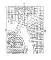
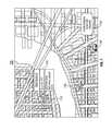
- FIG. 1is a diagram of an example embodiment of a color-coded map displayed on a cellular telephone display according to the present invention.
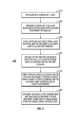
- FIG. 2is a flowchart of an example embodiment of a process for displaying different levels of risk according to the present invention.
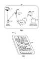
- FIG. 3is a schematic diagram of an example network environment according to the present invention.
- FIG. 5is a diagram of another example embodiment of a color-coded map with detailed crime information displayed on a cellular telephone display according to the present invention.
- FIG. 6is a diagram of yet another example embodiment of a color-coded map with detailed crime information over a time period displayed on a cellular telephone display according to the present invention.
- FIG. 7is a diagram of yet even another example embodiment of a color-coded map displaying a point of interest on a cellular telephone display according to the present invention.
- FIG. 8is a diagram of yet even another example embodiment of a color-coded map displaying on a cellular telephone display and categorizing a danger area based upon a selection of the user according to the present invention.
- an example embodiment of the inventionutilizes a GPS signal to obtain the cellular telephone's present location and then accesses a database of street maps to display a map of the cellular telephone's present location on the cellular telephone's display. Allowing the viewing of historical crime data in this manner aids a user in avoiding a dangerous area and provides a benefit to his safety.
- the applicationaccesses a crime statistics database and a relative level of crime is displayed as a section of the map with different coloration from the rest of the map, such as with red indicating the greatest danger, orange the next greatest, yellow the third and green for a zone of the least danger.
- an example embodiment of the inventionhas a direction providing feature to provide a turn-by-turn direction, which avoids a high crime area.
- the databasecompiles a crime statistic by a zip code and the zip code is further subdivided geographically, if a sufficiently detailed statistic is available.
- Some categories of crime statistics trackedinclude the number of murders, rapes, robberies, assaults, burglaries, thefts, auto thefts and arson that occur.
- statisticsare also tracked by year, which allows a user of an example embodiment of the invention to track whether a neighborhood is “improving” or “worsening” year by year.
- the crime statistics databaseis located in the memory of the cellular telephone and periodically updated with new statistics.
- the databaseis located remotely and is contacted by the cellular telephone each time new data is requested.
- an example embodiment of the inventionwill provide a color-coded map, which displays the likelihood of just the selected types of crimes. For example, whereas an individual interested in buying a house in an area would generally be interested in the number of arsons and burglaries in the area, a person interested in jogging in an area would be interested in the number of assaults, rapes and murders so as to reduce the potential for any harmful encounters. Compilation of statistics in this manner makes an example embodiment of the invention useable not to just travelers, but to many other individuals.
- a customized mapis provided, which displays a color-coded map with different colors, such as the highest level of risk indicated in red, orange the second highest, yellow the third and green the lowest level of risk.
- a point of interestsuch as a police precinct, a fire house and other emergency services as well as telephone numbers to contact them.
- a user of the systemrequests a location of a point of interest
- the requested locationsare displayed as icons on the map. If the user selects the requested location on the smartphone, a window appears with the name of the point of interest, the phone number and the street address. Escape routes in case of a natural disaster are displayed as well, if requested.
- FIG. 1is a diagram of an example embodiment of a color-coded map displayed on a cellular telephone display according to the present invention.
- a street map 100is displayed on a display of a cellular phone. Street map 100 illustrates a present location X 105 and regions 110 , 120 and 130 .
- Street map 100is displayed with the cellular telephone's (and, presumably, a user's) present location marked at “X” 105 on the street map.
- regions 110 , 120 and 130 of the street map 100are shaded with one shading indicating a same relative level of risk for regions 110 , 120 and 130 .
- different regions 110 , 120 and 130 of the street map 100are shaded differently with different shadings indicating different relative levels of risk.
- street map 100is displayed on a cellular telephone display with each region 110 , 120 and 130 having a different color.
- Each colorcorresponds to a tier of risk, such as crime level.
- regions 110 , 120 , 130would appear as different colors indicating tiers of risk, such as with red indicating the highest tier of risk, orange the second highest, yellow the third and green the lowest level.
- FIG. 2is a flowchart of an example embodiment of a process for displaying different levels of risk according to the present invention.
- a process 200includes steps 210 , 220 , 230 , 240 , 250 and 260 .
- Step 210is a software application is started by a user.
- the software applicationis started on a cellular telephone, such as a smartphone.
- Step 220is the software application establishes a present location of the cellular telephone with a location positioning technology, such as GPS or signal triangulation.
- a location positioning technologysuch as GPS or signal triangulation.
- Step 230is the software application accesses a local maps database to retrieve the relevant local maps of the location where the cellular telephone is presently located and the retrieved relevant local maps are loaded into the cellular telephone's memory.
- the softwarewirelessly accesses and retrieves the local maps from the local maps database.
- Step 250is the software application accesses a crime statistics database to retrieve the crime statistics data corresponding to the cellular telephone's present location and the retrieved crime statistics data is loaded into memory of the cellular telephone.
- the local maps data and the crime statistics dataare stored in one database.
- Step 260is the software application overlays different sections of the displayed map in different colors, which indicate the crime rate of the area based upon the loaded crime statistics data.
- displaying sections of the map in different colorsoffers the advantage of being immediately accessible to the user of the system and translates into the immediate ability to avoid dangerous areas.
- FIG. 3is a schematic diagram of an example network environment according to the present invention.
- a network environment 300includes a satellite 315 , a cellular telephone 310 , a cell phone tower 320 , an Internet 330 , a server 340 and a map and crime statistics database 350 .
- Cellular telephone 310obtains its present location by gathering data from global positioning satellite 315 , by triangulating its position with cellular telephone tower 320 or by using a combination of these location positioning methods.
- cellular telephone 310connects with cell phone tower 320 to request the local maps and crime statistics data corresponding to cellular telephone 310 present location.
- the local maps and crime statistics datais obtained by connecting to server 340 via cellular telephone tower 320 connected to Internet 330 .
- a connectionis made with server 340 and the local maps and crime statistics data for the region are downloaded from database 350 via server 340 connected to Internet 330 and via cell phone tower 320 to cellular telephone 310 .
- the local map with tiers of risk corresponding to downloaded crime statistics dataare displayed on the cellular telephone's display 310 .
- the software applicationoverlays different sections of the displayed map in different colors, which indicate the crime rate of the present location based upon the downloaded crime statistics data.
- FIG. 4is a perspective view of an example embodiment of a cellular telephone running a software application according to the present invention.
- a cellular telephone 400displays a map 420 .
- the cellular phoneincludes a liquid crystal display (LCD) and using a zooming means, such as a zoom toolbar or finger actions, the map 420 can be selectively or automatically zoomed-in and zoomed-out, displaying a narrow or wide area of map 420 .
- the software applicationoverlays different sections of the displayed map 420 in different colors, which indicate the crime rate of the present location based upon the downloaded crime statistics data.
- FIG. 5is a diagram of another example embodiment of a color-coded map with detailed crime information displayed on a cellular telephone display according to the present invention.
- a street map 500is displayed on a display of a cellular phone. Street map 500 illustrates a region 520 .
- a window 530is displayed over street map 500 .
- a cursor 510is controllable by a user of the cellular telephone and a movement and a current position of cursor 510 is displayed over street map 500 .
- a portion of cursor 510is transparent. Cursor 510 is dragged across the cellular telephone display highlighting region 520 of street map 500 where crime statistics are available. If cursor 510 is left stationary for a time period, such as a few seconds, over region 520 , window 530 appears on street map 500 .
- Window 530displays detailed crime information about region 520 .
- windows 530displays data corresponding to a number of murders, rapes, robberies, assaults, burglaries, auto thefts or acts of arson in region 520 in the year to date.
- display of window 530provides more detailed information to a user and would be utilized in different ways based upon the needs of the user, such as if the user was interested in jogging in the area versus interested in buying a house in the area.
- FIG. 6is a diagram of yet another example embodiment of a color-coded map with detailed crime information over a time period displayed on a cellular telephone display according to the present invention.
- a street map 600is displayed on a display of a cellular phone. Street map 600 illustrates region 520 .
- a window 630is displayed over street map 600 .
- window 630appears with crime statistics for region 520 for the present year to date as well as for the two previous years, such as 2008 and 2009.
- comparison of the data presentedindicates a higher number of murders, rapes, assaults, auto thefts or arson in the year to date than in the two previous years.
- the data displayed within window 630allows the user to determine that crime in region 520 is worsening and buying a home in the area is probably unwise.
- FIG. 7is a diagram of yet even another example embodiment of a color-coded map displaying a point of interest on a cellular telephone display according to the present invention.
- a street map 700is displayed on a display of a cellular phone. Street map 700 illustrates points of interest, such as a police station location 710 , a fire station location 730 and a hospital location 740 .
- a window 720is displayed over street map 700 .
- a button 750is displayed over street map 700 .
- the buttoncan be pressed via a cursor or a finger action, such as a touch or tap, if the screen is a touchscreen.
- button 750is displayed in a corner of street map 700 . If a user presses button 750 , then information corresponding to emergency escape route from the current position is displayed.
- the emergency escape route informationis travel directions, such as driving or walking directions.
- window 720appears over street map 700 .
- Window 720displays more detailed information, such a name of the point of interest (Police Precinct 63 ) and contact information of the point of interest, such as non-emergency phone number and a street address.
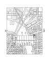
- FIG. 8is a diagram of yet even another example embodiment of a color-coded map displaying on a cellular telephone display and categorizing a danger area based upon a selection of the user according to the present invention.
- a street map 800is displayed on a display of a cellular phone. Street map 800 illustrates regions 810 , 820 and 830 .
- a window 890is displayed over street map 800 .
- a display button 895is displayed within window 890 .
- a label and a corresponding checkboxare also displayed within window 890 .
- the software application displaying street map 800allows a user to select which statistics the user is interested in tracking.
- the selectable statistics to trackare displayed within window 890 via the labels.
- the labelsare selectable via the corresponding checkboxes, which are also displayed within window 890 .
- the selectable statisticsare a number of murders, rapes, robberies, acts of arson, assaults or auto thefts.
- the usermade a selection within window 890 to display a number of robberies, acts of arson and burglaries within street map 800 .
- Each display color or shadingis substantially consistent with the retrieved and loaded crime statistics data corresponding to the cellular telephone present location.
- an embodiment of the inventiontracks only the statistics requested and then displays different shadings on street map 800 indicating level of risk based only upon statistics for regions 810 , 820 , 830 .
- the displayed selectionsare consistent with a user who is interested in buying a house in the area since the displayed selections are primarily threats against real property.
- a user interested in joggingsuch as a jogger
- in at least one of regions 810 , 820 and 830would be interested in personal safety statistics, such as murders, rapes, assaults, but would not be interested in crimes against real property.
- a joggerfor example may select checkboxes corresponding to labels matching statistics relating to personal safety statistics and unselect checkboxes corresponding to labels matching statistics relating to crimes against real property.
- the software applicationwill display different color overlays over regions 810 , 820 and 830 of street map 800 .
- Each colorcorresponds to a tier of risk, such as crime level with, for example, red, indicating the highest level of risk of the statistics requested, orange the second highest, yellow the third, and green the lowest level or risk.
- regions 810 , 820 and 830would appear as different colors indicating tiers of risk.
- aspects of the present inventionmay be embodied as a system, method or computer program product. Accordingly, aspects of the present invention may take the form of an entirely hardware embodiment, an entirely software embodiment (including firmware, resident software, micro-code, etc.) or an embodiment combining software and hardware aspects that may all generally be referred to herein as a “circuit,” “module” or “system.” Furthermore, aspects of the present invention may take the form of a computer program product embodied in one or more computer readable medium(s) having computer readable program code embodied thereon.
- the computer readable mediummay be a computer readable signal medium or a computer readable storage medium.
- a computer readable storage mediummay be, for example, but not limited to, an electronic, magnetic, optical, electromagnetic, infrared, or semiconductor system, apparatus, or device, or any suitable combination of the foregoing.
- a computer readable storage mediummay be any tangible medium that can contain, or store a program for use by or in connection with an instruction execution system, apparatus or device.
- a computer readable signal mediummay include a propagated data signal with computer readable program code embodied therein, for example, in baseband or as part of a carrier wave. Such a propagated signal may take any of a variety of forms, including, but not limited to, electro-magnetic, optical, or any suitable combination thereof.
- a computer readable signal mediummay be any computer readable medium that is not a computer readable storage medium and that can communicate, propagate or transport a program for use by or in connection with an instruction execution system, apparatus or device.
- Program code embodied on a computer readable mediummay be transmitted using any appropriate medium, including but not limited to wireless, wireline, optical fiber cable, RF, etc., or any suitable combination of the foregoing.
- Computer program code for carrying out operations for aspects of the present inventionmay be written in any combination of one or more programming languages, including an object oriented programming language such as Java, Smalltalk, C++ or the like and conventional procedural programming languages, such as the “C” programming language or similar programming languages.
- the program codemay execute entirely on the user's computer, partly on the user's computer, as a stand-alone software package, partly on the user's computer and partly on a remote computer or entirely on the remote computer or server.
- the remote computermay be connected to the user's computer through any type of network, including a local area network (LAN) or a wide area network (WAN), or the connection may be made to an external computer (for example, through the Internet using an Internet Service Provider).
- LANlocal area network
- WANwide area network
- Internet Service Providerfor example, AT&T, MCI, Sprint, EarthLink, MSN, GTE, etc.
- These computer program instructionsmay also be stored in a computer readable medium that can direct a computer, other programmable data processing apparatus, or other devices to function in a particular manner, such that the instructions stored in the computer readable medium produce an article of manufacture including instructions which implement the function/act specified in the flowchart and/or block diagram block or blocks.
- the computer program instructionsmay also be loaded onto a computer, other programmable data processing apparatus, or other devices to cause a series of operational steps to be performed on the computer, other programmable apparatus or other devices to produce a computer implemented process such that the instructions which execute on the computer or other programmable apparatus provide processes for implementing the functions/acts specified in the flowchart and/or block diagram block or blocks.
- each block in the flowchart or block diagramsmay represent a module, segment, or portion of code, which comprises one or more executable instructions for implementing the specified logical function(s).
- the functions noted in the blockmay occur out of the order noted in the figures. For example, two blocks shown in succession may, in fact, be executed substantially concurrently, or the blocks may sometimes be executed in the reverse order, depending upon the functionality involved.
Landscapes
- Engineering & Computer Science (AREA)
- Radar, Positioning & Navigation (AREA)
- Remote Sensing (AREA)
- Physics & Mathematics (AREA)
- General Physics & Mathematics (AREA)
- Theoretical Computer Science (AREA)
- Automation & Control Theory (AREA)
- Mathematical Physics (AREA)
- Business, Economics & Management (AREA)
- Educational Administration (AREA)
- Educational Technology (AREA)
- Instructional Devices (AREA)
Abstract
Description
Claims (36)
Priority Applications (1)
| Application Number | Priority Date | Filing Date | Title |
|---|---|---|---|
| US13/197,432US8433344B1 (en) | 2010-08-12 | 2011-08-03 | Displaying a tier of risk in a region of a map displayed via a mobile computing device |
Applications Claiming Priority (2)
| Application Number | Priority Date | Filing Date | Title |
|---|---|---|---|
| US37299110P | 2010-08-12 | 2010-08-12 | |
| US13/197,432US8433344B1 (en) | 2010-08-12 | 2011-08-03 | Displaying a tier of risk in a region of a map displayed via a mobile computing device |
Publications (1)
| Publication Number | Publication Date |
|---|---|
| US8433344B1true US8433344B1 (en) | 2013-04-30 |
Family
ID=48146129
Family Applications (1)
| Application Number | Title | Priority Date | Filing Date |
|---|---|---|---|
| US13/197,432Expired - Fee RelatedUS8433344B1 (en) | 2010-08-12 | 2011-08-03 | Displaying a tier of risk in a region of a map displayed via a mobile computing device |
Country Status (1)
| Country | Link |
|---|---|
| US (1) | US8433344B1 (en) |
Cited By (41)
| Publication number | Priority date | Publication date | Assignee | Title |
|---|---|---|---|---|
| US8914044B2 (en)* | 2012-05-18 | 2014-12-16 | Verizon Patent And Licensing Inc. | Method and system for associating context information with defined location data |
| US20150074132A1 (en)* | 2013-09-10 | 2015-03-12 | Pigeon.LY | Methods and systems for inmate searching |
| WO2015081760A1 (en)* | 2013-12-06 | 2015-06-11 | International Business Machines Corporation | Smart device safety mechanism |
| US9560482B1 (en) | 2015-12-09 | 2017-01-31 | Honeywell International Inc. | User or automated selection of enhanced geo-fencing |
| US9574884B1 (en)* | 2015-09-22 | 2017-02-21 | Cerner Innovation, Inc. | Providing a route through a predefined space |
| US20170059344A1 (en)* | 2015-08-31 | 2017-03-02 | Ariel Inventions, Llc | System, method, and device for routing through crime areas |
| US20170075646A1 (en)* | 2015-09-16 | 2017-03-16 | International Business Machines Corporation | Digital Map of a Physical Location Based on a User's Field of Interest and a Specific Sound Pattern |
| US9609478B2 (en) | 2015-04-27 | 2017-03-28 | Honeywell International Inc. | Geo-fencing with diagnostic feature |
| US9610853B1 (en)* | 2015-09-24 | 2017-04-04 | Ford Global Technologies, Llc | Identification of acceptable vehicle charge stations |
| US9628951B1 (en) | 2015-11-11 | 2017-04-18 | Honeywell International Inc. | Methods and systems for performing geofencing with reduced power consumption |
| US9651385B2 (en) | 2015-09-22 | 2017-05-16 | Cerner Innovation, Inc. | Providing a route through a predefined space |
| US20170153790A1 (en)* | 2015-11-30 | 2017-06-01 | Honeywell International Inc. | Incident management using a mobile device |
| WO2017102329A1 (en)* | 2015-12-17 | 2017-06-22 | Jaguar Land Rover Limited | Vehicle navigation system that includes safety information |
| US9860697B2 (en) | 2015-12-09 | 2018-01-02 | Honeywell International Inc. | Methods and systems for automatic adjustment of a geofence size |
| WO2018009400A1 (en)* | 2016-07-07 | 2018-01-11 | Motorola Solutions, Inc. | Method and apparatus for visualizing crime deterrent effects |
| US20180027064A1 (en)* | 2015-02-19 | 2018-01-25 | Agoop Corp. | Program and statistical processing system |
| US9900174B2 (en) | 2015-03-06 | 2018-02-20 | Honeywell International Inc. | Multi-user geofencing for building automation |
| EP3198576A4 (en)* | 2014-09-26 | 2018-02-28 | McAfee, LLC | Context-aware reputation of a place |
| US9967391B2 (en) | 2015-03-25 | 2018-05-08 | Honeywell International Inc. | Geo-fencing in a building automation system |
| US10057110B2 (en) | 2015-11-06 | 2018-08-21 | Honeywell International Inc. | Site management system with dynamic site threat level based on geo-location data |
| US10063387B2 (en) | 2012-08-07 | 2018-08-28 | Honeywell International Inc. | Method for controlling an HVAC system using a proximity aware mobile device |
| US20180293483A1 (en)* | 2017-04-11 | 2018-10-11 | Microsoft Technology Licensing, Llc | Creating a Conversational Chat Bot of a Specific Person |
| US10306403B2 (en) | 2016-08-03 | 2019-05-28 | Honeywell International Inc. | Location based dynamic geo-fencing system for security |
| US10302322B2 (en) | 2016-07-22 | 2019-05-28 | Ademco Inc. | Triage of initial schedule setup for an HVAC controller |
| US10317102B2 (en) | 2017-04-18 | 2019-06-11 | Ademco Inc. | Geofencing for thermostatic control |
| US10488062B2 (en) | 2016-07-22 | 2019-11-26 | Ademco Inc. | Geofence plus schedule for a building controller |
| US10516965B2 (en) | 2015-11-11 | 2019-12-24 | Ademco Inc. | HVAC control using geofencing |
| US10534331B2 (en) | 2013-12-11 | 2020-01-14 | Ademco Inc. | Building automation system with geo-fencing |
| US10605472B2 (en) | 2016-02-19 | 2020-03-31 | Ademco Inc. | Multiple adaptive geo-fences for a building |
| US10802469B2 (en) | 2015-04-27 | 2020-10-13 | Ademco Inc. | Geo-fencing with diagnostic feature |
| US10802459B2 (en) | 2015-04-27 | 2020-10-13 | Ademco Inc. | Geo-fencing with advanced intelligent recovery |
| US10909215B2 (en) | 2015-11-18 | 2021-02-02 | Global Specimen Solutions, Inc. | Method and system for codification, tracking, and use of informed consent data for human specimen research |
| US11163434B2 (en) | 2019-01-24 | 2021-11-02 | Ademco Inc. | Systems and methods for using augmenting reality to control a connected home system |
| US12277616B2 (en) | 2022-04-20 | 2025-04-15 | State Farm Mutual Automobile Insurance Company | Systems and methods for generating a home score for a user |
| US12313414B2 (en) | 2016-01-22 | 2025-05-27 | State Farm Mutual Automobile Insurance Company | Autonomous vehicle application |
| US12315024B2 (en) | 2022-04-20 | 2025-05-27 | State Farm Mutual Automobile Insurance Company | Systems and methods for generating a home score for a user |
| US12400274B2 (en) | 2016-06-23 | 2025-08-26 | State Farm Mutual Automobile Insurance Company | Systems and methods for analyzing property telematics data to update risk-based coverage of a property |
| US12423755B2 (en) | 2023-04-10 | 2025-09-23 | State Farm Mutual Automobile Insurance Company | Augmented reality system to provide recommendation to repair or replace an existing device to improve home score |
| US12424836B2 (en) | 2016-10-27 | 2025-09-23 | State Farm Mutual Automobile Insurance Company | Systems and methods for utilizing electricity monitoring devices to reconstruct an electrical event |
| US12437865B2 (en) | 2020-07-09 | 2025-10-07 | State Farm Mutual Automobile Insurance Company | Systems and methods for home health evaluation and remediation |
| US12444499B2 (en) | 2024-07-03 | 2025-10-14 | State Farm Mutual Automobile Insurance Company | Systems and methods for home health evaluation and remediation |
Citations (17)
| Publication number | Priority date | Publication date | Assignee | Title |
|---|---|---|---|---|
| US6175803B1 (en)* | 1998-08-04 | 2001-01-16 | Ford Global Technologies, Inc. | Vehicle navigation route generation with user selectable risk avoidance |
| US20030006913A1 (en) | 2001-07-03 | 2003-01-09 | Joyce Dennis P. | Location-based content delivery |
| US7109859B2 (en) | 2002-12-23 | 2006-09-19 | Gentag, Inc. | Method and apparatus for wide area surveillance of a terrorist or personal threat |
| US20060247852A1 (en)* | 2005-04-29 | 2006-11-02 | Kortge James M | System and method for providing safety-optimized navigation route planning |
| US7149533B2 (en)* | 2003-10-01 | 2006-12-12 | Laird Mark D | Wireless virtual campus escort system |
| US7191097B1 (en) | 2004-03-31 | 2007-03-13 | United States Of America | Method, apparatus, and system for assessing conditions |
| US7236100B2 (en) | 1997-06-20 | 2007-06-26 | American Calcar, Inc. | Personal communication and positioning system |
| US7321826B2 (en) | 2001-08-16 | 2008-01-22 | Networks In Motion, Inc. | Point on interest spatial rating search |
| US7345628B2 (en) | 2002-12-16 | 2008-03-18 | Koninklijke Philips Electronics N.V. | Location dependent display of information for GPS devices |
| US20080094230A1 (en) | 2006-10-23 | 2008-04-24 | Motorola, Inc. | Using location capabilities of a mobile device to permit users to avoid potentially harmful interactions |
| US20090157302A1 (en)* | 2007-12-14 | 2009-06-18 | Microsoft Corporation | Pedestrian route production |
| US7650234B2 (en) | 1999-10-19 | 2010-01-19 | American Calcar Inc. | Technique for effective navigation based on user preferences |
| US20100036599A1 (en) | 2008-08-11 | 2010-02-11 | RM Acquisition, LLC d/b/a/ Rand McNally | Safest transportation routing |
| US20100036610A1 (en)* | 2006-06-11 | 2010-02-11 | Volvo Technology Corp | Method and arrangement for reducing criminal risk to an overland transport |
| US7702455B2 (en) | 1997-06-20 | 2010-04-20 | American Calcar, Inc. | Personal communication system to send and receive voice data positioning information |
| US20100100319A1 (en)* | 2007-04-25 | 2010-04-22 | Thomas Trinko | Mobile Navigation System with Graphic Crime-Risk Display |
| US20110099180A1 (en)* | 2009-10-22 | 2011-04-28 | Nokia Corporation | Method and apparatus for searching geo-tagged information |
- 2011
- 2011-08-03USUS13/197,432patent/US8433344B1/ennot_activeExpired - Fee Related
Patent Citations (17)
| Publication number | Priority date | Publication date | Assignee | Title |
|---|---|---|---|---|
| US7702455B2 (en) | 1997-06-20 | 2010-04-20 | American Calcar, Inc. | Personal communication system to send and receive voice data positioning information |
| US7236100B2 (en) | 1997-06-20 | 2007-06-26 | American Calcar, Inc. | Personal communication and positioning system |
| US6175803B1 (en)* | 1998-08-04 | 2001-01-16 | Ford Global Technologies, Inc. | Vehicle navigation route generation with user selectable risk avoidance |
| US7650234B2 (en) | 1999-10-19 | 2010-01-19 | American Calcar Inc. | Technique for effective navigation based on user preferences |
| US20030006913A1 (en) | 2001-07-03 | 2003-01-09 | Joyce Dennis P. | Location-based content delivery |
| US7321826B2 (en) | 2001-08-16 | 2008-01-22 | Networks In Motion, Inc. | Point on interest spatial rating search |
| US7345628B2 (en) | 2002-12-16 | 2008-03-18 | Koninklijke Philips Electronics N.V. | Location dependent display of information for GPS devices |
| US7109859B2 (en) | 2002-12-23 | 2006-09-19 | Gentag, Inc. | Method and apparatus for wide area surveillance of a terrorist or personal threat |
| US7149533B2 (en)* | 2003-10-01 | 2006-12-12 | Laird Mark D | Wireless virtual campus escort system |
| US7191097B1 (en) | 2004-03-31 | 2007-03-13 | United States Of America | Method, apparatus, and system for assessing conditions |
| US20060247852A1 (en)* | 2005-04-29 | 2006-11-02 | Kortge James M | System and method for providing safety-optimized navigation route planning |
| US20100036610A1 (en)* | 2006-06-11 | 2010-02-11 | Volvo Technology Corp | Method and arrangement for reducing criminal risk to an overland transport |
| US20080094230A1 (en) | 2006-10-23 | 2008-04-24 | Motorola, Inc. | Using location capabilities of a mobile device to permit users to avoid potentially harmful interactions |
| US20100100319A1 (en)* | 2007-04-25 | 2010-04-22 | Thomas Trinko | Mobile Navigation System with Graphic Crime-Risk Display |
| US20090157302A1 (en)* | 2007-12-14 | 2009-06-18 | Microsoft Corporation | Pedestrian route production |
| US20100036599A1 (en) | 2008-08-11 | 2010-02-11 | RM Acquisition, LLC d/b/a/ Rand McNally | Safest transportation routing |
| US20110099180A1 (en)* | 2009-10-22 | 2011-04-28 | Nokia Corporation | Method and apparatus for searching geo-tagged information |
Cited By (59)
| Publication number | Priority date | Publication date | Assignee | Title |
|---|---|---|---|---|
| US8914044B2 (en)* | 2012-05-18 | 2014-12-16 | Verizon Patent And Licensing Inc. | Method and system for associating context information with defined location data |
| US10063387B2 (en) | 2012-08-07 | 2018-08-28 | Honeywell International Inc. | Method for controlling an HVAC system using a proximity aware mobile device |
| US20150074132A1 (en)* | 2013-09-10 | 2015-03-12 | Pigeon.LY | Methods and systems for inmate searching |
| WO2015081760A1 (en)* | 2013-12-06 | 2015-06-11 | International Business Machines Corporation | Smart device safety mechanism |
| US9390607B2 (en) | 2013-12-06 | 2016-07-12 | International Business Machines Corporation | Smart device safety mechanism |
| US10591877B2 (en) | 2013-12-11 | 2020-03-17 | Ademco Inc. | Building automation remote control device with an in-application tour |
| US10534331B2 (en) | 2013-12-11 | 2020-01-14 | Ademco Inc. | Building automation system with geo-fencing |
| US10768589B2 (en) | 2013-12-11 | 2020-09-08 | Ademco Inc. | Building automation system with geo-fencing |
| US10712718B2 (en) | 2013-12-11 | 2020-07-14 | Ademco Inc. | Building automation remote control device with in-application messaging |
| EP3198576A4 (en)* | 2014-09-26 | 2018-02-28 | McAfee, LLC | Context-aware reputation of a place |
| US11397761B2 (en)* | 2014-09-26 | 2022-07-26 | Mcafee, Llc | Context-aware reputation of a place |
| US20180027064A1 (en)* | 2015-02-19 | 2018-01-25 | Agoop Corp. | Program and statistical processing system |
| US9900174B2 (en) | 2015-03-06 | 2018-02-20 | Honeywell International Inc. | Multi-user geofencing for building automation |
| US10674004B2 (en) | 2015-03-25 | 2020-06-02 | Ademco Inc. | Geo-fencing in a building automation system |
| US10462283B2 (en) | 2015-03-25 | 2019-10-29 | Ademco Inc. | Geo-fencing in a building automation system |
| US9967391B2 (en) | 2015-03-25 | 2018-05-08 | Honeywell International Inc. | Geo-fencing in a building automation system |
| US10802469B2 (en) | 2015-04-27 | 2020-10-13 | Ademco Inc. | Geo-fencing with diagnostic feature |
| US9826357B2 (en) | 2015-04-27 | 2017-11-21 | Honeywell International Inc. | Geo-fencing with diagnostic feature |
| US10802459B2 (en) | 2015-04-27 | 2020-10-13 | Ademco Inc. | Geo-fencing with advanced intelligent recovery |
| US9609478B2 (en) | 2015-04-27 | 2017-03-28 | Honeywell International Inc. | Geo-fencing with diagnostic feature |
| US20170059344A1 (en)* | 2015-08-31 | 2017-03-02 | Ariel Inventions, Llc | System, method, and device for routing through crime areas |
| US9715366B2 (en)* | 2015-09-16 | 2017-07-25 | International Business Machines Corporation | Digital map of a physical location based on a user's field of interest and a specific sound pattern |
| US20170075646A1 (en)* | 2015-09-16 | 2017-03-16 | International Business Machines Corporation | Digital Map of a Physical Location Based on a User's Field of Interest and a Specific Sound Pattern |
| US9574884B1 (en)* | 2015-09-22 | 2017-02-21 | Cerner Innovation, Inc. | Providing a route through a predefined space |
| US9651385B2 (en) | 2015-09-22 | 2017-05-16 | Cerner Innovation, Inc. | Providing a route through a predefined space |
| CN106985682A (en)* | 2015-09-24 | 2017-07-28 | 福特全球技术公司 | The identification of qualified vehicular charging station |
| US9610853B1 (en)* | 2015-09-24 | 2017-04-04 | Ford Global Technologies, Llc | Identification of acceptable vehicle charge stations |
| US10057110B2 (en) | 2015-11-06 | 2018-08-21 | Honeywell International Inc. | Site management system with dynamic site threat level based on geo-location data |
| US10271284B2 (en) | 2015-11-11 | 2019-04-23 | Honeywell International Inc. | Methods and systems for performing geofencing with reduced power consumption |
| US9628951B1 (en) | 2015-11-11 | 2017-04-18 | Honeywell International Inc. | Methods and systems for performing geofencing with reduced power consumption |
| US10516965B2 (en) | 2015-11-11 | 2019-12-24 | Ademco Inc. | HVAC control using geofencing |
| US12087411B2 (en) | 2015-11-18 | 2024-09-10 | Global Specimen Solutions, Inc. | Method and system for codification, tracking, and use of informed consent data for human specimen research |
| US10909215B2 (en) | 2015-11-18 | 2021-02-02 | Global Specimen Solutions, Inc. | Method and system for codification, tracking, and use of informed consent data for human specimen research |
| US20170153790A1 (en)* | 2015-11-30 | 2017-06-01 | Honeywell International Inc. | Incident management using a mobile device |
| US9860697B2 (en) | 2015-12-09 | 2018-01-02 | Honeywell International Inc. | Methods and systems for automatic adjustment of a geofence size |
| US9560482B1 (en) | 2015-12-09 | 2017-01-31 | Honeywell International Inc. | User or automated selection of enhanced geo-fencing |
| US10021520B2 (en) | 2015-12-09 | 2018-07-10 | Honeywell International Inc. | User or automated selection of enhanced geo-fencing |
| WO2017102329A1 (en)* | 2015-12-17 | 2017-06-22 | Jaguar Land Rover Limited | Vehicle navigation system that includes safety information |
| US12313414B2 (en) | 2016-01-22 | 2025-05-27 | State Farm Mutual Automobile Insurance Company | Autonomous vehicle application |
| US12345536B2 (en) | 2016-01-22 | 2025-07-01 | State Farm Mutual Automobile Insurance Company | Smart home sensor malfunction detection |
| US12359927B2 (en) | 2016-01-22 | 2025-07-15 | State Farm Mutual Automobile Insurance Company | Autonomous vehicle component maintenance and repair |
| US10605472B2 (en) | 2016-02-19 | 2020-03-31 | Ademco Inc. | Multiple adaptive geo-fences for a building |
| US12400274B2 (en) | 2016-06-23 | 2025-08-26 | State Farm Mutual Automobile Insurance Company | Systems and methods for analyzing property telematics data to update risk-based coverage of a property |
| WO2018009400A1 (en)* | 2016-07-07 | 2018-01-11 | Motorola Solutions, Inc. | Method and apparatus for visualizing crime deterrent effects |
| US10048918B2 (en) | 2016-07-07 | 2018-08-14 | Motorola Solutions, Inc. | Method and apparatus for visualizing crime deterrent effects |
| GB2565727A (en)* | 2016-07-07 | 2019-02-20 | Motorola Solutions Inc | Method and apparatus for visualizing crime deterrent effects |
| US10488062B2 (en) | 2016-07-22 | 2019-11-26 | Ademco Inc. | Geofence plus schedule for a building controller |
| US10302322B2 (en) | 2016-07-22 | 2019-05-28 | Ademco Inc. | Triage of initial schedule setup for an HVAC controller |
| US10306403B2 (en) | 2016-08-03 | 2019-05-28 | Honeywell International Inc. | Location based dynamic geo-fencing system for security |
| US12424836B2 (en) | 2016-10-27 | 2025-09-23 | State Farm Mutual Automobile Insurance Company | Systems and methods for utilizing electricity monitoring devices to reconstruct an electrical event |
| US10853717B2 (en)* | 2017-04-11 | 2020-12-01 | Microsoft Technology Licensing, Llc | Creating a conversational chat bot of a specific person |
| US20180293483A1 (en)* | 2017-04-11 | 2018-10-11 | Microsoft Technology Licensing, Llc | Creating a Conversational Chat Bot of a Specific Person |
| US10317102B2 (en) | 2017-04-18 | 2019-06-11 | Ademco Inc. | Geofencing for thermostatic control |
| US11163434B2 (en) | 2019-01-24 | 2021-11-02 | Ademco Inc. | Systems and methods for using augmenting reality to control a connected home system |
| US12437865B2 (en) | 2020-07-09 | 2025-10-07 | State Farm Mutual Automobile Insurance Company | Systems and methods for home health evaluation and remediation |
| US12315024B2 (en) | 2022-04-20 | 2025-05-27 | State Farm Mutual Automobile Insurance Company | Systems and methods for generating a home score for a user |
| US12277616B2 (en) | 2022-04-20 | 2025-04-15 | State Farm Mutual Automobile Insurance Company | Systems and methods for generating a home score for a user |
| US12423755B2 (en) | 2023-04-10 | 2025-09-23 | State Farm Mutual Automobile Insurance Company | Augmented reality system to provide recommendation to repair or replace an existing device to improve home score |
| US12444499B2 (en) | 2024-07-03 | 2025-10-14 | State Farm Mutual Automobile Insurance Company | Systems and methods for home health evaluation and remediation |
Similar Documents
| Publication | Publication Date | Title |
|---|---|---|
| US8433344B1 (en) | Displaying a tier of risk in a region of a map displayed via a mobile computing device | |
| EP3372975B1 (en) | Leak detection for fluid distribution networks using hyperspectral imaging | |
| US20220014895A1 (en) | Spatiotemporal analysis for emergency response | |
| CN110869922B (en) | Map user interaction based on temporal proximity | |
| US20150163626A1 (en) | Monitoring system, server, mobile device and method | |
| EP3803774A1 (en) | Systems and user interfaces for emergency data integration | |
| AU2017219142A1 (en) | Location Based Augmented Reality Property Listing Method, Software and System | |
| US20160187310A1 (en) | Image Based Surveillance System | |
| US20180089869A1 (en) | System and Method For Previewing Indoor Views Using Augmented Reality | |
| CN107533421A (en) | Pair position entities associated with the current geographic position of mobile device disappear the system and method for qi | |
| US20130305171A1 (en) | Investigative system and method for visualizing and navigating dynamic relationships | |
| US12435988B2 (en) | User feedback interfaces for map location entry points | |
| US20190186946A1 (en) | Travel time mapping using isochrones | |
| US20250056199A1 (en) | Systems & methods for enhanced emergency data sharing | |
| RU2691223C2 (en) | Personal logic opportunities platform | |
| US12039672B2 (en) | Presenting labels in augmented reality | |
| US12432319B2 (en) | System for associating a digital map with a video feed, and method of use thereof | |
| US20220269397A1 (en) | Systems and methods for interactive maps | |
| US20240355058A1 (en) | Presenting Labels In Augmented Reality | |
| Ranasinghe et al. | Pedestrian navigation and GPS deteriorations: User behavior and adaptation strategies | |
| US11709063B2 (en) | Method and system for rendering a safe navigation route | |
| JP2016024823A (en) | Data structures for sensor-based detection systems | |
| WO2023116484A1 (en) | Video acquisition method and apparatus, information display method and apparatus, and device and medium | |
| JP2016024822A (en) | Sensor grouping for sensor-based detection systems | |
| US20160379386A1 (en) | User orientation when working with spatial data on a mapping interface |
Legal Events
| Date | Code | Title | Description |
|---|---|---|---|
| STCF | Information on status: patent grant | Free format text:PATENTED CASE | |
| FEPP | Fee payment procedure | Free format text:PATENT HOLDER CLAIMS MICRO ENTITY STATUS, ENTITY STATUS SET TO MICRO (ORIGINAL EVENT CODE: STOM); ENTITY STATUS OF PATENT OWNER: MICROENTITY | |
| FPAY | Fee payment | Year of fee payment:4 | |
| FEPP | Fee payment procedure | Free format text:MAINTENANCE FEE REMINDER MAILED (ORIGINAL EVENT CODE: REM.); ENTITY STATUS OF PATENT OWNER: MICROENTITY | |
| FEPP | Fee payment procedure | Free format text:SURCHARGE FOR LATE PAYMENT, MICRO ENTITY (ORIGINAL EVENT CODE: M3555); ENTITY STATUS OF PATENT OWNER: MICROENTITY | |
| MAFP | Maintenance fee payment | Free format text:PAYMENT OF MAINTENANCE FEE, 8TH YEAR, MICRO ENTITY (ORIGINAL EVENT CODE: M3552); ENTITY STATUS OF PATENT OWNER: MICROENTITY Year of fee payment:8 | |
| FEPP | Fee payment procedure | Free format text:MAINTENANCE FEE REMINDER MAILED (ORIGINAL EVENT CODE: REM.); ENTITY STATUS OF PATENT OWNER: MICROENTITY | |
| LAPS | Lapse for failure to pay maintenance fees | Free format text:PATENT EXPIRED FOR FAILURE TO PAY MAINTENANCE FEES (ORIGINAL EVENT CODE: EXP.); ENTITY STATUS OF PATENT OWNER: MICROENTITY | |
| STCH | Information on status: patent discontinuation | Free format text:PATENT EXPIRED DUE TO NONPAYMENT OF MAINTENANCE FEES UNDER 37 CFR 1.362 | |
| FP | Lapsed due to failure to pay maintenance fee | Effective date:20250430 |