US8396658B2 - Probabilistic reverse geocoding - Google Patents
Probabilistic reverse geocodingDownload PDFInfo
- Publication number
- US8396658B2 US8396658B2US12/588,143US58814309AUS8396658B2US 8396658 B2US8396658 B2US 8396658B2US 58814309 AUS58814309 AUS 58814309AUS 8396658 B2US8396658 B2US 8396658B2
- Authority
- US
- United States
- Prior art keywords
- route
- location
- user
- navigation device
- wireless navigation
- Prior art date
- Legal status (The legal status is an assumption and is not a legal conclusion. Google has not performed a legal analysis and makes no representation as to the accuracy of the status listed.)
- Expired - Fee Related, expires
Links
Images


Classifications
- G—PHYSICS
- G01—MEASURING; TESTING
- G01C—MEASURING DISTANCES, LEVELS OR BEARINGS; SURVEYING; NAVIGATION; GYROSCOPIC INSTRUMENTS; PHOTOGRAMMETRY OR VIDEOGRAMMETRY
- G01C21/00—Navigation; Navigational instruments not provided for in groups G01C1/00 - G01C19/00
- G01C21/26—Navigation; Navigational instruments not provided for in groups G01C1/00 - G01C19/00 specially adapted for navigation in a road network
- G01C21/34—Route searching; Route guidance
- G—PHYSICS
- G01—MEASURING; TESTING
- G01C—MEASURING DISTANCES, LEVELS OR BEARINGS; SURVEYING; NAVIGATION; GYROSCOPIC INSTRUMENTS; PHOTOGRAMMETRY OR VIDEOGRAMMETRY
- G01C21/00—Navigation; Navigational instruments not provided for in groups G01C1/00 - G01C19/00
- G01C21/26—Navigation; Navigational instruments not provided for in groups G01C1/00 - G01C19/00 specially adapted for navigation in a road network
- G01C21/28—Navigation; Navigational instruments not provided for in groups G01C1/00 - G01C19/00 specially adapted for navigation in a road network with correlation of data from several navigational instruments
- G01C21/30—Map- or contour-matching
- G—PHYSICS
- G01—MEASURING; TESTING
- G01C—MEASURING DISTANCES, LEVELS OR BEARINGS; SURVEYING; NAVIGATION; GYROSCOPIC INSTRUMENTS; PHOTOGRAMMETRY OR VIDEOGRAMMETRY
- G01C21/00—Navigation; Navigational instruments not provided for in groups G01C1/00 - G01C19/00
- G01C21/20—Instruments for performing navigational calculations
- G—PHYSICS
- G01—MEASURING; TESTING
- G01C—MEASURING DISTANCES, LEVELS OR BEARINGS; SURVEYING; NAVIGATION; GYROSCOPIC INSTRUMENTS; PHOTOGRAMMETRY OR VIDEOGRAMMETRY
- G01C21/00—Navigation; Navigational instruments not provided for in groups G01C1/00 - G01C19/00
- G01C21/26—Navigation; Navigational instruments not provided for in groups G01C1/00 - G01C19/00 specially adapted for navigation in a road network
- G01C21/34—Route searching; Route guidance
- G01C21/3407—Route searching; Route guidance specially adapted for specific applications
- G01C21/3415—Dynamic re-routing, e.g. recalculating the route when the user deviates from calculated route or after detecting real-time traffic data or accidents
Definitions
- This inventionrelates generally to wireless communication. More particularly it relates to route guidance (navigation) on a mobile wireless device including global positioning satellite (GPS) capability.
- GPSglobal positioning satellite
- Navigation devicesare typically GPS-based electronic systems used in a vehicle to provide a real-time map of the vehicle's current location, together with step-by-step directions to a requested destination.
- All navigation devicesmust handle the condition in which the user deviates (leaves) their intended route.
- the applicationtypically determines the user's current location by “reverse geocoding” the last GPS fix from the device. This new current location is then used to generate a new route to the original destination.
- Reverse geocodingis a process of returning an estimated position on a street as it relates to a given latitude/longitude coordinate.
- Mobile applications available todayuse a simple reverse geocoding algorithm to locate the closest point on any road segment near the GPS coordinate received from the device.
- a method of providing an accurate location to a portable navigation device in a congested area when in an off-route conditioncomprises obtaining a latest location fix of the user's wireless navigation device, the latest location fix being off-route.
- a last known on-route location of a user's wireless navigation deviceis obtained.
- An elapsed time between the last known on-route location and the latest location fixis determined.
- a reverse geocodeis performed on the latest location fix resulting in a plurality of potential location candidates.
- An estimated time of travel from the last known on-route location to each of the potential location candidatesis determined, and a current location of the user's wireless navigation device is mapped as the potential location candidate having a travel time closest to the elapsed time.
- a method of providing navigation server-based support for a wireless navigation device in accordance with another aspect of the inventioncomprises considering together a user wireless device's last known on-route location, a latest GPS fix of the user's wireless device, and an elapsed time between the last known location on the original route and the latest GPS fix. A likelihood that the users wireless device could have traveled from the last known on-route location on the original route to one of a plurality of candidate locations generated from a reverse geocode, in the elapsed time, is determined.
- mapping informationis provided based on a current location of the user's wireless navigation device being determined as being the potential location candidate that has an estimated time of travel closest to the elapsed time.
- FIG. 1shows an exemplary mobile phone including a user interface providing route guidance navigation, as a user goes off route, in accordance with the principles of the present invention.
- FIG. 2shows an exemplary method providing probabilistic reverse geocoding for a user of a mobile phone with an operating route guidance navigation interface, in accordance with the principles of the present invention.
- FIG. 3shows a graphical depiction of a list of candidate reverse geocodes generated by a current GPS fix, each being a point on a road segment near the actual latitude/longitude, in accordance with the principles of the present invention.
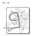
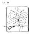
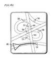
- FIGS. 4A to 4Gshow a route generated between the last known location and each respective candidate reverse geocode result shown in FIG. 3 .
- Car navigation systemstypically employ superior GPS technology, gyros and actual vehicle speed to determine a vehicle's current position more accurately. But more recently navigation applications have become available on wireless phones. However, mobile phones don't have access to a directly measured speed of a vehicle as do installed car navigation systems. Moreover, the antenna of a mobile phone may not be in an ideal position as are the antennas for an installed car navigation system. While very good, inaccuracies in the measurement of a current location may lead to an erroneous mapping onto a road in a mobile phone navigation application, particularly in areas where many roads intersect. In a worse case, such inaccuracies can result in mapping of a vehicle on a wrong road.
- the present inventorshave discovered that the accuracy of a reverse geocode can be improved significantly by considering together the user's last known location on the original route, the elapsed time between the last known location on the original route and the latest GPS fix, and the likelihood that the user could have traveled from the last known location on the original route to one of numerous candidate locations (generated from the reverse geocode) in the elapsed time.
- the present inventionprovides an alternative approach to reverse geocoding that relies only on a GPS fix, timestamps, and a back-end routing database.
- the present inventionprovides improved or superior accuracy of reverse geocoding a GPS fix (selection of a point on a road) when a relevant user has deviated from the intended route.
- the reverse geocodingallows for accurate and functional re-routing capabilities.
- FIG. 1shows an exemplary mobile phone including a user interface providing visual route guidance navigation, as a user goes off route, in accordance with the principles of the present invention.
- FIG. 1depicts a mobile phone 120 providing visual route guidance navigation to a user via a visual user interface including a mobile phone display.
- the useris presumed to be in an automobile, though the present invention relates equally to travel by way of any vehicle, including bicycles, bus, as well as travel by foot.
- the present inventionrelates equally to audio route guidance and/or visual route guidance.
- a visual user interfacedisplays a map with relevant paths (e.g., roads in the case of vehicle travel).
- relevant pathse.g., roads in the case of vehicle travel.
- the user of the mobile phone 120is carrying it with them while traveling in a car or bus as they approach an area congested with roadways.
- the inventionhas particular applicability to points at which one road passes over another, where a navigation application can easily get confused. In the given situation the user is traveling in a vehicle in an area near to quite a few roadways.
- the triangular icon 402depicts the vehicle in which the user is traveling, at its last known position of the mobile phone 120 as it traveled along a route 406 .
- the userwas presented with, and was expected to travel along, a previously calculated route 408 .
- the latest GPS fixputs the user at a point that would otherwise be considered to be along a different roadway 410 .
- the triangular icon 404depicts the latest GPS position fix of a user as reported by the GPS device of the mobile phone 120 carried by a passenger of a vehicle that was previously traveling along a preplanned route 408 .
- FIG. 2shows an exemplary method providing probabilistic reverse geocoding for a user of a mobile phone with an operating route guidance navigation interface, in accordance with the principles of the present invention.
- a mobile device 120performs a navigation method supported by route guidance navigation information provided by a remote navigation server 140 within a phone network.
- the mobile device 120communicates with the remote navigation server 140 via an otherwise conventional wireless phone protocol.
- steps 202 - 208are performed in the exemplary embodiment, whereas steps 302 - 316 are performed at a suitable navigation server 140 in the exemplary embodiment.
- step 202 of the mobile device 120the mobile phone 120 determines or otherwise obtains information informing it that it is ‘off-route’.
- step 204a new route request is created.
- step 206the new route request is sent to the navigation server 140 .
- step 208after the navigation server 140 provides a new route back to the mobile phone 120 , guidance is started on the new route received back from the navigation server 140 .
- the navigation server 140receives a new route request from the mobile phone 120 in step 302 .
- the navigation server 140determines candidate locations.
- the navigation server 140also examines the road network proximate to the latest GPS fix position.
- the navigation server 140also selects points on nearest road links within a given error radius of the GPS fix.
- the navigation server 140determines if there are more than one candidate location, or road presence point, within a given error radius of the latest GPS fix.
- a list of candidate reverse geocode location resultsis generated from the current GPS fix 404 .
- Each candidate locationis a point on a road segment near the actual latitude/longitude.
- FIG. 3shows a graphical depiction of a list of candidate reverse geocodes generated by a current GPS fix, each being a point on a road segment near the actual latitude/longitude, in accordance with the principles of the present invention.
- a latest GPS fixis depicted by the triangular icon 404 .
- at least 6 candidate locations 502 - 512are identified by the navigation server 140 .
- step 308for each candidate location, a route is generated for each candidate location, from the last known location 406 , to the respective candidate location.
- FIGS. 4A to 4Gshow a route generated between the last known location and each respective candidate reverse geocode result shown in FIG. 3 .
- FIG. 4Adepicts a route to get to location candidate 510 from the last known position 402 .
- FIG. 4Bdepicts a route to get to location candidate 512 from the last known position 402 .
- FIG. 4Cdepicts a route to get to location candidate 502 from the last known position 402 .
- FIG. 4Ddepicts a route to get to location candidate 508 from the last known position 402 .
- FIG. 4Edepicts a route to get to location candidate 506 from the last known position 402 .
- FIG. 4Fdepicts a route to get to location candidate 504 from the last known position 402 .
- FIG. 4Gdepicts a route to get to location candidate 514 from the last know position 402 .
- a routeis generated between the last known location 402 and the respective candidate location 502 - 514 .
- This route generation stepcalculates estimated elapsed time based on the speed limit of each road segment traveled.
- the present inventionalso contemplates that other influences such as traffic impacts may be taken into account, e.g., the presence and duty cycle of traffic lights along the way, stop signs, etc.
- step 310for each route to respective candidate locations calculated in step 308 , the travel time is determined, and compared to an elapsed time between the time stamp of the last known location 406 and the time stamp of the latest GPS fix 404 .
- the location candidates 502 - 514are ranked based on the elapsed time between the two GPS fixes 402 and 404 , and the estimated time of travel between the known and current location.
- the travel time for each routeis generally the driving distance on each road segment x the speed limit on each road segment.
- the speed limitis the same on all shown roads.
- a best fit candidate locationis selected as a candidate location having a time closest to an expected time since the last known location was fixed.
- the location candidate with the smallest time differenceis selected and returned as the reverse geocode result.
- the candidate location shown in FIG. 4Gis a best fit.
- a new routeis calculated from the latest or current location fix 404 , to the original destination.
- step 316the new route is communicated to the client mobile phone 120 .
- the present inventionmay be generalized further to find a best-fit route between a series of 2 or more points, in accordance with the principles of the present invention. In this case, there is not a last known location but pairs of candidates from which the most likely route may be selected. This would be more computationally intensive but can be used to improve the accuracy of reverse geocoding (of a moving device) when there is no last known location.
- the inventionmay also be generalized by maintaining an ongoing list of likely reverse geocode results. For each subsequent GPS fix, the previous list may be used to generate the new list. This may be employed even when not on a route.
- the present inventionhas particular application to navigation application providers.
Landscapes
- Engineering & Computer Science (AREA)
- Radar, Positioning & Navigation (AREA)
- Remote Sensing (AREA)
- Automation & Control Theory (AREA)
- Physics & Mathematics (AREA)
- General Physics & Mathematics (AREA)
- Navigation (AREA)
- Traffic Control Systems (AREA)
Abstract
Description
Claims (9)
Priority Applications (4)
| Application Number | Priority Date | Filing Date | Title |
|---|---|---|---|
| US12/588,143US8396658B2 (en) | 2008-10-06 | 2009-10-06 | Probabilistic reverse geocoding |
| US13/790,197US8838379B2 (en) | 2008-10-06 | 2013-03-08 | Probalistic reverse geocoding |
| US14/460,688US9400182B2 (en) | 2008-10-06 | 2014-08-15 | Probabilistic reverse geocoding |
| US15/052,018US20160169693A1 (en) | 2008-10-06 | 2016-02-24 | Probabilistic Reverse Geocoding |
Applications Claiming Priority (2)
| Application Number | Priority Date | Filing Date | Title |
|---|---|---|---|
| US13680508P | 2008-10-06 | 2008-10-06 | |
| US12/588,143US8396658B2 (en) | 2008-10-06 | 2009-10-06 | Probabilistic reverse geocoding |
Related Child Applications (1)
| Application Number | Title | Priority Date | Filing Date |
|---|---|---|---|
| US13/790,197ContinuationUS8838379B2 (en) | 2008-10-06 | 2013-03-08 | Probalistic reverse geocoding |
Publications (2)
| Publication Number | Publication Date |
|---|---|
| US20100088019A1 US20100088019A1 (en) | 2010-04-08 |
| US8396658B2true US8396658B2 (en) | 2013-03-12 |
Family
ID=42076425
Family Applications (4)
| Application Number | Title | Priority Date | Filing Date |
|---|---|---|---|
| US12/588,143Expired - Fee RelatedUS8396658B2 (en) | 2008-10-06 | 2009-10-06 | Probabilistic reverse geocoding |
| US13/790,197Expired - Fee RelatedUS8838379B2 (en) | 2008-10-06 | 2013-03-08 | Probalistic reverse geocoding |
| US14/460,688Expired - Fee RelatedUS9400182B2 (en) | 2008-10-06 | 2014-08-15 | Probabilistic reverse geocoding |
| US15/052,018AbandonedUS20160169693A1 (en) | 2008-10-06 | 2016-02-24 | Probabilistic Reverse Geocoding |
Family Applications After (3)
| Application Number | Title | Priority Date | Filing Date |
|---|---|---|---|
| US13/790,197Expired - Fee RelatedUS8838379B2 (en) | 2008-10-06 | 2013-03-08 | Probalistic reverse geocoding |
| US14/460,688Expired - Fee RelatedUS9400182B2 (en) | 2008-10-06 | 2014-08-15 | Probabilistic reverse geocoding |
| US15/052,018AbandonedUS20160169693A1 (en) | 2008-10-06 | 2016-02-24 | Probabilistic Reverse Geocoding |
Country Status (3)
| Country | Link |
|---|---|
| US (4) | US8396658B2 (en) |
| EP (1) | EP2338028A4 (en) |
| WO (1) | WO2010042172A1 (en) |
Families Citing this family (11)
| Publication number | Priority date | Publication date | Assignee | Title |
|---|---|---|---|---|
| US8024112B2 (en)* | 2005-09-29 | 2011-09-20 | Microsoft Corporation | Methods for predicting destinations from partial trajectories employing open-and closed-world modeling methods |
| US8489127B2 (en) | 2010-04-20 | 2013-07-16 | Apple Inc. | Context-based reverse geocoding |
| KR101814601B1 (en)* | 2010-12-09 | 2018-01-04 | 삼성전자주식회사 | System and method for safe taxi service |
| GB201100403D0 (en)* | 2011-01-11 | 2011-02-23 | Totom Dev Germany Gmbh | An efficient location referencing method |
| NL2008690C2 (en) | 2011-04-25 | 2014-07-15 | Google Inc | Dynamic highlighting of geographic entities on electronic maps. |
| US20140200025A1 (en)* | 2012-02-29 | 2014-07-17 | Rita H. Wouhavbi | Location discrepancy corrections based on community corrections and trajectory detection |
| US9726500B2 (en)* | 2013-11-08 | 2017-08-08 | At&T Mobility Ii Llc | Method and system for generating synthetic location information |
| US10417588B1 (en)* | 2013-12-06 | 2019-09-17 | Guidewire Software, Inc. | Processing insurance related address information |
| US10902522B1 (en) | 2013-12-06 | 2021-01-26 | Guidewire Software, Inc. | Inter-frame communication |
| JP6075298B2 (en)* | 2014-01-14 | 2017-02-08 | トヨタ自動車株式会社 | Information processing apparatus and mobile terminal |
| CN106875675B (en)* | 2017-04-28 | 2023-01-10 | 南京云计趟信息技术有限公司 | Detection system and method for rapidly identifying deviated running of muck truck |
Citations (150)
| Publication number | Priority date | Publication date | Assignee | Title |
|---|---|---|---|---|
| US5263136A (en) | 1991-04-30 | 1993-11-16 | Optigraphics Corporation | System for managing tiled images using multiple resolutions |
| US5359529A (en)* | 1992-05-15 | 1994-10-25 | Zexel Corporation | Route guidance on/off-route state filter |
| US5781200A (en) | 1996-08-08 | 1998-07-14 | Ulsi Systems | Tile memory mapping for increased throughput in a dual bank access DRAM |
| US5832408A (en) | 1996-02-14 | 1998-11-03 | Zexel Corporation | Method and apparatus for selecting a destination in a vehicle navigation system |
| US5973700A (en) | 1992-09-16 | 1999-10-26 | Eastman Kodak Company | Method and apparatus for optimizing the resolution of images which have an apparent depth |
| US6026398A (en) | 1997-10-16 | 2000-02-15 | Imarket, Incorporated | System and methods for searching and matching databases |
| US6064941A (en)* | 1996-09-30 | 2000-05-16 | Aisin Aw Co., Ltd. | Vehicle navigation apparatus and storage medium |
| US6104416A (en) | 1997-11-18 | 2000-08-15 | Stmicroelectronics, Inc. | Tiling in picture memory mapping to minimize memory bandwidth in compression and decompression of data sequences |
| US6108650A (en) | 1998-08-21 | 2000-08-22 | Myway.Com Corporation | Method and apparatus for an accelerated radius search |
| US6119013A (en) | 1996-05-17 | 2000-09-12 | Ksi, Inc. | Enhanced time-difference localization system |
| US6144338A (en) | 1998-03-17 | 2000-11-07 | Prc Public Sector. Inc. | Predictive drop and load algorithm for an object-based geographical information system |
| US6262741B1 (en) | 1998-03-17 | 2001-07-17 | Prc Public Sector, Inc. | Tiling of object-based geographic information system (GIS) |
| EP1128163A2 (en) | 2000-02-23 | 2001-08-29 | Deutsche Telekom AG | System for planning and guiding a travel route |
| US20010021894A1 (en) | 2000-03-01 | 2001-09-13 | Kiyomi Sakamoto | Navigation device |
| US20010038626A1 (en) | 1999-01-19 | 2001-11-08 | 3Com Corporation | Dynamic allocation of wireless mobile nodes over an internet protocol (IP) network |
| US20010047241A1 (en)* | 1998-03-25 | 2001-11-29 | Asta Khavakh | Method and system for route calcuation in a navigation application |
| US20020021231A1 (en) | 1998-07-06 | 2002-02-21 | Dan Schlager | Voice-activated personal alarm |
| US20020037716A1 (en) | 2000-08-14 | 2002-03-28 | Vesuvius, Inc. | Communique system for virtual private narrowcasts in cellular communication networks |
| US20020042819A1 (en) | 2000-09-25 | 2002-04-11 | Ron Reichert | System and method to correlate and access related text with locations on an electronically displayed map |
| US6377945B1 (en) | 1998-07-10 | 2002-04-23 | Fast Search & Transfer Asa | Search system and method for retrieval of data, and the use thereof in a search engine |
| US6401034B1 (en) | 1999-09-02 | 2002-06-04 | Navigation Technologies Corp. | Method and system for finding intermediate destinations with a navigation system |
| US20020067353A1 (en) | 2000-12-04 | 2002-06-06 | Kenyon Jeremy A. | Method and apparatus for distributing and displaying maps electronically |
| US20020082774A1 (en) | 2000-12-22 | 2002-06-27 | Bloebaum Leland Scott | Position updating method for a mobile terminal equipped with a positioning receiver |
| US20020083062A1 (en) | 1999-09-10 | 2002-06-27 | Neal Michael Renn | Sequential subset catalog search engine |
| US6424912B1 (en)* | 2001-11-09 | 2002-07-23 | General Motors Corporation | Method for providing vehicle navigation instructions |
| US20020098851A1 (en)* | 2001-01-24 | 2002-07-25 | Motorola Inc. | Method and system for validating a mobile station location fix |
| US6434482B1 (en) | 1999-07-12 | 2002-08-13 | Alpine Electronics, Inc. | On-vehicle navigation system for searching facilities along a guide route |
| US20020130953A1 (en) | 2001-03-13 | 2002-09-19 | John Riconda | Enhanced display of environmental navigation features to vehicle operator |
| US6470189B1 (en) | 1999-09-29 | 2002-10-22 | Motorola, Inc. | Method and apparatus in a wireless transceiver for seeking and transferring information available from a network server |
| US6487495B1 (en) | 2000-06-02 | 2002-11-26 | Navigation Technologies Corporation | Navigation applications using related location-referenced keywords |
| US20020190861A1 (en) | 2001-06-13 | 2002-12-19 | Wentworth Robert E. | Electronic tether |
| US20020198694A1 (en) | 2001-06-22 | 2002-12-26 | Qi Yang | Traffic data management and simulation system |
| US6507785B1 (en)* | 2001-09-21 | 2003-01-14 | General Motors Corportion | Method and system for detecting and correcting off route navigation for server based route guidance systems |
| US20030011623A1 (en) | 2001-06-12 | 2003-01-16 | Dermer Richard A. | Tiled vector flattened output |
| US20030033083A1 (en) | 2001-08-09 | 2003-02-13 | Hideki Nakashima | Route guidance system, information delivery center, and vehicular route guidance apparatus |
| US20030034936A1 (en) | 2001-08-10 | 2003-02-20 | Ernst Rudolf O. | Image display system |
| US6529143B2 (en) | 1998-10-23 | 2003-03-04 | Nokia Mobile Phones Ltd. | Information retrieval system |
| US20030055555A1 (en) | 1997-08-19 | 2003-03-20 | Siemens Automotive Corporation, A Delaware Corporation | Vehicle information system |
| US20030071728A1 (en) | 2001-10-11 | 2003-04-17 | Mcdonald Jill Elizabeth | Article locating device using position location |
| US20030095525A1 (en) | 2000-04-13 | 2003-05-22 | Daniel Lavin | Navigation control unit for a wireless computer resource access device, such as a wireless web content access device |
| US6571169B2 (en) | 2001-03-16 | 2003-05-27 | Alpine Electronics, Inc. | Destination input method in navigation system and navigation system |
| US6587782B1 (en) | 2000-03-14 | 2003-07-01 | Navigation Technologies Corp. | Method and system for providing reminders about points of interests while traveling |
| US20030128211A1 (en) | 2002-01-09 | 2003-07-10 | Nissan Motor Co., Ltd. | Map image display device, map image display method and map image display program |
| US20030182052A1 (en) | 1994-06-24 | 2003-09-25 | Delorme David M. | Integrated routing/mapping information system |
| US6671424B1 (en) | 2000-07-25 | 2003-12-30 | Chipworks | Predictive image caching algorithm |
| US20040003125A1 (en) | 2002-04-11 | 2004-01-01 | Nec Corporation | Method of operating a gateway with a location information system |
| US20040023645A1 (en) | 2002-03-21 | 2004-02-05 | United Parcel Service Of America, Inc. | Telematic programming logic control unit and methods of use |
| US20040030493A1 (en) | 2002-04-30 | 2004-02-12 | Telmap Ltd | Navigation system using corridor maps |
| US6714205B1 (en) | 1998-08-21 | 2004-03-30 | Canon Kabushiki Kaisha | Image data processing method and apparatus, and image processing system |
| US6734867B1 (en) | 2000-06-28 | 2004-05-11 | Micron Technology, Inc. | Cache invalidation method and apparatus for a graphics processing system |
| US20040135784A1 (en) | 2002-07-05 | 2004-07-15 | Andrew Cohen | System and method for caching and rendering images |
| US20040158829A1 (en) | 2001-03-30 | 2004-08-12 | Evgenij Beresin | Downloading application software to a mobile terminal |
| US20040185870A1 (en) | 2003-01-28 | 2004-09-23 | Nec Corporation | Location system and method for operating mobile terminal as a responsible location for selecting a positioning method |
| US20040203873A1 (en) | 2002-09-19 | 2004-10-14 | William H. Gray | Method and system of informing WAN user of nearby WLAN access point |
| US20040203603A1 (en) | 2003-01-06 | 2004-10-14 | William Pierce | Inter-network communications with subscriber devices in wireless communications networks |
| US20040215641A1 (en) | 2001-06-22 | 2004-10-28 | Kothuri Ravi Kanth V. | Query prunning using exterior tiles in an R-tree index |
| US20040217980A1 (en) | 2003-02-19 | 2004-11-04 | Radburn Andrew John | Image streaming |
| US20040220918A1 (en) | 2002-11-08 | 2004-11-04 | Dun & Bradstreet, Inc. | System and method for searching and matching databases |
| US20040225437A1 (en) | 2003-02-05 | 2004-11-11 | Yoshinori Endo | Route search method and traffic information display method for a navigation device |
| US20040224702A1 (en) | 2003-05-09 | 2004-11-11 | Nokia Corporation | System and method for access control in the delivery of location information |
| US6820092B2 (en) | 1998-05-28 | 2004-11-16 | Increment P Corporation | Map information providing system and map information searching method |
| US20040249568A1 (en) | 2003-04-11 | 2004-12-09 | Yoshinori Endo | Travel time calculating method and traffic information display method for a navigation device |
| US20050149253A1 (en) | 2004-01-05 | 2005-07-07 | Pioneer Corporation | Information-processing device, system thereof, method thereof, program thereof and recording medium storing the program |
| US20050148342A1 (en) | 2003-12-24 | 2005-07-07 | Nortel Networks Limited | Providing location-based information in local wireless zones |
| US20050188333A1 (en) | 2004-02-23 | 2005-08-25 | Hunleth Frank A. | Method of real-time incremental zooming |
| US6940407B2 (en) | 2003-08-28 | 2005-09-06 | Motorola, Inc. | Method and apparatus for detecting loss and location of a portable communications device |
| US20050228780A1 (en) | 2003-04-04 | 2005-10-13 | Yahoo! Inc. | Search system using search subdomain and hints to subdomains in search query statements and sponsored results on a subdomain-by-subdomain basis |
| US20050251331A1 (en) | 2004-04-20 | 2005-11-10 | Keith Kreft | Information mapping approaches |
| US20050270311A1 (en) | 2004-03-23 | 2005-12-08 | Rasmussen Jens E | Digital mapping system |
| US20050288033A1 (en) | 2004-06-15 | 2005-12-29 | Mcnew Justin P | System and method for location determination |
| US20060005114A1 (en) | 2004-06-25 | 2006-01-05 | Richard Williamson | Procedurally expressing graphic objects for web pages |
| US20060015513A1 (en) | 2004-07-13 | 2006-01-19 | Nokia Corporation | System, network entities and computer programs for configuration management of a dynamic host configuration protocol framework |
| US20060023626A1 (en) | 2004-07-29 | 2006-02-02 | Manuel Krausz | System and method for preventing loss of personal items |
| US20060055963A1 (en) | 2004-09-10 | 2006-03-16 | Junichi Otsuka | Communication setup method and program, startup method and program, and application startup method and system |
| US20060055693A1 (en) | 2004-09-15 | 2006-03-16 | Arizan Corporation | Method for requesting and viewing a zoomed area of detail from an image attachment on a mobile communication device |
| US20060064235A1 (en) | 2004-09-08 | 2006-03-23 | Aisin Aw Co., Ltd. | Navigation apparatus and method |
| US20060089792A1 (en) | 2004-10-25 | 2006-04-27 | Udi Manber | System and method for displaying location-specific images on a mobile device |
| US20060105782A1 (en) | 2004-11-12 | 2006-05-18 | Cameron Brock | Method and apparatus for controlling a geo-tracking device |
| US20060116818A1 (en) | 2004-12-01 | 2006-06-01 | Televigation, Inc. | Method and system for multiple route navigation |
| US20060135178A1 (en) | 2004-12-21 | 2006-06-22 | Allyn James F | Wireless tracking system for personal items |
| US20060155679A1 (en) | 2005-01-07 | 2006-07-13 | Oracle International Corporation | Pruning of spatial queries using index root MBRS on partitioned indexes |
| US20060167621A1 (en) | 2005-01-26 | 2006-07-27 | Fujitsu Limited | Planning a journey that includes waypoints |
| US20060167616A1 (en) | 2005-01-27 | 2006-07-27 | Hitachi, Ltd. | Navigation system |
| US20060174209A1 (en) | 1999-07-22 | 2006-08-03 | Barros Barbara L | Graphic-information flow method and system for visually analyzing patterns and relationships |
| US7093286B1 (en) | 1999-07-23 | 2006-08-15 | Openwave Systems Inc. | Method and system for exchanging sensitive information in a wireless communication system |
| US20060200308A1 (en) | 2005-03-03 | 2006-09-07 | Arutunian Ethan B | Server-based interactive enhanced map imagery engine |
| US20060206586A1 (en) | 2005-03-09 | 2006-09-14 | Yibei Ling | Method, apparatus and system for a location-based uniform resource locator |
| US20060223518A1 (en) | 2005-04-04 | 2006-10-05 | Haney Richard D | Location sharing and tracking using mobile phones or other wireless devices |
| US20060229802A1 (en) | 2004-11-30 | 2006-10-12 | Circumnav Networks, Inc. | User interface system and method for a vehicle navigation device |
| US20060246922A1 (en) | 2005-04-28 | 2006-11-02 | Northrop Grumman Corporation | Systems and methods for condition and location monitoring of mobile entities |
| WO2006125291A1 (en) | 2005-05-25 | 2006-11-30 | Hiroyuki Takada | System and method for estimating travel times of a traffic probe |
| US20070010942A1 (en) | 2004-10-29 | 2007-01-11 | Bill David S | Determining a route to a destination based on partially completed route |
| US20070015518A1 (en) | 2005-07-15 | 2007-01-18 | Agilis Systems, Inc. | Mobile resource location-based customer contact systems |
| US20070036318A1 (en) | 2005-07-27 | 2007-02-15 | Cisco Technology, Inc. | RFID for available resources not connected to the network |
| US7190839B1 (en) | 2002-06-12 | 2007-03-13 | Cadence Design System, Inc. | Methods and apparatus for generating multi-level graphics data |
| US20070072620A1 (en) | 2005-09-29 | 2007-03-29 | Levitan Benjamin C | System and method for recovering a lost or stolen wireless device |
| US20070083557A1 (en) | 2005-10-11 | 2007-04-12 | Telmap Ltd. | Geometry-based search engine for navigation systems |
| US20070083649A1 (en) | 2005-10-12 | 2007-04-12 | Brian Zuzga | Performance monitoring of network applications |
| US20070118520A1 (en) | 2005-11-07 | 2007-05-24 | Google Inc. | Local Search and Mapping for Mobile Devices |
| US20070124216A1 (en) | 2000-03-07 | 2007-05-31 | Michael Lucas | Systems and methods for locating and purchasing proximal inventory items |
| US20070156334A1 (en)* | 2006-01-05 | 2007-07-05 | Tien Vu | Off-route recalculation method and apparatus for navigation system |
| US20070153983A1 (en) | 2006-01-03 | 2007-07-05 | Sony Ericsson Mobile Communications Ab | Method and Apparatus for Routing Emergency Calls in a VoIP System |
| US20070174259A1 (en) | 2006-01-13 | 2007-07-26 | E-Centives, Inc. | Coupon and internet search method and system with mapping engine |
| US20070213043A1 (en) | 2005-09-09 | 2007-09-13 | Lg Electronics Inc. | Method of finding person using mobile messenger service and systems thereof |
| US20070219706A1 (en) | 2006-03-15 | 2007-09-20 | Qualcomm Incorporated | Method And Apparatus For Determining Relevant Point Of Interest Information Based Upon Route Of User |
| US20070219708A1 (en) | 2006-03-15 | 2007-09-20 | Microsoft Corporation | Location-based caching for mobile devices |
| US20070233817A1 (en) | 2006-03-31 | 2007-10-04 | Research In Motion Limited | Method and system for distribution of map content to mobile communication devices |
| US20070238472A1 (en) | 2006-04-05 | 2007-10-11 | James Andrew Wanless | Method and system for smart route dialling to a destination identifier using a telephone |
| US20070239752A1 (en) | 2006-04-11 | 2007-10-11 | Beitman Bruce A | Fuzzy alphanumeric search apparatus and method |
| US20070253642A1 (en) | 2006-04-27 | 2007-11-01 | Mapinfo Corporation | Method and apparatus for indexing, storing and retrieving raster (GRID) data in a combined raster vector system |
| US20070281690A1 (en) | 2006-06-01 | 2007-12-06 | Flipt, Inc | Displaying and tagging places of interest on location-aware mobile communication devices in a local area network |
| US20070288613A1 (en) | 2006-06-08 | 2007-12-13 | Sudame Pradeep S | Providing support for responding to location protocol queries within a network node |
| US20070298812A1 (en) | 2006-06-21 | 2007-12-27 | Singh Munindar P | System and method for naming a location based on user-specific information |
| US20080004043A1 (en) | 2002-06-14 | 2008-01-03 | Cingular Wireless Ii, Llc | Apparatus and Systems for Providing Location-Based Services Within a Wireless Network |
| JP2008039698A (en) | 2006-08-09 | 2008-02-21 | Univ Nagoya | Sequential map matching system, sequential map matching method, and sequential map matching program |
| US20080071465A1 (en) | 2006-03-03 | 2008-03-20 | Chapman Craig H | Determining road traffic conditions using data from multiple data sources |
| US20080104227A1 (en) | 2006-11-01 | 2008-05-01 | Yahoo! Inc. | Searching and route mapping based on a social network, location, and time |
| US20080112551A1 (en) | 2006-11-14 | 2008-05-15 | Microsoft Corporation | Secured communication via location awareness |
| US7379729B2 (en) | 1999-07-29 | 2008-05-27 | Bryan Holland | Locator system |
| US20080130597A1 (en) | 2006-11-30 | 2008-06-05 | Amit Kalhan | Apparatus, system and method for managing wireless local area network service based on a location of a multi-mode portable communication device |
| US7385600B2 (en) | 2003-07-16 | 2008-06-10 | 1614367 Ontario Inc. | Three dimensional display method, system and apparatus |
| US20080139114A1 (en) | 2006-12-06 | 2008-06-12 | Motorola, Inc. | Method for determining user location based on association with seamless mobility context |
| US20080140307A1 (en) | 2006-10-18 | 2008-06-12 | Kenny Chen | Method and apparatus for keyboard arrangement for efficient data entry for navigation system |
| US20080177462A1 (en) | 2005-12-07 | 2008-07-24 | Mototaka Yoshioka | Route information display device and route information display method |
| US20080177839A1 (en) | 2007-01-24 | 2008-07-24 | Chia Hao Chang | Method, System, and Program for Integrating Disjoined but Related Network Components into Collaborative Communities |
| US20080218407A1 (en) | 2007-03-08 | 2008-09-11 | Carl Jacob Norda | Digital camera with GNSS picture location determination |
| US20080249983A1 (en) | 2006-03-31 | 2008-10-09 | Aol Llc | Identifying a result responsive to a current location of a client device |
| US20080261560A1 (en) | 2007-04-19 | 2008-10-23 | Bellsouth Intellectual Property Corporation | Access authorization servers, methods and computer program products employing wireless terminal location |
| US7444326B1 (en) | 2002-06-17 | 2008-10-28 | At&T Corp. | Method of performing approximate substring indexing |
| US20080270366A1 (en) | 2005-06-28 | 2008-10-30 | Metacarta, Inc. | User interface for geographic search |
| US20080268822A1 (en) | 2007-04-25 | 2008-10-30 | Research In Motion Limited | Bitmap array for optimally distributing map data content to wireless communications devices |
| US20080275637A1 (en) | 2004-06-30 | 2008-11-06 | Sk Corporation | System and Method for Providing Telematics Service |
| US20080280599A1 (en) | 2007-05-08 | 2008-11-13 | Mediatek Inc. | Call processing method and system |
| US20080307445A1 (en) | 2007-06-05 | 2008-12-11 | Sukesh Garg | Method and apparatus for providing a unified system for interaction with cellular and internet protocol devices |
| US20080319990A1 (en) | 2007-06-18 | 2008-12-25 | Geographic Services, Inc. | Geographic feature name search system |
| US20090009397A1 (en)* | 2007-07-06 | 2009-01-08 | Qualcomm Incorporated | Location obtained by combining last known reliable position with position changes |
| US20090018840A1 (en) | 2007-07-11 | 2009-01-15 | Garmin Ltd. | Automated speech recognition (asr) tiling |
| US20090029693A1 (en) | 2007-07-25 | 2009-01-29 | Sony Ericsson Mobile Communications Ab | Methods of Remotely Updating Lists in Mobile Terminals and Related Systems and Computer Program Products |
| US20090055087A1 (en) | 2007-08-07 | 2009-02-26 | Brandon Graham Beacher | Methods and systems for displaying and automatic dynamic re-displaying of points of interest with graphic image |
| US20090061852A1 (en) | 2005-08-03 | 2009-03-05 | Kamilo Feher | Automobile wireless door opener and ignition starter by cellular device |
| US20090150349A1 (en) | 2007-12-11 | 2009-06-11 | Group 1 Software, Inc. | Dynamic geographical spatial search |
| US20090171955A1 (en) | 2007-12-31 | 2009-07-02 | Merz Christopher J | Methods and systems for implementing approximate string matching within a database |
| US20090192702A1 (en) | 2007-08-31 | 2009-07-30 | Proxpro, Inc. | Situation-aware personal information management for a mobile device |
| US20090237307A1 (en) | 2008-03-19 | 2009-09-24 | Quanta Computer Inc. | Ultra-Wideband Antenna |
| US7627656B1 (en) | 2005-05-16 | 2009-12-01 | Cisco Technology, Inc. | Providing configuration information to an endpoint |
| US20090325615A1 (en) | 2008-06-29 | 2009-12-31 | Oceans' Edge, Inc. | Mobile Telephone Firewall and Compliance Enforcement System and Method |
| US7706977B2 (en) | 2004-10-26 | 2010-04-27 | Honeywell International Inc. | Personal navigation device for use with portable device |
| US20110035141A1 (en) | 2006-03-03 | 2011-02-10 | Inrix, Inc. | Displaying road traffic condition information and user controls |
| US7949642B2 (en) | 2004-10-12 | 2011-05-24 | Wendy W Yang | System and method for managing and presenting entity information |
| USRE42927E1 (en) | 1998-02-13 | 2011-11-15 | Apple Inc. | System and method for obtaining and using location specific information |
Family Cites Families (40)
| Publication number | Priority date | Publication date | Assignee | Title |
|---|---|---|---|---|
| US6377810B1 (en) | 1999-06-11 | 2002-04-23 | Motorola, Inc. | Method of operation of mobile wireless communication system with location information |
| US6480783B1 (en) | 2000-03-17 | 2002-11-12 | Makor Issues And Rights Ltd. | Real time vehicle guidance and forecasting system under traffic jam conditions |
| US6317686B1 (en) | 2000-07-21 | 2001-11-13 | Bin Ran | Method of providing travel time |
| US6628938B1 (en) | 2000-08-14 | 2003-09-30 | Koninklijke Philips Electronics N.V. | Wireless system, a method of selecting an application while receiving application specific messages and user location method using user location awareness |
| JP2002201222A (en)* | 2000-09-19 | 2002-07-19 | Merck Patent Gmbh | Polymer bead, method of using polymer bead, reflective film, security mark, securities, security device |
| US6594576B2 (en) | 2001-07-03 | 2003-07-15 | At Road, Inc. | Using location data to determine traffic information |
| US6636803B1 (en) | 2001-11-30 | 2003-10-21 | Corus Home Realty | Real-estate information search and retrieval system |
| US6963748B2 (en) | 2001-12-26 | 2005-11-08 | Autodesk, Inc. | Mobile device locator adapter system for location based services |
| US7313476B2 (en) | 2002-08-15 | 2007-12-25 | Trimble Navigation Limited | Method and system for controlling a valuable movable item |
| US7155339B2 (en) | 2003-06-13 | 2006-12-26 | Alpine Electronics, Inc. | Display method and apparatus for navigation system for searching POI and arranging listing order of POI |
| US6976253B1 (en) | 2003-07-30 | 2005-12-13 | Microsoft Corporation | Method and apparatus for configuring a mobile device |
| US6954697B1 (en) | 2003-08-04 | 2005-10-11 | America Online, Inc. | Using a corridor search to identify locations of interest along a route |
| JP4072513B2 (en) | 2004-04-16 | 2008-04-09 | ソフトバンクモバイル株式会社 | Mobile communication terminal |
| US7480566B2 (en) | 2004-10-22 | 2009-01-20 | Alpine Electronics, Inc. | Method and apparatus for navigation system for searching easily accessible POI along route |
| KR100696801B1 (en) | 2005-03-04 | 2007-03-19 | 엘지전자 주식회사 | Navigation system and its location search method |
| US7385947B2 (en) | 2005-05-04 | 2008-06-10 | Nokia Corporation | Low-cost radio access network enabling local switching |
| US7565239B2 (en) | 2005-05-06 | 2009-07-21 | Alpine Electronics, Inc. | Method and apparatus for navigation system for searching selected type of information along route to destination |
| US7373246B2 (en) | 2005-05-27 | 2008-05-13 | Google Inc. | Using boundaries associated with a map view for business location searching |
| US8265864B1 (en) | 2005-09-12 | 2012-09-11 | Navteq B.V. | Method of providing geographic information for a navigation system |
| CN101356765A (en) | 2005-11-04 | 2009-01-28 | 探索无线公司 | Profile based communications service |
| US7630714B2 (en) | 2005-11-08 | 2009-12-08 | Research In Motion Limited | System and methods for data communications in a wireless communication system |
| US7873370B2 (en) | 2005-12-01 | 2011-01-18 | Lg Electronics Inc. | Location information system and method for performing notification based upon location |
| US8150421B2 (en) | 2005-12-30 | 2012-04-03 | Trueposition, Inc. | User plane uplink time difference of arrival (U-TDOA) |
| JP4878160B2 (en) | 2006-01-04 | 2012-02-15 | クラリオン株式会社 | Traffic information display method and navigation system |
| US7844247B2 (en) | 2006-01-25 | 2010-11-30 | International Business Machines Corporation | System for automatic wireless utilization of cellular telephone devices in an emergency by co-opting nearby cellular telephone devices |
| US9251521B2 (en) | 2006-05-12 | 2016-02-02 | At&T Intellectual Property I, L.P. | Location-based alerting |
| US7734296B2 (en) | 2006-05-31 | 2010-06-08 | Cisco Technology, Inc. | Management of distributed location servers |
| US8285481B2 (en) | 2006-08-10 | 2012-10-09 | Alpine Electronics, Inc. | Method and apparatus for associating brand icon with POI location for navigation system |
| US8045532B2 (en) | 2006-11-09 | 2011-10-25 | Cisco Technology, Inc. | Location architecture for large scale networks |
| US7974235B2 (en) | 2006-11-13 | 2011-07-05 | Telecommunication Systems, Inc. | Secure location session manager |
| US8068823B2 (en) | 2006-12-13 | 2011-11-29 | Qualcomm Incorporated | Optimizing call setup latency for geographically dense groups |
| JP2008209208A (en) | 2007-02-26 | 2008-09-11 | Denso Corp | Car navigation device |
| US20080227463A1 (en) | 2007-03-14 | 2008-09-18 | Motorola, Inc. | Determining location information |
| US9360337B2 (en) | 2007-06-20 | 2016-06-07 | Golba Llc | Navigation system and methods for route navigation |
| US20080319652A1 (en) | 2007-06-20 | 2008-12-25 | Radiofy Llc | Navigation system and methods for map navigation |
| US20090061862A1 (en) | 2007-08-30 | 2009-03-05 | Alberth Jr William P | Peer to peer service discovery sharing |
| WO2009061501A1 (en) | 2007-11-09 | 2009-05-14 | Telecommunication Systems, Inc. | Points-of-interest panning on a displayed map with a persistent search on a wireless phone |
| US8095434B1 (en) | 2007-12-17 | 2012-01-10 | Zillow, Inc. | Automatically performing varying levels of summarization of geographic data points in response to a user's selection of zoom level |
| EP2318807B1 (en) | 2008-08-11 | 2012-12-26 | Telcordia Technologies, Inc. | System and method for using networked mobile devices in vehicles |
| EP2344842A4 (en) | 2008-10-07 | 2012-11-14 | Telecomm Systems Inc | User interface for dynamic user-defined stopovers during guided navigation ("side trips") |
- 2009
- 2009-10-06EPEP09819546Apatent/EP2338028A4/ennot_activeWithdrawn
- 2009-10-06WOPCT/US2009/005486patent/WO2010042172A1/enactiveApplication Filing
- 2009-10-06USUS12/588,143patent/US8396658B2/ennot_activeExpired - Fee Related
- 2013
- 2013-03-08USUS13/790,197patent/US8838379B2/ennot_activeExpired - Fee Related
- 2014
- 2014-08-15USUS14/460,688patent/US9400182B2/ennot_activeExpired - Fee Related
- 2016
- 2016-02-24USUS15/052,018patent/US20160169693A1/ennot_activeAbandoned
Patent Citations (151)
| Publication number | Priority date | Publication date | Assignee | Title |
|---|---|---|---|---|
| US5263136A (en) | 1991-04-30 | 1993-11-16 | Optigraphics Corporation | System for managing tiled images using multiple resolutions |
| US5359529A (en)* | 1992-05-15 | 1994-10-25 | Zexel Corporation | Route guidance on/off-route state filter |
| US5973700A (en) | 1992-09-16 | 1999-10-26 | Eastman Kodak Company | Method and apparatus for optimizing the resolution of images which have an apparent depth |
| US20030182052A1 (en) | 1994-06-24 | 2003-09-25 | Delorme David M. | Integrated routing/mapping information system |
| US5832408A (en) | 1996-02-14 | 1998-11-03 | Zexel Corporation | Method and apparatus for selecting a destination in a vehicle navigation system |
| US6119013A (en) | 1996-05-17 | 2000-09-12 | Ksi, Inc. | Enhanced time-difference localization system |
| US5781200A (en) | 1996-08-08 | 1998-07-14 | Ulsi Systems | Tile memory mapping for increased throughput in a dual bank access DRAM |
| US6064941A (en)* | 1996-09-30 | 2000-05-16 | Aisin Aw Co., Ltd. | Vehicle navigation apparatus and storage medium |
| US20030055555A1 (en) | 1997-08-19 | 2003-03-20 | Siemens Automotive Corporation, A Delaware Corporation | Vehicle information system |
| US6026398A (en) | 1997-10-16 | 2000-02-15 | Imarket, Incorporated | System and methods for searching and matching databases |
| US6104416A (en) | 1997-11-18 | 2000-08-15 | Stmicroelectronics, Inc. | Tiling in picture memory mapping to minimize memory bandwidth in compression and decompression of data sequences |
| USRE42927E1 (en) | 1998-02-13 | 2011-11-15 | Apple Inc. | System and method for obtaining and using location specific information |
| US6262741B1 (en) | 1998-03-17 | 2001-07-17 | Prc Public Sector, Inc. | Tiling of object-based geographic information system (GIS) |
| US6144338A (en) | 1998-03-17 | 2000-11-07 | Prc Public Sector. Inc. | Predictive drop and load algorithm for an object-based geographical information system |
| US20010047241A1 (en)* | 1998-03-25 | 2001-11-29 | Asta Khavakh | Method and system for route calcuation in a navigation application |
| US6820092B2 (en) | 1998-05-28 | 2004-11-16 | Increment P Corporation | Map information providing system and map information searching method |
| US20020021231A1 (en) | 1998-07-06 | 2002-02-21 | Dan Schlager | Voice-activated personal alarm |
| US6377945B1 (en) | 1998-07-10 | 2002-04-23 | Fast Search & Transfer Asa | Search system and method for retrieval of data, and the use thereof in a search engine |
| US6108650A (en) | 1998-08-21 | 2000-08-22 | Myway.Com Corporation | Method and apparatus for an accelerated radius search |
| US6714205B1 (en) | 1998-08-21 | 2004-03-30 | Canon Kabushiki Kaisha | Image data processing method and apparatus, and image processing system |
| US6529143B2 (en) | 1998-10-23 | 2003-03-04 | Nokia Mobile Phones Ltd. | Information retrieval system |
| US20010038626A1 (en) | 1999-01-19 | 2001-11-08 | 3Com Corporation | Dynamic allocation of wireless mobile nodes over an internet protocol (IP) network |
| US6434482B1 (en) | 1999-07-12 | 2002-08-13 | Alpine Electronics, Inc. | On-vehicle navigation system for searching facilities along a guide route |
| US20060174209A1 (en) | 1999-07-22 | 2006-08-03 | Barros Barbara L | Graphic-information flow method and system for visually analyzing patterns and relationships |
| US7093286B1 (en) | 1999-07-23 | 2006-08-15 | Openwave Systems Inc. | Method and system for exchanging sensitive information in a wireless communication system |
| US7379729B2 (en) | 1999-07-29 | 2008-05-27 | Bryan Holland | Locator system |
| US6401034B1 (en) | 1999-09-02 | 2002-06-04 | Navigation Technologies Corp. | Method and system for finding intermediate destinations with a navigation system |
| US20020083062A1 (en) | 1999-09-10 | 2002-06-27 | Neal Michael Renn | Sequential subset catalog search engine |
| US6470189B1 (en) | 1999-09-29 | 2002-10-22 | Motorola, Inc. | Method and apparatus in a wireless transceiver for seeking and transferring information available from a network server |
| EP1128163A2 (en) | 2000-02-23 | 2001-08-29 | Deutsche Telekom AG | System for planning and guiding a travel route |
| US20010021894A1 (en) | 2000-03-01 | 2001-09-13 | Kiyomi Sakamoto | Navigation device |
| US20070124216A1 (en) | 2000-03-07 | 2007-05-31 | Michael Lucas | Systems and methods for locating and purchasing proximal inventory items |
| US6587782B1 (en) | 2000-03-14 | 2003-07-01 | Navigation Technologies Corp. | Method and system for providing reminders about points of interests while traveling |
| US20030095525A1 (en) | 2000-04-13 | 2003-05-22 | Daniel Lavin | Navigation control unit for a wireless computer resource access device, such as a wireless web content access device |
| US6487495B1 (en) | 2000-06-02 | 2002-11-26 | Navigation Technologies Corporation | Navigation applications using related location-referenced keywords |
| US6734867B1 (en) | 2000-06-28 | 2004-05-11 | Micron Technology, Inc. | Cache invalidation method and apparatus for a graphics processing system |
| US6671424B1 (en) | 2000-07-25 | 2003-12-30 | Chipworks | Predictive image caching algorithm |
| US20020037716A1 (en) | 2000-08-14 | 2002-03-28 | Vesuvius, Inc. | Communique system for virtual private narrowcasts in cellular communication networks |
| US20020042819A1 (en) | 2000-09-25 | 2002-04-11 | Ron Reichert | System and method to correlate and access related text with locations on an electronically displayed map |
| US20020067353A1 (en) | 2000-12-04 | 2002-06-06 | Kenyon Jeremy A. | Method and apparatus for distributing and displaying maps electronically |
| US20020082774A1 (en) | 2000-12-22 | 2002-06-27 | Bloebaum Leland Scott | Position updating method for a mobile terminal equipped with a positioning receiver |
| US20020098851A1 (en)* | 2001-01-24 | 2002-07-25 | Motorola Inc. | Method and system for validating a mobile station location fix |
| US20020130953A1 (en) | 2001-03-13 | 2002-09-19 | John Riconda | Enhanced display of environmental navigation features to vehicle operator |
| US6571169B2 (en) | 2001-03-16 | 2003-05-27 | Alpine Electronics, Inc. | Destination input method in navigation system and navigation system |
| US20040158829A1 (en) | 2001-03-30 | 2004-08-12 | Evgenij Beresin | Downloading application software to a mobile terminal |
| US20030011623A1 (en) | 2001-06-12 | 2003-01-16 | Dermer Richard A. | Tiled vector flattened output |
| US20020190861A1 (en) | 2001-06-13 | 2002-12-19 | Wentworth Robert E. | Electronic tether |
| US20020198694A1 (en) | 2001-06-22 | 2002-12-26 | Qi Yang | Traffic data management and simulation system |
| US20040215641A1 (en) | 2001-06-22 | 2004-10-28 | Kothuri Ravi Kanth V. | Query prunning using exterior tiles in an R-tree index |
| US20030033083A1 (en) | 2001-08-09 | 2003-02-13 | Hideki Nakashima | Route guidance system, information delivery center, and vehicular route guidance apparatus |
| US20030034936A1 (en) | 2001-08-10 | 2003-02-20 | Ernst Rudolf O. | Image display system |
| US6507785B1 (en)* | 2001-09-21 | 2003-01-14 | General Motors Corportion | Method and system for detecting and correcting off route navigation for server based route guidance systems |
| US20030071728A1 (en) | 2001-10-11 | 2003-04-17 | Mcdonald Jill Elizabeth | Article locating device using position location |
| US6424912B1 (en)* | 2001-11-09 | 2002-07-23 | General Motors Corporation | Method for providing vehicle navigation instructions |
| US20030128211A1 (en) | 2002-01-09 | 2003-07-10 | Nissan Motor Co., Ltd. | Map image display device, map image display method and map image display program |
| US20040023645A1 (en) | 2002-03-21 | 2004-02-05 | United Parcel Service Of America, Inc. | Telematic programming logic control unit and methods of use |
| US20040003125A1 (en) | 2002-04-11 | 2004-01-01 | Nec Corporation | Method of operating a gateway with a location information system |
| US20040030493A1 (en) | 2002-04-30 | 2004-02-12 | Telmap Ltd | Navigation system using corridor maps |
| US20040027258A1 (en) | 2002-04-30 | 2004-02-12 | Telmap Ltd | Template-based map distribution system |
| US7190839B1 (en) | 2002-06-12 | 2007-03-13 | Cadence Design System, Inc. | Methods and apparatus for generating multi-level graphics data |
| US20080004043A1 (en) | 2002-06-14 | 2008-01-03 | Cingular Wireless Ii, Llc | Apparatus and Systems for Providing Location-Based Services Within a Wireless Network |
| US7444326B1 (en) | 2002-06-17 | 2008-10-28 | At&T Corp. | Method of performing approximate substring indexing |
| US20040135784A1 (en) | 2002-07-05 | 2004-07-15 | Andrew Cohen | System and method for caching and rendering images |
| US20040203873A1 (en) | 2002-09-19 | 2004-10-14 | William H. Gray | Method and system of informing WAN user of nearby WLAN access point |
| US20040220918A1 (en) | 2002-11-08 | 2004-11-04 | Dun & Bradstreet, Inc. | System and method for searching and matching databases |
| US20040203603A1 (en) | 2003-01-06 | 2004-10-14 | William Pierce | Inter-network communications with subscriber devices in wireless communications networks |
| US20040185870A1 (en) | 2003-01-28 | 2004-09-23 | Nec Corporation | Location system and method for operating mobile terminal as a responsible location for selecting a positioning method |
| US20040225437A1 (en) | 2003-02-05 | 2004-11-11 | Yoshinori Endo | Route search method and traffic information display method for a navigation device |
| US20040217980A1 (en) | 2003-02-19 | 2004-11-04 | Radburn Andrew John | Image streaming |
| US20050228780A1 (en) | 2003-04-04 | 2005-10-13 | Yahoo! Inc. | Search system using search subdomain and hints to subdomains in search query statements and sponsored results on a subdomain-by-subdomain basis |
| US20040249568A1 (en) | 2003-04-11 | 2004-12-09 | Yoshinori Endo | Travel time calculating method and traffic information display method for a navigation device |
| US20040224702A1 (en) | 2003-05-09 | 2004-11-11 | Nokia Corporation | System and method for access control in the delivery of location information |
| US7385600B2 (en) | 2003-07-16 | 2008-06-10 | 1614367 Ontario Inc. | Three dimensional display method, system and apparatus |
| US6940407B2 (en) | 2003-08-28 | 2005-09-06 | Motorola, Inc. | Method and apparatus for detecting loss and location of a portable communications device |
| US20050148342A1 (en) | 2003-12-24 | 2005-07-07 | Nortel Networks Limited | Providing location-based information in local wireless zones |
| US20050149253A1 (en) | 2004-01-05 | 2005-07-07 | Pioneer Corporation | Information-processing device, system thereof, method thereof, program thereof and recording medium storing the program |
| US20050188333A1 (en) | 2004-02-23 | 2005-08-25 | Hunleth Frank A. | Method of real-time incremental zooming |
| US20050270311A1 (en) | 2004-03-23 | 2005-12-08 | Rasmussen Jens E | Digital mapping system |
| US20050251331A1 (en) | 2004-04-20 | 2005-11-10 | Keith Kreft | Information mapping approaches |
| US20050288033A1 (en) | 2004-06-15 | 2005-12-29 | Mcnew Justin P | System and method for location determination |
| US20060005114A1 (en) | 2004-06-25 | 2006-01-05 | Richard Williamson | Procedurally expressing graphic objects for web pages |
| US20080275637A1 (en) | 2004-06-30 | 2008-11-06 | Sk Corporation | System and Method for Providing Telematics Service |
| US20060015513A1 (en) | 2004-07-13 | 2006-01-19 | Nokia Corporation | System, network entities and computer programs for configuration management of a dynamic host configuration protocol framework |
| US20060023626A1 (en) | 2004-07-29 | 2006-02-02 | Manuel Krausz | System and method for preventing loss of personal items |
| US20060064235A1 (en) | 2004-09-08 | 2006-03-23 | Aisin Aw Co., Ltd. | Navigation apparatus and method |
| US20060055963A1 (en) | 2004-09-10 | 2006-03-16 | Junichi Otsuka | Communication setup method and program, startup method and program, and application startup method and system |
| US20060055693A1 (en) | 2004-09-15 | 2006-03-16 | Arizan Corporation | Method for requesting and viewing a zoomed area of detail from an image attachment on a mobile communication device |
| US7949642B2 (en) | 2004-10-12 | 2011-05-24 | Wendy W Yang | System and method for managing and presenting entity information |
| US20060089792A1 (en) | 2004-10-25 | 2006-04-27 | Udi Manber | System and method for displaying location-specific images on a mobile device |
| US7706977B2 (en) | 2004-10-26 | 2010-04-27 | Honeywell International Inc. | Personal navigation device for use with portable device |
| US20070010942A1 (en) | 2004-10-29 | 2007-01-11 | Bill David S | Determining a route to a destination based on partially completed route |
| US20060105782A1 (en) | 2004-11-12 | 2006-05-18 | Cameron Brock | Method and apparatus for controlling a geo-tracking device |
| US20060229802A1 (en) | 2004-11-30 | 2006-10-12 | Circumnav Networks, Inc. | User interface system and method for a vehicle navigation device |
| US20060116818A1 (en) | 2004-12-01 | 2006-06-01 | Televigation, Inc. | Method and system for multiple route navigation |
| US20060135178A1 (en) | 2004-12-21 | 2006-06-22 | Allyn James F | Wireless tracking system for personal items |
| US20060155679A1 (en) | 2005-01-07 | 2006-07-13 | Oracle International Corporation | Pruning of spatial queries using index root MBRS on partitioned indexes |
| US20060167621A1 (en) | 2005-01-26 | 2006-07-27 | Fujitsu Limited | Planning a journey that includes waypoints |
| US20060167616A1 (en) | 2005-01-27 | 2006-07-27 | Hitachi, Ltd. | Navigation system |
| US20060200308A1 (en) | 2005-03-03 | 2006-09-07 | Arutunian Ethan B | Server-based interactive enhanced map imagery engine |
| US20060206586A1 (en) | 2005-03-09 | 2006-09-14 | Yibei Ling | Method, apparatus and system for a location-based uniform resource locator |
| US20060223518A1 (en) | 2005-04-04 | 2006-10-05 | Haney Richard D | Location sharing and tracking using mobile phones or other wireless devices |
| US20060246922A1 (en) | 2005-04-28 | 2006-11-02 | Northrop Grumman Corporation | Systems and methods for condition and location monitoring of mobile entities |
| US7627656B1 (en) | 2005-05-16 | 2009-12-01 | Cisco Technology, Inc. | Providing configuration information to an endpoint |
| WO2006125291A1 (en) | 2005-05-25 | 2006-11-30 | Hiroyuki Takada | System and method for estimating travel times of a traffic probe |
| US20080270366A1 (en) | 2005-06-28 | 2008-10-30 | Metacarta, Inc. | User interface for geographic search |
| US20070015518A1 (en) | 2005-07-15 | 2007-01-18 | Agilis Systems, Inc. | Mobile resource location-based customer contact systems |
| US20070036318A1 (en) | 2005-07-27 | 2007-02-15 | Cisco Technology, Inc. | RFID for available resources not connected to the network |
| US20090061852A1 (en) | 2005-08-03 | 2009-03-05 | Kamilo Feher | Automobile wireless door opener and ignition starter by cellular device |
| US20070213043A1 (en) | 2005-09-09 | 2007-09-13 | Lg Electronics Inc. | Method of finding person using mobile messenger service and systems thereof |
| US20070072620A1 (en) | 2005-09-29 | 2007-03-29 | Levitan Benjamin C | System and method for recovering a lost or stolen wireless device |
| US20070083557A1 (en) | 2005-10-11 | 2007-04-12 | Telmap Ltd. | Geometry-based search engine for navigation systems |
| US20070083649A1 (en) | 2005-10-12 | 2007-04-12 | Brian Zuzga | Performance monitoring of network applications |
| US20070118520A1 (en) | 2005-11-07 | 2007-05-24 | Google Inc. | Local Search and Mapping for Mobile Devices |
| US20080177462A1 (en) | 2005-12-07 | 2008-07-24 | Mototaka Yoshioka | Route information display device and route information display method |
| US20070153983A1 (en) | 2006-01-03 | 2007-07-05 | Sony Ericsson Mobile Communications Ab | Method and Apparatus for Routing Emergency Calls in a VoIP System |
| US20070156334A1 (en)* | 2006-01-05 | 2007-07-05 | Tien Vu | Off-route recalculation method and apparatus for navigation system |
| US20070174259A1 (en) | 2006-01-13 | 2007-07-26 | E-Centives, Inc. | Coupon and internet search method and system with mapping engine |
| US20080071465A1 (en) | 2006-03-03 | 2008-03-20 | Chapman Craig H | Determining road traffic conditions using data from multiple data sources |
| US20110035141A1 (en) | 2006-03-03 | 2011-02-10 | Inrix, Inc. | Displaying road traffic condition information and user controls |
| US20070219706A1 (en) | 2006-03-15 | 2007-09-20 | Qualcomm Incorporated | Method And Apparatus For Determining Relevant Point Of Interest Information Based Upon Route Of User |
| US20070219708A1 (en) | 2006-03-15 | 2007-09-20 | Microsoft Corporation | Location-based caching for mobile devices |
| US20080249983A1 (en) | 2006-03-31 | 2008-10-09 | Aol Llc | Identifying a result responsive to a current location of a client device |
| US20070233817A1 (en) | 2006-03-31 | 2007-10-04 | Research In Motion Limited | Method and system for distribution of map content to mobile communication devices |
| US20070238472A1 (en) | 2006-04-05 | 2007-10-11 | James Andrew Wanless | Method and system for smart route dialling to a destination identifier using a telephone |
| US20070239752A1 (en) | 2006-04-11 | 2007-10-11 | Beitman Bruce A | Fuzzy alphanumeric search apparatus and method |
| US20070253642A1 (en) | 2006-04-27 | 2007-11-01 | Mapinfo Corporation | Method and apparatus for indexing, storing and retrieving raster (GRID) data in a combined raster vector system |
| US20070281690A1 (en) | 2006-06-01 | 2007-12-06 | Flipt, Inc | Displaying and tagging places of interest on location-aware mobile communication devices in a local area network |
| US20070288613A1 (en) | 2006-06-08 | 2007-12-13 | Sudame Pradeep S | Providing support for responding to location protocol queries within a network node |
| US20070298812A1 (en) | 2006-06-21 | 2007-12-27 | Singh Munindar P | System and method for naming a location based on user-specific information |
| JP2008039698A (en) | 2006-08-09 | 2008-02-21 | Univ Nagoya | Sequential map matching system, sequential map matching method, and sequential map matching program |
| US20080140307A1 (en) | 2006-10-18 | 2008-06-12 | Kenny Chen | Method and apparatus for keyboard arrangement for efficient data entry for navigation system |
| US20080104227A1 (en) | 2006-11-01 | 2008-05-01 | Yahoo! Inc. | Searching and route mapping based on a social network, location, and time |
| US20080112551A1 (en) | 2006-11-14 | 2008-05-15 | Microsoft Corporation | Secured communication via location awareness |
| US20080130597A1 (en) | 2006-11-30 | 2008-06-05 | Amit Kalhan | Apparatus, system and method for managing wireless local area network service based on a location of a multi-mode portable communication device |
| US20080139114A1 (en) | 2006-12-06 | 2008-06-12 | Motorola, Inc. | Method for determining user location based on association with seamless mobility context |
| US20080177839A1 (en) | 2007-01-24 | 2008-07-24 | Chia Hao Chang | Method, System, and Program for Integrating Disjoined but Related Network Components into Collaborative Communities |
| US20080218407A1 (en) | 2007-03-08 | 2008-09-11 | Carl Jacob Norda | Digital camera with GNSS picture location determination |
| US20080261560A1 (en) | 2007-04-19 | 2008-10-23 | Bellsouth Intellectual Property Corporation | Access authorization servers, methods and computer program products employing wireless terminal location |
| US20080268822A1 (en) | 2007-04-25 | 2008-10-30 | Research In Motion Limited | Bitmap array for optimally distributing map data content to wireless communications devices |
| US20080280599A1 (en) | 2007-05-08 | 2008-11-13 | Mediatek Inc. | Call processing method and system |
| US20080307445A1 (en) | 2007-06-05 | 2008-12-11 | Sukesh Garg | Method and apparatus for providing a unified system for interaction with cellular and internet protocol devices |
| US20080319990A1 (en) | 2007-06-18 | 2008-12-25 | Geographic Services, Inc. | Geographic feature name search system |
| US20090009397A1 (en)* | 2007-07-06 | 2009-01-08 | Qualcomm Incorporated | Location obtained by combining last known reliable position with position changes |
| US20090018840A1 (en) | 2007-07-11 | 2009-01-15 | Garmin Ltd. | Automated speech recognition (asr) tiling |
| US20090029693A1 (en) | 2007-07-25 | 2009-01-29 | Sony Ericsson Mobile Communications Ab | Methods of Remotely Updating Lists in Mobile Terminals and Related Systems and Computer Program Products |
| US20090055087A1 (en) | 2007-08-07 | 2009-02-26 | Brandon Graham Beacher | Methods and systems for displaying and automatic dynamic re-displaying of points of interest with graphic image |
| US20090192702A1 (en) | 2007-08-31 | 2009-07-30 | Proxpro, Inc. | Situation-aware personal information management for a mobile device |
| US20090150349A1 (en) | 2007-12-11 | 2009-06-11 | Group 1 Software, Inc. | Dynamic geographical spatial search |
| US20090171955A1 (en) | 2007-12-31 | 2009-07-02 | Merz Christopher J | Methods and systems for implementing approximate string matching within a database |
| US20090237307A1 (en) | 2008-03-19 | 2009-09-24 | Quanta Computer Inc. | Ultra-Wideband Antenna |
| US20090325615A1 (en) | 2008-06-29 | 2009-12-31 | Oceans' Edge, Inc. | Mobile Telephone Firewall and Compliance Enforcement System and Method |
Non-Patent Citations (10)
| Title |
|---|
| Ahern et al., "World Explorer: Visualizing Aggregate Data from Unstructured Text in Geo-Referened Collections," Jun. 18-23, 2007, ACM, JCDL'07. |
| European Search Report received in European Appl. No. 09819546.4 dated Oct. 15, 2012. |
| European Search Report received in European Appl. No. 09819547.2 dated Oct. 16, 2012. |
| International Search Report in PCT/US2008/10542 dated Aug. 19, 2010. |
| International Search Report in PCT/US2008/10543 dated Aug. 19, 2010. |
| International Search Report in PCT/US2009/05486 dated Jan. 12, 2011. |
| International Search Report in PCT/US2009/05486 dated Jan. 21, 2010. |
| John Krumm et al, "Map Matching with Travel Time Constraints", SAE 2007 World Congress, Apr. 19, 2007. |
| PCT International Search Report in PCT/US2009/05487 dated Nov. 17, 2009. |
| U.S. Appl. No. 11/251,766, filed Oct. 2005, Barcklay. |
Also Published As
| Publication number | Publication date |
|---|---|
| US20100088019A1 (en) | 2010-04-08 |
| US20130184986A1 (en) | 2013-07-18 |
| US20160169693A1 (en) | 2016-06-16 |
| EP2338028A1 (en) | 2011-06-29 |
| US8838379B2 (en) | 2014-09-16 |
| WO2010042172A1 (en) | 2010-04-15 |
| EP2338028A4 (en) | 2012-11-14 |
| US9400182B2 (en) | 2016-07-26 |
| US20150025798A1 (en) | 2015-01-22 |
Similar Documents
| Publication | Publication Date | Title |
|---|---|---|
| US8396658B2 (en) | Probabilistic reverse geocoding | |
| US11346684B2 (en) | Method and system for dynamic estimation and predictive route generation | |
| JP3496479B2 (en) | Road data maintenance system | |
| JP4209895B2 (en) | Method for determining initial position of navigation device | |
| US20060116818A1 (en) | Method and system for multiple route navigation | |
| US10641612B2 (en) | Method and apparatus for correcting current position in navigation system via human-machine interface | |
| KR20060020360A (en) | Determination of Path Deviation of Moving Object in Navigation System and Navigation System | |
| US7809500B2 (en) | Resolving discrepancies between location information and route data on a navigation device | |
| JP6055185B2 (en) | Determining the position of the navigation device | |
| KR100753933B1 (en) | Location method, location system, location server and user terminal | |
| KR100683555B1 (en) | Navigation method, navigation system, telematics terminal and navigation server | |
| US12188774B2 (en) | Method and apparatus for providing multi-modal service using a personal mobility vehicle | |
| CN119573745A (en) | Vehicle-mounted navigation system and vehicle-mounted navigation method | |
| JP2012093318A (en) | Navigation terminal, navigation method and navigation program |
Legal Events
| Date | Code | Title | Description |
|---|---|---|---|
| AS | Assignment | Owner name:TELECOMMUNICATION SYSTEMS, INC.,MARYLAND Free format text:ASSIGNMENT OF ASSIGNORS INTEREST;ASSIGNORS:BARCKLAY, ROBERT;HAHN, JOHN;TSURUTOME, KEVIN;SIGNING DATES FROM 20091015 TO 20091020;REEL/FRAME:023415/0257 Owner name:TELECOMMUNICATION SYSTEMS, INC., MARYLAND Free format text:ASSIGNMENT OF ASSIGNORS INTEREST;ASSIGNORS:BARCKLAY, ROBERT;HAHN, JOHN;TSURUTOME, KEVIN;SIGNING DATES FROM 20091015 TO 20091020;REEL/FRAME:023415/0257 | |
| AS | Assignment | Owner name:SILICON VALLEY BANK, AGENT,MASSACHUSETTS Free format text:SECURITY AGREEMENT;ASSIGNORS:TELECOMMUNICATION SYSTEMS, INC.;LONGHORN ACQUISITION, LLC;SOLVERN INNOVATIONS, INC.;AND OTHERS;REEL/FRAME:023870/0484 Effective date:20091231 Owner name:SILICON VALLEY BANK, AGENT, MASSACHUSETTS Free format text:SECURITY AGREEMENT;ASSIGNORS:TELECOMMUNICATION SYSTEMS, INC.;LONGHORN ACQUISITION, LLC;SOLVERN INNOVATIONS, INC.;AND OTHERS;REEL/FRAME:023870/0484 Effective date:20091231 | |
| FEPP | Fee payment procedure | Free format text:PAYOR NUMBER ASSIGNED (ORIGINAL EVENT CODE: ASPN); ENTITY STATUS OF PATENT OWNER: LARGE ENTITY Free format text:PAYER NUMBER DE-ASSIGNED (ORIGINAL EVENT CODE: RMPN); ENTITY STATUS OF PATENT OWNER: LARGE ENTITY | |
| AS | Assignment | Owner name:CITIBANK N.A., AS ADMINISTRATIVE AGENT, NEW YORK Free format text:SECURITY AGREEMENT;ASSIGNORS:COMTECH EF DATA CORP.;COMTECH XICOM TECHNOLOGY, INC.;COMTECH MOBILE DATACOM CORPORATION;AND OTHERS;REEL/FRAME:037993/0001 Effective date:20160223 Owner name:NETWORKS IN MOTION, INC., WISCONSIN Free format text:RELEASE BY SECURED PARTY;ASSIGNOR:SILICON VALLEY BANK;REEL/FRAME:037994/0113 Effective date:20160223 Owner name:QUASAR ACQUISITION, LLC, GEORGIA Free format text:RELEASE BY SECURED PARTY;ASSIGNOR:SILICON VALLEY BANK;REEL/FRAME:037994/0113 Effective date:20160223 Owner name:LONGHORN ACQUISITION, LLC, MARYLAND Free format text:RELEASE BY SECURED PARTY;ASSIGNOR:SILICON VALLEY BANK;REEL/FRAME:037994/0113 Effective date:20160223 Owner name:SOLVEM INNOVATIONS, INC., MARYLAND Free format text:RELEASE BY SECURED PARTY;ASSIGNOR:SILICON VALLEY BANK;REEL/FRAME:037994/0113 Effective date:20160223 Owner name:TELECOMMUNICATION SYSTEMS, INC., MARYLAND Free format text:RELEASE BY SECURED PARTY;ASSIGNOR:SILICON VALLEY BANK;REEL/FRAME:037994/0113 Effective date:20160223 | |
| REMI | Maintenance fee reminder mailed | ||
| LAPS | Lapse for failure to pay maintenance fees | ||
| STCH | Information on status: patent discontinuation | Free format text:PATENT EXPIRED DUE TO NONPAYMENT OF MAINTENANCE FEES UNDER 37 CFR 1.362 | |
| FP | Lapsed due to failure to pay maintenance fee | Effective date:20170312 |