US8340897B2 - Providing contemporaneous maps to a user at a non-GPS enabled mobile device - Google Patents
Providing contemporaneous maps to a user at a non-GPS enabled mobile deviceDownload PDFInfo
- Publication number
- US8340897B2 US8340897B2US11/888,190US88819007AUS8340897B2US 8340897 B2US8340897 B2US 8340897B2US 88819007 AUS88819007 AUS 88819007AUS 8340897 B2US8340897 B2US 8340897B2
- Authority
- US
- United States
- Prior art keywords
- data
- mobile device
- multimedia data
- location
- map
- Prior art date
- Legal status (The legal status is an assumption and is not a legal conclusion. Google has not performed a legal analysis and makes no representation as to the accuracy of the status listed.)
- Active, expires
Links
Images


Classifications
- G—PHYSICS
- G01—MEASURING; TESTING
- G01C—MEASURING DISTANCES, LEVELS OR BEARINGS; SURVEYING; NAVIGATION; GYROSCOPIC INSTRUMENTS; PHOTOGRAMMETRY OR VIDEOGRAMMETRY
- G01C21/00—Navigation; Navigational instruments not provided for in groups G01C1/00 - G01C19/00
- G01C21/26—Navigation; Navigational instruments not provided for in groups G01C1/00 - G01C19/00 specially adapted for navigation in a road network
- G01C21/34—Route searching; Route guidance
- G—PHYSICS
- G01—MEASURING; TESTING
- G01C—MEASURING DISTANCES, LEVELS OR BEARINGS; SURVEYING; NAVIGATION; GYROSCOPIC INSTRUMENTS; PHOTOGRAMMETRY OR VIDEOGRAMMETRY
- G01C21/00—Navigation; Navigational instruments not provided for in groups G01C1/00 - G01C19/00
- G01C21/20—Instruments for performing navigational calculations
- G—PHYSICS
- G01—MEASURING; TESTING
- G01C—MEASURING DISTANCES, LEVELS OR BEARINGS; SURVEYING; NAVIGATION; GYROSCOPIC INSTRUMENTS; PHOTOGRAMMETRY OR VIDEOGRAMMETRY
- G01C21/00—Navigation; Navigational instruments not provided for in groups G01C1/00 - G01C19/00
- G01C21/26—Navigation; Navigational instruments not provided for in groups G01C1/00 - G01C19/00 specially adapted for navigation in a road network
- G01C21/34—Route searching; Route guidance
- G01C21/36—Input/output arrangements for on-board computers
- G01C21/3667—Display of a road map
- G—PHYSICS
- G06—COMPUTING OR CALCULATING; COUNTING
- G06F—ELECTRIC DIGITAL DATA PROCESSING
- G06F16/00—Information retrieval; Database structures therefor; File system structures therefor
- G06F16/20—Information retrieval; Database structures therefor; File system structures therefor of structured data, e.g. relational data
- G06F16/29—Geographical information databases
- G—PHYSICS
- G06—COMPUTING OR CALCULATING; COUNTING
- G06F—ELECTRIC DIGITAL DATA PROCESSING
- G06F16/00—Information retrieval; Database structures therefor; File system structures therefor
- G06F16/40—Information retrieval; Database structures therefor; File system structures therefor of multimedia data, e.g. slideshows comprising image and additional audio data
- G06F16/43—Querying
- G06F16/432—Query formulation
- G06F16/434—Query formulation using image data, e.g. images, photos, pictures taken by a user
- G—PHYSICS
- G06—COMPUTING OR CALCULATING; COUNTING
- G06F—ELECTRIC DIGITAL DATA PROCESSING
- G06F16/00—Information retrieval; Database structures therefor; File system structures therefor
- G06F16/40—Information retrieval; Database structures therefor; File system structures therefor of multimedia data, e.g. slideshows comprising image and additional audio data
- G06F16/48—Retrieval characterised by using metadata, e.g. metadata not derived from the content or metadata generated manually
- G06F16/487—Retrieval characterised by using metadata, e.g. metadata not derived from the content or metadata generated manually using geographical or spatial information, e.g. location
Definitions
- Mobile devicessuch as cellular phones have become ubiquitous. Some mobile devices are equipped with global positioning satellite (GPS) technology to enable users to determine their contemporaneous locations. However, mobile devices that are GPS enabled can be expensive.
- GPSglobal positioning satellite
- a user with a non-GPS enabled mobile devicegenerally cannot readily determine its current location. For example, a user may be able to obtain local map information via a non-GPS enabled mobile device that has a browser application and an Internet connection. However, obtaining local map information via an Internet connection typically requires the user to perform tedious entry of the street address and/or other information into a network interface.
- An exemplary method for providing contemporaneous maps to a user at a non-GPS enabled mobile devicecomprises obtaining a request from the mobile device, decoding the request to obtain multimedia data, analyzing the multimedia data to obtain location information, accessing a map database using the location information, generating a map image based on data from the map database, generating a response including the map image, and sending the response to the mobile device to enable a display of the map image at the mobile device.
- An exemplary system for providing contemporaneous maps to a user at a non-GPS enabled mobile devicecomprises a map server accessible by the mobile device via a communication network.
- the map serverincludes a message decoder configured to obtain a request from the mobile device and decode the request to obtain multimedia data, a location recognition module configured to analyze the multimedia data to obtain location information, a local map creator configured to access a map database using the location information and generate a map image based on data from the map database, and a response generator configured to generate a response including the map image and send the response to the mobile device to enable a display of the map image at the mobile device.
- FIG. 1illustrates an exemplary system for providing contemporaneous maps to a user at a non-GPS enabled mobile device.
- FIG. 2illustrates an exemplary non-GPS enabled mobile device.
- FIG. 3illustrates an exemplary map server for providing contemporaneous maps to a user at a non-GPS enabled mobile device.
- FIG. 4illustrates an exemplary process for obtaining contemporaneous maps at a non-GPS enabled mobile device.
- FIG. 5illustrates an exemplary process for providing contemporaneous maps to a user at a non-GPS enabled mobile device.
- Section IIdescribes exemplary systems and processes providing contemporaneous maps to a user at a non-GPS enabled mobile device.
- Section IIIdescribes an exemplary computing environment.
- FIG. 1illustrates an exemplary system 100 for providing contemporaneous maps to a user at a non-GPS enabled mobile device.
- the system 100includes a non-GPS enabled mobile device 110 connected to a map server 130 via a network 120 .
- An exemplary non-GPS enabled mobile device 110will be described in more detail below with reference to FIG. 2 .
- An exemplary map server 130will be described in more detail below with reference to FIG. 3 .
- the network 120may comprise any communication network, distributed or otherwise.
- the exemplary system 100enables a user to obtain contemporaneous local maps of his/her current location without requiring a GPS enabled device.
- a usercaptures digital images of street names at his current location and sends the digital images to the map server 130 .
- the map server 130analyzes the digital images and/or any additional data from the user to determine the location of the user, generates a local map, and sends the local map back to the user.
- FIG. 2illustrates an exemplary non-GPS enabled mobile device 110 .
- the mobile device 110includes an image capturing device 210 , an input device 220 , an output device 230 , and a message encoder/decoder 240 .
- the image capturing device 210may be a digital camera, a digital video recorder, or any other device capable of capturing digital images.
- the input device 220includes, without limitation, one or more of a keypad, a microphone, a stylus, and/or any other device capable of obtaining user input.
- the output device 230includes, without limitation, one or more of a computer screen, a liquid crystal display (LCD), a set of speakers, and/or any other device capable of rendering output to a user.
- a computer screena liquid crystal display (LCD)
- LCDliquid crystal display
- the message encoder/decoder 240is configured to enable a user to send and receive messages from other devices.
- the message encoder/decoder 240is configured in accordance with the multimedia messaging service (MMS) standard.
- MMSmultimedia messaging service
- MMSis a standard for telephony messaging systems that enables users to send messages that include multimedia objects (images, audio, video, rich text), not just text as in Short Message Service (SMS). It is mainly deployed in cellular networks along with other messaging systems like SMS, Mobile Instant Messaging and Mobile E-mail.
- MMS-enabled mobile devicesallow users to compose and send messages with one or more multimedia parts. These content types should conform to the MMS Standards.
- a MMS messaging clientmay be installed on a mobile device to enable the user to compose, address, send, receive, and view MMS messages.
- MMSmultimedia messaging service
- a MMS messaging clientmay be installed on a mobile device to enable the user to compose, address, send, receive, and view MMS messages.
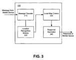
- FIG. 3illustrates an exemplary map server 130 .
- the exemplary map server 130includes a message decoder 310 , a location recognition module 320 , a local map creator 330 , and a response generator 340 .
- the map server 130received non-GPS data from a non-GPS enabled mobile device 110 .
- the message decoder 310is configured in accordance with the MMS standard for decoding MMS messages received from mobile devices.
- the message decoder 310obtains a MMS message from a non-GPS mobile device 110 and extracts multimedia data and/or other optional data from the message.
- the optional datamay include, without limitation, city, state, zip code, and/or other location-related information.
- the extracted dataare forwarded to the location recognition module 320 to determine location information.
- Multimedia datainclude, without limitation, image data, audio data, video data, etc.
- the location recognition module 220applies image analysis techniques known in the art to extract information from the multimedia data useful for determining location.
- the location recognition module 220may apply an optical character recognition (OCR) technique to analyze any image data by recognizing street names, street numbers, and/or other alphanumeric characters. For example, if an image received at the location recognition module 220 includes street signs at an intersection, the location recognition module 220 may be able to recognize street numbers and names in the image.
- OCRoptical character recognition
- the multimedia data received from the non-GPS mobile device 110may alternatively or in combination include audio data.
- the location recognition module 220may analyze the audio data (e.g., using speech recognition technology known in the art) to extract location-related information.
- the local map creator 330accesses a map database to determine data for generating a local map using the location information extracted by the location recognition module 320 .
- the local map creator 330may access a U.S. Geological Survey Geographic Information System (USGS GIS) database using a third-party application program interface (API), such as Microsoft® Mappoint or Google® Maps API.
- the local map creator 330uses data obtained from a map database to generate a local map image.
- the local map imagemay be transformed to a format suitable for display at the non-GPS mobile device.
- the response generator 340generates a response, to be sent to the non-GPS mobile device, including the local map image.
- the response generator 340is configured in accordance with the MMS standard for encoding and generating MMS responses.
- FIG. 4illustrates an exemplary process for obtaining a local map at a non-GPS enabled mobile device.
- a usercaptures obtains or generates multimedia data relevant to his/her current location.
- Multimedia datainclude, without limitation, image data, audio data, video data, etc.
- digital imagesare captured using an image capturing device incorporated into a non-GPS enabled mobile device (e.g., a camera phone).
- the digital imagesmay be captured by an image capturing device separate from the non-GPS enabled mobile device then uploaded onto the mobile device.
- the usermay alternatively record an audio message relating to the current location. In this example, the user may not capture any images.
- the usermay input optional location-related data into the non-GPS enabled mobile device.
- the usermay input the street address, the state, city, zip code, and/or other information using an input device (e.g., a keypad, a stylus, a microphone, etc.). Additional location information is optional because the map server 130 does not necessarily require the information to discern the user's current location.
- multimedia dataare sent from the non-GPS enabled mobile device to the map server 130 via a network 120 .
- the dataare included in an MMS message generated in conformance with the MMS standard.
- the non-GPS enabled mobile devicereceives a contemporaneous local map from the map server 130 .
- the mobile devicemay also receive navigational directions from the map server 130 .
- the servercould generate and return navigational directions for the user to travel from one location to another location.
- the local mapis included in an MMS response generated in conformance with the MMS standard. An exemplary process performed by the map server 130 for generating the local map will be described in more detail below with reference to FIG. 5 .
- the non-GPS enabled mobile devicedisplays the local map to the user.
- the response from the map server 130is decoded and the local map image is extracted.
- the local map image filemay require reformatting prior to being displayed on an output device of the mobile device.
- the directionscan be displayed or otherwise presented to the user (e.g., via audio).
- FIG. 5illustrates an exemplary process for generating a contemporaneous local map based on data from a non-GPS enabled mobile device.
- the map server 130obtains a message from a non-GPS enabled mobile device.
- the messageincludes multimedia data and other optional location-related data.
- Optional location-related datainclude, without limitation, state, city, zip code, and/or other data.
- the map server 130decodes the message to obtain the multimedia data.
- the map server 130applies an analysis technique to extract any location information from the multimedia data. For example, an OCR process may be applied to any image data to recognize alphanumeric characters. In another example, a speech recognition process may be applied to any audio data to recognize any location information.
- an OCR processmay be applied to any image data to recognize alphanumeric characters.
- a speech recognition processmay be applied to any audio data to recognize any location information.
- the map server 130accesses a map database using the extracted location information to obtain map data for generating a contemporaneous local map.
- extracted street namesmay be used to obtain the requisite map data.
- the multimedia datamay include data relating to multiple locations.
- the map servermay obtain map data relating to all the locations.
- the map server 130generates a local map image based on the map data from the map database.
- the server 130may also generate navigational directions from one location to another location.
- the map server 130generates a response including the local map image (and the navigational directions, if any).
- the local map image fileis either formatted to be displayed at the mobile device or enabled to be reformatted at the mobile device.
- the responseincluding the local map, is sent to the mobile device.
- the user at a non-GPS enabled deviceis enabled to obtain contemporaneous maps for its current locations.
- the local maps sent to a userneed not be contemporaneous to the user's current location. For example, a user who is interested in having a map image of a location he previously visited may still use the map server to obtain a relevant map. The map server 130 does not need to confirm that the local map is of the user's current location.
- the techniques described hereincan be implemented using any suitable computing environment.
- the computing environmentcould take the form of software-based logic instructions stored in one or more computer-readable memories and executed using a computer processor.
- some or all of the techniquescould be implemented in hardware, perhaps even eliminating the need for a separate general-purpose processor, if the hardware modules contain the requisite processor functionality.
- the hardware modulescould comprise PLAs, PALs, ASICs, and still other devices for implementing logic instructions known to those skilled in the art or hereafter developed.
- the computing environment with which the techniques can be implementedshould be understood to include any circuitry, program, code, routine, object, component, data structure, and so forth, that implements the specified functionality, whether in hardware, software, or a combination thereof.
- the software and/or hardwarewould typically reside on or constitute some type of computer-readable media which can store data and logic instructions that are accessible by the computer or the processing logic.
- Such mediamight include, without limitation, hard disks, floppy disks, magnetic cassettes, flash memory cards, digital video disks, removable cartridges, random access memories (RAMs), read only memories (ROMs), and/or still other electronic, magnetic and/or optical media known to those skilled in the art or hereafter developed.
Landscapes
- Engineering & Computer Science (AREA)
- Remote Sensing (AREA)
- Radar, Positioning & Navigation (AREA)
- Physics & Mathematics (AREA)
- General Physics & Mathematics (AREA)
- Theoretical Computer Science (AREA)
- Databases & Information Systems (AREA)
- Automation & Control Theory (AREA)
- Data Mining & Analysis (AREA)
- General Engineering & Computer Science (AREA)
- Multimedia (AREA)
- Library & Information Science (AREA)
- Mathematical Physics (AREA)
- Telephonic Communication Services (AREA)
Abstract
Description
Claims (19)
Priority Applications (1)
| Application Number | Priority Date | Filing Date | Title |
|---|---|---|---|
| US11/888,190US8340897B2 (en) | 2007-07-31 | 2007-07-31 | Providing contemporaneous maps to a user at a non-GPS enabled mobile device |
Applications Claiming Priority (1)
| Application Number | Priority Date | Filing Date | Title |
|---|---|---|---|
| US11/888,190US8340897B2 (en) | 2007-07-31 | 2007-07-31 | Providing contemporaneous maps to a user at a non-GPS enabled mobile device |
Publications (2)
| Publication Number | Publication Date |
|---|---|
| US20090037099A1 US20090037099A1 (en) | 2009-02-05 |
| US8340897B2true US8340897B2 (en) | 2012-12-25 |
Family
ID=40338899
Family Applications (1)
| Application Number | Title | Priority Date | Filing Date |
|---|---|---|---|
| US11/888,190Active2030-09-26US8340897B2 (en) | 2007-07-31 | 2007-07-31 | Providing contemporaneous maps to a user at a non-GPS enabled mobile device |
Country Status (1)
| Country | Link |
|---|---|
| US (1) | US8340897B2 (en) |
Families Citing this family (12)
| Publication number | Priority date | Publication date | Assignee | Title |
|---|---|---|---|---|
| US8095248B2 (en) | 2007-09-04 | 2012-01-10 | Modular Mining Systems, Inc. | Method and system for GPS based navigation and hazard avoidance in a mining environment |
| US20100157848A1 (en)* | 2008-12-22 | 2010-06-24 | Qualcomm Incorporated | Method and apparatus for providing and utilizing local maps and annotations in location determination |
| US8938211B2 (en) | 2008-12-22 | 2015-01-20 | Qualcomm Incorporated | Providing and utilizing maps in location determination based on RSSI and RTT data |
| US8938355B2 (en)* | 2009-03-13 | 2015-01-20 | Qualcomm Incorporated | Human assisted techniques for providing local maps and location-specific annotated data |
| US20110189980A1 (en)* | 2010-02-04 | 2011-08-04 | Research In Motion Limited | Method of sending information |
| KR20110097048A (en)* | 2010-02-24 | 2011-08-31 | 삼성전자주식회사 | Apparatus, methods, and computer-readable media for processing, playing back, or storing image files containing map data |
| US9080882B2 (en) | 2012-03-02 | 2015-07-14 | Qualcomm Incorporated | Visual OCR for positioning |
| JP2015104068A (en)* | 2013-11-27 | 2015-06-04 | サポートリンク株式会社 | Information display system, information display method and computer program |
| US9618344B2 (en) | 2014-12-09 | 2017-04-11 | Brett Harrison | Digital map tracking apparatus and methods |
| US20170155572A1 (en)* | 2015-11-30 | 2017-06-01 | International Business Machines Corporation | Relative positioning of a mobile computing device in a network |
| CN115774764A (en)* | 2021-09-07 | 2023-03-10 | 华为技术有限公司 | Map display method, electronic equipment and system |
| CN114485701B (en)* | 2021-12-30 | 2024-02-23 | 易图通科技(北京)有限公司 | Path planning method, path planning device, electronic equipment and readable storage medium |
Citations (11)
| Publication number | Priority date | Publication date | Assignee | Title |
|---|---|---|---|---|
| US20020102989A1 (en)* | 2001-01-26 | 2002-08-01 | Calvert Brian Edward | Method and apparatus for accurately locating a communication device in a wireless communication system |
| US20050063563A1 (en)* | 2003-09-23 | 2005-03-24 | Soliman Samir S. | System and method for geolocation using imaging techniques |
| US20050164716A1 (en)* | 1995-12-27 | 2005-07-28 | Yoji Kawamoto | Terminal unit, position display method, information providing system, and information providing method |
| US20050286421A1 (en)* | 2004-06-24 | 2005-12-29 | Thomas Janacek | Location determination for mobile devices for location-based services |
| US20060142027A1 (en)* | 2004-12-29 | 2006-06-29 | Nokia Corporation | Methods, apparatus and computer program product providing enhanced location-based services for mobile users |
| US7089110B2 (en)* | 2002-04-30 | 2006-08-08 | Telmap Ltd. | Dynamic navigation system |
| US20060248224A1 (en)* | 2005-04-27 | 2006-11-02 | Siemens Aktiengesellschaft | Device for navigating a vehicle and server system |
| US20080039120A1 (en)* | 2006-02-24 | 2008-02-14 | Telmap Ltd. | Visual inputs for navigation |
| US20080147730A1 (en)* | 2006-12-18 | 2008-06-19 | Motorola, Inc. | Method and system for providing location-specific image information |
| US20080267504A1 (en)* | 2007-04-24 | 2008-10-30 | Nokia Corporation | Method, device and computer program product for integrating code-based and optical character recognition technologies into a mobile visual search |
| US20080267521A1 (en)* | 2007-04-24 | 2008-10-30 | Nokia Corporation | Motion and image quality monitor |
- 2007
- 2007-07-31USUS11/888,190patent/US8340897B2/enactiveActive
Patent Citations (11)
| Publication number | Priority date | Publication date | Assignee | Title |
|---|---|---|---|---|
| US20050164716A1 (en)* | 1995-12-27 | 2005-07-28 | Yoji Kawamoto | Terminal unit, position display method, information providing system, and information providing method |
| US20020102989A1 (en)* | 2001-01-26 | 2002-08-01 | Calvert Brian Edward | Method and apparatus for accurately locating a communication device in a wireless communication system |
| US7089110B2 (en)* | 2002-04-30 | 2006-08-08 | Telmap Ltd. | Dynamic navigation system |
| US20050063563A1 (en)* | 2003-09-23 | 2005-03-24 | Soliman Samir S. | System and method for geolocation using imaging techniques |
| US20050286421A1 (en)* | 2004-06-24 | 2005-12-29 | Thomas Janacek | Location determination for mobile devices for location-based services |
| US20060142027A1 (en)* | 2004-12-29 | 2006-06-29 | Nokia Corporation | Methods, apparatus and computer program product providing enhanced location-based services for mobile users |
| US20060248224A1 (en)* | 2005-04-27 | 2006-11-02 | Siemens Aktiengesellschaft | Device for navigating a vehicle and server system |
| US20080039120A1 (en)* | 2006-02-24 | 2008-02-14 | Telmap Ltd. | Visual inputs for navigation |
| US20080147730A1 (en)* | 2006-12-18 | 2008-06-19 | Motorola, Inc. | Method and system for providing location-specific image information |
| US20080267504A1 (en)* | 2007-04-24 | 2008-10-30 | Nokia Corporation | Method, device and computer program product for integrating code-based and optical character recognition technologies into a mobile visual search |
| US20080267521A1 (en)* | 2007-04-24 | 2008-10-30 | Nokia Corporation | Motion and image quality monitor |
Non-Patent Citations (7)
| Title |
|---|
| "iPhone to Reset Road Map for Mobile Content"; http://www.gartner.com/DisplayDocument?id=508203. |
| "LiveSearch for Windows Mobile available for your WinMob Treo"; http://palmaddict.typepad.com/palmaddicts/2007/06/live-search-for.html. |
| "Nokia Delivers Free Downloadable Maps to the Mobile World"; http:/mobilesearch.nokia.com/A4344239. |
| "Three Handy Sites for Your Mobile Device"; Jun. 10, 2007; http:/www.washingtonpost.com. |
| Garofalakis, et al., "Web Based Device Independent Mobile Map Applications. The m-CHARTIS System," IW3C2, May 23-26, 2006. |
| http://www.google.com/gmm/gps.html. |
| www://mobile.my-symbian.com. |
Also Published As
| Publication number | Publication date |
|---|---|
| US20090037099A1 (en) | 2009-02-05 |
Similar Documents
| Publication | Publication Date | Title |
|---|---|---|
| US8340897B2 (en) | Providing contemporaneous maps to a user at a non-GPS enabled mobile device | |
| US10958598B2 (en) | Method and apparatus for generating candidate reply message | |
| AU2009257552B2 (en) | Machine-readable representation of geographic information | |
| US9251252B2 (en) | Context server for associating information based on context | |
| US7991607B2 (en) | Translation and capture architecture for output of conversational utterances | |
| US9497275B2 (en) | System and method for generating three-dimensional geofeeds, orientation-based geofeeds, and geofeeds based on ambient conditions based on content provided by social media content providers | |
| US8335496B1 (en) | Playing local device information over a telephone connection | |
| CN104111954B (en) | A kind of methods, devices and systems obtaining location information | |
| US10122845B2 (en) | Location based personal organizer | |
| US20080317346A1 (en) | Character and Object Recognition with a Mobile Photographic Device | |
| KR20140038355A (en) | Computerized method and device for annotating at least one feature of an image of a view | |
| US20120124125A1 (en) | Automatic journal creation | |
| CN105704675A (en) | Scenic region information processing method and device | |
| US20080126960A1 (en) | Context server for associating information with a media object based on context | |
| JP7247048B2 (en) | Information presentation system, information presentation method, server device and its program | |
| CN102750332A (en) | Method, device and system for information issue | |
| CN109684589B (en) | Client comment data processing method and device and computer storage medium | |
| CN105992171A (en) | Text information processing method and device | |
| CN101726284A (en) | Location identification method, photographing device and location identification system | |
| CN103209237A (en) | Method, device and mobile terminal for creating contacts | |
| US20060143233A1 (en) | Embedding location information in content objects | |
| CN104252475A (en) | Method and device for positioning text messages in picture | |
| CN103379022B (en) | A kind of instant communication method based on Internet map search and system | |
| CN111260445A (en) | House resource information display method, device, terminal and storage medium | |
| CN112966752B (en) | Image matching method and device |
Legal Events
| Date | Code | Title | Description |
|---|---|---|---|
| AS | Assignment | Owner name:HEWLETT-PACKARD DEVELOPMENT COMPANY, L.P., TEXAS Free format text:ASSIGNMENT OF ASSIGNORS INTEREST;ASSIGNOR:JOSHI, PARAG MULENDRA;REEL/FRAME:019689/0098 Effective date:20070731 | |
| STCF | Information on status: patent grant | Free format text:PATENTED CASE | |
| AS | Assignment | Owner name:HEWLETT PACKARD ENTERPRISE DEVELOPMENT LP, TEXAS Free format text:ASSIGNMENT OF ASSIGNORS INTEREST;ASSIGNOR:HEWLETT-PACKARD DEVELOPMENT COMPANY, L.P.;REEL/FRAME:037079/0001 Effective date:20151027 | |
| FPAY | Fee payment | Year of fee payment:4 | |
| SULP | Surcharge for late payment | ||
| AS | Assignment | Owner name:MEIZU TECHNOLOGY CO., LTD., CHINA Free format text:ASSIGNMENT OF ASSIGNORS INTEREST;ASSIGNOR:HEWLETT PACKARD ENTERPRISE DEVELOPMENT LP;REEL/FRAME:045057/0555 Effective date:20171027 | |
| MAFP | Maintenance fee payment | Free format text:PAYMENT OF MAINTENANCE FEE, 8TH YEAR, LARGE ENTITY (ORIGINAL EVENT CODE: M1552); ENTITY STATUS OF PATENT OWNER: LARGE ENTITY Year of fee payment:8 | |
| MAFP | Maintenance fee payment | Free format text:PAYMENT OF MAINTENANCE FEE, 12TH YEAR, LARGE ENTITY (ORIGINAL EVENT CODE: M1553); ENTITY STATUS OF PATENT OWNER: LARGE ENTITY Year of fee payment:12 |