US8271195B2 - Method for representing linear features in a location content management system - Google Patents
Method for representing linear features in a location content management systemDownload PDFInfo
- Publication number
- US8271195B2 US8271195B2US12/362,786US36278609AUS8271195B2US 8271195 B2US8271195 B2US 8271195B2US 36278609 AUS36278609 AUS 36278609AUS 8271195 B2US8271195 B2US 8271195B2
- Authority
- US
- United States
- Prior art keywords
- location
- linear
- content
- code
- management system
- Prior art date
- Legal status (The legal status is an assumption and is not a legal conclusion. Google has not performed a legal analysis and makes no representation as to the accuracy of the status listed.)
- Expired - Fee Related, expires
Links
Images


Classifications
- G—PHYSICS
- G06—COMPUTING OR CALCULATING; COUNTING
- G06Q—INFORMATION AND COMMUNICATION TECHNOLOGY [ICT] SPECIALLY ADAPTED FOR ADMINISTRATIVE, COMMERCIAL, FINANCIAL, MANAGERIAL OR SUPERVISORY PURPOSES; SYSTEMS OR METHODS SPECIALLY ADAPTED FOR ADMINISTRATIVE, COMMERCIAL, FINANCIAL, MANAGERIAL OR SUPERVISORY PURPOSES, NOT OTHERWISE PROVIDED FOR
- G06Q50/00—Information and communication technology [ICT] specially adapted for implementation of business processes of specific business sectors, e.g. utilities or tourism
- G06Q50/10—Services
- G—PHYSICS
- G01—MEASURING; TESTING
- G01C—MEASURING DISTANCES, LEVELS OR BEARINGS; SURVEYING; NAVIGATION; GYROSCOPIC INSTRUMENTS; PHOTOGRAMMETRY OR VIDEOGRAMMETRY
- G01C21/00—Navigation; Navigational instruments not provided for in groups G01C1/00 - G01C19/00
- G01C21/38—Electronic maps specially adapted for navigation; Updating thereof
- G01C21/3863—Structures of map data
- G01C21/3867—Geometry of map features, e.g. shape points, polygons or for simplified maps
- G—PHYSICS
- G06—COMPUTING OR CALCULATING; COUNTING
- G06F—ELECTRIC DIGITAL DATA PROCESSING
- G06F17/00—Digital computing or data processing equipment or methods, specially adapted for specific functions
- G—PHYSICS
- G09—EDUCATION; CRYPTOGRAPHY; DISPLAY; ADVERTISING; SEALS
- G09B—EDUCATIONAL OR DEMONSTRATION APPLIANCES; APPLIANCES FOR TEACHING, OR COMMUNICATING WITH, THE BLIND, DEAF OR MUTE; MODELS; PLANETARIA; GLOBES; MAPS; DIAGRAMS
- G09B29/00—Maps; Plans; Charts; Diagrams, e.g. route diagram
- G09B29/003—Maps
- G09B29/006—Representation of non-cartographic information on maps, e.g. population distribution, wind direction, radiation levels, air and sea routes
- G09B29/007—Representation of non-cartographic information on maps, e.g. population distribution, wind direction, radiation levels, air and sea routes using computer methods
Definitions
- the present inventionrelates generally to location-based services, and more particularly, relates to how to represent a linear feature that does not rely on linear features stored in a geographic database.
- vehicle navigation systemscan determine where a vehicle is located and provide directions to travel to a desired destination.
- Internet sitesare available that provide maps, directions for traveling to a desired destination from a specified starting point, and other map-related services.
- hand-held devicesare available that can determine one's position and provide a map of one's surroundings.
- the geographic datamay be in the form of one or more geographic databases that include data representing physical features in the geographic region.
- the geographic databaseincludes information about the represented geographic features, such as one-way streets, position of the roads, speed limits along portions of roads, address ranges along the road portions, turn restrictions at intersections of roads, direction restrictions, such as one-way streets, and so on.
- the geographic datamay include points of interest, such as restaurants, hotels, airports, gas stations, stadiums, police stations, and so on.
- This geographic datamay be stored in a geographic database, such as a geographic database published by NAVTEQ North America, LLC of Chicago, Ill.
- content sourceshave data regarding locations in a geographic area.
- the content sourcesmay provide their data to the map vendor for inclusion into the geographic database.
- an owner of a chain restaurantmay provide the map vendor with a current list of all their locations and for each of the locations the list may include address, telephone numbers, hours of operation, menu, web page address, and other information about the location.
- location content management systemshave been developed to allow multiple parties to provide data related to a location, which is sometimes referred to as “location content” or simply “content.”
- location content management systemprovides a link between the location content and the geographic location associated with the content.
- the linkis a location code that the location content management system assigns to a location.
- a location codemay be assigned to any location where a person can travel. For example, a person may want to travel to a particular office on a particular floor in a particular building in a geographic region. Using this example, the location content management system assigns a location code to each of the office, floor, and building. The location content management system may also assign a location code to stairs and/or an elevator if the floor is not on the ground level of the building. By assigning location codes in this manner, a navigation system can provide route guidance to a user for traveling to the office within the building.
- the location content management systemprovides a way for multiple parties to provide content regarding a location, there continues to be room for new features and improvements in the location content management system.
- One area for improvementis how to represent linear features in the location content management system.
- the location codereferences a point location minimally identified by latitude and longitude. However, in some situations it would be beneficial for a location code to reference a linear feature.
- a linear location codelike the point location code, necessarily remains outside a geographic database, the geographic database's two representations of linear objects, links and strands, are not suitable for representing linear features in the location content management system.
- a linkis a geographic object with two nodes (a reference node and a non-reference node) and zero or more intermediate shape points.
- a strandis a directed sequence of links used by conditions defined in the geographic database. Links suffer from the problem of being split and merged due to attribution requirements, while strands suffer from the problem of being so tightly coupled to conditions that the strand can only be referenced by the condition. Thus, the linear location code needs to represent a linear feature in a manner that overcomes the problems associated with links and strands.
- a method for representing linear features in a location content management systemdefines a linear location code for a linear feature.
- the linear location codeconsists of a sequence of routing points where a routing point consists of latitude, longitude, and an optional stack position (e.g., L for lower and U for upper) or altitude that defines a unique path when routed on a map through those points.
- the stack positionis used to disambiguate vertically stacked roads, such as a double-decker bridge (e.g., the San Francisco/Oakland Bay Bridge) or streets having upper and lower sections (e.g., Michigan Avenue and Wacker Drive in Chicago).
- the methodrepresents linear features independently from link and strand objects stored in a geographic database.
- FIG. 1is a block diagram of a location-based system, according to an example
- FIG. 2is a block diagram of a data structure for a linear location code, according to an example
- FIG. 3is a block diagram of a data structure for a routing point, according to an example
- FIG. 4is a pictorial representation of an example linear feature
- FIG. 5is a block diagram of a data structure for the linear feature depicted in FIG. 4B ; according to an example;
- FIG. 6is a pictorial representation of two point location codes representing two train stations and the route between the stations, according to an example
- FIG. 7is a pictorial representation of a linear location code representing the same two stations and the route between the stations depicted in FIG. 6 , according to an example;
- FIG. 8is a pictorial representation of an existing polyline location object and a potential new polyline location object; according to an example.
- FIG. 9is a flow chart of a matching routine for determining whether to assign a linear location code to the potential new polyline location object depicted in FIG. 8 , according to an example.
- FIG. 1is a block diagram showing a location-based system 100 .
- the location-based system 100includes a content source 102 , a location content management system 104 , and a content receiver 106 .
- the location content management system 104obtains content from the content source 102 .
- the location content management system 104provides content to the content receiver 106 .
- the content source 102 and the content receiver 106may be the same entity.
- the contentis any information associated with a location.
- the informationmay be static content (i.e., does not change frequently), such as a street address, a telephone number, a fax number, and hours of operation.
- the informationmay be dynamic content (i.e., changes frequently), such as gas prices, weather reports, air travel status, and traffic reports.
- the informationmay be in any format, including text, two-dimensional images, three-dimensional images, video, multimedia, and so on.
- the content source 102is any entity that provides content to the location content management system 104 .
- the content source 102may be a map vendor, a location owner/operator, a government agency, a chamber of commerce, an individual, or any other party. While one content source 102 is depicted in FIG. 1 , it is understood that the location content management system 104 obtains content from many content sources.
- the content receiver 106is any entity that accesses content from the location content management system 104 .
- the content receiver 106may be an end-user device, such as a personal computer, a mobile telephone, and a portable hand-held device. Additionally, the content receiver 106 may be an intermediate device that distributes location content to an end-user device. While one content receiver 106 is depicted in FIG. 1 , it is understood that the location content management system 104 provides content to many content receivers.
- the location content management system 104is a combination of hardware, software, and/or firmware that gathers, processes, and delivers location content.
- the location content management system 104includes a content upload server 108 , a content store 110 , a location referencing system 112 , a content quality system 114 , and a content delivery server 116 .
- the location content management system 104may include other entities as well.
- the content upload server 108may display a user interface for providing location content to the location content management system 104 .
- the user interfaceallows the content source 102 to enter, manage, and locate their content in a self-serve environment.
- the user interfacemay include a tool for inputting location information that includes fields that correspond to the data stored in the profile.
- the user interfaceallows the content source 102 to enter text and attach files, such as documents, image files, video files, sound files, and so on.
- the content upload server 108may provide a Web service to support machine-to-machine interaction over a network.
- the Web servicemay support any protocol.
- the content source 102may use the Web service to add or modify location content via bulk load.
- the content upload server 108also verifies the content source 102 .
- the content upload server 108may verify an individual, a business, and/or an organization with any suitable method or combination of methods including, but not limited to, a double opt-in routine, community validation, manual validation, and partner validation.
- the content upload server 108stores the content in the content store 110 .
- the content store 110may be any type of memory that allows read/write access.
- the content upload server 108may also store an indication of what verification method was used to verify the content source 102 in the content store 110 or in a separate memory device.
- the indicationmay be a binary flag, scaling factor, or word identifying the verification method.
- the location referencing system 112provides a link between location content and the geographic location associated with the content.
- the linkis needed when the location content is decoupled from (i.e., not included in) the geographic database.
- the location referencing system 112assigns a location identifier to one or more locations, and stores the location identifier in the content store 110 .
- the location identifiermay be a point location code or a linear location code.
- the point location codereferences a point feature (e.g., a point on a road, a position of a building, a point within a building).
- a point location codeis minimally represented by latitude and longitude attributes.
- the point location codemay also be associated with an address that allows the point location code to be geocoded to a geographic database link.
- Geocodingis the process of geographically associating an entity outside a geographic database (e.g., a location code) to a map object within the geographic database.
- the linear location codereferences a linear feature, such as a portion of a road network or a portion of a pedestrian route.
- the linear location codeconsists of a sequence of routing points that defines a unique path when routed on a map through those points.
- a routing pointhas latitude, longitude, and optionally a stack position used for roads and bridges having two levels (i.e., upper and lower levels). Additionally or alternatively, the routing point may have an altitude. For example, the routing point may have an altitude relative to sea level, an altitude relative to ground level, or relative to another reference level.
- the sequence of routing pointsmay be obtained by defining a canonical (i.e., normalized) representation of routing points.
- the canonical representationmay use key decision points.
- the canonical representationmay use a segment point half-way between two key decision points.
- a key decision pointis where a driver has to turn or otherwise make a choice between two or more alternatives (e.g., a fork in the road).
- Other canonical formsmay also be used.
- the canonical representationis unique for a given linear feature despite what intermediate points are used to initially define the linear location code.
- the canonical representation of routing pointsis further described with reference to FIG. 4 .
- the linear location codemay reference a line, polyline, or polygon object.
- a line location coderepresents a continuous line composed of one straight line segment and is defined by two routing points.
- a polyline location coderepresents a continuous line composed of two or more straight line segments, and is defined by three or more routing points.
- a polygon location coderepresents a closed path composed of three or more straight line segments, and is defined by three or more routing points.
- the location referencing system 112may randomly assign a location identifier to a location. Alternatively, the location referencing system 112 may assign the location identifiers in numerical order or in any other organized fashion.
- the location identifiermay be a numerical value. For example, the location identifier may be a 16-bit number, a 32-bit number, a 64-bit number, and so on. Alternatively, the location identifier may include a combination of numbers, letters, and/or characters.
- the location referencing system 112may first determine whether the linear feature has already been associated with a linear location code. For a line location code, the location referencing system 112 determines whether the two routing points associated with the line feature are within a predetermined radius (e.g., 1 meter) of two routing points associated with a line location code previously created. If there is a match, then the new line location code is not created. Otherwise, the new line location code is assigned to the linear feature.
- a predetermined radiuse.g. 1 meter
- the matching algorithmtakes into consideration whether the number of routing points is the same between an existing linear location code and the new linear location code.
- the matching algorithmuses a predetermined radius around each of the existing routing points to identify a match. This procedure is similar to the line location code matching algorithm with more routing points.
- the matching algorithmdetermines whether the routing points that do not match pre-existing points are within a predetermined perpendicular distance from a line segment. If the extra points are within the predetermined perpendicular distance, then these points are considered to be intermediate points not necessary to define a linear location code. In this case, a match is found and a new linear location code will not be created. This process is further described with respect to FIGS. 8 and 9 .
- the content quality system 114evaluates the quality of the location content stored in the content store 110 . The evaluation may be based on whether the content owner is trustworthy, the location data is accurate, the content is sufficiently complete, and/or the content is relatively current.
- the content quality system 114stores a quality score for the content in the content store 110 or other memory device.
- the content quality system 114may re-evaluate the content quality each time the content is changed, at a regular interval, at the request of the content source 102 and/or the content receiver 106 , or at any other time.
- the content quality system 114may store the historical quality scores for the content so that the content source 102 and/or the content receiver 106 can retrieve a score trend report.
- the content delivery server 116displays a user interface for retrieving location content from the location content management system 104 .
- the user interfacemay be the same user interface used by the content source 102 or a separate user interface. Additionally or alternatively, the content delivery server 116 may provide a Web service in a similar manner as the content upload server 108 .
- the user interface/Web serviceallows the content receiver 106 to obtain location content in a self-serve environment.
- the user interface/Web servicealso allows the content receiver 106 to receive one or more quality scores associated with the obtained content from the location content management system 104 .
- FIG. 2is a data structure for a linear location code record 200 .
- the data attributes depicted in FIG. 2include a code identification 202 , two or more routing points 204 , 206 , and a focal point 208 .
- the linear location code record 200may have other attributes as well.
- the linear location code record 200includes a unique code identification 202 assigned by the location referencing system 112 .
- the routing points 204 , 206define a unique path when routed on a map through those points.
- the linear location code record 200includes two routing points, the linear location code represents a continuous line composed of one straight line segment.
- the linear location code record 200includes three or more routing points, the linear location code represents a polyline or a polygon.
- the polylineis a continuous line composed of two or more straight line segments.
- the polygonis a closed path composed of three or more straight line segments.
- Each of the line, polyline, and polygon location codesare treated as single objects.
- the focal point 208is a point used for responding to a request for location codes in a region.
- the focal point 208is a center point of the line segment.
- the focal point 208is a centroid of the connected segments. The centroid is an average position of all points within the object.
- the focal point 208may be automatically calculated by the location referencing system 112 .
- the location referencing system 112may use the SDO_CENTROID function in Oracle 11 g.
- the focal point 208may also be manually defined and/or adjusted by the end user.
- FIG. 3is a data structure for a routing point record 300 .
- the data attributes depicted in FIG. 3include latitude 302 , longitude 304 , and stack 306 .
- the stack attribute 306is used to disambiguate vertically stacked roads, such as a double-decker bridge (e.g., the San Francisco/Oakland Bay Bridge) or streets having upper and lower levels (e.g., Upper and Lower Wacker Drive in Chicago).
- FIG. 3also depicts other attributes 308 .
- the routing point record 300may also include attributes for altitude (e.g., absolute or relative), street address, and so on.
- the stack attribute 306may be replaced by an altitude attribute.
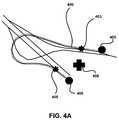
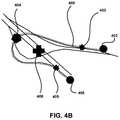
- FIG. 4is a pictorial representation of an example linear feature 400 (highlighted with the dashed-line).
- the linear feature 400is a path through the Ohio Street ramp to the southbound Kennedy Expressway in Chicago.
- the linear feature 400has a starting point 402 and an ending point 406 .
- the linear feature 400also has two key decision points 403 , 405 .
- the linear feature 400may be uniquely defined using four routing points located at the starting point 402 , the ending point 406 , and the two key decision points 403 , 405 as shown in FIG. 4A (i.e., key decision point canonical form).
- the linear feature 400may be uniquely defined using three routing points located at the starting point 402 , the ending point 406 , and a segment point 404 located half-way between the two key decision points 403 , 405 as shown in FIG. 4B (i.e., segment point half-way between two key decision points canonical form).
- the linear feature 400is also defined by a focal point 408 as shown in FIGS. 4A and 4B .
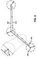
- FIG. 5depicts a linear location code 500 that may represent the linear feature 400 .
- the linear location code 500includes data using the segment point half-way between two key decision points canonical form as depicted in FIG. 4B .
- a linear location code that represents the linear feature 400 that includes data using the key decision point canonical formwould include an additional routing point. While the linear location code 500 does not depend on objects stored a geographic database (e.g., links, strands), the data associated with the code 500 is geocodable.
- the linear location code's routing pointsare matched (snapped) to data in the geographic database using reverse geocoding.
- Reverse geocodingis the process of resolving a latitude/longitude position to a location on a link in the geographic database.
- the reverse geocoding processuses a set of rules. For example, if a routing point is within a predetermined distance (e.g., 5 meters) of a node, the routing point is snapped to that node and the closest link reference to the node is identified. As another example, if reverse geocoding is unable to find a link position within a predetermined distance (e.g., 50 meters), the linear location code is not snapped to a link.
- the reverse geocoding processallows a routing algorithm to determine a sequence of links through the snapped-to-road-link routing points. While any appropriate routing algorithm may be used, the limited size of the linear location code objects means that sophisticated routing algorithms, such as the double-star routing algorithm, are not required.
- FIG. 6is a pictorial representation of two point location codes 601 , 602 representing two train stations and a route 605 between the two stations. Due to the limitations of point based location referencing mechanisms, the route information is only implicitly defined in FIG. 6 .
- the point location codes 601 , 602are associated with location content 604 stored in the location content store 110 .
- the location content 604may include the hours of operation, telephone numbers, ticket prices, train schedules, and images of the station buildings, tracks, and railroad cars.
- the location content 604may be limited to a radial distance 603 from the stations. In the point location code example depicted in FIG. 6 , location content is unavailable between the two radial distances 603 from the point location codes 601 , 602 associated with the train stations.
- FIG. 7is a pictorial representation of a linear location code 701 representing the same two train stations depicted in FIG. 6 .
- location contentis associated with the linear location code 701 .
- a person 702 with a handheld device 703is moving towards a point 704 between the two train stations to determine position.
- the handheld device 703includes a positioning system that may utilize GPS-type technology, a dead reckoning-type system, or combinations of these or other systems.
- the positioning systemmay include suitable sensing devices that measure the traveling distance speed, direction, orientation, and so on.
- the device 703may obtain location content particular to the person's travels, which would otherwise be unavailable in the example depicted in FIG. 6 .
- the device 703may obtain images that reflect the person's view as he walks. Additionally, if the device 703 knows the date and time, the device 703 may also provide content regarding when the next train will pass by the point 704 .
- a linear location codemay also be used to more easily represent features previously stored within the geographic database. For example, junction view conditions, which associate image files to a path through a highway exit decision point, may be replaced with a junction view object defined outside the geographic database. The junction view object associates a linear location code with a set of image files. As another example, No Passing zones that start in the middle of one link and end somewhere in another link may be modeled using a linear location code rather than breaking links to form a condition strand. Other features stored in the geographic database, such as evacuation or snow routes, may also benefit from being modeled outside the geographic database using a linear location code.
- FIG. 8is a pictorial representation of an existing polyline location object 802 and a potential new polyline location object 804 .
- the existing polyline location object 802has three routing points 806
- the potential new polyline location object 804has eight routing points 808 .
- FIG. 9is a flow chart of a matching routine 900 that may be used to determine whether to assign a new linear location code to the potential new polyline location object 804 .
- the routine 900receives data for the new object 804 .
- the dataincludes the latitude, longitude, and optionally stack level or altitude for each of the routing points 808 defining the new object 804 .
- the routine 900counts the number of routing points 808 defining the new object 804 . In the example shown in FIG. 8 , the routine 900 counts eight routing points 808 .
- the routine 900searches for an existing linear location code that has a routing point within a predetermined radial distance (r) from the first routing point defining the new object 804 .
- the predetermined distancemay be three meters. If no existing linear location code is identified at block 908 , then at block 920 , the routine 900 creates a new linear location code.
- the routine 900determines the distance (d n ) between the routing points evaluated at block 908 .
- the routine 900determines whether the distance is less than or equal to the pre-determined radial distance (d n ⁇ r). If the distance is greater than the radial distance (d n >r), the routine 900 creates a new linear location code at block 920 .
- the routine 900determines the perpendicular distance (d i ) between the next routing point and the linear feature represented by the existing linear location code at block 914 .
- the routine 900determines whether the perpendicular distance is less than or equal to the pre-determined radial distance (d i ⁇ r). If the distance is greater than the perpendicular distance (d i >r), the routine 900 creates a new linear location code at block 920 .
- the routine 900determines whether there are any additional routing points 808 to evaluate at block 918 . If there are additional routing points 808 , then the routine 900 returns to block 914 to evaluate the routing points. The routine 900 continues until a new linear location code is created at block 920 or a match is found with an existing linear location code. If a match is found, the routine 900 does not create a new linear location code.
Landscapes
- Engineering & Computer Science (AREA)
- Physics & Mathematics (AREA)
- Radar, Positioning & Navigation (AREA)
- Remote Sensing (AREA)
- Theoretical Computer Science (AREA)
- General Physics & Mathematics (AREA)
- Business, Economics & Management (AREA)
- General Engineering & Computer Science (AREA)
- Mathematical Physics (AREA)
- Ecology (AREA)
- Educational Technology (AREA)
- Educational Administration (AREA)
- Automation & Control Theory (AREA)
- Geometry (AREA)
- Life Sciences & Earth Sciences (AREA)
- Computer Hardware Design (AREA)
- Tourism & Hospitality (AREA)
- Software Systems (AREA)
- Economics (AREA)
- Human Resources & Organizations (AREA)
- Marketing (AREA)
- Primary Health Care (AREA)
- Strategic Management (AREA)
- General Business, Economics & Management (AREA)
- General Health & Medical Sciences (AREA)
- Health & Medical Sciences (AREA)
- Databases & Information Systems (AREA)
- Data Mining & Analysis (AREA)
- Navigation (AREA)
- Information Retrieval, Db Structures And Fs Structures Therefor (AREA)
- Instructional Devices (AREA)
Abstract
Description
Claims (10)
Priority Applications (11)
| Application Number | Priority Date | Filing Date | Title |
|---|---|---|---|
| US12/362,786US8271195B2 (en) | 2009-01-30 | 2009-01-30 | Method for representing linear features in a location content management system |
| AU2010200167AAU2010200167A1 (en) | 2009-01-30 | 2010-01-15 | Method for representing linear features in a location content management system |
| EP13155460.2AEP2594903B1 (en) | 2009-01-30 | 2010-01-22 | Method for representing linear features in a location content management system |
| EP10250100AEP2213982A3 (en) | 2009-01-30 | 2010-01-22 | Method for representing linear features in a location content management system |
| BRPI1000053-4ABRPI1000053B1 (en) | 2009-01-30 | 2010-01-27 | METHOD TO REPRESENT LINEAR FEATURES IN A LOCATION CONTENT MANAGEMENT SYSTEM, SYSTEM TO REPRESENT LINEAR FEATURES IN A LOCATION CONTENT MANAGEMENT SYSTEM, AND METHOD FOR EXTRACTING LOCATION CONTENT |
| KR1020100007966AKR101662841B1 (en) | 2009-01-30 | 2010-01-28 | Method for representing linear features in a location content management system |
| JP2010034053AJP5965575B2 (en) | 2009-01-30 | 2010-01-29 | Method for representing linear structure in location content management system |
| CN201010107866.4ACN101819579B (en) | 2009-01-30 | 2010-02-01 | Method for representing linear features in a location content management system |
| US13/613,411US8731831B2 (en) | 2009-01-30 | 2012-09-13 | Method for representing linear features in a location content management system |
| JP2015062969AJP6203773B2 (en) | 2009-01-30 | 2015-03-25 | Method for representing linear structure in location content management system |
| AU2016201843AAU2016201843B2 (en) | 2009-01-30 | 2016-03-23 | Method for representing linear features in a location content management system |
Applications Claiming Priority (1)
| Application Number | Priority Date | Filing Date | Title |
|---|---|---|---|
| US12/362,786US8271195B2 (en) | 2009-01-30 | 2009-01-30 | Method for representing linear features in a location content management system |
Related Child Applications (1)
| Application Number | Title | Priority Date | Filing Date |
|---|---|---|---|
| US13/613,411ContinuationUS8731831B2 (en) | 2009-01-30 | 2012-09-13 | Method for representing linear features in a location content management system |
Publications (2)
| Publication Number | Publication Date |
|---|---|
| US20100198505A1 US20100198505A1 (en) | 2010-08-05 |
| US8271195B2true US8271195B2 (en) | 2012-09-18 |
Family
ID=42107327
Family Applications (2)
| Application Number | Title | Priority Date | Filing Date |
|---|---|---|---|
| US12/362,786Expired - Fee RelatedUS8271195B2 (en) | 2009-01-30 | 2009-01-30 | Method for representing linear features in a location content management system |
| US13/613,411ActiveUS8731831B2 (en) | 2009-01-30 | 2012-09-13 | Method for representing linear features in a location content management system |
Family Applications After (1)
| Application Number | Title | Priority Date | Filing Date |
|---|---|---|---|
| US13/613,411ActiveUS8731831B2 (en) | 2009-01-30 | 2012-09-13 | Method for representing linear features in a location content management system |
Country Status (7)
| Country | Link |
|---|---|
| US (2) | US8271195B2 (en) |
| EP (2) | EP2213982A3 (en) |
| JP (2) | JP5965575B2 (en) |
| KR (1) | KR101662841B1 (en) |
| CN (1) | CN101819579B (en) |
| AU (2) | AU2010200167A1 (en) |
| BR (1) | BRPI1000053B1 (en) |
Cited By (4)
| Publication number | Priority date | Publication date | Assignee | Title |
|---|---|---|---|---|
| US20130332063A1 (en)* | 2012-06-10 | 2013-12-12 | Apple Inc. | Road height generation for a road network |
| US9208601B2 (en) | 2012-06-10 | 2015-12-08 | Apple Inc. | Computing plausible road surfaces in 3D from 2D geometry |
| US20170046859A1 (en)* | 2012-10-08 | 2017-02-16 | International Business Machines Corporation | Mapping Infrastructure Layout Between Non-Corresponding Datasets |
| US10586365B2 (en)* | 2009-11-13 | 2020-03-10 | Samsung Electronics Co., Ltd. | Server, user terminal, and service providing method, and control method thereof |
Families Citing this family (4)
| Publication number | Priority date | Publication date | Assignee | Title |
|---|---|---|---|---|
| US8271195B2 (en) | 2009-01-30 | 2012-09-18 | Navteq B.V. | Method for representing linear features in a location content management system |
| US20100250134A1 (en)* | 2009-03-24 | 2010-09-30 | Qualcomm Incorporated | Dead reckoning elevation component adjustment |
| US9693201B2 (en)* | 2012-11-30 | 2017-06-27 | Here Global B.V. | Method and apparatus for generating location reference information |
| GB201404040D0 (en) | 2014-03-07 | 2014-04-23 | Tomtom Int Bv | Reconstructing routes using electronic map data |
Citations (20)
| Publication number | Priority date | Publication date | Assignee | Title |
|---|---|---|---|---|
| US6202023B1 (en) | 1996-08-22 | 2001-03-13 | Go2 Systems, Inc. | Internet based geographic location referencing system and method |
| US20010051973A1 (en) | 2000-06-08 | 2001-12-13 | Poi Systems, Inc. | System, method and computer program product for a locator service |
| US20020070934A1 (en) | 1997-10-27 | 2002-06-13 | Kiyomi Sakamoto | Storage medium for use with a three-dimensional map display device |
| JP2002333830A (en) | 2001-05-07 | 2002-11-22 | Zenrin Co Ltd | Three-dimensional display of electronic map |
| US20040030490A1 (en) | 2000-06-02 | 2004-02-12 | Ildiko Hegedus | Method and system for forming a keyword database for referencing physical locations |
| US6876921B2 (en)* | 2002-11-01 | 2005-04-05 | Denso Corporation | Car navigation system |
| WO2006105754A1 (en)* | 2005-04-05 | 2006-10-12 | T-Mobile International Ag & Co. Kg | Method and device for automatic route registration |
| US20070106455A1 (en) | 2005-11-10 | 2007-05-10 | Gil Fuchs | Method and system for creating universal location referencing objects |
| US20070146374A1 (en) | 2005-12-13 | 2007-06-28 | Sorren Riise | System and method for creating minimum bounding rectangles for use in a geo-coding system |
| US7281021B2 (en)* | 2002-09-27 | 2007-10-09 | Fujifilm Corporation | Method, apparatus, and computer program for generating albums |
| US20070260628A1 (en) | 2006-05-02 | 2007-11-08 | Tele Atlas North America, Inc. | System and method for providing a virtual database environment and generating digital map information |
| US20070294031A1 (en)* | 2006-06-20 | 2007-12-20 | Zonar Compliance Systems, Llc | Method and apparatus to utilize gps data to replace route planning software |
| US20080319670A1 (en)* | 2004-10-18 | 2008-12-25 | Ford Motor Company | Feature target selection for countermeasure performance within a vehicle |
| US7564375B2 (en)* | 2001-09-11 | 2009-07-21 | Zonar Systems, Inc. | System and method to associate geographical position data collected from a vehicle with a specific route |
| US20090216435A1 (en)* | 2008-02-26 | 2009-08-27 | Microsoft Corporation | System for logging life experiences using geographic cues |
| US7720596B2 (en)* | 2002-08-05 | 2010-05-18 | Sony Corporation | Electronic guide system, contents server for electronic guide system, portable electronic guide device, and information processing method for electronic guide system |
| US20100211307A1 (en)* | 2006-01-18 | 2010-08-19 | Pieter Geelen | Method of Storing the Position of a Parked Vehicle and Navigation Device Arranged for That |
| US7805442B1 (en)* | 2000-12-05 | 2010-09-28 | Navteq North America, Llc | Method and system for representation of geographical features in a computer-based system |
| US7920965B1 (en)* | 2006-05-05 | 2011-04-05 | Mapquest, Inc. | Identifying a route configured to travel through multiple points of interest |
| US8065291B2 (en)* | 2000-03-03 | 2011-11-22 | Siss Business Systems Limited | On-line geographical directory |
Family Cites Families (68)
| Publication number | Priority date | Publication date | Assignee | Title |
|---|---|---|---|---|
| US7010A (en)* | 1850-01-08 | Machine for cutting shingles | ||
| JPH10229577A (en) | 1997-02-13 | 1998-08-25 | Nippon Telegr & Teleph Corp <Ntt> | Area management system |
| JPH11224047A (en) | 1998-02-06 | 1999-08-17 | Matsushita Electric Ind Co Ltd | Map information providing method and terminal device used therefor |
| JP2000222214A (en) | 1999-02-01 | 2000-08-11 | Hitachi Ltd | Geographic information display control device |
| JP4477615B2 (en) | 1999-07-29 | 2010-06-09 | 株式会社エヌ・ティ・ティ・ドコモ | Position-related data transmission method, data relay device, and recording medium |
| JP2001075967A (en) | 1999-08-31 | 2001-03-23 | Denso Corp | Method for preparing information for updating map data and difference updating for map data |
| JP2001134595A (en)* | 1999-11-08 | 2001-05-18 | Mega Chips Corp | Geographical information system |
| JP2001243595A (en) | 2000-03-01 | 2001-09-07 | Alpine Electronics Inc | Electronic map distribution system |
| JP2003528398A (en) | 2000-03-21 | 2003-09-24 | リットマスター,テッド・アール | System and process for delivering information to a communication network |
| JP2001280992A (en) | 2000-03-29 | 2001-10-10 | Hitachi Ltd | Geographic information output system |
| US6487495B1 (en) | 2000-06-02 | 2002-11-26 | Navigation Technologies Corporation | Navigation applications using related location-referenced keywords |
| US20080005275A1 (en) | 2000-06-02 | 2008-01-03 | Econnectix, Llc | Method and apparatus for managing location information in a network separate from the data to which the location information pertains |
| JP4132601B2 (en) | 2000-07-14 | 2008-08-13 | 富士通株式会社 | Incoming call control apparatus and method |
| JP2002041554A (en) | 2000-07-26 | 2002-02-08 | Denso Corp | Communication method for facility information concerning facilities, communication system, server and mobile terminal |
| US7487114B2 (en) | 2000-10-23 | 2009-02-03 | Costar Group, Inc. | System and method for associating aerial images, map features, and information |
| US20080214300A1 (en) | 2000-12-07 | 2008-09-04 | Igt | Methods for electronic data security and program authentication |
| JP4119088B2 (en) | 2000-12-28 | 2008-07-16 | パイオニア株式会社 | Navigation information update system and navigation information distribution apparatus |
| US6912545B1 (en) | 2001-06-12 | 2005-06-28 | Sprint Spectrum L.P. | Location-code system for location-based services |
| US20030135304A1 (en) | 2002-01-11 | 2003-07-17 | Brian Sroub | System and method for managing transportation assets |
| US20030158668A1 (en)* | 2002-02-15 | 2003-08-21 | Anderson James J. | System and method of geospatially mapping topological regions and displaying their attributes |
| DE10209173C1 (en) | 2002-03-01 | 2003-04-24 | Daimler Chrysler Ag | Map data updating method for automobile navigation system, uses difference data between original digital map card and updated map card for updating auxiliary information map |
| US6989765B2 (en) | 2002-03-05 | 2006-01-24 | Triangle Software Llc | Personalized traveler information dissemination system |
| US7221287B2 (en) | 2002-03-05 | 2007-05-22 | Triangle Software Llc | Three-dimensional traffic report |
| JP2004020220A (en) | 2002-06-12 | 2004-01-22 | Pioneer Electronic Corp | Communication system and method, communication terminal device, communication center device, and computer program |
| US7584049B2 (en) | 2002-07-17 | 2009-09-01 | Xanavi Informatics Corporation | Navigation method, processing method for navigation system, map data management device, map data management program, and computer program |
| JP4271931B2 (en) | 2002-12-06 | 2009-06-03 | アルパイン株式会社 | Navigation device and electronic map updating method |
| US20040122846A1 (en) | 2002-12-19 | 2004-06-24 | Ibm Corporation | Fact verification system |
| US7649838B2 (en) | 2003-03-31 | 2010-01-19 | Adknowledge, Inc. | System and method for ranking the quality of internet traffic directed from one web site to another |
| US9607092B2 (en) | 2003-05-20 | 2017-03-28 | Excalibur Ip, Llc | Mapping method and system |
| JP2005025291A (en) | 2003-06-30 | 2005-01-27 | Tokyo Gas Co Ltd | Geographic information processing service system, geographic information processing service method, and program |
| US7865507B2 (en) | 2003-09-15 | 2011-01-04 | Oracle International Corporation | Data quality analyzer |
| US7577655B2 (en) | 2003-09-16 | 2009-08-18 | Google Inc. | Systems and methods for improving the ranking of news articles |
| US20050096849A1 (en)* | 2003-11-04 | 2005-05-05 | Sorrells Robert J. | System and method for managing geospatially-enhanced agronomic data |
| US8676837B2 (en) | 2003-12-31 | 2014-03-18 | Google Inc. | Systems and methods for personalizing aggregated news content |
| JP2005291872A (en) | 2004-03-31 | 2005-10-20 | Clarion Co Ltd | Apparatus, method, and program for processing map data, and navigation apparatus, method, and program having the same |
| EP1779062A1 (en) | 2004-07-17 | 2007-05-02 | Shahriar Sarkeshik | Location codes for destination routing |
| US10043008B2 (en) | 2004-10-29 | 2018-08-07 | Microsoft Technology Licensing, Llc | Efficient white listing of user-modifiable files |
| KR100754168B1 (en) | 2004-11-12 | 2007-09-03 | 삼성전자주식회사 | Method and apparatus for updating map data, and a recording medium storing a program for performing the method |
| US20060149800A1 (en) | 2004-12-30 | 2006-07-06 | Daniel Egnor | Authoritative document identification |
| JP4614840B2 (en)* | 2005-07-25 | 2011-01-19 | 株式会社リコー | Image forming apparatus |
| IL169934A (en) | 2005-07-27 | 2013-02-28 | Rafael Advanced Defense Sys | Real-time geographic information system and method |
| US7421429B2 (en) | 2005-08-04 | 2008-09-02 | Microsoft Corporation | Generate blog context ranking using track-back weight, context weight and, cumulative comment weight |
| US8302030B2 (en) | 2005-09-14 | 2012-10-30 | Jumptap, Inc. | Management of multiple advertising inventories using a monetization platform |
| US7933897B2 (en) | 2005-10-12 | 2011-04-26 | Google Inc. | Entity display priority in a distributed geographic information system |
| JP2007139477A (en)* | 2005-11-16 | 2007-06-07 | Fujitsu Ten Ltd | Navigation device |
| WO2007062192A2 (en) | 2005-11-23 | 2007-05-31 | Skyhook Wireless, Inc. | Location toolbar for internet search and communication |
| JP4812415B2 (en) | 2005-11-30 | 2011-11-09 | 富士通株式会社 | Map information update system, central device, map information update method, and computer program |
| JP5269292B2 (en) | 2006-01-19 | 2013-08-21 | 三菱電機株式会社 | Geographic information integration system |
| US7415448B2 (en) | 2006-03-20 | 2008-08-19 | Microsoft Corporation | Adaptive engine for processing geographic data |
| US20070288518A1 (en) | 2006-05-03 | 2007-12-13 | Jeff Crigler | System and method for collecting and distributing content |
| EP2035995B1 (en) | 2006-06-22 | 2018-09-26 | Nokia Technologies Oy | Enforcing geographic constraints in content distribution |
| US20090319188A1 (en) | 2006-07-21 | 2009-12-24 | Teleatlas N.V. | Method for generating a location reference and method for mapping information to a position within a digital map database |
| CN101154222A (en) | 2006-09-27 | 2008-04-02 | 中国移动通信集团公司 | A system and method for updating maps online |
| JP4156003B2 (en) | 2006-10-12 | 2008-09-24 | 株式会社ゼンリン | Map information management system and map information distribution system |
| US7668651B2 (en)* | 2006-12-12 | 2010-02-23 | Pitney Bowes Software Inc. | Reverse geocoding system using combined street segment and point datasets |
| US20080256056A1 (en) | 2007-04-10 | 2008-10-16 | Yahoo! Inc. | System for building a data structure representing a network of users and advertisers |
| US8725597B2 (en) | 2007-04-25 | 2014-05-13 | Google Inc. | Merchant scoring system and transactional database |
| US7984052B2 (en) | 2007-06-12 | 2011-07-19 | Raytheon Company | System and method for integration of data records having differing data types to a geographical information system |
| JP2009003838A (en) | 2007-06-25 | 2009-01-08 | Foundation Of River & Basin Integrated Communications Japan | Atypical information display system |
| US9740731B2 (en) | 2007-08-14 | 2017-08-22 | John Nicholas and Kristen Gross Trust | Event based document sorter and method |
| CA2706242A1 (en) | 2007-09-10 | 2009-03-19 | Theodore S. Rappaport | System and method for providing network availability, performance, and localized content |
| US8892455B2 (en) | 2007-09-28 | 2014-11-18 | Walk Score Management, LLC | Systems, techniques, and methods for providing location assessments |
| US8155877B2 (en) | 2007-11-29 | 2012-04-10 | Microsoft Corporation | Location-to-landmark |
| US20090216438A1 (en) | 2008-02-21 | 2009-08-27 | Microsoft Corporation | Facility map framework |
| US8447643B2 (en) | 2008-06-02 | 2013-05-21 | Melvin L. Barnes, Jr. | System and method for collecting and distributing reviews and ratings |
| US7940171B2 (en) | 2008-06-10 | 2011-05-10 | Google Inc. | Machine-readable representation of geographic information |
| CN101319911B (en) | 2008-07-02 | 2012-02-01 | 深圳市凯立德科技股份有限公司 | Client terminal and server terminal of navigation system, and map updating method |
| US8271195B2 (en)* | 2009-01-30 | 2012-09-18 | Navteq B.V. | Method for representing linear features in a location content management system |
- 2009
- 2009-01-30USUS12/362,786patent/US8271195B2/ennot_activeExpired - Fee Related
- 2010
- 2010-01-15AUAU2010200167Apatent/AU2010200167A1/ennot_activeAbandoned
- 2010-01-22EPEP10250100Apatent/EP2213982A3/ennot_activeCeased
- 2010-01-22EPEP13155460.2Apatent/EP2594903B1/enactiveActive
- 2010-01-27BRBRPI1000053-4Apatent/BRPI1000053B1/ennot_activeIP Right Cessation
- 2010-01-28KRKR1020100007966Apatent/KR101662841B1/ennot_activeExpired - Fee Related
- 2010-01-29JPJP2010034053Apatent/JP5965575B2/ennot_activeExpired - Fee Related
- 2010-02-01CNCN201010107866.4Apatent/CN101819579B/ennot_activeExpired - Fee Related
- 2012
- 2012-09-13USUS13/613,411patent/US8731831B2/enactiveActive
- 2015
- 2015-03-25JPJP2015062969Apatent/JP6203773B2/ennot_activeExpired - Fee Related
- 2016
- 2016-03-23AUAU2016201843Apatent/AU2016201843B2/ennot_activeCeased
Patent Citations (21)
| Publication number | Priority date | Publication date | Assignee | Title |
|---|---|---|---|---|
| US6202023B1 (en) | 1996-08-22 | 2001-03-13 | Go2 Systems, Inc. | Internet based geographic location referencing system and method |
| US20020070934A1 (en) | 1997-10-27 | 2002-06-13 | Kiyomi Sakamoto | Storage medium for use with a three-dimensional map display device |
| US8065291B2 (en)* | 2000-03-03 | 2011-11-22 | Siss Business Systems Limited | On-line geographical directory |
| US20040030490A1 (en) | 2000-06-02 | 2004-02-12 | Ildiko Hegedus | Method and system for forming a keyword database for referencing physical locations |
| US20010051973A1 (en) | 2000-06-08 | 2001-12-13 | Poi Systems, Inc. | System, method and computer program product for a locator service |
| US7805442B1 (en)* | 2000-12-05 | 2010-09-28 | Navteq North America, Llc | Method and system for representation of geographical features in a computer-based system |
| JP2002333830A (en) | 2001-05-07 | 2002-11-22 | Zenrin Co Ltd | Three-dimensional display of electronic map |
| US7564375B2 (en)* | 2001-09-11 | 2009-07-21 | Zonar Systems, Inc. | System and method to associate geographical position data collected from a vehicle with a specific route |
| US7720596B2 (en)* | 2002-08-05 | 2010-05-18 | Sony Corporation | Electronic guide system, contents server for electronic guide system, portable electronic guide device, and information processing method for electronic guide system |
| US7281021B2 (en)* | 2002-09-27 | 2007-10-09 | Fujifilm Corporation | Method, apparatus, and computer program for generating albums |
| US6876921B2 (en)* | 2002-11-01 | 2005-04-05 | Denso Corporation | Car navigation system |
| US20080319670A1 (en)* | 2004-10-18 | 2008-12-25 | Ford Motor Company | Feature target selection for countermeasure performance within a vehicle |
| US20090043498A1 (en)* | 2005-04-05 | 2009-02-12 | T-Mobile International Agg & Co. Kg | Method and Device For Automatic Route Registration |
| WO2006105754A1 (en)* | 2005-04-05 | 2006-10-12 | T-Mobile International Ag & Co. Kg | Method and device for automatic route registration |
| US20070106455A1 (en) | 2005-11-10 | 2007-05-10 | Gil Fuchs | Method and system for creating universal location referencing objects |
| US20070146374A1 (en) | 2005-12-13 | 2007-06-28 | Sorren Riise | System and method for creating minimum bounding rectangles for use in a geo-coding system |
| US20100211307A1 (en)* | 2006-01-18 | 2010-08-19 | Pieter Geelen | Method of Storing the Position of a Parked Vehicle and Navigation Device Arranged for That |
| US20070260628A1 (en) | 2006-05-02 | 2007-11-08 | Tele Atlas North America, Inc. | System and method for providing a virtual database environment and generating digital map information |
| US7920965B1 (en)* | 2006-05-05 | 2011-04-05 | Mapquest, Inc. | Identifying a route configured to travel through multiple points of interest |
| US20070294031A1 (en)* | 2006-06-20 | 2007-12-20 | Zonar Compliance Systems, Llc | Method and apparatus to utilize gps data to replace route planning software |
| US20090216435A1 (en)* | 2008-02-26 | 2009-08-27 | Microsoft Corporation | System for logging life experiences using geographic cues |
Non-Patent Citations (2)
| Title |
|---|
| Priedhorsky, et al. "The Computational Geowiki: What, Why, and How." GroupLens Research, Department of Computer Science and Engineering, University of Minnesota. Paper presented at Computer Supported Cooperative Work Conference. 2008.* |
| Search Report for European Patent Application Serial No. 10250100.4-1236, dated Mar. 16, 2012. |
Cited By (10)
| Publication number | Priority date | Publication date | Assignee | Title |
|---|---|---|---|---|
| US10586365B2 (en)* | 2009-11-13 | 2020-03-10 | Samsung Electronics Co., Ltd. | Server, user terminal, and service providing method, and control method thereof |
| US10977850B2 (en)* | 2009-11-13 | 2021-04-13 | Samsung Electronics Co., Ltd. | Server, user terminal, and service providing method, and control method thereof |
| US11776185B2 (en) | 2009-11-13 | 2023-10-03 | Samsung Electronics Co., Ltd. | Server, user terminal, and service providing method, and control method thereof for displaying photo images within a map |
| US12106409B2 (en) | 2009-11-13 | 2024-10-01 | Samsung Electronics Co., Ltd. | Server, user terminal, and service providing method, and control method thereof |
| US20130332063A1 (en)* | 2012-06-10 | 2013-12-12 | Apple Inc. | Road height generation for a road network |
| US9207094B2 (en)* | 2012-06-10 | 2015-12-08 | Apple Inc. | Road height generation for a road network |
| US9208601B2 (en) | 2012-06-10 | 2015-12-08 | Apple Inc. | Computing plausible road surfaces in 3D from 2D geometry |
| US20170046859A1 (en)* | 2012-10-08 | 2017-02-16 | International Business Machines Corporation | Mapping Infrastructure Layout Between Non-Corresponding Datasets |
| US9928620B2 (en) | 2012-10-08 | 2018-03-27 | International Business Machines Corporation | Mapping infrastructure layout between non-corresponding datasets |
| US10424092B2 (en)* | 2012-10-08 | 2019-09-24 | International Business Machines Corporation | Mapping infrastructure layout between non-corresponding datasets |
Also Published As
| Publication number | Publication date |
|---|---|
| US8731831B2 (en) | 2014-05-20 |
| KR20100088552A (en) | 2010-08-09 |
| CN101819579B (en) | 2015-05-20 |
| AU2016201843B2 (en) | 2017-06-22 |
| EP2594903B1 (en) | 2020-04-22 |
| EP2594903A2 (en) | 2013-05-22 |
| AU2010200167A1 (en) | 2010-08-19 |
| JP5965575B2 (en) | 2016-08-10 |
| JP2010176681A (en) | 2010-08-12 |
| BRPI1000053B1 (en) | 2021-06-01 |
| BRPI1000053A2 (en) | 2011-03-29 |
| JP6203773B2 (en) | 2017-09-27 |
| AU2016201843A1 (en) | 2016-04-21 |
| US20100198505A1 (en) | 2010-08-05 |
| EP2213982A3 (en) | 2012-08-08 |
| EP2594903A3 (en) | 2013-11-27 |
| EP2213982A2 (en) | 2010-08-04 |
| JP2015156031A (en) | 2015-08-27 |
| KR101662841B1 (en) | 2016-10-14 |
| US20130013205A1 (en) | 2013-01-10 |
| CN101819579A (en) | 2010-09-01 |
Similar Documents
| Publication | Publication Date | Title |
|---|---|---|
| AU2016201843B2 (en) | Method for representing linear features in a location content management system | |
| US7953548B2 (en) | Location-based information determination | |
| US7660666B2 (en) | Geographic database with detailed local data | |
| US7085648B2 (en) | Information delivering server and clients and method thereof and storing medium stored programs to execute information delivery | |
| US9703804B2 (en) | Systems and methods for ranking points of interest | |
| AU2010200157B2 (en) | Method and system for assessing quality of location content | |
| JP4490028B2 (en) | Geographic database configuration to facilitate location-based advertising | |
| US7305302B2 (en) | Geographic database including data indicating wireless coverage and method and system for use thereof | |
| US6577949B1 (en) | Method and system for exchanging routing data between end users | |
| JP4408635B2 (en) | How to provide location-based advertising along with route information | |
| US20130091016A1 (en) | Method and System for Providing Location Targeted Advertisements | |
| CN112444254B (en) | Method, apparatus and computer program product for generating correspondence between map versions | |
| CN112444255B (en) | Method, apparatus and computer program product for generating correspondence between map versions | |
| US8401780B2 (en) | Method of prioritizing similar names of locations for use by a navigation system |
Legal Events
| Date | Code | Title | Description |
|---|---|---|---|
| AS | Assignment | Owner name:NAVTEQ NORTH AMERICA, LLC, ILLINOIS Free format text:ASSIGNMENT OF ASSIGNORS INTEREST;ASSIGNORS:PAINTER, JEFFREY E.;SAMSALOVIC, VOJISLAV;SIGNING DATES FROM 20090128 TO 20090129;REEL/FRAME:022181/0379 | |
| AS | Assignment | Owner name:NAVTEQ B.V., NETHERLANDS Free format text:ASSIGNMENT OF ASSIGNORS INTEREST;ASSIGNOR:NAVTEQ NORTH AMERICA, LLC;REEL/FRAME:027588/0051 Effective date:20111229 | |
| ZAAA | Notice of allowance and fees due | Free format text:ORIGINAL CODE: NOA | |
| ZAAB | Notice of allowance mailed | Free format text:ORIGINAL CODE: MN/=. | |
| STCF | Information on status: patent grant | Free format text:PATENTED CASE | |
| AS | Assignment | Owner name:HERE GLOBAL B.V., NETHERLANDS Free format text:CHANGE OF NAME;ASSIGNOR:NAVTEQ B.V.;REEL/FRAME:033830/0681 Effective date:20130423 | |
| FPAY | Fee payment | Year of fee payment:4 | |
| MAFP | Maintenance fee payment | Free format text:PAYMENT OF MAINTENANCE FEE, 8TH YEAR, LARGE ENTITY (ORIGINAL EVENT CODE: M1552); ENTITY STATUS OF PATENT OWNER: LARGE ENTITY Year of fee payment:8 | |
| FEPP | Fee payment procedure | Free format text:MAINTENANCE FEE REMINDER MAILED (ORIGINAL EVENT CODE: REM.); ENTITY STATUS OF PATENT OWNER: LARGE ENTITY | |
| LAPS | Lapse for failure to pay maintenance fees | Free format text:PATENT EXPIRED FOR FAILURE TO PAY MAINTENANCE FEES (ORIGINAL EVENT CODE: EXP.); ENTITY STATUS OF PATENT OWNER: LARGE ENTITY | |
| STCH | Information on status: patent discontinuation | Free format text:PATENT EXPIRED DUE TO NONPAYMENT OF MAINTENANCE FEES UNDER 37 CFR 1.362 | |
| FP | Lapsed due to failure to pay maintenance fee | Effective date:20240918 |