US8255149B2 - System and method for dual-mode location determination - Google Patents
System and method for dual-mode location determinationDownload PDFInfo
- Publication number
- US8255149B2 US8255149B2US11/044,708US4470805AUS8255149B2US 8255149 B2US8255149 B2US 8255149B2US 4470805 AUS4470805 AUS 4470805AUS 8255149 B2US8255149 B2US 8255149B2
- Authority
- US
- United States
- Prior art keywords
- mobile terminal
- location
- satellite
- communication
- telephone network
- Prior art date
- Legal status (The legal status is an assumption and is not a legal conclusion. Google has not performed a legal analysis and makes no representation as to the accuracy of the status listed.)
- Expired - Fee Related, expires
Links
- 238000000034methodMethods0.000titleclaimsdescription41
- 238000004891communicationMethods0.000claimsabstractdescription81
- 238000005259measurementMethods0.000claimsdescription41
- 238000004364calculation methodMethods0.000claimsdescription18
- 230000001413cellular effectEffects0.000claimsdescription16
- 239000000243solutionSubstances0.000description40
- 238000012937correctionMethods0.000description19
- 230000005540biological transmissionEffects0.000description12
- 230000001934delayEffects0.000description9
- 239000011159matrix materialSubstances0.000description8
- 238000012216screeningMethods0.000description8
- 230000008569processEffects0.000description4
- 238000010586diagramMethods0.000description3
- 239000003550markerSubstances0.000description3
- 230000004044responseEffects0.000description3
- 230000001360synchronised effectEffects0.000description3
- 230000008859changeEffects0.000description1
- 238000006243chemical reactionMethods0.000description1
- 230000000295complement effectEffects0.000description1
- 238000013480data collectionMethods0.000description1
- 230000001419dependent effectEffects0.000description1
- 239000012895dilutionSubstances0.000description1
- 238000010790dilutionMethods0.000description1
- 230000000694effectsEffects0.000description1
- 230000002349favourable effectEffects0.000description1
- 230000010354integrationEffects0.000description1
- 229910052741iridiumInorganic materials0.000description1
- GKOZUEZYRPOHIO-UHFFFAOYSA-Niridium atomChemical compound[Ir]GKOZUEZYRPOHIO-UHFFFAOYSA-N0.000description1
- 238000012986modificationMethods0.000description1
- 230000004048modificationEffects0.000description1
- 238000012544monitoring processMethods0.000description1
- 238000012545processingMethods0.000description1
- 230000000717retained effectEffects0.000description1
- 230000007480spreadingEffects0.000description1
- 230000002618waking effectEffects0.000description1
Images


Classifications
- G—PHYSICS
- G01—MEASURING; TESTING
- G01S—RADIO DIRECTION-FINDING; RADIO NAVIGATION; DETERMINING DISTANCE OR VELOCITY BY USE OF RADIO WAVES; LOCATING OR PRESENCE-DETECTING BY USE OF THE REFLECTION OR RERADIATION OF RADIO WAVES; ANALOGOUS ARRANGEMENTS USING OTHER WAVES
- G01S19/00—Satellite radio beacon positioning systems; Determining position, velocity or attitude using signals transmitted by such systems
- G01S19/01—Satellite radio beacon positioning systems transmitting time-stamped messages, e.g. GPS [Global Positioning System], GLONASS [Global Orbiting Navigation Satellite System] or GALILEO
- G01S19/13—Receivers
- G01S19/24—Acquisition or tracking or demodulation of signals transmitted by the system
- G01S19/25—Acquisition or tracking or demodulation of signals transmitted by the system involving aiding data received from a cooperating element, e.g. assisted GPS
- G01S19/256—Acquisition or tracking or demodulation of signals transmitted by the system involving aiding data received from a cooperating element, e.g. assisted GPS relating to timing, e.g. time of week, code phase, timing offset
- G—PHYSICS
- G01—MEASURING; TESTING
- G01S—RADIO DIRECTION-FINDING; RADIO NAVIGATION; DETERMINING DISTANCE OR VELOCITY BY USE OF RADIO WAVES; LOCATING OR PRESENCE-DETECTING BY USE OF THE REFLECTION OR RERADIATION OF RADIO WAVES; ANALOGOUS ARRANGEMENTS USING OTHER WAVES
- G01S19/00—Satellite radio beacon positioning systems; Determining position, velocity or attitude using signals transmitted by such systems
- G01S19/01—Satellite radio beacon positioning systems transmitting time-stamped messages, e.g. GPS [Global Positioning System], GLONASS [Global Orbiting Navigation Satellite System] or GALILEO
- G01S19/03—Cooperating elements; Interaction or communication between different cooperating elements or between cooperating elements and receivers
- G01S19/09—Cooperating elements; Interaction or communication between different cooperating elements or between cooperating elements and receivers providing processing capability normally carried out by the receiver
- G—PHYSICS
- G01—MEASURING; TESTING
- G01S—RADIO DIRECTION-FINDING; RADIO NAVIGATION; DETERMINING DISTANCE OR VELOCITY BY USE OF RADIO WAVES; LOCATING OR PRESENCE-DETECTING BY USE OF THE REFLECTION OR RERADIATION OF RADIO WAVES; ANALOGOUS ARRANGEMENTS USING OTHER WAVES
- G01S19/00—Satellite radio beacon positioning systems; Determining position, velocity or attitude using signals transmitted by such systems
- G01S19/38—Determining a navigation solution using signals transmitted by a satellite radio beacon positioning system
- G01S19/39—Determining a navigation solution using signals transmitted by a satellite radio beacon positioning system the satellite radio beacon positioning system transmitting time-stamped messages, e.g. GPS [Global Positioning System], GLONASS [Global Orbiting Navigation Satellite System] or GALILEO
- G01S19/40—Correcting position, velocity or attitude
- G—PHYSICS
- G01—MEASURING; TESTING
- G01S—RADIO DIRECTION-FINDING; RADIO NAVIGATION; DETERMINING DISTANCE OR VELOCITY BY USE OF RADIO WAVES; LOCATING OR PRESENCE-DETECTING BY USE OF THE REFLECTION OR RERADIATION OF RADIO WAVES; ANALOGOUS ARRANGEMENTS USING OTHER WAVES
- G01S5/00—Position-fixing by co-ordinating two or more direction or position line determinations; Position-fixing by co-ordinating two or more distance determinations
- G01S5/0009—Transmission of position information to remote stations
- G01S5/0018—Transmission from mobile station to base station
- G01S5/0036—Transmission from mobile station to base station of measured values, i.e. measurement on mobile and position calculation on base station
- G—PHYSICS
- G01—MEASURING; TESTING
- G01S—RADIO DIRECTION-FINDING; RADIO NAVIGATION; DETERMINING DISTANCE OR VELOCITY BY USE OF RADIO WAVES; LOCATING OR PRESENCE-DETECTING BY USE OF THE REFLECTION OR RERADIATION OF RADIO WAVES; ANALOGOUS ARRANGEMENTS USING OTHER WAVES
- G01S5/00—Position-fixing by co-ordinating two or more direction or position line determinations; Position-fixing by co-ordinating two or more distance determinations
- G01S5/02—Position-fixing by co-ordinating two or more direction or position line determinations; Position-fixing by co-ordinating two or more distance determinations using radio waves
- G01S5/14—Determining absolute distances from a plurality of spaced points of known location
Definitions
- the present inventionrelates generally to methods and systems for tracking the location of devices near the surface of the Earth, and more particularly to a method and system for tracking a device near the surface of the Earth using a very fast acquisition portable transponder.
- U.S. Pat. No. 3,063,048discloses the use of the Doppler shift in a transmitted signal to determine the position of a device transmitting the signal.
- This patentteaches measuring when the Doppler shift frequency is changing at a maximum rate to determine the position of the object transmitting the signal undergoing the Doppler frequency shift.
- the satellitemust continuously receive the signal being transmitted from the object to determine when the frequency is changing at its maximum to locate the object.
- the time to compute a position fixis unacceptably long for applications such as locating a satellite telephone.
- the Global Positioning Systemalso provides geo-location capability. Moreover, it is desirable to know the position of a mobile terminal, such as a cellular telephone, and to have this position information at a central location (e.g., at a Service Operations Center or SOC).
- a mobile terminalsuch as a cellular telephone
- SOCService Operations Center
- TTFFTime-To-First-Fix
- the present inventionis therefore directed to the problem of developing a system and method for calculating the position of a mobile terminal, which can be accomplished rapidly using a minimal amount of power and equipment.
- the present inventionsolves this problem by collecting observation data at the mobile terminal, forwarding the observation data to a central location, and performing the position calculations at the central location rather than at the individual mobile terminal.
- the mobile terminal of the present inventionneeds only to gather a few milliseconds of observation data, such as GPS code phase information, and then relays this observation data to a central station, via satellite or other relay means, for subsequent position calculation.
- the present inventionrequires that the mobile unit be on only for very brief periods of time, so that a very fast (e.g. 1 second including data transmission time) position solution can be obtained.
- a very faste.g. 1 second including data transmission time
- the fast solution and minimal battery drainmake practical the employment of a geolocating system in situations that may not otherwise economically justify such use.
- a system for determining the location of an object located on or near the surfaceincludes a communication satellite, a satellite gateway or earth station, a mobile terminal, and a service operations center.
- the communications satellitebroadcasts an interrogation signal, to which the mobile terminal responds.
- the mobile terminalis disposed on the object, and includes a receiver, a transmitter and a processor.
- the receiverreceives the interrogation signal from the communications satellite, and is capable of receiving signals being broadcast from GPS satellites.
- the processormeasures at least one characteristic in each of the signals being broadcast from the GPS satellites upon receipt of the interrogation signal from the communications satellite.
- the mobile terminaltransmits a reply signal at a predetermined time relative to receipt of the interrogation signal to the communications satellite.
- the reply signalincludes the measured characteristic(s) in each of the signals being broadcast from the plurality of GPS satellites.
- the operations centerreceives the reply signal from the communications satellite, and calculates a position of the mobile terminal using time of arrival information and the measured characteristics returned by the mobile terminal.
- the measured characteristic(s)can include, for example, code phase information, carrier phase information, Doppler-shift information, or bit phase information.
- Code phase measurements aloneare insufficient to unambiguously identify the position of the mobile terminal.
- the service operations centerrequires additional information to constrain the position solution.
- One means for constraining the position solutionis to determine the range from the terminal to the communications satellite.
- the service operations centerincludes a processor that calculates a range between the communications satellite and the mobile terminal.
- the processoruses a time the reply signal arrived at the satellite gateway and a time difference between the broadcast of the interrogation signal to the mobile terminal and its receipt at the satellite gateway. To do so, the processor accounts for known delays in the signal path between the communications satellite and the mobile terminal and the point at which the time-of-arrival information is measured at the satellite gateway.
- the processoralso calculates an intersection curve between a sphere, whose radius is the range previously determined, and a model of the surface of the Earth. Furthermore, the processor determines several initial points on the intersection curve, one of which points must lie within a known convergence zone around the terminal. Next, the processor calculates candidate position solutions for each initial point, and then screens the candidate solutions using predetermined criteria and discards any candidates not satisfying the screening. Finally, if more than one candidate solution remains, the processor selects the solution representing a best fit of all the observation data.
- the predetermined criteriamay include one or more selected of the following: a solution range to the communications satellite, solution residuals, a solution altitude, a solution clock bias and a solution proximity to a beam boundary.
- a second preferred embodiment of the present inventionsolves the problem existing in the art by sending additional signal-related information as data to the SOC along with the code phase measurements.
- the additional signal-related informationis a signal characteristic such as observed carrier frequency or observed Doppler shift of the carrier frequency.
- the time that the signal characteristic is measuredis sent to the SOC.
- the time that the signal characteristic is measuredis estimated from the time the message containing the observed data is received by the SOC.
- the code phase measurementsare obtained at the GPS receiver, for example, in a cellular telephone. These measurements are sent to the SOC.
- the carrier frequency of the GPS signal sent by each of the GPS satellitesis measured and sent to the SOC.
- the set of carrier frequency measurementsform a set of observed carrier frequencies.
- the second preferred embodiment of the present inventiondoes not require a satellite (other than the GPS satellites) for operation.
- one object of the present inventionis to determine a location of a mobile terminal using a SOC.
- Another object of the present inventionis to reduce the power requirements of a mobile terminal in order to determine its position.
- Another object of the present inventionis to reduce the time required for a mobile terminal to be powered on so that its position can be determined.
- Another object of the present inventionis to increase the speed of acquisition of information required to determine the position of a mobile terminal.
- Another object of the present inventionis to perform calculations required to determine the position of a mobile terminal on a device other than the mobile terminal.
- Another object of the present inventionis to provide a location of a mobile terminal using a SOC without having control of the communication channel over which measurement data is sent from the mobile terminal to the SOC.
- Another object of the present inventionis to provide a location of a mobile terminal using a SOC with little or no change to the communication channel over which measurement data is sent from the mobile terminal to the SOC.
- Another object of the present inventionis to provide location of a mobile terminal by performing position calculations in a SOC and not in the mobile terminal.
- Another object of the present inventionis to provide a ground-based (i.e., terrestrial) technique for determining position of a mobile terminal using GPS satellite measurements.
- Another object of the present inventionis to provide dual-mode location determination.
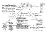
- FIG. 1depicts a block diagram of an exemplary embodiment of a system according to the present invention.
- FIG. 2depicts a diagram of an exemplary embodiment of the method according to the present invention.
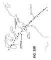
- FIGS. 3( a ) and 3 ( b )depicts a geographical representation of the method of FIG. 2 used to locate a terminal unit according to the present invention.
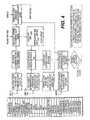
- FIG. 4depicts the various parameters returned to the Service Operations Center and used in calculating the position solution, and a flow chart of the calculations performed by the processor in the SOC.
- FIG. 5is a schematic illustration of an exemplary embodiment of a system according to a second embodiment of the present invention.
- an exemplary embodiment of a system [ 10 ]includes a Service Operations Center (SOC) [ 11 ], which is coupled to a Satellite Gateway (SG) [ 12 ], a communications satellite [ 13 ], satellites in the Global Positioning System (GPS) [ 14 - 17 ], a terminal unit [ 18 ], and a Reference Network (RN) [ 19 ].
- the terminal unit [ 18 ]receives signals from multiple GPS satellites [ 14 - 17 ], and the communications satellite [ 13 ].
- the terminal unit [ 18 ]receives a broadcast message on its forward communications satellite link, which broadcast message contains timing and acquisition aiding information. Following receipt of the message, the terminal unit performs its observation data collection function, and then transmits back to the SOC the observation data, along with any necessary system and/or status information, at a fixed delay from the received broadcast information. All processing of the observation data is done at the SOC [ 11 ]. The terminal unit [ 18 ] merely takes measurements and returns the observations as part of the broadcast/response cycle.
- the SOC [ 11 ]controls the operation of the system [ 10 ] of the present invention.
- the SOC [ 11 ]broadcasts a signal on the forward link which contains timing and acquisition aiding information that can be received and used by the mobile terminals to synchronize time and to rapidly acquire their intended GPS signals, from which they take their observation data set.
- the forward broadcastcan also contain command and control protocols for individual and/or groups of terminals.
- the return signal from the terminal [ 18 ]includes the observation data along with any system, status or protocol information necessary to operate the system.
- the return signalis synchronized to the forward signal by a specific and known delay, which allows the Satellite Gateway [ 12 ] to take an additional measurement of the round-trip signal propagation time and absolute Time-of-Arrival (TOA).
- TOAabsolute Time-of-Arrival
- This calculated propagation timeis used along with certain observation data to determine position.
- the SOCalso collects, on a continuous basis, all ancillary information necessary to the position calculations from a Reference Network [ 19 ] and other sources. As an example, this information includes:
- the Satellite Gateway [ 12 ]consists of satellite communications modems (channel units) and associated control and management equipment and software.
- the gatewaymaintains an accurate time and frequency reference for control of the forward link broadcast, and for propagation time measurements.
- the terminalneeds only to accurately respond relative to the forward signal and therefore can use a much less accurate, and low power, internal reference.
- the satellite gateway [ 12 ]is a traditional satellite communications facility. Therefore it also includes antenna, transmitter, amplifier, up/down conversion, and other standard satellite communications equipment and software that is not shown, but is known to those of skill in this art.
- the communications satellitecan be any (LEO, MEO, GEO) satellite capable of transponding the forward and return signals to/from the terminal and satellite gateway. It could also be a balloon, airplane, remotely piloted vehicle or other aircraft operating within the atmosphere (Non-Bent pipe satellites can also be used if all delays in the transmission path are known and removed).
- Non-Bent pipe satellitescan also be used if all delays in the transmission path are known and removed).
- the Satellite (or aircraft) position and velocity information, as well as transponder group delay and other operational parametersmust be known. Examples of suitable communications satellites include:
- the present inventiononly requires that the mobile terminal [ 18 ] receive a signal, make observations (measuring certain aspects of the GPS signals), and return another signal, which includes the observation data, and can be accomplished over a very short interval.
- observation dataThere are various types of observation data that can be relayed to the central site to enable the central site to determine the position of the mobile terminal.
- One possibilityis to collect code phase and/or carrier phase information inherent in the GPS signal. This enables the mobile unit to remain on for a very short time, thereby helping to minimize the Time-To-First-Fix.
- Other signal characteristics that can be measured by the terminalare Doppler-shift information, or bit phase information.
- Another possibilityis to digitize a brief interval of the received GPS signal and transmit the digital data to the central site. The central site can then reconstruct the received signal, and determine the position based on certain characteristics in the received signal, such as Doppler shift, code phase of arrival of the received signal, bit phase information, etc.
- COACode Phase of Arrival
- a Satellite Gateway (SG) [ 12 ]transmits a forward signal, with a marker event, through a communications satellite [ 13 ] to a region of the Earth bounded by the satellite beam pattern as in FIG. 3 .
- a marker eventis a synchronization data pattern in the packet preamble.
- the satellite [ 13 ]receives the signal at time t 1 , and retransmits the signal back to earth at time t 2 . Subsequently, at time t 3 the mobile terminal [ 18 ] receives the signal with the marker event.
- the mobile terminal [ 18 ]When the mobile terminal [ 18 ] needs to report its position, it searches for the SG signal in the satellite downlink.
- This signalcontains information to aid acquisition (e.g., a prioritized list of GPS satellite vehicles in view over the coverage region, Doppler offset information, timing reference, etc.). Satellite vehicles in the list are prioritized to allow the mobile terminal [ 18 ] to search for and select those satellites that provide a favorable observation set of GPS satellites (i.e., to minimize dilution of precision, exclude degraded or non-operational satellites, etc.).
- the SG [ 12 ]also synchronizes the outbound transmission relative to a GPS timing reference.
- the mobile terminal [ 18 ]uses the acquisition information recovered from the forward message to receive a multitude of GPS signals starting at time t obs , which is a fixed and known time interval from t 3 .
- the operation of the receiveris synchronized with the signal received from the SG [ 12 ].
- the signal received from the SG [ 12 ]is synchronized to GPS time (such as the X1 epoch). Consequently, the receiver clock offset associated with the GPS spreading codes used to recover the signals can be estimated back at the ground station with reasonable (less than +/ ⁇ 0.5 milliseconds) accuracy.
- the terminal [ 18 ]measures the Code Phase of Arrival (COA) of each of the GPS signals at t obs .
- COACode Phase of Arrival
- the terminal [ 18 ]then relays this measurement to the SG [ 12 ] by transmitting a return signal back through the communications satellite at time t 4 , which also has a fixed and known relationship to the inbound timing reference t 3 .
- the communications satellite [ 13 ]receives the return signal from the mobile 2 terminal at time t 5 and retransmits the same signal back to the SG [ 12 ] (or another ground station) at time t 6 .
- the return signalis received by the SG at time t 7 and compared to the forward link timing reference and a round-trip propagation time measurement is taken. Absolute Time of Arrival (TOA) measurements are also taken.
- the SG [ 12 ]recovers the contents of the return transmission and forwards the 30 data along with its propagation time and TOA measurements to the SOC [ 11 ].
- SOC [ 11 ]calculates the magnitude of the range vector between the communications satellite [ 13 ] and the terminal [ 18 ] by removing all known delays from the propagation time measurement. This is accomplished using the communications satellite position, velocity and transponder group delay information, the Satellite Gateway antenna position, known signal delays in the ground cable/equipment path, and if desired, any atmospheric or other transmission path delays that can be modeled. These delays and the relationships between the times are depicted in FIG. 2 . This range calculation is fairly standard and common practice in the satellite communications field, and would be known to those of skill in the art.
- the SOC [ 11 ]determines an arc of possible locations. This is determined by computing an intersection curve 31 (see FIG. 3 ) of a sphere, centered at the communications satellite having a radius given by the calculated range from the satellite [ 13 ] to the terminal [ 18 ], with a model of the surface of the Earth.
- the Earthcan be modeled as a mathematical approximation, such as an ellipsoid, or a geoid model, or with Terrain Elevation Data.
- a mathematical approximationsuch as an ellipsoid, or a geoid model, or with Terrain Elevation Data.
- the followingis one possible example of these calculations using an ellipsoid model:
- the Earthcan be modeled as an ellipsoid of revolution.
- the ellipsoid parametersdepend on choice of reference frame (e.g., WGS-84). This surface can be expressed:
- convergence zonerefers to the area around the location of the mobile terminal in which a point must lie to guarantee that the position calculation will converge to that location.
- the size of the convergence zonewill vary depending on number, quality and type of observation data used, but as an example, the convergence zone for the code phase observations is approximately a radius of 75-80 Km (See FIG. 3( b )).
- Pointscould be sub-sampled or interpolated as desired due to the fact that these only represent a first approximation as input to the least squares algorithm. It is only required that at least one point on the arc lay within the guaranteed convergence zone around the true solution.
- FIG. 3( a )which depicts the bounding of the arc (or parameterized intersection curve) by the beam pattern.
- the SOCnext determines the time that the mobile terminal collected the GPS signal (t obs ).
- the collection timeis determined from the range between the satellite and the terminal and SG.
- the known delays in the transmission pathsi.e., transponder group delay, atmosphere, etc.
- the terminal collection methodi.e., fixed delay from t 3 and integration period
- the absolute TOA measurementi.e., the absolute TOA measurement.
- the SOCthen employs a satellite orbit model to estimate the positions of the GPS satellites at their time of transmission (t xmt ).
- GPS t xmtis calculated from t obs less the GPS signal transit time (user must also correct for earth rotation during signal transit time if working in Earth fixed coordinates).
- the code observation P obsis corrected for the clock offset of the satellite according to the broadcast ephemerides (and atmospheric delays if desired).
- the preliminary value P 0is calculated from the initial coordinates of the satellite and from the arc of points generated previously.
- First guess at receiver clock offsetcan be estimated from broadcast signal timing and slant range to the terminal. Alternately, an additional observation may be taken to guarantee a unique solution if receiver clock offset cannot be estimated to within 0.5 msec.
- the right side of the normal equations brepresents the difference between the expected and observed code phase (modulo 1 msec) and is ambiguous.
- the receiver clock offsetis also treated as a modulo 1 msec value.
- the integer ambiguityis assumed by the choice of preliminary coordinates.
- Matrix bis kept in 5 the +/ ⁇ 0.5 msec range as a difference between two modulo 1 msec values. This forces convergence to a solution within ⁇ 150 Km from the preliminary coordinates.
- Matrix Cis the weight matrix (inverted covariance matrix) derived from signal strengths and/or GPS satellite URE (User Range Error) values and is used in a weighted least squares solution, or set to the identity matrix for a non-weighted solution.
- Matrix ris the residuals matrix and can be weighted and/or summed, or analyzed as a covariance matrix with minor manipulation.
- this estimated position solutionis then screened against the measured range to the communications satellite (with known tolerance), satellite beam boundaries, an acceptable altitude range (with respect to the ellipsoid, geoid or elevation model used), an acceptable receiver clock offset range, and a maximum residual threshold. Those position estimates not meeting these criteria are discarded.
- An example for each methodfollows:
- the initial estimate(s)lie on an arc of constant range from the communication satellite. If the candidate solution lies outside the known tolerance of this range estimate then it is discarded.
- AltitudeThe initial estimate(s) lie on the chosen earth model surface. If the candidate solution lies above/below the maximum/minimum height possible relative to this earth model then it is discarded.
- BeamThe initial estimate(s) lie within the beam coverage footprint. If the candidate solution lies outside the beam boundary it is discarded.
- the calculated receiver clock biasmust fall in the range of the estimated clock bias (with known tolerance) from the propagation time measurement. If the candidate solution falls outside this range it is discarded. Therefore, as the accuracy on the propagation time measurement increases, this becomes a more valuable discriminator.
- ResidualsIt has been observed that the residuals (goodness of fit) for the converged solutions (for an overdetermined problem) are smallest for the true position estimate.
- the residualsprovide an effective discriminator between ambiguous position solutions when the above least squares method is used. Therefore, an empirically determined or calculated threshold can be used (alone or in conjunction with the other screening criteria) to screen false candidates.
- DopplerThe observed Doppler can be compared with the expected Doppler at each of the candidate points. Candidate points falling outside a pre-determined screening criterion are discarded. One such criterion is the sum of the square of the differences criterion. At each candidate point, the sum of the squares of the differences of the measured and calculated Doppler is determined. This calculation is compared against a pre-determined threshold. Those candidate points for which the calculation exceeds the threshold are discarded.
- the remaining position estimate(s)can then be improved by using Atmospheric (Ionospheric and/or tropospheric) corrections to the code phase observations to further improve the position accuracy of this process (if desired), and then subjected to a final screening and residual comparison. (e.g., minimum RMS) and the best point selected.
- a final screening and residual comparisone.g., minimum RMS
- Other screening criteriacould be employed based on geospatial data sets, or application specific criteria (e.g., must be over land, or near a rail line, etc.).
- the area of interestis small enough (i.e., within the 20 guaranteed convergence zone), such as a very narrow satellite beam, an area or city covered by an aircraft platform or a mobile telephone network, or a cellular tower coverage zone, then the additional range measurement and the screening process are unnecessary, and a unique solution will result from an initial estimate at the center of the area of interest.
- DGPSdifferential correction
- FIG. 4depicts the above calculations performed by a processor in the SOC [ 11 ] in flow chart form, which is suitable for implementing in software for execution on a general purpose computer.
- the SOC processorUpon receipt of the information packet at the SOC [ 11 ] containing the observation data from the terminal [ 18 ] and the measurement and ancillary data from the SG [ 12 ], the SOC processor obtains the latest state vector for the communication satellite [ 13 ], and the ephemeris, clock and atmospheric data for the GPS satellites [ 14 - 17 ].
- the SOC [ 11 ]then performs a series of calculations as shown in the flow diagram resulting in several candidate position solutions.
- the candidate solutionsare then screened per the criteria described previously, and another iteration is performed which can include the atmospheric correction data. If there is more than one remaining solution then a final screen and selection takes place. The final position obtained can then be converted to the desired coordinate system.
- the present inventionuses timing correction information generated by communication satellite systems to synchronize data transmission from multiple mobile terminal to avoid overlapping data transmissions.
- systems using TDMA protocolssuch as GSM systems generate timing correction information that is used to adjust data transmission timing of a plurality of mobile terminals to avoid data from one mobile terminal overlapping a time slot assigned for data from another mobile terminal.
- TDMA systemshave signal structures containing a plurality of time slots. Each of the time slots is assigned to a particular mobile terminal or is used for some other purpose.
- One problem with such systemsis that due to different propagation delays between various mobile terminals and the communication satellite, a data packet sent from one mobile terminal can overlap with the time slot assigned to another mobile terminal. To avoid this data packet overlap, TDMA systems provide synchronization information to each of the mobile terminals to avoid data packet overlap.
- FIG. 5illustrates a communication system according a second embodiment of the present invention.
- a communication satellite 502transmits a forward control packet to a mobile terminal 504 .
- the forward control packetincludes information regarding the time slot in which the mobile terminal can send an access request to communication satellite 502 .
- Mobile terminal 504receives the forward control packet and synchronizes to it.
- mobile terminal 504transmits an access request to communication satellite 502 .
- Communication satellite 502receives the access request and measures the timing of the received access request with respect to the forward control packet's timing. The measured timing is compared to an internal reference. Based on this comparison, timing correction information is generated.
- the timing correction informationis used to adjust data transmission timing of mobile terminal 504 so that data packets it sends are received by communication satellite 502 properly aligned in the appropriate time slot of the reverse channel.
- Communication satellite 502transmits a response message to mobile terminal 504 containing the timing correction information.
- Mobile terminal 504receives the response containing the timing correction information.
- mobile terminaluses the timing correction information, mobile terminal adjusts its transmitter timing. This adjustment is to advance, delay or maintain the transmitter's timing.
- Mobile terminal 504then sends the GPS code phase data and the timing correction information to communication satellite 502 to be sent to a ground station 506 .
- Ground station 506receives the GPS code phase information and the timing correction information.
- Ground station 506then relays this information to a service operation center (described above), where it is used to determine position of the mobile terminal. Alternately, ground station 506 can initiate the transmission of the forward control packet, receive the access request, compare it to an internal reference and determine the timing correction information.
- the timing correction informationis a measure of the propagation delay from the mobile terminal to the communication satellite.
- a range arc(described above) is determined using the propagation delay.
- the range archas communication satellite 502 at its origin. Determination of the range arc using the propagation delay between mobile terminal 504 and communication satellite 502 is well known to those skilled in the art. This range arc is used to determine position as described above. Consequently, the range arc determined from the propagation delay corresponding to the timing correction information determined as part of the communication satellite's protocol is used as an input to the range ambiguity resolution technique described above.
- Mobile terminal 504can alternatively be programmed to send the timing correction information along with GPS code phase measurements to the SOC.
- the SOCuses this information to determine the mobile terminal's position. Modifying mobile terminal 504 to send this data to the SOC eliminates the need to modify or augment existing ground station equipment to provide these timing measurements directly to the service operations center.
- a mobile terminalis generally designed to forward information to an SOC for determination of the mobile terminal's location.
- the area of interestis small enough, such as a very narrow satellite beam, an area or city covered by an aircraft platform or a mobile telephone network, or a cellular tower coverage zone, then the position determination process at the SOC can be simplified since a unique solution will result from an initial estimate at the center of the area of interest.
- a mobile terminalcan be designed to obtain a location area identifier (LAI) from a broadcast control channel (BCCH) in a mobile telephone network that carries system and cell specific information.
- the LAIincludes a country code (CC), a mobile network code (MNC), and a location area code (LAC).
- This LAI informationcan be received by the mobile terminal and forwarded at least in part to the SOC as an initial estimate of the mobile terminal's position. For example, if the LAI information identifies a city or a town, then the SOC can use the center of the identified city or town as the initial estimate of the mobile terminal's position.
- the specific type of LAI information that would be receivedwould be dependent on the particular implementation of the mobile telephone network.
- a true position solutionwill result without the use of further screening procedures. If the area of interest identified by the LAI information is larger than the convergence zone, then additional candidate solutions and subsequent screening procedures may be needed. For example, if a range arc from a communication satellite is available, then two candidate solutions on the range arc that bound the LAI-produced position estimate could also be used in the position determination process. Alternatively, if a range arc is not available, then a small sample of candidate solutions that bound the LAI-produced position estimate on a defined grid could be used.
- the mobile terminalcould be designed to “sniff” the LAI information over the air without any intent of communicating voice traffic over the mobile telephone network.
- the mobile terminalcould be designed primarily for communication with a satellite communication network.
- the LAI informationwould therefore represent only an additional piece of information that would be forwarded to the SOC via the satellite communication network.
- the mobile terminalwould leverage information freely obtainable from a mobile telephone network without actually requiring the hardware in the mobile terminal to fully use the mobile telephone network.
- the mobile terminalcould be designed to operate in a dual-mode capacity.
- the mobile terminalcould be designed to communicate with an SOC through either a satellite communication network or through a mobile telephone network. In either capacity, the mobile terminal could communicate enough information to enable the SOC to determine the mobile terminal's location.
- the mobile terminalwould communicate GPS observation data to the SOC via a communication satellite as described above. The communication could also include location area information obtained from any available source, including a mobile telephone network.
- the mobile terminalwould communicate GPS observation data to the SOC via a mobile telephone network. In this mode, the mobile terminal would forward GPS observation data to the SOC along with location area information (e.g., LAI or base station identifiers) that would naturally be received through the use of the mobile telephone network.
- location area informatione.g., LAI or base station identifiers
- the mobile terminal's locationcould be determined through the use of complementary communication networks. Indeed, it is envisioned that a mobile terminal may have part-time visibility to either network, but full or close to full-time visibility to the collective pair of networks. A complete asset tracking and monitoring solution can therefore be produced that enables full-time visibility of an asset.
- the mobile terminalcould selectively communicate with the supporting communication networks. For example, the mobile terminal could prefer to communicate using one network with the other network providing a backup function. A determination would then be made as to whether the mobile terminal was in view of a particular communication network. In another embodiment, the mobile terminal could be designed to communicate with both networks simultaneously to provide redundancy in the SOC's receipt of position determination information.
Landscapes
- Engineering & Computer Science (AREA)
- Radar, Positioning & Navigation (AREA)
- Remote Sensing (AREA)
- Physics & Mathematics (AREA)
- General Physics & Mathematics (AREA)
- Computer Networks & Wireless Communication (AREA)
- Position Fixing By Use Of Radio Waves (AREA)
- Mobile Radio Communication Systems (AREA)
Abstract
Description
- x=a sin(φ)cos(λ)
- y=a sin(φ)sin(λ)
- z=b cos(φ)
- φ=0 to π with 0 being the positive z-axis. And λ=0 to 2π with 0 being the positive x-axis
(X−Xs)2+(Y−Ys)2+(Z−Zs)2=ρ2
(asin(φ)cos(λ)−Xs)2+(asin(φ)sin(λ)−Ys)2+(bcos(φ)−Zs)2=ρ2
(b2−a2)cos(φ)2−2asin(φ)cos(λ)Xs−2asin(φ)sin(λ)Ys−2bcos (φ)Zs=ρ2a2r2
A=−2asin(φ)Xs
B=−2asin(φ)Ys
C=(b2−a2)cos(φ)2−2bcos(φ)Z+r2+a2−ρ2
Acos(λ)+Bsin(λ)+C=O
Claims (17)
Priority Applications (2)
| Application Number | Priority Date | Filing Date | Title |
|---|---|---|---|
| US11/044,708US8255149B2 (en) | 1999-07-12 | 2005-01-28 | System and method for dual-mode location determination |
| US13/594,984US9841506B2 (en) | 1999-07-12 | 2012-08-27 | System and method for dual-mode location determination |
Applications Claiming Priority (8)
| Application Number | Priority Date | Filing Date | Title |
|---|---|---|---|
| US09/351,852US6243648B1 (en) | 1999-07-12 | 1999-07-12 | Fast acquisition position reporting system |
| US24343000P | 2000-10-27 | 2000-10-27 | |
| US09/984,069US6480788B2 (en) | 1999-07-12 | 2001-10-26 | System and method for fast acquisition reporting using communication satellite range measurement |
| US10/191,288US6725158B1 (en) | 1999-07-12 | 2002-07-10 | System and method for fast acquisition reporting using communication satellite range measurement |
| US10/754,492US20040143392A1 (en) | 1999-07-12 | 2004-01-12 | System and method for fast acquisition reporting using communication satellite range measurement |
| US63425604P | 2004-12-09 | 2004-12-09 | |
| US11/030,983US8630796B2 (en) | 1999-07-12 | 2005-01-10 | System and method for fast acquisition position reporting |
| US11/044,708US8255149B2 (en) | 1999-07-12 | 2005-01-28 | System and method for dual-mode location determination |
Related Parent Applications (1)
| Application Number | Title | Priority Date | Filing Date |
|---|---|---|---|
| US11/030,983Continuation-In-PartUS8630796B2 (en) | 1999-07-12 | 2005-01-10 | System and method for fast acquisition position reporting |
Related Child Applications (1)
| Application Number | Title | Priority Date | Filing Date |
|---|---|---|---|
| US13/594,984ContinuationUS9841506B2 (en) | 1999-07-12 | 2012-08-27 | System and method for dual-mode location determination |
Publications (2)
| Publication Number | Publication Date |
|---|---|
| US20050261833A1 US20050261833A1 (en) | 2005-11-24 |
| US8255149B2true US8255149B2 (en) | 2012-08-28 |
Family
ID=35376282
Family Applications (2)
| Application Number | Title | Priority Date | Filing Date |
|---|---|---|---|
| US11/044,708Expired - Fee RelatedUS8255149B2 (en) | 1999-07-12 | 2005-01-28 | System and method for dual-mode location determination |
| US13/594,984Expired - LifetimeUS9841506B2 (en) | 1999-07-12 | 2012-08-27 | System and method for dual-mode location determination |
Family Applications After (1)
| Application Number | Title | Priority Date | Filing Date |
|---|---|---|---|
| US13/594,984Expired - LifetimeUS9841506B2 (en) | 1999-07-12 | 2012-08-27 | System and method for dual-mode location determination |
Country Status (1)
| Country | Link |
|---|---|
| US (2) | US8255149B2 (en) |
Cited By (7)
| Publication number | Priority date | Publication date | Assignee | Title |
|---|---|---|---|---|
| US20050171695A1 (en)* | 1999-07-12 | 2005-08-04 | Sullivan Mark C. | System and method for fast acquisition position reporting using communication satellite range measurement |
| US20090119002A1 (en)* | 2005-08-22 | 2009-05-07 | Astrium Gmbh | Terminal For Satellite Navigation System |
| US20110285591A1 (en)* | 2010-05-19 | 2011-11-24 | Palm, Inc. | Correlating contextual data and position data to improve location based services |
| US20130021200A1 (en)* | 1999-07-12 | 2013-01-24 | Jay Brosius | System and Method for Dual-Mode Location Determination |
| US20130229174A1 (en)* | 2012-03-01 | 2013-09-05 | Atlas Elektronik Gmbh | Proximity Sensor and Method For Determining The Proximity To An Electrically Conductive Body |
| US11785424B1 (en) | 2021-06-28 | 2023-10-10 | Wm Intellectual Property Holdings, L.L.C. | System and method for asset tracking for waste and recycling containers |
| US12356292B1 (en) | 2023-07-21 | 2025-07-08 | Wm Intellectual Property Holdings, L.L.C. | Apparatus and method for asset tracking for metal waste and recycling containers |
Families Citing this family (28)
| Publication number | Priority date | Publication date | Assignee | Title |
|---|---|---|---|---|
| FI119169B (en)* | 2006-11-16 | 2008-08-15 | Fonecta Ltd | Combined map and positioning service for a mobile terminal equipment and server to perform this |
| WO2008103557A1 (en)* | 2007-02-21 | 2008-08-28 | Skybitz, Inc. | Satellite aided location tracking and data services using geo and leo satellites |
| US8010127B2 (en)* | 2007-02-22 | 2011-08-30 | Skybitz, Inc. | Satellite aided location tracking and data services using geosynchronous and low earth orbit satellites with global locating system |
| US20080233866A1 (en)* | 2007-02-21 | 2008-09-25 | Richard Burtner | Satellite aided location tracking and data services using geosynchronous and low earth orbit satellites |
| JP5109706B2 (en)* | 2007-04-23 | 2012-12-26 | セイコーエプソン株式会社 | Positioning method and positioning device |
| US9336635B2 (en) | 2009-02-10 | 2016-05-10 | Yikes Llc | System and method for permitting secure access to a structure |
| US9367975B2 (en) | 2009-02-10 | 2016-06-14 | Yikes Llc | System for permitting secure access to a restricted area |
| US20100201536A1 (en)* | 2009-02-10 | 2010-08-12 | William Benjamin Robertson | System and method for accessing a structure using a mobile device |
| US10085135B2 (en) | 2009-02-10 | 2018-09-25 | Yikes Llc | Radio frequency patch antenna and system for permitting secure access to a restricted area |
| US8791790B2 (en) | 2009-02-10 | 2014-07-29 | Yikes Llc | System and method for accessing a structure using a mobile device |
| US10818119B2 (en) | 2009-02-10 | 2020-10-27 | Yikes Llc | Radio frequency antenna and system for presence sensing and monitoring |
| US9558604B2 (en) | 2009-02-10 | 2017-01-31 | Yikes Llc | System for permitting secure access to a restricted area |
| US9151821B2 (en)* | 2009-07-24 | 2015-10-06 | Qualcomm Incorporated | Watermarking antenna beams for position determination |
| FR2954519B1 (en)* | 2009-12-21 | 2012-07-20 | Astrium Sas | SHIP TRACKING SYSTEM AT SEA. |
| JP5647814B2 (en)* | 2010-05-19 | 2015-01-07 | 日本電産エレシス株式会社 | Electronic scanning radar apparatus, received wave direction estimation method, and received wave direction estimation program |
| JP5310766B2 (en)* | 2011-03-28 | 2013-10-09 | ソニー株式会社 | POSITION CORRECTION DEVICE, POSITION CORRECTION METHOD, PROGRAM, AND POSITION CORRECTION SYSTEM |
| US9163948B2 (en)* | 2011-11-17 | 2015-10-20 | Speedgauge, Inc. | Position accuracy testing system |
| US9529074B2 (en) | 2013-10-10 | 2016-12-27 | Dizic Co., Ltd. | Ranging method, ranging device, location device and location method |
| TWI574029B (en)* | 2014-11-21 | 2017-03-11 | 專家科技有限公司 | Ranging method, ranging device, location device and location method |
| TWI574026B (en)* | 2014-11-21 | 2017-03-11 | 專家科技有限公司 | Ranging method, ranging device, location device and location method |
| TWI565960B (en)* | 2014-11-21 | 2017-01-11 | 專家科技有限公司 | Ranging method, ranging device, location device and location method |
| US9826495B2 (en)* | 2014-12-30 | 2017-11-21 | Hughes Network Systems, Llc | Apparatus and method for testing synchronized transmission between systems operating at different clock rates |
| US10422885B2 (en)* | 2016-03-18 | 2019-09-24 | Deere & Company | Rapid recovery of precise position after temporary signal loss |
| US10545243B2 (en)* | 2017-11-10 | 2020-01-28 | Spire Global, Inc. | Systems and methods for improved atmospheric monitoring and GPS positioning utilizing GNSS tomographic refractivity |
| WO2019183053A1 (en) | 2018-03-19 | 2019-09-26 | Simpello Llc | System and method for detecting presence within a strictly defined wireless zone |
| CN111106865B (en)* | 2018-10-25 | 2021-12-14 | 华为技术有限公司 | Communication method, device and system based on satellite network |
| EP3922063A1 (en)* | 2019-02-07 | 2021-12-15 | Nokia Technologies Oy | Localization estimation for non-terrestrial networks |
| CN113008907B (en)* | 2019-12-19 | 2024-04-12 | 华为技术有限公司 | Terahertz sensing system and terahertz sensing array |
Citations (164)
| Publication number | Priority date | Publication date | Assignee | Title |
|---|---|---|---|---|
| US3063048A (en) | 1959-05-04 | 1962-11-06 | Space General Corp | Discovery and location system |
| US3124799A (en) | 1964-03-10 | rueger | ||
| US3172108A (en) | 1964-06-29 | 1965-03-02 | Frank T Mcclure | Method of navigation |
| US3191176A (en) | 1962-09-18 | 1965-06-22 | William H Guier | Method of navigation |
| US3242494A (en) | 1962-01-25 | 1966-03-22 | Raytheon Co | Position determination system |
| US3351943A (en) | 1965-10-13 | 1967-11-07 | George B Bush | Correlation doppler system |
| US3384891A (en) | 1965-02-11 | 1968-05-21 | Gen Electric | Method and system for long distance navigation and communication |
| US3806936A (en) | 1972-08-14 | 1974-04-23 | Aero Electronics Dev Co Inc | Personal locator |
| US4359733A (en) | 1980-09-23 | 1982-11-16 | Neill Gerard K O | Satellite-based vehicle position determining system |
| US4701934A (en) | 1985-09-03 | 1987-10-20 | Motorola, Inc. | Method of doppler searching in a digital GPS receiver |
| US4751512A (en) | 1986-01-21 | 1988-06-14 | Oceanonics, Inc. | Differential navigation system for remote mobile users |
| US4819053A (en) | 1986-05-09 | 1989-04-04 | Halavais Richard A | Single-point locating system |
| US4896287A (en) | 1988-05-31 | 1990-01-23 | General Electric Company | Cordic complex multiplier |
| US4975707A (en) | 1989-07-13 | 1990-12-04 | Energetics Satellite Corporation | Multiple satellite locating system |
| US4998111A (en) | 1989-11-27 | 1991-03-05 | Motorola, Inc. | CPS transform correlation receiver and method |
| US5008679A (en) | 1990-01-31 | 1991-04-16 | Interferometrics Incorporated | Method and system for locating an unknown transmitter |
| US5017926A (en) | 1989-12-05 | 1991-05-21 | Qualcomm, Inc. | Dual satellite navigation system |
| USRE33629E (en) | 1980-02-13 | 1991-07-02 | Intel Corporation | Numeric data processor |
| US5103459A (en) | 1990-06-25 | 1992-04-07 | Qualcomm Incorporated | System and method for generating signal waveforms in a cdma cellular telephone system |
| US5119102A (en) | 1990-02-28 | 1992-06-02 | U.S. Philips Corporation | Vehicle location system |
| EP0488739A1 (en) | 1990-11-28 | 1992-06-03 | NOVATEL COMMUNICATIONS Ltd. | Multi-channel digital receiver for global positioning system |
| US5126748A (en) | 1989-12-05 | 1992-06-30 | Qualcomm Incorporated | Dual satellite navigation system and method |
| US5202901A (en) | 1991-05-21 | 1993-04-13 | General Electric Company | Digital discriminator for pulse shaped π/4 shifted differentially encoded quadrature phase shift keying |
| US5303286A (en) | 1991-03-29 | 1994-04-12 | Space Systems/Loral, Inc. | Wireless telephone/satellite roaming system |
| US5303393A (en) | 1990-11-06 | 1994-04-12 | Radio Satellite Corporation | Integrated radio satellite response system and method |
| US5361072A (en) | 1992-02-28 | 1994-11-01 | Codar Ocean Sensors, Ltd. | Gated FMCW DF radar and signal processing for range/doppler/angle determination |
| US5365516A (en) | 1991-08-16 | 1994-11-15 | Pinpoint Communications, Inc. | Communication system and method for determining the location of a transponder unit |
| US5365544A (en) | 1990-12-05 | 1994-11-15 | Interdigital Technology Corporation | CDMA communications and geolocation system and method |
| US5367306A (en) | 1993-06-04 | 1994-11-22 | Hollon Blake D | GPS integrated ELT system |
| US5379047A (en) | 1992-08-20 | 1995-01-03 | Nexus Telecommunication Systems, Inc. | Remote position determination system |
| US5392287A (en) | 1992-03-05 | 1995-02-21 | Qualcomm Incorporated | Apparatus and method for reducing power consumption in a mobile communications receiver |
| US5396647A (en) | 1992-11-03 | 1995-03-07 | Motorola, Inc. | GPS base wide area communication system site selection |
| US5412388A (en) | 1993-08-11 | 1995-05-02 | Motorola, Inc. | Position ambiguity resolution |
| US5412389A (en) | 1993-08-11 | 1995-05-02 | Motorola, Inc. | Multibeam position ambiguity resolution |
| US5414432A (en) | 1992-03-04 | 1995-05-09 | Motorola, Inc. | Position locating transceiver |
| US5414728A (en) | 1993-11-01 | 1995-05-09 | Qualcomm Incorporated | Method and apparatus for bifurcating signal transmission over in-phase and quadrature phase spread spectrum communication channels |
| US5459473A (en) | 1990-03-09 | 1995-10-17 | Sigtec Navigation Pty Ltd. | GPS receiver |
| US5469468A (en) | 1990-12-05 | 1995-11-21 | Interdigital Technology Corporation | Overlaying spread-spectrum satellite system and method |
| US5485486A (en) | 1989-11-07 | 1996-01-16 | Qualcomm Incorporated | Method and apparatus for controlling transmission power in a CDMA cellular mobile telephone system |
| US5528228A (en) | 1994-09-08 | 1996-06-18 | Wilk; Peter J. | Protective device for storage and transport containers |
| US5546087A (en) | 1993-11-05 | 1996-08-13 | Agence Spatiale Europeene | Altimetry method |
| US5554993A (en) | 1994-01-04 | 1996-09-10 | Panasonic Technologies, Inc. | Global position determining system and method |
| US5557637A (en) | 1994-09-24 | 1996-09-17 | Glynn; Thomas W. | Convolutional ambiguity multiple access (CAMA) transmission system |
| US5565764A (en) | 1995-05-05 | 1996-10-15 | Texas Instruments Incorporated | Digital processing method for parameter estimation of synchronous, asynchronous, coherent or non-coherent signals |
| US5587715A (en) | 1993-03-19 | 1996-12-24 | Gps Mobile, Inc. | Method and apparatus for tracking a moving object |
| US5594754A (en) | 1993-10-13 | 1997-01-14 | Nit Mobile Communications Network Inc. | Spread spectrum communication receiver |
| WO1997014057A1 (en) | 1995-10-09 | 1997-04-17 | Snaptrack, Inc. | A gps receiver and method for processing gps signals |
| US5627546A (en) | 1995-09-05 | 1997-05-06 | Crow; Robert P. | Combined ground and satellite system for global aircraft surveillance guidance and navigation |
| US5629707A (en) | 1995-01-06 | 1997-05-13 | Motorola, Inc. | Flexible signal source location apparatus and method therefor |
| US5689270A (en) | 1991-08-15 | 1997-11-18 | Pinterra Corporation | Navigation and positioning system and method using uncoordinated becon signals |
| US5691980A (en) | 1995-06-07 | 1997-11-25 | General Electric Company | Local communication network for power reduction and enhanced reliability in a multiple node tracking system |
| US5752976A (en) | 1995-06-23 | 1998-05-19 | Medtronic, Inc. | World wide patient location and data telemetry system for implantable medical devices |
| US5758261A (en) | 1995-06-06 | 1998-05-26 | Globalstar L.P. | Low earth orbit communication satellite gateway-to-gateway relay system |
| EP0856957A2 (en) | 1997-02-01 | 1998-08-05 | ICO Services Ltd. | User terminal positioning system and method of employing external signals |
| EP0874248A2 (en) | 1997-04-25 | 1998-10-28 | Lockheed Martin Corporation | Rapid and precise geolocation of cellular telephones through the use of the GPS satellite system |
| US5835012A (en) | 1997-06-18 | 1998-11-10 | Wilk Patent Development Corporation | Protective device for storage and transport containers |
| US5841398A (en) | 1996-11-20 | 1998-11-24 | Space Systems/Loral, Inc. | Integrated navigation and communication satellite system |
| US5852604A (en) | 1993-09-30 | 1998-12-22 | Interdigital Technology Corporation | Modularly clustered radiotelephone system |
| US5872810A (en) | 1996-01-26 | 1999-02-16 | Imec Co. | Programmable modem apparatus for transmitting and receiving digital data, design method and use method for said modem |
| US5884142A (en) | 1997-04-15 | 1999-03-16 | Globalstar L.P. | Low earth orbit distributed gateway communication system |
| US5955986A (en) | 1997-11-20 | 1999-09-21 | Eagle Eye Technologies, Inc. | Low-power satellite-based geopositioning system |
| US5963157A (en) | 1997-06-23 | 1999-10-05 | Motorola, Inc. | Method and apparatus for the addition and removal of a dither signal |
| US5969673A (en) | 1992-03-04 | 1999-10-19 | Motorola, Inc. | Position locating rescue transceiver |
| US5982324A (en) | 1998-05-14 | 1999-11-09 | Nortel Networks Corporation | Combining GPS with TOA/TDOA of cellular signals to locate terminal |
| US5995832A (en)* | 1990-03-19 | 1999-11-30 | Celsat America, Inc. | Communications system |
| US5999124A (en) | 1998-04-22 | 1999-12-07 | Snaptrack, Inc, | Satellite positioning system augmentation with wireless communication signals |
| US6018659A (en)* | 1996-10-17 | 2000-01-25 | The Boeing Company | Airborne broadband communication network |
| US6025774A (en) | 1998-06-24 | 2000-02-15 | Forbes; Mark P. | Method for retrieving vehicular collateral |
| US6038263A (en) | 1997-07-31 | 2000-03-14 | Motorola, Inc. | Method and apparatus for transmitting signals in a communication system |
| WO2000014568A1 (en) | 1998-09-09 | 2000-03-16 | Qualcomm Incorporated | Simplified receiver with rotator for performing position location |
| US6046678A (en) | 1994-09-08 | 2000-04-04 | Wilk; Peter J. | Protective device for storage and transport containers |
| US6067045A (en)* | 1998-09-01 | 2000-05-23 | Hughes Electronics Corporation | Communication network initialization apparatus and method for fast GPS-based positioning |
| US6073012A (en)* | 1997-10-04 | 2000-06-06 | Motorola, Inc. | System for defining an individual subscriber unit location within a wireless communication system and method therefor |
| US6108553A (en) | 1995-10-03 | 2000-08-22 | Nokia Mobile Phones, Ltd. | Mobile station positioning system |
| WO2000058748A1 (en) | 1999-03-29 | 2000-10-05 | Ericsson, Inc. | Systems and methods for resolving gps pseudo-range ambiguity |
| US6131067A (en) | 1995-10-09 | 2000-10-10 | Snaptrack, Inc. | Client-server based remote locator device |
| US6140956A (en) | 1997-06-25 | 2000-10-31 | Cellutrac, Inc. | Vehicle tracking and security system incorporating simultaneous voice and data communication |
| US6166687A (en)* | 1995-03-24 | 2000-12-26 | Kokusai Denshin Denwa Kabushiki Kaisha | Method for determining position of mobile earth station in satellite communication system |
| US6169514B1 (en) | 1999-02-04 | 2001-01-02 | Eagle Eye Technologies, Inc. | Low-power satellite-based geopositioning system |
| US6177907B1 (en) | 1999-09-30 | 2001-01-23 | Motorola, Inc. | Method and apparatus for determining an angle of arrival of a transmitted signal in a communication system |
| US6181944B1 (en) | 1997-03-14 | 2001-01-30 | Ntt Mobile Communications Network Inc. | Mobile station position estimation scheme for cellular mobile communication system |
| US6185427B1 (en) | 1996-09-06 | 2001-02-06 | Snaptrack, Inc. | Distributed satellite position system processing and application network |
| US6188351B1 (en)* | 1998-08-13 | 2001-02-13 | Ericsson Inc. | Method for improving signal acquistion in a global positioning system receiver |
| US6195041B1 (en) | 1998-09-09 | 2001-02-27 | Qualcomm Incorporated | Reliable position location in memory limited environment |
| US6201973B1 (en)* | 1997-03-28 | 2001-03-13 | Nec Corporation | Mobile communication apparatus |
| US6208292B1 (en) | 1998-09-09 | 2001-03-27 | Qualcomm Incorporated | Position location with low tolerance oscillator |
| US6208290B1 (en) | 1996-03-08 | 2001-03-27 | Snaptrack, Inc. | GPS receiver utilizing a communication link |
| US6236359B1 (en) | 1998-05-14 | 2001-05-22 | Nortel Networks Limited | Cellular terminal location using GPS signals in the cellular band |
| US6243648B1 (en) | 1999-07-12 | 2001-06-05 | Eagle Eye, Inc. | Fast acquisition position reporting system |
| US6249245B1 (en) | 1998-05-14 | 2001-06-19 | Nortel Networks Limited | GPS and cellular system interworking |
| US6249252B1 (en) | 1996-09-09 | 2001-06-19 | Tracbeam Llc | Wireless location using multiple location estimators |
| US6295449B1 (en) | 1992-01-27 | 2001-09-25 | @Track Communications, Inc. | Data messaging in a communications network using a feature request |
| US6311128B1 (en) | 2000-02-03 | 2001-10-30 | Hughes Electronics Corporation | Combined navigation and mobile communication satellite architecture |
| US6313791B1 (en) | 1999-05-27 | 2001-11-06 | Michael Dean Klanke | Automotive GPS control system |
| US6313786B1 (en) | 1998-07-02 | 2001-11-06 | Snaptrack, Inc. | Method and apparatus for measurement processing of satellite positioning system (SPS) signals |
| US6323805B1 (en) | 1998-09-09 | 2001-11-27 | Qualcomm, Inc. | Data boundary aware base station assisted position location |
| US6330452B1 (en)* | 1998-08-06 | 2001-12-11 | Cell-Loc Inc. | Network-based wireless location system to position AMPs (FDMA) cellular telephones, part I |
| US6332069B1 (en) | 1999-02-10 | 2001-12-18 | Hughes Electronics Corporation | Apparatus and method for grouping carriers to minimize the occurrence of call blocking in a satellite-based communications network |
| US20020025011A1 (en) | 2000-08-09 | 2002-02-28 | Sullivan Mark C. | System and method for fast code phase and carrier frequency acquisition in GPS receiver |
| US6389291B1 (en) | 2000-08-14 | 2002-05-14 | Sirf Technology | Multi-mode global positioning system for use with wireless networks |
| US20020057733A1 (en) | 2000-08-09 | 2002-05-16 | Sullivan Mark C. | Frequency translator using a cordic phase rotator |
| US20020064210A1 (en) | 2000-09-18 | 2002-05-30 | Sullivan Mark C. | System and method for fast code phase and carrier frequency acquisition in GPS receiver |
| US20020072853A1 (en) | 1999-07-12 | 2002-06-13 | Sullivan Mark C. | System and method for fast acquisition reporting using communication satellite range measurement |
| US6411254B1 (en) | 1997-04-15 | 2002-06-25 | Snaptrack, Inc. | Satellite positioning reference system and method |
| US6418319B1 (en) | 1994-01-11 | 2002-07-09 | Ericsson Inc. | Method of directing a call to a mobile telephone in a dual mode cellular-satellite communications network |
| US6420999B1 (en) | 2000-10-26 | 2002-07-16 | Qualcomm, Inc. | Method and apparatus for determining an error estimate in a hybrid position determination system |
| US6433734B1 (en) | 1996-03-08 | 2002-08-13 | Snaptrack, Inc. | Method and apparatus for determining time for GPS receivers |
| US6433740B1 (en) | 1994-03-25 | 2002-08-13 | Qualcomm Incorporated | Determination method for use with analog cellular system |
| US6437734B1 (en) | 2000-10-11 | 2002-08-20 | Seiko Epson Corporation | Satellite navigation receiver and method |
| US6437702B1 (en) | 2000-04-14 | 2002-08-20 | Qualcomm, Inc. | Cargo sensing system and method |
| US6505122B1 (en) | 2001-06-25 | 2003-01-07 | Qualcomm, Incorporated | Method and apparatus for providing accurate position estimates in instances of severe dilution of precision |
| US6525687B2 (en) | 2001-02-12 | 2003-02-25 | Enuvis, Inc. | Location-determination method and apparatus |
| US6525689B2 (en) | 2000-05-31 | 2003-02-25 | Koninklijke Philips Electronics N.V. | Method of despreading GPS spread spectrum signals |
| US6529830B1 (en) | 1997-08-04 | 2003-03-04 | Trimble Navigation Ltd. | Method and system for providing wide area augmentation systems (WAAS) like corrections using a server and processor on the internet |
| US6531981B1 (en) | 2000-05-01 | 2003-03-11 | Skynetix, Llc | Global augmentation to global positioning system |
| US6539305B2 (en) | 1999-05-26 | 2003-03-25 | Anthony R. Pratt | Positioning apparatus and method |
| US6538600B1 (en) | 1998-10-16 | 2003-03-25 | Lucent Technologies Inc. | Wireless assisted GPS using a reference location |
| US6542823B2 (en) | 2000-08-14 | 2003-04-01 | Sirf Technology, Inc. | Information transfer in a multi-mode global positioning system used with wireless networks |
| US6542821B2 (en) | 1995-10-09 | 2003-04-01 | Snaptrack, Inc. | GPS receiver and method for processing GPS signals |
| US6552681B1 (en) | 2000-10-02 | 2003-04-22 | Skynetix, Llc | Method for determining vertical and horizontal GPS position using altitude information |
| US6556832B1 (en) | 2000-02-04 | 2003-04-29 | Qualcomm Incorporated | Method and apparatus for evaluation of position location performance |
| US20030083816A1 (en) | 2001-10-31 | 2003-05-01 | Yoshitaka Imakado | Portable terminal device |
| US6560536B1 (en) | 1999-07-12 | 2003-05-06 | Eagle-Eye, Inc. | System and method for rapid telepositioning |
| US20030109988A1 (en) | 2001-10-12 | 2003-06-12 | Geissler Randolph K. | Three-dimensional GPS-assisted tracking device |
| US6603978B1 (en) | 2000-03-24 | 2003-08-05 | Ericsson Inc. | Accurate GPS time estimate based on information from a wireless communications system |
| US6611228B2 (en) | 2000-07-24 | 2003-08-26 | Furuno Electric Company, Limited | Carrier phase-based relative positioning apparatus |
| US6628232B1 (en) | 2002-04-15 | 2003-09-30 | The United States Of America As Represented By The Secretary Of The Army | GPS tracker |
| US6633255B2 (en) | 1995-10-09 | 2003-10-14 | Qualcomm Inc. | Method for open loop tracking GPS signals |
| US6643586B2 (en) | 2001-12-17 | 2003-11-04 | International Business Machines Corporation | System and method to determine fibre channel device locations using GPS |
| US20030220737A1 (en) | 2001-10-25 | 2003-11-27 | Smith Steven G. | Methods and systems for determining a telecommunications service location using global satellite positioning |
| US6657586B2 (en) | 2001-05-03 | 2003-12-02 | Wherenet Corp | System and method for locating an object using global positioning system receiver |
| US20030229445A1 (en) | 2002-05-13 | 2003-12-11 | The Charles Stark Draper Laboratory, Inc. | Low-cost, low-power geolocation system |
| US6665631B2 (en) | 2001-09-27 | 2003-12-16 | The United States Of America As Represented By The Secretary Of The Navy | System and method for measuring short distances |
| US6665539B2 (en) | 1998-09-09 | 2003-12-16 | Qualcomm Inc. | Position location with low tolerance oscillator |
| US6665541B1 (en) | 2000-05-04 | 2003-12-16 | Snaptrack, Incorporated | Methods and apparatuses for using mobile GPS receivers to synchronize basestations in cellular networks |
| US6671649B2 (en) | 2001-02-07 | 2003-12-30 | Hitachi, Ltd. | Position calculation method and position calculation apparatus |
| US20040006424A1 (en) | 2002-06-28 | 2004-01-08 | Joyce Glenn J. | Control system for tracking and targeting multiple autonomous objects |
| US6684158B1 (en) | 2001-02-28 | 2004-01-27 | Sirf Technology, Inc. | Method for aiding a global positioning system |
| US6694142B1 (en) | 1999-12-21 | 2004-02-17 | Hitachi, Ltd. | Wireless terminal positioning method and apparatus |
| US20040034471A1 (en) | 2002-08-13 | 2004-02-19 | Rorabaugh C. Britton | Method and system for determining absolute positions of mobile communications devices using remotely generated positioning information |
| US6697629B1 (en) | 2000-10-11 | 2004-02-24 | Qualcomm, Incorporated | Method and apparatus for measuring timing of signals received from multiple base stations in a CDMA communication system |
| US6718174B2 (en) | 2000-10-27 | 2004-04-06 | Qualcomm Incorporated | Method and apparatus for estimating velocity of a terminal in a wireless communication system |
| US20040068367A1 (en) | 2002-10-02 | 2004-04-08 | Tomiyuki Mitsunaga | Sensor unit |
| US6725158B1 (en) | 1999-07-12 | 2004-04-20 | Skybitz, Inc. | System and method for fast acquisition reporting using communication satellite range measurement |
| US6738713B2 (en) | 2000-05-26 | 2004-05-18 | Parthus (Uk) Limited | Positioning apparatus and method |
| US6748324B2 (en) | 2002-01-07 | 2004-06-08 | Motorola, Inc. | Method for determining location information |
| US6750814B1 (en) | 2000-09-18 | 2004-06-15 | Cellguide Ltd. | Efficient algorithm for processing GPS signals |
| US20040142660A1 (en) | 2001-09-14 | 2004-07-22 | Churan Gary G. | Network-assisted global positioning systems, methods and terminals including doppler shift and code phase estimates |
| US6782320B1 (en) | 2002-05-16 | 2004-08-24 | The United States Of America As Represented By The Secretary Of The Army | Method and system of single-antenna determination of position, time, and attitude of a moving object by satellite navigation |
| US20040172195A1 (en) | 2000-04-18 | 2004-09-02 | Underbrink Paul A. | Method and system for data detection in a global positioning system satellite receiver |
| US6791472B1 (en) | 1998-01-27 | 2004-09-14 | Steven M. Hoffberg | Mobile communication device |
| US6799116B2 (en) | 2000-12-15 | 2004-09-28 | Trimble Navigation Limited | GPS correction methods, apparatus and signals |
| US20040192330A1 (en) | 2002-04-18 | 2004-09-30 | Peter Gaal | Integrity monitoring in a position location system utilizing knowledge of local topography |
| US20040203876A1 (en) | 2002-09-30 | 2004-10-14 | Drawert Bruce M. | Method and apparatus for determining location of a remote unit using GPS |
| US20040220734A1 (en) | 2001-12-13 | 2004-11-04 | Gronemeyer Steven A. | Fast reacquisition of a GPS signal |
| US20040225438A1 (en) | 2002-09-23 | 2004-11-11 | Alexandr Draganov | Methods and apparatus for determining phase ambiguities in ranging and navigation systems |
| US20040246146A1 (en) | 2000-12-30 | 2004-12-09 | Mundi Fomukong | Method and apparatus for locating mobile units tracking another or within a prescribed geographic boundary |
| US6839547B2 (en) | 2000-03-30 | 2005-01-04 | Cellguide Ltd. | Enhanced GPS receiver utilizing wireless infrastructure |
| US6844847B2 (en) | 2000-04-21 | 2005-01-18 | Thales | Method and device for instantaneous determination of orientation, based on satellite positioning signals |
| US6850557B1 (en) | 2000-04-18 | 2005-02-01 | Sirf Technology, Inc. | Signal detector and method employing a coherent accumulation system to correlate non-uniform and disjoint sample segments |
| US6853910B1 (en) | 2003-08-11 | 2005-02-08 | General Motors Corporation | Vehicle tracking telematics system |
| US6856904B2 (en) | 2002-05-24 | 2005-02-15 | Xanavi Informatics Corporation | GPS receiver and navigation device |
| US7039418B2 (en) | 2000-11-16 | 2006-05-02 | Qualcomm Incorporated | Position determination in a wireless communication system with detection and compensation for repeaters |
| US7265668B1 (en)* | 2003-12-12 | 2007-09-04 | Skybitz, Inc. | System and method for asset tracking and monitoring |
Family Cites Families (25)
| Publication number | Priority date | Publication date | Assignee | Title |
|---|---|---|---|---|
| DE3842650C1 (en) | 1988-12-14 | 1990-06-07 | Grace Service Chemicals Gmbh, 6900 Heidelberg, De | Aqueous release agent, and the use thereof |
| US5043736B1 (en)* | 1990-07-27 | 1994-09-06 | Cae Link Corp | Cellular position location system |
| US5390207A (en)* | 1990-11-28 | 1995-02-14 | Novatel Communications Ltd. | Pseudorandom noise ranging receiver which compensates for multipath distortion by dynamically adjusting the time delay spacing between early and late correlators |
| US5734981A (en)* | 1991-01-17 | 1998-03-31 | Highwaymaster Communications, Inc. | Method and apparatus for call delivery to a mobile unit |
| US5235633A (en)* | 1991-12-26 | 1993-08-10 | Everett Dennison | Cellular telephone system that uses position of a mobile unit to make call management decisions |
| US5594740A (en)* | 1993-08-27 | 1997-01-14 | Axion Logistics Corporation | Wireless communications application specific enabling method and apparatus |
| MX9709144A (en)* | 1995-05-31 | 1998-03-31 | Ericsson Telefon Ab L M | Local control enhancement in a telecommunications system. |
| US6073016A (en)* | 1997-01-02 | 2000-06-06 | Telxon Corporation | Mobile device ID allocation system and method |
| US6185436B1 (en)* | 1997-03-27 | 2001-02-06 | Siemens Information And Communication Networks, Inc. | Wireless communication system |
| KR100267856B1 (en)* | 1997-04-16 | 2000-10-16 | 윤종용 | Over head channel management method an apparatus in mobile communication system |
| US6055426A (en)* | 1997-06-17 | 2000-04-25 | Highwaymaster Communications, Inc. | Notification of a mobile unit out of coverage |
| US6246363B1 (en)* | 1998-12-10 | 2001-06-12 | Hughes Electronics Corporation | Method and system for incorporating two-way ranging navigation as a calibration reference for GPS |
| US6556820B1 (en)* | 1998-12-16 | 2003-04-29 | Nokia Corporation | Mobility management for terminals with multiple subscriptions |
| US6449485B1 (en)* | 1999-01-22 | 2002-09-10 | International Business Machines Corporation | Technique for mobile wireless device location |
| US8255149B2 (en)* | 1999-07-12 | 2012-08-28 | Skybitz, Inc. | System and method for dual-mode location determination |
| US20040143392A1 (en)* | 1999-07-12 | 2004-07-22 | Skybitz, Inc. | System and method for fast acquisition reporting using communication satellite range measurement |
| US7970412B2 (en)* | 2000-05-18 | 2011-06-28 | Sirf Technology, Inc. | Aided location communication system |
| US7254402B2 (en) | 2000-10-12 | 2007-08-07 | Qualcomm Incorporated | GPS satellite signal acquisition assistance system and method in a wireless communications network |
| US6422254B1 (en) | 2001-01-08 | 2002-07-23 | Sauer-Danfoss Inc. | Hydraulic control cold start neutral valve |
| EP1304897A1 (en)* | 2001-10-22 | 2003-04-23 | Agilent Technologies, Inc. (a Delaware corporation) | Methods and apparatus for providing data for enabling location of a mobile communications device |
| US20040220725A1 (en)* | 2003-03-21 | 2004-11-04 | Cheng Steven D | Method and apparatus for avoiding route deviation |
| CN1918482B (en) | 2004-02-18 | 2010-04-28 | 艾利森电话股份有限公司 | Method and arrangement relating to satellite based positioning |
| US7899469B2 (en)* | 2005-07-12 | 2011-03-01 | Qwest Communications International, Inc. | User defined location based notification for a mobile communications device systems and methods |
| US7486174B2 (en) | 2005-09-12 | 2009-02-03 | Skybitz, Inc. | System and method for adaptive motion sensing with location determination |
| JP4825064B2 (en)* | 2006-06-30 | 2011-11-30 | 株式会社エヌ・ティ・ティ・ドコモ | Position measuring system and position measuring method |
- 2005
- 2005-01-28USUS11/044,708patent/US8255149B2/ennot_activeExpired - Fee Related
- 2012
- 2012-08-27USUS13/594,984patent/US9841506B2/ennot_activeExpired - Lifetime
Patent Citations (179)
| Publication number | Priority date | Publication date | Assignee | Title |
|---|---|---|---|---|
| US3124799A (en) | 1964-03-10 | rueger | ||
| US3063048A (en) | 1959-05-04 | 1962-11-06 | Space General Corp | Discovery and location system |
| US3242494A (en) | 1962-01-25 | 1966-03-22 | Raytheon Co | Position determination system |
| US3191176A (en) | 1962-09-18 | 1965-06-22 | William H Guier | Method of navigation |
| US3172108A (en) | 1964-06-29 | 1965-03-02 | Frank T Mcclure | Method of navigation |
| US3384891A (en) | 1965-02-11 | 1968-05-21 | Gen Electric | Method and system for long distance navigation and communication |
| US3351943A (en) | 1965-10-13 | 1967-11-07 | George B Bush | Correlation doppler system |
| US3806936A (en) | 1972-08-14 | 1974-04-23 | Aero Electronics Dev Co Inc | Personal locator |
| USRE33629E (en) | 1980-02-13 | 1991-07-02 | Intel Corporation | Numeric data processor |
| US4359733A (en) | 1980-09-23 | 1982-11-16 | Neill Gerard K O | Satellite-based vehicle position determining system |
| US4701934A (en) | 1985-09-03 | 1987-10-20 | Motorola, Inc. | Method of doppler searching in a digital GPS receiver |
| US4751512A (en) | 1986-01-21 | 1988-06-14 | Oceanonics, Inc. | Differential navigation system for remote mobile users |
| US4819053A (en) | 1986-05-09 | 1989-04-04 | Halavais Richard A | Single-point locating system |
| US4896287A (en) | 1988-05-31 | 1990-01-23 | General Electric Company | Cordic complex multiplier |
| US4975707A (en) | 1989-07-13 | 1990-12-04 | Energetics Satellite Corporation | Multiple satellite locating system |
| US5485486A (en) | 1989-11-07 | 1996-01-16 | Qualcomm Incorporated | Method and apparatus for controlling transmission power in a CDMA cellular mobile telephone system |
| US4998111A (en) | 1989-11-27 | 1991-03-05 | Motorola, Inc. | CPS transform correlation receiver and method |
| US5017926A (en) | 1989-12-05 | 1991-05-21 | Qualcomm, Inc. | Dual satellite navigation system |
| US5126748A (en) | 1989-12-05 | 1992-06-30 | Qualcomm Incorporated | Dual satellite navigation system and method |
| US5008679A (en) | 1990-01-31 | 1991-04-16 | Interferometrics Incorporated | Method and system for locating an unknown transmitter |
| US5119102A (en) | 1990-02-28 | 1992-06-02 | U.S. Philips Corporation | Vehicle location system |
| US5459473A (en) | 1990-03-09 | 1995-10-17 | Sigtec Navigation Pty Ltd. | GPS receiver |
| US5995832A (en)* | 1990-03-19 | 1999-11-30 | Celsat America, Inc. | Communications system |
| US5103459A (en) | 1990-06-25 | 1992-04-07 | Qualcomm Incorporated | System and method for generating signal waveforms in a cdma cellular telephone system |
| US5103459B1 (en) | 1990-06-25 | 1999-07-06 | Qualcomm Inc | System and method for generating signal waveforms in a cdma cellular telephone system |
| US5309474A (en) | 1990-06-25 | 1994-05-03 | Qualcomm Incorporated | System and method for generating signal waveforms in a CDMA cellular telephone system |
| US5303393A (en) | 1990-11-06 | 1994-04-12 | Radio Satellite Corporation | Integrated radio satellite response system and method |
| EP0488739A1 (en) | 1990-11-28 | 1992-06-03 | NOVATEL COMMUNICATIONS Ltd. | Multi-channel digital receiver for global positioning system |
| US5469468A (en) | 1990-12-05 | 1995-11-21 | Interdigital Technology Corporation | Overlaying spread-spectrum satellite system and method |
| US5365544A (en) | 1990-12-05 | 1994-11-15 | Interdigital Technology Corporation | CDMA communications and geolocation system and method |
| US5303286A (en) | 1991-03-29 | 1994-04-12 | Space Systems/Loral, Inc. | Wireless telephone/satellite roaming system |
| US5202901A (en) | 1991-05-21 | 1993-04-13 | General Electric Company | Digital discriminator for pulse shaped π/4 shifted differentially encoded quadrature phase shift keying |
| US5689270A (en) | 1991-08-15 | 1997-11-18 | Pinterra Corporation | Navigation and positioning system and method using uncoordinated becon signals |
| US5365516A (en) | 1991-08-16 | 1994-11-15 | Pinpoint Communications, Inc. | Communication system and method for determining the location of a transponder unit |
| US6295449B1 (en) | 1992-01-27 | 2001-09-25 | @Track Communications, Inc. | Data messaging in a communications network using a feature request |
| US5361072A (en) | 1992-02-28 | 1994-11-01 | Codar Ocean Sensors, Ltd. | Gated FMCW DF radar and signal processing for range/doppler/angle determination |
| US5414432A (en) | 1992-03-04 | 1995-05-09 | Motorola, Inc. | Position locating transceiver |
| US5969673A (en) | 1992-03-04 | 1999-10-19 | Motorola, Inc. | Position locating rescue transceiver |
| US5392287A (en) | 1992-03-05 | 1995-02-21 | Qualcomm Incorporated | Apparatus and method for reducing power consumption in a mobile communications receiver |
| US5379047A (en) | 1992-08-20 | 1995-01-03 | Nexus Telecommunication Systems, Inc. | Remote position determination system |
| US5396647A (en) | 1992-11-03 | 1995-03-07 | Motorola, Inc. | GPS base wide area communication system site selection |
| US5587715A (en) | 1993-03-19 | 1996-12-24 | Gps Mobile, Inc. | Method and apparatus for tracking a moving object |
| US5367306A (en) | 1993-06-04 | 1994-11-22 | Hollon Blake D | GPS integrated ELT system |
| US5412388A (en) | 1993-08-11 | 1995-05-02 | Motorola, Inc. | Position ambiguity resolution |
| US5412389A (en) | 1993-08-11 | 1995-05-02 | Motorola, Inc. | Multibeam position ambiguity resolution |
| US5852604A (en) | 1993-09-30 | 1998-12-22 | Interdigital Technology Corporation | Modularly clustered radiotelephone system |
| US5594754A (en) | 1993-10-13 | 1997-01-14 | Nit Mobile Communications Network Inc. | Spread spectrum communication receiver |
| US5414728A (en) | 1993-11-01 | 1995-05-09 | Qualcomm Incorporated | Method and apparatus for bifurcating signal transmission over in-phase and quadrature phase spread spectrum communication channels |
| US5546087A (en) | 1993-11-05 | 1996-08-13 | Agence Spatiale Europeene | Altimetry method |
| US5554993A (en) | 1994-01-04 | 1996-09-10 | Panasonic Technologies, Inc. | Global position determining system and method |
| US6418319B1 (en) | 1994-01-11 | 2002-07-09 | Ericsson Inc. | Method of directing a call to a mobile telephone in a dual mode cellular-satellite communications network |
| US6433740B1 (en) | 1994-03-25 | 2002-08-13 | Qualcomm Incorporated | Determination method for use with analog cellular system |
| US6046678A (en) | 1994-09-08 | 2000-04-04 | Wilk; Peter J. | Protective device for storage and transport containers |
| US5528228A (en) | 1994-09-08 | 1996-06-18 | Wilk; Peter J. | Protective device for storage and transport containers |
| US5557637A (en) | 1994-09-24 | 1996-09-17 | Glynn; Thomas W. | Convolutional ambiguity multiple access (CAMA) transmission system |
| US5629707A (en) | 1995-01-06 | 1997-05-13 | Motorola, Inc. | Flexible signal source location apparatus and method therefor |
| US6166687A (en)* | 1995-03-24 | 2000-12-26 | Kokusai Denshin Denwa Kabushiki Kaisha | Method for determining position of mobile earth station in satellite communication system |
| US5565764A (en) | 1995-05-05 | 1996-10-15 | Texas Instruments Incorporated | Digital processing method for parameter estimation of synchronous, asynchronous, coherent or non-coherent signals |
| US5758261A (en) | 1995-06-06 | 1998-05-26 | Globalstar L.P. | Low earth orbit communication satellite gateway-to-gateway relay system |
| US5691980A (en) | 1995-06-07 | 1997-11-25 | General Electric Company | Local communication network for power reduction and enhanced reliability in a multiple node tracking system |
| US5752976A (en) | 1995-06-23 | 1998-05-19 | Medtronic, Inc. | World wide patient location and data telemetry system for implantable medical devices |
| US5627546A (en) | 1995-09-05 | 1997-05-06 | Crow; Robert P. | Combined ground and satellite system for global aircraft surveillance guidance and navigation |
| US6108553A (en) | 1995-10-03 | 2000-08-22 | Nokia Mobile Phones, Ltd. | Mobile station positioning system |
| US6421002B2 (en) | 1995-10-09 | 2002-07-16 | Snaptrack, Inc. | GPS receiver utilizing a communication link |
| WO1997014057A1 (en) | 1995-10-09 | 1997-04-17 | Snaptrack, Inc. | A gps receiver and method for processing gps signals |
| US6661372B1 (en) | 1995-10-09 | 2003-12-09 | Qualcomm Incorporated | Client-server based remote locator device |
| US6633255B2 (en) | 1995-10-09 | 2003-10-14 | Qualcomm Inc. | Method for open loop tracking GPS signals |
| US6542821B2 (en) | 1995-10-09 | 2003-04-01 | Snaptrack, Inc. | GPS receiver and method for processing GPS signals |
| US6131067A (en) | 1995-10-09 | 2000-10-10 | Snaptrack, Inc. | Client-server based remote locator device |
| US5872810A (en) | 1996-01-26 | 1999-02-16 | Imec Co. | Programmable modem apparatus for transmitting and receiving digital data, design method and use method for said modem |
| US6433734B1 (en) | 1996-03-08 | 2002-08-13 | Snaptrack, Inc. | Method and apparatus for determining time for GPS receivers |
| US6208290B1 (en) | 1996-03-08 | 2001-03-27 | Snaptrack, Inc. | GPS receiver utilizing a communication link |
| US6185427B1 (en) | 1996-09-06 | 2001-02-06 | Snaptrack, Inc. | Distributed satellite position system processing and application network |
| US6725159B2 (en) | 1996-09-06 | 2004-04-20 | Snaptrack Incorporated | GPS receiver and method for processing GPS signals |
| US6249252B1 (en) | 1996-09-09 | 2001-06-19 | Tracbeam Llc | Wireless location using multiple location estimators |
| US6018659A (en)* | 1996-10-17 | 2000-01-25 | The Boeing Company | Airborne broadband communication network |
| US5841398A (en) | 1996-11-20 | 1998-11-24 | Space Systems/Loral, Inc. | Integrated navigation and communication satellite system |
| EP0856957A2 (en) | 1997-02-01 | 1998-08-05 | ICO Services Ltd. | User terminal positioning system and method of employing external signals |
| US6181944B1 (en) | 1997-03-14 | 2001-01-30 | Ntt Mobile Communications Network Inc. | Mobile station position estimation scheme for cellular mobile communication system |
| US6201973B1 (en)* | 1997-03-28 | 2001-03-13 | Nec Corporation | Mobile communication apparatus |
| US6411254B1 (en) | 1997-04-15 | 2002-06-25 | Snaptrack, Inc. | Satellite positioning reference system and method |
| US5884142A (en) | 1997-04-15 | 1999-03-16 | Globalstar L.P. | Low earth orbit distributed gateway communication system |
| EP0874248A2 (en) | 1997-04-25 | 1998-10-28 | Lockheed Martin Corporation | Rapid and precise geolocation of cellular telephones through the use of the GPS satellite system |
| US5835012A (en) | 1997-06-18 | 1998-11-10 | Wilk Patent Development Corporation | Protective device for storage and transport containers |
| US5963157A (en) | 1997-06-23 | 1999-10-05 | Motorola, Inc. | Method and apparatus for the addition and removal of a dither signal |
| US6140956A (en) | 1997-06-25 | 2000-10-31 | Cellutrac, Inc. | Vehicle tracking and security system incorporating simultaneous voice and data communication |
| US6038263A (en) | 1997-07-31 | 2000-03-14 | Motorola, Inc. | Method and apparatus for transmitting signals in a communication system |
| US6529830B1 (en) | 1997-08-04 | 2003-03-04 | Trimble Navigation Ltd. | Method and system for providing wide area augmentation systems (WAAS) like corrections using a server and processor on the internet |
| US6741935B1 (en) | 1997-08-04 | 2004-05-25 | Trimble Navigation Ltd. | Method and system for providing wide area augmentation system (WAAS) like corrections using a server and processor on the internet |
| US6073012A (en)* | 1997-10-04 | 2000-06-06 | Motorola, Inc. | System for defining an individual subscriber unit location within a wireless communication system and method therefor |
| US5955986A (en) | 1997-11-20 | 1999-09-21 | Eagle Eye Technologies, Inc. | Low-power satellite-based geopositioning system |
| US6154171A (en) | 1997-11-20 | 2000-11-28 | Eagle Eye Technologies, Inc. | Low-power satellite-based geopositioning system |
| US6094162A (en) | 1997-11-20 | 2000-07-25 | Eagle Eye Technologies, Inc. | Low-power satellite-based geopositioning system |
| US6791472B1 (en) | 1998-01-27 | 2004-09-14 | Steven M. Hoffberg | Mobile communication device |
| US5999124A (en) | 1998-04-22 | 1999-12-07 | Snaptrack, Inc, | Satellite positioning system augmentation with wireless communication signals |
| US6236359B1 (en) | 1998-05-14 | 2001-05-22 | Nortel Networks Limited | Cellular terminal location using GPS signals in the cellular band |
| US6249245B1 (en) | 1998-05-14 | 2001-06-19 | Nortel Networks Limited | GPS and cellular system interworking |
| US5982324A (en) | 1998-05-14 | 1999-11-09 | Nortel Networks Corporation | Combining GPS with TOA/TDOA of cellular signals to locate terminal |
| US6025774A (en) | 1998-06-24 | 2000-02-15 | Forbes; Mark P. | Method for retrieving vehicular collateral |
| US6249217B1 (en) | 1998-06-24 | 2001-06-19 | Mark P. Forbes | Method for retrieving vehicular collateral |
| US6313786B1 (en) | 1998-07-02 | 2001-11-06 | Snaptrack, Inc. | Method and apparatus for measurement processing of satellite positioning system (SPS) signals |
| US6707422B2 (en) | 1998-07-02 | 2004-03-16 | Snaptrack Incorporated | Method and apparatus for measurement processing of satellite positioning system (SPS) signals |
| US6330452B1 (en)* | 1998-08-06 | 2001-12-11 | Cell-Loc Inc. | Network-based wireless location system to position AMPs (FDMA) cellular telephones, part I |
| US6188351B1 (en)* | 1998-08-13 | 2001-02-13 | Ericsson Inc. | Method for improving signal acquistion in a global positioning system receiver |
| US6067045A (en)* | 1998-09-01 | 2000-05-23 | Hughes Electronics Corporation | Communication network initialization apparatus and method for fast GPS-based positioning |
| US6181911B1 (en) | 1998-09-09 | 2001-01-30 | Qualcomm Incorporated | Simplified receiver with rotator for performing position location |
| US6665539B2 (en) | 1998-09-09 | 2003-12-16 | Qualcomm Inc. | Position location with low tolerance oscillator |
| US6195041B1 (en) | 1998-09-09 | 2001-02-27 | Qualcomm Incorporated | Reliable position location in memory limited environment |
| US6208292B1 (en) | 1998-09-09 | 2001-03-27 | Qualcomm Incorporated | Position location with low tolerance oscillator |
| WO2000014568A1 (en) | 1998-09-09 | 2000-03-16 | Qualcomm Incorporated | Simplified receiver with rotator for performing position location |
| US6323805B1 (en) | 1998-09-09 | 2001-11-27 | Qualcomm, Inc. | Data boundary aware base station assisted position location |
| US6538600B1 (en) | 1998-10-16 | 2003-03-25 | Lucent Technologies Inc. | Wireless assisted GPS using a reference location |
| US6169514B1 (en) | 1999-02-04 | 2001-01-02 | Eagle Eye Technologies, Inc. | Low-power satellite-based geopositioning system |
| US6332069B1 (en) | 1999-02-10 | 2001-12-18 | Hughes Electronics Corporation | Apparatus and method for grouping carriers to minimize the occurrence of call blocking in a satellite-based communications network |
| US6408178B1 (en)* | 1999-03-29 | 2002-06-18 | Ericsson Inc. | Systems and methods for resolving GPS pseudo-range ambiguity |
| WO2000058748A1 (en) | 1999-03-29 | 2000-10-05 | Ericsson, Inc. | Systems and methods for resolving gps pseudo-range ambiguity |
| US6539305B2 (en) | 1999-05-26 | 2003-03-25 | Anthony R. Pratt | Positioning apparatus and method |
| US6313791B1 (en) | 1999-05-27 | 2001-11-06 | Michael Dean Klanke | Automotive GPS control system |
| US20020072853A1 (en) | 1999-07-12 | 2002-06-13 | Sullivan Mark C. | System and method for fast acquisition reporting using communication satellite range measurement |
| US6560536B1 (en) | 1999-07-12 | 2003-05-06 | Eagle-Eye, Inc. | System and method for rapid telepositioning |
| US6725158B1 (en) | 1999-07-12 | 2004-04-20 | Skybitz, Inc. | System and method for fast acquisition reporting using communication satellite range measurement |
| US6243648B1 (en) | 1999-07-12 | 2001-06-05 | Eagle Eye, Inc. | Fast acquisition position reporting system |
| US6480788B2 (en) | 1999-07-12 | 2002-11-12 | Eagle-Eye, Inc. | System and method for fast acquisition reporting using communication satellite range measurement |
| US6177907B1 (en) | 1999-09-30 | 2001-01-23 | Motorola, Inc. | Method and apparatus for determining an angle of arrival of a transmitted signal in a communication system |
| US6694142B1 (en) | 1999-12-21 | 2004-02-17 | Hitachi, Ltd. | Wireless terminal positioning method and apparatus |
| US6311128B1 (en) | 2000-02-03 | 2001-10-30 | Hughes Electronics Corporation | Combined navigation and mobile communication satellite architecture |
| US6556832B1 (en) | 2000-02-04 | 2003-04-29 | Qualcomm Incorporated | Method and apparatus for evaluation of position location performance |
| US6603978B1 (en) | 2000-03-24 | 2003-08-05 | Ericsson Inc. | Accurate GPS time estimate based on information from a wireless communications system |
| US6839547B2 (en) | 2000-03-30 | 2005-01-04 | Cellguide Ltd. | Enhanced GPS receiver utilizing wireless infrastructure |
| US6437702B1 (en) | 2000-04-14 | 2002-08-20 | Qualcomm, Inc. | Cargo sensing system and method |
| US20040172195A1 (en) | 2000-04-18 | 2004-09-02 | Underbrink Paul A. | Method and system for data detection in a global positioning system satellite receiver |
| US6850557B1 (en) | 2000-04-18 | 2005-02-01 | Sirf Technology, Inc. | Signal detector and method employing a coherent accumulation system to correlate non-uniform and disjoint sample segments |
| US6844847B2 (en) | 2000-04-21 | 2005-01-18 | Thales | Method and device for instantaneous determination of orientation, based on satellite positioning signals |
| US6531981B1 (en) | 2000-05-01 | 2003-03-11 | Skynetix, Llc | Global augmentation to global positioning system |
| US6665541B1 (en) | 2000-05-04 | 2003-12-16 | Snaptrack, Incorporated | Methods and apparatuses for using mobile GPS receivers to synchronize basestations in cellular networks |
| US6738713B2 (en) | 2000-05-26 | 2004-05-18 | Parthus (Uk) Limited | Positioning apparatus and method |
| US6525689B2 (en) | 2000-05-31 | 2003-02-25 | Koninklijke Philips Electronics N.V. | Method of despreading GPS spread spectrum signals |
| US6611228B2 (en) | 2000-07-24 | 2003-08-26 | Furuno Electric Company, Limited | Carrier phase-based relative positioning apparatus |
| US20020025011A1 (en) | 2000-08-09 | 2002-02-28 | Sullivan Mark C. | System and method for fast code phase and carrier frequency acquisition in GPS receiver |
| US20020057733A1 (en) | 2000-08-09 | 2002-05-16 | Sullivan Mark C. | Frequency translator using a cordic phase rotator |
| US6542823B2 (en) | 2000-08-14 | 2003-04-01 | Sirf Technology, Inc. | Information transfer in a multi-mode global positioning system used with wireless networks |
| US6519466B2 (en) | 2000-08-14 | 2003-02-11 | Sirf Technology, Inc. | Multi-mode global positioning system for use with wireless networks |
| US6389291B1 (en) | 2000-08-14 | 2002-05-14 | Sirf Technology | Multi-mode global positioning system for use with wireless networks |
| US6750814B1 (en) | 2000-09-18 | 2004-06-15 | Cellguide Ltd. | Efficient algorithm for processing GPS signals |
| US20020064210A1 (en) | 2000-09-18 | 2002-05-30 | Sullivan Mark C. | System and method for fast code phase and carrier frequency acquisition in GPS receiver |
| US6552681B1 (en) | 2000-10-02 | 2003-04-22 | Skynetix, Llc | Method for determining vertical and horizontal GPS position using altitude information |
| US6697629B1 (en) | 2000-10-11 | 2004-02-24 | Qualcomm, Incorporated | Method and apparatus for measuring timing of signals received from multiple base stations in a CDMA communication system |
| US6437734B1 (en) | 2000-10-11 | 2002-08-20 | Seiko Epson Corporation | Satellite navigation receiver and method |
| US6420999B1 (en) | 2000-10-26 | 2002-07-16 | Qualcomm, Inc. | Method and apparatus for determining an error estimate in a hybrid position determination system |
| US6718174B2 (en) | 2000-10-27 | 2004-04-06 | Qualcomm Incorporated | Method and apparatus for estimating velocity of a terminal in a wireless communication system |
| US7039418B2 (en) | 2000-11-16 | 2006-05-02 | Qualcomm Incorporated | Position determination in a wireless communication system with detection and compensation for repeaters |
| US6799116B2 (en) | 2000-12-15 | 2004-09-28 | Trimble Navigation Limited | GPS correction methods, apparatus and signals |
| US20040246146A1 (en) | 2000-12-30 | 2004-12-09 | Mundi Fomukong | Method and apparatus for locating mobile units tracking another or within a prescribed geographic boundary |
| US6671649B2 (en) | 2001-02-07 | 2003-12-30 | Hitachi, Ltd. | Position calculation method and position calculation apparatus |
| US6525687B2 (en) | 2001-02-12 | 2003-02-25 | Enuvis, Inc. | Location-determination method and apparatus |
| US6684158B1 (en) | 2001-02-28 | 2004-01-27 | Sirf Technology, Inc. | Method for aiding a global positioning system |
| US6657586B2 (en) | 2001-05-03 | 2003-12-02 | Wherenet Corp | System and method for locating an object using global positioning system receiver |
| US6505122B1 (en) | 2001-06-25 | 2003-01-07 | Qualcomm, Incorporated | Method and apparatus for providing accurate position estimates in instances of severe dilution of precision |
| US20040142660A1 (en) | 2001-09-14 | 2004-07-22 | Churan Gary G. | Network-assisted global positioning systems, methods and terminals including doppler shift and code phase estimates |
| US6665631B2 (en) | 2001-09-27 | 2003-12-16 | The United States Of America As Represented By The Secretary Of The Navy | System and method for measuring short distances |
| US20030109988A1 (en) | 2001-10-12 | 2003-06-12 | Geissler Randolph K. | Three-dimensional GPS-assisted tracking device |
| US6772064B1 (en) | 2001-10-25 | 2004-08-03 | Bellsouth Intellectual Property Corporation | Methods and systems for determining a telecommunications service location using global satellite positioning |
| US20030220737A1 (en) | 2001-10-25 | 2003-11-27 | Smith Steven G. | Methods and systems for determining a telecommunications service location using global satellite positioning |
| US20030083816A1 (en) | 2001-10-31 | 2003-05-01 | Yoshitaka Imakado | Portable terminal device |
| US20040220734A1 (en) | 2001-12-13 | 2004-11-04 | Gronemeyer Steven A. | Fast reacquisition of a GPS signal |
| US6643586B2 (en) | 2001-12-17 | 2003-11-04 | International Business Machines Corporation | System and method to determine fibre channel device locations using GPS |
| US6748324B2 (en) | 2002-01-07 | 2004-06-08 | Motorola, Inc. | Method for determining location information |
| US6628232B1 (en) | 2002-04-15 | 2003-09-30 | The United States Of America As Represented By The Secretary Of The Army | GPS tracker |
| US20040192330A1 (en) | 2002-04-18 | 2004-09-30 | Peter Gaal | Integrity monitoring in a position location system utilizing knowledge of local topography |
| US20030229445A1 (en) | 2002-05-13 | 2003-12-11 | The Charles Stark Draper Laboratory, Inc. | Low-cost, low-power geolocation system |
| US6782320B1 (en) | 2002-05-16 | 2004-08-24 | The United States Of America As Represented By The Secretary Of The Army | Method and system of single-antenna determination of position, time, and attitude of a moving object by satellite navigation |
| US6856904B2 (en) | 2002-05-24 | 2005-02-15 | Xanavi Informatics Corporation | GPS receiver and navigation device |
| US20040006424A1 (en) | 2002-06-28 | 2004-01-08 | Joyce Glenn J. | Control system for tracking and targeting multiple autonomous objects |
| US20040034471A1 (en) | 2002-08-13 | 2004-02-19 | Rorabaugh C. Britton | Method and system for determining absolute positions of mobile communications devices using remotely generated positioning information |
| US20040225438A1 (en) | 2002-09-23 | 2004-11-11 | Alexandr Draganov | Methods and apparatus for determining phase ambiguities in ranging and navigation systems |
| US20040203876A1 (en) | 2002-09-30 | 2004-10-14 | Drawert Bruce M. | Method and apparatus for determining location of a remote unit using GPS |
| US20040068367A1 (en) | 2002-10-02 | 2004-04-08 | Tomiyuki Mitsunaga | Sensor unit |
| US6853910B1 (en) | 2003-08-11 | 2005-02-08 | General Motors Corporation | Vehicle tracking telematics system |
| US7265668B1 (en)* | 2003-12-12 | 2007-09-04 | Skybitz, Inc. | System and method for asset tracking and monitoring |
Cited By (10)
| Publication number | Priority date | Publication date | Assignee | Title |
|---|---|---|---|---|
| US20050171695A1 (en)* | 1999-07-12 | 2005-08-04 | Sullivan Mark C. | System and method for fast acquisition position reporting using communication satellite range measurement |
| US20130021200A1 (en)* | 1999-07-12 | 2013-01-24 | Jay Brosius | System and Method for Dual-Mode Location Determination |
| US8630796B2 (en) | 1999-07-12 | 2014-01-14 | Skybitz, Inc. | System and method for fast acquisition position reporting |
| US9841506B2 (en)* | 1999-07-12 | 2017-12-12 | Skybitz, Inc. | System and method for dual-mode location determination |
| US20090119002A1 (en)* | 2005-08-22 | 2009-05-07 | Astrium Gmbh | Terminal For Satellite Navigation System |
| US20110285591A1 (en)* | 2010-05-19 | 2011-11-24 | Palm, Inc. | Correlating contextual data and position data to improve location based services |
| US20130229174A1 (en)* | 2012-03-01 | 2013-09-05 | Atlas Elektronik Gmbh | Proximity Sensor and Method For Determining The Proximity To An Electrically Conductive Body |
| US9151590B2 (en)* | 2012-03-01 | 2015-10-06 | Atlas Elektronik Gmbh | Proximity sensor and method for determining the proximity to an electrically conductive body |
| US11785424B1 (en) | 2021-06-28 | 2023-10-10 | Wm Intellectual Property Holdings, L.L.C. | System and method for asset tracking for waste and recycling containers |
| US12356292B1 (en) | 2023-07-21 | 2025-07-08 | Wm Intellectual Property Holdings, L.L.C. | Apparatus and method for asset tracking for metal waste and recycling containers |
Also Published As
| Publication number | Publication date |
|---|---|
| US9841506B2 (en) | 2017-12-12 |
| US20050261833A1 (en) | 2005-11-24 |
| US20130021200A1 (en) | 2013-01-24 |
Similar Documents
| Publication | Publication Date | Title |
|---|---|---|
| US9841506B2 (en) | System and method for dual-mode location determination | |
| US6725158B1 (en) | System and method for fast acquisition reporting using communication satellite range measurement | |
| US6480788B2 (en) | System and method for fast acquisition reporting using communication satellite range measurement | |
| EP1346236B1 (en) | System and method for rapid telepositioning | |
| US6243648B1 (en) | Fast acquisition position reporting system | |
| US8630796B2 (en) | System and method for fast acquisition position reporting | |
| Dureppagari et al. | NTN-based 6G localization: Vision, role of LEOs, and open problems | |
| US7277054B2 (en) | Method for positioning, a positioning system, and an electronic device | |
| EP1075665B1 (en) | Satellite positioning reference system and method | |
| EP1049942B1 (en) | Method for determining the location of a gps receiver using an estimated reference time | |
| EP1073913B1 (en) | Satellite positioning system augmentation with wireless communication signals | |
| US7898473B2 (en) | Method for positioning, a positioning system, and an electronic device | |
| US20020024461A1 (en) | Satellite positioning reference system and method | |
| KR20010071208A (en) | Method and apparatus for operating a satellite positioning system receiver | |
| CN1238868A (en) | Method and device for precise geolocation | |
| AU2004200563B2 (en) | Satellite positioning reference system and method | |
| AU2003246306A1 (en) | Satellite positioning reference system and method |
Legal Events
| Date | Code | Title | Description |
|---|---|---|---|
| AS | Assignment | Owner name:SKYBITZ, INC., VIRGINIA Free format text:ASSIGNMENT OF ASSIGNORS INTEREST;ASSIGNORS:BROSIUS, JAY;BURTNER, RICHARD;REEL/FRAME:018905/0621 Effective date:20050429 | |
| AS | Assignment | Owner name:ORIX VENTURE FINANCE LLC, NEW YORK Free format text:SECURITY AGREEMENT;ASSIGNOR:SKYBITZ, INC.;REEL/FRAME:021439/0420 Effective date:20080826 Owner name:ORIX VENTURE FINANCE LLC,NEW YORK Free format text:SECURITY AGREEMENT;ASSIGNOR:SKYBITZ, INC.;REEL/FRAME:021439/0420 Effective date:20080826 | |
| AS | Assignment | Owner name:SKYBITZ, INC., VIRGINIA Free format text:RELEASE BY SECURED PARTY;ASSIGNOR:ORIX VENTURE FINANCE LLC;REEL/FRAME:027640/0001 Effective date:20120201 Owner name:SILICON VALLEY BANK, CALIFORNIA Free format text:SECURITY AGREEMENT;ASSIGNOR:SKYBITZ, INC.;REEL/FRAME:027645/0702 Effective date:20120201 | |
| ZAAA | Notice of allowance and fees due | Free format text:ORIGINAL CODE: NOA | |
| ZAAB | Notice of allowance mailed | Free format text:ORIGINAL CODE: MN/=. | |
| ZAAA | Notice of allowance and fees due | Free format text:ORIGINAL CODE: NOA | |
| STCF | Information on status: patent grant | Free format text:PATENTED CASE | |
| AS | Assignment | Owner name:SUNTRUST BANK, AS FIRST LIEN ADMINISTRATIVE AGENT, Free format text:SECURITY AGREEMENT;ASSIGNORS:TELULAR CORPORATION;SKYBITZ, INC.;REEL/FRAME:030724/0331 Effective date:20130624 | |
| AS | Assignment | Owner name:SUNTRUST BANK, AS SECOND LIEN ADMINISTRATIVE AGENT Free format text:SECURITY AGREEMENT;ASSIGNORS:TELULAR CORPORATION;SKYBITZ, INC.;REEL/FRAME:030739/0932 Effective date:20130624 | |
| AS | Assignment | Owner name:SKYBITZ, INC., ILLINOIS Free format text:RELEASE BY SECURED PARTY;ASSIGNOR:SILICON VALLEY BANK;REEL/FRAME:030754/0239 Effective date:20130624 Owner name:TELULAR CORPORATION, ILLINOIS Free format text:RELEASE BY SECURED PARTY;ASSIGNOR:SILICON VALLEY BANK;REEL/FRAME:030754/0239 Effective date:20130624 Owner name:TANKLINK CORPORATION, ILLINOIS Free format text:RELEASE BY SECURED PARTY;ASSIGNOR:SILICON VALLEY BANK;REEL/FRAME:030754/0239 Effective date:20130624 | |
| AS | Assignment | Owner name:TELULAR CORPORATON, ILLINOIS Free format text:RELEASE BY SECURED PARTY;ASSIGNOR:SUNTRUST BANK, AS ADMINISTRATIVE AGENT;REEL/FRAME:036084/0195 Effective date:20150708 Owner name:SKYBITZ, INC., ILLINOIS Free format text:RELEASE BY SECURED PARTY;ASSIGNOR:SUNTRUST BANK, AS ADMINISTRATIVE AGENT;REEL/FRAME:036084/0195 Effective date:20150708 | |
| FEPP | Fee payment procedure | Free format text:PAT HOLDER NO LONGER CLAIMS SMALL ENTITY STATUS, ENTITY STATUS SET TO UNDISCOUNTED (ORIGINAL EVENT CODE: STOL); ENTITY STATUS OF PATENT OWNER: LARGE ENTITY | |
| FPAY | Fee payment | Year of fee payment:4 | |
| AS | Assignment | Owner name:SKYBITZ, INC., ILLINOIS Free format text:RELEASE BY SECURED PARTY;ASSIGNOR:SUNTRUST BANK;REEL/FRAME:047719/0345 Effective date:20181024 Owner name:TELULAR CORPORATION, ILLINOIS Free format text:RELEASE BY SECURED PARTY;ASSIGNOR:SUNTRUST BANK;REEL/FRAME:047719/0345 Effective date:20181024 | |
| MAFP | Maintenance fee payment | Free format text:PAYMENT OF MAINTENANCE FEE, 8TH YEAR, LARGE ENTITY (ORIGINAL EVENT CODE: M1552); ENTITY STATUS OF PATENT OWNER: LARGE ENTITY Year of fee payment:8 | |
| FEPP | Fee payment procedure | Free format text:MAINTENANCE FEE REMINDER MAILED (ORIGINAL EVENT CODE: REM.); ENTITY STATUS OF PATENT OWNER: LARGE ENTITY | |
| LAPS | Lapse for failure to pay maintenance fees | Free format text:PATENT EXPIRED FOR FAILURE TO PAY MAINTENANCE FEES (ORIGINAL EVENT CODE: EXP.); ENTITY STATUS OF PATENT OWNER: LARGE ENTITY | |
| STCH | Information on status: patent discontinuation | Free format text:PATENT EXPIRED DUE TO NONPAYMENT OF MAINTENANCE FEES UNDER 37 CFR 1.362 | |
| FP | Lapsed due to failure to pay maintenance fee | Effective date:20240828 |