US8244026B2 - Apparatus and method for automatic airborne LiDAR data processing and mapping using data obtained thereby - Google Patents
Apparatus and method for automatic airborne LiDAR data processing and mapping using data obtained therebyDownload PDFInfo
- Publication number
- US8244026B2 US8244026B2US12/318,783US31878309AUS8244026B2US 8244026 B2US8244026 B2US 8244026B2US 31878309 AUS31878309 AUS 31878309AUS 8244026 B2US8244026 B2US 8244026B2
- Authority
- US
- United States
- Prior art keywords
- ground
- points
- point cloud
- features
- lidar
- Prior art date
- Legal status (The legal status is an assumption and is not a legal conclusion. Google has not performed a legal analysis and makes no representation as to the accuracy of the status listed.)
- Expired - Fee Related, expires
Links
Images


Classifications
- G—PHYSICS
- G01—MEASURING; TESTING
- G01C—MEASURING DISTANCES, LEVELS OR BEARINGS; SURVEYING; NAVIGATION; GYROSCOPIC INSTRUMENTS; PHOTOGRAMMETRY OR VIDEOGRAMMETRY
- G01C15/00—Surveying instruments or accessories not provided for in groups G01C1/00 - G01C13/00
- G01C15/002—Active optical surveying means
- G—PHYSICS
- G06—COMPUTING OR CALCULATING; COUNTING
- G06V—IMAGE OR VIDEO RECOGNITION OR UNDERSTANDING
- G06V20/00—Scenes; Scene-specific elements
- G06V20/10—Terrestrial scenes
- G06V20/13—Satellite images
- G—PHYSICS
- G01—MEASURING; TESTING
- G01S—RADIO DIRECTION-FINDING; RADIO NAVIGATION; DETERMINING DISTANCE OR VELOCITY BY USE OF RADIO WAVES; LOCATING OR PRESENCE-DETECTING BY USE OF THE REFLECTION OR RERADIATION OF RADIO WAVES; ANALOGOUS ARRANGEMENTS USING OTHER WAVES
- G01S17/00—Systems using the reflection or reradiation of electromagnetic waves other than radio waves, e.g. lidar systems
- G01S17/88—Lidar systems specially adapted for specific applications
- G01S17/89—Lidar systems specially adapted for specific applications for mapping or imaging
Definitions
- the present inventionin some embodiments thereof, relates to LiDAR and aerial mapping of the ground topography, and more particularly but not exclusively to the mapping process using the data obtained from the LiDAR sensor.
- LiDARan acronym for Light Detection and Ranging
- LiDARis a sensor that enables rapid generation of dense, accurate, digital models of the topography and vertical structure of a target surface.
- the airborne LiDAR laser sensoris mounted on the underside of an aircraft. It transmits pulses of narrow laser beam towards the earth as the aircraft flies. A receiver affixed to the aircraft receives reflections of the pulses as they bounce off the ground surface, and objects on the ground, back to the aircraft. Most LiDAR systems use a scanning mirror to generate a swath of light pulses. Swath width depends on the mirror's angle of oscillation, and the ground-point density depends on factors such as aircraft speed and mirror oscillation rate. Each LiDAR laser reflection provides a single point on the ground. Ranges are determined by computing the amount of time it takes light to leave an airplane, travel to the ground and return to the sensor. The precise position and altitude of a sensing unit, instantaneous scan mirror angle and the collected ranges are used to calculate 3-D positions of terrain and object points from the detected reflections.
- the LiDAR datais typically coupled with additional precise positioning information gathered by on board Global Positioning Instruments (GPS) and other Inertial Navigation Systems (INS). Once the total information volume is stored and processed, the result is an extremely accurate “x.y.z.” mapping for every position scanned on the ground.
- GPSGlobal Positioning Instruments
- INSInertial Navigation Systems
- FIG. 1shows a basic system in which an aircraft uses a laser beam to scan the ground and detect reflections. GPS data is used to fix the position of the aircraft, with which position the LiDAR data can be correlated to the ground.
- LiDARcollects on average 10 points per square meter so a flight that covers 50 Sq. Km acquires approximately 2*10 10 data points to be processed, and one of the issues preventing widespread acceptance of LiDAR is the lack of software tools that automatically and efficiently process the LiDAR data.
- the raw LiDAR datais given to a specialist, who interprets the data in terms of recognizing and indicating structures on the ground.
- huge numbers of man-hoursare spent on LiDAR data, making the final product very expensive.
- the present inventionin some embodiments separates incoming LiDAR data into ground and elevation points creating a terrain model and a surface model and later on vectors and other information forms describing culture features such as roof shapes, trees, power lines etc. as will be explained below.
- apparatus for processing of a LiDAR geo-referenced point cloud of a ground scancomprising:
- a point cloud inputfor receiving said LiDAR point cloud said point cloud including ground topography and above-ground features
- a ground filterfor filtering out points that belong to the ground topography from the above ground features, thereby to isolate those points of said point cloud belonging to said above-ground features
- an automatic feature search and recognition unitassociated with said three dimensional graphical engine for searching said points belonging to said above-ground features to identify said above ground features therefrom and to replace points associated with a respective feature with a virtual object representing said feature, thereby to provide objects within said data;
- a three-dimensional graphical modelerfor generating a three dimensional model of said ground scan from said ground topography and said virtual objects.
- said ground filtercomprises a terrain modeler for searching said scan from below using a skin of relatively high rigidity to form a terrain model, and a surface modeler for searching said scan from above using a skin of relatively low rigidity to form a surface model, such that points appearing in said surface model but not in said terrain model are identifiable as said points belonging to said above-ground points.
- said automatic feature search and recognition unitis configured to search said points belonging to above ground features for regions where said points lie substantially in a plane and to draw boundaries around said region, thereby to fit said virtual objects within said boundaries.
- An embodimentmay comprise a graphical user interface to allow a user to compare said virtual objects with said point cloud.
- said graphical user interfaceis configured to support at least one member of the group of operations comprising: rotation, viewing of points, viewing of virtual objects and comparison between detected LiDAR points and virtual objects.
- the graphical user interfaceis configured to support at least one member of the group of operations comprising: confirmation of virtual objects, rejection of virtual objects and addition of virtual objects.
- the graphical user interfaceis configured to support a user suggestion for insertion of a virtual object and subsequent submission of said suggestion to said automatic feature search and recognition unit for consideration.
- a method for processing of a LiDAR point cloud of a ground scancomprising:
- the methodmay comprise filtering out points that belong to the ground from said point cloud, thereby to generate an elevation map showing features extending from the ground, therefrom to carry out said automatically recognizing.
- the methodmay comprise searching or scanning to compare points of said point cloud with recognized features, and
- the methodmay comprise providing a graphical user interface to allow a user to carry out said comparing.
- the methodmay comprise providing said graphical user interface with at least one member of the group of operations comprising: rotation, viewing of points, viewing of virtual objects and comparison between detected LiDAR points and virtual objects.
- the methodmay comprise providing the graphical user interface with at least one member of the group of operations comprising: confirmation of virtual objects, rejection of virtual objects and addition of virtual objects.
- the methodmay comprise providing the graphical user interface with a user suggestion for insertion of a virtual object into said model and subsequent repeating of said rendering.
- Implementation of the method and/or system of embodiments of the inventioncan involve performing or completing selected tasks manually, automatically, or a combination thereof. Moreover, according to actual instrumentation and equipment of embodiments of the method and/or system of the invention, several selected tasks could be implemented by hardware, by software or by firmware or by a combination thereof using an operating system.
- a data processorsuch as a computing platform for executing a plurality of instructions.
- the data processorincludes a volatile memory for storing instructions and/or data and/or a non-volatile storage, for example, a magnetic hard-disk and/or removable media, for storing instructions and/or data.
- a network connectionis provided as well.
- a display and/or a user input devicesuch as a keyboard or mouse are optionally provided as well.
- FIG. 1is a simplified diagram showing the use of an aircraft for gathering LiDAR information according to the known art
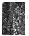
- FIG. 2is an image taken directly from LiDAR data, and shows raw LiDAR point cloud presented in 3D presentation;
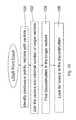
- FIG. 3is a simplified block diagram showing apparatus for processing LiDAR data according to a first preferred embodiment of the present invention
- FIG. 4is a simplified block diagram illustrating a procedure for processing LiDAR data from a point cloud according to a preferred embodiment of the present invention
- FIG. 5is a simplified block diagram showing the process of FIG. 4 in greater detail
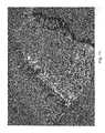
- FIG. 6shows a digital surface model (DSM) in which a relatively flexible skin is placed over the LiDAR points of FIG. 2 ;
- DSMdigital surface model
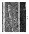
- FIG. 7shows the results of searching for the outlines of flat surface features within an elevation map formed by filtering out the ground points from FIG. 6 ;
- FIG. 8shows the result of having inserted objects in accordance with the outlines inserted in FIG. 7 to provide a three-dimensional model of the region in accordance with the embodiments of the present invention
- FIG. 9is a simplified flow chart showing in greater detail part of the process illustrated in FIG. 5 ;
- FIG. 10is a flow chart illustrating an embodiment of the present invention for identifying power lines.
- FIGS. 11-15show screen shots of the identification of actual power lines using the procedure of FIG. 10 .
- the present inventionin some embodiments thereof, relates to LiDAR and aerial mapping of ground topography, and more particularly but not exclusively to a mapping process using data obtained from the LiDAR sensor.
- the raw LiDAR datamay be inserted into a bare earth filter unit which calculates ground height over the data, bearing in mind that topography can vary over the data gathering area. Once ground height is calculated then all points relating to the ground are removed to leave only those points relating to features superimposed on the ground such as trees and buildings. These features may then be resolved into specific objects. Then the data points identified as these specific objects can be automatically replaced by virtual versions of the objects.
- the resultmay then be included in a 3D model.
- the result of the above processingmay then be presented to the specialist to confirm, add or correct the result using a graphical interface, which also allows rotation of the view and manual confirmation or addition or deletion of objects. Changes are then included in a revised 3D model.
- the 3D modelcan then be rendered for different points of view, allowing a user to carry out virtual travel through the model.
- Three-dimensional rendering of the modelmay take advantage of the computer's graphics card and thus the result is to provide a rendering of the interpreted LiDAR image while saving in all three of time, human resources and hardware resources.
- FIGS. 3-9 of the drawingsFor purposes of better understanding some embodiments of the present invention, as illustrated in FIGS. 3-9 of the drawings, reference is first made to the construction and operation of a conventional (i.e., prior art) LiDAR system as illustrated in FIG. 1 , producing a result as illustrated in FIG. 2 .
- a conventional (i.e., prior art) LiDAR systemas illustrated in FIG. 1 , producing a result as illustrated in FIG. 2 .
- aircraft 10carries a LiDAR sensor 11 on its underside, which scans the ground 12 with laser pulses.
- a typical scan pattern 14is shown.
- the pulsesare reflected by the ground and by objects on the ground and many of the reflections reach the aircraft where they are detected.
- the reflection time of each pulseis used to calculate a distance, and thus each reflected pulse indicates the height of the ground (plus object height) at a given point.
- the LiDARthus builds up a point cloud of data.
- Each pointmay be correlated with the current position of the aircraft, which can be obtained very accurately using Global Positioning System and Inertial Measurement Unit.
- Positioning data from a GPS ground reference station 16is used to enhance the Global Positioning System information.
- the outputis a geo-referenced point cloud.
- FIG. 2illustrates raw LiDAR data as obtained directly from the point cloud.
- FIG. 2illustrates raw LiDAR data as obtained directly from the point cloud.
- Featuresare clearly visible but not interpreted, and the current way to interpret the image is to supply it to a human specialist who marks the image with buildings, roads, trees, etc. It is noted that only upper surfaces are present in the point cloud and so buildings appear as hollow roof shapes, and trees appear as trunkless canopies.
- FIG. 3is a generalized diagram of a LiDAR processing system according to a first embodiment of the present invention.
- a LiDAR system 30provides a geo-referenced point cloud 32 , which has been produced by a LIDAR scan of the ground and geo-referenced by other software packages, as input to a CPU 33 .
- the datais input to CPU 33 , which then identifies the ground topology by first making a digital terrain model of the date and then a digital surface model of the data in the find bare earth unit 34 , and filters out the ground points to leave the elevation points in elevation filter 35 .
- the digital terrain modelis obtained by a process analogous to expanding a balloon from below.
- the walls of the balloonare given certain rigidity so that they do not expand into features in the landscape but they do expand to define the landscape itself.
- the digital surface modelis obtained by virtually expanding a balloon from above, but this time with less rigidity so that the effect is to provide a skin over the points from above. Points in both models may then be assumed to be terrain points and points only in the surface model may be assumed to belong to above-ground features or elevation features.
- FIG. 6illustrates the digital surface model, DSM.
- the LiDAR data with the recognized shapeis fitted with a flexible skin to produce the digital surface model.
- the elevation pointsare then analyzed by object recognition using shape fitting unit 38 .
- Object recognition by shape fittingmay work as follows: once non bare earth points—that is the elevation points are found—the area is divided into blocks. At each block one may look for points that may be part of a plane. Boundaries around the plane are then searched for and drawn in.
- the blocksmay interlap so that planes that fall between two blocks can be matched up.
- All planes from all blocksare then entered into a software machine that takes the planes and connects planes that overlap or intersect and tries to find the connection lines between intersecting planes—thus producing the shapes of the roofs and therefore determining a perimeter for potential buildings.
- the perimetersare then fitted with buildings taken from a library.
- the shape fittingcan be used to search for features in the data, such as power lines, trees, walls, etc, not just buildings. When such a feature is found it is replaced by a virtual object representative of the feature from the library as mentioned.
- the original point cloudmay have had an outline of a roof, which is all of a building that is usually seen from above
- the datamay now be automatically fitted with a three dimensional building fitted under the bounds of the detected roof and including walls and typical building coloring.
- regions having outlines suggestive of treescan have virtual objects indicating the trees.
- Power lines, roads, walls and other surface featuresmay likewise be found by the shape fitting unit 38 .
- automatic shape fitting unit 38searches the elevation points to identify features and replace the points associated with the feature with a virtual object that represents the feature.
- the result of searching for planesis to provide delineated features on the model, as shown in FIG. 7 to be discussed below.
- Interface 40allows such an expert to interact with the model formation process in order to provide the necessary quality control. In particular it allows the expert to rotate the model, zoom in and out and pan, to compare the original LiDAR points and the surface model with the objects that have been inserted.
- the expertmay see that points have been misinterpreted, and that objects have been added which should not have been. Such objects may be marked for deletion. In other cases the expert may see that points have been ignored, and he may mark an object for addition. In other cases the Expert may wish to substitute one object for another.
- the interfacemay allow the expert to add or remove objects in an absolute sense, or the expert may add or remove the objects as suggestions which are then returned to the CPU engine for re-processing.
- An advantage of being able to rotate, zoom and pan the modelis that a grouping of points which is apparent from one angle may look completely different from another angle.
- the expertmakes his changes or suggestions to object recognition module and to the bare earth module and then the calculations are repeated.
- the checking processmay be repeated until the expert is satisfied.
- FIG. 4is a simplified flow chart illustrating the above process.
- the methodcomprises receiving the LiDAR point cloud. Then a stage of identifying ground and objects is entered. In this stage the ground topology is identified and ground points are filtered out to leave elevation points. The elevation points are then searched for human features and fitted with virtual objects. The results is then rendered into a 3D model.
- a loopis then provided in which an expert makes changes using the graphical interface.
- the changesare incorporated into the model until the expert is satisfied and then the resulting model is produced as the final output.
- the resulting 3D modelmay be used in itself.
- the modelcan be used to transform airborne LiDAR geo-referenced point clouds into layers for a graphical information system (GIS).
- GISgraphical information system
- the geographic information systemalso known as a geographical information system or geospatial information system, is a system for capturing, storing, analyzing and managing data and associated attributes which are spatially referenced to the Earth.
- GISis an information system capable of integrating, storing, editing, analyzing, sharing, and displaying geographically-referenced information.
- GISis a tool that allows users to create interactive queries (user created searches), analyze the spatial information, edit data, maps, and present the results of all these operations.
- Geographic information system technologycan be used in applications as diverse as scientific investigations, resource management, asset management, Environmental Impact Assessment, Urban planning, cartography, criminology, history, sales, marketing, and logistics.
- GISmight allow emergency planners to easily calculate emergency response times in the event of a natural disaster
- GISmight be used to find wetlands that need protection from pollution
- GIScan be used by a company to site a new business to take advantage of a previously underserved market.
- the LiDAR data provided according to the present embodimentscan be added as a layer to the GIS.
- the present embodimentsprovide an automatic solution for airborne LiDAR data processing.
- This solutionhas the capability to handle large quantities of data, process them and create output, say in the form of DTM, DSM and SHP files that include specific representations of buildings, trees, power-lines and more feature layers.
- the embodimentthus automatically creates a 3D view of the mapped area.
- the present approach of automatic processing plus manual quality control on a three-dimensional platformincreases the confidence that the mapped area has been well covered and that the collected data is up to date.
- FIG. 5is a flow chart showing the method of FIG. 4 in greater detail.
- the present embodimentis described in relation to airborne data but it is to be borne in mind that aircraft are not the only source of LiDAR data. In particular both terrestrial and satellite LiDAR are contemplated in the present disclosure.
- the point cloud datais streamed in, and converted to a format appropriate for the following processing.
- the point densityis checked, since too low a point density does not allow for object fitting.
- a point density of a point per square meter of grounddoes not yield very much information about the surface structure and would not allow for surface features to be effectively identified.
- the data structureis divided into blocks.
- ground levelis identified using the digital terrain modeling technique discussed above. Ground points can then be filtered out and objects lying on the surface can be extracted. Viewed from above, the objects to be seen are likely to be roofs, trees, and power lines. Reconstruction and manual editing is carried out as described as the objects are inserted into the model and then output data is produced as required, in suitable formats.
- FIG. 6 aboveshows a digital surface model (DSM) of the raw LiDAR data as presented directly from the point cloud.
- the surface modelis constructed by applying a skin over the LiDAR points.
- the roofs of FIG. 2become solid shapes.
- FIG. 7shows how objects apparently identified from the raw LiDAR data as processed can be outlined by the search system following processing. Elevation points that define a plane are grouped together and a boundary drawn around as explained above. Tree objects are also outlined.
- FIG. 8shows building and tree objects that have been inserted to fit with the roof and tree outlines shown in FIG. 7 .
- FIG. 8may be used as the system output together with the digital information of DTM, DSM and vector files.
- the above described embodimentsthus provide for automatic processing of LiDAR data, automatic extraction of the digital terrain model DTM (bare earth) and DSM information, automatic feature extraction, including extraction of buildings, trees, power lines and the like, automatic full scene 3D reconstruction, and a graphical user interface for expert based quality control.
- the input formatsinclude any formats typically used for LiDAR data, such as LAS. Alternatively any ASCII format may be used.
- the output formatsmay include DTM, Shape files, DXF files and more. There is in principle no limitation on input file size.
- the applicationis suitable for fast parallel processing, and is based on a platform with a highly optimized 3D model for real-time applications. The result can be viewed on suitable 3D viewers.
- the present embodimentsprocess the LiDAR data by automatic creation of a virtual realistic 3D presentation of the processed information.
- the processed datamay be reviewed on a virtual realistic 3D presentation by combination of a 2D full area presentation and a 3D virtual realistic block.
- the 3D processed results of the LiDARmay be manually edited.
- FIG. 9expands on the process shown in FIG. 5 and shows in greater detail the three-dimensional reconstruction part of the process.
- the present embodimentsprocess the LiDAR geo-referenced point cloud, and identify and filter out the bare earth as explained.
- the resultis a Digital Elevation Model (DEM), and a classified LiDAR point cloud in which the embodiment identifies features and calculates roof shapes, trees, power lines etc.
- the resultis modeled in 3D.
- a three dimensional virtual reality picture of the scene in 90is produced by using an orthophoto as the background—block 92 .
- TLiDuses the LiDAR intensity to create a background picture for the presentation.
- the usergets a 2D map of all the processed area in 94 on which the review area is marked and the areas which are already reviewed are marked as well. This method insures full area coverage of the review process.
- the usercan rapidly check the quality of the automatic process.
- the userestimates that an erroneous classification exists he clicks the suspicious location and marks the required change.
- the automatic LiDAR data processingruns again in 98 , taking in consideration the inputs of the user by automatically changing parameters that influence the automatic process or by just placing the user requested objects in the user requested location.
- FIG. 10is a simplified flow diagram illustrating a further embodiment of the present invention in which power lines may be identified and added to the model.
- Power linesdiffer from buildings, trees and other features in that they are of much smaller dimension, meaning that while some points of the power lines may be picked up, there are often lacking the points necessary for a computer to see the continuity.
- Current art for identifying power lines from LiDAR point cloudsinvolves manually identifying the towers and power line suspension points and then manually indicating the points belonging to the power lines in between.
- the disadvantage of the aboveis that it is slow. Power providers may be fined for power outages of significant duration and need to be able to identify problems such as trees growing too close to the power lines, buildings illegally put up under the power lines, etc in good time to prevent any power outages.
- FIG. 10allows for automatic identification of power lines.
- a first stage 100points in the point cloud are identified which appear to be parts of substantially horizontal lines. The points are joined together as a vector function.
- a next stage 102is then to join together the disconnected vectors into as few as possible continuous vectors.
- Such a continuous vectorshould represent the power line itself and in fact, surprisingly, actually provides an estimate of the lie of the power line even where it is completely obscured within vegetation.
- the continuous linesend at certain places, giving locations of discontinuity— 104 .
- the next stage, 106is then to look for a tower at the point of discontinuity.
- the system outputsare a classified point cloud, with points classified as power lines and towers, an attachment point list which lists the points at which power lines are attached to the poles, the power line vectors themselves and a list of tower locations.
- the outputscan be provided graphically, and examples of power lines in images created from LiDAR point clouds are shown in FIGS. 11-15 .
- the datais stored in three dimensions so the figures can be viewed from different angles.
- FIG. 12is a two part view showing the final image in the upper part and the original data forming the basis of the image in the lower part. That is to say the lower part shows only the disconnected vectors from which the presence of power lines was inferred. This allows the end user to evaluate the computer's decision about the presence of a power line.
- the current artmerely teaches manual methods for transforming the 3D point cloud into objects and object layers.
- the userlooks at a visualization of a point cloud, and points and clicks the corners of the 3D objects as they are seen in the point cloud.
- the present embodimentsby contrast automatically calculate the bare earth for filtering out the elevation objects. They then display a virtual reality picture of the processed data to the user enabling fast and accurate review of the results. The user can correct errors in the automatic calculation by clicking on the 3D objects and manually selecting object type.
- LiDARLiDAR
Landscapes
- Engineering & Computer Science (AREA)
- Physics & Mathematics (AREA)
- General Physics & Mathematics (AREA)
- Remote Sensing (AREA)
- Radar, Positioning & Navigation (AREA)
- Astronomy & Astrophysics (AREA)
- Multimedia (AREA)
- Theoretical Computer Science (AREA)
- Processing Or Creating Images (AREA)
Abstract
Description
- 1. Enable LiDAR operators to take a substantial amount of data, say a day's worth, load it on a hard disk, and start processing the data automatically.
- 2. Enable a single operator to process quantities of LiDAR data that erstwhile would have required teams of experts, while at the same time the software ensures a certain level of accuracy.
- 3. Reduce overall LiDAR data processing times.
Claims (18)
Priority Applications (1)
| Application Number | Priority Date | Filing Date | Title |
|---|---|---|---|
| US12/318,783US8244026B2 (en) | 2008-01-09 | 2009-01-08 | Apparatus and method for automatic airborne LiDAR data processing and mapping using data obtained thereby |
Applications Claiming Priority (2)
| Application Number | Priority Date | Filing Date | Title |
|---|---|---|---|
| US637008P | 2008-01-09 | 2008-01-09 | |
| US12/318,783US8244026B2 (en) | 2008-01-09 | 2009-01-08 | Apparatus and method for automatic airborne LiDAR data processing and mapping using data obtained thereby |
Publications (2)
| Publication Number | Publication Date |
|---|---|
| US20090185741A1 US20090185741A1 (en) | 2009-07-23 |
| US8244026B2true US8244026B2 (en) | 2012-08-14 |
Family
ID=40848358
Family Applications (1)
| Application Number | Title | Priority Date | Filing Date |
|---|---|---|---|
| US12/318,783Expired - Fee RelatedUS8244026B2 (en) | 2008-01-09 | 2009-01-08 | Apparatus and method for automatic airborne LiDAR data processing and mapping using data obtained thereby |
Country Status (2)
| Country | Link |
|---|---|
| US (1) | US8244026B2 (en) |
| CA (1) | CA2649916A1 (en) |
Cited By (25)
| Publication number | Priority date | Publication date | Assignee | Title |
|---|---|---|---|---|
| US20140177928A1 (en)* | 2011-05-16 | 2014-06-26 | Ergon Energy Corporation Limited | Method and system for processing image data |
| WO2014132020A1 (en) | 2013-02-27 | 2014-09-04 | Arithmetica Ltd | Image processing |
| US9110163B2 (en) | 2013-06-14 | 2015-08-18 | Microsoft Technology Licensing, Llc | Lidar-based classification of object movement |
| US20150248577A1 (en)* | 2012-09-21 | 2015-09-03 | Umwelt (Australia) Pty. Limited | On-ground or near-ground discrete object detection method and system |
| CN105488836A (en)* | 2015-11-16 | 2016-04-13 | 武汉海达数云技术有限公司 | Circular colored tape point cloud rendering method based on elevation distribution characteristics |
| US9523772B2 (en) | 2013-06-14 | 2016-12-20 | Microsoft Technology Licensing, Llc | Object removal using lidar-based classification |
| US9576373B2 (en) | 2015-04-30 | 2017-02-21 | Harris Corporation | Geospatial imaging system providing segmentation and classification features and related methods |
| DE102016002354A1 (en)* | 2016-02-26 | 2017-08-31 | David Mauro | System for determining a topography of a terrain |
| CN108757345A (en)* | 2018-08-10 | 2018-11-06 | 上海扩博智能技术有限公司 | The automatic tracking detection method and system of fan blade are carried out by unmanned plane |
| WO2020021311A1 (en) | 2018-07-23 | 2020-01-30 | Bosch Car Multimedia Portugal S.a. | Terrestrial vehicle range finder device and operation method thereof |
| US10762707B2 (en) | 2017-11-17 | 2020-09-01 | Thales Canada, Inc. | Point cloud rail asset data extraction |
| US10908282B2 (en) | 2017-04-07 | 2021-02-02 | General Electric Company | LiDAR system and method |
| US10962650B2 (en) | 2017-10-31 | 2021-03-30 | United States Of America As Represented By The Administrator Of Nasa | Polyhedral geofences |
| US11391844B2 (en)* | 2018-12-19 | 2022-07-19 | Fca Us Llc | Detection and tracking of road-side pole-shaped static objects from LIDAR point cloud data |
| US11455565B2 (en) | 2017-08-31 | 2022-09-27 | Ford Global Technologies, Llc | Augmenting real sensor recordings with simulated sensor data |
| US11487988B2 (en) | 2017-08-31 | 2022-11-01 | Ford Global Technologies, Llc | Augmenting real sensor recordings with simulated sensor data |
| US11495026B2 (en)* | 2018-08-27 | 2022-11-08 | Hitachi Solutions, Ltd. | Aerial line extraction system and method |
| US20230042178A1 (en)* | 2020-03-31 | 2023-02-09 | Nec Corporation | Analysis device, analysis method, and storage medium |
| DE102021212789A1 (en) | 2021-11-15 | 2023-05-17 | Robert Bosch Gesellschaft mit beschränkter Haftung | Method for determining the maximum range of a LiDAR sensor and a corresponding device |
| US11810251B2 (en) | 2019-10-03 | 2023-11-07 | General Electric Company | Remote sensing method to model terrain shape by detecting reliable ground points |
| US11933967B2 (en) | 2019-08-22 | 2024-03-19 | Red Creamery, LLC | Distally actuated scanning mirror |
| US12123950B2 (en) | 2016-02-15 | 2024-10-22 | Red Creamery, LLC | Hybrid LADAR with co-planar scanning and imaging field-of-view |
| US20240355045A1 (en)* | 2023-04-24 | 2024-10-24 | Wuhan University | AIRBORNE LiDAR POINT CLOUD FILTERING METHOD DEVICE BASED ON SUPER-VOXEL GROUND SALIENCY |
| US12399279B1 (en) | 2016-02-15 | 2025-08-26 | Red Creamery Llc | Enhanced hybrid LIDAR with high-speed scanning |
| US12399278B1 (en) | 2016-02-15 | 2025-08-26 | Red Creamery Llc | Hybrid LIDAR with optically enhanced scanned laser |
Families Citing this family (67)
| Publication number | Priority date | Publication date | Assignee | Title |
|---|---|---|---|---|
| US8139863B1 (en)* | 2008-04-25 | 2012-03-20 | Hsu Shin-Yi | System for capturing, characterizing and visualizing lidar and generic image data |
| US9551575B2 (en) | 2009-03-25 | 2017-01-24 | Faro Technologies, Inc. | Laser scanner having a multi-color light source and real-time color receiver |
| DE102009015920B4 (en) | 2009-03-25 | 2014-11-20 | Faro Technologies, Inc. | Device for optically scanning and measuring an environment |
| DE102009057101A1 (en) | 2009-11-20 | 2011-05-26 | Faro Technologies, Inc., Lake Mary | Device for optically scanning and measuring an environment |
| US9210288B2 (en) | 2009-11-20 | 2015-12-08 | Faro Technologies, Inc. | Three-dimensional scanner with dichroic beam splitters to capture a variety of signals |
| US9529083B2 (en) | 2009-11-20 | 2016-12-27 | Faro Technologies, Inc. | Three-dimensional scanner with enhanced spectroscopic energy detector |
| US9113023B2 (en) | 2009-11-20 | 2015-08-18 | Faro Technologies, Inc. | Three-dimensional scanner with spectroscopic energy detector |
| DE102009055989B4 (en) | 2009-11-20 | 2017-02-16 | Faro Technologies, Inc. | Device for optically scanning and measuring an environment |
| FR2953313B1 (en)* | 2009-11-27 | 2012-09-21 | Thales Sa | OPTRONIC SYSTEM AND METHOD FOR PREPARING THREE-DIMENSIONAL IMAGES FOR IDENTIFICATION |
| US9879976B2 (en) | 2010-01-20 | 2018-01-30 | Faro Technologies, Inc. | Articulated arm coordinate measurement machine that uses a 2D camera to determine 3D coordinates of smoothly continuous edge features |
| US9628775B2 (en) | 2010-01-20 | 2017-04-18 | Faro Technologies, Inc. | Articulated arm coordinate measurement machine having a 2D camera and method of obtaining 3D representations |
| US8942940B2 (en) | 2010-01-20 | 2015-01-27 | Faro Technologies, Inc. | Portable articulated arm coordinate measuring machine and integrated electronic data processing system |
| US9607239B2 (en) | 2010-01-20 | 2017-03-28 | Faro Technologies, Inc. | Articulated arm coordinate measurement machine having a 2D camera and method of obtaining 3D representations |
| US9163922B2 (en) | 2010-01-20 | 2015-10-20 | Faro Technologies, Inc. | Coordinate measurement machine with distance meter and camera to determine dimensions within camera images |
| US8624902B2 (en)* | 2010-02-04 | 2014-01-07 | Microsoft Corporation | Transitioning between top-down maps and local navigation of reconstructed 3-D scenes |
| DE102010020925B4 (en) | 2010-05-10 | 2014-02-27 | Faro Technologies, Inc. | Method for optically scanning and measuring an environment |
| PL2418510T3 (en)* | 2010-07-30 | 2014-07-31 | Eads Deutschland Gmbh | Method for evaluating the suitability of a piece of land for a landing zone or taxi surface for airplanes |
| US20140125671A1 (en)* | 2010-09-16 | 2014-05-08 | Borys Vorobyov | System and Method for Detailed Automated Feature Extraction from Data Having Spatial Coordinates |
| US9168654B2 (en) | 2010-11-16 | 2015-10-27 | Faro Technologies, Inc. | Coordinate measuring machines with dual layer arm |
| US8713032B2 (en)* | 2011-02-23 | 2014-04-29 | Google Inc. | Cross-platform cloud-based map creation |
| DE102012100609A1 (en) | 2012-01-25 | 2013-07-25 | Faro Technologies, Inc. | Device for optically scanning and measuring an environment |
| US9347793B2 (en)* | 2012-04-02 | 2016-05-24 | Honeywell International Inc. | Synthetic vision systems and methods for displaying detached objects |
| CN102662179A (en)* | 2012-05-18 | 2012-09-12 | 四川省科学城久利科技实业有限责任公司 | Three-dimensional optimizing route selection method based on airborne laser radar |
| US9418478B2 (en) | 2012-06-05 | 2016-08-16 | Apple Inc. | Methods and apparatus for building a three-dimensional model from multiple data sets |
| US8997362B2 (en) | 2012-07-17 | 2015-04-07 | Faro Technologies, Inc. | Portable articulated arm coordinate measuring machine with optical communications bus |
| DE102012107544B3 (en) | 2012-08-17 | 2013-05-23 | Faro Technologies, Inc. | Optical scanning device i.e. laser scanner, for evaluating environment, has planetary gears driven by motor over vertical motor shaft and rotating measuring head relative to foot, where motor shaft is arranged coaxial to vertical axle |
| US10067231B2 (en) | 2012-10-05 | 2018-09-04 | Faro Technologies, Inc. | Registration calculation of three-dimensional scanner data performed between scans based on measurements by two-dimensional scanner |
| DE102012109481A1 (en) | 2012-10-05 | 2014-04-10 | Faro Technologies, Inc. | Device for optically scanning and measuring an environment |
| US9513107B2 (en) | 2012-10-05 | 2016-12-06 | Faro Technologies, Inc. | Registration calculation between three-dimensional (3D) scans based on two-dimensional (2D) scan data from a 3D scanner |
| HUP1300328A3 (en)* | 2013-05-23 | 2017-03-28 | Mta Szamitastechnika Es Automatizalasi Ki | Method and system for integrated three dimensional modelling |
| US9652852B2 (en) | 2013-09-24 | 2017-05-16 | Faro Technologies, Inc. | Automated generation of a three-dimensional scanner video |
| DE102013110580B4 (en)* | 2013-09-24 | 2024-05-23 | Faro Technologies, Inc. | Method for optically scanning and measuring a scene and laser scanner designed to carry out the method |
| US9562771B2 (en) | 2013-12-18 | 2017-02-07 | Sharper Shape Ltd | Analysis of sensor data |
| JP6274410B2 (en)* | 2014-02-14 | 2018-02-07 | コニカミノルタ株式会社 | Overhead detection method |
| US9460520B2 (en) | 2014-02-24 | 2016-10-04 | Vricon Systems Ab | Method and arrangement for identifying a difference between a first 3D model of an environment and a second 3D model of the environment |
| US9330435B2 (en)* | 2014-03-19 | 2016-05-03 | Raytheon Company | Bare earth finding and feature extraction for 3D point clouds |
| CN103954953B (en)* | 2014-05-16 | 2016-04-06 | 武汉大学 | The blind source error compensation method of a kind of airborne laser radar based on data-driven |
| CN104007432A (en)* | 2014-05-16 | 2014-08-27 | 武汉大学 | Landmark laying method for checking plane precision of airborne laser radar |
| CA2958204A1 (en)* | 2014-08-15 | 2016-02-18 | Aeye, Inc. | Methods and systems for ladar transmission |
| US10698110B2 (en) | 2015-03-05 | 2020-06-30 | Teledyne Digital Imaging, Inc. | Laser scanning apparatus and method |
| US9836895B1 (en) | 2015-06-19 | 2017-12-05 | Waymo Llc | Simulating virtual objects |
| AT517701B1 (en)* | 2016-04-15 | 2017-04-15 | Riegl Laser Measurement Systems Gmbh | laser scanner |
| US20170314925A1 (en)* | 2016-04-28 | 2017-11-02 | Rogerson Aircraft Corporation | System and method for providing terrain imagery during low visibility conditions |
| US10255716B1 (en) | 2016-08-09 | 2019-04-09 | Bentley Systems, Incorporated | Multi-resolution tiled 2.5D delaunay triangulation stitching |
| US10255720B1 (en) | 2016-10-13 | 2019-04-09 | Bentley Systems, Incorporated | Hybrid mesh from 2.5D and 3D point data |
| CN107367767A (en)* | 2017-06-27 | 2017-11-21 | 上海卓思智能科技股份有限公司 | A kind of vent cabinet window foreign matter detecting method and system and a kind of controller |
| CN108037514A (en)* | 2017-11-07 | 2018-05-15 | 国网甘肃省电力公司电力科学研究院 | One kind carries out screen of trees safety detection method using laser point cloud |
| CA3093512A1 (en)* | 2018-03-19 | 2019-09-26 | Outsight | Methods and systems for identifying material composition of objects |
| US11100664B2 (en)* | 2019-08-09 | 2021-08-24 | Google Llc | Depth-aware photo editing |
| US11508042B1 (en) | 2020-01-29 | 2022-11-22 | State Farm Mutual Automobile Insurance Company | Imputation of 3D data using generative adversarial networks |
| US20210373173A1 (en)* | 2020-06-02 | 2021-12-02 | Motional Ad Llc | Identifying background features using lidar |
| CN111796298B (en)* | 2020-07-06 | 2023-01-10 | 贵州电网有限责任公司 | Automatic point cloud point supplementing method for laser LiDAR power line |
| CN111913185B (en)* | 2020-07-09 | 2024-04-02 | 生态环境部南京环境科学研究所 | TLS (TLS (visual inspection) measuring method for low shrub pattern investigation of severe cold fragile region |
| CN112199991B (en)* | 2020-08-27 | 2024-04-30 | 广州中国科学院软件应用技术研究所 | A simulation point cloud filtering method and system for roadside perception in vehicle-road collaboration |
| CN112305559A (en)* | 2020-10-16 | 2021-02-02 | 贵州电网有限责任公司 | Power transmission line distance measuring method, device and system based on ground fixed-point laser radar scanning and electronic equipment |
| US11594022B2 (en)* | 2020-11-16 | 2023-02-28 | International Business Machines Corporation | Power line georectification |
| CN113065014B (en)* | 2020-12-05 | 2021-12-17 | 林周容 | Drop tree body type identification device and method |
| CN112884723B (en)* | 2021-02-02 | 2022-08-12 | 贵州电网有限责任公司 | Insulator string detection method in three-dimensional laser point cloud data |
| US12158547B2 (en) | 2021-02-18 | 2024-12-03 | Lg Innotek Co., Ltd. | Method for characterizing lidar point cloud quality |
| CN113589319A (en)* | 2021-10-08 | 2021-11-02 | 中南大学 | Iterative minimum laser radar point cloud filtering method |
| CN114018228B (en)* | 2021-11-04 | 2024-01-23 | 武汉天测测绘科技有限公司 | Mobile track traffic three-dimensional data acquisition method and system |
| CN114419231B (en)* | 2022-03-14 | 2022-07-19 | 幂元科技有限公司 | Traffic facility vector identification, extraction and analysis system based on point cloud data and AI technology |
| CN114965847B (en)* | 2022-05-23 | 2023-05-12 | 西南大学 | A non-destructive monitoring method of pepper nitrogen accumulation based on airborne lidar |
| EP4390442A1 (en)* | 2022-12-22 | 2024-06-26 | Axis AB | Method for reducing an amount of data representing a lidar measurement and a monitoring device implementing the method |
| CN116374863A (en)* | 2023-04-04 | 2023-07-04 | 陕西建设机械股份有限公司 | Intelligent auxiliary control method, system, medium, equipment, terminal and tower crane |
| CN116930993A (en)* | 2023-07-26 | 2023-10-24 | 北京易控智驾科技有限公司 | A sensing method, system, device and storage medium for roadside equipment |
| WO2025072464A1 (en)* | 2023-09-29 | 2025-04-03 | Battelle Memorial Institute | System and method for realtime sensor visualization in degraded visual environments |
Citations (5)
| Publication number | Priority date | Publication date | Assignee | Title |
|---|---|---|---|---|
| US6757445B1 (en)* | 2000-10-04 | 2004-06-29 | Pixxures, Inc. | Method and apparatus for producing digital orthophotos using sparse stereo configurations and external models |
| US20050286101A1 (en)* | 2004-04-13 | 2005-12-29 | Board Of Regents, The University Of Texas System | Holographic projector |
| US20070031064A1 (en)* | 2004-06-10 | 2007-02-08 | Wenyi Zhao | Method and apparatus for aligning video to three-dimensional point clouds |
| US7363157B1 (en)* | 2005-02-10 | 2008-04-22 | Sarnoff Corporation | Method and apparatus for performing wide area terrain mapping |
| US8139863B1 (en)* | 2008-04-25 | 2012-03-20 | Hsu Shin-Yi | System for capturing, characterizing and visualizing lidar and generic image data |
- 2009
- 2009-01-08CACA002649916Apatent/CA2649916A1/ennot_activeAbandoned
- 2009-01-08USUS12/318,783patent/US8244026B2/ennot_activeExpired - Fee Related
Patent Citations (7)
| Publication number | Priority date | Publication date | Assignee | Title |
|---|---|---|---|---|
| US6757445B1 (en)* | 2000-10-04 | 2004-06-29 | Pixxures, Inc. | Method and apparatus for producing digital orthophotos using sparse stereo configurations and external models |
| US20050031197A1 (en)* | 2000-10-04 | 2005-02-10 | Knopp David E. | Method and apparatus for producing digital orthophotos using sparse stereo configurations and external models |
| US20050286101A1 (en)* | 2004-04-13 | 2005-12-29 | Board Of Regents, The University Of Texas System | Holographic projector |
| US20070031064A1 (en)* | 2004-06-10 | 2007-02-08 | Wenyi Zhao | Method and apparatus for aligning video to three-dimensional point clouds |
| US7187809B2 (en)* | 2004-06-10 | 2007-03-06 | Sarnoff Corporation | Method and apparatus for aligning video to three-dimensional point clouds |
| US7363157B1 (en)* | 2005-02-10 | 2008-04-22 | Sarnoff Corporation | Method and apparatus for performing wide area terrain mapping |
| US8139863B1 (en)* | 2008-04-25 | 2012-03-20 | Hsu Shin-Yi | System for capturing, characterizing and visualizing lidar and generic image data |
Cited By (33)
| Publication number | Priority date | Publication date | Assignee | Title |
|---|---|---|---|---|
| US20140177928A1 (en)* | 2011-05-16 | 2014-06-26 | Ergon Energy Corporation Limited | Method and system for processing image data |
| US9384399B2 (en)* | 2011-05-16 | 2016-07-05 | Fugro Roames Pty Ltd. | Method and system for processing image data obtained from scanning a network infrastructure |
| US20150248577A1 (en)* | 2012-09-21 | 2015-09-03 | Umwelt (Australia) Pty. Limited | On-ground or near-ground discrete object detection method and system |
| US9530055B2 (en)* | 2012-09-21 | 2016-12-27 | Anditi Pty Ltd | On-ground or near-ground discrete object detection method and system |
| WO2014132020A1 (en) | 2013-02-27 | 2014-09-04 | Arithmetica Ltd | Image processing |
| US10186080B2 (en) | 2013-02-27 | 2019-01-22 | Arithmetica Ltd | Image processing |
| US9523772B2 (en) | 2013-06-14 | 2016-12-20 | Microsoft Technology Licensing, Llc | Object removal using lidar-based classification |
| US9870512B2 (en) | 2013-06-14 | 2018-01-16 | Uber Technologies, Inc. | Lidar-based classification of object movement |
| US9905032B2 (en) | 2013-06-14 | 2018-02-27 | Microsoft Technology Licensing, Llc | Object removal using lidar-based classification |
| US9110163B2 (en) | 2013-06-14 | 2015-08-18 | Microsoft Technology Licensing, Llc | Lidar-based classification of object movement |
| US9576373B2 (en) | 2015-04-30 | 2017-02-21 | Harris Corporation | Geospatial imaging system providing segmentation and classification features and related methods |
| CN105488836A (en)* | 2015-11-16 | 2016-04-13 | 武汉海达数云技术有限公司 | Circular colored tape point cloud rendering method based on elevation distribution characteristics |
| US12399278B1 (en) | 2016-02-15 | 2025-08-26 | Red Creamery Llc | Hybrid LIDAR with optically enhanced scanned laser |
| US12399279B1 (en) | 2016-02-15 | 2025-08-26 | Red Creamery Llc | Enhanced hybrid LIDAR with high-speed scanning |
| US12123950B2 (en) | 2016-02-15 | 2024-10-22 | Red Creamery, LLC | Hybrid LADAR with co-planar scanning and imaging field-of-view |
| DE102016002354B4 (en) | 2016-02-26 | 2023-10-05 | David Mauro | System for determining a topography of a terrain |
| DE102016002354A1 (en)* | 2016-02-26 | 2017-08-31 | David Mauro | System for determining a topography of a terrain |
| US10908282B2 (en) | 2017-04-07 | 2021-02-02 | General Electric Company | LiDAR system and method |
| US11921204B2 (en) | 2017-04-07 | 2024-03-05 | General Electric Company | LiDAR system and method |
| US11455565B2 (en) | 2017-08-31 | 2022-09-27 | Ford Global Technologies, Llc | Augmenting real sensor recordings with simulated sensor data |
| US11487988B2 (en) | 2017-08-31 | 2022-11-01 | Ford Global Technologies, Llc | Augmenting real sensor recordings with simulated sensor data |
| US10962650B2 (en) | 2017-10-31 | 2021-03-30 | United States Of America As Represented By The Administrator Of Nasa | Polyhedral geofences |
| US10762707B2 (en) | 2017-11-17 | 2020-09-01 | Thales Canada, Inc. | Point cloud rail asset data extraction |
| WO2020021311A1 (en) | 2018-07-23 | 2020-01-30 | Bosch Car Multimedia Portugal S.a. | Terrestrial vehicle range finder device and operation method thereof |
| CN108757345A (en)* | 2018-08-10 | 2018-11-06 | 上海扩博智能技术有限公司 | The automatic tracking detection method and system of fan blade are carried out by unmanned plane |
| US11495026B2 (en)* | 2018-08-27 | 2022-11-08 | Hitachi Solutions, Ltd. | Aerial line extraction system and method |
| US11391844B2 (en)* | 2018-12-19 | 2022-07-19 | Fca Us Llc | Detection and tracking of road-side pole-shaped static objects from LIDAR point cloud data |
| US11933967B2 (en) | 2019-08-22 | 2024-03-19 | Red Creamery, LLC | Distally actuated scanning mirror |
| US11810251B2 (en) | 2019-10-03 | 2023-11-07 | General Electric Company | Remote sensing method to model terrain shape by detecting reliable ground points |
| US20230042178A1 (en)* | 2020-03-31 | 2023-02-09 | Nec Corporation | Analysis device, analysis method, and storage medium |
| US12360235B2 (en)* | 2020-03-31 | 2025-07-15 | Nec Corporation | Analysis device, analysis method, and storage medium |
| DE102021212789A1 (en) | 2021-11-15 | 2023-05-17 | Robert Bosch Gesellschaft mit beschränkter Haftung | Method for determining the maximum range of a LiDAR sensor and a corresponding device |
| US20240355045A1 (en)* | 2023-04-24 | 2024-10-24 | Wuhan University | AIRBORNE LiDAR POINT CLOUD FILTERING METHOD DEVICE BASED ON SUPER-VOXEL GROUND SALIENCY |
Also Published As
| Publication number | Publication date |
|---|---|
| US20090185741A1 (en) | 2009-07-23 |
| CA2649916A1 (en) | 2009-07-09 |
Similar Documents
| Publication | Publication Date | Title |
|---|---|---|
| US8244026B2 (en) | Apparatus and method for automatic airborne LiDAR data processing and mapping using data obtained thereby | |
| CN113034689B (en) | Laser point cloud-based terrain three-dimensional model, terrain map construction method and system, and storage medium | |
| Corns et al. | High resolution 3-dimensional documentation of archaeological monuments & landscapes using airborne LiDAR | |
| CN108375367A (en) | Combined ground laser radar and the work of oblique photograph point surveying method and system | |
| KR101405891B1 (en) | Reality display system of air inteligence and method thereof | |
| JP4619504B2 (en) | 3D digital map generator | |
| Lai et al. | The territory-wide airborne light detection and ranging survey for the Hong Kong Special Administrative Region | |
| Starek et al. | Small-scale UAS for geoinformatics applications on an island campus | |
| Capolupo et al. | Integration of terrestrial laser scanning and UAV-SFM technique to generate a detailed 3D textured model of a heritage building | |
| Chen et al. | Intelligent interpretation of the geometric properties of rock mass discontinuities based on an unmanned aerial vehicle | |
| Di Stefano et al. | Point cloud classification of an urban environment using a semi-automatic approach | |
| CN114511795A (en) | Method and system for identifying and analyzing flatness of trench bottom and trench side slope of trench | |
| Chonpatathip et al. | Utilizing Unmanned Aerial Vehicles (UAVs) for Earthwork Fill Height Determination in Road Construction | |
| Zhang et al. | Primitive-based building reconstruction by integration of Lidar data and optical imagery | |
| RU2591173C1 (en) | Method of producing, processing and displaying geospatial data in 3d format with laser scanning technology | |
| US20230298207A1 (en) | Information processing apparatus, information processing system, information processing method, and non-transitory computer-executable medium | |
| Aringer et al. | Calculation and Update of a 3d Building Model of Bavaria Using LIDAR, Image Matching and Catastre Information | |
| Djenaliev et al. | Unmanned Aerial Systems for Building Footprint Extraction in Urban Area | |
| Mohamad et al. | Derivation of high-resolution orthophoto map from multirotor drone survey for application in infrastructure management | |
| Vasić et al. | The importance of mobile laser scanning in the collection of road infrastructure data | |
| Ramadhani | An Analysis of the Three-Dimensional Modelling Using LiDAR Data and Unmanned Aerial Vehicle (UAV)(Case Study: Institut Teknologi Sepuluh Nopember, Sukolilo Campus) | |
| CN120313560B (en) | Multi-dimensional mapping method and system for mountain | |
| Sima et al. | Computer-aided image geometry analysis and subset selection for optimizing texture quality in photorealistic models | |
| Maciąg et al. | Implementation of unmanned aerial vehicles in the automated assessment of geodetic database validity | |
| Lawas | Complementary use of aiborne LiDAR and terrestrial laser scanner to assess above ground biomass/carbon in Ayer Hitam tropical rain forest reserve |
Legal Events
| Date | Code | Title | Description |
|---|---|---|---|
| AS | Assignment | Owner name:TILTAN SYSTEMS ENGINEERING LTD., ISRAEL Free format text:ASSIGNMENT OF ASSIGNORS INTEREST;ASSIGNORS:NAHARI, ALON;MENAKER, EHUD;NAHARI, OFER;AND OTHERS;REEL/FRAME:022313/0501 Effective date:20090108 | |
| ZAAA | Notice of allowance and fees due | Free format text:ORIGINAL CODE: NOA | |
| ZAAB | Notice of allowance mailed | Free format text:ORIGINAL CODE: MN/=. | |
| STCF | Information on status: patent grant | Free format text:PATENTED CASE | |
| FPAY | Fee payment | Year of fee payment:4 | |
| AS | Assignment | Owner name:MATRIX I.T. SYSTEMS LTD, ISRAEL Free format text:MERGER;ASSIGNOR:TILTAN SYSTEMS ENGINEERING LTD;REEL/FRAME:051828/0007 Effective date:20170821 | |
| FEPP | Fee payment procedure | Free format text:ENTITY STATUS SET TO UNDISCOUNTED (ORIGINAL EVENT CODE: BIG.); ENTITY STATUS OF PATENT OWNER: LARGE ENTITY | |
| FEPP | Fee payment procedure | Free format text:7.5 YR SURCHARGE - LATE PMT W/IN 6 MO, LARGE ENTITY (ORIGINAL EVENT CODE: M1555); ENTITY STATUS OF PATENT OWNER: LARGE ENTITY | |
| MAFP | Maintenance fee payment | Free format text:PAYMENT OF MAINTENANCE FEE, 8TH YEAR, LARGE ENTITY (ORIGINAL EVENT CODE: M1552); ENTITY STATUS OF PATENT OWNER: LARGE ENTITY Year of fee payment:8 | |
| FEPP | Fee payment procedure | Free format text:MAINTENANCE FEE REMINDER MAILED (ORIGINAL EVENT CODE: REM.); ENTITY STATUS OF PATENT OWNER: LARGE ENTITY | |
| LAPS | Lapse for failure to pay maintenance fees | Free format text:PATENT EXPIRED FOR FAILURE TO PAY MAINTENANCE FEES (ORIGINAL EVENT CODE: EXP.); ENTITY STATUS OF PATENT OWNER: LARGE ENTITY | |
| STCH | Information on status: patent discontinuation | Free format text:PATENT EXPIRED DUE TO NONPAYMENT OF MAINTENANCE FEES UNDER 37 CFR 1.362 | |
| FP | Lapsed due to failure to pay maintenance fee | Effective date:20240814 |