US8174437B2 - System and method for augmenting DGNSS with internally-generated differential correction - Google Patents
System and method for augmenting DGNSS with internally-generated differential correctionDownload PDFInfo
- Publication number
- US8174437B2 US8174437B2US12/511,821US51182109AUS8174437B2US 8174437 B2US8174437 B2US 8174437B2US 51182109 AUS51182109 AUS 51182109AUS 8174437 B2US8174437 B2US 8174437B2
- Authority
- US
- United States
- Prior art keywords
- differential
- satellite
- rover
- observations
- receiver
- Prior art date
- Legal status (The legal status is an assumption and is not a legal conclusion. Google has not performed a legal analysis and makes no representation as to the accuracy of the status listed.)
- Active, expires
Links
- 238000012937correctionMethods0.000titleclaimsabstractdescription106
- 238000000034methodMethods0.000titleclaimsdescription58
- 230000003190augmentative effectEffects0.000title1
- 241001061260Emmelichthys struhsakeriSpecies0.000claimsabstractdescription110
- 238000005259measurementMethods0.000claimsdescription16
- 238000004891communicationMethods0.000claimsdescription5
- 230000003416augmentationEffects0.000claimsdescription4
- 239000000243solutionSubstances0.000description22
- 230000008901benefitEffects0.000description16
- 230000000694effectsEffects0.000description16
- 230000008859changeEffects0.000description15
- 239000005433ionosphereSubstances0.000description12
- 238000013459approachMethods0.000description11
- 239000005436troposphereSubstances0.000description10
- 230000008569processEffects0.000description9
- 230000001419dependent effectEffects0.000description7
- 230000001934delayEffects0.000description5
- 238000012545processingMethods0.000description5
- 238000001514detection methodMethods0.000description3
- 230000001133accelerationEffects0.000description2
- 230000004075alterationEffects0.000description2
- 238000013461designMethods0.000description2
- 238000010790dilutionMethods0.000description2
- 239000012895dilutionSubstances0.000description2
- 238000012986modificationMethods0.000description2
- 230000004048modificationEffects0.000description2
- 238000012544monitoring processMethods0.000description2
- 230000000644propagated effectEffects0.000description2
- 238000012935AveragingMethods0.000description1
- 241001061257EmmelichthyidaeSpecies0.000description1
- 238000009825accumulationMethods0.000description1
- 230000002238attenuated effectEffects0.000description1
- 230000001010compromised effectEffects0.000description1
- 239000000470constituentSubstances0.000description1
- 238000009795derivationMethods0.000description1
- 230000009977dual effectEffects0.000description1
- 238000005516engineering processMethods0.000description1
- 238000001914filtrationMethods0.000description1
- 230000003116impacting effectEffects0.000description1
- 238000007689inspectionMethods0.000description1
- 230000010354integrationEffects0.000description1
- 230000000670limiting effectEffects0.000description1
- 230000007774longtermEffects0.000description1
- 239000000463materialSubstances0.000description1
- 238000013508migrationMethods0.000description1
- 230000005012migrationEffects0.000description1
- 239000000203mixtureSubstances0.000description1
- 230000036961partial effectEffects0.000description1
- 230000000737periodic effectEffects0.000description1
- 230000003449preventive effectEffects0.000description1
- 230000001902propagating effectEffects0.000description1
- 230000002829reductive effectEffects0.000description1
- 230000003068static effectEffects0.000description1
- 239000013589supplementSubstances0.000description1
- 238000012360testing methodMethods0.000description1
Images


Classifications
- G—PHYSICS
- G01—MEASURING; TESTING
- G01S—RADIO DIRECTION-FINDING; RADIO NAVIGATION; DETERMINING DISTANCE OR VELOCITY BY USE OF RADIO WAVES; LOCATING OR PRESENCE-DETECTING BY USE OF THE REFLECTION OR RERADIATION OF RADIO WAVES; ANALOGOUS ARRANGEMENTS USING OTHER WAVES
- G01S19/00—Satellite radio beacon positioning systems; Determining position, velocity or attitude using signals transmitted by such systems
- G01S19/38—Determining a navigation solution using signals transmitted by a satellite radio beacon positioning system
- G01S19/39—Determining a navigation solution using signals transmitted by a satellite radio beacon positioning system the satellite radio beacon positioning system transmitting time-stamped messages, e.g. GPS [Global Positioning System], GLONASS [Global Orbiting Navigation Satellite System] or GALILEO
- G01S19/40—Correcting position, velocity or attitude
- G01S19/41—Differential correction, e.g. DGPS [differential GPS]
- G—PHYSICS
- G01—MEASURING; TESTING
- G01S—RADIO DIRECTION-FINDING; RADIO NAVIGATION; DETERMINING DISTANCE OR VELOCITY BY USE OF RADIO WAVES; LOCATING OR PRESENCE-DETECTING BY USE OF THE REFLECTION OR RERADIATION OF RADIO WAVES; ANALOGOUS ARRANGEMENTS USING OTHER WAVES
- G01S19/00—Satellite radio beacon positioning systems; Determining position, velocity or attitude using signals transmitted by such systems
- G01S19/01—Satellite radio beacon positioning systems transmitting time-stamped messages, e.g. GPS [Global Positioning System], GLONASS [Global Orbiting Navigation Satellite System] or GALILEO
- G01S19/13—Receivers
- G01S19/33—Multimode operation in different systems which transmit time stamped messages, e.g. GPS/GLONASS
Definitions
- the inventionrelates generally to methods for processing signals received from satellites within a Global Navigation Satellite System (GNSS) for example, Global Positioning System (GPS) receivers, and more particularly to a method for computing precise relative locations using differential GNSS/GPS techniques for all observations measured by a rover GNSS receiver, and not just those observations that are common to base and rover GNSS receivers.
- GNSSGlobal Navigation Satellite System
- GPSGlobal Positioning System
- GNSSGlobal Navigation Satellite System
- DGPSdifferential-based positioning
- Differential GPS/GNSS techniqueshave been successfully applied for a number of years. These techniques, for example, enable accurate real-time positioning of a rover receiver relative to a base receiver. This positioning includes code-only or carrier-smoothed-code differential techniques that result in sub-meter accuracy, such as those employed while operating with older RTCM 104 messages. They include carrier phase based techniques that facilitate centimeter-level real-time kinematic (RTK) positioning and employ single- or double- or even triple-differencing.
- RTKcentimeter-level real-time kinematic
- Satellite-Based-Augmentation-Systemssuch as the FAA's Wide Area Augmentation System (WAAS) system as well as commercial Wide Area Differential (WADGPS) services such as those provided by OmniStar.
- SAASatellite-Based-Augmentation-Systems
- WAASWide Area Augmentation System
- WADGPSWide Area Differential
- DGNSSDifferential GNSS
- DGNSSDifferential GNSS
- This type of differencecommonly referred to as the single-difference, removes common-mode errors (i.e. errors seen by both base and rover receivers) such as satellite orbit errors, satellite clock errors, and atmospheric errors that arise as the signal passes through the ionosphere and the troposphere.
- common-mode errorsi.e. errors seen by both base and rover receivers
- the remaining sources of error that result when employing single-difference techniquesare those that are unique to the receiver, such as receiver noise and multipath. These remaining errors are often small in comparison to the common-mode errors, especially when carrier-phase observations are employed.
- GNSSGlobal Navigation Satellite System
- GLONASSGlobal Navigation Satellite System
- GalileoGalileo
- Compass signalsCompass signals
- the advantagesare particularly related to increased numbers of observations which improve robustness, accuracy, and speed of ambiguity convergence.
- the gradual migration from GPS-only to multi-GNSS capabilityhas created a need for dealing with the wide variety of signals arriving from different satellite constellations.
- Different types of receiverswill have different capabilities as far as their ability to track and process the multitude of GNSS signals.
- variations in receiver capability between base and rovermay result in the inability to use all signals available for lack of appropriate matching pairs of observations. This situation is more likely when mixing different grades of receivers, receivers from different manufacturers, or older GPS-only receivers with newer GNSS receivers.
- a systemcomprising a dual-frequency GPS base receiver that sends RTCM Version 3 code and carrier observations for the L1 and L2 GPS ranging signals to a rover GPS/GLONASS receiver.
- the rovermeasures code and carrier phase not only from GPS L1 and L2, but also GLONASS L1 and L2 signals.
- the roverwhen performing differential positioning, could only use its GPS observations since GLONASS observations are of little use without matching observations from the base. This is actually a common problem since many RTK base stations are GPS-only, having been deployed before the recent shift towards GLONASS capability that has transpired as a result of the Soviet Union restoring GLONASS to full operational capability. And the net result is that the advantages that the added GLONASS satellites offer towards computing a robust, cycle-slip free location or solving RTK ambiguities cannot be realized.
- Another examplewould be the use of a dual-frequency (L1/L2) GPS rover receiver with a single-frequency (L1) GPS base station.
- L1/L2dual-frequency
- L1single-frequency
- dual-frequency RTK methodsresult in much quicker integer ambiguity resolution than single-frequency methods and are thus more desirable.
- a farmerfor example, using a GPS guided vehicle for precise planting of crops does not want to wait five to ten minutes after driving the vehicle under a tree to re-acquire RTK and continue planting. But this is often the case with single-frequency RTK.
- the dual-frequency rover on the tractormust, prior to this invention, rely only on single frequency RTK methods and essentially discard its L2 observations and its ability to do quick (or instant) ambiguity solutions.
- one manufacturer's rover GNSS receivermay choose to ignore the GLONASS observations from a different manufacturer's base GNSS receiver, resulting in the same disadvantages as if the base did not provide GLONASS observations at all.
- WADGPSWide Area Augmentation System
- WAASWide Area Augmentation System
- DOPDilution of Precision
- some GNSS receiverswill mirror the use of velocity observations with the use of code or carrier phase ranging observations. That is, if the rover lacks base range observations to perform differencing on a particular channel, it ignores all observations on that channel, including velocity-related observations such as Doppler and delta-carrier phase. By ignoring velocity observations, the GNSS receiver is essentially penalizing itself twice for the lack of matching base-rover observation sets.
- An object of this inventionis to provide such a method. This method allows all observations to be incorporated into a differential GNSS solution, not just those common to the base and the rover.
- a further objectis to provide additional differentially corrected observations that can potentially reduce the time required to solve integer ambiguities, especially when recovering from a momentary loss of RTK. It is further object to provide extra observations so as to improve the performance of methods that use redundancy of observations to detect cycle slips in GNSS carrier phase observations.
- Yet another object of this inventionis to provide a set of differential correctors that is locally generated in the rover receiver using the rover's own phase observations, with the correctors being referenced to the rover's, rather than the base', location.
- differentialis effectively zero-baseline differential and is thus insensitive to atmospheric variations seen across long baselines when used for such purposes as re-acquiring ambiguity lock. It is a further object of the invention to provide differential that can bypass the effects of receiver-dependent, group-delay variations.
- a rover receiverfirst utilizes data from a base receiver, a DGNSS reference network, or some other differential source to compute a differentially corrected location. Then, using this location and data observed only at the rover, the rover computes an internal set of differential corrections, which set is stored in computer memory, updated as necessary, and applied in future times to correct observations taken by the rover.
- the possibly mobile rover receivertherefore, corrects its own observations with differential corrections computed from its own past observations; relying on external differential for the sole purpose of establishing a reference location.
- a stationary base receiveruses its known location as a reference for computing differential corrections that correct errors in its own phase observations, and these corrections are then supplied over a communication link to a rover to correct similar errors seen at the rover.
- the basesupplies, over the communication link to the rover, its reference location and phase observations so that the rover can compute the differential corrections itself, or take a mathematically equivalent approach of forming single-differences between base and rover observations.
- the roveractually acts like a base, using its own dynamic location rather than the base's static location to compute differential corrections for its own ranging code and/or carrier observations.
- the rover's dynamic locationis updated continuously using differential from the base and is effectively “tied” to the base's location—having been established using base differentially-corrected observables. For example, an offset in the base' location estimate will cause a similar offset in the rover's location estimate and both rover and base will agree on the same location when placed on top of one another.
- Differential computed using the rover's own observations and location estimatewill have agreement with differential computed using the base' observations as far as positioning is concerned.
- differentialshould be nearly identical other than some minor effects due to inaccuracies of location and atmospheric differences over the baseline.
- One advantage, however, of using the rover location and rover observationsis that the set of differential corrections can be extended to include all satellites seen at the rover, not just those that are common to the base and rover.
- a rover receivercan perform an RTK ambiguity solution using GLONASS carrier phase without external carrier phase correctors supplied for GLONASS satellites by the base. Instead, the GLONASS carrier phase corrections are calculated internally by the rover using its own GLONASS data.
- corrections generated at the rover using the rover's own observations and dynamic locationwill be referred to as “internal corrections.” These internal corrections are computed at one instant of time and utilized at a future instant of time as the need arises. Such needs include compensating for loss of satellites, solving integer ambiguities, detecting cycle slips, removing atmospheric or group-delay biases, or generally improving robustness.
- corrections generated using conventional differential techniques where rover observations are corrected using observations from the basewill be referred to as “standard corrections.”
- the inventionallows for a use of a mixture of both standard and internal corrections.
- the internal correctionsare not over-utilized, and in non-critical times, the method falls back to performing the navigation solution primarily using observations that can be corrected with the standard base corrections.
- the internal observationsare de-weighted so that the standard base-corrected observations dominate the least-squares or Kalman filter solution. This avoids a positive-feedback scenario where errors in location propagate into errors in internal differential, which then propagate into future errors in location.
- the internally corrected observationsare de-weighted during normal operation, the weighting may be increased as the need arises, such as during times of signal blockages, particularly when those blockages result in loss of observations.
- the internally generated correctionsare used without restriction in situations for which the additional observations give added advantage, but for which their use is not directly coupled to rover location accuracy and thus, no potential exists for feedback of location error into the correction generation process.
- such usesinclude RAIM-like cycle slip monitoring and ambiguity resolution.
- the internally generated correctionsare computed only when certain conditions are met. At a minimum, the rovers' location estimate should have reached a desired level of accuracy. In an RTK application, this typically means that the rover is in true RTK mode with integers fixed. Another condition is that of stable signal tracking, (e.g., no recent cycle-slips) for any observation for which a correction is to be generated. When the above conditions are not met, the existing internally generated corrections are kept valid for a period of time by performing updates to account for changes in modeled atmospheric induced delays, changes in broadcast orbit and clock models, and changes in other predictable components of the corrections.
- coastingThe approach of keeping corrections updated over a period of time is referred to here as “coasting.”
- the ability to coastis important since the internal corrections will most likely be needed during times that are not ripe for their generation.
- Useful lifecan be extended only so long since coasting takes into account only the predictable nature of change. Unpredictable effects, such as un-modeled atmospheric errors and un-modeled satellite clock errors limit useful life. How long corrections will last depends on the required accuracy of the application. In RTK applications, useful life is typically 15 to 60 seconds.
- the inventionprovides a means to use all observations available at a rover in a differential GNSS solution by internally correcting these observations relative to a rover location that is itself relative to a base location. By doing so, all observations can be used, not just those that are common to both base and rover. Standard base-rover differential positioning of the rover is still needed to produce a location that serves as a reference when computing the internal corrections. A reference location computed as such will result in consistency of the internal corrections with the standard corrections in that they both agree on the same location in a differential solution.
- a base GNSS receiveris one source of standard differential corrections, or more generally, differential enabling data.
- differential enabling datathere are other sources of differential enabling data that fit this application. These include data that are available through use of Wide Area DGNSS networks, SBAS satellite broadcast and subscription-based differential services.
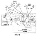
- FIG. 1Ais a schematic of a differential GNSS (DGNSS) application where one set of satellite information is measured at a base receiver and two sets of satellite information are measured at a rover receiver, the second set not being used due to lack of a corresponding set of information from the base.
- DDGNSSdifferential GNSS
- FIG. 1Bis a schematic of a differential GNSS application of the present invention.
- one set of satellite informationis measured at a base receiver and two sets of satellite information are measured at a rover receiver, both of which are used, one set being differentially corrected using methods of the present invention.
- FIG. 2is a flow chart showing the process flow of the present invention.
- FIG. 3is a chart showing how the process is distributed across time.
- FIGS. 4A-4Bare plots each showing three time-series curves of differential corrections, two of which are generated using information from an external source of measurements, and one of which is generated using a local source of measurement information. Coasting occurs on the latter correction.
- FIG. 4Ashows that three differential correction curves exhibit a common clock characteristic which is not well modeled in one curve when coasting.
- FIG. 4Bshows that three differential correction curves exhibit a common clock characteristic which is well modeled when coasting.
- FIG. 4Cshows that in three differential correction curves, the common clock characteristic has been reduced and is well modeled in coasting.
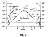
- FIG. 5shows atmospheric effects on the differential corrections in relation to satellite elevation angle.
- FIG. 6shows both atmospheric effects on the differential corrections in relation to satellite elevation angle and effects of satellite orbit model changes.
- FIG. 7shows how to compensate for satellite orbit and clock model changes to differential corrections while coasting.
- Differential GNSSrequires two GNSS receivers, a rover and a base receiver.
- the baseis typically stationary at a known location and sends to a rover GNSS receiver phase (or pseudo-range) observations plus its known location, or in lieu of this, differential correctors or other differential enabling data.
- the rovertakes the data from the base, and uses it to correct its own observations to increase their accuracy. The result is that the rover can provide a more accurate location using corrected observations, even to the centimeter level or less when carrier phase is used in an RTK solution.
- FIG. 1Ashows the details of a typical DGNSS scenario with two sets of satellites involved.
- the setscould be from different GNSS constellations such as GPS and GLONASS, or simply one set that is observable to both receivers while the other set is observable only to the rover.
- satellite Set 1is comprised of satellites 101 , 102 , and 103 while satellite set 2 is comprised of satellites 104 and 105 .
- the base 106receives signals from satellite Set 1, and computes observables of code phase, carrier phase, carrier velocity, and possibly other quantities related to the phase and phase-derivatives of the Set 1 signals that are tracked.
- the observables 108are denoted “Obs Set 1”, since they are derived form tracking the phases of signals arriving from satellite Set 1.
- a Nav Location 109also resides within the base receiver and may be manually entered as a “known location” or computed automatically by the base.
- the observables 108 and the Nay Location 109are transmitted from the base to the rover 107 over a communication link 133 .
- itmay be differential correctors or differential enabling data, rather than observables that are transmitted.
- the roverreceives the transmitted observables 112 and location 113 and delivers them to a differential computation engine 114 .
- well known techniquesare used to compute differential corrections, where an observed range is differenced with a “truth” range to compute a differential correction that, when added back to the observed range, will correct any measurement errors.
- the “truth” rangeis computed as the distance between a “known” location (the reference location) of the base and the satellite's location determined from orbit model parameters.
- Such correctionswill correct not only the observables measured at the base, but the rover as well when sufficiently close to the base (typically within the 10 to 100 mile range). When close, the rover will see errors similar to those seen at the base and hence the differential corrections are valid at the rover as well.
- Such base-transmitted differential correction datais generally designated “standard corrections” or “standard correctors.”
- the rover GNSS receiver 107Similar to the base, the rover GNSS receiver 107 also makes observations of code and carrier phase for signals arriving from satellite Set 1. Unlike the base 106 , the rover 107 has the added ability to make observations for satellite Set 2. For example, it may have capability of tracking Set 2 whereas the base may not. Or, the base may actually track Set 2, but choose not to send observations for Set 2 over the communication link 133 .
- the observations 110 and 111 corresponding to Set 1 and Set 2 signalsare denoted “Obs Set 1” and “Obs Set 2” respectively. Since the rover has differential correctors available only for the Set 1 observations, it may correct only to the Set 1 observations.
- the “standard” corrections 115are added to the Set 1 observations 110 at summer 116 .
- the corrected Set 1 observations 117are then fed into the Navigation Solution Computational Engine 118 , where a location is computed.
- This location computationmay involve RTK ambiguity resolution, double differencing, single differencing, Kalman filtering, and other well known methods of GNSS location determination. Since the base does not make observations for the Set 2 satellites, differential correctors are not available for these satellites. Hence the observations 111 from Obs Set 2 in the rover cannot be used and are rejected (or ignored) as indicated at 122 since they are not corrected and will thus degrade performance or accuracy when used in a DGNSS application.
- FIG. 1Bshows an embodiment of this invention.
- FIG. 1Bis similar to FIG. 1A except that it shows the added capability to differentially correct, and therefore use the Obs Set 2 observations.
- the observations 122 from Obs Set 2are now fed into a “Diff Set 2” differential computation engine 124 .
- This computationalso makes use of a location, but the location is that of the rover, not the base as the case with classical DGNSS prior art methods.
- This internally generated differentiali.e. “internal corrections” versus “standard corrections” is computed using methods that are similar to those used to compute the standard differential in prior art as is done for Satellite Set 1.
- an observed rangeis differenced with a “truth” range to form a differential correction that, when added back to the observed range, will correct any measurement errors.
- This internal correctionwill “internally” (to the rover 107 ) correct the observed errors seen at the rover, as opposed to observed errors seen at the base as in conventional DGNSS of prior art.
- Thisis an advantage since atmosphere-induced, spatially dependant error components that differ between rover and base, especially over long baselines, will not be present. This again, is unlike conventional DGNSS.
- atmospheric errorsmay be implicitly present, however, since such errors may exist in the Obs Set 1 corrections upon which the accuracy of the rover's location estimate depends.
- the rover location estimateis the reference for computing the Obs Set 2 differential, thereby implicitly impacting Obs Set 2 differential accuracy. But to the extent that the estimation of rover location provides an averaging of such errors (or canceling effect, such as when using ionosphere-free combinations), the impact of atmospheric delay variations may be attenuated or nearly eliminated.
- the Diff Set 2 differential 125is then added back to the Obs Set 2 observations at summer 126 , and the corrected Obs Set 2 observations 127 are fed into the Navigation Solution Engine 118 , along with the corrected Obs Set 1 observations 117 .
- Obs Set 2there are more observations available, giving well known advantages in RTK ambiguity resolution, cycle slip detection, and general robustness.
- the corrected Obs Set 2 observationsare de-weighted from the location estimate computation (by Kalman Filter, Weighted Least Squares or other means) during times when there is good availability of Obs Set 1 observations. Or they may not even be used at all for location computations during such times.
- This practiceavoids a positive-feedback scenario where errors in the rover's location estimate propagate into errors in the Set 2 differential correctors, which then cause an additional increase in the rover's location estimation error, and so on.
- the differential correctors for Obs Set 2are computed only during times of high availability of Obs Set 1 observations (and good satellite geometry) and hence times of high estimation accuracy in the rover's location.
- Obs Set 2 correctionsare computed only after RTK lock has been established to assure that they are accurate to near centimeter level and thus can be applied in future RTK computations.
- the Obs Set 1 differential correctorsare computed following the completion of the location estimation process to assure that location has been estimated to the best accuracy possible for the epoch.
- the Diff Set 2 differential correctionsare applied after their time-of-computation; up to several minutes if proper care is taken. What this means is that if portions of the Set 1 observations are suddenly not available, or otherwise compromised, perhaps due to blockages of signals while driving under a tree, differentially corrected Set 2 observations can be utilized to help maintain the integrity of the location estimation.
- the addition of Obs Set 2 observations in the DGNSS applicationcan help: 1) make up for losses in Dilution of Precision (DOP); 2) aid in cycle slip detection; 3) aid in ambiguity resolution should ambiguities need to be reacquired; and, more generically, 4) be applied whenever it is advantageous to have additional observations.
- DOPDilution of Precision
- the Obs Set 2 observationsare not corrected by conventional DGNSS means, they are still corrected and can be applied as if they are conventional DGNSS corrected observations in some of the more crucial situations, such as reacquiring ambiguities.
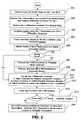
- FIG. 2shows a process flow chart of the invention as it applies to the rover 107 .
- Code phase, carrier phase, and possibly other observationsare made for Obs Set 1 and Obs Set 2 GNSS signals as depicted in step 201 .
- differential corrections for Obs Set 1become available.
- the source of these correctionscould be a base GNSS receiver, an SBAS satellite broadcast, a wide area differential system, a subscription differential service, or other such equivalent sources.
- differentialis received directly from the source, i.e. the external base 106 .
- differentialis computed in the rover 107 , as for example when computing differential using observations and a location received from a base receiver 106 over RTCM-3, CMR, or other protocol.
- the rover's locationis computed, using the Set 1 differentially corrected observations 117 and possibly de-weighted Set 2 differentially corrected observations 127 .
- the Set 2 observationsare de-weighted or not used to avoid accumulation of errors that may arise when repeatedly computing a location using differential corrections based on a previously computed location (the positive-feedback scenario mentioned previously).
- the geometric ranges to the Set 2 satellitesare computed in step 204 . It is important to have sufficient accuracy of the location of the rover relative to the base. The level of accuracy is dictated by the application.
- a location quality checkis found in step 205 .
- the locationshould be of RTK quality (cm level accuracy) before proceeding to compute Set 2 differential.
- the Set 1 ambiguitiesshould be fixed to their integer values and the receiver location should be estimated based upon the ambiguity-corrected carrier phase.
- Diff Set 2There is little point in computing differential (Diff Set 2) for Obs Set 2 observables if this differential cannot be made to the accuracy of RTK since this differential (Diff Set 2) will ultimately be used to supplement RTK positioning or to help reestablish ambiguities after drop from RTK due to blockages.
- step 205the individual quality of each Obs Set 2 observation is also checked in step 205 .
- Obs Set 2 observation qualityis monitored for possible cycle slips and other problems that would impact the quality of the Set 2 differentially corrected data 127 .
- a branch based on the quality checkis made at decision point 206 . If either location accuracy or observation quality fails the test, the process skips to step 209
- step 207the Diff Set 2 differential is computed for each Obs Set 2 observation that passes the quality check.
- step 208the differential corrections 125 from the Diff Set 2 engine 124 are time-tagged, and stored in computer memory for future use.
- step 209differential correctors are kept updated to account for various changes that can occur as the differential ages. This step is particularly important when the differential has not been recently computed due to a quality failure at 206 . There are three adjustments shown that may be necessary.
- the first adjustment 210is an adjustment to account for changes in atmosphere-induced delays that have occurred since the differential was last computed. Methods of accounting for such atmospheric effects are disclosed in U.S. Pat. No. 6,397,147. The discussion on the magnitude of such errors as they relate to satellite elevation is found later on in this disclosure.
- the second possible adjustment 211which may occur while keeping the differential updated, is accounting for parameter changes in the broadcast Orbit model (or Ephemeris) and the broadcast satellite clock model. Changes in parameters occur on a periodic basis as the GNSS satellite updates its navigation message content with new prediction data. Differential correctors compensate for errors in the orbit and clock broadcast models. When the broadcast models change, the differential corrections must change accordingly.
- a third adjustment 212that may or may not take place depending on the nature of the Diff Set 1 differential 115 , is to assure that the Diff Set 2 differential 125 stays consistent with any common-mode clock variation seen in the Diff Set 1 differential 115 .
- errors in estimating the base' clockwill translate into a common-mode error seen in all Diff Set 1 differential 115 .
- a clock-induced wanderexists in the Set 1 differential 115
- a similar wandershould be imposed on the Set 2 differential 125 to extend its useful life without forcing the navigation solution 118 to estimate additional clock components.
- This taskis not necessary, or is trivial, if proper care is taken when computing the Set 1 differential 115 so as to remove any significant receiver clock contributions.
- a double-difference approach to eliminating receiver clock dependencecan be deployed where one reference observation from Set 1 is used to difference away clock errors in other observations. More details on all three types of adjustments to the Set 2 differential will follow in later paragraphs.
- the life of the differentialDue to the fact that there are some components in differential that drift over time in a manner that is not fully predictable, it is necessary to impose a limit on the life of the differential as shown in step 213 .
- the age at which differential times-outmay depend on multiple factors, but a significant indicator as to useful life is the satellite elevation angle. Satellites at lower elevation angle have: 1) higher levels of multipath noise which may change rapidly over time and thus not cancel in future application of the differential; and 2) higher levels of atmospheric effects that may be difficult to reliably predict.
- the timeoutwill be a function of satellite elevation angle. Also, the level of accuracy that the differential is to provide when applied to correct observations will also contribute to the choice of timeout period.
- timeout conditionsshould be derived by observing accuracy versus age-of-differential while processing real signals in scenarios typical of the planned GNSS receiver usage.
- the final step, 216is to actually use the Diff Set 2 differential corrections 125 to correct the Obs Set 2 observations 122 .
- the Diff Set 2 differential correctionsare applied at an epoch that is in the future relative to the epoch in which the corrections are computed.
- differentially corrected Obs Set 2 observationsmay aid navigation algorithms in a number of ways, including reacquiring ambiguities after momentary signal blockage or for improving robustness by compensating for occasional loss of Obs Set 1 observations.
- FIG. 3elaborates more on the fact that Diff Set 2 differential is computed at one epoch, but then applied in a subsequent epoch.
- Two time epochs, 301 and 321are shown with a line 310 separating them.
- Set 1 satellite observations (Obs) Set 1designated 302
- the resulting differentially corrected Obs Set 1 observationsare fed into the Navigation Engine 305 where a location is estimated.
- the location for 305 and Obs Set 2 observations 306are delivered to the process 307 that computes the Diff Set 2 differential, which is stored for later use.
- the Diff Set 2 differentialis not used during the Time 1 epoch 301 .
- the process of delivering Diff Set 1 differentially corrected observations 323repeats in a similar manner to that of the first epoch.
- the utilization of the Diff Set 1 differential correctionsis shown by blocks 322 , 323 and 324 .
- the Diff Set 2 differentialis stored at 308
- the Diff Set 2 differential 328is available for use.
- An update to differentialtakes place as outlined in block 209 of FIG. 2 and this update is shown in block 327 .
- Diff Set 2 differential 328is then summed at summer 324 with the Obs Set 2 observations 326 .
- Both the Set 1 and Set 2 differentially corrected observationsare now delivered from summers 324 to the Navigation Engine 325 .
- the Obs Set 2 observationsmay not be used or may be de-weighted from the navigation solution unless needed to make up for loss of Set 1 observations or to recover from loss of RTK ambiguity fix.
- differential for the Obs Set 2 observationsmay again be computed at epoch 321 and stored for future use.
- t kis the instant of time at which the differential corrections are computed
- R measured ( t k )is the measured code or carrier phase range at time t k
- T sv (t k )is the satellite's clock error at time t k
- T rcvr (t k )is the receiver's clock error at time t k
- ⁇ right arrow over (r) ⁇ sv (t k )is the location vector of the GNSS satellite time t k
- ⁇ right arrow over (r) ⁇ rcvr (t k )is the location vector of the receiver at time t k
- R geometric,true ( t k )⁇ ⁇ right arrow over (r) ⁇ sv,true ( t k ) ⁇ ⁇ right arrow over (r) ⁇ rcvr,true ( t k ) ⁇
- ⁇ iono ( t k )is the ionospheric delay at time t k
- tropo (t k )is the tropospheric delay at time t k
- N(t k )is an ambiguity term that exists only when R
- B svis an inter-frequency, inter-channel, inter-constellation clock bias, or combination of these. It represents biases in the broadcast hardware, such as group-delay, or biases in the time-reference of the GNSS constellation.
- the subscript “true”means that these are actual measured quantities and are not estimated from models.
- ⁇ T svThe estimate of satellite clock is derived from data provided in the navigation data stream broadcast by the satellite. The estimate is typically fairly accurate and changes slowly, with the exception of sudden jumps as broadcast parameters change. ⁇ T rcvr This is the difference between estimated and true receiver clock. If the GNSS receiver does a good job of estimating its own clock error, then this term will be small. One way to at least keep this term nearly constant (not varying) is to make use of the fact that it is common to all observations (and thus all differential correctors) since they all share the same receiver clock. One observation can be chosen as a reference and then differenced with other observations to cancel-out the contribution of the common clock. Typically, the reference is taken as the highest satellite.
- AtmosThis is the atmosphere-induced delay term, or advance in the case of carrier phase passing through the ionosphere. It is due to the effects of troposphere and ionosphere on the signal propagation speed. The term is not constant, but typically changes slowly since satellite geometry changes slowly. It may change more rapidly at low satellite elevation angles. The location of the pierce-point through the ionosphere and troposphere is the biggest factor in the change as will be discussed.
- NThis is an ambiguity term. It appears when computing differential for carrier phase since the carrier phase measurement may undergo a cycle- slip do to track-loop stress. The term is always a multiple of the carrier wavelength. If cycle slips can be avoided, this term will be a constant. It is not present in code phase observations.
- B svThis inter-channel, inter-constellation bias usually has very good long- term stability as is nearly constant.
- the Diff Set 2 differentialmay not be computed every epoch.
- FIG. 2shows that a quality check on observations and location accuracy can bypass the computation. An example of such times is when the receiver drops out of RTK lock and location accuracy is no longer sufficient for the intended purpose of the Diff Set 2 differential.
- the Diff Set 2 differentialis not computed but is being updated (coasted) so that it is available for use, it is important to continue to maintain the clock trajectory within the Diff Set 1 differential.
- FIGS. 4A-Cillustrates methods of maintaining the clock trajectory.
- Two curves, 401 and 402depict two time-series plots of Diff Set 1 differential corrections.
- a third curve, 403shows a plot of a single Diff Set 2 differential correction.
- the Diff Set 2 differential correction 403is computed until point 405 at which time the computations cease and the correction must be propagated forward if it is to remain valid.
- the characteristic clock wandercan be seen in all three curves. Slight differences can be seen due to non-clock contributions, but all three curves exhibit a common fluctuation characteristic of an imperfect receiver clock estimate.
- FIG. 4Athe simple method of holding the correction constant is shown.
- the horizontal line 406represents this constant value whereas the dotted curve 404 represents the value that the correction would take if still being computed.
- this methodhas disadvantages. After a short period of time the constant differential assumption will no longer be valid and the time-out threshold will need to be set low to prevent differential use after even a relatively short period of coasting.
- the Diff Set 1 differentialis computed in such a manner that the receiver clock is not present to any significant degree and this translates into small Set 2 clock-induced variability as well.
- Thisis a preferred method of computing differential in general since clock-induced fluctuations can make it difficult to detect problems such as cycle slips.
- the common clock componentcan be removed by using a reference satellite in a double-difference approach, or otherwise assuring that the base receiver clock estimate is accurate when computing Diff Set 1 differential.
- the curves 401 , 402 and 403are shown considerably flattened as a result of eliminating most of the receiver clock induced wander. Due to this lack of wander, the assumption that the Set 2 differential correction is constant after point 405 has more validity. It can be seen that the constant curve 406 is much closer to the true trajectory 404 than it was in FIG. 4A . If the Set 1 differential is computed in the base 106 rather than the rover 107 , it may be easier to apply the scheme of FIG. 4B when significant clock wander is present. Otherwise the scheme of FIG. 4C is preferable.
- FIG. 5shows a typical differential correction from the time a satellite rises until it sets.
- Curve 501is the differential correction with corresponding scale provided on axis 521 .
- Curve 502is the elevation angle that the satellite makes with the horizon, and the elevation angle scale is shown on axis 522 .
- Plotsare against a time axis 523 .
- the highest slopes within the differential curvesare found in regions 502 and 504 as the satellite rises and sets.
- a 15 degree elevation angle, 505is projected up along vertical lines to the differential curve at points 506 and 507 to show that 15 degrees is roughly where the slope of the differential curve begins to increase sharply.
- This phenomenon of rapid changes at low elevation angleis mainly due to an obliquity factor (see “The Global Positioning System” by Bradford W. Parkinson, James J. Spilker, p. 148).
- Ionosphere-induced delayis roughly three times larger for satellites viewed near the horizon than it is for satellites viewed near the zenith.
- the troposphere obliquitycan be even larger since signals traveling horizontally to a receiver on the ground travel a much greater distance through the troposphere than do signals traveling vertically.
- the troposphere obliquity (or slant factor)is roughly the reciprocal of the sine of the elevation angle and can exceed a ratio of 20:1.
- the model methodcan include information provided in a satellite broadcast message such as the GPS ionosphere model or an ionosphere grid model provided by an SBAS system.
- the modelmay also include predictions based on past observations, or observations of the ionosphere-induced code and carrier phase divergence.
- a combination of early time-out and atmospheric modelcan be utilized, especially if the atmospheric model does a poor job of predicting reality.
- a time-out decisionis shown in FIG. 2 at 214 .
- FIG. 6again shows a differential correction curve 601 and a corresponding satellite elevation curve 602 .
- the scalesare shown on axes 603 and 604 respectively and the values are plotted against a time-axis 605 .
- regions 606 and 607are seen to exhibit large atmosphere-induced slopes.
- This differentialis typical of that from a GLONASS satellite.
- the provided orbit modelconsists of the satellite state of position, velocity, and acceleration. In the receiver, the state is propagated forward using a Runge-Kutta integration technique. The satellite state model parameters are usually updated every half hour in the GLONASS broadcast message.
- the resulting discontinuities caused by the updatecan be seen as jumps 611 , 612 , 613 and 614 of the differential curve.
- the discontinuitiesoccur as corrections to the state model are made.
- some slow variationis apparent in the differential correction term 601 .
- This variationis due to an imperfect orbit state model provided by GLONASS. Errors in the acceleration state appear to have a parabolic nature as evident in region 616 of the differential curve. Velocity model errors exhibit more of a constant slope such as that seen in region 615 .
- FIG. 7shows how to update the differential when an orbit model changes.
- the orbit trajectories resulting from using these parametersare shown as 702 (old parameter set) and 703 (new parameter set). Also shown are the two geometric ranges 704 and 705 for the old and new parameters, respectively.
- a faster RTK ambiguity fix (resolution) after a momentary loss of RTKFor example, a L1-only (single frequency) base transmits only L1 observations.
- a multi frequency (e.g., L1, L2, L5, etc.) rovercould, after determining an initial RTK fix using only the L1 observations, use its L2, L5 or other frequency observations in subsequent RTK fixes in accordance with this invention. It is well known that ambiguity resolution using dual frequency L1/L2 (or other multi frequency) observables are significantly quicker than when using L1-only data.
- the initial RTK fixmay be difficult due to large differential atmospheric errors between base and rover.
- subsequent RTK fixescan occur much more quickly; taking advantage of the fact that Diff Set 2 differential can absorb some of the atmospheric errors.
- Diff Set 2may actually be expanded to include all observables used by the rover since this may best reduce subsequent ambiguity search times (for example, searching after a blockage-induced loss of ambiguities). Even if rover location is not perfect, use of the disclosed method will still assure that all differentially corrected observables agree on a common location and that their residual error is small relative to this location.
- Cycle slip detectionis another advantage of the disclosed invention since the method provides, when needed, Obs Set 2 observations that would not otherwise be available. Algorithms such as Receiver Autonomous Integrity Monitoring (RAIM) have been shown to work better as the number of observations is increased.
- RAIMReceiver Autonomous Integrity Monitoring
- GLONASS frequency-dependent group-delay biasesSuch biases occur, for example, when mixing base and rover receivers from different manufacturers. If GLONASS observations are used as the Obs Set 2 observations, and GPS is used for Obs Set 1, the biases are eliminated since both the differential and the observations for Set 2 are from the same receiver (the rover), and the biases cancel as the differential is applied to the observations. Without the disclosed method, it may be necessary to account for the frequency-dependent biases using more complicated approaches, such as adding a frequency-dependent slope to the GLONASS clock estimate. Of course, combinations of approaches could be utilized. In a GPS/GLONASS RTK application, for example, the initial ambiguity resolution could take place by assuming a frequency-dependent GLONASS clock, but after that, the methods of this invention could be deployed.
- every observationis used, regardless of whether or not a differential pair can be formed using data from an external differential source.
- Locally generated range correctionsare formed as needed per this invention.
- Velocity-related observationssuch as Doppler and Delta-Carrier Phase are used as well. Velocity related observations may, in many situations, be used without differencing with a corresponding base velocity observation since the velocity observations from the stationary base are usually near zero and can be assumed as such. Use of velocity to aid a Kalman Filter location solution adds smoothness and robustness.
Landscapes
- Engineering & Computer Science (AREA)
- Radar, Positioning & Navigation (AREA)
- Remote Sensing (AREA)
- Computer Networks & Wireless Communication (AREA)
- Physics & Mathematics (AREA)
- General Physics & Mathematics (AREA)
- Position Fixing By Use Of Radio Waves (AREA)
Abstract
Description
Differential(tk)=└Rgeometric,est(tk)+Tsv,est(tk)+Trcvr,est(tk)┘−Rmeasured(tk) (1)
Rgeometric,est(tk)=∥{right arrow over (r)}sv,est(tk)−{right arrow over (r)}rcvr,est(tk)∥ (2)
Rmeasured(tk)=Rgeometric,true(tk)−Tsv,true(tk)+Trcvr,true(tk)+τiono,true(tk)+τtropo,true(tk)+N(tk)−Bsv (3)
Rgeometric,true(tk)=∥{right arrow over (r)}sv,true(tk)−{right arrow over (r)}rcvr,true(tk)∥
Where
τiono(tk) is the ionospheric delay at time tk
τtropo(tk) is the tropospheric delay at time tk
N(tk) is an ambiguity term that exists only when Rmeasured(tk) is measured carrier phase.
It is not present for code phase measurements.
Bsvis an inter-frequency, inter-channel, inter-constellation clock bias, or combination of these. It represents biases in the broadcast hardware, such as group-delay, or biases in the time-reference of the GNSS constellation.
The subscript “true” means that these are actual measured quantities and are not estimated from models.
Differential(tk)=ΔR−ΔTsv+ΔTrcvr−Atmos−N−Bsv (4)
ΔR=Rgeometric,est(tk)−Rgeometric,true(tk)
ΔTsv=Tsv,est(tk)−Tsv,true(tk)
ΔTrcvr=Trcvr,est(tk)−Trcvr,true(tk)
- N is an ambiguity term that exists only when correcting carrier phase. It is not present for code corrections.
| TABLE 1 |
| VARIATIONS OF DIFFERENTIAL COMPONENTS |
| Differential | |
| Component | Reason for Change in value of Component over time |
| ΔR | This is the difference between geometric and estimated range. This |
| changes for the following reasons: | |
| 1) Estimate of receiver location, {right arrow over (r)}rcvr,est(tk), is inaccurate, but the | |
| inaccuracy has different x, y, and z components. As the satellite | |
| moves across the sky, the projection of these components onto the | |
| slant-range vector will vary in magnitude, causing the differential | |
| to vary as well. This is usually a slow variation since satellite | |
| geometry changes slowly. The variation will not be present if the | |
| receiver location is accurate relative to GNSS coordinates, such as | |
| in RTK applications for which the base receiver has been | |
| accurately surveyed. If the RTK base station is not accurately | |
| surveyed, this variation will still exist, even in RTK applications. | |
| In practice, the location estimate of the base would have to be | |
| very far off (10 meters or more) for this term to change more than | |
| a centimeter or two over a few minutes. | |
| 2) Estimate of the satellite location, {right arrow over (r)}sv,est(tk), is inaccurate. | |
| Information to compute satellite location is provided in broadcast | |
| data from the satellite. The satellite ephemeris provided by GPS is | |
| usually good to a couple of meters, and the projection along the | |
| slant-range vector usually changes slowly. There is one | |
| exception: when satellite broadcast parameters change, a sudden | |
| jump will appear and this will translate to a jump in ΔR . | |
| ΔTsv | The estimate of satellite clock is derived from data provided in the |
| navigation data stream broadcast by the satellite. The estimate is | |
| typically fairly accurate and changes slowly, with the exception of | |
| sudden jumps as broadcast parameters change. | |
| ΔTrcvr | This is the difference between estimated and true receiver clock. If the |
| GNSS receiver does a good job of estimating its own clock error, then | |
| this term will be small. One way to at least keep this term nearly | |
| constant (not varying) is to make use of the fact that it is common to all | |
| observations (and thus all differential correctors) since they all share the | |
| same receiver clock. One observation can be chosen as a reference and | |
| then differenced with other observations to cancel-out the contribution of | |
| the common clock. Typically, the reference is taken as the highest | |
| satellite. Other well-known techniques can be deployed, but generally | |
| they all rely on taking advantage of the commonality of this term to all | |
| correctors or observations. | |
| Atmos | This is the atmosphere-induced delay term, or advance in the case of |
| carrier phase passing through the ionosphere. It is due to the effects of | |
| troposphere and ionosphere on the signal propagation speed. The term is | |
| not constant, but typically changes slowly since satellite geometry | |
| changes slowly. It may change more rapidly at low satellite elevation | |
| angles. The location of the pierce-point through the ionosphere and | |
| troposphere is the biggest factor in the change as will be discussed. A | |
| smaller part of the change is due to fluctuation in the levels of ionosphere | |
| and troposphere; the troposphere mainly as storms pass through, and the | |
| ionosphere mainly due to high solar activity and movement of the sun | |
| relative to the pierce point. There is ample material in the existing GNSS | |
| literature describing these effects. | |
| N | This is an ambiguity term. It appears when computing differential for |
| carrier phase since the carrier phase measurement may undergo a cycle- | |
| slip do to track-loop stress. The term is always a multiple of the carrier | |
| wavelength. If cycle slips can be avoided, this term will be a constant. It | |
| is not present in code phase observations. | |
| Bsv | This inter-channel, inter-constellation bias usually has very good long- |
| term stability as is nearly constant. | |
Diffclock=Diffclock+α1+α2, (a one-time adjustment as the new parameters are applied) (22)
α1=∥{right arrow over (r)}sv,est,new(tn)−{right arrow over (r)}rcvr,est(tn)∥−∥{right arrow over (r)}sv,est,old(tn)−{right arrow over (r)}rcvr,est(tn)∥
α2=Tsv,est,old(tn)−Tsv,est,new(tn)
tnis the time at which the new ephemeris and clock parameters are applied
{right arrow over (r)}rcvr,est(tn) is the estimate of the receiver's position at time tn
{right arrow over (r)}sv,est,old(tn) is the satellite's position at time tncomputed from the old set of parameters
{right arrow over (r)}sv,est,new(tn) is the satellite's position at time tncomputed from the new set of parameters
Tsv,est,old(tn) is the satellite's clock error at time tncomputed from the old set of parameters
Tsv,est,new(tn) is the satellite's clock error at time tncomputed from the new set of parameters
Claims (8)
Priority Applications (3)
| Application Number | Priority Date | Filing Date | Title |
|---|---|---|---|
| US12/511,821US8174437B2 (en) | 2009-07-29 | 2009-07-29 | System and method for augmenting DGNSS with internally-generated differential correction |
| EP10804918.0AEP2460029A4 (en) | 2009-07-29 | 2010-07-23 | SYSTEM AND METHOD FOR DGNSS REPRODUCTION WITH INTERNALLY DIFFERENTIAL CORRECTION |
| PCT/US2010/043094WO2011014431A1 (en) | 2009-07-29 | 2010-07-23 | System and method for augmenting dgnss with internally-generated differential correction |
Applications Claiming Priority (1)
| Application Number | Priority Date | Filing Date | Title |
|---|---|---|---|
| US12/511,821US8174437B2 (en) | 2009-07-29 | 2009-07-29 | System and method for augmenting DGNSS with internally-generated differential correction |
Publications (2)
| Publication Number | Publication Date |
|---|---|
| US20110025555A1 US20110025555A1 (en) | 2011-02-03 |
| US8174437B2true US8174437B2 (en) | 2012-05-08 |
Family
ID=43526490
Family Applications (1)
| Application Number | Title | Priority Date | Filing Date |
|---|---|---|---|
| US12/511,821Active2030-05-22US8174437B2 (en) | 2009-07-29 | 2009-07-29 | System and method for augmenting DGNSS with internally-generated differential correction |
Country Status (3)
| Country | Link |
|---|---|
| US (1) | US8174437B2 (en) |
| EP (1) | EP2460029A4 (en) |
| WO (1) | WO2011014431A1 (en) |
Cited By (23)
| Publication number | Priority date | Publication date | Assignee | Title |
|---|---|---|---|---|
| US20110234455A1 (en)* | 2010-03-25 | 2011-09-29 | Cellguide Ltd. | Gnss navigagtion aided by static data |
| US20130335268A1 (en)* | 2012-06-13 | 2013-12-19 | The Boeing Company | Multipath Isolation Through the Combined Use of Antenna Diversity and Frequency Diversity |
| US8613566B2 (en) | 2009-12-18 | 2013-12-24 | Wirtgen Gmbh | Self-propelled civil engineering machine and method of controlling a self-propelled civil engineering machine |
| US20140085139A1 (en)* | 2012-09-26 | 2014-03-27 | Trimble Navigation Limited | Global navigation satellite systems (gnss) positioning using precise satellite data |
| US8989968B2 (en) | 2012-10-12 | 2015-03-24 | Wirtgen Gmbh | Self-propelled civil engineering machine system with field rover |
| US9096977B2 (en) | 2013-05-23 | 2015-08-04 | Wirtgen Gmbh | Milling machine with location indicator system |
| WO2015131064A1 (en)* | 2014-02-28 | 2015-09-03 | Hemisphere Gnss Inc. | Locally enhanced gnss wide-area augmentation system |
| US20150268350A1 (en)* | 2013-08-14 | 2015-09-24 | Hemisphere Gnss Inc. | System and method for determining the direction of a false gnss satellite signal transmitter |
| US9181660B2 (en) | 2012-01-25 | 2015-11-10 | Wirtgen Gmbh | Self-propelled civil engineering machine and method of controlling a civil engineering machine |
| US9250327B2 (en) | 2013-03-05 | 2016-02-02 | Subcarrier Systems Corporation | Method and apparatus for reducing satellite position message payload by adaptive data compression techniques |
| US20160047917A1 (en)* | 2014-08-14 | 2016-02-18 | Trimble Navigation Limited | Navigation satellite system positioning involving the generation of receiver-specific or receiver-type-specific correction information |
| US20160061958A1 (en)* | 2014-09-03 | 2016-03-03 | Glacial Ridge Technologies, LLC | Device for inputting rtk correction data to a gps |
| US9405015B2 (en) | 2012-12-18 | 2016-08-02 | Subcarrier Systems Corporation | Method and apparatus for modeling of GNSS pseudorange measurements for interpolation, extrapolation, reduction of measurement errors, and data compression |
| US9541648B2 (en) | 2013-12-18 | 2017-01-10 | Agco Corporation | System and method of communicating GNSS information between mobile machines |
| US9719217B2 (en) | 2014-08-28 | 2017-08-01 | Wirtgen Gmbh | Self-propelled construction machine and method for visualizing the working environment of a construction machine moving on a terrain |
| US9798017B2 (en) | 2015-04-09 | 2017-10-24 | Topcon Positioning Systems, Inc. | Reducing time and increasing reliability of ambiguity resolution in GNSS |
| US9896810B2 (en) | 2014-08-28 | 2018-02-20 | Wirtgen Gmbh | Method for controlling a self-propelled construction machine to account for identified objects in a working direction |
| US9915041B2 (en) | 2014-08-28 | 2018-03-13 | Wirtgen Gmbh | Self-propelled construction machine and method for controlling a self-propelled construction machine |
| US10054687B2 (en) | 2013-08-14 | 2018-08-21 | Hemisphere Gnss Inc. | System and method for detecting false global navigation satellite system satellite signals |
| US10908293B2 (en) | 2013-08-14 | 2021-02-02 | Hemisphere GNSS, Inc. | System and method for detecting false global navigation satellite system satellite signals |
| US11525926B2 (en) | 2019-09-26 | 2022-12-13 | Aptiv Technologies Limited | System and method for position fix estimation using two or more antennas |
| US11572661B2 (en) | 2019-07-04 | 2023-02-07 | Wirtgen Gmbh | Self-propelled construction machine and method for controlling a self-propelled construction machine |
| US11774965B2 (en) | 2018-08-16 | 2023-10-03 | Wirtgen Gmbh | Slipform paver and method for operating a slipform paver |
Families Citing this family (47)
| Publication number | Priority date | Publication date | Assignee | Title |
|---|---|---|---|---|
| US8140223B2 (en) | 2003-03-20 | 2012-03-20 | Hemisphere Gps Llc | Multiple-antenna GNSS control system and method |
| US8686900B2 (en) | 2003-03-20 | 2014-04-01 | Hemisphere GNSS, Inc. | Multi-antenna GNSS positioning method and system |
| US8639416B2 (en) | 2003-03-20 | 2014-01-28 | Agjunction Llc | GNSS guidance and machine control |
| US8634993B2 (en) | 2003-03-20 | 2014-01-21 | Agjunction Llc | GNSS based control for dispensing material from vehicle |
| US8271194B2 (en) | 2004-03-19 | 2012-09-18 | Hemisphere Gps Llc | Method and system using GNSS phase measurements for relative positioning |
| US8190337B2 (en) | 2003-03-20 | 2012-05-29 | Hemisphere GPS, LLC | Satellite based vehicle guidance control in straight and contour modes |
| US9002565B2 (en) | 2003-03-20 | 2015-04-07 | Agjunction Llc | GNSS and optical guidance and machine control |
| US8583315B2 (en) | 2004-03-19 | 2013-11-12 | Agjunction Llc | Multi-antenna GNSS control system and method |
| US8311696B2 (en) | 2009-07-17 | 2012-11-13 | Hemisphere Gps Llc | Optical tracking vehicle control system and method |
| USRE48527E1 (en) | 2007-01-05 | 2021-04-20 | Agjunction Llc | Optical tracking vehicle control system and method |
| US9651667B2 (en)* | 2007-06-22 | 2017-05-16 | Trimble Inc. | Combined cycle slip indicators for regionally augmented GNSS |
| WO2009100463A1 (en) | 2008-02-10 | 2009-08-13 | Hemisphere Gps Llc | Visual, gnss and gyro autosteering control |
| US9046601B2 (en) | 2009-06-15 | 2015-06-02 | Hendrikus A. Le Sage | Handheld antenna attitude measuring system |
| US8401704B2 (en) | 2009-07-22 | 2013-03-19 | Hemisphere GPS, LLC | GNSS control system and method for irrigation and related applications |
| US8334804B2 (en) | 2009-09-04 | 2012-12-18 | Hemisphere Gps Llc | Multi-frequency GNSS receiver baseband DSP |
| DE102010011982A1 (en)* | 2009-09-29 | 2011-04-07 | Siemens Aktiengesellschaft | Method for the computer-aided creation and / or updating of a reference map for a satellite-based location of an object |
| US8548649B2 (en) | 2009-10-19 | 2013-10-01 | Agjunction Llc | GNSS optimized aircraft control system and method |
| US8583326B2 (en) | 2010-02-09 | 2013-11-12 | Agjunction Llc | GNSS contour guidance path selection |
| US8803735B2 (en) | 2010-11-19 | 2014-08-12 | Agjunction Llc | Portable base station network for local differential GNSS corrections |
| CN102288978B (en)* | 2011-07-20 | 2013-09-18 | 东南大学 | Continuous operational reference system (CORS) base station cycle slip detection and recovering method |
| TWI470259B (en)* | 2011-12-07 | 2015-01-21 | Inst Information Industry | Global positioning system device and ionosphere error estimation method thereof |
| EA028661B9 (en) | 2011-12-12 | 2018-03-30 | Сауди Бейсик Индастриз Корпорейшн (Сабик) | Catalyst system for the production of ultra-high molecular weight polyethylene |
| CN102519442A (en)* | 2011-12-28 | 2012-06-27 | 哈尔滨工业大学 | Space celestial body scientific detection method integrating navigation, geography acquisition and earth surface detection |
| US9429640B2 (en)* | 2012-12-28 | 2016-08-30 | Trimble Navigation Limited | Obtaining pseudorange information using a cellular device |
| FR3005228B1 (en)* | 2013-04-30 | 2016-11-25 | Electricite De France | COMMUNICATION INTERFACE BETWEEN EQUIPMENT AND A FLUID COUNTING SYSTEM |
| US9784846B2 (en)* | 2013-08-21 | 2017-10-10 | Samsung Electronics Co., Ltd. | System, method, and apparatus for compensating for ionospheric delay in a multi constellation single radio frequency path GNSS receiver |
| US20150092048A1 (en) | 2013-09-27 | 2015-04-02 | Qualcomm Incorporated | Off-Target Tracking Using Feature Aiding in the Context of Inertial Navigation |
| AU2015356145B2 (en)* | 2014-12-02 | 2018-12-06 | Mitsubishi Electric Corporation | Positioning device and positioning system |
| GB2548367A (en)* | 2016-03-15 | 2017-09-20 | Here Global Bv | Supporting an estimation of satellite locations |
| NZ747152A (en)* | 2016-04-22 | 2022-01-28 | Victoria Link Ltd | Method and system for monitoring land deformation |
| CN106125110B (en)* | 2016-06-12 | 2018-08-24 | 中国科学院上海天文台 | Satellite-based augmentation system Improvement Method of Localization Precision based on subregion correction |
| FR3066611A1 (en)* | 2017-05-16 | 2018-11-23 | Thales | SYSTEM FOR INCREASING A SATELLITE POSITIONING SYSTEM AND AUTONOMOUS INTEGRATED AUTONOMOUS MONITORING RECEIVER |
| CN107302750B (en)* | 2017-06-21 | 2020-09-01 | 交通运输通信信息集团有限公司 | Maritime satellite terminal position information acquisition method and system |
| CN108072887B (en)* | 2017-11-07 | 2021-04-30 | 同济大学 | Single-base-station long-distance offshore real-time dynamic positioning method |
| CN109307875A (en)* | 2018-10-28 | 2019-02-05 | 西南电子技术研究所(中国电子科技集团公司第十研究所) | A real-time navigation and positioning method for aerial target multi-station rendezvous |
| CN111193991A (en)* | 2018-10-29 | 2020-05-22 | 千寻位置网络有限公司 | Differential data gray level broadcasting method and device based on extensible rules |
| EP3828595A1 (en)* | 2019-11-28 | 2021-06-02 | Spaceopal GmbH | Method for providing differential code bias (dcb) correction for a global navigation satellite system (gnss) |
| WO2021202004A2 (en)* | 2020-02-14 | 2021-10-07 | Swift Navigation, Inc. | System and method for reconverging gnss position estimates |
| CN113541761B (en)* | 2020-04-10 | 2022-09-09 | 华为技术有限公司 | Communication method and device |
| CN111856514B (en)* | 2020-06-11 | 2024-06-14 | 北斗天地股份有限公司 | Synchronous pseudolite positioning method and system |
| CN114076968B (en)* | 2020-08-11 | 2025-03-14 | 新纳传感系统有限公司 | High-precision navigation system and method, and navigation terminal device |
| US11668840B2 (en)* | 2020-08-20 | 2023-06-06 | Qualcomm Incorporated | Ultra-long baseline RTK |
| CN112230262B (en)* | 2020-12-17 | 2021-06-01 | 航天宏图信息技术股份有限公司 | GNSS wide area positioning method, device and positioning service system |
| US12360255B2 (en)* | 2021-06-28 | 2025-07-15 | The Mitre Corporation | Systems and methods for navigation signal clustering |
| US20240118431A1 (en)* | 2022-10-11 | 2024-04-11 | Charter Communications Operating, Llc | Collection, distribution, use of timing/distance information to determine location in a wireless network |
| CN115480280B (en)* | 2022-11-14 | 2023-02-24 | 北京航空航天大学合肥创新研究院(北京航空航天大学合肥研究生院) | Vehicle pseudo base station based cooperative positioning method and storage medium |
| CN118426002B (en)* | 2024-04-29 | 2025-07-25 | 东南大学 | Real-time positioning enhancement method based on platform-user interaction feedback |
Citations (337)
| Publication number | Priority date | Publication date | Assignee | Title |
|---|---|---|---|---|
| US3585537A (en) | 1969-02-10 | 1971-06-15 | Bell Telephone Labor Inc | Electric wave filters |
| US3596228A (en) | 1969-05-29 | 1971-07-27 | Ibm | Fluid actuated contactor |
| US3727710A (en) | 1971-05-13 | 1973-04-17 | Gen Motors Corp | Steer control for a track-laying vehicle |
| US3815272A (en) | 1973-01-03 | 1974-06-11 | G Marleau | Collapsible, triangular net assembly |
| US3899028A (en) | 1972-03-30 | 1975-08-12 | Systron Donner Corp | Angular position sensing and control system, apparatus and method |
| US3987456A (en) | 1974-08-01 | 1976-10-19 | Lignes Telegraphiques Et Telephoniques | Wide relative frequency band and reduced size-to-wavelength ratio antenna |
| US4132272A (en) | 1977-06-30 | 1979-01-02 | International Harvester Company | Tractor hitch position control system |
| US4170776A (en) | 1977-12-21 | 1979-10-09 | Nasa | System for near real-time crustal deformation monitoring |
| US4180133A (en) | 1978-01-12 | 1979-12-25 | Iowa State University Research Foundation, Inc. | Guidance system for towed vehicles |
| US4398162A (en) | 1980-10-22 | 1983-08-09 | Ngk Spark Plug Co., Ltd. | Ladder-type piezoelectric filters |
| US4453614A (en) | 1982-03-19 | 1984-06-12 | Deere & Company | Steering arrangement for an off-highway articulated vehicle |
| US4529990A (en) | 1979-10-22 | 1985-07-16 | Siemens Aktiengesellschaft | Antenna system for a jamming transmitter |
| US4637474A (en) | 1974-11-05 | 1987-01-20 | Leonard Willie B | Tractor and towed implement with elevation control system for implement including pressure responsive valve actuator |
| US4667203A (en) | 1982-03-01 | 1987-05-19 | Aero Service Div, Western Geophysical | Method and system for determining position using signals from satellites |
| US4689556A (en) | 1984-10-12 | 1987-08-25 | Daymarc Corporation | Broad band contactor assembly for testing integrated circuit devices |
| US4694264A (en) | 1986-03-05 | 1987-09-15 | The United States Of America As Represented By The United States Department Of Energy | Radio frequency coaxial feedthrough device |
| US4710775A (en) | 1985-09-30 | 1987-12-01 | The Boeing Company | Parasitically coupled, complementary slot-dipole antenna element |
| US4714435A (en) | 1985-11-14 | 1987-12-22 | Molex Incorporated | Connection for flexible apparatus |
| US4739448A (en) | 1984-06-25 | 1988-04-19 | Magnavox Government And Industrial Electronics Company | Microwave multiport multilayered integrated circuit chip carrier |
| US4751512A (en) | 1986-01-21 | 1988-06-14 | Oceanonics, Inc. | Differential navigation system for remote mobile users |
| US4769700A (en) | 1981-11-20 | 1988-09-06 | Diffracto Ltd. | Robot tractors |
| US4785463A (en) | 1985-09-03 | 1988-11-15 | Motorola, Inc. | Digital global positioning system receiver |
| US4802545A (en) | 1986-10-15 | 1989-02-07 | J. I. Case Company | Steering control system for articulated vehicle |
| US4812991A (en) | 1986-05-01 | 1989-03-14 | Magnavox Govt. And Industrial Electronics Company | Method for precision dynamic differential positioning |
| US4813991A (en) | 1988-05-20 | 1989-03-21 | Thomson Consumer Electronics, Inc. | Universal stem mold for manufacturing a molded glass stem |
| US4858132A (en) | 1987-09-11 | 1989-08-15 | Ndc Technologies, Inc. | Optical navigation system for an automatic guided vehicle, and method |
| US4864320A (en) | 1988-05-06 | 1989-09-05 | Ball Corporation | Monopole/L-shaped parasitic elements for circularly/elliptically polarized wave transceiving |
| US4894662A (en) | 1982-03-01 | 1990-01-16 | Western Atlas International, Inc. | Method and system for determining position on a moving platform, such as a ship, using signals from GPS satellites |
| US4916577A (en) | 1988-12-20 | 1990-04-10 | Grumman Aerospace Corporation | Method of mounting removable modules |
| US4918607A (en) | 1988-09-09 | 1990-04-17 | Caterpillar Industrial Inc. | Vehicle guidance system |
| US4963889A (en) | 1989-09-26 | 1990-10-16 | Magnavox Government And Industrial Electronics Company | Method and apparatus for precision attitude determination and kinematic positioning |
| US5031704A (en) | 1988-05-10 | 1991-07-16 | Fleischer Manufacturing, Inc. | Guidance control apparatus for agricultural implement |
| US5100229A (en) | 1990-08-17 | 1992-03-31 | Spatial Positioning Systems, Inc. | Spatial positioning system |
| US5134407A (en) | 1991-04-10 | 1992-07-28 | Ashtech Telesis, Inc. | Global positioning system receiver digital processing technique |
| US5148179A (en) | 1991-06-27 | 1992-09-15 | Trimble Navigation | Differential position determination using satellites |
| US5152347A (en) | 1991-04-05 | 1992-10-06 | Deere & Company | Interface system for a towed implement |
| US5155493A (en) | 1990-08-28 | 1992-10-13 | The United States Of America As Represented By The Secretary Of The Air Force | Tape type microstrip patch antenna |
| US5155490A (en) | 1990-10-15 | 1992-10-13 | Gps Technology Corp. | Geodetic surveying system using multiple GPS base stations |
| US5156219A (en) | 1990-06-04 | 1992-10-20 | A.I.L., Inc. | Positioning apparatus for drawn implement |
| US5165109A (en) | 1989-01-19 | 1992-11-17 | Trimble Navigation | Microwave communication antenna |
| US5173715A (en) | 1989-12-04 | 1992-12-22 | Trimble Navigation | Antenna with curved dipole elements |
| US5177489A (en) | 1989-09-26 | 1993-01-05 | Magnavox Electronic Systems Company | Pseudolite-aided method for precision kinematic positioning |
| US5185610A (en) | 1990-08-20 | 1993-02-09 | Texas Instruments Incorporated | GPS system and method for deriving pointing or attitude from a single GPS receiver |
| US5191351A (en) | 1989-12-29 | 1993-03-02 | Texas Instruments Incorporated | Folded broadband antenna with a symmetrical pattern |
| US5202829A (en) | 1991-06-10 | 1993-04-13 | Trimble Navigation Limited | Exploration system and method for high-accuracy and high-confidence level relative position and velocity determinations |
| US5207239A (en) | 1991-07-30 | 1993-05-04 | Aura Systems, Inc. | Variable gain servo assist |
| US5239669A (en) | 1992-02-04 | 1993-08-24 | Trimble Navigation Limited | Coupler for eliminating a hardwire connection between a handheld global positioning system (GPS) receiver and a stationary remote antenna |
| US5255756A (en) | 1992-04-22 | 1993-10-26 | Progressive Farm Products, Inc. | Caddy with guidance system for agricultural implements |
| US5268695A (en) | 1992-10-06 | 1993-12-07 | Trimble Navigation Limited | Differential phase measurement through antenna multiplexing |
| US5294970A (en) | 1990-12-31 | 1994-03-15 | Spatial Positioning Systems, Inc. | Spatial positioning system |
| US5296861A (en) | 1992-11-13 | 1994-03-22 | Trimble Navigation Limited | Method and apparatus for maximum likelihood estimation direct integer search in differential carrier phase attitude determination systems |
| US5311149A (en) | 1993-03-12 | 1994-05-10 | Trimble Navigation Limited | Integrated phase locked loop local oscillator |
| US5323322A (en) | 1992-03-05 | 1994-06-21 | Trimble Navigation Limited | Networked differential GPS system |
| US5334987A (en) | 1993-04-01 | 1994-08-02 | Spectra-Physics Laserplane, Inc. | Agricultural aircraft control system using the global positioning system |
| US5343209A (en) | 1992-05-07 | 1994-08-30 | Sennott James W | Navigation receiver with coupled signal-tracking channels |
| US5345245A (en) | 1992-07-01 | 1994-09-06 | Kokusai Denshin Denwa Company, Limited | Differential data signal transmission technique |
| US5359332A (en) | 1992-12-31 | 1994-10-25 | Trimble Navigation Limited | Determination of phase ambiguities in satellite ranges |
| US5361212A (en) | 1992-11-02 | 1994-11-01 | Honeywell Inc. | Differential GPS landing assistance system |
| US5364093A (en)* | 1991-12-10 | 1994-11-15 | Huston Charles D | Golf distance measuring system and method |
| US5365447A (en) | 1991-09-20 | 1994-11-15 | Dennis Arthur R | GPS and satelite navigation system |
| US5369589A (en) | 1993-09-15 | 1994-11-29 | Trimble Navigation Limited | Plural information display for navigation |
| US5375059A (en) | 1990-02-05 | 1994-12-20 | Caterpillar Inc. | Vehicle position determination system and method |
| US5390207A (en) | 1990-11-28 | 1995-02-14 | Novatel Communications Ltd. | Pseudorandom noise ranging receiver which compensates for multipath distortion by dynamically adjusting the time delay spacing between early and late correlators |
| US5390124A (en) | 1992-12-01 | 1995-02-14 | Caterpillar Inc. | Method and apparatus for improving the accuracy of position estimates in a satellite based navigation system |
| US5416712A (en) | 1993-05-28 | 1995-05-16 | Trimble Navigation Limited | Position and velocity estimation system for adaptive weighting of GPS and dead-reckoning information |
| US5442363A (en) | 1994-08-04 | 1995-08-15 | U.S. Army Corps Of Engineers As Represented By The Secretary Of The Army | Kinematic global positioning system of an on-the-fly apparatus for centimeter-level positioning for static or moving applications |
| US5444453A (en) | 1993-02-02 | 1995-08-22 | Ball Corporation | Microstrip antenna structure having an air gap and method of constructing same |
| US5451964A (en) | 1994-07-29 | 1995-09-19 | Del Norte Technology, Inc. | Method and system for resolving double difference GPS carrier phase integer ambiguity utilizing decentralized Kalman filters |
| US5471217A (en) | 1993-02-01 | 1995-11-28 | Magnavox Electronic Systems Company | Method and apparatus for smoothing code measurements in a global positioning system receiver |
| US5477458A (en) | 1994-01-03 | 1995-12-19 | Trimble Navigation Limited | Network for carrier phase differential GPS corrections |
| US5477228A (en) | 1993-04-13 | 1995-12-19 | Differential Corrections Inc. | Differential global positioning system using radio data system |
| US5476147A (en) | 1993-03-19 | 1995-12-19 | Fixemer; Richard A. | Guidance system for an agricultural implement |
| US5490073A (en) | 1993-04-05 | 1996-02-06 | Caterpillar Inc. | Differential system and method for a satellite based navigation |
| US5491636A (en) | 1994-04-19 | 1996-02-13 | Glen E. Robertson | Anchorless boat positioning employing global positioning system |
| US5495257A (en) | 1994-07-19 | 1996-02-27 | Trimble Navigation Limited | Inverse differential corrections for SATPS mobile stations |
| US5504482A (en) | 1993-06-11 | 1996-04-02 | Rockwell International Corporation | Automobile navigation guidance, control and safety system |
| US5511623A (en) | 1994-09-12 | 1996-04-30 | Orthman Manufacturing, Inc. | Quick hitch guidance device |
| US5519620A (en) | 1994-02-18 | 1996-05-21 | Trimble Navigation Limited | Centimeter accurate global positioning system receiver for on-the-fly real-time kinematic measurement and control |
| US5521610A (en) | 1993-09-17 | 1996-05-28 | Trimble Navigation Limited | Curved dipole antenna with center-post amplifier |
| US5523761A (en) | 1993-01-12 | 1996-06-04 | Trimble Navigation Limited | Differential GPS smart antenna device |
| US5534875A (en) | 1993-06-18 | 1996-07-09 | Adroit Systems, Inc. | Attitude determining system for use with global positioning system |
| US5543804A (en) | 1994-09-13 | 1996-08-06 | Litton Systems, Inc. | Navagation apparatus with improved attitude determination |
| US5546093A (en) | 1994-01-04 | 1996-08-13 | Caterpillar Inc. | System and method for providing navigation signals to an earthmoving or construction machine |
| US5548293A (en) | 1993-03-24 | 1996-08-20 | Leland Stanford Junior University | System and method for generating attitude determinations using GPS |
| US5561432A (en) | 1995-05-12 | 1996-10-01 | Trimble Navigation | Out of plane antenna vector system and method |
| US5563786A (en) | 1994-02-16 | 1996-10-08 | Fuji Jukogyo Kabushiki Kaisha | Autonomous running control system for vehicle and the method thereof |
| US5568162A (en) | 1994-08-08 | 1996-10-22 | Trimble Navigation Limited | GPS navigation and differential-correction beacon antenna combination |
| US5568152A (en) | 1994-02-04 | 1996-10-22 | Trimble Navigation Limited | Integrated image transfer for remote target location |
| US5583513A (en) | 1993-03-24 | 1996-12-10 | Board Of Trustees Of The Leland Stanford Junior University | System and method for generating precise code based and carrier phase position determinations |
| US5589835A (en) | 1994-12-20 | 1996-12-31 | Trimble Navigation Limited | Differential GPS receiver system linked by infrared signals |
| US5592382A (en) | 1995-03-10 | 1997-01-07 | Rockwell International Corporation | Directional steering and navigation indicator |
| US5596328A (en) | 1994-08-23 | 1997-01-21 | Honeywell Inc. | Fail-safe/fail-operational differential GPS ground station system |
| US5600670A (en) | 1994-12-21 | 1997-02-04 | Trimble Navigation, Ltd. | Dynamic channel allocation for GPS receivers |
| US5604506A (en) | 1994-12-13 | 1997-02-18 | Trimble Navigation Limited | Dual frequency vertical antenna |
| US5608393A (en) | 1995-03-07 | 1997-03-04 | Honeywell Inc. | Differential ground station repeater |
| US5610616A (en) | 1994-08-23 | 1997-03-11 | Honeywell Inc. | Differential GPS ground station system |
| US5610522A (en) | 1993-09-30 | 1997-03-11 | Commissariat A L'energie Atomique | Open magnetic structure including pole pieces forming a V-shape threbetween for high homogeneity in an NMR device |
| US5610845A (en) | 1994-08-30 | 1997-03-11 | United Technologies Corporation | Multi-parameter air data sensing technique |
| US5612883A (en) | 1990-02-05 | 1997-03-18 | Caterpillar Inc. | System and method for detecting obstacles in the path of a vehicle |
| US5617317A (en) | 1995-01-24 | 1997-04-01 | Honeywell Inc. | True north heading estimator utilizing GPS output information and inertial sensor system output information |
| US5617100A (en) | 1994-04-07 | 1997-04-01 | Matsushita Electric Industrial Co., Ltd. | Accurate position measuring system |
| US5621646A (en) | 1995-01-17 | 1997-04-15 | Stanford University | Wide area differential GPS reference system and method |
| US5638077A (en) | 1995-05-04 | 1997-06-10 | Rockwell International Corporation | Differential GPS for fleet base stations with vector processing mechanization |
| US5644139A (en) | 1995-03-02 | 1997-07-01 | Allen; Ross R. | Navigation technique for detecting movement of navigation sensors relative to an object |
| US5673491A (en) | 1995-10-20 | 1997-10-07 | Brenna; Douglas J. | Crane level indicator device |
| US5680140A (en) | 1994-07-19 | 1997-10-21 | Trimble Navigation Limited | Post-processing of inverse differential corrections for SATPS mobile stations |
| US5706015A (en) | 1995-03-20 | 1998-01-06 | Fuba Automotive Gmbh | Flat-top antenna apparatus including at least one mobile radio antenna and a GPS antenna |
| US5717593A (en) | 1995-09-01 | 1998-02-10 | Gvili; Michael E. | Lane guidance system |
| US5725230A (en) | 1996-06-17 | 1998-03-10 | Walkup; Joseph L. | Self steering tandem hitch |
| US5731786A (en) | 1994-12-29 | 1998-03-24 | Trimble Navigation Limited | Compaction of SATPS information for subsequent signal processing |
| US5739785A (en) | 1993-03-04 | 1998-04-14 | Trimble Navigation Limited | Location and generation of high accuracy survey control marks using satellites |
| US5757316A (en) | 1997-02-01 | 1998-05-26 | Litton Systems, Inc. | Attitude determination utilizing an inertial measurement unit and a plurality of satellite transmitters |
| US5765123A (en) | 1993-08-07 | 1998-06-09 | Aisin Aw Co., Ltd. | Navigation system |
| US5777578A (en) | 1997-02-10 | 1998-07-07 | National Science Council | Global positioning system (GPS) Compass |
| US5810095A (en) | 1996-07-25 | 1998-09-22 | Case Corporation | System for controlling the position of an implement attached to a work vehicle |
| US5828336A (en) | 1996-03-29 | 1998-10-27 | The United States Of America As Represented By The Administrator Of The National Aeronautics And Space Administration | Robust real-time wide-area differential GPS navigation |
| US5854987A (en) | 1995-02-22 | 1998-12-29 | Honda Giken Kogyo Kabushiki Kaisha | Vehicle steering control system using navigation system |
| US5862501A (en) | 1995-08-18 | 1999-01-19 | Trimble Navigation Limited | Guidance control system for movable machinery |
| US5864315A (en) | 1997-04-07 | 1999-01-26 | General Electric Company | Very low power high accuracy time and frequency circuits in GPS based tracking units |
| US5864318A (en) | 1996-04-26 | 1999-01-26 | Dorne & Margolin, Inc. | Composite antenna for cellular and gps communications |
| US5875408A (en) | 1995-07-17 | 1999-02-23 | Imra America, Inc. | Automated vehicle guidance system and method for automatically guiding a vehicle |
| US5877725A (en) | 1997-03-06 | 1999-03-02 | Trimble Navigation Limited | Wide augmentation system retrofit receiver |
| JPH1172549A (en)* | 1997-08-29 | 1999-03-16 | Matsushita Electric Ind Co Ltd | GPS correction calculation method |
| US5906645A (en) | 1995-12-04 | 1999-05-25 | Toyota Jidosha Kabushiki Kaisha | Auto-drive control unit for vehicles |
| US5912798A (en) | 1997-07-02 | 1999-06-15 | Landsten Chu | Dielectric ceramic filter |
| US5914685A (en) | 1997-04-25 | 1999-06-22 | Magellan Corporation | Relative position measuring techniques using both GPS and GLONASS carrier phase measurements |
| US5917448A (en) | 1997-08-07 | 1999-06-29 | Rockwell Science Center, Inc. | Attitude determination system with sequencing antenna inputs |
| US5919242A (en) | 1992-05-14 | 1999-07-06 | Agri-Line Innovations, Inc. | Method and apparatus for prescription application of products to an agricultural field |
| US5918558A (en) | 1997-12-01 | 1999-07-06 | Case Corporation | Dual-pump, flow-isolated hydraulic circuit for an agricultural tractor |
| US5923270A (en) | 1994-05-13 | 1999-07-13 | Modulaire Oy | Automatic steering system for an unmanned vehicle |
| US5926079A (en) | 1996-12-05 | 1999-07-20 | Motorola Inc. | Ceramic waveguide filter with extracted pole |
| US5927603A (en) | 1997-09-30 | 1999-07-27 | J. R. Simplot Company | Closed loop control system, sensing apparatus and fluid application system for a precision irrigation device |
| US5929721A (en) | 1996-08-06 | 1999-07-27 | Motorola Inc. | Ceramic filter with integrated harmonic response suppression using orthogonally oriented low-pass filter |
| US5928309A (en) | 1996-02-05 | 1999-07-27 | Korver; Kelvin | Navigation/guidance system for a land-based vehicle |
| US5933110A (en) | 1998-07-13 | 1999-08-03 | Arinc, Inc. | Vessel attitude determination system and method |
| US5935183A (en) | 1996-05-20 | 1999-08-10 | Caterpillar Inc. | Method and system for determining the relationship between a laser plane and an external coordinate system |
| US5936573A (en) | 1997-07-07 | 1999-08-10 | Trimble Navigation Limited | Real-time kinematic integrity estimator and monitor |
| US5940026A (en) | 1997-07-21 | 1999-08-17 | Rockwell Science Center, Inc. | Azimuth determination for GPS/INS systems via GPS null steering antenna |
| US5941317A (en) | 1996-08-01 | 1999-08-24 | Great Western Corporation Pty Ltd. | Row cultivator with laterally moveable tool bar |
| US5943008A (en) | 1997-09-23 | 1999-08-24 | Rockwell Science Center, Inc. | Single global positioning system receiver capable of attitude determination |
| US5944770A (en) | 1995-12-28 | 1999-08-31 | Trimble Navigation Limited | Method and receiver using a low earth orbiting satellite signal to augment the global positioning system |
| US5945917A (en) | 1997-12-18 | 1999-08-31 | Rockwell International | Swathing guidance display |
| US5949371A (en) | 1998-07-27 | 1999-09-07 | Trimble Navigation Limited | Laser based reflectors for GPS positioning augmentation |
| US5955973A (en) | 1993-12-30 | 1999-09-21 | Concord, Inc. | Field navigation system |
| US5969670A (en) | 1998-01-22 | 1999-10-19 | Trimble Navigation Limited | Inexpensive monitoring technique for achieving high level integrity monitoring for differential GPS |
| US5987383A (en) | 1997-04-28 | 1999-11-16 | Trimble Navigation | Form line following guidance system |
| US6014101A (en) | 1996-02-26 | 2000-01-11 | Trimble Navigation Limited | Post-processing of inverse DGPS corrections |
| US6014608A (en) | 1996-11-04 | 2000-01-11 | Samsung Electronics Co., Ltd. | Navigator apparatus informing or peripheral situation of the vehicle and method for controlling the same |
| US6018313A (en) | 1995-09-01 | 2000-01-25 | Tilmar Konle | System for determining the location of mobile objects |
| US6023239A (en) | 1997-10-08 | 2000-02-08 | Arinc, Inc. | Method and system for a differential global navigation satellite system aircraft landing ground station |
| US6052647A (en) | 1997-06-20 | 2000-04-18 | Stanford University | Method and system for automatic control of vehicles based on carrier phase differential GPS |
| US6055477A (en) | 1995-03-31 | 2000-04-25 | Trimble Navigation Ltd. | Use of an altitude sensor to augment availability of GPS location fixes |
| US6057800A (en) | 1996-06-28 | 2000-05-02 | State University Of New York | RDOP surface for GPS relative positioning |
| US6061632A (en) | 1997-08-18 | 2000-05-09 | Trimble Navigation Limited | Receiver with seamless correction capacity |
| US6061390A (en) | 1994-09-02 | 2000-05-09 | California Institute Of Technology | P-code enhanced method for processing encrypted GPS signals without knowledge of the encryption code |
| US6062317A (en) | 1999-09-03 | 2000-05-16 | Caterpillar Inc. | Method and apparatus for controlling the direction of travel of an earthworking machine |
| US6069583A (en) | 1996-05-09 | 2000-05-30 | Agence Spatiale Europeene | Receiver for a navigation system, in particular a satellite navigation system |
| US6076612A (en) | 1999-08-31 | 2000-06-20 | Case Corporation | Transition from position to draft mode controlled by hitch position command and feedback |
| US6081171A (en) | 1998-04-08 | 2000-06-27 | Nokia Mobile Phones Limited | Monolithic filters utilizing thin film bulk acoustic wave devices and minimum passive components for controlling the shape and width of a passband response |
| US6100842A (en) | 1998-02-20 | 2000-08-08 | Trimble Navigation Limited | Chained location determination system |
| US6122595A (en) | 1996-05-20 | 2000-09-19 | Harris Corporation | Hybrid GPS/inertially aided platform stabilization system |
| US6128574A (en) | 1996-07-23 | 2000-10-03 | Claas Kgaa | Route planning system for agricultural work vehicles |
| US6144335A (en) | 1998-04-14 | 2000-11-07 | Trimble Navigation Limited | Automated differential correction processing of field data in a global positional system |
| US6191733B1 (en) | 1999-06-01 | 2001-02-20 | Modular Mining Systems, Inc. | Two-antenna positioning system for surface-mine equipment |
| US6191730B1 (en) | 1997-12-15 | 2001-02-20 | Trimble Navigation Limited | Two-channel fast-sequencing high-dynamics GPS navigation receiver |
| US6198992B1 (en) | 1997-10-10 | 2001-03-06 | Trimble Navigation Limited | Override for guidance control system |
| US6198430B1 (en) | 1999-03-26 | 2001-03-06 | Rockwell Collins, Inc. | Enhanced differential GNSS carrier-smoothed code processing using dual frequency measurements |
| US6199000B1 (en) | 1998-07-15 | 2001-03-06 | Trimble Navigation Limited | Methods and apparatus for precision agriculture operations utilizing real time kinematic global positioning system systems |
| US6205401B1 (en) | 1995-09-19 | 2001-03-20 | Litef Gmbh | Navigation system for a vehicle, especially a land craft |
| US6215828B1 (en) | 1996-02-10 | 2001-04-10 | Telefonaktiebolaget Lm Ericsson (Publ) | Signal transformation method and apparatus |
| US6230097B1 (en) | 1998-08-31 | 2001-05-08 | Trimble Navigation Limited | Accurate vehicle navigation |
| US6233511B1 (en) | 1997-11-26 | 2001-05-15 | Case Corporation | Electronic control for a two-axis work implement |
| US6236924B1 (en) | 1999-06-21 | 2001-05-22 | Caterpillar Inc. | System and method for planning the operations of an agricultural machine in a field |
| US6236916B1 (en) | 1999-03-29 | 2001-05-22 | Caterpillar Inc. | Autoguidance system and method for an agricultural machine |
| US6253160B1 (en) | 1999-01-15 | 2001-06-26 | Trimble Navigation Ltd. | Method and apparatus for calibrating a tool positioning mechanism on a mobile machine |
| US6256583B1 (en) | 1998-09-16 | 2001-07-03 | Rockwell Collins, Inc. | GPS attitude determination system and method using optimal search space identification for integer cycle ambiguity resolution |
| US6259398B1 (en) | 2000-05-19 | 2001-07-10 | Sri International | Multi-valued variable ambiguity resolution for satellite navigation signal carrier wave path length determination |
| US6266595B1 (en) | 1999-08-12 | 2001-07-24 | Martin W. Greatline | Method and apparatus for prescription application of products to an agricultural field |
| US6285320B1 (en) | 1999-09-03 | 2001-09-04 | Sikorsky Aircraft Corporation | Apparatus and method for mapping surfaces of an object |
| US6292132B1 (en) | 1999-08-13 | 2001-09-18 | Daimlerchrysler Ag | System and method for improved accuracy in locating and maintaining positions using GPS |
| US6307505B1 (en) | 1998-07-22 | 2001-10-23 | Trimble Navigation Limited | Apparatus and method for coupling data to a position determination device |
| US6314348B1 (en) | 1998-02-11 | 2001-11-06 | Trimble Navigation Limited | Correction control for guidance control system |
| US6313788B1 (en) | 1998-08-14 | 2001-11-06 | Seagull Technology, Inc. | Method and apparatus for reliable inter-antenna baseline determination |
| US6325684B1 (en) | 1999-06-11 | 2001-12-04 | Johnson Outdoors, Inc., | Trolling motor steering control |
| US6336066B1 (en) | 1998-09-29 | 2002-01-01 | Pellenc S.A. | Process for using localized agricultural data to optimize the cultivation of perennial plants |
| US6345231B2 (en) | 1998-07-10 | 2002-02-05 | Claas Selbstfahrende Erntemaschinen Gmbh | Method and apparatus for position determining |
| US6356602B1 (en) | 1998-05-04 | 2002-03-12 | Trimble Navigation Limited | RF integrated circuit for downconverting a GPS signal |
| US6377889B1 (en) | 2000-10-13 | 2002-04-23 | Trimble Navigation Limited | Non-linear method of guiding to arbitrary curves with adaptive feedback |
| US6380888B1 (en) | 2000-11-13 | 2002-04-30 | The United States Of America As Represented By The Secretary Of The Navy | Self-contained, self-surveying differential GPS base station and method of operating same |
| US6389345B2 (en) | 1999-06-29 | 2002-05-14 | Caterpillar Inc. | Method and apparatus for determining a cross slope of a surface |
| US6397147B1 (en)* | 2000-06-06 | 2002-05-28 | Csi Wireless Inc. | Relative GPS positioning using a single GPS receiver with internally generated differential correction terms |
| US6415229B1 (en) | 1996-06-21 | 2002-07-02 | Claas Kgaa | System for position determination of mobile objects, in particular vehicles |
| US6418031B1 (en) | 2000-05-01 | 2002-07-09 | International Business Machines Corporation | Method and means for decoupling a printed circuit board |
| US6421003B1 (en) | 2000-05-19 | 2002-07-16 | Sri International | Attitude determination using multiple baselines in a navigational positioning system |
| US6424915B1 (en) | 2000-06-01 | 2002-07-23 | Furuno Electric Co., Ltd. | System for determining the heading and/or attitude of a body |
| US6434462B1 (en) | 2001-06-28 | 2002-08-13 | Deere & Company | GPS control of a tractor-towed implement |
| US6431576B1 (en) | 1999-04-28 | 2002-08-13 | Deere & Company | System for steering towed implement in response to, or independently of, steering of towing vehicle |
| US6445983B1 (en) | 2000-07-07 | 2002-09-03 | Case Corporation | Sensor-fusion navigator for automated guidance of off-road vehicles |
| US6445990B1 (en) | 2001-03-19 | 2002-09-03 | Caterpillar Inc. | Method and apparatus for controlling straight line travel of a tracked machine |
| US6449558B1 (en) | 1998-05-29 | 2002-09-10 | David Anthony Small | Method and device for creating a network positioning system (NPS) |
| US6463091B1 (en) | 1995-08-09 | 2002-10-08 | Magellan Corporation | Spread spectrum receiver using a pseudo-random noise code for ranging applications in a way that reduces errors when a multipath signal is present |
| US6466871B1 (en) | 1999-10-03 | 2002-10-15 | Azimuth Technologies | Method for calibrating and verifying the attitude of a compass |
| US6469663B1 (en) | 2000-03-21 | 2002-10-22 | Csi Wireless Inc. | Method and system for GPS and WAAS carrier phase measurements for relative positioning |
| US6484097B2 (en) | 1999-04-23 | 2002-11-19 | Global Locate, Inc. | Wide area inverse differential GPS |
| US6501422B1 (en) | 1998-08-19 | 2002-12-31 | Trimble Navigation, Ltd. | Precise parallel swathing guidance via satellite navigation and tilt measurement |
| US20030014171A1 (en) | 2001-07-16 | 2003-01-16 | Xinghan Ma | Harvester with intelligent hybrid control system |
| US6515619B1 (en) | 1998-07-30 | 2003-02-04 | Mckay, Jr. Nicholas D. | Object location system |
| US6516271B2 (en) | 2001-06-29 | 2003-02-04 | The Regents Of The University Of California | Method and apparatus for ultra precise GPS-based mapping of seeds or vegetation during planting |
| US6539303B2 (en) | 2000-12-08 | 2003-03-25 | Mcclure John A. | GPS derived swathing guidance system |
| US6542077B2 (en) | 1993-06-08 | 2003-04-01 | Raymond Anthony Joao | Monitoring apparatus for a vehicle and/or a premises |
| US6549835B2 (en) | 2000-09-28 | 2003-04-15 | Nissan Motor Co., Ltd. | Apparatus for and method of steering vehicle |
| US6553311B2 (en) | 2000-12-08 | 2003-04-22 | Trimble Navigation Limited | Navigational off- line and off-heading indication system and method |
| US6570534B2 (en) | 2001-02-05 | 2003-05-27 | Integrinautics Corp. | Low cost system and method for making dual band GPS measurements |
| US6577952B2 (en) | 2001-01-08 | 2003-06-10 | Motorola, Inc. | Position and heading error-correction method and apparatus for vehicle navigation systems |
| US6587761B2 (en) | 2001-10-23 | 2003-07-01 | The Aerospace Corporation | Unambiguous integer cycle attitude determination method |
| US6606542B2 (en) | 1995-05-30 | 2003-08-12 | Agco Corporation | System and method for creating agricultural decision and application maps for automated agricultural machines |
| US6611755B1 (en) | 1999-12-19 | 2003-08-26 | Trimble Navigation Ltd. | Vehicle tracking, communication and fleet management system |
| US6611228B2 (en) | 2000-07-24 | 2003-08-26 | Furuno Electric Company, Limited | Carrier phase-based relative positioning apparatus |
| US6611754B2 (en) | 2000-03-14 | 2003-08-26 | Siemens Vdo Automotive Ag | Route planning system |
| US6622091B2 (en) | 2001-05-11 | 2003-09-16 | Fibersense Technology Corporation | Method and system for calibrating an IG/GP navigational system |
| US6631916B1 (en) | 2000-07-28 | 2003-10-14 | Merle E. Miller | Guidance system for pull-type equipment |
| US6643576B1 (en) | 2000-11-15 | 2003-11-04 | Integrinautics Corporation | Rapid adjustment of trajectories for land vehicles |
| US20030208319A1 (en) | 2000-06-05 | 2003-11-06 | Agco | System and method for creating demo application maps for site-specific farming |
| US6646603B2 (en) | 2000-06-16 | 2003-11-11 | Koninklijke Philips Electronics, N.V. | Method of providing an estimate of a location |
| US6657875B1 (en) | 2002-07-16 | 2003-12-02 | Fairchild Semiconductor Corporation | Highly efficient step-down/step-up and step-up/step-down charge pump |
| US6671587B2 (en) | 2002-02-05 | 2003-12-30 | Ford Motor Company | Vehicle dynamics measuring apparatus and method using multiple GPS antennas |
| US6688403B2 (en) | 2001-03-22 | 2004-02-10 | Deere & Company | Control system for a vehicle/implement hitch |
| US20040039514A1 (en) | 2002-04-05 | 2004-02-26 | Steichen John Carl | Method and apparatus for controlling a gas-emitting process and related devices |
| US6704652B2 (en)* | 2001-10-29 | 2004-03-09 | Total Soft Bank Ltd. | Real time self differential global positioning system and method for a moving station in a local area, and terminal global positioning system using the same |
| US6711501B2 (en) | 2000-12-08 | 2004-03-23 | Satloc, Llc | Vehicle navigation system and method for swathing applications |
| US6721638B2 (en) | 2001-05-07 | 2004-04-13 | Rapistan Systems Advertising Corp. | AGV position and heading controller |
| US6732024B2 (en) | 2001-05-07 | 2004-05-04 | The Board Of Trustees Of The Leland Stanford Junior University | Method and apparatus for vehicle control, navigation and positioning |
| US6744404B1 (en) | 2003-07-09 | 2004-06-01 | Csi Wireless Inc. | Unbiased code phase estimator for mitigating multipath in GPS |
| US6754584B2 (en) | 2001-02-28 | 2004-06-22 | Enpoint, Llc | Attitude measurement using a single GPS receiver with two closely-spaced antennas |
| US6774843B2 (en) | 2001-03-28 | 2004-08-10 | Communications Research Laboratory, Independent Administrative Institution | Method for acquiring azimuth information |
| US6792380B2 (en) | 2002-02-12 | 2004-09-14 | Furuno Electric Company Limited | Attitude angle detecting apparatus |
| US20040212533A1 (en) | 2003-04-23 | 2004-10-28 | Whitehead Michael L. | Method and system for satellite based phase measurements for relative positioning of fixed or slow moving points in close proximity |
| US6819269B2 (en) | 2000-05-17 | 2004-11-16 | Omega Patents, L.L.C. | Vehicle tracker including battery monitoring feature and related methods |
| US6822314B2 (en) | 2002-06-12 | 2004-11-23 | Intersil Americas Inc. | Base for a NPN bipolar transistor |
| US6865484B2 (en) | 2001-04-11 | 2005-03-08 | Mitsui & Co., Ltd. | Satellite position measurement system |
| US6865465B2 (en) | 2002-05-06 | 2005-03-08 | Csi Wireless, Inc. | Method and system for implement steering for agricultural vehicles |
| US20050080559A1 (en) | 2002-10-02 | 2005-04-14 | Hideto Ishibashi | Position measuring system for working machine |
| US6900992B2 (en) | 2001-09-18 | 2005-05-31 | Intel Corporation | Printed circuit board routing and power delivery for high frequency integrated circuits |
| US6922635B2 (en) | 2002-08-13 | 2005-07-26 | Drs Communications Company, Llc | Method and system for determining absolute positions of mobile communications devices using remotely generated positioning information |
| US6931233B1 (en) | 2000-08-31 | 2005-08-16 | Sirf Technology, Inc. | GPS RF front end IC with programmable frequency synthesizer for use in wireless phones |
| US20050225955A1 (en) | 2004-04-09 | 2005-10-13 | Hewlett-Packard Development Company, L.P. | Multi-layer printed circuit boards |
| US6967538B2 (en) | 2002-11-28 | 2005-11-22 | Hynix Semiconductor Inc. | PLL having VCO for dividing frequency |
| US20050265494A1 (en) | 2000-05-13 | 2005-12-01 | Goodings Christopher J | Method and apparatus for code phase tracking |
| WO2005119386A1 (en) | 2004-05-17 | 2005-12-15 | Csi Wireless Inc. | Satellite based vehicle guidance control in straight and contour modes |
| US6990399B2 (en) | 2002-10-31 | 2006-01-24 | Cnh America Llc | Agricultural utility vehicle and method of controlling same |
| US7006032B2 (en) | 2004-01-15 | 2006-02-28 | Honeywell International, Inc. | Integrated traffic surveillance apparatus |
| US7026982B2 (en) | 2001-12-19 | 2006-04-11 | Furuno Electric Ompany Limited | Carrier-phase-based relative positioning device |
| US7027918B2 (en) | 2003-04-07 | 2006-04-11 | Novariant, Inc. | Satellite navigation system using multiple antennas |
| US7031725B2 (en) | 2002-08-13 | 2006-04-18 | Drs Communications Company, Llc | Method and system for determining relative positions of networked mobile communication devices |
| US20060167600A1 (en) | 2005-01-27 | 2006-07-27 | Raven Industries, Inc. | Architecturally partitioned automatic steering system and method |
| US7089099B2 (en) | 2004-07-30 | 2006-08-08 | Automotive Technologies International, Inc. | Sensor assemblies |
| US20060215739A1 (en) | 2005-03-24 | 2006-09-28 | Ian Williamson | System and method for making correlation measurements utilizing pulse shape measurements |
| US7142956B2 (en) | 2004-03-19 | 2006-11-28 | Hemisphere Gps Llc | Automatic steering system and method |
| US7162348B2 (en) | 2002-12-11 | 2007-01-09 | Hemisphere Gps Llc | Articulated equipment position control system and method |
| US7191061B2 (en) | 2003-04-17 | 2007-03-13 | Battelle Energy Alliance, Llc | Auto-steering apparatus and method |
| US20070078570A1 (en) | 2005-10-04 | 2007-04-05 | Xiaowen Dai | Method and apparatus for reporting road conditions |
| US20070088447A1 (en) | 2004-04-27 | 2007-04-19 | Abb Research Ltd | Scheduling of industrial production processes |
| US20070121708A1 (en) | 2005-11-28 | 2007-05-31 | Honeywell International, Inc. | Discriminator function for GPS code alignment |
| US7248211B2 (en) | 2004-07-26 | 2007-07-24 | Navcom Technology Inc. | Moving reference receiver for RTK navigation |
| US20070205940A1 (en) | 2005-07-01 | 2007-09-06 | Chun Yang | Method and device for tracking weak global navigation satellite system (gnss) signals |
| US7271766B2 (en) | 2004-07-30 | 2007-09-18 | Novariant, Inc. | Satellite and local system position determination |
| US7277784B2 (en) | 2002-05-31 | 2007-10-02 | Deere & Company | Combination of a self-moving harvesting machine and a transport vehicle |
| US7292186B2 (en) | 2003-04-23 | 2007-11-06 | Csi Wireless Inc. | Method and system for synchronizing multiple tracking devices for a geo-location system |
| US20070285308A1 (en) | 2004-07-30 | 2007-12-13 | Integirnautics Corporation | Multiple frequency antenna structures and methods for receiving navigation or ranging signals |
| US7324915B2 (en) | 2005-07-14 | 2008-01-29 | Biosense Webster, Inc. | Data transmission to a position sensor |
| US7358896B2 (en) | 2005-11-03 | 2008-04-15 | Nemerix Sa | Multiband GNSS receiver |
| US20080129586A1 (en) | 2005-01-20 | 2008-06-05 | Thales | Satellite-Based Positioning Receiver with Improved Integrity and Continuity |
| US7388539B2 (en) | 2005-10-19 | 2008-06-17 | Hemisphere Gps Inc. | Carrier track loop for GNSS derived attitude |
| US7395769B2 (en) | 2004-10-21 | 2008-07-08 | Jensen Layton W | Individual row rate control of farm implements to adjust the volume of crop inputs across wide implements in irregularly shaped or contour areas of chemical application, planting or seeding |
| US20080204312A1 (en) | 2005-05-18 | 2008-08-28 | Leica Geosystems Ag | Phase Ambiguity Resolution Method for a Satellite Based Positioning System |
| US7428259B2 (en) | 2005-05-06 | 2008-09-23 | Sirf Technology Holdings, Inc. | Efficient and flexible GPS receiver baseband architecture |
| US7437230B2 (en) | 2003-03-20 | 2008-10-14 | Hemisphere Gps Llc | Satellite based vehicle guidance control in straight and contour modes |
| US7451030B2 (en) | 2005-02-04 | 2008-11-11 | Novariant, Inc. | System and method for interactive selection and determination of agricultural vehicle guide paths offset from each other with varying curvature along their length |
| US7479900B2 (en) | 2003-05-28 | 2009-01-20 | Legalview Assets, Limited | Notification systems and methods that consider traffic flow predicament data |
| US7505848B2 (en) | 2003-03-31 | 2009-03-17 | Deere & Company | Path planner and method for planning a contour path of a vehicle |
| US7522100B2 (en) | 2005-07-01 | 2009-04-21 | Sirf Technology Holdings, Inc. | Method and device for acquiring weak global navigation satellite system (GNSS) signals |
| US20090171583A1 (en) | 2006-03-15 | 2009-07-02 | The Boeing Company | Global position system (gps) user receiver and geometric surface processing for all-in-view coherent gps signal prn codes acquisition and navigation solution |
| US20090174622A1 (en) | 2005-12-27 | 2009-07-09 | Kyocera Corporation | Transmitter/Receiver Circuit and Transmission/Reception Method |
| US20090177395A1 (en) | 2008-01-07 | 2009-07-09 | David Stelpstra | Navigation device and method |
| US20090177399A1 (en) | 2008-01-07 | 2009-07-09 | Samsung Electronics Co., Ltd. | Method for estimating location and apparatus using the same |
| US20090174597A1 (en) | 2008-01-08 | 2009-07-09 | Dilellio James A | Global Positioning System Accuracy Enhancement |
| US7576690B2 (en)* | 2007-10-29 | 2009-08-18 | Trimble Navigation Limited | Position determination with reference data outage |
| US20090259707A1 (en) | 2006-03-21 | 2009-10-15 | Thales | Method and device for fast correlation calculation |
| WO2009126587A1 (en) | 2008-04-08 | 2009-10-15 | Hemisphere Gps Llc | Gnss-based mobile communication system and method |
| US20090259397A1 (en) | 2008-04-10 | 2009-10-15 | Richard Stanton | Navigation system with touchpad remote |
| US20090262014A1 (en) | 2006-03-15 | 2009-10-22 | The Boeing Company | Method and system for all-in-view coherent gps signal prn codes acquisition and navigation solution determination |
| US20090265054A1 (en) | 2008-04-16 | 2009-10-22 | Gm Global Technology Operations, Inc. | In-vehicle sensor-based calibration algorithm for yaw rate sensor calibration |
| US20090265104A1 (en) | 2008-04-22 | 2009-10-22 | Itt Manufacturing Enterprises, Inc. | Navigation System and Method of Obtaining Accurate Navigational Information in Signal Challenging Environments |
| US20090262018A1 (en) | 2008-02-05 | 2009-10-22 | Mstar Semiconductor, Inc. | High Accuracy Satellite Receiving Controller and Associated Method |
| US20090262974A1 (en) | 2008-04-18 | 2009-10-22 | Erik Lithopoulos | System and method for obtaining georeferenced mapping data |
| US20090265101A1 (en) | 2008-04-22 | 2009-10-22 | En-Min Jow | Access Device With Navigation Function |
| US20090274113A1 (en) | 2008-05-01 | 2009-11-05 | Mr.Daniel A. Katz | Channel Allocation for Burst Transmission to a Diversity of Satellites |
| US20090276155A1 (en) | 2008-04-30 | 2009-11-05 | Honeywell International, Inc. | Systems and methods for determining location information using dual filters |
| US20090273513A1 (en) | 2008-05-01 | 2009-11-05 | Skytraq Technology Inc. | Method of dynamically optimizing the update rate of gps output data |
| US20090274079A1 (en) | 2008-05-01 | 2009-11-05 | Qualcomm Incorporated | Radio Frequency (RF) Signal Multiplexing |
| US20090273372A1 (en) | 2005-02-25 | 2009-11-05 | Qualcomm Incorporated | Half bin linear frequency discriminator |
| US20090295633A1 (en) | 2008-06-02 | 2009-12-03 | Pinto Robert W | Attitude estimation using intentional translation of a global navigation satellite system (GNSS) antenna |
| US20090299550A1 (en) | 2008-05-27 | 2009-12-03 | Baker David A | Orientation-based wireless sensing apparatus |
| US20090295634A1 (en) | 2008-05-30 | 2009-12-03 | O2Micro, Inc. | Global positioning system receiver |
| WO2009148638A1 (en) | 2008-02-26 | 2009-12-10 | Hemisphere Gps Llc | Unbiased code phase discriminator |
| US20090322600A1 (en) | 2004-03-19 | 2009-12-31 | Whitehead Michael L | Method and system using gnss phase measurements for relative positioning |
| US20090322597A1 (en) | 2007-04-30 | 2009-12-31 | Navento Technologies, S.L. | Location method and system and locatable portable device |
| US20090322606A1 (en) | 2001-10-30 | 2009-12-31 | Sirf Technology, Inc. | Method and Apparatus for Real Time Clock (RTC) Brownout Detection |
| US20090322601A1 (en) | 2008-05-22 | 2009-12-31 | Jonathan Ladd | Gnss receiver using signals of opportunity and assistance information to reduce the time to first fix |
| US20090326809A1 (en) | 2003-10-06 | 2009-12-31 | Colley Jaime B | System and method for augmenting a satellite-based navigation solution |
| US20090322598A1 (en) | 2008-06-26 | 2009-12-31 | Honeywell International, Inc. | Integrity of differential gps corrections in navigation devices using military type gps receivers |
| US20100013703A1 (en) | 2006-05-25 | 2010-01-21 | The Boeing Company | Gps gyro calibration |
| US20100026569A1 (en) | 2008-07-31 | 2010-02-04 | Honeywell International Inc. | Method and apparatus for location detection using gps and wifi/wimax |
| US20100030470A1 (en) | 2008-07-02 | 2010-02-04 | O2Micro, Inc. | Global positioning system and dead reckoning (gps&dr) integrated navigation system |
| US20100039318A1 (en) | 2006-11-06 | 2010-02-18 | Marcin Michal Kmiecik | Arrangement for and method of two dimensional and three dimensional precision location and orientation determination |
| US20100039316A1 (en) | 2008-02-25 | 2010-02-18 | Sirf Technology, Inc. | System and Method for Operating a GPS Device in a Micro Power Mode |
| US20100039320A1 (en) | 2008-08-14 | 2010-02-18 | Boyer Pete A | Hybrid GNSS and TDOA Wireless Location System |
| US20100039321A1 (en) | 2008-08-15 | 2010-02-18 | Charles Abraham | Method and system for calibrating group delay errors in a combined gps and glonass receiver |
| US20100063649A1 (en) | 2008-09-10 | 2010-03-11 | National Chiao Tung University | Intelligent driving assistant systems |
| US20100060518A1 (en) | 2008-09-11 | 2010-03-11 | Bar-Sever Yoaz E | Method and apparatus for autonomous, in-receiver prediction of gnss ephemerides |
| US7689354B2 (en) | 2003-03-20 | 2010-03-30 | Hemisphere Gps Llc | Adaptive guidance system and method |
| US20100084147A1 (en) | 2008-10-02 | 2010-04-08 | Trimble Navigation Ltd. | Automatic Control of Passive, Towed Implements |
| US20100085253A1 (en) | 2008-10-03 | 2010-04-08 | Trimble Navigation Limited | Continuous Tracking Counter for Enabling Cycle-slip Free Messages in a Network of Global Navigation System Satellite Receivers |
| US20100106414A1 (en) | 2008-10-27 | 2010-04-29 | John Whitehead | Method of performing routing with artificial intelligence |
| US20100103033A1 (en) | 2008-10-23 | 2010-04-29 | Texas Instruments Incorporated | Loosely-coupled integration of global navigation satellite system and inertial navigation system |
| US20100106445A1 (en) | 2008-10-24 | 2010-04-29 | Takahiro Kondoh | Angular velocity sensor correcting apparatus for deriving value for correcting output signal from angular velocity sensor, angular velocity calculating apparatus, angular velocity sensor correcting method, and angular velocity calculating method |
| US20100103040A1 (en) | 2008-10-26 | 2010-04-29 | Matt Broadbent | Method of using road signs to augment Global Positioning System (GPS) coordinate data for calculating a current position of a personal navigation device |
| US20100103038A1 (en) | 2008-10-27 | 2010-04-29 | Mediatek Inc. | Power saving method adaptable in gnss device |
| US20100103034A1 (en) | 2008-10-24 | 2010-04-29 | Ntt Docomo, Inc. | Positioning control device and positioning control method |
| US20100109948A1 (en) | 2008-11-04 | 2010-05-06 | Leonid Razoumov | Methods and Apparatuses For GPS Coordinates Extrapolation When GPS Signals Are Not Available |
| US20100111372A1 (en) | 2008-11-03 | 2010-05-06 | Microsoft Corporation | Determining user similarities based on location histories |
| US20100109947A1 (en) | 2006-05-26 | 2010-05-06 | Savcor One Oy | System and method for positioning a gps device |
| US20100109944A1 (en) | 2003-03-20 | 2010-05-06 | Whitehead Michael L | Gnss-based tracking of fixed or slow-moving structures |
| US20100114483A1 (en) | 2008-11-03 | 2010-05-06 | Samsung Electronics Co., Ltd. | Method and apparatus for automatically optimizing and setting a GPS reception period and map contents |
| US20100109950A1 (en) | 2008-11-06 | 2010-05-06 | Texas Instruments Incorporated | Tightly-coupled gnss/imu integration filter having speed scale-factor and heading bias calibration |
| US20100109945A1 (en) | 2008-11-06 | 2010-05-06 | Texas Instruments Incorporated | Loosely-coupled integration of global navigation satellite system and inertial navigation system: speed scale-factor and heading bias calibration |
| US20100117894A1 (en) | 2008-01-09 | 2010-05-13 | Mayfllower Communications Company, Inc. | Gps-based measurement of roll rate and roll angle of spinning platforms |
Family Cites Families (6)
| Publication number | Priority date | Publication date | Assignee | Title |
|---|---|---|---|---|
| US6393291B1 (en)* | 1999-03-25 | 2002-05-21 | Rockwell Collins, Inc. | Method and apparatus for deriving a high rate output in a GPS system |
| US6879283B1 (en)* | 2003-02-21 | 2005-04-12 | Trimble Navigation Limited | Method and system for transmission of real-time kinematic satellite positioning system data |
| JP2007508550A (en)* | 2003-10-06 | 2007-04-05 | ジ インサイチュー グループ インコーポレイテッド | Method and apparatus for satellite-based relative positioning of a mobile platform |
| US7002513B2 (en)* | 2004-03-26 | 2006-02-21 | Topcon Gps, Llc | Estimation and resolution of carrier wave ambiguities in a position navigation system |
| US7163238B1 (en)* | 2005-08-05 | 2007-01-16 | Tecnologia Hidraulica Thc S.A. | Connector for flexible and semi-rigid pipings |
| US7522099B2 (en)* | 2005-09-08 | 2009-04-21 | Topcon Gps, Llc | Position determination using carrier phase measurements of satellite signals |
- 2009
- 2009-07-29USUS12/511,821patent/US8174437B2/enactiveActive
- 2010
- 2010-07-23EPEP10804918.0Apatent/EP2460029A4/ennot_activeWithdrawn
- 2010-07-23WOPCT/US2010/043094patent/WO2011014431A1/enactiveApplication Filing
Patent Citations (359)
| Publication number | Priority date | Publication date | Assignee | Title |
|---|---|---|---|---|
| US3585537A (en) | 1969-02-10 | 1971-06-15 | Bell Telephone Labor Inc | Electric wave filters |
| US3596228A (en) | 1969-05-29 | 1971-07-27 | Ibm | Fluid actuated contactor |
| US3727710A (en) | 1971-05-13 | 1973-04-17 | Gen Motors Corp | Steer control for a track-laying vehicle |
| US3899028A (en) | 1972-03-30 | 1975-08-12 | Systron Donner Corp | Angular position sensing and control system, apparatus and method |
| US3815272A (en) | 1973-01-03 | 1974-06-11 | G Marleau | Collapsible, triangular net assembly |
| US3987456A (en) | 1974-08-01 | 1976-10-19 | Lignes Telegraphiques Et Telephoniques | Wide relative frequency band and reduced size-to-wavelength ratio antenna |
| US4637474A (en) | 1974-11-05 | 1987-01-20 | Leonard Willie B | Tractor and towed implement with elevation control system for implement including pressure responsive valve actuator |
| US4132272A (en) | 1977-06-30 | 1979-01-02 | International Harvester Company | Tractor hitch position control system |
| US4170776A (en) | 1977-12-21 | 1979-10-09 | Nasa | System for near real-time crustal deformation monitoring |
| US4180133A (en) | 1978-01-12 | 1979-12-25 | Iowa State University Research Foundation, Inc. | Guidance system for towed vehicles |
| US4529990A (en) | 1979-10-22 | 1985-07-16 | Siemens Aktiengesellschaft | Antenna system for a jamming transmitter |
| US4398162A (en) | 1980-10-22 | 1983-08-09 | Ngk Spark Plug Co., Ltd. | Ladder-type piezoelectric filters |
| US4769700A (en) | 1981-11-20 | 1988-09-06 | Diffracto Ltd. | Robot tractors |
| US4667203A (en) | 1982-03-01 | 1987-05-19 | Aero Service Div, Western Geophysical | Method and system for determining position using signals from satellites |
| US4894662A (en) | 1982-03-01 | 1990-01-16 | Western Atlas International, Inc. | Method and system for determining position on a moving platform, such as a ship, using signals from GPS satellites |
| US4453614A (en) | 1982-03-19 | 1984-06-12 | Deere & Company | Steering arrangement for an off-highway articulated vehicle |
| US4739448A (en) | 1984-06-25 | 1988-04-19 | Magnavox Government And Industrial Electronics Company | Microwave multiport multilayered integrated circuit chip carrier |
| US4689556A (en) | 1984-10-12 | 1987-08-25 | Daymarc Corporation | Broad band contactor assembly for testing integrated circuit devices |
| US4785463A (en) | 1985-09-03 | 1988-11-15 | Motorola, Inc. | Digital global positioning system receiver |
| US4710775A (en) | 1985-09-30 | 1987-12-01 | The Boeing Company | Parasitically coupled, complementary slot-dipole antenna element |
| US4714435A (en) | 1985-11-14 | 1987-12-22 | Molex Incorporated | Connection for flexible apparatus |
| US4751512A (en) | 1986-01-21 | 1988-06-14 | Oceanonics, Inc. | Differential navigation system for remote mobile users |
| US4694264A (en) | 1986-03-05 | 1987-09-15 | The United States Of America As Represented By The United States Department Of Energy | Radio frequency coaxial feedthrough device |
| US4812991A (en) | 1986-05-01 | 1989-03-14 | Magnavox Govt. And Industrial Electronics Company | Method for precision dynamic differential positioning |
| US4802545A (en) | 1986-10-15 | 1989-02-07 | J. I. Case Company | Steering control system for articulated vehicle |
| US4858132A (en) | 1987-09-11 | 1989-08-15 | Ndc Technologies, Inc. | Optical navigation system for an automatic guided vehicle, and method |
| US4864320A (en) | 1988-05-06 | 1989-09-05 | Ball Corporation | Monopole/L-shaped parasitic elements for circularly/elliptically polarized wave transceiving |
| US5031704A (en) | 1988-05-10 | 1991-07-16 | Fleischer Manufacturing, Inc. | Guidance control apparatus for agricultural implement |
| US4813991A (en) | 1988-05-20 | 1989-03-21 | Thomson Consumer Electronics, Inc. | Universal stem mold for manufacturing a molded glass stem |
| US4918607A (en) | 1988-09-09 | 1990-04-17 | Caterpillar Industrial Inc. | Vehicle guidance system |
| US4916577A (en) | 1988-12-20 | 1990-04-10 | Grumman Aerospace Corporation | Method of mounting removable modules |
| US5165109A (en) | 1989-01-19 | 1992-11-17 | Trimble Navigation | Microwave communication antenna |
| US4963889A (en) | 1989-09-26 | 1990-10-16 | Magnavox Government And Industrial Electronics Company | Method and apparatus for precision attitude determination and kinematic positioning |
| US5177489A (en) | 1989-09-26 | 1993-01-05 | Magnavox Electronic Systems Company | Pseudolite-aided method for precision kinematic positioning |
| US5173715A (en) | 1989-12-04 | 1992-12-22 | Trimble Navigation | Antenna with curved dipole elements |
| US5191351A (en) | 1989-12-29 | 1993-03-02 | Texas Instruments Incorporated | Folded broadband antenna with a symmetrical pattern |
| US5956250A (en) | 1990-02-05 | 1999-09-21 | Caterpillar Inc. | Apparatus and method for autonomous vehicle navigation using absolute data |
| US5838562A (en) | 1990-02-05 | 1998-11-17 | Caterpillar Inc. | System and a method for enabling a vehicle to track a preset path |
| US5612883A (en) | 1990-02-05 | 1997-03-18 | Caterpillar Inc. | System and method for detecting obstacles in the path of a vehicle |
| US5615116A (en) | 1990-02-05 | 1997-03-25 | Caterpillar Inc. | Apparatus and method for autonomous vehicle navigation using path data |
| US5684696A (en) | 1990-02-05 | 1997-11-04 | Caterpillar Inc. | System and method for enabling an autonomous vehicle to track a desired path |
| US5390125A (en) | 1990-02-05 | 1995-02-14 | Caterpillar Inc. | Vehicle position determination system and method |
| US5375059A (en) | 1990-02-05 | 1994-12-20 | Caterpillar Inc. | Vehicle position determination system and method |
| US5156219A (en) | 1990-06-04 | 1992-10-20 | A.I.L., Inc. | Positioning apparatus for drawn implement |
| US5100229A (en) | 1990-08-17 | 1992-03-31 | Spatial Positioning Systems, Inc. | Spatial positioning system |
| US5185610A (en) | 1990-08-20 | 1993-02-09 | Texas Instruments Incorporated | GPS system and method for deriving pointing or attitude from a single GPS receiver |
| US5155493A (en) | 1990-08-28 | 1992-10-13 | The United States Of America As Represented By The Secretary Of The Air Force | Tape type microstrip patch antenna |
| US5155490A (en) | 1990-10-15 | 1992-10-13 | Gps Technology Corp. | Geodetic surveying system using multiple GPS base stations |
| US5390207A (en) | 1990-11-28 | 1995-02-14 | Novatel Communications Ltd. | Pseudorandom noise ranging receiver which compensates for multipath distortion by dynamically adjusting the time delay spacing between early and late correlators |
| US5294970A (en) | 1990-12-31 | 1994-03-15 | Spatial Positioning Systems, Inc. | Spatial positioning system |
| US5152347A (en) | 1991-04-05 | 1992-10-06 | Deere & Company | Interface system for a towed implement |
| US5134407A (en) | 1991-04-10 | 1992-07-28 | Ashtech Telesis, Inc. | Global positioning system receiver digital processing technique |
| US5293170A (en) | 1991-04-10 | 1994-03-08 | Ashtech Inc. | Global positioning system receiver digital processing technique |
| US5202829A (en) | 1991-06-10 | 1993-04-13 | Trimble Navigation Limited | Exploration system and method for high-accuracy and high-confidence level relative position and velocity determinations |
| US5148179A (en) | 1991-06-27 | 1992-09-15 | Trimble Navigation | Differential position determination using satellites |
| US5207239A (en) | 1991-07-30 | 1993-05-04 | Aura Systems, Inc. | Variable gain servo assist |
| US5467282A (en) | 1991-09-20 | 1995-11-14 | Dennis; Arthur R. | GPS and satellite navigation system |
| US5365447A (en) | 1991-09-20 | 1994-11-15 | Dennis Arthur R | GPS and satelite navigation system |
| US5364093A (en)* | 1991-12-10 | 1994-11-15 | Huston Charles D | Golf distance measuring system and method |
| US5239669A (en) | 1992-02-04 | 1993-08-24 | Trimble Navigation Limited | Coupler for eliminating a hardwire connection between a handheld global positioning system (GPS) receiver and a stationary remote antenna |
| US5323322A (en) | 1992-03-05 | 1994-06-21 | Trimble Navigation Limited | Networked differential GPS system |
| US5255756A (en) | 1992-04-22 | 1993-10-26 | Progressive Farm Products, Inc. | Caddy with guidance system for agricultural implements |
| US5343209A (en) | 1992-05-07 | 1994-08-30 | Sennott James W | Navigation receiver with coupled signal-tracking channels |
| US5919242A (en) | 1992-05-14 | 1999-07-06 | Agri-Line Innovations, Inc. | Method and apparatus for prescription application of products to an agricultural field |
| US5345245A (en) | 1992-07-01 | 1994-09-06 | Kokusai Denshin Denwa Company, Limited | Differential data signal transmission technique |
| US5268695A (en) | 1992-10-06 | 1993-12-07 | Trimble Navigation Limited | Differential phase measurement through antenna multiplexing |
| US5361212A (en) | 1992-11-02 | 1994-11-01 | Honeywell Inc. | Differential GPS landing assistance system |
| US5296861A (en) | 1992-11-13 | 1994-03-22 | Trimble Navigation Limited | Method and apparatus for maximum likelihood estimation direct integer search in differential carrier phase attitude determination systems |
| US5390124A (en) | 1992-12-01 | 1995-02-14 | Caterpillar Inc. | Method and apparatus for improving the accuracy of position estimates in a satellite based navigation system |
| US5359332A (en) | 1992-12-31 | 1994-10-25 | Trimble Navigation Limited | Determination of phase ambiguities in satellite ranges |
| US5523761A (en) | 1993-01-12 | 1996-06-04 | Trimble Navigation Limited | Differential GPS smart antenna device |
| US5471217A (en) | 1993-02-01 | 1995-11-28 | Magnavox Electronic Systems Company | Method and apparatus for smoothing code measurements in a global positioning system receiver |
| US5444453A (en) | 1993-02-02 | 1995-08-22 | Ball Corporation | Microstrip antenna structure having an air gap and method of constructing same |
| US5739785A (en) | 1993-03-04 | 1998-04-14 | Trimble Navigation Limited | Location and generation of high accuracy survey control marks using satellites |
| US5311149A (en) | 1993-03-12 | 1994-05-10 | Trimble Navigation Limited | Integrated phase locked loop local oscillator |
| US5476147A (en) | 1993-03-19 | 1995-12-19 | Fixemer; Richard A. | Guidance system for an agricultural implement |
| US5583513A (en) | 1993-03-24 | 1996-12-10 | Board Of Trustees Of The Leland Stanford Junior University | System and method for generating precise code based and carrier phase position determinations |
| US5548293A (en) | 1993-03-24 | 1996-08-20 | Leland Stanford Junior University | System and method for generating attitude determinations using GPS |
| US5334987A (en) | 1993-04-01 | 1994-08-02 | Spectra-Physics Laserplane, Inc. | Agricultural aircraft control system using the global positioning system |
| US5490073A (en) | 1993-04-05 | 1996-02-06 | Caterpillar Inc. | Differential system and method for a satellite based navigation |
| US5477228A (en) | 1993-04-13 | 1995-12-19 | Differential Corrections Inc. | Differential global positioning system using radio data system |
| US5416712A (en) | 1993-05-28 | 1995-05-16 | Trimble Navigation Limited | Position and velocity estimation system for adaptive weighting of GPS and dead-reckoning information |
| US6542077B2 (en) | 1993-06-08 | 2003-04-01 | Raymond Anthony Joao | Monitoring apparatus for a vehicle and/or a premises |
| US5504482A (en) | 1993-06-11 | 1996-04-02 | Rockwell International Corporation | Automobile navigation guidance, control and safety system |
| US5534875A (en) | 1993-06-18 | 1996-07-09 | Adroit Systems, Inc. | Attitude determining system for use with global positioning system |
| US5765123A (en) | 1993-08-07 | 1998-06-09 | Aisin Aw Co., Ltd. | Navigation system |
| US5369589A (en) | 1993-09-15 | 1994-11-29 | Trimble Navigation Limited | Plural information display for navigation |
| US5521610A (en) | 1993-09-17 | 1996-05-28 | Trimble Navigation Limited | Curved dipole antenna with center-post amplifier |
| US5610522A (en) | 1993-09-30 | 1997-03-11 | Commissariat A L'energie Atomique | Open magnetic structure including pole pieces forming a V-shape threbetween for high homogeneity in an NMR device |
| US5955973A (en) | 1993-12-30 | 1999-09-21 | Concord, Inc. | Field navigation system |
| US5899957A (en) | 1994-01-03 | 1999-05-04 | Trimble Navigation, Ltd. | Carrier phase differential GPS corrections network |
| US5477458A (en) | 1994-01-03 | 1995-12-19 | Trimble Navigation Limited | Network for carrier phase differential GPS corrections |
| US5546093A (en) | 1994-01-04 | 1996-08-13 | Caterpillar Inc. | System and method for providing navigation signals to an earthmoving or construction machine |
| US5568152A (en) | 1994-02-04 | 1996-10-22 | Trimble Navigation Limited | Integrated image transfer for remote target location |
| US5563786A (en) | 1994-02-16 | 1996-10-08 | Fuji Jukogyo Kabushiki Kaisha | Autonomous running control system for vehicle and the method thereof |
| US5519620A (en) | 1994-02-18 | 1996-05-21 | Trimble Navigation Limited | Centimeter accurate global positioning system receiver for on-the-fly real-time kinematic measurement and control |
| US5890091A (en) | 1994-02-18 | 1999-03-30 | Trimble Navigation Ltd. | Centimeter accurate global positioning system receiver for on-the-fly real-time kinematic measurement and control |
| US5617100A (en) | 1994-04-07 | 1997-04-01 | Matsushita Electric Industrial Co., Ltd. | Accurate position measuring system |
| US5491636A (en) | 1994-04-19 | 1996-02-13 | Glen E. Robertson | Anchorless boat positioning employing global positioning system |
| US5923270A (en) | 1994-05-13 | 1999-07-13 | Modulaire Oy | Automatic steering system for an unmanned vehicle |
| US5680140A (en) | 1994-07-19 | 1997-10-21 | Trimble Navigation Limited | Post-processing of inverse differential corrections for SATPS mobile stations |
| US5495257A (en) | 1994-07-19 | 1996-02-27 | Trimble Navigation Limited | Inverse differential corrections for SATPS mobile stations |
| US5451964A (en) | 1994-07-29 | 1995-09-19 | Del Norte Technology, Inc. | Method and system for resolving double difference GPS carrier phase integer ambiguity utilizing decentralized Kalman filters |
| US5442363A (en) | 1994-08-04 | 1995-08-15 | U.S. Army Corps Of Engineers As Represented By The Secretary Of The Army | Kinematic global positioning system of an on-the-fly apparatus for centimeter-level positioning for static or moving applications |
| US5568162A (en) | 1994-08-08 | 1996-10-22 | Trimble Navigation Limited | GPS navigation and differential-correction beacon antenna combination |
| US5610616A (en) | 1994-08-23 | 1997-03-11 | Honeywell Inc. | Differential GPS ground station system |
| US5596328A (en) | 1994-08-23 | 1997-01-21 | Honeywell Inc. | Fail-safe/fail-operational differential GPS ground station system |
| US5610845A (en) | 1994-08-30 | 1997-03-11 | United Technologies Corporation | Multi-parameter air data sensing technique |
| US6061390A (en) | 1994-09-02 | 2000-05-09 | California Institute Of Technology | P-code enhanced method for processing encrypted GPS signals without knowledge of the encryption code |
| US5664632A (en) | 1994-09-12 | 1997-09-09 | Orthman Manufacturing, Inc. | Quick hitch guidance device |
| US5511623A (en) | 1994-09-12 | 1996-04-30 | Orthman Manufacturing, Inc. | Quick hitch guidance device |
| US5543804A (en) | 1994-09-13 | 1996-08-06 | Litton Systems, Inc. | Navagation apparatus with improved attitude determination |
| US5604506A (en) | 1994-12-13 | 1997-02-18 | Trimble Navigation Limited | Dual frequency vertical antenna |
| US5589835A (en) | 1994-12-20 | 1996-12-31 | Trimble Navigation Limited | Differential GPS receiver system linked by infrared signals |
| US5600670A (en) | 1994-12-21 | 1997-02-04 | Trimble Navigation, Ltd. | Dynamic channel allocation for GPS receivers |
| US5731786A (en) | 1994-12-29 | 1998-03-24 | Trimble Navigation Limited | Compaction of SATPS information for subsequent signal processing |
| US5621646A (en) | 1995-01-17 | 1997-04-15 | Stanford University | Wide area differential GPS reference system and method |
| US5617317A (en) | 1995-01-24 | 1997-04-01 | Honeywell Inc. | True north heading estimator utilizing GPS output information and inertial sensor system output information |
| US5854987A (en) | 1995-02-22 | 1998-12-29 | Honda Giken Kogyo Kabushiki Kaisha | Vehicle steering control system using navigation system |
| US5644139A (en) | 1995-03-02 | 1997-07-01 | Allen; Ross R. | Navigation technique for detecting movement of navigation sensors relative to an object |
| US5608393A (en) | 1995-03-07 | 1997-03-04 | Honeywell Inc. | Differential ground station repeater |
| US5592382A (en) | 1995-03-10 | 1997-01-07 | Rockwell International Corporation | Directional steering and navigation indicator |
| US5706015A (en) | 1995-03-20 | 1998-01-06 | Fuba Automotive Gmbh | Flat-top antenna apparatus including at least one mobile radio antenna and a GPS antenna |
| US6055477A (en) | 1995-03-31 | 2000-04-25 | Trimble Navigation Ltd. | Use of an altitude sensor to augment availability of GPS location fixes |
| US5638077A (en) | 1995-05-04 | 1997-06-10 | Rockwell International Corporation | Differential GPS for fleet base stations with vector processing mechanization |
| US5561432A (en) | 1995-05-12 | 1996-10-01 | Trimble Navigation | Out of plane antenna vector system and method |
| US6606542B2 (en) | 1995-05-30 | 2003-08-12 | Agco Corporation | System and method for creating agricultural decision and application maps for automated agricultural machines |
| US5875408A (en) | 1995-07-17 | 1999-02-23 | Imra America, Inc. | Automated vehicle guidance system and method for automatically guiding a vehicle |
| US6463091B1 (en) | 1995-08-09 | 2002-10-08 | Magellan Corporation | Spread spectrum receiver using a pseudo-random noise code for ranging applications in a way that reduces errors when a multipath signal is present |
| US5862501A (en) | 1995-08-18 | 1999-01-19 | Trimble Navigation Limited | Guidance control system for movable machinery |
| US6018313A (en) | 1995-09-01 | 2000-01-25 | Tilmar Konle | System for determining the location of mobile objects |
| US5717593A (en) | 1995-09-01 | 1998-02-10 | Gvili; Michael E. | Lane guidance system |
| US6205401B1 (en) | 1995-09-19 | 2001-03-20 | Litef Gmbh | Navigation system for a vehicle, especially a land craft |
| US5673491A (en) | 1995-10-20 | 1997-10-07 | Brenna; Douglas J. | Crane level indicator device |
| US5906645A (en) | 1995-12-04 | 1999-05-25 | Toyota Jidosha Kabushiki Kaisha | Auto-drive control unit for vehicles |
| US5944770A (en) | 1995-12-28 | 1999-08-31 | Trimble Navigation Limited | Method and receiver using a low earth orbiting satellite signal to augment the global positioning system |
| US5928309A (en) | 1996-02-05 | 1999-07-27 | Korver; Kelvin | Navigation/guidance system for a land-based vehicle |
| US6215828B1 (en) | 1996-02-10 | 2001-04-10 | Telefonaktiebolaget Lm Ericsson (Publ) | Signal transformation method and apparatus |
| US6014101A (en) | 1996-02-26 | 2000-01-11 | Trimble Navigation Limited | Post-processing of inverse DGPS corrections |
| US5828336A (en) | 1996-03-29 | 1998-10-27 | The United States Of America As Represented By The Administrator Of The National Aeronautics And Space Administration | Robust real-time wide-area differential GPS navigation |
| US5864318A (en) | 1996-04-26 | 1999-01-26 | Dorne & Margolin, Inc. | Composite antenna for cellular and gps communications |
| US6069583A (en) | 1996-05-09 | 2000-05-30 | Agence Spatiale Europeene | Receiver for a navigation system, in particular a satellite navigation system |
| US5935183A (en) | 1996-05-20 | 1999-08-10 | Caterpillar Inc. | Method and system for determining the relationship between a laser plane and an external coordinate system |
| US6122595A (en) | 1996-05-20 | 2000-09-19 | Harris Corporation | Hybrid GPS/inertially aided platform stabilization system |
| US5725230A (en) | 1996-06-17 | 1998-03-10 | Walkup; Joseph L. | Self steering tandem hitch |
| US6415229B1 (en) | 1996-06-21 | 2002-07-02 | Claas Kgaa | System for position determination of mobile objects, in particular vehicles |
| US6057800A (en) | 1996-06-28 | 2000-05-02 | State University Of New York | RDOP surface for GPS relative positioning |
| US6128574A (en) | 1996-07-23 | 2000-10-03 | Claas Kgaa | Route planning system for agricultural work vehicles |
| US5810095A (en) | 1996-07-25 | 1998-09-22 | Case Corporation | System for controlling the position of an implement attached to a work vehicle |
| US5941317A (en) | 1996-08-01 | 1999-08-24 | Great Western Corporation Pty Ltd. | Row cultivator with laterally moveable tool bar |
| US5929721A (en) | 1996-08-06 | 1999-07-27 | Motorola Inc. | Ceramic filter with integrated harmonic response suppression using orthogonally oriented low-pass filter |
| US6014608A (en) | 1996-11-04 | 2000-01-11 | Samsung Electronics Co., Ltd. | Navigator apparatus informing or peripheral situation of the vehicle and method for controlling the same |
| US5926079A (en) | 1996-12-05 | 1999-07-20 | Motorola Inc. | Ceramic waveguide filter with extracted pole |
| US5757316A (en) | 1997-02-01 | 1998-05-26 | Litton Systems, Inc. | Attitude determination utilizing an inertial measurement unit and a plurality of satellite transmitters |
| US5777578A (en) | 1997-02-10 | 1998-07-07 | National Science Council | Global positioning system (GPS) Compass |
| US5877725A (en) | 1997-03-06 | 1999-03-02 | Trimble Navigation Limited | Wide augmentation system retrofit receiver |
| US5864315A (en) | 1997-04-07 | 1999-01-26 | General Electric Company | Very low power high accuracy time and frequency circuits in GPS based tracking units |
| US6229479B1 (en) | 1997-04-25 | 2001-05-08 | Magellan Corporation | Relative position measuring techniques using both GPS and GLONASS carrier phase measurements |
| US5914685A (en) | 1997-04-25 | 1999-06-22 | Magellan Corporation | Relative position measuring techniques using both GPS and GLONASS carrier phase measurements |
| US5987383A (en) | 1997-04-28 | 1999-11-16 | Trimble Navigation | Form line following guidance system |
| US5987383C1 (en) | 1997-04-28 | 2006-06-13 | Trimble Navigation Ltd | Form line following guidance system |
| US6463374B1 (en) | 1997-04-28 | 2002-10-08 | Trimble Navigation Ltd. | Form line following guidance system |
| US6052647A (en) | 1997-06-20 | 2000-04-18 | Stanford University | Method and system for automatic control of vehicles based on carrier phase differential GPS |
| US5912798A (en) | 1997-07-02 | 1999-06-15 | Landsten Chu | Dielectric ceramic filter |
| US5936573A (en) | 1997-07-07 | 1999-08-10 | Trimble Navigation Limited | Real-time kinematic integrity estimator and monitor |
| US5940026A (en) | 1997-07-21 | 1999-08-17 | Rockwell Science Center, Inc. | Azimuth determination for GPS/INS systems via GPS null steering antenna |
| US5917448A (en) | 1997-08-07 | 1999-06-29 | Rockwell Science Center, Inc. | Attitude determination system with sequencing antenna inputs |
| US6061632A (en) | 1997-08-18 | 2000-05-09 | Trimble Navigation Limited | Receiver with seamless correction capacity |
| JPH1172549A (en)* | 1997-08-29 | 1999-03-16 | Matsushita Electric Ind Co Ltd | GPS correction calculation method |
| US5943008A (en) | 1997-09-23 | 1999-08-24 | Rockwell Science Center, Inc. | Single global positioning system receiver capable of attitude determination |
| US5927603A (en) | 1997-09-30 | 1999-07-27 | J. R. Simplot Company | Closed loop control system, sensing apparatus and fluid application system for a precision irrigation device |
| US6023239A (en) | 1997-10-08 | 2000-02-08 | Arinc, Inc. | Method and system for a differential global navigation satellite system aircraft landing ground station |
| US6198992B1 (en) | 1997-10-10 | 2001-03-06 | Trimble Navigation Limited | Override for guidance control system |
| US6233511B1 (en) | 1997-11-26 | 2001-05-15 | Case Corporation | Electronic control for a two-axis work implement |
| US5918558A (en) | 1997-12-01 | 1999-07-06 | Case Corporation | Dual-pump, flow-isolated hydraulic circuit for an agricultural tractor |
| US6191730B1 (en) | 1997-12-15 | 2001-02-20 | Trimble Navigation Limited | Two-channel fast-sequencing high-dynamics GPS navigation receiver |
| US5945917A (en) | 1997-12-18 | 1999-08-31 | Rockwell International | Swathing guidance display |
| US5969670A (en) | 1998-01-22 | 1999-10-19 | Trimble Navigation Limited | Inexpensive monitoring technique for achieving high level integrity monitoring for differential GPS |
| US6314348B1 (en) | 1998-02-11 | 2001-11-06 | Trimble Navigation Limited | Correction control for guidance control system |
| US6100842A (en) | 1998-02-20 | 2000-08-08 | Trimble Navigation Limited | Chained location determination system |
| US6081171A (en) | 1998-04-08 | 2000-06-27 | Nokia Mobile Phones Limited | Monolithic filters utilizing thin film bulk acoustic wave devices and minimum passive components for controlling the shape and width of a passband response |
| US6392589B1 (en) | 1998-04-14 | 2002-05-21 | Trimble Navigation Limited | Automated differential correction processing of field data in a global positioning system |
| US6144335A (en) | 1998-04-14 | 2000-11-07 | Trimble Navigation Limited | Automated differential correction processing of field data in a global positional system |
| US6356602B1 (en) | 1998-05-04 | 2002-03-12 | Trimble Navigation Limited | RF integrated circuit for downconverting a GPS signal |
| US6449558B1 (en) | 1998-05-29 | 2002-09-10 | David Anthony Small | Method and device for creating a network positioning system (NPS) |
| US6345231B2 (en) | 1998-07-10 | 2002-02-05 | Claas Selbstfahrende Erntemaschinen Gmbh | Method and apparatus for position determining |
| US5933110A (en) | 1998-07-13 | 1999-08-03 | Arinc, Inc. | Vessel attitude determination system and method |
| US6199000B1 (en) | 1998-07-15 | 2001-03-06 | Trimble Navigation Limited | Methods and apparatus for precision agriculture operations utilizing real time kinematic global positioning system systems |
| US6553299B1 (en) | 1998-07-15 | 2003-04-22 | Trimble Navigation Ltd. | Methods and apparatus for precision agriculture operations utilizing real time kinematic global positioning system systems |
| US20030187560A1 (en) | 1998-07-15 | 2003-10-02 | Keller Russell J. | Methods and apparatus for precision agriculture operations utilizing real time kinematic global positioning system systems |
| US6307505B1 (en) | 1998-07-22 | 2001-10-23 | Trimble Navigation Limited | Apparatus and method for coupling data to a position determination device |
| US5949371A (en) | 1998-07-27 | 1999-09-07 | Trimble Navigation Limited | Laser based reflectors for GPS positioning augmentation |
| US6515619B1 (en) | 1998-07-30 | 2003-02-04 | Mckay, Jr. Nicholas D. | Object location system |
| US6313788B1 (en) | 1998-08-14 | 2001-11-06 | Seagull Technology, Inc. | Method and apparatus for reliable inter-antenna baseline determination |
| US6703973B1 (en) | 1998-08-19 | 2004-03-09 | Trimble Navigation, Ltd. | Guiding vehicle in adjacent swaths across terrain via satellite navigation and tilt measurement |
| US6501422B1 (en) | 1998-08-19 | 2002-12-31 | Trimble Navigation, Ltd. | Precise parallel swathing guidance via satellite navigation and tilt measurement |
| US6230097B1 (en) | 1998-08-31 | 2001-05-08 | Trimble Navigation Limited | Accurate vehicle navigation |
| US6256583B1 (en) | 1998-09-16 | 2001-07-03 | Rockwell Collins, Inc. | GPS attitude determination system and method using optimal search space identification for integer cycle ambiguity resolution |
| US6336066B1 (en) | 1998-09-29 | 2002-01-01 | Pellenc S.A. | Process for using localized agricultural data to optimize the cultivation of perennial plants |
| US6253160B1 (en) | 1999-01-15 | 2001-06-26 | Trimble Navigation Ltd. | Method and apparatus for calibrating a tool positioning mechanism on a mobile machine |
| US6198430B1 (en) | 1999-03-26 | 2001-03-06 | Rockwell Collins, Inc. | Enhanced differential GNSS carrier-smoothed code processing using dual frequency measurements |
| US6236916B1 (en) | 1999-03-29 | 2001-05-22 | Caterpillar Inc. | Autoguidance system and method for an agricultural machine |
| US6484097B2 (en) | 1999-04-23 | 2002-11-19 | Global Locate, Inc. | Wide area inverse differential GPS |
| US6431576B1 (en) | 1999-04-28 | 2002-08-13 | Deere & Company | System for steering towed implement in response to, or independently of, steering of towing vehicle |
| US6191733B1 (en) | 1999-06-01 | 2001-02-20 | Modular Mining Systems, Inc. | Two-antenna positioning system for surface-mine equipment |
| US6325684B1 (en) | 1999-06-11 | 2001-12-04 | Johnson Outdoors, Inc., | Trolling motor steering control |
| US6236924B1 (en) | 1999-06-21 | 2001-05-22 | Caterpillar Inc. | System and method for planning the operations of an agricultural machine in a field |
| US6389345B2 (en) | 1999-06-29 | 2002-05-14 | Caterpillar Inc. | Method and apparatus for determining a cross slope of a surface |
| US6266595B1 (en) | 1999-08-12 | 2001-07-24 | Martin W. Greatline | Method and apparatus for prescription application of products to an agricultural field |
| US6292132B1 (en) | 1999-08-13 | 2001-09-18 | Daimlerchrysler Ag | System and method for improved accuracy in locating and maintaining positions using GPS |
| US6076612A (en) | 1999-08-31 | 2000-06-20 | Case Corporation | Transition from position to draft mode controlled by hitch position command and feedback |
| US6062317A (en) | 1999-09-03 | 2000-05-16 | Caterpillar Inc. | Method and apparatus for controlling the direction of travel of an earthworking machine |
| US6285320B1 (en) | 1999-09-03 | 2001-09-04 | Sikorsky Aircraft Corporation | Apparatus and method for mapping surfaces of an object |
| US6466871B1 (en) | 1999-10-03 | 2002-10-15 | Azimuth Technologies | Method for calibrating and verifying the attitude of a compass |
| US6611755B1 (en) | 1999-12-19 | 2003-08-26 | Trimble Navigation Ltd. | Vehicle tracking, communication and fleet management system |
| US6611754B2 (en) | 2000-03-14 | 2003-08-26 | Siemens Vdo Automotive Ag | Route planning system |
| US6469663B1 (en) | 2000-03-21 | 2002-10-22 | Csi Wireless Inc. | Method and system for GPS and WAAS carrier phase measurements for relative positioning |
| US6418031B1 (en) | 2000-05-01 | 2002-07-09 | International Business Machines Corporation | Method and means for decoupling a printed circuit board |
| US20050265494A1 (en) | 2000-05-13 | 2005-12-01 | Goodings Christopher J | Method and apparatus for code phase tracking |
| US6819269B2 (en) | 2000-05-17 | 2004-11-16 | Omega Patents, L.L.C. | Vehicle tracker including battery monitoring feature and related methods |
| US6421003B1 (en) | 2000-05-19 | 2002-07-16 | Sri International | Attitude determination using multiple baselines in a navigational positioning system |
| US6259398B1 (en) | 2000-05-19 | 2001-07-10 | Sri International | Multi-valued variable ambiguity resolution for satellite navigation signal carrier wave path length determination |
| US6424915B1 (en) | 2000-06-01 | 2002-07-23 | Furuno Electric Co., Ltd. | System for determining the heading and/or attitude of a body |
| US20030208319A1 (en) | 2000-06-05 | 2003-11-06 | Agco | System and method for creating demo application maps for site-specific farming |
| US6397147B1 (en)* | 2000-06-06 | 2002-05-28 | Csi Wireless Inc. | Relative GPS positioning using a single GPS receiver with internally generated differential correction terms |
| US6646603B2 (en) | 2000-06-16 | 2003-11-11 | Koninklijke Philips Electronics, N.V. | Method of providing an estimate of a location |
| US6445983B1 (en) | 2000-07-07 | 2002-09-03 | Case Corporation | Sensor-fusion navigator for automated guidance of off-road vehicles |
| US6611228B2 (en) | 2000-07-24 | 2003-08-26 | Furuno Electric Company, Limited | Carrier phase-based relative positioning apparatus |
| US6631916B1 (en) | 2000-07-28 | 2003-10-14 | Merle E. Miller | Guidance system for pull-type equipment |
| US6931233B1 (en) | 2000-08-31 | 2005-08-16 | Sirf Technology, Inc. | GPS RF front end IC with programmable frequency synthesizer for use in wireless phones |
| US6549835B2 (en) | 2000-09-28 | 2003-04-15 | Nissan Motor Co., Ltd. | Apparatus for and method of steering vehicle |
| US6377889B1 (en) | 2000-10-13 | 2002-04-23 | Trimble Navigation Limited | Non-linear method of guiding to arbitrary curves with adaptive feedback |
| US6380888B1 (en) | 2000-11-13 | 2002-04-30 | The United States Of America As Represented By The Secretary Of The Navy | Self-contained, self-surveying differential GPS base station and method of operating same |
| US6643576B1 (en) | 2000-11-15 | 2003-11-04 | Integrinautics Corporation | Rapid adjustment of trajectories for land vehicles |
| US6711501B2 (en) | 2000-12-08 | 2004-03-23 | Satloc, Llc | Vehicle navigation system and method for swathing applications |
| US6553311B2 (en) | 2000-12-08 | 2003-04-22 | Trimble Navigation Limited | Navigational off- line and off-heading indication system and method |
| US6539303B2 (en) | 2000-12-08 | 2003-03-25 | Mcclure John A. | GPS derived swathing guidance system |
| US6577952B2 (en) | 2001-01-08 | 2003-06-10 | Motorola, Inc. | Position and heading error-correction method and apparatus for vehicle navigation systems |
| US6570534B2 (en) | 2001-02-05 | 2003-05-27 | Integrinautics Corp. | Low cost system and method for making dual band GPS measurements |
| US6754584B2 (en) | 2001-02-28 | 2004-06-22 | Enpoint, Llc | Attitude measurement using a single GPS receiver with two closely-spaced antennas |
| US6445990B1 (en) | 2001-03-19 | 2002-09-03 | Caterpillar Inc. | Method and apparatus for controlling straight line travel of a tracked machine |
| US6688403B2 (en) | 2001-03-22 | 2004-02-10 | Deere & Company | Control system for a vehicle/implement hitch |
| US6774843B2 (en) | 2001-03-28 | 2004-08-10 | Communications Research Laboratory, Independent Administrative Institution | Method for acquiring azimuth information |
| US6865484B2 (en) | 2001-04-11 | 2005-03-08 | Mitsui & Co., Ltd. | Satellite position measurement system |
| US6732024B2 (en) | 2001-05-07 | 2004-05-04 | The Board Of Trustees Of The Leland Stanford Junior University | Method and apparatus for vehicle control, navigation and positioning |
| US6721638B2 (en) | 2001-05-07 | 2004-04-13 | Rapistan Systems Advertising Corp. | AGV position and heading controller |
| US6622091B2 (en) | 2001-05-11 | 2003-09-16 | Fibersense Technology Corporation | Method and system for calibrating an IG/GP navigational system |
| US6434462B1 (en) | 2001-06-28 | 2002-08-13 | Deere & Company | GPS control of a tractor-towed implement |
| US6516271B2 (en) | 2001-06-29 | 2003-02-04 | The Regents Of The University Of California | Method and apparatus for ultra precise GPS-based mapping of seeds or vegetation during planting |
| US20030014171A1 (en) | 2001-07-16 | 2003-01-16 | Xinghan Ma | Harvester with intelligent hybrid control system |
| US6553300B2 (en) | 2001-07-16 | 2003-04-22 | Deere & Company | Harvester with intelligent hybrid control system |
| US6900992B2 (en) | 2001-09-18 | 2005-05-31 | Intel Corporation | Printed circuit board routing and power delivery for high frequency integrated circuits |
| US6587761B2 (en) | 2001-10-23 | 2003-07-01 | The Aerospace Corporation | Unambiguous integer cycle attitude determination method |
| US6704652B2 (en)* | 2001-10-29 | 2004-03-09 | Total Soft Bank Ltd. | Real time self differential global positioning system and method for a moving station in a local area, and terminal global positioning system using the same |
| US20090322606A1 (en) | 2001-10-30 | 2009-12-31 | Sirf Technology, Inc. | Method and Apparatus for Real Time Clock (RTC) Brownout Detection |
| US7026982B2 (en) | 2001-12-19 | 2006-04-11 | Furuno Electric Ompany Limited | Carrier-phase-based relative positioning device |
| US6671587B2 (en) | 2002-02-05 | 2003-12-30 | Ford Motor Company | Vehicle dynamics measuring apparatus and method using multiple GPS antennas |
| US6792380B2 (en) | 2002-02-12 | 2004-09-14 | Furuno Electric Company Limited | Attitude angle detecting apparatus |
| US7231290B2 (en) | 2002-04-05 | 2007-06-12 | E. I. Du Pont De Nemours And Company | Method and apparatus for controlling a gas-emitting process and related devices |
| US20040039514A1 (en) | 2002-04-05 | 2004-02-26 | Steichen John Carl | Method and apparatus for controlling a gas-emitting process and related devices |
| US6865465B2 (en) | 2002-05-06 | 2005-03-08 | Csi Wireless, Inc. | Method and system for implement steering for agricultural vehicles |
| US7277784B2 (en) | 2002-05-31 | 2007-10-02 | Deere & Company | Combination of a self-moving harvesting machine and a transport vehicle |
| US6822314B2 (en) | 2002-06-12 | 2004-11-23 | Intersil Americas Inc. | Base for a NPN bipolar transistor |
| US6657875B1 (en) | 2002-07-16 | 2003-12-02 | Fairchild Semiconductor Corporation | Highly efficient step-down/step-up and step-up/step-down charge pump |
| US7031725B2 (en) | 2002-08-13 | 2006-04-18 | Drs Communications Company, Llc | Method and system for determining relative positions of networked mobile communication devices |
| US6922635B2 (en) | 2002-08-13 | 2005-07-26 | Drs Communications Company, Llc | Method and system for determining absolute positions of mobile communications devices using remotely generated positioning information |
| US20050080559A1 (en) | 2002-10-02 | 2005-04-14 | Hideto Ishibashi | Position measuring system for working machine |
| US6990399B2 (en) | 2002-10-31 | 2006-01-24 | Cnh America Llc | Agricultural utility vehicle and method of controlling same |
| US6967538B2 (en) | 2002-11-28 | 2005-11-22 | Hynix Semiconductor Inc. | PLL having VCO for dividing frequency |
| US7162348B2 (en) | 2002-12-11 | 2007-01-09 | Hemisphere Gps Llc | Articulated equipment position control system and method |
| US7373231B2 (en) | 2002-12-11 | 2008-05-13 | Hemisphere Gps Llc | Articulated equipment position control system and method |
| US7437230B2 (en) | 2003-03-20 | 2008-10-14 | Hemisphere Gps Llc | Satellite based vehicle guidance control in straight and contour modes |
| US7689354B2 (en) | 2003-03-20 | 2010-03-30 | Hemisphere Gps Llc | Adaptive guidance system and method |
| US20100109944A1 (en) | 2003-03-20 | 2010-05-06 | Whitehead Michael L | Gnss-based tracking of fixed or slow-moving structures |
| US7505848B2 (en) | 2003-03-31 | 2009-03-17 | Deere & Company | Path planner and method for planning a contour path of a vehicle |
| US7027918B2 (en) | 2003-04-07 | 2006-04-11 | Novariant, Inc. | Satellite navigation system using multiple antennas |
| US7191061B2 (en) | 2003-04-17 | 2007-03-13 | Battelle Energy Alliance, Llc | Auto-steering apparatus and method |
| US7292186B2 (en) | 2003-04-23 | 2007-11-06 | Csi Wireless Inc. | Method and system for synchronizing multiple tracking devices for a geo-location system |
| US20040212533A1 (en) | 2003-04-23 | 2004-10-28 | Whitehead Michael L. | Method and system for satellite based phase measurements for relative positioning of fixed or slow moving points in close proximity |
| US7479900B2 (en) | 2003-05-28 | 2009-01-20 | Legalview Assets, Limited | Notification systems and methods that consider traffic flow predicament data |
| US6744404B1 (en) | 2003-07-09 | 2004-06-01 | Csi Wireless Inc. | Unbiased code phase estimator for mitigating multipath in GPS |
| US20090326809A1 (en) | 2003-10-06 | 2009-12-31 | Colley Jaime B | System and method for augmenting a satellite-based navigation solution |
| US7006032B2 (en) | 2004-01-15 | 2006-02-28 | Honeywell International, Inc. | Integrated traffic surveillance apparatus |
| US20090322600A1 (en) | 2004-03-19 | 2009-12-31 | Whitehead Michael L | Method and system using gnss phase measurements for relative positioning |
| US7142956B2 (en) | 2004-03-19 | 2006-11-28 | Hemisphere Gps Llc | Automatic steering system and method |
| US20050225955A1 (en) | 2004-04-09 | 2005-10-13 | Hewlett-Packard Development Company, L.P. | Multi-layer printed circuit boards |
| US20070088447A1 (en) | 2004-04-27 | 2007-04-19 | Abb Research Ltd | Scheduling of industrial production processes |
| WO2005119386A1 (en) | 2004-05-17 | 2005-12-15 | Csi Wireless Inc. | Satellite based vehicle guidance control in straight and contour modes |
| US7248211B2 (en) | 2004-07-26 | 2007-07-24 | Navcom Technology Inc. | Moving reference receiver for RTK navigation |
| US7271766B2 (en) | 2004-07-30 | 2007-09-18 | Novariant, Inc. | Satellite and local system position determination |
| US20070285308A1 (en) | 2004-07-30 | 2007-12-13 | Integirnautics Corporation | Multiple frequency antenna structures and methods for receiving navigation or ranging signals |
| US7089099B2 (en) | 2004-07-30 | 2006-08-08 | Automotive Technologies International, Inc. | Sensor assemblies |
| US7395769B2 (en) | 2004-10-21 | 2008-07-08 | Jensen Layton W | Individual row rate control of farm implements to adjust the volume of crop inputs across wide implements in irregularly shaped or contour areas of chemical application, planting or seeding |
| US20080129586A1 (en) | 2005-01-20 | 2008-06-05 | Thales | Satellite-Based Positioning Receiver with Improved Integrity and Continuity |
| US20060167600A1 (en) | 2005-01-27 | 2006-07-27 | Raven Industries, Inc. | Architecturally partitioned automatic steering system and method |
| US7451030B2 (en) | 2005-02-04 | 2008-11-11 | Novariant, Inc. | System and method for interactive selection and determination of agricultural vehicle guide paths offset from each other with varying curvature along their length |
| US20090273372A1 (en) | 2005-02-25 | 2009-11-05 | Qualcomm Incorporated | Half bin linear frequency discriminator |
| US20060215739A1 (en) | 2005-03-24 | 2006-09-28 | Ian Williamson | System and method for making correlation measurements utilizing pulse shape measurements |
| US7428259B2 (en) | 2005-05-06 | 2008-09-23 | Sirf Technology Holdings, Inc. | Efficient and flexible GPS receiver baseband architecture |
| US20080204312A1 (en) | 2005-05-18 | 2008-08-28 | Leica Geosystems Ag | Phase Ambiguity Resolution Method for a Satellite Based Positioning System |
| US7522100B2 (en) | 2005-07-01 | 2009-04-21 | Sirf Technology Holdings, Inc. | Method and device for acquiring weak global navigation satellite system (GNSS) signals |
| US20070205940A1 (en) | 2005-07-01 | 2007-09-06 | Chun Yang | Method and device for tracking weak global navigation satellite system (gnss) signals |
| US7324915B2 (en) | 2005-07-14 | 2008-01-29 | Biosense Webster, Inc. | Data transmission to a position sensor |
| US20070078570A1 (en) | 2005-10-04 | 2007-04-05 | Xiaowen Dai | Method and apparatus for reporting road conditions |
| US7571029B2 (en) | 2005-10-04 | 2009-08-04 | Gm Global Technology Operations, Inc. | Method and apparatus for reporting road conditions |
| US7388539B2 (en) | 2005-10-19 | 2008-06-17 | Hemisphere Gps Inc. | Carrier track loop for GNSS derived attitude |
| US7358896B2 (en) | 2005-11-03 | 2008-04-15 | Nemerix Sa | Multiband GNSS receiver |
| US20070121708A1 (en) | 2005-11-28 | 2007-05-31 | Honeywell International, Inc. | Discriminator function for GPS code alignment |
| US20090174622A1 (en) | 2005-12-27 | 2009-07-09 | Kyocera Corporation | Transmitter/Receiver Circuit and Transmission/Reception Method |
| US20090262014A1 (en) | 2006-03-15 | 2009-10-22 | The Boeing Company | Method and system for all-in-view coherent gps signal prn codes acquisition and navigation solution determination |
| US20090171583A1 (en) | 2006-03-15 | 2009-07-02 | The Boeing Company | Global position system (gps) user receiver and geometric surface processing for all-in-view coherent gps signal prn codes acquisition and navigation solution |
| US20090259707A1 (en) | 2006-03-21 | 2009-10-15 | Thales | Method and device for fast correlation calculation |
| US20100013703A1 (en) | 2006-05-25 | 2010-01-21 | The Boeing Company | Gps gyro calibration |
| US20100109947A1 (en) | 2006-05-26 | 2010-05-06 | Savcor One Oy | System and method for positioning a gps device |
| US20100039318A1 (en) | 2006-11-06 | 2010-02-18 | Marcin Michal Kmiecik | Arrangement for and method of two dimensional and three dimensional precision location and orientation determination |
| US20090322597A1 (en) | 2007-04-30 | 2009-12-31 | Navento Technologies, S.L. | Location method and system and locatable portable device |
| US7576690B2 (en)* | 2007-10-29 | 2009-08-18 | Trimble Navigation Limited | Position determination with reference data outage |
| US20090177395A1 (en) | 2008-01-07 | 2009-07-09 | David Stelpstra | Navigation device and method |
| US20090177399A1 (en) | 2008-01-07 | 2009-07-09 | Samsung Electronics Co., Ltd. | Method for estimating location and apparatus using the same |
| US20090174597A1 (en) | 2008-01-08 | 2009-07-09 | Dilellio James A | Global Positioning System Accuracy Enhancement |
| US20100117894A1 (en) | 2008-01-09 | 2010-05-13 | Mayfllower Communications Company, Inc. | Gps-based measurement of roll rate and roll angle of spinning platforms |
| US20090262018A1 (en) | 2008-02-05 | 2009-10-22 | Mstar Semiconductor, Inc. | High Accuracy Satellite Receiving Controller and Associated Method |
| US20100039316A1 (en) | 2008-02-25 | 2010-02-18 | Sirf Technology, Inc. | System and Method for Operating a GPS Device in a Micro Power Mode |
| WO2009148638A1 (en) | 2008-02-26 | 2009-12-10 | Hemisphere Gps Llc | Unbiased code phase discriminator |
| WO2009126587A1 (en) | 2008-04-08 | 2009-10-15 | Hemisphere Gps Llc | Gnss-based mobile communication system and method |
| US20090259397A1 (en) | 2008-04-10 | 2009-10-15 | Richard Stanton | Navigation system with touchpad remote |
| US20090265054A1 (en) | 2008-04-16 | 2009-10-22 | Gm Global Technology Operations, Inc. | In-vehicle sensor-based calibration algorithm for yaw rate sensor calibration |
| US20090262974A1 (en) | 2008-04-18 | 2009-10-22 | Erik Lithopoulos | System and method for obtaining georeferenced mapping data |
| US20090265101A1 (en) | 2008-04-22 | 2009-10-22 | En-Min Jow | Access Device With Navigation Function |
| US20090265104A1 (en) | 2008-04-22 | 2009-10-22 | Itt Manufacturing Enterprises, Inc. | Navigation System and Method of Obtaining Accurate Navigational Information in Signal Challenging Environments |
| US20090276155A1 (en) | 2008-04-30 | 2009-11-05 | Honeywell International, Inc. | Systems and methods for determining location information using dual filters |
| US20090273513A1 (en) | 2008-05-01 | 2009-11-05 | Skytraq Technology Inc. | Method of dynamically optimizing the update rate of gps output data |
| US20090274079A1 (en) | 2008-05-01 | 2009-11-05 | Qualcomm Incorporated | Radio Frequency (RF) Signal Multiplexing |
| US20090274113A1 (en) | 2008-05-01 | 2009-11-05 | Mr.Daniel A. Katz | Channel Allocation for Burst Transmission to a Diversity of Satellites |
| US20090322601A1 (en) | 2008-05-22 | 2009-12-31 | Jonathan Ladd | Gnss receiver using signals of opportunity and assistance information to reduce the time to first fix |
| US20090299550A1 (en) | 2008-05-27 | 2009-12-03 | Baker David A | Orientation-based wireless sensing apparatus |
| US20090295634A1 (en) | 2008-05-30 | 2009-12-03 | O2Micro, Inc. | Global positioning system receiver |
| US20090295633A1 (en) | 2008-06-02 | 2009-12-03 | Pinto Robert W | Attitude estimation using intentional translation of a global navigation satellite system (GNSS) antenna |
| US20090322598A1 (en) | 2008-06-26 | 2009-12-31 | Honeywell International, Inc. | Integrity of differential gps corrections in navigation devices using military type gps receivers |
| US20100030470A1 (en) | 2008-07-02 | 2010-02-04 | O2Micro, Inc. | Global positioning system and dead reckoning (gps&dr) integrated navigation system |
| US20100026569A1 (en) | 2008-07-31 | 2010-02-04 | Honeywell International Inc. | Method and apparatus for location detection using gps and wifi/wimax |
| US20100039320A1 (en) | 2008-08-14 | 2010-02-18 | Boyer Pete A | Hybrid GNSS and TDOA Wireless Location System |
| US20100039321A1 (en) | 2008-08-15 | 2010-02-18 | Charles Abraham | Method and system for calibrating group delay errors in a combined gps and glonass receiver |
| US20100063649A1 (en) | 2008-09-10 | 2010-03-11 | National Chiao Tung University | Intelligent driving assistant systems |
| US20100060518A1 (en) | 2008-09-11 | 2010-03-11 | Bar-Sever Yoaz E | Method and apparatus for autonomous, in-receiver prediction of gnss ephemerides |
| US20100084147A1 (en) | 2008-10-02 | 2010-04-08 | Trimble Navigation Ltd. | Automatic Control of Passive, Towed Implements |
| US20100085249A1 (en) | 2008-10-03 | 2010-04-08 | Trimble Navigation Limited | Compact Transmission of GPS Information Using Compressed Measurement Record Format |
| US20100085253A1 (en) | 2008-10-03 | 2010-04-08 | Trimble Navigation Limited | Continuous Tracking Counter for Enabling Cycle-slip Free Messages in a Network of Global Navigation System Satellite Receivers |
| US20100103033A1 (en) | 2008-10-23 | 2010-04-29 | Texas Instruments Incorporated | Loosely-coupled integration of global navigation satellite system and inertial navigation system |
| US20100106445A1 (en) | 2008-10-24 | 2010-04-29 | Takahiro Kondoh | Angular velocity sensor correcting apparatus for deriving value for correcting output signal from angular velocity sensor, angular velocity calculating apparatus, angular velocity sensor correcting method, and angular velocity calculating method |
| US20100103034A1 (en) | 2008-10-24 | 2010-04-29 | Ntt Docomo, Inc. | Positioning control device and positioning control method |
| US20100103040A1 (en) | 2008-10-26 | 2010-04-29 | Matt Broadbent | Method of using road signs to augment Global Positioning System (GPS) coordinate data for calculating a current position of a personal navigation device |
| US20100103038A1 (en) | 2008-10-27 | 2010-04-29 | Mediatek Inc. | Power saving method adaptable in gnss device |
| US20100106414A1 (en) | 2008-10-27 | 2010-04-29 | John Whitehead | Method of performing routing with artificial intelligence |
| US20100111372A1 (en) | 2008-11-03 | 2010-05-06 | Microsoft Corporation | Determining user similarities based on location histories |
| US20100114483A1 (en) | 2008-11-03 | 2010-05-06 | Samsung Electronics Co., Ltd. | Method and apparatus for automatically optimizing and setting a GPS reception period and map contents |
| US20100109948A1 (en) | 2008-11-04 | 2010-05-06 | Leonid Razoumov | Methods and Apparatuses For GPS Coordinates Extrapolation When GPS Signals Are Not Available |
| US20100109950A1 (en) | 2008-11-06 | 2010-05-06 | Texas Instruments Incorporated | Tightly-coupled gnss/imu integration filter having speed scale-factor and heading bias calibration |
| US20100109945A1 (en) | 2008-11-06 | 2010-05-06 | Texas Instruments Incorporated | Loosely-coupled integration of global navigation satellite system and inertial navigation system: speed scale-factor and heading bias calibration |
Non-Patent Citations (34)
| Title |
|---|
| "ARINC Engineering Services, Interface Specification IS-GPS-200, Revision D", Online [retrieved on May 18, 2010]. Retrieved from the Internet:, (Dec. 7, 2004), p. 168 para [0001]. |
| "ARINC Engineering Services, Interface Specification IS-GPS-200, Revision D", Online [retrieved on May 18, 2010]. Retrieved from the Internet:<URL: http://www.navcen.uscg.gov/gps/geninfo/IS-GPS-200D.pdf>, (Dec. 7, 2004), p. 168 para [0001]. |
| "EUROCONTROL, PEGASUS Technical Notes on SBAS", report [online], Dec. 7, 2004 [retrieved on May 18, 2010]. Retrieved from the Internet: , (Dec. 7, 2004), p. 89 paras [0001]-[0004]. |
| "EUROCONTROL, PEGASUS Technical Notes on SBAS", report [online], Dec. 7, 2004 [retrieved on May 18, 2010]. Retrieved from the Internet: <URL: http://www.icao.int/icao/en/ro/nacc/meetings/2004/gnss/documentation/Pegasus/tn.pdf>, (Dec. 7, 2004), p. 89 paras [0001]-[0004]. |
| "International Search Report / Written Opinion", PCT/US09/63594. |
| "International Search Report and Written Opinion", PCT/IB2008/003796,, (Jul. 15, 2009). |
| "International Search Report and Written Opinion", PCT/US10/21334. |
| "International Search Report and Written Opinion", PCT/US2004/015678, filed May 17, 2004, Jun. 21, 2005. |
| "International Search Report", PCT/AU/2008/000002, (Feb. 28, 2008). |
| "International Search Report", PCT/US09/039686, (May 26, 2009). |
| "International Search Report", PCT/US09/067693, (Jan. 26, 2010). |
| "International Search Report", PCT/US09/33567, (Feb. 9, 2009). |
| "International Search Report", PCT/US09/33693, (Mar. 30, 2009). |
| "International Search Report", PCT/US09/49776, (Aug. 11, 2009). |
| "International Search Report", PCT/US09/60668. |
| "International Search Report", PCT/US10/26509, (Apr. 20, 2010). |
| "International Search Report,", PCT/US09/34376, (Nov. 2, 2009). |
| "ISO", 11783 Part 7 Draft Amendment 1 Annex, Paragraphs B.6 and B.7.ISO 11783-7 2004 DAM1,ISO: Mar. 8 2004. |
| "Orthman Manufacturing Co., www.orthnnan.com/htm;guidance.htm", 2004, regarding the "Tracer Quick-Hitch". |
| Bevly, David M., "Comparison of INS v. Carrier-Phase DGPS for Attitude Determination in the Control of Off-Road Vehicles" ION 55th Annual Meeting; Jun. 28-30, 1999; Cambridge, Massachusetts; pp. 497-504. |
| Han, Shaowel et al., "Single-Epoch Ambiguity Resolution for Real-Time GPS Attitude Determination with the Aid of One-Dimensional Optical Fiber Gyro", GPS Solutions, vol. 3, No. 1, pp. 5-12 (1999) John Wiley & Sons, Inc. |
| Irsigler, M et al., "PPL Tracking Performance in the Presence of Oscillator Phase Noise", GPS Solutions, vol. 5, No. 4, pp. 45-57 (2002). |
| Kaplan, E D., "Understanding GPS: Principles and Applications", Artech House, MA, 1996. |
| Keicher, R. et al., "Automatic Guidance for Agricultural Vehicles in Europe", Computers and Electronics in Agriculture, vol. 25, (Jan. 2000),169-194. |
| Last, J. D., et al., "Effect of skywave interference on coverage of radiobeacon DGPS stations", IEEE Proc.-Radar, Sonar Navig., vol. 144, No. 3, Jun. 1997, pp. 163-168. |
| Lin, Dai et al., "Real-time Attitude Determination fro Microsatellite by Lamda Method Combined with Kalman Filtering", A Collection fof the 22nd AIAA International Communications Satellite Systems Conference and Exhibit Technical Paers vol. 1, Monetrey, California American Institute of Aeronautics and Astronautics, Inc., (May 2004),136-143. |
| Park, Chansik et al., "Integer Ambiguity Resolution for GPS Based Attitude Determination System", SICE 1998, Jul. 29-31, Chiba, 1115-1120. |
| Parkinson, Bradford W., et al., "Global Positioning System: Theory and Applications, vol. II", Bradford W. Parkinson and James J. Spiker, Jr., eds., Global Postioning System: Theory and Applicaitons, vol. II, 1995, AIAA, Reston, VA, USA, pp. 3-50, (1995),3-50. |
| Rho, Hyundho et al., "Dual-Frequency GPS Precise Point Positioning with WADGPS Corrections", [retrieved on May 18, 2010]. Retrieved from the Internet: ,URL: http://gauss.gge.unb.ca/papers.pdf/iongnss2005.rho.wadgps.pdf. (Jul. 12, 2006). |
| Schaer, et al., "Determination and Use of GPS Differential Code Bias Values", Presentation [online]. Revtrieved May 18, 2010. Retrieved from the Internet: . (May 8, 2006). |
| Schaer, et al., "Determination and Use of GPS Differential Code Bias Values", Presentation [online]. Revtrieved May 18, 2010. Retrieved from the Internet: <http://nng/esoc.esa.de/ws2006/REPR2.pdf>. (May 8, 2006). |
| Takac, Frank et al., "SmartRTK: A Novel Method of Processing Standardised RTCM Network RTK Information for High Precision Positioning", Proceedings of ENC GNSS 2008, Toulouse, France,(Apr. 22, 2008). |
| Ward, Phillip W., "Performance Comparisons Between FLL, PLL and a Novel FLL-Assisted-PLL Carrier Tracking Loop Under RF Interference Conditions", 11th Int. Tech Meeting of the Satellite Division of the U.S. Inst. of Navigation, Nashville, TN, Sep. 15-18, 783-795, 1998. |
| Xu, Jiangning et al., "An EHW Architecture for Real-Time GPS Attitude Determination Based on Parallel Genetic Algorithm" The Computer SocietyProceedings of the 2002 NASA/DOD Conference on Evolvable Hardware (EH'02), (2002). |
Cited By (41)
| Publication number | Priority date | Publication date | Assignee | Title |
|---|---|---|---|---|
| US8613566B2 (en) | 2009-12-18 | 2013-12-24 | Wirtgen Gmbh | Self-propelled civil engineering machine and method of controlling a self-propelled civil engineering machine |
| US8888402B2 (en) | 2009-12-18 | 2014-11-18 | Wirtgen Gmbh | Self-propelled civil engineering machine and method of controlling a self-propelled civil engineering machine |
| US8593347B2 (en)* | 2010-03-25 | 2013-11-26 | Cellguide Ltd. | GNSS navigation aided by static data |
| US20110234455A1 (en)* | 2010-03-25 | 2011-09-29 | Cellguide Ltd. | Gnss navigagtion aided by static data |
| US9598080B2 (en) | 2012-01-25 | 2017-03-21 | Wirtgen Gmbh | Self-propelled civil engineering machine and method of controlling a civil engineering machine |
| US9181660B2 (en) | 2012-01-25 | 2015-11-10 | Wirtgen Gmbh | Self-propelled civil engineering machine and method of controlling a civil engineering machine |
| US20130335268A1 (en)* | 2012-06-13 | 2013-12-19 | The Boeing Company | Multipath Isolation Through the Combined Use of Antenna Diversity and Frequency Diversity |
| US8843313B2 (en)* | 2012-06-13 | 2014-09-23 | The Boeing Company | Multipath isolation through the combined use of antenna diversity and frequency diversity |
| US9671501B2 (en)* | 2012-09-26 | 2017-06-06 | Trimble Inc. | Global navigation satellite systems (GNSS) positioning using precise satellite data |
| US20140085139A1 (en)* | 2012-09-26 | 2014-03-27 | Trimble Navigation Limited | Global navigation satellite systems (gnss) positioning using precise satellite data |
| US11313679B2 (en) | 2012-10-12 | 2022-04-26 | Wirtgen Gmbh | Self-propelled civil engineering machine system with field rover |
| US10746546B2 (en) | 2012-10-12 | 2020-08-18 | Wirtgen Gmbh | Self-propelled civil engineering machine system with field rover |
| US11761763B2 (en) | 2012-10-12 | 2023-09-19 | Wirtgen Gmbh | Self-propelled civil engineering machine system with field rover |
| US10180322B2 (en) | 2012-10-12 | 2019-01-15 | Wirtgen Gmbh | Self-propelled civil engineering machine system with field rover |
| US8989968B2 (en) | 2012-10-12 | 2015-03-24 | Wirtgen Gmbh | Self-propelled civil engineering machine system with field rover |
| US9405015B2 (en) | 2012-12-18 | 2016-08-02 | Subcarrier Systems Corporation | Method and apparatus for modeling of GNSS pseudorange measurements for interpolation, extrapolation, reduction of measurement errors, and data compression |
| US9250327B2 (en) | 2013-03-05 | 2016-02-02 | Subcarrier Systems Corporation | Method and apparatus for reducing satellite position message payload by adaptive data compression techniques |
| US9096977B2 (en) | 2013-05-23 | 2015-08-04 | Wirtgen Gmbh | Milling machine with location indicator system |
| US9359729B2 (en) | 2013-05-23 | 2016-06-07 | Wirtgen Gmbh | Milling machine with location indicator system |
| US9970164B2 (en) | 2013-05-23 | 2018-05-15 | Wirtgen Gmbh | Milling machine with location indicator system |
| US10234564B2 (en)* | 2013-08-14 | 2019-03-19 | Hemisphere Gnss Inc. | System and method for determining the direction of a false GNSS satellite signal transmitter |
| US10908293B2 (en) | 2013-08-14 | 2021-02-02 | Hemisphere GNSS, Inc. | System and method for detecting false global navigation satellite system satellite signals |
| US20150268350A1 (en)* | 2013-08-14 | 2015-09-24 | Hemisphere Gnss Inc. | System and method for determining the direction of a false gnss satellite signal transmitter |
| US10054687B2 (en) | 2013-08-14 | 2018-08-21 | Hemisphere Gnss Inc. | System and method for detecting false global navigation satellite system satellite signals |
| US9541648B2 (en) | 2013-12-18 | 2017-01-10 | Agco Corporation | System and method of communicating GNSS information between mobile machines |
| WO2015131064A1 (en)* | 2014-02-28 | 2015-09-03 | Hemisphere Gnss Inc. | Locally enhanced gnss wide-area augmentation system |
| US20150247931A1 (en)* | 2014-02-28 | 2015-09-03 | Hemisphere Gnss Inc. | Locally enhanced gnss wide-area augmentation system |
| US20160047917A1 (en)* | 2014-08-14 | 2016-02-18 | Trimble Navigation Limited | Navigation satellite system positioning involving the generation of receiver-specific or receiver-type-specific correction information |
| US9958550B2 (en)* | 2014-08-14 | 2018-05-01 | Trimble Inc. | Navigation satellite system positioning involving the generation of receiver-specific or receiver-type-specific correction information |
| US10273642B2 (en) | 2014-08-28 | 2019-04-30 | Wirtgen Gmbh | Self-propelled construction machine and method for controlling a self-propelled construction machine |
| US9719217B2 (en) | 2014-08-28 | 2017-08-01 | Wirtgen Gmbh | Self-propelled construction machine and method for visualizing the working environment of a construction machine moving on a terrain |
| US9915041B2 (en) | 2014-08-28 | 2018-03-13 | Wirtgen Gmbh | Self-propelled construction machine and method for controlling a self-propelled construction machine |
| US11072893B2 (en) | 2014-08-28 | 2021-07-27 | Wirtgen Gmbh | Self-propelled construction machine and method for controlling a self-propelled construction machine |
| US9896810B2 (en) | 2014-08-28 | 2018-02-20 | Wirtgen Gmbh | Method for controlling a self-propelled construction machine to account for identified objects in a working direction |
| US11619011B2 (en) | 2014-08-28 | 2023-04-04 | Wirtgen Gmbh | Self-propelled construction machine and method for controlling a self-propelled construction machine |
| US20160061958A1 (en)* | 2014-09-03 | 2016-03-03 | Glacial Ridge Technologies, LLC | Device for inputting rtk correction data to a gps |
| US9945955B2 (en)* | 2014-09-03 | 2018-04-17 | Glacial Ridge Technologies, LLC | Device for inputting RTK correction data to a GPS |
| US9798017B2 (en) | 2015-04-09 | 2017-10-24 | Topcon Positioning Systems, Inc. | Reducing time and increasing reliability of ambiguity resolution in GNSS |
| US11774965B2 (en) | 2018-08-16 | 2023-10-03 | Wirtgen Gmbh | Slipform paver and method for operating a slipform paver |
| US11572661B2 (en) | 2019-07-04 | 2023-02-07 | Wirtgen Gmbh | Self-propelled construction machine and method for controlling a self-propelled construction machine |
| US11525926B2 (en) | 2019-09-26 | 2022-12-13 | Aptiv Technologies Limited | System and method for position fix estimation using two or more antennas |
Also Published As
| Publication number | Publication date |
|---|---|
| US20110025555A1 (en) | 2011-02-03 |
| EP2460029A1 (en) | 2012-06-06 |
| EP2460029A4 (en) | 2015-10-28 |
| WO2011014431A1 (en) | 2011-02-03 |
Similar Documents
| Publication | Publication Date | Title |
|---|---|---|
| US8174437B2 (en) | System and method for augmenting DGNSS with internally-generated differential correction | |
| US10422885B2 (en) | Rapid recovery of precise position after temporary signal loss | |
| JP7122023B2 (en) | High-speed precision positioning method and system | |
| US10408941B2 (en) | GNSS regional correction data decoding | |
| US10802160B2 (en) | Rapid determination of precise position by aiding data | |
| US7576690B2 (en) | Position determination with reference data outage | |
| US9958550B2 (en) | Navigation satellite system positioning involving the generation of receiver-specific or receiver-type-specific correction information | |
| AU2007273193B2 (en) | A method for increasing the reliability of position information when transitioning from a regional, wide-area, or global carrier-phase differential navigation (WADGPS) to a local real-time kinematic (RTK) navigation system | |
| US10281587B2 (en) | Navigation satellite system positioning involving the generation of correction information | |
| US11808861B2 (en) | Adaptive estimation of GNSS satellite biases | |
| US7961141B2 (en) | Methods and systems to increase accuracy in the navigation of single frequency receivers | |
| US7982667B2 (en) | Post-processed accuracy prediction for GNSS positioning | |
| EP2380036B1 (en) | Navigation receiver and method for combined use of a standard rtk system and a global carrier-phase differential positioning system | |
| US8035552B2 (en) | Distance dependant error mitigation in real-time kinematic (RTK) positioning | |
| US11415705B2 (en) | Method, apparatus for carrier-phase cycle-slip detection and repair | |
| EP3206050A1 (en) | Gnss sinal processing with delta phase | |
| EP1704421A1 (en) | A method for combined use of a local rtk system and a regional, wide-area, or global carrier-phase positioning system | |
| CA2631479A1 (en) | A method for combined use of a local positioning system, a local rtk system, and a regional, wide-area, or global carrier-phase positioning system | |
| US20200309964A1 (en) | High Performance Positioning System Based on GNSS Receiver with Multiple Front Ends | |
| US20190196024A1 (en) | Advanced navigation satellite system positioning method and system using seeding information | |
| US20050203702A1 (en) | Method for backup dual-frequency navigation during brief periods when measurement data is unavailable on one of two frequencies | |
| US6704650B1 (en) | Technique for accurate distance and velocity calculations using the global positioning system (GPS) | |
| US20240168174A1 (en) | Methods and systems for forming time-differenced navigation satellite system observables | |
| Rizos et al. | High Precision GPS Kinematic Positioning: Progress and Outlook | |
| CN116819583A (en) | Navigation positioning method, device and storage medium |
Legal Events
| Date | Code | Title | Description |
|---|---|---|---|
| AS | Assignment | Owner name:HEMISPHERE GPS LLC, CANADA Free format text:ASSIGNMENT OF ASSIGNORS INTEREST;ASSIGNOR:WHITEHEAD, MICHAEL L.;REEL/FRAME:023031/0887 Effective date:20090729 | |
| STCF | Information on status: patent grant | Free format text:PATENTED CASE | |
| AS | Assignment | Owner name:HEMISPHERE GPS INC., CANADA Free format text:ASSIGNMENT OF ASSIGNORS INTEREST;ASSIGNOR:HEMISPHERE GPS LLC;REEL/FRAME:030569/0003 Effective date:20130101 Owner name:1718784 ALBERTA LTD., CANADA Free format text:ASSIGNMENT OF ASSIGNORS INTEREST;ASSIGNOR:HEMISPHERE GPS INC.;REEL/FRAME:030569/0328 Effective date:20130131 Owner name:HEMISPHERE GNSS INC., ARIZONA Free format text:CHANGE OF NAME;ASSIGNOR:1718784 ALBERTA LTD.;REEL/FRAME:030569/0691 Effective date:20130201 | |
| FPAY | Fee payment | Year of fee payment:4 | |
| MAFP | Maintenance fee payment | Free format text:PAYMENT OF MAINTENANCE FEE, 8TH YR, SMALL ENTITY (ORIGINAL EVENT CODE: M2552); ENTITY STATUS OF PATENT OWNER: SMALL ENTITY Year of fee payment:8 | |
| MAFP | Maintenance fee payment | Free format text:PAYMENT OF MAINTENANCE FEE, 12TH YR, SMALL ENTITY (ORIGINAL EVENT CODE: M2553); ENTITY STATUS OF PATENT OWNER: SMALL ENTITY Year of fee payment:12 | |
| FEPP | Fee payment procedure | Free format text:ENTITY STATUS SET TO UNDISCOUNTED (ORIGINAL EVENT CODE: BIG.); ENTITY STATUS OF PATENT OWNER: LARGE ENTITY |