US8086071B2 - System and method for revealing occluded objects in an image dataset - Google Patents
System and method for revealing occluded objects in an image datasetDownload PDFInfo
- Publication number
- US8086071B2 US8086071B2US11/980,033US98003307AUS8086071B2US 8086071 B2US8086071 B2US 8086071B2US 98003307 AUS98003307 AUS 98003307AUS 8086071 B2US8086071 B2US 8086071B2
- Authority
- US
- United States
- Prior art keywords
- image dataset
- view
- objects
- occluded
- point
- Prior art date
- Legal status (The legal status is an assumption and is not a legal conclusion. Google has not performed a legal analysis and makes no representation as to the accuracy of the status listed.)
- Active, expires
Links
Images


Classifications
- G—PHYSICS
- G06—COMPUTING OR CALCULATING; COUNTING
- G06T—IMAGE DATA PROCESSING OR GENERATION, IN GENERAL
- G06T11/00—2D [Two Dimensional] image generation
- G06T11/001—Texturing; Colouring; Generation of texture or colour
- G—PHYSICS
- G06—COMPUTING OR CALCULATING; COUNTING
- G06T—IMAGE DATA PROCESSING OR GENERATION, IN GENERAL
- G06T15/00—3D [Three Dimensional] image rendering
- G06T15/10—Geometric effects
- G06T15/20—Perspective computation
- G06T15/205—Image-based rendering
Definitions
- the present inventionis related generally to collections of images, and, more particularly, to processing images to reveal occluded objects.
- Image-based navigationhas become popular.
- a computerdisplays to a user photographic images taken in a real-world locality.
- the usernavigates through a representation of the depicted locality by changing his virtual location or by “turning his head.”
- the computerkeeps up with the user's navigation and displays photographic images taken from the real-world locality that represent the user's current point of view.
- the useris given a virtual, visual tour of the real-world locality.
- One system for performing this kind of featureis disclosed in U.S. Pat. No. 7,688,229 , filed Apr. 30, 2007, the entire disclosure of which is incorporated by reference herein.
- the images used for this applicationare collected by a set of one or more cameras carried through the locality.
- the cameramay be mounted on a vehicle or carried by a person on foot.
- the camerastake pictures (or video) in all directions as the vehicle or person moves. Because numerous, overlapping pictures are taken from several points of view, the set of pictures can be post-processed to create seamless 360-degree images, as disclosed in U.S. Pat. No. 7,688,229.
- These imagesare correlated with real-world geography, for example by gathering GPS data at the same time as the pictures are taken.
- the picturesare taken from public streets, they often include people, vehicles, and other transient objects that would be of no use to a user navigating through the virtual representation of the depicted locality. Furthermore, objects (e.g., trees) may obscure other objects (e.g., buildings). The presence of people in the pictures also raises privacy concerns when the people can be identified.
- occluding objectsare identified by processing the image dataset to determine the relative positions of visual objects.
- the imagesinclude precise location information (possibly gathered by a LIDAR system when the pictures were taken).
- Objects that sit in front of, say, a background wallare identified by their location as possible occluding objects.
- different pictures taken from slightly different viewpointsare compared. A possibly occluding foreground object can be seen to “move” by parallax with respect to a background object.
- occluded objectscan be revealed by removing the occluding objects from the image dataset.
- an occluding objectis left in place but is visually “de-emphasized” (e.g., it is rendered semi-transparent) to allow the occluded object to be seen.
- a visual objectmay be removed simply because it occludes another object (e.g., a tree that blocks a store sign).
- Another objectmay be removed because of privacy concerns (e.g., face-detection software identifies that an object is a person).
- a third objectmay be removed because it is transient (e.g., by comparing images, it is clear that the object was moving while the pictures were taken).
- a doorwaymay be obscured by a tree directly in front of it, but the doorway may be seen from an angle in pictures taken before or after passing the tree. Information from these images taken at an angle can be processed using known interpolation techniques, such as affine transformations, to reproduce a direct-on image of the doorway. Where no other information is available, the texture of objects surrounding the visual “hole” left by removing or de-emphasizing the occluding object can be interpolated to fill the hole.
- the resulting image datasetis further transformed.
- a “virtual landscaping” applicationfor example, trees and shrubbery objects are added to a view of buildings along an actual street to test whether the effect is desirable. Different locations for signs and other small structures can be tested in this manner both for aesthetic and practical effect.
- FIG. 1Ais a photograph of a street locality showing a shop sign partially occluded by a street sign
- FIG. 1Bis a photograph of the same locality as shown FIG. 1A but taken from a different viewpoint where the street sign does not occlude the same portion of the shop sign as occluded in FIG. 1A ;
- FIG. 1Cis a photograph showing the same view as in FIG. 1A but post-processed to remove the portion of the street sign that occludes the shop sign and replace the vacant space with the missing portion of the shop sign;
- FIG. 2Ais an overhead schematic of a vehicle collecting images in a street locality; in this view, a doorway is partially occluded by a signpost;
- FIG. 2Bis similar to FIG. 2A , but the vehicle has moved down the street to a position where the doorway is not occluded by the signpost;
- FIG. 3is a schematic of an exemplary system for collecting images into an image dataset and for post-processing the image dataset;
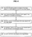
- FIG. 4is a flowchart of an exemplary method for post-processing an image dataset
- FIG. 5is a schematic of an exemplary end-user computing platform that accesses the transformed image dataset.
- FIGS. 1A through 1Cillustrate the utility of some embodiments of the present invention.
- FIG. 1Ais a photograph of street scene with buildings adjoining the street.
- a street sign 100partially blocks the view of a sign 102 on one of the shops next to the street.
- An image datasetcan incorporate the photograph of FIG. 1A . Different image datasets serve different purposes, and for some of those purposes, it is preferable that the shop sign 102 be clearly readable.
- FIG. 1Bis another photograph, taken from a slightly different point of view from that of FIG. 1A . Comparing FIGS. 1A and 1B , the foreground street sign 100 has “moved” relative to the background shop sign 102 . Because of this parallax “movement,” the portion of the shop sign 102 that is blocked in FIG. 1A is now clearly visible in FIG. 1B . (Also, a portion of the shop sign 102 that is visible in FIG. 1A is blocked in FIG. 1B .)
- FIGS. 1A and 1B togetherhave enough information to show the entire shop sign 102 .
- the information from these two figuresis processed to effectively “remove” the blocking portion of the street sign 100 and thus to allow the entire shop sign 102 to be seen.
- the resultis FIG. 1C .
- the viewpointis the same as in FIG. 1A , but the processed image of FIG. 1C shows the entire shop sign 102 .
- the processed image of FIG. 1Ceffectively replaces the image of FIG. 1A , thus rendering the shop sign 102 completely visible.
- the portion of the street sign 100 that blocks the shop sign 102is removed: Most of the street sign 100 is left in place. This is meant to clearly illustrate the removal of the blocking portion of the street sign 100 . In some embodiments, it is expected that the entire street sign 100 would be effectively removed. Also, other visible objects could be removed. For example, the person shown in the figures could be effectively removed from the scene using the techniques discussed below. In some embodiments, the blocking portion of the street sign 100 is left in place but is visually “de-emphasized” (e.g., rendered semi-transparent) so that the shop sign 102 is revealed behind it.
- FIGS. 2A and 2Billustrate an exemplary system for populating an image dataset.
- this systemcan be used to capture the images of FIGS. 1A and 1B .
- the system in these figurescollects images of a locality in the real world.
- a vehicle 200is driving down a road 202 .
- the vehicle 200includes an image-capture system 204 .
- the image-capture system 204may include multiple cameras taking overlapping still images or video of both sides of the road 202 .
- the images or videoare in a suitable format, such as *.jpg, *.mpg, *.avi, *.bmp, *.mov, etc.
- the vehicle 200also includes a system for determining its present location, such as a GPS receiver. As the vehicle 200 proceeds down the road 202 , the captured images are stored and are associated with the geographical location at which each picture was taken.
- the image-capture system 204includes a range-finding device, such as LIDAR.
- the image-capture system 204 and the range-finding deviceare “registered” so that the distance from the image-capture system 204 to whatever it is viewing is detected and recorded.
- a portion of a captured image(such as every pixel or a group of pixels) is associated with the distance from the image-capture system 204 to the object in the portion of the image.
- a range-finding deviceis combined with the vehicle's location-determination system (e.g., QPS), the precise real-world geographic location of every pixel is known. When stored with this location information, the resulting pixels are called “3D pixels.”
- FIG. 206shows the point-of-view of just one camera in the image-capture system 204 .
- this cameraand others, not shown
- image various areas of the building 208Located in front of the building 208 are “occluding objects,” here represented by signposts 210 . These are called “occluding objects” because they hide (or “occlude”) whatever is behind them.
- the doorway 212 of the building 208is partially occluded by one of the signposts 210 .
- the front of the building 208is of interest so it is desired to remove or de-emphasize these signposts 210 .
- each camera in the image-capture system 204maintains a fixed orientation with respect to the vehicle 200 . In other embodiments, the cameras pan as the vehicle 200 moves.) For the present discussion, the important point to make with respect to FIG.
- the doorway 212is not occluded by any of the signposts 210 . As discussed in greater detail below, this fact can be used to reveal the occluded objects, such as the doorway 212 , in the image dataset that stores the images captured by the system shown in FIGS. 2A and 2B .
- the image-capture system 204delivers its images to an image dataset 300 .
- the image dataset 300is stored on any of a number of computer-readable media. For example, it may be stored on one or more hard drives at one or more locations. During use and processing, portions of the image dataset 300 can be loaded into a computer's RAM or ROM. When the image dataset 300 is transformed or processed in some way, the resulting product is stored on the same computer-readable medium or on another one.
- the transformed image dataset 300in whole or in part, may be distributed to users on a tangible medium, such as a CD, or may be transmitted over a network such as the Internet or over a wireless link to a user's mobile navigation system.
- an image-based navigation application 302allows a user to virtually walk down the street 202 . No matter where the user moves or in what direction he turns his head, this navigation application 302 presents on the user's computer screen a photographic image from the real-world locality that corresponds to the user's virtual position and viewpoint.
- the captured imagesare “stitched” together using techniques, such as those disclosed in U.S. Pat. No. 7.688,229, to present seamless, 360-degree views (or even 360-degrees around plus up and down).
- the system in FIG. 3includes another component here called an “object evaluator” 304 .
- the evaluator 304reviews the visual objects represented by data in the image dataset 300 and determines which, if any, of these objects should be removed or otherwise de-emphasized. (Step 402 of FIG. 4 .)
- Various embodimentsuse one or more techniques to decide if a visual object should be removed or de-emphasized.
- the object evaluator 304can call the “relative position determiner” 306 to see if one object lies in front of, and partially occludes, another object. (Step 400 of FIG. 4 .) If so, then the object in front may need to be removed or de-emphasized. This is the situation with the signpost 210 of FIG. 2A .
- Embodiments of the relative position determiner 306can apply various techniques in parallel. First, when the image-capture system 204 includes a range finder and the pixels are 3D, the position information can be examined to see which objects were closer to the camera and thus in front of objects in the background.
- some, but not all, of the visual objects in the image dataset 300include direct position information. That is, only some of the pixels are 3D. In that case, the position of visual objects can often be inferred from cross-correlating the known positions of surrounding objects.) Second, when multiple images capture a similar area, the images are compared, and foreground objects will “move” by parallax with respect to the background objects.
- Another object identification techniquespecifically finds objects that represent people.
- the image dataset 300represents a real-world locality
- its captured imagesmay include views of pedestrians.
- Pedestriansmay be recognized by the relative position determiner 306 or could be recognized by specific face-detection software 308 .
- movement detectorcomponent 310
- This component 310reviews multiple images to see if an object, e.g., a vehicle, physically moved in the time interval between when one image was captured and when the next image was captured.
- moving objectsare not of interest and may be removed. (Note that this translational movement is different from the apparent, parallax movement discussed above. Nevertheless, there may well be overlap in the software between these two types of motion detectors.)
- Some embodimentsstrictly separate the act of choosing an object from the act of actually removing or de-emphasizing the chosen object. Because of this separation, the removal/de-emphasis techniques described below can be used with many different techniques for deciding which visual objects to remove or de-emphasize. These techniques base their decisions on particular situations and criteria. For example, a witness tells authorities that a blue car was used in a crime. The identification techniques described above are modified, and all non-blue cars are removed from the scene. Once the extraneous cars are removed, the modified scene may help the witness to further identify the desired vehicle. Another technique chooses to remove all occluding objects within a given distance of a chosen occluded object. In a third example, all occluding objects are removed along a given street from one selected street address to another. As other situations arise, other removal criteria are developed and fed into the removal/de-emphasis techniques.
- the data representing that visual objectmay be simply removed by the object replacer 312 from the image dataset 300 .
- Step 404 of FIG. 4different applications have different requirements for what should, and what should not, be removed.
- some embodimentsleave the data in place but “effectively delete” a chosen object by flagging its data in some way so that some applications can act as if the chosen object did not exist; other applications can choose to display the flagged object.
- objects chosen for deletionare left in place but are visually de-emphasized.
- a userstill sees the image of the occluding object, but at the same time sees through it to the occluded object. For example, FIG.
- 1Ccould be modified so that the street sign 100 is still visible, but it is semi-transparent or shown only in outline so that the shop sign 102 can be read.
- data representing removed objectsare stored in a repository for possible later use by the virtual-object adder 314 (discussed below).
- the work of the object replacer 312is not completed once a chosen visual object is effectively removed or de-emphasized.
- the data representing the signposts 210are deleted, but that leaves a visual “hole” in the doorway 212 as seen from the point-of-view 206 .
- the point-of-view 214includes the entire doorway 212 with no occlusion. The pixels taken in FIG. 2B can be used to fill in the visual hole. Because the angles of the points-of-view 206 ( FIG. 2A) and 214 ( FIG.
- the pixels from the point-of-view 214are first interpolated or transformed, using known techniques (such as an affine transformation) before putting them into the image for the point-of view 206 .
- known techniquessuch as an affine transformation
- the object replacer 312is able to choose among several candidate images in order to get the pixels needed to fill the hole created when a visual object is removed or de-emphasized.
- the object replacer 312applies any number of criteria to choose which images to work from. For example, the lighting may be better in one drive-by than in another. Also, a deciduous tree in winter occludes less of the background than does the same tree in summer. Having chosen an appropriate image (or an appropriate combination of images, if necessary), the object replacer 312 applies the techniques discussed above to fill in the visual hole.
- the image dataset 300may not have enough information to completely fill in the visual holes left when occluding objects are effectively removed or de-emphasized. It may be possible to guess what visual information should be supplied and then to proceed on that basis. For example, there is a brick wall on one side of the street, and that wall is mostly uniform wherever it can be seen. Thus, the visual texture of the brick wall can be interpolated even to locations that are always occluded. A hybrid approach is also sometimes useful, where non-occluded images are used to fill in as much of the visual holes as possible and with interpolation used for the remainder.
- a further use of the image dataset 300is contemplated.
- a “virtual-world locality”can be created by adding virtual visual objects to the image dataset 300 .
- Virtual-Object Adder component 314 of FIG. 3For example, a virtual landscaping application can add objects such as flower planters and trees to the street scene to assess their aesthetic appeal.
- Step 408 of FIG. 4Signs, bus stops, and other functional elements can be added, and their utility tested. (E.g., is a street sign visible from a sufficient distance and through a sufficient angle of view?) Visual objects can be added and deleted until the resulting image dataset 300 depicts a virtual-world locality rather than any real-world locality.
- the virtual-object adder 314draws visual objects from its own data repository.
- This repositorycan include, among other things, data representing visual objects that were removed from the image dataset 300 .
- a visual object representing an actual treeis removed from one view because it occludes the background.
- a virtual landscaping applicationuses the same data to add a virtual tree to another view.
- the transformed image dataset 300can be accessed from a device such as the exemplary computing platform 500 shown in FIG. 5 .
- This platform 500runs one or more applications 502 including, for example, the image-based navigation application 302 as discussed above.
- the usernavigates using tools provided by an interface 506 (such as a keyboard, mouse, microphone, voice recognition software, and the like).
- the application 302reads information from the transformed image dataset 300 and displays it on the display 508 of the user's interface 506 .
- Some embodiments of the computing platform 500include access to a geographic information database 504 .
- the platform 500can provide navigation-related applications 502 such as route calculation, route guidance, destination selection, electronic yellow pages, vehicle positioning, and map display. Other applications 502 are also possible.
- This geographic database 504can include data about the geographic area in which a user's vehicle 512 is located.
- the geographic database 504includes data about the roads in the geographic area, including data indicating the locations of the roads and intersections.
- the geographic database 504may also include information about the names of the roads, one-way streets, number of lanes, locations of traffic signals and signs, speed limits, turn restrictions, address ranges, and so on.
- the geographic database 504may also include information about points of interest, such as businesses, landmarks, museums, ATMs, government offices, and so on.
- the data in the geographic database 504are in a format that is optimized for providing navigation-related functions.
- applications 502have access to information from a positioning system 510 , such as a GPS device.
- the positioning system 510may include inertial sensors, differential wheel-speed sensors, a compass, or other equipment that enables the position of the user's vehicle 512 to be determined.
- the positionmay be determined as geographic coordinates (latitude, longitude, and altitude), street address, or in any other way.
- the computing platform 500is a combination of hardware, software, and data installed in a vehicle 512 as an in-vehicle navigation system.
- the platform 500can also be installed on a special-purpose, handheld navigation device, on a personal digital assistant, on a personal computer, or on a mobile telephone supporting a navigation application.
- the computing platform 500may be a standalone platform in which the hardware, software, and data are all located locally, e.g., within the vehicle 512 .
- the computing platform 500may be connected to a network, e.g., the Internet or a wireless network.
- the transformed image dataset 300 and the geographic database 504are located remotely from the computing platform 500 and are accessed via the network.
- the dataset 300 and database 504are local to the computing platform 500 , but updates are received over the network.
- Some applications 502can also be provided, in whole or in part, over the network.
Landscapes
- Engineering & Computer Science (AREA)
- Physics & Mathematics (AREA)
- Theoretical Computer Science (AREA)
- General Physics & Mathematics (AREA)
- Geometry (AREA)
- Computer Graphics (AREA)
- Computing Systems (AREA)
- Image Processing (AREA)
- Processing Or Creating Images (AREA)
- Image Analysis (AREA)
- Navigation (AREA)
- Image Generation (AREA)
- Closed-Circuit Television Systems (AREA)
Abstract
Description
Claims (25)
Priority Applications (3)
| Application Number | Priority Date | Filing Date | Title |
|---|---|---|---|
| US11/980,033US8086071B2 (en) | 2007-10-30 | 2007-10-30 | System and method for revealing occluded objects in an image dataset |
| EP08253525.3AEP2056256A3 (en) | 2007-10-30 | 2008-10-29 | System and method for revealing occluded objects in an image dataset |
| JP2008303147AJP2009134719A (en) | 2007-10-30 | 2008-10-30 | System and method of revealing occluded object in image dataset |
Applications Claiming Priority (1)
| Application Number | Priority Date | Filing Date | Title |
|---|---|---|---|
| US11/980,033US8086071B2 (en) | 2007-10-30 | 2007-10-30 | System and method for revealing occluded objects in an image dataset |
Publications (2)
| Publication Number | Publication Date |
|---|---|
| US20090110239A1 US20090110239A1 (en) | 2009-04-30 |
| US8086071B2true US8086071B2 (en) | 2011-12-27 |
Family
ID=40300470
Family Applications (1)
| Application Number | Title | Priority Date | Filing Date |
|---|---|---|---|
| US11/980,033Active2030-10-19US8086071B2 (en) | 2007-10-30 | 2007-10-30 | System and method for revealing occluded objects in an image dataset |
Country Status (3)
| Country | Link |
|---|---|
| US (1) | US8086071B2 (en) |
| EP (1) | EP2056256A3 (en) |
| JP (1) | JP2009134719A (en) |
Cited By (13)
| Publication number | Priority date | Publication date | Assignee | Title |
|---|---|---|---|---|
| US20110129143A1 (en)* | 2009-11-27 | 2011-06-02 | Sony Corporation | Method and apparatus and computer program for generating a 3 dimensional image from a 2 dimensional image |
| US8565958B1 (en)* | 2011-06-02 | 2013-10-22 | Google Inc. | Removing extraneous objects from maps |
| US8838381B1 (en)* | 2009-11-10 | 2014-09-16 | Hrl Laboratories, Llc | Automatic video generation for navigation and object finding |
| US20150049909A1 (en)* | 2012-03-27 | 2015-02-19 | Sony Corporation | Information processing device, information processing method and program |
| US9164511B1 (en) | 2013-04-17 | 2015-10-20 | Google Inc. | Use of detected objects for image processing |
| US20150310281A1 (en)* | 2014-04-25 | 2015-10-29 | Google Inc. | Methods and Systems for Object Detection using Multiple Sensors |
| US20160078249A1 (en)* | 2012-09-21 | 2016-03-17 | Intel Corporation | Enhanced privacy for provision of computer vision |
| US9569693B2 (en) | 2014-12-31 | 2017-02-14 | Here Global B.V. | Method and apparatus for object identification and location correlation based on received images |
| WO2017108221A1 (en)* | 2015-12-21 | 2017-06-29 | Robert Bosch Gmbh | Dynamic image blending for multiple-camera vehicle systems |
| US20200053506A1 (en)* | 2017-08-04 | 2020-02-13 | Alibaba Group Holding Limited | Information display method and apparatus |
| US10623680B1 (en) | 2017-07-11 | 2020-04-14 | Equinix, Inc. | Data center viewing system |
| US10720187B2 (en) | 2015-09-29 | 2020-07-21 | International Business Machines Corporation | Method and apparatus to extract key video frames from online education |
| US11353332B2 (en)* | 2018-12-14 | 2022-06-07 | Toyota Jidosha Kabushiki Kaisha | Information processing system, storage medium, and information processing method |
Families Citing this family (29)
| Publication number | Priority date | Publication date | Assignee | Title |
|---|---|---|---|---|
| US8253736B2 (en)* | 2007-01-29 | 2012-08-28 | Microsoft Corporation | Reducing occlusions in oblique views |
| US9138636B2 (en) | 2007-05-16 | 2015-09-22 | Eyecue Vision Technologies Ltd. | System and method for calculating values in tile games |
| US8531449B2 (en) | 2007-12-18 | 2013-09-10 | Navteq B.V. | System and method for producing multi-angle views of an object-of-interest from images in an image dataset |
| JP2013501304A (en) | 2009-08-04 | 2013-01-10 | アイキュー ビジョン テクノロジーズ リミテッド | System and method for object extraction |
| US9595108B2 (en) | 2009-08-04 | 2017-03-14 | Eyecue Vision Technologies Ltd. | System and method for object extraction |
| US8817071B2 (en)* | 2009-11-17 | 2014-08-26 | Seiko Epson Corporation | Context constrained novel view interpolation |
| US20110144909A1 (en)* | 2009-12-14 | 2011-06-16 | Robert Bosch Gmbh | Personalized and context-sensitive 3d route guidance |
| US9336452B2 (en)* | 2011-01-16 | 2016-05-10 | Eyecue Vision Technologies Ltd. | System and method for identification of printed matter in an image |
| CN103988227B (en)* | 2011-12-16 | 2017-08-04 | 诺基亚技术有限公司 | Method and apparatus for image capture target locking |
| US9501831B2 (en)* | 2012-10-02 | 2016-11-22 | Google Inc. | Identification of relative distance of objects in images |
| US20150325040A1 (en)* | 2012-12-27 | 2015-11-12 | Nokia Corporation | Method, apparatus and computer program product for image rendering |
| US9426451B2 (en) | 2013-03-15 | 2016-08-23 | Digimarc Corporation | Cooperative photography |
| US9449227B2 (en)* | 2014-01-08 | 2016-09-20 | Here Global B.V. | Systems and methods for creating an aerial image |
| US9659225B2 (en)* | 2014-02-12 | 2017-05-23 | Microsoft Technology Licensing, Llc | Restaurant-specific food logging from images |
| US9811889B2 (en) | 2014-12-31 | 2017-11-07 | Nokia Technologies Oy | Method, apparatus and computer program product for generating unobstructed object views |
| US9805274B2 (en) | 2016-02-03 | 2017-10-31 | Honda Motor Co., Ltd. | Partially occluded object detection using context and depth ordering |
| US11212437B2 (en)* | 2016-06-06 | 2021-12-28 | Bryan COLIN | Immersive capture and review |
| US10088676B2 (en)* | 2016-06-30 | 2018-10-02 | Paypal, Inc. | Enhanced safety through augmented reality and shared data |
| JP6407225B2 (en) | 2016-09-30 | 2018-10-17 | キヤノン株式会社 | Image processing apparatus, image processing method, image processing system, and program |
| JP6930091B2 (en)* | 2016-11-15 | 2021-09-01 | 富士フイルムビジネスイノベーション株式会社 | Image processing equipment, image processing methods, image processing systems and programs |
| US10726792B2 (en) | 2017-04-17 | 2020-07-28 | Intel Corporation | Glare and occluded view compensation for automotive and other applications |
| US10284789B2 (en) | 2017-09-15 | 2019-05-07 | Sony Corporation | Dynamic generation of image of a scene based on removal of undesired object present in the scene |
| GB2568278A (en)* | 2017-11-10 | 2019-05-15 | John Hudson Raymond | Image replacement system |
| JP6704554B2 (en)* | 2018-03-29 | 2020-06-03 | 三菱電機株式会社 | Image processing apparatus, image processing method, and monitoring system |
| US10878588B2 (en)* | 2018-06-22 | 2020-12-29 | X Development Llc | Detection and replacement of transient obstructions from high elevation digital images |
| US11388775B2 (en)* | 2019-09-11 | 2022-07-12 | Honeywell International Inc. | Systems and methods for identifying blockages of emergency exists in a building |
| WO2021185068A1 (en)* | 2020-03-18 | 2021-09-23 | Maycas Inventions Limited | Methods and apparatus for pasting advertisement to video |
| CN115223384B (en)* | 2021-03-29 | 2024-01-16 | 东风汽车集团股份有限公司 | Vehicle data display method and device, electronic equipment and storage medium |
| CN114972782A (en)* | 2022-04-29 | 2022-08-30 | 上海商汤临港智能科技有限公司 | Image processing method and device, computer equipment and storage medium |
Citations (22)
| Publication number | Priority date | Publication date | Assignee | Title |
|---|---|---|---|---|
| US5161886A (en) | 1989-01-11 | 1992-11-10 | U.S. Philips Corp. | Method for the perspective display of a part of a topographic map, and device suitable for performing such a method |
| US5684887A (en)* | 1993-07-02 | 1997-11-04 | Siemens Corporate Research, Inc. | Background recovery in monocular vision |
| US5774569A (en) | 1994-07-25 | 1998-06-30 | Waldenmaier; H. Eugene W. | Surveillance system |
| US5953076A (en)* | 1995-06-16 | 1999-09-14 | Princeton Video Image, Inc. | System and method of real time insertions into video using adaptive occlusion with a synthetic reference image |
| US6222583B1 (en) | 1997-03-27 | 2001-04-24 | Nippon Telegraph And Telephone Corporation | Device and system for labeling sight images |
| US6360168B1 (en)* | 1999-09-14 | 2002-03-19 | Alpine Electronics, Inc. | Navigation apparatus |
| US6363161B2 (en) | 1998-10-23 | 2002-03-26 | Facet Technology Corp. | System for automatically generating database of objects of interest by analysis of images recorded by moving vehicle |
| US20020113791A1 (en)* | 2001-01-02 | 2002-08-22 | Jiang Li | Image-based virtual reality player with integrated 3D graphics objects |
| US20040090523A1 (en)* | 2001-06-27 | 2004-05-13 | Tetsujiro Kondo | Image processing apparatus and method and image pickup apparatus |
| US20040098175A1 (en) | 2002-11-19 | 2004-05-20 | Amir Said | Methods and apparatus for imaging and displaying a navigable path |
| US20040126014A1 (en)* | 2002-12-31 | 2004-07-01 | Lipton Alan J. | Video scene background maintenance using statistical pixel modeling |
| US6760488B1 (en)* | 1999-07-12 | 2004-07-06 | Carnegie Mellon University | System and method for generating a three-dimensional model from a two-dimensional image sequence |
| US20040151342A1 (en)* | 2003-01-30 | 2004-08-05 | Venetianer Peter L. | Video scene background maintenance using change detection and classification |
| US20050104878A1 (en)* | 1998-05-27 | 2005-05-19 | Kaye Michael C. | Method of hidden surface reconstruction for creating accurate three-dimensional images converted from two-dimensional images |
| US6956573B1 (en)* | 1996-11-15 | 2005-10-18 | Sarnoff Corporation | Method and apparatus for efficiently representing storing and accessing video information |
| US20060120592A1 (en)* | 2004-12-07 | 2006-06-08 | Chang-Joon Park | Apparatus for recovering background in image sequence and method thereof |
| US7155336B2 (en) | 2004-03-24 | 2006-12-26 | A9.Com, Inc. | System and method for automatically collecting images of objects at geographic locations and displaying same in online directories |
| US7216035B2 (en) | 2002-08-07 | 2007-05-08 | Siemens Aktiengeselschaft | Method and device for displaying navigational information for a vehicle |
| US20070118281A1 (en) | 2005-11-18 | 2007-05-24 | Tomtom International B.V. | navigation device displaying traffic information |
| US20080112610A1 (en)* | 2006-11-14 | 2008-05-15 | S2, Inc. | System and method for 3d model generation |
| US20080246759A1 (en)* | 2005-02-23 | 2008-10-09 | Craig Summers | Automatic Scene Modeling for the 3D Camera and 3D Video |
| US7688229B2 (en) | 2007-04-30 | 2010-03-30 | Navteq North America, Llc | System and method for stitching of video for routes |
Family Cites Families (7)
| Publication number | Priority date | Publication date | Assignee | Title |
|---|---|---|---|---|
| JP3551467B2 (en)* | 1994-04-13 | 2004-08-04 | 松下電器産業株式会社 | Parallax calculating device, parallax calculating method, and image combining device |
| US6205231B1 (en)* | 1995-05-10 | 2001-03-20 | Identive Corporation | Object identification in a moving video image |
| US6466205B2 (en)* | 1998-11-19 | 2002-10-15 | Push Entertainment, Inc. | System and method for creating 3D models from 2D sequential image data |
| JP2002163672A (en)* | 2000-11-28 | 2002-06-07 | Mitsubishi Electric Corp | Three-dimensional graphics drawing apparatus and method |
| JP2003287434A (en)* | 2002-01-25 | 2003-10-10 | Iwane Kenkyusho:Kk | Image information retrieval system |
| JP4272966B2 (en)* | 2003-10-14 | 2009-06-03 | 和郎 岩根 | 3DCG synthesizer |
| US20050129324A1 (en)* | 2003-12-02 | 2005-06-16 | Lemke Alan P. | Digital camera and method providing selective removal and addition of an imaged object |
- 2007
- 2007-10-30USUS11/980,033patent/US8086071B2/enactiveActive
- 2008
- 2008-10-29EPEP08253525.3Apatent/EP2056256A3/ennot_activeCeased
- 2008-10-30JPJP2008303147Apatent/JP2009134719A/enactivePending
Patent Citations (24)
| Publication number | Priority date | Publication date | Assignee | Title |
|---|---|---|---|---|
| US5161886A (en) | 1989-01-11 | 1992-11-10 | U.S. Philips Corp. | Method for the perspective display of a part of a topographic map, and device suitable for performing such a method |
| US5161886C1 (en) | 1989-01-11 | 2001-10-30 | Philips Corp | Method for the perspective display of a part of a topographic map and device suitable for performing such a method |
| US5684887A (en)* | 1993-07-02 | 1997-11-04 | Siemens Corporate Research, Inc. | Background recovery in monocular vision |
| US5774569A (en) | 1994-07-25 | 1998-06-30 | Waldenmaier; H. Eugene W. | Surveillance system |
| US5953076A (en)* | 1995-06-16 | 1999-09-14 | Princeton Video Image, Inc. | System and method of real time insertions into video using adaptive occlusion with a synthetic reference image |
| US6956573B1 (en)* | 1996-11-15 | 2005-10-18 | Sarnoff Corporation | Method and apparatus for efficiently representing storing and accessing video information |
| US6222583B1 (en) | 1997-03-27 | 2001-04-24 | Nippon Telegraph And Telephone Corporation | Device and system for labeling sight images |
| US20050104878A1 (en)* | 1998-05-27 | 2005-05-19 | Kaye Michael C. | Method of hidden surface reconstruction for creating accurate three-dimensional images converted from two-dimensional images |
| US6363161B2 (en) | 1998-10-23 | 2002-03-26 | Facet Technology Corp. | System for automatically generating database of objects of interest by analysis of images recorded by moving vehicle |
| US6760488B1 (en)* | 1999-07-12 | 2004-07-06 | Carnegie Mellon University | System and method for generating a three-dimensional model from a two-dimensional image sequence |
| US6360168B1 (en)* | 1999-09-14 | 2002-03-19 | Alpine Electronics, Inc. | Navigation apparatus |
| US6760026B2 (en)* | 2001-01-02 | 2004-07-06 | Microsoft Corporation | Image-based virtual reality player with integrated 3D graphics objects |
| US20020113791A1 (en)* | 2001-01-02 | 2002-08-22 | Jiang Li | Image-based virtual reality player with integrated 3D graphics objects |
| US20040090523A1 (en)* | 2001-06-27 | 2004-05-13 | Tetsujiro Kondo | Image processing apparatus and method and image pickup apparatus |
| US7216035B2 (en) | 2002-08-07 | 2007-05-08 | Siemens Aktiengeselschaft | Method and device for displaying navigational information for a vehicle |
| US20040098175A1 (en) | 2002-11-19 | 2004-05-20 | Amir Said | Methods and apparatus for imaging and displaying a navigable path |
| US20040126014A1 (en)* | 2002-12-31 | 2004-07-01 | Lipton Alan J. | Video scene background maintenance using statistical pixel modeling |
| US20040151342A1 (en)* | 2003-01-30 | 2004-08-05 | Venetianer Peter L. | Video scene background maintenance using change detection and classification |
| US7155336B2 (en) | 2004-03-24 | 2006-12-26 | A9.Com, Inc. | System and method for automatically collecting images of objects at geographic locations and displaying same in online directories |
| US20060120592A1 (en)* | 2004-12-07 | 2006-06-08 | Chang-Joon Park | Apparatus for recovering background in image sequence and method thereof |
| US20080246759A1 (en)* | 2005-02-23 | 2008-10-09 | Craig Summers | Automatic Scene Modeling for the 3D Camera and 3D Video |
| US20070118281A1 (en) | 2005-11-18 | 2007-05-24 | Tomtom International B.V. | navigation device displaying traffic information |
| US20080112610A1 (en)* | 2006-11-14 | 2008-05-15 | S2, Inc. | System and method for 3d model generation |
| US7688229B2 (en) | 2007-04-30 | 2010-03-30 | Navteq North America, Llc | System and method for stitching of video for routes |
Non-Patent Citations (1)
| Title |
|---|
| "Automatic Occlusion Removal from Minimum Number of Images," HERLEY, Image Processing, 2005; vol. 2, Issue, Sep. 11-14, 2005; 4 pages.* |
Cited By (25)
| Publication number | Priority date | Publication date | Assignee | Title |
|---|---|---|---|---|
| US8838381B1 (en)* | 2009-11-10 | 2014-09-16 | Hrl Laboratories, Llc | Automatic video generation for navigation and object finding |
| US20110129143A1 (en)* | 2009-11-27 | 2011-06-02 | Sony Corporation | Method and apparatus and computer program for generating a 3 dimensional image from a 2 dimensional image |
| US8509521B2 (en)* | 2009-11-27 | 2013-08-13 | Sony Corporation | Method and apparatus and computer program for generating a 3 dimensional image from a 2 dimensional image |
| US8565958B1 (en)* | 2011-06-02 | 2013-10-22 | Google Inc. | Removing extraneous objects from maps |
| US20150049909A1 (en)* | 2012-03-27 | 2015-02-19 | Sony Corporation | Information processing device, information processing method and program |
| US9836644B2 (en)* | 2012-03-27 | 2017-12-05 | Sony Corporation | Changing a depiction in a captured image based on a state of a subject present in the captured image |
| US20160078249A1 (en)* | 2012-09-21 | 2016-03-17 | Intel Corporation | Enhanced privacy for provision of computer vision |
| US9569637B2 (en)* | 2012-09-21 | 2017-02-14 | Intel Corporation | Enhanced privacy for provision of computer vision |
| US9164511B1 (en) | 2013-04-17 | 2015-10-20 | Google Inc. | Use of detected objects for image processing |
| US12019443B2 (en) | 2013-04-17 | 2024-06-25 | Waymo Llc | Use of detected objects for image processing |
| US11181914B2 (en) | 2013-04-17 | 2021-11-23 | Waymo Llc | Use of detected objects for image processing |
| US10509402B1 (en) | 2013-04-17 | 2019-12-17 | Waymo Llc | Use of detected objects for image processing |
| US9804597B1 (en) | 2013-04-17 | 2017-10-31 | Waymo Llc | Use of detected objects for image processing |
| US20150310281A1 (en)* | 2014-04-25 | 2015-10-29 | Google Inc. | Methods and Systems for Object Detection using Multiple Sensors |
| US9607226B2 (en)* | 2014-04-25 | 2017-03-28 | Google Inc. | Methods and systems for object detection using multiple sensors |
| US9830510B2 (en) | 2014-12-31 | 2017-11-28 | Here Global B.V. | Method and apparatus for object identification and location correlation based on received images |
| US10346683B2 (en) | 2014-12-31 | 2019-07-09 | Here Global B.V. | Method and apparatus for object identification and location correlation based on received images |
| US9569693B2 (en) | 2014-12-31 | 2017-02-14 | Here Global B.V. | Method and apparatus for object identification and location correlation based on received images |
| US10720187B2 (en) | 2015-09-29 | 2020-07-21 | International Business Machines Corporation | Method and apparatus to extract key video frames from online education |
| WO2017108221A1 (en)* | 2015-12-21 | 2017-06-29 | Robert Bosch Gmbh | Dynamic image blending for multiple-camera vehicle systems |
| US11184531B2 (en) | 2015-12-21 | 2021-11-23 | Robert Bosch Gmbh | Dynamic image blending for multiple-camera vehicle systems |
| US10623680B1 (en) | 2017-07-11 | 2020-04-14 | Equinix, Inc. | Data center viewing system |
| US20200053506A1 (en)* | 2017-08-04 | 2020-02-13 | Alibaba Group Holding Limited | Information display method and apparatus |
| US11212639B2 (en)* | 2017-08-04 | 2021-12-28 | Advanced New Technologies Co., Ltd. | Information display method and apparatus |
| US11353332B2 (en)* | 2018-12-14 | 2022-06-07 | Toyota Jidosha Kabushiki Kaisha | Information processing system, storage medium, and information processing method |
Also Published As
| Publication number | Publication date |
|---|---|
| JP2009134719A (en) | 2009-06-18 |
| EP2056256A2 (en) | 2009-05-06 |
| EP2056256A3 (en) | 2017-03-22 |
| US20090110239A1 (en) | 2009-04-30 |
Similar Documents
| Publication | Publication Date | Title |
|---|---|---|
| US8086071B2 (en) | System and method for revealing occluded objects in an image dataset | |
| US9858717B2 (en) | System and method for producing multi-angle views of an object-of-interest from images in an image dataset | |
| US8000895B2 (en) | Navigation and inspection system | |
| US20100215250A1 (en) | System and method of indicating transition between street level images | |
| US20130155047A1 (en) | Image three-dimensional (3d) modeling | |
| CA2725789A1 (en) | Method of and arrangement for blurring an image | |
| JPWO2004095374A1 (en) | Video object recognition apparatus and recognition method, video annotation giving apparatus and giving method, and program | |
| JP2011170599A (en) | Outdoor structure measuring instrument and outdoor structure measuring method | |
| CN105444773A (en) | Navigation method and system based on real scene recognition and augmented reality | |
| JP3156646B2 (en) | Search-type landscape labeling device and system | |
| KR20090132317A (en) | Method and system for providing video based additional information | |
| WO2008082423A1 (en) | Navigation and inspection system | |
| CN110827340A (en) | Map updating method, device and storage medium | |
| JP3156645B2 (en) | Information transmission type landscape labeling device and system | |
| JPH1166355A (en) | Deformable label landscape labeling device and system | |
| Cho et al. | Image-based querying of urban knowledge databases | |
| WO1999033026A1 (en) | Acquisition and animation of surface detail images | |
| CN114241126A (en) | Method for extracting object position information in monocular video based on live-action model | |
| CN119579435A (en) | Sample creation, model training and target detection methods, devices, equipment and media | |
| Okatani et al. | Creating multi-viewpoint panoramas of streets with sparsely located buildings | |
| Cho et al. | Image-based querying of urban photos and videos | |
| Krausz et al. | Capturing and Processing of 360° Panoramic Images for Emergency Site Exploration |
Legal Events
| Date | Code | Title | Description |
|---|---|---|---|
| AS | Assignment | Owner name:NAVTEQ NORTH AMERICA, LLC, ILLINOIS Free format text:ASSIGNMENT OF ASSIGNORS INTEREST;ASSIGNORS:CHEN, XIN;GALE, WILLIAM;REEL/FRAME:020097/0701 Effective date:20071030 | |
| STCF | Information on status: patent grant | Free format text:PATENTED CASE | |
| AS | Assignment | Owner name:NAVTEQ B.V., NETHERLANDS Free format text:ASSIGNMENT OF ASSIGNORS INTEREST;ASSIGNOR:NAVTEQ NORTH AMERICA, LLC;REEL/FRAME:027588/0051 Effective date:20111229 | |
| AS | Assignment | Owner name:HERE GLOBAL B.V., NETHERLANDS Free format text:CHANGE OF NAME;ASSIGNOR:NAVTEQ B.V.;REEL/FRAME:033830/0681 Effective date:20130423 | |
| FPAY | Fee payment | Year of fee payment:4 | |
| MAFP | Maintenance fee payment | Free format text:PAYMENT OF MAINTENANCE FEE, 8TH YEAR, LARGE ENTITY (ORIGINAL EVENT CODE: M1552); ENTITY STATUS OF PATENT OWNER: LARGE ENTITY Year of fee payment:8 | |
| MAFP | Maintenance fee payment | Free format text:PAYMENT OF MAINTENANCE FEE, 12TH YEAR, LARGE ENTITY (ORIGINAL EVENT CODE: M1553); ENTITY STATUS OF PATENT OWNER: LARGE ENTITY Year of fee payment:12 |