US7995862B2 - System, computer program and method for 3D object measurement, modeling and mapping from single imagery - Google Patents
System, computer program and method for 3D object measurement, modeling and mapping from single imageryDownload PDFInfo
- Publication number
- US7995862B2 US7995862B2US12/118,515US11851508AUS7995862B2US 7995862 B2US7995862 B2US 7995862B2US 11851508 AUS11851508 AUS 11851508AUS 7995862 B2US7995862 B2US 7995862B2
- Authority
- US
- United States
- Prior art keywords
- shadow
- image
- measurement
- dimensional
- projection
- Prior art date
- Legal status (The legal status is an assumption and is not a legal conclusion. Google has not performed a legal analysis and makes no representation as to the accuracy of the status listed.)
- Expired - Lifetime, expires
Links
Images


Classifications
- G—PHYSICS
- G01—MEASURING; TESTING
- G01C—MEASURING DISTANCES, LEVELS OR BEARINGS; SURVEYING; NAVIGATION; GYROSCOPIC INSTRUMENTS; PHOTOGRAMMETRY OR VIDEOGRAMMETRY
- G01C11/00—Photogrammetry or videogrammetry, e.g. stereogrammetry; Photographic surveying
- G01C11/04—Interpretation of pictures
- G—PHYSICS
- G06—COMPUTING OR CALCULATING; COUNTING
- G06T—IMAGE DATA PROCESSING OR GENERATION, IN GENERAL
- G06T17/00—Three dimensional [3D] modelling, e.g. data description of 3D objects
- G06T17/05—Geographic models
- G—PHYSICS
- G01—MEASURING; TESTING
- G01C—MEASURING DISTANCES, LEVELS OR BEARINGS; SURVEYING; NAVIGATION; GYROSCOPIC INSTRUMENTS; PHOTOGRAMMETRY OR VIDEOGRAMMETRY
- G01C11/00—Photogrammetry or videogrammetry, e.g. stereogrammetry; Photographic surveying
- G—PHYSICS
- G06—COMPUTING OR CALCULATING; COUNTING
- G06T—IMAGE DATA PROCESSING OR GENERATION, IN GENERAL
- G06T7/00—Image analysis
- G06T7/50—Depth or shape recovery
Definitions
- the present inventionrelates to mapping, surveying, photogrammetry, remote sensing, visualization and simulation, gaming, planning, geomatics, civil engineering, geography, and more particularly relates to the collection of measurement and dimension information of or between objects from single images, and the three-dimensional (3D) models and maps and the subsequent use of such information in analysis, modeling, mapping and visualization.
- a conventional method of measuring 3D objectsis called stereo-vision that obtains paired stereo images taken of the same objects.
- imagery geometry model (IGM) of each imageis given, the 3D coordinate information of the objects can be determined.
- a photogrammetric methodsurveys the objects by selecting conjugate points, and thereby measure any dimension using the IGMs based on these points.
- the 3D models and mapsare then generated by using the stereo-vision approaches.
- the present inventionhas resulted in an operational method, computer program and system that can effectively obtain 3D measurements and create 3D object models and maps.
- the systemis comprised of unique utilities and novel algorithms that are designed to make use of object projection, shadow, object geometry, and the IGM.
- the IGMdescribes the geometric relationship between the object space and the image space, or vice visa.
- the two broadly used IGMsinclude the physical sensor model and the generalized sensor model.
- the rational function model (RFM)is a kind of generalized sensor model.
- a method for deriving three-dimensional measurement information and/or creating three-dimensional models and maps, from single images of at least one three-dimensional objectcomprising the steps of: obtaining at least one two-dimensional single image of the object, the image consisting of image data and being associated with an image geometry model (IGM); deriving three-dimensional coordinate information associated with the image, based on the IGM, and associating the three-dimensional coordinate information with the image data; analyzing the image data so as to measure the projection of the object using the IGM to derive measurement data including the height and/or point-to-point distances pertaining to the object; and/or, measure the shadow of the object to derive measurement data including the height and/or point-to-point distance pertaining to the object; and obtaining three-dimensional measurements based on the projection and/or shadow measurements of the object.
- IGMimage geometry model
- a system for deriving three-dimensional measurement information and/or creating three-dimensional models and maps, from single images of at least one three-dimensional objectcomprising: at least one computer; and a computer program operably linked to the computer so as to enable the computer to: obtain at least one two-dimensional single image of the object, the image consisting of image data and being associated with an image geometry model (IGM); derive three-dimensional coordinate information associated with the image, based on the IGM, and associating the three-dimensional coordinate information with the image data; analyze the image data so as to: measure the projection of the object using the IGM to derive measurement data including the height and/or point-to-point distances pertaining to the object; and/or measure the shadow of the object to derive measurement data including the height and/or point-to-point distance pertaining to the object; and obtain three-dimensional measurements based on the projection and/or shadow measurements of the object.
- IGMimage geometry model
- a computer usable mediumcomprising instructions for defining a measurement utility on a computer, the measurement utility being operable to: obtain at least one two-dimensional single image of the object, the image consisting of image data and being associated with an image geometry model (IGM); derive three-dimensional coordinate information associated with the image, based on the IGM, and associating the three-dimensional coordinate information with the image data; analyze the image data so as to: measure the projection of the object using the IGM to derive measurement data including the height and/or point-to-point distances pertaining to the object; and/or measure the shadow of the object to derive measurement data including the height and/or point-to-point distance pertaining to the object; and obtain three-dimensional measurements based on the projection and/or shadow measurements of the object.
- IGMimage geometry model
- the present inventionprovides a method for deriving 3D measurement information and creating 3D models and maps from the single imagery with the IGM support, including the RFM sensor model, where: (i) a single image is available, (ii) both static and dynamic objects are to be measured, (iii) no stereo viewing devices are available, or (iv) conjugate points from stereo image pairs cannot be identified.
- the present inventionincludes a system that enables measurement information to be readily accessed, and used from an image in accordance with the method of the present invention.
- This systemconsists of utilities to obtain 3D measurements and to create 3D models and 3D maps from the single image.
- the systemconsists generally of a computer system which is adapted to process instructions provided by the computer program of the present invention.
- the computer program of the present inventionconsists of a computer application that includes (1) a measurement utility that enables measurements to be made from a 2D image that supports the IGM, the measurement utility including a projection measurement utility and a shadow measurement utility.
- the projection measurement utility and the shadow measurement utilityco-operate so as to enable point-to-point measurements by operation of the projection measurement utility, the shadow measurement utility, or both, with the support of the IGM; and (2) a model generation utility that efficiently create 3D models and maps based on measurements made by the measurement utility of the invention.
- the applicationcan be applied for any images (e.g., satellite or aerial) supporting the RFM or the like.
- the present inventionenables the 3D measurements, models and maps from the single images.
- Another aspect of the method of the present inventionconsists of a method for obtaining measurement information, namely, the distance between any two points in the three dimensions from a single image, and for creating 3D models from the measurements and subsequently generating 3D maps from a single image.
- the present inventionprovides methods for:
- Another aspect of the method of the present inventionis the application of specific algorithms of the present invention in order to take the measurements described.
- the present inventioncan be applied for any images with the RFM support. This is due to the fact that the RFM is sensor independent and can be universally applied to multiple sensors. Thus the computer program resulted from this invention can be used for any images without a need to change its underlying sensor model.
- FIG. 1 aA conceptual drawing of a representative graphic user interface for accessing the functions of the computer program product of the present invention.
- the toolbar buttons illustratedenable access to the functions of the utilities of the present invention.
- FIG. 1 bA program resource diagram illustrating the resources of the computer program of the present invention.
- FIG. 2 aThe conceptual drawing of the measurement utility 8 displayed in the image display window.
- FIG. 2 bA schematic diagram showing the relationship among the projection and the shadow cast in the image, the IGM, the object, and the sun angles, assuming a flat ground surface.
- FIG. 3Illustration of determining the horizontal position (X, Y) by intersecting a plane having the elevation of Z in a single image. The elevation Z is adjusted at some incremental change.
- FIG. 4 aA schematic diagram of the height measurement of a building using the projection measurement utility based on the IGM.
- FIG. 4 bIllustration of the height measurement of a building using the projection measurement utility of the present invention based on the IGM.
- FIG. 5A diagram showing the relationship between the sun's position and the displacement of an object's shadow.
- FIG. 6A schematic diagram illustrating the method of the present invention, and more specifically showing a method of drawing the projection and the shadow of an object, assuming a non-flat ground surface.
- FIG. 7 aA block diagram illustrating the present invention, showing the measurement of the object height using the shadow information, for measurable shadows in the image.
- FIG. 7 bA block diagram illustrating the present invention, showing the measurement of the object height using the shadow information, for un-measurable shadows in the image.
- FIG. 8 aA schematic diagram showing the taking of a height measurement using the shadow measuring utility for an object that is a building, starting from its base point.
- FIG. 8 bIllustration of the present invention showing the taking of a height measurement using the shadow measuring utility for an object that is a building, starting from its base point.
- FIGS. 9 a , 9 b , 9 c and 9 dIllustrations of height measurement in accordance with the present invention using the shadow measurement utility for a) an airplane in the case of FIG. 9 a, b) an overpass in the case of FIG. 9 b, c) a tree in the case of FIG. 9 c, d) a chimney in the case of FIG. 9 d , starting from their shadow endpoints.
- FIG. 10 aIllustration of determination of the base point using the shadow measurement utility of the present invention, where the height of the airplane is shown to be 57.1 m.
- FIG. 10 bIllustration of drawing a line mark in accordance with the present invention, the line connecting the base point with the landing point of the runway, and the horizontal distance being shown as being 158.1 m.
- FIG. 10 cIllustrating the present invention by raising the base point of the line mark to the height of the airplane, and the slant distance being show to be 165.8 m.
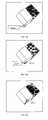
- FIG. 11 aIllustration of operation of the present invention to draw a line mark connecting the base points of the two objects.
- FIG. 11 bIllustration of the present invention by showing in operation the raising of the base points at the two ends of the line mark to the height of their respective roof.
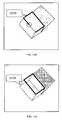
- FIG. 12 aIllustration of one particular aspect of the present invention, whereby the base points of the head point and the tail point of the airplane are determined.
- FIG. 12 bFurther illustration of the particular aspect of the present invention shown in FIG. 12 a : whereby the line connecting the two base points is shown.
- FIGS. 13 a and 13 bFurther illustrate the present invention whereby the heights of a multi-layered building are measured; whereby in FIG. 13 a the height of the first layer of the roof is measured and locked, and this height is 31 m, and whereby in FIG. 13 b the height of the second layer of the roof relative to the first layer is measured starting from the locked height.
- FIG. 14A schematic diagram of compensating the systematic biases of the object dimensions measured without using digital terrain models (DTM).
- DTMdigital terrain models
- FIGS. 15 a , 15 b , 15 c , 15 d and 15 eIllustrations of the base selection method for 3D mapping in accordance with the present invention; whereby in FIG. 15 a the base point is selected, whereby in FIGS. 15 b and 15 c the Z level is changed via the user dynamically updating the annotation and current Z level (as given by the yellow line in actual case); whereby in FIG. 15 d , the top of the building is outlined using a 3D mapping tool (polygon); whereby in FIG. 15 e the building footprint is enabled and displayed.
- FIGS. 16 a , 16 b , and 16 cIllustration of the roof-footprint displacement method for 3D modeling of flat roof buildings in accordance with the present invention: whereby in FIG. 16 a , the mapping of the roof outline is shown using the 3D polygon mapping tool; whereby in FIG. 16 b is shown the horizontal displacement of the roof outline to coincide with the base of the building; whereby in FIG. 16 c is shown that the 3D building model is constructed.
- FIG. 17A schematic diagram of roof shapes supported in modeling buildings with gable, clipped gable, hip and shed roof shapes.
- FIGS. 18 a , 18 bIllustration of the creation of the 3D vector maps from 2D vector maps in accordance with the present invention: whereby in FIG. 18 a , is shown the selection of 2D mapped vector after import into the computer program; whereby in FIG. 18 b , is shown the 2D mapped vector mapped into a 3D vector by raising it to the top of the building through the use of the IGM.
- FIG. 19A system diagram generally illustrating the deployment of the invention for web and network environment.
- a computer programis provided to obtain measurements of single, compound, multiple objects and object-to-object relations from single imagery using measurement utility and subsequently create 3D models and maps using model generation utility.
- 3D models and mapsare conventionally performed using stereo image pairs (generally referred to as “stereo pairs” in this context).
- the present inventionis best understood, in one embodiment thereof, as a software product that is capable of obtaining 3D measurements and producing 3D models and maps from the single images.
- the interface of the computer programis best understood by reference to FIG. 1 a .
- Elements of the computer program of the present inventionare best understood in reference to FIG. 1 b .
- Utilities derived from the inventionallow for the development of 3D models and maps by using measurements obtained from a single image.
- the method of the present inventionis best understood by reference to FIGS. 2 to 17 , and is further described below.
- the computer program of the present inventionconsists of a computer application that is adapted to provide instructions to a computer to implement the method of the present invention.
- the system of the present inventionis best understood by reference to FIG. 1 b.
- the present inventionprovides the measurement utility 8 designed to obtain 3D measurements of and between objects from single imagery by using the projection, or the shadow, as well as their combination (as shown in FIGS. 1 a and 1 b ) and model generation utility 9 designed to generate 3D models and maps.
- Measurements that are enabled by the present inventioninclude: height, distance in 3D dimension, line of sight distance (e.g., distance between two building roof tops, distance between the tower and the receiver), volume, bearings in 3D and their derivatives.
- 3D models and mapscan be generated using measurement information by using model generation utility.
- 3D modelscan be buildings, containers, tanks, towers etc. with complex roof structures.
- the objects that can be measured in accordance with the present inventioninclude:
- the objectcan be either stationary (e.g., buildings, trees etc.) or dynamic (e.g., airplane, moving vehicle etc.). It also includes real objects and synthetic objects (i.e., computer generated).
- the present inventionis capable of measuring, modeling and mapping objects at various levels of details or ground sampling distances.
- Single imagery referred to in this disclosuremay include:
- FIG. 1 aprovides a conceptual drawing of a representative user interface for accessing the functions of the measurement utility 8 and the model generation utility 9 of the present invention.
- the user interfaceis provided in a manner that is known.
- the present inventioncontemplates the use of alternate user interfaces for enabling an operator to access the functions of the measurement utility 8 and the model generation utility 9 .
- the present inventionprovides a measurement utility 8 to measure the dimensions of and between objects from single imagery with an IGM.
- the measurement utility 8enables the processes of the present invention thereby permitting 3D measurement using the projection or the shadow information or their combination.
- the measurement utility 8is best understood as a WindowsTM program that enables the display of single imagery (as described above) in accordance with its imagery geometry, and processing of such single imagery in accordance with the method of the present invention.
- the measurement utility 8enables an operator to use a mouse or other suitable interface device to point and click on selected points in the image, and thereby take the measurements particularized below.
- the measurement utility 8is programmed in a manner that is known.
- the disclosure hereinillustrates a representative computer application embodiment of the measurement utility 8 of the present invention.
- the measurement utility 8is linked to a display facility 10 for displaying the images.
- the measurement utility 8is also linked to a data input source 11 .
- This input data source 11stores all the data needed for the 3D measurements of objects, including the image data, the IGM and the DTM (optional).
- the data input for operation of the measurement utility 8is either stored to the database (or the file) (not shown), or in other embodiments, analyzed on the fly.
- the calculator 13supports the functions of the projection measurement utility 12 and shadow measurement utility 14 .
- the calculator 13is best understood as a utility that processes the input data in accordance with the methods and equations described herein.
- the calculatoralso analyzes the input data based on the model data (IGM or DTM, for example), and therefore is also best understood as a modeler and/or analyzer as well.
- the model generation utility 9is linked to the measurement utility 8 . It implements algorithms that allow for the efficient reconstruction of 3D models.
- the measurement utilityimplements algorithms that are based on projections or shadows of objects as well as both.
- FIG. 2 bshows the schematic diagram of the present invention about the relationship among the object, the IGM and the sun angles.
- An objectis extruded vertically on the ground, and its height is h. If the 3D coordinates of the base point are (X 0 , Y 0 , Z 0 ), the true tip of the object is at (X 0 , Y 0 , Z 2 ).
- Z 0is the elevation of the bottom of an object, which can be retrieved from the digital terrain model (DTM) or a constant plane, or a value set by user.
- Z 2is the elevation of the tip of an object.
- [ v r v c ][ ⁇ r ⁇ X ⁇ r ⁇ Y ⁇ c ⁇ X ⁇ c ⁇ Y ] ⁇ [ ⁇ ⁇ ⁇ X ⁇ ⁇ ⁇ Y ] - [ r - r ⁇ c - c ⁇ ] ( 1 )
- r and care the row and column coordinates of the selected point in the image
- ⁇ circumflex over (r) ⁇ and ⁇are estimated values
- ⁇ X and ⁇ Yare corrections.
- the operatorcan obtain the height measurements by adjusting the elevation Z.
- a projection rulercan be drawn, visualizing adjusted height information iteratively until the ruler line reaches the true tip of the object.
- line 1001represents the outline of the building.
- the operatorbegins by indicating the base of the building (thick black circle 1002 ) and then raises the height (thick black line 1003 ) of the floating cursor.
- the cursoris raised iteratively, its position in the image is computed by the IGM on in the real time and the cursor is continuously drawn in the graphic user interface. Once the cursor touches the roof edge in the image (thick black circle 1004 ), this interactive procedure stops.
- actual interface line 1003will be appeared as green as a representative embodiment of the present invention.
- the height of the roofas shown in FIG. 4 b is 48.6 m. This operation can be done at the boundary of the object's footprint.
- the 3D coordinates of the shadow endpointare (X 1 , Y 1 , Z 1 ), and Z 1 is equal to Z 0 for a flat ground surface.
- the shadow length l of the shadowis determined by the sun's altitude.
- FIG. 7 aillustrates the application of the method of the present invention to the measurable shadow of an object.
- This process flowgenerally has five steps. The operator selects the base point in the image, whose ground coordinates are calculated using EQU. 1. Then, the operator adjusts the value of the Z by the incremental change ⁇ Z. The ground coordinate offsets of the shadow endpoint are obtained using EQU. 3 for flat ground, or EQU. 4 for non-flat ground at the vicinity of the object. The shadow endpoint is cast in the image using the ground-to-image transformation of the IGM, and the shadow ruler is plotted. The process is terminated if the shadow ruler fits the image line well.
- FIG. 7 bshows the process for the immeasurable shadow of an object.
- This workflowgenerally has six steps. The operator should select the shadow endpoint in the image, whose ground coordinates are also calculated using EQU. 1. Then, the operator adjusts the elevation Z by the ⁇ Z. The computed offsets are subtracted from the endpoint to estimate the ground coordinates of the base point. Both the projection ruler and the shadow ruler are plotted. The projection ruler is used to judge if it reaches the true tip of the object. The process is terminated if the both rulers fit the visible parts of the projection and the shadow well in the image.
- a shadow ruler(in actual interface the line will be appeared as blue as a representative embodiment of the present invention) is drawn on the image in the graphic user interface illustrate herein. Height information is iteratively adjusted until the ruler line fits the whole shadow in the image. As shown in FIG. 8 a , the operator begins by locating the end point of the object's shadow (circle 1005 ) in the image and then raises the height of the floating cursor. As the cursor is raised, the position of the base point is updated as described in FIG. 7 b , and their locations in the image are computed by the IGM.
- a line (dotted line 1006 ) connecting the base point and shadow endpoint and a second line ( 1007 ) connecting the base point and the raised cursorare drawn in the graphic user interface. Once the cursor reaches the top edge of the object in the image (circle 1008 ), this interactive procedure stops.
- the height of the roof, as shown in FIG. 8 bis 48.4 m, which is close to the height value measured using the projection utility in Example 1.
- the base points of the objectscan not be located reliably or do not exist, but the shadow ruler can locate the base point accurately.
- the shadow ( 1009 )is measured by a dotted line
- the projection ( 1010 )is measured by a bold line. The intersection of the two lines is the base point to be located.
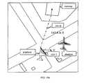
- FIG. 9 ashows the measurement of an airplane in the air.
- the airplaneis in the air and has no physical base point on the ground.
- the measured heightis 57.1 m.
- FIG. 9 ban overpass is measured, the dotted line ( 1011 ) is the measured shadow length and the thick line ( 1012 ) is the measured projected height (13.8 m).
- FIG. 9 ca tree is measured, the dotted line ( 1013 ) is the measured shadow length and the thick line ( 1014 ) is the measured projected height (29.4 m).
- FIG. 9 dshows the measurement of a chimney whose base point can be located accurately, and the height is 100.7 m.
- the dotted line ( 1015 )is the measured shadow length and the thick line ( 1016 ) is the measured projected height.
- the base points of these objectscan be inferred from the shadow endpoints when using information about the sun's position and the IGMs and in actual cases a representative embodiment of the these inventions of the measured shadow will be appeared as blue line and the measured projection will be appeared as green line.
- the base point of the airplane on the groundis determined using the shadow ruler, and the height of the airplane is 57.1 m (thick line 1017 ). Then a line mark (dash dot line 1018 ) is drawn ( FIG. 10 b ) to connect the base points and the landing points of the runway of the airport, and this distance on the ground is 158.1 m.
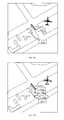
- the base point of the line markis raised to the airplane's height, and the slant distance (dash dot line 1019 ) becomes 165.8 m.
- the slant distance(dash dot line 1019 ) is 193.1 m when connecting the two base points of the two buildings. Both points are raised to their corresponding roof heights using the projection ruler, and the slant distance (dash dot line 1020 ) becomes 193.3 m in FIG. 11 b.
- FIG. 13An experiment was conducted to demonstrate the advantages of the present invention of height measurement of buildings with complex structures.
- the different levels of a multi-layered building roofcan be measured from single images using the projection and/or shadow rulers.
- the height (line 1024 ) of the first layer of the roofis measured using the projection ruler and then the height in the system is locked, and this height is 31 m.
- the height (line 1026 ) of the second layer of the roof relative to the first layeris measured starting from the locked height, and this height is 5.5 m as shown in FIG. 13 b . This shows that the height of the second layer is 36.5 relative to the ground surface.
- the measurement error ( ⁇ h) of the object heightis determined by the flying height (H), the object height (h), and the vertical shift ( ⁇ H) due to the terrain availability as given by
- h′is the measured object height using the measurement utilities.
- EQU. 8athe systematic errors of the object heights due to the vertical drifts can be compensated automatically for those objects when DTMs become available later. Each object's height is corrected separately since it usually has a different base height.
- the corrections to the displacements of objects due to the absence of DTMscan be accomplished by the calculation of that displacement for any point of the object.
- This processinvolves a few steps. First, both the raw image and the DTM are loaded into the computer system. Second, the measured 3D object models are loaded. In one particular embodiment, a message is popup to indicate if the bias compensation is needed. If so, a point (for instance, the first point) belong to the 3D models is projected to the image plane using the IGM. Then the projected image point is intersected with the DTM using EQU. 1. Third, the difference in the X, Y, and Z coordinates between the original position of that point and its position intersected with the DTM is calculated. Fourth, every point belongs to the 3D model is shifted by the same difference. The updated 3D models are preferably saved back to the disk files.
- the corrections to the displacements of objects due to the absence of GCPscan also be accomplished by carrying out a four-step procedure.
- the difference in the X, Y, and Z coordinates between the original position of that point and its position intersected againis calculated.
- Fourth, every point belonging to the 3D modelis shifted by the same difference.
- the updated 3D modelsare saved back to the disk files.
- the computer program of the present inventionis operable to collect a wide range of 3D measurements of and between objects. It utilizes the objects' projection, shadow and their combinations by using the measurement utility 8 as particularized above.
- Measurements and their derivativescan be used to generate many 3D products for urban planning, landscape analysis, transportation and hydrological watershed analysis, emergency response, disaster mitigation, and so on.
- the computer program of the present inventioncreates 3D models and maps by using the model generation utility.
- the Z level adjustment modeis enabled followed by marking the base of the structure using a mouse or similar pointing device ( FIG. 15 a ). Also, various key combinations can be used to accommodate locking/unlocking the cursor. The Z level is then adjusted for example using the page up/page down keys and the change in the Z level (thick line 1027 ) is visualized to the user (in actual case by a yellow line) in the image plane ( FIG. 15 b ). When the desired level is reached ( FIG. 15 c ) the user selects the 3D mapping tool, typically a polygon tool, and outlines the top (thick line 1028 , in actual case by a pre-defined line color) of the structure as shown in FIG. 15 d .
- the 3D mapping tooltypically a polygon tool
- the Z level adjustment modecan be disabled and the base point of the projected structure can then be checked by enabling the display footprint mode.
- the foot print modeuses the IGM to draw the projected footprints (dotted line 1029 , in actual case it is a dark color of the pre-defined outlined line color) as shown in FIG. 15 e .
- the desired 3D modelcan then saved into a database or file structure (not shown) if persistence storage is required. It can also be used to generate a 3D virtual scene by capturing the visible faces of the building and using them as textures in 3D visual models (not shown).
- the process of performing a 3D building modelingcan be accomplished by carrying out relative displacement or motion between the roof and the footprint.
- This approach to mapping a 3D structurecaptures its perimeter by first digitizing its roof outline (thick line 1030 as shown in FIG. 16 a ) as projected in image plane. This outline is then shifted in image plane ( FIG. 16 b ) to align with the base of the structure using the IGM. In the example provided, this is accomplished via pressing the page up/page down keys ( FIG. 16 b ).
- This algorithmcan create 3D models ( FIG. 16 c ) when part of the model footprint is not visible.
- roof shapesare supported in this computerized system. As shown in FIG. 17 , some typical roof types are flat, gable, clipped gable, hip and shed roof shapes.
- the computer programcan produce 3D building models with any complex roof types by the combination of the basic roof types.
- the 2D vector coordinates (r, c)are loaded into the computer application, and for each 2D position a Z level coordinate is assigned coinciding with the base level of the mapped feature ( FIG. 3 ). Each feature is then mapped into the 3rd dimension through the following actions:
- the userselects a feature (thick line 1031 , usually denoted by 8 circles) to be mapped ( FIG. 18 a ) into the 3 rd dimension and then presses the page up key to change the Z level coordinates of all nodes in the feature. Changes in the Z level are projected into image plane via the IGM giving visual feedback on the changing in Z level.
- the desired levelis reached ( FIG. 18 b ) the user ceases changing the Z level and may opt to save the feature to the database (not shown).
- the measurement accuracyhas been extensively tested and evaluated. In a summary, these testing results suggest that sub-meter accuracies can be achieved, and are thus acceptable for a wide range of commercial applications.
- the accuracyis dependent the flying height, object height, terrain availability, image resolution, image pixel measurement, and IGM accuracy.
- the present inventionalso contemplates integration of additional features to enhance the operation of the present invention. For example, processes may be built into the functions of the measurement utility that enable, based on predetermined parameters, more efficient convergence.
- the measurement utility and the model generation utilitycan be deployed in most popular computerized platform such as a PC, workstation, server, PDA, etc due to its simplicity to deploy, low overhead to computing, less restriction to the IGM (i.e., RFM) and no requirement for stereo viewing devices.
- IGMi.e., RFM
- the measurement utility 8 and the model generation utility 9are ideal for network-based applications such as web, internet as well as wireless networks given its simplicity to deploy, low overhead to computing, less restriction to the image geometry model and no requirement for stereo viewing devices.
- FIG. 19shows that the invention can be deployed in various forms (shaded component) in a web-enabled environment. It can be deployed as a client application 20 , web browser-based plug-ins (ActiveX controls) or Java applets 22 , Application server 24 and Portal-based web service 26 .
- the inventioncan also be embedded in wireless portals, PDAs or cell-phones etc. computerized platform with little modification, in a manner that is known.
- This inventionenables exploitation of the benefits of images for a wide range of applications including:
Landscapes
- Engineering & Computer Science (AREA)
- Physics & Mathematics (AREA)
- General Physics & Mathematics (AREA)
- Geometry (AREA)
- Software Systems (AREA)
- Remote Sensing (AREA)
- Theoretical Computer Science (AREA)
- Computer Graphics (AREA)
- Computer Vision & Pattern Recognition (AREA)
- Multimedia (AREA)
- Radar, Positioning & Navigation (AREA)
- Length Measuring Devices By Optical Means (AREA)
- Image Processing (AREA)
- Processing Or Creating Images (AREA)
Abstract
Description
OpenGIS Consortium, 1999. The OpenGIS Abstract Specification—
Tao, C. V., Hu, Y., 2001. A comprehensive study of the rational function model for photogrammetric processing,Photogrammetric Engineering&Remote Sensing,67(12): 1347-1357. (This reference provides a detailed mathematical formulation of the RFM sensor model and its experimental study on its accuracy).
- 1. Measuring the projection of an object or objects by operation of the projection measurement utility using the IGM to derive the heights, point-to-point distances of objects and the like;
- 2. Measuring the shadow of an object or objects by operation of the shadow measurement utility using IGM to derive the heights, point-to-point distance of both static (including buildings, overpasses, bridges, etc.) and dynamic objects (including airplanes in the air). These objects may not have footprints on the ground.
- 3. Obtaining the 3D measurements by using the cooperation of projection and/or shadow data with the IGM.
- 4. Creating 3D models and maps by using model generation utility that implements one or more algorithms.
- This invention allows the collection of a wide range of measurements as well as their derivatives (e.g., volume).
- This invention uses the model generation utility9 to quickly and effectively construct 3D models (e.g., building) including complex roof structures and subsequent 3D products (3D site maps and 3D urban or natural scenes) all from single imagery.
- As stated earlier, conventionally, 3D models are extracted by using stereo image pairs. Often special viewing devices are required to perform the extraction work. With this invention, 3D measurements and 3D models can be obtained without using stereo images or the special viewing devices.
- With the use of RFM as the underlying IGM, the present invention can be used for any sensor images (satellite and aerial, etc.) with the RFM support and without changing any program configurations. The present invention becomes scalable, flexible and interoperable for any sensor imagery. That is, one program can support multiple sensory images.
- Moreover, measurements of many dynamic objects such as vehicles, airplanes, clouds etc. including their moving features can be obtained in accordance with the present invention, e.g., the height and bearings of an airplane. Most airborne or satellite based stereo pairs are not captured at the same time. Thus the dimensions of the moving objects are not readily measured using stereo pairs.
- A single object on the ground e.g., building, tower, tree etc or ‘above’ the ground surface e.g., airplane, bridge, etc.
- Compound objects: multi-layered complex building roofs, complex constructions, etc.
- Multiple objects: a cluster of objects, e.g., volume estimation of a residential building block, damage assessment of forested area
- Object-to-object relationships: measurements relating to object-to-object spatial relationships, e.g., the 3D distance between a cellular tower and a receiver situated at a moving ground vehicle.
- Satellite images
- Aerial images
- Ground images, and
- Other images acquired by sensors with an appropriately calibrated image geometry model such as the RFM. The ground sampling distances of these images can range from several inches to several meters.
Button 1 displays the image coordinates of the mouse in the image plane.Button 2 displays the ground coordinates of the object point corresponding to the image point, and the ground coordinates are computed using EQU. 1 as shown inFIG. 3 . The datum and map projection are preferably set in a dialog box.Button 3 allows the input of image, IGM and DTM data (optional) to the programButton 4 allows the output of 3 D information including dimensions, models and maps.Button 5 turns the measurement utility8 on/off. A dialog box in the system gives two radio buttons for the selection of either the projection measurement utility12 (or projection ruler) or the shadow measurement utility14 (or shadow ruler) (these utilities are illustrated inFIG. 1 b).Button 6 turns the model generation utility9 on/off. The computer program, in one particular aspect thereof, implements a series of novel algorithms for generating 3D models and maps, as particularized below.Button 7 displays the drawing results and associate information.
- The present invention in one embodiment thereof relies on a particular imaging process determined by the applicable IGM. The imaging process generally provides the orientation information of the imagery. In a particular embodiment of the invention, the IGMs used is the rational function model, i.e. a sensor model (OGC, 1999; Tao and Hu, 2001) that is capable of supporting multiple sensors (sensor independence). The IGM used can also include the well known models such as those based on collinearity equations, direct linear transformation and others etc.
- The images used can be acquired by ground, airborne or satellite platforms using different imaging sensors such as frame, pushbroom or SAR etc.
- The measurement utility8 is preferably programmed such that it can combine the projection and shadow of objects so as to measure such objects (as particularized below).
- The measurement utility8 is also preferably programmed (as stated earlier) to implement the processes particularized below for measuring dynamic objects such as airplanes.
- The measurement utility8 can measure objects on the ground or above the ground surface such as overpasses, bridges, viaducts etc. The objects above the ground do not have physical base points on the ground.
where r and c are the row and column coordinates of the selected point in the image; {circumflex over (r)} and ĉ are estimated values, and ΔX and ΔY are corrections.
3.1 Projection Based Measurement Algorithm
l=h/tan θ=(Z2−Z0)/tan θ (2)
where h is the height of the object, θ is the sun's altitude.
Measurement on Non-flat Ground Surface
where h′ is the measured object height using the measurement utilities. Using EQU. 8a, the systematic errors of the object heights due to the vertical drifts can be compensated automatically for those objects when DTMs become available later. Each object's height is corrected separately since it usually has a different base height.
where l′ and l are the measured and true object dimension, respectively. Using EQU. 8b, the systematic errors due to the vertical drifts can be compensated for automatically in the same manner as described above for those object dimensions measured in 3D when DTMs become available later.
- Obtaining critical facility and target information such as building height, bridge clearance, road width, runway length, or forest cuts;
- Creation of 3D site maps of key facilities such as nuclear power plants, airports, urban cities, critical infrastructures for public safety and international intelligence;
- Measuring area of damage (such as forest fire, flood, earthquake) caused by disasters for insurance audits and emergency response;
- Modeling and planning for urban development, visualization and simulation, gaming, government, transportation, civil engineering etc.
- Defense
- Environment
- Homeland Security
- Telecom
- Visualization and Simulation
- Agriculture
- Local Government
- Geology
- Mapping
- Forestry
- Utilities
- Real Estate
- Transportation Planning
- Insurance
- Media
- Entertainment and Gaming
Claims (19)
Priority Applications (1)
| Application Number | Priority Date | Filing Date | Title |
|---|---|---|---|
| US12/118,515US7995862B2 (en) | 2004-01-16 | 2008-05-09 | System, computer program and method for 3D object measurement, modeling and mapping from single imagery |
Applications Claiming Priority (4)
| Application Number | Priority Date | Filing Date | Title |
|---|---|---|---|
| CA2445359 | 2004-01-16 | ||
| CA2455359ACA2455359C (en) | 2004-01-16 | 2004-01-16 | System, computer program and method for 3d object measurement, modeling and mapping from single imagery |
| US11/036,060US7376284B2 (en) | 2004-01-16 | 2005-01-18 | System, computer program and method for 3D object measurement, modeling and mapping from single imagery |
| US12/118,515US7995862B2 (en) | 2004-01-16 | 2008-05-09 | System, computer program and method for 3D object measurement, modeling and mapping from single imagery |
Related Parent Applications (1)
| Application Number | Title | Priority Date | Filing Date |
|---|---|---|---|
| US11/036,060ContinuationUS7376284B2 (en) | 2004-01-16 | 2005-01-18 | System, computer program and method for 3D object measurement, modeling and mapping from single imagery |
Publications (2)
| Publication Number | Publication Date |
|---|---|
| US20080310756A1 US20080310756A1 (en) | 2008-12-18 |
| US7995862B2true US7995862B2 (en) | 2011-08-09 |
Family
ID=34744405
Family Applications (2)
| Application Number | Title | Priority Date | Filing Date |
|---|---|---|---|
| US11/036,060Expired - Fee RelatedUS7376284B2 (en) | 2004-01-16 | 2005-01-18 | System, computer program and method for 3D object measurement, modeling and mapping from single imagery |
| US12/118,515Expired - LifetimeUS7995862B2 (en) | 2004-01-16 | 2008-05-09 | System, computer program and method for 3D object measurement, modeling and mapping from single imagery |
Family Applications Before (1)
| Application Number | Title | Priority Date | Filing Date |
|---|---|---|---|
| US11/036,060Expired - Fee RelatedUS7376284B2 (en) | 2004-01-16 | 2005-01-18 | System, computer program and method for 3D object measurement, modeling and mapping from single imagery |
Country Status (7)
| Country | Link |
|---|---|
| US (2) | US7376284B2 (en) |
| EP (1) | EP1709396B1 (en) |
| JP (1) | JP4773973B2 (en) |
| KR (1) | KR101159379B1 (en) |
| CN (1) | CN1918451B (en) |
| CA (1) | CA2455359C (en) |
| WO (1) | WO2005068936A1 (en) |
Cited By (27)
| Publication number | Priority date | Publication date | Assignee | Title |
|---|---|---|---|---|
| US8670961B2 (en) | 2007-04-17 | 2014-03-11 | Eagle View Technologies, Inc. | Aerial roof estimation systems and methods |
| US8687018B1 (en) | 2011-09-23 | 2014-04-01 | Google Inc. | Collection and confirmation of place metadata and graphic representations of fixed objects displayed in a mapping system |
| US8774525B2 (en) | 2012-02-03 | 2014-07-08 | Eagle View Technologies, Inc. | Systems and methods for estimation of building floor area |
| US8818770B2 (en) | 2008-10-31 | 2014-08-26 | Eagle View Technologies, Inc. | Pitch determination systems and methods for aerial roof estimation |
| US8825454B2 (en) | 2008-10-31 | 2014-09-02 | Eagle View Technologies, Inc. | Concurrent display systems and methods for aerial roof estimation |
| CN104019829A (en)* | 2014-06-09 | 2014-09-03 | 武汉克利福昇科技有限责任公司 | Vehicle-mounted panorama camera based on POS (position and orientation system) and external parameter calibrating method of linear array laser scanner |
| CN104133874A (en)* | 2014-07-25 | 2014-11-05 | 重庆数字城市科技有限公司 | Streetscape image generating method based on true color point cloud |
| US8995757B1 (en) | 2008-10-31 | 2015-03-31 | Eagle View Technologies, Inc. | Automated roof identification systems and methods |
| CN104931022A (en)* | 2015-04-21 | 2015-09-23 | 国家测绘地理信息局卫星测绘应用中心 | Satellite image three-dimensional area network adjustment method based on satellite-borne laser height measurement data |
| CN105783873A (en)* | 2016-02-24 | 2016-07-20 | 腾讯科技(深圳)有限公司 | Target object measuring method and high-precision map generating method and device |
| US9501700B2 (en) | 2012-02-15 | 2016-11-22 | Xactware Solutions, Inc. | System and method for construction estimation using aerial images |
| US9599466B2 (en) | 2012-02-03 | 2017-03-21 | Eagle View Technologies, Inc. | Systems and methods for estimation of building wall area |
| US9679227B2 (en) | 2013-08-02 | 2017-06-13 | Xactware Solutions, Inc. | System and method for detecting features in aerial images using disparity mapping and segmentation techniques |
| US9911228B2 (en) | 2010-02-01 | 2018-03-06 | Eagle View Technologies, Inc. | Geometric correction of rough wireframe models derived from photographs |
| US9933257B2 (en) | 2012-02-03 | 2018-04-03 | Eagle View Technologies, Inc. | Systems and methods for estimation of building wall area |
| US9953370B2 (en) | 2012-02-03 | 2018-04-24 | Eagle View Technologies, Inc. | Systems and methods for performing a risk management assessment of a property |
| US9959581B2 (en) | 2013-03-15 | 2018-05-01 | Eagle View Technologies, Inc. | Property management on a smartphone |
| US10373319B2 (en) | 2016-06-13 | 2019-08-06 | International Business Machines Corporation | Object tracking with a holographic projection |
| US10503843B2 (en) | 2017-12-19 | 2019-12-10 | Eagle View Technologies, Inc. | Supervised automatic roof modeling |
| US10528960B2 (en) | 2007-04-17 | 2020-01-07 | Eagle View Technologies, Inc. | Aerial roof estimation system and method |
| US10663294B2 (en) | 2012-02-03 | 2020-05-26 | Eagle View Technologies, Inc. | Systems and methods for estimation of building wall area and producing a wall estimation report |
| US10909482B2 (en) | 2013-03-15 | 2021-02-02 | Pictometry International Corp. | Building materials estimation |
| US11094113B2 (en) | 2019-12-04 | 2021-08-17 | Geomni, Inc. | Systems and methods for modeling structures using point clouds derived from stereoscopic image pairs |
| US11164256B2 (en) | 2013-03-15 | 2021-11-02 | Eagle View Technologies, Inc. | Price estimation model |
| EP4095809A4 (en)* | 2020-01-20 | 2023-06-28 | Sony Group Corporation | Image generation device, image generation method, and program |
| US12140419B2 (en) | 2012-02-03 | 2024-11-12 | Eagle View Technologies, Inc. | Systems and methods for estimation of building wall area and producing a wall estimation report |
| US12332660B2 (en) | 2018-11-21 | 2025-06-17 | Eagle View Technologies, Inc. | Navigating unmanned aircraft using pitch |
Families Citing this family (99)
| Publication number | Priority date | Publication date | Assignee | Title |
|---|---|---|---|---|
| US7424133B2 (en)* | 2002-11-08 | 2008-09-09 | Pictometry International Corporation | Method and apparatus for capturing, geolocating and measuring oblique images |
| CN1938738A (en)* | 2004-03-31 | 2007-03-28 | 日本先锋公司 | Map generation device and navigation device |
| JP4647514B2 (en)* | 2006-02-17 | 2011-03-09 | 株式会社日立ソリューションズ | Aerial image processing apparatus and aerial image processing method |
| US20070206005A1 (en)* | 2006-02-21 | 2007-09-06 | Nicholas Phelps | Method for generating 3D views or landscapes |
| US7773085B2 (en)* | 2006-03-07 | 2010-08-10 | Graphics Properties Holdings, Inc. | Flexible landscape display system for information display and control |
| US7853988B2 (en)* | 2006-05-16 | 2010-12-14 | Waterstone Environmental Hydrology & Engineering, Inc. | State saver/restorer for a geospatial decision management system |
| US20080307498A1 (en)* | 2006-12-27 | 2008-12-11 | Waterstone Environmental Hydrology & Engineering, Inc. | Access control for server-based geographic information system |
| US7853038B2 (en)* | 2007-01-04 | 2010-12-14 | Industrial Technology Research Institute | Systems and methods for object dimension estimation |
| US8483947B2 (en)* | 2007-04-25 | 2013-07-09 | Research In Motion Limited | Bitmap array for optimally distributing map data content to wireless communications devices |
| DE202008018628U1 (en)* | 2007-05-25 | 2017-01-13 | Google Inc. | System for playback, viewing and annotation of panoramic images and related applications |
| US7990394B2 (en) | 2007-05-25 | 2011-08-02 | Google Inc. | Viewing and navigating within panoramic images, and applications thereof |
| CA2693666A1 (en)* | 2007-07-12 | 2009-01-15 | Izzat H. Izzat | System and method for three-dimensional object reconstruction from two-dimensional images |
| CN101126725B (en)* | 2007-09-24 | 2010-12-15 | 舒嘉 | Method for realizing image reconstruction by adopting X ray dimension photograph |
| AU2014202326B2 (en)* | 2007-10-04 | 2016-08-11 | Sungevity | System and method for provisioning energy systems |
| EP3056836A3 (en)* | 2007-10-04 | 2016-09-14 | Sungevity | System and method for provisioning solar energy systems |
| US20090094077A1 (en)* | 2007-10-09 | 2009-04-09 | Bryn Fosburgh | Site development planning |
| JP5018404B2 (en)* | 2007-11-01 | 2012-09-05 | ソニー株式会社 | Image identification apparatus, image identification method, and program |
| US8531472B2 (en) | 2007-12-03 | 2013-09-10 | Pictometry International Corp. | Systems and methods for rapid three-dimensional modeling with real façade texture |
| USD576635S1 (en)* | 2007-12-05 | 2008-09-09 | Microsoft Corporation | Portion of a display screen showing a transitional user interface |
| USD585909S1 (en)* | 2007-12-05 | 2009-02-03 | Microsoft Corporation | Portion of a display screen showing a transitional user interface |
| USD575797S1 (en)* | 2007-12-05 | 2008-08-26 | Microsoft Corporation | Portion of a display screen showing a user interface |
| USD575798S1 (en)* | 2007-12-05 | 2008-08-26 | Microsoft Corporation | Portion of a display screen showing a user interface |
| US8275194B2 (en) | 2008-02-15 | 2012-09-25 | Microsoft Corporation | Site modeling using image data fusion |
| JP5192874B2 (en)* | 2008-03-28 | 2013-05-08 | 株式会社コナミデジタルエンタテインメント | Image processing apparatus, image processing apparatus control method, and program |
| US20090295791A1 (en)* | 2008-05-29 | 2009-12-03 | Microsoft Corporation | Three-dimensional environment created from video |
| US8204299B2 (en)* | 2008-06-12 | 2012-06-19 | Microsoft Corporation | 3D content aggregation built into devices |
| KR101556593B1 (en) | 2008-07-15 | 2015-10-02 | 삼성전자주식회사 | Image processing method |
| US8643717B2 (en)* | 2009-03-04 | 2014-02-04 | Hand Held Products, Inc. | System and method for measuring irregular objects with a single camera |
| JP5712217B2 (en)* | 2009-09-15 | 2015-05-07 | ソク、ジェイ ホSUK, Jey Ho | Method for measuring physical quantity of object using single light source and flat sensor unit, and system using the same |
| TWI402479B (en)* | 2009-12-15 | 2013-07-21 | Ind Tech Res Inst | Depth detection method and system using thereof |
| KR20110068469A (en)* | 2009-12-16 | 2011-06-22 | 인하대학교 산학협력단 | 3D object information extraction method from single image without meta information |
| WO2011093752A1 (en)* | 2010-01-26 | 2011-08-04 | Saab Ab | An automated three dimensional mapping method |
| KR101015486B1 (en)* | 2010-04-28 | 2011-02-22 | 펑션베이(주) | Modeling method for roller system in workpiece conveying system |
| BR112013001487B1 (en)* | 2010-07-21 | 2022-05-03 | Armin E. Moehrle | Image report creation method and apparatus |
| US9129438B2 (en) | 2011-01-18 | 2015-09-08 | NedSense Loft B.V. | 3D modeling and rendering from 2D images |
| JP5783243B2 (en)* | 2011-02-21 | 2015-09-24 | 日産自動車株式会社 | Periodic stationary object detection apparatus and periodic stationary object detection method |
| CN102736393B (en) | 2011-04-07 | 2014-12-17 | 台达电子工业股份有限公司 | Display device for displaying multiple visual angle images |
| US8768068B2 (en)* | 2011-05-04 | 2014-07-01 | Raytheon Company | Automated building detecting |
| US10748092B2 (en)* | 2011-06-07 | 2020-08-18 | The Boeing Company | Systems and methods for creating intuitive context for analysis data |
| US20140257862A1 (en)* | 2011-11-29 | 2014-09-11 | Wildfire Defense Systems, Inc. | Mobile application for risk management |
| CN102494611B (en)* | 2011-12-05 | 2013-12-18 | 中国人民解放军国防科学技术大学 | Method for rapidly measuring volume of object |
| WO2013086452A1 (en)* | 2011-12-09 | 2013-06-13 | California Institute Of Technology | Multi-view difraction granting imaging with two-dimensional displacement measurement for three-dimensional deformation or profile output |
| US20150009215A1 (en) | 2012-02-17 | 2015-01-08 | Schlumberger Technology Corporation | Generating a 3d image for geological modeling |
| US10387960B2 (en)* | 2012-05-24 | 2019-08-20 | State Farm Mutual Automobile Insurance Company | System and method for real-time accident documentation and claim submission |
| CN103017653B (en)* | 2012-11-27 | 2015-06-24 | 武汉海达数云技术有限公司 | Registration and measurement method of spherical panoramic image and three-dimensional laser scanning point cloud |
| CN103852066B (en)* | 2012-11-28 | 2016-08-17 | 联想(北京)有限公司 | Method, control method, electronic equipment and the control system of a kind of equipment location |
| CN103093388A (en)* | 2013-02-01 | 2013-05-08 | 河海大学 | Photography geological record system based on tunnel face |
| CN103236085A (en)* | 2013-04-07 | 2013-08-07 | 昆明理工大学 | Method for automatically establishing FLAC3D (fast Lagrangian analysis of continua in 3 dimensions) complicated three-dimensional geologic body models |
| CN103246964B (en)* | 2013-05-28 | 2016-01-06 | 国家电网公司 | Substation primary equipment safety inspection supervision method |
| EP2984506B1 (en)* | 2013-06-13 | 2022-07-20 | Halliburton Energy Services, Inc. | Logging while drilling (lwd) steering visualization tool methods and systems |
| CA2820305A1 (en)* | 2013-07-04 | 2015-01-04 | University Of New Brunswick | Systems and methods for generating and displaying stereoscopic image pairs of geographical areas |
| WO2015031593A1 (en) | 2013-08-29 | 2015-03-05 | Sungevity, Inc. | Improving designing and installation quoting for solar energy systems |
| JP6271953B2 (en)* | 2013-11-05 | 2018-01-31 | キヤノン株式会社 | Image processing apparatus and image processing method |
| US10444954B2 (en)* | 2013-11-11 | 2019-10-15 | Here Global B.V. | Distinguishable geographic area presentation |
| CN104751518B (en)* | 2013-12-30 | 2017-07-04 | 北京中盈安信技术服务股份有限公司 | The determination method and device of ground wire is pasted in a kind of three-dimensional map |
| CN103810286B (en)* | 2014-02-25 | 2017-05-24 | 合肥亿图网络科技有限公司 | Coordinate point positioning method for matching two-dimensional map with three-dimensional map |
| CN104091369B (en)* | 2014-07-23 | 2017-02-22 | 武汉大学 | Unmanned aerial vehicle remote-sensing image building three-dimensional damage detection method |
| CN104296726B (en)* | 2014-10-10 | 2016-07-27 | 中国科学院长春光学精密机械与物理研究所 | Two-sided battle array pushes away sweeps stereo mapping formation method and imaging system |
| DE102014115046B4 (en)* | 2014-10-16 | 2020-07-23 | Deutsches Zentrum für Luft- und Raumfahrt e.V. | Method and assistance system for determining a flight parameter of a flying object during the flight |
| CN104376596B (en)* | 2014-11-28 | 2017-05-31 | 北京航空航天大学 | A kind of three-dimensional scene structure modeling and register method based on single image |
| KR101644512B1 (en)* | 2014-12-19 | 2016-08-02 | 삼성중공업(주) | Apparatus and method for modelling 3d shape |
| CN104482921B (en)* | 2014-12-23 | 2016-09-07 | 河北工业大学 | A kind of measuring method of waterborne target |
| CN104700427B (en)* | 2015-04-03 | 2018-03-09 | 电子科技大学 | A kind of road damage information extracting method based on SAR image |
| GB2539030A (en)* | 2015-06-04 | 2016-12-07 | Ford Global Tech Llc | Method and system for fitting items into a space |
| KR101726506B1 (en)* | 2015-08-11 | 2017-04-13 | 포항공과대학교 산학협력단 | Method and apparatus for recognizing underwater landmark for compensating position |
| CN105302874A (en)* | 2015-10-09 | 2016-02-03 | 苏州盛景信息科技股份有限公司 | Geographic cloud data based spatial matching method |
| US10217283B2 (en) | 2015-12-17 | 2019-02-26 | Google Llc | Navigation through multidimensional images spaces |
| US10217207B2 (en) | 2016-01-20 | 2019-02-26 | Ez3D, Llc | System and method for structural inspection and construction estimation using an unmanned aerial vehicle |
| EP3228980B1 (en) | 2016-04-08 | 2018-10-03 | Siemens Aktiengesellschaft | Overburden thickness measurement |
| CN106126839B (en)* | 2016-06-29 | 2019-07-09 | 国家测绘地理信息局卫星测绘应用中心 | A kind of three-linear array stereo mapping satellite imagery emulation mode and system |
| CN107679441B (en)* | 2017-02-14 | 2020-06-02 | 郑州大学 | A method of extracting the height of urban buildings based on shadows from multi-temporal remote sensing images |
| EP3639221B1 (en)* | 2017-06-12 | 2023-03-01 | Intergraph Corporation | Onscene command vision |
| RU2680758C1 (en)* | 2017-11-14 | 2019-02-26 | Федеральное государственное бюджетное образовательное учреждение высшего образования "Юго-Западный государственный университет" (ЮЗГУ) | Method for building three-dimensional vector map on basis of digital model and terrain snapshot |
| CN107992856B (en)* | 2017-12-25 | 2021-06-29 | 南京信息工程大学 | High-resolution remote sensing building shadow detection method in urban scene |
| US11290530B2 (en)* | 2018-06-01 | 2022-03-29 | Apple Inc. | Customizable, pull-based asset transfer requests using object models |
| CN108898143B (en)* | 2018-06-28 | 2020-08-25 | 中国地震局地震预测研究所 | Building damage state detection method |
| CN108898144B (en)* | 2018-06-28 | 2020-12-11 | 中国地震局地震预测研究所 | Building damage state detection method |
| US10909713B2 (en) | 2018-10-25 | 2021-02-02 | Datalogic Usa, Inc. | System and method for item location, delineation, and measurement |
| CN109612439B (en)* | 2018-12-13 | 2020-04-28 | 同济大学 | Stereo image intersection angle and base line length estimation method based on rational function model |
| CN110580443B (en)* | 2019-06-19 | 2022-03-08 | 深圳大学 | A low-altitude near real-time building earthquake damage assessment method |
| CN110851118B (en)* | 2019-10-21 | 2021-03-23 | 中国地质大学(武汉) | Vector icon drawing method and device for three-dimensional scene |
| CN111121724A (en)* | 2019-12-31 | 2020-05-08 | 异起(上海)智能科技有限公司 | Method and device for distance measurement by using unmanned aerial vehicle |
| JP2023505611A (en) | 2020-02-10 | 2023-02-09 | コグネックス・コーポレイション | Composite 3D Blob Tool and Method for Operating Composite 3D Blob Tool |
| CN111462305B (en)* | 2020-03-17 | 2022-08-02 | 中国电建集团昆明勘测设计研究院有限公司 | Three-dimensional real estate management method applied to rural house-ground integration |
| CN111599023B (en)* | 2020-04-02 | 2023-06-16 | 思创数码科技股份有限公司 | Method and device for mapping city building models in large batch |
| CN111652071B (en)* | 2020-05-08 | 2023-08-29 | 中国工程物理研究院总体工程研究所 | Rapid runway cut-off analysis method |
| CN111666910B (en)* | 2020-06-12 | 2024-05-17 | 北京博能科技股份有限公司 | Airport clearance area obstacle detection method and device and electronic product |
| CN111738135B (en)* | 2020-06-18 | 2024-02-23 | 中国林业科学研究院资源信息研究所 | SAR image feature extraction method considering bias distance and geographic coordinate mapping deviation |
| US11367252B2 (en) | 2020-10-01 | 2022-06-21 | Here Global B.V. | System and method for generating line-of-sight information using imagery |
| US12307648B2 (en)* | 2020-10-02 | 2025-05-20 | Baker Hughes Oilfield Operations Llc | Automated turbine blade to shroud gap measurement |
| KR102422292B1 (en)* | 2020-11-03 | 2022-07-18 | 김동욱 | Method and apparatus for obtaining 3D-coordinates from 2D-image |
| CN113537063B (en)* | 2021-07-16 | 2022-09-13 | 海南省林业科学研究院(海南省红树林研究院) | Forest environment remote sensing monitoring method and terminal based on comprehensive remote sensing technology |
| WO2023075250A1 (en)* | 2021-10-27 | 2023-05-04 | 삼성전자 주식회사 | Electronic device and method for providing three-dimensional map |
| US20230296365A1 (en) | 2022-03-15 | 2023-09-21 | Metal-Era, Llc | System of measuring objects in an environment |
| CN115393528B (en)* | 2022-09-20 | 2023-04-18 | 中国地震局地球物理研究所 | Three-dimensional modeling method and system for ancient seismic exploration groove |
| CN115620278B (en)* | 2022-11-15 | 2023-03-10 | 广州奇志信息科技有限公司 | Method for identifying and measuring materials |
| CN116311325B (en)* | 2023-02-16 | 2023-10-27 | 江苏艾佳家居用品有限公司 | Automatic scale identification system based on artificial intelligence model |
| CN117433952B (en)* | 2023-12-21 | 2024-02-27 | 西南石油大学 | A method for rapid measurement of density of barite powder |
| CN118172499B (en)* | 2024-03-13 | 2024-08-20 | 重庆邮电大学 | Building height inversion method based on resource third-order remote sensing image |
Citations (8)
| Publication number | Priority date | Publication date | Assignee | Title |
|---|---|---|---|---|
| US3674369A (en)* | 1968-09-18 | 1972-07-04 | Hobrough Ltd | Automatic orthophoto printer |
| US5846084A (en)* | 1995-12-26 | 1998-12-08 | Volpe Prignano; Juan Pedro Alfredo Hector | Method for creating three-dimensional figures or forms from any flat surface image |
| US5926581A (en)* | 1996-04-25 | 1999-07-20 | Lockheed Martin Corporation | System for topographic mapping from remotely sensed images |
| US5943164A (en)* | 1994-11-14 | 1999-08-24 | Texas Instruments Incorporated | Curved 3-D object description from single aerial images using shadows |
| US20020024640A1 (en)* | 2000-08-29 | 2002-02-28 | Olympus Optical Co., Ltd. | Image projection display apparatus using plural projectors and projected image compensation apparatus |
| US20030044085A1 (en)* | 2001-05-01 | 2003-03-06 | Dial Oliver Eugene | Apparatuses and methods for mapping image coordinates to ground coordinates |
| US6795068B1 (en)* | 2000-07-21 | 2004-09-21 | Sony Computer Entertainment Inc. | Prop input device and method for mapping an object from a two-dimensional camera image to a three-dimensional space for controlling action in a game program |
| US20040240604A1 (en)* | 2003-02-14 | 2004-12-02 | Ge Wang | Methods and devices for CT reconstruction using a grangeat approach |
Family Cites Families (9)
| Publication number | Priority date | Publication date | Assignee | Title |
|---|---|---|---|---|
| US137673A (en)* | 1873-04-08 | Improvement in spring-mattresses | ||
| JP3622094B2 (en)* | 1995-10-05 | 2005-02-23 | 株式会社日立製作所 | Map update support apparatus and map information editing method |
| JPH10332334A (en)* | 1997-06-04 | 1998-12-18 | Hitachi Ltd | Position measurement method and apparatus by image processing |
| US6169553B1 (en)* | 1997-07-02 | 2001-01-02 | Ati Technologies, Inc. | Method and apparatus for rendering a three-dimensional scene having shadowing |
| JP3599268B2 (en)* | 1999-03-08 | 2004-12-08 | 株式会社ソニー・コンピュータエンタテインメント | Image processing method, image processing apparatus, and recording medium |
| FR2798761B1 (en)* | 1999-09-17 | 2002-03-29 | Thomson Multimedia Sa | METHOD OF CONSTRUCTING A 3D SCENE MODEL BY ANALYSIS OF IMAGE SEQUENCE |
| US6757445B1 (en)* | 2000-10-04 | 2004-06-29 | Pixxures, Inc. | Method and apparatus for producing digital orthophotos using sparse stereo configurations and external models |
| JP2003177017A (en)* | 2001-10-03 | 2003-06-27 | Mamoru Otsuki | Photogrammetry method and photogrammetry program |
| US20030137673A1 (en)* | 2002-12-13 | 2003-07-24 | Cox Cary B. | Systems, and methods of use, employing distorted patterns to ascertain the shape of a surface, for road or runway profiling, or as input to control pro-active suspension systems |
- 2004
- 2004-01-16CACA2455359Apatent/CA2455359C/ennot_activeExpired - Lifetime
- 2005
- 2005-01-14KRKR1020067016429Apatent/KR101159379B1/ennot_activeExpired - Fee Related
- 2005-01-14CNCN2005800025239Apatent/CN1918451B/ennot_activeExpired - Fee Related
- 2005-01-14WOPCT/CA2005/000043patent/WO2005068936A1/enactiveApplication Filing
- 2005-01-14EPEP05700272.7Apatent/EP1709396B1/ennot_activeExpired - Lifetime
- 2005-01-14JPJP2006548058Apatent/JP4773973B2/ennot_activeExpired - Fee Related
- 2005-01-18USUS11/036,060patent/US7376284B2/ennot_activeExpired - Fee Related
- 2008
- 2008-05-09USUS12/118,515patent/US7995862B2/ennot_activeExpired - Lifetime
Patent Citations (8)
| Publication number | Priority date | Publication date | Assignee | Title |
|---|---|---|---|---|
| US3674369A (en)* | 1968-09-18 | 1972-07-04 | Hobrough Ltd | Automatic orthophoto printer |
| US5943164A (en)* | 1994-11-14 | 1999-08-24 | Texas Instruments Incorporated | Curved 3-D object description from single aerial images using shadows |
| US5846084A (en)* | 1995-12-26 | 1998-12-08 | Volpe Prignano; Juan Pedro Alfredo Hector | Method for creating three-dimensional figures or forms from any flat surface image |
| US5926581A (en)* | 1996-04-25 | 1999-07-20 | Lockheed Martin Corporation | System for topographic mapping from remotely sensed images |
| US6795068B1 (en)* | 2000-07-21 | 2004-09-21 | Sony Computer Entertainment Inc. | Prop input device and method for mapping an object from a two-dimensional camera image to a three-dimensional space for controlling action in a game program |
| US20020024640A1 (en)* | 2000-08-29 | 2002-02-28 | Olympus Optical Co., Ltd. | Image projection display apparatus using plural projectors and projected image compensation apparatus |
| US20030044085A1 (en)* | 2001-05-01 | 2003-03-06 | Dial Oliver Eugene | Apparatuses and methods for mapping image coordinates to ground coordinates |
| US20040240604A1 (en)* | 2003-02-14 | 2004-12-02 | Ge Wang | Methods and devices for CT reconstruction using a grangeat approach |
Non-Patent Citations (2)
| Title |
|---|
| C. Vincent Tao and Yong Hu, Dec. 2001, "A Comprehensive Study of the Rational Function Model for Photogrammetric Processing", Photogrammetric Engineering & Remote Sensing, vol. 67, No. 12, pp. 1347-1357.* |
| Rao, 5,943,164, Aug. 24, 1999 Derwent, See attached PDF document for pp. 1-19.* |
Cited By (56)
| Publication number | Priority date | Publication date | Assignee | Title |
|---|---|---|---|---|
| US8670961B2 (en) | 2007-04-17 | 2014-03-11 | Eagle View Technologies, Inc. | Aerial roof estimation systems and methods |
| US10528960B2 (en) | 2007-04-17 | 2020-01-07 | Eagle View Technologies, Inc. | Aerial roof estimation system and method |
| US9514568B2 (en) | 2007-04-17 | 2016-12-06 | Eagle View Technologies, Inc. | Aerial roof estimation systems and methods |
| US10685149B2 (en) | 2008-10-31 | 2020-06-16 | Eagle View Technologies, Inc. | Pitch determination systems and methods for aerial roof estimation |
| US8818770B2 (en) | 2008-10-31 | 2014-08-26 | Eagle View Technologies, Inc. | Pitch determination systems and methods for aerial roof estimation |
| US8825454B2 (en) | 2008-10-31 | 2014-09-02 | Eagle View Technologies, Inc. | Concurrent display systems and methods for aerial roof estimation |
| US11030355B2 (en) | 2008-10-31 | 2021-06-08 | Eagle View Technologies, Inc. | Concurrent display systems and methods for aerial roof estimation |
| US11030358B2 (en) | 2008-10-31 | 2021-06-08 | Eagle View Technologies, Inc. | Pitch determination systems and methods for aerial roof estimation |
| US8995757B1 (en) | 2008-10-31 | 2015-03-31 | Eagle View Technologies, Inc. | Automated roof identification systems and methods |
| US9070018B1 (en) | 2008-10-31 | 2015-06-30 | Eagle View Technologies, Inc. | Automated roof identification systems and methods |
| US9129376B2 (en) | 2008-10-31 | 2015-09-08 | Eagle View Technologies, Inc. | Pitch determination systems and methods for aerial roof estimation |
| US9135737B2 (en) | 2008-10-31 | 2015-09-15 | Eagle View Technologies, Inc. | Concurrent display systems and methods for aerial roof estimation |
| US11423614B2 (en) | 2010-02-01 | 2022-08-23 | Eagle View Technologies, Inc. | Geometric correction of rough wireframe models derived from photographs |
| US9911228B2 (en) | 2010-02-01 | 2018-03-06 | Eagle View Technologies, Inc. | Geometric correction of rough wireframe models derived from photographs |
| US8687018B1 (en) | 2011-09-23 | 2014-04-01 | Google Inc. | Collection and confirmation of place metadata and graphic representations of fixed objects displayed in a mapping system |
| US10515414B2 (en) | 2012-02-03 | 2019-12-24 | Eagle View Technologies, Inc. | Systems and methods for performing a risk management assessment of a property |
| US11566891B2 (en) | 2012-02-03 | 2023-01-31 | Eagle View Technologies, Inc. | Systems and methods for estimation of building wall area and producing a wall estimation report |
| US11620714B2 (en) | 2012-02-03 | 2023-04-04 | Eagle View Technologies, Inc. | Systems and methods for estimation of building floor area |
| US9599466B2 (en) | 2012-02-03 | 2017-03-21 | Eagle View Technologies, Inc. | Systems and methods for estimation of building wall area |
| US12140419B2 (en) | 2012-02-03 | 2024-11-12 | Eagle View Technologies, Inc. | Systems and methods for estimation of building wall area and producing a wall estimation report |
| US8774525B2 (en) | 2012-02-03 | 2014-07-08 | Eagle View Technologies, Inc. | Systems and methods for estimation of building floor area |
| US10663294B2 (en) | 2012-02-03 | 2020-05-26 | Eagle View Technologies, Inc. | Systems and methods for estimation of building wall area and producing a wall estimation report |
| US9933257B2 (en) | 2012-02-03 | 2018-04-03 | Eagle View Technologies, Inc. | Systems and methods for estimation of building wall area |
| US9953370B2 (en) | 2012-02-03 | 2018-04-24 | Eagle View Technologies, Inc. | Systems and methods for performing a risk management assessment of a property |
| US9501700B2 (en) | 2012-02-15 | 2016-11-22 | Xactware Solutions, Inc. | System and method for construction estimation using aerial images |
| US11210433B2 (en) | 2012-02-15 | 2021-12-28 | Xactware Solutions, Inc. | System and method for construction estimation using aerial images |
| US10503842B2 (en) | 2012-02-15 | 2019-12-10 | Xactware Solutions, Inc. | System and method for construction estimation using aerial images |
| US12265758B2 (en) | 2012-02-15 | 2025-04-01 | Xactware Solutions, Inc. | System and method for construction estimation using aerial images |
| US11727163B2 (en) | 2012-02-15 | 2023-08-15 | Xactware Solutions, Inc. | System and method for construction estimation using aerial images |
| US11587176B2 (en) | 2013-03-15 | 2023-02-21 | Eagle View Technologies, Inc. | Price estimation model |
| US11164256B2 (en) | 2013-03-15 | 2021-11-02 | Eagle View Technologies, Inc. | Price estimation model |
| US9959581B2 (en) | 2013-03-15 | 2018-05-01 | Eagle View Technologies, Inc. | Property management on a smartphone |
| US10839469B2 (en) | 2013-03-15 | 2020-11-17 | Eagle View Technologies, Inc. | Image analysis system |
| US11526952B2 (en) | 2013-03-15 | 2022-12-13 | Eagle View Technologies, Inc. | Image analysis system |
| US11941713B2 (en) | 2013-03-15 | 2024-03-26 | Eagle View Technologies, Inc. | Image analysis system |
| US10909482B2 (en) | 2013-03-15 | 2021-02-02 | Pictometry International Corp. | Building materials estimation |
| US12270648B2 (en) | 2013-08-02 | 2025-04-08 | Xactware Solutions, Inc. | System and method for detecting features in aerial images using disparity mapping and segmentation techniques |
| US11144795B2 (en) | 2013-08-02 | 2021-10-12 | Xactware Solutions, Inc. | System and method for detecting features in aerial images using disparity mapping and segmentation techniques |
| US10896353B2 (en) | 2013-08-02 | 2021-01-19 | Xactware Solutions, Inc. | System and method for detecting features in aerial images using disparity mapping and segmentation techniques |
| US10540577B2 (en) | 2013-08-02 | 2020-01-21 | Xactware Solutions, Inc. | System and method for detecting features in aerial images using disparity mapping and segmentation techniques |
| US9679227B2 (en) | 2013-08-02 | 2017-06-13 | Xactware Solutions, Inc. | System and method for detecting features in aerial images using disparity mapping and segmentation techniques |
| CN104019829B (en)* | 2014-06-09 | 2017-02-15 | 武汉克利福昇科技有限责任公司 | Vehicle-mounted panorama camera based on POS (position and orientation system) and external parameter calibrating method of linear array laser scanner |
| CN104019829A (en)* | 2014-06-09 | 2014-09-03 | 武汉克利福昇科技有限责任公司 | Vehicle-mounted panorama camera based on POS (position and orientation system) and external parameter calibrating method of linear array laser scanner |
| CN104133874A (en)* | 2014-07-25 | 2014-11-05 | 重庆数字城市科技有限公司 | Streetscape image generating method based on true color point cloud |
| CN104133874B (en)* | 2014-07-25 | 2017-03-29 | 重庆数字城市科技有限公司 | Streetscape image generating method based on true color point cloud |
| CN104931022B (en)* | 2015-04-21 | 2018-03-16 | 国家测绘地理信息局卫星测绘应用中心 | Satellite image stereoblock adjustment method based on spaceborne laser altimeter system data |
| CN104931022A (en)* | 2015-04-21 | 2015-09-23 | 国家测绘地理信息局卫星测绘应用中心 | Satellite image three-dimensional area network adjustment method based on satellite-borne laser height measurement data |
| CN105783873A (en)* | 2016-02-24 | 2016-07-20 | 腾讯科技(深圳)有限公司 | Target object measuring method and high-precision map generating method and device |
| US10373319B2 (en) | 2016-06-13 | 2019-08-06 | International Business Machines Corporation | Object tracking with a holographic projection |
| US10891739B2 (en) | 2016-06-13 | 2021-01-12 | International Business Machines Corporation | Object tracking with a holographic projection |
| US11416644B2 (en) | 2017-12-19 | 2022-08-16 | Eagle View Technologies, Inc. | Supervised automatic roof modeling |
| US10503843B2 (en) | 2017-12-19 | 2019-12-10 | Eagle View Technologies, Inc. | Supervised automatic roof modeling |
| US12332660B2 (en) | 2018-11-21 | 2025-06-17 | Eagle View Technologies, Inc. | Navigating unmanned aircraft using pitch |
| US11915368B2 (en) | 2019-12-04 | 2024-02-27 | Insurance Services Office, Inc. | Systems and methods for modeling structures using point clouds derived from stereoscopic image pairs |
| US11094113B2 (en) | 2019-12-04 | 2021-08-17 | Geomni, Inc. | Systems and methods for modeling structures using point clouds derived from stereoscopic image pairs |
| EP4095809A4 (en)* | 2020-01-20 | 2023-06-28 | Sony Group Corporation | Image generation device, image generation method, and program |
Also Published As
| Publication number | Publication date |
|---|---|
| EP1709396B1 (en) | 2015-12-30 |
| CN1918451A (en) | 2007-02-21 |
| EP1709396A1 (en) | 2006-10-11 |
| CA2455359C (en) | 2013-01-08 |
| JP4773973B2 (en) | 2011-09-14 |
| CA2455359A1 (en) | 2005-07-16 |
| KR101159379B1 (en) | 2012-06-27 |
| EP1709396A4 (en) | 2011-10-19 |
| WO2005068936A1 (en) | 2005-07-28 |
| KR20070054593A (en) | 2007-05-29 |
| CN1918451B (en) | 2010-10-06 |
| US20080310756A1 (en) | 2008-12-18 |
| US20080089610A1 (en) | 2008-04-17 |
| US7376284B2 (en) | 2008-05-20 |
| JP2007522443A (en) | 2007-08-09 |
Similar Documents
| Publication | Publication Date | Title |
|---|---|---|
| US7995862B2 (en) | System, computer program and method for 3D object measurement, modeling and mapping from single imagery | |
| Chandler | Effective application of automated digital photogrammetry for geomorphological research | |
| Pakoksung et al. | Digital elevation models on accuracy validation and bias correction in vertical | |
| Ozturk et al. | A low-cost approach for determination of discontinuity orientation using smartphone images and application to a part of Ihlara Valley (Central Turkey) | |
| Ulvi | The effect of the distribution and numbers of ground control points on the precision of producing orthophoto maps with an unmanned aerial vehicle | |
| Webster et al. | An automated GIS procedure for comparing GPS and proximal LiDAR elevations | |
| Daramola et al. | Assessing the geometric accuracy of UAV-based orthophotos | |
| Buyuksalih et al. | 3D city modelling of Istanbul based on LiDAR data and panoramic images–Issues and challenges | |
| Walstra | Time for change-quantifying landslide evolution using historical aerial photographs and modern photogrammetric methods | |
| Ma et al. | Low‐Altitude Photogrammetry and Remote Sensing in UAV for Improving Mapping Accuracy | |
| Hlotov et al. | Accuracy assessment of external orientation elements for digital images obtained from UAVS using derivatives of implicitly specified functions | |
| Rabiu et al. | Unmanned Aerial Vehicle Photogrammetric Products Accuracy Assessment: a Review | |
| Habib et al. | Error budget of lidar systems and quality control of the derived point cloud | |
| Gonçalves et al. | Use of the SRTM DEM as a geo-referencing tool by elevation matching | |
| Park et al. | Estimation of forest canopy height using orthoimage-refined digital elevation models | |
| Sefercik et al. | Point-based and model-based geolocation analysis of airborne laser scanning data | |
| Pârvu et al. | The Importance of Ground Control Points In A Photogrammetric Workflow. | |
| Reiss et al. | Evaluation of an unmanned aerial vehicle (UAV) for measuring and monitoring natural disaster risk areas | |
| Jin et al. | Airborne laser scanning data quality enhancement via rigorous calibration and comprehensive strip adjustment techniques | |
| Chrustek et al. | Obtaining Snow Avalanche Information by Means of Terrestrial Photogrammetry—Evaluation of a New Approach | |
| Jankauskienė et al. | Surface modelling of a unique heritage object: Use of UAV combined with camera and lidar for mound inspection | |
| Ciobanu et al. | Using the Open Skies multi sensor system for military observation missions and civilian applications | |
| GALIATZATOS | 4.1 EXPLORING ARCHAEOLOGICAL LANDSCAPES WITH SATELLITE IMAGERY | |
| Chiabrando et al. | Digital wide scale orthoprojections and mapping from low-height aerial images | |
| Chandler | TECHNICAL COMMUNICATIONS-Effective Application of Automated Digital Photogrammetry for Geomorphological Research |
Legal Events
| Date | Code | Title | Description |
|---|---|---|---|
| AS | Assignment | Owner name:MICROSOFT CORPORATION, WASHINGTON Free format text:ASSIGNMENT OF ASSIGNORS INTEREST;ASSIGNOR:MICROSOFT AMALGAMATED COMPANY II;REEL/FRAME:026323/0923 Effective date:20110516 | |
| STCF | Information on status: patent grant | Free format text:PATENTED CASE | |
| CC | Certificate of correction | ||
| FPAY | Fee payment | Year of fee payment:4 | |
| AS | Assignment | Owner name:MICROSOFT TECHNOLOGY LICENSING, LLC, WASHINGTON Free format text:ASSIGNMENT OF ASSIGNORS INTEREST;ASSIGNOR:MICROSOFT CORPORATION;REEL/FRAME:036100/0048 Effective date:20150702 | |
| AS | Assignment | Owner name:MICROSOFT CANADA INC., CANADA Free format text:CHANGE OF NAME;ASSIGNOR:MICROSOFT CANADA CO.;REEL/FRAME:046232/0281 Effective date:20091231 Owner name:MICROSOFT AMALGAMATED COMPANY III, CANADA Free format text:MERGER;ASSIGNOR:MICROSOFT AMALGAMATED COMPANY II;REEL/FRAME:046232/0252 Effective date:20090101 Owner name:MICROSOFT CANADA CO., CANADA Free format text:MERGER;ASSIGNOR:MICROSOFT AMALGAMATED COMPANY III;REEL/FRAME:046232/0279 Effective date:20090701 | |
| MAFP | Maintenance fee payment | Free format text:PAYMENT OF MAINTENANCE FEE, 8TH YEAR, LARGE ENTITY (ORIGINAL EVENT CODE: M1552); ENTITY STATUS OF PATENT OWNER: LARGE ENTITY Year of fee payment:8 | |
| AS | Assignment | Owner name:MICROSOFT CORPORATION, WASHINGTON Free format text:ASSIGNMENT OF ASSIGNORS INTEREST;ASSIGNOR:MICROSOFT CANADA INC.;REEL/FRAME:051784/0704 Effective date:20200122 | |
| MAFP | Maintenance fee payment | Free format text:PAYMENT OF MAINTENANCE FEE, 12TH YEAR, LARGE ENTITY (ORIGINAL EVENT CODE: M1553); ENTITY STATUS OF PATENT OWNER: LARGE ENTITY Year of fee payment:12 |