US7933897B2 - Entity display priority in a distributed geographic information system - Google Patents
Entity display priority in a distributed geographic information systemDownload PDFInfo
- Publication number
- US7933897B2 US7933897B2US11/548,689US54868906AUS7933897B2US 7933897 B2US7933897 B2US 7933897B2US 54868906 AUS54868906 AUS 54868906AUS 7933897 B2US7933897 B2US 7933897B2
- Authority
- US
- United States
- Prior art keywords
- entity
- geospatial
- entities
- data
- ranking
- Prior art date
- Legal status (The legal status is an assumption and is not a legal conclusion. Google has not performed a legal analysis and makes no representation as to the accuracy of the status listed.)
- Active, expires
Links
Images


Classifications
- G—PHYSICS
- G06—COMPUTING OR CALCULATING; COUNTING
- G06F—ELECTRIC DIGITAL DATA PROCESSING
- G06F16/00—Information retrieval; Database structures therefor; File system structures therefor
- G06F16/20—Information retrieval; Database structures therefor; File system structures therefor of structured data, e.g. relational data
- G06F16/29—Geographical information databases
- G—PHYSICS
- G06—COMPUTING OR CALCULATING; COUNTING
- G06F—ELECTRIC DIGITAL DATA PROCESSING
- G06F16/00—Information retrieval; Database structures therefor; File system structures therefor
- G06F16/20—Information retrieval; Database structures therefor; File system structures therefor of structured data, e.g. relational data
- G06F16/24—Querying
- G06F16/245—Query processing
- G06F16/2457—Query processing with adaptation to user needs
- G06F16/24578—Query processing with adaptation to user needs using ranking
- G—PHYSICS
- G06—COMPUTING OR CALCULATING; COUNTING
- G06F—ELECTRIC DIGITAL DATA PROCESSING
- G06F16/00—Information retrieval; Database structures therefor; File system structures therefor
- G06F16/20—Information retrieval; Database structures therefor; File system structures therefor of structured data, e.g. relational data
- G06F16/24—Querying
- G06F16/248—Presentation of query results
- G—PHYSICS
- G06—COMPUTING OR CALCULATING; COUNTING
- G06F—ELECTRIC DIGITAL DATA PROCESSING
- G06F16/00—Information retrieval; Database structures therefor; File system structures therefor
- G06F16/20—Information retrieval; Database structures therefor; File system structures therefor of structured data, e.g. relational data
- G06F16/28—Databases characterised by their database models, e.g. relational or object models
- G06F16/284—Relational databases
- G06F16/288—Entity relationship models
- G—PHYSICS
- G06—COMPUTING OR CALCULATING; COUNTING
- G06F—ELECTRIC DIGITAL DATA PROCESSING
- G06F16/00—Information retrieval; Database structures therefor; File system structures therefor
- G06F16/40—Information retrieval; Database structures therefor; File system structures therefor of multimedia data, e.g. slideshows comprising image and additional audio data
- G06F16/44—Browsing; Visualisation therefor
- G06F16/444—Spatial browsing, e.g. 2D maps, 3D or virtual spaces
- G—PHYSICS
- G06—COMPUTING OR CALCULATING; COUNTING
- G06F—ELECTRIC DIGITAL DATA PROCESSING
- G06F17/00—Digital computing or data processing equipment or methods, specially adapted for specific functions
- G06F17/40—Data acquisition and logging
- G—PHYSICS
- G06—COMPUTING OR CALCULATING; COUNTING
- G06Q—INFORMATION AND COMMUNICATION TECHNOLOGY [ICT] SPECIALLY ADAPTED FOR ADMINISTRATIVE, COMMERCIAL, FINANCIAL, MANAGERIAL OR SUPERVISORY PURPOSES; SYSTEMS OR METHODS SPECIALLY ADAPTED FOR ADMINISTRATIVE, COMMERCIAL, FINANCIAL, MANAGERIAL OR SUPERVISORY PURPOSES, NOT OTHERWISE PROVIDED FOR
- G06Q30/00—Commerce
- G06Q30/02—Marketing; Price estimation or determination; Fundraising
- G06Q30/0201—Market modelling; Market analysis; Collecting market data
- G06Q30/0204—Market segmentation
- G06Q30/0205—Market segmentation based on location or geographical consideration
- G—PHYSICS
- G06—COMPUTING OR CALCULATING; COUNTING
- G06Q—INFORMATION AND COMMUNICATION TECHNOLOGY [ICT] SPECIALLY ADAPTED FOR ADMINISTRATIVE, COMMERCIAL, FINANCIAL, MANAGERIAL OR SUPERVISORY PURPOSES; SYSTEMS OR METHODS SPECIALLY ADAPTED FOR ADMINISTRATIVE, COMMERCIAL, FINANCIAL, MANAGERIAL OR SUPERVISORY PURPOSES, NOT OTHERWISE PROVIDED FOR
- G06Q30/00—Commerce
- G06Q30/02—Marketing; Price estimation or determination; Fundraising
- G06Q30/0241—Advertisements
- G06Q30/0251—Targeted advertisements
- G06Q30/0261—Targeted advertisements based on user location
Definitions
- the inventionrelates to mapping systems, and more particularly, to techniques for prioritizing geographical entities for placement on geographical displays.
- GISgeographic information system
- the systemgenerally can utilize a variety of data types, such as imagery, maps, and tables.
- GIS technologyhas been used for scientific and governmental investigations (e.g., to identify geographical areas adversely impacted by pollution or over-building), resource management (e.g., regional forestry observation), and development planning (e.g., suburban development of under-utilized geographic areas).
- placemarkse.g., designated on the map with an icon or other graphic.
- placemarksallow the user to write a brief description relevant to the location marked by the placemark, while other placemarks allow the user to change the style of icons and/or labels associated with the placemark.
- the number of available placemarksis significant.
- a geographic information systemcomprises information about a plurality of geospatial entities and is configured to prioritize the geospatial entities according to a ranking mechanism.
- the ranking mechanismuses data about a meta attribute of a geospatial entity to determine the geospatial entity's priority.
- the meta attributemay vary in different implementations but in one embodiment comprises the quality of information available about a geospatial entity.
- a computer-implemented methodcan be used to rank geospatial entities.
- the methodcomprises several steps including receiving geospatial entity data, evaluating attributes of geospatial entities included in the received geospatial entity data, ranking the geospatial entities based on the evaluation, and storing the ranked geospatial entity data.
- Another embodiment of the present inventionprovides one or more machine-readable mediums (e.g., one or more compact disks, diskettes, servers, memory sticks, or hard drives) encoded with instructions, that when executed by one or more processors, cause the one or more processors to carry out a process for ranking geospatial entities.
- This processcan be, for example, similar to or a variation of the methodologies described herein.
- FIG. 1is a block diagram of a GIS system with entity ranking capabilities in accordance with an embodiment of the invention.
- FIG. 2is a block diagram of the entity ranking module shown in FIG. 1 , according to one embodiment of the present invention.
- FIG. 3illustrates a method for generating and providing prioritized entities in accordance with an embodiment of the invention.
- FIG. 4illustrates a method for requesting and receiving a map including prioritized placemarks in accordance with an embodiment of the invention.
- FIG. 5depicts a GIS map that includes prioritized placemarks in accordance with an embodiment of the invention.
- GISgeographic information system
- DGISdistributed geographic information system
- some interactive Geographic Information Systemssupport different feature visibility criteria at different viewing distances. For example, a selection criteria might be constructed that would show only cities exceeding one million in population when the view was of the North American continent (viewing distance 1 ), then include additional cities exceeding 100,000 in population when the viewpoint is lowered to include a single state in the display area (viewing distance 2 ), and finally modified to include smaller cities as the view lowers within a state or county (viewing distance 3 ).
- selection criteriamight be constructed that would show only cities exceeding one million in population when the view was of the North American continent (viewing distance 1 ), then include additional cities exceeding 100,000 in population when the viewpoint is lowered to include a single state in the display area (viewing distance 2 ), and finally modified to include smaller cities as the view lowers within a state or county (viewing distance 3 ).
- An embodiment of the present inventionis configured to determine ‘which few of many’ geospatial items or entities to display on a map according to the relative importance of each entity according to its rank.
- a rankcan be generated based on extrinsic factors, such as the popularity of the entity to users (e.g., quantity and/or velocity of geospatial item access), quality of information (e.g., respect for the information source of geospatial item and community stature of geospatial item's author), and similar meta-data about the geospatial feature.
- an embodiment of the present inventionwould be to give that city a sufficiently significant place rank for display so as to display it along with the major cities exceeding one million in population.
- usersare shown the geospatial entities most likely to be of interest in the area of their visual search within an interactive geospatial information system.
- the ranking of geospatial itemsmay further be based on location, distance, or other intrinsic attributes of a geospatial feature such as position and altitude (zoom level).
- ranked entity data generated in accordance with an embodiment of the present inventionmay be supplied to various systems in addition to or instead of a digital mapping system as required by the context.
- a two or three-dimensional digital mapcan be generated that includes placemarks that correspond to geospatial entities.
- a map generated by a GISmay include several types of data about geospatial entities.
- the mapmay include geographic features such as the terrain, infrastructure including roads, rail routes and airports, buildings, and/or borders of a landscape.
- the mapmay also be annotated with information about government entities and services such as parks and recreational services, federal, state, or local government landmarks, and community services.
- placemarks belonging to one or more categoriesincluding commercial placemarks that represent businesses, travel placemarks including, for instance, historical sights and tourism destinations, user-defined placemarks that have been identified and named by a user for personal or community use, and/or community placemarks that have been voluntarily defined by members of the public in a forum.
- information presented on a mapis organized into collections that comprise layers, such as a terrain layer, road layer, border layer, community placemark layer, etc. Other layers include ‘current events’, ‘history’, and ‘education’, and indicate the organizational taxonomy of the source from which they were taken.
- a usercan interact with a map and turn on or off various layers of information.
- a basic or core layerincludes a basic subset of data (for instance, the terrain, major roads, and political borders), and the user can select additional layers to customize the map view.
- Various third-party content-providers and advertiserscan provide individual layers of data that can be overlaid onto such a basic map.
- the placemark ranking methods described hereincan be used in combination with any conventional, proprietary, and/or emerging techniques to generate a digital map.
- a conventional raster mapfor instance, the placemarks and other types of map data are used to create a map in a digital format such as .jpeg, .gif, or .png, at a map server and then delivered to a client. Requests to manipulate or interact with the map, are provided from the client to the server, which in turn generates the requested map view.
- pre-generated, rasterized images or “tiles” that include placemark dataare stored at a map server.
- map dataincluding placemark data
- map serverin the form of vector graphic instructions.
- the instructionsare interpreted by an application at the client in real-time to generate a map for the user.
- the mapcan be dynamically updated at the client to include those layers.
- the mapcan be dynamically regenerated at the client to include the new map views.
- GISGeographic information systems
- a GISmay be implemented as a distributed geographic information system (DGIS), in which, for instance, GIS components are distributed across two or more different computers in different physical locations across a network such as the Internet or a corporate enterprise.
- DGISdistributed geographic information system
- Google Eartha GIS-based digital globe that includes various elements such as servers, clients, and other components and features as will be apparent in light of this disclosure.
- Google Earth Communitya forum in which placemarks and entities are created, defined, described, and discussed by members of the participating public. Note that “Google Earth” and “Google Earth Community” and the descriptions provided herein may be protected under other forms of intellectual property, and are used for reference purposes only.
- FIG. 1is a high-level diagram of a digital map system 100 with entity ranking capabilities in accordance with an embodiment of the invention.
- the system 100includes a map server system 150 that is communicatively coupled to one or more clients 110 via a network 160 .
- the map server system 150is coupled to a database 140 of ranked entity data populated (e.g., offline, or in real-time) by a GIS 170 .
- the GIS 170is equipped with an entity ranking module 120 A that applies a ranking mechanism or algorithm to determine the relative ranks of geospatial entities. These entities may be defined within the GIS 170 , for instance, based on data provided to the GIS 170 from various external sources 180 .
- the ranked entitiesare stored in a database 140 and supplied to the map server system 150 , which uses the ranked entity data to generate maps for clients 110 .
- client-side entity ranking modules 120 B-Care also present for providing additional entity ranking functionality.
- the map server system 150may provide the ranked entity data to clients 110 for client-side generation of maps and ranked entity data layers. Principles of heavy-client and light-client functionality equally apply here, as will be apparent in light of this disclosure.
- modulesmay be included in the system, and illustrated modules may be rearranged and functionalities can be distributed.
- the GIS 170can be integrated into the map server system 150 .
- the entity ranking module 120 A of the GISmay be a standalone module. There may be a single entity ranking module 120 A implemented wholly in or with the GIS system 100 , without any entity ranking modules 120 B-C on the client side 110 . In another embodiment, entity ranking is implemented strictly by entity ranking modules 120 B-C at clients 110 .
- the term “module”refers to computer program logic or software for providing the specified functionality.
- a moduleWhen utilized by a client device 120 or map server system 150 , a module may be loaded into memory and executed on a processor.
- a modulecan be implemented in hardware (e.g., gate-level logic), firmware (e.g., a microcontroller with embedded routines for carrying out entity ranking as discussed herein), software, or some combination of hardware, firmware, and/or software.
- the client 110can be any device that allows a user to access the map server system 150 via the network 160 .
- the client 110may a device or system configured for computing, such as a personal computer or laptop, a mobile phone, a personal digital assistant, a smartphone, a navigation system located in a vehicle, or a handheld GPS system.
- Other clients 110may also be in communication with the map server system 150 via the network 160 .
- Each client 110includes an application such as a browser that allows the user to interface and communicate with systems such as the map server system 150 on the network 160 , as typically done.
- Examples of browsersinclude Microsoft's Internet Explorer browser, Netscape's Navigator browser, Mozilla's Firefox browser, PalmSource's Web Browser, or any other browsing or application software capable of communicating with network 160 .
- the client 110may include an application implemented outside of a browser, such as a specialized mapping or geographic application, from which data on the map server system 150 can be accessed. Interactions with the map server system 150 may be accomplished through a plug-in or other executable architecture implemented locally.
- the GIS 170can be configured with conventional technology, but further includes an entity ranking module 120 A configured in accordance with the principles of the present invention.
- the GIS 170receives data from various sources 180 upon which ranked entity data can be determined by the entity ranking module 120 A. Both geospatial entities and ranking data by which the geospatial entities can be ranked are represented in the data. These types of data can be provided to the GIS 170 in structured and unstructured form. For instance, while entity data in the form of city names and geographies may be provided in a structured form, ranking data in the form of community comments or ratings, for instance, may be provided in unstructured form. Or, entity data and ranking data may be provided from the same structured source that, for example, identifies a city and its population, or an unstructured source such as a community bulletin board in which an entity is defined and data by which it can be ranked is provided.
- the entity ranking capability of the map system 100is provided by one or more entity ranking modules 120 .
- the entity ranking module 120collects entity data and ranking data with which the geospatial entities can be rated. This data may be provided from various sources including the GIS 170 , external sources 180 , and the client 110 . These sources are described in further detail with reference to FIG. 2 .
- the module 120evaluates the geospatial entities using the ranking data in order to determine a score or rank for each of the entities.
- the module 120also associates the entities with placemarks for a map, and generates groupings or layers of placemarks based on, for instance, a certain placemark density or map view altitude.
- the resulting entities and entity layerscan be stored in a ranked entity database 140 , at a client 110 , or elsewhere. Each of these capabilities will be described in further detail with reference to FIG. 2 .
- the client-side modules 120 B-Cmay provide complementary rankings for use in generating a map for a client 110 .
- a server-side entity ranking module 120 Aprovides general placemarks whose rank is determined by a set of general ranking data
- a client-side entity ranking module 120 B-Cprovides personal placemarks that have been ranked using personal data about a user, their behavior, or their preferences.
- the network 160may be any type of communications network, such as a local area network (e.g., intranet), wide area network (e.g., internet), or some combination thereof.
- the network 160may be a direct connection between the client 110 and the map server system 150 .
- the client 110 , network 160 , and/or map server system 150may be in communication via any type of wired or wireless connection, using a wide variety of communication protocols.
- the map server system 150can be implemented with conventional or custom technology. Numerous known server architecture and functionalities can be used to implement a GIS server system. Further, the map server system 150 may include one or more servers operating under a load balancing scheme, with each server (or a combination of servers) configured to respond to and interact with clients 110 via the network 160 . In one particular embodiment, the server system 150 is implemented as discussed in U.S. application Ser. No. 10/270,272, filed Oct. 10, 2002, titled “Server for Geospatially Organized Flat File Data,” which is incorporated herein.
- a user of a client computer 110enters a search query (e.g., via browser and client side agent), it is put into a request by the client 110 , and sent to the map server system 150 via the network 160 .
- the server system 160determines what the search query is for, and responds with appropriate data from various sub-systems, such as geo-coders, routing engines, and local search indexes, in a format that the requesting client can use to present the data to the user (e.g., via a browser or other application).
- the GIS 170 and ranked entity database 140provide a map system 100 that serves map and GIS data over the Internet or other network 160 .
- the map system 100allows users to visualize, select, and explore geographic information (e.g., all over the world or in a particular region).
- the entity ranking module 120 Acan be configured to place rank available map data items based on various attributes associated with each geospatial feature (or a subdsdscset of geospatial features). These attributes may be extrinsic or instrinsic attributes of a geospatial feature, represent meta attributes of the feature, and/or reflect the personal behavior of a user. Based on ranking entities according to these attributes, users are shown the geospatial entities most likely to be of interest in the area of their visual search within the interactive GIS.
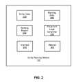
- FIG. 2is a high-level block diagram of an entity ranking module 120 that could be implemented at a client computer or server-side GIS according to one embodiment of the present invention.
- the entity ranking module 120receives or collects data from various sources about geospatial entities through an interface 250 .
- the datacontains both entity data 210 that identifies and defines geospatial entities and ranking data 220 by which geospatial entities can be evaluated.
- the entity data 210may comprise placemark-level data.
- the ranking engine 230applies one or more ranking algorithms or rank mechanisms to the ranking data 220 to determine scores for geospatial entities defined in the entity data 210 .
- the resulting ranked entity datamay be provided through the interface 250 to a requesting application such as a mapping application.
- the ranked entity datacan be formed into placemark layers by a placemark layer generator 240 .
- the ranked entity datais stored and provided to a map server system or other application.
- the entity ranking module 120includes a memory 260 in which data collected, including from a client, can be stored.
- the entity ranking module 120can receive entity data 210 and ranking data 220 about entities from any number of sources.
- the datamay include satellite data, aerial photographs, street-level photographs, digital map data, tabular data (e.g., digital yellow and white pages), and targeted database data (e.g., databases of diners, restaurants, museums, and/or schools; databases of seismic activity; database of national monuments; etc). It may also include government census and population data, building plan data, demographic data including socio-economic attributes associated with a geospatial entity such as a zip code or town, and alternative name data.
- the datacomprises proprietary content collected by a third-party provider and placemarks derived from it can only be accessed by users who have specifically paid for or subscribed to it.
- geospatial entities 210 and ranking data 220 in the form of information about attributes of geospatial entitiesmay also be provided in unstructured form.
- datacan be harvested from websites on the internet, and/or culled or provided from various sources including community forums such as the Google Earth Community, online bulletin boards, or other virtual spaces in which geospatial entities may be defined and described by users in a public, private, or semi-public setting.
- community forumssuch as the Google Earth Community, online bulletin boards, or other virtual spaces in which geospatial entities may be defined and described by users in a public, private, or semi-public setting.
- the entity ranking module 120may also receive data from one or more clients 110 that may be particular to a user or client device 110 . As described in more detail below, this data can be used to customize rankings and/or a user's experience.
- Example geospatial entitiesinclude a city name and location, a user defined entity, a commercial entity, a geospatial item found in a web search, or any item (e.g., physical thing, event, or quality) having a geographic association.
- a geospatial entityis thus comprised of a geometry associated with a physical place (such as a set of geographic coordinates on Earth or the moon) and a description.
- this geometrymay correspond to locations associated with the event.
- the entitycan correspond to single or multiple physical places and descriptions.
- geospatial entities in Google Earthcan be either singleton objects or may be a hierarchical folder of objects, each object in which may be another folder or an entity.
- a single entitymay correspond to one or more placemarks.
- an entity like “Oakland gas stations”may include several different physical locations, each of which is represented by a separate placemark.
- Ranking data 220may describe attributes of entities that can be evaluated by the ranking engine 230 to determine the entity's rank.
- the attributedefines the interestingness of an entity to a particular user. Such interestingness can be used to rank the various geospatial entities in the area of a user's visual search within an interactive geospatial information system (such as Google Earth), so that client-side entity display prioritizing is enabled.
- “interestingness” for a geospatial entitycan be determined by measuring or otherwise determining various types of extrinsic data associated with that entity. In one such embodiment, this measure, scaled by a corresponding weight, forms a bonus that augments the entity's score or rank (e.g., by addition or multiplication). Thus, higher ranked entities can be given priority for display over lower ranked (less interesting) entities.
- Data intrinsic to the GIS systemmay also be considered, as normally done (e.g., zoom level).
- ranking data 220comprises various indications of a user's interest in certain placemarks. For instance, placemarks that have been saved or annotated by the user at the browser or application level could be deemed to be of greater interest to a user.
- a user's search terms or patterns of web page access or usemay also be correlated to certain geospatial entities and used by an entity ranking module 120 at the client or on a server to select placemarks for the user.
- placemarks that the user has defined for his or her own usemay be assumed to be of high personal interest.
- geospatial entitiesincluding points of interest or personal relevance to the user, such as the location of the user's house, workplace, child's daycare, or favorite playground are identified and marked on any map in the vicinity of these elements, regardless of their relative rank as calculated by a GIS.
- These and other indications of user interestmay be gauged from the user's behavior, or may be in the form of preferences or instructions regarding entities affirmatively provided by the user, for instance instructing the inclusion or exclusion of specific entities or groups of entities in maps provided by a map server system.
- a rankings premiummay be assigned to geospatial entities based on the user's interest or preferences.
- User data collected at a clientmay be stored in the memory 260 of the entity ranking module and used by the ranking engine 230 to generate entity rankings that are personal to the user.
- the ranking engine 230comprises a module for ranking entities based on descriptions of entity attributes included in the ranking data 220 . Depending on the type of data provided, the ranking engine 230 can use a variety of mechanisms to evaluate geospatial entities, which are further described below.
- the entities as ranked by the ranking engine 230are organized into layers by a placemark layer generator 240 . This may be accomplished by determining a level of detail and threshold to be associated, for instance, with a given altitude or density. For instance, when a user's query implicates a number of entities greater than a given threshold, only those entities having a place rank above a certain threshold are provided. For example, assume the given threshold for the total number of entities that can be displayed at the current map view is 50, and that the place rank threshold is 80. If a user's query implicates over 100 geospatial entities, and 35 entities have a place rank over 80, then the server system will serve those 35 entities along with the 15 next highest ranked entities for display at the requesting client.
- a client-side entity ranking module 120which then determines which of those entities to display (in a similar fashion to the server-side functionality).
- server-side and client-side entity rankingcan be carried out, where the server system serves a set of ranked entities, and a client then displays a sub-set of that served set.
- Placemarkscan be subdivided into layers according to criteria other than altitude or density, including conceptual, spatial, temporal, or other groupings.
- the placemark layer generatoralso applies stylings to the various placemarks and stores those with the placemark layers.
- One embodiment of the present inventionis a method for computing a relative ranking of a geospatial entity such as a city name and location, user defined entity, commercial entity, or geospatial item found in a web search, as compared to other such entities.
- These relative rankingsare determined by a ranking engine 230 and are used within a GIS (e.g., as discussed with reference to client-side entity ranking of FIG. 1 ) to order the display of entities when not all can be selected for display, for example, to show some of the highest or lowest ranked entities, or perhaps a selected range of entities.
- this rankingwhich can be referred to as place rank, is computed based on the weighted contributions of various non-cartographic meta attributes about a geospatial entity. Rather than directly measuring a characteristic of a physical place, such as its population, these attributes reflect traits of abstractions or representations associated with the geospatial entity. Examples include an attribute of a description of an entity (for instance, the amount of detail in the description of an entity or the number of times a description has been viewed), an attribute of a definition of an entity (e.g.
- One or more of the attributes listed aboveis evaluated and the results are weighted individually with a scale factor before being summed to produce an overall score for an entity. Such a calculation could be performed by the ranking engine depicted in FIG. 2 .
- both meta attribute data about a geospatial entity and data that reflects attributes of the entity itselfare used to determine the overall score. For instance, in an embodiment, the size of a business and the number of replies to a posting about the business are both factors that are weighed by a ranking engine 230 . The ordering of entities by non-increasing score defines the ranking (descending order).
- the weighting factorscan be changed based on resulting rankings to adjust the relative prominence of each attribute (e.g., automatically, or as desired by the system administrator, or by an individual user).
- an end usercan assign the weights to be applied to each type of attribute. Any of the weightings can be set to zero (or one in the case of relative importance) to remove that attribute from consideration or equivalently some of the attributes may be ignored.
- the weighting factorscan be made negative to downgrade rather than reward entities for a particular attribute. Applying scale factors to individual attributes allows diverse attributes to be evaluated and a total score to be calculated based on the attributes.
- SCORENumberOfPostCharacters+a * NumberOfDescriptionCharacters)+b* NumberOfReplies+c* NumberOfViews+d * NumberOfDownloads+StatureWithinCommunity, wherein a, b, c, and d represent variables that can be adjusted based on the value assigned to each attribute.
- the StatureWithinCommunityreflects the poster of a description, and, in an embodiment, can range from 200 to 500 depending on the poster's stature based on any of a number of criteria including reputation, posting behavior, and ratings or endorsements by other users.
- One embodiment of the ranking system described hereinaggregates the individual attribute measures with a general linear combination.
- a more sophisticated aggregation, of which the linear combination is the subset along the main diagonal,is to use an M by M matrix of weights, where the dimension M corresponds to the number of attributes, and matrix reduction is used to allow specification of weights for the full cross product of attributes. For example, such a technique allows a specified weight for the product of ‘description length’ and ‘author stature’ as a combined component.
- the two equation structures described hereinare representative of the variety of attribute combination methods that will be apparent in light of this disclosure, such as including exponentiation or other algebraic forms in the evaluation of each attribute.
- extrinsic meta data about a geospatial entitycan be used as input to a scoring system that produces a relative ranking for purposes such as selection for display within a geospatial information system.
- a scoring systemthat produces a relative ranking for purposes such as selection for display within a geospatial information system.
- attributessuch as the degree of match between search terms and entity description text and historical search preferences of an individual user or users in aggregate, that may be incorporated into an interactive GIS as described herein as elements used to determine an entity score.
- the rankingmay be used for purposes other than selection for display.
- FIGS. 3 and 4are flow charts illustrating steps performed to generate and serve ranked entity data in accordance with embodiments of the invention. Not every possible step is shown in the figures. In addition, some embodiments perform different steps in addition to, or instead of, the ones described herein. Furthermore, the order of the steps can vary from that described herein.
- FIG. 3illustrates a method for generating and providing prioritized entities in accordance with an embodiment of the invention.
- One or more stepsmay be performed by an entity ranking module such as the one depicted in FIG. 2 and implemented on the client and/or server side as shown in FIG. 1 .
- certain stepsfor instance 350
- othersmay be performed ‘off-line’ outside the context of a particular search request.
- entity datais received 310 from various sources such as the data sources discussed with reference to FIG. 1 .
- Ranking datais also received 320 , from the same or different sources as the entity data.
- the collection of datamay take place, for instance, as part of a database construction process, or a web crawl and indexing process. Such data may also be pushed from vendors or third party sources. Some portions of the data, for instance, data about a user's personal placemarks, may be updated in real-time in response to a user request while others are received or refreshed according to a regular schedule.
- Various mechanismssuch as those described above may be applied to the ranking data to determine 330 rankings or scores for the entities.
- Comparable attribute scores based on disparate types of ranking data obtained from various sourcescan be calculated using the techniques described above.
- the entity datamay be stored in a database such as the one shown in FIG. 1 , or in another embodiment, a subset of the ranked entity data is cached in a memory of a client hosting an entity ranking module that determines 330 entity rankings based on the cached data.
- ranked entity datais used to generate 340 layers of placemarks for display on maps.
- the entitiesare mapped to placemarks, and stylings are applied based on the category in which an entity or placemark falls.
- Groups of placemarksare correlated to levels of detail in order to present a viewer of a map with an appropriate density of placemarks.
- the levels of detailmay reflect any number of inputs, including the altitude at which a map is being viewed, the resolution of the map, other layers depicted on a given map, and user preferences about how sparse or dense a map should be.
- placemarksmay also be organized into categories such that an individual placemark can be associated with different groups of placemarks, e.g. placemarks associated with a specific city as well as placemarks of tourist destinations. Each of these categories may be reflected a separate placemark layer.
- a request for a placemark layer or layersis received 345 , and the appropriate layers are provided 350 to the requester.
- a digital mapmay be generated according to raster, tiled, or vector-based methods.
- a placemark layermay be requested by a map server in real-time in response to a query, or provided 350 to create map components that are pre-stored and only served when a user request is received.
- the placemark layersare provided 350 in response to user preferences or selections.
- the placemark layeris combined with other layers to form a map, at a client or server site.
- FIG. 4is a flow chart illustrating steps for requesting and receiving a map including prioritized placemarks in accordance with an embodiment of the invention.
- FIG. 5illustrates a map that could be received based on a request formulated using steps in the processes depicted in FIG. 4 .
- One or more of these stepsmay be performed at a client requesting a map from a map server as shown in FIG. 1 .
- the processbegins when a map is requested 410 by a client, for instance from within a browser, specialized application such as Google Earth, or other software application.
- the map requestidentifies the geographic area for which the map is sought and the altitude the map should represent.
- User or client data and preferencesare also provided 420 to a map server system.
- the country from which the request originateswhich can be determined based on the IP address of the request, for instance, and a user's language preferences are provided to a map server so that only placemarks in the appropriate language and which reflect country or culture-specific stylings or sources of data are served.
- the country and language informationmay be provided 420 from the requesting application or another source such as the operating system of the client.
- user placemark preferencesmay also be provided 420 to the map system.
- the preferencesmay reflect for instance, which categories or layers of placemarks to display, how many placemark to include (density), and how much identifying information should be displayed on a map. For instance, in the case of the map of FIG. 5 , a user can select, using checkboxes on a graphical user interface 520 , which layers should be included on the map displayed 550 .
- Each layer of placemarksis associated with its own icon or styling, for instance, a knife and fork icon 51 OA for a dining placemark, and a cup 510 B for a drinking establishment.
- preferences provided 420 to the map systemcan be used to personalize the selection and display of placemarks to the user.
- Personalized placemark selectionmay be accomplished in a variety of ways, for instance by personalizing entity ranking by using a user's behavior or usage patterns as the basis of an attribute upon which an entity's rank is scored or varying the weight given to certain attributes based on a user's input; or, for example, by overriding generalized ranking schemes by always including placemarks that the user has defined or designated herself.
- a requestermay receive 432 various types of data depending on the personalization preferences provided to the map server system.
- there are no personalized placemarks 430 Aand the client receives 432 A and displays 450 A a map with general placemarks.
- no entity ranking capabilitiesare implemented locally at the client.
- a clientrequests that the requested map include only personalized placemarks 430 C.
- entity ranking capabilitiesare implemented wholly at the client, with an entity ranking module such as the module described in FIG. 2 hosted locally rather than on a centralized server.
- the clientreceives 432 A a map, comprised of map layers, which does not include any placemarks on it. Personalized placemarks generated and stored at the client are added 440 A to the map, and the resulting map is generated and displayed for the user.
- the usermay request a map that includes both personal and general placemarks 430 .
- the clientreceives 432 B a map and a group of general placemarks or entities associated with the geography of the map based on this request.
- the general placemarksare combined with personal placemarks that have been designated by the user in any of a variety of ways (for instance by authoring the entity definition or placing the placemark in a favorites folder), and a ranking mechanism is applied 436 B to the combined group of placemarks.
- the resultsare used to generate 440 B a layer that includes both personal and generalized placemarks, which is then combined with the map provided to the client to generate 450 B a map for display 450 B.
- FIG. 5shows an exemplary map including personal and general placemarks that has been generated in accordance with the method described at steps 412 - 420 and 430 B through 450 B.
- personal placemarksincluding Max's playground 105 and Dirk's coffee spot 419 are depicted together with dining (e.g. 510 A) and drinking placemarks (e.g. 510 B) on the map 550 .
- community placemarkswhich are demarcated with a special community placemark icon 540 .
- the map 550also includes interactive content, in the form of a text box 530 that links to a comment about a placemark provided by a community member. This allows a user to benefit from the input provided by other community members.
Landscapes
- Engineering & Computer Science (AREA)
- Theoretical Computer Science (AREA)
- Databases & Information Systems (AREA)
- Physics & Mathematics (AREA)
- Data Mining & Analysis (AREA)
- General Physics & Mathematics (AREA)
- General Engineering & Computer Science (AREA)
- Business, Economics & Management (AREA)
- Accounting & Taxation (AREA)
- Finance (AREA)
- Entrepreneurship & Innovation (AREA)
- Strategic Management (AREA)
- Development Economics (AREA)
- Computational Linguistics (AREA)
- Economics (AREA)
- Game Theory and Decision Science (AREA)
- Marketing (AREA)
- General Business, Economics & Management (AREA)
- Multimedia (AREA)
- Remote Sensing (AREA)
- Computer Hardware Design (AREA)
- Mathematical Physics (AREA)
- Software Systems (AREA)
- Instructional Devices (AREA)
- Information Retrieval, Db Structures And Fs Structures Therefor (AREA)
- Navigation (AREA)
- Alarm Systems (AREA)
Abstract
Description
This application claims the benefit of U.S. Provisional Application No. 60/726,505, filed on Oct. 12, 2005, which is hereby incorporated by reference in its entirety.
1. Field
The invention relates to mapping systems, and more particularly, to techniques for prioritizing geographical entities for placement on geographical displays.
2. Description of the Related Art
A geographic information system (GIS) is a system for archiving, retrieving, and manipulating data that has been stored and indexed according to the geographic coordinates of its elements. The system generally can utilize a variety of data types, such as imagery, maps, and tables. Historically, GIS technology has been used for scientific and governmental investigations (e.g., to identify geographical areas adversely impacted by pollution or over-building), resource management (e.g., regional forestry observation), and development planning (e.g., suburban development of under-utilized geographic areas).
More recently, GIS technology is being integrated into Internet-based mapping applications. Users can annotate digital map locations with placemarks (e.g., designated on the map with an icon or other graphic). Some placemarks allow the user to write a brief description relevant to the location marked by the placemark, while other placemarks allow the user to change the style of icons and/or labels associated with the placemark. However, in many instances, the number of available placemarks is significant.
What is needed, therefore, are techniques for prioritizing which placemarks (as well as other map entities) to display on a GIS-based map.
The above need is met by techniques for generating prioritized entity data described herein.
In an embodiment, a geographic information system (GIS) comprises information about a plurality of geospatial entities and is configured to prioritize the geospatial entities according to a ranking mechanism. The ranking mechanism uses data about a meta attribute of a geospatial entity to determine the geospatial entity's priority. The meta attribute may vary in different implementations but in one embodiment comprises the quality of information available about a geospatial entity.
In another embodiment, a computer-implemented method can be used to rank geospatial entities. The method comprises several steps including receiving geospatial entity data, evaluating attributes of geospatial entities included in the received geospatial entity data, ranking the geospatial entities based on the evaluation, and storing the ranked geospatial entity data.
Another embodiment of the present invention provides one or more machine-readable mediums (e.g., one or more compact disks, diskettes, servers, memory sticks, or hard drives) encoded with instructions, that when executed by one or more processors, cause the one or more processors to carry out a process for ranking geospatial entities. This process can be, for example, similar to or a variation of the methodologies described herein.
The figures depict various embodiments of the present invention for purposes of illustration only. One skilled in the art will readily recognize from the following description that alternative embodiments of the structures and methods illustrated herein may be employed without departing from the principles of the invention described herein.
A geographic information system (GIS) is disclosed that provides users with a greater degree of flexibility, utility, and information. The system may also be configured as a distributed geographic information system (DGIS). The system employs techniques for prioritizing which placemarks (as well as other map entities) to display on a GIS-based map.
General Overview
It is common practice in Geographic Information Systems to provide mechanisms to select a subset of available geographic features for display based on any of several criteria. For example, one might load a database of world cities into such a system and then request to see only those cities within the United States, those cities with populations exceeding one million persons, or perhaps those cities meeting both of these criteria. In this last case, only the markers for New York City, Los Angeles, Chicago, Houston, Philadelphia, San Diego, Detroit, and Dallas would be displayed if 1990 population data were being used.
Further, some interactive Geographic Information Systems support different feature visibility criteria at different viewing distances. For example, a selection criteria might be constructed that would show only cities exceeding one million in population when the view was of the North American continent (viewing distance1), then include additional cities exceeding 100,000 in population when the viewpoint is lowered to include a single state in the display area (viewing distance2), and finally modified to include smaller cities as the view lowers within a state or county (viewing distance3). These and related techniques are known in the GIS field as ‘selection’ and in the computer image generation field as ‘visibility culling’ and ‘level of detail management’.
An embodiment of the present invention is configured to determine ‘which few of many’ geospatial items or entities to display on a map according to the relative importance of each entity according to its rank. Such a rank can be generated based on extrinsic factors, such as the popularity of the entity to users (e.g., quantity and/or velocity of geospatial item access), quality of information (e.g., respect for the information source of geospatial item and community stature of geospatial item's author), and similar meta-data about the geospatial feature. For example, if many users of an interactive GIS system view a particular small city (e.g., Henderson, Nevada), then an embodiment of the present invention would be to give that city a sufficiently significant place rank for display so as to display it along with the major cities exceeding one million in population. In this way users are shown the geospatial entities most likely to be of interest in the area of their visual search within an interactive geospatial information system. The ranking of geospatial items may further be based on location, distance, or other intrinsic attributes of a geospatial feature such as position and altitude (zoom level).
Although the ranking of geospatial entities is described herein primarily in the context of choosing entities for display to a user on a map, the ranking may be used for other purposes, as will be apparent in light of this disclosure. Examples include selecting which entities should have associated keywords used for determining and displaying relevant advertising; selecting which entities should be suggested as potential origins, destinations, or waypoints in navigation computations; and other uses where an estimation of a most popular or most interesting subset of geospatial entities is desired. In such applications, ranked entity data generated in accordance with an embodiment of the present invention may be supplied to various systems in addition to or instead of a digital mapping system as required by the context.
Using such entity ranking information, a two or three-dimensional digital map can be generated that includes placemarks that correspond to geospatial entities. In one such embodiment, a map generated by a GIS may include several types of data about geospatial entities. For instance, the map may include geographic features such as the terrain, infrastructure including roads, rail routes and airports, buildings, and/or borders of a landscape. The map may also be annotated with information about government entities and services such as parks and recreational services, federal, state, or local government landmarks, and community services. These and other annotations may be presented in the form of placemarks belonging to one or more categories, including commercial placemarks that represent businesses, travel placemarks including, for instance, historical sights and tourism destinations, user-defined placemarks that have been identified and named by a user for personal or community use, and/or community placemarks that have been voluntarily defined by members of the public in a forum. In one particular embodiment, information presented on a map is organized into collections that comprise layers, such as a terrain layer, road layer, border layer, community placemark layer, etc. Other layers include ‘current events’, ‘history’, and ‘education’, and indicate the organizational taxonomy of the source from which they were taken. A user can interact with a map and turn on or off various layers of information. In an embodiment, a basic or core layer is provided that includes a basic subset of data (for instance, the terrain, major roads, and political borders), and the user can select additional layers to customize the map view. Various third-party content-providers and advertisers can provide individual layers of data that can be overlaid onto such a basic map.
As will be understood in light of this disclosure, the placemark ranking methods described herein can be used in combination with any conventional, proprietary, and/or emerging techniques to generate a digital map. In the case of a conventional raster map, for instance, the placemarks and other types of map data are used to create a map in a digital format such as .jpeg, .gif, or .png, at a map server and then delivered to a client. Requests to manipulate or interact with the map, are provided from the client to the server, which in turn generates the requested map view. In the case of a tiled raster map, pre-generated, rasterized images or “tiles” that include placemark data are stored at a map server. When the user submits a map query, the rasterized images are provided to the client, where they are used to create the requested map. Additional views based on, for instance, panning, zooming, or tilting the requested map can be generated at the client using the tiles. Vector-based methods can also be used to generate digital maps in accordance with other embodiments of the invention. In one such particular case, map data, including placemark data, is provided to the client by a map server in the form of vector graphic instructions. The instructions are interpreted by an application at the client in real-time to generate a map for the user. As a user interacts with the map, for instance, by including or excluding various layers including geospatial entities, the map can be dynamically updated at the client to include those layers. Likewise, as the user interacts with the map, for instance, by zooming or panning, the map can be dynamically regenerated at the client to include the new map views.
Geographic information systems (GIS) are referred to throughout the present disclosure. As is known, a GIS may be implemented as a distributed geographic information system (DGIS), in which, for instance, GIS components are distributed across two or more different computers in different physical locations across a network such as the Internet or a corporate enterprise. Reference is also made herein to Google Earth, a GIS-based digital globe that includes various elements such as servers, clients, and other components and features as will be apparent in light of this disclosure. Reference is also made to Google Earth Community, a forum in which placemarks and entities are created, defined, described, and discussed by members of the participating public. Note that “Google Earth” and “Google Earth Community” and the descriptions provided herein may be protected under other forms of intellectual property, and are used for reference purposes only.
System Architecture
Other modules may be included in the system, and illustrated modules may be rearranged and functionalities can be distributed. For instance, theGIS 170 can be integrated into themap server system 150. Similarly, theentity ranking module 120A of the GIS may be a standalone module. There may be a singleentity ranking module 120A implemented wholly in or with theGIS system 100, without anyentity ranking modules 120B-C on theclient side 110. In another embodiment, entity ranking is implemented strictly byentity ranking modules 120B-C atclients 110. Other configurations will be apparent in light of this disclosure, and the present invention is not intended to be limited to any particular one. In this example, the term “module” refers to computer program logic or software for providing the specified functionality. When utilized by aclient device 120 ormap server system 150, a module may be loaded into memory and executed on a processor. In other embodiments, a module can be implemented in hardware (e.g., gate-level logic), firmware (e.g., a microcontroller with embedded routines for carrying out entity ranking as discussed herein), software, or some combination of hardware, firmware, and/or software.
Theclient 110 can be any device that allows a user to access themap server system 150 via thenetwork 160. Theclient 110 may a device or system configured for computing, such as a personal computer or laptop, a mobile phone, a personal digital assistant, a smartphone, a navigation system located in a vehicle, or a handheld GPS system. Other clients110 (not shown) may also be in communication with themap server system 150 via thenetwork 160.
Eachclient 110 includes an application such as a browser that allows the user to interface and communicate with systems such as themap server system 150 on thenetwork 160, as typically done. Examples of browsers include Microsoft's Internet Explorer browser, Netscape's Navigator browser, Mozilla's Firefox browser, PalmSource's Web Browser, or any other browsing or application software capable of communicating withnetwork 160. Alternatively or in addition, theclient 110 may include an application implemented outside of a browser, such as a specialized mapping or geographic application, from which data on themap server system 150 can be accessed. Interactions with themap server system 150 may be accomplished through a plug-in or other executable architecture implemented locally.
TheGIS 170 can be configured with conventional technology, but further includes anentity ranking module 120A configured in accordance with the principles of the present invention. TheGIS 170 receives data fromvarious sources 180 upon which ranked entity data can be determined by theentity ranking module 120A. Both geospatial entities and ranking data by which the geospatial entities can be ranked are represented in the data. These types of data can be provided to theGIS 170 in structured and unstructured form. For instance, while entity data in the form of city names and geographies may be provided in a structured form, ranking data in the form of community comments or ratings, for instance, may be provided in unstructured form. Or, entity data and ranking data may be provided from the same structured source that, for example, identifies a city and its population, or an unstructured source such as a community bulletin board in which an entity is defined and data by which it can be ranked is provided.
The entity ranking capability of themap system 100 is provided by one or moreentity ranking modules 120. Theentity ranking module 120 collects entity data and ranking data with which the geospatial entities can be rated. This data may be provided from various sources including theGIS 170,external sources 180, and theclient 110. These sources are described in further detail with reference toFIG. 2 . Themodule 120 evaluates the geospatial entities using the ranking data in order to determine a score or rank for each of the entities. In an embodiment, themodule 120 also associates the entities with placemarks for a map, and generates groupings or layers of placemarks based on, for instance, a certain placemark density or map view altitude. The resulting entities and entity layers can be stored in a rankedentity database 140, at aclient 110, or elsewhere. Each of these capabilities will be described in further detail with reference toFIG. 2 .
In a system that includesserver 120A and client-sideentity ranking modules 120B-C, the client-side modules 120B-C may provide complementary rankings for use in generating a map for aclient 110. In one such embodiment, a server-sideentity ranking module 120A provides general placemarks whose rank is determined by a set of general ranking data, while a client-sideentity ranking module 120B-C provides personal placemarks that have been ranked using personal data about a user, their behavior, or their preferences.
Thenetwork 160 may be any type of communications network, such as a local area network (e.g., intranet), wide area network (e.g., internet), or some combination thereof. Alternatively, thenetwork 160 may be a direct connection between theclient 110 and themap server system 150. In general, theclient 110,network 160, and/ormap server system 150 may be in communication via any type of wired or wireless connection, using a wide variety of communication protocols.
Themap server system 150 can be implemented with conventional or custom technology. Numerous known server architecture and functionalities can be used to implement a GIS server system. Further, themap server system 150 may include one or more servers operating under a load balancing scheme, with each server (or a combination of servers) configured to respond to and interact withclients 110 via thenetwork 160. In one particular embodiment, theserver system 150 is implemented as discussed in U.S. application Ser. No. 10/270,272, filed Oct. 10, 2002, titled “Server for Geospatially Organized Flat File Data,” which is incorporated herein.
In general, when a user of aclient computer 110 enters a search query (e.g., via browser and client side agent), it is put into a request by theclient 110, and sent to themap server system 150 via thenetwork 160. Theserver system 160 then determines what the search query is for, and responds with appropriate data from various sub-systems, such as geo-coders, routing engines, and local search indexes, in a format that the requesting client can use to present the data to the user (e.g., via a browser or other application).
Used in conjunction with theserver system 150, theGIS 170 and rankedentity database 140 provide amap system 100 that serves map and GIS data over the Internet orother network 160. Themap system 100 allows users to visualize, select, and explore geographic information (e.g., all over the world or in a particular region). Theentity ranking module 120A can be configured to place rank available map data items based on various attributes associated with each geospatial feature (or a subdsdscset of geospatial features). These attributes may be extrinsic or instrinsic attributes of a geospatial feature, represent meta attributes of the feature, and/or reflect the personal behavior of a user. Based on ranking entities according to these attributes, users are shown the geospatial entities most likely to be of interest in the area of their visual search within the interactive GIS.
Entity Ranking Module
Theentity ranking module 120 can receiveentity data 210 and rankingdata 220 about entities from any number of sources. The data may include satellite data, aerial photographs, street-level photographs, digital map data, tabular data (e.g., digital yellow and white pages), and targeted database data (e.g., databases of diners, restaurants, museums, and/or schools; databases of seismic activity; database of national monuments; etc). It may also include government census and population data, building plan data, demographic data including socio-economic attributes associated with a geospatial entity such as a zip code or town, and alternative name data. In one particular embodiment, the data comprises proprietary content collected by a third-party provider and placemarks derived from it can only be accessed by users who have specifically paid for or subscribed to it.
While these sources comprise structured data about geospatial entities, definitions ofgeospatial entities 210 and rankingdata 220 in the form of information about attributes of geospatial entities may also be provided in unstructured form. Such data can be harvested from websites on the internet, and/or culled or provided from various sources including community forums such as the Google Earth Community, online bulletin boards, or other virtual spaces in which geospatial entities may be defined and described by users in a public, private, or semi-public setting. In the case of the Google Earth Community, for example, an entity may be posted by a user, and then descriptions of the entities may be provided on subsequent postings or replies to the initial posting. Theentity ranking module 120 may also receive data from one ormore clients 110 that may be particular to a user orclient device 110. As described in more detail below, this data can be used to customize rankings and/or a user's experience.
Example geospatial entities include a city name and location, a user defined entity, a commercial entity, a geospatial item found in a web search, or any item (e.g., physical thing, event, or quality) having a geographic association. A geospatial entity is thus comprised of a geometry associated with a physical place (such as a set of geographic coordinates on Earth or the moon) and a description. In the case of a geospatial entity that is non-geographical in nature, such as the War of 1812, this geometry may correspond to locations associated with the event. Thus, the entity can correspond to single or multiple physical places and descriptions. For instance, geospatial entities in Google Earth can be either singleton objects or may be a hierarchical folder of objects, each object in which may be another folder or an entity. Thus, while some entities represent one geospatial object, other entities may have folders that in aggregate represent many geospatial objects. A single entity, in turn, may correspond to one or more placemarks. For instance, an entity like “Oakland gas stations” may include several different physical locations, each of which is represented by a separate placemark.
Rankingdata 220 may describe attributes of entities that can be evaluated by theranking engine 230 to determine the entity's rank. In an embodiment, the attribute defines the interestingness of an entity to a particular user. Such interestingness can be used to rank the various geospatial entities in the area of a user's visual search within an interactive geospatial information system (such as Google Earth), so that client-side entity display prioritizing is enabled. As will be explained in turn, “interestingness” for a geospatial entity can be determined by measuring or otherwise determining various types of extrinsic data associated with that entity. In one such embodiment, this measure, scaled by a corresponding weight, forms a bonus that augments the entity's score or rank (e.g., by addition or multiplication). Thus, higher ranked entities can be given priority for display over lower ranked (less interesting) entities. Data intrinsic to the GIS system may also be considered, as normally done (e.g., zoom level).
In another embodiment, rankingdata 220 comprises various indications of a user's interest in certain placemarks. For instance, placemarks that have been saved or annotated by the user at the browser or application level could be deemed to be of greater interest to a user. A user's search terms or patterns of web page access or use may also be correlated to certain geospatial entities and used by anentity ranking module 120 at the client or on a server to select placemarks for the user. In addition, placemarks that the user has defined for his or her own use may be assumed to be of high personal interest. In one such embodiment, geospatial entities including points of interest or personal relevance to the user, such as the location of the user's house, workplace, child's daycare, or favorite playground are identified and marked on any map in the vicinity of these elements, regardless of their relative rank as calculated by a GIS. These and other indications of user interest may be gauged from the user's behavior, or may be in the form of preferences or instructions regarding entities affirmatively provided by the user, for instance instructing the inclusion or exclusion of specific entities or groups of entities in maps provided by a map server system. A rankings premium may be assigned to geospatial entities based on the user's interest or preferences. User data collected at a client may be stored in thememory 260 of the entity ranking module and used by theranking engine 230 to generate entity rankings that are personal to the user.
Theranking engine 230 comprises a module for ranking entities based on descriptions of entity attributes included in theranking data 220. Depending on the type of data provided, theranking engine 230 can use a variety of mechanisms to evaluate geospatial entities, which are further described below.
The entities as ranked by theranking engine 230 are organized into layers by aplacemark layer generator 240. This may be accomplished by determining a level of detail and threshold to be associated, for instance, with a given altitude or density. For instance, when a user's query implicates a number of entities greater than a given threshold, only those entities having a place rank above a certain threshold are provided. For example, assume the given threshold for the total number of entities that can be displayed at the current map view is 50, and that the place rank threshold is 80. If a user's query implicates over 100 geospatial entities, and 35 entities have a place rank over 80, then the server system will serve those 35 entities along with the 15 next highest ranked entities for display at the requesting client. Alternatively, all of the implicated geospatial entities generated are served to a client-sideentity ranking module 120, which then determines which of those entities to display (in a similar fashion to the server-side functionality). Or, both server-side and client-side entity ranking can be carried out, where the server system serves a set of ranked entities, and a client then displays a sub-set of that served set. Placemarks can be subdivided into layers according to criteria other than altitude or density, including conceptual, spatial, temporal, or other groupings. In one particular embodiment, the placemark layer generator also applies stylings to the various placemarks and stores those with the placemark layers.
Ranking Mechanisms
One embodiment of the present invention is a method for computing a relative ranking of a geospatial entity such as a city name and location, user defined entity, commercial entity, or geospatial item found in a web search, as compared to other such entities. These relative rankings are determined by aranking engine 230 and are used within a GIS (e.g., as discussed with reference to client-side entity ranking ofFIG. 1 ) to order the display of entities when not all can be selected for display, for example, to show some of the highest or lowest ranked entities, or perhaps a selected range of entities.
In an embodiment, this ranking, which can be referred to as place rank, is computed based on the weighted contributions of various non-cartographic meta attributes about a geospatial entity. Rather than directly measuring a characteristic of a physical place, such as its population, these attributes reflect traits of abstractions or representations associated with the geospatial entity. Examples include an attribute of a description of an entity (for instance, the amount of detail in the description of an entity or the number of times a description has been viewed), an attribute of a definition of an entity (e.g. the context or downloads of a definition of an entity, or attributes about the creation of an entity in a public forum), an indicator of the popularity of a geospatial entity (such as the number of views, downloads, or clicks on the entity or a placemark associated with the entity or an attribute based on a ranking or score assigned to an entity), or the relationship of an entity to its context, such as the category to which an entity belongs. Attributes that fit into each of these categories are described in greater detail below:
- The amount of detail in the description of an entity. Longer descriptions are given a greater score than shorter descriptions, based on the presumption that more words means more information. In one embodiment of the ranking system described herein, this bonus (increased score) is based on the number of characters in the description text irrespective of the number of bytes required to represent that character in a chosen alphabetic encoding (e.g., thereby normalizing for languages that require more data to encode). A detail penalty can be assessed when the description size is less than a selectable threshold as a means to down-weight “empty” or “signature only” texts.
- The number of entities created by a particular author or source. Sources that provide many entities are presumed more reliable than sources having created few entities. The rank bonus here rewards effort and experience and applies to user created entities (places or objects defined by users) as well as those taken from larger databases and from commercial vendors.
- The context of a publicly posted geospatial entity. Some geospatial entities originate in public forums (such as the Google Earth Community), and through this origination become associated with the context of that forum (e.g., social life in Rome). Since the context of the user's search is also known, an embodiment of the ranking system described herein gives a rank bonus to entities posted in forums having a common or similar context with the user.
- The number of replies to a publicly posted geospatial entity. Some geospatial entities originate in public forums (such as the Google Earth Community) and in this context there is a potential for dialog about such an entity, where some post to a forum is the specification of the entity and subsequent posts are replies to that entity specification post with discussion or additional information. In these cases, an entity can be credited with a rank bonus based on the number of replies. The replies can be selectively counted, either automatically or manually by a moderator, in order to avoid counting non-relevant replies (e.g., off-topic, flames, or the like).
- The number of views of a publicly posted geospatial entity. Some geospatial entities originate in public forums (such as the Google Earth Community) and in this context there is a potential for readers of these forums to view some such posts more frequently than others. Since the frequency of viewing (or similarly actions, such as repeat viewing or bookmarking) reflects an interest in the item, an embodiment of the ranking system described herein gives a rank bonus to entities based on the number of views to the web page where the entity is described. When considered temporally, the incidence of entity views may have occurred non-uniformly over time, such as the case with a publicity spike attending an entity associated with a natural disaster. In such cases it may be preferable, for example, to consider 1000 views spread broadly over a sample interval as indicating greater interest, rather than considering 900 views in a short interval followed by 100 views over a longer interval. To reflect this variation in level of interest, an embodiment of the ranking system described herein allows the number of views to be optionally considered as a time series and apply statistical measures to analyze the distribution of interest. In one such embodiment, the entity rank bonus is greater for distributions that are even than those that are uneven, though the choice of a negative value as the weight for this bonus will effectively invert the class of distribution considered most interesting.
- The number of downloads of a publicly posted geospatial entity. Some geospatial entities originate in public forums (such as the Google Earth Community) and in this context there is a potential for readers of these forums to download entity data from some such posts more frequently than others. Since the frequency of downloading (e.g., user click-through to the entity) reflects a deep interest in the item, an embodiment of the ranking system described herein gives a rank bonus to entities based on the number times an entity is downloaded. When considered temporally, the incidence of entity downloads may have occurred non-uniformly over time, such as the case with a publicity spike attending an entity associated with a natural disaster. In such cases it may be preferable, for example, to consider 1000 downloads spread broadly over a sample interval as indicating greater interest, rather than considering 900 downloads in a short interval followed by 100 downloads over a longer interval. To reflect this variation in level of interest, an embodiment of the ranking system described herein allows the number of downloads to be optionally considered as a time series and apply statistical measures to analyze the distribution of interest. In one such embodiment, the entity rank bonus is greater for distributions that are even than those that are uneven, though the choice of a negative value as the weight for this bonus will effectively invert the class of distribution considered most interesting.
- The community stature of the author a publicly posted geospatial entity. Some geospatial entities originate in public forums (such as the Google Earth Community) and in this context there is an identified author for each entity. In these forums the authors may have a community stature or status based on number of posts, quality of posts as perceived by readers of those forums, common knowledge of an author's stature, membership level (e.g., moderator, member, paid member, guest, etc.), and similar factors. An embodiment of the ranking system described herein gives a rank bonus to entities based on the stature of its author within such an online community.
- The number of entities contained within a multiple entity ensemble. For instance, geospatial entities in Google Earth can be either singleton objects or may be a hierarchical folder of objects, each object in which may be another folder or an entity. Due to this, some entities represent one geospatial object while other entities may have folders that in aggregate represent many geospatial objects. An embodiment of the ranking system described herein gives a rank bonus to aggregated collections since they contain more information. The bonus can be based, for example, on the total number of locations in the entity (e.g., bonus=5 if 5 locations; bonus=7 if 10 locations; bonus=10 if 15 locations; and bonus=15 if 20 or more locations). A further embodiment of the ranking system described herein assigns a greater rank bonus to multiple entity ensembles when they have more internal folders rather than less internal folders. This reflects the perception that entities with a detailed segmentation using folders are likely to be more detailed in other aspects as well. In practice, this bonus is computed based on the number of folders contained within a multiple entity ensemble, either proportionally to the number of folders or in a segmented manner (e.g., bonus=5 if 5 folders; bonus=7 if 10 folders; bonus=10 if 15 folders; and bonus=15 if 20 or more folders).
- The relative age of an entity definition. Some geospatial entities originate in public forums (such as the Google Earth Community) and in this context there is an identified creation date for each entity. When two or more entities are similar in location they likely describe related information. To establish a further refined ranking score for such cases, an embodiment of the ranking system described herein gives a rank bonus to the older post as an encouragement for users to create entities defining new information rather than revisiting previously described locations. In another embodiment, newer data receives a higher rank because it reflects fresher and more current information.
- The hierarchical importance of an entity. Some geospatial entities originate in public forums (such as the Google Earth Community) and in this context there is a potential parent-child relationship for the post that defines an entity. A parent post, such as “universities in Kansas” may have several child posts (known as replies) that supply geospatial entities defining each university within the state of Kansas. The parent post, perhaps describing the location of the main administrative office of the Kansas university system, might have an individual score lower than that of its children, which identify schools attended by many thousands of individuals. To direct attention to the parent post in such cases, an embodiment of the ranking system described herein assigns a rank bonus equal to the sum of the scores of any replies to each post. The ranking is thus based on the relationship of a geospatial entity to its place in a hierarchy of geospatial entities. This assures that the initiating parent post's score is greater than or equal to the sum of its parts. Other aggregation functions may also be used.
- The relative importance of an entity category or source of an entity category. Some geospatial entities originate in public forums (such as the Google Earth Community) and in this context there are divisions known as ‘forums’, within one of which the post that defines an entity will be located. Forums are typically topical; examples include ‘current events,’ ‘history,’ and ‘education.’ The importance of these forums is not necessarily uniform. For example, ‘current events’ entities may be less important over time than ‘history’ entities, which are timeless. This situation is captured in an embodiment of the ranking system described herein by assigning an importance to each source of entities, or categories of entities, for instance, per forum for the Google Earth Community (or other interactive GIS), by vendor for commercial entity data, and similarly for other sources of entity data such as discovery by web search (e.g., low importance) or from official government sources (e.g., high importance). This relative source importance factor scales (e.g., multiplies) the overall score computed for an entity.
- The externally-ranked importance of an entity. Some geospatial entities originate in public forums (such as the Google Earth Community) and in this context there may be a score or rank associated with that entity. In the Google Earth Community Forum, for example, each ranked post may have from one to five “stars,” where five stars indicates a well-respected or otherwise highly regarded entity and one star corresponds to a poor or perhaps less respected entity. The metrics used to determine these external rankings are not necessarily uniform across multiple entity sources, so for example the entities from a Google Earth forum might have originating scores ranging from one to five stars, while geospatial entities found at a restaurant review website might be rated with zero to four “forks.” Further, not only are such metrics as “stars” and “forks” not directly compatible in origin and range, the sources of these metrics may have varying degrees of reliability. For example, on source might be a public website with anonymous contributions and ratings while the other might be a professionally-created restaurant or tourist guide reporting refereed evaluations. For these reasons, the method by which an embodiment of the ranking system described herein incorporates such data is prefixed with an initial scale (A) and offset (B) transformation (e.g., NEW=A*OLD+B) before the subsequent weighting process (e.g., AttributeScore=Weight * [NEW]). For example, if a stars-based rating scheme goes from 1 to 5 (i.e, 0% to 100% satisfaction) and a forks-based scheme goes from 0 to 4 (i.e., 0% to 100% satisfaction), then the ratings cannot be compared or processed just by multiplying, since they start at a different values (1 vs. 0). One technique for handling this case of diverse rating systems is to take the entity source's native range (Low . . . High) and compute the following: Rescaled=(NativeValue−Low)/(High−Low). This maps any range into 0 as low and 1 as high. Then, the result (Rescaled) can be multiplied by a weighting factor (e.g., 100) to allow the entity to gain from 0 to 100 points of rank bonus as the native ranking moves from 1 . . . 5 stars or 0 . . . 4 forks. The values of Low and High are constant for each entity source (Forks, Stars, etc). Using algebra, the resealing equation can be reordered as: Rescaled=[1/(High−Low)] * NativeValue+[Low/(Low−High)] or, A=1/(High−Low) and B=Low/(Low−High). It follows then that Rescaled=A*Native+B. The entity score can then be augmented by WeightForThisAttribute*Rescaled (for each entity obtained from that source). One extension of such an embodiment uses the place ranking computed for an entity by the place rank process described herein to update the external-rank provided at the source where the entity was originally located, which could be for example the Google Earth Community Forums or other GIS forums.
- The spatial density of entities in a defined neighborhood. When multiple entities are clustered in a relatively small geographical region, this signifies that authors of the entities have indicated a geographical region of elevated interest. From this it can be assumed that an entity with an elevated density of neighboring entities has a greater value than would otherwise be the case. This is implemented in an embodiment of the ranking system described herein by adding or otherwise providing a rank bonus based on the number of other entities within a defined area that includes an entity's location (e.g., circle or box centered at an entity's location). Note that this metric, though geospatial in concept, is not an inherent attribute of an entity but rather an observation of that entity in relation to other entities.
- The click-through rate of displayed entities. When entities are displayed in an interactive GIS such as Google Earth, it is possible to track the number of instances where users further investigate an entity by various means such as clicking on it with a mouse operation, by performing operations on that entity such as selection or highlighting; by using that entity as a routing origin, destination, or waypoint; or by finding that entity to be responsive to a search for information (e.g., as when the entity description contains the word “Pizza” and a user of the interactive system performs a search with the keyword “Pizza”, “Italian”, or “Food”). A tabulation of such events yields a direct measure of importance for that entity as understood by users of the system. When this data is collected (e.g., in the optional client entity ranking module and/or in the server-side entity ranking module) it may be used as an attribute defining interestingness for an entity. An embodiment of the ranking system described herein exploits this measured activity level by assigning a rank bonus to an entity based on the number of user events it receives compared to the average value for other entities. This measure (e.g., scaled by the corresponding weight) forms a bonus added (e.g., or otherwise used) to augment an entity's score.
- The enablement rate of entity categories. When entities are displayed in an interactive GIS such as Google Earth, they are often presented in the form of layers, as described earlier. These layers are selectable individually and in aggregate. The enablement of each layer can be viewed as a vote in a plurality voting system and the aggregation of such votes may be used to determine the relative preferences that users have for the various entity data layers. When this data is collected (e.g., in the optional client entity ranking module and/or in the server-side entity ranking module) it may be used as an attribute defining relative interestingness for a collection of entities. For example, a layer of “Bars and Night Clubs” will likely be enabled more often than a layer of state “IRS Offices”. An embodiment of the ranking system described herein exploits this measured activity level by assigning a relative weighting for a class of entities or source of entities based on the number of layer selection actions observed compared to an average value. This measure can be used to set the relative importance of an entity category as previously discussed, or may be used to scale those static priorities by an additional amount based on empirical observation of user preferences.
- The estimated importance of the web page or document associated with an entity. When an entity is linked from a web page or other electronic document, it is possible to use the estimated importance of that page or document to infer the estimated importance of the linked geospatial entity. One estimate of relative importance for online documents is a page rank, such as described in U.S. Pat. No. 6,285,999, titled “Method for Node Ranking in a Linked Database” and/or U.S. Pat. No. 6,799,176, titled “Method for Scoring Documents in a Linked Database” and/or U.S. Patent Application No. 20050071741, titled “Information Retrieval Based on Historical Data,” each of which are hereby incorporated by reference herein. An embodiment of the ranking system described herein uses such page rank scores as a proxy score for geospatial entities referenced by online documents identified in a search result. For example, a Google search for “Kansas university” returns 1,560,000 results, which are ordered by the page rank mechanism described in the '999 patent to display the ten results deemed most relevant as the initial response to the query. These first ten results are exactly those having the highest page rank score. An embodiment of the present invention uses one or more of search result document page rank scores, scaled by the corresponding weighting factor, as an importance bonus for geospatial entities referenced by those documents. For example, the top page rank score may be used, or the average of the top ten page rank scores, or some other function or selection thereof.
One or more of the attributes listed above is evaluated and the results are weighted individually with a scale factor before being summed to produce an overall score for an entity. Such a calculation could be performed by the ranking engine depicted inFIG. 2 . In an embodiment, both meta attribute data about a geospatial entity and data that reflects attributes of the entity itself are used to determine the overall score. For instance, in an embodiment, the size of a business and the number of replies to a posting about the business are both factors that are weighed by aranking engine 230. The ordering of entities by non-increasing score defines the ranking (descending order). The weighting factors can be changed based on resulting rankings to adjust the relative prominence of each attribute (e.g., automatically, or as desired by the system administrator, or by an individual user). In one embodiment, an end user can assign the weights to be applied to each type of attribute. Any of the weightings can be set to zero (or one in the case of relative importance) to remove that attribute from consideration or equivalently some of the attributes may be ignored. The weighting factors can be made negative to downgrade rather than reward entities for a particular attribute. Applying scale factors to individual attributes allows diverse attributes to be evaluated and a total score to be calculated based on the attributes.
Numerous algorithms can be used to for determine place rank in accordance with an embodiment of the present invention. For example, in an embodiment, SCORE=NumberOfPostCharacters+a * NumberOfDescriptionCharacters)+b* NumberOfReplies+c* NumberOfViews+d * NumberOfDownloads+StatureWithinCommunity, wherein a, b, c, and d represent variables that can be adjusted based on the value assigned to each attribute. The StatureWithinCommunity reflects the poster of a description, and, in an embodiment, can range from 200 to 500 depending on the poster's stature based on any of a number of criteria including reputation, posting behavior, and ratings or endorsements by other users.
One embodiment of the ranking system described herein aggregates the individual attribute measures with a general linear combination. A more sophisticated aggregation, of which the linear combination is the subset along the main diagonal, is to use an M by M matrix of weights, where the dimension M corresponds to the number of attributes, and matrix reduction is used to allow specification of weights for the full cross product of attributes. For example, such a technique allows a specified weight for the product of ‘description length’ and ‘author stature’ as a combined component. The two equation structures described herein are representative of the variety of attribute combination methods that will be apparent in light of this disclosure, such as including exponentiation or other algebraic forms in the evaluation of each attribute.
Thus, extrinsic meta data about a geospatial entity can be used as input to a scoring system that produces a relative ranking for purposes such as selection for display within a geospatial information system. There are other attributes that may be used in such a system, such as the degree of match between search terms and entity description text and historical search preferences of an individual user or users in aggregate, that may be incorporated into an interactive GIS as described herein as elements used to determine an entity score. Further, as described earlier, the ranking may be used for purposes other than selection for display.
Generating Prioritized Placemarks for a Map
On a regular basis, entity data is received310 from various sources such as the data sources discussed with reference toFIG. 1 . Ranking data is also received320, from the same or different sources as the entity data. The collection of data may take place, for instance, as part of a database construction process, or a web crawl and indexing process. Such data may also be pushed from vendors or third party sources. Some portions of the data, for instance, data about a user's personal placemarks, may be updated in real-time in response to a user request while others are received or refreshed according to a regular schedule. Various mechanisms such as those described above may be applied to the ranking data to determine330 rankings or scores for the entities. Comparable attribute scores based on disparate types of ranking data obtained from various sources can be calculated using the techniques described above. The entity data may be stored in a database such as the one shown inFIG. 1 , or in another embodiment, a subset of the ranked entity data is cached in a memory of a client hosting an entity ranking module that determines330 entity rankings based on the cached data.
According to the example method shown inFIG. 3 , ranked entity data is used to generate340 layers of placemarks for display on maps. In an embodiment, the entities are mapped to placemarks, and stylings are applied based on the category in which an entity or placemark falls. Groups of placemarks are correlated to levels of detail in order to present a viewer of a map with an appropriate density of placemarks. The levels of detail may reflect any number of inputs, including the altitude at which a map is being viewed, the resolution of the map, other layers depicted on a given map, and user preferences about how sparse or dense a map should be. For instance, in an embodiment, if a placemark score is beyond a certain threshold, it receives a level 5 rating, meaning that map views at or below a certain altitude should include the placemark. The placemarks may also be organized into categories such that an individual placemark can be associated with different groups of placemarks, e.g. placemarks associated with a specific city as well as placemarks of tourist destinations. Each of these categories may be reflected a separate placemark layer.
In an embodiment, at a later point in time, a request for a placemark layer or layers is received345, and the appropriate layers are provided350 to the requester. As discussed earlier, a digital map may be generated according to raster, tiled, or vector-based methods. Depending on the method used, a placemark layer may be requested by a map server in real-time in response to a query, or provided350 to create map components that are pre-stored and only served when a user request is received. In an embodiment, the placemark layers are provided350 in response to user preferences or selections. In an embodiment, once provided, the placemark layer is combined with other layers to form a map, at a client or server site.
Requesting a Map with Prioritized Placemarks
In addition, user placemark preferences may also be provided420 to the map system. The preferences may reflect for instance, which categories or layers of placemarks to display, how many placemark to include (density), and how much identifying information should be displayed on a map. For instance, in the case of the map ofFIG. 5 , a user can select, using checkboxes on agraphical user interface 520, which layers should be included on the map displayed550. Each layer of placemarks is associated with its own icon or styling, for instance, a knife and fork icon51 OA for a dining placemark, and acup 510B for a drinking establishment.
In an embodiment, preferences provided420 to the map system can be used to personalize the selection and display of placemarks to the user. Personalized placemark selection may be accomplished in a variety of ways, for instance by personalizing entity ranking by using a user's behavior or usage patterns as the basis of an attribute upon which an entity's rank is scored or varying the weight given to certain attributes based on a user's input; or, for example, by overriding generalized ranking schemes by always including placemarks that the user has defined or designated herself.
In the flow chart ofFIG. 4 , a requester may receive432 various types of data depending on the personalization preferences provided to the map server system. However, as one of skill in the art would know, other steps reflecting different map generation and customization processes are also possible. In a default embodiment, there are nopersonalized placemarks 430A, and the client receives432A and displays450A a map with general placemarks. In such an embodiment, no entity ranking capabilities are implemented locally at the client. In another embodiment, however, a client requests that the requested map include onlypersonalized placemarks 430C. In such an embodiment, entity ranking capabilities are implemented wholly at the client, with an entity ranking module such as the module described inFIG. 2 hosted locally rather than on a centralized server. The client receives432A a map, comprised of map layers, which does not include any placemarks on it. Personalized placemarks generated and stored at the client are added440A to the map, and the resulting map is generated and displayed for the user.
In yet another embodiment, the user may request a map that includes both personal and general placemarks430. The client receives432B a map and a group of general placemarks or entities associated with the geography of the map based on this request. The general placemarks are combined with personal placemarks that have been designated by the user in any of a variety of ways (for instance by authoring the entity definition or placing the placemark in a favorites folder), and a ranking mechanism is applied436B to the combined group of placemarks. The results are used to generate440B a layer that includes both personal and generalized placemarks, which is then combined with the map provided to the client to generate450B a map fordisplay 450B.
The features and advantages described herein are not all-inclusive and, in particular, many additional features and advantages will be apparent to one of ordinary skill in the art in view of the figures and description. Moreover, it should be noted that the language used in the specification has been principally selected for readability and instructional purposes, and not to limit the scope of the inventive subject matter.
Claims (36)
1. A computer-implemented geographic information system (GIS), including a processor and memory, comprising:
a network interface to receive non-cartographic information about a plurality of geospatial entities, each geospatial entity having a geometry and located at a physical location, wherein the information is harvested from a plurality of websites, and wherein the information comprises an attribute of a description of the geospatial entity;
a database to store the non-cartographic information; and
a ranking module configured to prioritize the geospatial entities for display on a map using the non-cartographic information and according to a ranking mechanism.
2. The system ofclaim 1 , wherein the non-cartographic information further comprises one of: quality of information available about the geospatial entity and an attribute of a definition of the geospatial entity.
3. The system ofclaim 1 , wherein the non-cartographic information further comprises an indicator of the geospatial entity's popularity.
4. The system ofclaim 1 , wherein the non-cartographic information further comprises one of: an age attribute, a stature attribute, and an importance attribute.
5. The system ofclaim 1 , wherein the non-cartographic information further comprises a relationship of a geospatial entity to its place in a hierarchy of geospatial entities.
6. The system ofclaim 1 , wherein an entity of the plurality of entities comprises a collection of geospatial objects and wherein the priority of the entity is determined responsive to a characteristic of the collection of geospatial objects.
7. The system ofclaim 1 , wherein an entity of the plurality of entities comprises a geospatial entity defined in an on-line forum and wherein the ranking mechanism uses data generated in the on-line forum to determine the rank of the geospatial entity.
8. The system ofclaim 1 , wherein the ranking mechanism determines a geospatial entity's priority from a combination of weighted data from a plurality of meta attributes of the geospatial entity.
9. A computer-implemented method for ranking geospatial entities, the method comprising:
receiving non-cartographic geospatial entity data, wherein the data is harvested from a plurality of websites and wherein the non-cartographic geospatial entity data comprises an attribute of a description of the geospatial entity and wherein each geospatial entity has a geometry and is located at a physical location;
evaluating attributes of geospatial entities included in the received non-cartographic geospatial entity data;
ranking the geospatial entities for display on a map based on the evaluation; and
storing the ranked geospatial entity data.
10. The method ofclaim 9 , wherein the non-cartographic geospatial entity data comprises data generated in a community forum.
11. The method ofclaim 9 , wherein the non-cartographic geospatial entity data comprises data associated with a specific user and further comprising using the ranked geospatial entity data to generate a map for the specific user.
12. The method ofclaim 9 , further comprising providing the ranked geospatial entity data to a map system configured to generate a map that includes ranked geospatial entities and unranked geospatial entities.
13. The method ofclaim 9 , further comprising selecting geospatial entities to include in navigation instructions based on rankings of the geospatial entities.
14. The method ofclaim 9 , further comprising selecting a geospatial entity to associate with an advertising term based on the geospatial entity's ranking.
15. The method ofclaim 9 , further comprising providing the ranked geospatial entity data to an application for generating a search result based on the ranked geospatial entity data.
16. The method ofclaim 9 , wherein evaluating is performed responsive to user instructions for providing personalized geospatial entity rankings.
17. The method ofclaim 16 , wherein the user instructions comprise a weighting to be applied to an attribute of a geospatial entity identified in the non-cartographic geospatial entity data.
18. A system for ranking geospatial entities, the system comprising:
a network interface for receiving non-cartographic ranking data about a plurality of geospatial entities, each geospatial entity having a geometry and located at a physical location and the data harvested from a plurality of websites and wherein the data comprises an attribute of a description of the geospatial entity;
an entity ranking module for generating place ranks for geospatial entities for display on a map according to a ranking mechanism based on the ranking data; and
a database for storing ranked entity data generated by the entity ranking module.
19. The system ofclaim 18 , wherein the interface is configured to provide the ranked entity data to a requesting application.
20. The system ofclaim 19 , wherein the requesting application is a map server system configured to use the ranked entity data to generate a map including entities selected on the basis of place ranks.
21. The system ofclaim 20 , wherein the entity ranking module is hosted on the map server system.
22. The system ofclaim 18 , wherein the entity ranking module is configured to evaluate a plurality of diverse attributes to determine a total score for a geospatial entity.
23. The system ofclaim 18 , wherein the entity ranking module is configured to organize ranked entity data into placemark layers.
24. The system ofclaim 23 , wherein each placemark layer corresponds to at least one of: a level of detail, a density, an altitude, and an entity category.
25. A computer program product, comprising:
a computer usable medium having computer readable program code embodied therein to generate rankings for a plurality of geospatial entities the computer readable program code in the computer program product including:
computer readable program code to receive entity data that defines a plurality of geospatial entities, each geospatial entity having a geometry and located at a physical location, and non-cartographic ranking data harvested from a plurality of websites that describes the plurality of geospatial entities wherein the ranking data comprises an attribute of a description of the geospatial entity; and
computer readable program code to generate rankings for the geospatial entities, wherein the rankings are used to select which of the geospatial items to include in a map to be displayed on the client device.
26. The computer program product ofclaim 25 , further comprising computer readable program code to store data about a user of the client device and wherein computer readable program code to generate rankings is configured to apply a ranking mechanism responsive to the user data.
27. The computer program product ofclaim 26 , wherein the user data comprises user preferences about the relative weightings of attributes evaluated by the ranking engine.
28. The computer program product ofclaim 26 , wherein the user data comprises a user defined geospatial entity.
29. The computer program product ofclaim 26 , wherein the user data comprises an indication of a user's interest in a geospatial entity and wherein the ranking mechanism assigns a rankings premium to the geospatial entity based on the user's interest.
30. A computer-implemented geographic information system (GIS), including a processor and memory, the system in communication with a map server system storing geographic information for a plurality of geospatial entities, the system comprising:
a network interface to receive non-cartographic information about a plurality of geospatial entities, each geospatial entity in the map server system having a geometry and located at a physical location, and wherein the non-cartographic information is harvested from a plurality of websites and comprises an attribute of a description of the geospatial entity;
a database to store the non-cartographic information for each geospatial entity; and
a ranking module configured, in response to a query for geospatial entities, to rank the geospatial entities responsive to the query using the non-cartographic information and according to a ranking mechanism.
31. The system ofclaim 30 , wherein the non-cartographic information further comprises one of: quality of information available about the geospatial entity and an attribute of a definition of the geospatial entity.
32. The system ofclaim 30 , wherein the non-cartographic information further comprises an indicator of the geospatial entity's popularity.
33. The system ofclaim 30 , wherein the non-cartographic information further comprises one of: an age attribute, a stature attribute, and an importance attribute.
34. The system ofclaim 30 , wherein the non-cartographic information further comprises a relationship of a geospatial entity to its place in a hierarchy of geospatial entities.
35. The system ofclaim 30 , wherein an entity of the plurality of entities comprises a collection of geo spatial objects and wherein the priority of the entity is determined responsive to a characteristic of the collection of geospatial objects.
36. The system ofclaim 30 , wherein an entity of the plurality of entities comprises a geospatial entity defined in an on-line forum and wherein the ranking mechanism uses data generated in the on-line forum to determine the rank of the geospatial entity.
Priority Applications (16)
| Application Number | Priority Date | Filing Date | Title |
|---|---|---|---|
| US11/548,689US7933897B2 (en) | 2005-10-12 | 2006-10-11 | Entity display priority in a distributed geographic information system |
| AT06826074TATE536590T1 (en) | 2005-10-12 | 2006-10-12 | ENTITY DISPLAY PRIORITY IN A DISTRIBUTED GEOGRAPHIC INFORMATION SYSTEM |
| CN200680044327.2ACN101317175B (en) | 2005-10-12 | 2006-10-12 | Entity display priority in distributed geographic information system |
| KR1020087011184AKR101180761B1 (en) | 2005-10-12 | 2006-10-12 | Entity display priority in a distributed geographic information system |
| EP06826074AEP1955211B1 (en) | 2005-10-12 | 2006-10-12 | Entity display priority in a distributed geographic information system |
| CA2625651ACA2625651C (en) | 2005-10-12 | 2006-10-12 | Entity display priority in a distributed geographic information system |
| PCT/US2006/040480WO2007044975A2 (en) | 2005-10-12 | 2006-10-12 | Entity display priority in a distributed geographic information system |
| JP2008535780AJP5053283B2 (en) | 2005-10-12 | 2006-10-12 | Prioritizing entity display in distributed geographic information systems |
| US13/030,101US8290942B2 (en) | 2005-10-12 | 2011-02-17 | Entity display priority in a distributed geographic information system |
| US13/621,042US8626754B2 (en) | 2005-10-12 | 2012-09-15 | Entity display priority in a distributed geographic information system |
| US14/089,755US8965884B2 (en) | 2005-10-12 | 2013-11-26 | Entity display priority in a distributed geographic information system |
| US14/629,086US9715530B2 (en) | 2005-10-12 | 2015-02-23 | Entity display priority in a distributed geographic information system |
| US15/387,768US9785648B2 (en) | 2005-10-12 | 2016-12-22 | Entity display priority in a distributed geographic information system |
| US15/422,438US9870409B2 (en) | 2005-10-12 | 2017-02-01 | Entity display priority in a distributed geographic information system |
| US15/839,642US10592537B2 (en) | 2005-10-12 | 2017-12-12 | Entity display priority in a distributed geographic information system |
| US16/820,105US11288292B2 (en) | 2005-10-12 | 2020-03-16 | Entity display priority in a distributed geographic information system |
Applications Claiming Priority (2)
| Application Number | Priority Date | Filing Date | Title |
|---|---|---|---|
| US72650505P | 2005-10-12 | 2005-10-12 | |
| US11/548,689US7933897B2 (en) | 2005-10-12 | 2006-10-11 | Entity display priority in a distributed geographic information system |
Related Child Applications (1)
| Application Number | Title | Priority Date | Filing Date |
|---|---|---|---|
| US13/030,101ContinuationUS8290942B2 (en) | 2005-10-12 | 2011-02-17 | Entity display priority in a distributed geographic information system |
Publications (2)
| Publication Number | Publication Date |
|---|---|
| US20070143345A1 US20070143345A1 (en) | 2007-06-21 |
| US7933897B2true US7933897B2 (en) | 2011-04-26 |
Family
ID=37945058
Family Applications (9)
| Application Number | Title | Priority Date | Filing Date |
|---|---|---|---|
| US11/548,689Active2026-11-29US7933897B2 (en) | 2005-10-12 | 2006-10-11 | Entity display priority in a distributed geographic information system |
| US13/030,101ActiveUS8290942B2 (en) | 2005-10-12 | 2011-02-17 | Entity display priority in a distributed geographic information system |
| US13/621,042ActiveUS8626754B2 (en) | 2005-10-12 | 2012-09-15 | Entity display priority in a distributed geographic information system |
| US14/089,755ActiveUS8965884B2 (en) | 2005-10-12 | 2013-11-26 | Entity display priority in a distributed geographic information system |
| US14/629,086ActiveUS9715530B2 (en) | 2005-10-12 | 2015-02-23 | Entity display priority in a distributed geographic information system |
| US15/387,768ActiveUS9785648B2 (en) | 2005-10-12 | 2016-12-22 | Entity display priority in a distributed geographic information system |
| US15/422,438ActiveUS9870409B2 (en) | 2005-10-12 | 2017-02-01 | Entity display priority in a distributed geographic information system |
| US15/839,642Active2027-03-09US10592537B2 (en) | 2005-10-12 | 2017-12-12 | Entity display priority in a distributed geographic information system |
| US16/820,105Active2027-01-23US11288292B2 (en) | 2005-10-12 | 2020-03-16 | Entity display priority in a distributed geographic information system |
Family Applications After (8)
| Application Number | Title | Priority Date | Filing Date |
|---|---|---|---|
| US13/030,101ActiveUS8290942B2 (en) | 2005-10-12 | 2011-02-17 | Entity display priority in a distributed geographic information system |
| US13/621,042ActiveUS8626754B2 (en) | 2005-10-12 | 2012-09-15 | Entity display priority in a distributed geographic information system |
| US14/089,755ActiveUS8965884B2 (en) | 2005-10-12 | 2013-11-26 | Entity display priority in a distributed geographic information system |
| US14/629,086ActiveUS9715530B2 (en) | 2005-10-12 | 2015-02-23 | Entity display priority in a distributed geographic information system |
| US15/387,768ActiveUS9785648B2 (en) | 2005-10-12 | 2016-12-22 | Entity display priority in a distributed geographic information system |
| US15/422,438ActiveUS9870409B2 (en) | 2005-10-12 | 2017-02-01 | Entity display priority in a distributed geographic information system |
| US15/839,642Active2027-03-09US10592537B2 (en) | 2005-10-12 | 2017-12-12 | Entity display priority in a distributed geographic information system |
| US16/820,105Active2027-01-23US11288292B2 (en) | 2005-10-12 | 2020-03-16 | Entity display priority in a distributed geographic information system |
Country Status (8)
| Country | Link |
|---|---|
| US (9) | US7933897B2 (en) |
| EP (1) | EP1955211B1 (en) |
| JP (1) | JP5053283B2 (en) |
| KR (1) | KR101180761B1 (en) |
| CN (1) | CN101317175B (en) |
| AT (1) | ATE536590T1 (en) |
| CA (1) | CA2625651C (en) |
| WO (1) | WO2007044975A2 (en) |
Cited By (71)
| Publication number | Priority date | Publication date | Assignee | Title |
|---|---|---|---|---|
| US20080051994A1 (en)* | 2006-08-28 | 2008-02-28 | Microsoft Corporation | Representation and display of geographical popularity data |
| US20080301092A1 (en)* | 2007-06-01 | 2008-12-04 | Microsoft Corporation | Geocoding using information retrieval |
| US20090228232A1 (en)* | 2008-03-06 | 2009-09-10 | Anderson Gary F | Range-based evaluation |
| US20090228233A1 (en)* | 2008-03-06 | 2009-09-10 | Anderson Gary F | Rank-based evaluation |
| US20090292702A1 (en)* | 2008-05-23 | 2009-11-26 | Searete Llc | Acquisition and association of data indicative of an inferred mental state of an authoring user |
| US20090290767A1 (en)* | 2008-05-23 | 2009-11-26 | Searete Llc, A Limited Liability Corporation Of The State Of Delaware | Determination of extent of congruity between observation of authoring user and observation of receiving user |
| US20090292658A1 (en)* | 2008-05-23 | 2009-11-26 | Searete Llc, A Limited Liability Corporation Of The State Of Delaware | Acquisition and particular association of inference data indicative of inferred mental states of authoring users |
| US20090292713A1 (en)* | 2008-05-23 | 2009-11-26 | Searete Llc, A Limited Liability Corporation Of The State Of Delaware | Acquisition and particular association of data indicative of an inferred mental state of an authoring user |
| US20090292928A1 (en)* | 2008-05-23 | 2009-11-26 | Searete Llc, A Limited Liability Corporation Of The State Of Delaware | Acquisition and particular association of inference data indicative of an inferred mental state of an authoring user and source identity data |
| US20090305725A1 (en)* | 2008-06-10 | 2009-12-10 | Samsung Electronics Co., Ltd. | Method and system for providing service information using location information |
| US20100114854A1 (en)* | 2008-10-27 | 2010-05-06 | Samsung Electronics Co., Ltd. | Map-based websites searching method and apparatus therefor |
| US20100167256A1 (en)* | 2008-02-14 | 2010-07-01 | Douglas Michael Blash | System and method for global historical database |
| US20100293173A1 (en)* | 2009-05-13 | 2010-11-18 | Charles Chapin | System and method of searching based on orientation |
| US20100325552A1 (en)* | 2009-06-19 | 2010-12-23 | Sloo David H | Media Asset Navigation Representations |
| US20110047509A1 (en)* | 2009-08-18 | 2011-02-24 | Nokia Corporation | Method and apparatus for grouping points-of-interest on a map |
| US20110122132A1 (en)* | 2009-11-25 | 2011-05-26 | Electronics And Telecommunications Research Institute | Apparatus and method of managing objects and events with vector-based geographic information system |
| US20110208014A1 (en)* | 2008-05-23 | 2011-08-25 | Searete Llc, A Limited Liability Corporation Of The State Of Delaware | Determination of extent of congruity between observation of authoring user and observation of receiving user |
| US20110270914A1 (en)* | 2008-05-21 | 2011-11-03 | Jung Edward K Y | Acquisition and presentation of data indicative of an extent of congruence between inferred mental states of authoring users |
| US20120158746A1 (en)* | 2009-05-04 | 2012-06-21 | Terry William Johnson | Geospatial object property assessment apparatus, assessment system, editor apparatus and method of assessing property of a geospatial object |
| US20120213416A1 (en)* | 2011-02-23 | 2012-08-23 | Google Inc. | Methods and systems for browsing heterogeneous map data |
| US20120218150A1 (en)* | 2009-10-30 | 2012-08-30 | Ntt Docomo, Inc. | Management server, population information calculation management server, non-populated area management method, and population information calculation method |
| US20130080504A1 (en)* | 2011-09-26 | 2013-03-28 | Google Inc. | Managing map elements using aggregate feature identifiers |
| US8533187B2 (en) | 2010-12-23 | 2013-09-10 | Google Inc. | Augmentation of place ranking using 3D model activity in an area |
| US20130257742A1 (en)* | 2012-03-28 | 2013-10-03 | Google Inc. | Method and System for Controlling Imagery Panning Based on Displayed Content |
| US8566325B1 (en) | 2010-12-23 | 2013-10-22 | Google Inc. | Building search by contents |
| US8681176B1 (en) | 2011-09-20 | 2014-03-25 | Google Inc. | Rendering a map using style identifiers |
| US20140204117A1 (en)* | 2013-01-22 | 2014-07-24 | Peter Tobias Kinnebrew | Mixed reality filtering |
| US8848983B1 (en) | 2012-05-31 | 2014-09-30 | Google Inc. | System and method for ranking geographic features using viewshed analysis |
| US20140297455A1 (en)* | 2013-03-29 | 2014-10-02 | Ebay Inc. | Routine suggestion system |
| US8909771B2 (en) | 2011-09-15 | 2014-12-09 | Stephan HEATH | System and method for using global location information, 2D and 3D mapping, social media, and user behavior and information for a consumer feedback social media analytics platform for providing analytic measurements data of online consumer feedback for global brand products or services of past, present or future customers, users, and/or target markets |
| US8928691B2 (en) | 2011-09-26 | 2015-01-06 | Google Inc. | Rendering map images using modifications of non-raster map data |
| US8937627B1 (en) | 2012-03-28 | 2015-01-20 | Google Inc. | Seamless vector map tiles across multiple zoom levels |
| US20150039415A1 (en)* | 2013-07-30 | 2015-02-05 | Here Global B.V. | Method and apparatus for performing real-time out home advertising performance analytics based on arbitrary data streams and out of home advertising display analysis |
| US20150052130A1 (en)* | 2013-08-16 | 2015-02-19 | International Business Machines Corporation | Searching and classifying information about geographic objects within a defined area of an electronic map |
| US8963915B2 (en) | 2008-02-27 | 2015-02-24 | Google Inc. | Using image content to facilitate navigation in panoramic image data |
| US20150070383A1 (en)* | 2013-09-10 | 2015-03-12 | Microsoft Corporation | Techniques to generate digital maps |
| US8984099B1 (en) | 2013-01-11 | 2015-03-17 | Google Inc. | Systems and methods for identifying increased user interest and promoting content in a geographic information system |
| US20150094950A1 (en)* | 2007-04-17 | 2015-04-02 | Esther Abramovich Ettinger | Device, System and Method of Landmark-Based and Personal Contact-Based Route Guidance |
| US9043325B1 (en)* | 2011-06-24 | 2015-05-26 | Google Inc. | Collecting useful user feedback about geographical entities |
| US20150304394A1 (en)* | 2014-04-17 | 2015-10-22 | Rovio Entertainment Ltd | Distribution management |
| US20150355935A1 (en)* | 2013-05-21 | 2015-12-10 | Hitachi, Ltd. | Management system, management program, and management method |
| US9222797B2 (en) | 2007-04-17 | 2015-12-29 | Esther Abramovich Ettinger | Device, system and method of contact-based routing and guidance |
| US9243920B2 (en) | 2007-04-17 | 2016-01-26 | Esther Abramovich Ettinger | System and method for adapting the routing information provided by a mapping or routing device |
| US9396508B2 (en) | 2013-05-15 | 2016-07-19 | Google Inc. | Use of map data difference tiles to iteratively provide map data to a client device |
| US9424360B2 (en) | 2013-03-12 | 2016-08-23 | Google Inc. | Ranking events |
| US9552352B2 (en) | 2011-11-10 | 2017-01-24 | Microsoft Technology Licensing, Llc | Enrichment of named entities in documents via contextual attribute ranking |
| US9665924B2 (en) | 2015-04-01 | 2017-05-30 | Microsoft Technology Licensing, Llc | Prioritized requesting of mapping layers |
| US9702724B2 (en) | 2015-06-06 | 2017-07-11 | Apple Inc. | Mapping application with transit mode |
| US9710821B2 (en) | 2011-09-15 | 2017-07-18 | Stephan HEATH | Systems and methods for mobile and online payment systems for purchases related to mobile and online promotions or offers provided using impressions tracking and analysis, location information, 2D and 3D mapping, mobile mapping, social media, and user behavior and |
| US9726506B2 (en)* | 2015-06-06 | 2017-08-08 | Apple Inc. | Display of transit features in mapping application |
| US9754413B1 (en) | 2015-03-26 | 2017-09-05 | Google Inc. | Method and system for navigating in panoramic images using voxel maps |
| US20170365236A1 (en)* | 2016-06-21 | 2017-12-21 | Qualcomm Innovation Center, Inc. | Display-layer update deferral |
| US9874450B2 (en)* | 2016-04-28 | 2018-01-23 | Here Global B.V. | Referencing closed area geometry |
| US9891065B2 (en) | 2015-06-07 | 2018-02-13 | Apple Inc. | Transit incidents |
| US10007677B1 (en) | 2014-12-04 | 2018-06-26 | Google Llc | System and method for geospatial indexing |
| US10094675B2 (en) | 2015-06-07 | 2018-10-09 | Apple Inc. | Map application with transit navigation mode |
| US10096033B2 (en) | 2011-09-15 | 2018-10-09 | Stephan HEATH | System and method for providing educational related social/geo/promo link promotional data sets for end user display of interactive ad links, promotions and sale of products, goods, and/or services integrated with 3D spatial geomapping, company and local information for selected worldwide locations and social networking |
| US10102546B2 (en) | 2011-09-15 | 2018-10-16 | Stephan HEATH | System and method for tracking, utilizing predicting, and implementing online consumer browsing behavior, buying patterns, social networking communications, advertisements and communications, for online coupons, products, goods and services, auctions, and service providers using geospatial mapping technology, and social networking |
| US10120877B2 (en) | 2011-09-15 | 2018-11-06 | Stephan HEATH | Broad and alternative category clustering of the same, similar or different categories in social/geo/promo link promotional data sets for end user display of interactive ad links, coupons, mobile coupons, promotions and sale of products, goods and services integrated with 3D spatial geomapping and mobile mapping and social networking |
| US10127564B2 (en) | 2011-09-15 | 2018-11-13 | Stephan HEATH | System and method for using impressions tracking and analysis, location information, 2D and 3D mapping, mobile mapping, social media, and user behavior and information for generating mobile and internet posted promotions or offers for, and/or sales of, products and/or services |
| US10129211B2 (en) | 2011-09-15 | 2018-11-13 | Stephan HEATH | Methods and/or systems for an online and/or mobile privacy and/or security encryption technologies used in cloud computing with the combination of data mining and/or encryption of user's personal data and/or location data for marketing of internet posted promotions, social messaging or offers using multiple devices, browsers, operating systems, networks, fiber optic communications, multichannel platforms |
| US10127563B2 (en) | 2011-09-15 | 2018-11-13 | Stephan HEATH | System and method for providing sports and sporting events related social/geo/promo link promotional data sets for end user display of interactive ad links, promotions and sale of products, goods, gambling and/or services integrated with 3D spatial geomapping, company and local information for selected worldwide locations and social networking |
| US10140620B2 (en) | 2011-09-15 | 2018-11-27 | Stephan HEATH | Mobile device system and method providing combined delivery system using 3D geo-target location-based mobile commerce searching/purchases, discounts/coupons products, goods, and services, or service providers-geomapping-company/local and socially-conscious information/social networking (“PS-GM-C/LandSC/I-SN”) |
| US10140757B2 (en)* | 2013-03-15 | 2018-11-27 | Felix R Gaiter | Three-dimensional layered map |
| US10152722B2 (en) | 2011-09-15 | 2018-12-11 | Stephan HEATH | System and method for providing combination of online coupons, products or services with advertisements, geospatial mapping, related company or local information, and social networking |
| US10217117B2 (en) | 2011-09-15 | 2019-02-26 | Stephan HEATH | System and method for social networking interactions using online consumer browsing behavior, buying patterns, advertisements and affiliate advertising, for promotions, online coupons, mobile services, products, goods and services, entertainment and auctions, with geospatial mapping technology |
| US10302442B2 (en) | 2015-06-07 | 2019-05-28 | Apple Inc. | Transit incident reporting |
| US10495478B2 (en) | 2015-06-06 | 2019-12-03 | Apple Inc. | Feature selection in transit mode |
| US11506778B2 (en) | 2017-05-23 | 2022-11-22 | Spacealpha Insights Corp. | Synthetic aperture radar imaging apparatus and methods |
| US11525910B2 (en) | 2017-11-22 | 2022-12-13 | Spacealpha Insights Corp. | Synthetic aperture radar apparatus and methods |
| US11754703B2 (en) | 2015-11-25 | 2023-09-12 | Spacealpha Insights Corp. | Synthetic aperture radar imaging apparatus and methods |
Families Citing this family (426)
| Publication number | Priority date | Publication date | Assignee | Title |
|---|---|---|---|---|
| US8352400B2 (en) | 1991-12-23 | 2013-01-08 | Hoffberg Steven M | Adaptive pattern recognition based controller apparatus and method and human-factored interface therefore |
| US7904187B2 (en) | 1999-02-01 | 2011-03-08 | Hoffberg Steven M | Internet appliance system and method |
| US20090018922A1 (en)* | 2002-02-06 | 2009-01-15 | Ryan Steelberg | System and method for preemptive brand affinity content distribution |
| US20090112715A1 (en)* | 2007-10-31 | 2009-04-30 | Ryan Steelberg | Engine, system and method for generation of brand affinity content |
| US20090112692A1 (en)* | 2007-10-31 | 2009-04-30 | Ryan Steelberg | Engine, system and method for generation of brand affinity content |
| US20090228354A1 (en)* | 2008-03-05 | 2009-09-10 | Ryan Steelberg | Engine, system and method for generation of brand affinity content |
| US20090112698A1 (en)* | 2007-10-31 | 2009-04-30 | Ryan Steelberg | System and method for brand affinity content distribution and optimization |
| US20090024409A1 (en)* | 2002-02-06 | 2009-01-22 | Ryan Steelberg | Apparatus, system and method for a brand affinity engine using positive and negative mentions |
| US7529195B2 (en) | 2004-07-30 | 2009-05-05 | Fortiusone, Inc. | System and method of mapping and analyzing vulnerabilities in networks |
| US7933897B2 (en)* | 2005-10-12 | 2011-04-26 | Google Inc. | Entity display priority in a distributed geographic information system |
| US7991754B2 (en)* | 2005-12-05 | 2011-08-02 | Oneimage, Llc | System for integrated utilization of data to identify, characterize, and support successful farm and land use operations |
| US20070276845A1 (en)* | 2006-05-12 | 2007-11-29 | Tele Atlas North America, Inc. | Locality indexes and method for indexing localities |
| JP5118693B2 (en)* | 2006-05-19 | 2013-01-16 | ヨルン リセゲン | Source search engine |
| US9507778B2 (en) | 2006-05-19 | 2016-11-29 | Yahoo! Inc. | Summarization of media object collections |
| US11301532B2 (en) | 2006-06-22 | 2022-04-12 | Rohit Chandra | Searching for user selected portions of content |
| US10866713B2 (en) | 2006-06-22 | 2020-12-15 | Rohit Chandra | Highlighting on a personal digital assistant, mobile handset, eBook, or handheld device |
| US10289294B2 (en) | 2006-06-22 | 2019-05-14 | Rohit Chandra | Content selection widget for visitors of web pages |
| US11853374B2 (en) | 2006-06-22 | 2023-12-26 | Rohit Chandra | Directly, automatically embedding a content portion |
| US10909197B2 (en) | 2006-06-22 | 2021-02-02 | Rohit Chandra | Curation rank: content portion search |
| US11429685B2 (en) | 2006-06-22 | 2022-08-30 | Rohit Chandra | Sharing only a part of a web page—the part selected by a user |
| US11763344B2 (en) | 2006-06-22 | 2023-09-19 | Rohit Chandra | SaaS for content curation without a browser add-on |
| US8910060B2 (en)* | 2006-06-22 | 2014-12-09 | Rohit Chandra | Method and apparatus for highlighting a portion of an internet document for collaboration and subsequent retrieval |
| US8661031B2 (en)* | 2006-06-23 | 2014-02-25 | Rohit Chandra | Method and apparatus for determining the significance and relevance of a web page, or a portion thereof |
| US11288686B2 (en) | 2006-06-22 | 2022-03-29 | Rohit Chandra | Identifying micro users interests: at a finer level of granularity |
| US9292617B2 (en) | 2013-03-14 | 2016-03-22 | Rohit Chandra | Method and apparatus for enabling content portion selection services for visitors to web pages |
| US10884585B2 (en) | 2006-06-22 | 2021-01-05 | Rohit Chandra | User widget displaying portions of content |
| US8073564B2 (en)* | 2006-07-05 | 2011-12-06 | Battelle Energy Alliance, Llc | Multi-robot control interface |
| US8355818B2 (en)* | 2009-09-03 | 2013-01-15 | Battelle Energy Alliance, Llc | Robots, systems, and methods for hazard evaluation and visualization |
| US8271132B2 (en)* | 2008-03-13 | 2012-09-18 | Battelle Energy Alliance, Llc | System and method for seamless task-directed autonomy for robots |
| US7974738B2 (en) | 2006-07-05 | 2011-07-05 | Battelle Energy Alliance, Llc | Robotics virtual rail system and method |
| US8965578B2 (en) | 2006-07-05 | 2015-02-24 | Battelle Energy Alliance, Llc | Real time explosive hazard information sensing, processing, and communication for autonomous operation |
| US7801644B2 (en) | 2006-07-05 | 2010-09-21 | Battelle Energy Alliance, Llc | Generic robot architecture |
| EP2070006B1 (en) | 2006-09-08 | 2015-07-01 | FortiusOne, Inc. | System and method for web enabled geo-analytics and image processing |
| US8594702B2 (en) | 2006-11-06 | 2013-11-26 | Yahoo! Inc. | Context server for associating information based on context |
| US9110903B2 (en) | 2006-11-22 | 2015-08-18 | Yahoo! Inc. | Method, system and apparatus for using user profile electronic device data in media delivery |
| US8402356B2 (en) | 2006-11-22 | 2013-03-19 | Yahoo! Inc. | Methods, systems and apparatus for delivery of media |
| US10339539B2 (en)* | 2006-12-19 | 2019-07-02 | Celeritasworks, Llc | Campaign awareness management systems and methods |
| US10783526B2 (en) | 2006-12-19 | 2020-09-22 | Celeritasworks, Llc | Campaign awareness management systems and methods |
| US10929442B2 (en)* | 2006-12-27 | 2021-02-23 | Land Intelligence, Inc. | Method and system for optimizing electronic map data and determining real property development yield |
| US8769099B2 (en) | 2006-12-28 | 2014-07-01 | Yahoo! Inc. | Methods and systems for pre-caching information on a mobile computing device |
| EP2122490B1 (en)* | 2007-02-13 | 2020-11-25 | ESRI Technologies, LLC | A method and system for integrating a social network and data repository to enable map creation |
| US8930331B2 (en) | 2007-02-21 | 2015-01-06 | Palantir Technologies | Providing unique views of data based on changes or rules |
| US8584013B1 (en)* | 2007-03-20 | 2013-11-12 | Google Inc. | Temporal layers for presenting personalization markers on imagery |
| US10318110B2 (en)* | 2007-08-13 | 2019-06-11 | Oath Inc. | Location-based visualization of geo-referenced context |
| US20100318375A1 (en)* | 2007-09-07 | 2010-12-16 | Ryan Steelberg | System and Method for Localized Valuations of Media Assets |
| US20100030746A1 (en)* | 2008-07-30 | 2010-02-04 | Ryan Steelberg | System and method for distributing content for use with entertainment creatives including consumer messaging |
| US20110047050A1 (en)* | 2007-09-07 | 2011-02-24 | Ryan Steelberg | Apparatus, System And Method For A Brand Affinity Engine Using Positive And Negative Mentions And Indexing |
| US20110078003A1 (en)* | 2007-09-07 | 2011-03-31 | Ryan Steelberg | System and Method for Localized Valuations of Media Assets |
| US7809603B2 (en)* | 2007-09-07 | 2010-10-05 | Brand Affinity Technologies, Inc. | Advertising request and rules-based content provision engine, system and method |
| US20100131337A1 (en)* | 2007-09-07 | 2010-05-27 | Ryan Steelberg | System and method for localized valuations of media assets |
| US20090112700A1 (en)* | 2007-10-31 | 2009-04-30 | Ryan Steelberg | System and method for brand affinity content distribution and optimization |
| US20100114719A1 (en)* | 2007-09-07 | 2010-05-06 | Ryan Steelberg | Engine, system and method for generation of advertisements with endorsements and associated editorial content |
| US8452764B2 (en)* | 2007-09-07 | 2013-05-28 | Ryan Steelberg | Apparatus, system and method for a brand affinity engine using positive and negative mentions and indexing |
| US8725563B2 (en)* | 2007-09-07 | 2014-05-13 | Brand Affinity Technologies, Inc. | System and method for searching media assets |
| US8751479B2 (en)* | 2007-09-07 | 2014-06-10 | Brand Affinity Technologies, Inc. | Search and storage engine having variable indexing for information associations |
| US20100131085A1 (en)* | 2007-09-07 | 2010-05-27 | Ryan Steelberg | System and method for on-demand delivery of audio content for use with entertainment creatives |
| US20090112717A1 (en)* | 2007-10-31 | 2009-04-30 | Ryan Steelberg | Apparatus, system and method for a brand affinity engine with delivery tracking and statistics |
| US20100274644A1 (en)* | 2007-09-07 | 2010-10-28 | Ryan Steelberg | Engine, system and method for generation of brand affinity content |
| US20110040648A1 (en)* | 2007-09-07 | 2011-02-17 | Ryan Steelberg | System and Method for Incorporating Memorabilia in a Brand Affinity Content Distribution |
| US20100217664A1 (en)* | 2007-09-07 | 2010-08-26 | Ryan Steelberg | Engine, system and method for enhancing the value of advertisements |
| US20100131357A1 (en)* | 2007-09-07 | 2010-05-27 | Ryan Steelberg | System and method for controlling user and content interactions |
| US9294727B2 (en)* | 2007-10-31 | 2016-03-22 | Veritone, Inc. | System and method for creation and management of advertising inventory using metadata |
| US20090112714A1 (en)* | 2007-10-31 | 2009-04-30 | Ryan Steelberg | Engine, system and method for generation of brand affinity content |
| US20100114690A1 (en)* | 2007-09-07 | 2010-05-06 | Ryan Steelberg | System and method for metricizing assets in a brand affinity content distribution |
| US20100114701A1 (en)* | 2007-09-07 | 2010-05-06 | Brand Affinity Technologies, Inc. | System and method for brand affinity content distribution and optimization with charitable organizations |
| US20090112718A1 (en)* | 2007-10-31 | 2009-04-30 | Ryan Steelberg | System and method for distributing content for use with entertainment creatives |
| US8285700B2 (en) | 2007-09-07 | 2012-10-09 | Brand Affinity Technologies, Inc. | Apparatus, system and method for a brand affinity engine using positive and negative mentions and indexing |
| US20100082598A1 (en)* | 2008-02-07 | 2010-04-01 | Brand Affinity Technologies, Inc. | Engine, system and method for generation of brand affinity content |
| US9633505B2 (en) | 2007-09-07 | 2017-04-25 | Veritone, Inc. | System and method for on-demand delivery of audio content for use with entertainment creatives |
| US20090089319A1 (en)* | 2007-10-01 | 2009-04-02 | Tele Atlas North America, Inc. | System and Method for Differentiating Duplicate Addresses in a Locality |
| WO2009046351A1 (en)* | 2007-10-05 | 2009-04-09 | Autodesk, Inc. | Viewport overlays to expose alternate data representations |
| US20090100037A1 (en)* | 2007-10-15 | 2009-04-16 | Yahoo! Inc. | Suggestive meeting points based on location of multiple users |
| JP2009134280A (en)* | 2007-10-29 | 2009-06-18 | Interman Corp | Method for generating and providing map image for creating virtual space representing real world, server computer, and three-dimensional map image generating device |
| US8775420B2 (en)* | 2007-10-31 | 2014-07-08 | Yahoo! Inc. | Text display of geo-referenced information based on relative distance to a user location |
| US20110106632A1 (en)* | 2007-10-31 | 2011-05-05 | Ryan Steelberg | System and method for alternative brand affinity content transaction payments |
| US20090299837A1 (en)* | 2007-10-31 | 2009-12-03 | Ryan Steelberg | System and method for brand affinity content distribution and optimization |
| US20100076866A1 (en)* | 2007-10-31 | 2010-03-25 | Ryan Steelberg | Video-related meta data engine system and method |
| US8069142B2 (en) | 2007-12-06 | 2011-11-29 | Yahoo! Inc. | System and method for synchronizing data on a network |
| US8671154B2 (en) | 2007-12-10 | 2014-03-11 | Yahoo! Inc. | System and method for contextual addressing of communications on a network |
| US8307029B2 (en) | 2007-12-10 | 2012-11-06 | Yahoo! Inc. | System and method for conditional delivery of messages |
| US8166168B2 (en) | 2007-12-17 | 2012-04-24 | Yahoo! Inc. | System and method for disambiguating non-unique identifiers using information obtained from disparate communication channels |
| US7769740B2 (en)* | 2007-12-21 | 2010-08-03 | Yahoo! Inc. | Systems and methods of ranking attention |
| US9626685B2 (en)* | 2008-01-04 | 2017-04-18 | Excalibur Ip, Llc | Systems and methods of mapping attention |
| US9706345B2 (en) | 2008-01-04 | 2017-07-11 | Excalibur Ip, Llc | Interest mapping system |
| US8762285B2 (en) | 2008-01-06 | 2014-06-24 | Yahoo! Inc. | System and method for message clustering |
| US20090182618A1 (en) | 2008-01-16 | 2009-07-16 | Yahoo! Inc. | System and Method for Word-of-Mouth Advertising |
| EP2257919A4 (en)* | 2008-02-07 | 2012-12-12 | Brand Affinity Tech Inc | Qualitative and quantitative method for rating a brand using keywords |
| US8538811B2 (en) | 2008-03-03 | 2013-09-17 | Yahoo! Inc. | Method and apparatus for social network marketing with advocate referral |
| US8554623B2 (en) | 2008-03-03 | 2013-10-08 | Yahoo! Inc. | Method and apparatus for social network marketing with consumer referral |
| US8560390B2 (en) | 2008-03-03 | 2013-10-15 | Yahoo! Inc. | Method and apparatus for social network marketing with brand referral |
| US8745133B2 (en) | 2008-03-28 | 2014-06-03 | Yahoo! Inc. | System and method for optimizing the storage of data |
| US8589486B2 (en) | 2008-03-28 | 2013-11-19 | Yahoo! Inc. | System and method for addressing communications |
| US8271506B2 (en) | 2008-03-31 | 2012-09-18 | Yahoo! Inc. | System and method for modeling relationships between entities |
| JP5340751B2 (en)* | 2008-04-22 | 2013-11-13 | 株式会社エヌ・ティ・ティ・ドコモ | Document processing apparatus and document processing method |
| US20090307053A1 (en)* | 2008-06-06 | 2009-12-10 | Ryan Steelberg | Apparatus, system and method for a brand affinity engine using positive and negative mentions |
| EP2308019A4 (en)* | 2008-06-12 | 2012-01-11 | Ryan Steelberg | Barcode advertising |
| CN102084352A (en)* | 2008-06-24 | 2011-06-01 | 谷歌公司 | Method and system for displaying information based on user actions |
| US8813107B2 (en) | 2008-06-27 | 2014-08-19 | Yahoo! Inc. | System and method for location based media delivery |
| US8452855B2 (en) | 2008-06-27 | 2013-05-28 | Yahoo! Inc. | System and method for presentation of media related to a context |
| US8706406B2 (en) | 2008-06-27 | 2014-04-22 | Yahoo! Inc. | System and method for determination and display of personalized distance |
| US8583668B2 (en) | 2008-07-30 | 2013-11-12 | Yahoo! Inc. | System and method for context enhanced mapping |
| US10230803B2 (en) | 2008-07-30 | 2019-03-12 | Excalibur Ip, Llc | System and method for improved mapping and routing |
| US8386506B2 (en) | 2008-08-21 | 2013-02-26 | Yahoo! Inc. | System and method for context enhanced messaging |
| US8984390B2 (en) | 2008-09-15 | 2015-03-17 | Palantir Technologies, Inc. | One-click sharing for screenshots and related documents |
| US8281027B2 (en) | 2008-09-19 | 2012-10-02 | Yahoo! Inc. | System and method for distributing media related to a location |
| WO2010036643A1 (en)* | 2008-09-26 | 2010-04-01 | Brand Affinity Technologies, Inc. | An advertising request and rules-based content provision engine, system and method |
| US20100107094A1 (en)* | 2008-09-26 | 2010-04-29 | Ryan Steelberg | Advertising request and rules-based content provision engine, system and method |
| US20100114692A1 (en)* | 2008-09-30 | 2010-05-06 | Ryan Steelberg | System and method for brand affinity content distribution and placement |
| US9600484B2 (en) | 2008-09-30 | 2017-03-21 | Excalibur Ip, Llc | System and method for reporting and analysis of media consumption data |
| US8108778B2 (en) | 2008-09-30 | 2012-01-31 | Yahoo! Inc. | System and method for context enhanced mapping within a user interface |
| JP2012506088A (en) | 2008-10-14 | 2012-03-08 | ブランド・アフィニティー・テクノロジーズ・インコーポレイテッド | Apparatus, system and method for brand affinity engine using positive and negative descriptions and indexes |
| US20100121702A1 (en)* | 2008-11-06 | 2010-05-13 | Ryan Steelberg | Search and storage engine having variable indexing for information associations and predictive modeling |
| WO2010054234A1 (en)* | 2008-11-06 | 2010-05-14 | Brand Affinity Technologies, Inc. | System and method for developing software and web based applications |
| EP2350870A4 (en)* | 2008-11-06 | 2012-11-21 | Brand Affinity Tech Inc | System and method for searching media assets |
| WO2010054250A1 (en)* | 2008-11-06 | 2010-05-14 | Brand Affinity Technologies, Inc. | System and method for triggering development and delivery of advertisements |
| WO2010056866A1 (en)* | 2008-11-14 | 2010-05-20 | Brand Affinity Technologies, Inc. | System and method for brand affinity content distribution and optimization |
| US8032508B2 (en) | 2008-11-18 | 2011-10-04 | Yahoo! Inc. | System and method for URL based query for retrieving data related to a context |
| US8060492B2 (en) | 2008-11-18 | 2011-11-15 | Yahoo! Inc. | System and method for generation of URL based context queries |
| US8024317B2 (en) | 2008-11-18 | 2011-09-20 | Yahoo! Inc. | System and method for deriving income from URL based context queries |
| US9805123B2 (en) | 2008-11-18 | 2017-10-31 | Excalibur Ip, Llc | System and method for data privacy in URL based context queries |
| US9224172B2 (en) | 2008-12-02 | 2015-12-29 | Yahoo! Inc. | Customizable content for distribution in social networks |
| US8055675B2 (en) | 2008-12-05 | 2011-11-08 | Yahoo! Inc. | System and method for context based query augmentation |
| US8166016B2 (en) | 2008-12-19 | 2012-04-24 | Yahoo! Inc. | System and method for automated service recommendations |
| US8554871B2 (en) | 2009-01-30 | 2013-10-08 | Navteq B.V. | Method and system for exchanging location content data in different data formats |
| US8271195B2 (en) | 2009-01-30 | 2012-09-18 | Navteq B.V. | Method for representing linear features in a location content management system |
| US8775074B2 (en)* | 2009-01-30 | 2014-07-08 | Navteq B.V. | Method and system for refreshing location code data |
| US20100198503A1 (en)* | 2009-01-30 | 2010-08-05 | Navteq North America, Llc | Method and System for Assessing Quality of Location Content |
| US8150967B2 (en) | 2009-03-24 | 2012-04-03 | Yahoo! Inc. | System and method for verified presence tracking |
| AU2010242544B2 (en)* | 2009-05-01 | 2015-07-16 | Technological Resources Pty. Limited | Integrated automation system with picture compilation system |
| US9382797B2 (en) | 2009-05-01 | 2016-07-05 | The University Of Sydney | Integrated automation system |
| US8219598B1 (en)* | 2009-05-11 | 2012-07-10 | Google Inc. | Cross-domain communicating using data files |
| US9104695B1 (en) | 2009-07-27 | 2015-08-11 | Palantir Technologies, Inc. | Geotagging structured data |
| US10223701B2 (en) | 2009-08-06 | 2019-03-05 | Excalibur Ip, Llc | System and method for verified monetization of commercial campaigns |
| US8914342B2 (en) | 2009-08-12 | 2014-12-16 | Yahoo! Inc. | Personal data platform |
| US8364611B2 (en) | 2009-08-13 | 2013-01-29 | Yahoo! Inc. | System and method for precaching information on a mobile device |
| US8301641B2 (en)* | 2009-08-28 | 2012-10-30 | Navteq B.V. | Method of collecting information for a geographic database for use with a navigation system |
| US8364398B2 (en)* | 2009-08-28 | 2013-01-29 | Navteq B.V. | Method of operating a navigation system to provide route guidance |
| US8370060B2 (en)* | 2009-08-28 | 2013-02-05 | Navteq B.V. | Method of operating a navigation system to provide route guidance |
| US8442767B2 (en)* | 2009-08-28 | 2013-05-14 | Navteq B.V. | Method of operating a navigation system to provide route guidance |
| US20110072025A1 (en)* | 2009-09-18 | 2011-03-24 | Yahoo!, Inc., a Delaware corporation | Ranking entity relations using external corpus |
| US8452784B2 (en)* | 2009-10-22 | 2013-05-28 | Nokia Corporation | Method and apparatus for searching geo-tagged information |
| US20110098910A1 (en)* | 2009-10-22 | 2011-04-28 | Nokia Corporation | Method and apparatus for intelligent guidance using markers |
| US20110128227A1 (en)* | 2009-11-30 | 2011-06-02 | Research In Motion Limited | Portable electronic device and method of controlling same to provide tactile feedback |
| US8396888B2 (en)* | 2009-12-04 | 2013-03-12 | Google Inc. | Location-based searching using a search area that corresponds to a geographical location of a computing device |
| US8285716B1 (en)* | 2009-12-21 | 2012-10-09 | Google Inc. | Identifying and ranking digital resources relating to places |
| US8799074B2 (en)* | 2010-01-14 | 2014-08-05 | Goldstream Publishing Inc. | Methods and apparatus for performing enhanced queries for items such as maps and geospatial data |
| US8374791B2 (en)* | 2010-01-27 | 2013-02-12 | Navteq B.V. | Method of operating a navigation system to provide route guidance |
| US8301639B1 (en) | 2010-01-29 | 2012-10-30 | Google Inc. | Location based query suggestion |
| US8489326B1 (en) | 2010-02-09 | 2013-07-16 | Google Inc. | Placemarked based navigation and ad auction based on placemarks |
| US8838586B2 (en)* | 2010-03-05 | 2014-09-16 | Apple Inc. | Relevancy ranking for map-related search |
| US8782045B1 (en) | 2010-04-15 | 2014-07-15 | Google Inc. | Evaluating techniques for clustering geographic entities |
| US8683050B2 (en) | 2010-05-06 | 2014-03-25 | Microsoft Corporation | Directing service requests to providers |
| US8463772B1 (en) | 2010-05-13 | 2013-06-11 | Google Inc. | Varied-importance proximity values |
| US20130047106A1 (en)* | 2010-05-26 | 2013-02-21 | Mitsubishi Electric Corporation | Object relocation device, method and program for relocating map object |
| US8315791B2 (en) | 2010-06-18 | 2012-11-20 | Nokia Coporation | Method and apparatus for providing smart zooming of a geographic representation |
| US9275154B2 (en) | 2010-06-18 | 2016-03-01 | Google Inc. | Context-sensitive point of interest retrieval |
| US9194716B1 (en) | 2010-06-18 | 2015-11-24 | Google Inc. | Point of interest category ranking |
| US9715553B1 (en) | 2010-06-18 | 2017-07-25 | Google Inc. | Point of interest retrieval |
| KR101636723B1 (en)* | 2010-06-28 | 2016-07-06 | 엘지전자 주식회사 | Mobile terminal and operation method thereof |
| US8489641B1 (en)* | 2010-07-08 | 2013-07-16 | Google Inc. | Displaying layers of search results on a map |
| JP5372254B2 (en)* | 2010-07-21 | 2013-12-18 | 楽天株式会社 | Server apparatus, posting information processing method, posting information processing program, and recording medium |
| US9043296B2 (en) | 2010-07-30 | 2015-05-26 | Microsoft Technology Licensing, Llc | System of providing suggestions based on accessible and contextual information |
| US9829340B2 (en)* | 2010-11-18 | 2017-11-28 | Google Inc. | Analysis of interactive map usage patterns |
| KR101324336B1 (en)* | 2010-12-28 | 2013-10-31 | 주식회사 팬택 | Augmented reality terminal |
| US8527483B2 (en) | 2011-02-04 | 2013-09-03 | Mikko VÄÄNÄNEN | Method and means for browsing by walking |
| KR101829063B1 (en)* | 2011-04-29 | 2018-02-14 | 삼성전자주식회사 | Method for displaying marker in map service |
| US8700580B1 (en) | 2011-04-29 | 2014-04-15 | Google Inc. | Moderation of user-generated content |
| US9092482B2 (en) | 2013-03-14 | 2015-07-28 | Palantir Technologies, Inc. | Fair scheduling for mixed-query loads |
| US9547693B1 (en) | 2011-06-23 | 2017-01-17 | Palantir Technologies Inc. | Periodic database search manager for multiple data sources |
| US8799240B2 (en) | 2011-06-23 | 2014-08-05 | Palantir Technologies, Inc. | System and method for investigating large amounts of data |
| CA2837454A1 (en) | 2011-07-01 | 2013-01-10 | Truecar, Inc. | Method and system for selection, filtering or presentation of available sales outlets |
| US8949212B1 (en)* | 2011-07-08 | 2015-02-03 | Hariharan Dhandapani | Location-based informaton display |
| US9195769B2 (en)* | 2011-07-20 | 2015-11-24 | Opentable, Inc. | Method and apparatus for quickly evaluating entities |
| US8732574B2 (en) | 2011-08-25 | 2014-05-20 | Palantir Technologies, Inc. | System and method for parameterizing documents for automatic workflow generation |
| US8504542B2 (en) | 2011-09-02 | 2013-08-06 | Palantir Technologies, Inc. | Multi-row transactions |
| US8655873B2 (en)* | 2011-10-28 | 2014-02-18 | Geofeedr, Inc. | System and method for aggregating and distributing geotagged content |
| US20130110830A1 (en)* | 2011-10-31 | 2013-05-02 | Microsoft Corporation | Ranking of entity properties and relationships |
| US10084828B2 (en)* | 2011-11-22 | 2018-09-25 | Realnetworks, Inc. | Social-chronographic-geographic media file browsing system and method |
| US9665643B2 (en) | 2011-12-30 | 2017-05-30 | Microsoft Technology Licensing, Llc | Knowledge-based entity detection and disambiguation |
| US8688379B1 (en)* | 2012-01-10 | 2014-04-01 | Google Inc. | Method and system for generating drive time isocontours using nested graphs |
| US9864817B2 (en) | 2012-01-28 | 2018-01-09 | Microsoft Technology Licensing, Llc | Determination of relationships between collections of disparate media types |
| US20130238627A1 (en)* | 2012-03-06 | 2013-09-12 | Microsoft Corporation | Integrating searches |
| US9224118B2 (en)* | 2012-03-12 | 2015-12-29 | Google Inc. | Dynamic display of content consumption by geographic location |
| JP5801243B2 (en)* | 2012-04-05 | 2015-10-28 | 日本電信電話株式会社 | Feature keyword recommendation device, method and program |
| JP5801242B2 (en)* | 2012-04-05 | 2015-10-28 | 日本電信電話株式会社 | Estimated interest score database generation apparatus, method, and program |
| US9036888B2 (en)* | 2012-04-30 | 2015-05-19 | General Electric Company | Systems and methods for performing quality review scoring of biomarkers and image analysis methods for biological tissue |
| BR112014031922B1 (en) | 2012-06-18 | 2022-03-15 | Technological Resources Pty. Limited | Systems and methods for processing geophysical data |
| EP2867839A4 (en)* | 2012-06-29 | 2015-05-06 | Mapquest Inc | SYSTEMS AND METHODS FOR LOCALIZED ADVERTISING |
| US20140040236A1 (en)* | 2012-07-31 | 2014-02-06 | Microsoft Corporation | Visualization of top local geographical entities through web search data |
| US20140046888A1 (en)* | 2012-08-08 | 2014-02-13 | Telenav, Inc. | Navigation system with collection mechanism and method of operation thereof |
| US9030499B2 (en) | 2012-08-20 | 2015-05-12 | Google Inc. | Custom labeling of a map based on content |
| US8595317B1 (en) | 2012-09-14 | 2013-11-26 | Geofeedr, Inc. | System and method for generating, accessing, and updating geofeeds |
| US9152971B2 (en)* | 2012-09-26 | 2015-10-06 | Paypal, Inc. | Dynamic mobile seller routing |
| US9348677B2 (en) | 2012-10-22 | 2016-05-24 | Palantir Technologies Inc. | System and method for batch evaluation programs |
| WO2014066641A2 (en)* | 2012-10-24 | 2014-05-01 | Doublemap Llc | Route-linked advertising system and method |
| EP2914984B1 (en)* | 2012-11-02 | 2019-02-20 | Exxonmobil Upstream Research Company | Analyzing seismic data |
| US8655983B1 (en) | 2012-12-07 | 2014-02-18 | Geofeedr, Inc. | System and method for location monitoring based on organized geofeeds |
| US8639767B1 (en) | 2012-12-07 | 2014-01-28 | Geofeedr, Inc. | System and method for generating and managing geofeed-based alerts |
| FR3000242A1 (en) | 2012-12-21 | 2014-06-27 | France Telecom | METHOD FOR MANAGING A GEOGRAPHIC INFORMATION SYSTEM SUITABLE FOR USE WITH AT LEAST ONE POINTING DEVICE, WITH CREATION OF ASSOCIATIONS BETWEEN DIGITAL OBJECTS |
| FR3000241A1 (en)* | 2012-12-21 | 2014-06-27 | France Telecom | METHOD FOR MANAGING A GEOGRAPHIC INFORMATION SYSTEM ADAPTED TO BE USED WITH AT LEAST ONE POINTING DEVICE, WITH THE CREATION OF PURELY VIRTUAL DIGITAL OBJECTS. |
| WO2014100616A1 (en) | 2012-12-21 | 2014-06-26 | Truecar, Inc. | Pay-per-sale system, method and computer program product therefor |
| US9501507B1 (en) | 2012-12-27 | 2016-11-22 | Palantir Technologies Inc. | Geo-temporal indexing and searching |
| US9123086B1 (en) | 2013-01-31 | 2015-09-01 | Palantir Technologies, Inc. | Automatically generating event objects from images |
| US8612533B1 (en) | 2013-03-07 | 2013-12-17 | Geofeedr, Inc. | System and method for creating and managing geofeeds |
| US9307353B2 (en) | 2013-03-07 | 2016-04-05 | Geofeedia, Inc. | System and method for differentially processing a location input for content providers that use different location input formats |
| US8850531B1 (en) | 2013-03-07 | 2014-09-30 | Geofeedia, Inc. | System and method for targeted messaging, workflow management, and digital rights management for geofeeds |
| US20140280039A1 (en)* | 2013-03-12 | 2014-09-18 | Navteq B.V. | Visual Search Results |
| US10037314B2 (en) | 2013-03-14 | 2018-07-31 | Palantir Technologies, Inc. | Mobile reports |
| US9740369B2 (en) | 2013-03-15 | 2017-08-22 | Palantir Technologies Inc. | Systems and methods for providing a tagging interface for external content |
| US10275778B1 (en) | 2013-03-15 | 2019-04-30 | Palantir Technologies Inc. | Systems and user interfaces for dynamic and interactive investigation based on automatic malfeasance clustering of related data in various data structures |
| US8903717B2 (en) | 2013-03-15 | 2014-12-02 | Palantir Technologies Inc. | Method and system for generating a parser and parsing complex data |
| US9753965B2 (en) | 2013-03-15 | 2017-09-05 | Factual Inc. | Apparatus, systems, and methods for providing location information |
| US8862589B2 (en) | 2013-03-15 | 2014-10-14 | Geofeedia, Inc. | System and method for predicting a geographic origin of content and accuracy of geotags related to content obtained from social media and other content providers |
| US8917274B2 (en) | 2013-03-15 | 2014-12-23 | Palantir Technologies Inc. | Event matrix based on integrated data |
| US9965937B2 (en) | 2013-03-15 | 2018-05-08 | Palantir Technologies Inc. | External malware data item clustering and analysis |
| US9898167B2 (en) | 2013-03-15 | 2018-02-20 | Palantir Technologies Inc. | Systems and methods for providing a tagging interface for external content |
| US8849935B1 (en) | 2013-03-15 | 2014-09-30 | Geofeedia, Inc. | Systems and method for generating three-dimensional geofeeds, orientation-based geofeeds, and geofeeds based on ambient conditions based on content provided by social media content providers |
| US9317600B2 (en) | 2013-03-15 | 2016-04-19 | Geofeedia, Inc. | View of a physical space augmented with social media content originating from a geo-location of the physical space |
| US8855999B1 (en) | 2013-03-15 | 2014-10-07 | Palantir Technologies Inc. | Method and system for generating a parser and parsing complex data |
| US8868486B2 (en) | 2013-03-15 | 2014-10-21 | Palantir Technologies Inc. | Time-sensitive cube |
| US8937619B2 (en) | 2013-03-15 | 2015-01-20 | Palantir Technologies Inc. | Generating an object time series from data objects |
| US8930897B2 (en) | 2013-03-15 | 2015-01-06 | Palantir Technologies Inc. | Data integration tool |
| US8909656B2 (en) | 2013-03-15 | 2014-12-09 | Palantir Technologies Inc. | Filter chains with associated multipath views for exploring large data sets |
| US8818892B1 (en) | 2013-03-15 | 2014-08-26 | Palantir Technologies, Inc. | Prioritizing data clusters with customizable scoring strategies |
| US8924388B2 (en) | 2013-03-15 | 2014-12-30 | Palantir Technologies Inc. | Computer-implemented systems and methods for comparing and associating objects |
| EP2782058A1 (en)* | 2013-03-20 | 2014-09-24 | Valuetainment AG | Information system to obtain an exposition rating of a geographical area |
| US20160055668A1 (en)* | 2013-03-25 | 2016-02-25 | EM PUBLISHERS S.r.l | Method for generating a historical-geographic representation from a geographic map |
| US20150170455A1 (en)* | 2013-04-10 | 2015-06-18 | Google Inc. | System and Method for Scoring Points of Interest in a Parallel Reality Game |
| US9164651B2 (en)* | 2013-04-11 | 2015-10-20 | Google Inc. | Management of geographic data layers in a geographic information system |
| US8799799B1 (en)* | 2013-05-07 | 2014-08-05 | Palantir Technologies Inc. | Interactive geospatial map |
| US9424291B2 (en)* | 2013-05-13 | 2016-08-23 | Microsoft Technology Licensing, Llc | Efficient multi-tenant spatial and relational indexing |
| US9234765B1 (en) | 2013-06-05 | 2016-01-12 | Google Inc. | Discovering theme and attribute oriented travel routes and relevant geographic entities along a route |
| US20150006545A1 (en)* | 2013-06-27 | 2015-01-01 | Kodak Alaris Inc. | System for ranking and selecting events in media collections |
| CN104281576B (en)* | 2013-07-02 | 2018-08-31 | 威盛电子股份有限公司 | Method for displaying landmark data |
| CN104281578B (en)* | 2013-07-02 | 2017-11-03 | 威盛电子股份有限公司 | Geo-marking method and device for data files |
| CN103399923A (en)* | 2013-08-05 | 2013-11-20 | 河海大学 | Water conservancy general survey data result dynamic thematic map generating system and method |
| US9223773B2 (en) | 2013-08-08 | 2015-12-29 | Palatir Technologies Inc. | Template system for custom document generation |
| US9335897B2 (en) | 2013-08-08 | 2016-05-10 | Palantir Technologies Inc. | Long click display of a context menu |
| US8713467B1 (en) | 2013-08-09 | 2014-04-29 | Palantir Technologies, Inc. | Context-sensitive views |
| US10430420B2 (en)* | 2013-08-16 | 2019-10-01 | International Business Machines Corporation | Weighting sentiment information |
| US9625612B2 (en) | 2013-09-09 | 2017-04-18 | Google Inc. | Landmark identification from point cloud generated from geographic imagery data |
| US9785317B2 (en) | 2013-09-24 | 2017-10-10 | Palantir Technologies Inc. | Presentation and analysis of user interaction data |
| US8938686B1 (en) | 2013-10-03 | 2015-01-20 | Palantir Technologies Inc. | Systems and methods for analyzing performance of an entity |
| US8812960B1 (en) | 2013-10-07 | 2014-08-19 | Palantir Technologies Inc. | Cohort-based presentation of user interaction data |
| US9116975B2 (en) | 2013-10-18 | 2015-08-25 | Palantir Technologies Inc. | Systems and user interfaces for dynamic and interactive simultaneous querying of multiple data stores |
| US8924872B1 (en) | 2013-10-18 | 2014-12-30 | Palantir Technologies Inc. | Overview user interface of emergency call data of a law enforcement agency |
| US9021384B1 (en) | 2013-11-04 | 2015-04-28 | Palantir Technologies Inc. | Interactive vehicle information map |
| US8832594B1 (en) | 2013-11-04 | 2014-09-09 | Palantir Technologies Inc. | Space-optimized display of multi-column tables with selective text truncation based on a combined text width |
| US8868537B1 (en) | 2013-11-11 | 2014-10-21 | Palantir Technologies, Inc. | Simple web search |
| US10025468B2 (en)* | 2013-11-15 | 2018-07-17 | Google Llc | Personalization of map content via an application programming interface |
| US9105000B1 (en) | 2013-12-10 | 2015-08-11 | Palantir Technologies Inc. | Aggregating data from a plurality of data sources |
| US10025834B2 (en) | 2013-12-16 | 2018-07-17 | Palantir Technologies Inc. | Methods and systems for analyzing entity performance |
| US9552615B2 (en) | 2013-12-20 | 2017-01-24 | Palantir Technologies Inc. | Automated database analysis to detect malfeasance |
| US10356032B2 (en) | 2013-12-26 | 2019-07-16 | Palantir Technologies Inc. | System and method for detecting confidential information emails |
| US9043696B1 (en) | 2014-01-03 | 2015-05-26 | Palantir Technologies Inc. | Systems and methods for visual definition of data associations |
| US8832832B1 (en) | 2014-01-03 | 2014-09-09 | Palantir Technologies Inc. | IP reputation |
| US9348885B2 (en)* | 2014-02-04 | 2016-05-24 | Adobe Systems Incorporated | System and method for ranking and selecting data features |
| US9009827B1 (en) | 2014-02-20 | 2015-04-14 | Palantir Technologies Inc. | Security sharing system |
| US9483162B2 (en) | 2014-02-20 | 2016-11-01 | Palantir Technologies Inc. | Relationship visualizations |
| WO2015129038A1 (en)* | 2014-02-28 | 2015-09-03 | 楽天株式会社 | Information processing device, information processing method, and information processing program |
| US9727376B1 (en) | 2014-03-04 | 2017-08-08 | Palantir Technologies, Inc. | Mobile tasks |
| CA2942543C (en)* | 2014-03-15 | 2023-08-22 | Urban Engines, Inc. | Solution for highly customized interactive mobile maps |
| US8924429B1 (en) | 2014-03-18 | 2014-12-30 | Palantir Technologies Inc. | Determining and extracting changed data from a data source |
| US9749781B2 (en)* | 2014-03-19 | 2017-08-29 | Oath Inc. | Systems and methods for optimizing message notification based on geographic location and time |
| US9836580B2 (en) | 2014-03-21 | 2017-12-05 | Palantir Technologies Inc. | Provider portal |
| US10304114B2 (en) | 2014-03-25 | 2019-05-28 | Ebay Inc. | Data mesh based environmental augmentation |
| US9857958B2 (en) | 2014-04-28 | 2018-01-02 | Palantir Technologies Inc. | Systems and user interfaces for dynamic and interactive access of, investigation of, and analysis of data objects stored in one or more databases |
| US9830388B2 (en)* | 2014-04-30 | 2017-11-28 | Excalibur Ip, Llc | Modular search object framework |
| USD776140S1 (en) | 2014-04-30 | 2017-01-10 | Yahoo! Inc. | Display screen with graphical user interface for displaying search results as a stack of overlapping, actionable cards |
| US10303725B2 (en)* | 2014-05-01 | 2019-05-28 | Airbnb, Inc. | Re-ranking search results for location refining and diversity |
| US9009171B1 (en) | 2014-05-02 | 2015-04-14 | Palantir Technologies Inc. | Systems and methods for active column filtering |
| US20150330800A1 (en)* | 2014-05-19 | 2015-11-19 | Google Inc. | Systems and Methods for Personalized Multi-Destination Trip Planning |
| US9594808B2 (en) | 2014-06-04 | 2017-03-14 | Google Inc. | Determining relevance of points of interest to a user |
| US9817907B1 (en)* | 2014-06-18 | 2017-11-14 | Google Inc. | Using place of accommodation as a signal for ranking reviews and point of interest search results |
| US9129219B1 (en) | 2014-06-30 | 2015-09-08 | Palantir Technologies, Inc. | Crime risk forecasting |
| US9535974B1 (en) | 2014-06-30 | 2017-01-03 | Palantir Technologies Inc. | Systems and methods for identifying key phrase clusters within documents |
| US9619557B2 (en) | 2014-06-30 | 2017-04-11 | Palantir Technologies, Inc. | Systems and methods for key phrase characterization of documents |
| US9256664B2 (en) | 2014-07-03 | 2016-02-09 | Palantir Technologies Inc. | System and method for news events detection and visualization |
| US10572496B1 (en) | 2014-07-03 | 2020-02-25 | Palantir Technologies Inc. | Distributed workflow system and database with access controls for city resiliency |
| US9785773B2 (en) | 2014-07-03 | 2017-10-10 | Palantir Technologies Inc. | Malware data item analysis |
| US9021260B1 (en) | 2014-07-03 | 2015-04-28 | Palantir Technologies Inc. | Malware data item analysis |
| US9202249B1 (en) | 2014-07-03 | 2015-12-01 | Palantir Technologies Inc. | Data item clustering and analysis |
| US9798708B1 (en) | 2014-07-11 | 2017-10-24 | Google Inc. | Annotating relevant content in a screen capture image |
| US20160080438A1 (en)* | 2014-08-04 | 2016-03-17 | Place Pixel Inc. | Method and Apparatus for Tile-Based Geographic Social Interaction |
| US9965559B2 (en)* | 2014-08-21 | 2018-05-08 | Google Llc | Providing automatic actions for mobile onscreen content |
| US9454281B2 (en) | 2014-09-03 | 2016-09-27 | Palantir Technologies Inc. | System for providing dynamic linked panels in user interface |
| US9501851B2 (en) | 2014-10-03 | 2016-11-22 | Palantir Technologies Inc. | Time-series analysis system |
| US9767172B2 (en) | 2014-10-03 | 2017-09-19 | Palantir Technologies Inc. | Data aggregation and analysis system |
| US9785328B2 (en) | 2014-10-06 | 2017-10-10 | Palantir Technologies Inc. | Presentation of multivariate data on a graphical user interface of a computing system |
| US9984133B2 (en) | 2014-10-16 | 2018-05-29 | Palantir Technologies Inc. | Schematic and database linking system |
| US9229952B1 (en) | 2014-11-05 | 2016-01-05 | Palantir Technologies, Inc. | History preserving data pipeline system and method |
| US20160125628A1 (en)* | 2014-11-05 | 2016-05-05 | Geologis Ltd. | Geographical information systems |
| US9043894B1 (en) | 2014-11-06 | 2015-05-26 | Palantir Technologies Inc. | Malicious software detection in a computing system |
| US9483546B2 (en) | 2014-12-15 | 2016-11-01 | Palantir Technologies Inc. | System and method for associating related records to common entities across multiple lists |
| US9348920B1 (en) | 2014-12-22 | 2016-05-24 | Palantir Technologies Inc. | Concept indexing among database of documents using machine learning techniques |
| US9367872B1 (en) | 2014-12-22 | 2016-06-14 | Palantir Technologies Inc. | Systems and user interfaces for dynamic and interactive investigation of bad actor behavior based on automatic clustering of related data in various data structures |
| US10552994B2 (en) | 2014-12-22 | 2020-02-04 | Palantir Technologies Inc. | Systems and interactive user interfaces for dynamic retrieval, analysis, and triage of data items |
| US10362133B1 (en) | 2014-12-22 | 2019-07-23 | Palantir Technologies Inc. | Communication data processing architecture |
| US9817563B1 (en) | 2014-12-29 | 2017-11-14 | Palantir Technologies Inc. | System and method of generating data points from one or more data stores of data items for chart creation and manipulation |
| US9335911B1 (en)* | 2014-12-29 | 2016-05-10 | Palantir Technologies Inc. | Interactive user interface for dynamic data analysis exploration and query processing |
| US9870205B1 (en) | 2014-12-29 | 2018-01-16 | Palantir Technologies Inc. | Storing logical units of program code generated using a dynamic programming notebook user interface |
| US10372879B2 (en) | 2014-12-31 | 2019-08-06 | Palantir Technologies Inc. | Medical claims lead summary report generation |
| US11302426B1 (en) | 2015-01-02 | 2022-04-12 | Palantir Technologies Inc. | Unified data interface and system |
| US10387834B2 (en) | 2015-01-21 | 2019-08-20 | Palantir Technologies Inc. | Systems and methods for accessing and storing snapshots of a remote application in a document |
| US9727560B2 (en) | 2015-02-25 | 2017-08-08 | Palantir Technologies Inc. | Systems and methods for organizing and identifying documents via hierarchies and dimensions of tags |
| EP3611632A1 (en) | 2015-03-16 | 2020-02-19 | Palantir Technologies Inc. | Displaying attribute and event data along paths |
| US9886467B2 (en) | 2015-03-19 | 2018-02-06 | Plantir Technologies Inc. | System and method for comparing and visualizing data entities and data entity series |
| US9703541B2 (en) | 2015-04-28 | 2017-07-11 | Google Inc. | Entity action suggestion on a mobile device |
| AU2016271110B2 (en)* | 2015-05-29 | 2021-08-05 | Bytedance Inc. | Mobile search |
| US9460175B1 (en) | 2015-06-03 | 2016-10-04 | Palantir Technologies Inc. | Server implemented geographic information system with graphical interface |
| US10628834B1 (en) | 2015-06-16 | 2020-04-21 | Palantir Technologies Inc. | Fraud lead detection system for efficiently processing database-stored data and automatically generating natural language explanatory information of system results for display in interactive user interfaces |
| USD808421S1 (en)* | 2015-07-07 | 2018-01-23 | Google Llc | Display screen or portion thereof with a transitional graphical user interface component for identifying current location |
| US9418337B1 (en) | 2015-07-21 | 2016-08-16 | Palantir Technologies Inc. | Systems and models for data analytics |
| US9485318B1 (en) | 2015-07-29 | 2016-11-01 | Geofeedia, Inc. | System and method for identifying influential social media and providing location-based alerts |
| KR101813901B1 (en)* | 2015-07-29 | 2018-01-03 | 성 완 김 | Online advertising method using a free advertising website |
| US9454785B1 (en) | 2015-07-30 | 2016-09-27 | Palantir Technologies Inc. | Systems and user interfaces for holistic, data-driven investigation of bad actor behavior based on clustering and scoring of related data |
| US9996595B2 (en) | 2015-08-03 | 2018-06-12 | Palantir Technologies, Inc. | Providing full data provenance visualization for versioned datasets |
| US9456000B1 (en) | 2015-08-06 | 2016-09-27 | Palantir Technologies Inc. | Systems, methods, user interfaces, and computer-readable media for investigating potential malicious communications |
| US9600146B2 (en) | 2015-08-17 | 2017-03-21 | Palantir Technologies Inc. | Interactive geospatial map |
| US10489391B1 (en) | 2015-08-17 | 2019-11-26 | Palantir Technologies Inc. | Systems and methods for grouping and enriching data items accessed from one or more databases for presentation in a user interface |
| US10102369B2 (en) | 2015-08-19 | 2018-10-16 | Palantir Technologies Inc. | Checkout system executable code monitoring, and user account compromise determination system |
| US10853378B1 (en) | 2015-08-25 | 2020-12-01 | Palantir Technologies Inc. | Electronic note management via a connected entity graph |
| US11150917B2 (en) | 2015-08-26 | 2021-10-19 | Palantir Technologies Inc. | System for data aggregation and analysis of data from a plurality of data sources |
| US9485265B1 (en) | 2015-08-28 | 2016-11-01 | Palantir Technologies Inc. | Malicious activity detection system capable of efficiently processing data accessed from databases and generating alerts for display in interactive user interfaces |
| US9464914B1 (en) | 2015-09-01 | 2016-10-11 | International Business Machines Corporation | Landmark navigation |
| US10706434B1 (en) | 2015-09-01 | 2020-07-07 | Palantir Technologies Inc. | Methods and systems for determining location information |
| US9984428B2 (en) | 2015-09-04 | 2018-05-29 | Palantir Technologies Inc. | Systems and methods for structuring data from unstructured electronic data files |
| US9639580B1 (en) | 2015-09-04 | 2017-05-02 | Palantir Technologies, Inc. | Computer-implemented systems and methods for data management and visualization |
| US9576015B1 (en) | 2015-09-09 | 2017-02-21 | Palantir Technologies, Inc. | Domain-specific language for dataset transformations |
| US10025846B2 (en) | 2015-09-14 | 2018-07-17 | International Business Machines Corporation | Identifying entity mappings across data assets |
| US10970646B2 (en) | 2015-10-01 | 2021-04-06 | Google Llc | Action suggestions for user-selected content |
| US10296617B1 (en) | 2015-10-05 | 2019-05-21 | Palantir Technologies Inc. | Searches of highly structured data |
| US10178527B2 (en) | 2015-10-22 | 2019-01-08 | Google Llc | Personalized entity repository |
| US10055390B2 (en) | 2015-11-18 | 2018-08-21 | Google Llc | Simulated hyperlinks on a mobile device based on user intent and a centered selection of text |
| US10706056B1 (en) | 2015-12-02 | 2020-07-07 | Palantir Technologies Inc. | Audit log report generator |
| US9760556B1 (en) | 2015-12-11 | 2017-09-12 | Palantir Technologies Inc. | Systems and methods for annotating and linking electronic documents |
| US9514414B1 (en) | 2015-12-11 | 2016-12-06 | Palantir Technologies Inc. | Systems and methods for identifying and categorizing electronic documents through machine learning |
| US9542446B1 (en) | 2015-12-17 | 2017-01-10 | Palantir Technologies, Inc. | Automatic generation of composite datasets based on hierarchical fields |
| US10109094B2 (en) | 2015-12-21 | 2018-10-23 | Palantir Technologies Inc. | Interface to index and display geospatial data |
| US10871878B1 (en) | 2015-12-29 | 2020-12-22 | Palantir Technologies Inc. | System log analysis and object user interaction correlation system |
| US10089289B2 (en) | 2015-12-29 | 2018-10-02 | Palantir Technologies Inc. | Real-time document annotation |
| US9823818B1 (en) | 2015-12-29 | 2017-11-21 | Palantir Technologies Inc. | Systems and interactive user interfaces for automatic generation of temporal representation of data objects |
| US11086640B2 (en)* | 2015-12-30 | 2021-08-10 | Palantir Technologies Inc. | Composite graphical interface with shareable data-objects |
| US9792020B1 (en) | 2015-12-30 | 2017-10-17 | Palantir Technologies Inc. | Systems for collecting, aggregating, and storing data, generating interactive user interfaces for analyzing data, and generating alerts based upon collected data |
| US9612723B1 (en)* | 2015-12-30 | 2017-04-04 | Palantir Technologies Inc. | Composite graphical interface with shareable data-objects |
| US10698938B2 (en) | 2016-03-18 | 2020-06-30 | Palantir Technologies Inc. | Systems and methods for organizing and identifying documents via hierarchies and dimensions of tags |
| US10068199B1 (en) | 2016-05-13 | 2018-09-04 | Palantir Technologies Inc. | System to catalogue tracking data |
| US11029832B1 (en)* | 2016-06-02 | 2021-06-08 | Gametime | Dynamic linear control interface for spatial-temporal coordinate tracking |
| US10545975B1 (en) | 2016-06-22 | 2020-01-28 | Palantir Technologies Inc. | Visual analysis of data using sequenced dataset reduction |
| US10726085B2 (en)* | 2016-07-20 | 2020-07-28 | Facebook, Inc. | Systems and methods for evaluating diversity of content based on content properties |
| US10324609B2 (en) | 2016-07-21 | 2019-06-18 | Palantir Technologies Inc. | System for providing dynamic linked panels in user interface |
| US12204845B2 (en) | 2016-07-21 | 2025-01-21 | Palantir Technologies Inc. | Cached database and synchronization system for providing dynamic linked panels in user interface |
| US10719188B2 (en) | 2016-07-21 | 2020-07-21 | Palantir Technologies Inc. | Cached database and synchronization system for providing dynamic linked panels in user interface |
| US9686357B1 (en) | 2016-08-02 | 2017-06-20 | Palantir Technologies Inc. | Mapping content delivery |
| US10437840B1 (en) | 2016-08-19 | 2019-10-08 | Palantir Technologies Inc. | Focused probabilistic entity resolution from multiple data sources |
| US10552002B1 (en) | 2016-09-27 | 2020-02-04 | Palantir Technologies Inc. | User interface based variable machine modeling |
| US10318115B2 (en) | 2016-10-14 | 2019-06-11 | OneMarket Network LLC | System and method for presenting optimized map labels |
| US10535005B1 (en) | 2016-10-26 | 2020-01-14 | Google Llc | Providing contextual actions for mobile onscreen content |
| US10726507B1 (en) | 2016-11-11 | 2020-07-28 | Palantir Technologies Inc. | Graphical representation of a complex task |
| EP3539074A1 (en)* | 2016-11-14 | 2019-09-18 | One Market Network LLC | Systems and methods for presenting personalized map labels |
| US10318630B1 (en) | 2016-11-21 | 2019-06-11 | Palantir Technologies Inc. | Analysis of large bodies of textual data |
| US10515433B1 (en) | 2016-12-13 | 2019-12-24 | Palantir Technologies Inc. | Zoom-adaptive data granularity to achieve a flexible high-performance interface for a geospatial mapping system |
| GB201621434D0 (en) | 2016-12-16 | 2017-02-01 | Palantir Technologies Inc | Processing sensor logs |
| US11237696B2 (en) | 2016-12-19 | 2022-02-01 | Google Llc | Smart assist for repeated actions |
| US10249033B1 (en) | 2016-12-20 | 2019-04-02 | Palantir Technologies Inc. | User interface for managing defects |
| US10270727B2 (en) | 2016-12-20 | 2019-04-23 | Palantir Technologies, Inc. | Short message communication within a mobile graphical map |
| US11373752B2 (en) | 2016-12-22 | 2022-06-28 | Palantir Technologies Inc. | Detection of misuse of a benefit system |
| US10360238B1 (en) | 2016-12-22 | 2019-07-23 | Palantir Technologies Inc. | Database systems and user interfaces for interactive data association, analysis, and presentation |
| US10460602B1 (en) | 2016-12-28 | 2019-10-29 | Palantir Technologies Inc. | Interactive vehicle information mapping system |
| WO2018129251A1 (en)* | 2017-01-09 | 2018-07-12 | Clearsky Technologies, Inc. | Method of improving performance of a wireless coummunication network with consideration of multiple parameters |
| US10762471B1 (en) | 2017-01-09 | 2020-09-01 | Palantir Technologies Inc. | Automating management of integrated workflows based on disparate subsidiary data sources |
| US11586635B2 (en)* | 2017-01-11 | 2023-02-21 | Meta Platforms, Inc. | Methods and systems for ranking comments on a post in an online service |
| US10133621B1 (en) | 2017-01-18 | 2018-11-20 | Palantir Technologies Inc. | Data analysis system to facilitate investigative process |
| US10509844B1 (en) | 2017-01-19 | 2019-12-17 | Palantir Technologies Inc. | Network graph parser |
| US10515109B2 (en) | 2017-02-15 | 2019-12-24 | Palantir Technologies Inc. | Real-time auditing of industrial equipment condition |
| US11182393B2 (en)* | 2017-02-21 | 2021-11-23 | International Business Machines Corporation | Spatial data analyzer support |
| JP6785693B2 (en)* | 2017-03-17 | 2020-11-18 | ヤフー株式会社 | Information processing systems, information processing methods, and programs |
| US10678842B2 (en) | 2017-03-21 | 2020-06-09 | EarthX, Inc. | Geostory method and apparatus |
| US10579239B1 (en) | 2017-03-23 | 2020-03-03 | Palantir Technologies Inc. | Systems and methods for production and display of dynamically linked slide presentations |
| US10581954B2 (en) | 2017-03-29 | 2020-03-03 | Palantir Technologies Inc. | Metric collection and aggregation for distributed software services |
| US10866936B1 (en) | 2017-03-29 | 2020-12-15 | Palantir Technologies Inc. | Model object management and storage system |
| US10133783B2 (en) | 2017-04-11 | 2018-11-20 | Palantir Technologies Inc. | Systems and methods for constraint driven database searching |
| US10563990B1 (en) | 2017-05-09 | 2020-02-18 | Palantir Technologies Inc. | Event-based route planning |
| US11334216B2 (en) | 2017-05-30 | 2022-05-17 | Palantir Technologies Inc. | Systems and methods for visually presenting geospatial information |
| US10895946B2 (en) | 2017-05-30 | 2021-01-19 | Palantir Technologies Inc. | Systems and methods for using tiled data |
| US10795749B1 (en) | 2017-05-31 | 2020-10-06 | Palantir Technologies Inc. | Systems and methods for providing fault analysis user interface |
| US10956406B2 (en) | 2017-06-12 | 2021-03-23 | Palantir Technologies Inc. | Propagated deletion of database records and derived data |
| US10403011B1 (en) | 2017-07-18 | 2019-09-03 | Palantir Technologies Inc. | Passing system with an interactive user interface |
| US10430444B1 (en) | 2017-07-24 | 2019-10-01 | Palantir Technologies Inc. | Interactive geospatial map and geospatial visualization systems |
| CN110770720B (en)* | 2017-08-31 | 2023-11-07 | 深圳市欢太科技有限公司 | Resource searching method and related products |
| US10371537B1 (en) | 2017-11-29 | 2019-08-06 | Palantir Technologies Inc. | Systems and methods for flexible route planning |
| US11599706B1 (en) | 2017-12-06 | 2023-03-07 | Palantir Technologies Inc. | Systems and methods for providing a view of geospatial information |
| US11314721B1 (en) | 2017-12-07 | 2022-04-26 | Palantir Technologies Inc. | User-interactive defect analysis for root cause |
| CA3026837A1 (en)* | 2017-12-07 | 2019-06-07 | Fifth Third Bancorp | Geospatial market analytics |
| US10769171B1 (en) | 2017-12-07 | 2020-09-08 | Palantir Technologies Inc. | Relationship analysis and mapping for interrelated multi-layered datasets |
| US10877984B1 (en) | 2017-12-07 | 2020-12-29 | Palantir Technologies Inc. | Systems and methods for filtering and visualizing large scale datasets |
| US10698756B1 (en) | 2017-12-15 | 2020-06-30 | Palantir Technologies Inc. | Linking related events for various devices and services in computer log files on a centralized server |
| US11263382B1 (en) | 2017-12-22 | 2022-03-01 | Palantir Technologies Inc. | Data normalization and irregularity detection system |
| US11599369B1 (en) | 2018-03-08 | 2023-03-07 | Palantir Technologies Inc. | Graphical user interface configuration system |
| US10896234B2 (en) | 2018-03-29 | 2021-01-19 | Palantir Technologies Inc. | Interactive geographical map |
| US10830599B2 (en) | 2018-04-03 | 2020-11-10 | Palantir Technologies Inc. | Systems and methods for alternative projections of geographical information |
| US11585672B1 (en) | 2018-04-11 | 2023-02-21 | Palantir Technologies Inc. | Three-dimensional representations of routes |
| US10754822B1 (en) | 2018-04-18 | 2020-08-25 | Palantir Technologies Inc. | Systems and methods for ontology migration |
| US10885021B1 (en) | 2018-05-02 | 2021-01-05 | Palantir Technologies Inc. | Interactive interpreter and graphical user interface |
| US10429197B1 (en) | 2018-05-29 | 2019-10-01 | Palantir Technologies Inc. | Terrain analysis for automatic route determination |
| US11119630B1 (en) | 2018-06-19 | 2021-09-14 | Palantir Technologies Inc. | Artificial intelligence assisted evaluations and user interface for same |
| US11126638B1 (en) | 2018-09-13 | 2021-09-21 | Palantir Technologies Inc. | Data visualization and parsing system |
| US11366836B2 (en)* | 2018-09-20 | 2022-06-21 | Paper Crane, LLC | Automated geospatial data analysis |
| US11294928B1 (en) | 2018-10-12 | 2022-04-05 | Palantir Technologies Inc. | System architecture for relating and linking data objects |
| US10467435B1 (en) | 2018-10-24 | 2019-11-05 | Palantir Technologies Inc. | Approaches for managing restrictions for middleware applications |
| US11025672B2 (en) | 2018-10-25 | 2021-06-01 | Palantir Technologies Inc. | Approaches for securing middleware data access |
| KR102336450B1 (en) | 2018-12-12 | 2021-12-07 | 삼성전자주식회사 | Method and robot device for sharing object data |
| US11082125B2 (en)* | 2019-01-29 | 2021-08-03 | Arizona Board Of Regents On Behalf Of Arizona State University | Systems and methods for expert guided rule based identification of relevant planetary images for downlinking over limited bandwidth |
| US11230379B2 (en)* | 2019-03-28 | 2022-01-25 | Betria Interactive, LLC | Organizing places of interest in-flight |
| CN110095129A (en)* | 2019-06-06 | 2019-08-06 | 广东电网有限责任公司 | A kind of navigation system for roading prospecting |
| US11307039B2 (en)* | 2019-06-12 | 2022-04-19 | GM Global Technology Operations LLC | Combining heterogeneous types of maps |
| CN110334168A (en)* | 2019-06-28 | 2019-10-15 | 广东省国土资源测绘院 | A kind of cities and towns village ground class refinement technology method |
| US12353678B2 (en) | 2019-10-17 | 2025-07-08 | Palantir Technologies Inc. | Object-centric data analysis system and associated graphical user interfaces |
| US12033230B2 (en)* | 2020-02-18 | 2024-07-09 | International Business Machines Corporation | Development of geo-spatial physical models using historical lineage data |
| DE102020108508B3 (en)* | 2020-03-27 | 2021-09-02 | Daimler Ag | Procedure for evaluating route sections |
| CN112000700B (en)* | 2020-07-14 | 2024-08-06 | 北京百度网讯科技有限公司 | Map information display method and device, electronic equipment and storage medium |
| KR20230095074A (en)* | 2020-11-20 | 2023-06-28 | 주식회사 플럭시티 | Lod application-based data lightening method, device, and computer-readable recording medium for implementing 3d modeling on web platform |
| KR102297195B1 (en)* | 2021-03-17 | 2021-09-01 | 국립생태원 | Population dispersal prediction device based on population dispersal simulation model and population dispersal prediction method using the same |
| US20220327634A1 (en)* | 2021-04-01 | 2022-10-13 | Intuit Inc. | Generating relevant attribute data for benchmark comparison |
| KR102497681B1 (en)* | 2021-08-13 | 2023-02-24 | 주식회사 케이와이엠 | Digital map based virtual reality and metaverse online platform |
| WO2023018314A1 (en)* | 2021-08-13 | 2023-02-16 | 주식회사 에스360브이알 | Digital map-based virtual reality and metaverse online platform |
Citations (186)
| Publication number | Priority date | Publication date | Assignee | Title |
|---|---|---|---|---|
| US4972319A (en) | 1987-09-25 | 1990-11-20 | Delorme David M | Electronic global map generating system |
| US5051928A (en) | 1987-12-28 | 1991-09-24 | Dubner Computer Systems, Inc. | Color correction for video graphics system |
| US5220507A (en) | 1990-11-08 | 1993-06-15 | Motorola, Inc. | Land vehicle multiple navigation route apparatus |
| US5263136A (en) | 1991-04-30 | 1993-11-16 | Optigraphics Corporation | System for managing tiled images using multiple resolutions |
| US5272638A (en) | 1991-05-31 | 1993-12-21 | Texas Instruments Incorporated | Systems and methods for planning the scheduling travel routes |
| US5307419A (en) | 1990-11-30 | 1994-04-26 | Honda Giken Kogyo Kabushiki Kaisha | Control device of an autonomously moving body and evaluation method for data thereof |
| US5341463A (en) | 1990-01-31 | 1994-08-23 | The United States Of America As Represented By The Secretary Of The Navy | Selective polygon map display method |
| US5396254A (en) | 1990-11-08 | 1995-03-07 | Sanden Corporation | Position recognition system and position-coordinate converting device |
| US5434788A (en) | 1991-11-01 | 1995-07-18 | Motorola, Inc. | Sensory system for vehicle navigation |
| US5490285A (en) | 1993-05-20 | 1996-02-06 | Motorola, Inc. | Method of topographically displaying selected information in a cellular communication system |
| US5555354A (en) | 1993-03-23 | 1996-09-10 | Silicon Graphics Inc. | Method and apparatus for navigation within three-dimensional information landscape |
| US5559707A (en) | 1994-06-24 | 1996-09-24 | Delorme Publishing Company | Computer aided routing system |
| CA2169421A1 (en) | 1995-05-01 | 1996-11-02 | Bruce Alan Barclay | Display method for data images |
| US5579459A (en) | 1995-03-09 | 1996-11-26 | Hewlett-Packard Co. | Method for clipping a line segment against an arbitrary polygon in the floating point domain |
| US5613051A (en) | 1994-12-21 | 1997-03-18 | Harris Corp. | Remote image exploitation display system and method |
| US5646751A (en) | 1995-05-25 | 1997-07-08 | Xerox Corporation | Encoding method for deferred anti-aliasing |
| US5710835A (en) | 1995-11-14 | 1998-01-20 | The Regents Of The University Of California, Office Of Technology Transfer | Storage and retrieval of large digital images |
| US5754182A (en) | 1994-11-09 | 1998-05-19 | Matsushita Electric Industrial Co., Ltd. | Shape model generation device for generating shape models with a reduced number of polygons while maintaining quality of the two-dimensional image of the generated shape models |
| US5760783A (en) | 1995-11-06 | 1998-06-02 | Silicon Graphics, Inc. | Method and system for providing texture using a selected portion of a texture map |
| US5802492A (en) | 1994-06-24 | 1998-09-01 | Delorme Publishing Company, Inc. | Computer aided routing and positioning system |
| US5822123A (en) | 1993-09-09 | 1998-10-13 | Davis; Bruce | Electronic television program guide schedule system and method with pop-up hints |
| US5848373A (en) | 1994-06-24 | 1998-12-08 | Delorme Publishing Company | Computer aided map location system |
| US5864337A (en) | 1997-07-22 | 1999-01-26 | Microsoft Corporation | Mehtod for automatically associating multimedia features with map views displayed by a computer-implemented atlas program |
| US5902347A (en) | 1996-11-19 | 1999-05-11 | American Navigation Systems, Inc. | Hand-held GPS-mapping device |
| US5910805A (en) | 1996-01-11 | 1999-06-08 | Oclc Online Computer Library Center | Method for displaying bitmap derived text at a display having limited pixel-to-pixel spacing resolution |
| US5929860A (en) | 1996-01-11 | 1999-07-27 | Microsoft Corporation | Mesh simplification and construction of progressive meshes |
| US5933100A (en) | 1995-12-27 | 1999-08-03 | Mitsubishi Electric Information Technology Center America, Inc. | Automobile navigation system with dynamic traffic data |
| US5938709A (en) | 1996-11-22 | 1999-08-17 | Case Corporation | Panning display of GPS field maps |
| US6002809A (en) | 1993-04-15 | 1999-12-14 | International Business Machines Corporation | Digital image processor for image scaling |
| EP0967556A2 (en) | 1998-06-26 | 1999-12-29 | Hewlett-Packard Company | Flat image delivery server |
| US6021372A (en) | 1997-08-08 | 2000-02-01 | Microsoft Corporation | System and method for calculating a best-route |
| US6021371A (en) | 1997-04-16 | 2000-02-01 | Trimble Navigation Limited | Communication and navigation system incorporating position determination |
| US6028550A (en) | 1997-08-08 | 2000-02-22 | Trimble Navigation Limited | Vehicle guidance system using signature zones to detect travel path |
| US6031963A (en) | 1995-02-03 | 2000-02-29 | Kabushiki Kaisha Toshiba | Image information encoding/decoding system |
| US6054990A (en) | 1996-07-05 | 2000-04-25 | Tran; Bao Q. | Computer system with handwriting annotation |
| US6098015A (en) | 1996-04-23 | 2000-08-01 | Aisin Aw Co., Ltd. | Navigation system for vehicles and storage medium |
| US6100897A (en) | 1995-12-22 | 2000-08-08 | Art +Com Medientechnologie Und Gestaltung Gmbh | Method and device for pictorial representation of space-related data |
| US6111583A (en) | 1997-09-29 | 2000-08-29 | Skyline Software Systems Ltd. | Apparatus and method for three-dimensional terrain rendering |
| US6144338A (en) | 1998-03-17 | 2000-11-07 | Prc Public Sector. Inc. | Predictive drop and load algorithm for an object-based geographical information system |
| US6182010B1 (en) | 1999-01-28 | 2001-01-30 | International Business Machines Corporation | Method and apparatus for displaying real-time visual information on an automobile pervasive computing client |
| US6199014B1 (en) | 1997-12-23 | 2001-03-06 | Walker Digital, Llc | System for providing driving directions with visual cues |
| US6202026B1 (en) | 1997-08-07 | 2001-03-13 | Aisin Aw Co., Ltd. | Map display device and a recording medium |
| US6208934B1 (en) | 1999-01-19 | 2001-03-27 | Navigation Technologies Corp. | Method and system for providing walking instructions with route guidance in a navigation program |
| US6215503B1 (en) | 1998-05-29 | 2001-04-10 | Microsoft Corporation | Image generator and method for resolving non-binary cyclic occlusions with image compositing operations |
| US6222557B1 (en) | 1998-06-26 | 2001-04-24 | Visual Insights, Inc. | Navigation system and method for viewing a 3D data landscape |
| US6233523B1 (en) | 1997-10-02 | 2001-05-15 | Ibs Integrierte Business Systeme Gmbh | Method of collection and linking of positional data from satellite localization and other data |
| US6247019B1 (en) | 1998-03-17 | 2001-06-12 | Prc Public Sector, Inc. | Object-based geographic information system (GIS) |
| US6252608B1 (en) | 1995-08-04 | 2001-06-26 | Microsoft Corporation | Method and system for improving shadowing in a graphics rendering system |
| US6262741B1 (en) | 1998-03-17 | 2001-07-17 | Prc Public Sector, Inc. | Tiling of object-based geographic information system (GIS) |
| US6266614B1 (en) | 1997-12-24 | 2001-07-24 | Wendell Alumbaugh | Travel guide |
| US6278432B1 (en) | 1998-06-11 | 2001-08-21 | Seiko Epson Corporation | Image delivery and display system |
| US6285999B1 (en) | 1997-01-10 | 2001-09-04 | The Board Of Trustees Of The Leland Stanford Junior University | Method for node ranking in a linked database |
| US6308133B1 (en) | 1998-11-25 | 2001-10-23 | Mannessmann Vdo Ag | Adaptive navigation system |
| US6307573B1 (en) | 1999-07-22 | 2001-10-23 | Barbara L. Barros | Graphic-information flow method and system for visually analyzing patterns and relationships |
| US6321158B1 (en) | 1994-06-24 | 2001-11-20 | Delorme Publishing Company | Integrated routing/mapping information |
| US20010050999A1 (en) | 1997-03-03 | 2001-12-13 | Bacus Research Laboratories, Inc. | Method and apparatus for acquiring and reconstructing magnified specimen images from a computer-controlled microscope |
| US6331869B1 (en) | 1998-08-07 | 2001-12-18 | Be Here Corporation | Method and apparatus for electronically distributing motion panoramic images |
| US6346938B1 (en) | 1999-04-27 | 2002-02-12 | Harris Corporation | Computer-resident mechanism for manipulating, navigating through and mensurating displayed image of three-dimensional geometric model |
| US20020035451A1 (en) | 2000-09-18 | 2002-03-21 | Todd Rothermel | Spatail data enabled engineering, construction, and operations computer-aided design (CAD) project system, method and computer program product |
| US20020049742A1 (en) | 1999-02-22 | 2002-04-25 | Jawe Chan | System and method for accessing local information by using referencing position system |
| EP1203931A1 (en) | 2000-11-06 | 2002-05-08 | Sony International (Europe) GmbH | Navigation system |
| US6388684B1 (en) | 1989-07-14 | 2002-05-14 | Hitachi, Ltd. | Method and apparatus for displaying a target region and an enlarged image |
| US6392646B1 (en) | 1999-12-22 | 2002-05-21 | General Electric Co. | Iterative determination of the shortest path between two points on a polygonal surface |
| US20020067353A1 (en) | 2000-12-04 | 2002-06-06 | Kenyon Jeremy A. | Method and apparatus for distributing and displaying maps electronically |
| US20020067374A1 (en) | 2000-12-04 | 2002-06-06 | Kenyon Jeremy A. | Method and apparatus for distributing and displaying maps electronically |
| US20020067379A1 (en) | 2000-12-04 | 2002-06-06 | Kenyon Jeremy A. | Method and apparatus for distributing and displaying maps electronically |
| US6405123B1 (en) | 1999-12-21 | 2002-06-11 | Televigation, Inc. | Method and system for an efficient operating environment in a real-time navigation system |
| US6421053B1 (en) | 1999-05-24 | 2002-07-16 | International Business Machines Corporation | Block rendering method for a graphics subsystem |
| US20020103597A1 (en) | 1998-11-20 | 2002-08-01 | Fujitsu Limited | Apparatus and method for presenting navigation information based on instructions described in a script |
| US20020112237A1 (en) | 2000-04-10 | 2002-08-15 | Kelts Brett R. | System and method for providing an interactive display interface for information objects |
| US20020113797A1 (en) | 2000-11-17 | 2002-08-22 | Potter Scott T. | Systems and methods for representing and displaying graphics |
| US20020120396A1 (en) | 2001-02-27 | 2002-08-29 | International Business Machines Corporation | Apparatus, system, method and computer program product for determining an optimum route based on historical information |
| US20020123841A1 (en) | 2000-09-19 | 2002-09-05 | Hiroyuki Satoh | Map display apparatus and display method therefor |
| US20020128773A1 (en) | 2001-03-09 | 2002-09-12 | Chowanic Andrea Bowes | Multiple navigation routes based on user preferences and real time parameters |
| US20020129014A1 (en) | 2001-01-10 | 2002-09-12 | Kim Brian S. | Systems and methods of retrieving relevant information |
| US6452596B1 (en) | 1998-10-06 | 2002-09-17 | International Business Machines Corporation | Methods and apparatus for the efficient compression of non-manifold polygonal meshes |
| US20020156779A1 (en) | 2001-09-28 | 2002-10-24 | Elliott Margaret E. | Internet search engine |
| US6473691B1 (en) | 1999-12-30 | 2002-10-29 | Robert Bosch Gmbh | Method for operating a navigation system |
| US20020159657A1 (en) | 2001-04-27 | 2002-10-31 | Delorme Publishing Company | Folding holder for maps and related travel information printouts |
| US20020163654A1 (en) | 2001-03-23 | 2002-11-07 | Oak Technology, Inc. | System and method of simulated increase in image resolution |
| US6489955B1 (en) | 1999-06-07 | 2002-12-03 | Intel Corporation | Ray intersection reduction using directionally classified target lists |
| US20020184043A1 (en) | 2001-06-04 | 2002-12-05 | Egidio Lavorgna | Systems and methods for managing business metrics |
| US6496189B1 (en) | 1997-09-29 | 2002-12-17 | Skyline Software Systems Ltd. | Remote landscape display and pilot training |
| US6522336B1 (en) | 1997-10-31 | 2003-02-18 | Hewlett-Packard Company | Three-dimensional graphics rendering apparatus and method |
| US6525726B1 (en) | 1999-11-02 | 2003-02-25 | Intel Corporation | Method and apparatus for adaptive hierarchical visibility in a tiled three-dimensional graphics architecture |
| US20030038845A1 (en) | 2001-08-24 | 2003-02-27 | Pioneer Corporation | System and method of displaying map image |
| US6538656B1 (en) | 1999-11-09 | 2003-03-25 | Broadcom Corporation | Video and graphics system with a data transport processor |
| US20030060973A1 (en) | 2001-05-31 | 2003-03-27 | Infomove, Inc. | Method and system for distributed navigation and automated guidance |
| US6542812B1 (en) | 1999-10-19 | 2003-04-01 | American Calcar Inc. | Technique for effective navigation based on user preferences |
| US20030074391A1 (en) | 2001-07-30 | 2003-04-17 | Oneoffshore, Inc. | Knowledge base system for an equipment market |
| US6553420B1 (en) | 1998-03-13 | 2003-04-22 | Massachusetts Institute Of Technology | Method and apparatus for distributing requests among a plurality of resources |
| US20030095135A1 (en) | 2001-05-02 | 2003-05-22 | Kaasila Sampo J. | Methods, systems, and programming for computer display of images, text, and/or digital content |
| US6573905B1 (en) | 1999-11-09 | 2003-06-03 | Broadcom Corporation | Video and graphics system with parallel processing of graphics windows |
| EP1193626A4 (en) | 1999-10-14 | 2003-07-09 | Yamaha Motor Co Ltd | Trip planning system |
| US6594823B1 (en) | 2000-09-13 | 2003-07-15 | Microsoft Corporation | Method and system for representing a high-level programming language data structure in a mark-up language |
| US6622090B2 (en) | 2000-09-26 | 2003-09-16 | American Gnc Corporation | Enhanced inertial measurement unit/global positioning system mapping and navigation process |
| US6622084B2 (en) | 2000-06-02 | 2003-09-16 | Compudigm International Limited | Travel route planner system and method |
| US6622087B2 (en) | 2000-12-26 | 2003-09-16 | Intel Corporation | Method and apparatus for deriving travel profiles |
| US20030194057A1 (en) | 2002-03-27 | 2003-10-16 | Piet Dewaele | Method of performing geometric measurements on digital radiological images |
| US20030220734A1 (en) | 2002-02-11 | 2003-11-27 | Harrison Craig D. | Land software tool |
| US6680674B1 (en) | 1994-04-13 | 2004-01-20 | Seiko Instruments Inc. | Adaptive geographic mapping in vehicle information systems |
| US20040027258A1 (en) | 2002-04-30 | 2004-02-12 | Telmap Ltd | Template-based map distribution system |
| US6697799B1 (en) | 1999-09-10 | 2004-02-24 | Requisite Technology, Inc. | Automated classification of items using cascade searches |
| US20040039520A1 (en) | 1998-03-25 | 2004-02-26 | Asta Khavakh | Method and system for route calculation in a navigation application |
| US20040041805A1 (en) | 2001-07-31 | 2004-03-04 | Tomoaki Hayano | Automatic generating device for 3-d structure shape, automatic generating method, program therefor, and recording medium recording the program |
| US6721769B1 (en) | 1999-05-26 | 2004-04-13 | Wireless Valley Communications, Inc. | Method and system for a building database manipulator |
| US20040075660A1 (en) | 2002-10-17 | 2004-04-22 | Ming-Hao Liao | Apparatus and method for line drawing |
| US20040078750A1 (en) | 2002-08-05 | 2004-04-22 | Metacarta, Inc. | Desktop client interaction with a geographical text search system |
| US20040105573A1 (en) | 2002-10-15 | 2004-06-03 | Ulrich Neumann | Augmented virtual environments |
| US20040122936A1 (en) | 2002-12-20 | 2004-06-24 | Ge Mortgage Holdings, Llc | Methods and apparatus for collecting, managing and presenting enterprise performance information |
| US20040145599A1 (en) | 2002-11-27 | 2004-07-29 | Hiroki Taoka | Display apparatus, method and program |
| US6772174B1 (en) | 1998-11-16 | 2004-08-03 | Cycore Ab | Data administration method |
| US20040217980A1 (en) | 2003-02-19 | 2004-11-04 | Radburn Andrew John | Image streaming |
| US20040225437A1 (en) | 2003-02-05 | 2004-11-11 | Yoshinori Endo | Route search method and traffic information display method for a navigation device |
| US6826472B1 (en) | 1999-12-10 | 2004-11-30 | Tele Atlas North America, Inc. | Method and apparatus to generate driving guides |
| US20040243307A1 (en) | 2003-06-02 | 2004-12-02 | Pieter Geelen | Personal GPS navigation device |
| US6853912B2 (en) | 2002-08-10 | 2005-02-08 | Alpine Electronics, Inc. | Display method and apparatus for navigation system |
| US6856807B1 (en) | 2000-09-07 | 2005-02-15 | Ericsson Inc. | Method to control the update frequency of a positioning device by a mobile terminal |
| US20050065959A1 (en) | 2003-09-22 | 2005-03-24 | Adam Smith | Systems and methods for clustering search results |
| US20050071741A1 (en) | 2003-09-30 | 2005-03-31 | Anurag Acharya | Information retrieval based on historical data |
| US20050080786A1 (en) | 2003-10-14 | 2005-04-14 | Fish Edmund J. | System and method for customizing search results based on searcher's actual geographic location |
| US20050091193A1 (en) | 2000-02-22 | 2005-04-28 | Metacarta, Inc. | Spatially directed crawling of documents |
| US20050096849A1 (en) | 2003-11-04 | 2005-05-05 | Sorrells Robert J. | System and method for managing geospatially-enhanced agronomic data |
| US20050110789A1 (en) | 2003-11-20 | 2005-05-26 | Microsoft Corporation | Dynamic 2D imposters of 3D graphic objects |
| US20050122294A1 (en) | 2002-04-11 | 2005-06-09 | Ilan Ben-David | Color display devices and methods with enhanced attributes |
| US20050131634A1 (en) | 2003-12-15 | 2005-06-16 | Gary Ignatin | Estimation of roadway travel information based on historical travel data |
| US20050144592A1 (en) | 2003-12-24 | 2005-06-30 | Below Paul A. | Metrics capability self assessment |
| US6915205B2 (en) | 2003-03-14 | 2005-07-05 | Samsung Electronics Co., Ltd. | Apparatus for detecting location of movable body in navigation system and method thereof |
| US20050171686A1 (en) | 2004-01-30 | 2005-08-04 | Davis Scott B. | Method and apparatus for obtaining and providing information related to a point-of-interest |
| US20050197894A1 (en) | 2004-03-02 | 2005-09-08 | Adam Fairbanks | Localized event server apparatus and method |
| US20050209944A1 (en) | 2004-03-02 | 2005-09-22 | Ballow John J | Total return to shareholders target setting |
| US6957237B1 (en) | 2000-06-02 | 2005-10-18 | Sun Microsystems, Inc. | Database store for a virtual heap |
| US20050232513A1 (en) | 2003-07-30 | 2005-10-20 | Radiological Imaging Technology, Inc. | System and method for aligning images |
| US6960997B2 (en) | 2000-03-03 | 2005-11-01 | Robert Bosch Gmbh | Method for transmitting location-related data between a main station and a mobile terminal, mobile terminal and main station |
| US20050270311A1 (en) | 2004-03-23 | 2005-12-08 | Rasmussen Jens E | Digital mapping system |
| US20050278386A1 (en)* | 2004-06-15 | 2005-12-15 | Geographic Data Technology, Inc. | Geospatial information system and method for updating same |
| US20050286493A1 (en) | 2004-06-25 | 2005-12-29 | Anders Angelhag | Mobile terminals, methods, and program products that generate communication information based on characters recognized in image data |
| US20060002590A1 (en) | 2004-06-30 | 2006-01-05 | Borak Jason M | Method of collecting information for a geographic database for use with a navigation system |
| US20060004512A1 (en) | 2004-06-30 | 2006-01-05 | Herbst James M | Method of operating a navigation system using images |
| US20060017562A1 (en) | 2004-07-20 | 2006-01-26 | Bachelder Aaron D | Distributed, roadside-based real-time ID recognition system and method |
| US20060026067A1 (en) | 2002-06-14 | 2006-02-02 | Nicholas Frank C | Method and system for providing network based target advertising and encapsulation |
| US6999876B2 (en) | 2001-03-30 | 2006-02-14 | University Of North Florida | Modular architecture for rapid deployment and coordination of emergency event field surveillance |
| US20060041375A1 (en) | 2004-08-19 | 2006-02-23 | Geographic Data Technology, Inc. | Automated georeferencing of digitized map images |
| US20060041376A1 (en) | 2004-07-23 | 2006-02-23 | Poppen Richard F | Automated prioritization of map objects |
| US20060075442A1 (en) | 2004-08-31 | 2006-04-06 | Real Data Center, Inc. | Apparatus and method for producing video drive-by data corresponding to a geographic location |
| US20060080156A1 (en) | 2004-10-08 | 2006-04-13 | Accenture Global Services Gmbh | Outsourcing command center |
| US20060085392A1 (en) | 2004-09-30 | 2006-04-20 | Microsoft Corporation | System and method for automatic generation of search results based on local intention |
| US20060106944A1 (en)* | 2004-11-16 | 2006-05-18 | Microsoft Corporation | Hueristic determination of user origin |
| US7050068B1 (en) | 2003-12-02 | 2006-05-23 | Nvidia Corporation | Generation of jittered sub-pixel samples using programmable sub-pixel offsets |
| US7053830B2 (en) | 2003-06-30 | 2006-05-30 | Microsoft Corproration | System and methods for determining the location dynamics of a portable computing device |
| US20060149742A1 (en) | 2004-12-30 | 2006-07-06 | Daniel Egnor | Classification of ambiguous geographic references |
| US7081902B1 (en) | 2003-09-24 | 2006-07-25 | Nvidia Corporation | Apparatus, system, and method for gamma correction of smoothed primitives |
| US20060173841A1 (en) | 2004-10-29 | 2006-08-03 | Bill David S | Determining a route to destination based on partially completed route |
| US7088266B2 (en) | 2002-10-18 | 2006-08-08 | Nissan Motor Co., Ltd. | Map image display device |
| US20060200383A1 (en) | 2005-03-03 | 2006-09-07 | Arutunian Ethan B | Enhanced maps, such as for lead generation |
| US7124022B2 (en) | 2002-05-31 | 2006-10-17 | Qinetiq Limited | Feature mapping between data sets |
| US20060241859A1 (en) | 2005-04-21 | 2006-10-26 | Microsoft Corporation | Virtual earth real-time advertising |
| US20060271286A1 (en) | 2005-05-27 | 2006-11-30 | Outland Research, Llc | Image-enhanced vehicle navigation systems and methods |
| US20060271281A1 (en)* | 2005-05-20 | 2006-11-30 | Myron Ahn | Geographic information knowledge systems |
| US20060288014A1 (en) | 2005-06-15 | 2006-12-21 | Edwards David M | Method and software for mobile data collection having managed workflow |
| US20070011145A1 (en) | 2005-07-08 | 2007-01-11 | Matthew Snyder | System and method for operation control functionality |
| US20070010942A1 (en) | 2004-10-29 | 2007-01-11 | Bill David S | Determining a route to a destination based on partially completed route |
| US7173546B2 (en) | 2003-08-28 | 2007-02-06 | Denso Corporation | Map display device |
| US7177761B2 (en) | 2004-10-27 | 2007-02-13 | Navteq North America, Llc | Map display for a navigation system |
| WO2007021177A1 (en) | 2005-08-12 | 2007-02-22 | Erwin Nikkels | Method and device for visualization of information |
| US7197393B2 (en) | 2004-01-20 | 2007-03-27 | Lg Electronics Inc. | Method for converting coordinate values of map data |
| US20070080830A1 (en) | 2005-08-11 | 2007-04-12 | Josh Sacks | Techniques for displaying and caching tiled map data on constrained-resource services |
| US20070106468A1 (en) | 2005-11-07 | 2007-05-10 | France Telecom | Product, service and activity based interactive trip mapping system, method, and computer program product |
| US20070116357A1 (en) | 2005-11-23 | 2007-05-24 | Agfa-Gevaert | Method for point-of-interest attraction in digital images |
| US7225207B1 (en) | 2001-10-10 | 2007-05-29 | Google Inc. | Server for geospatially organized flat file data |
| US20070149214A1 (en) | 2005-12-13 | 2007-06-28 | Squareloop, Inc. | System, apparatus, and methods for location managed message processing |
| US20070154067A1 (en) | 1998-10-23 | 2007-07-05 | Facet Technology Corp. | Method and apparatus for identifying objects depicted in a videostream |
| US7256732B2 (en) | 2004-07-01 | 2007-08-14 | Global Locate, Inc | Method and apparatus for location-based triggering in an assisted satellite positioning system |
| US7260474B1 (en) | 2005-02-08 | 2007-08-21 | Cellco Partnership | GIS point-to-point routing for directions |
| US20070198182A1 (en) | 2004-09-30 | 2007-08-23 | Mona Singh | Method for incorporating images with a user perspective in navigation |
| US20070203643A1 (en) | 2006-02-27 | 2007-08-30 | Xanavi Informatics Corporation | Vehicle navigation system and method for displaying waypoint information |
| US20070225986A1 (en) | 2001-09-28 | 2007-09-27 | Siebel Systems, Inc. | Method and system for instantiating entitlements into contracts |
| US20070239348A1 (en) | 2006-04-05 | 2007-10-11 | Microsoft Corporation | Waypoint adjustment and advertisement for flexible routing |
| US20080010262A1 (en) | 2006-06-12 | 2008-01-10 | Metacarta, Inc. | System and methods for providing statstically interesting geographical information based on queries to a geographic search engine |
| US7376510B1 (en) | 2004-11-05 | 2008-05-20 | Navteq North America, Llc | Map display for a navigation system |
| US20080234752A1 (en) | 2007-03-21 | 2008-09-25 | The University Of North Carolina At Chapel Hill | Surgical plate puller devices and methods for use with surgical bone screw/plate systems |
| US7451041B2 (en) | 2005-05-06 | 2008-11-11 | Facet Technology Corporation | Network-based navigation system having virtual drive-thru advertisements integrated with actual imagery from along a physical route |
| US20080288306A1 (en) | 2001-10-11 | 2008-11-20 | Visual Sciences Technologies, Llc | System, method and computer program product for processing and visualization of information |
| US20080313532A1 (en) | 2001-03-06 | 2008-12-18 | International Business Machines Corporation | Method and apparatus for repurposing formatted content |
| US7542882B2 (en) | 2000-03-17 | 2009-06-02 | Microsoft Corporation | System and method for abstracting and visualizing a route map |
| US7565240B2 (en) | 2004-11-30 | 2009-07-21 | Kabushiki Kaisha Kenwood | Navigation device, method, and program |
Family Cites Families (57)
| Publication number | Priority date | Publication date | Assignee | Title |
|---|---|---|---|---|
| JPS61135270A (en) | 1984-12-06 | 1986-06-23 | Fujitsu Ltd | Picture display system |
| JP2611592B2 (en) | 1991-12-09 | 1997-05-21 | 三菱電機株式会社 | Navigation apparatus for mobile object and display method thereof |
| KR100278972B1 (en) | 1996-08-21 | 2001-01-15 | 모리 하루오 | Navigation device |
| US5919860A (en) | 1997-12-17 | 1999-07-06 | Bayer Corporation | Aqueous polyurethane/urea dispersions containing alkoxysilane groups |
| JP2000029448A (en) | 1998-07-13 | 2000-01-28 | Toshiba Corp | Image information providing system, image information display terminal, and server device |
| US6373482B1 (en) | 1998-12-23 | 2002-04-16 | Microsoft Corporation | Method, system, and computer program product for modified blending between clip-map tiles |
| JP2001027876A (en)* | 1999-07-14 | 2001-01-30 | Omron Corp | Map information display method and map information display device |
| US20010030667A1 (en)* | 2000-04-10 | 2001-10-18 | Kelts Brett R. | Interactive display interface for information objects |
| JP2002032280A (en) | 2000-07-13 | 2002-01-31 | Ism Consulting Firm Kk | Service system and method for distributing contents and software via distributed server and information storage medium |
| US20020055926A1 (en)* | 2000-11-06 | 2002-05-09 | Meir Dan | Open platform information on universal maps |
| US20090106124A1 (en)* | 2000-12-08 | 2009-04-23 | Ping Yang | Method and apparatus for ordering and delivering of meals |
| SE520533C2 (en)* | 2001-03-13 | 2003-07-22 | Picsearch Ab | Method, computer programs and systems for indexing digitized devices |
| CN100461159C (en)* | 2001-05-25 | 2009-02-11 | 恩迪卡技术公司 | Hierarchical data-driven navigation system and method for information retrieval |
| US20030046311A1 (en)* | 2001-06-19 | 2003-03-06 | Ryan Baidya | Dynamic search engine and database |
| US7602379B2 (en)* | 2001-06-19 | 2009-10-13 | Hewlett-Packard Development Company, L.P. | Digital annotator |
| KR100513998B1 (en) | 2001-06-26 | 2005-09-09 | (주)넷피아닷컴 | System for providing nfomations related a location using keyword name and method thereof |
| US20030083922A1 (en)* | 2001-08-29 | 2003-05-01 | Wendy Reed | Systems and methods for managing critical interactions between an organization and customers |
| US8190436B2 (en) | 2001-12-07 | 2012-05-29 | At&T Intellectual Property Ii, L.P. | System and method of spoken language understanding in human computer dialogs |
| JP2003208597A (en) | 2002-01-11 | 2003-07-25 | Dream Technologies Kk | Image converter and image conversion method |
| US6575776B1 (en) | 2002-01-18 | 2003-06-10 | Tyco Electronics Corporation | Convective cooling vents for electrical connector housing |
| JP4199671B2 (en)* | 2002-03-15 | 2008-12-17 | 富士通株式会社 | Regional information retrieval method and regional information retrieval apparatus |
| JP2003337823A (en)* | 2002-05-17 | 2003-11-28 | Mitsubishi Electric Corp | Map information providing device |
| WO2004044779A1 (en)* | 2002-11-08 | 2004-05-27 | Dun & Bradstreet, Inc. | System and method for searching and matching databases |
| JP2004280659A (en)* | 2003-03-18 | 2004-10-07 | Kddi Corp | Address information automatic extraction method, extraction device, position information providing method and providing device |
| US7031838B1 (en)* | 2003-03-25 | 2006-04-18 | Integrated Environmental Services. Inc. | System and method for a cradle-to-grave solution for investigation and cleanup of hazardous waste impacted property and environmental media |
| JP2004326712A (en)* | 2003-04-23 | 2004-11-18 | Atsushi Matsumoto | Method for collecting job vacancy information on internet automatically and method for supplying the information |
| US20050027705A1 (en)* | 2003-05-20 | 2005-02-03 | Pasha Sadri | Mapping method and system |
| US20050021415A1 (en) | 2003-07-22 | 2005-01-27 | Wealthy Desai | Systems, methods and computer program products for online ordering of business directory listings and advertisements |
| US20050047575A1 (en)* | 2003-08-29 | 2005-03-03 | Stephen Parker | Secure valet telephone system |
| JP2005235144A (en)* | 2004-02-19 | 2005-09-02 | Rainbow Japan Inc | A navigation system that recommends and guides famous stores and spots |
| US7155336B2 (en) | 2004-03-24 | 2006-12-26 | A9.Com, Inc. | System and method for automatically collecting images of objects at geographic locations and displaying same in online directories |
| US7373244B2 (en)* | 2004-04-20 | 2008-05-13 | Keith Kreft | Information mapping approaches |
| WO2005114400A1 (en)* | 2004-05-21 | 2005-12-01 | Computer Associates Think, Inc. | Method and apparatus for supporting multiple versions of a web services protocol |
| US20050278311A1 (en) | 2004-06-07 | 2005-12-15 | Trent Moore | System and method for generating advertisements utilizing a database of stock imagery |
| US9213461B2 (en)* | 2004-06-16 | 2015-12-15 | Redfin Corporation | Web-based real estate mapping system |
| US20060047691A1 (en)* | 2004-08-31 | 2006-03-02 | Microsoft Corporation | Creating a document index from a flex- and Yacc-generated named entity recognizer |
| WO2006036866A1 (en)* | 2004-09-27 | 2006-04-06 | Travelocity.Com Lp | System, method and computer program product for searching amd retrieving ranked points of interest within a polygonal area of interest |
| US7826472B2 (en)* | 2005-02-18 | 2010-11-02 | Avaya Inc. | Methods and systems for providing priority access to 802.11 endpoints using DCF protocol |
| US7373246B2 (en)* | 2005-05-27 | 2008-05-13 | Google Inc. | Using boundaries associated with a map view for business location searching |
| US8825370B2 (en)* | 2005-05-27 | 2014-09-02 | Yahoo! Inc. | Interactive map-based travel guide |
| US20070050128A1 (en)* | 2005-08-31 | 2007-03-01 | Garmin Ltd., A Cayman Islands Corporation | Method and system for off-board navigation with a portable device |
| US7933897B2 (en)* | 2005-10-12 | 2011-04-26 | Google Inc. | Entity display priority in a distributed geographic information system |
| US7792870B2 (en)* | 2005-11-08 | 2010-09-07 | Yahoo! Inc. | Identification and automatic propagation of geo-location associations to un-located documents |
| US7612770B2 (en) | 2005-12-15 | 2009-11-03 | Tpo Displays Corp. | Systems for displaying images |
| AU2007343390A1 (en)* | 2007-01-10 | 2008-07-17 | Tomtom International B.V. | Navigation device and method for displaying navigation information |
| US8229458B2 (en)* | 2007-04-08 | 2012-07-24 | Enhanced Geographic Llc | Systems and methods to determine the name of a location visited by a user of a wireless device |
| TWI391700B (en)* | 2009-07-01 | 2013-04-01 | Mstar Semiconductor Inc | Portable electronic apparatus and operating method thereof |
| DE112009005035B4 (en)* | 2009-10-22 | 2020-03-26 | Mitsubishi Electric Corporation | On-board display device |
| US20110184945A1 (en)* | 2010-01-22 | 2011-07-28 | Qualcomm Incorporated | Location aware recommendation engine |
| US20120041675A1 (en)* | 2010-08-10 | 2012-02-16 | Steven Juliver | Method and System for Coordinating Transportation Service |
| US20120130796A1 (en)* | 2010-11-20 | 2012-05-24 | James David Busch | Systems and Methods to Advertise a Physical Business Location with Digital Location-Based Coupons |
| US20120296512A1 (en)* | 2011-04-26 | 2012-11-22 | University Of Cincinnati | Method and system for electric vehicle battery prognostics and health management |
| US20120290383A1 (en)* | 2011-05-15 | 2012-11-15 | James David Busch | Systems and Methods to Advertise a Physical Business Location with Digital Location-Based Coupons |
| KR102072055B1 (en)* | 2012-04-13 | 2020-01-31 | 악티방 | Cosmetic composition comprising a muconopeptide |
| US9582932B2 (en)* | 2012-06-05 | 2017-02-28 | Apple Inc. | Identifying and parameterizing roof types in map data |
| CN104035948B (en)* | 2013-09-29 | 2016-04-06 | 腾讯科技(深圳)有限公司 | Geographic position display packing and device |
| US9442647B2 (en)* | 2014-04-25 | 2016-09-13 | Honda Motor Co., Ltd. | System and method for limiting interaction between a portable electronic device and a navigation system in a vehicle |
- 2006
- 2006-10-11USUS11/548,689patent/US7933897B2/enactiveActive
- 2006-10-12JPJP2008535780Apatent/JP5053283B2/enactiveActive
- 2006-10-12CACA2625651Apatent/CA2625651C/enactiveActive
- 2006-10-12WOPCT/US2006/040480patent/WO2007044975A2/enactiveApplication Filing
- 2006-10-12KRKR1020087011184Apatent/KR101180761B1/enactiveActive
- 2006-10-12EPEP06826074Apatent/EP1955211B1/ennot_activeNot-in-force
- 2006-10-12ATAT06826074Tpatent/ATE536590T1/enactive
- 2006-10-12CNCN200680044327.2Apatent/CN101317175B/ennot_activeExpired - Fee Related
- 2011
- 2011-02-17USUS13/030,101patent/US8290942B2/enactiveActive
- 2012
- 2012-09-15USUS13/621,042patent/US8626754B2/enactiveActive
- 2013
- 2013-11-26USUS14/089,755patent/US8965884B2/enactiveActive
- 2015
- 2015-02-23USUS14/629,086patent/US9715530B2/enactiveActive
- 2016
- 2016-12-22USUS15/387,768patent/US9785648B2/enactiveActive
- 2017
- 2017-02-01USUS15/422,438patent/US9870409B2/enactiveActive
- 2017-12-12USUS15/839,642patent/US10592537B2/enactiveActive
- 2020
- 2020-03-16USUS16/820,105patent/US11288292B2/enactiveActive
Patent Citations (198)
| Publication number | Priority date | Publication date | Assignee | Title |
|---|---|---|---|---|
| US4972319A (en) | 1987-09-25 | 1990-11-20 | Delorme David M | Electronic global map generating system |
| US5051928A (en) | 1987-12-28 | 1991-09-24 | Dubner Computer Systems, Inc. | Color correction for video graphics system |
| US6388684B1 (en) | 1989-07-14 | 2002-05-14 | Hitachi, Ltd. | Method and apparatus for displaying a target region and an enlarged image |
| US5341463A (en) | 1990-01-31 | 1994-08-23 | The United States Of America As Represented By The Secretary Of The Navy | Selective polygon map display method |
| US5396254A (en) | 1990-11-08 | 1995-03-07 | Sanden Corporation | Position recognition system and position-coordinate converting device |
| US5220507A (en) | 1990-11-08 | 1993-06-15 | Motorola, Inc. | Land vehicle multiple navigation route apparatus |
| US5307419A (en) | 1990-11-30 | 1994-04-26 | Honda Giken Kogyo Kabushiki Kaisha | Control device of an autonomously moving body and evaluation method for data thereof |
| US5263136A (en) | 1991-04-30 | 1993-11-16 | Optigraphics Corporation | System for managing tiled images using multiple resolutions |
| US5272638A (en) | 1991-05-31 | 1993-12-21 | Texas Instruments Incorporated | Systems and methods for planning the scheduling travel routes |
| US5434788A (en) | 1991-11-01 | 1995-07-18 | Motorola, Inc. | Sensory system for vehicle navigation |
| US5555354A (en) | 1993-03-23 | 1996-09-10 | Silicon Graphics Inc. | Method and apparatus for navigation within three-dimensional information landscape |
| US6002809A (en) | 1993-04-15 | 1999-12-14 | International Business Machines Corporation | Digital image processor for image scaling |
| US5490285A (en) | 1993-05-20 | 1996-02-06 | Motorola, Inc. | Method of topographically displaying selected information in a cellular communication system |
| US5822123A (en) | 1993-09-09 | 1998-10-13 | Davis; Bruce | Electronic television program guide schedule system and method with pop-up hints |
| US6680674B1 (en) | 1994-04-13 | 2004-01-20 | Seiko Instruments Inc. | Adaptive geographic mapping in vehicle information systems |
| US5848373A (en) | 1994-06-24 | 1998-12-08 | Delorme Publishing Company | Computer aided map location system |
| US5802492A (en) | 1994-06-24 | 1998-09-01 | Delorme Publishing Company, Inc. | Computer aided routing and positioning system |
| US6321158B1 (en) | 1994-06-24 | 2001-11-20 | Delorme Publishing Company | Integrated routing/mapping information |
| US5559707A (en) | 1994-06-24 | 1996-09-24 | Delorme Publishing Company | Computer aided routing system |
| US5754182A (en) | 1994-11-09 | 1998-05-19 | Matsushita Electric Industrial Co., Ltd. | Shape model generation device for generating shape models with a reduced number of polygons while maintaining quality of the two-dimensional image of the generated shape models |
| US5613051A (en) | 1994-12-21 | 1997-03-18 | Harris Corp. | Remote image exploitation display system and method |
| US6031963A (en) | 1995-02-03 | 2000-02-29 | Kabushiki Kaisha Toshiba | Image information encoding/decoding system |
| US5579459A (en) | 1995-03-09 | 1996-11-26 | Hewlett-Packard Co. | Method for clipping a line segment against an arbitrary polygon in the floating point domain |
| CA2169421A1 (en) | 1995-05-01 | 1996-11-02 | Bruce Alan Barclay | Display method for data images |
| US5646751A (en) | 1995-05-25 | 1997-07-08 | Xerox Corporation | Encoding method for deferred anti-aliasing |
| US6252608B1 (en) | 1995-08-04 | 2001-06-26 | Microsoft Corporation | Method and system for improving shadowing in a graphics rendering system |
| US5760783A (en) | 1995-11-06 | 1998-06-02 | Silicon Graphics, Inc. | Method and system for providing texture using a selected portion of a texture map |
| US5710835A (en) | 1995-11-14 | 1998-01-20 | The Regents Of The University Of California, Office Of Technology Transfer | Storage and retrieval of large digital images |
| US6100897A (en) | 1995-12-22 | 2000-08-08 | Art +Com Medientechnologie Und Gestaltung Gmbh | Method and device for pictorial representation of space-related data |
| US5933100A (en) | 1995-12-27 | 1999-08-03 | Mitsubishi Electric Information Technology Center America, Inc. | Automobile navigation system with dynamic traffic data |
| US5929860A (en) | 1996-01-11 | 1999-07-27 | Microsoft Corporation | Mesh simplification and construction of progressive meshes |
| US5910805A (en) | 1996-01-11 | 1999-06-08 | Oclc Online Computer Library Center | Method for displaying bitmap derived text at a display having limited pixel-to-pixel spacing resolution |
| US6098015A (en) | 1996-04-23 | 2000-08-01 | Aisin Aw Co., Ltd. | Navigation system for vehicles and storage medium |
| US6337708B1 (en) | 1996-06-24 | 2002-01-08 | Be Here Corporation | Method and apparatus for electronically distributing motion panoramic images |
| US6054990A (en) | 1996-07-05 | 2000-04-25 | Tran; Bao Q. | Computer system with handwriting annotation |
| US5902347A (en) | 1996-11-19 | 1999-05-11 | American Navigation Systems, Inc. | Hand-held GPS-mapping device |
| US5938709A (en) | 1996-11-22 | 1999-08-17 | Case Corporation | Panning display of GPS field maps |
| US6285999B1 (en) | 1997-01-10 | 2001-09-04 | The Board Of Trustees Of The Leland Stanford Junior University | Method for node ranking in a linked database |
| US6799176B1 (en) | 1997-01-10 | 2004-09-28 | The Board Of Trustees Of The Leland Stanford Junior University | Method for scoring documents in a linked database |
| US20010050999A1 (en) | 1997-03-03 | 2001-12-13 | Bacus Research Laboratories, Inc. | Method and apparatus for acquiring and reconstructing magnified specimen images from a computer-controlled microscope |
| US6404906B2 (en) | 1997-03-03 | 2002-06-11 | Bacus Research Laboratories,Inc. | Method and apparatus for acquiring and reconstructing magnified specimen images from a computer-controlled microscope |
| US6021371A (en) | 1997-04-16 | 2000-02-01 | Trimble Navigation Limited | Communication and navigation system incorporating position determination |
| US5864337A (en) | 1997-07-22 | 1999-01-26 | Microsoft Corporation | Mehtod for automatically associating multimedia features with map views displayed by a computer-implemented atlas program |
| US6202026B1 (en) | 1997-08-07 | 2001-03-13 | Aisin Aw Co., Ltd. | Map display device and a recording medium |
| US6028550A (en) | 1997-08-08 | 2000-02-22 | Trimble Navigation Limited | Vehicle guidance system using signature zones to detect travel path |
| US6021372A (en) | 1997-08-08 | 2000-02-01 | Microsoft Corporation | System and method for calculating a best-route |
| US6496189B1 (en) | 1997-09-29 | 2002-12-17 | Skyline Software Systems Ltd. | Remote landscape display and pilot training |
| US6111583A (en) | 1997-09-29 | 2000-08-29 | Skyline Software Systems Ltd. | Apparatus and method for three-dimensional terrain rendering |
| US6233523B1 (en) | 1997-10-02 | 2001-05-15 | Ibs Integrierte Business Systeme Gmbh | Method of collection and linking of positional data from satellite localization and other data |
| US6522336B1 (en) | 1997-10-31 | 2003-02-18 | Hewlett-Packard Company | Three-dimensional graphics rendering apparatus and method |
| US6199014B1 (en) | 1997-12-23 | 2001-03-06 | Walker Digital, Llc | System for providing driving directions with visual cues |
| US6278938B1 (en) | 1997-12-24 | 2001-08-21 | Wendell Alumbaugh | Method of processing waypoint data for travel guide device |
| US6266614B1 (en) | 1997-12-24 | 2001-07-24 | Wendell Alumbaugh | Travel guide |
| US6553420B1 (en) | 1998-03-13 | 2003-04-22 | Massachusetts Institute Of Technology | Method and apparatus for distributing requests among a plurality of resources |
| US6262741B1 (en) | 1998-03-17 | 2001-07-17 | Prc Public Sector, Inc. | Tiling of object-based geographic information system (GIS) |
| US6144338A (en) | 1998-03-17 | 2000-11-07 | Prc Public Sector. Inc. | Predictive drop and load algorithm for an object-based geographical information system |
| US6247019B1 (en) | 1998-03-17 | 2001-06-12 | Prc Public Sector, Inc. | Object-based geographic information system (GIS) |
| US20040039520A1 (en) | 1998-03-25 | 2004-02-26 | Asta Khavakh | Method and system for route calculation in a navigation application |
| US6215503B1 (en) | 1998-05-29 | 2001-04-10 | Microsoft Corporation | Image generator and method for resolving non-binary cyclic occlusions with image compositing operations |
| US6278432B1 (en) | 1998-06-11 | 2001-08-21 | Seiko Epson Corporation | Image delivery and display system |
| US6222557B1 (en) | 1998-06-26 | 2001-04-24 | Visual Insights, Inc. | Navigation system and method for viewing a 3D data landscape |
| EP0967556A2 (en) | 1998-06-26 | 1999-12-29 | Hewlett-Packard Company | Flat image delivery server |
| US6331869B1 (en) | 1998-08-07 | 2001-12-18 | Be Here Corporation | Method and apparatus for electronically distributing motion panoramic images |
| US6452596B1 (en) | 1998-10-06 | 2002-09-17 | International Business Machines Corporation | Methods and apparatus for the efficient compression of non-manifold polygonal meshes |
| US20070154067A1 (en) | 1998-10-23 | 2007-07-05 | Facet Technology Corp. | Method and apparatus for identifying objects depicted in a videostream |
| US6772174B1 (en) | 1998-11-16 | 2004-08-03 | Cycore Ab | Data administration method |
| US20020103597A1 (en) | 1998-11-20 | 2002-08-01 | Fujitsu Limited | Apparatus and method for presenting navigation information based on instructions described in a script |
| US6308133B1 (en) | 1998-11-25 | 2001-10-23 | Mannessmann Vdo Ag | Adaptive navigation system |
| US6208934B1 (en) | 1999-01-19 | 2001-03-27 | Navigation Technologies Corp. | Method and system for providing walking instructions with route guidance in a navigation program |
| US6182010B1 (en) | 1999-01-28 | 2001-01-30 | International Business Machines Corporation | Method and apparatus for displaying real-time visual information on an automobile pervasive computing client |
| US20020049742A1 (en) | 1999-02-22 | 2002-04-25 | Jawe Chan | System and method for accessing local information by using referencing position system |
| US6346938B1 (en) | 1999-04-27 | 2002-02-12 | Harris Corporation | Computer-resident mechanism for manipulating, navigating through and mensurating displayed image of three-dimensional geometric model |
| US6421053B1 (en) | 1999-05-24 | 2002-07-16 | International Business Machines Corporation | Block rendering method for a graphics subsystem |
| US6721769B1 (en) | 1999-05-26 | 2004-04-13 | Wireless Valley Communications, Inc. | Method and system for a building database manipulator |
| US6489955B1 (en) | 1999-06-07 | 2002-12-03 | Intel Corporation | Ray intersection reduction using directionally classified target lists |
| US6307573B1 (en) | 1999-07-22 | 2001-10-23 | Barbara L. Barros | Graphic-information flow method and system for visually analyzing patterns and relationships |
| US6697799B1 (en) | 1999-09-10 | 2004-02-24 | Requisite Technology, Inc. | Automated classification of items using cascade searches |
| EP1193626A4 (en) | 1999-10-14 | 2003-07-09 | Yamaha Motor Co Ltd | Trip planning system |
| US6542812B1 (en) | 1999-10-19 | 2003-04-01 | American Calcar Inc. | Technique for effective navigation based on user preferences |
| US6525726B1 (en) | 1999-11-02 | 2003-02-25 | Intel Corporation | Method and apparatus for adaptive hierarchical visibility in a tiled three-dimensional graphics architecture |
| US6538656B1 (en) | 1999-11-09 | 2003-03-25 | Broadcom Corporation | Video and graphics system with a data transport processor |
| US6573905B1 (en) | 1999-11-09 | 2003-06-03 | Broadcom Corporation | Video and graphics system with parallel processing of graphics windows |
| US6826472B1 (en) | 1999-12-10 | 2004-11-30 | Tele Atlas North America, Inc. | Method and apparatus to generate driving guides |
| US6405123B1 (en) | 1999-12-21 | 2002-06-11 | Televigation, Inc. | Method and system for an efficient operating environment in a real-time navigation system |
| US6392646B1 (en) | 1999-12-22 | 2002-05-21 | General Electric Co. | Iterative determination of the shortest path between two points on a polygonal surface |
| US6473691B1 (en) | 1999-12-30 | 2002-10-29 | Robert Bosch Gmbh | Method for operating a navigation system |
| US20050091193A1 (en) | 2000-02-22 | 2005-04-28 | Metacarta, Inc. | Spatially directed crawling of documents |
| US6960997B2 (en) | 2000-03-03 | 2005-11-01 | Robert Bosch Gmbh | Method for transmitting location-related data between a main station and a mobile terminal, mobile terminal and main station |
| US7542882B2 (en) | 2000-03-17 | 2009-06-02 | Microsoft Corporation | System and method for abstracting and visualizing a route map |
| US20020112237A1 (en) | 2000-04-10 | 2002-08-15 | Kelts Brett R. | System and method for providing an interactive display interface for information objects |
| US6622084B2 (en) | 2000-06-02 | 2003-09-16 | Compudigm International Limited | Travel route planner system and method |
| US6957237B1 (en) | 2000-06-02 | 2005-10-18 | Sun Microsystems, Inc. | Database store for a virtual heap |
| US6856807B1 (en) | 2000-09-07 | 2005-02-15 | Ericsson Inc. | Method to control the update frequency of a positioning device by a mobile terminal |
| US6594823B1 (en) | 2000-09-13 | 2003-07-15 | Microsoft Corporation | Method and system for representing a high-level programming language data structure in a mark-up language |
| US20020035451A1 (en) | 2000-09-18 | 2002-03-21 | Todd Rothermel | Spatail data enabled engineering, construction, and operations computer-aided design (CAD) project system, method and computer program product |
| US20020123841A1 (en) | 2000-09-19 | 2002-09-05 | Hiroyuki Satoh | Map display apparatus and display method therefor |
| US6622090B2 (en) | 2000-09-26 | 2003-09-16 | American Gnc Corporation | Enhanced inertial measurement unit/global positioning system mapping and navigation process |
| EP1203931A1 (en) | 2000-11-06 | 2002-05-08 | Sony International (Europe) GmbH | Navigation system |
| US20020113797A1 (en) | 2000-11-17 | 2002-08-22 | Potter Scott T. | Systems and methods for representing and displaying graphics |
| US20020067379A1 (en) | 2000-12-04 | 2002-06-06 | Kenyon Jeremy A. | Method and apparatus for distributing and displaying maps electronically |
| US20020067353A1 (en) | 2000-12-04 | 2002-06-06 | Kenyon Jeremy A. | Method and apparatus for distributing and displaying maps electronically |
| US20020067374A1 (en) | 2000-12-04 | 2002-06-06 | Kenyon Jeremy A. | Method and apparatus for distributing and displaying maps electronically |
| US6724382B2 (en) | 2000-12-04 | 2004-04-20 | Wildtangent, Inc. | Method and apparatus for distributing and displaying maps electronically |
| US6622087B2 (en) | 2000-12-26 | 2003-09-16 | Intel Corporation | Method and apparatus for deriving travel profiles |
| US20020129014A1 (en) | 2001-01-10 | 2002-09-12 | Kim Brian S. | Systems and methods of retrieving relevant information |
| US20020120396A1 (en) | 2001-02-27 | 2002-08-29 | International Business Machines Corporation | Apparatus, system, method and computer program product for determining an optimum route based on historical information |
| US20080313532A1 (en) | 2001-03-06 | 2008-12-18 | International Business Machines Corporation | Method and apparatus for repurposing formatted content |
| US20020128773A1 (en) | 2001-03-09 | 2002-09-12 | Chowanic Andrea Bowes | Multiple navigation routes based on user preferences and real time parameters |
| US20020163654A1 (en) | 2001-03-23 | 2002-11-07 | Oak Technology, Inc. | System and method of simulated increase in image resolution |
| US6999876B2 (en) | 2001-03-30 | 2006-02-14 | University Of North Florida | Modular architecture for rapid deployment and coordination of emergency event field surveillance |
| US20020159657A1 (en) | 2001-04-27 | 2002-10-31 | Delorme Publishing Company | Folding holder for maps and related travel information printouts |
| US7222306B2 (en) | 2001-05-02 | 2007-05-22 | Bitstream Inc. | Methods, systems, and programming for computer display of images, text, and/or digital content |
| US20030095135A1 (en) | 2001-05-02 | 2003-05-22 | Kaasila Sampo J. | Methods, systems, and programming for computer display of images, text, and/or digital content |
| US20030060973A1 (en) | 2001-05-31 | 2003-03-27 | Infomove, Inc. | Method and system for distributed navigation and automated guidance |
| US20020184043A1 (en) | 2001-06-04 | 2002-12-05 | Egidio Lavorgna | Systems and methods for managing business metrics |
| US20030074391A1 (en) | 2001-07-30 | 2003-04-17 | Oneoffshore, Inc. | Knowledge base system for an equipment market |
| US20040041805A1 (en) | 2001-07-31 | 2004-03-04 | Tomoaki Hayano | Automatic generating device for 3-d structure shape, automatic generating method, program therefor, and recording medium recording the program |
| US20030038845A1 (en) | 2001-08-24 | 2003-02-27 | Pioneer Corporation | System and method of displaying map image |
| US20070225986A1 (en) | 2001-09-28 | 2007-09-27 | Siebel Systems, Inc. | Method and system for instantiating entitlements into contracts |
| US20020156779A1 (en) | 2001-09-28 | 2002-10-24 | Elliott Margaret E. | Internet search engine |
| US7225207B1 (en) | 2001-10-10 | 2007-05-29 | Google Inc. | Server for geospatially organized flat file data |
| US20080288306A1 (en) | 2001-10-11 | 2008-11-20 | Visual Sciences Technologies, Llc | System, method and computer program product for processing and visualization of information |
| US20030220734A1 (en) | 2002-02-11 | 2003-11-27 | Harrison Craig D. | Land software tool |
| US20030194057A1 (en) | 2002-03-27 | 2003-10-16 | Piet Dewaele | Method of performing geometric measurements on digital radiological images |
| US20050122294A1 (en) | 2002-04-11 | 2005-06-09 | Ilan Ben-David | Color display devices and methods with enhanced attributes |
| US20050033511A1 (en) | 2002-04-30 | 2005-02-10 | Telmap Ltd. | Dynamic navigation system |
| US20040027258A1 (en) | 2002-04-30 | 2004-02-12 | Telmap Ltd | Template-based map distribution system |
| US7124022B2 (en) | 2002-05-31 | 2006-10-17 | Qinetiq Limited | Feature mapping between data sets |
| US20060026067A1 (en) | 2002-06-14 | 2006-02-02 | Nicholas Frank C | Method and system for providing network based target advertising and encapsulation |
| US20040078750A1 (en) | 2002-08-05 | 2004-04-22 | Metacarta, Inc. | Desktop client interaction with a geographical text search system |
| US6853912B2 (en) | 2002-08-10 | 2005-02-08 | Alpine Electronics, Inc. | Display method and apparatus for navigation system |
| US20040105573A1 (en) | 2002-10-15 | 2004-06-03 | Ulrich Neumann | Augmented virtual environments |
| US20040075660A1 (en) | 2002-10-17 | 2004-04-22 | Ming-Hao Liao | Apparatus and method for line drawing |
| US7088266B2 (en) | 2002-10-18 | 2006-08-08 | Nissan Motor Co., Ltd. | Map image display device |
| US20040145599A1 (en) | 2002-11-27 | 2004-07-29 | Hiroki Taoka | Display apparatus, method and program |
| US20040122936A1 (en) | 2002-12-20 | 2004-06-24 | Ge Mortgage Holdings, Llc | Methods and apparatus for collecting, managing and presenting enterprise performance information |
| US20040225437A1 (en) | 2003-02-05 | 2004-11-11 | Yoshinori Endo | Route search method and traffic information display method for a navigation device |
| US20040217980A1 (en) | 2003-02-19 | 2004-11-04 | Radburn Andrew John | Image streaming |
| US6915205B2 (en) | 2003-03-14 | 2005-07-05 | Samsung Electronics Co., Ltd. | Apparatus for detecting location of movable body in navigation system and method thereof |
| US20040243307A1 (en) | 2003-06-02 | 2004-12-02 | Pieter Geelen | Personal GPS navigation device |
| US7053830B2 (en) | 2003-06-30 | 2006-05-30 | Microsoft Corproration | System and methods for determining the location dynamics of a portable computing device |
| US20050232513A1 (en) | 2003-07-30 | 2005-10-20 | Radiological Imaging Technology, Inc. | System and method for aligning images |
| US7173546B2 (en) | 2003-08-28 | 2007-02-06 | Denso Corporation | Map display device |
| US20050065959A1 (en) | 2003-09-22 | 2005-03-24 | Adam Smith | Systems and methods for clustering search results |
| US7081902B1 (en) | 2003-09-24 | 2006-07-25 | Nvidia Corporation | Apparatus, system, and method for gamma correction of smoothed primitives |
| US20050071741A1 (en) | 2003-09-30 | 2005-03-31 | Anurag Acharya | Information retrieval based on historical data |
| US20050080786A1 (en) | 2003-10-14 | 2005-04-14 | Fish Edmund J. | System and method for customizing search results based on searcher's actual geographic location |
| US20050096849A1 (en) | 2003-11-04 | 2005-05-05 | Sorrells Robert J. | System and method for managing geospatially-enhanced agronomic data |
| US20050110789A1 (en) | 2003-11-20 | 2005-05-26 | Microsoft Corporation | Dynamic 2D imposters of 3D graphic objects |
| US7050068B1 (en) | 2003-12-02 | 2006-05-23 | Nvidia Corporation | Generation of jittered sub-pixel samples using programmable sub-pixel offsets |
| US20050131634A1 (en) | 2003-12-15 | 2005-06-16 | Gary Ignatin | Estimation of roadway travel information based on historical travel data |
| US20050144592A1 (en) | 2003-12-24 | 2005-06-30 | Below Paul A. | Metrics capability self assessment |
| US7197393B2 (en) | 2004-01-20 | 2007-03-27 | Lg Electronics Inc. | Method for converting coordinate values of map data |
| US20050171686A1 (en) | 2004-01-30 | 2005-08-04 | Davis Scott B. | Method and apparatus for obtaining and providing information related to a point-of-interest |
| US20050209944A1 (en) | 2004-03-02 | 2005-09-22 | Ballow John J | Total return to shareholders target setting |
| US20050197894A1 (en) | 2004-03-02 | 2005-09-08 | Adam Fairbanks | Localized event server apparatus and method |
| US20050270311A1 (en) | 2004-03-23 | 2005-12-08 | Rasmussen Jens E | Digital mapping system |
| US7158878B2 (en) | 2004-03-23 | 2007-01-02 | Google Inc. | Digital mapping system |
| US7379811B2 (en) | 2004-03-23 | 2008-05-27 | Google Inc. | Digital mapping system |
| US20070096945A1 (en) | 2004-03-23 | 2007-05-03 | Jens Eilstrup Rasmussen | Digital Mapping System |
| US20050278386A1 (en)* | 2004-06-15 | 2005-12-15 | Geographic Data Technology, Inc. | Geospatial information system and method for updating same |
| US20050286493A1 (en) | 2004-06-25 | 2005-12-29 | Anders Angelhag | Mobile terminals, methods, and program products that generate communication information based on characters recognized in image data |
| US7460953B2 (en) | 2004-06-30 | 2008-12-02 | Navteq North America, Llc | Method of operating a navigation system using images |
| US20060002590A1 (en) | 2004-06-30 | 2006-01-05 | Borak Jason M | Method of collecting information for a geographic database for use with a navigation system |
| US20060004512A1 (en) | 2004-06-30 | 2006-01-05 | Herbst James M | Method of operating a navigation system using images |
| US20090037103A1 (en) | 2004-06-30 | 2009-02-05 | Navteq North America, Llc | Method of Operating a Navigation System Using Images |
| US7256732B2 (en) | 2004-07-01 | 2007-08-14 | Global Locate, Inc | Method and apparatus for location-based triggering in an assisted satellite positioning system |
| US20060017562A1 (en) | 2004-07-20 | 2006-01-26 | Bachelder Aaron D | Distributed, roadside-based real-time ID recognition system and method |
| US20060041376A1 (en) | 2004-07-23 | 2006-02-23 | Poppen Richard F | Automated prioritization of map objects |
| US20060041375A1 (en) | 2004-08-19 | 2006-02-23 | Geographic Data Technology, Inc. | Automated georeferencing of digitized map images |
| US20060075442A1 (en) | 2004-08-31 | 2006-04-06 | Real Data Center, Inc. | Apparatus and method for producing video drive-by data corresponding to a geographic location |
| US20070198182A1 (en) | 2004-09-30 | 2007-08-23 | Mona Singh | Method for incorporating images with a user perspective in navigation |
| US20060085392A1 (en) | 2004-09-30 | 2006-04-20 | Microsoft Corporation | System and method for automatic generation of search results based on local intention |
| US20060080156A1 (en) | 2004-10-08 | 2006-04-13 | Accenture Global Services Gmbh | Outsourcing command center |
| US7177761B2 (en) | 2004-10-27 | 2007-02-13 | Navteq North America, Llc | Map display for a navigation system |
| US20060173841A1 (en) | 2004-10-29 | 2006-08-03 | Bill David S | Determining a route to destination based on partially completed route |
| US20070010942A1 (en) | 2004-10-29 | 2007-01-11 | Bill David S | Determining a route to a destination based on partially completed route |
| US7376510B1 (en) | 2004-11-05 | 2008-05-20 | Navteq North America, Llc | Map display for a navigation system |
| US20060106944A1 (en)* | 2004-11-16 | 2006-05-18 | Microsoft Corporation | Hueristic determination of user origin |
| US7565240B2 (en) | 2004-11-30 | 2009-07-21 | Kabushiki Kaisha Kenwood | Navigation device, method, and program |
| US20060149742A1 (en) | 2004-12-30 | 2006-07-06 | Daniel Egnor | Classification of ambiguous geographic references |
| US7260474B1 (en) | 2005-02-08 | 2007-08-21 | Cellco Partnership | GIS point-to-point routing for directions |
| US20060200383A1 (en) | 2005-03-03 | 2006-09-07 | Arutunian Ethan B | Enhanced maps, such as for lead generation |
| US20060241859A1 (en) | 2005-04-21 | 2006-10-26 | Microsoft Corporation | Virtual earth real-time advertising |
| US7451041B2 (en) | 2005-05-06 | 2008-11-11 | Facet Technology Corporation | Network-based navigation system having virtual drive-thru advertisements integrated with actual imagery from along a physical route |
| US20060271281A1 (en)* | 2005-05-20 | 2006-11-30 | Myron Ahn | Geographic information knowledge systems |
| US20060271286A1 (en) | 2005-05-27 | 2006-11-30 | Outland Research, Llc | Image-enhanced vehicle navigation systems and methods |
| US20060288014A1 (en) | 2005-06-15 | 2006-12-21 | Edwards David M | Method and software for mobile data collection having managed workflow |
| US20070011145A1 (en) | 2005-07-08 | 2007-01-11 | Matthew Snyder | System and method for operation control functionality |
| US20070080830A1 (en) | 2005-08-11 | 2007-04-12 | Josh Sacks | Techniques for displaying and caching tiled map data on constrained-resource services |
| WO2007021177A1 (en) | 2005-08-12 | 2007-02-22 | Erwin Nikkels | Method and device for visualization of information |
| US20070106468A1 (en) | 2005-11-07 | 2007-05-10 | France Telecom | Product, service and activity based interactive trip mapping system, method, and computer program product |
| US20070116357A1 (en) | 2005-11-23 | 2007-05-24 | Agfa-Gevaert | Method for point-of-interest attraction in digital images |
| US20070149214A1 (en) | 2005-12-13 | 2007-06-28 | Squareloop, Inc. | System, apparatus, and methods for location managed message processing |
| US20070203643A1 (en) | 2006-02-27 | 2007-08-30 | Xanavi Informatics Corporation | Vehicle navigation system and method for displaying waypoint information |
| US20070239348A1 (en) | 2006-04-05 | 2007-10-11 | Microsoft Corporation | Waypoint adjustment and advertisement for flexible routing |
| US20080010262A1 (en) | 2006-06-12 | 2008-01-10 | Metacarta, Inc. | System and methods for providing statstically interesting geographical information based on queries to a geographic search engine |
| US20080234752A1 (en) | 2007-03-21 | 2008-09-25 | The University Of North Carolina At Chapel Hill | Surgical plate puller devices and methods for use with surgical bone screw/plate systems |
Non-Patent Citations (98)
| Title |
|---|
| "Comparing Vector and Raster Mapping for Internet Applications," ESRI White Paper, Aug. 2006, 10 pages, Redlands, CA. |
| "ESRI Video Clips, What is GIS?" Jul. 25, 2006, [online] [Retrieved on Jul. 25, 2006] Retrieved from the Internet. |
| "ESRI Video Clips, What is GIS?" Jul. 25, 2006, [online] [Retrieved on Jul. 25, 2006] Retrieved from the Internet<URL:http://gis.esri.com/esriclips/clip.cfm?ClipID=60>. |
| "Geography Markup Language" Wikipedia, [online], [retrieved on Oct. 23, 2007], Retrieved from the Internet , p. 1-8. |
| "Geography Markup Language" Wikipedia, [online], [retrieved on Oct. 23, 2007], Retrieved from the Internet <URL: http://en.wikipedia.org/wiki/Geography—Markup—Language>, p. 1-8. |
| "Information Visualization: Visual Interfaces for Decision Support Systems," AVS Advanced Visual Systems, [online] [Retrieved on Aug. 28, 2006] Retrieved from the Internet <URL:http://www.avs.com/white-papers/infoviz.html> undated. |
| "Information Visualization: Visual Interfaces for Decision Support Systems," AVS Advanced Visual Systems, [online] [Retrieved on Aug. 28, 2006] Retrieved from the Internet undated. |
| "Microsoft Streets & Trips 2001," Answers.com, 1999, [online] [Retrieved on May 29, 2009] Retrieved from the internet URL:http://www.answers.com/topic/microsoft-streets-trips-2001>, 2 Pages. |
| Amendment and Response, U.S. Appl. No. 09/729,613, Oct. 2, 2003, 13 pages. |
| Azuma, R., "A Survey of Augmented Reality," In Presence: Teleoperators and Virtual Environments, pp. 355-385, Aug. 1997, vol. 6, No. 4. |
| Barclay, T., et al., "The Microsoft TerraServer," Microsoft Research, Microsoft Corporation, Jun. 1998. |
| Bedard, Y., et al., "Supporting Multiple Representations with Spatial Databases Views Management and the Concept of 'VUEL,'" Joint Workshop on Multi-Scale Representations of Spatial Data, Jul. 7-8, 2002, pp. 1-14, ISPRS WG IV/3, ICA Com. on Map Generation, Ottawa, Canada. |
| Bernier, E., et al., "UMapIT: An On-Demand Web Mapping Tool Based on a Multiple Representation Database," Eighth ICA Workshop on Generalisation and Multiple Representation, Jul. 7-8, 2005, pp. 1-9, A Coruña, Spain. |
| Brenner, C., et al., "Extracting Landmarks For Car Navigation Systems Using Existing GIS Databases And Laser Scanning," ISPRS Archives, Sep. 2003, 6 Pages, vol. XXXIV, Part 3/W8. |
| Burges, Chris, et al., Learning to Rank Using Gradient Descent, Proceedings of the 22nd International Conference on machine Learning, Bonn, Germany, 2005, pp. 1-8, [online]. |
| Burnett, G.E., ""Turn right at the King's Head" Drivers' requirements for route guidance information," A Doctoral Thesis of Loughborough University, Nov. 1998, 341 pages, [online] [retrieved on Feb. 22, 2010], Retrieved from the internet . |
| Burnett, G.E., ""Turn right at the King's Head" Drivers' requirements for route guidance information," A Doctoral Thesis of Loughborough University, Nov. 1998, 341 pages, [online] [retrieved on Feb. 22, 2010], Retrieved from the internet <URL: http://dspace.mit.edu/handle/1721.1/14225>. |
| Burnett, G.E., "Turn right at the traffic lights" The requirement for landmarks in vehicle navigation systems, The Journal of Navigation, 2000, p. 499-510, vol. 53 No. 3. |
| Communication pursuant to Article 94(3) EPC, for European Patent Application No. EP05729642.8, Oct. 8, 2010, 6 Pages. |
| Cosman, M., "Global Terrain Texture: Lowering the Cost," Proceedings of the 1994 Image VII Conference, Tempe, Arizona: The Image Society, pp. 53-64. |
| Crawford, Clayton, et al., Fast 3D Visualization of Large Image Datasets in a GIS, Earth Observation Magazine, vol. 12, No. 9, Dec. 2003, USA, pp. 1-5. |
| Davis, J.R., "The Back Seat Driver: Real Time Spoken Driving Instructions," IEEE, 1989, pp. 146-150. |
| Dragan, Richard V., MSN Virtual Earth 1.0, MSN Virtual Earth 1.0 review by PC Magazine, Jul. 26, 2005, [online], [retrieved on Aug. 1, 2005]. Retrieved from the Internet , pp. 1-2. |
| Dragan, Richard V., MSN Virtual Earth 1.0, MSN Virtual Earth 1.0 review by PC Magazine, Jul. 26, 2005, [online], [retrieved on Aug. 1, 2005]. Retrieved from the Internet <URL:http://www.pcmag.com/article2/0.1895.1840750.00.asp>, pp. 1-2. |
| Egenhofer, M., et al., "Exploratory Access to Geographic Data Based on the Map-Overlay Metaphor," Journal of Visual Languages and Computing, 1993, p. 105-125, vol. 4, No. 2. |
| Egenhofer, M., et al., "Visual Map-Algebra: a direct-manipulation user interface for GIS," Visual Database Systems 3, Visual Information Management, Proceedings of the Third IFIP 2.6 Working Conference on Visual Database Systems, Lausanne, Switzerland, Chapman & Hall, 1995, pp. 235-253. |
| Ester, M., et al., "Spatial Data Mining: A Database Approach," Proceedings of the Fifth International Symposium on Large Spatial Databases (SSD '97), 1997, 20 pages, Lecture Notes in Computer Science, Springer, Berlin, Germany. |
| Examination Report for European Patent Application No. EP 05726046.5, Apr. 23, 2010, 4 Pages. |
| Feiner, S., et al., "Knowledge-Based Augmented Reality," Communications of the ACM, Jul. 1993, pp. 53-62, vol. 36, No. 7. |
| First Office Action for Chinese Patent Application No. 200680044327.2, Apr. 21, 2010, 10 Pages. |
| First Office Action of China State Intellectual Property Office, Chinese Patent Application No. 200580013512.0, May 8, 2009, 11 Pages. |
| First Office Action of China State Intellectual Property Office, Chinese Patent Application No. 200580013912.1, Aug. 28, 2009, 16 Pages. |
| Fraser, B., et al., "Usability of Geospatial Metadata of Space-Time Matters," Bulletin of the American Society for Information Science and Technology, Aug. 1999, vol. 25, No. 6, pp. 24-28. |
| Geo-Web, Markup and Geo-Web, GML and KML Syntax, [online], [retrieved on Oct. 23, 2007], Retrieved from the Internet , p. 1-10. |
| Geo-Web, Markup and Geo-Web, GML and KML Syntax, [online], [retrieved on Oct. 23, 2007], Retrieved from the Internet <URL: http://geoweb.blog.com/313918/>, p. 1-10. |
| Gleicher, M. et al., "Through-the-Lens Camera Control," Computer Graphics, Proceedings SIGGRAPH '92, Jul. 1992, pp. 331-340, vol. 26, No. 2, [online] [Retrieved on Jul. 25, 2006] Retrieved from the Internet. |
| Gleicher, M. et al., "Through-the-Lens Camera Control," Computer Graphics, Proceedings SIGGRAPH '92, Jul. 1992, pp. 331-340, vol. 26, No. 2, [online] [Retrieved on Jul. 25, 2006] Retrieved from the Internet<URL:http://www.cs.wisc.edu/graphics/Papers/Gleicher/CMU/camera.pdf>. |
| Hollerer, T., et al., "Mobile Augmented Reality," Chapter 9, Telegeoinformatics: Location-Based Computing and Services, Jan. 2004, pp. 221-260, H Karimi and A. Hammad (eds.). Taylor & Francis Books Ltd. |
| Indian Office Action, Indian Patent Application No. 1237/MUMNP/2006, Nov. 13, 2007, 2 pages. |
| Indian Office Action, Indian Patent Application No. 1247/MUMNP/2006, Nov. 8, 2007, 2 pages. |
| International Search Report and Written Opinion, PCT/US06/40480, Jun. 20, 2007, 7 pages. |
| Leclerc et al., "TerraVision: A Terrain Visualization System," SRI International, Menlo Park, California, Tech. Note No. 540, Apr. 22, 1994. |
| MapQuest.Com Maps, Directions and More, [online], [retrieved on Aug. 1, 2005]. Retrieved from the Internet . |
| MapQuest.Com Maps, Directions and More, [online], [retrieved on Aug. 1, 2005]. Retrieved from the Internet <URL: http://www.mapquest.com>. |
| Meeks, W., et al., "Geospatial information utility: an estimation of the relevance of geospatial information to users," Decision Support Systems, Jul. 25, 2003, pp. 47-63. |
| Meeks, W., et al., "Geospatial information utility: an estimation of the relevance of geospatial information to users,". |
| Montalbano, Elizabeth, Microsoft Takes on Google with Virtual Earth, IDG News Service, Jul. 25, 2005, [online], [retrieved on Aug. 1, 2005]. Retrieved from the Internet . |
| Montalbano, Elizabeth, Microsoft Takes on Google with Virtual Earth, IDG News Service, Jul. 25, 2005, [online], [retrieved on Aug. 1, 2005]. Retrieved from the Internet <URL:http://www.infoworld.com/article/05/07/25/HNmsvirtualearth.sub.--- 1.html>. |
| MSN Maps & Directions, [online], [retrieved on Aug. 1, 2005]. Retrieved from the Internet . |
| MSN Maps & Directions, [online], [retrieved on Aug. 1, 2005]. Retrieved from the Internet <URL: <http://maps.msn.com/(ogxuearj4ya5au55fogcdzbt)/Home.aspx>. |
| MSN Virtual Earth To Take On Google Earth, [online], [retrieved on Aug. 1, 2005]. Retrieved from the Internet , pp. 1-4. |
| MSN Virtual Earth To Take On Google Earth, [online], [retrieved on Aug. 1, 2005]. Retrieved from the Internet <URL: http://blog.searchenginewatch.com/blog/050523-125208>, pp. 1-4. |
| MSN Virtual Earth-Microsoft Internet Explorer, [online], [retrieved on Aug. 1, 2005]. Retrieved from the Internet URL:http://virtualearth.msn.com, pp. 1-3. |
| MultiMap.com-Online Maps Everywhere, [online], [retrieved on Aug. 1, 2005]. Retrieved from the Internet . |
| MultiMap.com—Online Maps Everywhere, [online], [retrieved on Aug. 1, 2005]. Retrieved from the Internet <URL: http://multimaps.com>. |
| NASA World Wind, [online], [retrieved on Aug. 1, 2005]. Retrieved from the Internet , pp. 1-2. |
| NASA World Wind, [online], [retrieved on Aug. 1, 2005]. Retrieved from the Internet <URL: http://worldwind.arc.nasa.gov/>, pp. 1-2. |
| Notice of Grounds for Rejection, Japanese Patent Application No. P2007-505107, May 18, 2010, 6 Pages. |
| Office Action for U.S. Appl. No. 09/729,613, Jul. 2, 2003, 7 pages. |
| Office Action for U.S. Appl. No. 09/729,613, Nov. 26, 2003, 7 pages. |
| Office Action for U.S. Appl. No. 09/768,928, Sep. 15, 200313 pages. |
| Office Action for U.S. Appl. No. 11/088,542, Dec. 3, 2008, 5 pages. |
| Office Action for U.S. Appl. No. 11/305,694, Dec. 3, 2009, 12 Pages. |
| Office Action for U.S. Appl. No. 11/323,603, Jul. 29, 2009, 5 Pages. |
| Office Action for U.S. Appl. No. 12/766,077, Jun. 18, 2010, 6 pages. |
| Office Action Issued by Canadian Intellectual Property Office, Canadian Patent Application No. 2,560,386, Jun. 23, 2009, 2 pages. |
| Office Action Issued by Canadian Intellectual Property Office, Canadian Patent Application No. 2,560,386, Oct. 29, 2007, 3 pages. |
| Office Action issued by Canadian Intellectual Property Office, Canadian Patent Application No. 2,560,558, Aug. 7, 2009, 3 pages. |
| Office Action issued by Canadian Intellectual Property Office, Canadian Patent Application No. 2,560,560, Feb. 5, 2008, 3 pages. |
| Office Action issued by Canadian Intellectual Property Office, Canadian Patent Application No. 2,560,560, Mar. 18, 2009, 2 pages. |
| PCT International Search Report and Written Opinion, PCT/US04/41679, Nov. 29, 2005, 4 pages. |
| PCT International Search Report and Written Opinion, PCT/US05/03832, Dec. 14, 2006, 4 pages. |
| PCT International Search Report and Written Opinion, PCT/US05/09538, Sep. 20, 2007, 7 pages. |
| PCT International Search Report and Written Opinion, PCT/US06/26745, Nov. 21, 2007, 7 pages. |
| PCT International Search Report and Written Opinion, PCT/US06/49400, Feb. 12, 2008, 9 pages. |
| Poslad, S., et al., "Crumpet: Creation of User-Friendly Mobile Services Personalized for Tourism," Second International Conference on 3G Mobile Communication Technologies, 3G 2001, Mar. 2001, 5 pages, London, UK. |
| Potmesil, M., "Maps Alive: Viewing Geospatial Information on the WWW," [online] [Retrieved on Feb. 19, 2009] Retrieved from the internet: . |
| Potmesil, M., "Maps Alive: Viewing Geospatial Information on the WWW," [online] [Retrieved on Feb. 19, 2009] Retrieved from the internet: <URL:http://geckil.com/˜harvest/www6/Technical/Paper130/Paper130...>. |
| Rabinovich, B., et al., "Visualization of Large Terrains in Resource-Limited Computing Environments," Proceedings of the 8th IEEE Visualization '97 Conference, Oct. 19-24, 1997, pp. 95-102, Phoenix, Arizona. |
| Reitmayr, G., et al., "Collaborative Augmented Reality for Outdoor Navigation and Information Browsing," Proceedings of the Second Symposium on Location Based Services and TeleCartography, pp. 31-41, 2004. |
| Rekimoto, J., et al., "The World through the Computer: Computer Augmented Interaction with Real World Environments," Symposium on User Interface Software and Technology, Proceedings of the 8th annual ACM symposium on User interface and software technology, 1995, pp. 29-36. |
| Ribeiro, J.A., et al., "A Syntactic and Lexicon Analyzer for the Geography Markup Language (GML)," IEEE, 2004, p. 2896-2899. |
| Richards, J., et al., "A Comparison Of Two Direct-Manipulation Gis User Interfaces For Map Overlay," Geographical Systems, 1995, p. 267-290, vol. 2, No. 4. |
| Samet, H., "MARCO: MAp Retrieval by Content," IEEE Transactions on Pattern Analysis and Machine Intelligence, Aug. 1996, pp. 783-798, vol. 18, No. 8. |
| Second Office Action of China State Intellectual Property Office, Chinese Patent Application No. CN200580013512.0, Oct. 23, 2009, 8 Pages. |
| Summons to attend oral proceedings pursuant to Rule 115(1) EPC for European Patent Application No. EP06826074.4, Oct. 27, 2010, 6 Pages. |
| Supplementary European Search Report for European Patent Application No. EP05713028, Sep. 6, 2010, 3 Pages. |
| Supplementary European Search Report, European Patent Application No. 06826074.4, Oct. 31, 2008. |
| Supplementary European Search Report, European Patent Application No. EP 05726046.5, Nov. 6, 2008, 3 pages. |
| Supplementary European Search Report, European Patent Application No. EP 05729642.8, May 12, 2010, 5 Pages. |
| TerraServer-USA, [online], [retrieved on Aug. 1, 2005]. Retrieved from the Internet . |
| TerraServer-USA, [online], [retrieved on Aug. 1, 2005]. Retrieved from the Internet <URL: http://terraserver.homeadvisor.msn.com/>. |
| whereis.com-Search Australian Maps, [online], [retrieved on Aug. 1, 2005]. Retrieved from the Internet . |
| whereis.com—Search Australian Maps, [online], [retrieved on Aug. 1, 2005]. Retrieved from the Internet <URL: http://www.whereis.com/whereis/home.jsp>. |
| Yahoo! Maps, Driving Directions, and Traffic, [online], [retrieved on Aug. 1, 2005]. Retrieved from the Internet . |
| Yahoo! Maps, Driving Directions, and Traffic, [online], [retrieved on Aug. 1, 2005]. Retrieved from the Internet <URL: http://maps.yahoo.com>. |
| Yamaichi, R., "We can see web business models of the Windows 2000 era! Backside of Exchange2000 (Café www.exchange2000j.com)", BackOffice WORLD, Oct. 1, 2000, pp. 91-97 vol. 3, IDG Japan. (With English Summary). |
| Zhou, X., et al., "On Spatial Information Retrieval an Database Generalization," International Conference on Digital Libraries: Research and Practice, 2000, pp. 328-334, IEEE, Kyoto, Japan. |
Cited By (123)
| Publication number | Priority date | Publication date | Assignee | Title |
|---|---|---|---|---|
| US20080051994A1 (en)* | 2006-08-28 | 2008-02-28 | Microsoft Corporation | Representation and display of geographical popularity data |
| US10066950B2 (en) | 2007-04-17 | 2018-09-04 | Uber Technologies, Inc. | Routing device that modifies route guidance based on user input |
| US9222797B2 (en) | 2007-04-17 | 2015-12-29 | Esther Abramovich Ettinger | Device, system and method of contact-based routing and guidance |
| US11137260B2 (en) | 2007-04-17 | 2021-10-05 | Uber Technologies, Inc. | System and method for rating landmarks for use as route guidance in vehicle navigation |
| US10168162B2 (en) | 2007-04-17 | 2019-01-01 | Uber Technologies, Inc. | Navigation apparatus and mapping system using personal contacts |
| US9562781B2 (en)* | 2007-04-17 | 2017-02-07 | Esther Abramovich Ettinger | Device, system and method of landmark-based and personal contact-based route guidance |
| US10215577B2 (en) | 2007-04-17 | 2019-02-26 | Uber Technologies, Inc. | System and method for rating landmarks for use as route guidance in vehicle navigation |
| US11112253B2 (en) | 2007-04-17 | 2021-09-07 | Uber Technologies, Inc. | Navigation apparatus and mapping system using personal contacts |
| US20150094950A1 (en)* | 2007-04-17 | 2015-04-02 | Esther Abramovich Ettinger | Device, System and Method of Landmark-Based and Personal Contact-Based Route Guidance |
| US9243920B2 (en) | 2007-04-17 | 2016-01-26 | Esther Abramovich Ettinger | System and method for adapting the routing information provided by a mapping or routing device |
| US20080301092A1 (en)* | 2007-06-01 | 2008-12-04 | Microsoft Corporation | Geocoding using information retrieval |
| US8626789B2 (en)* | 2007-06-01 | 2014-01-07 | Microsoft Corporation | Geocoding using information retrieval |
| US20100167256A1 (en)* | 2008-02-14 | 2010-07-01 | Douglas Michael Blash | System and method for global historical database |
| US8963915B2 (en) | 2008-02-27 | 2015-02-24 | Google Inc. | Using image content to facilitate navigation in panoramic image data |
| US9632659B2 (en) | 2008-02-27 | 2017-04-25 | Google Inc. | Using image content to facilitate navigation in panoramic image data |
| US10163263B2 (en) | 2008-02-27 | 2018-12-25 | Google Llc | Using image content to facilitate navigation in panoramic image data |
| US20090228232A1 (en)* | 2008-03-06 | 2009-09-10 | Anderson Gary F | Range-based evaluation |
| US20090228233A1 (en)* | 2008-03-06 | 2009-09-10 | Anderson Gary F | Rank-based evaluation |
| US20110270914A1 (en)* | 2008-05-21 | 2011-11-03 | Jung Edward K Y | Acquisition and presentation of data indicative of an extent of congruence between inferred mental states of authoring users |
| US8429225B2 (en)* | 2008-05-21 | 2013-04-23 | The Invention Science Fund I, Llc | Acquisition and presentation of data indicative of an extent of congruence between inferred mental states of authoring users |
| US9192300B2 (en) | 2008-05-23 | 2015-11-24 | Invention Science Fund I, Llc | Acquisition and particular association of data indicative of an inferred mental state of an authoring user |
| US9161715B2 (en) | 2008-05-23 | 2015-10-20 | Invention Science Fund I, Llc | Determination of extent of congruity between observation of authoring user and observation of receiving user |
| US20110208014A1 (en)* | 2008-05-23 | 2011-08-25 | Searete Llc, A Limited Liability Corporation Of The State Of Delaware | Determination of extent of congruity between observation of authoring user and observation of receiving user |
| US8380658B2 (en) | 2008-05-23 | 2013-02-19 | The Invention Science Fund I, Llc | Determination of extent of congruity between observation of authoring user and observation of receiving user |
| US9101263B2 (en) | 2008-05-23 | 2015-08-11 | The Invention Science Fund I, Llc | Acquisition and association of data indicative of an inferred mental state of an authoring user |
| US20090292928A1 (en)* | 2008-05-23 | 2009-11-26 | Searete Llc, A Limited Liability Corporation Of The State Of Delaware | Acquisition and particular association of inference data indicative of an inferred mental state of an authoring user and source identity data |
| US20090292713A1 (en)* | 2008-05-23 | 2009-11-26 | Searete Llc, A Limited Liability Corporation Of The State Of Delaware | Acquisition and particular association of data indicative of an inferred mental state of an authoring user |
| US20090292658A1 (en)* | 2008-05-23 | 2009-11-26 | Searete Llc, A Limited Liability Corporation Of The State Of Delaware | Acquisition and particular association of inference data indicative of inferred mental states of authoring users |
| US20090290767A1 (en)* | 2008-05-23 | 2009-11-26 | Searete Llc, A Limited Liability Corporation Of The State Of Delaware | Determination of extent of congruity between observation of authoring user and observation of receiving user |
| US8615664B2 (en) | 2008-05-23 | 2013-12-24 | The Invention Science Fund I, Llc | Acquisition and particular association of inference data indicative of an inferred mental state of an authoring user and source identity data |
| US20090292702A1 (en)* | 2008-05-23 | 2009-11-26 | Searete Llc | Acquisition and association of data indicative of an inferred mental state of an authoring user |
| US8868098B2 (en)* | 2008-06-10 | 2014-10-21 | Samsung Electronics, Co., Ltd. | Method and system for providing service information using location information |
| US20090305725A1 (en)* | 2008-06-10 | 2009-12-10 | Samsung Electronics Co., Ltd. | Method and system for providing service information using location information |
| US20100114854A1 (en)* | 2008-10-27 | 2010-05-06 | Samsung Electronics Co., Ltd. | Map-based websites searching method and apparatus therefor |
| US20120158746A1 (en)* | 2009-05-04 | 2012-06-21 | Terry William Johnson | Geospatial object property assessment apparatus, assessment system, editor apparatus and method of assessing property of a geospatial object |
| US8782055B2 (en)* | 2009-05-04 | 2014-07-15 | Tomtom North America, Inc. | Geospatial object property assessment apparatus, assessment system, editor apparatus and method of assessing property of a geospatial object |
| US20100293173A1 (en)* | 2009-05-13 | 2010-11-18 | Charles Chapin | System and method of searching based on orientation |
| US20100325552A1 (en)* | 2009-06-19 | 2010-12-23 | Sloo David H | Media Asset Navigation Representations |
| US20110047509A1 (en)* | 2009-08-18 | 2011-02-24 | Nokia Corporation | Method and apparatus for grouping points-of-interest on a map |
| US8335990B2 (en)* | 2009-08-18 | 2012-12-18 | Nokia Corporation | Method and apparatus for grouping points-of-interest on a map |
| US20120218150A1 (en)* | 2009-10-30 | 2012-08-30 | Ntt Docomo, Inc. | Management server, population information calculation management server, non-populated area management method, and population information calculation method |
| US20110122132A1 (en)* | 2009-11-25 | 2011-05-26 | Electronics And Telecommunications Research Institute | Apparatus and method of managing objects and events with vector-based geographic information system |
| US8943049B2 (en) | 2010-12-23 | 2015-01-27 | Google Inc. | Augmentation of place ranking using 3D model activity in an area |
| US9171011B1 (en) | 2010-12-23 | 2015-10-27 | Google Inc. | Building search by contents |
| US8533187B2 (en) | 2010-12-23 | 2013-09-10 | Google Inc. | Augmentation of place ranking using 3D model activity in an area |
| US8566325B1 (en) | 2010-12-23 | 2013-10-22 | Google Inc. | Building search by contents |
| US20120213416A1 (en)* | 2011-02-23 | 2012-08-23 | Google Inc. | Methods and systems for browsing heterogeneous map data |
| US9043325B1 (en)* | 2011-06-24 | 2015-05-26 | Google Inc. | Collecting useful user feedback about geographical entities |
| US10152722B2 (en) | 2011-09-15 | 2018-12-11 | Stephan HEATH | System and method for providing combination of online coupons, products or services with advertisements, geospatial mapping, related company or local information, and social networking |
| US8909771B2 (en) | 2011-09-15 | 2014-12-09 | Stephan HEATH | System and method for using global location information, 2D and 3D mapping, social media, and user behavior and information for a consumer feedback social media analytics platform for providing analytic measurements data of online consumer feedback for global brand products or services of past, present or future customers, users, and/or target markets |
| US10217117B2 (en) | 2011-09-15 | 2019-02-26 | Stephan HEATH | System and method for social networking interactions using online consumer browsing behavior, buying patterns, advertisements and affiliate advertising, for promotions, online coupons, mobile services, products, goods and services, entertainment and auctions, with geospatial mapping technology |
| US10140620B2 (en) | 2011-09-15 | 2018-11-27 | Stephan HEATH | Mobile device system and method providing combined delivery system using 3D geo-target location-based mobile commerce searching/purchases, discounts/coupons products, goods, and services, or service providers-geomapping-company/local and socially-conscious information/social networking (“PS-GM-C/LandSC/I-SN”) |
| US10127563B2 (en) | 2011-09-15 | 2018-11-13 | Stephan HEATH | System and method for providing sports and sporting events related social/geo/promo link promotional data sets for end user display of interactive ad links, promotions and sale of products, goods, gambling and/or services integrated with 3D spatial geomapping, company and local information for selected worldwide locations and social networking |
| US10129211B2 (en) | 2011-09-15 | 2018-11-13 | Stephan HEATH | Methods and/or systems for an online and/or mobile privacy and/or security encryption technologies used in cloud computing with the combination of data mining and/or encryption of user's personal data and/or location data for marketing of internet posted promotions, social messaging or offers using multiple devices, browsers, operating systems, networks, fiber optic communications, multichannel platforms |
| US10127564B2 (en) | 2011-09-15 | 2018-11-13 | Stephan HEATH | System and method for using impressions tracking and analysis, location information, 2D and 3D mapping, mobile mapping, social media, and user behavior and information for generating mobile and internet posted promotions or offers for, and/or sales of, products and/or services |
| US10120877B2 (en) | 2011-09-15 | 2018-11-06 | Stephan HEATH | Broad and alternative category clustering of the same, similar or different categories in social/geo/promo link promotional data sets for end user display of interactive ad links, coupons, mobile coupons, promotions and sale of products, goods and services integrated with 3D spatial geomapping and mobile mapping and social networking |
| US10102546B2 (en) | 2011-09-15 | 2018-10-16 | Stephan HEATH | System and method for tracking, utilizing predicting, and implementing online consumer browsing behavior, buying patterns, social networking communications, advertisements and communications, for online coupons, products, goods and services, auctions, and service providers using geospatial mapping technology, and social networking |
| US10096033B2 (en) | 2011-09-15 | 2018-10-09 | Stephan HEATH | System and method for providing educational related social/geo/promo link promotional data sets for end user display of interactive ad links, promotions and sale of products, goods, and/or services integrated with 3D spatial geomapping, company and local information for selected worldwide locations and social networking |
| US9710821B2 (en) | 2011-09-15 | 2017-07-18 | Stephan HEATH | Systems and methods for mobile and online payment systems for purchases related to mobile and online promotions or offers provided using impressions tracking and analysis, location information, 2D and 3D mapping, mobile mapping, social media, and user behavior and |
| US10533871B2 (en) | 2011-09-20 | 2020-01-14 | Google Llc | Rendering a map using style identifiers |
| US8681176B1 (en) | 2011-09-20 | 2014-03-25 | Google Inc. | Rendering a map using style identifiers |
| US8903900B2 (en) | 2011-09-26 | 2014-12-02 | Google Inc. | Managing map elements using aggregate feature identifiers |
| US8928691B2 (en) | 2011-09-26 | 2015-01-06 | Google Inc. | Rendering map images using modifications of non-raster map data |
| US8560600B2 (en)* | 2011-09-26 | 2013-10-15 | Google Inc. | Managing map elements using aggregate feature identifiers |
| US9830064B2 (en) | 2011-09-26 | 2017-11-28 | Google Inc. | Rendering map images using modifications of non-raster map data |
| US20130080504A1 (en)* | 2011-09-26 | 2013-03-28 | Google Inc. | Managing map elements using aggregate feature identifiers |
| US9552352B2 (en) | 2011-11-10 | 2017-01-24 | Microsoft Technology Licensing, Llc | Enrichment of named entities in documents via contextual attribute ranking |
| US8937627B1 (en) | 2012-03-28 | 2015-01-20 | Google Inc. | Seamless vector map tiles across multiple zoom levels |
| US20130257742A1 (en)* | 2012-03-28 | 2013-10-03 | Google Inc. | Method and System for Controlling Imagery Panning Based on Displayed Content |
| US8848983B1 (en) | 2012-05-31 | 2014-09-30 | Google Inc. | System and method for ranking geographic features using viewshed analysis |
| US11747150B2 (en) | 2012-10-19 | 2023-09-05 | Uber Technologies, Inc. | Routing device that modifies route guidance based on user input |
| US10739148B2 (en) | 2012-10-19 | 2020-08-11 | Uber Technologies, Inc. | Routing device that modifies route guidance based on user input |
| US8984099B1 (en) | 2013-01-11 | 2015-03-17 | Google Inc. | Systems and methods for identifying increased user interest and promoting content in a geographic information system |
| US9357019B1 (en) | 2013-01-11 | 2016-05-31 | Google Inc. | Systems and methods for identifying increased user interest and promoting content in a geographic information system |
| US9412201B2 (en)* | 2013-01-22 | 2016-08-09 | Microsoft Technology Licensing, Llc | Mixed reality filtering |
| US20140204117A1 (en)* | 2013-01-22 | 2014-07-24 | Peter Tobias Kinnebrew | Mixed reality filtering |
| US9424360B2 (en) | 2013-03-12 | 2016-08-23 | Google Inc. | Ranking events |
| US10140757B2 (en)* | 2013-03-15 | 2018-11-27 | Felix R Gaiter | Three-dimensional layered map |
| US12033279B2 (en) | 2013-03-15 | 2024-07-09 | Knowroads, Llc | Three-dimensional layered map |
| US11087533B1 (en)* | 2013-03-15 | 2021-08-10 | Knowroads, Llc | Three dimensional layered map |
| US10726615B2 (en)* | 2013-03-15 | 2020-07-28 | Felix R. Gaiter | Three dimensional layered map |
| US11657566B2 (en)* | 2013-03-15 | 2023-05-23 | Knowroads, Llc | Three-dimensional layered map |
| US20140297455A1 (en)* | 2013-03-29 | 2014-10-02 | Ebay Inc. | Routine suggestion system |
| US9396508B2 (en) | 2013-05-15 | 2016-07-19 | Google Inc. | Use of map data difference tiles to iteratively provide map data to a client device |
| US9513957B2 (en)* | 2013-05-21 | 2016-12-06 | Hitachi, Ltd. | Management system, management program, and management method |
| US20150355935A1 (en)* | 2013-05-21 | 2015-12-10 | Hitachi, Ltd. | Management system, management program, and management method |
| US10055752B2 (en)* | 2013-07-30 | 2018-08-21 | Here Global B.V. | Method and apparatus for performing real-time out home advertising performance analytics based on arbitrary data streams and out of home advertising display analysis |
| US20150039415A1 (en)* | 2013-07-30 | 2015-02-05 | Here Global B.V. | Method and apparatus for performing real-time out home advertising performance analytics based on arbitrary data streams and out of home advertising display analysis |
| US20150052130A1 (en)* | 2013-08-16 | 2015-02-19 | International Business Machines Corporation | Searching and classifying information about geographic objects within a defined area of an electronic map |
| US9424358B2 (en)* | 2013-08-16 | 2016-08-23 | International Business Machines Corporation | Searching and classifying information about geographic objects within a defined area of an electronic map |
| US9443023B2 (en)* | 2013-08-16 | 2016-09-13 | International Business Machines Corporation | Searching and classifying information about geographic objects within a defined area of an electronic map |
| US20150052116A1 (en)* | 2013-08-16 | 2015-02-19 | International Business Machines Corporation | Searching and classifying information about geographic objects within a defined area of an electronic map |
| US9905043B2 (en)* | 2013-09-10 | 2018-02-27 | Microsoft Technology Licensing, Llc | Techniques to generate digital maps |
| US20150070383A1 (en)* | 2013-09-10 | 2015-03-12 | Microsoft Corporation | Techniques to generate digital maps |
| US20150304394A1 (en)* | 2014-04-17 | 2015-10-22 | Rovio Entertainment Ltd | Distribution management |
| US10007677B1 (en) | 2014-12-04 | 2018-06-26 | Google Llc | System and method for geospatial indexing |
| US10838988B2 (en) | 2014-12-04 | 2020-11-17 | Google Llc | System and method for efficient geospatial indexing |
| US10186083B1 (en) | 2015-03-26 | 2019-01-22 | Google Llc | Method and system for navigating in panoramic images using voxel maps |
| US9754413B1 (en) | 2015-03-26 | 2017-09-05 | Google Inc. | Method and system for navigating in panoramic images using voxel maps |
| US9665924B2 (en) | 2015-04-01 | 2017-05-30 | Microsoft Technology Licensing, Llc | Prioritized requesting of mapping layers |
| US10345117B2 (en) | 2015-06-06 | 2019-07-09 | Apple Inc. | Mapping application with transit mode |
| US9702724B2 (en) | 2015-06-06 | 2017-07-11 | Apple Inc. | Mapping application with transit mode |
| US10495478B2 (en) | 2015-06-06 | 2019-12-03 | Apple Inc. | Feature selection in transit mode |
| US10514271B2 (en) | 2015-06-06 | 2019-12-24 | Apple Inc. | Mapping application with transit mode |
| US9726506B2 (en)* | 2015-06-06 | 2017-08-08 | Apple Inc. | Display of transit features in mapping application |
| US11054275B2 (en) | 2015-06-06 | 2021-07-06 | Apple Inc. | Mapping application with transit mode |
| US11015951B2 (en) | 2015-06-06 | 2021-05-25 | Apple Inc. | Feature selection in transit mode |
| US10976168B2 (en) | 2015-06-07 | 2021-04-13 | Apple Inc. | Frequency based transit trip characterizations |
| US10533865B2 (en) | 2015-06-07 | 2020-01-14 | Apple Inc. | Transit navigation |
| US9891065B2 (en) | 2015-06-07 | 2018-02-13 | Apple Inc. | Transit incidents |
| US10094675B2 (en) | 2015-06-07 | 2018-10-09 | Apple Inc. | Map application with transit navigation mode |
| US12066293B2 (en) | 2015-06-07 | 2024-08-20 | Apple Inc. | Transit navigation |
| US10302442B2 (en) | 2015-06-07 | 2019-05-28 | Apple Inc. | Transit incident reporting |
| US10180331B2 (en) | 2015-06-07 | 2019-01-15 | Apple Inc. | Transit navigation |
| US11231288B2 (en) | 2015-06-07 | 2022-01-25 | Apple Inc. | Transit navigation |
| US11768077B2 (en) | 2015-06-07 | 2023-09-26 | Apple Inc. | Transit navigation |
| US10401180B2 (en) | 2015-06-07 | 2019-09-03 | Apple Inc. | Frequency based transit trip characterizations |
| US10197409B2 (en) | 2015-06-07 | 2019-02-05 | Apple Inc. | Frequency based transit trip characterizations |
| US11754703B2 (en) | 2015-11-25 | 2023-09-12 | Spacealpha Insights Corp. | Synthetic aperture radar imaging apparatus and methods |
| US9874450B2 (en)* | 2016-04-28 | 2018-01-23 | Here Global B.V. | Referencing closed area geometry |
| US20170365236A1 (en)* | 2016-06-21 | 2017-12-21 | Qualcomm Innovation Center, Inc. | Display-layer update deferral |
| US11506778B2 (en) | 2017-05-23 | 2022-11-22 | Spacealpha Insights Corp. | Synthetic aperture radar imaging apparatus and methods |
| US11525910B2 (en) | 2017-11-22 | 2022-12-13 | Spacealpha Insights Corp. | Synthetic aperture radar apparatus and methods |
Also Published As
| Publication number | Publication date |
|---|---|
| WO2007044975A3 (en) | 2007-08-23 |
| KR20080068845A (en) | 2008-07-24 |
| US8290942B2 (en) | 2012-10-16 |
| US20140089052A1 (en) | 2014-03-27 |
| EP1955211A4 (en) | 2008-12-03 |
| JP2009511991A (en) | 2009-03-19 |
| EP1955211B1 (en) | 2011-12-07 |
| US20170147607A1 (en) | 2017-05-25 |
| US20070143345A1 (en) | 2007-06-21 |
| US11288292B2 (en) | 2022-03-29 |
| US20180101548A1 (en) | 2018-04-12 |
| US20150169588A1 (en) | 2015-06-18 |
| CN101317175A (en) | 2008-12-03 |
| US20110208724A1 (en) | 2011-08-25 |
| US20170103090A1 (en) | 2017-04-13 |
| KR101180761B1 (en) | 2012-09-07 |
| US8626754B2 (en) | 2014-01-07 |
| JP5053283B2 (en) | 2012-10-17 |
| US20130013621A1 (en) | 2013-01-10 |
| US9870409B2 (en) | 2018-01-16 |
| CA2625651A1 (en) | 2007-04-19 |
| CN101317175B (en) | 2015-10-21 |
| US9715530B2 (en) | 2017-07-25 |
| EP1955211A2 (en) | 2008-08-13 |
| ATE536590T1 (en) | 2011-12-15 |
| US8965884B2 (en) | 2015-02-24 |
| US20200218742A1 (en) | 2020-07-09 |
| US9785648B2 (en) | 2017-10-10 |
| WO2007044975A8 (en) | 2007-06-21 |
| WO2007044975A2 (en) | 2007-04-19 |
| CA2625651C (en) | 2012-09-25 |
| US10592537B2 (en) | 2020-03-17 |
Similar Documents
| Publication | Publication Date | Title |
|---|---|---|
| US11288292B2 (en) | Entity display priority in a distributed geographic information system | |
| US9703804B2 (en) | Systems and methods for ranking points of interest | |
| US9607092B2 (en) | Mapping method and system | |
| US7096233B2 (en) | Server, user terminal, information providing service system and information providing service method for providing information in conjunction with a geographical mapping application | |
| US9885585B1 (en) | Route based search | |
| AU2007307926B2 (en) | Location based, content targeted information | |
| JP5878555B2 (en) | View-dependent technology to determine user interest in 3D application features | |
| JP2009511991A5 (en) | ||
| US20060271281A1 (en) | Geographic information knowledge systems | |
| US20110238591A1 (en) | Automated profile standardization and competency profile generation | |
| US20120166431A1 (en) | Augmentation of place ranking using 3d model activity in an area | |
| JP2021086634A (en) | System and method for accurately and efficiently generating recommendation of surrounding point of interest | |
| Sardiana et al. | Analysis of Spatial Data Infrastructure (SDI) to Support Tourism Village Promotion in Badung Regency, Bali, Indonesia |
Legal Events
| Date | Code | Title | Description |
|---|---|---|---|
| AS | Assignment | Owner name:GOOGLE INC., CALIFORNIA Free format text:ASSIGNMENT OF ASSIGNORS INTEREST;ASSIGNORS:JONES, MICHAEL T.;MCCLENDON, BRIAN;CHARANIYA, AMIN P.;AND OTHERS;REEL/FRAME:018938/0252 Effective date:20061011 | |
| STCF | Information on status: patent grant | Free format text:PATENTED CASE | |
| FPAY | Fee payment | Year of fee payment:4 | |
| AS | Assignment | Owner name:GOOGLE LLC, CALIFORNIA Free format text:CHANGE OF NAME;ASSIGNOR:GOOGLE INC.;REEL/FRAME:044101/0405 Effective date:20170929 | |
| MAFP | Maintenance fee payment | Free format text:PAYMENT OF MAINTENANCE FEE, 8TH YEAR, LARGE ENTITY (ORIGINAL EVENT CODE: M1552); ENTITY STATUS OF PATENT OWNER: LARGE ENTITY Year of fee payment:8 | |
| MAFP | Maintenance fee payment | Free format text:PAYMENT OF MAINTENANCE FEE, 12TH YEAR, LARGE ENTITY (ORIGINAL EVENT CODE: M1553); ENTITY STATUS OF PATENT OWNER: LARGE ENTITY Year of fee payment:12 |