US7894980B2 - Method and apparatus for estimating real-time travel times over a transportation network based on limited real-time data - Google Patents
Method and apparatus for estimating real-time travel times over a transportation network based on limited real-time dataDownload PDFInfo
- Publication number
- US7894980B2 US7894980B2US11/052,310US5231005AUS7894980B2US 7894980 B2US7894980 B2US 7894980B2US 5231005 AUS5231005 AUS 5231005AUS 7894980 B2US7894980 B2US 7894980B2
- Authority
- US
- United States
- Prior art keywords
- link
- transportation network
- time
- real
- data
- Prior art date
- Legal status (The legal status is an assumption and is not a legal conclusion. Google has not performed a legal analysis and makes no representation as to the accuracy of the status listed.)
- Expired - Fee Related, expires
Links
- 238000000034methodMethods0.000titleclaimsabstractdescription113
- 230000003068static effectEffects0.000claimsdescription21
- 230000001902propagating effectEffects0.000claims2
- 238000010586diagramMethods0.000description14
- 230000001419dependent effectEffects0.000description8
- 230000007613environmental effectEffects0.000description5
- 238000010521absorption reactionMethods0.000description3
- 238000013507mappingMethods0.000description3
- 230000003044adaptive effectEffects0.000description2
- 230000003190augmentative effectEffects0.000description2
- 230000006399behaviorEffects0.000description2
- 230000008901benefitEffects0.000description2
- 230000006870functionEffects0.000description2
- 238000010348incorporationMethods0.000description2
- 230000007774longtermEffects0.000description2
- 230000003287optical effectEffects0.000description2
- 230000035945sensitivityEffects0.000description2
- 238000004088simulationMethods0.000description2
- 230000036962time dependentEffects0.000description2
- 238000013459approachMethods0.000description1
- 238000004364calculation methodMethods0.000description1
- 239000000969carrierSubstances0.000description1
- 230000001413cellular effectEffects0.000description1
- 230000008859changeEffects0.000description1
- 238000006243chemical reactionMethods0.000description1
- 238000004891communicationMethods0.000description1
- 238000010276constructionMethods0.000description1
- 238000013480data collectionMethods0.000description1
- 230000003247decreasing effectEffects0.000description1
- 230000000694effectsEffects0.000description1
- 230000006698inductionEffects0.000description1
- 238000012804iterative processMethods0.000description1
- 230000007246mechanismEffects0.000description1
- 230000008520organizationEffects0.000description1
- 230000008569processEffects0.000description1
- 238000012545processingMethods0.000description1
- 238000007619statistical methodMethods0.000description1
- 230000003442weekly effectEffects0.000description1
Images


Classifications
- G—PHYSICS
- G08—SIGNALLING
- G08G—TRAFFIC CONTROL SYSTEMS
- G08G1/00—Traffic control systems for road vehicles
- G08G1/09—Arrangements for giving variable traffic instructions
- G08G1/0962—Arrangements for giving variable traffic instructions having an indicator mounted inside the vehicle, e.g. giving voice messages
- G08G1/0968—Systems involving transmission of navigation instructions to the vehicle
- G08G1/096805—Systems involving transmission of navigation instructions to the vehicle where the transmitted instructions are used to compute a route
- G08G1/096811—Systems involving transmission of navigation instructions to the vehicle where the transmitted instructions are used to compute a route where the route is computed offboard
- G08G1/096816—Systems involving transmission of navigation instructions to the vehicle where the transmitted instructions are used to compute a route where the route is computed offboard where the complete route is transmitted to the vehicle at once
- G—PHYSICS
- G08—SIGNALLING
- G08G—TRAFFIC CONTROL SYSTEMS
- G08G1/00—Traffic control systems for road vehicles
- G08G1/01—Detecting movement of traffic to be counted or controlled
- G08G1/0104—Measuring and analyzing of parameters relative to traffic conditions
- G—PHYSICS
- G08—SIGNALLING
- G08G—TRAFFIC CONTROL SYSTEMS
- G08G1/00—Traffic control systems for road vehicles
- G08G1/09—Arrangements for giving variable traffic instructions
- G08G1/0962—Arrangements for giving variable traffic instructions having an indicator mounted inside the vehicle, e.g. giving voice messages
- G08G1/0968—Systems involving transmission of navigation instructions to the vehicle
- G08G1/096805—Systems involving transmission of navigation instructions to the vehicle where the transmitted instructions are used to compute a route
- G08G1/096827—Systems involving transmission of navigation instructions to the vehicle where the transmitted instructions are used to compute a route where the route is computed onboard
- H—ELECTRICITY
- H04—ELECTRIC COMMUNICATION TECHNIQUE
- H04L—TRANSMISSION OF DIGITAL INFORMATION, e.g. TELEGRAPHIC COMMUNICATION
- H04L47/00—Traffic control in data switching networks
- H04L47/10—Flow control; Congestion control
- H04L47/24—Traffic characterised by specific attributes, e.g. priority or QoS
- H04L47/2416—Real-time traffic
- H—ELECTRICITY
- H04—ELECTRIC COMMUNICATION TECHNIQUE
- H04L—TRANSMISSION OF DIGITAL INFORMATION, e.g. TELEGRAPHIC COMMUNICATION
- H04L47/00—Traffic control in data switching networks
- H04L47/10—Flow control; Congestion control
- H04L47/28—Flow control; Congestion control in relation to timing considerations
- H04L47/283—Flow control; Congestion control in relation to timing considerations in response to processing delays, e.g. caused by jitter or round trip time [RTT]
Definitions
- the inventionrelates generally to transportation networks, and relates more particularly to the incorporation of dynamic data in transportation network calculations.
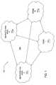
- FIG. 1is a schematic diagram illustrating a typical large-area transportation network 100 .
- the transportation network 100comprises a plurality of urban metropolitan areas 102 1 - 102 N (hereinafter collectively referred to as “metropolitan areas 102 ), towns 104 1 - 104 N (hereinafter collectively referred to as “towns 104 ”) and inter-urban and/or rural areas (generally designated 106 ) situated between the metropolitan areas 102 and towns 104 .
- the metropolitan areas 102 , towns 104 and inter-urban/rural areas 106 that comprise the transportation network 100may span a large geographical area (e.g., comprising a plurality of cities, states, regions or countries).
- a shortest pathor best (e.g., fastest) route, to travel from an origin to a destination.
- Conventional applicationssuch as internet mapping and vehicle navigation systems typically compute this best route based on static, non-state-dependent data about links in the transportation network (e.g., speed limits, numbers of lanes, average loads).
- a problem with this approachis that dynamic, state-dependent data that may influence travel time (e.g., current traffic conditions or other environmental factors) is not accounted for. Thus, a computed route may not, in fact, be the best route at a given time.
- travel timee.g., current traffic conditions or other environmental factors
- a computed routemay not, in fact, be the best route at a given time.
- some methods currently existthat do account for current traffic states, these existing methods are computationally intensive and limited to small or moderately-sized geographic areas. Moreover, these methods do not function well where access to real-time data is limited to only some roads in the transportation network (e.g., as with large urban transportation networks).
- the present inventionis a method and an apparatus for estimating real-time travel times or traffic loads (e.g., traffic flows or densities) over a transportation network based on limited real-time data.
- a method for estimating a travel time over a transportation networkcomprising at least a first link and a second link includes receiving a data feed associated with a real-time traffic flow over the first link, estimating a first travel time over the first link based at least in part on the data feed, and estimating a second travel time over the second link, also based at least in part on the data feed.
- the methodassumes that a real-time data feed is not available for the second link, and thus estimates the traffic flow over the second link based on the known traffic flow over the first link and other known data, such as historical traffic patterns and physical parameters of the transportation network.
- FIG. 1is a schematic diagram illustrating a typical large-area transportation network
- FIG. 2is a flow diagram illustrating one embodiment of a method for end-to-end route prediction using state-dependent data, according to the present invention
- FIG. 3is a flow diagram illustrating one embodiment of a method for generating travel time predictions for at least one zone of a transportation network
- FIG. 4is a flow diagram illustrating one embodiment of a template-based method for future travel time predictions
- FIG. 5is a graph illustrating one embodiment of a template for use in accordance with the method
- FIG. 6is a flow diagram illustrating one embodiment of a method for estimating real-time travel times in a transportation network based on limited real-time data
- FIG. 7is a schematic diagram illustrating one embodiment of an exemplary transportation network including a plurality of links and nodes, as well as a park or public space;
- FIG. 8is a high level block diagram of the present route generation system that is implemented using a general purpose computing device.
- the present inventionis a method and apparatus for end-to-end travel time estimation using dynamic traffic data.
- Embodiments of the present inventionaccount for real-time, state-dependent data in order to provide more accurate end-to-end estimates and predictions (e.g., shortest paths or best routes) for transportation networks, including wide-area, spatially heterogeneous transportation networks.
- embodiments of the present inventionmay be implemented to advantage in applications such as internet mapping, route guidance, in-vehicle or on-board navigation, fleet routing (e.g., for major carriers or the military) and the like.
- shortest pathor “best route” refer to one or more individual links (e.g., road segments) in a transportation network that connect a designated point of origin to a designated destination.
- a shortest path or best routerepresents the series of links that, if traveled, are expected to allow one to travel from the origin to the destination in the least amount of time (e.g., as compared with alternate paths or routes).
- the methods and apparatuses of the present inventionprocess a plurality of static and dynamic inputs, including link load estimates, current or real-time streaming traffic condition data (e.g., from one or more sources including but not limited to traffic sensors, induction loops, video feeds, cellular telephones and Global Positioning Systems (GPS)), (computed) statistical traffic patterns, real-time environmental data (e.g., weather conditions), radio-based real-time incident data (e.g., data pertaining to events and weather conditions, including traffic and accident reports), (computed) static origin-destination (O-D) matrices and static maps (e.g., digital maps), in order to identify a best route from an origin to a destination in the transportation network.
- traffic condition datae.g., from one or more sources including but not limited to traffic sensors, induction loops, video feeds, cellular telephones and Global Positioning Systems (GPS)
- GPSGlobal Positioning Systems
- OFDstatic origin-destination
- static mapse.g., digital
- FIG. 2is a flow diagram illustrating one embodiment of a method 200 for end-to-end route prediction using state-dependent data, according to the present invention.
- the method 200may be implemented, for example, by an internet mapping or vehicle navigation system to generate a best route between two transportation network endpoints (e.g., an origin and a destination) at a given time.
- two transportation network endpointse.g., an origin and a destination
- the method 200is initialized at step 202 and proceeds to step 204 , where the method 200 receives, e.g., from a user, a specified origin and a specified destination in the transportation network under consideration.
- the method 200then proceeds to step 206 and generates network-wide loads (e.g., numbers of vehicles per units of time) for the entire urban and regional zones of the transportation network, including highways (e.g., higher-density zones for which real-time traffic data feeds are typically available).
- these loadsare generated in accordance with a fine- or medium-grained static (non-state-dependent) or dynamic fine load-generation technique (e.g., a technique suitable for assessing regions of fine- or medium-grained spatial dimension).
- the loadsare generated in accordance with at least one of: static or dynamic traffic assignment, queuing networks, simulation (e.g., as typically used for modeling urban area traffic flows), probabilistic local techniques and flow propagation.
- the loadsare generated in accordance with at least one input relating to the static or dynamic characteristics of zones under consideration, such as: current or real-time traffic condition data, real-time environmental data (e.g., weather conditions), radio-based real-time incident data (e.g., traffic and accident reports), (computed) statistical traffic patterns, (computed) static origin-destination (O-D) matrices and static maps (e.g., digital maps).
- real-time environmental datae.g., weather conditions
- radio-based real-time incident datae.g., traffic and accident reports
- O-Dstatic origin-destination
- static mapse.g., digital maps
- the method 200generates travel time predictions for the entire inter-urban and rural zones of the transportation network under consideration (e.g., lower-density zones for which real-time traffic data feeds may not be available) based on the static or dynamic network-wide data obtained or estimated in step 206 .
- these predictionsare generated in accordance with a coarse-grained load-generation technique (e.g., a technique suitable for assessing regions of coarse-grained spatial dimension).
- the travel timesare generated in accordance with at least one of: template methods (e.g., as used in predicting the medium and long-term future), statistical traffic classification, traffic assignment, simulation and probabilistic local techniques.
- the loadsare generated in accordance with at least one input relating to the static or dynamic characteristics of zones under consideration, such as: current or real-time traffic condition data, real-time environmental data (e.g., weather conditions), radio-based real-time incident data (e.g., traffic and accident reports), (computed) statistical traffic patterns, (computed) static origin-destination (O-D) matrices and static maps (e.g., digital maps).
- real-time environmental datae.g., weather conditions
- radio-based real-time incident datae.g., traffic and accident reports
- O-Dstatic origin-destination
- static mapse.g., digital maps
- the method 200then proceeds to step 210 and obtains real-time data, where available, which is then incorporated into the current-time-step load computations generated in steps 206 and 208 .
- real-time datais not available for all zones of the transportation network.
- the obtained real-time dataincludes at least one of: current or real-time traffic condition data, real-time environmental data and radio-based real-time incident data.
- the method 200combines the generated load data for all zones in the transportation network under consideration.
- this combination of load dataincludes converting all loads to travel times.
- this conversionis performed in accordance with at least one analytic model.
- the informationmay remain as units of load (e.g., flow or density).
- the method 200then proceeds to step 214 and, where the combined load data has been converted to units of travel time, scales the computed travel times in accordance with any relevant incidents or occurrences (e.g., events and weather conditions) that may affect travel times through the transportation network under consideration (e.g., accidents, construction, special events or occurrences at points of interest in the transportation network, weather and the like). In this way, more accurate, real-time travel times can be estimated.
- any relevant incidents or occurrencese.g., events and weather conditions
- any relevant incidents or occurrencese.g., events and weather conditions
- the method 200then proceeds to step 216 and identifies at least one best route in accordance with the scaled travel times.
- the best route identified by the method 200is the set of links (road segments) between the specified origin and specified destination over which travel time is expected to be the shortest (e.g., accounting for both the static and dynamic transportation network data).
- the method 200terminates in step 218 .
- the method 200is thus capable of processing a plurality of different types of data relating to static and dynamic transportation network characteristics in order to estimate travel times through the transportation network.
- the method 200is designed to take advantage of real-time, state-dependent data, where available for a given zone or link, as well as to maximize the use of static, non state-dependent data when real-time data is not available.
- the method 200produces a more accurate current travel time estimate than conventional route planning techniques.
- steps 206 - 214 of the method 200may be implemented independent of any specific route request, e.g., in order to maintain up-to-date information about the transportation network for future route requests.
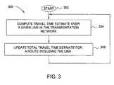
- FIG. 3is a flow diagram illustrating one embodiment of a method 300 for generating travel time predictions for at least one zone of a transportation network, e.g., in accordance with steps 206 and/or 208 of the method 200 .
- the method 300is initialized at step 302 and proceeds to step 304 , where the method 300 computes the estimated travel time over a given link in the zone, e.g., in accordance with observed (current) or predicted (future) traffic patterns over the link.
- This estimationmay be computed in accordance with any of the methods described above, or in accordance with a template-based statistical method described in further detail with respect to FIG. 4 .
- the method 300proceeds to step 306 and updates a total travel time estimate for at least one route including the link.
- the method 300then returns to step 304 and proceeds as described above, this time computing the estimated travel time over a second link in the transportation network. This iterative process is repeated on a link-by-link basis to obtain a total estimated travel time for a route comprising one or more links.
- FIG. 4is a flow diagram illustrating one embodiment of a template-based method 400 for future travel time predictions, e.g., for use in accordance with the method 300 (and therefore steps 206 and/or 208 of the method 200 ).
- the method 400identifies, on a link-by-link basis, the traffic state characteristics (e.g., speed, volume, etc.) that best characterize the progression of that traffic state into the future. Predictions of future travel times over a given link are then made in accordance with the observed traffic state (e.g., “peak weekday traffic volumes typically occur between 8:00 AM and 9:00 AM”).
- the method 400will be described in the context of predicting travel times for inter-urban and rural zones, those skilled in the art will appreciate that the method 400 may also used to predict travel times for urban zones as well.
- the method 400is initialized at step 402 and proceeds to step 404 , where the method 400 initializes a template that will reflect a repeating behavior of a traffic pattern on a given link of the transportation network.
- the templatemaps traffic volume (e.g., numbers of vehicles per unit of time) over a given link versus time, in order to illustrate a traffic pattern. This pattern may represent daily, weekly, monthly, or yearly behavior, or may be tailored over any other useful time horizon.
- t( 0 )represents midnight of a given day. From this information, an estimate of travel time over the link at a given time in the future can be derived.
- templates representing multiple time horizonsmay be maintained for a single link.
- the template initialized in step 402is associated with an initialized traffic volume of zero, e.g., the initialized template contains no data.
- the method 400receives a data point for incorporation in the template.
- the data pointrepresents, for example, real-time traffic volume at a given time on the link for which the template is generated.
- the data pointis a point in an incoming data stream (e.g., where a new data point is received every hour).
- the data streamcould represent the number of vehicles, x, passing by a particular marking point on the link, such that a received data points represents x(i), or the number of vehicles passing the marking point at time t(i).
- the method 400then proceeds to step 408 and updates the current volume estimate for the given time in accordance with the received data point.
- the current volume estimateis updated in accordance with a moving average (e.g., an exponentially weighted moving average) that smoothes out jitters in received data and captures gradual data shifts.
- a moving averagee.g., an exponentially weighted moving average
- an update of the current volume estimate in accordance with step 408could involve setting
- ⁇is a free variable representing the level of sensitivity of the method 400 and has a value between zero and one. In one embodiment, ⁇ has a value between 0.4 and 07. The larger the value of ⁇ , the less sensitive and the more adaptive to changing traffic patterns the method 400 is.
- the method 400generates a prediction p(i, j) for the number of vehicles that are expected to pass the marking point at a future time t(i+j), in accordance with the updated volume estimate.
- the prediction p(i, j)is based on observed information (e.g., traffic volumes) up to time t(i), at which the prediction p(i, j) is generated.
- the method 400then proceeds to step 412 and updates the current template estimate in accordance with the generated predictions p(i, j) (i.e., computed statistical traffic patterns) and one or more maps of the transportation network including the link.
- the template estimateis an estimate of the traffic pattern over time (such as an increasing pattern in the morning hours and a decreasing pattern after the evening rush hours).
- the template t(i)is normalized, as discussed above, so that the sum of t( 0 )+t( 1 )+ . . . +t( 24 ) is equal to one.
- the current template estimateis updated in accordance with a moving average (e.g., an exponentially weighted moving average) that smoothes out jitters in received data and captures gradual data shifts.
- a moving averagee.g., an exponentially weighted moving average
- an update of the current template estimate in accordance with step 412could involve setting
- ⁇like ⁇ , is a free variable representing the level of sensitivity of the method 400 and has a value between zero and one. In one embodiment, ⁇ has a value between 0.4 and 07. The larger the value of ⁇ , the less sensitive and the more adaptive to changing traffic patterns the method 400 is.
- the generated travel time estimatesare a function of both the composition of the template and the ongoing traffic volume.
- the method 400may be repeated link-by-link for each link in the transportation network.
- the method 400therefore learns from past observed traffic patterns and is refined over time using real-time data (e.g., without user input).
- the method 400is thus capable of quickly catching up with shifts in trends or traffic patterns. This is especially significant, for example, where an overall traffic volume may shift up or increase in relation to a general observed pattern for a particular day.
- the method 400can quickly detect this increase in volume as it develops and adjust predictions for future periods accordingly.
- the method 400is particularly effective in predicting short-, medium- and long-term future conditions.
- FIG. 5is a graph illustrating one embodiment of a template 500 for use in accordance with the method 400 .
- the template 500maps traffic volume (e.g., numbers of cars per unit of time) over a given link versus time (e.g., approximately three days in the case of FIG. 5 ).
- the templatemay be marked by peaks 502 1 - 502 n (hereinafter collectively referred to as “peaks 502 ”) where the traffic volume is greatest (e.g., such as during morning or afternoon rush hours), plateaus 504 1 - 504 n (hereinafter collectively referred to as “plateaus 504 ”) where traffic volume remains relatively constant (e.g., between morning and afternoon rush hours), and valleys 506 1 - 506 n (hereinafter collectively referred to as “valleys 506 ”) where traffic volume is lightest.
- peaks 502where the traffic volume is greatest (e.g., such as during morning or afternoon rush hours)
- plateaus 504 1 - 504 nhereinafter collectively referred to as “plateaus 504 ”
- valleys 506 1 - 506 nhereinafter collectively referred to as “valleys 506 ” where traffic volume is lightest.
- the template 500thus enables the prediction of future traffic patterns or volumes over a link at a given time based on historical traffic volumes over the same link.
- Real-time datamay be incorporated in the template 500 as the data is received, in order to quickly identify traffic patterns that may deviate from the historical norm and to predict the effects of these changing traffic patterns into the future.
- FIG. 6is a flow diagram illustrating one embodiment of a method 600 for estimating real-time travel times in a transportation network based on limited real-time data, e.g., for use in accordance with steps 206 and/or 208 of the method 200 .
- the method 600estimates travel times over links in the transportation network for which link-specific real-time data is not available.
- the method 600will be described in the context of predicting travel times for urban zones, those skilled in the art will appreciate that the method 600 may also used to predict travel times for inter-urban and rural zones as well.
- the method 600is initialized at step 602 and proceeds to step 604 , where the method 600 receives one or more static or dynamic parameters of the transportation network (e.g., links, nodes or intersections of two or more links, free-flow speeds and likely origins and destinations such as parking garages, on-street parking spots and other points of interest).
- one or more static or dynamic parameters of the transportation networke.g., links, nodes or intersections of two or more links, free-flow speeds and likely origins and destinations such as parking garages, on-street parking spots and other points of interest.
- the method 600then proceeds to step 606 and obtains at least one set of link flows over the entire transportation network.
- more than one set of link flows for the entire transportation networkmay be obtained, such as one set of link flows for peak periods and one set of link flows for off-peak periods, or one set of link flows for a weekday and one set of link flows for weekends, or separate sets of link flows for different time periods over a typical day or week.
- the link flowsmay be derived from at least one origin-destination (O-D) trip table (e.g., via trip assignment).
- these O-D trip tablesare static tables for an average time period on an average day and can be obtained, for example, from the associated metropolitan planning organization.
- the O-D trip tablesmay be time-dependent, or may represent peak or off-peak times, weekday versus weekend, or may be hourly, etc.
- the method 600computes a traffic assignment for each O-D trip table. In one embodiment, this traffic assignment is computed in accordance with a one-period traffic assignment method, such as a known traffic assignment method. From each traffic assignment, the method 600 can then obtain link flows for all links in the transportation network for the average time period in which the O-D trip table is valid.
- the method 600uses the link flows to determine the splitting probabilities at each node in the transportation network, from each incoming link.
- a splitting probabilityrefers to the percentages of vehicles that go left, right and straight through a given node or intersection. For example, the average case for a given node may dictate that sixty percent of traffic arriving at the node goes straight, thirty percent of the traffic turns right, and ten percent of the traffic turns left. This information is computed and stored for each node in the transportation data, in accordance with the node's average case data (e.g., as obtained from one or more sets of link flows or one or more O-D trip tables).
- the method 600then proceeds to step 610 and receives a real-time data feed associated with a given link in the transportation network (e.g., relating to current traffic volume, flow or speed over the link).
- This real-time data feedmay be received from, for example, a sensor (e.g., a motion sensor, a camera or other real-time data collection mechanism) placed on the link.
- a sensore.g., a motion sensor, a camera or other real-time data collection mechanism
- such real-time data feedsare available only for a limited number of links in the transportation network. If the real-time data feed is received in speed units, the method 600 converts the value to flow units.
- the method 600applies the real-time flows to the computed splitting percentages for each node and propagates the real-time flows throughout the transportation network, in order to estimate the real-time volumes on the links of the transportation network.
- the real-time flowsare applied to the computed splitting probabilities in accordance with one or more flow balance equations. In one embodiment, this is done using a set of network flows that closely resembles the current time period.
- the method 600then proceeds to step 614 and applies one or more special techniques to account for absorption (e.g., for different types of parking garages, parking meters, points of interest, etc. in the transportation network that may absorb some of the traffic flow on certain links).
- absorptionis accounted for by deducting a fixed or variable percentage or absolute quantity of load (e.g., flow or density) from the link load at one or more relevant time periods, where the quantity deducted depends on the nature of the attraction points on the link (e.g., parking garages, points of interest, etc.) and the time of day, day of week, etc.
- loadis typically absorbed from a link load when vehicles enter a parking garage on the link.
- traffic generationmay be accounted for on those or other links by augmenting the load (e.g., flow or density) on the link in accordance with the time of day, day of week, etc. and the nature of attraction points on the link.
- loade.g., flow or density
- loadis typically augmented on a link when vehicles exit a parking garage on the link at the end of the work day.
- absorption and origin statesare changeable over time, for example as parking rules change during the day.
- step 616the method 600 determines whether inconsistent flow is exhibited on any link in the transportation network and, if so, generates a mega-node (e.g., an artificial node representing—and merging or combining the characteristics of—two or more network nodes, and suppressing the links between those network nodes) incorporating that link.
- a mega-nodee.g., an artificial node representing—and merging or combining the characteristics of—two or more network nodes, and suppressing the links between those network nodes
- This mega-nodeis generated dynamically using only observed, real-time flows.
- the method 600determines the updated splitting probabilities for the mega-node and applies these splitting probabilities to the inconsistent link flow.
- the method 600then returns to step 608 and proceeds as described above for a next node in the transportation network.
- FIG. 7is a schematic diagram illustrating one embodiment of an exemplary transportation network 700 including a plurality of links 702 and nodes 704 , as well as a park or public space 706 . As further illustrated, some, but not all, of the links 702 are associated with sensors 708 (illustrated as darkened links 702 ) that provide real-time data feed of current traffic volume, flow or speed over the associated link 702 .
- sensors 708illustrated as darkened links 702
- a sensor 708 placed along the link 702 ′may observe a real-time traffic flow over the link 702 ′ of approximately 15 vehicles per second.
- the splitting probabilities for a node 704 ′ including the link 702 ′may be computed such that twenty percent of the traffic flow from the link 702 ′ is expected to go straight through the node 704 ′ and forty percent of the traffic flow from the link 702 ′ is expected to turn left at the node 704 ′.
- FIG. 8is a high level block diagram of the present route generation system that is implemented using a general purpose computing device 800 .
- a general purpose computing device 800comprises a processor 802 , a memory 804 , a route generator or module 805 and various input/output (I/O) devices 806 such as a display, a keyboard, a mouse, a modem, and the like.
- I/O devices 806such as a display, a keyboard, a mouse, a modem, and the like.
- at least one I/O deviceis a storage device (e.g., a disk drive, an optical disk drive, a floppy disk drive).
- the route generator 805can be implemented as a physical device or subsystem that is coupled to a processor through a communication channel.
- the route generator 805can be represented by one or more software applications (or even a combination of software and hardware, e.g., using Application Specific Integrated Circuits (ASIC)), where the software is loaded from a storage medium (e.g., I/O devices 806 ) and operated by the processor 802 in the memory 804 of the general purpose computing device 800 .
- a storage mediume.g., I/O devices 806
- a computer readable medium or carriere.g., RAM, magnetic or optical drive or diskette, and the like.
- the present inventionrepresents a significant advancement in the field of travel time estimation for transportation networks.
- Embodiments of the present inventionassume that real-time data feeds relating to traffic flows are available only for a limited number of links in a transportation network.
- Real-time traffic flows for links for which real-time data feeds are not availableare thus estimated in accordance with the real-time data feeds that are available, as well as with known historical traffic patterns and physical parameters of the transportation network.
- substantially accurate estimates of real-time traffic flowscan be obtained even for links for which real-time data is not provided.
Landscapes
- Engineering & Computer Science (AREA)
- Physics & Mathematics (AREA)
- General Physics & Mathematics (AREA)
- Computer Networks & Wireless Communication (AREA)
- Signal Processing (AREA)
- Radar, Positioning & Navigation (AREA)
- Remote Sensing (AREA)
- Chemical & Material Sciences (AREA)
- Analytical Chemistry (AREA)
- Traffic Control Systems (AREA)
Abstract
Description
where α is a free variable representing the level of sensitivity of the
where β, like α, is a free variable representing the level of sensitivity of the
Claims (17)
Priority Applications (1)
| Application Number | Priority Date | Filing Date | Title |
|---|---|---|---|
| US11/052,310US7894980B2 (en) | 2005-02-07 | 2005-02-07 | Method and apparatus for estimating real-time travel times over a transportation network based on limited real-time data |
Applications Claiming Priority (1)
| Application Number | Priority Date | Filing Date | Title |
|---|---|---|---|
| US11/052,310US7894980B2 (en) | 2005-02-07 | 2005-02-07 | Method and apparatus for estimating real-time travel times over a transportation network based on limited real-time data |
Publications (2)
| Publication Number | Publication Date |
|---|---|
| US20060176817A1 US20060176817A1 (en) | 2006-08-10 |
| US7894980B2true US7894980B2 (en) | 2011-02-22 |
Family
ID=36779808
Family Applications (1)
| Application Number | Title | Priority Date | Filing Date |
|---|---|---|---|
| US11/052,310Expired - Fee RelatedUS7894980B2 (en) | 2005-02-07 | 2005-02-07 | Method and apparatus for estimating real-time travel times over a transportation network based on limited real-time data |
Country Status (1)
| Country | Link |
|---|---|
| US (1) | US7894980B2 (en) |
Cited By (6)
| Publication number | Priority date | Publication date | Assignee | Title |
|---|---|---|---|---|
| US20080177460A1 (en)* | 2007-01-10 | 2008-07-24 | Adrian Blackwood | Navigation device and method for enhancing traffic data |
| US20090248296A1 (en)* | 2008-03-31 | 2009-10-01 | Aisin Aw Co., Ltd. | Driving support system, driving support method and computer program |
| US20100049428A1 (en)* | 2007-02-27 | 2010-02-25 | Kenichi Murata | Travel time calculation server, a travel time calculating apparatus used for a vehicle and a travel time calculation system |
| US20100158202A1 (en)* | 2008-12-23 | 2010-06-24 | International Business Machines Corporation | Location Based Emergency Services Dispatching |
| US8666645B2 (en)* | 2011-12-21 | 2014-03-04 | Navteq B.V. | Method of selecting a traffic pattern for use by a navigation system |
| WO2014112249A1 (en) | 2013-01-17 | 2014-07-24 | Mitsubishi Electric Corporation | Method and system for predicting future travel times of a target vehicle |
Families Citing this family (12)
| Publication number | Priority date | Publication date | Assignee | Title |
|---|---|---|---|---|
| US7363144B2 (en)* | 2005-02-07 | 2008-04-22 | International Business Machines Corporation | Method and apparatus for predicting future travel times over a transportation network |
| DE102006033744A1 (en)* | 2006-07-21 | 2008-01-24 | Deutsche Telekom Ag | Method and device for merging traffic data with incomplete information |
| FR2918495B1 (en)* | 2007-07-02 | 2009-10-02 | Mediamobile Sa | ESTIMATION OF TRAFFIC IN A ROAD NETWORK |
| US8874354B2 (en)* | 2007-10-16 | 2014-10-28 | International Business Machines Corporation | Method and system for expansion of real-time data on traffic networks |
| US20090265091A1 (en)* | 2008-04-16 | 2009-10-22 | Xanavi Informatics Corporation | Method and apparatus utilizing both statistical and real time data for a vehicle navigation system |
| US10540615B2 (en)* | 2011-09-13 | 2020-01-21 | United Parcel Service Of America, Inc. | Network planning tool |
| CN114287022A (en)* | 2019-09-25 | 2022-04-05 | 华为云计算技术有限公司 | Multi-step traffic prediction |
| WO2021058100A1 (en)* | 2019-09-25 | 2021-04-01 | Huawei Technologies Co., Ltd. | Multisensory learning system for traffic prediction |
| CN112749854B (en)* | 2019-10-29 | 2024-04-16 | 顺丰科技有限公司 | Traffic limit data processing method, device, computer equipment and storage medium |
| US11488046B2 (en)* | 2020-06-09 | 2022-11-01 | Huawei Technologies Co., Ltd. | Method and apparatus for supporting estimation of link acquisition time in satellite-based networks |
| US20220382926A1 (en)* | 2021-05-28 | 2022-12-01 | Ford Global Technologies, Llc | Simulation-based corridor design for connected autonomous vehicles |
| US12010026B2 (en)* | 2022-03-09 | 2024-06-11 | International Business Machines Corporation | Managing computer network traffic based on weather conditions |
Citations (31)
| Publication number | Priority date | Publication date | Assignee | Title |
|---|---|---|---|---|
| US5610821A (en)* | 1994-11-18 | 1997-03-11 | Ibm Corporation | Optimal and stable route planning system |
| US5845228A (en)* | 1996-02-08 | 1998-12-01 | Mitsubishi Denki Kabushiki Kaisha | Vehicle-route computing apparatus |
| US6192314B1 (en)* | 1998-03-25 | 2001-02-20 | Navigation Technologies Corp. | Method and system for route calculation in a navigation application |
| US6222836B1 (en)* | 1997-04-04 | 2001-04-24 | Toyota Jidosha Kabushiki Kaisha | Route searching device |
| US6253152B1 (en)* | 1997-09-02 | 2001-06-26 | Toyota Jidosha Kabushiki Kaisha | Navigation controller |
| US6308177B1 (en)* | 1996-10-25 | 2001-10-23 | Vijaya S. Israni | System and method for use and storage of geographic data on physical media |
| US6317686B1 (en)* | 2000-07-21 | 2001-11-13 | Bin Ran | Method of providing travel time |
| US20010047242A1 (en)* | 1998-04-28 | 2001-11-29 | Kazutaka Ohta | Route searching device |
| US6356836B1 (en)* | 1997-06-12 | 2002-03-12 | Michael Adolph | Method and device for generating, merging and updating of destination tracking data |
| US6421606B1 (en)* | 1999-08-17 | 2002-07-16 | Toyota Jidosha Kabushiki Kaisha | Route guiding apparatus and medium |
| US6427114B1 (en)* | 1998-08-07 | 2002-07-30 | Dinbis Ab | Method and means for traffic route control |
| US20020120390A1 (en)* | 2001-02-26 | 2002-08-29 | Bullock James Blake | Method of optimizing traffic content |
| US6459387B1 (en)* | 1999-10-15 | 2002-10-01 | Koito Manufacturing Co., Ltd. | Vehicle lighting apparatus |
| US6484092B2 (en)* | 2001-03-28 | 2002-11-19 | Intel Corporation | Method and system for dynamic and interactive route finding |
| US20030060977A1 (en)* | 2001-09-21 | 2003-03-27 | General Motors Corporation. | Method and system for mobile vehicle re-routing |
| US6587781B2 (en)* | 2000-08-28 | 2003-07-01 | Estimotion, Inc. | Method and system for modeling and processing vehicular traffic data and information and applying thereof |
| US6615130B2 (en)* | 2000-03-17 | 2003-09-02 | Makor Issues And Rights Ltd. | Real time vehicle guidance and traffic forecasting system |
| US20030167109A1 (en)* | 2002-02-28 | 2003-09-04 | Clarke Michael D. D. | Methods and systems for routing mobile vehicles |
| US20030182051A1 (en)* | 2002-03-20 | 2003-09-25 | Vehicle Information And Communication System Center | Road traffic information transmitter, transmitting method, transmitting program, and road traffic information receiver, receiving method, and reception program |
| US20030191579A1 (en)* | 2002-04-03 | 2003-10-09 | Kiyomi Sakamoto | Travel route searching apparatus |
| US20030236615A1 (en)* | 2001-11-01 | 2003-12-25 | Nissan Motor Co., Ltd. | Navigation system, data server, traveling route establishing method and information providing method |
| US20040225437A1 (en)* | 2003-02-05 | 2004-11-11 | Yoshinori Endo | Route search method and traffic information display method for a navigation device |
| US20040249568A1 (en)* | 2003-04-11 | 2004-12-09 | Yoshinori Endo | Travel time calculating method and traffic information display method for a navigation device |
| US6882930B2 (en)* | 2000-06-26 | 2005-04-19 | Stratech Systems Limited | Method and system for providing traffic and related information |
| US20050093720A1 (en)* | 2003-10-16 | 2005-05-05 | Hitachi, Ltd. | Traffic information providing system and car navigation system |
| US20050131634A1 (en)* | 2003-12-15 | 2005-06-16 | Gary Ignatin | Estimation of roadway travel information based on historical travel data |
| US20050273250A1 (en)* | 2004-05-18 | 2005-12-08 | Bruce Hamilton | System and method for dynamic navigational route selection |
| US20060106506A1 (en)* | 2004-11-16 | 2006-05-18 | Nichols William M | Automatic contingency generator |
| US7239963B2 (en)* | 2002-08-26 | 2007-07-03 | Alpine Electronics, Inc. | Method and apparatus for displaying navigation information |
| US20080114529A1 (en)* | 2006-11-10 | 2008-05-15 | Hitachi, Ltd | Traffic Information Interpolation System |
| US20080183376A1 (en)* | 1997-08-19 | 2008-07-31 | Continental Automotive Systems Us, Inc. | Vehicle information system |
- 2005
- 2005-02-07USUS11/052,310patent/US7894980B2/ennot_activeExpired - Fee Related
Patent Citations (32)
| Publication number | Priority date | Publication date | Assignee | Title |
|---|---|---|---|---|
| US5610821A (en)* | 1994-11-18 | 1997-03-11 | Ibm Corporation | Optimal and stable route planning system |
| US5845228A (en)* | 1996-02-08 | 1998-12-01 | Mitsubishi Denki Kabushiki Kaisha | Vehicle-route computing apparatus |
| US6308177B1 (en)* | 1996-10-25 | 2001-10-23 | Vijaya S. Israni | System and method for use and storage of geographic data on physical media |
| US6222836B1 (en)* | 1997-04-04 | 2001-04-24 | Toyota Jidosha Kabushiki Kaisha | Route searching device |
| US6356836B1 (en)* | 1997-06-12 | 2002-03-12 | Michael Adolph | Method and device for generating, merging and updating of destination tracking data |
| US20080183376A1 (en)* | 1997-08-19 | 2008-07-31 | Continental Automotive Systems Us, Inc. | Vehicle information system |
| US6253152B1 (en)* | 1997-09-02 | 2001-06-26 | Toyota Jidosha Kabushiki Kaisha | Navigation controller |
| US6192314B1 (en)* | 1998-03-25 | 2001-02-20 | Navigation Technologies Corp. | Method and system for route calculation in a navigation application |
| US20010047242A1 (en)* | 1998-04-28 | 2001-11-29 | Kazutaka Ohta | Route searching device |
| US6427114B1 (en)* | 1998-08-07 | 2002-07-30 | Dinbis Ab | Method and means for traffic route control |
| US6421606B1 (en)* | 1999-08-17 | 2002-07-16 | Toyota Jidosha Kabushiki Kaisha | Route guiding apparatus and medium |
| US6459387B1 (en)* | 1999-10-15 | 2002-10-01 | Koito Manufacturing Co., Ltd. | Vehicle lighting apparatus |
| US6615130B2 (en)* | 2000-03-17 | 2003-09-02 | Makor Issues And Rights Ltd. | Real time vehicle guidance and traffic forecasting system |
| US6882930B2 (en)* | 2000-06-26 | 2005-04-19 | Stratech Systems Limited | Method and system for providing traffic and related information |
| US6317686B1 (en)* | 2000-07-21 | 2001-11-13 | Bin Ran | Method of providing travel time |
| US6587781B2 (en)* | 2000-08-28 | 2003-07-01 | Estimotion, Inc. | Method and system for modeling and processing vehicular traffic data and information and applying thereof |
| US20020120390A1 (en)* | 2001-02-26 | 2002-08-29 | Bullock James Blake | Method of optimizing traffic content |
| US6484092B2 (en)* | 2001-03-28 | 2002-11-19 | Intel Corporation | Method and system for dynamic and interactive route finding |
| US20030060977A1 (en)* | 2001-09-21 | 2003-03-27 | General Motors Corporation. | Method and system for mobile vehicle re-routing |
| US20030236615A1 (en)* | 2001-11-01 | 2003-12-25 | Nissan Motor Co., Ltd. | Navigation system, data server, traveling route establishing method and information providing method |
| US20030167109A1 (en)* | 2002-02-28 | 2003-09-04 | Clarke Michael D. D. | Methods and systems for routing mobile vehicles |
| US20030182051A1 (en)* | 2002-03-20 | 2003-09-25 | Vehicle Information And Communication System Center | Road traffic information transmitter, transmitting method, transmitting program, and road traffic information receiver, receiving method, and reception program |
| US20030191579A1 (en)* | 2002-04-03 | 2003-10-09 | Kiyomi Sakamoto | Travel route searching apparatus |
| US7239963B2 (en)* | 2002-08-26 | 2007-07-03 | Alpine Electronics, Inc. | Method and apparatus for displaying navigation information |
| US20040225437A1 (en)* | 2003-02-05 | 2004-11-11 | Yoshinori Endo | Route search method and traffic information display method for a navigation device |
| US20040249568A1 (en)* | 2003-04-11 | 2004-12-09 | Yoshinori Endo | Travel time calculating method and traffic information display method for a navigation device |
| US20050093720A1 (en)* | 2003-10-16 | 2005-05-05 | Hitachi, Ltd. | Traffic information providing system and car navigation system |
| US20080140308A1 (en)* | 2003-10-16 | 2008-06-12 | Hitachi, Ltd. | Traffic Information Providing System and Car Navigation System |
| US20050131634A1 (en)* | 2003-12-15 | 2005-06-16 | Gary Ignatin | Estimation of roadway travel information based on historical travel data |
| US20050273250A1 (en)* | 2004-05-18 | 2005-12-08 | Bruce Hamilton | System and method for dynamic navigational route selection |
| US20060106506A1 (en)* | 2004-11-16 | 2006-05-18 | Nichols William M | Automatic contingency generator |
| US20080114529A1 (en)* | 2006-11-10 | 2008-05-15 | Hitachi, Ltd | Traffic Information Interpolation System |
Cited By (8)
| Publication number | Priority date | Publication date | Assignee | Title |
|---|---|---|---|---|
| US20080177460A1 (en)* | 2007-01-10 | 2008-07-24 | Adrian Blackwood | Navigation device and method for enhancing traffic data |
| US20100049428A1 (en)* | 2007-02-27 | 2010-02-25 | Kenichi Murata | Travel time calculation server, a travel time calculating apparatus used for a vehicle and a travel time calculation system |
| US8255145B2 (en)* | 2007-02-27 | 2012-08-28 | Toyota Jidosha Kabushiki Kaisha | Travel time calculation server, a travel time calculating apparatus used for a vehicle and a travel time calculation system |
| US20090248296A1 (en)* | 2008-03-31 | 2009-10-01 | Aisin Aw Co., Ltd. | Driving support system, driving support method and computer program |
| US8190363B2 (en)* | 2008-03-31 | 2012-05-29 | Aisin Aw Co., Ltd. | Driving support system, driving support method and computer program for setting and using facility entry difficulty levels |
| US20100158202A1 (en)* | 2008-12-23 | 2010-06-24 | International Business Machines Corporation | Location Based Emergency Services Dispatching |
| US8666645B2 (en)* | 2011-12-21 | 2014-03-04 | Navteq B.V. | Method of selecting a traffic pattern for use by a navigation system |
| WO2014112249A1 (en) | 2013-01-17 | 2014-07-24 | Mitsubishi Electric Corporation | Method and system for predicting future travel times of a target vehicle |
Also Published As
| Publication number | Publication date |
|---|---|
| US20060176817A1 (en) | 2006-08-10 |
Similar Documents
| Publication | Publication Date | Title |
|---|---|---|
| US7236881B2 (en) | Method and apparatus for end-to-end travel time estimation using dynamic traffic data | |
| US7920960B2 (en) | Method and apparatus for predicting future travel times over a transportation network | |
| US7894980B2 (en) | Method and apparatus for estimating real-time travel times over a transportation network based on limited real-time data | |
| US6539300B2 (en) | Method for regional system wide optimal signal timing for traffic control based on wireless phone networks | |
| CN101253388B (en) | Method and navigation device for time-dependent route planning | |
| DE60319993T2 (en) | DEVICE AND METHOD FOR TRANSPORT INFORMATION PROCESSING | |
| US6317686B1 (en) | Method of providing travel time | |
| US7706964B2 (en) | Inferring road speeds for context-sensitive routing | |
| US6882930B2 (en) | Method and system for providing traffic and related information | |
| US20150253144A1 (en) | Methods and route planning systems for dynamic trip modifications and quick and easy alternative routes | |
| CN107702729A (en) | A kind of automobile navigation method and system for considering expected road conditions | |
| JP2005537497A (en) | Apparatus and method for providing traffic information | |
| Ghandeharioun et al. | Link travel time estimation for arterial networks based on sparse GPS data and considering progressive correlations | |
| Mepparambath et al. | A novel modelling approach of integrated taxi and transit mode and route choice using city-scale emerging mobility data | |
| Kanoh et al. | Short-term traffic prediction using fuzzy c-means and cellular automata in a wide-area road network | |
| Mishra et al. | Transit signal priority along a signalized arterial: A passenger-based approach | |
| Kristoffersson et al. | A dynamic transportation model for the Stockholm area: Implementation issues regarding departure time choice and OD-pair reduction | |
| Safirova et al. | Measuring Marginal Congestion Costs of Urban Transportation: Do Networks Matter? | |
| JP3355887B2 (en) | Travel time prediction method and travel time prediction device | |
| Park et al. | Location-based dynamic route guidance system of Korea: system design, algorithms and initial results | |
| Reddy et al. | Travel data collection using a smart phone for the estimation of multimodal travel times of intra-city public transportation | |
| Shah et al. | Detroit freeway corridor ITS evaluation | |
| Van Grol et al. | DACCORD: On-line travel time prediction | |
| Chrobok et al. | On-line simulation and traffic forecast: Applications and results | |
| Barahona | Assessing the Impact of Ridesourcing Transportation Services on Mobility and the Taxi Industry in Global Cities by Leveraging Big Data |
Legal Events
| Date | Code | Title | Description |
|---|---|---|---|
| AS | Assignment | Owner name:INTERNATIONAL BUSINESS MACHINES CORPORATION, NEW Y Free format text:ASSIGNMENT OF ASSIGNORS INTEREST;ASSIGNORS:LIU, ZHEN;WYNTER, LAURA;ZHANG, LI;REEL/FRAME:016218/0150;SIGNING DATES FROM 20050504 TO 20050510 | |
| FEPP | Fee payment procedure | Free format text:PAYOR NUMBER ASSIGNED (ORIGINAL EVENT CODE: ASPN); ENTITY STATUS OF PATENT OWNER: LARGE ENTITY | |
| STCF | Information on status: patent grant | Free format text:PATENTED CASE | |
| AS | Assignment | Owner name:GOOGLE INC., CALIFORNIA Free format text:ASSIGNMENT OF ASSIGNORS INTEREST;ASSIGNOR:INTERNATIONAL BUSINESS MACHINES CORPORATION;REEL/FRAME:027463/0594 Effective date:20111228 | |
| FPAY | Fee payment | Year of fee payment:4 | |
| AS | Assignment | Owner name:GOOGLE LLC, CALIFORNIA Free format text:CHANGE OF NAME;ASSIGNOR:GOOGLE INC.;REEL/FRAME:044101/0405 Effective date:20170929 | |
| FEPP | Fee payment procedure | Free format text:MAINTENANCE FEE REMINDER MAILED (ORIGINAL EVENT CODE: REM.); ENTITY STATUS OF PATENT OWNER: LARGE ENTITY | |
| LAPS | Lapse for failure to pay maintenance fees | Free format text:PATENT EXPIRED FOR FAILURE TO PAY MAINTENANCE FEES (ORIGINAL EVENT CODE: EXP.); ENTITY STATUS OF PATENT OWNER: LARGE ENTITY | |
| STCH | Information on status: patent discontinuation | Free format text:PATENT EXPIRED DUE TO NONPAYMENT OF MAINTENANCE FEES UNDER 37 CFR 1.362 | |
| FP | Lapsed due to failure to pay maintenance fee | Effective date:20190222 |