US7881730B2 - Method and system for dynamic estimation and predictive route generation - Google Patents
Method and system for dynamic estimation and predictive route generationDownload PDFInfo
- Publication number
- US7881730B2 US7881730B2US12/484,091US48409109AUS7881730B2US 7881730 B2US7881730 B2US 7881730B2US 48409109 AUS48409109 AUS 48409109AUS 7881730 B2US7881730 B2US 7881730B2
- Authority
- US
- United States
- Prior art keywords
- location
- mobile communication
- communication device
- route
- information
- Prior art date
- Legal status (The legal status is an assumption and is not a legal conclusion. Google has not performed a legal analysis and makes no representation as to the accuracy of the status listed.)
- Expired - Lifetime, expires
Links
Images


Classifications
- G—PHYSICS
- G01—MEASURING; TESTING
- G01C—MEASURING DISTANCES, LEVELS OR BEARINGS; SURVEYING; NAVIGATION; GYROSCOPIC INSTRUMENTS; PHOTOGRAMMETRY OR VIDEOGRAMMETRY
- G01C21/00—Navigation; Navigational instruments not provided for in groups G01C1/00 - G01C19/00
- G01C21/26—Navigation; Navigational instruments not provided for in groups G01C1/00 - G01C19/00 specially adapted for navigation in a road network
- G01C21/34—Route searching; Route guidance
- G01C21/36—Input/output arrangements for on-board computers
- G01C21/3667—Display of a road map
- G01C21/367—Details, e.g. road map scale, orientation, zooming, illumination, level of detail, scrolling of road map or positioning of current position marker
- G—PHYSICS
- G01—MEASURING; TESTING
- G01C—MEASURING DISTANCES, LEVELS OR BEARINGS; SURVEYING; NAVIGATION; GYROSCOPIC INSTRUMENTS; PHOTOGRAMMETRY OR VIDEOGRAMMETRY
- G01C21/00—Navigation; Navigational instruments not provided for in groups G01C1/00 - G01C19/00
- G01C21/26—Navigation; Navigational instruments not provided for in groups G01C1/00 - G01C19/00 specially adapted for navigation in a road network
- G01C21/34—Route searching; Route guidance
- G01C21/3407—Route searching; Route guidance specially adapted for specific applications
- G01C21/3438—Rendezvous; Ride sharing
- G—PHYSICS
- G01—MEASURING; TESTING
- G01C—MEASURING DISTANCES, LEVELS OR BEARINGS; SURVEYING; NAVIGATION; GYROSCOPIC INSTRUMENTS; PHOTOGRAMMETRY OR VIDEOGRAMMETRY
- G01C19/00—Gyroscopes; Turn-sensitive devices using vibrating masses; Turn-sensitive devices without moving masses; Measuring angular rate using gyroscopic effects
- G01C19/02—Rotary gyroscopes
- G01C19/42—Rotary gyroscopes for indicating rate of turn; for integrating rate of turn
- G—PHYSICS
- G01—MEASURING; TESTING
- G01C—MEASURING DISTANCES, LEVELS OR BEARINGS; SURVEYING; NAVIGATION; GYROSCOPIC INSTRUMENTS; PHOTOGRAMMETRY OR VIDEOGRAMMETRY
- G01C21/00—Navigation; Navigational instruments not provided for in groups G01C1/00 - G01C19/00
- G01C21/26—Navigation; Navigational instruments not provided for in groups G01C1/00 - G01C19/00 specially adapted for navigation in a road network
- G01C21/28—Navigation; Navigational instruments not provided for in groups G01C1/00 - G01C19/00 specially adapted for navigation in a road network with correlation of data from several navigational instruments
- G01C21/30—Map- or contour-matching
- G—PHYSICS
- G01—MEASURING; TESTING
- G01C—MEASURING DISTANCES, LEVELS OR BEARINGS; SURVEYING; NAVIGATION; GYROSCOPIC INSTRUMENTS; PHOTOGRAMMETRY OR VIDEOGRAMMETRY
- G01C21/00—Navigation; Navigational instruments not provided for in groups G01C1/00 - G01C19/00
- G01C21/26—Navigation; Navigational instruments not provided for in groups G01C1/00 - G01C19/00 specially adapted for navigation in a road network
- G01C21/34—Route searching; Route guidance
- G01C21/3407—Route searching; Route guidance specially adapted for specific applications
- G01C21/3415—Dynamic re-routing, e.g. recalculating the route when the user deviates from calculated route or after detecting real-time traffic data or accidents
- G—PHYSICS
- G01—MEASURING; TESTING
- G01C—MEASURING DISTANCES, LEVELS OR BEARINGS; SURVEYING; NAVIGATION; GYROSCOPIC INSTRUMENTS; PHOTOGRAMMETRY OR VIDEOGRAMMETRY
- G01C21/00—Navigation; Navigational instruments not provided for in groups G01C1/00 - G01C19/00
- G01C21/26—Navigation; Navigational instruments not provided for in groups G01C1/00 - G01C19/00 specially adapted for navigation in a road network
- G01C21/34—Route searching; Route guidance
- G01C21/3453—Special cost functions, i.e. other than distance or default speed limit of road segments
- G01C21/3469—Fuel consumption; Energy use; Emission aspects
- G—PHYSICS
- G01—MEASURING; TESTING
- G01C—MEASURING DISTANCES, LEVELS OR BEARINGS; SURVEYING; NAVIGATION; GYROSCOPIC INSTRUMENTS; PHOTOGRAMMETRY OR VIDEOGRAMMETRY
- G01C21/00—Navigation; Navigational instruments not provided for in groups G01C1/00 - G01C19/00
- G01C21/26—Navigation; Navigational instruments not provided for in groups G01C1/00 - G01C19/00 specially adapted for navigation in a road network
- G01C21/34—Route searching; Route guidance
- G01C21/3453—Special cost functions, i.e. other than distance or default speed limit of road segments
- G01C21/3476—Special cost functions, i.e. other than distance or default speed limit of road segments using point of interest [POI] information, e.g. a route passing visible POIs
- G—PHYSICS
- G01—MEASURING; TESTING
- G01C—MEASURING DISTANCES, LEVELS OR BEARINGS; SURVEYING; NAVIGATION; GYROSCOPIC INSTRUMENTS; PHOTOGRAMMETRY OR VIDEOGRAMMETRY
- G01C21/00—Navigation; Navigational instruments not provided for in groups G01C1/00 - G01C19/00
- G01C21/26—Navigation; Navigational instruments not provided for in groups G01C1/00 - G01C19/00 specially adapted for navigation in a road network
- G01C21/34—Route searching; Route guidance
- G01C21/3453—Special cost functions, i.e. other than distance or default speed limit of road segments
- G01C21/3484—Personalized, e.g. from learned user behaviour or user-defined profiles
- G—PHYSICS
- G01—MEASURING; TESTING
- G01C—MEASURING DISTANCES, LEVELS OR BEARINGS; SURVEYING; NAVIGATION; GYROSCOPIC INSTRUMENTS; PHOTOGRAMMETRY OR VIDEOGRAMMETRY
- G01C21/00—Navigation; Navigational instruments not provided for in groups G01C1/00 - G01C19/00
- G01C21/26—Navigation; Navigational instruments not provided for in groups G01C1/00 - G01C19/00 specially adapted for navigation in a road network
- G01C21/34—Route searching; Route guidance
- G01C21/36—Input/output arrangements for on-board computers
- G01C21/3605—Destination input or retrieval
- G01C21/3617—Destination input or retrieval using user history, behaviour, conditions or preferences, e.g. predicted or inferred from previous use or current movement
- G—PHYSICS
- G01—MEASURING; TESTING
- G01C—MEASURING DISTANCES, LEVELS OR BEARINGS; SURVEYING; NAVIGATION; GYROSCOPIC INSTRUMENTS; PHOTOGRAMMETRY OR VIDEOGRAMMETRY
- G01C21/00—Navigation; Navigational instruments not provided for in groups G01C1/00 - G01C19/00
- G01C21/26—Navigation; Navigational instruments not provided for in groups G01C1/00 - G01C19/00 specially adapted for navigation in a road network
- G01C21/34—Route searching; Route guidance
- G01C21/36—Input/output arrangements for on-board computers
- G01C21/3626—Details of the output of route guidance instructions
- G—PHYSICS
- G01—MEASURING; TESTING
- G01C—MEASURING DISTANCES, LEVELS OR BEARINGS; SURVEYING; NAVIGATION; GYROSCOPIC INSTRUMENTS; PHOTOGRAMMETRY OR VIDEOGRAMMETRY
- G01C21/00—Navigation; Navigational instruments not provided for in groups G01C1/00 - G01C19/00
- G01C21/26—Navigation; Navigational instruments not provided for in groups G01C1/00 - G01C19/00 specially adapted for navigation in a road network
- G01C21/34—Route searching; Route guidance
- G01C21/36—Input/output arrangements for on-board computers
- G01C21/3667—Display of a road map
- G01C21/3676—Overview of the route on the road map
- G—PHYSICS
- G01—MEASURING; TESTING
- G01S—RADIO DIRECTION-FINDING; RADIO NAVIGATION; DETERMINING DISTANCE OR VELOCITY BY USE OF RADIO WAVES; LOCATING OR PRESENCE-DETECTING BY USE OF THE REFLECTION OR RERADIATION OF RADIO WAVES; ANALOGOUS ARRANGEMENTS USING OTHER WAVES
- G01S19/00—Satellite radio beacon positioning systems; Determining position, velocity or attitude using signals transmitted by such systems
- G01S19/38—Determining a navigation solution using signals transmitted by a satellite radio beacon positioning system
- G01S19/39—Determining a navigation solution using signals transmitted by a satellite radio beacon positioning system the satellite radio beacon positioning system transmitting time-stamped messages, e.g. GPS [Global Positioning System], GLONASS [Global Orbiting Navigation Satellite System] or GALILEO
- G01S19/42—Determining position
- G—PHYSICS
- G06—COMPUTING OR CALCULATING; COUNTING
- G06Q—INFORMATION AND COMMUNICATION TECHNOLOGY [ICT] SPECIALLY ADAPTED FOR ADMINISTRATIVE, COMMERCIAL, FINANCIAL, MANAGERIAL OR SUPERVISORY PURPOSES; SYSTEMS OR METHODS SPECIALLY ADAPTED FOR ADMINISTRATIVE, COMMERCIAL, FINANCIAL, MANAGERIAL OR SUPERVISORY PURPOSES, NOT OTHERWISE PROVIDED FOR
- G06Q50/00—Information and communication technology [ICT] specially adapted for implementation of business processes of specific business sectors, e.g. utilities or tourism
- G06Q50/40—Business processes related to the transportation industry
- G—PHYSICS
- G08—SIGNALLING
- G08G—TRAFFIC CONTROL SYSTEMS
- G08G1/00—Traffic control systems for road vehicles
- G08G1/20—Monitoring the location of vehicles belonging to a group, e.g. fleet of vehicles, countable or determined number of vehicles
- G08G1/202—Dispatching vehicles on the basis of a location, e.g. taxi dispatching
- G—PHYSICS
- G08—SIGNALLING
- G08G—TRAFFIC CONTROL SYSTEMS
- G08G1/00—Traffic control systems for road vehicles
- G08G1/20—Monitoring the location of vehicles belonging to a group, e.g. fleet of vehicles, countable or determined number of vehicles
- G08G1/205—Indicating the location of the monitored vehicles as destination, e.g. accidents, stolen, rental
Definitions
- the present inventionis directed to systems and methods for dynamic route estimation and prediction using discrete sampled location updates from various mobile devices, and to also provide supplemental information such as route metrics, including without limitation traveled distance and elapsed time.
- mapping softwareis achieving widespread use today. Such mapping programs are commonly used to automate tasks of calculating routes, viewing location-specific geographical areas for their spatial content, such as addresses, roadways, rivers, etc., and for the purpose of being used with Global Positioning System (GPS) devices for various applications, such as a personal navigation application.
- GPSGlobal Positioning System
- Mapping software programsapply to a wide variety of uses, such as personal navigation, telematics, thematic mapping, resource planning, routing, fleet tracking, safety dispatching (i.e., police, Fire, and Rescue organizations), and a wide variety of specialized Geographic Information System (GIS) applications, all of which are well known to people skilled in the art.
- GISGeographic Information System
- Real-time communication networks todayalso provide the ability to transfer, in real-time, voice and data information from various mobile devices, such as wireless phones, telemetry devices, or the like, to a multitude of other devices, either mobile or stationary, all of which are well known to people that are skilled in the art.
- mobile devicessuch as wireless phones, telemetry devices, or the like
- GPS devicesthat are connected to a wireless MODEM are able to transfer their position coordinates, such as latitude and longitude, wirelessly to a computer or server for later retrieval or real-time viewing of said information.
- Current applications that integrate or combine mapping, real-time communication capabilities, and position devices, for various computing devicesare well known to people skilled in the art. These applications are referred to by various terminologies, including, but not limited to Automatic Vehicle Location (AVL), Location-Based Services (LBS), Fleet Tracking Systems, etc., all of which are well known to people skilled in the art.
- AOLAutomatic Vehicle Location
- LBSLocation-Based Services
- Fleet Tracking Systemsetc.
- Conventional systemssuch as AVL systems, typically involve a positioning device connected to a wireless MODEM sending location information, amongst other telemetry information, at discrete time intervals to a computer for the viewing of said information.
- This monitoring, or tracking, of real-time location information or of location-history informationis sometimes referred to as the breadcrumb trail or history information of the mobile device, since it illustrates the current and/or previous locations that the mobile device is or has been in space and time.
- the problem with the conventional systemis that the ‘breadcrumb’ trail does not provide the user with sufficient information about the mobile device's actual or estimated route during the course of its travels, but only provides discrete location information over a specified period of time. How the mobile device traveled along the underling routable network infrastructure, such as roads, highways, exit ramps, etc., from point-to-point is not provided in prior art.
- a routeis typically defined as a road, course, or way for traveling from one place to another over a set of various defined paths, such as a route along a highway.
- True routing applicationsinclude a network of paths that are used in combination with destination points, where destination points can include both an origin and stop points, in order to determine a specific route along said network paths between each of the destination points.
- a method and system that can create a dynamic estimated route between various discrete locationswould provide a number of improvements over existing prior art, such as providing a better illustration of the data, which has inherent limitations due to its being discrete location data, extrapolating total driving distance from a set of discrete location updates, and providing to the user an ability to save the calculated estimated route or plan new routes from the existing location information.
- a wireless mobile devicetransmits its location information by means of a centralized server where the location data is routed to the specific destination device, either stationary or mobile. The device initially displays the first location point on the map display that has either a visible or transparent underlying road network.
- the next location update that arrives from the mobile device, indicating its next position,is preferably displayed similarly to the first location update, and a dynamically estimated route is generated in real-time based on a set of route preferences and displayed on the map display between the two location points.
- the points used in the route calculationare a result of the location points being snapped to the nearest road pathway or segment for the purpose of enabling the route calculation.
- Predictive routingprovides the user or application with estimated predicted route calculation information between location updates based on various preferences, such as origin and destination information, map data information (e.g., road speed limits, one-way information, etc.), mobile device information (i.e., heading, speed, vehicle type, etc.).
- Predictive routingis based on one or more known location updates and is calculated from the time an initial location update arrives to the time when the next location update arrives.
- Predictive routingis preferably further augmented when the destination information is known in advance, but the various points between the origin and destination are not known.
- an initial location updateis provided and the destination location is known in advance.
- various other aiding informationsuch as vehicle vector information such as heading, speed, etc.
- an estimated routecan be calculated in pseudo real-time using the vector information of the device along with some destination information.
- the predicted routeis calculated and displayed in all possible directions that routes can exist.
- a mobile devicewould send discrete location information in a peer-to-peer connection to another mobile device, such as an in-vehicle navigation device, for the display of the remote mobile device's location information and for real-time dynamic route calculation of the remote mobile device's travels or to the remote mobile device's current location.
- the mobile devicewould send discrete location information by means of a distributed server system that routes the location information to a stationary dispatch computer or group of computers. In both cases, the display and calculation of dynamic route information is similarly performed.
- route preferenceswhen using map data that consists of road networks for motor vehicles, includes various types of categories, such as Driving Speeds, Route Optimization Goals, Road Preferences, etc.
- Driving Speedsillustrates average speeds the vehicle travels over various types of roads, such as Interstate Highways Average Speed, Other Highways Average Speed, Arterial Roads Average Speed, Surface Streets Average Speed, or the like.
- Route Optimization Goalsillustrates either the Fastest Route or the Shortest Route
- Road Preferencesillustrates whether the motor vehicle typically avoids Highways, Arterial Roads, or Toll Roads.
- map datasuch as road map data
- a mobile deviceis attached to a positioning device, such as a GPS receiver, that has a positional error typically on the order of 2-15 meters.
- Map dataconsists of various segments of roadways, each of which typically has it own positional error, sometimes on the order of 2-50 meters.
- the map datais preferably used as the datum, and the mobile device's location information is “snapped-to” the nearest point or segment on the map data. That is, the location used for route calculation is preferably the point on the network pathways of the map data nearest to the actual mobile device's location. This allows the dynamic route calculation to be as accurate as possible relative to the map data and location updates from the mobile device.
- a mobile deviceis connected to a GPS receiver that transmits its location information, via a wireless communication network and the Internet, preferably at a frequency of one update per second (i.e., 1 Hz) to another mobile device connected to a different wireless communication network and is connected to the Internet.
- a mobile devicesends its updated position information intermittently and directly (i.e., peer-to-peer) to an online server-computing device via a wireless communications network and the Internet.
- a mobile deviceis connected to a GPS receiver that transmits its location information, via a wireless connection and the Internet, preferably at a frequency of one update every half a second (i.e., 2 Hz) to a centralized server that is connected to the Internet and routes the location information to a stationary computing device by means of an Internet connection.
- a mobile devicetransmits its position information periodically to a server that routes the location packet updates to another server component or system for storage and real-time or future dynamic estimated route calculation, performed at the server component or system and then delivered to the stationary or mobile computing device.
- the location packet updatescan be directly delivered to the stationary or mobile computing device, in real-time or from storage on the server, and the estimated route calculation would be performed at the stationary or mobile computing device.
- the estimated route calculationcan be preformed on the server, and then delivered to the stationary or mobile computing device.
- the mobile devicecan then calculate and display the estimated route information of the mobile devices' journey locally. Additionally, the mobile device can transfer the location information to a remote client directly (i.e., peer-to-peer) or to a server (i.e., peer-to-server), which can then deliver the location information to a client (i.e., server-to-peer), which may include the estimated route already calculated.
- the transfer to the remote client and/or servercan occur using various transfer methods, such as wireless (e.g., Bluetooth, 802.11, etc.), infrared, wired (i.e., USB cable, etc.), or storage transfer (i.e., floppy disk, etc.).
- a mobile devicestores location information over a period of time, and then, using a wireless connection, transmits its location information to an in-vehicle navigation system, which calculates estimated route information using the discrete location updates that the mobile device recorded.
- the transfer to the in-vehicle navigation systemcould consist of using a floppy disk drive to transfer said location update information.
- the end client and server applicationscan calculate the route estimation and prediction information in real-time, or can store the location information (i.e., location history information) and calculate the route estimation at a later time for delivery to the end user or client.
- the server applicationcan calculate, in real-time or on demand (using stored location history), the estimated route information for delivery to the end client (i.e., mobile or stationary computing device), either through a web interface (i.e., Web Browser), web service, or other communication protocol and interface.
- a web interfacei.e., Web Browser
- the server applicationcan also calculate the route estimate information and store the results on the server for future deliver to the end client.
- the end clientcan also calculate the route estimation and prediction information in real-time or store the location history information for post-processing the route estimation information after it has been stored locally, such as in memory or in the local computing device's hard disk drive, optical disk drive, etc.
- a wireless mobile devicesends its location information to an online server, via a wireless communication network and the Internet, every 60 seconds.
- the serverroutes the location information to an end client that dynamically, and in real-time, calculates and displays the estimated route information of the mobile wireless device as the location updates arrive at the end client through the Internet connection to the online server.
- a wireless mobile devicesends its location information to an online server, via a wireless communication network and the Internet, every period of predetermined time interval.
- the serverstores the location history information into an online server database.
- the user of the mobile wireless devicepreferably logs onto the online server and request to see the location history information of their trek, including the estimated route information.
- a server application componentuses, from the database, the stored location history records for the mobile device for the time past and pre-defined general route preferences to calculate the estimated route information for the specific mobile device's journey on a known map data set.
- the location information points and estimated route informationare displayed to the mobile device's user via a web browser end client.
- an ad-hoc location updatecan also be transmitted accompanying the information packet.
- the additional information contained in this information packetconsists of various location-related information, such as stop information (e.g., origin, stop, via, destination), waypoint information (e.g., personal notes, etc.), PIM (Personal Information Management) information, Point of Interest (POI) information (e.g., restaurants, gas stations, etc.), or the like.
- a user of a wireless mobile devicesuch as a wireless phone, arrives at a customer's location and enters the location and other appropriate information about the customer into an application on the wireless mobile device.
- the wireless mobile devicethen either locally stores the location and additional information, or remotely transmits the information to the remote client or online server.
- location updatesperiodically arrive to a dispatch client from a mobile wireless device.
- the location updatescan then be transferred to a route planner application that allows the modification of the location update points prior to calculating the estimated route information. For instance, if a location update illustrates a point on a specific highway, but the mobile device should have been traveling on a different highway, then that point can be moved to the appropriate highway prior to the calculation of the estimated route.
- the estimated routecan be calculated prior to modifying the location history update information or in real-time as the location updates arrive, since the estimated route information provides graphical information that would aid the user in modifying the location history information.
- the location update pointsare typically defined as via points, but the via points can be changed to other destination points, such as a stop, origin, or destination end point, thus providing route planning capabilities on the discrete location updates. Additionally, these destination points can be accompanied by additional information, such as notes, start/departure time, stop duration, etc.
- the estimated route information rangei.e., date, time, position, etc.
- location updatesperiodically are received via the Internet and are displayed on a map display. With every location update received, an estimated route is calculated based on various route preferences. The user can select the displayed location history information with estimated route information and save it locally or to a remote server. Additionally, the user can select a subset of the entire estimated route and/or location history information and save only that portion to the local hard disk drive or flash memory, or to the online server for retrieval from other networked devices.
- estimated route informationsuch as driving distance
- using location history informationan estimated route is calculated based on a set of user route preferences (e.g., shortest time, etc.).
- the total driving distancecan then be computed.
- a subset of informationcan also be illustrated, such as driving instructions (i.e., Turn Right onto Lawrence Road, etc.), heading, distance, and elapsed time for each portion of the estimated route, including summary information for the estimated route, such as total driving distance traveled.
- These ordering calculation metricsmay include preferences such as shortest time, shortest distance, most use of highways, most use of surface streets, least amount of traffic, least amount of cost, such as fuel usage for each mobile satellite and/or central point (which in this case can be considered to be a mobile motor vehicle), or the like.
- the central satellite destination or origin pointcan be a place, such as a POI (i.e., address, house, landmark, etc.), or a stationary or mobile device, where the mobile device's location is provided in real-time or from a cached location either locally, where the estimate route is calculated, or on the server system.
- the estimated routeis based on various route preferences such as Driving Speeds, Route Optimization Goals, Road Preferences, etc., where each of the satellite points and/or central point can have estimated routes based on individual route preferences for each mobile or stationary point.
- the satellite points or central pointcan include real-time location updates from mobile devices, and known position points, such as POIs (i.e., stationary points), or the like.
- an applicationdefines an entered address as the central point, which is, for this embodiment, a stationary point.
- the applicationcalculates in real-time an estimated route from each of the satellite mobile devices to the central address.
- the applicationuses the total travel distance of the estimated route from each of the mobile devices to the central address location and calculates the estimated travel time for each mobile device to travel from their current location to the central address location. This time calculation is based on various route preferences and map data for each of the satellite mobile devices, such as the posted driving speed of the roads, number of stop lights required and the typical time spent at each stop light, etc.
- the mobile devicesare preferably ranked or sorted based on various metrics, such as distance, time, fuel usage, etc.
- the central pointis another mobile device, and using real-time location updates, the estimated routes are dynamically calculated, in real-time, for a mobile device when an update on its location is received.
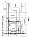
- FIG. 1illustrates a network system for providing a communication channel between various different computing devices
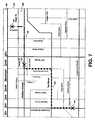
- FIG. 2illustrates an aspect of the present invention showing a real-time communications program with an integrated mapping environment that graphically displays various location-relevant objects on a map;
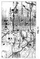
- FIG. 3illustrates another aspect of the present invention for graphically displaying a road network of streets in a map display
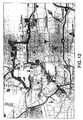
- FIG. 4illustrates another aspect of the present invention for dynamically plotting various location update points on a map display that originated from a mobile device
- FIG. 4Aillustrates another aspect of the present invention for using a snap-to algorithm for determining the line segment of the map data that is nearest to location updates from a mobile device;
- FIG. 4Bis a pictorial example of how location update information can arrive both asynchronously and synchronously from a mobile device
- FIG. 5illustrates another aspect of the present invention for graphically displaying various possible routes between two points in space that are correlated against map data
- FIG. 6illustrates another aspect of the present invention for providing the most accurate estimated route between two location update points in real-time using various route preferences
- FIG. 7illustrates another aspect of the present invention for providing an additional estimated route between two location update points in real-time
- FIG. 8illustrates another aspect of the present invention for graphically displaying the start of a predictive route calculation
- FIG. 9illustrates yet another aspect of the present invention for graphically displaying all of the possible predictive route calculations at a fork or juncture of the map data
- FIG. 10illustrates yet another aspect of the present invention for graphically displaying all of the possible predictive route calculations between an origin point and a destination point along a route resulting from a set of route preferences
- FIG. 11illustrates yet another aspect of the present invention for graphically displaying a prior art location history trail of location points on a map display
- FIG. 12illustrates yet another aspect of the present invention for graphically displaying the estimated route based on a set of location history points
- FIG. 13illustrates yet another aspect of the present invention for graphically displaying a real-time location update point in addition to the previous estimated route calculation
- FIG. 14illustrates yet another aspect of the present invention for graphically displaying a real-time route calculation based on tracking the mobile device that is periodically sending its location updates;
- FIG. 15illustrates yet another aspect of the present invention for graphically displaying the entire location history trail in addition to the real-time tracked location updates
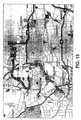
- FIG. 16illustrates yet another aspect of the present invention for graphically displaying an entire estimated route specifically illustrating the updated real-time estimated route calculations for the most recent location update points;
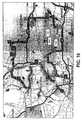
- FIG. 17illustrates still another aspect of the present invention for graphically displaying the entire estimated route based on a set of location history points
- FIG. 18illustrates still another aspect of the present invention for graphically changing a location update point to a Route Origin point
- FIG. 19illustrates still another aspect of the present invention for graphically changing a location update point to a Route Destination point
- FIG. 20illustrates still another aspect of the present invention for graphically changing a location update point to a Route Stop point
- FIG. 21illustrates still another aspect of the present invention for graphically changing a location update point to a Route Via point
- FIG. 22illustrates still another aspect of the present invention for graphically saving an estimated route to a route planner and illustrating the capability to clear the current estimated route and location points;
- FIG. 23illustrates still another aspect of the present invention for graphically displaying the location update points added to a route planner window for modifying and/or saving the estimated route;
- FIG. 24illustrates still another aspect of the present invention for graphically saving a calculated route after it has been added to the route planner window.
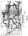
- FIG. 25illustrates still another aspect of the present invention for graphically displaying the estimated route calculations from various mobile devices to a centralized stationary position or other mobile device.
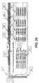
- FIG. 26illustrates still another aspect of the present invention for graphically displaying the sorting order of the previous figure's estimated route calculation.
- FIGS. 1-26The various embodiments of the present invention will now be described with references to FIGS. 1-26 .
- the present inventionprovides a method and system for creating, storing, and displaying dynamic route prediction and estimation using discrete sampled location update information.
- the dynamic route prediction and estimationcan be further augmented using additional information pertaining to the location points, such as stop or waypoint information. Additional route information can be obtained from this method and system including various route metrics, such as total elapsed distance, etc.
- the present inventionmay be embodied within or along with a mapping and real-time communication application.
- FIG. 1illustrates a high-level diagram of an environment in which the invention may be implemented.
- the embodiment of the present inventionwill be described in the general context of an application that executes on an operating system in conjunction with a personal computer or server, but those skilled in the art will realize that this invention may also be implemented in combination with other program modules.
- this inventionis not limited to a typical personal computer, but may also be utilized with other computing systems, such as handheld devices, mobile laptop computers, wireless phones, in-vehicle navigation systems, programmable consumer electronics, mainframe computers, distributed computer systems, etc., and the like.
- FIG. 1illustrates a network server and client system for sending and receiving packets of data information, such as location updates, and includes a typical mobile positioning device, such as a wireless device, but those skilled in the art will appreciate that this may also include an optical or wired mobile device.
- the mobile device 100includes or is attached via a connection interface 101 , to a positioning device 102 , such as a GPS receiver.
- the position devicecan receive position-aiding information by mean of a wireless connection, either a separate wireless connection 105 or by means of the primary wireless connection 103 that the wireless device uses to send data wirelessly to the wireless base station 104 .
- the wireless base station 104provides the interface, typically a connection 110 to the Internet, Intranet, or Extranet 111 , but those skilled in the art will appreciate that the connection may include a wireless communication network, such as a telephone network. Additionally, other mobile computing devices 107 can also be supported by the wireless base station 104 through various types of connections 106 , such as a TDMA, CDMA, or the like, connection. In one embodiment, there are preferably five primary architectures of routing location updates, amongst other location-relevant information, to the local or to other computing devices, which may be either a stationary 108 or mobile computing device 107 , or a server system 125 , or the like.
- a server systempreferably includes a XML router 115 for routing the location update packets, a position device server gateway 113 that connects to various mobile devices, a database 124 for storing the location information, a web page server client 118 for calculating on the server the estimated route information, and a web server 121 for delivering the location information or estimated route information to the end client.
- the various primary architectures for routing location updatespreferably include:
- the first architecturedoes not route its location updates, but only displays them on the mobile computing device's 100 local display.
- the second routing architectureis a peer-to-peer (P2P) model.
- a P2P architectureincludes a mobile wireless device 100 that obtains its position updates through various interfaces 101 or positioning devices 102 , all which are known to those skilled in the art.
- the location updateis routed from the mobile wireless device 100 , through the wireless connection 103 to the wireless base station 104 .
- the wireless base station 104then routes, typically using an IP (i.e., TCP or UDP) protocol, to the appropriate other device, which is either a mobile device 107 connected 106 using the same or different wireless base station 104 , or is a stationary computing device 108 , which is typically connected 109 to the Internet, or the like.
- the remote peercan also be a server system 125 that would receive, calculate, and display the route information (i.e., estimated route information, predictive route information, total distance traveled, etc.).
- a third route architectureis a peer-to-server (P2S), then a server-to-peer (S2P) model.
- a P2S architectureis similar to the P2P architecture, except that the end device is a server.
- the wireless mobile device 100obtains its location information from a positioning device 102 .
- the discrete location update informationis then transmitted 103 to the wireless base station 104 that is connected 110 to the Internet 111 .
- the server system's 125 positioning device gateway 113is also connected 112 to the Internet 111 , and is capable of receiving location update packets from the mobile wireless device sending said packets.
- the mobile wireless device 100is capable of transmitting its discrete location update information to the server system (i.e., P2S).
- the same, or another client, such as a stationary computing device 108is also connected 109 to the Internet 111 .
- the stationary computing device 108has a connection to the server system 125 preferably by means of the XML Router 115 , that is also connected to the Internet 111 . If the discrete location packets are sent by the mobile wireless device 100 , they arrive at the server system's 125 positioning device gateway, and are then preferably routed 114 to the XML Router 115 which then forwards the location packets to the stationary computing device 108 via the Internet 111 and the XML Router's Internet connection 120 .
- the discrete location packetsare then sent to the stationary computing device 108 preferably by means of a dedicated Internet connection 109 , which is the S2P part of the third routing architecture.
- the peer device in the S2P portion of the modelcould be a different mobile device 107 , or even the same mobile device 100 that is transmitting the location updates.
- the location informationcould also be obtained by means of a server connected to the mobile wireless device 100 at its location, thus sending the location update information directly to the Internet 111 , or the like, and to the server system 125 .
- This scenarioalso applies for all of the other architectures of routing location update information.
- the position information obtained for calculating the discrete location informationcan vary across networks that use various technology implementations, such as E-OTD, TOA, AOA, gpsOne from Qualcomm, SnapTrack Servers, Assisted-GPS, etc., which are known to those skilled in the art.
- a fourth architectureincludes a mobile device (i.e., where the mobile device does not need to be a wireless device, such as a non-wireless Personal Digital Assistant (PDA)) that captures the location information from a positioning device and stores it locally, such as in its hard disk drive, optical drive, local memory (i.e., Flash, SDRAM, etc.), floppy disk drive, etc.
- the mobile devicecan then transfer its stored discrete location information to another computing device, either stationary or mobile, using various methods. These transfer methods include, but are not limited to, the use of an infrared connection, floppy disk, Bluetooth connection, removable hard drive, or the like.
- This architectureis denoted as a peer-to-peer local (i.e., storage device) transfer, followed by a peer-to-peer transfer (P2L-P2P).
- a fifth architectureincludes a mobile device that captures location history and stores it locally as previously mentioned. At a later point in time, the location history information is transferred to the online server system 125 through the previously mentioned methods, or the like. Once the data is stored on the server, the S2P model can be used to retrieve the store information. Location history information can be stored completely on the server and, by request, be transferred to an end peer client, such as a stationary computing device 108 or a mobile computing device 107 using either a wireless 106 or dedicated landline connection, such as an Ethernet cable.
- an end peer clientsuch as a stationary computing device 108 or a mobile computing device 107 using either a wireless 106 or dedicated landline connection, such as an Ethernet cable.
- the end clientscan directly interact with each other through the provided system, or directly with the server systems 125 .
- a personal computer 108can request to view estimated route information through a web server application 118 that interfaces to the server system's 125 database 124 .
- the web server application 118can display the estimated route information to the stationary computing device 108 using its interface 123 to the web server 121 , the web server's connection 122 to the Internet 111 , and a dedicated connection 109 from the Internet 111 to the stationary computing device 108 .
- the estimated route informationin this embodiment, is calculated on the server system 125 in the web server application 118 and displayed to the end client 108 using the web server 121 .
- the discrete location history informationis transferred from the server system 125 to the end client 108 by the primary means of the Internet 111 and the direct connections that interface 120 , 122 to the Internet with the end client 108 and XML Router 115 .
- the XML Router 115routes the location history information to the end client 108 from its storage place in the database 124 contained in the online server system 125 .
- the estimated route informationis then preferably calculated and displayed on the end client 108 .
- the online server system 125is displayed as a centralized server system, but can also embody a distributed server system, which is well known to those skilled in the art.
- FIG. 2illustrates an application screen display of the Real-Time Communication and Mapping Program (RTCMP) 201 with a map display of several geographical objects in a map window 202 below a menu bar 200 .
- the map display 202contains a route estimate 207 starting with an initial point 204 (i.e., origin), an intermediate point 205 (i.e., via or stop), and an end point 206 (i.e., destination).
- a typical graphical users interface (GUI) programi.e., RTCMP
- a route 207preferably includes an origin 204 and one or more destination points 205 & 206 , which can each be considered a “link”.
- the routeis illustrated as a series of links, such as link between the origin point 204 and the first destination point 205 . It should be noted and appreciated to those skilled in the art that a link is not typically a straight line as illustrated in the sample map, but rather follows the topography of the roadways calculated between two route points, such as an origin 204 and destination 205 point. However, for simplicity, all links are illustrated as straight lines.
- FIG. 3illustrates a map display 202 that shows a network of streets, such as Colorado Boulevard 300 , Lawrence Road 302 , Madison Avenue 303 , and Tea Street 301 , amongst other surface streets.
- FIG. 4illustrates a series of location updates, such as Point T 1 400 (Colorado Blvd.), Point T 2 401 (Madison Ave.), and Point T 3 402 (NIM Rd.). These location updates illustrate the course of a mobile vehicle's path versus time, as illustrated in FIG. 4B . Note in FIG. 4B that the location updates can arrive asynchronously and independently of each other relative to the other location updates (i.e., they are mutually exclusive). For instance, Point T 1 423 arrives at an initial time, while Point T 2 424 arrives at a significantly later time compared to the time difference between Points T 2 424 and T 3 425 .
- location update pointssuch as Point T 1 400 of FIG. 4
- a positional error radiusis due to the original calculation of the position coordinates on the device or by using the device's characteristics (e.g., Time-of-Arrival (TOA) Location Estimation), and is typically due to the datum used, GPS satellite orbit error, multipath, or the like.
- TOATime-of-Arrival
- map dataalso has its own inherent positional error typically associated with every element, such as a highway or surface street.
- the goal for calculating the estimated routeis to correlate the location update position of the mobile device with the most likely position on the map data. Once a point in the map data has been chosen, or Snapped-To, estimated and/or predicted routes can be calculated with greater efficiency and accuracy.
- FIG. 4Aillustrates several location updates 404 , 403 , 406 , & 405 each with its own positional accuracy superimposed on the map data's positional accuracy of roads, such as 9 th Street 421 , 10 th Street 420 , and Bear Road 419 & 422 .
- map dataas the current datum, it is necessary to “snap” the location update information to the most likely road position on the map data that a location update point actually represents. This is a moot point if, for example, the location update information is accompanied with other location-relevant information, such as an address.
- the point on the streetcan be GEO-Coded, which allows the address information to be compared against an additional file, typically contained in the map data, where the file provides the latitude and longitude position of the device in the map data, such as on 9 th Street 416 .
- GEO-Codingis a term widely known to people skilled in the art.
- location update informationi.e., latitude, longitude, altitude, etc.
- location update informationi.e., latitude, longitude, altitude, etc.
- Point- 1 404appears to be either on 9 th Street 416 or Bear Road 422 .
- the preferred method used to calculate the most probable map data point for Point- 1 404would be the point on a road nearest to the location update point, as described by the following method: 1) Extend an error radius 408 that creates a circle 412 from the center of the location update 404 ; and 2) as the circle radius 408 is increased, determine the road segment from the map data that first intersects the newly created circle 412 .
- FIG. 4Athat point is illustrated 416 on 9 th Street 421 . As people skilled in the art will appreciate, this point 416 also has a street address, but it is omitted in this example.
- This same approachis applied to all location update points shown in FIG. 4A , such as Point- 1 404 , Point- 2 403 , Point- 3 406 , and Point- 4 405 .
- Each location update pointis snapped-to the nearest road segment, such as 416 , 415 , 418 , & 417 , using the same circle test 412 , 411 , 414 , & 413 and circle radius 408 , 407 , 410 , & 409 illustrated in FIG. 4A .
- FIG. 5there are various pathways that can result from a route computation between Points T 1 400 and T 2 401 , a subset of which are illustrated in FIG. 5 .
- the possible routes from Point T 1 400 and Point T 2 illustratedinclude, but are not limited to 500 , 501 , 502 , 503 , 504 , 505 , 506 , 507 , 508 , and 509 .
- route 500travels north on Colorado Boulevard 300 and then East on Madison Avenue 303 until Point T 2 401 is reached.
- the estimated route, from Point T 1 400 to Point T 2 401is based on various general route preferences, and can be greatly improved when the route preferences are tailored to the specific mobile device, such as in the case of a truck which would only be allowed to travel on major roads, while a car can transverse major and minor road networks.
- These route preferencescan include various categories, such as Driving Speeds, Route Optimization Goal, Road Preferences, etc.
- Driving Speedsillustrates various types of average speeds the specific motor vehicle travels over various type of roads, such as Interstate Highways Average Speed, Other Highways Average Speed, Arterial Roads Average Speed, Surface Streets Average Speed, or the like.
- Route Optimization Goalrepresents either the Fastest Route or the Shortest Route
- Road Preferencesillustrates whether the motor vehicle typically avoids Highways, Arterial Roads, or Toll Roads.
- the most probable route 600 that the mobile device traveled between Point T 1 400 and Point T 2 401is illustrated in FIG. 6 .
- This routeincludes the shortest distance and fastest time route between the two points.
- the route informationincludes driving directions, such as “North on Colorado Blvd for 0.2 miles, Right onto Tea Street heading East for 0.4 miles, Left onto Independence Road heading North for 0.35 miles, Right onto Madison Avenue heading East for 120 yards, Arrive at Destination”.
- this routeis dynamically created upon the receipt of Point T 2 401 , given that Point T 1 400 has already been received and displayed on the application.
- An estimated routeis computed upon the arrival of each location update, and at least 2 location updates are needed to compute an estimated route.
- a predictive routegraphically illustrates the mobile device's location when a location update is received, and a predicted estimate of its current location, based on metrics such as speed, heading, etc., until the next location update arrives.
- FIG. 8if an origin point 800 and destination point 801 are known, and the origin update arrives at a given time, using either the road speed limit or the mobile device's typical speed (i.e., motor vehicle, bicycle, runner, etc.), a predictive route can be calculated.
- a scalar distance 807is computed and displayed as a highlighted partial route up to the point 802 .
- a scalar distance 806is computed and displayed as a highlighted partial route up to the point 803 .
- a scalar distance 805is computed and displayed as a highlighted partial route up to the point 804 . This process is continued until a fork in the road is encountered. This is further illustrated by FIG. 9 .
- the previous points 900 , 904 , 905 , 906are already drawn.
- the possible pathways the vehicle can continue moving alongare: 1). The same road (North), 2). Turn Left (West), or 3). Turn Right (East).
- the predicted routewould display all possible routes. For example, after point 906 is received from the mobile device, and 1 second later, routes to points 907 , 910 , and 915 would be calculated and displayed. At a time of 2 seconds later, routes to points 908 , 911 , and 914 would be drawn.
- routes to points 909 , 912 , and 913would be calculated and displayed.
- the other route legs that do not lead towards the new point 901i.e., 915 , 914 , 913 , and 910 , 911 , and 912 ) would be erased and the route from point 900 to 901 would be displayed.
- this same processwould be completed for all known forks in the road. For example, having the route 1003 drawn from point 1000 to 1001 and continuing at various time intervals based on the expected speed of the mobile device, all possible forks 1012 , 1010 , 1011 , 1013 , 1008 , 1009 , 1014 , 1007 , 1006 , 1005 can be drawn until the next location update is provided 1002 . Using the last known position 1001 with the expected destination 1002 to calculate the best estimated route between the 2 points can narrow down the possible routes and further mitigate excessive drawing.
- FIG. 11illustrates a typical breadcrumb history trail.
- the trailconsists of points 1101 , 1102 , 1103 , 1104 , 1105 , 1106 , 1107 , and 1108 , all in chronological order of the mobile devices path.
- the problemis that the user does not know looking at this location history information where the device actually traveled. Since the location history information is discrete in nature, it is impossible to derive the actual route traveled by the mobile device without additional information and/or providing location history information at a significantly higher frequency.
- Calculating an estimated route 1201provides the breadcrumb history trail with significantly more visual information and metric information, such as total driving distance, or the like.
- the estimated routeprovides a much closer approximation to the actual driven route that the mobile device traveled.
- the estimated route calculationcan be tailored using extensive route (e.g., driving) preferences that are specific to the mobile device.
- FIG. 13illustrates a new location update 1301 which arrives in real-time and is displayed on the map display.
- FIG. 14illustrates the new estimated route leg 1401 calculated between Point- 8 1108 and Point- 9 1301 .
- itis not necessary to compute an entire new route for the entire breadcrumb trail, but only the portion of the estimated route that needs to be calculated.
- the original estimated route 1201does not need to be recalculated, but only the new additional estimated route segment 1401 needs to be calculated.
- the present inventioncan also allow a user to pull the entire location history information from a server or the mobile device in a number of ways, such as wirelessly, over the Internet, through a floppy disk, etc.
- the entire location history trailwas pulled from a server.
- the trailincludes the previously noted points 1101 , 1102 , 1103 , 1104 , 1105 , 1106 , 1107 , 1301 , as well as the new additional points 1501 , 1502 , 1503 , 1504 , and 1505 that are added in real-time from the mobile device.
- These location history pointsare preferably numbered in their chronological order according to the time that the mobile device recorded them. As illustrated in FIG.
- an estimated route 1201is preferably displayed for the previous location history points, and the newly updated real-time estimated routes are preferably displayed as each new location update arrives, either via a server (P2S-S2P) or directly from the device (P2P).
- the new estimated routes, calculated in real-time as the location updates arrive to the application,are illustrated as 1601 , 1602 , 1603 , 1604 , and 1605 . Shown in FIG. 17 are the entire location history trail points as they were captured from the mobile device.
- Each one of these points 1701 , 1702 , 1703 , 1704 , 1705 , 1706 , 1707 , 1708 , 1709 , 1710 , 1711 , 1712 , 1713 , and 1714are considered “via” points (i.e., a pass through point).
- Another embodiment of the present inventionalso allows the capability to change the individual location update points, such as in a route planner or directly on the map display.
- a route planneror directly on the map display.
- FIG. 18using an icon pointer 1803 and selecting the desired point 1801 , it is possible to change the point 1801 to a different type of destination point, such as an origin, via, stop, or destination point (by default, all points are vias).
- a pop-up window 1802will open illustrating the various destination point types that the current location point type can be changed to.
- the desired destination typein this case a route origin, it is possible to change the route point attributes.
- the route Point- 14 1901can be selected using an icon pointer causing a pop-up window 1902 to appear.
- the selected 1904 destination pointis changed using the icon pointer 1903 to the desired type, a route destination.
- the route Point- 11 2001can also be selected using an icon pointer causing a pop-up window 2002 to appear.
- the selected 2004 destination pointis changed using the icon pointer 2003 to select the desired type, a route stop.
- the route Point- 5 2101is again selected using an icon pointer 2003 causing a pop-up window 2102 to appear.
- the selected 2103 destination pointis changed using the icon pointer 2103 to select the desired type, a route via.
- the entire estimated routecould be saved or cleared.
- selecting the entire route 2201 with the icon pointer 2203causes a pop-up window 2202 to appear where the desired action can be selected 2204 using the icon pointer 2204 .
- individual pointscan be modified, moved or deleted, and new points can be added to the route. This is possible by adding the highlighted estimated route or location history points into a route planner where all of these modifications can be implemented either in the planner or on the map display.
- the Map MessengerTM program 2309contains a menu bar 2304 , a tool bar 2305 , a map display 2305 , and a route planner window 2301 .
- the location history trail with its estimated route 2306 calculated using the aforementioned method and systemconsists of 14 route points.
- the first 2310 and last 2311 points of the estimated route 2306are changed to an origin 2302 and destination 2304 route point, respectively.
- Each of the other individual route points 2307are also added to the route planner window 2301 , and in the same order are displayed on the map display 2305 .
- the route planner window 2301illustrates all of the location points and the addresses 2303 of the location points.
- the route planner window 2301it is possible to modify the route completely by adding points, deleting points, moving points, or the like.
- the route planner window 2310gives the user complete control over the location history trail and estimated route 2306 , in the event that they want to modify it at anytime.
- the capability to save a route 2308is also illustrated in FIG. 23 . After a route is in the route planner window 2301 , all of the specific information can be saved, either locally or on the server system 125 .
- FIG. 24illustrates the window 2405 for saving a route, which includes a place to enter a file name 2403 and a mechanism for selecting the directory 2402 to save the route within and the account 2404 to save the route to.
- the icon pointer 2401is preferably used to select the save button 2406 .
- the routeis then stored either locally or on the server system 125 , which is then available for later retrieval.
- a user wishing to calculate which mobile device is closest to a particular single location, or single mobile device, when using real-time location updates from each of the mobile devicescan significantly improving the sorting calculation and decision process when compared to Line-Of-Sight (LOS) distance calculations which are currently used in the prior art.
- LOSLine-Of-Sight
- calculating the estimated route in real-time, or based on the current position information for each mobile devicewill significantly improve the decision making process in determining which mobile device is closest to the central point. For example, as illustrated in FIG.
- the location of the house 2501represents the pick-up location, as in a dispatching software application, where the person at the house wants to receive transportation to the airport from a cab.
- the requirements for this customerare that they need a vehicle with a capacity to hold 3 passengers to pick them up at the house in 15 minutes.
- the local dispatch applicationcomputes the vehicle best suited to meet the customer's needs by first performing a search for vehicles in the area that can support 3 or more passengers, and then calculating the estimated route for each of the mobile vehicles from their current location to the pick-up location.
- the estimated routepreferably uses the provided map data to calculate the route, and is based on various vehicle-specific route preferences and map data information, such as one-way streets, posted road speeds, turn restrictions, etc. As illustrated in FIG. 25 , there are specific estimated routes 2508 , 2509 , 2510 , 2511 , 2512 , & 2513 for each of the mobile vehicles' current locations 2502 , 2503 , 2504 , 2505 , 2506 , & 2507 , respectively. Each of the estimated routes is relative to the map data's road network.
- the sort order of the mobile vehiclesis further illustrated by the numbering of each vehicle's position 2502 , 2503 , 2504 , 2505 , 2506 , & 2507 , where the lower the number is (i.e., two (2) is the closet), the closer to the pick-up location 2501 the vehicle is.
- the pick-up locationis shown as the numeral one (1) in FIG. 25 .
- FIG. 26illustrates an accompanying window 2601 for the map display of FIG. 25 and shows the various metrics, such as distance 2604 , time 2605 , fuel usage 2606 , and number of passengers 2607 , that the dispatch application user can use to determine the ‘closest’ 2602 mobile vehicle relative to the pick-up location 2501 , according to the calculation of each mobile vehicle's estimated route to the customer's location 2501 .
- the sorting order of the illustrated mobile vehicles 2502 , 2503 , 2504 , 2505 , 2506 , & 2507is based on, in this embodiment, the time 2605 and distance 2604 required to arrive at the customer's address 2603 location 2501 . Each vehicle is sorted based on 1).
- the mobile vehicle that is ‘closest’ 2602 to the pick-up location 2051is illustrated as “Vehicle 1257 —Bill's Taxi—Car” 2613 , along side other information such as the driver's name and the type of taxi (i.e., a car).
- the sorting orderindicates that this vehicle 2613 is the closest vehicle to the pick-up location 2501 , since it is numbered as two (2) 2614 (i.e., the closest number to the address location, numbered (1) 2616 ) on the current sort display 2601 .
- the “Estimated Route Order” display 2601also illustrates various driving metrics to the pick-up location, such as distance (i.e., 3 miles 2609 ), time 2605 (i.e., 5 minutes 2610 ), fuel usage 2610 (i.e., 0.5 gallons 2611 ), and information about its vehicle, such as the number of passengers 2607 (i.e., 4 passengers 2612 ).
- the fuel usage field 2606is preferably calculated based on the specific vehicle's fuel compensation and the total travel distance and time.
Landscapes
- Engineering & Computer Science (AREA)
- Radar, Positioning & Navigation (AREA)
- Remote Sensing (AREA)
- Physics & Mathematics (AREA)
- General Physics & Mathematics (AREA)
- Automation & Control Theory (AREA)
- Health & Medical Sciences (AREA)
- General Health & Medical Sciences (AREA)
- Business, Economics & Management (AREA)
- Social Psychology (AREA)
- Tourism & Hospitality (AREA)
- Strategic Management (AREA)
- Human Resources & Organizations (AREA)
- Marketing (AREA)
- Primary Health Care (AREA)
- Economics (AREA)
- General Business, Economics & Management (AREA)
- Theoretical Computer Science (AREA)
- Computer Networks & Wireless Communication (AREA)
- Navigation (AREA)
- Operations Research (AREA)
- Traffic Control Systems (AREA)
Abstract
Description
- 1. Local Display, No Routing of Location Updates.
- 2. Peer-to-Peer
- 3. Peer-to-Server, then Server-to-Peer
- 4. Peer-to-Local Storage Device, then Local Storage Device (i.e., Peer)-to-Peer
- 5. Peer-to-Local Storage Device, then Local Storage Device (i.e., Peer)-to-Server, then to Peer
Claims (24)
Priority Applications (16)
| Application Number | Priority Date | Filing Date | Title |
|---|---|---|---|
| US12/484,091US7881730B2 (en) | 2002-04-10 | 2009-06-12 | Method and system for dynamic estimation and predictive route generation |
| US12/929,458US8095152B2 (en) | 2002-04-10 | 2011-01-26 | Method and system for dynamic estimation and predictive route generation |
| US13/346,265US8577390B2 (en) | 2002-04-10 | 2012-01-09 | Method and system for dynamic estimation and predictive route generation |
| US14/067,415US9354069B2 (en) | 2002-04-10 | 2013-10-30 | Method and system for dynamic estimation and predictive route generation |
| US14/997,521US9607346B2 (en) | 2002-04-10 | 2016-01-16 | Method and system for dynamic estimation and predictive route generation |
| US14/997,518US20160196629A1 (en) | 2002-04-10 | 2016-01-16 | Method and System for Dynamic Estimation and Predictive Route Generation |
| US15/435,283US9746341B2 (en) | 2002-04-10 | 2017-02-16 | Method and system for dynamic estimation and predictive route generation |
| US15/657,141US9921077B2 (en) | 2002-04-10 | 2017-07-22 | Method and system for dynamic estimation and predictive route generation |
| US15/887,989US10274337B2 (en) | 2002-04-10 | 2018-02-03 | Method and system for dynamic estimation and predictive route generation |
| US16/377,228US10502583B2 (en) | 2002-04-10 | 2019-04-07 | Method and system for dynamic estimation and predictive route generation |
| US16/517,566US10551208B2 (en) | 2002-04-10 | 2019-07-20 | Method and system for dynamic estimation and predictive route generation |
| US16/747,460US10677608B2 (en) | 2002-04-10 | 2020-01-20 | Method and system for dynamic estimation and predictive route generation |
| US16/862,168US10996071B2 (en) | 2002-04-10 | 2020-04-29 | Method and system for dynamic estimation and predictive route generation |
| US17/246,628US11346684B2 (en) | 2002-04-10 | 2021-05-01 | Method and system for dynamic estimation and predictive route generation |
| US17/322,839US11473925B2 (en) | 2002-04-10 | 2021-05-17 | Method and system for dynamic estimation and predictive route generation |
| US17/739,142US11619513B2 (en) | 2002-04-10 | 2022-05-08 | Method and system for dynamic estimation and predictive route generation |
Applications Claiming Priority (3)
| Application Number | Priority Date | Filing Date | Title |
|---|---|---|---|
| US37194102P | 2002-04-10 | 2002-04-10 | |
| US10/410,740US7565155B2 (en) | 2002-04-10 | 2003-04-10 | Method and system for dynamic estimation and predictive route generation |
| US12/484,091US7881730B2 (en) | 2002-04-10 | 2009-06-12 | Method and system for dynamic estimation and predictive route generation |
Related Parent Applications (1)
| Application Number | Title | Priority Date | Filing Date |
|---|---|---|---|
| US10/410,740DivisionUS7565155B2 (en) | 2002-04-10 | 2003-04-10 | Method and system for dynamic estimation and predictive route generation |
Related Child Applications (1)
| Application Number | Title | Priority Date | Filing Date |
|---|---|---|---|
| US12/929,458ContinuationUS8095152B2 (en) | 2002-04-10 | 2011-01-26 | Method and system for dynamic estimation and predictive route generation |
Publications (2)
| Publication Number | Publication Date |
|---|---|
| US20090287407A1 US20090287407A1 (en) | 2009-11-19 |
| US7881730B2true US7881730B2 (en) | 2011-02-01 |
Family
ID=34395939
Family Applications (17)
| Application Number | Title | Priority Date | Filing Date |
|---|---|---|---|
| US10/410,740Expired - Fee RelatedUS7565155B2 (en) | 2002-04-10 | 2003-04-10 | Method and system for dynamic estimation and predictive route generation |
| US12/484,091Expired - LifetimeUS7881730B2 (en) | 2002-04-10 | 2009-06-12 | Method and system for dynamic estimation and predictive route generation |
| US12/929,458Expired - Fee RelatedUS8095152B2 (en) | 2002-04-10 | 2011-01-26 | Method and system for dynamic estimation and predictive route generation |
| US13/346,265Expired - LifetimeUS8577390B2 (en) | 2002-04-10 | 2012-01-09 | Method and system for dynamic estimation and predictive route generation |
| US14/067,415Expired - LifetimeUS9354069B2 (en) | 2002-04-10 | 2013-10-30 | Method and system for dynamic estimation and predictive route generation |
| US14/997,521Expired - Fee RelatedUS9607346B2 (en) | 2002-04-10 | 2016-01-16 | Method and system for dynamic estimation and predictive route generation |
| US14/997,518AbandonedUS20160196629A1 (en) | 2002-04-10 | 2016-01-16 | Method and System for Dynamic Estimation and Predictive Route Generation |
| US15/435,283Expired - Fee RelatedUS9746341B2 (en) | 2002-04-10 | 2017-02-16 | Method and system for dynamic estimation and predictive route generation |
| US15/657,141Expired - LifetimeUS9921077B2 (en) | 2002-04-10 | 2017-07-22 | Method and system for dynamic estimation and predictive route generation |
| US15/887,989Expired - Fee RelatedUS10274337B2 (en) | 2002-04-10 | 2018-02-03 | Method and system for dynamic estimation and predictive route generation |
| US16/377,228Expired - Fee RelatedUS10502583B2 (en) | 2002-04-10 | 2019-04-07 | Method and system for dynamic estimation and predictive route generation |
| US16/517,566Expired - Fee RelatedUS10551208B2 (en) | 2002-04-10 | 2019-07-20 | Method and system for dynamic estimation and predictive route generation |
| US16/747,460Expired - Fee RelatedUS10677608B2 (en) | 2002-04-10 | 2020-01-20 | Method and system for dynamic estimation and predictive route generation |
| US16/862,168Expired - Fee RelatedUS10996071B2 (en) | 2002-04-10 | 2020-04-29 | Method and system for dynamic estimation and predictive route generation |
| US17/246,628Expired - LifetimeUS11346684B2 (en) | 2002-04-10 | 2021-05-01 | Method and system for dynamic estimation and predictive route generation |
| US17/322,839Expired - LifetimeUS11473925B2 (en) | 2002-04-10 | 2021-05-17 | Method and system for dynamic estimation and predictive route generation |
| US17/739,142Expired - LifetimeUS11619513B2 (en) | 2002-04-10 | 2022-05-08 | Method and system for dynamic estimation and predictive route generation |
Family Applications Before (1)
| Application Number | Title | Priority Date | Filing Date |
|---|---|---|---|
| US10/410,740Expired - Fee RelatedUS7565155B2 (en) | 2002-04-10 | 2003-04-10 | Method and system for dynamic estimation and predictive route generation |
Family Applications After (15)
| Application Number | Title | Priority Date | Filing Date |
|---|---|---|---|
| US12/929,458Expired - Fee RelatedUS8095152B2 (en) | 2002-04-10 | 2011-01-26 | Method and system for dynamic estimation and predictive route generation |
| US13/346,265Expired - LifetimeUS8577390B2 (en) | 2002-04-10 | 2012-01-09 | Method and system for dynamic estimation and predictive route generation |
| US14/067,415Expired - LifetimeUS9354069B2 (en) | 2002-04-10 | 2013-10-30 | Method and system for dynamic estimation and predictive route generation |
| US14/997,521Expired - Fee RelatedUS9607346B2 (en) | 2002-04-10 | 2016-01-16 | Method and system for dynamic estimation and predictive route generation |
| US14/997,518AbandonedUS20160196629A1 (en) | 2002-04-10 | 2016-01-16 | Method and System for Dynamic Estimation and Predictive Route Generation |
| US15/435,283Expired - Fee RelatedUS9746341B2 (en) | 2002-04-10 | 2017-02-16 | Method and system for dynamic estimation and predictive route generation |
| US15/657,141Expired - LifetimeUS9921077B2 (en) | 2002-04-10 | 2017-07-22 | Method and system for dynamic estimation and predictive route generation |
| US15/887,989Expired - Fee RelatedUS10274337B2 (en) | 2002-04-10 | 2018-02-03 | Method and system for dynamic estimation and predictive route generation |
| US16/377,228Expired - Fee RelatedUS10502583B2 (en) | 2002-04-10 | 2019-04-07 | Method and system for dynamic estimation and predictive route generation |
| US16/517,566Expired - Fee RelatedUS10551208B2 (en) | 2002-04-10 | 2019-07-20 | Method and system for dynamic estimation and predictive route generation |
| US16/747,460Expired - Fee RelatedUS10677608B2 (en) | 2002-04-10 | 2020-01-20 | Method and system for dynamic estimation and predictive route generation |
| US16/862,168Expired - Fee RelatedUS10996071B2 (en) | 2002-04-10 | 2020-04-29 | Method and system for dynamic estimation and predictive route generation |
| US17/246,628Expired - LifetimeUS11346684B2 (en) | 2002-04-10 | 2021-05-01 | Method and system for dynamic estimation and predictive route generation |
| US17/322,839Expired - LifetimeUS11473925B2 (en) | 2002-04-10 | 2021-05-17 | Method and system for dynamic estimation and predictive route generation |
| US17/739,142Expired - LifetimeUS11619513B2 (en) | 2002-04-10 | 2022-05-08 | Method and system for dynamic estimation and predictive route generation |
Country Status (1)
| Country | Link |
|---|---|
| US (17) | US7565155B2 (en) |
Cited By (36)
| Publication number | Priority date | Publication date | Assignee | Title |
|---|---|---|---|---|
| US20050032527A1 (en)* | 2003-08-08 | 2005-02-10 | Networks In Motion, Inc. | Method and system for collecting synchronizing, and reporting telecommunication call events and work flow related information |
| US20070277100A1 (en)* | 2005-12-07 | 2007-11-29 | Networks In Motion, Inc. | Method and system for a user input solution for a limited telecommunication device |
| US20080170679A1 (en)* | 2001-07-17 | 2008-07-17 | Networks In Motion, Inc. | System and method for providing routing, mapping, and relative position information to users of a communication network |
| US20100042320A1 (en)* | 2004-11-26 | 2010-02-18 | Microsoft Corporation | Location aware mobile-device software development |
| US20100138246A1 (en)* | 2008-09-22 | 2010-06-03 | John Michael Carey | Event management system |
| US20110066369A1 (en)* | 2009-09-14 | 2011-03-17 | Research In Motion Limited | Methods, device and systems for determining route metrics using stored route information |
| US20110125396A1 (en)* | 2004-10-01 | 2011-05-26 | Sheha Michael A | Method and system for enabling an off board navigation solution |
| US20110122797A1 (en)* | 2002-04-10 | 2011-05-26 | Sheha Michael A | Method and system for dynamic estimation and predictive route generation |
| US20110130960A1 (en)* | 2003-02-14 | 2011-06-02 | Sheha Michael A | Method and system for saving and retrieving spatial related information |
| US20110167371A1 (en)* | 2002-03-01 | 2011-07-07 | Sheha Michael A | Method and apparatus for sending, retrieving, and planning location relevant information |
| US8019532B2 (en) | 2005-03-07 | 2011-09-13 | Telecommunication Systems, Inc. | Method and system for identifying and defining geofences |
| US8090796B2 (en) | 2001-09-05 | 2012-01-03 | Telecommunication Systems, Inc. | Position identification method and system |
| US20120009890A1 (en)* | 2010-07-09 | 2012-01-12 | Nokia Corporation | Method and apparatus for providing a geo-predictive streaming service |
| US8099238B2 (en) | 2007-11-14 | 2012-01-17 | Telecommunication Systems, Inc. | Stateful, double-buffered dynamic navigation voice prompting |
| US20130179070A1 (en)* | 2012-01-09 | 2013-07-11 | Ford Global Technologies, Llc | Adaptive method for trip prediction |
| US8666397B2 (en) | 2002-12-13 | 2014-03-04 | Telecommunication Systems, Inc. | Area event handling when current network does not cover target area |
| US20140074391A1 (en)* | 2012-09-11 | 2014-03-13 | GM Global Technology Operations LLC | Vehicle range projection |
| US8682321B2 (en) | 2011-02-25 | 2014-03-25 | Telecommunication Systems, Inc. | Mobile internet protocol (IP) location |
| US8831556B2 (en) | 2011-09-30 | 2014-09-09 | Telecommunication Systems, Inc. | Unique global identifier header for minimizing prank emergency 911 calls |
| US8885796B2 (en) | 2006-05-04 | 2014-11-11 | Telecommunications Systems, Inc. | Extended efficient usage of emergency services keys |
| US8930139B2 (en) | 2012-06-21 | 2015-01-06 | Telecommunication Systems, Inc. | Dynamically varied map labeling |
| US8983047B2 (en) | 2013-03-20 | 2015-03-17 | Telecommunication Systems, Inc. | Index of suspicion determination for communications request |
| US9088614B2 (en) | 2003-12-19 | 2015-07-21 | Telecommunications Systems, Inc. | User plane location services over session initiation protocol (SIP) |
| US9217644B2 (en) | 2012-01-26 | 2015-12-22 | Telecommunication Systems, Inc. | Natural navigational guidance |
| US9220958B2 (en) | 2002-03-28 | 2015-12-29 | Telecommunications Systems, Inc. | Consequential location derived information |
| US9307372B2 (en) | 2012-03-26 | 2016-04-05 | Telecommunication Systems, Inc. | No responders online |
| US9313638B2 (en) | 2012-08-15 | 2016-04-12 | Telecommunication Systems, Inc. | Device independent caller data access for emergency calls |
| US9400591B2 (en) | 2010-05-21 | 2016-07-26 | Telecommunication Systems, Inc. | Personal wireless navigation system |
| US9408034B2 (en) | 2013-09-09 | 2016-08-02 | Telecommunication Systems, Inc. | Extended area event for network based proximity discovery |
| US9456301B2 (en) | 2012-12-11 | 2016-09-27 | Telecommunication Systems, Inc. | Efficient prisoner tracking |
| US9479897B2 (en) | 2013-10-03 | 2016-10-25 | Telecommunication Systems, Inc. | SUPL-WiFi access point controller location based services for WiFi enabled mobile devices |
| US9516104B2 (en) | 2013-09-11 | 2016-12-06 | Telecommunication Systems, Inc. | Intelligent load balancer enhanced routing |
| US9544260B2 (en) | 2012-03-26 | 2017-01-10 | Telecommunication Systems, Inc. | Rapid assignment dynamic ownership queue |
| US9599717B2 (en) | 2002-03-28 | 2017-03-21 | Telecommunication Systems, Inc. | Wireless telecommunications location based services scheme selection |
| US10002109B2 (en)* | 2016-06-24 | 2018-06-19 | Freeport-Mcmoran Inc. | Systems and methods of correlating satellite position data with terrestrial features |
| US20230135051A1 (en)* | 2019-11-14 | 2023-05-04 | Si Wan Lee | Pedestrian road data construction method using mobile device, and system therefor |
Families Citing this family (244)
| Publication number | Priority date | Publication date | Assignee | Title |
|---|---|---|---|---|
| JP5228366B2 (en)* | 2007-04-25 | 2013-07-03 | 株式会社デンソー | Driving information collection system and driving information learning method |
| DE10149943A1 (en)* | 2001-10-10 | 2003-04-24 | Vodafone Ag | Method and system for determining the travel time of a mobile user terminal |
| CN1206872C (en)* | 2002-03-15 | 2005-06-15 | 国际商业机器公司 | System and method for managing position of mobile station mobile station and mobile network |
| US7313375B2 (en)* | 2002-05-02 | 2007-12-25 | Lucent Technologies Inc. | Follow-me broadcast reception method and system |
| AU2003253765A1 (en) | 2002-06-27 | 2004-01-19 | Small World Productions, Inc. | System and method for locating and notifying a user of a person, place or thing having attributes matching the user's stated prefernces |
| US8427303B1 (en) | 2002-06-27 | 2013-04-23 | Geomass Limited Liability Company | System and method for providing media content having attributes matching a user's stated preference |
| JP2004096621A (en)* | 2002-09-03 | 2004-03-25 | Fujitsu Ltd | Information distribution service system based on position change prediction of mobile information terminal |
| US7130646B2 (en)* | 2003-02-14 | 2006-10-31 | Atheros Communications, Inc. | Positioning with wireless local area networks and WLAN-aided global positioning systems |
| JPWO2004079298A1 (en)* | 2003-03-07 | 2006-06-15 | 株式会社ナビタイムジャパン | Pedestrian navigation device, pedestrian navigation method and program |
| DE10316477A1 (en)* | 2003-04-09 | 2004-10-28 | Daimlerchrysler Ag | User interface and communication system for a motor vehicle and associated operating methods |
| US8483717B2 (en) | 2003-06-27 | 2013-07-09 | Qualcomm Incorporated | Local area network assisted positioning |
| JP4493953B2 (en)* | 2003-08-22 | 2010-06-30 | 富士通テン株式会社 | Moving body position providing apparatus and moving body position providing system |
| US7715934B2 (en) | 2003-09-19 | 2010-05-11 | Macrovision Corporation | Identification of input files using reference files associated with nodes of a sparse binary tree |
| US7149504B1 (en)* | 2003-09-25 | 2006-12-12 | Sprint Spectrum L.P. | Method and system for managing location polling intervals |
| JP4127180B2 (en)* | 2003-10-10 | 2008-07-30 | 日本電気株式会社 | Mobile communication system, management server, and mobile communication method |
| US20050108378A1 (en)* | 2003-10-25 | 2005-05-19 | Macrovision Corporation | Instrumentation system and methods for estimation of decentralized network characteristics |
| US8060112B2 (en)* | 2003-11-20 | 2011-11-15 | Intellient Spatial Technologies, Inc. | Mobile device and geographic information system background and summary of the related art |
| US7245923B2 (en)* | 2003-11-20 | 2007-07-17 | Intelligent Spatial Technologies | Mobile device and geographic information system background and summary of the related art |
| US7877810B2 (en)* | 2004-03-02 | 2011-01-25 | Rovi Solutions Corporation | System, method and client user interface for a copy protection service |
| US20050234979A1 (en)* | 2004-04-16 | 2005-10-20 | Alcatel | Map navigation with breadcrumb buttons |
| KR100846781B1 (en)* | 2004-06-01 | 2008-10-27 | 삼성전자주식회사 | Service display control method of DA receiver using high speed information channel (FIC) and apparatus therefor |
| JP2006033403A (en)* | 2004-07-15 | 2006-02-02 | Honda Motor Co Ltd | Mobile body, information center and mobile communication system |
| US8091130B1 (en)* | 2004-08-12 | 2012-01-03 | Verizon Corporate Services Group Inc. | Geographical intrusion response prioritization mapping system |
| US8082506B1 (en)* | 2004-08-12 | 2011-12-20 | Verizon Corporate Services Group Inc. | Geographical vulnerability mitigation response mapping system |
| US8572734B2 (en) | 2004-08-12 | 2013-10-29 | Verizon Patent And Licensing Inc. | Geographical intrusion response prioritization mapping through authentication and flight data correlation |
| WO2006023819A2 (en)* | 2004-08-19 | 2006-03-02 | United States Postal Service | Delivery operations information system with route and unit maintenance |
| US20060058953A1 (en) | 2004-09-07 | 2006-03-16 | Cooper Clive W | System and method of wireless downloads of map and geographic based data to portable computing devices |
| US10645562B2 (en) | 2004-09-21 | 2020-05-05 | Agis Software Development Llc | Method to provide ad hoc and password protected digital and voice networks |
| US7720652B2 (en)* | 2004-10-19 | 2010-05-18 | Microsoft Corporation | Modeling location histories |
| US7610560B2 (en)* | 2004-11-16 | 2009-10-27 | Microsoft Corporation | Methods for automated and semiautomated composition of visual sequences, flows, and flyovers based on content and context |
| US7908080B2 (en) | 2004-12-31 | 2011-03-15 | Google Inc. | Transportation routing |
| US8635014B2 (en)* | 2005-03-22 | 2014-01-21 | The Invention Science Fund I, Llc | Map-based guide system and method |
| US9188454B2 (en)* | 2005-03-22 | 2015-11-17 | Invention Science Fund I, Llc | Map-based guide system and method |
| US9702713B2 (en) | 2005-01-31 | 2017-07-11 | Searete Llc | Map-based guide system and method |
| US7809500B2 (en)* | 2005-02-07 | 2010-10-05 | Microsoft Corporation | Resolving discrepancies between location information and route data on a navigation device |
| US7353034B2 (en) | 2005-04-04 | 2008-04-01 | X One, Inc. | Location sharing and tracking using mobile phones or other wireless devices |
| US8045998B2 (en)* | 2005-06-08 | 2011-10-25 | Cisco Technology, Inc. | Method and system for communicating using position information |
| EP1737160B1 (en)* | 2005-06-21 | 2013-08-14 | Alcatel Lucent | Method for predicting access points along a travel route |
| US20060291396A1 (en)* | 2005-06-27 | 2006-12-28 | Monplaisir Hamilton | Optimizing driving directions |
| US8111622B2 (en)* | 2005-10-17 | 2012-02-07 | The Invention Science Fund I, Llc | Signal routing dependent on a node speed change prediction |
| US9456469B2 (en) | 2005-09-07 | 2016-09-27 | Invention Science Fund I, Llc | Heading-dependent routing method and network subsystem |
| US7809943B2 (en)* | 2005-09-27 | 2010-10-05 | Rovi Solutions Corporation | Method and system for establishing trust in a peer-to-peer network |
| US8125896B2 (en)* | 2005-10-17 | 2012-02-28 | The Invention Science Fund I, Llc | Individualizing a connectivity-indicative mapping |
| US8495239B2 (en)* | 2005-10-17 | 2013-07-23 | The Invention Science Fund I, Llc | Using a signal route dependent on a node speed change prediction |
| US20070087695A1 (en)* | 2005-10-17 | 2007-04-19 | Searete Llc, A Limited Liability Corporation Of The State Of Delaware | Mobile directional antenna |
| US20070106468A1 (en)* | 2005-11-07 | 2007-05-10 | France Telecom | Product, service and activity based interactive trip mapping system, method, and computer program product |
| US8086722B2 (en) | 2005-12-21 | 2011-12-27 | Rovi Solutions Corporation | Techniques for measuring peer-to-peer (P2P) networks |
| US20080312828A1 (en)* | 2006-02-15 | 2008-12-18 | Marsalka Joseph P | System and method for providing directions |
| US20070241901A1 (en)* | 2006-03-31 | 2007-10-18 | Honeywell International Inc. | System and method for object tracking via tag readings |
| US7743056B2 (en)* | 2006-03-31 | 2010-06-22 | Aol Inc. | Identifying a result responsive to a current location of a client device |
| US7761350B1 (en)* | 2006-04-26 | 2010-07-20 | Aol Inc. | Biasing of search result clustering to ensure more effective point of interest (POI) targeting |
| US8571580B2 (en) | 2006-06-01 | 2013-10-29 | Loopt Llc. | Displaying the location of individuals on an interactive map display on a mobile communication device |
| US8989778B2 (en) | 2006-06-01 | 2015-03-24 | Green Dot Corporation | Secure and private location sharing for location-aware mobile communication devices |
| US8538676B2 (en)* | 2006-06-30 | 2013-09-17 | IPointer, Inc. | Mobile geographic information system and method |
| US8099105B2 (en)* | 2006-09-19 | 2012-01-17 | Telecommunication Systems, Inc. | Device based trigger for location push event |
| AR064237A1 (en)* | 2006-09-27 | 2009-03-25 | Tomtom Int Bv | PORTABLE NAVIGATION DEVICE |
| KR100874109B1 (en)* | 2006-11-14 | 2008-12-15 | 팅크웨어(주) | Friend geolocation system and method |
| TW200828141A (en)* | 2006-12-19 | 2008-07-01 | Asustek Comp Inc | A map service system with updating data method |
| US9008617B2 (en)* | 2006-12-28 | 2015-04-14 | Verizon Patent And Licensing Inc. | Layered graphical event mapping |
| US7869941B2 (en) | 2006-12-29 | 2011-01-11 | Aol Inc. | Meeting notification and modification service |
| US8712810B2 (en)* | 2006-12-29 | 2014-04-29 | Facebook, Inc. | Reserving a time block in a calendar application to account for a travel time between geographic locations of appointments |
| US20080201074A1 (en)* | 2007-02-15 | 2008-08-21 | Garmin Ltd. | System and method for creating and sharing navigation routes with electronic devices |
| US20080201513A1 (en)* | 2007-02-20 | 2008-08-21 | Assaf Waisler | Method and Device to Transfer Digital Data |
| US20080208463A1 (en)* | 2007-02-22 | 2008-08-28 | Reed William E | Map interface with path locations that can be reordered |
| US7865297B2 (en)* | 2007-02-23 | 2011-01-04 | At&T Intellectual Property I, L.P. | Methods for obtaining a navigation track between a first and a second location based on location information shared between peer devices and related devices and computer program products |
| US8144920B2 (en)* | 2007-03-15 | 2012-03-27 | Microsoft Corporation | Automated location estimation using image analysis |
| US10146871B2 (en) | 2007-03-27 | 2018-12-04 | Sholem Weisner | Method and apparatus for a digital leg history |
| US20080243386A1 (en)* | 2007-03-27 | 2008-10-02 | Cisco Technology, Inc. | Method and System for Communicating Arrival Notifications |
| WO2008121122A1 (en)* | 2007-04-03 | 2008-10-09 | U-Nav Microelectronics Corporation | Gps position accuracy using feedback from a map database |
| US20080270576A1 (en)* | 2007-04-09 | 2008-10-30 | Ian Cummings | Apparatus and methods for reducing data transmission in wireless client-server navigation systems |
| US9222797B2 (en)* | 2007-04-17 | 2015-12-29 | Esther Abramovich Ettinger | Device, system and method of contact-based routing and guidance |
| US20080319652A1 (en)* | 2007-06-20 | 2008-12-25 | Radiofy Llc | Navigation system and methods for map navigation |
| US9360337B2 (en) | 2007-06-20 | 2016-06-07 | Golba Llc | Navigation system and methods for route navigation |
| US8108144B2 (en) | 2007-06-28 | 2012-01-31 | Apple Inc. | Location based tracking |
| US9066199B2 (en) | 2007-06-28 | 2015-06-23 | Apple Inc. | Location-aware mobile device |
| US9109904B2 (en)* | 2007-06-28 | 2015-08-18 | Apple Inc. | Integration of map services and user applications in a mobile device |
| US8385946B2 (en) | 2007-06-28 | 2013-02-26 | Apple Inc. | Disfavored route progressions or locations |
| US20090005964A1 (en)* | 2007-06-28 | 2009-01-01 | Apple Inc. | Intelligent Route Guidance |
| US20090005018A1 (en)* | 2007-06-28 | 2009-01-01 | Apple Inc. | Route Sharing and Location |
| US20090005982A1 (en)* | 2007-06-29 | 2009-01-01 | Hua Luo Yu | Method and system for collecting and distributing driving related information or the like |
| US8170793B2 (en)* | 2007-06-29 | 2012-05-01 | Tele Atlas North America, Inc. | System and method for determining routing point placement for aiding in encoding and decoding a path |
| WO2009019672A1 (en)* | 2007-08-09 | 2009-02-12 | Mapflow Limited | A transport management system |
| US8315792B2 (en)* | 2007-08-13 | 2012-11-20 | Speier Gary J | System and method for travel route planning using safety metrics |
| US7885764B2 (en)* | 2007-09-06 | 2011-02-08 | GM Global Technology Operations LLC | Method for adaptively constructing and revising road maps |
| US9277351B2 (en)* | 2007-09-07 | 2016-03-01 | International Business Machines Corporation | Wireless transmission duration and location-based services |
| US8862710B2 (en)* | 2007-09-11 | 2014-10-14 | Telecommunication Systems, Inc. | Dynamic configuration of mobile station location services |
| US8243646B2 (en) | 2007-09-19 | 2012-08-14 | International Business Machines Corporation | Method and system for digital communication through infrastructure network with receiving stations according to their geographical status |
| KR101405945B1 (en)* | 2007-10-15 | 2014-06-12 | 엘지전자 주식회사 | How to create movement history of communication devices and communication devices |
| KR101430452B1 (en)* | 2007-10-15 | 2014-08-14 | 엘지전자 주식회사 | Communication device and its location information providing method |
| US20090109022A1 (en)* | 2007-10-31 | 2009-04-30 | Gm Global Technology Operations, Inc. | Method and apparatus for providing in-vehicle fuel related information |
| FI20075778A0 (en)* | 2007-11-01 | 2007-11-01 | Polar Electro Oy | Method for generating graphical data and electronic device |
| US9145153B2 (en) | 2007-11-07 | 2015-09-29 | At&T Intellectual Property I, L.P. | Method, system and computer program products for real-time departure estimations for transportation systems |
| US7822426B1 (en)* | 2008-01-17 | 2010-10-26 | Where, Inc. | System and method for snapping a user location to a landmark of known location |
| US8015144B2 (en) | 2008-02-26 | 2011-09-06 | Microsoft Corporation | Learning transportation modes from raw GPS data |
| US8972177B2 (en)* | 2008-02-26 | 2015-03-03 | Microsoft Technology Licensing, Llc | System for logging life experiences using geographic cues |
| US8966121B2 (en)* | 2008-03-03 | 2015-02-24 | Microsoft Corporation | Client-side management of domain name information |
| US9826344B2 (en)* | 2008-03-28 | 2017-11-21 | At&T Mobility Ii Llc | Systems and methods for determining previous occupation in or proximate to an alert area |
| US20090254265A1 (en)* | 2008-04-08 | 2009-10-08 | Thimmannagari Chandra Reddy | Video map technology for navigation |
| US20090326815A1 (en)* | 2008-05-02 | 2009-12-31 | Apple Inc. | Position Fix Indicator |
| US9250092B2 (en)* | 2008-05-12 | 2016-02-02 | Apple Inc. | Map service with network-based query for search |
| US8494768B2 (en)* | 2008-07-31 | 2013-07-23 | Samsung Electronics Co., Ltd | Navigation system, method and database using mobile devices |
| US7982614B2 (en)* | 2008-08-18 | 2011-07-19 | Honeywell International Inc. | Method and apparatus for wireless asset tracking using asset tags with motion sensors |
| US8635219B2 (en)* | 2008-08-27 | 2014-01-21 | International Business Machines Corporation | Automated browser history sorting based upon location |
| WO2010048146A1 (en)* | 2008-10-20 | 2010-04-29 | Carnegie Mellon University | System, method and device for predicting navigational decision-making behavior |
| US8219316B2 (en)* | 2008-11-14 | 2012-07-10 | Google Inc. | System and method for storing and providing routes |
| US8886453B2 (en)* | 2008-12-11 | 2014-11-11 | Telogis, Inc. | System and method for efficient routing on a network in the presence of multiple-edge restrictions and other constraints |
| US8948738B2 (en)* | 2008-12-17 | 2015-02-03 | International Business Machines Corporation | Generating alerts based on predicted wireless connection losses |
| US8352175B2 (en)* | 2008-12-17 | 2013-01-08 | International Business Machines Corporation | Generating optimal itineraries based on network connectivity |
| EP2361424A1 (en)* | 2008-12-22 | 2011-08-31 | Intelligent Spatial Technologies, Inc. | System and method for exploring 3d scenes by pointing at a reference object |
| US8483519B2 (en) | 2008-12-22 | 2013-07-09 | Ipointer Inc. | Mobile image search and indexing system and method |
| US8675912B2 (en)* | 2008-12-22 | 2014-03-18 | IPointer, Inc. | System and method for initiating actions and providing feedback by pointing at object of interest |
| WO2010075466A1 (en) | 2008-12-22 | 2010-07-01 | Intelligent Spatial Technologies, Inc. | System and method for linking real-world objects and object representations by pointing |
| US8200425B2 (en)* | 2008-12-31 | 2012-06-12 | Sap Ag | Route prediction using network history |
| US9063226B2 (en)* | 2009-01-14 | 2015-06-23 | Microsoft Technology Licensing, Llc | Detecting spatial outliers in a location entity dataset |
| US20100241623A1 (en)* | 2009-03-23 | 2010-09-23 | Acker Robert L | User generated notes integrated with location-based application |
| CN102575940A (en)* | 2009-03-30 | 2012-07-11 | 哈曼专业股份有限公司 | Predictive Search Based on Location Apps |
| US20100262366A1 (en)* | 2009-04-10 | 2010-10-14 | General Electric Company | System and method for distance estimation |
| US10408623B2 (en)* | 2009-06-12 | 2019-09-10 | Microsoft Technology Licensing, Llc | Retracing steps |
| US8549044B2 (en)* | 2009-09-17 | 2013-10-01 | Ydreams—Informatica, S.A. Edificio Ydreams | Range-centric contextual information systems and methods |
| US9009177B2 (en) | 2009-09-25 | 2015-04-14 | Microsoft Corporation | Recommending points of interests in a region |
| US20110098922A1 (en)* | 2009-10-27 | 2011-04-28 | Visteon Global Technologies, Inc. | Path Predictive System And Method For Vehicles |
| US20110098915A1 (en)* | 2009-10-28 | 2011-04-28 | Israel Disatnik | Device, system, and method of dynamic route guidance |
| US8898008B2 (en)* | 2009-11-18 | 2014-11-25 | Telenav, Inc. | Navigation system with relative ranking mechanism and method of operation thereof |
| WO2011062581A1 (en)* | 2009-11-18 | 2011-05-26 | Telenav, Inc. | Navigation system with relative ranking mechanism and method of operation thereof |
| GB2476097A (en)* | 2009-12-11 | 2011-06-15 | Tony Jones | A portable communication device for evaluating an environment |
| US8498947B1 (en)* | 2009-12-17 | 2013-07-30 | Amazon Technologies, Inc. | Inserting stops into delivery routes |
| US8645402B1 (en)* | 2009-12-22 | 2014-02-04 | Teradata Us, Inc. | Matching trip data to transportation network data |
| JP2011138011A (en)* | 2009-12-28 | 2011-07-14 | Sony Corp | Information processing apparatus, program, information processing method, and map data |
| US20110172871A1 (en)* | 2010-01-08 | 2011-07-14 | William David Hall | System and method for measuring energy efficiency in vehicles |
| WO2011087408A1 (en)* | 2010-01-13 | 2011-07-21 | Telefonaktiebolaget L M Ericsson (Publ) | Methods and arrangements in a cellular network |
| US8655371B2 (en)* | 2010-01-15 | 2014-02-18 | Apple Inc. | Location determination using cached location area codes |
| US8433334B2 (en)* | 2010-01-15 | 2013-04-30 | Apple Inc. | Managing a location database for network-based positioning system |
| US8660576B2 (en)* | 2010-01-15 | 2014-02-25 | Apple Inc. | Adaptive location determination |
| US8634860B2 (en)* | 2010-01-15 | 2014-01-21 | Apple Inc. | Location determination using cached location area codes |
| US8200251B2 (en)* | 2010-01-15 | 2012-06-12 | Apple Inc. | Determining a location of a mobile device using a location database |
| US8504059B2 (en)* | 2010-01-15 | 2013-08-06 | Apple Inc. | Location filtering using mobile country code |
| JP5440219B2 (en)* | 2010-01-29 | 2014-03-12 | 株式会社デンソー | Map data and map data creation method |
| US9261376B2 (en)* | 2010-02-24 | 2016-02-16 | Microsoft Technology Licensing, Llc | Route computation based on route-oriented vehicle trajectories |
| US10288433B2 (en)* | 2010-02-25 | 2019-05-14 | Microsoft Technology Licensing, Llc | Map-matching for low-sampling-rate GPS trajectories |
| CN102792330A (en)* | 2010-03-16 | 2012-11-21 | 日本电气株式会社 | Degree of interest measurement system, degree of interest measurement device, degree of interest measurement method and degree of interest measurement program |
| US8620344B2 (en) | 2010-04-07 | 2013-12-31 | Apple Inc. | Location-based application program management |
| US8719198B2 (en) | 2010-05-04 | 2014-05-06 | Microsoft Corporation | Collaborative location and activity recommendations |
| US9593957B2 (en)* | 2010-06-04 | 2017-03-14 | Microsoft Technology Licensing, Llc | Searching similar trajectories by locations |
| JP2012008771A (en)* | 2010-06-24 | 2012-01-12 | Sony Corp | Information processing device, information processing system, information processing method and program |
| JP5567446B2 (en)* | 2010-10-12 | 2014-08-06 | 京セラ株式会社 | Mobile terminal device |
| US8249621B2 (en)* | 2010-10-21 | 2012-08-21 | Google Inc. | Frequency of geographic location updates for an electronic device based on user communication |
| US8504035B2 (en) | 2010-11-09 | 2013-08-06 | Ntt Docomo, Inc. | System and method for population tracking, counting, and movement estimation using mobile operational data and/or geographic information in mobile network |
| US20120130627A1 (en)* | 2010-11-23 | 2012-05-24 | Islam Mohammad R | Taxi dispatch system |
| JP5310766B2 (en)* | 2011-03-28 | 2013-10-09 | ソニー株式会社 | POSITION CORRECTION DEVICE, POSITION CORRECTION METHOD, PROGRAM, AND POSITION CORRECTION SYSTEM |
| US9055408B2 (en) | 2011-04-02 | 2015-06-09 | Open Invention Network, Llc | System and method for determining geolocation of wireless access point or wireless device |
| KR101110639B1 (en) | 2011-06-22 | 2012-06-12 | 팅크웨어(주) | Safe service system and method thereof |
| TW201303754A (en)* | 2011-07-04 | 2013-01-16 | Mitac Int Corp | Taxi-calling service management system and server and device thereof |
| US9215383B2 (en)* | 2011-08-05 | 2015-12-15 | Sportsvision, Inc. | System for enhancing video from a mobile camera |
| US9267806B2 (en)* | 2011-08-29 | 2016-02-23 | Bayerische Motoren Werke Aktiengesellschaft | System and method for automatically receiving geo-relevant information in a vehicle |
| US9754226B2 (en) | 2011-12-13 | 2017-09-05 | Microsoft Technology Licensing, Llc | Urban computing of route-oriented vehicles |
| US20130155102A1 (en)* | 2011-12-20 | 2013-06-20 | Honeywell International Inc. | Systems and methods of accuracy mapping in a location tracking system |
| US20130166188A1 (en) | 2011-12-21 | 2013-06-27 | Microsoft Corporation | Determine Spatiotemporal Causal Interactions In Data |
| US9043133B2 (en) | 2011-12-29 | 2015-05-26 | Intel Corporation | Navigation systems and associated methods |
| US9207331B2 (en)* | 2012-01-04 | 2015-12-08 | Numerex Corp. | Using statistical analysis to infer an accurate GPS location for use in tracking devices |
| US9008954B2 (en)* | 2012-04-30 | 2015-04-14 | Hewlett-Packard Development Company, L.P. | Predicting impact of a traffic incident on a road network |
| KR102041449B1 (en)* | 2012-05-11 | 2019-11-27 | 삼성전자주식회사 | Method and apparatus for obtaining location of user |
| JP5920463B2 (en)* | 2012-06-06 | 2016-05-18 | トヨタ自動車株式会社 | POSITION INFORMATION TRANSMISSION DEVICE AND POSITION INFORMATION TRANSMISSION SYSTEM |
| US20130332279A1 (en)* | 2012-06-07 | 2013-12-12 | Nokia Corporation | Method and apparatus for location-based advertisements for dynamic points of interest |
| JP5685313B2 (en)* | 2012-06-08 | 2015-03-18 | ▲華▼▲為▼終端有限公司Huawei Device Co., Ltd. | Method and apparatus for synchronizing heartbeat behavior |
| US8463299B1 (en)* | 2012-06-08 | 2013-06-11 | International Business Machines Corporation | Displaying a digital version of a paper map and a location of a mobile device on the digital version of the map |
| CN102722798A (en)* | 2012-06-21 | 2012-10-10 | 上海众恒信息产业股份有限公司 | Policing command system based on geographic information system |
| US9947004B2 (en) | 2012-06-28 | 2018-04-17 | Green Dot Corporation | Wireless client transaction systems and related methods |
| US20140019322A1 (en) | 2012-07-13 | 2014-01-16 | Green Dot Corporation | Mobile banking systems and related methods |
| US8903657B2 (en)* | 2012-07-31 | 2014-12-02 | Motorola Solutions, Inc. | Systems and methods for correlating routes of mobile devices |
| WO2014024264A1 (en)* | 2012-08-08 | 2014-02-13 | 株式会社 日立製作所 | Traffic-volume prediction device and method |
| US9958272B2 (en) | 2012-08-10 | 2018-05-01 | Telogis, Inc. | Real-time computation of vehicle service routes |
| US9338098B2 (en)* | 2012-12-13 | 2016-05-10 | Cellco Partnership | Dynamic flow management at a firewall based on error messages |
| US20140180576A1 (en)* | 2012-12-24 | 2014-06-26 | Anthony G. LaMarca | Estimation of time of arrival based upon ambient identifiable wireless signal sources encountered along a route |
| US9195938B1 (en)* | 2012-12-27 | 2015-11-24 | Google Inc. | Methods and systems for determining when to launch vehicles into a fleet of autonomous vehicles |
| EP2944923A4 (en)* | 2013-01-13 | 2016-08-24 | Lg Electronics Inc | Method for transferring route and device therefor |
| US20140278085A1 (en)* | 2013-03-15 | 2014-09-18 | International Business Machines Corporation | Determining an optimal vehicular transportation route |
| CN104142507B (en)* | 2013-05-10 | 2017-02-08 | 中国电信股份有限公司 | GpsOne indoor positioning circular error probable obtaining method and device |
| CN103471602A (en)* | 2013-05-17 | 2013-12-25 | 深圳市车友互联科技有限公司 | Vehicle-mounted navigator and vehicle navigation system based on mobile phone |
| CN103345769B (en)* | 2013-07-17 | 2016-04-13 | 铁道第三勘察设计院集团有限公司 | Complete trails remote sensing image thematic charting method |
| US20150057024A1 (en)* | 2013-08-22 | 2015-02-26 | Locus Location Systems, Llc | Method And System For Tracking, Controlling, Monitoring And Dispatching Devices Based On Geo-Location Information Shared Through A Controlling Hierarchy |
| US10579647B1 (en)* | 2013-12-16 | 2020-03-03 | Palantir Technologies Inc. | Methods and systems for analyzing entity performance |
| US9959508B2 (en) | 2014-03-20 | 2018-05-01 | CloudMade, Inc. | Systems and methods for providing information for predicting desired information and taking actions related to user needs in a mobile device |
| US10402896B1 (en) | 2014-07-03 | 2019-09-03 | Wells Fargo Bank, N.A. | Systems and methods for interactive financial categorization and budgeting |
| US9551588B2 (en) | 2014-08-29 | 2017-01-24 | The Nielsen Company, LLC | Methods and systems to determine consumer locations based on navigational voice cues |
| WO2016035091A1 (en)* | 2014-09-03 | 2016-03-10 | Meru Cab Company Private Limited | Dynamic forecasting for forward reservation of cab |
| KR102089511B1 (en)* | 2015-01-27 | 2020-04-16 | 한국전자통신연구원 | Method and Apparatus for Secure Access Controlling of Terminal |
| US20160253702A1 (en)* | 2015-02-27 | 2016-09-01 | Ebay, Inc. | Location-Based Budget Alerts |
| US9990624B2 (en)* | 2015-05-05 | 2018-06-05 | Paypal, Inc. | Transmitting data based on retrieval locations |
| US9733101B2 (en) | 2015-05-18 | 2017-08-15 | International Business Machines Corporation | Vehicle convergence analysis based on sparse location data |
| US9638542B2 (en)* | 2015-05-28 | 2017-05-02 | Alpine Electronics, Inc. | Method and system of route scheduling and presenting route-based fuel information |
| US10430788B2 (en) | 2015-08-06 | 2019-10-01 | Green Dot Corporation | Systems and methods for fund transfers |
| CN106610288A (en)* | 2015-10-27 | 2017-05-03 | 高德软件有限公司 | Navigation control method and apparatus |
| US10325228B2 (en)* | 2015-10-30 | 2019-06-18 | Zemcar, Inc. | Rules based driver selection |
| EP3368860A4 (en)* | 2015-10-30 | 2019-11-27 | Zemcar, Inc. | Rules-based ride security |
| CN105550203B (en)* | 2015-12-03 | 2019-05-24 | 金花 | A kind of article lending system and method based on mobile terminal location search |
| US10332192B2 (en)* | 2016-01-15 | 2019-06-25 | Mastercard International Incorporated | Methods and systems for locating a mobile merchant |
| US9702717B1 (en) | 2016-02-19 | 2017-07-11 | International Business Machines Corporation | Creating route based on image analysis or reasoning |
| US10785600B2 (en) | 2016-06-06 | 2020-09-22 | Rec N' Trek Ltd. | System, device, and method of navigation in tracks |
| CN106156531B (en)* | 2016-08-04 | 2020-09-01 | 复旦大学 | Travel time estimation method based on low-sampling historical track |
| US10296200B2 (en)* | 2016-09-08 | 2019-05-21 | Gt Gettaxi Limited | Drag and drop map for marking pickup and drop off locations on a predetermined line |
| US10650621B1 (en) | 2016-09-13 | 2020-05-12 | Iocurrents, Inc. | Interfacing with a vehicular controller area network |
| US10274331B2 (en) | 2016-09-16 | 2019-04-30 | Polaris Industries Inc. | Device and method for improving route planning computing devices |
| US20180082361A1 (en)* | 2016-09-21 | 2018-03-22 | Wal-Mart Stores, Inc. | Systems and methods for generating a visual representation showing order availability at shopping facilities |
| EP3322149B1 (en)* | 2016-11-10 | 2023-09-13 | Tata Consultancy Services Limited | Customized map generation with real time messages and locations from concurrent users |
| CN106599080B (en)* | 2016-11-22 | 2019-09-24 | 河海大学 | A kind of rapid generation for keeping away big vast transfer figure based on GIS |
| EP3348964A1 (en)* | 2017-01-13 | 2018-07-18 | Carrosserie Hess AG | Method for predicting future driving conditions for a vehicle |
| US10916076B2 (en)* | 2017-04-25 | 2021-02-09 | Ford Global Technologies, Llc | Method and apparatus for adaptive vehicle route-related data gathering |
| CN107389082B (en)* | 2017-07-18 | 2021-01-22 | 浙江高速信息工程技术有限公司 | Vehicle-mounted navigation system with good navigation performance |
| US9965960B1 (en)* | 2017-08-07 | 2018-05-08 | Lyft, Inc. | Facilitating transportation services by generating a directional indicator between a requester and a transportation vehicle |
| JP6561095B2 (en)* | 2017-09-01 | 2019-08-14 | 本田技研工業株式会社 | Replenishment recommendation system and method |
| US11715154B2 (en) | 2017-09-22 | 2023-08-01 | Green Dot Corporation | Systems and methods for managing accounts in a financial services system |
| US10656645B1 (en)* | 2017-10-10 | 2020-05-19 | Uatc, Llc | Determining autonomous vehicle routes |
| CN107797127A (en)* | 2017-10-27 | 2018-03-13 | 千寻位置网络有限公司 | High accuracy positioning high in the clouds calculation method and system |
| CN107708062A (en)* | 2017-10-31 | 2018-02-16 | 济南浪潮高新科技投资发展有限公司 | A kind of fire evacuation system and method based on indoor positioning |
| CN109785657A (en)* | 2017-11-13 | 2019-05-21 | 宝马汽车股份有限公司 | The method for the user that transportation system and tracking travel in transportation system |
| US10460420B2 (en)* | 2017-11-22 | 2019-10-29 | The Government Of The United States Of America, As Represented By The Secretary Of The Navy | Converting spatial features to map projection |
| US10732635B2 (en)* | 2017-12-30 | 2020-08-04 | Lyft Inc. | Localization based on sensor data |
| US20190050787A1 (en)* | 2018-01-03 | 2019-02-14 | Intel Corporation | Rider matching in ridesharing |
| US11928310B2 (en)* | 2018-04-24 | 2024-03-12 | Dial House, LLC | Vehicle systems and interfaces and related methods |
| US12162375B2 (en) | 2018-06-06 | 2024-12-10 | Lyft, Inc. | Systems and methods for determining allocation of personal mobility vehicles |
| CN112219217B (en)* | 2018-06-08 | 2024-08-13 | 索尼公司 | Information processing device, information processing method, and program |
| CN109493621B (en)* | 2018-12-25 | 2020-03-27 | 华南理工大学 | A Mapping Method for Spatial Time-Diagrams Showing the Coordinated Control Effect of Regional Green Waves |
| US11087575B2 (en)* | 2019-01-07 | 2021-08-10 | United States Postal Service | Systems and methods for item delivery integration with a smart home |
| WO2020244946A1 (en)* | 2019-06-03 | 2020-12-10 | Koninklijke Philips N.V. | Systems and methods for hospital asset logistics optimization |
| CN110133693A (en)* | 2019-06-06 | 2019-08-16 | 张天晔 | Big-dipper satellite positioning terminal and its localization method based on ARM Crotex-M4 and μ CGUI |
| US10794715B1 (en) | 2019-07-16 | 2020-10-06 | Capital One Services, Llc | Systems and methods for route mapping with familiar routes |
| CN110440821A (en)* | 2019-08-01 | 2019-11-12 | 深圳云天励飞技术有限公司 | Target based on digital map navigation arrests method and device |
| US11949935B2 (en) | 2020-01-23 | 2024-04-02 | The Nielsen Company (Us), Llc | Methods and apparatus for network-based monitoring and serving of media to in-vehicle occupants |
| WO2021149072A1 (en)* | 2020-01-25 | 2021-07-29 | Tvs Motor Company Limited | Driver assistance system and method |
| CN111356083A (en)* | 2020-04-03 | 2020-06-30 | 许昌泛网信通科技有限公司 | Map data filtering and transmitting method for automatic driving vehicle |
| WO2021209802A1 (en)* | 2020-04-17 | 2021-10-21 | Telefonaktiebolaget Lm Ericsson (Publ) | Method and system for offline modeling for quality of service prediction for connected vehicles |
| CN112289061A (en)* | 2020-10-12 | 2021-01-29 | 祁星星 | Driving trip departure reminding system and method based on big data |
| US20220189642A1 (en)* | 2020-12-14 | 2022-06-16 | International Business Machines Corporation | Social distancing optimization |
| US12253376B2 (en) | 2020-12-18 | 2025-03-18 | Here Global B.V. | Network support for vehicle routing |
| US20220196426A1 (en)* | 2020-12-18 | 2022-06-23 | Here Global B.V. | Network support for dynamic vehicle routing |
| CN112579512B (en)* | 2020-12-24 | 2023-04-18 | 中国航空工业集团公司西安航空计算技术研究所 | Airborne embedded intelligent micro-processing system |
| CN113053114B (en)* | 2021-03-12 | 2022-01-11 | 广西计算中心有限责任公司 | Dynamic prediction and inspection method for exit station and exit time of illegal vehicles on highway |
| US11841231B2 (en) | 2021-05-25 | 2023-12-12 | Cambridge Mobile Telematics Inc. | Method and system for vehicle route determination based on motion data |
| US12096310B2 (en)* | 2021-07-28 | 2024-09-17 | Zoom Video Communications, Inc. | Velocity-based presence detection and routing rule selection for plurality of mobile device users |
| WO2024031018A1 (en)* | 2022-08-04 | 2024-02-08 | Frederick Mobile Instrumentation, Llc | Point of interest facility marking modules and systems and methods of using the same |
| US12365488B2 (en) | 2022-08-26 | 2025-07-22 | Raytheon Company | Interactive object trajectory prediction systems and methods |
| US20240338480A1 (en)* | 2023-04-07 | 2024-10-10 | On The Way Llc | Systems and methods for linking devices and protecting data |
| US12429342B2 (en)* | 2023-12-11 | 2025-09-30 | Verizon Patent And Licensing Inc. | Systems and methods for identifying an optimal route for network performance testing |
| CN119886486A (en)* | 2025-01-14 | 2025-04-25 | 北京市科学技术研究院 | Community firefighting rescue path optimization method and system |
Citations (98)
| Publication number | Priority date | Publication date | Assignee | Title |
|---|---|---|---|---|
| US4939662A (en) | 1987-07-10 | 1990-07-03 | Aisin Aw Co., Ltd. | Navigation apparatus |
| US5389934A (en) | 1993-06-21 | 1995-02-14 | The Business Edge Group, Inc. | Portable locating system |
| US5508930A (en) | 1991-12-23 | 1996-04-16 | Motorola, Inc. | Vehicle navigation apparatus with new route replanning apparatus |
| US5557254A (en) | 1993-11-16 | 1996-09-17 | Mobile Security Communications, Inc. | Programmable vehicle monitoring and security system having multiple access verification devices |
| WO1996036930A1 (en) | 1995-05-17 | 1996-11-21 | Mobile Information Systems, Inc. | Method and apparatus for tracking vehicle location |
| GB2305568A (en) | 1995-09-25 | 1997-04-09 | Gps Genetic Ltd | Remote location monitoring |
| US5684951A (en) | 1996-03-20 | 1997-11-04 | Synopsys, Inc. | Method and system for user authorization over a multi-user computer system |
| US5689269A (en) | 1995-01-25 | 1997-11-18 | American Technology Corporation | GPS relative position detection system |
| US5689809A (en) | 1994-03-10 | 1997-11-18 | Motorola, Inc. | Method for determining geographic relationships between communication units |
| US5727057A (en) | 1994-12-27 | 1998-03-10 | Ag Communication Systems Corporation | Storage, transmission, communication and access to geographical positioning data linked with standard telephony numbering and encoded for use in telecommunications and related services |
| US5731788A (en) | 1995-01-11 | 1998-03-24 | Trimble Navigation | Global positioning and communications system and method for race and start line management |
| US5774824A (en) | 1995-08-24 | 1998-06-30 | The Penn State Research Foundation | Map-matching navigation system |
| US5798733A (en) | 1997-01-21 | 1998-08-25 | Northrop Grumman Corporation | Interactive position guidance apparatus and method for guiding a user to reach a predetermined target position |
| US5801700A (en) | 1996-01-19 | 1998-09-01 | Silicon Graphics Incorporated | System and method for an iconic drag and drop interface for electronic file transfer |
| US5802492A (en) | 1994-06-24 | 1998-09-01 | Delorme Publishing Company, Inc. | Computer aided routing and positioning system |
| US5904727A (en) | 1995-05-17 | 1999-05-18 | Mobile Information Systems, Inc. | Graphical fleet management methods |
| US5926118A (en)* | 1995-06-28 | 1999-07-20 | Aisin Aw Co., Ltd. | Vehicular navigation apparatus |
| US5944768A (en) | 1995-10-30 | 1999-08-31 | Aisin Aw Co., Ltd. | Navigation system |
| US5982301A (en) | 1995-01-20 | 1999-11-09 | Mitsubishi Denki Kabushiki Kaisha | Navigation apparatus |
| US6032097A (en) | 1996-11-27 | 2000-02-29 | Honda Giken Kogyo Kabushiki Kaisha | Vehicle platoon control system |
| US6049718A (en) | 1997-07-29 | 2000-04-11 | Stewart; Gordon M. | Telephone system and method with background location response capability |
| US6084951A (en) | 1997-04-23 | 2000-07-04 | Nortel Networks Corporation | Iconized name list |
| US6091957A (en) | 1997-06-12 | 2000-07-18 | Northern Telecom Limited | System and method for providing a geographic location of a mobile telecommunications unit |
| US6091057A (en) | 1998-06-16 | 2000-07-18 | Sharp Kabushiki Kaisha | Broiler oven |
| US6125278A (en) | 1998-07-27 | 2000-09-26 | Wieczorek; Alfred A. | Method for optimizing resource allocation based on subscriber transmission history |
| US6138003A (en) | 1997-11-26 | 2000-10-24 | Ericsson Inc. | System and method for authorization of location services |
| US6169516B1 (en)* | 1997-01-20 | 2001-01-02 | Nissan Motor Co., Ltd. | Navigation system and memorizing medium for memorizing operation programs used for the same |
| US6182006B1 (en) | 1999-06-01 | 2001-01-30 | Navigation Technologies Corporation | Navigation system remote control unit with data caddy functionality |
| US6182227B1 (en) | 1998-06-22 | 2001-01-30 | International Business Machines Corporation | Lightweight authentication system and method for validating a server access request |
| US6185426B1 (en) | 1997-11-20 | 2001-02-06 | Ericsson Inc | System, method, and apparatus for delivery of location information about caller |
| US6188957B1 (en)* | 1999-10-04 | 2001-02-13 | Navigation Technologies Corporation | Method and system for providing bicycle information with a navigation system |
| US6204844B1 (en) | 1999-10-08 | 2001-03-20 | Motorola, Inc. | Method and apparatus for dynamically grouping communication units in a communication system |
| US6208934B1 (en) | 1999-01-19 | 2001-03-27 | Navigation Technologies Corp. | Method and system for providing walking instructions with route guidance in a navigation program |
| US6226367B1 (en) | 1997-04-23 | 2001-05-01 | Nortel Networks Limited | Calling line identification with location icon |
| US6317684B1 (en) | 1999-12-22 | 2001-11-13 | At&T Wireless Services Inc. | Method and apparatus for navigation using a portable communication device |
| US6321158B1 (en) | 1994-06-24 | 2001-11-20 | Delorme Publishing Company | Integrated routing/mapping information |
| US6331825B1 (en) | 1994-10-31 | 2001-12-18 | Peoplenet, Inc. | Mobile locator system |
| US20010054036A1 (en) | 1995-01-11 | 2001-12-20 | Bouve W. Lincoln | System and methods for remotely accessing a selected group of items of interest from a database |
| US6353664B1 (en) | 1997-12-01 | 2002-03-05 | Agere Systems Guardian Corp. | Caller ID equipment which displays location of caller |
| US20020032036A1 (en) | 2000-04-09 | 2002-03-14 | Taketoshi Nakajima | System for providing name of location at which cellular phone terminal unit |
| US6366856B1 (en) | 2000-11-21 | 2002-04-02 | Qualcomm Incorporated | Method and apparatus for orienting a map display in a mobile or portable device |
| US6366782B1 (en) | 1999-10-08 | 2002-04-02 | Motorola, Inc. | Method and apparatus for allowing a user of a display-based terminal to communicate with communication units in a communication system |
| US6377210B1 (en) | 2000-02-25 | 2002-04-23 | Grey Island Systems, Inc. | Automatic mobile object locator apparatus and method |
| US20020052786A1 (en) | 2000-08-09 | 2002-05-02 | Lg Electronics Inc. | Informative system based on user's position and operating method thereof |
| US20020053985A1 (en) | 2000-05-16 | 2002-05-09 | Nesbitt Bryce C. | Method and system for providing corrected time dependent data across a wireless network |
| US20020059201A1 (en) | 2000-05-09 | 2002-05-16 | Work James Duncan | Method and apparatus for internet-based human network brokering |
| US20020069239A1 (en) | 2000-12-06 | 2002-06-06 | Seiko Epson Corporation | Data transmission system and its method |
| US6415224B1 (en) | 2001-02-06 | 2002-07-02 | Alpine Electronics, Inc. | Display method and apparatus for navigation system |
| US20020086683A1 (en) | 2000-12-15 | 2002-07-04 | Handoko Kohar | Method of providing position information of mobile terminals |
| US6441752B1 (en) | 2000-12-30 | 2002-08-27 | Mundi Fomukong | Method and apparatus for locating mobile units tracking another or within a prescribed geographic boundary |
| US6442391B1 (en) | 1997-05-16 | 2002-08-27 | Telefonaktiebolaget L M Ericsson (Publ) | Location security for a subscriber unit in a telecommunication system by denying a parties' location request |
| US6459782B1 (en) | 1999-11-10 | 2002-10-01 | Goldstar Information Technologies, Llc | System and method of developing mapping and directions from caller ID |
| US6466788B1 (en) | 1998-12-21 | 2002-10-15 | Telefonaktiebolaget Lm Ericsson (Publ) | Methods and apparatus for transferring position data between terminals in wireless communications systems |
| US20020169539A1 (en) | 2001-03-28 | 2002-11-14 | Menard Raymond J. | Method and system for wireless tracking |
| US20030014487A1 (en) | 2001-07-16 | 2003-01-16 | Fujitsu Limited | Introduction system |
| US20030036949A1 (en) | 1999-12-10 | 2003-02-20 | Karim Kaddeche | Method and system for targeting internet advertisements and messages by geographic location |
| US6526268B1 (en) | 1999-09-07 | 2003-02-25 | Delphi Technologies, Inc. | Mobile weather band radio and method |
| US6529143B2 (en) | 1998-10-23 | 2003-03-04 | Nokia Mobile Phones Ltd. | Information retrieval system |
| US6539080B1 (en) | 1998-07-14 | 2003-03-25 | Ameritech Corporation | Method and system for providing quick directions |
| US20030061211A1 (en) | 2000-06-30 | 2003-03-27 | Shultz Troy L. | GIS based search engine |
| US6563824B1 (en) | 1999-04-20 | 2003-05-13 | 3Com Corporation | Apparatus and methods for determining the correct workstation within a LAN for a LAN modem to route a packet |
| US6571174B2 (en) | 2001-08-14 | 2003-05-27 | Matsushita Electric Industrial Co., Ltd. | Apparatus for efficient dispatch and selection of information in law enforcement applications |
| US20030144795A1 (en) | 2000-09-26 | 2003-07-31 | Ching-Fang Lin | Enhanced inertial measurement unit/global positioning system mapping and navigation process |
| US6603405B2 (en) | 2000-12-05 | 2003-08-05 | User-Centric Enterprises, Inc. | Vehicle-centric weather prediction system and method |
| US6621423B1 (en) | 2000-03-06 | 2003-09-16 | Sony Corporation | System and method for effectively implementing an electronic visual map device |
| US6665715B1 (en) | 2000-04-03 | 2003-12-16 | Infosplit Inc | Method and systems for locating geographical locations of online users |
| US6674849B1 (en) | 2000-07-28 | 2004-01-06 | Trimble Navigation Limited | Telephone providing directions to a location |
| US20040008225A1 (en) | 2002-07-11 | 2004-01-15 | Campbell Geoffrey Michael | Method, apparatus, and computer program product for providing a graphical user interface with a linear map component |
| US6714859B2 (en) | 1993-05-18 | 2004-03-30 | Arrivalstar, Inc. | System and method for an advance notification system for monitoring and reporting proximity of a vehicle |
| US6766174B1 (en) | 1999-03-25 | 2004-07-20 | Qwest Communications, Int'l., Inc. | Method and apparatus for providing directional information |
| US20040140909A1 (en) | 2000-06-06 | 2004-07-22 | Vernon Meadows | Method and system for monitoring vehicular traffic using a wireless communications network |
| US20040148332A1 (en) | 2002-02-27 | 2004-07-29 | Sbc Technology Resources, Inc. | Multi-modal communications method |
| US20040153239A1 (en) | 2001-12-20 | 2004-08-05 | Garmin Ltd., A Cayman Islands Corporation | Portable navigation system and device with audible turn instructions |
| US6775371B2 (en) | 1997-03-13 | 2004-08-10 | Metro One Telecommunications, Inc. | Technique for effectively providing concierge-like services in a directory assistance system |
| US6801850B1 (en) | 2000-10-30 | 2004-10-05 | University Of Illionis - Chicago | Method and system for tracking moving objects |
| US20040204829A1 (en) | 2002-03-19 | 2004-10-14 | Yoshinori Endo | Navigation system using telecommunications |
| US6816782B1 (en) | 2002-10-10 | 2004-11-09 | Garmin Ltd. | Apparatus, systems and methods for navigation data transfer between portable devices |
| US6819919B1 (en) | 1999-10-29 | 2004-11-16 | Telcontar | Method for providing matching and introduction services to proximate mobile users and service providers |
| US20040229595A1 (en) | 1997-12-09 | 2004-11-18 | Openwave Systems Inc. | Method and apparatus for accessing a common database from a mobile device and a computing device |
| US6829532B2 (en) | 1999-10-19 | 2004-12-07 | American Calcar Inc. | Technique for suggesting favorites in navigation |
| US6839630B2 (en) | 2001-05-15 | 2005-01-04 | Matsushita Electric Industrial Co., Ltd. | Navigation system |
| US20050062636A1 (en) | 2003-09-19 | 2005-03-24 | Universal Electronics Inc. | Controlling device using visual cues to indicate appliance and function key relationships |
| US6885874B2 (en) | 2001-11-27 | 2005-04-26 | Motorola, Inc. | Group location and route sharing system for communication units in a trunked communication system |
| US6910818B2 (en) | 2001-04-30 | 2005-06-28 | Microsoft Corporation | Keyboard with improved function and editing sections |
| US6944535B2 (en) | 1999-08-11 | 2005-09-13 | Nec Corporation | Map display terminal and map display method |
| US20050242168A1 (en) | 2004-04-29 | 2005-11-03 | Eastman Kodak Company | Network scanner interface |
| US6970871B1 (en) | 2002-04-11 | 2005-11-29 | Sprint Spectrum L.P. | System and method of sorting information based on a location of a mobile station |
| US7079945B1 (en) | 2001-04-17 | 2006-07-18 | Navteq North America, Llc | Geographic database including data indicating wireless coverage and method and system for use thereof |
| US7142196B1 (en) | 1999-10-12 | 2006-11-28 | Autodesk, Inc. | Geographical data markup on a personal digital assistant (PDA) |
| US7142205B2 (en) | 2000-03-29 | 2006-11-28 | Autodesk, Inc. | Single gesture map navigation graphical user interface for a personal digital assistant |
| US20070004461A1 (en) | 2005-06-30 | 2007-01-04 | Bathina Sridhar N | Terminal with messaging application |
| US7167187B2 (en) | 2000-03-29 | 2007-01-23 | Sourceprose Corporation | System and method for georeferencing digital raster maps using a georeferencing function |
| US20070208687A1 (en) | 2006-03-06 | 2007-09-06 | O'conor William C | System and Method for Audible Web Site Navigation |
| US20080077324A1 (en) | 2004-08-11 | 2008-03-27 | Pioneer Corporation | Move Guidance Device, Portable Move Guidance Device, Move Guidance System, Move Guidance Method, Move Guidance Program and Recording Medium on which the Program is Recorded |
| US20080129475A1 (en) | 2000-09-08 | 2008-06-05 | Automotive Technologies International, Inc. | System and Method for In-Vehicle Communications |
| US20080288166A1 (en) | 2004-05-07 | 2008-11-20 | Navitime Japan Co., Ltd. | Portable Navigation Terminal and Program |
| US7653544B2 (en) | 2003-08-08 | 2010-01-26 | Audioeye, Inc. | Method and apparatus for website navigation by the visually impaired |
| US20100268848A1 (en) | 2001-04-20 | 2010-10-21 | Palmsource, Inc. | Content access from a communications network using a handheld computer system and method |
Family Cites Families (149)
| Publication number | Priority date | Publication date | Assignee | Title |
|---|---|---|---|---|
| JPS58190713A (en)* | 1982-05-01 | 1983-11-07 | Honda Motor Co Ltd | Displaying device of present position of moving object |
| JPH0690596B2 (en) | 1985-04-30 | 1994-11-14 | 日本電装株式会社 | Electronic map display |
| DE3519276A1 (en) | 1985-05-30 | 1986-12-04 | Robert Bosch Gmbh, 7000 Stuttgart | NAVIGATION SYSTEM FOR VEHICLES |
| EP0345818B1 (en) | 1988-06-10 | 1996-12-04 | Oki Electric Industry Company, Limited | Route guidance system for a mobile telecommunication system |
| US5220507A (en)* | 1990-11-08 | 1993-06-15 | Motorola, Inc. | Land vehicle multiple navigation route apparatus |
| USRE38724E1 (en)* | 1991-02-01 | 2005-04-12 | Peterson Thomas D | Method and apparatus for providing shortest elapsed time route and tracking information to users |
| KR100264482B1 (en) | 1991-06-05 | 2000-09-01 | 도시오 쓰유끼 | Navigation apparatus and navigation method |
| US5291413A (en) | 1992-04-14 | 1994-03-01 | Zexel Corporation Daihatsu-Nissan Ikebukuro | Navigation system for guiding a vehicle along a precomputed optimal route |
| JP3235866B2 (en) | 1992-05-08 | 2001-12-04 | パイオニア株式会社 | Navigation device |
| US5758313A (en)* | 1992-10-16 | 1998-05-26 | Mobile Information Systems, Inc. | Method and apparatus for tracking vehicle location |
| DE4310099C2 (en) | 1993-03-23 | 1997-09-04 | Mannesmann Ag | Path identification device |
| JP3514264B2 (en) | 1993-08-17 | 2004-03-31 | 松下電器産業株式会社 | Electronic map display |
| DE4415993A1 (en) | 1994-05-06 | 1995-11-09 | Bosch Gmbh Robert | Correction method and navigation system for the coupling location of a motor vehicle |
| US5543789A (en) | 1994-06-24 | 1996-08-06 | Shields Enterprises, Inc. | Computerized navigation system |
| US5948040A (en)* | 1994-06-24 | 1999-09-07 | Delorme Publishing Co. | Travel reservation information and planning system |
| US5610821A (en) | 1994-11-18 | 1997-03-11 | Ibm Corporation | Optimal and stable route planning system |
| US5648768A (en) | 1994-12-30 | 1997-07-15 | Mapsys, Inc. | System and method for identifying, tabulating and presenting information of interest along a travel route |
| US5926516A (en)* | 1995-05-24 | 1999-07-20 | Siemens Aktiengesellschaft | Absorption structure for absorbing neutrons and method for producing an absorption structure |
| JP3198883B2 (en)* | 1995-08-24 | 2001-08-13 | トヨタ自動車株式会社 | Travel schedule processing device |
| US5699255A (en) | 1995-10-18 | 1997-12-16 | Trimble Navigation Limited | Map transmission for in-vehicle navigation system with dynamic scale/detail adjustment |
| JPH09114367A (en) | 1995-10-24 | 1997-05-02 | Mitsubishi Electric Corp | In-vehicle drive controller |
| KR960042490A (en) | 1995-11-09 | 1996-12-21 | 모리 하루오 | Vehicle navigation device and recording medium therefor |
| US6023653A (en) | 1995-11-30 | 2000-02-08 | Fujitsu Ten Limited | Vehicle position detecting apparatus |
| US5933100A (en) | 1995-12-27 | 1999-08-03 | Mitsubishi Electric Information Technology Center America, Inc. | Automobile navigation system with dynamic traffic data |
| US5928309A (en) | 1996-02-05 | 1999-07-27 | Korver; Kelvin | Navigation/guidance system for a land-based vehicle |
| US6519463B2 (en) | 1996-02-28 | 2003-02-11 | Tendler Cellular, Inc. | Location based service request system |
| JPH09297032A (en) | 1996-05-02 | 1997-11-18 | Pioneer Electron Corp | Method and device for setting route |
| US5911775A (en)* | 1996-10-08 | 1999-06-15 | Alpine Electronics, Inc. | Return point route searching for vehicle navigation |
| EP1531319A3 (en)* | 1997-01-29 | 2006-05-03 | Matsushita Electric Industrial Co., Ltd. | Method and apparatus for searching a route |
| US6169902B1 (en) | 1997-04-09 | 2001-01-02 | Sony Corporation | Information terminal, processing method by information terminal, information providing apparatus and information network system |
| EP1005627B1 (en) | 1997-08-19 | 2003-10-29 | Siemens VDO Automotive Corporation | Vehicle information system |
| US5959577A (en)* | 1997-08-28 | 1999-09-28 | Vectorlink, Inc. | Method and structure for distribution of travel information using network |
| US6529159B1 (en)* | 1997-08-28 | 2003-03-04 | At Road, Inc. | Method for distributing location-relevant information using a network |
| US6085148A (en)* | 1997-10-22 | 2000-07-04 | Jamison; Scott R. | Automated touring information systems and methods |
| US7266560B2 (en) | 1998-01-30 | 2007-09-04 | Navteq North America, Llc | Parcelized geographic data medium with internal spatial indices and method and system for use and formation thereof |
| IL123420A0 (en) | 1998-02-24 | 1998-09-24 | Jaffe Shai | Request dispatch system |
| JP3581559B2 (en) | 1998-04-22 | 2004-10-27 | 株式会社ザナヴィ・インフォマティクス | Route search device |
| JP3473398B2 (en)* | 1998-05-01 | 2003-12-02 | 株式会社日立製作所 | Map application system and map display control method |
| US6810405B1 (en)* | 1998-08-18 | 2004-10-26 | Starfish Software, Inc. | System and methods for synchronizing data between multiple datasets |
| CA2266208C (en)* | 1999-03-19 | 2008-07-08 | Wenking Corp. | Remote road traffic data exchange and intelligent vehicle highway system |
| US6285950B1 (en) | 1999-05-13 | 2001-09-04 | Alpine Electronics, Inc. | Vehicle navigation system |
| EP1200917A4 (en)* | 1999-06-17 | 2002-11-20 | Mobius Man Systems Inc | Electronic statement, bill presentment and payment system and method |
| US6122593A (en) | 1999-08-03 | 2000-09-19 | Navigation Technologies Corporation | Method and system for providing a preview of a route calculated with a navigation system |
| US6341255B1 (en)* | 1999-09-27 | 2002-01-22 | Decell, Inc. | Apparatus and methods for providing route guidance to vehicles |
| US6442384B1 (en)* | 1999-10-22 | 2002-08-27 | Ericsson Inc. | System and method for identification of uplink/downlink interference sources |
| US6756913B1 (en) | 1999-11-01 | 2004-06-29 | Mourad Ben Ayed | System for automatically dispatching taxis to client locations |
| US7822823B2 (en)* | 1999-12-14 | 2010-10-26 | Neeraj Jhanji | Systems for communicating current and future activity information among mobile internet users and methods therefor |
| US7284033B2 (en)* | 1999-12-14 | 2007-10-16 | Imahima Inc. | Systems for communicating current and future activity information among mobile internet users and methods therefor |
| US6405128B1 (en) | 1999-12-20 | 2002-06-11 | Navigation Technologies Corp. | Method and system for providing an electronic horizon in an advanced driver assistance system architecture |
| KR20010058728A (en) | 1999-12-30 | 2001-07-06 | 서평원 | System for calling car using Global Positioning System |
| US6928230B2 (en)* | 2000-02-21 | 2005-08-09 | Hewlett-Packard Development Company, L.P. | Associating recordings and auxiliary data |
| EP1128284A2 (en)* | 2000-02-21 | 2001-08-29 | Hewlett-Packard Company, A Delaware Corporation | Associating image and location data |
| US6615130B2 (en)* | 2000-03-17 | 2003-09-02 | Makor Issues And Rights Ltd. | Real time vehicle guidance and traffic forecasting system |
| US6697730B2 (en) | 2000-04-04 | 2004-02-24 | Georgia Tech Research Corp. | Communications and computing based urban transit system |
| WO2001086492A1 (en) | 2000-05-05 | 2001-11-15 | Abm Industries Pty. Ltd. | End user to mobile service provider message exchange system based on proximity |
| US6714797B1 (en) | 2000-05-17 | 2004-03-30 | Nokia Corporation | System and method for the transfer of digital data to a mobile device |
| JP3479499B2 (en) | 2000-06-27 | 2003-12-15 | 秀明 岡 | Vehicle reservation system and operation status management device |
| US6847892B2 (en)* | 2001-10-29 | 2005-01-25 | Digital Angel Corporation | System for localizing and sensing objects and providing alerts |
| US6411897B1 (en)* | 2000-07-10 | 2002-06-25 | Iap Intermodal, Llc | Method to schedule a vehicle in real-time to transport freight and passengers |
| US6356838B1 (en) | 2000-07-25 | 2002-03-12 | Sunil Paul | System and method for determining an efficient transportation route |
| JP2002032889A (en)* | 2000-07-14 | 2002-01-31 | Dis System Hanbai Kk | Taxi arranging system |
| US20020042819A1 (en)* | 2000-09-25 | 2002-04-11 | Ron Reichert | System and method to correlate and access related text with locations on an electronically displayed map |
| JP3801433B2 (en) | 2000-10-02 | 2006-07-26 | アイシン・エィ・ダブリュ株式会社 | Navigation device and storage medium thereof |
| JP2002199433A (en) | 2000-10-18 | 2002-07-12 | Sony Corp | Communication method, communication unit and its system, positional information providing method and its system |
| US6397143B1 (en) | 2000-10-26 | 2002-05-28 | George Peschke | Layout based method for map navigation |
| US6829630B1 (en)* | 2000-11-24 | 2004-12-07 | Xerox Corporation | Mechanisms for web-object event/state-driven communication between networked devices |
| JP2002163335A (en)* | 2000-11-29 | 2002-06-07 | Akesesu:Kk | Taxi operation management system |
| US7034695B2 (en) | 2000-12-26 | 2006-04-25 | Robert Ernest Troxler | Large area position/proximity correction device with alarms using (D)GPS technology |
| US6421602B1 (en)* | 2001-01-03 | 2002-07-16 | Motorola, Inc. | Method of navigation guidance for a distributed communications system having communications nodes |
| US6456207B1 (en) | 2001-02-20 | 2002-09-24 | John Yen | Intelligent taxi total service system |
| WO2002069100A2 (en)* | 2001-02-26 | 2002-09-06 | Alk Technologies, Inc. | Thin-client navigation and route guidance system |
| US7187278B2 (en) | 2001-03-06 | 2007-03-06 | Peter Biffar | Rule based proximity and time based tracking system |
| US20020128773A1 (en)* | 2001-03-09 | 2002-09-12 | Chowanic Andrea Bowes | Multiple navigation routes based on user preferences and real time parameters |
| US6661353B1 (en) | 2001-03-15 | 2003-12-09 | Matsushita Avionics Systems Corporation | Method for displaying interactive flight map information |
| US7076741B2 (en) | 2001-03-16 | 2006-07-11 | Alpine Electronics, Inc. | Point-of-interest icon and point-of-interest mark display method |
| JP2002352388A (en) | 2001-05-25 | 2002-12-06 | Aisin Seiki Co Ltd | Vehicle search system and vehicle dispatch system using the vehicle search system |
| KR100433734B1 (en) | 2001-06-18 | 2004-06-04 | 이재욱 | Automatic Connecting Service Method For Taxi By a Communication Network |
| US6594576B2 (en)* | 2001-07-03 | 2003-07-15 | At Road, Inc. | Using location data to determine traffic information |
| US20030032447A1 (en) | 2001-08-10 | 2003-02-13 | Koninklijke Philips Electronics N.V. | Conversation rewind |
| US20030035518A1 (en)* | 2001-08-16 | 2003-02-20 | Fan Rodric C. | Voice interaction for location-relevant mobile resource management |
| US7082365B2 (en) | 2001-08-16 | 2006-07-25 | Networks In Motion, Inc. | Point of interest spatial rating search method and system |
| US8112529B2 (en) | 2001-08-20 | 2012-02-07 | Masterobjects, Inc. | System and method for asynchronous client server session communication |
| US20030040944A1 (en) | 2001-08-22 | 2003-02-27 | Hileman Ryan M. | On-demand transportation system |
| JP2003078950A (en)* | 2001-09-04 | 2003-03-14 | Toshiba Corp | Portable external storage device |
| US6658260B2 (en) | 2001-09-05 | 2003-12-02 | Telecommunication Systems, Inc. | Inter-carrier short messaging service providing phone number only experience |
| JP2003087847A (en)* | 2001-09-14 | 2003-03-20 | Sony Corp | Telephone system |
| US6665613B2 (en) | 2001-09-25 | 2003-12-16 | Lojack Corporation | Method of and apparatus for dynamically GoeFencing movable vehicle and other equipment and the like |
| JP4240446B2 (en) | 2002-06-24 | 2009-03-18 | 富士通テン株式会社 | Image display device |
| JP2003168190A (en) | 2001-11-30 | 2003-06-13 | Tamura Electric Works Ltd | System and method for guiding vehicle dispatching |
| US6636803B1 (en) | 2001-11-30 | 2003-10-21 | Corus Home Realty | Real-estate information search and retrieval system |
| FI114957B (en)* | 2001-12-31 | 2005-01-31 | Nokia Corp | Method and systems for mobile telecommunications |
| US7092957B2 (en) | 2002-01-18 | 2006-08-15 | Boundary Solutions Incorporated | Computerized national online parcel-level map data portal |
| US6816090B2 (en) | 2002-02-11 | 2004-11-09 | Ayantra, Inc. | Mobile asset security and monitoring system |
| US7046827B2 (en) | 2002-02-15 | 2006-05-16 | International Business Machines Corporation | Adapting point geometry for storing address density |
| BR0308165A (en) | 2002-03-01 | 2005-06-28 | Networks In Motion Inc | Method and apparatus for sending, retrieving and planning relevant location information |
| US20030231190A1 (en) | 2002-03-15 | 2003-12-18 | Bjorn Jawerth | Methods and systems for downloading and viewing maps |
| US7565155B2 (en)* | 2002-04-10 | 2009-07-21 | Networks In Motion | Method and system for dynamic estimation and predictive route generation |
| US7016705B2 (en)* | 2002-04-17 | 2006-03-21 | Microsoft Corporation | Reducing power consumption in a networked battery-operated device using sensors |
| EP1502080B1 (en)* | 2002-04-30 | 2013-05-22 | Telmap Ltd. | Navigation system using corridor maps |
| US7116985B2 (en) | 2002-06-14 | 2006-10-03 | Cingular Wireless Ii, Llc | Method for providing location-based services in a wireless network, such as varying levels of services |
| US7751825B2 (en) | 2002-06-27 | 2010-07-06 | Qualcomm Incorporated | Controlling geographic location information of devices operating in wireless communication systems |
| US20040021567A1 (en) | 2002-08-02 | 2004-02-05 | Tim Dunn | Method and apparatus of distance-based location alarm |
| US20040186880A1 (en)* | 2002-10-17 | 2004-09-23 | Yoshiki Yamamoto | Management apparatus, terminal apparatus, and management system |
| US6721652B1 (en) | 2002-11-22 | 2004-04-13 | Electronic Data Systems Corporation (EDS) | Implementing geo-fencing on mobile devices |
| US6782319B1 (en) | 2002-11-26 | 2004-08-24 | Navteq North America, Llc | Method for organizing map data |
| US7099882B2 (en) | 2003-04-29 | 2006-08-29 | Navteq North America, Llc | Method and system for forming, updating, and using a geographic database |
| JP2005031068A (en)* | 2003-06-20 | 2005-02-03 | Matsushita Electric Ind Co Ltd | Location guidance device |
| US6845321B1 (en) | 2003-06-30 | 2005-01-18 | Michael Lester Kerns | Method and system for providing narrative information to a traveler |
| CN100583554C (en)* | 2003-08-29 | 2010-01-20 | 精工爱普生株式会社 | Loop antenna device |
| US7668649B2 (en) | 2003-10-16 | 2010-02-23 | Alpine Electronics, Inc. | Display method and apparatus for navigation system |
| US7634421B2 (en)* | 2003-11-20 | 2009-12-15 | Fort James Corporation | System and method for tour planning |
| US7233861B2 (en)* | 2003-12-08 | 2007-06-19 | General Motors Corporation | Prediction of vehicle operator destinations |
| US7164986B2 (en) | 2004-01-16 | 2007-01-16 | Mci, Llc | Method and system for tracked device location and route adherence via geofencing |
| US7171304B2 (en) | 2004-05-18 | 2007-01-30 | Alpine Electronics, Inc. | Navigation method and apparatus to define favorite spot and extract information concerning the favorite spot |
| EP1762822A4 (en)* | 2004-06-29 | 2011-06-29 | Sony Corp | Information processing device and method, program, and information processing system |
| US20060041375A1 (en) | 2004-08-19 | 2006-02-23 | Geographic Data Technology, Inc. | Automated georeferencing of digitized map images |
| US7403851B2 (en) | 2004-09-30 | 2008-07-22 | Navteq North America, Llc | Method of operating a navigation system to report effects of updated portions of a geographic database |
| US7323982B2 (en) | 2004-11-05 | 2008-01-29 | Wirelesswerx International, Inc. | Method and system to control movable entities |
| US7376510B1 (en) | 2004-11-05 | 2008-05-20 | Navteq North America, Llc | Map display for a navigation system |
| WO2006070047A1 (en) | 2004-12-31 | 2006-07-06 | Nokia Corporation | Provision of target specific information |
| US8301159B2 (en) | 2004-12-31 | 2012-10-30 | Nokia Corporation | Displaying network objects in mobile devices based on geolocation |
| US7805317B2 (en) | 2005-03-03 | 2010-09-28 | Navteq North America, Llc | Method of organizing map data for affinity relationships and application for use thereof |
| US7751614B2 (en)* | 2005-05-16 | 2010-07-06 | Fujifilm Corporation | Album creating apparatus, album creating method, and album creating program |
| US7848765B2 (en) | 2005-05-27 | 2010-12-07 | Where, Inc. | Location-based services |
| US20070032244A1 (en)* | 2005-08-08 | 2007-02-08 | Microsoft Corporation | Group-centric location tagging for mobile devices |
| US8769408B2 (en)* | 2005-10-07 | 2014-07-01 | Apple Inc. | Intelligent media navigation |
| US7565157B1 (en)* | 2005-11-18 | 2009-07-21 | A9.Com, Inc. | System and method for providing search results based on location |
| US20080066167A1 (en) | 2006-09-12 | 2008-03-13 | Andri Michael J | Password based access including error allowance |
| GB2443472A (en)* | 2006-10-30 | 2008-05-07 | Cotares Ltd | Method of generating routes |
| US8571787B2 (en)* | 2006-12-06 | 2013-10-29 | Sony Corporation | Dynamic routing |
| US7904062B2 (en)* | 2007-03-08 | 2011-03-08 | Yahoo! Inc. | Scrolling mobile advertisements |
| US8332402B2 (en) | 2007-06-28 | 2012-12-11 | Apple Inc. | Location based media items |
| US9195765B2 (en)* | 2007-08-16 | 2015-11-24 | Oso Ip, Llc | Method and apparatus for presenting content |
| US8285245B2 (en) | 2007-08-30 | 2012-10-09 | Wirelesswerx International, Inc. | Messaging in a multi-dimensional space |
| US8204687B2 (en)* | 2007-10-22 | 2012-06-19 | Sony Corporation | Display route creation method, display route creation apparatus, and display route creation program |
| US8943425B2 (en)* | 2007-10-30 | 2015-01-27 | Google Technology Holdings LLC | Method and apparatus for context-aware delivery of informational content on ambient displays |
| US20090328163A1 (en)* | 2008-06-28 | 2009-12-31 | Yahoo! Inc. | System and method using streaming captcha for online verification |
| US20100004993A1 (en)* | 2008-07-02 | 2010-01-07 | Ann Cameron Troy | Intelligent multi-media player |
| US20100042592A1 (en)* | 2008-08-11 | 2010-02-18 | Pascal Stolz | System and methods for facilitating user- requested content services and related technologies |
| JP4582428B2 (en) | 2008-08-29 | 2010-11-17 | ソニー株式会社 | Place name registration device and place name registration method |
| US8331611B2 (en) | 2009-07-13 | 2012-12-11 | Raytheon Company | Overlay information over video |
| US9378511B2 (en)* | 2009-07-15 | 2016-06-28 | International Business Machines Corporation | Real-time appointment of enterprise mobile agents in response to customer requests |
| JP2011210321A (en) | 2010-03-30 | 2011-10-20 | Panasonic Corp | Optical disk device |
| US9429438B2 (en) | 2010-12-23 | 2016-08-30 | Blackberry Limited | Updating map data from camera images |
| CN104457767B (en)* | 2013-09-18 | 2019-03-01 | 腾讯科技(深圳)有限公司 | The method and apparatus for realizing location-based service |
| US20160018969A1 (en)* | 2014-07-21 | 2016-01-21 | Verizon Patent And Licensing Inc. | Method and apparatus for contextual notifications and user interface |
| US10347134B2 (en)* | 2015-12-31 | 2019-07-09 | Gt Gettaxi Limited | System for navigating drivers to selected locations to reduce passenger wait time |
| US10169804B2 (en)* | 2016-02-09 | 2019-01-01 | Conduent Business Services, Llc | Methods and systems for transportation service recommendation |
| US10024683B2 (en)* | 2016-06-06 | 2018-07-17 | Uber Technologies, Inc. | User-specific landmarks for navigation systems |
- 2003
- 2003-04-10USUS10/410,740patent/US7565155B2/ennot_activeExpired - Fee Related
- 2009
- 2009-06-12USUS12/484,091patent/US7881730B2/ennot_activeExpired - Lifetime
- 2011
- 2011-01-26USUS12/929,458patent/US8095152B2/ennot_activeExpired - Fee Related
- 2012
- 2012-01-09USUS13/346,265patent/US8577390B2/ennot_activeExpired - Lifetime
- 2013
- 2013-10-30USUS14/067,415patent/US9354069B2/ennot_activeExpired - Lifetime
- 2016
- 2016-01-16USUS14/997,521patent/US9607346B2/ennot_activeExpired - Fee Related
- 2016-01-16USUS14/997,518patent/US20160196629A1/ennot_activeAbandoned
- 2017
- 2017-02-16USUS15/435,283patent/US9746341B2/ennot_activeExpired - Fee Related
- 2017-07-22USUS15/657,141patent/US9921077B2/ennot_activeExpired - Lifetime
- 2018
- 2018-02-03USUS15/887,989patent/US10274337B2/ennot_activeExpired - Fee Related
- 2019
- 2019-04-07USUS16/377,228patent/US10502583B2/ennot_activeExpired - Fee Related
- 2019-07-20USUS16/517,566patent/US10551208B2/ennot_activeExpired - Fee Related
- 2020
- 2020-01-20USUS16/747,460patent/US10677608B2/ennot_activeExpired - Fee Related
- 2020-04-29USUS16/862,168patent/US10996071B2/ennot_activeExpired - Fee Related
- 2021
- 2021-05-01USUS17/246,628patent/US11346684B2/ennot_activeExpired - Lifetime
- 2021-05-17USUS17/322,839patent/US11473925B2/ennot_activeExpired - Lifetime
- 2022
- 2022-05-08USUS17/739,142patent/US11619513B2/ennot_activeExpired - Lifetime
Patent Citations (101)
| Publication number | Priority date | Publication date | Assignee | Title |
|---|---|---|---|---|
| US4939662A (en) | 1987-07-10 | 1990-07-03 | Aisin Aw Co., Ltd. | Navigation apparatus |
| US5508930A (en) | 1991-12-23 | 1996-04-16 | Motorola, Inc. | Vehicle navigation apparatus with new route replanning apparatus |
| US5636122A (en) | 1992-10-16 | 1997-06-03 | Mobile Information Systems, Inc. | Method and apparatus for tracking vehicle location and computer aided dispatch |
| US6714859B2 (en) | 1993-05-18 | 2004-03-30 | Arrivalstar, Inc. | System and method for an advance notification system for monitoring and reporting proximity of a vehicle |
| US5389934A (en) | 1993-06-21 | 1995-02-14 | The Business Edge Group, Inc. | Portable locating system |
| US5557254A (en) | 1993-11-16 | 1996-09-17 | Mobile Security Communications, Inc. | Programmable vehicle monitoring and security system having multiple access verification devices |
| US5689809A (en) | 1994-03-10 | 1997-11-18 | Motorola, Inc. | Method for determining geographic relationships between communication units |
| US5802492A (en) | 1994-06-24 | 1998-09-01 | Delorme Publishing Company, Inc. | Computer aided routing and positioning system |
| US6321158B1 (en) | 1994-06-24 | 2001-11-20 | Delorme Publishing Company | Integrated routing/mapping information |
| US6331825B1 (en) | 1994-10-31 | 2001-12-18 | Peoplenet, Inc. | Mobile locator system |
| US5727057A (en) | 1994-12-27 | 1998-03-10 | Ag Communication Systems Corporation | Storage, transmission, communication and access to geographical positioning data linked with standard telephony numbering and encoded for use in telecommunications and related services |
| US5731788A (en) | 1995-01-11 | 1998-03-24 | Trimble Navigation | Global positioning and communications system and method for race and start line management |
| US20010054036A1 (en) | 1995-01-11 | 2001-12-20 | Bouve W. Lincoln | System and methods for remotely accessing a selected group of items of interest from a database |
| US5982301A (en) | 1995-01-20 | 1999-11-09 | Mitsubishi Denki Kabushiki Kaisha | Navigation apparatus |
| US5689269A (en) | 1995-01-25 | 1997-11-18 | American Technology Corporation | GPS relative position detection system |
| WO1996036930A1 (en) | 1995-05-17 | 1996-11-21 | Mobile Information Systems, Inc. | Method and apparatus for tracking vehicle location |
| US5904727A (en) | 1995-05-17 | 1999-05-18 | Mobile Information Systems, Inc. | Graphical fleet management methods |
| US5926118A (en)* | 1995-06-28 | 1999-07-20 | Aisin Aw Co., Ltd. | Vehicular navigation apparatus |
| US5774824A (en) | 1995-08-24 | 1998-06-30 | The Penn State Research Foundation | Map-matching navigation system |
| GB2305568A (en) | 1995-09-25 | 1997-04-09 | Gps Genetic Ltd | Remote location monitoring |
| US5944768A (en) | 1995-10-30 | 1999-08-31 | Aisin Aw Co., Ltd. | Navigation system |
| US5801700A (en) | 1996-01-19 | 1998-09-01 | Silicon Graphics Incorporated | System and method for an iconic drag and drop interface for electronic file transfer |
| US5684951A (en) | 1996-03-20 | 1997-11-04 | Synopsys, Inc. | Method and system for user authorization over a multi-user computer system |
| US6032097A (en) | 1996-11-27 | 2000-02-29 | Honda Giken Kogyo Kabushiki Kaisha | Vehicle platoon control system |
| US6169516B1 (en)* | 1997-01-20 | 2001-01-02 | Nissan Motor Co., Ltd. | Navigation system and memorizing medium for memorizing operation programs used for the same |
| US5798733A (en) | 1997-01-21 | 1998-08-25 | Northrop Grumman Corporation | Interactive position guidance apparatus and method for guiding a user to reach a predetermined target position |
| US6775371B2 (en) | 1997-03-13 | 2004-08-10 | Metro One Telecommunications, Inc. | Technique for effectively providing concierge-like services in a directory assistance system |
| US6226367B1 (en) | 1997-04-23 | 2001-05-01 | Nortel Networks Limited | Calling line identification with location icon |
| US6084951A (en) | 1997-04-23 | 2000-07-04 | Nortel Networks Corporation | Iconized name list |
| US6442391B1 (en) | 1997-05-16 | 2002-08-27 | Telefonaktiebolaget L M Ericsson (Publ) | Location security for a subscriber unit in a telecommunication system by denying a parties' location request |
| US6091957A (en) | 1997-06-12 | 2000-07-18 | Northern Telecom Limited | System and method for providing a geographic location of a mobile telecommunications unit |
| US6643516B1 (en) | 1997-07-29 | 2003-11-04 | Gordon M. Stewart | Telephone system and method with background location response capability |
| US6049718A (en) | 1997-07-29 | 2000-04-11 | Stewart; Gordon M. | Telephone system and method with background location response capability |
| US6185426B1 (en) | 1997-11-20 | 2001-02-06 | Ericsson Inc | System, method, and apparatus for delivery of location information about caller |
| US6138003A (en) | 1997-11-26 | 2000-10-24 | Ericsson Inc. | System and method for authorization of location services |
| US6353664B1 (en) | 1997-12-01 | 2002-03-05 | Agere Systems Guardian Corp. | Caller ID equipment which displays location of caller |
| US20040229595A1 (en) | 1997-12-09 | 2004-11-18 | Openwave Systems Inc. | Method and apparatus for accessing a common database from a mobile device and a computing device |
| US6091057A (en) | 1998-06-16 | 2000-07-18 | Sharp Kabushiki Kaisha | Broiler oven |
| US6182227B1 (en) | 1998-06-22 | 2001-01-30 | International Business Machines Corporation | Lightweight authentication system and method for validating a server access request |
| US6539080B1 (en) | 1998-07-14 | 2003-03-25 | Ameritech Corporation | Method and system for providing quick directions |
| US6125278A (en) | 1998-07-27 | 2000-09-26 | Wieczorek; Alfred A. | Method for optimizing resource allocation based on subscriber transmission history |
| US6529143B2 (en) | 1998-10-23 | 2003-03-04 | Nokia Mobile Phones Ltd. | Information retrieval system |
| US6466788B1 (en) | 1998-12-21 | 2002-10-15 | Telefonaktiebolaget Lm Ericsson (Publ) | Methods and apparatus for transferring position data between terminals in wireless communications systems |
| US6208934B1 (en) | 1999-01-19 | 2001-03-27 | Navigation Technologies Corp. | Method and system for providing walking instructions with route guidance in a navigation program |
| US6766174B1 (en) | 1999-03-25 | 2004-07-20 | Qwest Communications, Int'l., Inc. | Method and apparatus for providing directional information |
| US6563824B1 (en) | 1999-04-20 | 2003-05-13 | 3Com Corporation | Apparatus and methods for determining the correct workstation within a LAN for a LAN modem to route a packet |
| US6182006B1 (en) | 1999-06-01 | 2001-01-30 | Navigation Technologies Corporation | Navigation system remote control unit with data caddy functionality |
| US6944535B2 (en) | 1999-08-11 | 2005-09-13 | Nec Corporation | Map display terminal and map display method |
| US6526268B1 (en) | 1999-09-07 | 2003-02-25 | Delphi Technologies, Inc. | Mobile weather band radio and method |
| US6188957B1 (en)* | 1999-10-04 | 2001-02-13 | Navigation Technologies Corporation | Method and system for providing bicycle information with a navigation system |
| US6366782B1 (en) | 1999-10-08 | 2002-04-02 | Motorola, Inc. | Method and apparatus for allowing a user of a display-based terminal to communicate with communication units in a communication system |
| US6204844B1 (en) | 1999-10-08 | 2001-03-20 | Motorola, Inc. | Method and apparatus for dynamically grouping communication units in a communication system |
| US7142196B1 (en) | 1999-10-12 | 2006-11-28 | Autodesk, Inc. | Geographical data markup on a personal digital assistant (PDA) |
| US6829532B2 (en) | 1999-10-19 | 2004-12-07 | American Calcar Inc. | Technique for suggesting favorites in navigation |
| US6819919B1 (en) | 1999-10-29 | 2004-11-16 | Telcontar | Method for providing matching and introduction services to proximate mobile users and service providers |
| US6459782B1 (en) | 1999-11-10 | 2002-10-01 | Goldstar Information Technologies, Llc | System and method of developing mapping and directions from caller ID |
| US20030036949A1 (en) | 1999-12-10 | 2003-02-20 | Karim Kaddeche | Method and system for targeting internet advertisements and messages by geographic location |
| US6317684B1 (en) | 1999-12-22 | 2001-11-13 | At&T Wireless Services Inc. | Method and apparatus for navigation using a portable communication device |
| US6377210B1 (en) | 2000-02-25 | 2002-04-23 | Grey Island Systems, Inc. | Automatic mobile object locator apparatus and method |
| US6621423B1 (en) | 2000-03-06 | 2003-09-16 | Sony Corporation | System and method for effectively implementing an electronic visual map device |
| US7167187B2 (en) | 2000-03-29 | 2007-01-23 | Sourceprose Corporation | System and method for georeferencing digital raster maps using a georeferencing function |
| US7142205B2 (en) | 2000-03-29 | 2006-11-28 | Autodesk, Inc. | Single gesture map navigation graphical user interface for a personal digital assistant |
| US6665715B1 (en) | 2000-04-03 | 2003-12-16 | Infosplit Inc | Method and systems for locating geographical locations of online users |
| US20020032036A1 (en) | 2000-04-09 | 2002-03-14 | Taketoshi Nakajima | System for providing name of location at which cellular phone terminal unit |
| US20020059201A1 (en) | 2000-05-09 | 2002-05-16 | Work James Duncan | Method and apparatus for internet-based human network brokering |
| US20020053985A1 (en) | 2000-05-16 | 2002-05-09 | Nesbitt Bryce C. | Method and system for providing corrected time dependent data across a wireless network |
| US20040140909A1 (en) | 2000-06-06 | 2004-07-22 | Vernon Meadows | Method and system for monitoring vehicular traffic using a wireless communications network |
| US20030061211A1 (en) | 2000-06-30 | 2003-03-27 | Shultz Troy L. | GIS based search engine |
| US6674849B1 (en) | 2000-07-28 | 2004-01-06 | Trimble Navigation Limited | Telephone providing directions to a location |
| US20020052786A1 (en) | 2000-08-09 | 2002-05-02 | Lg Electronics Inc. | Informative system based on user's position and operating method thereof |
| US20080129475A1 (en) | 2000-09-08 | 2008-06-05 | Automotive Technologies International, Inc. | System and Method for In-Vehicle Communications |
| US20030144795A1 (en) | 2000-09-26 | 2003-07-31 | Ching-Fang Lin | Enhanced inertial measurement unit/global positioning system mapping and navigation process |
| US6801850B1 (en) | 2000-10-30 | 2004-10-05 | University Of Illionis - Chicago | Method and system for tracking moving objects |
| US6895329B1 (en) | 2000-10-30 | 2005-05-17 | Board Of Trustees Of The University Of Illinois | Method and system for querying in a moving object database |
| US6366856B1 (en) | 2000-11-21 | 2002-04-02 | Qualcomm Incorporated | Method and apparatus for orienting a map display in a mobile or portable device |
| US6603405B2 (en) | 2000-12-05 | 2003-08-05 | User-Centric Enterprises, Inc. | Vehicle-centric weather prediction system and method |
| US20020069239A1 (en) | 2000-12-06 | 2002-06-06 | Seiko Epson Corporation | Data transmission system and its method |
| US20020086683A1 (en) | 2000-12-15 | 2002-07-04 | Handoko Kohar | Method of providing position information of mobile terminals |
| US6441752B1 (en) | 2000-12-30 | 2002-08-27 | Mundi Fomukong | Method and apparatus for locating mobile units tracking another or within a prescribed geographic boundary |
| US6415224B1 (en) | 2001-02-06 | 2002-07-02 | Alpine Electronics, Inc. | Display method and apparatus for navigation system |
| US20020169539A1 (en) | 2001-03-28 | 2002-11-14 | Menard Raymond J. | Method and system for wireless tracking |
| US7079945B1 (en) | 2001-04-17 | 2006-07-18 | Navteq North America, Llc | Geographic database including data indicating wireless coverage and method and system for use thereof |
| US20100268848A1 (en) | 2001-04-20 | 2010-10-21 | Palmsource, Inc. | Content access from a communications network using a handheld computer system and method |
| US6910818B2 (en) | 2001-04-30 | 2005-06-28 | Microsoft Corporation | Keyboard with improved function and editing sections |
| US6839630B2 (en) | 2001-05-15 | 2005-01-04 | Matsushita Electric Industrial Co., Ltd. | Navigation system |
| US20030014487A1 (en) | 2001-07-16 | 2003-01-16 | Fujitsu Limited | Introduction system |
| US6571174B2 (en) | 2001-08-14 | 2003-05-27 | Matsushita Electric Industrial Co., Ltd. | Apparatus for efficient dispatch and selection of information in law enforcement applications |
| US6885874B2 (en) | 2001-11-27 | 2005-04-26 | Motorola, Inc. | Group location and route sharing system for communication units in a trunked communication system |
| US20040153239A1 (en) | 2001-12-20 | 2004-08-05 | Garmin Ltd., A Cayman Islands Corporation | Portable navigation system and device with audible turn instructions |
| US20040148332A1 (en) | 2002-02-27 | 2004-07-29 | Sbc Technology Resources, Inc. | Multi-modal communications method |
| US20040204829A1 (en) | 2002-03-19 | 2004-10-14 | Yoshinori Endo | Navigation system using telecommunications |
| US6970871B1 (en) | 2002-04-11 | 2005-11-29 | Sprint Spectrum L.P. | System and method of sorting information based on a location of a mobile station |
| US20040008225A1 (en) | 2002-07-11 | 2004-01-15 | Campbell Geoffrey Michael | Method, apparatus, and computer program product for providing a graphical user interface with a linear map component |
| US6816782B1 (en) | 2002-10-10 | 2004-11-09 | Garmin Ltd. | Apparatus, systems and methods for navigation data transfer between portable devices |
| US7653544B2 (en) | 2003-08-08 | 2010-01-26 | Audioeye, Inc. | Method and apparatus for website navigation by the visually impaired |
| US20050062636A1 (en) | 2003-09-19 | 2005-03-24 | Universal Electronics Inc. | Controlling device using visual cues to indicate appliance and function key relationships |
| US20050242168A1 (en) | 2004-04-29 | 2005-11-03 | Eastman Kodak Company | Network scanner interface |
| US20080288166A1 (en) | 2004-05-07 | 2008-11-20 | Navitime Japan Co., Ltd. | Portable Navigation Terminal and Program |
| US20080077324A1 (en) | 2004-08-11 | 2008-03-27 | Pioneer Corporation | Move Guidance Device, Portable Move Guidance Device, Move Guidance System, Move Guidance Method, Move Guidance Program and Recording Medium on which the Program is Recorded |
| US20070004461A1 (en) | 2005-06-30 | 2007-01-04 | Bathina Sridhar N | Terminal with messaging application |
| US20070208687A1 (en) | 2006-03-06 | 2007-09-06 | O'conor William C | System and Method for Audible Web Site Navigation |
Non-Patent Citations (1)
| Title |
|---|
| Supplementary European Search Report in European Appl. No. 02 75 0138 dated Oct. 13, 2010. |
Cited By (75)
| Publication number | Priority date | Publication date | Assignee | Title |
|---|---|---|---|---|
| US20080170679A1 (en)* | 2001-07-17 | 2008-07-17 | Networks In Motion, Inc. | System and method for providing routing, mapping, and relative position information to users of a communication network |
| US8107608B2 (en) | 2001-07-17 | 2012-01-31 | Telecommunication Systems, Inc. | System and method for providing routing, mapping, and relative position information to users of a communication network |
| US8509412B2 (en) | 2001-07-17 | 2013-08-13 | Telecommunication Systems, Inc. | System and method for providing routing, mapping, and relative position information to users of a communication network |
| US8090796B2 (en) | 2001-09-05 | 2012-01-03 | Telecommunication Systems, Inc. | Position identification method and system |
| US20110167371A1 (en)* | 2002-03-01 | 2011-07-07 | Sheha Michael A | Method and apparatus for sending, retrieving, and planning location relevant information |
| US8621374B2 (en) | 2002-03-01 | 2013-12-31 | Telecommunication Systems, Inc. | Method and apparatus for sending, retrieving, and planning location relevant information |
| US9582177B2 (en) | 2002-03-01 | 2017-02-28 | Telecommunication Systems, Inc. | Method and apparatus for sending, retrieving, and planning location relevant information |
| US9599717B2 (en) | 2002-03-28 | 2017-03-21 | Telecommunication Systems, Inc. | Wireless telecommunications location based services scheme selection |
| US9220958B2 (en) | 2002-03-28 | 2015-12-29 | Telecommunications Systems, Inc. | Consequential location derived information |
| US20110122797A1 (en)* | 2002-04-10 | 2011-05-26 | Sheha Michael A | Method and system for dynamic estimation and predictive route generation |
| US9354069B2 (en)* | 2002-04-10 | 2016-05-31 | Bluestone Ventures, Inc. | Method and system for dynamic estimation and predictive route generation |
| US20140058666A1 (en)* | 2002-04-10 | 2014-02-27 | Telecommunication Systems, Inc. | Method and System for Dynamic Estimation and Predictive Route Generation |
| US8577390B2 (en) | 2002-04-10 | 2013-11-05 | Telecommunication Systems, Inc. | Method and system for dynamic estimation and predictive route generation |
| US8095152B2 (en)* | 2002-04-10 | 2012-01-10 | Telecommunication Systems, Inc. | Method and system for dynamic estimation and predictive route generation |
| US8666397B2 (en) | 2002-12-13 | 2014-03-04 | Telecommunication Systems, Inc. | Area event handling when current network does not cover target area |
| US8169343B2 (en) | 2003-02-14 | 2012-05-01 | Telecommunication Systems, Inc. | Method and system for saving and retrieving spatial related information |
| US20110130960A1 (en)* | 2003-02-14 | 2011-06-02 | Sheha Michael A | Method and system for saving and retrieving spatial related information |
| US9217651B2 (en) | 2003-02-14 | 2015-12-22 | Telecommunication Systems, Inc. | Method and system for saving and retrieving spatial related information |
| US8390480B2 (en) | 2003-02-14 | 2013-03-05 | Telecommunication Systems, Inc. | Method and system for saving and retrieving spatial related information |
| US8786469B2 (en) | 2003-02-14 | 2014-07-22 | Telecommunications Systems, Inc. | Method and system for saving and retrieving spatial related information |
| US20100261486A1 (en)* | 2003-08-08 | 2010-10-14 | Sheha Michael A | Method and system for collecting, synchronizing, and reporting telecommunication call events and work flow related information |
| US9344850B2 (en) | 2003-08-08 | 2016-05-17 | Telecommunication Systems, Inc. | Method and system for collecting, synchronizing, and reporting telecommunication call events |
| US20050032527A1 (en)* | 2003-08-08 | 2005-02-10 | Networks In Motion, Inc. | Method and system for collecting synchronizing, and reporting telecommunication call events and work flow related information |
| US20110045868A1 (en)* | 2003-08-08 | 2011-02-24 | Sheha Michael A | Method and system for collecting, synchronizing, and reporting telecommunication call events and work flow related information |
| US9088614B2 (en) | 2003-12-19 | 2015-07-21 | Telecommunications Systems, Inc. | User plane location services over session initiation protocol (SIP) |
| US9197992B2 (en) | 2003-12-19 | 2015-11-24 | Telecommunication Systems, Inc. | User plane location services over session initiation protocol (SIP) |
| US20110125396A1 (en)* | 2004-10-01 | 2011-05-26 | Sheha Michael A | Method and system for enabling an off board navigation solution |
| US8090534B2 (en) | 2004-10-01 | 2012-01-03 | Telecommunications Systems, Inc. | Method and system for enabling an off board navigation solution |
| US20100042320A1 (en)* | 2004-11-26 | 2010-02-18 | Microsoft Corporation | Location aware mobile-device software development |
| US9128956B2 (en)* | 2004-11-26 | 2015-09-08 | Microsoft Technology Licensing, Llc | Location aware mobile-device software development |
| US8019532B2 (en) | 2005-03-07 | 2011-09-13 | Telecommunication Systems, Inc. | Method and system for identifying and defining geofences |
| US9137636B2 (en) | 2005-03-07 | 2015-09-15 | Telecommunication Systems, Inc. | Method and system for identifying and defining geofences |
| US8731813B2 (en) | 2005-03-07 | 2014-05-20 | Telecommunication Systems, Inc. | Method and system for identifying and defining geofences |
| US20070277100A1 (en)* | 2005-12-07 | 2007-11-29 | Networks In Motion, Inc. | Method and system for a user input solution for a limited telecommunication device |
| US8885796B2 (en) | 2006-05-04 | 2014-11-11 | Telecommunications Systems, Inc. | Extended efficient usage of emergency services keys |
| US9584661B2 (en) | 2006-05-04 | 2017-02-28 | Telecommunication Systems, Inc. | Extended efficient usage of emergency services keys |
| US8099238B2 (en) | 2007-11-14 | 2012-01-17 | Telecommunication Systems, Inc. | Stateful, double-buffered dynamic navigation voice prompting |
| US8521422B2 (en) | 2007-11-14 | 2013-08-27 | Telecommunication Systems, Inc. | Stateful, double-buffered dynamic navigation voice prompting |
| US8224572B2 (en) | 2007-11-14 | 2012-07-17 | Telecommunication Systems, Inc. | Stateful, double-buffered dynamic navigation voice prompting |
| US8744882B2 (en)* | 2008-09-22 | 2014-06-03 | 212, Llc | Event management system |
| US8600785B2 (en)* | 2008-09-22 | 2013-12-03 | 212, Llc | Event management system with grouping feature |
| US20100138246A1 (en)* | 2008-09-22 | 2010-06-03 | John Michael Carey | Event management system |
| US20100145741A1 (en)* | 2008-09-22 | 2010-06-10 | John Michael Carey | Event management system with grouping feature |
| US8892353B2 (en)* | 2009-09-14 | 2014-11-18 | Blackberry Limited | Methods, device and systems for determining route metrics using stored route information |
| US20110066369A1 (en)* | 2009-09-14 | 2011-03-17 | Research In Motion Limited | Methods, device and systems for determining route metrics using stored route information |
| US8437951B2 (en)* | 2009-09-14 | 2013-05-07 | Research In Motion Limited | Methods, device and systems for determining route metrics using stored route information |
| US9400591B2 (en) | 2010-05-21 | 2016-07-26 | Telecommunication Systems, Inc. | Personal wireless navigation system |
| US20120009890A1 (en)* | 2010-07-09 | 2012-01-12 | Nokia Corporation | Method and apparatus for providing a geo-predictive streaming service |
| US8391896B2 (en)* | 2010-07-09 | 2013-03-05 | Nokia Corporation | Method and apparatus for providing a geo-predictive streaming service |
| US9173059B2 (en) | 2011-02-25 | 2015-10-27 | Telecommunication Systems, Inc. | Mobile internet protocol (IP) location |
| US8682321B2 (en) | 2011-02-25 | 2014-03-25 | Telecommunication Systems, Inc. | Mobile internet protocol (IP) location |
| US9178996B2 (en) | 2011-09-30 | 2015-11-03 | Telecommunication Systems, Inc. | Unique global identifier header for minimizing prank 911 calls |
| US8831556B2 (en) | 2011-09-30 | 2014-09-09 | Telecommunication Systems, Inc. | Unique global identifier header for minimizing prank emergency 911 calls |
| US9401986B2 (en) | 2011-09-30 | 2016-07-26 | Telecommunication Systems, Inc. | Unique global identifier header for minimizing prank emergency 911 calls |
| US20130179070A1 (en)* | 2012-01-09 | 2013-07-11 | Ford Global Technologies, Llc | Adaptive method for trip prediction |
| US8768616B2 (en)* | 2012-01-09 | 2014-07-01 | Ford Global Technologies, Llc | Adaptive method for trip prediction |
| US9470541B2 (en) | 2012-01-26 | 2016-10-18 | Telecommunication Systems, Inc. | Natural navigational guidance |
| US9217644B2 (en) | 2012-01-26 | 2015-12-22 | Telecommunication Systems, Inc. | Natural navigational guidance |
| US9423266B2 (en) | 2012-01-26 | 2016-08-23 | Telecommunication Systems, Inc. | Navigational lane guidance |
| US9307372B2 (en) | 2012-03-26 | 2016-04-05 | Telecommunication Systems, Inc. | No responders online |
| US9544260B2 (en) | 2012-03-26 | 2017-01-10 | Telecommunication Systems, Inc. | Rapid assignment dynamic ownership queue |
| US9304012B2 (en) | 2012-06-21 | 2016-04-05 | Telecommunication Systems, Inc. | Dynamically varied map labeling |
| US8930139B2 (en) | 2012-06-21 | 2015-01-06 | Telecommunication Systems, Inc. | Dynamically varied map labeling |
| US9313638B2 (en) | 2012-08-15 | 2016-04-12 | Telecommunication Systems, Inc. | Device independent caller data access for emergency calls |
| US8996295B2 (en)* | 2012-09-11 | 2015-03-31 | GM Global Technology Operations LLC | Vehicle range projection |
| US20140074391A1 (en)* | 2012-09-11 | 2014-03-13 | GM Global Technology Operations LLC | Vehicle range projection |
| US9456301B2 (en) | 2012-12-11 | 2016-09-27 | Telecommunication Systems, Inc. | Efficient prisoner tracking |
| US8983047B2 (en) | 2013-03-20 | 2015-03-17 | Telecommunication Systems, Inc. | Index of suspicion determination for communications request |
| US9408034B2 (en) | 2013-09-09 | 2016-08-02 | Telecommunication Systems, Inc. | Extended area event for network based proximity discovery |
| US9516104B2 (en) | 2013-09-11 | 2016-12-06 | Telecommunication Systems, Inc. | Intelligent load balancer enhanced routing |
| US9479897B2 (en) | 2013-10-03 | 2016-10-25 | Telecommunication Systems, Inc. | SUPL-WiFi access point controller location based services for WiFi enabled mobile devices |
| US10002109B2 (en)* | 2016-06-24 | 2018-06-19 | Freeport-Mcmoran Inc. | Systems and methods of correlating satellite position data with terrestrial features |
| US20200034404A1 (en)* | 2016-06-24 | 2020-01-30 | Freeport-Mcmoran Inc. | Systems and methods of correlating satellite position data with terrestrial features |
| US10769237B2 (en)* | 2016-06-24 | 2020-09-08 | Freeport-Mcmoran Inc. | Systems and methods of correlating satellite position data with terrestrial features |
| US20230135051A1 (en)* | 2019-11-14 | 2023-05-04 | Si Wan Lee | Pedestrian road data construction method using mobile device, and system therefor |
Also Published As
| Publication number | Publication date |
|---|---|
| US20170322044A1 (en) | 2017-11-09 |
| US11346684B2 (en) | 2022-05-31 |
| US8095152B2 (en) | 2012-01-10 |
| US10502583B2 (en) | 2019-12-10 |
| US7565155B2 (en) | 2009-07-21 |
| US10274337B2 (en) | 2019-04-30 |
| US8577390B2 (en) | 2013-11-05 |
| US11473925B2 (en) | 2022-10-18 |
| US20160131492A1 (en) | 2016-05-12 |
| US20120202530A1 (en) | 2012-08-09 |
| US20170160095A1 (en) | 2017-06-08 |
| US20200149912A1 (en) | 2020-05-14 |
| US20200256693A1 (en) | 2020-08-13 |
| US9354069B2 (en) | 2016-05-31 |
| US20160196629A1 (en) | 2016-07-07 |
| US20050075119A1 (en) | 2005-04-07 |
| US20210278234A1 (en) | 2021-09-09 |
| US20190234754A1 (en) | 2019-08-01 |
| US11619513B2 (en) | 2023-04-04 |
| US10677608B2 (en) | 2020-06-09 |
| US20190339090A1 (en) | 2019-11-07 |
| US20220333946A1 (en) | 2022-10-20 |
| US20140058666A1 (en) | 2014-02-27 |
| US9921077B2 (en) | 2018-03-20 |
| US9746341B2 (en) | 2017-08-29 |
| US10996071B2 (en) | 2021-05-04 |
| US20090287407A1 (en) | 2009-11-19 |
| US20110122797A1 (en) | 2011-05-26 |
| US10551208B2 (en) | 2020-02-04 |
| US9607346B2 (en) | 2017-03-28 |
| US20180180438A1 (en) | 2018-06-28 |
| US20210254990A1 (en) | 2021-08-19 |
Similar Documents
| Publication | Publication Date | Title |
|---|---|---|
| US11619513B2 (en) | Method and system for dynamic estimation and predictive route generation | |
| US11073404B2 (en) | Systems and methods for providing mobile mapping services including trip prediction and route recommendation | |
| RU2516575C2 (en) | Device and method for determining parking information | |
| US6807483B1 (en) | Method and system for prediction-based distributed navigation | |
| US6526349B2 (en) | Method of compiling navigation route content | |
| US20060116818A1 (en) | Method and system for multiple route navigation | |
| US8396658B2 (en) | Probabilistic reverse geocoding | |
| CN1751227A (en) | Supply of navigation information | |
| JP2006209416A (en) | System, method and server for supporting traffic congestion decrease and onboard terminal |
Legal Events
| Date | Code | Title | Description |
|---|---|---|---|
| AS | Assignment | Owner name:NETWORKS IN MOTION, INC., CALIFORNIA Free format text:ASSIGNMENT OF ASSIGNORS INTEREST;ASSIGNORS:SHEHA, MICHAEL A.;SHEHA, ANGIE;PETILLI, STEVEN;AND OTHERS;REEL/FRAME:022823/0286;SIGNING DATES FROM 20031031 TO 20031130 Owner name:NETWORKS IN MOTION, INC., CALIFORNIA Free format text:ASSIGNMENT OF ASSIGNORS INTEREST;ASSIGNORS:SHEHA, MICHAEL A.;SHEHA, ANGIE;PETILLI, STEVEN;AND OTHERS;SIGNING DATES FROM 20031031 TO 20031130;REEL/FRAME:022823/0286 | |
| AS | Assignment | Owner name:SILICON VALLEY BANK, AGENT, MASSACHUSETTS Free format text:SECURITY AGREEMENT;ASSIGNORS:TELECOMMUNICATION SYSTEMS, INC.;LONGHORN ACQUISITION, LLC;SOLVERN INNOVATIONS, INC.;AND OTHERS;REEL/FRAME:023870/0484 Effective date:20091231 Owner name:SILICON VALLEY BANK, AGENT,MASSACHUSETTS Free format text:SECURITY AGREEMENT;ASSIGNORS:TELECOMMUNICATION SYSTEMS, INC.;LONGHORN ACQUISITION, LLC;SOLVERN INNOVATIONS, INC.;AND OTHERS;REEL/FRAME:023870/0484 Effective date:20091231 | |
| AS | Assignment | Owner name:TELECOMMUNICATION SYSTEMS, INC.,MARYLAND Free format text:CHANGE OF NAME;ASSIGNOR:NETWORKS IN MOTION, INC.;REEL/FRAME:024516/0246 Effective date:20091215 Owner name:TELECOMMUNICATION SYSTEMS, INC., MARYLAND Free format text:CHANGE OF NAME;ASSIGNOR:NETWORKS IN MOTION, INC.;REEL/FRAME:024516/0246 Effective date:20091215 | |
| STCF | Information on status: patent grant | Free format text:PATENTED CASE | |
| FPAY | Fee payment | Year of fee payment:4 | |
| AS | Assignment | Owner name:MICRODATA, LLC, MARYLAND Free format text:RELEASE BY SECURED PARTY;ASSIGNOR:SILICON VALLEY BANK, AGENT;REEL/FRAME:036137/0862 Effective date:20150325 Owner name:SOLVERN INNOVATIONS, INC., MARYLAND Free format text:RELEASE BY SECURED PARTY;ASSIGNOR:SILICON VALLEY BANK, AGENT;REEL/FRAME:036137/0862 Effective date:20150325 Owner name:TELECOMMUNICATION SYSTEMS, INC., MARYLAND Free format text:RELEASE BY SECURED PARTY;ASSIGNOR:SILICON VALLEY BANK, AGENT;REEL/FRAME:036137/0862 Effective date:20150325 Owner name:NEXTGEN COMMUNICATIONS, INC., MARYLAND Free format text:RELEASE BY SECURED PARTY;ASSIGNOR:SILICON VALLEY BANK, AGENT;REEL/FRAME:036137/0862 Effective date:20150325 Owner name:OLIVE ACQUISITION, LLC, MARYLAND Free format text:RELEASE BY SECURED PARTY;ASSIGNOR:SILICON VALLEY BANK, AGENT;REEL/FRAME:036137/0862 Effective date:20150325 Owner name:MICRODATA GIS, INC., MARYLAND Free format text:RELEASE BY SECURED PARTY;ASSIGNOR:SILICON VALLEY BANK, AGENT;REEL/FRAME:036137/0862 Effective date:20150325 Owner name:NETWORKS IN MOTION, INC., MARYLAND Free format text:RELEASE BY SECURED PARTY;ASSIGNOR:SILICON VALLEY BANK, AGENT;REEL/FRAME:036137/0862 Effective date:20150325 | |
| AS | Assignment | Owner name:BLUESTONE VENTURES INC., VIRGINIA Free format text:ASSIGNMENT OF ASSIGNORS INTEREST;ASSIGNOR:TELECOMMUNICATION SYSTEMS, INC.;REEL/FRAME:036206/0985 Effective date:20150325 | |
| AS | Assignment | Owner name:NETWORKS IN MOTION, INC., WISCONSIN Free format text:RELEASE BY SECURED PARTY;ASSIGNOR:SILICON VALLEY BANK;REEL/FRAME:037994/0113 Effective date:20160223 Owner name:TELECOMMUNICATION SYSTEMS, INC., MARYLAND Free format text:RELEASE BY SECURED PARTY;ASSIGNOR:SILICON VALLEY BANK;REEL/FRAME:037994/0113 Effective date:20160223 Owner name:LONGHORN ACQUISITION, LLC, MARYLAND Free format text:RELEASE BY SECURED PARTY;ASSIGNOR:SILICON VALLEY BANK;REEL/FRAME:037994/0113 Effective date:20160223 Owner name:SOLVEM INNOVATIONS, INC., MARYLAND Free format text:RELEASE BY SECURED PARTY;ASSIGNOR:SILICON VALLEY BANK;REEL/FRAME:037994/0113 Effective date:20160223 Owner name:QUASAR ACQUISITION, LLC, GEORGIA Free format text:RELEASE BY SECURED PARTY;ASSIGNOR:SILICON VALLEY BANK;REEL/FRAME:037994/0113 Effective date:20160223 | |
| FEPP | Fee payment procedure | Free format text:MAINTENANCE FEE REMINDER MAILED (ORIGINAL EVENT CODE: REM.); ENTITY STATUS OF PATENT OWNER: LARGE ENTITY | |
| AS | Assignment | Owner name:CITIBANK, N.A., NEW YORK Free format text:SECURITY INTEREST;ASSIGNORS:COMTECH TELECOMMUNICATIONS CORP.;COMTECH EF DATA CORP.;COMTECH XICOM TECHNOLOGY, INC.;AND OTHERS;REEL/FRAME:048104/0080 Effective date:20181031 | |
| PRDP | Patent reinstated due to the acceptance of a late maintenance fee | Effective date:20190220 | |
| FEPP | Fee payment procedure | Free format text:PETITION RELATED TO MAINTENANCE FEES FILED (ORIGINAL EVENT CODE: PMFP); ENTITY STATUS OF PATENT OWNER: LARGE ENTITY Free format text:PETITION RELATED TO MAINTENANCE FEES GRANTED (ORIGINAL EVENT CODE: PMFG); ENTITY STATUS OF PATENT OWNER: LARGE ENTITY Free format text:SURCHARGE, PETITION TO ACCEPT PYMT AFTER EXP, UNINTENTIONAL (ORIGINAL EVENT CODE: M1558); ENTITY STATUS OF PATENT OWNER: LARGE ENTITY | |
| MAFP | Maintenance fee payment | Free format text:PAYMENT OF MAINTENANCE FEE, 8TH YEAR, LARGE ENTITY (ORIGINAL EVENT CODE: M1552); ENTITY STATUS OF PATENT OWNER: LARGE ENTITY Year of fee payment:8 | |
| FEPP | Fee payment procedure | Free format text:MAINTENANCE FEE REMINDER MAILED (ORIGINAL EVENT CODE: REM.); ENTITY STATUS OF PATENT OWNER: LARGE ENTITY | |
| FEPP | Fee payment procedure | Free format text:11.5 YR SURCHARGE- LATE PMT W/IN 6 MO, LARGE ENTITY (ORIGINAL EVENT CODE: M1556); ENTITY STATUS OF PATENT OWNER: LARGE ENTITY | |
| MAFP | Maintenance fee payment | Free format text:PAYMENT OF MAINTENANCE FEE, 12TH YEAR, LARGE ENTITY (ORIGINAL EVENT CODE: M1553); ENTITY STATUS OF PATENT OWNER: LARGE ENTITY Year of fee payment:12 |