US7808428B2 - GNSS receiver and external storage device system and GNSS data processing method - Google Patents
GNSS receiver and external storage device system and GNSS data processing methodDownload PDFInfo
- Publication number
- US7808428B2 US7808428B2US12/247,139US24713908AUS7808428B2US 7808428 B2US7808428 B2US 7808428B2US 24713908 AUS24713908 AUS 24713908AUS 7808428 B2US7808428 B2US 7808428B2
- Authority
- US
- United States
- Prior art keywords
- gnss
- usb
- data
- storage device
- receiver
- Prior art date
- Legal status (The legal status is an assumption and is not a legal conclusion. Google has not performed a legal analysis and makes no representation as to the accuracy of the status listed.)
- Active
Links
- 238000003672processing methodMethods0.000titleabstract2
- 238000000034methodMethods0.000claimsdescription35
- 238000012805post-processingMethods0.000claimsdescription11
- 238000012545processingMethods0.000claimsdescription7
- 239000005433ionosphereSubstances0.000claimsdescription6
- 238000013507mappingMethods0.000claimsdescription6
- 230000000694effectsEffects0.000claimsdescription5
- 238000004458analytical methodMethods0.000claimsdescription4
- 238000012937correctionMethods0.000claimsdescription4
- 238000013024troubleshootingMethods0.000claimsdescription4
- 238000004364calculation methodMethods0.000claimsdescription3
- 238000004891communicationMethods0.000claimsdescription3
- 230000006870functionEffects0.000claimsdescription3
- 239000000126substanceSubstances0.000claimsdescription3
- 230000003111delayed effectEffects0.000claimsdescription2
- 238000007667floatingMethods0.000claimsdescription2
- 230000002708enhancing effectEffects0.000claims1
- 238000012544monitoring processMethods0.000claims1
- 210000003813thumbAnatomy0.000abstractdescription4
- 238000005259measurementMethods0.000description7
- 230000008901benefitEffects0.000description5
- 238000005516engineering processMethods0.000description5
- 230000008569processEffects0.000description4
- 238000012546transferMethods0.000description4
- 238000010586diagramMethods0.000description2
- 230000007246mechanismEffects0.000description2
- 239000005436troposphereSubstances0.000description2
- 230000003750conditioning effectEffects0.000description1
- 238000005314correlation functionMethods0.000description1
- 230000008878couplingEffects0.000description1
- 238000010168coupling processMethods0.000description1
- 238000005859coupling reactionMethods0.000description1
- 238000013500data storageMethods0.000description1
- 238000013461designMethods0.000description1
- 230000009977dual effectEffects0.000description1
- 238000001914filtrationMethods0.000description1
- 238000003780insertionMethods0.000description1
- 230000037431insertionEffects0.000description1
Images


Classifications
- G—PHYSICS
- G01—MEASURING; TESTING
- G01S—RADIO DIRECTION-FINDING; RADIO NAVIGATION; DETERMINING DISTANCE OR VELOCITY BY USE OF RADIO WAVES; LOCATING OR PRESENCE-DETECTING BY USE OF THE REFLECTION OR RERADIATION OF RADIO WAVES; ANALOGOUS ARRANGEMENTS USING OTHER WAVES
- G01S19/00—Satellite radio beacon positioning systems; Determining position, velocity or attitude using signals transmitted by such systems
- G01S19/01—Satellite radio beacon positioning systems transmitting time-stamped messages, e.g. GPS [Global Positioning System], GLONASS [Global Orbiting Navigation Satellite System] or GALILEO
- G01S19/13—Receivers
- G01S19/35—Constructional details or hardware or software details of the signal processing chain
Definitions
- the present inventionrelates generally to GNSS receivers, and in particular to a GNSS receiver connected to a storage device.
- a global navigation satellite system (GNSSincluding without limitation GPS, GLONASS, etc.) receiver includes a correlation digital signal processor (DSP) for performing the correlation function required by a GNSS receiver and a general purpose processor for performing such functions as closing code and carrier tracking loops, calculating a GNSS solution, communicating with the user interface, and other generic tasks as required for the particular GNSS application.
- DSPcorrelation digital signal processor
- a GNSS receiveralso typically contains a means to output data, often through a serial interface such as RS-232 or serial USB.
- USB flash drivesare NAND-type flash memory data storage devices integrated with USB interfaces. They are typically small, lightweight, removable and rewritable. Memory capacities for USB flash drives currently range from 32 megabytes up to at least 8 gigabytes. Capacity is limited only by current flash memory densities, although cost per megabyte may increase rapidly at higher capacities due to the expensive components.
- USB flash driveswhich are sometimes referred to as thumb drives, offer potential advantages over other portable storage devices, particularly floppy disks. For example, their advantages generally include relatively large capacities, compactness, speed, self-powering, durability and reliability due to their lack of moving parts.
- Computersincluding desktop and laptop (notebook) personal computer (PC) units, are commonly equipped with one or more USB ports.
- USB flash drivesuse the USB mass storage standard, which is supported natively by modern operating systems such as Windows, Mac OS X, Linux, and Unix. Flash drives are increasingly becoming a preferred means of data transfer, backup and storage.
- USBis a polling technology.
- the host devicetypically a PC polls all client devices on the USB bus to determine if they need servicing.
- Servicingconsists of either sending data to a USB endpoint or receiving data from a USB endpoint.
- a client devicecannot initiate transactions; it can only respond to requests from a USB host.
- High-end GNSS receivers and some low-end GNSS receiversare capable of outputting raw measurements such as pseudorange, (integrated) carrier phase, Doppler, and/or satellite navigation message data such as satellite ephemeris parameters, satellite clock correction parameters and ionosphere delay parameters.
- These receiversmay output in a proprietary format or use commonly known RINEX format. In the past, output has typically been over a communication link such as RS-232, USB, or Ethernet.
- Freescale's MX31 processordoes include controllers that allow them to be USB hosts.
- the Freescale MX31 processoris used as the GNSS receiver's processor since it supports the USB host functionality and also incorporates high performance vector floating point for rapid calculation of GNSS solutions.
- Post-processing software using raw GNSS observationscan significantly improve positioning accuracy. With the right equipment and under the right conditions, one can achieve decimeter, centimeter or even millimeter level positioning. Such processing requires data to be collected from at least two GNSS receivers, one of which is at a known position. Various methods of post-processing are known in the art.
- a systemIn order to post-process such information, a system must output raw measurement data from a GNSS receiver, store this output data to a file (typically on a PC) and finally post-process the data using specialized software designed to perform functions that are difficult to do in real-time, including the simultaneous processing of data from multiple receivers, forward and backward filtering, use of precise orbits, and improved ionosphere and troposphere models.
- Ionosphere-free float solutionsallow for accuracies of a few decimeters with tens of minutes of data over a thousand kilometers. Fixed solutions are sometimes possible with observations spanning several hours over a baseline several hundred kilometers in length.
- GNSS receiver external storage systemswould preferably included minimizing overall size and cost, and maximizing the capacity, speed and compatibility with common computer system configurations.
- Previous GNSS receiver and external storage device systemshave not provided the advantages and features of the present invention.
- aspects of the present inventioninclude methods and applications of using and coupling a USB flash drive storage device with a GNSS receiver, for example a GPS receiver.
- a GNSS receiverfor example a GPS receiver.
- the combination of a GNSS receiver and a USB flash drivelends itself to many applications that were difficult or inconvenient using previous methods of direct serial output.
- USB flash driveprovides a simple means to store GNSS/GPS measurement data to a file for later post-processing by a GNSS receiver itself where the method avoids the use of a PC altogether.
- FIG. 1is a schematic diagram of a system including a generic GNSS receiver and a USB flash drive comprising an aspect of the present invention.
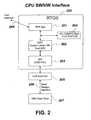
- FIG. 2is a schematic diagram of another system including a real-type operating system (RTOS) for hosting a GNSS/GPS application and USB functionality for supporting a flash drive.
- RTOSreal-type operating system
- FIG. 1shows an exemplary depiction of a generic GNSS receiver that supports a USB flash drive.
- An antenna 101is connected an RF signal conditioning portion 102 .
- the RF datais shown-converted, sampled and then fed to a high-speed digital signal processing (DSP) correlator 103 which performs correlations on the received GNSS signals for eventual tracking.
- DSPdigital signal processing
- Tracking and positioning softwarereside in a general purpose CPU 104 .
- the CPUsupports a USB host hardware interface 105 which communicates to a USB flash drive 109 through a mass storage interface 106 .
- Also supportedare a generic RS-232 interface 108 and a generic USB serial interface 107 .
- the software enabling USB host capabilityis standard in PC-based operating systems but is not present in many current real-time operating systems (RTOS) used in GNSS receivers. Therefore this capability and associated software are added to the RTOS of the GNSS receiver.
- the RTOSis designed to include a hardware abstraction layer (HAL) along with higher level software to enable USB host capability.
- HALhardware abstraction layer
- the purpose of the HALis to create an interface between the USB host controller hardware and the upper level USB software.
- USB functionalitymust not impact the ability of the GNSS receiver to deliver on-time location solutions.
- the receiverTo obtain a location solution, the receiver must track the code and carrier phase of the satellite generated GPS signals. It is often the duty of a general purpose CPU to close code and carrier phase tracking loops. This is usually done on a fixed time interval (interrupt) basis. This time basis must be maintained so that the characteristics of the code and carrier tracking loops remain consistent. That implies that any USB activities must not impact the interrupt servicing of the code and carrier tracking loops. Therefore, the embedded USB host software that is divided between the HAL and the upper level software consist of interrupt service routines (ISRs) and delayed service routines (DSRs).
- ISRsinterrupt service routines
- DSRsdelayed service routines
- the ISRscomplete their tasks quickly so as not to impact the servicing of the code and carrier tracking loops.
- the USB ISRsare the interface between the upper level USB software and the HAL.
- the USB DSRshandle all USB activities that are not handled by the ISRs. These DSRs will be executed on a time slice basis as dictated by the RTOS.
- FIG. 2depicts the RTOS 200 which hosts the GPS application 201 as well the USB functionality necessary for the flash drive support.
- the flash drive supportincludes the DSR 202 as well as the ISR low level HAL routines residing in the ISR 203 .
- There is also a software modulecomprising a PC compatible file system 204 to support a file system on the USB flash drive 207 .
- the ISR softwarecommunicates with USB host hardware 205 and data transfer to and from a USB flash drive 207 is through a mass storage device serial interface 206 .
- a method of selecting and naming data log filesis utilized that employs a user (command) interface 208 through one of the GNSS receiver, RS-232 or conventional USB interfaces.
- Various messagescan be turned on and assigned to be written to a particular file. All messages that can be output to an RS-232 port can also be written to a file on the USB flash drive 109 , 207 .
- a benefit of a large USB flash driveis that it can hold large data files for later post-processing, which can involve days or even weeks worth of GNSS data.
- a simple meansis provided for storing GNSS measurement data to a file for later post-processing without the use of an external computer such as a PC for logging of the data.
- a USB flash drivemaintains compatibility with a PC and provides a mechanism for easy transfer of data to a PC for post-processing.
- Data loggingis also advantageous for trouble shooting a GNSS device.
- a stream of all GNSS receiver observables needed to reconstruct receiver performance off-line (in non-real time)may be logged for playback.
- Modern high-end receiversmay run at solution rates of 20 Hz or more and can output significant amounts of data. The data rates may be too high for conventional RS-232.
- high speed data for trouble shooting or analysismay be logged directly to a file on the attached USB Flash drive.
- Another application of data loggingis simply to log GNSS-derived locations or tracks into a file for display on a map, perhaps to document proper coverage when applying chemicals in an agricultural application.
- New mapping technologysuch as Google Earth
- Google Earthhas an expanding API which allows data to be presented in a variety of ways. Real-time logging of track, swath and area calculations and colorizations based on speed or altitude can be logged to the USB flash drive in a format that will load automatically by a mapping application such as Google Earth.
- USB flash driveIn addition to map-formatted data, other types of data that may be logged to the USB flash drive include: real-time aircraft tracking; raw code and carrier observables; range/pitch/yaw information; XYZ position; speed and time.
- An application of this inventionis to provide a means to store data, including map data or data for analysis to a USB flash drive directly from a GNSS receiver.
- the means of uploading firmware or FGPA images into a GNSS receiveroften involve the use of laptop computers to run the uploading program and to deliver the image file to be uploaded.
- a laptop computeris not always readily available. It would be more desirable to use a compact, low-cost means of delivering the firmware update while avoiding the use of a laptop computer.
- firmware within the GPS receivercan detect the insertion of the USB flash drive and further detect that a new firmware file resides on the USB flash drive by scanning the drive and looking for a particular signature.
- the receiver softwarecan then automatically upload the firmware into RAM and then invoke an internal process of programming the firmware into the receiver's own nonvolatile memory.
- DGPSDifferential GPS
- CODECenter for Orbit Determination in Europe
- Datamay be downloaded from the World Wide Web (Internet) once per day, copied to a USB flash drive, and then the flash drive removed from the PC and inserted into the host USB port on the GNSS receiver.
- Positioning software within the receiveris designed to utilize the aforementioned data to enhance positioning accuracy.
- PPPprecise point positioning
- a parameter filecan also be used to set up the logging options automatically on power-up from the GNSS application. These options can include the various data messages to be polled and the format to be logged, logging rate, start and end times, automated logging-on, exceeding speed limits or leaving complex geo-fence polygons.
- USB flash driveprovides a simple means to store GPS measurement data to a file for later post-processing by the GNSS receiver itself. This avoids a PC altogether. This is particularly suited for PPP applications that involve data from a single GNSS receiver.
- precise orbit and clock datamay first be stored on the USB flash drive, then the flash drive inserted into the GNSS receiver where it is brought to the field to gather data. Once the desired amount of data has been gathered, the GNSS receiver is placed in a mode where it invokes post-processing algorithms on the stored data.
- USBuniversal serial bus
- Other possibilitiesinclude FireWire, wireless USB, or any other enabling technology.
Landscapes
- Engineering & Computer Science (AREA)
- Radar, Positioning & Navigation (AREA)
- Remote Sensing (AREA)
- Signal Processing (AREA)
- Computer Networks & Wireless Communication (AREA)
- Physics & Mathematics (AREA)
- General Physics & Mathematics (AREA)
- Position Fixing By Use Of Radio Waves (AREA)
Abstract
Description
Claims (20)
Priority Applications (4)
| Application Number | Priority Date | Filing Date | Title |
|---|---|---|---|
| US12/247,139US7808428B2 (en) | 2007-10-08 | 2008-10-07 | GNSS receiver and external storage device system and GNSS data processing method |
| PCT/US2008/081727WO2010042131A1 (en) | 2008-10-07 | 2008-10-30 | Gnss receiver and external storage device system and gnss data processing method |
| CA2739823ACA2739823C (en) | 2008-10-07 | 2008-10-30 | Gnss receiver and external storage device system and gnss data processing method |
| US12/898,485US8456356B2 (en) | 2007-10-08 | 2010-10-05 | GNSS receiver and external storage device system and GNSS data processing method |
Applications Claiming Priority (2)
| Application Number | Priority Date | Filing Date | Title |
|---|---|---|---|
| US97827607P | 2007-10-08 | 2007-10-08 | |
| US12/247,139US7808428B2 (en) | 2007-10-08 | 2008-10-07 | GNSS receiver and external storage device system and GNSS data processing method |
Related Child Applications (1)
| Application Number | Title | Priority Date | Filing Date |
|---|---|---|---|
| US12/898,485ContinuationUS8456356B2 (en) | 2007-10-08 | 2010-10-05 | GNSS receiver and external storage device system and GNSS data processing method |
Publications (2)
| Publication Number | Publication Date |
|---|---|
| US20090091496A1 US20090091496A1 (en) | 2009-04-09 |
| US7808428B2true US7808428B2 (en) | 2010-10-05 |
Family
ID=40522826
Family Applications (2)
| Application Number | Title | Priority Date | Filing Date |
|---|---|---|---|
| US12/247,139ActiveUS7808428B2 (en) | 2007-10-08 | 2008-10-07 | GNSS receiver and external storage device system and GNSS data processing method |
| US12/898,485Active2029-07-21US8456356B2 (en) | 2007-10-08 | 2010-10-05 | GNSS receiver and external storage device system and GNSS data processing method |
Family Applications After (1)
| Application Number | Title | Priority Date | Filing Date |
|---|---|---|---|
| US12/898,485Active2029-07-21US8456356B2 (en) | 2007-10-08 | 2010-10-05 | GNSS receiver and external storage device system and GNSS data processing method |
Country Status (3)
| Country | Link |
|---|---|
| US (2) | US7808428B2 (en) |
| CA (1) | CA2739823C (en) |
| WO (1) | WO2010042131A1 (en) |
Cited By (3)
| Publication number | Priority date | Publication date | Assignee | Title |
|---|---|---|---|---|
| US20110018765A1 (en)* | 2007-10-08 | 2011-01-27 | Whitehead Michael L | Gnss receiver and external storage device system and gnss data processing method |
| US11228329B2 (en) | 2017-04-03 | 2022-01-18 | Topcon Positioning Systems, Inc. | Method and apparatus for interference monitoring of radio data signals |
| US20240028541A1 (en)* | 2022-05-10 | 2024-01-25 | Juniper Networks, Inc. | Systems and methods for providing a global navigation satellite system capability to a time sensitive network device |
Families Citing this family (29)
| Publication number | Priority date | Publication date | Assignee | Title |
|---|---|---|---|---|
| US8634993B2 (en) | 2003-03-20 | 2014-01-21 | Agjunction Llc | GNSS based control for dispensing material from vehicle |
| US9002565B2 (en) | 2003-03-20 | 2015-04-07 | Agjunction Llc | GNSS and optical guidance and machine control |
| US8140223B2 (en) | 2003-03-20 | 2012-03-20 | Hemisphere Gps Llc | Multiple-antenna GNSS control system and method |
| US8217833B2 (en) | 2008-12-11 | 2012-07-10 | Hemisphere Gps Llc | GNSS superband ASIC with simultaneous multi-frequency down conversion |
| US8386129B2 (en) | 2009-01-17 | 2013-02-26 | Hemipshere GPS, LLC | Raster-based contour swathing for guidance and variable-rate chemical application |
| US8334804B2 (en) | 2009-09-04 | 2012-12-18 | Hemisphere Gps Llc | Multi-frequency GNSS receiver baseband DSP |
| US7966437B1 (en) | 2009-09-18 | 2011-06-21 | Rockwell Collins, Inc. | Wireless USB enabled dataloads |
| US9178573B2 (en) | 2010-02-02 | 2015-11-03 | Hemisphere Gnss Inc. | RF/digital signal-separating GNSS receiver and manufacturing method |
| US8583326B2 (en)* | 2010-02-09 | 2013-11-12 | Agjunction Llc | GNSS contour guidance path selection |
| US8803735B2 (en) | 2010-11-19 | 2014-08-12 | Agjunction Llc | Portable base station network for local differential GNSS corrections |
| CN102073615B (en)* | 2010-12-02 | 2012-07-25 | 西北工业大学 | Interface method for satellite navigation receiving system and high-speed intelligent unified bus |
| WO2012177719A2 (en)* | 2011-06-21 | 2012-12-27 | Northwestern University | Touch interface device and method for applying lateral forces on a human appendage |
| US9274230B2 (en)* | 2011-09-16 | 2016-03-01 | Trimble Navigation Limited | GNSS signal processing methods and apparatus |
| US8781685B2 (en) | 2012-07-17 | 2014-07-15 | Agjunction Llc | System and method for integrating automatic electrical steering with GNSS guidance |
| CN102914779A (en)* | 2012-10-26 | 2013-02-06 | 广州南方卫星导航仪器有限公司 | Measuring device of global navigation satellite system |
| US9945957B2 (en) | 2013-03-14 | 2018-04-17 | Agjunction Llc | Machine control system and method |
| US9781915B2 (en) | 2013-03-14 | 2017-10-10 | Agjunction Llc | Implement and boom height control system and method |
| US20160147594A1 (en)* | 2014-11-26 | 2016-05-26 | Qualcomm Technologies International, Ltd. | Method and apparatus for preventing and managing corruption of flash memory contents |
| US9720861B2 (en) | 2014-12-02 | 2017-08-01 | Qualcomm Incorporated | Memory access by dual processor systems |
| US11086025B2 (en)* | 2015-08-13 | 2021-08-10 | Propeller Aerobotics Pty Ltd | Integrated visual geo-referencing target unit and method of operation |
| CN105589662B (en)* | 2015-12-21 | 2018-10-02 | 上海华测导航技术股份有限公司 | A kind of GNSS receiver data storage and management method |
| CN107806860A (en)* | 2016-09-09 | 2018-03-16 | 上海华测导航技术股份有限公司 | A kind of aerial survey of unmanned aerial vehicle is taken pictures the methods of accurate spatial locations |
| CN108376477B (en)* | 2017-05-02 | 2021-04-16 | 山东大学 | Vehicle-road coordination bus precise data fusion center system and working method |
| CN107796389A (en)* | 2017-10-17 | 2018-03-13 | 北京航天发射技术研究所 | A kind of positioning navigation method based on multi-core DSP |
| CN109828290A (en)* | 2019-01-31 | 2019-05-31 | 泰斗微电子科技有限公司 | The method and terminal device of the information processing of positioning chip |
| CN109976893A (en)* | 2019-03-29 | 2019-07-05 | 北京润科通用技术有限公司 | The sequential control method and device of real time operating system |
| RU2754813C1 (en)* | 2020-08-27 | 2021-09-07 | Общество с ограниченной ответственностью "Эмбиот" (ООО "Эмбиот") | Method for linking "internet of things" and "smart city" devices to geographical coordinates and to the map of the area with increased coordinates accuracy |
| CN112505732A (en)* | 2020-11-19 | 2021-03-16 | 西安航光卫星测控技术有限公司 | Beidou vehicle-mounted machine with wireless encryption transmission and encryption and decryption method |
| CN117687049B (en)* | 2023-12-26 | 2024-10-25 | 航天恒星科技有限公司 | Satellite navigation anti-interference receiving method based on hybrid array |
Citations (31)
| Publication number | Priority date | Publication date | Assignee | Title |
|---|---|---|---|---|
| US4894662A (en)* | 1982-03-01 | 1990-01-16 | Western Atlas International, Inc. | Method and system for determining position on a moving platform, such as a ship, using signals from GPS satellites |
| US5134407A (en) | 1991-04-10 | 1992-07-28 | Ashtech Telesis, Inc. | Global positioning system receiver digital processing technique |
| US5185610A (en) | 1990-08-20 | 1993-02-09 | Texas Instruments Incorporated | GPS system and method for deriving pointing or attitude from a single GPS receiver |
| US5268695A (en) | 1992-10-06 | 1993-12-07 | Trimble Navigation Limited | Differential phase measurement through antenna multiplexing |
| US5296861A (en) | 1992-11-13 | 1994-03-22 | Trimble Navigation Limited | Method and apparatus for maximum likelihood estimation direct integer search in differential carrier phase attitude determination systems |
| US5323322A (en) | 1992-03-05 | 1994-06-21 | Trimble Navigation Limited | Networked differential GPS system |
| US5471217A (en) | 1993-02-01 | 1995-11-28 | Magnavox Electronic Systems Company | Method and apparatus for smoothing code measurements in a global positioning system receiver |
| US5477228A (en) | 1993-04-13 | 1995-12-19 | Differential Corrections Inc. | Differential global positioning system using radio data system |
| US5477458A (en) | 1994-01-03 | 1995-12-19 | Trimble Navigation Limited | Network for carrier phase differential GPS corrections |
| US5864315A (en) | 1997-04-07 | 1999-01-26 | General Electric Company | Very low power high accuracy time and frequency circuits in GPS based tracking units |
| US5943008A (en) | 1997-09-23 | 1999-08-24 | Rockwell Science Center, Inc. | Single global positioning system receiver capable of attitude determination |
| US5969670A (en) | 1998-01-22 | 1999-10-19 | Trimble Navigation Limited | Inexpensive monitoring technique for achieving high level integrity monitoring for differential GPS |
| US6018313A (en) | 1995-09-01 | 2000-01-25 | Tilmar Konle | System for determining the location of mobile objects |
| US6061390A (en) | 1994-09-02 | 2000-05-09 | California Institute Of Technology | P-code enhanced method for processing encrypted GPS signals without knowledge of the encryption code |
| US6069583A (en) | 1996-05-09 | 2000-05-30 | Agence Spatiale Europeene | Receiver for a navigation system, in particular a satellite navigation system |
| US6144335A (en) | 1998-04-14 | 2000-11-07 | Trimble Navigation Limited | Automated differential correction processing of field data in a global positional system |
| US6191730B1 (en) | 1997-12-15 | 2001-02-20 | Trimble Navigation Limited | Two-channel fast-sequencing high-dynamics GPS navigation receiver |
| US6198430B1 (en) | 1999-03-26 | 2001-03-06 | Rockwell Collins, Inc. | Enhanced differential GNSS carrier-smoothed code processing using dual frequency measurements |
| US6229479B1 (en) | 1997-04-25 | 2001-05-08 | Magellan Corporation | Relative position measuring techniques using both GPS and GLONASS carrier phase measurements |
| US6259398B1 (en) | 2000-05-19 | 2001-07-10 | Sri International | Multi-valued variable ambiguity resolution for satellite navigation signal carrier wave path length determination |
| US6292132B1 (en) | 1999-08-13 | 2001-09-18 | Daimlerchrysler Ag | System and method for improved accuracy in locating and maintaining positions using GPS |
| US6397147B1 (en) | 2000-06-06 | 2002-05-28 | Csi Wireless Inc. | Relative GPS positioning using a single GPS receiver with internally generated differential correction terms |
| US6469663B1 (en) | 2000-03-21 | 2002-10-22 | Csi Wireless Inc. | Method and system for GPS and WAAS carrier phase measurements for relative positioning |
| US6754584B2 (en) | 2001-02-28 | 2004-06-22 | Enpoint, Llc | Attitude measurement using a single GPS receiver with two closely-spaced antennas |
| US6792380B2 (en) | 2002-02-12 | 2004-09-14 | Furuno Electric Company Limited | Attitude angle detecting apparatus |
| US6865484B2 (en) | 2001-04-11 | 2005-03-08 | Mitsui & Co., Ltd. | Satellite position measurement system |
| US7027918B2 (en) | 2003-04-07 | 2006-04-11 | Novariant, Inc. | Satellite navigation system using multiple antennas |
| US7292186B2 (en) | 2003-04-23 | 2007-11-06 | Csi Wireless Inc. | Method and system for synchronizing multiple tracking devices for a geo-location system |
| US20070285308A1 (en)* | 2004-07-30 | 2007-12-13 | Integirnautics Corporation | Multiple frequency antenna structures and methods for receiving navigation or ranging signals |
| US7428259B2 (en) | 2005-05-06 | 2008-09-23 | Sirf Technology Holdings, Inc. | Efficient and flexible GPS receiver baseband architecture |
| US20090171583A1 (en)* | 2006-03-15 | 2009-07-02 | The Boeing Company | Global position system (gps) user receiver and geometric surface processing for all-in-view coherent gps signal prn codes acquisition and navigation solution |
Family Cites Families (343)
| Publication number | Priority date | Publication date | Assignee | Title |
|---|---|---|---|---|
| US3585537A (en) | 1969-02-10 | 1971-06-15 | Bell Telephone Labor Inc | Electric wave filters |
| US3596228A (en) | 1969-05-29 | 1971-07-27 | Ibm | Fluid actuated contactor |
| US3727710A (en) | 1971-05-13 | 1973-04-17 | Gen Motors Corp | Steer control for a track-laying vehicle |
| US3899028A (en) | 1972-03-30 | 1975-08-12 | Systron Donner Corp | Angular position sensing and control system, apparatus and method |
| US3815272A (en) | 1973-01-03 | 1974-06-11 | G Marleau | Collapsible, triangular net assembly |
| FR2280985B1 (en) | 1974-08-01 | 1977-01-07 | Lignes Telegraph Telephon | WIDE BAND MINIATURIZED ANTENNA |
| US4637474A (en) | 1974-11-05 | 1987-01-20 | Leonard Willie B | Tractor and towed implement with elevation control system for implement including pressure responsive valve actuator |
| US4132272A (en) | 1977-06-30 | 1979-01-02 | International Harvester Company | Tractor hitch position control system |
| US4170776A (en) | 1977-12-21 | 1979-10-09 | Nasa | System for near real-time crustal deformation monitoring |
| US4180133A (en) | 1978-01-12 | 1979-12-25 | Iowa State University Research Foundation, Inc. | Guidance system for towed vehicles |
| DE2942557C2 (en) | 1979-10-22 | 1983-01-27 | Siemens AG, 1000 Berlin und 8000 München | Directional antenna arrangement or directional antenna for a jammer |
| JPS639141Y2 (en) | 1980-10-22 | 1988-03-18 | ||
| US4769700A (en) | 1981-11-20 | 1988-09-06 | Diffracto Ltd. | Robot tractors |
| US4667203A (en) | 1982-03-01 | 1987-05-19 | Aero Service Div, Western Geophysical | Method and system for determining position using signals from satellites |
| US4453614A (en) | 1982-03-19 | 1984-06-12 | Deere & Company | Steering arrangement for an off-highway articulated vehicle |
| US4739448A (en) | 1984-06-25 | 1988-04-19 | Magnavox Government And Industrial Electronics Company | Microwave multiport multilayered integrated circuit chip carrier |
| US4689556A (en) | 1984-10-12 | 1987-08-25 | Daymarc Corporation | Broad band contactor assembly for testing integrated circuit devices |
| US4785463A (en) | 1985-09-03 | 1988-11-15 | Motorola, Inc. | Digital global positioning system receiver |
| US4710775A (en) | 1985-09-30 | 1987-12-01 | The Boeing Company | Parasitically coupled, complementary slot-dipole antenna element |
| US4714435A (en) | 1985-11-14 | 1987-12-22 | Molex Incorporated | Connection for flexible apparatus |
| US4751512A (en) | 1986-01-21 | 1988-06-14 | Oceanonics, Inc. | Differential navigation system for remote mobile users |
| US4694264A (en) | 1986-03-05 | 1987-09-15 | The United States Of America As Represented By The United States Department Of Energy | Radio frequency coaxial feedthrough device |
| US4812991A (en) | 1986-05-01 | 1989-03-14 | Magnavox Govt. And Industrial Electronics Company | Method for precision dynamic differential positioning |
| US4802545A (en) | 1986-10-15 | 1989-02-07 | J. I. Case Company | Steering control system for articulated vehicle |
| US4858132A (en) | 1987-09-11 | 1989-08-15 | Ndc Technologies, Inc. | Optical navigation system for an automatic guided vehicle, and method |
| US4864320A (en) | 1988-05-06 | 1989-09-05 | Ball Corporation | Monopole/L-shaped parasitic elements for circularly/elliptically polarized wave transceiving |
| US5031704A (en) | 1988-05-10 | 1991-07-16 | Fleischer Manufacturing, Inc. | Guidance control apparatus for agricultural implement |
| US4813991A (en)* | 1988-05-20 | 1989-03-21 | Thomson Consumer Electronics, Inc. | Universal stem mold for manufacturing a molded glass stem |
| US4918607A (en) | 1988-09-09 | 1990-04-17 | Caterpillar Industrial Inc. | Vehicle guidance system |
| US4916577A (en) | 1988-12-20 | 1990-04-10 | Grumman Aerospace Corporation | Method of mounting removable modules |
| US5165109A (en) | 1989-01-19 | 1992-11-17 | Trimble Navigation | Microwave communication antenna |
| US4963889A (en) | 1989-09-26 | 1990-10-16 | Magnavox Government And Industrial Electronics Company | Method and apparatus for precision attitude determination and kinematic positioning |
| US5177489A (en) | 1989-09-26 | 1993-01-05 | Magnavox Electronic Systems Company | Pseudolite-aided method for precision kinematic positioning |
| US5173715A (en) | 1989-12-04 | 1992-12-22 | Trimble Navigation | Antenna with curved dipole elements |
| US5191351A (en) | 1989-12-29 | 1993-03-02 | Texas Instruments Incorporated | Folded broadband antenna with a symmetrical pattern |
| US5375059A (en) | 1990-02-05 | 1994-12-20 | Caterpillar Inc. | Vehicle position determination system and method |
| US5838562A (en) | 1990-02-05 | 1998-11-17 | Caterpillar Inc. | System and a method for enabling a vehicle to track a preset path |
| US5156219A (en) | 1990-06-04 | 1992-10-20 | A.I.L., Inc. | Positioning apparatus for drawn implement |
| US5100229A (en) | 1990-08-17 | 1992-03-31 | Spatial Positioning Systems, Inc. | Spatial positioning system |
| US5155493A (en) | 1990-08-28 | 1992-10-13 | The United States Of America As Represented By The Secretary Of The Air Force | Tape type microstrip patch antenna |
| US5155490A (en) | 1990-10-15 | 1992-10-13 | Gps Technology Corp. | Geodetic surveying system using multiple GPS base stations |
| US5390207A (en) | 1990-11-28 | 1995-02-14 | Novatel Communications Ltd. | Pseudorandom noise ranging receiver which compensates for multipath distortion by dynamically adjusting the time delay spacing between early and late correlators |
| US5294970A (en) | 1990-12-31 | 1994-03-15 | Spatial Positioning Systems, Inc. | Spatial positioning system |
| US5152347A (en) | 1991-04-05 | 1992-10-06 | Deere & Company | Interface system for a towed implement |
| US5202829A (en) | 1991-06-10 | 1993-04-13 | Trimble Navigation Limited | Exploration system and method for high-accuracy and high-confidence level relative position and velocity determinations |
| US5148179A (en) | 1991-06-27 | 1992-09-15 | Trimble Navigation | Differential position determination using satellites |
| JP2533741B2 (en) | 1991-07-30 | 1996-09-11 | オーラ システムズ,インコーポレーテッド | Variable gain servo auxiliary device |
| US5365447A (en) | 1991-09-20 | 1994-11-15 | Dennis Arthur R | GPS and satelite navigation system |
| US5239669A (en) | 1992-02-04 | 1993-08-24 | Trimble Navigation Limited | Coupler for eliminating a hardwire connection between a handheld global positioning system (GPS) receiver and a stationary remote antenna |
| US5255756A (en) | 1992-04-22 | 1993-10-26 | Progressive Farm Products, Inc. | Caddy with guidance system for agricultural implements |
| US5343209A (en) | 1992-05-07 | 1994-08-30 | Sennott James W | Navigation receiver with coupled signal-tracking channels |
| US5919242A (en) | 1992-05-14 | 1999-07-06 | Agri-Line Innovations, Inc. | Method and apparatus for prescription application of products to an agricultural field |
| JP2904241B2 (en) | 1992-07-01 | 1999-06-14 | ケイディディ株式会社 | Transmission method of differential data signal |
| US5361212A (en) | 1992-11-02 | 1994-11-01 | Honeywell Inc. | Differential GPS landing assistance system |
| US5390124A (en) | 1992-12-01 | 1995-02-14 | Caterpillar Inc. | Method and apparatus for improving the accuracy of position estimates in a satellite based navigation system |
| US5359332A (en) | 1992-12-31 | 1994-10-25 | Trimble Navigation Limited | Determination of phase ambiguities in satellite ranges |
| US5523761A (en) | 1993-01-12 | 1996-06-04 | Trimble Navigation Limited | Differential GPS smart antenna device |
| US5444453A (en) | 1993-02-02 | 1995-08-22 | Ball Corporation | Microstrip antenna structure having an air gap and method of constructing same |
| US5739785A (en) | 1993-03-04 | 1998-04-14 | Trimble Navigation Limited | Location and generation of high accuracy survey control marks using satellites |
| US5311149A (en) | 1993-03-12 | 1994-05-10 | Trimble Navigation Limited | Integrated phase locked loop local oscillator |
| US5392863A (en) | 1993-03-19 | 1995-02-28 | Richard Fixemer | Guidance system for an agricultural implement |
| US5548293A (en) | 1993-03-24 | 1996-08-20 | Leland Stanford Junior University | System and method for generating attitude determinations using GPS |
| US5583513A (en) | 1993-03-24 | 1996-12-10 | Board Of Trustees Of The Leland Stanford Junior University | System and method for generating precise code based and carrier phase position determinations |
| US5334987A (en) | 1993-04-01 | 1994-08-02 | Spectra-Physics Laserplane, Inc. | Agricultural aircraft control system using the global positioning system |
| US5490073A (en) | 1993-04-05 | 1996-02-06 | Caterpillar Inc. | Differential system and method for a satellite based navigation |
| US5416712A (en) | 1993-05-28 | 1995-05-16 | Trimble Navigation Limited | Position and velocity estimation system for adaptive weighting of GPS and dead-reckoning information |
| US6542077B2 (en) | 1993-06-08 | 2003-04-01 | Raymond Anthony Joao | Monitoring apparatus for a vehicle and/or a premises |
| US5504482A (en) | 1993-06-11 | 1996-04-02 | Rockwell International Corporation | Automobile navigation guidance, control and safety system |
| US5534875A (en) | 1993-06-18 | 1996-07-09 | Adroit Systems, Inc. | Attitude determining system for use with global positioning system |
| US5537324A (en) | 1993-08-07 | 1996-07-16 | Aisin Aw Co., Ltd. | Navigation system |
| US5369589A (en) | 1993-09-15 | 1994-11-29 | Trimble Navigation Limited | Plural information display for navigation |
| US5521610A (en) | 1993-09-17 | 1996-05-28 | Trimble Navigation Limited | Curved dipole antenna with center-post amplifier |
| FR2710780B1 (en) | 1993-09-30 | 1995-10-27 | Commissariat Energie Atomique | Open magnetic structures. |
| WO1995018432A1 (en) | 1993-12-30 | 1995-07-06 | Concord, Inc. | Field navigation system |
| US5546093A (en) | 1994-01-04 | 1996-08-13 | Caterpillar Inc. | System and method for providing navigation signals to an earthmoving or construction machine |
| US5568152A (en) | 1994-02-04 | 1996-10-22 | Trimble Navigation Limited | Integrated image transfer for remote target location |
| JPH07230315A (en) | 1994-02-16 | 1995-08-29 | Fuji Heavy Ind Ltd | Traveling controller for autonomously traveling vehicle |
| US5519620A (en) | 1994-02-18 | 1996-05-21 | Trimble Navigation Limited | Centimeter accurate global positioning system receiver for on-the-fly real-time kinematic measurement and control |
| US5617100A (en) | 1994-04-07 | 1997-04-01 | Matsushita Electric Industrial Co., Ltd. | Accurate position measuring system |
| US5491636A (en) | 1994-04-19 | 1996-02-13 | Glen E. Robertson | Anchorless boat positioning employing global positioning system |
| FI942218A0 (en) | 1994-05-13 | 1994-05-13 | Modulaire Oy | Automatic storage system Foer obemannat fordon |
| US5495257A (en) | 1994-07-19 | 1996-02-27 | Trimble Navigation Limited | Inverse differential corrections for SATPS mobile stations |
| US5680140A (en) | 1994-07-19 | 1997-10-21 | Trimble Navigation Limited | Post-processing of inverse differential corrections for SATPS mobile stations |
| US5451964A (en) | 1994-07-29 | 1995-09-19 | Del Norte Technology, Inc. | Method and system for resolving double difference GPS carrier phase integer ambiguity utilizing decentralized Kalman filters |
| US5442363A (en) | 1994-08-04 | 1995-08-15 | U.S. Army Corps Of Engineers As Represented By The Secretary Of The Army | Kinematic global positioning system of an on-the-fly apparatus for centimeter-level positioning for static or moving applications |
| US5568162A (en) | 1994-08-08 | 1996-10-22 | Trimble Navigation Limited | GPS navigation and differential-correction beacon antenna combination |
| US5596328A (en) | 1994-08-23 | 1997-01-21 | Honeywell Inc. | Fail-safe/fail-operational differential GPS ground station system |
| CA2197333C (en) | 1994-08-23 | 2004-11-23 | Lawrence C. Vallot | Differential gps ground station system |
| US5610845A (en) | 1994-08-30 | 1997-03-11 | United Technologies Corporation | Multi-parameter air data sensing technique |
| US5511623A (en) | 1994-09-12 | 1996-04-30 | Orthman Manufacturing, Inc. | Quick hitch guidance device |
| US5543804A (en) | 1994-09-13 | 1996-08-06 | Litton Systems, Inc. | Navagation apparatus with improved attitude determination |
| US5604506A (en) | 1994-12-13 | 1997-02-18 | Trimble Navigation Limited | Dual frequency vertical antenna |
| US5589835A (en) | 1994-12-20 | 1996-12-31 | Trimble Navigation Limited | Differential GPS receiver system linked by infrared signals |
| US5600670A (en) | 1994-12-21 | 1997-02-04 | Trimble Navigation, Ltd. | Dynamic channel allocation for GPS receivers |
| US5731786A (en) | 1994-12-29 | 1998-03-24 | Trimble Navigation Limited | Compaction of SATPS information for subsequent signal processing |
| WO1996022546A1 (en) | 1995-01-17 | 1996-07-25 | The Board Of Trustees Of The Leland Stanford Junior University | Wide area differential gps reference system and method |
| US5617317A (en) | 1995-01-24 | 1997-04-01 | Honeywell Inc. | True north heading estimator utilizing GPS output information and inertial sensor system output information |
| US5854987A (en) | 1995-02-22 | 1998-12-29 | Honda Giken Kogyo Kabushiki Kaisha | Vehicle steering control system using navigation system |
| US5578813A (en) | 1995-03-02 | 1996-11-26 | Allen; Ross R. | Freehand image scanning device which compensates for non-linear movement |
| US5608393A (en) | 1995-03-07 | 1997-03-04 | Honeywell Inc. | Differential ground station repeater |
| US5592382A (en) | 1995-03-10 | 1997-01-07 | Rockwell International Corporation | Directional steering and navigation indicator |
| US5646857A (en) | 1995-03-31 | 1997-07-08 | Trimble Navigation Limited | Use of an altitude sensor to augment availability of GPS location fixes |
| DE59501555D1 (en) | 1995-04-20 | 1998-04-09 | Fuba Automotive Gmbh | Flat antenna arrangement |
| US5638077A (en) | 1995-05-04 | 1997-06-10 | Rockwell International Corporation | Differential GPS for fleet base stations with vector processing mechanization |
| US5561432A (en) | 1995-05-12 | 1996-10-01 | Trimble Navigation | Out of plane antenna vector system and method |
| US6236907B1 (en) | 1995-05-30 | 2001-05-22 | Ag-Chem Equipment Co., Inc. | System and method for creating agricultural decision and application maps for automated agricultural machines |
| US5875408A (en) | 1995-07-17 | 1999-02-23 | Imra America, Inc. | Automated vehicle guidance system and method for automatically guiding a vehicle |
| US5953367A (en) | 1995-08-09 | 1999-09-14 | Magellan Corporation | Spread spectrum receiver using a pseudo-random noise code for ranging applications in a way that reduces errors when a multipath signal is present |
| US5862501A (en) | 1995-08-18 | 1999-01-19 | Trimble Navigation Limited | Guidance control system for movable machinery |
| US5717593A (en) | 1995-09-01 | 1998-02-10 | Gvili; Michael E. | Lane guidance system |
| DE19536601A1 (en) | 1995-09-19 | 1997-03-20 | Teldix Gmbh | Navigation system for a vehicle, in particular for a land vehicle |
| US5673491A (en) | 1995-10-20 | 1997-10-07 | Brenna; Douglas J. | Crane level indicator device |
| JP3171119B2 (en) | 1995-12-04 | 2001-05-28 | トヨタ自動車株式会社 | Automatic driving control device for vehicles |
| US5812961A (en) | 1995-12-28 | 1998-09-22 | Trimble Navigation Limited | Method and reciever using a low earth orbiting satellite signal to augment the global positioning system |
| US5928309A (en) | 1996-02-05 | 1999-07-27 | Korver; Kelvin | Navigation/guidance system for a land-based vehicle |
| SE519541C2 (en) | 1996-10-02 | 2003-03-11 | Ericsson Telefon Ab L M | Method and apparatus for transforming a real digital broadband bandpass signal into a set of digital baseband signals with I and Q components |
| US6014101A (en) | 1996-02-26 | 2000-01-11 | Trimble Navigation Limited | Post-processing of inverse DGPS corrections |
| US5828336A (en) | 1996-03-29 | 1998-10-27 | The United States Of America As Represented By The Administrator Of The National Aeronautics And Space Administration | Robust real-time wide-area differential GPS navigation |
| US5864318A (en) | 1996-04-26 | 1999-01-26 | Dorne & Margolin, Inc. | Composite antenna for cellular and gps communications |
| US5935183A (en) | 1996-05-20 | 1999-08-10 | Caterpillar Inc. | Method and system for determining the relationship between a laser plane and an external coordinate system |
| US5948044A (en) | 1996-05-20 | 1999-09-07 | Harris Corporation | Hybrid GPS/inertially aided platform stabilization system |
| US5725230A (en) | 1996-06-17 | 1998-03-10 | Walkup; Joseph L. | Self steering tandem hitch |
| DE19624719A1 (en) | 1996-06-21 | 1998-01-02 | Claas Ohg | System for determining the position of mobile objects, in particular vehicles |
| US6057800A (en) | 1996-06-28 | 2000-05-02 | State University Of New York | RDOP surface for GPS relative positioning |
| DE19629618A1 (en) | 1996-07-23 | 1998-01-29 | Claas Ohg | Route planning system for agricultural work vehicles |
| US5810095A (en) | 1996-07-25 | 1998-09-22 | Case Corporation | System for controlling the position of an implement attached to a work vehicle |
| AUPO135296A0 (en) | 1996-08-01 | 1996-08-22 | Great Western Corporation Pty Ltd | Agricultural cultivator |
| US5929721A (en) | 1996-08-06 | 1999-07-27 | Motorola Inc. | Ceramic filter with integrated harmonic response suppression using orthogonally oriented low-pass filter |
| KR0183299B1 (en) | 1996-11-04 | 1999-04-15 | 삼성전자주식회사 | Navigation device that informs the surroundings of the car and its control method |
| US5926079A (en) | 1996-12-05 | 1999-07-20 | Motorola Inc. | Ceramic waveguide filter with extracted pole |
| US5757316A (en) | 1997-02-01 | 1998-05-26 | Litton Systems, Inc. | Attitude determination utilizing an inertial measurement unit and a plurality of satellite transmitters |
| US5777578A (en) | 1997-02-10 | 1998-07-07 | National Science Council | Global positioning system (GPS) Compass |
| US5877725A (en) | 1997-03-06 | 1999-03-02 | Trimble Navigation Limited | Wide augmentation system retrofit receiver |
| US5987383C1 (en) | 1997-04-28 | 2006-06-13 | Trimble Navigation Ltd | Form line following guidance system |
| US6052647A (en) | 1997-06-20 | 2000-04-18 | Stanford University | Method and system for automatic control of vehicles based on carrier phase differential GPS |
| US5912798A (en) | 1997-07-02 | 1999-06-15 | Landsten Chu | Dielectric ceramic filter |
| US5936573A (en) | 1997-07-07 | 1999-08-10 | Trimble Navigation Limited | Real-time kinematic integrity estimator and monitor |
| US5940026A (en) | 1997-07-21 | 1999-08-17 | Rockwell Science Center, Inc. | Azimuth determination for GPS/INS systems via GPS null steering antenna |
| US5917448A (en) | 1997-08-07 | 1999-06-29 | Rockwell Science Center, Inc. | Attitude determination system with sequencing antenna inputs |
| US6061632A (en) | 1997-08-18 | 2000-05-09 | Trimble Navigation Limited | Receiver with seamless correction capacity |
| US5927603A (en) | 1997-09-30 | 1999-07-27 | J. R. Simplot Company | Closed loop control system, sensing apparatus and fluid application system for a precision irrigation device |
| US6023239A (en) | 1997-10-08 | 2000-02-08 | Arinc, Inc. | Method and system for a differential global navigation satellite system aircraft landing ground station |
| US6198992B1 (en) | 1997-10-10 | 2001-03-06 | Trimble Navigation Limited | Override for guidance control system |
| US6233511B1 (en) | 1997-11-26 | 2001-05-15 | Case Corporation | Electronic control for a two-axis work implement |
| US5918558A (en) | 1997-12-01 | 1999-07-06 | Case Corporation | Dual-pump, flow-isolated hydraulic circuit for an agricultural tractor |
| US5945917A (en) | 1997-12-18 | 1999-08-31 | Rockwell International | Swathing guidance display |
| FI108478B (en)* | 1998-01-21 | 2002-01-31 | Nokia Corp | Built-in system |
| US6314348B1 (en) | 1998-02-11 | 2001-11-06 | Trimble Navigation Limited | Correction control for guidance control system |
| US6100842A (en) | 1998-02-20 | 2000-08-08 | Trimble Navigation Limited | Chained location determination system |
| US6104978A (en)* | 1998-04-06 | 2000-08-15 | General Electric Company | GPS-based centralized tracking system with reduced energy consumption |
| US6081171A (en) | 1998-04-08 | 2000-06-27 | Nokia Mobile Phones Limited | Monolithic filters utilizing thin film bulk acoustic wave devices and minimum passive components for controlling the shape and width of a passband response |
| US6356602B1 (en) | 1998-05-04 | 2002-03-12 | Trimble Navigation Limited | RF integrated circuit for downconverting a GPS signal |
| AUPP375498A0 (en) | 1998-05-29 | 1998-06-18 | Small, David | A method for creating a network positioning system (NPS) |
| DE19830858A1 (en) | 1998-07-10 | 2000-01-13 | Claas Selbstfahr Erntemasch | Device and method for determining a virtual position |
| US5933110A (en) | 1998-07-13 | 1999-08-03 | Arinc, Inc. | Vessel attitude determination system and method |
| US6199000B1 (en) | 1998-07-15 | 2001-03-06 | Trimble Navigation Limited | Methods and apparatus for precision agriculture operations utilizing real time kinematic global positioning system systems |
| US6307505B1 (en) | 1998-07-22 | 2001-10-23 | Trimble Navigation Limited | Apparatus and method for coupling data to a position determination device |
| US5949371A (en) | 1998-07-27 | 1999-09-07 | Trimble Navigation Limited | Laser based reflectors for GPS positioning augmentation |
| US6515619B1 (en) | 1998-07-30 | 2003-02-04 | Mckay, Jr. Nicholas D. | Object location system |
| US6313788B1 (en) | 1998-08-14 | 2001-11-06 | Seagull Technology, Inc. | Method and apparatus for reliable inter-antenna baseline determination |
| US6501422B1 (en) | 1998-08-19 | 2002-12-31 | Trimble Navigation, Ltd. | Precise parallel swathing guidance via satellite navigation and tilt measurement |
| US6230097B1 (en) | 1998-08-31 | 2001-05-08 | Trimble Navigation Limited | Accurate vehicle navigation |
| US6256583B1 (en) | 1998-09-16 | 2001-07-03 | Rockwell Collins, Inc. | GPS attitude determination system and method using optimal search space identification for integer cycle ambiguity resolution |
| FR2783945B1 (en) | 1998-09-29 | 2000-12-15 | Pellenc Sa | PROCESS FOR EXPLOITING LOCALIZED AGRICULTURAL DATA TO OPTIMIZE THE CULTIVATION OF PERENNIAL PLANTS |
| US6253160B1 (en) | 1999-01-15 | 2001-06-26 | Trimble Navigation Ltd. | Method and apparatus for calibrating a tool positioning mechanism on a mobile machine |
| US6236916B1 (en) | 1999-03-29 | 2001-05-22 | Caterpillar Inc. | Autoguidance system and method for an agricultural machine |
| US6453237B1 (en) | 1999-04-23 | 2002-09-17 | Global Locate, Inc. | Method and apparatus for locating and providing services to mobile devices |
| DE19919321A1 (en) | 1999-04-28 | 2000-11-02 | Deere & Co | Steering system and harvesting machine |
| US6191733B1 (en) | 1999-06-01 | 2001-02-20 | Modular Mining Systems, Inc. | Two-antenna positioning system for surface-mine equipment |
| US6325684B1 (en) | 1999-06-11 | 2001-12-04 | Johnson Outdoors, Inc., | Trolling motor steering control |
| US6236924B1 (en) | 1999-06-21 | 2001-05-22 | Caterpillar Inc. | System and method for planning the operations of an agricultural machine in a field |
| US6275758B1 (en) | 1999-06-29 | 2001-08-14 | Caterpillar Inc. | Method and apparatus for determining a cross slope of a surface |
| US6266595B1 (en) | 1999-08-12 | 2001-07-24 | Martin W. Greatline | Method and apparatus for prescription application of products to an agricultural field |
| US6076612A (en) | 1999-08-31 | 2000-06-20 | Case Corporation | Transition from position to draft mode controlled by hitch position command and feedback |
| US6062317A (en) | 1999-09-03 | 2000-05-16 | Caterpillar Inc. | Method and apparatus for controlling the direction of travel of an earthworking machine |
| US6285320B1 (en) | 1999-09-03 | 2001-09-04 | Sikorsky Aircraft Corporation | Apparatus and method for mapping surfaces of an object |
| IL132191A (en) | 1999-10-03 | 2008-04-13 | Azimuth Technologies Ltd | Method for calibrating and verifying the attitude of a compass |
| US6611755B1 (en) | 1999-12-19 | 2003-08-26 | Trimble Navigation Ltd. | Vehicle tracking, communication and fleet management system |
| US6424295B1 (en)* | 2000-02-22 | 2002-07-23 | Trimble Navigation Limited | GPS weather data recording system for use with the applications of chemicals to agricultural fields |
| DE60013763T2 (en) | 2000-03-14 | 2005-01-27 | Siemens Ag | Route planning system |
| US6418031B1 (en) | 2000-05-01 | 2002-07-09 | International Business Machines Corporation | Method and means for decoupling a printed circuit board |
| GB0011493D0 (en) | 2000-05-13 | 2000-06-28 | Koninkl Philips Electronics Nv | Method and apparatus for code phase tracking |
| US6819269B2 (en) | 2000-05-17 | 2004-11-16 | Omega Patents, L.L.C. | Vehicle tracker including battery monitoring feature and related methods |
| US6421003B1 (en) | 2000-05-19 | 2002-07-16 | Sri International | Attitude determination using multiple baselines in a navigational positioning system |
| GB2368218B (en) | 2000-06-01 | 2004-04-28 | Furuno Electric Co | System for determining the heading and/or attitude of a body |
| WO2001095162A1 (en) | 2000-06-05 | 2001-12-13 | Ag-Chem Equipment Company, Inc. | System and method for creating demo application maps for site-specific farming |
| GB0014719D0 (en) | 2000-06-16 | 2000-08-09 | Koninkl Philips Electronics Nv | A method of providing an estimate of a location |
| US6445983B1 (en) | 2000-07-07 | 2002-09-03 | Case Corporation | Sensor-fusion navigator for automated guidance of off-road vehicles |
| JP4446569B2 (en) | 2000-07-24 | 2010-04-07 | 古野電気株式会社 | Carrier phase relative positioning device |
| US6631916B1 (en) | 2000-07-28 | 2003-10-14 | Merle E. Miller | Guidance system for pull-type equipment |
| US6931233B1 (en) | 2000-08-31 | 2005-08-16 | Sirf Technology, Inc. | GPS RF front end IC with programmable frequency synthesizer for use in wireless phones |
| JP3721973B2 (en) | 2000-09-28 | 2005-11-30 | 日産自動車株式会社 | Vehicle steering device |
| US6377889B1 (en) | 2000-10-13 | 2002-04-23 | Trimble Navigation Limited | Non-linear method of guiding to arbitrary curves with adaptive feedback |
| US6380888B1 (en) | 2000-11-13 | 2002-04-30 | The United States Of America As Represented By The Secretary Of The Navy | Self-contained, self-surveying differential GPS base station and method of operating same |
| US6643576B1 (en) | 2000-11-15 | 2003-11-04 | Integrinautics Corporation | Rapid adjustment of trajectories for land vehicles |
| US6539303B2 (en) | 2000-12-08 | 2003-03-25 | Mcclure John A. | GPS derived swathing guidance system |
| US6711501B2 (en) | 2000-12-08 | 2004-03-23 | Satloc, Llc | Vehicle navigation system and method for swathing applications |
| US6553311B2 (en) | 2000-12-08 | 2003-04-22 | Trimble Navigation Limited | Navigational off- line and off-heading indication system and method |
| US6577952B2 (en) | 2001-01-08 | 2003-06-10 | Motorola, Inc. | Position and heading error-correction method and apparatus for vehicle navigation systems |
| WO2002063328A2 (en) | 2001-02-05 | 2002-08-15 | Clark Cohen | Low cost system and method for making dual band gps measurements |
| US6445990B1 (en) | 2001-03-19 | 2002-09-03 | Caterpillar Inc. | Method and apparatus for controlling straight line travel of a tracked machine |
| DE10114091A1 (en) | 2001-03-22 | 2002-09-26 | Deere & Co | Control device for a vehicle mounting interface |
| GB2379112B (en) | 2001-03-28 | 2003-10-15 | Comm Res Lab | Method for acquiring azimuth information |
| US6732024B2 (en) | 2001-05-07 | 2004-05-04 | The Board Of Trustees Of The Leland Stanford Junior University | Method and apparatus for vehicle control, navigation and positioning |
| US6721638B2 (en) | 2001-05-07 | 2004-04-13 | Rapistan Systems Advertising Corp. | AGV position and heading controller |
| US6622091B2 (en) | 2001-05-11 | 2003-09-16 | Fibersense Technology Corporation | Method and system for calibrating an IG/GP navigational system |
| US6434462B1 (en) | 2001-06-28 | 2002-08-13 | Deere & Company | GPS control of a tractor-towed implement |
| US6516271B2 (en) | 2001-06-29 | 2003-02-04 | The Regents Of The University Of California | Method and apparatus for ultra precise GPS-based mapping of seeds or vegetation during planting |
| US6553300B2 (en) | 2001-07-16 | 2003-04-22 | Deere & Company | Harvester with intelligent hybrid control system |
| US6900992B2 (en) | 2001-09-18 | 2005-05-31 | Intel Corporation | Printed circuit board routing and power delivery for high frequency integrated circuits |
| US6587761B2 (en) | 2001-10-23 | 2003-07-01 | The Aerospace Corporation | Unambiguous integer cycle attitude determination method |
| US6985811B2 (en) | 2001-10-30 | 2006-01-10 | Sirf Technology, Inc. | Method and apparatus for real time clock (RTC) brownout detection |
| JP4116792B2 (en) | 2001-12-19 | 2008-07-09 | 古野電気株式会社 | Carrier phase relative positioning device |
| US6671587B2 (en) | 2002-02-05 | 2003-12-30 | Ford Motor Company | Vehicle dynamics measuring apparatus and method using multiple GPS antennas |
| KR101100530B1 (en) | 2002-04-05 | 2011-12-30 | 이 아이 듀폰 디 네모아 앤드 캄파니 | Method and apparatus for controlling gas release process and related apparatus |
| US6865465B2 (en) | 2002-05-06 | 2005-03-08 | Csi Wireless, Inc. | Method and system for implement steering for agricultural vehicles |
| DE10224939B4 (en) | 2002-05-31 | 2009-01-08 | Deere & Company, Moline | Driving-axle trailer |
| US6822314B2 (en) | 2002-06-12 | 2004-11-23 | Intersil Americas Inc. | Base for a NPN bipolar transistor |
| US6657875B1 (en) | 2002-07-16 | 2003-12-02 | Fairchild Semiconductor Corporation | Highly efficient step-down/step-up and step-up/step-down charge pump |
| EP1552247A2 (en) | 2002-08-13 | 2005-07-13 | DRS Communications Company, LLC | Method and system for determining absolute positions of mobile communications devices using remotely generated positioning information |
| EP1530882A1 (en) | 2002-08-13 | 2005-05-18 | DRS Communications Company, LLC | Method and system for determining relative positions of networked mobile communication devices |
| US7783423B2 (en) | 2002-08-15 | 2010-08-24 | Trimble Navigation Limited | Position determination system and method |
| JP2004125580A (en) | 2002-10-02 | 2004-04-22 | Hitachi Constr Mach Co Ltd | Position measuring system of working machine |
| DE10250694B3 (en) | 2002-10-31 | 2004-02-12 | CNH Österreich GmbH | Agricultural vehicle control method provides automatic travel and field end management by detection, storage and controlled alteration of vehicle operating parameters |
| KR100506058B1 (en) | 2002-11-28 | 2005-08-05 | 매그나칩 반도체 유한회사 | Phase Locked Loop having Voltage Controlled Oscillator dividing frequency |
| US7142956B2 (en) | 2004-03-19 | 2006-11-28 | Hemisphere Gps Llc | Automatic steering system and method |
| US7437230B2 (en) | 2003-03-20 | 2008-10-14 | Hemisphere Gps Llc | Satellite based vehicle guidance control in straight and contour modes |
| US7689354B2 (en) | 2003-03-20 | 2010-03-30 | Hemisphere Gps Llc | Adaptive guidance system and method |
| US7162348B2 (en) | 2002-12-11 | 2007-01-09 | Hemisphere Gps Llc | Articulated equipment position control system and method |
| US20040212533A1 (en) | 2003-04-23 | 2004-10-28 | Whitehead Michael L. | Method and system for satellite based phase measurements for relative positioning of fixed or slow moving points in close proximity |
| US8138970B2 (en) | 2003-03-20 | 2012-03-20 | Hemisphere Gps Llc | GNSS-based tracking of fixed or slow-moving structures |
| US8214111B2 (en) | 2005-07-19 | 2012-07-03 | Hemisphere Gps Llc | Adaptive machine control system and method |
| US8271194B2 (en) | 2004-03-19 | 2012-09-18 | Hemisphere Gps Llc | Method and system using GNSS phase measurements for relative positioning |
| US7216033B2 (en) | 2003-03-31 | 2007-05-08 | Deere & Company | Path planner and method for planning a contour path of a vehicle |
| US7191061B2 (en) | 2003-04-17 | 2007-03-13 | Battelle Energy Alliance, Llc | Auto-steering apparatus and method |
| US7119716B2 (en) | 2003-05-28 | 2006-10-10 | Legalview Assets, Limited | Response systems and methods for notification systems for modifying future notifications |
| US6744404B1 (en) | 2003-07-09 | 2004-06-01 | Csi Wireless Inc. | Unbiased code phase estimator for mitigating multipath in GPS |
| US7155335B2 (en)* | 2003-08-06 | 2006-12-26 | General Motors Corporation | Satellite radio real time traffic updates |
| WO2005076031A2 (en) | 2003-10-06 | 2005-08-18 | Sirf Technology, Inc. | A system and method for augmenting a satellite-based navigation solution |
| US20050089513A1 (en)* | 2003-10-28 | 2005-04-28 | Norio Sakuragawa | Side population cells originated from human amnion and their uses |
| US7006032B2 (en) | 2004-01-15 | 2006-02-28 | Honeywell International, Inc. | Integrated traffic surveillance apparatus |
| US20050225955A1 (en) | 2004-04-09 | 2005-10-13 | Hewlett-Packard Development Company, L.P. | Multi-layer printed circuit boards |
| EP1591847A1 (en) | 2004-04-27 | 2005-11-02 | Abb Research Ltd. | Scheduling of industrial production processes |
| AU2004320401B2 (en) | 2004-05-17 | 2009-04-02 | Agjunction Inc. | Satellite based vehicle guidance control in straight and contour modes |
| US7248211B2 (en) | 2004-07-26 | 2007-07-24 | Navcom Technology Inc. | Moving reference receiver for RTK navigation |
| US7271766B2 (en) | 2004-07-30 | 2007-09-18 | Novariant, Inc. | Satellite and local system position determination |
| US7089099B2 (en) | 2004-07-30 | 2006-08-08 | Automotive Technologies International, Inc. | Sensor assemblies |
| US7334117B2 (en)* | 2004-08-04 | 2008-02-19 | National Instruments Corporation | Device boot loader for processing one or more requests from a host computer system concurrently with loading or updating the firmware of the device |
| US7395769B2 (en) | 2004-10-21 | 2008-07-08 | Jensen Layton W | Individual row rate control of farm implements to adjust the volume of crop inputs across wide implements in irregularly shaped or contour areas of chemical application, planting or seeding |
| US20060206246A1 (en) | 2004-10-28 | 2006-09-14 | Walker Richard C | Second national / international management and security system for responsible global resourcing through technical management to brige cultural and economic desparity |
| FR2881008B1 (en) | 2005-01-20 | 2007-04-20 | Thales Sa | SATELLITE POSITIONING RECEIVER WITH IMPROVED INTEGRITY AND CONTINUITY |
| US20060167600A1 (en) | 2005-01-27 | 2006-07-27 | Raven Industries, Inc. | Architecturally partitioned automatic steering system and method |
| US7451030B2 (en) | 2005-02-04 | 2008-11-11 | Novariant, Inc. | System and method for interactive selection and determination of agricultural vehicle guide paths offset from each other with varying curvature along their length |
| DE602005002618T2 (en) | 2005-02-25 | 2008-07-24 | Nemerix S.A. | Half Bin linear frequency discriminator |
| US7738606B2 (en) | 2005-03-24 | 2010-06-15 | Novatel Inc. | System and method for making correlation measurements utilizing pulse shape measurements |
| EP1724605A1 (en) | 2005-05-18 | 2006-11-22 | Leica Geosystems AG | Method of determining position for a satellite based positioning system |
| US7522100B2 (en) | 2005-07-01 | 2009-04-21 | Sirf Technology Holdings, Inc. | Method and device for acquiring weak global navigation satellite system (GNSS) signals |
| US7639181B2 (en)* | 2005-07-01 | 2009-12-29 | Sirf Technology Holdings, Inc. | Method and device for tracking weak global navigation satellite system (GNSS) signals |
| US7324915B2 (en) | 2005-07-14 | 2008-01-29 | Biosense Webster, Inc. | Data transmission to a position sensor |
| US7571029B2 (en) | 2005-10-04 | 2009-08-04 | Gm Global Technology Operations, Inc. | Method and apparatus for reporting road conditions |
| US7388539B2 (en) | 2005-10-19 | 2008-06-17 | Hemisphere Gps Inc. | Carrier track loop for GNSS derived attitude |
| ATE453125T1 (en) | 2005-11-03 | 2010-01-15 | Qualcomm Inc | MULTI-BAND RECEIVER FOR NAVIGATION SATELLITE SIGNALS (GNSS) |
| US7701388B2 (en) | 2005-11-15 | 2010-04-20 | O2Micro International Ltd. | Novas hybrid positioning technology using terrestrial digital broadcasting signal (DBS) and global positioning system (GPS) satellite signal |
| US7742518B2 (en) | 2005-11-28 | 2010-06-22 | Honeywell International Inc. | Discriminator function for GPS code alignment |
| US7761072B2 (en) | 2005-12-14 | 2010-07-20 | Sige Semiconductor (Europe) Limited | GPS receiver with improved immunity to burst transmissions |
| JP4647486B2 (en) | 2005-12-27 | 2011-03-09 | 京セラ株式会社 | Transceiver circuit |
| US7619559B2 (en) | 2006-03-15 | 2009-11-17 | The Boeing Company | Method and system for all-in-view coherent GPS signal PRN codes acquisition and navigation solution determination |
| FR2898998B1 (en) | 2006-03-21 | 2008-07-25 | Thales Sa | METHOD AND DEVICE FOR FAST CORRELATION CALCULATION |
| US7667645B2 (en) | 2006-05-25 | 2010-02-23 | The Boeing Company | GPS gyro calibration |
| FI118394B (en) | 2006-05-26 | 2007-10-31 | Savcor One Oy | A system and method for locating a GPS device |
| EP2095148B8 (en) | 2006-11-06 | 2012-12-12 | TomTom Global Content B.V. | Arrangement for and method of two dimensional and three dimensional precision location and orientation determination |
| GB2446189B (en) | 2007-01-31 | 2011-07-13 | Hewlett Packard Development Co | Referencing a map to a coordinate space of a positioning system |
| US8000381B2 (en) | 2007-02-27 | 2011-08-16 | Hemisphere Gps Llc | Unbiased code phase discriminator |
| JP5398120B2 (en) | 2007-03-22 | 2014-01-29 | 古野電気株式会社 | GPS combined navigation system |
| ES2360769B1 (en) | 2007-04-30 | 2012-05-08 | Navento Technologies, S.L | PROCEDURE AND SYSTEM OF LOCALIZATION AND DEVICE PORT�? TIL LOCALIZABLE. |
| WO2008147232A1 (en) | 2007-05-29 | 2008-12-04 | Deimos Engenharia S.A. | Highly integrated gps, galileo and inertial navigation system |
| US7808428B2 (en)* | 2007-10-08 | 2010-10-05 | Hemisphere Gps Llc | GNSS receiver and external storage device system and GNSS data processing method |
| US7667644B2 (en) | 2007-10-09 | 2010-02-23 | Honeywell International Inc. | GPS receiver RAIM with slaved precision clock |
| JP5769971B2 (en) | 2007-11-15 | 2015-08-26 | クゥアルコム・インコーポレイテッドQualcomm Incorporated | GNSS receiver and signal tracking circuit and system |
| US8059028B2 (en) | 2008-08-14 | 2011-11-15 | Trueposition, Inc. | Hybrid GNSS and TDOA wireless location system |
| US20100161179A1 (en) | 2008-12-22 | 2010-06-24 | Mcclure John A | Integrated dead reckoning and gnss/ins positioning |
| US20090177395A1 (en) | 2008-01-07 | 2009-07-09 | David Stelpstra | Navigation device and method |
| KR20090076171A (en) | 2008-01-07 | 2009-07-13 | 삼성전자주식회사 | Location estimation method and device |
| US7969352B2 (en) | 2008-01-08 | 2011-06-28 | The Boeing Company | Global positioning system accuracy enhancement |
| US7994971B2 (en) | 2008-01-09 | 2011-08-09 | Mayflower Communications Company, Inc. | GPS-based measurement of roll rate and roll angle of spinning platforms |
| JP2011515725A (en) | 2008-02-05 | 2011-05-19 | ソニー エリクソン モバイル コミュニケーションズ, エービー | Communication terminal including graphical bookmark manager |
| US8188917B2 (en) | 2008-02-25 | 2012-05-29 | CSR Technology Holdings Inc. | System and method for operating a GPS device in a micro power mode |
| WO2009126587A1 (en) | 2008-04-08 | 2009-10-15 | Hemisphere Gps Llc | Gnss-based mobile communication system and method |
| US20090259397A1 (en) | 2008-04-10 | 2009-10-15 | Richard Stanton | Navigation system with touchpad remote |
| US8195357B2 (en) | 2008-04-16 | 2012-06-05 | GM Global Technology Operations LLC | In-vehicle sensor-based calibration algorithm for yaw rate sensor calibration |
| US20090262974A1 (en) | 2008-04-18 | 2009-10-22 | Erik Lithopoulos | System and method for obtaining georeferenced mapping data |
| TWI375012B (en) | 2008-04-22 | 2012-10-21 | En Min Jow | Storage device with navigation function |
| US8725327B2 (en) | 2008-04-22 | 2014-05-13 | Exelis Inc. | Navigation system and method of obtaining accurate navigational information in signal challenging environments |
| US8260552B2 (en) | 2008-04-30 | 2012-09-04 | Honeywell International Inc. | Systems and methods for determining location information using dual filters |
| US7606567B1 (en) | 2008-05-01 | 2009-10-20 | Daniel A. Katz | Channel allocation for burst transmission to a diversity of satellites |
| US20090273513A1 (en) | 2008-05-01 | 2009-11-05 | Skytraq Technology Inc. | Method of dynamically optimizing the update rate of gps output data |
| US8634785B2 (en) | 2008-05-01 | 2014-01-21 | Qualcomm Incorporated | Radio frequency (RF) signal multiplexing |
| CA2724994C (en) | 2008-05-22 | 2014-08-12 | Novatel Inc. | Gnss receiver using signals of opportunity and assistance information to reduce the time to first fix |
| US8244411B2 (en) | 2008-05-27 | 2012-08-14 | Baker David A | Orientation-based wireless sensing apparatus |
| US8035559B2 (en) | 2008-05-30 | 2011-10-11 | O2 Micro, Inc | Global positioning system receiver |
| US7671794B2 (en) | 2008-06-02 | 2010-03-02 | Enpoint, Llc | Attitude estimation using intentional translation of a global navigation satellite system (GNSS) antenna |
| US7940210B2 (en) | 2008-06-26 | 2011-05-10 | Honeywell International Inc. | Integrity of differential GPS corrections in navigation devices using military type GPS receivers |
| US8239133B2 (en) | 2008-07-02 | 2012-08-07 | O2Micro, International | Global positioning system and dead reckoning (GPSandDR) integrated navigation system |
| US7701366B2 (en) | 2008-07-25 | 2010-04-20 | Seiko Epson Corporation | Data compression by multi-order differencing |
| US8633853B2 (en) | 2008-07-31 | 2014-01-21 | Honeywell International Inc. | Method and apparatus for location detection using GPS and WiFi/WiMAX |
| US7859454B2 (en) | 2008-08-15 | 2010-12-28 | Broadcom Corporation | Method and system for calibrating group delay errors in a combined GPS and GLONASS receiver |
| TWI332454B (en) | 2008-09-10 | 2010-11-01 | Univ Nat Chiao Tung | Intelligent vehicle traffic safety supply system |
| US8120529B2 (en) | 2008-09-11 | 2012-02-21 | California Institute Of Technology | Method and apparatus for autonomous, in-receiver prediction of GNSS ephemerides |
| EP2329287B1 (en) | 2008-09-17 | 2015-04-22 | Intel Corporation | A time reference system |
| US8112201B2 (en) | 2008-10-02 | 2012-02-07 | Trimble Navigation Limited | Automatic control of passive, towed implements |
| US8044849B2 (en) | 2008-10-03 | 2011-10-25 | Trimble Navigation Limited | Method of compactly communicating ionospheric and tropospheric corrections in a network of global navigation system satellite receivers |
| US8860609B2 (en) | 2008-10-23 | 2014-10-14 | Texas Instruments Incorporated | Loosely-coupled integration of global navigation satellite system and inertial navigation system |
| JP4780174B2 (en) | 2008-10-24 | 2011-09-28 | 日本ビクター株式会社 | Angular velocity sensor correction device, angular velocity calculation device, angular velocity sensor correction method, angular velocity calculation method |
| JP4709886B2 (en) | 2008-10-24 | 2011-06-29 | 株式会社エヌ・ティ・ティ・ドコモ | POSITIONING CONTROL DEVICE AND POSITIONING CONTROL METHOD |
| US7928905B2 (en) | 2008-10-26 | 2011-04-19 | Mitac International Corp. | Method of using road signs to augment global positioning system (GPS) coordinate data for calculating a current position of a personal navigation device |
| US20100106414A1 (en) | 2008-10-27 | 2010-04-29 | John Whitehead | Method of performing routing with artificial intelligence |
| US8836576B2 (en) | 2008-10-27 | 2014-09-16 | Mediatek Inc. | Power saving method adaptable in GNSS device |
| US20100111372A1 (en) | 2008-11-03 | 2010-05-06 | Microsoft Corporation | Determining user similarities based on location histories |
| KR101677756B1 (en) | 2008-11-03 | 2016-11-18 | 삼성전자주식회사 | Method and apparatus for setting up automatic optimized gps reception period and map contents |
| US7855683B2 (en) | 2008-11-04 | 2010-12-21 | At&T Intellectual Property I, L.P. | Methods and apparatuses for GPS coordinates extrapolation when GPS signals are not available |
| US8412456B2 (en) | 2008-11-06 | 2013-04-02 | Texas Instruments Incorporated | Loosely-coupled integration of global navigation satellite system and inertial navigation system: speed scale-factor and heading bias calibration |
| US8447517B2 (en) | 2008-11-06 | 2013-05-21 | Texas Instruments Incorporated | Tightly-coupled GNSS/IMU integration filter having speed scale-factor and heading bias calibration |
| US7948434B2 (en) | 2008-11-13 | 2011-05-24 | Broadcom Corporation | Method and system for maintaining a GNSS receiver in a hot-start state |
| US8159391B2 (en) | 2008-11-13 | 2012-04-17 | Ecole Polytechnique Federale De Lausanne (Epfl) | Method to secure GNSS based locations in a device having GNSS receiver |
| US20100124210A1 (en) | 2008-11-14 | 2010-05-20 | Ralink Technology Corporation | Method and system for rf transmitting and receiving beamforming with gps guidance |
| US9048905B2 (en) | 2008-11-14 | 2015-06-02 | Mediatek Inc. | Method and system for RF transmitting and receiving beamforming with location or GPS guidance |
| US7994977B2 (en) | 2008-12-02 | 2011-08-09 | Sirf Technology Inc. | Method and apparatus for a GPS receiver capable or reception of GPS signals and binary offset carrier signals |
| US9322924B2 (en) | 2008-12-12 | 2016-04-26 | Broadcom Corporation | Method and system for power management for a frequency synthesizer in a GNSS receiver chip |
| KR101581653B1 (en) | 2008-12-15 | 2015-12-30 | 삼성전자주식회사 | Global positioning system receiver and locating method therof |
| US20100152949A1 (en) | 2008-12-15 | 2010-06-17 | Delphi Technologies, Inc. | Vehicle event recording system and method |
| TW201024777A (en) | 2008-12-17 | 2010-07-01 | Altek Corp | Method for calculating current position coordinate and method for calculating pseudo range |
| US8639263B2 (en) | 2008-12-18 | 2014-01-28 | Verizon Patent And Licensing Inc. | Method and system for providing location-based information to a group of mobile user agents |
| TWI390231B (en) | 2008-12-19 | 2013-03-21 | Altek Corp | Calculation of current position coordinates |
| US7911378B2 (en) | 2008-12-19 | 2011-03-22 | Nexteq Navigation Corporation | System and method for applying code corrections for GNSS positioning |
| US9482761B2 (en) | 2008-12-23 | 2016-11-01 | Toyota Motor Sales, U.S.A., Inc. | GPS gate system |
| TWI393860B (en) | 2008-12-24 | 2013-04-21 | Mitac Int Corp | Navigation method and system of geo-locations by identifying web pages |
| US8386129B2 (en) | 2009-01-17 | 2013-02-26 | Hemipshere GPS, LLC | Raster-based contour swathing for guidance and variable-rate chemical application |
| US20100185389A1 (en) | 2009-01-21 | 2010-07-22 | Michael Glenn Woodard | GPS-based vehicle alert and control system |
| US8018377B2 (en) | 2009-01-23 | 2011-09-13 | Her Majesty The Queen In Right Of Canada As Represented By The Minister Of Natural Resources | Decoupled clock model with ambiguity datum fixing |
| EP2211476A1 (en) | 2009-01-27 | 2010-07-28 | U-Blox A.G. | A method of processing a digital signal derived from a direct-sequence spread spectrum signal |
| US8352120B2 (en) | 2009-02-17 | 2013-01-08 | Lockheed Martin Corporation | System and method for stability control using GPS data |
| US8049667B2 (en) | 2009-02-18 | 2011-11-01 | Bae Systems Information And Electronic Systems Integration Inc. | GPS antenna array and system for adaptively suppressing multiple interfering signals in azimuth and elevation |
| US8823586B2 (en) | 2009-02-27 | 2014-09-02 | Broadcom Corporation | Method and system for GNSS assistance data or LTO data download over a broadcast band |
- 2008
- 2008-10-07USUS12/247,139patent/US7808428B2/enactiveActive
- 2008-10-30CACA2739823Apatent/CA2739823C/enactiveActive
- 2008-10-30WOPCT/US2008/081727patent/WO2010042131A1/enactiveApplication Filing
- 2010
- 2010-10-05USUS12/898,485patent/US8456356B2/enactiveActive
Patent Citations (32)
| Publication number | Priority date | Publication date | Assignee | Title |
|---|---|---|---|---|
| US4894662A (en)* | 1982-03-01 | 1990-01-16 | Western Atlas International, Inc. | Method and system for determining position on a moving platform, such as a ship, using signals from GPS satellites |
| US5185610A (en) | 1990-08-20 | 1993-02-09 | Texas Instruments Incorporated | GPS system and method for deriving pointing or attitude from a single GPS receiver |
| US5134407A (en) | 1991-04-10 | 1992-07-28 | Ashtech Telesis, Inc. | Global positioning system receiver digital processing technique |
| US5323322A (en) | 1992-03-05 | 1994-06-21 | Trimble Navigation Limited | Networked differential GPS system |
| US5268695A (en) | 1992-10-06 | 1993-12-07 | Trimble Navigation Limited | Differential phase measurement through antenna multiplexing |
| US5296861A (en) | 1992-11-13 | 1994-03-22 | Trimble Navigation Limited | Method and apparatus for maximum likelihood estimation direct integer search in differential carrier phase attitude determination systems |
| US5471217A (en) | 1993-02-01 | 1995-11-28 | Magnavox Electronic Systems Company | Method and apparatus for smoothing code measurements in a global positioning system receiver |
| US5477228A (en) | 1993-04-13 | 1995-12-19 | Differential Corrections Inc. | Differential global positioning system using radio data system |
| US5477458A (en) | 1994-01-03 | 1995-12-19 | Trimble Navigation Limited | Network for carrier phase differential GPS corrections |
| US5899957A (en) | 1994-01-03 | 1999-05-04 | Trimble Navigation, Ltd. | Carrier phase differential GPS corrections network |
| US6061390A (en) | 1994-09-02 | 2000-05-09 | California Institute Of Technology | P-code enhanced method for processing encrypted GPS signals without knowledge of the encryption code |
| US6018313A (en) | 1995-09-01 | 2000-01-25 | Tilmar Konle | System for determining the location of mobile objects |
| US6069583A (en) | 1996-05-09 | 2000-05-30 | Agence Spatiale Europeene | Receiver for a navigation system, in particular a satellite navigation system |
| US5864315A (en) | 1997-04-07 | 1999-01-26 | General Electric Company | Very low power high accuracy time and frequency circuits in GPS based tracking units |
| US6229479B1 (en) | 1997-04-25 | 2001-05-08 | Magellan Corporation | Relative position measuring techniques using both GPS and GLONASS carrier phase measurements |
| US5943008A (en) | 1997-09-23 | 1999-08-24 | Rockwell Science Center, Inc. | Single global positioning system receiver capable of attitude determination |
| US6191730B1 (en) | 1997-12-15 | 2001-02-20 | Trimble Navigation Limited | Two-channel fast-sequencing high-dynamics GPS navigation receiver |
| US5969670A (en) | 1998-01-22 | 1999-10-19 | Trimble Navigation Limited | Inexpensive monitoring technique for achieving high level integrity monitoring for differential GPS |
| US6144335A (en) | 1998-04-14 | 2000-11-07 | Trimble Navigation Limited | Automated differential correction processing of field data in a global positional system |
| US6198430B1 (en) | 1999-03-26 | 2001-03-06 | Rockwell Collins, Inc. | Enhanced differential GNSS carrier-smoothed code processing using dual frequency measurements |
| US6292132B1 (en) | 1999-08-13 | 2001-09-18 | Daimlerchrysler Ag | System and method for improved accuracy in locating and maintaining positions using GPS |
| US6469663B1 (en) | 2000-03-21 | 2002-10-22 | Csi Wireless Inc. | Method and system for GPS and WAAS carrier phase measurements for relative positioning |
| US6259398B1 (en) | 2000-05-19 | 2001-07-10 | Sri International | Multi-valued variable ambiguity resolution for satellite navigation signal carrier wave path length determination |
| US6397147B1 (en) | 2000-06-06 | 2002-05-28 | Csi Wireless Inc. | Relative GPS positioning using a single GPS receiver with internally generated differential correction terms |
| US6754584B2 (en) | 2001-02-28 | 2004-06-22 | Enpoint, Llc | Attitude measurement using a single GPS receiver with two closely-spaced antennas |
| US6865484B2 (en) | 2001-04-11 | 2005-03-08 | Mitsui & Co., Ltd. | Satellite position measurement system |
| US6792380B2 (en) | 2002-02-12 | 2004-09-14 | Furuno Electric Company Limited | Attitude angle detecting apparatus |
| US7027918B2 (en) | 2003-04-07 | 2006-04-11 | Novariant, Inc. | Satellite navigation system using multiple antennas |
| US7292186B2 (en) | 2003-04-23 | 2007-11-06 | Csi Wireless Inc. | Method and system for synchronizing multiple tracking devices for a geo-location system |
| US20070285308A1 (en)* | 2004-07-30 | 2007-12-13 | Integirnautics Corporation | Multiple frequency antenna structures and methods for receiving navigation or ranging signals |
| US7428259B2 (en) | 2005-05-06 | 2008-09-23 | Sirf Technology Holdings, Inc. | Efficient and flexible GPS receiver baseband architecture |
| US20090171583A1 (en)* | 2006-03-15 | 2009-07-02 | The Boeing Company | Global position system (gps) user receiver and geometric surface processing for all-in-view coherent gps signal prn codes acquisition and navigation solution |
Cited By (4)
| Publication number | Priority date | Publication date | Assignee | Title |
|---|---|---|---|---|
| US20110018765A1 (en)* | 2007-10-08 | 2011-01-27 | Whitehead Michael L | Gnss receiver and external storage device system and gnss data processing method |
| US8456356B2 (en)* | 2007-10-08 | 2013-06-04 | Hemisphere Gnss Inc. | GNSS receiver and external storage device system and GNSS data processing method |
| US11228329B2 (en) | 2017-04-03 | 2022-01-18 | Topcon Positioning Systems, Inc. | Method and apparatus for interference monitoring of radio data signals |
| US20240028541A1 (en)* | 2022-05-10 | 2024-01-25 | Juniper Networks, Inc. | Systems and methods for providing a global navigation satellite system capability to a time sensitive network device |
Also Published As
| Publication number | Publication date |
|---|---|
| WO2010042131A1 (en) | 2010-04-15 |
| US20110018765A1 (en) | 2011-01-27 |
| US8456356B2 (en) | 2013-06-04 |
| CA2739823C (en) | 2014-07-08 |
| CA2739823A1 (en) | 2010-04-15 |
| US20090091496A1 (en) | 2009-04-09 |
Similar Documents
| Publication | Publication Date | Title |
|---|---|---|
| US7808428B2 (en) | GNSS receiver and external storage device system and GNSS data processing method | |
| Estey et al. | TEQC: the multi-purpose toolkit for GPS/GLONASS data | |
| JP4384501B2 (en) | Recording location determination using multiple signal sources of different types | |
| US9274230B2 (en) | GNSS signal processing methods and apparatus | |
| Broekman et al. | A low-cost, mobile real-time kinematic geolocation service for engineering and research applications | |
| EP2153242A1 (en) | Gnss receiver | |
| CN105738928A (en) | GNSS receiver, terminal equipment and positioning system | |
| KR101981082B1 (en) | Method and apparatus for position measuring of portable eletronic device | |
| US7561967B2 (en) | Navigation receiver with functional extensibility | |
| EP1952172B1 (en) | A method of determining a gps position fix and a gps receiver for the same | |
| CA3148650A1 (en) | Systems and methods for multi-sensor mapping using a single device that can operate in multiple modes | |
| EP1907794A1 (en) | Device for assisting ground navigation of an aircraft on an airport | |
| Cai et al. | A multimode GNSS/MIMU integrated orientation and navigation system | |
| CN106657745B (en) | A kind of vehicular collecting system of multi-source GPS data and monocular image | |
| CN113093516A (en) | Time calibration method, device, equipment and storage medium for unmanned aerial vehicle battery | |
| CN117111123A (en) | Positioning method, positioning device, electronic equipment and readable storage medium | |
| CN101446633B (en) | parasitic GPS resolving program and information service program communication method | |
| Skaloud et al. | GPs/INs Integration | |
| CN111896978B (en) | GNSS original observation data recording method and device of unmanned aerial vehicle | |
| CN111208537B (en) | GNSS receiver and data transmission method thereof | |
| RU2190189C1 (en) | Navigator | |
| Sakai et al. | Implementation of the QZSS L1-SAIF message generator | |
| CN115616638A (en) | Combined positioning device, system, method, vehicle, equipment and medium of vehicle | |
| Walker | Design and Evaluation of An Integrated, Self-Contained GPS/INS Shallow-Water AUV Navigation System (SANS). | |
| Rao | GPS Based Driver Assistance Development with Dynamic Route Map Information |
Legal Events
| Date | Code | Title | Description |
|---|---|---|---|
| AS | Assignment | Owner name:HEMISPHERE GPS LLC,CANADA Free format text:ASSIGNMENT OF ASSIGNORS INTEREST;ASSIGNORS:WHITEHEAD, MICHAEL L.;BADKE, BRADLEY P.;MILLER, STEVEN R.;AND OTHERS;SIGNING DATES FROM 20100506 TO 20100510;REEL/FRAME:024361/0197 Owner name:HEMISPHERE GPS LLC, CANADA Free format text:ASSIGNMENT OF ASSIGNORS INTEREST;ASSIGNORS:WHITEHEAD, MICHAEL L.;BADKE, BRADLEY P.;MILLER, STEVEN R.;AND OTHERS;SIGNING DATES FROM 20100506 TO 20100510;REEL/FRAME:024361/0197 | |
| STCF | Information on status: patent grant | Free format text:PATENTED CASE | |
| AS | Assignment | Owner name:HEMISPHERE GNSS INC., ARIZONA Free format text:CHANGE OF NAME;ASSIGNOR:1718784 ALBERTA LTD.;REEL/FRAME:030569/0691 Effective date:20130201 Owner name:1718784 ALBERTA LTD., CANADA Free format text:ASSIGNMENT OF ASSIGNORS INTEREST;ASSIGNOR:HEMISPHERE GPS INC.;REEL/FRAME:030569/0328 Effective date:20130131 Owner name:HEMISPHERE GPS INC., CANADA Free format text:ASSIGNMENT OF ASSIGNORS INTEREST;ASSIGNOR:HEMISPHERE GPS LLC;REEL/FRAME:030569/0003 Effective date:20130101 | |
| FEPP | Fee payment procedure | Free format text:PAT HOLDER NO LONGER CLAIMS SMALL ENTITY STATUS, ENTITY STATUS SET TO UNDISCOUNTED (ORIGINAL EVENT CODE: STOL); ENTITY STATUS OF PATENT OWNER: SMALL ENTITY | |
| REMI | Maintenance fee reminder mailed | ||
| FPAY | Fee payment | Year of fee payment:4 | |
| SULP | Surcharge for late payment | ||
| MAFP | Maintenance fee payment | Free format text:PAYMENT OF MAINTENANCE FEE, 8TH YEAR, LARGE ENTITY (ORIGINAL EVENT CODE: M1552) Year of fee payment:8 | |
| FEPP | Fee payment procedure | Free format text:ENTITY STATUS SET TO SMALL (ORIGINAL EVENT CODE: SMAL); ENTITY STATUS OF PATENT OWNER: SMALL ENTITY | |
| MAFP | Maintenance fee payment | Free format text:PAYMENT OF MAINTENANCE FEE, 12TH YR, SMALL ENTITY (ORIGINAL EVENT CODE: M2553); ENTITY STATUS OF PATENT OWNER: SMALL ENTITY Year of fee payment:12 | |
| FEPP | Fee payment procedure | Free format text:ENTITY STATUS SET TO UNDISCOUNTED (ORIGINAL EVENT CODE: BIG.); ENTITY STATUS OF PATENT OWNER: LARGE ENTITY |