US7636901B2 - System for increasing accuracy of geocode data - Google Patents
System for increasing accuracy of geocode dataDownload PDFInfo
- Publication number
- US7636901B2 US7636901B2US10/877,060US87706004AUS7636901B2US 7636901 B2US7636901 B2US 7636901B2US 87706004 AUS87706004 AUS 87706004AUS 7636901 B2US7636901 B2US 7636901B2
- Authority
- US
- United States
- Prior art keywords
- image
- map
- street address
- location
- geographic coordinates
- Prior art date
- Legal status (The legal status is an assumption and is not a legal conclusion. Google has not performed a legal analysis and makes no representation as to the accuracy of the status listed.)
- Active, expires
Links
- 238000013507mappingMethods0.000claimsabstractdescription10
- 238000000034methodMethods0.000claimsdescription22
- 230000008569processEffects0.000claimsdescription5
- 238000004590computer programMethods0.000claimsdescription3
- 241000282376Panthera tigrisSpecies0.000description21
- 230000001788irregularEffects0.000description4
- 238000012502risk assessmentMethods0.000description4
- 241000208140AcerSpecies0.000description2
- 230000008901benefitEffects0.000description2
- 238000010586diagramMethods0.000description2
- 230000003287optical effectEffects0.000description2
- 238000005452bendingMethods0.000description1
- 230000005540biological transmissionEffects0.000description1
- 230000000694effectsEffects0.000description1
- 238000013213extrapolationMethods0.000description1
- 230000008676importEffects0.000description1
- 230000006872improvementEffects0.000description1
- 230000003993interactionEffects0.000description1
- 230000002452interceptive effectEffects0.000description1
- 230000004044responseEffects0.000description1
- 239000007787solidSubstances0.000description1
Images


Classifications
- G—PHYSICS
- G09—EDUCATION; CRYPTOGRAPHY; DISPLAY; ADVERTISING; SEALS
- G09B—EDUCATIONAL OR DEMONSTRATION APPLIANCES; APPLIANCES FOR TEACHING, OR COMMUNICATING WITH, THE BLIND, DEAF OR MUTE; MODELS; PLANETARIA; GLOBES; MAPS; DIAGRAMS
- G09B29/00—Maps; Plans; Charts; Diagrams, e.g. route diagram
- G09B29/10—Map spot or coordinate position indicators; Map reading aids
- G09B29/106—Map spot or coordinate position indicators; Map reading aids using electronic means
Definitions
- TIGERa registered trademark of the United States Census Bureau, is a digital database that defines the location and relationship of streets, rivers and other features in the United States to each other.
- the term TIGERis derived from the acronym Topologically Integrated Geographic Encoding and Referencing.
- Publicly available TIGER/line files created from the TIGER databaseinclude geographic location (latitude/longitude), name and ranges for assigned street addresses for streets/roads in the United States.
- GISGeographic Information System
- the GIS softwareassumes that each lot or property parcel, that is, each measured parcel of land having fixed boundaries and designated on a plot of survey, on the street segment is the same width. Also, the TIGER/Lines files are only designed to show relative position of elements. Additionally, the address range for a street segment may be incorrect. Thus, the location of the street address may be incorrectly identified blocks from the actual location. The GIS software also assumes that a building on each lot on the street is the same distance from the street/road, and that the building is located in the center of the lot. In campus settings, or with irregular sized or shaped lots this is simply not the case.
- TIGER/Lines fileis useful for creating maps that do not require a high level of positional accuracy.
- a TIGER/Lines fileis typically used by applications to provide driving directions between two street addresses or to display the location of property offered for sale.
- the TIGER/Lines filecan also be used by risk analysis applications.
- Risk analysis applicationsare typically used by property insurance underwriters in the insurance industry for generating geographical reports regarding distances from a building to natural hazards such as coastlines, earthquake faults and flood zones.
- the inaccuracies in the databasemay be critical.
- the insurance premiumis higher if a building is within 250 feet of a flood zone.
- the distance from the building to the flood zoneis important for both the insurer and the insured.
- an inaccuracy in position of the building of 50 feetcould result in a different, and perhaps significantly higher or lower price for flood insurance.
- the property insurance underwriter that made the incorrect assessmentcould be liable for the entire value of the building.
- the TIGER/Line filesdo not include every street in the United States. In many cases, this is because a street came into existence after the database was created. Additionally, many street segments are not associated with a name. Thus, the TIGER/Lines files cannot be used by GIS software to locate a street address on an unnamed street.
- the need for physically viewing the location of the property at the street addressis further reduced through the use of aerial photographs.
- the correct locationcan be identified in the aerial photographs, the distance to natural hazards such as a flood zone is based on the incorrect geographic location computed based on information stored in the streets file.
- geographic co-ordinates (geocode data) for a street addressare corrected interactively through the use of a user interface that displays a georeferenced image of the geographic area represented by the map.
- a method in accordance with embodiments of the inventioninteractively computes geographical coordinates corresponding to a street address.
- a map representing a geographical area that includes an indication of the location of the street addressis displayed on a screen of a display device.
- a georeferenced image of the geographical areais also displayed on the screen.
- geographic co-ordinates of the corrected locationare computed and the map is redrawn based on the computed geographic co-ordinates.
- An indication of the corrected location of the street addressis displayed in the redrawn map at the computed geographic co-ordinates.
- An indication of the corrected location of the street addressmay also be displayed in the georeferenced image
- the geographical co-ordinatesmay be computed by converting the location of the selected pixel in the geo-referenced image into the corrected geographic co-ordinates. Geographical analysis may be performed using the computed geographic co-ordinates. The geographical analysis performed may be the distance of the street address to a natural hazard such as a flood zone.
- the georeferenced imagemay be displayed beside the map or the map may be overlaid on top of the georeferenced image.
- the georeferenced imagemay be an aerial photograph, a satellite image, a parcel map or a scaled topographical map.
- FIG. 1is an example of a neighborhood street map generated by prior art GIS software
- FIG. 2illustrates an irregular shaped lot on the street segment shown in FIG. 1 ;
- FIG. 3is a block diagram of a system including a geographic information system according to the principles of the present invention.
- FIG. 4illustrates a display image displayed by the display in the client allowing the user to enter a request for displaying a location of a street address
- FIG. 5illustrates a display image displayed on a screen by the client illustrating the result of the request for identifying a location returned by the server
- FIG. 6is a flowchart illustrating a method for providing more accurate geocode data according to the principles of the present invention.
- FIG. 7illustrates the display screen, after the mapping software has regenerated the map based on the corrected geocode data for the building.
- FIG. 1is an example of a neighborhood street map generated by prior art GIS software.
- a street segment named “Main Street”intersects with Oak Street at the left end of Main Street and with Maple Street at the right end of Main Street.
- the geographic locations of the endpoints of Main Streetare stored in the TIGER/Lines files, that is, the intersection with Oak Street at 42.0 N, 108.0 W and the intersection with Maple Street at 42.0 N, 107.9 W.
- the street address ranges for each side of Main Streetare also stored in the TIGER/Lines files. As shown, the address range on one side of the street segment is even numbers from 2 to 198 and the address range on the other side of the street segment is odd numbers from 1 to 199.
- the GIS softwareinterpolates geographic coordinates (latitude/longitude) for the end points of the street segment that are stored in the TIGER/Lines database. This process is commonly referred to as geocoding and the result is geocode data for the street address.
- the GIS softwareretrieves geographic coordinates stored in the database for the endpoints of street segment (Main Street). These geographic coordinates are used to identify the location of 141 Main Street.
- the GIS softwareinterpolates the geographic co-ordinates of the endpoints along Main Street. After the interpolation of the endpoints, the location of 141 Main Street is shown on the map at 42.0 N, 107.84 W.
- FIG. 2illustrates an irregular shaped lot on the street segment shown in FIG. 1 .
- the lothas a narrow driveway extending to the building at location 200 which is further from the centerline of the street than the location 202 computed by the GIS software. It is a goal of the system to correct the geocode data/map to reflect actual physical locations of lots or property parcels, that is, each measured parcel of land having fixed boundaries and designated on a plot of survey properties.
- FIG. 3is a block diagram of a geographic information system according to the principles of the present invention.
- a geographical information systemis an application for viewing and creating maps.
- a geographic information systemincludes a viewing system, an environment for creating maps and a server for managing maps and data for real-time on line viewing.
- the geographic information systemis implemented in a client/server architecture.
- a client 304 and server 302 that are coupled to a Local Area Network (LAN)work together to provide a geographic information system application, with the application split between the “front end” client and the “back-end” server.
- the client portion of the applicationis typically optimized for user interaction and the server portion provides multi-user functionality.
- the clientcan be a personal computer.
- the servercan be a personal computer, minicomputer or mainframe.
- the server 302includes a Central Processing Unit (CPU) 350 which includes a processor 312 and memory 314 .
- a mapping application 316 and geocoder 318are stored in the memory and executed by the processor 312 .
- a storage device 306 in the server 302stores street files 308 and aerial images 310 .
- the street files 308can be TIGER/Lines files publicly available from the United States Census Bureau or commercially available “enhanced TIGER” files or any other database that includes street information.
- the client 304includes a Central Processing Unit (CPU) 320 that includes a processor 352 and memory 322 .
- the memorystores an image 324 and map 326 for display on a screen of a display device 328 .
- the clientalso includes an input device 330 .
- the mapping software 316 in the server 302uses the street files 308 to generate a map in response to a request received from the client 304 for a map displaying the geographic location of a street address.
- the geographic area represented by the mapis based on the geographic location of the street address; that is, the geographic area extends from the location of the street address which is placed in the center of the map.
- the geocoder 318 in the server 302computes geocode data (geographic co-ordinates) for the street address based on data stored in the street files 308 using a process commonly referred to as geocoding.
- Geocodingis the process of determining the geographic coordinates of a location from a street address.
- the mapping software 316takes the determined geocode data and creates a map 326 centered on the geocode data.
- the mapping softwareuses the determined geocode data to identify the location of the street address on the map.
- the serveralso retrieves a georereferenced aerial image of the same area represented by the map from the stored aerial images 310 .
- An aerial photographis skewed due to perspective and elevation effects and is converted to a image without skew using a process commonly referred to as “rubber sheeting” because the image is stretched like a sheet of rubber.
- the imageis georeferenced by registering points in the image with “control points” on the ground.
- Control pointsare points on the ground with known geographical coordinates.
- a control pointmay be a street intersection for which geographical coordinates are available from a streets file or from a Global Positioning System. These control points can be identified in the photograph and a georeferenced image is generated from the photograph by ‘bending’ the photograph to match the points in the photograph with the geographical coordinates to eliminate the skew.
- the georeferenced aerial image, map and geocode dataare transmitted to the client.
- the clientstores the map 326 and corresponding image 324 in memory for display on screen of the display device 328 .
- aerial imagesare stored in the server. In alternative embodiments, the aerial images can be retrieved over the Internet.
- FIG. 4illustrates a display image displayed by the display in the client that allows the user to enter a request to display a map indicating the location of a street address.
- a user on the clientcan enter a request for a map indicating the location of a street address, city, zip code, state or the location of property covered by a particular insurance policy by entering the information into fields 400 , 402 , 404 , 406 , 408 in the display image. After the information has been entered into one or more fields, the user submits the request by selecting a button 410 labeled “submit”.
- a request for a location based on the entered informationis formulated by the client 304 and transmitted to the server 302 for processing by the mapping software 316 .
- FIG. 5illustrates a display image displayed on a screen by the client illustrating the result of the request for identifying a location returned by the server.
- FIG. 5is described in conjunction with FIG. 3 .
- the display imagedisplays a map 500 generated by the mapping software 316 in the server 302 and stored in memory in the client.
- the mapis generated based on a request for the location of a street 318 entered by the user as described in conjunction with FIG. 4 .
- the geocoder software 318 in the server 302uses information stored in the street files 306 to compute geocode data for the location of the street address on the street. With the computed geocode, mapping software creates a map is with the geocode data at the center of the map.
- the location of the street address based on the computed geocode datais indicated by building symbol 506 in the map 500 .
- the text “subject”is also displayed above the building symbol 506 .
- a geocoded image 502 covering the same geographical area as the map 500is also displayed.
- the location identified by the computed geocoded datais indicated by star symbol 523 .
- the image 502 and the map 500are displayed side-by-side in the display image on the screen of the display device.
- the image 502can be displayed above or below the map 500 in the display image.
- the geographic area represented by the map and shown in the aerial imagecan be modified through the use of radio buttons 534 , 536 labeled “Zoom In” and “Zoom Out”. Methods for rescaling an image for display on a screen are well-known to those skilled in the art and beyond the scope of the present invention.
- flood zone determinationis selected as indicated by the checkmark displayed in the Flood Zone Determinations field 550 and the map displays the boundary of a flood zone 504 .
- the house symbol 506 indicating the location of a building associated with the street addressis shown as being located within a distance from the flood zone boundary that is considered to be within the flood zone as indicated by flood zone field 546 labeled “IN”.
- the geographic location of the building represented by the house symbol 506 on the mapcan be more accurately determined.
- Another radio button labeled “Manual Placement”allows the computed geocode data for the street address to be corrected by selecting a building in the aerial image that corresponds to the street address.
- the building in the aerial imagecan be selected through the use of a user input device, such as a mouse.
- the location of the street addressmay be incorrectly identified as building 514 , the second building from street junction 530 based on the geocode data determined from the data stored in the street files.
- the correct buildingmay be building 516 , the third building from street junction 530 . As building 516 is further from the flood zone 504 than building 514 , this may affect the flood zone determination.
- the userselects the Manual Placement Tool by selecting radio button 540 and moves a cursor to select another location in the aerial image.
- an input devicesuch as a mouse is moved to move a cursor on top of building 516 in the aerial image.
- This corrected locationis selected by “clicking the mouse”, that is pressing and releasing a button on the mouse.
- the geocode data for the selected location (pixel) in the aerial imageis computed.
- the corrected geocode datareplaces the geocode data for the street address based on information in the street address files and provides more accurate geocode data for the street address. This more accurate geocode data is used to redraw the map in which the corrected location of the street address is shown.
- the flood zone determinationcan be re-computed based on the more accurate geocode data.
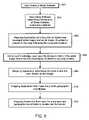
- FIG. 6is a flowchart illustrating a method for providing more accurate geocode data according to the principles of the present invention. FIG. 6 will be described in conjunction with FIGS. 3-5 .
- a user of an applicationis prompted to enter a street address as shown and described in conjunction with FIG. 4 .
- the userindicates completion by selecting a button on the display labeled “submit” 410 .
- a geocoder 318retrieves information from a streets file and determines the geocode data (latitude and longitude) for the street address.
- the geographic locations of the endpoints of the streetare stored in the streets files (database) along with the range of numbers for the street.
- the geocoderinterpolates geographic coordinates (latitude/longitude) retrieved from the streets database for the endpoints of the street address along the street address.
- the mapping software 316FIG.
- each lot or property parcelthat is, each measured parcel of land having fixed boundaries and designated on a plot of survey, on the street segment is the same width.
- the mapping software 316also assumes that the building on each lot on the street is the same distance from center of the street/road, and that the building is located in the center of the lot. Based on the interpolation, the geocoder 318 assigns geocode data to the street address.
- a mapping applicationcreates a map of a geographical area around the computed location, with the computed location being in the center of the map.
- the mapis displayed in the display image on the screen of the display device as shown in FIG. 5 .
- a building symbol 506is displayed on the map in the location corresponding to the computed geocode data.
- the mapping softwareretrieves a georeferenced aerial image from the stored aerial images 310 for the same geographical area represented by the map and transmits the aerial image for display by the client on the screen of the display device as shown in FIG. 4 .
- a star symbol 532 representing the computed geocodedis overlaid on top of the aerial image to indicate the location of the computed geocode.
- both the mapwhich may be overlaid with other geographical information, such as, natural hazards, for example, flood zones and earthquake zones and the aerial image are displayed on the screen of the display device.
- the mapprovides distance from the building at the street address to natural hazards, such as flood zones.
- the aerial imageallows the user to visualize the location of the building represented in the map. Due to inaccuracies in the streets database used to produce the map, the location of the building at the street address may be incorrectly represented in the map. As the location identified by the computed geocode data is also identified in the georeferenced aerial image, the user can quickly determine if the identified location is correct.
- the usercan select the correct building in the aerial image by selecting the correct building directly on the georeferenced aerial image using a user input device.
- a user input deviceis a mouse
- the mouseas the mouse is moved on a surface, such as a desktop a cursor (an on-screen icon) moves on the screen with movements of the mouse.
- the mousecan be a mechanical mouse, an optical mouse or an optomechanical mouse or any other type of mouse.
- step 608notification of the “mouse click” is received by the mapping application.
- the mapping applicationdetermines the x, y display screen co-ordinates of the selected location in the aerial image provided by the “mouse click” event.
- the x, y display screen co-ordinatesmap to a pixel (picture (pix) element), that is, the smallest element in the displayed image.
- the mapping applicationdetermines the geographic coordinates that map to the identified pixel. Geographical coordinates are known for at least two opposite corners of the georeferenced aerial image. Thus, knowing the dimension of the image in pixels and the location of the selected pixel, geographical coordinates for the selected pixel in the aerial image can be computed using the known geographical coordinates. These computed geographical co-ordinates for the selected pixel are the corrected geocode data for the street address.
- the mapping applicationuses the corrected geocode data to create a map with the corrected geocode in the center of the map.
- the location of the corrected street addressis indicated in the map.
- An aerial image covering the same geographic area represented by the mapis retrieved and displayed on the screen of the display image.
- the corrected geocode datais then used for further geographic analysis, for example, to compute risk factors associated with the street address, such as, distance from flood zone.
- FIG. 7illustrates the display screen, after the mapping software has created the map based on the corrected geocode data for the building.
- the building symbol 506is displayed in the center of the map at the location identified by the corrected geocode data.
- a star symbol 532 overlaid on top of building 516identifies building 516 in the aerial image corresponding to the corrected geocode data.
- This corrected geographical location (geocode data) of the building at the street addressis used to perform future geographic queries. As shown in FIG. 6 , the placement of the building has changed based on the corrected geocode data. In the case of the flood zone, the distance of the flood zone to the corrected geographical location has been recomputed and displayed. Based on the corrected geocode data, the flood zone further from the building, and the risk of the flood has changed to low. The location identified by the corrected geocode data is outside of the flood zone as indicated by the selection of field 548 labeled “OUT”.
- the systemprovides interactive feedback allowing a location corresponding to a street address to be corrected and corresponding geographic queries to be rerun using the corrected geographic location.
- the geographical locationis computed automatically based on a “click” of a mouse on an aerial image indicating the corrected location.
- any positional error in the mapcan be corrected quickly.
- accurate geographic queriescan be performed quickly.
- the geographical information systemcan use the corrected geographical location to automatically make a more accurate determination or to obtain a more accurate answer to any further geospatial queries.
- the inventionhas been described for an embodiment in which aerial photographs are used to correct the location of the street address, in an alternate embodiment satellite images or any other geo-referenced figure or drawing can be used instead of an aerial image.
- the drawingcan be a parcel map, topographical map or any other map that is drawn to scale and georeferenced.
- the postal codealso referred to as a ZIP (Zone Improvement Program) code in the United States, or a city or state can be used as the initial geocode data to select the geographic area in which the street address is located.
- ZIPZero Improvement Program
- the location of the buildingis positioned initially in the geographic center of the ZIP code area. In many cases, this approximation of the geographic location is adequate and the correct location can be determined by zooming in to the street address on the map and viewing the corresponding aerial image.
- the initial geographic area represented by the mapcan be selected by requesting a map centered on a landmark. For example, to find a building on an unknown street close to a well-known monument, the geographic area can be selected based on the geographical location of the monument provided by the streets file. By displaying the map centered on the monument and the aerial image of the geographical area represented by the map, the location of the building can be easily identified and the street address retrieved for the identified building.
- the map and the aerial imageare displayed side-by-side.
- the map and aerial imagecan be combined by overlaying the map on top of the aerial image.
- the inventionhas been described for risk analysis based on flood zones. However, the invention is not limited to flood zones or risk analysis. The invention can be used for any application that requires accurate geographical location information.
- a computer usable mediumcan include a readable memory device, such as a solid state memory device, a hard drive device, a CD-ROM, a DVD-ROM, or a computer diskette, having computer readable program code segments stored thereon.
- the computer readable mediumcan also include a communications or transmission medium, such as a bus or a communications link, either optical, wired, or wireless, having program code segments carried thereon as digital or analog data signals.
Landscapes
- Engineering & Computer Science (AREA)
- Physics & Mathematics (AREA)
- Theoretical Computer Science (AREA)
- Mathematical Physics (AREA)
- Business, Economics & Management (AREA)
- Educational Administration (AREA)
- Educational Technology (AREA)
- General Physics & Mathematics (AREA)
- Processing Or Creating Images (AREA)
- Instructional Devices (AREA)
Abstract
Description
Claims (26)
Priority Applications (1)
| Application Number | Priority Date | Filing Date | Title |
|---|---|---|---|
| US10/877,060US7636901B2 (en) | 2003-06-27 | 2004-06-25 | System for increasing accuracy of geocode data |
Applications Claiming Priority (2)
| Application Number | Priority Date | Filing Date | Title |
|---|---|---|---|
| US48462203P | 2003-06-27 | 2003-06-27 | |
| US10/877,060US7636901B2 (en) | 2003-06-27 | 2004-06-25 | System for increasing accuracy of geocode data |
Publications (2)
| Publication Number | Publication Date |
|---|---|
| US20050034074A1 US20050034074A1 (en) | 2005-02-10 |
| US7636901B2true US7636901B2 (en) | 2009-12-22 |
Family
ID=34118718
Family Applications (1)
| Application Number | Title | Priority Date | Filing Date |
|---|---|---|---|
| US10/877,060Active2026-12-04US7636901B2 (en) | 2003-06-27 | 2004-06-25 | System for increasing accuracy of geocode data |
Country Status (1)
| Country | Link |
|---|---|
| US (1) | US7636901B2 (en) |
Cited By (53)
| Publication number | Priority date | Publication date | Assignee | Title |
|---|---|---|---|---|
| US20090324815A1 (en)* | 2007-03-13 | 2009-12-31 | Nielsen Steven E | Marking apparatus and marking methods using marking dispenser with machine-readable id mechanism |
| US20100253514A1 (en)* | 2008-10-02 | 2010-10-07 | Certusview Technologies, Llc | Locate transmitter configured to detect out-of-tolerance conditions in connection with underground facility locate operations, and associated methods and systems |
| US7885959B2 (en)* | 2005-02-21 | 2011-02-08 | Computer Process Controls, Inc. | Enterprise controller display method |
| US20110071960A1 (en)* | 2002-10-31 | 2011-03-24 | Emerson Retail Services, Inc. | System For Monitoring Optimal Equipment Operating Parameters |
| US8065886B2 (en) | 2001-05-03 | 2011-11-29 | Emerson Retail Services, Inc. | Refrigeration system energy monitoring and diagnostics |
| US8077927B1 (en)* | 2006-11-17 | 2011-12-13 | Corelogic Real Estate Solutions, Llc | Updating a database with determined change identifiers |
| US8265344B2 (en) | 2008-02-12 | 2012-09-11 | Certusview Technologies, Llc | Electronic manifest of underground facility locate operation |
| US8270666B2 (en) | 2008-02-12 | 2012-09-18 | Certusview Technologies, Llc | Searchable electronic records of underground facility locate marking operations |
| US8280631B2 (en) | 2008-10-02 | 2012-10-02 | Certusview Technologies, Llc | Methods and apparatus for generating an electronic record of a marking operation based on marking device actuations |
| US8311765B2 (en) | 2009-08-11 | 2012-11-13 | Certusview Technologies, Llc | Locating equipment communicatively coupled to or equipped with a mobile/portable device |
| US8374789B2 (en) | 2007-04-04 | 2013-02-12 | Certusview Technologies, Llc | Systems and methods for using marking information to electronically display dispensing of markers by a marking system or marking tool |
| US8401791B2 (en) | 2007-03-13 | 2013-03-19 | Certusview Technologies, Llc | Methods for evaluating operation of marking apparatus |
| US8400155B2 (en) | 2008-10-02 | 2013-03-19 | Certusview Technologies, Llc | Methods and apparatus for displaying an electronic rendering of a locate operation based on an electronic record of locate information |
| US20130096987A1 (en)* | 2011-10-06 | 2013-04-18 | Ut Battelle, Llc | Citizen engagement for energy efficient communities |
| US8442766B2 (en) | 2008-10-02 | 2013-05-14 | Certusview Technologies, Llc | Marking apparatus having enhanced features for underground facility marking operations, and associated methods and systems |
| US8473106B2 (en) | 2009-05-29 | 2013-06-25 | Emerson Climate Technologies Retail Solutions, Inc. | System and method for monitoring and evaluating equipment operating parameter modifications |
| US8478523B2 (en) | 2007-03-13 | 2013-07-02 | Certusview Technologies, Llc | Marking apparatus and methods for creating an electronic record of marking apparatus operations |
| US8495886B2 (en) | 2001-05-03 | 2013-07-30 | Emerson Climate Technologies Retail Solutions, Inc. | Model-based alarming |
| US8510141B2 (en) | 2008-10-02 | 2013-08-13 | Certusview Technologies, Llc | Methods and apparatus for generating alerts on a marking device, based on comparing electronic marking information to facilities map information and/or other image information |
| US8542884B1 (en)* | 2006-11-17 | 2013-09-24 | Corelogic Solutions, Llc | Systems and methods for flood area change detection |
| US8572193B2 (en) | 2009-02-10 | 2013-10-29 | Certusview Technologies, Llc | Methods, apparatus, and systems for providing an enhanced positive response in underground facility locate and marking operations |
| US8583372B2 (en) | 2009-12-07 | 2013-11-12 | Certusview Technologies, Llc | Methods, apparatus, and systems for facilitating compliance with marking specifications for dispensing marking material |
| US8583264B2 (en) | 2008-10-02 | 2013-11-12 | Certusview Technologies, Llc | Marking device docking stations and methods of using same |
| US8589202B2 (en) | 2008-10-02 | 2013-11-19 | Certusview Technologies, Llc | Methods and apparatus for displaying and processing facilities map information and/or other image information on a marking device |
| US8620616B2 (en) | 2009-08-20 | 2013-12-31 | Certusview Technologies, Llc | Methods and apparatus for assessing marking operations based on acceleration information |
| US8620572B2 (en) | 2009-08-20 | 2013-12-31 | Certusview Technologies, Llc | Marking device with transmitter for triangulating location during locate operations |
| US8649567B1 (en)* | 2006-11-17 | 2014-02-11 | Corelogic Solutions, Llc | Displaying a flood change map with change designators |
| US8781499B2 (en) | 2012-06-28 | 2014-07-15 | Floodsearch Llc | Methods and systems for remote flood zone determinations |
| US8830265B2 (en) | 2009-07-07 | 2014-09-09 | Certusview Technologies, Llc | Methods, apparatus and systems for generating searchable electronic records of underground facility marking operations and assessing aspects of same |
| US8902251B2 (en) | 2009-02-10 | 2014-12-02 | Certusview Technologies, Llc | Methods, apparatus and systems for generating limited access files for searchable electronic records of underground facility locate and/or marking operations |
| US8930836B2 (en) | 2008-10-02 | 2015-01-06 | Certusview Technologies, Llc | Methods and apparatus for displaying an electronic rendering of a locate and/or marking operation using display layers |
| US8965700B2 (en) | 2008-10-02 | 2015-02-24 | Certusview Technologies, Llc | Methods and apparatus for generating an electronic record of environmental landmarks based on marking device actuations |
| US8964338B2 (en) | 2012-01-11 | 2015-02-24 | Emerson Climate Technologies, Inc. | System and method for compressor motor protection |
| US8977558B2 (en) | 2010-08-11 | 2015-03-10 | Certusview Technologies, Llc | Methods, apparatus and systems for facilitating generation and assessment of engineering plans |
| US8974573B2 (en) | 2004-08-11 | 2015-03-10 | Emerson Climate Technologies, Inc. | Method and apparatus for monitoring a refrigeration-cycle system |
| CN104508730A (en)* | 2012-08-02 | 2015-04-08 | 株式会社电装 | Storage device, navigation device, and map database creation method |
| US9004004B2 (en) | 2008-07-10 | 2015-04-14 | Certusview Technologies, Llc | Optical sensing methods and apparatus for detecting a color of a marking substance |
| US9097522B2 (en) | 2009-08-20 | 2015-08-04 | Certusview Technologies, Llc | Methods and marking devices with mechanisms for indicating and/or detecting marking material color |
| US9121407B2 (en) | 2004-04-27 | 2015-09-01 | Emerson Climate Technologies, Inc. | Compressor diagnostic and protection system and method |
| US9140728B2 (en) | 2007-11-02 | 2015-09-22 | Emerson Climate Technologies, Inc. | Compressor sensor module |
| US9177403B2 (en) | 2008-10-02 | 2015-11-03 | Certusview Technologies, Llc | Methods and apparatus for overlaying electronic marking information on facilities map information and/or other image information displayed on a marking device |
| US9280269B2 (en) | 2008-02-12 | 2016-03-08 | Certusview Technologies, Llc | Electronic manifest of underground facility locate marks |
| US9285802B2 (en) | 2011-02-28 | 2016-03-15 | Emerson Electric Co. | Residential solutions HVAC monitoring and diagnosis |
| US9310439B2 (en) | 2012-09-25 | 2016-04-12 | Emerson Climate Technologies, Inc. | Compressor having a control and diagnostic module |
| US9310094B2 (en) | 2007-07-30 | 2016-04-12 | Emerson Climate Technologies, Inc. | Portable method and apparatus for monitoring refrigerant-cycle systems |
| US9551504B2 (en) | 2013-03-15 | 2017-01-24 | Emerson Electric Co. | HVAC system remote monitoring and diagnosis |
| US9638436B2 (en) | 2013-03-15 | 2017-05-02 | Emerson Electric Co. | HVAC system remote monitoring and diagnosis |
| US9765979B2 (en) | 2013-04-05 | 2017-09-19 | Emerson Climate Technologies, Inc. | Heat-pump system with refrigerant charge diagnostics |
| US9803902B2 (en) | 2013-03-15 | 2017-10-31 | Emerson Climate Technologies, Inc. | System for refrigerant charge verification using two condenser coil temperatures |
| US9823632B2 (en) | 2006-09-07 | 2017-11-21 | Emerson Climate Technologies, Inc. | Compressor data module |
| US9885507B2 (en) | 2006-07-19 | 2018-02-06 | Emerson Climate Technologies, Inc. | Protection and diagnostic module for a refrigeration system |
| US20180239031A1 (en)* | 2015-08-13 | 2018-08-23 | Propeller Aerobotics Pty Ltd | Integrated visual geo-referencing target unit and method of operation |
| US10798520B2 (en) | 2012-06-28 | 2020-10-06 | Floodsearch Llc | Remote flood zone determination method, system, and computer program product |
Families Citing this family (44)
| Publication number | Priority date | Publication date | Assignee | Title |
|---|---|---|---|---|
| US7343303B2 (en) | 2000-07-19 | 2008-03-11 | Ijet International, Inc. | Global asset risk management system and methods |
| US7783500B2 (en) | 2000-07-19 | 2010-08-24 | Ijet International, Inc. | Personnel risk management system and methods |
| US7038619B2 (en)* | 2001-12-31 | 2006-05-02 | Rdp Associates, Incorporated | Satellite positioning system enabled media measurement system and method |
| US7155336B2 (en)* | 2004-03-24 | 2006-12-26 | A9.Com, Inc. | System and method for automatically collecting images of objects at geographic locations and displaying same in online directories |
| CA2559726C (en) | 2004-03-24 | 2015-10-20 | A9.Com, Inc. | System and method for displaying images in an online directory |
| AU2005267688A1 (en)* | 2004-07-30 | 2006-02-09 | Nielson Media Research, Inc. | Methods and apparatus for improving the accuracy and reach of electronic media exposure measurement systems |
| US20060241859A1 (en) | 2005-04-21 | 2006-10-26 | Microsoft Corporation | Virtual earth real-time advertising |
| JP4246195B2 (en)* | 2005-11-01 | 2009-04-02 | パナソニック株式会社 | Car navigation system |
| US20070185649A1 (en)* | 2006-02-08 | 2007-08-09 | Tele Atlas North America, Inc. | Map database having address points for determining destinations |
| US7539573B2 (en) | 2006-06-23 | 2009-05-26 | Pitney Bowes Software Inc. | Enhanced positional accuracy in geocoding by dynamic interpolation |
| US8655595B1 (en) | 2006-10-17 | 2014-02-18 | Corelogic Solutions, Llc | Systems and methods for quantifying flood risk |
| US7917292B1 (en) | 2006-10-17 | 2011-03-29 | Jpmorgan Chase Bank, N.A. | Systems and methods for flood risk assessment |
| US8538918B1 (en) | 2006-12-05 | 2013-09-17 | Corelogic Solutions, Llc | Systems and methods for tracking parcel data acquisition |
| US8253797B1 (en)* | 2007-03-05 | 2012-08-28 | PureTech Systems Inc. | Camera image georeferencing systems |
| US8688368B2 (en)* | 2007-04-09 | 2014-04-01 | Microsoft Corporation | Image-based localization for addresses |
| WO2008127626A1 (en)* | 2007-04-13 | 2008-10-23 | Hntb Holdings Ltd | System asset management |
| US8626789B2 (en) | 2007-06-01 | 2014-01-07 | Microsoft Corporation | Geocoding using information retrieval |
| US8775960B1 (en) | 2008-03-10 | 2014-07-08 | United Services Automobile Association (Usaa) | Systems and methods for geographic mapping and review |
| US20100188088A1 (en)* | 2008-10-02 | 2010-07-29 | Certusview Technologies, Llc | Methods and apparatus for displaying and processing facilities map information and/or other image information on a locate device |
| CA2691780C (en)* | 2009-02-11 | 2015-09-22 | Certusview Technologies, Llc | Management system, and associated methods and apparatus, for providing automatic assesment of a locate operation |
| US9020745B2 (en)* | 2009-03-30 | 2015-04-28 | Microsoft Technology Licensing, Llc | Business data display and position correction in street-side imagery |
| US8929918B2 (en)* | 2010-04-07 | 2015-01-06 | Telefonaktiebolaget L M Ericsson (Publ) | Positioning and location services using civic address information |
| US8478516B2 (en)* | 2010-05-17 | 2013-07-02 | Fujitsu Limited | Method and system for providing navigation assistance on a mobile device |
| US9639757B2 (en)* | 2011-09-23 | 2017-05-02 | Corelogic Solutions, Llc | Building footprint extraction apparatus, method and computer program product |
| US8655873B2 (en) | 2011-10-28 | 2014-02-18 | Geofeedr, Inc. | System and method for aggregating and distributing geotagged content |
| US8595317B1 (en) | 2012-09-14 | 2013-11-26 | Geofeedr, Inc. | System and method for generating, accessing, and updating geofeeds |
| US8639767B1 (en) | 2012-12-07 | 2014-01-28 | Geofeedr, Inc. | System and method for generating and managing geofeed-based alerts |
| US8655983B1 (en) | 2012-12-07 | 2014-02-18 | Geofeedr, Inc. | System and method for location monitoring based on organized geofeeds |
| US8612533B1 (en) | 2013-03-07 | 2013-12-17 | Geofeedr, Inc. | System and method for creating and managing geofeeds |
| US8850531B1 (en) | 2013-03-07 | 2014-09-30 | Geofeedia, Inc. | System and method for targeted messaging, workflow management, and digital rights management for geofeeds |
| US9307353B2 (en) | 2013-03-07 | 2016-04-05 | Geofeedia, Inc. | System and method for differentially processing a location input for content providers that use different location input formats |
| US9881163B2 (en)* | 2013-03-12 | 2018-01-30 | Pictometry International Corp. | System and method for performing sensitive geo-spatial processing in non-sensitive operator environments |
| US8849935B1 (en) | 2013-03-15 | 2014-09-30 | Geofeedia, Inc. | Systems and method for generating three-dimensional geofeeds, orientation-based geofeeds, and geofeeds based on ambient conditions based on content provided by social media content providers |
| US8862589B2 (en)* | 2013-03-15 | 2014-10-14 | Geofeedia, Inc. | System and method for predicting a geographic origin of content and accuracy of geotags related to content obtained from social media and other content providers |
| US9753950B2 (en)* | 2013-03-15 | 2017-09-05 | Pictometry International Corp. | Virtual property reporting for automatic structure detection |
| US9317600B2 (en) | 2013-03-15 | 2016-04-19 | Geofeedia, Inc. | View of a physical space augmented with social media content originating from a geo-location of the physical space |
| JP5617027B1 (en)* | 2013-12-25 | 2014-10-29 | ナレッジスイート株式会社 | Information management system and information management program |
| US10019761B2 (en) | 2014-04-25 | 2018-07-10 | State Farm Mutual Automobile Insurance Company | System and method for virtual inspection of a structure |
| US20150310557A1 (en)* | 2014-04-25 | 2015-10-29 | State Farm Mutual Automobile Insurance Company | System and Method for Intelligent Aerial Image Data Processing |
| US9485318B1 (en) | 2015-07-29 | 2016-11-01 | Geofeedia, Inc. | System and method for identifying influential social media and providing location-based alerts |
| US10937165B2 (en)* | 2018-03-21 | 2021-03-02 | International Business Machines Corporation | Comparison of relevant portions of images |
| CN113646753B (en)* | 2018-12-28 | 2025-08-01 | 浙江大华技术股份有限公司 | Image display system and method |
| CN111784238B (en)* | 2020-06-11 | 2024-03-05 | 上海东普信息科技有限公司 | Electronic fence ordering method and device, terminal equipment and storage medium |
| CN112836092A (en)* | 2021-01-11 | 2021-05-25 | Oppo广东移动通信有限公司 | A data processing method, device and storage medium |
Citations (16)
| Publication number | Priority date | Publication date | Assignee | Title |
|---|---|---|---|---|
| US5794178A (en)* | 1993-09-20 | 1998-08-11 | Hnc Software, Inc. | Visualization of information using graphical representations of context vector based relationships and attributes |
| US6101496A (en)* | 1998-06-08 | 2000-08-08 | Mapinfo Corporation | Ordered information geocoding method and apparatus |
| US20010026270A1 (en) | 2000-03-29 | 2001-10-04 | Higgins Darin Wayne | System and method for synchronizing raster and vector map images |
| US20010033292A1 (en) | 2000-03-29 | 2001-10-25 | Scott Dan Martin | System and method for georeferencing digital raster maps |
| US20020124015A1 (en)* | 1999-08-03 | 2002-09-05 | Cardno Andrew John | Method and system for matching data |
| US6552670B2 (en) | 2000-05-26 | 2003-04-22 | Switchboard Incorporated | Location encoder |
| US6631326B1 (en) | 2000-03-29 | 2003-10-07 | Sourceprose Corporation | System and method for performing flood zone certifications |
| US6658356B2 (en)* | 2002-02-15 | 2003-12-02 | International Business Machines Corporation | Programmatically deriving street geometry from address data |
| US20030225725A1 (en) | 2001-05-31 | 2003-12-04 | Miller Julia K. | System and method for geocoding diverse address formats |
| US20040138817A1 (en)* | 2002-11-15 | 2004-07-15 | Zoken Jack M. | Methods for assigning geocodes to street addressable entities |
| US20060012582A1 (en)* | 2004-07-15 | 2006-01-19 | De Lega Xavier C | Transparent film measurements |
| US7031959B2 (en)* | 2000-11-17 | 2006-04-18 | United States Postal Service | Address matching |
| US20060125828A1 (en)* | 2002-02-11 | 2006-06-15 | Landnet Corporation | Land software tool |
| US7076452B2 (en)* | 2000-10-23 | 2006-07-11 | Costar Group, Inc. | System and method for collection, distribution, and use of information in connection with commercial real estate |
| US7085650B2 (en)* | 2002-02-15 | 2006-08-01 | Gis Data Resources, Inc. | System and method of geospatially mapping topological regions and displaying their attributes |
| US7171389B2 (en)* | 2001-06-01 | 2007-01-30 | Landnet Corporation | Identification, storage and display of land data on a website |
- 2004
- 2004-06-25USUS10/877,060patent/US7636901B2/enactiveActive
Patent Citations (24)
| Publication number | Priority date | Publication date | Assignee | Title |
|---|---|---|---|---|
| US5794178A (en)* | 1993-09-20 | 1998-08-11 | Hnc Software, Inc. | Visualization of information using graphical representations of context vector based relationships and attributes |
| US6101496A (en)* | 1998-06-08 | 2000-08-08 | Mapinfo Corporation | Ordered information geocoding method and apparatus |
| US20020124015A1 (en)* | 1999-08-03 | 2002-09-05 | Cardno Andrew John | Method and system for matching data |
| US20010033291A1 (en) | 2000-03-29 | 2001-10-25 | Scott Dan Martin | System and method for georeferencing digital raster maps |
| US20010028348A1 (en) | 2000-03-29 | 2001-10-11 | Higgins Darin Wayne | System and method for synchronizing raster and vector map images |
| US20010033292A1 (en) | 2000-03-29 | 2001-10-25 | Scott Dan Martin | System and method for georeferencing digital raster maps |
| US20040078143A1 (en)* | 2000-03-29 | 2004-04-22 | Sourceprose Corporation | System and method for performing flood zone certifications |
| US20010033290A1 (en) | 2000-03-29 | 2001-10-25 | Scott Dan Martin | System and method for georeferencing digial raster maps |
| US20010026271A1 (en) | 2000-03-29 | 2001-10-04 | Higgins Darin Wayne | System and method for synchronizing raster and vector map images |
| US20030052896A1 (en) | 2000-03-29 | 2003-03-20 | Higgins Darin Wayne | System and method for synchronizing map images |
| US6631326B1 (en) | 2000-03-29 | 2003-10-07 | Sourceprose Corporation | System and method for performing flood zone certifications |
| US20010026270A1 (en) | 2000-03-29 | 2001-10-04 | Higgins Darin Wayne | System and method for synchronizing raster and vector map images |
| US6678615B2 (en)* | 2000-03-29 | 2004-01-13 | Sourceprose Corporation | System and method for performing flood zone certifications |
| US6552670B2 (en) | 2000-05-26 | 2003-04-22 | Switchboard Incorporated | Location encoder |
| US7076452B2 (en)* | 2000-10-23 | 2006-07-11 | Costar Group, Inc. | System and method for collection, distribution, and use of information in connection with commercial real estate |
| US7031959B2 (en)* | 2000-11-17 | 2006-04-18 | United States Postal Service | Address matching |
| US20030225725A1 (en) | 2001-05-31 | 2003-12-04 | Miller Julia K. | System and method for geocoding diverse address formats |
| US7039640B2 (en)* | 2001-05-31 | 2006-05-02 | Mapinfo Corporation | System and method for geocoding diverse address formats |
| US7171389B2 (en)* | 2001-06-01 | 2007-01-30 | Landnet Corporation | Identification, storage and display of land data on a website |
| US20060125828A1 (en)* | 2002-02-11 | 2006-06-15 | Landnet Corporation | Land software tool |
| US6658356B2 (en)* | 2002-02-15 | 2003-12-02 | International Business Machines Corporation | Programmatically deriving street geometry from address data |
| US7085650B2 (en)* | 2002-02-15 | 2006-08-01 | Gis Data Resources, Inc. | System and method of geospatially mapping topological regions and displaying their attributes |
| US20040138817A1 (en)* | 2002-11-15 | 2004-07-15 | Zoken Jack M. | Methods for assigning geocodes to street addressable entities |
| US20060012582A1 (en)* | 2004-07-15 | 2006-01-19 | De Lega Xavier C | Transparent film measurements |
Cited By (129)
| Publication number | Priority date | Publication date | Assignee | Title |
|---|---|---|---|---|
| US8065886B2 (en) | 2001-05-03 | 2011-11-29 | Emerson Retail Services, Inc. | Refrigeration system energy monitoring and diagnostics |
| US8495886B2 (en) | 2001-05-03 | 2013-07-30 | Emerson Climate Technologies Retail Solutions, Inc. | Model-based alarming |
| US8316658B2 (en) | 2001-05-03 | 2012-11-27 | Emerson Climate Technologies Retail Solutions, Inc. | Refrigeration system energy monitoring and diagnostics |
| US8700444B2 (en) | 2002-10-31 | 2014-04-15 | Emerson Retail Services Inc. | System for monitoring optimal equipment operating parameters |
| US20110071960A1 (en)* | 2002-10-31 | 2011-03-24 | Emerson Retail Services, Inc. | System For Monitoring Optimal Equipment Operating Parameters |
| US9121407B2 (en) | 2004-04-27 | 2015-09-01 | Emerson Climate Technologies, Inc. | Compressor diagnostic and protection system and method |
| US10335906B2 (en) | 2004-04-27 | 2019-07-02 | Emerson Climate Technologies, Inc. | Compressor diagnostic and protection system and method |
| US9669498B2 (en) | 2004-04-27 | 2017-06-06 | Emerson Climate Technologies, Inc. | Compressor diagnostic and protection system and method |
| US9023136B2 (en) | 2004-08-11 | 2015-05-05 | Emerson Climate Technologies, Inc. | Method and apparatus for monitoring a refrigeration-cycle system |
| US9021819B2 (en) | 2004-08-11 | 2015-05-05 | Emerson Climate Technologies, Inc. | Method and apparatus for monitoring a refrigeration-cycle system |
| US9690307B2 (en) | 2004-08-11 | 2017-06-27 | Emerson Climate Technologies, Inc. | Method and apparatus for monitoring refrigeration-cycle systems |
| US9017461B2 (en) | 2004-08-11 | 2015-04-28 | Emerson Climate Technologies, Inc. | Method and apparatus for monitoring a refrigeration-cycle system |
| US8974573B2 (en) | 2004-08-11 | 2015-03-10 | Emerson Climate Technologies, Inc. | Method and apparatus for monitoring a refrigeration-cycle system |
| US9046900B2 (en) | 2004-08-11 | 2015-06-02 | Emerson Climate Technologies, Inc. | Method and apparatus for monitoring refrigeration-cycle systems |
| US9081394B2 (en) | 2004-08-11 | 2015-07-14 | Emerson Climate Technologies, Inc. | Method and apparatus for monitoring a refrigeration-cycle system |
| US9086704B2 (en) | 2004-08-11 | 2015-07-21 | Emerson Climate Technologies, Inc. | Method and apparatus for monitoring a refrigeration-cycle system |
| US9304521B2 (en) | 2004-08-11 | 2016-04-05 | Emerson Climate Technologies, Inc. | Air filter monitoring system |
| US10558229B2 (en) | 2004-08-11 | 2020-02-11 | Emerson Climate Technologies Inc. | Method and apparatus for monitoring refrigeration-cycle systems |
| US7885961B2 (en) | 2005-02-21 | 2011-02-08 | Computer Process Controls, Inc. | Enterprise control and monitoring system and method |
| US7885959B2 (en)* | 2005-02-21 | 2011-02-08 | Computer Process Controls, Inc. | Enterprise controller display method |
| US9885507B2 (en) | 2006-07-19 | 2018-02-06 | Emerson Climate Technologies, Inc. | Protection and diagnostic module for a refrigeration system |
| US9823632B2 (en) | 2006-09-07 | 2017-11-21 | Emerson Climate Technologies, Inc. | Compressor data module |
| US8542884B1 (en)* | 2006-11-17 | 2013-09-24 | Corelogic Solutions, Llc | Systems and methods for flood area change detection |
| US8649567B1 (en)* | 2006-11-17 | 2014-02-11 | Corelogic Solutions, Llc | Displaying a flood change map with change designators |
| US8077927B1 (en)* | 2006-11-17 | 2011-12-13 | Corelogic Real Estate Solutions, Llc | Updating a database with determined change identifiers |
| US8478523B2 (en) | 2007-03-13 | 2013-07-02 | Certusview Technologies, Llc | Marking apparatus and methods for creating an electronic record of marking apparatus operations |
| US8407001B2 (en) | 2007-03-13 | 2013-03-26 | Certusview Technologies, Llc | Systems and methods for using location data to electronically display dispensing of markers by a marking system or marking tool |
| US8903643B2 (en) | 2007-03-13 | 2014-12-02 | Certusview Technologies, Llc | Hand-held marking apparatus with location tracking system and methods for logging geographic location of same |
| US8775077B2 (en) | 2007-03-13 | 2014-07-08 | Certusview Technologies, Llc | Systems and methods for using location data to electronically display dispensing of markers by a marking system or marking tool |
| US8473209B2 (en) | 2007-03-13 | 2013-06-25 | Certusview Technologies, Llc | Marking apparatus and marking methods using marking dispenser with machine-readable ID mechanism |
| US20090324815A1 (en)* | 2007-03-13 | 2009-12-31 | Nielsen Steven E | Marking apparatus and marking methods using marking dispenser with machine-readable id mechanism |
| US8700325B2 (en) | 2007-03-13 | 2014-04-15 | Certusview Technologies, Llc | Marking apparatus and methods for creating an electronic record of marking operations |
| US9086277B2 (en) | 2007-03-13 | 2015-07-21 | Certusview Technologies, Llc | Electronically controlled marking apparatus and methods |
| US8401791B2 (en) | 2007-03-13 | 2013-03-19 | Certusview Technologies, Llc | Methods for evaluating operation of marking apparatus |
| US8374789B2 (en) | 2007-04-04 | 2013-02-12 | Certusview Technologies, Llc | Systems and methods for using marking information to electronically display dispensing of markers by a marking system or marking tool |
| US8386178B2 (en) | 2007-04-04 | 2013-02-26 | Certusview Technologies, Llc | Marking system and method |
| US10352602B2 (en) | 2007-07-30 | 2019-07-16 | Emerson Climate Technologies, Inc. | Portable method and apparatus for monitoring refrigerant-cycle systems |
| US9310094B2 (en) | 2007-07-30 | 2016-04-12 | Emerson Climate Technologies, Inc. | Portable method and apparatus for monitoring refrigerant-cycle systems |
| US9194894B2 (en) | 2007-11-02 | 2015-11-24 | Emerson Climate Technologies, Inc. | Compressor sensor module |
| US9140728B2 (en) | 2007-11-02 | 2015-09-22 | Emerson Climate Technologies, Inc. | Compressor sensor module |
| US10458404B2 (en) | 2007-11-02 | 2019-10-29 | Emerson Climate Technologies, Inc. | Compressor sensor module |
| US9471835B2 (en) | 2008-02-12 | 2016-10-18 | Certusview Technologies, Llc | Electronic manifest of underground facility locate marks |
| US9280269B2 (en) | 2008-02-12 | 2016-03-08 | Certusview Technologies, Llc | Electronic manifest of underground facility locate marks |
| US8532342B2 (en)* | 2008-02-12 | 2013-09-10 | Certusview Technologies, Llc | Electronic manifest of underground facility locate marks |
| US8630463B2 (en) | 2008-02-12 | 2014-01-14 | Certusview Technologies, Llc | Searchable electronic records of underground facility locate marking operations |
| US8532341B2 (en) | 2008-02-12 | 2013-09-10 | Certusview Technologies, Llc | Electronically documenting locate operations for underground utilities |
| US8340359B2 (en) | 2008-02-12 | 2012-12-25 | Certusview Technologies, Llc | Electronic manifest of underground facility locate marks |
| US8543937B2 (en) | 2008-02-12 | 2013-09-24 | Certusview Technologies, Llc | Methods and apparatus employing a reference grid for generating electronic manifests of underground facility marking operations |
| US8416995B2 (en) | 2008-02-12 | 2013-04-09 | Certusview Technologies, Llc | Electronic manifest of underground facility locate marks |
| US8290204B2 (en) | 2008-02-12 | 2012-10-16 | Certusview Technologies, Llc | Searchable electronic records of underground facility locate marking operations |
| US9256964B2 (en) | 2008-02-12 | 2016-02-09 | Certusview Technologies, Llc | Electronically documenting locate operations for underground utilities |
| US9183646B2 (en) | 2008-02-12 | 2015-11-10 | Certusview Technologies, Llc | Apparatus, systems and methods to generate electronic records of underground facility marking operations performed with GPS-enabled marking devices |
| US8270666B2 (en) | 2008-02-12 | 2012-09-18 | Certusview Technologies, Llc | Searchable electronic records of underground facility locate marking operations |
| US8265344B2 (en) | 2008-02-12 | 2012-09-11 | Certusview Technologies, Llc | Electronic manifest of underground facility locate operation |
| US8994749B2 (en) | 2008-02-12 | 2015-03-31 | Certusview Technologies, Llc | Methods, apparatus and systems for generating searchable electronic records of underground facility locate and/or marking operations |
| US8907978B2 (en) | 2008-02-12 | 2014-12-09 | Certusview Technologies, Llc | Methods, apparatus and systems for generating searchable electronic records of underground facility locate and/or marking operations |
| US9004004B2 (en) | 2008-07-10 | 2015-04-14 | Certusview Technologies, Llc | Optical sensing methods and apparatus for detecting a color of a marking substance |
| US9542863B2 (en) | 2008-10-02 | 2017-01-10 | Certusview Technologies, Llc | Methods and apparatus for generating output data streams relating to underground utility marking operations |
| US8400155B2 (en) | 2008-10-02 | 2013-03-19 | Certusview Technologies, Llc | Methods and apparatus for displaying an electronic rendering of a locate operation based on an electronic record of locate information |
| US8478524B2 (en) | 2008-10-02 | 2013-07-02 | Certusview Technologies, Llc | Methods and apparatus for dispensing marking material in connection with underground facility marking operations based on environmental information and/or operational information |
| US8930836B2 (en) | 2008-10-02 | 2015-01-06 | Certusview Technologies, Llc | Methods and apparatus for displaying an electronic rendering of a locate and/or marking operation using display layers |
| US8361543B2 (en) | 2008-10-02 | 2013-01-29 | Certusview Technologies, Llc | Methods and apparatus for displaying an electronic rendering of a marking operation based on an electronic record of marking information |
| US8965700B2 (en) | 2008-10-02 | 2015-02-24 | Certusview Technologies, Llc | Methods and apparatus for generating an electronic record of environmental landmarks based on marking device actuations |
| US20100253514A1 (en)* | 2008-10-02 | 2010-10-07 | Certusview Technologies, Llc | Locate transmitter configured to detect out-of-tolerance conditions in connection with underground facility locate operations, and associated methods and systems |
| US8442766B2 (en) | 2008-10-02 | 2013-05-14 | Certusview Technologies, Llc | Marking apparatus having enhanced features for underground facility marking operations, and associated methods and systems |
| US8478525B2 (en) | 2008-10-02 | 2013-07-02 | Certusview Technologies, Llc | Methods, apparatus, and systems for analyzing use of a marking device by a technician to perform an underground facility marking operation |
| US8510141B2 (en) | 2008-10-02 | 2013-08-13 | Certusview Technologies, Llc | Methods and apparatus for generating alerts on a marking device, based on comparing electronic marking information to facilities map information and/or other image information |
| US8280631B2 (en) | 2008-10-02 | 2012-10-02 | Certusview Technologies, Llc | Methods and apparatus for generating an electronic record of a marking operation based on marking device actuations |
| US8457893B2 (en) | 2008-10-02 | 2013-06-04 | Certusview Technologies, Llc | Methods and apparatus for generating an electronic record of a marking operation including service-related information and/or ticket information |
| US8770140B2 (en) | 2008-10-02 | 2014-07-08 | Certusview Technologies, Llc | Marking apparatus having environmental sensors and operations sensors for underground facility marking operations, and associated methods and systems |
| US8583264B2 (en) | 2008-10-02 | 2013-11-12 | Certusview Technologies, Llc | Marking device docking stations and methods of using same |
| US8731830B2 (en) | 2008-10-02 | 2014-05-20 | Certusview Technologies, Llc | Marking apparatus for receiving environmental information regarding underground facility marking operations, and associated methods and systems |
| US9046621B2 (en) | 2008-10-02 | 2015-06-02 | Certusview Technologies, Llc | Locate apparatus configured to detect out-of-tolerance conditions in connection with underground facility locate operations, and associated methods and systems |
| US8644965B2 (en) | 2008-10-02 | 2014-02-04 | Certusview Technologies, Llc | Marking device docking stations having security features and methods of using same |
| US9069094B2 (en) | 2008-10-02 | 2015-06-30 | Certusview Technologies, Llc | Locate transmitter configured to detect out-of-tolerance conditions in connection with underground facility locate operations, and associated methods and systems |
| US9177403B2 (en) | 2008-10-02 | 2015-11-03 | Certusview Technologies, Llc | Methods and apparatus for overlaying electronic marking information on facilities map information and/or other image information displayed on a marking device |
| US8589202B2 (en) | 2008-10-02 | 2013-11-19 | Certusview Technologies, Llc | Methods and apparatus for displaying and processing facilities map information and/or other image information on a marking device |
| US8612148B2 (en) | 2008-10-02 | 2013-12-17 | Certusview Technologies, Llc | Marking apparatus configured to detect out-of-tolerance conditions in connection with underground facility marking operations, and associated methods and systems |
| US8467969B2 (en) | 2008-10-02 | 2013-06-18 | Certusview Technologies, Llc | Marking apparatus having operational sensors for underground facility marking operations, and associated methods and systems |
| US8600526B2 (en) | 2008-10-02 | 2013-12-03 | Certusview Technologies, Llc | Marking device docking stations having mechanical docking and methods of using same |
| US8572193B2 (en) | 2009-02-10 | 2013-10-29 | Certusview Technologies, Llc | Methods, apparatus, and systems for providing an enhanced positive response in underground facility locate and marking operations |
| US9235821B2 (en) | 2009-02-10 | 2016-01-12 | Certusview Technologies, Llc | Methods, apparatus, and systems for providing an enhanced positive response for underground facility locate and marking operations based on an electronic manifest documenting physical locate marks on ground, pavement or other surface |
| US8902251B2 (en) | 2009-02-10 | 2014-12-02 | Certusview Technologies, Llc | Methods, apparatus and systems for generating limited access files for searchable electronic records of underground facility locate and/or marking operations |
| US9177280B2 (en) | 2009-02-10 | 2015-11-03 | Certusview Technologies, Llc | Methods, apparatus, and systems for acquiring an enhanced positive response for underground facility locate and marking operations based on an electronic manifest documenting physical locate marks on ground, pavement, or other surface |
| US9773217B2 (en) | 2009-02-10 | 2017-09-26 | Certusview Technologies, Llc | Methods, apparatus, and systems for acquiring an enhanced positive response for underground facility locate and marking operations |
| US8473106B2 (en) | 2009-05-29 | 2013-06-25 | Emerson Climate Technologies Retail Solutions, Inc. | System and method for monitoring and evaluating equipment operating parameter modifications |
| US9395711B2 (en) | 2009-05-29 | 2016-07-19 | Emerson Climate Technologies Retail Solutions, Inc. | System and method for monitoring and evaluating equipment operating parameter modifications |
| US8761908B2 (en) | 2009-05-29 | 2014-06-24 | Emerson Climate Technologies Retail Solutions, Inc. | System and method for monitoring and evaluating equipment operating parameter modifications |
| US9159107B2 (en) | 2009-07-07 | 2015-10-13 | Certusview Technologies, Llc | Methods, apparatus and systems for generating location-corrected searchable electronic records of underground facility locate and/or marking operations |
| US8830265B2 (en) | 2009-07-07 | 2014-09-09 | Certusview Technologies, Llc | Methods, apparatus and systems for generating searchable electronic records of underground facility marking operations and assessing aspects of same |
| US9189821B2 (en) | 2009-07-07 | 2015-11-17 | Certusview Technologies, Llc | Methods, apparatus and systems for generating digital-media-enhanced searchable electronic records of underground facility locate and/or marking operations |
| US8907980B2 (en) | 2009-07-07 | 2014-12-09 | Certus View Technologies, LLC | Methods, apparatus and systems for generating searchable electronic records of underground facility locate and/or marking operations |
| US9165331B2 (en) | 2009-07-07 | 2015-10-20 | Certusview Technologies, Llc | Methods, apparatus and systems for generating searchable electronic records of underground facility locate and/or marking operations and assessing aspects of same |
| US8928693B2 (en) | 2009-07-07 | 2015-01-06 | Certusview Technologies, Llc | Methods, apparatus and systems for generating image-processed searchable electronic records of underground facility locate and/or marking operations |
| US8917288B2 (en) | 2009-07-07 | 2014-12-23 | Certusview Technologies, Llc | Methods, apparatus and systems for generating accuracy-annotated searchable electronic records of underground facility locate and/or marking operations |
| US8311765B2 (en) | 2009-08-11 | 2012-11-13 | Certusview Technologies, Llc | Locating equipment communicatively coupled to or equipped with a mobile/portable device |
| US9097522B2 (en) | 2009-08-20 | 2015-08-04 | Certusview Technologies, Llc | Methods and marking devices with mechanisms for indicating and/or detecting marking material color |
| US8620616B2 (en) | 2009-08-20 | 2013-12-31 | Certusview Technologies, Llc | Methods and apparatus for assessing marking operations based on acceleration information |
| US8620572B2 (en) | 2009-08-20 | 2013-12-31 | Certusview Technologies, Llc | Marking device with transmitter for triangulating location during locate operations |
| US8583372B2 (en) | 2009-12-07 | 2013-11-12 | Certusview Technologies, Llc | Methods, apparatus, and systems for facilitating compliance with marking specifications for dispensing marking material |
| US8977558B2 (en) | 2010-08-11 | 2015-03-10 | Certusview Technologies, Llc | Methods, apparatus and systems for facilitating generation and assessment of engineering plans |
| US9285802B2 (en) | 2011-02-28 | 2016-03-15 | Emerson Electric Co. | Residential solutions HVAC monitoring and diagnosis |
| US9703287B2 (en) | 2011-02-28 | 2017-07-11 | Emerson Electric Co. | Remote HVAC monitoring and diagnosis |
| US10234854B2 (en) | 2011-02-28 | 2019-03-19 | Emerson Electric Co. | Remote HVAC monitoring and diagnosis |
| US10884403B2 (en) | 2011-02-28 | 2021-01-05 | Emerson Electric Co. | Remote HVAC monitoring and diagnosis |
| US20130096987A1 (en)* | 2011-10-06 | 2013-04-18 | Ut Battelle, Llc | Citizen engagement for energy efficient communities |
| US8964338B2 (en) | 2012-01-11 | 2015-02-24 | Emerson Climate Technologies, Inc. | System and method for compressor motor protection |
| US9590413B2 (en) | 2012-01-11 | 2017-03-07 | Emerson Climate Technologies, Inc. | System and method for compressor motor protection |
| US9876346B2 (en) | 2012-01-11 | 2018-01-23 | Emerson Climate Technologies, Inc. | System and method for compressor motor protection |
| US10798520B2 (en) | 2012-06-28 | 2020-10-06 | Floodsearch Llc | Remote flood zone determination method, system, and computer program product |
| US10034125B2 (en) | 2012-06-28 | 2018-07-24 | Floodsearch Llc | Remote flood zone determination method, system, and computer program product |
| US8781499B2 (en) | 2012-06-28 | 2014-07-15 | Floodsearch Llc | Methods and systems for remote flood zone determinations |
| CN104508730A (en)* | 2012-08-02 | 2015-04-08 | 株式会社电装 | Storage device, navigation device, and map database creation method |
| CN104508730B (en)* | 2012-08-02 | 2017-09-12 | 株式会社电装 | Storage device, guider and map data base preparation method |
| US9310439B2 (en) | 2012-09-25 | 2016-04-12 | Emerson Climate Technologies, Inc. | Compressor having a control and diagnostic module |
| US9762168B2 (en) | 2012-09-25 | 2017-09-12 | Emerson Climate Technologies, Inc. | Compressor having a control and diagnostic module |
| US9803902B2 (en) | 2013-03-15 | 2017-10-31 | Emerson Climate Technologies, Inc. | System for refrigerant charge verification using two condenser coil temperatures |
| US10274945B2 (en) | 2013-03-15 | 2019-04-30 | Emerson Electric Co. | HVAC system remote monitoring and diagnosis |
| US10488090B2 (en) | 2013-03-15 | 2019-11-26 | Emerson Climate Technologies, Inc. | System for refrigerant charge verification |
| US9551504B2 (en) | 2013-03-15 | 2017-01-24 | Emerson Electric Co. | HVAC system remote monitoring and diagnosis |
| US10775084B2 (en) | 2013-03-15 | 2020-09-15 | Emerson Climate Technologies, Inc. | System for refrigerant charge verification |
| US9638436B2 (en) | 2013-03-15 | 2017-05-02 | Emerson Electric Co. | HVAC system remote monitoring and diagnosis |
| US10060636B2 (en) | 2013-04-05 | 2018-08-28 | Emerson Climate Technologies, Inc. | Heat pump system with refrigerant charge diagnostics |
| US10443863B2 (en) | 2013-04-05 | 2019-10-15 | Emerson Climate Technologies, Inc. | Method of monitoring charge condition of heat pump system |
| US9765979B2 (en) | 2013-04-05 | 2017-09-19 | Emerson Climate Technologies, Inc. | Heat-pump system with refrigerant charge diagnostics |
| US20180239031A1 (en)* | 2015-08-13 | 2018-08-23 | Propeller Aerobotics Pty Ltd | Integrated visual geo-referencing target unit and method of operation |
| US11086025B2 (en)* | 2015-08-13 | 2021-08-10 | Propeller Aerobotics Pty Ltd | Integrated visual geo-referencing target unit and method of operation |
| US20210341630A1 (en)* | 2015-08-13 | 2021-11-04 | Propeller Aerobotics Pty Ltd | Integrated Visual Geo-Referencing Target Unit And Method Of Operation |
| US11650331B2 (en)* | 2015-08-13 | 2023-05-16 | Propeller Aerobotics Pty Ltd | Integrated visual geo-referencing target unit and method of operation |
Also Published As
| Publication number | Publication date |
|---|---|
| US20050034074A1 (en) | 2005-02-10 |
Similar Documents
| Publication | Publication Date | Title |
|---|---|---|
| US7636901B2 (en) | System for increasing accuracy of geocode data | |
| US8675995B2 (en) | Precisely locating features on geospatial imagery | |
| US7190377B2 (en) | System and method for georeferencing digital raster maps with resistance to potential errors | |
| US8897541B2 (en) | Accurate digitization of a georeferenced image | |
| US8368695B2 (en) | Transforming offline maps into interactive online maps | |
| US9471986B2 (en) | Image-based georeferencing | |
| US6930715B1 (en) | Method, system and program product for augmenting an image of a scene with information about the scene | |
| US8854453B2 (en) | Determining geographic position information from a single image | |
| US5414462A (en) | Method and apparatus for generating a comprehensive survey map | |
| US20110010650A1 (en) | Systems and methods for decluttering electronic map displays | |
| US9552669B2 (en) | System, apparatus, and method for utilizing geographic information systems | |
| US20060293847A1 (en) | Interactive scaling feature having scalability in three dimensional space | |
| US20010032050A1 (en) | System and method for performing flood zone certifications | |
| US8294710B2 (en) | Extensible map with pluggable modes | |
| KR20210022343A (en) | Method and system for providing mixed reality contents related to underground facilities | |
| US10521943B1 (en) | Lot planning | |
| US20180357779A1 (en) | Systems and methods for dynamically providing scale information on a digital map | |
| Cetl et al. | A comparison of address geocoding techniques–case study of the city of Zagreb, Croatia | |
| JP2010506337A (en) | System and method for visualizing and measuring real-world 3-D spatial data | |
| US9188444B2 (en) | 3D object positioning in street view | |
| CN113272626B (en) | Concentric distance ring and distance visualization | |
| Diakité | About the Geo-referencing of BIM models | |
| TWI812967B (en) | Regional price display device excluding special objects | |
| TWI833440B (en) | Information presentation device using landmarks to define blocks | |
| JP6961033B2 (en) | Lot number information provision system, lot number information provision method |
Legal Events
| Date | Code | Title | Description |
|---|---|---|---|
| AS | Assignment | Owner name:CDS BUSINESS MAPPING LLC, MASSACHUSETTS Free format text:ASSIGNMENT OF ASSIGNORS INTEREST;ASSIGNORS:MUNSON, DANIEL E.;MUNSON, KENNETH A.;MUNSON, JAMES M.;REEL/FRAME:015283/0100;SIGNING DATES FROM 20041020 TO 20041021 | |
| STCF | Information on status: patent grant | Free format text:PATENTED CASE | |
| CC | Certificate of correction | ||
| FPAY | Fee payment | Year of fee payment:4 | |
| AS | Assignment | Owner name:BANK OF AMERICA, N.A., AS COLLATERAL AGENT, TEXAS Free format text:SECURITY INTEREST;ASSIGNOR:CDS BUSINESS MAPPING, LLC;REEL/FRAME:032798/0197 Effective date:20140404 | |
| FPAY | Fee payment | Year of fee payment:8 | |
| AS | Assignment | Owner name:CDS BUSINESS MAPPING, LLC, CONNECTICUT Free format text:RELEASE OF SECURITY INTEREST RECORDED AT 032798/0197;ASSIGNOR:BANK OF AMERICA, N.A.;REEL/FRAME:056493/0876 Effective date:20210604 | |
| AS | Assignment | Owner name:U.S. BANK NATIONAL ASSOCIATION, OREGON Free format text:SECURITY INTEREST;ASSIGNORS:CDS BUSINESS MAPPING, LLC;CLAREITY SECURITY, LLC;CORELOGIC CREDCO, LLC;AND OTHERS;REEL/FRAME:056539/0146 Effective date:20210604 Owner name:ARES CAPITAL CORPORATION, NEW YORK Free format text:SECOND LIEN PATENT SECURITY AGREEMENT;ASSIGNORS:CDS BUSINESS MAPPING, LLC;CLAREITY SECURITY, LLC;CORELOGIC CREDCO, LLC;AND OTHERS;REEL/FRAME:056539/0227 Effective date:20210604 Owner name:JPMORGAN CHASE BANK, N.A., OHIO Free format text:FIRST LIEN PATENT SECURITY AGREEMENT;ASSIGNORS:CDS BUSINESS MAPPING, LLC;CLAREITY SECURITY, LLC;CORELOGIC CREDCO, LLC;AND OTHERS;REEL/FRAME:056539/0241 Effective date:20210604 | |
| MAFP | Maintenance fee payment | Free format text:PAYMENT OF MAINTENANCE FEE, 12TH YEAR, LARGE ENTITY (ORIGINAL EVENT CODE: M1553); ENTITY STATUS OF PATENT OWNER: LARGE ENTITY Year of fee payment:12 |