US7606687B2 - Proximity search methods using tiles to represent geographical zones - Google Patents
Proximity search methods using tiles to represent geographical zonesDownload PDFInfo
- Publication number
- US7606687B2 US7606687B2US10/941,227US94122704AUS7606687B2US 7606687 B2US7606687 B2US 7606687B2US 94122704 AUS94122704 AUS 94122704AUS 7606687 B2US7606687 B2US 7606687B2
- Authority
- US
- United States
- Prior art keywords
- location
- index
- reference location
- pointer
- predefined geographic
- Prior art date
- Legal status (The legal status is an assumption and is not a legal conclusion. Google has not performed a legal analysis and makes no representation as to the accuracy of the status listed.)
- Ceased, expires
Links
Images


Classifications
- G—PHYSICS
- G06—COMPUTING OR CALCULATING; COUNTING
- G06F—ELECTRIC DIGITAL DATA PROCESSING
- G06F16/00—Information retrieval; Database structures therefor; File system structures therefor
- G06F16/20—Information retrieval; Database structures therefor; File system structures therefor of structured data, e.g. relational data
- G06F16/29—Geographical information databases
Definitions
- the present inventiongenerally relates to proximity search techniques, and more specifically, to a method and a system for performing searches based on proximity to a reference location.
- a geographic locationmay be represented as latitude and longitude.
- FIG. 1illustrates a map of the world with latitude lines shown every 30 degrees and longitude lines shown every 30 degrees. The distance between any two points on the map shown in FIG. 1 may be calculated based on their latitude and longitude positions, and the known radius of the earth (6371.01 km or 3958.76 miles).
- Latitude and longitude positions for locations specified using zip codes, postal codes and citiesmay be obtained from third party databases using a simple table look-up.
- a handheld electronic devicesuch as a pocket PC, cell phone or a personal digital assistant (PDA) may have a GPS receiver and associated software for determining the latitude and longitude position of the handheld electronic device.
- PDApersonal digital assistant
- a proximity search of database records with respect to a reference locationis carried out by calculating the distances between the reference location and the locations associated with each of the database records. First, the latitude and longitude positions of the reference location are obtained. Second, the latitude and longitude positions of the locations associated with the database records are obtained. Third, the distances between the reference location and the locations associated with the database records are calculated. Fourth, the database records associated with locations that are within a certain distance (as specified in the proximity search request) from the reference location are selected to be included in the search results.
- the proximity search method carried out in the above mannerbecomes computationally very expensive because of the large number of distance calculations that are required.
- Distance calculations that are based on zip codes and postal codeshave been used to reduce the computational cost, but are not very accurate, and only work for locations in countries having postal codes that are mapped to latitude-longitude values.
- Quad trees and R-Treesthat rely on a two-dimensional grid of regions and subregions have been used to describe the locations of objects in a two-dimensional space, but they require binary-like searches to zero in on the appropriate regions. For proximity searching, they are either too inaccurate (e.g., when the region size is large) or computationally too expensive (e.g., when the region size is sufficiently small).
- the inventionprovides an improved proximity search technique that is either faster or more accurate than the ones employed in the current art.
- the earthis divided into predefined geographic regions of substantially equal areas, referred to as tiles, and records that are searched based on proximity to a reference location include location pointers, each of which identifies a particular tile that encompasses the physical location indicated by the corresponding record.
- location pointerseach of which identifies a particular tile that encompasses the physical location indicated by the corresponding record.
- the reference locationmay be specified in the proximity search as a zip code, city-state, or city-country, or the location of the user requesting the proximity search may be retrieved from a database as the reference location. If the user requesting the proximity search is carrying a handheld electronic device that includes a GPS receiver and associated software, the reference location may also be specified as the current location of the user as determined by the GPS receiver and associated software.
- the latitude and longitude of the reference locationare obtained and the tile that includes the latitude and longitude of the reference location is identified.
- the searched records that have location pointers that point to those tiles that are within the specified distance from the reference location tileare then selected for inclusion in the search results.
- Proximity searches carried out in the above mannerno longer require individual distance calculations between the reference location and each database record being searched. As a result, the total number of distance calculations is reduced with the invention and the speed of the executed searches is increased.
- the inventionalso provides flexibility in designing proximity searches, e.g., the accuracy of proximity searches can be increased by decreasing the tile size and the speed of the proximity searches can be increased by increasing the tile size.
- FIG. 1is a map of the world illustrating latitude and longitude lines that uniquely identify a location on the map;
- FIG. 2is a map of the world employing a coordinate system defining points that represent geographic regions having substantially the same area;
- FIG. 3is a diagram illustrating the relationships between members in a social network
- FIG. 4is a block diagram illustrating a system for creating and managing an online social network
- FIG. 5shows a simplified user interface with which a new record is entered into a database
- FIG. 6is a flow diagram illustrating how a location pointer is obtained for the new record entered in FIG. 5 ;
- FIG. 7illustrates a database containing records having location information
- FIG. 8shows an input interface for specifying a search query that includes a proximity criteria
- FIG. 9is a flow diagram illustrating how search results that are responsive to the search query of FIG. 8 are obtained.
- Each geographic location in FIG. 1which can be represented as latitude and longitude, may be mapped onto a point in FIG. 2 .
- the map of FIG. 1is divided into a plurality predefined geographical regions or areas, referred to as tiles, and all points contained in one tile map onto a single point in FIG. 2 .
- a tilecan have any configuration, but in the embodiment of the invention described herein, each such tile covers roughly the same area in FIG. 1 and all four sides of each such tile have the same fixed length.
- the right tip of the triangle in FIG. 2represents the (LatQ, LongQ) pair corresponding to the tile that contains the equator at the international date line (longitude: 180° E or 180° W).
- the upper and lower sides of the triangle in FIG. 2represent the international date line that is approached when moving west to east.
- a social networkis generally defined by the relationships among groups of individuals, and may include relationships ranging from casual acquaintances to close familial bonds.
- a social networkmay be represented using a graph structure. Each node of the graph corresponds to a member of the social network. Edges connecting two nodes represent a relationship between two individuals.
- the degree of separation between any two nodesis defined as the minimum number of hops required to traverse the graph from one node to the other.
- a degree of separation between two membersis a measure of relatedness between the two members.
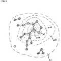
- FIG. 3illustrates a graph representation of a social network centered on a given individual (ME).
- Other members of this social networkinclude A-U whose position, relative to ME's, is referred to by the degree of separation between ME and each other member.
- Friends of MEwhich includes A, B, and C, are separated from ME by one degree of separation (1 d/s).
- a friend of a friend of MEis separated from ME by 2 d/s.
- D, E, F and Gare each separated from ME by 2 d/s.
- a friend of a friend of a friend of MEis separated from ME by 3 d/s.
- FIG. 1depicts all nodes separated from ME by more than 3 degrees of separation as belonging to the category ALL.
- Degrees of separation in a social networkare defined relative to an individual. For example, in ME's social network, H and ME are separated by 2 d/s, whereas in G's social network, H and G are separated by only 1 d/s. Accordingly, each individual will have their own set of first, second and third degree relationships.
- an individual's social networkmay be extended to include nodes to an Nth degree of separation. As the number of degrees increases beyond three, however, the number of nodes typically grows at an explosive rate and quickly begins to mirror the ALL set.
- FIG. 4is a block diagram illustrating a system for creating and managing an online social network.
- FIG. 4illustrates a system 100 , including an application server 200 and graph servers 300 .
- the computers of system 100are connected by a network 400 , e.g., the Internet, and accessible by over the network by a plurality of computers, collectively designated as 500 .
- the application server 200manages a member database 210 , a relationship database 220 , and a search database 230 .
- the member database 210contains profile information for each of the members in the online social network managed by the system 100 .
- the profile informationmay include, among other things: a unique member identifier, name, age, gender, location, hometown, references to image files, listing of interests, attributes, and the like.
- the location informationmay include: (i) address, city, state, zip code or postal code, and country; (ii) latitude and longitude values associated with the specified address, zip code, postal code, city-state or city-country; and (iii) a pointer to a tile that includes the location associated with the latitude and longitude values.
- the relationship database 220stores information defining to the first degree relationships between members.
- the relationship database 220stores information relating to the first degree relationships between members.
- the contents of the member database 210are indexed and optimized for search, and stored in the search database 230 .
- the member database 210 , the relationship database 220 , and the search database 230are updated to reflect inputs of new member information and edits of existing member information that are made through the computers 500 .
- the application server 200also manages the information exchange requests that it receives from the remote computers 500 .
- the graph servers 300receive a query from the application server 200 , process the query and return the query results to the application server 200 .
- Graph servers 300store a graph representation of the social network defined by all of the members (nodes) and their corresponding relationships (edges).
- the graph servers 300respond to requests from application server 200 to identify relationships and the degree of separation between members of the online social network.
- the application server 200is further configured to query a third party service 600 for latitude and longitude values corresponding to location information (e.g., address, zip code, postal code, city-state, city-country, etc.) that it sends as a part of the query.
- the third party service 600looks up the latitude and longitude values corresponding to the location specified in the query from its database 610 and returns the latitude and longitude values to the application server 200 .
- the database containing latitude and longitude values corresponding to locations specified in terms of address, zip code, postal code, city-state, and/or city-countrymay be maintained as part of the computer system 100 and accessed internally by the application server 200 .
- FIG. 5shows a simplified user interface with which a new record is entered into the member database 210 .
- the inputsinclude location information such as the address, city, state and zip code. Persons not living in the U.S. will enter country information in place of state and postal code information instead of zip code.
- FIG. 6is a flow diagram illustrating how a location pointer is obtained for a new record and stored in the member database 210 .
- user inputse.g., those made with the user interface of FIG. 5
- the computer system 100queries a third party service 600 for latitude and longitude values corresponding to the location information associated with the new record and receives them from the third party service 600 .
- the location parameters that are passed to the third party service 600may be address, city, state, country, zip code, postal code, or any combination of the foregoing.
- the third party service 600looks up the latitude and longitude values corresponding to the location parameters and returns them to the computer system 100 . In an alternative embodiment, the latitude and longitude look up is not performed by the third party service 600 , but by the computer system 100 .
- ris the length of the sides of the tiles and is 3.4 miles; and latitude and longitude values are expressed in degrees.
- Accuracy in the proximity searchescan be improved by reducing r, but at the expense of computational speed.
- Computation speed of the proximity searchescan be increased by increasing r, but at the expense of accuracy.
- Step 604the (LatQ, LongQ) pair is stored in the member database 210 as part of the new record and is used as a pointer to identify the particular tile that covers the location associated with the new record.
- the (LatQ, LongQ) pairmay be packed into a single integer value.
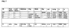
- FIG. 7illustrates a member database 210 containing location information. It shows the location information for records ME, A, B, C, and U, and the corresponding latitude and longitude values. Each record also has a pointer (x, y) that identifies the particular tile that covers the location associated with such record. Each of these pointers was derived in the manner illustrated in FIG. 6 when its corresponding record was entered into the database as a new record.
- FIG. 8shows a sample input interface for specifying a search query that includes a proximity criterion.
- the input parameter “Your Location”defaults to the zip code of the person who is requesting this search, but it may be changed by the user if the user desires to perform the proximity search with respect to a different zip code.
- the search queryis being entered using a handheld electronic device that includes a GPS receiver and associated software that automatically determines the latitude and longitude values associated with the current location of the handheld electronic device, and the user desires to perform the proximity search based on the GPS-determined location, the user leaves the “Your Location” field blank, and the latitude and longitude values determined by the GPS receiver and associated software appears in the corresponding “Latitude” and “Longitude” fields and are passed as part of the search query.
- the location specified in the “Your Location” field or the GPS-determined locationrepresents the reference location from which the proximity search will be carried out.
- the input parameter “Proximity”defines the distance value that is used in carrying out the proximity search.
- a distance value of 25 miles, as illustrated in FIG. 8means that the proximity search will be carried out for all records having associated locations that are within 25 miles of the reference location.
- Other input parametersmay be specified in conducting a proximity search (e.g., keywords, gender preference, marital status, etc.), but for simplicity, are not illustrated here.
- the inventionis applicable to any type of proximity searches, and not limited to proximity searches for members within a social network.
- FIG. 9is a flow diagram illustrating how search results that are responsive to the search query are obtained.
- the proximity search parameterse.g., those made with the user interface of FIG. 8
- Step 901the proximity search parameters, e.g., those made with the user interface of FIG. 8
- Step 902a decision is made as to whether latitude and longitude values are passed as part of the search query. If not, the reference location information, e.g., zip code, is passed to the third party service 600 , and the third party service 600 looks up the latitude and longitude values corresponding to the reference location information and returns them to the computer system 100 (Step 903 ). In an alternative embodiment, the latitude and longitude look up is not performed by the third party service 600 , but by the computer system 100 . Flow then proceeds to Step 904 .
- the reference location informatione.g., zip code
- Step 904a set of (LatQ, LongQ) values that correspond to the longitude of the reference location and are within the specified distance from the reference location is obtained.
- Step 905for each (LatQ, LongQ) value in the set obtained in Step 904 , all LongQ values that are within the specified distance directly to the west and directly to the east (i.e., to the west and to the east along the same latitude) are obtained.
- Step 906all (LatQ, LongQ) values obtained in Step 905 are compiled into an array as valid location pointers.
- Step 907if any records in the database have (LatQ, LongQ) values that are contained in the array of valid location pointers, these records are included in the search results.
Landscapes
- Engineering & Computer Science (AREA)
- Databases & Information Systems (AREA)
- Theoretical Computer Science (AREA)
- Remote Sensing (AREA)
- Data Mining & Analysis (AREA)
- Physics & Mathematics (AREA)
- General Engineering & Computer Science (AREA)
- General Physics & Mathematics (AREA)
- Information Retrieval, Db Structures And Fs Structures Therefor (AREA)
Abstract
Description
LatQ=Int((latitude+90)*k/r+1); and
LongQ=Int((longitude+180)*kCos (latitude/r+1),
where latitude and longitude values are expressed in degrees; k is a factor for converting a 1-degree arc measured with respect to earth's center into miles (k=2π*(earth's radius)/360°=69.0933 miles/degree); r is the length of each side of a tile (in the illustrated embodiment, r=3.4 miles); and LatQ and LongQ define the position of a tile in the coordinate system shown in
LatQ=Int((latitude+90)*k/r+1); and
LongQ=Int((longitude+180)*k* Cos (latitude)/r+1).
where k is a factor for converting a 1-degree arc measured with respect to earth's center into miles (k=2π*(earth's radius)/360°=69.0933 miles/degree); r is the length of the sides of the tiles and is 3.4 miles; and latitude and longitude values are expressed in degrees. Accuracy in the proximity searches can be improved by reducing r, but at the expense of computational speed. Computation speed of the proximity searches can be increased by increasing r, but at the expense of accuracy.
- Range=Round((Distance−(r/2.0))/r); //r=3.4 miles, as specified before;
- Distance represents the distance value that is specified in the search query;
| Round represents an integer operation of rounding up |
| for (i = −Range; i <= Range; i++) { |
| midBoxLat = latitude + i * r / k; // latitude is the latitude of | |
| the reference location; k is the factor for converting 1 degree of | |
| latitude into miles and equals 69.0933 miles/degree | |
| midBoxLatQ = Int((midBoxLat + 90)*k/r+1); | |
| midBoxLonQ = Int((longitude+180)*k*Cos(midBoxLat)/r+1); // | |
| longitude is the longitude of the reference location | |
| for (j = midBoxLonQ − Range; j <= midBoxLonQ +Range; j++) { |
| list.add((midBoxLatQ | j); |
| } |
| } |
Claims (11)
Priority Applications (2)
| Application Number | Priority Date | Filing Date | Title |
|---|---|---|---|
| US10/941,227US7606687B2 (en) | 2004-09-14 | 2004-09-14 | Proximity search methods using tiles to represent geographical zones |
| US13/277,008USRE44876E1 (en) | 2004-09-14 | 2011-10-19 | Proximity search methods using tiles to represent geographical zones |
Applications Claiming Priority (1)
| Application Number | Priority Date | Filing Date | Title |
|---|---|---|---|
| US10/941,227US7606687B2 (en) | 2004-09-14 | 2004-09-14 | Proximity search methods using tiles to represent geographical zones |
Related Child Applications (1)
| Application Number | Title | Priority Date | Filing Date |
|---|---|---|---|
| US13/277,008ReissueUSRE44876E1 (en) | 2004-09-14 | 2011-10-19 | Proximity search methods using tiles to represent geographical zones |
Publications (2)
| Publication Number | Publication Date |
|---|---|
| US20060058958A1 US20060058958A1 (en) | 2006-03-16 |
| US7606687B2true US7606687B2 (en) | 2009-10-20 |
Family
ID=36035209
Family Applications (2)
| Application Number | Title | Priority Date | Filing Date |
|---|---|---|---|
| US10/941,227CeasedUS7606687B2 (en) | 2004-09-14 | 2004-09-14 | Proximity search methods using tiles to represent geographical zones |
| US13/277,008Active2027-01-01USRE44876E1 (en) | 2004-09-14 | 2011-10-19 | Proximity search methods using tiles to represent geographical zones |
Family Applications After (1)
| Application Number | Title | Priority Date | Filing Date |
|---|---|---|---|
| US13/277,008Active2027-01-01USRE44876E1 (en) | 2004-09-14 | 2011-10-19 | Proximity search methods using tiles to represent geographical zones |
Country Status (1)
| Country | Link |
|---|---|
| US (2) | US7606687B2 (en) |
Cited By (27)
| Publication number | Priority date | Publication date | Assignee | Title |
|---|---|---|---|---|
| US20090292626A1 (en)* | 2008-04-22 | 2009-11-26 | Oxford J Craig | System and method for interactive map, database, and social networking engine |
| US20090327928A1 (en)* | 2008-03-05 | 2009-12-31 | Anastasia Dedis | Method and System Facilitating Two-Way Interactive Communication and Relationship Management |
| US20100011081A1 (en)* | 2004-05-12 | 2010-01-14 | Crowley Dennis P | Location-Based Social Software for Mobile Devices |
| US20110161827A1 (en)* | 2008-03-05 | 2011-06-30 | Anastasia Dedis | Social media communication and contact organization |
| US8073590B1 (en) | 2008-08-22 | 2011-12-06 | Boadin Technology, LLC | System, method, and computer program product for utilizing a communication channel of a mobile device by a vehicular assembly |
| US8078397B1 (en) | 2008-08-22 | 2011-12-13 | Boadin Technology, LLC | System, method, and computer program product for social networking utilizing a vehicular assembly |
| US8117242B1 (en) | 2008-01-18 | 2012-02-14 | Boadin Technology, LLC | System, method, and computer program product for performing a search in conjunction with use of an online application |
| US8117225B1 (en) | 2008-01-18 | 2012-02-14 | Boadin Technology, LLC | Drill-down system, method, and computer program product for focusing a search |
| US8131458B1 (en) | 2008-08-22 | 2012-03-06 | Boadin Technology, LLC | System, method, and computer program product for instant messaging utilizing a vehicular assembly |
| US8180829B2 (en) | 2006-03-20 | 2012-05-15 | Boadin Technology, LLC | Message board aggregator |
| US8185096B2 (en) | 2007-02-05 | 2012-05-22 | Boadin Technology, LLC | Systems and methods for multi-modal mobile media services |
| US8190692B1 (en) | 2008-08-22 | 2012-05-29 | Boadin Technology, LLC | Location-based messaging system, method, and computer program product |
| US8229458B2 (en) | 2007-04-08 | 2012-07-24 | Enhanced Geographic Llc | Systems and methods to determine the name of a location visited by a user of a wireless device |
| US8265862B1 (en) | 2008-08-22 | 2012-09-11 | Boadin Technology, LLC | System, method, and computer program product for communicating location-related information |
| US8352419B2 (en) | 2006-09-14 | 2013-01-08 | Stragent, Llc | Online marketplace for automatically extracted data |
| US8385964B2 (en) | 2005-04-04 | 2013-02-26 | Xone, Inc. | Methods and apparatuses for geospatial-based sharing of information by multiple devices |
| US20130103595A1 (en)* | 2011-10-24 | 2013-04-25 | Fannie Mae | Searching real estate using spatial exclusion conditions |
| US20130339094A1 (en)* | 2012-06-13 | 2013-12-19 | Fannie Mae | System and method for including and excluding specific comparables |
| US20140141803A1 (en)* | 2012-11-21 | 2014-05-22 | Apple Inc. | Tiling of map data |
| US8996573B2 (en) | 2011-10-10 | 2015-03-31 | George Peter Kelesis | Journaling system with segregated data access |
| US8996302B2 (en) | 2012-11-30 | 2015-03-31 | Apple Inc. | Reduction of the impact of hard limit constraints in state space models |
| CN104884896A (en)* | 2012-12-31 | 2015-09-02 | 高通股份有限公司 | Context-based parameter mapping for location determination |
| US9128981B1 (en) | 2008-07-29 | 2015-09-08 | James L. Geer | Phone assisted ‘photographic memory’ |
| US20150326682A1 (en)* | 2014-05-12 | 2015-11-12 | Rufus Armor, Llc | System and method for social networking among mutually-interested users |
| US9226111B2 (en) | 2012-11-21 | 2015-12-29 | Apple Inc. | Pathway matching |
| US10796015B2 (en) | 2017-03-29 | 2020-10-06 | Mybitchbook, Inc. | Method and system for anonymous user data storage and controlled data access |
| US11405474B2 (en) | 2019-11-01 | 2022-08-02 | Microsoft Technology Licensing, Llc | Abstracting geographic location to a square block of pre-defined size |
Families Citing this family (25)
| Publication number | Priority date | Publication date | Assignee | Title |
|---|---|---|---|---|
| SG157355A1 (en)* | 2004-10-29 | 2009-12-29 | Skyhook Wireless Inc | Location beacon database and server, method of building location beacon database, and location based service using same |
| US8369264B2 (en) | 2005-10-28 | 2013-02-05 | Skyhook Wireless, Inc. | Method and system for selecting and providing a relevant subset of Wi-Fi location information to a mobile client device so the client device may estimate its position with efficient utilization of resources |
| US8244272B2 (en)* | 2005-02-22 | 2012-08-14 | Skyhook Wireless, Inc. | Continuous data optimization of moved access points in positioning systems |
| JP4742660B2 (en)* | 2005-04-25 | 2011-08-10 | 富士ゼロックス株式会社 | Document processing system |
| US8315233B2 (en) | 2006-07-07 | 2012-11-20 | Skyhook Wireless, Inc. | System and method of gathering WLAN packet samples to improve position estimates of WLAN positioning device |
| US20080108027A1 (en)* | 2006-10-20 | 2008-05-08 | Sallin Matthew D | Graphical radially-extending family hedge |
| US9037409B2 (en)* | 2007-05-04 | 2015-05-19 | Ian Cummings | Navigator database search methods |
| US20090049031A1 (en)* | 2007-08-14 | 2009-02-19 | Hepburn Neil C | Method And System For Database Searching |
| EP2194466A1 (en)* | 2008-11-28 | 2010-06-09 | SEARCHTEQ GmbH | Method and system for indexing data in a search engine or a database for speed-optimized proximity queries with different radii |
| US20100306249A1 (en)* | 2009-05-27 | 2010-12-02 | James Hill | Social network systems and methods |
| US8321435B2 (en)* | 2009-08-12 | 2012-11-27 | Apple Inc. | Quick find for data fields |
| US8406785B2 (en) | 2009-08-18 | 2013-03-26 | Skyhook Wireless, Inc. | Method and system for estimating range of mobile device to wireless installation |
| US8489618B2 (en)* | 2010-01-29 | 2013-07-16 | Lexisnexis Risk Data Management Inc. | Statistical record linkage calibration for geographic proximity matching |
| US9253605B2 (en) | 2010-03-24 | 2016-02-02 | Skyhook Wireless, Inc. | System and method for resolving multiple location estimate conflicts in a WLAN-positioning system |
| US8630657B2 (en) | 2010-06-11 | 2014-01-14 | Skyhook Wireless, Inc. | Systems for and methods of determining likelihood of reference point identity duplication in a positioning system |
| KR101669017B1 (en)* | 2010-07-12 | 2016-10-25 | 톰슨 라이센싱 | System, method and user interface for content search |
| US8606294B2 (en) | 2010-10-05 | 2013-12-10 | Skyhook Wireless, Inc. | Method of and system for estimating temporal demographics of mobile users |
| KR20120053868A (en)* | 2010-11-18 | 2012-05-29 | 한국전자통신연구원 | A apparatus for providing semantic context and a method thereof |
| SE1100374A1 (en)* | 2011-05-17 | 2012-11-18 | Jan Stocklassa | System and procedure |
| US20120331561A1 (en) | 2011-06-22 | 2012-12-27 | Broadstone Andrew J | Method of and Systems for Privacy Preserving Mobile Demographic Measurement of Individuals, Groups and Locations Over Time and Space |
| US20140067658A1 (en)* | 2012-09-06 | 2014-03-06 | Hassen Damon Alhandy | Internet operating system and method |
| US9501526B2 (en) | 2013-04-17 | 2016-11-22 | Excalibur Ip, Llc | Efficient database searching |
| US9589305B2 (en)* | 2014-12-30 | 2017-03-07 | Facebook, Inc. | Techniques for graph based natural language processing |
| US20200058025A1 (en)* | 2018-08-15 | 2020-02-20 | Royal Bank Of Canada | System, methods, and devices for payment recovery platform |
| US11502908B1 (en)* | 2021-06-02 | 2022-11-15 | Zscaler, Inc. | Geo tagging for advanced analytics and policy enforcement on remote devices |
Citations (43)
| Publication number | Priority date | Publication date | Assignee | Title |
|---|---|---|---|---|
| US5848373A (en)* | 1994-06-24 | 1998-12-08 | Delorme Publishing Company | Computer aided map location system |
| US5950200A (en) | 1997-01-24 | 1999-09-07 | Gil S. Sudai | Method and apparatus for detection of reciprocal interests or feelings and subsequent notification |
| US5956397A (en)* | 1993-02-22 | 1999-09-21 | Murex Securities, Ltd. | Automatic routing and information system for telephonic services |
| US5963951A (en)* | 1997-06-30 | 1999-10-05 | Movo Media, Inc. | Computerized on-line dating service for searching and matching people |
| US5968109A (en)* | 1996-10-25 | 1999-10-19 | Navigation Technologies Corporation | System and method for use and storage of geographic data on physical media |
| US5974419A (en)* | 1996-10-25 | 1999-10-26 | Navigation Technologies Corporation | Parcelization of geographic data for storage and use in a navigation application |
| US5978768A (en)* | 1997-05-08 | 1999-11-02 | Mcgovern; Robert J. | Computerized job search system and method for posting and searching job openings via a computer network |
| US6052122A (en) | 1997-06-13 | 2000-04-18 | Tele-Publishing, Inc. | Method and apparatus for matching registered profiles |
| US6061681A (en) | 1997-06-30 | 2000-05-09 | Movo Media, Inc. | On-line dating service for locating and matching people based on user-selected search criteria |
| US6073138A (en) | 1998-06-11 | 2000-06-06 | Boardwalk A.G. | System, method, and computer program product for providing relational patterns between entities |
| US6073105A (en) | 1997-06-13 | 2000-06-06 | Tele-Publishing, Inc. | Interactive personals online network method and apparatus |
| US6175831B1 (en) | 1997-01-17 | 2001-01-16 | Six Degrees, Inc. | Method and apparatus for constructing a networking database and system |
| US6269369B1 (en) | 1997-11-02 | 2001-07-31 | Amazon.Com Holdings, Inc. | Networked personal contact manager |
| US6324541B1 (en) | 1998-06-11 | 2001-11-27 | Boardwalk Ltd. | System, method, and computer program product for providing relational patterns between entities |
| US6363427B1 (en) | 1998-12-18 | 2002-03-26 | Intel Corporation | Method and apparatus for a bulletin board system |
| US6366962B1 (en) | 1998-12-18 | 2002-04-02 | Intel Corporation | Method and apparatus for a buddy list |
| US20020051540A1 (en)* | 2000-10-30 | 2002-05-02 | Glick Barry J. | Cryptographic system and method for geolocking and securing digital information |
| US20020054082A1 (en)* | 1999-01-02 | 2002-05-09 | Karpf Ronald S. | System and method for providing accurate geocoding of responses to location questions in a computer assisted self interview |
| US6401039B1 (en)* | 1997-02-10 | 2002-06-04 | Baron Services, Inc. | System and method for projecting storms using NEXRAD attributes |
| US6408309B1 (en) | 2000-02-23 | 2002-06-18 | Dinesh Agarwal | Method and system for creating an interactive virtual community of famous people |
| US20020086676A1 (en) | 2000-06-10 | 2002-07-04 | Hendrey Geoffrey R. | Method and system for connecting mobile users based on degree of separation |
| US20020123934A1 (en)* | 2000-07-07 | 2002-09-05 | Tanaka Hirohisa A. | Method and apparatus for location-sensitive, subsidized cell phone billing |
| US20020151315A1 (en)* | 2000-12-13 | 2002-10-17 | Gravitate, Inc. | Managing and querying moving point data |
| US6542748B2 (en) | 2000-06-10 | 2003-04-01 | Telcontar | Method and system for automatically initiating a telecommunications connection based on distance |
| US20030069693A1 (en)* | 2001-01-16 | 2003-04-10 | Snapp Douglas N. | Geographic pointing device |
| US20030074471A1 (en)* | 2000-04-03 | 2003-04-17 | Mark Anderson | Method and apparatus for estimating a geographic location of a networked entity |
| US20030154194A1 (en) | 2001-12-28 | 2003-08-14 | Jonas Jeffrey James | Real time data warehousing |
| US20040034601A1 (en) | 2002-08-16 | 2004-02-19 | Erwin Kreuzer | System and method for content distribution and reselling |
| US20040064334A1 (en)* | 2000-10-10 | 2004-04-01 | Geosign Corporation | Method and apparatus for providing geographically authenticated electronic documents |
| US20040066330A1 (en)* | 1997-08-19 | 2004-04-08 | Siemens Automotive Corporation, A Delaware Corporation | Vehicle information system |
| US20040076279A1 (en)* | 2000-05-16 | 2004-04-22 | John Taschereau | Method and system for providing geographically targeted information and advertising |
| US6735568B1 (en) | 2000-08-10 | 2004-05-11 | Eharmony.Com | Method and system for identifying people who are likely to have a successful relationship |
| US20040104842A1 (en)* | 1997-08-19 | 2004-06-03 | Siemens Vdo Automotive Corporation, A Delaware Corporation | Driver information system |
| US20040110515A1 (en)* | 2000-02-29 | 2004-06-10 | Blumberg Brad W. | System and method for providing information based on geographic position |
| US20040117358A1 (en)* | 2002-03-16 | 2004-06-17 | Von Kaenel Tim A. | Method, system, and program for an improved enterprise spatial system |
| US20040139049A1 (en)* | 1996-08-22 | 2004-07-15 | Wgrs Licensing Company, Llc | Unified geographic database and method of creating, maintaining and using the same |
| US20040144301A1 (en) | 2003-01-24 | 2004-07-29 | Neudeck Philip G. | Method for growth of bulk crystals by vapor phase epitaxy |
| US20040148275A1 (en) | 2003-01-29 | 2004-07-29 | Dimitris Achlioptas | System and method for employing social networks for information discovery |
| US20040266457A1 (en)* | 1997-08-20 | 2004-12-30 | Dupray Dennis J. | Wireless location gateway and applications therefor |
| US20050003831A1 (en)* | 1999-01-08 | 2005-01-06 | Anderson Robert J. | Monitoring of call information in a wireless location system |
| US20050015307A1 (en)* | 2003-04-28 | 2005-01-20 | Simpson Todd Garrett | Method and system of providing location sensitive business information to customers |
| US20060200492A1 (en)* | 2004-08-31 | 2006-09-07 | Mario Villena | Automatic evaluation system using specialized communications interfaces |
| US20070005373A1 (en)* | 2004-08-31 | 2007-01-04 | Villena Mario A | Computerized agent and systems for automatic searching of properties having favorable attributes |
Family Cites Families (31)
| Publication number | Priority date | Publication date | Assignee | Title |
|---|---|---|---|---|
| US5835061A (en) | 1995-06-06 | 1998-11-10 | Wayport, Inc. | Method and apparatus for geographic-based communications service |
| JPH102950A (en) | 1995-07-25 | 1998-01-06 | Rookasu:Kk | Positioning system |
| US6202023B1 (en) | 1996-08-22 | 2001-03-13 | Go2 Systems, Inc. | Internet based geographic location referencing system and method |
| US5839088A (en) | 1996-08-22 | 1998-11-17 | Go2 Software, Inc. | Geographic location referencing system and method |
| US5938721A (en) | 1996-10-24 | 1999-08-17 | Trimble Navigation Limited | Position based personal digital assistant |
| US7890581B2 (en)* | 1996-12-16 | 2011-02-15 | Ip Holdings, Inc. | Matching network system for mobile devices |
| US6370513B1 (en) | 1997-08-08 | 2002-04-09 | Parasoft Corporation | Method and apparatus for automated selection, organization, and recommendation of items |
| US6370566B2 (en) | 1998-04-10 | 2002-04-09 | Microsoft Corporation | Generating meeting requests and group scheduling from a mobile device |
| US6014090A (en) | 1997-12-22 | 2000-01-11 | At&T Corp. | Method and apparatus for delivering local information to travelers |
| US6349290B1 (en) | 1998-06-30 | 2002-02-19 | Citibank, N.A. | Automated system and method for customized and personalized presentation of products and services of a financial institution |
| US6343274B1 (en) | 1998-09-11 | 2002-01-29 | Hewlett-Packard | Apparatus and method for merchant-to-consumer advertisement communication system |
| US6701307B2 (en)* | 1998-10-28 | 2004-03-02 | Microsoft Corporation | Method and apparatus of expanding web searching capabilities |
| US6360167B1 (en) | 1999-01-29 | 2002-03-19 | Magellan Dis, Inc. | Vehicle navigation system with location-based multi-media annotation |
| US6381603B1 (en) | 1999-02-22 | 2002-04-30 | Position Iq, Inc. | System and method for accessing local information by using referencing position system |
| US6161071A (en) | 1999-03-12 | 2000-12-12 | Navigation Technologies Corporation | Method and system for an in-vehicle computing architecture |
| US6349257B1 (en) | 1999-09-15 | 2002-02-19 | International Business Machines Corporation | System for personalized mobile navigation information |
| US6374177B1 (en) | 2000-09-20 | 2002-04-16 | Motorola, Inc. | Method and apparatus for providing navigational services in a wireless communication device |
| US6353398B1 (en) | 1999-10-22 | 2002-03-05 | Himanshu S. Amin | System for dynamically pushing information to a user utilizing global positioning system |
| US6343317B1 (en) | 1999-12-29 | 2002-01-29 | Harry A. Glorikian | Internet system for connecting client-travelers with geographically-associated data |
| AU2001253161A1 (en)* | 2000-04-04 | 2001-10-15 | Stick Networks, Inc. | Method and apparatus for scheduling presentation of digital content on a personal communication device |
| US6339397B1 (en) | 2000-06-01 | 2002-01-15 | Lat-Lon, Llc | Portable self-contained tracking unit and GPS tracking system |
| US6356838B1 (en) | 2000-07-25 | 2002-03-12 | Sunil Paul | System and method for determining an efficient transportation route |
| US6618593B1 (en) | 2000-09-08 | 2003-09-09 | Rovingradar, Inc. | Location dependent user matching system |
| US6356812B1 (en) | 2000-09-14 | 2002-03-12 | International Business Machines Corporation | Method and apparatus for displaying information in a vehicle |
| US20020106066A1 (en)* | 2001-02-05 | 2002-08-08 | Onepub.Com | System and methods for providing anonymous telephone communications |
| WO2002063911A1 (en) | 2001-02-08 | 2002-08-15 | Nokia Corporation | Method and apparatus for providing position profiles in mobile value-added services |
| US6505121B1 (en) | 2001-08-01 | 2003-01-07 | Hewlett-Packard Company | Onboard vehicle navigation system |
| AU2003253765A1 (en) | 2002-06-27 | 2004-01-19 | Small World Productions, Inc. | System and method for locating and notifying a user of a person, place or thing having attributes matching the user's stated prefernces |
| US8102253B1 (en)* | 2002-06-27 | 2012-01-24 | Earthcomber, Llc | System and method for notifying a user of people, places or things having attributes matching a user's stated preference |
| US7289814B2 (en)* | 2003-04-01 | 2007-10-30 | International Business Machines Corporation | System and method for detecting proximity between mobile device users |
| US6906643B2 (en)* | 2003-04-30 | 2005-06-14 | Hewlett-Packard Development Company, L.P. | Systems and methods of viewing, modifying, and interacting with “path-enhanced” multimedia |
- 2004
- 2004-09-14USUS10/941,227patent/US7606687B2/ennot_activeCeased
- 2011
- 2011-10-19USUS13/277,008patent/USRE44876E1/enactiveActive
Patent Citations (49)
| Publication number | Priority date | Publication date | Assignee | Title |
|---|---|---|---|---|
| US5956397A (en)* | 1993-02-22 | 1999-09-21 | Murex Securities, Ltd. | Automatic routing and information system for telephonic services |
| US5848373A (en)* | 1994-06-24 | 1998-12-08 | Delorme Publishing Company | Computer aided map location system |
| US20040139049A1 (en)* | 1996-08-22 | 2004-07-15 | Wgrs Licensing Company, Llc | Unified geographic database and method of creating, maintaining and using the same |
| US5968109A (en)* | 1996-10-25 | 1999-10-19 | Navigation Technologies Corporation | System and method for use and storage of geographic data on physical media |
| US5974419A (en)* | 1996-10-25 | 1999-10-26 | Navigation Technologies Corporation | Parcelization of geographic data for storage and use in a navigation application |
| US6175831B1 (en) | 1997-01-17 | 2001-01-16 | Six Degrees, Inc. | Method and apparatus for constructing a networking database and system |
| US5950200A (en) | 1997-01-24 | 1999-09-07 | Gil S. Sudai | Method and apparatus for detection of reciprocal interests or feelings and subsequent notification |
| US6401039B1 (en)* | 1997-02-10 | 2002-06-04 | Baron Services, Inc. | System and method for projecting storms using NEXRAD attributes |
| US5978768A (en)* | 1997-05-08 | 1999-11-02 | Mcgovern; Robert J. | Computerized job search system and method for posting and searching job openings via a computer network |
| US6370510B1 (en) | 1997-05-08 | 2002-04-09 | Careerbuilder, Inc. | Employment recruiting system and method using a computer network for posting job openings and which provides for automatic periodic searching of the posted job openings |
| US6073105A (en) | 1997-06-13 | 2000-06-06 | Tele-Publishing, Inc. | Interactive personals online network method and apparatus |
| US6052122A (en) | 1997-06-13 | 2000-04-18 | Tele-Publishing, Inc. | Method and apparatus for matching registered profiles |
| US6249282B1 (en) | 1997-06-13 | 2001-06-19 | Tele-Publishing, Inc. | Method and apparatus for matching registered profiles |
| US6061681A (en) | 1997-06-30 | 2000-05-09 | Movo Media, Inc. | On-line dating service for locating and matching people based on user-selected search criteria |
| US5963951A (en)* | 1997-06-30 | 1999-10-05 | Movo Media, Inc. | Computerized on-line dating service for searching and matching people |
| US20040104842A1 (en)* | 1997-08-19 | 2004-06-03 | Siemens Vdo Automotive Corporation, A Delaware Corporation | Driver information system |
| US20040066330A1 (en)* | 1997-08-19 | 2004-04-08 | Siemens Automotive Corporation, A Delaware Corporation | Vehicle information system |
| US20040266457A1 (en)* | 1997-08-20 | 2004-12-30 | Dupray Dennis J. | Wireless location gateway and applications therefor |
| US6269369B1 (en) | 1997-11-02 | 2001-07-31 | Amazon.Com Holdings, Inc. | Networked personal contact manager |
| US6324541B1 (en) | 1998-06-11 | 2001-11-27 | Boardwalk Ltd. | System, method, and computer program product for providing relational patterns between entities |
| US6073138A (en) | 1998-06-11 | 2000-06-06 | Boardwalk A.G. | System, method, and computer program product for providing relational patterns between entities |
| US6363427B1 (en) | 1998-12-18 | 2002-03-26 | Intel Corporation | Method and apparatus for a bulletin board system |
| US6366962B1 (en) | 1998-12-18 | 2002-04-02 | Intel Corporation | Method and apparatus for a buddy list |
| US20020054082A1 (en)* | 1999-01-02 | 2002-05-09 | Karpf Ronald S. | System and method for providing accurate geocoding of responses to location questions in a computer assisted self interview |
| US20050003831A1 (en)* | 1999-01-08 | 2005-01-06 | Anderson Robert J. | Monitoring of call information in a wireless location system |
| US6408309B1 (en) | 2000-02-23 | 2002-06-18 | Dinesh Agarwal | Method and system for creating an interactive virtual community of famous people |
| US20040110515A1 (en)* | 2000-02-29 | 2004-06-10 | Blumberg Brad W. | System and method for providing information based on geographic position |
| US7072963B2 (en)* | 2000-04-03 | 2006-07-04 | Quova, Inc. | Method and system to modify geolocation activities based on logged query information |
| US20030074471A1 (en)* | 2000-04-03 | 2003-04-17 | Mark Anderson | Method and apparatus for estimating a geographic location of a networked entity |
| US20040068582A1 (en)* | 2000-04-03 | 2004-04-08 | Mark Anderson | Method and system to initiate geolocation activities on demand and responsive to receipt of a query |
| US20040078489A1 (en)* | 2000-04-03 | 2004-04-22 | Mark Anderson | Method and system to associate a geographic location information with a network address using a combination of automated and manual process |
| US20040076279A1 (en)* | 2000-05-16 | 2004-04-22 | John Taschereau | Method and system for providing geographically targeted information and advertising |
| US6542748B2 (en) | 2000-06-10 | 2003-04-01 | Telcontar | Method and system for automatically initiating a telecommunications connection based on distance |
| US20020086676A1 (en) | 2000-06-10 | 2002-07-04 | Hendrey Geoffrey R. | Method and system for connecting mobile users based on degree of separation |
| US20020123934A1 (en)* | 2000-07-07 | 2002-09-05 | Tanaka Hirohisa A. | Method and apparatus for location-sensitive, subsidized cell phone billing |
| US6735568B1 (en) | 2000-08-10 | 2004-05-11 | Eharmony.Com | Method and system for identifying people who are likely to have a successful relationship |
| US20040064334A1 (en)* | 2000-10-10 | 2004-04-01 | Geosign Corporation | Method and apparatus for providing geographically authenticated electronic documents |
| US20020051540A1 (en)* | 2000-10-30 | 2002-05-02 | Glick Barry J. | Cryptographic system and method for geolocking and securing digital information |
| US20020151315A1 (en)* | 2000-12-13 | 2002-10-17 | Gravitate, Inc. | Managing and querying moving point data |
| US7010308B2 (en)* | 2000-12-13 | 2006-03-07 | Telcontar | Managing and querying moving point data |
| US20030069693A1 (en)* | 2001-01-16 | 2003-04-10 | Snapp Douglas N. | Geographic pointing device |
| US20030154194A1 (en) | 2001-12-28 | 2003-08-14 | Jonas Jeffrey James | Real time data warehousing |
| US20040117358A1 (en)* | 2002-03-16 | 2004-06-17 | Von Kaenel Tim A. | Method, system, and program for an improved enterprise spatial system |
| US20040034601A1 (en) | 2002-08-16 | 2004-02-19 | Erwin Kreuzer | System and method for content distribution and reselling |
| US20040144301A1 (en) | 2003-01-24 | 2004-07-29 | Neudeck Philip G. | Method for growth of bulk crystals by vapor phase epitaxy |
| US20040148275A1 (en) | 2003-01-29 | 2004-07-29 | Dimitris Achlioptas | System and method for employing social networks for information discovery |
| US20050015307A1 (en)* | 2003-04-28 | 2005-01-20 | Simpson Todd Garrett | Method and system of providing location sensitive business information to customers |
| US20060200492A1 (en)* | 2004-08-31 | 2006-09-07 | Mario Villena | Automatic evaluation system using specialized communications interfaces |
| US20070005373A1 (en)* | 2004-08-31 | 2007-01-04 | Villena Mario A | Computerized agent and systems for automatic searching of properties having favorable attributes |
Non-Patent Citations (4)
| Title |
|---|
| "MySQL Reference Manual", , §§ 19.1 and 19.6 (2004). |
| U.S. Appl. No. 10/462,142, filed Jun. 16, 2003, Abrams. |
| U.S. Appl. No. 10/854,054, filed May 26, 2004, Galbreath et al. |
| U.S. Appl. No. 10/854,057, filed May 26, 2004, Galbreath et al. |
Cited By (108)
| Publication number | Priority date | Publication date | Assignee | Title |
|---|---|---|---|---|
| US8204513B2 (en) | 2004-05-12 | 2012-06-19 | Google Inc. | Location-based social software for mobile devices |
| US12101695B2 (en) | 2004-05-12 | 2024-09-24 | Google Llc | Location-based social software for mobile devices |
| US20100011081A1 (en)* | 2004-05-12 | 2010-01-14 | Crowley Dennis P | Location-Based Social Software for Mobile Devices |
| US9319832B2 (en) | 2004-05-12 | 2016-04-19 | Google Inc. | Location-based social software for mobile devices |
| US11653179B2 (en) | 2004-05-12 | 2023-05-16 | Google Llc | Location-based social software for mobile devices |
| US9712958B2 (en) | 2004-05-12 | 2017-07-18 | Google Inc. | Location-based social software for mobile devices |
| US10142770B2 (en) | 2004-05-12 | 2018-11-27 | Google Llc | Location-based social software for mobile devices |
| US11051130B2 (en) | 2004-05-12 | 2021-06-29 | Google Llc | Location-based social software for mobile devices |
| US8676173B1 (en) | 2004-05-12 | 2014-03-18 | Google Inc. | Local social awards |
| US8670786B2 (en) | 2004-05-12 | 2014-03-11 | Google Inc. | Location based social software for mobile devices |
| US10440502B2 (en) | 2004-05-12 | 2019-10-08 | Google Llc | Location-based social software for mobile devices |
| US9955298B1 (en) | 2005-04-04 | 2018-04-24 | X One, Inc. | Methods, systems and apparatuses for the formation and tracking of location sharing groups |
| US8750898B2 (en) | 2005-04-04 | 2014-06-10 | X One, Inc. | Methods and systems for annotating target locations |
| US11778415B2 (en) | 2005-04-04 | 2023-10-03 | Xone, Inc. | Location sharing application in association with services provision |
| US9584960B1 (en) | 2005-04-04 | 2017-02-28 | X One, Inc. | Rendez vous management using mobile phones or other mobile devices |
| US9253616B1 (en) | 2005-04-04 | 2016-02-02 | X One, Inc. | Apparatus and method for obtaining content on a cellular wireless device based on proximity |
| US10750311B2 (en) | 2005-04-04 | 2020-08-18 | X One, Inc. | Application-based tracking and mapping function in connection with vehicle-based services provision |
| US10750310B2 (en) | 2005-04-04 | 2020-08-18 | X One, Inc. | Temporary location sharing group with event based termination |
| US9615204B1 (en) | 2005-04-04 | 2017-04-04 | X One, Inc. | Techniques for communication within closed groups of mobile devices |
| US10750309B2 (en) | 2005-04-04 | 2020-08-18 | X One, Inc. | Ad hoc location sharing group establishment for wireless devices with designated meeting point |
| US8385964B2 (en) | 2005-04-04 | 2013-02-26 | Xone, Inc. | Methods and apparatuses for geospatial-based sharing of information by multiple devices |
| US9654921B1 (en) | 2005-04-04 | 2017-05-16 | X One, Inc. | Techniques for sharing position data between first and second devices |
| US10341808B2 (en) | 2005-04-04 | 2019-07-02 | X One, Inc. | Location sharing for commercial and proprietary content applications |
| US10341809B2 (en) | 2005-04-04 | 2019-07-02 | X One, Inc. | Location sharing with facilitated meeting point definition |
| US10313826B2 (en) | 2005-04-04 | 2019-06-04 | X One, Inc. | Location sharing and map support in connection with services request |
| US8538458B2 (en) | 2005-04-04 | 2013-09-17 | X One, Inc. | Location sharing and tracking using mobile phones or other wireless devices |
| US10299071B2 (en) | 2005-04-04 | 2019-05-21 | X One, Inc. | Server-implemented methods and systems for sharing location amongst web-enabled cell phones |
| US10200811B1 (en) | 2005-04-04 | 2019-02-05 | X One, Inc. | Map presentation on cellular device showing positions of multiple other wireless device users |
| US10165059B2 (en) | 2005-04-04 | 2018-12-25 | X One, Inc. | Methods, systems and apparatuses for the formation and tracking of location sharing groups |
| US10149092B1 (en) | 2005-04-04 | 2018-12-04 | X One, Inc. | Location sharing service between GPS-enabled wireless devices, with shared target location exchange |
| US9185522B1 (en) | 2005-04-04 | 2015-11-10 | X One, Inc. | Apparatus and method to transmit content to a cellular wireless device based on proximity to other wireless devices |
| US10856099B2 (en) | 2005-04-04 | 2020-12-01 | X One, Inc. | Application-based two-way tracking and mapping function with selected individuals |
| US9167558B2 (en) | 2005-04-04 | 2015-10-20 | X One, Inc. | Methods and systems for sharing position data between subscribers involving multiple wireless providers |
| US11356799B2 (en) | 2005-04-04 | 2022-06-07 | X One, Inc. | Fleet location sharing application in association with services provision |
| US9736618B1 (en) | 2005-04-04 | 2017-08-15 | X One, Inc. | Techniques for sharing relative position between mobile devices |
| US8712441B2 (en) | 2005-04-04 | 2014-04-29 | Xone, Inc. | Methods and systems for temporarily sharing position data between mobile-device users |
| US9749790B1 (en) | 2005-04-04 | 2017-08-29 | X One, Inc. | Rendez vous management using mobile phones or other mobile devices |
| US10791414B2 (en) | 2005-04-04 | 2020-09-29 | X One, Inc. | Location sharing for commercial and proprietary content applications |
| US9031581B1 (en) | 2005-04-04 | 2015-05-12 | X One, Inc. | Apparatus and method for obtaining content on a cellular wireless device based on proximity to other wireless devices |
| US9854394B1 (en) | 2005-04-04 | 2017-12-26 | X One, Inc. | Ad hoc location sharing group between first and second cellular wireless devices |
| US8798593B2 (en) | 2005-04-04 | 2014-08-05 | X One, Inc. | Location sharing and tracking using mobile phones or other wireless devices |
| US8798645B2 (en) | 2005-04-04 | 2014-08-05 | X One, Inc. | Methods and systems for sharing position data and tracing paths between mobile-device users |
| US8798647B1 (en) | 2005-04-04 | 2014-08-05 | X One, Inc. | Tracking proximity of services provider to services consumer |
| US8831635B2 (en) | 2005-04-04 | 2014-09-09 | X One, Inc. | Methods and apparatuses for transmission of an alert to multiple devices |
| US9967704B1 (en) | 2005-04-04 | 2018-05-08 | X One, Inc. | Location sharing group map management |
| US9467832B2 (en) | 2005-04-04 | 2016-10-11 | X One, Inc. | Methods and systems for temporarily sharing position data between mobile-device users |
| US9854402B1 (en) | 2005-04-04 | 2017-12-26 | X One, Inc. | Formation of wireless device location sharing group |
| US9942705B1 (en) | 2005-04-04 | 2018-04-10 | X One, Inc. | Location sharing group for services provision |
| US9883360B1 (en) | 2005-04-04 | 2018-01-30 | X One, Inc. | Rendez vous management using mobile phones or other mobile devices |
| US8682961B2 (en) | 2006-03-20 | 2014-03-25 | Boadin Technology, LLC | Hyperlink with graphical cue |
| US10042823B2 (en) | 2006-03-20 | 2018-08-07 | Aloft Media, Llc | Hyperlink with graphical cue |
| US10078623B2 (en) | 2006-03-20 | 2018-09-18 | Aloft Media, Llc | Hyperlink with graphical cue |
| US11308260B2 (en) | 2006-03-20 | 2022-04-19 | Alof Media, LLC | Hyperlink with graphical cue |
| US8700704B2 (en) | 2006-03-20 | 2014-04-15 | Boadin Technology, LLC | Message board aggregator |
| US8683003B2 (en) | 2006-03-20 | 2014-03-25 | Boadin Technology, LLC | Hyperlink with graphical cue |
| US8180829B2 (en) | 2006-03-20 | 2012-05-15 | Boadin Technology, LLC | Message board aggregator |
| US8219906B2 (en) | 2006-03-20 | 2012-07-10 | Boadin Technology, LLC | Instantaneous symbol lookup |
| US8219615B2 (en) | 2006-03-20 | 2012-07-10 | Boadin Technology, LLC | Instantaneous symbol lookup |
| US8352419B2 (en) | 2006-09-14 | 2013-01-08 | Stragent, Llc | Online marketplace for automatically extracted data |
| US8949340B2 (en) | 2007-02-05 | 2015-02-03 | Boadin Technology, LLC | Systems and methods for organizing content for mobile media services |
| US8185096B2 (en) | 2007-02-05 | 2012-05-22 | Boadin Technology, LLC | Systems and methods for multi-modal mobile media services |
| US8224298B2 (en) | 2007-02-05 | 2012-07-17 | Boadin Technology, LLC | Systems and methods for mobile media services utilizing a short form command structure |
| US8566236B2 (en) | 2007-04-08 | 2013-10-22 | Enhanced Geographic Llc | Systems and methods to determine the name of a business location visited by a user of a wireless device and process payments |
| US8447331B2 (en) | 2007-04-08 | 2013-05-21 | Enhanced Geographic Llc | Systems and methods to deliver digital location-based content to a visitor at a physical business location |
| US9277366B2 (en) | 2007-04-08 | 2016-03-01 | Enhanced Geographic Llc | Systems and methods to determine a position within a physical location visited by a user of a wireless device using Bluetooth® transmitters configured to transmit identification numbers and transmitter identification data |
| US8768379B2 (en) | 2007-04-08 | 2014-07-01 | Enhanced Geographic Llc | Systems and methods to recommend businesses to a user of a wireless device based on a location history associated with the user |
| US8774839B2 (en) | 2007-04-08 | 2014-07-08 | Enhanced Geographic Llc | Confirming a venue of user location |
| US9521524B2 (en) | 2007-04-08 | 2016-12-13 | Enhanced Geographic Llc | Specific methods that improve the functionality of a location based service system by determining and verifying the branded name of an establishment visited by a user of a wireless device based on approximate geographic location coordinate data received by the system from the wireless device |
| US8559977B2 (en) | 2007-04-08 | 2013-10-15 | Enhanced Geographic Llc | Confirming a venue of user location |
| US8229458B2 (en) | 2007-04-08 | 2012-07-24 | Enhanced Geographic Llc | Systems and methods to determine the name of a location visited by a user of a wireless device |
| US9076165B2 (en) | 2007-04-08 | 2015-07-07 | Enhanced Geographic Llc | Systems and methods to determine the name of a physical business location visited by a user of a wireless device and verify the authenticity of reviews of the physical business location |
| US8364171B2 (en) | 2007-04-08 | 2013-01-29 | Enhanced Geographic Llc | Systems and methods to determine the current popularity of physical business locations |
| US8437776B2 (en) | 2007-04-08 | 2013-05-07 | Enhanced Geographic Llc | Methods to determine the effectiveness of a physical advertisement relating to a physical business location |
| US9008691B2 (en) | 2007-04-08 | 2015-04-14 | Enhanced Geographic Llc | Systems and methods to provide an advertisement relating to a recommended business to a user of a wireless device based on a location history of visited physical named locations associated with the user |
| US8996035B2 (en) | 2007-04-08 | 2015-03-31 | Enhanced Geographic Llc | Mobile advertisement with social component for geo-social networking system |
| US8626194B2 (en) | 2007-04-08 | 2014-01-07 | Enhanced Geographic Llc | Systems and methods to determine the name of a business location visited by a user of a wireless device and provide suggested destinations |
| US8515459B2 (en) | 2007-04-08 | 2013-08-20 | Enhanced Geographic Llc | Systems and methods to provide a reminder relating to a physical business location of interest to a user when the user is near the physical business location |
| US8892126B2 (en) | 2007-04-08 | 2014-11-18 | Enhanced Geographic Llc | Systems and methods to determine the name of a physical business location visited by a user of a wireless device based on location information and the time of day |
| US8117225B1 (en) | 2008-01-18 | 2012-02-14 | Boadin Technology, LLC | Drill-down system, method, and computer program product for focusing a search |
| US8117242B1 (en) | 2008-01-18 | 2012-02-14 | Boadin Technology, LLC | System, method, and computer program product for performing a search in conjunction with use of an online application |
| US20110161827A1 (en)* | 2008-03-05 | 2011-06-30 | Anastasia Dedis | Social media communication and contact organization |
| US20090327928A1 (en)* | 2008-03-05 | 2009-12-31 | Anastasia Dedis | Method and System Facilitating Two-Way Interactive Communication and Relationship Management |
| US20090292626A1 (en)* | 2008-04-22 | 2009-11-26 | Oxford J Craig | System and method for interactive map, database, and social networking engine |
| US9128981B1 (en) | 2008-07-29 | 2015-09-08 | James L. Geer | Phone assisted ‘photographic memory’ |
| US8265862B1 (en) | 2008-08-22 | 2012-09-11 | Boadin Technology, LLC | System, method, and computer program product for communicating location-related information |
| US8078397B1 (en) | 2008-08-22 | 2011-12-13 | Boadin Technology, LLC | System, method, and computer program product for social networking utilizing a vehicular assembly |
| US8131458B1 (en) | 2008-08-22 | 2012-03-06 | Boadin Technology, LLC | System, method, and computer program product for instant messaging utilizing a vehicular assembly |
| US8073590B1 (en) | 2008-08-22 | 2011-12-06 | Boadin Technology, LLC | System, method, and computer program product for utilizing a communication channel of a mobile device by a vehicular assembly |
| US8190692B1 (en) | 2008-08-22 | 2012-05-29 | Boadin Technology, LLC | Location-based messaging system, method, and computer program product |
| US8996573B2 (en) | 2011-10-10 | 2015-03-31 | George Peter Kelesis | Journaling system with segregated data access |
| US10489580B2 (en) | 2011-10-10 | 2019-11-26 | George Peter Kelesis | Journaling system with segregated data access |
| US11960594B2 (en) | 2011-10-10 | 2024-04-16 | Alethos, Inc. | Journaling system with segregated data access |
| US20130103595A1 (en)* | 2011-10-24 | 2013-04-25 | Fannie Mae | Searching real estate using spatial exclusion conditions |
| US20130339094A1 (en)* | 2012-06-13 | 2013-12-19 | Fannie Mae | System and method for including and excluding specific comparables |
| US20140141803A1 (en)* | 2012-11-21 | 2014-05-22 | Apple Inc. | Tiling of map data |
| US9226111B2 (en) | 2012-11-21 | 2015-12-29 | Apple Inc. | Pathway matching |
| US8849308B2 (en)* | 2012-11-21 | 2014-09-30 | Apple Inc. | Tiling of map data |
| US9998877B2 (en) | 2012-11-21 | 2018-06-12 | Apple Inc. | Pathway matching |
| US8996302B2 (en) | 2012-11-30 | 2015-03-31 | Apple Inc. | Reduction of the impact of hard limit constraints in state space models |
| CN104884896B (en)* | 2012-12-31 | 2017-10-17 | 高通股份有限公司 | Context-based parameter mapping for location determination |
| CN104884896A (en)* | 2012-12-31 | 2015-09-02 | 高通股份有限公司 | Context-based parameter mapping for location determination |
| US9736638B2 (en) | 2012-12-31 | 2017-08-15 | Qualcomm Incorporated | Context-based parameter maps for position determination |
| US9826375B2 (en)* | 2014-05-12 | 2017-11-21 | Rufus Labs, Inc. | System and method for social networking among mutually-interested users |
| US20150326682A1 (en)* | 2014-05-12 | 2015-11-12 | Rufus Armor, Llc | System and method for social networking among mutually-interested users |
| US11455414B2 (en) | 2017-03-29 | 2022-09-27 | Alethos, Inc. | Method and system for anonymous user data storage and controlled data access |
| US11941141B2 (en) | 2017-03-29 | 2024-03-26 | Alethos, Inc. | Method and system for anonymous user data storage and controlled data access |
| US10796015B2 (en) | 2017-03-29 | 2020-10-06 | Mybitchbook, Inc. | Method and system for anonymous user data storage and controlled data access |
| US11405474B2 (en) | 2019-11-01 | 2022-08-02 | Microsoft Technology Licensing, Llc | Abstracting geographic location to a square block of pre-defined size |
Also Published As
| Publication number | Publication date |
|---|---|
| US20060058958A1 (en) | 2006-03-16 |
| USRE44876E1 (en) | 2014-04-29 |
Similar Documents
| Publication | Publication Date | Title |
|---|---|---|
| US7606687B2 (en) | Proximity search methods using tiles to represent geographical zones | |
| US8538973B1 (en) | Directions-based ranking of places returned by local search queries | |
| US7634465B2 (en) | Indexing and caching strategy for local queries | |
| CN107092638B (en) | Method and computing device for providing relevant element information from map history based on position | |
| KR101614264B1 (en) | Labeling visited locations based on contact information | |
| US7444343B2 (en) | Hybrid location and keyword index | |
| US9430510B2 (en) | Computer implemented methods and systems for multi-level geographic query | |
| US9275154B2 (en) | Context-sensitive point of interest retrieval | |
| JP5798661B2 (en) | Refined location estimation and inverse geocoding based on user profile | |
| US20060271281A1 (en) | Geographic information knowledge systems | |
| US9194716B1 (en) | Point of interest category ranking | |
| US8015172B1 (en) | Method of conducting searches on the internet to obtain selected information on local entities and provide for searching the data in a way that lists local businesses at the top of the results | |
| US20170131110A1 (en) | Searching similar trajectories by locations | |
| US20100185385A1 (en) | Route based search | |
| US20080234929A1 (en) | System and method to determine, in a vehicle, locations of interest | |
| US20110191697A1 (en) | Method and system for discovery of local activities based on autonomous suggestion for discovery of local activities | |
| EP2488969A1 (en) | A locating system and a method for operating a locating system | |
| US20080133484A1 (en) | Device, Method and Program for Managing Area Information | |
| US10803125B2 (en) | Rendering locations on map based on location data | |
| CN114881430B (en) | A method for evaluating the convenience of community life based on network map services | |
| Ge et al. | MPG: not so random exploration of a city | |
| CN110263108B (en) | Keyword Skyline fuzzy query method and system based on road network | |
| Yan et al. | Efficient location-based search of trajectories with location importance | |
| CN107346313B (en) | Method and device for virtual face mining | |
| CN103995871B (en) | Approximate massive address data nearest neighbor query method |
Legal Events
| Date | Code | Title | Description |
|---|---|---|---|
| AS | Assignment | Owner name:FRIENDSTER, INC., CALIFORNIA Free format text:ASSIGNMENT OF ASSIGNORS INTEREST;ASSIGNORS:GALBREATH, NICHOLAS;SOUNG, YUH-WEN;REEL/FRAME:015806/0884 Effective date:20040909 | |
| AS | Assignment | Owner name:VENTURE LENDING & LEASING III, INC., CALIFORNIA Free format text:SECURITY INTEREST;ASSIGNOR:FRIENDSTER, INC.;REEL/FRAME:017191/0638 Effective date:20050928 | |
| STCF | Information on status: patent grant | Free format text:PATENTED CASE | |
| FEPP | Fee payment procedure | Free format text:PAYOR NUMBER ASSIGNED (ORIGINAL EVENT CODE: ASPN); ENTITY STATUS OF PATENT OWNER: LARGE ENTITY Free format text:PAT HOLDER NO LONGER CLAIMS SMALL ENTITY STATUS, ENTITY STATUS SET TO UNDISCOUNTED (ORIGINAL EVENT CODE: STOL); ENTITY STATUS OF PATENT OWNER: LARGE ENTITY | |
| AS | Assignment | Owner name:FRIENDSTER, INC., CALIFORNIA Free format text:RELEASE BY SECURED PARTY;ASSIGNOR:VENTURE LENDING & LEASING III, LLC;REEL/FRAME:023679/0925 Effective date:20091222 Owner name:BALTHASER ONLINE, INC., CALIFORNIA Free format text:SECURITY AGREEMENT;ASSIGNOR:FRIENDSTER, INC.;REEL/FRAME:023691/0700 Effective date:20091204 Owner name:BALTHASER ONLINE, INC.,CALIFORNIA Free format text:SECURITY AGREEMENT;ASSIGNOR:FRIENDSTER, INC.;REEL/FRAME:023691/0700 Effective date:20091204 | |
| AS | Assignment | Owner name:FRIENDSTER, INC.,CALIFORNIA Free format text:RELEASE OF LIMITED INTELLECTUAL PROPERTY SECURITY AGREEMENT;ASSIGNOR:BALTHASER ONLINE, INC.;REEL/FRAME:023915/0424 Effective date:20100121 Owner name:FRIENDSTER, INC., CALIFORNIA Free format text:RELEASE OF LIMITED INTELLECTUAL PROPERTY SECURITY AGREEMENT;ASSIGNOR:BALTHASER ONLINE, INC.;REEL/FRAME:023915/0424 Effective date:20100121 | |
| AS | Assignment | Owner name:FACEBOOK, INC.,CALIFORNIA Free format text:ASSIGNMENT OF ASSIGNORS INTEREST;ASSIGNOR:FRIENDSTER, INC.;REEL/FRAME:024492/0139 Effective date:20100513 Owner name:FACEBOOK, INC., CALIFORNIA Free format text:ASSIGNMENT OF ASSIGNORS INTEREST;ASSIGNOR:FRIENDSTER, INC.;REEL/FRAME:024492/0139 Effective date:20100513 | |
| AS | Assignment | Owner name:FACEBOOK, INC., CALIFORNIA Free format text:ASSIGNMENT OF ASSIGNORS INTEREST;ASSIGNOR:FRIENDSTER, INC.;REEL/FRAME:024878/0801 Effective date:20100513 | |
| RF | Reissue application filed | Effective date:20111019 | |
| FPAY | Fee payment | Year of fee payment:4 | |
| AS | Assignment | Owner name:META PLATFORMS, INC., CALIFORNIA Free format text:CHANGE OF NAME;ASSIGNOR:FACEBOOK, INC.;REEL/FRAME:058553/0802 Effective date:20211028 |