US7557730B2 - GPS-generated traffic information - Google Patents
GPS-generated traffic informationDownload PDFInfo
- Publication number
- US7557730B2 US7557730B2US11/751,628US75162807AUS7557730B2US 7557730 B2US7557730 B2US 7557730B2US 75162807 AUS75162807 AUS 75162807AUS 7557730 B2US7557730 B2US 7557730B2
- Authority
- US
- United States
- Prior art keywords
- traffic
- data
- incident
- information
- segment
- Prior art date
- Legal status (The legal status is an assumption and is not a legal conclusion. Google has not performed a legal analysis and makes no representation as to the accuracy of the status listed.)
- Expired - Fee Related, expires
Links
Images


Classifications
- G—PHYSICS
- G08—SIGNALLING
- G08G—TRAFFIC CONTROL SYSTEMS
- G08G1/00—Traffic control systems for road vehicles
- G08G1/09—Arrangements for giving variable traffic instructions
- G08G1/0962—Arrangements for giving variable traffic instructions having an indicator mounted inside the vehicle, e.g. giving voice messages
- G08G1/0967—Systems involving transmission of highway information, e.g. weather, speed limits
- G—PHYSICS
- G01—MEASURING; TESTING
- G01C—MEASURING DISTANCES, LEVELS OR BEARINGS; SURVEYING; NAVIGATION; GYROSCOPIC INSTRUMENTS; PHOTOGRAMMETRY OR VIDEOGRAMMETRY
- G01C21/00—Navigation; Navigational instruments not provided for in groups G01C1/00 - G01C19/00
- G01C21/26—Navigation; Navigational instruments not provided for in groups G01C1/00 - G01C19/00 specially adapted for navigation in a road network
- G01C21/28—Navigation; Navigational instruments not provided for in groups G01C1/00 - G01C19/00 specially adapted for navigation in a road network with correlation of data from several navigational instruments
- G01C21/30—Map- or contour-matching
- G—PHYSICS
- G01—MEASURING; TESTING
- G01C—MEASURING DISTANCES, LEVELS OR BEARINGS; SURVEYING; NAVIGATION; GYROSCOPIC INSTRUMENTS; PHOTOGRAMMETRY OR VIDEOGRAMMETRY
- G01C21/00—Navigation; Navigational instruments not provided for in groups G01C1/00 - G01C19/00
- G01C21/26—Navigation; Navigational instruments not provided for in groups G01C1/00 - G01C19/00 specially adapted for navigation in a road network
- G01C21/34—Route searching; Route guidance
- G01C21/3407—Route searching; Route guidance specially adapted for specific applications
- G—PHYSICS
- G01—MEASURING; TESTING
- G01C—MEASURING DISTANCES, LEVELS OR BEARINGS; SURVEYING; NAVIGATION; GYROSCOPIC INSTRUMENTS; PHOTOGRAMMETRY OR VIDEOGRAMMETRY
- G01C21/00—Navigation; Navigational instruments not provided for in groups G01C1/00 - G01C19/00
- G01C21/26—Navigation; Navigational instruments not provided for in groups G01C1/00 - G01C19/00 specially adapted for navigation in a road network
- G01C21/34—Route searching; Route guidance
- G01C21/3453—Special cost functions, i.e. other than distance or default speed limit of road segments
- G01C21/3492—Special cost functions, i.e. other than distance or default speed limit of road segments employing speed data or traffic data, e.g. real-time or historical
- G—PHYSICS
- G01—MEASURING; TESTING
- G01C—MEASURING DISTANCES, LEVELS OR BEARINGS; SURVEYING; NAVIGATION; GYROSCOPIC INSTRUMENTS; PHOTOGRAMMETRY OR VIDEOGRAMMETRY
- G01C21/00—Navigation; Navigational instruments not provided for in groups G01C1/00 - G01C19/00
- G01C21/26—Navigation; Navigational instruments not provided for in groups G01C1/00 - G01C19/00 specially adapted for navigation in a road network
- G01C21/34—Route searching; Route guidance
- G01C21/36—Input/output arrangements for on-board computers
- G01C21/3691—Retrieval, searching and output of information related to real-time traffic, weather, or environmental conditions
- G01C21/3694—Output thereof on a road map
- G—PHYSICS
- G06—COMPUTING OR CALCULATING; COUNTING
- G06N—COMPUTING ARRANGEMENTS BASED ON SPECIFIC COMPUTATIONAL MODELS
- G06N5/00—Computing arrangements using knowledge-based models
- G06N5/04—Inference or reasoning models
- G—PHYSICS
- G08—SIGNALLING
- G08G—TRAFFIC CONTROL SYSTEMS
- G08G1/00—Traffic control systems for road vehicles
- G08G1/01—Detecting movement of traffic to be counted or controlled
- G08G1/0104—Measuring and analyzing of parameters relative to traffic conditions
- G08G1/0125—Traffic data processing
- G08G1/0129—Traffic data processing for creating historical data or processing based on historical data
- G—PHYSICS
- G08—SIGNALLING
- G08G—TRAFFIC CONTROL SYSTEMS
- G08G1/00—Traffic control systems for road vehicles
- G08G1/09—Arrangements for giving variable traffic instructions
- G08G1/091—Traffic information broadcasting
- G08G1/093—Data selection, e.g. prioritizing information, managing message queues, selecting the information to be output
- G—PHYSICS
- G08—SIGNALLING
- G08G—TRAFFIC CONTROL SYSTEMS
- G08G1/00—Traffic control systems for road vehicles
- G08G1/09—Arrangements for giving variable traffic instructions
- G08G1/0962—Arrangements for giving variable traffic instructions having an indicator mounted inside the vehicle, e.g. giving voice messages
- G08G1/0967—Systems involving transmission of highway information, e.g. weather, speed limits
- G08G1/096708—Systems involving transmission of highway information, e.g. weather, speed limits where the received information might be used to generate an automatic action on the vehicle control
- G08G1/096716—Systems involving transmission of highway information, e.g. weather, speed limits where the received information might be used to generate an automatic action on the vehicle control where the received information does not generate an automatic action on the vehicle control
- G—PHYSICS
- G08—SIGNALLING
- G08G—TRAFFIC CONTROL SYSTEMS
- G08G1/00—Traffic control systems for road vehicles
- G08G1/09—Arrangements for giving variable traffic instructions
- G08G1/0962—Arrangements for giving variable traffic instructions having an indicator mounted inside the vehicle, e.g. giving voice messages
- G08G1/0967—Systems involving transmission of highway information, e.g. weather, speed limits
- G08G1/096733—Systems involving transmission of highway information, e.g. weather, speed limits where a selection of the information might take place
- G08G1/096741—Systems involving transmission of highway information, e.g. weather, speed limits where a selection of the information might take place where the source of the transmitted information selects which information to transmit to each vehicle
- G—PHYSICS
- G08—SIGNALLING
- G08G—TRAFFIC CONTROL SYSTEMS
- G08G1/00—Traffic control systems for road vehicles
- G08G1/09—Arrangements for giving variable traffic instructions
- G08G1/0962—Arrangements for giving variable traffic instructions having an indicator mounted inside the vehicle, e.g. giving voice messages
- G08G1/0967—Systems involving transmission of highway information, e.g. weather, speed limits
- G08G1/096733—Systems involving transmission of highway information, e.g. weather, speed limits where a selection of the information might take place
- G08G1/09675—Systems involving transmission of highway information, e.g. weather, speed limits where a selection of the information might take place where a selection from the received information takes place in the vehicle
- G—PHYSICS
- G08—SIGNALLING
- G08G—TRAFFIC CONTROL SYSTEMS
- G08G1/00—Traffic control systems for road vehicles
- G08G1/09—Arrangements for giving variable traffic instructions
- G08G1/0962—Arrangements for giving variable traffic instructions having an indicator mounted inside the vehicle, e.g. giving voice messages
- G08G1/0967—Systems involving transmission of highway information, e.g. weather, speed limits
- G08G1/096766—Systems involving transmission of highway information, e.g. weather, speed limits where the system is characterised by the origin of the information transmission
- G08G1/096775—Systems involving transmission of highway information, e.g. weather, speed limits where the system is characterised by the origin of the information transmission where the origin of the information is a central station
- G—PHYSICS
- G08—SIGNALLING
- G08G—TRAFFIC CONTROL SYSTEMS
- G08G1/00—Traffic control systems for road vehicles
- G08G1/09—Arrangements for giving variable traffic instructions
- G08G1/0962—Arrangements for giving variable traffic instructions having an indicator mounted inside the vehicle, e.g. giving voice messages
- G08G1/0968—Systems involving transmission of navigation instructions to the vehicle
- G08G1/096805—Systems involving transmission of navigation instructions to the vehicle where the transmitted instructions are used to compute a route
- G08G1/096811—Systems involving transmission of navigation instructions to the vehicle where the transmitted instructions are used to compute a route where the route is computed offboard
- G08G1/096816—Systems involving transmission of navigation instructions to the vehicle where the transmitted instructions are used to compute a route where the route is computed offboard where the complete route is transmitted to the vehicle at once
- G—PHYSICS
- G08—SIGNALLING
- G08G—TRAFFIC CONTROL SYSTEMS
- G08G1/00—Traffic control systems for road vehicles
- G08G1/09—Arrangements for giving variable traffic instructions
- G08G1/0962—Arrangements for giving variable traffic instructions having an indicator mounted inside the vehicle, e.g. giving voice messages
- G08G1/0968—Systems involving transmission of navigation instructions to the vehicle
- G08G1/096805—Systems involving transmission of navigation instructions to the vehicle where the transmitted instructions are used to compute a route
- G08G1/096811—Systems involving transmission of navigation instructions to the vehicle where the transmitted instructions are used to compute a route where the route is computed offboard
- G08G1/096822—Systems involving transmission of navigation instructions to the vehicle where the transmitted instructions are used to compute a route where the route is computed offboard where the segments of the route are transmitted to the vehicle at different locations and times
- G—PHYSICS
- G08—SIGNALLING
- G08G—TRAFFIC CONTROL SYSTEMS
- G08G1/00—Traffic control systems for road vehicles
- G08G1/09—Arrangements for giving variable traffic instructions
- G08G1/0962—Arrangements for giving variable traffic instructions having an indicator mounted inside the vehicle, e.g. giving voice messages
- G08G1/0968—Systems involving transmission of navigation instructions to the vehicle
- G08G1/096805—Systems involving transmission of navigation instructions to the vehicle where the transmitted instructions are used to compute a route
- G08G1/096827—Systems involving transmission of navigation instructions to the vehicle where the transmitted instructions are used to compute a route where the route is computed onboard
- G—PHYSICS
- G08—SIGNALLING
- G08G—TRAFFIC CONTROL SYSTEMS
- G08G1/00—Traffic control systems for road vehicles
- G08G1/09—Arrangements for giving variable traffic instructions
- G08G1/0962—Arrangements for giving variable traffic instructions having an indicator mounted inside the vehicle, e.g. giving voice messages
- G08G1/0968—Systems involving transmission of navigation instructions to the vehicle
- G08G1/096855—Systems involving transmission of navigation instructions to the vehicle where the output is provided in a suitable form to the driver
- G08G1/096866—Systems involving transmission of navigation instructions to the vehicle where the output is provided in a suitable form to the driver where the complete route is shown to the driver
- G—PHYSICS
- G08—SIGNALLING
- G08G—TRAFFIC CONTROL SYSTEMS
- G08G1/00—Traffic control systems for road vehicles
- G08G1/09—Arrangements for giving variable traffic instructions
- G08G1/0962—Arrangements for giving variable traffic instructions having an indicator mounted inside the vehicle, e.g. giving voice messages
- G08G1/0968—Systems involving transmission of navigation instructions to the vehicle
- G08G1/096877—Systems involving transmission of navigation instructions to the vehicle where the input to the navigation device is provided by a suitable I/O arrangement
- G08G1/096888—Systems involving transmission of navigation instructions to the vehicle where the input to the navigation device is provided by a suitable I/O arrangement where input information is obtained using learning systems, e.g. history databases
- H—ELECTRICITY
- H04—ELECTRIC COMMUNICATION TECHNIQUE
- H04B—TRANSMISSION
- H04B1/00—Details of transmission systems, not covered by a single one of groups H04B3/00 - H04B13/00; Details of transmission systems not characterised by the medium used for transmission
- H04B1/38—Transceivers, i.e. devices in which transmitter and receiver form a structural unit and in which at least one part is used for functions of transmitting and receiving
- H04B1/3822—Transceivers, i.e. devices in which transmitter and receiver form a structural unit and in which at least one part is used for functions of transmitting and receiving specially adapted for use in vehicles
- H—ELECTRICITY
- H04—ELECTRIC COMMUNICATION TECHNIQUE
- H04W—WIRELESS COMMUNICATION NETWORKS
- H04W4/00—Services specially adapted for wireless communication networks; Facilities therefor
- H04W4/02—Services making use of location information
- H04W4/025—Services making use of location information using location based information parameters
- H—ELECTRICITY
- H04—ELECTRIC COMMUNICATION TECHNIQUE
- H04W—WIRELESS COMMUNICATION NETWORKS
- H04W4/00—Services specially adapted for wireless communication networks; Facilities therefor
- H04W4/02—Services making use of location information
- H04W4/029—Location-based management or tracking services
Definitions
- This inventiongenerally relates to systems for monitoring motor vehicle traffic conditions on highways and incidents affecting transit, and to an improved system for alerting drivers of traffic incidents and congestion pertaining to their usual or current route of travel, as well as users of transit of conditions affecting them.
- Traffic congestion on highways and other roadwayshas increasingly become a problem, particularly in most large metropolitan areas. For example, traffic congestion is not without an economic impact. For instance, a recent mobility study by the Texas Transportation. Institute estimated that the cost of congestion for an average driver in the San Francisco Bay Area during 2002 was about $800 per driver per year, where drivers also wasted an average of 92 hours. This report also estimated that in general, more than halt of the travel delay is due to incidents such as accidents, obstructions, disabled vehicles, and related problems.
- radio reportsare the primary source of Information for travelers. Radio reports are often delayed, as many radio stations report traffic every 10 to 20 minutes. As radio reports are limited to announcing a few incidents and are provided for a large area, their relevance to an individual traveler is generally limited.
- TrafficWarnTMdispatches traffic alerts to subscribers. Subscribers are required to choose routes for receiving alerts. Once a route is chosen, alerts are received for the entire length of the route, which can result in the receipt of unwanted and confusing information.
- the SigalertTM systemdispatches traffic alerts to subscribers. Subscribers are permitted to select portions of highways.
- prior art systems for publishing traveler informationdo not qualify data and therefore routinely publish outdated information.
- prior art systemstypically publish the exact list of information from a data source without providing necessary additions or correcting omissions. For example, such systems do not predict or publish an expected end time if such data is not explicitly available.
- some prior art systemswill continue to publish potentially outdated information, if for some reason the supply of fresh data is disrupted.
- disruptions in datacan occur frequently. Thus, prior art systems are not enabled to determine whether the impact of an incident has expired.
- the systemshould be capable of matching to active or passive subscribers, and providing information through various mechanisms and on various devices including cell-phones and other similar devices which, may be ported from one vehicle to another.
- the systemshould provide data, that is reliable, complete, timely, and preferably concisely stated.
- the systemfurther ensures the relevance of the data provided to travelers (users) through enabling the entry and tracking of user specific information that may be customized by location and time.
- the systemcollects data on a continuous basis at one or more locations.
- One or more feeding programsoperate to collect information, parse the information into a standard form, and subsequently transmit the information to a server.
- the feeding programsare able to transmit, data with a very short delay, as they may conduct queries of data sources once every minute or even more frequently.
- the feeding programis run as a daemon program.
- a data processoranalyzes data provided by the feeding program, determines whether the fed data is new or not, assigns a beginning and end time for each record of fed data, determines whether the data is active, whether the data was previously known or unknown to the system, assigns an importance or severity level to the data.
- the data processoranalyzes fed data continuously, for instance, as a daemon program.
- the data processorcompiles and stores an up-to-date list of active and new data. In determining whether an incident is known or not known, the system may determine that new information pertaining to known traffic data may increase the severity of the data and classify the data as new and more severe.
- the data processorwill gradually remove outdated, events from the active list using known information or reasonable assumptions. For example, the data processor may gradually remove data where previously established event end time predates the current time. Thus, outdated data will be limited by the publishing and dispatching system.
- the data processorwill be fed, or calculate, a latitude and longitude for each record of data.
- the systemoperates to merge data from various sources. For instance, incidents from a state police dispatch, system may be merged with, highway monitoring speed sensor data produced by a department of transportation. Thus a single data form that is readily and conveniently publishable and dispatchable to subscribers is provided.
- the systemcollects and stores subscriber preferences for each subscriber, or user.
- Information collected from a subscriberincludes, without limitation, unique locations for monitoring (referred to as “segment IDs”), combined with a segment of time (day and time) for monitoring, as well as the severity level of an incident for which a subscriber wishes to be notified.
- a section of roadwaysuch, as Southbound US-101 between Whipple Ave and University Ave may be stored as a single Segment ID.
- the useralso enters certain periods of time when they wish, to monitor the given Segment ID. This time may correspond to a known commuting time.
- the segmentsmay include other transit routes, such as subway or bus.
- a publishing and dispatching systemtakes input from the data processor and publishes active data using text and maps. In case there are new subscribers since the previous execution of the system, the active incident list is matched against new subscribers.
- usersmay be passively logged into the database with a device that transmits the user location to the system, such as through use of a GPS receiver, or by a cellular telephone cell, and the system will transmit appropriate route information as is available.
- FIG. 1is a block diagram illustrating the overall system for collecting, publishing and dispatching traveler information
- FIG. 2is a flow chart illustrating the details of the processing of traveler information
- FIG. 3is a flow chart illustrating the dispatch of traveler information to subscribers
- FIG. 4is a pictorial illustration of the operation of the present invention in publishing and disseminating traveler information
- FIG. 5is a flow chart illustrating an exemplary process of publishing traveler data
- FIG. 6is a flow chart illustrating an exemplary process of computing travel time
- FIG. 7is a pictorial illustration of an exemplary routing computation report interface
- FIGS. 8A-Care pictorial illustrations of an exemplary route creation interface
- FIG. 9Aillustrates an exemplary selected route interface
- FIG. 9Billustrates an exemplary fasted route interface
- FIG. 10Aillustrates an exemplary interface for generating a traffic alert
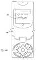
- FIG. 10 Billustrates an exemplary mobile device having received an exemplary SMS traffic alert
- FIG. 11Aillustrates an exemplary animated road traffic report
- FIG. 11Billustrates exemplary three-dimensional representations of vehicles as may be implemented in the road traffic report for FIG. 11A ;
- FIG. 12is an exemplary graphic interface highlighting a significant incident
- FIG. 13is a flow chart illustrating an exemplary process of preparing a travel time forecast
- FIGS. 14A and 14Billustrate an exemplary travel time forecast.
- this inventionprovides vehicular traffic congestion information to subscribers, or users, through various communication systems available to consumers.
- the methods and apparatus disclosedmay be used to provide any type of information to users where time sensitive general interest information is needed. Examples of such information include, without limitation, weather information, information regarding arrival and/or departure of scheduled flights, trains, as well as other similar types of information.
- the disclosure hereindescribes preferred embodiments in terms of a vehicular traffic monitoring system for the San Francisco Bay area. It should be recognized that the embodiment disclosed is but one embodiment, and the invention herein is not limited to this one embodiment. For example, the teachings herein may be used in other urban and/or rural areas.
- the inventionherein, makes use of various existing technologies.
- informationcan be collected by the system from locations on the Internet, such as from a web page that provides real time data.
- Usersmay be provided information on communication devices, such as, without limitation, a cell phone, a pager, or through email.
- communication devicessuch as, without limitation, a cell phone, a pager, or through email.
- real-time datameans data mat is available as soon as practicable. Availability of real time data may range anywhere from a few seconds to a few minutes, but typically no more than, a few minutes, from the time the data was first known or published.
- Tools for the development of software used in this inventionmay include tools having the capabilities of packages such as: GNUEmacs editor on either a UNIX or Windows platform as well as Microsoft Visual Studio .NET on the Windows platform.
- the preferred programming languagesare C, C++, C#, Perl and SQL, but other language or development tools may be used as well.
- a personalized information dissemination system as disclosed hereingenerally includes components as described in this Overview. However, certain refinements and exceptions to the above relationships and functions exist or may be realized. These refinements and exceptions are either disclosed herein, or may be apparent to one skilled in the art. Therefore, the invention disclosed herein is not to be limited by the exemplary embodiment, or this overview.
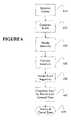
- the Traveler Information Dissemination System (TIDS) 10includes certain components, which generally function as outlined in this overview.
- Traffic datais provided by sources in real time, or near real time, by third parties.
- the Feeding Programs 114collect the data in various forms from a variety of Data Sources 100 .
- the Feeding Programs 114standardize the data, and provide the data to the Traveler Data Processor (TDP) 150 .
- TDP 150engages in various routines to organize and otherwise manage the data.
- the Traveler Data Publisher 170 and the Traveler Data Dispatcher 180complete timely issuance of data to subscribers, also referred to herein as “users.”
- Each userhaving entered information desired for a specific or routine itinerary through a Commute Route Selector 190 , receives the data through a-mechanism such as a cellular phone or pager 195 .
- traveler informationis generally available for viewing, such as at a computer connected to the Internet.
- icons, or graphical iconsare used to provide users with general traveler information.
- a usermay therefore view traveler information that may be related or unrelated to a given route.
- the Traveler Information Dissemination System (TIDS) 10includes multiple Data Sources 100 , as shown.
- Datamay come from a variety of sources, and in a variety of forms.
- Data Sources 100include: the TravInfoTM system 104 (a collaboration of public agencies including the California Highway Patrol, Metropolitan Transportation Commission and CALTRANS). Data may come from a web service 102 .
- Another example of a data source 100is the California Highway Patrol (CHP) World Wide Web server 106 .
- CHPCalifornia Highway Patrol
- exemplary data sourcesinclude the National Weather Service 107 , the PeMS system at the University of Berkeley 108 , Public Event Listings 113 , as well as data input manually by system operators or users using, for example, a User Input Mechanism 112 .
- Other data sources 110may be incorporated as they become available.
- the User Input Mechanism 112may be accessible to selected operators, users, or the general public may be permitted to provide input.
- Some of these exemplary Data Sources 100may require subscription, or authentication for access, and may be accessible via Telnet, FTP, or web services protocols. Some of these Data Sources 100 provide comprehensive data, while others do not. Exemplary data is now provided. Other examples of data appear elsewhere in this disclosure.
- Time Type Location Area 019427AM Disabled Vehicle SB US101 JNO MARSH RD Redwood City ADDITIONAL DETAILS 3:28AM - UNK VEH ON RHS RESPONDING OFFICERS STATUS 3:32AM - CHP Unit Assigned
- one Data Source 100may report a location in terms of a street address
- another Data Source 100may report the same incident having the location in terms of an equipment identification number, such as a sensor
- another Data Source 100may report location in geographic terms, such as latitude and longitude. Therefore, standardization of data as the data is collected is required to ensure integrity of the TIDS 10 .
- the Traveler Information Dissemination System (TIDS) 10includes one or more Feeding Programs 114 .
- the Feeding Programs 114may be Data Transfer Programs 116 , or Data Feeding and Repackaging Programs 118 .
- the Feeding Program Subsystem 114is responsible for fetching the data from the different Data Sources 100 , converting the data to a common format, and pushing the data to a server using periodic FTP connections, which are widely accepted by commercial servers and pose minimal security concerns. Other communication methods may be used.
- Various Data Sources 100provide data, some of which may require modification before use. Modification may involve processing to produce desired information, such as to assign a unique ID to an incident. In cases where little or no data modification is required, a Data Transfer Program 116 is used. In eases where data modification is required, a Data Feeding and Repackaging Program 118 is used. A Data Feeding and Repackaging Program 118 is typically required for public data, such as the California Highway Patrol (CHP) World Wide Web server. In this example, the Data Feeding, and Repackaging Program 118 retrieves and analyzes HTML data.
- CHPCalifornia Highway Patrol
- Examples of data that require few manipulationsinclude data produced by a Telnet Server 104 , an example being the TravInfoTM system 104 .
- Another example of data that may require few manipulationsmay be data originating at a specific Web Service 102 .
- Reliability for the Feeding Program Subsystem 114is achieved by redundancy. That is, several computers equipped with the same feeding tasks can operate in various locations and on different networks to feed simultaneously.
- the Feeding Program Subsystem 114 operationrequires minimal bandwidth for transmitting the data. This is due to the limited amount of data involved in each transmission, such as a list of incidents, traffic speed and congestion information at specific locations.
- the Feeding Program Subsystem 114may thus successfully operate from a small collection of PCs connected with a low-grade connection to the Internet, such as cable or DSL.
- a Unique identificationis produced for each incident, so that several independent instances of Feeding Programs 114 may be executed in parallel.
- the Feeding Programs 114may be executed on one or more computers, at one or more locations.
- the creation of the Unique ID in association with each record of dataprovides for subsequent sorting and elimination, of redundant data.
- the Unique IDmay be created using any convention that, is suitable to the TIDS 10 operator, (such as by combining date, time and location information), or the Unique ID may be produced by one or more of the Data Sources 100 .
- a Traveler Data Processor 150 and a Traveler Data Publisher 170typically execute on a server computer that has access to large bandwidth on the Internet, and are directed to publishing data very quickly and for a large number of users. Such servers may be potentially shared by several companies, and may impose certain communications restrictions, for reasons such as efficiency and security. Accordingly, in preferred embodiments, the Feeding Programs 114 push data to the Traveler Data Processor 150 . However, in some embodiments, the Traveler Data Processor 150 and/or Traveler Data Publisher 170 may obtain data directly. For example, data may be obtained directly when using the FTP protocol, or when receiving input from, users via a User Input Mechanism 112 .
- the Feeding Programs 114“push” data to the Traveler Data Processor 150 . That is, the Feeding Programs 114 send data files to the processing system. The appropriate data processor subsequently opens the data files for processing. In other embodiments, tasks related to the communication of data between, the data processors, such as, in non-limiting examples, some of the other embodiments described in the previous paragraph.
- the Traveler Data Processor 150coordinates with external resources as appropriate to ensure accurate or reliable operation.
- the TIDS 10maintains an accurate Clock 134 by reference to an external clock, such as one maintained by the National Institute of Standards Technologies. Maintaining an Independent Clock 134 limits inaccuracies in calculation of end times that may arise from reliance upon server clock time.
- the Traveler Data Processor 150includes at least one and preferably more of the following sub-processors: a Traffic Incident Processor 152 ; a Traffic Congestion and Speed Processor 154 ; a Transit Processor 156 ; a Weather Processor 158 ; and, a Public Event Processor 160 .
- a Traffic Incident Processor 152a Traffic Incident Processor 152 ; a Traffic Congestion and Speed Processor 154 ; a Transit Processor 156 ; a Weather Processor 158 ; and, a Public Event Processor 160 .
- additional or other sub-processorsmay be included. These additional or other sub-processors may be used to process data from sources not disclosed herein.
- the Traveler Data Processor 150executes on a regular basis using either an on-going daemon program, that switches periodically between a waiting and an active state, or a program that stops completely and is started or executed, periodically.
- An example of the latteris the cron mechanism on UNIX operating systems.
- Traveler Data Processor 150execute frequently, such as every minute, or more frequently. However, in some embodiments, it is appropriate to vary the interval of execution. For example, in the embodiment where weather information is of principal interest, it may be necessary to execute the Traveler Data Processor 150 only once per hour. Execution frequency or the Traveler Data Processor 150 therefore depends on various factors, such as the nature of the data, predominating in the TIDS 10 .
- Traffic Incident Processor 152may appropriately function or coincide with other sub-processors, such as those disclosed herein, or as may be used in accordance with the teachings herein.
- Each of the sub-processorsensure data quality through functions including, and not limited to, completing missing information in records of input data provided by the Feeding Programs 114 , or directly by one of the Data Sources 100 .
- the sub-processorstherefore share and complete analogous tasks for each of their respective streams of data.
- each sub-processorwill analyze each record of the particular data, or stream of data, calculate or estimate appropriate values as may be missing or otherwise valuable to a traveler, and include these values in the current or input data.
- the process of including omitted or otherwise valuable information in the current or input datais also referred to as “completing”, “ensuring”, or “producing” quality data.
- the resultis that current data, or streams of data, are transformed into quality data.
- quality datamay be referred to by other terms, such as, “traveler information” or in other similar terms, and that such data is therefore not limited by the terminology.
- Non-limiting examples of ensuring data qualityinclude: adding geographic coordinates; including a severity level; assigning a unique identifier, and others. Another non-limiting example of ensuring data quality involves projecting an incident end time for the current data.
- the Traffic Incident Processor 152accepts input from a variety of sources, either through the Feeding Programs 114 , such as the Transfer Programs 116 , the Data Feeding and Repackaging Programs 118 , and/or directly from the Data Sources 100 .
- the Traffic Incident Processor 152determines if the incidents input are currently active. For example, the Traffic Incident Processor 152 determines if an incident has a current impact on travelers depending upon the incident description, location, and estimated beginning and end time. As another example, the Traffic Incident Processor 152 evaluates a temporal aspect of the incident, in this case, the Traffic Incident Processor 152 compares the time between the beginning and end time (if presented in the data) to the present time. If the end time is not in the past, the temporal comparison shows the incident has a current impact. If the incident has a current impact, the incident is put into the Active Traveler Information Database 130 .
- incident datamay be repackaged in the form below, or in a similar form.
- the incident data recordincludes a unique ID as a 6-digit number, or other unique form.
- the expected end of the incidentis computed by the system, by adding a fixed amount of time to the incident start time or end time.
- the fixed amount of time addedmay vary, depending upon factors such as the type and severity of the incident, and the number of updates an incident has received.
- global positioning coordinate and severity level informationis preferably generated. Generation of this information for each incident provides at least for placement on a map, and ranking with respect to severity:
- Table 1lists exemplary severity levels that may be associated with incidents when examining the type, subtype, and description of incidents, wherein the lowest severity number corresponds to the most severe incidents types.
- the incident durationmay yield a lower severity number, as well as the indication that the same incident, was reported and corroborated by another independent data source (such as CHP 106 and TravInfoTM 104 , or CHP 106 and a Web user 112 ).
- another independent data sourcesuch as CHP 106 and TravInfoTM 104 , or CHP 106 and a Web user 112 .
- the severity numberis decreased, by one for that incident. This rule may not be applied for certain types of incident, such as road work or weather-related incidents (heavy winds, snow). Severity level is therefore a preferred embodiment of indicating an impact upon a traveler. The impact is assessed by severity, or the magnitude of the disturbance typically associated with such an event.
- the New Traveler Information Database 132is used as a data resource for pushing new traveler Information to users, and will be described in greater detail in reference to the Traveler Data Dispatcher 180 .
- the Active Traveler Information Database 130contains information of incidents and other traveler data that is currently in effect and presumably impacts travelers.
- An impact determinationdepends, at least in part, upon time indicated by the Independent Clock 134 . That is, the end time of an incident should not be significantly prior to the indicated time on the Clock 134 . Other factors may play a role in the determination of whether traveler information is active. For example, an incident may be reported for a location that is outside the geographical coverage of the system.
- the Traffic Incident Processor 152ensures that the information in the Active Traveler Information Database 130 is up-to-date; this means that the contents of the Active Traveler Information Database 130 contain quality data for publication by the Traveler Data Publisher 170 .
- the Traveler Data Dispatcher 180ensures that the New Traveler Information Database 132 is up-to-date, meaning that the contents of the New Traveler Information Database 132 contain quality data for dispatch to subscribers. After the Traffic Incident Processor 152 finishes processing an incident and incorporates associated information into the Active Traveler Information Database 130 the complete information regarding the incident would typically be as follows:
- the Traffic Incident Processor 152combines incident information with the Independent Clock 134 and other domain knowledge information to manage, add to, enhance and correct the information.
- incident informationwith the Independent Clock 134 and other domain knowledge information to manage, add to, enhance and correct the information.
- data correctionwherein the data source inputs erroneous information for the location of an incident: a latitude of 0 and a longitude of 0.
- the Traffic Incident Processor 152detects that the latitude and longitude are erroneous and determines the proper latitude and longitude for the incident location:
- the Traffic Congestion and Speed Processor 154typically operates similarly to the Traffic Incident Processor 152 . Due to the nature of congestion and speed data, the Traffic Congestion and Speed Processor 154 may execute less frequently, that the Traffic Incident Processor 152 . As congestion and/or speed data is considered somewhat erratic, or inconsistent, in preferred embodiments, the Traffic Congestion and Speed Processor 154 averages Incoming data and applies filters to smooth the data and provide reliable information.
- the use of data averaging or smoothingcauses a slight delay. Accordingly, other smoothing algorithms or techniques may be employed to optimize the availability or other aspects of the data.
- the Weather Processor 158examines weather data. If the data is new and different from the weather data already stored in the Active Traveler Information Database 130 , then the Weather Processor 158 places the new data in the Active Traveler information Database 130 for the Traveler Data Publisher 170 to use. The Weather Processor 158 then scans input data for relevant keywords, such as the names of counties. The Weather Processor 158 may then create hyperlinks for those such that when a Web user on the Internet selects such a hyperlink the Web user is immediately presented with the weather data for that county. Such hyperlinks are preferably stored in an html file suitable for publication.
- the Transit Processor 156 and Public Events Processor 160also operate in a manner similar to the Traffic Incident Processor 152 and the Traffic Congestion and Speed processor 154 .
- the Transit Processor 156 and Public Events Processor 160also adapt the frequency of execution to aspects of the incoming data.
- the most frequent executionis needed for the Traffic Incident Processor 152 , because data relating to events, such as accidents or other traffic disruptions, typically have a short lifespan and must be disseminated as quickly as possible to be valuable or relevant to a user.
- weather data, public event data, and other similar types of dataare generally provided by at least one data source 100 , and therefore may, in some instances, appear in other data streams.
- notice of a public eventmay be included in data from, a traffic incident data source, and thus treated by the Traffic Incident Processor 152 as if the public event were an accident or other traffic disruption.
- the Traveler Data Publisher 170is mainly responsible for publishing the quality data on the Internet, thereby making the data accessible to the general public, including potentially users of cell-phones who can access websites using the WAP protocol.
- the TIDS 10also include a Traveler Data Dispatcher 180 , which sends or pushes quality data to a user.
- the main difference between the Traveler Data Publisher 170 and the Traveler Data Dispatcher 180is that the Traveler Data Dispatcher 180 typically pushes new data to subscribers as soon as the information is known by the system, whereas the Traveler Data Publisher 170 publishes the data for users to actively retrieve it. Retrieval may be accomplished, for instance, with a web browser.
- the Traveler Data Publisher 170typically uses the Active Traveler Information Database 130 and publishes its content, while the Traveler Data Dispatcher 180 uses the New Traveler information Database 132 , so that only new information is being pushed to a subscriber.
- the New Traveler Information Database 132is then flushed upon each execution of the Traveler Data Dispatcher 180 .
- the Traveler Data Publisher 170typically comprises a Text Publisher 172 , an HTML Publisher 174 , and a Map Drawer 176 .
- the Text Publisher 172typically publishes incident data in complete text form, which may be most appropriate for some individuals, such as transportation or media professionals interested in obtaining all the available detail.
- the Text Publisher 172preferably sorts the incidents in decreasing rank of the severity number.
- the Text Publisher 172preferably groups incidents by counties.
- the HTML Publisher 174preferably sorts incidents in decreasing rank of the severity number and groups incidents by counties similarly to the Text Publisher 172 .
- the HTML Publisher 174also displays a different icon for each incident type or subtype.
- the HTML Publisher 174preferably tests for the presence of keywords to determine which icon preferably represents an incident. If no keyword is found, an icon may be used instead.
- a portion of html and javascript codemay be used to implement a routine wherein when pointing to an icon, detailed information about the underlying incident or event is displayed on the user's computer screen.
- An input mechanismmay include, without limitation, a mouse or a stylus.
- HTML Publisher 174Although disclosed herein as an HTML Publisher 174 , it is recognized that some equivalent embodiments may not employ HTML. Therefore, the HTML Publisher 174 may also be referred to as a “graphical icon publisher.” Other aspects of publication are disclosed below.
- the Map Drawer 176displays a map with incident, speed and congestion data, wherein at least one of the size and the color of overlying icons used to provide notice of traveler information is varied with an aspect of the associated traveler information. For example, in one embodiment, larger overlying icons are presented for indicating more severe incidents. In other embodiments, a more intense and saturated color is used for more severe incidents.
- graphical iconsare drawn on the map.
- the graphical iconsmay convey information themselves.
- a graphical iconmay include a symbol for a tow truck, an event, a fire truck, or another symbol that is readily understood by the user.
- a key to graphical icon symbologymay be included or otherwise available the user.
- An example of graphical icons, with an accompanying key,is provided in FIG. 4 .
- the iconsappear in inverse order of severity: most severe (and larger) first followed the least severe (smaller), in this way, if overlap occurs, the smaller icons only partially obscure the larger ones and both are visible.
- most severe (and larger)first followed the least severe (smaller) in this way, if overlap occurs, the smaller icons only partially obscure the larger ones and both are visible.
- Other embodiments of these teachingsmay be used.
- HTML Publisher 174when the user's mouse goes over an incident icon, detailed information about the incident is displayed on the user's computer screen. In case of overlap, the most severe information is displayed. This is achieved by listing the most severe information first in the list of pop-ups.
- the Traveler Data Dispatcher 180dispatches new information to subscriber devices, such as, in non-limiting examples, cell phones, pagers or email 195 .
- the Traveler Data Dispatcher 180typically comprises a Matcher to Segments 182 , a Matcher to Severity and Time 184 , an Abbreviation Engine 186 and a Transmitter SMTP/SMS/MMS 188 .
- An incidentmay be dispatched as appropriate to a given subscriber by the Matcher to Severity and Time 184 respecting the subscriber and general requirements in terms of the incident severity.
- the Commute Route Selector 190is accessible from the Internet, Users can choose to watch specific routes at certain times and on certain days.
- the user selecting a routeis preferably presented with a selection of roadway or highway options with corresponding visual icons representing highway signs.
- typically about 50 highwaysare presented to the user on one page next to representative icons. The user is expected to choose one. If the user wishes to watch another highway, then the user may select the “OTHER” highway.
- the useris then requested to choose a specific roadway, a time span for watching the specific roadway, and a level of information severity for which they wish to subscribe.
- a usermay select criteria that equate to the following:
- the foregoing selectionis made using a combination of checkboxes, selection boxes and text forms, if the “OTHER” highway was selected before, then the user is requested to type in the name of a roadway in a text box.
- segmentis typically represented to the user as follows:
- each segmentcontains a unique location or identification code.
- the segment informationmay also include latitude and longitude values.
- the unique location code and geographic coordinatesare preferably not revealed to the user.
- the unique location codeis generally used for sorting and accessing data internally. That is, location information is typically stored according to a segment ID, as well as the user criteria for desired notifications. Unique location, codes may also be referred, to as “user criteria location codes” as these codes are preferably used for sorting and/or other functions related to management of the traveler information.
- the unique location codes, or segment IDsare known for each segment of road, or may be assigned for locations newly introduced to the system 10 .
- Information corresponding to a unique location codei.e. newly introduced location
- Derivationmay include referencing to a map database, or other database.
- the system 10preferably assigns new unique IDs automatically using conventional methods for assigning new unique IDs, In another embodiment, unique IDs are added manually by a system administrator.
- the Commute Route Selector 190stores the information provided by the user in a User Database 142 . Among other things, the Commute Route Selector 190 maintains a list of Active Segments 140 that are actively watched by users.
- the Commute Route Selector 190modifies the Active Segment 140 accordingly.
- This maintenanceis preferably accomplished by a Maintenance Program 192 that executes periodically when the system is least used, such as once a day during the night.
- the Maintenance Program 192may also monitor the number of alerts being sent, as well as user subscription information, and may send email to subscribers requesting feedback, or notification that a free trial period will end soon, etc.
- Active Segment 140are preferably stored by referencing the ID of the segment and the window of time the segment is being watched by a subscriber.
- each segment ID with at least one subscriber watchingis stored as a file on disk that can be quickly retrieved by the operating and file system of the computer once equipped with only a file name.
- Hash-tablesmay be also be used in an alternate embodiment instead of files. Hash-tables reside in main memory instead of on the hard disk. A database system such as Oracle or Microsoft SQL Server or Microsoft MSDE may be used as well.
- a segment IDmay be 9000 for a given segment, or 1 for a public place, where public events affecting travelers may occur.
- one operational systemincludes about 10,000 segments correlated to San Francisco Bay Area highways and about 20 public places, such, as 3COM Stadium, PACBELL Park, and the SHORELINE Amphitheater.
- the Segment Database 136contains a record that describes the segment.
- An example of a segment record maintained in the Segment Database 136is provided:
- the first numberis the segment identification number
- the second and third numbersrepresent latitude and longitude.
- a corresponding data fileis used to store user information.
- An example of the information, that may be stored in file named “9000”is as follows:
- the TIDS 10correlates the location of the traveler information with the segment ID, and obtains user criteria from the data file named 9000. The system 10 will, then process notifications appropriately.
- the times and claysmay be reduced to numerical codes. For instance each possible quarter of hour of a week may be encoded using a four-digit code using between 1 and 7 for encoding the day, 00 through 23 for encoding the hour, and 0 through 3 for encoding quarters of hours. Each possible hour may be encoded with a three-digit code. Such codes may be combined with the segment ID to form a combined ID. Matching combined IDs for traveler information and subscribers would guarantee that not only the segment is being watched by the subscriber but also at a time that matters to the subscriber.
- the current systempreferably uses the embodiment wherein the matching occurs on the segment ID first and a test is applied to determine whether an alert should be sent to the subscriber or not.
- a usermay communicate to an operator a verbal or written description of his or her commute route and commute times and the operator may enter the times and route as a list of segment IDs using the previously described method.
- the usermay also communicate an origin address and time, and a destination and time, or an origin zip-code and time, and a destination zip-code and time, and conventional methods may be used to compute one or several routes between origin and destination.
- a device or processmay communicate a user's location, speed and/or heading back to the TIDS 10 through use of a wireless device, such as a transmitter or a transceiver.
- a wireless devicesuch as a transmitter or a transceiver.
- An example of a wireless deviceincludes a Global Positioning System (GPS) receiver coupled with a cell phone.
- GPSGlobal Positioning System
- the cellular carriermay use “time difference of arrival (TDOA)” from cellular base stations for specifying the location of the cellular telephone.
- TDOAtime difference of arrival
- the information provided by a GPS device supporting the NMEA standardwould preferably be presented as indicated in the line below, wherein the second value is the time in hours, minutes and seconds in UTC or GMT time, the fourth and fifth, values represent latitude, the sixth and seventh, longitude, the eight speed in kilometers per hour, the ninth value represents the heading in degrees of an angle:
- such informationis typically updated every second.
- the latitude and longitudeare first converted to decimal values using methods known in the art, and are then compared with the segment latitude and longitude values of the Segment Database 136 .
- a segmentis typically associated with one latitude and one longitude value that is typically representative of the center of the segment.
- a conventional method for determining which segment the subscriber is onwould compare the latitude and longitude of each segment with the current latitude and longitude, compute a Euclidean distance in decimal latitude and longitude space, and select the closest segment according to the distance.
- the problems with this conventional methodis that the direction of travel is not taken into account, as well as the interference between segments on unrelated routes that are close in latitude and longitude.
- An exemplary result of applying this conventional, methodas is follows; after one second elapses the system wrongfully determines that the subscriber has changed direction:
- the correct answerobtained using the following embodiment of the present, invention, is as follows; the subscriber has moved to an adjacent highway segment in the subscriber's direction of travel.
- the collection, of highway segmentsforms a directed graph.
- the TIDS 10determines for each segment relationships with other nearby segments. For instance, segment 10000 immediately precedes segment 10001along highway CA-85 Southbound, as Segment 10000 ends at FREMONT AVE and Segment 10001 starts at FREMONT AVE.
- the TIDS 10determines a vector in (latitude, longitude) coordinates for the segment, compute the distance to this vector using methods known in the art for the distance between a point and a vector and also compute a scalar product between the direction of travel and the segment direction.
- the best segment matchis obtained with a combination of a low distance and high scalar product, with a preference for the same segment on which the subscriber already is or the following segment along the same highway as it is noted at 60 miles per hour, the vehicle stays on the same segment for about 60 measurements of the GPS device.
- the current formulais preferably used to determine the best match: Minimize A*distance ⁇ B*scalar_product+C*ID_flag wherein A, B, and C are constants that may be tuned, and ID_flag equals zero if the segment is the same and one if the segment is different for the current segment. For the first match as there is no current segment all ID_flags are equal to zero. B may be set to zero, in which case segments corresponding to negative scalar products must be eliminated.
- a wireless devicemay communicate with the server hosting Active Segment 140 via WAP, HTTP, SMS, etc.
- a subscribermay thus subscribe to traveler information completely automatically, without action from his or her part.
- the subscriptionuses a combination of wireless communication and geographic positioning, informing a server of the segment on which the subscriber is, the segments on which the subscriber is likely to be on in the near future, and communicating this information to the Commute Route Selector 190 for insertion in the list of Active Segment 140 .
- Such data automatically transmitted to the Commute Route Selector 190may be used for recording a usual commute route.
- the Commute Route Selector 190provided by the present invention is particularly beneficial to travelers that repetitively commute a known route.
- the facility provided by the Commute Route Selector 190therefore simplifies the process of gathering and/or retaining the commute route information.
- automated transmission of the user's current segmentmay locate the user along his or her commute route and provides for temporarily discarding the segments already traveled by the user for the purpose of sending alerts.
- the information transmitted to the Commute Route Selector 190may still be used to dispatch current incidents in neighboring or upcoming segments. Such information may also be used to subscribe temporarily to alerts on upcoming segments, based upon speed and time data.
- a combination of publishing of current incidents (relevant for the Traveler Data Publisher 170 ) and temporary subscription to dispatches (relevant for the Traveler Data Dispatcher 180 )may be suitable so as to limit the number of back-and-forth communications between the user's wireless device and Commute Route Selector 190 and server or computer on which the Commute Route Selector 190 runs.
- the information collectedmay be used to compute travel time and speed, as it is widely regarded that GPS data systems provide accurate time and speed estimates.
- the travel time and speedwhich are a form of traveler information, and may be optionally published by the Traveler Data. Publisher 170 and dispatched by the Traveler Data Dispatcher 180 if there is an agreement with the source of the data that such further publishing and dispatching are acceptable.
- the level of severity of the information dispatched to the usermay be changed at any time by the subscriber or the administrator of the system 10 .
- the system 10may monitor the number of alerts that were sent to a user, and beyond a certain number send an email to the user, explaining that various levels of severity are possible.
- the email recipientmay then click on either link to adapt the level, of severity of the information to his or her choosing.
- An exemplary emailis shown below, explaining the current levels of severity supported by the system 10 . Since an underlying system of numerical severity values is used, any number of thresholds may be put in place corresponding to fewer severity values exposed, to subscribers, such as a three-level system shown below. But an n-level system where n is an arbitrary integer value is also possible.
- An exemplary e-mail messagefollows:
- Data Sources 100are, or will be, available in different locations, on different networks, and on different computers. However, it is conceivable to have several data sources on the same computer.
- the Data Sources 100may communicate with the feeding programs 114 and the Traveler Data Processor 150 through the internet, however, it is recognized that a large variety of communication requirements or protocols may exist and need to be overcome. However, the techniques required for communicating data from the Data Sources 100 are not discussed further herein.
- the Traveler Data Processor 150executes on the same computer, such as a server.
- the Active Traveler information Database 130New Traveler Information Database 132 , Independent Clock 134 , Segment Database 136 , sub-segment Database 138 , User Database 142 and Active Segment 140 are also located on the server.
- An example of a system configuration that is supportive of this implementationincludes, without limitation, a network system.
- Reliabilityis considered to be a critical factor for a successful traffic reporting system, as well as cost effective operation. Therefore, the invention disclosed herein was designed to achieve a high level, of reliability without incurring prohibitive costs. The above described design, choices have allowed at least one operational example of the invention disclosed herein to achieve significant reliability at a low cost.
- the system 10 disclosed hereindecouples the operations of feeding and preprocessing the data (subsystems 114 and 150 ) publishing the data on the Internet (subsystem 170 ) and delivering the data to subscribers using messages (subsystem 180 ).
- web serversor application servers specifically designed to serve customers files or the result of executing programs through, the internet and Web browsers such as Netscape and Microsoft's Internet Explorer.
- Non-limiting examples of web server or application serversare: Apache Software Foundation's “Apache” Microsoft Corporation's “IIS”, and BEA Systems's “Web Logic”.
- Traveler Data Processor 150 and Traveler Data Publisher 170use programs that may execute periodically on a server, merging the data from different sources, and preparing the data for publishing. These programs, however, typically do not fetch the data through the Internet but rather look periodically if new data was deposited/made available on the server.
- Traffic Incident Processor 152reviews all the traffic incidents in the Active Traveler Information Database 130 and rewrites it from scratch every time it is executed. Other sub-processors may similarly process corresponding input data.
- the Traffic incident Processor 152obtains the current time from the Independent Clock 134 and determines an incident expiration threshold. In one embodiment, the Traffic Incident Processor 152 completes this step by subtracting a few minutes from the current time. As an example, the Traffic incident Processor 152 subtracts about ten minutes. This embodiment subsequently provides for the publication of incidents a few minutes after their expected end time, thus accounting for some of the potential errors in the expected end time.
- the first Data Source 100is the Active Traveler Information Database 130 which contains the list of incidents currently known and currently active.
- the subsequent Data Sources 100may be processed in any order, for instance in the ordering implied in FIG. 1 inside the Data Sources 100 block.
- Step 202the next Data Source 100 is opened for reading.
- the data from, the Data Source 100is preferably located on the same computer where the Traffic Incident Processor 152 operates, as pushed using the Feeding Programs 114 ; if this is not the case there are various techniques for retrieving the data from a remote location, using either the Telnet or FTP network transfer protocols. Remote access is not preferred as this may incur a delay and a potential risk that the data or network connection may be unavailable.
- an incidentis retrieved from a Data Source 100 .
- the system 10reads the incident ID of the incident.
- the system 10uses 6-digit incident IDs for an incident that is encountered by the system 10 for the first time, for instance 123456. If the system 10 receives updates on that incident then a 9-digit system is used instead as follows: the first update will have the ID 123456000, the second update 123456001, the third update 123456002 and so on.
- Step 208the system 10 processes the end time of the incident.
- a default durationis being added to the start time of the incident. If the start time of the incident is not available, then the current time of the Independent Clock 134 is used.
- the fixed durationis dependent upon the level of reliability that is attached to the Data Source 100 and the type of incident. For instance an incident from data source CHP 106 and relating to a PEDESTRIAN ON THE ROADWAY, may be assigned a default duration of 20 minutes, while an Accident reported by data source TravInfoTM 104 , which may have gone through further verification of the data, may be assigned a default duration of 30 minutes. Default durations are typically determined when monitoring data sources and observing the incident durations reported when available.
- the end timeis at a date too far remote in the future, such as more than two days after the current time, this is assumed to be an error in the data, except when the incident is ROAD WORK.
- the end timeis then corrected by combining the current date with the incident end time.
- Step 210if the end time predates the incident expiry date then the incident is not inserted in the Active Traveler Information Database 130 and the process returns to Step 204 where the next incident is read.
- Step 212the system 10 reads the incident description. Upon reading and analyzing the description of the incident, the system 10 determines if the incident is a duplicate or not, meaning that the same incident is already in the Active Traveler Information Database 130 . A decision is then made to erase the incident from the Active Traveler Information Database 130 or to erase the incident under current consideration.
- the system 10evaluates whether an incident that appears to be a duplicate is a duplicate or is an update or correction to existing information. The system 10 then saves the best data, and discards the lesser quality version.
- the system 10may also apply a number of corrections to the incident description, such as translating a number of abbreviations into plain English text. Examples: #1 LANE is translated to FIRST LANE FROM LEFT; 3A is translated to AAA TOW REQUESTED.
- Step 214the system 10 determines if the base ID of the incident as computed in Step 206 already exists in the Active Traveler Information Database 130 . If this is the case then the system 10 takes note of the incident currently listed in the Active Traveler Information Database 130 and with an identical base ID. The system 10 then executes Step 216 . Otherwise, the system 10 executes Step 220 .
- Step 216the system determines it the incident is a duplicate.
- the incidentIn preferred embodiments of duplicate incident testing, the incident must end after the existing incident, by at least 15 minutes. This test limits the risk of a data source automatically generating an excessive number of corrections within a few minutes; which could result in a large number of updates being dispatches to subscribers, with very few changes in the Information actually conveyed.
- Other aspects of the incident informationmay be tested as well. For example, description and/or location information may be tested.
- one considerationis that some recurring incidents may be continuously updated with only the end time being different. Examples of these incidents include congestion or “heavy traffic” incidents, weather conditions such as wind, ice, or snow. Otherwise, minor differences in the description and location may occur as the incident is not yet completely known. It is suitable to wait a little before the Information is completely confirmed and republish or redispatch the incident then.
- Step 204the system 10 returns to Step 204 for reading of the next incident; if not the system executes Step 218 .
- Step 218the system computes a 9-digit ID from the incident ID. If the incident ID already has 9-digit, then it is simply Incremented by one. Otherwise if the incident ID has 6 digits, then it is multiplied by 1000. The system 10 then executes Step 222 .
- Step 220the system 10 determines whether the incident description, already exists for some incident currently listed in the Active Traveler Information Database 130 . If this is the case then the incident currently listed is dropped from the database 130 in Step 222 .
- Step 222the incident currently listed in the Active Traveler Information Database 130 is dropped from, the database and the system 10 executes next Step 224 .
- Step 224the incident is inserted into the Active Traveler Information Database 130 .
- Step 224the system 10 computes latitude and longitude if missing or corrupted. This computation is completed using the Segment Database 136 . In testing, it was found chat the method can locate on average 80% of the incidents with missing latitude and longitude.
- the incidentis determined to be geocoded and the latitude and longitude recorded in the database are used for the incident.
- the matchdoes not have to be exact: this is implemented by going through the list of segments and intersections in the database and assigning a score to each potential match, while retaining the match with the maximum score.
- the scoring systemworks in the following order, from the maximum score to the minimum score:
- the scoresare only indicative and may be refined or new matching criteria may be entered.
- the scoring systemrequires a single pass through the database (that contains local highways only and is typically rather small).
- the scoresmay be determined using a distance function between two strings such as the Levenshtein Distance known in the art.
- At least 80 percent of the incidents lacking geographic coordinatesmay be geocoded, and thus assigned a location on a map using the abovementioned process, or equivalents thereto.
- Step 226the system 10 determines whether there are more incidents for the current data source being considered. If this is the case, then the system 10 returns to Step 204 and otherwise, the system 10 executes Step 228 .
- Step 228the system 10 determines whether there are more data sources to be considered. If this is the case, the system 10 returns to Step 202 and otherwise terminates, awaiting for a next scheduled execution.
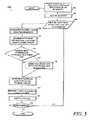
- FIG. 3describes aspects of the Traveler Data Dispatcher 180 .
- the Traveler Data Dispatcher 180comprises a Matcher to Segments 182 , a Matcher to Severity and Time 184 , an Abbreviation Engine 186 , and a Transmitter SMTP SMS (Short Message Service)/MMS (Multimedia Message Service) 188 .
- SMTP SMSShort Message Service
- MMSMultimedia Message Service
- the Matcher to Segments 182is preferably implemented with the Steps 302 through 318 illustrated in FIG. 3 .
- the Matcher to Severity and Time 184is preferably implemented with the Steps 320 through 324 .
- the Abbreviation Engine 186 and transmitter 188are implemented in Step 326 .
- Step 302the next incident from the Active Traveler Information Database 130 is retrieved. If there are no more incidents, the process ends.
- Step 304the system determines whether the ID of the incident already exists in the traveler Information database that was previously active. (Previously active means that the incident was active and published in the previous iteration of the system 10 ). If this is the case, then the system 10 returns to Step 302 , or otherwise proceeds to Step 306 .
- Step 306the system 10 determines whether the ID exists in the list of the last few incidents. If this is the case the system 10 returns to Step 302 , and otherwise executes Step 308 .
- the last few incidentsare a list of IDs of the incidents that the system 10 has most recently encountered.
- Step 308the incident is considered to be new and is inserted in the New Traveler Information Database 132 .
- the incidentis also set to be the first in the last few incidents list, and the last incident of that list is removed.
- the incidentis reported on one highway or transit route, in spatial relation to an intersection with, another route or stop, such as: Before, after, at, just north, of, etc.
- the Matcher to Segments 182attempts to interprets the location of the incident as an (ON: AT:) pair such as: ON: I-580 E AT: GROVE WAY wherein the AT; component of the location may potentially be missing.
- the systemlooks for the keywords “ON” and “AT”, but also for JUST NORTH OF, OR JNO, JUST SOUTH OF, or JSO, etc. and as many similar ways of specifying an intersection location as possible.
- the system 10then builds a first hash-table mapping the ON; AT: location for segments of the Segment Database 136 to segment ID and well as a second hash-table mapping the ON: END: segment location to segment IDs.
- ATlocation for segments of the Segment Database 136 to segment ID
- ENDsegment location to segment IDs.
- CA-85 S,FREMONT AVE,HOMESTEAD RDthe ON: AT: key for the first hash-table is; CA-85 S FREMONT AV and the ON: END: key for the second hash-table is: CA-85 S HOMESTEAD RD.
- Both keysare mapped to the segment ID, 10001 in the hash-tables.
- Preferably both hash-tablesare built ahead of time, because they are the same for all the incidents being treated and only depend upon the Segment Database 136 .
- Step 310is executed next.
- Step 310an ON: AT: key is built for the incident in the same fashion as for the list of segments in Step 308 . If there is an exact match in the first hash-table then it is determined that the incident is matched to a segment and the system executes Step 320 next (for Instance if the ON: AT: key is CA-85 S FREMONT AV then there is an exact match in the first hash-table and the incident is determined to be on Segment 10001 ). Otherwise if there is an exact match with the second hash-table the system executes Step 320 as well.
- Step 312the key is reversed, meaning that the AT: ON: key is built for the incident. If there is an exact match with the first hash-table the system executes Step 320 . Otherwise if there is an exact match with the second hash-table the system executes Step 320 as well.
- a subsegmentis a portion of a highway segment, that does not fully extend from the segment origin (or AT:) to the segment destination (or END:).
- a subsegmentmay simply be an intersection, wherein the (END:) information is unavailable, or even simply a place, wherein both the AT; and END; information is unavailable. But in all cases the subsegment must be associated with a reliable latitude and longitude. Subsegments are particularly useful because incidents may be reported inside a segment as opposed to a segment endpoint.
- one segment 12345 along US-101 Sis defined between MONTEREY RD and CA-25 and is assigned a latitude and longitude values of 36,973988 and ⁇ 121.555046.
- the latitude and longitude of a segmentare typically representative of the center of the segment.
- One particular subsegment of this segmentwould be 60235 on US-101 S at CASTRO VALLEY RD with a latitude of 36.967833 and a longitude of ⁇ 121.552667.
- a subsegmentis typically associated with a numeric ID that distinguishes it from a segment, typically associated with a lower number ID.
- a subsegmentis also associated with the ID of the larger segment it belongs to: 12345,
- a subsegmentmay also be created for a new spelling or denomination of an existing segment endpoint.
- Step 314the system 10 tests the incident location as an ON: AT: key with the subsegment Database. If an exact match is found, then Step 320 is executed next, otherwise Step 316 is executed.
- Step 316the system 10 attempts to create a new subsegment corresponding to the current incident, as no corresponding segment or subsegment could be found so far.
- the system 10computes the distance in (latitude, longitude) space between the incident location and each road segment along the same road, of the incident (Only the road segments on US-101 S are searched in the previous example. Searching only those types of segments is easily performed by matching the string in the ON: portion of the segment description). The closest road segment is retained. The distance in latitude and longitude is then approximately translated into a Euclidean distance using the following formula: 0.01 degrees of latitude or longitude correspond to about 1 Kilometer.
- the incidentis determined to occur on a subsegment of the segment and the incident is determined to be localized on the segment.
- the system 10then proceeds to Step 318 . Otherwise the system 10 returns to Step 302 and considers the next incident.
- Step 318the subsegment determined in Step 316 is added to the subSegment Database 138 , and the system 10 proceeds to Step 320 .
- Another advantage of the above described methods for matching incidents to segmentsis that in case Information is only partially available (such that the END: or even AT: and END: of an incident, the system may still be able to find an exact match in the Segment Database, considering the missing information, as an empty string and performing a matching on the remaining, available Information. Since other parts of the system are dedicated to computing latitude and longitude of an incident when such latitude and longitude are unavailable, in most cases through Steps 310 , 312 , 314 , and 316 incidents may be matched to a segment.
- Another advantage of the present inventionis that the incident databases gradually increase in accuracy as more and more incidents are processed: subsegments are being continuously created and the matching of incidents becomes increasingly flexible.
- Step 320the system 10 examines the next user from the list of users subscribed for alerts relating to the matched segment. If there is no more user subscribed for the matched segment, the process ends.
- Step 322if the severity of the present incident matches the level of severity that, the user has requested for the segment (specifically, if the severity number is lower, as lower numbers correspond to more severe incidents in the present invention) the system 10 proceeds to Step 324 and otherwise the system returns to Step 320 .
- Step 324the system 10 examines the predicted window of time for the incident, and determines if there is any intersection between the predicted window of time for the incident and the window of time the user watches the segment for. This is preferably performed by making comparisons of precedence between dates. Determining whether two windows of time overlap is analogous to determining whether two linear segments overlap in one dimension, and the techniques are generally known.
- Step 326the system 10 proceeds to Step 326 , and otherwise the system 10 returns to Step 320 .
- Step 326the system 10 prepares a message by means of compiling and especially abbreviating the Information, and dispatches a message to the user on the user preferred address.
- the system 10preferably interprets any delivery address (cellular telephone, pager, email) as an email address.
- the system 10looks in a lookup database for converting a wireless provider name to a valid email address suffix publicized by the wireless provider. For instance, a wireless device may be mapped using a convention such as wirelessdevicenumber@mobile.wirelessdeviceprovider.net in the lookup database.
- the lookup databaseis compiled by collecting addresses publicized by wireless providers.
- the systemstores a primary and a secondary address for each user, which may be the same.
- the usermay attach either the primary or the secondary address to any segment that the user watches. For instance a user may want to receive alerts on a cell phone (primary address) on her way to work in the morning, and at work on her company e-mail system, (secondary address) right before she takes her car to return home.
- primary addressa cell phone
- secondary addresse-mail system
- Abbreviation Engine 186provides a benefit of formatting traveler information for dissemination to systems with certain formatting requirements, as well as a separate benefit of enhancing information, transfer. That, is, as a user becomes accustomed to a set of abbreviations, the user is able to more quickly read and digest the traveler information that if the traveler information were spelled out in long form.
- the origin email addressis necessary for the Information to be sent at all through the Internet.
- the smallest possible valid email address for the businessis preferably used.
- begin and end timedisplayed for instance as: “at 10:00 PM till 11: PM” (the days are eliminated, assuming it is today as the information is dispatched very quickly and the date may be carried elsewhere in the header of the message by the provider).
- Type and SubType of incidenta look-up table of abbreviations for single words is used. Examples of abbreviations and corresponding terms are provided:
- the final messagemay be presented as follows: I-80 W @POWELL ST at5:20 PM til5:47 PM disabled veh rt lane blkd WB I-80 just after Powell St
- the messageis typically dispatched to its destination email via an SMTP server, however connecting to an SMS gateway would also be possible.
- a wireless providerwill typically operate an SMTP gateway, which will then transmit the message to the recipient.
- the message headerincorporates a number of notification requests following the Delivery Service Notification (DSN) standard.
- DSNDelivery Service Notification
- the System 10is typically notified of whether the message was received, read or deleted before being read, and the time of delivery. Not all gateways respond to the DSN standard and therefore, the system 10 cannot rely on receiving any or all of the notifications.
- An expiration date or time tagmay also be added, indicating a time at which the information will stop being relevant in case the delivery would be late.
- Some e-mail clientssuch, as Microsoft Outlook acknowledge the expiry date.
- a programsuch as the Diagnostic Program 194 is launched, to examine the proper functioning, or the health, of the system 10 .
- the programexamines the logging files.
- the Diagnostic Program 194looks at the numbers of incidents published.
- the Diagnostic Program 194determines whether there is an abnormal pattern in the numbers and origin of incidents produced. For a given, source of data the number of new incidents per day varies from day to day but almost never goes down to zero. Exemplary statistics are as follows: x.
- Dis a positive value adding/compounding all absolute values of the differences between the number of incidents reported at a given time, and the number of incidents reported in the previous iteration.
- Eis a positive or negative value derived from adding all the differences between the number of incidents reported at a given time, and the number of incidents reported in the previous iteration.
- the email address of an administrator for a given data sourcecan be recorded.
- any test, or combination of testsindicates a problem
- a simple algorithmsuch as the exemplary one below, is used to detect the problem.
- An email message containing the statistics and the algorithm's guessis dispatched to the administrator(s) as well as individuals responsible for the data source, in addition, a message indicating technical problems may be displayed on the publishing side. (The later is reserved for situations where the number of published incidents is zero).
- One example of criteria that is applied to decide whether there is a problem on the server or notis a test that evaluates if A is equal to zero, then check whether F is less than a minimum threshold, if this is the case, then a preliminary determination is made that there is a problem, (meaning, that in addition of no new incidents coming in, the currently published number is getting very low) or E is less than a minimum negative threshold (meaning that the pool has been decreasing in size).
- the systemchecks whether B equals zero. If this is the case, then the algorithm returns an estimation of the problem as: “probably new data cannot be transmitted to the server. Otherwise if D equals zero then the algorithm returns: “probably new data cannot be transmitted to the server” Otherwise if F equals zero and B is greater than zero (some incidents reported but none published) “Incidents are transmitted to the server but unpublishable”
- a value for G of close to oneis a good, indication that the system, works well overall. If G is low but D is high, there is an indication of problems on the server/publishing side.
- System 10 diagnosticsmay be completed on a predetermined schedule, or as required.
- the System 10provides facilities for the management of the user preferences and subscriptions.
- Table 2lists exemplary information that may be displayed by the System 10 for each user: the user's email address; the user's first name; whether the user's email address was confirmed by the user's response to an email; A potential referral code, whether or not the user is currently subscribed to alerts, and a potential date of subscription end.
- a super-user of the System 10may view and update the profile of a user.
- a super usermay access a user profile by selecting a displayed link to a user profile displayed in Table 2.
- a super usermay thus enter user preferences manually in case the user would prefer or request a super-user to do so.
- a super usermay also subscribe and unsubscribe a user, as well as add or subtract a period of time to the subscription.
- a super-usermay also compose and send an email message to one or more users, or compose and send a text message to one or more user cell-phones or pagers.
- the super-userchecks one or more check-boxes in the “select” column of Table 2, and then activates one button of a collection of buttons labeled as follows:
- the present inventionuses larger Graphical icons 404 for more severe incidents, and typically uses more intense and saturated colors for depicting more severe incidents.
- the systemmay thus represent a significant number of incident types such as ten, twelve or more, and a viewer may readily assess the type and importance of the incident with a single look at the overall Map 401 .
- the iconsalso differ in shape: square, rectangle that is wider in the horizontal direction, rectangle that is wider in the vertical direction.
- the system 10is capable of representing a large number of incidents at the same time, as a large number of incidents typically occur at the same time in a large metropolitan area such as the San Francisco Bay Area.
- Graphical Icons 404 on a Map 401are also drawn in inverse order of severity: most severe (and larger) first followed the least severe (smaller). In this way, if overlap occurs, the smaller icons only partially obscure the larger ones and both are visible.
- the size of the Graphical Icons 404in general may be reduced so as not to obscure other Graphical Icons 404 , or the Map 401 .
- the size of each Graphical Icon 404may increased as a user points to the Graphical Icon 404 , thereby enabling the user to obtain a better view of the graphic. This feature may be used with, or without, the presentation of detailed information.
- a conventional Cellular Phone 403 receiving traveler information produced and dispatched by the present, inventionis also shown on FIG. 4 .
- the Abbreviation Engine 186 of the Traveler Information Dispatcher 180the most important, information about the incident may be entirely displayed on the small, screen of a conventional cellular telephone, and this invention allows a user to understand the location, specific nature, begin and end time of an incident presumably affecting the user in his or her traveling pattern.
- FIG. 5is exemplary of further aspects a preferred embodiment of the Traveler Data Publisher 170 , including a Publishing Process 500 .
- the Publishing Process 500is preferably Invoked frequently, such as every minute.
- Step 502the Active Traveler Information Database 130 is being sorted by county.
- Step 504the Incidents from the Active Traveler Information Database 130 are sorted, in decreasing order of severity, for a specific area, such as within a county.
- Step 506The next incident from the Active Traveler Information Database 130 is retrieved in Step 506 .
- a graphical iconis chosen for an incident depending upon the type, subtype and description of the incident. This is preferably accomplished by searching the type, subtype and description of the incident for keywords and keyword combinations that preferably correspond to a graphical icon. For Instance “Collision” or “Accident” combined with “Ambulance” or “Injury” or “Injuries” typically corresponds to an INJURY ACCIDENT icon.
- Step 512detailed information, for an incident is determined using the incident's type, subtype, status, location, time, and detailed, description.
- the detailed descriptionis preferably displayed as a user points to the incident icon, for instance using a mouse or other pointing device.
- Step 514geographical coordinates for the incident are being retrieved, when available. If geographical coordinates are available and designate a location inside a map then Step 516 is executed next. Otherwise, Step 518 is executed.
- an iconis being embedded in a map at a location corresponding to geographical coordinates.
- the locationis determined by converting latitude and longitude data to pixel (picture element) coordinates in the map.
- Latitude and longitudeare converted using the latitude and longitude at the map center, knowledge of how many pixels in the map correspond to a degree of latitude and longitude deviation, and using conventional trigonometry.
- An iconis embedded at the pixel coordinates by copying the icon into the map. Detailed information for the incident is also being embedded in an html file.
- the systemthen executes Step 518 .
- graphical iconsare being chosen for routes intersecting at the location of the incident.
- Graphical iconsare determined by creating an icon name from a route name; A route name is provided in the incident location Information. Then, it is determined whether the icon name corresponds to an existing icon, in which case the icon is chosen. Otherwise no icon is chosen.
- an incident locationis typically described as an intersection of two highways, two graphical icons are typically chosen.
- an html tableis prepared for formatting the various elements of an incident information.
- the tableallows to position an incident icon, route icons, the type of incident, and other incident information in a manner suitable for clear exposition, as illustrated in a list of Incidents 402 .
- Table gridlinesare preferably invisible to the viewer.
- Step 522formatted incident information is added, to an html file, suitable for viewing.
- Step 524if there are more incidents Step 506 is executed next and otherwise the Publishing Process 500 ends.
- real-time or predictive traveler informationmay be provided. This information may be utilized, in the context of, for example, routing whereby an optimal route is supplied to a user. The optimal route is dependent upon factors such as real-time and/or predictive traffic congestion.
- This predictive datamay be representative of archived data over a variable window of time to reflect, certain seasonal or other cyclical variations.
- forecastsmay be generated for a given route based upon a calendar of events, the time and day of the week and/or sensor data providing the speed of traffic along portions of a particular road, highway or other thoroughfare.
- a profilemay be generated wherein the expected travel time for any route for a reasonable period of time is provided.
- a routing enginemay take into account real-time speed information as well as predictive speed based upon calculations derived from predictive congestion models as they relate to historical and predicted traffic patterns.
- the routing enginemay utilize an embodiment of the A* search technique (also referred to as the heuristic search technique).
- the A* techniqueuses estimates on distances to a destination to guide vertex selection in a search from the source.
- the A* techniqueis further described in Microsoft Research Technical Report MSR-TR-2004-24, the disclosure of which is incorporated, herein by reference.
- the present predictive traveling embodimentfurther utilizes a user interface for selecting a start point, end point and any intermediate way points.
- the user interfacefurther allows for a determination of whether the routing engine should compute a fastest route or a shortest route.
- all road nodes and segments that are relevant for routingare loaded into a shared memory.
- the shared, memoryovercomes the difficulties that the A* algorithm would otherwise encounter in searching through a large number of road segments to find an optimal route, those road segments being fetched from a database.
- Effective utilization of the A* algorithmfurther requires the specification of a weight for each aforementioned road segment as well as an estimate of the total weight to reach the destination.
- Exemplary segment weightsinclude segment length, segment travel time using a segment speed for a base map, segment travel time using speed from real-time traffic flow information (e.g., sensors, toll-tags and the like), and segment travel time using predicted speed for a given day or time of day. These segments weights are exemplary in nature and other weights are envisioned as being within the scope of the present invention. Segment travel time is obtained by dividing segment length by segment speed.
- an array of historical speed measurementsare maintained; for example, one for each ten minute interval in a day thereby resulting in 144 such intervals. Further, these intervals are maintained for each day of the week (seven such days), holiday departure and return dates (two such, days) and other potentially meaningful days as they pertain to traffic conditions (e.g., known road closures or special high-traffic events such as sporting events. At least 144 ⁇ 9 historical speed values are maintained for each segment.
- Certain embodiments of the present inventionallow a timestamp to be recorded for each segment thereby recording the time of latest speed update. After a certain duration, the historical values for the segments can all be invalidated as they have become too old to be relevant and/or accurate. In this manner, the historical speed values are typically updated, slightly every three minutes.
- the updatepreferably occurs within computer memory rather than through accessing database software on storage media although data can be stored or backed up on a regular basis (e.g., once a day).
- a travel time profilemay be computed 600 as follows.
- step 610the start and finish nodes of a route are retrieved.
- the routing algorithmis then used in step 620 to compute a route from start to finish including retrieval of an ordered list of road segments.
- step 630on a given day for which a travel profile is requested, 10 minute intervals are iterated.
- step 640the 10 minute intervals are converted to a time of day. For example, interval zero might correspond to midnight while interval 143 would correspond to 10 minutes before midnight (i.e., 23:50).
- step 650starting with a travel time of zero, the ordered list of road segments is iterated. For each segments, the time to travel that segment is computed by dividing the segment length with a historical speed value for that segment and corresponding to the current time of day. In step 660 , the resulting time to travel the segment is added to the current time of day as well as pre-existing travel time.
- step 670once the ordered list of segments is completely processed, the travel time is obtained. By repeating this process for each 10 minute interval on a given day, a travel time is obtained for each such interval; this time can be graphed.
- the end resultis a routing computation wherein the following information may be reported: (a) a route length; (b) an ideal trip duration if the selected route is un-congested, that is, prescribed speeds on highways as reported in the aforementioned base map; and (c) real-time trip duration that, takes into account, current congestion. Congestion may be real-time or predictive based upon a particular time of day (e.g., rush hour or traffic related to a particular event such as planned construction, holiday traffic or a sporting event).
- An exemplary routing computation report interface 700 reflective of this Informationis shown, in FIG. 7 .
- the routing computation report interface 700reflects a particular route 710 , the distance 720 to traverse that route, the current travel time 730 and the ideal travel time 740 .
- Route 710may be titled based upon a particular destination (e.g., Sacramento or Seattle) or the nature of the point-to-point route (e.g., home 2 work). Route 710 may also be titled, based upon, for example, the actual route traveled (e.g., highway CA-85).
- Distance 720is the distance between the point of origin and the point of termination.
- Current 730 and ideal 740 travel timescorrespond to the reported information described above.
- the routing computation report interface 700further allows for the creation of a new route or the modification of a pre-existing route through, for example, hyperlinks in an HTML-based interface.
- FIG. 8Aillustrates a route creation interface 800 .
- route creation interface 800a user is presented with a map 810 populated with points 820 that may be utilized as a start, end or way point.
- Points 820may be representative of highway ramps, mile markers, major cross streets or any other point wherein a destination may originate, terminate or pass-through.
- points 820are designed to be representative of useful points for selecting a route (e.g., intersections of highways, cities or major landmarks).
- the number of points 820may increase based on the particular magnification of the map 810 .
- a regional mapmay reflect only a few points 820 whereas a city map may reflect a larger number of points 820 in that particular points of interest as they pertain to starting, terminating or passing-through on a particular journey are more easily identified.
- Points 820may be selected through the use of a mouse (e.g., point-and-click) or through the use of a keyboard (e.g., through tabbing) or via any other means of selection (e.g., through use of a stylus on a handheld device).
- the particular map 810 displayedmay be controlled through, a drop-down menu 830 .
- Drop-down menu 830may reflect a list of all available maps. In the present example, drop-down menu 830 reflects the selection of a map 810 of the Seattle, Wash. area.
- the route being generated through the selection of points 820may be named through the use of naming tool 840 .
- the name of the route as provided through naming tool 840will correspond to route 710 as illustrated in FIG. 7 .
- interface 800further offers the ability to automatically generate a return trip route through return trip selection tool 850 without having to manually re-select points 820 in a reverse order offering added convenience to a user of interface 800 .
- the routemay be saved by clicking on the ⁇ save> button 860 .
- the routewill be uploaded to routing computation report interface 700 .
- the routemay be disposed of by clicking on the ⁇ cancel> button 870 .
- route creation interface 800As a user navigates about the map 810 , and more particularly points 820 , in route creation interface 800 , information corresponding to a highway exit or other position may be rendered in the interface 800 as is reflected in FIG. 8B . Once two points 810 have been selected (selected points 880 ), a route is computed by the routing engine from the first point to the second point and displayed as a part of the selected route 890 and also displayed on the map 810 , If a user has utilized the aforementioned return trip selection tool 850 , the second route is entered into the system simultaneously in the opposite direction of travel.
- Selected points 880may be promoted, demoted or even deleted as to alter the course of the route.
- a selected route 890is displayed wherein four selected points 880 are shown as a part of that route (SR-3, I-5, I-405 and SR-522). The numbering of those selected points 880 is graphically illustrated on map 810 .
- a promotion arrow next to each selected point 880offers promotion of the point whereas a demotion arrow offers alternative demotion of the selected point 880 as a start, destination or waypoint.
- a deletion ‘X’offers the aforementioned ability to eliminate a selected point 880 from the selected route 890 .
- the routing enginedetermines travel time by compounding the weights of the segments that compose the shortest or fastest route. Depending upon the weights that are used (e.g., ideal speed, speed from real-time congestion, speed from predicted congestion), different travel times may be reported.
- the selected route 890is shown with corresponding route title 710 , distance 720 and travel time information: current 730 and ideal 740 .
- this routeis by no means an expedient route due to high traffic volume as may be indicated by road colorations 910 .
- Road colorations 910may be reflective of high traffic (e.g. red colorations) or smooth, uninterrupted traffic flow (e.g. green colorations). Mot all points on selected route map 900 may evidence a road coloration 910 as some portions of road or thoroughfare may not allow for calculation of real-time or predictive traffic conditions (e.g., no sensors or traffic reporting).
- a usermay presented with a ⁇ Show Fastest Route Tool> 920 as illustrated in FIGS. 9A and 9B .
- the routing engineUpon selection of the ⁇ Fastest Route Tool> 920 , the routing engine will re-calculate a route between the point of origin and selected destination and display the same as shown in the fastest route map 930 of FIG. 9B . If the routing engine has already calculated the fastest route (e.g., in a parallel calculation with the selected route 890 ), then the new route is merely displayed. In some embodiments, the fastest route (or certain portions thereof) may be overlaid with the selected route 890 . It should be noted that in some instances, the shortest route may be the fastest route notwithstanding existing traffic delays.
- an alertmay be sent to a user if the delay in a selected, route 890 exceeds an optional user-specified threshold (e.g., 30 minutes more than the ideal time or current travel time exceeds two hours total). Generation of the alert would be a result of the routing engine continuously calculating congestion and travel times relative the user's selected route 890 .
- Such an alertmay be sent to, for example, a cellular phone utilizing SMS or to a user's computer via an automatically generated e-mail message.
- the selected route 890may be altered (e.g., selection of the fastest route).
- An alert interface 1000is illustrated in FIG. 10A .
- a useris first offered the choice of a particular device 1010 where the alert is to be sent.
- This drop-down menumay list a variety of devices such as ‘cell,’ ‘computer’, ‘PDA,’ pager’ and so forth.
- the useris then offered the choice of determining to which route 1020 the alert will pertain. For example, a user may only be concerned with the travel route home from work so that they may be home in time for a family event. Routes 1020 as reflected in this drop-down menu would correspond to those routes 710 previously referenced in FIG. 7 .
- the useris further given the option of receiving alerts as they pertain to traffic conditions on particular days 1030 and between particular times 1040 through a series of check boxes and drop-down menus, respectively.
- the useris further given the option to determine whether to be alerted as to particular incidents 1050 or changes in travel speed 1060 .
- particular incidents 1050may be associated with severe incidents that might block a lane of traffic (e.g., an overturned semi) or of any and all incidents (e.g., stalled cards and/or minor fender benders).
- a usermay wish to be alerted as to changes in travel speed 1060 regardless of the cause (i.e., the particular incident 1050 causing the delay). In these instances, the user may wish to be alerted whenever their travel time changes by a particular time.
- FIG. 10BIllustrates an exemplary SMS message 1070 sent to a cellular device 1080 , the message reflecting that the route identified as ⁇ work2home> has increased in travel time by a total of six minutes.
- FIG. 11AAn exemplary animated road traffic report 1100 is illustrated in FIG. 11A .
- the exemplary animated road traffic report 1100 illustrated in FIG. 11Acomprises satellite images 1110 of a traffic area 1120 .
- Traffic area 1120may be, for example, a particular intersection of roads, highways or other transportation thoroughfares (e.g., train or subway tracks); a particular area surrounding a city (e.g., a 20-square mile area surrounding Sacramento, Calif.); or a particular traffic ‘hot spot’ (e.g., a section of highway undergoing construction). Traffic areas may also be artificial areas of particular focus at a particular time. For example, a traffic area may begin as the aforementioned 20-square mile area surrounding Sacramento but may be enlarged/focused in with regard to a particular region in that 20-square mile region (i.e., an enlarged area allowing for increased viewing ease). Traffic areas 1120 are referenced in a non-restrictive sense and are meant to include any particular area wherein particular traffic patterns may be of present interest.
- Satellite images 1110 of the traffic area 1120may be acquired from any variety of sources.
- satellite imagerymay be obtained from a proprietary satellite orbiting the Earth. Satellite imagery may also be obtained directly from commercial satellites orbiting the Earth, Satellite imagery may also be obtained from commercial vendors with access to satellite equipment. Satellite imagery may also be obtained from, for example, government entities such as the U.S. Geological Survey or U.S. Department of Defense. The particular source of satellite imagery is irrelevant so long as the satellite images 1110 of a particular traffic area 1120 allow for the overlay of traffic animation.
- Satellite image 1110may be of varying detail. For example, certain satellite images 1110 may provide detailed geographic information or simply provide the most, fundamental of satellite images. Satellite images may also be manipulated to aid in generating three-dimensional information. For example, one-dimensional satellite images 1110 may be processed in the context of other geographical information (e.g., altitude information) to generate a three-dimensional satellite image that reflects information along an X-, Y-, and Z-axis like the satellite image 1110 shown in the animated traffic report 1100 of FIG. 11A .
- geographical informatione.g., altitude information
- Animated traffic report 1100further comprises thoroughfare images 1130 .
- Thoroughfare images 1130are computer-enhanced images that follow the natural path of real-world traffic thoroughfares (e.g., roads, highways, subway, train, etc.).
- the textured three-dimensional representation of landscape of the particular traffic area 1120aligns with and provides the three-dimensional coordinates for the roads (i.e., a thoroughfare) that are animated and overlaid on the satellite image 1110 .
- animated traffic report 1100illustrates a thoroughfare image 1130 of Interstate Highway 5.
- This computer-enhanced imageaids the viewed with regard to identifying, highlighting and following the course of Interstate 5 in that the satellite image 1110 by itself may not provide a clear view of the highway, which may be the result of poor imaging, cloud cover or other atmospheric anomalies (e.g., smog or haze) or as may occur due to natural geographic formations (e.g., a road traversing a mountain and the particular angle of the satellite image not allowing for a top-plan view of the particular thoroughfare) or manmade formations (e.g., tunnels through a mountain range).
- thoroughfare Images 1130may not be necessary.
- Animated traffic report 1100may also comprise thoroughfare identifiers 1140 .
- Thoroughfare identifiers 1140identify particular thoroughfares or thoroughfare images 1130 .
- interstate 5is identified through a graphical representation of a readily recognized Interstate highway sign with the appropriate highway number applied to the sign.
- California State Highway 160is identified by a thoroughfare identifier 1140 resembling a readily recognized California state highway sign with the appropriate highway number applied to the sign.
- Smaller thoroughfarese.g., city streets, exits, specially named sections of highways or city streets
- Thoroughfare identifiers 1140may be rendered in such a way that they resemble a street or highway sign that might be found in the real-world relative the particular thoroughfare. Thoroughfare identifiers 1140 need not be limited to any particular format and may be adjusted to resemble the particular signage format of a particular state or region or any other format as may be desired by a party operating the present system.
- Animated traffic report 1100may also comprise structure identifiers 1150 .
- Structure identifiers 1150are graphic representations of certain structures within the traffic area 1120 . For example, in FIG. 11A , the Sacramento Capital Building and the Tower Bridge are rendered in the traffic area 1110 as structure identifiers 1150 . Structure identifiers 1150 aid in providing context to the traffic map and various thoroughfares in addition to improving the graphic realism of the animated road traffic report 1100 . For example, if a user were informed that there exists a particular traffic condition on State Highway 160, this information is generally useless absent some sort of relative positional context. If the user is shown the same traffic condition but near a structure identifier 1150 representative of the State Capitol, this information may be of use to the user should they need to travel to or near the state capitol building.
- Interstate 5may constitute a road segment. Further, particular portions of Interstate 5 may constitute a road segment (e.g., the area between exit X and Y may constitute a first segment and the area between exit Y and Z may constitute a second segment). These road segments are then color coded 1160 relative particular traffic data for that road segment.
- the southbound traffic area between 12 th Avenue and Martin Luther King Boulevard as illustrated in the present animated road traffic reportis color coded red indicating slow traffic.
- Northbound I-5is color coded green indicating free moving traffic.
- a portion of I-80is color coded orange indicating a mild slow down but not to the extent of, for example, the slow down between 12 th Avenue and Martin Luther King Boulevard, which is more indicative of an accident.
- trafficis color coded 1170 .
- the visualization of traffic conditions in the present animated road traffic report 1100combines a traffic model, the current state of traffic, as provided, with speed measurements for the road segments and a three-dimensional representation of landscape comprising topography textured with satellite or aerial imagery, as well as three-dimensional landmarks.
- the traffic modelcomprises a number of vehicles, which may be represented abstractly such as through using triangles in FIG. 11A or using faithful three-dimensional representations of a car like those shown in FIG. 11B .
- the vehiclesare initially positioned along the road segments proportionally to the density of traffic if known.
- each vehicle's position, speed and accelerationare being updated.
- Each vehicle's new accelerationis determined by the vehicle's current state, the current state of traffic for the segment where the vehicle is located, and the acceleration, speed and position of the vehicle ahead.
- Acceleration and decelerationare computed by mitigating average acceleration and deceleration with vehicle-specific random factors. Because real traffic has a random component, this randomization provides a realistic appearance to the traffic model and the resulting visualization.
- the traffic modelis adapted to comply with the current traffic conditions whereby each vehicle's color is set to match the color of the road segment on which it currently is located.
- Each vehicle's speedis influenced in the model so as to match the segment's speed as soon and as accurately as possible.
- Vehicle's depicted in the animated traffic report 1100may also be ‘squashed’ and ‘stretched’ proportionally to correspond to acceleration or deceleration of the vehicle. These proportional adjustments are visually intuitive with regard to the process of backing up to comply with a specific speed.
- real-time traffic datamaybe combined with various routing capabilities to determine travel times of common and alternative routes.
- mapping, routing, and personal preferencesmay be integrated to enable efficient archiving and time-series forecasting such that the travel time for a particular route or series of routes may be forecast based upon observed conditions and other factors.
- Incidentsare qualified with respect to the current travel time on a route where the incident occurs and in the vicinity of the incident. A determination of whether the travel rime is significantly affected from usual travel conditions over that route is also made.
- an embodiment of the present inventionidentifies or promotes that incident to ‘significant incident’ status.
- the significant incidentmay be highlighted graphically and/or reported to users via, for example, e-mails, SMS messages and the like.
- Significant incidentsmay also be reported to traffic broadcasters in order to disseminate that data to drivers who may not subscribe to the present system (e.g., via a radio broadcast).
- FIG. 12is an exemplary graphic interface 1200 highlighting a significant incident 1210 .
- the hit-and-run incident reported at the intersection of I-405S and Getty Center Drivehas been promoted to ‘significant status’ as a result of the present system having correlated a slowdown in traffic patterns relative the reported incident.
- These traffic patternsmay be identified from a single source or a plurality of sources.
- An embodiment of the present inventionwill periodically review the traffic patterns relative to the significant incident 1210 and determine whether the incident still affects travel, time. If the incident is no longer adversely affecting travel time—adversity being a variable determinable by a user of the present system—the incident may be demoted to regular status and is no longer displayed on interface 1200 , nor are reports delivered to users or other individuals. The nature of the incident, the period of time the incident affected travel flows and the degree to which traffic was affected may all be recorded in a traffic database.
- an embodiment of the present inventionmay access a data archive whereby recently observed traffic conditions are allocated to segments of road or highway. Utilizing this data format, a profile of trip duration for a given route may be generated for a specific time period, for example, seven days. This forecast may be based on recent history of speeds over the route or particular segments of the route as well as other facts such as weather forecasts and holiday traffic.
- the travel time forecastmay integrate speed forecasts for the entire duration of the trip as opposed to a forecast generated only at the trip start time.
- an embodiment of the presently described travel time forecastmay relate to a trip starting at 3 pm and lasting 100 minutes (i.e., 100 minutes of travel time).
- the present inventionwill consider traffic speed forecasts from 3 pm to 4:40 pm and apply those forecasts to the relevant highway or road portions as they relate to the specific route to be traversed by a user of the present system.
- the presently described forecasting embodimentstores an array of speed for, for example, ten minute intervals for each day of the week for each road segment, in each direction of travel.
- 2016 valueswould be allocated.
- the allocation of a full precision floating point numberis not necessary.
- Datais recorded only for segments that have speed sensors other speed data determining means (e.g., toll tags). If a speed value is not readily available, a default value may be utilized, the default value being calculated relative to surrounding speed values or subject to a manual setting.
- the forecast engine of the present inventionwill then generate a table of travel times for the route for each 144 ten minute interval (i.e., 24 hours broken into 60 minutes further broken into 10 minute segments—(24*60)/10—in each day of the seven day week.
- the resultis a table of 1008 pieces of unique routing information.
- a first segmentis identified in step 1310 and a speed is forecast for the ten minute interval in step 1320 .
- the travel time on that particular segmentis then calculated in step 1330 .
- the next segment in the routeis then identified in step 1340 and a speed is forecast for that segment using the appropriate ten minute interval, not earlier than the current ten minute interval, and, depending upon the time of day when that segment is reached, the next incremental ten minute interval in step 1350 .
- the travel time for this second segmentbased on the particular increment of the ten minute interval is then identified in step 1360 .
- the travel time for the first segmentis then added to the travel time for the second segment in step 1370 .
- the resultis repealed until, a travel time has been allocated to each segment along the entire route and a final travel time is calculated (step 1380 ).
- travel patternsmay be identified and illustrated graphically whereby users may plan travel around peak times in order to optimize travel.
- FIGS. 14A and 14Billustrate an exemplary travel time forecast 1400 for a particular route, specifically from Oakland, Calif., to Palo Alto, Calif., utilizing the aforementioned methodology. Travel time 1410 is reflected along the y-axis whereas time of day is reflected along the X-axis 1420 . As can be seen by peak-traffic highlighting 1430 , commencing travel from Oakland to Palo Alto between the times of 7.14 am and 8.45 am is not advised.
- significant peaks of travel timemay be identified through a criterion wherein the maximum travel time in the graph exceeds the minimum by a predetermined ratio, for example, 25%, If the minimum is exceeded by the aforementioned ratio, then the travel time graph will accumulate temporal interest, on a graph, a horizontal line with a valuation equal to the peak value less X % of that value.
- Xis equal to 10.
- the resulting intersectionis a sequence of pair values wherein each value pair determines a peak driving time (e.g., avoid driving a particular route between a start and finish time).
- the two peak timesmay be combined into a single peak.
- a peak driving time of 4.40 to 5.50 and 6.00 to 6.24may be combined into a single peak driving time of 4.40 to 6.24 because the peak driving times are otherwise ten minutes apart.
- the temporary period of time leading to a combination of peak timesmay be set by a user of the system.
- Traveler Information Dissemination system 10as disclosed herein is susceptible to many variations and additional embodiments not described herein. Therefore, it is considered the teachings herein are only illustrative of the invention, and not limiting of the invention in any way. For example, new traffic patterns may be recorded and observed utilizing the methodologies described herein.
Landscapes
- Engineering & Computer Science (AREA)
- Radar, Positioning & Navigation (AREA)
- Remote Sensing (AREA)
- Physics & Mathematics (AREA)
- General Physics & Mathematics (AREA)
- Life Sciences & Earth Sciences (AREA)
- Atmospheric Sciences (AREA)
- Automation & Control Theory (AREA)
- Computer Networks & Wireless Communication (AREA)
- Signal Processing (AREA)
- Theoretical Computer Science (AREA)
- Environmental Sciences (AREA)
- Environmental & Geological Engineering (AREA)
- Ecology (AREA)
- Biodiversity & Conservation Biology (AREA)
- Databases & Information Systems (AREA)
- Chemical & Material Sciences (AREA)
- Analytical Chemistry (AREA)
- Multimedia (AREA)
- Data Mining & Analysis (AREA)
- Software Systems (AREA)
- Mathematical Physics (AREA)
- General Engineering & Computer Science (AREA)
- Computing Systems (AREA)
- Evolutionary Computation (AREA)
- Computational Linguistics (AREA)
- Artificial Intelligence (AREA)
- Traffic Control Systems (AREA)
Abstract
Description
| No. | Time | Type | Location | Area |
| 0194 | 3:27AM | Disabled Vehicle | SB US101 JNO MARSH RD | Redwood City |
| ADDITIONAL DETAILS |
| 3:28AM - UNK VEH ON RHS |
| RESPONDING OFFICERS STATUS |
| 3:32AM - CHP Unit Assigned |
| Sensor ID | Time Read | Speed | Congestion | ||
| 2219 | 03:34:03AM | 47 | 2 | ||
| Traffic Incident: | #130194 | ||
| Type: | Obstruction | ||
| Subtype: | Disabled Vehicle | ||
| Started: | Updated: | ||
| Expected End: | |||
| Reported By: | CHP | Time: | |
| Location: On: | US-101 S | At: | MARSH RD |
| City: | Redwood City | County: | SAN MATEO |
| Description: | .CHP 0194, 3:28AM - unk veh on rhs 3:32AM - CHP unit assigned |
| Coordinates: | Lat: 372834N | Lon: 1221004W | ||
| Severity: 11 | ||||
| TABLE 1 | |||
| Severity | |||
| Keyword (s) | Level | ||
| SIGALERT/Avoid the | 5 | ||
| Injury Accident/Ambulance Responding | 7 | ||
| Accident/ | 8 | ||
| 9 | |||
| 10 | |||
| Disabled Vehicle/Bus or | 11 | ||
| 12 | |||
| 13 | |||
| 14 | |||
| 15 | |||
| General Warning | 16 | ||
| 17 | |||
| Pedestrian or animal on roadway | 26 | ||
| Traffic Incident: | #130194 |
| Type: | Obstruction |
| Subtype: | Disabled Vehicle |
| Started: | Updated: | ||
| Expected End: | |||
| Reported By: | CHP | Time: |
| Location: | On: | US-101 S | At: | MARSH RD |
| City: | Redwood City | County: | SAN MATEO |
| Coordinates: | Lat: 372834N Lon: 1221004W |
| Advice: | Drive carefully |
| Status: | unknown vehicle on right-hand-side |
| Description: | .CHP 0194, 3:28AM- unk veh on rhs 3:22 AM - CHP unit assigned |
| Severity: | 11 |
| Traffic Incident: | #26402 | ||
| Type: | Planned Event | ||
| Subtype: | Skating | ||
| Started: | Updated: | ||
| Exacted End: | |||
| Reported: | By: | CHP | Time: | |
| Location: | On: | COW PALACE | At: |
| City: | (unknown) | County: | SAN MATEO |
| Coordinates: | Lat: | 000000N Lon: | 0000000E |
| Status: | All Lanes Open | ||
| Advice: | drive carefully |
| Description: TIC : Special event - Skating: Disney On Ice at the Cow Palace show |
| starts at 7:30 pm and ends at 10 pm. Expect delays |
| Traffic Incident: | #126402 | ||
| Type: | Planned Event | ||
| Subtype: | Skating | ||
| Started: | Updated: | ||
| Expected End: | |||
| Reported: | By: | CHP | Time: | |
| Location: | On: | COW PALACE | At: |
| City: | (unknown) | County: | SAN MATEO |
| Advice: | drive carefully | ||
| Coordinates: | Lat: 374227N Lon: 1222510W | ||
| Status: | all lanes open |
| Description: .TIC Special event Skating: Disney On Ice at the Cow Palace show starts |
| at 7:30 pm and ends at 10 pm. Expect delays |
| US-101 N | I-80 N | I-880 N | CA-85 N | CENTRAL_EXPY |
| US-101 S | I-80 S | I-880 S | CA-85 S | OTHER |
- inc_ON US-101 N
- inc_AT WHIPPLE AVE
- (where “inc_” stands for incident)
- BRDG becomes BRIDGE
- MOUNT becomes MT
- PZ becomes PLAZA
- EXWY becomes EXPY
- PKWY become PKY
- AV becomes AVE
- inc_ON_OPP US-101 S
No direction; - inc_ON_NOP US-101
- 14 (Unk_ON equals ON) and (unk_AT equals AT) and the specified county for the incident equals the county specified in the database for that (ON, AT) combination: exact match, and maximum score
- 13 (Unk_ON equals ON) and (unk_AT equals AT) with a different county (which is the result of errors at typically happens at the boundary between counties)
- 12 (Unk_ON equals AT) and (unk_AT equals ON) (inverted)
- 11 (Unk_ON equals ON) and (AT contains unk_AT): contains meaning that the string AT contains completely unk_AT (for instance “CAPITOL AV” contains “CAPITOL” entirely)
- 10 (Unk_ON equals ON) and (unk_AT contains AT)
- 9 (unk_ON_OPP equals ON) and (unk_AT equals AT)
- 8 (unk_ON_OPP equals ON) and (AT contains unk_AT)
- 7 (unk_ON_OPP equals ON) and (unk_AT contains AT)
- 6 (unk_ON_NOD equals ON) and (unk_AT equals AT)
- 5 (unk_ON_NOD equals ON) and (AT contains unk_AT)
- 4 (unk_ON_NOD equals ON) and (unk_AT contains AT)
- 3 (ON contains unk_ON_NOD) and (unk_AT equals AT) (for instance if ON is US-101 S and unk_ON is US-101 N)
- 2 (ON contains unk_ON_NOD) and (AT contains unk_AT)
- 1 (ON contains unk_ON_NOD) and (unk_AT contains AT)
- E San Mateo Bridge
- becomes
- E SAN MATEO (11 characters) and not:
- E SAN MATEO (12 characters)
- maintenance is maint
- operations is ops
- obstruction is obstruct
- roadway is rdway
- vehicle is veh
- injury is inj,
- blocked is blkd
- center is ctr
- left is lt
- right is rt
- two is 2
- three is 3
- traffic is traf
| <!-- Traffic Incident: #397772 --> |
| Subtype: | disabled vehicle |
| Started: | Updated: | ||
| Expected End: |
| Reported: | By: | CHP | Time: | |
| Location: | On: | I-80 W | At: | POWELL ST |
| City: EMERYVILLE | County: | ALAMEDA |
| Coordinates: | Lat: | 375017N | Lon: 1221747W |
| Status: right lane blocked |
| Advice: | drive carefully |
| Description: 1705-WB I-80 just after Powell St stalled vehicle blocking the right lane. |
| 5131 |
- A=Total number of new incidents reported in the last hour.
- B=Average number of incidents reported at any given time in the past hour
- C=Average number of Incidents published at any given time in the past hour; A number equal to zero would mean that the publishing side is completely devoid of data, which would certainly be indicative of a technical problem.
- D=Variation between the number of incident reported by a data feed: some variation is a good indicator of a healthy behavior for the data source.
| TABLE 2 | |||||||||||
| First | Referral | Last | Secondary | this | so | ||||||
| Select | User | Namef | Confirmed | code | Subscribed | visit | Created | Primary address | address | month | far |
 | <link to user | Alex | Yes/Confirmation | SFBT | Yes/no | date | date | 123456789@ | user@zzz.ttt | 15 | 200 |
| profile here> | code | date | xxx.yyy | ||||||||
| <link to user | |||||||||||
| profile here> | |||||||||||
- “ComposeMail”, for composing an email message to one or several users
- “TextMessage”, for composing a text message to one or several users
- “Subscribe”,
- “Unsubscribe”,
- “Add1Week”,
- “Sub1Week”,
- “Add1Month”,
- “Add6Months”, for managing the user's subscription
- “Confirm”, for marking a user's address as being confirmed
- “MailCoupon”,
- “MailConfirmationCode”, for sending account confirmation information to a user via an email message
- “MailCoupon”, for sending a discount coupon to a user via an email message
- “Delete”, for deleting a user.
Claims (18)
Priority Applications (7)
| Application Number | Priority Date | Filing Date | Title |
|---|---|---|---|
| US11/751,628US7557730B2 (en) | 2002-03-05 | 2007-05-21 | GPS-generated traffic information |
| US12/482,285US7880642B2 (en) | 2002-03-05 | 2009-06-10 | GPS-generated traffic information |
| US12/967,045US8358222B2 (en) | 2002-03-05 | 2010-12-13 | GPS-generated traffic information |
| US13/747,454US8786464B2 (en) | 2002-03-05 | 2013-01-22 | GPS generated traffic information |
| US14/327,468US9368029B2 (en) | 2002-03-05 | 2014-07-09 | GPS generated traffic information |
| US14/793,879US9640073B2 (en) | 2002-03-05 | 2015-07-08 | Generating visual information associated with traffic |
| US15/181,221US9602977B2 (en) | 2002-03-05 | 2016-06-13 | GPS generated traffic information |
Applications Claiming Priority (8)
| Application Number | Priority Date | Filing Date | Title |
|---|---|---|---|
| US36215502P | 2002-03-05 | 2002-03-05 | |
| US10/379,967US6989765B2 (en) | 2002-03-05 | 2003-03-05 | Personalized traveler information dissemination system |
| US63495104P | 2004-12-10 | 2004-12-10 | |
| US65831205P | 2005-03-03 | 2005-03-03 | |
| US69474205P | 2005-06-28 | 2005-06-28 | |
| US11/253,301US7161497B2 (en) | 2002-03-05 | 2005-10-17 | System for aggregating traveler information |
| US11/302,418US7221287B2 (en) | 2002-03-05 | 2005-12-12 | Three-dimensional traffic report |
| US11/751,628US7557730B2 (en) | 2002-03-05 | 2007-05-21 | GPS-generated traffic information |
Related Parent Applications (1)
| Application Number | Title | Priority Date | Filing Date |
|---|---|---|---|
| US11/302,418ContinuationUS7221287B2 (en) | 2002-03-05 | 2005-12-12 | Three-dimensional traffic report |
Related Child Applications (1)
| Application Number | Title | Priority Date | Filing Date |
|---|---|---|---|
| US12/482,285ContinuationUS7880642B2 (en) | 2002-03-05 | 2009-06-10 | GPS-generated traffic information |
Publications (2)
| Publication Number | Publication Date |
|---|---|
| US20080109153A1 US20080109153A1 (en) | 2008-05-08 |
| US7557730B2true US7557730B2 (en) | 2009-07-07 |
Family
ID=36683297
Family Applications (19)
| Application Number | Title | Priority Date | Filing Date |
|---|---|---|---|
| US11/302,418Expired - LifetimeUS7221287B2 (en) | 2002-03-05 | 2005-12-12 | Three-dimensional traffic report |
| US11/505,048Expired - LifetimeUS7508321B2 (en) | 2002-03-05 | 2006-08-15 | System and method for predicting travel time for a travel route |
| US11/509,954Expired - LifetimeUS7375649B2 (en) | 2002-03-05 | 2006-08-24 | Traffic routing based on segment travel time |
| US11/751,628Expired - Fee RelatedUS7557730B2 (en) | 2002-03-05 | 2007-05-21 | GPS-generated traffic information |
| US12/482,285Expired - LifetimeUS7880642B2 (en) | 2002-03-05 | 2009-06-10 | GPS-generated traffic information |
| US12/967,045Expired - Fee RelatedUS8358222B2 (en) | 2002-03-05 | 2010-12-13 | GPS-generated traffic information |
| US13/561,269Expired - Fee RelatedUS8531312B2 (en) | 2002-03-05 | 2012-07-30 | Method for choosing a traffic route |
| US13/561,327Expired - LifetimeUS8537033B2 (en) | 2002-03-05 | 2012-07-30 | Method for predicting a travel time for a traffic route |
| US13/561,304Expired - LifetimeUS8564455B2 (en) | 2002-03-05 | 2012-07-30 | Generating visual information associated with traffic |
| US13/747,454Expired - LifetimeUS8786464B2 (en) | 2002-03-05 | 2013-01-22 | GPS generated traffic information |
| US14/022,224Expired - LifetimeUS8958988B2 (en) | 2002-03-05 | 2013-09-10 | Method for choosing a traffic route |
| US14/029,621Expired - LifetimeUS9070291B2 (en) | 2002-03-05 | 2013-09-17 | Method for predicting a travel time for a traffic route |
| US14/029,617Expired - LifetimeUS9082303B2 (en) | 2002-03-05 | 2013-09-17 | Generating visual information associated with traffic |
| US14/327,468Expired - Fee RelatedUS9368029B2 (en) | 2002-03-05 | 2014-07-09 | GPS generated traffic information |
| US14/624,498Expired - Fee RelatedUS9489842B2 (en) | 2002-03-05 | 2015-02-17 | Method for choosing a traffic route |
| US14/692,097Expired - Fee RelatedUS9401088B2 (en) | 2002-03-05 | 2015-04-21 | Method for predicting a travel time for a traffic route |
| US14/793,879Expired - Fee RelatedUS9640073B2 (en) | 2002-03-05 | 2015-07-08 | Generating visual information associated with traffic |
| US15/181,221Expired - Fee RelatedUS9602977B2 (en) | 2002-03-05 | 2016-06-13 | GPS generated traffic information |
| US15/218,619AbandonedUS20160335893A1 (en) | 2002-03-05 | 2016-07-25 | Method for predicting a travel time for a traffic route |
Family Applications Before (3)
| Application Number | Title | Priority Date | Filing Date |
|---|---|---|---|
| US11/302,418Expired - LifetimeUS7221287B2 (en) | 2002-03-05 | 2005-12-12 | Three-dimensional traffic report |
| US11/505,048Expired - LifetimeUS7508321B2 (en) | 2002-03-05 | 2006-08-15 | System and method for predicting travel time for a travel route |
| US11/509,954Expired - LifetimeUS7375649B2 (en) | 2002-03-05 | 2006-08-24 | Traffic routing based on segment travel time |
Family Applications After (15)
| Application Number | Title | Priority Date | Filing Date |
|---|---|---|---|
| US12/482,285Expired - LifetimeUS7880642B2 (en) | 2002-03-05 | 2009-06-10 | GPS-generated traffic information |
| US12/967,045Expired - Fee RelatedUS8358222B2 (en) | 2002-03-05 | 2010-12-13 | GPS-generated traffic information |
| US13/561,269Expired - Fee RelatedUS8531312B2 (en) | 2002-03-05 | 2012-07-30 | Method for choosing a traffic route |
| US13/561,327Expired - LifetimeUS8537033B2 (en) | 2002-03-05 | 2012-07-30 | Method for predicting a travel time for a traffic route |
| US13/561,304Expired - LifetimeUS8564455B2 (en) | 2002-03-05 | 2012-07-30 | Generating visual information associated with traffic |
| US13/747,454Expired - LifetimeUS8786464B2 (en) | 2002-03-05 | 2013-01-22 | GPS generated traffic information |
| US14/022,224Expired - LifetimeUS8958988B2 (en) | 2002-03-05 | 2013-09-10 | Method for choosing a traffic route |
| US14/029,621Expired - LifetimeUS9070291B2 (en) | 2002-03-05 | 2013-09-17 | Method for predicting a travel time for a traffic route |
| US14/029,617Expired - LifetimeUS9082303B2 (en) | 2002-03-05 | 2013-09-17 | Generating visual information associated with traffic |
| US14/327,468Expired - Fee RelatedUS9368029B2 (en) | 2002-03-05 | 2014-07-09 | GPS generated traffic information |
| US14/624,498Expired - Fee RelatedUS9489842B2 (en) | 2002-03-05 | 2015-02-17 | Method for choosing a traffic route |
| US14/692,097Expired - Fee RelatedUS9401088B2 (en) | 2002-03-05 | 2015-04-21 | Method for predicting a travel time for a traffic route |
| US14/793,879Expired - Fee RelatedUS9640073B2 (en) | 2002-03-05 | 2015-07-08 | Generating visual information associated with traffic |
| US15/181,221Expired - Fee RelatedUS9602977B2 (en) | 2002-03-05 | 2016-06-13 | GPS generated traffic information |
| US15/218,619AbandonedUS20160335893A1 (en) | 2002-03-05 | 2016-07-25 | Method for predicting a travel time for a traffic route |
Country Status (1)
| Country | Link |
|---|---|
| US (19) | US7221287B2 (en) |
Cited By (39)
| Publication number | Priority date | Publication date | Assignee | Title |
|---|---|---|---|---|
| US20050140525A1 (en)* | 2003-12-26 | 2005-06-30 | Aisin Aw Co., Ltd. | Systems and methods of displaying predicted traffic information |
| US20070168131A1 (en) | 2006-01-19 | 2007-07-19 | Weatherbank, Inc. | Interactive advisory system |
| US20070208492A1 (en)* | 2006-03-03 | 2007-09-06 | Inrix, Inc. | Dynamic time series prediction of future traffic conditions |
| US20070208498A1 (en)* | 2006-03-03 | 2007-09-06 | Inrix, Inc. | Displaying road traffic condition information and user controls |
| US20070208497A1 (en)* | 2006-03-03 | 2007-09-06 | Inrix, Inc. | Detecting anomalous road traffic conditions |
| US20080071465A1 (en)* | 2006-03-03 | 2008-03-20 | Chapman Craig H | Determining road traffic conditions using data from multiple data sources |
| US20080071466A1 (en)* | 2006-08-18 | 2008-03-20 | Inrix, Inc. | Representative road traffic flow information based on historical data |
| US20100153006A1 (en)* | 2008-12-11 | 2010-06-17 | Mitac International Corp. | Route planning methods and systems |
| US20100194605A1 (en)* | 2009-01-30 | 2010-08-05 | Navteq North America, Llc | Method and System for Refreshing Location Code Data |
| US20100198907A1 (en)* | 2009-01-30 | 2010-08-05 | NAVTEQ North America,LLC | Method and System for Exchanging Location Content Data in Different Data Formats |
| US20100198503A1 (en)* | 2009-01-30 | 2010-08-05 | Navteq North America, Llc | Method and System for Assessing Quality of Location Content |
| US20100268456A1 (en)* | 2003-07-25 | 2010-10-21 | Christopher Kantarjiev | System and method for delivering departure notifications |
| US20110238543A1 (en)* | 2010-03-26 | 2011-09-29 | Paez Ivan E | System and method of verifying driving logs with gps data |
| US20120123667A1 (en)* | 2010-11-14 | 2012-05-17 | Gueziec Andre | Crowd sourced traffic reporting |
| US20130218607A1 (en)* | 2010-09-10 | 2013-08-22 | State Farm Mutual Automobile Insurance Company | Computer Readable Medium Containing a Set of Computer Readable Instructions for Grid-Based Insurance Rating |
| US8531312B2 (en) | 2002-03-05 | 2013-09-10 | Triangle Software Llc | Method for choosing a traffic route |
| US8619072B2 (en) | 2009-03-04 | 2013-12-31 | Triangle Software Llc | Controlling a three-dimensional virtual broadcast presentation |
| US8634814B2 (en) | 2007-02-23 | 2014-01-21 | Locator IP, L.P. | Interactive advisory system for prioritizing content |
| US8694240B1 (en)* | 2010-10-05 | 2014-04-08 | Google Inc. | Visualization of paths using GPS data |
| US8694241B1 (en) | 2010-10-05 | 2014-04-08 | Google Inc. | Visualization of traffic patterns using GPS data |
| US8700296B2 (en) | 2006-03-03 | 2014-04-15 | Inrix, Inc. | Dynamic prediction of road traffic conditions |
| US8725396B2 (en) | 2011-05-18 | 2014-05-13 | Pelmorex Canada Inc. | System for providing traffic data and driving efficiency data |
| US8731831B2 (en) | 2009-01-30 | 2014-05-20 | Navteq B.V. | Method for representing linear features in a location content management system |
| US8781718B2 (en) | 2012-01-27 | 2014-07-15 | Pelmorex Canada Inc. | Estimating time travel distributions on signalized arterials |
| US8825359B1 (en) | 2013-02-27 | 2014-09-02 | Google Inc. | Systems, methods, and computer-readable media for verifying traffic designations of roads |
| US8832121B2 (en) | 2005-02-02 | 2014-09-09 | Accuweather, Inc. | Location-based data communications system and method |
| US8886457B2 (en) | 2011-03-31 | 2014-11-11 | Google Inc. | Mobile state determination of location aware devices |
| US8909679B2 (en) | 2000-07-24 | 2014-12-09 | Locator Ip, Lp | Interactive advisory system |
| US20150066813A1 (en)* | 2013-08-27 | 2015-03-05 | Bank Of America Corporation | Outage window scheduler tool |
| US8982116B2 (en) | 2009-03-04 | 2015-03-17 | Pelmorex Canada Inc. | Touch screen based interaction with traffic data |
| US9046924B2 (en) | 2009-03-04 | 2015-06-02 | Pelmorex Canada Inc. | Gesture based interaction with traffic data |
| US20150317901A1 (en)* | 2012-12-21 | 2015-11-05 | Continental Teves Ag & Co. Ohg | Method and system for learning traffic events, and use of the system |
| US9257041B2 (en) | 2009-04-22 | 2016-02-09 | Inrix, Inc. | Predicting expected road traffic conditions based on historical and current data |
| US9410812B1 (en) | 2010-10-06 | 2016-08-09 | Google Inc. | User queries to model road network usage |
| CN106128290A (en)* | 2016-08-27 | 2016-11-16 | 安徽中凯信息产业有限公司 | A kind of city virtual road method for drafting and device thereof |
| US9958280B2 (en) | 2011-08-16 | 2018-05-01 | Inrix, Inc. | Assessing inter-modal passenger travel options |
| US10223909B2 (en) | 2012-10-18 | 2019-03-05 | Uber Technologies, Inc. | Estimating time travel distributions on signalized arterials |
| US10491748B1 (en) | 2006-04-03 | 2019-11-26 | Wai Wu | Intelligent communication routing system and method |
| US11150378B2 (en) | 2005-01-14 | 2021-10-19 | Locator IP, L.P. | Method of outputting weather/environmental information from weather/environmental sensors |
Families Citing this family (513)
| Publication number | Priority date | Publication date | Assignee | Title |
|---|---|---|---|---|
| US6466862B1 (en)* | 1999-04-19 | 2002-10-15 | Bruce DeKock | System for providing traffic information |
| US20100241342A1 (en)* | 2009-03-18 | 2010-09-23 | Ford Global Technologies, Llc | Dynamic traffic assessment and reporting |
| US7116326B2 (en)* | 2002-09-06 | 2006-10-03 | Traffic.Com, Inc. | Method of displaying traffic flow data representing traffic conditions |
| US9286795B2 (en)* | 2003-05-09 | 2016-03-15 | Dimitri Vorona | System for transmitting, processing, receiving, and displaying traffic information |
| US7634352B2 (en)* | 2003-09-05 | 2009-12-15 | Navteq North America, Llc | Method of displaying traffic flow conditions using a 3D system |
| DE102004009274A1 (en)* | 2004-02-26 | 2005-09-15 | Robert Bosch Gmbh | Device for providing and / or evaluating navigation data and method for activating navigation data in a navigation system |
| TW200532236A (en)* | 2004-03-31 | 2005-10-01 | Mitac Int Corp | Method of automatic setting return trip rout for global positioning system device |
| US8453065B2 (en) | 2004-06-25 | 2013-05-28 | Apple Inc. | Preview and installation of user interface elements in a display environment |
| US20060058948A1 (en)* | 2004-07-28 | 2006-03-16 | Ms. Melanie Blass | Recordable location-based reminder system organizer |
| US7835859B2 (en)* | 2004-10-29 | 2010-11-16 | Aol Inc. | Determining a route to a destination based on partially completed route |
| US7831384B2 (en)* | 2004-10-29 | 2010-11-09 | Aol Inc. | Determining a route to destination based on partially completed route |
| US7627425B2 (en)* | 2004-11-26 | 2009-12-01 | Microsoft Corporation | Location aware mobile-device software development |
| US9275052B2 (en) | 2005-01-19 | 2016-03-01 | Amazon Technologies, Inc. | Providing annotations of a digital work |
| US7765055B2 (en)* | 2005-04-18 | 2010-07-27 | Traffic.Com, Inc. | Data-driven traffic views with the view based on a user-selected object of interest |
| US20060253246A1 (en)* | 2005-04-18 | 2006-11-09 | Cera Christopher D | Data-driven combined traffic/weather views |
| US8626440B2 (en)* | 2005-04-18 | 2014-01-07 | Navteq B.V. | Data-driven 3D traffic views with the view based on user-selected start and end geographical locations |
| US8781736B2 (en)* | 2005-04-18 | 2014-07-15 | Navteq B.V. | Data-driven traffic views with continuous real-time rendering of traffic flow map |
| US7274311B1 (en)* | 2005-04-20 | 2007-09-25 | Navteq North America, Llc | Animated display of traffic information |
| KR20060119739A (en)* | 2005-05-18 | 2006-11-24 | 엘지전자 주식회사 | Method and apparatus for providing prediction information about interval passing time |
| KR20060119746A (en) | 2005-05-18 | 2006-11-24 | 엘지전자 주식회사 | Method and apparatus for providing information on traffic conditions and using it |
| KR20060119741A (en)* | 2005-05-18 | 2006-11-24 | 엘지전자 주식회사 | Method and apparatus for providing trend information of communication status and using it |
| KR20060119742A (en)* | 2005-05-18 | 2006-11-24 | 엘지전자 주식회사 | Method and apparatus for providing road information and using it |
| KR100711866B1 (en)* | 2005-05-18 | 2007-04-25 | 엘지전자 주식회사 | Method and apparatus for providing prediction information on traffic and using the information |
| KR20060119743A (en)* | 2005-05-18 | 2006-11-24 | 엘지전자 주식회사 | Method and apparatus for providing prediction information about interval speed and using same |
| US8711850B2 (en)* | 2005-07-08 | 2014-04-29 | Lg Electronics Inc. | Format for providing traffic information and a method and apparatus for using the format |
| US8677377B2 (en) | 2005-09-08 | 2014-03-18 | Apple Inc. | Method and apparatus for building an intelligent automated assistant |
| KR101254219B1 (en)* | 2006-01-19 | 2013-04-23 | 엘지전자 주식회사 | method and apparatus for identifying a link |
| US20070129880A1 (en)* | 2005-12-01 | 2007-06-07 | Thacher Jeffery W | Maps, routes and schedule generation based on historical and real-time data |
| US7859392B2 (en) | 2006-05-22 | 2010-12-28 | Iwi, Inc. | System and method for monitoring and updating speed-by-street data |
| US9067565B2 (en)* | 2006-05-22 | 2015-06-30 | Inthinc Technology Solutions, Inc. | System and method for evaluating driver behavior |
| JP4360381B2 (en)* | 2006-06-05 | 2009-11-11 | ソニー株式会社 | Information processing apparatus, information processing method, and computer program |
| US7739040B2 (en)* | 2006-06-30 | 2010-06-15 | Microsoft Corporation | Computation of travel routes, durations, and plans over multiple contexts |
| US9318108B2 (en) | 2010-01-18 | 2016-04-19 | Apple Inc. | Intelligent automated assistant |
| US9672533B1 (en) | 2006-09-29 | 2017-06-06 | Amazon Technologies, Inc. | Acquisition of an item based on a catalog presentation of items |
| US8725565B1 (en) | 2006-09-29 | 2014-05-13 | Amazon Technologies, Inc. | Expedited acquisition of a digital item following a sample presentation of the item |
| US8170960B1 (en) | 2006-11-22 | 2012-05-01 | Aol Inc. | User behavior-based remotely-triggered automated actions |
| US7865817B2 (en) | 2006-12-29 | 2011-01-04 | Amazon Technologies, Inc. | Invariant referencing in digital works |
| DE602007010415D1 (en)* | 2007-02-14 | 2010-12-23 | Hitachi Ltd | Method and device for estimating the travel time of a travel route |
| JP2008209208A (en)* | 2007-02-26 | 2008-09-11 | Denso Corp | Car navigation device |
| JP4789827B2 (en)* | 2007-03-05 | 2011-10-12 | アルパイン株式会社 | Navigation device and freeway search method |
| WO2008114385A1 (en)* | 2007-03-19 | 2008-09-25 | Pioneer Corporation | Photographing image provision system, photographing management server, photographing management method, photographing management program and memory medium |
| KR20100005048A (en)* | 2007-03-28 | 2010-01-13 | 가부시키가이샤 나비타이무쟈판 | Map display system, map display, and map display method |
| US9665529B1 (en) | 2007-03-29 | 2017-05-30 | Amazon Technologies, Inc. | Relative progress and event indicators |
| US7716224B2 (en) | 2007-03-29 | 2010-05-11 | Amazon Technologies, Inc. | Search and indexing on a user device |
| US8977255B2 (en) | 2007-04-03 | 2015-03-10 | Apple Inc. | Method and system for operating a multi-function portable electronic device using voice-activation |
| US9222797B2 (en) | 2007-04-17 | 2015-12-29 | Esther Abramovich Ettinger | Device, system and method of contact-based routing and guidance |
| US9243920B2 (en) | 2007-04-17 | 2016-01-26 | Esther Abramovich Ettinger | System and method for adapting the routing information provided by a mapping or routing device |
| US8930135B2 (en)* | 2007-04-17 | 2015-01-06 | Esther Abramovich Ettinger | Device, system and method of landmark-based routing and guidance |
| KR20080097320A (en)* | 2007-05-01 | 2008-11-05 | 엘지전자 주식회사 | Driving route selection method and terminal |
| US20080284642A1 (en)* | 2007-05-17 | 2008-11-20 | International Business Machines Corporation | Optimizing bandwidth of a global positioning system |
| US8234282B2 (en) | 2007-05-21 | 2012-07-31 | Amazon Technologies, Inc. | Managing status of search index generation |
| US8825277B2 (en)* | 2007-06-05 | 2014-09-02 | Inthinc Technology Solutions, Inc. | System and method for the collection, correlation and use of vehicle collision data |
| US8666590B2 (en) | 2007-06-22 | 2014-03-04 | Inthinc Technology Solutions, Inc. | System and method for naming, filtering, and recall of remotely monitored event data |
| US9129460B2 (en) | 2007-06-25 | 2015-09-08 | Inthinc Technology Solutions, Inc. | System and method for monitoring and improving driver behavior |
| US8204684B2 (en) | 2007-06-28 | 2012-06-19 | Apple Inc. | Adaptive mobile device navigation |
| US9066199B2 (en) | 2007-06-28 | 2015-06-23 | Apple Inc. | Location-aware mobile device |
| US8463238B2 (en) | 2007-06-28 | 2013-06-11 | Apple Inc. | Mobile device base station |
| US8385946B2 (en) | 2007-06-28 | 2013-02-26 | Apple Inc. | Disfavored route progressions or locations |
| US8762056B2 (en) | 2007-06-28 | 2014-06-24 | Apple Inc. | Route reference |
| US8108144B2 (en) | 2007-06-28 | 2012-01-31 | Apple Inc. | Location based tracking |
| US8290513B2 (en) | 2007-06-28 | 2012-10-16 | Apple Inc. | Location-based services |
| US8180379B2 (en) | 2007-06-28 | 2012-05-15 | Apple Inc. | Synchronizing mobile and vehicle devices |
| US8311526B2 (en) | 2007-06-28 | 2012-11-13 | Apple Inc. | Location-based categorical information services |
| US8332402B2 (en) | 2007-06-28 | 2012-12-11 | Apple Inc. | Location based media items |
| US8275352B2 (en) | 2007-06-28 | 2012-09-25 | Apple Inc. | Location-based emergency information |
| US9109904B2 (en) | 2007-06-28 | 2015-08-18 | Apple Inc. | Integration of map services and user applications in a mobile device |
| US8175802B2 (en) | 2007-06-28 | 2012-05-08 | Apple Inc. | Adaptive route guidance based on preferences |
| US8774825B2 (en) | 2007-06-28 | 2014-07-08 | Apple Inc. | Integration of map services with user applications in a mobile device |
| US7999670B2 (en) | 2007-07-02 | 2011-08-16 | Inthinc Technology Solutions, Inc. | System and method for defining areas of interest and modifying asset monitoring in relation thereto |
| WO2009003241A1 (en)* | 2007-07-04 | 2009-01-08 | Innovation Science Pty Ltd | Visit feasibility using scheduled transport within a network of connected nodes |
| US7801675B2 (en)* | 2007-07-13 | 2010-09-21 | Dash Navigation, Inc. | System and method of identifying portions of roads |
| US8660794B2 (en)* | 2007-07-13 | 2014-02-25 | Dash Navigation, Inc. | System and method for providing shared information about traveled road segments |
| US9117246B2 (en)* | 2007-07-17 | 2015-08-25 | Inthinc Technology Solutions, Inc. | System and method for providing a user interface for vehicle mentoring system users and insurers |
| US8818618B2 (en)* | 2007-07-17 | 2014-08-26 | Inthinc Technology Solutions, Inc. | System and method for providing a user interface for vehicle monitoring system users and insurers |
| US8577703B2 (en)* | 2007-07-17 | 2013-11-05 | Inthinc Technology Solutions, Inc. | System and method for categorizing driving behavior using driver mentoring and/or monitoring equipment to determine an underwriting risk |
| US20090051510A1 (en)* | 2007-08-21 | 2009-02-26 | Todd Follmer | System and Method for Detecting and Reporting Vehicle Damage |
| US9990655B2 (en) | 2007-08-24 | 2018-06-05 | Iheartmedia Management Services, Inc. | Live media stream including personalized notifications |
| US11265355B2 (en) | 2007-08-24 | 2022-03-01 | Iheartmedia Management Services, Inc. | Customized perishable media content based on user-specified preference for static or variable location |
| US9699232B2 (en)* | 2007-08-24 | 2017-07-04 | Iheartmedia Management Services, Inc. | Adding perishable content to media stream based on user location preference |
| US7885764B2 (en)* | 2007-09-06 | 2011-02-08 | GM Global Technology Operations LLC | Method for adaptively constructing and revising road maps |
| US9852624B2 (en) | 2007-09-07 | 2017-12-26 | Connected Signals, Inc. | Network security system with application for driver safety system |
| US10083607B2 (en) | 2007-09-07 | 2018-09-25 | Green Driver, Inc. | Driver safety enhancement using intelligent traffic signals and GPS |
| US9043138B2 (en)* | 2007-09-07 | 2015-05-26 | Green Driver, Inc. | System and method for automated updating of map information |
| US20110037619A1 (en)* | 2009-08-11 | 2011-02-17 | On Time Systems, Inc. | Traffic Routing Using Intelligent Traffic Signals, GPS and Mobile Data Devices |
| US20110037618A1 (en)* | 2009-08-11 | 2011-02-17 | Ginsberg Matthew L | Driver Safety System Using Machine Learning |
| US8972192B2 (en)* | 2007-09-25 | 2015-03-03 | Here Global B.V. | Estimation of actual conditions of a roadway segment by weighting roadway condition data with the quality of the roadway condition data |
| US20090142002A1 (en)* | 2007-09-25 | 2009-06-04 | LYNX GEOSYSTEMS, LLC A Colorado Limited Liability Company | Polygon and polyline measuring tool for gis applications |
| US8127246B2 (en) | 2007-10-01 | 2012-02-28 | Apple Inc. | Varying user interface element based on movement |
| US7876205B2 (en)* | 2007-10-02 | 2011-01-25 | Inthinc Technology Solutions, Inc. | System and method for detecting use of a wireless device in a moving vehicle |
| WO2009046378A1 (en)* | 2007-10-04 | 2009-04-09 | Zos Communications, Llc | Location-based messaging system |
| US8983497B2 (en) | 2007-10-04 | 2015-03-17 | Zos Communications, Llc | Method for managing a geo-targeted campaign |
| US8892112B2 (en) | 2011-07-21 | 2014-11-18 | At&T Mobility Ii Llc | Selection of a radio access bearer resource based on radio access bearer resource historical information |
| US8977294B2 (en) | 2007-10-10 | 2015-03-10 | Apple Inc. | Securely locating a device |
| US7917288B2 (en)* | 2007-10-11 | 2011-03-29 | Microsoft Corporation | Abbreviated directions for route navigation |
| EP2203714B1 (en)* | 2007-10-26 | 2017-05-10 | TomTom Traffic B.V. | A method of creating map data |
| US8428856B2 (en)* | 2007-10-29 | 2013-04-23 | At&T Intellectual Property I, L.P. | Methods, systems, devices, and computer program products for implementing condition alert services |
| GB2455105A (en)* | 2007-11-27 | 2009-06-03 | Visteon Global Tech Inc | In-vehicle Traffic Announcements |
| US8355862B2 (en) | 2008-01-06 | 2013-01-15 | Apple Inc. | Graphical user interface for presenting location information |
| US20090177343A1 (en)* | 2008-01-09 | 2009-07-09 | Honeywell International Inc. | System and method for selectable weather object display |
| US8452529B2 (en) | 2008-01-10 | 2013-05-28 | Apple Inc. | Adaptive navigation system for estimating travel times |
| DE102008006357A1 (en)* | 2008-01-28 | 2009-08-13 | Continental Automotive Gmbh | Method for operating navigation system, involves collecting velocity data of motor vehicle for traveling street type during journey of vehicle |
| US8406998B2 (en)* | 2008-02-12 | 2013-03-26 | Cisco Technology, Inc. | Traffic predictive directions |
| US8015144B2 (en)* | 2008-02-26 | 2011-09-06 | Microsoft Corporation | Learning transportation modes from raw GPS data |
| US8972177B2 (en) | 2008-02-26 | 2015-03-03 | Microsoft Technology Licensing, Llc | System for logging life experiences using geographic cues |
| US8966121B2 (en) | 2008-03-03 | 2015-02-24 | Microsoft Corporation | Client-side management of domain name information |
| US8121777B2 (en) | 2008-03-07 | 2012-02-21 | Microsoft Corporation | Wireless broadcasting of drive-times data |
| US7899614B2 (en)* | 2008-03-07 | 2011-03-01 | International Business Machines Corporation | Providing route alternatives based on radio strength |
| US8024111B1 (en) | 2008-04-02 | 2011-09-20 | Strategic Design Federation W, Inc. | Travel route system and method |
| US8606517B1 (en) | 2008-04-02 | 2013-12-10 | Strategic Design Federaton W, Inc. | Travel route system and method |
| US20090265091A1 (en)* | 2008-04-16 | 2009-10-22 | Xanavi Informatics Corporation | Method and apparatus utilizing both statistical and real time data for a vehicle navigation system |
| US9250092B2 (en) | 2008-05-12 | 2016-02-02 | Apple Inc. | Map service with network-based query for search |
| US7483786B1 (en) | 2008-05-15 | 2009-01-27 | International Business Machines Corporation | Method and system for selective route search on satellite navigators |
| US8644843B2 (en) | 2008-05-16 | 2014-02-04 | Apple Inc. | Location determination |
| US8560236B1 (en)* | 2008-06-20 | 2013-10-15 | Google Inc. | Showing uncertainty of location |
| CA2726146A1 (en)* | 2008-06-25 | 2009-12-30 | Tomtom International B.V. | Navigation apparatus and method of detection that a parking facility is sought |
| US8369867B2 (en) | 2008-06-30 | 2013-02-05 | Apple Inc. | Location sharing |
| US20090322560A1 (en)* | 2008-06-30 | 2009-12-31 | General Motors Corporation | In-vehicle alert delivery maximizing communications efficiency and subscriber privacy |
| AU2009265793A1 (en)* | 2008-06-30 | 2010-01-07 | Tomtom International B.V. | A method of resolving a location from encoded data representative thereof |
| US8688180B2 (en)* | 2008-08-06 | 2014-04-01 | Inthinc Technology Solutions, Inc. | System and method for detecting use of a wireless device while driving |
| EP2154663B1 (en)* | 2008-08-11 | 2016-03-30 | Xanavi Informatics Corporation | Method and apparatus for determining traffic data |
| CN102203810A (en) | 2008-09-09 | 2011-09-28 | 美国联合包裹服务公司 | Systems and methods of utilizing telematics data to improve fleet management operations |
| US11482058B2 (en) | 2008-09-09 | 2022-10-25 | United Parcel Service Of America, Inc. | Systems and methods for utilizing telematics data to improve fleet management operations |
| US8359643B2 (en) | 2008-09-18 | 2013-01-22 | Apple Inc. | Group formation using anonymous broadcast information |
| US8600098B2 (en)* | 2008-09-25 | 2013-12-03 | Volkswagen Ag | Method for processing a satellite image and/or an aerial image |
| US8150611B2 (en)* | 2008-09-30 | 2012-04-03 | International Business Machines Corporation | System and methods for providing predictive traffic information |
| US8010285B1 (en) | 2008-09-30 | 2011-08-30 | Denise Jason A | Electronic navigation related technology |
| US8676904B2 (en) | 2008-10-02 | 2014-03-18 | Apple Inc. | Electronic devices with voice command and contextual data processing capabilities |
| DE102008057372A1 (en) | 2008-11-14 | 2009-07-02 | Daimler Ag | Active destination guidance information displaying method for vehicle i.e. motor vehicle, involves displaying detected and predicted temporal-spatial traffic patterns on ahead-lying driving route in animated preview of route |
| JP4811454B2 (en)* | 2008-12-02 | 2011-11-09 | 村田機械株式会社 | Conveying cart system and method for instructing traveling route to conveying cart |
| JP2012513587A (en)* | 2008-12-22 | 2012-06-14 | テレ アトラス ノース アメリカ インコーポレイテッド | Method, apparatus and map database for low fuel consumption routing |
| WO2010081550A1 (en)* | 2009-01-14 | 2010-07-22 | Tomtom International B.V. | Navigation apparatus and method |
| CA2725982A1 (en)* | 2009-01-14 | 2009-07-22 | Tomtom International B.V. | Improvements relating to navigation apparatus used in-vehicle |
| US9063226B2 (en) | 2009-01-14 | 2015-06-23 | Microsoft Technology Licensing, Llc | Detecting spatial outliers in a location entity dataset |
| EP2387700A1 (en)* | 2009-01-14 | 2011-11-23 | TomTom International B.V. | Navigation or mapping system and method |
| US8326319B2 (en)* | 2009-01-23 | 2012-12-04 | At&T Mobility Ii Llc | Compensation of propagation delays of wireless signals |
| US9087032B1 (en) | 2009-01-26 | 2015-07-21 | Amazon Technologies, Inc. | Aggregation of highlights |
| US8010281B2 (en)* | 2009-01-29 | 2011-08-30 | Ford Global Technologies, Llc | Method and apparatus for providing a navigation summary |
| US20100205038A1 (en)* | 2009-02-10 | 2010-08-12 | Microsoft Corporation | Travel market analysis tools |
| US8892341B2 (en)* | 2009-02-13 | 2014-11-18 | Inthinc Technology Solutions, Inc. | Driver mentoring to improve vehicle operation |
| US8963702B2 (en)* | 2009-02-13 | 2015-02-24 | Inthinc Technology Solutions, Inc. | System and method for viewing and correcting data in a street mapping database |
| US8548736B2 (en)* | 2009-02-27 | 2013-10-01 | Telecommunication Systems, Inc. | Historical data based navigational routing |
| US20100225644A1 (en)* | 2009-03-05 | 2010-09-09 | Navteq North America, Llc | Method and System for Transitioning Between Views in a Traffic Report |
| US8384564B2 (en)* | 2009-03-06 | 2013-02-26 | Navteq B.V. | Method and system for adding gadgets to a traffic report |
| US8457888B2 (en)* | 2009-03-08 | 2013-06-04 | Mitac International Corp. | Method for reminding users about future appointments while taking into account traveling time to the appointment location |
| US8832584B1 (en) | 2009-03-31 | 2014-09-09 | Amazon Technologies, Inc. | Questions on highlighted passages |
| US8660530B2 (en) | 2009-05-01 | 2014-02-25 | Apple Inc. | Remotely receiving and communicating commands to a mobile device for execution by the mobile device |
| US8666367B2 (en) | 2009-05-01 | 2014-03-04 | Apple Inc. | Remotely locating and commanding a mobile device |
| US8670748B2 (en) | 2009-05-01 | 2014-03-11 | Apple Inc. | Remotely locating and commanding a mobile device |
| US20120309363A1 (en) | 2011-06-03 | 2012-12-06 | Apple Inc. | Triggering notifications associated with tasks items that represent tasks to perform |
| US20120139755A1 (en)* | 2009-08-11 | 2012-06-07 | On Time Systems, Inc. | Automatic Detection of Road Conditions |
| US10198942B2 (en) | 2009-08-11 | 2019-02-05 | Connected Signals, Inc. | Traffic routing display system with multiple signal lookahead |
| WO2011025533A1 (en)* | 2009-08-25 | 2011-03-03 | Inthinc Technology Solutions, Inc. | System and method for determining relative positions of moving objects and sequence of objects |
| US8255146B2 (en)* | 2009-09-23 | 2012-08-28 | Sudharshan Srinivasan | Time slot based roadway traffic management system |
| US9009177B2 (en) | 2009-09-25 | 2015-04-14 | Microsoft Corporation | Recommending points of interests in a region |
| US8692763B1 (en) | 2009-09-28 | 2014-04-08 | John T. Kim | Last screen rendering for electronic book reader |
| CN102713903A (en)* | 2009-10-12 | 2012-10-03 | 美泰(控股)有限公司 | A locating system and a method for operating a locating system |
| JP5554045B2 (en)* | 2009-10-21 | 2014-07-23 | アルパイン株式会社 | Map display device and map display method |
| JP2011099798A (en)* | 2009-11-09 | 2011-05-19 | Hitachi Ltd | Method and device for predicting congestion range |
| CN102074109B (en)* | 2009-11-24 | 2012-12-26 | 深圳市赛格导航科技股份有限公司 | Method and system for scheduling vehicles |
| US20110145739A1 (en)* | 2009-12-16 | 2011-06-16 | Peter Glen Berger | Device, Method, and Graphical User Interface for Location-Based Data Collection |
| US9143603B2 (en)* | 2009-12-31 | 2015-09-22 | Digimarc Corporation | Methods and arrangements employing sensor-equipped smart phones |
| US10276170B2 (en) | 2010-01-18 | 2019-04-30 | Apple Inc. | Intelligent automated assistant |
| US9689685B2 (en)* | 2010-01-21 | 2017-06-27 | Qualcomm Incorporated | Methods and apparatuses for use in route navigation involving a mobile station |
| US9261376B2 (en) | 2010-02-24 | 2016-02-16 | Microsoft Technology Licensing, Llc | Route computation based on route-oriented vehicle trajectories |
| US8566035B2 (en) | 2010-02-25 | 2013-10-22 | International Business Machines Corporation | Route optimization |
| US9008684B2 (en) | 2010-02-25 | 2015-04-14 | At&T Mobility Ii Llc | Sharing timed fingerprint location information |
| US9196157B2 (en) | 2010-02-25 | 2015-11-24 | AT&T Mobolity II LLC | Transportation analytics employing timed fingerprint location information |
| US10288433B2 (en)* | 2010-02-25 | 2019-05-14 | Microsoft Technology Licensing, Llc | Map-matching for low-sampling-rate GPS trajectories |
| US9053513B2 (en) | 2010-02-25 | 2015-06-09 | At&T Mobility Ii Llc | Fraud analysis for a location aware transaction |
| US8224349B2 (en)* | 2010-02-25 | 2012-07-17 | At&T Mobility Ii Llc | Timed fingerprint locating in wireless networks |
| US8682667B2 (en) | 2010-02-25 | 2014-03-25 | Apple Inc. | User profiling for selecting user specific voice input processing information |
| US8254959B2 (en)* | 2010-02-25 | 2012-08-28 | At&T Mobility Ii Llc | Timed fingerprint locating for idle-state user equipment in wireless networks |
| US8825255B2 (en)* | 2010-03-02 | 2014-09-02 | International Business Machines Corporation | Reconciling service class-based routing affecting user service within a controllable transit system |
| US7902855B1 (en) | 2010-03-03 | 2011-03-08 | Altera Corporation | Repairable IO in an integrated circuit |
| US10527448B2 (en)* | 2010-03-24 | 2020-01-07 | Telenav, Inc. | Navigation system with traffic estimation using pipeline scheme mechanism and method of operation thereof |
| US8417448B1 (en) | 2010-04-14 | 2013-04-09 | Jason Adam Denise | Electronic direction technology |
| JP6118246B2 (en)* | 2010-04-21 | 2017-04-19 | トムトム インターナショナル ベスローテン フエンノートシャップ | System and method for generating a route over an electronic map |
| US20110264363A1 (en)* | 2010-04-27 | 2011-10-27 | Honda Motor Co., Ltd. | Method of Estimating Travel Time on a Route |
| JP5676147B2 (en) | 2010-05-28 | 2015-02-25 | 富士通テン株式会社 | In-vehicle display device, display method, and information display system |
| JP5656456B2 (en) | 2010-05-28 | 2015-01-21 | 富士通テン株式会社 | In-vehicle display device and display method |
| US9593957B2 (en) | 2010-06-04 | 2017-03-14 | Microsoft Technology Licensing, Llc | Searching similar trajectories by locations |
| US20130096969A1 (en)* | 2010-06-17 | 2013-04-18 | Christos Karanicolas | Method for enhancing transit schedule |
| US8731814B2 (en) | 2010-07-02 | 2014-05-20 | Ford Global Technologies, Llc | Multi-modal navigation system and method |
| US9846046B2 (en) | 2010-07-30 | 2017-12-19 | Ford Global Technologies, Llc | Vehicle navigation method and system |
| US8335643B2 (en) | 2010-08-10 | 2012-12-18 | Ford Global Technologies, Llc | Point of interest search, identification, and navigation |
| US8447328B2 (en) | 2010-08-27 | 2013-05-21 | At&T Mobility Ii Llc | Location estimation of a mobile device in a UMTS network |
| US9495322B1 (en) | 2010-09-21 | 2016-11-15 | Amazon Technologies, Inc. | Cover display |
| US8521424B2 (en) | 2010-09-29 | 2013-08-27 | Ford Global Technologies, Llc | Advanced map information delivery, processing and updating |
| US8849552B2 (en) | 2010-09-29 | 2014-09-30 | Ford Global Technologies, Llc | Advanced map information delivery, processing and updating |
| US20120084248A1 (en)* | 2010-09-30 | 2012-04-05 | Microsoft Corporation | Providing suggestions based on user intent |
| US8566026B2 (en) | 2010-10-08 | 2013-10-22 | Trip Routing Technologies, Inc. | Selected driver notification of transitory roadtrip events |
| US8977767B2 (en) | 2010-10-20 | 2015-03-10 | Qualcomm Incorporated | Methods and apparatuses for affecting programming of content for transmission over a multicast network |
| GB201018815D0 (en) | 2010-11-08 | 2010-12-22 | Tomtom Int Bv | High-definition weather for improved routing and navigation systems |
| US9009629B2 (en) | 2010-12-01 | 2015-04-14 | At&T Mobility Ii Llc | Motion-based user interface feature subsets |
| US8509806B2 (en) | 2010-12-14 | 2013-08-13 | At&T Intellectual Property I, L.P. | Classifying the position of a wireless device |
| US8483958B2 (en) | 2010-12-20 | 2013-07-09 | Ford Global Technologies, Llc | User configurable onboard navigation system crossroad presentation |
| GB201100403D0 (en) | 2011-01-11 | 2011-02-23 | Totom Dev Germany Gmbh | An efficient location referencing method |
| CN102063794B (en)* | 2011-01-14 | 2012-09-26 | 隋亚刚 | Urban expressway automatic even detecting and synergetic command dispatching system based on occupation ratio data |
| GB201113122D0 (en)* | 2011-02-03 | 2011-09-14 | Tom Tom Dev Germany Gmbh | Generating segment data |
| CA2850250C (en) | 2011-03-07 | 2020-09-01 | Intelligent Imaging Systems, Inc. | Vehicle traffic and vehicle related transaction control system |
| US9262612B2 (en) | 2011-03-21 | 2016-02-16 | Apple Inc. | Device access using voice authentication |
| US9070100B2 (en) | 2011-03-31 | 2015-06-30 | United Parcel Service Of America, Inc. | Calculating speed and travel times with travel delays |
| US9208626B2 (en) | 2011-03-31 | 2015-12-08 | United Parcel Service Of America, Inc. | Systems and methods for segmenting operational data |
| US9953468B2 (en) | 2011-03-31 | 2018-04-24 | United Parcel Service Of America, Inc. | Segmenting operational data |
| US9117190B2 (en)* | 2011-03-31 | 2015-08-25 | United Parcel Service Of America, Inc. | Calculating speed and travel times with travel delays |
| US8606713B1 (en) | 2011-04-04 | 2013-12-10 | Ledder High Risk Capital Ventures, Lp | Computer implemented method for accumulating money |
| US8635158B1 (en) | 2011-04-04 | 2014-01-21 | Ledder High Risk Capital Ventures, Lp | Student loan repayment system |
| US8612349B1 (en) | 2011-04-04 | 2013-12-17 | Ledder High Risk Capital Ventures, Lp | Cloud computing system and method for accumulating money |
| WO2012144429A1 (en)* | 2011-04-20 | 2012-10-26 | 日本電気株式会社 | Traffic situation monitoring system, method, and storage medium |
| US8866638B2 (en)* | 2011-05-23 | 2014-10-21 | GM Global Technology Operations LLC | Acquisition of travel- and vehicle-related data |
| US10057736B2 (en) | 2011-06-03 | 2018-08-21 | Apple Inc. | Active transport based notifications |
| GB2492331A (en)* | 2011-06-27 | 2013-01-02 | Tomtom Int Bv | Means for estimating journey attributes based on mobile device journey data |
| US8612410B2 (en) | 2011-06-30 | 2013-12-17 | At&T Mobility Ii Llc | Dynamic content selection through timed fingerprint location data |
| US9462497B2 (en) | 2011-07-01 | 2016-10-04 | At&T Mobility Ii Llc | Subscriber data analysis and graphical rendering |
| US8688321B2 (en) | 2011-07-11 | 2014-04-01 | Ford Global Technologies, Llc | Traffic density estimation |
| US9519043B2 (en) | 2011-07-21 | 2016-12-13 | At&T Mobility Ii Llc | Estimating network based locating error in wireless networks |
| US8761799B2 (en) | 2011-07-21 | 2014-06-24 | At&T Mobility Ii Llc | Location analytics employing timed fingerprint location information |
| US8897802B2 (en) | 2011-07-21 | 2014-11-25 | At&T Mobility Ii Llc | Selection of a radio access technology resource based on radio access technology resource historical information |
| US8923134B2 (en) | 2011-08-29 | 2014-12-30 | At&T Mobility Ii Llc | Prioritizing network failure tickets using mobile location data |
| US8666390B2 (en) | 2011-08-29 | 2014-03-04 | At&T Mobility Ii Llc | Ticketing mobile call failures based on geolocated event data |
| US9158741B1 (en) | 2011-10-28 | 2015-10-13 | Amazon Technologies, Inc. | Indicators for navigating digital works |
| US8762048B2 (en) | 2011-10-28 | 2014-06-24 | At&T Mobility Ii Llc | Automatic travel time and routing determinations in a wireless network |
| US8909247B2 (en) | 2011-11-08 | 2014-12-09 | At&T Mobility Ii Llc | Location based sharing of a network access credential |
| US8970432B2 (en) | 2011-11-28 | 2015-03-03 | At&T Mobility Ii Llc | Femtocell calibration for timing based locating systems |
| US9026133B2 (en) | 2011-11-28 | 2015-05-05 | At&T Mobility Ii Llc | Handset agent calibration for timing based locating systems |
| US9754226B2 (en) | 2011-12-13 | 2017-09-05 | Microsoft Technology Licensing, Llc | Urban computing of route-oriented vehicles |
| US8838385B2 (en) | 2011-12-20 | 2014-09-16 | Ford Global Technologies, Llc | Method and apparatus for vehicle routing |
| US20130166188A1 (en) | 2011-12-21 | 2013-06-27 | Microsoft Corporation | Determine Spatiotemporal Causal Interactions In Data |
| US9518830B1 (en) | 2011-12-28 | 2016-12-13 | Intelligent Technologies International, Inc. | Vehicular navigation system updating based on object presence |
| US9236864B1 (en) | 2012-01-17 | 2016-01-12 | Altera Corporation | Stacked integrated circuit with redundancy in die-to-die interconnects |
| US8713045B2 (en)* | 2012-01-17 | 2014-04-29 | Xerox Corporation | Location-type tagging using collected traveler data |
| US8756012B2 (en) | 2012-02-03 | 2014-06-17 | Honeywell International Inc. | System and method for displaying performance based range and time scales on a navigation display |
| US9147336B2 (en)* | 2012-02-29 | 2015-09-29 | Verizon Patent And Licensing Inc. | Method and system for generating emergency notifications based on aggregate event data |
| US10134385B2 (en) | 2012-03-02 | 2018-11-20 | Apple Inc. | Systems and methods for name pronunciation |
| US8437948B1 (en)* | 2012-04-12 | 2013-05-07 | Inrix, Inc. | Traffic forecasting |
| CA2812494C (en)* | 2012-04-13 | 2019-06-04 | Trapeze Software Ulc. | System and method for configurable deployment of transit agency content |
| US8925104B2 (en) | 2012-04-13 | 2014-12-30 | At&T Mobility Ii Llc | Event driven permissive sharing of information |
| US9008954B2 (en)* | 2012-04-30 | 2015-04-14 | Hewlett-Packard Development Company, L.P. | Predicting impact of a traffic incident on a road network |
| US10417037B2 (en) | 2012-05-15 | 2019-09-17 | Apple Inc. | Systems and methods for integrating third party services with a digital assistant |
| US8929827B2 (en) | 2012-06-04 | 2015-01-06 | At&T Mobility Ii Llc | Adaptive calibration of measurements for a wireless radio network |
| JP5920463B2 (en)* | 2012-06-06 | 2016-05-18 | トヨタ自動車株式会社 | POSITION INFORMATION TRANSMISSION DEVICE AND POSITION INFORMATION TRANSMISSION SYSTEM |
| US9094929B2 (en) | 2012-06-12 | 2015-07-28 | At&T Mobility Ii Llc | Event tagging for mobile networks |
| US9326263B2 (en) | 2012-06-13 | 2016-04-26 | At&T Mobility Ii Llc | Site location determination using crowd sourced propagation delay and location data |
| US9046592B2 (en) | 2012-06-13 | 2015-06-02 | At&T Mobility Ii Llc | Timed fingerprint locating at user equipment |
| US8938258B2 (en) | 2012-06-14 | 2015-01-20 | At&T Mobility Ii Llc | Reference based location information for a wireless network |
| US8897805B2 (en) | 2012-06-15 | 2014-11-25 | At&T Intellectual Property I, L.P. | Geographic redundancy determination for time based location information in a wireless radio network |
| US9408174B2 (en) | 2012-06-19 | 2016-08-02 | At&T Mobility Ii Llc | Facilitation of timed fingerprint mobile device locating |
| US9053632B2 (en)* | 2012-06-29 | 2015-06-09 | International Business Machines Corporation | Real-time traffic prediction and/or estimation using GPS data with low sampling rates |
| US8892054B2 (en) | 2012-07-17 | 2014-11-18 | At&T Mobility Ii Llc | Facilitation of delay error correction in timing-based location systems |
| EP2687819A1 (en) | 2012-07-19 | 2014-01-22 | Deutsche Post AG | Preparation of local data |
| US9351223B2 (en) | 2012-07-25 | 2016-05-24 | At&T Mobility Ii Llc | Assignment of hierarchical cell structures employing geolocation techniques |
| WO2014024264A1 (en)* | 2012-08-08 | 2014-02-13 | 株式会社 日立製作所 | Traffic-volume prediction device and method |
| US9285218B2 (en)* | 2012-08-24 | 2016-03-15 | Regents Of The University Of Minnesota | Shortest travel path determination using critical start time points |
| CN102842234B (en)* | 2012-08-30 | 2015-08-19 | 西北工业大学 | Based on the FPGA on-line prediction control method of Michalopoulos macroscopic traffic flow |
| CN102831771B (en)* | 2012-08-30 | 2015-08-19 | 西北工业大学 | Based on the FPGA on-line prediction control method of discrete Macro-traffic Flow P model |
| CN102842222B (en)* | 2012-08-30 | 2015-08-19 | 西北工业大学 | Based on the FPGA on-line prediction control method of Phillips macroscopic traffic flow |
| CN102842233B (en)* | 2012-08-30 | 2015-08-26 | 西北工业大学 | Based on the FPGA on-line prediction control method of K ü hne macroscopic traffic flow |
| CN102842224B (en)* | 2012-08-30 | 2015-08-26 | 西北工业大学 | Based on the FPGA on-line prediction control method of LWR macroscopic traffic flow |
| CN102842232B (en)* | 2012-08-30 | 2015-07-15 | 西北工业大学 | FPGA (Field Programmable Gate Array) online predication control method based on Kerner-Konhauser macroscopic traffic flow model |
| CN102842231B (en)* | 2012-08-30 | 2015-07-15 | 西北工业大学 | FPGA (Field Programmable Gate Array) online predication control method based on Zhang improved model |
| KR101323971B1 (en) | 2012-09-03 | 2013-10-31 | 현대엠엔소프트 주식회사 | A method for automatic generation of tunnel information using a mobile mapping system |
| CN103680180B (en) | 2012-09-13 | 2017-09-22 | 腾讯科技(深圳)有限公司 | A kind of traffic related information reminding method and system |
| US9122987B2 (en) | 2013-01-17 | 2015-09-01 | Mitsubishi Electric Research Laboratories, Inc. | Method for predicting future travel time using geospatial inference |
| US9373109B2 (en) | 2013-01-31 | 2016-06-21 | Wal-Mart Stores, Inc. | Helping customers select a checkout lane with relative low congestion |
| DE212014000045U1 (en) | 2013-02-07 | 2015-09-24 | Apple Inc. | Voice trigger for a digital assistant |
| US9713963B2 (en) | 2013-02-18 | 2017-07-25 | Ford Global Technologies, Llc | Method and apparatus for route completion likelihood display |
| US9863777B2 (en) | 2013-02-25 | 2018-01-09 | Ford Global Technologies, Llc | Method and apparatus for automatic estimated time of arrival calculation and provision |
| US8977479B2 (en) | 2013-03-12 | 2015-03-10 | Ford Global Technologies, Llc | Method and apparatus for determining traffic conditions |
| US9047774B2 (en) | 2013-03-12 | 2015-06-02 | Ford Global Technologies, Llc | Method and apparatus for crowd-sourced traffic reporting |
| US9874452B2 (en) | 2013-03-14 | 2018-01-23 | Ford Global Technologies, Llc | Method and apparatus for enhanced driving experience including dynamic POI identification |
| US10652394B2 (en) | 2013-03-14 | 2020-05-12 | Apple Inc. | System and method for processing voicemail |
| US10748529B1 (en) | 2013-03-15 | 2020-08-18 | Apple Inc. | Voice activated device for use with a voice-based digital assistant |
| US9154915B2 (en) | 2013-04-16 | 2015-10-06 | Google Inc. | Apparatus and method for ascertaining the operating hours of a business |
| GB201307550D0 (en) | 2013-04-26 | 2013-06-12 | Tomtom Dev Germany Gmbh | Methods and systems of providing information indicative of a recommended navigable stretch |
| JP6335437B2 (en)* | 2013-04-26 | 2018-05-30 | キヤノン株式会社 | COMMUNICATION DEVICE, COMMUNICATION METHOD, AND PROGRAM |
| FR3005296B1 (en)* | 2013-05-03 | 2016-10-07 | Renault Sa | METHOD FOR OPTIMIZING THE ENERGY CONSUMPTION OF A HYBRID VEHICLE |
| US8831881B1 (en) | 2013-05-15 | 2014-09-09 | Google Inc. | Interactive user interface for displaying available trips |
| US9530316B2 (en) | 2013-06-01 | 2016-12-27 | Apple Inc. | User interface tools for commute assistant |
| US10176167B2 (en) | 2013-06-09 | 2019-01-08 | Apple Inc. | System and method for inferring user intent from speech inputs |
| DE112014002747T5 (en) | 2013-06-09 | 2016-03-03 | Apple Inc. | Apparatus, method and graphical user interface for enabling conversation persistence over two or more instances of a digital assistant |
| DE112014003653B4 (en) | 2013-08-06 | 2024-04-18 | Apple Inc. | Automatically activate intelligent responses based on activities from remote devices |
| CN103488893B (en)* | 2013-09-23 | 2017-02-15 | 北京交通发展研究中心 | Forecasting technical scheme for traffic congestion spreading caused by waterlogging under bridge |
| US9430942B2 (en) | 2013-09-26 | 2016-08-30 | International Business Machines Corporation | Method and system for optimizing road traffic control in the presence of incidents |
| US9804756B2 (en)* | 2013-09-27 | 2017-10-31 | Iteris, Inc. | Comparative data analytics and visualization tool for analyzing traffic performance data in a traffic management system |
| US20150095157A1 (en)* | 2013-09-30 | 2015-04-02 | Mapquest, Inc. | Methods and systems for defining targeted geographic zones for delivering electronic content |
| EP2863180A1 (en)* | 2013-10-21 | 2015-04-22 | Realtimetech Co., Ltd. | Apparatus and method for partially updating a navigation data while driving |
| US9172477B2 (en) | 2013-10-30 | 2015-10-27 | Inthinc Technology Solutions, Inc. | Wireless device detection using multiple antennas separated by an RF shield |
| US9629104B2 (en)* | 2013-11-27 | 2017-04-18 | At&T Intellectual Property I, Lp | Client-side scheduling for media transmissions according to client device states |
| US9805521B1 (en) | 2013-12-03 | 2017-10-31 | United Parcel Service Of America, Inc. | Systems and methods for assessing turns made by a vehicle |
| US10296160B2 (en) | 2013-12-06 | 2019-05-21 | Apple Inc. | Method for extracting salient dialog usage from live data |
| CN103740216B (en)* | 2013-12-20 | 2016-09-07 | 南通昂申金属材料有限公司 | A kind of anti-rust coating composition and preparation method thereof |
| US9536424B2 (en)* | 2014-02-10 | 2017-01-03 | Here Global B.V. | Adaptive traffic dynamics prediction |
| JP6324101B2 (en)* | 2014-02-21 | 2018-05-16 | 株式会社ゼンリン | TRAVEL TIME DATA PREPARATION DEVICE, TRAVEL TIME DATA PREPARATION METHOD, AND PROGRAM |
| JP5689993B1 (en)* | 2014-02-28 | 2015-03-25 | 株式会社ブリヂストン | Vehicle running state monitoring device |
| US10692370B2 (en) | 2014-03-03 | 2020-06-23 | Inrix, Inc. | Traffic obstruction detection |
| US9547989B2 (en)* | 2014-03-04 | 2017-01-17 | Google Inc. | Reporting road event data and sharing with other vehicles |
| US9175973B2 (en) | 2014-03-26 | 2015-11-03 | Trip Routing Technologies, Llc | Selected driver notification of transitory roadtrip events |
| US9008858B1 (en) | 2014-03-31 | 2015-04-14 | Toyota Motor Engineering & Manufacturing North America, Inc. | System and method for providing adaptive vehicle settings based on a known route |
| US9266443B2 (en) | 2014-03-31 | 2016-02-23 | Toyota Motor Engineering & Manufacturing North America, Inc. | System and method for adaptive battery charge and discharge rates and limits on known routes |
| US9695760B2 (en) | 2014-03-31 | 2017-07-04 | Toyota Motor Engineering & Manufacturing North America, Inc. | System and method for improving energy efficiency of a vehicle based on known route segments |
| US9290108B2 (en) | 2014-03-31 | 2016-03-22 | Toyota Motor Engineering & Manufacturing North America, Inc. | System and method for adaptive battery temperature control of a vehicle over a known route |
| US10332358B1 (en) | 2014-04-15 | 2019-06-25 | United Services Automobile Association (Usaa) | Systems and methods for distributed currency management |
| US10402799B1 (en) | 2014-04-15 | 2019-09-03 | United Services Automobile Association (Usaa) | Systems and methods for distributed currency management |
| WO2015162458A1 (en) | 2014-04-24 | 2015-10-29 | Singapore Telecommunications Limited | Knowledge model for personalization and location services |
| US9609046B2 (en)* | 2014-04-29 | 2017-03-28 | Here Global B.V. | Lane level road views |
| US9892637B2 (en) | 2014-05-29 | 2018-02-13 | Rideshare Displays, Inc. | Vehicle identification system |
| US10467896B2 (en) | 2014-05-29 | 2019-11-05 | Rideshare Displays, Inc. | Vehicle identification system and method |
| US10170123B2 (en) | 2014-05-30 | 2019-01-01 | Apple Inc. | Intelligent assistant for home automation |
| US9633004B2 (en) | 2014-05-30 | 2017-04-25 | Apple Inc. | Better resolution when referencing to concepts |
| CN110797019B (en) | 2014-05-30 | 2023-08-29 | 苹果公司 | Multi-command single speech input method |
| US9430463B2 (en) | 2014-05-30 | 2016-08-30 | Apple Inc. | Exemplar-based natural language processing |
| US9715875B2 (en) | 2014-05-30 | 2017-07-25 | Apple Inc. | Reducing the need for manual start/end-pointing and trigger phrases |
| US9338493B2 (en) | 2014-06-30 | 2016-05-10 | Apple Inc. | Intelligent automated assistant for TV user interactions |
| DE102014213326A1 (en)* | 2014-07-09 | 2016-01-14 | Bayerische Motoren Werke Aktiengesellschaft | Method for processing data of a route profile, decoding method, coding and decoding method, system, computer program and computer program product |
| US11132629B2 (en) | 2014-07-30 | 2021-09-28 | Allstate Insurance Company | Crowdsourced roadside assistance service provider assignment system |
| US10559038B1 (en) | 2014-07-30 | 2020-02-11 | Allstate Insurance Company | Mobile service provider and insurance systems |
| CN105335413B (en)* | 2014-07-31 | 2019-10-22 | 国际商业机器公司 | The method and apparatus for generating search index and being inquired based on the search index |
| WO2016028184A1 (en) | 2014-08-19 | 2016-02-25 | Motorola Solutions, Inc. | Method of and system for determining route speed of a mobile navigation unit movable along a route segment of a route having a plurality of intersections |
| US9389094B2 (en)* | 2014-09-05 | 2016-07-12 | Paypal, Inc. | Methods and systems for determining routing |
| US9791282B2 (en)* | 2014-09-27 | 2017-10-17 | Intel Corporation | Technologies for route navigation sharing in a community cloud |
| US10074360B2 (en) | 2014-09-30 | 2018-09-11 | Apple Inc. | Providing an indication of the suitability of speech recognition |
| US9668121B2 (en) | 2014-09-30 | 2017-05-30 | Apple Inc. | Social reminders |
| US10127911B2 (en) | 2014-09-30 | 2018-11-13 | Apple Inc. | Speaker identification and unsupervised speaker adaptation techniques |
| US11182870B2 (en) | 2014-12-24 | 2021-11-23 | Mcafee, Llc | System and method for collective and collaborative navigation by a group of individuals |
| US10175054B2 (en)* | 2015-01-11 | 2019-01-08 | Microsoft Technology Licensing, Llc | Predicting and utilizing variability of travel times in mapping services |
| US9686451B2 (en)* | 2015-01-21 | 2017-06-20 | Toyota Jidosha Kabushiki Kaisha | Real time driving difficulty categorization |
| US9928741B2 (en)* | 2015-02-04 | 2018-03-27 | Here Global B.V. | Traffic adjustment for variable network state |
| US10620010B2 (en) | 2015-02-05 | 2020-04-14 | Moovit App Global Ltd | Public and ordered transportation trip planning |
| US20160240016A1 (en)* | 2015-02-17 | 2016-08-18 | Marc M. Ranpour | Method of Managing Usage Fares for a Transportation System |
| US9351111B1 (en) | 2015-03-06 | 2016-05-24 | At&T Mobility Ii Llc | Access to mobile location related information |
| US10152299B2 (en) | 2015-03-06 | 2018-12-11 | Apple Inc. | Reducing response latency of intelligent automated assistants |
| US9721566B2 (en) | 2015-03-08 | 2017-08-01 | Apple Inc. | Competing devices responding to voice triggers |
| US9886953B2 (en) | 2015-03-08 | 2018-02-06 | Apple Inc. | Virtual assistant activation |
| US20160290823A1 (en)* | 2015-03-31 | 2016-10-06 | Naver Corporation | Method and system for providing route search service |
| WO2016162781A1 (en)* | 2015-04-05 | 2016-10-13 | Trailze Ltd. | Personalized estimated time of arrival |
| US20160320198A1 (en)* | 2015-04-29 | 2016-11-03 | Ford Global Technologies, Llc | Ride-sharing routing using contextual constraints |
| US10796248B2 (en) | 2015-04-29 | 2020-10-06 | Ford Global Technologies, Llc | Ride-sharing joint rental groups |
| CN104900073B (en)* | 2015-05-05 | 2017-04-26 | 北京科技大学 | Vehicle induction method for supplementing missing data of road network under haze condition |
| US20160334225A1 (en) | 2015-05-11 | 2016-11-17 | United Parcel Service Of America, Inc. | Determining street segment headings |
| US10460227B2 (en) | 2015-05-15 | 2019-10-29 | Apple Inc. | Virtual assistant in a communication session |
| US10083688B2 (en) | 2015-05-27 | 2018-09-25 | Apple Inc. | Device voice control for selecting a displayed affordance |
| US10200824B2 (en) | 2015-05-27 | 2019-02-05 | Apple Inc. | Systems and methods for proactively identifying and surfacing relevant content on a touch-sensitive device |
| US9578173B2 (en) | 2015-06-05 | 2017-02-21 | Apple Inc. | Virtual assistant aided communication with 3rd party service in a communication session |
| US10514271B2 (en) | 2015-06-06 | 2019-12-24 | Apple Inc. | Mapping application with transit mode |
| US9702724B2 (en) | 2015-06-06 | 2017-07-11 | Apple Inc. | Mapping application with transit mode |
| US10302442B2 (en)* | 2015-06-07 | 2019-05-28 | Apple Inc. | Transit incident reporting |
| US20160356603A1 (en) | 2015-06-07 | 2016-12-08 | Apple Inc. | Map application with transit navigation mode |
| US9891065B2 (en)* | 2015-06-07 | 2018-02-13 | Apple Inc. | Transit incidents |
| US9754485B2 (en)* | 2015-06-16 | 2017-09-05 | DataSpark, PTE. LTD. | Traffic prediction and real time analysis system |
| US9646493B2 (en) | 2015-06-19 | 2017-05-09 | International Business Machines Corporation | Management of moving objects |
| US20160377447A1 (en)* | 2015-06-25 | 2016-12-29 | International Business Machines Corporation | Cognitive needs-based trip planning |
| US20160378747A1 (en) | 2015-06-29 | 2016-12-29 | Apple Inc. | Virtual assistant for media playback |
| US9791573B2 (en)* | 2015-06-30 | 2017-10-17 | International Business Machines Corporation | Intelligent global positioning system service |
| US10749734B2 (en) | 2015-07-07 | 2020-08-18 | International Business Machines Corporation | Management of events and moving objects |
| US9959339B2 (en)* | 2015-07-13 | 2018-05-01 | International Business Machines Corporation | Journey time estimation |
| US9558660B1 (en)* | 2015-07-31 | 2017-01-31 | Here Global B.V. | Method and apparatus for providing state classification for a travel segment with multi-modal speed profiles |
| JP6429219B2 (en)* | 2015-08-19 | 2018-11-28 | 本田技研工業株式会社 | Vehicle control device, vehicle control method, and vehicle control program |
| US10331312B2 (en) | 2015-09-08 | 2019-06-25 | Apple Inc. | Intelligent automated assistant in a media environment |
| US10671428B2 (en) | 2015-09-08 | 2020-06-02 | Apple Inc. | Distributed personal assistant |
| US10747498B2 (en) | 2015-09-08 | 2020-08-18 | Apple Inc. | Zero latency digital assistant |
| US10740384B2 (en) | 2015-09-08 | 2020-08-11 | Apple Inc. | Intelligent automated assistant for media search and playback |
| WO2017042752A1 (en)* | 2015-09-10 | 2017-03-16 | Traffic Engineering & Management Limited | Improvements in, or relating to, vehicle, infrastructure and roading measurement and management |
| US9704398B2 (en) | 2015-09-14 | 2017-07-11 | At&T Intellectual Property I, L.P. | Method and apparatus for enhancing driver situational awareness |
| US11587559B2 (en) | 2015-09-30 | 2023-02-21 | Apple Inc. | Intelligent device identification |
| US10118603B2 (en)* | 2015-10-30 | 2018-11-06 | Toyota Motor Engineering & Manufacturing North America, Inc. | Systems and methods for traffic learning |
| US10691473B2 (en) | 2015-11-06 | 2020-06-23 | Apple Inc. | Intelligent automated assistant in a messaging environment |
| US10956666B2 (en) | 2015-11-09 | 2021-03-23 | Apple Inc. | Unconventional virtual assistant interactions |
| US9541412B1 (en)* | 2015-11-19 | 2017-01-10 | International Business Machines Corporation | Method, computer readable storage medium and system for providing a safe mobility area |
| US10049668B2 (en) | 2015-12-02 | 2018-08-14 | Apple Inc. | Applying neural network language models to weighted finite state transducers for automatic speech recognition |
| US10841852B2 (en) | 2015-12-09 | 2020-11-17 | DataSpark, PTE. LTD. | Transportation network monitoring using cellular radio metadata |
| US11588776B1 (en)* | 2015-12-14 | 2023-02-21 | Amazon Technologies, Inc. | Publish-subscribe message updates |
| US10223066B2 (en) | 2015-12-23 | 2019-03-05 | Apple Inc. | Proactive assistance based on dialog communication between devices |
| CN105489040A (en)* | 2016-01-20 | 2016-04-13 | 李万鸿 | Vehicle networked intelligent control device and control method |
| US10002226B1 (en)* | 2016-02-02 | 2018-06-19 | Toyota Jidosha Kabushiki Kaisha | Realistic roadway virtualization system |
| US10176340B2 (en) | 2016-03-13 | 2019-01-08 | DataSpark, PTE. LTD. | Abstracted graphs from social relationship graph |
| US11157520B2 (en) | 2016-03-28 | 2021-10-26 | DataSpark, Pte Ltd. | Uniqueness level for anonymized datasets |
| CN105608902B (en)* | 2016-03-28 | 2017-10-03 | 辽宁省交通科学研究院 | A kind of expressway traffic accident Multiple trauma identification system and method |
| CN107305742A (en) | 2016-04-18 | 2017-10-31 | 滴滴(中国)科技有限公司 | Method and apparatus for determining estimated time of arrival |
| US10068470B2 (en)* | 2016-05-06 | 2018-09-04 | Here Global B.V. | Determination of an average traffic speed |
| CN107369318A (en) | 2016-05-11 | 2017-11-21 | 杭州海康威视数字技术股份有限公司 | A kind of speed predicting method and device |
| US10145691B2 (en)* | 2016-05-18 | 2018-12-04 | Here Global B.V. | Ambiguity map match rating |
| US11227589B2 (en) | 2016-06-06 | 2022-01-18 | Apple Inc. | Intelligent list reading |
| US10049663B2 (en) | 2016-06-08 | 2018-08-14 | Apple, Inc. | Intelligent automated assistant for media exploration |
| US12223282B2 (en) | 2016-06-09 | 2025-02-11 | Apple Inc. | Intelligent automated assistant in a home environment |
| US10586535B2 (en) | 2016-06-10 | 2020-03-10 | Apple Inc. | Intelligent digital assistant in a multi-tasking environment |
| US12197817B2 (en) | 2016-06-11 | 2025-01-14 | Apple Inc. | Intelligent device arbitration and control |
| DK201670540A1 (en) | 2016-06-11 | 2018-01-08 | Apple Inc | Application integration with a digital assistant |
| DK179415B1 (en) | 2016-06-11 | 2018-06-14 | Apple Inc | Intelligent device arbitration and control |
| US9916760B1 (en)* | 2016-06-30 | 2018-03-13 | Amazon Technologies, Inc. | Efficient traffic map rendering |
| EP3267419B1 (en)* | 2016-07-08 | 2021-11-10 | Volvo Car Corporation | Method and system for maintaining a database comprising reported traffic-affecting events |
| CN105957387B (en)* | 2016-07-11 | 2018-10-23 | 南通大学 | A kind of transport condition method for early warning of route vehicle |
| US10474753B2 (en) | 2016-09-07 | 2019-11-12 | Apple Inc. | Language identification using recurrent neural networks |
| US10650621B1 (en) | 2016-09-13 | 2020-05-12 | Iocurrents, Inc. | Interfacing with a vehicular controller area network |
| US10043516B2 (en) | 2016-09-23 | 2018-08-07 | Apple Inc. | Intelligent automated assistant |
| CN106297296B (en)* | 2016-10-12 | 2019-01-01 | 北京理工大学 | A kind of fine granularity hourage distribution method based on sparse track point data |
| CN106571034B (en)* | 2016-11-02 | 2019-02-05 | 浙江大学 | A rolling prediction method of urban expressway traffic state based on fusion data |
| CN106448168B (en)* | 2016-11-24 | 2019-02-19 | 中山大学 | Automatic detection method of traffic incidents based on trend index and volatility index |
| CN106504535B (en)* | 2016-11-30 | 2018-10-12 | 东南大学 | A kind of trip distribution modeling method of combination Gravity Models and Fratar models |
| US20180188057A1 (en)* | 2017-01-03 | 2018-07-05 | International Business Machines Corporation | Detecting and simulating a moving event for an affected vehicle |
| US11204787B2 (en) | 2017-01-09 | 2021-12-21 | Apple Inc. | Application integration with a digital assistant |
| TWI627613B (en)* | 2017-02-06 | 2018-06-21 | Zeng Ming De | Time-making method and device for generating traffic sign by using travel time |
| CN106846802B (en)* | 2017-02-09 | 2021-01-05 | 陕西公路交通科技开发咨询公司 | Expressway data processing method and device |
| US20210172759A1 (en) | 2017-02-17 | 2021-06-10 | Dataspark Pte Ltd | Map Matching and Trajectory Analysis |
| WO2018150227A1 (en) | 2017-02-17 | 2018-08-23 | Dataspark Pte, Ltd | Mobility gene for trajectory data |
| US10945096B2 (en) | 2017-02-17 | 2021-03-09 | DataSpark, PTE. LTD. | Mobility gene for visit data |
| US10565214B2 (en) | 2017-03-22 | 2020-02-18 | Bank Of America Corporation | Intelligent database control systems with automated request assessments |
| RU2666333C1 (en) | 2017-04-04 | 2018-09-06 | Общество С Ограниченной Ответственностью "Яндекс" | Methods of determining error parameter in calculation of user traffic, which is associated with estimated traffic conditions |
| CN108734955B (en)* | 2017-04-14 | 2021-06-11 | 腾讯科技(深圳)有限公司 | Method and device for predicting road condition state |
| US10417266B2 (en)* | 2017-05-09 | 2019-09-17 | Apple Inc. | Context-aware ranking of intelligent response suggestions |
| DK201770383A1 (en) | 2017-05-09 | 2018-12-14 | Apple Inc. | User interface for correcting recognition errors |
| US10395654B2 (en) | 2017-05-11 | 2019-08-27 | Apple Inc. | Text normalization based on a data-driven learning network |
| DK180048B1 (en) | 2017-05-11 | 2020-02-04 | Apple Inc. | MAINTAINING THE DATA PROTECTION OF PERSONAL INFORMATION |
| US10726832B2 (en) | 2017-05-11 | 2020-07-28 | Apple Inc. | Maintaining privacy of personal information |
| DK201770427A1 (en) | 2017-05-12 | 2018-12-20 | Apple Inc. | Low-latency intelligent automated assistant |
| DK179496B1 (en) | 2017-05-12 | 2019-01-15 | Apple Inc. | USER-SPECIFIC Acoustic Models |
| US11301477B2 (en) | 2017-05-12 | 2022-04-12 | Apple Inc. | Feedback analysis of a digital assistant |
| DK179745B1 (en) | 2017-05-12 | 2019-05-01 | Apple Inc. | SYNCHRONIZATION AND TASK DELEGATION OF A DIGITAL ASSISTANT |
| DK201770411A1 (en) | 2017-05-15 | 2018-12-20 | Apple Inc. | MULTI-MODAL INTERFACES |
| US20180336892A1 (en) | 2017-05-16 | 2018-11-22 | Apple Inc. | Detecting a trigger of a digital assistant |
| US10403278B2 (en) | 2017-05-16 | 2019-09-03 | Apple Inc. | Methods and systems for phonetic matching in digital assistant services |
| US10311144B2 (en) | 2017-05-16 | 2019-06-04 | Apple Inc. | Emoji word sense disambiguation |
| WO2018209576A1 (en) | 2017-05-16 | 2018-11-22 | Beijing Didi Infinity Technology And Development Co., Ltd. | Systems and methods for digital route planning |
| DK179549B1 (en) | 2017-05-16 | 2019-02-12 | Apple Inc. | Far-field extension for digital assistant services |
| US10303715B2 (en) | 2017-05-16 | 2019-05-28 | Apple Inc. | Intelligent automated assistant for media exploration |
| EP3410362B1 (en)* | 2017-05-31 | 2022-03-30 | HERE Global B.V. | Method and apparatus for next token prediction based on previously observed tokens |
| US10600322B2 (en) | 2017-06-21 | 2020-03-24 | International Business Machines Corporation | Management of mobile objects |
| US10546488B2 (en) | 2017-06-21 | 2020-01-28 | International Business Machines Corporation | Management of mobile objects |
| US10535266B2 (en) | 2017-06-21 | 2020-01-14 | International Business Machines Corporation | Management of mobile objects |
| US10540895B2 (en) | 2017-06-21 | 2020-01-21 | International Business Machines Corporation | Management of mobile objects |
| US10504368B2 (en) | 2017-06-21 | 2019-12-10 | International Business Machines Corporation | Management of mobile objects |
| US10585180B2 (en) | 2017-06-21 | 2020-03-10 | International Business Machines Corporation | Management of mobile objects |
| CA3172879A1 (en)* | 2017-07-20 | 2019-01-24 | Weatherman, Inc. | Networked personal weather devices and related methods for providing weather information |
| US10545027B2 (en) | 2017-09-21 | 2020-01-28 | Wipro Limited | Method and system for preventing traffic congestion of vehicles |
| US10240936B1 (en)* | 2017-09-27 | 2019-03-26 | Motorola Solutions, Inc. | Device and method for electronically deploying responders |
| US11486718B2 (en)* | 2017-10-25 | 2022-11-01 | Tata Consultancy Services Limited | Predicting vehicle travel time on routes of unbounded length in arterial roads |
| US10475336B2 (en)* | 2017-12-04 | 2019-11-12 | Bluesignal Corporation | System for forecasting traffic condition pattern by analysis of traffic data and forecasting method thereof |
| US11346679B2 (en) | 2017-12-05 | 2022-05-31 | Ford Global Technologies, Llc | Method and apparatus for route characteristic determination and presentation |
| US11238494B1 (en)* | 2017-12-11 | 2022-02-01 | Sprint Communications Company L.P. | Adapting content presentation based on mobile viewsheds |
| US10663313B2 (en) | 2017-12-15 | 2020-05-26 | Google Llc | Providing traffic warnings to a user based on return journey |
| US10775186B2 (en) | 2017-12-29 | 2020-09-15 | ANI Technologies Private Limited | Method and system for predicting traffic conditions |
| US10733375B2 (en) | 2018-01-31 | 2020-08-04 | Apple Inc. | Knowledge-based framework for improving natural language understanding |
| US10417909B1 (en) | 2018-02-26 | 2019-09-17 | Verizon Connect Ireland Ltd. | Identifying wrong-way travel events |
| JP7147178B2 (en)* | 2018-02-27 | 2022-10-05 | トヨタ自動車株式会社 | ACTION SUPPORT DEVICE, ACTION SUPPORT METHOD, AND PROGRAM |
| US10592604B2 (en) | 2018-03-12 | 2020-03-17 | Apple Inc. | Inverse text normalization for automatic speech recognition |
| US11544584B2 (en)* | 2018-03-26 | 2023-01-03 | Adp, Inc. | Commute distance optimization |
| US10818288B2 (en) | 2018-03-26 | 2020-10-27 | Apple Inc. | Natural assistant interaction |
| US10909331B2 (en) | 2018-03-30 | 2021-02-02 | Apple Inc. | Implicit identification of translation payload with neural machine translation |
| CN110400155B (en)* | 2018-04-20 | 2022-12-09 | 比亚迪股份有限公司 | Vehicle service system and vehicle service recommendation method and system |
| US10928918B2 (en) | 2018-05-07 | 2021-02-23 | Apple Inc. | Raise to speak |
| US11145294B2 (en) | 2018-05-07 | 2021-10-12 | Apple Inc. | Intelligent automated assistant for delivering content from user experiences |
| US10984780B2 (en) | 2018-05-21 | 2021-04-20 | Apple Inc. | Global semantic word embeddings using bi-directional recurrent neural networks |
| US10516972B1 (en) | 2018-06-01 | 2019-12-24 | At&T Intellectual Property I, L.P. | Employing an alternate identifier for subscription access to mobile location information |
| DK179822B1 (en) | 2018-06-01 | 2019-07-12 | Apple Inc. | Voice interaction at a primary device to access call functionality of a companion device |
| DK180639B1 (en) | 2018-06-01 | 2021-11-04 | Apple Inc | DISABILITY OF ATTENTION-ATTENTIVE VIRTUAL ASSISTANT |
| US11386266B2 (en) | 2018-06-01 | 2022-07-12 | Apple Inc. | Text correction |
| US10892996B2 (en) | 2018-06-01 | 2021-01-12 | Apple Inc. | Variable latency device coordination |
| DK201870355A1 (en) | 2018-06-01 | 2019-12-16 | Apple Inc. | Virtual assistant operation in multi-device environments |
| US10504518B1 (en) | 2018-06-03 | 2019-12-10 | Apple Inc. | Accelerated task performance |
| US11735028B2 (en) | 2018-06-12 | 2023-08-22 | Intergraph Corporation | Artificial intelligence applications for computer-aided dispatch systems |
| CN108663064A (en)* | 2018-07-03 | 2018-10-16 | 中国联合网络通信集团有限公司 | Quickest route determines method and apparatus |
| US11359927B2 (en) | 2018-07-16 | 2022-06-14 | Toyota Research Institute, Inc. | Mapping of temporal roadway conditions |
| CN109191174A (en)* | 2018-07-27 | 2019-01-11 | 阿里巴巴集团控股有限公司 | A kind of expectation duration section determines method, stroke verification method and device |
| CN108961762A (en)* | 2018-08-24 | 2018-12-07 | 东北林业大学 | A kind of urban road traffic flow amount prediction technique based on multifactor fusion |
| CN109215369B (en)* | 2018-09-20 | 2021-07-06 | 北京新能源汽车股份有限公司 | Control method, device, equipment and network equipment of ADAS system |
| US11010561B2 (en) | 2018-09-27 | 2021-05-18 | Apple Inc. | Sentiment prediction from textual data |
| US10839159B2 (en) | 2018-09-28 | 2020-11-17 | Apple Inc. | Named entity normalization in a spoken dialog system |
| US11462215B2 (en) | 2018-09-28 | 2022-10-04 | Apple Inc. | Multi-modal inputs for voice commands |
| US11170166B2 (en) | 2018-09-28 | 2021-11-09 | Apple Inc. | Neural typographical error modeling via generative adversarial networks |
| US11475898B2 (en) | 2018-10-26 | 2022-10-18 | Apple Inc. | Low-latency multi-speaker speech recognition |
| US11638059B2 (en) | 2019-01-04 | 2023-04-25 | Apple Inc. | Content playback on multiple devices |
| CN109754603B (en)* | 2019-01-21 | 2020-11-03 | 石家庄铁道大学 | Bicycle travel time calculation method and device and terminal equipment |
| US11513518B2 (en) | 2019-01-30 | 2022-11-29 | Toyota Motor Engineering & Manufacturing North America, Inc. | Avoidance of obscured roadway obstacles |
| US11348573B2 (en) | 2019-03-18 | 2022-05-31 | Apple Inc. | Multimodality in digital assistant systems |
| US11403938B2 (en) | 2019-04-04 | 2022-08-02 | Geotab Inc. | Method for determining traffic metrics of a road network |
| US11216830B1 (en) | 2019-04-09 | 2022-01-04 | Sprint Communications Company L.P. | Mobile communication device location data analysis supporting build-out decisions |
| US11423908B2 (en) | 2019-05-06 | 2022-08-23 | Apple Inc. | Interpreting spoken requests |
| US11307752B2 (en) | 2019-05-06 | 2022-04-19 | Apple Inc. | User configurable task triggers |
| DK201970509A1 (en) | 2019-05-06 | 2021-01-15 | Apple Inc | Spoken notifications |
| US11475884B2 (en) | 2019-05-06 | 2022-10-18 | Apple Inc. | Reducing digital assistant latency when a language is incorrectly determined |
| US12130152B2 (en) | 2019-05-20 | 2024-10-29 | Schlumberger Technology Corporation | System for offsite navigation |
| US11598639B2 (en) | 2019-05-20 | 2023-03-07 | Schlumberger Technology Corporation | System for offsite navigation |
| US11140099B2 (en) | 2019-05-21 | 2021-10-05 | Apple Inc. | Providing message response suggestions |
| DK180129B1 (en) | 2019-05-31 | 2020-06-02 | Apple Inc. | USER ACTIVITY SHORTCUT SUGGESTIONS |
| US11289073B2 (en) | 2019-05-31 | 2022-03-29 | Apple Inc. | Device text to speech |
| DK201970511A1 (en) | 2019-05-31 | 2021-02-15 | Apple Inc | Voice identification in digital assistant systems |
| US11496600B2 (en) | 2019-05-31 | 2022-11-08 | Apple Inc. | Remote execution of machine-learned models |
| US11227599B2 (en) | 2019-06-01 | 2022-01-18 | Apple Inc. | Methods and user interfaces for voice-based control of electronic devices |
| US11360641B2 (en) | 2019-06-01 | 2022-06-14 | Apple Inc. | Increasing the relevance of new available information |
| US11423775B2 (en)* | 2019-07-18 | 2022-08-23 | International Business Machines Corporation | Predictive route congestion management |
| US11488406B2 (en) | 2019-09-25 | 2022-11-01 | Apple Inc. | Text detection using global geometry estimators |
| DE102019215376A1 (en)* | 2019-10-08 | 2021-04-08 | Continental Automotive Gmbh | Method for predicting a speed profile of a vehicle |
| CN112991798B (en)* | 2019-12-12 | 2022-05-20 | 沈阳美行科技股份有限公司 | Road segment running time determining method and device based on traffic speed data |
| WO2021174015A1 (en)* | 2020-02-27 | 2021-09-02 | Intercontinental Exchange Holdings, Inc. | Integrated weather graphical user interface |
| KR20210123904A (en)* | 2020-04-06 | 2021-10-14 | 현대자동차주식회사 | Vehicle information providind server and method using the same |
| CN111489553B (en)* | 2020-04-26 | 2022-02-25 | 百度在线网络技术(北京)有限公司 | Route planning method, device, equipment and computer storage medium |
| US20220388399A1 (en)* | 2020-04-28 | 2022-12-08 | Mitsubishi Jidosha Kogyo Kabushiki Kaisha | Vehicle state display device and vehicle state display method |
| US11061543B1 (en) | 2020-05-11 | 2021-07-13 | Apple Inc. | Providing relevant data items based on context |
| US11183193B1 (en) | 2020-05-11 | 2021-11-23 | Apple Inc. | Digital assistant hardware abstraction |
| US11755276B2 (en) | 2020-05-12 | 2023-09-12 | Apple Inc. | Reducing description length based on confidence |
| EP4153945B1 (en)* | 2020-05-18 | 2024-06-26 | Apple Inc. | User interfaces for reporting incidents |
| WO2021243373A1 (en)* | 2020-05-28 | 2021-12-02 | Uber Technologies, Inc. | Automated routing graph modification management |
| US11490204B2 (en) | 2020-07-20 | 2022-11-01 | Apple Inc. | Multi-device audio adjustment coordination |
| US11438683B2 (en) | 2020-07-21 | 2022-09-06 | Apple Inc. | User identification using headphones |
| US20220034667A1 (en)* | 2020-07-30 | 2022-02-03 | Here Global B.V. | Method, apparatus, and computer program product for estimating a time-of-arrival at a destination |
| US20220058944A1 (en)* | 2020-08-24 | 2022-02-24 | Quantela Inc | Computer-based method and system for traffic congestion forecasting |
| US12217606B1 (en) | 2021-09-30 | 2025-02-04 | Lytx, Inc. | Timing or zone alert determination from vehicle events and/or an accident database |
| US12198546B1 (en) | 2021-09-30 | 2025-01-14 | Lytx, Inc. | Context based alert filtering using ranked risk from vehicle events and/or an accident database |
| US11587441B1 (en) | 2021-09-30 | 2023-02-21 | Lytx, Inc. | Location risk determination and ranking based on vehicle events and/or an accident database |
| CN114218288B (en)* | 2021-11-09 | 2022-09-23 | 北京中交兴路车联网科技有限公司 | Driving route recommendation method and device, storage medium and terminal |
| US12320648B1 (en)* | 2022-05-10 | 2025-06-03 | Amazon Technologies, Inc. | Artificial intelligence model-based travel time estimation |
| JP7666449B2 (en)* | 2022-08-09 | 2025-04-22 | トヨタ自動車株式会社 | Traffic prediction system, traffic prediction method and program |
| JP7635768B2 (en)* | 2022-08-18 | 2025-02-26 | トヨタ自動車株式会社 | Information processing device, information processing method, and program |
| CN118379866B (en)* | 2024-06-24 | 2024-09-10 | 四川万网鑫成信息科技有限公司 | Big data-based vehicle scheduling method, computer equipment and storage medium |
Citations (145)
| Publication number | Priority date | Publication date | Assignee | Title |
|---|---|---|---|---|
| US4734863A (en) | 1985-03-06 | 1988-03-29 | Etak, Inc. | Apparatus for generating a heading signal for a land vehicle |
| US4788645A (en) | 1986-03-21 | 1988-11-29 | Etak, Incorporated | Method and apparatus for measuring relative heading changes in a vehicular onboard navigation system |
| US4792803A (en) | 1987-06-08 | 1988-12-20 | Madnick Peter A | Traffic monitoring and reporting system |
| US4796191A (en) | 1984-06-07 | 1989-01-03 | Etak, Inc. | Vehicle navigational system and method |
| US4878170A (en) | 1987-03-17 | 1989-10-31 | Zeevi Eliahu I | Vehicle navigation system |
| US4914605A (en) | 1984-10-22 | 1990-04-03 | Etak, Inc. | Apparatus and method for displaying a map |
| US5068656A (en) | 1990-12-21 | 1991-11-26 | Rockwell International Corporation | System and method for monitoring and reporting out-of-route mileage for long haul trucks |
| US5095532A (en) | 1989-12-29 | 1992-03-10 | Robert Bosch Gmbh | Method and apparatus for route-selective reproduction of broadcast traffic announcements |
| US5126941A (en) | 1982-11-08 | 1992-06-30 | Hailemichael Gurmu | Vehicle guidance system |
| US5164904A (en) | 1990-07-26 | 1992-11-17 | Farradyne Systems, Inc. | In-vehicle traffic congestion information system |
| US5173691A (en) | 1990-07-26 | 1992-12-22 | Farradyne Systems, Inc. | Data fusion process for an in-vehicle traffic congestion information system |
| US5182555A (en) | 1990-07-26 | 1993-01-26 | Farradyne Systems, Inc. | Cell messaging process for an in-vehicle traffic congestion information system |
| US5247439A (en) | 1982-11-08 | 1993-09-21 | Hailemichael Gurmu | Vehicle guidance system |
| US5262775A (en) | 1992-04-07 | 1993-11-16 | Zexel Corporation | Navigation system with off-route detection and route recalculation |
| US5276785A (en) | 1990-08-02 | 1994-01-04 | Xerox Corporation | Moving viewpoint with respect to a target in a three-dimensional workspace |
| US5283575A (en) | 1991-11-08 | 1994-02-01 | Zexel Corporation | System and method for locating a travelling vehicle |
| US5291412A (en) | 1992-03-24 | 1994-03-01 | Zexel Corporation | Navigation system |
| US5291414A (en) | 1992-04-14 | 1994-03-01 | Zexel Corporation Diahatsu-Nissan Ikebukuro | Navigation system for guiding a vehicle along a precomputed optimal route |
| US5291413A (en) | 1992-04-14 | 1994-03-01 | Zexel Corporation Daihatsu-Nissan Ikebukuro | Navigation system for guiding a vehicle along a precomputed optimal route |
| US5297049A (en) | 1982-11-08 | 1994-03-22 | Hailemichael Gurmu | Vehicle guidance system |
| US5297028A (en) | 1991-08-27 | 1994-03-22 | Zexel Corporation Daihatsu-Nissan | Method and apparatus for correcting drift errors in an angular rate sensor |
| US5303159A (en) | 1992-04-14 | 1994-04-12 | Zexel Corporation Daihatsu-Nissan | Navigation system with off-route detection and route recalculation |
| US5311434A (en) | 1991-08-05 | 1994-05-10 | Zexel Corporation | Vehicle navigation system |
| US5311195A (en) | 1991-08-30 | 1994-05-10 | Etak, Inc. | Combined relative and absolute positioning method and apparatus |
| US5339246A (en) | 1992-03-17 | 1994-08-16 | Zexel Corporation Diahatsu-Nissan | Apparatus for correcting vehicular compass heading with the aid of the global positioning system |
| US5343400A (en) | 1990-09-04 | 1994-08-30 | Zexel Corporation | Method for detecting relative travel direction of a vehicle |
| US5345382A (en) | 1992-05-15 | 1994-09-06 | Zexel Corporation | Calibration method for a relative heading sensor |
| US5359529A (en) | 1992-05-15 | 1994-10-25 | Zexel Corporation | Route guidance on/off-route state filter |
| US5374933A (en) | 1993-01-05 | 1994-12-20 | Zexel Corporation | Position correction method for vehicle navigation system |
| US5377113A (en) | 1992-05-27 | 1994-12-27 | Zexel Corporation | Navigation system for use in vehicle |
| US5390123A (en) | 1992-06-09 | 1995-02-14 | Zexel Corporation Daihatsu-Nissay | Navigation system with accurate determination of angular velocity |
| US5394333A (en) | 1991-12-23 | 1995-02-28 | Zexel Usa Corp. | Correcting GPS position in a hybrid naviation system |
| US5402120A (en) | 1993-08-18 | 1995-03-28 | Zexel Corporation | Navigation system |
| US5414630A (en) | 1993-09-29 | 1995-05-09 | Zexel Corporation | Vehicle-mounted navigation system |
| US5430655A (en) | 1992-07-16 | 1995-07-04 | Zexel Corporation | Navigation system for use in vehicle |
| US5477220A (en) | 1990-09-04 | 1995-12-19 | Zexel Corporation | Method for detecting relative travel direction of a vehicle |
| US5488559A (en) | 1993-08-02 | 1996-01-30 | Motorola, Inc. | Map-matching with competing sensory positions |
| US5515283A (en) | 1994-06-20 | 1996-05-07 | Zexel Corporation | Method for identifying highway access ramps for route calculation in a vehicle navigation system |
| US5515284A (en) | 1991-09-25 | 1996-05-07 | Zexel Corporation | Storage medium for map information for navigation system and system for offering map information for navigation system |
| US5546107A (en) | 1994-04-05 | 1996-08-13 | Etak, Inc. | Automatic chain-based conflation of digital maps |
| US5548822A (en)* | 1993-06-15 | 1996-08-20 | Aisin Seiki Kabushiki Kaisha | Mobile station monitoring system |
| US5550538A (en) | 1993-07-14 | 1996-08-27 | Zexel Corporation | Navigation system |
| US5554845A (en) | 1994-11-14 | 1996-09-10 | Santa Barbara Research Center | Method and apparatus to effectively eliminate optical interference structure in detector response |
| US5608635A (en) | 1992-04-14 | 1997-03-04 | Zexel Corporation | Navigation system for a vehicle with route recalculation between multiple locations |
| US5694534A (en) | 1985-07-25 | 1997-12-02 | Etak, Inc. | Apparatus storing a presentation of topological structures and methods of building and searching the representation |
| US5706503A (en) | 1994-05-18 | 1998-01-06 | Etak Inc | Method of clustering multi-dimensional related data in a computer database by combining the two verticles of a graph connected by an edge having the highest score |
| US5712788A (en) | 1995-02-09 | 1998-01-27 | Zexel Corporation | Incremental route calculation |
| US5729458A (en) | 1995-12-29 | 1998-03-17 | Etak, Inc. | Cost zones |
| US5731978A (en) | 1995-06-07 | 1998-03-24 | Zexel Corporation | Method and apparatus for enhancing vehicle navigation through recognition of geographical region types |
| US5751245A (en) | 1994-03-25 | 1998-05-12 | Trimble Navigation Ltd. | Vehicle route and schedule exception reporting system |
| US5757359A (en) | 1993-12-27 | 1998-05-26 | Aisin Aw Co., Ltd. | Vehicular information display system |
| US5774827A (en) | 1996-04-03 | 1998-06-30 | Motorola Inc. | Commuter route selection system |
| US5818356A (en) | 1995-10-25 | 1998-10-06 | Daimler-Benz Ag | Method and device for guiding vehicles as a function of the traffic situation |
| US5845227A (en) | 1991-02-01 | 1998-12-01 | Peterson; Thomas D. | Method and apparatus for providing shortest elapsed time route and tracking information to users |
| US5850190A (en) | 1997-03-06 | 1998-12-15 | Sony Corporation | Traffic information pager |
| US5862509A (en) | 1996-12-20 | 1999-01-19 | Zexel Corporation | Vehicle navigation using timed turn and timed lane restrictions |
| US5862244A (en)* | 1995-07-13 | 1999-01-19 | Motorola, Inc. | Satellite traffic reporting system and methods |
| US5893081A (en) | 1996-11-25 | 1999-04-06 | Etak, Inc. | Using multiple levels of costs for a pathfinding computation |
| US5893898A (en) | 1996-07-30 | 1999-04-13 | Alpine Electronics, Inc. | Navigation system having intersection routing using a road segment based database |
| US5898390A (en) | 1995-09-14 | 1999-04-27 | Zexel Corporation | Method and apparatus for calibration of a distance sensor in a vehicle navigation system |
| US5902350A (en) | 1996-10-30 | 1999-05-11 | Visteon Technologies, Llc | Generating a maneuver at the intersection through a turn lane |
| US5904728A (en) | 1996-10-11 | 1999-05-18 | Visteon Technologies, Llc | Voice guidance timing in a vehicle navigation system |
| US5910177A (en) | 1996-12-09 | 1999-06-08 | Visteon Technologies, Llc | Navigating close proximity routes with a vehicle navigation system |
| US5916299A (en) | 1996-11-25 | 1999-06-29 | Etak, Inc. | Method for determining exits and entrances for a region in a network |
| US5922042A (en) | 1996-09-30 | 1999-07-13 | Visteon Technologies, Llc | Automatic resumption of route guidance in vehicle navigation system |
| US5928307A (en) | 1997-01-15 | 1999-07-27 | Visteon Technologies, Llc | Method and apparatus for determining an alternate route in a vehicle navigation system |
| US5938720A (en) | 1995-02-09 | 1999-08-17 | Visteon Technologies, Llc | Route generation in a vehicle navigation system |
| US5948043A (en) | 1996-11-08 | 1999-09-07 | Etak, Inc. | Navigation system using GPS data |
| US5978730A (en) | 1997-02-20 | 1999-11-02 | Sony Corporation | Caching for pathfinding computation |
| US5982298A (en) | 1996-11-14 | 1999-11-09 | Microsoft Corporation | Interactive traffic display and trip planner |
| US5987381A (en) | 1997-03-11 | 1999-11-16 | Visteon Technologies, Llc | Automobile navigation system using remote download of data |
| US5999882A (en) | 1997-06-04 | 1999-12-07 | Sterling Software, Inc. | Method and system of providing weather information along a travel route |
| US6011494A (en) | 1994-02-04 | 2000-01-04 | Nissan Motor Co., Ltd. | Portable or vehicular navigating apparatus and method capable of displaying bird's eye view |
| US6016485A (en) | 1998-02-13 | 2000-01-18 | Etak, Inc. | System for pathfinding |
| US6021406A (en) | 1997-11-14 | 2000-02-01 | Etak, Inc. | Method for storing map data in a database using space filling curves and a method of searching the database to find objects in a given area and to find objects nearest to a location |
| US6038509A (en) | 1998-01-22 | 2000-03-14 | Etak, Inc. | System for recalculating a path |
| US6058390A (en) | 1996-11-26 | 2000-05-02 | Visteon Technologies, Llc | Vehicle navigation assistance device having fast file access capability |
| EP1006367A2 (en) | 1998-12-05 | 2000-06-07 | Alcatel | Satellite aided map matching method |
| US6091359A (en) | 1997-07-14 | 2000-07-18 | Motorola, Inc. | Portable dead reckoning system for extending GPS coverage |
| US6097399A (en) | 1998-01-16 | 2000-08-01 | Honeywell Inc. | Display of visual data utilizing data aggregation |
| US6111521A (en) | 1996-09-18 | 2000-08-29 | Mannesmann Vdo Ag | Apparatus for supplying traffic-related information |
| WO2000050917A1 (en) | 1999-02-22 | 2000-08-31 | Magellan Dis Inc. | Vehicle navigation system with correction for selective availability |
| US6144919A (en) | 1998-03-27 | 2000-11-07 | Visteon Technologies, Llc | Method and apparatus for using non-digitized cities for route calculation |
| US6147626A (en) | 1998-08-11 | 2000-11-14 | Visteon Technologies, Llc | Determination of zero-angular-velocity output level for angular velocity sensor |
| US6161092A (en) | 1998-09-29 | 2000-12-12 | Etak, Inc. | Presenting information using prestored speech |
| US6188956B1 (en) | 1998-12-30 | 2001-02-13 | Garmin Corporation | Navigation device and method for selectively displaying thoroughfare names |
| US6209026B1 (en) | 1997-03-07 | 2001-03-27 | Bin Ran | Central processing and combined central and local processing of personalized real-time traveler information over internet/intranet |
| US6222485B1 (en) | 1999-05-20 | 2001-04-24 | Garmin Corporation | Use of desired orientation in automotive navigation equipment |
| US6236933B1 (en) | 1998-11-23 | 2001-05-22 | Infomove.Com, Inc. | Instantaneous traffic monitoring system |
| US6253146B1 (en) | 1999-12-06 | 2001-06-26 | At&T Corp. | Network-based traffic congestion notification service |
| US6253154B1 (en) | 1996-11-22 | 2001-06-26 | Visteon Technologies, Llc | Method and apparatus for navigating with correction of angular speed using azimuth detection sensor |
| US6282496B1 (en) | 1999-10-29 | 2001-08-28 | Visteon Technologies, Llc | Method and apparatus for inertial guidance for an automobile navigation system |
| US6292745B1 (en) | 2000-07-24 | 2001-09-18 | Navigation Technologies Corp. | Method and system for forming a database of geographic data for distribution to navigation system units |
| US6298305B1 (en) | 1998-07-15 | 2001-10-02 | Visteon Technologies, Llc | Methods and apparatus for providing voice guidance in a vehicle navigation system |
| US20010033225A1 (en) | 1999-06-14 | 2001-10-25 | Behfar Razavi | System and method for collecting vehicle information |
| US6317686B1 (en) | 2000-07-21 | 2001-11-13 | Bin Ran | Method of providing travel time |
| US20010047242A1 (en) | 1998-04-28 | 2001-11-29 | Kazutaka Ohta | Route searching device |
| US6353795B1 (en) | 2000-02-01 | 2002-03-05 | Infospace, Inc. | Method and system for matching an incident to a route |
| US6360165B1 (en) | 1999-10-21 | 2002-03-19 | Visteon Technologies, Llc | Method and apparatus for improving dead reckoning distance calculation in vehicle navigation system |
| US6362778B2 (en) | 2000-03-26 | 2002-03-26 | Timothy J Neher | Personal location detection system |
| US20020042819A1 (en) | 2000-09-25 | 2002-04-11 | Ron Reichert | System and method to correlate and access related text with locations on an electronically displayed map |
| US20020077748A1 (en) | 2000-12-20 | 2002-06-20 | Pioneer Corporation And Increment P Corporation | Method and system for setting travel time and method and system for route calculation with use thereof |
| US6415291B2 (en) | 1995-01-11 | 2002-07-02 | Civix-Ddi, Llc | System and methods for remotely accessing a selected group of items of interest from a database |
| US6424910B1 (en) | 2000-11-22 | 2002-07-23 | Navigation Technologies Corp. | Method and system for providing related navigation features for two or more end users |
| US6456935B1 (en) | 2000-03-28 | 2002-09-24 | Horizon Navigation, Inc. | Voice guidance intonation in a vehicle navigation system |
| US6456931B1 (en) | 2001-03-07 | 2002-09-24 | Visteon Technologies, Llc | Indicating directions to destination and intermediate locations in vehicle navigation systems |
| US6463400B1 (en) | 1999-02-01 | 2002-10-08 | Tele Atlas North America Inc | Quarter sectioning algorithm |
| US6470268B1 (en) | 2001-08-14 | 2002-10-22 | Horizon Navigation, Inc. | Navigation destination entry via glyph to digital translation |
| US20020177947A1 (en) | 2001-05-25 | 2002-11-28 | Randall Cayford | Method and system for electronically determining dynamic traffic information |
| US6504541B1 (en) | 1998-10-21 | 2003-01-07 | Tele Atlas North America, Inc. | Warping geometric objects |
| US6529143B2 (en) | 1998-10-23 | 2003-03-04 | Nokia Mobile Phones Ltd. | Information retrieval system |
| US6532304B1 (en) | 1998-10-21 | 2003-03-11 | Tele Atlas North America, Inc. | Matching geometric objects |
| US6542814B2 (en) | 2001-03-07 | 2003-04-01 | Horizon Navigation, Inc. | Methods and apparatus for dynamic point of interest display |
| US6552656B2 (en) | 2001-04-12 | 2003-04-22 | Horizon Navigation, Inc. | Method and apparatus for generating notification of changed conditions behind a vehicle |
| US6559865B1 (en) | 1999-05-21 | 2003-05-06 | Tele Atlas North America, Inc. | Computing sign text for branches of an electronic map network |
| US6598016B1 (en) | 1998-10-20 | 2003-07-22 | Tele Atlas North America, Inc. | System for using speech recognition with map data |
| US6600994B1 (en) | 2001-05-17 | 2003-07-29 | Horizon Navigation, Inc. | Quick selection of destinations in an automobile navigation system |
| US6603405B2 (en) | 2000-12-05 | 2003-08-05 | User-Centric Enterprises, Inc. | Vehicle-centric weather prediction system and method |
| US6622086B2 (en) | 2002-02-11 | 2003-09-16 | Horizon Navigation, Inc. | Method of representing a location in a database for a vehicle navigation system |
| US20030182052A1 (en) | 1994-06-24 | 2003-09-25 | Delorme David M. | Integrated routing/mapping information system |
| US6650997B2 (en) | 2001-09-28 | 2003-11-18 | Robert Bosch Gmbh | System and method for interfacing mobile units using a cellphone |
| US6681176B2 (en) | 2002-05-02 | 2004-01-20 | Robert Bosch Gmbh | Method and device for a detachable navigation system |
| US6687615B1 (en) | 2001-12-21 | 2004-02-03 | Garmin Ltd. | Navigation system, method and device with detour algorithm |
| US6700503B2 (en) | 2001-08-06 | 2004-03-02 | Siemens Energy & Automation, Inc | Method of communicating conditions within a storage tank level |
| US20040046759A1 (en) | 2002-09-06 | 2004-03-11 | Mobility Technologies | Method of displaying traffic flow data representing traffic conditions |
| US6728628B2 (en) | 2001-12-28 | 2004-04-27 | Trafficgauge, Inc. | Portable traffic information system |
| US6735516B1 (en) | 2000-09-06 | 2004-05-11 | Horizon Navigation, Inc. | Methods and apparatus for telephoning a destination in vehicle navigation |
| US20040107288A1 (en) | 2002-11-29 | 2004-06-03 | Mobility Technologies. | Remote radio spectrum information acquisition |
| US6754833B1 (en) | 1997-12-09 | 2004-06-22 | Openwave Systems Inc. | Method for generating and distributing telecom and internet revenue |
| US20040143385A1 (en) | 2002-11-22 | 2004-07-22 | Mobility Technologies | Method of creating a virtual traffic network |
| US6791472B1 (en) | 1998-01-27 | 2004-09-14 | Steven M. Hoffberg | Mobile communication device |
| US20040249568A1 (en) | 2003-04-11 | 2004-12-09 | Yoshinori Endo | Travel time calculating method and traffic information display method for a navigation device |
| US6845316B2 (en)* | 2002-10-14 | 2005-01-18 | Mytrafficnews.Com, Inc. | Distribution of traffic and transit information |
| USRE38724E1 (en) | 1991-02-01 | 2005-04-12 | Peterson Thomas D | Method and apparatus for providing shortest elapsed time route and tracking information to users |
| US6885937B1 (en) | 1998-12-10 | 2005-04-26 | Tele Atlas North America, Inc. | Shortcut generator |
| US6901330B1 (en) | 2001-12-21 | 2005-05-31 | Garmin Ltd. | Navigation system, method and device with voice guidance |
| US20050143902A1 (en) | 2003-09-05 | 2005-06-30 | Soulchin Robert M. | Method of displaying traffic flow conditions using a 3D system |
| GB2400293B (en) | 2003-02-26 | 2005-08-10 | Tomtom Bv | Navigation device and method for displaying alternative routes |
| WO2005076031A3 (en) | 2003-10-06 | 2005-10-06 | Sirf Tech Inc | A system and method for augmenting a satellite-based navigation solution |
| US6965665B2 (en)* | 2001-08-16 | 2005-11-15 | @ Road, Inc. | Voice interaction to instruct a user to effect a transaction while avoiding repeated transmission of a previously transmitted voice message |
| US6989765B2 (en) | 2002-03-05 | 2006-01-24 | Triangle Software Llc | Personalized traveler information dissemination system |
| US6999873B1 (en) | 2001-12-21 | 2006-02-14 | Garmin Ltd. | Navigation system, method and device with detour algorithm |
| US7062378B2 (en) | 2001-12-20 | 2006-06-13 | Garmin, Ltd. | Portable navigation system and device with audible turn instructions |
| US20060158330A1 (en) | 2002-03-05 | 2006-07-20 | Andre Gueziec | Traffic information dissemination |
| US7103854B2 (en) | 2002-06-27 | 2006-09-05 | Tele Atlas North America, Inc. | System and method for associating text and graphical views of map information |
Family Cites Families (209)
| Publication number | Priority date | Publication date | Assignee | Title |
|---|---|---|---|---|
| US38724A (en)* | 1863-06-02 | Improved hydraulic propeller | ||
| US584227A (en)* | 1897-06-08 | Milk-aerator | ||
| JPH0827811B2 (en) | 1985-02-28 | 1996-03-21 | 株式会社日立製作所 | Transportation planning method and system |
| US5086510A (en) | 1988-12-16 | 1992-02-04 | Robert Bosch Gmbh | Multi-choice information system for a motor vehicle |
| US5220507A (en) | 1990-11-08 | 1993-06-15 | Motorola, Inc. | Land vehicle multiple navigation route apparatus |
| JPH05313578A (en) | 1992-05-13 | 1993-11-26 | Sumitomo Electric Ind Ltd | Navigation device |
| US5465079A (en) | 1992-08-14 | 1995-11-07 | Vorad Safety Systems, Inc. | Method and apparatus for determining driver fitness in real time |
| SE9203474L (en) | 1992-11-19 | 1994-01-31 | Kjell Olsson | Ways to predict traffic parameters |
| JP2999339B2 (en) | 1993-01-11 | 2000-01-17 | 三菱電機株式会社 | Vehicle route guidance device |
| US5504482A (en) | 1993-06-11 | 1996-04-02 | Rockwell International Corporation | Automobile navigation guidance, control and safety system |
| US5583972A (en)* | 1993-08-02 | 1996-12-10 | Miller; Richard L. | 3-D weather display and weathercast system |
| US5539645A (en) | 1993-11-19 | 1996-07-23 | Philips Electronics North America Corporation | Traffic monitoring system with reduced communications requirements |
| SE516278C2 (en) | 1994-03-04 | 2001-12-10 | Volvo Ab | Traffic information systems and procedures for providing traffic information |
| EP0705875B1 (en) | 1994-08-29 | 1999-10-20 | Cabot Corporation | Universal masterbatch |
| JP3099934B2 (en) | 1994-09-08 | 2000-10-16 | 株式会社東芝 | Travel time prediction device |
| US5931888A (en) | 1994-09-22 | 1999-08-03 | Aisin Aw Co., Ltd. | Navigation system for vehicles with alternative route searching capabilities |
| CA2158500C (en)* | 1994-11-04 | 1999-03-30 | Ender Ayanoglu | Navigation system for an automotive vehicle |
| US5610821A (en) | 1994-11-18 | 1997-03-11 | Ibm Corporation | Optimal and stable route planning system |
| US5485161A (en) | 1994-11-21 | 1996-01-16 | Trimble Navigation Limited | Vehicle speed control based on GPS/MAP matching of posted speeds |
| US5499182A (en) | 1994-12-07 | 1996-03-12 | Ousborne; Jeffrey | Vehicle driver performance monitoring system |
| US5699056A (en) | 1994-12-28 | 1997-12-16 | Omron Corporation | Traffic information system |
| US5532690A (en)* | 1995-04-04 | 1996-07-02 | Itt Corporation | Apparatus and method for monitoring and bounding the path of a ground vehicle |
| US5842142A (en) | 1995-05-15 | 1998-11-24 | The Boeing Company | Least time alternate destination planner |
| SE9501919L (en) | 1995-05-19 | 1996-07-01 | Dimbis Ab | Detection and prediction of traffic disturbances |
| EP0749103B1 (en) | 1995-06-13 | 2003-05-14 | Matsushita Electric Industrial Co., Ltd. | Automotive navigation apparatus and recording medium storing program therefor |
| US5911773A (en) | 1995-07-24 | 1999-06-15 | Aisin Aw Co., Ltd. | Navigation system for vehicles |
| JP3425276B2 (en) | 1995-08-11 | 2003-07-14 | 株式会社日立製作所 | Information notification system |
| JPH09114367A (en) | 1995-10-24 | 1997-05-02 | Mitsubishi Electric Corp | In-vehicle drive controller |
| US5933100A (en) | 1995-12-27 | 1999-08-03 | Mitsubishi Electric Information Technology Center America, Inc. | Automobile navigation system with dynamic traffic data |
| US5797134A (en) | 1996-01-29 | 1998-08-18 | Progressive Casualty Insurance Company | Motor vehicle monitoring system for determining a cost of insurance |
| US5742922A (en) | 1996-02-12 | 1998-04-21 | Hyundai Motor Company | Vehicle navigation system and method for selecting a route according to fuel consumption |
| US6169552B1 (en) | 1996-04-16 | 2001-01-02 | Xanavi Informatics Corporation | Map display device, navigation device and map display method |
| US5878368A (en)* | 1996-09-13 | 1999-03-02 | Magellan Dis, Inc. | Navigation system with user definable cost values |
| JP3698835B2 (en) | 1996-10-25 | 2005-09-21 | 三菱電機株式会社 | Traffic information display device, display method thereof, and medium on which display control program for traffic information display device is recorded |
| ATE355645T1 (en) | 1996-11-19 | 2006-03-15 | Surgx Corp | PROTECTIVE DEVICE AGAINST TRANSIENT VOLTAGE AND METHOD FOR PRODUCING THE SAME |
| JPH10261188A (en) | 1997-03-21 | 1998-09-29 | Omron Corp | Travel time prediction device and travel time prediction mechanism |
| US20010018628A1 (en) | 1997-03-27 | 2001-08-30 | Mentor Heavy Vehicle Systems, Lcc | System for monitoring vehicle efficiency and vehicle and driver perfomance |
| JP3560761B2 (en) | 1997-04-01 | 2004-09-02 | 富士通テン株式会社 | Navigation system |
| JPH10293533A (en) | 1997-04-21 | 1998-11-04 | Mitsubishi Electric Corp | Terrain information display system |
| US6091956A (en) | 1997-06-12 | 2000-07-18 | Hollenberg; Dennis D. | Situation information system |
| DE19724919A1 (en) | 1997-06-12 | 1999-01-07 | Adolph Michael Dr | Method for generating, merging and updating data usable in a route guidance system |
| WO1999001017A2 (en) | 1997-07-01 | 1999-01-14 | Mannesmann Vdo Ag | Navigation system for use in a vehicle |
| US5991687A (en)* | 1997-07-02 | 1999-11-23 | Case Corporation | System and method for communicating information related to a geographical area |
| US6680694B1 (en) | 1997-08-19 | 2004-01-20 | Siemens Vdo Automotive Corporation | Vehicle information system |
| DE19746904B4 (en) | 1997-10-23 | 2004-09-30 | Telefonaktiebolaget L M Ericsson (Publ) | Traffic data evaluation device and associated method for a network with dynamic switching |
| KR100595922B1 (en) | 1998-01-26 | 2006-07-05 | 웨인 웨스터만 | Method and apparatus for integrating manual input |
| US6878066B2 (en) | 1998-02-13 | 2005-04-12 | Freedom Wave Llc | Wireless game control units |
| EP0987665A3 (en) | 1998-07-30 | 2000-10-25 | Visteon Technologies, LLC | Vehicle navigation system, method and apparatus |
| JP2000055675A (en) | 1998-08-14 | 2000-02-25 | Toyota Motor Corp | Vehicle map display apparatus and method |
| JP3449240B2 (en)* | 1998-09-24 | 2003-09-22 | 株式会社デンソー | Vehicle current position detection device, vehicle current position display device, navigation device, and recording medium |
| JP3654009B2 (en) | 1998-10-08 | 2005-06-02 | 日産自動車株式会社 | Navigation device |
| US6150961A (en) | 1998-11-24 | 2000-11-21 | International Business Machines Corporation | Automated traffic mapping |
| DE19856704C2 (en) | 1998-12-09 | 2001-09-13 | Daimler Chrysler Ag | Method and device for vehicle route guidance and / or travel time estimation |
| US6754485B1 (en) | 1998-12-23 | 2004-06-22 | American Calcar Inc. | Technique for effectively providing maintenance and information to vehicles |
| US6295492B1 (en) | 1999-01-27 | 2001-09-25 | Infomove.Com, Inc. | System for transmitting and displaying multiple, motor vehicle information |
| DE19903909A1 (en) | 1999-02-01 | 2000-08-03 | Delphi 2 Creative Tech Gmbh | Method and device for obtaining relevant traffic information and for dynamic route optimization |
| US20060074546A1 (en) | 1999-04-19 | 2006-04-06 | Dekock Bruce W | System for providing traffic information |
| US6466862B1 (en) | 1999-04-19 | 2002-10-15 | Bruce DeKock | System for providing traffic information |
| US6710774B1 (en) | 1999-05-12 | 2004-03-23 | Denso Corporation | Map display device |
| US6467106B1 (en)* | 1999-06-14 | 2002-10-22 | Hill-Rom Services, Inc. | Patient transfer apparatus |
| EP1750091B1 (en) | 1999-06-22 | 2008-05-21 | Mitsubishi Denki Kabushiki Kaisha | Server in a navigation system |
| JP3532492B2 (en) | 1999-06-25 | 2004-05-31 | 株式会社ザナヴィ・インフォマティクス | Road traffic information providing system, information providing device, and navigation device |
| JP3908419B2 (en) | 1999-09-14 | 2007-04-25 | アルパイン株式会社 | Navigation device |
| US6256577B1 (en) | 1999-09-17 | 2001-07-03 | Intel Corporation | Using predictive traffic modeling |
| US6335765B1 (en) | 1999-11-08 | 2002-01-01 | Weather Central, Inc. | Virtual presentation system and method |
| JP3941312B2 (en) | 1999-12-24 | 2007-07-04 | 株式会社日立製作所 | Road traffic system and information processing method thereof |
| US6526335B1 (en) | 2000-01-24 | 2003-02-25 | G. Victor Treyz | Automobile personal computer systems |
| US6317685B1 (en) | 2000-03-13 | 2001-11-13 | Navigation Technologies Corp. | Method and system for providing alternate routes with a navigation system |
| US6480783B1 (en) | 2000-03-17 | 2002-11-12 | Makor Issues And Rights Ltd. | Real time vehicle guidance and forecasting system under traffic jam conditions |
| DE60137660D1 (en) | 2000-03-17 | 2009-04-02 | Panasonic Corp | Map display and navigation device |
| JP2001330451A (en) | 2000-03-17 | 2001-11-30 | Matsushita Electric Ind Co Ltd | Map display device and navigation device |
| US6282486B1 (en) | 2000-04-03 | 2001-08-28 | International Business Machines Corporation | Distributed system and method for detecting traffic patterns |
| US6731940B1 (en) | 2000-04-28 | 2004-05-04 | Trafficmaster Usa, Inc. | Methods of using wireless geolocation to customize content and delivery of information to wireless communication devices |
| GB0011797D0 (en)* | 2000-05-16 | 2000-07-05 | Yeoman Group Plc | Improved vehicle routeing |
| JP2001331893A (en) | 2000-05-22 | 2001-11-30 | Matsushita Electric Ind Co Ltd | Traffic violation warning and traffic violation storage device |
| JP2002022464A (en) | 2000-07-05 | 2002-01-23 | Mazda Motor Corp | Apparatus and method of processing information for moving bodies and memory medium having stored information processing programs for moving bodies |
| US6675085B2 (en) | 2000-08-17 | 2004-01-06 | Michael P. Straub | Method and apparatus for storing, accessing, generating and using information about speed limits and speed traps |
| JP2004507724A (en) | 2000-08-24 | 2004-03-11 | シーメンス アクチエンゲゼルシヤフト | Method for displaying target information, method for navigating in a map screen, computer program product and navigation device |
| US6556905B1 (en) | 2000-08-31 | 2003-04-29 | Lisa M. Mittelsteadt | Vehicle supervision and monitoring |
| US6539302B1 (en) | 2000-09-06 | 2003-03-25 | Navigation Technologies Corporation | Method, system, and article of manufacture for providing notification of traffic conditions |
| US7135961B1 (en) | 2000-09-29 | 2006-11-14 | International Business Machines Corporation | Method and system for providing directions for driving |
| US6650948B1 (en) | 2000-11-28 | 2003-11-18 | Applied Generics Limited | Traffic flow monitoring |
| JP3849435B2 (en) | 2001-02-23 | 2006-11-22 | 株式会社日立製作所 | Traffic situation estimation method and traffic situation estimation / provision system using probe information |
| JP2002267467A (en) | 2001-03-09 | 2002-09-18 | Mitsubishi Electric Corp | Navigation system |
| EP1374180A2 (en) | 2001-03-27 | 2004-01-02 | Computer Associates Think, Inc. | Determining a spatial hierarchy for polygonal data by using cube-root scaling |
| US6484092B2 (en) | 2001-03-28 | 2002-11-19 | Intel Corporation | Method and system for dynamic and interactive route finding |
| US6584400B2 (en) | 2001-04-09 | 2003-06-24 | Louis J C Beardsworth | Schedule activated management system for optimizing aircraft arrivals at congested airports |
| US6728605B2 (en) | 2001-05-16 | 2004-04-27 | Beacon Marine Security Limited | Vehicle speed monitoring system and method |
| US6594576B2 (en)* | 2001-07-03 | 2003-07-15 | At Road, Inc. | Using location data to determine traffic information |
| US6690294B1 (en) | 2001-07-10 | 2004-02-10 | William E. Zierden | System and method for detecting and identifying traffic law violators and issuing citations |
| US6922629B2 (en) | 2001-08-10 | 2005-07-26 | Aisin Aw Co., Ltd. | Traffic information retrieval method, traffic information retrieval system, mobile communication device, and network navigation center |
| US20030046158A1 (en) | 2001-09-04 | 2003-03-06 | Kratky Jan Joseph | Method and system for enhancing mobile advertisement targeting with virtual roadside billboards |
| JP3882554B2 (en)* | 2001-09-17 | 2007-02-21 | 日産自動車株式会社 | Navigation device |
| US6473000B1 (en) | 2001-10-24 | 2002-10-29 | James Secreet | Method and apparatus for measuring and recording vehicle speed and for storing related data |
| US6606557B2 (en) | 2001-12-07 | 2003-08-12 | Motorola, Inc. | Method for improving dispatch response time |
| US6983204B2 (en) | 2002-01-09 | 2006-01-03 | International Business Machines Corporation | Mapping travel routes |
| US20030135304A1 (en) | 2002-01-11 | 2003-07-17 | Brian Sroub | System and method for managing transportation assets |
| US6859728B2 (en) | 2002-04-03 | 2005-02-22 | Matsushita Electric Industrial Co., Ltd. | Navigation system |
| WO2004001541A2 (en) | 2002-06-21 | 2003-12-31 | Nuride, Inc. | System and method for facilitating ridesharing |
| US7243134B2 (en) | 2002-06-25 | 2007-07-10 | Motorola, Inc. | Server-based navigation system having dynamic transmittal of route information |
| EP1532600B1 (en) | 2002-08-29 | 2008-03-26 | Itis Holdings Plc | Apparatus and method for providing traffic information |
| US6807483B1 (en) | 2002-10-11 | 2004-10-19 | Televigation, Inc. | Method and system for prediction-based distributed navigation |
| US20040080624A1 (en) | 2002-10-29 | 2004-04-29 | Yuen Siltex Peter | Universal dynamic video on demand surveillance system |
| AU2003284397A1 (en) | 2002-11-15 | 2004-06-15 | Omron Corporation | Charging method in service providing system, service providing server, service providing program, recording medium containing the service providing program, terminal device, terminal processing program, and recording medium containing the terminal processing program |
| US9108107B2 (en) | 2002-12-10 | 2015-08-18 | Sony Computer Entertainment America Llc | Hosting and broadcasting virtual events using streaming interactive video |
| JP3928721B2 (en)* | 2003-01-23 | 2007-06-13 | アイシン・エィ・ダブリュ株式会社 | Vehicle navigation device |
| KR101168423B1 (en)* | 2003-02-05 | 2012-07-25 | 가부시키가이샤 자나비 인포메틱스 | Path search method of navigation apparatus and display method of traffic information |
| GB2400493B (en) | 2003-04-08 | 2005-11-09 | Avx Corp | Plated terminations |
| US6931309B2 (en) | 2003-05-06 | 2005-08-16 | Innosurance, Inc. | Motor vehicle operating data collection and analysis |
| US7440842B1 (en) | 2003-05-09 | 2008-10-21 | Dimitri Vorona | System for transmitting, processing, receiving, and displaying traffic information |
| US8825356B2 (en) | 2003-05-09 | 2014-09-02 | Dimitri Vorona | System for transmitting, processing, receiving, and displaying traffic information |
| US7188026B2 (en) | 2003-05-12 | 2007-03-06 | Dash Navigation, Inc. | Hierarchical floating car data network |
| DE602004032226D1 (en) | 2003-05-15 | 2011-05-26 | Speedgauge Inc | SYSTEM AND METHOD FOR EVALUATING VEHICLE AND OPERATOR PERFORMANCE |
| WO2005013063A2 (en) | 2003-07-25 | 2005-02-10 | Landsonar, Inc. | System and method for determining recommended departure time |
| JP3994937B2 (en)* | 2003-07-29 | 2007-10-24 | アイシン・エィ・ダブリュ株式会社 | Vehicle traffic information notification system and navigation system |
| KR100520708B1 (en) | 2003-10-20 | 2005-10-14 | 엘지전자 주식회사 | Method for displaying three dimensional map |
| US7106219B2 (en) | 2003-11-07 | 2006-09-12 | Pearce James W | Decentralized vehicular traffic status system |
| DE10358034A1 (en) | 2003-12-11 | 2005-07-14 | Daimlerchrysler Ag | Adaptation of an automatic follow-up to potential road users shunting their own lane |
| US7561966B2 (en) | 2003-12-17 | 2009-07-14 | Denso Corporation | Vehicle information display system |
| EP1695317B1 (en) | 2003-12-19 | 2008-10-08 | Bayerische Motoren Werke Aktiengesellschaft | Traffic status recognition with a threshold value method |
| WO2005065436A2 (en) | 2003-12-31 | 2005-07-21 | Microfabrica Inc. | Method and apparatus for maintaining parallelism of layers and/or achieving desired thicknesses of layers during the electrochemical fabrication of structures |
| EP1714207A2 (en) | 2004-01-30 | 2006-10-25 | Koninklijke Philips Electronics N.V. | 3-d cursor control system |
| US7180501B2 (en) | 2004-03-23 | 2007-02-20 | Fujitsu Limited | Gesture based navigation of a handheld user interface |
| JP4396380B2 (en) | 2004-04-26 | 2010-01-13 | アイシン・エィ・ダブリュ株式会社 | Traffic information transmission device and transmission method |
| US20080021632A1 (en) | 2004-06-25 | 2008-01-24 | Kouji Amano | Traffic Condition Report Device, System Thereof, Method Thereof, Program For Executing The Method, And Recording Medium Containing The Program |
| US8081112B2 (en) | 2004-07-20 | 2011-12-20 | Global Precision Solutions, Llp. | System and method for collecting information related to utility assets |
| KR20060070280A (en) | 2004-12-20 | 2006-06-23 | 한국전자통신연구원 | User interface device using hand gesture recognition and its method |
| US7511634B2 (en) | 2004-12-22 | 2009-03-31 | Htnb Corporation | Retrieving and presenting dynamic traffic information |
| EP1834312A2 (en) | 2005-01-03 | 2007-09-19 | Vumii, Inc. | Systems and methods for night time surveillance |
| US7646916B2 (en) | 2005-04-15 | 2010-01-12 | Mississippi State University | Linear analyst |
| US7548197B2 (en) | 2005-06-20 | 2009-06-16 | At&T Intellectual Property I, L.P. | GPS parasite system |
| US7885758B2 (en) | 2005-06-30 | 2011-02-08 | Marvell World Trade Ltd. | GPS-based traffic monitoring system |
| US7603138B2 (en) | 2005-08-22 | 2009-10-13 | Toshiba American Research, Inc. | Environmental monitoring using mobile devices and network information server |
| US7927216B2 (en) | 2005-09-15 | 2011-04-19 | Nintendo Co., Ltd. | Video game system with wireless modular handheld controller |
| JP4794957B2 (en) | 2005-09-14 | 2011-10-19 | 任天堂株式会社 | GAME PROGRAM, GAME DEVICE, GAME SYSTEM, AND GAME PROCESSING METHOD |
| US7847708B1 (en) | 2005-09-29 | 2010-12-07 | Baron Services, Inc. | System for providing site-specific, real-time environmental condition information to vehicles and related methods |
| US7486201B2 (en) | 2006-01-10 | 2009-02-03 | Myweather, Llc | Combined personalized traffic and weather report and alert system and method |
| US7831380B2 (en) | 2006-03-03 | 2010-11-09 | Inrix, Inc. | Assessing road traffic flow conditions using data obtained from mobile data sources |
| US7912628B2 (en) | 2006-03-03 | 2011-03-22 | Inrix, Inc. | Determining road traffic conditions using data from multiple data sources |
| US8700296B2 (en) | 2006-03-03 | 2014-04-15 | Inrix, Inc. | Dynamic prediction of road traffic conditions |
| US7912627B2 (en) | 2006-03-03 | 2011-03-22 | Inrix, Inc. | Obtaining road traffic condition data from mobile data sources |
| US8014936B2 (en) | 2006-03-03 | 2011-09-06 | Inrix, Inc. | Filtering road traffic condition data obtained from mobile data sources |
| JP4837405B2 (en) | 2006-03-09 | 2011-12-14 | 任天堂株式会社 | Coordinate calculation apparatus and coordinate calculation program |
| JP5424373B2 (en) | 2006-03-09 | 2014-02-26 | 任天堂株式会社 | Image processing apparatus, image processing program, image processing system, and image processing method |
| JP4151982B2 (en) | 2006-03-10 | 2008-09-17 | 任天堂株式会社 | Motion discrimination device and motion discrimination program |
| JP4798705B2 (en) | 2006-03-23 | 2011-10-19 | 任天堂株式会社 | POSITION CALCULATION DEVICE, POSITION CALCULATION PROGRAM, GAME DEVICE, AND GAME PROGRAM |
| JP3990716B1 (en) | 2006-04-07 | 2007-10-17 | 富士重工業株式会社 | Vehicle display device |
| US7558674B1 (en) | 2006-04-24 | 2009-07-07 | Wsi, Corporation | Weather severity and characterization system |
| KR100796339B1 (en) | 2006-05-13 | 2008-01-21 | 삼성전자주식회사 | Traffic information providing method and schedule device using schedule registration information |
| WO2008011432A2 (en) | 2006-07-17 | 2008-01-24 | Abraham Vasant | System and method for coordinating customized mobility services through a network |
| US7908076B2 (en) | 2006-08-18 | 2011-03-15 | Inrix, Inc. | Representative road traffic flow information based on historical data |
| US8125448B2 (en) | 2006-10-06 | 2012-02-28 | Microsoft Corporation | Wearable computer pointing device |
| US20080096654A1 (en) | 2006-10-20 | 2008-04-24 | Sony Computer Entertainment America Inc. | Game control using three-dimensional motions of controller |
| US20080133120A1 (en) | 2006-11-30 | 2008-06-05 | Romanick Ian D | Method for determining and outputting travel instructions for most fuel-efficient route |
| US8882594B2 (en) | 2007-04-05 | 2014-11-11 | Microsoft Corporation | Control scheme for real time strategy game |
| US20080255754A1 (en) | 2007-04-12 | 2008-10-16 | David Pinto | Traffic incidents processing system and method for sharing real time traffic information |
| US8100769B2 (en) | 2007-05-09 | 2012-01-24 | Nintendo Co., Ltd. | System and method for using accelerometer outputs to control an object rotating on a display |
| US8175802B2 (en) | 2007-06-28 | 2012-05-08 | Apple Inc. | Adaptive route guidance based on preferences |
| WO2009029910A2 (en) | 2007-08-31 | 2009-03-05 | Proxpro, Inc. | Situation-aware personal information management for a mobile device |
| US20090061971A1 (en) | 2007-08-31 | 2009-03-05 | Visual Sports Systems | Object Tracking Interface Device for Computers and Gaming Consoles |
| US20110037619A1 (en) | 2009-08-11 | 2011-02-17 | On Time Systems, Inc. | Traffic Routing Using Intelligent Traffic Signals, GPS and Mobile Data Devices |
| US8068974B2 (en) | 2007-09-10 | 2011-11-29 | GM Global Technology Operations LLC | Methods and systems for determining driver efficiency and operating modes in a hybrid vehicle |
| DE102007045991A1 (en) | 2007-09-26 | 2009-04-02 | Siemens Ag | Method for determining consumption and / or emission values |
| KR20090038540A (en) | 2007-10-16 | 2009-04-21 | 주식회사 현대오토넷 | Apparatus and method for changing image position on screen and navigation system using same |
| US8428856B2 (en) | 2007-10-29 | 2013-04-23 | At&T Intellectual Property I, L.P. | Methods, systems, devices, and computer program products for implementing condition alert services |
| US8050862B2 (en) | 2007-10-30 | 2011-11-01 | GM Global Technology Operations LLC | Vehicular navigation system for recalling preset map views |
| US9183744B2 (en) | 2008-01-29 | 2015-11-10 | Here Global B.V. | Method for providing images of traffic incidents |
| US8881040B2 (en) | 2008-08-28 | 2014-11-04 | Georgetown University | System and method for detecting, collecting, analyzing, and communicating event-related information |
| US8489324B2 (en) | 2008-04-01 | 2013-07-16 | Decarta Inc. | Retrieval of vehicular traffic information optimized for wireless mobile environments |
| US8024111B1 (en) | 2008-04-02 | 2011-09-20 | Strategic Design Federation W, Inc. | Travel route system and method |
| EP2154663B1 (en) | 2008-08-11 | 2016-03-30 | Xanavi Informatics Corporation | Method and apparatus for determining traffic data |
| US8279086B2 (en) | 2008-09-26 | 2012-10-02 | Regents Of The University Of Minnesota | Traffic flow monitoring for intersections with signal controls |
| US8386157B2 (en) | 2008-10-10 | 2013-02-26 | Jin Hong Kim | Universal GPS traffic monitoring system |
| US8185297B2 (en) | 2008-10-15 | 2012-05-22 | Navteq NA LLC | Personalized traffic reports |
| US8618954B2 (en) | 2008-10-27 | 2013-12-31 | James J Free | Mobile FLOW readout and mobile FLOW sequencer features |
| US8335647B2 (en) | 2008-12-04 | 2012-12-18 | Verizon Patent And Licensing Inc. | Navigation based on popular user-defined paths |
| US8255151B2 (en) | 2008-12-09 | 2012-08-28 | Motorola Mobility Llc | Method and system for providing environmentally-optimized navigation routes |
| GR1006698B (en) | 2008-12-22 | 2010-02-05 | Method and system for the collection, processing and distribution of traffic data for optimizing routing in satellite navigation systems of vehicles. | |
| US8229658B1 (en) | 2009-01-24 | 2012-07-24 | Steve Dabell | Method and apparatus for predicting locations and schedules of law enforcement traffic patrols |
| US8364389B2 (en) | 2009-02-02 | 2013-01-29 | Apple Inc. | Systems and methods for integrating a portable electronic device with a bicycle |
| US8325088B2 (en) | 2009-02-04 | 2012-12-04 | Google Inc. | Mobile device battery management |
| US8982116B2 (en) | 2009-03-04 | 2015-03-17 | Pelmorex Canada Inc. | Touch screen based interaction with traffic data |
| US8619072B2 (en) | 2009-03-04 | 2013-12-31 | Triangle Software Llc | Controlling a three-dimensional virtual broadcast presentation |
| US9046924B2 (en) | 2009-03-04 | 2015-06-02 | Pelmorex Canada Inc. | Gesture based interaction with traffic data |
| US20110029189A1 (en) | 2009-07-29 | 2011-02-03 | Searete Llc, A Limited Liability Corporation Of The State Of Delaware | Promotional correlation with selective vehicle modes |
| KR20110049548A (en) | 2009-11-05 | 2011-05-12 | 엘지전자 주식회사 | Navigation method of mobile terminal and device therefor |
| CN102110365B (en) | 2009-12-28 | 2013-11-06 | 日电(中国)有限公司 | Road condition prediction method and road condition prediction system based on space-time relationship |
| US8972171B1 (en) | 2010-04-09 | 2015-03-03 | Google Inc. | Collective vehicle traffic routing |
| JP2012003408A (en) | 2010-06-15 | 2012-01-05 | Rohm Co Ltd | Drive recorder |
| US20120065871A1 (en) | 2010-06-23 | 2012-03-15 | Massachusetts Institute Of Technology | System and method for providing road condition and congestion monitoring |
| EP2423063B1 (en) | 2010-08-23 | 2013-03-06 | Harman Becker Automotive Systems GmbH | Method of detecting the braking of a vehicle |
| US8718910B2 (en) | 2010-11-14 | 2014-05-06 | Pelmorex Canada Inc. | Crowd sourced traffic reporting |
| TW201227381A (en) | 2010-12-20 | 2012-07-01 | Ind Tech Res Inst | Real-time traffic situation awareness system and method |
| US8744734B2 (en) | 2011-03-04 | 2014-06-03 | Board of Regents, University of Arizona | Active traffic and demand management system |
| US9953468B2 (en) | 2011-03-31 | 2018-04-24 | United Parcel Service Of America, Inc. | Segmenting operational data |
| US9070100B2 (en) | 2011-03-31 | 2015-06-30 | United Parcel Service Of America, Inc. | Calculating speed and travel times with travel delays |
| US9129449B2 (en) | 2011-03-31 | 2015-09-08 | United Parcel Service Of America, Inc. | Calculating speed and travel times with travel delays |
| US9117190B2 (en) | 2011-03-31 | 2015-08-25 | United Parcel Service Of America, Inc. | Calculating speed and travel times with travel delays |
| US8725396B2 (en) | 2011-05-18 | 2014-05-13 | Pelmorex Canada Inc. | System for providing traffic data and driving efficiency data |
| WO2013113029A1 (en) | 2012-01-27 | 2013-08-01 | Triangle Software, Llc | Estimating time travel distributions on signalized arterials |
| EP3432286B1 (en) | 2012-01-27 | 2021-03-03 | Muddy River, Series 97 of Allied Security Trust 1 | Estimating time travel distributions on signalized arterials |
| US8606508B2 (en) | 2012-02-09 | 2013-12-10 | Flightaware, Llc | System and method for sending air traffic data to users for display |
| US20150168174A1 (en) | 2012-06-21 | 2015-06-18 | Cellepathy Ltd. | Navigation instructions |
| US20150177010A1 (en) | 2013-08-23 | 2015-06-25 | Cellepathy Ltd. | Suppressed navigation instructions |
| WO2013192533A2 (en) | 2012-06-22 | 2013-12-27 | Google, Inc. | Contextual traffic or transit alerts |
| US9158980B1 (en) | 2012-09-19 | 2015-10-13 | Google Inc. | Use of relationship between activities of different traffic signals in a network to improve traffic signal state estimation |
| US10223909B2 (en) | 2012-10-18 | 2019-03-05 | Uber Technologies, Inc. | Estimating time travel distributions on signalized arterials |
| EP2757504B1 (en) | 2013-01-17 | 2022-06-01 | Google LLC | Route planning |
| US9330565B2 (en) | 2013-09-18 | 2016-05-03 | Iteris, Inc. | Traffic bottleneck detection and classification on a transportation network graph |
- 2005
- 2005-12-12USUS11/302,418patent/US7221287B2/ennot_activeExpired - Lifetime
- 2006
- 2006-08-15USUS11/505,048patent/US7508321B2/ennot_activeExpired - Lifetime
- 2006-08-24USUS11/509,954patent/US7375649B2/ennot_activeExpired - Lifetime
- 2007
- 2007-05-21USUS11/751,628patent/US7557730B2/ennot_activeExpired - Fee Related
- 2009
- 2009-06-10USUS12/482,285patent/US7880642B2/ennot_activeExpired - Lifetime
- 2010
- 2010-12-13USUS12/967,045patent/US8358222B2/ennot_activeExpired - Fee Related
- 2012
- 2012-07-30USUS13/561,269patent/US8531312B2/ennot_activeExpired - Fee Related
- 2012-07-30USUS13/561,327patent/US8537033B2/ennot_activeExpired - Lifetime
- 2012-07-30USUS13/561,304patent/US8564455B2/ennot_activeExpired - Lifetime
- 2013
- 2013-01-22USUS13/747,454patent/US8786464B2/ennot_activeExpired - Lifetime
- 2013-09-10USUS14/022,224patent/US8958988B2/ennot_activeExpired - Lifetime
- 2013-09-17USUS14/029,621patent/US9070291B2/ennot_activeExpired - Lifetime
- 2013-09-17USUS14/029,617patent/US9082303B2/ennot_activeExpired - Lifetime
- 2014
- 2014-07-09USUS14/327,468patent/US9368029B2/ennot_activeExpired - Fee Related
- 2015
- 2015-02-17USUS14/624,498patent/US9489842B2/ennot_activeExpired - Fee Related
- 2015-04-21USUS14/692,097patent/US9401088B2/ennot_activeExpired - Fee Related
- 2015-07-08USUS14/793,879patent/US9640073B2/ennot_activeExpired - Fee Related
- 2016
- 2016-06-13USUS15/181,221patent/US9602977B2/ennot_activeExpired - Fee Related
- 2016-07-25USUS15/218,619patent/US20160335893A1/ennot_activeAbandoned
Patent Citations (153)
| Publication number | Priority date | Publication date | Assignee | Title |
|---|---|---|---|---|
| US5247439A (en) | 1982-11-08 | 1993-09-21 | Hailemichael Gurmu | Vehicle guidance system |
| US5297049A (en) | 1982-11-08 | 1994-03-22 | Hailemichael Gurmu | Vehicle guidance system |
| US5126941A (en) | 1982-11-08 | 1992-06-30 | Hailemichael Gurmu | Vehicle guidance system |
| US4796191A (en) | 1984-06-07 | 1989-01-03 | Etak, Inc. | Vehicle navigational system and method |
| US4914605A (en) | 1984-10-22 | 1990-04-03 | Etak, Inc. | Apparatus and method for displaying a map |
| US4734863A (en) | 1985-03-06 | 1988-03-29 | Etak, Inc. | Apparatus for generating a heading signal for a land vehicle |
| US5694534A (en) | 1985-07-25 | 1997-12-02 | Etak, Inc. | Apparatus storing a presentation of topological structures and methods of building and searching the representation |
| US4788645A (en) | 1986-03-21 | 1988-11-29 | Etak, Incorporated | Method and apparatus for measuring relative heading changes in a vehicular onboard navigation system |
| US4878170A (en) | 1987-03-17 | 1989-10-31 | Zeevi Eliahu I | Vehicle navigation system |
| US4792803A (en) | 1987-06-08 | 1988-12-20 | Madnick Peter A | Traffic monitoring and reporting system |
| US5095532A (en) | 1989-12-29 | 1992-03-10 | Robert Bosch Gmbh | Method and apparatus for route-selective reproduction of broadcast traffic announcements |
| US5173691A (en) | 1990-07-26 | 1992-12-22 | Farradyne Systems, Inc. | Data fusion process for an in-vehicle traffic congestion information system |
| US5182555A (en) | 1990-07-26 | 1993-01-26 | Farradyne Systems, Inc. | Cell messaging process for an in-vehicle traffic congestion information system |
| US5164904A (en) | 1990-07-26 | 1992-11-17 | Farradyne Systems, Inc. | In-vehicle traffic congestion information system |
| US5276785A (en) | 1990-08-02 | 1994-01-04 | Xerox Corporation | Moving viewpoint with respect to a target in a three-dimensional workspace |
| US5477220A (en) | 1990-09-04 | 1995-12-19 | Zexel Corporation | Method for detecting relative travel direction of a vehicle |
| US5343400A (en) | 1990-09-04 | 1994-08-30 | Zexel Corporation | Method for detecting relative travel direction of a vehicle |
| US5068656A (en) | 1990-12-21 | 1991-11-26 | Rockwell International Corporation | System and method for monitoring and reporting out-of-route mileage for long haul trucks |
| US5845227A (en) | 1991-02-01 | 1998-12-01 | Peterson; Thomas D. | Method and apparatus for providing shortest elapsed time route and tracking information to users |
| USRE38724E1 (en) | 1991-02-01 | 2005-04-12 | Peterson Thomas D | Method and apparatus for providing shortest elapsed time route and tracking information to users |
| US5311434A (en) | 1991-08-05 | 1994-05-10 | Zexel Corporation | Vehicle navigation system |
| US5297028A (en) | 1991-08-27 | 1994-03-22 | Zexel Corporation Daihatsu-Nissan | Method and apparatus for correcting drift errors in an angular rate sensor |
| US5311195A (en) | 1991-08-30 | 1994-05-10 | Etak, Inc. | Combined relative and absolute positioning method and apparatus |
| US5515284A (en) | 1991-09-25 | 1996-05-07 | Zexel Corporation | Storage medium for map information for navigation system and system for offering map information for navigation system |
| US5283575A (en) | 1991-11-08 | 1994-02-01 | Zexel Corporation | System and method for locating a travelling vehicle |
| US5394333A (en) | 1991-12-23 | 1995-02-28 | Zexel Usa Corp. | Correcting GPS position in a hybrid naviation system |
| US5339246A (en) | 1992-03-17 | 1994-08-16 | Zexel Corporation Diahatsu-Nissan | Apparatus for correcting vehicular compass heading with the aid of the global positioning system |
| US5291412A (en) | 1992-03-24 | 1994-03-01 | Zexel Corporation | Navigation system |
| US5262775A (en) | 1992-04-07 | 1993-11-16 | Zexel Corporation | Navigation system with off-route detection and route recalculation |
| US5291413A (en) | 1992-04-14 | 1994-03-01 | Zexel Corporation Daihatsu-Nissan Ikebukuro | Navigation system for guiding a vehicle along a precomputed optimal route |
| US5303159A (en) | 1992-04-14 | 1994-04-12 | Zexel Corporation Daihatsu-Nissan | Navigation system with off-route detection and route recalculation |
| US5291414A (en) | 1992-04-14 | 1994-03-01 | Zexel Corporation Diahatsu-Nissan Ikebukuro | Navigation system for guiding a vehicle along a precomputed optimal route |
| US5608635A (en) | 1992-04-14 | 1997-03-04 | Zexel Corporation | Navigation system for a vehicle with route recalculation between multiple locations |
| US5440484A (en) | 1992-05-15 | 1995-08-08 | Zexel Corporation | Calibration method for a relative heading sensor |
| US5359529A (en) | 1992-05-15 | 1994-10-25 | Zexel Corporation | Route guidance on/off-route state filter |
| US5508931A (en) | 1992-05-15 | 1996-04-16 | Zexel Corporation | Route guidance on/off-route state filter |
| US5345382A (en) | 1992-05-15 | 1994-09-06 | Zexel Corporation | Calibration method for a relative heading sensor |
| US5377113A (en) | 1992-05-27 | 1994-12-27 | Zexel Corporation | Navigation system for use in vehicle |
| US5390123A (en) | 1992-06-09 | 1995-02-14 | Zexel Corporation Daihatsu-Nissay | Navigation system with accurate determination of angular velocity |
| US5430655A (en) | 1992-07-16 | 1995-07-04 | Zexel Corporation | Navigation system for use in vehicle |
| US5374933A (en) | 1993-01-05 | 1994-12-20 | Zexel Corporation | Position correction method for vehicle navigation system |
| US5548822A (en)* | 1993-06-15 | 1996-08-20 | Aisin Seiki Kabushiki Kaisha | Mobile station monitoring system |
| US5550538A (en) | 1993-07-14 | 1996-08-27 | Zexel Corporation | Navigation system |
| US5488559A (en) | 1993-08-02 | 1996-01-30 | Motorola, Inc. | Map-matching with competing sensory positions |
| US5402120A (en) | 1993-08-18 | 1995-03-28 | Zexel Corporation | Navigation system |
| US5414630A (en) | 1993-09-29 | 1995-05-09 | Zexel Corporation | Vehicle-mounted navigation system |
| US5757359A (en) | 1993-12-27 | 1998-05-26 | Aisin Aw Co., Ltd. | Vehicular information display system |
| US6011494A (en) | 1994-02-04 | 2000-01-04 | Nissan Motor Co., Ltd. | Portable or vehicular navigating apparatus and method capable of displaying bird's eye view |
| US5751245A (en) | 1994-03-25 | 1998-05-12 | Trimble Navigation Ltd. | Vehicle route and schedule exception reporting system |
| US5546107A (en) | 1994-04-05 | 1996-08-13 | Etak, Inc. | Automatic chain-based conflation of digital maps |
| US5706503A (en) | 1994-05-18 | 1998-01-06 | Etak Inc | Method of clustering multi-dimensional related data in a computer database by combining the two verticles of a graph connected by an edge having the highest score |
| US5515283A (en) | 1994-06-20 | 1996-05-07 | Zexel Corporation | Method for identifying highway access ramps for route calculation in a vehicle navigation system |
| US20030182052A1 (en) | 1994-06-24 | 2003-09-25 | Delorme David M. | Integrated routing/mapping information system |
| US5554845A (en) | 1994-11-14 | 1996-09-10 | Santa Barbara Research Center | Method and apparatus to effectively eliminate optical interference structure in detector response |
| US6415291B2 (en) | 1995-01-11 | 2002-07-02 | Civix-Ddi, Llc | System and methods for remotely accessing a selected group of items of interest from a database |
| US5938720A (en) | 1995-02-09 | 1999-08-17 | Visteon Technologies, Llc | Route generation in a vehicle navigation system |
| US5712788A (en) | 1995-02-09 | 1998-01-27 | Zexel Corporation | Incremental route calculation |
| US5731978A (en) | 1995-06-07 | 1998-03-24 | Zexel Corporation | Method and apparatus for enhancing vehicle navigation through recognition of geographical region types |
| US5862244A (en)* | 1995-07-13 | 1999-01-19 | Motorola, Inc. | Satellite traffic reporting system and methods |
| US5898390A (en) | 1995-09-14 | 1999-04-27 | Zexel Corporation | Method and apparatus for calibration of a distance sensor in a vehicle navigation system |
| US5912635A (en) | 1995-09-14 | 1999-06-15 | Visteon Technologies, Inc. | Method and apparatus for calibration of a distance sensor in a vehicle navigation system |
| US5818356A (en) | 1995-10-25 | 1998-10-06 | Daimler-Benz Ag | Method and device for guiding vehicles as a function of the traffic situation |
| US5729458A (en) | 1995-12-29 | 1998-03-17 | Etak, Inc. | Cost zones |
| US5774827A (en) | 1996-04-03 | 1998-06-30 | Motorola Inc. | Commuter route selection system |
| US5893898A (en) | 1996-07-30 | 1999-04-13 | Alpine Electronics, Inc. | Navigation system having intersection routing using a road segment based database |
| US6111521A (en) | 1996-09-18 | 2000-08-29 | Mannesmann Vdo Ag | Apparatus for supplying traffic-related information |
| US5922042A (en) | 1996-09-30 | 1999-07-13 | Visteon Technologies, Llc | Automatic resumption of route guidance in vehicle navigation system |
| US5904728A (en) | 1996-10-11 | 1999-05-18 | Visteon Technologies, Llc | Voice guidance timing in a vehicle navigation system |
| US5902350A (en) | 1996-10-30 | 1999-05-11 | Visteon Technologies, Llc | Generating a maneuver at the intersection through a turn lane |
| US5948043A (en) | 1996-11-08 | 1999-09-07 | Etak, Inc. | Navigation system using GPS data |
| US5982298A (en) | 1996-11-14 | 1999-11-09 | Microsoft Corporation | Interactive traffic display and trip planner |
| US6297748B1 (en) | 1996-11-14 | 2001-10-02 | Microsoft Corporation | Interactive traffic display and trip planner |
| US6253154B1 (en) | 1996-11-22 | 2001-06-26 | Visteon Technologies, Llc | Method and apparatus for navigating with correction of angular speed using azimuth detection sensor |
| US5916299A (en) | 1996-11-25 | 1999-06-29 | Etak, Inc. | Method for determining exits and entrances for a region in a network |
| US5893081A (en) | 1996-11-25 | 1999-04-06 | Etak, Inc. | Using multiple levels of costs for a pathfinding computation |
| US6058390A (en) | 1996-11-26 | 2000-05-02 | Visteon Technologies, Llc | Vehicle navigation assistance device having fast file access capability |
| US5910177A (en) | 1996-12-09 | 1999-06-08 | Visteon Technologies, Llc | Navigating close proximity routes with a vehicle navigation system |
| US5862509A (en) | 1996-12-20 | 1999-01-19 | Zexel Corporation | Vehicle navigation using timed turn and timed lane restrictions |
| US5928307A (en) | 1997-01-15 | 1999-07-27 | Visteon Technologies, Llc | Method and apparatus for determining an alternate route in a vehicle navigation system |
| US5978730A (en) | 1997-02-20 | 1999-11-02 | Sony Corporation | Caching for pathfinding computation |
| US5850190A (en) | 1997-03-06 | 1998-12-15 | Sony Corporation | Traffic information pager |
| US6209026B1 (en) | 1997-03-07 | 2001-03-27 | Bin Ran | Central processing and combined central and local processing of personalized real-time traveler information over internet/intranet |
| US5987381A (en) | 1997-03-11 | 1999-11-16 | Visteon Technologies, Llc | Automobile navigation system using remote download of data |
| US5999882A (en) | 1997-06-04 | 1999-12-07 | Sterling Software, Inc. | Method and system of providing weather information along a travel route |
| US6091359A (en) | 1997-07-14 | 2000-07-18 | Motorola, Inc. | Portable dead reckoning system for extending GPS coverage |
| US6021406A (en) | 1997-11-14 | 2000-02-01 | Etak, Inc. | Method for storing map data in a database using space filling curves and a method of searching the database to find objects in a given area and to find objects nearest to a location |
| US6754833B1 (en) | 1997-12-09 | 2004-06-22 | Openwave Systems Inc. | Method for generating and distributing telecom and internet revenue |
| US6097399A (en) | 1998-01-16 | 2000-08-01 | Honeywell Inc. | Display of visual data utilizing data aggregation |
| US6038509A (en) | 1998-01-22 | 2000-03-14 | Etak, Inc. | System for recalculating a path |
| US6791472B1 (en) | 1998-01-27 | 2004-09-14 | Steven M. Hoffberg | Mobile communication device |
| US6016485A (en) | 1998-02-13 | 2000-01-18 | Etak, Inc. | System for pathfinding |
| US6144919A (en) | 1998-03-27 | 2000-11-07 | Visteon Technologies, Llc | Method and apparatus for using non-digitized cities for route calculation |
| US6259987B1 (en) | 1998-03-27 | 2001-07-10 | Visteon Technologies, Llc | Method and apparatus for using non-digitized cities for route calculation |
| US20010047242A1 (en) | 1998-04-28 | 2001-11-29 | Kazutaka Ohta | Route searching device |
| US6298305B1 (en) | 1998-07-15 | 2001-10-02 | Visteon Technologies, Llc | Methods and apparatus for providing voice guidance in a vehicle navigation system |
| US6147626A (en) | 1998-08-11 | 2000-11-14 | Visteon Technologies, Llc | Determination of zero-angular-velocity output level for angular velocity sensor |
| US6161092A (en) | 1998-09-29 | 2000-12-12 | Etak, Inc. | Presenting information using prestored speech |
| US6598016B1 (en) | 1998-10-20 | 2003-07-22 | Tele Atlas North America, Inc. | System for using speech recognition with map data |
| US6532304B1 (en) | 1998-10-21 | 2003-03-11 | Tele Atlas North America, Inc. | Matching geometric objects |
| US6504541B1 (en) | 1998-10-21 | 2003-01-07 | Tele Atlas North America, Inc. | Warping geometric objects |
| US6529143B2 (en) | 1998-10-23 | 2003-03-04 | Nokia Mobile Phones Ltd. | Information retrieval system |
| US6236933B1 (en) | 1998-11-23 | 2001-05-22 | Infomove.Com, Inc. | Instantaneous traffic monitoring system |
| EP1006367A2 (en) | 1998-12-05 | 2000-06-07 | Alcatel | Satellite aided map matching method |
| US6885937B1 (en) | 1998-12-10 | 2005-04-26 | Tele Atlas North America, Inc. | Shortcut generator |
| US6188956B1 (en) | 1998-12-30 | 2001-02-13 | Garmin Corporation | Navigation device and method for selectively displaying thoroughfare names |
| US6463400B1 (en) | 1999-02-01 | 2002-10-08 | Tele Atlas North America Inc | Quarter sectioning algorithm |
| WO2000050917A1 (en) | 1999-02-22 | 2000-08-31 | Magellan Dis Inc. | Vehicle navigation system with correction for selective availability |
| US6222485B1 (en) | 1999-05-20 | 2001-04-24 | Garmin Corporation | Use of desired orientation in automotive navigation equipment |
| US6559865B1 (en) | 1999-05-21 | 2003-05-06 | Tele Atlas North America, Inc. | Computing sign text for branches of an electronic map network |
| US20010033225A1 (en) | 1999-06-14 | 2001-10-25 | Behfar Razavi | System and method for collecting vehicle information |
| US6360165B1 (en) | 1999-10-21 | 2002-03-19 | Visteon Technologies, Llc | Method and apparatus for improving dead reckoning distance calculation in vehicle navigation system |
| US6282496B1 (en) | 1999-10-29 | 2001-08-28 | Visteon Technologies, Llc | Method and apparatus for inertial guidance for an automobile navigation system |
| US6253146B1 (en) | 1999-12-06 | 2001-06-26 | At&T Corp. | Network-based traffic congestion notification service |
| US6353795B1 (en) | 2000-02-01 | 2002-03-05 | Infospace, Inc. | Method and system for matching an incident to a route |
| US6362778B2 (en) | 2000-03-26 | 2002-03-26 | Timothy J Neher | Personal location detection system |
| US6456935B1 (en) | 2000-03-28 | 2002-09-24 | Horizon Navigation, Inc. | Voice guidance intonation in a vehicle navigation system |
| US6317686B1 (en) | 2000-07-21 | 2001-11-13 | Bin Ran | Method of providing travel time |
| US6292745B1 (en) | 2000-07-24 | 2001-09-18 | Navigation Technologies Corp. | Method and system for forming a database of geographic data for distribution to navigation system units |
| US6735516B1 (en) | 2000-09-06 | 2004-05-11 | Horizon Navigation, Inc. | Methods and apparatus for telephoning a destination in vehicle navigation |
| US20020042819A1 (en) | 2000-09-25 | 2002-04-11 | Ron Reichert | System and method to correlate and access related text with locations on an electronically displayed map |
| US6424910B1 (en) | 2000-11-22 | 2002-07-23 | Navigation Technologies Corp. | Method and system for providing related navigation features for two or more end users |
| US6603405B2 (en) | 2000-12-05 | 2003-08-05 | User-Centric Enterprises, Inc. | Vehicle-centric weather prediction system and method |
| US20020077748A1 (en) | 2000-12-20 | 2002-06-20 | Pioneer Corporation And Increment P Corporation | Method and system for setting travel time and method and system for route calculation with use thereof |
| US6542814B2 (en) | 2001-03-07 | 2003-04-01 | Horizon Navigation, Inc. | Methods and apparatus for dynamic point of interest display |
| US6456931B1 (en) | 2001-03-07 | 2002-09-24 | Visteon Technologies, Llc | Indicating directions to destination and intermediate locations in vehicle navigation systems |
| US6552656B2 (en) | 2001-04-12 | 2003-04-22 | Horizon Navigation, Inc. | Method and apparatus for generating notification of changed conditions behind a vehicle |
| US6600994B1 (en) | 2001-05-17 | 2003-07-29 | Horizon Navigation, Inc. | Quick selection of destinations in an automobile navigation system |
| US20020177947A1 (en) | 2001-05-25 | 2002-11-28 | Randall Cayford | Method and system for electronically determining dynamic traffic information |
| US6700503B2 (en) | 2001-08-06 | 2004-03-02 | Siemens Energy & Automation, Inc | Method of communicating conditions within a storage tank level |
| US6470268B1 (en) | 2001-08-14 | 2002-10-22 | Horizon Navigation, Inc. | Navigation destination entry via glyph to digital translation |
| US6965665B2 (en)* | 2001-08-16 | 2005-11-15 | @ Road, Inc. | Voice interaction to instruct a user to effect a transaction while avoiding repeated transmission of a previously transmitted voice message |
| US6650997B2 (en) | 2001-09-28 | 2003-11-18 | Robert Bosch Gmbh | System and method for interfacing mobile units using a cellphone |
| US7062378B2 (en) | 2001-12-20 | 2006-06-13 | Garmin, Ltd. | Portable navigation system and device with audible turn instructions |
| US6687615B1 (en) | 2001-12-21 | 2004-02-03 | Garmin Ltd. | Navigation system, method and device with detour algorithm |
| US6999873B1 (en) | 2001-12-21 | 2006-02-14 | Garmin Ltd. | Navigation system, method and device with detour algorithm |
| US6901330B1 (en) | 2001-12-21 | 2005-05-31 | Garmin Ltd. | Navigation system, method and device with voice guidance |
| US6728628B2 (en) | 2001-12-28 | 2004-04-27 | Trafficgauge, Inc. | Portable traffic information system |
| US7069143B2 (en) | 2001-12-28 | 2006-06-27 | Trafficgauge, Inc. | Mobile traffic information system |
| US6622086B2 (en) | 2002-02-11 | 2003-09-16 | Horizon Navigation, Inc. | Method of representing a location in a database for a vehicle navigation system |
| US20060145892A1 (en) | 2002-03-05 | 2006-07-06 | Andre Gueziec | Personalized traveler information dissemination system |
| US20060158330A1 (en) | 2002-03-05 | 2006-07-20 | Andre Gueziec | Traffic information dissemination |
| US7221287B2 (en)* | 2002-03-05 | 2007-05-22 | Triangle Software Llc | Three-dimensional traffic report |
| US6989765B2 (en) | 2002-03-05 | 2006-01-24 | Triangle Software Llc | Personalized traveler information dissemination system |
| US6681176B2 (en) | 2002-05-02 | 2004-01-20 | Robert Bosch Gmbh | Method and device for a detachable navigation system |
| US7103854B2 (en) | 2002-06-27 | 2006-09-05 | Tele Atlas North America, Inc. | System and method for associating text and graphical views of map information |
| US20040046759A1 (en) | 2002-09-06 | 2004-03-11 | Mobility Technologies | Method of displaying traffic flow data representing traffic conditions |
| US6845316B2 (en)* | 2002-10-14 | 2005-01-18 | Mytrafficnews.Com, Inc. | Distribution of traffic and transit information |
| US20040143385A1 (en) | 2002-11-22 | 2004-07-22 | Mobility Technologies | Method of creating a virtual traffic network |
| US20040107288A1 (en) | 2002-11-29 | 2004-06-03 | Mobility Technologies. | Remote radio spectrum information acquisition |
| GB2400293B (en) | 2003-02-26 | 2005-08-10 | Tomtom Bv | Navigation device and method for displaying alternative routes |
| US20040249568A1 (en) | 2003-04-11 | 2004-12-09 | Yoshinori Endo | Travel time calculating method and traffic information display method for a navigation device |
| US20050143902A1 (en) | 2003-09-05 | 2005-06-30 | Soulchin Robert M. | Method of displaying traffic flow conditions using a 3D system |
| WO2005076031A3 (en) | 2003-10-06 | 2005-10-06 | Sirf Tech Inc | A system and method for augmenting a satellite-based navigation solution |
Non-Patent Citations (9)
| Title |
|---|
| Adib Kanafani, "Towards a Technology Assessment of Highway Navigation and Route Guidance," Program on Advanced Technology for the Highway, Institute of Transportation Studies, University of California, Berkeley, Dec. 1987, Path Working Paper UCB-ITS-PWP-87-6. |
| Barnaby J. Feder, "Talking Deals; Big Partners in Technology," Technology, The New York Times, Sep. 3, 1987. |
| Brooks, et al., "Turn-by-Turn Displays versus Electronic Maps: An On-the-Road Comparison of Driver Glance Behavior," Technical Report, The University of Michigan, Transportation Research Institute (UMTRI), Jan. 1999. |
| Goldberg et al., "Computing the Shortest Path: A* Search Meets Graph Theory," Microsoft Research, Technical Report MSR-TR-2004-24 Mar. 2003. |
| Goldberg et al., "Computing the Shortest Path: A* Search Meets Graph Theory," Proc. of the 16th Annual ACM-SIAM Sym. on Discrete Algorithms, Jan. 23-25, 2005. Vancouver, BC. |
| Gueziec, Andre, "3D Traffic Visualization in Real Time," ACM Siggraph Technical Sketches, Conference Abstracts and Applications, p. 144, Los Angeles, CA, Aug. 2001. |
| Hankey, et al., "In-Vehicle Information Systems Behavioral Model and Design Support: Final Report," Feb. 16, 2000, Publication No. 00-135, Research, Development, and Technology, Turner-Fairbank Highway Research Center, McLean, Virginia. |
| Texas Transportation Institute, "2002 Urban Mobility Study: 220 Mobility Issues and Measures: The Effects of Incidents-Crashes and Vehicle Breakdowns" (2002). |
| Yim et al., "TravInfo Field Operational Test Evaluation: Information Service Providers Customer Survey" (2000). |
Cited By (112)
| Publication number | Priority date | Publication date | Assignee | Title |
|---|---|---|---|---|
| US9560480B2 (en) | 2000-07-24 | 2017-01-31 | Locator Ip, Lp | Interactive advisory system |
| US8909679B2 (en) | 2000-07-24 | 2014-12-09 | Locator Ip, Lp | Interactive advisory system |
| US9191776B2 (en) | 2000-07-24 | 2015-11-17 | Locator Ip, Lp | Interactive advisory system |
| US11108582B2 (en) | 2000-07-24 | 2021-08-31 | Locator IP, L.P. | Interactive weather advisory system |
| US10411908B2 (en) | 2000-07-24 | 2019-09-10 | Locator IP, L.P. | Interactive advisory system |
| US9197990B2 (en) | 2000-07-24 | 2015-11-24 | Locator Ip, Lp | Interactive advisory system |
| US10021525B2 (en) | 2000-07-24 | 2018-07-10 | Locator IP, L.P. | Interactive weather advisory system |
| US9998295B2 (en) | 2000-07-24 | 2018-06-12 | Locator IP, L.P. | Interactive advisory system |
| US9668091B2 (en) | 2000-07-24 | 2017-05-30 | Locator IP, L.P. | Interactive weather advisory system |
| US9661457B2 (en) | 2000-07-24 | 2017-05-23 | Locator Ip, Lp | Interactive advisory system |
| US9204252B2 (en) | 2000-07-24 | 2015-12-01 | Locator IP, L.P. | Interactive advisory system |
| US9554246B2 (en) | 2000-07-24 | 2017-01-24 | Locator Ip, Lp | Interactive weather advisory system |
| US9368029B2 (en) | 2002-03-05 | 2016-06-14 | Pelmorex Canada Inc. | GPS generated traffic information |
| US8564455B2 (en) | 2002-03-05 | 2013-10-22 | Triangle Software Llc | Generating visual information associated with traffic |
| US9602977B2 (en) | 2002-03-05 | 2017-03-21 | Pelmorex Canada Inc. | GPS generated traffic information |
| US9640073B2 (en) | 2002-03-05 | 2017-05-02 | Pelmorex Canada Inc. | Generating visual information associated with traffic |
| US9489842B2 (en) | 2002-03-05 | 2016-11-08 | Pelmorex Canada Inc. | Method for choosing a traffic route |
| US9401088B2 (en) | 2002-03-05 | 2016-07-26 | Pelmorex Canada Inc. | Method for predicting a travel time for a traffic route |
| US8958988B2 (en) | 2002-03-05 | 2015-02-17 | Pelmorex Canada Inc. | Method for choosing a traffic route |
| US8786464B2 (en) | 2002-03-05 | 2014-07-22 | Pelmorex Canada Inc. | GPS generated traffic information |
| US9070291B2 (en) | 2002-03-05 | 2015-06-30 | Pelmorex Canada Inc. | Method for predicting a travel time for a traffic route |
| US8531312B2 (en) | 2002-03-05 | 2013-09-10 | Triangle Software Llc | Method for choosing a traffic route |
| US9082303B2 (en) | 2002-03-05 | 2015-07-14 | Pelmorex Canada Inc. | Generating visual information associated with traffic |
| US9644982B2 (en) | 2003-07-25 | 2017-05-09 | Pelmorex Canada Inc. | System and method for delivering departure notifications |
| US20100268456A1 (en)* | 2003-07-25 | 2010-10-21 | Christopher Kantarjiev | System and method for delivering departure notifications |
| US9127959B2 (en) | 2003-07-25 | 2015-09-08 | Pelmorex Canada Inc. | System and method for delivering departure notifications |
| US8103443B2 (en) | 2003-07-25 | 2012-01-24 | Triangle Software Llc | System and method for delivering departure notifications |
| US8660780B2 (en) | 2003-07-25 | 2014-02-25 | Pelmorex Canada Inc. | System and method for delivering departure notifications |
| US20050140525A1 (en)* | 2003-12-26 | 2005-06-30 | Aisin Aw Co., Ltd. | Systems and methods of displaying predicted traffic information |
| US11150378B2 (en) | 2005-01-14 | 2021-10-19 | Locator IP, L.P. | Method of outputting weather/environmental information from weather/environmental sensors |
| US8832121B2 (en) | 2005-02-02 | 2014-09-09 | Accuweather, Inc. | Location-based data communications system and method |
| US8229467B2 (en) | 2006-01-19 | 2012-07-24 | Locator IP, L.P. | Interactive advisory system |
| US20070168131A1 (en) | 2006-01-19 | 2007-07-19 | Weatherbank, Inc. | Interactive advisory system |
| US9094798B2 (en) | 2006-01-19 | 2015-07-28 | Locator IP, L.P. | Interactive advisory system |
| US10362435B2 (en) | 2006-01-19 | 2019-07-23 | Locator IP, L.P. | Interactive advisory system |
| US8611927B2 (en) | 2006-01-19 | 2013-12-17 | Locator Ip, Lp | Interactive advisory system |
| US9210541B2 (en) | 2006-01-19 | 2015-12-08 | Locator IP, L.P. | Interactive advisory system |
| US9215554B2 (en) | 2006-01-19 | 2015-12-15 | Locator IP, L.P. | Interactive advisory system |
| US8880324B2 (en) | 2006-03-03 | 2014-11-04 | Inrix, Inx. | Detecting unrepresentative road traffic condition data |
| US9280894B2 (en) | 2006-03-03 | 2016-03-08 | Inrix, Inc. | Filtering road traffic data from multiple data sources |
| US8682571B2 (en) | 2006-03-03 | 2014-03-25 | Inrix, Inc. | Detecting anomalous road traffic conditions |
| US20070208492A1 (en)* | 2006-03-03 | 2007-09-06 | Inrix, Inc. | Dynamic time series prediction of future traffic conditions |
| US20070208498A1 (en)* | 2006-03-03 | 2007-09-06 | Inrix, Inc. | Displaying road traffic condition information and user controls |
| US8275540B2 (en) | 2006-03-03 | 2012-09-25 | Inrix, Inc. | Dynamic time series prediction of traffic conditions |
| US8700296B2 (en) | 2006-03-03 | 2014-04-15 | Inrix, Inc. | Dynamic prediction of road traffic conditions |
| US8190362B2 (en) | 2006-03-03 | 2012-05-29 | Inrix, Inc. | Displaying road traffic condition information and user controls |
| US20070208497A1 (en)* | 2006-03-03 | 2007-09-06 | Inrix, Inc. | Detecting anomalous road traffic conditions |
| US20080071465A1 (en)* | 2006-03-03 | 2008-03-20 | Chapman Craig H | Determining road traffic conditions using data from multiple data sources |
| US8090524B2 (en) | 2006-03-03 | 2012-01-03 | Inrix, Inc. | Determining road traffic conditions using data from multiple data sources |
| US20100185382A1 (en)* | 2006-03-03 | 2010-07-22 | Inrix, Inc. | Displaying road traffic condition information and user controls |
| US7813870B2 (en)* | 2006-03-03 | 2010-10-12 | Inrix, Inc. | Dynamic time series prediction of future traffic conditions |
| US7899611B2 (en)* | 2006-03-03 | 2011-03-01 | Inrix, Inc. | Detecting anomalous road traffic conditions |
| US8065073B2 (en) | 2006-03-03 | 2011-11-22 | Inrix, Inc. | Dynamic time series prediction of future traffic conditions |
| US7912628B2 (en) | 2006-03-03 | 2011-03-22 | Inrix, Inc. | Determining road traffic conditions using data from multiple data sources |
| US20110082636A1 (en)* | 2006-03-03 | 2011-04-07 | Inrix, Inc. | Dynamic time series prediction of future traffic conditions |
| US8615354B2 (en) | 2006-03-03 | 2013-12-24 | Inrix, Inc. | Displaying road traffic condition information and user controls |
| US8909463B2 (en) | 2006-03-03 | 2014-12-09 | Inrix, Inc. | Assessing road traffic speed using data from multiple data sources |
| US8483940B2 (en) | 2006-03-03 | 2013-07-09 | Inrix, Inc. | Determining road traffic conditions using multiple data samples |
| US10491748B1 (en) | 2006-04-03 | 2019-11-26 | Wai Wu | Intelligent communication routing system and method |
| US20110202266A1 (en)* | 2006-08-18 | 2011-08-18 | Inrix, Inc. | Representative road traffic flow information based on historical data |
| US7908076B2 (en) | 2006-08-18 | 2011-03-15 | Inrix, Inc. | Representative road traffic flow information based on historical data |
| US20080071466A1 (en)* | 2006-08-18 | 2008-03-20 | Inrix, Inc. | Representative road traffic flow information based on historical data |
| US8700294B2 (en) | 2006-08-18 | 2014-04-15 | Inrix, Inc. | Representative road traffic flow information based on historical data |
| US9237416B2 (en) | 2007-02-23 | 2016-01-12 | Locator IP, L.P. | Interactive advisory system for prioritizing content |
| US8634814B2 (en) | 2007-02-23 | 2014-01-21 | Locator IP, L.P. | Interactive advisory system for prioritizing content |
| US10616708B2 (en) | 2007-02-23 | 2020-04-07 | Locator Ip, Lp | Interactive advisory system for prioritizing content |
| US10021514B2 (en) | 2007-02-23 | 2018-07-10 | Locator IP, L.P. | Interactive advisory system for prioritizing content |
| US20100153006A1 (en)* | 2008-12-11 | 2010-06-17 | Mitac International Corp. | Route planning methods and systems |
| US8386161B2 (en)* | 2008-12-11 | 2013-02-26 | Mitac International Corp. | Route planning methods and systems |
| US8554871B2 (en) | 2009-01-30 | 2013-10-08 | Navteq B.V. | Method and system for exchanging location content data in different data formats |
| US20100198503A1 (en)* | 2009-01-30 | 2010-08-05 | Navteq North America, Llc | Method and System for Assessing Quality of Location Content |
| US8775074B2 (en) | 2009-01-30 | 2014-07-08 | Navteq B.V. | Method and system for refreshing location code data |
| US9148330B2 (en) | 2009-01-30 | 2015-09-29 | Here Global B.V. | Method and system for exchanging location content data in different data formats |
| US8731831B2 (en) | 2009-01-30 | 2014-05-20 | Navteq B.V. | Method for representing linear features in a location content management system |
| US20100198907A1 (en)* | 2009-01-30 | 2010-08-05 | NAVTEQ North America,LLC | Method and System for Exchanging Location Content Data in Different Data Formats |
| US20100194605A1 (en)* | 2009-01-30 | 2010-08-05 | Navteq North America, Llc | Method and System for Refreshing Location Code Data |
| US8982116B2 (en) | 2009-03-04 | 2015-03-17 | Pelmorex Canada Inc. | Touch screen based interaction with traffic data |
| US9448690B2 (en) | 2009-03-04 | 2016-09-20 | Pelmorex Canada Inc. | Controlling a three-dimensional virtual broadcast presentation |
| US9046924B2 (en) | 2009-03-04 | 2015-06-02 | Pelmorex Canada Inc. | Gesture based interaction with traffic data |
| US10289264B2 (en) | 2009-03-04 | 2019-05-14 | Uber Technologies, Inc. | Controlling a three-dimensional virtual broadcast presentation |
| US8619072B2 (en) | 2009-03-04 | 2013-12-31 | Triangle Software Llc | Controlling a three-dimensional virtual broadcast presentation |
| US9257041B2 (en) | 2009-04-22 | 2016-02-09 | Inrix, Inc. | Predicting expected road traffic conditions based on historical and current data |
| US20110238543A1 (en)* | 2010-03-26 | 2011-09-29 | Paez Ivan E | System and method of verifying driving logs with gps data |
| US20130218607A1 (en)* | 2010-09-10 | 2013-08-22 | State Farm Mutual Automobile Insurance Company | Computer Readable Medium Containing a Set of Computer Readable Instructions for Grid-Based Insurance Rating |
| US8738408B2 (en)* | 2010-09-10 | 2014-05-27 | State Farm Mutual Automobile Insurance Company | Methods for grid-based rating insurance products using a programmed computer system |
| US20130226625A1 (en)* | 2010-09-10 | 2013-08-29 | State Farm Mutual Automobile Insurance Company | Methods for Grid-Based Rating Insurance Products Using a Programmed Computer System |
| US8738407B2 (en)* | 2010-09-10 | 2014-05-27 | State Farm Mutual Automobile Insurance Company | Computer readable medium containing a set of computer readable instructions for grid-based insurance rating |
| US9311819B1 (en) | 2010-10-05 | 2016-04-12 | Google Inc. | Visualization of traffic patterns using GPS data |
| US9070296B1 (en) | 2010-10-05 | 2015-06-30 | Google Inc. | Visualization of traffic patterns using GPS data |
| US8694241B1 (en) | 2010-10-05 | 2014-04-08 | Google Inc. | Visualization of traffic patterns using GPS data |
| US9291459B2 (en)* | 2010-10-05 | 2016-03-22 | Google Inc. | Visualization of paths using GPS data |
| US8694240B1 (en)* | 2010-10-05 | 2014-04-08 | Google Inc. | Visualization of paths using GPS data |
| US20140172291A1 (en)* | 2010-10-05 | 2014-06-19 | Google Inc. | Visualization of Paths Using GPS Data |
| US9410812B1 (en) | 2010-10-06 | 2016-08-09 | Google Inc. | User queries to model road network usage |
| US8718910B2 (en)* | 2010-11-14 | 2014-05-06 | Pelmorex Canada Inc. | Crowd sourced traffic reporting |
| WO2012065188A3 (en)* | 2010-11-14 | 2012-08-02 | Triangle Software Llc | Crowd sourced traffic reporting |
| US20120123667A1 (en)* | 2010-11-14 | 2012-05-17 | Gueziec Andre | Crowd sourced traffic reporting |
| US8886457B2 (en) | 2011-03-31 | 2014-11-11 | Google Inc. | Mobile state determination of location aware devices |
| US8725396B2 (en) | 2011-05-18 | 2014-05-13 | Pelmorex Canada Inc. | System for providing traffic data and driving efficiency data |
| US9390620B2 (en) | 2011-05-18 | 2016-07-12 | Pelmorex Canada Inc. | System for providing traffic data and driving efficiency data |
| US9547984B2 (en) | 2011-05-18 | 2017-01-17 | Pelmorex Canada Inc. | System for providing traffic data and driving efficiency data |
| US9958280B2 (en) | 2011-08-16 | 2018-05-01 | Inrix, Inc. | Assessing inter-modal passenger travel options |
| US8781718B2 (en) | 2012-01-27 | 2014-07-15 | Pelmorex Canada Inc. | Estimating time travel distributions on signalized arterials |
| US9293039B2 (en) | 2012-01-27 | 2016-03-22 | Pelmorex Canada Inc. | Estimating time travel distributions on signalized arterials |
| US10223909B2 (en) | 2012-10-18 | 2019-03-05 | Uber Technologies, Inc. | Estimating time travel distributions on signalized arterials |
| US10971000B2 (en) | 2012-10-18 | 2021-04-06 | Uber Technologies, Inc. | Estimating time travel distributions on signalized arterials |
| US9652982B2 (en)* | 2012-12-21 | 2017-05-16 | Continental Teves Ag & Co. Ohg | Method and system for learning traffic events, and use of the system |
| US20150317901A1 (en)* | 2012-12-21 | 2015-11-05 | Continental Teves Ag & Co. Ohg | Method and system for learning traffic events, and use of the system |
| US8825359B1 (en) | 2013-02-27 | 2014-09-02 | Google Inc. | Systems, methods, and computer-readable media for verifying traffic designations of roads |
| US9372734B2 (en)* | 2013-08-27 | 2016-06-21 | Bank Of America Corporation | Outage window scheduler tool |
| US20150066813A1 (en)* | 2013-08-27 | 2015-03-05 | Bank Of America Corporation | Outage window scheduler tool |
| CN106128290A (en)* | 2016-08-27 | 2016-11-16 | 安徽中凯信息产业有限公司 | A kind of city virtual road method for drafting and device thereof |
Also Published As
Similar Documents
| Publication | Publication Date | Title |
|---|---|---|
| US9602977B2 (en) | GPS generated traffic information | |
| US6989765B2 (en) | Personalized traveler information dissemination system | |
| US7439878B2 (en) | Apparatus and method for processing and displaying traffic information in an automotive navigation system | |
| US20220276063A1 (en) | Method and System for Dynamically Navigating Routes According to Safety-Related Risk Profiles | |
| US7359796B2 (en) | Methods and systems for reporting automotive traffic conditions in response to user-specific requests | |
| US8548734B2 (en) | System and method for real-time travel path prediction and automatic incident alerts | |
| US20070129880A1 (en) | Maps, routes and schedule generation based on historical and real-time data | |
| HK1116907A1 (en) | Instantaneous traffic monitoring system | |
| HK1116907B (en) | Instantaneous traffic monitoring system |
Legal Events
| Date | Code | Title | Description |
|---|---|---|---|
| AS | Assignment | Owner name:TRIANGLE SOFTWARE LLC, CALIFORNIA Free format text:ASSIGNMENT OF ASSIGNORS INTEREST;ASSIGNOR:GUEZIEC, ANDRE;REEL/FRAME:022150/0740 Effective date:20060312 | |
| STCF | Information on status: patent grant | Free format text:PATENTED CASE | |
| FEPP | Fee payment procedure | Free format text:PAT HOLDER NO LONGER CLAIMS SMALL ENTITY STATUS, ENTITY STATUS SET TO UNDISCOUNTED (ORIGINAL EVENT CODE: STOL); ENTITY STATUS OF PATENT OWNER: LARGE ENTITY | |
| FPAY | Fee payment | Year of fee payment:4 | |
| AS | Assignment | Owner name:1836549 ONTARIO LIMITED C/O PELMOREX MEDIA INC., C Free format text:ASSIGNMENT OF ASSIGNORS INTEREST;ASSIGNOR:TRIANGLE SOFTWARE LLC;REEL/FRAME:031696/0793 Effective date:20120731 Owner name:PELMOREX CANADA INC., CANADA Free format text:CHANGE OF NAME;ASSIGNOR:1836549 ONTARIO LIMITED C/O PELMOREX MEDIA INC.;REEL/FRAME:031745/0861 Effective date:20130205 | |
| AS | Assignment | Owner name:MUDDY RIVER, SERIES 97 OF ALLIED SECURITY TRUST I, Free format text:ASSIGNMENT OF ASSIGNORS INTEREST;ASSIGNOR:PELMOREX CANADA, INC.;REEL/FRAME:041069/0953 Effective date:20170118 | |
| FPAY | Fee payment | Year of fee payment:8 | |
| SULP | Surcharge for late payment | Year of fee payment:7 | |
| AS | Assignment | Owner name:UBER TECHNOLOGIES, INC., CALIFORNIA Free format text:ASSIGNMENT OF ASSIGNORS INTEREST;ASSIGNOR:MUDDY RIVER, SERIES 97 OF ALLIED SECURITY TRUST I;REEL/FRAME:045204/0800 Effective date:20171103 | |
| AS | Assignment | Owner name:CORTLAND CAPITAL MARKET SERVICES LLC, AS ADMINISTRATIVE AGENT, ILLINOIS Free format text:SECURITY INTEREST;ASSIGNOR:UBER TECHNOLOGIES, INC.;REEL/FRAME:045853/0418 Effective date:20180404 Owner name:CORTLAND CAPITAL MARKET SERVICES LLC, AS ADMINISTR Free format text:SECURITY INTEREST;ASSIGNOR:UBER TECHNOLOGIES, INC.;REEL/FRAME:045853/0418 Effective date:20180404 | |
| AS | Assignment | Owner name:CORTLAND CAPITAL MARKET SERVICES LLC, AS ADMINISTR Free format text:CORRECTIVE ASSIGNMENT TO CORRECT THE PROPERTY NUMBER PREVIOUSLY RECORDED AT REEL: 45853 FRAME: 418. ASSIGNOR(S) HEREBY CONFIRMS THE ASSIGNMENT;ASSIGNOR:UBER TECHNOLOGIES, INC.;REEL/FRAME:049259/0064 Effective date:20180404 Owner name:CORTLAND CAPITAL MARKET SERVICES LLC, AS ADMINISTRATIVE AGENT, ILLINOIS Free format text:CORRECTIVE ASSIGNMENT TO CORRECT THE PROPERTY NUMBER PREVIOUSLY RECORDED AT REEL: 45853 FRAME: 418. ASSIGNOR(S) HEREBY CONFIRMS THE ASSIGNMENT;ASSIGNOR:UBER TECHNOLOGIES, INC.;REEL/FRAME:049259/0064 Effective date:20180404 | |
| AS | Assignment | Owner name:MORGAN STANLEY SENIOR FUNDING, INC., AS ADMINISTRA Free format text:SECURITY INTEREST;ASSIGNOR:UBER TECHNOLOGIES, INC.;REEL/FRAME:050767/0076 Effective date:20191017 Owner name:MORGAN STANLEY SENIOR FUNDING, INC., AS ADMINISTRA Free format text:SECURITY INTEREST;ASSIGNOR:UBER TECHNOLOGIES, INC.;REEL/FRAME:050767/0109 Effective date:20191017 Owner name:MORGAN STANLEY SENIOR FUNDING, INC., AS ADMINISTRATIVE AGENT, MARYLAND Free format text:SECURITY INTEREST;ASSIGNOR:UBER TECHNOLOGIES, INC.;REEL/FRAME:050767/0109 Effective date:20191017 Owner name:MORGAN STANLEY SENIOR FUNDING, INC., AS ADMINISTRATIVE AGENT, MARYLAND Free format text:SECURITY INTEREST;ASSIGNOR:UBER TECHNOLOGIES, INC.;REEL/FRAME:050767/0076 Effective date:20191017 | |
| FEPP | Fee payment procedure | Free format text:MAINTENANCE FEE REMINDER MAILED (ORIGINAL EVENT CODE: REM.); ENTITY STATUS OF PATENT OWNER: LARGE ENTITY | |
| AS | Assignment | Owner name:UBER TECHNOLOGIES, INC., CALIFORNIA Free format text:RELEASE BY SECURED PARTY;ASSIGNOR:CORTLAND CAPITAL MARKET SERVICES LLC, AS ADMINISTRATIVE AGENT;REEL/FRAME:055547/0404 Effective date:20210225 | |
| LAPS | Lapse for failure to pay maintenance fees | Free format text:PATENT EXPIRED FOR FAILURE TO PAY MAINTENANCE FEES (ORIGINAL EVENT CODE: EXP.); ENTITY STATUS OF PATENT OWNER: LARGE ENTITY | |
| STCH | Information on status: patent discontinuation | Free format text:PATENT EXPIRED DUE TO NONPAYMENT OF MAINTENANCE FEES UNDER 37 CFR 1.362 | |
| FP | Lapsed due to failure to pay maintenance fee | Effective date:20210707 | |
| AS | Assignment | Owner name:UBER TECHNOLOGIES, INC., CALIFORNIA Free format text:TERMINATION AND RELEASE OF PATENT SECURITY AGREEMENT (TERM LOAN) AT REEL 050767, FRAME 0076;ASSIGNOR:MORGAN STANLEY SENIOR FUNDING, INC. AS ADMINISTRATIVE AGENT;REEL/FRAME:069133/0167 Effective date:20240909 | |
| AS | Assignment | Owner name:UBER TECHNOLOGIES, INC., CALIFORNIA Free format text:RELEASE BY SECURED PARTY;ASSIGNOR:MORGAN STANLEY SENIOR FUNDING, INC., AS ADMINISTRATIVE AGENT;REEL/FRAME:069110/0508 Effective date:20240926 |