US7469827B2 - Vehicle information systems and methods - Google Patents
Vehicle information systems and methodsDownload PDFInfo
- Publication number
- US7469827B2 US7469827B2US11/281,843US28184305AUS7469827B2US 7469827 B2US7469827 B2US 7469827B2US 28184305 AUS28184305 AUS 28184305AUS 7469827 B2US7469827 B2US 7469827B2
- Authority
- US
- United States
- Prior art keywords
- information
- location
- vehicle
- mass transit
- wireless
- Prior art date
- Legal status (The legal status is an assumption and is not a legal conclusion. Google has not performed a legal analysis and makes no representation as to the accuracy of the status listed.)
- Active, expires
Links
Images


Classifications
- G—PHYSICS
- G08—SIGNALLING
- G08G—TRAFFIC CONTROL SYSTEMS
- G08G1/00—Traffic control systems for road vehicles
- G08G1/123—Traffic control systems for road vehicles indicating the position of vehicles, e.g. scheduled vehicles; Managing passenger vehicles circulating according to a fixed timetable, e.g. buses, trains, trams
Definitions
- This documentrelates to generating and providing vehicle information, such as vehicle route information or schedule information.
- route maps and vehicle schedulesUsers of mass transmit vehicles, such as trains, buses, or planes, often rely on route maps and vehicle schedules to properly identify a desirable vehicle, stop location, and time of departure from that stop location. If the route map or vehicle schedules are erroneous, out-of-date, or temporarily adjusted (e.g., due to extreme weather conditions, broken tracks, road construction, or the like), the passengers are often left waiting for excessive amounts of time at the stop location or, in some cases, may never find the appropriate vehicle for their purposes.
- a number of factorscan affect the design of a system that generates vehicle information and provides access to route map information, vehicle schedule information, and the like.
- Information reliabilityis one such factor. If a vehicle information system is unreliable, passengers may dismiss any information provided by the system as being untrustworthy and may become frustrated with the overall mass transit system. For example, in some developing countries, train schedules are published for the benefit of train passengers, but the schedules are frequently erroneous—sometimes causing passengers to wait for hours after the published arrival time. Moreover, in some developing nations, the train schedules are not even published, thereby leaving passengers with past experience and word-of-mouth to determine the appropriate arrival and departure time of the trains.
- a monitoring devicedesigned to periodically track and report the location of the train—that is registered to a particular train and is physically attached to the train's conductor car.
- the train-registered monitoring devicecan provide updated estimates of the particular train's location on a given day based upon a predetermined route map.
- train-registered monitorsare generally complex and require a significant investment from the train companies.
- This documentdescribes vehicle information systems and methods that may generate route map information, schedule information, estimated time of arrival information, or the like based upon location information received from passenger-carried wireless devices, such as passengers' cellular phones.
- a remote devicee.g., a display device at a vehicle station, a network-connected personal computer, or a cellular phone of a person who plans to board a mass transit vehicle
- the informationmay be generated, for example, by analyzing locations of aggregated mobile devices, whether at one point in time or over a time period, such as mobile telephones, and making inferences when multiple devices are observed to be moving together.
- a method of providing information related to a mass transit vehicle's schedulemay include receiving location information associated with a plurality of wireless devices carried by passengers or cargo of a mass transit vehicle. The method may also include generating schedule information based at least in part on the location information of the plurality of wireless devices, and transmitting data relating to the schedule information to a remote device.
- a method of generating route map information for a mass transit vehiclemay include receiving location information associated with a plurality of wireless devices carried by passengers or cargo of a mass transit vehicle. The method may also include aggregating the location information over a period of time so that the location information represents a plurality of locations of the mass transit vehicle, and generating vehicle path data that substantially includes the plurality of locations.
- a system for providing transportation-related informationmay include an interface to receive location information associated with a plurality of wireless devices carried by passengers or cargo of a mass transit vehicle, and means for generating schedule information associated with the mass transit vehicle based at least in part on the location information of the plurality of wireless devices.
- the interfacemay transmit data relating to the schedule information to the remote device.
- a system for providing transportation-related informationmay include an interface to receive location information associated with a plurality of wireless devices carried by passengers or cargo of a mass transit vehicle.
- the systemmay also include a schedule generator in communication with the interface to determine schedule information related to a future location of the mass transit vehicle.
- the systemmay further include a report generator to receive information from the schedule generator and to provide schedule information to a remote device.
- the systemmay be capable of generating location information associated with moving vehicles using combination of passive devices on the vehicle and active, wireless devices.
- the active, wireless devicesmay be adapted to transmit information associated with their own location and information associated with the location of the passive devices, regardless of whether the active, wireless devices are positioned on the moving vehicles.
- the systemmay be adapted to represent schedules and routes associated with moving vehicles.
- the schedules, routes, or a combination thereofmay be represented in a compact and derivable, integrable manner using, for example, Galerkin functions.
- various other servicesmay query or otherwise employ the location, route and schedule data generated by the system.
- location-based servicessuch as news, traffic, or weather alert services may query or otherwise employ the location, route and schedule data generated by the system.
- the systemmay be capable of receiving location information associated with a plurality of wireless devices situated on a moving vehicle and capable of generating more accurate and precise data (related to the vehicle's position, velocity, acceleration, or combination thereof) than the data any single wireless device may report of itself.
- the systemmay be configured to determine vehicle stop locations based on entry/exit of devices to/from the vehicle.
- the systemmay receive location information associated with a plurality of wireless devices that are entering or exiting a vehicle.
- the entry/exit locationsmay be deduced by time history of the location information associated with a wireless device and the deduced pose (position, velocity, and acceleration) history data of the vehicle.
- the systemmay be adapted to label vehicle stop locations and vehicle routes using statistically aggregated query data of wireless device users who may be aboard the vehicle or positioned at the stop locations.
- the location and time information corresponding to a particular mass transit vehiclemay be obtained from a plurality of passenger-carried wireless devices that are not registered with that particular vehicle. Accordingly, a robust system to gather and report route map information, vehicle schedule information, estimated time or arrival, and other vehicle information may be developed without the requirement of location monitoring devices that are physically mounted and registered to each and every mass transit vehicle in the fleet. By using wireless devices that are not registered to particular vehicles, the vehicle location information gathering processes may be accomplished without the excessive costs and maintenance attributed to monitoring devices that are physically mounted to each and every vehicle in the fleet.
- the location information gathered from the plurality of passenger-carried wireless devicesmay be continuously or periodically updated.
- the route map data and schedule datamay be incrementally modified to reflect any changes to the route or schedule of a mass transit vehicle.
- potential passengersmay readily access the systems described herein to receive current and accurate information related to a particular mass transit vehicle. For example, using a text messaging service on the potential passenger's cellular phone, he or she may request information of when a particular vehicle will arrive at a nearby vehicle stop location.
- the systems and methods described hereinmay be used to provide a number of service applications to passengers and potential passengers of one or more mass transit vehicles.
- the systemmay be used to provide trip planning services to potential passengers or situational awareness features and location-based services for those passengers aboard a particular mass transit vehicle.
- the route of a mass transit vehiclemay be determined without relying upon outdated maps. Rather, the vehicle route may be more accurately determined using a set of global coordinates or the like, and thereafter the vehicle's route may overlay a preexisting map image. In such circumstances, the system may identify vehicle paths or stop locations that were previously hidden or unmapped.
- the systemmay be implemented for purposes of fleet management.
- a business or municipality that operates a fleet of vehiclesmay use the methods describe below review vehicle schedules, track a vehicle's progress, or other fleet management tasks.
- One or more of these and other advantagesmay be provided by the systems and methods described herein.
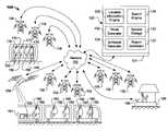
- FIG. 1is a diagram of a vehicle information system.
- FIG. 2is a schematic diagram of an exemplary information provider of the vehicle information system of FIG. 1 .
- FIG. 3is a flow chart showing an exemplary method for generating and providing vehicle information
- FIG. 4is a diagram illustrating an exemplary geographic area in which the location information of a plurality of wireless devices may be determined.
- FIG. 5is a diagram illustrating an exemplary route of a mass transit vehicle based upon the location information of passenger-carried devices of FIG. 3 .
- FIG. 6is a diagram illustrating an exemplary route map representative of a plurality of locations of the mass transit vehicle over a period of time.
- the systems and methods described hereinrelate to generating route map information, schedule information, estimated times of arrival, or other vehicle information based upon location information received from passenger-carried wireless devices, such as passengers' cellular phones.
- substantially reliable (and updateable) vehicle informationmay be provided to a user of a remote device without requiring a monitoring device that is registered with, and physically mounted to, a particular vehicle.
- a vehicle information system 100may include an information provider 120 that is connected to a network 105 , such as the internet, so as to receive and transmit certain information related to one or more vehicles.
- the system 100may also include a plurality of wireless devices 150 that are connected to the network 105 via one or more antennas towers 152 , 154 , and 156 or, in some embodiments, via one or more satellites 158 .
- the information provider 120is capable of receiving information via the network 105 related to the geographic location of the wireless devices 150 .
- the wireless devices 150may be carried by cargo 161 or passengers 160 and 170 in mass transit vehicles, such as trains 165 , buses 175 , airplanes, or the like.
- the wireless devices 150may comprise cellular phones that are carried by a plurality of passengers 160 aboard a particular train 165 .
- the information provider 120may receive location information over a period of time—the location information being associated with a group of cellular phones or other wireless devices carried by passengers 160 of that particular train 160 . It should be understood that the information provider 120 may receive the location information either directly or indirectly from the cellular phones.
- the information provider 120may receive location information indirectly from a cellular phone via a telephone service carrier that uses triangulation techniques based on signals from the cellular phone to generate location information before transmitting the location information to the provider 120 (described in more detail below).
- the information provider 120may receive location information directly from a cellular phone via an embedded GPS sensors that generates the location information, which is subsequently sent to the information provider 120 via the network 105 (described in more detail below).
- the wireless devices 150may include passive devices, active devices, or a combination thereof.
- some wireless devices 150 in the systemmay be short-range wireless devices that are capable of communicating with nearby wireless telephones or other active communication devices, as shown, for example, by device 150 in the cargo 161 of FIG. 1 .
- the short-range wireless devicese.g., RFID devices, Bluetooth devices, and IEEE 802.11/16-compliant devices
- the short-range wireless devicesmay communicate with at least one nearby wireless telephones or other active receiver/communication device (represented for illustrative purposes by the dotted line from the cargo 161 in FIG. 1 ) so that location information associated with the short-range wireless devices can be transmitted to the information provider 120 as described in more detail below.
- the information provider 120may generate route map data, schedule data, and other information related to the mass transit vehicle. Such data can be provided, via the network 105 , to at least one remote device (e.g., a personal computer, a display device 186 at a vehicle stopping station 185 , or a wireless device 150 of a remote user 180 ) so that a user 180 can effectively plan an appropriate travel route and schedule.
- a remote devicee.g., a personal computer, a display device 186 at a vehicle stopping station 185 , or a wireless device 150 of a remote user 180
- the wireless devices 150 carried by the passengers 160 , 170 and the remote users 180may connect to the network via one or more wireless service provider networks, which may provide, for example, voice and data services.
- a variety of wireless devices 150may access the services provided by the wireless service provider networks, such as a wireless cellular phone, a wireless-enabled personal digital assistant (wireless PDA), portable computers, or a short-range device (e.g., RFID device, a Bluetooth device, and an IEEE 802.11-compliant device) that communicates with any of the aforementioned devices located in proximity thereto.
- the wireless service provider networkmay comprise a plurality of antenna towers 152 , 154 , and 156 , through which data and voice communications and services may be transmitted or received.
- the wireless service provider networkmay connect the wireless devices 150 to the Internet 105 using a direct server connection, a public switched telephone network (PSTN), or the like.
- PSTNpublic switched telephone network
- the raw or anonymous location data of the wireless devices 150may be continuously or periodically transmitted via the network 105 from the wireless service provider service to the information provider 120 .
- one or more of the wireless devices 150may communicate with one or more satellites 158 to connect to the network 105 , to determine geographic location information, or both.
- a wireless device 150may comprise a satellite phone that is capable of transmitting data and voice communications through one or more communication satellites to the network 105 .
- the wireless devices 150may receive signals from a global positioning system (GPS) satellites. If a wireless device 150 is equipped with a GPS unit, it may determine a precise geographic location of the wireless device 150 . The GPS location can be communicated to the information provider 120 through the network 105 using antenna towers 152 , 154 , and 156 or using communication satellites.
- GPSglobal positioning system
- the geographic location information of the wireless devices 150may be determined by systems other than GPS.
- the location information of the wireless devices 150may be determined using base-station triangulation technologies, base station location information, cell identification, explicit requests of the user to provide location information, inferences drawn from user data such as location-specific requests, and location identification software running on a wireless device 150 .
- a plurality of passengers 160 aboard a train 165may carry wireless devices 150 such as cellular phones.
- Each cellular phone 150may be adapted to periodically broadcast its presence to one or more of the nearby antenna towers 152 .
- the cellular phones 150may receive signals from several different antenna towers 152 and may transmit a time of arrival for a synchronized signal from each tower 152 . From the time-of-arrival transmissions, the wireless service provider may be able to calculate a relatively precise location of the wireless device 150 using, for example, a technique such as Advanced Forward Link Trilateration (AFLT).
- AFLTAdvanced Forward Link Trilateration
- the location informationmay be transmitted from the wireless service provider to the information provider 120 via the network 105 . It is also contemplated that a plurality of passengers 170 aboard a bus 175 or other mass transit vehicle may carry wireless devices 150 , the location of which can be determined using the previously described techniques.
- the wireless device 150may be augmented with a GPS unit. Such augmentation can increase the accuracy of the location calculation or can provide location information during the moments when the wireless device 150 is not communicating with the antenna towers 152 , 154 , or 156 .
- the wireless device 150may be equipped with inertial sensors (e.g., linear accelerometer, angular accelerometer, compass, or the like) to increase the accuracy of the location calculation or to provide location information during the moments when the wireless device 150 and GPS unit are unable to provide accuracy location determinations (e.g., inside deep tunnels).
- the wireless devicemay also store location information locally and transmit it in batches or in summarized form, and may also calculate speed or velocity, and also transmit such calculated values.
- the location calculations from each of the antenna tower triangulation, the GPS unit, and the inertial sensor systemmay be combined using sensor fusion techniques, such as an Extended Kalman Filter (EKF) technique, clustering technique, or outlier pruning technique, to calculate an accurate estimate of the location of the wireless device 150 .
- the location informationmay be transmitted from the wireless device 150 , to the wireless service provider, and then to the information provider 120 via the network 105 .
- FIG. 2is a schematic diagram of an exemplary information provider 120 of the vehicle information system 100 of FIG. 1 .
- the information provider 120is capable of receiving information via the network 105 related to the geographic location of the wireless devices 150 .
- the information provider 120may also receive requests for data from users and generate responses to the requests.
- the user 180 of a remote devicee.g., the display device 186 or the wireless device of the user 180 shown in FIG. 1
- a report generator 122may retrieve data related to the request from a system storage 123 and then transmit such data to the remote device.
- the datamay also be prepared before a request is received.
- the information provider 120may comprise an Internet search engine 124 that is capable of providing information such as real-time traffic information, weather forecasts, news or real-time stock quotes.
- the informationmay include text, graphics, animations, audio, video or other appropriate information.
- the information provider 120may be a subsystem of an Internet search engine.
- the information provider 120is connected to the Internet 105 to receive location information of the wireless devices 150 ( FIG. 1 ) and to communicate with users who may be interested in accessing the services provided by the information provider 120 .
- the information provider 120could also be connected to other networks (not shown), such as, for example, an internal business network, or a local wireless communication network.
- the information provider 120may be embodied in a bank of server computer systems or as a data center.
- the information provider 120may be divided into separate systems to allow for scalability, data integrity, or data security, and it may be connected to the Internet 105 or to another network in any of a variety of ways, as is commonly known.
- the information provider 120may comprise subsystems other than those shown in FIGS. 1-2 , depending upon the various functions that will be performed by the information provider.
- the information provider 120may communicate through an external interface 121 . Through the external interface 121 , the information provider 120 receives location information data, receives data requests, and transmits responses.
- the information provider 120may also include an internal interface (not shown in FIG. 2 ) to internally route information to and from the proper subsystems.
- the internal interfacemay comprise interface devices for a high-speed, high-bandwidth network such as SONET, Infiniband or Ethernet, or any suitable communication hardware operating under an appropriate protocol such that the information provider 120 can respond to a large number of distinct requests simultaneously.
- the external interface 121may comprise network interface cards (NICs) or other communication devices and may similarly include components or interfaces of a high-speed, high-bandwidth network.
- NICsnetwork interface cards
- Data requestssuch as data requests from users, may be received through the external interface 121 and handled by another subsystem of the information provider 120 .
- the data requestsmay be in the form of a text message transmitted from a short messaging service (SMS) application of a remote wireless device such as a cellular phone or a PDA device.
- SMS requests from a particular wireless devices 150may be the source of the location information of that wireless device 150 (e.g., the location information for that wireless device 150 may be embedded in the data transmitted as part of the SMS request).
- the data requestsmay be in the form of HTML data, XML data, image map data, synthesized speech, or the like transmitted from a browser application of a remote personal computer system.
- the information provider 120may reformat from, for example, HTML or text format, to search terms or strings that are compatible with the report generator 122 or the search engine 124 .
- the data requestsmay be implicit (e.g., requests from the user to send information regarding whether the vehicle that she is presently aboard or will board in the future will be more than five minutes late or is going to enter a traffic jam) or inferred (e.g., the information provider 120 is capable of determining the user's location based upon the user's wireless device and infers a data request based on the nature of the user's location or other personal information supplied by the user).
- the information generated in response to a requestmay be converted to another format in a manner that allows it to be used by the requesting device.
- the information provider 120may convert data that is in an internal format to HTML, WAP, XML, VoiceXML, or a textual data format that can be used, for by the wireless device's SMS application/text-messaging function. After formatting the response, the information provider 120 may transmit it to the requesting user via its external interface 121 .
- a location information engine 125may gather or organize such information, for example, into a location information database 126 .
- the location information databasemay include a number of categories 128 a - d pertaining to the location information of particular wireless devices 150 .
- the database 126may include a “device identifier” category 128 a , which includes a unique identifier for each wireless device 150 having location information that is received by the information provider 120 .
- the unique identifiermay be a telephone number for a particular cellular phone device, a serial number, a signature embedded in the data or wireless signal of the wireless device 150 , or other identification code assigned by a wireless service provider when each cellular phone 150 or other wireless device periodically broadcasts its presence to one or more of the nearby antenna towers 152 , 154 , or 156 .
- An identifier not related to the device 150may also be provided so that a user may be assured of anonymity from the information provider 120 .
- the location information database 126may also include a “location” category 128 b and a “time” category 128 c associated with each “device identifier” category 128 a .
- the “location” category 128 bmay include a series of entries representative of the geographic location measurement of the wireless device 150 .
- the geographic location measurementmay comprise, for example, GPS coordinates, global longitude and latitude coordinates, other coordinates that are representative of a geographic location, or raw data associated with the location of the wireless device 150 (e.g., signals from triangulation units, accelerations measurements from inertial sensors, or the like).
- Such coordinate entriesmay be directly compatible with a route generator 130 (described in more detail below).
- each of these entriesmay be stored over a period of time, and the particular time of each geographic location measurement may be entered into the “time” category 128 c . Accordingly, each entry in the “device identifier” category 128 a may include a series of corresponding “location” and “time” entries as the location information of the wireless devices 150 is periodically received by the information provider 120 via the network 105 .
- the location information database 126may include a “vector” category 128 d associated with each “device identifier” category 128 a .
- the vector category 128 dmay be representative of the approximate velocity and direction of the wireless device 150 at the particular time of each geographic location measurement.
- the velocity and directionmay be measured, for example, by a GPS unit in the wireless device 150 or may be calculated, for example, by the wireless service provider after performing the antenna tower triangular techniques. In such circumstances, the velocity/direction data may be transmitted to the information provider 120 via the network 105 .
- the velocity/direction datamay be calculated by the location information engine 125 using, for example, the relative location/time differences in the associated “location” and “time” categories 128 b and 128 c .
- Such calculations by the location information engine 125may be more accurate if the time between the geographic location measurements is reduced or if variable sampling or indexing techniques are employed (e.g., sample particular wireless devices more frequently as the non-linearity—variation from the predicted location, velocity, acceleration, or other functions—increases).
- the entries in the vector category 128 d and other categoriesmay be used by a route generator 130 , a schedule generator 134 , the report generator 122 , or another subsystem to sort various groups of wireless devices 150 , to determine vehicle stop locations, or to determine other vehicle information (e.g., estimated time of arrival).
- the location information database 126may include other categories associated with each “device identifier” category 128 a .
- the location information database 126may include a category that stores data related to acceleration measurements from an inertial sensor in the wireless device 150 .
- the location information database 126may include a category that stores the error bounds related to the location, time, or vector data.
- the entries in the location information database 126may be continuously or periodically updated and refreshed to provide current location information for particular mass transit vehicles. For example, after the information provider 120 has identified and generated vehicle route data after aggregating location and time information or a period of time, the information provider 120 may continuously track the location information of a group of wireless devices 150 that are aboard a particular vehicle so as to determine the current location of that vehicle. As described in more detail below, the current location of the vehicle may be compared with the previously recorded route data and schedule data to determine estimated times of arrival, to determine which vehicles are currently operating ahead of schedule or behind schedule, or the like.
- the volume of data received by the information provider 120may be so great that the data stored in the location, time, vector, and other categories 128 a - d may be stored only for a brief period of time.
- the data related to a particular wireless device 150may be cached for a time sufficient to derive the actual geographic location of that wireless device 150 before it is discarded.
- much of the datawould be discarded while the information provider 120 would store only aggregate residuals such as error bounds, geographic locations, velocities, accelerations, a sub-sample of a ranked version of the raw data (for subsequent analysis), or the like.
- the information provider 120may include one or more subsystems to generate vehicle information based upon the location information of the wireless devices 150 .
- the location information of the wireless devices 150may be stored in the location information engine 125 , and this information may be used by other subsystems of the information provider 120 .
- the information provider 120includes the route generator 130 to generate route data of particular mass transit vehicles based upon the location information of the wireless devices 150 carried by passengers in those particular vehicles.
- the route generator 130may include a database 131 that is continuously or periodically updated based upon the data by the information provider 120 from the wireless devices 150 .
- the route database 131may include a “route group” category 132 a to distinguish a particular set of data points representative of a vehicle's geographic route.
- the “route group” category 132 amay include a name identifies with a particular route, such as the “commuter blue line,” “train # 9 ,” “bus # 17 ,” “flight # 1611 ,” “New Delhi westbound train,” or the like.
- the “route group” categorymay include identifier numerals assigned by the information provider (e.g., group 835 - 912 ) to distinguish a set of data having, for example, a similar set of vector entries from vector category 128 d and a similar location entries from the location category 128 b.
- the route database 131may also include an “estimated locations” category 132 b having a series of entries representative of the approximated geographic locations of the vehicles that are tracked using the location information of the wireless devices 150 .
- the geographic location entriesmay comprise, for example, GPS coordinates, global longitude and latitude coordinates, or other coordinates.
- the series of entries in the “estimated locations” category 132 bmay represent a series of locations of a vehicle measured or inferred over a period of time. Thus, each entry in the “route group” category 132 a may be associated with a plurality of entries in the “estimated locations” category 132 b .
- the series of entries in the “estimated locations” category 132 bmay be used by the report generator 122 to provide route map data or provide lists of geographic locations representative of a vehicle path.
- the route generator 130may sort entries stored in the location information database 126 based upon a group of device identifiers in category 128 a sharing a similar set of vector entries from vector category 128 d and a similar set location entries from the from the location category 128 b .
- this selected group of device identifiersmay be representative of wireless devices 150 traveling aboard a mass transit vehicle (e.g., train 165 , bus 175 , airplane, or the like).
- the route generator 130may assign a route group entry into the “route group” category 132 a for this sorted data in the location information database 126 .
- the location information entries (category 128 b ) for the selected group of device identifiers in category 128 amay be used by the route generator 130 to assign a list of approximate locations in category 132 b .
- the approximate locations of the vehiclemay be calculated using statistical techniques based upon the “location” entries in category 128 b .
- a subset of data in the location information database 126may be used by the route generator 130 to create a route group and an associated list of approximate locations of a mass transit vehicle.
- the associated list of approximate locations of the mass transit vehiclecan be incrementally updated as the entries in the location information database are updated or refreshed in the future.
- the route generator 130may characterize a route as functions of a single variable, for example, variable s, where s goes from 0 to D and where D is the total distance of a route.
- each routemay be characterized as functions x(s), y(s), and z(s) (e.g., representing the three-dimensional coordinates of the vehicle on the Earth's surface), as functions lat(s), long(s), elevation(s) (representing the latitude, longitude, and elevation of the vehicle), or the like.
- These functionmay be recorded in the “estimated locations” category 132 b or another category associated with the “route group” category 132 a .
- each routemay be captured as a series of location points (as described above), as a series of one or more functions that capture the approximate paths of the vehicle, or a combination thereof.
- the route generator 130may substantially compress the data necessary to characterize each route and may substantially speed up any query or search processes.
- One example of a process used to generate the one or more functions that characterize a routeis to identify clusters of wireless devices that are traveling through the same space (e.g., x-y-z coordinates or latitude-longitude-elevation coordinates) for short periods of time (e.g., from 1 to 15 minutes or more). Then, route segments may be generated for each of these short time periods. After a series of route segments have been generated, the route segments may be combined into one route path characterized by one or more functions if the route segments are continuous (e.g., one end of a route segment matches the beginning of a second route segment). If more than two route segments meet at a single location, that location may be identified as a regular stop, a passenger station, or the like. As more location information is received by the information provider 120 , the route functions may be further refined by analysis to determine if a predominant number of wireless devices 150 travel from one of the route segments to the next.
- the route functionsmay be further refined by analysis to determine if a predominant number of wireless
- a schedule generator 134may be used to generate vehicle schedule data of particular mass transit vehicles based upon the location information of the wireless devices 150 carried by passengers in those particular vehicles.
- the schedule generator 134may include a database 135 that is continuously or periodically updated based upon the data received by the information provider 120 .
- the schedule generator database 135may include “route group” category 136 a to distinguish a particular set of data points representative of a vehicle's geographic route.
- the entries in the “route group” category 136 amay be assigned based upon sorted groups of in the location information database 126 (as previously described in connection with the route generator database 131 ) or may be retrieved directly from the route generator database 131 (e.g., from category 132 a ).
- each entry in the “route group” category 136 amay be a series of entries in the “regular stop locations” category 136 b and the “estimated stop times” category 136 c .
- the series of entries in the “regular stop locations” category 136 bmay be determined by analyzing when a group of wireless devices 150 aboard a vehicle remain at a similar location for an extended period of time. Such an analysis may be conducted by analyzing when a selected group of device identifiers in the location information database 126 share a similar string of “location” entries and “time” entries.
- the entries in the “regular stop locations” category 136 bmay be selected from these sorted “location” entries in the location information database 126 .
- the regular stop locations of the vehiclemay be calculated using statistical techniques based upon the “location” entries in category 128 b .
- the entries in the “estimated stop times” category 136 cmay be selected from the corresponding “time” entries in the location information database 126 . Accordingly, a subset of data in the location information database 126 may be used by the schedule generator 134 to create a list of estimated stop locations of a mass transit vehicle and an associated list of stop times for a particular route group.
- the series of entries in the “regular stop locations” category 136 b and the “estimated stop times” category 136 cmay be used by the report generator 122 to provide vehicle map data or provide lists of locations representative of the vehicle's regular stopping locations.
- the route generatormay characterize a route as functions of a single variable, for example, variable s.
- each routemay be characterized as functions x(s), y(s), and z(s) (e.g., representing the three-dimensional coordinates of the vehicle on the Earth's surface), as functions lat(s), long(s), elevation(s) (representing the latitude, longitude, and elevation of the vehicle), or the like.
- the distinction between the route and the scheduleis imposition of time.
- a schedulemay require a function t(s), which represents a function of time relative to the variable “s,” to be generated along with the route functions (e.g., x(s), y(s), and z(s)). These functions may be recorded in one of the categories associated with the “route group” category 136 a of the schedule generator 135 . Accordingly, the processes for generating route functions as previously described can be used to generate route and schedule data contemporaneously. It should be understood that a single route may have multiple such schedules (e.g., t 1 (s), t 2 (s), and so on).
- Functions suitable to characterize schedulesmay include selecting s points between which acceleration is piecewise linear, galerkin functions, second order polynomials (e.g., c 2 continuous functions), or the like.
- One example of a process to generate these schedule functionsincludes taking data captured from any time instant (e.g. a very short time interval) as examples of these schedules and attempting to merge these schedules with others based on similarity with other schedules offset by time constants. If the time constants are uniformly spaced daily or every “k” days or every “m” minutes, they may be classified as repeating schedules that repeat according to the pattern found.
- the process to determine these repeating schedulesis using statistical techniques.
- the statistical techniquesmay include employing the least squares or SVD techniques, creating a standard deviation or some other density function from the mean, determining a confidence based on the number of distinct schedule examples.
- the statistical techniquesmay include using Savitsky Golay techniques.
- the series of entries in the “regular stop locations” category 136 b and the “estimated stop times” category 136 cmay be used by the report generator 122 to provide data corresponding to the vehicle's estimated time of arrival at a particular stop location.
- a remote user of a wireless device 150may use an SMS application to send a text message requesting the estimated time of arrival of a vehicle on a particular route at a particular stop location (e.g., text message sent to information provider may include “estimated arrival time of 4:30 Caltrain to Palo Alto”).
- This data request from the remote wireless devicemay also include the current time and the remote user's location information, which could be manually entered by the user or automatically embedded in the data request after a determination using any of the previously described GPS or triangulation techniques.
- the information provider 120may receive this data request and parse the information into the appropriate text components.
- the information providermay identify the particular route that was queried by the remote user (i.e., “4:30 Caltrain to Palo Alto”) and compare the remote user's location information to the nearest stop location (e.g., an entry in the “regular stop locations” category 136 b ) for that identified route. Then, the information provider 120 may compare the most recent location and speed information for that particular vehicle (using information from the group of wireless devices that are currently aboard the identified vehicle route) to the historical or previously aggregated schedule data for the identified route to determine the estimated time of arrival. The data corresponding to the estimated time of arrival may be transmitted back to the SMS application or other application of the remote user's wireless device.
- the routes stored by the information provider 120may be labeled by human intervention or by some other external application that is capable of identifying and labeling the routes.
- the routesmay be labeled by workers assigned to label routes that stored by the information provider 120 , by users who access an interface to label particular routes, by collaborative filtering or data requests from users (e.g., text messages), or other such processes.
- the embodiments of the information provider 120are not limited the illustrative embodiment depicted in FIG. 2 .
- the operations and the databases of the route generator 130 and the schedule generator 134may be combined into a single subsystem.
- the route generator 130 and the schedule generator 134may be subsystems of the report generator 122 .
- the report generator 122may be equipped to provide route map data, schedule data, estimated time of arrival data, and other vehicle information, either collectively or separately, to a remote device (e.g., a personal computer, a display device 186 at a vehicle stopping station 185 , or a wireless device 150 of a remote user 180 as shown in FIG. 1 ) so that the user 180 can effectively plan an appropriate travel route and schedule, as described in more detail below.
- a remote devicee.g., a personal computer, a display device 186 at a vehicle stopping station 185 , or a wireless device 150 of a remote user 180 as shown in FIG. 1
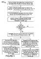
- FIG. 3is a flow chart showing one exemplary method 200 for generating and providing vehicle information.
- the information provider 120may generate route map data, schedule data, estimated times of arrival, or and other information related to one or more mass transit vehicles based upon location information received from a plurality of wireless devices 150 , such as a plurality of passengers' cellular phones aboard the mass transit vehicles.
- the exemplary method 200 depicted in FIG. 3 and other methods described hereinmay be implemented, for example, using one or more computer systems as described in more detail below, and may be stored as instructions on a recordable media so that the methods are performed when the instructions are executed (as described, for example, in more detail below).
- the information provider 120may perform the operation 205 of receiving location information over a period of time associated with a plurality of wireless devices 150 .
- the location informationmay be received (directly or indirectly, as previously described) from a plurality of wireless devices 150 , such as cellular phones, that are carried by passengers or cargo aboard a mass transit vehicle (e.g., a train 165 , a bus 175 , or a plane).
- the location informationmay be sent, for example, via the antenna towers 152 , 154 , or 156 and the cellular service provider and then through the network 105 (e.g., the internet).
- the information provider 120may receive the location information from the network 105 through its external interface 121 .
- the information provider 120may perform the operation 210 of determining the movement vector for some or all devices in the plurality of the wireless devices 150 .
- the information providers 120may include the location information engine 125 or other similar subsystem (e.g., route generator 130 , schedule generator 134 , or the like) that is capable of determining the movement vector of some or all of the wireless devices 150 for which it received location information.
- the movement vectormay be representative of the approximate velocity and direction of the wireless device 150 at the particular time of each geographic location measurement.
- the information provider 120may determine the movement vector for each device separately, or the information provider 120 may determine the movement vector for only some of the wireless devices 150 that are traveling together aboard a vehicle.
- some of the wireless devices 150may be equipped with inertial sensors that may directly report the movement vectors of that particular device.
- the information provider 120may filter the information received from wireless devices that do not meet selected criteria.
- the information provider 120may include a subsystem (location information engine 125 , route generator 130 , schedule generator 134 , or the like) that uses statistical techniques to filter information received from wireless devices 150 that (1) are not geographically clustered near other wireless devices 150 (e.g., a person carrying a cellular phone who is walking alone on a sidewalk), or (2) are not traveling at a similar rate of speed and in a similar direction as other wireless devices 150 (e.g., a plurality of cellular phone users who are near a common street corner but are walking, biking, or driving in different directions or at different speeds).
- Such filteringmay permit the information provider 120 to identify a group of wireless devices 150 having substantially similar movement vectors and geographical locations, as shown in operation 220 .
- the information provider 120may include a subsystem that is capable of identifying wireless devices 150 having a similar set of movement vectors at similar geographic locations such that those wireless devices 150 may be identified, to a reasonable degree of certainty, as collectively riding aboard a mass transit vehicle (e.g., a train 165 , a bus 175 , or a plane). Locations and movement vectors may also be recorded over a period of time to help ensure that individuals are moving together. Also, each device may transmit location and vector information independent of other devices so that data collection is not truly simultaneous. As a result, interpolation or other adjustments may be applied to the location and vector information to set the relevant devices in a common time domain.
- a mass transit vehiclee.g., a train 165 , a bus 175 , or a plane.
- the method 200may include a operation 222 are determines a confidence level for the group of wireless devices 150 that were previously identified. If the confidence level does not satisfy a particular threshold (e.g., there is a low confidence that all of the wireless devices in the identified group are actually traveling together aboard the same vehicle), another iteration of filtering may be employed. The subsequent iterations of filtering may use different criteria or statistical techniques in order to further refine the identified group of wireless devices 150 . In this embodiment, if the confidence level is determined to satisfy a particular threshold level, the method may proceed to subsequent operations.
- the information provider 120may aggregate time and location information received from the group of wireless devices 150 (e.g., the group of wireless devices 150 carried by train passengers 160 as shown in FIG. 1 ). After the group of wireless devices 150 that are riding aboard a mass transit vehicle is identified, the location information of those particular wireless devices 150 may be tracked over a period of time. As previously described in connection with FIG. 2 , this location and time information may be used to generate vehicle route data or vehicle schedule data without the use of electronic components that are physically attached to the vehicle. It should be understood the group of wireless devices may be subject to minor changes over that period of time, for example, when a passenger departs the mass transit vehicle and another person boards that vehicle. In such circumstances, the information provider may redefine the group of wireless devices 150 aboard the mass transit vehicle based upon the location and movement vector information of the wireless devices 150 .
- the group of wireless devices 150e.g., the group of wireless devices 150 carried by train passengers 160 as shown in FIG. 1 .
- the location information of those particular wireless devices 150may be tracked over a period of time.
- the information provider 120may have the capability to generate vehicle route data, vehicle schedule data, or both.
- the operations for generating route data and for generating schedule dataare shown as separate and independent from one another. It is contemplated that, in other implementations, the generation of route data and the generation of schedule data may be performed separately but dependent on one another or collectively and contemporaneously with one another.
- the information provider 120may generate route map data representative of a plurality of location of the group of wireless devices 150 over a period of time.
- the information provider 120may include a subsystem, such as the route generator 130 ( FIG. 2 ), that is capable of generating a list of location data for particular groups of wireless devices 150 that were previously determined to have substantially similar movement vectors and geographical locations.
- This location data for the group of wireless devices 150may be used, for example, to create a route map of the mass transit vehicle on which the group of wireless devices were believed to be aboard.
- the information provider 120may transmit the route map data to a remote device (e.g., a personal computer, a display device 186 at a vehicle stopping station 185 , or a wireless device 150 of a remote user 180 ).
- the route map datamay be transmitted to the remote device as part of a regular, periodic transmission or as part of a response to a data request from a particular remote device.
- the information provider 120may include a report generator 122 or another subsystem that is capable of receiving data requests and obtaining route map data from the route generator 130 .
- the report generator 122may transmit one or more packets of information that includes the route map data so that a route map may be displayed on a remote device.
- the route map data and other such informationmay be stored in an index internal to the information provider 120 .
- the indexmay be updatable and search able, and in some circumstances, two or more parallel indexes that are optimized for various uses can be employed by the information provider 120 .
- the indexmay be used, for example, by various services (e.g., a location-based alert service or other services described in more detail below) that are configured to query the index for particular route map data and/or other information and configured to transmit such data to a remote device (e.g., a wireless phone having an SMS application).
- the servicemay be a report generator 122 in that it transmits the route data to a remote device.
- the information provider 120may generate schedule data representative of a plurality of stop locations and corresponding approximate stop times of the group of wireless devices 150 over a period of time.
- the information provider 120may include a subsystem, such as the schedule generator 134 ( FIG. 2 ), that is capable of generating a list of regular stop locations for particular groups of wireless devices 150 that were previously determined to have substantially similar movement vectors and geographical locations.
- This location data for the group of wireless devices 150may be used, for example, to create a schedules or stop location maps for the mass transit vehicle on which the group of wireless devices were believed to be aboard.
- a route maphas previously been identified, individuals aboard a vehicle on that route may be more readily identified than when the system has no knowledge of a transit system. Specifically rather than using statistical analysis to identify common travelers, the system may simply seek individual wireless devices having location and vector information that substantially matches those for an already-identified route map.
- the information provider 120may transmit the route schedule data to a remote device (e.g., a personal computer, a display device 186 at a vehicle stopping station 185 , or a wireless device 150 of a remote user 180 ).
- the route schedule datamay be transmitted to the remote device as part of a regular, periodic transmission or as part of a response to a data request from a particular remote device.
- the information provider 120may include a report generator 122 or another subsystem that is capable of receiving data requests and obtaining route schedule data from the schedule generator 134 .
- the report generator 122may transmit one or more packets of information that includes the route schedule data so that schedule listings or stop location maps may be displayed on a remote device.
- the route schedule data and other such informationmay be stored in an index internal to the information provider 120 .
- the indexmay be updatable and search able, and in some circumstances, two or more parallel indexes that are optimized for various uses can be employed by the information provider 120 .
- the indexmay be used, for example, by various services (e.g., a location-based alert service or other services described in more detail below) that are configured to query the index for particular route schedule data and/or other information and configured to transmit such data to a remote device (e.g., a wireless phone having an SMS application).
- the servicemay be a report generator 122 in that it transmits the schedule data to a remote device.
- the information provider 120may be configured to receive text messages from a SMS application of a remote wireless device and to transmit the data in the form of a text message for viewability using the SMS application of the remote device.
- the information provider 120may transmit the requested data in HTML format, XML format, or another format that can be displayed in a browser application of the remote device.
- the information provider 120may be configured to provide various types of information related to a mass transit vehicle in addition to route map data and schedule data.
- the report generator 122 or other subsystem of the information provider 120may be configured to provide, in addition to route map data and schedule data, information associated with the future scheduled stops of the vehicle on that particular day (e.g., indicating whether the vehicle is early or late for subsequent stops).
- the report generator 122 or other subsystem of the information provider 120may be configured to provide the estimated duration of the vehicle at a particular stop location (e.g., the train will be boarding passengers from 3:12 PM to 3:16 PM). Such information may be helpful to a person who is accessing the vehicle information via his or her cellular phone while that person is trying to get to a particular stop location.
- the report generator 122 or other subsystem of the information provider 120may be configured to provide data associated with a particular vehicle's estimated time of arrival at a defined location.
- the information provider 120may identify the particular route that was queried by the remote device and compare the remote device's location information to the nearest stop location for that identified route. Then, the information provider 120 may compare the most recent location and speed information for that particular vehicle (using information from the group of wireless devices that are currently aboard the identified vehicle route) to the historical or previously aggregated schedule data for the identified route to determine the estimated time of arrival. Such information may be helpful to a person who is planning to go to a particular stop location and desires to know how much time is available before the mass transit vehicle arrives.
- the report generator 122 or other subsystem of the information provider 120may be configured to provide an estimated time of passage at various points in the route map (e.g., crossing over the North River Bridge at 5:13 PM). This information may be determined by comparing the most recent location and speed information for that particular vehicle (using information from the group of wireless devices that are currently aboard the identified vehicle route) to the historical or previously aggregated route map data for the identified route.
- the information associated with the estimated time of arrival or the estimate time of passage at various points in the routemay be intentionally skewed for security purposes.
- the report generator 122 or other subsystem of the information provider 120may be configured to add or subtract one minute or less from the estimated times so that the reported estimates are slightly skewed from the true estimates.
- the information provider 120can provide potential passengers with sufficiently accurate data associated with the estimated times of arrival (or other estimated times) without providing exact timing information.
- the information provider 120may be configured to intentionally skew the current location of the mass transit vehicle for security purposes.
- the report generator 122 or other subsystem of the information provider 120may be configured to add or subtract several meters or miles from the vehicle's current location so that the reported locations are slightly skewed from the true locations. In those circumstances, the information provider 120 can provide potential passengers with sufficiently accurate data associated with the vehicle's location without providing exact timing information.
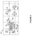
- FIGS. 4-6show diagrams of one example of the route map generation techniques.
- FIG. 4in a given geographical area 310 , there are a plurality of wireless devices 150 that are individually carried by different persons.
- FIG. 4represents a diagram that visually illustrates some of the processes of the systems and methods described herein. The diagram itself is not necessarily displayed onscreen of any previously described device (in some embodiments, it may be displayed on a central or remote device), but rather represents some of the data that may be received or determined by the information provider 120 .
- the location information 350 for each of the wireless devices 150may be received by the information provider 120 .
- the location 350 a of one wireless device 150 amay be determine to be substantially different from the location 350 b another wireless device 150 b .
- the movement vectors 351 of the wireless devices 150may be determined such that the movement vector 351 a of one wireless device 150 a is substantially different from the movement vector 351 c of another wireless device 15 c.
- the information provider 120may be adapted to filter information associated with some wireless devices 150 that do not meet certain criteria.
- a wireless device 150 b in the geographic area 310may have a location 350 b that is somewhat distant from other wireless devices 150 .
- the information provider 120may filter out the information from the wireless device 150 b for purposes of identifying a group of wireless devices 150 that are carried by passengers 160 riding aboard a mass transit vehicle 165 .
- a wireless device 150 cmay have a substantially similar location 350 c to a group of wireless devices (e.g., wireless device 150 a and other near by devices), but the wireless device 150 c has a substantially different movement vector 351 c from the movement vectors (e.g., movement vector 351 a ) of the group of wireless devices.
- the information provider 120may filter out the information from the wireless device 150 c for purposes of identifying a group of wireless devices 150 that are carried by passengers 160 riding aboard a mass transit vehicle 165 .
- a group 365 of wireless devices 150having substantially similar locations (e.g., in proximity to location 350 a ) and movement vectors (e.g., movement vector 351 a ). Based upon the number of wireless devices and the velocity profile of the wireless devices 150 in the group 365 , this group 365 may be identified as those passenger-carried (or cargo-carried) wireless devices that are collectively riding aboard a mass transit vehicle 165 .
- the statistical techniquesmay be known to those having skill in the art in statistics, machine learning, regression, optimization, optimal control, and other algorithmic/numerical techniques.
- the location and time information for those wireless devices in that group 365may be aggregated over a period time.
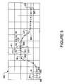
- the group 365 of wireless devicesmay have a particular location (as shown, for example, on the left side of the geographic area 320 ) and a particular movement vector 351 .
- the group 365may have a different location (as shown, for example, to the right of the previous location).
- the aggregation of the location and time informationmay continue for a period of time (e.g., including t 1 through t 25 and beyond) so as to generate a listing of locations for route map data and to generate a listing of stop locations (e.g., location 370 ) for route schedule data. Aggregation may also occur even before a particular group has been identified as common travelers.
- the stop locations for the group 365 of wireless devicesmay be determined from the movement vectors 351 .
- the group 365 of wireless devicesmay have movement vectors 351 that indicate the group 365 is slowing down.
- the group 365may have movement vectors 351 that indicate the group 365 is completely stopped over a period of time.
- the location information for the group 365 of wireless devices during this period of timee.g., from time t 12 to time t 15 ) may be stored as a stop location 370 that can be part of the schedule data reported by the information provider 120 .
- the group 365 of wireless devicesmay have a movement vector 351 that indicates a forward motion after the vehicle stop is completed. Where only a subgroup of group 365 has registered its location during a time period, only the location and time information from that subgroup may be considered.
- the aggregation of the location and time information for a group of wireless devices 150 inside a particular mass transit vehiclemay continue over a period of days or weeks. Such information from different days or weeks may be used to refine the route map data and route schedule data (e.g., indicate that some stop locations do not occur everyday) reported by the information provider 120 . Furthermore, it should be understood that location and time information from many groups of wireless devices 150 may be aggregated so as to generate route map data and route schedule data for a plurality of mass transit vehicle routes, any one of which may be reported by the information provider 120 to a remote device. Also, the location and time information for a particular group of wireless devices aboard a previously identified vehicle route may be aggregated again at a later time to update or incrementally change the route map data and/or route schedule data for that particular route.
- map image 330may correspond to the geographic area 320 that was analyzed as shown in FIG. 5 .
- at least a portion of the map image 330may be provided by the report generator 122 of the information provider 120 .
- the map image 330may include previously known geographic features, such as cities 332 , airports 334 , highways 336 , other roads 338 , or the like.
- the route map datamay be used to indicate the location of a mass transit vehicle's pathway 335 relative to the other geographic features.
- the route schedule datamay be used to indicate a stop point 337 that corresponds to the vehicle stop location 370 ( FIG. 5 ) previously determined by the information provider.
- the route of a mass transit vehiclemay be determined without the use of predetermined maps. Rather, the maps showing other geographic features may be incorporated after the location information for the vehicle's route has already been determined by the information provider 120 .
- the information providermay include an function that determines what type of vehicle (e.g., on-road, off-road, train, plane, etc.) was identified based upon information such as the cluster size of the group of wireless devices, the velocity, the stop locations, the terrain over which the route passes, or the like.
- This process of determining the vehicle's route without relying upon old or outdated mapsmay provide a more accurate estimate of the vehicle's route pathway and route schedule.
- the vehiclemay consistently stop at an unofficial stop point 337 to pick up passengers.
- This unofficial stop point 337may not be located on a road, on a highway, or in a large city that could be identified on an old map. Rather, the unofficial stop point 337 may be located proximal to a hidden or otherwise unmapped walking or biking pathway 339 that local villagers regularly use to intercept a train or a bus (e.g., a situation that occasionally occurs in India and other nations).
- stop point 337may be detected by identifying a location where a statistically significant number of previously ungrouped wireless devices engage the previous group of wireless devices that were known to be aboard the vehicle. Because the vehicle's route data and schedule data can be generated without reliance on old maps, the vehicle's route pathway 335 and stop points (e.g., stop point 337 ) may be accurately reported regardless of whether the vehicle uses unmapped pathways or unofficial stop points.
- the location and time information corresponding to a particular mass transit vehiclemay be obtained from a plurality of passenger-carried wireless devices 150 that are not registered with that particular vehicle. Accordingly, a robust system to gather and report route map information, vehicle schedule information, estimated time or arrival, and other vehicle information may be developed without the requirement of location monitoring devices that are physically mounted and registered to each and every mass transit vehicle in the fleet.
- the route map data and schedule data generated by the information provider 120may be used to provide a number of different services to remote users.
- remote wireless devices 150e.g., a cellular phone or a PDA device
- the information provider 120may supply more accurate information than static, pre-recorded schedules that are published by transit authorities.
- the information provider 120may provide access to route data and schedule data that would not otherwise be available to potential passengers (e.g., public train authorities in some countries do not publish train schedules).
- the information provider 120may be used to provide situational awareness features to passengers of the mass transit vehicle.
- a passenger of a vehiclemay desire to know the next possible stopping location or the future route locations.
- the wireless device carried by that passengermay be used to request such information without having to enter the user's location or time information.
- the user's location and time informationcan be automatically embedded in the data request using the previously described GPS or triangulation techniques.
- the report generator 122may respond to the data request with information related to the vehicles next stopping location and the estimated duration of that stop (e.g., the response may include a text message stating “the train will stop at the River Dam with an 80% confidence in 32 minutes” even though the River Dam is not an officially scheduled stop on the literature published by the transit authority).
- the information provider 120may be used to provide location-based services for those passengers aboard a particular mass transit vehicle. These services may be accessed, for example, using a passenger's cellular phone or a PDA device connected to a wireless network, a passenger's laptop computer that is connected to a Wifi network or other local network provided on the vehicle, or a public computer station accessible to a plurality of passengers aboard the vehicle.
- the location-based servicesmay include location-based news, location-based factoids or zeitgeist alerts (e.g., used by tourists aboard a cross-country bus or train route), location-based advertisements, or localized web searches.
- a passenger aboard a mass transit vehiclemay send a data request via his or her cellular phone to the information provider 120 requesting information on the coffee shops close to the next stop location.
- the information provider 120may use the passenger's location and time information that was embedded in the data request to identify a vehicle route and the next stop location. From there, the information provider 120 may include a subsystem to perform a localized web search of the coffee shops nearest to the identified stop location. The result of the localized web search may be reported back to the passenger's cellular phone.
- the location-based servicesmay include automatic location-based notifications.
- a wireless device usermay subscribe to a service that automatically notifies the user of location-based events, such as train delays or current local news stories.
- the information provider 120may determine the user's location as previously described and then transmit a relevant mass transit alert or other locally relevant information.
- location-based advertisementscan be automatically transmitted to wireless devices or computer stations aboard the vehicle when the information provider 120 transmits responses to other data requests. For example, if a passenger aboard a vehicle sends a data request to the information provider 120 requesting the estimated time of arrival at the next stop location, the report generator 122 may transmit a response that reports the estimated time until the next stop location (as previously described). In addition, the response may include location-based advertisements that are associated with the vehicle's next stop location. The information provider 120 may use the passenger's location and time information that was embedded in the data request to identify a vehicle route and the next stop location.
- the information provider 120may include an advertisement generator or other subsystem to embed one or more advertisements in the response to the data request.
- the passengermay receive the requested information (e.g., the estimated time of arrival at the next stop location) along with one or more advertisements pertinent to the location of the next stop.
- training of a system to determine the parameters of a routemay be distinct from obtaining latter data from devices that follow that route. For example, greater amounts of aggregated data may be required before a system has the confidence level necessary to conclude that a route is present at a particular path in the initial case. Once the route has been established, however, less data may be used to confirm that a mass transit vehicle is at a particular location along that route.
- datamay be aggregated over days or more to establish the repetition needed to conclude that a particular path is a transit route.
- itmay be enough to locate a single device moving along that route to determine where a mass transit vehicle is along the route—particularly if the received data is consistent with other data showing when a vehicle should be on the route.
- the lesser amount of datamay allow a system to report the progress of the vehicle, such as to a user waiting on a station platform and having a GPS-enabled device that reports the user's location, which location is checked against the location of various stops.
- implementations of the systems and techniques described hereincan be realized in digital electronic circuitry, integrated circuitry, specially designed ASICs (application specific integrated circuits), computer hardware, firmware, software, and/or combinations thereof.
- ASICsapplication specific integrated circuits
- These various implementationscan include implementation in one or more computer programs that are executable and/or interpretable on a programmable system including at least one programmable processor, which may be special or general purpose, coupled to receive data and instructions from, and to transmit data and instructions to, a storage system, at least one input device, and at least one output device.
- the systems and techniques described herecan be implemented on a computer having a display device (e.g., a CRT or LCD monitor or a audio output instrument such as a headset) for communicating information to the user and a user-input device (e.g., a keyboard or a pointing device, such as a mouse or a trackball) by which the user can provide input to the computer.
- a display devicee.g., a CRT or LCD monitor or a audio output instrument such as a headset
- a user-input devicee.g., a keyboard or a pointing device, such as a mouse or a trackball
- Other kinds of devicescan be used to provide for interaction with a user as well.
- feedback provided to the usercan be any form of sensory feedback (e.g., visual feedback, auditory feedback, or tactile feedback).
- input from the usercan be received in any form, including acoustic, speech, or tactile input.
- the systems and techniques described herecan be implemented in a computing system that includes a back end component (e.g., as a data server), or that includes a middleware component (e.g., an application server), or that includes a front end component (e.g., a client computer having a graphical user interface or a Web browser through which a user can interact with an implementation of the systems and techniques described here), or any combination of such back end, middleware, or front end components.
- the components of the systemcan be interconnected by any form or medium of digital data communication (e.g., a communication network). Examples of communication networks include a local area network (“LAN”), a wide area network (“WAN”), and the Internet.
- LANlocal area network
- WANwide area network
- the Internetthe global information network
- the computing systemcan include clients and servers.
- a client and serverare generally remote from each other and typically interact through a communication network.
- the relationship of client and serverarises by virtue of computer programs running on the respective computers and having a client-server relationship to each other.
- Some systems and methods described hereinmay be implemented in many different wireless networks, including by way of example, cellular voice networks; wide area wireless networks such as TDMA, CDMA, W-CDMA, GSM, satellite-based, or EDGE networks; metro area networks such as WiMAX networks; local area networks such as WiFi networks; and any other wireless networks that can deliver voice, data, information, gaming applications, business or utility applications, or other services over a large or small geographical area.
- cellular voice networkssuch as TDMA, CDMA, W-CDMA, GSM, satellite-based, or EDGE networks
- metro area networkssuch as WiMAX networks
- local area networkssuch as WiFi networks
- any other wireless networksthat can deliver voice, data, information, gaming applications, business or utility applications, or other services over a large or small geographical area.
- the logic flows depicted in the figuresdo not require the particular order shown, or sequential order, to achieve desirable results.
- Other stepsmay be provided, or steps may be eliminated, from the described flows, and other components may be added to, or removed
Landscapes
- Engineering & Computer Science (AREA)
- Radar, Positioning & Navigation (AREA)
- Remote Sensing (AREA)
- Physics & Mathematics (AREA)
- General Physics & Mathematics (AREA)
- Traffic Control Systems (AREA)
- Navigation (AREA)
Abstract
Description
Claims (34)
Priority Applications (2)
| Application Number | Priority Date | Filing Date | Title |
|---|---|---|---|
| US11/281,843US7469827B2 (en) | 2005-11-17 | 2005-11-17 | Vehicle information systems and methods |
| PCT/US2006/044455WO2007061734A2 (en) | 2005-11-17 | 2006-11-16 | Vehicle information systems and methods |
Applications Claiming Priority (1)
| Application Number | Priority Date | Filing Date | Title |
|---|---|---|---|
| US11/281,843US7469827B2 (en) | 2005-11-17 | 2005-11-17 | Vehicle information systems and methods |
Publications (2)
| Publication Number | Publication Date |
|---|---|
| US20080054072A1 US20080054072A1 (en) | 2008-03-06 |
| US7469827B2true US7469827B2 (en) | 2008-12-30 |
Family
ID=38067742
Family Applications (1)
| Application Number | Title | Priority Date | Filing Date |
|---|---|---|---|
| US11/281,843Active2027-03-01US7469827B2 (en) | 2005-11-17 | 2005-11-17 | Vehicle information systems and methods |
Country Status (2)
| Country | Link |
|---|---|
| US (1) | US7469827B2 (en) |
| WO (1) | WO2007061734A2 (en) |
Cited By (61)
| Publication number | Priority date | Publication date | Assignee | Title |
|---|---|---|---|---|
| US20070074197A1 (en)* | 2005-08-30 | 2007-03-29 | Novell, Inc. | Automatic dependency resolution |
| US20070150168A1 (en)* | 2005-12-12 | 2007-06-28 | Microsoft Corporation | Traffic channel |
| US20080082403A1 (en)* | 2006-09-28 | 2008-04-03 | Olasunkanmi John Adegoke | Method for providing customized information for using a public transportation system |
| US20090128362A1 (en)* | 2006-06-22 | 2009-05-21 | Kareem Darwish | Method and system for providing information to a transportation vehicle on the presence of passengers |
| US20090184163A1 (en)* | 2006-12-04 | 2009-07-23 | Ayman Hammad | Bank issued contactless payment card used in transit fare collection |
| US20100057336A1 (en)* | 2008-08-27 | 2010-03-04 | Uri Levine | System and method for road map creation |
| US20100114423A1 (en)* | 2008-10-30 | 2010-05-06 | International Business Machines Corporation | Location-based vehicle maintenance scheduling method, system, and program product |
| US20100121917A1 (en)* | 2007-02-22 | 2010-05-13 | Iac Search & Media, Inc. | Map interface with directional navigation |
| US20100179753A1 (en)* | 2009-01-15 | 2010-07-15 | Microsoft Corporation | Estimating Time Of Arrival |
| US20100231383A1 (en)* | 2009-03-16 | 2010-09-16 | Uri Levine | Condition-based activation, shut-down and management of applications of mobile devices |
| US20110136480A1 (en)* | 2009-12-04 | 2011-06-09 | Osann Jr Robert | System for Preventing Text Messaging While Driving |
| US20110173229A1 (en)* | 2010-01-13 | 2011-07-14 | Qualcomm Incorporated | State driven mobile search |
| US20110260869A1 (en)* | 2008-10-06 | 2011-10-27 | Tektrap Systems, Inc. | Method And Device For Tracing Objects And Detecting Change In Configuration Of Objects |
| US20120095677A1 (en)* | 2010-10-15 | 2012-04-19 | Alex Morgan Bell | System and method for tracking mass transit vehicles |
| US20120253862A1 (en)* | 2011-03-31 | 2012-10-04 | United Parcel Service Of America, Inc. | Systems and methods for providing a fleet management user interface |
| US8335494B2 (en) | 2010-12-30 | 2012-12-18 | Ford Global Technologies, Llc | Provisioning of callback reminders on a vehicle-based computing system |
| US8346639B2 (en) | 2007-02-28 | 2013-01-01 | Visa U.S.A. Inc. | Authentication of a data card using a transit verification value |
| US8376227B2 (en) | 2006-09-28 | 2013-02-19 | Ayman Hammad | Smart sign mobile transit fare payment |
| US8386349B2 (en) | 2007-02-28 | 2013-02-26 | Visa U.S.A. Inc. | Verification of a portable consumer device in an offline environment |
| US8406938B2 (en) | 2011-05-19 | 2013-03-26 | Ford Global Technologies, Llc | Remote operator assistance for one or more user commands in a vehicle |
| US8523069B2 (en) | 2006-09-28 | 2013-09-03 | Visa U.S.A. Inc. | Mobile transit fare payment |
| US8682529B1 (en) | 2013-01-07 | 2014-03-25 | Ford Global Technologies, Llc | Methods and apparatus for dynamic embedded object handling |
| US8698622B1 (en) | 2006-08-22 | 2014-04-15 | S. Moore Maschine Limited Liability Company | Alerting based on location, region, and temporal specification |
| US8738485B2 (en) | 2007-12-28 | 2014-05-27 | Visa U.S.A. Inc. | Contactless prepaid product for transit fare collection |
| US8738574B2 (en) | 2010-12-20 | 2014-05-27 | Ford Global Technologies, Llc | Automatic wireless device data maintenance |
| US8762035B2 (en) | 2008-05-19 | 2014-06-24 | Waze Mobile Ltd. | System and method for realtime community information exchange |
| US8812065B2 (en) | 2010-06-07 | 2014-08-19 | Ford Global Technologies, Llc | System and method for monitoring the location of a communication device in a vehicle based on signal strength |
| US8818341B2 (en) | 2013-01-25 | 2014-08-26 | Google Inc. | Wristwatch notification for late trains |
| US8855921B2 (en)* | 2013-02-28 | 2014-10-07 | Here Global B.V. | Method and apparatus for transit mapping |
| US8874713B1 (en)* | 2011-02-18 | 2014-10-28 | Google Inc. | Location correction |
| US8880490B2 (en) | 2010-09-10 | 2014-11-04 | Google Inc. | Correlating transportation data |
| US8896430B2 (en) | 2008-09-09 | 2014-11-25 | United Parcel Service Of America, Inc. | Systems and methods for utilizing telematics data to improve fleet management operations |
| US8898010B2 (en) | 2013-01-11 | 2014-11-25 | Here Global B.V. | Deviation detection in mobile transit systems |
| US20140358410A1 (en)* | 2013-06-01 | 2014-12-04 | Apple Inc. | User Interface Tools for Commute Assistant |
| US9031732B1 (en) | 2013-12-13 | 2015-05-12 | Lenovo Enterprise Solutions (Singapore) Pte. Ltd. | Secondary sources of navigation data for improved control of an automonous vehicle |
| US9361090B2 (en) | 2014-01-24 | 2016-06-07 | Ford Global Technologies, Llc | Apparatus and method of software implementation between a vehicle and mobile device |
| US20160323233A1 (en)* | 2013-12-23 | 2016-11-03 | Korea National University Of Transportation Industry-Academic Cooperation Foundation | Method and system for providing traffic information-based social network service |
| US9489637B2 (en) | 2013-04-29 | 2016-11-08 | Here Global B.V. | Method and apparatus for deriving spatial properties of bus stops and traffic controls |
| US20160358112A1 (en)* | 2015-06-05 | 2016-12-08 | Apple Inc. | Enriching Transit Data and Transit Data Processing |
| US9612797B2 (en) | 2011-08-25 | 2017-04-04 | Ford Global Technologies, Llc | Method and apparatus for a near field communication system to exchange occupant information |
| US9659492B2 (en) | 2013-01-11 | 2017-05-23 | Here Global B.V. | Real-time vehicle spacing control |
| US9702724B2 (en) | 2015-06-06 | 2017-07-11 | Apple Inc. | Mapping application with transit mode |
| US9725103B2 (en) | 2012-04-25 | 2017-08-08 | Siemens Aktiengesellshaft | Method and arrangement for determining the occupancy of a rail vehicle |
| US9726506B2 (en) | 2015-06-06 | 2017-08-08 | Apple Inc. | Display of transit features in mapping application |
| US9789788B2 (en) | 2013-01-18 | 2017-10-17 | Ford Global Technologies, Llc | Method and apparatus for primary driver verification |
| US9805521B1 (en) | 2013-12-03 | 2017-10-31 | United Parcel Service Of America, Inc. | Systems and methods for assessing turns made by a vehicle |
| US9836725B2 (en) | 2013-11-28 | 2017-12-05 | Google Llc | Determining transportation status using network connections |
| US9857193B2 (en) | 2013-06-08 | 2018-01-02 | Apple Inc. | Mapping application with turn-by-turn navigation mode for output to vehicle display |
| US9891065B2 (en) | 2015-06-07 | 2018-02-13 | Apple Inc. | Transit incidents |
| US10094675B2 (en) | 2015-06-07 | 2018-10-09 | Apple Inc. | Map application with transit navigation mode |
| US10163074B2 (en) | 2010-07-07 | 2018-12-25 | Ford Global Technologies, Llc | Vehicle-based methods and systems for managing personal information and events |
| US10302442B2 (en) | 2015-06-07 | 2019-05-28 | Apple Inc. | Transit incident reporting |
| US10309788B2 (en) | 2015-05-11 | 2019-06-04 | United Parcel Service Of America, Inc. | Determining street segment headings |
| US10371526B2 (en) | 2013-03-15 | 2019-08-06 | Apple Inc. | Warning for frequently traveled trips based on traffic |
| US10495478B2 (en) | 2015-06-06 | 2019-12-03 | Apple Inc. | Feature selection in transit mode |
| US10579939B2 (en) | 2013-03-15 | 2020-03-03 | Apple Inc. | Mobile device with predictive routing engine |
| US10713860B2 (en) | 2011-03-31 | 2020-07-14 | United Parcel Service Of America, Inc. | Segmenting operational data |
| CN111461489A (en)* | 2020-03-05 | 2020-07-28 | 支付宝(杭州)信息技术有限公司 | Route generation method and device, electronic equipment and readable storage medium |
| US10769217B2 (en) | 2013-06-08 | 2020-09-08 | Apple Inc. | Harvesting addresses |
| US11482058B2 (en) | 2008-09-09 | 2022-10-25 | United Parcel Service Of America, Inc. | Systems and methods for utilizing telematics data to improve fleet management operations |
| US20230269789A1 (en)* | 2020-07-14 | 2023-08-24 | Hewlett-Packard Development Company, L.P. | Establishing communication connections |
Families Citing this family (127)
| Publication number | Priority date | Publication date | Assignee | Title |
|---|---|---|---|---|
| US20070208864A1 (en)* | 2002-10-21 | 2007-09-06 | Flynn Lori A | Mobility access gateway |
| US7499401B2 (en)* | 2002-10-21 | 2009-03-03 | Alcatel-Lucent Usa Inc. | Integrated web cache |
| US7562393B2 (en)* | 2002-10-21 | 2009-07-14 | Alcatel-Lucent Usa Inc. | Mobility access gateway |
| JP3874356B2 (en)* | 2004-05-06 | 2007-01-31 | 株式会社ナビタイムジャパン | Portable guidance device |
| DE102004059179B4 (en)* | 2004-12-08 | 2006-12-28 | Siemens Ag | Method for locating a transmitting and receiving device |
| US7743056B2 (en) | 2006-03-31 | 2010-06-22 | Aol Inc. | Identifying a result responsive to a current location of a client device |
| US7865194B2 (en)* | 2006-04-13 | 2011-01-04 | Carrier Iq, Inc. | Systems and methods for characterizing the performance of a wireless network |
| US8112061B2 (en)* | 2006-07-21 | 2012-02-07 | Telefonaktiebolaget L M Ericsson (Publ) | Emergency call system using specific mobile user information |
| US7697917B2 (en)* | 2006-08-30 | 2010-04-13 | Sony Ericsson Mobile Communications Ab | Method for safe operation of mobile phone in a car environment |
| US20080203170A1 (en)* | 2007-02-28 | 2008-08-28 | Visa U.S.A. Inc. | Fraud prevention for transit fare collection |
| FR2906881B1 (en)* | 2006-10-05 | 2009-01-30 | Mbda France Sa | METHOD FOR FUNCTIONALLY CONTROLLING AN INERTIAL POWER PLANT OF A MOBILE. |
| JP4889445B2 (en)* | 2006-10-30 | 2012-03-07 | 株式会社ソニー・コンピュータエンタテインメント | User grouping apparatus and user grouping method |
| US7869941B2 (en) | 2006-12-29 | 2011-01-11 | Aol Inc. | Meeting notification and modification service |
| US8712810B2 (en)* | 2006-12-29 | 2014-04-29 | Facebook, Inc. | Reserving a time block in a calendar application to account for a travel time between geographic locations of appointments |
| US8311914B2 (en)* | 2007-10-30 | 2012-11-13 | Visa U.S.A. Inc. | Payment entity for account payables processing using multiple payment methods |
| US9338597B2 (en) | 2007-12-06 | 2016-05-10 | Suhayya Abu-Hakima | Alert broadcasting to unconfigured communications devices |
| US8515429B2 (en) | 2008-07-18 | 2013-08-20 | Telefonaktiebolaget L M Ericsson (Publ) | Method, wireless telecommunications network and node for pre-adjusting transmission parameters of radio base station in advance of arrival of groups of mobile stations |
| WO2010020832A1 (en)* | 2008-08-22 | 2010-02-25 | Renault Trucks | A system for providing information related to a vehicle stop occurrence |
| US20100121563A1 (en)* | 2008-11-07 | 2010-05-13 | International Business Machines Corporation | Real-time personal device transit information presentment |
| US20100259058A1 (en)* | 2009-04-08 | 2010-10-14 | Knighton Mark S | Environmentally friendly mobile office with location based advertising |
| US9590733B2 (en) | 2009-07-24 | 2017-03-07 | Corning Optical Communications LLC | Location tracking using fiber optic array cables and related systems and methods |
| US8645014B1 (en) | 2009-08-19 | 2014-02-04 | Allstate Insurance Company | Assistance on the go |
| US9659301B1 (en) | 2009-08-19 | 2017-05-23 | Allstate Insurance Company | Roadside assistance |
| US9384491B1 (en) | 2009-08-19 | 2016-07-05 | Allstate Insurance Company | Roadside assistance |
| US10453011B1 (en) | 2009-08-19 | 2019-10-22 | Allstate Insurance Company | Roadside assistance |
| US9412130B2 (en) | 2009-08-19 | 2016-08-09 | Allstate Insurance Company | Assistance on the go |
| US8417409B2 (en)* | 2009-11-11 | 2013-04-09 | Google Inc. | Transit routing system for public transportation trip planning |
| US9609621B2 (en)* | 2009-12-04 | 2017-03-28 | Robert Osann, Jr. | Tracking warning, and blocking unsafe texting in moving vehicles including telematics systems |
| US8855682B2 (en) | 2010-02-23 | 2014-10-07 | Robert Osann, Jr. | System for safe texting while driving |
| US8818711B2 (en)* | 2009-12-18 | 2014-08-26 | Empire Technology Development Llc | 3D path analysis for environmental modeling |
| WO2011123336A1 (en)* | 2010-03-31 | 2011-10-06 | Corning Cable Systems Llc | Localization services in optical fiber-based distributed communications components and systems, and related methods |
| WO2011127363A2 (en)* | 2010-04-09 | 2011-10-13 | Carnegie Mellon University | Crowd-sourcing of information for shared transportation vehicles |
| CN102236973B (en)* | 2010-05-01 | 2014-07-02 | 包钢 | Electronic stop board instant forenotice system |
| CN103038605B (en)* | 2010-06-15 | 2016-05-04 | 通腾比利时公司 | The position probing of passing through for barrier, timetable and traveling time in numerical map are estimated |
| US20130096969A1 (en)* | 2010-06-17 | 2013-04-18 | Christos Karanicolas | Method for enhancing transit schedule |
| US8570914B2 (en) | 2010-08-09 | 2013-10-29 | Corning Cable Systems Llc | Apparatuses, systems, and methods for determining location of a mobile device(s) in a distributed antenna system(s) |
| US8346758B2 (en) | 2010-08-31 | 2013-01-01 | International Business Machines Corporation | Method and system for transmitting a query in a wireless network |
| US8645050B2 (en) | 2010-09-09 | 2014-02-04 | Google Inc. | Transportation information systems and methods associated with degradation modes |
| KR101677638B1 (en)* | 2010-09-29 | 2016-11-18 | 엘지전자 주식회사 | Mobile terminal system and control method thereof |
| US9390427B2 (en) | 2010-09-30 | 2016-07-12 | Fitbit, Inc. | Methods, systems and devices for automatic linking of activity tracking devices to user devices |
| US8694282B2 (en) | 2010-09-30 | 2014-04-08 | Fitbit, Inc. | Methods and systems for geo-location optimized tracking and updating for events having combined activity and location information |
| US8954290B2 (en) | 2010-09-30 | 2015-02-10 | Fitbit, Inc. | Motion-activated display of messages on an activity monitoring device |
| US8738323B2 (en) | 2010-09-30 | 2014-05-27 | Fitbit, Inc. | Methods and systems for metrics analysis and interactive rendering, including events having combined activity and location information |
| US10004406B2 (en) | 2010-09-30 | 2018-06-26 | Fitbit, Inc. | Portable monitoring devices for processing applications and processing analysis of physiological conditions of a user associated with the portable monitoring device |
| US8615377B1 (en) | 2010-09-30 | 2013-12-24 | Fitbit, Inc. | Methods and systems for processing social interactive data and sharing of tracked activity associated with locations |
| US11243093B2 (en) | 2010-09-30 | 2022-02-08 | Fitbit, Inc. | Methods, systems and devices for generating real-time activity data updates to display devices |
| US9148483B1 (en) | 2010-09-30 | 2015-09-29 | Fitbit, Inc. | Tracking user physical activity with multiple devices |
| US8620617B2 (en) | 2010-09-30 | 2013-12-31 | Fitbit, Inc. | Methods and systems for interactive goal setting and recommender using events having combined activity and location information |
| US8805646B2 (en) | 2010-09-30 | 2014-08-12 | Fitbit, Inc. | Methods, systems and devices for linking user devices to activity tracking devices |
| US8762102B2 (en) | 2010-09-30 | 2014-06-24 | Fitbit, Inc. | Methods and systems for generation and rendering interactive events having combined activity and location information |
| US8954291B2 (en) | 2010-09-30 | 2015-02-10 | Fitbit, Inc. | Alarm setting and interfacing with gesture contact interfacing controls |
| US8744803B2 (en) | 2010-09-30 | 2014-06-03 | Fitbit, Inc. | Methods, systems and devices for activity tracking device data synchronization with computing devices |
| US8712724B2 (en) | 2010-09-30 | 2014-04-29 | Fitbit, Inc. | Calendar integration methods and systems for presentation of events having combined activity and location information |
| US8762101B2 (en) | 2010-09-30 | 2014-06-24 | Fitbit, Inc. | Methods and systems for identification of event data having combined activity and location information of portable monitoring devices |
| US8738321B2 (en) | 2010-09-30 | 2014-05-27 | Fitbit, Inc. | Methods and systems for classification of geographic locations for tracked activity |
| US9253168B2 (en) | 2012-04-26 | 2016-02-02 | Fitbit, Inc. | Secure pairing of devices via pairing facilitator-intermediary device |
| US9241635B2 (en) | 2010-09-30 | 2016-01-26 | Fitbit, Inc. | Portable monitoring devices for processing applications and processing analysis of physiological conditions of a user associated with the portable monitoring device |
| US10983945B2 (en) | 2010-09-30 | 2021-04-20 | Fitbit, Inc. | Method of data synthesis |
| GB201106555D0 (en) | 2011-04-19 | 2011-06-01 | Tomtom Int Bv | Taxi dispatching system |
| US8738925B1 (en)* | 2013-01-07 | 2014-05-27 | Fitbit, Inc. | Wireless portable biometric device syncing |
| KR101834937B1 (en)* | 2011-07-06 | 2018-03-06 | 삼성전자 주식회사 | Apparatus and method for obtaining information of user equipment in communication system |
| CN102951185A (en)* | 2011-08-31 | 2013-03-06 | 黄金富 | Positioning tracking system for high-speed rails through public supervision and corresponding method |
| GB201118432D0 (en) | 2011-10-25 | 2011-12-07 | Tomtom Dev Germany Gmbh | Detecting traffic light cycle and transition times from GPS probe data |
| US9576491B1 (en)* | 2011-12-07 | 2017-02-21 | Tian Wu | School child tracking system |
| EP2795603A4 (en)* | 2011-12-20 | 2015-08-19 | Via Analytics Inc | Automated system for preventing vehicle bunching |
| DE102012201786A1 (en)* | 2012-02-07 | 2013-08-08 | Siemens Ag Österreich | Method for outputting user-specific information content in a means of transport |
| JP5952025B2 (en)* | 2012-02-20 | 2016-07-13 | 株式会社 ヴァル研究所 | Route search device and computer program |
| US9224158B2 (en)* | 2012-03-02 | 2015-12-29 | International Business Machines Corporation | Mobile device cluster advertisement delivery |
| US9373112B1 (en) | 2012-03-16 | 2016-06-21 | Square, Inc. | Ranking of merchants for cardless payment transactions |
| JP5937869B2 (en)* | 2012-03-30 | 2016-06-22 | 日本信号株式会社 | Train control system |
| EP2842108B1 (en)* | 2012-04-27 | 2022-07-06 | Verizon Connect Ireland Limited | System and method for tracking driver hours and timekeeping |
| US20150177010A1 (en)* | 2013-08-23 | 2015-06-25 | Cellepathy Ltd. | Suppressed navigation instructions |
| WO2013190380A2 (en) | 2012-06-21 | 2013-12-27 | Cellepathy Ltd. | Device context determination |
| US9641239B2 (en) | 2012-06-22 | 2017-05-02 | Fitbit, Inc. | Adaptive data transfer using bluetooth |
| JP6175820B2 (en)* | 2012-06-27 | 2017-08-09 | 株式会社リコー | Communication apparatus and communication system |
| HK1210852A1 (en) | 2012-09-07 | 2016-05-06 | 姆威特App环球有限公司 | Public transportation navigator |
| US10194284B2 (en)* | 2012-09-12 | 2019-01-29 | Digit International Inc. | Embedded communication in message based transports |
| US11449854B1 (en) | 2012-10-29 | 2022-09-20 | Block, Inc. | Establishing consent for cardless transactions using short-range transmission |
| US9143897B2 (en)* | 2012-11-05 | 2015-09-22 | Nokia Technologies Oy | Method and apparatus for providing an application engine based on real-time commute activity |
| US9264850B1 (en) | 2012-11-20 | 2016-02-16 | Square, Inc. | Multiple merchants in cardless payment transactions and multiple customers in cardless payment transactions |
| CN103366552B (en)* | 2012-12-10 | 2015-07-29 | 上海上科信息技术研究所 | A kind of intelligent public transportation system and its implementation |
| WO2014106854A2 (en)* | 2013-01-06 | 2014-07-10 | Ionroad Technologies Ltd. | Driving support |
| US9728059B2 (en) | 2013-01-15 | 2017-08-08 | Fitbit, Inc. | Sedentary period detection utilizing a wearable electronic device |
| US9039614B2 (en) | 2013-01-15 | 2015-05-26 | Fitbit, Inc. | Methods, systems and devices for measuring fingertip heart rate |
| US9652791B1 (en) | 2013-02-08 | 2017-05-16 | Square, Inc. | Updating merchant location for cardless payment transactions |
| US9659495B2 (en)* | 2013-02-28 | 2017-05-23 | Here Global B.V. | Method and apparatus for automated service schedule derivation and updating |
| US9774552B2 (en)* | 2013-03-14 | 2017-09-26 | Qualcomm Incorporated | Methods, servers and systems for verifying reported locations of computing devices |
| US9020754B2 (en)* | 2013-03-22 | 2015-04-28 | Here Global B.V. | Vehicle arrival prediction |
| US9924322B2 (en) | 2013-07-23 | 2018-03-20 | Square, Inc. | Computing distances of devices |
| CN105659639B (en)* | 2013-07-26 | 2019-09-06 | 艾纳高格有限公司 | External equipment is associated with the vehicles and the associated application |
| US10154130B2 (en) | 2013-08-23 | 2018-12-11 | Cellepathy Inc. | Mobile device context aware determinations |
| CN104157161A (en)* | 2013-09-02 | 2014-11-19 | 深圳华宏联创科技有限公司 | Intelligent bus electronic bus-stop board system |
| US10332162B1 (en)* | 2013-09-30 | 2019-06-25 | Square, Inc. | Using wireless beacons for transit systems |
| US20150112585A1 (en)* | 2013-10-22 | 2015-04-23 | Quicken Loans, Inc. | Communication System |
| CN103593974B (en)* | 2013-11-06 | 2015-11-11 | 福建工程学院 | A kind of public transport passenger capacity collection method based on locating information |
| US10163148B1 (en) | 2013-11-13 | 2018-12-25 | Square, Inc. | Wireless beacon shopping experience |
| US9915542B2 (en)* | 2013-12-20 | 2018-03-13 | Google Llc | Transportation system reconstruction |
| US9552560B1 (en)* | 2013-12-31 | 2017-01-24 | Google Inc. | Facilitating communication between event attendees based on event starting time |
| US20150235477A1 (en)* | 2014-02-19 | 2015-08-20 | Swyft Technologies Inc. | Automatic Wireless Transportation Monitoring and Transactions for Mobile Devices |
| CA2891151C (en)* | 2014-05-19 | 2023-07-04 | Siddhartha Sengupta | System and method for generating vehicle movement plans in a large railway network |
| CN103971535A (en)* | 2014-05-26 | 2014-08-06 | 山西百得科技开发有限公司 | Vehicle position data processing method, device and system |
| DE102014211655A1 (en) | 2014-06-18 | 2015-12-24 | Robert Bosch Gmbh | Method for determining traffic-related information |
| CN104156524B (en)* | 2014-08-01 | 2018-03-06 | 河海大学 | The Aggregation Query method and system of transport data stream |
| US10110674B2 (en)* | 2014-08-11 | 2018-10-23 | Qualcomm Incorporated | Method and apparatus for synchronizing data inputs generated at a plurality of frequencies by a plurality of data sources |
| US10620010B2 (en) | 2015-02-05 | 2020-04-14 | Moovit App Global Ltd | Public and ordered transportation trip planning |
| US10565626B2 (en)* | 2015-03-18 | 2020-02-18 | Xandr Inc. | Methods and systems for dynamic auction floors |
| EP3101620A1 (en)* | 2015-06-05 | 2016-12-07 | FourC AS | Passenger flow determination |
| US20180190126A1 (en) | 2015-06-30 | 2018-07-05 | Telefonaktiebolaget Lm Ericsson (Publ) | Method, registration device and vehicle control node for guidance of a transport vehicle |
| EP3400572B1 (en)* | 2016-01-08 | 2024-08-21 | Visa International Service Association | In-vehicle access |
| US10080530B2 (en) | 2016-02-19 | 2018-09-25 | Fitbit, Inc. | Periodic inactivity alerts and achievement messages |
| CN105894846A (en)* | 2016-06-22 | 2016-08-24 | 广东诚进科技股份有限公司 | Intelligent bus control system |
| US10515390B2 (en)* | 2016-11-21 | 2019-12-24 | Nio Usa, Inc. | Method and system for data optimization |
| US10621609B2 (en)* | 2017-01-03 | 2020-04-14 | International Business Machines Corporation | Group-based purchasing incentives |
| JP6843662B2 (en)* | 2017-03-23 | 2021-03-17 | 株式会社日立製作所 | Mobility data processing equipment, mobility data processing methods, and mobility data processing systems |
| US11295121B2 (en)* | 2017-04-11 | 2022-04-05 | Microsoft Technology Licensing, Llc | Context-based shape extraction and interpretation from hand-drawn ink input |
| US10210757B2 (en)* | 2017-06-21 | 2019-02-19 | Google Llc | Passenger transit vehicle geolocation |
| CN107463940B (en)* | 2017-06-29 | 2020-02-21 | 清华大学 | Method and device for vehicle type identification based on mobile phone data |
| WO2019073311A1 (en)* | 2017-10-10 | 2019-04-18 | Telefonaktiebolaget Lm Ericsson (Publ) | Timetables for public transport lines from mobile network handovers |
| US10643500B2 (en)* | 2017-12-21 | 2020-05-05 | Cattron North America, Inc. | Computerized railroad track mapping methods and systems |
| US11176812B2 (en)* | 2018-03-26 | 2021-11-16 | International Business Machines Corporation | Real-time service level monitor |
| US11748817B2 (en) | 2018-03-27 | 2023-09-05 | Allstate Insurance Company | Systems and methods for generating an assessment of safety parameters using sensors and sensor data |
| US11348170B2 (en) | 2018-03-27 | 2022-05-31 | Allstate Insurance Company | Systems and methods for identifying and transferring digital assets |
| CN112119436A (en)* | 2018-05-15 | 2020-12-22 | 日产自动车株式会社 | Riding position calculation method, riding position calculation device, and riding position calculation system |
| US10769712B1 (en)* | 2018-07-16 | 2020-09-08 | Amazon Technologies, Inc. | ETA-based item pick-up and fulfillment alternatives |
| US10762462B1 (en)* | 2018-08-07 | 2020-09-01 | Amazon Technologies, Inc. | Sensor-based customer arrival detection |
| US10921147B1 (en) | 2018-08-29 | 2021-02-16 | Amazon Technologies, Inc. | Customer and merchant location-based ETA determination |
| US20230343147A1 (en)* | 2020-09-27 | 2023-10-26 | Azuga, Inc. | Methods and system for vehicle telematics |
Citations (17)
| Publication number | Priority date | Publication date | Assignee | Title |
|---|---|---|---|---|
| US5812069A (en) | 1995-07-07 | 1998-09-22 | Mannesmann Aktiengesellschaft | Method and system for forecasting traffic flows |
| US6356838B1 (en)* | 2000-07-25 | 2002-03-12 | Sunil Paul | System and method for determining an efficient transportation route |
| US6374176B1 (en) | 1996-08-13 | 2002-04-16 | Nextbus Information Systems, Inc. | Public transit vehicle arrival information system |
| US6381533B1 (en) | 1997-10-16 | 2002-04-30 | Navigation Technologies Corp. | Method and system using positions of cellular phones matched to road network for collecting data |
| US6560532B2 (en) | 2001-05-25 | 2003-05-06 | Regents Of The University Of California, The | Method and system for electronically determining dynamic traffic information |
| US6609659B2 (en)* | 1997-06-24 | 2003-08-26 | Richard P. Sehr | Passport system and methods utilizing multi-application passport cards |
| US6759972B2 (en)* | 2001-11-27 | 2004-07-06 | Digicomp Research Corporation | Tour group notification method |
| US20040139101A1 (en)* | 2001-05-24 | 2004-07-15 | Tsutomu Watanabe | Process controller, product information collector, and process tracer |
| US6810321B1 (en) | 2003-03-17 | 2004-10-26 | Sprint Communications Company L.P. | Vehicle traffic monitoring using cellular telephone location and velocity data |
| US20050251330A1 (en)* | 2003-04-17 | 2005-11-10 | Paul Waterhouse | Internet package tracking system |
| US6965325B2 (en) | 2003-05-19 | 2005-11-15 | Sap Aktiengesellschaft | Traffic monitoring system |
| US20060095277A1 (en)* | 2004-10-29 | 2006-05-04 | Noonan Eric D | Tracking system |
| US20060164259A1 (en)* | 2002-02-14 | 2006-07-27 | Winkler Josef K | Wireless moble vehicle real-time tracking and notification systems and methods related thereto |
| US20060182055A1 (en)* | 2000-09-11 | 2006-08-17 | Coffee John R | Location aware wireless data gateway |
| US20070042789A1 (en)* | 2000-12-19 | 2007-02-22 | Bellsouth Intellectual Property Corporation | System and method for using location information to execute an action |
| US7245925B2 (en)* | 2000-12-19 | 2007-07-17 | At&T Intellectual Property, Inc. | System and method for using location information to execute an action |
| US20070198276A1 (en)* | 2003-09-19 | 2007-08-23 | Andreas Hinrichs | System for procuring services |
- 2005
- 2005-11-17USUS11/281,843patent/US7469827B2/enactiveActive
- 2006
- 2006-11-16WOPCT/US2006/044455patent/WO2007061734A2/enactiveApplication Filing
Patent Citations (17)
| Publication number | Priority date | Publication date | Assignee | Title |
|---|---|---|---|---|
| US5812069A (en) | 1995-07-07 | 1998-09-22 | Mannesmann Aktiengesellschaft | Method and system for forecasting traffic flows |
| US6374176B1 (en) | 1996-08-13 | 2002-04-16 | Nextbus Information Systems, Inc. | Public transit vehicle arrival information system |
| US6609659B2 (en)* | 1997-06-24 | 2003-08-26 | Richard P. Sehr | Passport system and methods utilizing multi-application passport cards |
| US6381533B1 (en) | 1997-10-16 | 2002-04-30 | Navigation Technologies Corp. | Method and system using positions of cellular phones matched to road network for collecting data |
| US6356838B1 (en)* | 2000-07-25 | 2002-03-12 | Sunil Paul | System and method for determining an efficient transportation route |
| US20060182055A1 (en)* | 2000-09-11 | 2006-08-17 | Coffee John R | Location aware wireless data gateway |
| US7245925B2 (en)* | 2000-12-19 | 2007-07-17 | At&T Intellectual Property, Inc. | System and method for using location information to execute an action |
| US20070042789A1 (en)* | 2000-12-19 | 2007-02-22 | Bellsouth Intellectual Property Corporation | System and method for using location information to execute an action |
| US20040139101A1 (en)* | 2001-05-24 | 2004-07-15 | Tsutomu Watanabe | Process controller, product information collector, and process tracer |
| US6560532B2 (en) | 2001-05-25 | 2003-05-06 | Regents Of The University Of California, The | Method and system for electronically determining dynamic traffic information |
| US6759972B2 (en)* | 2001-11-27 | 2004-07-06 | Digicomp Research Corporation | Tour group notification method |
| US20060164259A1 (en)* | 2002-02-14 | 2006-07-27 | Winkler Josef K | Wireless moble vehicle real-time tracking and notification systems and methods related thereto |
| US6810321B1 (en) | 2003-03-17 | 2004-10-26 | Sprint Communications Company L.P. | Vehicle traffic monitoring using cellular telephone location and velocity data |
| US20050251330A1 (en)* | 2003-04-17 | 2005-11-10 | Paul Waterhouse | Internet package tracking system |
| US6965325B2 (en) | 2003-05-19 | 2005-11-15 | Sap Aktiengesellschaft | Traffic monitoring system |
| US20070198276A1 (en)* | 2003-09-19 | 2007-08-23 | Andreas Hinrichs | System for procuring services |
| US20060095277A1 (en)* | 2004-10-29 | 2006-05-04 | Noonan Eric D | Tracking system |
Non-Patent Citations (2)
| Title |
|---|
| "TrainSTAT(TM) Automated Vehicle Location (AVL) and Passenger Information Management System (PIMS)," Ensco, Inc., 2004, 2 pages. |
| 'Zipdash' [online]. zipdash, 2005, [retrieved on Jun. 20, 2005]. Retrieved from the Internet: <URL: www.zipdash.com/>. |
Cited By (140)
| Publication number | Priority date | Publication date | Assignee | Title |
|---|---|---|---|---|
| US20070074197A1 (en)* | 2005-08-30 | 2007-03-29 | Novell, Inc. | Automatic dependency resolution |
| US8291405B2 (en)* | 2005-08-30 | 2012-10-16 | Novell, Inc. | Automatic dependency resolution by identifying similar machine profiles |
| US20070150168A1 (en)* | 2005-12-12 | 2007-06-28 | Microsoft Corporation | Traffic channel |
| US20090128362A1 (en)* | 2006-06-22 | 2009-05-21 | Kareem Darwish | Method and system for providing information to a transportation vehicle on the presence of passengers |
| US8943077B1 (en) | 2006-08-22 | 2015-01-27 | Vivint, Inc. | Community-modified profile with activity-based authorization |
| US8698622B1 (en) | 2006-08-22 | 2014-04-15 | S. Moore Maschine Limited Liability Company | Alerting based on location, region, and temporal specification |
| US9373115B2 (en) | 2006-09-28 | 2016-06-21 | Visa U.S.A. Inc. | Contactless prepaid product for transit fare collection |
| US9213977B2 (en) | 2006-09-28 | 2015-12-15 | Visa U.S.A. Inc. | Authentication of a data card using a transit verification value |
| US8376227B2 (en) | 2006-09-28 | 2013-02-19 | Ayman Hammad | Smart sign mobile transit fare payment |
| US8827156B2 (en) | 2006-09-28 | 2014-09-09 | Visa U.S.A. Inc. | Mobile payment device |
| US8523069B2 (en) | 2006-09-28 | 2013-09-03 | Visa U.S.A. Inc. | Mobile transit fare payment |
| US10692071B2 (en) | 2006-09-28 | 2020-06-23 | Visa U.S.A. Inc. | Mobile device containing contactless payment device |
| US20080082403A1 (en)* | 2006-09-28 | 2008-04-03 | Olasunkanmi John Adegoke | Method for providing customized information for using a public transportation system |
| US9495672B2 (en) | 2006-09-28 | 2016-11-15 | Visa U.S.A. Inc. | Mobile device containing contactless payment card used in transit fare collection |
| US8733663B2 (en) | 2006-12-04 | 2014-05-27 | Visa U.S.A. Inc. | Mobile phone containing contactless payment card used in transit fare collection |
| US8688554B2 (en)* | 2006-12-04 | 2014-04-01 | Visa U.S.A. Inc. | Bank issued contactless payment card used in transit fare collection |
| US20090239512A1 (en)* | 2006-12-04 | 2009-09-24 | Ayman Hammad | Mobile phone containing contactless payment card used in transit fare collection |
| US20090184163A1 (en)* | 2006-12-04 | 2009-07-23 | Ayman Hammad | Bank issued contactless payment card used in transit fare collection |
| US20100121917A1 (en)* | 2007-02-22 | 2010-05-13 | Iac Search & Media, Inc. | Map interface with directional navigation |
| US8700513B2 (en) | 2007-02-28 | 2014-04-15 | Visa U.S.A. Inc. | Authentication of a data card using a transit verification value |
| US8712892B2 (en) | 2007-02-28 | 2014-04-29 | Visa U.S.A. Inc. | Verification of a portable consumer device in an offline environment |
| US8346639B2 (en) | 2007-02-28 | 2013-01-01 | Visa U.S.A. Inc. | Authentication of a data card using a transit verification value |
| US8386349B2 (en) | 2007-02-28 | 2013-02-26 | Visa U.S.A. Inc. | Verification of a portable consumer device in an offline environment |
| US8738485B2 (en) | 2007-12-28 | 2014-05-27 | Visa U.S.A. Inc. | Contactless prepaid product for transit fare collection |
| US8762035B2 (en) | 2008-05-19 | 2014-06-24 | Waze Mobile Ltd. | System and method for realtime community information exchange |
| US9972208B2 (en) | 2008-05-19 | 2018-05-15 | Google Llc | System and method for realtime community information exchange |
| US9275544B2 (en) | 2008-05-19 | 2016-03-01 | Google Inc. | System and method for realtime community information exchange |
| US8958979B1 (en)* | 2008-08-27 | 2015-02-17 | Google Inc. | System and method for road map creation |
| US8612136B2 (en)* | 2008-08-27 | 2013-12-17 | Waze Mobile Ltd. | System and method for road map creation |
| US20100057336A1 (en)* | 2008-08-27 | 2010-03-04 | Uri Levine | System and method for road map creation |
| US9472030B2 (en) | 2008-09-09 | 2016-10-18 | United Parcel Service Of America, Inc. | Systems and methods for utilizing telematics data to improve fleet management operations |
| US9324198B2 (en) | 2008-09-09 | 2016-04-26 | United Parcel Service Of America, Inc. | Systems and methods for utilizing telematics data to improve fleet management operations |
| US10540830B2 (en) | 2008-09-09 | 2020-01-21 | United Parcel Service Of America, Inc. | Systems and methods for utilizing telematics data to improve fleet management operations |
| US8896430B2 (en) | 2008-09-09 | 2014-11-25 | United Parcel Service Of America, Inc. | Systems and methods for utilizing telematics data to improve fleet management operations |
| US10192370B2 (en) | 2008-09-09 | 2019-01-29 | United Parcel Service Of America, Inc. | Systems and methods for utilizing telematics data to improve fleet management operations |
| US9704303B2 (en) | 2008-09-09 | 2017-07-11 | United Parcel Service Of America, Inc. | Systems and methods for utilizing telematics data to improve fleet management operations |
| US11482058B2 (en) | 2008-09-09 | 2022-10-25 | United Parcel Service Of America, Inc. | Systems and methods for utilizing telematics data to improve fleet management operations |
| US20110260869A1 (en)* | 2008-10-06 | 2011-10-27 | Tektrap Systems, Inc. | Method And Device For Tracing Objects And Detecting Change In Configuration Of Objects |
| US8060274B2 (en)* | 2008-10-30 | 2011-11-15 | International Business Machines Corporation | Location-based vehicle maintenance scheduling |
| US20100114423A1 (en)* | 2008-10-30 | 2010-05-06 | International Business Machines Corporation | Location-based vehicle maintenance scheduling method, system, and program product |
| US20100179753A1 (en)* | 2009-01-15 | 2010-07-15 | Microsoft Corporation | Estimating Time Of Arrival |
| US8271057B2 (en) | 2009-03-16 | 2012-09-18 | Waze Mobile Ltd. | Condition-based activation, shut-down and management of applications of mobile devices |
| US20100231383A1 (en)* | 2009-03-16 | 2010-09-16 | Uri Levine | Condition-based activation, shut-down and management of applications of mobile devices |
| US8295854B2 (en)* | 2009-12-04 | 2012-10-23 | Osann Jr Robert | System for preventing text messaging while driving |
| US20110136480A1 (en)* | 2009-12-04 | 2011-06-09 | Osann Jr Robert | System for Preventing Text Messaging While Driving |
| US20110173229A1 (en)* | 2010-01-13 | 2011-07-14 | Qualcomm Incorporated | State driven mobile search |
| US9378223B2 (en) | 2010-01-13 | 2016-06-28 | Qualcomm Incorporation | State driven mobile search |
| US9774717B2 (en) | 2010-06-07 | 2017-09-26 | Ford Global Technologies, Llc | System and method for detecting the location of a communication device in a vehicle based on camera detection |
| US8812065B2 (en) | 2010-06-07 | 2014-08-19 | Ford Global Technologies, Llc | System and method for monitoring the location of a communication device in a vehicle based on signal strength |
| US10163074B2 (en) | 2010-07-07 | 2018-12-25 | Ford Global Technologies, Llc | Vehicle-based methods and systems for managing personal information and events |
| US8880490B2 (en) | 2010-09-10 | 2014-11-04 | Google Inc. | Correlating transportation data |
| US8560230B2 (en)* | 2010-10-15 | 2013-10-15 | Alex Morgan Bell | System and method for tracking mass transit vehicles |
| US20120095677A1 (en)* | 2010-10-15 | 2012-04-19 | Alex Morgan Bell | System and method for tracking mass transit vehicles |
| US9558254B2 (en) | 2010-12-20 | 2017-01-31 | Ford Global Technologies, Llc | Automatic wireless device data maintenance |
| US8738574B2 (en) | 2010-12-20 | 2014-05-27 | Ford Global Technologies, Llc | Automatic wireless device data maintenance |
| US8457608B2 (en) | 2010-12-30 | 2013-06-04 | Ford Global Technologies, Llc | Provisioning of callback reminders on a vehicle-based computing system |
| US8335494B2 (en) | 2010-12-30 | 2012-12-18 | Ford Global Technologies, Llc | Provisioning of callback reminders on a vehicle-based computing system |
| US8874713B1 (en)* | 2011-02-18 | 2014-10-28 | Google Inc. | Location correction |
| US10713860B2 (en) | 2011-03-31 | 2020-07-14 | United Parcel Service Of America, Inc. | Segmenting operational data |
| US11670116B2 (en) | 2011-03-31 | 2023-06-06 | United Parcel Service Of America, Inc. | Segmenting operational data |
| US9799149B2 (en)* | 2011-03-31 | 2017-10-24 | United Parcel Service Of America, Inc. | Fleet management computer system for providing a fleet management user interface displaying vehicle and operator data on a geographical map |
| US10692037B2 (en) | 2011-03-31 | 2020-06-23 | United Parcel Service Of America, Inc. | Systems and methods for updating maps based on telematics data |
| US11727339B2 (en) | 2011-03-31 | 2023-08-15 | United Parcel Service Of America, Inc. | Systems and methods for updating maps based on telematics data |
| US10267642B2 (en) | 2011-03-31 | 2019-04-23 | United Parcel Service Of America, Inc. | Systems and methods for assessing vehicle and vehicle operator efficiency |
| US9256992B2 (en) | 2011-03-31 | 2016-02-09 | United Parcel Service Of America, Inc. | Systems and methods for assessing vehicle handling |
| US20120253862A1 (en)* | 2011-03-31 | 2012-10-04 | United Parcel Service Of America, Inc. | Systems and methods for providing a fleet management user interface |
| US9858732B2 (en) | 2011-03-31 | 2018-01-02 | United Parcel Service Of America, Inc. | Systems and methods for assessing vehicle and vehicle operator efficiency |
| US9208626B2 (en) | 2011-03-31 | 2015-12-08 | United Parcel Service Of America, Inc. | Systems and methods for segmenting operational data |
| US10563999B2 (en) | 2011-03-31 | 2020-02-18 | United Parcel Service Of America, Inc. | Systems and methods for assessing operational data for a vehicle fleet |
| US9613468B2 (en) | 2011-03-31 | 2017-04-04 | United Parcel Service Of America, Inc. | Systems and methods for updating maps based on telematics data |
| US10748353B2 (en) | 2011-03-31 | 2020-08-18 | United Parcel Service Of America, Inc. | Segmenting operational data |
| US9903734B2 (en) | 2011-03-31 | 2018-02-27 | United Parcel Service Of America, Inc. | Systems and methods for updating maps based on telematics data |
| US9865098B2 (en) | 2011-03-31 | 2018-01-09 | United Parcel Service Of America, Inc. | Systems and methods for forecasting travel delays |
| US11157861B2 (en) | 2011-03-31 | 2021-10-26 | United Parcel Service Of America, Inc. | Systems and methods for updating maps based on telematics data |
| US8972081B2 (en) | 2011-05-19 | 2015-03-03 | Ford Global Technologies, Llc | Remote operator assistance for one or more user commands in a vehicle |
| US8406938B2 (en) | 2011-05-19 | 2013-03-26 | Ford Global Technologies, Llc | Remote operator assistance for one or more user commands in a vehicle |
| US9612797B2 (en) | 2011-08-25 | 2017-04-04 | Ford Global Technologies, Llc | Method and apparatus for a near field communication system to exchange occupant information |
| US10261755B2 (en) | 2011-08-25 | 2019-04-16 | Ford Global Technologies, Llc | Method and apparatus for a near field communication system to exchange occupant information |
| US9940098B2 (en) | 2011-08-25 | 2018-04-10 | Ford Global Technologies, Llc | Method and apparatus for a near field communication system to exchange occupant information |
| US9725103B2 (en) | 2012-04-25 | 2017-08-08 | Siemens Aktiengesellshaft | Method and arrangement for determining the occupancy of a rail vehicle |
| US9071568B2 (en) | 2013-01-07 | 2015-06-30 | Ford Global Technologies, Llc | Customer-identifying email addresses to enable a medium of communication that supports many service providers |
| US9225679B2 (en) | 2013-01-07 | 2015-12-29 | Ford Global Technologies, Llc | Customer-identifying email addresses to enable a medium of communication that supports many service providers |
| US8682529B1 (en) | 2013-01-07 | 2014-03-25 | Ford Global Technologies, Llc | Methods and apparatus for dynamic embedded object handling |
| US9739621B2 (en) | 2013-01-11 | 2017-08-22 | Here Global B.V. | Deviation detection in mobile transit systems |
| US8898010B2 (en) | 2013-01-11 | 2014-11-25 | Here Global B.V. | Deviation detection in mobile transit systems |
| US9659492B2 (en) | 2013-01-11 | 2017-05-23 | Here Global B.V. | Real-time vehicle spacing control |
| US9789788B2 (en) | 2013-01-18 | 2017-10-17 | Ford Global Technologies, Llc | Method and apparatus for primary driver verification |
| US8818341B2 (en) | 2013-01-25 | 2014-08-26 | Google Inc. | Wristwatch notification for late trains |
| US8855921B2 (en)* | 2013-02-28 | 2014-10-07 | Here Global B.V. | Method and apparatus for transit mapping |
| US11934961B2 (en) | 2013-03-15 | 2024-03-19 | Apple Inc. | Mobile device with predictive routing engine |
| US10371526B2 (en) | 2013-03-15 | 2019-08-06 | Apple Inc. | Warning for frequently traveled trips based on traffic |
| US11506497B2 (en) | 2013-03-15 | 2022-11-22 | Apple Inc. | Warning for frequently traveled trips based on traffic |
| US10579939B2 (en) | 2013-03-15 | 2020-03-03 | Apple Inc. | Mobile device with predictive routing engine |
| US9489637B2 (en) | 2013-04-29 | 2016-11-08 | Here Global B.V. | Method and apparatus for deriving spatial properties of bus stops and traffic controls |
| US11573097B2 (en) | 2013-06-01 | 2023-02-07 | Apple Inc. | Location-based features for commute assistant |
| US12174037B2 (en) | 2013-06-01 | 2024-12-24 | Apple Inc. | Location-based features for commute assistant |
| US20140358410A1 (en)* | 2013-06-01 | 2014-12-04 | Apple Inc. | User Interface Tools for Commute Assistant |
| US10101169B2 (en) | 2013-06-01 | 2018-10-16 | Apple Inc. | Architecture for distributing transit data |
| US10215586B2 (en) | 2013-06-01 | 2019-02-26 | Apple Inc. | Location based features for commute assistant |
| US9530316B2 (en)* | 2013-06-01 | 2016-12-27 | Apple Inc. | User interface tools for commute assistant |
| US10655979B2 (en) | 2013-06-08 | 2020-05-19 | Apple Inc. | User interface for displaying predicted destinations |
| US10718627B2 (en) | 2013-06-08 | 2020-07-21 | Apple Inc. | Mapping application search function |
| US11874128B2 (en) | 2013-06-08 | 2024-01-16 | Apple Inc. | Mapping application with turn-by-turn navigation mode for output to vehicle display |
| US10769217B2 (en) | 2013-06-08 | 2020-09-08 | Apple Inc. | Harvesting addresses |
| US10677606B2 (en) | 2013-06-08 | 2020-06-09 | Apple Inc. | Mapping application with turn-by-turn navigation mode for output to vehicle display |
| US9857193B2 (en) | 2013-06-08 | 2018-01-02 | Apple Inc. | Mapping application with turn-by-turn navigation mode for output to vehicle display |
| US9891068B2 (en) | 2013-06-08 | 2018-02-13 | Apple Inc. | Mapping application search function |
| US12320661B2 (en) | 2013-06-08 | 2025-06-03 | Apple Inc. | Mapping application with turn-by-turn navigation mode for output to vehicle display |
| US10127526B2 (en) | 2013-11-28 | 2018-11-13 | Google Llc | Determining transportation status using network connections |
| US9836725B2 (en) | 2013-11-28 | 2017-12-05 | Google Llc | Determining transportation status using network connections |
| US10607423B2 (en) | 2013-12-03 | 2020-03-31 | United Parcel Service Of America, Inc. | Systems and methods for assessing turns made by a vehicle |
| US9805521B1 (en) | 2013-12-03 | 2017-10-31 | United Parcel Service Of America, Inc. | Systems and methods for assessing turns made by a vehicle |
| US10055902B2 (en) | 2013-12-03 | 2018-08-21 | United Parcel Service Of America, Inc. | Systems and methods for assessing turns made by a vehicle |
| US9037337B1 (en) | 2013-12-13 | 2015-05-19 | Lenovo Enterprise Solutions (Singapore) Pte. Ltd. | Secondary sources of navigation data for improved control of an automonous vehicle |
| US9031732B1 (en) | 2013-12-13 | 2015-05-12 | Lenovo Enterprise Solutions (Singapore) Pte. Ltd. | Secondary sources of navigation data for improved control of an automonous vehicle |
| US20160323233A1 (en)* | 2013-12-23 | 2016-11-03 | Korea National University Of Transportation Industry-Academic Cooperation Foundation | Method and system for providing traffic information-based social network service |
| US9361090B2 (en) | 2014-01-24 | 2016-06-07 | Ford Global Technologies, Llc | Apparatus and method of software implementation between a vehicle and mobile device |
| US10309788B2 (en) | 2015-05-11 | 2019-06-04 | United Parcel Service Of America, Inc. | Determining street segment headings |
| US11080631B2 (en)* | 2015-06-05 | 2021-08-03 | Apple Inc. | Enriching transit data and transit data processing |
| US20160358112A1 (en)* | 2015-06-05 | 2016-12-08 | Apple Inc. | Enriching Transit Data and Transit Data Processing |
| US10514271B2 (en) | 2015-06-06 | 2019-12-24 | Apple Inc. | Mapping application with transit mode |
| US10345117B2 (en) | 2015-06-06 | 2019-07-09 | Apple Inc. | Mapping application with transit mode |
| US9726506B2 (en) | 2015-06-06 | 2017-08-08 | Apple Inc. | Display of transit features in mapping application |
| US11015951B2 (en) | 2015-06-06 | 2021-05-25 | Apple Inc. | Feature selection in transit mode |
| US11054275B2 (en) | 2015-06-06 | 2021-07-06 | Apple Inc. | Mapping application with transit mode |
| US9702724B2 (en) | 2015-06-06 | 2017-07-11 | Apple Inc. | Mapping application with transit mode |
| US10495478B2 (en) | 2015-06-06 | 2019-12-03 | Apple Inc. | Feature selection in transit mode |
| US10533865B2 (en) | 2015-06-07 | 2020-01-14 | Apple Inc. | Transit navigation |
| US10401180B2 (en) | 2015-06-07 | 2019-09-03 | Apple Inc. | Frequency based transit trip characterizations |
| US11231288B2 (en) | 2015-06-07 | 2022-01-25 | Apple Inc. | Transit navigation |
| US10302442B2 (en) | 2015-06-07 | 2019-05-28 | Apple Inc. | Transit incident reporting |
| US10197409B2 (en) | 2015-06-07 | 2019-02-05 | Apple Inc. | Frequency based transit trip characterizations |
| US10180331B2 (en) | 2015-06-07 | 2019-01-15 | Apple Inc. | Transit navigation |
| US11768077B2 (en) | 2015-06-07 | 2023-09-26 | Apple Inc. | Transit navigation |
| US10094675B2 (en) | 2015-06-07 | 2018-10-09 | Apple Inc. | Map application with transit navigation mode |
| US9891065B2 (en) | 2015-06-07 | 2018-02-13 | Apple Inc. | Transit incidents |
| US12066293B2 (en) | 2015-06-07 | 2024-08-20 | Apple Inc. | Transit navigation |
| US10976168B2 (en) | 2015-06-07 | 2021-04-13 | Apple Inc. | Frequency based transit trip characterizations |
| CN111461489A (en)* | 2020-03-05 | 2020-07-28 | 支付宝(杭州)信息技术有限公司 | Route generation method and device, electronic equipment and readable storage medium |
| US20230269789A1 (en)* | 2020-07-14 | 2023-08-24 | Hewlett-Packard Development Company, L.P. | Establishing communication connections |
Also Published As
| Publication number | Publication date |
|---|---|
| WO2007061734A2 (en) | 2007-05-31 |
| WO2007061734A3 (en) | 2009-05-22 |
| US20080054072A1 (en) | 2008-03-06 |
Similar Documents
| Publication | Publication Date | Title |
|---|---|---|
| US7469827B2 (en) | Vehicle information systems and methods | |
| US10984652B2 (en) | Method and system for modeling and processing vehicular traffic data and information and applying thereof | |
| CN104812654B (en) | Dynamically provide location information of traffic objects to computing devices | |
| US8494991B2 (en) | Optimizing traffic predictions and enhancing notifications | |
| US8981995B2 (en) | Low accuracy positional data by detecting improbable samples | |
| Jimoh et al. | A vehicle tracking system using greedy forwarding algorithms for public transportation in urban arterial | |
| CN1313504A (en) | Route planning system | |
| Ackaah | Exploring the use of advanced traffic information system to manage traffic congestion in developing countries | |
| US20200250966A1 (en) | Method and apparatus for recommending services based on map-based dynamic location sampling | |
| US20120299724A1 (en) | Location determination | |
| US20030182057A1 (en) | Method and system for vehicle proximity searching | |
| Liu et al. | Feasibility of using taxi dispatch system as probes for collecting traffic information | |
| US11107175B2 (en) | Method, apparatus, and system for providing ride-sharing functions based on joint motion | |
| US20210142187A1 (en) | Method, apparatus, and system for providing social networking functions based on joint motion | |
| KR20090108192A (en) | Method and system for providing route information linking heterogeneous public transportation | |
| Stojanović et al. | Web information system for transport telematics and fleet management | |
| Stenneth et al. | Monitoring and mining GPS traces in transit space | |
| Kane et al. | Vehicle tracking in public transport domain and associated spatio-temporal query processing | |
| Mishra et al. | A Novel and Cost Effective Approach to Public Vehicle Tracking System | |
| Zhang et al. | Intelligent vehicle navigation and traffic system | |
| Varshini et al. | Bus tracking application using smartphone | |
| Qiu et al. | Cellular probe technology applied in advanced traveller information system | |
| Satyakumar et al. | Travel time estimation and prediction using mobile phones: a cost effective method for developing countries | |
| Morenz et al. | An estimation-based automatic vehicle location system for public transport vehicles | |
| Hung et al. | Reducing the network load in CREPEnvironment |
Legal Events
| Date | Code | Title | Description |
|---|---|---|---|
| AS | Assignment | Owner name:GOOGLE, INC., CALIFORNIA Free format text:ASSIGNMENT OF ASSIGNORS INTEREST;ASSIGNORS:KATRAGADDA, LALITESH;JAIN, SANJAY;REEL/FRAME:017331/0617 Effective date:20060307 | |
| STCF | Information on status: patent grant | Free format text:PATENTED CASE | |
| CC | Certificate of correction | ||
| FEPP | Fee payment procedure | Free format text:PAYOR NUMBER ASSIGNED (ORIGINAL EVENT CODE: ASPN); ENTITY STATUS OF PATENT OWNER: LARGE ENTITY | |
| FPAY | Fee payment | Year of fee payment:4 | |
| FEPP | Fee payment procedure | Free format text:PAYER NUMBER DE-ASSIGNED (ORIGINAL EVENT CODE: RMPN); ENTITY STATUS OF PATENT OWNER: LARGE ENTITY Free format text:PAYOR NUMBER ASSIGNED (ORIGINAL EVENT CODE: ASPN); ENTITY STATUS OF PATENT OWNER: LARGE ENTITY | |
| FPAY | Fee payment | Year of fee payment:8 | |
| AS | Assignment | Owner name:GOOGLE LLC, CALIFORNIA Free format text:CHANGE OF NAME;ASSIGNOR:GOOGLE INC.;REEL/FRAME:044101/0610 Effective date:20170929 | |
| MAFP | Maintenance fee payment | Free format text:PAYMENT OF MAINTENANCE FEE, 12TH YEAR, LARGE ENTITY (ORIGINAL EVENT CODE: M1553); ENTITY STATUS OF PATENT OWNER: LARGE ENTITY Year of fee payment:12 |