US7443340B2 - Method and apparatus for generating and distributing satellite tracking information - Google Patents
Method and apparatus for generating and distributing satellite tracking informationDownload PDFInfo
- Publication number
- US7443340B2 US7443340B2US11/333,787US33378706AUS7443340B2US 7443340 B2US7443340 B2US 7443340B2US 33378706 AUS33378706 AUS 33378706AUS 7443340 B2US7443340 B2US 7443340B2
- Authority
- US
- United States
- Prior art keywords
- satellite
- model
- tracking data
- orbit
- amplitude
- Prior art date
- Legal status (The legal status is an assumption and is not a legal conclusion. Google has not performed a legal analysis and makes no representation as to the accuracy of the status listed.)
- Expired - Fee Related, expires
Links
- 238000000034methodMethods0.000titleclaimsabstractdescription57
- 238000012937correctionMethods0.000claimsdescription19
- 230000007774longtermEffects0.000claimsdescription6
- 230000001174ascending effectEffects0.000claimsdescription4
- 230000003442weekly effectEffects0.000claimsdescription4
- 238000005259measurementMethods0.000description13
- 230000005540biological transmissionEffects0.000description9
- 238000004891communicationMethods0.000description5
- 238000005457optimizationMethods0.000description4
- 230000000644propagated effectEffects0.000description4
- 238000013459approachMethods0.000description3
- 230000001413cellular effectEffects0.000description3
- 238000010586diagramMethods0.000description3
- 230000006870functionEffects0.000description2
- 238000012545processingMethods0.000description2
- 230000005855radiationEffects0.000description2
- 230000004044responseEffects0.000description2
- 230000001133accelerationEffects0.000description1
- 239000013065commercial productSubstances0.000description1
- 238000013480data collectionMethods0.000description1
- 230000007812deficiencyEffects0.000description1
- 230000000694effectsEffects0.000description1
- 238000005516engineering processMethods0.000description1
- 230000005484gravityEffects0.000description1
- 238000012067mathematical methodMethods0.000description1
- 238000012544monitoring processMethods0.000description1
- 230000000737periodic effectEffects0.000description1
- 230000035945sensitivityEffects0.000description1
- 230000005477standard modelEffects0.000description1
- 239000013598vectorSubstances0.000description1
Images


Classifications
- B—PERFORMING OPERATIONS; TRANSPORTING
- B64—AIRCRAFT; AVIATION; COSMONAUTICS
- B64G—COSMONAUTICS; VEHICLES OR EQUIPMENT THEREFOR
- B64G1/00—Cosmonautic vehicles
- B64G1/10—Artificial satellites; Systems of such satellites; Interplanetary vehicles
- B64G1/1014—Navigation satellites
- G—PHYSICS
- G01—MEASURING; TESTING
- G01S—RADIO DIRECTION-FINDING; RADIO NAVIGATION; DETERMINING DISTANCE OR VELOCITY BY USE OF RADIO WAVES; LOCATING OR PRESENCE-DETECTING BY USE OF THE REFLECTION OR RERADIATION OF RADIO WAVES; ANALOGOUS ARRANGEMENTS USING OTHER WAVES
- G01S19/00—Satellite radio beacon positioning systems; Determining position, velocity or attitude using signals transmitted by such systems
- G01S19/01—Satellite radio beacon positioning systems transmitting time-stamped messages, e.g. GPS [Global Positioning System], GLONASS [Global Orbiting Navigation Satellite System] or GALILEO
- G01S19/03—Cooperating elements; Interaction or communication between different cooperating elements or between cooperating elements and receivers
- G01S19/05—Cooperating elements; Interaction or communication between different cooperating elements or between cooperating elements and receivers providing aiding data
- G—PHYSICS
- G01—MEASURING; TESTING
- G01S—RADIO DIRECTION-FINDING; RADIO NAVIGATION; DETERMINING DISTANCE OR VELOCITY BY USE OF RADIO WAVES; LOCATING OR PRESENCE-DETECTING BY USE OF THE REFLECTION OR RERADIATION OF RADIO WAVES; ANALOGOUS ARRANGEMENTS USING OTHER WAVES
- G01S19/00—Satellite radio beacon positioning systems; Determining position, velocity or attitude using signals transmitted by such systems
- G01S19/01—Satellite radio beacon positioning systems transmitting time-stamped messages, e.g. GPS [Global Positioning System], GLONASS [Global Orbiting Navigation Satellite System] or GALILEO
- G01S19/13—Receivers
- G01S19/24—Acquisition or tracking or demodulation of signals transmitted by the system
- G01S19/25—Acquisition or tracking or demodulation of signals transmitted by the system involving aiding data received from a cooperating element, e.g. assisted GPS
- G01S19/258—Acquisition or tracking or demodulation of signals transmitted by the system involving aiding data received from a cooperating element, e.g. assisted GPS relating to the satellite constellation, e.g. almanac, ephemeris data, lists of satellites in view
- G—PHYSICS
- G01—MEASURING; TESTING
- G01S—RADIO DIRECTION-FINDING; RADIO NAVIGATION; DETERMINING DISTANCE OR VELOCITY BY USE OF RADIO WAVES; LOCATING OR PRESENCE-DETECTING BY USE OF THE REFLECTION OR RERADIATION OF RADIO WAVES; ANALOGOUS ARRANGEMENTS USING OTHER WAVES
- G01S19/00—Satellite radio beacon positioning systems; Determining position, velocity or attitude using signals transmitted by such systems
- G01S19/01—Satellite radio beacon positioning systems transmitting time-stamped messages, e.g. GPS [Global Positioning System], GLONASS [Global Orbiting Navigation Satellite System] or GALILEO
- G01S19/13—Receivers
- G01S19/24—Acquisition or tracking or demodulation of signals transmitted by the system
- G01S19/27—Acquisition or tracking or demodulation of signals transmitted by the system creating, predicting or correcting ephemeris or almanac data within the receiver
Definitions
- the present inventiongenerally relates to generating satellite tracking information for earth orbiting satellites. More specifically, the invention relates to a method and apparatus for generating and distributing satellite tracking information through a network or communications link.
- a positioning receiver for the Global Positioning Systemuses measurements from several satellites to compute a position.
- the process of acquiring the GPS radio signalis enhanced in speed and sensitivity if the GPS receiver has prior access to a model of the satellite orbit and clock.
- This modelis broadcast by the GPS satellites and is known as an ephemeris or ephemeris information. Each satellite broadcasts its own ephemeris once every 30 seconds. Once the GPS radio signal has been acquired, the process of computing position requires the use of the ephemeris information.
- the broadcast ephemeris informationis encoded in a 900 bit message within the GPS satellite signal. It is transmitted at a rate of 50 bits per second, taking 18 seconds in all for a complete ephemeris transmission.
- the broadcast ephemeris informationis typically valid for 2 to 4 hours into the future (from the time of broadcast). Before the end of the period of validity the GPS receiver must obtain a fresh broadcast ephemeris to continue operating correctly and produce an accurate position. It is always slow (no faster than 18 seconds), frequently difficult, and sometimes impossible (in environments with very low signal strengths), for a GPS receiver to download an ephemeris from a satellite.
- U.S. Pat. No. 4,445,118issued Apr. 24, 1984, describes a technique that collects ephemeris information at a GPS reference station, and transmits the ephemeris to the remote GPS receiver via a wireless transmission.
- This technique of providing the ephemeris, or equivalent data, to a GPS receiverhas become known as “Assisted-GPS.” Since the source of ephemeris in Assisted-GPS is the satellite signal, the ephemeris information remains valid for only a few hours. As such, the remote GPS receiver must periodically connect to a source of ephemeris information whether that information is received directly from the satellite or from a wireless transmission. Without such a periodic update, the remote GPS receiver will not accurately determine position.
- the present inventionis a method and apparatus for generating satellite tracking data (STD) that is valid for extend periods of time into the future, i.e., long term STD or LT-STD.
- STDsatellite tracking data
- the STDmay contain future satellite trajectory information and/or satellite clock information.
- the STDis derived by receiving at one or more satellite tracking stations the signals from at least one satellite and determining satellite tracking information (STI) from the received signals.
- STIcontains present satellite orbit trajectory data and satellite clock information.
- the STDmay be provided to a remote satellite signal receiver via a network or communications system.
- the satellite systemmay include the global positioning system (GPS), GLONASS, GALILEO, or other satellite systems that may use STD to enhance the performance of the receiver.
- GPSglobal positioning system
- GLONASSGLONASS
- GALILEOGALILEO
- a remote receivermay accurately operate for days without receiving an update of the broadcast ephemeris information as normally provided from the satellites.
- FIG. 1depicts a system for creating and distributing satellite tracking data (STD) to remote GPS receivers;
- STDsatellite tracking data
- FIG. 2depicts a method for forming the STD from the satellite measurements made at satellite tracking stations
- FIG. 3depicts a timeline of STD data that conforms to the broadcast ephemeris format models as described in ICD-GPS-200C yet spans many hours;
- FIG. 4depicts a flow diagram of a method that uses a least squares estimation technique to update parameters in an orbit trajectory model
- FIG. 5depicts the error in the orbit model derived from the STD, and compares the error to the error in the broadcast ephemeris;
- FIG. 6depicts an example of a data table that could be used in an STD database.
- FIG. 1depicts a block diagram of a system 100 for creating and distributing satellite tracking data (STD).
- the satellite systemmay include the global positioning system (GPS), GLONASS, GALILEO, or other satellite systems that may use STD to enhance the performance of the receiver.
- GPSglobal positioning system
- GLONASSGLONASS
- GALILEOGALILEO
- the following disclosureuses GPS as an illustrative system within which the invention operates. From the following disclosure, those skilled in the art will be able to practice the invention in conjunction with other satellite systems.
- a network of GPS tracking stations 102is used to collect measurement data from the GPS satellites 104 .
- the networkcould comprise several tracking stations that collect satellite tracking information (STI) from all the satellites in the constellation, or a few tracking stations, or a single tracking station that only collects STI for a particular region of the world.
- An STD collection and computation server 106collects and processes the measurement data (this measurement data is referred to herein as satellite tracking information (STI) that includes at least one of: code phase measurements, carrier phase measurements, Doppler measurements, or ephemeris data).
- STIsatellite tracking information
- measurement datais obtained from both the L1 and L2 frequencies on which the GPS satellites transmit.
- Alternative embodimentsmay use only one of these frequencies, and/or other frequencies used by other satellite systems or by future versions of the GPS system.
- the server 106produces: 1) accurate satellite tracking data (STD) (e.g., a trajectory of each satellite and/or a clock offset measurement) during the data collection period, 2) a prediction of the future STD of each satellite, and 3) models that match the future STD of each satellite.
- the server 106comprises a central processing unit (CPU) 118 , support circuits 122 , and memory 120 .
- the CPU 118may be any one of the many CPUs available on the market to perform general computing.
- the CPUmay be a specific purpose processor such as an application specific integrated circuit (ASIC) that is designed to process satellite tracking information.
- the support circuits 122are well known circuits such as clock circuits, cache, power supplies and the like.
- the memory 120may be read only memory, random access memory, disk drive storage, removable storage or any combination thereof.
- the memory 120stores executable software, e.g., LT-STD software 124 , that, when executed by the CPU 118 , causes the system 100 to operate in accordance with the present invention.
- the set of satellite trajectory and clock data produced by the LT-STD software 124constitutes the STD information, and is stored in an STD database 108 .
- a distribution server 110accesses the database 108 to gather the most recent set of data, formats the data using the trajectory conversion software 111 according to the relevant interface standard, and distributes the formatted data to GPS devices 112 that require satellite orbit information.
- the distribution processmay be by some form of wireless communications system 114 , or over the Internet 116 , or a combination of both, or by some other means of communication.
- the orbit data distributed to the GPS devicesmay be in the same format as the broadcast ephemeris or may be some other model format that is defined by the GPS device.
- this orbit datais generally referred to as a satellite tracking model (STM).
- STMsatellite tracking model
- the loading of the STM into the GPS receivercan be accomplished in many ways.
- PDApersonal digital assistant
- direct connection to a network, or a wireless technology, such as Bluetooth or a cellular networkare a few examples of how the ephemeris data can be transferred to the receiver.
- the transmissionis generally accomplished by broadcasting the LT-STD (or a model representing all or a portion of the LT-STD) without knowledge of the specific location of the GPS receiver.
- the distribution serverdoes not require the GPS receiver to send any information through the network to the distribution server.
- the data transmitted by the GPS satellitescan be used to determine the range, range-rate and clock offsets to the GPS satellites from a set of tracking stations.
- This set of observations generated by the tracking stations 102is used in the orbit determination process, and in the estimation of the satellite clock characteristics.
- the set of monitoring stations 102could be a single station, a public network such as the Continuously Operating Reference System (CORS), or a privately owned and/or operated network.
- CORSContinuously Operating Reference System
- FIG. 2illustrates the preferred embodiment of a process for computing LT-STD.
- the processbegins at step 202 with the collection of satellite measurements from the network of tracking stations. Measurements such as code phase, (CP), carrier phase (CPH), and Doppler may be used for GPS satellite tracking information.
- the measurementsare used to compute the satellite trajectories and clock offsets over the periods during which the data was collected.
- This stepis performed using standard GPS processing techniques and software packages well known in the art. Examples of this type of software are GIPSY from the Jet Propulsion Laboratory (JPL), GEODYN from NASA Goddard Space Flight Center (GSFC), and the commercial product, MicroCosm, from Van Martin Systems.
- the satellite trajectories and clock offsets from step 204are propagated into the future with the same software package, using standard orbit models, such as gravity, drag, solar radiation pressure, tides, third body effects, precession, nutation, and other conservative and non-conservative forces effecting the satellite trajectory.
- standard orbit modelssuch as gravity, drag, solar radiation pressure, tides, third body effects, precession, nutation, and other conservative and non-conservative forces effecting the satellite trajectory.
- Theseare normally the same force models that are used in the estimation of the satellite orbits during the data fit interval.
- a subset of these models, such as those for drag and solar radiation pressureare adjusted during the orbit estimation process described in step 204 to best fit the trajectory.
- This combination of known and estimated force models parametersis used in the propagation 206 to provide the propagated orbit for time outside the data fit interval.
- the clock offsets for GPS satellitesare typically very small, and change linearly over time. These clock offsets are propagated into the future using standard models, such as a second order model
- the propagated satellite trajectories and/or clock offsetsare stored as STD in a database.
- the trajectory conversion softwareconverts the LT-STD data into a model and format expected by the GPS device to which the model is to be provided.
- the prescribed model or informationis output.
- the preferred embodiment of the modelis the GPS ephemeris model as described in ICD-GPS-200 and an ephemeris model is generated from the LT-STD for each 4 hour period as illustrated in the timeline 300 of FIG. 3 , i.e., a different model 301 , 302 and so on is generated for each six hour period.
- the plurality of models 301 , 302 and so oncumulatively span the length of the available LT-STD.
- the satellite trajectories and clock offsetsmay be estimated using the data broadcast by the satellites and the standard equations given in ICD-GPS-200c.
- the orbit modelis a mathematical representation of the satellite trajectory that describes the trajectory as a function of a small number of variables and eliminates the need to provide satellite position vectors explicitly as a table of time vs. satellite positions.
- An example of an ephemeris modelis the classic six element Keplerian orbital model. Although this model lacks long term accuracy, it is a functional ephemeris model for providing satellite trajectory information as a function of a small number of variables.
- the model used to describe the trajectoryis GPS standard ephemeris, specified in ICD-GPS-200c, following the same conventions and units. This is the preferred method to provide maximum compatibility with existing GPS receivers.
- other orbit modelscould also be used to represent the satellite trajectory. Orbit models can be selected to provide increased accuracy, longer duration fits, more compact representation of the trajectory, or other optimizations required in an application.
- This inventionis different from the current art in that the orbit model provided to the GPS device is not the ephemeris data broadcast by the GPS satellites.
- Current artdownloads the ephemeris broadcast from the GPS satellites and retransmits that data to GPS devices.
- the broadcast ephemeris datais not required at any stage and is not used in the preferred implementation.
- the broadcast ephemeris data provided by the GPS satellitescover a specific time period (typically 4 hours) and the end of that time the information becomes unusable. For example, if a device receives a broadcast ephemeris that will expire in 5 minutes, the device would need the new broadcast ephemeris before operating outside that 5 minute interval.
- the STDmay be formatted for the time period required by the device. This time period may be for the current time forward or may be for some time interval in the future.
- a devicemay request orbit information in the standard GPS ephemeris format for the current time. In this case, the ephemeris provided to the device would be valid for the next 6 hours. The device could request orbit information for the next 12 hours in the standard GPS format which could be supplied as two six hour ephemeris orbit models.
- different orbit models and formats that support different accuracies and standardscan be generated from the LT-STD.
- Fitting the LT-STD to the desired orbit modelcan be accomplished in a number of mathematical methods.
- the preferred embodimentis a least-squares fit of the orbit model parameters to the trajectory data.
- Other methodssuch as Kalman filters or other estimators can also be used to obtain the orbit model parameters that best fit the trajectory data.
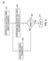
- FIG. 4depicts a flow diagram of a method of generating an orbit model using a least squares estimation technique.
- LT-STDis a table representation of time, position, and clock offset for each satellite, as shown in FIG. 6 .
- the time, position, and clock offsetcan be in any time/coordinate system.
- the time/coordinate systemis GPS time and Earth-Centered-Earth-Fixed (ECEF) position in the World Geodetic Survey 1984 (WGS-84) reference frame.
- ECEFEarth-Centered-Earth-Fixed
- the STD for the desired time intervalis extracted from the STD database.
- the orbit model parametersare initialized to the orbit model values obtained by a similar process for the previous interval. This guarantees that the initial orbit model parameters are a good fit at least for the beginning of the desired time interval. The rest of the process 400 will ensure that the parameters are adjusted so that they become a good fit for the entire time interval.
- the orbit modelis used to predict what the trajectory would be, the predicted data is denoted the “Model Trajectory Data” (MTD). If the model were perfect, the MTD would coincide exactly with the STD.
- the MTD and OTDare compared to see how closely the orbit model fits the orbit data. In the preferred embodiment, the comparison step 406 is performed by summing the squares of the differences between each trajectory point in the OTD and the corresponding point in the MTD, and comparing the resulting sum to a threshold. If the fit is “good”, the model parameters are deemed “good” and the process stops at step 410 . If the fit is not good then the model parameters are adjusted at step 408 .
- the six-hour ephemeris modelwas adjusted to fit six hours of OTD using a subspace trust region method based on the interior-reflective Newton method described in Coleman, T. F., and Y. Li, “On the convergence of reflective Newton methods for large scale nonlinear minimization subject to bounds”, Mathematical Programming , Vol. 67, Number 2, pp. 189-224, 1994, and Coleman, T. F., and Y. Li, “An interior, trust region approach for nonlinear minimization subject to bounds”, SIAM Journal on Optimization , Vol. 6, pp. 418-445, 1996.
- Steps 404 , 406 and 408are repeated until the model parameters are found that fit the OTD well.
- the preferred embodimentis to use orbit models with parameters that have been defined in well-known standards.
- the ephemeris parameters defined in the GPS interface control document, ICD-GPS-200care used.
- the ICD-GPS-200c definitionincludes a bit that specifies a 4-hour fit or a 6-hour fit.
- the satellite datais broadcast in 4-hour fits and, by the time this data is obtained by the observer of the satellite, the data is often near the end of its fit interval.
- sequential 6 hour windows of STDare used to create 6-hour ephemeris models, using the technique described in FIG. 4 and the accompanying text.
- the transmission time for the modelmay be dynamically determined in response to various transmission network characteristics, e.g., cellular telephone rate structures, data transmission bandwidths, low network utilization periods, low network congestion periods and the like.
- the inventiondetermines present value of the specific characteristics and compares the present value to a threshold.
- the inventionwill transmit or not transmit the model.
- the inventionmay monitor the network traffic and determine the least congested time to transmit the model.
- Many wireless networkshave time varying rates. For example, cellular telephone use is often less expensive on weekends compared to mid-week rates.
- a useful embodiment of the current inventionis to create a satellite tracking model that is valid for the period between inexpensive rates (example: valid from one Saturday to the next), and transmit the model during the time that the rate is inexpensive. As such, the model is transmitted for less cost than if the models were transmitted during a peak rate period. Also, or as an alternative, one may define and send the model to coincide with periods of low data use on the network—whether the network is wireless or not (e.g. the internet). Those skilled in the art will realize that many other transmission time optimization characteristics can be used to determine when it is best to transmit the model to the receiver(s).
- FIG. 5shows an example of Satellite Tracking Data (STD) that was generated for a time interval of greater than six hours. Then, using the technique described by FIG. 4 and accompanying text, parameters of an ICD-GPS-200c ephemeris model were adjusted to give a best fit to 6 hours of the STD. The orbit modeled by this 6-hour ephemeris was then compared to the true trajectory, and for comparison, the true trajectory was also compared to the orbit modeled by the broadcast ephemeris. The results are shown in FIG. 5 , illustrating how the broadcast ephemeris loses validity while the ephemeris created by this invention maintains its validity with approximately one meter of error.
- STDSatellite Tracking Data
- the clock offset of GPS satellitesis easily modeled by three parameters.
- the measured clock offsetis modeled by the three parameters defined in ICD-GPS-200c. These parameters represent clock offset, drift, and drift rate. The parameters are adjusted in a similar way to the method 400 described above to give a model that best fits the measured data over the time interval.
- Alternative embodimentsmay use longer fit intervals, such as 8, 14, 26, 50, 74, 98, 122, or 146 hours for each ephemeris model. These fit intervals are envisaged in ICD-GPS-200c, but are seldom, if ever, available from the broadcast ephemeris. Under the current invention, models with these fit intervals may be generated even when the broadcast ephemeris is limited to a 4-hour fit interval.
- Alternative embodiments of the STD datamay include observed satellite velocity, acceleration, clock drift, or clock drift rate and these terms may be used in the process of fitting a model in ways which are well known in the art.
- an orbit modeluses the spare data bits in the current ephemeris format of a conventional GPS signal to provide additional model parameters that would improve the data fit over long time intervals. For example, subframe 1 has 87 spare bits that are available for additional parameters. This technique allows for more parameters to describe the orbital motion of the satellites without compromising the standard data format. This new ephemeris model is based on the current ephemeris model with additional correction terms used to augment the model to support the longer fit intervals with greater accuracy.
- Yet another embodiment of an orbit modelis to develop a new set of orbital parameters that describe the satellite orbit which are different, in part or in their entirety, from the GPS ephemeris model parameters. With the goal of making the fit interval longer, different parameters may provide a better description of the satellite orbit. This new set of parameters could be defined such that they would fit into the existing data structures, however, their implementation and algorithms for use would be different.
- an orbit modelwould be to develop a new set of orbital parameters that would not fit into the existing GPS ephemeris model format. This new set of parameters would be developed to better address the trade-off between the number of parameters required, the fit interval, and the orbit accuracy resulting from the model.
- An example of this type of ephemeris parameter setis Brouwer's theory that could be used as is or modified to account for GPS specific terms. Brouwer's theory as described in Brouwer, D. “Solution of the Problem of Artificial Satellite Theory without Drag”, Astron J. 64: 378-397, November 1959 is limited to satellites in nearly circular orbits such as GPS satellites.
- Another embodimentis to use a subset of the standard ephemeris parameters defined in ICD-GPS-200c. This approach is particularly useful when bandwidth and/or packet size is limited in the communication link that will be used to convey the orbit model to the Remote GPS Receiver.
- the fifteen orbit parameters described above, and in ICD-GPS-200cmay be reduced to a subset of 9 parameters, by setting all harmonic terms in the model to zero:
Landscapes
- Engineering & Computer Science (AREA)
- Remote Sensing (AREA)
- Radar, Positioning & Navigation (AREA)
- Physics & Mathematics (AREA)
- General Physics & Mathematics (AREA)
- Computer Networks & Wireless Communication (AREA)
- Astronomy & Astrophysics (AREA)
- Aviation & Aerospace Engineering (AREA)
- Power Engineering (AREA)
- Position Fixing By Use Of Radio Waves (AREA)
- Automation & Control Theory (AREA)
- Radio Relay Systems (AREA)
Abstract
Description
- Square root of semi-major axis (meters^½)
- Eccentricity (dimensionless)
- Amplitude of sine harmonic correction term to the orbit radius (meters)
- Amplitude of cosine harmonic correction term to the orbit radius (meters)
- Mean motion difference from computed value (radians/sec)
- Mean anomaly at reference time (radians)
- Amplitude of cosine harmonic correction term to the argument of latitude (radians)
- Amplitude of sine harmonic correction term to the argument of latitude (radians)
- Amplitude of cosine harmonic correction term to the angle of inclination (radians)
- Amplitude of sine harmonic correction term to the angle of inclination (radians)
- Longitude of ascending node of orbit plane at weekly epoch (radians)
- Inclination angle at reference time (radians)
- Rate of inclination angle (radians/sec)
- Argument of perigee (radians)
- Rate of right ascension (radians/sec)
Although it will be readily apparent that more terms may be used, for better fits, or, fewer terms may be used for a more compact model.
- Square root of semi-major axis (meters^½)
- Eccentricity (dimensionless)
- Mean motion difference from computed value (radians/sec)
- Mean anomaly at reference time (radians)
- Longitude of ascending node of orbit plane at weekly epoch (radians)
- Inclination angle at reference time (radians)
- Rate of inclination angle (radians/sec)
- Argument of perigee (radians)
- Rate of right ascension (radians/sec)
Process 400 is then executed using this subset of parameters. This reduces the amount of data that must be sent to the Remote GPS Receiver. The receiver can then reconstruct a standard ephemeris model by setting the “missing” harmonic terms to zero. There are a large number of alternative embodiments to reduce the size of the data, while still providing a model that fits the STD, including: - Removing parameters from the model, and replacing them with a constant, such as zero—as done above—or some other predetermined value, which is either stored in the Remote GPS Receiver or occasionally sent to the receiver.
- The resolution of the parameters may be restricted in the
process 400, this too reduces the amount of data that must be sent to the mobile GPS receiver. - Parameters, which are similar among two or more satellites, may be represented as a master value plus a delta, where the delta requires fewer bits to encode; an example of this is the parameter Eccentricity, which changes very little among different GPS satellites.
Some of these approaches reduce the ability of the model to fit the data over a period of time (e.g., six hours). In this case, the fit interval may be reduced (e.g. to four hours) to compensate.
Claims (21)
Priority Applications (21)
| Application Number | Priority Date | Filing Date | Title |
|---|---|---|---|
| US11/333,787US7443340B2 (en) | 2001-06-06 | 2006-01-17 | Method and apparatus for generating and distributing satellite tracking information |
| US11/277,943US7548816B2 (en) | 2001-06-06 | 2006-03-29 | Method and apparatus for generating and securely distributing long-term satellite tracking information |
| US11/567,629US20070200752A1 (en) | 2001-06-06 | 2006-12-06 | Method and apparatus for maintaining integrity of long-term orbits in a remote receiver |
| KR20087005466AKR20080088569A (en) | 2006-01-17 | 2007-01-17 | Method and device for generating and distributing satellite tracking information |
| EP07718066AEP1979710A4 (en) | 2006-01-17 | 2007-01-17 | Method and apparatus for generating and distributing satellite tracking information |
| PCT/US2007/001187WO2007084530A2 (en) | 2006-01-17 | 2007-01-17 | Method and apparatus for generating and distributing satellite tracking information |
| HK09106627.9AHK1129140B (en) | 2006-01-17 | 2007-01-17 | A method and device for generating and delivering satellite tracking information |
| CN2007800010571ACN101351686B (en) | 2006-01-17 | 2007-01-17 | Method and apparatus for generating and distributing satellite tracking information |
| US11/724,627US8090536B2 (en) | 2001-06-06 | 2007-03-15 | Method and apparatus for compression of long term orbit data |
| US11/927,236US20080189037A1 (en) | 2001-06-06 | 2007-10-29 | Method and apparatus for decompression of compressed long-term-orbit data |
| US11/932,283US8212719B2 (en) | 2001-06-06 | 2007-10-31 | Method and apparatus for background decoding of a satellite navigation message to maintain integrity of long term orbit information in a remote receiver |
| US11/941,529US20080186229A1 (en) | 2001-06-06 | 2007-11-16 | Method and Apparatus for Monitoring Satellite-Constellation Configuration To Maintain Integrity of Long-Term-Orbit Information In A Remote Receiver |
| US12/014,386US20080129588A1 (en) | 2001-06-06 | 2008-01-15 | Method and apparatus for determining location information of a mobile device |
| US12/026,915US20080125971A1 (en) | 2001-06-06 | 2008-02-06 | Method and apparatus for improving accuracy and/or integrity of long-term-orbit information for a global-navigation-satellite system |
| US12/259,268US9274225B2 (en) | 2000-11-17 | 2008-10-27 | Method and apparatus for generating and distributing satellite tracking information |
| US12/326,465US8358245B2 (en) | 2001-06-06 | 2008-12-02 | Method and system for extending the usability period of long term orbit (LTO) |
| US12/467,464US20090234571A1 (en) | 2001-06-06 | 2009-05-18 | Method and Apparatus for Generating and Securely Distributing Long-Term Satellite Tracking Information |
| US12/857,295US20110133985A1 (en) | 2001-06-06 | 2010-08-16 | Method and apparatus for maintaining integrity of long-term orbits in a remote receiver |
| US13/712,286US20130099969A1 (en) | 2001-06-06 | 2012-12-12 | Method and System for Extending the Usability Period of Long Term Orbit (LTO) |
| US13/924,069US8963773B2 (en) | 2000-11-17 | 2013-06-21 | Method and apparatus for maintaining integrity of long-term orbits in a remote receiver |
| US14/600,961US20150153455A1 (en) | 2000-11-17 | 2015-01-20 | Method and apparatus for generating and distributing satellite tracking information |
Applications Claiming Priority (4)
| Application Number | Priority Date | Filing Date | Title |
|---|---|---|---|
| US09/875,809US6542820B2 (en) | 2001-06-06 | 2001-06-06 | Method and apparatus for generating and distributing satellite tracking information |
| US09/884,874US6560534B2 (en) | 2001-06-06 | 2001-06-19 | Method and apparatus for distributing satellite tracking information |
| US09/993,335US7053824B2 (en) | 2001-11-06 | 2001-11-06 | Method and apparatus for receiving a global positioning system signal using a cellular acquisition signal |
| US11/333,787US7443340B2 (en) | 2001-06-06 | 2006-01-17 | Method and apparatus for generating and distributing satellite tracking information |
Related Parent Applications (1)
| Application Number | Title | Priority Date | Filing Date |
|---|---|---|---|
| US09/993,335Continuation-In-PartUS7053824B2 (en) | 1999-04-23 | 2001-11-06 | Method and apparatus for receiving a global positioning system signal using a cellular acquisition signal |
Related Child Applications (8)
| Application Number | Title | Priority Date | Filing Date |
|---|---|---|---|
| US11/277,943Continuation-In-PartUS7548816B2 (en) | 2001-06-06 | 2006-03-29 | Method and apparatus for generating and securely distributing long-term satellite tracking information |
| US11/567,629Continuation-In-PartUS20070200752A1 (en) | 2000-11-17 | 2006-12-06 | Method and apparatus for maintaining integrity of long-term orbits in a remote receiver |
| US11/724,627Continuation-In-PartUS8090536B2 (en) | 2001-06-06 | 2007-03-15 | Method and apparatus for compression of long term orbit data |
| US11/932,283Continuation-In-PartUS8212719B2 (en) | 2001-06-06 | 2007-10-31 | Method and apparatus for background decoding of a satellite navigation message to maintain integrity of long term orbit information in a remote receiver |
| US11/941,529Continuation-In-PartUS20080186229A1 (en) | 2001-06-06 | 2007-11-16 | Method and Apparatus for Monitoring Satellite-Constellation Configuration To Maintain Integrity of Long-Term-Orbit Information In A Remote Receiver |
| US12/014,386Continuation-In-PartUS20080129588A1 (en) | 2001-06-06 | 2008-01-15 | Method and apparatus for determining location information of a mobile device |
| US12/026,915Continuation-In-PartUS20080125971A1 (en) | 2001-06-06 | 2008-02-06 | Method and apparatus for improving accuracy and/or integrity of long-term-orbit information for a global-navigation-satellite system |
| US12/259,268ContinuationUS9274225B2 (en) | 2000-11-17 | 2008-10-27 | Method and apparatus for generating and distributing satellite tracking information |
Publications (2)
| Publication Number | Publication Date |
|---|---|
| US20070260399A1 US20070260399A1 (en) | 2007-11-08 |
| US7443340B2true US7443340B2 (en) | 2008-10-28 |
Family
ID=38288192
Family Applications (3)
| Application Number | Title | Priority Date | Filing Date |
|---|---|---|---|
| US11/333,787Expired - Fee RelatedUS7443340B2 (en) | 2000-11-17 | 2006-01-17 | Method and apparatus for generating and distributing satellite tracking information |
| US12/259,268Expired - Fee RelatedUS9274225B2 (en) | 2000-11-17 | 2008-10-27 | Method and apparatus for generating and distributing satellite tracking information |
| US14/600,961AbandonedUS20150153455A1 (en) | 2000-11-17 | 2015-01-20 | Method and apparatus for generating and distributing satellite tracking information |
Family Applications After (2)
| Application Number | Title | Priority Date | Filing Date |
|---|---|---|---|
| US12/259,268Expired - Fee RelatedUS9274225B2 (en) | 2000-11-17 | 2008-10-27 | Method and apparatus for generating and distributing satellite tracking information |
| US14/600,961AbandonedUS20150153455A1 (en) | 2000-11-17 | 2015-01-20 | Method and apparatus for generating and distributing satellite tracking information |
Country Status (5)
| Country | Link |
|---|---|
| US (3) | US7443340B2 (en) |
| EP (1) | EP1979710A4 (en) |
| KR (1) | KR20080088569A (en) |
| CN (1) | CN101351686B (en) |
| WO (1) | WO2007084530A2 (en) |
Cited By (8)
| Publication number | Priority date | Publication date | Assignee | Title |
|---|---|---|---|---|
| US20080024361A1 (en)* | 2006-02-07 | 2008-01-31 | Diggelen Frank V | Computing long term orbit and clock models with variable time-horizons |
| US20080238765A1 (en)* | 2007-03-30 | 2008-10-02 | Gengsheng Zhang | Satellite Clock Prediction |
| US20080275598A1 (en)* | 2007-05-03 | 2008-11-06 | Lawrence Schwartz | Trajectory Estimation System for an Orbiting Satellite |
| US20090201196A1 (en)* | 2000-11-17 | 2009-08-13 | Global Locate, Inc. | Method and apparatus for generating and distributing satellite tracking information |
| US20100105353A1 (en)* | 2003-04-18 | 2010-04-29 | Christina Cacioppo | Method for Confirming End Point Location of 911 Calls |
| US20110130151A1 (en)* | 2008-04-25 | 2011-06-02 | Philip Geoffrey Eade | Apparatus for assisting in providing a first fixing global positioning satellite system, associated apparatus and methods |
| US8358245B2 (en) | 2001-06-06 | 2013-01-22 | Broadcom Corporation | Method and system for extending the usability period of long term orbit (LTO) |
| US20150378027A1 (en)* | 2014-06-30 | 2015-12-31 | Casio Computer Co., Ltd. | Positioning system, positioning apparatus, storage apparatus, and positioning method |
Families Citing this family (23)
| Publication number | Priority date | Publication date | Assignee | Title |
|---|---|---|---|---|
| JP2008545992A (en) | 2005-06-13 | 2008-12-18 | ノキア コーポレイション | Support for assisted satellite positioning |
| US8676501B2 (en)* | 2006-12-22 | 2014-03-18 | The Boeing Company | Satellite navigation using long-term navigation information |
| US8099186B2 (en)* | 2006-12-22 | 2012-01-17 | The Boeing Company | Satellite navigation using long-term navigation information and autonomous orbit control |
| US7786929B2 (en)* | 2007-11-26 | 2010-08-31 | Mediatek Inc. | Method and device for predicting GNSS satellite trajectory extension data used in mobile apparatus |
| US8368588B2 (en)* | 2007-11-26 | 2013-02-05 | Mediatek Inc. | Method and apparatus for updating transformation information parameters used in global navigation satellite system |
| US8120530B2 (en)* | 2008-04-15 | 2012-02-21 | Mediatek Inc. | Method and device for using GNSS satellite trajectory extension data in mobile apparatus |
| US9075140B2 (en)* | 2009-09-23 | 2015-07-07 | Purdue Research Foundation | GNSS ephemeris with graceful degradation and measurement fusion |
| SG10201408310QA (en)* | 2009-12-18 | 2015-01-29 | Aerovironment Inc | High altitude, long endurance, unmanned aircraft and methods of operation thereof |
| US20140125519A1 (en)* | 2010-11-09 | 2014-05-08 | Alexander Brown | Methods for Encoding and Recovering GNSS Ephemeris For Over-The-Air Transmission |
| US9846238B2 (en)* | 2013-03-11 | 2017-12-19 | Raven Industries, Inc. | Enhanced delivery of GNSS correction data through restricted networks |
| CN105528488B (en)* | 2015-12-11 | 2019-02-05 | 中国人民解放军63791部队 | A kind of spacecraft measurement blind area benefit ballistic methods |
| CN105425252A (en)* | 2015-12-17 | 2016-03-23 | 四川九洲空管科技有限责任公司 | Portable multifunctional outfield inspection instrument based on 1090ES (1090MHz Extended Squitter) data link |
| JP6856656B2 (en) | 2016-02-15 | 2021-04-07 | クアルコム,インコーポレイテッド | Management of ephemeris information for satellite communications |
| US10470189B2 (en)* | 2016-06-27 | 2019-11-05 | At&T Intellectual Property I, L.P. | Facilitation of efficient software downloads for vehicles |
| WO2018102146A1 (en) | 2016-12-01 | 2018-06-07 | Google Llc | Methods and systems for location determination |
| US10795028B2 (en)* | 2016-12-20 | 2020-10-06 | Here Global B.V. | Supporting an extension of a validity period of parameter values defining an orbit |
| CN108390712B (en)* | 2018-01-24 | 2020-06-09 | 中国人民解放军63920部队 | Judgment method for spacecraft instruction execution result facing multi-path remote measurement |
| KR101888339B1 (en)* | 2018-06-01 | 2018-09-20 | 한국 천문 연구원 | Method for Re-entry Prediction of Uncontrolled Space Objects |
| CN109738919B (en)* | 2019-02-28 | 2020-12-15 | 西安开阳微电子有限公司 | Method for autonomous ephemeris prediction of GPS receiver |
| DE112019006954T5 (en) | 2019-03-01 | 2021-12-16 | Google Llc | SPEED DETERMINATION WITH THE HELP OF A REFLECTED POSITIONING SIGNAL |
| JP7586885B2 (en) | 2019-07-08 | 2024-11-19 | グーグル エルエルシー | Increasing sensitivity to reflected GNSS signals |
| US20240183992A1 (en)* | 2022-12-05 | 2024-06-06 | Qualcomm Incorporated | Real time gnss space vehicle broadcast data quality monitoring using crowd-sourced data from road side units |
| CN116374212B (en)* | 2023-05-17 | 2024-03-29 | 北京星网宇达科技股份有限公司 | Satellite orbit correction method and device, computer equipment and storage medium |
Citations (85)
| Publication number | Priority date | Publication date | Assignee | Title |
|---|---|---|---|---|
| US4445118A (en) | 1981-05-22 | 1984-04-24 | The United States Of America As Represented By The Administrator Of The National Aeronautics And Space Administration | Navigation system and method |
| WO1989012835A1 (en) | 1988-06-17 | 1989-12-28 | Keith Chisholm Brown | Road vehicle locating system |
| US4894662A (en) | 1982-03-01 | 1990-01-16 | Western Atlas International, Inc. | Method and system for determining position on a moving platform, such as a ship, using signals from GPS satellites |
| US5043736A (en) | 1990-07-27 | 1991-08-27 | Cae-Link Corporation | Cellular position locating system |
| US5223844A (en) | 1992-04-17 | 1993-06-29 | Auto-Trac, Inc. | Vehicle tracking and security system |
| US5365450A (en) | 1992-12-17 | 1994-11-15 | Stanford Telecommunications, Inc. | Hybrid GPS/data line unit for rapid, precise, and robust position determination |
| US5408237A (en) | 1991-11-08 | 1995-04-18 | Teledesic Corporation | Earth-fixed cell beam management for satellite communication system |
| US5418537A (en) | 1992-11-18 | 1995-05-23 | Trimble Navigation, Ltd. | Location of missing vehicles |
| US5417217A (en) | 1991-08-20 | 1995-05-23 | Ge Yokogawa Medical Systems, Limited | Echo beam former for an ultrasonic diagnostic apparatus |
| US5430657A (en)* | 1992-10-20 | 1995-07-04 | Caterpillar Inc. | Method and apparatus for predicting the position of a satellite in a satellite based navigation system |
| US5506781A (en) | 1994-06-03 | 1996-04-09 | Itt Corporation | RF link control of satellite clocks |
| CA2177310A1 (en) | 1995-05-30 | 1996-12-01 | Farshad Mohamadi | Gps ready digital cellular telephone |
| US5589833A (en) | 1995-04-21 | 1996-12-31 | University Corporation For Atmospheric Research | Radar acquisition system |
| GB2307812A (en) | 1995-12-02 | 1997-06-04 | Plessey Semiconductors Ltd | GPS Receiver |
| US5663735A (en) | 1996-05-20 | 1997-09-02 | Trimble Navigation Limited | GPS receiver using a radio signal for improving time to first fix |
| US5673256A (en) | 1995-07-25 | 1997-09-30 | Motorola, Inc. | Apparatus and method for sending data messages at an optimum time |
| WO1998009181A1 (en) | 1996-08-29 | 1998-03-05 | Philips Electronics N.V. | Combination of a gps receiver and a telecommunications apparatus |
| US5726893A (en) | 1992-12-17 | 1998-03-10 | Stanford Telecommunications, Inc. | Cellular telephone with voice-in-data modem |
| US5786789A (en) | 1994-11-14 | 1998-07-28 | Trimble Navigation Limited | GPS and cellphone unit having add-on modules |
| US5828336A (en)* | 1996-03-29 | 1998-10-27 | The United States Of America As Represented By The Administrator Of The National Aeronautics And Space Administration | Robust real-time wide-area differential GPS navigation |
| US5841396A (en) | 1996-03-08 | 1998-11-24 | Snaptrack, Inc. | GPS receiver utilizing a communication link |
| US5845227A (en) | 1991-02-01 | 1998-12-01 | Peterson; Thomas D. | Method and apparatus for providing shortest elapsed time route and tracking information to users |
| US5877724A (en) | 1997-03-25 | 1999-03-02 | Trimble Navigation Limited | Combined position locating and cellular telephone system with a single shared microprocessor |
| WO1999019743A1 (en) | 1997-10-15 | 1999-04-22 | Ericsson Inc. | Reduced global positioning system receiver code shift search space for a cellular telephone system |
| US5913170A (en) | 1994-11-16 | 1999-06-15 | Highwaymaster Communications, Inc. | Locating system and method using a mobile communications network |
| US5938721A (en) | 1996-10-24 | 1999-08-17 | Trimble Navigation Limited | Position based personal digital assistant |
| US5943014A (en) | 1996-06-06 | 1999-08-24 | Qualcom Incorporated | Using a signal with increased power for determining the position of a mobile subscriber in a CDMA cellular telephone system |
| US5963167A (en) | 1996-03-13 | 1999-10-05 | California Institute Of Technology | Analyzing system for global positioning system and general satellite tracking |
| US5983109A (en) | 1997-02-03 | 1999-11-09 | Northern Telecom Limited | Method and apparatus for using advanced positioning systems in cellular communications networks |
| US5999124A (en) | 1998-04-22 | 1999-12-07 | Snaptrack, Inc, | Satellite positioning system augmentation with wireless communication signals |
| US6016117A (en)* | 1998-06-26 | 2000-01-18 | Trimble Navigation Limited | Method for the efficient determination of GPS satellite orbital position |
| US6067045A (en) | 1998-09-01 | 2000-05-23 | Hughes Electronics Corporation | Communication network initialization apparatus and method for fast GPS-based positioning |
| US6081229A (en) | 1998-03-17 | 2000-06-27 | Qualcomm Incorporated | System and method for determining the position of a wireless CDMA transceiver |
| US6085128A (en)* | 1998-02-06 | 2000-07-04 | The United States Of America As Represented By The Secretary Of The Navy | Orbit/covariance estimation and analysis (OCEAN) determination for satellites |
| US6084544A (en) | 1997-12-18 | 2000-07-04 | Ericsson Inc. | Method for determining the location of a GPS receiver using an estimated reference time |
| US6097974A (en) | 1997-12-12 | 2000-08-01 | Ericsson Inc. | Combined GPS and wide bandwidth radiotelephone terminals and methods |
| US6107960A (en) | 1998-01-20 | 2000-08-22 | Snaptrack, Inc. | Reducing cross-interference in a combined GPS receiver and communication system |
| US6122506A (en) | 1998-05-04 | 2000-09-19 | Trimble Navigation Limited | GSM cellular telephone and GPS receiver combination |
| US6121923A (en) | 1999-02-19 | 2000-09-19 | Motorola, Inc. | Fixed site and satellite data-aided GPS signal acquisition method and system |
| US6131067A (en) | 1995-10-09 | 2000-10-10 | Snaptrack, Inc. | Client-server based remote locator device |
| US6134483A (en) | 1999-02-12 | 2000-10-17 | Vayanos; Alkinoos Hector | Method and apparatus for efficient GPS assistance in a communication system |
| US6133874A (en) | 1996-03-08 | 2000-10-17 | Snaptrack, Inc. | Method and apparatus for acquiring satellite positioning system signals |
| US6150980A (en) | 1996-03-08 | 2000-11-21 | Snaptrack, Inc. | Method and apparatus for determining time for GPS receivers |
| US6178195B1 (en) | 1998-05-14 | 2001-01-23 | Motorola, Inc. | Method and apparatus for detecting spread spectrum signals using a signal from a secondary source |
| US6188351B1 (en) | 1998-08-13 | 2001-02-13 | Ericsson Inc. | Method for improving signal acquistion in a global positioning system receiver |
| US6204808B1 (en) | 1998-08-13 | 2001-03-20 | Ericsson Inc. | Method and system for aiding GPS receivers via a cellular or PCS network |
| US6211819B1 (en)* | 1999-08-27 | 2001-04-03 | Motorola, Inc. | Mobile station location determination in a radio communication system |
| US6215442B1 (en) | 1997-02-03 | 2001-04-10 | Snaptrack, Inc. | Method and apparatus for determining time in a satellite positioning system |
| US6215441B1 (en) | 1997-04-15 | 2001-04-10 | Snaptrack, Inc. | Satellite positioning reference system and method |
| US6222483B1 (en) | 1998-09-29 | 2001-04-24 | Nokia Mobile Phones Limited | GPS location for mobile phones using the internet |
| US6239742B1 (en) | 1997-02-03 | 2001-05-29 | Snaptrack, Inc. | Method and apparatus for satellite positioning system based time measurement |
| US6256475B1 (en) | 1997-09-11 | 2001-07-03 | Lucent Technologies, Inc. | Telecommunications-assisted satellite positioning system |
| US6272316B1 (en) | 1995-11-17 | 2001-08-07 | Globalstar L.P. | Mobile satellite user information request system and methods |
| US6285315B1 (en) | 1999-02-16 | 2001-09-04 | Symmetricom, Inc. | Positioning systems |
| US6289279B1 (en) | 1998-11-20 | 2001-09-11 | Sony Computer Entertainment, Inc. | Positioning system, method, and device for obtaining information about a current position |
| WO2001075473A2 (en) | 2000-03-30 | 2001-10-11 | Cellguide Ltd. | Enhanced gps receiver utilizing wireless infrastructure |
| US6313787B1 (en) | 1999-11-12 | 2001-11-06 | Motorola, Inc. | Method and apparatus for assisted GPS protocol |
| US6323804B1 (en) | 2000-06-06 | 2001-11-27 | Motorola, Inc. | Method and apparatus for GPS time determination |
| US20020032526A1 (en) | 2000-07-13 | 2002-03-14 | Diggelen Frank Van | Method and apparatus for locating mobile receivers using a wide area reference network for propagating ephemeris |
| US6369751B1 (en) | 1999-10-20 | 2002-04-09 | Sony Corporation | Signal receiving apparatus of global positioning system and mobile wireless terminal apparatus |
| EP1197761A2 (en) | 2000-10-11 | 2002-04-17 | eRide, Inc. | Satellite navigation receiver and method |
| US6377585B1 (en) | 1998-06-05 | 2002-04-23 | Datum, Inc. | Precision reference generation system and method |
| US20020049536A1 (en) | 2000-08-08 | 2002-04-25 | Peter Gaal | Method, apparatus, and system for signal prediction |
| US6411899B2 (en) | 1996-10-24 | 2002-06-25 | Trimble Navigation Ltd. | Position based personal digital assistant |
| US6424890B1 (en)* | 2000-11-30 | 2002-07-23 | Nokia Mobile Phones, Ltd. | Method and apparatus for satellite orbit interpolation using piecewise hermite interpolating polynomials |
| US6433735B1 (en) | 2000-12-26 | 2002-08-13 | Telefonaktiebolaget (Lme) | Mobile terminal and system and method for determining the geographic location of a mobile terminal |
| US6437735B1 (en)* | 2000-09-07 | 2002-08-20 | Ericsson Inc. | Position detection system integrated into mobile terminal |
| US6453237B1 (en) | 1999-04-23 | 2002-09-17 | Global Locate, Inc. | Method and apparatus for locating and providing services to mobile devices |
| US20020172313A1 (en) | 2001-05-17 | 2002-11-21 | Ut-Battelle, L.L.C. | Carrier-frequency synchronization system for improved amplitude modulation and television broadcast reception |
| US20020188403A1 (en)* | 2001-06-06 | 2002-12-12 | Lamance James W. | Method and apparatus for generating and distributing satellite tracking information |
| US20020198657A1 (en) | 2000-12-15 | 2002-12-26 | Robbins James E. | GPS correction methods, apparatus and signals |
| WO2002103383A2 (en) | 2001-06-19 | 2002-12-27 | Global Locate, Inc. | Method and apparatus for distributing satellite tracking information |
| US20030098810A1 (en) | 2001-11-23 | 2003-05-29 | Jeong-Sook Lee | System for determining precise orbit of satellite and method thereof |
| US6642884B2 (en) | 2000-05-08 | 2003-11-04 | Sigtec Navigation Pty Ltd. | Satellite-based positioning system receiver for weak signal operation |
| US20030212821A1 (en) | 2002-05-13 | 2003-11-13 | Kiyon, Inc. | System and method for routing packets in a wired or wireless network |
| US20030223422A1 (en) | 2002-05-28 | 2003-12-04 | Ntt Docomo, Inc., Tokyo, Japan | Packet transmission method and communication system |
| US6693882B1 (en) | 1999-01-26 | 2004-02-17 | International Business Machines Corporation | Frequency correction burst detection |
| US6725159B2 (en) | 1996-09-06 | 2004-04-20 | Snaptrack Incorporated | GPS receiver and method for processing GPS signals |
| US20040203853A1 (en) | 2002-04-24 | 2004-10-14 | Leonid Sheynblat | Position determination for a wireless terminal in a hybrid position determination system |
| US20040203915A1 (en) | 2003-01-22 | 2004-10-14 | Van Diggelen Frank | Method and apparatus for locating a mobile receiver having a position cache |
| US6829535B2 (en)* | 2001-07-25 | 2004-12-07 | Global Locate, Inc. | Method and apparatus for generating satellite tracking information in a compact format |
| US20040263386A1 (en)* | 2003-06-26 | 2004-12-30 | King Thomas M. | Satellite positioning system receivers and methods |
| US20050003833A1 (en) | 2001-03-15 | 2005-01-06 | Saed Younis | Time acquisition in a wireless position determination system |
| US6856282B2 (en) | 2002-02-08 | 2005-02-15 | Qualcomm Incorporated | Directly acquiring precision code GPS signals |
| US7020555B1 (en) | 2003-12-23 | 2006-03-28 | Trimble Navigation Limited | Subscription GPS information service system |
Family Cites Families (10)
| Publication number | Priority date | Publication date | Assignee | Title |
|---|---|---|---|---|
| US5119504A (en) | 1990-07-19 | 1992-06-02 | Motorola, Inc. | Position aided subscriber unit for a satellite cellular system |
| US5225842A (en) | 1991-05-09 | 1993-07-06 | Navsys Corporation | Vehicle tracking system employing global positioning system (gps) satellites |
| US5917444A (en) | 1995-05-22 | 1999-06-29 | Trimble Navigation Ltd. | Reduction of time to first fix in an SATPS receiver |
| USRE37408E1 (en) | 1993-05-21 | 2001-10-16 | Trimble Navigation Ltd. | Reduction of time to first fix in an SATPS receiver |
| US5889492A (en) | 1996-07-31 | 1999-03-30 | Motorola, Inc. | Method and apparatus for an acquisition-aided Geo-locating subscriber unit |
| US6411254B1 (en) | 1997-04-15 | 2002-06-25 | Snaptrack, Inc. | Satellite positioning reference system and method |
| US6636740B1 (en) | 1998-06-16 | 2003-10-21 | Ericsson Inc. | Apparatus and methods for position computation based on broadcast initialization data |
| US7053824B2 (en) | 2001-11-06 | 2006-05-30 | Global Locate, Inc. | Method and apparatus for receiving a global positioning system signal using a cellular acquisition signal |
| US7443340B2 (en) | 2001-06-06 | 2008-10-28 | Global Locate, Inc. | Method and apparatus for generating and distributing satellite tracking information |
| US7595752B2 (en)* | 2002-10-02 | 2009-09-29 | Global Locate, Inc. | Method and apparatus for enhanced autonomous GPS |
- 2006
- 2006-01-17USUS11/333,787patent/US7443340B2/ennot_activeExpired - Fee Related
- 2007
- 2007-01-17KRKR20087005466Apatent/KR20080088569A/ennot_activeCeased
- 2007-01-17EPEP07718066Apatent/EP1979710A4/ennot_activeWithdrawn
- 2007-01-17CNCN2007800010571Apatent/CN101351686B/ennot_activeExpired - Fee Related
- 2007-01-17WOPCT/US2007/001187patent/WO2007084530A2/enactiveApplication Filing
- 2008
- 2008-10-27USUS12/259,268patent/US9274225B2/ennot_activeExpired - Fee Related
- 2015
- 2015-01-20USUS14/600,961patent/US20150153455A1/ennot_activeAbandoned
Patent Citations (93)
| Publication number | Priority date | Publication date | Assignee | Title |
|---|---|---|---|---|
| US4445118A (en) | 1981-05-22 | 1984-04-24 | The United States Of America As Represented By The Administrator Of The National Aeronautics And Space Administration | Navigation system and method |
| US4894662A (en) | 1982-03-01 | 1990-01-16 | Western Atlas International, Inc. | Method and system for determining position on a moving platform, such as a ship, using signals from GPS satellites |
| WO1989012835A1 (en) | 1988-06-17 | 1989-12-28 | Keith Chisholm Brown | Road vehicle locating system |
| US5043736A (en) | 1990-07-27 | 1991-08-27 | Cae-Link Corporation | Cellular position locating system |
| US5043736B1 (en) | 1990-07-27 | 1994-09-06 | Cae Link Corp | Cellular position location system |
| US5845227A (en) | 1991-02-01 | 1998-12-01 | Peterson; Thomas D. | Method and apparatus for providing shortest elapsed time route and tracking information to users |
| US5417217A (en) | 1991-08-20 | 1995-05-23 | Ge Yokogawa Medical Systems, Limited | Echo beam former for an ultrasonic diagnostic apparatus |
| US5408237A (en) | 1991-11-08 | 1995-04-18 | Teledesic Corporation | Earth-fixed cell beam management for satellite communication system |
| US5223844A (en) | 1992-04-17 | 1993-06-29 | Auto-Trac, Inc. | Vehicle tracking and security system |
| US5223844B1 (en) | 1992-04-17 | 2000-01-25 | Auto Trac Inc | Vehicle tracking and security system |
| US5430657A (en)* | 1992-10-20 | 1995-07-04 | Caterpillar Inc. | Method and apparatus for predicting the position of a satellite in a satellite based navigation system |
| US5418537A (en) | 1992-11-18 | 1995-05-23 | Trimble Navigation, Ltd. | Location of missing vehicles |
| US5726893A (en) | 1992-12-17 | 1998-03-10 | Stanford Telecommunications, Inc. | Cellular telephone with voice-in-data modem |
| US5365450A (en) | 1992-12-17 | 1994-11-15 | Stanford Telecommunications, Inc. | Hybrid GPS/data line unit for rapid, precise, and robust position determination |
| US5506781A (en) | 1994-06-03 | 1996-04-09 | Itt Corporation | RF link control of satellite clocks |
| US5786789A (en) | 1994-11-14 | 1998-07-28 | Trimble Navigation Limited | GPS and cellphone unit having add-on modules |
| US5913170A (en) | 1994-11-16 | 1999-06-15 | Highwaymaster Communications, Inc. | Locating system and method using a mobile communications network |
| US5589833A (en) | 1995-04-21 | 1996-12-31 | University Corporation For Atmospheric Research | Radar acquisition system |
| CA2177310A1 (en) | 1995-05-30 | 1996-12-01 | Farshad Mohamadi | Gps ready digital cellular telephone |
| US5673256A (en) | 1995-07-25 | 1997-09-30 | Motorola, Inc. | Apparatus and method for sending data messages at an optimum time |
| US6131067A (en) | 1995-10-09 | 2000-10-10 | Snaptrack, Inc. | Client-server based remote locator device |
| US6064336A (en) | 1995-10-09 | 2000-05-16 | Snaptrack, Inc. | GPS receiver utilizing a communication link |
| US6272316B1 (en) | 1995-11-17 | 2001-08-07 | Globalstar L.P. | Mobile satellite user information request system and methods |
| GB2307812A (en) | 1995-12-02 | 1997-06-04 | Plessey Semiconductors Ltd | GPS Receiver |
| US6150980A (en) | 1996-03-08 | 2000-11-21 | Snaptrack, Inc. | Method and apparatus for determining time for GPS receivers |
| US5841396A (en) | 1996-03-08 | 1998-11-24 | Snaptrack, Inc. | GPS receiver utilizing a communication link |
| US6133874A (en) | 1996-03-08 | 2000-10-17 | Snaptrack, Inc. | Method and apparatus for acquiring satellite positioning system signals |
| US5963167A (en) | 1996-03-13 | 1999-10-05 | California Institute Of Technology | Analyzing system for global positioning system and general satellite tracking |
| US5828336A (en)* | 1996-03-29 | 1998-10-27 | The United States Of America As Represented By The Administrator Of The National Aeronautics And Space Administration | Robust real-time wide-area differential GPS navigation |
| US5663735A (en) | 1996-05-20 | 1997-09-02 | Trimble Navigation Limited | GPS receiver using a radio signal for improving time to first fix |
| US5943014A (en) | 1996-06-06 | 1999-08-24 | Qualcom Incorporated | Using a signal with increased power for determining the position of a mobile subscriber in a CDMA cellular telephone system |
| WO1998009181A1 (en) | 1996-08-29 | 1998-03-05 | Philips Electronics N.V. | Combination of a gps receiver and a telecommunications apparatus |
| US6725159B2 (en) | 1996-09-06 | 2004-04-20 | Snaptrack Incorporated | GPS receiver and method for processing GPS signals |
| US5938721A (en) | 1996-10-24 | 1999-08-17 | Trimble Navigation Limited | Position based personal digital assistant |
| US6411899B2 (en) | 1996-10-24 | 2002-06-25 | Trimble Navigation Ltd. | Position based personal digital assistant |
| US5983109A (en) | 1997-02-03 | 1999-11-09 | Northern Telecom Limited | Method and apparatus for using advanced positioning systems in cellular communications networks |
| US6239742B1 (en) | 1997-02-03 | 2001-05-29 | Snaptrack, Inc. | Method and apparatus for satellite positioning system based time measurement |
| US6215442B1 (en) | 1997-02-03 | 2001-04-10 | Snaptrack, Inc. | Method and apparatus for determining time in a satellite positioning system |
| US5877724A (en) | 1997-03-25 | 1999-03-02 | Trimble Navigation Limited | Combined position locating and cellular telephone system with a single shared microprocessor |
| US6215441B1 (en) | 1997-04-15 | 2001-04-10 | Snaptrack, Inc. | Satellite positioning reference system and method |
| US6256475B1 (en) | 1997-09-11 | 2001-07-03 | Lucent Technologies, Inc. | Telecommunications-assisted satellite positioning system |
| WO1999019743A1 (en) | 1997-10-15 | 1999-04-22 | Ericsson Inc. | Reduced global positioning system receiver code shift search space for a cellular telephone system |
| US6097974A (en) | 1997-12-12 | 2000-08-01 | Ericsson Inc. | Combined GPS and wide bandwidth radiotelephone terminals and methods |
| US6084544A (en) | 1997-12-18 | 2000-07-04 | Ericsson Inc. | Method for determining the location of a GPS receiver using an estimated reference time |
| US6107960A (en) | 1998-01-20 | 2000-08-22 | Snaptrack, Inc. | Reducing cross-interference in a combined GPS receiver and communication system |
| US6085128A (en)* | 1998-02-06 | 2000-07-04 | The United States Of America As Represented By The Secretary Of The Navy | Orbit/covariance estimation and analysis (OCEAN) determination for satellites |
| US6081229A (en) | 1998-03-17 | 2000-06-27 | Qualcomm Incorporated | System and method for determining the position of a wireless CDMA transceiver |
| US5999124A (en) | 1998-04-22 | 1999-12-07 | Snaptrack, Inc, | Satellite positioning system augmentation with wireless communication signals |
| US6122506A (en) | 1998-05-04 | 2000-09-19 | Trimble Navigation Limited | GSM cellular telephone and GPS receiver combination |
| US6178195B1 (en) | 1998-05-14 | 2001-01-23 | Motorola, Inc. | Method and apparatus for detecting spread spectrum signals using a signal from a secondary source |
| US6377585B1 (en) | 1998-06-05 | 2002-04-23 | Datum, Inc. | Precision reference generation system and method |
| US6016117A (en)* | 1998-06-26 | 2000-01-18 | Trimble Navigation Limited | Method for the efficient determination of GPS satellite orbital position |
| US6204808B1 (en) | 1998-08-13 | 2001-03-20 | Ericsson Inc. | Method and system for aiding GPS receivers via a cellular or PCS network |
| US6188351B1 (en) | 1998-08-13 | 2001-02-13 | Ericsson Inc. | Method for improving signal acquistion in a global positioning system receiver |
| US6067045A (en) | 1998-09-01 | 2000-05-23 | Hughes Electronics Corporation | Communication network initialization apparatus and method for fast GPS-based positioning |
| US6222483B1 (en) | 1998-09-29 | 2001-04-24 | Nokia Mobile Phones Limited | GPS location for mobile phones using the internet |
| US6289279B1 (en) | 1998-11-20 | 2001-09-11 | Sony Computer Entertainment, Inc. | Positioning system, method, and device for obtaining information about a current position |
| US6693882B1 (en) | 1999-01-26 | 2004-02-17 | International Business Machines Corporation | Frequency correction burst detection |
| US6134483A (en) | 1999-02-12 | 2000-10-17 | Vayanos; Alkinoos Hector | Method and apparatus for efficient GPS assistance in a communication system |
| US6285315B1 (en) | 1999-02-16 | 2001-09-04 | Symmetricom, Inc. | Positioning systems |
| US6121923A (en) | 1999-02-19 | 2000-09-19 | Motorola, Inc. | Fixed site and satellite data-aided GPS signal acquisition method and system |
| US6453237B1 (en) | 1999-04-23 | 2002-09-17 | Global Locate, Inc. | Method and apparatus for locating and providing services to mobile devices |
| US6211819B1 (en)* | 1999-08-27 | 2001-04-03 | Motorola, Inc. | Mobile station location determination in a radio communication system |
| US6369751B1 (en) | 1999-10-20 | 2002-04-09 | Sony Corporation | Signal receiving apparatus of global positioning system and mobile wireless terminal apparatus |
| US6313787B1 (en) | 1999-11-12 | 2001-11-06 | Motorola, Inc. | Method and apparatus for assisted GPS protocol |
| WO2001075473A2 (en) | 2000-03-30 | 2001-10-11 | Cellguide Ltd. | Enhanced gps receiver utilizing wireless infrastructure |
| US6642884B2 (en) | 2000-05-08 | 2003-11-04 | Sigtec Navigation Pty Ltd. | Satellite-based positioning system receiver for weak signal operation |
| US6323804B1 (en) | 2000-06-06 | 2001-11-27 | Motorola, Inc. | Method and apparatus for GPS time determination |
| US6411892B1 (en) | 2000-07-13 | 2002-06-25 | Global Locate, Inc. | Method and apparatus for locating mobile receivers using a wide area reference network for propagating ephemeris |
| US6813560B2 (en) | 2000-07-13 | 2004-11-02 | Global Locate, Inc. | Method and apparatus for locating mobile receivers using a wide area reference network for propagating ephemeris |
| US20020032526A1 (en) | 2000-07-13 | 2002-03-14 | Diggelen Frank Van | Method and apparatus for locating mobile receivers using a wide area reference network for propagating ephemeris |
| US20020049536A1 (en) | 2000-08-08 | 2002-04-25 | Peter Gaal | Method, apparatus, and system for signal prediction |
| US6437735B1 (en)* | 2000-09-07 | 2002-08-20 | Ericsson Inc. | Position detection system integrated into mobile terminal |
| EP1197761A2 (en) | 2000-10-11 | 2002-04-17 | eRide, Inc. | Satellite navigation receiver and method |
| US6424890B1 (en)* | 2000-11-30 | 2002-07-23 | Nokia Mobile Phones, Ltd. | Method and apparatus for satellite orbit interpolation using piecewise hermite interpolating polynomials |
| US6799116B2 (en) | 2000-12-15 | 2004-09-28 | Trimble Navigation Limited | GPS correction methods, apparatus and signals |
| US20020198657A1 (en) | 2000-12-15 | 2002-12-26 | Robbins James E. | GPS correction methods, apparatus and signals |
| US6433735B1 (en) | 2000-12-26 | 2002-08-13 | Telefonaktiebolaget (Lme) | Mobile terminal and system and method for determining the geographic location of a mobile terminal |
| US20050003833A1 (en) | 2001-03-15 | 2005-01-06 | Saed Younis | Time acquisition in a wireless position determination system |
| US20020172313A1 (en) | 2001-05-17 | 2002-11-21 | Ut-Battelle, L.L.C. | Carrier-frequency synchronization system for improved amplitude modulation and television broadcast reception |
| US6542820B2 (en) | 2001-06-06 | 2003-04-01 | Global Locate, Inc. | Method and apparatus for generating and distributing satellite tracking information |
| US6560534B2 (en)* | 2001-06-06 | 2003-05-06 | Global Locate, Inc. | Method and apparatus for distributing satellite tracking information |
| US20020188403A1 (en)* | 2001-06-06 | 2002-12-12 | Lamance James W. | Method and apparatus for generating and distributing satellite tracking information |
| WO2002103383A2 (en) | 2001-06-19 | 2002-12-27 | Global Locate, Inc. | Method and apparatus for distributing satellite tracking information |
| US6829535B2 (en)* | 2001-07-25 | 2004-12-07 | Global Locate, Inc. | Method and apparatus for generating satellite tracking information in a compact format |
| US20030098810A1 (en) | 2001-11-23 | 2003-05-29 | Jeong-Sook Lee | System for determining precise orbit of satellite and method thereof |
| US6856282B2 (en) | 2002-02-08 | 2005-02-15 | Qualcomm Incorporated | Directly acquiring precision code GPS signals |
| US20040203853A1 (en) | 2002-04-24 | 2004-10-14 | Leonid Sheynblat | Position determination for a wireless terminal in a hybrid position determination system |
| US20030212821A1 (en) | 2002-05-13 | 2003-11-13 | Kiyon, Inc. | System and method for routing packets in a wired or wireless network |
| US20030223422A1 (en) | 2002-05-28 | 2003-12-04 | Ntt Docomo, Inc., Tokyo, Japan | Packet transmission method and communication system |
| US20040203915A1 (en) | 2003-01-22 | 2004-10-14 | Van Diggelen Frank | Method and apparatus for locating a mobile receiver having a position cache |
| US20040263386A1 (en)* | 2003-06-26 | 2004-12-30 | King Thomas M. | Satellite positioning system receivers and methods |
| US7020555B1 (en) | 2003-12-23 | 2006-03-28 | Trimble Navigation Limited | Subscription GPS information service system |
Non-Patent Citations (14)
| Title |
|---|
| Cameron, M., et al., "Intelligent Transportation System Mayday Becomes a Reality", Navsys Corporation, IEEE 1985, 340-347. |
| Dietrich, F. J., "The Globalstar Cellular Satellite System", IEEE Transaction on Amtennas and Propagation, 46(6), Publisher item Identifier S 0018-926X(98), (Jun. 1998), 935-942. |
| Djuknic, Goran M., et al., "Geolocation and Assisted GPS", Computer vol. 34, Issue 2, (Feb. 2001), 123-125. |
| International Search Report mailed Jul. 10, 2007 for PCT Application No. PCT/US2007/001187. |
| Johnson, LT Gregory W., "Communications Technologies for Automated Dependent Surveillance", USCG Research & Development Center (1995), 40-44. |
| Makino, H., "Development of Navigation System for the Blind Using GPS and Mobile Phone Combination", 18th Annual International Conference of the IEEE Engineering in Medicine and Biology Society(1996), 506-507. |
| PCT International Search Report of the International Searching Authority mailed Aug. 23, 2003 for PCT Application No. PCT/US02/35311.. |
| Sennott, Dr., J. W., "A High Performance Position Tracker for Embedded Paging, Cellular Telephone, and Law Enforcement Applications", Department of Electrical and Computer Engineering and Technology, IEEE 1992, 96-103. |
| Stewart, J. M., "Vehicle Location and Position Monitoring System Using Satellite Navigation and Cellular Telephone", LITEF GmbH, 7 & 1-15. |
| Sturza, M. A., "Architecture of the Teledesic Satellite System", Teledesic Corporation, 1-7. |
| Van Diggelen, Frank , "Global Locate Indoor GPS Chipset & Services", JON GPS 2001, Sep. 11-14, 2001, Salt Lake City, UT, USA, (Online) Sep. 11, 2001, pp. 1515-1521, XP002358532 Retrieved from the Internet: URL:http://ww.ion.org/:: (retrieved on Dec. 9, 2005). |
| Wheatley, C., "CDMA's Dependence on Good Timing and Related Issues", IEEE International Frequency Control Symposium, Qualcomm Incorporated (1996), 1211-1218. |
| Written Opinion mailed Jul. 10, 2007 for PCT Application No. PCT/US2007/001187. |
| Zhao, Y., "Efficient and Reliable Data Transmission for Cellular-and-GPS-Based Mayday Systems", Motorola, Inc., Chicago Corporate Research Laboratories, IEEE 1998, 555-559. |
Cited By (15)
| Publication number | Priority date | Publication date | Assignee | Title |
|---|---|---|---|---|
| US20090201196A1 (en)* | 2000-11-17 | 2009-08-13 | Global Locate, Inc. | Method and apparatus for generating and distributing satellite tracking information |
| US9274225B2 (en)* | 2000-11-17 | 2016-03-01 | Broadcom Corporation | Method and apparatus for generating and distributing satellite tracking information |
| US8358245B2 (en) | 2001-06-06 | 2013-01-22 | Broadcom Corporation | Method and system for extending the usability period of long term orbit (LTO) |
| US20100105353A1 (en)* | 2003-04-18 | 2010-04-29 | Christina Cacioppo | Method for Confirming End Point Location of 911 Calls |
| US9036792B2 (en)* | 2003-04-18 | 2015-05-19 | At&T Intellectual Property Ii, L.P. | Method for confirming end point location of 911 calls |
| US7693660B2 (en)* | 2006-02-07 | 2010-04-06 | Global Locate, Inc. | Computing long term orbit and clock models with variable time-horizons |
| US20080024361A1 (en)* | 2006-02-07 | 2008-01-31 | Diggelen Frank V | Computing long term orbit and clock models with variable time-horizons |
| US7839331B2 (en)* | 2007-03-30 | 2010-11-23 | Sirf Technology, Inc. | Satellite clock prediction |
| US20080238765A1 (en)* | 2007-03-30 | 2008-10-02 | Gengsheng Zhang | Satellite Clock Prediction |
| US20080275598A1 (en)* | 2007-05-03 | 2008-11-06 | Lawrence Schwartz | Trajectory Estimation System for an Orbiting Satellite |
| US7725259B2 (en)* | 2007-05-03 | 2010-05-25 | Raytheon Company | Trajectory estimation system for an orbiting satellite |
| US20110130151A1 (en)* | 2008-04-25 | 2011-06-02 | Philip Geoffrey Eade | Apparatus for assisting in providing a first fixing global positioning satellite system, associated apparatus and methods |
| US8473190B2 (en)* | 2008-04-25 | 2013-06-25 | Nokia Corporation | Apparatus for assisting in providing a first fixing global positioning satellite system, associated apparatus and methods |
| US20150378027A1 (en)* | 2014-06-30 | 2015-12-31 | Casio Computer Co., Ltd. | Positioning system, positioning apparatus, storage apparatus, and positioning method |
| US10088575B2 (en)* | 2014-06-30 | 2018-10-02 | Casio Computer Co., Ltd. | Positioning system, positioning apparatus, storage apparatus, and positioning method |
Also Published As
| Publication number | Publication date |
|---|---|
| HK1129140A1 (en) | 2009-11-20 |
| US20150153455A1 (en) | 2015-06-04 |
| KR20080088569A (en) | 2008-10-02 |
| US20070260399A1 (en) | 2007-11-08 |
| CN101351686A (en) | 2009-01-21 |
| EP1979710A4 (en) | 2011-01-26 |
| CN101351686B (en) | 2011-11-23 |
| US20090201196A1 (en) | 2009-08-13 |
| US9274225B2 (en) | 2016-03-01 |
| WO2007084530A2 (en) | 2007-07-26 |
| WO2007084530A3 (en) | 2007-12-06 |
| EP1979710A2 (en) | 2008-10-15 |
Similar Documents
| Publication | Publication Date | Title |
|---|---|---|
| US7443340B2 (en) | Method and apparatus for generating and distributing satellite tracking information | |
| US6560534B2 (en) | Method and apparatus for distributing satellite tracking information | |
| US6542820B2 (en) | Method and apparatus for generating and distributing satellite tracking information | |
| US8090536B2 (en) | Method and apparatus for compression of long term orbit data | |
| US6651000B2 (en) | Method and apparatus for generating and distributing satellite tracking information in a compact format | |
| US20020190898A1 (en) | Method and apparatus for creating and distributing satellite orbit and clock data | |
| US6285315B1 (en) | Positioning systems | |
| US7548816B2 (en) | Method and apparatus for generating and securely distributing long-term satellite tracking information | |
| US8009093B2 (en) | Method and device for predicting GNSS satellite trajectory extension data in mobile apparatus | |
| US7839330B2 (en) | Determining position without current broadcast ephemeris | |
| US20120229335A1 (en) | Method and Apparatus for Enhanced Autonomous GPS | |
| HK1129140B (en) | A method and device for generating and delivering satellite tracking information | |
| HK1030989A (en) | Satellite based positioning system |
Legal Events
| Date | Code | Title | Description |
|---|---|---|---|
| AS | Assignment | Owner name:GLOBAL LOCATE, INC., CALIFORNIA Free format text:ASSIGNMENT OF ASSIGNORS INTEREST;ASSIGNORS:ABRAHAM, CHARLES;VAN DIGGELEN, FRANK;RIBEN, MATTHEW;REEL/FRAME:017591/0174 Effective date:20060411 | |
| AS | Assignment | Owner name:GLOBAL LOCATE, INC., CALIFORNIA Free format text:ASSIGNMENT OF ASSIGNORS INTEREST;ASSIGNOR:LAMANCE, JAMES;REEL/FRAME:019414/0046 Effective date:20070611 | |
| STCF | Information on status: patent grant | Free format text:PATENTED CASE | |
| FPAY | Fee payment | Year of fee payment:4 | |
| AS | Assignment | Owner name:BROADCOM CORPORATION, CALIFORNIA Free format text:ASSIGNMENT OF ASSIGNORS INTEREST;ASSIGNOR:GLOBAL LOCATE, INC.;REEL/FRAME:036617/0654 Effective date:20150908 | |
| AS | Assignment | Owner name:BANK OF AMERICA, N.A., AS COLLATERAL AGENT, NORTH CAROLINA Free format text:PATENT SECURITY AGREEMENT;ASSIGNOR:BROADCOM CORPORATION;REEL/FRAME:037806/0001 Effective date:20160201 Owner name:BANK OF AMERICA, N.A., AS COLLATERAL AGENT, NORTH Free format text:PATENT SECURITY AGREEMENT;ASSIGNOR:BROADCOM CORPORATION;REEL/FRAME:037806/0001 Effective date:20160201 | |
| REMI | Maintenance fee reminder mailed | ||
| FPAY | Fee payment | Year of fee payment:8 | |
| SULP | Surcharge for late payment | Year of fee payment:7 | |
| AS | Assignment | Owner name:AVAGO TECHNOLOGIES GENERAL IP (SINGAPORE) PTE. LTD., SINGAPORE Free format text:ASSIGNMENT OF ASSIGNORS INTEREST;ASSIGNOR:BROADCOM CORPORATION;REEL/FRAME:041706/0001 Effective date:20170120 Owner name:AVAGO TECHNOLOGIES GENERAL IP (SINGAPORE) PTE. LTD Free format text:ASSIGNMENT OF ASSIGNORS INTEREST;ASSIGNOR:BROADCOM CORPORATION;REEL/FRAME:041706/0001 Effective date:20170120 | |
| AS | Assignment | Owner name:BROADCOM CORPORATION, CALIFORNIA Free format text:TERMINATION AND RELEASE OF SECURITY INTEREST IN PATENTS;ASSIGNOR:BANK OF AMERICA, N.A., AS COLLATERAL AGENT;REEL/FRAME:041712/0001 Effective date:20170119 | |
| AS | Assignment | Owner name:AVAGO TECHNOLOGIES INTERNATIONAL SALES PTE. LIMITE Free format text:MERGER;ASSIGNOR:AVAGO TECHNOLOGIES GENERAL IP (SINGAPORE) PTE. LTD.;REEL/FRAME:047195/0658 Effective date:20180509 | |
| AS | Assignment | Owner name:AVAGO TECHNOLOGIES INTERNATIONAL SALES PTE. LIMITE Free format text:CORRECTIVE ASSIGNMENT TO CORRECT THE EFFECTIVE DATE OF MERGER PREVIOUSLY RECORDED ON REEL 047195 FRAME 0658. ASSIGNOR(S) HEREBY CONFIRMS THE THE EFFECTIVE DATE IS 09/05/2018;ASSIGNOR:AVAGO TECHNOLOGIES GENERAL IP (SINGAPORE) PTE. LTD.;REEL/FRAME:047357/0302 Effective date:20180905 | |
| AS | Assignment | Owner name:AVAGO TECHNOLOGIES INTERNATIONAL SALES PTE. LIMITE Free format text:CORRECTIVE ASSIGNMENT TO CORRECT THE ERROR IN RECORDING THE MERGER PREVIOUSLY RECORDED AT REEL: 047357 FRAME: 0302. ASSIGNOR(S) HEREBY CONFIRMS THE ASSIGNMENT;ASSIGNOR:AVAGO TECHNOLOGIES GENERAL IP (SINGAPORE) PTE. LTD.;REEL/FRAME:048674/0834 Effective date:20180905 | |
| FEPP | Fee payment procedure | Free format text:MAINTENANCE FEE REMINDER MAILED (ORIGINAL EVENT CODE: REM.); ENTITY STATUS OF PATENT OWNER: LARGE ENTITY | |
| LAPS | Lapse for failure to pay maintenance fees | Free format text:PATENT EXPIRED FOR FAILURE TO PAY MAINTENANCE FEES (ORIGINAL EVENT CODE: EXP.); ENTITY STATUS OF PATENT OWNER: LARGE ENTITY | |
| STCH | Information on status: patent discontinuation | Free format text:PATENT EXPIRED DUE TO NONPAYMENT OF MAINTENANCE FEES UNDER 37 CFR 1.362 | |
| FP | Lapsed due to failure to pay maintenance fee | Effective date:20201028 |