US7437062B2 - Remote sensing system capable of coregistering data from sensors potentially having unique perspectives - Google Patents
Remote sensing system capable of coregistering data from sensors potentially having unique perspectivesDownload PDFInfo
- Publication number
- US7437062B2 US7437062B2US11/384,954US38495406AUS7437062B2US 7437062 B2US7437062 B2US 7437062B2US 38495406 AUS38495406 AUS 38495406AUS 7437062 B2US7437062 B2US 7437062B2
- Authority
- US
- United States
- Prior art keywords
- sensor
- data
- image
- key
- key sensor
- Prior art date
- Legal status (The legal status is an assumption and is not a legal conclusion. Google has not performed a legal analysis and makes no representation as to the accuracy of the status listed.)
- Active, expires
Links
Images


Classifications
- G—PHYSICS
- G01—MEASURING; TESTING
- G01C—MEASURING DISTANCES, LEVELS OR BEARINGS; SURVEYING; NAVIGATION; GYROSCOPIC INSTRUMENTS; PHOTOGRAMMETRY OR VIDEOGRAMMETRY
- G01C11/00—Photogrammetry or videogrammetry, e.g. stereogrammetry; Photographic surveying
- G01C11/02—Picture taking arrangements specially adapted for photogrammetry or photographic surveying, e.g. controlling overlapping of pictures
- G—PHYSICS
- G03—PHOTOGRAPHY; CINEMATOGRAPHY; ANALOGOUS TECHNIQUES USING WAVES OTHER THAN OPTICAL WAVES; ELECTROGRAPHY; HOLOGRAPHY
- G03B—APPARATUS OR ARRANGEMENTS FOR TAKING PHOTOGRAPHS OR FOR PROJECTING OR VIEWING THEM; APPARATUS OR ARRANGEMENTS EMPLOYING ANALOGOUS TECHNIQUES USING WAVES OTHER THAN OPTICAL WAVES; ACCESSORIES THEREFOR
- G03B15/00—Special procedures for taking photographs; Apparatus therefor
- G03B15/006—Apparatus mounted on flying objects
- G—PHYSICS
- G06—COMPUTING OR CALCULATING; COUNTING
- G06T—IMAGE DATA PROCESSING OR GENERATION, IN GENERAL
- G06T17/00—Three dimensional [3D] modelling, e.g. data description of 3D objects
- G06T17/05—Geographic models
- G—PHYSICS
- G06—COMPUTING OR CALCULATING; COUNTING
- G06V—IMAGE OR VIDEO RECOGNITION OR UNDERSTANDING
- G06V20/00—Scenes; Scene-specific elements
- G06V20/10—Terrestrial scenes
- G06V20/13—Satellite images
Definitions
- the present inventionrelates generally to remote sensing.
- Remote sensingcan be defined as the science of deriving information about Earth's land and water areas from images acquired at a distance. It usually relies upon measurement of electromagnetic energy reflected by or emitted from the features of interest.
- Remote sensingtypically uses an electromagnetic sensor such as a camera (often a digital camera) or radar device, an airborne platform carrying the electromagnetic sensor and a position and attitude sensor.
- an electromagnetic sensorsuch as a camera (often a digital camera) or radar device, an airborne platform carrying the electromagnetic sensor and a position and attitude sensor.
- Exterior orientationdefines the position and angular orientation (also known as the attitude) of an image.
- the exterior orientationinvolves three coordinate systems: the ground-space coordinate system (X, Y, and Z), in which all points on the ground are defined; the focal-plane coordinate system (x, y, z), on which the lens of the sensor focuses light reflected by the ground; and the image-space coordinate system, which is the positive image of the image focused by the sensor on the focal-plane coordinate system.
- the focal-plane and image-space coordinate systemsare displaced along the z-axis by the focal length f.
- the perspective center O of the sensoris displaced from the center of the image-space coordinate system o by the focal length f.
- Xo, Yo, and Zodefine the position of the sensor in the ground-space coordinate system at any given time.
- Xp, Yp and Zpdefine the position of a ground point P on the ground-space coordinate system and xp, yp define the position in the image-space coordinate system.
- the attitude of the sensorwill affect the position of the ground point's representation in the image-space coordinate system. Therefore, the attitude is typically measured while the sensor captures imagery.
- the attitudeis illustrated using three angles, omega ( ⁇ ), phi ( ⁇ ) and kappa ( ⁇ ), which define attitude about the x, y and z axes, respectively, of the focal-plane coordinate system. Since the focal-plane coordinate system and the image-space coordinate system are parallel, the three angles also define the orientation of the image-space coordinate system relative to the ground-space coordinate system.
- FIG. 7also shows that the distance between the sensor and the ground point affects the location of the representation of that ground point in the image-space coordinate system.
- terrain variationsalso known as topography
- Terrain variationsare not considered part of the exterior orientation of the sensor and are not accounted for merely by knowing the exterior orientation. Rather, terrain variations are accounted for via external data that describes the terrain, such as a digital elevation model, or DEM.
- an aerial imaging systemincludes a platform capable of moving through air, a spatial sensor, a plurality of image sensors and a computer.
- the spatial sensorcollects position data indicating the position of the platform.
- the plurality of image sensorsincludes a key sensor and at least one non-key sensor.
- the computerincludes a storage device and a processor configured to execute instructions comprising the steps of (i) controlling the plurality of image sensors to collect image data simultaneously, (ii) determining the exterior orientation of the key sensor based on the position data, and (iii) determining the exterior orientation of at least one non-key sensor based on the exterior orientation of the key sensor.
- a method of remote sensingincludes the steps of determining the interior orientations of a plurality of image sensors, which includes a key sensor and at least one non-key sensor, collecting platform position data from a spatial sensor; determining a relationship between the key sensor and the spatial sensor; determining a relationship between the at least one non-key sensor and the key sensor; determining the exterior orientation of a key sensor based on the platform position data collected from the spatial sensor and the relationship between the key sensor and the spatial sensor; and determining the exterior orientation of at least one non-key sensor based on the exterior orientation of the key sensor and the relationship between the key sensor and the at least one non-key sensor.
- FIG. 5is a flow diagram of the data-processing flow according to an alternative embodiment of the invention showing a process for real-time display of imagery.
- FIG. 6shows an example of a complete solution according to the preferred embodiment that can be telemetered to a ground command center.
- FIG. 7is a diagram illustrating exterior orientation.
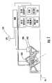
- the aerial mapping system of the preferred embodimentincludes an aircraft 99 carrying a plurality of image sensors 100 and processing equipment.
- the plurality of image sensors 100are mounted on a platform or frame 102 that is in turn mounted to the aircraft.
- Each of the sensorscould be produced by different manufacturers and be designed to collect light from the same or various bands in the electromagnetic spectrum such as infrared, ultraviolet, visible-light, and other bands of electromagnetic wavelengths.
- each sensorcould have the same or a different footprint on the ground from the other sensors, although the sensors are preferably fixed in the aircraft in such a way that 60 to 80% of the footprints overlap during a flight (even if the distance between the ground and the aircraft during the flight varies to some extent).
- each sensormay have unique interior orientation parameters owing to its unique circumstances during manufacturing.
- the plurality of image sensors 100oscillate as a group on a gimbal, although this configuration is not essential and the sensors could instead be fixed.
- the aircraft 99carries a spatial sensor that senses the position and attitude of the sensor frame.
- the spatial spatial sensorincludes, preferably, a GPS receiver 104 and an IMU 106 , which together with a position computer 108 form an Inertial Navigation System (called an INS).
- the position computer 108integrates data from the IMU 106 and the GPS receiver 104 to solve for an instantaneous attitude of the sensor frame and its instantaneous position, which includes a reference to the earth (e.g., latitude/longitude). Applanix Corp. of Richmond Hill, Ontario and Leica Geosystems Geospatial Imaging of Norcross, Ga. produce or are capable of producing INSs.
- Each of the GPS receiver, IMU and image sensorsfeed data to at least the position computer 108 , which preferably sends processed position data to a primary computer 110 that includes processors and storage media.
- a primary computer 110that includes processors and storage media.
- the plurality of image sensors 100 , the GPS receiver 104 , the IMU 106 , the position computer 108 and the primary computer 110are electrically interconnected.
- position computer 108 and the primary computer 110are shown as separate units since they are typically constructed that way in commercial embodiments. Nevertheless, one of ordinary skill will appreciate that the position computer 108 and the primary computer 110 can be integrated into a single computer without any change in the concept of operation.
- the INScomprises a GPS receiver and an IMU because they work well together to provide ground reference points more frequently or more accurately than, for example, a GPS receiver alone can.
- GPSmeans any kind of satellite-based positioning system, including GLONASS and Galileo, in this patent application.
- a typical GPS receiverreceives a position with respect to the earth at least about 60 times a second, and a typical IMU collects acceleration data in the interim. The acceleration data is twice integrated to obtain a position, and the integration constants are resolved using the GPS position data.
- a key sensoralso called a primary sensor
- one or more of the other sensorsis boresighted, or relatively oriented, to this key sensor. This means that the data collected by the non-key sensors are transformed to overlie the key sensor's image data set so that a pixel in an image by the key sensor can correspond to a pixel in an image by every other sensor.
- the primary computer 110There are three principle sets of data stored in the primary computer 110 , in addition to the interior orientation data of each sensor, and, optionally, the digital elevation model (DEM), vector data and projection data. (As previously mentioned, the primary computer 110 is not exclusively qualified to store this data; other computers could store and process the information without departing from the scope of the invention.)
- the three setsare a key vector describing the position of the key sensor relative to the GPS receiver, relative vectors describing the positions of the non-key sensors relative to the key sensor, and the average height above the terrain for the planned flight.
- the key vectorallows the computer to determine the position and attitude of the key sensor based on the information from the INS.
- the relative vectorsallow the computer to determine the position and attitude of the non-key sensors based on the position (and attitude) of the key sensor.
- the average height above the terraincan be an input, along with the key and relative vectors, to allow the computer to determine a matrix (or, stated in another way, a transformation) for an image-to-image transformation (also known as a coregistration).
- each sensoris usually mounted in the aircraft adjacent to another sensor.
- each sensorhas a unique perspective, rather than looking through the same space to an identical area on the ground.
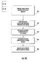
- a computercontrols in step 400 the trigger pulse for each of the plurality of image sensors 100 so that the sensors collect data simultaneously.
- the primary computer 110collects in step 402 position data from the spatial sensor and uses the position data to determine the exterior orientation of the key sensor, as shown in step 404 .
- the primary computer 110calculates the matrix representing the transform from the non-key sensors to the key sensor to determine the exterior orientation of the non-key sensors (step 406 ).
- the exterior orientation data for and imagery from each sensoris then stored in the computer's mass-storage device in step 408 .
- the computerreads the interior and exterior orientations from the storage device, and transforms the raw image data of the image sensors using the orientation data to permit image-to-image coregistration with the data of the key sensor (step 410 ).
- a simple, first-order polynomial transformationalso known as an affine transformation
- the computeruses the relative position vector to linearly shift and/or rotate the non-key sensor image data to correspond to the key sensor image data.
- More complex, higher-order polynomial transformationscan account for different interior orientations among the image sensors. Such higher-order polynomial transformations could warp the image data to better account for localized distortions in the imagery caused, for example, by lens distortion.
- the primary computer 110simply stacks or overlays the coregistered image data of the non-key sensor and the key sensor (step 412 ).
- the stacked image datais preferably saved (step 414 ).
- Position data from the position computer 108 or the spatial sensorcan optionally be associated with the stacked image or be incorporated into a stacked-image file. Alternatively, the position data can be used to georeference the stacked image. This georeferenced, stacked image can then be telemetered to the ground facility (step 422 ) using well-known wireless technology.
- an image(whether a stacked image or a thematic image, which will be described below) can be orthorectified after being georeferenced.
- Orthorectifying the thematic imagemay be useful when collecting imagery from mountainous or otherwise substantially varied terrain and the flying height is low enough for such variation to be significant.
- the tradeoff, however,is that orthorectifying requires additional processing power and may require additional computers in a parallel-processing environment.
- the softwareperforms a thematic analysis in step 416 on the stacked image.
- the resulting thematic imagegroups pixels according to some criteria. For example, if looking for oil slicks, the analysis algorithm might automatically classify all pixels with certain pixel values or spectral characteristics as an oil slick to generate an “oil slick” thematic image.
- Analysis disclosed hereincan include performing a classifying operation on the image data.
- Encoding pixels to convey informationis a well-documented and well-researched discipline that includes automated pattern recognition and artificial intelligence.
- Chapter 7 of the ERDAS IMAGINE Field Guidepublished by Leica Geosystems Geospatial Imaging of Norcross, Ga. (7 th Ed. 2003)—which is incorporated herein by reference—discusses classification at length.
- Traditional classification techniquescan be applied to imagery from the remote-sensing system of the preferred embodiment in a variety of ways.
- the primary computer 110 of FIG. 1can be trained prior to a flight based on a series of test images. (In other words, the computer contains software that is configured to execute known classification algorithms.) This way, as the classification algorithm is run during a flight (as in step 416 of FIG. 4B ), the computer is already primed to recognize patterns in the image data.
- the thematic imageis georeferenced using the position data and combined with a vector file. Georeferencing the thematic image prior to combining with the vector file will probably be required because vector files for use with the preferred embodiment are preferably georeferenced. Thus, for the vector objects (e.g., lines, polygons) to appear in the correct location in the thematic image, both must be georeferenced. (After all, there must be some common referenced system between the vector file, which exists before the flight, and the imagery, which is generated during a flight.)
- the vector objectse.g., lines, polygons
- an analysis algorithmcan analyze both data sets jointly (step 420 ).
- the resultis then preferably telemetered to a ground facility (step 422 ).
- the vector filecould be a file that was created using commercially available software, such as ERDAS IMAGINE from Leica Geosystems Geospatial Imaging of Norcross, Georgia or ARCINFO from ESRI of Redlands, Calif. In this example, assume the vector file shows the regions in the ocean in which certain kinds of fishing is prohibited.
- the userflies the sensor system over the area of interest according to a flight plan while the plurality of image sensors acquires imagery.
- the spatial sensorsimultaneously collects the position data, which with the key vector allows the computer to determine the exterior orientation of the key sensor. From the exterior orientation of the key sensor and the relative vectors, the computer determines the exterior orientation of each of the non-key sensors.
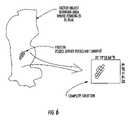
- thematic imageis a grayscale image in which pixels are given intensity according to the likelihood that they represent a freezer.
- the algorithmhas identified in the stacked image features that are likely an freezer, but the algorithm has not yet incorporated vector data that graphically shows where commercial fishing is illegal.
- the next stepis to perform an analysis on the thematic layer, which in this example means incorporating the vector data of illegal fishing areas.
- the thematic layeris georeferenced (orthorectification using a DEM is not required in this instance because the sea lacks height variation) and transformed to conform to the same map projection as the legal/illegal vector layer. Then the system can telemeter a complete solution to the ground facility.
- the complete solutionmight be a file containing one image layer and one vector layer.
- the imagemay have a box or other highlight showing the nexus of the thematic image and the vector layer.
- the complete solutionwill show a box around chartreuse pixels that are located in an illegal fishing vector object.
- the complete solutionpreferably shows the map coordinates of the box.
- the complete solutionis preferably telemetered to the ground. On the ground, a command post or processing center need merely view the complete solution to determine whether illegal fishing is occurring and where.
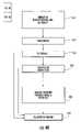
- FIG. 5An alternative embodiment is shown in FIG. 5 .
- each set of stacked imagesis stored in memory so that the image stack can be quickly accessed by the computer.
- the computerreads the image stack (step 500 ) and creates, in step 502 , using well-known algorithms, a plurality of layers of increasing level of detail (otherwise known as pyramid layers).
- One of the pyramid layersis shown on a display as a thumbnail (i.e., a reduced-resolution image) and the thumbnails of a plurality of image stacks are mosaicked in real time as the imagery is collected and processed (step 504 ).
- a complete image(composed of several images or image stacks collected over a period of time) is displayed on an on-board monitor or can be printed.
- the displayis interactive in that a user viewing the display can zoom in and out of the image and view different levels of detail.
- the usercan use the displayed images to monitor the progress of the data collection during a flight.
- Other meanscan also be used to visually monitor data collection during flight, such as a motion-picture camera that collects imagery from substantially the same area of the ground as the plurality of image sensors.
Landscapes
- Engineering & Computer Science (AREA)
- Physics & Mathematics (AREA)
- General Physics & Mathematics (AREA)
- Remote Sensing (AREA)
- Theoretical Computer Science (AREA)
- Multimedia (AREA)
- Geometry (AREA)
- Software Systems (AREA)
- Astronomy & Astrophysics (AREA)
- Radar, Positioning & Navigation (AREA)
- Computer Graphics (AREA)
- Image Processing (AREA)
- Studio Devices (AREA)
Abstract
Description
Claims (19)
Priority Applications (1)
| Application Number | Priority Date | Filing Date | Title |
|---|---|---|---|
| US11/384,954US7437062B2 (en) | 2005-11-10 | 2006-03-20 | Remote sensing system capable of coregistering data from sensors potentially having unique perspectives |
Applications Claiming Priority (2)
| Application Number | Priority Date | Filing Date | Title |
|---|---|---|---|
| US73542805P | 2005-11-10 | 2005-11-10 | |
| US11/384,954US7437062B2 (en) | 2005-11-10 | 2006-03-20 | Remote sensing system capable of coregistering data from sensors potentially having unique perspectives |
Publications (2)
| Publication Number | Publication Date |
|---|---|
| US20070104354A1 US20070104354A1 (en) | 2007-05-10 |
| US7437062B2true US7437062B2 (en) | 2008-10-14 |
Family
ID=38003791
Family Applications (1)
| Application Number | Title | Priority Date | Filing Date |
|---|---|---|---|
| US11/384,954Active2027-04-07US7437062B2 (en) | 2005-11-10 | 2006-03-20 | Remote sensing system capable of coregistering data from sensors potentially having unique perspectives |
Country Status (1)
| Country | Link |
|---|---|
| US (1) | US7437062B2 (en) |
Cited By (15)
| Publication number | Priority date | Publication date | Assignee | Title |
|---|---|---|---|---|
| US20070046448A1 (en)* | 2002-09-20 | 2007-03-01 | M7 Visual Intelligence | Vehicle based data collection and processing system and imaging sensor system and methods thereof |
| US20080211910A1 (en)* | 2006-07-18 | 2008-09-04 | Wolfgang Niem | Surveillance Camera, Method For Calibrating the Surveillance Camera, and Use of the Surveillance Camera |
| US20080291280A1 (en)* | 2002-08-28 | 2008-11-27 | Peters Iii Leo J | Retinal array compound camera system having at least three imaging sensors |
| US20090037476A1 (en)* | 2007-08-02 | 2009-02-05 | Kuhner Jens | Method for Georeferenced Representation of Data of an Area of Measurement Measured by Means of Ground Detectors, and Detectors for the Same |
| US20090087050A1 (en)* | 2007-08-16 | 2009-04-02 | Michael Gandyra | Device for determining the 3D coordinates of an object, in particular of a tooth |
| US20090256909A1 (en)* | 2008-04-11 | 2009-10-15 | Nixon Stuart | Systems and methods of capturing large area images in detail including cascaded cameras and/or calibration features |
| US20100013927A1 (en)* | 2008-04-11 | 2010-01-21 | Nearmap Pty Ltd. | Systems and Methods of Capturing Large Area Images in Detail Including Cascaded Cameras and/or Calibration Features |
| US20100228418A1 (en)* | 2009-03-04 | 2010-09-09 | Honeywell International Inc. | System and methods for displaying video with improved spatial awareness |
| US20110090399A1 (en)* | 2009-10-19 | 2011-04-21 | Intergraph Technologies Company | Data Search, Parser, and Synchronization of Video and Telemetry Data |
| US20120226470A1 (en)* | 2009-09-18 | 2012-09-06 | Cassidian Sas | Three-dimensional location of target land area by merging images captured by two satellite-based sensors |
| US8483960B2 (en) | 2002-09-20 | 2013-07-09 | Visual Intelligence, LP | Self-calibrated, remote imaging and data processing system |
| US8994822B2 (en) | 2002-08-28 | 2015-03-31 | Visual Intelligence Lp | Infrastructure mapping system and method |
| USRE49105E1 (en) | 2002-09-20 | 2022-06-14 | Vi Technologies, Llc | Self-calibrated, remote imaging and data processing system |
| US12078738B2 (en) | 2021-11-09 | 2024-09-03 | Msrs Llc | Method, apparatus, and computer readable medium for a multi-source reckoning system |
| US12259246B1 (en) | 2024-05-13 | 2025-03-25 | Msrs Llc | Method, apparatus, and computer readable medium for calculating a handrail influence intensity factor |
Families Citing this family (9)
| Publication number | Priority date | Publication date | Assignee | Title |
|---|---|---|---|---|
| US20080195316A1 (en)* | 2007-02-12 | 2008-08-14 | Honeywell International Inc. | System and method for motion estimation using vision sensors |
| JP2012511697A (en)* | 2008-12-09 | 2012-05-24 | トムトム ノース アメリカ インコーポレイテッド | How to generate a geodetic reference database |
| FR2953940B1 (en)* | 2009-12-16 | 2012-02-03 | Thales Sa | METHOD FOR GEO-REFERENCING AN IMAGE AREA |
| US8477190B2 (en) | 2010-07-07 | 2013-07-02 | Pictometry International Corp. | Real-time moving platform management system |
| KR101304579B1 (en)* | 2011-07-15 | 2013-09-05 | 삼성중공업 주식회사 | Device and method for measuring position of moving object in water |
| IL226752A (en)* | 2013-06-04 | 2017-02-28 | Padowicz Ronen | Self-contained navigation system and method |
| KR102005805B1 (en)* | 2018-06-05 | 2019-10-01 | (주)케이워터크레프트 | Self contained oceanic drone and method for oceanographic survey and surveillance |
| CN114399896B (en)* | 2020-09-25 | 2023-04-07 | 汉桑(南京)科技股份有限公司 | Method and system for configuring remote control function data according to remote control equipment image |
| CN113705640B (en)* | 2021-08-16 | 2024-03-01 | 中国电子科技集团公司第二十八研究所 | Method for quickly constructing airplane detection data set based on remote sensing image |
Citations (12)
| Publication number | Priority date | Publication date | Assignee | Title |
|---|---|---|---|---|
| US5124915A (en) | 1990-05-29 | 1992-06-23 | Arthur Krenzel | Computer-aided data collection system for assisting in analyzing critical situations |
| US5422989A (en) | 1992-11-23 | 1995-06-06 | Harris Corporation | User interface mechanism for interactively manipulating displayed registered images obtained from multiple sensors having diverse image collection geometries |
| US5550937A (en) | 1992-11-23 | 1996-08-27 | Harris Corporation | Mechanism for registering digital images obtained from multiple sensors having diverse image collection geometries |
| US5596494A (en) | 1994-11-14 | 1997-01-21 | Kuo; Shihjong | Method and apparatus for acquiring digital maps |
| US5765044A (en) | 1993-12-13 | 1998-06-09 | Core Corp. | Airborne photographing apparatus |
| US5995681A (en) | 1997-06-03 | 1999-11-30 | Harris Corporation | Adjustment of sensor geometry model parameters using digital imagery co-registration process to reduce errors in digital imagery geolocation data |
| WO2001069535A2 (en) | 2000-03-10 | 2001-09-20 | Sarnoff Corporation | Method and apparatus for performing geo-spatial registration of imagery |
| US6664529B2 (en) | 2000-07-19 | 2003-12-16 | Utah State University | 3D multispectral lidar |
| US6735348B2 (en)* | 2001-05-01 | 2004-05-11 | Space Imaging, Llc | Apparatuses and methods for mapping image coordinates to ground coordinates |
| US6798984B2 (en)* | 2000-06-06 | 2004-09-28 | Centre National D'etudes Spatiales | Image pick-up device on board a space craft, space craft and image sensing method comprising same |
| US20050271264A1 (en)* | 2004-04-21 | 2005-12-08 | Topcon Corporation | Three-dimensional image measuring apparatus and method |
| US7127348B2 (en)* | 2002-09-20 | 2006-10-24 | M7 Visual Intelligence, Lp | Vehicle based data collection and processing system |
Family Cites Families (1)
| Publication number | Priority date | Publication date | Assignee | Title |
|---|---|---|---|---|
| US5628264A (en)* | 1995-03-16 | 1997-05-13 | Union Special Corporation | Sleeve making method and apparatus |
- 2006
- 2006-03-20USUS11/384,954patent/US7437062B2/enactiveActive
Patent Citations (13)
| Publication number | Priority date | Publication date | Assignee | Title |
|---|---|---|---|---|
| US5124915A (en) | 1990-05-29 | 1992-06-23 | Arthur Krenzel | Computer-aided data collection system for assisting in analyzing critical situations |
| US5422989A (en) | 1992-11-23 | 1995-06-06 | Harris Corporation | User interface mechanism for interactively manipulating displayed registered images obtained from multiple sensors having diverse image collection geometries |
| US5550937A (en) | 1992-11-23 | 1996-08-27 | Harris Corporation | Mechanism for registering digital images obtained from multiple sensors having diverse image collection geometries |
| US5765044A (en) | 1993-12-13 | 1998-06-09 | Core Corp. | Airborne photographing apparatus |
| US5596494A (en) | 1994-11-14 | 1997-01-21 | Kuo; Shihjong | Method and apparatus for acquiring digital maps |
| US6597818B2 (en)* | 1997-05-09 | 2003-07-22 | Sarnoff Corporation | Method and apparatus for performing geo-spatial registration of imagery |
| US5995681A (en) | 1997-06-03 | 1999-11-30 | Harris Corporation | Adjustment of sensor geometry model parameters using digital imagery co-registration process to reduce errors in digital imagery geolocation data |
| WO2001069535A2 (en) | 2000-03-10 | 2001-09-20 | Sarnoff Corporation | Method and apparatus for performing geo-spatial registration of imagery |
| US6798984B2 (en)* | 2000-06-06 | 2004-09-28 | Centre National D'etudes Spatiales | Image pick-up device on board a space craft, space craft and image sensing method comprising same |
| US6664529B2 (en) | 2000-07-19 | 2003-12-16 | Utah State University | 3D multispectral lidar |
| US6735348B2 (en)* | 2001-05-01 | 2004-05-11 | Space Imaging, Llc | Apparatuses and methods for mapping image coordinates to ground coordinates |
| US7127348B2 (en)* | 2002-09-20 | 2006-10-24 | M7 Visual Intelligence, Lp | Vehicle based data collection and processing system |
| US20050271264A1 (en)* | 2004-04-21 | 2005-12-08 | Topcon Corporation | Three-dimensional image measuring apparatus and method |
Non-Patent Citations (7)
| Title |
|---|
| ADS40 Airborne Digital Sensor Brochure, Leica Geosystems 2001-2002 (8 pgs). |
| ADS40 Airborne Digital Sensor Product Description, Leica Geosystems 2002 (6 pgs). |
| ADS40-Progress in Digital Aerial Data Collection, Peter Fricker, Wichmann Veriag, Heidelberg, 2001 (12 pgs). |
| Design Principles of the LH Systems ADS40 Airborne Digital Sensor, Sandau et al. IAPRS, vol. XXXIII, Amsterdam, 2000 (9 pgs). |
| ERDAS Field Guide, Leica Geosystems Geospatial Imaging, LLC 2005 (70 pgs). |
| Photogrammetric Software for the LH Systems ADS40 Airborne Digital Sensor, Templemann et al. (8 pgs). |
| Sensor Modeling for Aerial Mobile Mapping with Three-Line-Scanner (TLS) Imagery, A. Gruen & L. Zhang, ISPRS Commission II Symposium, 2002 (7 pgs). |
Cited By (31)
| Publication number | Priority date | Publication date | Assignee | Title |
|---|---|---|---|---|
| US20080291280A1 (en)* | 2002-08-28 | 2008-11-27 | Peters Iii Leo J | Retinal array compound camera system having at least three imaging sensors |
| US8334903B2 (en) | 2002-08-28 | 2012-12-18 | Visual Intelligence, L.P. | Retinal array compound camera system having at least three imaging sensors |
| US20090322883A1 (en)* | 2002-08-28 | 2009-12-31 | Visual Intelligence Systems, Inc. | Method of producing a remote imaging array |
| US8471907B2 (en) | 2002-08-28 | 2013-06-25 | Visual Intelligence, LP | Method of producing a remote imaging array |
| US8994822B2 (en) | 2002-08-28 | 2015-03-31 | Visual Intelligence Lp | Infrastructure mapping system and method |
| US8896695B2 (en) | 2002-08-28 | 2014-11-25 | Visual Intelligence Lp | Retinal concave array compound camera system |
| US8483960B2 (en) | 2002-09-20 | 2013-07-09 | Visual Intelligence, LP | Self-calibrated, remote imaging and data processing system |
| US20070046448A1 (en)* | 2002-09-20 | 2007-03-01 | M7 Visual Intelligence | Vehicle based data collection and processing system and imaging sensor system and methods thereof |
| USRE49105E1 (en) | 2002-09-20 | 2022-06-14 | Vi Technologies, Llc | Self-calibrated, remote imaging and data processing system |
| US9797980B2 (en) | 2002-09-20 | 2017-10-24 | Visual Intelligence Lp | Self-calibrated, remote imaging and data processing system |
| US9389298B2 (en) | 2002-09-20 | 2016-07-12 | Visual Intelligence Lp | Self-calibrated, remote imaging and data processing system |
| US7725258B2 (en)* | 2002-09-20 | 2010-05-25 | M7 Visual Intelligence, L.P. | Vehicle based data collection and processing system and imaging sensor system and methods thereof |
| US9025033B2 (en)* | 2006-07-18 | 2015-05-05 | Robert Bosch Gmbh | Surveillance camera and method for calibrating the survelliance camera using a calibration tool |
| US20080211910A1 (en)* | 2006-07-18 | 2008-09-04 | Wolfgang Niem | Surveillance Camera, Method For Calibrating the Surveillance Camera, and Use of the Surveillance Camera |
| US20090037476A1 (en)* | 2007-08-02 | 2009-02-05 | Kuhner Jens | Method for Georeferenced Representation of Data of an Area of Measurement Measured by Means of Ground Detectors, and Detectors for the Same |
| US8411917B2 (en)* | 2007-08-16 | 2013-04-02 | Steinbichler Optotechnik Gmbh | Device for determining the 3D coordinates of an object, in particular of a tooth |
| US20090087050A1 (en)* | 2007-08-16 | 2009-04-02 | Michael Gandyra | Device for determining the 3D coordinates of an object, in particular of a tooth |
| US8913814B2 (en)* | 2007-08-16 | 2014-12-16 | Steinbichler Optotechnik Gmbh | Device for determining the 3D coordinates of an object, in particular of a tooth |
| US20100013927A1 (en)* | 2008-04-11 | 2010-01-21 | Nearmap Pty Ltd. | Systems and Methods of Capturing Large Area Images in Detail Including Cascaded Cameras and/or Calibration Features |
| US8497905B2 (en) | 2008-04-11 | 2013-07-30 | nearmap australia pty ltd. | Systems and methods of capturing large area images in detail including cascaded cameras and/or calibration features |
| US8675068B2 (en) | 2008-04-11 | 2014-03-18 | Nearmap Australia Pty Ltd | Systems and methods of capturing large area images in detail including cascaded cameras and/or calibration features |
| US10358234B2 (en) | 2008-04-11 | 2019-07-23 | Nearmap Australia Pty Ltd | Systems and methods of capturing large area images in detail including cascaded cameras and/or calibration features |
| US10358235B2 (en) | 2008-04-11 | 2019-07-23 | Nearmap Australia Pty Ltd | Method and system for creating a photomap using a dual-resolution camera system |
| US20090256909A1 (en)* | 2008-04-11 | 2009-10-15 | Nixon Stuart | Systems and methods of capturing large area images in detail including cascaded cameras and/or calibration features |
| US20100228418A1 (en)* | 2009-03-04 | 2010-09-09 | Honeywell International Inc. | System and methods for displaying video with improved spatial awareness |
| US9310198B2 (en)* | 2009-09-18 | 2016-04-12 | Airbus Ds Sas | Three-dimensional location of target land area by merging images captured by two satellite-based sensors |
| US20120226470A1 (en)* | 2009-09-18 | 2012-09-06 | Cassidian Sas | Three-dimensional location of target land area by merging images captured by two satellite-based sensors |
| US20110090399A1 (en)* | 2009-10-19 | 2011-04-21 | Intergraph Technologies Company | Data Search, Parser, and Synchronization of Video and Telemetry Data |
| US8189690B2 (en) | 2009-10-19 | 2012-05-29 | Intergraph Technologies Company | Data search, parser, and synchronization of video and telemetry data |
| US12078738B2 (en) | 2021-11-09 | 2024-09-03 | Msrs Llc | Method, apparatus, and computer readable medium for a multi-source reckoning system |
| US12259246B1 (en) | 2024-05-13 | 2025-03-25 | Msrs Llc | Method, apparatus, and computer readable medium for calculating a handrail influence intensity factor |
Also Published As
| Publication number | Publication date |
|---|---|
| US20070104354A1 (en) | 2007-05-10 |
Similar Documents
| Publication | Publication Date | Title |
|---|---|---|
| US7437062B2 (en) | Remote sensing system capable of coregistering data from sensors potentially having unique perspectives | |
| Lissak et al. | Remote sensing for assessing landslides and associated hazards | |
| US20200401617A1 (en) | Visual positioning system | |
| US8520079B2 (en) | Event multiplexer for managing the capture of images | |
| US7298869B1 (en) | Multispectral data acquisition system and method | |
| CN103575267B (en) | The method for making image related to the landform altitude map for navigating | |
| KR102200299B1 (en) | A system implementing management solution of road facility based on 3D-VR multi-sensor system and a method thereof | |
| CN109871739B (en) | Automatic target detection and space positioning method for mobile station based on YOLO-SIOCTL | |
| CN109596121A (en) | A kind of motor-driven station Automatic Targets and space-location method | |
| US20160091297A1 (en) | Operating device, operating method, and program therefor | |
| Mancini et al. | High-resolution mapping of river and estuary areas by using unmanned aerial and surface platforms | |
| GB2527997A (en) | Registration of SAR images by mutual information | |
| Ho et al. | Robustness of Structure from Motion Accuracy/Precision Against the Non-Optimality in Analysis Settings: Case Study in Constant-Pitch Flight Design | |
| Sambolek et al. | Determining the geolocation of a person detected in an image taken with a drone | |
| Schwind | Comparing and characterizing three-dimensional point clouds derived by structure from motion photogrammetry | |
| Shahbazi | Professional drone mapping | |
| Eboigbe | Low-cost, close-range digital photogrammetry for coastal cliff deformation and beach monitoring | |
| Shafaat | Change detection of urban vegetation from terrestrial laser scanning and drone photogrammetry | |
| Suir et al. | Unmanned aircraft systems to support environmental applications within USACE civil works | |
| Essel | Developing an Enhanced Photogrammetric Methodology for Mapping Water Bodies Using Low-Cost Drones | |
| Wang | Augmented UAS navigation in GPS denied terrain environments using synthetic vision | |
| Castleberry | Methods for Improving Visual Terrain Relative Navigation for Dynamic Aerial Systems | |
| Jones | Automatic Registration of Imagery to Mobile LiDAR Maps | |
| Cantoro et al. | Integrating Low Altitude with Satellite and Airborne Aerial Images: Photogrammetric Documentation of Early Byzantine Settlements in Crete | |
| Reich | The Application of Structure from Motion Photogrammetry to the Ontario Rockfall Hazard Rating System (RHRON) |
Legal Events
| Date | Code | Title | Description |
|---|---|---|---|
| AS | Assignment | Owner name:ERADAS, INC, GEORGIA Free format text:ASSIGNMENT OF ASSIGNORS INTEREST;ASSIGNOR:HOLCOMB, DERROLD;REEL/FRAME:021486/0829 Effective date:20080815 | |
| AS | Assignment | Owner name:ERDAS, INC., GEORGIA Free format text:CORRECTIVE ASSIGNMENT TO CORRECT THE SPELLING OF THE ASSIGNEE FROM ERADAS, INC. TO ERDAS, INC. PREVIOUSLY RECORDED ON REEL 021486 FRAME 0829. ASSIGNOR(S) HEREBY CONFIRMS THE ERDAS, INC., 5051 PEACHTREE CORNERS CIRCLE, STE 100, NORCROSS GA 30092.;ASSIGNOR:HOLCOMB, DERROLD;REEL/FRAME:021581/0204 Effective date:20080815 Owner name:ERDAS, INC., GEORGIA Free format text:CORRECTIVE ASSIGNMENT TO CORRECT THE SPELLING OF THE ASSIGNEE FROM ERADAS, INC. TO ERDAS, INC. PREVIOUSLY RECORDED ON REEL 021486 FRAME 0829;ASSIGNOR:HOLCOMB, DERROLD;REEL/FRAME:021581/0204 Effective date:20080815 | |
| STCF | Information on status: patent grant | Free format text:PATENTED CASE | |
| FEPP | Fee payment procedure | Free format text:PAYER NUMBER DE-ASSIGNED (ORIGINAL EVENT CODE: RMPN); ENTITY STATUS OF PATENT OWNER: LARGE ENTITY Free format text:PAYOR NUMBER ASSIGNED (ORIGINAL EVENT CODE: ASPN); ENTITY STATUS OF PATENT OWNER: LARGE ENTITY | |
| FPAY | Fee payment | Year of fee payment:4 | |
| AS | Assignment | Owner name:INTERGRAPH CORPORATION, ALABAMA Free format text:ASSIGNMENT OF ASSIGNORS INTEREST;ASSIGNOR:INTERGRAPH GOVERNMENT SOLUTIONS CORPORATION;REEL/FRAME:032983/0936 Effective date:20110801 Owner name:INTERGRAPH GOVERNMENT SOLUTIONS CORPORATION, ALABA Free format text:ASSIGNMENT OF ASSIGNORS INTEREST;ASSIGNOR:ERDAS, INC.;REEL/FRAME:032983/0867 Effective date:20110801 | |
| FPAY | Fee payment | Year of fee payment:8 | |
| MAFP | Maintenance fee payment | Free format text:PAYMENT OF MAINTENANCE FEE, 12TH YEAR, LARGE ENTITY (ORIGINAL EVENT CODE: M1553); ENTITY STATUS OF PATENT OWNER: LARGE ENTITY Year of fee payment:12 |