US7343867B2 - Method for prescribing site-specific fertilizer application in agricultural fields - Google Patents
Method for prescribing site-specific fertilizer application in agricultural fieldsDownload PDFInfo
- Publication number
- US7343867B2 US7343867B2US11/643,647US64364706AUS7343867B2US 7343867 B2US7343867 B2US 7343867B2US 64364706 AUS64364706 AUS 64364706AUS 7343867 B2US7343867 B2US 7343867B2
- Authority
- US
- United States
- Prior art keywords
- site
- field
- map
- soil
- specific
- Prior art date
- Legal status (The legal status is an assumption and is not a legal conclusion. Google has not performed a legal analysis and makes no representation as to the accuracy of the status listed.)
- Expired - Fee Related
Links
Images


Classifications
- A—HUMAN NECESSITIES
- A01—AGRICULTURE; FORESTRY; ANIMAL HUSBANDRY; HUNTING; TRAPPING; FISHING
- A01B—SOIL WORKING IN AGRICULTURE OR FORESTRY; PARTS, DETAILS, OR ACCESSORIES OF AGRICULTURAL MACHINES OR IMPLEMENTS, IN GENERAL
- A01B49/00—Combined machines
- A01B49/04—Combinations of soil-working tools with non-soil-working tools, e.g. planting tools
- A01B49/06—Combinations of soil-working tools with non-soil-working tools, e.g. planting tools for sowing or fertilising
- A—HUMAN NECESSITIES
- A01—AGRICULTURE; FORESTRY; ANIMAL HUSBANDRY; HUNTING; TRAPPING; FISHING
- A01B—SOIL WORKING IN AGRICULTURE OR FORESTRY; PARTS, DETAILS, OR ACCESSORIES OF AGRICULTURAL MACHINES OR IMPLEMENTS, IN GENERAL
- A01B79/00—Methods for working soil
- A01B79/005—Precision agriculture
- A—HUMAN NECESSITIES
- A01—AGRICULTURE; FORESTRY; ANIMAL HUSBANDRY; HUNTING; TRAPPING; FISHING
- A01C—PLANTING; SOWING; FERTILISING
- A01C21/00—Methods of fertilising, sowing or planting
- A01C21/007—Determining fertilization requirements
- Y—GENERAL TAGGING OF NEW TECHNOLOGICAL DEVELOPMENTS; GENERAL TAGGING OF CROSS-SECTIONAL TECHNOLOGIES SPANNING OVER SEVERAL SECTIONS OF THE IPC; TECHNICAL SUBJECTS COVERED BY FORMER USPC CROSS-REFERENCE ART COLLECTIONS [XRACs] AND DIGESTS
- Y02—TECHNOLOGIES OR APPLICATIONS FOR MITIGATION OR ADAPTATION AGAINST CLIMATE CHANGE
- Y02P—CLIMATE CHANGE MITIGATION TECHNOLOGIES IN THE PRODUCTION OR PROCESSING OF GOODS
- Y02P60/00—Technologies relating to agriculture, livestock or agroalimentary industries
- Y02P60/20—Reduction of greenhouse gas [GHG] emissions in agriculture, e.g. CO2
- Y02P60/21—Dinitrogen oxide [N2O], e.g. using aquaponics, hydroponics or efficiency measures
- Y—GENERAL TAGGING OF NEW TECHNOLOGICAL DEVELOPMENTS; GENERAL TAGGING OF CROSS-SECTIONAL TECHNOLOGIES SPANNING OVER SEVERAL SECTIONS OF THE IPC; TECHNICAL SUBJECTS COVERED BY FORMER USPC CROSS-REFERENCE ART COLLECTIONS [XRACs] AND DIGESTS
- Y10—TECHNICAL SUBJECTS COVERED BY FORMER USPC
- Y10S—TECHNICAL SUBJECTS COVERED BY FORMER USPC CROSS-REFERENCE ART COLLECTIONS [XRACs] AND DIGESTS
- Y10S111/00—Planting
- Y10S111/90—Methods of planting seeds and miscellaneous compositions
- Y—GENERAL TAGGING OF NEW TECHNOLOGICAL DEVELOPMENTS; GENERAL TAGGING OF CROSS-SECTIONAL TECHNOLOGIES SPANNING OVER SEVERAL SECTIONS OF THE IPC; TECHNICAL SUBJECTS COVERED BY FORMER USPC CROSS-REFERENCE ART COLLECTIONS [XRACs] AND DIGESTS
- Y10—TECHNICAL SUBJECTS COVERED BY FORMER USPC
- Y10S—TECHNICAL SUBJECTS COVERED BY FORMER USPC CROSS-REFERENCE ART COLLECTIONS [XRACs] AND DIGESTS
- Y10S111/00—Planting
- Y10S111/903—Monitor
Definitions
- This inventionrelates to a method/process that prescribes the site-specific application of fertilizers in agricultural fields, and more particularly to minimizing the amount of fertilizer that is applied while maintaining the maximum possible yield for the field.
- Fertilizerssupply nutrients to the soil needed to produce various crops.
- the most common nutrients in soilare nitrogen, phosphorous and potassium.
- some cropsrequire micronutrients, such as zinc (Zn) and iron (Fe), depending on soils.
- Fertilizerof course costs money, but the risk of lower yields resulting from under-fertilizing has in the past generally outweighed the monetary cost of over-fertilizing.
- the volatility in natural gas pricingcan cause nitrogen fertilizer prices to escalate unpredictably.
- the overuse of fertilizercreates the potential for negative environmental consequences, and so from an environmental perspective too it is desirable to minimize the application of fertilizers.
- N FERTN CROP ⁇ N RES.SOIL ⁇ ( N OM +N PREV.CROP +N MANURE ) ⁇ N IRR
- N FERTfertilizer N recommendation
- GPSGlobal Positioning System
- the '876 patentdescribes a variable-rate fertilizer application system.
- the systemhas a digital map characterizing the field's soil types.
- the systemalso has other maps that characterize the desired level of various fertilizer types to be applied upon the field.
- the patentstates that the levels of fertilizer can be determined from predefined characteristics, such as existing fertilizer levels, field topography or drainage studies.
- a processorcalculates and controls the dispensing of the various fertilizers based on both the soil map and the fertilizer map.
- a position locator on the vehicle dispensing the fertilizersprovides the necessary location information to apply the prescribed amount of fertilizer in the correct location.
- Related U.S. Pat. No. 5,355,815 to Monsondescribes a closed-loop fertilizer application system, which also varies the application rate, but which does not require maps of current fertilizer levels. The system is said to be able to determine a chemical prescription in real-time for a soil scene, depending on the existing soil fertilizer content ascertained by a real-time soil analyzer. The system then dispenses fertilizer in response to the prescription.
- the maximum possible crop yield—that is, “yield goal,” which factors into the calculation of N CROP in the equation above—that a particular location in a field is able to attainmay vary from location to location.
- yield goalwhich factors into the calculation of N CROP in the equation above—that a particular location in a field is able to attain
- the gravelmay cause only weeds to grow at that location, or may hinder the growth of any vegetation.
- Gravelmay be on the surface, or may be at a shallow level below the surface. The gravel may not be detectable from a soil image.
- Other factors that may vary the yield at a particular location in a field, but which also may not be detectable from a soil imageare the soil's fertility and its pH content.
- the inventionis a method and system that regulates the amount of fertilizer that is applied to agricultural fields while still maintaining the maximum possible crop yield.
- the inventioninvolves the creation of a map for an agricultural field of site-specific amounts of a soil nutrient needed at each site to produce the maximum possible crop yield that the site is capable of producing. Subtracted from the site-specific amounts of nutrient needed for the crop are site-specific amounts of the nutrient currently existing in the field, thus producing a map of site-specific amounts of the soil nutrient that need to be applied to the field in a fertilizer using conventional variable rate fertilizer application methods.
- the inventionhas applicability to crops such as corn, both for grain and seed, grain sorghum, soybeans, cotton, cereal grains, such as barley and wheat, and forage crops.
- cropssuch as corn, both for grain and seed, grain sorghum, soybeans, cotton, cereal grains, such as barley and wheat, and forage crops.
- cropor “crops” generally, it will be understood to encompass grasses unless the context indicates otherwise.
- site-specific maximum possible crop yield, or “yield goal,” predictionsmay be based on site-specific measures of biomass, such as a conventional leaf area index (LAI) for example, that the field produced in a past growing season or seasons.
- LAIleaf area index
- a site-specific measures of biomasscould be also produced from a vegetation index, which is derived from visible and near-infrared bands of satellite images, such as normalized difference vegetation index (NDVI) and soil-adjusted vegetation index (SVI).
- site-specific maximum crop yield predictionsmay be based on a map of site-specific measures of a conventional soil wetness index.
- the site-specific measures of soil wetness indexmay be based on topographic data for the field or other derivative methods, such as deriving from soil brightness index as topography surrogate layer.
- the methods and systems of the inventionare helpful in the prediction of various soil nutrients that are commonly applied by fertilizer, such as nitrogen, phosphorous, potassium, organic fertilizers (manure), and micronutrients (e.g., Zn and Fe).
- fertilizersuch as nitrogen, phosphorous, potassium, organic fertilizers (manure), and micronutrients (e.g., Zn and Fe).
- the systems and methodsinclude the use of a variety of methods to predict a field's organic matter content of the soil nutrient.
- a bare soil image of the field acquired before plantingis used to create a site-specific map of organic matter content of the nutrient in the soil, while in another embodiment, samples of the soil's electrical conductivity are used to create the site-specific map of organic matter content of the nutrient in the soil.
- the amount of fertilizer applied to agricultural fieldsmay be reduced with no impact on crop yield, thus reducing the cost of producing crops and the potential adverse environmental consequences of over-fertilizing. Fertilizer will not be wasted on areas of a field that will never reach high yields, for example, areas that have gravel that negatively impacts the yield. Also, a display of the site-specific information used and produced by the invention to a farmer may provide the farmer with the needed confidence that a decision to reduce the amount of fertilizers in certain areas of a field will have no negative impact on yield, thereby making it more likely that the producers will in fact reduce the amount of fertilizers to those areas.
- fertilization with a constant flat ratemay result in under-fertilizing some highly productive areas in a given field.
- Increasing the rate of fertilizer to highly productive areascan result in increased overall yields while not substantially increasing the total amount of fertilizer applied to the total land area.
- Some embodiments of the inventionmay be used to affect crop quality as well as yield. For instance, in hard red, (bread) wheat, a minimum protein level must be achieved to meet grading standards. Insufficient soil nitrogen causes protein levels to be sub-standard; the method may be used to apply additional nitrogen to areas that are detected to be deficient. Conversely, high protein in malting barley is a deleterious trait. It is desirable to apply sufficient nitrogen to ensure adequate yields, yet just enough such that the nitrogen is “used up” by the crop and excess is not available to be converted to protein. The method can be used to minimize the amount of nitrogen to field areas that exhibit high levels of residual nitrogen.
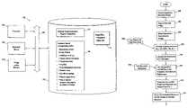
- FIG. 1is a block diagram of a computer system containing in memory a computer program in accordance with the invention.
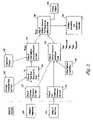
- FIG. 2is a conceptual diagram illustrating the operation of a computer program in accordance with the invention.
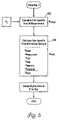
- FIGS. 3-5are flowcharts of steps performed by a computer program operating in accordance with the invention.
- FIG. 6is a conceptual diagram illustrating an alternative embodiment of the invention.
- FIG. 7is a graph illustrating a calculation used in the FIG. 6 embodiment.
- a conventional computer system 100has at least a processor component 102 capable of executing computer program instructions, a memory component 104 for storing programs and data, a user interface device or devices 106 by which a person—a user— may interact with programs running on the system 100 , and an output device or devices 110 such as a printer or a video monitor. These and other components are connected to interact with each other by one or more buses 108 .
- the memory component 104will generally include a volatile random access memory (RAM), a non-volatile read-only memory (ROM), and one or more large disk drives for data and programs storage.
- Residing in memory 104is a software program in accordance with the invention.
- the software programhas program instructions 112 that may be executed to operate on data from various image files 114 and a database 116 of information pertaining to one or more agricultural fields.
- the image files 114may include, in one embodiment of the invention, a satellite image of growing crops taken at a time when the biomass of the crops are at their peak and another satellite image of bare soil taken some time before planting. These images will be discussed in more detail later.
- the database 116may include the following information for each agricultural field: geographic boundaries for the field; crops planted in the field from season-to-season, for example, corn, soybeans, etc.; yield data for these crops; organic matter samplings that have been taken in the field; topographic data, which may be in the form of an elevation map; irrigation data that may include an amount of water irrigated for the crop season; crop management practices; historical weather data; soil nitrate test results; manure applications; and a map of nutrient amounts that need to be added by fertilizer.
- the map of nutrient amounts that need to be added by fertilizer shown in database 116deserves to be highlighted at this point, as it is the data that are produced by the computer program of the present invention.
- This mapcan be printed out in graphic format, or it can be used to create a site-specific fertilizer prescription for the field.
- the site-specific fertilizer prescriptioncan then be downloaded, for example, and used in a conventional manner to control the rate that fertilizer is applied in a field.
- the information contained in database 116will be discussed in more detail later, as that information is discussed in connection with a detailed discussion of the steps in the process of determining site-specific nutrient amounts to be applied to a field divided into multiple sites.
- FIG. 2conceptually the operation of a computer program in accordance with an embodiment of the invention.
- the specific example in FIG. 2pertains to nitrogen, but the general concept of the invention will readily be seen to apply to other soil nutrients, such as phosphorous, potassium, organic fertilizers (e.g., manure), and micronutrients (e.g., Zn and Fe).
- Two remotely sensed imagesare used by the program in this embodiment of the invention.
- the firstis an image of vegetation 120 for the field. This image is acquired, for example, when a previous crop is at or near its biomass peak.
- the second imageis a bare soil image 122 for the field. This image is acquired, for example, prior to planting.
- the computer programcreates a map of biomass measures for the field 124 .
- the measures for biomassmay be, as an example, measures of leaf area index (LAI), using a conventional canopy reflectance model.
- Other measures of biomasscould include a vegetation index derived from visible and near-infrared bands of images at peak biomass, such as NDVI and SVI.
- the map of biomass measures for the field 124and using also a single-value measure for the average historical yield for the field 126 , the computer program creates a map of site-specific yield goal (Y G ) measures for the field 128 .
- Y Gsite-specific yield goal
- biomasshas a direct relationship to yield potential, and so in accordance with the invention, a map of site-specific yield goal measures for the field 128 is created and used in the calculation the fertilizer that is needed to be applied to the field. Then, from the map of yield goal measures for the field 128 , and using also the crop type to be planted 130 given that different crops have different nutrient requirements, the computer program calculates a map of total nutrient amounts required for the field 132 (denoted N CROP using an example of nitrogen being the nutrient) for the particular crop to achieve the site-specific yield goals. As such, the map of total nutrient amounts required for the field 132 represents the amounts of nutrient needed to achieve the maximum possible yield that any particular location is capable of sustaining.
- the lower half of FIG. 2generally depicts the calculations needed to determine the amount of nutrient, in this case nitrogen, that already exists in the soil, or in other words, the nutrient credits.
- the nutrient creditsfor example, N OM , N PREV.CROP , N IRR , N RES.SOIL , and N MANURE —are subtracted from the total amount of nutrient required for the crop (N CROP ).
- the computer programcreates a map of soil brightness measures for the field 134 , using conventional models such as canopy reflectance. Soil brightness is related to organic matter content in the field, and in the case of nitrogen, the organic matter credit N OM .
- the map of soil brightness measures 134enters into the calculation of a map of nutrient amounts existing in the field 136 .
- biomass of a previous year's cropis related to the nutrient credit for that crop (N PREV.CROP ), and so the map of biomass measures for the field 124 also enters into the calculation of the map of nutrient amounts existing in the field 136 .
- Residual soil nutrients, for example, nitrogen (N RES.SOIL ) from previous fertilizer applicationare related to soil organic matter that is derived from soil brightness for the field 136 .
- Other nutrient credit data 138such as information pertaining to irrigation and manure application, also enter into the map of nutrient amounts existing in the field 136 .
- the map of nutrient credits 136are subtracted from the map of total nutrient amounts required 132 to produce a map of nutrient amounts that need to be added to the field 138 .
- the map 138can be printed out in graphic form on printer 140 .
- the map 138can be used, as depicted by block 142 , to calculate yet another map of the amounts of a particular nitrogen-based fertilizer that needs to be added to the field, which in turn would be used to control the application of the fertilizer in a conventional location-based application method.
- FIGS. 3-5are flowcharts that show an example of processing steps that could be used to implement the embodiment of the invention shown in FIG. 2 . It will be understood that many of the steps in the flowchart need not be in the order depicted, while others will need to be in the order indicated because the step is predicated on data calculated in a prior step.
- the processbegins with image acquisition 200 and 202 .
- the time window for the maximum vegetation, or biomass, image acquisition 200is during a crop's last vegetative state, which for example in the U.S. cornbelt is from mid-July to mid-August.
- the biomass image 200may be of the last crop season or any of the last five crop seasons with favorable weather conditions when the image was acquired.
- the biomass imageis preferably a multi-spectral image, including green, red and infrared channels.
- the time window for the bare crop image acquisition 202is during the pre-planting stage, which in the U.S. cornbelt is from April to early May.
- the bare soil imagemay be either a panchromatic (black and white) or a multi-spectral image.
- the imagesare, for example, satellite images acquired by a commercial satellite such as SPOT 1, 2, 4, Landsat TM 5 and 7, or IRS 5 meters. Satellite acquired multi-spectral images will preferably have 30-meter or less spatial resolution. Panchromatic images generally have better resolution on the existing commercial satellites, and so preferably these images will be acquired with 20-meter or less special resolution either from satellite or airborne platforms. It is possible to obtain images from one of a number of commercial vendors, who may need to acquire a particular image that is requested of a customer, or the vendor may already have acquired a requested image.
- One vendorfor example, is SPOT Image Corporation (1897 Preston White Drive, Reston, Va. 20191-4368, United States), who provides images in compact disc (CD) format.
- the imagetypically covers a 120 by 120 square-mile area for Landsat, and 36 by 36 square-mile area for SPOT.
- Multi-spectral images of the above mentioned satellitestypically have an individual pixel size of 30 by 30 square meters, whereas panchromatic images typically have a pixel size of 10 by 10 square meters.
- the software programmay require geo-referencing of the image to a particular coordinate or globally map-projected reference system, such as Universal Transverse Mercator (UTM) with WGS 84 datum within one pixel error.
- UTMUniversal Transverse Mercator
- the imagesmay be accompanied by a scene sensor parameter file that includes absolute calibration values, solar angle, satellite view angle, and relative azimuth angle for each band and each scene of images, which is used, at block 204 , to make an atmospheric correction to the images and, at block 206 , to calculate leaf area index (LAI) for biomass measures.
- the atmospheric correctionmay be done using a relatively simple atmospheric correction algorithm to calculate canopy reflectance to eliminate haze, water vapor, ozone, aerosol, etc. See Kaufmann et al., “Algorithm for automatic atmospheric corrections to visible and near-IR satellite imagery,” Int'l Jnl.
- a map of leaf area indexis calculated from the corrected image using a conventional canopy reflectance or other similar model, for example, as described in Verhoef, 1985 and Kuusk, 1995.
- a model for calculating LAI in this embodimentis also coupled with an inversion procedure that includes a search algorithm to achieve the inversion procedure.
- a search algorithmsearches a look-up table database created by the canopy reflectance model for LAI and other model parameters to “match up” each pixel with a minimum error. The use of such a search algorithm enables the calculation of LAI in an excellent speed.
- a vegetation indexsuch as NDVI and SVI
- An alternative procedurecan be accompanied by using the maximum biomass image to obtain crop information using an image classification method.
- an acquired imagemay include an area of 120 by 120 square miles, and thus include many agricultural fields included in database 116 ( FIG. 1 ). Also, different fields may have different crops planted at the time of image acquisition. Therefore, the processing at block 206 takes this field boundary information and the crop information from each field and uses that to calculate the LAI map for the field.
- a map of soil brightness indexis calculated.
- the soil brightness indexmay be a relatively simple calculation involving the normalization of the bare soil image (either panchromatic or multi-spectral image) into a certain range of numbers.
- the soil brightness indexcan be developed with a soil reflectance model or “soil line” methods. The “soil line” method is to use visible and near infrared bands with a rotation of the multi-spectral data from the origin.
- the maps of LAI and soil brightness index measuresare cut into individual image files for the agricultural fields in database 116 ( FIG. 1 ). To do this field boundary information 214 is again needed. Then at 216 and 218 the LAI and soil brightness index measures are normalized into ranges between 0 and 1 within a field boundary, and values of the measures that fall outside a calculated standard deviation are corrected.
- a map of site-specific yield goal (Y G ) measures for a particular fieldare calculated, based on the map of LAI biomass measures for the field 222 , the particular crop to be planted in the field 224 , and historical yield results for past crops produced in the field 226 .
- the historical yield measure 225 in this embodimentis a single measure for the entire field, though the single measure may be the average yield over the last five crop years.
- the yield goal distribution across a given fieldwill typically be correlated to LAI, as yield goal has the same spatial distribution pattern as LAI across the field.
- the distribution of yield goal measuresmay correspond to at least 90% of the total distribution of the corresponding LAI measures, with each end of the distribution getting 5% cut off.
- Y Gmay be set to be 50 bushels/acre for a location. This is done to guarantee that there will be enough N-based fertilizer for a low elevation spot where there is typically waterlogging in the field in the event that the upcoming growing seasons turns out to be abnormally dry.
- step 226 , 232 , 238 , 242 and 248the nutrient credits are calculated for the agricultural field.
- N OMsite-specific nitrogen (N) credit for organic matter
- N OMaverage field organic matter content
- the average field organic matter content(% of dry weight) measured in the last five-years of soil samples. It may be assumed that the field organic matter content is not changing in the last five years.
- the map of soil brightness measures 230 for the fieldSoil brightness has a known relationship to organic matter content, topography, and soil moisture distribution. A lower soil brightness corresponds to higher soil organic matter content, a lower position in the field's topography, and a relatively higher soil moisture.
- upper and lower limitsmay be set for the distribution of normalized soil brightness and average field organic matter content.
- a site-specific N credit from a previous crop(N PREV.CROP ) is calculated, based on the map of LAI biomass measures for the field 234 and the previous growing season's crop type.
- the most common reason for such a creditis when the previous crop was a crop of soybeans or other legume crops.
- the average N credit for a previous season crop of soybeansmay be 30 pounds/acre because soybeans fix nitrogen in the soil.
- the N credit for a previous soybean cropis also related to the biomass of that crop, and thus the biomass measures 234 enter into the calculation at 232 .
- a flat-rate N credit for having irrigated water(N IRR ) is calculated.
- inputs 240may include, for example, the total amount in inches of irrigated water over a period of time and a number in parts-per-million (ppm) of nitrate N in the water for the particular season and location.
- the average N credit from irrigatedmay be estimated to be 2.7 pound-N/acre-foot per ppm nitrate N. See Havlin, 1999.
- N RES.SOILa site-specific N credit for residual soil
- the number in ppm of average nitrate N for the given fieldmay be calculated based on the previous crop type and management practices, weather conditions, and topography of the field. This information may also be obtained through soil nitrate testing done before fertilizer is applied.
- N RES.SOILis based on normalized values for soil brightness index 244 and average ppm nitrate N from soil nitrate testing 246 . As discussed in connection with other steps, again there may be set upper and lower limits for the distribution of the normalized values.
- the average N creditmay be 3.6 pound-N/ppm nitrate N. See Havlin, 1999.
- a flat-rate N credit for manure(N MANURE ) is calculated, based on inputs 250 of the amount of manure applied per acre and the type of manure applied (for example, from a hog farm or a chicken farm).
- the average N credit for manuremay be 10 pound-N/ton-manure, depending again on the type of manure. See Havlin, 1999.
- the N credit for manure from a chicken farmwould typically be greater than the N credit for manure from a hog farm.
- Manurealso may affect soil nutrients in the following crop seasons depending on the condition of manure decomposition and nutrients removed from soils from crops.
- a site-specific total N requirement(N CROP ) is calculated, based on the site-specific yield goals calculated at 220 ( FIG. 4 ) multiplied by an N conversion factor.
- this map of NCROPrepresents the amount of nitrogen needed to produce the maximum possible yield that the particular location is able to sustain.
- the conversion factormay range, for example, from 1.0 to 1.4 for most U.S. cornbelt soils.
- the N conversion factorpreferably will be dependent on weather conditions and soil properties.
- N FERTsite-specific measures of nitrogen
- the map 128 of yield goal measures for the fieldis created based on a map 324 of soil wetness index (WI) measures for the field, which in turn is calculated based on topography data 320 for the field.
- WIsoil wetness index
- a high wetness index areamay be subjected to excessive soil moisture during parts of the season causing yield reductions by stand reductions, shallow roots and de-nitrification.
- a sub-field area with low wetness indexmay experience yield reductions due to lack of water. The extent to which this will occur depends on the weather that is by nature unpredictable. In a very dry year, for example, the areas of the field with high wetness indices will probably be the best producing area of a field, if not subjected to other factors such as pests and diseases.
- FIG. 6Also shown in FIG. 6 is another alternative to the FIG. 2 embodiment.
- soil electrical conductivity (EC) measurements 322 made in the fieldare used ( FIG. 6 ).
- soil ECpositively correlates to organic matter. Soil EC thus may be used as a surrogate measurement to organic matter and the ability of the soil to supply N during the season.
- the inventionapplies to soil nutrients other than nitrogen.
- the inventionapplies to phosphorous (P), potassium, micronutrients such as Zn and Fe, and organic fertilizer such as manure.
- Pphosphorous
- potassiumpotassium
- micronutrientssuch as Zn and Fe
- organic fertilizersuch as manure.
- the calculationswill of course differ depending on the nutrient, but the inventive aspects remain the same.
- nitrogen existing in soilis in large part depleted or washed away each growing season (except of course, if the crop is soybeans, as noted previously).
- the past management of the field with respect to the particular nutrientwill weigh much more heavily in the calculation of the site-specific amounts of the nutrient that need to be applied to a field.
- the pH of the soildirectly relates to the amount of phosphorous in the soil.
- an implementation of the invention to provide a prescription for phosphorous applicationmay require soil pH samples, although there may be other ways to estimate pH in various locations of a field.
- the phosphorous prescriptionmay also include biomass measures to determine the site-specific maximum possible crop yields for the field. It will be recognized that the invention will be particularly useful to provide a phosphorous prescription in areas where the lack of phosphorous in the soil is a particular problem, such as in areas of Brazil.
Landscapes
- Life Sciences & Earth Sciences (AREA)
- Soil Sciences (AREA)
- Environmental Sciences (AREA)
- Engineering & Computer Science (AREA)
- Mechanical Engineering (AREA)
- Fertilizing (AREA)
- Fertilizers (AREA)
Abstract
Description
NFERT=NCROP−NRES.SOIL−(NOM+NPREV.CROP+NMANURE)−NIRR
- NCROP=yield goal×N yield factor
- NRES.SOIL=preplant soil profile NO3-content (or residual soil)
- NOM=organic N mineralization
- NPREV.CROP=legume N availability
- NMANURE=manure N availability
- NIRR=irrigation water N availability
Havlin et al.,Soil Fertility and Fertilizers, 1999, Prentice Hall, New Jersey, at pages 350-51. The equation above differs from that provided in Havlin et al., in that the equation above factors in the availability of N from irrigation water (NIRR). As discussed by Havlin et al. on page 351, NCROPrepresents the nitrogen required by the crop and involves predicting the crop yield and the nitrogen needed to produce that yield. A measure of “biomass,” which is basically the density or amount of plant-life, is known to be directly related to crop yield. One measure of biomass for crops such as corn and soybeans is known as “leaf area index” (LAI), which can be measured in at least two ways. First, LAI can be measured directly by taking all the crop leaves from a unit field area and measuring in a laboratory the total area of one side of the leaves using an area meter. Another way by which LAI can be derived is from remotely sensed data using a canopy reflectance model. See Kuusk, “A Fast, Invertible Canopy Reflectance Model,” inRemote Sensing of Environment, 51:342-50 (1995); Verhoef, “Light Scattering by Leaf Layers with Application to Canopy Reflectance Modeling: The SAIL Model,” inRemote Sensing of Environment, 16:125-41 (1984). The later method is non-destructive to the crops and suitable for agricultural field management.
W1=1n(As/tan α)
- α=slope angle
See Moore et al., “Soil Attribute Prediction Using Terrain Analysis,” inSoil Sci. Soc. Am. Jnl., 57:443-452 (1993). The wetness index may be considered as an indicator of the probability of soil moisture levels during the season, the higher the wetness index for a given sub-area of a field, the higher the probability that the particular sub-area will experience higher levels of moisture during the season. The yield goal relationship shown inFIG. 7 may be shifted depending if the field is normally subjected to drainage problems (shift to the left) or to the right if the field is located in an upland position with well-drained soils or soils with low water-holding capacity. In fact, in the latter case it is possible that the yield goal would not decrease for high wet indices (dashed line).
- α=slope angle
Claims (25)
Priority Applications (1)
| Application Number | Priority Date | Filing Date | Title |
|---|---|---|---|
| US11/643,647US7343867B2 (en) | 2001-02-28 | 2006-12-21 | Method for prescribing site-specific fertilizer application in agricultural fields |
Applications Claiming Priority (4)
| Application Number | Priority Date | Filing Date | Title |
|---|---|---|---|
| US27215801P | 2001-02-28 | 2001-02-28 | |
| US10/083,681US6889620B2 (en) | 2001-02-28 | 2002-02-26 | Method for prescribing site-specific fertilizer application in agricultural fields |
| US11/085,589US7171912B2 (en) | 2001-02-28 | 2005-03-21 | Method for prescribing site-specific fertilizer application in agricultural fields |
| US11/643,647US7343867B2 (en) | 2001-02-28 | 2006-12-21 | Method for prescribing site-specific fertilizer application in agricultural fields |
Related Parent Applications (1)
| Application Number | Title | Priority Date | Filing Date |
|---|---|---|---|
| US11/085,589ContinuationUS7171912B2 (en) | 2001-02-28 | 2005-03-21 | Method for prescribing site-specific fertilizer application in agricultural fields |
Publications (2)
| Publication Number | Publication Date |
|---|---|
| US20070186830A1 US20070186830A1 (en) | 2007-08-16 |
| US7343867B2true US7343867B2 (en) | 2008-03-18 |
Family
ID=23038658
Family Applications (3)
| Application Number | Title | Priority Date | Filing Date |
|---|---|---|---|
| US10/083,681Expired - Fee RelatedUS6889620B2 (en) | 2001-02-28 | 2002-02-26 | Method for prescribing site-specific fertilizer application in agricultural fields |
| US11/085,589Expired - LifetimeUS7171912B2 (en) | 2001-02-28 | 2005-03-21 | Method for prescribing site-specific fertilizer application in agricultural fields |
| US11/643,647Expired - Fee RelatedUS7343867B2 (en) | 2001-02-28 | 2006-12-21 | Method for prescribing site-specific fertilizer application in agricultural fields |
Family Applications Before (2)
| Application Number | Title | Priority Date | Filing Date |
|---|---|---|---|
| US10/083,681Expired - Fee RelatedUS6889620B2 (en) | 2001-02-28 | 2002-02-26 | Method for prescribing site-specific fertilizer application in agricultural fields |
| US11/085,589Expired - LifetimeUS7171912B2 (en) | 2001-02-28 | 2005-03-21 | Method for prescribing site-specific fertilizer application in agricultural fields |
Country Status (9)
| Country | Link |
|---|---|
| US (3) | US6889620B2 (en) |
| EP (1) | EP1379987A4 (en) |
| CN (1) | CN1505794A (en) |
| AR (1) | AR032918A1 (en) |
| AU (1) | AU2008202110B2 (en) |
| BR (1) | BR0207723A (en) |
| CA (1) | CA2439575C (en) |
| MX (1) | MXPA03007772A (en) |
| WO (1) | WO2002069230A1 (en) |
Cited By (25)
| Publication number | Priority date | Publication date | Assignee | Title |
|---|---|---|---|---|
| US20050246066A1 (en)* | 2004-04-29 | 2005-11-03 | Pursell Technologies, Inc. | Method of predicting fertilizer performance |
| US20070024879A1 (en)* | 2005-07-28 | 2007-02-01 | Eastman Kodak Company | Processing color and panchromatic pixels |
| US20110211109A1 (en)* | 2006-05-22 | 2011-09-01 | Compton John T | Image sensor with improved light sensitivity |
| US20110239918A1 (en)* | 2010-04-04 | 2011-10-06 | Uri Rapoport | Stationary system for gas treatment of top soil to kill plant pests and methods thereof |
| US20110295500A1 (en)* | 2010-05-28 | 2011-12-01 | Gvm, Inc. | System and method for collecting and processing agricultural field data |
| US20120048960A1 (en)* | 2010-08-31 | 2012-03-01 | Valmont Industries, Inc. | Self propelled mechanized irrigation system with a remote visual monitoring system |
| US8139130B2 (en) | 2005-07-28 | 2012-03-20 | Omnivision Technologies, Inc. | Image sensor with improved light sensitivity |
| US20120101784A1 (en)* | 2010-10-25 | 2012-04-26 | Trimble Navigation Limited | Wide-area agricultural monitoring and prediction |
| US8412419B1 (en) | 2009-09-17 | 2013-04-02 | Helena Chemical Company | System for mapping GIS layers |
| US8416339B2 (en) | 2006-10-04 | 2013-04-09 | Omni Vision Technologies, Inc. | Providing multiple video signals from single sensor |
| US8737694B2 (en) | 2011-02-07 | 2014-05-27 | Southern Minnesota Beet Sugar Cooperative | Organic matter mapping using remotely sensed images |
| US8768667B2 (en) | 2010-10-25 | 2014-07-01 | Trimble Navigation Limited | Water erosion management incorporating topography, soil type, and weather statistics |
| US8855937B2 (en) | 2010-10-25 | 2014-10-07 | Trimble Navigation Limited | Crop characteristic estimation |
| US9058633B2 (en) | 2010-10-25 | 2015-06-16 | Trimble Navigation Limited | Wide-area agricultural monitoring and prediction |
| US20150242970A1 (en)* | 2014-02-25 | 2015-08-27 | Pioneer Hi-Bred International, Inc. | Environmental Management Zone Modeling And Analysis |
| US9213905B2 (en) | 2010-10-25 | 2015-12-15 | Trimble Navigation Limited | Automatic obstacle location mapping |
| US9265187B2 (en) | 2013-11-20 | 2016-02-23 | Rowbot Systems Llc | Robotic platform and method for performing multiple functions in agricultural systems |
| US9288938B2 (en) | 2012-06-01 | 2016-03-22 | Rowbot Systems Llc | Robotic platform and method for performing multiple functions in agricultural systems |
| US20160179779A1 (en)* | 2013-09-04 | 2016-06-23 | Nec Solution Innovators, Ltd. | Cultivation assistance device, cultivation assistance method, and recording medium for storing program |
| US9392743B2 (en) | 2013-08-14 | 2016-07-19 | Rowbot Systems Llc | Agricultural autonomous vehicle platform with articulated base |
| US9408342B2 (en) | 2010-10-25 | 2016-08-09 | Trimble Navigation Limited | Crop treatment compatibility |
| US9489576B2 (en) | 2014-03-26 | 2016-11-08 | F12 Solutions, LLC. | Crop stand analysis |
| US10028426B2 (en) | 2015-04-17 | 2018-07-24 | 360 Yield Center, Llc | Agronomic systems, methods and apparatuses |
| WO2018138648A1 (en) | 2017-01-24 | 2018-08-02 | Gamaya Sa | Method and apparatus for recording, processing, visualisation and application of agronomical data |
| US10115158B2 (en) | 2010-10-25 | 2018-10-30 | Trimble Inc. | Generating a crop recommendation |
Families Citing this family (117)
| Publication number | Priority date | Publication date | Assignee | Title |
|---|---|---|---|---|
| US6889620B2 (en)* | 2001-02-28 | 2005-05-10 | The Mosaic Company | Method for prescribing site-specific fertilizer application in agricultural fields |
| US20040032973A1 (en)* | 2002-08-13 | 2004-02-19 | Eastman Kodak Company | Method for using remote imaging to predict quality parameters for agricultural commodities |
| US20050111756A1 (en)* | 2003-11-25 | 2005-05-26 | Turner Robert W. | System and method for generating coherent data sets of images from various sources |
| US7657124B2 (en)* | 2004-02-27 | 2010-02-02 | The Boeing Company | Multiple image data source information processing systems and methods |
| CN1324507C (en)* | 2004-04-12 | 2007-07-04 | 中国科学院合肥智能机械研究所 | Device and method for monitoring growth state of crops and generating nutrition fertilization prescription |
| US20060025927A1 (en)* | 2004-07-27 | 2006-02-02 | Hoskinson Reed L | Method of optimally producing and harvesting agricultural products |
| FI20061153A7 (en)* | 2006-12-22 | 2008-06-23 | Kemira Growhow Oyj | Method, device and system for determining the need for growth aids to promote plant growth |
| WO2009050729A2 (en)* | 2007-06-06 | 2009-04-23 | Tata Consultancy Services Limited | A mobile based advisory system and a method thereof |
| US9585307B2 (en) | 2007-07-03 | 2017-03-07 | Kyle H. Holland | Optical real-time soil sensor and auto-calibration methods |
| US8816262B2 (en) | 2007-07-03 | 2014-08-26 | Kyle H. Holland | Auto-calibration method for real-time agricultural sensors |
| US8319165B2 (en)* | 2007-07-03 | 2012-11-27 | Holland Kyle H | Variable rate chemical management for agricultural landscapes |
| NZ562273A (en) | 2007-10-04 | 2009-11-27 | David Stanley Hoyle | Spreader with GPS guided spread pattern |
| WO2009149384A1 (en)* | 2008-06-06 | 2009-12-10 | Monsanto Technology Llc | Generating agricultural information products using remote sensing |
| FR2940002B1 (en)* | 2008-12-22 | 2013-01-18 | Hexagrain | AGRICULTURAL TRACEABILITY METHOD |
| US8321365B2 (en)* | 2009-04-21 | 2012-11-27 | Deere & Company | Horticultural knowledge base for managing yards and gardens |
| US8028470B2 (en) | 2009-04-21 | 2011-10-04 | Deere & Company | Robotic watering unit |
| US8437879B2 (en)* | 2009-04-21 | 2013-05-07 | Deere & Company | System and method for providing prescribed resources to plants |
| US8150554B2 (en) | 2009-04-21 | 2012-04-03 | Deere & Company | Resource use management in yards and gardens |
| US9538714B2 (en)* | 2009-04-21 | 2017-01-10 | Deere & Company | Managing resource prescriptions of botanical plants |
| JP5425688B2 (en)* | 2010-03-31 | 2014-02-26 | 株式会社日立ソリューションズ | Map-linked fertilization design system |
| US8594375B1 (en)* | 2010-05-20 | 2013-11-26 | Digitalglobe, Inc. | Advanced cloud cover assessment |
| US8321061B2 (en) | 2010-06-17 | 2012-11-27 | Deere & Company | System and method for irrigation using atmospheric water |
| US9357759B2 (en) | 2010-08-20 | 2016-06-07 | Deere & Company | Networked chemical dispersion system |
| US8504234B2 (en) | 2010-08-20 | 2013-08-06 | Deere & Company | Robotic pesticide application |
| US9076105B2 (en) | 2010-08-20 | 2015-07-07 | Deere & Company | Automated plant problem resolution |
| US8594897B2 (en)* | 2010-09-30 | 2013-11-26 | The Curators Of The University Of Missouri | Variable product agrochemicals application management |
| US9872445B2 (en)* | 2010-09-30 | 2018-01-23 | The Toro Company | Turf management |
| US9846848B2 (en) | 2010-10-25 | 2017-12-19 | Trimble Inc. | Exchanging water allocation credits |
| DE102011050877B4 (en)* | 2011-03-04 | 2014-05-22 | Technische Universität München | Method for determining the fertilizer requirement, in particular the nitrogen fertilizer requirement and apparatus for carrying out the method |
| US20120287273A1 (en)* | 2011-05-09 | 2012-11-15 | Abengoa Bioenergia Nuevas Tecnologias, S.A. | System for identifying sustainable geographical areas by remote sensing techniques and method thereof |
| US20120290363A1 (en)* | 2011-05-09 | 2012-11-15 | Abengoa Bioenergia Nuevas Tecnologias, S.A. | Method of monitoring sustainability of bioproducts |
| US9756844B2 (en) | 2011-05-13 | 2017-09-12 | The Climate Corporation | Method and system to map biological pests in agricultural fields using remotely-sensed data for field scouting and targeted chemical application |
| US10096073B2 (en)* | 2011-05-13 | 2018-10-09 | The Climate Corporation | Systems to prescribe and deliver fertilizer over agricultural fields and related methods |
| US9131642B2 (en)* | 2011-05-13 | 2015-09-15 | Hydrobio, Inc. | Method and system to control irrigation across large geographic areas using remote sensing, weather and field level data |
| WO2012156490A1 (en)* | 2011-05-18 | 2012-11-22 | Georg Fritzmeier Gmbh & Co.Kg | Method for determining an amount to be applied and device for carrying out the method |
| CN103930919A (en)* | 2011-10-24 | 2014-07-16 | 天宝导航有限公司 | Agricultural and soil management |
| CN102668899B (en)* | 2012-03-28 | 2015-02-25 | 北京师范大学 | Crop planting mode recognition method |
| US20140321714A1 (en)* | 2013-04-24 | 2014-10-30 | Billy R. Masten | Methods of enhancing agricultural production using spectral and/or spatial fingerprints |
| CA2912449C (en) | 2013-05-13 | 2018-12-04 | Clean Seed Agricultural Technologies Ltd. | A system for variable-ratio blending of multiple agricultural products for delivery via a ported opener |
| US11026362B2 (en) | 2013-08-27 | 2021-06-08 | Amvac Chemical Corporation | System and method for treating individual seeds with liquid chemicals during the planting process |
| US10064327B2 (en) | 2015-07-03 | 2018-09-04 | Amvac Chemical Corporation | Apparatus and method for minimizing the volume of a liquid carrier used for delivering agricultural products into a furrow during planting |
| US11058046B2 (en) | 2013-08-27 | 2021-07-13 | Amvac Chemical Corporation | System and method for dispensing multiple low rate agricultural products |
| US10517206B2 (en) | 2013-08-27 | 2019-12-31 | Amvac Chemical Corporation | System for providing prescriptive application of multiple products |
| US9820431B2 (en) | 2013-08-27 | 2017-11-21 | American Vanguard Corporation | System and process for dispensing multiple and low rate agricultural products |
| US10470356B2 (en) | 2013-08-27 | 2019-11-12 | Amvac Chemical Corporation | System and method for dispensing multiple low rate agricultural products |
| US10058023B2 (en) | 2016-07-13 | 2018-08-28 | Amvac Chemical Corporation | Electronically pulsing agricultural product with seed utilizing seed transport mechanism |
| US9488630B2 (en) | 2013-11-08 | 2016-11-08 | Dow Agrosciences Llc | Integrated remote aerial sensing system |
| EP3107367B1 (en)* | 2014-02-21 | 2023-08-02 | Blue River Technology Inc. | Method and system for in-situ precision calibration of a precision agricultural system to accommodate for a treatment delay |
| CN103810640A (en)* | 2014-02-21 | 2014-05-21 | 孙克 | Mobile phone positioning type soil testing and formulated fertilization service platform implementation method and system |
| CN103914755A (en)* | 2014-03-18 | 2014-07-09 | 北京农业信息技术研究中心 | Method and system for determining spatial scales of field investigation and field management |
| US10474454B2 (en)* | 2014-03-20 | 2019-11-12 | Oracle International Corporation | System and method for updating a trusted application (TA) on a device |
| FR3020876B1 (en)* | 2014-05-06 | 2016-05-06 | Polyor Sarl | DIAGNOSIS OF THE DIAZOTROPHE STATE OF ARABLE SOILS AND RECOMMENDATION OF N FERTILIZER CONTRIBUTIONS |
| WO2015200489A1 (en)* | 2014-06-24 | 2015-12-30 | 360 Yield Center, Llc | Agronomic system, methods and apparatuses |
| US11089773B2 (en) | 2014-08-27 | 2021-08-17 | Premier Crop Systems, LLC | System and method for controlling machinery for randomizing and replicating predetermined argonomic input levels |
| EP3185666B1 (en) | 2014-08-27 | 2019-11-13 | Premier Crop Systems, LLC | System and method for controlling machinery for randomizing and replicating predetermined agronomic input levels |
| US9519861B1 (en)* | 2014-09-12 | 2016-12-13 | The Climate Corporation | Generating digital models of nutrients available to a crop over the course of the crop's development based on weather and soil data |
| US9916505B2 (en)* | 2014-09-22 | 2018-03-13 | Deere & Company | Method and system for collecting image data |
| US9652840B1 (en) | 2014-10-30 | 2017-05-16 | AgriSight, Inc. | System and method for remote nitrogen monitoring and prescription |
| CN104521397B (en)* | 2014-12-18 | 2016-09-21 | 长沙伟诺机电有限公司 | Trees fertilising control method and fertilizer applicator automatic control system |
| US9719973B2 (en)* | 2015-01-05 | 2017-08-01 | Deere & Company | System and method for analyzing the effectiveness of an application to a crop |
| WO2016166383A1 (en)* | 2015-04-13 | 2016-10-20 | Tsb Real Time Location Systems, S.L. | Identifier device |
| CN104732372A (en)* | 2015-04-13 | 2015-06-24 | 成都数云科技有限公司 | Decision support auxiliary system for agricultural product supply chain |
| UA125018C2 (en) | 2015-07-15 | 2021-12-29 | Зе Клаймет Корпорейшн | Generating digital models of nutrients available to a crop over the course of the crop's development based on weather and soil data |
| US9740208B2 (en) | 2015-07-30 | 2017-08-22 | Deere & Company | UAV-based sensing for worksite operations |
| US10628895B2 (en)* | 2015-12-14 | 2020-04-21 | The Climate Corporation | Generating digital models of relative yield of a crop based on nitrate values in the soil |
| CA3016216C (en)* | 2016-03-04 | 2023-05-02 | Nutrien Ag Solutions (Canada) Inc. | System and method for prescribing fertilizer application rates for spatial distribution of a product |
| US10275550B2 (en) | 2016-04-27 | 2019-04-30 | The Climate Corporation | Assimilating a soil sample into a digital nutrient model |
| US11544296B1 (en)* | 2016-09-15 | 2023-01-03 | Winfield Solutions, Llc | Systems and methods for spatially-indexing agricultural content |
| JP6906959B2 (en)* | 2017-01-12 | 2021-07-21 | 東光鉄工株式会社 | Fertilizer spraying method using a drone |
| MX2019014283A (en) | 2017-06-01 | 2021-01-08 | Valmont Industries | System and method for irrigation management using machine learning workflows. |
| UA127761C2 (en) | 2017-07-28 | 2023-12-27 | Кінз Меньюфекчуринг, Інк. | Agricultural implement and row units including double acting actuator systems, methods, and apparatus |
| US11263707B2 (en) | 2017-08-08 | 2022-03-01 | Indigo Ag, Inc. | Machine learning in agricultural planting, growing, and harvesting contexts |
| CN107609695B (en)* | 2017-09-04 | 2018-10-23 | 北京信德智图科技有限公司 | Crop yield remote sensing estimation method based on adjustable vegetation index |
| US11140812B2 (en) | 2017-12-15 | 2021-10-12 | Kinze Manufacturing, Inc. | Systems, methods, and apparatus for controlling downforce of an agricultural implement |
| US11367093B2 (en) | 2018-04-24 | 2022-06-21 | Indigo Ag, Inc. | Satellite-based agricultural modeling |
| WO2019209947A1 (en) | 2018-04-24 | 2019-10-31 | Indigo Ag, Inc. | Interaction management in an online agricultural system |
| CN108521963B (en)* | 2018-05-16 | 2020-06-02 | 吉林省土壤肥料总站 | General accurate model of formula fertilization surveys soil |
| CN108828147B (en)* | 2018-06-14 | 2021-04-20 | 福州大学 | Diamond-shaped bamboo moth hazard detection method coupled with remote sensing response characteristics |
| US11596119B2 (en)* | 2018-08-13 | 2023-03-07 | Climate Llc | Digital nutrient models using spatially distributed values unique to an agronomic field |
| JP7250457B2 (en)* | 2018-08-23 | 2023-04-03 | キヤノン株式会社 | Information processing device, information processing method and program |
| USD908277S1 (en) | 2018-08-25 | 2021-01-19 | Amvac Chemical Corporation | Container for dry products |
| US11382261B2 (en) | 2018-08-28 | 2022-07-12 | Amvac Chemical Corporation | System and method for stacking containers |
| CN113163712B (en) | 2018-08-28 | 2023-03-24 | 艾姆瓦克香港有限公司 | Container system for transporting and dispensing produce |
| CA3106467A1 (en)* | 2018-08-31 | 2020-03-05 | Farmers Edge Inc. | Method and system for estimating effective crop nitrogen applications |
| US10684612B2 (en)* | 2018-10-10 | 2020-06-16 | The Climate Corporation | Agricultural management recommendations based on blended model |
| US11487254B2 (en)* | 2018-12-20 | 2022-11-01 | Climate Llc | Utilizing spatial statistical models for implementing agronomic trials |
| CN110115142A (en)* | 2019-04-25 | 2019-08-13 | 中科赛诺(北京)科技有限公司 | A kind of farmland variable fertilization method based on remotely-sensed data |
| US20220261928A1 (en)* | 2019-07-08 | 2022-08-18 | Indigo Ag, Inc. | Crop yield forecasting models |
| WO2021041666A1 (en) | 2019-08-27 | 2021-03-04 | Indigo Ag, Inc. | Imagery-based boundary identification for agricultural fields |
| US11895941B2 (en) | 2019-09-23 | 2024-02-13 | Cnh Industrial America Llc | Tillage system with variable fertilizer application |
| US11610272B1 (en) | 2020-01-29 | 2023-03-21 | Arva Intelligence Corp. | Predicting crop yield with a crop prediction engine |
| US11704576B1 (en) | 2020-01-29 | 2023-07-18 | Arva Intelligence Corp. | Identifying ground types from interpolated covariates |
| US11715024B1 (en) | 2020-02-20 | 2023-08-01 | Arva Intelligence Corp. | Estimating soil chemistry at different crop field locations |
| US11704581B1 (en) | 2020-01-29 | 2023-07-18 | Arva Intelligence Corp. | Determining crop-yield drivers with multi-dimensional response surfaces |
| CN111328516A (en)* | 2020-04-10 | 2020-06-26 | 厦门精图信息技术有限公司 | Intelligent agricultural service system and method based on high-resolution satellite |
| JP7429964B2 (en)* | 2020-04-27 | 2024-02-09 | 国立研究開発法人農業・食品産業技術総合研究機構 | Base fertilizer amount calculation device, basal fertilizer amount calculation method, and basal fertilizer amount calculation program |
| CA3177357A1 (en) | 2020-05-01 | 2021-11-04 | Christopher Edward Holden | Dynamic data tiling |
| BR112023000950A2 (en) | 2020-07-21 | 2023-03-28 | Indigo Ag Inc | REMOTE SENSING ALGORITHMS FOR MAPPING REGENERATIVE AGRICULTURE |
| US11947355B2 (en) | 2020-10-15 | 2024-04-02 | Topcon Positioning Systems, Inc. | Method and apparatus for zone mapping |
| JP2024501815A (en)* | 2020-12-23 | 2024-01-16 | ビーエーエスエフ アグロ トレードマークス ゲーエムベーハー | Decision system for applying seed products and/or crop nutrition products using soil parameters based on remote sensing |
| CN112840772B (en)* | 2021-01-11 | 2022-03-29 | 河北省农林科学院农业资源环境研究所 | Smart volume fertilizer injection unit of summer maize according to winter wheat stubble volume |
| CN113099804A (en)* | 2021-04-07 | 2021-07-13 | 济宁市农业科学研究院 | Automatic fertilization equipment of maize cultivation based on big data |
| WO2023034118A1 (en) | 2021-08-30 | 2023-03-09 | Indigo Ag, Inc. | Systems for management of location-aware market data |
| WO2023034386A1 (en) | 2021-08-31 | 2023-03-09 | Indigo Ag, Inc. | Systems and methods for ecosystem credit recommendations |
| CN114051810A (en)* | 2021-11-10 | 2022-02-18 | 上海联适导航技术股份有限公司 | Unmanned high-precision agricultural machine fertilization control method and system and intelligent agricultural machine |
| CN114391351A (en)* | 2021-12-29 | 2022-04-26 | 北京市农林科学院信息技术研究中心 | Variable fertilization decision-making method and device |
| IL289666A (en)* | 2022-01-06 | 2023-08-01 | SADEH Yuval | A versatile crop yield estimator |
| NO20220416A1 (en)* | 2022-04-05 | 2023-10-06 | Digifarm As | Methods and systems for estimating crop yield from vegetation index data |
| US12058951B2 (en)* | 2022-04-08 | 2024-08-13 | Deere & Company | Predictive nutrient map and control |
| WO2023250041A1 (en)* | 2022-06-21 | 2023-12-28 | Raven Industries, Inc. | Agricultural slurry applicator |
| CN115349340B (en)* | 2022-09-19 | 2023-05-19 | 沈阳农业大学 | Sorghum fertilization control method and system based on artificial intelligence |
| CN115443780B (en)* | 2022-10-24 | 2023-06-23 | 西北农林科技大学 | Dry land wheat zinc fertilizer application method based on soil zinc content and human zinc demand |
| CN116108318B (en)* | 2023-04-06 | 2023-06-13 | 华中农业大学 | Rape nitrogen fertilizer recommended dressing amount calculation method based on unmanned aerial vehicle multispectral image |
| US12008447B1 (en)* | 2023-04-18 | 2024-06-11 | Advanced Agrilytics Holdings, Llc | Methods and systems for sub-field soil nutrient management |
| CN116686510A (en)* | 2023-07-21 | 2023-09-05 | 云南省烟草公司昆明市公司 | Soil testing formula fertilization method for improving growth and nutrient uniformity of flue-cured tobacco in continuous zone |
| CN117957997B (en)* | 2024-04-02 | 2024-05-28 | 洛阳展尚建筑工程有限公司 | Automatic fertilization method for garden trees |
| CN119672615B (en)* | 2025-02-19 | 2025-05-13 | 西昌学院 | Tobacco pest and disease damage identification method and system |
Citations (33)
| Publication number | Priority date | Publication date | Assignee | Title |
|---|---|---|---|---|
| US3852750A (en) | 1972-10-16 | 1974-12-03 | Communications Satellite Corp | Navigation satellite system |
| US4013875A (en) | 1974-01-11 | 1977-03-22 | Mcglynn Daniel R | Vehicle operation control system |
| US4479444A (en) | 1982-09-30 | 1984-10-30 | Ag-Chem Equipment Co., Inc. | Manometer apparatus and system for distribution of liquid fertilizers |
| US4630773A (en) | 1984-11-06 | 1986-12-23 | Soil Teq., Inc. | Method and apparatus for spreading fertilizer |
| US4984279A (en) | 1989-01-04 | 1991-01-08 | Emyville Enterprises Limited | Image processing and map production systems |
| US5033397A (en) | 1990-07-31 | 1991-07-23 | Aguila Corporation | Soil chemical sensor and precision agricultural chemical delivery system and method |
| US5220876A (en) | 1992-06-22 | 1993-06-22 | Ag-Chem Equipment Co., Inc. | Variable rate application system |
| US5323317A (en) | 1991-03-05 | 1994-06-21 | Hampton Terry L | Method and apparatus for determining runoff using remote geographic sensing |
| US5355815A (en) | 1993-03-19 | 1994-10-18 | Ag-Chem Equipment Co., Inc. | Closed-loop variable rate applicator |
| US5479992A (en) | 1993-07-27 | 1996-01-02 | Dawn Equipment Company | Agricultural implement controller to compensate for soil hardness variation |
| US5519609A (en) | 1993-06-30 | 1996-05-21 | Black & Veatch | Biosolids tracking system |
| US5668719A (en) | 1994-08-05 | 1997-09-16 | Tyler Limited Partnership | Method of fertilizer application and field treatment |
| US5673637A (en) | 1991-07-22 | 1997-10-07 | Crop Technology, Inc. | Soil constituent sensor and precision agrichemical delivery system and method |
| US5721679A (en) | 1995-12-18 | 1998-02-24 | Ag-Chem Equipment Co., Inc. | Heads-up display apparatus for computer-controlled agricultural product application equipment |
| US5841282A (en) | 1997-02-10 | 1998-11-24 | Christy; Colin | Device for measuring soil conductivity |
| US5845229A (en) | 1996-10-28 | 1998-12-01 | Appropriate Systems | Method and apparatus for mapping crop quality |
| US5955973A (en) | 1993-12-30 | 1999-09-21 | Concord, Inc. | Field navigation system |
| US6070539A (en) | 1997-03-21 | 2000-06-06 | Case Corporation | Variable rate agricultural product application implement with multiple inputs and feedback |
| US6091997A (en) | 1997-09-23 | 2000-07-18 | Case Corporation | Enhanced statistical/status display |
| US6122581A (en) | 1997-09-30 | 2000-09-19 | Ag-Chem Equipment Co., Inc. | Multi-variable rate dispensing system for agricultural machine |
| US6138590A (en) | 1987-07-21 | 2000-10-31 | Aguila Corporation | Soil constituent sensor and precision agrichemical delivery system and method |
| US6141614A (en) | 1998-07-16 | 2000-10-31 | Caterpillar Inc. | Computer-aided farming system and method |
| US6216614B1 (en) | 1999-04-28 | 2001-04-17 | Ag-Chem Equipment Co., Inc. | Boom dispensing point control system |
| US6236907B1 (en) | 1995-05-30 | 2001-05-22 | Ag-Chem Equipment Co., Inc. | System and method for creating agricultural decision and application maps for automated agricultural machines |
| US6266432B1 (en) | 1998-10-22 | 2001-07-24 | Centrak, Llc | User modifiable land management zones for the variable application of substances thereto |
| US6266595B1 (en) | 1999-08-12 | 2001-07-24 | Martin W. Greatline | Method and apparatus for prescription application of products to an agricultural field |
| US6389999B1 (en) | 2001-11-02 | 2002-05-21 | Dennis Duello | Dynamic controller of excess downpressure for surface engaging implement |
| US6393927B1 (en) | 1995-03-24 | 2002-05-28 | Li-Cor, Inc. | Method and apparatus for real-time determination and application of nitrogen fertilizer using rapid, non-destructive crop canopy measurements |
| US6484652B1 (en) | 1991-07-22 | 2002-11-26 | Crop Technology, Inc. | Soil constituent sensor and precision agrichemical delivery system and method |
| US6549852B2 (en) | 2001-07-13 | 2003-04-15 | Mzb Technologies, Llc | Methods and systems for managing farmland |
| US6570999B1 (en) | 1998-08-17 | 2003-05-27 | Ag-Chem Equipment Co., Inc. | Soil particle and soil analysis system |
| US6792684B1 (en) | 1999-10-28 | 2004-09-21 | Diware Oy | Method for determination of stand attributes and a computer program to perform the method |
| US6889620B2 (en) | 2001-02-28 | 2005-05-10 | The Mosaic Company | Method for prescribing site-specific fertilizer application in agricultural fields |
Family Cites Families (3)
| Publication number | Priority date | Publication date | Assignee | Title |
|---|---|---|---|---|
| US6266549B1 (en)* | 1993-12-06 | 2001-07-24 | Heska Corporation | Apparatus and method for evaluating cardiac functions |
| US5630773A (en)* | 1996-02-02 | 1997-05-20 | Eaton Corporation | Method and apparatus for slip mode control of automatic clutch |
| JP4853935B2 (en)* | 2000-09-01 | 2012-01-11 | 日立マクセルエナジー株式会社 | Alkaline battery |
- 2002
- 2002-02-26USUS10/083,681patent/US6889620B2/ennot_activeExpired - Fee Related
- 2002-02-28WOPCT/US2002/006321patent/WO2002069230A1/ennot_activeApplication Discontinuation
- 2002-02-28CACA002439575Apatent/CA2439575C/ennot_activeExpired - Lifetime
- 2002-02-28EPEP02709751Apatent/EP1379987A4/ennot_activeWithdrawn
- 2002-02-28ARARP020100724Apatent/AR032918A1/enactiveIP Right Grant
- 2002-02-28MXMXPA03007772Apatent/MXPA03007772A/enunknown
- 2002-02-28BRBR0207723-0Apatent/BR0207723A/ennot_activeApplication Discontinuation
- 2002-02-28CNCNA02808912XApatent/CN1505794A/enactivePending
- 2005
- 2005-03-21USUS11/085,589patent/US7171912B2/ennot_activeExpired - Lifetime
- 2006
- 2006-12-21USUS11/643,647patent/US7343867B2/ennot_activeExpired - Fee Related
- 2008
- 2008-05-13AUAU2008202110Apatent/AU2008202110B2/ennot_activeExpired
Patent Citations (34)
| Publication number | Priority date | Publication date | Assignee | Title |
|---|---|---|---|---|
| US3852750A (en) | 1972-10-16 | 1974-12-03 | Communications Satellite Corp | Navigation satellite system |
| US4013875A (en) | 1974-01-11 | 1977-03-22 | Mcglynn Daniel R | Vehicle operation control system |
| US4479444A (en) | 1982-09-30 | 1984-10-30 | Ag-Chem Equipment Co., Inc. | Manometer apparatus and system for distribution of liquid fertilizers |
| US4630773A (en) | 1984-11-06 | 1986-12-23 | Soil Teq., Inc. | Method and apparatus for spreading fertilizer |
| US6138590A (en) | 1987-07-21 | 2000-10-31 | Aguila Corporation | Soil constituent sensor and precision agrichemical delivery system and method |
| US4984279A (en) | 1989-01-04 | 1991-01-08 | Emyville Enterprises Limited | Image processing and map production systems |
| US5033397A (en) | 1990-07-31 | 1991-07-23 | Aguila Corporation | Soil chemical sensor and precision agricultural chemical delivery system and method |
| US5323317A (en) | 1991-03-05 | 1994-06-21 | Hampton Terry L | Method and apparatus for determining runoff using remote geographic sensing |
| US6484652B1 (en) | 1991-07-22 | 2002-11-26 | Crop Technology, Inc. | Soil constituent sensor and precision agrichemical delivery system and method |
| US5673637A (en) | 1991-07-22 | 1997-10-07 | Crop Technology, Inc. | Soil constituent sensor and precision agrichemical delivery system and method |
| US5220876A (en) | 1992-06-22 | 1993-06-22 | Ag-Chem Equipment Co., Inc. | Variable rate application system |
| US5355815A (en) | 1993-03-19 | 1994-10-18 | Ag-Chem Equipment Co., Inc. | Closed-loop variable rate applicator |
| US5519609A (en) | 1993-06-30 | 1996-05-21 | Black & Veatch | Biosolids tracking system |
| US5479992A (en) | 1993-07-27 | 1996-01-02 | Dawn Equipment Company | Agricultural implement controller to compensate for soil hardness variation |
| US5955973A (en) | 1993-12-30 | 1999-09-21 | Concord, Inc. | Field navigation system |
| US5668719A (en) | 1994-08-05 | 1997-09-16 | Tyler Limited Partnership | Method of fertilizer application and field treatment |
| US6393927B1 (en) | 1995-03-24 | 2002-05-28 | Li-Cor, Inc. | Method and apparatus for real-time determination and application of nitrogen fertilizer using rapid, non-destructive crop canopy measurements |
| US6236907B1 (en) | 1995-05-30 | 2001-05-22 | Ag-Chem Equipment Co., Inc. | System and method for creating agricultural decision and application maps for automated agricultural machines |
| US6606542B2 (en) | 1995-05-30 | 2003-08-12 | Agco Corporation | System and method for creating agricultural decision and application maps for automated agricultural machines |
| US5721679A (en) | 1995-12-18 | 1998-02-24 | Ag-Chem Equipment Co., Inc. | Heads-up display apparatus for computer-controlled agricultural product application equipment |
| US5845229A (en) | 1996-10-28 | 1998-12-01 | Appropriate Systems | Method and apparatus for mapping crop quality |
| US5841282A (en) | 1997-02-10 | 1998-11-24 | Christy; Colin | Device for measuring soil conductivity |
| US6070539A (en) | 1997-03-21 | 2000-06-06 | Case Corporation | Variable rate agricultural product application implement with multiple inputs and feedback |
| US6091997A (en) | 1997-09-23 | 2000-07-18 | Case Corporation | Enhanced statistical/status display |
| US6122581A (en) | 1997-09-30 | 2000-09-19 | Ag-Chem Equipment Co., Inc. | Multi-variable rate dispensing system for agricultural machine |
| US6141614A (en) | 1998-07-16 | 2000-10-31 | Caterpillar Inc. | Computer-aided farming system and method |
| US6570999B1 (en) | 1998-08-17 | 2003-05-27 | Ag-Chem Equipment Co., Inc. | Soil particle and soil analysis system |
| US6266432B1 (en) | 1998-10-22 | 2001-07-24 | Centrak, Llc | User modifiable land management zones for the variable application of substances thereto |
| US6216614B1 (en) | 1999-04-28 | 2001-04-17 | Ag-Chem Equipment Co., Inc. | Boom dispensing point control system |
| US6266595B1 (en) | 1999-08-12 | 2001-07-24 | Martin W. Greatline | Method and apparatus for prescription application of products to an agricultural field |
| US6792684B1 (en) | 1999-10-28 | 2004-09-21 | Diware Oy | Method for determination of stand attributes and a computer program to perform the method |
| US6889620B2 (en) | 2001-02-28 | 2005-05-10 | The Mosaic Company | Method for prescribing site-specific fertilizer application in agricultural fields |
| US6549852B2 (en) | 2001-07-13 | 2003-04-15 | Mzb Technologies, Llc | Methods and systems for managing farmland |
| US6389999B1 (en) | 2001-11-02 | 2002-05-21 | Dennis Duello | Dynamic controller of excess downpressure for surface engaging implement |
Non-Patent Citations (8)
| Title |
|---|
| Kaufman et al.., "Algorithm for automatic atmospheric corrections to visible and near-IR satellite imagery," Int. J. Remote Sensing, 9(8):1357-1381 (1988). |
| Kuusk, "A Fast, Invertible Canopy Reflectance Model," Remote Sensing of Environment, 51:342-50 (1995). |
| Mathot, H., "Challenges Facing the Fertilizer Industry," IFA-FAO Agriculture Conference, 19 pgs., found on http://www.fertilizer.org/ifa/publicat/PDF/2003<SUB>-</SUB>rome<SUB>-</SUB>mathot.pdf#search=%22insite%20vrn%22, Rome, Italy Mar. 26-28, 2003. |
| Moore et al., "Soil Attribute Prediction Using Terrain Analysis," Soil Sci. Soc. Am. J., 57:443-452 (1993). |
| Richter, "A fast atmospheric correction algorithm applied to Landsat TM images," Int. J. of Remote Sensing, 11:159-166 (1990). |
| Richter, "Correction of atmospheric and topographic effects for high spatial resolution satellite imagery," Int. J. of Remote Sensing, 18(5):1099-1111 (1997). |
| Tisdale et al., "Soil Fertility and Fertilizers", Fifth Edition, 1993, Pretice Hall, Inc. Upper Saddle river, New Jersey, pp. 350-351. |
| Verhoef, "Light Scattering by Leaf Layers with Application to Canopy Reflectance Modeling: The SAIL Model," Remote Sensing of Environment, 16:125-41 (1984). |
Cited By (40)
| Publication number | Priority date | Publication date | Assignee | Title |
|---|---|---|---|---|
| US20050246066A1 (en)* | 2004-04-29 | 2005-11-03 | Pursell Technologies, Inc. | Method of predicting fertilizer performance |
| US20070024879A1 (en)* | 2005-07-28 | 2007-02-01 | Eastman Kodak Company | Processing color and panchromatic pixels |
| US8139130B2 (en) | 2005-07-28 | 2012-03-20 | Omnivision Technologies, Inc. | Image sensor with improved light sensitivity |
| US8711452B2 (en) | 2005-07-28 | 2014-04-29 | Omnivision Technologies, Inc. | Processing color and panchromatic pixels |
| US8274715B2 (en)* | 2005-07-28 | 2012-09-25 | Omnivision Technologies, Inc. | Processing color and panchromatic pixels |
| US8330839B2 (en) | 2005-07-28 | 2012-12-11 | Omnivision Technologies, Inc. | Image sensor with improved light sensitivity |
| US20110211109A1 (en)* | 2006-05-22 | 2011-09-01 | Compton John T | Image sensor with improved light sensitivity |
| US8194296B2 (en) | 2006-05-22 | 2012-06-05 | Omnivision Technologies, Inc. | Image sensor with improved light sensitivity |
| US8416339B2 (en) | 2006-10-04 | 2013-04-09 | Omni Vision Technologies, Inc. | Providing multiple video signals from single sensor |
| US8412419B1 (en) | 2009-09-17 | 2013-04-02 | Helena Chemical Company | System for mapping GIS layers |
| US20110239918A1 (en)* | 2010-04-04 | 2011-10-06 | Uri Rapoport | Stationary system for gas treatment of top soil to kill plant pests and methods thereof |
| US8850996B2 (en)* | 2010-04-04 | 2014-10-07 | Uri Rapoport | Stationary system for gas treatment of top soil to kill plant pests and methods thereof |
| US8897973B2 (en)* | 2010-05-28 | 2014-11-25 | Agjunction Llc | System and method for collecting and processing agricultural field data |
| US8521372B2 (en)* | 2010-05-28 | 2013-08-27 | Agjunction Llc | System and method for collecting and processing agricultural field data |
| US20110295500A1 (en)* | 2010-05-28 | 2011-12-01 | Gvm, Inc. | System and method for collecting and processing agricultural field data |
| US8437498B2 (en)* | 2010-08-31 | 2013-05-07 | Valmont Industries Inc. | Self propelled mechanized irrigation system with a remote visual monitoring system |
| US20120048960A1 (en)* | 2010-08-31 | 2012-03-01 | Valmont Industries, Inc. | Self propelled mechanized irrigation system with a remote visual monitoring system |
| US20120101784A1 (en)* | 2010-10-25 | 2012-04-26 | Trimble Navigation Limited | Wide-area agricultural monitoring and prediction |
| US8768667B2 (en) | 2010-10-25 | 2014-07-01 | Trimble Navigation Limited | Water erosion management incorporating topography, soil type, and weather statistics |
| US8855937B2 (en) | 2010-10-25 | 2014-10-07 | Trimble Navigation Limited | Crop characteristic estimation |
| US9058633B2 (en) | 2010-10-25 | 2015-06-16 | Trimble Navigation Limited | Wide-area agricultural monitoring and prediction |
| US10115158B2 (en) | 2010-10-25 | 2018-10-30 | Trimble Inc. | Generating a crop recommendation |
| US9213905B2 (en) | 2010-10-25 | 2015-12-15 | Trimble Navigation Limited | Automatic obstacle location mapping |
| US9408342B2 (en) | 2010-10-25 | 2016-08-09 | Trimble Navigation Limited | Crop treatment compatibility |
| US8737694B2 (en) | 2011-02-07 | 2014-05-27 | Southern Minnesota Beet Sugar Cooperative | Organic matter mapping using remotely sensed images |
| US9288938B2 (en) | 2012-06-01 | 2016-03-22 | Rowbot Systems Llc | Robotic platform and method for performing multiple functions in agricultural systems |
| US10123473B2 (en) | 2012-06-01 | 2018-11-13 | Rowbot Systems Llc | Robotic platform and method for performing multiple functions in agricultural systems |
| US9392743B2 (en) | 2013-08-14 | 2016-07-19 | Rowbot Systems Llc | Agricultural autonomous vehicle platform with articulated base |
| US20160179779A1 (en)* | 2013-09-04 | 2016-06-23 | Nec Solution Innovators, Ltd. | Cultivation assistance device, cultivation assistance method, and recording medium for storing program |
| US9265187B2 (en) | 2013-11-20 | 2016-02-23 | Rowbot Systems Llc | Robotic platform and method for performing multiple functions in agricultural systems |
| US10890912B2 (en) | 2013-11-20 | 2021-01-12 | Rowbot Systems Llc | Robotic platform and method for performing multiple functions in agricultural systems |
| US10528048B2 (en) | 2013-11-20 | 2020-01-07 | Rowbot Systems Llc | Robotic platform and method for performing multiple functions in agricultural systems |
| US20150242970A1 (en)* | 2014-02-25 | 2015-08-27 | Pioneer Hi-Bred International, Inc. | Environmental Management Zone Modeling And Analysis |
| US10387977B2 (en)* | 2014-02-25 | 2019-08-20 | Pioneer Hi-Bred International, Inc. | Environmental management zone modeling and analysis |
| US10832359B2 (en) | 2014-02-25 | 2020-11-10 | Pioneer Hi-Bred International, Inc. | Environmental management zone modeling and analysis |
| US11341591B2 (en) | 2014-02-25 | 2022-05-24 | Pioneer Hi-Bred International, Inc. | Environmental management zone modeling and analysis |
| US11625798B2 (en) | 2014-02-25 | 2023-04-11 | Pioneer Hi-Bred International, Inc. | Environmental management zone modeling and analysis |
| US9489576B2 (en) | 2014-03-26 | 2016-11-08 | F12 Solutions, LLC. | Crop stand analysis |
| US10028426B2 (en) | 2015-04-17 | 2018-07-24 | 360 Yield Center, Llc | Agronomic systems, methods and apparatuses |
| WO2018138648A1 (en) | 2017-01-24 | 2018-08-02 | Gamaya Sa | Method and apparatus for recording, processing, visualisation and application of agronomical data |
Also Published As
| Publication number | Publication date |
|---|---|
| US7171912B2 (en) | 2007-02-06 |
| EP1379987A4 (en) | 2006-08-09 |
| EP1379987A1 (en) | 2004-01-14 |
| AR032918A1 (en) | 2003-12-03 |
| CA2439575C (en) | 2008-02-19 |
| US20050165552A1 (en) | 2005-07-28 |
| CN1505794A (en) | 2004-06-16 |
| AU2008202110A1 (en) | 2008-06-05 |
| AU2008202110B2 (en) | 2011-03-03 |
| MXPA03007772A (en) | 2004-11-12 |
| US20070186830A1 (en) | 2007-08-16 |
| US20030019408A1 (en) | 2003-01-30 |
| CA2439575A1 (en) | 2002-09-06 |
| WO2002069230A8 (en) | 2002-10-10 |
| BR0207723A (en) | 2004-12-28 |
| WO2002069230A1 (en) | 2002-09-06 |
| US6889620B2 (en) | 2005-05-10 |
Similar Documents
| Publication | Publication Date | Title |
|---|---|---|
| US7343867B2 (en) | Method for prescribing site-specific fertilizer application in agricultural fields | |
| Kayad et al. | Ten years of corn yield dynamics at field scale under digital agriculture solutions: A case study from North Italy | |
| CN111399508B (en) | Intelligent agriculture system and intelligent agriculture method | |
| US8319165B2 (en) | Variable rate chemical management for agricultural landscapes | |
| CA2392962C (en) | Methods and systems for managing farmland | |
| US7723660B2 (en) | Sensor-based chemical management for agricultural landscapes | |
| US9652691B2 (en) | Method of predicting crop yield loss due to N-deficiency | |
| Munnaf et al. | Map-based site-specific seeding of consumption potato production using high-resolution soil and crop data fusion | |
| BR112021010533A2 (en) | Predictive script generation for soybeans | |
| US9508007B2 (en) | Method of predicting crop yield loss due to N-deficiency | |
| Munnaf et al. | Site-specific seeding for maize production using management zone maps delineated with multi-sensors data fusion scheme | |
| WO2022175236A1 (en) | Remote soil and vegetation properties determination method and system | |
| Fieuzal et al. | Estimation of sunflower yield using a simplified agrometeorological model controlled by optical and SAR satellite data | |
| Schneider | Assimilating remote sensing data into a land-surface process model | |
| Alvarez | Croplands in the Pampas of Argentina will become an atmospheric carbon sink in coming decades | |
| Charvát et al. | Delineation of Management Zones Using Satellite Imageries | |
| AU2002244220A1 (en) | Computer specified fertilizer application for agricultural fields | |
| Seidl et al. | Integrating remotely sensed images with a soybean model to improve spatial yield simulation | |
| Mesterházi | Development of measurement technique for GPS-aided plant production | |
| HK1066890A (en) | Computer specified fertilizer application for agricultural fields | |
| Keyes | Yield prediction using remote sensing techniques for variable rate nitrogen and seeding in Ontario dry bean production systems | |
| Duchemin et al. | Estimating cereal evapotranspiration using a simple model driven by satellite data | |
| Charvát et al. | Delineation of management zones by using satellite imagery | |
| Schepers | Site-specific Nitrogen Management for Irrigated Corn | |
| MESTERHÁZI | Faculty of Agricultural and Food Sciences, Mosonmagyaróvár |
Legal Events
| Date | Code | Title | Description |
|---|---|---|---|
| AS | Assignment | Owner name:THE MOSAIC COMPANY, MINNESOTA Free format text:ASSIGNMENT OF ASSIGNORS INTEREST;ASSIGNOR:CARGILL INCORPORATED;REEL/FRAME:020372/0125 Effective date:20041022 | |
| STCF | Information on status: patent grant | Free format text:PATENTED CASE | |
| FPAY | Fee payment | Year of fee payment:4 | |
| AS | Assignment | Owner name:FARMERS EDGE PRECISION CONSULTING INC., CANADA Free format text:ASSIGNMENT OF ASSIGNORS INTEREST;ASSIGNOR:MOS HOLDINGS INC.;REEL/FRAME:030778/0884 Effective date:20130613 | |
| AS | Assignment | Owner name:MOS HOLDINGS INC., MINNESOTA Free format text:MERGER;ASSIGNORS:GNS MERGER SUB LLC;THE MOSAIC COMPANY;REEL/FRAME:030804/0079 Effective date:20110524 | |
| AS | Assignment | Owner name:FARMER'S EDGE PRECISION CONSULTING INC., CANADA Free format text:CORRECTIVE ASSIGNMENT TO CORRECT THE FARMERS EDGE PRECISION CONSULTING INC. PREVIOUSLY RECORDED ON REEL 030778 FRAME 0884. ASSIGNOR(S) HEREBY CONFIRMS THE FARMER'S EDGE PRECISION CONSULTING INC.;ASSIGNOR:MOS HOLDINGS INC.;REEL/FRAME:031957/0126 Effective date:20130613 | |
| IPR | Aia trial proceeding filed before the patent and appeal board: inter partes review | Free format text:TRIAL NO: IPR2015-00711 Opponent name:GEOSYS-INTL, INC. Effective date:20150218 | |
| AS | Assignment | Owner name:FARMER'S EDGE INC., CANADA Free format text:MERGER AND CHANGE OF NAME;ASSIGNORS:FARMER'S EDGE PRECISION CONSULTING INC.;FARMER'S EDGE INC.;REEL/FRAME:036071/0001 Effective date:20140821 | |
| AS | Assignment | Owner name:OSMINGTON INC., CANADA Free format text:SECURITY INTEREST;ASSIGNOR:FARMERS EDGE INC.;REEL/FRAME:036269/0400 Effective date:20150717 Owner name:FARMERS EDGE INC., CANADA Free format text:CORRECTIVE ASSIGNMENT TO CORRECT THE INCORRECT PATENT NO. 7373867 PREVIOUSLY RECORDED AT REEL: 036071 FRAME: 0001. ASSIGNOR(S) HEREBY CONFIRMS THE CHANGE OF NAME;ASSIGNOR:FARMER'S EDGE PRECISION CONSULTING INC.;REEL/FRAME:036303/0518 Effective date:20140821 | |
| FPAY | Fee payment | Year of fee payment:8 | |
| AS | Assignment | Owner name:FARMERS EDGE INC., CANADA Free format text:RELEASE BY SECURED PARTY;ASSIGNOR:OSMINGTON INC.;REEL/FRAME:037559/0748 Effective date:20160106 | |
| IPRC | Trial and appeal board: inter partes review certificate | Kind code of ref document:K1 Free format text:INTER PARTES REVIEW CERTIFICATE; TRIAL NO. IPR2015-00711, FEB. 18, 2015INTER PARTES REVIEW CERTIFICATE FOR PATENT 7,343,867, ISSUED MAR. 18, 2008, APPL. NO. 11/643,647, DEC. 21, 2006INTER PARTES REVIEW CERTIFICATE ISSUED FEB. 9, 2018 Effective date:20180209 | |
| FEPP | Fee payment procedure | Free format text:MAINTENANCE FEE REMINDER MAILED (ORIGINAL EVENT CODE: REM.); ENTITY STATUS OF PATENT OWNER: LARGE ENTITY | |
| LAPS | Lapse for failure to pay maintenance fees | Free format text:PATENT EXPIRED FOR FAILURE TO PAY MAINTENANCE FEES (ORIGINAL EVENT CODE: EXP.); ENTITY STATUS OF PATENT OWNER: LARGE ENTITY | |
| STCH | Information on status: patent discontinuation | Free format text:PATENT EXPIRED DUE TO NONPAYMENT OF MAINTENANCE FEES UNDER 37 CFR 1.362 | |
| FP | Lapsed due to failure to pay maintenance fee | Effective date:20200318 |