US7339496B2 - Geographic data transmitting method, information delivering apparatus and information terminal - Google Patents
Geographic data transmitting method, information delivering apparatus and information terminalDownload PDFInfo
- Publication number
- US7339496B2 US7339496B2US10/529,886US52988605AUS7339496B2US 7339496 B2US7339496 B2US 7339496B2US 52988605 AUS52988605 AUS 52988605AUS 7339496 B2US7339496 B2US 7339496B2
- Authority
- US
- United States
- Prior art keywords
- map data
- road
- data
- map
- recommended route
- Prior art date
- Legal status (The legal status is an assumption and is not a legal conclusion. Google has not performed a legal analysis and makes no representation as to the accuracy of the status listed.)
- Expired - Fee Related, expires
Links
- 238000000034methodMethods0.000titleclaimsdescription44
- 230000005540biological transmissionEffects0.000claimsdescription51
- 239000000446fuelSubstances0.000claimsdescription4
- 238000012545processingMethods0.000description38
- 238000004891communicationMethods0.000description29
- 230000009467reductionEffects0.000description8
- 230000004044responseEffects0.000description7
- 102220637010Actin-like protein 7A_S10T_mutationHuman genes0.000description5
- 238000010586diagramMethods0.000description5
- 238000010295mobile communicationMethods0.000description5
- 230000008901benefitEffects0.000description4
- 230000008859changeEffects0.000description3
- 238000009434installationMethods0.000description3
- 102200048773rs2224391Human genes0.000description3
- 238000001514detection methodMethods0.000description2
- 238000013459approachMethods0.000description1
- 238000004422calculation algorithmMethods0.000description1
- 238000004364calculation methodMethods0.000description1
- 230000001010compromised effectEffects0.000description1
- 238000004590computer programMethods0.000description1
- 238000013075data extractionMethods0.000description1
- 230000008030eliminationEffects0.000description1
- 238000003379elimination reactionMethods0.000description1
- 238000005516engineering processMethods0.000description1
- 239000000284extractSubstances0.000description1
- 230000006870functionEffects0.000description1
- 238000010348incorporationMethods0.000description1
- 230000002093peripheral effectEffects0.000description1
- 230000000717retained effectEffects0.000description1
Images


Classifications
- G—PHYSICS
- G01—MEASURING; TESTING
- G01C—MEASURING DISTANCES, LEVELS OR BEARINGS; SURVEYING; NAVIGATION; GYROSCOPIC INSTRUMENTS; PHOTOGRAMMETRY OR VIDEOGRAMMETRY
- G01C21/00—Navigation; Navigational instruments not provided for in groups G01C1/00 - G01C19/00
- G01C21/38—Electronic maps specially adapted for navigation; Updating thereof
- G01C21/3885—Transmission of map data to client devices; Reception of map data by client devices
- G01C21/3889—Transmission of selected map data, e.g. depending on route
- G—PHYSICS
- G01—MEASURING; TESTING
- G01C—MEASURING DISTANCES, LEVELS OR BEARINGS; SURVEYING; NAVIGATION; GYROSCOPIC INSTRUMENTS; PHOTOGRAMMETRY OR VIDEOGRAMMETRY
- G01C21/00—Navigation; Navigational instruments not provided for in groups G01C1/00 - G01C19/00
- G01C21/38—Electronic maps specially adapted for navigation; Updating thereof
- G01C21/3804—Creation or updating of map data
- G01C21/3807—Creation or updating of map data characterised by the type of data
- G01C21/3815—Road data
- G01C21/3819—Road shape data, e.g. outline of a route
- G—PHYSICS
- G01—MEASURING; TESTING
- G01C—MEASURING DISTANCES, LEVELS OR BEARINGS; SURVEYING; NAVIGATION; GYROSCOPIC INSTRUMENTS; PHOTOGRAMMETRY OR VIDEOGRAMMETRY
- G01C21/00—Navigation; Navigational instruments not provided for in groups G01C1/00 - G01C19/00
- G01C21/38—Electronic maps specially adapted for navigation; Updating thereof
- G01C21/3863—Structures of map data
- G01C21/387—Organisation of map data, e.g. version management or database structures
- G01C21/3878—Hierarchical structures, e.g. layering
- G—PHYSICS
- G01—MEASURING; TESTING
- G01C—MEASURING DISTANCES, LEVELS OR BEARINGS; SURVEYING; NAVIGATION; GYROSCOPIC INSTRUMENTS; PHOTOGRAMMETRY OR VIDEOGRAMMETRY
- G01C21/00—Navigation; Navigational instruments not provided for in groups G01C1/00 - G01C19/00
- G01C21/38—Electronic maps specially adapted for navigation; Updating thereof
- G01C21/3885—Transmission of map data to client devices; Reception of map data by client devices
- G01C21/3896—Transmission of map data from central databases
Definitions
- the present inventionrelates to a map data distribution technology whereby map data to be used at an information terminal such as a navigation apparatus installed in a vehicle are distributed through communication.
- information communication navigation systemsmainly comprising a navigation apparatus installed in a vehicle and an information distribution center that searches for a route to be taken to a destination and distributes map data to the navigation apparatus upon a request at the navigation apparatus.
- map data distribution methodin the related art, map data obtained by slicing out a specific range corresponding to an area around the route are distributed unmodified.
- the present inventionreduces the volume of data to be transmitted when navigating a vehicle to a destination by providing a limited volume of information with regard to data which are not crucial for the navigation.
- a recommended route to be taken from the current position to a destinationis determined based upon map data containing road shape information indicating road shapes and road connection information indicating connecting conditions with which roads are connected to one another, map data over a slicing range set within a predetermined distance from the determined recommended route are extracted from the map data, a decision is made as to whether or not to eliminate the road connection information from the extracted map data, and the road connection information is eliminated from the extracted map data and map data without the road connection information are transmitted if the results of the decision indicate that the road connection information is to be eliminated.
- the decision as to whether or not to eliminate the road connection information from the extracted map databe made in conformance to geographical conditions set with regard to the map data.
- the geographical conditionsshould include criteria such as whether or not the extracted map data are corresponding to an urban area and whether or not the extracted map data are corresponding to an area with good GPS reception, and it is desirable to eliminate the road connection information if the map data are not corresponding to an urban area or if they cover an area with good GPS reception.
- the road connection information corresponding to extracted data of a road that does not connect with the recommended routemay be eliminated.
- the volume of data to be transmittedmay be reduced by eliminating part of the road shape information instead of the road connection information in the map data transmission method.
- part of the road shape information corresponding to data on a road that does not connect with the recommended route in the extracted map datamay be eliminated.
- shapes of roads on the recommended routemay be simplified under predetermined conditions. Namely, part of the road shape information corresponding to a portion of the recommended route except for the portion located on the approaching side to the guidance point and within a predetermined distance from a guidance point or part of the road shape information corresponding to other roads may be eliminated.
- information indicating that the road connection information has been eliminatedshould be appended. Also, the distance from the current position to the destination on the determined recommended route may be calculated and the road connection information may be eliminated if an estimated total data volume of the extracted map data obtained based upon the calculated distance is greater than a predetermined value.
- the information distribution apparatusexecutes map data transmission by adopting the map data transmission method described above.
- An information terminalincludes a reception means for receiving map data transmitted from the information distribution apparatus and a display means for displaying map data corresponding to a recommended route and an area ranging within a predetermined distance from the recommended route based upon the received map data.
- map data transmission methodIn another map data transmission method according to the present invention, road map data over a slicing range set within a predetermined distance from a determined recommended route are extracted based upon map data, facility data of a facility satisfying specific conditions are extracted from facility data outside the slicing range, and the road map data extracted from within the slicing range, the facility data extracted from the facility data outside the slicing range and map data of a road connecting with the facility, at least, are transmitted.
- the facility data satisfying the specific conditions mentioned abovemay pertain to a facility located at a point that allows the vehicle to approach the facility through a road connecting with the recommended route and to return to the recommended route through a road connecting with the recommended route.
- facility data pertaining to a type of facility suitable to be used at an estimated time point as the vehicle travels on the recommended routemay be extracted.
- facility data of a refueling stationmay be extracted based upon an estimated traveling distance, an estimated time point or an estimated geographical position at which the remaining fuel quantity in the vehicle traveling on the recommended route is estimated to become equal to or less than a predetermined value.
- Another information terminalincludes a reception means for receiving map data transmitted by adopting the map data transmission method described above and a display means for displaying road map data taken over a slicing range containing the recommended route and set within a predetermined distance from the recommended route and a facility mark corresponding to the extracted facility data.
- FIG. 1is a block diagram of the configuration adopted in the map information distribution system in first through fourth embodiments;
- FIG. 2is a block diagram of the structure of the on-vehicle apparatus used in the map information distribution system in the first through fourth embodiments;
- FIG. 3is a block diagram of the structure of the information distribution center adopted in the map information distribution system in the first through fourth embodiments;
- FIG. 4shows how data flow in response to a route search request
- FIG. 5illustrates a method of slicing out a map within a specific range along the route
- FIG. 6presents a structural example of map data for transmission
- FIG. 7shows conditions set for node link connection information elimination
- FIG. 8presents a flowchart of the processing executed in the map information distribution system in the first embodiment to eliminate node link connection information
- FIG. 9illustrates conditions under which road shape data are culled
- FIG. 10shows how the appearance of the map changes after the shape data cull processing
- FIG. 11presents a flowchart of the processing executed in the map information distribution system in the second embodiment to cull road shape data
- FIG. 12presents a flowchart of the processing executed in the map information distribution system in the third embodiment to cull road shape data
- FIG. 13illustrates conditions under which the slicing range is reset
- FIG. 14presents a flowchart of the processing executed in the map information distribution system in the fourth embodiments to reset the slicing range
- FIG. 15shows how the present invention may be adopted in conjunction with a personal computer.
- a car navigation apparatus (hereafter referred to as an on-vehicle apparatus) 100 installed in a vehicle 1is connected with a communication terminal 200 through a communication cable.
- the communication terminal 200is connected with an information distribution center 400 via a mobile communication network 300 through radio waves.
- the information distribution center 400receives various requests from the on-vehicle apparatus 100 , which are transmitted through the communication terminal 200 , and provides various types of information such as map data to the on-vehicle apparatus 100 in correspondence to the specific contents of the requests.
- the communication terminal 200may be constituted with, for instance, a portable telephone.
- FIG. 2is a system block diagram of the structure adopted in the on-vehicle apparatus 100 in the map information distribution system in the first embodiment.
- a current position detection device 101 that detects the current position of the vehiclemay be constituted with, for instance, an azimuth sensor 101 a that detects the advancing azimuth of the vehicle, a vehicle speed sensor 101 b that detects the vehicle speed, a GPS sensor 101 c that detects a GPS signal transmitted from a GPS satellite and the like.
- a control circuit 102constituted with a microprocessor and its peripheral circuits implements various types of control in a RAM 104 used as a work area by executing a control program stored in a ROM 103 .
- Image data to be displayed at a display monitor 106are stored in an image memory 105 .
- the image dataare constituted of road map drawing data, various types of graphic data and the like, and map information is displayed at the display monitor 106 based upon map data transmitted from the information distribution center 400 in FIG. 1 .
- An input device 107includes various switches through which a destination for the vehicle and the like are input.
- Various types of communication dataare exchanged between the communication terminal 200 and the control circuit 102 and the communication terminal 200 is also connected through radio waves with the information distribution center 400 via the mobile communication network 300 .
- FIG. 3is a system block diagram of the structure adopted in the information distribution center 400 in the map information distribution system in the first embodiment.
- the information distribution center 400is connected with the mobile communication network 300 via an external interface 401 .
- a request receiving server 402receives a request for a route search and the like via the external interface 401 and then issues a request to a relevant server to be detailed later to execute the requested processing in response to a route search request, a map request or the like.
- the results of processing output from the individual serversare output to the external interface 401 as well.
- a map distribution server 403holds map data stored in a storage medium such as a hard disk. In response to a map request from the request receiving server 402 , it searches for the requested map data included in the map data stored in memory and outputs the retrieved map data to the request receiving server 402 . In response to a route search request from the request receiving server 402 , a route search server 404 searches for the requested route by using position information provided by a position information search server 405 , a traffic information database provided by a traffic information server 406 and the like and outputs the results of the search. The position information search server 405 conducts a search of facility information and the like corresponding to an area around the current position. The traffic information server 406 holds a database containing current traffic information.
- a customer DB server 407holds personal data of the customer to whom the on-vehicle apparatus 100 belongs and updates the personal data based upon the status of utilization of services provided by the information distribution center 400 .
- the personal datainclude, for instance, billing information.
- FIG. 4shows how data flow in response to a route search request in the map information distribution system in the first embodiment.
- the on-vehicle apparatus 100issues a route search request.
- the route search request issued by the on-vehicle apparatus 100is transmitted to the information distribution center 400 via the communication terminal 200 and the mobile communication network 300 .
- the route search request received at the information distribution center 400first passes through the external interface 401 and is then input to the request receiving server 402 where the request contents are recognized.
- a request for the route search server 404 to conduct a route searchis first issued to the route search server 404 .
- the route search server 404executes a route search based upon position information provided by the position information search server and traffic information provided by the traffic information server 406 , and returns route guidance information to the request receiving server 402 .
- the request receiving server 402Upon receiving the route guidance information from the route search server 404 , the request receiving server 402 outputs a request for a map along the route to the map distribution server 403 .
- the map distribution server 403extracts map information by slicing out map data over a specific range along the route from the stored map data through the method to be detailed later and transmits the extracted map information to the request receiving server 402 .
- the request receiving server 402having obtained the route guidance information and the map information as described above then outputs the obtained information to the external interface 401 .
- the data thus outputare transmitted to the on-vehicle apparatus 100 via the mobile communication network 300 and the communication terminal 200 .
- the on-vehicle apparatus 100provides the transmitted information to the user by displaying it as an image. With this, the sequence of the route search processing ends.
- FIG. 5illustrates the method adopted to slice out the map over the specific range along the route having been set, i.e., over the slicing range set within a predetermined distance from the recommended route.
- the route search server 404sets a current position 52 and a destination 53 .
- a recommended route 54 connecting the current position and the destinationis set through route search calculation processing in the known art.
- a slicing range 55 along the routeis set over a specific area around the route 54 , such as the hatched range in the figure.
- the slicing rangeis set over wider areas around the current position 52 and the destination 53 compared to the slicing range along the route.
- Map data within the slicing range 55are extracted in units of individual meshes 51 obtained by dividing the map into equal portions ranging in a specific area size and are distributed to the on-vehicle apparatus 100 as map data from the information distribution center 400 .
- Map data 60are constituted with header data 61 , map information data 62 and route guidance data 63 .
- the header data 61include various types of management data.
- the route guidance data 63are constituted with name data and shape data with regard to guidance points set on the route determined through the search, i.e., data indicating the names and the shapes of, for instance, intersections and buildings, right/left turn data and the like.
- the map information data 62are constituted with a number of layers 64 and layer data 65 .
- the layer data 65are constituted of the data contained in layers ( 0 ) to (N).
- the layer ( 0 ) to the layer (N)are defined as maps assuming scaling factors different from one another.
- the number of layers 64indicates the number of layers (N+1 layers in this example).
- the data of the layer ( 0 )are constituted with a number of meshes 66 and mesh data 67 .
- the data of other layersare constituted with similar structure to this.
- the mesh data 67are constituted of data contained in mesh ( 0 ) to mesh (M).
- the mesh ( 0 ) to the mesh (M)are defined as areas obtained by dividing the map at the scaling factor defining the layer ( 0 ) into equal portions corresponding to a specific range.
- the number of meshes 66indicates the number of meshes (M+1 meshes in this example).
- the data of the mesh ( 0 )are constituted with header data 68 , road data 69 , background data 70 and name data 71 .
- the data of the other meshesadopt similar structure to this.
- the header data 68contain various types of management data.
- the background data 70are constituted of data related to the background other than roads that is displayed on the map, e.g., data related to railways, rivers and lakes.
- the name data 71are constituted of data indicating the names of the roads and the background objects in the road data 69 and the background data 70 .
- the road data 69are constituted with a link string header 72 , link string shape information 73 and node link connection information 74 .
- the link string header 72contains various types of management data including a flag which indicates the presence/absence of node link connection information (to be detailed later).
- the link string shape information 73includes data with regard to the shape of the road formed by a given link string, such as the coordinates of the individual nodes in the link string.
- the node link connection information 74includes data related to road connections, i.e., data indicating how the individual nodes in link strings are connected. In the map information distribution system achieved in the first embodiment, the volume of transmission data is reduced by limiting the volume of the node link connection information to be transmitted as part of the map data.
- map data of the entire nation assuming the data structure shown in FIG. 6are stored in the map distribution server 403 .
- a map along the recommended route extending from the current position to the destinationis sliced out from the map database holding the map data of the entire nation and the map data for distribution assuming the structure shown in FIG. 6 are prepared.
- the unsliced nationwide map datacontain information indicating the presence of any elevated installation overhead which is to be detailed later and information indicating the numbers of intersections.
- FIG. 7shows portions of the map sliced out along the route, in which data are reduced, in the map information distribution achieved in the first embodiment.
- the volume of transmission datais reduced by limiting the volume of node link connection information 74 for transmission as explained below over a map acquisition range 81 sliced out through the method described earlier along a route 80 set by the route search server 404 .
- the node link connection informationis included in the transmission data over a range 82 set in an urban area where numerous roads run and information related to the connections of the various roads should be provided.
- the node link connection informationis included in the transmission data corresponding to an area designated as an area with poor GPS reception, e.g., a range 83 with an elevated installation present overhead, since it is difficult to pinpoint the position of the vehicle and thus it is necessary to execute map matching with a high degree of accuracy in an area with poor GPS reception.
- Areas with good GPS receptioninclude roads in the suburbs. As positional detection can be executed with a high degree of accuracy by using GPS signals on such roads, map matching may be skipped.
- the node link connection information of any road connecting with the route 80such as a road 84 is included in the transmission data as well.
- FIG. 8presents a flowchart of the control implemented on the processing executed in the map information distribution system in the first embodiment to reduce the volume of node link connection information.
- This control flowis executed constantly based upon a program executed by the map distribution server 403 .
- step S 1a decision is made as to whether or not a map request has been received from the request receiving server 402 .
- the operationproceeds to the following step S 2 if a map request has been received, whereas the processing in step S 1 is repeatedly executed if no map request has been received.
- step S 2a map mesh is selected.
- map meshin this context refers to a group of map data in a specific partitioned area set over a specific range (a specific partitioned area) in a given map layer.
- map layersrefers to a hierarchical structure of map data with the individual map layers defined in correspondence to scaling factors different from one another.
- step S 3a slicing range in the selected mesh is set.
- step S 4the map data within the slicing range are extracted. The processing in steps S 2 to S 4 is now explained in detail.
- step S 2all the meshes through which the recommended route extending from the current position to the destination passes are extracted and one of the extracted meshes is selected. If the processing in step S 2 is being executed for the first time in the control flow shown in FIG. 8 , the mesh in which the current position is located is selected as the first mesh. Next, a mesh containing the recommended route or a mesh near the recommended route, which is adjacent to the mesh containing the current position, is selected as a second mesh, and a mesh adjacent to the second mesh, through which the recommended route passes, is selected as a third mesh. Finally, a mesh in which the destination is located is selected as an nth mesh.
- step S 3the slicing range over which the map data are to be extracted is set for the selected mesh.
- an area surrounding the current position over, for instance, a radius of 250 meters around the current positionis identified and set as the slicing range. If this current position surrounding area ranges into an adjacent mesh, the current position surrounding area contained in the adjacent mesh, too, is set as part of the current position surrounding area over which the map data are to be sliced out.
- the portion of the recommended route running outside the current position surrounding area but inside the mesh containing the current positionis identified. Then, an area along this portion of the recommended route, e.g., an area ranging on both sides of the recommended route over a width of 500 m, is identified and set as the slicing range. This slicing range along the recommended route is not set if the recommended route does not run outside the current position surrounding area in the mesh.
- an area along the route passing through the second meshe.g., an area ranging on both sides of the route over a width of 500 meters, is identified and is set as the slicing range.
- an area surrounding the destination over, for instance, a radius of 250 meters around the destinationis identified and set as the slicing range in step S 3 . If this destination surrounding area ranges into an adjacent mesh, the destination surrounding area contained in the adjacent mesh, too, is set as part of the destination surrounding area over which the map data are to be sliced out.
- the portion of the recommended route running outside the destination surrounding area but inside the mesh containing the destinationis identified.
- an area along the recommended routee.g., an area ranging on both sides of the recommended route over a width of 500 m, is identified and is set as the slicing range. This slicing range along the recommended route is not set if the recommended route does not run outside the destination surrounding area in the mesh.
- step S 4the map data in the slicing range set in step S 3 are extracted.
- the road dataare constituted as link string data, each set thereof having a plurality of nodes connecting a start point node to an end point node.
- the nodeseach have specific coordinate values. Accordingly, map data containing node information corresponding to all the nodes with coordinate values within the area set as the slicing range are extracted.
- This data extraction processingis executed in the meshes starting with the mesh containing the current position and ending with the mesh containing the destination so as to extract all the map data within the route surrounding area over the specific range set along the route extending from the current position to the destination.
- FIG. 5( b )is an enlargement of the mesh 511 in FIG. 5( a ).
- a link string R 11 having nodes n 11 to n 17 and a link string R 12 having nodes n 21 to n 23are present within a route surrounding area 541 with, for instance, a width of 500 m along the route 54 in the mesh 511 .
- the nodes n 14 , n 15 , n 16 , n 21 and n 22 contained in the route surrounding area 541are extracted. Since the nodes n 11 to n 13 , n 17 and n 23 are present outside the slicing range, no map data are extracted in correspondence to these nodes. It is to be noted that map data containing node information of all the nodes present in an adjacent mesh, into which the route surrounding area ranges but through which the recommended route 54 does not pass, are also extracted.
- step S 5a decision is made as to whether or not a data reduction request has been issued for the selected map mesh. This decision may be made based upon a flag setting indicated in the data transmitted from the on-vehicle apparatus 100 , for instance. It is to be noted that a data reduction request may be issued by, for instance, selecting a specific mode setting through an operation of the input device 107 . The operation proceeds to the following step S 6 if a data reduction request has been issued, whereas the operation proceeds to step S 10 upon deciding that the data volume is not to be reduced if there is no such request. In step S 6 , a decision is made as to whether or not the entire distance over which the recommended route having been set extends is equal to or greater than a predetermined value.
- a value representing a distance at which an excessively large volume of map data will need to be sliced out over the range set along the route and thus the need to reduce the data volume will ariseis selected for this predetermined value.
- the operationproceeds to the following step S 7 if the distance is judged to be equal to or greater than the predetermined value, whereas the operation proceeds to step S 10 upon deciding that the data volume is not to be reduced if the distance is judged to be less than the predetermined value. It is to be noted that the processing in step S 6 may be skipped.
- steps S 7 , S 8 and S 9may be simply executed without first executing step S 6 to reduce or not reduce the data volume based upon the various criteria in steps S 7 , S 8 and S 9 , regardless of the specific volume of the extracted map data corresponding to the entire recommended route.
- step S 7a decision is made as to whether or not the currently selected map mesh is designated as an area with good GPS reception.
- an area with an elevated installation present overheadfor instance, is designated as an area with poor GPS reception. If the map mesh is designated as an area with good GPS reception, the operation proceeds to step S 11 upon deciding that the data are to be reduced. If, on the other hand, the map mesh is designated as an area with poor GPS reception, the operation proceeds to the following step S 8 .
- step S 8a decision is made as to whether or not the currently selected map mesh is designated as an urban area.
- an area containing a predetermined minimum number of intersections, for instanceis designated as an urban area.
- the operationproceeds to step S 11 upon judging that the data are to be reduced if the map mesh is not designated as an urban area. However, if the map mesh is designated as an urban area, the operation proceeds to the following step S 9 .
- step S 9a decision is made as to whether or not each of the roads contained in the selected map mesh connects to the route.
- the operationproceeds to step S 11 upon deciding that the data are to be reduced if a given road does not connect with the route.
- the operationproceeds to step S 10 upon deciding that the data are not to be reduced if the road is judged to connect with the route.
- step S 10to which the operation proceeds after deciding that the data are not to be reduced, the node link connection information is included in the transmission data.
- step S 11to which the operation proceeds after deciding that the data are to be reduced, on the other hand, the node link connection information is excluded from the transmission data.
- step S 12a decision is made as to whether or not the processing executed in steps S 2 through S 11 has been completed for all the map meshes pertaining to the route with regard to which the map request was received. If it is decided that the processing has been completed for all the map meshes, the operation proceeds to step S 13 , whereas the operation returns to step S 2 to execute the processing again if the processing for all the map meshes has not been completed.
- step S 13the individual sets of map data, some containing the node link connection information and the others without the node link connection information as determined through the processing executed in step S 12 , are compiled and are edited in a specific data format shown in FIG. 6 as transmission data.
- step S 14the map data edited in step S 13 are transmitted to the request receiving server.
- the volume of transmission datais reduced through the method described above.
- the on-vehicle apparatus 100re-executes an arithmetic operation for the route search by using the node link connection information that it has received and stored into memory. Under such circumstances, the route search arithmetic operation cannot be re-executed in an area meeting a specific data reduction criterion, as described earlier, over which no node link connection information is available. Accordingly, the on-vehicle apparatus 100 transmits a repeated route search request to the information distribution center 400 . In addition, even in an area with the node link connection information, the on-vehicle apparatus 100 may not be able to re-execute the route search arithmetic operation due to an insufficient data volume. In this case, too, a repeated route search request is transmitted to the information distribution center 400 .
- the map information distribution system achieved in the second embodiment of the present inventionis now explained. While the data volume is reduced in the first embodiment by eliminating the node link connection information from the transmission data as necessary, the data volume is reduced in the second embodiment by culling as necessary the link string shape information, which indicates road shapes. Since the system configuration and the method adopted to slice out the map data within a specific range along the route are identical to those in the first embodiment, their explanation is omitted.
- FIG. 9shows areas in which the data are reduced in the map sliced out along the route in the map information distribution system achieved in the second embodiment.
- the link string shape information 73 within the map acquisition range 81 over which the map is sliced out along the route 80 set by the route search server 404 through the method described earlieris reduced as explained below to reduce the entire transmission data volume.
- Link string shape information in ranges 87 and 89 preceding guidance points 86 and 88 respectively(assuming that the vehicle advances from the upper left side toward the lower right side in the figure) over a predetermined distance is retained intact, since the road shapes need to be displayed accurately in order to provide guidance for the vehicle near the guidance points.
- the term “guidance point” in this contextrefers to a point at which the advancing direction along the route changes, e.g., a point at which the vehicle makes a turn at an intersection.
- FIG. 10shows how the road shapes displayed at the on-vehicle apparatus change as part of the link string shape information is eliminated from the transmission data through the method described above.
- the road shapesare indicated by using the entire link string shape information as lines connecting individual nodes 90 a to 90 s at specific coordinate positions, as shown in FIG. 10( a ).
- the map datano longer contain the link string shape information corresponding to nodes other than the nodes 90 a, 90 d, 90 e, 90 i, 90 k, 90 l, 90 n and 90 s, as shown in FIG. 10( b ) (the map data have been culled).
- the roadsare indicated as lines connecting the remaining nodes.
- the decision as to the data of which nodes should be culledis made in conformance to a specific algorithm by, for instance, calculating the extent to which the road shape will change after culling the data corresponding to each node and deciding that the data of the node are to be culled if the extent of the change is equal to or less than a predetermined value, e.g., if the node is on a straight road or on a road with a large radius of curvature.
- FIG. 11presents a flowchart of the control implemented during the processing executed in the map information distribution system in the second embodiment to eliminate part of the link string shape information.
- the flow of this controlis implemented at all times on the processing executed by the map distribution server 403 in conformance to a program.
- steps S 1 to S 4processing similar to that executed in the map information distribution system in the first embodiment to reduce the node link connection information is executed.
- step S 5 Aa decision is made as to whether or not a shape data cull request has been issued for the selected map mesh. This decision may be made by, for instance, checking a flag contained in data transmitted from the on-vehicle apparatus 100 . As is the case with the data reduction request, the user is allowed to set a shape data cull request mode through the input device 107 . The operation proceeds to the following step S 15 if it is decided that a shape data cull request has been issued, whereas the operation proceeds to step S 10 A upon deciding that the data are not to be reduced if a shape data cull request has not been issued.
- step S 15a decision is made as to whether or not each set of link string data extracted from the selected map mesh is contained in the predetermined range preceding a guidance point. If the link string data are not contained in the predetermined range preceding a guidance point, the operation proceeds to step S 11 A upon deciding that the data are to be reduced through the shape data cull. If, on the other hand, the link string data are contained in the predetermined range preceding a guidance point, the operation proceeds to the following step S 10 A.
- step S 10 Ato which the operation proceeds after deciding that the data are not to be reduced through the shape data cull, all the link string shape information is included into the transmission data.
- step S 11 Ato which the operation proceeds after deciding that the data are to be reduced through the shape data cull, on the other hand, the shape data cull is executed by partially eliminating the link string shape information.
- steps S 12 through S 14processing similar to the processing executed in the map information distribution system in the first embodiment to reduce the node link connection information is executed.
- a flag indicating that the shape data cull has been executedis attached to each set of data having undergone the shape data cull (data with the link string shape information partially eliminated). The volume of the transmission data is reduced through this method.
- the map information distribution system achieved in the third embodiment of the present inventionis explained.
- part of the link string shape information related to any road that is not connected to the recommended routeis eliminated to reduce the data volume in the map information distribution system in the third embodiment.
- the link string shape information corresponding to a road connected with the route 80e.g., the road 84
- the link string shape information corresponding to a road connected with the route 80e.g., the road 84
- Part of the link string shape information of a road not connected with the route 80e.g., the road 85 , is eliminated from the transmission data.
- FIG. 12presents a flowchart of the control implemented on the processing executed in the map information distribution system in the third embodiment to eliminate part of the link string shape information.
- This control flowis constantly implemented on the processing executed by the map distribution server 403 in conformance to a program. It is to be noted that since the third embodiment is identical to the second embodiment except for its control flow, the following explanation focuses on the control flow.
- steps S 1 through S 5 Aprocessing similar to the processing flow in the map information distribution system in the second embodiment executed to eliminate part of the link string shape information is executed.
- steps S 6 through S 8processing similar to that executed in the map information distribution system in the first embodiment to reduce the volume of the node link connection information is executed.
- step S 9 Aa decision is made as to whether or not each road present in the selected map mesh connects with the route.
- the operationproceeds to step S 11 A upon deciding that the data are to be reduced if the road does not connect with the route.
- step S 10 Aupon deciding that the data are not to be reduced if the road is judged to connect with the route.
- steps S 10 A through S 14processing similar to the processing executed in the map information distribution system in the second embodiment to eliminate part of the link string shape information is executed. The volume of the transmission data is thus reduced.
- the map information distribution system achieved in the fourth embodiment of the present inventionis now explained.
- a POIpoint of interest; information on a sightseeing spot or a specific type of facility
- the range in the vicinity of the POIis expanded to modify the map slicing range. Since a system configuration identical to that in the first through third embodiments is adopted in the fourth embodiment, its explanation is omitted.
- FIG. 13illustrates the method adopted in the map information distribution system in the fourth embodiment to modify the map slicing range in the vicinity of POIs.
- Map data within the map acquisition range 81 along the route 80 set by the route search server 404are first sliced out through a method similar to that explained earlier in reference to the map information distribution system in the first embodiment.
- a POI 91 and a POI 92 each satisfying a specific requirementare present within a predetermined distance beyond the map acquisition range 81 and that roads 93 and 94 connecting with the route 80 allow access from the route 80 to the POI 91 and the POI 92 and from the POI 91 and the POI 92 to the route 80 .
- map acquisition ranges 95 and 96are respectively set around the POI 91 and the road 93 connecting with the POI 91 and around the POI 92 and the road 94 connecting with the POI 92 . Then, map data to be transmitted are extracted over a map acquisition range that includes the map acquisition ranges 95 and 96 as well as the map acquisition range 81 .
- the POI requirements mentioned abovemay include the following:
- FIG. 14presents a flowchart of the control implemented on the processing executed in the map information distribution system in the fourth embodiment to modify the map slicing range in the vicinity of a POI.
- This control flowis continuously implemented on the processing executed by the map distribution server 403 in conformance to a program.
- steps S 1 through S 3processing similar to that in the control flows implemented in the map information distribution systems in the first through third embodiments is executed.
- step S 16a decision is made as to whether or not any POI setting indicating that a specific type of POI of particular interest to the user has been selected.
- This decision-makingmay be enabled by, for instance, transmitting any POI setting selected through an operation of the input device 107 at the on-vehicle apparatus to the information distribution center 400 together with the route search request.
- a decisionmay be made by checking any POI automatically set at the information distribution center 400 as explained in (2) and (3) above, as per the state of the user utilizing the system.
- the operationproceeds to step S 17 if it is decided that any POI setting is selected, whereas the operation proceeds to step S 4 if no POI setting is selected.
- step S 17a decision is made as to whether or not the type of POI determined to be set in step S 16 is present within a predetermined distance beyond the slicing range set in step S 3 .
- the predetermined distance used to make this decisionwill have been selected when, for instance, selecting a specific POI setting at the on-vehicle apparatus 100 which has been verified in step S 16 as described above. If the specific type of POI is present within the predetermined distance, the operation proceeds to step S 18 , whereas the operation proceeds to step S 4 if no such POI is present within the predetermined distance.
- step S 18a decision is made as to whether or not the POI determined to be present within the predetermined distance in step S 17 is located along a road connecting with the route. If the POI is determined to be located on a road connecting with the route, the operation proceeds to step S 19 , but the operation proceeds to step S 4 otherwise.
- step S 19an area surrounding the POI determined to be present within the predetermined distance in step S 17 and an area surrounding the road extending from the route to the POI, which has been determined to connect with the route in step S 18 , are selected over a range corresponding to the predetermined distance as explained earlier. Then, the newly selected range is added to the slicing range set in step S 3 .
- step S 4 and steps S 12 to S 14processing similar to that in the control flows executed in the map information distribution system, in the first through third embodiments is executed. As a result, the map slicing range becomes reset.
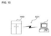
- FIG. 15shows how the present invention may be adopted in such an application.
- a personal computer 500which can be connected to a communication line 501 receives the map data described above from an information distribution center 400 .
- the information distribution center 400has functions similar to those explained in reference to FIG. 3 .
- the communication line 501may be a communication line used for Internet communication or personal computer communication, or it may be a dedicated communication line.
- the information distribution center 400transmits map data related to the selected route to the personal computer 500 .
- the map dataare converted to a signal on a carrier wave that carries a transmission medium and the signal is then transmitted via the communication line 501 .
- the map datacan be distributed as a computer readable computer program product adopting any of various modes.
Landscapes
- Engineering & Computer Science (AREA)
- Radar, Positioning & Navigation (AREA)
- Remote Sensing (AREA)
- Automation & Control Theory (AREA)
- Physics & Mathematics (AREA)
- General Physics & Mathematics (AREA)
- Databases & Information Systems (AREA)
- Navigation (AREA)
- Traffic Control Systems (AREA)
- Instructional Devices (AREA)
Abstract
Description
- (1) In a non-urban area or an area with good GPS reception, the number of roads connecting with the recommended route will be smaller and there is not much need to display them, and for this reason, the node link connection information over the area is eliminated. As a result, the volume of map data around the recommended route to be distributed from the information distribution center to the on-vehicle apparatus can be reduced to result in reductions in both the length of communication time and the communication cost.
- (2) Information indicating that the data volume has been reduced is appended to enable the on-vehicle apparatus to recognize any absence of the node link connection information.
- (1) A rough representation of the shape of a road shape is deemed to suffice even on the recommended route since the vehicle will only need to travel straight ahead along the road as long as the road is outside a predetermined range preceding a guidance point, and accordingly, the volume of the data indicating the road shape outside the predetermined range is reduced through the shape data cull. In addition, the shape data related to a road connecting with the recommended route, which does not bear direct relation to a guidance point, too, are reduced through the shape data cull. As a result, the volume of map data around the recommended route to be distributed from the information distribution center to the on-vehicle apparatus is reduced to achieve reductions in both the length of communication time and the communication cost.
- (2) Information indicating that the data volume has been reduced is attached. Thus, the on-vehicle apparatus is enabled to recognize data having undergone the shape data cull.
- (1) A road contained in the slicing range set along the recommended route, which does not connect with the recommended route, e.g., a road extending parallel to the recommended route, is deemed to bear little significance on the display brought up when providing the road guidance, and accordingly, the volume of data related to such a road is reduced through a shape data cull. As a result, the volume of map data around the recommended route to be distributed from the information distribution center to the on-vehicle apparatus is reduced to achieve reductions in both the length of communication time and the communication cost.
- (1) A specific type of facility which is of interest to the user, pre-selected by the user at the on-
vehicle apparatus 100; - (2) a specific type of facility that the user is likely to wish to use around the estimated time point at which the vehicle on the route is expected to arrive at the facility location, e.g., a restaurant during mealtimes; and
- (3) a refueling facility such as a gas station selected by estimating a traveling distance, a time point, a geographical position or the like at which the remaining fuel quantity is expected to become equal to or less than a predetermined value.
- (1) If a POI satisfying a specific requirement is present in the vicinity, the map slicing range is expanded so that the modified range includes an area ranging from the recommended route and containing the POI. The specific requirement may be set by the user, or it may relate to a specific type of facility such as a restaurant that the user is likely to wish to visit while he is driving on the recommended route at a specific estimated time point or a gas station located at a specific point at which the remaining fuel quantity becomes equal to or smaller than a predetermined value. Thus, map data that satisfy the user's needs can be provided in a timely manner.
Claims (21)
Applications Claiming Priority (3)
| Application Number | Priority Date | Filing Date | Title |
|---|---|---|---|
| JP2002-288824 | 2002-10-01 | ||
| JP2002288824AJP3803629B2 (en) | 2002-10-01 | 2002-10-01 | Map data transmission method, information distribution device, and information terminal |
| PCT/JP2003/012593WO2004031690A1 (en) | 2002-10-01 | 2003-10-01 | Geographic data transmitting method, information delivering apparatus and information terminal |
Publications (2)
| Publication Number | Publication Date |
|---|---|
| US20060007022A1 US20060007022A1 (en) | 2006-01-12 |
| US7339496B2true US7339496B2 (en) | 2008-03-04 |
Family
ID=32063694
Family Applications (1)
| Application Number | Title | Priority Date | Filing Date |
|---|---|---|---|
| US10/529,886Expired - Fee RelatedUS7339496B2 (en) | 2002-10-01 | 2003-10-01 | Geographic data transmitting method, information delivering apparatus and information terminal |
Country Status (4)
| Country | Link |
|---|---|
| US (1) | US7339496B2 (en) |
| EP (1) | EP1553385A4 (en) |
| JP (1) | JP3803629B2 (en) |
| WO (1) | WO2004031690A1 (en) |
Cited By (31)
| Publication number | Priority date | Publication date | Assignee | Title |
|---|---|---|---|---|
| US20070106459A1 (en)* | 2005-10-31 | 2007-05-10 | Aisin Aw Co., Ltd. | Route navigation systems, methods and programs |
| US20070118279A1 (en)* | 2005-11-21 | 2007-05-24 | Denso Corporation | System and method for facility search |
| US20090005070A1 (en)* | 2007-06-28 | 2009-01-01 | Apple Inc. | Synchronizing mobile and vehicle devices |
| US20090005005A1 (en)* | 2007-06-28 | 2009-01-01 | Apple Inc. | Mobile Device Base Station |
| US20090005021A1 (en)* | 2007-06-28 | 2009-01-01 | Apple Inc. | Location-based categorical information services |
| US20090182492A1 (en)* | 2008-01-10 | 2009-07-16 | Apple Inc. | Adaptive Navigation System for Estimating Travel Times |
| US20100279652A1 (en)* | 2009-05-01 | 2010-11-04 | Apple Inc. | Remotely Locating and Commanding a Mobile Device |
| US20110282575A1 (en)* | 2009-07-31 | 2011-11-17 | Aisin Aw Co., Ltd. | Map information guidance device, map information guidance method, and computer program |
| US8108144B2 (en) | 2007-06-28 | 2012-01-31 | Apple Inc. | Location based tracking |
| US8127246B2 (en) | 2007-10-01 | 2012-02-28 | Apple Inc. | Varying user interface element based on movement |
| US20120083999A1 (en)* | 2010-09-30 | 2012-04-05 | Honda Motor Co., Ltd. | Drive support system |
| US8175802B2 (en) | 2007-06-28 | 2012-05-08 | Apple Inc. | Adaptive route guidance based on preferences |
| US8204684B2 (en) | 2007-06-28 | 2012-06-19 | Apple Inc. | Adaptive mobile device navigation |
| US8275352B2 (en) | 2007-06-28 | 2012-09-25 | Apple Inc. | Location-based emergency information |
| US8290513B2 (en) | 2007-06-28 | 2012-10-16 | Apple Inc. | Location-based services |
| US8332402B2 (en) | 2007-06-28 | 2012-12-11 | Apple Inc. | Location based media items |
| US8355862B2 (en) | 2008-01-06 | 2013-01-15 | Apple Inc. | Graphical user interface for presenting location information |
| US8359643B2 (en) | 2008-09-18 | 2013-01-22 | Apple Inc. | Group formation using anonymous broadcast information |
| US8369867B2 (en) | 2008-06-30 | 2013-02-05 | Apple Inc. | Location sharing |
| US8385946B2 (en) | 2007-06-28 | 2013-02-26 | Apple Inc. | Disfavored route progressions or locations |
| US8385964B2 (en) | 2005-04-04 | 2013-02-26 | Xone, Inc. | Methods and apparatuses for geospatial-based sharing of information by multiple devices |
| US8644843B2 (en) | 2008-05-16 | 2014-02-04 | Apple Inc. | Location determination |
| US8660530B2 (en) | 2009-05-01 | 2014-02-25 | Apple Inc. | Remotely receiving and communicating commands to a mobile device for execution by the mobile device |
| US8670748B2 (en) | 2009-05-01 | 2014-03-11 | Apple Inc. | Remotely locating and commanding a mobile device |
| US8762056B2 (en) | 2007-06-28 | 2014-06-24 | Apple Inc. | Route reference |
| US8774825B2 (en) | 2007-06-28 | 2014-07-08 | Apple Inc. | Integration of map services with user applications in a mobile device |
| US8977294B2 (en) | 2007-10-10 | 2015-03-10 | Apple Inc. | Securely locating a device |
| US9066199B2 (en) | 2007-06-28 | 2015-06-23 | Apple Inc. | Location-aware mobile device |
| US9109904B2 (en) | 2007-06-28 | 2015-08-18 | Apple Inc. | Integration of map services and user applications in a mobile device |
| US9250092B2 (en) | 2008-05-12 | 2016-02-02 | Apple Inc. | Map service with network-based query for search |
| US20190283623A1 (en)* | 2018-03-19 | 2019-09-19 | Honda Motor Co., Ltd. | Notification system, notification method, and non-transitory computer-readable storage medium storing program |
Families Citing this family (34)
| Publication number | Priority date | Publication date | Assignee | Title |
|---|---|---|---|---|
| JP3975998B2 (en)* | 2003-10-16 | 2007-09-12 | 株式会社日立製作所 | Navigation server device |
| US7124023B2 (en)* | 2003-12-12 | 2006-10-17 | Palo Alto Research Center Incorporated | Traffic flow data collection agents |
| US7688228B2 (en) | 2004-07-29 | 2010-03-30 | Hitachi, Ltd. | Map data delivering device, communication terminal, and map delivering method |
| JP2006275774A (en)* | 2005-03-29 | 2006-10-12 | Nissan Motor Co Ltd | Navigation device, map data update system, map data update method |
| US20090109022A1 (en)* | 2007-10-31 | 2009-04-30 | Gm Global Technology Operations, Inc. | Method and apparatus for providing in-vehicle fuel related information |
| US7483786B1 (en) | 2008-05-15 | 2009-01-27 | International Business Machines Corporation | Method and system for selective route search on satellite navigators |
| CN101625245A (en)* | 2009-08-07 | 2010-01-13 | 肖湘萍 | Navigation terminal and navigation method |
| DE102010030309A1 (en) | 2010-06-21 | 2011-12-22 | Ford Global Technologies, Llc | Method and device for determining an energy consumption optimized route |
| US20110225105A1 (en)* | 2010-10-21 | 2011-09-15 | Ford Global Technologies, Llc | Method and system for monitoring an energy storage system for a vehicle for trip planning |
| US20120179323A1 (en)* | 2011-01-06 | 2012-07-12 | Ford Global Technologies, Llc | Method and Apparatus for Charging Station Guidance |
| US8849499B2 (en)* | 2011-01-06 | 2014-09-30 | Ford Global Technologies, Llc | Methods and systems for monitoring a vehicle's energy source |
| US20110224852A1 (en)* | 2011-01-06 | 2011-09-15 | Ford Global Technologies, Llc | Methods and system for selectively charging a vehicle |
| US8548739B2 (en)* | 2011-02-10 | 2013-10-01 | Telenav, Inc. | Navigation system with interactive accelerometer mechanism and method of operation thereof |
| US10453226B1 (en) | 2011-07-26 | 2019-10-22 | Google Llc | Presenting information on a map |
| US20130041552A1 (en) | 2011-08-11 | 2013-02-14 | Ford Global Technologies, Llc | Methods and Apparatus for Estimating Power Usage |
| US8280414B1 (en) | 2011-09-26 | 2012-10-02 | Google Inc. | Map tile data pre-fetching based on mobile device generated event analysis |
| US8907776B2 (en) | 2011-10-05 | 2014-12-09 | Ford Global Technologies, Llc | Method and apparatus for do not disturb message delivery |
| US8886715B1 (en) | 2011-11-16 | 2014-11-11 | Google Inc. | Dynamically determining a tile budget when pre-fetching data in a client device |
| US8711181B1 (en) | 2011-11-16 | 2014-04-29 | Google Inc. | Pre-fetching map data using variable map tile radius |
| US9305107B2 (en) | 2011-12-08 | 2016-04-05 | Google Inc. | Method and apparatus for pre-fetching place page data for subsequent display on a mobile computing device |
| US9197713B2 (en) | 2011-12-09 | 2015-11-24 | Google Inc. | Method and apparatus for pre-fetching remote resources for subsequent display on a mobile computing device |
| US8803920B2 (en) | 2011-12-12 | 2014-08-12 | Google Inc. | Pre-fetching map tile data along a route |
| US9389088B2 (en)* | 2011-12-12 | 2016-07-12 | Google Inc. | Method of pre-fetching map data for rendering and offline routing |
| US8849742B2 (en) | 2012-01-24 | 2014-09-30 | Ford Global Technologies, Llc | Method and apparatus for providing charging state alerts |
| US9462545B2 (en) | 2013-03-14 | 2016-10-04 | Ford Global Technologies, Llc | Method and apparatus for a battery saver utilizing a sleep and vacation strategy |
| US9066298B2 (en) | 2013-03-15 | 2015-06-23 | Ford Global Technologies, Llc | Method and apparatus for an alert strategy between modules |
| CN103218406B (en)* | 2013-03-21 | 2019-11-26 | 百度在线网络技术(北京)有限公司 | The processing method and equipment of the address information of point of interest |
| DE102015206474A1 (en)* | 2015-04-10 | 2016-10-13 | Robert Bosch Gmbh | Provision of environmental data of a planned route |
| CN106919567B (en)* | 2015-12-24 | 2020-06-02 | 北京四维图新科技股份有限公司 | Method and device for processing POI (Point of interest) address |
| EP3514486B1 (en)* | 2016-09-16 | 2021-10-06 | Panasonic Intellectual Property Corporation of America | Method for creating three-dimensional data and device for creating three-dimensional data |
| JP2017227652A (en)* | 2017-09-06 | 2017-12-28 | パイオニア株式会社 | Image processing device, image processing method, and image processing program |
| CN110556049B (en)* | 2018-06-04 | 2021-11-12 | 百度在线网络技术(北京)有限公司 | Map data processing method, device, server and storage medium |
| KR102586966B1 (en)* | 2018-08-01 | 2023-10-10 | 한화에어로스페이스 주식회사 | Interior-map generation system and interior-exploration robot |
| US11875678B2 (en)* | 2019-07-19 | 2024-01-16 | Zoox, Inc. | Unstructured vehicle path planner |
Citations (14)
| Publication number | Priority date | Publication date | Assignee | Title |
|---|---|---|---|---|
| US5568390A (en)* | 1993-08-10 | 1996-10-22 | Toyota Jidosha Kabushiki Kaisha | Navigation system to be mounted on vehicles |
| US5790973A (en)* | 1995-12-19 | 1998-08-04 | Prince Corporation | Last exit warning system |
| US5911773A (en)* | 1995-07-24 | 1999-06-15 | Aisin Aw Co., Ltd. | Navigation system for vehicles |
| JP2000123295A (en) | 1998-10-15 | 2000-04-28 | Equos Research Co Ltd | Navigation center device, navigation device, navigation system and method |
| JP2001141490A (en) | 1999-11-18 | 2001-05-25 | Equos Research Co Ltd | Navigation method, navigation device and information providing device therefor |
| US20010027376A1 (en)* | 2000-03-03 | 2001-10-04 | Lutz Tiede | Navigation method using a small volume of data |
| US6320518B2 (en)* | 2000-03-01 | 2001-11-20 | Mitsubishi Denshi Kabushiki Kaisha | Map data transmitting apparatus, and computer readable recording medium having computer readable programs stored therein for causing computer to perform map data transmitting method |
| JP2002107169A (en) | 2000-10-03 | 2002-04-10 | Hitachi Ltd | Communication type navigation device and information center |
| JP2002228480A (en) | 2001-02-05 | 2002-08-14 | Seiko Epson Corp | Travel planning device, navigation device, portable information terminal and server |
| US20020165663A1 (en)* | 2001-05-02 | 2002-11-07 | Mitsubishi Denki Kabushiki Kaisha | On-board navigation terminal and navigation controller |
| US6559865B1 (en)* | 1999-05-21 | 2003-05-06 | Tele Atlas North America, Inc. | Computing sign text for branches of an electronic map network |
| US6594580B1 (en)* | 1999-11-18 | 2003-07-15 | Toyota Jidosha Kabushiki Kaisha | Apparatus and system for providing route guidance information and a communication terminal thereof |
| US6636805B1 (en) | 1999-11-18 | 2003-10-21 | Toyota Jidosha Kabushiki Kaisha | Navigation system, remote navigation device and method, and in-vehicle navigation device |
| US6691028B2 (en)* | 2002-06-07 | 2004-02-10 | Motorola, Inc. | Server-based navigation system and method of operating same |
Family Cites Families (1)
| Publication number | Priority date | Publication date | Assignee | Title |
|---|---|---|---|---|
| US6249740B1 (en) | 1998-01-21 | 2001-06-19 | Kabushikikaisha Equos Research | Communications navigation system, and navigation base apparatus and vehicle navigation apparatus both used in the navigation system |
- 2002
- 2002-10-01JPJP2002288824Apatent/JP3803629B2/ennot_activeExpired - Fee Related
- 2003
- 2003-10-01USUS10/529,886patent/US7339496B2/ennot_activeExpired - Fee Related
- 2003-10-01EPEP03753975.6Apatent/EP1553385A4/ennot_activeCeased
- 2003-10-01WOPCT/JP2003/012593patent/WO2004031690A1/enactiveApplication Filing
Patent Citations (15)
| Publication number | Priority date | Publication date | Assignee | Title |
|---|---|---|---|---|
| US5568390B1 (en)* | 1993-08-10 | 1998-03-31 | Toyota Motor Co Ltd | Navigation system to be mounted on vehicles |
| US5568390A (en)* | 1993-08-10 | 1996-10-22 | Toyota Jidosha Kabushiki Kaisha | Navigation system to be mounted on vehicles |
| US5911773A (en)* | 1995-07-24 | 1999-06-15 | Aisin Aw Co., Ltd. | Navigation system for vehicles |
| US5790973A (en)* | 1995-12-19 | 1998-08-04 | Prince Corporation | Last exit warning system |
| JP2000123295A (en) | 1998-10-15 | 2000-04-28 | Equos Research Co Ltd | Navigation center device, navigation device, navigation system and method |
| US6559865B1 (en)* | 1999-05-21 | 2003-05-06 | Tele Atlas North America, Inc. | Computing sign text for branches of an electronic map network |
| JP2001141490A (en) | 1999-11-18 | 2001-05-25 | Equos Research Co Ltd | Navigation method, navigation device and information providing device therefor |
| US6636805B1 (en) | 1999-11-18 | 2003-10-21 | Toyota Jidosha Kabushiki Kaisha | Navigation system, remote navigation device and method, and in-vehicle navigation device |
| US6594580B1 (en)* | 1999-11-18 | 2003-07-15 | Toyota Jidosha Kabushiki Kaisha | Apparatus and system for providing route guidance information and a communication terminal thereof |
| US6320518B2 (en)* | 2000-03-01 | 2001-11-20 | Mitsubishi Denshi Kabushiki Kaisha | Map data transmitting apparatus, and computer readable recording medium having computer readable programs stored therein for causing computer to perform map data transmitting method |
| US20010027376A1 (en)* | 2000-03-03 | 2001-10-04 | Lutz Tiede | Navigation method using a small volume of data |
| JP2002107169A (en) | 2000-10-03 | 2002-04-10 | Hitachi Ltd | Communication type navigation device and information center |
| JP2002228480A (en) | 2001-02-05 | 2002-08-14 | Seiko Epson Corp | Travel planning device, navigation device, portable information terminal and server |
| US20020165663A1 (en)* | 2001-05-02 | 2002-11-07 | Mitsubishi Denki Kabushiki Kaisha | On-board navigation terminal and navigation controller |
| US6691028B2 (en)* | 2002-06-07 | 2004-02-10 | Motorola, Inc. | Server-based navigation system and method of operating same |
Cited By (100)
| Publication number | Priority date | Publication date | Assignee | Title |
|---|---|---|---|---|
| US10200811B1 (en) | 2005-04-04 | 2019-02-05 | X One, Inc. | Map presentation on cellular device showing positions of multiple other wireless device users |
| US10165059B2 (en) | 2005-04-04 | 2018-12-25 | X One, Inc. | Methods, systems and apparatuses for the formation and tracking of location sharing groups |
| US11778415B2 (en) | 2005-04-04 | 2023-10-03 | Xone, Inc. | Location sharing application in association with services provision |
| US9185522B1 (en) | 2005-04-04 | 2015-11-10 | X One, Inc. | Apparatus and method to transmit content to a cellular wireless device based on proximity to other wireless devices |
| US10856099B2 (en) | 2005-04-04 | 2020-12-01 | X One, Inc. | Application-based two-way tracking and mapping function with selected individuals |
| US10791414B2 (en) | 2005-04-04 | 2020-09-29 | X One, Inc. | Location sharing for commercial and proprietary content applications |
| US10750311B2 (en) | 2005-04-04 | 2020-08-18 | X One, Inc. | Application-based tracking and mapping function in connection with vehicle-based services provision |
| US10750309B2 (en) | 2005-04-04 | 2020-08-18 | X One, Inc. | Ad hoc location sharing group establishment for wireless devices with designated meeting point |
| US10750310B2 (en) | 2005-04-04 | 2020-08-18 | X One, Inc. | Temporary location sharing group with event based termination |
| US10341808B2 (en) | 2005-04-04 | 2019-07-02 | X One, Inc. | Location sharing for commercial and proprietary content applications |
| US10341809B2 (en) | 2005-04-04 | 2019-07-02 | X One, Inc. | Location sharing with facilitated meeting point definition |
| US10313826B2 (en) | 2005-04-04 | 2019-06-04 | X One, Inc. | Location sharing and map support in connection with services request |
| US10299071B2 (en) | 2005-04-04 | 2019-05-21 | X One, Inc. | Server-implemented methods and systems for sharing location amongst web-enabled cell phones |
| US10149092B1 (en) | 2005-04-04 | 2018-12-04 | X One, Inc. | Location sharing service between GPS-enabled wireless devices, with shared target location exchange |
| US9967704B1 (en) | 2005-04-04 | 2018-05-08 | X One, Inc. | Location sharing group map management |
| US9955298B1 (en) | 2005-04-04 | 2018-04-24 | X One, Inc. | Methods, systems and apparatuses for the formation and tracking of location sharing groups |
| US9942705B1 (en) | 2005-04-04 | 2018-04-10 | X One, Inc. | Location sharing group for services provision |
| US9883360B1 (en) | 2005-04-04 | 2018-01-30 | X One, Inc. | Rendez vous management using mobile phones or other mobile devices |
| US9854394B1 (en) | 2005-04-04 | 2017-12-26 | X One, Inc. | Ad hoc location sharing group between first and second cellular wireless devices |
| US9167558B2 (en) | 2005-04-04 | 2015-10-20 | X One, Inc. | Methods and systems for sharing position data between subscribers involving multiple wireless providers |
| US9854402B1 (en) | 2005-04-04 | 2017-12-26 | X One, Inc. | Formation of wireless device location sharing group |
| US9749790B1 (en) | 2005-04-04 | 2017-08-29 | X One, Inc. | Rendez vous management using mobile phones or other mobile devices |
| US8385964B2 (en) | 2005-04-04 | 2013-02-26 | Xone, Inc. | Methods and apparatuses for geospatial-based sharing of information by multiple devices |
| US9736618B1 (en) | 2005-04-04 | 2017-08-15 | X One, Inc. | Techniques for sharing relative position between mobile devices |
| US9654921B1 (en) | 2005-04-04 | 2017-05-16 | X One, Inc. | Techniques for sharing position data between first and second devices |
| US9615204B1 (en) | 2005-04-04 | 2017-04-04 | X One, Inc. | Techniques for communication within closed groups of mobile devices |
| US8538458B2 (en) | 2005-04-04 | 2013-09-17 | X One, Inc. | Location sharing and tracking using mobile phones or other wireless devices |
| US9584960B1 (en) | 2005-04-04 | 2017-02-28 | X One, Inc. | Rendez vous management using mobile phones or other mobile devices |
| US9467832B2 (en) | 2005-04-04 | 2016-10-11 | X One, Inc. | Methods and systems for temporarily sharing position data between mobile-device users |
| US9253616B1 (en) | 2005-04-04 | 2016-02-02 | X One, Inc. | Apparatus and method for obtaining content on a cellular wireless device based on proximity |
| US11356799B2 (en) | 2005-04-04 | 2022-06-07 | X One, Inc. | Fleet location sharing application in association with services provision |
| US8750898B2 (en) | 2005-04-04 | 2014-06-10 | X One, Inc. | Methods and systems for annotating target locations |
| US9031581B1 (en) | 2005-04-04 | 2015-05-12 | X One, Inc. | Apparatus and method for obtaining content on a cellular wireless device based on proximity to other wireless devices |
| US8831635B2 (en) | 2005-04-04 | 2014-09-09 | X One, Inc. | Methods and apparatuses for transmission of an alert to multiple devices |
| US8712441B2 (en) | 2005-04-04 | 2014-04-29 | Xone, Inc. | Methods and systems for temporarily sharing position data between mobile-device users |
| US8798593B2 (en) | 2005-04-04 | 2014-08-05 | X One, Inc. | Location sharing and tracking using mobile phones or other wireless devices |
| US8798647B1 (en) | 2005-04-04 | 2014-08-05 | X One, Inc. | Tracking proximity of services provider to services consumer |
| US8798645B2 (en) | 2005-04-04 | 2014-08-05 | X One, Inc. | Methods and systems for sharing position data and tracing paths between mobile-device users |
| US20070106459A1 (en)* | 2005-10-31 | 2007-05-10 | Aisin Aw Co., Ltd. | Route navigation systems, methods and programs |
| US20070118279A1 (en)* | 2005-11-21 | 2007-05-24 | Denso Corporation | System and method for facility search |
| US8108144B2 (en) | 2007-06-28 | 2012-01-31 | Apple Inc. | Location based tracking |
| US9891055B2 (en) | 2007-06-28 | 2018-02-13 | Apple Inc. | Location based tracking |
| US8694026B2 (en) | 2007-06-28 | 2014-04-08 | Apple Inc. | Location based services |
| US8924144B2 (en) | 2007-06-28 | 2014-12-30 | Apple Inc. | Location based tracking |
| US8275352B2 (en) | 2007-06-28 | 2012-09-25 | Apple Inc. | Location-based emergency information |
| US12228411B2 (en) | 2007-06-28 | 2025-02-18 | Apple Inc. | Location based tracking |
| US9066199B2 (en) | 2007-06-28 | 2015-06-23 | Apple Inc. | Location-aware mobile device |
| US9109904B2 (en) | 2007-06-28 | 2015-08-18 | Apple Inc. | Integration of map services and user applications in a mobile device |
| US12114284B2 (en) | 2007-06-28 | 2024-10-08 | Apple Inc. | Location-aware mobile device |
| US20090005070A1 (en)* | 2007-06-28 | 2009-01-01 | Apple Inc. | Synchronizing mobile and vehicle devices |
| US11665665B2 (en) | 2007-06-28 | 2023-05-30 | Apple Inc. | Location-aware mobile device |
| US11419092B2 (en) | 2007-06-28 | 2022-08-16 | Apple Inc. | Location-aware mobile device |
| US8290513B2 (en) | 2007-06-28 | 2012-10-16 | Apple Inc. | Location-based services |
| US9310206B2 (en) | 2007-06-28 | 2016-04-12 | Apple Inc. | Location based tracking |
| US9414198B2 (en) | 2007-06-28 | 2016-08-09 | Apple Inc. | Location-aware mobile device |
| US20090005005A1 (en)* | 2007-06-28 | 2009-01-01 | Apple Inc. | Mobile Device Base Station |
| US9578621B2 (en) | 2007-06-28 | 2017-02-21 | Apple Inc. | Location aware mobile device |
| US8548735B2 (en) | 2007-06-28 | 2013-10-01 | Apple Inc. | Location based tracking |
| US8463238B2 (en) | 2007-06-28 | 2013-06-11 | Apple Inc. | Mobile device base station |
| US11221221B2 (en) | 2007-06-28 | 2022-01-11 | Apple Inc. | Location based tracking |
| US9702709B2 (en) | 2007-06-28 | 2017-07-11 | Apple Inc. | Disfavored route progressions or locations |
| US10952180B2 (en) | 2007-06-28 | 2021-03-16 | Apple Inc. | Location-aware mobile device |
| US20090005021A1 (en)* | 2007-06-28 | 2009-01-01 | Apple Inc. | Location-based categorical information services |
| US8385946B2 (en) | 2007-06-28 | 2013-02-26 | Apple Inc. | Disfavored route progressions or locations |
| US10508921B2 (en) | 2007-06-28 | 2019-12-17 | Apple Inc. | Location based tracking |
| US10412703B2 (en) | 2007-06-28 | 2019-09-10 | Apple Inc. | Location-aware mobile device |
| US8332402B2 (en) | 2007-06-28 | 2012-12-11 | Apple Inc. | Location based media items |
| US8774825B2 (en) | 2007-06-28 | 2014-07-08 | Apple Inc. | Integration of map services with user applications in a mobile device |
| US8738039B2 (en) | 2007-06-28 | 2014-05-27 | Apple Inc. | Location-based categorical information services |
| US8175802B2 (en) | 2007-06-28 | 2012-05-08 | Apple Inc. | Adaptive route guidance based on preferences |
| US8180379B2 (en) | 2007-06-28 | 2012-05-15 | Apple Inc. | Synchronizing mobile and vehicle devices |
| US8311526B2 (en) | 2007-06-28 | 2012-11-13 | Apple Inc. | Location-based categorical information services |
| US10064158B2 (en) | 2007-06-28 | 2018-08-28 | Apple Inc. | Location aware mobile device |
| US8204684B2 (en) | 2007-06-28 | 2012-06-19 | Apple Inc. | Adaptive mobile device navigation |
| US9131342B2 (en) | 2007-06-28 | 2015-09-08 | Apple Inc. | Location-based categorical information services |
| US8762056B2 (en) | 2007-06-28 | 2014-06-24 | Apple Inc. | Route reference |
| US8127246B2 (en) | 2007-10-01 | 2012-02-28 | Apple Inc. | Varying user interface element based on movement |
| US8977294B2 (en) | 2007-10-10 | 2015-03-10 | Apple Inc. | Securely locating a device |
| US8355862B2 (en) | 2008-01-06 | 2013-01-15 | Apple Inc. | Graphical user interface for presenting location information |
| US8452529B2 (en) | 2008-01-10 | 2013-05-28 | Apple Inc. | Adaptive navigation system for estimating travel times |
| US20090182492A1 (en)* | 2008-01-10 | 2009-07-16 | Apple Inc. | Adaptive Navigation System for Estimating Travel Times |
| US9250092B2 (en) | 2008-05-12 | 2016-02-02 | Apple Inc. | Map service with network-based query for search |
| US9702721B2 (en) | 2008-05-12 | 2017-07-11 | Apple Inc. | Map service with network-based query for search |
| US8644843B2 (en) | 2008-05-16 | 2014-02-04 | Apple Inc. | Location determination |
| US10368199B2 (en) | 2008-06-30 | 2019-07-30 | Apple Inc. | Location sharing |
| US10841739B2 (en) | 2008-06-30 | 2020-11-17 | Apple Inc. | Location sharing |
| US8369867B2 (en) | 2008-06-30 | 2013-02-05 | Apple Inc. | Location sharing |
| US8359643B2 (en) | 2008-09-18 | 2013-01-22 | Apple Inc. | Group formation using anonymous broadcast information |
| US8670748B2 (en) | 2009-05-01 | 2014-03-11 | Apple Inc. | Remotely locating and commanding a mobile device |
| US9979776B2 (en) | 2009-05-01 | 2018-05-22 | Apple Inc. | Remotely locating and commanding a mobile device |
| US20100279652A1 (en)* | 2009-05-01 | 2010-11-04 | Apple Inc. | Remotely Locating and Commanding a Mobile Device |
| US12250262B2 (en) | 2009-05-01 | 2025-03-11 | Apple Inc. | Remotely locating and commanding a mobile device |
| US8660530B2 (en) | 2009-05-01 | 2014-02-25 | Apple Inc. | Remotely receiving and communicating commands to a mobile device for execution by the mobile device |
| US8666367B2 (en) | 2009-05-01 | 2014-03-04 | Apple Inc. | Remotely locating and commanding a mobile device |
| US8417453B2 (en)* | 2009-07-31 | 2013-04-09 | Aisin Aw Co., Ltd. | Map information guidance device, map information guidance method, and computer program |
| US20110282575A1 (en)* | 2009-07-31 | 2011-11-17 | Aisin Aw Co., Ltd. | Map information guidance device, map information guidance method, and computer program |
| US8649966B2 (en)* | 2010-09-30 | 2014-02-11 | Honda Motor Co., Ltd | Drive support system |
| US20120083999A1 (en)* | 2010-09-30 | 2012-04-05 | Honda Motor Co., Ltd. | Drive support system |
| US20190283623A1 (en)* | 2018-03-19 | 2019-09-19 | Honda Motor Co., Ltd. | Notification system, notification method, and non-transitory computer-readable storage medium storing program |
| US11642980B2 (en)* | 2018-03-19 | 2023-05-09 | Honda Motor Co., Ltd. | System and method of notifying vehicle occupant of replenishing place corresponding to related facility |
Also Published As
| Publication number | Publication date |
|---|---|
| EP1553385A4 (en) | 2013-06-19 |
| WO2004031690A1 (en) | 2004-04-15 |
| JP2004125553A (en) | 2004-04-22 |
| JP3803629B2 (en) | 2006-08-02 |
| US20060007022A1 (en) | 2006-01-12 |
| EP1553385A1 (en) | 2005-07-13 |
Similar Documents
| Publication | Publication Date | Title |
|---|---|---|
| US7339496B2 (en) | Geographic data transmitting method, information delivering apparatus and information terminal | |
| US6282492B1 (en) | Navigation system and navigation apparatus used in the navigation system | |
| EP0702208B1 (en) | Method and system of route selection | |
| JP4775419B2 (en) | Navigation method and navigation apparatus | |
| JP4952516B2 (en) | Weather information notification device, program | |
| US7158149B2 (en) | Map data transmitting method, map data transmitting apparatus, information device and map data transmitting system | |
| JP3481168B2 (en) | Digital map location information transmission method | |
| US6314369B1 (en) | Communications navigation system, and navigation base apparatus and navigation apparatus both used in the navigation system | |
| KR100493092B1 (en) | Navigation apparatus and method for calculating optimal path | |
| JP3555466B2 (en) | Navigation center device and navigation device | |
| US8073876B2 (en) | Computer product having distribution map data, distribution map data generating method, distrubution map data generating apparatus and terminal device | |
| WO2000066975A1 (en) | Route guide system | |
| JP2001041757A (en) | Digital map location information transmission method and device for implementing the method | |
| US20120016584A1 (en) | Route guiding system, route guiding server, and route guiding method | |
| US8494769B2 (en) | Information system, terminal device, and information center device | |
| US20140372023A1 (en) | Navigation Method And System With Centralised Server | |
| US20060149467A1 (en) | Map drawing method, map drawing system, navigation apparatus and input/output apparatus | |
| US20110246063A1 (en) | Information providing system, information distribution server, and information providing method | |
| JP2019152628A (en) | Method for transmitting route information, system for transmitting route information, and vehicle-mounted terminal | |
| JPH0822246A (en) | Road map information providing method and vehicle-mounted navigation device using this method | |
| JP3894017B2 (en) | Navigation system, navigation program, and rapid road information creation method | |
| KR102131012B1 (en) | Optimal route guidance system for vehicle, and route calculation server for the same | |
| JP3832284B2 (en) | Navigation system and navigation program | |
| JP2007256020A (en) | Navigation device, navigation method, and navigation program | |
| EP4479705A1 (en) | Processing digital map data |
Legal Events
| Date | Code | Title | Description |
|---|---|---|---|
| AS | Assignment | Owner name:XANAVI INFORMATICS CORPORATION, JAPAN Free format text:ASSIGNMENT OF ASSIGNORS INTEREST;ASSIGNORS:ENDO, YOSHINORI;SUMIZAWA, AKIO;REEL/FRAME:017014/0685;SIGNING DATES FROM 20050321 TO 20050323 | |
| STCF | Information on status: patent grant | Free format text:PATENTED CASE | |
| FEPP | Fee payment procedure | Free format text:PAYOR NUMBER ASSIGNED (ORIGINAL EVENT CODE: ASPN); ENTITY STATUS OF PATENT OWNER: LARGE ENTITY | |
| FPAY | Fee payment | Year of fee payment:4 | |
| AS | Assignment | Owner name:CLARION CO., LTD., JAPAN Free format text:MERGER;ASSIGNOR:XANAVI INFORMATICS CORPORATION;REEL/FRAME:032631/0424 Effective date:20090402 | |
| FPAY | Fee payment | Year of fee payment:8 | |
| FEPP | Fee payment procedure | Free format text:MAINTENANCE FEE REMINDER MAILED (ORIGINAL EVENT CODE: REM.); ENTITY STATUS OF PATENT OWNER: LARGE ENTITY | |
| LAPS | Lapse for failure to pay maintenance fees | Free format text:PATENT EXPIRED FOR FAILURE TO PAY MAINTENANCE FEES (ORIGINAL EVENT CODE: EXP.); ENTITY STATUS OF PATENT OWNER: LARGE ENTITY | |
| STCH | Information on status: patent discontinuation | Free format text:PATENT EXPIRED DUE TO NONPAYMENT OF MAINTENANCE FEES UNDER 37 CFR 1.362 | |
| FP | Lapsed due to failure to pay maintenance fee | Effective date:20200304 |