US7319387B2 - GPS interface for locating device - Google Patents
GPS interface for locating deviceDownload PDFInfo
- Publication number
- US7319387B2 US7319387B2US10/802,345US80234504AUS7319387B2US 7319387 B2US7319387 B2US 7319387B2US 80234504 AUS80234504 AUS 80234504AUS 7319387 B2US7319387 B2US 7319387B2
- Authority
- US
- United States
- Prior art keywords
- gps
- marker
- data
- position marker
- locating
- Prior art date
- Legal status (The legal status is an assumption and is not a legal conclusion. Google has not performed a legal analysis and makes no representation as to the accuracy of the status listed.)
- Expired - Lifetime, expires
Links
- 239000003550markerSubstances0.000claimsabstractdescription136
- 238000013507mappingMethods0.000claimsdescription36
- 238000000034methodMethods0.000claimsdescription20
- 238000004891communicationMethods0.000claimsdescription19
- 230000008569processEffects0.000description16
- 238000013480data collectionMethods0.000description13
- 238000010586diagramMethods0.000description13
- 230000000694effectsEffects0.000description2
- 230000006870functionEffects0.000description2
- 238000012545processingMethods0.000description2
- BXNJHAXVSOCGBA-UHFFFAOYSA-NHarmineChemical compoundN1=CC=C2C3=CC=C(OC)C=C3NC2=C1CBXNJHAXVSOCGBA-UHFFFAOYSA-N0.000description1
- 238000010923batch productionMethods0.000description1
- 238000013479data entryMethods0.000description1
- 238000001983electron spin resonance imagingMethods0.000description1
- 238000005516engineering processMethods0.000description1
- 230000008570general processEffects0.000description1
- 230000005236sound signalEffects0.000description1
- 230000000007visual effectEffects0.000description1
Images


Classifications
- G—PHYSICS
- G01—MEASURING; TESTING
- G01V—GEOPHYSICS; GRAVITATIONAL MEASUREMENTS; DETECTING MASSES OR OBJECTS; TAGS
- G01V15/00—Tags attached to, or associated with, an object, in order to enable detection of the object
Definitions
- the present inventionrelates to a device for locating position markers, and more particularly to a GPS device having an interface for communication with a position marker locator to associate GPS position data with the marker.
- Position marking productsare commonly used to mark the location of field features such as underground utility cables. These markers have traditionally been implemented as passive antennas that are locatable by transmitting an RF signal from a locator that is reflected by the marker back to the locator. The user of the locator is then able to document the position of the marker by employing cartographic or surveying equipment to determine the GPS coordinates of the locator and marker, and transcribing or electronically logging the coordinates that are determined. This equipment may be professional use equipment utilizing differential GPS technology, or may be a retail GPS receiver, depending on the accuracy required. After a number of markers have been located and their GPS coordinates have been determined, the list of coordinates can be manually uploaded into a mapping application, typically implemented as a software program on a personal computer (PC).
- PCpersonal computer
- More advanced position markershave been recently introduced that have the ability to store data associated with the marker, so that data can be written to the marker and retrieved from the marker by a locator device.
- the data that is written and retrievedcan also be stored in the memory of the locator device, for later uploading to a PC. While these markers have added utility to the locating process, the process required to determine GPS coordinates of the markers has remained substantially the same.
- An exemplary existing locating systemincludes DynatelTM locating devices manufactured by 3M Company of St. Paul, Minn. under the 2200M Series product name (for products capable of locating position markers and cables) or under the 1400 Series product name (for a product capable of locating position markers), and includes EMS position markers manufactured by 3M Company of St. Paul, Minn. under various product names.
- GPS coordinatesmay be determined for the located markers by a separate, stand-alone GPS system, many of which are commercially available from various manufacturers, and the determined GPS coordinates are transcribed or electronically logged in a process separate from the location process.
- U.S. Pat. No. 5,576,973 to Haddydescribes a system in which GPS coordinate data that is determined for a located marker is recorded in the marker.
- a system for locating a position markeris disclosed herein.
- a locating devicelocates the position marker, and a GPS device is communicatively coupled to the locating device to provide GPS coordinate data when the position marker is located by the locating device.
- Electronic memoryis provided in at least one of the locating device and the GPS device for storing a data record associating the GPS coordinate data with the located position marker.
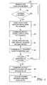
- FIG. 1is a flow diagram illustrating a conventional process of locating and mapping position markers.
- FIG. 2is a flow diagram illustrating a process of locating and mapping position markers according to an embodiment of the present invention.
- FIG. 3is a diagram illustrating a first embodiment of a GPS position marker locating and mapping system.
- FIG. 4is a diagram illustrating a second embodiment of a GPS position marker locating and mapping system.
- FIG. 5is a diagram illustrating a third embodiment of a GPS position marker locating and mapping system.
- FIG. 6is a diagram illustrating exemplary data communication and storage achieved by a GPS position marker locating and mapping system.
- FIG. 1is a flow diagram illustrating a conventional process of locating and mapping position markers.
- a field techniciansearches for a position marker with a conventional locating device.
- a suitable locating deviceis a DynatelTM Locator, manufactured by 3M Corporation of St. Paul, Minn. under the 2200M Series product name.
- the locating deviceprovides a visual and/or audio signal to guide the field technician to the location of the position marker.
- the step of searching for the position markercontinues until the marker is located, as indicated by decision step 12 . Once the position marker has been located, its location is visibly marked by a physical marker as indicated by step 14 .
- the position markermay be a traditional non-data-storing marker, in which case it is not possible to read data from and write data to the marker.
- the position markermay be an RFID type of marker that has the capability to store information, in which case data can be read from and written to the marker, as indicated by optional step 16 .
- cartographic equipmentmay be employed to determine the GPS coordinates of the position marker, as indicated by step 18 . These coordinates are then recorded manually by the field technician (or electronically logged by the GPS equipment), as indicated by step 20 .
- the processmay be repeated for other position markers, as indicated by decision step 22 . If there are no further position markers to locate for a particular project (or if time does not permit further locating activity, for example), the GPS coordinates that were determined for the located position markers are uploaded, such as by manual data entry, in a batch process to a computer mapping application, as indicated by step 24 .
- FIG. 2is a flow diagram illustrating a process of locating and mapping position markers according to an embodiment of the present invention.
- a field techniciansearches for a position marker using a locating device having capabilities similar to a conventional locating device described above. The step of searching for the position marker continues until the marker is located, as indicated by decision step 32 . Once the position marker has been located, a number of actions may occur. In situations where the position marker has the capability to store information, data can be read from and written to the marker, as indicated by optional step 34 . Also, once the position marker has been located, GPS coordinates can be associated with the marker. A GPS device may be communicatively coupled to the locating device, as indicated by step 36 .
- GPS capabilitymay be provided as an integral part of the locating device.
- the locating deviceis then operated to store marker data and GPS coordinate data, as indicated at step 38 .
- Thisprovides the ability to associate GPS coordinate data with position markers in a single field process with the press of a single button by the user, which has not been possible with existing systems.
- the locating deviceis equipped with communication equipment that allows automatic uploading of the GPS coordinate data and marker data to a remote computer, as indicated at step 40 . This may be achieved in a number of different ways, such as a wired serial or USB connection, a wireless infrared or RF connection, communication via a local or wide area network, or in other ways.
- the locating devicesimply stores the GPS coordinate data and marker data in its memory as an appropriately formatted data record, or itself includes processing capability sufficient to run a mapping application program that may be automatically updated by the GPS coordinate data acquired.
- the processmay be repeated for other position markers, as indicated by decision step 42 . If there are no further position markers to locate for a particular project (or if time does not permit further locating activity, for example), the locating device may be communicatively coupled to a computer as indicated by step 44 , and the GPS and marker data that were stored for the located position markers are uploaded to a computer mapping application, as indicated by step 46 .
- FIGS. 3-5illustrate various exemplary embodiments of a GPS position marker locating and mapping system.
- FIG. 3is a diagram illustrating a first embodiment of a GPS position marker locating and mapping system.
- This embodimentincludes GPS device 50 , locating device 52 , and computer (PC) 54 .
- GPS device 50communicates with locating device 52 via communication link 56 , which may be a wired or wireless link of any type, such as RS-232, USB, infrared, RF, or an internal bus or embedded connection, among others.
- Locating device 52operates in a manner known in the art to locate position marker 58 , and may also write data to and read data from marker 58 in embodiments where marker 58 has that capability.
- locating device 52is operable to receive GPS coordinate data from GPS device 50 and to receive position marker data from marker 58 .
- Locating device 52is then able to communicate with PC 54 via communication link 60 , which may be a wired or wireless link.
- the GPS coordinate data and marker dataare uploaded from locating device 52 to an application running on PC 54 , such as a mapping application.
- This configurationprovides the ability to associate GPS coordinate data with position markers in a single field process, controllable by a single user button press or command, by operating GPS device 50 and locating device 52 together in the field.
- GPS device 50is a commercially available retail GPS receiver operating according to the standard NMEA (National Marine Electronics Association) protocol, such as an eTrex® GPS receiver manufactured by Garmin International Inc. of Olathe, Kans. In this configuration, GPS device 50 repeatedly outputs GPS coordinates according to its location.
- Locating device 52is a DynatelTM Locator manufactured by 3M Corporation of St. Paul, Minn. under the 2200M Series product name, and is connected to GPS device 50 by an RS-232 interface. Locating device 52 captures the GPS coordinate data output by GPS device 50 when commanded by the user, indicating that position marker 58 has been located. This command also initiates a read operation to read data from position marker 58 , if it is an RFID marker equipped to store data.
- mapping softwaresuch as the Microstation® line of products (e.g., GeoGraphics®) sold by Bentley Systems, Incorporated of Exton, Pa., the Autodesk MapTM series of products sold by Autodesk, Inc. of San Rafael, Calif., the ArcView® series of products sold by ESRI of Redlands, Calif., or another suitable software product.
- position marker 58is an EMS marker manufactured by 3M Company of St. Paul, Minn. under various product names.
- FIG. 4is a diagram illustrating a second embodiment of a GPS position marker locating and mapping system.
- This embodimentincludes locating device 70 , GPS-enabled data collection terminal 72 , and computer (PC) 74 .
- Locating device 70operates in a manner known in the art to locate position marker 76 , and may also write data to and read data from marker 76 in embodiments where marker 76 has that capability.
- Locating device 70communicates with data collection terminal 72 via communication link 78 , which may be a wired or wireless link of any type, such as RS-232, USB, infrared, RF, or an internal bus or embedded connection, among others.
- Data collection device 72which is a hand-held computer of the type often used for data collection in field applications, determines GPS coordinates and associates that GPS coordinate data with position marker 76 , including marker data if that data exists.
- suitable data collection devicesare the Mobile MapperTM product sold by Thales Navigation, Inc. of Santa Clara, Calif. or the GeoExplorer® series of products sold by Trimble Navigation Limited of Sunnyvale, Calif.
- data collection device 72generates GPS coordinate data and receives position marker data from locating device 70 . This data is stored in the memory of data collection device 72 .
- Data collection device 72has the capability to manipulate marker data and GPS coordinate data in a format used by an appropriate mapping software program, such as the programs mentioned above with respect to FIG. 3 .
- Data collection device 72is then able to communicate with PC 74 via communication link 80 , which may be a wired or wireless link.
- the GPS coordinate data and marker datais uploaded from data collection terminal 72 to the mapping application running on PC 74 .
- This configurationprovides the ability to associate GPS coordinate data with position markers in a single field process, controllable by a single user button press or command, by operating locating device 70 and data collection terminal 72 together in the field.
- locating device 70is a DynatelTM Locator manufactured by 3M Corporation of St. Paul, Minn. under the 2200M Series product name, and is connected to data collection device 72 by an RS-232 interface.
- position marker 76is an EMS marker manufactured by 3M Company of St. Paul, Minn. under various product names.
- FIG. 5is a diagram illustrating a third embodiment of a GPS position marker locating and mapping system.
- This embodimentincludes GPS device 90 , locating device 92 , computer (PC) 94 and mapping database system 95 . Similar to the first embodiment described above and shown in FIG. 3 , GPS device 90 communicates with locating device 92 via communication link 96 , which may be a wired or wireless link of any type, such as RS-232, USB, infrared, RF, or an internal bus or embedded connection, among others.
- Locating device 92operates in a manner known in the art to locate position marker 98 , and may also write data to and read data from marker 98 in embodiments where marker 98 has that capability.
- mapping device 92receives GPS coordinate data from GPS device 90 and receives position marker data from marker 98 . This data is then transferred to mapping database system 95 , either by upload on communication link 100 to PC 94 which then communicates the data to mapping database system 95 on communication link 101 , or by direct communication from locating device 92 to mapping database system 95 on communication link 102 .
- These communication linksmay be wired or wireless links of any suitable type, such as RS-232, USB, infrared, RF, or communication on a wired or wireless local or wide area network, among others.
- the functions of PC 94may be integrated into GPS device 90 , where GPS device 90 includes sufficient processing capability to run mapping software directly. The configuration shown in FIG.
- mapping database system 95provides the ability to associate GPS coordinate data with position markers and to dynamically update a mapping database in a single field process, controllable by a single user button press or command, by operating locating device 90 and data collection terminal 92 together in the field and dynamically transferring the GPS coordinate data and marker data to mapping database system 95 .
- the functions of the GPS devicemay be integrated into the locating device.
- FIG. 6is a diagram illustrating exemplary data communication and storage achieved by a GPS device 110 and locating device 112 in a GPS position marker locating and mapping system.
- GPS device 110includes an optional memory block 114 .
- Locating device 112includes data interface port 116 , memory block 118 , and position marker locator reader block 120 .
- An exemplary position marker 122stores marker data in its memory.
- locating device 112operates in a manner known in the art to locate the position of marker 122 . Once marker 122 has been located, locating device 112 receives the marker data stored in marker 122 at position marker reader block 120 . Locating device 112 also receives GPS coordinate data from GPS device 110 at data interface port 116 . Receiving both marker data and GPS coordinate data allows locating device 112 to store records in memory block 114 that associate GPS coordinate data with position marker data.
- FIG. 6shows data records 124 , 126 and 128 , each of which have GPS coordinate data associated with indexed position marker data. This association and storage of data is accomplished in a single field process, which has not been possible with existing systems.
- memory block 114 of GPS device 110stores the GPS data and marker data, rather than (or in addition to) memory block 120 of locating device 112 .
- datais communicated from data interface port 116 of locating device 112 to GPS device 110 , so that the data records can be stored in memory block 114 of GPS device 110 .
- the disclosed GPS position marker locating and mapping systemprovides the ability to associate GPS data with position markers in a single field process.
- the locating device or a computer coupled to the locating deviceis equipped with communication equipment that allows automatic uploading of the GPS and marker data to a remote mapping database system.
- the locating devicesimply stores the GPS and marker data in its memory as an appropriately formatted data record, for later upload to a mapping system. The system reduces the amount of time and expense involved to determine GPS coordinates for located position markers.
- GPS coordinate data and marker datamay be stored in a variety of media, such as a removable memory card (secure digital memory card, compact flash card, PCMCIA card, microdrive), an external hard disc drive, a CD, a DVD, or another type of media.
- the data recordsmay be stored in many different formats, which may be dictated by the mapping software that is employed.
- the data recordsmay also be arranged in a variety of different ways, such as the memory block format shown in FIG. 6 , or in memory link tables, vector tables, or other arrangements. The examples described herein are not intended to limit the scope of the invention in any way.
Landscapes
- Physics & Mathematics (AREA)
- Life Sciences & Earth Sciences (AREA)
- General Life Sciences & Earth Sciences (AREA)
- General Physics & Mathematics (AREA)
- Geophysics (AREA)
- Position Fixing By Use Of Radio Waves (AREA)
Abstract
Description
The present invention relates to a device for locating position markers, and more particularly to a GPS device having an interface for communication with a position marker locator to associate GPS position data with the marker.
Position marking products are commonly used to mark the location of field features such as underground utility cables. These markers have traditionally been implemented as passive antennas that are locatable by transmitting an RF signal from a locator that is reflected by the marker back to the locator. The user of the locator is then able to document the position of the marker by employing cartographic or surveying equipment to determine the GPS coordinates of the locator and marker, and transcribing or electronically logging the coordinates that are determined. This equipment may be professional use equipment utilizing differential GPS technology, or may be a retail GPS receiver, depending on the accuracy required. After a number of markers have been located and their GPS coordinates have been determined, the list of coordinates can be manually uploaded into a mapping application, typically implemented as a software program on a personal computer (PC).
More advanced position markers have been recently introduced that have the ability to store data associated with the marker, so that data can be written to the marker and retrieved from the marker by a locator device. The data that is written and retrieved can also be stored in the memory of the locator device, for later uploading to a PC. While these markers have added utility to the locating process, the process required to determine GPS coordinates of the markers has remained substantially the same.
An exemplary existing locating system includes Dynatel™ locating devices manufactured by 3M Company of St. Paul, Minn. under the 2200M Series product name (for products capable of locating position markers and cables) or under the 1400 Series product name (for a product capable of locating position markers), and includes EMS position markers manufactured by 3M Company of St. Paul, Minn. under various product names. As mentioned above, GPS coordinates may be determined for the located markers by a separate, stand-alone GPS system, many of which are commercially available from various manufacturers, and the determined GPS coordinates are transcribed or electronically logged in a process separate from the location process. U.S. Pat. No. 5,576,973 to Haddy describes a system in which GPS coordinate data that is determined for a located marker is recorded in the marker.
It would be useful to provide position marker locating capability that is more efficiently able to determine the GPS coordinates of the markers.
A system for locating a position marker is disclosed herein. A locating device locates the position marker, and a GPS device is communicatively coupled to the locating device to provide GPS coordinate data when the position marker is located by the locating device. Electronic memory is provided in at least one of the locating device and the GPS device for storing a data record associating the GPS coordinate data with the located position marker.
Once a position marker has been located and its GPS coordinates have been determined and recorded, the process may be repeated for other position markers, as indicated bydecision step 22. If there are no further position markers to locate for a particular project (or if time does not permit further locating activity, for example), the GPS coordinates that were determined for the located position markers are uploaded, such as by manual data entry, in a batch process to a computer mapping application, as indicated bystep 24.
Once a position marker has been located and its GPS coordinates and other marker data have been determined and uploaded or stored in memory of the locating device, the process may be repeated for other position markers, as indicated bydecision step 42. If there are no further position markers to locate for a particular project (or if time does not permit further locating activity, for example), the locating device may be communicatively coupled to a computer as indicated bystep 44, and the GPS and marker data that were stored for the located position markers are uploaded to a computer mapping application, as indicated bystep 46.
The general process described in the flow diagram ofFIG. 2 may be implemented by a number of different combinations of devices.FIGS. 3-5 illustrate various exemplary embodiments of a GPS position marker locating and mapping system.
In an exemplary configuration,GPS device 50 is a commercially available retail GPS receiver operating according to the standard NMEA (National Marine Electronics Association) protocol, such as an eTrex® GPS receiver manufactured by Garmin International Inc. of Olathe, Kans. In this configuration,GPS device 50 repeatedly outputs GPS coordinates according to its location. Locatingdevice 52 is a Dynatel™ Locator manufactured by 3M Corporation of St. Paul, Minn. under the 2200M Series product name, and is connected toGPS device 50 by an RS-232 interface. Locatingdevice 52 captures the GPS coordinate data output byGPS device 50 when commanded by the user, indicating thatposition marker 58 has been located. This command also initiates a read operation to read data fromposition marker 58, if it is an RFID marker equipped to store data.PC 54 runs mapping software such as the Microstation® line of products (e.g., GeoGraphics®) sold by Bentley Systems, Incorporated of Exton, Pa., the Autodesk Map™ series of products sold by Autodesk, Inc. of San Rafael, Calif., the ArcView® series of products sold by ESRI of Redlands, Calif., or another suitable software product. As described previously,position marker 58 is an EMS marker manufactured by 3M Company of St. Paul, Minn. under various product names. These examples are intended to illustrate the devices that can be used to make up the GPS position marker locating and mapping system, and are not intended for the purpose of limitation of any kind.
In an exemplary configuration, locatingdevice 70 is a Dynatel™ Locator manufactured by 3M Corporation of St. Paul, Minn. under the 2200M Series product name, and is connected todata collection device 72 by an RS-232 interface. As described previously,position marker 76 is an EMS marker manufactured by 3M Company of St. Paul, Minn. under various product names.
In an alternative version of the embodiments shown inFIGS. 3-5 , the functions of the GPS device may be integrated into the locating device.
In operation, locatingdevice 112 operates in a manner known in the art to locate the position ofmarker 122. Oncemarker 122 has been located, locatingdevice 112 receives the marker data stored inmarker 122 at positionmarker reader block 120. Locatingdevice 112 also receives GPS coordinate data fromGPS device 110 atdata interface port 116. Receiving both marker data and GPS coordinate data allows locatingdevice 112 to store records inmemory block 114 that associate GPS coordinate data with position marker data. The example illustrated inFIG. 6 showsdata records
In an alternative embodiment,memory block 114 ofGPS device 110 stores the GPS data and marker data, rather than (or in addition to)memory block 120 of locatingdevice 112. In this embodiment, data is communicated fromdata interface port 116 of locatingdevice 112 toGPS device 110, so that the data records can be stored inmemory block 114 ofGPS device 110.
The disclosed GPS position marker locating and mapping system provides the ability to associate GPS data with position markers in a single field process. In some embodiments, the locating device or a computer coupled to the locating device is equipped with communication equipment that allows automatic uploading of the GPS and marker data to a remote mapping database system. In other embodiments, the locating device simply stores the GPS and marker data in its memory as an appropriately formatted data record, for later upload to a mapping system. The system reduces the amount of time and expense involved to determine GPS coordinates for located position markers.
Many of the features described above have several possible implementations. For example, GPS coordinate data and marker data may be stored in a variety of media, such as a removable memory card (secure digital memory card, compact flash card, PCMCIA card, microdrive), an external hard disc drive, a CD, a DVD, or another type of media. The data records may be stored in many different formats, which may be dictated by the mapping software that is employed. The data records may also be arranged in a variety of different ways, such as the memory block format shown inFIG. 6 , or in memory link tables, vector tables, or other arrangements. The examples described herein are not intended to limit the scope of the invention in any way.
Although the present invention has been described with reference to preferred embodiments, workers skilled in the art will recognize that changes may be made in form and detail without departing from the spirit and scope of the invention.
Claims (18)
1. A system for locating a position marker, comprising:
a locating device for obtaining the physical location of the position marker but not GPS coordinates associated with the physical location;
a GPS device communicatively coupled to the locating device, the GPS device providing GPS coordinate data associated with the obtained physical location of the position marker when the position marker is located by the locating device; and
electronic memory in at least one of the locating device and the GPS device for storing a data record associating the GPS coordinate data with the located position marker.
2. The system ofclaim 1 , further comprising:
a computer for running a mapping application, the computer being capable of receiving the data record stored in the electronic memory to update the mapping application.
3. The system ofclaim 2 , wherein the electronic memory is located in the locating device and the locating device is capable of transmitting the data record to the computer.
4. The system ofclaim 2 , wherein the electronic memory is located in the GPS device and the GPS device is capable of transmitting the stored data record to the computer.
5. The system ofclaim 1 , wherein the locating device reads marker data from the position marker.
6. The system ofclaim 5 , wherein the data record includes GPS coordinate data provided by the GPS device that is associated with marker data read from the position marker.
7. The system ofclaim 1 , wherein the electronic memory is a removable memory card.
8. The system ofclaim 1 , wherein the GPS device is connected to the locating device by an RS-232 cable.
9. A locating device for locating a position marker, comprising:
a locating system for obtaining the physical location of the position marker but not GPS coordinates associated with the physical location and reading marker data from the position marker;
a GPS system for providing GPS coordinate data associated with the obtained physical location of the position marker when the position marker is located by the locating circuitry; and
electronic memory for storing a data record associating the GPS coordinate data with the marker data.
10. The locating device ofclaim 9 , further comprising:
communication circuitry for transmitting the stored data record to a computer running a mapping application.
11. A system for locating a position marker, comprising:
a locating device for obtaining the physical location of the position marker but not GPS coordinates associated with the physical location;
a GPS device communicatively coupled to the locating device, the GPS device providing GPS coordinate data associated with the obtained physical location of the position marker when the position marker is located by the locating device;
a computer for running a mapping application; and
communication circuitry in at least one of the locating device and the GPS device for transmitting a data record to the computer to update the mapping application, the data record associating the GPS coordinate data with the located position marker.
12. The system ofclaim 11 , wherein the locating device reads marker data from the position marker.
13. The system ofclaim 12 , wherein the data record includes GPS coordinate data provided by the GPS device that is associated with marker data read from the position marker.
14. The system ofclaim 11 , wherein the GPS device and the computer are integrated in the same device.
15. A method of locating a position marker, comprising:
operating a locating device to obtain the physical location of the position marker but not GPS coordinates associated with the physical location;
obtaining GPS coordinate data associated with the obtained physical location of the position marker in the same step as location of the position marker by the locating device; and
storing a data record associating the GPS coordinate data with the located position marker.
16. The method ofclaim 15 , further comprising:
operating a computer to run a mapping application; and
transmitting the data record to the computer to update the mapping application.
17. The method ofclaim 15 , further comprising:
operating the locating device to read marker data from the position marker.
18. The method ofclaim 17 , wherein storing the data record comprises associating the GPS coordinate data with the marker data read from the position marker.
Priority Applications (5)
| Application Number | Priority Date | Filing Date | Title |
|---|---|---|---|
| US10/802,345US7319387B2 (en) | 2004-03-17 | 2004-03-17 | GPS interface for locating device |
| EP05725151AEP1725894A1 (en) | 2004-03-17 | 2005-03-11 | Gps interface for locating device |
| CN2005800085297ACN1934461B (en) | 2004-03-17 | 2005-03-11 | GPS interface for positioning devices |
| PCT/US2005/007813WO2005091020A1 (en) | 2004-03-17 | 2005-03-11 | Gps interface for locating device |
| CA002559775ACA2559775A1 (en) | 2004-03-17 | 2005-03-11 | Gps interface for locating device |
Applications Claiming Priority (1)
| Application Number | Priority Date | Filing Date | Title |
|---|---|---|---|
| US10/802,345US7319387B2 (en) | 2004-03-17 | 2004-03-17 | GPS interface for locating device |
Publications (2)
| Publication Number | Publication Date |
|---|---|
| US20050206562A1 US20050206562A1 (en) | 2005-09-22 |
| US7319387B2true US7319387B2 (en) | 2008-01-15 |
Family
ID=34963116
Family Applications (1)
| Application Number | Title | Priority Date | Filing Date |
|---|---|---|---|
| US10/802,345Expired - LifetimeUS7319387B2 (en) | 2004-03-17 | 2004-03-17 | GPS interface for locating device |
Country Status (5)
| Country | Link |
|---|---|
| US (1) | US7319387B2 (en) |
| EP (1) | EP1725894A1 (en) |
| CN (1) | CN1934461B (en) |
| CA (1) | CA2559775A1 (en) |
| WO (1) | WO2005091020A1 (en) |
Cited By (46)
| Publication number | Priority date | Publication date | Assignee | Title |
|---|---|---|---|---|
| US20060220955A1 (en)* | 2005-03-31 | 2006-10-05 | Hamilton Jeffery A | Geographic marking device with RFID transponder |
| US20070096898A1 (en)* | 2005-10-28 | 2007-05-03 | Chun-Pu Chou | Method for reading position data from remote portable electronic device through signal switching network system |
| US20080228294A1 (en)* | 2007-03-13 | 2008-09-18 | Dycom Identity, Llc | Marking system and method with location and/or time tracking |
| US20080245299A1 (en)* | 2007-04-04 | 2008-10-09 | Dycom Identity, Llc | Marking system and method |
| US20090202111A1 (en)* | 2008-02-12 | 2009-08-13 | Steven Nielsen | Electronic manifest of underground facility locate marks |
| US20090204238A1 (en)* | 2007-03-13 | 2009-08-13 | Nielsen Steven E | Electronically controlled marking apparatus and methods |
| US20090240554A1 (en)* | 2008-03-24 | 2009-09-24 | Pinpoint Geotech, Llc | System and method for providing identification and location information of certain items |
| US20090324815A1 (en)* | 2007-03-13 | 2009-12-31 | Nielsen Steven E | Marking apparatus and marking methods using marking dispenser with machine-readable id mechanism |
| US20100088031A1 (en)* | 2008-10-02 | 2010-04-08 | Certusview Technologies, Llc | Methods and apparatus for generating an electronic record of environmental landmarks based on marking device actuations |
| US20100085694A1 (en)* | 2008-10-02 | 2010-04-08 | Certusview Technologies, Llc | Marking device docking stations and methods of using same |
| US20100085185A1 (en)* | 2008-10-02 | 2010-04-08 | Certusview Technologies, Llc | Methods and apparatus for generating electronic records of locate operations |
| US20100085376A1 (en)* | 2008-10-02 | 2010-04-08 | Certusview Technologies, Llc | Methods and apparatus for displaying an electronic rendering of a marking operation based on an electronic record of marking information |
| US20100088164A1 (en)* | 2008-10-02 | 2010-04-08 | Certusview Technologies, Llc | Methods and apparatus for analyzing locate and marking operations with respect to facilities maps |
| US20100117654A1 (en)* | 2008-10-02 | 2010-05-13 | Certusview Technologies, Llc | Methods and apparatus for displaying an electronic rendering of a locate and/or marking operation using display layers |
| US20100188245A1 (en)* | 2008-10-02 | 2010-07-29 | Certusview Technologies, Llc | Locate apparatus having enhanced features for underground facility locate operations, and associated methods and systems |
| US20100189312A1 (en)* | 2008-10-02 | 2010-07-29 | Certusview Technologies, Llc | Methods and apparatus for overlaying electronic locate information on facilities map information and/or other image information displayed on a locate device |
| US20100188088A1 (en)* | 2008-10-02 | 2010-07-29 | Certusview Technologies, Llc | Methods and apparatus for displaying and processing facilities map information and/or other image information on a locate device |
| US20100188407A1 (en)* | 2008-10-02 | 2010-07-29 | Certusview Technologies, Llc | Methods and apparatus for displaying and processing facilities map information and/or other image information on a marking device |
| US20100188215A1 (en)* | 2008-10-02 | 2010-07-29 | Certusview Technologies, Llc | Methods and apparatus for generating alerts on a marking device, based on comparing electronic marking information to facilities map information and/or other image information |
| US20100188216A1 (en)* | 2008-10-02 | 2010-07-29 | Certusview Technologies, Llc | Methods and apparatus for generating alerts on a locate device, based on comparing electronic locate information to facilities map information and/or other image information |
| US20100198663A1 (en)* | 2008-10-02 | 2010-08-05 | Certusview Technologies, Llc | Methods and apparatus for overlaying electronic marking information on facilities map information and/or other image information displayed on a marking device |
| WO2010093451A1 (en) | 2009-02-11 | 2010-08-19 | Certusview Technologies, Llc | Marking apparatus having enhanced features for underground facility marking operations, and associated methods and systems |
| WO2010093426A2 (en) | 2009-02-11 | 2010-08-19 | Certusview Technologies, Llc | Locate apparatus having enhanced features for underground facility locate operations, and associated methods and systems |
| US20100228588A1 (en)* | 2009-02-11 | 2010-09-09 | Certusview Technologies, Llc | Management system, and associated methods and apparatus, for providing improved visibility, quality control and audit capability for underground facility locate and/or marking operations |
| US20100245086A1 (en)* | 2008-10-02 | 2010-09-30 | Certusview Technologies, Llc | Marking apparatus configured to detect out-of-tolerance conditions in connection with underground facility marking operations, and associated methods and systems |
| US20100272885A1 (en)* | 2006-08-16 | 2010-10-28 | SeekTech, Inc., a California corporation | Marking Paint Applicator for Portable Locator |
| US20110045175A1 (en)* | 2009-08-20 | 2011-02-24 | Certusview Technologies, Llc | Methods and marking devices with mechanisms for indicating and/or detecting marking material color |
| US20110060549A1 (en)* | 2009-08-20 | 2011-03-10 | Certusview Technologies, Llc | Methods and apparatus for assessing marking operations based on acceleration information |
| USD634657S1 (en) | 2010-03-01 | 2011-03-22 | Certusview Technologies, Llc | Paint holder of a marking device |
| USD634655S1 (en) | 2010-03-01 | 2011-03-22 | Certusview Technologies, Llc | Handle of a marking device |
| USD634656S1 (en) | 2010-03-01 | 2011-03-22 | Certusview Technologies, Llc | Shaft of a marking device |
| US20110068164A1 (en)* | 2009-09-24 | 2011-03-24 | Trimble Navigation Limited | Method and Apparatus for Barcode and Position Detection |
| US20110117272A1 (en)* | 2009-08-20 | 2011-05-19 | Certusview Technologies, Llc | Marking device with transmitter for triangulating location during locate operations |
| US20110191058A1 (en)* | 2009-08-11 | 2011-08-04 | Certusview Technologies, Llc | Locating equipment communicatively coupled to or equipped with a mobile/portable device |
| USD643321S1 (en) | 2010-03-01 | 2011-08-16 | Certusview Technologies, Llc | Marking device |
| US8358201B1 (en)* | 2012-07-06 | 2013-01-22 | Alan Haddy | Storage and recall of buried asset data over communications networks for damage avoidance and mapping |
| US8424486B2 (en) | 2008-07-10 | 2013-04-23 | Certusview Technologies, Llc | Marker detection mechanisms for use in marking devices and methods of using same |
| USD684067S1 (en) | 2012-02-15 | 2013-06-11 | Certusview Technologies, Llc | Modular marking device |
| US8500005B2 (en) | 2008-05-20 | 2013-08-06 | Trimble Navigation Limited | Method and system for surveying using RFID devices |
| US20140191904A1 (en)* | 2013-01-09 | 2014-07-10 | Baker Hughes Incorporated | System and method to generate three-dimensional mapping of a tubular component layout |
| US8800859B2 (en) | 2008-05-20 | 2014-08-12 | Trimble Navigation Limited | Method and system for surveying using RFID devices |
| US9046413B2 (en) | 2010-08-13 | 2015-06-02 | Certusview Technologies, Llc | Methods, apparatus and systems for surface type detection in connection with locate and marking operations |
| US20150169524A1 (en)* | 2006-06-17 | 2015-06-18 | Google Inc. | Sharing Geographical Information Between Users |
| US9279900B2 (en) | 2008-10-02 | 2016-03-08 | Certusview Technologies, Llc | Systems and methods for generating electronic records of locate and marking operations |
| US20220011108A1 (en)* | 2018-12-20 | 2022-01-13 | Grtgaz | Communicating survey nail, topographical grid, device and method for recording topography and communicating portable terminal |
| US11768308B2 (en)* | 2016-12-16 | 2023-09-26 | SeeScan, Inc. | Systems and methods for electronically marking, locating and virtually displaying buried utilities |
Families Citing this family (13)
| Publication number | Priority date | Publication date | Assignee | Title |
|---|---|---|---|---|
| US7342496B2 (en) | 2000-01-24 | 2008-03-11 | Nextreme Llc | RF-enabled pallet |
| US8077040B2 (en) | 2000-01-24 | 2011-12-13 | Nextreme, Llc | RF-enabled pallet |
| US20070120736A1 (en)* | 2005-11-29 | 2007-05-31 | General Electric Company | Method and system for discrete location triggering for enhanced asset management and tracking |
| NL1033485C2 (en)* | 2007-03-05 | 2008-09-17 | Volkerwessels Intellectuele Eigendom Bv | Identification method for locating object forming part of underground infrastructure, e.g. cable, involves measuring distance between ID tag receiving device and position of object in database |
| US20100229100A1 (en)* | 2009-03-03 | 2010-09-09 | Sprint Spectrum L.P. | Methods and Systems for Storing and Accessing Application History |
| US20100262366A1 (en)* | 2009-04-10 | 2010-10-14 | General Electric Company | System and method for distance estimation |
| CN102486378B (en)* | 2010-12-03 | 2014-08-20 | 国基电子(上海)有限公司 | Wheel path alerting method and navigation apparatus |
| US9405285B2 (en) | 2011-03-18 | 2016-08-02 | Honeywell International Inc. | Interface for local configuration and monitoring of an industrial field device with support for provisioning onto an industrial wireless network and related system and method |
| US9065813B2 (en) | 2011-03-18 | 2015-06-23 | Honeywell International Inc. | Adapter device for coupling an industrial field instrument to an industrial wireless network and related system and method |
| US8818417B2 (en)* | 2011-10-13 | 2014-08-26 | Honeywell International Inc. | Method for wireless device location using automatic location update via a provisioning device and related apparatus and system |
| WO2015130979A1 (en)* | 2014-02-26 | 2015-09-03 | UtilityLink, LLC | Centralized database for infrastructure detection and incident reporting |
| JP2020043471A (en)* | 2018-09-11 | 2020-03-19 | 本田技研工業株式会社 | Remote control device and remote control system |
| BR112021024472A2 (en) | 2019-06-04 | 2022-02-15 | Geoquest Systems Bv | Applying geomarkers to images to identify exploration opportunities |
Citations (24)
| Publication number | Priority date | Publication date | Assignee | Title |
|---|---|---|---|---|
| US4814711A (en) | 1984-04-05 | 1989-03-21 | Deseret Research, Inc. | Survey system and method for real time collection and processing of geophysicals data using signals from a global positioning satellite network |
| US5065098A (en) | 1990-06-18 | 1991-11-12 | The Charles Machine Works, Inc. | System for locating concealed underground objects using digital filtering |
| US5214757A (en) | 1990-08-07 | 1993-05-25 | Georesearch, Inc. | Interactive automated mapping system |
| US5250955A (en)* | 1992-06-05 | 1993-10-05 | Lockheed Information Services Company | State entry beacon system |
| US5264795A (en) | 1990-06-18 | 1993-11-23 | The Charles Machine Works, Inc. | System transmitting and receiving digital and analog information for use in locating concealed conductors |
| US5576973A (en) | 1994-04-18 | 1996-11-19 | Radiodetection Limited | Apparatus and method for obtaining geographical positional data for an object located underground |
| EP0798570A2 (en) | 1996-03-25 | 1997-10-01 | Vallon GmbH | Method and measuringarrangement for locating objects in the earth |
| EP0849611A2 (en) | 1996-12-19 | 1998-06-24 | Vallon GmbH | Locating device for underground objects |
| EP0855595A2 (en) | 1997-01-22 | 1998-07-29 | Kawasaki Steel Corporation | Method and apparatus for locating coating faults on buried pipeline |
| US5819859A (en) | 1996-01-11 | 1998-10-13 | Vermeer Manufacturing Company | Apparatus and method for detecting an underground structure |
| US5825298A (en) | 1996-01-16 | 1998-10-20 | Walter; Kenneth E. | Radio frequency transponder method for identifying geographical locations such as survey traverse points |
| US5949373A (en) | 1998-06-03 | 1999-09-07 | At & T Corp | Automated cable installation method and apparatus |
| US6043777A (en)* | 1997-06-10 | 2000-03-28 | Raytheon Aircraft Company | Method and apparatus for global positioning system based cooperative location system |
| US6259990B1 (en)* | 1998-05-15 | 2001-07-10 | Hitachi, Ltd. | Information processing apparatus and pedestrian navigation system using the same |
| JP2002098774A (en) | 2000-09-21 | 2002-04-05 | Mitsubishi Plastics Ind Ltd | Buried pipeline recognition system |
| US20020171438A1 (en) | 2001-05-18 | 2002-11-21 | Douglas Dudley | Pipeline monitoring system |
| US20030164789A1 (en) | 2002-03-01 | 2003-09-04 | Ensco, Inc. | System and method for detecting and locating underground objects |
| US6650293B1 (en) | 2001-10-22 | 2003-11-18 | At&T Corp. | Technique for providing conveyance locating information |
| US6683538B1 (en)* | 1998-08-29 | 2004-01-27 | Robert D Wilkes, Jr. | Position dependent messaging system |
| US6711535B2 (en) | 1996-09-16 | 2004-03-23 | Datria Systems, Inc. | Method and apparatus for performing field data collection |
| US6958708B2 (en)* | 2002-01-29 | 2005-10-25 | Hewlett-Packard Development Company, L.P. | Beacon-based electronic guide system |
| US7079025B2 (en)* | 2002-06-11 | 2006-07-18 | Worcester Polytechnic Institute | Reconfigurable geolocation system |
| US7142096B2 (en)* | 2001-01-02 | 2006-11-28 | Robert C Eisenman | Combination car alarm and personal locator system |
| US7167715B2 (en)* | 2002-05-17 | 2007-01-23 | Meshnetworks, Inc. | System and method for determining relative positioning in AD-HOC networks |
- 2004
- 2004-03-17USUS10/802,345patent/US7319387B2/ennot_activeExpired - Lifetime
- 2005
- 2005-03-11WOPCT/US2005/007813patent/WO2005091020A1/enactiveApplication Filing
- 2005-03-11CACA002559775Apatent/CA2559775A1/ennot_activeAbandoned
- 2005-03-11EPEP05725151Apatent/EP1725894A1/ennot_activeCeased
- 2005-03-11CNCN2005800085297Apatent/CN1934461B/ennot_activeExpired - Fee Related
Patent Citations (24)
| Publication number | Priority date | Publication date | Assignee | Title |
|---|---|---|---|---|
| US4814711A (en) | 1984-04-05 | 1989-03-21 | Deseret Research, Inc. | Survey system and method for real time collection and processing of geophysicals data using signals from a global positioning satellite network |
| US5065098A (en) | 1990-06-18 | 1991-11-12 | The Charles Machine Works, Inc. | System for locating concealed underground objects using digital filtering |
| US5264795A (en) | 1990-06-18 | 1993-11-23 | The Charles Machine Works, Inc. | System transmitting and receiving digital and analog information for use in locating concealed conductors |
| US5214757A (en) | 1990-08-07 | 1993-05-25 | Georesearch, Inc. | Interactive automated mapping system |
| US5250955A (en)* | 1992-06-05 | 1993-10-05 | Lockheed Information Services Company | State entry beacon system |
| US5576973A (en) | 1994-04-18 | 1996-11-19 | Radiodetection Limited | Apparatus and method for obtaining geographical positional data for an object located underground |
| US5819859A (en) | 1996-01-11 | 1998-10-13 | Vermeer Manufacturing Company | Apparatus and method for detecting an underground structure |
| US5825298A (en) | 1996-01-16 | 1998-10-20 | Walter; Kenneth E. | Radio frequency transponder method for identifying geographical locations such as survey traverse points |
| EP0798570A2 (en) | 1996-03-25 | 1997-10-01 | Vallon GmbH | Method and measuringarrangement for locating objects in the earth |
| US6711535B2 (en) | 1996-09-16 | 2004-03-23 | Datria Systems, Inc. | Method and apparatus for performing field data collection |
| EP0849611A2 (en) | 1996-12-19 | 1998-06-24 | Vallon GmbH | Locating device for underground objects |
| EP0855595A2 (en) | 1997-01-22 | 1998-07-29 | Kawasaki Steel Corporation | Method and apparatus for locating coating faults on buried pipeline |
| US6043777A (en)* | 1997-06-10 | 2000-03-28 | Raytheon Aircraft Company | Method and apparatus for global positioning system based cooperative location system |
| US6259990B1 (en)* | 1998-05-15 | 2001-07-10 | Hitachi, Ltd. | Information processing apparatus and pedestrian navigation system using the same |
| US5949373A (en) | 1998-06-03 | 1999-09-07 | At & T Corp | Automated cable installation method and apparatus |
| US6683538B1 (en)* | 1998-08-29 | 2004-01-27 | Robert D Wilkes, Jr. | Position dependent messaging system |
| JP2002098774A (en) | 2000-09-21 | 2002-04-05 | Mitsubishi Plastics Ind Ltd | Buried pipeline recognition system |
| US7142096B2 (en)* | 2001-01-02 | 2006-11-28 | Robert C Eisenman | Combination car alarm and personal locator system |
| US20020171438A1 (en) | 2001-05-18 | 2002-11-21 | Douglas Dudley | Pipeline monitoring system |
| US6650293B1 (en) | 2001-10-22 | 2003-11-18 | At&T Corp. | Technique for providing conveyance locating information |
| US6958708B2 (en)* | 2002-01-29 | 2005-10-25 | Hewlett-Packard Development Company, L.P. | Beacon-based electronic guide system |
| US20030164789A1 (en) | 2002-03-01 | 2003-09-04 | Ensco, Inc. | System and method for detecting and locating underground objects |
| US7167715B2 (en)* | 2002-05-17 | 2007-01-23 | Meshnetworks, Inc. | System and method for determining relative positioning in AD-HOC networks |
| US7079025B2 (en)* | 2002-06-11 | 2006-07-18 | Worcester Polytechnic Institute | Reconfigurable geolocation system |
Cited By (119)
| Publication number | Priority date | Publication date | Assignee | Title |
|---|---|---|---|---|
| US20060220955A1 (en)* | 2005-03-31 | 2006-10-05 | Hamilton Jeffery A | Geographic marking device with RFID transponder |
| US20070096898A1 (en)* | 2005-10-28 | 2007-05-03 | Chun-Pu Chou | Method for reading position data from remote portable electronic device through signal switching network system |
| US8766796B2 (en)* | 2005-10-28 | 2014-07-01 | Getac Technology Corporation | Method for reading position data from remote portable electronic device through signal switching network system |
| US20150169524A1 (en)* | 2006-06-17 | 2015-06-18 | Google Inc. | Sharing Geographical Information Between Users |
| US9099014B2 (en)* | 2006-06-17 | 2015-08-04 | Google Inc. | Sharing geographical information between users |
| US9436666B1 (en) | 2006-06-17 | 2016-09-06 | Google Inc. | Sharing geographical information between users |
| US20100272885A1 (en)* | 2006-08-16 | 2010-10-28 | SeekTech, Inc., a California corporation | Marking Paint Applicator for Portable Locator |
| US20140067263A1 (en)* | 2007-03-13 | 2014-03-06 | Steven Nielsen | Hand-held marking apparatus with location tracking system and methods for logging geographic location of same |
| US8478523B2 (en)* | 2007-03-13 | 2013-07-02 | Certusview Technologies, Llc | Marking apparatus and methods for creating an electronic record of marking apparatus operations |
| US20090208642A1 (en)* | 2007-03-13 | 2009-08-20 | Nielsen Steven E | Marking apparatus and methods for creating an electronic record of marking operations |
| US7640105B2 (en)* | 2007-03-13 | 2009-12-29 | Certus View Technologies, LLC | Marking system and method with location and/or time tracking |
| US20090324815A1 (en)* | 2007-03-13 | 2009-12-31 | Nielsen Steven E | Marking apparatus and marking methods using marking dispenser with machine-readable id mechanism |
| US20090201178A1 (en)* | 2007-03-13 | 2009-08-13 | Nielsen Steven E | Methods for evaluating operation of marking apparatus |
| US20090204238A1 (en)* | 2007-03-13 | 2009-08-13 | Nielsen Steven E | Electronically controlled marking apparatus and methods |
| US9086277B2 (en) | 2007-03-13 | 2015-07-21 | Certusview Technologies, Llc | Electronically controlled marking apparatus and methods |
| US20130085670A1 (en)* | 2007-03-13 | 2013-04-04 | Certusview Technologies, Llc | Systems and methods for using location data to electronically display dispensing of markers by a marking system or marking tool |
| US20080228294A1 (en)* | 2007-03-13 | 2008-09-18 | Dycom Identity, Llc | Marking system and method with location and/or time tracking |
| US8903643B2 (en)* | 2007-03-13 | 2014-12-02 | Certusview Technologies, Llc | Hand-held marking apparatus with location tracking system and methods for logging geographic location of same |
| US8401791B2 (en) | 2007-03-13 | 2013-03-19 | Certusview Technologies, Llc | Methods for evaluating operation of marking apparatus |
| US8775077B2 (en)* | 2007-03-13 | 2014-07-08 | Certusview Technologies, Llc | Systems and methods for using location data to electronically display dispensing of markers by a marking system or marking tool |
| US8473209B2 (en) | 2007-03-13 | 2013-06-25 | Certusview Technologies, Llc | Marking apparatus and marking methods using marking dispenser with machine-readable ID mechanism |
| US20100094553A1 (en)* | 2007-03-13 | 2010-04-15 | Certusview Technologies, Llc | Systems and methods for using location data and/or time data to electronically display dispensing of markers by a marking system or marking tool |
| US20090210098A1 (en)* | 2007-03-13 | 2009-08-20 | Nielsen Steven E | Marking apparatus and methods for creating an electronic record of marking apparatus operations |
| US8700325B2 (en) | 2007-03-13 | 2014-04-15 | Certusview Technologies, Llc | Marking apparatus and methods for creating an electronic record of marking operations |
| US8407001B2 (en) | 2007-03-13 | 2013-03-26 | Certusview Technologies, Llc | Systems and methods for using location data to electronically display dispensing of markers by a marking system or marking tool |
| US8386178B2 (en) | 2007-04-04 | 2013-02-26 | Certusview Technologies, Llc | Marking system and method |
| US20080245299A1 (en)* | 2007-04-04 | 2008-10-09 | Dycom Identity, Llc | Marking system and method |
| US20100090858A1 (en)* | 2007-04-04 | 2010-04-15 | Certusview Technologies, Llc | Systems and methods for using marking information to electronically display dispensing of markers by a marking system or marking tool |
| US8374789B2 (en) | 2007-04-04 | 2013-02-12 | Certusview Technologies, Llc | Systems and methods for using marking information to electronically display dispensing of markers by a marking system or marking tool |
| US8060304B2 (en) | 2007-04-04 | 2011-11-15 | Certusview Technologies, Llc | Marking system and method |
| US8416995B2 (en) | 2008-02-12 | 2013-04-09 | Certusview Technologies, Llc | Electronic manifest of underground facility locate marks |
| US20090202111A1 (en)* | 2008-02-12 | 2009-08-13 | Steven Nielsen | Electronic manifest of underground facility locate marks |
| US20090240554A1 (en)* | 2008-03-24 | 2009-09-24 | Pinpoint Geotech, Llc | System and method for providing identification and location information of certain items |
| US8500005B2 (en) | 2008-05-20 | 2013-08-06 | Trimble Navigation Limited | Method and system for surveying using RFID devices |
| US8800859B2 (en) | 2008-05-20 | 2014-08-12 | Trimble Navigation Limited | Method and system for surveying using RFID devices |
| US8424486B2 (en) | 2008-07-10 | 2013-04-23 | Certusview Technologies, Llc | Marker detection mechanisms for use in marking devices and methods of using same |
| US9004004B2 (en) | 2008-07-10 | 2015-04-14 | Certusview Technologies, Llc | Optical sensing methods and apparatus for detecting a color of a marking substance |
| US20100198663A1 (en)* | 2008-10-02 | 2010-08-05 | Certusview Technologies, Llc | Methods and apparatus for overlaying electronic marking information on facilities map information and/or other image information displayed on a marking device |
| US8577707B2 (en)* | 2008-10-02 | 2013-11-05 | Certusview Technologies, Llc | Methods and apparatus for overlaying electronic locate information on facilities map information and/or other image information displayed on a locate device |
| US20100262470A1 (en)* | 2008-10-02 | 2010-10-14 | Certusview Technologies, Llc | Methods, apparatus, and systems for analyzing use of a marking device by a technician to perform an underground facility marking operation |
| US9542863B2 (en) | 2008-10-02 | 2017-01-10 | Certusview Technologies, Llc | Methods and apparatus for generating output data streams relating to underground utility marking operations |
| US20100088031A1 (en)* | 2008-10-02 | 2010-04-08 | Certusview Technologies, Llc | Methods and apparatus for generating an electronic record of environmental landmarks based on marking device actuations |
| US9279900B2 (en) | 2008-10-02 | 2016-03-08 | Certusview Technologies, Llc | Systems and methods for generating electronic records of locate and marking operations |
| US9208458B2 (en) | 2008-10-02 | 2015-12-08 | Certusview Technologies, Llc | Methods and apparatus for analyzing locate and marking operations with respect to facilities maps |
| US9177403B2 (en) | 2008-10-02 | 2015-11-03 | Certusview Technologies, Llc | Methods and apparatus for overlaying electronic marking information on facilities map information and/or other image information displayed on a marking device |
| US20100085694A1 (en)* | 2008-10-02 | 2010-04-08 | Certusview Technologies, Llc | Marking device docking stations and methods of using same |
| US20100085185A1 (en)* | 2008-10-02 | 2010-04-08 | Certusview Technologies, Llc | Methods and apparatus for generating electronic records of locate operations |
| US20110095885A9 (en)* | 2008-10-02 | 2011-04-28 | Certusview Technologies, Llc | Methods and apparatus for generating electronic records of locate operations |
| US9069094B2 (en) | 2008-10-02 | 2015-06-30 | Certusview Technologies, Llc | Locate transmitter configured to detect out-of-tolerance conditions in connection with underground facility locate operations, and associated methods and systems |
| US20100084532A1 (en)* | 2008-10-02 | 2010-04-08 | Certusview Technologies, Llc | Marking device docking stations having mechanical docking and methods of using same |
| US9046621B2 (en) | 2008-10-02 | 2015-06-02 | Certusview Technologies, Llc | Locate apparatus configured to detect out-of-tolerance conditions in connection with underground facility locate operations, and associated methods and systems |
| US20100257029A1 (en)* | 2008-10-02 | 2010-10-07 | Certusview Technologies, Llc | Methods, apparatus, and systems for analyzing use of a locate device by a technician to perform an underground facility locate operation |
| US8280631B2 (en) | 2008-10-02 | 2012-10-02 | Certusview Technologies, Llc | Methods and apparatus for generating an electronic record of a marking operation based on marking device actuations |
| US20100085376A1 (en)* | 2008-10-02 | 2010-04-08 | Certusview Technologies, Llc | Methods and apparatus for displaying an electronic rendering of a marking operation based on an electronic record of marking information |
| US8965700B2 (en) | 2008-10-02 | 2015-02-24 | Certusview Technologies, Llc | Methods and apparatus for generating an electronic record of environmental landmarks based on marking device actuations |
| US8361543B2 (en) | 2008-10-02 | 2013-01-29 | Certusview Technologies, Llc | Methods and apparatus for displaying an electronic rendering of a marking operation based on an electronic record of marking information |
| US20100253511A1 (en)* | 2008-10-02 | 2010-10-07 | Certusview Technologies, Llc | Locate apparatus configured to detect out-of-tolerance conditions in connection with underground facility locate operations, and associated methods and systems |
| US20100247754A1 (en)* | 2008-10-02 | 2010-09-30 | Certusview Technologies, Llc | Methods and apparatus for dispensing marking material in connection with underground facility marking operations based on environmental information and/or operational information |
| US8400155B2 (en) | 2008-10-02 | 2013-03-19 | Certusview Technologies, Llc | Methods and apparatus for displaying an electronic rendering of a locate operation based on an electronic record of locate information |
| US20100245086A1 (en)* | 2008-10-02 | 2010-09-30 | Certusview Technologies, Llc | Marking apparatus configured to detect out-of-tolerance conditions in connection with underground facility marking operations, and associated methods and systems |
| US8930836B2 (en) | 2008-10-02 | 2015-01-06 | Certusview Technologies, Llc | Methods and apparatus for displaying an electronic rendering of a locate and/or marking operation using display layers |
| US20100088164A1 (en)* | 2008-10-02 | 2010-04-08 | Certusview Technologies, Llc | Methods and apparatus for analyzing locate and marking operations with respect to facilities maps |
| US20100086677A1 (en)* | 2008-10-02 | 2010-04-08 | Certusview Technologies, Llc | Methods and apparatus for generating an electronic record of a marking operation based on marking device actuations |
| US20100188216A1 (en)* | 2008-10-02 | 2010-07-29 | Certusview Technologies, Llc | Methods and apparatus for generating alerts on a locate device, based on comparing electronic locate information to facilities map information and/or other image information |
| US8442766B2 (en) | 2008-10-02 | 2013-05-14 | Certusview Technologies, Llc | Marking apparatus having enhanced features for underground facility marking operations, and associated methods and systems |
| US8457893B2 (en) | 2008-10-02 | 2013-06-04 | Certusview Technologies, Llc | Methods and apparatus for generating an electronic record of a marking operation including service-related information and/or ticket information |
| US8770140B2 (en) | 2008-10-02 | 2014-07-08 | Certusview Technologies, Llc | Marking apparatus having environmental sensors and operations sensors for underground facility marking operations, and associated methods and systems |
| US8467969B2 (en) | 2008-10-02 | 2013-06-18 | Certusview Technologies, Llc | Marking apparatus having operational sensors for underground facility marking operations, and associated methods and systems |
| US20100188215A1 (en)* | 2008-10-02 | 2010-07-29 | Certusview Technologies, Llc | Methods and apparatus for generating alerts on a marking device, based on comparing electronic marking information to facilities map information and/or other image information |
| US20130162431A1 (en)* | 2008-10-02 | 2013-06-27 | Steven Nielsen | Methods and apparatus for generating alerts on a locate device, based on comparing electronic locate information to facilities map information and/or other image information |
| US8478617B2 (en)* | 2008-10-02 | 2013-07-02 | Certusview Technologies, Llc | Methods and apparatus for generating alerts on a locate device, based on comparing electronic locate information to facilities map information and/or other image information |
| US8476906B2 (en)* | 2008-10-02 | 2013-07-02 | Certusview Technologies, Llc | Methods and apparatus for generating electronic records of locate operations |
| US20100188407A1 (en)* | 2008-10-02 | 2010-07-29 | Certusview Technologies, Llc | Methods and apparatus for displaying and processing facilities map information and/or other image information on a marking device |
| US8478525B2 (en) | 2008-10-02 | 2013-07-02 | Certusview Technologies, Llc | Methods, apparatus, and systems for analyzing use of a marking device by a technician to perform an underground facility marking operation |
| US8478524B2 (en) | 2008-10-02 | 2013-07-02 | Certusview Technologies, Llc | Methods and apparatus for dispensing marking material in connection with underground facility marking operations based on environmental information and/or operational information |
| US20100188088A1 (en)* | 2008-10-02 | 2010-07-29 | Certusview Technologies, Llc | Methods and apparatus for displaying and processing facilities map information and/or other image information on a locate device |
| US8510141B2 (en)* | 2008-10-02 | 2013-08-13 | Certusview Technologies, Llc | Methods and apparatus for generating alerts on a marking device, based on comparing electronic marking information to facilities map information and/or other image information |
| US8527308B2 (en)* | 2008-10-02 | 2013-09-03 | Certusview Technologies, Llc | Methods and apparatus for overlaying electronic locate information on facilities map information and/or other image information displayed on a locate device |
| US20100263591A1 (en)* | 2008-10-02 | 2010-10-21 | Certusview Technologies, Llc | Marking apparatus having environmental sensors and operations sensors for underground facility marking operations, and associated methods and systems |
| US8583264B2 (en) | 2008-10-02 | 2013-11-12 | Certusview Technologies, Llc | Marking device docking stations and methods of using same |
| US8589201B2 (en)* | 2008-10-02 | 2013-11-19 | Certusview Technologies, Llc | Methods and apparatus for generating alerts on a locate device, based on comparing electronic locate information to facilities map information and/or other image information |
| US8589202B2 (en)* | 2008-10-02 | 2013-11-19 | Certusview Technologies, Llc | Methods and apparatus for displaying and processing facilities map information and/or other image information on a marking device |
| US8600526B2 (en) | 2008-10-02 | 2013-12-03 | Certusview Technologies, Llc | Marking device docking stations having mechanical docking and methods of using same |
| US8612148B2 (en) | 2008-10-02 | 2013-12-17 | Certusview Technologies, Llc | Marking apparatus configured to detect out-of-tolerance conditions in connection with underground facility marking operations, and associated methods and systems |
| US20100090700A1 (en)* | 2008-10-02 | 2010-04-15 | Certusview Technologies, Llc | Methods and apparatus for displaying an electronic rendering of a locate operation based on an electronic record of locate information |
| US20100117654A1 (en)* | 2008-10-02 | 2010-05-13 | Certusview Technologies, Llc | Methods and apparatus for displaying an electronic rendering of a locate and/or marking operation using display layers |
| US8766638B2 (en) | 2008-10-02 | 2014-07-01 | Certusview Technologies, Llc | Locate apparatus with location tracking system for receiving environmental information regarding underground facility marking operations, and associated methods and systems |
| US8644965B2 (en) | 2008-10-02 | 2014-02-04 | Certusview Technologies, Llc | Marking device docking stations having security features and methods of using same |
| US20100189312A1 (en)* | 2008-10-02 | 2010-07-29 | Certusview Technologies, Llc | Methods and apparatus for overlaying electronic locate information on facilities map information and/or other image information displayed on a locate device |
| US20100188245A1 (en)* | 2008-10-02 | 2010-07-29 | Certusview Technologies, Llc | Locate apparatus having enhanced features for underground facility locate operations, and associated methods and systems |
| US8749239B2 (en) | 2008-10-02 | 2014-06-10 | Certusview Technologies, Llc | Locate apparatus having enhanced features for underground facility locate operations, and associated methods and systems |
| US8731830B2 (en) | 2008-10-02 | 2014-05-20 | Certusview Technologies, Llc | Marking apparatus for receiving environmental information regarding underground facility marking operations, and associated methods and systems |
| US20100228588A1 (en)* | 2009-02-11 | 2010-09-09 | Certusview Technologies, Llc | Management system, and associated methods and apparatus, for providing improved visibility, quality control and audit capability for underground facility locate and/or marking operations |
| WO2010093426A2 (en) | 2009-02-11 | 2010-08-19 | Certusview Technologies, Llc | Locate apparatus having enhanced features for underground facility locate operations, and associated methods and systems |
| US8731999B2 (en) | 2009-02-11 | 2014-05-20 | Certusview Technologies, Llc | Management system, and associated methods and apparatus, for providing improved visibility, quality control and audit capability for underground facility locate and/or marking operations |
| US9185176B2 (en) | 2009-02-11 | 2015-11-10 | Certusview Technologies, Llc | Methods and apparatus for managing locate and/or marking operations |
| US20100318401A1 (en)* | 2009-02-11 | 2010-12-16 | Certusview Technologies, Llc | Methods and apparatus for performing locate and/or marking operations with improved visibility, quality control and audit capability |
| WO2010093451A1 (en) | 2009-02-11 | 2010-08-19 | Certusview Technologies, Llc | Marking apparatus having enhanced features for underground facility marking operations, and associated methods and systems |
| US8626571B2 (en) | 2009-02-11 | 2014-01-07 | Certusview Technologies, Llc | Management system, and associated methods and apparatus, for dispatching tickets, receiving field information, and performing a quality assessment for underground facility locate and/or marking operations |
| US8311765B2 (en) | 2009-08-11 | 2012-11-13 | Certusview Technologies, Llc | Locating equipment communicatively coupled to or equipped with a mobile/portable device |
| US20110191058A1 (en)* | 2009-08-11 | 2011-08-04 | Certusview Technologies, Llc | Locating equipment communicatively coupled to or equipped with a mobile/portable device |
| US9097522B2 (en) | 2009-08-20 | 2015-08-04 | Certusview Technologies, Llc | Methods and marking devices with mechanisms for indicating and/or detecting marking material color |
| US20110060549A1 (en)* | 2009-08-20 | 2011-03-10 | Certusview Technologies, Llc | Methods and apparatus for assessing marking operations based on acceleration information |
| US20110045175A1 (en)* | 2009-08-20 | 2011-02-24 | Certusview Technologies, Llc | Methods and marking devices with mechanisms for indicating and/or detecting marking material color |
| US8620616B2 (en) | 2009-08-20 | 2013-12-31 | Certusview Technologies, Llc | Methods and apparatus for assessing marking operations based on acceleration information |
| US8620572B2 (en) | 2009-08-20 | 2013-12-31 | Certusview Technologies, Llc | Marking device with transmitter for triangulating location during locate operations |
| US20110117272A1 (en)* | 2009-08-20 | 2011-05-19 | Certusview Technologies, Llc | Marking device with transmitter for triangulating location during locate operations |
| US20110068164A1 (en)* | 2009-09-24 | 2011-03-24 | Trimble Navigation Limited | Method and Apparatus for Barcode and Position Detection |
| USD634655S1 (en) | 2010-03-01 | 2011-03-22 | Certusview Technologies, Llc | Handle of a marking device |
| USD634656S1 (en) | 2010-03-01 | 2011-03-22 | Certusview Technologies, Llc | Shaft of a marking device |
| USD643321S1 (en) | 2010-03-01 | 2011-08-16 | Certusview Technologies, Llc | Marking device |
| USD634657S1 (en) | 2010-03-01 | 2011-03-22 | Certusview Technologies, Llc | Paint holder of a marking device |
| US9046413B2 (en) | 2010-08-13 | 2015-06-02 | Certusview Technologies, Llc | Methods, apparatus and systems for surface type detection in connection with locate and marking operations |
| USD684067S1 (en) | 2012-02-15 | 2013-06-11 | Certusview Technologies, Llc | Modular marking device |
| US8358201B1 (en)* | 2012-07-06 | 2013-01-22 | Alan Haddy | Storage and recall of buried asset data over communications networks for damage avoidance and mapping |
| US20140191904A1 (en)* | 2013-01-09 | 2014-07-10 | Baker Hughes Incorporated | System and method to generate three-dimensional mapping of a tubular component layout |
| US9869749B2 (en)* | 2013-01-09 | 2018-01-16 | Baker Hughes, A Ge Company, Llc | System and method to generate three-dimensional mapping of a tubular component layout |
| US11768308B2 (en)* | 2016-12-16 | 2023-09-26 | SeeScan, Inc. | Systems and methods for electronically marking, locating and virtually displaying buried utilities |
| US20220011108A1 (en)* | 2018-12-20 | 2022-01-13 | Grtgaz | Communicating survey nail, topographical grid, device and method for recording topography and communicating portable terminal |
Also Published As
| Publication number | Publication date |
|---|---|
| CA2559775A1 (en) | 2005-09-29 |
| CN1934461A (en) | 2007-03-21 |
| US20050206562A1 (en) | 2005-09-22 |
| EP1725894A1 (en) | 2006-11-29 |
| WO2005091020A1 (en) | 2005-09-29 |
| CN1934461B (en) | 2012-05-23 |
Similar Documents
| Publication | Publication Date | Title |
|---|---|---|
| US7319387B2 (en) | GPS interface for locating device | |
| US7908083B2 (en) | System and method for recording a note with location information derived from rangefinding and/or observer position | |
| US20060220955A1 (en) | Geographic marking device with RFID transponder | |
| KR101423928B1 (en) | Image reproducing apparatus which uses the image files comprised in the electronic map, image reproducing method for the same, and recording medium which records the program for carrying the same method. | |
| US7492966B2 (en) | Image mapping method and image mapping program | |
| EP1481539B1 (en) | Recording-location determination using different types of signal sources | |
| US6694252B2 (en) | Method of displaying landmark in navigation device | |
| KR100564145B1 (en) | Survey Marking Management System Using Survey Control Point Cover | |
| CN101874195B (en) | Map display device, map display method, and imaging device | |
| US20090201154A1 (en) | Apparatus for securing a land surveyor's mark based on the use of a radio frequency identifier tag | |
| US20140012503A1 (en) | Detecting, locating and tracing of buried assets using mobile computing device integrated with antenna accessory wand | |
| US20110032385A1 (en) | Image positioning method, poi tagging method and the apparatus | |
| US20120078898A1 (en) | Method and Device for Modifying Meta Data of Media Objects | |
| US8547247B1 (en) | Detecting, locating and tracing of buried assets using distributed processing over communications networks | |
| US7184611B2 (en) | Data recording apparatus and method, data reproducing apparatus and method, data recording and reproducing apparatus and method, and map image data format | |
| US20120203506A1 (en) | Information processing apparatus, control method therefor, and non-transitory computer readable storage medium | |
| US6205399B1 (en) | Position recognition device | |
| CN101268381B (en) | GPS positioning method and receiver thereof | |
| KR20120064347A (en) | The management system of measuring standard point | |
| WO2010069380A1 (en) | Method and apparatus for updating map data | |
| US8898179B2 (en) | Method for extracting attribute data from a media file | |
| JP2008224530A (en) | Navigation apparatus and destination registration program | |
| JP2023144527A (en) | Work site information collection system and work site information retrieval system | |
| CN1107386C (en) | Mobile positioning system and method | |
| JP2006287741A (en) | Cooperation system of navigation device and photography device and navigation device |
Legal Events
| Date | Code | Title | Description |
|---|---|---|---|
| AS | Assignment | Owner name:3M INNOVATIVE PROPERTIES COMPANY, MINNESOTA Free format text:ASSIGNMENT OF ASSIGNORS INTEREST;ASSIGNORS:WILLSON, COREY M.;DOANY, ZIYAD HANNA;PARKINSON, TIMOTHY A.;REEL/FRAME:014744/0323;SIGNING DATES FROM 20040603 TO 20040615 | |
| STCF | Information on status: patent grant | Free format text:PATENTED CASE | |
| CC | Certificate of correction | ||
| FPAY | Fee payment | Year of fee payment:4 | |
| FPAY | Fee payment | Year of fee payment:8 | |
| MAFP | Maintenance fee payment | Free format text:PAYMENT OF MAINTENANCE FEE, 12TH YEAR, LARGE ENTITY (ORIGINAL EVENT CODE: M1553); ENTITY STATUS OF PATENT OWNER: LARGE ENTITY Year of fee payment:12 |