US7308118B1 - Building security, occupant safety, and emergency response - Google Patents
Building security, occupant safety, and emergency responseDownload PDFInfo
- Publication number
- US7308118B1 US7308118B1US10/633,908US63390803AUS7308118B1US 7308118 B1US7308118 B1US 7308118B1US 63390803 AUS63390803 AUS 63390803AUS 7308118 B1US7308118 B1US 7308118B1
- Authority
- US
- United States
- Prior art keywords
- building
- floor
- door
- digital image
- segments
- Prior art date
- Legal status (The legal status is an assumption and is not a legal conclusion. Google has not performed a legal analysis and makes no representation as to the accuracy of the status listed.)
- Expired - Fee Related, expires
Links
- 230000004044responseEffects0.000titledescription5
- 238000000034methodMethods0.000claimsabstractdescription17
- 238000013480data collectionMethods0.000claims2
- 230000000717retained effectEffects0.000claims2
- 230000006872improvementEffects0.000description3
- 230000002411adverseEffects0.000description2
- 238000010276constructionMethods0.000description2
- 230000001276controlling effectEffects0.000description2
- 238000013500data storageMethods0.000description1
- 239000000383hazardous chemicalSubstances0.000description1
- 231100000225lethalityToxicity0.000description1
- 230000014759maintenance of locationEffects0.000description1
- 230000007246mechanismEffects0.000description1
- 230000006855networkingEffects0.000description1
- 230000001105regulatory effectEffects0.000description1
- 239000000779smokeSubstances0.000description1
- 230000000007visual effectEffects0.000description1
Images

Classifications
- G—PHYSICS
- G09—EDUCATION; CRYPTOGRAPHY; DISPLAY; ADVERTISING; SEALS
- G09B—EDUCATIONAL OR DEMONSTRATION APPLIANCES; APPLIANCES FOR TEACHING, OR COMMUNICATING WITH, THE BLIND, DEAF OR MUTE; MODELS; PLANETARIA; GLOBES; MAPS; DIAGRAMS
- G09B29/00—Maps; Plans; Charts; Diagrams, e.g. route diagram
- G09B29/003—Maps
- G09B29/006—Representation of non-cartographic information on maps, e.g. population distribution, wind direction, radiation levels, air and sea routes
- G09B29/007—Representation of non-cartographic information on maps, e.g. population distribution, wind direction, radiation levels, air and sea routes using computer methods
Definitions
- the presently disclosed inventionrelates to systems and methods for improving security and, more particularly, for improving the security of buildings
- a system for developing an emergency planto execute the steps of collecting data to define the architectural features of a building.
- a plan view of at least one floor of the buildingis based on the collected data.
- the plan viewis organized into at least one coded zone that is broken into segments.
- the codingcan be by means of color, geometric shapes, or other visual coding device or convention.
- Each segment of the color-coded zoneis associated with an alpha/numeric character that is unique to that zone.
- the completed planis stored at a location that is remote from the building and where it is available to emergency responders.
- the segments of the color-coded zoneis defined by internal and external walls of the building wherein physically adjacent segments are associated with alpha/numeric characters that are in a selected pattern.
- the color-coded zones and the segments of the zonesare added to the image of the collected data and stored on a digital data file or readable copy that can be accessed by emergency responders.
- emergency respondersmaintain such digital data files in a library of digital data files, each of said files corresponding to a building within the service area of the emergency responder.
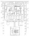
- FIG. 1illustrates a specimen plan view of a building, said plan view including three color-coded zones and numbered segments in each of said zones;
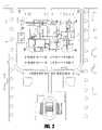
- FIG. 2illustrates the portion of the system that is used for collecting data to define the architectural features of a building.
- the subject inventionprovides a color-coded, segmented plan view of a building that shows those architectural features that are generally of interest to emergency responders such as police, firemen, paramedics and others when they are trying to accomplish efficient, rapid, and reliable ingress/egress into/out of a building.
- the plan viewis stored as a digital image file on a storage media such as a floppy disc, CD, hard drive or other similar device.
- a storage mediasuch as a floppy disc, CD, hard drive or other similar device.
- various alternative formats for storage and display of the plan view of the buildingwill be apparent to those skilled in the art such as computer hard drives, and disc carousels.
- the stored fileis a digital image that is developed from specific data pertaining to the building for which the emergency plan is being developed.
- the datais collected by creating a digital image of a plan drawing of a least one floor of the building as further illustrated in FIG. 1 .
- a plan view of a selected floor of the buildingis prepared from a suitable, accurate plan view of the building that shows the substantial architectural features of the building, including all external and internal walls on the respective floor of the building.
- the external walls 10define the exterior envelope or footprint of the building.
- the internal walls 12 for the same floorare also shown in FIG. 1 and generally define the interior rooms in cooperation with the exterior walls.
- architectural featurescould include elevators, stairwells, key lock boxes, door swings, utility shut-off locations, roof-top access, directional signage, emergency exits, and similar features that would be expected to be of interest to an emergency responder.
- Architectural featurescan also include landscaping and other land improvements such as parking lots, fire hydrants, trees, retention basins, and other architectural features that would be of interest to emergency responders. As shown in FIG. 2 , these can be appropriately added to a drawing of the building footprint by selecting the appropriate symbol that is displayed on a decal that is included in an assortment of decals and applying it to the drawing at the location that corresponds to the actual land improvement. In addition, any features for which no decal is available can be indicated on the drawing by sketching or other suitable means.
- the building flooris divided into several zones 14 .
- Each zone 14is coded so that it is readily distinguishable from the other zones on the same floor. Such coding can be by color-coding or by way of a common design or by other equivalent means. In the example of the preferred embodiment, a color-coding scheme is used to identify different zones.
- Each of the zones 14is broken further into segments 16 that are defined by the external and internal walls of the building. In the example of the preferred embodiment, each of the segments are identified by a number, although other alpha/numeric characters could also be used and are within the scope of the disclosed invention.
- the numbers that identify each segmentfollow a rational numbering system and are unique within the particular color-coded zone. In the case of some segments, as, for example, bathrooms, the numbering system assigns a number to a segment that has no other numeric address or identification.
- the plan drawingis recorded in digital format and saved on a disc.
- the digital filecould be stored on another digital media such as a computer hard drive or other storage media.
- the digital fileis saved in a read-only format to deter any unauthorized tampering with the stored image.
- the saved digital drawingis maintained off the site at a location that will be convenient to an emergency responder. An additional copy is also maintained on-site for immediate on-site reference.
- the saved filewould be stored in a digital memory that is connected to an Ethernet or similar networking facility or device with the digital memory being accessible through the network by an emergency responder from their own respective computer system that is also connected to the network.
- Alternative storage and retrieval mechanismsare also possible.
- the digital drawingcould be maintained on a remote data storage file that is accessible though internet connections or other remote access.
- the plancan be similarly developed for some or all of the other floors on a floor by floor basis.
- the interior and/or exterior doorsare provided with insignias such as signs and/or decals that are located directly on the door or on the adjacent room interior.
- insigniasindicate to the emergency responder which color-coded zones and segments of those zones are accessible from that particular door. This instructs the emergency responder with regard to the most efficient point of entry.
- the stored image of the buildingcan also be in the form of a video or a virtual tour of the building.
- the digitally stored imageincludes videos, virtual tours, still images and other representations of the building such as would become apparent to those skilled in the art based on the disclosure presented herein.
- an emergency responder of other building occupantscould use the coded zones 14 and the alpha/numeric segments 16 to navigate the building.
- the emergency response dispatchercould consult the building plan that is stored on the floppy disc, hard drive or other storage device.
- the dispatchercan communicate with parties at the building and even inside the building via telephone or otherwise and define the location of the problem or danger in terms of the color-coded zone(s) 14 and the numbered segment(s) 16 .
- the dispatchercan then instruct the emergency responder with instructions for approaching or traversing the building.
- the instructionswould be generic for any building for which a plan is available so that persons could familiarize themselves with the system of coded zones and segments in advance. For example, a dispatcher could review preferred ingress and egress routes while the emergency responder is still enroute to the building.
- the dispatchercan transmit a copy of the plan to the responder while they are still en route and then discuss it with the emergency responder while they are viewing a copy of the plan to which the dispatcher is referring. If the emergency response vehicle has the necessary supporting equipment, the responder could access the data base directly and view the plan from a hard drive, CD or over the internet. If the emergency response vehicle is not equipped to support viewing stored digital images, then the responder can carry a hard copy version of the plan drawings.
Landscapes
- Engineering & Computer Science (AREA)
- Physics & Mathematics (AREA)
- Theoretical Computer Science (AREA)
- Mathematical Physics (AREA)
- Ecology (AREA)
- Life Sciences & Earth Sciences (AREA)
- General Engineering & Computer Science (AREA)
- Computer Hardware Design (AREA)
- Business, Economics & Management (AREA)
- Educational Administration (AREA)
- Educational Technology (AREA)
- General Physics & Mathematics (AREA)
- Alarm Systems (AREA)
Abstract
Description
Claims (26)
Priority Applications (1)
| Application Number | Priority Date | Filing Date | Title |
|---|---|---|---|
| US10/633,908US7308118B1 (en) | 2003-08-04 | 2003-08-04 | Building security, occupant safety, and emergency response |
Applications Claiming Priority (1)
| Application Number | Priority Date | Filing Date | Title |
|---|---|---|---|
| US10/633,908US7308118B1 (en) | 2003-08-04 | 2003-08-04 | Building security, occupant safety, and emergency response |
Publications (1)
| Publication Number | Publication Date |
|---|---|
| US7308118B1true US7308118B1 (en) | 2007-12-11 |
Family
ID=38792925
Family Applications (1)
| Application Number | Title | Priority Date | Filing Date |
|---|---|---|---|
| US10/633,908Expired - Fee RelatedUS7308118B1 (en) | 2003-08-04 | 2003-08-04 | Building security, occupant safety, and emergency response |
Country Status (1)
| Country | Link |
|---|---|
| US (1) | US7308118B1 (en) |
Cited By (14)
| Publication number | Priority date | Publication date | Assignee | Title |
|---|---|---|---|---|
| US20090216438A1 (en)* | 2008-02-21 | 2009-08-27 | Microsoft Corporation | Facility map framework |
| US20100023251A1 (en)* | 2008-07-25 | 2010-01-28 | Gale William N | Cost based open area maps |
| US20100023249A1 (en)* | 2008-07-25 | 2010-01-28 | Mays Joseph P | Open area maps with restriction content |
| US20100021012A1 (en)* | 2008-07-25 | 2010-01-28 | Seegers Peter A | End user image open area maps |
| US20100020093A1 (en)* | 2008-07-25 | 2010-01-28 | Stroila Matei N | Open area maps based on vector graphics format images |
| US20100023250A1 (en)* | 2008-07-25 | 2010-01-28 | Mays Joseph P | Open area maps |
| US20100299065A1 (en)* | 2008-07-25 | 2010-11-25 | Mays Joseph P | Link-node maps based on open area maps |
| US20120276517A1 (en)* | 2007-09-20 | 2012-11-01 | United Tecnologies Corporation | Model-based egress support system |
| US20130060729A1 (en)* | 2011-02-28 | 2013-03-07 | Curtis Massey | Disaster and emergency management system |
| US20130085588A1 (en)* | 2011-10-03 | 2013-04-04 | Siemens Ag | System and method for automatically naming objects in a building automation system |
| US8825387B2 (en)* | 2008-07-25 | 2014-09-02 | Navteq B.V. | Positioning open area maps |
| US20150170498A1 (en)* | 2010-07-27 | 2015-06-18 | Ryan P. Beggs | Methods and apparatus to detect and warn proximate entities of interest |
| US20210334926A1 (en)* | 2020-04-26 | 2021-10-28 | Venn Agency | System and a method for creating and transmitting an occupant safety test for occupants in an organization |
| US20220270196A1 (en)* | 2020-04-26 | 2022-08-25 | Loci, Inc. | System and method for creating and transmitting an incentivized or mandated serious game safety test to occupants or users of liable property in an organization |
Citations (7)
| Publication number | Priority date | Publication date | Assignee | Title |
|---|---|---|---|---|
| US20040036579A1 (en)* | 2002-08-21 | 2004-02-26 | Megerle Clifford A. | Adaptive escape routing system |
| US20050086227A1 (en)* | 2002-02-27 | 2005-04-21 | Andrew Sullivan | Risk mapping system |
| US20050146429A1 (en)* | 2003-12-31 | 2005-07-07 | Spoltore Michael T. | Building occupant location and fire detection system |
| US20050245232A1 (en)* | 2004-04-30 | 2005-11-03 | Robert Jakober | Emergency response mission support platform |
| US20050289467A1 (en)* | 2004-06-28 | 2005-12-29 | Raphael Imhof | Method and apparatus for representing a building system |
| US20060049933A1 (en)* | 2004-09-09 | 2006-03-09 | Kelley Sean P | Method and apparatus for tactical planning |
| US20060109113A1 (en)* | 2004-09-17 | 2006-05-25 | Reyes Tommy D | Computer-enabled, networked, facility emergency notification, management and alarm system |
- 2003
- 2003-08-04USUS10/633,908patent/US7308118B1/ennot_activeExpired - Fee Related
Patent Citations (9)
| Publication number | Priority date | Publication date | Assignee | Title |
|---|---|---|---|---|
| US20050086227A1 (en)* | 2002-02-27 | 2005-04-21 | Andrew Sullivan | Risk mapping system |
| US20040036579A1 (en)* | 2002-08-21 | 2004-02-26 | Megerle Clifford A. | Adaptive escape routing system |
| US6778071B2 (en)* | 2002-08-21 | 2004-08-17 | Lockheed Martin Corporation | Adaptive escape routing system |
| US20050146429A1 (en)* | 2003-12-31 | 2005-07-07 | Spoltore Michael T. | Building occupant location and fire detection system |
| US20050245232A1 (en)* | 2004-04-30 | 2005-11-03 | Robert Jakober | Emergency response mission support platform |
| US20050289467A1 (en)* | 2004-06-28 | 2005-12-29 | Raphael Imhof | Method and apparatus for representing a building system |
| US20060010388A1 (en)* | 2004-06-28 | 2006-01-12 | Raphael Imhof | Method and apparatus for representing a building system enabling facility viewing for maintenance purposes |
| US20060049933A1 (en)* | 2004-09-09 | 2006-03-09 | Kelley Sean P | Method and apparatus for tactical planning |
| US20060109113A1 (en)* | 2004-09-17 | 2006-05-25 | Reyes Tommy D | Computer-enabled, networked, facility emergency notification, management and alarm system |
Cited By (29)
| Publication number | Priority date | Publication date | Assignee | Title |
|---|---|---|---|---|
| US20120276517A1 (en)* | 2007-09-20 | 2012-11-01 | United Tecnologies Corporation | Model-based egress support system |
| US9109896B2 (en)* | 2007-09-20 | 2015-08-18 | Utc Fire & Security Corporation | Model-based egress support system |
| US20090216438A1 (en)* | 2008-02-21 | 2009-08-27 | Microsoft Corporation | Facility map framework |
| US20100020093A1 (en)* | 2008-07-25 | 2010-01-28 | Stroila Matei N | Open area maps based on vector graphics format images |
| US8339417B2 (en) | 2008-07-25 | 2012-12-25 | Navteq B.V. | Open area maps based on vector graphics format images |
| US20100023250A1 (en)* | 2008-07-25 | 2010-01-28 | Mays Joseph P | Open area maps |
| US20100299065A1 (en)* | 2008-07-25 | 2010-11-25 | Mays Joseph P | Link-node maps based on open area maps |
| US8099237B2 (en) | 2008-07-25 | 2012-01-17 | Navteq North America, Llc | Open area maps |
| US8229176B2 (en) | 2008-07-25 | 2012-07-24 | Navteq B.V. | End user image open area maps |
| US20100021012A1 (en)* | 2008-07-25 | 2010-01-28 | Seegers Peter A | End user image open area maps |
| US8825387B2 (en)* | 2008-07-25 | 2014-09-02 | Navteq B.V. | Positioning open area maps |
| US8374780B2 (en) | 2008-07-25 | 2013-02-12 | Navteq B.V. | Open area maps with restriction content |
| US20100023249A1 (en)* | 2008-07-25 | 2010-01-28 | Mays Joseph P | Open area maps with restriction content |
| US8396257B2 (en) | 2008-07-25 | 2013-03-12 | Navteq B.V. | End user image open area maps |
| US20100023251A1 (en)* | 2008-07-25 | 2010-01-28 | Gale William N | Cost based open area maps |
| US8417446B2 (en)* | 2008-07-25 | 2013-04-09 | Navteq B.V. | Link-node maps based on open area maps |
| US8594930B2 (en) | 2008-07-25 | 2013-11-26 | Navteq B.V. | Open area maps |
| US9542824B2 (en) | 2010-07-27 | 2017-01-10 | Rite-Hite Holding Corporation | Methods and apparatus to detect and warn proximate entities of interest |
| US20150170498A1 (en)* | 2010-07-27 | 2015-06-18 | Ryan P. Beggs | Methods and apparatus to detect and warn proximate entities of interest |
| US9547969B2 (en) | 2010-07-27 | 2017-01-17 | Right-Hite Holding Corporation | Methods and apparatus to detect and warn proximate entities of interest |
| US9607496B2 (en) | 2010-07-27 | 2017-03-28 | Rite-Hite Holding Corporation | Methods and apparatus to detect and warn proximate entities of interest |
| US9633537B2 (en)* | 2010-07-27 | 2017-04-25 | Rite-Hite Holding Corporation | Methods and apparatus to detect and warn proximate entities of interest |
| US9672713B2 (en) | 2010-07-27 | 2017-06-06 | Rite-Hite Holding Corporation | Methods and apparatus to detect and warn proximate entities of interest |
| US20130060729A1 (en)* | 2011-02-28 | 2013-03-07 | Curtis Massey | Disaster and emergency management system |
| US20130085588A1 (en)* | 2011-10-03 | 2013-04-04 | Siemens Ag | System and method for automatically naming objects in a building automation system |
| US9400493B2 (en)* | 2011-10-03 | 2016-07-26 | Siemens Schweiz Ag | System and method for automatically naming objects in a building automation system |
| US20210334926A1 (en)* | 2020-04-26 | 2021-10-28 | Venn Agency | System and a method for creating and transmitting an occupant safety test for occupants in an organization |
| US20220270196A1 (en)* | 2020-04-26 | 2022-08-25 | Loci, Inc. | System and method for creating and transmitting an incentivized or mandated serious game safety test to occupants or users of liable property in an organization |
| US20230377080A1 (en)* | 2020-04-26 | 2023-11-23 | Loci, Inc. | System and method for creating and transmitting an incentivized or mandated serious game safety test to occupants or users of liable property in an organization |
Similar Documents
| Publication | Publication Date | Title |
|---|---|---|
| US7308118B1 (en) | Building security, occupant safety, and emergency response | |
| US7483917B2 (en) | Risk mapping system | |
| Newman | Creating defensible space | |
| Berg et al. | Defensible space: Deterring crime and building community | |
| Freeman et al. | Accumulation by forced removal: the thinning of rio de janeiro's favelas in preparation for the games | |
| EA006788B1 (en) | Method and system for providing tactical information during crisis situations | |
| CN102063690A (en) | Satellite and three-dimensional city based digital fire fighting early warning intelligent management system | |
| Curtis et al. | Capturing damage assessment with a spatial video: An example of a building and street-scale analysis of tornado-related mortality in Joplin, Missouri, 2011 | |
| Switzer et al. | Redrawing cognitive maps of conflict: Lost spaces and forgetting in the centre of Belfast | |
| Herbert | Territoriality and the Police | |
| Vale | The imaging of the city: Public housing and communication | |
| Clark | Ruined landscapes and residual architecture: Affect and palimpsest in trauma tourism | |
| Matlovičová et al. | Environment of estates and crime prevention through urban environment formation and modification | |
| Miller et al. | Wayfinding in complex healthcare environments | |
| Abdelmonem et al. | Architecture, space and memory of resurrection in Northern Ireland: Shareness in a divided nation | |
| Lama et al. | Crime mapping and crime analysis of property crimes in Jodhpur | |
| Passini | Wayfinding: backbone of graphic support systems | |
| Banerji et al. | Designing safer cities-review of environmental crime prevention strategies | |
| Jenkins et al. | Saving city lifelines: Lessons learned in the 9-11 terrorist attacks | |
| Cisneros | Defensible space: Deterring crime and building community | |
| Xaba | An examination of the effectiveness of the implementation of safety and security measures at public schools in South Africa | |
| Mahoney | Businesses and bombs: Preplanning and response | |
| BRYANT et al. | Archaeology in the changing townscape: the case of the Centre region in France | |
| Herseth et al. | Prepare to protect: operating and maintaining a tornado safe room | |
| Seretis | An island divided: politicised landscapes, modern borders, and shifting identities |
Legal Events
| Date | Code | Title | Description |
|---|---|---|---|
| AS | Assignment | Owner name:SIMECEK, A JAY, OHIO Free format text:ASSIGNMENT OF ASSIGNORS INTEREST;ASSIGNOR:MEADOWS, ROY F;REEL/FRAME:019905/0476 Effective date:20070929 | |
| AS | Assignment | Owner name:SIMECEK, A. JAY, PENNSYLVANIA Free format text:CORRECTIVE ASSIGNMENT TO CORRECT THE CONVEYING PARTY NAME TO READ "ROY E. MEADOWS" PREVIOUSLY RECORDED ON REEL 019905 FRAME 0476;ASSIGNOR:MEADOWS, ROY E;REEL/FRAME:020011/0579 Effective date:20070929 | |
| STCF | Information on status: patent grant | Free format text:PATENTED CASE | |
| REMI | Maintenance fee reminder mailed | ||
| FPAY | Fee payment | Year of fee payment:4 | |
| SULP | Surcharge for late payment | ||
| FPAY | Fee payment | Year of fee payment:8 | |
| FEPP | Fee payment procedure | Free format text:MAINTENANCE FEE REMINDER MAILED (ORIGINAL EVENT CODE: REM.); ENTITY STATUS OF PATENT OWNER: SMALL ENTITY | |
| LAPS | Lapse for failure to pay maintenance fees | Free format text:PATENT EXPIRED FOR FAILURE TO PAY MAINTENANCE FEES (ORIGINAL EVENT CODE: EXP.); ENTITY STATUS OF PATENT OWNER: SMALL ENTITY | |
| STCH | Information on status: patent discontinuation | Free format text:PATENT EXPIRED DUE TO NONPAYMENT OF MAINTENANCE FEES UNDER 37 CFR 1.362 | |
| FP | Lapsed due to failure to pay maintenance fee | Effective date:20191211 |