US7271742B2 - Method and apparatus for sending, retrieving and planning location relevant information - Google Patents
Method and apparatus for sending, retrieving and planning location relevant informationDownload PDFInfo
- Publication number
- US7271742B2 US7271742B2US10/378,980US37898003AUS7271742B2US 7271742 B2US7271742 B2US 7271742B2US 37898003 AUS37898003 AUS 37898003AUS 7271742 B2US7271742 B2US 7271742B2
- Authority
- US
- United States
- Prior art keywords
- user
- location
- route
- point
- interest
- Prior art date
- Legal status (The legal status is an assumption and is not a legal conclusion. Google has not performed a legal analysis and makes no representation as to the accuracy of the status listed.)
- Expired - Fee Related, expires
Links
Images


Classifications
- G—PHYSICS
- G06—COMPUTING OR CALCULATING; COUNTING
- G06F—ELECTRIC DIGITAL DATA PROCESSING
- G06F3/00—Input arrangements for transferring data to be processed into a form capable of being handled by the computer; Output arrangements for transferring data from processing unit to output unit, e.g. interface arrangements
- G06F3/01—Input arrangements or combined input and output arrangements for interaction between user and computer
- G06F3/048—Interaction techniques based on graphical user interfaces [GUI]
- G06F3/0484—Interaction techniques based on graphical user interfaces [GUI] for the control of specific functions or operations, e.g. selecting or manipulating an object, an image or a displayed text element, setting a parameter value or selecting a range
- G06F3/0486—Drag-and-drop
- G—PHYSICS
- G06—COMPUTING OR CALCULATING; COUNTING
- G06Q—INFORMATION AND COMMUNICATION TECHNOLOGY [ICT] SPECIALLY ADAPTED FOR ADMINISTRATIVE, COMMERCIAL, FINANCIAL, MANAGERIAL OR SUPERVISORY PURPOSES; SYSTEMS OR METHODS SPECIALLY ADAPTED FOR ADMINISTRATIVE, COMMERCIAL, FINANCIAL, MANAGERIAL OR SUPERVISORY PURPOSES, NOT OTHERWISE PROVIDED FOR
- G06Q30/00—Commerce
- G06Q30/02—Marketing; Price estimation or determination; Fundraising
- G—PHYSICS
- G01—MEASURING; TESTING
- G01C—MEASURING DISTANCES, LEVELS OR BEARINGS; SURVEYING; NAVIGATION; GYROSCOPIC INSTRUMENTS; PHOTOGRAMMETRY OR VIDEOGRAMMETRY
- G01C21/00—Navigation; Navigational instruments not provided for in groups G01C1/00 - G01C19/00
- G01C21/20—Instruments for performing navigational calculations
- G—PHYSICS
- G01—MEASURING; TESTING
- G01C—MEASURING DISTANCES, LEVELS OR BEARINGS; SURVEYING; NAVIGATION; GYROSCOPIC INSTRUMENTS; PHOTOGRAMMETRY OR VIDEOGRAMMETRY
- G01C21/00—Navigation; Navigational instruments not provided for in groups G01C1/00 - G01C19/00
- G01C21/26—Navigation; Navigational instruments not provided for in groups G01C1/00 - G01C19/00 specially adapted for navigation in a road network
- G01C21/34—Route searching; Route guidance
- G01C21/3407—Route searching; Route guidance specially adapted for specific applications
- G01C21/3438—Rendezvous; Ride sharing
- G—PHYSICS
- G01—MEASURING; TESTING
- G01C—MEASURING DISTANCES, LEVELS OR BEARINGS; SURVEYING; NAVIGATION; GYROSCOPIC INSTRUMENTS; PHOTOGRAMMETRY OR VIDEOGRAMMETRY
- G01C21/00—Navigation; Navigational instruments not provided for in groups G01C1/00 - G01C19/00
- G01C21/26—Navigation; Navigational instruments not provided for in groups G01C1/00 - G01C19/00 specially adapted for navigation in a road network
- G01C21/34—Route searching; Route guidance
- G01C21/36—Input/output arrangements for on-board computers
- G01C21/3664—Details of the user input interface, e.g. buttons, knobs or sliders, including those provided on a touch screen; remote controllers; input using gestures
- G—PHYSICS
- G01—MEASURING; TESTING
- G01C—MEASURING DISTANCES, LEVELS OR BEARINGS; SURVEYING; NAVIGATION; GYROSCOPIC INSTRUMENTS; PHOTOGRAMMETRY OR VIDEOGRAMMETRY
- G01C21/00—Navigation; Navigational instruments not provided for in groups G01C1/00 - G01C19/00
- G01C21/26—Navigation; Navigational instruments not provided for in groups G01C1/00 - G01C19/00 specially adapted for navigation in a road network
- G01C21/34—Route searching; Route guidance
- G01C21/36—Input/output arrangements for on-board computers
- G01C21/3679—Retrieval, searching and output of POI information, e.g. hotels, restaurants, shops, filling stations, parking facilities
- G01C21/3682—Retrieval, searching and output of POI information, e.g. hotels, restaurants, shops, filling stations, parking facilities output of POI information on a road map
- G—PHYSICS
- G06—COMPUTING OR CALCULATING; COUNTING
- G06F—ELECTRIC DIGITAL DATA PROCESSING
- G06F3/00—Input arrangements for transferring data to be processed into a form capable of being handled by the computer; Output arrangements for transferring data from processing unit to output unit, e.g. interface arrangements
- G06F3/01—Input arrangements or combined input and output arrangements for interaction between user and computer
- G06F3/048—Interaction techniques based on graphical user interfaces [GUI]
- G06F3/0481—Interaction techniques based on graphical user interfaces [GUI] based on specific properties of the displayed interaction object or a metaphor-based environment, e.g. interaction with desktop elements like windows or icons, or assisted by a cursor's changing behaviour or appearance
- G06F3/04817—Interaction techniques based on graphical user interfaces [GUI] based on specific properties of the displayed interaction object or a metaphor-based environment, e.g. interaction with desktop elements like windows or icons, or assisted by a cursor's changing behaviour or appearance using icons
- G—PHYSICS
- G06—COMPUTING OR CALCULATING; COUNTING
- G06F—ELECTRIC DIGITAL DATA PROCESSING
- G06F3/00—Input arrangements for transferring data to be processed into a form capable of being handled by the computer; Output arrangements for transferring data from processing unit to output unit, e.g. interface arrangements
- G06F3/01—Input arrangements or combined input and output arrangements for interaction between user and computer
- G06F3/048—Interaction techniques based on graphical user interfaces [GUI]
- G06F3/0484—Interaction techniques based on graphical user interfaces [GUI] for the control of specific functions or operations, e.g. selecting or manipulating an object, an image or a displayed text element, setting a parameter value or selecting a range
- G—PHYSICS
- G06—COMPUTING OR CALCULATING; COUNTING
- G06F—ELECTRIC DIGITAL DATA PROCESSING
- G06F3/00—Input arrangements for transferring data to be processed into a form capable of being handled by the computer; Output arrangements for transferring data from processing unit to output unit, e.g. interface arrangements
- G06F3/01—Input arrangements or combined input and output arrangements for interaction between user and computer
- G06F3/048—Interaction techniques based on graphical user interfaces [GUI]
- G06F3/0487—Interaction techniques based on graphical user interfaces [GUI] using specific features provided by the input device, e.g. functions controlled by the rotation of a mouse with dual sensing arrangements, or of the nature of the input device, e.g. tap gestures based on pressure sensed by a digitiser
- G06F3/0489—Interaction techniques based on graphical user interfaces [GUI] using specific features provided by the input device, e.g. functions controlled by the rotation of a mouse with dual sensing arrangements, or of the nature of the input device, e.g. tap gestures based on pressure sensed by a digitiser using dedicated keyboard keys or combinations thereof
- G06F3/04892—Arrangements for controlling cursor position based on codes indicative of cursor displacements from one discrete location to another, e.g. using cursor control keys associated to different directions or using the tab key
- G—PHYSICS
- G08—SIGNALLING
- G08G—TRAFFIC CONTROL SYSTEMS
- G08G1/00—Traffic control systems for road vehicles
- G08G1/09—Arrangements for giving variable traffic instructions
- G08G1/0962—Arrangements for giving variable traffic instructions having an indicator mounted inside the vehicle, e.g. giving voice messages
- G08G1/0968—Systems involving transmission of navigation instructions to the vehicle
- G08G1/096805—Systems involving transmission of navigation instructions to the vehicle where the transmitted instructions are used to compute a route
- G08G1/096827—Systems involving transmission of navigation instructions to the vehicle where the transmitted instructions are used to compute a route where the route is computed onboard
- G—PHYSICS
- G08—SIGNALLING
- G08G—TRAFFIC CONTROL SYSTEMS
- G08G1/00—Traffic control systems for road vehicles
- G08G1/09—Arrangements for giving variable traffic instructions
- G08G1/0962—Arrangements for giving variable traffic instructions having an indicator mounted inside the vehicle, e.g. giving voice messages
- G08G1/0968—Systems involving transmission of navigation instructions to the vehicle
- G08G1/096833—Systems involving transmission of navigation instructions to the vehicle where different aspects are considered when computing the route
- G08G1/096844—Systems involving transmission of navigation instructions to the vehicle where different aspects are considered when computing the route where the complete route is dynamically recomputed based on new data
- G—PHYSICS
- G08—SIGNALLING
- G08G—TRAFFIC CONTROL SYSTEMS
- G08G1/00—Traffic control systems for road vehicles
- G08G1/09—Arrangements for giving variable traffic instructions
- G08G1/0962—Arrangements for giving variable traffic instructions having an indicator mounted inside the vehicle, e.g. giving voice messages
- G08G1/0968—Systems involving transmission of navigation instructions to the vehicle
- G08G1/096855—Systems involving transmission of navigation instructions to the vehicle where the output is provided in a suitable form to the driver
- G08G1/096866—Systems involving transmission of navigation instructions to the vehicle where the output is provided in a suitable form to the driver where the complete route is shown to the driver
- G—PHYSICS
- G08—SIGNALLING
- G08G—TRAFFIC CONTROL SYSTEMS
- G08G1/00—Traffic control systems for road vehicles
- G08G1/09—Arrangements for giving variable traffic instructions
- G08G1/0962—Arrangements for giving variable traffic instructions having an indicator mounted inside the vehicle, e.g. giving voice messages
- G08G1/0968—Systems involving transmission of navigation instructions to the vehicle
- G08G1/0969—Systems involving transmission of navigation instructions to the vehicle having a display in the form of a map
- H—ELECTRICITY
- H04—ELECTRIC COMMUNICATION TECHNIQUE
- H04L—TRANSMISSION OF DIGITAL INFORMATION, e.g. TELEGRAPHIC COMMUNICATION
- H04L51/00—User-to-user messaging in packet-switching networks, transmitted according to store-and-forward or real-time protocols, e.g. e-mail
- H04L51/04—Real-time or near real-time messaging, e.g. instant messaging [IM]
- H—ELECTRICITY
- H04—ELECTRIC COMMUNICATION TECHNIQUE
- H04L—TRANSMISSION OF DIGITAL INFORMATION, e.g. TELEGRAPHIC COMMUNICATION
- H04L65/00—Network arrangements, protocols or services for supporting real-time applications in data packet communication
- H04L65/40—Support for services or applications
- H04L65/403—Arrangements for multi-party communication, e.g. for conferences
- H—ELECTRICITY
- H04—ELECTRIC COMMUNICATION TECHNIQUE
- H04M—TELEPHONIC COMMUNICATION
- H04M1/00—Substation equipment, e.g. for use by subscribers
- H04M1/72—Mobile telephones; Cordless telephones, i.e. devices for establishing wireless links to base stations without route selection
- H04M1/724—User interfaces specially adapted for cordless or mobile telephones
- H04M1/72403—User interfaces specially adapted for cordless or mobile telephones with means for local support of applications that increase the functionality
- H04M1/7243—User interfaces specially adapted for cordless or mobile telephones with means for local support of applications that increase the functionality with interactive means for internal management of messages
- H04M1/72436—User interfaces specially adapted for cordless or mobile telephones with means for local support of applications that increase the functionality with interactive means for internal management of messages for text messaging, e.g. short messaging services [SMS] or e-mails
Definitions
- This present inventionrelates to a computerized mapping and real-time communication software program, and more specifically, to integrating or coupling computerized mapping and real-time communication software for the purpose of transferring location-related information using a real-time communication system.
- mapping and real-time communication softwareare independently achieving widespread use today.
- Such mapping programsare commonly used to automate tasks of calculating routes, viewing location-specific geographical areas for their spatial content, such as addresses, roadways, rivers, etc., and for the purpose of being used with Global Positioning System (GPS) devices for various applications, such as a personal navigation application.
- GPSGlobal Positioning System
- Mapping software programsapply to a wide variety of uses, such as personal navigation, telematics, thematic mapping, resource planning, routing, fleet tracking, safety dispatching (i.e., police, Fire, and Rescue organizations), and a wide variety of specialized Geographic Information System (GIS) applications, all of which are well known to people skilled in the art.
- GISGeographic Information System
- Real-time communication software applicationsare also being used today in various applications, like Instant Messaging (IM) applications such as American Online's (AOL) IM (AIM), Yahoo's IM, and Microsoft's IM, all of which are well known to people skilled in the art. None of these prior art IM software applications contain mapping capabilities. These applications provide presence information about other users on a user's roster or buddy list, such as online, busy, away, on the phone, offline, etc., and are primarily used for noncommercial applications, such as for conversing with friends or buddies that are online.
- IMInstant Messaging
- AOLAmerican Online's
- AzureYahoo's IM
- Microsoft's IMMicrosoft's IM
- Prior art applicationsprovide various features, such as displaying driving directions (i.e., routes), Points Of Interest (POI), waypoints (such as personalized, user-specific, points on a route or along a track), etc., but do not enable the transfer of such information to other users in real-time.
- driving directionsi.e., routes
- Points Of InterestPOI
- waypointssuch as personalized, user-specific, points on a route or along a track
- a userwill typically copy an image of a map from a standard mapping program, usually with a highlighted route, and e-mail the bitmap image and/or directions to another user or group of users for the purpose of meeting at a specific location or POI, such as a restaurant.
- userscan transfer these images and directions, typically by using an integrated file transfer program (FTP) connection, in real-time to other users based on their presence, and obtain real-time feedback from their buddies about the destination POI or location and specific route used to get to the destination.
- FTPfile transfer program
- mapping and real-time messagingare well known in the art, such as the Automatic Vehicle Location (AVL) or Fleet Tracking industry, where vehicles that have position devices, such as GPS, report their position to a centralized computer for the mapping and display of the vehicles' locations.
- AOLAutomatic Vehicle Location
- Some of these prior art systemsmay incorporate real-time messaging for the transfer of logistical information, such as pickup and drop-off status messages.
- these existing applicationsdo not provide a method for dynamically and graphically transferring location-relevant information coupled with a spatial map. Additionally, these applications typically provide only one-way transfer of position information, from the mobile vehicle to the dispatcher application, either on a web-based or desktop-based program.
- Mobile devicestypically use location telemetry devices to transmit their location in a pre-defined manner or by request, where the dispatcher's location request is usually initiated by clicking on a Graphical User Interface (GUI) or by using a set of preferences to automatically request position updates. These preferences are based on various parameters, such as reporting location updates based on the distance traveled by the vehicle or by using various time intervals to trigger position updates either by a push or pull method relative to the telemetry device.
- GUIGraphical User Interface
- AVL software solutionsprovide the ability to display moving vehicles on dynamically viewable maps.
- Some dynamic mapping applicationssuch as Microsoft's MapPoint application, allow users to select Points Of Interest (POI) generally for the purpose of providing additional information about the POI or enabling the user to add the POI to a route planner as a route start, end, or stop point. This POI is selected by ‘right-clicking’ on the object after it has been selected and then choosing the specific route option.
- POIsPoints Of Interest
- prior artfails to provide real-time communication capability with location-relevant information (i.e., POIs) for the purpose of graphically sending location-relevant information in established or ad-hoc networks to other users or location-enabled devices.
- AVL mapping and tracking systemssuch as At Road Inc., only allow users to select from a list of pre-configured location-updating vehicles, and then require the user to press a button in order to map the location of the selected vehicle(s).
- mapping and communication programssuch as AVL applications
- AVL applicationsprovide the ability for the receiving of position information for mapping purposes only.
- location-relevant informationsuch as POIs
- PDAPersonal Digital Assistants
- prior art mapping systemssuch as Microsoft's MapPoint, allow the user to select POIs, such as restaurants and gas stations, but does not allow the user to transfer these POIs to other users, and more specifically does not allow users to graphically drag-and-drop these selections (i.e., POIs) for various purposes, such as to dynamically add them to a route planner for inclusion in an undefined route or pre-calculated route.
- POIssuch as restaurants and gas stations
- a highly dynamic mapping applicationand a real-time communication system enables users to select POIs, such as houses, theaters, city names, roads, etc., or icon representations of other users on a mapping program for the purpose of graphically sending location-relevant graphical information, such as the selected POIs, to a specific user on a roster listing of available online users in real-time.
- location-relevant graphical informationis not limited to only POIs, but also includes mapped routes, waypoints, geo-fenced areas, planes, etc.
- a valuable feature that prior art fails to provideis the transfer mechanism that allows the ability to drag-and-drop this location-relevant map information (i.e., routes, geo-fenced areas, etc.) to the current application's roster list for such transfers.
- Prior art systemssuch as AVL software, also fail to provide the capability of allowing the map application user (i.e., in the case of an AVL software solution the user is typically denoted as the dispatcher) to send the position information of one vehicle to another vehicle on the user's roster list for an ad-hoc location transfer.
- This method of transferring informationis best performed by dragging the icon representation of one vehicle to the icon representation of another vehicle in the user's roster list.
- the user or dispatcheracts as the location-transfer hub, each user sets the appropriate permissions to allow the transfer.
- each of the vehicles' roster listsdo not need to be included in the other vehicle's roster list, since the user or dispatcher has both vehicles on its roster list and acts as the hub for the transfer of the position information. This creates a dynamic environment for ad-hoc position transfers that are not available in prior art systems.
- a more useful methodwhich can incorporate the integrated real-time communication system, is by allowing the user to drag a graphical representation of a location-relevant object, such as POI (i.e., restaurant, gas station, house, user, etc.), to the pre-calculated route itself or to a route planner, thus graphically altering the pre-calculated route by creating a destination point based on the dragged POI's location information. If the POI has a static location, and its position information is already known, then the real-time communication system is not utilized.
- a location-relevant objectsuch as POI (i.e., restaurant, gas station, house, user, etc.)
- the real-time communication systemis utilized to obtain the position information of the selected dynamic POI in real-time, thus producing a dynamically moving route, where the destination point can change its position in real-time, thus causing the route to continually update it parameters based on the moving object.
- Another advantage for using the dynamic route calculationis as the POI moves its location, the entire route need not be re-calculated in real-time, but only that portion of the route that needs to be re-calculated.
- Current prior art systems that are capable of generating routesallow users to send route representations, such as bitmap images or driving directions, to other users either by e-mail or FTP connection, where these routes representations only provide a static set of information, such as the starting and ending (i.e., destination) points of the predefined route.
- the routeis usually generated based on the sender's origin and destination, or is based on generic major roadways that are easily identifiable in the immediate area.
- a more useful implementationwhen compared to prior art systems, would enable users to transfer or ‘share’ pre-defined routes, including all of the destination and turn points of the route and all of the metrics used to calculate the route, in real-time, so that they can be incorporated into the recipient user's routes or dynamically viewed on the recipient user's map.
- transferring a vehicle's actual route to another vehicle or graphical applicationallows the other user to view in real-time the exact location of that vehicle relative to the route that vehicle is traveling along.
- An additional benefit of this more useful applicationwould be that the recipient of the route would be able to use in their route planner tool the sent destination points (i.e., stop points, end point, etc.), and use their own current location as the route's origin.
- the sent destination pointsi.e., stop points, end point, etc.
- MapBlastallow users to send image representations of static routes to other users. However, these routes are relative to the sender's location.
- Providing a solution enabling users to graphically send, request, and plan, in real-time, location-relevant information between users and deviceswould prove especially useful for wireless devices that incorporate positioning technologies, such as Global Positioning Satellite (GPS) devices.
- GPSGlobal Positioning Satellite
- personal data informationi.e., vcard or personal profile information
- userscan include inanimate objects (i.e., phones, vehicles, boats, database, device, etc.) or living things (i.e., people, pets, etc.)
- living thingsi.e., people, pets, etc.
- the location-relevant informationcan be stored locally, typically with contact information, cached from a recently received location update, or location information can be automatically requested in real-time from a specified user or group of users where a user may include an online database storage system.
- location-relevant informatione.g., latitude, longitude, altitude, heading, etc.
- a usercan select another user, typically from a roster list, and drag-and-drop the user onto a map in order to automatically map this other user's current location.
- the mapped usercan be in the form of a contact, where the location information (i.e., vcard), such as an address, is typically stored locally in the storage system of the computing device, or the user can be in the form of a roster list of users connected via a real-time communication system.
- the location informationcan be in the form of vcard information, and may also include position information from various positioning devices, such as a GPS device.
- the remote user to be mappede.g., person, phone, vehicle, etc.
- the requesting user's real-time communication programUpon accepting the request to send their position information, the requesting user's real-time communication program would receive the remote user's position information from the remote user and transfer the remote user's position information to the requesting user's mapping application to be displayed on a graphical map.
- the remote usercan also be considered to be in the form of an online database storage system. In essence, all of the previous steps are performed using a simple selection and drag-and-drop operation.
- the mapping application and the real-time communication applicationdo not have to be fully integrated (i.e., they can be separate applications), but do preferably include a conduit for transferring position information between the two applications. Integrating the two applications typically provides for a better user experience, but is not required by this object.
- a user engaged in an instant message conversation with a mobile wireless phone userdesires to obtain the position of said wireless phone user.
- the requesting usercan push a button on the instant message window, or select a menu bar option, to initiate the request of the wireless phone user's position information.
- the requesting user's mapping applicationcan automatically display the location of the wireless phone user. Additionally, the requesting user could have also initiated the position request by selecting the body of an instant message window and performing a drag-and-drop operation onto the mapping application. In this manner, the user is able to request the position information of another user and automatically map it quickly, easily, using an ad-hoc position request method and system.
- a user engaged in an instant message sessioncan push a button to send their own position information to the other user or group of users that are currently participating in the instant message session.
- the recipient user or group of userscan have the option to accept or decline the transfer of the said position information, and, upon acceptance, the recipient user's mapping application can automatically perform a mapping operation.
- location-relevant information objectssuch as routes, POIs, waypoints, user's locations, geo-fenced areas, vehicles, planes, etc.
- a usercan select a position-enabled object (e.g. POI) from a graphical map and either drag-and-drop the POI to a user or group in a list, or select from a menu list the specific destination user or group of users to which the POI should be sent.
- a position-enabled objecte.g. POI
- location-relevant informationsuch as routes, another user's location information, POIs, etc.
- the informationcan be automatically mapped in an accompanying mapping application.
- the mapping application and the real-time communication applicationdo not have to be fully integrated (i.e., they can be separate applications), but they do require a conduit, such as a software application program interface (API), for transferring said position information between the two applications.
- a remote user that has been sent location-relevant information, such as a POIcan receive a notification message indicating that the POI will be transferred upon acceptance of the request.
- the POIUpon acceptance of the request, the POI will be transferred to the destination user, who can then have the option to map the received POI or display the textual location and name of the POI, or both.
- This preference informationcan be configured in real-time or pre-configured in the application preferences of the real-time communication application.
- a user that has a list of N other userscan select an icon representation of a user or group of users and initiate the transfer of the location information of the selected user or group of users to a destination user or group of users other then themselves.
- the initiating useressentially acts as the hub for graphically initiating and transferring the location information between users and/or groups of users.
- the initiating usercan perform this graphical initiation of a location transfer by highlighting a user or group of users from a list or graphical icon representation, and select from a pop-up menu or list the destination user or group of users to which the location information should be sent. Additionally, the initiator can start the location transfer by selecting the icon representation of the user or group of users from a list or graphical icon representation, and then dragging-and-dropping it to another icon or list representation of a user or group of users, or any combination thereof, for the purpose of sending or transferring said location information. Before the location transfer is completed, permission settings can be obtained from the origin and destination users or groups of users. It is not a requirement that the origin and destination user or group of users include each other in their own roster list, since only the initiating user needs to have both origin and destination users or groups of users in their roster lists.
- a user wanting to send their own position information to a group of userscan select their own icon representation and drag-and-drop said icon representation onto the icon representation of the group of users who should receive said position information.
- each user in the groupwill have the option of accepting or declining said position information transfer, and each receiving user that accepts the position information transfer has a mapping application that automatically performs a mapping operation to display the received position information on a graphical map.
- an in-vehicle navigation system on a defined routemay need to transfer that route to a desktop computer.
- the route, and all of its parameters,can be transferred to the desktop's mapping application for display.
- the sender of the routecan include and send their own real-time position information with the route for display on the desktop computer's mapping application.
- the sender's real-time communication applicationis configured to send its own location on the route to the recipient, via a real-time communication system, at any given interval of time, distance change, or upon the sender's request.
- the recipient's real-time communication applicationis configured to receive these location updates from the sender, which then triggers the recipient's mapping application to display the updated location of the sender.
- the real-time communication applicationnot only provides the ability to send the route, but to transfer the vehicle's real-time position information in order for it to be mapped.
- the destinations in the received routecan remain a common element between the sender and the recipient, but the origin, or closest starting position relative to the received route, can change to be the recipient's current position information on the received route, thus allowing a new route to be calculated based on the recipient's current position information and a common set of received destinations. All of the received destinations are optional, but at least one received destination is required to calculate a new route from the recipient's current position.
- the recipient usercan receive the sent route with the original origin and destinations of the route.
- the recipient's mapping applicationcan then dynamically re-calculate a new route based on all or a subset of the received route's destinations and with an origin being the recipient's current real-time position information.
- an inanimate objecti.e., phone, vehicle, boat, etc.
- living thingi.e., person, pet, etc.
- a usercan select an icon representation of another user, group of users, or contact from a list and drag-and-drop said icon representation onto a pre-calculated graphically-displayed route for the purpose of modifying said route by inserting into that route as destinations the location(s) of the selected user(s), such that the inserted destinations are placed after the destination point that immediately preceded the route segment where the icon was dropped, and before the destination point that immediately followed the route segment where the icon was dropped.
- the useris able to add a new route destination simply by dragging an icon representation of the user, group of users, or contact onto a pre-calculated route.
- the position informationcan be either locally stored, as is typically the case with contacts, or can be retrieved and updated in real-time as the position information changes, which may be very useful for a user that is defined as a mobile phone or vehicle.
- One advantage of the present inventionis that the entire route need not be recomputed each time a destination is updated. Only the portion of the route that was changed can be recalculated. For example, if a route consists of origin point A and destination points B then C, and an additional destination is added in-between points A and B, then only the portion of the route between A and B needs to be recalculated to include the added destination.
- a usercan select another user, group of users, or contact icon representation from a list and drag-and-drop said icon representation into a route planner window, such that the order of the route destinations are arranged as previously described, with the new destination point being inserted in the route between the points immediately preceding and following the point where the icon was dropped. If there is no destination point immediately preceding or immediately following the point where the icon was dropped, then that new route destination point becomes the origin or destination, respectively, of the new route.
- the minimal route calculationcan compute the route segment consisting of the new destination point and the destination points immediately preceding and immediately following the new destination point can then be recalculated. However, the entire route may be recalculated to maximize overall route optimization.
- the retrieval of the position informationis the same as described in previous objects, but in this embodiment the route would not automatically calculate a new route until the user instructs it to be calculated.
- location-relevant information objectssuch as POIs, city names, street names, user icon representations, vehicles, etc.
- graphically selecting location-relevant information objects, such as POIs, dragging said objects to a pre-calculated graphically-displayed route, and dropping said objects onto the routeenables the addition of destination points, based on the selected location-relevant information objects, along said route at the point where they were graphically dropped.
- the need for the mapping program to calculate which portion of the route to alteris eliminated since the user selects the appropriate portion directly with the selected location-relevant information object.
- a location-relevant objectsuch as a gas station POI
- a location-relevant objectis selected and dragged to the graphically displayed pre-calculated route, and then dropped onto a particular route segment on the map.
- This actionautomatically adds the POI as a destination point, where the order of the destination point in the route is determined by the object's drop point, and automatically recalculates the route with the new inserted destination point included.
- Another benefitis that the entire route need not be recalculated, but only the segment of the route upon which the object was dropped needs to be computed.
- This objectalso applies to another embodiment of a method for graphically selecting location-relevant information objects, such as POIs, and dragging-and-dropping said objects to a route planner for the purpose of adding additional origin or destination points along said route.
- location-relevant information objectssuch as POIs
- dragging-and-dropping said objectsto a route planner for the purpose of adding additional origin or destination points along said route.
- the difference in this embodimentis that the POI is not dropped onto a pre-calculated graphically displayed route, but onto a route planner instead.
- the benefit of the previous embodimentalso applies to this embodiment, in that the entire route does not need to be recalculated, but only the portion of the route into which the new destination point is inserted can be recomputed.
- the routecan be a pre-calculated route or a route that is being planned and still needs to be calculated.
- the selected user's position informationis updated either through the real-time communications system, or if the selected user is the application user, the position information is updated from a locally connected positioning device (e.g. GPS).
- the POIis sometimes considered a static location-relevant object, such as a gas station, house, restaurant, city location identifier, etc., whose position remains relatively unchanged.
- a user tracking a vehicle on a map that wishes to obtain a route for said vehicle to a gas stationcan select the vehicle's graphical icon representation on the map and drag-and-drop it onto an icon representation of a restaurant on the map. This action can generate a route from the selected vehicle's current position on the map to the location of the restaurant and may create a new route in a route planner consisting of the origin as the selected vehicle's current location and the destination as the selected POI's location.
- the real-time communication systemallows the vehicle to move while the route is dynamically updated using the vehicle's new position information as the origin of the route and using the restaurant POI as the destination.
- Another benefit of this objectis that if there are two or more destinations (i.e., three or more route points) the entire route does not need to be recalculated, but only the portion of the route that has been changed, by real-time position updates of location-relevant objects such as the vehicle, needs to be computed.
- a location-relevant objectis a map object that has a spatial component associated with it, such as latitude and longitude values, and is graphically selectable by the user.
- Selecting an icon representation for a dynamic location-relevant objectsuch as a vehicle, person, plane, boat, etc., where the position of the dynamic location-relevant object can change with time and its real-time position updates can be received via the real-time communications system or locally when connected to a local positioning device such as a GPS receiver, and dragging and dropping said object representation onto another icon representation of a dynamic location-relevant object will create a route between the two dynamic objects and/or add the objects into a route planner, depending on the user's preferences.
- the object that was first selectedis considered the starting point, or origin, of the route, and the second selected object is considered the destination point of the route.
- the selection of an icon representation of a location-relevant object on a map, such as a vehicle, pet, person, boat, wireless phone, computer, city name, street name, park, etc., followed by the use of a drag-and-drop operation to a route planner window in order to drop said location-relevant object into the route planner windowadds the said object to the route planner for the purpose of either updating a pre-calculated route or creating a new route.
- the order that the location-relevant object is dropped into the route planner windowdirectly affects the order of the destination points of the route, and thus the route itself.
- a route planner window displayconsists of a route with three destination points (i.e., four route points including the origin). Selecting an icon representation of a location-relevant object, such as a wireless phone, and then dragging-and-dropping the icon into the route planner between the first and second destination points causes the wireless phone object to become the second destination in the route. Since the wireless phone's location can change with time, the route will be a dynamically calculated route based on changes in its position. Another benefit of this object is that if there are two or more destinations (i.e., three or more route points) the entire route does not have to be recalculated, but only the portion of the route that has changed, including any real-time position updates of location-relevant objects.
- a routecan then be generated between the two location-relevant user objects, or the objects can be included in a route planner window for the purpose of planning a new route.
- the origin route pointis defined as the first selected and dragged location-relevant user object
- the destination route pointis defined as the location-relevant user object that the first object was dropped upon.
- the position information for these location-relevant user objectsif not stored locally, can be retrieved in real-time using the real-time communication system.
- the location retrieval processis based on the approval of the transfer of the required location information by the users.
- a usercan select a graphical icon representation of themselves in a list and drag said representation to the graphical icon representation in a list or on a map of any location-relevant object on a map, such as another user or a static POI, for the purpose of generating a route.
- the route's origincan be the user's current position information
- the destinationcan be the position information of either a dynamic location-relevant object, such as a mobile user, where the real-time position information is received via the real-time communications system, or can be a static location-relevant object, such as a POI (i.e., gas station), where the position information may already be known.
- a POIi.e., gas station
- the position information for a POIis not known, it can be retrieved using the real-time communication system connected to a database where the appropriate position information is stored.
- a pre-calculated route with two or more destination pointswill be recalculated when any of those destination points change due to a position update via the real-time communication system.
- the route portion that is different from the original routeis graphically displayed differently than the recalculated route, thus providing the user with a greater amount of information.
- an icon representation of a location-relevant object, such as a carthat has been included into a pre-calculated route along with a stationary POI, such as a gas station, can initially display the pre-calculated route on a map.
- a new routecan be calculated based on its new position information and displayed.
- the previous pre-calculated routecan be displayed using a different highlighted color and pattern than the new route that was just calculated.
- Another benefit of this objectis that if there are two or more destinations (i.e., three or more route points) the entire route does not have to be recalculated, but only the portion of the route that has changed will be displayed differently than the new route segment.
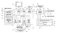
- FIG. 1illustrates a computer system and a network system that provide an operating environment for the present invention
- FIG. 2illustrates one embodiment of the present invention showing a real-time communications program with an integrated mapping environment that displays various location-relevant objects on a map;
- FIG. 3illustrates one embodiment of the present invention for dynamically mapping a roster list of users and/or contacts using a drag-and-drop operation
- FIG. 4illustrates one embodiment of the present invention for dynamically mapping a user from an Instant Message window
- FIG. 4Aillustrates one embodiment of the present invention for receiving location-relevant information in an Instant Message program and then mapping the received information in a separate mapping program;
- FIG. 4Billustrates one embodiment of the present invention for displaying a location request from another user
- FIG. 5illustrates one embodiment of the present invention for displaying the location of a user on a graphical map
- FIG. 6illustrates one embodiment of the present invention for sending, or sharing, a route with another user by using a graphical drag-and-drop operation
- FIG. 6Aillustrates one embodiment of the present invention for sending, or sharing, a route with another user by using a graphical menu selection operation
- FIG. 7illustrates one embodiment of the present invention for sending, or sharing, a route with a user or group of users by using a menu selection operation
- FIG. 8illustrates one embodiment of the present invention for selecting a user for the purpose of sending, or sharing, a route with a user on a menu list
- FIG. 9illustrates one embodiment of the present invention for selecting a POI and graphically sending the location-relevant object to a vehicle by means of a real-time communication system
- FIG. 10illustrates one embodiment of the present invention for selecting a POI and graphically sending the location-relevant object to a user selected from a menu list;
- FIG. 11illustrates one embodiment of the present invention for selecting a POI and graphically sending the location-relevant object to a vehicle selected from a menu list;
- FIG. 12illustrates one embodiment of the present invention for graphically displaying the request to transfer a location-relevant object
- FIG. 13illustrates one embodiment of the present invention for graphically transferring location-relevant information or objects from a user-to-user, or object-to-user where the initiator of the transfer acts as the hub;
- FIG. 14illustrates one embodiment of the present invention for graphically transferring one's own location information to another user
- FIG. 15illustrates one embodiment of the present invention for graphically displaying a received route from another user, and that other user's current location along that route on a map;
- FIG. 16illustrates one embodiment of the present invention for graphically displaying the originally received route and the newly calculated route based on the local user's position information and the received destination points;
- FIG. 17illustrates one embodiment of the present invention for graphically adding a roster list user as a destination point to the graphical representation of a pre-calculated route
- FIG. 18illustrates one embodiment of the present invention for graphically adding a roster list user as a destination point in a route planner window
- FIG. 19illustrates one embodiment of the present invention for displaying the graphical route created in FIG. 18 ;
- FIG. 20illustrates one embodiment of the present invention for graphically adding location-relevant object icon representations to a pre-calculated route
- FIG. 21illustrates one embodiment of the present invention for displaying the graphical route created in FIG. 20 ;
- FIG. 22illustrates one embodiment of the present invention for graphically creating a route using location-relevant objects on a map, where one of the objects is a roster list user and the other is a POI;
- FIG. 23illustrates one embodiment of the present invention for graphically displaying the route created in FIG. 22 ;
- FIG. 24illustrates one embodiment of the present invention for graphically creating a route from location-relevant objects on a map, where both of the objects are icon representations of roster list users.
- FIG. 25illustrates one embodiment of the present invention for displaying the graphical route created in FIG. 24 ;
- FIG. 26illustrates one embodiment of the present invention for graphically adding location-relevant objects to a route planner using their icon representations
- FIG. 27illustrates one embodiment of the present invention for graphically adding destination points to a route using location-relevant objects
- FIG. 28illustrates one embodiment of the present invention for displaying the graphical route created in FIG. 24 ;
- FIG. 29illustrates one embodiment of the present invention for graphically creating routes using a roster list of users or contacts, where the local user is the origin of the route;
- FIG. 30illustrates one embodiment of the present invention for graphically creating routes using location-relevant objects on a map, where the local user is the origin of the route;
- FIG. 31illustrates one embodiment of the present invention for displaying the graphical route created in FIG. 30 ;
- FIG. 32illustrates one embodiment of the present invention for displaying a current dynamic route and a history of previous routes on the same map.
- the present inventionprovides a method and system for graphically sending (and sharing), retrieving, and planning location-relevant information with a mapping and real-time communications applications, where both applications can be integrated into one application or each application is separate and capable of communicating with the other.
- the present inventionmay be embodied in a mapping and real-time communication application, such as the “Map Messenger” application owned and licensed by the Networks In Motion Corporation of Pasadena, Calif.
- FIG. 1illustrates a high-level diagram of one environment that is a suitable computing and networking environment in which the invention may be implemented.
- the inventionwill be described in the general context of an application that executes on an operating system in conjunction with a personal computer, but those skilled in the art will realize that this invention also may be implemented in combination with other program modules.
- Program modulestypically include routines, programs, data structures, etc. that perform particular tasks or implement particular abstract data types.
- This inventionis not limited to a typical personal computer, but may also be utilized with other computing systems, such as handheld devices, mobile laptop computers, wireless phones, in-vehicle navigation systems, programmable consumer electronics, mainframe computers, distributed computer systems, etc., and the like.
- FIG. 1includes a typical personal computer 100 , that includes a central processing unit (CPU) 135 , video adapter 134 , hard disk drive 107 , optical disk 108 , serial port 109 , magnetic disk drive 110 , system bus 106 , and network interface 136 .
- the hard disk drive 107typically refers to a local non-volatile storage system for storing large amounts of data, such as map data.
- the optical disk 108typically refers to a CD-ROM disk used for storing read-only data, such as an installation program.
- the serial port interface 109is typically used to connect 113 the computer 100 to external devices 111 , such as a keyboard, mouse, and graphical touch screen interface, and also can connect 137 to positioning devices 138 , such as a GPS receiver.
- the keyboard and mouse 111amongst other input devices 138 , enable users to input information into the computer 100 .
- the connection 113 & 137 cablescan include a serial cable or universal serial bus (USB) cable.
- Other input devicesmay include a joystick, scanner, camera, microphone, or the like.
- the magnetic disk drive 110is typically used to store small amounts data, in comparison to a hard 107 or optical 108 disk drive, and typically lacks the data transfer rates of those other storage drives, but it enables both readable and writable capability.
- the hard disk drive 107 , optical disk drive 108 , serial port interface 109 , and magnetic disk drive 110are all connected to the main system bus 106 of the computer 100 for transferring data.
- Additional peripheral output deviceswhich are not included in this embodiment, such as a printer, speaker, etc., can also be connected to a personal computer 100 .
- the system bus 106also connects to the network interface 136 , central processing unit (CPU) 135 , and system memory 101 .
- the system memory 101contains both random access memory (RAM) 103 , and read only memory (ROM) 102 , that typically consists of the BIOS (Basic Input/Output System) of the computer, necessary for containing basic routines that enable the transfer of information between elements within the personal computer 100 .
- the RAM 103stores a number of program modules, such as the Mapping and Communication Program, including Map Data, 105 , and the Operating System 104 of the personal computing device 100 or personal computer 100 .
- One example of such a program module 105can be the “Map Messenger” program previously mentioned.
- a network interface 136illustrates how data is typically transferred between other computing devices 122 , 126 , 127 , & 130 and a computer 100 through an Internet, Intranet, or Extranet network 124 . Additionally, this connection 115 can be implemented using a MODEM 112 that is connected 114 to the personal computing device 100 by using a serial port interface 109 . In one embodiment, a computer 100 can connect 121 to a network 124 , such as an Internet, Intranet, or Extranet, by various means that are well known in the art, such as by using a Digital Subscriber Line (DSL) cable.
- DSLDigital Subscriber Line
- a computing device 100can also connect to the Internet 124 by means of a wireless connection 120 to a wireless base station 122 , where the antenna is coupled 119 to the network interface 136 of the computing device or personal computer 100 .
- the wireless base station 122is also connected 123 to the Internet, Intranet, or Extranet network 124 by some means well known to people skilled in the art, such as a T1 connection.
- a wireless base station 122can represent a local area network (LAN) base station, such as that used in an office building, or a wide area network (WAN) base station, such as that used in a cellular, Personal Communications System (PCS), 3G, or the like, wireless phone network.
- LANlocal area network
- WANwide area network
- PCSPersonal Communications System
- the Internet, Intranet, or Extranet 124allows for connection 129 & 128 to other personal computing devices 126 & 127 , such as a wireless phone, hand-held device, in-vehicle navigation (i.e., telematics device), or the like.
- the Internet, Intranet, or Extranet 124is also connected 125 to a central or distributed server system 130 , however this connection is not necessary in a peer-to-peer environment.
- This server system 130can contain a real-time communication server 132 , a mapping server 133 which can provide map data for devices that do not have large storage capabilities, and a database 131 where location-relevant information such as POIs can be stored.
- the real-time communication system 150can be either one of two possible systems, both of which apply to this invention.
- the first embodimentis a peer-to-peer system, where each computing device 100 , 126 , & 127 is connected to the Internet, Intranet, or Extranet 124 by some means 120 , 122 , & 123 , or 121 , or 115 , 112 , & 114 , or 129 or 128 , such as a wireless connection or landline connection.
- This connectionprovides the capability for all computing devices 100 , 126 , & 127 to communicate directly with each other, in a peer-to-peer manner.
- This peer-to-peer environmentallows for an ad-hoc user-to-user configuration for sending data to and from all users.
- the second embodimentsometime referred to as a star configuration system to people skilled in the art, uses a centralized (or distributed) server system 130 that is connected 125 to the Internet, Intranet, or Extranet 124 providing the infrastructure for all computing devices ( 100 , 126 , & 127 ) where each user's computing device 100 , 126 , & 127 is connected directly to the server system 130 .
- the server systemeffectively acts as a router for passing location data to and from individual or groups of users.
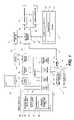
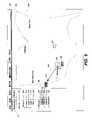
- FIG. 2illustrates an application screen display of the Real-Time Communication and Mapping Program (RTCMP) 201 with a sample map 224 displayed below a menu bar 200 .
- a location-relevant objectis a map object that has a spatial component associated with it, such as latitude and longitude values, and is graphically selectable by the user.
- Identified on the map display 224are several location-relevant objects 211 , 210 , 212 , 206 , 205 , 203 , & 204 , that are selectable either in the RTCMP 201 , or, when the two applications have been separated, such as shown in FIG. 4A , in the mapping application 419 .
- a useris an entity, which can be an inanimate object (i.e., phone, vehicle, boat, etc.) or a living thing (i.e., person, pet, etc.) that uses the real-time communications system to communicate with other users.
- An example of various location-relevant objects, as shown in the sample map 224includes a person (i.e., user) 211 , vehicle (i.e., user) 205 , plane (i.e., user) 203 , POI (i.e., a gas station) 210 , map identifier (i.e., city name) 212 , route 206 , and a geo-fenced boundary 204 .
- a route 206is comprised of an origin 207 and one or more destination points 209 & 202 , which can each be considered a “link”.
- the routeis illustrated as a series of links, such as link 209 that connects an origin 207 and a destination 202 .
- a linkneed not be a straight line as illustrated in the sample map 224 , but rather follows the topography of the roadways calculated between two route points, such as an origin 207 and destination 202 point. However, for simplicity, all links are illustrated as straight lines.
- an icon pointer 208or cursor, that provides a signal to the RTCMP 201 to indicate an active segment of the display 201 .
- an element or object of the screen displayis coincident with the focus of the icon pointer 208 , that element or object is said to have the focus of the icon pointer 208 .
- the input devicesuch as a mouse
- receives a triggered inputsuch as a mouse click or tap of a touchpad
- the element having the focus of the icon pointer 208 at that momentis selected.
- the real-time communication 212 part of the applicationis illustrated to the left of the map 224 .
- the real-time communication feature 212denoted as the messenger window, preferably provides a listing of users that are connected, in real-time communication, to the user's application. This list of users 212 is denoted as a roster list of users.
- the top-level user 213or the controller of the RTCMP 201 program, is illustrated as “User A” 213 . “User A” 213 has two groups 214 & 219 beneath it, with each group consisting of four users.
- the first groupdenoted as “Group 1” 214
- the second groupdenoted as “Group 2” 219
- the second groupalso has four users beneath it 220 , 221 , 222 , & 223 , where a user in this group 219 is represented here as, for instance, a vehicle.
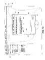
- FIG. 3illustrates one embodiment of a situation where a user can map another user's location using a simple graphical method of selecting a user, contact, or group of users or contacts, and dragging-and-dropping its graphical representation onto the map display 224 .
- icon pointer 301is used to select the roster list representation of “User 1” 215 , typically by such mechanisms as a mouse “click-hold” or a “tap-hold” of a touchpad for a handheld device.
- This actiontypically provides feedback to the user by highlighting or outlining 306 the selected user, such as “User 1” 215 .
- the list representation of “User 1” 215is then dragged 302 into the map display 224 , and “dropped” 303 , such as when the mouse “click” (or button) or the tapped-hold in a handheld device is dropped.
- “dropped” 303such as when the mouse “click” (or button) or the tapped-hold in a handheld device is dropped.
- the drop actiongenerally occurs when the user stops dragging the icon pointer and releases the mouse button.
- the release of the mouse button, at the point of the focus of the pointer 301 and at the moment the mouse button is released anywhere on the map display 224is identified by the RTCMP 201 .
- This “drag-and-drop” operationsignals to the RTCMP 201 program to initiate a location request, depending on whether the location information for the selected roster list user is stored locally, as in the form of a contact 311 , or remotely, as in the form of a user 215 connected by the real-time communication system 150 . If the selected user's location information is stored locally, as is the case with a contact whose location information is typically stored in a vcard that is located locally in the storage medium (such as a hard disk drive 107 or magnetic disk drive 110 ) of the computing device 100 , then the location request retrieves the said location information and uses that for the mapping operation. If the location information is stored remotely, or is updated in an on-demand format, then the real-time communication system 150 is used to retrieve the location information from the remote user, such as “User 1” 215 .
- “User 1” 215represents a user with a wireless phone.
- the RTCMP 201uses the real-time communication system 150 to initiate a request for “User 1's” 215 location. This location request is communicated via the real-time communication system 150 to “User 1's” 215 computing device application and either notifies “User 1” of the location request or automatically retrieves “User 1's” current location information from “User 1's” RTCMP 126 .
- a notification of a location requestis given to “User 1” if its permissions and/or preferences that specify notifications of location requests are preferably required for “User A” or for all users on “User 1's” roster list.
- “User 1's” RTCMP 126does not have to be in the exact form of “User A's” RTCMP 201 , but only provide the functionality required by the real-time communication system 150 for the sending of location-relevant information. For instance, “User 1” 215 does not have to have a positioning device, such as a GPS device 138 , connected to their RTCMP 126 .
- the location information for “User 1” 215may only include its vcard information, which is stored locally on “User 1's” computing device.
- “User A's” RTCMP 201maps “User 1's” 215 retrieved location on the map display 224 of varying resolution and size.
- FIG. 5illustrates “User 1's” current position 501 on a map display 224 of “User A's” RTCMP 201 .
- “User A” 213can select 304 a contact, such as “Contact 1” 311 , and, using the same “drag 305 and drop 303 ” method, can map the contact's location information on the map display 224 of varying resolution and size.
- this “drag-and-drop” methodallows users to retrieve and map location information locally or remotely through a real-time communication system 150 .
- a typical Instant Message (IM) window 407includes, for desktop computing devices, a menu bar 410 , text entry window 405 , and a send button 406 for use in transferring composed messages.
- IMInstant Message
- An IM window 407typically also displays the user identification token 409 (i.e. user's name, email address, etc.) of the remote user to which these instant messages are being sent. While engaged in an instant message session with another user 409 , the local user (i.e., “User A” 213 ) preferably types messages that are viewable in the message window display 408 , also included in a typical IM window 407 .
- the local useri.e., “User A” 213
- a method for mapping 401 and requesting a user's text location 403 informationcan be implemented by pressing a button 402 & 403 on an IM window application.
- the real-time communication system 150preferably request from the other user their current location information, which includes obtaining their permission for transferring the said location information.
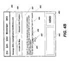
- FIG. 4BOne embodiment of such a permission request is illustrated in FIG. 4B .
- a user using a similar IM window 452which illustrates that real-time communication (i.e. instant messaging) is occurring with “User A” 450 .
- the other similarities to the previous IM window 407such as the menu bar 460 , send button 453 , and message composition window 454 are also shown.
- the location request 459may resemble a message in the message window display 451 , displaying the option to accept 455 or decline 458 the location request 459 .
- a usercan accept 455 or decline 458 the location request 459 by using an icon pointer 457 to select either choice.
- the local RTCMPUpon accepting the location request 459 from “User A” 450 , the local RTCMP would acquire its current position information from a positioning device 138 or from pre-defined position information, such as a default home address stored locally in a computer file. After the location information for the accepting user has been sent to the requesting user's (i.e. “User A”) real-time communication program, the IM window 407 will display said location information.
- “User A” 213can request “User 1's” 409 location information for mapping. The same process is initiated and once the location information for “User 1” 409 has been obtained, a mapping program 413 or map display 224 preferably display on a map of varying resolution and size “User 1's” 409 current location 501 .
- a mapping program 413 or map display 224preferably display on a map of varying resolution and size “User 1's” 409 current location 501 .
- another embodiment for mapping “User 1's” 409 location information using the real-time communication system 150is to graphically select 404 the message display window 408 of the IM window 407 and “drag 411 and drop 412 ” onto a mapping program 413 . This would cause the mapping program 413 to map the user's current location of varying resolution in the map display of the mapping program 413 .
- mapping program 413For both embodiments, where the real-time communication program 407 is not part of the mapping program 413 , a hardware or software conduit (e.g., API) is necessary in order to pass the necessary commands that will trigger the mapping program 413 to map the desired location of varying resolution.
- This mapping operationcan also be completed using the ‘Locate On Map’ 402 button or from a similar action familiar to those skilled in the art.
- FIG. 4AAn additional benefit of this invention, as illustrated in FIG. 4A , is that both the real-time communication program 414 and mapping program 419 need not be integrated into one application. The only requirement is that the two applications allow the transfer of the necessary data required for this invention, which can be accomplished, as people skilled in the art know, by using software API, DLLs, or the like.
- a location request and mapping eventcan be triggered using a real-time communication program 414 , by selecting from a menu 417 the function 418 to map a user's location.
- a usercan use an icon pointer 416 to select a user 421 , or set of users 415 , whose location information should be mapped on a separate, non-integrated mapping program 419 .
- the usercan then invoke the appearance of a pop-up menu 417 or a menu available from the menu bar of the application 422 , and then choose the option from either menu to map the user's location.
- the appearance of the pop-up menu 417can be invoked either by “right-clicking” the selected user's graphical representation in the roster list, or by using a tap-and-hold operation on a handheld device, which are all well known techniques to people skilled in the art.
- the pop-up menu 417would illustrate various actions, one of which is mapping the selected user's location 418 . Selecting the option to map the selected user's location would cause the location information to be retrieved as previously described in this section.
- the program 414Once the real-time communication program 414 has received the location information from the appropriate user 421 , the program 414 would establish a connection with the mapping program 419 and pass the necessary data to initiate the mapping of varying resolution and size of the retrieved location information 420 .
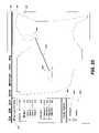
- a pre-calculated route 206is defined as having an origin 207 and one or more destinations 209 & 202 .
- Making a route selectable by an icon pointer 604enables the local user 213 to initiate the process of sending the route to a user, or group of users in their roster list, as shown in FIG. 6 .
- a local user 213To send a route to a user or group of users, a local user 213 first selects the route 206 with their icon pointer 604 and drags 602 the route to the graphical representation for the specific roster list user, such as “User 1” 215 , to which the route should be sent.
- the graphical representation for “User 1” 215illustrates some feedback to the local user 213 controlling the pointer that the route selected 601 is ready to be sent.
- the feedbackis typically shown as a highlighted image 603 on the graphical representation of the selected user that the dragged object should be sent to.
- the two displayed icon pointers 604 & 601 in FIG. 6illustrate different actions. Specifically, the first pointer 604 illustrates that a user is about to select a location-relevant object, while a second pointer 601 illustrates that an object has been selected and is now being dragged with the pointer 604 .
- the route 206has been dropped onto the graphical representation of the destination user “User 1” 215
- the routeis sent via the real-time communication system 150 to the destination user “User 1” 215 .
- the destination user “User 1” 215has an option to accept 1203 or decline 1204 the receipt of the route from the sender “User A” 213 .
- FIG. 1As shown in FIG.
- “User 1” 215can receive in its IM window 1205 the request for the receipt of location-relevant information, indicating the option to accept or decline the receiving of said route by a message text question 1211 within the IM window's text display 1208 .
- the IM window 1205is similar to the previously mentioned IM windows 407 & 452 , since it also includes a menu bar 1210 , a user identification display of the current user the message window is connected with 1209 , a text entry window 1207 and a send button 1206 .
- the remote user, “User 1” 215can accept 1203 or decline 1204 the transfer using their icon pointer 1202 .
- a usercan send a route 206 , shown in FIG. 6A , using a similar approach.
- a user 213can select the route 608 and then immediately select the user “User 1” 215 to which the route 206 should be sent.
- This processdoes not require the drag-and-drop method, displays a different line type 607 to indicate the route sending selection process has begun, and consists of two back-to-back selection processes.
- the first selection 608is the selection of the route 206 or location-relevant object
- the second selection 605is the selection of the destination user 215 to which the route 206 should be sent.
- the local user 213can move the pointer 608 over the destined user 215 , where the user 215 can highlight 606 indicating that the user 215 has been selected.
- a menu 609would pop-up displaying the options for the local user 213 to take, one of which, as in this case, is to send the route to the highlighted 606 user “User 1” 215 .
- the local user 213moves the icon pointer 608 over the menu 609 and selects “Send ‘Route’ To User 1” 610 , as shown in FIG. 6A , the route 206 will be sent to the user “User 1” 215 using the real-time communication system 150 .
- a location-relevant objectsuch as a route 206
- FIG. 7Other embodiments exist for this invention for sending location-relevant objects, such as selecting a location-relevant object, such as a route 206 , as shown in FIG. 7 .
- a pop-up menuappears 701 that displays the local user's 702 roster list of users and groups of users, including the local user 702 itself.
- the local user 213can select 801 the graphical representation of the user 704 to which the route 206 should be sent.
- the processis completed when the user “clicks” or “taps” the destination user or group of users, or by an equivalent mechanism known to people skilled in the art.
- the route 206 that is sentincludes all necessary information to completely re-create the route 206 on the remote user's 704 application without any loss of information.
- POIssuch as map identifiers which include names associated specifically with a map, such as city names, street names, highways names, interstates names, rivers names, state names, or a map name that is associated with a location.
- a POIcan include, without limitation, a house, business, person, pet, map identifier, etc., and is also a well known term to people skilled in the art. For example, if a map displays a name on a map display, then that location on the map can be assumed to be the location associated with the displayed name.
- This inventionallows users to send map identifiers using the real-time communication system 150 to other users in their roster list or, in an ad-hoc manner, to other users identified by a unique identifier, such as an e-mail address, telephone number, or the like.
- a user 213preferably uses the icon pointer 901 to select 903 a map identifier, such as a city name 902 .
- a map identifiersuch as a city name 902 .
- the usercan drag 904 the location-relevant object to the graphical representation for another user 220 in the local user's 213 roster list.
- the applicationcan highlight 906 the specific user 220 that the icon pointer 905 is focused 220 on.
- the location-transfer processbegins by using the real-time communication system 150 , sending the POI to the selected user as previously described, thus allowing the receiving user 220 to utilize the location-relevant object for a number of purposes, such as mapping, routing, etc.
- FIG. 10Another embodiment of sending POIs, which include map identifiers, is illustrated in FIG. 10 .
- a map identifiersuch as the city name Pasadena 902
- an icon pointer 1001a new pop-up menu would appear 1002 showing the main user's 213 roster list. Selecting a user “Vehicle 1” 309 from this pop-up menu will initiate the sending of the selected POI 902 to the selected user 309 .
- the icon pointer 1101shown in FIG. 11 , to select 1103 the specific user 309 to send the POI to allow the local user to effectively send POIs over the real-time communication system 150 to any user in their roster list.
- a local user of the RTCMP 201 programcan transfer location-relevant information between users on their roster list, where the initiator acts as the location transfer hub of said location information.
- the local user 213 of the RTCMP 201 programcan send the location information of “User 1” 215 to “User 4” 218 by using a graphical method.
- the local user “User A” 213can use the icon pointer 1316 to select 1302 the source user “User 1” 215 , where a selection is known to be made when the icon pointer 1301 is illustrative of a selected object, when compared to the normal icon pointer symbol 1316 .
- the graphical representation of “User 1” 215can then be dragged 1304 to its destination position, which in this example is the graphical representation for “User 4” 218 , so that the location information of “User 1” 215 is transferred to “User 4” 218 .
- This actionis competed in the RTCMP 201 program by moving the icon pointer 1301 to the new location 1303 over the destination user “User 4” 218 .
- the destination user “User 4” 218is highlighted 1317 when the icon pointer 1303 is focused on the destination user “User 4” 218 .
- the real-time communication system 150provides the infrastructure for this transfer.
- the transferoccurs by requesting the location information from “User 1” 215 and after “User 1” 215 has agreed to sending their location information to “User 4” 218 , the location transfer can occur using a number of methods of the real-time communication system 150 .
- a peer-to-peer methodcan be employed, sending the information directly from “User 1” 215 to “User 4” 218 , or the location-information can be sent to a real-time communication server 132 and then redirected to the “User 4” 218 .
- the location-informationcan be sent from “User 1” 215 to the RTCMP 201 of the initiating user “User A” 213 and then sent to “User 4” 218 .
- the first two methodsallow “User A” 213 to initiate the transfer, even if “User 1” 215 and “User 4” 218 do not have each other in their own roster lists, and the location-information does not necessarily ever have to be sent to the initiating user “User A” 213 .
- the mapping programdoes not need to be integrated with the real-time communication program in order to compete this transaction, as shown in FIG. 4A as “Application 1” 414 .
- FIG. 13Another embodiment of transferring location information between other users, where the initiator acts as the location-transfer hub, is shown in FIG. 13 .
- the destination useris illustrated as an icon map object 1312 , representing “Vehicle 1” 220
- location-relevant information and objectscan be transferred to the vehicle icon 1312 , and thus the user of “Vehicle 1” 220 by selecting objects and dragging and dropping them onto the icon representation of “Vehicle 1” 1312 on a map display 224 .
- “User A”can drag 1313 the icon list representation of “Vehicle 4” 223 onto the map icon representation of “Vehicle 1” 1312 , and drop or select the icon map representation of “Vehicle 1” 1312 using the icon pointer 1311 . This will initiate, as previously described, the transfer process of sending “Vehicle 4's” 223 location information to “Vehicle 1” 220 using a graphical method.
- this processcan be reversed, since the local user 213 can select 1311 , drag 1313 and drop 1314 the vehicle icon representation of “Vehicle 1” 1312 to the “Vehicle 4” user list representation 223 , thus initiating the location transfer from user “Vehicle 1” 220 to user “Vehicle 4” 223 . Additionally, this process can be done using a user's icon map representation 1308 to graphically initiate the transfer of “User 2's” 1308 current location information to another user's icon map representation, such as “Vehicle 1” 1312 .
- selecting “User 2's” 216 icon map representation 1308 , and using the icon pointer 1309 to drag 1310 and using the icon pointer 1309 to drop the icon onto the “Vehicle 1” 220 user map icon representation 1312initiates the location-transfer from “User 2” 216 to “Vehicle 1” 220 .
- a local user 213can select 1306 a POI 1305 , such as a gas station, drag 1307 it to the vehicle icon map representation 1312 , and drop it, using the icon pointer 1311 , onto the vehicle icon map representation 1312 of “Vehicle 1” 220 in order to initiate the transfer of the POI 1305 to “Vehicle 1” 220 .
- the difference of this scenario compared to the previous location-transfers,is that the location for the POI 1305 is known, or not changing since the POI 1305 is a static object (i.e., similar to a map identifier), prior to the start of the location transfer process.
- a location requestneed not be sent to the POI 1305 , since its location is already known.
- the real-time communication program of the RTCMP 201will then transfer the location-information of the POI 1305 to the selected user 1312 immediately upon their acceptance of the transfer.
- Another advantage of this inventionis that it allows a local user 213 to send their current location to another user on their roster list graphically.
- “User A” 213uses the icon pointer 1402 to select 1401 their own icon list representation and then drags 1403 the icon pointer 1405 to another user's icon list representation 218 .
- the highlight 1404is shown to illustrate that the icon pointer 1405 is over “User 4's” 218 icon list representation.
- Dropping or releasing the icon pointer 1405initiates the transfer of the location information of “User A” 213 to the selected user “User 4” 218 , and sends the location information after the requested user “User 4” 218 has accepted the transfer of said location information.
- this graphical transfer of the local user's location informationsignificantly reduces the process required in prior art systems.
- the inventionallows a user to send a route to another user.
- the destination userAfter the destination user has accepted the route, as illustrated in FIG. 12 , if the remote destination user is running a RTCMP 126 similar to the sender's RTCMP the received route 1505 will be displayed in the destination user's map display 224 , as shown in FIG. 15 .
- the received route 1505is the same as the original route 206 , with the same origin 1501 and destination points 1502 and 1503 as the original route 206 , except that the received route 1505 is being displayed on the destination user's (“User 1”) 215 RTCMP 126 .
- the sender 213has the option to also send their own real-time location information 1504 via the real-time communication system 150 to the destination user 215 , which can then be graphically displayed on the map display 224 of the destination user's (“User 1”) 215 RTCMP 126 . As people skilled in the art will appreciate, this allows users to send or share routes with other users in real-time.
- the received route 206does not have to include only the sending user's (“User A”) 213 original route origin and destination points, amongst all the other parameters that completely define the sent route, such as the map database identifier, all relevant turn points, user preferences, etc.
- the destination user's (“User 1”) 215 RTCMP 126can automatically adjust the received route's 206 origin and destination points based on the destination user's (“User 1”) 215 RTCMP 126 preferences.
- the new origin of the received routecan be automatically changed to the destination user's (“User 1”) 215 current location information or to a chosen origin location, and the sent route 206 can then be recalculated and displayed on the destination user's map display 224 .
- the original received route 1505is displayed on the local user's (“User 1”) 215 map display 224 .
- the real-time location information 1504 of the sending user (“User A”) 213is also sent to the local user's (“User 1”) real-time communication program and displayed on the map display 224 of the local user's (“User 1”) 215 RTCMP 126 .
- a received routemay include a destination location where the local user (“User 1”) 215 may want to meet the sending user (“User A”).
- the local user (“User 1”) 215would want to calculate a new route 1602 based on its own current location information 1601 and the desired meeting and/or destination points 1502 & 1503 present in the received route 206 .
- a benefit of this inventionis that all links 1603 in the route need not be re-calculated, but only the part of the received route 206 that has changed.
- the portion 1505 of the received route 206(which consists of route points 1501 , 1502 , & 1503 and links 1505 & 1603 as shown in FIG. 16 ) between points 1501 and 1502 is the only portion of the route 1505 that needs to be recalculated, since the destination points 1502 & 1503 are common between both users.
- a new link 1602can be calculated based on the received route's first destination point 1502 and the local user's (“User 1”) 215 current location 1601 or preferred origin point.
- the rest of the route links 1603can remain common between both users.
- the original received route 206could be displayed in combination with the new route 1602 and the real-time location of both users 1504 & 1601 along those routes can also be displayed.
- this inventionalso has the capability to modify, create, and save routes using the real-time communication system 150 .
- modifying, creating, and saving routes via a real-time communication system 150allows users to make use of mapping and routing applications not available in current or prior art.
- the following figures relating to routesassume the application is in a route-planner mode, except as otherwise noted, since some of the same actions that are used for sending and mapping POIs can also be utilized for modifying, creating, planning, and retrieving routes.
- a route 1708is defined as a combination of destination points 1701 , 1702 , & 1703 , or an origin 1701 and one or more destination points 1702 & 1703 .
- a map display 224 showing a pre-calculated route 1708provides a user with a graphical illustration of the route, which provides better planning capabilities than standard driving directions or text information.
- Current prior artsuch as Microsoft's MapPoint application, allows the ability to graphically add destination points to a pre-calculated route by selecting a point on the route and dragging-and-dropping the selected point to a new location in order to add a new destination point or change an existing one.
- a mapping applicationallows the capability to add users, contacts, or groups of users and contacts, using a graphical mechanism, to a pre-calculated route.
- a usercan select 1704 a user 215 from a roster list of users using a icon pointer 1705 .
- the usercan then drag 1706 the selected user 215 to a point 1709 on the pre-calculated route 1708 to dynamically add a new destination point 1709 to the pre-calculated route 1708 , which corresponds to the current location information for the selected user which is obtained from the real-time communication system 150 .
- a usercan select a point 1709 on a pre-calculated route 1708 using the icon pointer 1707 where a new destination point should be added, and drag 1706 that point 1709 with the icon pointer 1705 to a user, contact, or group of users and contacts in the messenger window 212 .
- the icon pointer 1705is dropped or released over the icon list representation for a user “User 1” 215 .
- This actionwould cause the current location information for “User 1” 215 , obtained using the real-time communication system 150 , to be added as a new destination point in the route 1708 .
- the real-time communication system 150does not have to be used, since the location information can be retrieved locally, as is typically the case with a user's contact information.
- Both of the previously described methods for adding a user, contact, or group of users or contacts to a pre-calculated routeinvolve adding them to a portion of the pre-calculated route. In the provided embodiments, as shown in FIG. 17 , this was between the pre-calculated route points “1” 1701 and “2” 1702 .
- the location information of the user, contact, or group of users or contactscan be incorporated into the route as a new destination point between these two points.
- the resultis a system without the burden of recalculating the preferred order of destinations each time a new destination is added.
- the new destinationis directly inserted in the proper order because the user is presented with the graphical representation of the pre-calculated route and has graphically identified the order position of the new destination point.
- the RTCMP 126does not need to recalculate the entire route, but rather only the portion that was altered by the addition of the new destination.
- Another aspect of this inventionis allowing the user to directly add destinations, similar to the previous embodiments, except that the user selects 1801 the user, contact, or group of users or contacts with the icon pointer 1802 and drags 1803 the listing representation of the user “User 1” 215 to a route planner window 1710 and adds 1804 the selected 1801 user “User 1” 215 in the preferred destination order.
- the destination orderis determined by the order that the user adds the new destinations to the route planner window 1710 or the position in which they are added if an origin 1701 and/or destination points 1702 & 1703 already exist. For example, Los Angeles, Calif. 1701 is the origin, while Kansas City, Miss. 1702 is the second stop and New York, N.Y.
- the route 1703is the final destination.
- the routeis-recalculated based on the new order and on the retrieved location-information of the user “User 1” 215 added to the route 1708 in the route planner window 1710 .
- the location information for user “User 1” 215is retrieved using the real-time communication system 150 .
- the map display 224shows a new route 1901 that includes the new destination point of Dallas, Tex. 1902 .
- the route planner window 1710illustrates the added destination point of Dallas, Tex. 1902 as the first destination point (i.e., point #2), the order of which was determined by the point at which the dropping or releasing action occurred, typically by using a mouse click release or any other acceptable mechanism for releasing the element with the focus of the icon pointer 1804 , as shown in the previous figure.
- the origin and destination order of the route 1708 in the route planner window 1710is follows that displayed in the map display window 224 .
- FIGS. 20-21illustrate the addition of roster list users and POIs to a pre-calculated route using a graphical method.
- a pre-calculated route 2004is has an origin of Los Angeles, Calif. 2001 and destination points Kansas City, Mo. 2002 and New York, N.Y. 2003 .
- the origin and destination pointsare shown graphically on the map display 224 in the form of a route 2004 and in the route planner window 2013 in the form of a list.
- Both static POIs, whose positions are stored in the map data of the RTCMP 201 and dynamic POIs, which are graphical icon representations of roster list users whose position information is obtained using the real-time communication system 150 ,can be selected on the map display 224 using a graphical method defined by this invention to graphically add origin and destination points to a pre-calculated route.
- a usercan select 2006 a graphical icon representation of a user 2005 , whose position information is obtained using the real-time communication system 150 , then using the icon pointer 2006 , drag 2012 the icon representation of the user 2005 to a pre-calculated route 2004 .
- the point 2014 at which the user releases the selected object using the icon pointer 2007is added to the pre-calculated route as a new destination point.
- a usercan select a static POI 2009 , such as a gas station, using the icon pointer 2008 , and drag 2013 the POI icon to the route planner window 2013 in order to add the new destination point in between the first 2002 and second 2003 destination points. Adding a new destination point can automatically recalculate the new route, or the user can initiate the new route calculation.
- the usercan drag 2011 the selected static POI 2009 to the pre-calculated route 2004 and add a new destination point to the pre-calculated route 2004 at the point 2015 where the POI icon was dropped by releasing the selected POI 2010 , which is done, as known to people skilled in the art, by a mouse click release, tap release, etc.
- the newly added destination pointscan also be illustrated in the route planner window 2013 as italicized, indicating that they are to be added once the route has been recalculated.
- the new route that was calculated in the previous exampleincludes the new origin 2001 and destination points 2101 , 2002 , 2102 , & 2003 .
- the new destination points that were addedare shown in FIG. 21 as San Jose, Calif. 2101 , which is the position of another user 2005 updated using the real-time communication system 150 , and Blacksburg, Va. 2102 , the position of the POI 2009 .
- the only the links of the route that have changedare the ones that need to be recalculated and not the entire route. Under this example, the entire route needs to be recalculated.
- FIG. 22Another benefit of this invention is illustrated in FIG. 22 .
- a usercan select 2206 a POI 2205 , such as a gas station, and drag 2204 it to a graphical icon representation 2202 of a roster list user on the map display 224 , and then drop or release the icon pointer 2201 with the focus over the graphical icon representation 2202 of a roster list user in order to create a route from the location of that roster list user to the selected POI 2205 .
- the messenger window 212 icon listing of said user 220will also highlight 2203 , as illustrated in FIG. 22 .
- the location information of the roster list user whose graphical icon representation 2202 was selectedwas known and can be periodically updated using the real-time communication system 150 .
- the calculated route 2304 between “Vehicle 1” 2202 and the “Gas Station” 2205 whose address is in Pittsburgh, Pa.is displayed in the map display 224 of FIG. 23 .
- the route planner window 2303illustrates the order of the origin 2301 and destination 2302 of the route 2304 .
- each POIin this embodiment, is added as the last destination in the route 2304 and displayed as such in the route planner window 2303 .
- this method of adding a destination to a routecan be reversed, such that, in one embodiment, the graphical icon representation 2202 of the roster list user “Vehicle 1” 220 can be dragged onto a POI's graphical icon representation 2205 on the map display 224 .
- the order of the destinationsis chronological, according to the time a new destination point was added to the route 2304 .
- the routeis dynamically calculated based on location updates from the real-time communication system 150 .
- FIG. 24includes two graphical icon representations 2403 & 2406 of roster list users “Vehicle 1” 220 and “User 4” 218 , respectively.
- the selection of the graphical icon representation 2406 of roster list user “User 4” 218causes the roster list window 212 list representation of “User 4” 218 to highlight 2407 .
- Dragging the select user 2406 using the icon pointer 2405 so that it is positioned over the graphical icon representation 2403 of roster list user “Vehicle 1” 220causes the roster list window 212 representation of user “Vehicle 1” 220 to highlight 2402 .
- the graphical icon representation 2406 of roster list user “User 4” 218is dropped or released onto the graphical icon representation 2403 of roster list user “Vehicle 1” 2403 , a real-time route between the first user 2406 (‘destination) and the second user 2403 (‘origin’) is created.
- the real-time communication system 150can be used when new position updates arrive, and then a new route is recalculated based on those new locations. Shown in FIG. 25 is the route 2504 calculated between the graphical icon representations for the origin user 2403 and destination user 2406 .
- the route planner window 2501also shows the order of the route between the two users, where the origin 2502 is the location of “Vehicle 1” 220 and the destination 2503 is the location of “User 4” 218 .
- the origin 2502is the location of “Vehicle 1” 220
- the destination 2503is the location of “User 4” 218 .
- multiple destinationscan be added to this route using both static (i.e., POIs) and dynamic (i.e., roster users) location-relevant objects, where the order, in this embodiment, of the new destination point is based on the order it was added.
- a POI 2601such as a map identifier (i.e., city name of Pasadena)
- a POI 2601can be graphically selected using an icon pointer 2602 and using a dragging motion 2603 or some other accepted practice used by those in the art.
- the selected POI 2601can then be dragged into a route planner window 2609 .
- the usercan then use the icon pointer 2604 to drop the POI 2601 into the route planner window 2609 , where the focus of the icon pointer 2604 relative to the current origin 2606 and destination points 2607 & 2608 determines the new order of the origin and destination points.
- the POI 2601was added to the end of the list of origin and destination points in the route planner window 2609 , thus causing this POI 2601 to be the last destination 2605 of the route, which can be either a pre-calculated or a previously-uncalculated route.
- FIG. 27Illustrating the use of a combination of both static POIs and dynamic POIs, which represent roster list users, in the graphical creation of a route is further shown in FIG. 27 .
- a usercan create a route by selecting 2701 the icon list representation of a roster list user “User 1” 215 using an icon pointer 2702 . Then by dragging 2703 the roster list user icon list representation 215 to a graphical icon representation 2704 on a map display 224 and releasing it with the icon pointer 2705 focused over the destined objected 2704 , so that the destined object's 2704 roster list representation 223 is highlighted 2709 in the roster list window 212 . This action will add both objects to a route in the route planner window 2710 .
- the origin 2711is the location of the destined object 2704 of the drag 2703 operation
- the first destination point 2712is the location of the roster list user 215 .
- the same processcan be completed using a static POI 2707 , where the user selects the POI 2707 using an icon pointer 2708 and drags 2706 the icon pointer to the desired map object 2704 .
- the icon pointer 2705is focused on the desired map object 2704 on the map display 224 and then released both objects will be added to the route in the route planner window 2710 .
- the POI 2707is added to the end of the destination points 2713 in the route planner window 2710 . It should be noted that as location updates arrive using the real-time communication system 150 , the location of all points in the route planner window 2710 that are tied to the real-time communication system 150 could be updated accordingly.
- a route 2805is displayed in the route planner window 2801 and on the map display 224 .
- the originwill be the user 2802 that was first selected and the first destination is that object 2803 upon which the first selected object was dropped.
- the second destinationwill be the POI 2804 that was added to the first selected object 2802 .
- the new route 2805will display the origin and destination points 2802 & 2803 & 2804 in both the map display 224 and route planner window 2801 .
- Another aspect of this inventionwhile in a route planner mode, allows an extremely efficient mechanism for creating routes to and from the local user's “User A” 213 current location.
- creating a route from the local user's “User A” 213 current location to the location of another user or contactsimply involves selecting the local user's “User A” 213 roster list representation 213 with the icon pointer 2902 , which will cause it to be highlighted 2901 , and dragging 2905 it to another roster list user's list representation, such as “User 4” 218 .
- Both of these embodimentscan use the real-time communication system 150 for location updates. If both the user's and the contact's location information is stored locally or cached, then the real-time communication system 150 is not necessary. As illustrated in FIG. 29 , the double arrows 2905 & 2906 indicate that the dragging operation process can be reversed, and the contacts and other users can be selected and then dragged and dropped into the local user's “User A” roster list representation 213 with the icon pointer.
- Other objects that can be used for route creation in an in-vehicle navigation system in route planner modeinclude POIs or any graphical map object (i.e., map identifiers, users, etc.).
- the local user's “User A” roster list representation 213can be selected with the icon pointer 3002 , illustrated by the local user's icon representation 213 being highlighted 3001 , and then dragged 3003 and dropped using the icon pointer 3005 onto a POI 3004 in order to create a route.
- a route 3105is generated between the current location 3106 of “User A” 213 and the location of the POI 3104 .
- the route planner window 3103is updated to include both the origin 3101 and destination 3102 points. It should be noted that the origin could be a moving point when it represents an object whose location information is updated locally or through the real-time communication system 150 .
- an original route 3207 between an origin 3201 and destination 3202is displayed in a route planner window 3210 .
- the original route 3207 that was createdis shown in the map display 224 .
- the origin location of “Vehicle 1” 3201 & 220changes thus changing its location on the map display 224 .
- the new origin location on the map display 224is shown 3205 , as well as the original destination point 3203 . Additionally, a new route 3208 is computed between the new origin 3205 and original destination 3203 .
- a new route 3209will be computed based on the new origin location 3201 & 3206 and the original destination 3202 & 3203 .
- a legendcan even be displayed to illustrate the pattern and color of the routes correlated with the time when they were updated. This route history allows the user to better graphically analyze the route information when using a dynamically updated route origin or destination.
Landscapes
- Engineering & Computer Science (AREA)
- Radar, Positioning & Navigation (AREA)
- Remote Sensing (AREA)
- Physics & Mathematics (AREA)
- General Physics & Mathematics (AREA)
- Theoretical Computer Science (AREA)
- General Engineering & Computer Science (AREA)
- Human Computer Interaction (AREA)
- Automation & Control Theory (AREA)
- Computer Networks & Wireless Communication (AREA)
- Signal Processing (AREA)
- Business, Economics & Management (AREA)
- General Business, Economics & Management (AREA)
- Finance (AREA)
- Accounting & Taxation (AREA)
- Development Economics (AREA)
- Strategic Management (AREA)
- Multimedia (AREA)
- Game Theory and Decision Science (AREA)
- Mathematical Physics (AREA)
- Entrepreneurship & Innovation (AREA)
- Economics (AREA)
- Marketing (AREA)
- Navigation (AREA)
- Traffic Control Systems (AREA)
- User Interface Of Digital Computer (AREA)
- Circuits Of Receivers In General (AREA)
- Mobile Radio Communication Systems (AREA)
Abstract
Description
Claims (55)
Priority Applications (4)
| Application Number | Priority Date | Filing Date | Title |
|---|---|---|---|
| US10/378,980US7271742B2 (en) | 2002-03-01 | 2003-03-03 | Method and apparatus for sending, retrieving and planning location relevant information |
| US11/888,992US7913179B2 (en) | 2002-03-01 | 2007-08-02 | Method and apparatus for sending, retrieving and planning location relevant information |
| US13/064,267US8621374B2 (en) | 2002-03-01 | 2011-03-15 | Method and apparatus for sending, retrieving, and planning location relevant information |
| US14/132,658US9582177B2 (en) | 2002-03-01 | 2013-12-18 | Method and apparatus for sending, retrieving, and planning location relevant information |
Applications Claiming Priority (2)
| Application Number | Priority Date | Filing Date | Title |
|---|---|---|---|
| US36073702P | 2002-03-01 | 2002-03-01 | |
| US10/378,980US7271742B2 (en) | 2002-03-01 | 2003-03-03 | Method and apparatus for sending, retrieving and planning location relevant information |
Related Child Applications (1)
| Application Number | Title | Priority Date | Filing Date |
|---|---|---|---|
| US11/888,992DivisionUS7913179B2 (en) | 2002-03-01 | 2007-08-02 | Method and apparatus for sending, retrieving and planning location relevant information |
Publications (2)
| Publication Number | Publication Date |
|---|---|
| US20040054428A1 US20040054428A1 (en) | 2004-03-18 |
| US7271742B2true US7271742B2 (en) | 2007-09-18 |
Family
ID=27789010
Family Applications (4)
| Application Number | Title | Priority Date | Filing Date |
|---|---|---|---|
| US10/378,980Expired - Fee RelatedUS7271742B2 (en) | 2002-03-01 | 2003-03-03 | Method and apparatus for sending, retrieving and planning location relevant information |
| US11/888,992Expired - Fee RelatedUS7913179B2 (en) | 2002-03-01 | 2007-08-02 | Method and apparatus for sending, retrieving and planning location relevant information |
| US13/064,267Expired - Fee RelatedUS8621374B2 (en) | 2002-03-01 | 2011-03-15 | Method and apparatus for sending, retrieving, and planning location relevant information |
| US14/132,658Expired - Fee RelatedUS9582177B2 (en) | 2002-03-01 | 2013-12-18 | Method and apparatus for sending, retrieving, and planning location relevant information |
Family Applications After (3)
| Application Number | Title | Priority Date | Filing Date |
|---|---|---|---|
| US11/888,992Expired - Fee RelatedUS7913179B2 (en) | 2002-03-01 | 2007-08-02 | Method and apparatus for sending, retrieving and planning location relevant information |
| US13/064,267Expired - Fee RelatedUS8621374B2 (en) | 2002-03-01 | 2011-03-15 | Method and apparatus for sending, retrieving, and planning location relevant information |
| US14/132,658Expired - Fee RelatedUS9582177B2 (en) | 2002-03-01 | 2013-12-18 | Method and apparatus for sending, retrieving, and planning location relevant information |
Country Status (10)
| Country | Link |
|---|---|
| US (4) | US7271742B2 (en) |
| EP (1) | EP1481221B1 (en) |
| AT (1) | ATE488746T1 (en) |
| AU (1) | AU2003217926B2 (en) |
| BR (1) | BR0308165A (en) |
| CA (1) | CA2478496A1 (en) |
| DE (1) | DE60334974D1 (en) |
| ES (1) | ES2355076T3 (en) |
| IL (1) | IL163861A (en) |
| WO (1) | WO2003074973A2 (en) |
Cited By (54)
| Publication number | Priority date | Publication date | Assignee | Title |
|---|---|---|---|---|
| US20040263491A1 (en)* | 2003-04-30 | 2004-12-30 | Satoru Ishigaki | Data processing apparatus and function selection method |
| US20050021976A1 (en)* | 2003-06-23 | 2005-01-27 | Nokia Corporation | Systems and methods for controlling access to an event |
| US20070300172A1 (en)* | 2002-04-18 | 2007-12-27 | Sap Ag | Manipulating A Data Source Using A Graphical User Interface |
| US20080039059A1 (en)* | 2002-03-25 | 2008-02-14 | Mullen Jeffrey D | Systems and methods for locating cellular phones and security measures for the same |
| US20080052373A1 (en)* | 2006-05-01 | 2008-02-28 | Sms.Ac | Systems and methods for a community-based user interface |
| US20080231507A1 (en)* | 2007-03-21 | 2008-09-25 | Burckart Erik J | Method and system for navigating to a common point of interest based on the locations of multiple gps receivers |
| US20080301570A1 (en)* | 2007-06-01 | 2008-12-04 | Milstead James M | Spaciotemporal graphical user interface for collaborative and secure information sharing |
| US20080306682A1 (en)* | 2007-06-05 | 2008-12-11 | General Motors Corporation | System serving a remotely accessible page and method for requesting navigation related information |
| US20090018769A1 (en)* | 2007-07-11 | 2009-01-15 | Anthony Andrew Poliak | Remote Entry Navigation System |
| US20090100342A1 (en)* | 2007-10-12 | 2009-04-16 | Gabriel Jakobson | Method and system for presenting address and mapping information |
| US20090227280A1 (en)* | 2008-03-04 | 2009-09-10 | Stefan Bernard Raab | Method and system for integrated satellite assistance services |
| US20090228196A1 (en)* | 2008-03-04 | 2009-09-10 | Stefan Bernard Raab | Method and system for using routine driving information in mobile interactive satellite services |
| US20090228207A1 (en)* | 2008-03-05 | 2009-09-10 | Denso Corporation | Vehicle navigation apparatus |
| US20090240429A1 (en)* | 2008-03-19 | 2009-09-24 | Xanavi Informatics Corporation | Method for route planning on a navigation system including points of interest |
| US20100019990A1 (en)* | 2008-07-24 | 2010-01-28 | Htc Corporation | Method and system for synchronizing mark on electronic map and recording medium using the same |
| US20100030465A1 (en)* | 2008-07-31 | 2010-02-04 | Samsung Electronics Co., Ltd. | Navigation system, method and database using mobile devices |
| US20100056100A1 (en)* | 2008-09-04 | 2010-03-04 | Microsoft Corporation | Rules-based association of a phone number with one or more destination locations |
| US20100159975A1 (en)* | 2008-12-19 | 2010-06-24 | Cisco Technology, Inc. | System and Method for Providing a Trunked Radio and Gateway |
| US20100159977A1 (en)* | 2008-12-19 | 2010-06-24 | Cisco Technology, Inc. | System and Method for Providing Channel Configurations in a Communications Environment |
| US20100161727A1 (en)* | 2008-12-19 | 2010-06-24 | Cisco Technology, Inc. | System and Method for Accelerating a Wide Area Notification |
| US20100169199A1 (en)* | 2008-12-31 | 2010-07-01 | Fuller Max L | Method for In-Cab Driver Operation |
| US7761350B1 (en)* | 2006-04-26 | 2010-07-20 | Aol Inc. | Biasing of search result clustering to ensure more effective point of interest (POI) targeting |
| US20110022308A1 (en)* | 2008-03-31 | 2011-01-27 | Britton Jason A | Calculating route and distance on computerized map using touchscreen user interface |
| US7890123B2 (en) | 2005-05-11 | 2011-02-15 | Aol Inc. | Personalized location information for mobile devices |
| US20110137814A1 (en)* | 2005-12-19 | 2011-06-09 | Stewart Brett B | Social Networking System which Provides Notification of User Location Based on Distance |
| US20110185012A1 (en)* | 2010-01-27 | 2011-07-28 | Colley Matthew D | System and method for generating a notification mailing list |
| US20110225238A1 (en)* | 2010-03-11 | 2011-09-15 | Cisco Technology, Inc. | System and method for providing data channel management in a network environment |
| US8385964B2 (en) | 2005-04-04 | 2013-02-26 | Xone, Inc. | Methods and apparatuses for geospatial-based sharing of information by multiple devices |
| US8548503B2 (en) | 2008-08-28 | 2013-10-01 | Aol Inc. | Methods and system for providing location-based communication services |
| US8566026B2 (en) | 2010-10-08 | 2013-10-22 | Trip Routing Technologies, Inc. | Selected driver notification of transitory roadtrip events |
| US8577598B2 (en) | 2006-04-14 | 2013-11-05 | Scenera Technologies, Llc | System and method for presenting a computed route |
| US8589064B2 (en) | 2005-09-23 | 2013-11-19 | Scenera Technologies, Llc | System and method for selecting and presenting a route to a user |
| US8620532B2 (en) | 2009-03-25 | 2013-12-31 | Waldeck Technology, Llc | Passive crowd-sourced map updates and alternate route recommendations |
| US8682350B2 (en) | 2006-06-01 | 2014-03-25 | Loopt Llc | Location-based advertising message serving for mobile communication devices |
| US8719354B2 (en) | 2005-05-11 | 2014-05-06 | Facebook, Inc. | Identifying users sharing common characteristics |
| US8935638B2 (en) | 2012-10-11 | 2015-01-13 | Google Inc. | Non-textual user input |
| CN104303525A (en)* | 2012-05-01 | 2015-01-21 | 高通股份有限公司 | Mechanism to reduce missing breach detection in geofencing solution |
| US20150134235A1 (en)* | 2013-09-29 | 2015-05-14 | Tencent Technology (Shenzhen) Company Limited | Method and apparatus for displaying geographic location |
| US20150204685A1 (en)* | 2014-01-22 | 2015-07-23 | Mapquest, Inc. | Methods and systems for providing dynamic point of interest information and trip planning |
| US9175973B2 (en) | 2014-03-26 | 2015-11-03 | Trip Routing Technologies, Llc | Selected driver notification of transitory roadtrip events |
| US9183560B2 (en) | 2010-05-28 | 2015-11-10 | Daniel H. Abelow | Reality alternate |
| US9357345B2 (en) | 2003-09-09 | 2016-05-31 | James A. Roskind | Mobile surveillance |
| US9360990B1 (en)* | 2003-09-09 | 2016-06-07 | James A. Roskind | Location-based applications |
| US9560479B2 (en) | 2006-06-01 | 2017-01-31 | Green Dot Corporation | Secure and private location sharing for location-aware mobile communication devices |
| US20170293634A1 (en)* | 2016-04-07 | 2017-10-12 | Vizsafe, Inc. | Distributing maps, floor plans and blueprints to users based on their location |
| US20180152556A1 (en)* | 2004-09-21 | 2018-05-31 | Agis Software Development Llc | Method to provide ad hoc and password protected digital and voice networks |
| US10270550B2 (en) | 2007-04-30 | 2019-04-23 | Dish Network Corporation | Mobile interactive satellite services |
| US10645562B2 (en) | 2004-09-21 | 2020-05-05 | Agis Software Development Llc | Method to provide ad hoc and password protected digital and voice networks |
| US10706405B2 (en) | 2012-06-28 | 2020-07-07 | Green Dot Corporation | Wireless client transaction systems and related methods |
| US20200232798A1 (en)* | 2009-08-21 | 2020-07-23 | Samsung Electronics Co., Ltd. | Method and apparatus for generating, managing, and sharing moving path |
| US10937088B2 (en) | 2012-07-13 | 2021-03-02 | Green Dot Corporation | Mobile account data access systems and methods |
| US11216810B2 (en) | 2015-08-06 | 2022-01-04 | Green Dot Corporation | Systems and methods for fund transfers |
| US20230237906A1 (en)* | 2013-03-15 | 2023-07-27 | Norcom | Method and system for inter and intra agency communication, tracking and coordination |
| US11715154B2 (en) | 2017-09-22 | 2023-08-01 | Green Dot Corporation | Systems and methods for managing accounts in a financial services system |
Families Citing this family (295)
| Publication number | Priority date | Publication date | Assignee | Title |
|---|---|---|---|---|
| US7469043B1 (en) | 2000-12-21 | 2008-12-23 | At&T Delaware Intellectual Property, Inc. | Disposable telephone numbers |
| US7333820B2 (en) | 2001-07-17 | 2008-02-19 | Networks In Motion, Inc. | System and method for providing routing, mapping, and relative position information to users of a communication network |
| BR0308165A (en) | 2002-03-01 | 2005-06-28 | Networks In Motion Inc | Method and apparatus for sending, retrieving and planning relevant location information |
| US7127386B2 (en)* | 2002-03-22 | 2006-10-24 | Sun Microsystems, Inc. | Java telematics emulator |
| US8918073B2 (en) | 2002-03-28 | 2014-12-23 | Telecommunication Systems, Inc. | Wireless telecommunications location based services scheme selection |
| US8290505B2 (en) | 2006-08-29 | 2012-10-16 | Telecommunications Systems, Inc. | Consequential location derived information |
| US7565155B2 (en) | 2002-04-10 | 2009-07-21 | Networks In Motion | Method and system for dynamic estimation and predictive route generation |
| US7447756B2 (en)* | 2002-05-21 | 2008-11-04 | At&T Intellectual Property I, L.P. | Temporary aliasing for resource list |
| US7096255B2 (en)* | 2002-05-21 | 2006-08-22 | Bellsouth Intellectual Property Corp. | System and method for providing a roster list of temporary contacts having expiration periods designated by a user in an instant messaging environment |
| US7266776B2 (en)* | 2002-11-25 | 2007-09-04 | Aol Llc | Facilitating communications between computer users across a network |
| US7434169B2 (en)* | 2002-11-25 | 2008-10-07 | Aol Llc, A Delaware Limited Liability Company | Facilitating communications between computer users across a network |
| WO2004074778A1 (en)* | 2003-02-14 | 2004-09-02 | Networks In Motion, Inc. | Method and system for saving and retrieving spatial related information |
| US20040243307A1 (en)* | 2003-06-02 | 2004-12-02 | Pieter Geelen | Personal GPS navigation device |
| AU2004302220A1 (en)* | 2003-08-08 | 2005-02-17 | Telecommunication Systems, Inc. | Method and system for collecting synchronizing and reporting telecommunication call events and work flow related information |
| US20080126535A1 (en) | 2006-11-28 | 2008-05-29 | Yinjun Zhu | User plane location services over session initiation protocol (SIP) |
| US8050688B2 (en)* | 2003-12-31 | 2011-11-01 | Motorola Mobility, Inc. | Method and apparatus for delivering services |
| US7373244B2 (en)* | 2004-04-20 | 2008-05-13 | Keith Kreft | Information mapping approaches |
| US8499248B1 (en) | 2004-04-29 | 2013-07-30 | Paul Erich Keel | Methods and apparatus for managing and exchanging information using information objects |
| US8453065B2 (en) | 2004-06-25 | 2013-05-28 | Apple Inc. | Preview and installation of user interface elements in a display environment |
| JP2006033403A (en)* | 2004-07-15 | 2006-02-02 | Honda Motor Co Ltd | Mobile body, information center and mobile communication system |
| US20060074531A1 (en)* | 2004-09-28 | 2006-04-06 | Nokia Corporation | System for interaction of navigation and connectivity programs and personal information management applications |
| US7783982B1 (en)* | 2004-09-29 | 2010-08-24 | RadioShack, Corporation | Programmable actuator and method in a network terminal device |
| AU2005292243B2 (en)* | 2004-10-01 | 2011-03-10 | Telecommunication Systems, Inc. | Off board navigation solution |
| US7323982B2 (en)* | 2004-11-05 | 2008-01-29 | Wirelesswerx International, Inc. | Method and system to control movable entities |
| US9286729B2 (en) | 2005-02-25 | 2016-03-15 | The Invention Science Fund I, Llc | Image mapping to provide visual geographic path |
| US9188454B2 (en)* | 2005-03-22 | 2015-11-17 | Invention Science Fund I, Llc | Map-based guide system and method |
| US7522996B2 (en) | 2005-04-30 | 2009-04-21 | Searete Llc | Map display system and method |
| US9702713B2 (en) | 2005-01-31 | 2017-07-11 | Searete Llc | Map-based guide system and method |
| US20060217880A1 (en)* | 2005-03-22 | 2006-09-28 | Jung Edward K | Map-based guide system and method |
| US7734073B2 (en)* | 2005-02-25 | 2010-06-08 | The Invention Science Fund I, Llc | Image mapping to provide visual geographic path |
| US8635014B2 (en)* | 2005-03-22 | 2014-01-21 | The Invention Science Fund I, Llc | Map-based guide system and method |
| US7729708B2 (en)* | 2005-01-31 | 2010-06-01 | The Invention Science Fund I, Llc | Method and system for interactive mapping to provide goal-oriented instructions |
| US7756300B2 (en) | 2005-02-25 | 2010-07-13 | The Invention Science Fund I, Llc | Image mapping to provide visual geographic path |
| US20080215435A1 (en)* | 2005-03-22 | 2008-09-04 | Searete Llc, A Limited Liability Corporation Of The State Of Delaware | Map-based guide system and method |
| US9214033B2 (en) | 2005-06-01 | 2015-12-15 | Invention Science Fund I, Llc | Map display system and method |
| US8396001B2 (en)* | 2005-02-03 | 2013-03-12 | The Invention Science Fund I, Llc | Interactive queued mapping method and system |
| US7260474B1 (en) | 2005-02-08 | 2007-08-21 | Cellco Partnership | GIS point-to-point routing for directions |
| US8311733B2 (en) | 2005-02-15 | 2012-11-13 | The Invention Science Fund I, Llc | Interactive key frame image mapping system and method |
| US8136038B2 (en)* | 2005-03-04 | 2012-03-13 | Nokia Corporation | Offering menu items to a user |
| BRPI0607818A2 (en)* | 2005-03-07 | 2009-10-06 | Networks In Motion Inc | method and system for identifying and defining virtual geographic fences |
| TWI269023B (en)* | 2005-03-14 | 2006-12-21 | Mitac Int Corp | Method of exchanging route schemes of global positioning system |
| US7734622B1 (en) | 2005-03-25 | 2010-06-08 | Hewlett-Packard Development Company, L.P. | Media-driven browsing |
| US20060225108A1 (en)* | 2005-04-01 | 2006-10-05 | Nextel Communications, Inc. | System and method for interactivity between mobile stations and a television device |
| US8045998B2 (en)* | 2005-06-08 | 2011-10-25 | Cisco Technology, Inc. | Method and system for communicating using position information |
| US20070011171A1 (en)* | 2005-07-08 | 2007-01-11 | Nurminen Jukka K | System and method for operation control functionality |
| US7633914B2 (en)* | 2005-08-10 | 2009-12-15 | Cisco Technology, Inc. | Method and system for providing interoperable communications with location information |
| US7636339B2 (en)* | 2005-08-10 | 2009-12-22 | Cisco Technology, Inc. | Method and system for automatic configuration of virtual talk groups based on location of media sources |
| US7706339B2 (en)* | 2005-08-10 | 2010-04-27 | Cisco Technology, Inc. | Method and system for communicating media based on location of media source |
| US7869386B2 (en)* | 2005-08-29 | 2011-01-11 | Cisco Technology, Inc. | Method and system for conveying media source location information |
| US20070050128A1 (en)* | 2005-08-31 | 2007-03-01 | Garmin Ltd., A Cayman Islands Corporation | Method and system for off-board navigation with a portable device |
| CN101288076B (en)* | 2005-10-14 | 2013-04-10 | 雅虎公司 | Interactive drawing method and system |
| US7954064B2 (en)* | 2005-10-27 | 2011-05-31 | Apple Inc. | Multiple dashboards |
| US20070106468A1 (en)* | 2005-11-07 | 2007-05-10 | France Telecom | Product, service and activity based interactive trip mapping system, method, and computer program product |
| BRPI0619558A2 (en)* | 2005-12-07 | 2011-10-04 | Networks In Motion Inc | portable electronic device and method for presenting information |
| US9459622B2 (en) | 2007-01-12 | 2016-10-04 | Legalforce, Inc. | Driverless vehicle commerce network and community |
| US8874489B2 (en)* | 2006-03-17 | 2014-10-28 | Fatdoor, Inc. | Short-term residential spaces in a geo-spatial environment |
| US20070218900A1 (en)* | 2006-03-17 | 2007-09-20 | Raj Vasant Abhyanker | Map based neighborhood search and community contribution |
| US8756501B1 (en)* | 2005-12-30 | 2014-06-17 | Google Inc. | Method, system, and graphical user interface for meeting-spot-related introductions |
| US20070161382A1 (en)* | 2006-01-09 | 2007-07-12 | Melinger Daniel J | System and method including asynchronous location-based messaging |
| KR100655084B1 (en)* | 2006-01-17 | 2006-12-08 | 삼성전자주식회사 | Sense Amplifier Enable Circuit and Semiconductor Memory Device Having the Same |
| US20070174072A1 (en)* | 2006-01-20 | 2007-07-26 | Specialty Software Systems, Inc. | Method, system and computer program for displaying an image of framed artwork |
| US7450003B2 (en)* | 2006-02-24 | 2008-11-11 | Yahoo! Inc. | User-defined private maps |
| US8085671B2 (en)* | 2006-02-27 | 2011-12-27 | Cisco Technology, Inc. | Method and system for providing interoperable communications with congestion management |
| US8260338B2 (en)* | 2006-02-28 | 2012-09-04 | Cisco Technology, Inc. | Method and system for providing interoperable communications with dynamic event area allocation |
| US7813325B2 (en)* | 2006-03-03 | 2010-10-12 | Sony Ericsson Mobile Communications Ab | Location information communication |
| US9098545B2 (en)* | 2007-07-10 | 2015-08-04 | Raj Abhyanker | Hot news neighborhood banter in a geo-spatial social network |
| US8732091B1 (en) | 2006-03-17 | 2014-05-20 | Raj Abhyanker | Security in a geo-spatial environment |
| US9373149B2 (en) | 2006-03-17 | 2016-06-21 | Fatdoor, Inc. | Autonomous neighborhood vehicle commerce network and community |
| US8738545B2 (en)* | 2006-11-22 | 2014-05-27 | Raj Abhyanker | Map based neighborhood search and community contribution |
| US9071367B2 (en)* | 2006-03-17 | 2015-06-30 | Fatdoor, Inc. | Emergency including crime broadcast in a neighborhood social network |
| US9070101B2 (en) | 2007-01-12 | 2015-06-30 | Fatdoor, Inc. | Peer-to-peer neighborhood delivery multi-copter and method |
| US9002754B2 (en) | 2006-03-17 | 2015-04-07 | Fatdoor, Inc. | Campaign in a geo-spatial environment |
| US20070220174A1 (en)* | 2006-03-17 | 2007-09-20 | Fatdoor, Inc. | Marker placement in a mapping environment |
| US9064288B2 (en) | 2006-03-17 | 2015-06-23 | Fatdoor, Inc. | Government structures and neighborhood leads in a geo-spatial environment |
| US8965409B2 (en) | 2006-03-17 | 2015-02-24 | Fatdoor, Inc. | User-generated community publication in an online neighborhood social network |
| US9037516B2 (en) | 2006-03-17 | 2015-05-19 | Fatdoor, Inc. | Direct mailing in a geo-spatial environment |
| US7571050B2 (en)* | 2006-03-27 | 2009-08-04 | Microsoft Corporation | Transit-coordinated local search |
| US8793605B2 (en)* | 2006-03-29 | 2014-07-29 | Yahoo! Inc. | Smart drag-and-drop |
| US9112746B2 (en)* | 2006-04-05 | 2015-08-18 | Cisco Technology, Inc. | Method and system for managing virtual talk groups |
| US8208605B2 (en) | 2006-05-04 | 2012-06-26 | Telecommunication Systems, Inc. | Extended efficient usage of emergency services keys |
| US7860070B2 (en)* | 2006-05-10 | 2010-12-28 | Cisco Technology, Inc. | Providing multiple virtual talk group communication sessions |
| US7831270B2 (en)* | 2006-05-18 | 2010-11-09 | Cisco Technology, Inc. | Providing virtual talk group communication sessions in accordance with endpoint resources |
| US7639634B2 (en)* | 2006-06-02 | 2009-12-29 | Cisco Technology, Inc. | Method and System for Joining a virtual talk group |
| US20070300165A1 (en)* | 2006-06-26 | 2007-12-27 | Microsoft Corporation, Corporation In The State Of Washington | User interface for sub-conferencing |
| US7844663B2 (en)* | 2006-07-10 | 2010-11-30 | International Business Machines Corporation | Methods, systems, and computer program products for gathering information and statistics from a community of nodes in a network |
| US9031777B2 (en) | 2006-08-08 | 2015-05-12 | Verizon Patent And Licensing Inc. | Driving directions with selective printing |
| US20080046513A1 (en)* | 2006-08-17 | 2008-02-21 | International Business Machines Corporation | Method, system, and computer program product for message mapping of communications |
| US8570909B1 (en) | 2006-10-17 | 2013-10-29 | Cisco Technology, Inc. | Method and system for providing an indication of a communication |
| US8863245B1 (en) | 2006-10-19 | 2014-10-14 | Fatdoor, Inc. | Nextdoor neighborhood social network method, apparatus, and system |
| KR100861652B1 (en)* | 2006-11-17 | 2008-10-02 | 엔에이치엔(주) | Map service system and method |
| TW200823678A (en)* | 2006-11-22 | 2008-06-01 | Acer Inc | Method and electronic device for sharing data via instant message |
| JP4974217B2 (en)* | 2006-11-27 | 2012-07-11 | アルパイン株式会社 | Navigation device |
| DE102006057427A1 (en)* | 2006-12-06 | 2008-06-12 | Robert Bosch Gmbh | Route guidance method and arrangement for carrying out such and a corresponding computer program and a corresponding processor-readable storage medium |
| US20080147319A1 (en)* | 2006-12-19 | 2008-06-19 | Verizon Laboratories Inc. | Landmark selection tools for map systems and methods |
| US8744758B2 (en)* | 2006-12-19 | 2014-06-03 | Verizon Patent And Licensing Inc. | Driving directions printed text scaling |
| US8189460B2 (en)* | 2006-12-28 | 2012-05-29 | Cisco Technology, Inc. | Method and system for providing congestion management within a virtual talk group |
| US7917290B1 (en) | 2007-01-16 | 2011-03-29 | Uniden America Corporation | Method and apparatus for automatic point of interest creator from contact list for GPS units |
| KR101341494B1 (en)* | 2007-02-13 | 2013-12-16 | 엘지전자 주식회사 | Apparatus for providing location information of hand-held devices and method thereof |
| WO2008114369A1 (en)* | 2007-03-19 | 2008-09-25 | Fujitsu Limited | Route retrieval system, mobile terminal device, route providing server and route providing program |
| US20080234929A1 (en)* | 2007-03-20 | 2008-09-25 | Ford Motor Company | System and method to determine, in a vehicle, locations of interest |
| JP4807452B2 (en)* | 2007-03-26 | 2011-11-02 | トヨタ自動車株式会社 | Navigation device |
| US8229458B2 (en)* | 2007-04-08 | 2012-07-24 | Enhanced Geographic Llc | Systems and methods to determine the name of a location visited by a user of a wireless device |
| US20080275990A1 (en)* | 2007-05-01 | 2008-11-06 | Ford Motor Company | Method and system for selecting, in a vehicle, an active preference group |
| US8874159B2 (en)* | 2007-05-10 | 2014-10-28 | Cisco Technology, Inc. | Method and system for handling dynamic incidents |
| US7900153B2 (en)* | 2007-06-18 | 2011-03-01 | Sterling Commerce, Inc. | Supply chain visualization and management system with dynamic zooming |
| US20080319773A1 (en)* | 2007-06-21 | 2008-12-25 | Microsoft Corporation | Personalized travel guide |
| US8290513B2 (en) | 2007-06-28 | 2012-10-16 | Apple Inc. | Location-based services |
| US8108144B2 (en) | 2007-06-28 | 2012-01-31 | Apple Inc. | Location based tracking |
| US8463238B2 (en)* | 2007-06-28 | 2013-06-11 | Apple Inc. | Mobile device base station |
| US9066199B2 (en) | 2007-06-28 | 2015-06-23 | Apple Inc. | Location-aware mobile device |
| US8204684B2 (en) | 2007-06-28 | 2012-06-19 | Apple Inc. | Adaptive mobile device navigation |
| US8385946B2 (en) | 2007-06-28 | 2013-02-26 | Apple Inc. | Disfavored route progressions or locations |
| US8311526B2 (en) | 2007-06-28 | 2012-11-13 | Apple Inc. | Location-based categorical information services |
| US8774825B2 (en) | 2007-06-28 | 2014-07-08 | Apple Inc. | Integration of map services with user applications in a mobile device |
| US9109904B2 (en) | 2007-06-28 | 2015-08-18 | Apple Inc. | Integration of map services and user applications in a mobile device |
| US20090005076A1 (en)* | 2007-06-28 | 2009-01-01 | Scott Forstall | Location-Based Information Services |
| US8175802B2 (en)* | 2007-06-28 | 2012-05-08 | Apple Inc. | Adaptive route guidance based on preferences |
| US8180379B2 (en) | 2007-06-28 | 2012-05-15 | Apple Inc. | Synchronizing mobile and vehicle devices |
| US8275352B2 (en)* | 2007-06-28 | 2012-09-25 | Apple Inc. | Location-based emergency information |
| US8762056B2 (en) | 2007-06-28 | 2014-06-24 | Apple Inc. | Route reference |
| US8332402B2 (en) | 2007-06-28 | 2012-12-11 | Apple Inc. | Location based media items |
| CN101802888A (en)* | 2007-07-31 | 2010-08-11 | 歌乐株式会社 | Map display device |
| KR101423928B1 (en)* | 2007-08-20 | 2014-07-28 | 삼성전자주식회사 | Image reproducing apparatus which uses the image files comprised in the electronic map, image reproducing method for the same, and recording medium which records the program for carrying the same method. |
| US8127246B2 (en)* | 2007-10-01 | 2012-02-28 | Apple Inc. | Varying user interface element based on movement |
| US8977294B2 (en) | 2007-10-10 | 2015-03-10 | Apple Inc. | Securely locating a device |
| US9532164B2 (en)* | 2007-10-12 | 2016-12-27 | Empire Ip Llc | Mashing mapping content displayed on mobile devices |
| FR2923008B1 (en)* | 2007-10-26 | 2010-01-08 | Thales Sa | METHOD AND DEVICE FOR DISPLAYING FORECASTS ON A NAVIGATION PLAN |
| US8099238B2 (en) | 2007-11-14 | 2012-01-17 | Telecommunication Systems, Inc. | Stateful, double-buffered dynamic navigation voice prompting |
| US7814435B2 (en)* | 2007-11-29 | 2010-10-12 | Alpine Electronics, Inc. | Method and apparatus for displaying local brand icons for navigation system |
| KR101111004B1 (en)* | 2007-11-29 | 2012-03-13 | 교세라 가부시키가이샤 | Mobile terminal |
| US8554243B2 (en)* | 2007-12-04 | 2013-10-08 | Blackberry Limited | Mobile tracking |
| KR20090073666A (en)* | 2007-12-31 | 2009-07-03 | 팅크웨어(주) | Navigation system and method for exchanging location information by messenger |
| US8355862B2 (en) | 2008-01-06 | 2013-01-15 | Apple Inc. | Graphical user interface for presenting location information |
| US8452529B2 (en) | 2008-01-10 | 2013-05-28 | Apple Inc. | Adaptive navigation system for estimating travel times |
| KR20090113010A (en)* | 2008-04-25 | 2009-10-29 | 삼성전자주식회사 | GI provision method and applied multimedia device |
| US8856671B2 (en)* | 2008-05-11 | 2014-10-07 | Navteq B.V. | Route selection by drag and drop |
| US9250092B2 (en) | 2008-05-12 | 2016-02-02 | Apple Inc. | Map service with network-based query for search |
| US20090280833A1 (en)* | 2008-05-12 | 2009-11-12 | Motorola, Inc. | Method and system for providing information associated with previously visited locations |
| US8644843B2 (en) | 2008-05-16 | 2014-02-04 | Apple Inc. | Location determination |
| US8369867B2 (en) | 2008-06-30 | 2013-02-05 | Apple Inc. | Location sharing |
| US10326725B2 (en) | 2008-07-16 | 2019-06-18 | Glympse Inc. | Systems and methods for mobile communication integration |
| BRPI0916213A8 (en)* | 2008-07-16 | 2018-06-19 | Glympse Inc | sharing information about location in a network computing environment |
| US20100017482A1 (en)* | 2008-07-17 | 2010-01-21 | International Business Machines Corporation | Method and system for location aware electronic communication |
| US8078397B1 (en) | 2008-08-22 | 2011-12-13 | Boadin Technology, LLC | System, method, and computer program product for social networking utilizing a vehicular assembly |
| US8265862B1 (en)* | 2008-08-22 | 2012-09-11 | Boadin Technology, LLC | System, method, and computer program product for communicating location-related information |
| US8073590B1 (en) | 2008-08-22 | 2011-12-06 | Boadin Technology, LLC | System, method, and computer program product for utilizing a communication channel of a mobile device by a vehicular assembly |
| US8655581B2 (en)* | 2008-09-04 | 2014-02-18 | Telefonaktiebolaget Lm Ericsson (Publ) | Data server, user terminal, route information providing system and control method thereof |
| US11482058B2 (en) | 2008-09-09 | 2022-10-25 | United Parcel Service Of America, Inc. | Systems and methods for utilizing telematics data to improve fleet management operations |
| CN102203810A (en) | 2008-09-09 | 2011-09-28 | 美国联合包裹服务公司 | Systems and methods of utilizing telematics data to improve fleet management operations |
| US8359643B2 (en) | 2008-09-18 | 2013-01-22 | Apple Inc. | Group formation using anonymous broadcast information |
| US8433805B2 (en)* | 2008-09-19 | 2013-04-30 | Apple Inc. | Method and system for facilitating contacting people using electronic devices |
| GB0820447D0 (en)* | 2008-11-07 | 2008-12-17 | Skype Ltd | Location information in a communications system |
| US8799048B2 (en)* | 2008-11-14 | 2014-08-05 | Novell, Inc. | Techniques for visual integration of meeting space in calendar systems |
| CN101751286B (en)* | 2008-11-28 | 2015-05-13 | 汉达精密电子(昆山)有限公司 | Intuitive file transfer method |
| US9250331B2 (en)* | 2008-12-31 | 2016-02-02 | At&T Intellectual Property I, L.P. | Method and apparatus for providing mapping data |
| US8294766B2 (en)* | 2009-01-28 | 2012-10-23 | Apple Inc. | Generating a three-dimensional model using a portable electronic device recording |
| US12235918B2 (en) | 2009-02-02 | 2025-02-25 | Stripe, Inc. | System and method for filtering and creating points-of-interest |
| US8208943B2 (en)* | 2009-02-02 | 2012-06-26 | Waldeck Technology, Llc | Anonymous crowd tracking |
| US20100241623A1 (en)* | 2009-03-23 | 2010-09-23 | Acker Robert L | User generated notes integrated with location-based application |
| CN102575940A (en)* | 2009-03-30 | 2012-07-11 | 哈曼专业股份有限公司 | Predictive Search Based on Location Apps |
| US8150621B1 (en)* | 2009-04-07 | 2012-04-03 | The United States of America as represeneted by the Secretary of the Navy | Command and control of autonomous surface vehicle |
| US20100274569A1 (en)* | 2009-04-23 | 2010-10-28 | Douglas Reudink | Real-time location sharing |
| US8670748B2 (en) | 2009-05-01 | 2014-03-11 | Apple Inc. | Remotely locating and commanding a mobile device |
| US8666367B2 (en)* | 2009-05-01 | 2014-03-04 | Apple Inc. | Remotely locating and commanding a mobile device |
| US8660530B2 (en)* | 2009-05-01 | 2014-02-25 | Apple Inc. | Remotely receiving and communicating commands to a mobile device for execution by the mobile device |
| US20110029904A1 (en)* | 2009-07-30 | 2011-02-03 | Adam Miles Smith | Behavior and Appearance of Touch-Optimized User Interface Elements for Controlling Computer Function |
| TWI408565B (en)* | 2009-08-04 | 2013-09-11 | Htc Corp | Method and apparatus for trip planning and computer program product using the same |
| MX2012001497A (en) | 2009-08-14 | 2012-06-19 | Telogis Inc | Real time map rendering with data clustering and expansion and overlay. |
| DE102009042664A1 (en) | 2009-09-23 | 2011-04-07 | Bayerische Motoren Werke Aktiengesellschaft | Method and device for providing information about a user of a social network in the social network |
| US9094354B2 (en)* | 2009-09-30 | 2015-07-28 | Avaya Inc. | Facilitating real-time communications in electronic message boards |
| US8473512B2 (en) | 2009-11-06 | 2013-06-25 | Waldeck Technology, Llc | Dynamic profile slice |
| KR20110051393A (en)* | 2009-11-10 | 2011-05-18 | 엘지전자 주식회사 | Mobile terminal and its control method |
| US8930129B2 (en)* | 2009-11-18 | 2015-01-06 | Telenav, Inc. | Navigation system with multiple users and method of operation thereof |
| US9230292B2 (en) | 2012-11-08 | 2016-01-05 | Uber Technologies, Inc. | Providing on-demand services through use of portable computing devices |
| EP3522081A1 (en) | 2009-12-04 | 2019-08-07 | Uber Technologies, Inc. | System and method for arranging transport amongst parties through use of mobile devices |
| US8694383B2 (en)* | 2009-12-09 | 2014-04-08 | Microsoft Corporation | Path queries |
| US20120063367A1 (en) | 2009-12-22 | 2012-03-15 | Waldeck Technology, Llc | Crowd and profile based communication addresses |
| US20130019185A1 (en)* | 2010-03-26 | 2013-01-17 | Nokia Corporation | Method, Devices and a System for Communication |
| US9541402B2 (en) | 2010-03-31 | 2017-01-10 | Telenav, Inc. | Hybrid navigation system with location based services and method of operation thereof |
| US9182498B2 (en)* | 2010-03-31 | 2015-11-10 | Telenav Inc. | Hybrid navigation system with non-network update and method of operation thereof |
| US20110285591A1 (en)* | 2010-05-19 | 2011-11-24 | Palm, Inc. | Correlating contextual data and position data to improve location based services |
| US20120254804A1 (en) | 2010-05-21 | 2012-10-04 | Sheha Michael A | Personal wireless navigation system |
| US10066948B2 (en) | 2010-06-04 | 2018-09-04 | Nokia Technologies Oy | Method and apparatus for generating map-based snippets |
| CN102338641A (en)* | 2010-07-27 | 2012-02-01 | 成都宇达电通有限公司 | Input method of departure place and destination |
| EP3614361B1 (en)* | 2010-08-24 | 2024-02-14 | BlackBerry Limited | Mobile tracking |
| US8886212B2 (en)* | 2010-08-24 | 2014-11-11 | Blackberry Limited | Mobile tracking |
| KR20120026859A (en)* | 2010-09-10 | 2012-03-20 | 삼성전자주식회사 | Method and system for providing social network service using mobile terminal |
| US8275508B1 (en) | 2011-03-03 | 2012-09-25 | Telogis, Inc. | History timeline display for vehicle fleet management |
| KR101740435B1 (en)* | 2010-10-18 | 2017-05-26 | 엘지전자 주식회사 | Mobile terminal and Method for managing object related information thererof |
| US9143881B2 (en)* | 2010-10-25 | 2015-09-22 | At&T Intellectual Property I, L.P. | Providing interactive services to enhance information presentation experiences using wireless technologies |
| US8723888B2 (en)* | 2010-10-29 | 2014-05-13 | Core Wireless Licensing, S.a.r.l. | Method and apparatus for determining location offset information |
| US20120109505A1 (en)* | 2010-11-02 | 2012-05-03 | Research In Motion Limited | Traffic information based on trusted group behaviour |
| US8694245B2 (en)* | 2010-12-02 | 2014-04-08 | At&T Mobility Ii Llc | Methods, devices, and computer program products for exchanging interactive map information |
| WO2012087353A1 (en) | 2010-12-22 | 2012-06-28 | Telecommunication Systems, Inc. | Area event handling when current network does not cover target area |
| US20120179998A1 (en)* | 2011-01-12 | 2012-07-12 | Nesladek Christopher D | Touch screen user interfaces |
| US8682321B2 (en) | 2011-02-25 | 2014-03-25 | Telecommunication Systems, Inc. | Mobile internet protocol (IP) location |
| US9953468B2 (en) | 2011-03-31 | 2018-04-24 | United Parcel Service Of America, Inc. | Segmenting operational data |
| US9208626B2 (en) | 2011-03-31 | 2015-12-08 | United Parcel Service Of America, Inc. | Systems and methods for segmenting operational data |
| US20120271541A1 (en)* | 2011-04-20 | 2012-10-25 | Telefonaktiebolaget L M Ericsson (Publ) | Route recommendation system |
| KR101110639B1 (en) | 2011-06-22 | 2012-06-12 | 팅크웨어(주) | Safe service system and method thereof |
| EP2538375A1 (en)* | 2011-06-23 | 2012-12-26 | NV Mobicage | A communication platform for iterative multiparty convergence towards a microdecision |
| US9177336B2 (en) | 2011-09-08 | 2015-11-03 | Telefonaktiebolaget L M Ericsson (Publ) | Apparatuses and methods for recommending a path through an information space |
| WO2013043928A2 (en) | 2011-09-20 | 2013-03-28 | Telogis, Inc. | Vehicle fleet work order management system |
| WO2013048551A1 (en) | 2011-09-30 | 2013-04-04 | Telecommunication Systems, Inc. | Unique global identifier for minimizing prank 911 calls |
| US8810454B2 (en) | 2011-10-13 | 2014-08-19 | Microsoft Corporation | Power-aware tiered geofencing and beacon watchlists |
| TWI454663B (en)* | 2011-11-22 | 2014-10-01 | Core Wireless Licensing Sarl | Method, apparatus and computer-readable storage medium for determining location offset information |
| EP2807454A4 (en) | 2012-01-26 | 2015-08-19 | Telecomm Systems Inc | Navigational lane guidance |
| US9325797B2 (en)* | 2012-02-29 | 2016-04-26 | Google Inc. | System and method for requesting an updated user location |
| JP5882087B2 (en)* | 2012-03-07 | 2016-03-09 | 船井電機株式会社 | Terminal device, operation key display order changing method |
| US9544260B2 (en) | 2012-03-26 | 2017-01-10 | Telecommunication Systems, Inc. | Rapid assignment dynamic ownership queue |
| US9307372B2 (en) | 2012-03-26 | 2016-04-05 | Telecommunication Systems, Inc. | No responders online |
| GB2511668A (en) | 2012-04-12 | 2014-09-10 | Supercell Oy | System and method for controlling technical processes |
| US8814674B2 (en) | 2012-05-24 | 2014-08-26 | Supercell Oy | Graphical user interface for a gaming system |
| US8954890B2 (en)* | 2012-04-12 | 2015-02-10 | Supercell Oy | System, method and graphical user interface for controlling a game |
| CN103455847B (en)* | 2012-05-30 | 2017-04-12 | 国际商业机器公司 | Method and device for determining paths |
| KR101952702B1 (en)* | 2012-06-01 | 2019-02-28 | 삼성전자주식회사 | User terminal device providing service based on personal information and methods thereof |
| US20130332279A1 (en)* | 2012-06-07 | 2013-12-12 | Nokia Corporation | Method and apparatus for location-based advertisements for dynamic points of interest |
| US20130339266A1 (en) | 2012-06-15 | 2013-12-19 | Telogis, Inc. | Vehicle fleet routing system |
| US20130339098A1 (en) | 2012-06-15 | 2013-12-19 | Telogis, Inc. | Vehicle fleet routing system |
| US8930139B2 (en) | 2012-06-21 | 2015-01-06 | Telecommunication Systems, Inc. | Dynamically varied map labeling |
| WO2014028712A1 (en) | 2012-08-15 | 2014-02-20 | Telecommunication Systems, Inc. | Device independent caller data access for emergency calls |
| CN102801653B (en)* | 2012-08-15 | 2018-08-14 | 上海量明科技发展有限公司 | The method and system navigated by instant messaging circle |
| US20150163256A1 (en)* | 2012-08-30 | 2015-06-11 | Google Inc. | Group travel planning |
| US9488489B2 (en)* | 2012-09-28 | 2016-11-08 | Google Inc. | Personalized mapping with photo tours |
| CN102929508B (en)* | 2012-10-11 | 2015-04-01 | 中兴通讯股份有限公司 | Touch method and device for electronic map |
| EP2720001A1 (en)* | 2012-10-15 | 2014-04-16 | GN Store Nord A/S | A navigation system with a hearing device |
| US9671233B2 (en) | 2012-11-08 | 2017-06-06 | Uber Technologies, Inc. | Dynamically providing position information of a transit object to a computing device |
| US9456301B2 (en) | 2012-12-11 | 2016-09-27 | Telecommunication Systems, Inc. | Efficient prisoner tracking |
| KR20140091125A (en)* | 2013-01-07 | 2014-07-21 | 삼성전자주식회사 | Method for transmitting for contents dual tone multi frequency an electronic device thereof |
| CN103968822B (en)* | 2013-01-24 | 2018-04-13 | 腾讯科技(深圳)有限公司 | Air navigation aid, equipment and navigation system for navigation |
| US9677886B2 (en)* | 2013-02-10 | 2017-06-13 | Qualcomm Incorporated | Method and apparatus for navigation based on media density along possible routes |
| US20140278085A1 (en)* | 2013-03-15 | 2014-09-18 | International Business Machines Corporation | Determining an optimal vehicular transportation route |
| US8983047B2 (en) | 2013-03-20 | 2015-03-17 | Telecommunication Systems, Inc. | Index of suspicion determination for communications request |
| US20140365944A1 (en)* | 2013-06-09 | 2014-12-11 | Apple Inc. | Location-Based Application Recommendations |
| US10262462B2 (en) | 2014-04-18 | 2019-04-16 | Magic Leap, Inc. | Systems and methods for augmented and virtual reality |
| US20150046930A1 (en)* | 2013-08-12 | 2015-02-12 | Lingua Next Technologies Pvt. Ltd. | Method And System For Integrating Applications |
| US9408034B2 (en) | 2013-09-09 | 2016-08-02 | Telecommunication Systems, Inc. | Extended area event for network based proximity discovery |
| US9516104B2 (en) | 2013-09-11 | 2016-12-06 | Telecommunication Systems, Inc. | Intelligent load balancer enhanced routing |
| KR102057944B1 (en)* | 2013-09-17 | 2019-12-23 | 삼성전자주식회사 | Terminal device and sharing method thereof |
| US9244940B1 (en) | 2013-09-27 | 2016-01-26 | Google Inc. | Navigation paths for panorama |
| US9479897B2 (en) | 2013-10-03 | 2016-10-25 | Telecommunication Systems, Inc. | SUPL-WiFi access point controller location based services for WiFi enabled mobile devices |
| JP5930218B2 (en)* | 2013-10-30 | 2016-06-08 | インターナショナル・ビジネス・マシーンズ・コーポレーションInternational Business Machines Corporation | Information processing apparatus, method, and program having function of restricting user operation |
| US9805521B1 (en) | 2013-12-03 | 2017-10-31 | United Parcel Service Of America, Inc. | Systems and methods for assessing turns made by a vehicle |
| RU2653503C2 (en)* | 2014-01-10 | 2018-05-10 | Филипс Лайтинг Холдинг Б.В. | Tablet-based commissioning tool for addressable lighting |
| US9439367B2 (en) | 2014-02-07 | 2016-09-13 | Arthi Abhyanker | Network enabled gardening with a remotely controllable positioning extension |
| US10261670B2 (en) | 2014-03-14 | 2019-04-16 | Atronix Acquisition Corp. | Zooming user interface for a material handling control system |
| US9457901B2 (en) | 2014-04-22 | 2016-10-04 | Fatdoor, Inc. | Quadcopter with a printable payload extension system and method |
| US9189839B1 (en) | 2014-04-24 | 2015-11-17 | Google Inc. | Automatically generating panorama tours |
| US9004396B1 (en) | 2014-04-24 | 2015-04-14 | Fatdoor, Inc. | Skyteboard quadcopter and method |
| US9022324B1 (en) | 2014-05-05 | 2015-05-05 | Fatdoor, Inc. | Coordination of aerial vehicles through a central server |
| CN105203118B (en)* | 2014-06-17 | 2018-04-10 | 昆达电脑科技(昆山)有限公司 | Route programming result modification method and path planning apparatus |
| US9441981B2 (en) | 2014-06-20 | 2016-09-13 | Fatdoor, Inc. | Variable bus stops across a bus route in a regional transportation network |
| US9971985B2 (en) | 2014-06-20 | 2018-05-15 | Raj Abhyanker | Train based community |
| US10217134B2 (en)* | 2014-06-24 | 2019-02-26 | Google Llc | Detour based content selections |
| US9002647B1 (en) | 2014-06-27 | 2015-04-07 | Google Inc. | Generating turn-by-turn direction previews |
| US9418472B2 (en) | 2014-07-17 | 2016-08-16 | Google Inc. | Blending between street view and earth view |
| US9451020B2 (en) | 2014-07-18 | 2016-09-20 | Legalforce, Inc. | Distributed communication of independent autonomous vehicles to provide redundancy and performance |
| US9357343B2 (en)* | 2014-07-22 | 2016-05-31 | Telenav, Inc. | Navigation system with content delivery mechanism and method of operation thereof |
| US10146748B1 (en)* | 2014-09-10 | 2018-12-04 | Google Llc | Embedding location information in a media collaboration using natural language processing |
| USD914047S1 (en)* | 2014-11-04 | 2021-03-23 | Teenage Engineering Ab | Display screen or portion thereof with graphical user interface |
| USD789955S1 (en) | 2014-11-04 | 2017-06-20 | Teenage Engineering Ab | Display screen or portion thereof with graphical user interface |
| KR102206387B1 (en)* | 2014-12-08 | 2021-01-22 | 엘지전자 주식회사 | Mobile terminal and control method for the mobile terminal |
| US9752881B2 (en)* | 2014-12-23 | 2017-09-05 | Intel Corporation | Locating services |
| US10026506B1 (en) | 2015-02-06 | 2018-07-17 | Brain Trust Innovations I, Llc | System, RFID chip, server and method for capturing vehicle data |
| US10147210B1 (en)* | 2015-03-13 | 2018-12-04 | Amazon Technologies, Inc. | Data visualization system |
| US10168166B2 (en)* | 2015-03-13 | 2019-01-01 | Thinkware Corporation | Method and system for searching route |
| US9973572B2 (en)* | 2015-04-14 | 2018-05-15 | SkyKick, Inc. | Server load management for data migration |
| US10025771B2 (en) | 2015-05-07 | 2018-07-17 | Here Global B.V. | Method and apparatus for providing shared annotations and recall of geospatial information |
| US20160334225A1 (en) | 2015-05-11 | 2016-11-17 | United Parcel Service Of America, Inc. | Determining street segment headings |
| US10430070B2 (en)* | 2015-07-13 | 2019-10-01 | Sap Se | Providing defined icons on a graphical user interface of a navigation system |
| KR102482595B1 (en)* | 2015-12-17 | 2022-12-30 | 삼성전자주식회사 | Method for providing map information and electronic device supporting the same |
| US9829322B2 (en)* | 2016-03-03 | 2017-11-28 | Toyota Motor Engineering & Manufacturing North America, Inc. | Systems and methods for directing a vision-impaired user to a vehicle |
| US20170277673A1 (en)* | 2016-03-28 | 2017-09-28 | Microsoft Technology Licensing, Llc | Inking inputs for digital maps |
| JP6575915B2 (en)* | 2016-05-31 | 2019-09-18 | パナソニックIpマネジメント株式会社 | Driving support device, driving support system, driving support method, driving support program, and autonomous driving vehicle |
| US10048918B2 (en)* | 2016-07-07 | 2018-08-14 | Motorola Solutions, Inc. | Method and apparatus for visualizing crime deterrent effects |
| US10746559B2 (en) | 2016-08-15 | 2020-08-18 | International Business Machines Corporation | Dynamic route guidance based on real-time data |
| USD829760S1 (en)* | 2016-10-31 | 2018-10-02 | Walmart Apollo, Llc | Display screen portion with graphical user interface |
| USD820855S1 (en)* | 2016-11-02 | 2018-06-19 | Google Llc | Computer display screen with graphical user interface for navigation |
| USD830376S1 (en)* | 2016-11-02 | 2018-10-09 | Google Llc | Computer display screen with transitional graphical user interface for navigation |
| EP3322149B1 (en)* | 2016-11-10 | 2023-09-13 | Tata Consultancy Services Limited | Customized map generation with real time messages and locations from concurrent users |
| KR102344393B1 (en)* | 2016-12-08 | 2021-12-28 | 구글 엘엘씨 | Contextual map view |
| CN106855881B (en)* | 2016-12-16 | 2021-01-08 | 北京奇鱼时代科技有限公司 | Multi-map switching method and device based on mobile equipment |
| US10234299B2 (en)* | 2016-12-16 | 2019-03-19 | Osvaldo Morales | Geo-location tracking system and method |
| WO2018136030A1 (en) | 2017-01-17 | 2018-07-26 | Google Llc | Assistive screenshots |
| US20180330325A1 (en) | 2017-05-12 | 2018-11-15 | Zippy Inc. | Method for indicating delivery location and software for same |
| US20180342142A1 (en)* | 2017-05-25 | 2018-11-29 | Michael Stephen LAU | Concealed location tracking device for tracking location of a user and method thereof |
| US10648829B2 (en)* | 2017-06-08 | 2020-05-12 | Microsoft Technology Licensing, Llc | Selecting content items using map contexts by background applications |
| US10533872B2 (en)* | 2017-07-14 | 2020-01-14 | Uber Technologies, Inc. | Displaying visible points of interest with a navigating system |
| US10923227B2 (en)* | 2017-08-03 | 2021-02-16 | Episode Solutions, LLC | Tracking program interface |
| US20200034765A1 (en)* | 2018-07-27 | 2020-01-30 | Servicenow, Inc. | Systems and methods for contextual actions using a map interface |
| US11483267B2 (en)* | 2020-06-15 | 2022-10-25 | Snap Inc. | Location sharing using different rate-limited links |
| US11290851B2 (en) | 2020-06-15 | 2022-03-29 | Snap Inc. | Location sharing using offline and online objects |
| US11314776B2 (en) | 2020-06-15 | 2022-04-26 | Snap Inc. | Location sharing using friend list versions |
| US11503432B2 (en) | 2020-06-15 | 2022-11-15 | Snap Inc. | Scalable real-time location sharing framework |
| WO2023097633A1 (en)* | 2021-12-03 | 2023-06-08 | Citrix Systems, Inc. | Telephone call information collection and retrieval |
Citations (32)
| Publication number | Priority date | Publication date | Assignee | Title |
|---|---|---|---|---|
| US4939662A (en) | 1987-07-10 | 1990-07-03 | Aisin Aw Co., Ltd. | Navigation apparatus |
| WO1996036930A1 (en) | 1995-05-17 | 1996-11-21 | Mobile Information Systems, Inc. | Method and apparatus for tracking vehicle location |
| GB2305568A (en) | 1995-09-25 | 1997-04-09 | Gps Genetic Ltd | Remote location monitoring |
| US5727057A (en) | 1994-12-27 | 1998-03-10 | Ag Communication Systems Corporation | Storage, transmission, communication and access to geographical positioning data linked with standard telephony numbering and encoded for use in telecommunications and related services |
| US5802492A (en) | 1994-06-24 | 1998-09-01 | Delorme Publishing Company, Inc. | Computer aided routing and positioning system |
| US5904727A (en) | 1995-05-17 | 1999-05-18 | Mobile Information Systems, Inc. | Graphical fleet management methods |
| US6049718A (en) | 1997-07-29 | 2000-04-11 | Stewart; Gordon M. | Telephone system and method with background location response capability |
| US6084951A (en) | 1997-04-23 | 2000-07-04 | Nortel Networks Corporation | Iconized name list |
| US6091957A (en) | 1997-06-12 | 2000-07-18 | Northern Telecom Limited | System and method for providing a geographic location of a mobile telecommunications unit |
| US6136072A (en)* | 1998-01-20 | 2000-10-24 | Electric Power Research Institute, Inc. | Apparatus and method for the removal of contaminants in gases |
| US6185426B1 (en) | 1997-11-20 | 2001-02-06 | Ericsson Inc | System, method, and apparatus for delivery of location information about caller |
| US6208934B1 (en) | 1999-01-19 | 2001-03-27 | Navigation Technologies Corp. | Method and system for providing walking instructions with route guidance in a navigation program |
| US6226367B1 (en) | 1997-04-23 | 2001-05-01 | Nortel Networks Limited | Calling line identification with location icon |
| US6263278B1 (en) | 1999-06-25 | 2001-07-17 | Microsoft Corporation | System and method for graphically altering a pre-calculated route |
| US6321158B1 (en) | 1994-06-24 | 2001-11-20 | Delorme Publishing Company | Integrated routing/mapping information |
| US6353664B1 (en) | 1997-12-01 | 2002-03-05 | Agere Systems Guardian Corp. | Caller ID equipment which displays location of caller |
| US6377210B1 (en) | 2000-02-25 | 2002-04-23 | Grey Island Systems, Inc. | Automatic mobile object locator apparatus and method |
| US20020052786A1 (en) | 2000-08-09 | 2002-05-02 | Lg Electronics Inc. | Informative system based on user's position and operating method thereof |
| US20020059201A1 (en) | 2000-05-09 | 2002-05-16 | Work James Duncan | Method and apparatus for internet-based human network brokering |
| US6434482B1 (en)* | 1999-07-12 | 2002-08-13 | Alpine Electronics, Inc. | On-vehicle navigation system for searching facilities along a guide route |
| US6459782B1 (en) | 1999-11-10 | 2002-10-01 | Goldstar Information Technologies, Llc | System and method of developing mapping and directions from caller ID |
| US6529143B2 (en) | 1998-10-23 | 2003-03-04 | Nokia Mobile Phones Ltd. | Information retrieval system |
| US6539080B1 (en) | 1998-07-14 | 2003-03-25 | Ameritech Corporation | Method and system for providing quick directions |
| US20030061211A1 (en) | 2000-06-30 | 2003-03-27 | Shultz Troy L. | GIS based search engine |
| US6621423B1 (en)* | 2000-03-06 | 2003-09-16 | Sony Corporation | System and method for effectively implementing an electronic visual map device |
| US6674849B1 (en) | 2000-07-28 | 2004-01-06 | Trimble Navigation Limited | Telephone providing directions to a location |
| US6766174B1 (en) | 1999-03-25 | 2004-07-20 | Qwest Communications, Int'l., Inc. | Method and apparatus for providing directional information |
| US6775371B2 (en) | 1997-03-13 | 2004-08-10 | Metro One Telecommunications, Inc. | Technique for effectively providing concierge-like services in a directory assistance system |
| US6791477B2 (en)* | 2001-07-17 | 2004-09-14 | Waypoint West, Llc | Method and apparatus for identifying waypoints and providing keyless remote entry in a handheld locator device |
| US20040229595A1 (en) | 1997-12-09 | 2004-11-18 | Openwave Systems Inc. | Method and apparatus for accessing a common database from a mobile device and a computing device |
| US6873907B1 (en)* | 1998-05-05 | 2005-03-29 | Magellan Dis, Inc. | Navigation system with user interface |
| US6983203B1 (en)* | 2000-07-28 | 2006-01-03 | Alpine Electronics, Inc. | POI icon display method and navigation system |
Family Cites Families (151)
| Publication number | Priority date | Publication date | Assignee | Title |
|---|---|---|---|---|
| JPH0690596B2 (en) | 1985-04-30 | 1994-11-14 | 日本電装株式会社 | Electronic map display |
| US5220507A (en) | 1990-11-08 | 1993-06-15 | Motorola, Inc. | Land vehicle multiple navigation route apparatus |
| US5557154A (en) | 1991-10-11 | 1996-09-17 | Exlar Corporation | Linear actuator with feedback position sensor device |
| US6278936B1 (en) | 1993-05-18 | 2001-08-21 | Global Research Systems, Inc. | System and method for an advance notification system for monitoring and reporting proximity of a vehicle |
| US5389934A (en)* | 1993-06-21 | 1995-02-14 | The Business Edge Group, Inc. | Portable locating system |
| US5557254A (en)* | 1993-11-16 | 1996-09-17 | Mobile Security Communications, Inc. | Programmable vehicle monitoring and security system having multiple access verification devices |
| US5689809A (en)* | 1994-03-10 | 1997-11-18 | Motorola, Inc. | Method for determining geographic relationships between communication units |
| US7049981B2 (en)* | 1994-06-24 | 2006-05-23 | Navteq North America, Llc | Electronic navigation system and method |
| US6331825B1 (en)* | 1994-10-31 | 2001-12-18 | Peoplenet, Inc. | Mobile locator system |
| US5982301A (en) | 1995-01-20 | 1999-11-09 | Mitsubishi Denki Kabushiki Kaisha | Navigation apparatus |
| US5689269A (en)* | 1995-01-25 | 1997-11-18 | American Technology Corporation | GPS relative position detection system |
| US7313467B2 (en) | 2000-09-08 | 2007-12-25 | Automotive Technologies International Inc. | System and method for in-vehicle communications |
| JPH0914984A (en) | 1995-06-28 | 1997-01-17 | Aisin Aw Co Ltd | Navigation device for vehicle |
| US5774824A (en)* | 1995-08-24 | 1998-06-30 | The Penn State Research Foundation | Map-matching navigation system |
| KR970002795A (en)* | 1995-10-30 | 1997-01-28 | 모리 하루오 | Navigation device |
| KR960042490A (en) | 1995-11-09 | 1996-12-21 | 모리 하루오 | Vehicle navigation device and recording medium therefor |
| US5801700A (en)* | 1996-01-19 | 1998-09-01 | Silicon Graphics Incorporated | System and method for an iconic drag and drop interface for electronic file transfer |
| US5684951A (en) | 1996-03-20 | 1997-11-04 | Synopsys, Inc. | Method and system for user authorization over a multi-user computer system |
| US6263824B1 (en)* | 1996-12-31 | 2001-07-24 | Shell Oil Company | Spar platform |
| DE19801801C2 (en) | 1997-01-20 | 2000-06-29 | Nissan Motor | Navigation system and storage medium for storing operating programs used for it |
| US5924118A (en)* | 1997-04-14 | 1999-07-13 | International Business Machines Corporation | Method and system for speculatively sourcing cache memory data prior to upstream cache invalidation within a multiprocessor data-processing system |
| US6138072A (en)* | 1997-04-24 | 2000-10-24 | Honda Giken Kogyo Kabushiki Kaisha | Navigation device |
| SE509435C2 (en)* | 1997-05-16 | 1999-01-25 | Ericsson Telefon Ab L M | Privacy protection in a telecommunications system |
| US6148261A (en)* | 1997-06-20 | 2000-11-14 | American Calcar, Inc. | Personal communication system to send and receive voice data positioning information |
| US6138003A (en)* | 1997-11-26 | 2000-10-24 | Ericsson Inc. | System and method for authorization of location services |
| US7266560B2 (en) | 1998-01-30 | 2007-09-04 | Navteq North America, Llc | Parcelized geographic data medium with internal spatial indices and method and system for use and formation thereof |
| JPH11345184A (en)* | 1998-06-01 | 1999-12-14 | Sharp Corp | Electronic mail communication device and control method thereof |
| US6182227B1 (en) | 1998-06-22 | 2001-01-30 | International Business Machines Corporation | Lightweight authentication system and method for validating a server access request |
| US6810405B1 (en) | 1998-08-18 | 2004-10-26 | Starfish Software, Inc. | System and methods for synchronizing data between multiple datasets |
| US20020169539A1 (en)* | 2001-03-28 | 2002-11-14 | Menard Raymond J. | Method and system for wireless tracking |
| US6466788B1 (en)* | 1998-12-21 | 2002-10-15 | Telefonaktiebolaget Lm Ericsson (Publ) | Methods and apparatus for transferring position data between terminals in wireless communications systems |
| US6563824B1 (en) | 1999-04-20 | 2003-05-13 | 3Com Corporation | Apparatus and methods for determining the correct workstation within a LAN for a LAN modem to route a packet |
| US6182006B1 (en) | 1999-06-01 | 2001-01-30 | Navigation Technologies Corporation | Navigation system remote control unit with data caddy functionality |
| EP1200917A4 (en) | 1999-06-17 | 2002-11-20 | Mobius Man Systems Inc | Electronic statement, bill presentment and payment system and method |
| US6122593A (en) | 1999-08-03 | 2000-09-19 | Navigation Technologies Corporation | Method and system for providing a preview of a route calculated with a navigation system |
| JP3543690B2 (en) | 1999-08-11 | 2004-07-14 | 日本電気株式会社 | Map display terminal, map display method used therefor, and recording medium recording control program therefor |
| JP2001092878A (en) | 1999-09-27 | 2001-04-06 | Fujitsu Ltd | Schedule presentation and action proposal / execution device corresponding thereto, processing method thereof, recording medium recording program for the processing, schedule recording medium, and automatic schedule generation device |
| US6188957B1 (en) | 1999-10-04 | 2001-02-13 | Navigation Technologies Corporation | Method and system for providing bicycle information with a navigation system |
| US6366782B1 (en)* | 1999-10-08 | 2002-04-02 | Motorola, Inc. | Method and apparatus for allowing a user of a display-based terminal to communicate with communication units in a communication system |
| US6204844B1 (en)* | 1999-10-08 | 2001-03-20 | Motorola, Inc. | Method and apparatus for dynamically grouping communication units in a communication system |
| US7142196B1 (en) | 1999-10-12 | 2006-11-28 | Autodesk, Inc. | Geographical data markup on a personal digital assistant (PDA) |
| KR100845568B1 (en) | 1999-10-19 | 2008-07-10 | 아메리칸 캘카어 인코포레이티드 | Technique for effective navigation based on user preferences |
| US6442384B1 (en) | 1999-10-22 | 2002-08-27 | Ericsson Inc. | System and method for identification of uplink/downlink interference sources |
| US6819919B1 (en)* | 1999-10-29 | 2004-11-16 | Telcontar | Method for providing matching and introduction services to proximate mobile users and service providers |
| US20030036949A1 (en) | 1999-12-10 | 2003-02-20 | Karim Kaddeche | Method and system for targeting internet advertisements and messages by geographic location |
| US7822823B2 (en) | 1999-12-14 | 2010-10-26 | Neeraj Jhanji | Systems for communicating current and future activity information among mobile internet users and methods therefor |
| US7284033B2 (en) | 1999-12-14 | 2007-10-16 | Imahima Inc. | Systems for communicating current and future activity information among mobile internet users and methods therefor |
| US6317684B1 (en)* | 1999-12-22 | 2001-11-13 | At&T Wireless Services Inc. | Method and apparatus for navigation using a portable communication device |
| US6928230B2 (en) | 2000-02-21 | 2005-08-09 | Hewlett-Packard Development Company, L.P. | Associating recordings and auxiliary data |
| EP1128284A2 (en) | 2000-02-21 | 2001-08-29 | Hewlett-Packard Company, A Delaware Corporation | Associating image and location data |
| US7142205B2 (en) | 2000-03-29 | 2006-11-28 | Autodesk, Inc. | Single gesture map navigation graphical user interface for a personal digital assistant |
| US7190377B2 (en) | 2000-03-29 | 2007-03-13 | Sourceprose Corporation | System and method for georeferencing digital raster maps with resistance to potential errors |
| US6665715B1 (en) | 2000-04-03 | 2003-12-16 | Infosplit Inc | Method and systems for locating geographical locations of online users |
| US6847892B2 (en) | 2001-10-29 | 2005-01-25 | Digital Angel Corporation | System for localizing and sensing objects and providing alerts |
| JP3811941B2 (en) | 2000-09-04 | 2006-08-23 | 日本電気株式会社 | A method for providing the location name of the mobile phone terminal |
| US7177651B1 (en)* | 2000-09-22 | 2007-02-13 | Texas Instruments Incorporated | System and method for the exchange of location information in a telephone network |
| US7065348B1 (en)* | 2000-09-28 | 2006-06-20 | Kabushiki Kaisha Toshiba | Communication system for providing information on position of communication party |
| US6397143B1 (en) | 2000-10-26 | 2002-05-28 | George Peschke | Layout based method for map navigation |
| US6801850B1 (en)* | 2000-10-30 | 2004-10-05 | University Of Illionis - Chicago | Method and system for tracking moving objects |
| JP2002149528A (en) | 2000-11-13 | 2002-05-24 | Sharp Corp | Information providing system, server used in the system, information providing method, and machine-readable recording medium for implementing the method |
| US6366856B1 (en) | 2000-11-21 | 2002-04-02 | Qualcomm Incorporated | Method and apparatus for orienting a map display in a mobile or portable device |
| JP2002176675A (en)* | 2000-12-06 | 2002-06-21 | Seiko Epson Corp | Data transmission system and method |
| CN1401082A (en)* | 2000-12-15 | 2003-03-05 | 皇家菲利浦电子有限公司 | Method of providing position information of mobile terminals |
| US7034695B2 (en) | 2000-12-26 | 2006-04-25 | Robert Ernest Troxler | Large area position/proximity correction device with alarms using (D)GPS technology |
| US6441752B1 (en)* | 2000-12-30 | 2002-08-27 | Mundi Fomukong | Method and apparatus for locating mobile units tracking another or within a prescribed geographic boundary |
| US6421602B1 (en) | 2001-01-03 | 2002-07-16 | Motorola, Inc. | Method of navigation guidance for a distributed communications system having communications nodes |
| US6415224B1 (en) | 2001-02-06 | 2002-07-02 | Alpine Electronics, Inc. | Display method and apparatus for navigation system |
| DE10105897A1 (en)* | 2001-02-09 | 2002-08-14 | Bosch Gmbh Robert | Procedure for exchanging navigation information |
| US7187278B2 (en) | 2001-03-06 | 2007-03-06 | Peter Biffar | Rule based proximity and time based tracking system |
| US20020128773A1 (en) | 2001-03-09 | 2002-09-12 | Chowanic Andrea Bowes | Multiple navigation routes based on user preferences and real time parameters |
| US6661353B1 (en) | 2001-03-15 | 2003-12-09 | Matsushita Avionics Systems Corporation | Method for displaying interactive flight map information |
| US7076741B2 (en) | 2001-03-16 | 2006-07-11 | Alpine Electronics, Inc. | Point-of-interest icon and point-of-interest mark display method |
| US6867733B2 (en)* | 2001-04-09 | 2005-03-15 | At Road, Inc. | Method and system for a plurality of mobile units to locate one another |
| US7079945B1 (en) | 2001-04-17 | 2006-07-18 | Navteq North America, Llc | Geographic database including data indicating wireless coverage and method and system for use thereof |
| US7747781B2 (en) | 2001-04-20 | 2010-06-29 | Palmsource Inc. | Content access from a communications network using a handheld computer system and method |
| US6910818B2 (en) | 2001-04-30 | 2005-06-28 | Microsoft Corporation | Keyboard with improved function and editing sections |
| EP1258706A2 (en) | 2001-05-15 | 2002-11-20 | Matsushita Electric Industrial Co., Ltd. | Navigation system |
| JP4804663B2 (en)* | 2001-07-16 | 2011-11-02 | 富士通株式会社 | Referral system |
| US6640185B2 (en) | 2001-07-21 | 2003-10-28 | Alpine Electronics, Inc. | Display method and apparatus for navigation system |
| US20030032447A1 (en) | 2001-08-10 | 2003-02-13 | Koninklijke Philips Electronics N.V. | Conversation rewind |
| US6571174B2 (en)* | 2001-08-14 | 2003-05-27 | Matsushita Electric Industrial Co., Ltd. | Apparatus for efficient dispatch and selection of information in law enforcement applications |
| US20030036844A1 (en)* | 2001-08-15 | 2003-02-20 | Senaka Balasuriya | System and method for bookmarking a route |
| US20030035518A1 (en) | 2001-08-16 | 2003-02-20 | Fan Rodric C. | Voice interaction for location-relevant mobile resource management |
| US7082365B2 (en) | 2001-08-16 | 2006-07-25 | Networks In Motion, Inc. | Point of interest spatial rating search method and system |
| US8112529B2 (en) | 2001-08-20 | 2012-02-07 | Masterobjects, Inc. | System and method for asynchronous client server session communication |
| JP2003078950A (en) | 2001-09-04 | 2003-03-14 | Toshiba Corp | Portable external storage device |
| JP2003087847A (en) | 2001-09-14 | 2003-03-20 | Sony Corp | Telephone system |
| US6665613B2 (en) | 2001-09-25 | 2003-12-16 | Lojack Corporation | Method of and apparatus for dynamically GoeFencing movable vehicle and other equipment and the like |
| JP4240446B2 (en) | 2002-06-24 | 2009-03-18 | 富士通テン株式会社 | Image display device |
| US6885874B2 (en)* | 2001-11-27 | 2005-04-26 | Motorola, Inc. | Group location and route sharing system for communication units in a trunked communication system |
| FI114957B (en) | 2001-12-31 | 2005-01-31 | Nokia Corp | Method and systems for mobile telecommunications |
| US7092957B2 (en) | 2002-01-18 | 2006-08-15 | Boundary Solutions Incorporated | Computerized national online parcel-level map data portal |
| US6816090B2 (en) | 2002-02-11 | 2004-11-09 | Ayantra, Inc. | Mobile asset security and monitoring system |
| US7046827B2 (en) | 2002-02-15 | 2006-05-16 | International Business Machines Corporation | Adapting point geometry for storing address density |
| BR0308165A (en) | 2002-03-01 | 2005-06-28 | Networks In Motion Inc | Method and apparatus for sending, retrieving and planning relevant location information |
| US20030231190A1 (en) | 2002-03-15 | 2003-12-18 | Bjorn Jawerth | Methods and systems for downloading and viewing maps |
| US6873905B2 (en) | 2002-03-19 | 2005-03-29 | Opnext Japan, Inc. | Communications type navigation device |
| US7565155B2 (en) | 2002-04-10 | 2009-07-21 | Networks In Motion | Method and system for dynamic estimation and predictive route generation |
| US6970871B1 (en)* | 2002-04-11 | 2005-11-29 | Sprint Spectrum L.P. | System and method of sorting information based on a location of a mobile station |
| US7016705B2 (en) | 2002-04-17 | 2006-03-21 | Microsoft Corporation | Reducing power consumption in a networked battery-operated device using sensors |
| EP1502080B1 (en) | 2002-04-30 | 2013-05-22 | Telmap Ltd. | Navigation system using corridor maps |
| US7751825B2 (en) | 2002-06-27 | 2010-07-06 | Qualcomm Incorporated | Controlling geographic location information of devices operating in wireless communication systems |
| US6842696B2 (en) | 2002-07-01 | 2005-01-11 | Intel Corporation | Method and device for location detection for a scheduling program |
| US7076505B2 (en) | 2002-07-11 | 2006-07-11 | Metrobot Llc | Method, apparatus, and computer program product for providing a graphical user interface with a linear map component |
| US7966184B2 (en) | 2006-03-06 | 2011-06-21 | Audioeye, Inc. | System and method for audible web site navigation |
| US7653544B2 (en) | 2003-08-08 | 2010-01-26 | Audioeye, Inc. | Method and apparatus for website navigation by the visually impaired |
| US20040021567A1 (en) | 2002-08-02 | 2004-02-05 | Tim Dunn | Method and apparatus of distance-based location alarm |
| US6934705B2 (en) | 2002-08-12 | 2005-08-23 | Alpine Electronics, Inc | Data sorting method and navigation method and system using the sorting method |
| US6816782B1 (en)* | 2002-10-10 | 2004-11-09 | Garmin Ltd. | Apparatus, systems and methods for navigation data transfer between portable devices |
| US20040186880A1 (en) | 2002-10-17 | 2004-09-23 | Yoshiki Yamamoto | Management apparatus, terminal apparatus, and management system |
| US6721652B1 (en) | 2002-11-22 | 2004-04-13 | Electronic Data Systems Corporation (EDS) | Implementing geo-fencing on mobile devices |
| US6782319B1 (en) | 2002-11-26 | 2004-08-24 | Navteq North America, Llc | Method for organizing map data |
| US7202801B2 (en) | 2002-12-11 | 2007-04-10 | Geospatial Technologies, Inc. | Method and apparatus for an automated location-based, dynamic notification system (ALDNS) |
| US7099882B2 (en) | 2003-04-29 | 2006-08-29 | Navteq North America, Llc | Method and system for forming, updating, and using a geographic database |
| JP2005031068A (en) | 2003-06-20 | 2005-02-03 | Matsushita Electric Ind Co Ltd | Location guidance device |
| US6845321B1 (en) | 2003-06-30 | 2005-01-18 | Michael Lester Kerns | Method and system for providing narrative information to a traveler |
| CN100583554C (en) | 2003-08-29 | 2010-01-20 | 精工爱普生株式会社 | Loop antenna device |
| US7876255B2 (en) | 2003-09-19 | 2011-01-25 | Universal Electronics Inc. | Controlling device using visual cues to indicate appliance and function key relationships |
| US7668649B2 (en) | 2003-10-16 | 2010-02-23 | Alpine Electronics, Inc. | Display method and apparatus for navigation system |
| US7233861B2 (en) | 2003-12-08 | 2007-06-19 | General Motors Corporation | Prediction of vehicle operator destinations |
| US7164986B2 (en) | 2004-01-16 | 2007-01-16 | Mci, Llc | Method and system for tracked device location and route adherence via geofencing |
| US20050219067A1 (en) | 2004-04-02 | 2005-10-06 | Chung Won S | Portable telephone keypad |
| US20050242168A1 (en) | 2004-04-29 | 2005-11-03 | Eastman Kodak Company | Network scanner interface |
| JP4476687B2 (en) | 2004-05-07 | 2010-06-09 | 株式会社ナビタイムジャパン | Portable navigation terminal, map display method and program |
| US7171304B2 (en) | 2004-05-18 | 2007-01-30 | Alpine Electronics, Inc. | Navigation method and apparatus to define favorite spot and extract information concerning the favorite spot |
| EP1762822A4 (en) | 2004-06-29 | 2011-06-29 | Sony Corp | Information processing device and method, program, and information processing system |
| EP1777497A4 (en) | 2004-08-11 | 2011-03-02 | Pioneer Corp | DISPLACEMENT GUIDING DEVICE, DISPLACEMENT GUIDING DEVICE, DISPLACEMENT GUIDING SYSTEM, DISPLACEMENT GUIDING METHOD, MOVEMENT GUIDING PROGRAM, AND RECORDING MEDIUM ON WHICH PROGRAM IS RECORDED |
| US20060041375A1 (en) | 2004-08-19 | 2006-02-23 | Geographic Data Technology, Inc. | Automated georeferencing of digitized map images |
| US7403851B2 (en) | 2004-09-30 | 2008-07-22 | Navteq North America, Llc | Method of operating a navigation system to report effects of updated portions of a geographic database |
| US7376510B1 (en) | 2004-11-05 | 2008-05-20 | Navteq North America, Llc | Map display for a navigation system |
| US7323982B2 (en) | 2004-11-05 | 2008-01-29 | Wirelesswerx International, Inc. | Method and system to control movable entities |
| WO2006070047A1 (en) | 2004-12-31 | 2006-07-06 | Nokia Corporation | Provision of target specific information |
| US8301159B2 (en) | 2004-12-31 | 2012-10-30 | Nokia Corporation | Displaying network objects in mobile devices based on geolocation |
| US7805317B2 (en) | 2005-03-03 | 2010-09-28 | Navteq North America, Llc | Method of organizing map data for affinity relationships and application for use thereof |
| US7751614B2 (en) | 2005-05-16 | 2010-07-06 | Fujifilm Corporation | Album creating apparatus, album creating method, and album creating program |
| US7848765B2 (en) | 2005-05-27 | 2010-12-07 | Where, Inc. | Location-based services |
| US20070004461A1 (en) | 2005-06-30 | 2007-01-04 | Bathina Sridhar N | Terminal with messaging application |
| US20070032244A1 (en) | 2005-08-08 | 2007-02-08 | Microsoft Corporation | Group-centric location tagging for mobile devices |
| US8769408B2 (en) | 2005-10-07 | 2014-07-01 | Apple Inc. | Intelligent media navigation |
| US7565157B1 (en) | 2005-11-18 | 2009-07-21 | A9.Com, Inc. | System and method for providing search results based on location |
| US20080066167A1 (en) | 2006-09-12 | 2008-03-13 | Andri Michael J | Password based access including error allowance |
| US7904062B2 (en) | 2007-03-08 | 2011-03-08 | Yahoo! Inc. | Scrolling mobile advertisements |
| US8332402B2 (en) | 2007-06-28 | 2012-12-11 | Apple Inc. | Location based media items |
| US8285245B2 (en) | 2007-08-30 | 2012-10-09 | Wirelesswerx International, Inc. | Messaging in a multi-dimensional space |
| US8943425B2 (en) | 2007-10-30 | 2015-01-27 | Google Technology Holdings LLC | Method and apparatus for context-aware delivery of informational content on ambient displays |
| US20090328163A1 (en) | 2008-06-28 | 2009-12-31 | Yahoo! Inc. | System and method using streaming captcha for online verification |
| US20100004993A1 (en) | 2008-07-02 | 2010-01-07 | Ann Cameron Troy | Intelligent multi-media player |
| US20100042592A1 (en) | 2008-08-11 | 2010-02-18 | Pascal Stolz | System and methods for facilitating user- requested content services and related technologies |
| JP4582428B2 (en) | 2008-08-29 | 2010-11-17 | ソニー株式会社 | Place name registration device and place name registration method |
| US8331611B2 (en) | 2009-07-13 | 2012-12-11 | Raytheon Company | Overlay information over video |
| US9429438B2 (en) | 2010-12-23 | 2016-08-30 | Blackberry Limited | Updating map data from camera images |
- 2003
- 2003-03-03BRBR0308165-6Apatent/BR0308165A/ennot_activeApplication Discontinuation
- 2003-03-03EPEP03713901Apatent/EP1481221B1/ennot_activeExpired - Lifetime
- 2003-03-03ESES03713901Tpatent/ES2355076T3/ennot_activeExpired - Lifetime
- 2003-03-03ATAT03713901Tpatent/ATE488746T1/ennot_activeIP Right Cessation
- 2003-03-03CACA002478496Apatent/CA2478496A1/ennot_activeAbandoned
- 2003-03-03AUAU2003217926Apatent/AU2003217926B2/ennot_activeCeased
- 2003-03-03DEDE60334974Tpatent/DE60334974D1/ennot_activeExpired - Lifetime
- 2003-03-03WOPCT/US2003/006663patent/WO2003074973A2/ennot_activeApplication Discontinuation
- 2003-03-03USUS10/378,980patent/US7271742B2/ennot_activeExpired - Fee Related
- 2004
- 2004-09-01ILIL163861Apatent/IL163861A/ennot_activeIP Right Cessation
- 2007
- 2007-08-02USUS11/888,992patent/US7913179B2/ennot_activeExpired - Fee Related
- 2011
- 2011-03-15USUS13/064,267patent/US8621374B2/ennot_activeExpired - Fee Related
- 2013
- 2013-12-18USUS14/132,658patent/US9582177B2/ennot_activeExpired - Fee Related
Patent Citations (33)
| Publication number | Priority date | Publication date | Assignee | Title |
|---|---|---|---|---|
| US4939662A (en) | 1987-07-10 | 1990-07-03 | Aisin Aw Co., Ltd. | Navigation apparatus |
| US5802492A (en) | 1994-06-24 | 1998-09-01 | Delorme Publishing Company, Inc. | Computer aided routing and positioning system |
| US6321158B1 (en) | 1994-06-24 | 2001-11-20 | Delorme Publishing Company | Integrated routing/mapping information |
| US5727057A (en) | 1994-12-27 | 1998-03-10 | Ag Communication Systems Corporation | Storage, transmission, communication and access to geographical positioning data linked with standard telephony numbering and encoded for use in telecommunications and related services |
| WO1996036930A1 (en) | 1995-05-17 | 1996-11-21 | Mobile Information Systems, Inc. | Method and apparatus for tracking vehicle location |
| US5904727A (en) | 1995-05-17 | 1999-05-18 | Mobile Information Systems, Inc. | Graphical fleet management methods |
| GB2305568A (en) | 1995-09-25 | 1997-04-09 | Gps Genetic Ltd | Remote location monitoring |
| US6775371B2 (en) | 1997-03-13 | 2004-08-10 | Metro One Telecommunications, Inc. | Technique for effectively providing concierge-like services in a directory assistance system |
| US6226367B1 (en) | 1997-04-23 | 2001-05-01 | Nortel Networks Limited | Calling line identification with location icon |
| US6084951A (en) | 1997-04-23 | 2000-07-04 | Nortel Networks Corporation | Iconized name list |
| US6091957A (en) | 1997-06-12 | 2000-07-18 | Northern Telecom Limited | System and method for providing a geographic location of a mobile telecommunications unit |
| US6049718A (en) | 1997-07-29 | 2000-04-11 | Stewart; Gordon M. | Telephone system and method with background location response capability |
| US6643516B1 (en) | 1997-07-29 | 2003-11-04 | Gordon M. Stewart | Telephone system and method with background location response capability |
| US6185426B1 (en) | 1997-11-20 | 2001-02-06 | Ericsson Inc | System, method, and apparatus for delivery of location information about caller |
| US6353664B1 (en) | 1997-12-01 | 2002-03-05 | Agere Systems Guardian Corp. | Caller ID equipment which displays location of caller |
| US20040229595A1 (en) | 1997-12-09 | 2004-11-18 | Openwave Systems Inc. | Method and apparatus for accessing a common database from a mobile device and a computing device |
| US6136072A (en)* | 1998-01-20 | 2000-10-24 | Electric Power Research Institute, Inc. | Apparatus and method for the removal of contaminants in gases |
| US6873907B1 (en)* | 1998-05-05 | 2005-03-29 | Magellan Dis, Inc. | Navigation system with user interface |
| US6539080B1 (en) | 1998-07-14 | 2003-03-25 | Ameritech Corporation | Method and system for providing quick directions |
| US6529143B2 (en) | 1998-10-23 | 2003-03-04 | Nokia Mobile Phones Ltd. | Information retrieval system |
| US6208934B1 (en) | 1999-01-19 | 2001-03-27 | Navigation Technologies Corp. | Method and system for providing walking instructions with route guidance in a navigation program |
| US6766174B1 (en) | 1999-03-25 | 2004-07-20 | Qwest Communications, Int'l., Inc. | Method and apparatus for providing directional information |
| US6263278B1 (en) | 1999-06-25 | 2001-07-17 | Microsoft Corporation | System and method for graphically altering a pre-calculated route |
| US6434482B1 (en)* | 1999-07-12 | 2002-08-13 | Alpine Electronics, Inc. | On-vehicle navigation system for searching facilities along a guide route |
| US6459782B1 (en) | 1999-11-10 | 2002-10-01 | Goldstar Information Technologies, Llc | System and method of developing mapping and directions from caller ID |
| US6377210B1 (en) | 2000-02-25 | 2002-04-23 | Grey Island Systems, Inc. | Automatic mobile object locator apparatus and method |
| US6621423B1 (en)* | 2000-03-06 | 2003-09-16 | Sony Corporation | System and method for effectively implementing an electronic visual map device |
| US20020059201A1 (en) | 2000-05-09 | 2002-05-16 | Work James Duncan | Method and apparatus for internet-based human network brokering |
| US20030061211A1 (en) | 2000-06-30 | 2003-03-27 | Shultz Troy L. | GIS based search engine |
| US6674849B1 (en) | 2000-07-28 | 2004-01-06 | Trimble Navigation Limited | Telephone providing directions to a location |
| US6983203B1 (en)* | 2000-07-28 | 2006-01-03 | Alpine Electronics, Inc. | POI icon display method and navigation system |
| US20020052786A1 (en) | 2000-08-09 | 2002-05-02 | Lg Electronics Inc. | Informative system based on user's position and operating method thereof |
| US6791477B2 (en)* | 2001-07-17 | 2004-09-14 | Waypoint West, Llc | Method and apparatus for identifying waypoints and providing keyless remote entry in a handheld locator device |
Cited By (172)
| Publication number | Priority date | Publication date | Assignee | Title |
|---|---|---|---|---|
| US20080039059A1 (en)* | 2002-03-25 | 2008-02-14 | Mullen Jeffrey D | Systems and methods for locating cellular phones and security measures for the same |
| US11234117B2 (en)* | 2002-03-25 | 2022-01-25 | Jeffrey David Mullen | Systems and methods for locating cellular phones and security measures for the same |
| US20070300172A1 (en)* | 2002-04-18 | 2007-12-27 | Sap Ag | Manipulating A Data Source Using A Graphical User Interface |
| US20040263491A1 (en)* | 2003-04-30 | 2004-12-30 | Satoru Ishigaki | Data processing apparatus and function selection method |
| US20050021976A1 (en)* | 2003-06-23 | 2005-01-27 | Nokia Corporation | Systems and methods for controlling access to an event |
| US9360990B1 (en)* | 2003-09-09 | 2016-06-07 | James A. Roskind | Location-based applications |
| US9357345B2 (en) | 2003-09-09 | 2016-05-31 | James A. Roskind | Mobile surveillance |
| US20180152556A1 (en)* | 2004-09-21 | 2018-05-31 | Agis Software Development Llc | Method to provide ad hoc and password protected digital and voice networks |
| US10292033B2 (en) | 2004-09-21 | 2019-05-14 | Agis Software Development Llc | Method to provide ad hoc and password protected digital and voice networks |
| US10299100B2 (en) | 2004-09-21 | 2019-05-21 | Agis Software Development Llc | Method to provide ad hoc and password protected digital and voice networks |
| US10341838B2 (en)* | 2004-09-21 | 2019-07-02 | Agis Software Development Llc | Method to provide ad hoc and password protected digital and voice networks |
| US12022370B2 (en) | 2004-09-21 | 2024-06-25 | Agis Software Development Llc | Method to provide ad hoc and password protected digital and voice networks |
| US10645562B2 (en) | 2004-09-21 | 2020-05-05 | Agis Software Development Llc | Method to provide ad hoc and password protected digital and voice networks |
| US9031581B1 (en) | 2005-04-04 | 2015-05-12 | X One, Inc. | Apparatus and method for obtaining content on a cellular wireless device based on proximity to other wireless devices |
| US9749790B1 (en) | 2005-04-04 | 2017-08-29 | X One, Inc. | Rendez vous management using mobile phones or other mobile devices |
| US9467832B2 (en) | 2005-04-04 | 2016-10-11 | X One, Inc. | Methods and systems for temporarily sharing position data between mobile-device users |
| US9253616B1 (en) | 2005-04-04 | 2016-02-02 | X One, Inc. | Apparatus and method for obtaining content on a cellular wireless device based on proximity |
| US9185522B1 (en) | 2005-04-04 | 2015-11-10 | X One, Inc. | Apparatus and method to transmit content to a cellular wireless device based on proximity to other wireless devices |
| US10856099B2 (en) | 2005-04-04 | 2020-12-01 | X One, Inc. | Application-based two-way tracking and mapping function with selected individuals |
| US10791414B2 (en) | 2005-04-04 | 2020-09-29 | X One, Inc. | Location sharing for commercial and proprietary content applications |
| US10750309B2 (en) | 2005-04-04 | 2020-08-18 | X One, Inc. | Ad hoc location sharing group establishment for wireless devices with designated meeting point |
| US9167558B2 (en) | 2005-04-04 | 2015-10-20 | X One, Inc. | Methods and systems for sharing position data between subscribers involving multiple wireless providers |
| US10750310B2 (en) | 2005-04-04 | 2020-08-18 | X One, Inc. | Temporary location sharing group with event based termination |
| US9584960B1 (en) | 2005-04-04 | 2017-02-28 | X One, Inc. | Rendez vous management using mobile phones or other mobile devices |
| US9615204B1 (en) | 2005-04-04 | 2017-04-04 | X One, Inc. | Techniques for communication within closed groups of mobile devices |
| US9654921B1 (en) | 2005-04-04 | 2017-05-16 | X One, Inc. | Techniques for sharing position data between first and second devices |
| US9736618B1 (en) | 2005-04-04 | 2017-08-15 | X One, Inc. | Techniques for sharing relative position between mobile devices |
| US11356799B2 (en) | 2005-04-04 | 2022-06-07 | X One, Inc. | Fleet location sharing application in association with services provision |
| US9854394B1 (en) | 2005-04-04 | 2017-12-26 | X One, Inc. | Ad hoc location sharing group between first and second cellular wireless devices |
| US9854402B1 (en) | 2005-04-04 | 2017-12-26 | X One, Inc. | Formation of wireless device location sharing group |
| US9883360B1 (en) | 2005-04-04 | 2018-01-30 | X One, Inc. | Rendez vous management using mobile phones or other mobile devices |
| US9942705B1 (en) | 2005-04-04 | 2018-04-10 | X One, Inc. | Location sharing group for services provision |
| US8831635B2 (en) | 2005-04-04 | 2014-09-09 | X One, Inc. | Methods and apparatuses for transmission of an alert to multiple devices |
| US10750311B2 (en) | 2005-04-04 | 2020-08-18 | X One, Inc. | Application-based tracking and mapping function in connection with vehicle-based services provision |
| US9955298B1 (en) | 2005-04-04 | 2018-04-24 | X One, Inc. | Methods, systems and apparatuses for the formation and tracking of location sharing groups |
| US11778415B2 (en) | 2005-04-04 | 2023-10-03 | Xone, Inc. | Location sharing application in association with services provision |
| US9967704B1 (en) | 2005-04-04 | 2018-05-08 | X One, Inc. | Location sharing group map management |
| US10341808B2 (en) | 2005-04-04 | 2019-07-02 | X One, Inc. | Location sharing for commercial and proprietary content applications |
| US10341809B2 (en) | 2005-04-04 | 2019-07-02 | X One, Inc. | Location sharing with facilitated meeting point definition |
| US8385964B2 (en) | 2005-04-04 | 2013-02-26 | Xone, Inc. | Methods and apparatuses for geospatial-based sharing of information by multiple devices |
| US8798647B1 (en) | 2005-04-04 | 2014-08-05 | X One, Inc. | Tracking proximity of services provider to services consumer |
| US10313826B2 (en) | 2005-04-04 | 2019-06-04 | X One, Inc. | Location sharing and map support in connection with services request |
| US10299071B2 (en) | 2005-04-04 | 2019-05-21 | X One, Inc. | Server-implemented methods and systems for sharing location amongst web-enabled cell phones |
| US8798593B2 (en) | 2005-04-04 | 2014-08-05 | X One, Inc. | Location sharing and tracking using mobile phones or other wireless devices |
| US8798645B2 (en) | 2005-04-04 | 2014-08-05 | X One, Inc. | Methods and systems for sharing position data and tracing paths between mobile-device users |
| US8538458B2 (en) | 2005-04-04 | 2013-09-17 | X One, Inc. | Location sharing and tracking using mobile phones or other wireless devices |
| US8750898B2 (en) | 2005-04-04 | 2014-06-10 | X One, Inc. | Methods and systems for annotating target locations |
| US8712441B2 (en) | 2005-04-04 | 2014-04-29 | Xone, Inc. | Methods and systems for temporarily sharing position data between mobile-device users |
| US10149092B1 (en) | 2005-04-04 | 2018-12-04 | X One, Inc. | Location sharing service between GPS-enabled wireless devices, with shared target location exchange |
| US10165059B2 (en) | 2005-04-04 | 2018-12-25 | X One, Inc. | Methods, systems and apparatuses for the formation and tracking of location sharing groups |
| US10200811B1 (en) | 2005-04-04 | 2019-02-05 | X One, Inc. | Map presentation on cellular device showing positions of multiple other wireless device users |
| US8712431B2 (en) | 2005-05-11 | 2014-04-29 | Facebook, Inc. | Personalized location information for mobile devices |
| US9049160B2 (en) | 2005-05-11 | 2015-06-02 | Facebook, Inc. | Identifying users sharing common characteristics |
| US8818407B2 (en) | 2005-05-11 | 2014-08-26 | Facebook, Inc. | Personalized location information for mobile devices |
| US9369411B2 (en) | 2005-05-11 | 2016-06-14 | Facebook, Inc. | Identifying users sharing common characteristics |
| US9210546B2 (en) | 2005-05-11 | 2015-12-08 | Facebook, Inc. | Commenting on location information for mobile devices |
| US8787940B2 (en) | 2005-05-11 | 2014-07-22 | Facebook, Inc. | Personalized location information for mobile devices |
| US9204255B2 (en) | 2005-05-11 | 2015-12-01 | Facebook, Inc. | Providing a log of location information for a mobile device |
| US9203787B2 (en) | 2005-05-11 | 2015-12-01 | Facebook, Inc. | Identifying users sharing common characteristics |
| US8868112B2 (en) | 2005-05-11 | 2014-10-21 | Facebook, Inc. | Personalized location information for mobile devices |
| US8719354B2 (en) | 2005-05-11 | 2014-05-06 | Facebook, Inc. | Identifying users sharing common characteristics |
| US9197999B2 (en) | 2005-05-11 | 2015-11-24 | Facebook, Inc. | Providing a location identifier for a location with multiple co-users |
| US9571975B2 (en) | 2005-05-11 | 2017-02-14 | Facebook, Inc. | Identifying users of a communications system at commonn geographic locations |
| US7890123B2 (en) | 2005-05-11 | 2011-02-15 | Aol Inc. | Personalized location information for mobile devices |
| US8805408B2 (en) | 2005-05-11 | 2014-08-12 | Facebook, Inc. | Personalized location information for mobile devices |
| US8787932B2 (en) | 2005-05-11 | 2014-07-22 | Facebook, Inc. | Personalized location information for mobile devices |
| US8589064B2 (en) | 2005-09-23 | 2013-11-19 | Scenera Technologies, Llc | System and method for selecting and presenting a route to a user |
| US20140058669A1 (en)* | 2005-09-23 | 2014-02-27 | Scenera Technologies, Llc | System And Method For Selecting And Presenting A Route To A User |
| US9366542B2 (en)* | 2005-09-23 | 2016-06-14 | Scenera Technologies, Llc | System and method for selecting and presenting a route to a user |
| US20110137813A1 (en)* | 2005-12-19 | 2011-06-09 | Stewart Brett B | Providing a Map Indicating Locations of Users in a Social Network |
| US20110136506A1 (en)* | 2005-12-19 | 2011-06-09 | Stewart Brett B | Determining and Providing Locations of Communication Devices in Proximity to Wireless Access Points |
| US8554245B2 (en) | 2005-12-19 | 2013-10-08 | Behemoth Development Co. L.L.C. | Determining and providing locations of communication devices in proximity to wireless access points |
| US12165220B2 (en) | 2005-12-19 | 2024-12-10 | Chemtron Research Llc | Social networking system which provides location information of related users |
| US8504089B2 (en) | 2005-12-19 | 2013-08-06 | Behemoth Development Co. L.L.C. | Providing a map indicating locations of users in a social network |
| US9189817B2 (en) | 2005-12-19 | 2015-11-17 | Behemoth Development Co. L.L.C. | Managing location labels in a social network |
| US9563922B2 (en) | 2005-12-19 | 2017-02-07 | Chemtron Research Llc | Social networking system which provides location information of related |
| US8787960B2 (en) | 2005-12-19 | 2014-07-22 | Behemoth Development Co. L.L.C. | Automatically populating a database of wireless access point locations |
| US10949931B2 (en) | 2005-12-19 | 2021-03-16 | Chemtron Research Llc | Social networking system which provides location information of related users |
| US20110137997A1 (en)* | 2005-12-19 | 2011-06-09 | Stewart Brett B | Social Networking System which Provides Location Information of Related Users |
| US8594715B1 (en) | 2005-12-19 | 2013-11-26 | Behemoth Development Co. L.L.C. | Automatic management of geographic information pertaining to social networks, groups of users, or assets |
| US20110137996A1 (en)* | 2005-12-19 | 2011-06-09 | Stewart Brett B | Managing Location Labels in a Social Network |
| US20110137814A1 (en)* | 2005-12-19 | 2011-06-09 | Stewart Brett B | Social Networking System which Provides Notification of User Location Based on Distance |
| US20110138006A1 (en)* | 2005-12-19 | 2011-06-09 | Stewart Brett B | Managing User Location Information in a Social Network |
| US8391909B2 (en) | 2005-12-19 | 2013-03-05 | Behemoth Development Co. L.L.C. | Social networking system which provides notification of user location based on distance |
| US20110137995A1 (en)* | 2005-12-19 | 2011-06-09 | Stewart Brett B | Selectively Providing Locations of Users Based on Notification Rules in a Social Network |
| US20110136505A1 (en)* | 2005-12-19 | 2011-06-09 | Stewart Brett B | Automatically Populating a Database of Wireless Access Point Locations |
| US9092827B2 (en) | 2005-12-19 | 2015-07-28 | Behemoth Development Co. L.L.C. | Managing user location information in a social network |
| US8577598B2 (en) | 2006-04-14 | 2013-11-05 | Scenera Technologies, Llc | System and method for presenting a computed route |
| US9228850B2 (en) | 2006-04-14 | 2016-01-05 | Scenera Technologies, Llc | System and method for presenting a computed route |
| US20110166957A1 (en)* | 2006-04-26 | 2011-07-07 | Aol Inc. | Biasing of search result clustering to ensure more effective point of interest (poi) targeting |
| US7761350B1 (en)* | 2006-04-26 | 2010-07-20 | Aol Inc. | Biasing of search result clustering to ensure more effective point of interest (POI) targeting |
| US8645235B2 (en)* | 2006-04-26 | 2014-02-04 | Aol Inc. | Biasing of search result clustering to ensure more effective point of interest (POI) targeting |
| US20140114566A1 (en)* | 2006-04-26 | 2014-04-24 | Aol Inc. | Biasing of search result clustering to ensure more effective point of interest (poi) targeting |
| US20080052373A1 (en)* | 2006-05-01 | 2008-02-28 | Sms.Ac | Systems and methods for a community-based user interface |
| US8725175B2 (en) | 2006-06-01 | 2014-05-13 | Loopt Llc | Network manager system for location-aware mobile communication devices |
| US9560479B2 (en) | 2006-06-01 | 2017-01-31 | Green Dot Corporation | Secure and private location sharing for location-aware mobile communication devices |
| US9503533B2 (en) | 2006-06-01 | 2016-11-22 | Green Dot Corporation | Network manager system for location-aware mobile communication devices |
| US8682350B2 (en) | 2006-06-01 | 2014-03-25 | Loopt Llc | Location-based advertising message serving for mobile communication devices |
| US20080231507A1 (en)* | 2007-03-21 | 2008-09-25 | Burckart Erik J | Method and system for navigating to a common point of interest based on the locations of multiple gps receivers |
| US10979160B2 (en) | 2007-04-30 | 2021-04-13 | Dbsd Corporation | Mobile interactive satellite services |
| US10659181B2 (en) | 2007-04-30 | 2020-05-19 | Dish Network Corporation | Mobile interactive satellite services |
| US9939286B2 (en) | 2007-04-30 | 2018-04-10 | Dish Network L.L.C. | Method and system for integrated assistance services |
| US10270550B2 (en) | 2007-04-30 | 2019-04-23 | Dish Network Corporation | Mobile interactive satellite services |
| US11108479B2 (en) | 2007-04-30 | 2021-08-31 | Dbsd Corporation | Mobile interactive satellite services |
| US20080301570A1 (en)* | 2007-06-01 | 2008-12-04 | Milstead James M | Spaciotemporal graphical user interface for collaborative and secure information sharing |
| US20080306682A1 (en)* | 2007-06-05 | 2008-12-11 | General Motors Corporation | System serving a remotely accessible page and method for requesting navigation related information |
| US20090018769A1 (en)* | 2007-07-11 | 2009-01-15 | Anthony Andrew Poliak | Remote Entry Navigation System |
| US20090100342A1 (en)* | 2007-10-12 | 2009-04-16 | Gabriel Jakobson | Method and system for presenting address and mapping information |
| US9109916B2 (en) | 2008-03-04 | 2015-08-18 | Dish Network Corporation | Method and system for using routine driving information |
| US8626230B2 (en) | 2008-03-04 | 2014-01-07 | Dish Network Corporation | Method and system for using routine driving information in mobile interactive satellite services |
| US20090227280A1 (en)* | 2008-03-04 | 2009-09-10 | Stefan Bernard Raab | Method and system for integrated satellite assistance services |
| US20090228196A1 (en)* | 2008-03-04 | 2009-09-10 | Stefan Bernard Raab | Method and system for using routine driving information in mobile interactive satellite services |
| US8942620B2 (en) | 2008-03-04 | 2015-01-27 | Dish Network Corporation | Method and system for using routine driving information in mobile interactive satellite services |
| US8750790B2 (en) | 2008-03-04 | 2014-06-10 | Dish Network Corporation | Method and system for using routine driving information in mobile interactive services |
| US8626231B2 (en) | 2008-03-04 | 2014-01-07 | Dish Network Corporation | Method and system for integrated satellite assistance services |
| US8805435B2 (en) | 2008-03-04 | 2014-08-12 | Disk Network Corporation | Method and system for integrated assistance services |
| US10401189B2 (en) | 2008-03-04 | 2019-09-03 | Dish Network Corporation | Method and system for integrated satellite assistance services |
| US9664526B2 (en) | 2008-03-04 | 2017-05-30 | Dish Network Corporation | Method and system for using routine driving information |
| US10274333B2 (en) | 2008-03-04 | 2019-04-30 | Dish Network Corporation | Navigation using routine driving information and destination areas |
| US8457682B2 (en) | 2008-03-04 | 2013-06-04 | Dbsd Satellite Services G.P. | Method and system for integrated satellite assistance services |
| US8200429B2 (en)* | 2008-03-05 | 2012-06-12 | Denso Corporation | Vehicle navigation apparatus |
| US20090228207A1 (en)* | 2008-03-05 | 2009-09-10 | Denso Corporation | Vehicle navigation apparatus |
| US20090240429A1 (en)* | 2008-03-19 | 2009-09-24 | Xanavi Informatics Corporation | Method for route planning on a navigation system including points of interest |
| US20110022308A1 (en)* | 2008-03-31 | 2011-01-27 | Britton Jason A | Calculating route and distance on computerized map using touchscreen user interface |
| US20100019990A1 (en)* | 2008-07-24 | 2010-01-28 | Htc Corporation | Method and system for synchronizing mark on electronic map and recording medium using the same |
| US8976082B2 (en) | 2008-07-24 | 2015-03-10 | Htc Corporation | Method and system for synchronizing mark on electronic map and recording medium using the same |
| US8494768B2 (en)* | 2008-07-31 | 2013-07-23 | Samsung Electronics Co., Ltd | Navigation system, method and database using mobile devices |
| US20100030465A1 (en)* | 2008-07-31 | 2010-02-04 | Samsung Electronics Co., Ltd. | Navigation system, method and database using mobile devices |
| US9705996B2 (en) | 2008-08-28 | 2017-07-11 | Aol Inc. | Methods and system for providing location-based communication services |
| US8548503B2 (en) | 2008-08-28 | 2013-10-01 | Aol Inc. | Methods and system for providing location-based communication services |
| US9154561B2 (en) | 2008-08-28 | 2015-10-06 | Aol Inc. | Methods and system for providing location-based communication services |
| US20100056100A1 (en)* | 2008-09-04 | 2010-03-04 | Microsoft Corporation | Rules-based association of a phone number with one or more destination locations |
| US20100161727A1 (en)* | 2008-12-19 | 2010-06-24 | Cisco Technology, Inc. | System and Method for Accelerating a Wide Area Notification |
| US8126494B2 (en) | 2008-12-19 | 2012-02-28 | Cisco Technology, Inc. | System and method for providing a trunked radio and gateway |
| US8041378B2 (en) | 2008-12-19 | 2011-10-18 | Cisco Technology, Inc. | System and method for providing channel configurations in a communications environment |
| US20100159975A1 (en)* | 2008-12-19 | 2010-06-24 | Cisco Technology, Inc. | System and Method for Providing a Trunked Radio and Gateway |
| US20100159977A1 (en)* | 2008-12-19 | 2010-06-24 | Cisco Technology, Inc. | System and Method for Providing Channel Configurations in a Communications Environment |
| US8831664B2 (en) | 2008-12-19 | 2014-09-09 | Cisco Technology, Inc. | System and method for providing channel configurations in a communications environment |
| US20100169199A1 (en)* | 2008-12-31 | 2010-07-01 | Fuller Max L | Method for In-Cab Driver Operation |
| US8285611B2 (en) | 2008-12-31 | 2012-10-09 | Fuller Max L | Method for in-cab driver operation |
| US9410814B2 (en) | 2009-03-25 | 2016-08-09 | Waldeck Technology, Llc | Passive crowd-sourced map updates and alternate route recommendations |
| US9082077B2 (en) | 2009-03-25 | 2015-07-14 | Waldeck Technology, Llc | Mobile private assisted location tracking |
| US9140566B1 (en) | 2009-03-25 | 2015-09-22 | Waldeck Technology, Llc | Passive crowd-sourced map updates and alternative route recommendations |
| US8620532B2 (en) | 2009-03-25 | 2013-12-31 | Waldeck Technology, Llc | Passive crowd-sourced map updates and alternate route recommendations |
| US12146745B2 (en)* | 2009-08-21 | 2024-11-19 | Samsung Electronics Co., Ltd | Method and apparatus for generating, managing, and sharing moving path |
| US20200232798A1 (en)* | 2009-08-21 | 2020-07-23 | Samsung Electronics Co., Ltd. | Method and apparatus for generating, managing, and sharing moving path |
| US20110185012A1 (en)* | 2010-01-27 | 2011-07-28 | Colley Matthew D | System and method for generating a notification mailing list |
| US8495142B2 (en) | 2010-03-11 | 2013-07-23 | Cisco Technology, Inc. | System and method for providing data channel management in a network environment |
| US20110225238A1 (en)* | 2010-03-11 | 2011-09-15 | Cisco Technology, Inc. | System and method for providing data channel management in a network environment |
| US9183560B2 (en) | 2010-05-28 | 2015-11-10 | Daniel H. Abelow | Reality alternate |
| US11222298B2 (en) | 2010-05-28 | 2022-01-11 | Daniel H. Abelow | User-controlled digital environment across devices, places, and times with continuous, variable digital boundaries |
| US8566026B2 (en) | 2010-10-08 | 2013-10-22 | Trip Routing Technologies, Inc. | Selected driver notification of transitory roadtrip events |
| US9151617B2 (en) | 2010-10-08 | 2015-10-06 | Trip Routing Technologies, Llc | Selected driver notification of transitory roadtrip events |
| CN104303525B (en)* | 2012-05-01 | 2018-02-16 | 高通股份有限公司 | To reduce the mechanism that missing in geography fence solution violates detection |
| CN104303525A (en)* | 2012-05-01 | 2015-01-21 | 高通股份有限公司 | Mechanism to reduce missing breach detection in geofencing solution |
| US11403616B2 (en) | 2012-06-28 | 2022-08-02 | Green Dot Corporation | Wireless client transaction systems and related methods |
| US10706405B2 (en) | 2012-06-28 | 2020-07-07 | Green Dot Corporation | Wireless client transaction systems and related methods |
| US10937088B2 (en) | 2012-07-13 | 2021-03-02 | Green Dot Corporation | Mobile account data access systems and methods |
| US8935638B2 (en) | 2012-10-11 | 2015-01-13 | Google Inc. | Non-textual user input |
| US11961399B2 (en)* | 2013-03-15 | 2024-04-16 | Norcom | Method and system for inter and intra agency communication, tracking and coordination |
| US20230237906A1 (en)* | 2013-03-15 | 2023-07-27 | Norcom | Method and system for inter and intra agency communication, tracking and coordination |
| US20150134235A1 (en)* | 2013-09-29 | 2015-05-14 | Tencent Technology (Shenzhen) Company Limited | Method and apparatus for displaying geographic location |
| US9638528B2 (en)* | 2013-09-29 | 2017-05-02 | Tencent Technology (Shenzhen) Company Limited | Method and apparatus for displaying geographic location |
| US9651392B2 (en)* | 2014-01-22 | 2017-05-16 | Mapquest, Inc. | Methods and systems for providing dynamic point of interest information and trip planning |
| US20150204685A1 (en)* | 2014-01-22 | 2015-07-23 | Mapquest, Inc. | Methods and systems for providing dynamic point of interest information and trip planning |
| US9677903B2 (en) | 2014-03-26 | 2017-06-13 | Trip Routing Technologies, Llc. | Selected driver notification of transitory roadtrip events |
| US9175973B2 (en) | 2014-03-26 | 2015-11-03 | Trip Routing Technologies, Llc | Selected driver notification of transitory roadtrip events |
| US11216810B2 (en) | 2015-08-06 | 2022-01-04 | Green Dot Corporation | Systems and methods for fund transfers |
| US12314942B2 (en) | 2015-08-06 | 2025-05-27 | Green Dot Corporation | Systems and methods for fund transfers |
| US20170293634A1 (en)* | 2016-04-07 | 2017-10-12 | Vizsafe, Inc. | Distributing maps, floor plans and blueprints to users based on their location |
| US10663318B2 (en)* | 2016-04-07 | 2020-05-26 | Vizsafe, Inc. | Distributing maps, floor plans and blueprints to users based on their location |
| US11715154B2 (en) | 2017-09-22 | 2023-08-01 | Green Dot Corporation | Systems and methods for managing accounts in a financial services system |
Also Published As
| Publication number | Publication date |
|---|---|
| IL163861A (en) | 2009-06-15 |
| US8621374B2 (en) | 2013-12-31 |
| WO2003074973A2 (en) | 2003-09-12 |
| BR0308165A (en) | 2005-06-28 |
| US9582177B2 (en) | 2017-02-28 |
| AU2003217926A1 (en) | 2003-09-16 |
| US20140223331A1 (en) | 2014-08-07 |
| DE60334974D1 (en) | 2010-12-30 |
| EP1481221A2 (en) | 2004-12-01 |
| EP1481221B1 (en) | 2010-11-17 |
| AU2003217926B2 (en) | 2008-07-17 |
| CA2478496A1 (en) | 2003-09-12 |
| US20110167371A1 (en) | 2011-07-07 |
| US7913179B2 (en) | 2011-03-22 |
| ES2355076T3 (en) | 2011-03-22 |
| US20080036778A1 (en) | 2008-02-14 |
| ATE488746T1 (en) | 2010-12-15 |
| US20040054428A1 (en) | 2004-03-18 |
| WO2003074973A3 (en) | 2003-10-16 |
Similar Documents
| Publication | Publication Date | Title |
|---|---|---|
| US7271742B2 (en) | Method and apparatus for sending, retrieving and planning location relevant information | |
| US20140122136A1 (en) | Social interaction system for facilitating display of current location of friends and location of preferred businesses | |
| US9730024B2 (en) | Method and system for saving and retrieving spatial related information | |
| US8671365B2 (en) | Method, apparatus and computer program product for providing a cursor for indicating context data in a mapping application | |
| US20180283889A1 (en) | Navigation based on user intentions | |
| US20070150444A1 (en) | Methods and apparatus for organizing and presenting contact information in a mobile communication system | |
| US10094681B2 (en) | Controlling a map system to display off-screen points of interest | |
| CN107449428A (en) | A kind of missing air navigation aid, device, server and terminal device | |
| US11457048B2 (en) | User selectable document state identifier mechanism | |
| AU2017277679B2 (en) | Location integration into electronic mail system | |
| JP2009531654A (en) | Buddy system for navigation devices | |
| US20210112112A1 (en) | Surfacing sharing attributes of a link proximate a browser address bar | |
| US20240187267A1 (en) | Method, user terminal, and server for displaying chat room based on location information | |
| TW201122431A (en) | Dynamic point of interest suggestion | |
| HK1126551A (en) | A buddy system for navigation devices | |
| TW201123099A (en) | Dynamic point of interest suggestion |
Legal Events
| Date | Code | Title | Description |
|---|---|---|---|
| AS | Assignment | Owner name:NETWORKS IN MOTION, CALIFORNIA Free format text:ASSIGNMENT OF ASSIGNORS INTEREST;ASSIGNORS:SHEHA, MICHAEL A.;SHEHA, ANGIE;PETILLI, STEPHEN;REEL/FRAME:014100/0151 Effective date:20031031 | |
| STCF | Information on status: patent grant | Free format text:PATENTED CASE | |
| AS | Assignment | Owner name:SILICON VALLEY BANK, AGENT, MASSACHUSETTS Free format text:SECURITY AGREEMENT;ASSIGNORS:TELECOMMUNICATION SYSTEMS, INC.;LONGHORN ACQUISITION, LLC;SOLVERN INNOVATIONS, INC.;AND OTHERS;REEL/FRAME:023870/0484 Effective date:20091231 Owner name:SILICON VALLEY BANK, AGENT,MASSACHUSETTS Free format text:SECURITY AGREEMENT;ASSIGNORS:TELECOMMUNICATION SYSTEMS, INC.;LONGHORN ACQUISITION, LLC;SOLVERN INNOVATIONS, INC.;AND OTHERS;REEL/FRAME:023870/0484 Effective date:20091231 | |
| FPAY | Fee payment | Year of fee payment:4 | |
| AS | Assignment | Owner name:TELECOMMUNICATION SYSTEMS, INC., MARYLAND Free format text:MERGER AND CHANGE OF NAME;ASSIGNOR:NETWORKS IN MOTION, INC.;REEL/FRAME:026123/0189 Effective date:20091215 | |
| FPAY | Fee payment | Year of fee payment:8 | |
| FEPP | Fee payment procedure | Free format text:PAYER NUMBER DE-ASSIGNED (ORIGINAL EVENT CODE: RMPN); ENTITY STATUS OF PATENT OWNER: LARGE ENTITY Free format text:PAYOR NUMBER ASSIGNED (ORIGINAL EVENT CODE: ASPN); ENTITY STATUS OF PATENT OWNER: LARGE ENTITY | |
| AS | Assignment | Owner name:CITIBANK N.A., AS ADMINISTRATIVE AGENT, NEW YORK Free format text:SECURITY AGREEMENT;ASSIGNORS:COMTECH EF DATA CORP.;COMTECH XICOM TECHNOLOGY, INC.;COMTECH MOBILE DATACOM CORPORATION;AND OTHERS;REEL/FRAME:037993/0001 Effective date:20160223 Owner name:SOLVEM INNOVATIONS, INC., MARYLAND Free format text:RELEASE BY SECURED PARTY;ASSIGNOR:SILICON VALLEY BANK;REEL/FRAME:037994/0113 Effective date:20160223 Owner name:LONGHORN ACQUISITION, LLC, MARYLAND Free format text:RELEASE BY SECURED PARTY;ASSIGNOR:SILICON VALLEY BANK;REEL/FRAME:037994/0113 Effective date:20160223 Owner name:TELECOMMUNICATION SYSTEMS, INC., MARYLAND Free format text:RELEASE BY SECURED PARTY;ASSIGNOR:SILICON VALLEY BANK;REEL/FRAME:037994/0113 Effective date:20160223 Owner name:NETWORKS IN MOTION, INC., WISCONSIN Free format text:RELEASE BY SECURED PARTY;ASSIGNOR:SILICON VALLEY BANK;REEL/FRAME:037994/0113 Effective date:20160223 Owner name:QUASAR ACQUISITION, LLC, GEORGIA Free format text:RELEASE BY SECURED PARTY;ASSIGNOR:SILICON VALLEY BANK;REEL/FRAME:037994/0113 Effective date:20160223 | |
| FEPP | Fee payment procedure | Free format text:MAINTENANCE FEE REMINDER MAILED (ORIGINAL EVENT CODE: REM.); ENTITY STATUS OF PATENT OWNER: LARGE ENTITY | |
| LAPS | Lapse for failure to pay maintenance fees | Free format text:PATENT EXPIRED FOR FAILURE TO PAY MAINTENANCE FEES (ORIGINAL EVENT CODE: EXP.); ENTITY STATUS OF PATENT OWNER: LARGE ENTITY | |
| STCH | Information on status: patent discontinuation | Free format text:PATENT EXPIRED DUE TO NONPAYMENT OF MAINTENANCE FEES UNDER 37 CFR 1.362 | |
| FP | Lapsed due to failure to pay maintenance fee | Effective date:20190918 |