US7257469B1 - Delivering data updates to an avionics device - Google Patents
Delivering data updates to an avionics deviceDownload PDFInfo
- Publication number
- US7257469B1 US7257469B1US10/722,303US72230303AUS7257469B1US 7257469 B1US7257469 B1US 7257469B1US 72230303 AUS72230303 AUS 72230303AUS 7257469 B1US7257469 B1US 7257469B1
- Authority
- US
- United States
- Prior art keywords
- receiver
- receiving
- data
- information
- update information
- Prior art date
- Legal status (The legal status is an assumption and is not a legal conclusion. Google has not performed a legal analysis and makes no representation as to the accuracy of the status listed.)
- Expired - Lifetime, expires
Links
- 238000000034methodMethods0.000claimsabstractdescription49
- 238000004891communicationMethods0.000claimsabstractdescription5
- 238000013475authorizationMethods0.000claimsdescription14
- 230000005540biological transmissionEffects0.000claimsdescription2
- 238000004806packaging method and processMethods0.000claimsdescription2
- 230000006870functionEffects0.000description9
- 239000000446fuelSubstances0.000description3
- 238000005516engineering processMethods0.000description2
- 238000007726management methodMethods0.000description2
- 241000220317RosaSpecies0.000description1
- 230000006978adaptationEffects0.000description1
- 230000001419dependent effectEffects0.000description1
- 239000003550markerSubstances0.000description1
Images


Classifications
- G—PHYSICS
- G01—MEASURING; TESTING
- G01C—MEASURING DISTANCES, LEVELS OR BEARINGS; SURVEYING; NAVIGATION; GYROSCOPIC INSTRUMENTS; PHOTOGRAMMETRY OR VIDEOGRAMMETRY
- G01C23/00—Combined instruments indicating more than one navigational value, e.g. for aircraft; Combined measuring devices for measuring two or more variables of movement, e.g. distance, speed or acceleration
- G01C23/005—Flight directors
Definitions
- Embodiments of the present inventionrelate generally to aviation systems and, more particularly to methods, systems, and devices for delivering updates to an avionics device or system.
- GPSGlobal Positioning System
- Electronic devicescan allow the pilot to navigate the aircraft by viewing the information displayed on a monitor, for example on a cockpit instrument panel, or the like.
- Cockpit instrument panelscan include for example, a single device that is capable of providing the above functions, an integrated group of devices for providing the functions, or separate devices all providing functions independently.
- Some devicescan be utilized to indicate, the location of airports, waypoints, obstacles, and the like en route. Devices can also provide capabilities such as aircraft attitude, altitude, engine instrumentation, weather link data, and traffic and terrain data, among other functions. The devices that provide the functionality in the cockpit are increasingly utilizing software to provide various functions.
- the application and operating system software that provides the functionality to the cockpitcannot typically be updated without a hardwired connection between the computer system of the aircraft and a server having the updates. Therefore, in order to update the software, the computer either has to be removed from the aircraft or a wired connection has to be made with the computer.
- Some proposed systemsare capable of being updated through use of a close proximity transfer mechanism such as Bluetooth, 802.11 (wi-fi), or Infrared technologies.
- a close proximity transfer mechanismsuch as Bluetooth, 802.11 (wi-fi), or Infrared technologies.
- these methodsrequire the use of a device, having the updates thereon, that is in close proximity to the avionics computer on the aircraft.
- These devicestypically are portable in order for the device to get close enough to make the connection to the computer on the aircraft.
- these systemsare not suitable in all situations.
- the portable devicewhen the size of the update is too large to be held on a portable device, the portable device would not be effective to execute updates. Additionally, in order to update the computer systems on a number of aircraft, the portable device would have to be brought into proximity to each aircraft. Such devices may not be readily available to all aircraft. For these and other reasons, this method of updating may not be accessible.
- FIG. 1illustrates an embodiment of an avionics device.
- FIG. 2illustrates another embodiment of an avionics device.
- FIG. 3illustrates the components of an embodiment of an avionics device.
- FIG. 4illustrates a system embodiment
- FIG. 5illustrates a method embodiment for receiving data updates with an avionics device.
- FIG. 6illustrates a method embodiment for delivering data updates to an avionics device.
- FIG. 7illustrates a method embodiment for interpreting data to update executable instructions.
- an avionics devicecan include a receiver for receiving radio signals from a remote transmitter.
- the radio signalscan include update information for updating application and/or operating system software.
- the radio signalscan include digital data for updating data used with the avionics device, such as terrain or map data or other navigation-related data such as airport and runway data.
- navigational dataincludes, for example, geographic terrain information, airport information, navaid information, and the like.
- the navigational datacan provide the background context information upon which such things as maps and travel routes are illustrated.
- FIG. 1illustrates a device embodiment of the present invention.
- the device 100can be a multifunction display (MFD) device 100 and can provide a variety of functions.
- the device 100as shown in FIG. 1 , can be incorporated within a cockpit instrument panel.
- the device 100can include a frame (or bezel) 101 that surrounds a display 140 .
- the device 100can include a number of aircraft instrument and/or input controls. As one of ordinary skill in the art will understand upon reading this disclosure, flight information data and other information associated with these aircraft instrument and/or input controls can be provided on display 140 .
- the device 100is employed as a Primary Flight Display (PFD) device 100 .
- the frame 101can have navigational input controls 110 , such as for permitting control over a receiver.
- the frame 101has communication input controls 120 , for example, for permitting radio communications with air traffic controllers and/or other pilots.
- the frame 101has additional input controls including; transponder input controls such as numeric touch pad 130 and additional controls 132 .
- transponder input controlssuch as numeric touch pad 130 and additional controls 132 are one embodiment of controls which can be included on frame 101 .
- additional input controlssuch as GPS controls 115 and autopilot controls 135 can be included on the embodiment shown in FIG. 1 .
- overlay controls 114can be located on the frame 101 , to permit the pilot to adjust the main display 140 by overlaying graphical data related to weather, traffic, and terrain.
- the display 140can be customized by assigning functions to keys such as keys 114 of FIG. 1 . All of the above described controls can be adapted to or be operable to manipulate the presentation of flight information data on display 140 .
- flight information data and/or a control settingis displayed horizontally as a data strip 142 across a top portion of the display 140 .
- additional flight information datasuch as a flight plan waypoint (WPT KUKL), desired track (DTK), distance (DIS) to a flight plan waypoint, estimated time en route (ETE), and a number of other enunciators (LOC HDG, AP YD, and VS ALT G/S) can be provided.
- WPT KUKLflight plan waypoint
- DTKdesired track
- DISdistance
- ETEestimated time en route
- LOC HDGestimated time en route
- AP YDAP YD
- VS ALT G/Sa number of other enunciators
- the display 140 of the device 100can further include one or more inset displays, such as display inset 150 , as well as a number of graphical information overlays, 160 , 170 , 180 , and 190 .
- the display inset 150 and graphical information overlays, 160 , 170 , 180 , and 190can provide additional flight information data on display 140 .
- graphical information overlays, 160 , 170 , 180 , and 190can include indicators for airspeed 160 , attitude 170 , altitude 180 , and heading 190 .
- inset 150illustrates a top down navigational view. Attitude indicator 170 provides, for example, functions such as pitch, roll, bank, and skid.
- the navigation related, flight information dataillustrates a number of geographical features such as a horizon line 177 , reservoirs and roadways 178 , and a flight plan waypoint (KUKL) 179 .
- the embodiment shown in FIG. 1provides navigation related flight information data which can be displayed in the primary display region of display 140 according to a cockpit view display convention.
- an altitude indicator 180shows a scale which can provide the aircraft's altitude data on the display 140 of device 100 .
- the embodiment shown in FIG. 1illustrates such data as the aircraft's vertical assent and vertical velocity.
- the vertically oriented rectangular box on the right margin of the scalecan provide data for example, on both a desired rate of ascent, or decent, and data on the actual rate of ascent or descent.
- Heading indicator 190in FIG. 1 , illustrates an arc heading indication 190 .
- the arcis a partial compass rose which can present data for the aircraft's course and heading.
- FIG. 2provides an illustration of another device that can be utilized as or in a cockpit instrument panel.
- FIG. 2illustrates one variably configurable complimentary multifunction display (MFD) device 200 , which can be employed in conjunction with the device 100 described above in connection with FIG. 1 .
- MFDcomplimentary multifunction display
- the device 200is a cockpit instrument panel 200 .
- the device 200 of FIG. 2is a device capable of presenting text and graphical data/information, image, or video data.
- device 200is adapted to include control of a number of audio capabilities.
- device 200can be oriented side by side with the device 100 of FIG. 1 with an audio system situated between the two devices 100 and 200 .
- the device 200shown in the embodiment of FIG. 2 , illustrates the device 200 being utilized as navigational MFD.
- the device 200 of FIG. 2can be referred to as a NAV display 200 .
- the display 240 of device 200illustrates engine data, shown at 201 , and navigational data 202 presented from a viewpoint located above the actual aircraft.
- the navigational data presented from a viewpoint located above the actual aircraftis one of many viewpoint embodiments from which such navigational data can be displayed on device 200 .
- the embodiments of the inventionare not so limited.
- the display format of navigation related flight information data 202 presented on display 240can be dynamically configurable.
- the primary display region on display 240 and any display insets and/or graphical information overlayscan be independently or collectively configurable to display navigation related, flight information data.
- the primary display region on display 240provides a two dimensional (2-D) perspective view.
- 2-Dtwo dimensional
- 3-Dthree dimensional
- the navigational data 202 portion of display 240illustrates a number of geographical features such as a reservoir 203 , a number of roadways 204 , a north directional arrow marker 205 , a number of aviation waypoints 206 , a flight plan waypoint (KUKL) 207 , and the aircraft's position relative to these features.
- a reservoir 203a number of roadways 204 , a north directional arrow marker 205 , a number of aviation waypoints 206 , a flight plan waypoint (KUKL) 207 , and the aircraft's position relative to these features.
- KUKLflight plan waypoint
- device 200is illustrated providing complimentary flight information data to that discussed and illustrated above in connection with the device 100 of FIG. 1 . That is, as shown in FIG. 2 , engine data can be displayed within a column 201 on the display 240 of device 200 . In the embodiment shown in FIG. 2 , the engine data shown in column 201 can include additional data, such as aircraft equipment data, for example.
- the column 201can be used to display engine data representing engine power management, shown as exhaust gas temperature and cylinder heat temperature in order to regulate fine tuning of the engine power.
- the column 201can also be used to display engine data representing fuel planning management. That is, the column 201 can include such engine data as fuel range, the current fuel burn rate, and or other so related parameters.
- Devices, 100 and 200can be used as complimentary devices and thereby can be used to provide wide graphical data displays integrated in one central location with the controls and devices themselves.
- a perspective, cockpit flight viewis principally illustrated on the display 140 of PFD 100 in FIG. 1 and a top down view is principally illustrated in on the display 240 of NAV display 200 in FIG. 2 .
- the cockpit flight view on display 140can include a presentation of flight information data indicators such as airspeed 160 , attitude 170 , altitude 180 , and heading 190 .
- FIG. 3illustrates components of an embodiment of an avionics device, such as devices 100 and 200 of FIGS. 1 and 2 .
- an avionics device 310can include a processor 312 , a memory 314 , a display 316 , an input 318 , a GPS receiver 320 , a GPS antenna 322 , a Radio Frequency (RF) receiver 324 , and an RF antenna 326 .
- RFRadio Frequency
- the processor 312can be utilized process executable instructions that make up a software application or an operating system.
- the processor 312can also be utilized to interpret data within a received signal.
- the signalcan be interpreted to identify where the received information is to be stored, and/or can be utilized to indicate if the information is to be added to the information resident in the memory 314 on the device 310 , or if the information is to replace information already stored in memory 314 , for example.
- the information receivedcan, for example, be application software programs, operating system software programs, data for use in application or operating system software programs, and software program updates, among others.
- Examples of such informationcan include, but are not limited to global positioning system application software, navigational application information, navigational data, navaid data, and operating system information.
- Embodimentscan be performed by software, application modules, and computer executable instructions operable on the systems and devices shown herein or otherwise.
- the embodiments of the inventionare not limited to any particular operating environment or to software written in a particular programming language.
- Software, application modules and/or computer executable instructions, suitable for carrying out embodiments of the present inventioncan be resident in one or more devices or locations or in several and even many locations.
- NVNon-Volatile
- Flash memoryvolatile memory
- RAMrandom access memory
- ROMread-only memory
- magnetic mediamagnetic media
- optically read mediaincludes such physical formats as memory cards, memory sticks, memory keys, CDs, DVDs, hard disks, and floppy disks, to name a few.
- the display 316can be utilized to view information when receiving a signal.
- the displaycan indicate that a signal is incoming.
- the device 310can be designed to automatically accept signals or can be designed to allow a user to manually accept the receipt of a signal.
- the displaycould show a message indicating that a signal is being transmitted and can ask the user if the signal should be received.
- the usercan respond, for example, via an input 318 such as a keypad or the like, that the signal should be received.
- the device 310can be designed such that a signal will not be received until a code or password is entered into the device 310 .
- the code or passwordcan, for example, be entered via the input 318 , such as a keypad. Any type of input 318 can be utilized, including but not limited to keypads, touch screens, voice recognition systems, and the like.
- the GPS receiver 320 and GPS antenna 322can act to receive GPS signals from a GPS system.
- the GPS receiver 320 and antenna 322can be located together or apart from each other.
- the RF receiver 324 and RF antenna 326can act to receive RF signals from a radio frequency transmitter, such as land based transmitter 438 or satellite based transmitter 436 described in detail below with regard to FIG. 4 .
- the RF receiver 320 and antenna 322can be located together or apart from each other, the embodiments of the invention are not so limited.
- the receivercan receive signals within the range of 500 to 1500 MHz and/or 2300 to 2400 MHz. These ranges have been licensed for use in transmitting satellite radio signals, also referred to as digital radio signals.
- the receivercan receive signals transmitted from Automatic Dependent Surveillance Broadcast (ADS-B) stations or may include a Universal Access Transceiver (UAT) and, in that regard, may be part of a transceiver for two-way data links.
- ADS-BAutomatic Dependent Surveillance Broadcast
- UATUniversal Access Transceiver
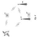
- FIG. 4illustrates a system embodiment.
- the systemincludes an avionics device 410 , a satellite 436 , a number of land based transmitters 438 , and a server 440 .
- informationsuch as update information can be transmitted from the server 440 to the avionics device 410 along a number of paths, for example via satellite, via land based transmitters, or via a combination of satellite and land based transmitters.
- an aviation navigation systemcan include a remote transmitter, a receiver, and an avionics device.
- a remote transmittercan include transmitters resident on satellites, fixed land/ground based transmitters, and the like.
- the systemcan also include a relay for relaying a radio signal from a transmitter to a receiver.
- the relaycan be provided on a satellite or on a land based structure and can be a transceiver for transmitting and receiving radio signals.
- a signalhaving information therein, can be transmitted from the server 440 to a land based transmitter 438 .
- the transmitter 438can act as a relay and send the signal on to a satellite 436 .
- the satellite 436can transmit the signal directly to the avionics device 410 or can act as a relay to send the signal to a second satellite 436 or land based transmitter 438 .
- the second satellite 436 or land based transmitter 438can transmit the signal to the avionics device 410 or act as another relay.
- the signalhaving the information therein, can also be transmitted from the server 440 to a first land based transmitter 438 .
- the first transmitter 438can send the signal directly to the avionics device 410 or can act as a relay to send the signal on to a second land based transmitter 438 .
- the second land based transmitter 438can transmit the signal to the avionics device 410 .
- FIGS. 5-7illustrate method embodiments for delivering updates to an avionics device or system. Unless explicitly stated, the method embodiments described herein are not constrained to a particular order or sequence. Additionally, some of the described method embodiments and elements thereof can occur or be performed at the same point in time.
- FIG. 5illustrates a method embodiment for receiving data updates with an avionics device.
- the method of FIG. 5includes, receiving update information, in the form of a radio signal from a remote transmitter, with an avionics device at block 510 .
- receiving a radio signalcan include receiving a radio signal transmitted from a satellite or a land based transmitter.
- Receiving update informationcan include receiving information updating geographic terrain map data.
- receiving update informationcan include receiving information updating navaid map data.
- Receiving update informationcan include receiving information updating airport map data.
- Receiving update informationcan include receiving information updating avionics device operating system data.
- Receiving update informationcan include receiving information updating global positioning system data such as, for example, integrity information.
- the methodincludes interpreting the signal to identify information to be updated.
- the method of FIG. 5also includes updating existing information resident on the avionics device with the update information at block 530 .
- FIG. 6illustrates a method embodiment for delivering data updates to an avionics device.
- the method of FIG. 6includes identifying information to be transmitted as an update to an avionics device at block 610 .
- the methodalso includes packaging the information for transmission.
- the method of FIG. 6also includes transmitting a radio signal via a remote transmitter having packaged update information therein to a number of avionics devices at block 630 .
- Transmitting a radio signal having update information thereincan include transmitting a radio signal at a private frequency restricted to devices authorized to access the frequency.
- the methodcan include providing an authorization code for accessing the radio signal.
- providing an authorization codecan include providing an authorization code to the device that allows the avionics device to receive the update information.
- Providing an authorization codecan include providing an authorization code within the radio signal that allows the avionics device to receive the update information.
- Providing an authorization codecan include providing an authorization code to the device that allows the remote transmitter to transmit the update information.
- FIG. 7illustrates a method embodiment for interpreting data to update executable instructions.
- the method of FIG. 7includes providing an avionics device having executable instructions thereon at block 710 .
- the methodalso includes receiving data, in the form of a radio signal from a remote transmitter, with the avionics device.
- receiving datacan include receiving software.
- Receiving softwarecan include receiving application software.
- receiving dataincludes receiving update information.
- Receiving datacan include receiving data in the form of radio signals transmitted in radio frequencies in the range of 2300 and 2400 MHz.
- Receiving datacan include receiving data in the form of radio signals transmitted in radio frequencies in the range of 500 and 1500 MHz.
- the method of FIG. 7also includes interpreting the data to update the executable instructions on the avionics device at block 730 .
Landscapes
- Engineering & Computer Science (AREA)
- Radar, Positioning & Navigation (AREA)
- Remote Sensing (AREA)
- Aviation & Aerospace Engineering (AREA)
- Physics & Mathematics (AREA)
- General Physics & Mathematics (AREA)
- Position Fixing By Use Of Radio Waves (AREA)
Abstract
Description
Claims (42)
Priority Applications (1)
| Application Number | Priority Date | Filing Date | Title |
|---|---|---|---|
| US10/722,303US7257469B1 (en) | 2003-11-25 | 2003-11-25 | Delivering data updates to an avionics device |
Applications Claiming Priority (1)
| Application Number | Priority Date | Filing Date | Title |
|---|---|---|---|
| US10/722,303US7257469B1 (en) | 2003-11-25 | 2003-11-25 | Delivering data updates to an avionics device |
Publications (1)
| Publication Number | Publication Date |
|---|---|
| US7257469B1true US7257469B1 (en) | 2007-08-14 |
Family
ID=38337104
Family Applications (1)
| Application Number | Title | Priority Date | Filing Date |
|---|---|---|---|
| US10/722,303Expired - LifetimeUS7257469B1 (en) | 2003-11-25 | 2003-11-25 | Delivering data updates to an avionics device |
Country Status (1)
| Country | Link |
|---|---|
| US (1) | US7257469B1 (en) |
Cited By (31)
| Publication number | Priority date | Publication date | Assignee | Title |
|---|---|---|---|---|
| US20050192724A1 (en)* | 2004-02-26 | 2005-09-01 | Jason Hendry | Method and apparatus for importing weather data from source external to vehicle |
| US20070200674A1 (en)* | 2006-02-14 | 2007-08-30 | Garmin Ltd., A Cayman Islands Corporation | Electronic device having a location-based security feature |
| US20070252760A1 (en)* | 1999-03-05 | 2007-11-01 | Smith Alexander E | Method and apparatus for ADS-B validation, active and passive multilateration, and elliptical surviellance |
| US20080005734A1 (en)* | 2006-03-08 | 2008-01-03 | Shay Poristoin | Navigation device and method of updating information on a navigation device |
| US20090024312A1 (en)* | 2007-07-18 | 2009-01-22 | Honeywell International Inc. | Method and system for updating navigation information |
| US20090140925A1 (en)* | 1999-03-05 | 2009-06-04 | Smith Alexander E | Multilateration Enhancements for Noise and Operations Management |
| US20090201287A1 (en)* | 2008-02-07 | 2009-08-13 | Honeywell International Inc. | System and method of adaptively filtering parametric data for display |
| US7576695B2 (en) | 1999-03-05 | 2009-08-18 | Era Systems Corporation | Multilateration enhancements for noise and operations management |
| US7612716B2 (en) | 1999-03-05 | 2009-11-03 | Era Systems Corporation | Correlation of flight track data with other data sources |
| US7667647B2 (en) | 1999-03-05 | 2010-02-23 | Era Systems Corporation | Extension of aircraft tracking and positive identification from movement areas into non-movement areas |
| US7739167B2 (en) | 1999-03-05 | 2010-06-15 | Era Systems Corporation | Automated management of airport revenues |
| US7777675B2 (en) | 1999-03-05 | 2010-08-17 | Era Systems Corporation | Deployable passive broadband aircraft tracking |
| US7782256B2 (en) | 1999-03-05 | 2010-08-24 | Era Systems Corporation | Enhanced passive coherent location techniques to track and identify UAVs, UCAVs, MAVs, and other objects |
| US7908077B2 (en) | 2003-06-10 | 2011-03-15 | Itt Manufacturing Enterprises, Inc. | Land use compatibility planning software |
| US20110102199A1 (en)* | 2009-10-30 | 2011-05-05 | Honeywell International Inc. | Aircraft visual display system with direct page navigation |
| US7945356B2 (en)* | 2007-06-29 | 2011-05-17 | The Boeing Company | Portable autonomous terminal guidance system |
| US7965227B2 (en) | 2006-05-08 | 2011-06-21 | Era Systems, Inc. | Aircraft tracking using low cost tagging as a discriminator |
| US20110202272A1 (en)* | 2010-02-12 | 2011-08-18 | Honeywell International Inc. | System for enhancing a vehicle operator's orientation and ability to navigate |
| US8035547B1 (en)* | 2008-03-17 | 2011-10-11 | Garmin Switzerland Gmbh | System and method of assisted aerial navigation |
| US20120078448A1 (en)* | 2010-09-27 | 2012-03-29 | Honeywell International Inc. | Mixed-intiative transfer of datalink-based information |
| US8203486B1 (en) | 1999-03-05 | 2012-06-19 | Omnipol A.S. | Transmitter independent techniques to extend the performance of passive coherent location |
| CN102883305A (en)* | 2011-07-15 | 2013-01-16 | 上海艾特维通信科技有限公司 | Device and method for realizing remote software upgrading of wireless terminal |
| US20130067450A1 (en)* | 2010-04-29 | 2013-03-14 | Airbus Operations (Sas) | Method of upgrading an aircraft |
| US8446321B2 (en) | 1999-03-05 | 2013-05-21 | Omnipol A.S. | Deployable intelligence and tracking system for homeland security and search and rescue |
| EP3029654A1 (en)* | 2014-12-03 | 2016-06-08 | Honeywell International Inc. | Systems and method for wirelessly and securely updating a terrain awareness warning system database |
| US20160328978A1 (en)* | 2015-04-30 | 2016-11-10 | Ge Aviation Systems Llc | Systems and methods of providing a data update to an aircraft |
| GB2533631B (en)* | 2014-12-24 | 2019-07-03 | Ge Aviation Systems | Method for providing an airport model |
| US10375561B2 (en)* | 2016-05-26 | 2019-08-06 | International Business Machines Corporation | Coordinating the use of independent radio receivers associated with multiple different transmitters |
| US10650688B1 (en)* | 2016-07-22 | 2020-05-12 | Rockwell Collins, Inc. | Air traffic situational awareness using HF communication |
| US20230163835A1 (en)* | 2005-08-18 | 2023-05-25 | Smartsky Networks LLC | Terrestrial based high speed data communications mesh network |
| US11876790B2 (en)* | 2020-01-21 | 2024-01-16 | The Boeing Company | Authenticating computing devices based on a dynamic port punching sequence |
Citations (20)
| Publication number | Priority date | Publication date | Assignee | Title |
|---|---|---|---|---|
| US4642775A (en)* | 1984-05-25 | 1987-02-10 | Sundstrand Data Control, Inc. | Airborne flight planning and information system |
| US5597335A (en) | 1995-10-18 | 1997-01-28 | Woodland; Richard L. K. | Marine personnel rescue system and apparatus |
| US5948040A (en) | 1994-06-24 | 1999-09-07 | Delorme Publishing Co. | Travel reservation information and planning system |
| US6275231B1 (en) | 1997-08-01 | 2001-08-14 | American Calcar Inc. | Centralized control and management system for automobiles |
| US6381538B1 (en)* | 2000-05-26 | 2002-04-30 | Aerotech Research (U.S.A.), Inc. | Vehicle specific hazard estimation, presentation, and route planning based on meteorological and other environmental data |
| US6401034B1 (en) | 1999-09-02 | 2002-06-04 | Navigation Technologies Corp. | Method and system for finding intermediate destinations with a navigation system |
| US20020111720A1 (en)* | 2001-02-13 | 2002-08-15 | William Holst | Method and apparatus to support remote and automatically initiated data loading and data acquisition of airborne computers using a wireless spread spectrum aircraft data services link |
| US6438468B1 (en)* | 2000-11-28 | 2002-08-20 | Honeywell International Inc. | Systems and methods for delivering data updates to an aircraft |
| US6545631B2 (en)* | 2000-10-17 | 2003-04-08 | United Parcel Service Of America, Inc. | Integrated datalinks in a surveillance receiver |
| US6603405B2 (en)* | 2000-12-05 | 2003-08-05 | User-Centric Enterprises, Inc. | Vehicle-centric weather prediction system and method |
| US6650972B1 (en)* | 2000-05-26 | 2003-11-18 | Aerotech Research (U.S.A.), Inc. | Estimation, transmission, receipt, and presentation of vehicle specific environmental conditions and hazards information |
| US20030222887A1 (en)* | 2001-10-11 | 2003-12-04 | Wilkins Robert Ryan | Control system providing perspective flight guidance |
| US6687578B2 (en) | 2002-03-28 | 2004-02-03 | Honeywell International Inc. | Integration of avionics subsystems into cockpit multifunctional displays |
| US6744396B2 (en)* | 2001-07-20 | 2004-06-01 | Aviation Communication & Surveillance Systems Llc | Surveillance and collision avoidance system with compound symbols |
| US20040106404A1 (en)* | 2002-12-02 | 2004-06-03 | Gould Todd W. | Remote aircraft manufacturing, monitoring, maintenance and management system |
| US6768942B1 (en) | 2000-09-18 | 2004-07-27 | Navigation Technologies Corp. | Navigation system with decryption functions and secure geographic database |
| US6828922B1 (en) | 1998-02-09 | 2004-12-07 | Honeywell International Inc. | Synthetic airborne hazard display |
| US6973479B2 (en)* | 2002-05-01 | 2005-12-06 | Thales Avionics, Inc. | Method and system for configuration and download in a restricted architecture network |
| US6975923B2 (en) | 2002-10-01 | 2005-12-13 | Roke Manor Research Limited | Autonomous vehicle guidance on or near airports |
| US6978208B2 (en) | 2002-03-19 | 2005-12-20 | Yoshinori Endo | Information center for communications-type navigation device |
- 2003
- 2003-11-25USUS10/722,303patent/US7257469B1/ennot_activeExpired - Lifetime
Patent Citations (24)
| Publication number | Priority date | Publication date | Assignee | Title |
|---|---|---|---|---|
| US4642775A (en)* | 1984-05-25 | 1987-02-10 | Sundstrand Data Control, Inc. | Airborne flight planning and information system |
| US5948040A (en) | 1994-06-24 | 1999-09-07 | Delorme Publishing Co. | Travel reservation information and planning system |
| US5597335A (en) | 1995-10-18 | 1997-01-28 | Woodland; Richard L. K. | Marine personnel rescue system and apparatus |
| US6275231B1 (en) | 1997-08-01 | 2001-08-14 | American Calcar Inc. | Centralized control and management system for automobiles |
| US6703944B1 (en) | 1997-08-01 | 2004-03-09 | American Calcar Inc. | Technique for effectively maintaining a safe distance between a vehicle and an object |
| US6828922B1 (en) | 1998-02-09 | 2004-12-07 | Honeywell International Inc. | Synthetic airborne hazard display |
| US6401034B1 (en) | 1999-09-02 | 2002-06-04 | Navigation Technologies Corp. | Method and system for finding intermediate destinations with a navigation system |
| US6381538B1 (en)* | 2000-05-26 | 2002-04-30 | Aerotech Research (U.S.A.), Inc. | Vehicle specific hazard estimation, presentation, and route planning based on meteorological and other environmental data |
| US6917860B1 (en)* | 2000-05-26 | 2005-07-12 | Aerotech Research (Usa), Inc. | Transmission, receipt, and presentation of vehicle specific environmental conditions and hazards information |
| US6650972B1 (en)* | 2000-05-26 | 2003-11-18 | Aerotech Research (U.S.A.), Inc. | Estimation, transmission, receipt, and presentation of vehicle specific environmental conditions and hazards information |
| US6768942B1 (en) | 2000-09-18 | 2004-07-27 | Navigation Technologies Corp. | Navigation system with decryption functions and secure geographic database |
| US6545631B2 (en)* | 2000-10-17 | 2003-04-08 | United Parcel Service Of America, Inc. | Integrated datalinks in a surveillance receiver |
| US6438468B1 (en)* | 2000-11-28 | 2002-08-20 | Honeywell International Inc. | Systems and methods for delivering data updates to an aircraft |
| US6603405B2 (en)* | 2000-12-05 | 2003-08-05 | User-Centric Enterprises, Inc. | Vehicle-centric weather prediction system and method |
| US20020111720A1 (en)* | 2001-02-13 | 2002-08-15 | William Holst | Method and apparatus to support remote and automatically initiated data loading and data acquisition of airborne computers using a wireless spread spectrum aircraft data services link |
| US20030003872A1 (en)* | 2001-02-13 | 2003-01-02 | Brinkley Roger R. | Methods and apparatus for wireless upload and download of aircraft data |
| US6744396B2 (en)* | 2001-07-20 | 2004-06-01 | Aviation Communication & Surveillance Systems Llc | Surveillance and collision avoidance system with compound symbols |
| US20030222887A1 (en)* | 2001-10-11 | 2003-12-04 | Wilkins Robert Ryan | Control system providing perspective flight guidance |
| US7010398B2 (en)* | 2001-10-11 | 2006-03-07 | The Boeing Company | Control system providing perspective flight guidance |
| US6978208B2 (en) | 2002-03-19 | 2005-12-20 | Yoshinori Endo | Information center for communications-type navigation device |
| US6687578B2 (en) | 2002-03-28 | 2004-02-03 | Honeywell International Inc. | Integration of avionics subsystems into cockpit multifunctional displays |
| US6973479B2 (en)* | 2002-05-01 | 2005-12-06 | Thales Avionics, Inc. | Method and system for configuration and download in a restricted architecture network |
| US6975923B2 (en) | 2002-10-01 | 2005-12-13 | Roke Manor Research Limited | Autonomous vehicle guidance on or near airports |
| US20040106404A1 (en)* | 2002-12-02 | 2004-06-03 | Gould Todd W. | Remote aircraft manufacturing, monitoring, maintenance and management system |
Cited By (47)
| Publication number | Priority date | Publication date | Assignee | Title |
|---|---|---|---|---|
| US8072382B2 (en) | 1999-03-05 | 2011-12-06 | Sra International, Inc. | Method and apparatus for ADS-B validation, active and passive multilateration, and elliptical surveillance |
| US7667647B2 (en) | 1999-03-05 | 2010-02-23 | Era Systems Corporation | Extension of aircraft tracking and positive identification from movement areas into non-movement areas |
| US20070252760A1 (en)* | 1999-03-05 | 2007-11-01 | Smith Alexander E | Method and apparatus for ADS-B validation, active and passive multilateration, and elliptical surviellance |
| US8203486B1 (en) | 1999-03-05 | 2012-06-19 | Omnipol A.S. | Transmitter independent techniques to extend the performance of passive coherent location |
| US8446321B2 (en) | 1999-03-05 | 2013-05-21 | Omnipol A.S. | Deployable intelligence and tracking system for homeland security and search and rescue |
| US20090140925A1 (en)* | 1999-03-05 | 2009-06-04 | Smith Alexander E | Multilateration Enhancements for Noise and Operations Management |
| US7570214B2 (en) | 1999-03-05 | 2009-08-04 | Era Systems, Inc. | Method and apparatus for ADS-B validation, active and passive multilateration, and elliptical surviellance |
| US7782256B2 (en) | 1999-03-05 | 2010-08-24 | Era Systems Corporation | Enhanced passive coherent location techniques to track and identify UAVs, UCAVs, MAVs, and other objects |
| US7576695B2 (en) | 1999-03-05 | 2009-08-18 | Era Systems Corporation | Multilateration enhancements for noise and operations management |
| US7612716B2 (en) | 1999-03-05 | 2009-11-03 | Era Systems Corporation | Correlation of flight track data with other data sources |
| US7889133B2 (en) | 1999-03-05 | 2011-02-15 | Itt Manufacturing Enterprises, Inc. | Multilateration enhancements for noise and operations management |
| US7739167B2 (en) | 1999-03-05 | 2010-06-15 | Era Systems Corporation | Automated management of airport revenues |
| US7777675B2 (en) | 1999-03-05 | 2010-08-17 | Era Systems Corporation | Deployable passive broadband aircraft tracking |
| US7908077B2 (en) | 2003-06-10 | 2011-03-15 | Itt Manufacturing Enterprises, Inc. | Land use compatibility planning software |
| US20050192724A1 (en)* | 2004-02-26 | 2005-09-01 | Jason Hendry | Method and apparatus for importing weather data from source external to vehicle |
| US12101168B2 (en) | 2005-08-18 | 2024-09-24 | Smartsky Networks LLC | Terrestrial based high speed data communications mesh network |
| US11876595B2 (en)* | 2005-08-18 | 2024-01-16 | Smartsky Networks LLC | Terrestrial based high speed data communications mesh network |
| US20230163835A1 (en)* | 2005-08-18 | 2023-05-25 | Smartsky Networks LLC | Terrestrial based high speed data communications mesh network |
| US11968026B2 (en) | 2005-08-18 | 2024-04-23 | Smartsky Networks LLC | Terrestrial based high speed data communications mesh network |
| US20070200674A1 (en)* | 2006-02-14 | 2007-08-30 | Garmin Ltd., A Cayman Islands Corporation | Electronic device having a location-based security feature |
| US20080005734A1 (en)* | 2006-03-08 | 2008-01-03 | Shay Poristoin | Navigation device and method of updating information on a navigation device |
| US7965227B2 (en) | 2006-05-08 | 2011-06-21 | Era Systems, Inc. | Aircraft tracking using low cost tagging as a discriminator |
| US7945356B2 (en)* | 2007-06-29 | 2011-05-17 | The Boeing Company | Portable autonomous terminal guidance system |
| US20090024312A1 (en)* | 2007-07-18 | 2009-01-22 | Honeywell International Inc. | Method and system for updating navigation information |
| US8185254B2 (en)* | 2007-07-18 | 2012-05-22 | Honeywell International Inc. | Method and system for updating navigation information |
| US20090201287A1 (en)* | 2008-02-07 | 2009-08-13 | Honeywell International Inc. | System and method of adaptively filtering parametric data for display |
| US8035547B1 (en)* | 2008-03-17 | 2011-10-11 | Garmin Switzerland Gmbh | System and method of assisted aerial navigation |
| US8698655B2 (en) | 2008-03-17 | 2014-04-15 | Garmin International, Inc. | System and method of assisted aerial navigation |
| US20110102199A1 (en)* | 2009-10-30 | 2011-05-05 | Honeywell International Inc. | Aircraft visual display system with direct page navigation |
| US8432298B2 (en)* | 2009-10-30 | 2013-04-30 | Honeywell International Inc. | Aircraft visual display system with direct page navigation |
| US8140260B2 (en) | 2010-02-12 | 2012-03-20 | Honeywell International Inc. | System for enhancing a vehicle operator's orientation and ability to navigate |
| US20110202272A1 (en)* | 2010-02-12 | 2011-08-18 | Honeywell International Inc. | System for enhancing a vehicle operator's orientation and ability to navigate |
| US20130067450A1 (en)* | 2010-04-29 | 2013-03-14 | Airbus Operations (Sas) | Method of upgrading an aircraft |
| US9349295B2 (en)* | 2010-09-27 | 2016-05-24 | Honeywell International Inc. | Mixed-intiative transfer of datalink-based information |
| US20120078448A1 (en)* | 2010-09-27 | 2012-03-29 | Honeywell International Inc. | Mixed-intiative transfer of datalink-based information |
| CN102883305A (en)* | 2011-07-15 | 2013-01-16 | 上海艾特维通信科技有限公司 | Device and method for realizing remote software upgrading of wireless terminal |
| EP3029654A1 (en)* | 2014-12-03 | 2016-06-08 | Honeywell International Inc. | Systems and method for wirelessly and securely updating a terrain awareness warning system database |
| US9753969B2 (en) | 2014-12-03 | 2017-09-05 | Honeywell International Inc. | Systems and method for wirelessly and securely updating a terrain awareness warning system database |
| EP3598421A1 (en)* | 2014-12-03 | 2020-01-22 | Honeywell International Inc. | Systems and method for wirelessly and securely updating a terrain awareness warning system database |
| GB2533631B (en)* | 2014-12-24 | 2019-07-03 | Ge Aviation Systems | Method for providing an airport model |
| US10068488B2 (en)* | 2015-04-30 | 2018-09-04 | Ge Aviation Systems Llc | Systems and methods of providing a data update to an aircraft |
| US20160328978A1 (en)* | 2015-04-30 | 2016-11-10 | Ge Aviation Systems Llc | Systems and methods of providing a data update to an aircraft |
| US10735938B2 (en)* | 2016-05-26 | 2020-08-04 | International Business Machines Corporation | Coordinating the use of independent radio receivers associated with multiple different transmitters |
| US20190274028A1 (en)* | 2016-05-26 | 2019-09-05 | International Business Machines Corporation | Coordinating the use of independent radio receivers associated with multiple different transmitters |
| US10375561B2 (en)* | 2016-05-26 | 2019-08-06 | International Business Machines Corporation | Coordinating the use of independent radio receivers associated with multiple different transmitters |
| US10650688B1 (en)* | 2016-07-22 | 2020-05-12 | Rockwell Collins, Inc. | Air traffic situational awareness using HF communication |
| US11876790B2 (en)* | 2020-01-21 | 2024-01-16 | The Boeing Company | Authenticating computing devices based on a dynamic port punching sequence |
Similar Documents
| Publication | Publication Date | Title |
|---|---|---|
| US7257469B1 (en) | Delivering data updates to an avionics device | |
| EP2922046B1 (en) | A system and method for providing enhanced flight-plan management | |
| US6832138B1 (en) | Cockpit instrument panel systems and methods with redundant flight data display | |
| US7268702B2 (en) | Apparatus and methods for providing a flight display in an aircraft | |
| US6867711B1 (en) | Cockpit instrument panel systems and methods with variable perspective flight display | |
| US6985801B1 (en) | Cockpit instrument panel systems and methods with redundant flight data display | |
| EP2679959B1 (en) | Avionics display system providing enhanced flight-plan management | |
| US7874521B2 (en) | Method and system for aviation navigation | |
| US6633810B1 (en) | Graphical system and method for defining pilot tasks, patterns and constraints | |
| US6216065B1 (en) | Method and system for creating an approach to a position on the ground from a location above the ground | |
| US8032267B1 (en) | Aviation navigational and flight management systems and methods with emergency landing guidance and radar vectoring | |
| US8160755B2 (en) | Displaying air traffic symbology based on relative importance | |
| US8467966B2 (en) | Device for aiding the flight management of an aircraft | |
| EP2623935B1 (en) | System and method for displaying performance based range and time scales on a navigation display | |
| US9105183B2 (en) | System and method for graphically displaying aircraft traffic information using aircraft symbology | |
| US20060005147A1 (en) | Methods and systems for controlling the display of maps aboard an aircraft | |
| US20140331161A1 (en) | System and method for graphically displaying weather hazards in a perspective view | |
| US9262931B2 (en) | System and method for graphically generating an approach/departure course | |
| US20090248224A1 (en) | Integrated Air Navigation and Flight Control System | |
| EP3657131B1 (en) | Waypoint list presentation methods and systems | |
| EP2899508A1 (en) | A system and method for graphically displaying intruder incorrect barometric setting | |
| Terpstra | Jeppesen charting for area navigation |
Legal Events
| Date | Code | Title | Description |
|---|---|---|---|
| AS | Assignment | Owner name:GARMIN LTD., CAYMAN ISLANDS Free format text:ASSIGNMENT OF ASSIGNORS INTEREST;ASSIGNOR:PEMBLE, CLIFF A.;REEL/FRAME:014756/0608 Effective date:20031124 | |
| AS | Assignment | Owner name:GARMIN INTERNATIONAL, INC., KANSAS Free format text:CORRECTIVE ASSIGNMENT TO CORRECT THE NAME AND ADDRESS OF RECEIVING PARTY PREVIOUSLY RECORDED ON REEL 014756 FRAME 0608;ASSIGNOR:PEMBLE, CLIFF A.;REEL/FRAME:014870/0927 Effective date:20031124 | |
| STCF | Information on status: patent grant | Free format text:PATENTED CASE | |
| FPAY | Fee payment | Year of fee payment:4 | |
| FEPP | Fee payment procedure | Free format text:PAYOR NUMBER ASSIGNED (ORIGINAL EVENT CODE: ASPN); ENTITY STATUS OF PATENT OWNER: LARGE ENTITY | |
| FPAY | Fee payment | Year of fee payment:8 | |
| MAFP | Maintenance fee payment | Free format text:PAYMENT OF MAINTENANCE FEE, 12TH YEAR, LARGE ENTITY (ORIGINAL EVENT CODE: M1553); ENTITY STATUS OF PATENT OWNER: LARGE ENTITY Year of fee payment:12 |