US7248219B2 - Correlation of flight track data with other data sources - Google Patents
Correlation of flight track data with other data sourcesDownload PDFInfo
- Publication number
- US7248219B2 US7248219B2US11/209,030US20903005AUS7248219B2US 7248219 B2US7248219 B2US 7248219B2US 20903005 AUS20903005 AUS 20903005AUS 7248219 B2US7248219 B2US 7248219B2
- Authority
- US
- United States
- Prior art keywords
- aircraft
- data
- time
- flight
- mode
- Prior art date
- Legal status (The legal status is an assumption and is not a legal conclusion. Google has not performed a legal analysis and makes no representation as to the accuracy of the status listed.)
- Expired - Lifetime
Links
- 238000000034methodMethods0.000claimsabstractdescription61
- 238000001914filtrationMethods0.000claimsabstractdescription18
- 230000008859changeEffects0.000claimsabstractdescription13
- 238000004891communicationMethods0.000claimsabstractdescription11
- 230000005540biological transmissionEffects0.000description17
- 230000002596correlated effectEffects0.000description16
- 238000007726management methodMethods0.000description11
- 238000004364calculation methodMethods0.000description8
- 238000007499fusion processingMethods0.000description8
- 238000004422calculation algorithmMethods0.000description7
- 238000005259measurementMethods0.000description7
- 238000012544monitoring processMethods0.000description7
- 230000008569processEffects0.000description7
- 239000000446fuelSubstances0.000description6
- 238000013459approachMethods0.000description5
- 238000010586diagramMethods0.000description5
- 238000012545processingMethods0.000description5
- 230000001419dependent effectEffects0.000description4
- 230000010354integrationEffects0.000description4
- 238000012937correctionMethods0.000description3
- 238000005516engineering processMethods0.000description3
- WBWWGRHZICKQGZ-HZAMXZRMSA-MtaurocholateChemical compoundC([C@H]1C[C@H]2O)[C@H](O)CC[C@]1(C)[C@@H]1[C@@H]2[C@@H]2CC[C@H]([C@@H](CCC(=O)NCCS([O-])(=O)=O)C)[C@@]2(C)[C@@H](O)C1WBWWGRHZICKQGZ-HZAMXZRMSA-M0.000description3
- RAHZWNYVWXNFOC-UHFFFAOYSA-NSulphur dioxideChemical compoundO=S=ORAHZWNYVWXNFOC-UHFFFAOYSA-N0.000description2
- 230000001133accelerationEffects0.000description2
- 230000003190augmentative effectEffects0.000description2
- 230000000875corresponding effectEffects0.000description2
- 230000007423decreaseEffects0.000description2
- 230000007613environmental effectEffects0.000description2
- 230000006872improvementEffects0.000description2
- 238000012806monitoring deviceMethods0.000description2
- 230000009467reductionEffects0.000description2
- MGWGWNFMUOTEHG-UHFFFAOYSA-N4-(3,5-dimethylphenyl)-1,3-thiazol-2-amineChemical compoundCC1=CC(C)=CC(C=2N=C(N)SC=2)=C1MGWGWNFMUOTEHG-UHFFFAOYSA-N0.000description1
- CBENFWSGALASAD-UHFFFAOYSA-NOzoneChemical compound[O-][O+]=OCBENFWSGALASAD-UHFFFAOYSA-N0.000description1
- 230000003044adaptive effectEffects0.000description1
- 238000004458analytical methodMethods0.000description1
- 238000010420art techniqueMethods0.000description1
- 230000033228biological regulationEffects0.000description1
- 239000000969carrierSubstances0.000description1
- 238000006243chemical reactionMethods0.000description1
- 239000002131composite materialSubstances0.000description1
- 230000001934delayEffects0.000description1
- 230000003111delayed effectEffects0.000description1
- 239000006185dispersionSubstances0.000description1
- 230000000694effectsEffects0.000description1
- 239000000835fiberSubstances0.000description1
- 230000010006flightEffects0.000description1
- 238000009472formulationMethods0.000description1
- 230000006870functionEffects0.000description1
- 230000004927fusionEffects0.000description1
- 238000009499grossingMethods0.000description1
- 230000002452interceptive effectEffects0.000description1
- QSHDDOUJBYECFT-UHFFFAOYSA-NmercuryChemical compound[Hg]QSHDDOUJBYECFT-UHFFFAOYSA-N0.000description1
- 229910052753mercuryInorganic materials0.000description1
- 239000000203mixtureSubstances0.000description1
- 238000012986modificationMethods0.000description1
- 230000004048modificationEffects0.000description1
- JCXJVPUVTGWSNB-UHFFFAOYSA-Nnitrogen dioxideInorganic materialsO=[N]=OJCXJVPUVTGWSNB-UHFFFAOYSA-N0.000description1
- 230000008520organizationEffects0.000description1
- 230000002093peripheral effectEffects0.000description1
- 238000001556precipitationMethods0.000description1
- 238000011160researchMethods0.000description1
- 230000004044responseEffects0.000description1
- 238000010079rubber tappingMethods0.000description1
- 238000005070samplingMethods0.000description1
- 238000004088simulationMethods0.000description1
- 238000012795verificationMethods0.000description1
- 239000002023woodSubstances0.000description1
Images


Classifications
- G—PHYSICS
- G08—SIGNALLING
- G08G—TRAFFIC CONTROL SYSTEMS
- G08G5/00—Traffic control systems for aircraft
- G08G5/20—Arrangements for acquiring, generating, sharing or displaying traffic information
- G08G5/26—Transmission of traffic-related information between aircraft and ground stations
- G—PHYSICS
- G01—MEASURING; TESTING
- G01S—RADIO DIRECTION-FINDING; RADIO NAVIGATION; DETERMINING DISTANCE OR VELOCITY BY USE OF RADIO WAVES; LOCATING OR PRESENCE-DETECTING BY USE OF THE REFLECTION OR RERADIATION OF RADIO WAVES; ANALOGOUS ARRANGEMENTS USING OTHER WAVES
- G01S13/00—Systems using the reflection or reradiation of radio waves, e.g. radar systems; Analogous systems using reflection or reradiation of waves whose nature or wavelength is irrelevant or unspecified
- G01S13/74—Systems using reradiation of radio waves, e.g. secondary radar systems; Analogous systems
- G01S13/76—Systems using reradiation of radio waves, e.g. secondary radar systems; Analogous systems wherein pulse-type signals are transmitted
- G01S13/78—Systems using reradiation of radio waves, e.g. secondary radar systems; Analogous systems wherein pulse-type signals are transmitted discriminating between different kinds of targets, e.g. IFF-radar, i.e. identification of friend or foe
- G01S13/781—Secondary Surveillance Radar [SSR] in general
- G—PHYSICS
- G01—MEASURING; TESTING
- G01S—RADIO DIRECTION-FINDING; RADIO NAVIGATION; DETERMINING DISTANCE OR VELOCITY BY USE OF RADIO WAVES; LOCATING OR PRESENCE-DETECTING BY USE OF THE REFLECTION OR RERADIATION OF RADIO WAVES; ANALOGOUS ARRANGEMENTS USING OTHER WAVES
- G01S13/00—Systems using the reflection or reradiation of radio waves, e.g. radar systems; Analogous systems using reflection or reradiation of waves whose nature or wavelength is irrelevant or unspecified
- G01S13/86—Combinations of radar systems with non-radar systems, e.g. sonar, direction finder
- G—PHYSICS
- G01—MEASURING; TESTING
- G01S—RADIO DIRECTION-FINDING; RADIO NAVIGATION; DETERMINING DISTANCE OR VELOCITY BY USE OF RADIO WAVES; LOCATING OR PRESENCE-DETECTING BY USE OF THE REFLECTION OR RERADIATION OF RADIO WAVES; ANALOGOUS ARRANGEMENTS USING OTHER WAVES
- G01S5/00—Position-fixing by co-ordinating two or more direction or position line determinations; Position-fixing by co-ordinating two or more distance determinations
- G01S5/02—Position-fixing by co-ordinating two or more direction or position line determinations; Position-fixing by co-ordinating two or more distance determinations using radio waves
- G01S5/06—Position of source determined by co-ordinating a plurality of position lines defined by path-difference measurements
- G—PHYSICS
- G08—SIGNALLING
- G08G—TRAFFIC CONTROL SYSTEMS
- G08G5/00—Traffic control systems for aircraft
- G08G5/50—Navigation or guidance aids
- G08G5/55—Navigation or guidance aids for a single aircraft
- G—PHYSICS
- G08—SIGNALLING
- G08G—TRAFFIC CONTROL SYSTEMS
- G08G5/00—Traffic control systems for aircraft
- G08G5/50—Navigation or guidance aids
- G08G5/59—Navigation or guidance aids in accordance with predefined flight zones, e.g. to avoid prohibited zones
- G—PHYSICS
- G08—SIGNALLING
- G08G—TRAFFIC CONTROL SYSTEMS
- G08G5/00—Traffic control systems for aircraft
- G08G5/70—Arrangements for monitoring traffic-related situations or conditions
- G08G5/72—Arrangements for monitoring traffic-related situations or conditions for monitoring traffic
- G08G5/727—Arrangements for monitoring traffic-related situations or conditions for monitoring traffic from a ground station
- G—PHYSICS
- G01—MEASURING; TESTING
- G01S—RADIO DIRECTION-FINDING; RADIO NAVIGATION; DETERMINING DISTANCE OR VELOCITY BY USE OF RADIO WAVES; LOCATING OR PRESENCE-DETECTING BY USE OF THE REFLECTION OR RERADIATION OF RADIO WAVES; ANALOGOUS ARRANGEMENTS USING OTHER WAVES
- G01S5/00—Position-fixing by co-ordinating two or more direction or position line determinations; Position-fixing by co-ordinating two or more distance determinations
- G01S5/02—Position-fixing by co-ordinating two or more direction or position line determinations; Position-fixing by co-ordinating two or more distance determinations using radio waves
- G01S5/0284—Relative positioning
Definitions
- 10/457,439in turn is a Continuation-In-Part application of U.S. patent application Ser. No. 09/516,215, filed Mar. 5, 1999, Now U.S. Pat. No. 6,633,259, which is incorporated herein by reference in its entirety, application Ser. No. 10/457,439 is also a Continuation-In-Part of U.S. patent application Ser. No. 10/319,725, filed Dec. 16, 2002, now U.S. Pat. No. 6,812,890 incorporated herein by reference in its entirety; application Ser. No. 10/457,439 also claims priority from Provisional U.S. Patent Application No. 60/440,618, filed Jan. 17, 2003, incorporated herein by reference in its entirety.
- the present inventionrelates to the field of aircraft tracking and identification.
- the present inventionis specifically directed toward a technique for passively retrieving and correlating aircraft data from existing aircraft data sources.
- Six embodiments of present inventionare described wherein aircraft flight track may be calculated and correlated with other data or where flight track data may be enhanced with other data.
- Mode S transpondersare capable of transmitting a number (e.g., 25) of formats of coded data.
- This coded dataincludes such information as a unique 24-bit binary address for each aircraft.
- the aircraft registration numbermay be derived from this 24-bit binary address.
- the coded Mode-S dataalso includes such information as aircraft altitude and may be transmitted continuously throughout a flight at a minimum rate of 1 Hz (i.e., once per second). Coded Mode-S data may be collected passively without any connection to air traffic control equipment.
- the FAAhas endorsed the Aircraft Communications Addressing and Reporting System (ACARS) system, which uses various data link technologies including the VHF communication band, HF and SATCOM along with a ground station network to allow aircraft to transmit and receive messages of coded data.
- ACARSAircraft Communications Addressing and Reporting System
- Many domestic and international carriershave equipped their aircraft with ACARS equipment.
- ACARS equipmentis capable of transmitting a number of types of coded data.
- ACARScurrently uses frequency shift keying (FSK) as a modulation scheme, however, other modulation schemes including minimum shift keying (MSK) and time division multiple access (TDMA) are being evaluated for future improvement of ACARS.
- FSKfrequency shift keying
- MSKminimum shift keying
- TDMAtime division multiple access
- ACARS dataincludes such information as the aircraft registration number and airline flight identification number (flight number).
- ACARS transmissions from a single aircraftmay be sent at varying intervals from as little as no transmissions in a single flight to several transmissions per minute. ACARS transmissions may be collected passively without any connection to air traffic control equipment.
- Mode S downlink formatsNone of the currently used or planned Mode S downlink formats provides for the transmission of flight identification data. There are a number of methods including Automatic Dependent Surveillance-Broadcast (ADS-B) and multilateration which allow for the precise determination of aircraft location through the Mode S downlink formats on a frequent basis.
- ADS-BAutomatic Dependent Surveillance-Broadcast
- multilaterationwhich allow for the precise determination of aircraft location through the Mode S downlink formats on a frequent basis.
- ACARS transmissionswhile capable of encoding aircraft position and altitude, are not typically used for position determination as the frequency of ACARS transmissions may be too infrequent to allow one to accurately and timely determine the exact position of an aircraft.
- NMTswould generally store a day's worth of noise information and then download that information each night for correlation with the post-processed flight tracks.
- noise and flight track datamay be not correlated until many hours after a noise event, it may be difficult if not impossible to respond to specific noise complaints or noise incidents, or to accurately determine post hoc which airplane caused which noise event. What is needed in the art is a system which allows for almost instantaneous correlation between noise data and flight tracks.
- Triangulating on an aircraft's transponder signalmay require decoding real-time transponder replies at several locations, time-stamping them and sending them to a central location for matching. Matching would attempt to pair up the transponder signals that had emanated from the same target.
- Such Prior Art methodsused active interrogations to elicit the transponder replies, which allowed for some form of expectancy time for the replies. By scheduling interrogations the system estimated when replies might be received at each of the receivers and the system could then use windows in which to “listen” for replies. All replies received within these windows would then be time-stamped and then sent to the central server for matching.
- Multilateration and ASDImay be augmented with airline flight information available from an airlines flight reservation system.
- Dunsky et alU.S. patent application Ser. No. 10/136,865, filed May 1, 2002 (Publication No. 2003/0009261 A1, published Jan. 9, 2003) entitled “Apparatus and method for providing live display of aircraft flight information”, incorporated herein by reference, describes the integration of Megadata's PAssive Secondary SUrveillance Radar (PASSUR) and airline flight information.
- PASSURPAssive Secondary SUrveillance Radar
- the present inventionincludes hardware, software, and a methodology for correlating flight identification data with aircraft registration numbers.
- the present inventionincludes a 1090 MHz receiver, Mode S decoder, ACARS receiver, and ACARS decoder, aircraft registration numbers and other Mode S data are correlated with the current flight identification of an aircraft as well as other data provided from ACARS messages.
- the present inventionprovides for linking (correlation) of flight identification data from ACARS messages with the data from Mode S transponder transmissions, which are more frequent and provide for real time position and altitude determination. The effect of which is to provide the same data as an air traffic controller would see on his or her screen without the need for active interrogation or connection to any Air Traffic Control equipment.
- the present applicationincludes six additional embodiments which are improvements and/or enhancements to technology previously developed by the inventors and the assignee of the present application.
- ACARS datamay be used to determine aircraft weight and identification. using this information, along with flight track, aircraft thrust may be calculated accurately. From calculated aircraft thrust and flight track, the amount of noise that the aircraft produced may be accurately determined using any one of a number of noise calculation models—and without the need for microphones or noise monitoring devices.
- the surveillance elementallows real time flight tracking and complete aircraft identification, which is a feature which has not previously been available to airport management and other users. Since the flight track information may now be available to the airport in real-time, the airport may make use of noise data from the NMTS in real-time to provide a real-time correlated set of aircraft flight tracks and noise measurements. This correlated set of flight tracks and noise measurements allows the airport to respond in real time to any inquiry such as a noise complaint that may be telephoned into the airport, or to put certain information on a real-time airport noise report, such as might be presented on the Internet at an airport website.
- a low bandwidth communication pathmay be used between multiple multilateration sensors and central server.
- Intelligent processing techniquesare used at each of multiple multilateration receivers.
- the techniqueincludes the use of logic or rules at each receiver which may be applied to incoming replies and effectively filter out unnecessary and redundant replies.
- tracking aircraft from radar or transponder signalsprovides a real-time picture of the aircraft's position as well as identification information. This picture may also be stored and replayed up to the current time for a variety of reasons including airport management and air traffic control. Aircraft positions may be tracked around the airport surface as well as in terminal and en route areas. Fusing ACARS data with this surveillance information adds a variety of other information including aircraft/pilot intent as well as other details.
- integration with ASDImay be provided.
- the multilateration portion of the present inventionprovides highly accurate aircraft tracks. Coverage may be dependent on the number and placement of the remote sensors.
- a large variety of informationmay be available from the aircraft's registration information which may be provided from the Mode S transponder code.
- the transponder derived informationincludes such fields as aircraft make, model, type, serial number, owner, and engine type. In conjunction with other sources such as ACARS, other information may be available on the target such as flight number and aircraft/pilot intent.
- the tracking systemmay be used to track ground vehicles around the surface areas of airport thereby building up a complete picture of all moving and stationary traffic around an airport ranging from service vehicles and catering trucks to emergency service vehicles.
- the multilateration systemprovides accurate high update rate surveillance information on each target.
- the Mode S transponder derived informationprovides details on the aircraft type including registration which may be used to determine the avionics equipage in the aircraft.
- a means for correcting reported aircraft altitude based on pressureis provided. Since pressure varies depending on local weather conditions, it may impact the performance of airport management systems that rely on precise altitude information, for example for billing for landing fees, or collision avoidance systems.
- FIG. 1is a flow chart of a process for decoding secondary surveillance radar transmissions, decoding ACARS transmissions, and correlating flight identifications from ACARS with registration details from both SSR and ACARS.
- FIG. 2is a diagram of DF-11 Mode S transponder transmission data and ACARS data, indicating the position of the Mode S address from within a Mode S transmission and illustrating the association between the Mode S address and derived registration data.
- FIG. 3is a diagram of an aircraft multilateration system that integrates SSR and ACARS data.
- FIG. 4is a block diagram illustrating the self-learning database system of the preferred embodiment of the present invention.
- FIG. 5is a flowchart illustrating the operating steps of the noise estimation and calculation process of the first embodiment of the present invention.
- FIG. 6is a flowchart illustrating the operating steps of the real-time noise tracking system of the second embodiment of the present invention.
- FIG. 7is a flowchart illustrating the operating steps of the intelligent processing techniques for multiple multilateration receivers of the third embodiment of the present invention.
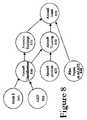
- FIG. 8is a flowchart illustrating the operating steps of the fourth and fifth embodiments of the present invention where tracking aircraft from radar or transponder signals provides a real-time picture of the aircraft's position as well as identification information, and the multilateration system provides accurate high update rate surveillance information on each target.
- FIG. 9is a diagram illustrating the altitude compensation technique of the sixth embodiment of the present invention.
- Mode S transponder signalsare received by a receiver/decoder in step 1 .
- the received analog Mode S signalmay be converted to digital data.
- the Mode S addressmay be extracted from the digital data.
- the Mode S addressmay then be stored in a roster in step 3 and used to generate the aircraft registration or “N” number which may be extracted in step 4 .
- U.S. aircraft registration numbersmay be determined directly by an algorithm, while foreign aircraft registrations may be determined by a lookup table.
- Step 5utilizes a database 6 which may contain details of aircraft make, model, serial number, owner/operator, owner/operator address, engine type, engine noise class, engine modifications and any other pertinent data associated with a particular aircraft. Such data may be extracted in step 7 .
- Aircraft registration number and flight ID number, as well as other ACARS message details, including but not limited to, “Out, Off, On and In” reports, cockpit message reports, fuel reports, peripheral message reports and miscellaneous message reportsare then stored in a roster in step 9 .
- Data from step 9may then be matched with data from step 7 .
- aircraft registration numbers from steps 7 and 9are matched to determine flight identification number.
- the flight identification numbermay be thereby associated with the corresponding aircraft registration number as a result of step 10 . If there is no correlation between registration numbers from steps 7 and 10 , the data may also be stored. The resultant information from steps 7 , 9 , and 10 may then be displayed locally over a display terminal in step 11 and/or distributed to remote locations via communication links as illustrated in step 12 .
- a DF-11 Mode S transponder transmission 21may be received and aircraft Mode S address 22 may be extracted.
- Mode S address 22may be either converted to a U.S. aircraft registration number 23 through an algorithm or determined to be a non-U.S. registered aircraft whose registration may be looked-up from a database.
- Data 24 associated with a particular registration number, such as aircraft owner, make, model, and serial numbermay then be looked-up from a database.
- Aircraft altitude 25may be decoded from other Mode S transponder signals which include altitude information.
- the resultant correlated datacontains a host of information specifically identifying an aircraft. Such information, when correlated with multilateration data, may provide a complete and accurate picture of aircraft identity and position. Such information may be useful to an airline in tracking individual aircraft for business planning purposes. In addition, such information may be used for ground tracking purposes (e.g., for noise abatement verification). Moreover, such data may be re-transmitted on a data channel to other aircraft to provide a real-time display of aircraft in the vicinity.
- Aircraft 300transmits SSR signals 301 at least once per second.
- SSR signals 301may be received at one or more of multiple ground stations 302 .
- the time of arrival at each ground stationmay be determined by reference to a standard time reference provided by GPS signal 306 from GPS satellite 320 .
- Time-stamped SSR data 303includes the Mode S address of aircraft 300 which may be unique to every aircraft and may be correlated to a registration number.
- a processorthen calculates the position of the aircraft using difference time of arrival (DTOA) techniques. The aircraft's location and registration number are then known and may be displayed to a user.
- DTOAdifference time of arrival
- ACARS datamay be received and modulated, providing a roster or look-up table between registration number and aircraft assigned flight number.
- the entire systemprovides an independent air traffic control picture complete with aircraft position and identification by flight number, using only passive radio reception techniques.
- an adaptive or learning database of aircraft registration information and related detailsmay be implemented as database 6 of FIG. 1 .
- One difficulty in decoding an aircraft Mode S addressis that one may not be able to match every address to a unique aircraft identification number without having either a look-up table or conversion algorithm.
- an aircraftmight be brand new and not in the present database or the look-up table might not be available from a particular country of origin. It should be noted that unidentifiable registrations for these reasons are expected to be the minority of aircraft. However, for reasons such as noise monitoring, it may still be important to identify all or as many aircraft as possible.
- a Mode S transmissionmay be received by a decoder in step 31 , and may be read from the decoder in block 32 .
- a roster or tablemay be built for the aircraft in general area 33 .
- no registration look-upmay be available as illustrated in step 34 .
- the country of originmay be known as are other details provided by Mode S decoding process 37 .
- an ACARS receiverreceives and processes ACARS data in step 35 and a table may be built in step 36 matching flight number to registration, and other details, based solely upon the ACARS information. Also, details on a particular aircraft may be known from the registration number, by looking up in other commercially available databases, such as the OAG schedule in step 38 .
- a best estimatemay be made of the match between the aircraft Mode S address and a registration number in step 39 .
- the new registration/mode S look-upmay then be entered into the database 40 for future use.
- the data acquired using such a techniquemay be accessed the next time such an aircraft re-visits the airspace.
- the system of the present inventionmay be networked to other such systems over a wide area to share such “learned” data.
- database datamay be corrected or upgraded. Again, such data may be accessed during subsequent visits of an aircraft to an airspace, or may be shared with other systems so as to update a database for an overall network.
- ACARS datamay be used to determine aircraft weight and identification. Using this information, along with flight track, aircraft thrust may be calculated accurately. From calculated aircraft thrust and flight track, the amount of noise that the aircraft produced may be accurately determined using any one of a number of noise calculation models.
- FIG. 5is a flowchart illustrating the operating steps of the noise and emissions estimation and calculation process of the first embodiment of the present invention.
- the aircraft weight information available from the registrationmay be the aircraft's gross take off weight. While useful, for the purposes of noise monitoring, more useful information may be the aircraft's actual weight, which varies from flight to flight depending on the aircraft's passenger and cargo load as well as fuel on board.
- the actual weight of the aircraft, coupled with the exact aircraft and aircraft engine typeallows accurate estimation of engine thrust in real time and in a post-processed form. If accurate estimates of engine thrust may be calculated, then a more accurate estimate of the noise produced by aircraft engines may be determined.
- the method of the first embodiment of the present inventionuses a combination of gross take off weight from the aircraft registration details coupled with actual weight information available from aircraft ACARS transmissions. This method therefore provides highly accurate, estimates of the aircraft's weight throughout the aircraft's operation.
- the types of emissions modeled in the first embodiment of the present inventioninclude but are not limited to ground level ozone, nitrogen dioxide, and sulfur dioxide.
- Radar and/or Multilateration block 510generates data indicating aircraft position in the vicinity of the airport. From this position information, aircraft flight tracks 515 may be generated, providing a three-dimensional flight path data track of individual airplanes in and around an airport of interest. From flight track data in block 515 , dynamic aircraft information, such as velocity and acceleration may be derived. For example, integrating flight track data over time may produce velocity data. Integrating velocity data may produce acceleration data. Other information, such as climb rate may be obtained from aircraft tracking data.
- Mode-S code datamay be retrieved from a Mode-S transponder on the aircraft (if so equipped).
- the specific aircraftmay be identified from the mode-S data.
- Block 545represents receipt of ACARS data from the aircraft.
- actual aircraft weightmay be obtained from the ACARS data in block 550 .
- data for the airplanesuch as engine type (and even serial numbers) may be obtained by correlating aircraft identification data with data from other databases (e.g., FAA).
- Aircraft identification data(which may include engine type), along with dynamic aircraft information and aircraft weight, may be fed into block 535 to determine engine thrust.
- engine thrustmay be calculated using one of a number of known algorithms. Since the dynamic aircraft information and aircraft weight are known, mathematical calculations may be made to determine the amount of thrust necessary to produce the resultant flight track for given weather conditions. Fuel burn rates may even be calculated to compensate for decrease in fuel weight as the aircraft travels on its flight path.
- weather data 555may include atmospheric pressure, wind direction and intensity, humidity, and precipitation. These factors may affect engine operation, noise levels, and emissions.
- airport noise estimation and noise contour modelingmay be generated using, for example, the FAA's Integrated Noise Model (INM), suitably modified for use with the present invention.
- IMMIntegrated Noise Model
- the latest release of this noise modelmay be downloaded from the FAA website at http://www.aee.faa.gov/Noise/inm and is incorporated herein by reference in its entirety.
- Other types of noise modelingmay be used within the spirit and scope of the present invention, including proprietary noise modeling methods and the like.
- Such noise modeling methodsmay be enhanced in the present invention by providing more accurately calculated thrust measurements (from more accurate weight and flight track data), as well as specific engine type and model data. Noise varies from one engine type and model to another, and with different thrust levels and environmental conditions. Thus the present invention more accurately models noise levels that prior art techniques.
- airport emissionsmay be modeled using various known models, suitably modified for use with the present invention.
- Examples of such emissions modelsinclude those produced by the International Civil Aviation Organization (ICAO), the Federal Aviation Administration (FAA), Environmental Protection Agency (EPA) or European models.
- the ICAO Aircraft Engine Exhaust Emission Databankmay be downloaded from http://www.qinetiq.com/aviation_emissions_databank and is incorporated herein by reference in its entirety.
- the EPA's AERMOD modelis described, for example, in AERMOD: DESCRIPTION OF MODEL FORMULATION (Version 0222) EPA 454/R-02-002d, Oct. 31, 2002, incorporated herein by reference in its entirety.
- the FAA's Emission and Dispersions Modeling System(EDMS) may be downloaded from http://www.aee.faa.gov/emissions/EDMS/EDMShome.htm and is incorporated herein by reference in its entirety.
- the surveillance elementallows real time flight tracking and complete aircraft identification, which may be a feature which has not previously been available to airport management and other users. Since the flight track information may now be available to the airport in real-time, the airport may make use of noise data from the NMTS in real-time to provide a real-time correlated set of aircraft flight tracks and noise measurements.
- Real-time noise trackingallows the airport to respond in real time to any inquiry such as a noise complaint telephoned into the airport.
- real-time noise trackingallows certain information to be presented in a real-time airport noise report, such as might be presented on the Internet at an airport website.
- FIG. 6is a flowchart illustrating the operating steps of the real-time noise tracking system of the second embodiment of the present invention.
- radar or tracking source data from multilateration, passive radar, or other sourcesmay be input to the system.
- thismay comprise multilateration data produced by one or more of the multilateration apparatus produced by the assignee of the present invention, Rannoch Corporation, of Alexandria, Va., and described in the Patents and parent applications incorporated by reference above.
- multilateration dataavoids having to tap into the tower radar data stream.
- radar datawas typically only available as tape data provided at the end of a day or shift, and thus generally not available in real-time. Tapping into tower radar data in real time may require FAA approval and runs the risk of interfering with tower radar systems, which could be a liability concern.
- Multilaterationuses an independent set of multilateration equipment that need not be tied to any tower equipment, and thus comprises an independent data stream available in real-time.
- two or three-dimensional flight tracksare determined for an aircraft, based upon broadcast aircraft identification data and position data (e.g., from multilateration). These flight tracks accurately illustrate the path of the airplane in its approach and departure from an airport. Calculation of a flight track may be a simple as connecting together a series of position data points recorded periodically from multilateration or other techniques. Cubic spline curve smoothing or other curve generating techniques may be used to interpolate data between reported data points. Alternately, flight tracks may be reported as a series of actual position data points.
- Mode S transponder codesare received. If a multilateration system is used, these Mode-S codes may be received by the same equipment used for flight tracking. As noted above, the mode-S codes themselves may provide a wealth of information about an aircraft. If correlated with an aircraft database, even more information may be retrieved to identify aircraft model and serial number, engine type and serial number, aircraft owner, and the like, as illustrated in step 640 .
- continuous noise measurementmay be recorded by microphones or other noise measuring devices strategically located near an airport operating area. These devices may be located near flight tracks, or may be located near sources of noise complaints, or may be portably mounted (e.g., on a mobile van, truck, trailer, or the like). The location of the noise monitoring device relative to the airport may be known or reported by the device.
- the noise measuring deviceprovides a data stream (analog or digital) of noise conditions at its location, and may be suitably filtered or directed to measure specifically aircraft type noises. Such noise measuring devices are known in the art.
- a thresholdmay be applied to the noise measurement device such that only noise levels above a predetermined threshold may be reported. Alternately, this threshold may be used to alert the system to preserve or track data for aircraft when a noise event has occurred. Alternately, all noise data may be reported, and then a noise profile generated to determined which aircraft have potentially violated noise regulations.
- the use of the noise thresholdmay be therefore optional, depending upon application. The use of the noise threshold may, however, reduce computational requirements, particularly at busy airports.
- step 650data from steps 610 , 620 , 530 , 640 , 660 , and 670 may be combined to correlate flight track, identification detail, and noise events. From flight track data and noise data, the aircraft producing a noise violation (usually due to failure to follow arrival or departure procedures) may be readily identified. Aircraft identification information associated with flight track (e.g., from mode-S data) may be obtained from the correlation of flight track and identification data.
- this datamay include aircraft owner, address, and the like, a modified version of applicant's automated billing system (incorporated previously by reference) may be used to automatically generate noise violation reports and invoices for noise violation fines, and the like. This real-time reporting would also allow airport operators to advise pilots that they are in violation of noise rules. Since many approaching aircraft may use similar flight paths at similar times, other approaching aircraft may be able to adjust their flight paths to reduce noise complaints.
- the present inventionprovides an automated technique which may be used in real-time. This real-time feature allows for more careful monitoring of aircraft noise and thus may result in better and more effective noise reduction in the vicinity of airports.
- FIG. 7is a flowchart illustrating the operating steps of the intelligent processing techniques for multiple multilateration receivers of the third embodiment of the present invention.
- intelligent processing techniquesare used at each of multiple multilateration receivers.
- the techniqueincludes the use of logic or rules at each receiver which may be applied to incoming replies and effectively filter out unnecessary and redundant replies.
- These rulesinclude such techniques as altitude filtering, Mode S, Mode A/C code filtering, and change filtering, where certain replies are accepted when they change state, which greatly decreases the number of replies to be time-stamped and sent to the central server while maintaining a sufficient number of time-stamped replies to match and provide high quality aircraft tracks.
- the rulesapply equally to active interrogation of targets as well as passive reception of any transponder equipped targets.
- the techniqueallows the bandwidth between the server and receiver to be managed to the point that commercial voice grade telephone lines may be used as the communications medium, greatly lowering the cost of ownership of a flight tracking system using triangulation or multilateration of transponder signals. Previous techniques had used high bandwidth communications such as fiber networks or T-1 lines.
- the receiver decoderdetermines the type of reply in step 735 as Mode S/ADS-B or Mode A/C. Different types of radar reply formats are subjected to different logic and rules to compress the amount of information, as illustrated in FIG. 7 .
- the formatsare filtered based on type (i.e., Uplink Format #) in step 710 and unnecessary formats removed.
- the informationmay also be formatted within an altitude band, as illustrated in step 710 .
- step 710all formats from aircraft above 20,000 feet may be removed.
- redundant messagesmay be removed in step 715 using a combination of techniques which may include only forwarding those formats where the information changes, as illustrated in step 720 . For example this includes an aircraft's descending altitude on approach.
- the signal strengthmay be filtered in step 725 to remove certain values, effectively limiting the range of the system. Note that all of these filtering techniques may not be required, and any combination of one or more of the filtering techniques of the Mode S path of FIG. 7 may be used within the spirit and scope of the present invention.
- time windowing techniquesmay be used to effectively sample the asynchronous replies.
- Sampling 750may be employed at a plurality of receivers, as all have access to a common accurate synchronization time source.
- the resultmay be an intelligently filtered set of radar data that allows multilateration of each aircraft target, but with redundant and unnecessary radar signals removed.
- the signal strengthmay be filtered in step 760 to remove certain values, effectively limiting the range of the system. Note that all of these filtering techniques may not be required, and any combination of one or more of the filtering techniques of the mode A/C path of FIG. 7 may be used within the spirit and scope of the present invention.
- both Mode S and Mode A/C signalsare now filtered for low bandwidth.
- the filtered signalsmay be sent to a central processor. Since the signals have been filtered, a high data bandwidth may be not required as in the Prior Art.
- a lower data bandwidth path(e.g., modem) may be used to communicate from the multilateration receivers and a central station, since much of the initial filtering has taken place in the remote receivers.
- tracking aircraft from radar or transponder signalsprovides a real-time picture of the aircraft's position as well as identification information. This picture may also be stored and replayed up to the current time for a variety of reasons including airport management and air traffic control. Aircraft positions may be tracked around the airport surface as well as in terminal and en route areas. Fusing ACARS data with this surveillance information adds a variety of other information including aircraft/pilot intent as well as other details.
- ACARSdetects when a pilot/aircraft intends to depart from a gate, while the surveillance element determines when the aircraft actually pushes back from the gate. For those aircraft taxiing around on runway surfaces it may be difficult to determine whether an aircraft is departing or arriving at any instant in time based on the instantaneous surveillance position. However, intent may be readily identified from clearance messages provided by ACARS. If other pilots and airport users knew whether a plane was departing or arriving, they would have a better idea of the intentions and direction of travel of aircraft on the ground.
- ACARS datawhich indicates flight number and other aircraft and flight identification information may be fused with other data to show whether an aircraft is departing or arriving on an onboard or other type of aircraft position display.
- This datamay be displayed on an in-cockpit display, ground display, or both.
- the system of the present inventionmay obtain such information as to arrival or departure from a variety of sources.
- the systemknows if it landed and therefore may be labeled an arrival. If a tracked aircraft pushes back from a gate, the system knows it is a departure. In addition, this information may come from ACARS in the form of departure airport/arrival airport.
- ACARS flight informationincludes both origin and destination airports, either (or both) data may be used to determine whether an airplane is arriving or departing from a given airport.
- arrival or departure informationmay be inferred from source/destination data from flight plan information from an FAA database interface or from the FAA ASDI (aircraft situational awareness display to industry) which the industry has access to.
- the use of data base data or ASDI datamay delay arrival/departure determination by a minute or so if such sources are used, as it takes time to download such data.
- an aircraftmay be identified using Mode S (step 805 ) for airframe details or by flight number (step 820 ), from sources such as ASDI to produce aircraft identification 810 .
- the aircraftmay be tracked using multilateration, radar, or passive radar in step 825 to produce aircraft position data which in turn produces an aircraft track 830 .
- a database 815may be used to determine the avionics and systems equipage on the aircraft, for example whether it has Category II/III landing system capability or a Flight Management System. As the pilot enters information into various systems in the cockpit, some of that information may then be broadcast over ACARS in step 840 , effectively indicating pilot intent (For example, pushback from gate). From these various data sources, aircraft intent may be determined as illustrated in step 835 .
- integration with ASDImay be provided.
- the multilateration portion of the present inventionprovides highly accurate aircraft tracks. Coverage may be dependent on the number and placement of the remote sensors.
- a large variety of informationmay be available from aircraft registration information which may be provided from a Mode S transponder code.
- the transponder-derived informationincludes such fields as aircraft make, model, type, serial number, owner, and engine type. In conjunction with other sources such as ACARS, other information may be available on the target such as flight number and aircraft/pilot intent.
- the Aircraft Situational Display to Industryuses a data feed from the FAA's enhanced traffic management system, which includes surveillance and flight plan information for aircraft throughout the U.S. Near-real-time information on most aircraft with filed flight plans may be available from this source. When correlated with the other surveillance information, the ASDI source offers some additional information on targets such as flight plan destination and arrival airport.
- ASDIprovides near-real-time position data for aircraft across the U.S. and Canada.
- ASDIdoes not provide surface surveillance and does not provide full terminal area coverage in the vicinity of some airports.
- multilaterationprovides airport surface surveillance and terminal area surveillance where ASDI does not provide surveillance coverage.
- Fusing multilateration and ASDI surveillanceprovides gate-to-gate surveillance. Correlating the ASDI data with multilateration surveillance provides a means to obtain flight plan data for aircraft being tracked by the multilateration ground systems.
- the multilateration surveillance system of the present inventionmay be used in place of the PASSUR system as disclosed by Dunsky et al.
- the data correlation and fusion processreceives real-time aircraft position, altitude, speed and identification from the multilateration system.
- the identification datacomprises of aircraft beacon code or Mode C code and Mode S address. Data may be time-stamped to identify the time that the update occurred.
- the data correlation and fusion processreceives near-real-time (i.e., time delayed) aircraft position, altitude, speed and identification from ASDI. Data may be time-stamped to identify the time that the update occurred.
- ASDItypically has a data delay of about five minutes.
- the data correlation and fusion process of the present inventionforward-estimates the location and altitude of an ASDI tracked aircraft with the fixed delay removed. This forward estimation may be performed by determining or estimating the speed of the aircraft and then dividing the speed by the delay time to determine the difference in aircraft position. From the aircraft's reported flight track, the projected position can then be determined.
- the data correlation and fusion processcorrelates the position, heading, altitude and speed of the multilateration target data and the forward estimate of the ADSI targets.
- a target tracked by both multilateration and ASDIwill have similar position, heading, altitude and speed.
- the Mode S address obtained from the multilateration systemmay be converted to tail number, which provides an indication of airline and/or country of registration.
- the data correlation and fusion processmay compare airline and/or country of registration data provided by the Mode S address to the airline information provided by ASDI to confirm the data is correct. This comparison may be performed to increase confidence in the correlation of multilateration and ASDI targets.
- An ASDI trackmay be considered uncorrelated, if the track has not been correlated to a multilateration track.
- Targetsmay be displayed in either real-time or near-real-time with the ASDI delay.
- the option of real-time or near-real-timemay be user selectable.
- the correlation and fusion processperforms the selection of displaying either the multilateration or ASDI tracks.
- real-time multilateration tracks and forward-estimated uncorrelated ASDI tracksare displayed.
- near-real-time displaymultilateration track updates that correspond to the time of the near-real-time ASDI target tracks are displayed along with the near-real-time uncorrelated ASDI tracks.
- the multilateration trackWhen multilateration tracks are correlated with ASDI tracks, the multilateration track may be displayed, as they represent the more accurate track.
- the associated ASDI track data for the correlated trackmay be not displayed.
- Uncorrelated ASDI track data which have no corresponding multilateration trackmay be displayed.
- Multilateration and ASDI surveillance and flight informationmay be augmented with flight information provided by the airline flight information systems.
- An interface via the data correlation and fusion process and the airline flight information systemmay be implemented.
- Information, such as flight delays, boarding information, passenger information, boarding procedures,may be sent to the data correlation and fusion process for processing and display to systems users.
- the tracking systemmay be used to track ground vehicles around the surface areas of airport thereby building up a complete picture of all moving and stationary traffic around an airport ranging from service vehicles and catering trucks to emergency service vehicles.
- vehicle tracking devicesinclude http://www.racal-tracs.com/products/tdma.shtml
- ground vehiclesjust like aircraft by equipping them with an aircraft-like device, such as a transponder, Mode A/C/S/ or ADS-B. Then, all targets may be tracked and displayed on the same system. Otherwise if the vehicles are tracked using another technology, they may be fused into the aircraft display system to track all targets in the one system.
- an aircraft-like devicesuch as a transponder, Mode A/C/S/ or ADS-B.
- the multilateration systemprovides accurate high update rate surveillance information on each target.
- the Mode S transponder derived informationprovides details on the aircraft type including registration which may be used to determine the avionics equipage in the aircraft. Further information may be available from the aircraft's ACARS messages and controller pilot data link communications (CPDLC). This information may be fused to provide a composite picture of aircraft flight states and in turn this may be used to drive flight simulation programs, such as the SimAuthor suite of programs (see http://www.simauthor.com).
- Flight simulatorsare usually driven by information from the aircraft's onboard navigation and surveillance systems. However, based on the fusion of data collected passively from the aircraft, it may be possible to recreate many aircraft maneuvers, such as vertical descent rate and flight path, and response to a TCAS advisory.
- a method of correcting reported altitude from aircraft transponders based on pressuremay be provided. Since pressure varies depending on local weather conditions, it may impact the performance of airport management systems that rely on precise altitude information, for example for billing for landing fees or collision avoidance systems.
- barometric pressuremay have a significant impact on the performance of landing fee and billing systems and operations monitoring systems, unless they are corrected for non-standard barometric pressure through use of a correction factor from a pressure sensing device.
- a correction factorfrom a pressure sensing device.
- Each tenth of an inch of mercuryequates to approximately a 100′ change in reported altitude.
- the barometric pressurechanged from 30.57′′ to 29.09′′ in the course of one week, during a winter storm in the Washington D.C. area. This represents a change of 1.48′′ or 1480 feet in reported altitude.
- the systemIn order for flight tracking systems to successfully track aircraft that are practicing takeoffs and landings in the traffic pattern, the system needs to be able to track aircraft from the surface up to about 800-1000 feet AGL, which may be typical traffic pattern altitude for single engine aircraft.
- the algorithmmay require that the aircraft transmit at least one of two lower altitude boundaries in order for a departure track to be initiated.
- these lower boundariesare set to 200′ and 300′ to insure a good chance that the aircraft may be high enough to be interrogated by a ground radar (assuming that there may be one not too far away) then this example aircraft would only transmit two possible altitudes to qualify it as a departure. This may be not even close to the six hits that were hypothesized as being required, and even farther from the eight that were found to be adequate at a typical municipal airport for the aircraft that climbed well above traffic pattern altitude as they departed.
- Flight trackingmay function well some of the time but may require a barometric correction to consistently perform well.
- FIG. 9is a diagram illustrating the altitude compensation technique of the sixth embodiment of the present invention.
- the altitude reported from the aircraft's altitude encoder (1.)reports altitude based on a default transponder setting that assumes the current sea level pressure is 29.92′′ of Hg. Such a sea level pressure would rarely be the case, as weather systems are constantly affecting the atmospheric pressure.
- FAA computerscorrect the altitude for any difference in sea level pressure from 29.92′′ Hg and then send the mean sea level (MSL) altitude to the controller's display. Controllers give updates to pilots on the local sea level pressure as the aircraft flies along. The pilot then sets this pressure setting on the altimeter, so that the controllers and pilots are both using MSL altitude.
- MSLmean sea level
- the altitude encoderis separate from the altimeter, and always sends the aircraft's altitude based on the fixed, 29.92′′ Hg pressure setting.
- use of a fixed barometric calculationmay produce inaccurate altitude readings, for air traffic control, this is not a problem, so long as all aircraft are using the same pressure setting—and reporting the same inaccuracy. Spacing between aircraft altitudes may still be maintained. Indeed, if the system relied upon pilots manually setting a barometric offset for transponder altitudes, the resultant reported altitudes could vary significantly if different pilots used different settings.
- altitude from a pressure sensor on the ground (2.) at the airportis collected based on the assumption that the sea level pressure is 29.92′′ Hg.
- the same type of pressure sensor and encoder (2.)is used as in the aircraft (1.) to insure that the two measurements have similar correlations.
- the “pressure altitude” on the ground at the airport, which assumes the sea level pressure is 29.92′′ Hg,is 400′.
- the actual altitude above sea level (5.)is 200 feet (4.).
- actual aircraft altitudemay be accurately determined based upon transponder altitudes, even though reported transponder altitudes may be inaccurate.
- position and identification informationare obtained and displayed in an air traffic display.
- only position or identification informationmay be obtained and displayed.
- identification informationmay be obtained using the techniques of the present invention for use in identifying aircraft in the vicinity.
- Position information of such aircraftmay not be required, or may be obtained using other techniques, including, but not limited to, conventional radar.
Landscapes
- Engineering & Computer Science (AREA)
- Radar, Positioning & Navigation (AREA)
- Remote Sensing (AREA)
- Physics & Mathematics (AREA)
- General Physics & Mathematics (AREA)
- Aviation & Aerospace Engineering (AREA)
- Computer Networks & Wireless Communication (AREA)
- Traffic Control Systems (AREA)
- Radar Systems Or Details Thereof (AREA)
Abstract
Description
| TABLE I | |
| MESSAGE | DESCRIPTION |
| C-GDSU | Aircraft Registration C-CDSU, Flight number Air Canada |
| AC0878 | 878, going from Toronto to Zurich |
| YYZ ZRH | |
| TTL PAX | 149 total passengers on board |
| 149 | |
| OA 51, | 51 in first class, 54 in business class, and 44 in steerage |
| OB 54, | |
| OC 44 | |
| FOB 44.8 | 44,800 kilograms of fuel on board |
| ZFW 108.3 | Zero fuel weight is 108,300 kilograms |
| TOW 152.6 | Actual take off weight is 152,600 kilograms |
| Current Day Maximum Pressure | 29.81 Inches | |
| Current Day Minimum Pressure | 29.61 Inches | |
| Monthly Maximum Pressure | 30.40 Inches | Mar. 14, 2003 |
| Monthly Minimum Pressure | 29.57 Inches | Mar. 2, 2003 |
| Yearly Maximum Pressure | 30.57 Inches | Feb. 16, 2003 |
| Yearly Minimum Pressure | 29.09 Inches | Feb. 23, 2003 |
Claims (6)
Priority Applications (16)
| Application Number | Priority Date | Filing Date | Title |
|---|---|---|---|
| US11/209,030US7248219B2 (en) | 2000-02-29 | 2005-08-22 | Correlation of flight track data with other data sources |
| US11/257,416US7495612B2 (en) | 1999-03-05 | 2005-10-24 | Method and apparatus to improve ADS-B security |
| US11/342,289US7576695B2 (en) | 1999-03-05 | 2006-01-28 | Multilateration enhancements for noise and operations management |
| US11/343,079US7375683B2 (en) | 1999-03-05 | 2006-01-30 | Use of geo-stationary satellites to augment wide— area multilateration synchronization |
| US11/541,480US7570214B2 (en) | 1999-03-05 | 2006-09-29 | Method and apparatus for ADS-B validation, active and passive multilateration, and elliptical surviellance |
| US11/545,800US7667647B2 (en) | 1999-03-05 | 2006-10-10 | Extension of aircraft tracking and positive identification from movement areas into non-movement areas |
| US11/649,350US8446321B2 (en) | 1999-03-05 | 2007-01-03 | Deployable intelligence and tracking system for homeland security and search and rescue |
| US11/688,348US8203486B1 (en) | 1999-03-05 | 2007-03-20 | Transmitter independent techniques to extend the performance of passive coherent location |
| US11/742,012US7423590B2 (en) | 1999-03-05 | 2007-04-30 | Method and apparatus for improving ADS-B security |
| US11/749,045US7782256B2 (en) | 1999-03-05 | 2007-05-15 | Enhanced passive coherent location techniques to track and identify UAVs, UCAVs, MAVs, and other objects |
| US11/758,072US7612716B2 (en) | 1999-03-05 | 2007-06-05 | Correlation of flight track data with other data sources |
| US11/840,285US7777675B2 (en) | 1999-03-05 | 2007-08-17 | Deployable passive broadband aircraft tracking |
| US12/360,702US7889133B2 (en) | 1999-03-05 | 2009-01-27 | Multilateration enhancements for noise and operations management |
| US12/471,384US8072382B2 (en) | 1999-03-05 | 2009-06-06 | Method and apparatus for ADS-B validation, active and passive multilateration, and elliptical surveillance |
| US12/565,654US20100079342A1 (en) | 1999-03-05 | 2009-09-23 | Multilateration enhancements for noise and operations management |
| US12/697,234US20100198490A1 (en) | 1999-03-05 | 2010-01-30 | Extension of aircraft tracking and positive identification from movement areas into non-movement areas |
Applications Claiming Priority (6)
| Application Number | Priority Date | Filing Date | Title |
|---|---|---|---|
| US09/516,215US6633259B1 (en) | 1999-03-05 | 2000-02-29 | Method and apparatus for improving utility of automatic dependent surveillance |
| US10/319,725US6812890B2 (en) | 2000-02-29 | 2002-12-16 | Voice recognition landing fee billing system |
| US44061803P | 2003-01-17 | 2003-01-17 | |
| US10/457,439US6885340B2 (en) | 2000-02-29 | 2003-06-10 | Correlation of flight track data with other data sources |
| US10/830,444US7123192B2 (en) | 2000-02-29 | 2004-04-23 | Correlation of flight track data with other data sources |
| US11/209,030US7248219B2 (en) | 2000-02-29 | 2005-08-22 | Correlation of flight track data with other data sources |
Related Parent Applications (5)
| Application Number | Title | Priority Date | Filing Date |
|---|---|---|---|
| US10/457,439Continuation-In-PartUS6885340B2 (en) | 1999-03-05 | 2003-06-10 | Correlation of flight track data with other data sources |
| US10/830,444Continuation-In-PartUS7123192B2 (en) | 1999-03-05 | 2004-04-23 | Correlation of flight track data with other data sources |
| US10/830,444DivisionUS7123192B2 (en) | 1999-03-05 | 2004-04-23 | Correlation of flight track data with other data sources |
| US11/203,823Continuation-In-PartUS7739167B2 (en) | 1999-03-05 | 2005-08-15 | Automated management of airport revenues |
| US11/257,416Continuation-In-PartUS7495612B2 (en) | 1999-03-05 | 2005-10-24 | Method and apparatus to improve ADS-B security |
Related Child Applications (7)
| Application Number | Title | Priority Date | Filing Date |
|---|---|---|---|
| US11/257,416Continuation-In-PartUS7495612B2 (en) | 1999-03-05 | 2005-10-24 | Method and apparatus to improve ADS-B security |
| US11/342,289Continuation-In-PartUS7576695B2 (en) | 1999-03-05 | 2006-01-28 | Multilateration enhancements for noise and operations management |
| US11/343,079Continuation-In-PartUS7375683B2 (en) | 1999-03-05 | 2006-01-30 | Use of geo-stationary satellites to augment wide— area multilateration synchronization |
| US11/541,480Continuation-In-PartUS7570214B2 (en) | 1999-03-05 | 2006-09-29 | Method and apparatus for ADS-B validation, active and passive multilateration, and elliptical surviellance |
| US11/545,800Continuation-In-PartUS7667647B2 (en) | 1999-03-05 | 2006-10-10 | Extension of aircraft tracking and positive identification from movement areas into non-movement areas |
| US11/688,348Continuation-In-PartUS8203486B1 (en) | 1999-03-05 | 2007-03-20 | Transmitter independent techniques to extend the performance of passive coherent location |
| US11/758,072DivisionUS7612716B2 (en) | 1999-03-05 | 2007-06-05 | Correlation of flight track data with other data sources |
Publications (2)
| Publication Number | Publication Date |
|---|---|
| US20070069950A1 US20070069950A1 (en) | 2007-03-29 |
| US7248219B2true US7248219B2 (en) | 2007-07-24 |
Family
ID=33568802
Family Applications (4)
| Application Number | Title | Priority Date | Filing Date |
|---|---|---|---|
| US10/457,439Expired - LifetimeUS6885340B2 (en) | 1999-03-05 | 2003-06-10 | Correlation of flight track data with other data sources |
| US10/830,444Expired - LifetimeUS7123192B2 (en) | 1999-03-05 | 2004-04-23 | Correlation of flight track data with other data sources |
| US11/111,957AbandonedUS20050200501A1 (en) | 1999-03-05 | 2005-04-22 | Aircraft boundary transition warnings and auto alerting |
| US11/209,030Expired - LifetimeUS7248219B2 (en) | 1999-03-05 | 2005-08-22 | Correlation of flight track data with other data sources |
Family Applications Before (3)
| Application Number | Title | Priority Date | Filing Date |
|---|---|---|---|
| US10/457,439Expired - LifetimeUS6885340B2 (en) | 1999-03-05 | 2003-06-10 | Correlation of flight track data with other data sources |
| US10/830,444Expired - LifetimeUS7123192B2 (en) | 1999-03-05 | 2004-04-23 | Correlation of flight track data with other data sources |
| US11/111,957AbandonedUS20050200501A1 (en) | 1999-03-05 | 2005-04-22 | Aircraft boundary transition warnings and auto alerting |
Country Status (1)
| Country | Link |
|---|---|
| US (4) | US6885340B2 (en) |
Cited By (15)
| Publication number | Priority date | Publication date | Assignee | Title |
|---|---|---|---|---|
| US20070120729A1 (en)* | 2005-10-31 | 2007-05-31 | James Barry | System and method for providing airport financial reports |
| US20070217288A1 (en)* | 2006-03-14 | 2007-09-20 | James Barry | System and method for airport noise monitoring |
| US20070265776A1 (en)* | 2005-12-20 | 2007-11-15 | Thales | Airborne system for preventing collisions of an aircraft with the terrain |
| US20080158040A1 (en)* | 2006-11-27 | 2008-07-03 | Stayton Gregory T | Systems and methods employing active tcas to enhance situational awareness |
| US20090094011A1 (en)* | 2006-03-02 | 2009-04-09 | Airways Corporation New Zealand Limited | System and method for modelling a flight |
| US20090273504A1 (en)* | 2008-05-01 | 2009-11-05 | Honeywell International Inc. | Radar target processing reduction systems and methods using cooperative surveillance sources |
| US20100036669A1 (en)* | 2007-07-20 | 2010-02-11 | Danto Evan J | System and method for determining a weight of an arriving aircraft |
| US20110001654A1 (en)* | 2009-07-03 | 2011-01-06 | Airbus Operations (Sas) | Process and a device for detecting aircrafts circulating in an air space surrounding an airplane |
| US20120127015A1 (en)* | 2008-04-26 | 2012-05-24 | Roke Manor Research Limited | Multilateration System and Method |
| US8606508B2 (en) | 2012-02-09 | 2013-12-10 | Flightaware, Llc | System and method for sending air traffic data to users for display |
| US8681040B1 (en)* | 2007-01-22 | 2014-03-25 | Rockwell Collins, Inc. | System and method for aiding pilots in resolving flight ID confusion |
| US8958931B2 (en) | 2012-05-07 | 2015-02-17 | Flightaware, Llc | System and method for collecting remotely located positional data |
| US8977483B2 (en) | 2013-06-20 | 2015-03-10 | Raytheon Company | Methods and apparatus for beacon code changes in an air traffic control system |
| US9377524B2 (en) | 2011-04-12 | 2016-06-28 | Era A.S. | Time synchronization via over-determined measurements |
| US11094209B1 (en) | 2019-08-22 | 2021-08-17 | Facebook, Inc. | Location determination when satellite navigation system is inaccessible |
Families Citing this family (162)
| Publication number | Priority date | Publication date | Assignee | Title |
|---|---|---|---|---|
| US8965677B2 (en) | 1998-10-22 | 2015-02-24 | Intelligent Technologies International, Inc. | Intra-vehicle information conveyance system and method |
| US8255144B2 (en)* | 1997-10-22 | 2012-08-28 | Intelligent Technologies International, Inc. | Intra-vehicle information conveyance system and method |
| US6885340B2 (en)* | 2000-02-29 | 2005-04-26 | Rannoch Corporation | Correlation of flight track data with other data sources |
| US7889133B2 (en) | 1999-03-05 | 2011-02-15 | Itt Manufacturing Enterprises, Inc. | Multilateration enhancements for noise and operations management |
| US7477193B2 (en)* | 1999-03-05 | 2009-01-13 | Era Systems Corporation | Method and system for elliptical-based surveillance |
| US7739167B2 (en)* | 1999-03-05 | 2010-06-15 | Era Systems Corporation | Automated management of airport revenues |
| US20100079342A1 (en)* | 1999-03-05 | 2010-04-01 | Smith Alexander E | Multilateration enhancements for noise and operations management |
| US7570214B2 (en) | 1999-03-05 | 2009-08-04 | Era Systems, Inc. | Method and apparatus for ADS-B validation, active and passive multilateration, and elliptical surviellance |
| US7612716B2 (en)* | 1999-03-05 | 2009-11-03 | Era Systems Corporation | Correlation of flight track data with other data sources |
| US7429950B2 (en)* | 1999-03-05 | 2008-09-30 | Era Systems Corporation | Method and apparatus to extend ADS performance metrics |
| US7423590B2 (en) | 1999-03-05 | 2008-09-09 | Era Systems Corporation | Method and apparatus for improving ADS-B security |
| US7437250B2 (en)* | 1999-03-05 | 2008-10-14 | Era Systems Corporation | Airport pavement management system |
| US7667647B2 (en) | 1999-03-05 | 2010-02-23 | Era Systems Corporation | Extension of aircraft tracking and positive identification from movement areas into non-movement areas |
| US7782256B2 (en) | 1999-03-05 | 2010-08-24 | Era Systems Corporation | Enhanced passive coherent location techniques to track and identify UAVs, UCAVs, MAVs, and other objects |
| US8446321B2 (en) | 1999-03-05 | 2013-05-21 | Omnipol A.S. | Deployable intelligence and tracking system for homeland security and search and rescue |
| US7908077B2 (en) | 2003-06-10 | 2011-03-15 | Itt Manufacturing Enterprises, Inc. | Land use compatibility planning software |
| US8203486B1 (en) | 1999-03-05 | 2012-06-19 | Omnipol A.S. | Transmitter independent techniques to extend the performance of passive coherent location |
| US7495612B2 (en) | 1999-03-05 | 2009-02-24 | Era Systems Corporation | Method and apparatus to improve ADS-B security |
| US7375683B2 (en)* | 1999-03-05 | 2008-05-20 | Era Systems Corporation | Use of geo-stationary satellites to augment wide— area multilateration synchronization |
| US7576695B2 (en)* | 1999-03-05 | 2009-08-18 | Era Systems Corporation | Multilateration enhancements for noise and operations management |
| US7777675B2 (en) | 1999-03-05 | 2010-08-17 | Era Systems Corporation | Deployable passive broadband aircraft tracking |
| DE10120536C2 (en)* | 2001-04-26 | 2003-12-24 | Eads Deutschland Gmbh | Radar system for active obstacle warning and imaging of the earth's surface |
| US7146299B2 (en)* | 2002-08-16 | 2006-12-05 | The Boeing Company | Adjustable simulation vehicle capabilities |
| US20070138347A1 (en)* | 2004-12-16 | 2007-06-21 | Ehlers Gregory A | System and method for providing information to an operator of a vehicle |
| JP4491586B2 (en)* | 2004-08-06 | 2010-06-30 | 独立行政法人 宇宙航空研究開発機構 | Low noise flight support system |
| US7656506B2 (en)* | 2004-12-23 | 2010-02-02 | Asml Netherlands B.V. | Lithographic apparatus and device manufacturing method utilizing a substrate handler |
| US7831381B2 (en)* | 2005-08-04 | 2010-11-09 | Microsoft Corporation | Data engine for ranking popularity of landmarks in a geographical area |
| EP1764759A1 (en)* | 2005-09-14 | 2007-03-21 | Honeywell International Inc. | System and method for displaying protected or restricted airspace inside an aircraft |
| US7522088B2 (en)* | 2005-10-31 | 2009-04-21 | Passur Aerospace, Inc. | System and method for monitoring airspace |
| US20070152814A1 (en)* | 2005-12-29 | 2007-07-05 | Arinc Inc. | Systems and methods for autonomous data acquisition, sensor integration and information transmission in a lightweight device |
| US7778768B2 (en)* | 2006-02-09 | 2010-08-17 | Passur Aerospace, Inc. | Reducing airport delays using passive radar information and analytics |
| US7420501B2 (en)* | 2006-03-24 | 2008-09-02 | Sensis Corporation | Method and system for correlating radar position data with target identification data, and determining target position using round trip delay data |
| US7965227B2 (en) | 2006-05-08 | 2011-06-21 | Era Systems, Inc. | Aircraft tracking using low cost tagging as a discriminator |
| US8144151B2 (en)* | 2006-05-10 | 2012-03-27 | Hireright, Inc. | Spatial and temporal graphical display of verified/validated data organized as complex events |
| US8331888B2 (en)* | 2006-05-31 | 2012-12-11 | The Boeing Company | Remote programmable reference |
| US20070282492A1 (en)* | 2006-05-31 | 2007-12-06 | Sensis Corporation | Method and system of managing data transmissions from broadcast-equipped targets |
| US7957853B2 (en)* | 2006-06-13 | 2011-06-07 | The Mitre Corporation | Flight restriction zone detection and avoidance |
| US7818099B2 (en)* | 2006-08-24 | 2010-10-19 | Honeywell International Inc. | System and method for alerting a user of an aircraft of a possible entrance into a selected airspace |
| US20080165183A1 (en)* | 2006-11-08 | 2008-07-10 | Rassieur Theodore C | System and Method for Three-Dimensional Display of Airspaces |
| WO2008060605A2 (en)* | 2006-11-17 | 2008-05-22 | Raytheon Company | Methods and apparatus to contact aircraft |
| US20080140727A1 (en)* | 2006-12-07 | 2008-06-12 | Karl Christian Pschierer | Method and apparatus for managing geographic information system data |
| US20080147320A1 (en)* | 2006-12-19 | 2008-06-19 | Garmin International, Inc. | Aircraft airspace display |
| US20080183344A1 (en)* | 2007-01-30 | 2008-07-31 | Arinc Inc. | Systems and methods for communicating restricted area alerts |
| FR2913800B1 (en)* | 2007-03-13 | 2010-08-20 | Thales Sa | DEVICES AND METHODS FOR FILTERING FIELD ANTI-COLLISION ALERTS AND OBSTACLES FOR AN AIRCRAFT |
| GB2449123B (en)* | 2007-05-11 | 2012-04-25 | Timothy Colin Barnes | Pilot warning system and method |
| AU2008254982B2 (en)* | 2007-05-14 | 2010-11-18 | Raytheon Company | Methods and apparatus for testing software with real-time source data from a projectile |
| US8533180B2 (en)* | 2007-06-13 | 2013-09-10 | The Boeing Company | Method and apparatus for enhancing a geographic information system database with operational data |
| ATE514986T1 (en)* | 2007-10-15 | 2011-07-15 | Saab Ab | METHOD AND DEVICE FOR GENERATING AT LEAST ONE SELECTED TRAVEL PATH OF A VEHICLE |
| FR2924240B1 (en)* | 2007-11-23 | 2016-01-15 | Thales Sa | AUTOMATIC PILOT DEVICE AND METHOD WITH TARGET INSTINCTIVE ATTACHMENT |
| US8054215B2 (en)* | 2007-11-30 | 2011-11-08 | Lockheed Martin Corporation | Precision registration for radar |
| US20090189787A1 (en)* | 2008-01-30 | 2009-07-30 | Honeywell International Inc. | System and method for generating an altimeter mis-set alert on a primary flight display |
| US9595198B2 (en) | 2008-02-15 | 2017-03-14 | Kutta Technologies, Inc. | Unmanned aerial system position reporting system |
| US8437956B2 (en) | 2008-02-15 | 2013-05-07 | Kutta Technologies, Inc. | Unmanned aerial system position reporting system and related methods |
| WO2009137309A2 (en)* | 2008-05-01 | 2009-11-12 | Travel Tech Systems, Llc | Process and system to determine commercial airline arrivals |
| US8374733B2 (en)* | 2008-08-15 | 2013-02-12 | Myfligtdata, LLC | Transportation information management system |
| US8160755B2 (en)* | 2008-09-30 | 2012-04-17 | Honeywell International Inc. | Displaying air traffic symbology based on relative importance |
| EP2345022A1 (en)* | 2008-10-10 | 2011-07-20 | Raytheon Company | Tracking air and ground vehicles |
| US8140252B2 (en)* | 2008-12-09 | 2012-03-20 | Honeywell International Inc. | System and method for displaying protected airspace associated with a projected trajectory of aircraft in a confidence display |
| US7893863B2 (en)* | 2009-01-07 | 2011-02-22 | Honeywell International Inc. | Enhanced aircraft transponder reliability |
| US8350753B2 (en)* | 2009-02-16 | 2013-01-08 | Honeywell International Inc. | Methods and systems for displaying an object having an associated beacon signal |
| US8311686B2 (en)* | 2009-08-20 | 2012-11-13 | The Boeing Company | Onboard airplane community noise and emissions monitor |
| US8188907B2 (en)* | 2009-09-12 | 2012-05-29 | International Business Machines Corporation | Aircraft collision avoidance alarm |
| US8554393B2 (en)* | 2009-09-25 | 2013-10-08 | Honeywell International Inc. | Airspace awareness enhancement system and method |
| US20120038501A1 (en)* | 2009-12-18 | 2012-02-16 | Garmin International, Inc. | Self-configuring universal access transceiver |
| US8456328B2 (en)* | 2010-02-17 | 2013-06-04 | Honeywell International Inc. | System and method for informing an aircraft operator about a temporary flight restriction in perspective view |
| US8248294B2 (en)* | 2010-04-13 | 2012-08-21 | The Boeing Company | Method for protecting location privacy of air traffic communications |
| US8264400B2 (en)* | 2010-06-03 | 2012-09-11 | Raytheon Company | Signature matching method and apparatus |
| US20120001788A1 (en)* | 2010-07-02 | 2012-01-05 | L-3 Communications Avionics Systems, Inc. | Transponder decoder |
| US9761148B2 (en)* | 2010-08-03 | 2017-09-12 | Honeywell International Inc. | Airborne separation assurance system and required time of arrival function cooperation |
| ITRM20110651A1 (en)* | 2010-12-20 | 2012-06-21 | Selex Sistemi Integrati Spa | METHOD OF QUICK PREDICTION OF THE VERTICAL PROFILE OF THE TRAJECTORY FOR THE MANAGEMENT OF AIR TRAFFIC, AND ITS RELATED ATM SYSTEM. |
| US9014880B2 (en)* | 2010-12-21 | 2015-04-21 | General Electric Company | Trajectory based sense and avoid |
| DE102011010411B4 (en)* | 2011-02-04 | 2013-02-21 | Deutsches Zentrum für Luft- und Raumfahrt e.V. | Laser system and control of a laser system |
| US8538669B2 (en)* | 2011-09-09 | 2013-09-17 | Honeywell International Inc. | Ground based system and methods for identifying incursions along the flight path of an in-flight aircraft |
| US9117368B2 (en)* | 2011-09-09 | 2015-08-25 | Honeywell International Inc. | Ground based system and methods for providing multiple flightplan re-plan scenarios to a pilot during flight |
| US8786633B2 (en) | 2011-10-18 | 2014-07-22 | Honeywell International, Inc. | System and method for dynamically rendering bounded region labels on a moving map display |
| US8798898B2 (en) | 2011-10-31 | 2014-08-05 | General Electric Company | Methods and systems for inferring aircraft parameters |
| US9285472B2 (en) | 2011-12-06 | 2016-03-15 | L-3 Communications Avionics Systems, Inc. | Multi-link transponder for aircraft and method of providing multi-link transponder capability to an aircraft having an existing transponder |
| US9250320B2 (en) | 2012-05-15 | 2016-02-02 | L-3 Communications Avionics Systems, Inc. | Harmonizing code from independent airborne aircraft identification systems |
| EP2667273A1 (en)* | 2012-05-24 | 2013-11-27 | The Boeing Company | Method for providing a description of aircraft intent using a decomposition of flight intent into constrained flight segments |
| EP2667275B1 (en)* | 2012-05-24 | 2023-03-22 | The Boeing Company | Method for providing a description of aircraft intent using a decomposition of flight intent into flight segments with optimal parameters |
| EP2667366B1 (en) | 2012-05-25 | 2017-10-04 | The Boeing Company | Conflict detection and resolution using predicted aircraft trajectories |
| EP2667364B1 (en) | 2012-05-25 | 2017-11-08 | The Boeing Company | Conflict detection and resolution using predicted aircraft trajectories |
| EP2667367B1 (en) | 2012-05-25 | 2017-10-04 | The Boeing Company | Conflict detection and resolution using predicted aircraft trajectories |
| EP2667363B1 (en)* | 2012-05-25 | 2017-12-13 | The Boeing Company | Conflict detection and resolution using predicted aircraft trajectories |
| EP2667365B1 (en) | 2012-05-25 | 2018-03-07 | The Boeing Company | Conflict detection and resolution using predicted aircraft trajectories |
| DE102012210149A1 (en)* | 2012-06-15 | 2013-12-19 | Lufthansa Technik Ag | A method and passenger information system for providing flight information data |
| GB2504496A (en)* | 2012-07-31 | 2014-02-05 | Ibm | Removing code instrumentation based on the comparison between collected performance data and a threshold |
| US9354078B2 (en) | 2012-09-12 | 2016-05-31 | Honeywell International Inc. | Methods and systems for indicating whether an aircraft is within distance and altitude criteria for an IFR procedure turn |
| GB201219732D0 (en)* | 2012-11-02 | 2012-12-12 | Qinetiq Ltd | A radar imaging system |
| US9182484B2 (en)* | 2013-01-11 | 2015-11-10 | Garmin International, Inc. | Traffic information services-broadcast (TIS-B) automatic address detection and coverage indication |
| US20170299723A1 (en)* | 2013-08-08 | 2017-10-19 | NavWorx Incorporated | System and Method for Pressure Altitude Correction |
| US9906609B2 (en) | 2015-06-02 | 2018-02-27 | GeoFrenzy, Inc. | Geofence information delivery systems and methods |
| US10235726B2 (en)* | 2013-09-24 | 2019-03-19 | GeoFrenzy, Inc. | Systems and methods for secure encryption of real estate titles and permissions |
| US9262928B2 (en)* | 2013-10-02 | 2016-02-16 | The Boeing Company | Prediction of flight path privacy |
| US9869190B2 (en) | 2014-05-30 | 2018-01-16 | General Electric Company | Variable-pitch rotor with remote counterweights |
| US9704405B2 (en)* | 2014-06-12 | 2017-07-11 | Honeywell International Inc. | Aircraft display systems and methods for providing an aircraft display for use with airport departure and arrival procedures |
| US9666080B2 (en)* | 2014-07-09 | 2017-05-30 | Honeywell International Inc. | Systems and methods for displaying degraded intruder traffic data on an aircraft display |
| US12022352B2 (en) | 2014-07-29 | 2024-06-25 | GeoFrenzy, Inc. | Systems, methods and apparatus for geofence networks |
| US12302191B2 (en)* | 2014-07-29 | 2025-05-13 | GeoFrenzy, Inc. | Systems and methods for decoupling and delivering geofence geometries to maps |
| US10805761B2 (en)* | 2014-07-29 | 2020-10-13 | GeoFrenzy, Inc. | Global registration system for aerial vehicles |
| US10375514B2 (en)* | 2014-07-29 | 2019-08-06 | GeoFrenzy, Inc. | Systems, methods and apparatus for geofence networks |
| US12387578B2 (en)* | 2014-07-29 | 2025-08-12 | GeoFrenzy, Inc. | Systems and methods for geofence security |
| US9986378B2 (en)* | 2014-07-29 | 2018-05-29 | GeoFrenzy, Inc. | Systems and methods for defining and implementing rules for three dimensional geofences |
| US10237232B2 (en)* | 2014-07-29 | 2019-03-19 | GeoFrenzy, Inc. | Geocoding with geofences |
| US20160070261A1 (en)* | 2014-09-10 | 2016-03-10 | Appareo Systems, Llc | Automated flight control system for unmanned aerial vehicles |
| US10072510B2 (en) | 2014-11-21 | 2018-09-11 | General Electric Company | Variable pitch fan for gas turbine engine and method of assembling the same |
| MY184166A (en)* | 2014-12-02 | 2021-03-24 | Sita Information Networking Computing Uk Ltd | Apparatus for monitoring aircraft position |
| US10001546B2 (en)* | 2014-12-02 | 2018-06-19 | Sita Information Networking Computing Uk Limited | Apparatus for monitoring aircraft position |
| EP3088911B1 (en)* | 2015-04-20 | 2019-03-13 | The Boeing Company | A method of communicating airborne multilateration information |
| EP3133469B1 (en)* | 2015-08-18 | 2019-11-13 | Sikorsky Aircraft Corporation | System and method for digitization of vehicular components |
| US10100653B2 (en) | 2015-10-08 | 2018-10-16 | General Electric Company | Variable pitch fan blade retention system |
| CN105488260B (en)* | 2015-11-25 | 2019-01-18 | 南京航空航天大学 | A kind of aviation noise identification and non-aeronautical noise filtering method |
| US20190116468A1 (en)* | 2016-04-04 | 2019-04-18 | Nokia Solutions And Networks Oy | Efficient broadcast to mobile device operating independently of a sim |
| US10650688B1 (en)* | 2016-07-22 | 2020-05-12 | Rockwell Collins, Inc. | Air traffic situational awareness using HF communication |
| US10529239B2 (en)* | 2016-08-15 | 2020-01-07 | Honeywell International Inc. | Air traffic and weather data aggregating and de-conflicting |
| CN106251711A (en)* | 2016-08-24 | 2016-12-21 | 桂林信通科技有限公司 | A kind of aircraft docking guidance and distance display and information system |
| DK3336580T3 (en)* | 2016-12-16 | 2021-06-07 | Thales Man & Services Deutschland Gmbh | Method and ADS-B base station for validating position information contained in a mode S-extended squitter message (ADS-B) from an aircraft |
| US10399689B2 (en)* | 2017-06-07 | 2019-09-03 | Ge Aviation Systems Llc | Optimizing aircraft control based on noise abatement volumes |
| US10529243B2 (en)* | 2017-06-15 | 2020-01-07 | The Boeing Company | Boolean mathematics approach to air traffic management |
| US12275525B2 (en) | 2018-06-21 | 2025-04-15 | Sierra Nevada Corporation | Net edge composite core splices for aircraft wing |
| US11167836B2 (en) | 2018-06-21 | 2021-11-09 | Sierra Nevada Corporation | Devices and methods to attach composite core to a surrounding structure |
| US10446041B1 (en)* | 2018-08-23 | 2019-10-15 | Kitty Hawk Corporation | User interfaces for mutually exclusive three dimensional flying spaces |
| US10438495B1 (en) | 2018-08-23 | 2019-10-08 | Kitty Hawk Corporation | Mutually exclusive three dimensional flying spaces |
| EP3654060B1 (en)* | 2018-11-13 | 2022-05-11 | Thales Management & Services Deutschland GmbH | A system and a method for determining the position of an aircraft |
| CN110058223B (en)* | 2019-03-14 | 2022-03-18 | 四川九洲电器集团有限责任公司 | Single-station passive positioning method based on navigation management response signal |
| GB2584499C (en)* | 2019-06-28 | 2021-10-20 | Satavia Ltd | System and method for generating an aircraft flight trajectory |
| US11193810B2 (en) | 2020-01-31 | 2021-12-07 | Pratt & Whitney Canada Corp. | Validation of fluid level sensors |
| CN111551149B (en)* | 2020-04-24 | 2022-05-20 | 中国航空无线电电子研究所 | Calculation method suitable for airplane geometric height |
| US12262211B2 (en) | 2020-05-01 | 2025-03-25 | Digital Global Systems, Inc. | System, method, and apparatus for providing dynamic, prioritized spectrum management and utilization |
| US12413984B2 (en) | 2020-05-01 | 2025-09-09 | Digital Global Systems, Inc. | System, method, and apparatus for providing dynamic, prioritized spectrum management and utilization |
| US12192777B2 (en) | 2020-05-01 | 2025-01-07 | Digital Global Systems, Inc. | System, method, and apparatus for providing dynamic, prioritized spectrum management and utilization |
| US12262213B2 (en) | 2020-05-01 | 2025-03-25 | Digital Global Systems, Inc. | System, method, and apparatus for providing dynamic, prioritized spectrum management and utilization |
| US12302113B2 (en) | 2020-05-01 | 2025-05-13 | Digital Global Systems, Inc. | System, method, and apparatus for providing dynamic, prioritized spectrum management and utilization |
| US12294866B2 (en) | 2020-05-01 | 2025-05-06 | Digital Global Systems, Inc. | System, method, and apparatus for providing dynamic, prioritized spectrum management and utilization |
| US12212974B2 (en) | 2020-05-01 | 2025-01-28 | Digital Global Systems, Inc. | System, method, and apparatus for providing dynamic, prioritized spectrum management and utilization |
| US11395149B2 (en) | 2020-05-01 | 2022-07-19 | Digital Global Systems, Inc. | System, method, and apparatus for providing dynamic, prioritized spectrum management and utilization |
| US12133082B2 (en) | 2020-05-01 | 2024-10-29 | Digital Global Systems, Inc. | System, method, and apparatus for providing dynamic, prioritized spectrum management and utilization |
| US12177679B2 (en) | 2020-05-01 | 2024-12-24 | Digital Global Systems, Inc. | System, method, and apparatus for providing dynamic, prioritized spectrum management and utilization |
| US12309599B2 (en) | 2020-05-01 | 2025-05-20 | Digital Global Systems, Inc. | System, method, and apparatus for providing dynamic, prioritized spectrum management and utilization |
| US12256225B2 (en) | 2020-05-01 | 2025-03-18 | Digital Global Systems, Inc. | System, method, and apparatus for providing dynamic, prioritized spectrum management and utilization |
| US11638160B2 (en) | 2020-05-01 | 2023-04-25 | Digital Global Systems, Inc. | System, method, and apparatus for providing dynamic, prioritized spectrum management and utilization |
| US11665547B2 (en) | 2020-05-01 | 2023-05-30 | Digital Global Systems, Inc. | System, method, and apparatus for providing dynamic, prioritized spectrum management and utilization |
| US11700533B2 (en) | 2020-05-01 | 2023-07-11 | Digital Global Systems, Inc. | System, method, and apparatus for providing dynamic, prioritized spectrum management and utilization |
| US11653213B2 (en) | 2020-05-01 | 2023-05-16 | Digital Global Systems. Inc. | System, method, and apparatus for providing dynamic, prioritized spectrum management and utilization |
| US11849332B2 (en) | 2020-05-01 | 2023-12-19 | Digital Global Systems, Inc. | System, method, and apparatus for providing dynamic, prioritized spectrum management and utilization |
| US12323812B2 (en) | 2020-05-01 | 2025-06-03 | Digital Global Systems, Inc. | System, method, and apparatus for providing dynamic, prioritized spectrum management and utilization |
| US12219365B2 (en) | 2020-05-01 | 2025-02-04 | Digital Global Systems, Inc. | System, method, and apparatus for providing dynamic, prioritized spectrum management and utilization |
| US12096230B2 (en) | 2020-05-01 | 2024-09-17 | Digital Global Systems, Inc. | System, method, and apparatus for providing dynamic, prioritized spectrum management and utilization |
| US11817935B2 (en) | 2020-07-10 | 2023-11-14 | Skystream LLC | Automatic dependent surveillance-broadcast (ADS-B) device having coarse and fine accuracy flight position data and associated methods |
| US12399274B2 (en) | 2020-07-10 | 2025-08-26 | Skystream LLC | Enhanced LDACS that uses doppler shifts in carrier signals for positioning and navigation |
| EP3968311A1 (en)* | 2020-09-11 | 2022-03-16 | Rockwell Collins, Inc. | Indication of uav areas in cockpit |
| US11726499B2 (en) | 2020-10-06 | 2023-08-15 | Ge Aviation Systems Llc | Systems and methods for providing altitude reporting |
| CN113096450B (en)* | 2021-06-04 | 2021-08-27 | 中航材导航技术(北京)有限公司 | Airport pavement road network generation method |
| US11674435B2 (en) | 2021-06-29 | 2023-06-13 | General Electric Company | Levered counterweight feathering system |
| US11795964B2 (en) | 2021-07-16 | 2023-10-24 | General Electric Company | Levered counterweight feathering system |
| EP4377207A4 (en)* | 2021-07-29 | 2025-05-14 | Rowan, Chris | Methods, devices, and systems for recording a flight segment |
| US11789441B2 (en) | 2021-09-15 | 2023-10-17 | Beta Air, Llc | System and method for defining boundaries of a simulation of an electric aircraft |
| US11282398B1 (en) | 2021-10-04 | 2022-03-22 | Airspeed Systems LLC | Autonomous aircraft separation system and method |
| US11508246B1 (en) | 2021-10-04 | 2022-11-22 | Airspeed Systems LLC | Autonomous air taxi separation system and method |
| CA3178300C (en)* | 2021-10-04 | 2023-05-02 | Airspeed Systems LLC | Autonomus air taxi separation system and method |
| CN115131994B (en)* | 2022-06-29 | 2023-08-18 | 四川九洲空管科技有限责任公司 | H-ACAS target monitoring capacity and overload capacity test method and system |
| CN117218550B (en)* | 2023-11-09 | 2024-02-20 | 南京信息工程大学 | Remote sensing image multi-scale ship target detection method based on improved YOLOV5 network |
Citations (90)
| Publication number | Priority date | Publication date | Assignee | Title |
|---|---|---|---|---|
| US3668403A (en) | 1969-05-05 | 1972-06-06 | Goodyear Aerospace Corp | Method and apparatus for vehicle traffic control |
| US3705404A (en) | 1969-11-17 | 1972-12-05 | John P Chisholm | Aircraft clock monitoring and time propagating |
| US3792472A (en) | 1972-08-14 | 1974-02-12 | Bendix Corp | Warning indicator to alert aircraft pilot to presence and bearing of other aircraft |
| US4079414A (en)* | 1970-04-21 | 1978-03-14 | Skiatron Electronics & Television Corporation | Interrogated transponder system |
| US4167006A (en) | 1976-10-22 | 1979-09-04 | Toyo Tsushinki Kabushiki Kaisha | Collision avoidance system of aircraft |
| US4196474A (en) | 1974-02-11 | 1980-04-01 | The Johns Hopkins University | Information display method and apparatus for air traffic control |
| US4224669A (en) | 1977-12-22 | 1980-09-23 | The Boeing Company | Minimum safe altitude monitoring, indication and warning system |
| US4229737A (en) | 1978-02-06 | 1980-10-21 | Cubic Western Data | Ranging system and method for determining the range of a vehicle from a plurality of reference points |
| US4327437A (en)* | 1980-07-30 | 1982-04-27 | Nasa | Reconfiguring redundancy management |
| US4359733A (en) | 1980-09-23 | 1982-11-16 | Neill Gerard K O | Satellite-based vehicle position determining system |
| US4454510A (en) | 1978-12-18 | 1984-06-12 | Crow Robert P | Discrete address beacon, navigation and landing system (DABNLS) |
| US4524931A (en) | 1980-11-12 | 1985-06-25 | Ingeniorsfirma N.D.C. Netzler & Dahlgren Co Aktiebolag | Device for indicating a certain proximity between movable units |
| US4646244A (en) | 1984-02-02 | 1987-02-24 | Sundstrand Data Control, Inc. | Terrain advisory system |
| US4688046A (en) | 1982-09-13 | 1987-08-18 | Isc Cardion Electronics, Inc. | ADF bearing and location for use with ASR and ASDE displays |
| US4782450A (en) | 1985-08-27 | 1988-11-01 | Bennett Flax | Method and apparatus for passive airborne collision avoidance and navigation |
| US4811308A (en) | 1986-10-29 | 1989-03-07 | Michel Howard E | Seismo-acoustic detection, identification, and tracking of stealth aircraft |
| US4914733A (en) | 1987-10-30 | 1990-04-03 | Allied-Signal, Inc. | Traffic advisory-instantaneous vertical speed display |
| US5075694A (en) | 1987-05-18 | 1991-12-24 | Avion Systems, Inc. | Airborne surveillance method and system |
| US5144315A (en) | 1989-02-10 | 1992-09-01 | Cardion, Inc. | System for accurately monitoring aircraft position during training exercises |
| US5153836A (en) | 1990-08-22 | 1992-10-06 | Edward J. Fraughton | Universal dynamic navigation, surveillance, emergency location, and collision avoidance system and method |
| US5191342A (en) | 1981-08-06 | 1993-03-02 | The United States Of America As Represented By The Secretary Of The Navy | Fix-tracking system |
| US5260702A (en) | 1989-12-27 | 1993-11-09 | Thompson Keith P | Aircraft information system |
| US5262784A (en) | 1992-06-15 | 1993-11-16 | Cardion, Inc. | System for monitoring aircraft position |
| US5268698A (en) | 1992-07-31 | 1993-12-07 | Smith Sr Louis P | Target acquisition, locating and tracking system |
| US5283574A (en) | 1985-02-22 | 1994-02-01 | Sundstrand Data Control, Inc. | Altitude loss after take-off warning system utilizing time and altitude |
| US5317316A (en) | 1992-12-22 | 1994-05-31 | Honeywell Inc. | Method of altitude track initialization in an aircraft tracking system |
| WO1994014251A1 (en) | 1992-12-04 | 1994-06-23 | Hughes Aircraft Company | Frequency tuning for satellite ground stations |
| US5365516A (en) | 1991-08-16 | 1994-11-15 | Pinpoint Communications, Inc. | Communication system and method for determining the location of a transponder unit |
| JPH06342061A (en) | 1992-12-04 | 1994-12-13 | Unyusho Senpaku Gijutsu Kenkyusho | Aircraft discrimination method on airport plane and its automatic aircraft discriminating apparatus |
| US5374932A (en) | 1993-08-02 | 1994-12-20 | Massachusetts Institute Of Technology | Airport surface surveillance system |
| US5381140A (en) | 1992-02-18 | 1995-01-10 | Kabushiki Kaisha Toshiba | Aircraft position monitoring system |
| US5402116A (en) | 1992-04-28 | 1995-03-28 | Hazeltine Corp. | Atmospheric pressure calibration systems and methods |
| US5454720A (en) | 1994-05-31 | 1995-10-03 | Motorola, Inc. | Method for elimination of ambiguous solutions in a hyperbolic positioning system |
| US5506590A (en) | 1990-08-13 | 1996-04-09 | Minter; Jerry B. | Pilot warning system |
| JPH08146130A (en) | 1994-11-24 | 1996-06-07 | Mitsubishi Electric Corp | Airport surface ground control system |
| US5528244A (en) | 1995-03-31 | 1996-06-18 | Cardion, Inc. | Processing for mode S signals suffering multipath distortion |
| US5570095A (en) | 1994-04-01 | 1996-10-29 | Massachusetts Institute Of Technology | Automatic dependent surveillance air navigation system |
| US5596332A (en) | 1994-04-19 | 1997-01-21 | Northrop Corporation | Aircraft location and identification system |
| US5596326A (en) | 1995-07-17 | 1997-01-21 | Northrop Grumman Corporation | Secondary surveillance radar interrogation system using dual frequencies |
| JPH09119983A (en) | 1995-05-26 | 1997-05-06 | He Holdings Inc Dba Hughes Electron | Airport surface monitoring and runway intrusion warning system |
| US5627546A (en) | 1995-09-05 | 1997-05-06 | Crow; Robert P. | Combined ground and satellite system for global aircraft surveillance guidance and navigation |
| US5666110A (en) | 1995-03-09 | 1997-09-09 | Paterson; Noel S. | Helicopter enhanced descent after take-off warning for GPWS |
| US5680140A (en) | 1994-07-19 | 1997-10-21 | Trimble Navigation Limited | Post-processing of inverse differential corrections for SATPS mobile stations |
| JPH09288175A (en) | 1996-04-19 | 1997-11-04 | Nec Corp | Method for identifying airplane at airport surface |
| US5714948A (en) | 1993-05-14 | 1998-02-03 | Worldwide Notifications Systems, Inc. | Satellite based aircraft traffic control system |
| US5752216A (en) | 1994-07-06 | 1998-05-12 | Dimensions International, Inc. | Non-intrusive data interface system for air traffic control |
| US5774829A (en) | 1995-12-12 | 1998-06-30 | Pinterra Corporation | Navigation and positioning system and method using uncoordinated beacon signals in conjunction with an absolute positioning system |
| US5781150A (en) | 1995-01-25 | 1998-07-14 | American Technology Corporation | GPS relative position detection system |
| US5839080A (en) | 1995-07-31 | 1998-11-17 | Alliedsignal, Inc. | Terrain awareness system |
| US5867804A (en) | 1993-09-07 | 1999-02-02 | Harold R. Pilley | Method and system for the control and management of a three dimensional space envelope |
| WO1999050985A1 (en) | 1998-03-30 | 1999-10-07 | Telia Ab (Publ) | Method and arrangement for synchronisation at a mobile radio communications system |
| US5999116A (en) | 1998-07-14 | 1999-12-07 | Rannoch Corporation | Method and apparatus for improving the surveillance coverage and target identification in a radar based surveillance system |
| US6049304A (en) | 1997-07-10 | 2000-04-11 | Rannoch Corporation | Method and apparatus for improving the accuracy of relative position estimates in a satellite-based navigation system |
| US6085150A (en) | 1997-07-22 | 2000-07-04 | Rockwell Collins, Inc. | Traffic collision avoidance system |
| US6092009A (en) | 1995-07-31 | 2000-07-18 | Alliedsignal | Aircraft terrain information system |
| US6094169A (en) | 1998-12-11 | 2000-07-25 | Rannoch Corporation | Multilateration auto-calibration and position error correction |
| US6127944A (en) | 1996-04-23 | 2000-10-03 | Allied Signal Inc. | Integrated hazard avoidance system |
| US6133867A (en) | 1998-01-02 | 2000-10-17 | Eberwine; David Brent | Integrated air traffic management and collision avoidance system |
| US6138060A (en) | 1995-07-31 | 2000-10-24 | Alliedsignal Inc. | Terrain awareness system |
| US6208284B1 (en) | 1998-06-16 | 2001-03-27 | Rockwell Science Center, Inc. | Radar augmented TCAS |
| US6292721B1 (en) | 1995-07-31 | 2001-09-18 | Allied Signal Inc. | Premature descent into terrain visual awareness enhancement to EGPWS |
| US20010026240A1 (en)* | 2000-03-26 | 2001-10-04 | Neher Timothy J. | Personal location detection system |
| US6311127B1 (en)* | 1999-09-02 | 2001-10-30 | Rockwell Collins | Satellite navigation system having redundant signal processing and matched filtering |
| US6314363B1 (en) | 1993-09-07 | 2001-11-06 | Harold Robert Pilley | Computer human method and system for the control and management of an airport |
| US20020009267A1 (en) | 1998-04-24 | 2002-01-24 | Tsuguhito Shirakawa | Optical fiber connector |
| US20020021247A1 (en) | 1999-03-05 | 2002-02-21 | Smith Alexander E. | Method and apparatus for improving utility of automatic dependent surveillance |
| US6380870B1 (en) | 1999-02-01 | 2002-04-30 | Honeywell International, Inc. | Apparatus, methods, and computer program products for determining a look ahead distance value for high speed flight |
| US6384783B1 (en) | 1998-07-14 | 2002-05-07 | Rannoch Corporation | Method and apparatus for correlating flight identification data with secondary surveillance |
| US6445310B1 (en) | 1999-02-01 | 2002-09-03 | Honeywell International, Inc. | Apparatus, methods, computer program products for generating a runway field clearance floor envelope about a selected runway |
| US6448929B1 (en) | 1998-07-14 | 2002-09-10 | Rannoch Corporation | Method and apparatus for correlating flight identification data with secondary surveillance radar data |
| US6463383B1 (en) | 1999-04-16 | 2002-10-08 | R. Michael Baiada | Method and system for aircraft flow management by airlines/aviation authorities |
| US6469664B1 (en) | 1999-10-05 | 2002-10-22 | Honeywell International Inc. | Method, apparatus, and computer program products for alerting surface vessels to hazardous conditions |
| US6477449B1 (en) | 1999-02-01 | 2002-11-05 | Honeywell International Inc. | Methods, apparatus and computer program products for determining a corrected distance between an aircraft and a selected runway |
| US6571155B2 (en) | 2001-07-02 | 2003-05-27 | The Boeing Company | Assembly, computer program product and method for displaying navigation performance based flight path deviation information |
| US6606034B1 (en) | 1995-07-31 | 2003-08-12 | Honeywell International Inc. | Terrain awareness system |
| US20040004554A1 (en) | 2000-12-08 | 2004-01-08 | Regaswamy Srinivasan | Wireless multi-funtional sensor platform, system containing same and method for its use |
| US6691004B2 (en) | 1995-07-31 | 2004-02-10 | Honeywell International, Inc. | Method for determining a currently obtainable climb gradient of an aircraft |
| US6707394B2 (en) | 1999-02-01 | 2004-03-16 | Honeywell, Inc. | Apparatus, method, and computer program product for generating terrain clearance floor envelopes about a selected runway |
| US6789011B2 (en) | 1999-04-16 | 2004-09-07 | R. Michael Baiada | Method and system for allocating aircraft arrival/departure slot times |
| US6812890B2 (en) | 2000-02-29 | 2004-11-02 | Rannoch Corporation | Voice recognition landing fee billing system |
| US20050021283A1 (en) | 2001-09-11 | 2005-01-27 | Zonar Compliance Systems, Llc | System and process to ensure performance of mandated inspections |
| US20050046569A1 (en) | 2001-11-21 | 2005-03-03 | Spriggs Timothy John | Detection of undesired objects on surfaces |
| US6873903B2 (en) | 2001-09-07 | 2005-03-29 | R. Michael Baiada | Method and system for tracking and prediction of aircraft trajectories |
| US6885340B2 (en) | 2000-02-29 | 2005-04-26 | Rannoch Corporation | Correlation of flight track data with other data sources |
| US6927701B2 (en) | 2003-01-29 | 2005-08-09 | Architecture Technology Corporation | Runway occupancy monitoring and warning |
| US6930638B2 (en) | 2001-08-01 | 2005-08-16 | Roke Manor Research Limited | Passive moving object detection system and method using signals transmitted by a mobile telephone station |
| US6992626B2 (en) | 1999-03-05 | 2006-01-31 | Rannoch Corporation | Method and apparatus to correlate aircraft flight tracks and events with relevant airport operations information |
| US7123169B2 (en) | 2004-11-16 | 2006-10-17 | Northrop Grumman Corporation | Method and apparatus for collaborative aggregate situation awareness |
| US7126534B2 (en) | 1999-03-05 | 2006-10-24 | Rannoch Corporation | Minimum safe altitude warning |
| US7142154B2 (en) | 2002-01-10 | 2006-11-28 | Roke Manor Research Limited | Time and frequency synchronizations of equipment at different locations |
Family Cites Families (15)
| Publication number | Priority date | Publication date | Assignee | Title |
|---|---|---|---|---|
| US9267A (en)* | 1852-09-21 | Alaem-timepiece fob | ||
| US4122522A (en)* | 1974-05-20 | 1978-10-24 | Smith Gerald R | Aircraft ground monitoring system |
| US4293857A (en)* | 1979-08-10 | 1981-10-06 | Baldwin Edwin L | Collision avoidance warning system |
| WO1992006442A1 (en)* | 1990-10-09 | 1992-04-16 | Pilley Harold R | Airport control/management system |
| US5299765A (en)* | 1991-12-23 | 1994-04-05 | The Boeing Company | Apparatus and methods for controlling aircraft thrust during a climb |
| US5568140A (en)* | 1993-12-28 | 1996-10-22 | Matsushita Electric Industrial Co., Ltd. | Header detector and associated decoding apparatus |
| FR2728374A1 (en)* | 1994-12-15 | 1996-06-21 | Aerospatiale | METHOD AND APPARATUS FOR PROVIDING INFORMATION, ALERT, OR ALARM FOR AN AIRCRAFT NEAR THE GROUND |
| FR2731824B1 (en)* | 1995-03-17 | 1997-05-16 | Sextant Avionique | COLLISION AVOIDANCE DEVICE FOR AIRCRAFT, PARTICULARLY WITH THE GROUND |
| US5657949A (en)* | 1995-05-10 | 1997-08-19 | The Boeing Company | Method and apparatus for providing a dynamic thrust asymmetry rudder compensation command with no direct thrust measurement |
| US5936552A (en)* | 1997-06-12 | 1999-08-10 | Rockwell Science Center, Inc. | Integrated horizontal and profile terrain display format for situational awareness |
| US6930617B2 (en)* | 2000-11-08 | 2005-08-16 | Toyota Motor Sales, U.S.A., Inc. | Methods and apparatus for airspace navigation |
| US6792340B2 (en)* | 2001-05-01 | 2004-09-14 | Ronald Dunsky | Apparatus and method for providing live display of aircraft flight information |
| US6675095B1 (en)* | 2001-12-15 | 2004-01-06 | Trimble Navigation, Ltd | On-board apparatus for avoiding restricted air space in non-overriding mode |
| US7127334B2 (en)* | 2002-12-03 | 2006-10-24 | Frink Bentley D | System and methods for preventing the unauthorized use of aircraft |
| US7098810B2 (en)* | 2003-04-22 | 2006-08-29 | Honeywell International Inc. | Aircraft autorecovery systems and methods |
- 2003
- 2003-06-10USUS10/457,439patent/US6885340B2/ennot_activeExpired - Lifetime
- 2004
- 2004-04-23USUS10/830,444patent/US7123192B2/ennot_activeExpired - Lifetime
- 2005
- 2005-04-22USUS11/111,957patent/US20050200501A1/ennot_activeAbandoned
- 2005-08-22USUS11/209,030patent/US7248219B2/ennot_activeExpired - Lifetime
Patent Citations (103)
| Publication number | Priority date | Publication date | Assignee | Title |
|---|---|---|---|---|
| US3668403A (en) | 1969-05-05 | 1972-06-06 | Goodyear Aerospace Corp | Method and apparatus for vehicle traffic control |
| US3705404A (en) | 1969-11-17 | 1972-12-05 | John P Chisholm | Aircraft clock monitoring and time propagating |
| US4079414A (en)* | 1970-04-21 | 1978-03-14 | Skiatron Electronics & Television Corporation | Interrogated transponder system |
| US3792472A (en) | 1972-08-14 | 1974-02-12 | Bendix Corp | Warning indicator to alert aircraft pilot to presence and bearing of other aircraft |
| US4196474A (en) | 1974-02-11 | 1980-04-01 | The Johns Hopkins University | Information display method and apparatus for air traffic control |
| US4167006A (en) | 1976-10-22 | 1979-09-04 | Toyo Tsushinki Kabushiki Kaisha | Collision avoidance system of aircraft |
| US4224669A (en) | 1977-12-22 | 1980-09-23 | The Boeing Company | Minimum safe altitude monitoring, indication and warning system |
| US4229737A (en) | 1978-02-06 | 1980-10-21 | Cubic Western Data | Ranging system and method for determining the range of a vehicle from a plurality of reference points |
| US4454510A (en) | 1978-12-18 | 1984-06-12 | Crow Robert P | Discrete address beacon, navigation and landing system (DABNLS) |
| US4327437A (en)* | 1980-07-30 | 1982-04-27 | Nasa | Reconfiguring redundancy management |
| US4359733A (en) | 1980-09-23 | 1982-11-16 | Neill Gerard K O | Satellite-based vehicle position determining system |
| US4524931A (en) | 1980-11-12 | 1985-06-25 | Ingeniorsfirma N.D.C. Netzler & Dahlgren Co Aktiebolag | Device for indicating a certain proximity between movable units |
| US5191342A (en) | 1981-08-06 | 1993-03-02 | The United States Of America As Represented By The Secretary Of The Navy | Fix-tracking system |
| US4688046A (en) | 1982-09-13 | 1987-08-18 | Isc Cardion Electronics, Inc. | ADF bearing and location for use with ASR and ASDE displays |
| US4646244A (en) | 1984-02-02 | 1987-02-24 | Sundstrand Data Control, Inc. | Terrain advisory system |
| US5283574A (en) | 1985-02-22 | 1994-02-01 | Sundstrand Data Control, Inc. | Altitude loss after take-off warning system utilizing time and altitude |
| US4782450A (en) | 1985-08-27 | 1988-11-01 | Bennett Flax | Method and apparatus for passive airborne collision avoidance and navigation |
| US4811308A (en) | 1986-10-29 | 1989-03-07 | Michel Howard E | Seismo-acoustic detection, identification, and tracking of stealth aircraft |
| US5075694A (en) | 1987-05-18 | 1991-12-24 | Avion Systems, Inc. | Airborne surveillance method and system |
| US4914733A (en) | 1987-10-30 | 1990-04-03 | Allied-Signal, Inc. | Traffic advisory-instantaneous vertical speed display |
| US5144315A (en) | 1989-02-10 | 1992-09-01 | Cardion, Inc. | System for accurately monitoring aircraft position during training exercises |
| US5260702A (en) | 1989-12-27 | 1993-11-09 | Thompson Keith P | Aircraft information system |
| US5506590A (en) | 1990-08-13 | 1996-04-09 | Minter; Jerry B. | Pilot warning system |
| US5153836A (en) | 1990-08-22 | 1992-10-06 | Edward J. Fraughton | Universal dynamic navigation, surveillance, emergency location, and collision avoidance system and method |
| US20040225432A1 (en) | 1991-02-25 | 2004-11-11 | H. Robert Pilley | Method and system for the navigation and control of vehicles at an airport and in the surrounding airspace |
| US5365516A (en) | 1991-08-16 | 1994-11-15 | Pinpoint Communications, Inc. | Communication system and method for determining the location of a transponder unit |
| US5381140A (en) | 1992-02-18 | 1995-01-10 | Kabushiki Kaisha Toshiba | Aircraft position monitoring system |
| US5402116A (en) | 1992-04-28 | 1995-03-28 | Hazeltine Corp. | Atmospheric pressure calibration systems and methods |
| US5262784A (en) | 1992-06-15 | 1993-11-16 | Cardion, Inc. | System for monitoring aircraft position |
| US5268698A (en) | 1992-07-31 | 1993-12-07 | Smith Sr Louis P | Target acquisition, locating and tracking system |
| JPH06342061A (en) | 1992-12-04 | 1994-12-13 | Unyusho Senpaku Gijutsu Kenkyusho | Aircraft discrimination method on airport plane and its automatic aircraft discriminating apparatus |
| WO1994014251A1 (en) | 1992-12-04 | 1994-06-23 | Hughes Aircraft Company | Frequency tuning for satellite ground stations |
| US5317316A (en) | 1992-12-22 | 1994-05-31 | Honeywell Inc. | Method of altitude track initialization in an aircraft tracking system |
| US5714948A (en) | 1993-05-14 | 1998-02-03 | Worldwide Notifications Systems, Inc. | Satellite based aircraft traffic control system |
| US5374932A (en) | 1993-08-02 | 1994-12-20 | Massachusetts Institute Of Technology | Airport surface surveillance system |
| US5867804A (en) | 1993-09-07 | 1999-02-02 | Harold R. Pilley | Method and system for the control and management of a three dimensional space envelope |
| US6314363B1 (en) | 1993-09-07 | 2001-11-06 | Harold Robert Pilley | Computer human method and system for the control and management of an airport |
| US5570095A (en) | 1994-04-01 | 1996-10-29 | Massachusetts Institute Of Technology | Automatic dependent surveillance air navigation system |
| US5596332A (en) | 1994-04-19 | 1997-01-21 | Northrop Corporation | Aircraft location and identification system |
| US5454720A (en) | 1994-05-31 | 1995-10-03 | Motorola, Inc. | Method for elimination of ambiguous solutions in a hyperbolic positioning system |
| US5752216A (en) | 1994-07-06 | 1998-05-12 | Dimensions International, Inc. | Non-intrusive data interface system for air traffic control |
| US5680140A (en) | 1994-07-19 | 1997-10-21 | Trimble Navigation Limited | Post-processing of inverse differential corrections for SATPS mobile stations |
| JPH08146130A (en) | 1994-11-24 | 1996-06-07 | Mitsubishi Electric Corp | Airport surface ground control system |
| US5781150A (en) | 1995-01-25 | 1998-07-14 | American Technology Corporation | GPS relative position detection system |
| US5666110A (en) | 1995-03-09 | 1997-09-09 | Paterson; Noel S. | Helicopter enhanced descent after take-off warning for GPWS |
| US5528244A (en) | 1995-03-31 | 1996-06-18 | Cardion, Inc. | Processing for mode S signals suffering multipath distortion |
| JPH09119983A (en) | 1995-05-26 | 1997-05-06 | He Holdings Inc Dba Hughes Electron | Airport surface monitoring and runway intrusion warning system |
| US5629691A (en) | 1995-05-26 | 1997-05-13 | Hughes Electronics | Airport surface monitoring and runway incursion warning system |
| US5596326A (en) | 1995-07-17 | 1997-01-21 | Northrop Grumman Corporation | Secondary surveillance radar interrogation system using dual frequencies |
| US5839080A (en) | 1995-07-31 | 1998-11-17 | Alliedsignal, Inc. | Terrain awareness system |
| US6138060A (en) | 1995-07-31 | 2000-10-24 | Alliedsignal Inc. | Terrain awareness system |
| US6606034B1 (en) | 1995-07-31 | 2003-08-12 | Honeywell International Inc. | Terrain awareness system |
| US6691004B2 (en) | 1995-07-31 | 2004-02-10 | Honeywell International, Inc. | Method for determining a currently obtainable climb gradient of an aircraft |
| US6347263B1 (en) | 1995-07-31 | 2002-02-12 | Alliedsignal Inc. | Aircraft terrain information system |
| US6710723B2 (en) | 1995-07-31 | 2004-03-23 | Honeywell International Inc. | Terrain data retrieval system |
| US6088634A (en) | 1995-07-31 | 2000-07-11 | Alliedsignal Inc. | Method and apparatus for alerting a pilot to a hazardous condition during approach to land |
| US6092009A (en) | 1995-07-31 | 2000-07-18 | Alliedsignal | Aircraft terrain information system |
| US6292721B1 (en) | 1995-07-31 | 2001-09-18 | Allied Signal Inc. | Premature descent into terrain visual awareness enhancement to EGPWS |
| US6122570A (en) | 1995-07-31 | 2000-09-19 | Alliedsignal Inc. | System and method for assisting the prevention of controlled flight into terrain accidents |
| US6219592B1 (en) | 1995-07-31 | 2001-04-17 | Alliedsignal Inc. | Method and apparatus for terrain awareness |
| US5839080B1 (en) | 1995-07-31 | 2000-10-17 | Allied Signal Inc | Terrain awareness system |
| US5627546A (en) | 1995-09-05 | 1997-05-06 | Crow; Robert P. | Combined ground and satellite system for global aircraft surveillance guidance and navigation |
| US5774829A (en) | 1995-12-12 | 1998-06-30 | Pinterra Corporation | Navigation and positioning system and method using uncoordinated beacon signals in conjunction with an absolute positioning system |
| JPH09288175A (en) | 1996-04-19 | 1997-11-04 | Nec Corp | Method for identifying airplane at airport surface |
| US6127944A (en) | 1996-04-23 | 2000-10-03 | Allied Signal Inc. | Integrated hazard avoidance system |
| US6049304A (en) | 1997-07-10 | 2000-04-11 | Rannoch Corporation | Method and apparatus for improving the accuracy of relative position estimates in a satellite-based navigation system |
| US6085150A (en) | 1997-07-22 | 2000-07-04 | Rockwell Collins, Inc. | Traffic collision avoidance system |
| US6133867A (en) | 1998-01-02 | 2000-10-17 | Eberwine; David Brent | Integrated air traffic management and collision avoidance system |
| WO1999050985A1 (en) | 1998-03-30 | 1999-10-07 | Telia Ab (Publ) | Method and arrangement for synchronisation at a mobile radio communications system |
| US20020009267A1 (en) | 1998-04-24 | 2002-01-24 | Tsuguhito Shirakawa | Optical fiber connector |
| US6208284B1 (en) | 1998-06-16 | 2001-03-27 | Rockwell Science Center, Inc. | Radar augmented TCAS |
| US6211811B1 (en) | 1998-07-14 | 2001-04-03 | Rannoch Corporation | Method and apparatus for improving the surveillance coverage and target identification in a radar based surveillance system |
| US5999116A (en) | 1998-07-14 | 1999-12-07 | Rannoch Corporation | Method and apparatus for improving the surveillance coverage and target identification in a radar based surveillance system |
| US6384783B1 (en) | 1998-07-14 | 2002-05-07 | Rannoch Corporation | Method and apparatus for correlating flight identification data with secondary surveillance |
| US6448929B1 (en) | 1998-07-14 | 2002-09-10 | Rannoch Corporation | Method and apparatus for correlating flight identification data with secondary surveillance radar data |
| US6094169A (en) | 1998-12-11 | 2000-07-25 | Rannoch Corporation | Multilateration auto-calibration and position error correction |
| US6445310B1 (en) | 1999-02-01 | 2002-09-03 | Honeywell International, Inc. | Apparatus, methods, computer program products for generating a runway field clearance floor envelope about a selected runway |
| US6477449B1 (en) | 1999-02-01 | 2002-11-05 | Honeywell International Inc. | Methods, apparatus and computer program products for determining a corrected distance between an aircraft and a selected runway |
| US6380870B1 (en) | 1999-02-01 | 2002-04-30 | Honeywell International, Inc. | Apparatus, methods, and computer program products for determining a look ahead distance value for high speed flight |
| US6707394B2 (en) | 1999-02-01 | 2004-03-16 | Honeywell, Inc. | Apparatus, method, and computer program product for generating terrain clearance floor envelopes about a selected runway |
| US20020021247A1 (en) | 1999-03-05 | 2002-02-21 | Smith Alexander E. | Method and apparatus for improving utility of automatic dependent surveillance |
| US7126534B2 (en) | 1999-03-05 | 2006-10-24 | Rannoch Corporation | Minimum safe altitude warning |
| US6567043B2 (en) | 1999-03-05 | 2003-05-20 | Rannoch Corporation | Method and apparatus for improving utility of automatic dependent surveillance |
| US6992626B2 (en) | 1999-03-05 | 2006-01-31 | Rannoch Corporation | Method and apparatus to correlate aircraft flight tracks and events with relevant airport operations information |
| US6633259B1 (en) | 1999-03-05 | 2003-10-14 | Rannuch Corporation | Method and apparatus for improving utility of automatic dependent surveillance |
| US6789011B2 (en) | 1999-04-16 | 2004-09-07 | R. Michael Baiada | Method and system for allocating aircraft arrival/departure slot times |
| US6463383B1 (en) | 1999-04-16 | 2002-10-08 | R. Michael Baiada | Method and system for aircraft flow management by airlines/aviation authorities |
| US6311127B1 (en)* | 1999-09-02 | 2001-10-30 | Rockwell Collins | Satellite navigation system having redundant signal processing and matched filtering |
| US6750815B2 (en) | 1999-10-05 | 2004-06-15 | Honeywell International Inc. | Method, apparatus, and computer program products for alerting surface vessels to hazardous conditions |
| US6469664B1 (en) | 1999-10-05 | 2002-10-22 | Honeywell International Inc. | Method, apparatus, and computer program products for alerting surface vessels to hazardous conditions |
| US6885340B2 (en) | 2000-02-29 | 2005-04-26 | Rannoch Corporation | Correlation of flight track data with other data sources |
| US6812890B2 (en) | 2000-02-29 | 2004-11-02 | Rannoch Corporation | Voice recognition landing fee billing system |
| US7123192B2 (en) | 2000-02-29 | 2006-10-17 | Rannoch Corporation | Correlation of flight track data with other data sources |
| US20010026240A1 (en)* | 2000-03-26 | 2001-10-04 | Neher Timothy J. | Personal location detection system |
| US20040004554A1 (en) | 2000-12-08 | 2004-01-08 | Regaswamy Srinivasan | Wireless multi-funtional sensor platform, system containing same and method for its use |
| US6571155B2 (en) | 2001-07-02 | 2003-05-27 | The Boeing Company | Assembly, computer program product and method for displaying navigation performance based flight path deviation information |
| US6930638B2 (en) | 2001-08-01 | 2005-08-16 | Roke Manor Research Limited | Passive moving object detection system and method using signals transmitted by a mobile telephone station |
| US6873903B2 (en) | 2001-09-07 | 2005-03-29 | R. Michael Baiada | Method and system for tracking and prediction of aircraft trajectories |
| US20050021283A1 (en) | 2001-09-11 | 2005-01-27 | Zonar Compliance Systems, Llc | System and process to ensure performance of mandated inspections |
| US20050046569A1 (en) | 2001-11-21 | 2005-03-03 | Spriggs Timothy John | Detection of undesired objects on surfaces |
| US7142154B2 (en) | 2002-01-10 | 2006-11-28 | Roke Manor Research Limited | Time and frequency synchronizations of equipment at different locations |
| US6927701B2 (en) | 2003-01-29 | 2005-08-09 | Architecture Technology Corporation | Runway occupancy monitoring and warning |
| US7123169B2 (en) | 2004-11-16 | 2006-10-17 | Northrop Grumman Corporation | Method and apparatus for collaborative aggregate situation awareness |
Non-Patent Citations (99)
| Title |
|---|
| "A Prototype Transceiver for Evaluating An Integrated Broadcast Data Link Architecture", Chris Moody & Warrent Wilson, RCTA SC-186, Aug. 17, 1995, RTCA Paper No. 449-95/SC186-033. |
| "A Routine that converts an American Mode S address into its corresponding 'N' number string", Ken Banis, Feb. 17, 1992/. |
| "ADSE and Multilateration Mode-S Data Fusion for Location and Identification on Airport Surface", J.G. Herraro J.A. Portas, F.J. Rodriguez,(IEEE 1999 Radar Conference Proceedings, pp. 315-320, Apr. 20-22, 1999). |
| "Airborne Information Initiatives: Capitalizing on a Multi-Purpose Broadcast Communications Architecture", R.C. Strain, J.C. Moody, E.C. Hahn, B.E. Dunbar, S. Kavoussi, J.P. Mittelman, Digital Avionics Systems Conference, Oct. 1995. |
| "Capstone Program Plan Version 1.0", Federal Aviation Administration, Mar. 10, 1999. |
| "Comparison of Claims in U.S. Appl. No. 09/971,672 with Prior Art", May 16, 2002, Otto M. Wildensteiner, Department of Transportation, Washington, DC. |
| "Description of the U.S. Algorithm for Assigning Mode A Addresses", Robert D. Grappel, M.I.T. Lincoln Laboratory, Nov. 1991. |
| "Flight Explorer News: Flight Explorer and Lochard Team to Provide Enhanced Flight Tracking for Customers Worldwide", Apr. 28, 2003, http://www.flightexplorer/com/News/press%20releases/pr042803.asp. |
| "Ground-Based Transceiver (GBT) For Broadcast Services Using the Universal Access Transceiver (UAT) Data Link", FAA-E-2973, Department of Transportation, Federal Aviation Administration, Jan. 15, 2004. |
| "Minimum Aviation System Performance Standards for Automatic Dependent Surveillance Broadcast (ADS-B)", RCTA, Inc. Washington, DC, (C) 1998. |
| "Minutes of SC-186 WG-2 (TIS-B) Meeting", Jun. 13-14, 2000. |
| "Overview of the FAA ADS-B Link Decision", John Scardina, Director, Office of System Architecture and Investment Analysis, Federal Aviation Administration, Jun. 7, 2002. |
| "Phase I-Operational Evaluation Final Report Cargo Airline Association ADS-B Program, FAA SafeFlight 21 Program" Apr. 10, 2000. |
| "Program to convert Mode S address to U.S. Tail Number", R.D. Grappel, M.I.T. Lincoln Laboratory, 1991. |
| "Program to convert U.S. aircraft tail numbers to Mode S code", R.D. Grappel, M.I.T. Lincoln Laboratory, 1991. |
| "RTCA Special Commmittee 186, Working Group 5 ADS-B UAT MOPS Meeting #2, Proposed Contents and Transmission Rates for ADS-B Messages" Chris Moody, MITRE Corp., Feb. 20, 2001. |
| "Runway Incursion Reduction Program Dallas-Ft. Worth Formal Evaluation Report, Final Report", Trios Associates, Inc. Dec. 21, 2000. |
| "Terminal Area Productivity (TAP) Study Low Visibility Landing and Surface Operations (LVLASO) Demonstration Report" Surface Products Team (AND-410) Sep. 4, 1998. |
| "The Future of Alerts ADS-B Seminar", Mark Palm, Thales Melbourne, Thales Air Systems Division, undated. |
| "The Universal Access Transceiver (UAT)", Warren Wilson & Chris Moody, May 10, 1995. |
| "TIS-B Concept and Approach", MITRE, Chris Moody, Feb. 29, 2000. |
| "TIS-B DFW Application for Airport Surface Situational Awareness", Trios Associates, Inc., Sep. 6, 2000. |
| "Wide Area Multilateration Report on EATMP TRS 131/04 Version 1.1", NLR-CR-2004-472, Roke Manor, Nov. 2004. |
| A New Positioning System Using Television Synchronization Signals, Matthew Rabinowitz, James Spilker, ROSUM, undated. |
| A Radar Substitute-David Hughes, Aviation Week & Space Technology, Mar. 7, 2005. |
| Acoustic System for Aircraft Detection and Tracking, based on Passive Microphone Arrays. Caronna, Rosello, Testa, 148<SUP>th </SUP>Meeting of the Acoustical Society of America, http://pcfite.ing.uniroma1.it/upload/research/4psp711079482021710.pdf Nov. 2004. |
| ADS-B, Automatic Dependent Surveillance-Broadcast Will ADS-B Increase Safety and Security for Aviation?, Mar. 1999, revised Jul. 2000, Darryl H. Phillips AirSport Corporation, 1100 West Cherokee Sallisaw OK 74955. |
| AERMOD: Description of Model Formulation (Version 02222) EPA 454/R-02-002d, Oct. 21, 2002. |
| AEROWARE Airport Management Software, AEROWARE, P.O. Box 220046 Kirkwood, MO 63122, www.areoware.com. |
| Aircraft Noise Report, vol. 17, No. 1, Jan. 31, 200. |
| Airfield Pavement: Keeping Nations Runways in Good Condition Could Require Substantially higher Spending, GAO/RCED-98-226, Jul. 1998. |
| AIRSCENE, The complete Air Traffic Picture in Real Time, www.airscene.com, Rannoch Corporation, Alexandria, Virginia, undated. |
| Albany International Airport Pavement Management System, Albany, New York, Albany International Airport GIS-Based Pavement and Facilities Management , Fall, 2002. |
| Albany International Airport, New York, Uses GIS for Pavement Management, Lena Weber, Ph.D., GIS Manager, and Pat Rooney, GIS/GPS Technician, C.T. Male Associates, Summer, 2002, http://www.esri.com/news/arcnews/summer02articles/albany-airport.html. |
| Analysis of ADS-B, ASDE-3 and Multilateration Surveillance Performance-NASA Atlanta Demonstration Presented at the AIAA 17th Annual Digital Avionics Systems Conference in Oct. 1998. |
| Application of ADS-B for Airport Surface Surveillance, Daniel Hicok, Derrick Lee IEEE AIAA 17<SUP>th </SUP>Annual Digital Avionics Conference, 1998. |
| Application of CNS/ATM Technologies to Airport Management, Alex Smith & Jon Baldwin, Rannoch Corporation, 1800 Diagonal Rd, Suite 430, Alexandria, VA 22314, USA (undated). |
| ASA MASPS-Change Issue, Bob Smith, Sep. 1, 2004. |
| ASA MASPS-Change Issue, Greg Stayton, Aug. 1, 2002. |
| ASA MASPS-Change Issue, Heleberg and Kaliardos, Oct. 15, 2004. |
| ASA MASPS-Change Issue, J. Stuart Searight, Jan. 23, 2003. |
| ASA MASPS-Change Issue, J. Stuart Searight, Nov. 18, 2002. |
| ASA MASPS-Change Issue, James Maynard, Apr. 23, 2003. |
| ASA MASPS-Change Issue, James Maynard, Oct. 21, 2002. |
| ASA MASPS-Change Issue, Jonathan Hammer et al., Jan. 13, 2004. |
| ASA MASPS-Change Issue, Michael Petri, Dec. 16, 2002. |
| ASA MASPS-Change Issue, Michael Petri, Oct. 23, 2002. |
| ASA MASPS-Change Issue, Mike Castle, Feb. 13, 2004. |
| ASA MASPS-Change Issue, Mike Castle, Sep. 10, 2004. |
| ASA MASPS-Change Issue, Steve George, Apr. 23, 2003. |
| ASA MASPS-Change Issue, Stuart Searight, Nov. 3, 2004. |
| ASA MASPS-Change Issue, T.E. Foster, Jun. 11, 2003. |
| ASA MASPS-Change Issue, Taji Shafaat, Sep. 19, 2004. |
| ASA MASPS-Change Issue, Tom Mosher, Jan. 13, 2004. |
| ASA MASPS-Change Issue, Tony Warren, Feb. 3, 2003. |
| ASA MASPS-Change Issue, Tony Warren, Sep. 10, 2004. |
| Atlanta Hartsfield International Airport-Results of FAA Trials to Accurately Locate/Identify Aircraft on the Airport Movement Area, IEEE Plans, Atlanta, GA, Apr. 1996. |
| Automated Correlation of Aircraft Flight Tracks and Events with ATC Data, Alex Smith, Rannoch Corporation, 1800 Diagonal Rd, Suite 430, Alexandria, VA 22314, USA (undated). |
| Aviation Infrastructure: Challenges Associated with Building and Maintaining Runways, General Accounting Office, GAO-01-90-T, Oct. 5, 2000. |
| Boeing Subsidiary and Megadata Announce Joint Marketing Agreement, Press Release, Aug. 7, 2003. |
| Cassell, R., Smith A., Cohen, B., Yang, E., Sleep, B., A Prototype Aircraft Performance Risk Assessment Model, Final Report, Rannoch Corporation, Feb. 28, 2002. |
| Cassell, R., Smith A., Cohen, B., Yang, E., Sleep, B., Esche, J., Aircraft Performance Risk Assessment Model (APRAM), Rannoch Corporation, Nov. 30, 2002. |
| Cox, E., A., Fuzzy Logic For Business and Industry, Charles River Media, 1995, Chapter 5. |
| D. E. Manolakis and C. C. Lefas, Aircraft geometric height computation using secondary surveillance radar range differences,<?imgCUSTOM-CHARACTER-00001"+he%3D"3.13mm"+wi%3D"2.79mm"+file%3D"US07248219-20070724-P00001.TIF"+alt%3D"custom+character"+img-content%3D"character"+img-format%3D"tif"'>CUSTOM-CHARACTER-00001" he="3.13mm" wi="2.79mm" file="US07248219-20070724-P00001.TIF" alt="custom character" img-content="character" img-format="tif" ?> IEE Proceedings-F, Radar, Sonar, Navigation, vol. 141, No. 2, pp. 139-148, 1994. |
| D. E. Manolkais and C. C. Lefas, "Aircraft geometric height computation using secondary surveillance radar range differences," IEE Proceedings-F, Radar, Sonar, Navigation, vol. 141, No. 2, pp. 139-148, 1994. |
| D.C. Rickard, D.J. Sherry, S.J. Taylor, The development of a prototype aircraft-height monitoring unit utilizing an SSR-based difference in time of arrival technique, Int'l Conference Radar 92 (Conf. Publ. No. 365), 1992, p. 250-3. |
| D.C. Rickard, D.J.Sherry, S.J.Taylor, "The development of a prototype aircraft-height monitoring unit utillising an SSR-based difference in time of arrival technique", International Conference Radar 92 (Conf. Publ. No.365), 1992, p. 250-3. |
| Draft Proposal for the Amendment of the Sub-Cap on Off-Peak Takeoff and Landing Charges at Dublin Airport, Commission for Aviation Regulation, Nov. 23, 2003. |
| Dynatest Airports PMS, Dynatest International Rev. 040101-9, www.dynatest.com. |
| Evaluation of Airport Surface Surveillance Technologies, IEEE Radar 96 conference, Beijing, China, Oct. 1996. |
| FAA Integrated Noise Model, www.faa.gov, current release INM 6.1 (Mar. 4, 2003). |
| Federal Airways & Airspace, Inc. Because Accuracy Matters, Feb. 2003, Jan. 2002. |
| GPS Relative Accuracy for Collision Avoidance, Institute of Navigation Technical Meeting, Jan. 1997 (Rudel et al.). |
| GPS Risk Assessment Study, Final Report, T.M. Corrigan et al., Johns Hopkins Univ., Applied Physics Laboratory, Jan. 1999. |
| http://www.airsysatm.thomson-csf.com/products/NAV/ads<SUB>-</SUB>b.htm. |
| http://www.eurocontrol.be/care/asas/tn-workshop1/asas-tn-howlett.ppt. |
| http://www.eurocontrol.be/care/asas/tn-workshop1/asas-tn-vanderkraan2.ppt. |
| Improved Location/Identification of Aircraft/Ground Vehicles on Airport Movement Areas-Results of FAA Trials, Institute of Navigation in Santa Monica, CA, Jan. 1996. |
| J.G. Herrero, J. A. B. Portas, F.J.J. Rodriguez, J.R.C. Corredera, ASDE and Multilateration Mode-S Data Fusion for Location and Identification on Airport Surface, (IEEE 1999 Radar Conf. Proc., pp. 315-320, Apr. 20-22, 1999). |
| M.L. Wood and R. W. Bush, "Multilateration on Mode S and ATCRBS Signals at Atlanta's Hartsfield Airport", Lincoln Laboratory, M.I.T., Jan. 8, 1998. |
| Method to Provide System-Wide ADS-B Back-Up, Validation, and Security, A. Smith et al. 25<SUP>th </SUP>AIAA/IEEE Digital Avionics Systems Conference, Oct. 15, 2006. |
| Micropaver, Dr. M.Y. Shahin, CECER-CFF Champaign, IL May 2, 2005. |
| Positive Identification of Aircraft on Surface Movement Area-Results of FAA Trials, 10th Annual International AeroSense Symposium, Orlando, Florida, Apr. 1996. |
| Protest Letter dated May 16, 2002 from Otto M. Wildensteiner, U.S. Department of Transportation, Washington, DC. |
| Radio Wave Propagation, Kamran Ahmed, Powerpoint presentation, undated. |
| Raytheon Systems Limited Launches a Unique Solution for ADS-B,. Jan. 19, 2005, Raytheon Corp. http://www.raytheon.co.uk/highlights/ATMS.html. |
| Raytheon Systems Limited's ADS-B Solution Prized by International Air Traffic Authorities, Feb. 2, 2005, http://www.raytheon.co.uk/news<SUB>-</SUB>room/news/press<SUB>-</SUB>02022005.pdf. |
| Request for Proposal for Acquisition of Airport Noise and Operations Monitoring System (NOMS), Indianapolis Airport Authority, Oct. 21, 2003. |
| Roke RADAR, Design and development of miniature radars and fuze sensors through to major radar programme builds, http://www.roke.co.uk/skills/radar/, (C) 2006. |
| Sensis News, http://www.sensis.com/docs/128/ (C) 1999-2006. |
| Smith, A., Cassell, R., Cohen, B., An approach to Aircraft Performance Risk Assessment Modeling, Final Report, Rannoch Corporation, Mar. 1999. |
| Source Code received by Rannoch Corp. from FAA, circa 1998. |
| Statement of ACI-NA and AAAE on Airport Improvement Program Reauthorization before the Senate Aviation Subcommittee on Feb. 12, 1998. David Plavin. |
| Surveillance Monitoring of Parallel Precision Approaches in a Free Flight Environment, AIAA 16th Annual Digital Avionics Systems Conference, Oct. 1997. |
| Switch, Airport Core Product Description (undated). |
| Technical Specifications, for Aircraft Flight Track and Noise Management System for the Regional Airport Authority of Louisville and Jefferson County, Harris Miller, Miller & Hanson Inc. 15 New England Executive Park Burlington, MA 01803 HMMH Report No. 298950, May 16, 2003. |
| Traffic Alert System Technical Design Summary, Final Report, Apr. 1994 (Baldwin et al.). |
| VDL4 TM Alignment with DO-242A (RTCA ADS-B MASPS) WG51/SG2, NASA, Sep. 2003. |
| www.retl.com realtime Market Information, "Baggage Modeling to Improve the Business Passenger Experience" (undated). |
Cited By (25)
| Publication number | Priority date | Publication date | Assignee | Title |
|---|---|---|---|---|
| US20070120729A1 (en)* | 2005-10-31 | 2007-05-31 | James Barry | System and method for providing airport financial reports |
| US7859433B2 (en)* | 2005-10-31 | 2010-12-28 | Passur Aerospace, Inc. | System and method for providing airport financial reports |
| US20070265776A1 (en)* | 2005-12-20 | 2007-11-15 | Thales | Airborne system for preventing collisions of an aircraft with the terrain |
| US7881866B2 (en)* | 2005-12-20 | 2011-02-01 | Thales | Airborne system for preventing collisions of an aircraft with the terrain |
| US8214075B2 (en)* | 2006-03-02 | 2012-07-03 | Airways Corporation Of New Zealand Limited | System and method for modelling a flight |
| US20090094011A1 (en)* | 2006-03-02 | 2009-04-09 | Airways Corporation New Zealand Limited | System and method for modelling a flight |
| US20070217288A1 (en)* | 2006-03-14 | 2007-09-20 | James Barry | System and method for airport noise monitoring |
| US9218742B2 (en)* | 2006-03-14 | 2015-12-22 | Passur Aerospace, Inc. | System and method for airport noise monitoring |
| US20080158040A1 (en)* | 2006-11-27 | 2008-07-03 | Stayton Gregory T | Systems and methods employing active tcas to enhance situational awareness |
| US7786922B2 (en)* | 2006-11-27 | 2010-08-31 | Aviation Communication & Surveillance Systems Llc | Systems and methods employing active TCAS to enhance situational awareness |
| US8681040B1 (en)* | 2007-01-22 | 2014-03-25 | Rockwell Collins, Inc. | System and method for aiding pilots in resolving flight ID confusion |
| US20100036669A1 (en)* | 2007-07-20 | 2010-02-11 | Danto Evan J | System and method for determining a weight of an arriving aircraft |
| US7970619B2 (en)* | 2007-07-20 | 2011-06-28 | Passur Aerospace, Inc. | System and method for determining a weight of an arriving aircraft |
| US20120127015A1 (en)* | 2008-04-26 | 2012-05-24 | Roke Manor Research Limited | Multilateration System and Method |
| US8232913B2 (en)* | 2008-04-26 | 2012-07-31 | Roke Manor Research Limited | Multilateration system and method |
| US7889114B2 (en)* | 2008-05-01 | 2011-02-15 | Honeywell International Inc. | Radar target processing reduction systems and methods using cooperative surveillance sources |
| US20090273504A1 (en)* | 2008-05-01 | 2009-11-05 | Honeywell International Inc. | Radar target processing reduction systems and methods using cooperative surveillance sources |
| US20110001654A1 (en)* | 2009-07-03 | 2011-01-06 | Airbus Operations (Sas) | Process and a device for detecting aircrafts circulating in an air space surrounding an airplane |
| US8390505B2 (en)* | 2009-07-03 | 2013-03-05 | Airbus Operations (Sas) | Process and a device for detecting aircrafts circulating in an air space surrounding an airplane |
| US9377524B2 (en) | 2011-04-12 | 2016-06-28 | Era A.S. | Time synchronization via over-determined measurements |
| US8606508B2 (en) | 2012-02-09 | 2013-12-10 | Flightaware, Llc | System and method for sending air traffic data to users for display |
| US8755992B2 (en) | 2012-02-09 | 2014-06-17 | Flightaware, Llc | System and method for sending air traffic data to users for display |
| US8958931B2 (en) | 2012-05-07 | 2015-02-17 | Flightaware, Llc | System and method for collecting remotely located positional data |
| US8977483B2 (en) | 2013-06-20 | 2015-03-10 | Raytheon Company | Methods and apparatus for beacon code changes in an air traffic control system |
| US11094209B1 (en) | 2019-08-22 | 2021-08-17 | Facebook, Inc. | Location determination when satellite navigation system is inaccessible |
Also Published As
| Publication number | Publication date |
|---|---|
| US20050068232A1 (en) | 2005-03-31 |
| US7123192B2 (en) | 2006-10-17 |
| US6885340B2 (en) | 2005-04-26 |
| US20050007272A1 (en) | 2005-01-13 |
| US20070069950A1 (en) | 2007-03-29 |
| US20050200501A1 (en) | 2005-09-15 |
Similar Documents
| Publication | Publication Date | Title |
|---|---|---|
| US7248219B2 (en) | Correlation of flight track data with other data sources | |
| US7612716B2 (en) | Correlation of flight track data with other data sources | |
| USRE39829E1 (en) | Method and apparatus for correlating flight identification data with secondary surveillance radar data | |
| US6384783B1 (en) | Method and apparatus for correlating flight identification data with secondary surveillance | |
| US7385527B1 (en) | Smart airport automation system | |
| CA2772482C (en) | Method and system for aerial vehicle trajectory management | |
| US6992626B2 (en) | Method and apparatus to correlate aircraft flight tracks and events with relevant airport operations information | |
| US11727818B1 (en) | Aircraft surface state event track system and method | |
| US6810322B2 (en) | Multisource target correlation | |
| US7043355B2 (en) | Multisource target correlation | |
| US6812890B2 (en) | Voice recognition landing fee billing system | |
| Lester | Benefits and incentives for ADS-B equipage in the national airspace system | |
| US11869373B1 (en) | Autonomous and automatic, predictive aircraft surface state event track system and corresponding methods | |
| Ali | A safety assessment framework for automatic dependent surveillance broadcast (ads-b) and its potential impact on aviation safety | |
| Kunzi | ADS-B benefits to general aviation and barriers to implementation | |
| Mitkas et al. | A Data Collection Scheme to Support Applications for Capacity Enhancements at Small Airports | |
| Bussolari et al. | Mode S data link applications for general aviation | |
| Gilbert et al. | Surveillance and Broadcast Services-An effective nationwide solution | |
| Ostroumov et al. | Airplane Trajectory Data Processing with Actual Weather Data | |
| Wichgers | Automatic Dependent Surveillance—Broadcast | |
| Speelman et al. | Cargo Airline Association ADS-B data link evaluation and production | |
| Berenguer Sau et al. | Automatic Dependent Surveillance (ADS) | |
| Thompson et al. | An Assessment of the Communications, Navigation, Surveillance (CNS) Capabilities Needed to Support the Future Air Traffic Management System | |
| Montazeri et al. | Handbook NOTAM, SNOWTAM, GRF, RCC | |
| Raghavan | DAG-TM Concept Element 11 CNS Performance Assessment: ADS-B Performance in the TRACON |
Legal Events
| Date | Code | Title | Description |
|---|---|---|---|
| AS | Assignment | Owner name:RANNOCH CORPORATION, VIRGINIA Free format text:ASSIGNMENT OF ASSIGNORS INTEREST;ASSIGNORS:SMITH, MR. ALEXANDER E.;COHEN, MR. BENNETT;REEL/FRAME:016703/0844;SIGNING DATES FROM 20040713 TO 20040719 | |
| AS | Assignment | Owner name:ACCESSION EASTERN EUROPE CAPITAL AB,SWEDEN Free format text:SECURITY AGREEMENT;ASSIGNOR:RANNOCH CORPORATION;REEL/FRAME:018433/0218 Effective date:20061018 Owner name:ACCESSION EASTERN EUROPE CAPITAL AB, SWEDEN Free format text:SECURITY AGREEMENT;ASSIGNOR:RANNOCH CORPORATION;REEL/FRAME:018433/0218 Effective date:20061018 | |
| STCF | Information on status: patent grant | Free format text:PATENTED CASE | |
| AS | Assignment | Owner name:RANNOCH CORPORATION, VIRGINIA Free format text:RELEASE BY SECURED PARTY;ASSIGNOR:ACCESSION EASTERN EUROPE CAPITAL AB;REEL/FRAME:021794/0088 Effective date:20081106 Owner name:RANNOCH CORPORATION,VIRGINIA Free format text:RELEASE BY SECURED PARTY;ASSIGNOR:ACCESSION EASTERN EUROPE CAPITAL AB;REEL/FRAME:021794/0088 Effective date:20081106 | |
| FEPP | Fee payment procedure | Free format text:PAT HOLDER NO LONGER CLAIMS SMALL ENTITY STATUS, ENTITY STATUS SET TO UNDISCOUNTED (ORIGINAL EVENT CODE: STOL); ENTITY STATUS OF PATENT OWNER: LARGE ENTITY | |
| FPAY | Fee payment | Year of fee payment:4 | |
| AS | Assignment | Owner name:ITT INFORMATION SYSTEMS, A DIVISION OF ITT CORPORA Free format text:ASSIGNMENT OF ASSIGNORS INTEREST;ASSIGNOR:ERA SYSTEMS CORPORATION;REEL/FRAME:025621/0110 Effective date:20101119 | |
| AS | Assignment | Owner name:ITT MANUFACTURING ENTERPRISES, INC., DELAWARE Free format text:ASSIGNMENT OF ASSIGNORS INTEREST;ASSIGNOR:ITT INFORMATION SYSTEMS, A DIVISION OF ITT CORPORATION;REEL/FRAME:025725/0680 Effective date:20110126 | |
| FPAY | Fee payment | Year of fee payment:8 | |
| AS | Assignment | Owner name:HARRIS CORPORATION, FLORIDA Free format text:MERGER;ASSIGNOR:EXELIS INC.;REEL/FRAME:039362/0534 Effective date:20151223 | |
| MAFP | Maintenance fee payment | Free format text:PAYMENT OF MAINTENANCE FEE, 12TH YEAR, LARGE ENTITY (ORIGINAL EVENT CODE: M1553); ENTITY STATUS OF PATENT OWNER: LARGE ENTITY Year of fee payment:12 |